
The PowerPoint template in wide screen format
91
Swimming IoT: A hackers journey into the secrets of modern yacht (in)security Swimming IoT· Stephan Gerling · ©CERTivation, a ROSEN-Group · 20-Sep-2018
Transcript of The PowerPoint template in wide screen format
Swimming IoT:A hackers journey into the secrets of modern yacht (in)security
Swimming IoT· Stephan Gerling · ©CERTivation, a ROSEN-Group · 20-Sep-2018

Agenda
• Who am I
• Yachts and ships
• ICS in ships?
• attack vectors
• Bugs in maritime IT equipment

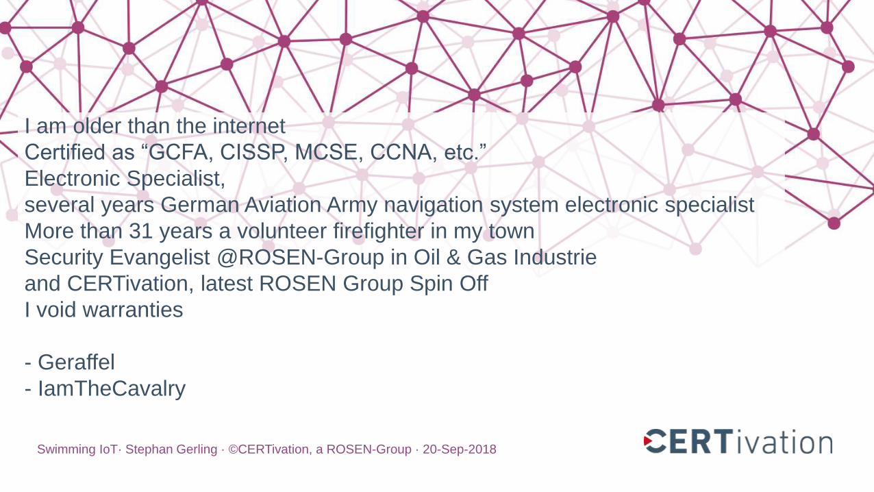
I am older than the internet
Certified as “GCFA, CISSP, MCSE, CCNA, etc.”
Electronic Specialist,
several years German Aviation Army navigation system electronic specialist
More than 31 years a volunteer firefighter in my town
Security Evangelist @ROSEN-Group in Oil & Gas Industrie
and CERTivation, latest ROSEN Group Spin Off
I void warranties
- Geraffel
- IamTheCavalry
Stephan Gerling @ObiWan666
Swimming IoT· Stephan Gerling · ©CERTivation, a ROSEN-Group · 20-Sep-2018
I am older than the internet
Certified as “GCFA, CISSP, MCSE, CCNA, etc.”
Electronic Specialist,
several years German Aviation Army navigation system electronic specialist
More than 31 years a volunteer firefighter in my town
Security Evangelist @ROSEN-Group in Oil & Gas Industrie
and CERTivation, latest ROSEN Group Spin Off
I void warranties
- Geraffel
- IamTheCavalry


Accidents in 2017
Februar: Containervessel 10h without access to Navigationsystem
18. Sep Norwegian: GPS Jamming from eastern direction
US Navy involved in 4 collisions in eastern pacific
• Februar USS Antietam in Bay of Tokios grounded
• Mai USS Lake Champlain: collision with trawler
• 17. Juni USS Fitzgerald: collision with freighter
• 21. August USS John S. McCain: collision with Tanker

Vessels, Yachts and ships

Overview
A yacht is a recreational boat or ship.
The term originates from the Dutch word jacht, which means "hunt"
It was originally defined as a light fast sailing vessel used by the Dutch
navy to pursue pirates and other transgressors around and into the shallow
waters of the Low Countries.

Size matters
Boot up to 7m (20ft.)
Yacht >= 10m (33 Fuß)
Super Yacht bigger than 24m (79 ft.)
mega yacht any yacht over 50 meters (164 ft.)

Superyacht
Indigo Star
Length 38,8m
Beam 7,7m

Swimming IoT
Modern vessels becomme swimming IoT devices
• Vessel Traffic Service (VTS)
• Automatic identification system (AIS)
• Autopilot
• GPS
• Radar
• Camera‘s, including Thermal imaging
• Engine control and monitoring (some now cloud based)
• Internet Access
• Entertainmentsystems

NMEA
NMEA 0183 (National Marine Electronics Association)
A combined electrical and data specification for communication between
marine electronic devices, 4800 Baud speed
• echo sounder
• Sonars
• Anemometer
• Gyrocompass
• Autopilot
• GPS receivers
and many other types of instruments

NMEA
NMEA 2000
bandwidth capacities of less than 1Mbit/s
connects devices using Controller Area Network (CAN) technology originally
developed for the auto industry.
NMEA 2000 network is not electrically compatible with an NMEA 0183
network

NMEA

SeaTalkng
http://www.raymarine.de/uploadedFiles/Products/Networking/SeaTalk/SeaTalkng.pdf

SeaTalkhs
http://www.raymarine.de/uploadedImages/Products/Networking/HS%20with%20HS5%20switch.jpg

Network
TCP/IP to NMEA 2000
Gateway
USB to NMEA 2000
Gateway
Engine
GPS
AIS
Radar
Sonar
SATComWLANGSM
InternetRouter
NMEA Network
TCP/IP Network
Internet
Autopilot

Marine Electronic
Vessel Traffic Service (VTS)
Automatic identification system (AIS)
Electronic Chart Display and Information System (ECDIS)
Autopilot
Internet Access

Vessel traffic service
A vessel traffic service (VTS) is a marine traffic monitoring system established
by harbour or port authorities, similar to air traffic control for aircraft.
VTS systems use
• Radar
• closed-circuit television (CCTV)
• VHF radiotelephony
• automatic identification system

Automatic identification system (AIS)
AIS is an automatic tracking system used
• on ships and
• by vessel traffic services (VTS).
Satellite-AIS (S-AIS)
• satellites are used to detect AIS signatures

Automatic identification system (AIS)
AIS information supplements marine radar,
- similar to GPS in Aircrafts –
which continues to be the primary method of collision avoidance for water
transport.

Electronic Chart Display and
Information System (ECDIS)
ECDIS is a geographic information system used for nautical navigation
displays information from:
• Electronic Navigational Charts (ENC)
• or Digital Nautical Charts (DNC)
integrates position information
• Position
• Heading
• speed
sensors which could interface with an ECDIS are radar, Navtex, Automatic
Identification Systems (AIS), and depth sounders.

IT Equipment on Board
Internet Access
• GSM
• WiFi
• SAT (Inmarsat, VSAT, Iridium, etc. )
On Board
• Entertainment Systems
• WiFi (Crew, Guest/Owner)
• VoIP

IT equipment on Board
10 Smart TV & Sat Receiver
1 Chart PC
14 VoIP Telephones
1 Internet Router (GSM, WiFi, SAT)
1 rack mounted Switch (48ports)
1 UPS
4 WiFi Access Point
(Crew, Guest/Owner)
Router
Server
Switch
UPS
24
VoIP Server

Smart Ships
Audio & Video Streaming
iPhone/iPad remote control of
• Lights
• Electric curtains
• Engine monitor
Etc.

Attack vectors
TCP/IP to NMEA 2000
Gateway
USB to NMEA 2000
Gateway
Engine
GPS
AIS
Radar
Sonar
SATComWLANGSM
InternetRouter
NMEA Network
TCP/IP Network
Internet
Autopilot

Attack vectors
• GPS
• AIS
• Autopilot
• IT equipment on Board
• Internet connection routers (VSAT, InmarSat, GSM, WLAN, etc.)
• Cloud based services

GPS
GNSS or GPS attacks

GPS – many different systems
GNSS (global Navigation satellite system)
• NAVSTAR GPS (United Staates of America)
• GLONASS (Russian Föderation)
• Galileo (Europe Union)
• Beidou (China)

GPS – many different systems
https://upload.wikimedia.org/wikipedia/commons/9/9a/Gnss_bandwidth.svg

GPS
2 Scenarios are possible
• jamming
• spoofing
complexibility:
Jamming = quite simple
Spoofing = complex – feasible for under1000 Euro

GPS attacks
Spoofing GPS signal is not that easy
Minimum 3 different Satellite signal has to be spoofed
Commercial ships and bigger yachts have backup GPS (Navstar + Galileo)
Some GPS receiver can detect position jumps
It’s easier to fake the NMEA data of the GPS Sensor

GPS - Jamming
Eastern Pacific reports more and more GPS anomalies
• Juni, week 25 – more than 20 reports – north east black see
• NATO Troops maneuver at same time there
• Sept. Norway reports anomalies in a height >2000ft
• https://rntfnd.org/wp-content/uploads/Norway-Comms-Auth-Report-GPS-Jamming-Sept-2017.pdf
• US Navy teaching again offline Navigation with Sixtant

Securing GPS?
Research Project – „Galant“ by DLR – Institute of communications and navigation
- 2x2 active antenna array
- Beamforming & array processing
http://www.dlr.de/kn/en/desktopdefault.aspx/tabid-4306/6938_read-9224/

Automatic identification system (#1)
Following Data a AIS transceiver sends every 2 to 10 seconds while underway,
and every 3 minutes while a vessel is at anchor:
• Maritime Mobile Service Identity (MMSI) – a unique nine digit identification number.
• Navigation status – "at anchor", "under way using engine(s)", "not under command", etc.
• Rate of turn – right or left, from 0 to 720 degrees per minute
• Speed over ground – 0.1-knot (0.19 km/h) resolution from 0 to 102 knots (189 km/h)
• Positional accuracy: Longitude & Latitude – to 0.0001 minutes
• Course over ground – relative to true north to 0.1°
• True heading – 0 to 359 degrees (for example from a gyro compass)
• True bearing at own position. 0 to 359 degrees
• UTC Seconds

Automatic identification system

Automatic identification system (#1)
Following Data a AIS transceiver sends every 2 to 10 seconds while underway,
and every 3 minutes while a vessel is at anchor:
• Maritime Mobile Service Identity (MMSI) – a unique nine digit identification number.
• Navigation status – "at anchor", "under way using engine(s)", "not under command", etc.
• Rate of turn – right or left, from 0 to 720 degrees per minute
• Speed over ground – 0.1-knot (0.19 km/h) resolution from 0 to 102 knots (189 km/h)
• Positional accuracy: Longitude & Latitude – to 0.0001 minutes
• Course over ground – relative to true north to 0.1°
• True heading – 0 to 359 degrees (for example from a gyro compass)
• True bearing at own position. 0 to 359 degrees
• UTC Seconds

Automatic identification system (#2)
following data are broadcast every 6 minutes:
• IMO ship identification number – a seven digit number that remains unchanged
• Radio call sign – international radio call sign,
• Name – 20 characters to represent the name of the vessel
• Type of ship/cargo
• Dimensions of ship – to nearest meter
• Location of positioning system's (e.g., GPS) antenna on board the vessel - in meters aft of bow and meters port or starboard
• Type of positioning system – such as GPS, DGPS or LORAN-C.
• Draught of ship – 0.1 meter to 25.5 meters
• Destination – max. 20 characters
• ETA (estimated time of arrival) at destination – UTC month/date hour:minute
optional : high precision time request, a vessel can request other vessels provide a high precision UTC time and datestamp

AIS RF part
AIS uses the globally allocated Marine Band channels 87 & 88.
AIS uses the high side of the duplex from VHF radio "channels" (87B) & (88B)
• Channel A 161.975 MHz (87B)
• Channel B 162.025 MHz (88B)
• Before being transmitted, AIS messages must be NRZI encoded.
• AIS messages are GMSK modulated.
• transmission bit rate is 9600bit/s

AIS hacking
2-CHANNEL AIS RECEIVER WITH RTL-SDR AND GNUAIS
https://www.rtl-sdr.com/2-channel-ais-receiver-rtl-sdr-gnuais/

Autopilot (future Project – started already)
Remote control for heading & speed !
No issues found yet
I am working on it !

Autopilot
Raymarine S100 wireless Remote Control
The compact Raymarine S100 remote control gives you basic, onboard
wireless control of any Raymarine SeaTalk autopilot, even if you're below
deck and out of sight of your autopilot.
Key Features
• Two lines of text
• Signal strength indicator
• Out of range of base station warning

Autopilot
FCC ID search

Autopilot
Raymarine Autopilot S100 Handheld
- FCC ID PJ5Smart
- Communicates with the S1000 Autopilot
- Operates wireless on 2.45GHz
- Is not WiFi

Autopilot
RCM is based upon Ember’s EM2420 2.45GHz RF transceiver
connected to an ATMEGA64 microprocessor
runs on Emberstack


Yacht Router hacking
Locomarine
Yachtrouter

Yacht Router hacking
Locomarine Yachtrouter
• High power WIFI Booster for long distance connectivity (15+ NM)
• High power 4G/3G/2G module (30+ Nautical miles)

Issue #1 – The control software

Issue #1 – The control software
• FTP connect to router
• Download “YachtRouterGen3.xml
• The APP changes settings in the XML
• Uploaded to the Router
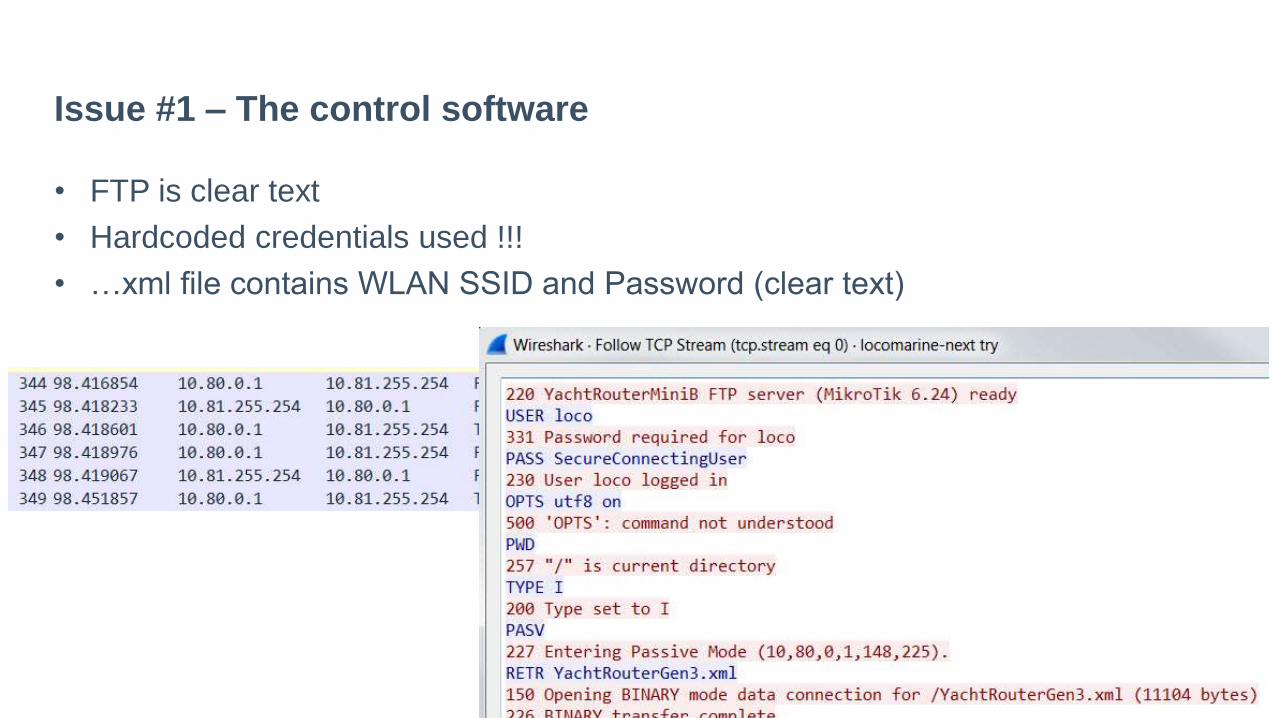
Issue #1 – The control software
• FTP is clear text
• Hardcoded credentials used !!!
• …xml file contains WLAN SSID and Password (clear text)

Issue #2 – code contains juicy informations

Issue #2 – code contains juicy informations

Issue #3 - no firewall
NMAP scan on the puplic IP
• Router os= Mikrotik Router OS
• Winbox Management 8291/TCP
• API access of the Yachtrouter exe 8728/TCP (API)
• Portscan from Internet:
• PORT STATE SERVICE
• 21/tcp open ftp
• 22/tcp open ssh
• 53/tcp open domain
• 2000/tcp open cisco-sccp
• 8291/tcp open unknown

Issue #4 - Remote support
• 9.1. Remote SupportEach Yacht Router is equipped with Remote Support feature that gives our Technical Support ability to connect remotely over the Internet to your Yacht Router. You can use Remote Supportin various situatons like remote setup, diagnostcs or Cloud Service actvaton.
•To establish Remote Support please send an e-mail to [email protected] with following details:• Contact details (name, e-mail, phone number)• Yacht Router model• Yacht Router serial number• Descripton of the problem • Suggested best time (minimum one)

Issue #4 - Remote support
Yacht Router model & serial number ?
How do they know the IP address?

Issue #4 - Remote support

Issue #4 - Remote support
Remember the Portscan ?
Router os= Mikrotik Router OS
8291/tcp open unknown
Port 8291/TCP belongs to Winbox Management
Ok, lets Try with the passwords from the source

Issue #4 – WinBox Management

Issue #4 – Winbox Management

Issue #4 – Winbox Management Cracking
MKBRUTUS v1.0.0
Password bruteforcer for MikroTik devices or boxes running RouterOS
Site: https://github.com/mkbrutusproject/MKBRUTUS
Or use CVE-2018-14847
https://github.com/BigNerd95/WinboxExploit
$ python3 WinboxExploit.py 192.168.0.1
• User: the user
• Pass: StrengGeheim

How to find vulnerable Yachts

How to find vulnerable Yachts

How to find vulnerable Yachts

Vendor response
• Security issues reported in June 2017 to vendor
• 2 bugs intensely fixed
• New Apps and router firmware versions were developed
• In November finaly released
• Permission from vendor to present
• CVE-2017-17673 requested
http://cve.mitre.org/cgi-bin/cvename.cgi?name=CVE-2017-17673

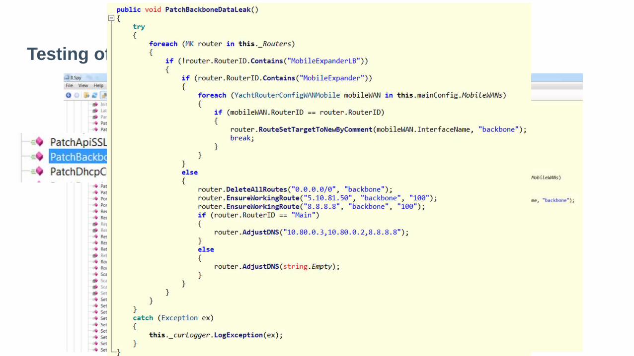
Testing of the patched Software
• Vendor asked me to test the patched software
• They send me a Test Router
• .Net application is now obfuscated
• SSH instead of FTP
But…. Security by obscurity – seriously ?

Testing of the patched Software

Don‘t forget the APP‘s
Testing of the patched Software

Summery of the Patches
• Use of SSH instead of FTP
• Obfuscated Exe + DLL in Windows Version
• Android APK not obfuscated
• iOS Version not tested yest
• still Hardcoded credentials in yrEngine
• SSH and Winbox still reachable from Internet

Satcom

Satcom
• Offshore internet acces via Satcom
• Patching ?
• Many old Versions still online
• A sample

Satcom
Shodan.io search hint’s for possible vulnerable devices
• “Sailor 900”
• “Inmarsat Solutions”
• “Telenor Satellite”
• “Commbox”
• org:"Intelsat GlobalConnex Solutions (GXS)“
• org:"Telenor UK Ltd"

Satcom
Did u know? Shodan.io has a Live Shiptracker
URL: Shiptracker.shodan.io
Tracks via VSAT connected Antennas and exposes Web Services

Satcom
Was shodan surfing for other Satcom Boxes !
Digital Antenna System paid my attention
• Results in Cobham MXP Webserver
• Shodan Query for “Server: Micro Digital Webserver” gives result

Cobham Seatel Satcom
Demo

Search “Server: Micro Digital Webserver”

Cobham Seatel Satcom
• Was looking for Satcom devices via Shodan
• Found some online
• Analyzed Webinterface with Fiddler/burpsuite
• Found some juicy javascripts

Cobham Seatel Satcom
/js/userLogin.js contains some hints
if(t=="Dealer"){if(r=="true"){e="MenuDealerGx.html"}else{e="MenuDealer.html"}}else
if(t=="SysAdmin"){if(r=="true"){e="MenuSysGx.html"}else{e="MenuSys.html"}}else
if(t=="User"){if(r=="true"){e="MenuEuNCGx.html"}else{e="MenuEuNC.html"}}

Cobham Seatel Satcom

Cobham Seatel Satcom RTFM
RTFM ! In the manual: default usename and password
• Dealer
• seatel3
• SysAdmin
• seatel2
• User
• seatel1

Cobham Seatel Satcom
CVE Lookup if someone found already:
F..K – someone was already faster
But….

Cobham Seatel Satcom
CVE-2018-5267 reported Auth bypass only in Version 121 Build 222701
I can confirm following other versions too:
- Version number: 179 (Build:224945)
- Version number: 171 (Build:224753)
- Version number: 148 (Build:223591)
- Version number: 147 (Build:223551)

Cobham Seatel Satcom
To have fun with the seatel device, following Menues are available without authentication:
ConfigPortGx.html configuration der IO Ports
CommDiag.html cli command interface
PositionAntGx.html change Antenna configuration
FileAdmin.html
CfgFileDnUpload.html down/upload config
FirmwareUpload.html firmware update
CfgSysCommon.html rename ship name in menue
SysStatus.html
RebootUnit.html reboot

Cobham Seatel Satcom
Whats the Risk now?
- Increase Cost
- Denial of Service

What’s next?
• NMEA protocol needs more test
• Wireless Autopilot
• Other Internet Equipment tested by others
• Vessel hacking is just in the beginning
• Cloud services

Future is cloud
https://www.nmea.org/Assets/nmea%20ibex%20integrating%20smart%20phones%20%20marine%20electronics%20lr.pdf

Cloud services
• Engine control
• Monitoring
• From anywhere
https://www.nmea.org/Assets/nmea%20ibex%20integrating%20smart%20phones%20%20marine%20electronics%20lr.pdf

conclusion
• NMEA Gateways needs more research
• SATCom Boxes mostly unpatched
• VTS is unexplored
• Autopilot Remote control (currently working on)
• Injecting NMEA messages to the Bus (currently working on)
• GPS spoofing protection (DLR “Galant” new Antenna array)
My conclusion: Maritime Cyber-Security is years behind

THANK YOU FOR JOINING
THIS PRESENTATION.
www.certivation.com