New methods for MRI denoising based on sparseness and self ...
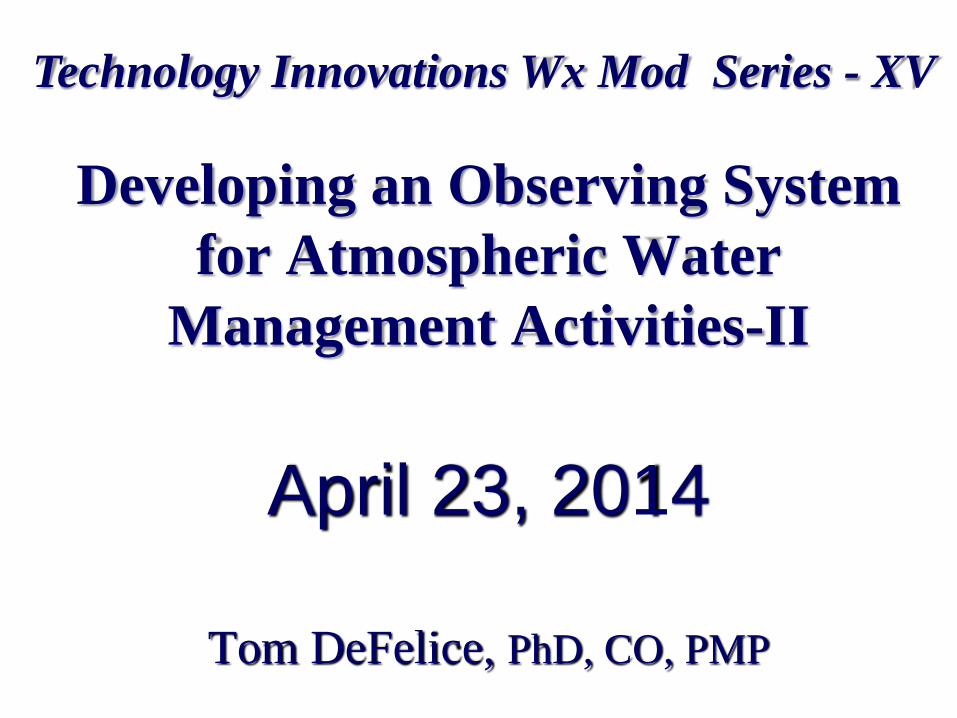
Developing an Observing System
for Atmospheric Water
Management Activities-II
April 23, 2014
Tom DeFelice, PhD, CO, PMP
Technology Innovations Wx Mod Series - XV

Background
Series began over 14 years ago
Conceptual high-level plan for the “next phase” in
weather modification science and technology
development.
– “…. Comprehensive research and development efforts
directed toward optimizing current technologies used to
manage “treatable” atmospheric processes. …. (DeFelice,
2002-JWM-nRev-short Contribution; DeFelice &
Golden, 2005-JWM)”
Mendoza Meeting (mention UAV – “in passing”)
…..
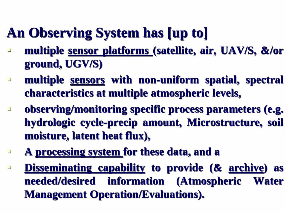
An Observing System has [up to]
multiple sensor platforms (satellite, air, UAV/S, &/or
ground, UGV/S)
multiple sensors with non-uniform spatial, spectral
characteristics at multiple atmospheric levels,
observing/monitoring specific process parameters (e.g.
hydrologic cycle-precip amount, Microstructure, soil
moisture, latent heat flux),
A processing system for these data, and a
Disseminating capability to provide (& archive) as
needed/desired information (Atmospheric Water
Management Operation/Evaluations).
Definition – Observing System
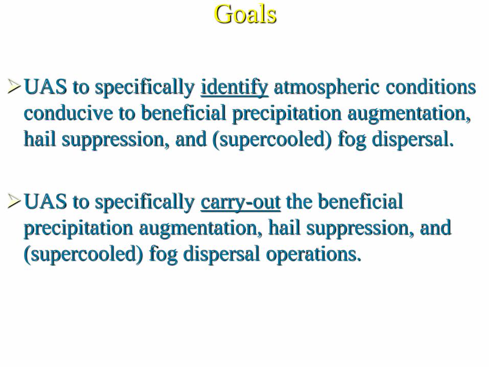
Goals
UAS to specifically identify atmospheric conditions
conducive to beneficial precipitation augmentation,
hail suppression, and (supercooled) fog dispersal.
UAS to specifically carry-out the beneficial
precipitation augmentation, hail suppression, and
(supercooled) fog dispersal operations.
Explore the possibility of using and developing a:
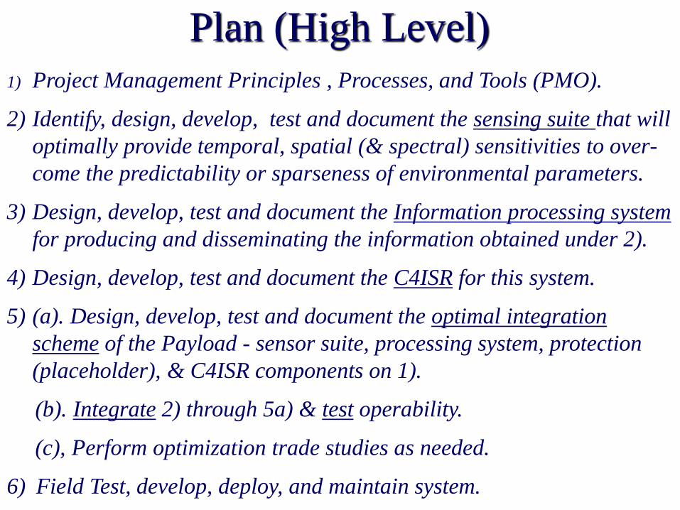
Plan (High Level) 1) Project Management Principles , Processes, and Tools (PMO).
2) Identify, design, develop, test and document the sensing suite that will
optimally provide temporal, spatial (& spectral) sensitivities to over-
come the predictability or sparseness of environmental parameters.
3) Design, develop, test and document the Information processing system
for producing and disseminating the information obtained under 2).
4) Design, develop, test and document the C4ISR for this system.
5) (a). Design, develop, test and document the optimal integration
scheme of the Payload - sensor suite, processing system, protection
(placeholder), & C4ISR components on 1).
(b). Integrate 2) through 5a) & test operability.
(c), Perform optimization trade studies as needed.
6) Field Test, develop, deploy, and maintain system.

Observing System to ID AWM
Opportunities: Capabilities Function Capability
Sensing *Atmospheric profiles-(Sfc to Flight-level: T, Td, Wind field, P, Spectral
Irradiance)
*Atmospheric Constituents & Composition (Aerosols, Cloud, Precip; gas)
*Surf Characteristics (spectral reflectance, SM/ST profiles)
*Ancillary, Auxiliary (e.g. GPS, TOPO30, Video)
Sensor
Coverage
Omni-slight skew toward forward hemisphere
Data
Processing
Ability to process up to Terabytes of data per second; Functional Tools-
decision support; Cal/Val
Software Algorithms to provide Required Information; CMMI III
C4ISR Secure, Remote, Virtual Platform
Protection Stall for Reinforcements during a Terrorist Attack

Observing System to Carry out
AWM Operations: Capabilities
HYS
Function Capability
Sensing *Atmospheric profiles-(Sfc to Flight-level: T, Td, Wind field, P,
Spectral Irradiance)
*Atmospheric Constituents & Composition (Aerosols, Cloud, Precip;
Gas; Supercooled Liquid Water-SLW)
*Surf Characteristics (spectral reflectance, SM/ST profiles)
*Ancillary, Auxiliary (e.g. GPS, TOPO30, Video)
* AgI, Dry Ice?, (hygroscopic) agent dispenser
Sensor Coverage Omni-slight skew toward forward hemisphere; Sub-UAV point(AgI)
Data Processing Ability to process up to Terabytes of data per second; Functional
Tools-decision support; Cal/Val (Seed-Start & Stop, locations-
GPS, GPS-delays, amt AgI/DI burned/dispensed)
Software (CMMI III Level, ) Algorithms to provide Required Information,
Control (e.g., Ignite Squib-burn AgI Solution/flare, TA and flight
path), Communication, Command, C?, I, S(e.g. Video), R.
C4ISR Secure, Remote, Virtual Platform
Protection Stall for Reinforcements during a Terrorist Attack
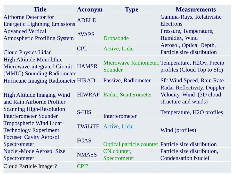
Title Acronym Type Measurements
Airborne Detector for
Energetic Lightning Emissions ADELE
Gamma-Rays, Relativistic
Electrons
Advanced Vertical
Atmospheric Profiling System AVAPS
Dropsonde
Pressure, Temperature,
Humidity, Wind
Cloud Physics Lidar CPL Active, Lidar
Aerosol, Optical Depth,
Particle size distribution
High Altitude Monolithic
Microwave integrated Circuit
(MMIC) Sounding Radiometer
HAMSR Microwave Radiometer,
Sounder
Temperature, H2Ov, Precip
profiles (Cloud Top to Sfc)
Hurricane Imaging Radiometer HIRAD Passive, Radiometer Sfc Wind Speed, Rain Rate
High Altitude Imaging Wind
and Rain Airborne Profiler
HIWRAP Radar, Scatterometer
Radar Reflectivity, Doppler
Velocity, Wind (3D cloud
structure and winds)
Scanning High-Resolution
Interferometer Sounder S-HIS
Interferometer Temperature, H2O profiles
Tropospheric Wind Lidar
Technology Experiment TWiLiTE Active, Lidar
Wind (profiles)
Focused Cavity Aerosol
Spectrometer FCAS
Optical particle counter Particle size distribution
Nuclei-Mode Aerosol Size
Spectrometer NMASS
CN counter,
Spectrometer
Particle size distribution,
Condensation Nuclei
Cloud Particle Imager? CPI?
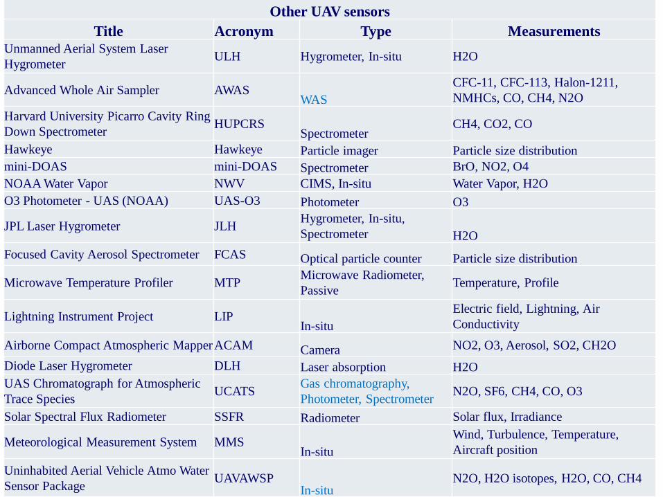
Other UAV sensors
Title Acronym Type Measurements
Unmanned Aerial System Laser
Hygrometer ULH Hygrometer, In-situ H2O
Advanced Whole Air Sampler AWAS WAS
CFC-11, CFC-113, Halon-1211,
NMHCs, CO, CH4, N2O
Harvard University Picarro Cavity Ring
Down Spectrometer HUPCRS
Spectrometer CH4, CO2, CO
Hawkeye Hawkeye Particle imager Particle size distribution
mini-DOAS mini-DOAS Spectrometer BrO, NO2, O4
NOAA Water Vapor NWV CIMS, In-situ Water Vapor, H2O
O3 Photometer - UAS (NOAA) UAS-O3 Photometer O3
JPL Laser Hygrometer JLH Hygrometer, In-situ,
Spectrometer H2O
Focused Cavity Aerosol Spectrometer FCAS Optical particle counter Particle size distribution
Microwave Temperature Profiler MTP Microwave Radiometer,
Passive Temperature, Profile
Lightning Instrument Project LIP In-situ
Electric field, Lightning, Air
Conductivity
Airborne Compact Atmospheric Mapper ACAM Camera NO2, O3, Aerosol, SO2, CH2O
Diode Laser Hygrometer DLH Laser absorption H2O
UAS Chromatograph for Atmospheric
Trace Species UCATS
Gas chromatography,
Photometer, Spectrometer N2O, SF6, CH4, CO, O3
Solar Spectral Flux Radiometer SSFR Radiometer Solar flux, Irradiance
Meteorological Measurement System MMS In-situ
Wind, Turbulence, Temperature,
Aircraft position
Uninhabited Aerial Vehicle Atmo Water
Sensor Package UAVAWSP
In-situ N2O, H2O isotopes, H2O, CO, CH4

Ground-based measurement
(&/or UGV)
Airborne measurement/ Satellite
with moderate resolution/ UAV
or UGV with Low-Mod
resolution
Satellite with low resolution
Satellite sensor measurement with
high resolution; UGV/UAV with
Moderate resolution
Conceptual Projected Surface Coverage
Relationships of Various Data Platforms
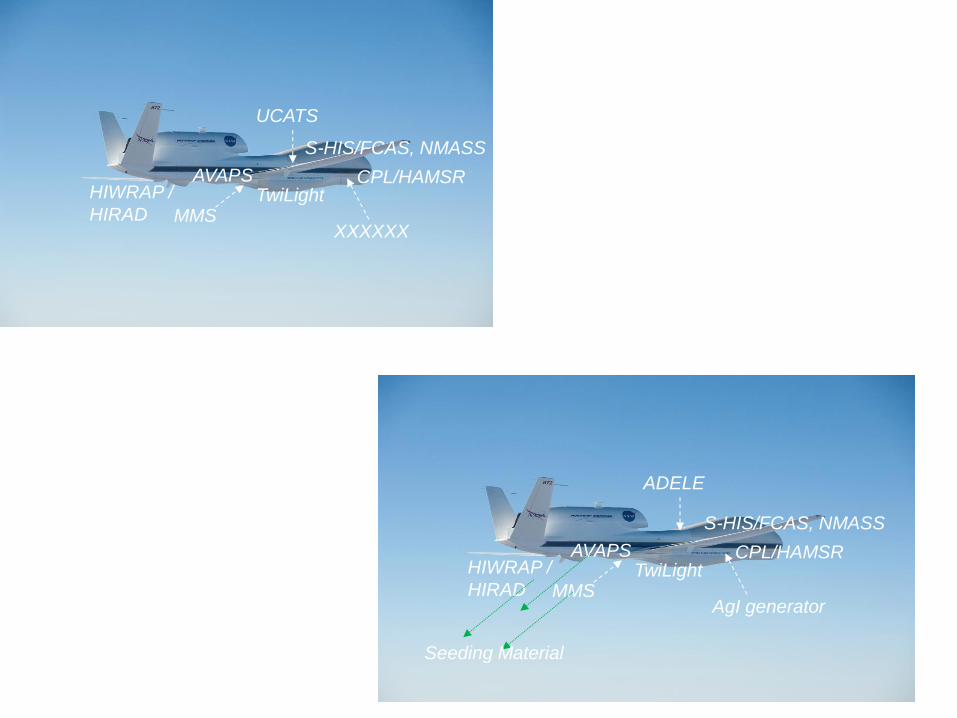
Unmanned ID AWM Opportunity System
Unmanned Carry-Out AWM Operations System
AVAPS CPL/HAMSR HIWRAP /
HIRAD
S-HIS/FCAS, NMASS
XXXXXX
TwiLight MMS
UCATS
AVAPS CPL/HAMSR HIWRAP /
HIRAD
S-HIS/FCAS, NMASS
AgI generator
TwiLight MMS
ADELE
Seeding Material
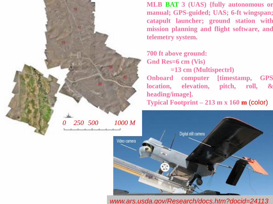
MLB BAT 3 (UAS) {fully autonomous or
manual; GPS-guided; UAS; 6-ft wingspan;
catapult launcher; ground station with
mission planning and flight software, and
telemetry system.
700 ft above ground:
Gnd Res=6 cm (Vis)
=13 cm (Multispectrl)
Onboard computer [timestamp, GPS
location, elevation, pitch, roll, &
heading/image].
Typical Footprint – 213 m x 160 m (color)
0 250 500 1000 M
www.ars.usda.gov/Research/docs.htm?docid=24113

Risk/Issue/Concerns
FAA Programmatic
Functional

• Conduct AWM Operations(?)
• AWM Operational & Evaluation Models, &
Decision Support Tool Development,
Improvement, &/or Validation Activities
• ‘Process’ Monitoring (e.g., Monitoring Strategies,
improved understanding of physic-chemical
atmospheric processes-govern Hydrologic Cycle,
Climate change, etc.)
• Many Others …….
Benefits: