The Nectar Project - CLOK
6
The Nectar Project Solar Development of Post-Industrial Urban Communities (Tutti Frutti, New Islington, Manchester) 363, 363, 363 AND 363 ABSACT: The 'solar city' is an oxymoron; buildings close together shade each other and thus prevent insolation. The solar suburbs are generally low density and poorly connected. In response, this study advances the understanding of compact urban sustainability, and strengthens the architectural knowledge of urban and celestial solar geometries - the synergy of which are key to true solar city design. e objective is to generate a solar community capable of sustaining an inevitable urban population within an existing and site limited Nohe European city. With reference to previous masterplanning models by this author (Main, C. L., & Keeffe, G., 2007) this paper creates and uses a mapping of city and sun. By recognizing the city as an intensified, light stratified system, a flexible sunlight and shadow strategy for the volumetric development of brownfield urban has emerged. The Nectar Pject applies a solar growth methodology to one of the UK's largest brownfield sites - New Islington, Manchester. Utilising advanced CAD soſtware packages the forms generated display intense faceted dynamism which offer sustainable design an energy quantifiable and visually expressive language. Keywords: solar, sustainable, bwnfield, urban, masterplanning 1. INTRODUCTION MANCHESTER, ANCOATS, NEW ISLINGTON, TUTTI FRUTTI 1.1. Site Histo Manchester, England (53.7 ° N 2.1 ° W) was the world's first unplanned and chaotically arranged industrial city. The city plan and the built forms that now dominate are essentially Victorian and Edwardian due to its transformation from medieval settlement to an industrial Cottonopolis during the nineteenth-century. Despite massive redevelopment Manchester remains an unchanging gridded context, its low-rise form, latitude, climate and organically compact urban grain conflict continuingly with the principles of passive solar design. The need to address overshadowing, inevitable for most of year, became the main argument of CAD generated 'Synergy Crystal' form [1], and the reason why Manchester continues to serve as a solar lab for current research. Ancoats in north-east Manchester was once a thriving district of cotton mills. In the early 1930s the area suffered economic decline due to a slump in the industry and an associated depopulation in the years following the Second World War. This would be particularly compounded during the slum clearances of the 1960s. During the 1990s Ancoats' industrial heritage was to be recognised, and this, along with its close proximity to the city centre of Manchester, led to major investment and the proposal of substantial regeneration plans that aimed to reinstall an original community spirit. A 31-acre plot of land, rebranded 'New Islington' would act as a significant catalyst in the area. Various plots have now been completed, the most notable being a large, colourful and bold block of flats known as 'Chips' designed by Will Alsop Architects. The site of exploration for The Nectar Project is 'Tutti Frutti', a linear 26-plot block orientated toward the northwest and southeast. Urban Splash, one of the largest property developers and urban renewal specialists in Europe own the site and intend to introduce sustainable strategies to the existing layout (Fig. 1 ). The Nectar Project attempts to implement a solar design methodology to the Tutti Frutti site, the predetermined orientation of which is least favourable to solar design. , • ·\ /"\ � / /" / Figure 1: New Islington Masterplan by Urban Splash. The tti Frutti linear block is 15 metres deep and located in the centre of the plan. 26 Plots are laid out ranging fm 4 to 5 metres wide. A historical narrative of urban grids and their relationship with optimum solar design follows. Comparisons are drawn between the contextual challenges that faced pioneering solar architects with those faced in The Nectar Project at Tutti Frutti.
Transcript of The Nectar Project - CLOK

The Nectar Project
Solar Development of Post-Industrial Urban Communities
(Tutti Frutti, New Islington, Manchester)
363, 363, 363 AND 363
ABSTRACT: The 'solar city' is an oxymoron; buildings close together shade each other and thus prevent insolation. The solar suburbs are generally low density and poorly connected. In response, this study advances the understanding of compact urban sustainability, and strengthens the architectural knowledge of urban and celestial solar geometries - the synergy of which are key to true solar city design. The objective is to generate a solar community capable of sustaining an inevitable urban population within an existing and site limited Northern European city. With reference to previous masterplanning models by this author (Martin, C. L., & Keeffe, G.,
2007) this paper creates and uses a mapping of city and sun. By recognizing the city as an intensified, light stratified system, a flexible sunlight and shadow strategy for the volumetric development of brownfield urban has emerged. The Nectar Project applies a solar growth methodology to one of the UK's largest brownfield sites - New Islington, Manchester. Utilising advanced CAD software packages the forms generated display intense faceted dynamism which offer sustainable design an energy quantifiable and visually expressive language.
Keywords: solar, sustainable, brownfield, urban, masterplanning
1. INTRODUCTION MANCHESTER,
ANCOATS, NEW ISLINGTON, TUTTI
FRUTTI
1.1. Site History
Manchester, England (53.7°N 2.1 °W) was the world's first unplanned and chaotically arranged industrial city. The city plan and the built forms that now dominate are essentially Victorian and Edwardian due to its transformation from medieval settlement to an industrial Cottonopolis during the nineteenth-century. Despite massive redevelopment Manchester remains an unchanging gridded context, its low-rise form, latitude, climate and organically compact urban grain conflict continuingly with the principles of passive solar design. The need to address overshadowing, inevitable for most of year, became the main argument of CAD generated 'Synergy Crystal' form [1], and the reason why Manchester continues to serve as a solar lab for current research.
Ancoats in north-east Manchester was once a thriving district of cotton mills. In the early 1930s the area suffered economic decline due to a slump in the industry and an associated depopulation in the years following the Second World War. This would be particularly compounded during the slum clearances of the 1960s. During the 1990s Ancoats' industrial heritage was to be recognised, and this, along with its close proximity to the city centre of Manchester, led to major investment and the proposal of substantial regeneration plans that aimed to reinstall an original community spirit. A 31-acre plot of land, rebranded 'New Islington' would act as a significant catalyst in the area. Various plots have now been completed, the most notable being a large, colourful
and bold block of flats known as 'Chips' designed by Will Alsop Architects. The site of exploration for The Nectar Project is 'Tutti Frutti', a linear 26-plot block orientated toward the northwest and southeast. Urban Splash, one of the largest property developers and urban renewal specialists in Europe own the site and intend to introduce sustainable strategies to the existing layout (Fig. 1 ). The Nectar Project attempts to implement a solar design methodology to the Tutti Frutti site, the predetermined orientation of which is least favourable to solar design.
,...,__
...t\ • ,,,..._ ·\ ""- /"\
"' � /' /r-
::;=./". "-./ /'- ,,.
Figure 1: New Islington Masterplan by Urban Splash. The Tutti Frutti linear block is 15 metres deep and located in the centre of the plan. 26 Plots are laid out ranging from 4 to 5metres wide.
A historical narrative of urban grids and their relationship with optimum solar design follows. Comparisons are drawn between the contextual challenges that faced pioneering solar architects with those faced in The Nectar Project at Tutti Frutti.

2. SOLAR GRID 2.1. Ancient History
The Greeks were the first to use solar architecture at city scale. Their design resolution was a form of egalitarian planning that employed the gridiron layout and per stigas (South-facing rows separated to allow the midday winter sun to penetrate all dwellings. An advantage being that low summer sun from the east and west would only be received by smaller end surfaces, thus reducing heat gain). This approach would influence the solar cities of Olynthus and Priene, as well as solar layouts that are commonplace in Northern Europe today.
Other than those of ancient Rome and Greece Northern European solar city models do not exist before 1860. This would be a consequence of living in constant turmoil and lawlessness during the Middle Ages where issues of defence would primarily instruct the design of homes and cities. However, during the seventeenth-century solar design was the concern of innovative horticulturalists such as Fatio de Duillier whose Fruit wall allowed plants from warmer regions, e.g. grapes and figs, to be grown in the temperate climates of England and France by attaching their branches to sun heated walls to accelerate ripening [2]. A volumetric arrangement not dissimilar to that of the BedZED urban solar village by Bill Duster Architects (Fig. 2).
(a)
(b)
Figure 2: (a) Engraving of sloping fruit walls in seventeenth-century France. Each row faced south and was separated by a distance chosen for optimum year-round solar collection. (b) BedZed by Bill Dunster Architects.
It was only until the early twentieth-century that Northern Europe sought to rectify this void in solar knowledge by allowing the sun to inform a number of its more utopian housing experiments.
2.2. Modern History
Working class communities born out of industrialisation lived in squalor with little access to the sun. Socially concerned groups pushed for a marked change in housing policy and by 1900 European governments conceded and passed legislation that stipulated rooms shall be placed as to permit sunlight to enter freely (British Govt.) and must be designed so that an adequate supply of sunshine can be secured in occupied rooms (German Govt.) [3].
Relocating the urban masses to the suburbs and countryside was akin to treating the symptom and not the cause. The benefits of such a move had to be translated into the city with a comprehensive urban solar strategy. Augustin Rey, a French housing official, was the first to investigate this possibility. In 1912 Rey like the ancient Greek and Anasazi communities before him calculated the minimum amount of open space needed around a building to make certain that winter sunlight would not be blocked by adjacent structures. By determining the sun’s position on the winter solstice for ten major world cities Rey calculated the length of the shadows cast by two, four and six story buildings respectively (Fig. 3). He concluded that south-facing apartments in Paris, built one in front of the other, required nearly twice the land area of east or west-facing buildings [4].
Figure 3: Rey’s Sectional north-south study highlighting winter shadow length.
According to Rey blocks of housing in rows facing east and west could be tightly packed without casting shadows on one another. However, the sun’s intensity being extremely low through winter morning and afternoon due to atmospheric absorption and the fact that a southerly aspect would receive a greater proportion of what little radiation there was available makes this observation questionable. However, Rey’s contribution lies in the recognition that a scientific approach was of great value in investigating the possibility of solar access within our industrial environments.
In 1930s Germany the stabilization of the economy led cities to expand allowing the modernist ideals of the optimum city to be expressed. Bruno Taut, Ernst May and Walter Gropius took up a call for large-scale, high-density, low cost standard housing models. All prescribed to the Zeilenbau or long, narrow slab blocks. Architects were now in a quandary as to which direction buildings should face for the best solar access in winter. Marcel Breuer
even commented that most architects made their own rules. Walter Gropius was instrumental in promoting interest in orienting buildings to take advantage of the sun [5]. In a paper entitled Flach-, mittel- oder hochbau? (Houses, walk-ups or apartment blocks) given at the 3rd meeting of Les Congres Internationaux D’Architecture Moderne (CIAM) he pursed a rationalisation of spaced housing blocks demonstrating optimal relationships between orientation, sunlight and open space [6]. The solar masterplan at Dammerstock near Karlsruhe and the Berlin housing project at Siemensstadt epitomise these design intentions, and unfortunately, also their solar limitations (Fig. 4).
(a) (b)
Figure 4: Zeilenbau masterplans by Walter Gropius. Linear blocks facing east-west. (a) Dammerstock. (b) Siemensstadt.
The Dammerstock and Siemensstadt masterplans faced east-west allowing no obstruction to the midday winter sun. However, the winter sun is in the south for a short period, making east and west surfaces incapable of receiving useful insolation. This occurance was explored by Paul Schmitt, a scientist of the period, who observed that the streets collected more solar heat than the apartments [7].
At the CIAM 1933 conference of Le Corbusier proposed rigid functional zoning and open green spaces. Like Walter Gropius before him, this was an attempt to insert order by replacing unhygienic slums. Although Le Corbusier knew the advantages of designing with the sun, he was not convinced by the solar derived Zeilenbau layouts of his contemporaries [8]. At Ville Radieuse Le Corbusier followed the Heliothermic Axis by orientating slightly west of south [9]. Although the prescribed orientation for maximum solar heat gain is an elongated building facing south, in temperate climates it can be advantageous to collect solar energy earlier in the winter evenings. To achieve this the orientation can deviate to the west by a small margin, a move that will not adversely reduce heat gain in summer. However, once again an error resulted within the so-called radiant city concept, Le Corbusier misinterpreting the principles of the Axis and the temperate climate of Paris. Henry Wright would demonstrate the correct use and solar advantages of the Axis in his housing scheme of 1936 [10].
2.3. Present Day
To summarise, by 1930, and for the first time since ancient Greek planning, the scientific analysis
of solar geometries began to instruct experimental working class development in Northern Europe. Design resolutions, influenced by optimal relationships between the sun and land-use, resulted in projects being overshadowed due to improper orientation and spacing. To some extent these errors have now been rectified. However, the question still remains - How should solar access and compact urban brownfield sites be planned. With the world’s urban population set to rise dramatically from 49.2% to 60.8% by 2030 the answer must be found within cities, not on the outskirts as suggested by greenfield schemes such as the expansive per stigas SolarCity at Linz pliching.
3. CONCEPT 3.1. Urban Sun and Form
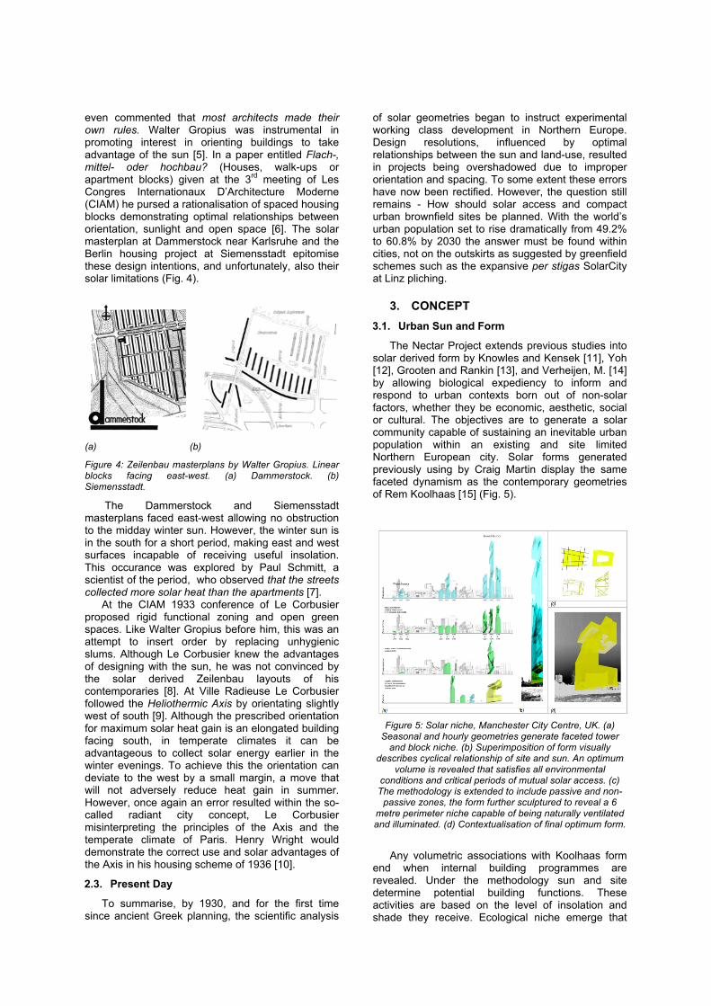
The Nectar Project extends previous studies into solar derived form by Knowles and Kensek [11], Yoh [12], Grooten and Rankin [13], and Verheijen, M. [14] by allowing biological expediency to inform and respond to urban contexts born out of non-solar factors, whether they be economic, aesthetic, social or cultural. The objectives are to generate a solar community capable of sustaining an inevitable urban population within an existing and site limited Northern European city. Solar forms generated previously using by Craig Martin display the same faceted dynamism as the contemporary geometries of Rem Koolhaas [15] (Fig. 5).
Figure 5: Solar niche, Manchester City Centre, UK. (a)
Seasonal and hourly geometries generate faceted tower and block niche. (b) Superimposition of form visually
describes cyclical relationship of site and sun. An optimum volume is revealed that satisfies all environmental
conditions and critical periods of mutual solar access. (c) The methodology is extended to include passive and non-
passive zones, the form further sculptured to reveal a 6 metre perimeter niche capable of being naturally ventilated and illuminated. (d) Contextualisation of final optimum form.
Any volumetric associations with Koolhaas form
end when internal building programmes are revealed. Under the methodology sun and site determine potential building functions. These activities are based on the level of insolation and shade they receive. Ecological niche emerge that

can either support programmes that are essentially shade-tolerant or shade-intolerant. When a generated volume is deemed shade-tolerant (due to prolonged overshadowing by adjacent buildings), proposed activities ideally do not require direct sunlight and would largely be unaffected by and indeed benefit from continuous shade e.g. office skyscraper, auditoria, library, workshop and TV studio etc… Such programmes are likely to require diffuse daylighting or at least low levels of artificial lighting, and ordinarily would tend to take steps to prevent solar ingress. On the other hand a building activity is considered shade-intolerant. Generally programmes that make use of active and passive solar systems, such as photovoltaic, flat-plate solar thermal collectors, evacuated tubes, direct/Indirect gain heating strategies etc… Under the method a residential use would epitomize a shade-intolerant activity.
Solar aperture in Northern European locals is an important form generator. By using hourly solar data of azimuth and altitude at three times of the year (Summer solstice, Winter solstice, and Equinox) such ecological urban ‘niche’ can be CAD modelled. This niche, shade-tolerant or shade-intolerant will guarantee solar or shade access at specified times of the day to neighbouring buildings, whilst simultaneously indicating, the energy conversion potential of the plot itself for specific seasonal and diurnal time periods. Due to the method of CAD construction a community of new niche can start to inform further niche, creating a self-generating community whose initial growth was dependant on the existing and built urban context.
4. METHODOLOGY 4.1. The Solar Envelope
The methodology presented here has evolved from the principles set out by the Solar Envelope originally developed by Ralph Knowles [15]. Knowles’ method of manipulating solar and urban geometry in order to prevent new buildings overshadowing neighbouring plots is advanced in this study by the addition of a second volume that is not shaded by existing buildings. Entitled the Perfect Passive Solar Envelope (P.P.S.E.), its volumetric intersection with Knowles’ Solar Envelope, creates a third solar niche that not only allows solar access to surrounding buildings as with the Solar Envelope, but also visually indicates the energy conversion potential of the site itself for specific seasonal and diurnal time periods.
4.2. Shade & Tolerance
As the utilization or tolerance of shade is critical within any light stratified system, whether a natural forest or post-industrial city landscape, the aim of the methodology was to embrace the physical compaction of cities and therefore the volumes of shade that will inevitably result. The objective being to grow a community of solar related forms that visually indicate regions where both shadow and sunlight occur at critical times of the day and season without compromising present or future community
solar access. Further, a solar resolution was sought that offered a compacted and contextually receptive alternative to expansive solar developments formulated by the oblique winter midday sun angles.
4.3. Urban Intensification
In the same way that natural kingdoms develop through the incremental steps of succession, eventually achieving a sustained and diverse community with an increasing level of growth, it would be argued that an urban community should also have the capacity to respond to varying light conditions brought on by urban intensification. Current European solar housing prototypes typified by Linz-Pichling’s SolarCity masterplan fail to complete this analogy by offering a solar monoculture, i.e. the absence of shade-tolerant types (Fig. 6).
Figure 6: SolarCity, Linz-Pichling, Austria. Total Developable site areas empathising expansive usage of
land due to winter sun: Areas: Sector 1 – 26440m2, Sector 2 – 13076m2, Sector 3 – 28135m2, Sector 4 – 25747m2,
Sector 5 – 28135m2 . Total 121131m2 approx.
4.4. Seed Grid
Solar growth begins with the formulation of a contextualized urban seed grid, the numbering of each seed grid subdivision (or in this case, Tutti Frutti plot) from north to south ensures an equitable share of the sun. Through the implementation of various growth rules relating to solar and urban geometry, energy potential and land-use, a community of solar-related volumes emerges that diurnally and seasonally apportion periods of solar and shade access to both existing and future urban form.
4.5. Rules for Growth
All growth rules relate to periods of solar access, existing building/plot use, and present/future energy potential. For example, walls of nearby buildings that function as window walls or that have window openings that are greater than 25% of the wall area may be partially shadowed by a generated volume, as long as no more than 33% was overshadowed during specified solar access hours. Walls of surrounding buildings that serve as firewalls or other vertical surfaces with limited window area may be totally overshadowed by newly generated form. Resultant volumes are not permitted to overshadow above the roof parapet of any existing building during specified solar access hours, a move safeguarding

the future potential of solar collectors installed on nearby roofs.
In summary, the methodology for the growth of varying brownfield sites adheres to the following sequence (Fig. 7):
1. Divide site into plots, if not already divided. 2. Decide on order for seeding – this can be
random or controlled e.g. from north to south. 3. Use solar azimuth and altitude for each hour on
Equinox to create a passive solar envelope that does not shade adversely.
4. Identify shade-tolerant layer beneath. 5. Conduct a Boolean intersection of forms. 6. Shade-intolerant and shade-tolerant
volume/niche emerge suggesting appropriate building programmes.
Figure 7: Self-perpetuating solar city methodology. Selected slides describing the sequential technique used during the
growth of a dual shade-intolerant and shade-tolerant volume i.e. a volume partly overshadowed by both
surrounding built context and previously generated solar forms. For a step-by-step description of the technique refer to ’The Biomimetic Solar City’ by C.L. Martin and G. Keeffe
[16].
5. CASE STUDY – TUTTI FRUTTI 5.1. Solar Growth Model
Figure 8 illustrates the solar model for the Tutti Frutti site. The construction of a complex series of CAD volumes at varying time intervals was necessary to arrive at this final design. Both shade-tolerant and shade-intolerant niche exist together on the linear block, this will ultimately suggest individual building programme and operation. As the six plots (4/5 subdivisions per plot) were generated in sequence from north to south a distinct saw tooth arrangement has occurred that graphically empathises an equitable allocation of potential solar energy. In Figure 8 niche allowing 6 hours unobstructed access to the sun at the equinox are graphically presented.
(a) The model generated plot-by-plot, from north to south (view from south-east).
(b) Final form displays faceted roofscapes that are derived by the synergy of solar geometry at critical times of the day
and the existing urban fabric (view from north-west).
(c) Shade-tolerant niche identified at lower level suggesting working programme with insolated residential spaces
above.
Figure 8: Preliminary self-perpetuating solar city model, New Islington, Tutti Frutti, Manchester. Model satisfies solar access conditions for the Equinox season during
09.00, 12.00 and 15.00hrs.
To initiate growth the equinox seasonal period was chosen before that of winter and summer. The reasons for this stem from previous research findings in that for winter, the niche generated is volumetrically shallow and therefore cannot sustain building activity. For summer, while niche size is large, the need for solar energy is generally small. The equinox period mediates these ratios whilst lending itself to an interseasonal storage strategy. Referring to sunpath data for the location, a time period of 09.00 to 15.00hrs is sufficient due to a relatively high solar altitude. Any increase in solar access will decrease the volumetric size of the community; again a balance is required between energy capture and commercial pragmatism.
As we have seen, architects have historically struggled with the optimum solar orientation of their buildings and masterplans, particular those arrangements similar to that of New Islington. However, the method of solar design described here was initially developed to embrace challenging contexts in this regard, culminating with a dynamic community of forms across a linear block whose orientation was primarily governed by economic and commercial forces, not environmental ones.

5.2. Future Energy Analysis
Further energy analysis will be conducted on the model using ecotect software. Under this masterplan strategy, environmental conditions inform building usage, building usage does not inform the environmental condition. As with any natural ecosystem a level of redundancy must be expected. Under such a method based on a level of natural selection the urban niche proposed may not be fit for purpose. It may be volumetrically too small or large, or excessively overshadowed or even insolated. Presented with such a model the architect must make an informed choice to whether niche can support the required activity.
6. CONCLUSION Historian William Durant once wrote, “Nothing is
new except arrangement”, this is certainly true of solar design. The ancients showed great technological ingenuity in their solar creative communities where quantitative solar data would be visually expressed by rhythm and ritual within often extreme environmental conditions. This concept, lost in the Middle Ages, resurfaced in the idealist 1930’s and found particular research acclaim during the 1970’s oil crisis. Today, in an era of energy uncertainty we must again revisit the synergy of solar and city geometry. A tabula rasa approach to solar masterplanning lacks any understanding of current and predicted population migration to our urban centres.
The solar planning method presented at PLEA 2011 operates within post-industrial cities; it requires, their facades, roofs, streets, grids and plots in order to generate form. As with the Solar Envelope, environmental rules are applied to allow solar access to existing and future buildings. Urban niche offering varying hours of sun and shade are then identified, creating a solar stratified community more in tune with natural biorhythms and structure. Future city form is now reliant on the ability to be sustained by ecological niche. Any large-scale adoption of this concept would ensure that its citizens would be reacquainted with solar orientation, energy management and bio-rhythms, concepts that were once, and likely to be again, essential to our survival.
7. REFERENCES [1] C.L. Martin and G. Keeffe, ‘The Synergy Crystal:
Climatically Derived Urban Form Computer Implementation of a Solar Urban Planning Strategy for Mixed-Use Building in Northern European Cities’, Proc. The 9th International Conference on Solar Energy in High Latitudes, NorthSun 2001, Leiden - The Netherlands (2001).
[2] K. Butti, and J. Perlin, A GOLDEN THREAD 2500 Years of Solar Architecture and Technology, New York: Van Nostrand Reinhold Company (1980), 42-46.
[3] Parliamentary legislation is paraphrased in: C.M. Robinson, City Planning, London: Knickerbocker Press (1916), 236.
[4] K. Butti, and, J. Perlin, A GOLDEN THREAD 2500 Years of Solar Architecture and Technology, New York: Van Nostrand Reinhold Company, ‘Urban Solar Planning in France’ (1980),163.
[5] W. Gropius, Scope of total architecture, London: Allen & Unwin; World perspectives, 2 (1956), 10.
[6] L. Martin, and L. March, (eds.) Urban space and structures, London: Cambridge University Press 1972, Cambridge urban and architectural studies; 1, (1956) 71.
[7] P. Schmitt, Die Besonnongsverhaltnisse an Stadtsgrassen und Die Gustigste Blockstellung, 80 (1930), 109.
[8] Le Corbusier. Le Corbusier et Pierre Jeanneret: oeuvre complète 1934-1938, 2nd ed. Zurich: Girsberger, (1945).
[9] The Ville Radieuse masterplan was directly influenced by Justin Pidoux’s heliothermic method as described in La Science des plans des villes, (The Science of Town Plans) of 1928. See also: K, Frampton, Le Corbusier, London: Thames & Hudson, World of art series, (2001), 56.
[10] J.G.F. Littler, and G.F. John, Design with energy: the conservation and use of energy in buildings, Cambridge University Press (1984),18-19, 30-32, 64.
[11] R.L. Knowles, and K.M. Kensek, The Interstitium: A Zoning Strategy for Seasonally Adaptive Architecture. In Proceedings of PLEA, Architecture, City, Environment, University of Cambridge, UK, (2000), 773-774.
[12] S. Yoh, Solar Orientated City. In Vogliazzo, M. (ed.), l’Arca Edizioni (2001), 161, 12-17.
[13] S. Grooten, and C. Rankin, Claustro City - Datascape. In Maas, Winy (ed.) Farmax: excursions on density – MVRDV, Rotterdam: 010 Publishers, (1998), 665-675.
[14] M. Verheijen, Trojan Extrusion: Densification Study for Rotterdam Centre, The Netherlands. In W. Maas, (ed.) Farmax: excursions on density – MVRDV, Rotterdam: 010 Publishers (1998), 296-310.
[15] R. L. Knowles, Sun Rhythm Form. Cambridge, Massachusetts and London, England, MIT Press, (1981).
[16] (a) C. L. Martin, and G. Keeffe, The Biomimetic Solar City. In Proceedings of the 24th International Conference on Passive and Low Energy Architecture (PLEA), University of Singapore (Nominated for Best Paper), (2007), (b) C. L. Martin, ‘Synbiocity: Self-Perpetuating Solar Niche Within The First Shock City’, 3rd Cib International Conference On Smart And Sustainable Built Environments (SASBE), TU Delft (2009). http://www.sasbe2009.com/papers.html#papers