The Good Neighbor Trail January 2012 A in - … Good Neighbor Trail January 2012 A Vision ... Ingred...
81
The Good Neighbor Trail January 2012 A Vision For a Regional Trail in Western Dane County Developed through efforts of the Good Neighbor Committee and the Good Neighbor Trail Subcommittee
Transcript of The Good Neighbor Trail January 2012 A in - … Good Neighbor Trail January 2012 A Vision ... Ingred...

The Good Neighbor Trail
January 2012
A Vision
For a
Regional Trail in Western Dane County
Developed through efforts of the Good Neighbor Committee and the
Good Neighbor Trail Subcommittee

This page intentionally left blank.

GOOD NEIGHBOR COMMITTEE MUNICPAL MEMBERS
City of Middleton
Town of Berry
Village of Black Earth
Town of Black Earth
Village of Cross Plains
Town of Cross Plains
Village of Mazomanie
Town of Mazomanie
Town of Middleton
GOOD NEIGHBOR TRAIL SUBCOMMITTEE ACTIVE ATTENDEES & MUNICIPAL REPRESENTATIVES
Sue Dietzen, Village of Mazomanie
Tim Henneman, Town of Berry
Karen and Chris Upper, Town of Berry
Don Ripp, Town of Berry
Laurie Statz, Town of Berry
Vera Riley, Town of Cross Plains
Jody Parsley, Town of Cross Plains
Mike Schultz, Village of Cross Plains
Gary Whitney, Town of Middleton
Sara Luedtke, Town of Middleton
Penni Klein, City of Middleton
Mark Opitz, City of Middleton
Sam Landes, Dane County Council of
Snowmobiles
Scott Stokes, Wolf Run Association
Terry Beuthling, HNTB
Chuck Law, UW‐Extension
Bill Rizzo, UW‐Extension

PLANNING ASSITANCE BY:
JSD Professional Services Jim Bricker, AICP, Project Manager 161 Horizon Drive Sarah Lerner, ASLA, LEED AP Suite 101 Verona, WI 53593 Justin Frahm, ASLA (608) 848‐5060 Mike Marlin www.jsdinc.com
Alta Planning + Design Sarah Gaskell, Planner
City of Middleton Penni Klein, Public Lands Manager Mark Opitz, Assistant City Planner Mark Wegner, City Forester
Dane County Land Conservation Darren Marsh, Parks Director Chris James, Parks Division Planner Sara Kwitek, Parks Division Planner
Wisconsin DNR Kurt Welke, Fish Management Brigit Brown, State Trails Coordinator
USDA‐USFS Leon LaVigne, Midwest Trails Coordinator
Trail Design Specialists, Inc. Mike Riter, Consultant
Thompson and Associates Alice Thompson, Consultant
Glacial Drumlin Horse Trail Assn Ken Carpenter Margie Kraegie
Wisconsin State Horse Council Ken Carpenter
Dairyland Driving Club Jane and Wes Licht
American Driving Society Susie Acker Ingred Krause

ACKNOWLEDGMENTS
This project would not have been possible without guidance and support from the many people who
share the vision of the Good Neighbor Trail.
The map exhibits and GIS work were developed through collaboration with JSD Professional Services,
the City of Middleton and Dane County Parks Department.
Participating Municipalities
City of Middleton: Common Council; Parks, Recreation and Forestry Commission; Conservancy Lands
Committee
Village of Black Earth
Village of Cross Plains
Village of Mazomanie
Town of Black Earth
Town of Berry
Town of Cross Plains
Town of Mazomanie
Town of Middleton
Other Supporting Organizations
Dane County Board of Supervisors
Dane County Council of Snowmobiles
National Park Service (NPS)
Ice Age Park and Trail Foundation (IAPTF)
Wisconsin Department of Transportation
(WisDOT)
Wisconsin Department of Natural Resources
(Wisconsin DNR)
Glacial Drumlin Trail Horse Association (GDHTA)
Pursley’s Valley Stable
Sugar Valley Horse Stable
Dairyland Driving Club (DDC)
American Driving Society (ADS)
Wisconsin State Horse Council (WSHC)
Verona Chamber of Commerce
City of Middleton Tourism Department and
Chamber of Commerce
Madison Nordic Ski Club (MadNorSki)
Blackhawk Ski Club
Bicycle Federation of Wisconsin
Trail Design Specialists, Inc
Cross Roads Café, Cross Plains
Old Feed Mill Restaurant, Mazomanie
Quaker Steak and Lube Restaurant, Middleton
Madison Fishing Expo, Inc. (MFE)
Dane County Conservation League (DCCL)
Yahara Fishing Club
Black Earth Creek Association (BECWA)
The Nature Conservancy (TNC)
Wisconsin Area Guide Dogs Service (WAGS)
Starlight Veterinary Clinic, Blue Mounds
Cardno JFNew

Major Financial support for this planning effort was provided by:
City of Middleton, Conservancy Lands Committee
Dane County Council of Snowmobiles
Additional Financial Support provided by:
Dane County Bike Program Grant
Wisconsin State Horse Council

Purpose and Intent
Mission Statement:
To create a Trail Master Plan as a forum for discussion and planning the development of a
regional trail connecting the City of Middleton and the Village of Mazomanie, within a 2 mile
corridor of HWY 14. The Trail Master Plan shall provide conceptual recommendations for future
trail development that interconnects people to neighborhoods, business, parks, schools, public
facilities, and environmental features. This trail intends to be both recreational and
transportation based, with the intention that the planning process will provide insight into
recreational and transportation‐ based opportunities for trail development.
The Good Neighbor Trail is envisioned to be a regional trail that serves western Dane County as both an
alternative transportation route and as a recreation trail. The regional trail will be ADA accessible and
serve the needs of diverse trail user groups.
Development of a regional trail system of this length requires substantial financial and community
support. The intent of this document is to provide the data necessary to generate community support
and approvals, establish the foundation for municipal and jurisdictional approvals, to gather approvals
for formal and adoption, and to satisfy application requirements for grant funding or donations.
The Good Neighbor Trail Plan is a planning document, and does not commit any of the municipalities
participating in the Good Neighbor Committee, or any local organization or agency to provide financial
support or to acquire property or easements for the construction of the trail.
Swamplovers property

This page intentionally left blank.

i
Table of Contents & Plan Outline
Organizational and Process Overview .......................................................................................................... 1
GNT Planning Statement Regarding Public versus Private Property ........................................................ 1
Plan Objectives .............................................................................................................................................. 3
Planning Considerations ............................................................................................................................... 5
The Good Neighbor Trail Planning Corridor .............................................................................................. 5
Historical/Cultural Context ................................................................................................................... 6
The Built Landscape ............................................................................................................................ 14
Community Health .................................................................................................................................. 16
Economic Opportunities ......................................................................................................................... 18
Transportation Opportunities ................................................................................................................. 19
Commuter Travel ................................................................................................................................ 19
Safe Routes to School ......................................................................................................................... 20
Recreation Opportunities ....................................................................................................................... 24
Horse Enthusiasts ................................................................................................................................ 24
Snowmobilers ..................................................................................................................................... 26
Bicyclists .............................................................................................................................................. 27
Pedestrians .......................................................................................................................................... 28
Roller Bladers, Roller Skiers ................................................................................................................ 28
Cross‐Country Skiers ........................................................................................................................... 28
Fishing ................................................................................................................................................. 29
Natural Area and Cultural Resource Enthusiasts ................................................................................ 29
All Terrain Vehicles (ATV’s) ................................................................................................................. 30
Related State, Regional and Local Planning Efforts .................................................................................... 33
State of Wisconsin .................................................................................................................................. 33
Dane County ............................................................................................................................................ 33
Local Trail Municipalities ..................................................................................................................... 35
Trail Design Considerations......................................................................................................................... 37
Shared Use Trails ..................................................................................................................................... 37
Need/Intent ........................................................................................................................................ 37

ii | Good Neighbor Trail
Design Guidelines ................................................................................................................................ 37
Shared Use Paths and Natural Corridors ................................................................................................ 38
Intent ................................................................................................................................................... 38
Design Guidelines ................................................................................................................................ 38
Regulatory Standards: Crossing Standards ............................................................................................. 38
Intent ................................................................................................................................................... 38
Design .................................................................................................................................................. 38
Shared‐use Path & Natural Feature Crossing ......................................................................................... 39
Intent ................................................................................................................................................... 39
Design .................................................................................................................................................. 39
Equestrian Needs Summary .................................................................................................................... 40
Intent ................................................................................................................................................... 40
Design .................................................................................................................................................. 40
Physical Forces on the Trail Surface – Trail Design Standards ............................................................ 41
Compaction and Displacement of the Trail Surface ........................................................................... 41
Erosion ................................................................................................................................................ 42
Tread Watershed ................................................................................................................................ 42
Rolling Grade/Grade Reversal ............................................................................................................. 42
Trail Etiquette ..................................................................................................................................... 43
Strategies for Limiting Access ............................................................................................................. 43
Trail User Safety .................................................................................................................................. 43
Equestrian Support Facilities .............................................................................................................. 43
Trailer Parking ..................................................................................................................................... 43
Mounting Blocks/Box .......................................................................................................................... 43
Hitching or Tethering .......................................................................................................................... 44
Equestrian Trail / Roadway Crossings ..................................................................................................... 44
Accessibility – Equestrian Use ................................................................................................................. 45
Trail Management Objectives ..................................................................................................................... 47
Trail Experience ....................................................................................................................................... 47
Trail Activities .......................................................................................................................................... 48

iii | Good Neighbor Trail
Americans with Disabilities Act ............................................................................................................... 48
Trail Surfaces ....................................................................................................................................... 49
Trail Design Guidelines and User Groups ................................................................................................ 49
Recommended Good Neighbor Trail Design Standard ............................................................................... 51
Recommendations for the Good Neighbor Trail Network .......................................................................... 53
Probable Costs and Construction and Maintenance Considerations ......................................................... 57
Potential Trail Funding Sources and Strategies .......................................................................................... 59
Federal Funding ...................................................................................................................................... 59
Surface Transportation Program (STP) ............................................................................................... 60
Transportation Enhancements ........................................................................................................... 60
Congestion Mitigation/Air Quality Improvement Program (CMAQ) .................................................. 61
Recreational Trails Program ................................................................................................................ 61
Rivers, Trails, and Conservation Assistance Program (RTCA) ............................................................. 61
Land and Water Conservation Fund (LWCF) ....................................................................................... 62
State Resources ................................................................................................................................... 62
Funding for Acquisition ....................................................................................................................... 62
Local Partnerships ............................................................................................................................... 62
Implementation Efforts and Strategy ......................................................................................................... 63
GNT Plan in the Context of Local Planning Decisions ............................................................................. 63
Wolf Run ................................................................................................................................................. 63

1 | Good Neighbor Trail
Organizational and Process Overview
The Good Neighbor Committee (GNC) was collectively formed in 2007 by 11 communities in western
Dane County to “promote intergovernmental cooperation on matters of mutual interest through
communication and information sharing”. The committee includes elected and appointed officials, and
interested residents from the Towns of Berry, Black Earth, Cross Plains, Mazomanie, Middleton,
Springfield, and Vermont; the Villages of Black Earth, Cross Plains, and Mazomanie; and the City of
Middleton.
The Good Neighbor Trail Subcommittee (GNTS) was organized to provide a forum to support discussion
and the decision‐making process for the creation of a regional shared use trail extending 22 miles from
the City of Middleton to the Village of Mazomanie. The City of Middleton has been the lead agency for
the planning and development of the Good Neighbor Trail.
The Good Neighbor Trail plan provides conceptual recommendations for future trail development that
will connect people to neighborhoods, business, parks, schools, public facilities and environmental
features. The planning process included over 36 GNTS meetings, conversations with interested
stakeholders and landowners, and discussions with each of the local jurisdictions along the trail corridor.
The first draft of the Good Neighbor Trail Plan has been distributed for comment to over 20
organizations as well as to individuals who requested a copy.
It is anticipated that the final plan will be adopted by individual municipalities in February/March 2012
and provide the framework for developing the trail in each jurisdiction.
GNT Planning Statement Regarding Public versus Private Property The Good Neighbor Trail will likely utilize both private and public lands when completed. In the final
implementation phase led by the individual jurisdictions, all appropriate measures to protect the
property owners’ interests should be initiated including agreements for market rate payments or leases,
improvements, seasonal use restrictions and appropriate maintenance agreements whenever trail
segments traverse private property.

2 | Good Neighbor Trail
This page intentionally left blank.

3 | Good Neighbor Trail
Plan Objectives
The Good Neighbor Trail Subcommittee approved nine objectives for the Good Neighbor Trail Plan.
They are as follows:
1. Provide both a recreational and alternative transportation trail as an Americans with
Disabilities Act (ADA) accessible shared‐use facility inclusive of snowmobilers, bicyclists,
hikers, runners, equestrians, skiers, dog walkers, and possibly – in designated segments
and seasons – All Terrain Vehicle (ATV) users.
2. Recognize and incorporate into the design process the perspectives of landowners, trail
users, and requirements established by grant funding sources.
3. Formulate and develop trail routes, facility construction standards, and effective
maintenance activities that consider topography, existing natural features, parks,
conservancy areas, trails and natural resource areas, and that provide contiguous trail
segments to minimize impediments to travel.
4. Evaluate financing opportunities for funding trail construction, maintenance and
operations.
5. Recognize and incorporate adopted goals and objectives of local, regional and state trail
planning initiatives.
6. Identify future trails and linkages that complement the Good Neighbor Trail (e.g. links to
existing trails for specific uses, state trails like the Military Ridge Trail and to national
trails like the Ice Age Trail).
7. Advocate adoption and inclusion of a Good Neighbor Trail Plan into municipal, county
and state planning documents and projects.
8. Provide recommendations for trail standards, rules, user education and etiquette to
allow for diverse user groups and minimize inter‐group use conflicts.
9. Formulate solutions that balance and respect concerns of individual stakeholder groups
yet serve the common good and the interests of the broader, regional community.

4 | Good Neighbor Trail
This page intentionally left blank.
5 | Good Neighbor Trail
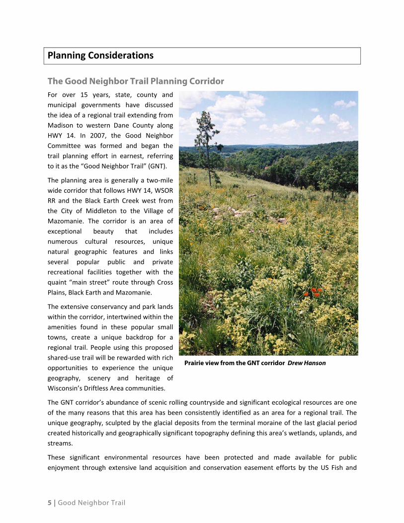
Planning Considerations
The Good Neighbor Trail Planning Corridor For over 15 years, state, county and
municipal governments have discussed
the idea of a regional trail extending from
Madison to western Dane County along
HWY 14. In 2007, the Good Neighbor
Committee was formed and began the
trail planning effort in earnest, referring
to it as the “Good Neighbor Trail” (GNT).
The planning area is generally a two‐mile
wide corridor that follows HWY 14, WSOR
RR and the Black Earth Creek west from
the City of Middleton to the Village of
Mazomanie. The corridor is an area of
exceptional beauty that includes
numerous cultural resources, unique
natural geographic features and links
several popular public and private
recreational facilities together with the
quaint “main street” route through Cross
Plains, Black Earth and Mazomanie.
The extensive conservancy and park lands
within the corridor, intertwined within the
amenities found in these popular small
towns, create a unique backdrop for a
regional trail. People using this proposed
shared‐use trail will be rewarded with rich
opportunities to experience the unique
geography, scenery and heritage of
Wisconsin’s Driftless Area communities.
The GNT corridor’s abundance of scenic rolling countryside and significant ecological resources are one
of the many reasons that this area has been consistently identified as an area for a regional trail. The
unique geography, sculpted by the glacial deposits from the terminal moraine of the last glacial period
created historically and geographically significant topography defining this area’s wetlands, uplands, and
streams.
These significant environmental resources have been protected and made available for public
enjoyment through extensive land acquisition and conservation easement efforts by the US Fish and
Prairie view from the GNT corridor Drew Hanson

6 | Good Neighbor Trail
Wildlife Service, United States Department of Agriculture (USDA) Natural Resources Conservation
Service, Dane County, the National Park Service, Wisconsin Department of Natural Resources (DNR) and
other public and private organizations. Within the planning corridor, there are an estimated 3,619 acres
of public and private recreational and conservancy lands.
The regional shared‐use trail in this corridor is an innovative way to connect communities with these
public lands and with each other. Developing this trail as part of a regional recreation/transportation/
greenway corridor opens doors to more diverse funding resources that can support and enhance the
preservation of the unique environmental resources, expand educational opportunities, improve
transportation efficiency, and create interesting and enjoyable recreational opportunities.
Historical/Cultural Context
The Driftless Area
The Good Neighbor Trail Corridor is located within a geographical feature known as the Driftless Area.
Encompassing more than 24,000 square miles in the states of Wisconsin, Minnesota, Iowa and Illinois,
the Driftless Area is one of America’s unique natural resource treasures. This area was bypassed by the
last continental glacier, which flattened much of the landscape in the upper Midwest and left behind
large deposits of soil and rock—referred to as drift. During the last glacial epoch, this area was “an island
of land rising from a sheet of continental ice.” (Lesson Jerusalem Creek: Journeys into Driftless Country).
The landscape in the Driftless Area is estimated to be approximately 500 million years old—one tenth of
the age of the Earth— and is marked by steep‐sided ridges, caves and towering limestone and sandstone
bluffs. The region also contains sinkholes and over 600 spring creeks with more than 3,600 stream miles
in six major watersheds. These streams, which eventually drain into the Mississippi River, are fed by
deep limestone aquifers.
The Driftless Area is rich in natural and human history. In the era of pre‐European settlement, the
majority of the region was characterized by tall‐grass prairies and oak savannahs, which supported a
wide range of prairie dwelling animals including elk and bison. Extremely high rates of groundwater
discharge kept streams flowing through narrow deep channels with cold pure water supporting a
thriving, naturally reproducing population of brook trout. Extensive root systems of the tall‐grass
prairies lined most stream banks and virtually eliminated bank erosion.
The first non‐native populations began to arrive in the early 1800’s attracted by the regions abundant
natural resources and productive agricultural opportunities. By the mid 1800’s there three settlements
along Black Earth Creek (Cross Plains, Black Earth and Mazomanie); each had a vibrant and prosperous
economy supported by agricultural production from surrounding farmland.
According to the State Historical Society, there are 25 archaeological and cultural sites located in the
Black Earth Creek Resource Area. Within the villages and towns that encompass the GNT Trail planning
corridor there are over 30 sites and buildings that are listed on the State’s register of historic places.
7 | Good Neighbor Trail
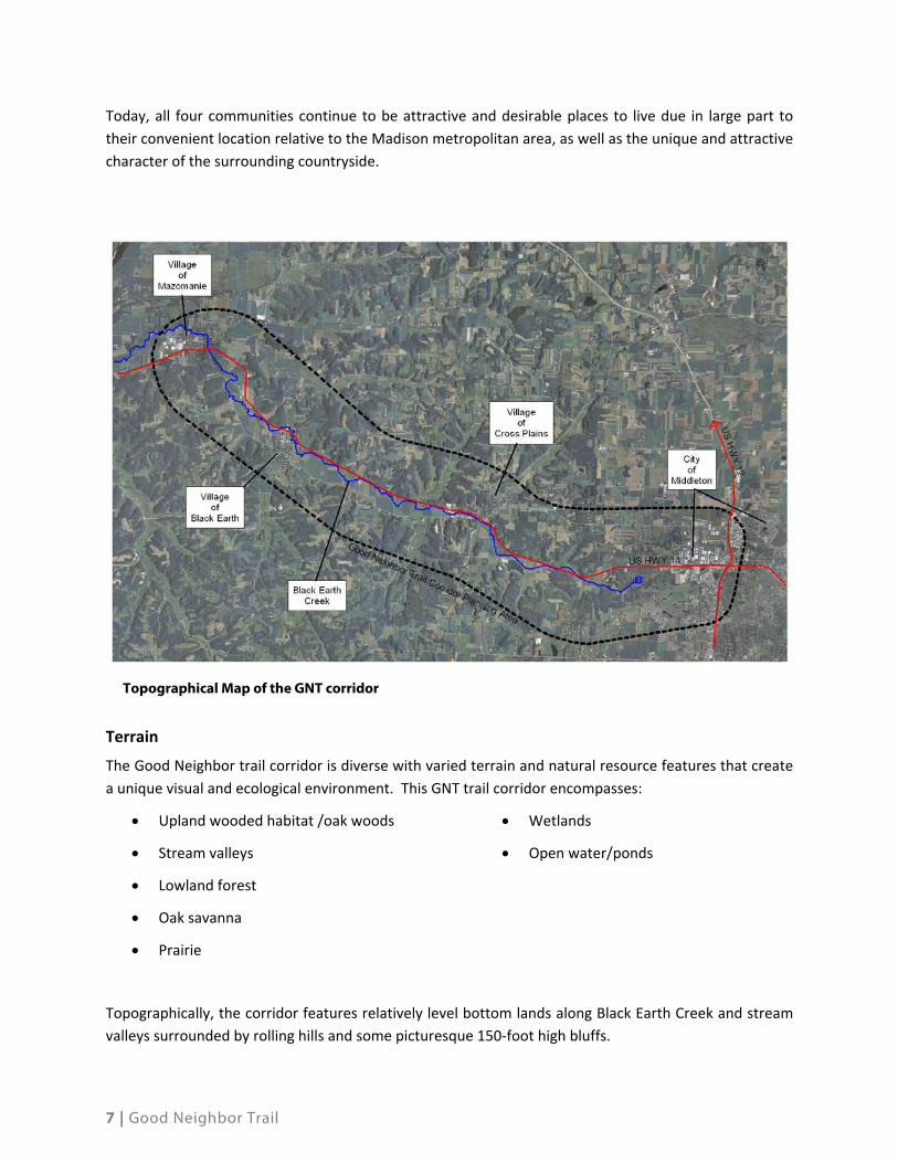
Today, all four communities continue to be attractive and desirable places to live due in large part to
their convenient location relative to the Madison metropolitan area, as well as the unique and attractive
character of the surrounding countryside.
Terrain
The Good Neighbor trail corridor is diverse with varied terrain and natural resource features that create
a unique visual and ecological environment. This GNT trail corridor encompasses:
Upland wooded habitat /oak woods
Stream valleys
Lowland forest
Oak savanna
Prairie
Wetlands
Open water/ponds
Topographically, the corridor features relatively level bottom lands along Black Earth Creek and stream
valleys surrounded by rolling hills and some picturesque 150‐foot high bluffs.
Topographical Map of the GNT corridor

8 | Good Neighbor Trail
Land Cover
Outside of the developed neighborhoods in the communities of Middleton, Cross Plains, Black Earth and
Mazomanie, agricultural production and continue to dominate the land uses within this region today.
Much of the lands along the Black Earth creek are classified as Prime Farm Soils and Soils of Statewide
Importance and continue to be productive farmland.
Wetlands
According to the Wisconsin DOT’s HWY 14 Corridor Study, the generalized, non‐urban area along the
highway corridor “has been historically used for agriculture resulting in a reduction or degradation of
many of the once‐extensive wetland areas”. Currently there are over 450 acres of mapped wetlands
and over 1000 acres of hydric soils within the planning corridor.
Streams and Ponds
The predominant natural feature in the trail Corridor is
Black Earth Creek, a nationally recognized trout stream
(rated in the top 10 in America). Black Earth Creek flows
westerly to the Wisconsin River at Spring Green.
The value of Black Earth Creek to the region extends
beyond its importance as an ecological resource and is a
key factor to the economy of the region. The annual
economic impact from fishing was tallied at $647 million
in 2006. The headwater wetlands of the Black Earth Creek
and all of the reaches of the stream that are designated
as cold water fishery are within the trail corridor. In 2010,
the Dane County Parks Department sold over 4000 lake
access permits indicating the strength of the economic impact of accommodating fishing as a
recreational use. According the Wisconsin Department of Natural Resources:
Wisconsin has 1.4 million anglers that annually catch 88 million fish and keep 33 million fish of
all kinds, releasing the rest to challenge anglers another day. Those kinds of numbers, combined
with great scenery, and record fish ‐ such as the world record brown trout caught in Lake
Michigan in 2010 ‐ makes Wisconsin the #2 most popular fishing destination in the U.S.
Fishing isn’t only big adventure here, it’s big business ‐ generating $2.75 billion dollars in
economic benefits and supporting more than 30,000 jobs. It has been and will continue to be an
important part of Wisconsin's nature‐based economy.
Various programs have been developed to ensure that the creek and its tributaries are protected from
degradation including: the formation of BECWA (Black Earth Creek Watershed Association), the
purchase of parcels adjacent to the creek by DNR and US Fish and Wildlife Service and the development
of strict stormwater regulations regarding construction and development of facilities within the Black
Earth Creek watershed.
Birding opportunites abound in the corridor

9 | Good Neighbor Trail
The Pheasant Branch Creek is located in the eastern end of the GNT trail corridor. The Pheasant Branch
Creek flows east into Lake Mendota and the Yahara River Watershed. A major portion of the headwaters
drainage basin and wetlands of Pheasant Branch Creek and its main tributaries are protected by the City
of Middleton’s Pheasant Branch Creek Conservancy (PBC). The Pheasant Branch Creek wetland complex
has been designated as a “Workhorse Wetland” by the Wisconsin Wetland Association. A 1998
functional assessment of wetlands at this site found that they have groundwater connections of high
significance. Two large sets of springs discharge into Pheasant Branch wetlands – each day more than
2.6 million gallons of clear groundwater flow from these springs. Significant volumes of groundwater
seep into other marshy areas of the site as well. These wetlands in turn contribute to flow in Pheasant
Branch Creek and ultimately feed Lake Mendota. Because of the clear quality of this water, northern
pike and other Lake Mendota fish species once used the lower channel and marches for spawning.
Dane County Conservation League awarded Penni Klein, Public Lands Manager for the City of Middleton,
Conservationist of the Year for her wetland and fisheries stewardship work in Pheasant Branch
Conservancy during the shared use trail development process (2005).
The Pheasant Branch Conservancy area is managed as a public conservancy area and has an extensive
network of porous paved and natural surface trails. The PBC attracts nearly 99,000 visitors per year to
its shared use trail with no negative impacts to its extensive bio‐diversity.
The landscapes in the PBC are, in many ways,
similar to the Black Earth Creek and GNT corridor.
The shared use trail and habitat management
techniques used in the PBC area are models for
formulating improvements and management of the
Good Neighbor Trail. The 4.2 mile Pheasant Branch
Conservancy shared use trail received national
recognition in 2004 for its design and layout,
highlighting how shared use trails can be developed
in cooperation with habitat restoration work and
fisheries enhancement. Additionally, the 1.25 mile
porous paved DOT trail along the Pheasant Branch
Creek was national recognized for innovative
green/sustainable design at the 2010 American
Trails Conference in Chattanooga, TN.
Other Waterways and Ponds
The GNT planning corridor includes segments of Halfway Prairie Creek, Brewery Creek, Garfoot Creek
and Swamplovers wetland areas. It also includes natural kettle ponds, such as Shovelers Sink, Esser’s
Pond, and Stricker’s Pond. In addition, the corridor has several impoundments, including Salmo Pond
and Lake Marion, which are popular recreation sites.
Sandhill cranes in the Pheasant Branch Conservancy

10 | Good Neighbor Trail
Native Habitats and Endangered or Threatened Species
The Good Neighbor Trail planning corridor’s glacial terrain and diverse ecological resources create a
unique environment with varied topography and ecosystems. The trail corridor encompasses oak
woods, oak savanna, prairie, stream valleys and lowlands with wetlands and open water and ponds.
The GNT trail corridor possesses a few scattered remnant native prairies and oak savannas habitats with
rare and endangered plant and animal species in natural communities. The most common remnant
prairies within the Black Earth Creek watershed are the “goat prairies” on the steep sided hills in the
Black Earth Creek valley. The steep hillsides, characterized by red cedar and junipers in the understory of
prairie grass, were too difficult for cultivation or grazing.
Table 1. Public Park and Conservancy Lands and Existing Trails Within and Near the Good Neighbor
Trail Planning Corridor
Jurisdiction Parks Conservancies
Names Acres Names AcresIce Age Park and Trail Foundation, NPS Ice Age Trail 705*
Wisconsin DNR Ice Age Trail 705* Black Earth Creek Fishery Area 244*
US Fish and Wildlife
Black Earth Creek Fishery Area 244*
Shovelers Sink 171
Dane County Festge Park, Walking Iron Park, Salmo Pond, Old Lake Middleton 576
Black Earth Creek Fishery Area 244*
Black Earth Creek Wildlife Area - Sunnyside 292
City of Middleton
Pleasant View Golf Course, Esser Pond, Quisling Park North and South, Firefighters Memorial Park 399
Pheasant Branch Creek Conservancy (part, including confluence pond and North Fork) 200
Village of Cross Plains All Parks 25 All Conservancies 81
Village of Black Earth All Parks 15 All Conservancies 16
Village of Mazomanie All Parks 108 All Conservancies 2
Town of Middleton Pioneer, Hickory Woods, Settlers Prairie, Summit Ridge 76
Tallard Conservancy, Goth Park, Pope Farm, Hickory Woods 167
Total Governmental Lands 1199 1173
Swamp Lovers Table Bluff Wetland 432
Wolf Run Association Wolf Run Conservancy 95
The Prairie Enthusiasts Inc Rettenmund Prairie 15
Total NGO Lands 0 542
Total Park and Conservancy Lands Within and Near the Good Neighbor Trail Planning Corridor 3619
* Land within multiple jurisdictions

11 | Good Neighbor Trail
Outdoor Recreation and Conservancy Areas within the GNT Trail Corridor
Within Dane County, there is strong community support for public outdoor recreation and to protect
and enhance their ecological function. There is a strong legacy of conservation and preservation of these
unique habitats in this area.
All five communities in the corridor unanimously supported the GNT (see Memorandum of
Understanding [MOU]’s in appendix and Dane County Resolution) and wish to continue that
preservation, enhancement and accessibility of outdoor recreation through the GNT.
Black Earth Creek Natural Resource Area (BECNRA)
The Black Earth Creek Wildlife Area was acquired through joint funding from the Natural Heritage Land
Trust, the Wisconsin DNR Stewardship Fund, Dane County, and the Town of Middleton. This land has
been identified for passive recreation and natural resource protection. Some of the lands along the
creek are owned by the Wisconsin DNR as public fishing and wildlife habitat areas. Future land
acquisitions should seek to fill in the gaps between existing publicly‐owned lands and protect the scenic
quality of the stream corridor.
Festge Park (Dane County) is located in the Driftless Area of Dane County, near the Town of Berry and
features an overlook 100 feet above Black Earth Creek. The park contains 126 acres feature hiking trails,
shelters, restrooms, recreation fields, and family picnic spot all secluded within mature forested area. An
overlook provides panoramic view of the Black Earth Creek valleys.
Salmo Pond is adjacent to Festge Park, south of USH 14 and is owned by the Wisconsin DNR. Dane
County has a 99‐year management lease on the property that allows for operation and maintenance of
the property as a county park. The park offers users a shoreline and ADA pier for fishing. The area
features trails and places to picnic around the pond and along Black Earth Creek. A trail runs along a
narrow isthmus between Salmo Pond and Black Earth Creek.
Shoveler’s Sink Shoveler’s Sink is a small, permanent, remnant glacial depression that provides excellent
habitat for migratory birds such as waterfowl, shorebirds, songbirds, and water birds seeking a
freshwater pond, marsh, and grassland. The pond provides floating and submerged plants in the open
water zone and is surrounded by an emergent zone that includes cattails, smartweed, and arrowheads
whose tubers provide important food for migrating waterfowl and geese. Shoveler’s Sink is also an
important area for breeding amphibians, which in turn, makes it very attractive for water birds such as
herons and cranes. The area is currently a production area in the Leopold Wetland Management District
Waterfowl Production Area. Shoveler’s Sink is located off Mineral Point Rd and hosts a wide variety of
waterfowl, offering great birding opportunities.
Lake Marion Is a lake just outside Mazomanie, WI which offers fishing opportunities, kayaking and a
unique place to sail for model boat hobbyists.
Pleasant View Golf Course is a challenging 27‐hole course in Middleton, WI. Located south of HWY 14
on Pleasant View Road, the golf course amenities also include a 9 hole par‐3 course, driving range,
putting green, a new clubhouse, and cross country ski trails. The property features panoramic views of
Lake Mendota, the City of Madison, and the City of Middleton.

12 | Good Neighbor Trail
Blackhawk Ski Club is a membership club that provides facilities for alpine skiing, ski jumping,
snowboarding, cross country skiing, biathlon, Nordic combined, and mountain biking. The ski club
property is located in the Town of Middleton featuring 60 acres with five miles of mountain bike trails
and open space for cross country and downhill skiing.
Ice Age Trail Corridor – When completed this trail will
be thousand mile long footpath, entirely in Wisconsin,
that highlights the landscape of the Ice Age Era. The
Ice Age Trail is one of 11 National Scenic Trails and
allows individuals to walk, hike, snowshoe, and
backpack through a landscape varying from a family
friendly to a wilderness experience. Approximately 3
miles of the Ice Age Trail passes through the GNT
corridor and the Village of Cross Plains.
Table Bluff – Located just north of the Village of Cross
Plains, this 73 acre unit of the Ice Age Trail occupies a
high limestone ridge formed in the Paleozoic Era over
500‐million years ago. The trail to Table Bluff features
prairie, oak savanna, and forested areas as it ascends
100 feet to the summit. The bluff offers dramatic
views of the Driftless Area landscape, Black Earth
Creek and the Blue Mound (located in Blue Mound
State Park 10 miles to the southwest).
Black Earth Creek State Fishery – The Wisconsin DNR has 240 acres of land and public easements along
Black Earth Creek to provide public fishing and resource management of this class 1 trout stream. Class 1
trout streams are high quality trout waters that have sufficient natural reproduction to sustain
populations of wild trout, at or near carry capacity. Streams in this category do not require stocking of
hatchery trout. This BEC fishery is an important recreational resource area and is ranked 8th in the
country as a cold‐water fishing area.
Wolf Run Conservancy – Located immediately southeast of the Village of Mazomanie, this privately
managed conservancy is dedicated to the restoration of the natural habitat along Black Earth Creek. The
conservancy is also implementing stream improvement and trail development projects in collaboration
with the restoration of the adjoining Lake Marion impoundment by the Village of Mazomanie.
DNR Natural Heritage Inventory
The eastern point of the GNT begins in Middleton. Pheasant Branch Conservancy is a spring fed marsh
and wetland complex and surrounding hills, and numerous kettle ponds that dot the landscape were
created by glacial processes over 15,000 years ago. The glacial ice sheet carved the lakes, kettles formed
under ice blocks and the heavy clays deposited in glacial lakes perch water and create the extensive
spring fed wetlands adjacent Lake Mendota.
Hiking the Ice Age Trail
Table Bluff
13 | Good Neighbor Trail
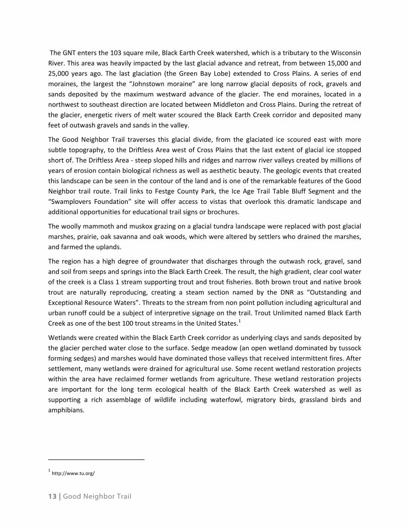
The GNT enters the 103 square mile, Black Earth Creek watershed, which is a tributary to the Wisconsin
River. This area was heavily impacted by the last glacial advance and retreat, from between 15,000 and
25,000 years ago. The last glaciation (the Green Bay Lobe) extended to Cross Plains. A series of end
moraines, the largest the “Johnstown moraine” are long narrow glacial deposits of rock, gravels and
sands deposited by the maximum westward advance of the glacier. The end moraines, located in a
northwest to southeast direction are located between Middleton and Cross Plains. During the retreat of
the glacier, energetic rivers of melt water scoured the Black Earth Creek corridor and deposited many
feet of outwash gravels and sands in the valley.
The Good Neighbor Trail traverses this glacial divide, from the glaciated ice scoured east with more
subtle topography, to the Driftless Area west of Cross Plains that the last extent of glacial ice stopped
short of. The Driftless Area ‐ steep sloped hills and ridges and narrow river valleys created by millions of
years of erosion contain biological richness as well as aesthetic beauty. The geologic events that created
this landscape can be seen in the contour of the land and is one of the remarkable features of the Good
Neighbor trail route. Trail links to Festge County Park, the Ice Age Trail Table Bluff Segment and the
“Swamplovers Foundation” site will offer access to vistas that overlook this dramatic landscape and
additional opportunities for educational trail signs or brochures.
The woolly mammoth and muskox grazing on a glacial tundra landscape were replaced with post glacial
marshes, prairie, oak savanna and oak woods, which were altered by settlers who drained the marshes,
and farmed the uplands.
The region has a high degree of groundwater that discharges through the outwash rock, gravel, sand
and soil from seeps and springs into the Black Earth Creek. The result, the high gradient, clear cool water
of the creek is a Class 1 stream supporting trout and trout fisheries. Both brown trout and native brook
trout are naturally reproducing, creating a steam section named by the DNR as “Outstanding and
Exceptional Resource Waters”. Threats to the stream from non point pollution including agricultural and
urban runoff could be a subject of interpretive signage on the trail. Trout Unlimited named Black Earth
Creek as one of the best 100 trout streams in the United States.1
Wetlands were created within the Black Earth Creek corridor as underlying clays and sands deposited by
the glacier perched water close to the surface. Sedge meadow (an open wetland dominated by tussock
forming sedges) and marshes would have dominated those valleys that received intermittent fires. After
settlement, many wetlands were drained for agricultural use. Some recent wetland restoration projects
within the area have reclaimed former wetlands from agriculture. These wetland restoration projects
are important for the long term ecological health of the Black Earth Creek watershed as well as
supporting a rich assemblage of wildlife including waterfowl, migratory birds, grassland birds and
amphibians.
1 http://www.tu.org/

14 | Good Neighbor Trail
Complementing the recreational potential of the
corridor, the GNT also creates educational
opportunities in this ecologically rich landscape.
Interpretive trail signage could be used to highlight
ecological and geological features on the route, as
well as highlight other adjacent trails and parks
(Pheasant Branch trail, Ice Age Trail, etc). A dynamic
story of glacial advance and retreat could be
explained and interpreted from the glacial landscapes
surrounding Middleton to the “driftless” ridges and
valleys from Cross Plains west. A story of ice and
water, and the resulting landscape as well as the
important ecological features of the present day
landscape could be dramatically demonstrated by the
route.
The Built Landscape
Population and Settlement Patterns
The first non‐native peoples began to arrive in the
area in the early 1800s attracted by the region’s
abundant natural resources and fertile farmland. By
the mid 1800s there were four settlements in the planning corridor: Middleton, Cross Plains, Black Earth
and Mazomanie. Each had a prosperous vibrant economy supported by agricultural production from the
surrounding farmland. Cross Plains, Black Earth and Mazomanie each had flour/grist mills and mill ponds
on Black Earth Creek. Also by the mid 1800 each community was linked by the rail road (connecting west
to Prairie du Chien and east to Madison, Janesville and Milwaukee) and an important roadway, now
designated as US Highway 14.
According to the State Historical Society, there are 25 archeological and cultural sites along Black Earth
Creek. Within the Village and Towns in the corridor there are over 30 sites and buildings listed on the
State’s register of Historic Places.
Today, all four communities continue to be attractive desirable places to live, due in large part to their
attractive character, the convenient access to the Madison Metropolitan area, and the unique and
appealing landscape of the surrounding countryside. The high quality of life enjoyed by residents in this
area is further evidenced by the City of Middleton’s acclaim as one of the best places to live in America
in 2007.
The 2010 population of the towns and communities along the planning corridor totaled 34,054 which
represented approximately 7% of Dane County’s populace.
As noted, historically settlement concentrated in the four villages because they were commercial
centers supporting surrounding farmlands. This development pattern was driven in large part by
Kiosk panel from the N. Fork Trail

15 | Good Neighbor Trail
geography, available resources, and railroad technology of the day. The resulting settlement pattern not
only created the quiet village places that attract today’s residents and visitors but also preserved many
areas of unique and sensitive habitat and productive farmland. For the most part, local land use policy
has been successful in maintaining this landscape west of the City of Middleton.
Individually, each of the four communities has been able to maintain a strong sense of place with a
“downtown” business core, civic areas, neighborhood parks, and schools. Though each community has
been able to sustain a limited local business economy, the vast majority of employment and consumer
retail businesses are located in Middleton and Madison. Middleton imports more jobs than Madison and
has a thriving technical business area, and will soon house a major medical facility.
Transportation System
The predominant vehicle travel pattern in the trail corridor follows the east/west orientation of US Hwy
14 created by the geography of Black Earth Creek. The key transportation infrastructure in the corridor
includes:
US Highway 14 which carried and average of 19,000 vehicles per day in 2010
The Wisconsin Southern Railroad
From Cross Plains to Mazomanie, County Highway KP is the secondary east west travel route next to US
Hwy 14.
The geography of the corridor, the BEC, and the Railroad have also limited the opportunities for
north/south pedestrian and vehicle circulation. Key north south roads include:
Twin Valley Road
Timer Lane/Cleveland Road
CTH P
CTH KP
Scherbel Road
South Valley Road
Washington Department of Transportation (WisDOT) 2011 highway improvement planning studies have
focused on resurfacing Highway 14. In the Village of Cross Plains this highway improvement will be
coordinated with reconstructing the County Highway P bridge to accommodate wider travel lanes and
pedestrian and bike travel.
As part of US Highway 14 access planning, preliminary concept plans were prepared to improve the
Rocky Dell Road‐ Cleveland Road intersection. A component of this improvement was the construction
of a new road segment linking Cleveland Road and Stagecoach Road, which would greatly improve
opportunity for east/west travel.
16 | Good Neighbor Trail
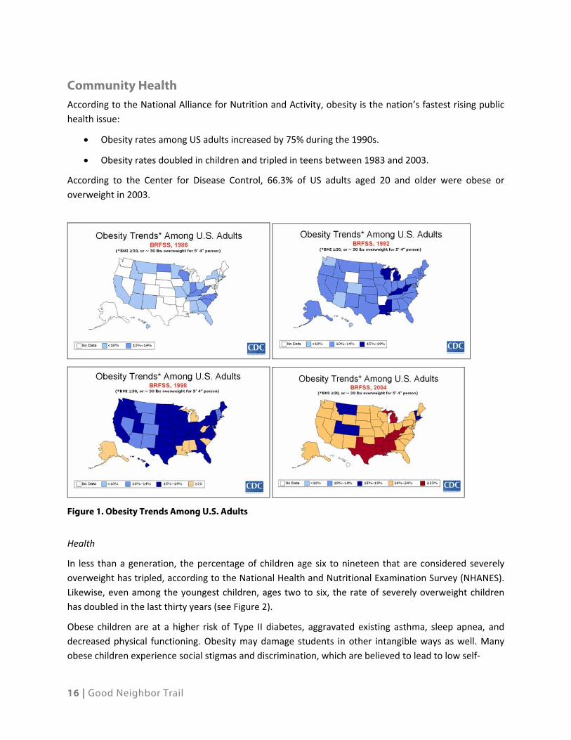
Community Health According to the National Alliance for Nutrition and Activity, obesity is the nation’s fastest rising public
health issue:
Obesity rates among US adults increased by 75% during the 1990s.
Obesity rates doubled in children and tripled in teens between 1983 and 2003.
According to the Center for Disease Control, 66.3% of US adults aged 20 and older were obese or
overweight in 2003.
Figure 1. Obesity Trends Among U.S. Adults
Health
In less than a generation, the percentage of children age six to nineteen that are considered severely
overweight has tripled, according to the National Health and Nutritional Examination Survey (NHANES).
Likewise, even among the youngest children, ages two to six, the rate of severely overweight children
has doubled in the last thirty years (see Figure 2).
Obese children are at a higher risk of Type II diabetes, aggravated existing asthma, sleep apnea, and
decreased physical functioning. Obesity may damage students in other intangible ways as well. Many
obese children experience social stigmas and discrimination, which are believed to lead to low self‐

17 | Good Neighbor Trail
Figure 2. Obesity prevalence among U.S. children and adolescents by Age and Time Frame, 1963-2004 (Source: Centers for Disease Control)
esteem and symptoms of depression. In addition, poor health and fitness impacts army recruits, and the
Army has noted “a downward trend in physical capability of our [new] soldiers,” attributed to obesity
and inactivity.
Contributing to the obesity epidemic, recent studies have demonstrated that most children are not
getting the exercise they need. Among 9 to 13 year‐olds, 61.5% do not engage in organized physical
activity during non‐school hours; 22.6% do not participate in any free‐time physical activity at all. These
statistics become even more dismal as children get older. As age increases, physical activity participation
drastically declines.
The US Department of Health and Human Services estimated that health related expenses resulting
from obesity exceeded $117 billion in 2000.
In order to reduce these trends and costs, it is essential for communities to Increase the number of
opportunities to participate in healthy and active lifestyles. There is convincing evidence that people are
more physically active if there are parks and trails to use near their homes or communities. The chart
below from the 2010 Outdoor Recreation Participation Report from the Outdoor Foundation illustrates
this point.

18 | Good Neighbor Trail
Figure 3. Participation Rate in Outdoor Recreation With and Without Nearby, Accessible Walking and Biking Routes All Americans, Ages 6 and Older
Economic Opportunities Recent research studies regarding the economic impact of trails and outdoor recreation opportunities
are validating what many people have intuitively believed – outdoor recreation has have a positive
impact on local businesses and the tax base. Some examples include:
The Wisconsin Bicycle Federation indicates that bicycling contributes $1.5 billion annually and
13,200 jobs to the Wisconsin economy.
Tourists from outside the state are estimated to spend $535 million annually on bicycling in
Wisconsin.
According to the Wisconsin Statewide Comprehensive Outdoor Recreation Plan, outdoor
recreation contributes over $9.7 billion annually to the Wisconsin economy by supporting
129,000 jobs and providing nearly 4% of the gross state product.
Fishing in the Driftless Area’s coldwater streams brings in $647 million each year.
Studies in Brown County, relating to the Fox River Trail and the Mountain Bay Trail, concluded
that: 1) residential real estate adjacent to the trail sold for an average of 9% more than similar
property that was not located next to the trail, and 2) 39% of responding businesses reported
increased business as a result of trail ridership.
A study commissioned by the National Fish and Wildlife Foundation in 2011 indicates that
homeowners near parks and protected areas are repeatedly seen to have property values that
are more than 20% higher than similar homes located elsewhere.
A study by the Outdoor Industry Foundation in 2006 determined that nationally, outdoor sports
(bicycling, camping, fishing, hunting, paddling, snow based, trail based, and wildlife viewing)

19 | Good Neighbor Trail
generated economic activity totaling nearly $821 billion a year. (Camping was the largest sector
at $306 billion, and bicycling and trail based sports were second and third, respectively, with a
combined impact of $243.3 billion).
There were 236,566 Snowmobile registrations in Wisconsin in 2010; this is the third highest
number of registrations in the nation.
Nationally, the economic impact of snowmobiling is estimated to be $2.2 billion.
Evidence in Dane County regarding economic impacts on
the local economy indicates that many dining and tavern
businesses depend upon local snowmobile trails for their
revenue. During summer months there are several biking
and equestrian events in Dane County that draw a large
number of participants who add revenue to the local
economy by spending money on lodging, food, fuel,
entertainment, and equipment. In several locations in
Wisconsin, local food and entertainment business have
installed corrals and hitching posts to accommodate
equestrians using nearby trails.
The presence of attractive, interesting, safe and convenient trail facilities and routes will generate more
trail use by residents and visitors who spend money during events or their weekend recreational rides.
Additionally, when shared use trails are conveniently located, people will be more likely to use them for
daily trips that they might normally have used their cars, thus reducing dependence on motor vehicles
and reducing local road congestion.
Transportation Opportunities
Commuter Travel
In 2009, Average Annual Daily Traffic (AADT) on US Hwy 14 ranged from 11,200 in Mazomanie to 16,700
in Middleton. Traffic is currently estimated at 14,000 vehicles per day and is projected to increase to
22,000 by 2020. US Hwy 14 has a capacity of 25,000 vehicles per day.
According to the Business Survey Report for US Hwy 14 Corridor Study “tourists and visitors accounted
for fewer than 15% of customers” indicating that most business based traffic was local traffic between
the communities of Madison and Mazomanie. Since rural areas and outlying communities lack public
transit, there are few options to access local businesses other than by driving. Seventy‐three percent of
the businesses in the planning area are either located on or within 1 block of US Hwy 14. Providing a
shared use trail for alternative transportation choices could help reduce local traffic issues and conserve
resources.
In 2010, Wisconsin DOT conducted a corridor study to formulate strategies and recommendations to
improve the function of the highway and extend the useful life of the existing HWY 14 infrastructure for
as long as possible. Providing multimodal transportation options (bike paths, park and ride lots, and
Snowmobilers in Dane County

20 | Good Neighbor Trail
equine, snowmobile and mass transit services) to relieve HWY 14 congestion is considered a viable
method to reduce the need for and/or postpone public expenditures for expanding highway capacity
with additional lanes and new alignments.
The east end of the GNT Corridor connects with the planned Western Inter‐modal Transportation Center
(WITC) – a new multi‐modal transportation hub (park and ride transit stop) at the intersection of Hwy
14, Hwy 12, and University Avenue. This location provides efficient, safe, and convenient transportation
options for the GNT as a commuter corridor for bikes/pedestrians serving western Dane County, the City
of Middleton, and the City of Madison.
Recent surveys within the metropolitan area have indicated a strong interest by employees working in
downtown Madison to commute by bike. Park and Ride lots strategically located along the GNT would
facilitate more bike commuting. The GNT Corridor could function as a primary route connecting
Middleton, the Villages of Cross Plains, Black Earth, and Mazomanie. There will be additional
opportunities for future intermodal facilities in each of these population and local business centers.
This trail corridor is vital to maintaining and growing the metropolitan area’s potential to create and
sustain employment opportunities and increased economic competitiveness.
Safe Routes to School
Safe Routes to School (SRTS) began as a European phenomenon thirty years ago and migrated through
Canada to New York City in 1997, spurred by high pedestrian crash rates. In the 1970s, Denmark had
Europe’s highest child pedestrian crash rate. Implementing the first Safe Routes to School program,
planners in Denmark identified specific road dangers leading to the country’s schools and took steps to
remedy these hazards. Today, the child pedestrian crash rate has dropped by 80% in Denmark since
1970.
Based on the initial success of U.S. pilot programs in New York, Marin and Florida, Safe Routes to School
became a nationwide effort in 2005, when Congress included a national SRTS program in the
reauthorization of Federal highway legislation. The 2005 passage of the Safe, Accountable, Flexible,
Efficient Transportation Equity Act: A Legacy for Users (SAFETEA‐LU) institutionalized Safe Routes to
School programs by allocating $612 million among the fifty states. These funds have been distributed to
states based on student enrollment, with no state receiving less than $1 million per year. SRTS funds can
be used for both infrastructure projects and non‐infrastructure activities.
In Wisconsin, this funding has amounted to almost $12 million for program years 2005 through 2009,
including projects in Middleton, Madison and Cross Plains.
National Trends
Safe Routes to School programming is gaining popularity across the country largely as a result of
national trends in health, safety, the environment, and land use.
According to the U.S. Centers for Disease Control and Prevention (CDC), in 1969, 42% of children 5 to 18
years of age walked or bicycled to school. By 2001, this dropped to 16%—two and a half times less than
the percentage of students who walked or biked to school in 1969.

21 | Good Neighbor Trail
Even when the distance to school remained constant, fewer kids were walking and biking to school. In
1969, 87% of children 5 to 18 years of age who lived within one mile of school walked or bicycled to
school. By 2001, only 63% of children who lived within one mile of school walked or bicycled to school.
42%
87%
49%
16%
63%
18%
0%10%20%30%40%50%60%70%80%90%
100%
Any Distance <1 Mile <2 Miles
Distance of Residence from School
1969
2001
Figure 4. Active transportation to school among youth 5 to 8 years of age (Source: Centers for Disease Control)
Experts recommend that children get at least 60 minutes of physical activity or movement on most,
preferably all, days of the week. Convincing or allowing students to walk or bicycle to school is one
method to increase physical activity among young people and help reverse the detrimental childhood
health trends of the last thirty years.
Safety
Americans are driving more than ever before. According to the National Household Transportation
Survey (NHTSA), over the past twenty years, the number of miles Americans travel on highways has
nearly doubled. This includes increased automobile trips to school. In fact, as part of the Marin County,
California SRTS pilot program, the county’s congestion management agency determined parents driving
their children to school accounted for 20‐25 percent of all morning rush‐hour traffic. Paradoxically, as
motor vehicle traffic increases, parents often become
more convinced that it is unsafe for their children to walk
or bike to school so more parents drive their children to
school, thereby increasing the amount of traffic
experienced and justifying their perception.
Additional safety concerns about walking or biking to
school were identified in a 2004 CDC nationwide survey.
The survey revealed the most commonly reported barrier
was distance to school (62%), followed by traffic‐related
concerns (30%), and weather (19%).

22 | Good Neighbor Trail
Air Quality
Children are particularly vulnerable to air pollution because they breathe faster than adults and inhale
more air per pound of body weight (up to 50% more). Exposure to fine particulates, from fossil fuel
combustion, is associated with increased frequency of childhood illnesses including asthma. Stand
outside almost any elementary school at arrival and dismissal times and you are likely to witness parents
and caregivers converging in their vehicles around the school and many parked with their engines
running, increasing the amount of fine particulates within the school zone.
The U.S. Environmental Protection Agency’s “Clean School Bus USA” program identified idling school
buses as contributing to air pollution outside and inside of schools. Automobile emissions can enter
school buildings through air intakes, doors, and open windows. Instructing bus drivers to shut off their
buses also saves money. A typical school bus engine burns approximately half a gallon of fuel per hour.
School districts that eliminate unnecessary idling can also save significant dollars in fuel costs each year,
but a greater benefit to reducing vehicle emissions in the school zone is increased school attendance.
Asthma is the most common chronic illness in children and the cause of most school absences. It is also
the third leading cause of hospitalization among children under the age of 15.
Land Use Patterns
Parents who drive their children to school are reacting, in part, to decades of auto‐oriented land use
planning that has neglected pedestrians, bicyclists and other users of alternative transportation modes
as users of the transportation system. In many areas, auto‐oriented development has hindered the
creation of walkable communities. These new developments lack sidewalks or bicycle facilities and may
be located too far away to make bicycling or walking practical.
Traditionally, schools were located in the center of communities, and this close proximity to residential
areas contributed to high rates of walking and bicycling to school. Beginning in the 1970s, rather than
renovating existing schools or building schools within existing residential communities, most new
schools were built on the edges of communities where the land costs were lower. School siting policies
may also dictate a certain acreage minimum that precludes many inner‐community locations. Peripheral
school siting means fewer kids live close enough to these facilities to make walking or biking to school
practical.
School consolidation that closes small centrally‐located schools in lieu of one newer and larger facility
has also meant that these small walkable schools are abandoned in neighborhoods where they were
ideally situated for walking and biking.
Learning and Behavior
SRTS plans can help improve students’ attention and behavior by increasing physical activity levels.
Studies have found a significant positive relationship between physical activity and cognitive functioning
in children. An examination of students who had the highest scores on standardized academic
achievement tests found that the students who had the highest average scores were physically fit at
both the start and the end of the study. Other studies have indicated that overweight and obese
students tend to struggle in school, which can be alleviated with regular exercise. Other negative
23 | Good Neighbor Trail
behaviors such as higher rates of school absences, detentions, violence and drug use are also more
closely associated with obese and overweight students.
This connection between physical activity and academic achievement may be both physical and
psychological. The physical basis of the connection is related to how exercise increases oxygen and the
amount of blood flowing to the brain, which has been shown to have “positive effects on concentration,
planning, abstract thinking, self control and verbal and mathematical competencies.” Psychologically,
physical activity is associated with mental health and good relationships. By providing the opportunity
to walk or bike to school, SRTS programs are able to increase the physical activity levels of students and
thereby offset some of the negative effects of inactivity on the learning environment.
Comprehensive Safe Routes to School programs are developed using five complementary strategies,
referred to as the “Five E’s”:
Engineering – Design, implementation and maintenance of signage, striping, and infrastructure
improvements designed to improve the safety of pedestrians, bicyclists, and motorists along
school commute routes.
Enforcement – Strategies to deter the unsafe behavior of drivers, bicyclists and pedestrians, and
encourage all road users to obey traffic laws and share the road. One example of this are the
Park Rangers employed by the town of Middleton.
Education – Educational programs that teach students bicycle, pedestrian, and traffic safety
skills, and teach drivers how to share the road safely. Examples include the DNR Horse
brochures, the GNT brochure, PBC trail maps and kiosks providing trail etiquette information.
Encouragement – Special events, clubs, contests, and ongoing activities that encourage more
walking, bicycling, or carpooling through fun activities and incentives. Local events include:
o Dairyland Driving Events
o GDHTA local horse trail rides
o WSHC – Midwest Horse Fair
o Madison Fishing Expo at the Alliant Energy Center
o Snowmobile events that benefit local charities
o City of Middleton “Big Event” and National Trails Day events
Evaluation – Evaluating the projects and programs is fundamental to assessing successes of
each of the “E’s” above and helps to determine which programs were most effective and helps
to identify ways to improve programs.
Good Neighbor Trail Planning Area
The Good Neighbor Trail corridor encompasses several local school districts with a combined enrollment
estimated to exceed 6,700 students. Within and near the GNT corridor are eight elementary schools,
three middle schools, two high schools, and one parochial K‐8 school.

24 | Good Neighbor Trail
While most of these schools are within urbanized areas with adequate sidewalks, the lack of pedestrian
and bike friendly routes from rural locations to these schools leaves little choice for school districts and
parents other than to provide door to door car or bus transportation.
While the Good Neighbor Trail cannot completely eliminate bus and vehicular traffic to school, a
dedicated paved off‐street 10’ paved bike path, along with a comprehensive shared use trail
system, can increase the viability of alternative transportation opportunities for students and
faculty.
An off‐street 12‐foot gravel shared use trail serving the Wisconsin Heights School campus would
appear to be a very effective alternate transportation route for snowmobilers, equine and other
uses.
Recreation Opportunities As evident from the discussions at the GNT meetings, the enthusiasm for this regional trail lies in its
opportunity to provide a shared use trail that addresses a broad spectrum of regional “route‐based”
outdoor recreational activities including: hiking, cross‐country skiing, running, snowmobiling, biking,
equestrian riding and driving.
Conceptually, the GNT could also provide route‐based outdoor recreation opportunities and resolve
limitations for ADA qualified individuals needing to use motorized and non‐motorized POVs for access to
various public recreation areas as well as schools. This bike/friendly route must be a 10‐foot minimum
paved facility for year round use and ADA accessibility.
The rural locale and variety of features within the Good Neighbor Trail corridor create opportunities to
address demands for underserved groups and provides a unique trail experience with linkages between
the four business districts in the corridor and accessibility to a wide range of outdoor recreation sites
and unique natural resource areas.
The following trail user groups and stakeholders have been
identified.
Horse Enthusiasts
Two categories of horse enthusiast groups have expressed
interest in the GNT planning efforts: saddle horse/trail
riders and drivers (carriages and carts). Each group has
distinct trail planning considerations that range from
trailhead improvements that can accommodate trailers to
specific trail design and surface requirements.
The 2008 Survey Research Center at the University of
Wisconsin ‐River Falls estimated that the number of
households in the state that own horses is currently
between 103,432 and 113,078 and that there are between Equestrian Trails are a popular amenity

25 | Good Neighbor Trail
299,341 and 351,208 horses in the state. The Wisconsin State Horse Council estimates that there are
roughly 20,500 to 26,695 households owning horses in southern Wisconsin.
The equine industry is a significant economic sector in the state. Total impact to the state, including
indirect and induced impacts, is estimated to be over $1.3 billion in sales; over 33,260 jobs; and over
$106 million in local, state, and federal tax revenues.
Fifty percent of the responding horse owners stated that lack of trails was an issue facing horse
ownership.
Despite their significant numbers and presence in Dane County, Horse Enthusiasts (trail riders and
pleasure drivers) have relatively few opportunities in western Dane County in terms of public trails or
facilities. Within or near the GNT planning corridor there are four public horse trail sites:
Walking Iron County Park, located in the Village of Mazomanie at the western end of the Good
Neighbor Trail Corridor, features 5.8 miles of natural surface equestrian trails and a grass
parking lot. There are no restrooms or water available and a trail permit is required.
The Town of Middleton’s Pope Farm Conservancy, near GNT Corridor on Old Sauk Road.
Donald Park located in the Town of Springdale, 11 miles south of the GNT corridor, has 6 miles
of equestrian trails.
Blackhawk Ridge, located 4 miles north of the GNT corridor on Hwy 78with over 10 miles of
equestrian trails.
The Good Neighbor Trail could provide additional permanent or seasonal linkages to these areas that
would be attractive to this user group and conveniently accessible. Wisconsin DNR State Trail design
standards recommend a minimum of 7 miles or more of equestrian trails to ensure an adequate user
experience.
Route planning and facility considerations include trail surfacing, parking, water and natural resource
protection, and appropriate design for shared use facilities such as bridges and road crossings.
There is a strong commitment to cooperation and self regulation by horse enthusiasts. They are
continuing to expand their working relationships with landowners and local communities to develop and
maintain equine trail locations.
The GNT is also an opportunity to:
Provide off street routes/alternative shared use trails to minimize motor vehicle vs. horse
conflicts
Facilitate equestrian travel to Wisconsin Heights High School – an alternate SRTS mode
Horse enthusiasts and equine related businesses in the area to expand their sport with public
outreach efforts and promotional events/activities.
Increase local economies and revenues from this new user group.

26 | Good Neighbor Trail
Snowmobilers
Snowmobiling is a high demand outdoor recreation sport for Wisconsin with almost 20% of the state’s
population (~773,000 people) participating. Dane County has a significantly large snowmobiling
population with an estimated 5,500 registered snowmobiles and 500 miles of snowmobile trails.
Two State Snowmobile Trails cross portions of the GNT planning corridor and there is an extensive
network of “Club” trails connecting the Village of Mazomanie to the City of Middleton. All of the
snowmobile trails within the GNT planning corridor are maintained by the CP Drifters Snowmobile Club.
Figure 5. Snowmobile Trails in the Corridor
Snowmobiling has become an alternative means of winter travel
for many people within the trail corridor. Many businesses lie
along snowmobile trails including gas stations, restaurants, and
bars. Some of these businesses rely almost entirely on profits
made during the winter snowmobile season.
Snowmobiling is also an accepted routine alternative mode of
transportation during winter months. Wisconsin Heights High
School, located between Mazomanie and Black Earth, has
sanctioned limited use of snowmobiles by students to commute
to school, thus reducing motor vehicle congestion on US Hwy 14. Snowmobiling and cross-county skiing can be accommodated on the same trail

27 | Good Neighbor Trail
There is a strong commitment to cooperation and self regulation in the snowmobile community with a
great deal of attention paid to respecting and maintaining good working relationships with landowners
and communities. Snowmobile clubs develop and maintain the trail network and also help to groom and
maintain local cross‐country ski trails.
Connectivity of trails to points of interest, businesses and service facilities is a primary consideration for
snowmobilers. The Dane County Council of Snowmobiles has invested significant efforts regarding the
planning and development of the Good Neighbor Trail, and is optimistic that a segment of this trail could
complete the much needed link from the Village Cross Plains to the City of Middleton businesses and
services needed.
Bicyclists
The League of American Bicyclists ranked Wisconsin
as #2 in the nation and #1 in the Midwest for
bicycling. The Madison Area was the fourth best
“Bicycling City in the United States.” Bicycling
provides significant economic, health,
transportation and enjoyment benefits to area
residents.
Bicycling is an iconic symbol of the recreational
community in Dane County. Cycling participation
(and participants) ranges from the occasional
weekend afternoon ride, to commuters, to
organized recreational events, to serious athletic
training rides and competitions. Western Dane
County, with its varied terrain, attractive
landscapes, well maintained roads, and
convenience to the Madison metropolitan area, is a
very heavily utilized bicycling venue and many
popular rides traverse the GNT corridor and use
community or county parks within the corridor as
starting and destination locations for organized
rides.
The 2012‐2017 Dane County Parks and Open Space
Plan notes an overall long term County‐wide vision
is to create a regional bicycle pedestrian trail system
that connects the majority of the major population
centers to the County park system and other
regional trails. Within the GNT corridor there are
five county parks – Old Lake Middleton, Sunnyseed
Farm, Festge Park, Salmo Pond and Walking Iron.
Running and biking in Pheasant Branch Conservancy
Shared use trail

28 | Good Neighbor Trail
In the “bigger picture,” there are discussions of a regional bike trail network linking the Mazomanie area
via Hwy 78 to Sauk City to with Devil’s Lake State Park. WisDOT is investigating a “Bicycle Interstate”
concept that would provide a combination of off and on‐road linkages between LaCrosse, Madison and
Milwaukee. The GNT could become a significant “off‐road” segment of this regional DOT network.
The GNT trail will provide a platform to:
Resolve user/community conflicts by finding common ground, supporting outreach and
educational efforts to cooperate on mutually acceptable routes.
Provide off street routes to reduce motorized vehicle traffic conflicts on US Hwy 14 and other
roadways.
Provide off street routes that are recreational in character. Provide off street routes for race
events, fundraising drives/rides, triathlon events, local races, fundraising walks/runs, national
trails events and sleigh rallies
Pedestrians
This user type includes everyone from dog walker and nature enthusiasts to parents with strollers. The
GNT will provide an opportunity for recreation and education walking experiences.
Roller Bladers, Roller Skiers
These user types desire flat, smoothed surface trails with
few crossings for the best experience. The Good Neighbor
Trail will provide such a facility.
Cross‐Country Skiers
There are significant public areas within the GNT Planning
with over 10 miles of cross country ski trails. The GNT
presents the opportunity to provide a ski trail route in and
of itself and become a main artery linking the extensive
trail facilities in Pleasant View Golf Course, Pope Farm
Conservancy, the future trails in the BECWA (Sunnyside Seed), Festge Park, Wolf Run Conservancy, and
Walking Iron County Park. This will create one of southern Wisconsin’s largest network of cross‐country
ski trails.
Additionally the GNT provides year‐round linkages between parks and outdoor recreation activities
beginning and ending at local businesses along the corridor.
The GNT will also provide a Safe Route to School for student/staff commuting to Wisconsin Heights High
School and for other employment locations in this area.
Reconciling inevitable conflicts between motorized and non‐motorized uses is an important planning
consideration for shared‐use aspect of the GNT. The exceptional outreach and cooperative efforts
Roller skiing is a popular summer activity in Wisconsin

29 | Good Neighbor Trail
between the local snowmobile clubs and ski trail users is an effective model for maintaining and using
shared facilities that have applications to all users of the GNT.
Fishing
Black Earth Creek is the key surface water resource in
the GNT planning corridor and is ranked as one of the
best trout streams in the United States. Black Earth
Creek is considered Class 1 trout water for the entire
length of the corridor.
A 2008 study on recreational angling in Driftless Area
(including portions of Wisconsin, Minnesota and Iowa)
prepared by Trout Unlimited, reported that men and
women of all ages and income levels fish various
Driftless area streams. Trout angling as a sport is
dominated by men over 40 years old who have college
degrees, and median household incomes of $60,000 to $80,000 (2006) – much higher than the US
median income of $48,200. The study reported that average spending by anglers in the Driftless area as
between $209 and $391 per outing. This is important since any activity which draws a substantial
number of high income people to regularly visit or reside in an area, contributes substantially to the
local economy.
The Good Neighbor Trail, with its design as a shared use path, will provide greater access to the stream
for anglers. The trail will also facilitate more efficient maintenance and stream restoration efforts
conducted by the Wisconsin DNR.
Natural Area and Cultural Resource Enthusiasts
Historic Societies
There are a number of historical societies located in the trail corridor communities.
Black Earth Historical Society ‐ In August 1992, The Black Earth Historical Society was organized.
Affiliated with the State Historical Society of Wisconsin, it has two charges: to preserve and to educate
the history and inhabitants of the Black Earth valley, respectively. Since its inception, and with the help
of local government, businesses, and citizens, this Society has restored and refurbished the Black Earth
Depot into a local museum.
Cross Plains – Berry Historical Society ‐ The Cross Plains‐Berry Historical Museum is housed in the St.
Martin’s EV. Lutheran Church, built in 1886.
Mazomanie Historical Society ‐ The Mazomanie Historical Society was organized in 1966 and currently
has over 100 members. It operates a museum, a research center, and a document and artifact storage
annex. The purpose of the Mazomanie Historical Society is exclusively educational and was organized to
Accessible fishing pier

30 | Good Neighbor Trail
preserve, advance, and disseminate the knowledge of the history of the Village of Mazomanie and the
surrounding area.
Middleton Area Historical Society - It was established in 1972. With the hope of providing a real and
lasting contribution to the Middleton community, the following objectives were created:
1. To collect and preserve artifacts reflective of the daily lives of our pioneers in the home, on
the farm and in places of business.
2. To record the story of the lives and struggles of the unsung members of our early days, who
changed a wilderness into a forward‐looking, energetic, productive and beautiful
community that we enjoy today.
3. To honor the foresight, sacrifices, and the services of the many who have gone before, while
still serving the living of today and tomorrow.
4. To bring about the realization of the dream of having a local historical museum building of
our own.
All Terrain Vehicles (ATV’s)
There are no organized ATV ridership groups in Dane County, nor are there any trail facilities for ATV’s in
the area. In Northern Wisconsin, recreational ATV trails occupy the same or similar routes as
snowmobiles/equestrians with consideration and respect for agricultural lands agreements.
One of the issues identified earlier in the GNT Trail process related to potential conflicts between
different user groups. Sometimes, the use and enjoyment of different trail type users can be conflicting.
Non‐motorized trail users seeking quiet, solitude or wildlife viewing experiences can have a difficult time
meeting these goals in areas where motorized use is prevalent. Some examples of user conflicts
between motorized and non‐motorized trail users included hikers, horses, bikers and runners vs. ATV
use in the summer and skiers and hikers vs. snowmobiles in the winter. Similarly, safety issues can arise
when non‐motorized and/or motorized users meet on trails where visibility is limited. A sustainable
trails system will address methods to deal with user conflicts including education, enforcement and
design standards.
While most motorized trail users act in a responsible, thoughtful manner, it takes just a few users or
overuse of a specific area to cause damage to the natural environment, particularly in stream corridors,
wetlands, or other wet areas, those where the topsoil is relatively thin and where steep grades may
exacerbate the potential for erosion. Proper trail design and use, and ongoing management of trails are
needed to reduce negative impacts now and in the future.
Current and Future Trail Maintenance and Stewardship
ATV users note that they often assist in maintaining and improving ATV trails, although the majority of
these efforts appear to be conducted primarily by individuals. They also note that many ATV users use
trails in a responsible and courteous manner, recognizing that the bad behavior of a smaller number of
individuals can result in environmental damage and user conflicts. In coordination with other user
groups, ATV users can participate in more organized trail maintenance and improvement efforts. ATV
users should be encouraged to distribute information about proper stewardship of trails and

31 | Good Neighbor Trail
surrounding areas. Such information could be distributed by ATV dealers, guides who use ATVs to access
fishing and hunting areas and lodges, any organized ATV user groups and others. It should also be noted
that most ATV users are also members of the other trail user groups – such as equestrians,
snowmobilers and pedestrians.
Strategies to Address ATV Use Issues
A variety of strategies related to trail access, management, use, improvement and education include:
Continue to update trail maps as information about the location and condition of publicly
accessible trails is provided, highlighting information about land ownership associated with trails
and surrounding areas and any restrictions for specific types of trail users.
Provide information about permitting processes and use restrictions by providing Web site links
or contact information for local, state and federal agencies and others.
Continue to work with partnering agencies and groups to prepare and provide educational
materials related to trail access, private property owner rights and responsible stewardship of
trails and surrounding areas.
Develop a set of procedures for managing or permitting trail access or use on the Good
Neighbor Trail.

32 | Good Neighbor Trail
This page intentionally left blank.

33
Related State, Regional and Local Planning Efforts
The concept of a regional trail through the northwesterly part of Dane County has been “on the books”
of various local, county, state and federal plans for over 20 years.
State of Wisconsin The Wisconsin Department of Natural Resources (DNR) has also identified a proposed regional trail
connecting Madison with western Dane County as part of the 2001 Wisconsin State Trails Network Plan
(WSTNP). The proposed Good Neighbor Trail (GNT)would be a part of “Trail Network Segment 22 ‐
Prairie du Chien to Madison” shown in the WSTNP potential network for South Central Region.
“Segment 22” would be a major east‐west route along the Wisconsin River corridor that creates a long‐
distance trail linking the Madison/Middleton metropolitan area with the Mississippi River Valley corridor
– Cross Plains, Black Earth, Mazomanie, and Spring Green.
Dane County The 2006 ‐2011 Dane County Park & Open Space Plan (POSP) lists “Develop[ing] a County‐wide regional
bicycle‐pedestrian system that connects communities and large population centers with other public
parks and regional trail systems” as a top priority. The plan suggests development of a regional trail
linking the communities of Mazomanie (from Walking Iron County Park) to the City of Middleton. Dane
County proposes this trail to be roughly located along HWY 14/Black Earth Creek with north‐south
linkages connecting Town, Village and County parks along the way.
The current version of the Dane County POSP ‐ Draft 2012‐2017 Parks and Open Space Plan includes
these regional trail initiatives as well. The following italicized text is directly excerpted from the Draft
Plan.
Trails are perhaps the most frequently used recreation facility in the park system. Development of
additional trails is also consistent with providing future recreation opportunities for the forecasted aging
population of Dane County. This plan will make County‐wide recommendations for regionally significant
hiking, water, bicycle‐pedestrian, equestrian and snowmobile trails. Recommendations of the 2010
BikeDane initiative are also included in this plan.
BICYCLE PEDESTRIAN FACILITIES
Strong public support was again evident throughout the planning process for development of bicycle
pedestrian trails that are identified in the plan.
Since 2001, Dane County has included the concept of an off road trail between the City of Middleton and
Village of Mazomanie. In 2007, local unit of government elected officials and interested parties formed
the Good Neighbor Committee (GNC) to promote intergovernmental cooperation on matters of mutual
interest through communication and information sharing along the corridor. A GNC Trail Subcommittee
formed out of the GNC as a forum for the discussion and decision making process for the development of

34 | Good Neighbor Trail
a regional multi‐use trail to connect the City of Middleton to the Village of Mazomanie. Dane County will
continue to explore planning, funding and development partnerships with this organization.
The overall long term Countywide vision is for a regional bicycle pedestrian trail system that connects the
majority of the major population centers to County park facilities and other regional trails.
Recommendations:
The County’s role is to develop off road regional trails within project areas identified in the Parks
and Open Space Plan. Regional trails that extend outside of these project areas would be
developed by the local unit of government. In some circumstances, the County may consider
partnering with local units of government to utilize its own staff and equipment to develop off
road regional trails identified in this plan by formal agreement.
For regional trails identified in this plan that extend outside of County project area boundaries
and are funded or developed with assistance by Dane County Parks, the County may have the
option to eventually transfer ownership to the State or charge user fees to offset maintenance
costs. These trails would also be identified by signage as County trails with other partner logos as
apply.
For regional trails identified in this plan that extend outside of County project area boundaries,
the County’s primary role is to provide eligibility to apply for Conservation Fund grant dollars for
local units of government to acquire lands necessary for trail construction.
Some of the regional bicycle pedestrian trails identified on this plan may be on road bike routes
or bike lanes. These would be implemented by the local unit of government and possibly
coordinated with the Dane County Highway Department. The intent of including them in this
plan is for grant eligibility purposes only.
Investigate feasibility of implementing a seamless, shared Countywide bike trail pass via an
advisory panel consisting of local units of government, the Bike Federation, Capital Off Road
Pathfinders, Wisconsin DNR and the Greater Madison Bicycling Advocacy Committee.
Investigate creation of bicycle advocate Friends groups to assist with operation and maintenance
of trails.
Continue and expand on BikeDane initiatives.
Continue working with the Bike Federation, rural townships, Dane County Highway and Sheriff,
and bicycle clubs to improve coordination of bicycle events that effect County highways or parks.
Coordinate semi annual meetings with Dane County Highway.
EQUESTRIAN TRAILS
Dane County Parks has been working with equestrian riders to develop an “outside the park” regional
trail system. These trails are made possible by volunteers securing formal access agreements to construct
equestrian trails on lands adjacent to and beyond County park lands. Donald County Park has recently
developed such a trail and additional loops have been added. The equestrian community hopes to further

35 | Good Neighbor Trail
this concept from other public riding areas in the County with the
eventual goal of forming a continuous loop through rural areas
around the entire metropolitan area.
Recommendations:
It is envisioned that Dane County equestrian clubs would
form a committee that would carry out landowner
negotiations, development and maintenance of this
regional trail system.
SNOWMOBILE TRAILS
Dane County has a long snowmobiling history. Several of the
oldest snowmobile clubs within the State originate from the County. Dane County Parks manages over
350 miles of State funded snowmobile trails and assists with the coordination of another 150 miles of
club trails. The Parks Director is the Snowmobile Trail Coordinator for the program and works closely
with the Dane County Council of Snowmobile Clubs. Administration of the funded trails is handled
through the parks office; staff inspects the funded seasonal trails once a year for proper signing, layout
and safety issues.
Dane County has been one of the fastest growing counties for the last 20 years. As the County's urban
centers continue to expand, the snowmobile trail system has had to move into increasingly narrower
corridors. Snowmobiling is an important winter recreation activity for residents and provides an
economic benefit for both Dane County and the State of Wisconsin. To maintain the integrity of the trail
system, more needs to be done to protect and preserve lands where these seasonal trails (and other
trails) can be maintained for future generations of users. A comprehensive study of the present
snowmobile trail system in Dane County should be done in conjunction with the Dane County
Snowmobile Council. This study should identify snowmobile trail needs for the future and designate
permanent trail corridor goals.
Recommendations:
Utilize summer intern, university students or volunteer help to complete a comprehensive study
of the existing and future snowmobile trail system.
The Dane County Board of Supervisors expressed their strongly support of the concept of the Good
Neighbor Trail with the adoption of Resolution 72, 08‐09 on September 18, 2008.
Local Trail Municipalities
Five of the eight communities in the Good Neighbor Trail corridor have approved and signed a
Memorandum of Understanding for GNT. Many of the Good Neighbor communities have adopted
Comprehensive and Park planning goals and policies which support GNT development. All of the eight
communities recognize contributions that trails have on the “quality of life” characteristics and
economic development opportunities.
Equestrian trails provide nature based opportunities for riding

36 | Good Neighbor Trail
Each of the eight communities in the GNT corridor has adopted comprehensive plans and development
policies which strongly support trail development and trail interconnection between communities.
Mazomanie, Cross Plains and the City of Middleton are currently implementing projects. Excerpts from
the comprehensive plans are included in the appendix.

37
Trail Design Considerations
Shared Use Trails
Need/Intent
The shared‐use dual purpose is the main component of the Good Neighbor Trail Plan and serves as both
an extension of the surrounding communities’ alternative transportation network and as a outdoor
recreation trail. As such, this trail type will provide the framework for connecting communities, schools,
parks, downtowns, civic facilities, and workplaces for all levels of users. The Good Neighbor Trail (GNT)
shall be in line with American Association of State Highway and Transportation Officials (AASHTO),
Americans with Disabilities Act (ADA), Manual on Uniform Traffic Control Devices (MUTCD) and City of
Middleton Conservancy Lands Committee (CLC) trail standards.
Design Guidelines
The following specifications are for a dual purpose shared use trail.
Materials: Unless otherwise specified, surface shall be comprised of porous asphalt and should
be structurally suitable for emergency vehicles. The surface should be smooth and free of tread
obstacles. Typical construction should include a 3‐inch porous asphalt surface over an 4‐6 inch
minimum compacted aggregate base.
Width: Trail width shall be 10 feet minimum. In cases of limited right‐of‐way, an 8‐foot wide trail
may be used if properly marked and signed according to the standards identified in this manual.
Aggregate base shall extend 12 inches beyond the edge of asphalt on both sides of the trail in
order to reduce edge deterioration.
Clear Zone: A clear zone should occur on both sides of the shared‐use path at a minimum of 1‐2
feet wide. Area should be graded at a maximum slope of 3:1. Additionally, a minimum 1‐foot
buffer zone between the edge of the graded clear zone and any fixed objects such as signs, mile
markers, lighting, or plantings should occur. On bridges this guideline does not apply.
Vertical Clearance: Clear height zone should be a minimum of 17 feet.
Drainage: For drainage, slope should not exceed a uniform cross slope of 2%. Where a shared‐
use path is benched into a slope, a swale on the uphill side should be considered to catch water
before it crosses the shared‐use path. Culverts may be necessary to move water under the
shared‐use path. Disturbed areas should be seeded with native species and mulched to prevent
erosion.
Design Criteria: Shared‐use path shall comply with all AASHTO requirements for design speed,
surface type, sight lines, stopping distances, and grades, unless variances are needed for natural
resource feature preservation.
Minimum Curve Radius: 95 feet as per AASHTO guidelines, where possible.

38 | Good Neighbor Trail
Profile Grades: maximum recommended grade for shared‐use paths is 5 percent. Grades
steeper than 5% are possible, but should be restricted to distances as indicate in the AASHTO
and ADA Guidelines.
Shared Use Paths and Natural Corridors
Intent
When passing through natural and environmentally
significant areas, such as the environment in which most
of the Good Neighbor Trail is located, the shared use path
system should respect natural conditions, minimize
disturbance to existing conditions, protect cultural
resources, and minimize disturbance of biodiversity.
Design Guidelines
The shared‐use path and associated amenities
should be designed to blend in with the natural
context of the environment, and should not
create a visual obstruction on the landscape.
When designing the shared‐use path, the path
location should take advantage of significant
scenic views.
In natural areas, native plants and grasses should
be used in landscaping along the shared‐use path.
On sloped areas, uphill drainage as well as other standard drainage should be incorporated into
the design to prevent trail damage.
Regulatory Standards: Crossing Standards
Intent
Shared‐use paths need to be specially designed at all roadway intersections to create the safest solution
for all users and vehicles.
Design
The greatest potential safety hazard to users is when a shared‐use path crosses a roadway,
driveway, railroad, watercourse, or another sidewalk or shared‐use path. The best way to
increase safety is to increase visibility. It is important that crossings are visible both to trail users
and to motorized vehicles. There are two types of crossings: at‐grade and grade‐separated. Of
these, grade‐separated crossings are necessary for watercourses, and strongly recommended
Boardwalks are used to protect sensitive natural areas

39 | Good Neighbor Trail
for high‐volume roadways. At‐grade crossings are appropriate where motorized traffic volumes
are low or local conditions prohibit grade separation.
At‐grade crossings should be used when roadway traffic volumes are low, where shared‐use
paths cross roadways at existing traffic signals, or when local conditions restrict the ability to
implement a grade‐separated crossing.
Mid‐block crossings may be used with special design consideration that would include pavement
markings or striping, and signage.
Shared‐use paths should cross roadways at right angles when possible.
Signage, striping and other pavement markings, and signals are the three basic components of
at‐grade crossings. All regulatory signage shall comply with MUTCD’s Traffic Controls for Bicycle
Facilities. For more detail refer to Operation Standard O1. Regulatory markings shall comply
with MUTCD’s Traffic Controls for Bicycle Facilities. For more detail refer to Operation Standards
O2 and O3.
Where practical, curb radii of street intersections should be minimal to reduce the length of
pedestrian and trail crossings. Determination of exact radii shall be dependent on design
vehicle, width of the approach and receiving lanes, and the curb radius itself. City of Middleton
Conservancy Lands standards use a 10’ curb cut at trail crossings.
Shared-use Path & Natural Feature Crossing
Intent
Shared‐use paths need to be specially designed at all natural features to provide access across
waterways, wetlands and steep terrain.
Design
All crossings of environmentally sensitive areas should be designed to minimize impacts due to
trail construction.
All construction should minimize the amount of fill material used in sensitive areas, especially
floodways, floodplains, and wetlands.
Where possible, shared‐use path placement should avoid sensitive environments such as
wetlands or endangered flora and fauna. In areas where the shared‐use path will impact
sensitive areas, trail construction should be done in a manner to minimize disturbance and use
sustainable methods for construction of shared‐use path. For example, if the shared‐use path
passes through a designated wetland, boardwalks should be used to minimize the trail’s effect
on the wetland.
For bridges over streams and water courses, use above ground footings and Custom‐ type
bridges. See http://www.custommfginc.com/index.html

40 | Good Neighbor Trail
In forested areas, shared‐use path alignment should be designed to minimize impact to the
forest.
In natural areas, native plants and grasses should be used in landscaping along the shared‐use
trail.
Equestrian Needs Summary
Intent
To provide equestrians with the facilities necessary
for an enjoyable experience, the following standards
should be followed:
Trailheads with parking for horse trailers
17 feet of vertical clearance
Areas to tie horses
Mounting blocks
Design
Trail design standards refer to the characteristics of the trail to provide varying levels of access, traffic
loads, maintenance requirements, and costs. In order to select the appropriate trail standards for a
particular trail or trail system, a number of factors should be considered. These include:
Trail grades/slopes
Anticipated trail traffic volumes and
seasonal demands
Trail user types
Drainage needs
Maintenance needs
Maintenance costs and schedules
The needs of equestrian trail users are unique due to the natural flight instinct of horses when startled.
Multi‐use trails can easily serve both pedestrians and equestrians, as they both travel easily on unpaved
surfaces and move at relatively slow speeds. However, equestrians and bicyclists are not typically
compatible on the same tread. For instance, a quiet, fast‐moving cyclist can startle a horse. In areas
where trail user conflicts seem likely, efforts should be made to physically separate non‐compatible user
groups. The GNT is designed to employ a dual use trail design with a 10‐foot porous paved trail for
bikers, runners and faster users and a 12‐foot gravel trail for horse carts/buggies, horse and riders and
dog walkers. Bikers and runners prefer to use year‐round porous paved surfaces, while the horse group
would use the adjacent gravel trail, along with pedestrians.
Pleasure Drivers, Courtesy of Peter Mischka

41 | Good Neighbor Trail
Equestrians include youth, adults, seniors, leisure riders, professional endurance riders, organized
groups, and people with disabilities. Riders may recreate individually or in groups for pleasure, exercise
or challenge. Safety concerns for equestrian riders in rural settings involve:
Visibility
Trail user conflicts
Stream crossings
Bridges and boardwalks
As with any trail design, the design of an equestrian trail facility should respond to the setting, needs of
the trail users, level of use, and safety issues. Equestrian trail facilities should provide enough space for a
horse and rider to feel at ease. Horses prefer to travel away from walls or barriers that they cannot see
through or over, and they are most comfortable traveling in the tread that other horses have traveled.
Width of the trail depends on whether the corridor is intended to be used as a single‐track (6‐foot) or
double‐track (12‐foot) trail.
Physical Forces on the Trail Surface – Trail Design Standards
There are three main forces that act upon natural or soft surface trails:
Compaction – downward force caused by trail users
Displacement – horizontal movement of tread material caused by the impact of hooves, feet or
wheels
Erosion – natural process of trail tread being worn away by wind or water
Each of these forces acts alone or in tandem with another force to break down trail tread. Designing
sustainable trails is an act of effectively managing each of these forces.
Compaction and Displacement of the Trail Surface
The forces of compaction and displacement combine to lower the level of the tread over time. Different
trail users will generate varying degrees of each force.
Equestrians generate high degrees of compaction and generate medium degrees of displacement. As
horses walk, the flipping of their hooves deposits tread material on each side of the trail. A typical
equestrian trail will develop an 18‐inch wide tread with flat bottoms and vertical sides. Over time,
compaction causes soils, (particularly soils with higher clay contents), to become more resistant to
displacement. The GNT will be a 12‐foot wide gravel trial for all summer users such as equine,
pedestrians, dog walkers etc. In the winter, this surface will be used by both snowmobilers and cross‐
country skiers.
However, displacement will continue to occur for the life of the trail. The degree of each force is a factor
of the tread material and tread slope. On level tread, downward force is straight down. On tread with a
steeper side slope, much of the compaction force is deflected into downhill displacement force because
of gravity. Tread material that is loose or muddy is less resistant to compaction and is more susceptible
to displacement.

42 | Good Neighbor Trail
Erosion
Some erosion will occur on all trails. Erosion is not a force that can be avoided or prevented. However,
trails can be designed to minimize the amount of erosion that will occur over time. Small amounts of
erosion are at least a nuisance to trail users, and will clog natural trail drainages and deposit organic
materials in low‐lying areas. At worse, erosion will scour the tread surface and erode large quantities of
tread material leaving the tread uneven.
While images of steep trails that are severely eroded come to mind, even slightly graded trails are
subject to erosion. Material loosened as a result of displacement is the first to be eroded, while
compacted soils can withstand higher amounts of runoff. The forces of compaction and displacement
can also act to hide signs of erosion by filling in the ruts caused by water flowing down the trail tread.
Compaction and Displacement combine to lower the tread level over time and create berms along the
trail edges.
Tread Watershed
Over time, compaction, displacement, and erosion will re‐shape the trail tread. To manage these
changes, natural surface trails are designed with series of dips and crests. These dips and crests divide
the trail tread into a series of watersheds. This creates a system of redundancy in the design of the trail.
If water does begin to flow along the trail tread, it will only do so until it reaches the next dip. Dividing
the trail tread into smaller watersheds minimizes erosion caused by water flowing along the tread. Small
scale erosion will remain a problem within each watershed, but the problems will be more manageable.
Rolling Grade/Grade Reversal
The preferred design pattern for designing and building sustainable trails is to incorporate a pattern of
rolling grades or grade reversal. Rolling grade is defined as “a series of dips, crests, climbs, drainage
crossings, and edge buffers that are intrinsically linked and purposefully designed to form a sustainable
trail” (Trail Planning, Design, and Development Guidelines [MN DNR, 2006], 6.13). Trails built with a
rolling grade automatically incorporate the concept of tread watersheds described above. Rolling grade
trails climb slopes using a series of climbs and subtle drops. The change in grade allows water to drain
off the trail tread. Depending on soil type and annual rainfall, a low point should occur every 20 to 50
linear feet. Trails climb by traversing a slope. Typically, a trail should rise by no more than one‐third to
one‐half the grade of the side slope. Trails steeper than this will intercept water flow and be prone to
serious erosion problems. Tread watersheds use a series of crests and dips to direct runoff off of the
tread surface and minimize erosion.
Rolling grade is the preferred design‐pattern for sustainable trails. The series of curves and dips makes
the trail more interesting for users, and provide short periods of downhill during long climbs. The curves
also provide visual separation between groups of trail users, and offer an experience of solitude even on
high‐use days.

43 | Good Neighbor Trail
Trail Etiquette
Simple signs reminding hikers and cyclists to yield the right‐of‐way to equestrians should be posted at
trail access points. The trail etiquette sign to the right is recommended for portions of the trail that will
be multi‐use.
Strategies for Limiting Access
One effective method for preventing unwanted motorized users from accessing the trails is to install a
“step up” gate as shown to the right. The gate shown at right allows equestrians and hikers to pass
through, but prevents motorized users from easily accessing the trails. In the winter, these gates can
either be opened to allow snowmobiles to pass, or trails would be closed to motorized users until snow
levels cover the step up.
Trail User Safety
Creating a safe trail environment goes beyond design and law enforcement. It should involve the entire
community. The most effective and most visible deterrent to illegal activity on trails and at trailheads
will be the presence of legitimate users. Getting as many “eyes on the corridor” as possible is a key
deterrent to undesirable activity. User diversity ensures active use and more “eyes on the trail”.
Equestrian Support Facilities
Suggested facilities are:
Signage
Trailer Parking lot
Hitch or Tie rail
Interpretative programs/Trail education
area
Mounting blocks/box
Trailer Parking
Equestrians require parking spaces with additional length and width in trailhead parking areas to
accommodate their vehicles, the loading and unloading of horses, and tacking up. A typical truck and
trailer “rig” is between 44 and 78 feet long; 15 additional feet is needed to safely unload horses from
the back of the trailer without stepping into the vehicle circulation area. Rigs are usually eight feet wide,
12 feet of clearance should be provided for horses to be tied to the side of a trailer, and four feet of
clearance should be provided for a person to walk or lead another animal behind a tied horse. To
accommodate these needs, parking stalls should be 55‐78 feet by 24‐28 feet wide.
Mounting Blocks/Box
Mounting blocks typically resemble a short staircase that ends in midair to assist riders in mounting their
horses and can be made from fiberglass, wood, metal, concrete or plastic. Mounting blocks can also be
rocks, hay bales, stumps, etc. It is important to note that riders usually mount horses from the left, thus
adequate clearance (typically 8 to 10 feet) of any obstructions should be provided around mounting

44 | Good Neighbor Trail
blocks. Many riders provide their own mounting blocks, but some permanent fixtures throughout the
trailhead are recommended as well as ADA mounting blocks.
Hitching or Tethering
Hitching and tethering are interchangeable terms that describe a means to secure horses to a fixed
object. Both are commonly used amenities at trailhead facilities.
Hitching rails are used to secure horses for short periods of time. Hitching rails can be made of wood,
metal or other sturdy material and should have “stops” along the rail to prevent reins from sliding.
Hitching rails should be placed near information points and rest areas and at midway points on trails
over 8 miles long to increase rider ease and comfort.
Hitch rails are typically:
4 feet long to accommodates two horses, one on each side
10 feet long to accommodate three horses, two on one side and one on the opposite side
42 inches tall
Rounded at the ends, with no sharp corners or protrusions
Equipped with “stops” where the horizontal rail meets the support posts to prevent leads from
sliding off the rail
A horse highline tie is a length of rope or cable tightly stretched between two secure upright fixtures.
Highlines have “stops” that consist of tie loops, Montana Cinches, in‐line swivels, or similar devices, to
connect the horse’s lead rope. The “stops” on the rope or cable lock the lead rope into place greatly
reducing the risk of horses becoming entangled. Highlines allow horses to move around in a circle and
are suitable for longer periods of restraint.
Equestrian Trail / Roadway Crossings It is highly desirable to minimize the number of potential
vehicle‐trail user conflicts. As a general rule, when
roadway crossings are required, they should occur at
established pedestrian crossings, or at locations
completely away from the influence of intersections.
When considering an off‐street equestrian or multi‐use
trail and required at‐grade crossings of roadways, it is
important to remember two items: 1) trail users will be
enjoying an auto‐free experience and may enter into an
intersection unexpectedly; and 2) motorists may not
anticipate trail users riding out from a perpendicular trail
into the roadway. However, in most cases, an at‐grade
Typical City of Middleton shared use trail crossing

45 | Good Neighbor Trail
trail can be properly designed to a reasonable degree of safety and meet existing traffic engineering
standards.
Evaluation of equestrian and multi‐use trail crossings should involve an analysis of vehicular traffic
patterns, as well as the behavior of trail users. This includes traffic speeds, street width, traffic volumes
(average daily traffic and peak hour traffic), line of sight, and trail user profiles (age distribution, range of
mobility, destinations). Traffic safety studies should be consulted as part of the actual design of the
proposed crossings to determine the most appropriate design features.
Like many trails, the Good Neighbor trail will most likely have to cross roadways at certain points. These
roadway crossings may be designed at‐, below‐, or above‐grade. At‐grade crossings create potential
conflicts between trail users and motorists. However, well‐designed crossings have not historically
posed a safety problem, as evidenced by the thousands of successful trails around the United States
with at‐grade crossings. Designing safe at‐grade crossings is a key to safe implementation of any trail
plan. Trail roadway crossings should comply with the AASHTO, MUTCD, and any local standards that may
apply.
Asphalt and concrete are considered a dangerous surface material for equine. The smooth finish of
asphalt and concrete does not provide a gripping surface for hooves. It is recommended that equine
exposure to asphalt and concrete be minimized. Equestrian crossings of roadways may require
appropriate tread surfaces, such as slip‐resistant slurry, rough‐textured concrete or traction friendly
pavers to increase traction. Trail approaches at roadways should always have ‘STOP’ or ‘YIELD’ signs to
minimize conflicts with automobiles. The preferred equine surface would be a typical gravel/limestone
screenings trail surface.
Accessibility – Equestrian Use Projects funded with community or State money are subject to the Americans with Disabilities Act
(ADA). Projects funded with Federal dollars, or operating under a permit issued by a Federal agency, fall
under the Architectural Barriers Act (ABA) and Section 504 of the ADA, and must abide by the
Architectural Barriers Act Accessibility Guidelines (ABAAG). ADA/ABAAG focuses on facilities in highly
developed areas such as cities, towns, and major tourist attractions. With the exception of boating
facilities and fishing piers and platforms, ADA/ABAAG does not provide direction for construction or
renovation of outdoor developed recreation areas or trails designed for hikers and pedestrians.
In response to the lack of accessibility guidelines for outdoor recreation areas, the Forest Service
developed its own guidelines. The Forest Service Outdoor Recreation Accessibility Guidelines (FSORAG)
and the Forest Service Trail Accessibility Guidelines (FSTAG) are detailed accessibility guidelines that
apply to developed recreation sites and hiker and pedestrian trails within the National Forest System.
Both the FSORAG and the FSTAG are based on draft accessibility guidelines for outdoor recreation areas
created by a committee of the Architectural and Transportation Barriers Compliance Board (Access
Board). The Forest Service guidelines recognize the realities of the outdoors and allow exceptions for
certain circumstances. While the FSORAG and FSTAG only have to be followed within National Forest
System boundaries, the guidelines are useful for others who are planning and designing outdoor
recreation projects.

46 | Good Neighbor Trail
Facilities at trailheads and campgrounds, including toilet buildings and parking areas, must be accessible.
Pathways within such areas and those that lead to trailheads and interpretive sites also must be
accessible.
The FSORAG addresses the accessibility of camp and picnic units, picnic tables, grills, and so forth. For
more information see Chapter 11‐Designing for Riders with Disabilities and Appendix F‐Summary of
Accessibility Legislation, Standards, and Guidelines at the following website:
http://www.fhwa.dot.gov/environment/Fspubs/07232816/page04.htm#fede
The following trail standards, classifications, and guidelines offer a framework for management and
decision making to build an equestrian trail component as part of the Good Neighbor Trail. In addition,
this guide establishes standards terms and definitions that can aid communication with planning
partners about trail needs, design standards and environmental issues.
Table 2. USDA/FHWA Equestrian Trail Standards (Source: USDA/FHWA Equestrian Design Guidebook for Trails, Trailheads, and Campgrounds) Level of Development
Tread Width
Clearance Width
Average Grade* Maximum Grade
Outslope Turn
Radius Low
1.5’-2’ 5.5’-8’ (w)
10’ (h) 12% 20%
No more than 200’
5-10% 5’-6’
Moderate
3’-6’ 9’-12’ (w)
10-12’ (h) 10%
15%
No more than 200’
5%
6’-8’
High
8’-12’ 14’-18’ (w)
12’ (h) 5%
5-8% (800’-1500’)
8-10% (500-800’)
10% (500’)
2-5%
8’-10’
*Target range (over at least 90% of trail)

47
Trail Management Objectives
Trail Management Objectives (TMO’s) help define how an individual trail functions, its level of
development, its intended user groups, maintenance, and the range of experiences it provides. The
overall goal of the TMOs is to provide a framework that can eventually be applied to existing and future
trails.
As an output to the TMO process, the physical characteristics of a trail and the intended user experience
must be tied to a trail classification system and maintenance standards. For the Good Neighbor Trail, the
United States Forest Service Trail Classification System is applied as a basis. Additional factors unique to
this trail and its users have been taken into account and incorporated into the recommended
classification system. At the most basic level, any segment of the Good Neighbor Trail (GNT) can be
matched to the following:
Trail Class 1: Minimal/Undeveloped Trail
Trail Class 2: Simple/Minor Development Trail
Trail Class 3: Developed/Improved Trail
Trail Class 4: Highly Developed Trail
Trail Class 5: Fully Developed Trail such as the GNT trail with 10’ wide paved surface adjacent to
a 12‐foot wide gravel surface
Trail Experience One of the most important pieces of information to consider
when defining a TMO for a particular trail is the intended user
experience. A Trail that provides access to public lands will have
a much different user group than a more developed trail that
links to businesses. A trail’s intended purpose can also provide
insight into what user groups use the trail. Trails can have
multiple purposes that provide a variety of functions and
benefits to the community. Example of trail purpose categories
can include the following:
Access to Public Lands
Access to Hunting
Recreational/Camping
Scenic
Fitness
Alternative transportation (between rural
areas and village centers)
The GNT plan seeks to provide outdoor recreational experiences in conjunction with an alternative
transportation trail to increase user types and trail availability to more people.
Trail amenities enhance the overall experience

48 | Good Neighbor Trail
Trail Activities The Good Neighbor Trail will be open to multiple user groups. Potential uses include:
Short Hikes (1‐2 hours or less)
Longer Hikes (1/2‐full day)
Fitness/Running/Walking
Dog walking
Horse Riding
Pleasure horse driving
Wildlife Viewing/birding/photography
Hunting Access
Fishing access
Birding
Cross Country Skiing/ Roller skiing
Snowmobiling
Snowshoeing
Rollerblading
AASHTO generally finds that it undesirable to mix stock and bicyclist on paved shared use trails and
recommends a separate bridle path. The reasoning is that many bicyclists have little experience sharing
a facility with equestrians, and stock can be unpredictable.
The Pedestrian and Bicycle Information Center notes that some rural trails with hard surfaces already
include a soft shoulder for runners. The GNT plan recommends providing a two side by side for all users
to be accommodated.
Americans with Disabilities Act In order to conform to the Americans with
Disabilities Act (ADA) in regard to programs,
services, and facilities a government entity must
follow numerous requirements. The Act, as
structure, first defines broad mandates followed by
prescriptive technical or physical descriptions on
recognized methods that best achieve the
mandates. Title II of the ADA, relating to
requirement of government entities, states that
“no qualified disabled individual may be denied the
benefits of service, programs, or activities by state
or local governments or their agencies, nor be
excluded from participation in those benefits.”
This definition dictates that a government entity currently must have some type of established program
in place to reasonably accommodate individuals with disabilities for nearly everything activity service or
facility that is provided.
With regards to trails, best way to integrate accessibility is to use the principles of universal design.
Universal design focuses on building for everyone while conforming to accessibility standards. Simply
put, universal design means designing programs and facilities to include all people to greatest extent
City of Middleton trails are built using the principles of universal design

49 | Good Neighbor Trail
possible, without separate or segregated access for people with disabilities. The classic example of
universal design is constructing a single at‐grade entrance to structure rather than steps and access
ramps.
Higher railings are necessary on bike/equestrian bridges than on pedestrian bridges.
Trail Surfaces
Firm and Stable Surfaces
To be accessible, facilities must have a firm and stable surface. In general, if the answer to both of the
following questions is yes, the surface is probably firm and stable.
Could a person ride a narrow tired bicycle across the surface easily without making ruts (bicycle
tires are similar to large rear wheels of a wheelchair)?
Could a folding stroller with small narrow plastic wheels carrying a 3 year old be pushed easily
across the surface without making ruts (the stroller’s wheels are similar to the front wheels of a
wheelchair)?
Trail Design Guidelines and User Groups Trail design is directly related to the intended trail users. On regional trails, however, trail users and
design often vary amongst segments of the trail. This varied use and design often corresponds to
changes between rural and urban settings. For example, it might be appropriate to design for a 10’ wide
asphalt path in a constrained urban area, or where the trail is restricted to walkers and recreational
bicycling. In a trail segment that is truly intended and designed as a shared use facility supporting
equestrians, cyclists, walkers, skiers and snowmobilers, the design will be much wider with 2 to 3
different surfaces (grass, porous asphalt, and compacted aggregate).
The Good Neighbor Trail proposes the following three trail standards depending upon the planned use
for each designated segment.
Good Neighbor Trail Shared Use Design Standard
24 to 30 foot wide corridor
Side by side trail with 10 foot wide porous asphalt surface and a 12 foot wide gravel surface
2 to 3 foot wide clear zone on either side
This design accommodates walkers, bicyclists, dog walkers, roller bladders, roller skiers, horses, pleasure
horse drivers, and winter use by skiers and snowmobilers.

50 | Good Neighbor Trail
This page intentionally left blank.

51 | Good Neighbor Trail
Recommended Good Neighbor Trail Design Standard
The Good Neighbor Trail Master Plan provides a brief analysis regarding appropriate trail users as it
relates to route alignment. Trail users as part of this planning document includes those identified
through the goals and objectives phase including bicyclists, equestrian pleasure drivers and riders,
hikers, skiers, snowmobilers. These user groups were defined by the Good Neighbor Trail Subcommittee
and approved as such.

52 | Good Neighbor Trail
This page intentionally left blank.

53
Recommendations for the Good Neighbor Trail Network
Generalized Descriptive Narrative of Trail Segment Maps
Map 1 – City of Middleton to Cross Plains
The easterly end of the Good Neighbor Trail originates in the urbanized area of Middleton. Conceptually,
a trailhead facility could be co‐located with the proposed Western Intermodal Transportation Center at
Deming Way and USH 14. From this junction point there are bike trail connections to:
Middleton to Madison Bike Path leading to downtown Middleton and toward the UW Campus
Esser Pond/South Fork Trail leading to Pleasant View Golf Course
Pheasant Branch‐Confluence Pond Trails (via Deming Way) heading northwest towards Firefighters Memorial Park and Old Lake Middleton Park
Ideally, the primary corridor of the Good Neighbor Trail follows the northwesterly route through Old
Lake Middleton Park and then westerly to the Black Earth Creek Natural Resource Area – Sunnyside
Unit.
An existing trailhead parking area is located in the southeast quadrant of the Black Earth Creek Natural
Resource Area (BECNRA‐SU) which would provides a way point for connecting trail segments to Twin
Valley Road (and looping back to the Blackhawk Ski Club, Pope Farm Conservancy and Pleasant View
Golf Course), and for trail experiences within the BECNRA property.
An additional trailhead location could be considered in the southwest quadrant of Old Lake Middleton
Park and would be a logical way point for future connecting trail segments south to Pleasant View Golf
Course (ski trails and the City’s mountain bike pump track), southwesterly to the Black Hawk Ski Club,
and easterly along the USH 14 and railroad ROWs back to Pleasant View Road and the South Fork Bike
Trail.
At Twin Valley Road, the Good Neighbor Trail is envisioned to cross to the south side of USH 14 and
proceed westerly to Cleveland Road and Stagecoach Road. Approximately half of this distance is within
the BECNRA property and UW owned lands.
Just east of Stagecoach Road (North Birch Trail), the Good Neighbor Trail joins with the Ice Age Trail
from the south and proceeds west along the Stagecoach Road ROW , Black Earth Creek Fishery lands,
and the railroad ROW to County Highway P (CTH P) in the Village of Cross Plains.
Development Issues and Constraints
Other than determining the best approach for crossing USH 14, the actual development of the trail along
this general corridor alignment is fairly straight forward. Dane County has identified a former cattle
pass/culvert within the BECNRA property that may provide an opportunity when USH 14 is
reconstructed or upgraded. There also appears to be an alternative corridor alignment possible which
keeps the Good Neighbor Trail on the north side of USH 14 though terrain and ROW widths may be an
issue.

54 | Good Neighbor Trail
Map 2 – Village of Cross Plains to the Village of Black Earth
A trailhead site in the vicinity of the CTH P/Bourbon Road/USH 14 intersection appears to be a logical
way point for this section of the Good Neighbor Trail; especially considering the planned improvements
to the CTH P bridge and USH 14 through the Village. This way point would also support the long range
conceptual plan to extend a trail corridor south to link with the Military Ridge Trail.
Westerly from this trailhead the Good Neighbor Trail corridor would proceed along Zander Park and
Bourbon Road to Market Street/CTH KP. From Market Street the primary trail corridor would follow
along the south side of Black Earth Creek to Scherbel Road and Salmo Pond. The existing parking areas
at Salmo Pond and nearby at Festge Park are potentially trailhead sites supporting this segment of the
trail.
The trail is envisioned to continue westerly along the south edge of the BEC and the DNR fisheries
properties to South Valley Road and on to Park Street in the Village of Black Earth.
Within the Village of Black Earth the trail would be a designated route utilizing village streets and linking
the Black Earth Elementary School, Downtown, and the old railroad depot. The depot site appears to be
a noteworthy way point for the trail.
There are several opportunities for north‐south connections along this corridor segment:
Railroad grade crossing/fishery parking lot in section in the northwest quarter of section 4
(which could provide a trail opportunity linking to the Table Bluff segment of the Ice Age Trail)
Sherbel Road linking to Festge Park
South Valley Road
An alternative trail corridor utilizes the railroad and USH 14 ROWs but this would result in a less than
ideal trail experience. Loop route possibilities utilize the described corridor routes and CTH KP.
Development Issues and Constraints
Although not technically challenging, there may be significant cost factors relating to creating new or
additional BEC bridge crossings.
Map 3 – Village of Black Earth to the Village of Mazomanie
Westerly from the Depot trailhead, the Good Neighbor Trail follows the railroad ROW, Black Earth Creek
and USH 14 ROW to the Wisconsin Heights School property. From the school property the trail corridor
combines with the Wolf Run Trail and continues into the Village of Mazomanie and crosses Black Earth
Creek at a new trail bridge at Crescent Street. The trail would then continue through the Village on
streets and the Village’s bike path network to the downtown and west to Walking Iron Park. Loop route
possibilities would utilize Olson Road, CTH KP, and the Lake Marion Park Path network.
From the larger, multi‐county perspective, Mazomanie is the way point for the Good Neighbor Trail
junction with the proposed Sauk County/Devils Lake Trail Corridor.
Potential way points/trail heads along this segment are located at Wisconsin Heights School, Lake
Marion Park, downtown Mazomanie, and Walking Iron Park.

55 | Good Neighbor Trail
Development Issues and Constraints
This segment is relatively straightforward and would utilize the Wolf Run Trail corridor improvements
between Wisconsin Heights School and the Village of Mazomanie. The terrain and ROW widths between
the school and the Village of Black Earth may pose some minor but not insurmountable design
challenges in the segment immediately west of the village of Black Earth.
The maps are located at the end of the document.

56 | Good Neighbor Trail
This page intentionally left blank.
57
Probable Costs and Construction and Maintenance Considerations
Trail construction costs will depend not only on the width and material of the trail, but will vary
depending on what type of land the trail will traverse. Some trail sections may require earthwork and
grading work, other sections may require wetland delineations. Trail constructions costs also vary
depending upon engineering and design standards, or whether the trail is constructed by municipal
crews and labor. Parks staff will attempt to design/layout best trail routes on existing lands/area to save
costs. Parks staff will assist with habitat management work to clear routes and save money.

58 | Good Neighbor Trail
This page intentionally left blank.

59
Potential Trail Funding Sources and Strategies
There are several funding options related to trail construction in local municipalities. Local municipalities
may fund trail development through capital funds, grants, donations, or may be developed as part of the
land development process. Trails that lie on federal, county, or state land usually do not require
municipal funding.
Since the Good Neighbor Trail intends to connect numerous private, federal, and state owned land ‐ a
large portion of project funding will come from those agencies. For example, the National Park Service
has already incorporated trail parking facilities and possible trail development as part of their master
plan for the Ice Age Complex Park Development.
In 2012, the City of Middleton is developing the South Fork link to the Pleasant View Golf Course with
DNR/RTP Grant funds. The GNT will also be developed in 2012 from Mazomanie to Wisconsin Heights
High School using a Dane County Park grant.
All agencies involved in the trail planning process will primarily seek trail development funding via
grants. Grants and donations for trail construction may be directly related to trails, or may provide
funding for trails as part of larger projects. For example, local fishing and conservation organizations
may fund trail construction as it relates to development of an accessible fishing pier or as it relates to
service drives created for creek stabilization activities.
A full list of grants related to trail construction, design, and easement or acquisition is assistance is listed
in the Appendix.
Acquiring funding for projects and programs is considerably more likely if it can be leveraged with a
variety of local, state, federal and private sources. This section identifies potential matching and major
funding sources available for bicycle and pedestrian projects and programs as well as their associated
need and criteria.
Federal Funding Federal funding is primarily distributed through a number of different programs established by the
federal transportation act. The latest act, The Safe, Accountable, Flexible, Efficient Transportation Equity
Act – a Legacy for Users (SAFETEA‐LU) was enacted in August 2005 as Public Law 109‐59. SAFETEA‐LU
authorizes the federal surface transportation programs for highways, highway safety, and transit for the
five‐year period 2005‐2009.
This legislation has been extended through several Continuing Resolutions, in anticipation of new
transportation legislation. In Wisconsin, federal funding is administered through state (WisDOT) and
regional planning agencies such as SWRPC. Most, but not all, of these funding programs are oriented
toward transportation versus recreation, with an emphasis on reducing auto trips and providing inter‐
modal connections. Federal funding is intended for capital improvements and safety and education
programs, and projects must relate to the surface transportation system.

60 | Good Neighbor Trail
There are a number of programs identified within SAFETEA‐LU that provide for the funding of bicycle
and pedestrian projects. Every six years, Congress sets the country's transportation and infrastructure
priorities — allocating hundreds of billions of dollars for projects that shape communities for
generations. The re‐authorization the current bill (SAFETEA‐LU) is expected to provide high‐level
transportation funding policy changes.
Surface Transportation Program (STP)
Currently, the Surface Transportation Program (STP) provides states with flexible funds which may be
used for a wide variety of projects on any Federal‐Aid Highway System including the National Highway
System, bridges on any public road, and transit facilities.
The new transportation bill may create an Office of Livability within the Federal Highway Administration.
The office would administer bicycle and pedestrian programs, including Safe Routes to School and
transportation enhancements. The office would be charged with increasing modal choice, advancing
livable communities, and promoting integrated land use and planning. Also under the office's
jurisdiction would be compilation and dissemination of best practices on active transportation,
developing better data collection and analysis on active transportation, and requiring that all federal‐aid
projects consider comprehensive street design principles, policies, and standards. The office would also
oversee the creation of the U.S. Bicycle Route System.
Bicycle and pedestrian improvements are eligible activities under the current STP. This covers a wide
variety of projects such as on‐street facilities, off‐road trails, sidewalks, crosswalks, bicycle and
pedestrian signals, parking, and other ancillary facilities. SAFETEA‐LU also specifically clarifies that the
modification of sidewalks to comply with the requirements of the Americans with Disabilities Act is an
eligible activity.
As an exception to the general rule described above, STP‐funded bicycle and pedestrian facilities may be
located on local and collector roads which are not part of the Federal‐aid Highway System. In addition,
bicycle‐related non‐construction projects, such as maps, coordinator positions, and encouragement
programs, are eligible for STP funds.
Transportation Enhancements
Administered by WisDOT, this program is funded by a set‐aside of STP funds. Projects must serve a
transportation need. These funds can be used to build a variety of pedestrian, bicycle, streetscape, and
other improvements that enhance the cultural, aesthetic, or environmental value of transportation
systems. The statewide grant process is competitive.
WisDOT's Transportation Enhancement Program can be used for a feasibility study for a greenway,
however the greenway must serve primarily as a transportation facility, rather than a recreational one.
The requirement is an 80/20 match and must be pursued by a government entity. The required match
can be in‐kind.

61 | Good Neighbor Trail
Congestion Mitigation/Air Quality Improvement Program (CMAQ)
The Congestion Mitigation/Air Quality Improvement Program (CMAQ) provides funding for projects and
programs in air quality, non‐attainment, and maintenance areas for ozone, carbon monoxide, and
particulate matter which reduce transportation‐related emissions.
These federal funds can be used to build bicycle and pedestrian facilities that reduce travel by
automobile. Recreational facilities generally are not funded.
Recreational Trails Program
The Recreational Trails Program of the Federal Transportation Bill provides funding to states to develop
and maintain recreational trails and trail‐related facilities for both non‐motorized and motorized
recreational trail uses. Examples of trail uses include hiking, bicycling, in‐line skating, equestrian use, and
other non‐motorized and motorized uses. These funds are available for both paved and unpaved trails,
but may not be used to improve roads for general passenger vehicle use or to provide shoulders or
sidewalks along roads.
Recreational Trails Program funds may be used for:
Maintenance and restoration of existing trails
Purchase and lease of trail construction and maintenance equipment
Construction of new trails, including unpaved trails
Acquisition or easements of property for trails
State administrative costs related to this program (limited to seven percent of a state's funds)
Operation of educational programs to promote safety and environmental protection related to
trails (limited to five percent of a state's funds)
The Wisconsin Recreational Trails Program is a Federal‐aid assistance program with an annual grant
cycle requiring a 50/50 match (match can be in‐kind services). The program is for motorized and non‐
motorized recreational use. Applications are due in June and the award date varies. Maximum grant
amount is $45,000. Applicants can be municipal, state, or federal government, or for‐ or non‐profit
organizations.
Rivers, Trails, and Conservation Assistance Program (RTCA)
The Rivers, Trails, and Conservation Assistance Program (RTCA) is a National Parks Service program
which provides technical assistance via direct staff involvement, to establish and restore greenways,
rivers, trails, watersheds and open space. The RTCA program provides only for planning assistance—
there are no implementation monies available. Projects are prioritized for assistance based on criteria
that include conserving significant community resources, fostering cooperation between agencies,
serving a large number of users, encouraging public involvement in planning and implementation, and
focusing on lasting accomplishments. These generally are not grant funds available to agencies, rather,

62 | Good Neighbor Trail
this program provides NPS staff to assist communities or agencies with technical issues, such as planning
efforts.
Land and Water Conservation Fund (LWCF)
The Land and Water Conservation Fund (LWCF) is a federally‐funded program that provides grants for
planning and acquiring outdoor recreation areas and facilities, including trails. Funds can be used for
right‐of‐way acquisition and construction. These funds are administered by the Wisconsin Department
of Natural Resources.
State Resources
Wisconsin DNR funding options include the Acquisition and Development of Local Parks (ADLP) with a
50/50 match, the Clean Water Fund (CLWF) for trails/streambank stabilization with a 50/50 match and
the Wisconsin DNR Wetland Initiative grants for habitat work in wetlands which are funded at 100
percent.
Funding for Acquisition
If acquisition or easements are required, several grants through the Wisconsin DNR give priority to
acquisition for regional trails. If acquisition funding is needed for trail development, then the Good
Neighbor Trail should seek status as a state trail with the Wisconsin DNR. Acknowledgement as a state
trail will aid in ensuring county and state partnerships that can assist in necessary acquisition or land
easements.
Local Partnerships
Several local non‐profit organizations donate funds that can provide the matching funds required for
grants, or stand alone as project funding. A list of these organizations includes the Madison Community
Foundation, Bass Masters, the Dane County Conservation League, and the International Mountain Bike
Association. In particular, the Madison Community Foundation has a strong reputation for assisting in
park and trail development, recently providing over $100,000 to the Wisconsin DNR for trail
construction for the Badger State Trail.
Local partnership options include the following:
Madison Fish Expo Inc (MFE) who can
assist with onshore ADA fishing piers
and projects
Yahara Fishing Club
Dairyland Driving Club (DDC)
Wisconsin State Horse Council (WSHC)
Glacial Drumlin Horse Trails Association
(GDHTA)
Black Earth Creek Watershed
Association (BECWA)
The Nature Conservancy (TNC)
Wisconsin Ducks Unlimited (DU)
Trout Unlimited (TU)

63 | Good Neighbor Trail
Implementation Efforts and Strategy
GNT Plan in the Context of Local Planning Decisions On its own, the regional Good Neighbor Trail network, a main route following the USH 14 and Black
Earth Creek corridors together and connecting local trails, holds the promise of being a compelling
regional trail asset. There is every expectation would be that it will be very successful in linking together
– and thereby expanding the public’s accessibility to ‐‐ many public parks and open spaces. It will also
become a destination in and of itself.
The Good Neighbor Trail will likely utilize both private and public lands and public street rights of way in
order to be completed. The planning approach will continue to be a joint effort between all five
communities.
In the final implementation phase, all appropriate measures, within local fiscal and regulatory
capabilities, should be considered to protect the property owner’s interests, including: agreements for
market rate payments or leases, improvements, seasonal use restrictions and appropriate maintenance
agreements whenever trail segments traverse private property.
Strategies and tools to establish, protect, improve, and maintain trail corridors, include:
Parkland Dedications
Direct Purchase/Fee Simple Acquisition
Acquisition of Easements
Zoning standards to permit trail use
Conservation or Cluster development
Land trusts
Deed Restrictions and covenants
Voluntary Stewardship
Wolf Run The Wolf Run Trail is the first segment of the Good Neighbor Trail to be implemented and is the result of
cooperative and collaborative efforts by the Wolf Family, the Wolf Run Association, the Village of
Mazomanie, Wisconsin DNR, NRCS, and Trout Unlimited.
The trail will be a 1.4 mile long shared use trail extending from Crescent Street in the Village of
Mazomanie to the Wisconsin Heights School campus. The trail will be a benefit to the community as it
Provides a safe non‐vehicular route to Wisconsin Heights School for Village residents including
snowmobiles in the winter months,
Creates convenient and safe access to Gradma’s Park – a new park in the Village,
Enhances environment education and cultural enrichment opportunities with interpretive
signage throughout the trail corridor explaining environmental and historical information about
the area and community, and
Expands accessible fishing facilities along the nationally recognized Black Earth Creek.

64 | Good Neighbor Trail
The trail corridor is 22 to 24 feet wide and will have a 10 foot wide porous asphalt lane side‐by‐side with
12 foot wide crushed limestone surface, and 1 foot wide vegetated shoulders. A variance to the GNT
standard will be made where the trail corridor traverses the WDNR property north of the Wisconsin
Heights School campus. In this segment, the crushed limestone lane will be replaced with a turf surface
(or maintained as undisturbed native vegetation if possible) in order to minimize impacts to the natural
habitats in the WDNR parcel.
The 10 foot wide porous asphalt trail cross‐section consists of a base of geotextile fabric covered by 6
inches of ¾‐inch diameter crushed aggregate and top dressed with a 3‐inch layer of porous asphalt.
Planted vegetation in the trail corridor will consist of native short grass seed mix blends, with sedges
and little blue stem.
The Wolf Run Trail follows upland soil types and vegetative communities adjacent to, and paralleling the
east bank of Black Earth Creek. Boardwalks will be constructed to cross two 30 foot long sections where
the trail alignment crosses over wetland habitats. At the northern end, the trail will span Black Earth
Creek and connect to Crescent Street in the Village of Mazomanie.

65

66 | Good Neighbor Trail
This page intentionally left blank.

67

68 | Good Neighbor Trail
This page intentionally left blank.

69 | Good Neighbor Trail

70 | Good Neighbor Trail
This page intentionally left blank.