THE GIANT PROGRAM scar-ggi.au/geodesy/giant.htm
31
THE GIANT PROGRAM http://www.scar-ggi.org.au/geodesy/giant. htm Working Group on Geodesy and Geographic Information (WG-GGI)
description
THE GIANT PROGRAM http://www.scar-ggi.org.au/geodesy/giant.htm. Working Group on Geodesy and Geographic Information (WG-GGI). SCAR Antarctic Geodesy Symposia. Chile 1999 Warsaw 2000 St Petersburg - AGS 01 Objectives : mid term review of workplan maintain group contact - PowerPoint PPT Presentation
Transcript of THE GIANT PROGRAM scar-ggi.au/geodesy/giant.htm

THE GIANT PROGRAM http://www.scar-ggi.org.au/geodesy/giant.htm
Working Group on Geodesy and Geographic Information (WG-GGI)

Cybercartographic Atlas of Antarctica Workshop, Ottawa 22-24 May 2002
SCAR Antarctic Geodesy Symposia Chile 1999 Warsaw 2000 St Petersburg - AGS 01 Objectives :
mid term review of workplan maintain group contact assess progress and suggest new
cooperative initiatives publish activities

Cybercartographic Atlas of Antarctica Workshop, Ottawa 22-24 May 2002
SCAR BACKGROUND
ISCU Body
Origin third IGY (1957)
Coordinate cooperative research
Series of specialist working groups
Geography WG formed 1958

Cybercartographic Atlas of Antarctica Workshop, Ottawa 22-24 May 2002
WG- GGI Background
WG renamed Geodesy and Cartography 1960
Renamed Geodesy and Geographic Information 1988
Structural refocussed since 1992 into a number of sub programs
Now has two major groupings plus an outreach component
Cybercartographic Atlas of Antarctica Workshop, Ottawa 22-24 May 2002
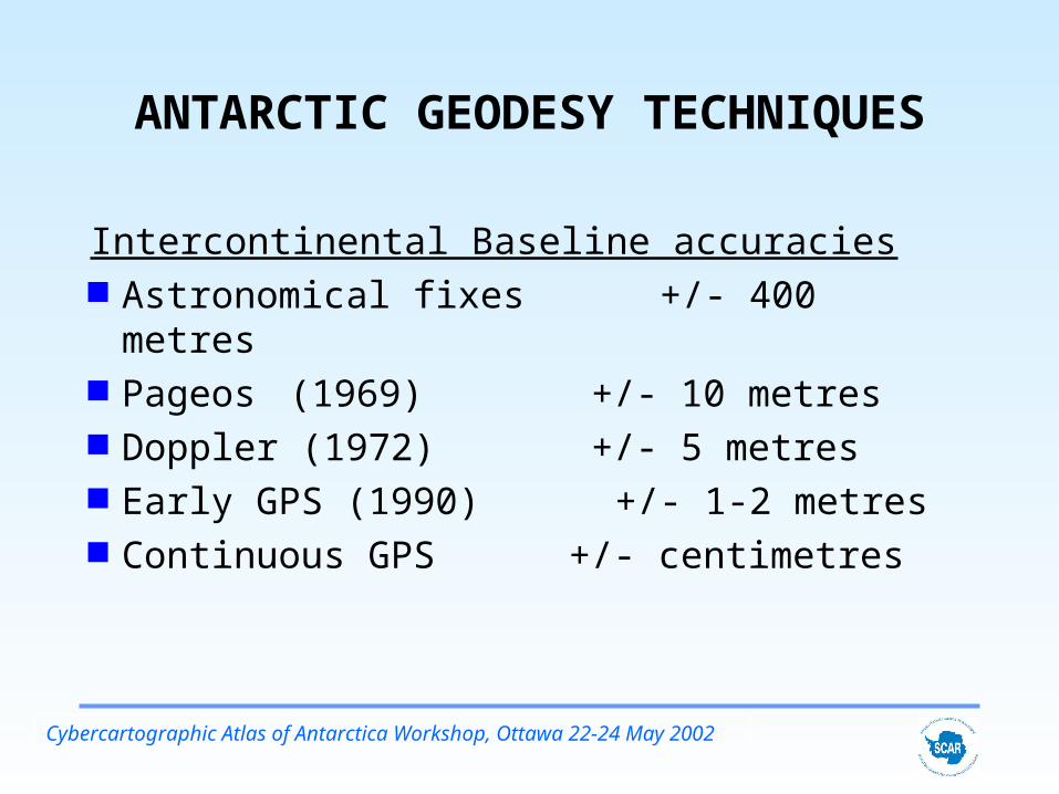
ANTARCTIC GEODESY TECHNIQUES
Intercontinental Baseline accuracies Astronomical fixes +/- 400 metres Pageos (1969) +/- 10 metres Doppler (1972) +/- 5 metres Early GPS (1990) +/- 1-2 metres Continuous GPS +/- centimetres

Cybercartographic Atlas of Antarctica Workshop, Ottawa 22-24 May 2002
WG-GGI PROGRAMS
Geodetic Infrastructure (GIANT)
Geographic Information
Outreach (web site etc)

Cybercartographic Atlas of Antarctica Workshop, Ottawa 22-24 May 2002
GIANT
Initially conceived 1992 as application of new space Geodesy to Antarctic mapping problems
Space technological development now enables monitoring of current surface geodynamics
Cybercartographic Atlas of Antarctica Workshop, Ottawa 22-24 May 2002
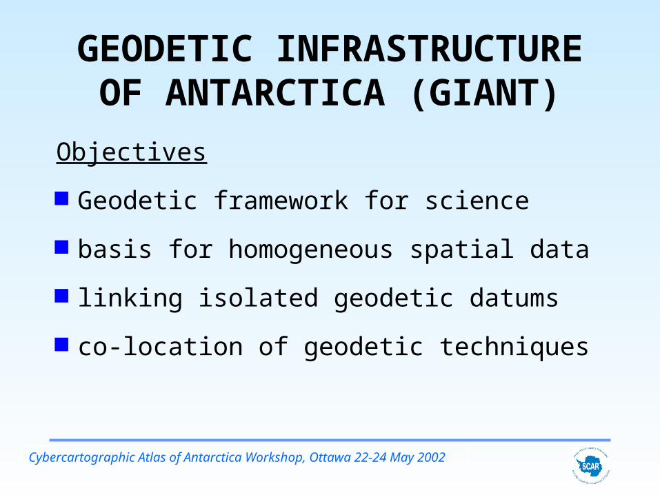
GEODETIC INFRASTRUCTURE OF ANTARCTICA (GIANT)
Objectives
Geodetic framework for science
basis for homogeneous spatial data
linking isolated geodetic datums
co-location of geodetic techniques

Cybercartographic Atlas of Antarctica Workshop, Ottawa 22-24 May 2002
GEODETIC FRAMEWORK
Permanent GPS Base Stations Epoch GPS Campaigns VLBI DORIS Tide Gauges Absolute Gravity

Cybercartographic Atlas of Antarctica Workshop, Ottawa 22-24 May 2002
Giant program components
Permanent Geodetic Observatories;
Crustal Deformation Network;
Physical Geodesy;
Geodetic Control Database;
Tide Gauge Data; Atmospheric Impact on
GPS Observations in Antarctica;
Remote Geodetic Observatories; and
New Geodetic Satellite Missions

Cybercartographic Atlas of Antarctica Workshop, Ottawa 22-24 May 2002
Antarctic GPS base stations
Data from Red dots available through IGS
Data from blue dots available on request from individual researchers

Cybercartographic Atlas of Antarctica Workshop, Ottawa 22-24 May 2002
Davis GPS and Glonass Antenna

Cybercartographic Atlas of Antarctica Workshop, Ottawa 22-24 May 2002
Mawson GPS Antenna

Cybercartographic Atlas of Antarctica Workshop, Ottawa 22-24 May 2002
Casey GPS Antenna

Cybercartographic Atlas of Antarctica Workshop, Ottawa 22-24 May 2002

Cybercartographic Atlas of Antarctica Workshop, Ottawa 22-24 May 2002
Mawson GPS data availability

Cybercartographic Atlas of Antarctica Workshop, Ottawa 22-24 May 2002
Mawson CGPS
time series

Cybercartographic Atlas of Antarctica Workshop, Ottawa 22-24 May 2002
Antarctic VLBI sites
Cybercartographic Atlas of Antarctica Workshop, Ottawa 22-24 May 2002
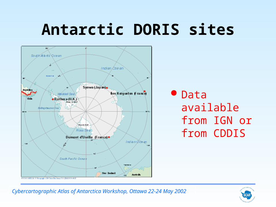
Antarctic DORIS sites
Data available from IGN or from CDDIS

Cybercartographic Atlas of Antarctica Workshop, Ottawa 22-24 May 2002
Absolute Gravity Sites

Cybercartographic Atlas of Antarctica Workshop, Ottawa 22-24 May 2002
Antarctic Tide Gauge operations
IOC web site http://ioc.unesco.org/iocweb/default.htm
Southern Ocean
Sea level centre http://www.ntf.flinders
.edu.au/TEXT/PRJS/
SOUTH/south.html

Cybercartographic Atlas of Antarctica Workshop, Ottawa 22-24 May 2002
GLONASS orbits and comparisons : IGLOS Electronic Mail
Permanent receivers at
Davis, McMurdo, O’Higgins
Product access : By anonymous ftp to
http://igs.ifag.de

Cybercartographic Atlas of Antarctica Workshop, Ottawa 22-24 May 2002
Difference between OSU91 & EGM96 Gravity Models

Cybercartographic Atlas of Antarctica Workshop, Ottawa 22-24 May 2002
GPS EPOCH CAMPAIGNS
1989 -feasibility 1990 - pilot 1991 - CIGNET 1992 - Major
Campaign 1993 Minor 1994 Minor
1995 - Major 1996 Minor 1997 - Major 1998 Minor 1999 2000

Cybercartographic Atlas of Antarctica Workshop, Ottawa 22-24 May 2002
Primary ITRF2000 Sites and Collocated Techniques

Cybercartographic Atlas of Antarctica Workshop, Ottawa 22-24 May 2002
Horizontal vectors from SCAR ITRF 2000 solution

Cybercartographic Atlas of Antarctica Workshop, Ottawa 22-24 May 2002
ITRF2000 Antarctic Velocities (m/yr)ID DOMES LATv LONv HGTv
7400 41705M001 0.0163 0.0189 0.0047ART1 66017M001 0.0161 0.0068 0.0001BEL1 66018M001 0.0105 0.0119 0.0347BELG 66018M002 0.0105 0.0119 0.0347BRAZ 41606M001 0.0125 -0.0039 0.0016CAS1 66011M001 -0.0096 0.0026 0.0037DAL1 66019M001 0.0142 0.0077 0.0019DALL 66019M002 0.0142 0.0077 0.0019DAV1 66010M001 -0.0048 -0.0015 0.0043DUM1 91501M001 -0.0081 0.0116 -0.0009ELE1 66021M001 0.0141 0.0062 0.0024ESP1 66022M001 0.0097 0.0142 0.0102FOR1 66023M001 0.0058 -0.0009 0.0079FOR2 66023M002 0.0058 -0.0009 0.0079FOS1 66024M001 0.0107 0.0129 0.0007GOUG 30608M001 0.0185 0.0202 -0.0017GRW1 66012M001 0.0162 0.0086 0.0075KERG 91201M002 -0.0031 0.0060 0.0050KOUR 97301M210 0.0120 -0.0045 0.0026LPGS 41510M001 0.0114 -0.0017 0.0011MAC1 50135M001 0.0304 -0.0108 0.0001

Cybercartographic Atlas of Antarctica Workshop, Ottawa 22-24 May 2002
SUMMARY GIANT provides a fiducial framework of
permanent sites Contemporary velocities at permanent
and remote sites Linkages at fiducial sites to other
techniques - VLBI, Tide Gauges, Gravity
Contributions to global geodesy

Cybercartographic Atlas of Antarctica Workshop, Ottawa 22-24 May 2002
GIANT Ongoing Strategy
Encourage establishment of IGS stations and use of IGS procedures
Open data from base stations Access to RINEX and SINEX results Produce integrated solutions for ITRF
densification Official published verified results in ITRF

Cybercartographic Atlas of Antarctica Workshop, Ottawa 22-24 May 2002
GIANT STRATEGY Continue as the overall linking
mechanism for Antarctic Geodesy Encourage participation in building a
combined cooperative network Use of one reference frame for positions use of web site for meta data and
information access

Cybercartographic Atlas of Antarctica Workshop, Ottawa 22-24 May 2002
SCAR WG-GGI Highlights ADD Composite Gazetteer Map and chart catalogue Specifications for GIS Contribution to Global Map project Permanent network of geodetic
observatories Global orbits and ITRF primary datum Densification of ITRF2000 Absolute gravity