The Eureka Mining District Nevada - USGS · 2011-11-28 · THE EUREKA MINING DISTRICT, NEVADA By...
83
The Eureka Mining District Nevada By THOMAS B. NOLAN GEOLOGICAL SURVEY PROFESSIONAL PAPER 406 Prepared in cooperation with the State Bureau of Mines UNITED· STATES GOVERNMENT PRINTING OFFICE, WASHINGTON : 1962
Transcript of The Eureka Mining District Nevada - USGS · 2011-11-28 · THE EUREKA MINING DISTRICT, NEVADA By...
The Eureka Mining District
Nevada By THOMAS B. NOLAN
GEOLOGICAL SURVEY PROFESSIONAL PAPER 406
Prepared in cooperation with the
Ne~ada State Bureau of Mines
UNITED· STATES GOVERNMENT PRINTING OFFICE, WASHINGTON : 1962

•.
UNITED STATES DEPARTMENT OF THE INTERIOR
STEW ART L. UDALL, Secretary
GEOLOGICAL SURVEY
Thomas B. Nolan, Director
[Library catalog card follows page 78]
For sale by the Superintendent of Documents, U.S. Government Printing Office Washington 25, D.C.

CONTENTS
Abstract __________________________________________ _ Introduction ______________________________________ _
Geography ____________________________________ _ History _______________________________________ _
Fieldwork and acknowledgments _________________ _ Rock formations ___________________________________ _
Cambrian system ______________________________ _ Prospect Mountain quartzite ________________ _ Pioche shale _______________________________ _ Eldorado dolomite _________________________ _ Geddes limestone ___________ · _______________ _ Secret Canyon shale ___________________ · _____ _ Ham burg dolomite _________________________ _ Dunderberg shale __________________________ _ Windfall formation _________________________ _
Ordovician system _____________________________ _ Pogonip group _____________________________ _ Eureka quartzite ___________________________ _ Hanson Creek formation ____________________ _
Silurian and Devonian systems __________________ _ Devils Gate limestone ___ ..: __________________ _
Carboniferous systems __________ ..: _______________ _ Chainman shale ___________________________ _ Diamond Peak formation ___________________ _
Permian system _______________________________ _ Carbon Ridge formation ____________________ _
Cretaceous system _____________________________ _ Newark Canyon formation __________________ _
Igneous rocks of Cretaceous age _________________ _ Quartz diorite _____________________________ _ Quartz porphyry ___________________________ _
Igneous rocks of Cenozoic age ___________________ _ Hornblende andesite and related rocks ________ _ Rhyolite _______________________________ ----Rhyolite· tuff ______________________________ _ Andesite and basalt ________________________ _
Sedimentary rocks of Quaternary ·age _____________ _ Alluvium ______________________________ ----
Geologic structure _________________________________ _ Prospect Ridge block ___________________________ _
Diamond tunnel thrust zone ________________ _ Ruby Hill thrust zone ______________________ _ Dugout tunnel thrust zone __________________ _ Silver Connor transverse fault_ ______________ _ Jackson-Lawton-Bowman normal-fault system __ Ruby Hill normal fault _____________________ _
Page
1 2 2 2 3 4 5 5 6 6 7 7 8 8 9 9 9
10 10 10 10 11
·11 11 11 11 12 12 13 13 14 14 14 15 16 17 17 17 18 19 19 19 20 21. 22 23
Geologic structure-Continued Hoosac fault _______________________ --------Spring Valley fault zone ____________________ _
Carbon Ridge-Spring Ridge block _________ -------Conical Hill anticline _______________________ _
Structural features in the Newark Canyon formation _______________________________ _
Hornblende andesite intrusive body __________ _ Mahogany Hills block _________________________ --Fish Creek Mountains block ____________________ _ Age of the structural features __________________ - _
Paleozoic _________________________________ _ Pre-Newark Canyon-Mesozoic _____________ _ Late Cretaceous ___________________________ _ Pleistocene and Recent ____ ~ _____________ :.._--
Ore deposits ________________________________ ----- --:.. Geographic distribution of the ore bodies ___ -.- ____ _ Form of the ore bodies ________________________ - -
Irregular replacement deposits _______________ _ Bedded replacement deposits _______________ --
. Fault-zone replacement deposits _________ .. ___ _ Disseminated deposits _________ :_ ____________ _ Contact-metasomatic deposits _______________ _
Mineralogy ___________________________________ _ Base-metal deposits ________________________ _ Windfall gold ore __________________________ _ Contact-metasomatic ores __________________ _
Tenor of the ores ________________ - ----- _- -------Origin of the ores ______________________________ _
Source of the metals _______________________ _ Relation of the ore bodies to faults ___________ _ Relation of the ore bodies to the enclosing
rocks ___________________________________ _
Oxidation of the ores _______________________ _ Mines and mining ______________ ~ __________________ _
Production ____________________________________ _ ~line drainage _________________________________ _ Notes on the mines ____________________________ _
Adams. Hill area ___________________________ _ Ruby Hill area ____________________________ _ Prospect Ridge group ______________________ _ Dunderberg-Windfall belt ___________________ _ Lower New York Canyon group _____________ _ Other properties ___ . ____ · ____________________ _
References cited ___________________________________ _
Index_~-------------------------------------------
ILLUSTRATIONS
[Plates are in map volume]
PLATE 1. Geolqgic map of the Eureka mining district, Nevada. 2. Geologic sections of the Eureka mining district, Nevada. 3. Geologic structure map of the Eureka mining district, Nevada.
UI
Page
24 25 26 26
26 26 27 27 27 27 28 28 29 29 29 30 30 36 37 39 39 41 41 44 46 46 48 48 49
51 52 53 56 57 61 63 65 67 70 71 71 72 75

l
IV
PLATE 4. 5.
6. 7. 8. 9.
10.
11.
FIGURE 1. 2. 3. 4. 5. 6.
7. 8. 9.
10. 11. 12.
13.
14:
15.
CONTENTS
Horizontal projection of stopes in Ruby Hill mines. Patented claims within the part ofT. 19 N., R. 53 E., included in plate 1, and certain of the unpatented claims in the
northern and western parts of the Eureka mining district. Mine workings in the Adams Hill area for which maps are available. Mine workings in the Ruby Hill area for which maps are available (in three sheets). Location of drill holes intersecting sulfide ore in relation to the Fad and Locan shafts. Mine workings in the Prospect Ridge area for which maps _are available. Mine workings in the vicinity of the new ore shoots in the No. 1 shaft area, Diamond mine, Consolidated Eureka Mining
Co. Mine workings in the Dunderberg-Windfall belt for which maps are available.
Page
Geologic map of the Dead broke tunnel, illustrating the occurrence of mineralized pods_____________________ 32 Section in a plane N. 53° E. through the Eureka Croesus mine, showingthe pipelike habit of the ore shoots______ 33 Vertical section through the Lawton shaft, showing ore bodies in the Eldorado dolomite______________________ 34 Map of a part of the Diamond tunnel and 120-foot levels________________________________________________ 35 Longitudinal projection in a plane N. 10° E. of ore bodies associated with open caves, Diamond mine__________ 36 Section looking north, Holly mine, showing localization of stoped areas at intersection of favorable limestone
beds and steeply dipping fractures__________________________________________________________________ 37 Map of the Wabash tunnel, showing stopes of fault-zone replacement bodies in Eldorado dolomite_____________ 38 Vertical north-south section of Windfall mine with approximate projection of main stopes_ _ _ _ _ _ _ _ _ _ _ _ _ _ _ _ _ _ _ _ 40 Map of the Rogers tunneL__________________________________________________________________________ 41 Polished surface of sulfide ore from the 1006- 1 W stope above the 1,050-foot level, T. L. shaft________________ 44 Thin section of oxidized ore from 1002-1 W stope above 1,050-foot level, T. L. shaft________________________ 45 Cerussite crystals in quartz matrix. Thin section of oxidized ore from 901-2 E stope above 950-foot level, T. L.
shaft ______________________________ -------------------------------------------------------------- 45 Fine-grained mimetite in quartz: Thin section of oxidized ore from 809-14 E stope above 850-foot level, T. L. shaft-------------------------------------------------------------------------------------~------ 46
Rate of pumping from the T. L. shaft (Aug. 16, 1954-June 30, 1957) and changes in level of ground water in diamond-drill holes 104 (Feb. 14, 1955-June 30, 1957) and 106 (Feb. 14, 1955-June 30, 1957)_______________ 62
Map of Lower Dugout tunnels _________________________________________________________ ~~____________ 72
TABLES Page
TABLE 1. Geologic formations present in the Eureka Mining district_______________________________________________ 4 2. Available data on annual production of the Eureka Mining district, 1866-1959_ _ _ _ _ _ _ _ _ _ _ _ _ _ _ _ _ _ _ _ _ _ _ _ _ _ _ _ _ 58

THE EUREKA MINING DISTRICT, NEVADA
By THOl\fAS B. NOLAN
ABSTRACT
The Eureka Mining district lies south and west of the town of Eureka, county seat of Eureka County, 'in central Nevada. Ore was discovered in the district in 1864, and the peak production was reached in the 20 years from 1870 to 1890. Since that time production has varied considerably from year to year, reflecting periods of renewed or expanded programs of exploration and development.
The rock formations that crop out in the district range in age from Early Cambrian to Recent. The Cambrian units comprise eight formations, aggregating 7,400 feet in thickness. A basal quartzite, overlain by shale, is followed by a series of limestones and dolomites. The two important host rocks for the ore are in this age group-the Middle Cambrian Eldorado dolomite and the Middle and Upper Cambrian Hamburg dolomite.
Rocks of Ordovician age, the Pogonip group, the Eureka quartzite, and the Hanson Creek formation, make up at least 2,400 feet of the section. They are composed of limestones, quartzites, nnd dolomites.
The Devils Gate limestone of Middle and Late Devonian age, the Chainman shale and the Diamond Peak formation of Late Mississippian age, the Carbon Ridge formation of Permian age, and the Newark Canyon for~1ation of Early Cretaceous age complete the older sedimentary sequence.
Igneous rocks ranging in age from Late Cretaceous to late ~L'ertiary or Quaternary are rather sparsely distributed throughout the western part of the mapped area ; they underlie considerable portions of the eastern part, however.
A quartz diorite plug of probable Late Cretaceous age occurs south of Ruby Hill and is believed to be part of a larger concealed intrusive mass. To the north a sill-like mass of quartz porphyry is believed to be related to the quartz diorite. Extrusive and intrusive hornblende andesites of possible middle Eocene age occur in the southern part of ·the district.
Other igneous rocks include rhyolites and rhyolite tuffs of Oligocene or Miocene age. and pyroxene andesites and. basalts of late Tertiary or Quarternary age.
The youngest sedimentary rocks are made up of various unconsolidated rocks: fanglomerates and finer grained clastic roeks composin~ the valley fill, and thinner and less extensive bodies of stream alluvium and slope wash.
~'he sedimentary rocks are intensely deformed; most of those exposed on Prospect Ridge, which makes up much of the mineralized area, .have near vertical or overturned dips. These rocks are cut by three zo1ies of minor thrust faulting, which ~ut through at least two pei1econtemporaneous folds. The compound thrust plates are themselves folded and are cut by one major transverse fault and at least three major normal faults.
Prospect Ridge is bomided on the west by a zone of relatively recent normal faults of the Basin-Range type, which is believed
to be responsible for an uplift of the ridge of approximately 2,000 feet.
The small scale, minor irregularities, and lack of continuity of most of the pre-Basin-Range fault structures suggest that these features developed near the surface, and under a very light confining load. They contrast markedly with the major Roberts Mountain thrust zone, which is exposed just west of the district and which is believed to have a minimum displacement of 50 miles. The Eureka structural features are believed to represent near-surface disturbances in front of the advancing thrust. The nature and distribution of fresh-water sediments of the Newark Canyon formation are thought to be in accord with this belief.
Earlier crustal movements are recorded by unconformities in the Paleozoic section. Tw·o of these, one in Middle to Late Ordovician time and the other in the Late Silurian or Early
.Devonian, are apparently the result of gentle upwarps, which bowed the older rocks without notably folding or faulting them.
An unconformity at the base of the Permian also appears to have been the result of a broad uplift, but in the vicinity of Eureka the uplift must have been more intense than the two earlier ones, since the angularity of the unconformity here is considerable in places.
The greater part of the deformation at Eureka is believed to have occurred in the late Mesozoic, although it appears to have continued over a com;iderable period of time, to judge from the relations of the thrust zones, folds, and faults to one another. This age assignment contrasts with that proposed 0
by other workers for the age \lf the Roberts Mountain thrust to the west, which is regarded as of Late Devonian to Early Pennsylvanian age. It is possible that future work may indicate that orogeny in central Nevada occurred spasmodically from Devonian to Cretaceous time.
The ore bodies at Eureka were among the first of the large replacement deposits in limestone or dolomi·te to be mined extensively in the 'Vestern United States and were early the subject of the extensive litigation that resulted from the difficulties met in applying mining laws based on gold-quartz veins to irregular replacement bodies. They were also the scene of some the earliest experiments in geochemical and geophysical prospecting.
The ore bodies are localized in five belts or cluster.s, with intenening areas that show only sporadic prospecting of small extent. These five clusters include the Adams Hill group, the Ruby Hill group, the Prospect Ridge belt, the Dunderberg and Windfall belts, and a fifth group, which lies near the mouth of New York Canyon. Of these, the Ruby Hill group of ore bodies has yielded by far the largest part of the district production.
The Eureka replacement deposits are of five general types: irregular replacement deposits, bedded replacement deposits, fault-zone replacement deposits, disseminated deposits, and
1

2 THE EUREKA MINING DISTRICT, NEVADA
contact metasomatic bodies. The irregular replacement deposits are numerous, widely distributed, and considerably important economically. The other types are relatively few in number and are restricted in distribution.
The ores of the district are made up of oxidized lead, arsenic, and silver minerals, and gold. In a few places oxidized zinc minerals are present, although not in amounts to constitute ore. The proportions of these minerals differ from mine to mine, and often within an individual mine. The common gangue minerals include iron-rich minerals, silica-rich minerals, and carbonate wallrock.
Two exceptions to the usual oxidized lead-silver ore bodies have been mined. In the Windfall mine, in the south-central part of the district, a low-grade gold ore was exploited ; iron, lead, and zinc minerals are almost completely absent in this ore. The sulfide ores of the Eurelm Corp., Ltd., lying below the water table, are also unique within the district. Some have been mined in the T. L. Shaft workings, but the main occurrences, in the vicinity of the Fad shaft, are known only from drill holes.
The origin of the ores of the district is somewhat conjectural. Some observers have considered the Ruby Hill ores to be derived from the quartz diorite plug lying beneath the hill and the Adams Hill ores to be genetically related to the quartz porphyry body in Adams Hill. The ore bodies in other parts of the district, however, are not in close proximity to intrusive masses; it therefore seems more likely that a larger igneous mass that is thought to underlie Prospect Ridge was the source. of the ore-forming solutions.
Other factors were important in the emplacement of the ore bodies. The numerous faults in the district have acted both as the main channelways through which the ore-bearing solutions traveled and as the fissures in and along which the ore minerals were deposited. Almost all the ore bodies of the district are found in limestone or dolomite, presumably beca-use these two carbonate rocks were more readily replaced. Dolomite, rather than limestone, appears to have been favored by the ore solutions; it is much more brittle and hence is more
• extensively, fractured than limestone, which in many places has reacted to deformation by recrystallizing to a massive rock, .relatively free of fractures.
A. final stage in the development of the ore deposits was the oxidation of the sulfide minerals by circulating ground water. The distribution of the oxidized ore bodies in relation to the ground-water level suggests that the recent Basin-Range normal faulting occurred after much of the oxidation had been accomplished.
Production records for the Eurelm mi~ing district are fragmentary, particularly for the period before 1903. The available data, interpreted in the light of specific data for individual mines, or bullion shipments, suggest that the total production of metals from the district since 1866 has had a value on the order of $122 million.
INTRODUCTION
GEOGRAPHY
The Eureka mining district is in central Nevada; the mining activity in the district has been concentrated west and south of the to''~n o{Eureka, which is the county seat of Eureka County. Like many other western mining districts, its boundaries are indefinite.
The area mapped encloses most of the region that has been productive in the past, but does not include the mining properties in Secret Canyon, although these are frequently considered to be included within the Eureka district.
The district lies at the north end of the Fish Creek Range, one of the linear, northward-trending ranges of the Great Basin. The Fish Creek Range ends, not by a simple dying out into low lands, but by splitting into two parallel ranges, separated by Diamond Valley. The two ranges comprise the Sulphur Spring Range and 'Vhistler Mountain on the· w~st, and the Diamond Mountains on the east. Diamond Valley, whose low point is slightly below 5,770 feet, is the local sink, not only for the area enclosed by its bordering ranges, but for a large area to the west.
The climate resembles · that of much of central Nevada-hot dry summer days that are commonly alleviated by cool nights, and a normally severe winter. Eureka itself receives an appreciable snowfall and has been snowbound to automobile traffic for short periods. The usual desert-plant assetnblages are found : sagebrush, Mormon tea, rabbit brush, and catscla w in the lower and drier areas; juniper, pinyon pine, and mountain mahogany in the higher and moister zones. Large pines were formerly somewhat abundant above 9,000 feet. They, together with pinyon pine and juniper, were extensively cut for fuel and charcoal in the earlier days of the mining camp. ·
Eureka is on U.S. Highway 50, 78 miles from Ely, on the Nevada Northern Railway to the east; and about 250 miles from Reno, on the main lines of the 'Vestern Pacific and Southern Pacific, to the west. The latter railroads are also reached by way of State Highway 20 to Palisade, 91 miles to the north. Palisade was formerly the terminus of the narrow-gauge Eureka Nevada Railway, but the rails of this line were removed in 1939, after 65 years of operation.
HISTORY
Ore was discovered in the Eureka district in 1864, when a party of prospectors from the then-booming camp of Austin, 68 miles to the west, found ore in the vicinity of the Seventy Six mine in New York Canyon, south of the present town of Eureka. Smelting methods then current, however, were not suited to treat the oxidized gold-silver-lead ores rich in iron that characterized the new district,. and it was not· until 1869, when an improved smelting technique was developed and· the rich ore bodies on Ruby Hill were discovered, that the district became prosperous.
Most of the district's production was n1ade in the 20 years from 1870 to 1890, when the Richmond,

INTRODUCTION 3
Eureka, and other mines on Ruby Hill, and smaller ones, such as the :Hamburg, Dunderberg, and Silver Connor mines on Prospect Ridge and the Silver Lick and Bullwhacker on Adams Hill, were most active. Two large smelters, the Richmond at the south end of town and the Eureka Consolidated at the north end, and several smaller ones were in operation during these years, and even now their slag piles are prominent features of the landscape.
Following the ~xhaustion of the rich Ruby Hill ores, production was continued by lessees in the older mines and from new discoveries in such properties as the Diamond-Excelsior, the Windfall, and the Holly. In 1905, the old Eureka Consolidated and Richmond properties were consolidated as the Richmond-Eureka Mining Co. ; and considerable amounts of stope fillings and of lower grade ore that surrounded the rich shoots were shipped to Salt Lake Valley smelters. This production ceased in 1912, however, and since then, the output from the district, though substantial, has varied greatly from year to year. Much of it has resulted either from the activities of lessees, or has been the byproduct of exploration campaigns.
The termination in depth of the Ruby Hill ore bodies by the Ruby I-Iill fault caused speculation at an early date about possible extensions of the bonanza ore bodies 01~ the hanging wall side of the fault. Both the Richmond and the Eureka companies penetrated the fault from the deeper workings of the two mines, and the Eureka company sank the 1,200-foot Locan shaft as a part of the search for down-faulted ore bodies. These efforts were unsuccessful, however, partly because of the quantities of water encounterd, and partly because of the then widespread belief that the Ruby I-Iill fault was of premineral age and hence may have been the boundary of the original mineralization.
R.enewed exploration for the possible displaced extensions of the Ruby I-Iill ore shoots was made in 1919 by the Ruby I-Iill Development Co., and by the Richmond-Eureka Co. in 1923. The most recent program was started in. 1937 when the Eureka Corp., Ltd., secured leases and options on a substantial block of ground. The initial drill hole did not disclose ore of any importance, but five succeeding holes all struck notable thicknesses of sulfide ore of good grade. A new shaft, the Fad, was started to exploit this new ore; it had reached a depth of 2,500 feet in 1949, when a large flow of water was tn.pped in a crosscut 250 feet higher. An economical solution of the resulting water problem has. not as yet been reached (1959), and the company in the past few years has concentrated its exploratory work in the region north of Adams Hill.
Considerable ore has been mined from this area, in which a new shaft, the T. L., was sunk, and also from renewed activity in the Diamond mine of the Consolidated Eureka Mining Co., about 4 miles south of Eureka.
Colorful accounts of the early Eureka history are given by Molinelli ( 1879) and Angel ( 1881). Curtis ( 1884) has recorded the development of the mining industry in the district, and a recent summary is given by Sharp (1947).
FIELDWORK AND ACKNOWLEDGMENTS
The Eureka mining district topographic map, on a scale of 2,000 feet to the inch, was prepared by R. R. Monbeck in 1931 as a part of a cooperative topographic and geologic mapping program between the Nevada State Bureau of Mines and the U.S. Geological Survey. The geologic mapping was begun the following year, using an enlargement (1,000 feet to the inch) of Monbeck's topographic map as a base. The cooperative program, unfortunately, was terminated at this time, and the mapping of the surface geology and of the mine workings in the dist1:ict was not resumed until the summer of 1938. During this season, and the two following ones-1939 and 1940-nearly all the fieldwork upon which this report is based was completed. Alan T. Broderick participated in the mapping in 1938, John Van N. Dorr 2d, in 1939, David T. Griggs, in 1939 and 1940, and J ~hn S. Shelton, in 1940.
During each of these four seasons, the fieldwork was interrupted by other assignments, and the preparation of this report has been even more seriously delayed because of other responsibilities. Its completion in its present form is to a large extent due to the assistance in the office of Miss Jane Wallace; she has reviewed, and corrected, the text, prepared the bibliography, and prepared the final copy for all the illustrations, in some instances compiling them from numerous sources that not uncommonly were difficult to reconcile with one another.
I am indebted to many individuals for assistance, both in the prosecution of the fieldwork and in the preparation of the report. John A. Fulton, then Di rector of the Nevada Bureau of Mines, and Gerald F. Loughlin, of the Geological Survey, were primarily responsible for the initiation of the project in 1932, and Dr. Loughlin made available specimens and data that he had collected in the. district in 1914. Representatives and lessees of all the mining companies were most helpful in furnishing maps and data; among them are: William Sharp, Harry Eather, George Mitchell, Neil O'Donnell, John Brozo, and '¥alter Paroni, of Eureka Corp., Ltd.; George Stott, Carl

4 THE EUREKA MINING DISTRICT, NEVADA
Stehle, Jr., and Sherman Hinckley, of the Diamond mine (Consolidated Eureka Mining Co.) ; John DePaoli, John Cardinelli, and Tony Frank, of the Croesus mine, and Earl Young, of· the Windfall mine. l\{any of my colleagues on the Geological Survey, notably Charles vV. Merriam, James Gilluly, J. Fred Smith, and G. H. Espenshade, have given assistance and advice both in the field and in the office on paleontologic, petrologic, and structural questions, and have provided helpful comments on the text of this report. Finally, I 'vish to acknowledge the cooperation and many kindnesses of the citizens of Eureka; their friendliness has been a source of continual pleasure.
ROCK FORMATIONS
The rocks exposed in the Eureka mining district quadrangle include both sedimentary and igneous rocks that range in age from Early Cambrian to Recent (table 1). The sedimentary rocks are the more extensive at the surface and are, moreover, the host rocks for the numerous ore bodies that have been explored in the district. Additionally, they have been the subject of considerable recent interest in that some of them
are thought to be the source rock of the petroleum that has been discovered southeast of Eureka in Railroad Valley, Nye County. The older igneous rocks also have economic significance in that they are believed to be genetically related to the metalliferous ore bodies.
The early work by Hague and his associates ( 1883 ; 1892) led to the recognition, and definition, of many of the formations that are shown on plates 1 and 2. Hague's work was, however, seriously handicapped .by inadequate understanding of the geologic structure of the district. This was a natural consequence of the conditions under which his survey was carried outnotably the necessity for preparing the geologic map in the office after the completion of fieldwork. A nmnber of emendations of Hague's work have therefore been made; atriong others by 'iV alcott ( 1908a, b; 1923; 1925), vVheeler and Lemmon ( 1939), Gianella ( 1946), Sharp (1947), Easton and others (1953), and most recently. Nolan, Merriam, and 'iVilliams (1956). The stratigraphic names used in the latter report for the sedimentary rocks are those used in this report, in which the more economically important aspects of the formations are emphasized.
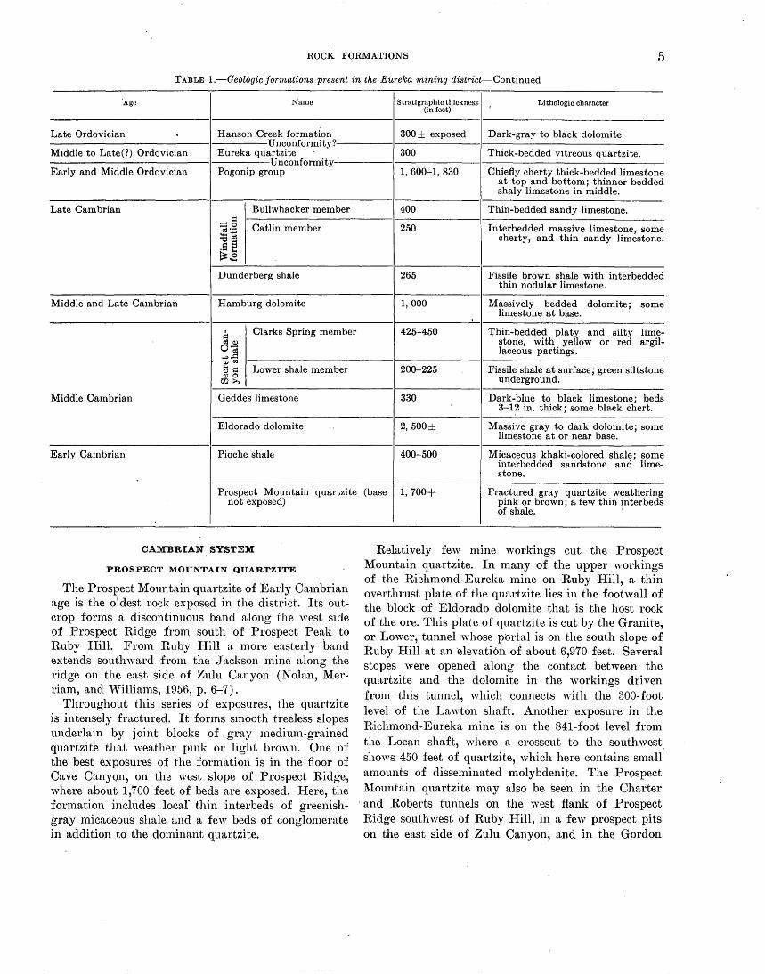
TABLE 1.-Geologic formations present. in the Eureka mining district
Age Name Stratigraphic thickness Lithologic character (in feet)
Quatern~ry Alluvium 0-500± Stream and slope alluvium, terrace gravels, and mine and smelter
I dumps. Unconformity
Late Tertiary or Quaternary Pyroxene andesite and basalt 700+ Lava flows; a few dikes and small plugs.
Oligocene or Miocene Intrusive contact and unconformity Rhyolite tuff 400± White, layered tuff.
Rhyolite 100± of flows Chiefly intrusive plug, dikes, and exposed breccia pipes; vitrophyre sill; and
local lava flows.
Eocene Hornblende andesite 300± of flows Dike and lava flows. exposed
Late Cretaceous Quartz porphyry ---------------- Sills and dikes.
Quartz diorite ---------------- Intrusive plug south of Ruby Hill. Intrusive contact
Early Cretaceous Newark Canyon formation 200± Fresh-water conglomerate, sandstone, grit, shale, and limestone.
Unconformity Thin-bedded sandy and' silty lime-Permian Carbon Ridge formation 1, 000±
stone; some included sandstone and dark shale.
Unconformity-Ely limestone absent Late Mississippian · Diamond Peak formation 0-300 Conglomerate, limestone, and sand-
stone.
Chainman shale 500 ± exposed Black shale with thin interbedded sandstone.
Break in section Middle and Late Devonian Devils Gate limestone 500 ± exposed Thick-bedded limestone, locally dolo-
mitized. Break in section-Nevada, Lone
Mountain, and Roberts Mountains formations not mapped area
recognized in
ROCK FORMATIONS 5
TABLE I.-Geologic formations present in the Eureka mining district-Continued
Age Name Stratigraphic thickness (in feet)
Lithologic character
Late Ordovician Hanson Creek formati'on Unconformity?
300 ± exposed Dark-gray to black dolomite.
Middle to Late(?) Ordovician Eureka quartzite 300 Thick-bedded vitreous quartzite. Unconformity
Early and Middle Ordovician Pogonip group 1,600-1,830 Chiefly cherty thick-bedded limestone at top and bottom; thinner bedded shaly limestone in middle.
Late Cambrian Bullwhacker member 400 Thin-bedded sandy limestone. ~ ::::::o Catlin member 250 Interbedded massive limestone, some a:!''""
!B~ cherty, and thin sandy limestone. ~ s ~.8 Dunderberg shale 265 Fissile brown shale with interbedded
thin nodular limestone.
Middle and Late Cambrian Hamburg dolomite 1,000 Massively bedded dolomite; some limestone at base.
I
~ Clarks Spring member 425-450 Thin-bedded platy and silty lime-a:IQ) stone, with yellow or red argil-o-; laceous partings. +"~ Q)rl.l
t5 ~ Lower shale member 200-225 Fissile shale at surface; green siltstone a>O underground. 00>.
Middle Cambrian Geddes limestone 330 Dark-blue to black limestone; beds 3-1~ in. thick; some black chert.
Eldorado dolomite 2, 500± Massive gray to dark dolomite; some limestone at or near base.
Early Cambrian Pioche shale 400-500 Micaceous khaki-colored shale; some interbedded sandstone and lime-stone.
Prospect Mountain quartzite (base 1, 700+ Fractured gray quartzite weathering not exposed)
CAMBRIAN SYSTEM
PROSPECT MOUNTAIN QUARTZITE
The Prospect Mountain quartzite of Early Cambrian age is the oldest rock exposed in the district. Its outcrop forms a discontinuous band along the west side of Prospect Ridge from south of Prospect Peak to Ruby :Hill. From Ruby I-Iill a more easterly band extends southward from the Jackson mine along the ridge on the east side of Zulu Canyon (Nolan, Merriam, and "'\Villiams, 1956, p. 6-7).
Throughout this series of exposures, the quartzite is intensely fractured. It forms smooth treeless slopes underlain by joint blocks of . gray medium-grained quartzite that weather pink or light brown. One of the best exposures of the formation is in the floor of Cave Canyon, on the west slope of Prospect Ridge, where about 1,700 feet of beds are exposed. Here, the formation includes locar thin interbeds of greenishgray micaceous shale and a few beds of conglomerate in addition to the dominant quartzite.
pink or brown; a few thin interbeds of shale.
Relatively few 1nine workings cut the Prospect Mountain quartzite. In many of the upper workings of the Richmond-Eureka mine on Ruby Hill, a thin overthrust plate of the quartzite lies in the footwall of the block of Eldorado dolomite that is the host rock of the ore. This plate of quartzite is cut by the Granite, or Lower, tunnel ·whose portal is on the south slope of Ruby Hill at an ·elevati6n of about 6,970 feet. Several stopes were opened along the contact between the quartzite and the dolomite in the workings driven from this tunnel, which connects with the 300-foot level of the Lawton shaft. Another exposure in the Richmond-Eureka mine 'is on the 841-foot level from the Locan shaft, where a crosscut to the southwest shows 450 feet of quartzite, which here contains small amounts of disseminated 1nolybdenite. The Prospect Mountain quartzite may also be seen in the Charter
· and Roberts tunnels on the west flank of Prospect Ridge southwest of Ruby Hill, in a few prospect pits on the east side of Zulu Canyon, and in the Gordon

6 THE EUREKA MINING DISTRICT, NEVADA
tunnel workings, 1,750 feet east of south from the portal of the Prospect Mountain tunnel, one of the few· places where ore has been sought in the quartzite.
PIOCHE SHALE
The Pioche shale (Nolan, Merriam, and vVilliams, 1956, p. 7-9) is exposed at the surface in a muchfaulted belt of outcrops extending f.rom Prospect Peak to the Prospect Mountain tunnel. It is also found on several levels of the Richmond-Eureka mine, although these are no longer easily accessible.
The Pioche shale consists of interbedded sandy and micaceous shale, sandstone, and limestone. Like the underlying Prospect Mountain quartzite, it forms smooth slopes ; these are treeless and grassy and tend to make topographic saddles or benches, except where thicker beds of limestone crop out.
Because of its relative incompetence, the Pioche shale has been considerably deformed. The exposed shale beds are commonly crumpled, and the limestone beds are lenticular, because of local shearing and minor thrusting. North of the Prospect Mountain tunnel, the formation is cut out at the surface by a thrust fault which has brought the overlying Eldorado dolomite into contact with the Prospect Mountain quartzite. At the surface this relation is especially clear near the Richmond-Eureka mine, but on the lower levels of the mine, beds belonging to the Pioche have been preserved beneath the thrust.
The thickness of the Pioche as exposed ranges rather widely because of its deformation. The maximum observed is close to 500 feet.
A few prospect pits have been dug in the Pioche shale, hi.1t no significant amounts of ore have been found in it. This contrasts with the situation at Pioche and several other Nevada niining districts, where the limestone beds in the Pioche shale have been extensively replaced by sulfides.
Fossils indicative of an Early Cambrian age have been found in both the shales and the limestones of the formation.
ELDORADO DOLOMITE
The Eldorado dolomite of Middle Cambrian age is widely exposed from Ruby Hill on the north to a point about 31;2 miles south of the southern border of the Eureka mining district quadrangle (Nolan, l\{erriam, and Williams, 1956, p. 9-11).
It is also the most significant formation economically, since it is the host rock for the ore bodies found under Ruby Hill. For many years the formation was thought to be the only unit susceptible of replacement by the ore-forming solutions, but the recent mapping has
shown that the lithologically similar, but stratigraphically higher, Hamburg dolomite also contains important ore bodies, notably those of the Diamond-Excelsior and T. L. mines.
The Eldorado dolomite is largely composed of massive, thick-bedded gray dolomite that generally forms steep rough slopes which support a sparse growth of pinyon, juniper, and mountain mahogany. Locally beds of limestone occur in the formation, especially near the base, and these tend to form somewhat smoother slopes.
Two kinds of dolomite are present in the Eldorado. One, which is believed to be a product of sedimentary processes, is well bedded, rather fine grained, and commonly dark gray to black. Most of these beds exhibit textures similar to those of other dolomites of lower and middle Paleozoic age in the Great Basin : fine lamination, a mottled appearance caused by irregular patches of lighter and darker dolomite, and a speckling due to white rods set in a darker matrix-the Bluebird dolomite of Loughlin (Lindgren and Loughlin, 1919, p. 28). The other variety is much lighter gray, is coarser grained and essentially texture~ess, and is somewhat vuggy in most exposures. It is ·believed to be the product of recrystallization of the darker dolomites caused by circulating hydrothermal solutions.
Both kinds of dolomite are commonly severely fractured; in some places, notably in the R.ichmondEureka ·mine, it is difficult to find a specimen even an inch across that is unshattered.
The sparse limestones are also thick bedded ; they are normally blue gray and fine grained and weather to much smoother surfaces than the rough, hackly dolomite. The limestones moreover are not as susceptible to fracturing as the dolomites, and in many places it seems clear that the limestone beds have recrystallized to coarse light-colored marble while the dolomites have been intimately fractured. In a few places, coarsely crystalline light-gray limestones appear to have formed as a result of the mineralizing process. These contain sparse remnants of dark dolomite, and thus appear to have been formed by dedolomitization.
The Eldorado dolomite occurs in two different thrust plates, but no lithologic differences were recognized between them. In both plates the Eldorado is mineralized: in the lower of the two, the Silver Connor mine, Eldorado tunnel, and other properties near the ridge line east of the Prospect Mountain tunnel were the source of rich ore bodies in the early days of the district; and the upper one contains the rich ore bodies on Ruby Hill.
Because of the extensive recrystallization and shearing, the true thickness of the Eldorado is somewhat un-

ROCK FORMATIONS 7
certain. The best estimate is believed to be 2,500 feet, but a much smaller thickness is found on Ruby Hill, where the lower contact is a thrust fault that appears to have cut out the lower part of the formation. On the other hand, somewhat greater thicknesses are present on Prospect Ridge, but this is regarded as probably the result of repetition along as yet unrecognized steep thrust faults.
GEDDES LIMESTONE
The Geddes limestone, like most of the formations of Cambrian age, is exposed over most of the length of Prospect Ridge south of Ruby Hill (Nolan, Merriam, and Williams, 1956, p. 11-12). It continues south of the Eureka mining district quadrangle throughout the length of Secret Canyon. In all of this belt, the outcrop is relatively .narrow and discontinuous, especially to the north.
The Geddes was not mapped separately by Hague (1892), though its distinctive lithologic character was early recognized and led to its being distinguished as the "Stratified Limestone" or the "Blue Flaggy" limestone. Wheeler and Lemmon ( 1939, p. 20-23) were the first to map it separately; they made the type locality the Geddes and Bertrand mine in Secret Canyon.
The formation is easily recognized in the field as its lithology is not duplicated by any of the other formations of Paleozoic age. It is made up of beds of darkblue to black carbonaceous fine-grained limestone 3 to 12 inches thick. Locally, small amounts of nodular black chert are present in the limestone, and small agnostid trilobites are found in it in many places. Near the quartz diorite plug, south. of Ruby Hill, the limestones are bleached whit'3 or light gray and coiltain needles of tremolite. In many outcrops, especially those along the east base of Prospect Ridge, the limestone beds of the Geddes are rather closely folded, and the strikes and dips observed may be notably discord-ant within short distances. ·
No ore of any importance has been found in the Geddes, although it has been cut by several tunnels, especially by the Prospect. Mountain, Eureka, Charter, and Roberts tunnels.
"Vhere unfolded and unfaulted, the formation is ~bout 330 feet thick, but in the sections explored by drilling north of Ruby Hill, it is appreciably thinner.
The fauna was first described by Walcott (1884, p. 284-285). It has recently been restudied by A. R. Palmer. (1954), of the Geological Survey, who regards it as early Middle Cambrian in age.
SECRET CANYON SHALE
The Secret Canyon shale is found within a belt that extends from the south side of Adams Hill on the north to the south end of Secret Canyon (Nolan, Mer-. riam, and "Villiams, 1956, p. 12-16). South of the latitude of Prospect Peak, the formation forms a single continuous band, which has localized the amphitheatre at the head of Windfall Canyon and the floor of Secret Canyon. To the north, however, the exposures are discontinuous, and the unit outcrops on both the east and the west flanks of Prospect Ridge.*
The Secret Canyon shale, and the underlying Geddes limestone, are less resistant to erosion than either the Eldorado or Hamburg dolomites, which normally lie below and above them. The two formations consequently tend to underlie valleys, or form saddles, between the cliffy slopes of the dolomites. In most places both formations support a heavier growth of vegetation than the dolomites.
Two members of the Secret Canyon shale have been distinguished in mapping: a lower shale member and an upper, or Clarks Spring member. The shale member is rarely exposed at the surface but can commonly be recognized by the presence of a deep soil containing · tiny flakes of green or dark-brown shale. Underground, the shale member has quite a different appearance; here it is a deep-green siltstone apparently lacking in fissility. The Clarks Spring member, as a rule, is much b.etter exposed. It consists of thin limestone bands, from a quarter of an inch to an inch thick separated by thin argillaceous partings which weather to sliades of yello'v brown, or locally red, and give the outcrops of the member a distinctive color.
The Secret Canyon shale is exposed in a few of the mine workings-notably in the Prospect Mountain, Diamond, and Eureka tunnels, in the· RichmondEureka mine, where it occurs as fault lenses in the Ruby Hill fault zone, and in the Fad and T. L. shafts. There appear to be no significant bodies of ore developed in it.
Hague ( 1892, p. 38, 103-106) mentions a belt of shale and shaly limestone, which he called the Mountain shale, in several of these mine workings. He regarded this unit as a member of the Eldorado dolomite, but the recent mapping shows that these are faulted bodies of the Secret Canyon shale ..
The lower shale member has a thickness of 200 to 225 feet, and the Clarks Spring member, 425 to 450 feet. Most of the exposures are faulted and folded, however. In the drill holes from the Locan Shaft, much smaller thicknesses are found, while in New York and Wind-
•1.'he area just east of the word "CANYON" in Zulu Canyon shown on pl. 1 in the color of the Bullwhacker member of the Windfall fot·mation should be Clarks Spring member of Secret Canyon shale.

8 THE EUREKA MINING DISTRICT, NEVADA
fall Canyons, repetition by folding or faulting, or both, has resulted in an apparent total thickness for the formation of about 2,000 feet.
The Secret Canyon shale contains fossils of Middle Cambrian age.
HAMBURG DOLOMITE
The Hamburg dolomite is one of the two important host rocks for ore bodies in the Eureka district (Nolan, Merriam, and Williams, 1956, p. 16-18). Its distribution is somewhat similar to that of the Eldorado dolomite, the other economically important formation. East of Prospect Peak, the Hamburg forms a ridge east of and somewhat lower than that underlain by the Eldorado but north of the Diamond-Excelsior mine for ' . most of the distance to Ruby Hill the Hamburg occurs in two northerly trending bands. North of Ruby Hill it underlies Adams Hill; here it has much lower dips than to the south.
Except for some limestone beds at the base, the Hamburg is made up wholly of massive dolomite, which like the Eldorado dolomite is partly sedimentary and partly the result of hydrothermal alteration. Both varieties are so similar lithologically to beds in the Eldorado that allocation of a particular sequence of dolomite beds to one or the other formation can generally be made only by determining its position relative to the Secret Canyon or Dunderberg shales, or to the Geddes limestone, which lie above or below the dolo-mites. This is especially true where the dolomites are intensely fractured.
The basal beds of the Hamburg dolomite, however, are distinctive where unaltered. The basal bed, immediately above the Secret Canyon shale, is a massive blue-gray limestone, thinly banded by numerous crinkly shale partings. The limestone is overlain in many places by massive dark oolitic dolomite, which is markedly and regularly banded. Neither of these rock varieties was recognized in the Eldorado dolomite.
The Hamburg also is subject to three kinds of alteration that are rare or lacking in the Eldorado. One of these, which is apparently restricted to a north-south zone through the Windfall mine, results in a rock which has been called sand dolomite (Lovering and Tweto, 1942, p. 85-87) in the field. The rock retains all the textures and the color of the normal dolomite, but has apparently been subjected to an intergranular corrosion that results in its being easily disintegrated ·by a pick into individual granules. Such rock is the chief host of the gold ore in the vVindfall mine ; elsewhere along the zone, however, it does not contain significant amounts of gold.
The Hamburg is also more commonly silicified than is the Eldorado, although the presenc~ or absence of
silicified rock is far from being diagnostic. In general, fractured parts of the Hamburg adjoining the overlying Dunderberg shale appear most susceptible to silicification.
Adjacent to the quartz diorite plug, south of Ruby Hill, the Hamburg dolomite is locally intensely altered. Garnet and diopside are the most commen silicate minerals, and along with serpentine, the chlorite pe~ninite, epidote, zoisite, sphene, and the manganese epidote thulite have been introduced, together with magnetite, pyrite, and pyrrhotite. Farther from the contact, the Hamburg has recrystallized to a coarsegrained white dolomite marble.
The Hamburg dolomite forms the wallrock for the ore bodies of several mines: an easterly group, including the Windfall, Hamburg, Croesus, and Dunderberg; and a more w·esterly one that includes the DiamondExcelsior and adjoining mines north to the Eureka tunnel as well as the T. L. and numerous small mines ' .
on the north slopes of Adams.Hill. The true thickness of the Hamburg dolomite seems
to be close to 1,000 feet, but the numerous faults which cut it have resulted in apparent thicknesses that range from half to nearly double that amount.
Fossils have been found in the basal limestone beds at a few· places. They indicate a late Middle Cambrian age for this part of the formation. It is believed, however that the unit in its upper part is of Late Cambrian ·age.
DUNDERBERG •SHALE
The Dunderberg shale has a distribution similar to that of the Hamburg dolomite, which it normally overlies (Nolan, Merriam, and Williams, 1956, p. 18-19). The contact is sharp and is commonly a zone of slipping or faulting marked by silicification or other alteration in the dolomite.
The Dunderberg is composed of thick interbed~ of brown fissile shale and thin-bedded nodular blmshgray limestone. The shale as a rule is poorly exposed, but the associated limestone, even when it is found only as float blocks, makes it possible to identify the formation with relative ease.
Very few mine workings cut the Dunderberg shale, but where visible in a few tunnels, it is commonly much sheared and distorted.
A section· 265 feet thick was measured on the spur east of the New Windfall Shaft. Faulting and folding have caused considerable variation in the apparent thickness, however, and it has apparently been completely eliminated locally by shearing.
The limestone beds especially are highly fossiliferous and have yielded a large and varied fauna of Late

ROCK FORMATIONS 9
Cambrian age. A similar fauna has been recorded from many localities in eastern Nevada.
WINDFALL FORMATION
vVithin the Eureka mining district quadrangle, the vVindfall formation of Late Cambrian age forms· an essentially continuous band from the western slopes of Hoosac Mountain to the Jackson mine (Nolan, Merriam, and Williams, 1956, p. 19-23). Other exposures are found on the eastern slope of Prospect Ridge above the portal of the Diamond tunnel and on the northern and eastern slopes of Adams Hill.
The formation has been divided into two members : the Catlin member, 250 feet thick, and the overlying Bullwhacker member, 400 feet thick. The Catlin member is made up of an alternation of massively bedded limestones and thin-bedded platy and sandy limestone. Where exposures are good, five massive limestone beds can be recognized. All but the lowest contain rather apundant stringers of laminated black chert, and some similar chert is interlayered with the platy limestone in the upper part of the member. The Bullwhacker member is a uniform sequence of platy and sandy limestones similar to the beds of the lower member. In areas of poor exposures, these may be confused with the Clarks Spring member of the Secret Canyon shale, but the Bullwhacker rocks are sandy, rather than shaly, and the partings are relatively thinner.
Relatively little ore has been found in the Windfall formation except on the northern end of Adams Hill, where the workings of the Bullwhacker and adjoining properties have been driven in the formation. Some of the workings of the Diamond tunnel and some prospects in the belt northwards from Hoosac Mountain also expose the 'iVindfall sediments.
ORDOVICIAN SYSTEM
POGONIP GROUP
The ·Pogonip group is extensively exposed in the central and northern parts of the Eureka mining district quadrangle, extending in an irregular band from Hoosac ~Iountain to the northern tip of Mineral Point, north of Adams Hill (Nolan, Merriam, and Williams, 1956, p. 23-29). A small oufcrop occurs on the east flank of Prospect Ridge, above the Diamond tunnel portal, and a more extensive one, representing part of a thrust plate, is found west and south of Prospect Peak.
Hague ( 1892, p. 48-54) , in his report on the Eureka district, used the name Pogonip limestone for the beds between the Dunderberg shale and the Eureka quartzite; this usage was a restriction of the original definition by Clarence IGng ( 1878, p. 189) . Recent work
(Nolan, Merriam, and Williams, 1956, p. 24) has resulted in a further restriction of the Pogoni p to the beds between the Windfall and the Eureka quartzite, and that usage is adopted for this report.
The Pogonip, as redefined, is made up dominantly· of limestone, most of it thick bedded. Thinner bedded limestones occur throughout the section, l;mt except for a zone of brown-weathering silty olive or green-gray limestones near the middle of the group, they are interspersed with the more massively bedded limestones. The thicker bedded limestones are also commonly cherty, but in the lower half of the unit especially, the chert is nodular and pale gray to white; this habit contrasts with the stringers of black chert in the underlying Windfall formation. Some beds in the upper part, however, do contain darker chert.
In the redefinition of the Pogonip it was classed as a group, rather than a formation, because in the Antelope Range, southeast of Eureka, three mappable units are distinguished. These can also be recognized over much of the area of exposure in the Eureka mining district, although they were not separately mapped when the survey of the mining district was made; this work had been completed prior to the investigation of the Antelope Range. · The three formations recognized in the Antelope
Range, in ascending order are: the Good win limestone, Ninemile formation, and Antelope Valley limestone. At Eureka, the Goodwin probably makes up most of the exposures; it is characterized by massively bedded limestones with white or gray chert. Ninemile :formation lithology can be recognized in several places above the Goodwin-notably in the bottom of the main drainage channel in Goodwin Canyon. The Antelope Valley is also recognizable on the east side of this canyon, immediately below tlu~ outcrops of Eureka quartzite.
Although there are many prospects in the Pogonip group, relatively little ore has been mined from it. The Holly mine, near the north end of the district, has produced ore :from the Pogoni p, as has the Page and Corwin, south of the south boundary of plate 1.
Because of variations in dip and of rather wide-spread faulting, the outcrop width of the Pogonip ranges from a few feet to nearly ·5,000 feet; the true thickness, however, ranges between 1,600 .feet and.1,830 feet. An unconformity between the Pogonip and the overlying Eureka quartzite has been recognized within the district although it is not here marked by a noticeable angular discordance.
Fossils are :fairly abundant throughout the Pogonip group. They indicate an Early and Middle Ordovician age :for the unit.

10 THE EUREKA MINING DISTRICT, NEVADA
EUREKA QUARTZITE
The Eureka quartzite, though named by Hague ( 1892, p. 54--57) from the mining district, is poorly and rather discontinuously exposed within the area mapped on plate 1. The best exposures are along the crest of McCoy Ridge, where both the underlying Pogonip group and the overlying Hanson Creek formation are in contact with it. Other outcrops are found on Caribou Hill, on either side of Windfall Canyon south to ·Hoosac Mountain, and south and west of Prospect Peak in the southwestern corner of the Eureka mining district quadrangle . (Nolan, Merriam, and Williams, 1956, p. 19-32).
Within the Eureka district the Eureka quartzite is a highly fractured dense vitreous white· quartzite. It forms prominent outcrops, and large rounded blocks of the quartzite are strewn over the surface slopes for considerable distances below the outcrops. Although locally the quartzite weathers to shades of reddish brown, it is so uniformly deformed at Eureka that it is not divisible into the three units that are recognizable elsewhere in the region. At most-outcrops, in fact, it is difficult to determine the strike and dip of the formation except by its relations to the Pogonip below or the Hanson Creek above. ·
In general, the Eureka quartzi~~ has not been a favorable host rock for ore deposits. The Hoosac mine was productive in the early days of the district, but there has been little recent exploration in the f?rmation.
The true thickness of the Eureka quartzite is difficult to determine in the district chiefly because of the considerable deformation it has undergone; the apparent variations in thickness may in part, however, result from unconformities that lie both below and probably above the for~ation. A figure of 300 feet is probably approximately correct.
The Eureka is regarded as of Middle to Late ( ~) Ordovician age, from evidence obtained outside the mining district.
HANSON CREEK FORMATION
The Hanson Creek formation in Roberts Creek Mountain was described by Merriam (1940, p. 10-11), who defined it as including the lower part of Hague's (1892, p. 57-59) Lone Mountain limestone· (Nolan, Merriam, and Williams, 1956, p. 32-34). The rocks in New York Canyon mapped by Hague as Lone Mountain are believed to be a part of this lower unit and are shown as Hanson Creek formation on plate 1. Two additional exposures of the Hanson Creek are found on the northeast spur of Hoosac Mountain, and in the saddle southwest of .Prospect Peak.
At all these exposures the formation is composed of a· thoroughly fractured dark-gray to black dolomite. Any sedimentary textures orginally present appear to have been destroyed by the intimate brecciation which the rock has undergone. Near the mouth of New York Canyon, it is somewhat paler, with a slight purplish cast to the medium-gray of the dolomite fragments. Here too there seems to be somewhat more veining by thin seams of iron -stained silica than elsewhere.
The ore bodies of the Seventy Six mine and adjoining properties in lower New York Canyon are in the Hanson Creek formation. The Seventy Six is reported to be the site of the first discovery of ore at Eureka in 1864.
The thickness of the formation is somewhat uncertain but appears to reach a maximum of about 300 feet in lower New York Canyon.
The Hanson Creek formation is fossiliferous at Wood Cone, southwest of Eureka, and on Roberts Creek Mountain, but no fossils were found near Eureka. It is considered to be of Late Ordovician age.
SILURIAN AND DEVONIAN SYSTEMS
Silurian and Devonian rocks are extensively exposed in the region around Eureka although they are nearly absent from th~ area represented on plate 1. Recent work by Merriam and others (Merriam, 1940, p. 11-17; Nolan, Merriam, and Williams, 1956, p. 36-54) has led to the recognition of five formations: the Roberts Mountains formation and Lone Mountain dolomite of Silurian age, the Nevada formation and Devils Gate limestone of Devonian age, and the Pilot shale of Devonian and Mississippian age. Of these, only the Devils Gate limestone is found in the immediate vicinity of Eureka.
DEVILS GATE LIMESTONE
The Devils Gate limestone is exposed at only two places in the Eureka mining district quadrangle. One of these is on the west side of Spring Valley, west of the Prospect Mountain tunnel; the other is at the head of Mountain Valley, on the south flank of Prospect Peak.
The exposures in Spring Valley are mostly of sheared massive light-gray to white limestone. Locally, however, considerable dolomite is present. Some of this dolomite is light gray and coarse grained and is presumably the result of hydrothermal alteration. Other outcrops, howeve~, are of dark dolomite. Most of the material exposed on the south flank of Prospect Peak is also dolomitic, but there the rock forms a thin thrust plate between two thicker ones and is intensely crushed.

ROCK FORMATIONS 11
Both areas have been assigned to the Devils Gate limestone, of Middle and Late Devonian age. Fragmentary fossils were found· by C. W. Merriam in the Spring Valley localities, and gastropods identified by the late Edwin IGrk as belonging to the higher part of the Devonian were collected from the southern locality. The presence of some dark dolomite at both places, however, suggests that the Nevada formation, of Early and Middle Devonian age, may also be present. More extensive mapping of surrounding areas will be needed to confirm this, however.
At neither locality are there ?ignificant indications of any mineralized rock, although one or two prospect pits have been excavated.
Only partial sections of the formation are found within the area mapped on plate 1; none appears to exceed a total thickness of about 500 feet. Elsewhere in the vicinity, the Devils Gate limestone ranges in thickness from 700 to 1,200 feet.
CARBONIFEROUS SYSTEMS
Carboniferous rocks are exposed along the eastern edge of the area shown in plate 1 (Nolan, Merriam, n.nd Williams, 1956, p. 54-63). They have been divided into the Chainman shale and Diamond· Peak formation, both of Late Mississippian age. The contact between these rocks and the underlying formations of Devonian age is not exposed in the immediate vicinity of Eureka, though it may be seen in Tollhouse Canyon several miles to the east. In the Eureka district, also, no beds of Pennsylvanian age have been recognized, although about 2,000 feet of the Pennsylvanian Ely limestone is found east of Eureka. The absence of Ely limestone is not due to a lack of exposures, as is the case with the beds at the Devonian-Mississippian contact, but to erosion, the Permian Carbon Ridge formation resting directly on the Upper Mississippian rocks.
CHAINMAN SHALE
The Chainman shale crops out at several places in lower Windfall Canyon in the vicinity of Con~cal Hill n.nd also on the east flank of Hoosac Mountain. These exposures were mapped by Hague ( 1892) as part of his "Lower Coal Measures," although lithologically they are identical with other rocks he mapped as White Pine shale (of former usage) . The name Chainman is used in this report; it was first applied to rocks in a similar stratigraphic position at Ely (Spencer, 1917, p. 26-27).
The formation is poorly exposed. It is composed almost wholly of a hard black shale, which forms a soil composed of tiny fragments of the rock. Usually, however, the outcrop area is covered .by float or wash
from the adjoining formations. Sandstone beds, half an inch or so thick, are interbedded with the shale in places.
The Chainman shale was not a favorable host rock for ore deposition, and no noteworthy mines or prospect pits have been driven in it.
About 500 feet. of beds are exposed within the area covered by plate 1. Considerably greater thicknesses are found in the Diamond Range to the east.
The formation is of Late Mississippian age.
DIAMOND PEAK FORMATION
The Diamond Peak formation, like the Chainman shale, crops out in lower Windfall Canyon from Cherry Springs to south of Conical Hill, and also on the lower eastern slopes of Hoosac Mountain. These exposures were mapped by Hague (1892) as part of the Lower Coal Measures rather than as Diamond Peak quartzite, which has its type locality on Diamond Peak northeast of the Eureka district.
The most prominent elements in the Diamond Peak formation near Eureka are thick-bedded brown-weathering coarse conglomerates; these are cliff forming and make up the prominent narrow ridge north of Cherry Spring. Interbedded with these. are thick-bedded blue-gray limestone, and. thin beds of brown sandstone. Most of the pebbles in the conglomerate range from 1 to 6 inches in diameter and are derived from cherts· of the Vinini formation, a formation of Ordovician age exposed northwest of Eureka, but not within the area itself. In places the limestone and conglomerate. beds grade into one another within 50 feet along the strike.
There are no mines or. important prospects within the Diamond Peak formation.
The thickness of the formation in the mapped area is as much as 300 feet. West of the road in 'Vindfall Canyon, it has in places been completely removed by late Carboniferous erosion, and the next younger, Carbon Ridge formation rests directly on Chainman shale. Much greater thicknesses are found east of Eureka in the Diamond Range where one section of the Chainman shale and Diamond Peak formation gave a combined thickness of 7,500 feet. .
The limestone beds in the Diamond Peak are abundantly fossiliferous; the fossils indicate a Late Mississippi~n age for the unit.
PERMIAN SYSTEM
CARBON RIDGE FORMATION
The Carbon Ridge formation is extensively, although somewhat discontinuously, exposed along the eastern

12 THE EUREKA MINING DISTRICT, NEVADA
border of the Eureka mining district quadrangle. It was included by Hague ( 1892) in the body of Lower Coal Measures that he mapped south and southeast of Eureka, although elsewhere he assigned similar sediments to his Upper Coal Measures. The name Carbon Ridge is taken from a topographic feature with this name, about 8 miles east of south from Eureka.
The Carbon Ridge formation is made up in large part of rather thin-bedded sandy and silty limestones but includes a few thicker bedded zones. In most exposures the formation weathers to smooth, relatively treeless light-brown slopes. Local chert-pebble conglomerates-perhaps more accurately, limestones containing abundant rounded chert fragments with an average diameter of less than half an inch-are also found. The basal beds near Etl.reka are carbonaceous sandstones and dark-gray carbonaceous shales that locally contain oval concretions as much n.s a foot in din-meter.
·No ore bodies have been found in the Carbon Ridge formation although it is locally replaced by jasperoid. There have been only scattered prospect pits sunk in the unit.
A maximum thickness of 1,750 feet was measured at the type locality of Carbon Ridge. Probably only half this thickness of beds is present in the area shown on plate 1.
The formation contains a rather abundant fauna chn.racterized by fusulinids. J. Steele Williams and Lloyd Hen best have studied the collections and correlate the formation with the W olfcamp and Leonard of Texas, which are of Permian age.
CRETACEOUS SYSTEM·
NEW ARK CANYON FORMATION
The Newark Canyon formation is composed of a sequence of fresh-·water sedimentary rocks that 1ie with notable unconformity on the older sedimentary rocks. Hn.gue did not distinguish them as constituting a separate formation; indeed, he (1892, p. 87) regarded the fauna that they contain as indicating the existence of terrestrial conditions during early Carboniferous time. The Cretaceous age of these beds was first· recorded by MacNeil (1939), following a suggestion by W. P. Woodring that the fauna described by Hague was much younger than Carboniferous. The name for the formation was assigned later (Nolan, Merriam, and Williams, 1956, p. 68-70) and is based on the section in Newark Canyon, east of Eureka.
Within the area of plate 1, the Newark Canyon formation. is exposed in scattered outcrops from just south of Eureka to the southern border of the Eureka 1nining district and :from the western slopes of McCoy
Ridge and the summit of Hoosac Mountain to the eastern border of the sheet.
Although it includes a wide variety of rocks, the chief characteristic of the Newark Canyon formation is its generally very poor exposure. The deep soil that overlies it commonly is notably reddish, and supports a rather thick vegetative cover. Two of the most distinctive rocks are conglomerate and fresh-water limestone. The conglomerate beds are normally thoroughly cemented and contain~ limestone pebbles as well as the common chert pebbles. Unlike most of the formation, the beds made up largely of chert pebbles commonly stand out prominently and greatly resemble the much older conglomerate beds of the Diamond Peak. On the other hand, the limestone-pebble conglomerates yield poor outcrops and are exposed chiefly as large fragments in the soil. The fresh-water limestone beds also are represented by rock fragments rather than continuous outcrops. They are cream to white, silty, and dense to porcellaneous. Locally the beds contain numerous sections of gastropods and other mollusks.
Calcareous siltstones and shales, commonly dark gray, are probably the most abundant rocks of the formation, although they are rarely exposed. Pl~nt fragments and, in one place, fish remains have been found in such beds. Sandstone beds are also not uncommon ; they too resemble beds in the Diamond Peak formation; some contain fragments of silicified wood and bone.
One of the most puzzling rocks mapped as a part of the formation is :found over much of the higher parts of Hoosac Mountain. This is a dense silicified rock consi~ered to be the product of n.lteration of the normn,l Newark Cn.nyon sed~ments. Much is white to light gray and weathers to small frn.gments; in other places the rock is dn.rker n.nd forms rather bold outcrops. Patches of unn.ltered Cretaceous rocks hn.ve been found associn.ted with these rocks and n.re the chief ren.son :for their assignment tQ the Newark Canyon, but it is possible that n.t least some mn.y represent n.ltered Pn.leozoic rocks.
The Newark Canyon formn.tion is. locally silicified, and a few prospect pits have been ¢lug in it. Its chief economic importance, however, was as n, source of brick cln.y for local use, but none has been so used for many years.
The type section of Newark Cn.nyon is about 2,000 feet thick. The fragmentary sections south of Eurekn., however, probably do not exceed a fe,v hundred feet.
Mn.cNeil (1939) and Dn.vid (1941) have described some of the fossils collected from the :f(_)rmn.tion. These indicate an Early Cretaceous n.ge.

ROCK FORMATIONS 13
IGNEOUS ROCKS OF CRETACEOUS AGE
QUARTZ DIORrrE
A small intrusive plug of quartz diorite crops out on the north end of Mineral Hill, immediately south of the ravine that borders Ruby Hill on the south. The plug is elongate east and west and has max~mui? dimensions of about 1,000 by 500 feet. Its outline IS
irregular in detail, especially to the west.1
·The quartz diorite is poorly exposed. In most places only sporadic fragments of the rock can be found in the dark brush -covered soil that marks the area underlain by the intrusive body. The best specimens of the quartz diorite are found in prospect pits and tunnels, notably in the Rogers tunnel, whose portal is near the north boundary of the plug and whose workings extend south through the plug to its contact with the Ham-burg dolomite. ·
Iddings (in Hague, 1892, p. 218-220; 337-338) has described the quartz diorite, which he identified as granite. It is a granular rock of variable but generally fine-CTrained texture. Quartz is the most abundant con-
o . . .. stituent, and andesine, near labradorite Ill composition, is next in abundance. The plagioclase is generally rather thoroughly sericitized. The two ferromagnesian minern.ls hornblende and biotite are much less abun·dant than feldspar; hornblende is relatively unaltered, but the biotite is commonly chloritized. Minor quantities of orthoclase are present. Sphene, iron oxide minerals, apatite zircon, and allanite are accessories, together ' . with the n.lteration products calcite, epidote, chlonte, quartz and oxides of iron. Pyrite, barite, and sericite ' . are also present in the altered rock. Some speCimens are composed largely of fine-grained quartz and feldspn,r a.nd appear to have formed by recrystallization of the original rock.
Thee quartz diorite is surrounded by an asymmetric halo of alteration in the adjoining sedimentary rocks. The contact effects are most pronounced to the south; in this direction the Secret Canyon shale has been partially recrystallized for about half a mile, and both the Geddes limestone and the Hamburg dolomite have been bleached and locally converted to marble for nearly an equal distance. The more distant alteration was apparently not accompanied by the introduction of new material; the argillaceous layers of the shaly limestones in the Clarks Spring member of the Secret Canyon shale, for example, were recrystallized to a mixture of fine-CTrained dense silicates that stand out in relief
b
1 A written communication from R. N. Hunt (1961) states that recent exploratory drllling shows that the quartz diorite mass extends much farther to the east. One drill hole lying approximately N. 22" E. and 1 280 .ft from the Jackson mine shaft intersected quartz diorite nt n depth of 2,105 ft and another npproxtmately N. 30" E. and 1,850 ft from the mine reached quartz diorite at 2,280 ft.
613943 Q-62--2
whereas the relatively unaltered limestone layers weather out. The lower shale member has been similarly converted to a hard dense green hornfels. Some dolomite beds in the Hamburg dolomite, in addition to bein (T bleached have been converted to a coarse marble 0 I
of individual crystals half an inch across. Within a few. hundred feet of the contact, the alter
ation has been much more intense, and considerable quantities of silica, with iron, sulfur, and other elements, have been introduced. Surface exposures of the altered zone are also poor, but the Rogers tunnel cuts what appears to be a roof pendant of Hamburg dolomite thn.t is largely converted to silicate minerals, chiefly garnet, diopside, and epidote. At the face of the. tunnel, where the intrusion is in contact with the main mass of the Hamburg, the dolomite contains thulite, the manganese epidote, (Schaller and Glass, 1942, p. 521) together with serpentine and other minerals. West of the contact, prospect pits show abundant introduced iron minerals. Magnetite, associated with serpentine, is abundant in the float; and a pit just below the pipeline trail exposes a considerabl~
mass of pyrrhotite, with associated pyrite and chalcopyrite. No scheelite has been recognized in this zone of intense alteration.
Little if any altered rock is exposed on Ruby Hill north of the intrusion. It seems likely that the .two thrust faults, which intervene between the quartz diorite and the carbonate rocks of the Eldorado dolomite that make up most of the hill, acted as barriers.
The quartz diorite contains no known ore bodies, though the altered zone immediately surrounding it has been considerably prospected. Probably the plug, or more likely, a· deeper and larger intrusive mass of which it is a part, has been the source of the mineralizing solutions that formed most of the ore in the district.
Hague ( 1892, p. 220) considered the age of the quartz diorite unknown, although he appeared to favor the then prevailing opinion that it, like all other bodies of granitic rock in the Great Basin, was Archean. The recent mapping, however, shows clearly the intrusive nature of the mass and proves that it must be at ·least post-Cambrian in age, and presumably of post-Paleozoic age. The mass is not in contact with the Lower Cretaceous Newark Canyon formation, but the deformation which that formation has undergone suggests that it was deposited prior to the intrusion of the quartz diorite. This conclusion has been strengthened by Howard W. Jaffe and others (1959, p. 73), of the Geological Survey, who have determined the age of zircons concentrated from 50 pounds of quartz diorite collected from the dump of the Rogers tunnel to be 62

14 THE EUREKA MINING DISTRICT, NEVADA
-+-12 million years. In terms of the frequently quoted age scale of Holmes ( 1959, p. 204), this figure would correspond to Late Cretaceous time. ·
QUARTZ PORPHYRY
The rocks mapped as quartz porphyry are restricted to the area north and east of Adams and ·Ruby Hills. The main body is an irregular sill-like mass that extends from Mineral Point southwards through the Bullwhacker mine and then eastward just north of the Helen shaft to the Bowman fault. Small irregular outcrops are found at intervals southwards along the Bowman fault, and two small outcrops surrounded by alluvium lie along the line of the Jackson fault just north of its intersection· with the Ruby Hill fault.
Like the quartz diorite, the quartz porphyry is rather poorly exposed, and most areas underlain by it are marked by fragments of the rock rather than by continuous outcrops. The quartz porphyry exposures do· not, however, support an especially luxuriant growth of vegetation.
Although the quartz porphyry is much more highly altered than the quartz diorite, the enclosing rocks seem to have· been scarcely affected by the intrusion. Probably the porphyry, partly sill and partly dike, brought in with it the volatile constituents that resulted in autoalteration but did not long maintain connection with a main intrusive mass needed to provide enough hydrothermal solutions to alter the wallrocks.
Iddings (in Hague, 1892, p. 345) reports that the quartz porphyry : is closely related to granite-porphyry, having apparently a micrograni.tic groundmass ; :but a thin film of isotropic glass is detected between the grains along the thinnest edge of [thin sections], and colorless glass is found included in the macroscopic quartz grains, whose quartz-porphyry habit is further evinced by intrusions of groundmass, small amount of fluid indusions, some of which have salt cubes, and by the absence of liquid carbon dioxide. The quartz shows a well developed rhombohedral cleavage-and is the only primary mineral except apatite and zircon remaining unaltered. A small amount of feldspar is indicated by patches of a colorless, aggregately polarizing substance, probably kaolin. The mica occurs in comparatively large crystals * * * which have been altered to a mass of confused laminae of colorless potash-mica, calcite, and red oxide of iron. The groundmass also is crowded with shreds of potash-mica * * * Sections that have the outline of hornblende crystals are filled with calcite and ferrite, and quite large deposits of calcite with very distinct rhombohedral cleavage have filled cavities in the rock. Iron is present as magnetite and the hydrous oxides and as ilmenite and pyrite, the latter in comparatively large crystals, including portions of the groundmass. Apatite and zircon occur in very small quantities.
No ore has been mined from' the quartz porphyry, but its general similarity to the quartz diorite suggests
that it too may have been part of the igneous activity believed responsible for the ore genesis. An aeromagnetic reconnaissance by W. J. Dempsey and others ( 1951), of the Geological Survey, indicated a magnetic high along the line of the quartz porphyry intrusion; this high is similar to but much less intense than one apparently related to the quartz diorite intrusion south of Ruby Hill.
The quartz porphyry is thus thought to be of approximately the same age as the quartz diorite, although this is by no means proved. An effort was made to obtain an age determination by the Larsen method, but Howard W. Jaffe· (written communication, 1954), who studied the material collected from a dump at the Bullwhacker mine, reported that it "contained a large amount of blue titanium mineral (rutile or brookite) which could not be separated from the zircon. Because of the very impure nature of the zircon concentrate, it was not us~d for an age determination."
IGNEOUS ROCKS OF CENOZOIC AGE
HORNBLENDE ANDESITE AND RELATED ROCKS .
Hague. (1892) distinguished, as the oldest of the volcanic rocks, a group of intrusive and extrusive rocks which he grouped together under the name of hornblende andesite. Within the area covered by plate 1, these rocks extend from the south end of McCoy Ridge on the northwest side of New York Canyon, southward into Windfall Canyon. To the west along a belt extending northwards from Hoosac Mountain and the vicinity of the 'Vindfall mine, rocks of this age occur as intrusive dikelike masses. To the east on the southern end of Spring Ridge and on the eastern flank of Hoosac Mountain, they are clearly lava flows.
Although the distribution and attitude of the hornblende andesites make it clear that the intrusive rocks to the west pass into extrusive rocks to the east, exposures in the transitional areas are too poor for the exact relation to be determined. Hague recognized that these rocks included both intrusive and extrusive members and noted ( 1892, p. 235) that the andesite "occurs as a fissure eruption along the Hoosac fault, the lavas coming to the surface just to the south of the junction of the Ruby Hill branch with the main fault and extending southward until lost beneath rhyolitic flows." The recent mapping would suggest that the intrusive phase reached the surface along a north-south line about. 1,000· feet west of Lucky Springs, as the contact between the lavas and the underlying Carbon Ridge formation is nearly horizontal . at the head of the valley in which the sp~ings are located.

ROCK FORMATIONS 15
The hornblende andesite,. especially the intrusive phase, is very poorly exposed in most outcrops: it tends to form a rather deep soil, in which only a few blocks of the rock remain; and because it occupies depressions, its areas of outcrop tend to be covered by locally thick deposits of slope wash or terrace gravels, especially where resistant units such as the Eureka quartzite adjoin the andesite.
The hornblende andesites are variable in composition and in texture as well as in mode of emplacement. All are eharacterized by large weU-zoned phenocrysts of andesine-labradorite and by thoroughly altered hornblende. Fresh hornblende was absent from all the sections studied, but its former presence was indicated by pseudomorphs composed of fine-grained alteration products, and having its characteristic cross· section .. Biotite is commonly present in grains larger in size but in considerably lesser amounts than hornblende. Corroded or rounded grains of quartz occur rather n.bundantly in some sections and may imply a more dacitic composition for parts of the extrusive body. The groundmass ranges from holocrystalline to hypocrystalline with dusty quartz. and feldspar laths as common constituents. Iron oxides, apatite, and zircon are accessory minerals, and some secondary carbonate minerals have been introduced.
The freshest rock, usually seen in quantity only in a few prospect pits, is light reddish purple, with abun_dant small phenocrysts of feldspar, hornblende pseudomorphs, and biotite in a dense crystalline ·matrix. In most places, however, the andesites are highly altered, and are gray or greenish-gray; where the matrix was originally glassy, the rock tends to become pulverulent, and the small fragments make up a soil whose original nature is recognized chiefly by the residual biotite flakes. A prospect tunnel on the west side of vVindfaJl Canyon near the prominent outcrops of Eureka quartzite, shows considerable masses of kaolinite in the intrusive andesite near and along its border.
The intrusive andesites apparently reached the surface along channelways which were successfully reopened and invaded by several varieties of rock. Exposures are not good enough to prove this, but the occurrence of several different lithologic types of intrusive rocks, as well as agglomerates with rock fragments several inches in diameter, suggest it.
No significant ore deposits are known in the hornblende andesite. However, the intrusive parts of the andesite are nea.r the ore deposits of the Windfall, I-Ioosac, and adjoining properties, and these ores appear to have certn.in characteristics that distinguish them from ores in other parts of the district. There are some grounds, therefore, for the belief that the horn-
blende andesites may have influenced the mineralization; most likely this influence was confined to the modification of existing ore bodies or their host rocks by hot solutions emanating from the andesite intrusions, rather than their being the primary source of the ores.
Hague ( 1892, p. 232) regarded the hornblende andesites as the oldest of the surficial volcanic rocks, whose eruptions he believed to have extended from Pliocene into Quaternary time. A large sample taken from the dump of a shaft 1,400 feet S. 15° W. of the old Windfall Mill, however, yielded a concentrate of zircon crystals which Howard vV .• Jaffe, and others (1959, p. 73) , of the Geological Survey, report to be about 50 million years old. This figure would suggest a much greater age for the andesites-middle Eocene-than the one postulated by Hague. The hornblende andesite is reported by Jaffe to contain considerable barite and may therefore be somewhat altered.
The andesites are younger than the quartz diorite and quartz porphyry because considerable erosion must have taken place between the two eruptions in order to bring the coarsely crystalline quartz diorite plug up. to the same level in the crust as the andesite flows and dikes. On the other hand, they must similarly be older than the rhyolite because the intrusive andesites had been exposed by erosion and were locally buried by rhyolite flows. This age sequence has been independently confirmed by age determinations of 62, 50, and 38 million years obtained by the Larsen method on zircons concentrated from quartz diorite, hornblende andesite, and rhyolite, respectively· (Jaffe, 1959, p. 73).
RHYOLITE
Rhyolite flows, dikes, and plugs make several separate exposures in the Eureka district. The most northerly one shown on plate 1, an intrusive plug, underlies Target Hill.2 A group of four small outcrops occurs along the Ruby Hill fault zone between Goodwin and New York Canyons; these are believed to be remnants. of an extrusive body or bodies. Many dikes and small irregular intrusive masses extend from just east of the Eureka tunnel to just west of the spring at the east base of Prospect Peak. Finally, a group of flow remnants and two pi pes of rhyolite breccia crop out on the east flank of Hoosac Mountain.
The juxtaposition of intrusive and extrusive phases of the rhyolite implies that when it was erupted the surface must have been approximately the same as that <?f the present day. The fact that the more westerly exposures tend to be intrusive and that the eastern ones tend to be extrusive suggests either that the land
2 Target Hill was formerly known as Purple Mountain and is so referred to by Hague (1892).
16 THE EUREKA MINING DISTRICT, NEVADA
to the west stood higher then, as now, or that it has since been elevated relative to the area to the east. Perhaps both possibilities are true, though there is good evidence for the second in that the main mass of Prospect Ridge has been elevated and tilted eastward along a recent fault in Spring Valley.
Most of the rhyolite, whether intrusive or extrusive, is similar petrographically. It contains conspicuous and abundant phenocrysts of quartz and somewhat less abundant ones of sanidine and, locally, oligoclase (Iddings in Hague, 1892, p. 37 4-379) . Sparse biotite grains are the only dark minerals present. The ground- . mass is commonly microcrystalline but in some places is wholly or partly glassy. Zircon and sparse garnet are the only accessories. The rock is prevailingly white
. or light colored. . High on the east flank of Hoosac Mountain are two
small breccia pi pes believed to belong to the period of rhyolite eruption .. These are dark purple and contain numerous blocks and fragments of both sedimentary and igneous rocks in a rhyolitic matrix. Farther south, beyond the borders of plate 1, other intrusive rhyolite breccias, better exposed,_ seem to have been feeders or conduits .for the rhyolite masses centering around Pinto Peak.
Still another rock variety, rhyolite vitrophyre, occurs within the intrusive plug underlying Target Hill. It is highly glassy with rather sparse phenocrysts. The phenocrysts are predominantly quartz with embayed and corroded borders. Subhedral to euhedral crystals of sanidine and sodic plagioclase, a few irregular grains of augite, and laths of biotite also occur as phenocrysts. The glassy groundmass contains small randomly oriented feldspar laths. This vitrophyre appears to form a sheet that dips at gentle angles towards the center of the main rhyolite mass. It is shown separately on plate 1 as rhyolite vitrophyre.
The few exposures of flow banding in the main rhyolite, as well as an exposure in a tunnel along the south boundary, point to a funnel shape for the plug. Its areal relation to the rhyolite tuff suggests that the flaring of the plug or neck may be related to the breaching of the surface by the rhyolite.
So far as now known, the rhyolite masses neither contain any ore bodies nor ar·e they related to the emplacement of ore in other rocks. A very few prospect pits have been driven in the rock, but those examined give no indication of ore.
Hague (1892, p. 232) included the rhyolites in his age assignment of Pliocene through Quaternary for the Eureka volcanic rocks. A large sample was collected, in the course of the present survey, from a tunnel along the south border of the Target Hill mass. A zircon
concentrate from this was found by Howard W. Jaffe and others ( 1959, p. 73) to be 38 ±5 million yearS; old. This corresponds approximately to Oligocene time. A closely related rhyolite tuff, however, has yielded a diatom flora that K. E. Lohman, of the Geological Survey, considers to be of Miocene age. (See p. 17.) In either .event, the rock appears to be older than believed by Hague. It· is here considered to be of Oligocene or Miocene age.
RHYOLITE TUFF
Within the area covered by plate 1, rhyolite tuff is exposed only in the north, outcrops of it being found
·from the west base of Newark Mountain westward nearly to the Richmond-Eureka mine. Beyond the area· of the map, it is widely distributed to the east and south .. Much of the area underlain by tuff is covered either by slope wash or by gravels.
Most exposures of-the tuff are well bedded and dazzling white. Individual layers commonly show graded bedding and suggest that the tuff was laid down in standing water, successive explosive eruptions resulting in separate graded layers. In composition it is similar to the rhyolite intrusive masses and flows, although individual beds may contain, in addition, sparse small fragments of foreign rock particles. Iddings (in Hague, 1892, p. · 380-385) has described the microscopic features of the tuff in some detail. Rowel Williams (oral communication, 1959) has recently found a layer of welded tuff in the dominantly pyroclastic sequence; it is lithologically distinctive, with white fragments in a pink matrix. He reports material of similar character to be rather widely distributed in the region between Eureka and Ely~
The tuffs were probably derived from the same centers as the intrusive plugs and pipes of rhyolite, as suggested by exposures on the northeast slope of . Target Hill, which appear to show a continuous gradation from tuff at the base of the slope to the normal intrusive rhyolite above, at about the level of the abandoned narrow-gauge railroad grade. Iddings has also described this occurrence (in Hague, 1892, p. 380).
The rhyolite tuffs are overlain, and locally invaded, by the andesites and basalts that cap Richmond Mountain. In several places along the intrusive contacts, the tuff has been fused for variable,. although small, distances. Iddings mentions several of these (in Hague, 1892, p. 381-384), and Gianella ( 1946, p. 1251) has called attention particularly to the outcrop a few hundred feet northeast of the town of Eureka.
Although the, rhyolite tuff has not been mineralized, several quarries have been opened in it, both east and west of Eureka. The blocks of tuff from these quarries

ROCK FORMATIONS 17
were extensively used during the early history of the town as foundation stone for many buildings; some were completely constructed of it. The stone stands well, as mu,y be seen in the Eureka County Courthouse, which was built in 1879. None of the quarries is now active.
The rhyolite t\lff is believed to be of approximately the same age as the rhyolite to which it is so clearly related. The evidence on the geologic age of the two units is, however, somewhat conflicting. As noted (p. 16), zircons frmn the intrusive plug on Target IIill were determined to be of probable Oligocene age by Jaffe. l(. E. Lohman, of the Geological Survey, however, believes that diatoms collected by him · in Newark Canyon about 5 miles east of Eureka correlate with a flora collected by him in Red Rock. Canyon, Lander County, Nev. This latter flora is associated with vertebrate remains that G. Edward Lewis, of the Geological Survey, considers to be of late Miocene age. This conclusion appears to be consistent with the presently knqwn ranges of the nine species and subspecies of diatoms that were recognized by Lohman near Eureka. Until the apparent conflict between the physical and biological age determinations can be resolved, the rhyolite tuff can probably best be regarded as of Oligocene or Miocene age.
ANDESITE AND BASALT
Richmond Mountain, lying just east of Eureka and appearing on the northeastern edge of plate 1, is underlain by dark andesites and basalts. These are largely flows, but in places intrusive dikes and irregular masses of basalt occur. A body of basalt intrusive into the rhyolite tuffs may be seen at the base of the mountain, just east of Eureka.
The andesite and basalt were separately mapped by Hague ( 1892) , but they occur together on the northwest slopes of Richmond Mountain within the area covered by plate 1, and were not distinguished in the present mapping. Basalt occurs chiefly on the extreme northwest spur of the mountain and appears to be wholly, or largely, intrusive. Pyroxene andesites make up the main shoulder of Richmond Mountain.
The petrography of the two rocks has been described by I-I ague and Iddings (in Hague, 1892, p. ·239-243; 348-364; 386-394). Both rocks are porphyritic, having phenocrysts of plagioclase, augite, hypersthene ( especially in the andesite), and olivine (in many of the basalts) ; less abundant or sporadic crystals of hornblende, biotite, and quartz also occur. The groundmass ranges from glassy to holocrystalline, and the accessory minerals include magnetite, zircon, and apatite. In general the basalts are darker-deep gray to black-.
and the andesites ·are dark grayish purple, but color iB not an infallible criterion of the composition. A thickness of about 700 feet of extrusive rocks are exposed within the area of plate 1.
Neither rock is mineralized, and their only significance to the ore deposits is that they may conceal ore bodies in the rocks beneath.
Both the andesite and the basalt are younger than the rhyolite tuff: basalt intrudes the tuff just east of Eureka, and the pyroxene andesites overlie it on Richmond Mountain. Hague believed that all the volcanic activ.ity in the Eureka district occurred in Pliocene to Quaternary time, and as the basalts and pyroxene andesites are the youngest of these rocks, he presumably considered them to be late Pliocene or Pleistocene age. No new and direct evidence of their age has been found, though it is clear that there has been extensive erosion since the two rocks were erupted. In view of the present age assignments of the older volcanic rocks, a late Tertiary of Quaternary age for these rocks would seem to be warranted.
SEDIMENTARY ROCKS OF QUATERNARY AGE
ALLUVIUM
Several different kinds of surficial deposits of Pleistocene and Recent age have been mapped together as Quaternary alluvium. They occur throughout the mapped area, being most abundant in the valleys, but some material mapped as alluvium is found at elevations as high as 9,000 feet on the south slope of Prospect Peak. .
The great bulk of the surficial sediments are made up of stream alluvium, piedmont gravels, and slope wash. The three types of material merge with one another, and boundaries between them are difficult to plot accurately in most places.
Talus deposits are relatively uncommon. They are most apparent on Richmond Mountain, where blocks from the overlying pyroxene andesite have concealed the underlying rhyolite tuff in most places. A small landslide mass was recognized east and south of the Albion shaft, where a rubble composed of fragments of the Eldorado dolomite has covered a bedrock underlain by Secret Canyon shale. The slide apparently resulted from oversteepening of the west slope of Ruby Hill in the footwall of the Sharp fault which bounds the Hill on the west.
In several places, especially in the southeast part of plate 1, high-level gravels remain to indicate former erosion levels. Where these have been isolated from alluvial deposits that are currently being formed, they are easily recognized; in most places, however, these

18 THE EUREKA MINING DISTRICT, NEVADA
remnants-some of which rest on terraces-merge with the· alluvial deposits on slopes or in valley bottoms.
The numerous mine dumps and smelter slag piles of the district constitute very young manmade surficial deposits. Those large enough have been mapped and shown with the other types of alluvium.
GEOLOGIC STRUCTURE
Hague ( 1892, p. 8-30), in describing the geologic structure of the Eureka district, divided the region into structural units or blocks, each separated from the adjoining ones by fault zones of large displacement. The blocks thus formed were characterized at the surface by rocks of different ages, as well as by different structural habit.
Most of the area underlain by plate 1 was included by Hague within two of his structural blocks: the Prospect Ridge block, which makes up the western two-thirds of plate 1, and the Carbon Ridge-Spring Ridge block, the eastern third. Small areas along the western and southwestern borde~s are parts of his Mahogany Hills and Fish Creek Mountains blocks.
Hague believed the Prospect Ridge block to be characterized by a sharp anticlinal fold of lower Paleozoic rocks, bounded on either side by major longitudinal faults. The eastern fault was described as the Hoosac fault, and the western one as the Spring Valley-Prospect Ridge-Sierra fault. The Carbon Ridge-Spring Ridge block, east of the Hoosac fault and almost completely surrounded by volcanic. rocks, was regarded as a relatively depressed, gently folded mass of Carboniferous rocks. The Mahogany Hills and Fish Creek Mountains blocks, which lie west and southwest of the Prospect Ridge block, were reported to be rather flat .. lying blocks of Devonian and Ordovician rocks, respectively.
The concept of separate structural blocks is still sound, although recent detailed mapping and more precise knowledge of the stratigraphy have led to major changes in interpretation both of the internal structure of each block and of the nature of the major faults or fault zones that separate them. The nine structure sections shown on plate 2 illustrate the complex structural features that are now believed to be present ·within the district. The sections are based in large part upon the observations made during the surface mapping, but the data provided by extensive and deep mine workings (such as those of the Diamond, Prospect Mountain, and Eureka tunnels and the Richmond-Eureka mine) yielded much additional information that supplemented the surface data and thus increased confidence in the interpretations that had been made from the surface relationships (pl. 3).
The Prospect Ridge block, rather than being a simple closely folded anticline, is now regarded as containing at least three zones of thrust faults, with which are associated the remnants of two possibly contemporaneous folds. These compound thrust plates are themselves broadly folded and are cut by one major transverse fault and at least three major normal faults, as well as by numerous smaller faults of several types.
The Spring Valley fault zone that bounds the Prospect Ridge block on the west appears to be in large part a zone of en echelon Basin-Range faults along which the movement that produced the present altitude of Prospect Ridge took place. The Spring Valley zone dies out to the south; beyond its termination the west boundary of the Prospect Ridge block is believed to be one of the zones of thrust faulting that to the north lies within the block. Similarly it would appear that the Hoosac fault, the east boundary of the Prospect Ridge block, is another thrust fault; it too may be the faulted continuation of one of the thrust zones !n the Prospect Ridge block. . The Carbon Ridge-Spring Ridge block, although structurally somewhat simpler than the Prospect Ridge block, is nevertheless much more complex than reported by Hague. An anticline, whose crest is broken by a minor thrust, occurs just east of the Hoosac fault, but both the fault and the other structures in the ·beds of Carboniferous age that compose the block are in many places concealed by an extensive mass of intrusive and extrusive hornblende andesite and by patches of fresh-water Cretaceous sediments, both of which are younger than the structural features.
The small scale, the minor irregularities, and the lack of continuity of the structural features in the Eureka mining district suggest that they formed at or near the· surface, and hence under a very light confining load. They contrast notably with a major structural feature just west of the district. This is the Roberts Mountains thrust, first described by Merriam and Anderson (1942, p. 1701-1706) and recently considered by Gilluly (1954) to have a minimum displacement of 50 miles. ·In the latitude of Eureka, the th'rust extends to_ within 3 or 4 miles of the western boundary of plate 1, and has brought rocks quite dissimilar to those in the Eureka mining district over the western extension of the Eureka stratigraphic section.
Existing exposures are not conclusive as to whether the E·ureka district was overriden by the Roberts Mountains thrust plate or whether the eastern limit of the thrust plate lies just west of the mining district. The former hypothesis appears less likely, b~cause the

GEOLOGIC STRUCTURE 19
character of the Eureka structural features suggest' that they formed under less load than that of the thick sedimentary plate that presumably overlay the Roberts Mountains thrust. If, on the other hand, the Roberts Mountains thrust failed to reach Eureka, the Eureka structural features might represent the near surface disturbances in front of the advancing major thrust plate. The distribution and nature of the Cretaceous· sediments in the Carbon Ridge-Spring Ridge block also suggest a nearby active block that was higher than the one in which these sediments were deposited.
PROSPECT RIDGE BLOCK
The geologic structure of the Prospect Ridge block has considerable economic significance as nearly all the ore bodies of the Eureka district are contained within it; moreover, the location of the ore bodies is believed to be controlled at least in part by several thrust, normal, and transverse faults exposed within the block. Three minor thrust zones have been perhaps most influential in determining the distribution of the different rock formations within the block; two large normal fault zones and a major transverse fault rtre believed to have been especially influential in ore deposition.
DIAMOND TUNNEL THRUST ZONE
The lowest, and probably the oldest, of the three thrust zones crops out only at the head of New York Canyon on the steep slopes above the Diamond tunnel portal. The zone COI}sists of at least two, and probably more,t minor thrust faults involving rock ranging in age from Hamburg dolomite to limestones of the Pogonip group (section E-E', pl. 2). The individual thrusts dip to the west at moderately steep angles. At the surface the Dunderberg shale and the two members of the Windfall formation are cut by the faulting, and each of these units has been thinned below its normal thickness as a result. The thrusts transgress the strike of the sedimentary beds at an acute angle and hence cut across formation or member boundaries. The DunderberO' shale and the Windfall formation
b . 1 commonly show overturned dips to the west, In paces as low as 35°.
The thrust zone appears to steepen downdip, and the branches are believed to unite in a single fracture; in some of the more easterly of the workings below the tunnel level of the Diamond-Excelsior mine, only one fault is recognized. Along it, Hamburg dolomite is in contact with rather massive cherty limestones of the PoO'onip ()'roup. This west-dipping fault is . b b
tParts of the Diamond tunnel thrust zone on pl. 1 have been shown without the thrust fault symbols; the branch just west of Orange tunnel (saw teeth on west side) and two subparallel branches east of Sterling tunnel (saw teeth on west side).
locally an effective boundary to the ore zone in the mine, and the Jumbo stope in the lower workings of the Diamond-Excelsior mine to the north apparently bottoms against it.
The Diamond tunnel level, from a point 200 feet in from the portal for a distance of more than 800 feet, cuts some of the minor thrusts in this zone. The thinbedded limestones of the Windfall formation, in which the thrusts occur, are locally closely folded, with the axial planes of the folds dipping west at angles of 40° to 65°.
"\iVhat may be a related member of this thrust zone is seen on the surface farther up the slope and above the thrusts affecting beds of the Windfall and Dunderberg. This is a fault with an apparent steep west dip; it bounds a discontinuous and thin sliver of Dunder- · berg shale that lies within the Hamburg dolomite. The mechanics of this faulting, if it is a part of the Diamond tunnel thrust zone, are puzzling, since the geometry would require that the fault have a normal throw. It is perhaps more likely, however, that the fault represents thrusting along the axis of a tightly folded syncline, which had a core of Dunderberg shale along the axis. This belief is supported both by the failure of the shale to appear in the Diamond or Prospect Mountain tunnels and by the apparent greater than normal thickness of the Hamburg dolomite in this section.
RUBY HILL THRUST ZONE
The Ruby Hill thrust zone (sections B-B', 0-0', E -E', and F -F', plate 2) lies west of and above the Diamond tunnel thrust zone and is much more extensively exposed. The most southerly outcrops are in the latitude of Prospect Peak; the peak itself is underlain by the thrust zone at a relatively shallow depth. East of the Peak a small window exposes the thrust at an elevation of 8,600 feet at the head of "\iVindfall Canyon; and just to the north the zone crops out in a crenulate belt that indicates that it has been gently folded (section F-F') .t These exposures of the thrust zone are cut off to the east by the southern extension of Jackson-Lawton-Bowman normal fault zone.
The Ruby Hill thrust zone crosses Prospect Ridge at an elevation of about 8,900 feet, and on the western slope of the Ridge its outcrop makes a nearly closed loop that extends southward some 2,500 feet. Northwest from the southerly end of the loop, the outcrop of the zone extends rather irregularly along the west slope of Prospect Ridge to just beyond the portal of the Prospect Mountain tunnel, where it is cut off by a small northeasterly fault. In this stretch the zone
:j:These exposures of the thrust are shown on pls. 1 and 3 without the thrust fault symbolization.

20 THE EUREKA MINING DISTRICT, NEVADA
is complex (section E-E'), being composed of three or more thrust faults, and encloses se~eral small irregular structures, such as the spike of Prospect Mountain quartzite which is found in the floor of Cave Canyon at an e~evation of 8,100 feet.
There is a gap in the outcrop of the thrust zone for about 1,000 feet· north of the Prospect Mountain tunnel; beyond this point the thrust zone extends north to the Richmond-Eureka mine. It underlies Ruby Hill, on whose south slopes it crops out with a U-shaped trace, the opening of the U being to the south. Eastward the thrust zone is cut off by the Jackson-Lawton-Bowman normal fault zone, and no additional outcrops were recognized within the mapped area (seCtions B-B' and I-I').
In this northern segment of the Ruby Hill thrust zone, two major branches were recognized: a lower one which brings Prospect Mountain quartzite over younger Cambrian rocks, and an lipper one' on which Eldorado dolomite has overridden the quartzite.§ It is in this upper plate of dolomite that the Ruby Hill ore bodies occur.
The rocks above and below the thrust zones are folded, as is the thrust zone itself; this folding indicates that compressive forces continued to be active after the thrust movement was completed. The rocks in the overriding plate strike east of north and appear to be folded into an anticline whose axis, so far as it can be recognized in the much disturbed outcrops, must be close to the portal of the Prospect Mountain tunnel. Its existence is shown· by the westward-facing sequence from Prospect Mountain quartzite through Pioche shale to Eldorado dolomite mapped south and west of the Prospect Mountain tunnel (section D-D'); and a similar stratigraphic sequence that faces eastward, which is exposed still farther south (sections E-E' and F-F').
In what is believed to be the down-faulted extension of the upper plate of the Ruby Hill thrust zone east of the Jackson-Lawton-Bowman normal fault zone, the Geddes limestone and Secret Canyon shale are extensively folded (sections E -E' and F -F'). These two formations- are exposed in amphitheaters at the heads of New York and Windfall Canyons, where· their bands of outcrop range from about 1,000 to 3,000 feet in width. The outcrops of the Geddes exhibit close folding in that unit, and probable folding of the Secret Canyon shale is suggested by the several bands of outcrop. of the two members of the formation. Some of this repetition may be due to minor thrusting, but much of it is thought to be the result of folding.
§In two short segments of the branch on the south side of Ruby Hill, the thrust fault symbolization has been omitted on pls. 1 and 2.
The · rocks underneath the thrust zone are also folded. Throughout their exposure on Prospect Ridge, the Cambrian- sediments below the thrust are steeply overturned. To the north the overturning increases in intensity eastwa~d, and on the east side of Zulu Canyon beneath the overthrust block of Prospect Mountain quartzite,ll the underlying beds of Cambrian age are nearly horizontal. The beds here constitute the western or upper limb of a recumbent syncline. The 'lower limb of the fold is not exposed at the surface; it is perhaps represented in depth by the Diamond. tunnel thrust zone.
The Ruby Hill thrust zone itself is folded. In the westerly exposures it dips to the west at fairly steep angles, but in the m<_>re easterly ones the thrust zone is either nearly horizontal, or has low east dips. An anticline appears to have been formed in the upper plate about along the line of Prospect Ridge. The window and embayments in the trace of the thrust zone to the south show that it has undergone minor folding in that area. To the north the plate of Prospect Mountain quartzite above the lowest thrust in the zone not only is folded anticlinally, but the fold has been beveled so deeply by the higher plate of Eldorado dolomite that less than 50 feet of the quartzite plate remains above the fold axis. This seems to be good evidence that folding of the lower, or older, branches of the thrust zone progressed concurre~1tly with the movement along the younger, or higher, branches.
All ore bodies on Adams and Ruby Hills occur in the dolomites (b9th Eldorado and Hamburg) that overlie the Ruby Hill thrust zone.
DUGOUT TUNNEL THRUST ZONE
The Dugout tunnel thrust zone is exposed only in the s6uthwest corner of plate 1. It brings Ordovician and Devonian rocks over the Lower and Middle Cambrian sediments that form the upper plate of the Ruby Hill thrust zone.
The most northerly exposure of the zone crops out about 2,500 feet north of the mouth of Cave Canyon along the west base of Prospect Ridge. The single thrust that here constitutes the zone extends southward above the Dugout tunnels and then rises steeply to the divide between Prospect Peak and White Mountain to the southwest. At the divide a westwarddipping normal fault appears to have utilized the thrust as its plane of n1ovement; southward, however, the normal fault diverges from the thrust.
On the south flank of Prospect Peak, there are at least two faults that constitute the zone. The trace of the compound thrust zone here drops well down into the drainage basin of the west branch of Rocky
liThe symbolization indicating a thrust fault has been omitted for much of the outcrop of the fault in this area on pl. 1.

GEOLOGIC STRUCTURE 21
Canyon. Eastward it rises to the southeast shoulder of Prospect Peak, and the ridge that separates the two branches of R.ocky Canyon is underlain by Eureka quartzite which lies above the higher branch of the thrust. The Dugout tunnel thrust zone is cut off to the east by a northward-striking normal fault that follows the floor of the east .branch of R.ocky Canyon. A few klippen of the thrust zone are found east of this fault (section G-G'). Three small ones occur 1,000 to 2,000 feet south of the summit of Prospect Peak. They are composed of Eureka quartzite and limestones near the top of the Pogonip group and lie on Prospect :Mountain quartzite, Pioche shale, and Eldorado dolomite. Another group of outliers are found along the southern boundary of plate 1.
In the floor of the western branch of R.ocky Canyon and along its eastern. slopes, a thrust plate of limestone, of Devonian age occurs as a part of the thrust zone. It lies between the main thrust plate of Ordovician rocks and the overridden Lower Ca1nbrian Prospect ~fountain quartzite. This plate appears to wedge out eastward and northward; it is much thicker to the south, where it is extensively exposed in Grays Canyon.
Within the area covered by plate 1, the rocks above the Dugout tunnel thrust zone contain no significant ore bodies.
SILVER CONNOR TRANSVERSE FAULT
l'he Silver Connor transverse fault is best exposed on the western slope of Prospect R.idge. Here, it extends N. 40° E. from a point 3,300 feet west of south of the portal of the Prospect Mountain tunnel to a point 750 feet nearly due west of the portal of the
· Eureka tunneL Its dip in most places is close to ·goo (section D-D'). It terminates to the southwest at the R.uby I-Iill thrust zone; to the northeast, the main crop of the fault is cut by the Lawton branch of the Jackson-Lawton-Bowman fault zone. Two other segments of the fault are thought to occur farther to the east. A short one, less than 500 feet long, extends from the Lawton branch to the main branch of the JacksonLawton-Bowman fault zone just north of their junction; instead of the N. 45° E. strike of the western segment, however, this segment has an easterly strike; n.nd close to the main branch of the normal fault, it swings to southeast. What is probably another segment of the Silver Connor fault lies in the hanging wall of the main branch of the Jackson-Lawton-Bowman fault; its intersection with that fault is just north of the portal of the Eureka tunnel, and it strikes about N. 35° E. from that point to an intersection with the R.uby IIill normal fault zone.
The Silver Connor is representative of a considerable number of faults of similar strike; the displacement
along it, however, Is much larger than that of the others. All these faults are regarded as having a dominant lateral or horizontal movement, and to have formed during the same general epoch of deformation as the thrust faults.
The evidence that the movement along the Silver Connor fault was horizontal is not entirely conclusive. The fault brings steeply dipping beds of the Eldorado on the north into contact with similarly disposed ·Hamburg dolomite and Secret Canyon shale on the south. If only vertical movement along the fault were involved, a displacement of at least 11,000 feet would be required, and this figure would be greatly increased if steeper (and more likely) angles of dip in the sedimentary ·beds were assumed. This figure seems much too large for a fault with as little areal extent as the
·Silver Connor; the apparent horizontal· displacement of 4,500 feet along the western segment is believed to be much more probable.
The displacement along the most easterly segment is similar in direction, but appears to be somewhat less than 1,000 feet; the decrease in amount may be due to obscure bedding-plane faults that are thought to split from the Silver Connor fault on the s~mth. The small amount of drag shown by the massive dolomites indicates a horizontal movement, but some bending of bedding planes, suggesting that the northwest side moved to the northeast, may be seen in the Eldorado dolomite close to the Silver Connor shaft and also in the Clarks Spring member of the Secret Canyon shale on the southeast side of the fault.
Somewhat similar evidence may be seen along many of the smaller transverse faults of parallel strike; these may show, in addition to drag along the fault, a change in strike of the fault from northeast to nearly north, accompanied by a decrease in dip. Along such faults, the horizontal movement along a nearly vertical fracture appears to have changed to overriding along a minor thrust. One of the best examples of such a transition is found south of Conical Hill in Windfall Canyon.
The essential contemporaneity of the Silver Connor transverse fault with thrusting ·is best shown near its southwest end. Here it clearly cuts some of the thrusts in the R.uby ;Hill thrust zone, but is itself cut off by another thrust in the zone.
The Silver Connor fault, ~s well· as the other par-. allel faults, makes an angle of 50° to 60° with the strike of the beds that it offsets. Its failure to cut
.. across the bedding at right angles, which might seem more probable for a tear fault with dominant horizontal ·movement, is not understood. It is possible, although not very likely, that later deformation may

22 THE EUREKA MINING DISTRICT, NEVADA
have caused the strike of the bedding in the walls of the fault to rotate; another more probable explanation might be that the northeasterly tear faults are the dominant set of a conjugate pair~the corresponding northwesterly faults being suppressed or poorly developed.
JACKSON-LAWTON-BOWMAN NORMAL-FAULT SYSTEM
The Jackson-Lawton-Bowman normal fault system, or more concisely, the Jackson fault zone, roughly bisects the area covered by plate 1. It extends from Mineral Point at the north end of the mapped area to the southern boundary of· the map and ranges in character from a simple downwarp with no welldefined fracture to a wide zone of branching faults. The amount of displacement along the zone also varies within wide limits, being about 400 feet in the zone of warping and faulting to the south, increasing to an estimated maximum of about 3,000 feet in the vicinity of the Diamond tunnel, and then decreasing to about 2,000 feet north and east of Adams Hill. Measurements of the throw in the central part of plate 1 are approximate only, as the rocks on the down-dropped, or hanging-wall, side are all in the upper plate of the Ruby Hill thrust zone, while those on the footwall side lie below the Ruby Hill thrusts. The dips of individual faults in the system are steeply east, ranging from 65° to 75°.
The zone is fairly simple as far north as the divide between New York and Goodwin Canyons, consisting either of a single main fracture, or to the south, of a monoclinal flexure. A few branch faults are known in this stretch (section H -H') . In the Diamond tunnel, for example, the main fault is· cut at a point 440 feet from the portal; at that point it dips east 67°, and it is marked by 6 inches to 2 feet of gouge; a l)i:anch fault, 170 feet in the hanging wall of the main fault, luts a similar dip.
Northward from the vicinity of the Eureka tunnel, there are two major branches of the Jackson fault zone: a main, or Jackson, branch, which trends generally north, and a Lawton branch which crops out along the bottom of Zulu Canyon to the west of the main branch (section D-D') .
The main branch between the Eureka tunnel and the Ruby Hill normal fault has an estimated throw of 1,200 feet and marks the eastern limit of outcrop of the plate of Prospect Mountain quartzite that lies above the lowest branch of the Ruby Hill thrust zone (section 0-0'). There is a single split in the main. branch in this region; it may be seen on the shoulder 1,000 feet northeast of the Magnet shaft. Here, .its displacement appears to be 200 feet or less.
The Jackson branch cuts and offsets the Ruby Hill normal fault. The displacement appears to be on the order of 1,200 to 1,500 feet, but the exact amount is uncertain because of the complex relations between the two faults. Adjoining the Jackson branch to the northwest, the Ruby Hill normal fault is a braided complex of faults that separate narrow slices of different rock formations. To the southeast the Ruby Hill normal fault splits into at least four branches. The Jackson branch, on the other hand, changes its strike by nearly 25 ° along the zone of intersection, having a strike west of north along the stretch in which the Ruby Hill normal fault is offset, and resuming its east. of north strike beyond this point. These relations are believed to result from pre- and post-Jackson fault zone movement along the Ruby Hill normal fa.ult, a· conclusion that is supported by the relationship of the Ruby Hill fault to the Sharp fault.
North of the intersection with the Ruby Hill normal fault, the Jackson branch is poorly exposed and is covered by gravel and tuff in most places. Its trace must be just east of the Fad shaft of the Eureka Corp., Ltd., and just west of the base of Caribou Hill. North of Caribou Hill all surface evidence of its existence is lost.
The Lawton branch is offset a short distance, about halfway between the Eureka tunnel and Ruby Hill, by a northeastward-striking transverse fault. This fault appears to be younger than the parallel Silver Connor fault, as the latter is cut off and displaced by the Lawton a short distance to the south. The throw along the Lawton branch is about 800 feet and has resulted in dropping the Prospect Mountain quartzite plate of the Ruby Hill thrust zone on the east against Hamburg dolomite, which underlies the plate, on the west.
The Lawton branch just south of Ruby Hill appears to limit the quartz diorite plug to the east, and to be a single fracture. On the south slopes of Ruby Hill, in the area of caved stopes known as the Lava Beds, however, the branch appears to split into a number of northward- and northwestward-striking branches and cannot be traced with certainty (section I -I'). Underground, a number of these splits have been cut by the mine workings, and some at least appear to have been influential in localizing the ore bodies. None of them is known to cut the Ruby Hill normal fault but appear, on the contrary, to be terminated by it. The splits, which have received individual names where found underground, do cut the Ruby Hill thrust zone, however.
North of the Ruby Hill normal fault, the Lawton branch is believed to continue as the Bmvman branch. The Bowman crops out close to the Richmond shaft on

GEOLOGIC STRUCTURE 23
the hanging-wall side of the Ruby Hill normal fault and strikes east of north through the Bowman shaft to n. point just east of the Helen shaft on Adams Hill. In this stretch the fault is a compound one, composed of numerous anastomosing splits, along which thin dikes and masses of quartz porphyry have been intruded (section A-A').
Between the Richmond and Bowman shafts, the splits of the Lawton branch appear to be cut and offset by what is believed to be the Martin fault. This northwestward-striking fault has been recognized with certainty only in the Fad shaft; its surface trace has recently been mapped by Neil O'Donnell (oral communication, 1961) of the Ruby Hill Mining Co.
In the Bowman mine several of the splits were the locus of ore shoots and were rather extensively (3X
plored. Each split, when followed away from the main zone, flattens notably in dip and appears to pass into bedding-plane slips.
It is possible that the Bowman branch behaves similarly in the region just north of the Richmond shaft. flere, the extensive drilling by Eureka Corp., Ltd., in the block of ground lying in the hanging walls of the Bowman branch and Ruby Hill normal fault has shown that the formations of Cambrian age above the Ruby frill thrust zone are much thinner than normal. The most reasonable explanation for this diminution would appear to be that splits from the B~nvman branch, which pass into bedding plane faults eastward, have accomplished the thinning. An alternative possibility is that the thinning results from subsidiary thrusts related to the Ruby Hill thrust zone. It is perhaps likely, in view of the recurrent movement along both the Ruby frill and the Bowman faults, that both possibilities are in part true. 3
North of the Bowman mine, the Bowman branch appears to split, one split striking west of north and passing close to the shaft of the Bullwhacker mine and the main branch continuing on an east of north course and disappearing under gravel. The dip of these splits appears to decrease northwards, but the total displacement probably continues to be about 1,000 feet.
The relations of the Lawton and Jackson branches to the Ruby Hill normal fault differ materially, in part because there have been two periods of movement along the Ruby flill normal fault. The main branch of the Jackson fault zone appears to have been younger than the earliest movement on the Ruby Hill fault, and
3 The recent (1960-61) drilling by the Ruby Hill Mining Co. has disclosed very considerable varntlons in both thickness and position of the stratigraphic units above the Ruby Hill thrust zone in the area between the Locan and li'nd shafts. A combination of minor normal and thrust faulting seems to be required by the distribution disclosed by the drilling.
where the branch intersected the Ruby Hill at the point now exposed by erosion, it cut through and displaced the Ruby Hill cleanly. With renewed movement along the Ruby Hill fault, the plan~ of the Jackson branch was utilized along the zone of intersection, and the original Ruby Hill fault plane, in the vicinity of the intersection, split and branched in adjusting to movement along this nonparallel Jackson branch.
The Lawton branch, on the other hand, did not cut the original Ruby Hill normal fault cleanly, at least in the region now exposed. It is not unlikely that this failure resulted from the fact that in this region the Ruby Hill thrust zone was also intersected by the Lawton and that movement along the Lawton was divided between a number of splits where it cut through the anticlinally folded thrust-fault zone. The plunging nose of the anticline in the thrust zone appears to have influenced the strike and dip of these splits of the Lawton. Away from this triple intersection of the Lawton, Ruby Hill normal, and Ruby Hill thrust faults, it is probable that the Lawton branch had the same relation to the early displacement along the Ruby Hill normal fault as the m·ain, or Jackson, branch. But in the region now exposed when renewed movement occurred on the Ruby Hill normal fault, there was no single clean offset by the Lawton on which movement could be diverted. The Ruby Hill fault at this intersection, therefore, cuts across the line of the Lawton without complication; and in its hanging wall to' the north, the Ruby Hill exposes a relatively simple Bowman continuation of the Lawton. This relative simplicity of the Bowman can be attributed to the fact that it is, in the area of exposure, 1,000 feet or more above the Ruby Hill thrust zone, and hence not notably affected by it.
The Jackson-Lawton-Bowman normal fault system coincides with the belt of most intense mineralization in the Eureka district. It seems likely that the coincidenc~ is significant,·. although the role played by the zone is perhaps no more than·that of proviqing, along parts of its strike, major channels along which the mineralizing solutions were able to travel on their paths from an ultimate source in a deep-seated igneous body to their eventual point of deposition in suitably fractured rock.
RUBY HILL NORMAL FAULT
The Ruby Hill normal fault is perhaps the best known structural feature in the Eureka mining district (sections B-B', 0-0', and/-/'). It forms the northeastern boundary of Ruby Hill and is exposed at the surf~ce from its point of intersection with the Sharp fault on the northwest to the floor of New York Can-

24 THE EUREKA MINING DISTRICT, NEVADA
yon on the southeast. The general strike of the fault, on either side of the offsetting main branch of the Jackson fault zone, is N. 40° W. Near the northern end of the line of intersection with the Jackson branch, in the vicinity of the Jackson mine, the Ruby Hill normal fault consists of a braided zone· of numerous thin fault slices, each of which is composed of a thin wedge of rocks belonging to formations ranging in age from Eldorado dolomite to Hamburg dolomite. Similar fault slices have been recognized in the mine workings .as far northwest as the Richmond mine. South of the southern intersection with the Jackson branch, the Ruby Hill normal fault is not braided but is composed of at least four somewhat divergent branches (section 0-0') .
The total displacement along the Ruby Hill normal fault, in the vicinity of Ruby Hill, appears to be close to 2,000 feet. This estimate is based on the position of the thrust contact between the Prospect Mountain quartzite and the Eldorado dolomite on the two sides of the fault (section /-/'). Other projections, based on the normal thicknesses of the formations of Middle Cambrian age lead to higher figures, but the data disclosed by the recent diamond drilling in the triangular area ·between the Fad, Locan, and Richmond shafts show rather conclusively that all the formations have been irregularly thinned in this region.
Several references have been made to the probability that there have been two periods of movement along the Ruby Hill fault. The relations of the Ruby Hill to the Sharp fault also lead to this conclusion. South of the point of intersection, the Sharp fault has a throw of about 900 feet; north of it, about 500 feet. Even allowing for the fact that the Sharp fault dies out to the north, it seems probable that the 400-foot difference in throw along it on either side of the intersection with the Ruby Hill fault indicates that much if not all of the 400 feet represents late movement along the Ruby Hill which too~ place at the same time as the movement along the Sharp fault. Moreover, the movement along the Sharp fault is regarded as relatively recent, and as being reflected in the present topography. Hence, contemporaneous movement along the Ruby Hill should also affebt the existing· topography. This seems to be true, as the Ruby Hill fault line is expressed by a scarp that is as sharp and steep as that of the Sharp fault; and there is a difference of about 350 feet between the summit of Ruby Hill in the footwall of the fault and the beveled bedrock surface north of the Locan shaft in the hanging wall.
These estimates, therefore, suggest a throw of approximately 1,600 feet along the Ruby Hill fault prior
to .the development of the Jackson fault zone, and a later throw of about 400 feet in fairly recent time.
The relation of the earlier movement to the time of ore deposition has been a subject of.considerable speculation by mining geologists. The probability that there has been about 400 feet of fairly recent move-
. ment along the fault makes it difficult to reach any conclusions by direct observation of the effect of the faulting on the ore bodies. The discovery of ore in several drill ·holes in the hanging wall of the Ruby Hill fault at depths of about 2,200 feet below the surface has, however, been interpreted to support the idea that the Ruby Hill fault is postmineral in age. The drill-hole evidence, however, may equally well be interpreted as indicating that the Ruby Hill fault was of premineral age and acted as a channel for the ore solutions to find their way to a favorable fractured zone near the base .of the thrust plate of Eldorado dolomite. A final conclusion about the age of the Ruby Hill fault probably must await a better knowledge of the nature and· relations of the ore bodies in the down-faulted hanging-wall block.
HOOSAC FAULT
The Hoosac fault was first described by Hague (1892, p. 15-17) as a longitudinal fault separating the Prospect Ridge and the Carbon Ridge-Spring Ridge blocks. The fault is not certainly exposed throughout its course, its line of outcrop being concealed by rhyolite and hornblende andesite intrusive bodies and flows, Cretaceous rocks, or alluvium. Its location, as at present understood, differs materially from the position shown by Hague.
The Hoosac fault marks the boundary between lower Paleozoic rocks to the west and Carboniferous and Permian sediments to the east. Hague regarded it as a normal fault, with a downthrow of more than 12,000 feet to the east. At the only places where the contact between these two groups of sediments is exposed at the surface-on the northern and eastern slopes of Hoosac l\1ountain-the poor exposures suggest a nearly vertical dip and, hence, presumably a normal fault.
There are, however, some grounds for believing that the Hoosac fault may represent a thrust zone and that the vertical fault seen on Hoosac Mountain is a normal fault that cuts the thrust. One of the chief reasons for this belief lies in the irregular course of the trace of the fault from south of Eureka into New York Canyon. Although most of this stretch is covered by Cretaceous rocks or by alluvium, there are sufficient outcrops of either the Hanson Creek formation to the west or the Carbon Ridge formation to the east to require. that a steep normal fault, if this were the
GEOLOGIC STRUCTURE 25
nature of the contact bebveen the two units, be irregularly offset by later faults or by warping Neither of these features is shown in requisite degree by the continuous exposures on the ridges on either side of New York Canyon. A sinuous course such as is required
. by the outcrops would, on the other hand, be compatible with a thrust fault of moderate to low dip.
In addition, a thrust fault would be structurally in accord with the nature of the faulting throughout the district. It would also be more likely to have caused, or to be related to, the folding in the Carboniferous rocks to the east. A normal fault with the thro·w specified by I-Iague, while not ruled out by the evidence of the rest of the district, is, moreover, a much larger fault than any of the other normal faults recognized.
On the geologic sections of plate 2, (sections A-A' through F-F'), it is assumed that the Hoosac fault is a thrust and that it underlies the lower Paleozoic rocks in the hanging wall of the Jackson normal fault system. Such a thrust is of too great a magnitude to be the down-faulted extension of either the Ruby HiU or Dugout tunnel thrust zones; more probably, it is a separate thrust which is in the nature of a sole to the three minor thrust zones exposed to the ·west beneath Prospect Ridge.
SPRING VALLEY FAULT ZONE
The Spring Valley fault zone was also first defined by I-Iague (1892, p. 14-15); he described it as a structural feature that formed the boundary between the Prospect Ridge block on the east and the Mahogany I-Iills and Fish Creek Mountains blocks to the west and southwest.
The recent mapping has shown that the Spring Valley fault, as mapped by Hague within the area of plate 1, is made up of two very different structures. One of them is the Dugout tunnel thrust zone, which was not recognized by I-Iague as a reverse fault. He regarded it as the southern extension of the other of the two structures-a normal fault zone to which the name Spring Valley fault zone is here restrict~d. This relatively recent fault zone limits Prospect Ridge to the west; the movement along it is believed to· be responsible for the present elevation of the ridge.
The Spring Valley fault zone as thus defined is probably a zone of en · echelon steep normal faults, rather than a single fracture. There are at least three separate faults, the Spring Valley, the Sharp, and the Cave Canyon in the zone, but only the middle or Sharp fault can be accurately located. The existence of the northern Spring Valley and southern Cave Canyon faults is based wholly on physiographic evidence.
The Sharp fault is known from a point about 3,000 feet west of south from the Prospect l\{ountain tunnel to a point a few hundred feet east of the summit of Adams Hill. Over most of its course, its location is regarded as being at about the contact between the alluvium of Spring Valley and the bedrock of Prospect Ridge. This conclusion is confirmed by the evidence provided by the Roberts and Charter tunnels, along the west base of Prospect Ridge, and by a prospect pit a few hundred feet south of them. At all three localities the contact between the gravel of the valley and the bedrock is a fault surface, dipping from 55° to 60° vV., and ·with a local thin gouge zone along the contact. Farther north, in the latitude of Ruby Hill, the fault splits and .is exposed in several prospects, including the flue tunnels that served the Albion smelter. A small landslide block, apparently resulting from oversteepened slop~s along the fault, may be seen southeast of the Albion shaft, and the rubble composing the block may be studied in the roof of the flue tunnels. The northern end of the Sharp fault is easily traced along the southeast side of Adams Hill, where it dies out to the north.
The displacement along the Sharp fault zone can be measured both by the stratigraphic throw and from the physiographic evidence. To the south the former appears to corroborate the 11,000-foot throw suggested by Hague; but this figure is deceptive since it is based on the assumption that the stratigraphic sequence from the Lower Cambrian on the east to the Middle and Upper Devonian Devils Gate limestone on the west is unbroken. This assumption is not correct, however, for the Dugout tunnel thrust zone is cut by and dropped to the west by the Spring Valley fault zone. It must, therefore, underlie outcrops of the Devils Gate limestone and must be responsible for the elimination of at least 8,000 feet of beds. The physiographic evidence in this region suggests a total displacement of about 2,500 feet, and this figure is probably more nearly in accord with the true figure. Northward, the amount of the throw decreases. Just south of the intersection of the Sharp fault with the Ruby Hill fault, the throw- has decreased to about 900 feet, as measured from the formations exposed on either side of the fault; north of the intersection it is about 500 feet and decreases in amount northward. •
The southern branch of the 0 Spring Valley fault
zone, the Cave Canyon fault, is believed to have its northern limit about 500 feet east of the point at which physiographic evidence of the middle segment is lost in alluvium. The fault plane is exposed in one of the Dugout tunnels, where it dips from 60° to 75° W. and is marked by a zone of crushing and gouge, not only
26 THE EUREKA MINING DISTRICT, NEVADA
in limestone of the Pogonip group in th~ footwall but also in the gravel hanging wall (pl. 10) .
Southward, the fault is believed to curve to the southwest following the trend of Spring Valley. This part of the fault extends beyond the limits of plate 1 and was not studied.
Measurement of the displacement along this segment is based wholly on physiographic evidence. In the latitude of Prospect Peak it is believed to be in the order of 2,500 feet. The segment dies out northward and is lost in the mass of Eldorado dolomite southwest of the Gordon tunnel.
The Spring Valley segment of the Spring Valley fault zone has not been closely located. ·A fault is required to separate the eastward-striking beds of Devonian age in the Mahogany Hills on the west side of Spring Valley from the Cambrian sediments of Adams Hill and Mineral Point on the east side. It is believed to lie not far west of the bedrock outcrops of Adams Hill, and to have an en echelon relation to the Sharp fault. The much more irregular contact between gravel and bedrock, as well as the lesser topographic expression, suggests, however, that the amount of recent movement along the segment has been appreciably less than on the other two segments.
CARBON RIDGE-SPRING RIDGE BLOCK
The eastern third of the area covered by plate 1 is included in the Carbon Ridge-Spring Ridge block of Hague ( 1892, p. 28-30). It is structurally much simpler than the Prospect Ridge block: the chief elements controlling the distribution of the different formations being an anticline, here termed the Conical Hill anticline; an eruptive mass of hornblende andesite; and a depositional· basin in which fresh-water Cretaceous sediments were deposited. The Hoosac fault, which forms the boundary of the block, has been described on a preceding page.
No ore bodies of significance have been found in the Carbon Ridge-Spring Ridge block.
CONICAL HILL ANTICLINE
The axis of the Conical Hill anticline is approximately parallel to the Hoosac fault and may be related in origin to that feature. It is best seen east of the road in lower Windfall Canyon in the latitude of Conical Hill. Here the core of the fold is marked by outcrops of Chainman shale; these are flanked both to the east and to the west by beds of the Diamond Peak formation and the Carbon Ridge formation.
The fold is not a simple one, as it is broken about 2,000 feet south of the summit of Conical Hill by a northeastward -striking tear fault. To the north the
strike of this fault swings nearly 60°, and in this part the fault appears to be a minor thrust. The Conical Hill mass has moved eastward along this thrust a sufficient distance to bring a section of the Diamond Peak formation on the west limb of the fold that is less than 200 feet thick into contact with a much thicker section of the formation which is exposed in the east limb on Spring Ridge (section E-E').
The Conical Hill fold axis is poorly exposed both to the north and to the south though it continues in each direction. Northward the axis must be concealed beneath the Cretaceous sediments that crop out northwest of the steeply east-dipping beds of the Diamond Peak formation ·at Cherry Spring. On the east flank of Hoosac Mountain, to the south, the axis is represented by the exposures of Chainman shale in the southeast corner of plate 1. These are bounded on the east by eastward-dipping beds of the Diamond Peak formation and on the west by poorly exposed and metamorphosed members of the Carbon Ridge formation (section H -H'). ·
The western limb of the Conical Hill fold is in general rather poorly exposed, but on Gorman· Hill, just east of the probable course of the Hoosac fault, minor folding has been superposed on it. A southward-plunging synclinal axis may be seen near the end of the northeast spur of the hill, and apparently persists for some distance northward.
Both the tear fault and the associated thrust that cut the Conical Hill anticline, and the minor· folding on its western flank are compatible with the possibility that the folding in the Carbon Ridge-Spring Ridge block is genetically related to the thrust movements that are believed to have occurred along the Hoosac fault.
STRUCTURAL FEATURES IN THE NEWARK CANYON FORM.ATION
The Newark Canyon formation is widely distributed · in the Carbon Ridge-Spring Ridge block, though it is
generally poorly exposed. The distribution of the formation has been controlled in part by the probable trace of the Hoosac fault and, to a lesser extent, by the band of Chainman shale that crops out along the axis of the Conical Hill anticline. In both series of occurrences, it is markedly unconformable on the older beds. Although it is gently folded and cut by small normal faults, it does not appear to have been involved In thrust faulting.
HORNBLENDE ANDESITE INTRUSIVE BODY
The largest exposure of the intrusive hornblende andesite appears to have been localized by the intersection of the Ruby Hill normal fault and the Hoosac

GEOLOGIC STRUCTURE 27
fault. The flows derived from the intrusion, moreover, appear to have reached the surface along the southeastward extension of the Ruby Hill normal fault; this suggests that the trace of the fault in this direction was topographically low at the time the flows were erupted.
The intrusive body was seemingly emplaced passively, since the invaded rocks show no structures that imply ~'- pushing aside of the walls; the irregular outcrop of the Eureka quartzite likewise suggests that something akin to "stoping" took place (section E-E'). The variations in the composition and texture of the intrusive mass do, however, require that successive introductions of quite unlike material must have occurred along the channelway.
MAHOGANY HILLS BLOCK
The only part of the Mahogany Hills block (Hague, 1892, p. 23-25) included in plate ·1 is along the westcentral border of the .map. Here, the hills composed of limestones and dolomites of Devonian age on the west side of Spring Valley, west of the Prospect Mountain tunnel, are a part of the much more extensive area that makes up the block. These carbonate rocks are sheared and altered, and the details of their structure are obscure. The beds appear to have a general westerly strike and northerly dip; this is consistent with the exposures farther west, where the more northerly beds are progressively younger.
No ore has been recognized in these rocks within the area of plate 1. .
FISH CREEK MOUNTAINS BLOCK
The Ordovician and Devonian rocks above the Dugout tunnel thrust zone in the southwest corner of plate 1 faH within I-Iague's Fish Creek Mountains block ( 1892, p. 21-2:3). In addition to the two thrusts that constitute the Dugout tunnel thrust zone, there are one or more minor thrusts that cause repetitions of the Eureka quartzite outcrops, and at least one transverse fault of relatively small displacement.
No ore bodies are known to occur in this block within the area of plate 1.
AGE OF THE STRUCTURAL FEATURES
The age of the thrusts, folds, and normal faults in the Eureka district is of considerable interest not only because of the light that is thrown on the geologic history of the area, but also because of the economic importance that attaches to a correct understanding of the relation of the ore bodies to the several structural features. Preore structural features, for example,
may be expected to have had a direct influence on the ore bodies, either through providing the channel ways that the mineralizing solutions followed or by determining the locus at which the ore minerals were deposited. Postore structures, on the other hand, indirectly affect the ore bodies through displacing them as a result of faulting or through changing their physical character by fracturing or crushing; both may make exploration or exploitation difficult.
The available evidence indicates that most of the structures that have been described are of preore origin. They were probably formed prior to the emplacement of the quartz diorite plug in pre-Eocene time. These older structures were, moreover, formed during several periods, some during the Paleozoic; some during the later Mesozoic, but prior to the Lower Cretaceous Newark Canyon formation; and some after the deposition of that formation. The Spring Valley fault zone and the latest movement along the Ruby Hill fault, however, are postore, and are regarded as of relatively recent age; on both, the topographically expressed displacements are thought to have occurred in Pleistocene or Recent time.
PALEOZOIC
The oldest disturbances of the rocks now exposed in the district are recorded by the unconformities exhibited in the Paleozoic sequence. The two earlier of these disturbances are indicated at the base of the Eureka quartzite (Nolan, Merriam, and Williams, 1956, p. 28, 30) and at the base of the Devonian Nevada formation (Nolan, Merriam, and Williams, 1956, p. 38, 41). The latter unconformity, though not found within the area of plate 1, is well exposed ·at localities short distances to the southeast and to the west. Both the pre-Eureka and the pre-Nevada discordances appear to have been eaused by upwarps, which in this area gently bowed the older rocks without markedly folding or faulting them.
The youngest of the Paleozoic disturbances is represented by the unconformity at the base of the Permian Carbon Ridge formation. Like the other two, it appears to have been the result of a broad uplift (Nolan, 1928), but the deformation accompanying the uplift must have been rather intense in the vicinity of Eureka, since the angularity of' the unconformity is in places marked, and presumably implies local relatively pronounced folding or tilting of the pre-Carbon Ridge sedimentary rocks.
A much more striking unconformity at this horizon is found west and north of Eureka, where the Garden Valley formation (Nolan, Merriam, and Williams, 1956, p. 67-68), which is believed to be of approxi-

28 THE EUREKA MINING DISTRICT, NEVADA
mately the same age as the Carbon Ridge formation, rests on Ordovician rocks that have been folded and cut by minor thrust faults.
StiH farther west and northwest, Roberts and his coworkers (1958, p. 2850-2854) ha~e found extensive thrusting-assigned to the Antler orogeny-,Yhich is of latest Devonian to Early Pennsylvanian age. At least some of this deformation is related to the Roberts Mountains thrust (p. 18), which is regarded as closely related to the major folding and thrusting in the Eureka district. The .. evidence available at and near Eureka, ho·wever, suggests that the pre-Permian deformation in this area, which is represented by unconformities in the late Paleozoic section, may have been of relatively minor magnitude.
If, as is believed likely, the thrusting and folding at Eureka occurred under near-surface conditions in front of an advancing Roberts ~Iountains thrust plate and involved the Permian Carbon Ridge formation, it would seem necessary to assume that the Roberts ~fountains thrusting continued over a much longer period of time than Late Devonian to Early Pennsylvanian.
So far as known, none of the deformation now represented by these unconformities was directly influential in localizing the presently known ore bodies. It is possible, however, that the unconfor~1ities may have influenced the localization of later structures, which are related to the ore bodies.
PRE-NEW ARK CANYON-MESOZOIC
The greater number of the faults and folds in the Eureka district are believed to be post-Carbon Ridge Permian: and pre-Newark Canyon Cretaceous in age. Although the evidence is far from conclusive, the folds, thrusts, and faults of this episode are believed to have developed as successive stages during the period of deformation.
'Vithin the Ruby Hill thrust zone, for example, the upper of the two larger thrust faults that make up.the zone appears to have formed later than the lower one. The Prospect ~fountain quartzite that overlies the lower thrust is folded into a gentle anticline south of R.uby IIill ; this arch is beveled by the higher thrust plate composed of Eldorado dolomite. Similarly, the Dugout tunnel thrust zone appears to have formed later than the structurally lower R.uby Hill thrust zone. In the vicinity of Prospect Peak, for example, the Ruby Hill thrust zone has been folded into an anticline that is appreciably tighter than the fold affecting the Dugout tunnel thrust zone. Near the mouth of Cave Canyon, in particular, the Dugout tunnel thrust zone is only a :few hundred feet above
the Ruby Hill thrusts, whereas east. of Prospect Peak the two are more than a thousand feet apart. The steeper faults must also have formed at different times. The. Jackson fault zone thus clearly cuts both the Diamond tunnel and the Ruby Hill thrust zones, but the Silver Connor transverse fault is cut both by the Dugout tunnel thrusts and by the t! ackson fault.
It has not been possible to place all the structural features in a single consistent sequence, but it would appear that the Diamond tunnel thrust zone may have been the earliest of the structures formed during this episode. It is believed to have been followed by the Ruby Hill thrust zone, the Silver Connor transverse fault and the earlier movement on the Ruby I-Iill fault, the Dugout tunnel thrust zone, and last of all, the .Jackson fault zone. The position of the Hoosac fault in the sequence is unknown.
The sedimentary rocks of the Newark Canyon formation are clearly younger than all the faults and folds of this episode, but the lithologic character of these sediments-coarse poorly sorted lenticularly bedded conglo~erates alternating with fresh-water limestones and siltstones--and the surface of considerable relief on which they were deposited combine to
. suggest that deposition of the formation occurred during a pe~iod of crustal instability. This, combined with the probable Cretaceous age of the intrusive quartz diorite, leads to the spect~lation that the folding and thrusting at Eureka may have occurred just prior to deposition of the Newark Canyon formation and that its deformation and the emplacement of the igneous mass were the final stages in an episode of deformation that was most intense at the beginning of Early Cretaceous time.
Most of the structures formed during this episode probably had some effect on the passage of the oreforming solutions and on their precipitation. The Diamond tunnel and Ruby Hill thrust zones, the Silver Connor transverse and Ruby Hill normal fault, and the Jackson fault zone, however, were apparently most intimately connected ·with ore formation.
LATE CRETACEOUS
Exposures of the Newark Canyon formation in most places exhibit gentle to fairly close folding and in many places are cut by normal faults. So far . as known, hmvever, the formation is not affected by thrusting. On the other hand, these structural features are clearly cut by the Eocene hornblende andesites.
Perhaps the most likely conclusion to. be drawn is that the N"nvark Canyon sediments were not only laid down near the end of the more intense deformation that affected the older rocks but were themselves
ORE DEPOSITS 2.9
affected by the closing stages of this deformation, which was completed by Eocene time. .
There appears to have been no ore formation related to this episode, however.
PLEISTOCENE AND RECENT
Nlovement .along the Spring Valley fau.lt zm~e and the later movement along the Ruby Hill normal fault is reflecte<:l in the present topography and hence is believed to have occurred in Pleistocene, or even Recent, time. Probably . ~h~ chief effect of tl1is late movement on the exploration for ore would lie in the displacement, by the amount of such movement, of favorable environments for ore depositiori.
PRE DEPOSITS
The ore bodies at. Eureka and at Leadville, Colo., were the first of the large replacement ore bodies in limestone or dolomite to be mined extensively in the vVestern United States. In spite of this long history of mining at Eureka, however, the nature ancl relations of the deposits are still inadequately known. Sharp's accow1t (1947) of the mining district provides the only recent description 9f tlie ore bodies; prior to his repOI,'t, the chief source of published information was contained in the report by Curtis (1884), ~vhich was based on a field study ma,de in .1881-82.' · ,
A detailed modern analysi~ of . the mineralog~cal character and structural setting of the Eureka ore bodies is lacking,' probably becat~se of .. th~ . relative brevity of the period during wl~ich the large bQnanz~s were ~xploited; in the years 1871-88, when.most. of_the production was made, attention was concen~rated on the rapid extraction and efficient smelting of the rich ores, rather than on the careful recording of the features of the replacement deposits that were n1ined. At the present time many of the inine- workings are no longer accessible, mving to ·caving or· to filling of the st,oped· areas. Such information would be of great value today in exploration for new ore bodies in the district.
The exploitation of the rich Eureka ore bodies, however, did coincide with .a period in which ~wp matters of great interest to miners and mining geologists were· being debated. One of these concerned tl~e ·application of the· "extralateral ·right" ·pro:vision · of· the· U.S. mining laws to irregular replacement deposits such as those of Eureka. The other, although less ·directly significant, was important to ·the explor~itory work then being conducted; it involved the origin of the ore: forming solutions....:_ whether they were formed by . a proqes~ of '.'lateral secretion" or by eman.~tions from bodies of magPla a.t depth.
613943 0-62--3
The first of these controversies appears to. have had the unfortunate effect of im peeling· the understanding of the -Eureka ore bodies. l\1ost .of the not inconsider:able research and study inspired by. the severalla w suits that characterized the early. history of the camp was designed to show that a particular ore sho.ot either was or was not a "true fissure vein" or a part .of a· "lode" in the then -accepted legal sense of these two words. Lacking the compulsion to interpret the Eureka replacement bodies in terms applicable to the California gold-quartz veins that were the models for our mining laws, exploration of the Eureka ore bodies might have been much more efficient.
Eureka, however, did provide useful evidei1ce on the seqond of the two controversies. In the course of his fieldwork, Curtis (1884, p. 80-92) carried out an i~1tensive sampling program of the wallrocks of .the ore bodies. in order to· determine their gold a,11d silver content. The results of ,this early geochen1ical study were conclusive in showing that the lateral secretion hypothesis could not account for· the ore deposits; they supported, on the other hand, the concept· that hot magmat~c waters were responsible for transporting the metals .. It is unfortunate that Curtis was .not able to make a similarly detailed study of one .or more of the rich ·ore shoots.
Because so many of the mine. workings, especially those in and surrounding the ore bodies, have been inaccessible for many years, study· of the processes of mineralization at Eurek~t is difficult and in some respects rather unproductive. But the geologic mapping of the sur.face: and of the accessible mine workings has provided some data on· the relations of the ore to the. several rock units and to the geologic. structure which may be helpful in future exploration.
GEOGRAPiuc ·n~·s~R:J;:Qur;r:~;o~ oF THE oRE BODIE~
Prospect pits ·and: mine shafts and tunnels are such conspicuous features ·o.f the landscape in the vicinity of Eureka ·that the. impression ·is easily gained that the ore ·bodies of the. district are uniformly distributed throughout the area covered by the 'Eureka · min.ing district map. Closer. study; however, reveals that the productive properties may be grouped ·-into five clusters, or· ·linear belts, separated from· one another by areas in which prospecting has been sporadic·mi.d .of small extent, and ore. production in:significant or entirely lacking.
· The most northerly cluster is on the north slope of Adams Hill. It extends to· Mineral Point, where the Paleozoic bedrock disappears beneath the alluvium of Diamond Valley. The Holly, Holly Extension, and Bullwhacker mine~ .. are at the northern ·end of this

30 THE EUREKA MINING DISTRICT, NEVADA
cluster, and the· Helen, Cyanide, and Silver Lick properties at the south end. The new T. L. shaft of the Eureka. Corp., Ltd., has been sunk near the center of this area to explore ore occurrences discovered by drilling from the surface. Prior to this discovery, the ore shoots mined in this area were. found to be relatively small and shallow.
Most of the production of the Eureka district has come from the mines in the second cluster. These are centered around Ruby Hill and contained the bonanza ore shoots that made Eureka famous in the last century. The mi11es of the Richmond-Eureka Co., in recent years under lease to Eureka Corp., Ltd., enclose most of the mineralized· area. The Phoenix and the .Jackson mines are located on the extension of this belt to the southeast. Another group of small and relatively unproductive properties extends to the southwest along Mineral Hill; it includes the Charter and Roberts tunnels and the Grant mine. To the north, the Bowman mine, with· a small production· from rather shallow ore shoots, connects the Ruby Hill cluster with that of Adams Hill. The Fad shaft has been sunk recently by Eureka Corp., Ltd., to develop deep sulfide ore bodies found by drilling from the surface and from the 900-foot level of the Locan shaft of the RichmondEureka mine. These new ore shoots lie in the northeastern part of the area.
The third cluster of productive properties lies athwart Prospect Ridge south of Ruby Hill. It includes several small properties that were active· many years ago; some ·are now controlled by the Consoli-' dated Eureka Mining Co., which is mining a recently discovered ore body in the Diamond-Excelsior mine. Individu~l properties include the Eri.reka, Eldorado, and Prospect Mountain tunnels on the north, the Silver Connor and Metamoras shafts and the Sterling tunnel in the central part of 'the cluster, and the Berryman, Diamond, and Fourth of July tunnels on the south. Individual ore bodies in the area ranged from sma11 pods to the large Jumbo ore shoot in the DiamondExcelsior mine; .they were found throughout a· depth range of more than 1,500 feet.
The fourth group of mines is linear and lies east and southeast of the Prospect Ridge cluster. The niost northerly mine .in the group, the Dunderberg, is not far from the· Eureka tunnel of the Prospect Ridge group, but the other mines diverge more and more as the belt is followed southward. These other properties include the. Croesus, Uncle Sam ti1nnel, ·Hamburg, Windfall, and Hoosac. All have been inactive in recent years, and most of the mine workings are inaccessible. Individual ore bodies appear to have been of moderate size and to have occurred at rather shallow depths.
The fifth cluster is small both in areal extent and in production. It lies near the mouth of New York Canyon and includes the Seventy Six mine, which· is reported to be the site of the original discovery of ·ore in the Eureka district.. The properties in the group have been idle for m~uiy years, and the ore bodies explored in them appear to have been both small and shallow.
Although t:he boundaries of the five clusters are indefinite and locally tl~ere are connecting links between them, there appear to be underlying geologic causes for the groupings. In part, these are the presence of one or more major stnictural features; and in part,· they reflect the occurrence of particular geologic formations. Probably, however, all five of the groups reflect aeombination of several factors; an understanding of them might materially assist in the exploration for new ore bodies in the district.
FORM OF THE ORE BODIES
As is true generally of replacement ore bodies in carbonate rocks, both the size a1id the shape of the Eureka ore shoots range within wide limits. These variations reflect differences that existed at the site of individual ore shoots in the two geologic features that largely controlled the form of the ore bodies: the channelways through which the ore-forming solutions traveled and the physical and chemical character of the rocks in \vhich the ore was deposited.
Five general types o'f the replacement ore bodies may be recognized, although there are, of course, gradations between them. The five types may be characterized as:
1. Irregular replacement deposits 2. Bedded replacement deposits 3. Fault-zone replacement deposits 4. Disseminated deposits 5. Contact-metasomatic deposits
Of these, only deposits of the first type are numerous, widely distributed, and of considerable economic sig-· nificance. Representatives of the other types are relatively few in number and are restricted in distribution.
IRREGULAR REPLACEMENT DEPOSITS
Most of the pro<;luction from Eureka has been obtained from irregular ore bodies in dolomite or lime-
. stone that appear to be best characterized as irregular replacement deposits. Some of these deposits are similar to the "n1anto" deposits of lVIexico, as described by Prescott (1926); but Simons and Mapes V. (1956, p. 62-64),. in a recent study of' the Zimapan district in Mexico, suggest that this term be restricted to "a tabular ore body with two dimensions much greater than

ORE DEPOSITS 31
the third, which dips at any angle and lies approximately parallel to the bedding of the enclosing limestone." Although Prescott, in an unpublished report, identified some of the Eureka ore bodies as mantos, most of them clearly diverge from the quoted definition in one or n1ore significant respects. The more general phrase of irregular replacement deposit therefore seems preferable.
The distinctive features of these deposits at Eureka are the nearly complete replacement of the host rock by ore minerals, and their restricted occurrence to massive carbonate rock~ commonly dolomite. There is, as a rule, no easily recognized relation of the ore body to the bedding in the host rock. Most of the ore bodies first discovered were nearly completely oxidized, and many were a·ssociated with open caves.
The irregular replacement deposits contrast with two other common types of carbonate replacement ore bodies: so-called "bedded replacements" which appear especially characteristic of districts in which the stratigraphic sections are. made up of relatively thin limestone beds interlayered with less easily replaced shales, sandstones, or quartzites; and disseminations in carbonate rocks, wherein the ore minerals form only a relatively small proportion of the ore body, the bulk of which is com posed of the original limestone or dolomite.
Deposits of this type are found at Eureka in each of the five geographic areas in which ore bodies are clustered. They range widely in size, in the details of shape, and somewhat in mineralogic composition. Some are small, approximately equidimensional, and podlike; others are relatively steeply dipping, such as the Potts Chamber on Ruby Hill, but still others are rather flat and appear to resemble the typical manto of Mexico. Mnny nre associated with open caves, and much early exploration beneath Prospect Ridge was accomplished by prospecting along, nnd beneath, n series of large caves; individual caves in the series were connected by small, commonly tortuous, channelways that were locally completely filled by postore sediments.
The smnll podlike d~posits scarcely deserve consideration, or inclusion, in a discussion of these deposits. A few that were closely spaced have been mined, however, but many have a maximum diameter of less than 3 feet and have not been mined. Although some are found as isolated bodies in dolomite or limestone without apparent connection to other ore shoots or channel ways, the pods are especially abundant in the walls of mineralized fissures, or are localized along them. The· Dead Broke tunnel illustrates this habit of concentration along and in the vicinity of fissures (fig. 1).
613948 Q-62--4
In other places, concentrations of pods have a pipelike habit. One such locality is in the Eureka tunnel, above a short crosscut that branches to the north ·at a point 887 feet from the portal of the main tunnel. Here the ore zone was followed by the miners up a corkscrew raise that would be difficult to duplicate at the present time with modern mining methods~
Another type, resembling the ore chimneys of Mexico, is represented by the steeply dipping continuous pipes of ore found in the Croesus mine (fig. 2) and in the Richmond-Eureka mine, where the remarkably rich Potts Chamber had this habit. The similarity ·in form between the pipelike deposits nnd the string of pods that were stoped above the Eureka tunnel suggests that they had a similar origin, and differed only in the amount of ore material introduced. ·
Most of the ore bodies in the Richmond-Eureka, and in the adjoining mines on Ruby Hill, had, however, a rather gentle plunge (pl. 4 and fig. 3) . The numerous ore shoots of this character showed a wide variation in size, the smaller deposits in general tending to be localized 'in the southeast part of the belt, in the Jackson. and Phoenix mines. Except for the difference in plunge, these deposits and the pipelike dep~sits closely resemble one another. Near the outcrop, many of the ore bodies approached and in places followed the thrust contact between the Eldorado dolomite and the Prospect Mountain quartzite, and in such places are actually fault-zone replacement ore bodies. Very few of the Ruby Hill stopes are still open, and most of our knowledge about them derives from Curtis' account of 1884 (especially p. 51-79).
The replacement deposits underlying Prospect Ridge, especially those in the Dia~ond-Excelsior mine, are more accessible. This is in part, at least, due to the fact that the ore bodies in this region are commonly associated with open caves, through which access may be had to many of the old stopes. As shown by the plan (fig. 4) and the somewhat diagrammatic longitudinal projection (fig. 5), the c~ve-associated deposits at the Diamond mine are of approximately the same dimensions and relations as those on Ruby Hill. As at Ruby Hill, the gently dipping replacement deposits are in close proximity to fault-zone replacements, as represented by the Banner Fissure stopes, and to pipelike deposits, such as the ore body beneath the Jumbo Cave. The ore shoots are below the. op~n caves and are overlain by cave breccia, or by well-bedded finer grained sediments, derived on the one hand from collapse of the cave roof, or on the other by deposition from subterranean streams that at one time flowed through the cave system.

32 THE EUREKA MINING DISTRICT, NEVADA
--,\-open \ '
/Iron oxide spotted and sheared dolomite
Shattered zone...-1
:::rushed and caving; iron/ oxide spotting
Thin crushing and iron oxide Vein very thin; a few quartz
stringers Irregular masses
iron oxide
May offset N-S slip 6 in:" 78
Thin crushed zone,_
0
90 only minor E.lips
50 100 FEET
/
pods
~-Iron oxide seams in dolomite 150 Crushing and iron oxide
Mapped by T. B. Nolnn and J. V. N. Dorr 2d, 1939
EXPLANATION
--+--- • • • •
Mineralized material
·· .. ·.· Iron oxide pods
Crushed zone
78
Strike and dip of mineralized or crushed zone
90
Vertical dip of mineralized or crushed zone
[8]
Raise
l2l Winze
----1-----------f---
Caved workings
FIGURE L-Geologic map of the Dead Broke tunnel, illuRtrating occurrence of mineralized pods.

I I
\ l I I I
. "~· (/(\\ .
J I I Engine room Conn_~_lly \/ !
tunnel [_ __ 1
~-Portal I I I I I I I I I I I I I I. I I I I I I I I
\ II
CONNELLY STOPE
ORE DEPOSITS
KELLY STOPE
I I ~Stope
I I I I
\ I
\~\ ,----j IT . ~~~~~~~~~:~;;;NIA STOP£ ~ \-----:
1
~I~[----~--;;;,~e:-;;;_~-L"'i:vEL 1 NORTH WINZE
\ I L Pocket I - - -----.. PEERLESS WINZE
CONNELL\-+ i t~N--;.::;_ ~ ~~~~-" SHAFT I I 45ft below 200-ft level
\1: ~~ -CATLIN SHAFT I I I I I I I I : I CONNELLY DRIFT
1 ~ _'y_A~~~~o~~~el
EXPLANATION
• Intersection of drift and section
l rrc-~""'F.f67""'R"'AiS£- . I 1 of section
I \ ~Q Projection to plane
33.
L L.-lJ"-_ -----=--~ --1 O\C5 --~----_-_-_-_ -_ -_-_-_-_--=---:-= = =. ~ \. 0 400-FT CATLIN LEVEL .
' -"'--- Section furnished by John DePaoli '-. NO 7 WINZE Eureka Croesus Co. , ,.
' " 100 0
FwtJIUJ 2.-Scctlon inn. plane N. 53° K through the Eureka Croesus mine, showing the pipellke habit of the ore shoot:>.
100 FEET

SE
EXPLANATION
($it)
Ore body
w Winze
400 0 400 FEET
FIGURE 3.--Vertical section through the Lawton shaft, showing ore bodies in the Eldorado dolomite.
Ada
NW
"600 R"
C;.j .,p...
8 ·::q t::rJ
t::rJ d ~ t::rJ
~ ~ z z 0
t;j ...... (f)
8 ~ ...... c ~8
z t::rJ
~ t;j >

N
I
I Cave I
.. up I :j -L~-1 ~ 9~) f ... ! ! I 50 ~JANUARY
II. ', f I CAV£
i'.f..:... 4 , • - -- ,3;-rregular
EXPLANATION
Diamond tunnel level
Fault or fisst.re
_____...c..L2 Caves and associated mineralized ground
120-foot level
Fault or fissure
~-~.::.:--~-6-,.--,;:,..~ Caves and associated mineralized ground
~ --1.!:. ~so
Direction and amount of dip of fault, fracture, or mineralized ground
~-Vertical fault, fracture or mineralized.ground
II!]
Shaft
0
Raise or winze
==:::j::
Caved working
100 0 100 FEET
FIGURE 4.-Map of a part of the Diamond tunnel and 120-foot levels.
Base map furnished by Consolidated Eureka Mining Co.
0 ~ l".j
t::! l".j I'd 0 U2 1-1 1-3 U2
w C)-.
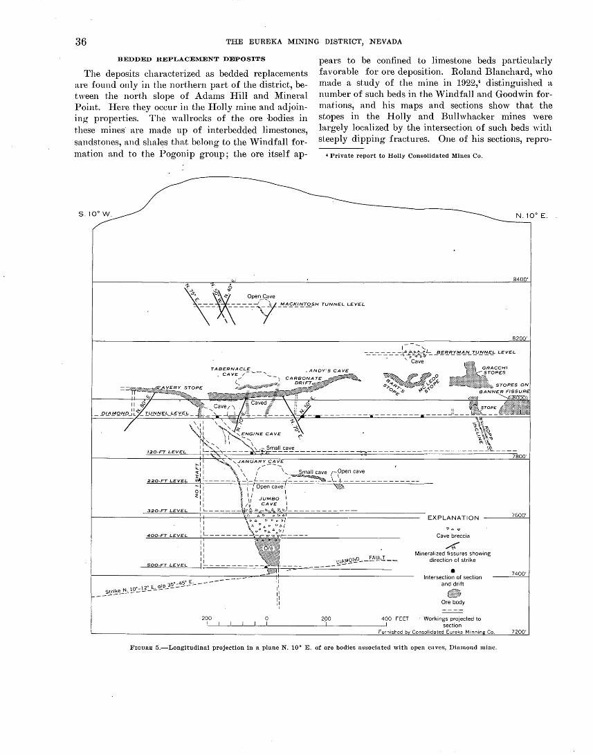
36 THE EUREKA MINING DISTRICT, NEVADA
BEDDED REPLACEMENT DEPOSITS
The deposits characterized as bedded replacements are found only in the northern part of the district, between the north slope of Adams Hill and Mineral Point. Here they occur in the I-Iolly mine and adjoining properties. The wallrocks of the ore ·bodies in these mines· are made up of interbedded limestones, sandstones, and shales that belong to the Windfall formation and to the Pogonip group; the ore itself ap-
pears to be confined to limestone beds particularly favorable for ore deposition. Roland Blanchard, who made a study of the n1ine in 1922,4 distinguished a. number of such beds in the Windfall and Goodwin formations, and his maps and sections show that the stopes in the I-Iolly and Bullwhacker mines were largely localized by the intersection of such beds with steeply dipping fractures. One of his sections, repro-
4 Private report to Holly Consolidated Mines Co.
N. 10• E.
84
TABERNACLE CAVE /-....._-,_
.ANDY"SCAVE
220-FT LEVEL
500-FT LEVEL
/ -)
~~:;:>.t@'i#·"'-=
II II II II 1----------
5o-450 E. _____ _
N 10•-120 E., ~p_3 ___ _
5_!!'0.~~-----
200 0
t> A <7
Cave breccia
4 Mineralized fissures showing
direction of strike
• Intersection of section
and drift
Ore body
FIGURE 5.-Longitudinal projection in a plane N. 10• E. of ore bodies associated with open caves, Diamond mine.

ORE DEPOSITS 37
clucecl as figure 6, illustrates this habit especially well. The control that was exercised by the stratigraphy of the "Tindfall and Goodwin formations in localizing these ore shoots distinguishes t.hem· from the irregular replacement deposits in the massive dolomites of the Eldorado and I-Iamburg formations; in these latter formations no relation between the ore shoots and particular beds has been recognized.
FAUL"l'-ZONE REPLACEMENT DEPOSITS
Deposits of this type are fairly numerous and widely distributed throughout the district except in the lower New York Cnnyon group of deposits, and even there
w
,....--:: 0 ~<:::::< .. >:·· 63 STOPE Workings projected 21ft
··.:·>( above actual elevations
71 STOPE :::_·"·::::::.
EXPLANATION
Quartz porphyry
Limestone bed Contact, dashed where
projected
Fracture or minor fault
Major fault
• Drift
100'
Section prepared by Roland Bl<~nchard, 1922
0
SCALE APPROXIMATE
if the old workings were still accessible, veinlike deposits might be found.
The fault-zone replacement deposits are tabular and steeply dipping and have been localized by faults or fracture zones that persist beyond the limits of the ore shoots or mineralized zones. The relation between these deposits and the irregular replacements is shown in several localities, where ore shoots of the latter type occur along fractures and, in places, grade into tabular fault-zone replacement bodies. Locally, fracture or fault zones have not been completely replaced by iron oxides and ore minerals to for1n a tabular body. Instead, small masses of mineralized material, or pods,
E 0
\
100'
200'
300'
• 400'
500'
100 FEET
• • 600'
FIGURE G.-Section looking north, Holly mine, showing localization of stoped areas at intersection of favorable limestone beds and steeply dipping fractures.

38 THE EUREKA MINlNG DISTRICT, NEVADA
N
-Shattered cavernous zone
EXPLANATION
Shattered, crushed, or sheeted zone
~ Iron oxide
Iron oxide pods or stain
...!.. 45
Strike and dip of fault zone or -iron oxide
Vertical dip of fault zone
0
Raise [2J
Winze
==1::::::: Caved working
/Nearly vertical sheeted zone; / rare iron oxide pods
~7/'-·linear open stope in iron oxide; some dolomite remnants
50 0 50
; ~ Open stope 75
Mapped by T. B. Nolan and J. V. N. Dorr 2d, 1939
100 F.EET
FIGURE 7.-Map of the Wabash tunnel, showing stopes on fault zone replacement bodies in Eldorado dolomite.
occur In the zone. Elsewhere irregular replacement deposits are found along the strike of fault-zone replacement deposits; these appear to form where another fracture intersects the mineralized zone. Such an occurrence is seen in the Wabash tunnel, where a nearly circular stope, with a diameter of about 40 feet, has been ·mined at the intersection of several mineralized fractures which themselves have been stoped (fig. 7).
The dimensions of these tabular deposits range widely. Some stopes, such as those in the Dead Broke
tunne.l (fig. 1) are only a few feet long, but many are from 50 to ioo feet in length and extend comparable distances down the dip. Few stopes exceed 3 or 4 feet in width. Some of the veinlike deposits are much more extensive, however. The Banner fissure on the Diamond-tunnel level of the Diamond-Excelsior mine has been followed underground, and locally stoped, for more than 700 feet horizontally' and may be recognized on the surface, 900 feet vertically above the tunnel level.

ORE DEPOSITS 39
There seems to be no correlation between the intensity o:f mineralization, and the displacement along the fractures. A large proportion of the mineralized fractures appear to have had little significant displacement, although in many places it is true that a measurable throw wol.1ld be difficult to recognize in the massive dolomite or limestone that forms the walls of the fracture. In some places, though, it is clear that ore formed along faults of considerable throw. The stopes in the Bowman mine, for example, occur along branches of the Bowman fault, which has a total displacement of about 1,000 feet (p. 23).
Other parts of the Lawton-Bowman fault, in the footwall of the Ruby I-Iill fault, were the locus of some of the earliest mining on Ruby Hill. Much of the stoping above the Granite, or Lower, tunnel on the south slope of Ruby Hill, followed the steep faults of the Lawton-Bowman system in addition to the lower thrust of the Ruby Hill thrust zone (p. 19-20).
Little information is now available in regard to dif-. ferences between the ores in these tabular ore bodies and those of the irregular replacement deposits. In general, the two kinds of ore bodies seem to have been essentially identical in tenor and in mineralogical composition, though in places there is a suggestion that the fault-zone replacement deposits may have been relatively somewhat richer in iron. On the other hand, the Banner fissure, and possibly some others, contain quartz-rich ore shoots in which the chief metallic minerals appear to have been silver-rich tetrahedrite and galena.
DISSEMINATED DEPOSITS
Only at the Windfall mine, near the middle of the linear cluster east of Prospect Ridge, have deposits of this category been mined. The Windfall ore bodies differ markedly from the other mineralized bodies in the district in that they are low-grade gold ore shoots with indistinct assay walls. The ore milled was composed of altered I-Iamburg dolomite with only a small content of introduced material.
The individual ore shoots in the Windfall mine exhibited a marked structural and stratigraphic control, being localized by the intersection of northeaststriking .fissures or faults with the uppermost beds of the I-Iamburg dolomite. Five shoots appear to have been mined by glory holes; these were roughly circular at the surface with diameters of from 50 to 150 feet (fig. 8). Only the near-surface workings are now accessible, but existing records suggest that most of the stopes terminated above the 200-foot level, and none extended below the 300-foot level.
Unlike the three types of deposits described above, the disseminated ore shoots of the Windfall mine show
~ew features gradational to the other kinds of ore bodies in the district. The most striking dissimilarities are the relative absence both of gangue minerals and of lead and silver in the ores. These features perhaps overshadow the fact that all four types of deposits . appear to be dependent upon the presence of mineralizing fissures, but they are so distinctive that one might suspect a different source for the disseminated ore bodies. There is, however, some similarity between all four types of deposits in that all tend to be relatively rich in gold and arsenic. The apparent lack of relation may therefore be the result of a discontinuity in the mineralization process, rather than to lack of a common origin.
CONT ACT.;METASOMATIC DEPOSITS
It is perhaps doubtful if any of the occurrences of contact-metasomatic deposits should be considered as ore bodies; probably none of the prospects that explore them has actually yielded shipments of ore. There are, however, several places· where metamorphosed sedimentary rocks of the Hamburg, Secret Canyon, and Geddes formations have been prospected. All are near the quartz diorite stock south of Ruby Hill; moreover, they are below, and close to, the lowest thrusts of the Ruby Hill thrust zone. Because of the northwardplunging fold of the thrust beneath Ruby Hill, the metamorphosed rocks beneath the thrust are exposed chiefly to the south of the intrusive plug; they extend as much as half a mile south of the intrusion, as shown in the Roberts tunnel.
Garnet-diopside rock makes up much of the metamorphic zone in which prospecting has taken place in the area beneath the thrust. Ore minerals have been introduced at relatively few places, however, and the controls at these few are obscure. Most of the prospects appear to have explored concentrations of the three iron-rich minerals, pyrite, pyrrhotite, and magnetite, and their . oxidation products. These minerals form irregular masses in the silicate rock, but nowhere has exploration gone f~r enough to reveal the extent or precise form of the deposit. Other prospects have exposed veinlike quartz-rich shoots, or zones rich in quartz veinlets, but these also appear to have been so low in grade as to discourage extensive work.
During World War II, the areas of garnet rock were unsuccessfully prospected for scheelite ore bodies.. Some occurrences of the tungsten mineral, however, have been reported from Mineral Hill, the ridge .that extends southward from the quartz diorite plug.

s
1T//~-=-~
MAIN SHAFT Stope on east-west Collar elev 7700 ft_.....--------fissure
Stulled stope on eastwest fissure IV
II/':: l[/ I ' / 3::11 I ;I//// ~~~~ 1 /Square set stopesJ II / I j ~ to surface /f I / //
c.::-.=-.=-J0~~~i-i#"..%~~J • 0 %.sx!4 se\s /// • Jft~e/ /t;'P)I ~ ~ • • • ' Portal
// / //,( //Stope « ll._g/ / LOWER NORTH TUNNEL.
N
l ~IF/ ff.'' //..///// / c ~ Extensiv:(// 0_"/ // Stope(1: ~/ 40 It below 100-ft le~eJ "- 2oo-FTLEVEL • /irf-47/Zl ///~~ ///::~ ,
stope 11
300-FT LEVEL /,' • • /~ I I
EXPLANATION
~ I;
400-FT LEVEL \ .
r 100 0 100 200 FEET
Stope
• Intersection of section with drift
Workings projected to section
Compiled by Combined Metals Co .. July 29. 1937
FIGURE B.-Vertical north-south section of Windfall mine with approximate projection of main stopes.
~ 0
1-3 ~ t'::l
t'::l q ~ t'::l ~ > ~ z z 0
t::' H U1 1-3 ~ H 0
~1-3
z t'::l < > t::' >

ORE DEPOSITS 41
R0-85
Rather shattered quartz-_, mica rock 1-Wide crushed zone
!-Steep quartz veins in quartz diorite
N
Large quartz grains in-\ quartz diorite
\-Quartz seams 1/4-3 in. in soft
rather white quartz diorite
-Crushing
•o \-Crushing
\-'Biotitic quartz diorite
\-Irregular slips and joints
\-Hard quartz diorite
, ....... Coarse-grained quartz diorite
/Rather soft coarse-grained I quartz diorite
6~;-2 ft crushing
I I_Ra_th~r fine grained quartz
d1onte somewhat altered
i "
/ [-:-/Massive sulfide garnet rock
' 1 1 Dolomite Quartz diorite : 1-Quartz diorite
Thin seam-• ~ -4-ft crushed zone Quartz diorite \ !-shattered quartz diorite
Quartz· diorite Rather intense alteration with \
some iron oxide at the con-tact-quartz diorite probably \-Wet gouge altered over 4 ft. Contact
65 Sediments altered to silicate
is crosscutting and dips minerals, pyrite, and magnetite more steeply than bedding-- 75-so
Probable bedding-. 10 Mapped by T. B. Nolan and 190 5,0 · 9 190 FEET Alan Broderick, 1938
FlOUR~) 9.-Map of the Rogers tunnel.
Good exposures of the metamorphosed sedimentary rocks are found in the Granite tunnel, north of the intrusi ve mass. In the 325 feet of exposures from the portal of the tunnel, dark-green hornfels is exposed with at least two zones relatively rich in pyrite. The Rogers tunnel, which cuts the intrusive rock from its northern to its southern boundaries also exposes the
metamorphosed rock at each contact as well as in one extensive inclusion (fig. 9). At the southern contact, the metamorphosed rock contains veinlets and masses of the manganese epidote thulite (Schaller and Glass, 1942).
MINERALOGY
The ores mined in the Eureka district up to the present time have contained, in addition to the gangue, chiefly oxidized lead, arsenic, and silver minerals; they have been relatively rich in· gold. The relative proportion of the four metals in the ores has varied from one mine to another and has even shown significant differences from place to place in the same mine. Similarly there are marked variations in the amounts of gangue; iron-rich minerals, silica minerals, and the carbonate wallrock are the chief components of the non-valuable part of the ore. In a few places, oxidized . zinc minerals are found, but most oxidized ores contain very little zinc, although such zinc minerals as hemimorphite and smithsonite occur disseminated in the walls of the ore shoots.
The gold ore from the ·vvindfall 1nine, though oxidized, differed materially from the other ores of the district in that significant quantities of iron, lead, silver, and zinc minerals were absent. Another type of ore, differing from the prevalent oxidized ores, is the sulfide ore found below the water table in the Ruby and Adams Hill mines of_ Eureka Corp., Ltd.; these unoxidized ores have not as yet been mined in significant quantities. Also unexplored to any great extent are the contact-metamorphic mineralized bodies south of Ruby Hill.
BAStE· METAL DEPOSITS
Most of our present-day knowledge of the character of the oxidized ores mined in the past is provided by the descriptions of these ores given in Curtis ( 1884, p. 51-63), who mapped the district during the period of peak production in 1880-1. Curtis' observations can be currently supplem~nted by study of the ores mined by the Consolidated Eureka Co. in the Di~unondExcelsior mine since 1955 and by the Eureka Corp., Ltd., in the T. L. shaft workings since 1957.
Curtis believed limonite to be the principal component of the Ruby Hill ores, and anglesite, cerussite, mimetite, and galena to be the principal ore minerals. Less abundant constituents were wulfenite, pyrite, arsenopyrite, hematite, sphalerite, calamine (hemimorphite), smithsonite, · calcite, aragonite, siderite, quartz, clay minerals, molybdenite, aziu·ite, malachite, and wad. Curtis also ~elieved that pyromorphite, leadhillite, and an oxide of lead occurred, but appears not to have actually identified them. Silver was "found

42 ' THE EUREKA MINING DISTRICT, NEVADA
in the form of chloride and sulphide, and the gold exists in all probability in a finely divided metallic state" (Curtis, 1884, p. 62).
The miners' classification of the ores, according to Curtis (1884, p. 59-60) was "indicative of their most striking characteristics, and the popular idea of the corresponding composition." Five categories of ore were apparently distinguished: "red carbonate," "yellow carbonate," so-called sulphuret ore, quartz ore, and true sulphuret or sulfide ore. The first three of these seem to have provided the great bulk of the ore produced from Ruby· Hill; quartz ore was more abundant in the Eureka tunnel and in some parts of Prospect Ridge, and the sulfide ore was found only locally at or near the water table; it appears to have yielded only a small part of the early production.
Curtis ( 1884, p. 59-60) describes the "roo carbonate" ore as a mixture of
hydrated oxide of iron * * * with some sulphate and carbonate of lead and containing intermingled grains and lumps of undecomposed galena. It usually carries about equal values of gold and silver, from $25 to $50 of each per ton,5 though sometimes the gold is considerably in excess * * * There are several varieties of red ore consisting principally of the hydrated · oxide of iron, with a little lead and silver, which are tolerably rich in gold. There is usually nothing in their appearance to indicate their value, and it is only by constant assaying that it is possible to determine what they are worth.
The relative richness of the "red" ores in gold noted by Curtis may be due, in part at least, to a relatively higher amount of pyrite or arsenopyrite in the sulfide ore ·from which the oxidized ore was derived. A correlation. between high gold and high iron, which is in general valid for ore now exposed, has been found to be true in milling tests conducted by the Eureka Corp., Ltd., on the sulfide bodies cut in the drill holes from the Locan shaft.
"Yellow carbonate" ore, according to Curtis ( 1884, p. 59), was a term
applied * * * to any ore of a' yellow color which contains lead. It belongs particularly, however, to a very characteristic ore, which is a mixture of the hydrated oxide of iron with the sulphate and chloroarsenate of lead. in varying proportions. The ratio of the silve;r to th.e gold in this ore is not at all uniform ; sometimes one metal, sometimes the other, being in excess. The value of both metals does not usually exceed $100 per ton.6 Another variety of "yellow carbonate" is that which owes its color to the molybdate of lead mixed through it. As the molybdate of lead usually carries but little silver and less gold, this ore is not very rich unless it· contains other minerals bearing the precious metals.
Probably most of the ores shipped since 1954 from the Diamond-Excelsior mine and from the T. L. shaft
56 Silver valued at $1.29 per ounce and gold at $20.67 per ounce.
of Eureka Corp., Ltd., would fall in Curtis' "yellow carbonate" ore category. It is probable, however, that their mineral content differs from that described by Curtis, in that a considerable part of the ore consists of ~ jarositelike mineral or minerals that is probably largely plumbojarosite. The antimony-rich mineral bindheimite also occurs as a constituent of yellow pulverulent material in ore from the 950-foot level from the T. L. shaft. Jarositelike minerals may still be observed in the walls of some of the old stopes on Ruby Hill.
Curtis ( 1884, P·. 53-54) records the occurrence of crystalline mimetite in the Richmond mine, and considered it to be present in considerable quantities in the "'yellow carbonate" ores that were shipped. The mineral is fairly abundant in the recently mined ores from the T. L. shaft.
Curtis (1884, p. 59) describes the "so-called sulphuret ore" of the miners as an "almost pure crystallized carbonate of lead. It is grayish in color, and consists of aggregated crystals of cerussite. It is sometimes quite· rich in silver, assaying as high as $125,7 but like all the lead ores proper is poor in gold." Some of the ore currently being mined, especially at the DiamondExcelsior n1ine, appears to be of this character, although it does not occur in stope-size n1asses, but rather intermixed with iron-rich ores.
Of the quartz ores, Curtis ( 1884, p. 60) writes that. they are uncommon, "especially those carrying quartz in visible crystals * * * except in the Eureka tunnel and some parts of Prospect ]\.fountain, but when found they are usually r1ch in gold and poor in silver and lead; There is a porous crystalline quartz ore found in some places in the Richmond mine, from which assays of over $300 per ton (0.04977 per cent) in gold, with but a few dollars in silver, have been obtain~d."
J.;ittle of Curtis' quartz ore is now available for study, but in several places both on Prospect Ridge and on Ruby Hill in or adjacent to the iron-rich oxidized ores, quartz-rich masses occur that closely resemble the silver-rich quartz-tetrahedrite-galenabarite ores of many TJtah, Nevada, and California districts. Cortez, Mineral Hill, and the Bay State and other mines in the Diamond Range are examples of districts north and east of Eureka in which such bonanza silver ores were found (Emmons, 1910). In some of the 1nines in these districts, material that may be similar to the "black metal" mentioned by Curtis, includes copper pitch, in addition to the galena and anglesite which he describes.
The ore in the Banner fissure, in the Diamond mine, was quartz rich and where stoped probably contained
7 Presumably the silver was valued at $1.29 an ounce.

ORE DEPOSITS 43
silver-rich ore of this type. It differed from the other quartz ores of Prospect Ridge by being relatively iron free.
So far as known, there has been no recent production of ores of this type within the Eureka district proper, although the Phillipsburg mine and two properties on the west side of Black Point, about 12 miles northeast of Eureka, have made small shipments in recent years.
Curtis ( 1884, p. 60) writes of the true sulphuret or sulfide ores that they "usually consist of a compact mass, composed of pyrite, arsenopyrite, galena, and blende, and vary very considerably· in the amounts of silver and gold that they contain. The miners do not as yet distinguish different varieties by name." He notes (1884, p. 51) that this type of ore has been found only "in a Overy few places in a region two or three hundred feet above the water level and in some localities below it. As might naturally be expected, the line which divides the oxidized from the unoxidized ores is not sharply defined, and the transition is a gradual one." ·
Curtis records that galena and, to a lesser extent, sphalerite persist locally into the oxidized ores. In these, galena "occurs in the form of nodules, which are changed at the surface into sulphate and carbonate of lead, and in irregular masses distributed throughout the ore. It is often of a dull black color, owing to the admixture of sulphate, and contains small quantities of arsenic and antimony, and in some cases molybdenum, which is probably in the state of sulfide. It usually carries from $100 to $150 per ton in silver and from $1 to $10 in gold" (Curtis, 1R84, p. 52). Molybdenite is recorded by Curtis as occurring in the Prospect l\Iountain quartzite on the 900-foot to the 1,200-foot levels of the Richmond mine, and an additional occurrence was disclosed by some work in the quartzite by the Eureka Corp., Ltd., from the Locan 841-foot level in recent years. The mineral here is too sparsely distributed to form a ;molybdenum ore.
The drilling since 1940 by the Eureka Corp., Ltd., in the hanging wall of the Ruby Hill fault has disclosed considerable additional sulfide ore, although it is so far known only from the sludge and the cores of the several drill holes. Sharp (1947, p. 11) writes of this material that "pyrite, some arsenopyrite, and some dolomite were the gangue minerals, and lead, zinc, and pyrite concentrates will be made by selective flotation. The pyrite, which contains most of the gold, will then be roasted and cyanided." l\fore recent work in the T. L. shaft by the corporation has disclosed additional amounts of sulfide-rich ore on the 1,050-foot level, although even here, more than 400 feet below the ·
ground-water table, there has been significant oxidation of the ore.
A representative suite of ore specimens from stopes in the 850-foot, 950-foot, and 1,050-foot levels from the T. L. shaft have been examined by Charles l\1ilton, Ed ward Chao, and l\{ary E. 1\{rose, of the U.S. Geological Survey. Most of the specimens were of oxidized ore, but one specimen from the 1006-1 W stope above the 1,059-foot level was composed largely of sulfides. Pyrite, containing numerous diamond-shaped arsenopyrite crystals, is abundant in this material (fig. 10), in addition to galena and sphalerite.
Most of the ore stoped from the T. L. workings was thoroughly oxidized, and satisfactory identification of the fine-grained oxidatim~ products is difficult; it can be accomplished only by, detailed microscopic study, combined with X-ray powder diffraction analysis. _Milton and his coworkers ~ave distinguished among the ore minerals, plumbojarosite PbFe6 (0H) 12 (S04)4, mimetite (PbCl}Pb4(As04) 3, and cerussite PbC03, with less abundant wulfenite PbMo04, hemimorphite H2Zn2Si05, and bindheimite Pb:$b206 (0, OH); quartz, ha.lloysite, goethite, and calcite, as well as wallrock remnants, constitute the gangue. Although not identified in the specimens examined, it is likely that anglesite PbS04 is also present in the oxidized ore, together with small quantities of cerargyrite AgCl, and native gold.
The oxidized ore minerals are all fine grained ; they occur either as pulverulent or powdery coatings or as more massive aggregates; thin sections show that locally at least there are considerable quantities of finegrained quartz intermixed with them (figs. 11-13). Mimetite, particularly, appears to occur in a variety of colors and textures, some being found as tiny, wellformed crystals in vugs in the ore, but elsewhere as yellow or red powdery coatings, or as finely crystalline masses, ranging from white through yellow to red.
The abundant plumbojarosite, where it occurs alone as massive fine-grained aggregates, is typically brownish yellow with a characteristic rather greasy feel. In most specimens, however, it is intergrown with quartz and other minerals. In view of the relatively high arsenic content of the oxidized ores, it is possible that beudantite PbFe3 ( As04) ( 804) ( OH) 6 is also present in the ore, either as a separate mineral, or an isomorphous replacement of part of the plumbojarosite molecule. The X-ray diffraction patterns of the two minerals are indistinguishable, however; and in these poorly crystallized specimens, recognition of beudantite, alone or in combination, would be difficult and tim~ consuming.
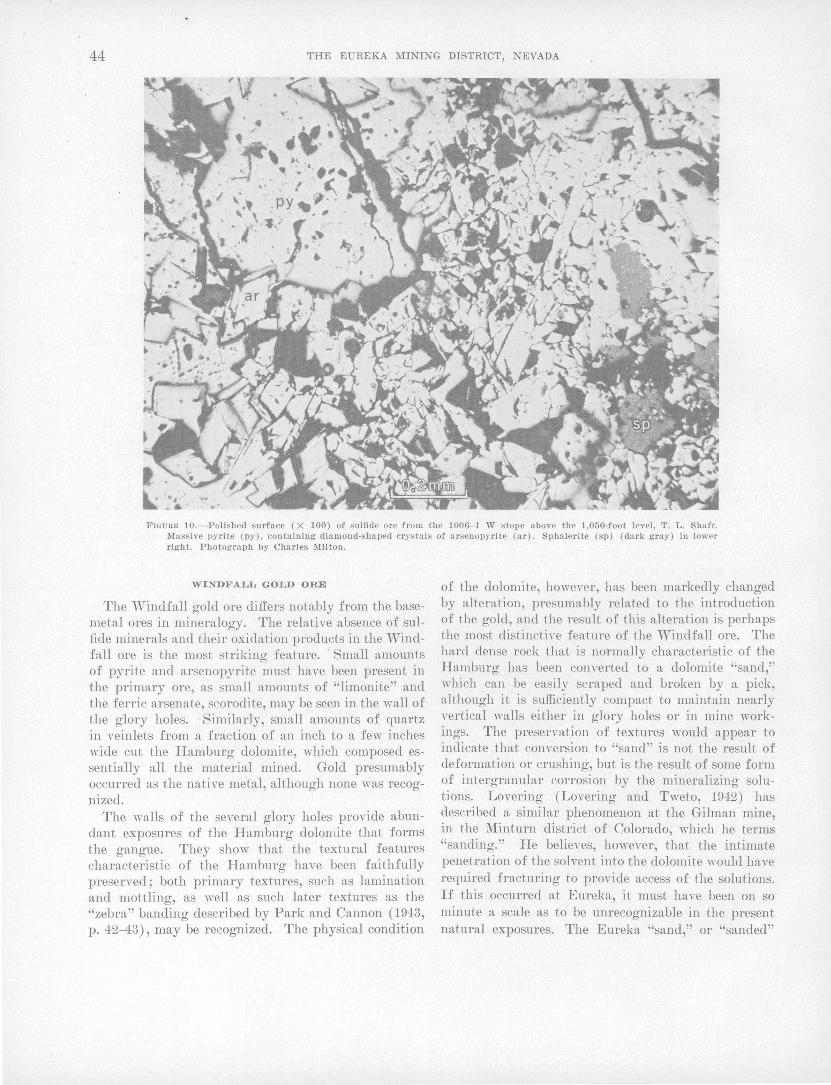
44 THE EUREKA MINING DISTRICT, NEVADA
FIGURE 10.-Polished surface (X 100) of s ulfide ore from the 1006- 1 W stope above the 1,050-foot level, '!.'. L . Shaft. 1\Iassive pyrite (py), containing diamond-shaped cr.rs tals of arsenopyrite (ar). Sphalerite (sp) (dark gray) In lowet· right. Photograph by Charles Milton.
WINDFALL GOLD ORE
The ·windfall gold ore differs notably from the basemetal ores in mineralogy. The relative absence of sulfide minerals and their oxidation products in the ·windfall ore is the most striking feature. - Small amounts of pyrite and arsenopyrite must have been present in the primary ore, as small amounts of "limonite" and the ferric arsenate, scorodite, may be seen in the wall of the glory holes. ·Similarly, small amounts of quartz in veinlets from a fraction of an inch to a few inches wide cut the Hamburg dolomite, which composed essentially all the material mined. Gold presumably occurred as the native metal, although none was recognized.
The walls of the several glory holes provide abundant exposures of the Hamburg dolomite that forms the gangue. They show that the textural features characteristic of the Hamburg have been faithfully preserved; both primary textures, such as lamination and mottling, as well as such later textures as the "zebra" banding described by Park and Cannon ( 1943, p. 42---43), may be recognized. The physical condition
of the dolomite, however, has been markedly changed by alteration, presumably related to the introduction of the gold, and the result of this alteration is perhaps the most distinctive feature of the ·windfall ore. The hard dense rock that is normally characteristic of the Hamburg has been converted to a dolomite "sand," "·hich can be easily scraped and broken by a pick, although it is sufficiently compact to maintain nearly vertical vmlls either in glory holes or in mine workings. The preservation of textures would appear to indicate that conversion to "sand" is not the result of deformation or crushing, but is the result of some form of intergranular corrosion by the mineralizing solutions. Lovering (Lovering and Tweto, 1942) has described a similar phenomenon at the Gilman mine, in the Minturn district of Colorado, which he terms "sanding." He belie\'es, however, that the intimate penetration of the solvent into the dolomite \Yould have required fracturing to provide access of the solutions. If this occurred at Eureka, it must have been on so minute a scale as to be unrecognizable in the present natural exposures. The Eureka "sand," or "sanded"

ORE DEPOSITS 45
FIGUilE 11.- 'l'hin section (X 15) of oxidized ore from 1002- 1 W stope, above 1,050-foot level , '1' . L. shaft. Quartz (Q) (white), ceruRsite (ce) (gra~·), and plumbojarosite (pi) (dark). Photogrnph by Charles )lilton.
FIGURE 12.-Cerussite crystals (ce) in quartz (Q) matrix. Thin sect ion (X 25) of oxidized ore from 901-2 E stope above 950-foot level, T. L. shaft. Photograph by Charles l\lilton.

46 THE EUREKA MINING DISTRICT, NEVADA
FIGURID 13.- Fine-grained mimetite (M) (black) in quartz (Q) . White areas are holes (H) in slide. Thin section ( X 25) of oxidized ore from 809- 14 E stope above 850-foot level, '!.'. L. shaft. Photograph by Charles Milton.
dolomite also differs from that in the Minturn district by being essentially unrelated to natural caves.
CONTACT-METASOMATIC ORES
Because of their lack of economic importance, very little attention has been given to the mineralogy of the contact-metasomatic deposits by the mining companies or by geologists who have studied the Eureka district. Megascopically, red-brown garnet, light-green diopside, tremolite, and serpentine have been recognized, the first being much the most abundant. Schaller and Glass (1942) have reported the presence of thulite (a manganese epidote) in the Rogers tunnel, and epidote, zoisite, clinozoisite, pem1inite and other chlorites, sphene, zircon, apatite, and allanite have been found in thin sections from tactite cut by the tunnel.
The iron minerals magnetite, pyrite, and pyrrhotite occur sporadically in the masses of silicate-rich rock, and the two latter minerals appear, locally at least, to be concentrated into masses 10 feet or more in diameter. No information concerning the possible gold or silver content of such concentrations is available, although the relation between gold and pyrite in the sulfide ore from the drill holes of the Eureka Corp.,
Ltd., suggests that it might be desirable to investigate the precious-metal content of these iron-rich bodies.
TENOR OF T H E ORES
The tenor, or grade, of the Eureka ores, like the total production, is uncertain, because of the unavailability of detailed and dependable records contemporary with mining. Such figures as are of record are in part, at least, mutually inconsistent, although two lines of evidence suggests that the vaiue of recoverable meta,ls in the ore produced by the Richmond and Eureka mines during the period of their major production was in the vicinity of $30 to $40 per ton, using metal prices then current..
The chief source of information on grade, expressed in dollars per ton, is a quarterly tabulation, which has been maintained by the county assessors office since 1866, first. in Lander County, and, since 1873 in Eureka County, as a basis for computation of a State tax on metal production. Through the courtesy of the Eureka County officials, this record has been made available, and a copy has been made of the reports of each productive property in the county from January 1, 1873,

ORE DEPOSITS 47
through December 31, 1905. These reports include figures for the tonnage mined during each quarter, the gross value in dollars, and the treatment cost. A summary of these records is included in a report. by Couch and Carpenter (1943, p. 56-64). ·
These figures ·were used to determine the average grade of ore produced during the period of peak production for a number of the then-active mines. The following tabulation lists the total tonnage and t.he average grade in dollars per ton of ore produced from .January 1, 1873, through December 31, 1897, for the mines listed.
llfine Tonnage Average gra(le Eureka Consolidated ___________________ 535,456 $32
Uichmond -------------------------- 460,361 34 Ruby-Dundcrberg (Dunderberg incline)__ 52,909 36
Diamond --------------------------- 35,490 31 Hamburg --------------------------- 12,885 31 Silver Lick ------------------------- 4,875 45 Phoenix ---------------------------- ~712 28 Silver Connor ----------------------- 4,649 35 Eureka tunnel __________ _:____________ 4,309 45
-Bullwhn.cker ------------------------ 3,662 29 Hoosnc _ _:___________________________ 3,344 33
Metamorns ------------------------- 1,479 54 Williamsburg ----------------------- 1,260 65
Grunt ----------------------------~- 627 62 Eldorado --------------------------- 605 99
The gross values shown presumably reflect the thencurrent prices for gold, silver, and lead. As the assessors figures provide no data on amounts of the three metals, it is not p<;>ssible to recompute these figures to present-day values. It is probable that the larger n.verage values of the ore from the last four properties listed resulted from more careful sorting and consequent up.:grading of the ore in these small properties in order to reduce transportation costs to the smelters, rather than being indicative of an actual higher grade of the ore bodies. ·
The general rn.nge of values shown by the assessors figures appears to be approximately confirmed by Curtis ( 1884, p. 151), who· recorded the terms offered by the Eurekn. mine to leasers or "tributors," \vho, beginning in 1878, produced a considerable proportion of the Eureka ores. He reports that initially (in 1878) the lessee was paid "10 percent of the assay value in gold and silver of all ore above $40 * * *. This rate wn.s pn.id for about 1 year when it was increased to 15 percent. Then a new schedule of prices was arranged based upon the assay value of the ore: $6 per ton of 2,000 pounds was paid for $40 ore and $30 for $100 ore, with proportional prices for the intervening grades. Finally, in 1881, still another schedule of _ prices was adopted: $2.50 was paid for ore assaying $30 per ton, and 50 percent of all that it assayed above $30." The. wages paid miners during this latter period were $4 per shift of 10 hours.
613943 0-62--5
Another, more detailed, indication of the tenor of the ores is also recorded by C1utis ( 1884, p. 60-61). This is an analysis of ore from the Richmond mine for the year 1878, which Curti~ writes "will serve as an example of the ores from all the mines of Ruby Hill, which greatly resemble each other both as regards quality and the minerals which compose them. The sample analyzed was an average of all the Richmond ore worked at the ftu·naces of that company during the previous year and the analysis was made by Fred. Claudet of London." 8
Percent Percent
Lead oxide -------------- 35.65 Lead -------------------- 33.12 Bismuth ---------------- --Copper oxide ------------ .15 Copper ------------------ .12 Il'on protoxide*---------- 34.39 Iron -------------------- 24.07 Zinc oxide -------------- 2.37 Zinc -------------------- 1.89 Manganese oxide --------- .13 Arsenic acid ------------ 6.34 Arsenic ------------------ 4.13 Antimony --------------- .25 Antimony ---------------- .25 Sulphuric acid ----------- 4.18 Sulphur ----------------- 1.67 Chlorine ----------------Silica ------------------ 2.95 Alumina ---------------- .64 Lime ------------------- 1.14 Magnesia --------------- .41 Water and carbonic acid __ 10.90 Silver und gold ---------- .10
[1] 100.52
27.55 Troy ounces" silYer per ton of 2,000 poun1l,;. 1.59 Troy ounces b gold per ton of 2,000 pounds.
*In this analysis the iron is represented in the form of protoxide, whereas it occurs as sesqnioxide. That it was intended to give it in the form of sesquioxide is shown by the percentage of iron (24.07) given would correspond with 34.39 of sesquioxide.
n $35.61 b $32.87
1 This summation is that given by Curtis. The correct total for the figures listed is 99.60.
This analysis indicates a gross value for the R.ichmond ores for the year 1878 of something on the order of $100 per ton, using Curtis' values of $35.61 for silver, $32.87. for gold and allowing about 4 cents a pound for lead. The figure not only conflicts \vith the average value of Richmond ores noted above but is nearly twice as large as the average value of Richmond ore for the yeat· 1878 obtained from the assessors records. These show Richmond mine production for the year as 34,410 tons with a gross value of $1,761,-852.67, or an average value of somewhat more than $51 per ton.
A possible explanation for this discrepancy may be provided by some rather fragmentary figures now in the files of the U.S. Geological Survey which were copied by G. F. Loughlin in 1915 from assay records of the Richmond-Eureka Co. that were then in the possession o.f Mrs. fi. M:. Schneider, of Eureka. Among
8 "Copied, by permission, from the records of the company."

48 THE EUREKA MINING DISTRICT, NEVADA
these figt-ires are average monthly assay value for gold, silver, and lead of both Richmond mine ore and custom ore purchased for treatment in the Richmond smelter·
' no tonnages for the ass~ty values are recorded. Arith-metic averages for 8 months of the year indicate a gross average value for the mine ore of about $92 per ton and of only $59 per ton for custom ore. The f<?rmer figure is comparable to the Claudet figures quoted by Curtis, but the lower grade custom ore would clearly reduce the grade materially. It is possible that the $51 per ton figure obtained from the assessors records would approximate the recoverable value of n1etals obtained from smelting a mixture of approximately equal amounts of mine and custom ore that averaged in gross value about $73 per ton.
Other assay values copied by Loughlin indicate that the Richmond ore decreased in grade with the passing years and that the recoverable value of $30 to $40 quoted above may not be too much in error. The original records of the Richmond and Eureka mines, however, appear to be no longer in existence, and without them it is probably fruitless to analyze further the significance of the apparent discrepancies between the fragmentary figures on tenor that are available for the years prior to 1900.
A very much lower grade of ore was mined dt1ring the period 1905-10, when the newly formed RichmondEureka Mining Co. mined the fill and walls of the old stopes to provide an ore that would act as a flux to the highly siliceous ores that were then being treated by the Salt Lake Valley smelters. ·sharp (1947, p. 9) reports that this ore "had an average grade of 3 pet lead, 30 pet excess iron over insoluble, with some lime and a gold-si1ver content of $6.00 per ton."
The recently mined ore from the Diamond mine and :from the T. L. shaft of Eureka Corp., Ltd., is comparable in grade to that mined in the past century. Although the content of the metals may be somewhat lower than those cited by Curtis for the Richmond mine in 1878, present-day prices for gold and lead bring the gross value per ton to amounts comparable to the high-grade ores of tne past.
Both of the companies that were shipping ore in 1957 have released figures on the tonnage and grade of the ore mined. The Eureka Corp., Ltd.,9 during the fiscal year ending September 30, 1957, mined more than 25,000 tons ·of ore that contained 0.48 ounce of gold per ton, 11.7 ounces of silver per ton, and 17.8 percent lead. Shipments totaling 6,024 tons were made; these had an average gross value per ton at the smelters of $64.57 per ton.
0 Eureka Corp., Ltd., Mar. 21, 1958, Annual Report year ended Sept. 30, 1957 : Toronto, Ontario, Canada.
The Consolidated Eureka Co. has also released information on its production from 1954 through 1956. The ore mined duri1ig this period had an average grade per:. ton of 0.751 ounce of gold, :39.7 ounces of silver, and 28.1 percent lead, with a gross value of $125.04 per ton .. 10
ORIGIN OF THE ORES
The processes by which the metals and other elements composing the sulfide minerals that form the primary ore of the Eureka district were transported to and precipitated in the surrounding sedimentary rocks and then subsequently oxidized and reconstituted to. form the present-day ore bodies ar:e of much more than academic interest. An understandin<r of what
b
these processes were, and how they operated, is essen-tial if explorati<>n for. new ore bodies is to be prosecuted successfully and efficiently.
The source of the introduced metals is to a larO'e ' M
extent, speculative; and knowledge of the channels through which the solutions that are presumed to have transported them moved, and of the probable physical and chemical factors that lead to their precipitation, is only slightly better founded. Even the mechanics of the oxidation process that occurred much later and under conditions that in part at least approximate those of the present day are not too "·ell understood. The following paragraphs summarize the data that are available and that appear to be significant.
SOURCE OF THE METALS
The proximity of the quartz diorite plug to the rich ore bodies of Ruby Hill, together with the rather clear relation of that intrusive body to the contact-metasomatic deposits that .border it, has led most recent observers to regard the quartz diorite as the source of the metals in the deposits that have yielded- so large a part of the Eureka production. On the other hand, the similar, though smaller, deposits in other parts of the district presumably have been derived from the same source as the Ruby Hill deposits. If they too were formed by solutions emanating from the quartz diorite, some other type of evidence than proximity to the plug is required.
Further, the rude grouping of the ore bodies of the district into five centers or belts suggests, in the absence of any recognizable channelways between the other four groups and the Ruby Hill plug, that more than one local source was involved. The Adams Hill cluster, for example, may have a genetic relation to the altered quartz porphyry sills and dikes that crop
1° Consolidated Eureka Mining Co., Mar. 27, 1957, Annual report year ended December 31, 1956: Salt Lake City, Utah.

ORE DEPOSITS 49
out in that area, especially as these bodies are believed to be of about the same age as the quartz diorite plug. There are no similar outcrops of intrusive masses of dioritic composition near the other tlu:ee clusters of ore bodies, however, and if there is a casual relation between the dioritic intrusive masses and the ore bodies, there must either be other intrusive masses concealed beneath these three centers, or the source of the ore must be a single and much larger intrusive mass, of which the ~Ruby and Adams Hill outcrops are apophyses.
This last hypothesis, on the basis of the scant available evidence, appears to be the most satisfactory one. An igneous source of the ore appears to be necessary to provide the large quantities of metals, especially n.rsenic, and· of sulfur that have been introduced into the sediments, since compn.rable concentrn.tions of these elements in Cambrian rocks distant from intrusive masses are not known. The existence of a large mass underlying the district cannot, however, be proved by evidence now at hand, although the n1ine workings. on Ruby I:Iill indicate that the outcropping quartz diorite plug does increase in size downward.11 Additional work, such as the widespread determination of 0 18/016
ratios in the sedimentary carbonate rocks adjoining the ore bodies, may point to the exis~ence of fonner temperature gradients that would be indicative of the existence, and configuration, of the hypothetical buried igneous source (Engel, Clayton, and Epstein, 1958). Another possible method of determining the existence, or the outline, of such a buried intrusive mass would be through an extension to the south of the aeromagnetic map prepared by Dempsey and others (1951). Their work showed marked magnetic anomalies over both the Ruby I-Iill plug and the intrusive quartz porphyry area of Adams Hill. If there is a deep intrusive mass, with concealed apophyses beneath the other ·three centers, it ise likely that similar, though less pronounced, anomalies would mark their position.
RELATION OF THE ORE BODIES TO FAULTS
The numerous fn.ults in the district appear to have been utilized in two different, though complementary, ways during the period of ore formation. One was as trunk channels, along which the ore-bearing solutions traveled from their source, or sources, to the five areas of ore deposition; the other was as mineralizing fisstues controlling the localization of individual ore bodies. Locally, a single fracture may have acted in both capacities; but in general the major faults, in-
u H.cccnt (1960-61) exploratory drllllng confirms the pres~nce at depth of quartz diorite 2,500 to 3,000 ft northeast of the area mapped• ns quartz diorite on pl. 1.
eluding the overthrusts, seem to have served as the trunk channels, and the minor fractures, as . the mineralizing fissures.
The difference in behavior between the major and minor faults may have resulted f~om the capacity of the former to provide both the means of ingress for the ore-forming solutions and the means of egress for the waste products of the ore deposition process. McIGnstry ( 1948, p. 239) has called attention to the need for a mechanism to carry away the material replaced by ore minerals, and the major through fractures that, in places at least, must have reached the surface at the time of ore formation were probably more effective in this regard.
Probably, however, the role any single fracture may have played, either as a through channel, or as a mineral localizer, was also controlled by the environment of the fracture during ore formation. Quite apart from the influence of the wallrocks, the temperature-pressure conditions would play a major role in determining whether or not solutions along a given fracture would continue to circulate or would lose their load of metals by precipitation or chemical reaction. Here also, it is possible that new or refined geochemical techniques, or determination of the variation in isotope ratios, will some day permit the delineation of the zones in which ore fonnation could have occurred.
The ore cluster at Ruby Hill illustrates the utilization of faults both as through channels and as sites of ore· deposition. Two of the major faults of the district crop out on either side of the summit of Ruby Hill, and both may have played an important part in guiding the ore solutions to sites of deposition. Although evidence as to a premineralization or postmineralization age for the earlier movement along the Ruby Hill fault is not conclusive (p. 24), several features suggest both a premineralization age and a relation to ore deposition. On the 1,200-foot level from the Locan shaft, for example, a body of massive pyrite occurs along the fault zone. In addition, the stopes of the Richmond-Eureka. mine appear to fan out from several separate foci, or sources, along the Ruby Hill fault (pl. 4 and fig. 3). Finally, although other interpretations are possible, the close · proximity of the two suggests a relation between the fault and the ore shoots found by the driliing in the hanging wall of the fault.
The upper of the two thrusts that constitute the Ruby Hill thrust zone (p. 19-20) also appears to have been a major channel of circulation for the ore solutions. No ore bodies have been found in the rocks beneath the thrust, but the thrust itself has been a

50 THE EUREKA MINING DISTRICT, NEVADA
locus of ore deposition, as shown by stopes along it in the workings of the Granite tunnel.
In these same workings, small normal faults thought to be branches of the Lawton branch of the JacksonLawton-Bowman .fault system (p. 22) have also acted both as channelways and as mineralizing or localizing fissures, for they not only connect the stoped are.as on the Ruby Hill thrust, but are themselves mineralized. Elsewhere in the Richmond-Eureka mine, these branch faults appear to have acted primarily as "mineralizers"; large irregular replacement ore bodies were mined at what are believed to be the intersections of these normal faults and nearly flat faults, which are parallel to and in the hanging wall of the Ruby Hill thrust fault.
The Diamond tunnel thrust zone probably acted as a channel for the ores of-the Prospect Ridge group, although the evidence for this is not conclusive. Like the Ruby I·Iill thrust zone, it marks the lower limit of ore deposition nearby, and the group of stopes and caves in the Diamond-Excelsior mine appear to diverge upward and southward from the thrust zone.
A northwestward-striking fault, the Banner Fissure, is also exposed in the Diamond tunnel workings, where it is not only itself mineralized, but the relative abundance o{stoping near it suggests that it may have been one of the channels through which ore-bearing solutions reached the numerous mines and prospects above.
Small mineralized fractures comparable to those in the Ruby Hill area are less easily recognized in the Prospect Ridge cluster, however, and many of the orebearing pipes and mantos appear to have formed with little or no recognizable structural control.
The north-south Jackson-Lawton-Bowman normal fault system ( p. 22-23) extends through the three most productive areas in the Eureka district. There are therefore sound grounds for considering that it may have played a majo~ role in the localization of ore in the district. Geographically it forms the eastern boundary of ore bodies in the Prospect Ridge; Ruby Hill, and Adams Hill clusters, but the major fault zone itself exhibits little evidence of mineralization along most of its course. The much more apparent relation of the northwest-striking Ruby Hill and Banner faults to ore shoots in fact suggests that at the time of mineralization the northwesterly ~aults were more open and provided a better channel for circulation than the major north-south fractures. The role of the Jackson fault zone may therefore have been that of a barrier, rather than a channelway, except for those parts of it that either had a more northwesterly strike or that were marked by more intense fracturing and, hence,
were more permeable. Under both of these circumstances, the Jackson zone probably acted as a channelway.
The effectiveness of the northwestward-striking Lawton branches of the Jackson fault. zone as mineralizing fractures was noted above. Another branch to the north may also have been similarly effective in localizing the Adams Hill ore cluster, although the evidence for this is not convincing. The }).ear-surface ores in the Holly and Bullwhacker mines, however, occur close to a split of the Bowman branch of the Jackson where a west-of-north strike is characteristic ( p. 23), and it is possible that this split provided access for the ore-bearing solutions to the numerous mineralized fractures in these mines (fig. 6). The deeper ores in the Eureka Corp., Ltd., mine workings from the T. L. shaft show little relation either to fractures that might have localized mineralization or to through channels, and the irregular stopes resemble in several respects the ore bodies in the DiamondExcelsior mine.
Still far:ther south in the .... .\dams Hill area, the nearsurface ore bodies that are so abundant from the Silver Lick claims on the west to the Wales and Helen shafts on the east appear to be controlled in part by abundant steep mineralized fractures and in part by the blanketing effect of the Dunderberg shale, which limits the ore bodies upwards. It may be significant, though, that the west branch of the Jackson fault zone here shows a pr~mounced bend to the west.
The Silver Connor transverse fault (p. 21-22) may also have acted as a channelway, as there are numerous
· prospects and mines near it, especially close to its intersection with the Jackson fault zone. Its northeasterly course may have permitted circulation of the ore solutions along it as suggested for the faults of northwesterly strike. - Few of the. mine workings in the linear belt of ore bodies south of the Dunderberg mine were accessible for study. The localization of these ore bodies in steeply dipping beds near the top of the Hamburg dolomite suggests that the zone of thoroughly fractured rock here constituted the major channelway. Old maps of the Croesus mine, as well as the projection of . structures known in the footwall of the Jackson fault zone into the down -dropped block of the DunderbergWindfall belt, sugge~t that this group of mines is underlain at a relatively shallow depth by the eastward continuation of the Diamond tunnel thrust zone. This thrust may also have acted as a channel for the mines of this group. , Only near the Windfall mine is there clear evidence of mineralizing fractures. The east-northeast cross

ORE DEPOSITS 51
faults that offset the I:Iamburg-Dunderberg contact luwe also clearly controll~d the localization of the ore shoots in the mine (fig. 8 and p. 39). Sur.face mapping discloses similar c~·oss faults in the vicinity of the Dunderberg, Croesus, Uncle Sam, and Hamburg mines, but it is not known if they similarly influenced ore deposition.
Even less information is at hand in regard to the fifth cluster of ore bodies. The properties in Lower New York Canyon which constitute this group were the earliest to be worked .in the district, and almost none of the old workings was seen during the course of the survey. Possibly the Hoosac fault ( p. 24-25) provided the channel through which the ore-bearing solutions reached the group; perhaps also the northwesterly faults that cut and offset the Eureka quartzite may have acted as mineralizing fractures. Both possibilities, however, remain speculative until direct evidence can be obtained from the old workings.
RELATION OF THE ORE BODIES TO THE ENCLOSING ROCKS
The third element in the emplacement of the Eureka ore bodies, deposition of the ore minerals, was largely controlled by the physical and chemical properties of the wallrocks through which the ore-bearing solutions passed.
Although prospect holes, and presumably some traces of mineralization, can be found in almost all the formations shown on the geologic map, minable ore seems to have been restricted to the massive dolomites of th~ Eldorado, Hamburg, and Hanson Creek formations, the limestones of the Windfall formation and Pogonip group, and the Eureka quartzite in the Roosac mine. Probably more than 90 percent of the production has come from the dolomites of the Eldorado and Hamburg and more than 90 percent of the remainder from the limestones of the Windfall and Pogonip.
The almost uni versa} restriction of the ore bodies to dolomite or limestone, is presumably due to the greater replaceability of the carbonate rocks by the metal-bearing solutions. The absence of ore shoots, or even mineralized rock, along much of the extent of the faults or fractures that locally contain ore shoots, and hence must have been followed by the ore-bearing solutions, would seem to indicate that the balance between reaction and no reaction was delicate. In part, this balance may have reflected such local physical conditions as the degree of fracturing of the carbonate wallrocks or the travel speed of the solutions. But because mineralized .rock is generally lacking along the f.ractures followed by the ore solutions, it is perhaps
more likely that the answer lies in the nature of the solutions themselves-possibly in a pH nearly in equilibrium with the carbonate wallrocks or in a concentration so dilute that reaction could take place only after prolonged contact between solutions .and wallrock.
The remarkable preference shown by the ore-forming solutions for dolomite, rather than limestone, as a host for the ore bodies is believed to be caused by the significantly greater brittleness of the dolomite. The much more intense fracturing in the dolomite would provide a very much greater amount of surface along which reaction between the wallrock and the ore solutions could take place; and if, as suggested above, the disequilibrium favoring reaction was slight, such an increase in the contact of solution and wallrock would be conducive to precipitation.
In both the Hamburg and the Eldorado formations, some limestone is interlayered with the dominant dolomite. Both on the surface and in the mine workings, the differing response of the two rocks to deformation is strikjng. In many places near the ore shoots in the Ruby Hill and the Diamond workings, for example, it is difficult to find a hand specimen of dolomi~e free from numerous fractures; indeed, locally the fracturing is so pervasive that the dolomite is a rubble of angular fragments a half inch or so in diameter. In contrast, the limestones have reacted to deformation by flowage and recrystallization; in several places underground wide, well-defined fracture zones disappear in passing from dolomite to limestone.
Possibly the ore bodies .of the Hoosac mine, reportedly i~ Eureka quartzite, also were localized by intense fracturing of the britt~e quartzite. Little can now be learned of these ore bodies, as the workings have long been inaccessible.
The impervious shales and the thin shaly and sandy beds of the Dunderberg and Windfall formations and of the Pogonip group have indirectly influenced ore deposition. Dunderberg shale, especially. on Adams Hill, appears to have served as an impervious barrier to ore deposition and to have caused a concentration of small ore shoots in the Hamburg dolomite immediately below it. Possibly a somewhat similar mechanism may have operated at the Windfall mine, but here the Dunderberg shale must have channeled the ore solutions laterally, rather than vertically.
The thin-bedded shaly and sandy zones that separate the massive limestones in the lower part of the 'Vindfall formation and in the Pogonip group have similarly acted as confining beds to the bedded replacement deposits of the Holly mine (p. 36-37). Alongside the

52 THE EUREKA MINING DISTRICT, NEVADA
mineraliz.ing fissures, however, even these beds have been replaced to some extent.
OXIDATION OF THE ORES
The final stage in the development of the ore bodies of the Eureka district was one during which the sulfide minerals ·were oxidized and the products of oxidation were in part transported into the adjoining wallrocks. The alteration, by circulating ground water, of an original hypogene ore body that consisted of pyrite, arsenopyrite, galena, sphalerite, molybdenite, gold, and an undetermined silver mineral to the carbonate, sulfate, and oxide minerals that constitute the presentday ores seems to have proceeded along the same lines as in many other districts containing limestone replace-ment deposits. .
The lead in the primary ore remained essentially where it was originally deposited, because of the relative insolubility ·of the oxidized lead minerals. The primary lead mineral galena initially alters to the sulfate, anglesite, and then to the carbonate, cerussite. A final stage at Eureka is the formation of the leadiron sulfate plumbojarosite and the arsenate mimetite to()'ether with smaller amounts of the antimonate bind-b
heimite. The sulf~arsenate beudantite, as noted on page 43, may also have formed at this stage. Plumbojarosite forms considerable masses of a fine-grained yellow micaceous product that may have constituted a considerable part of the early-day ores; it is abundant in the ores recently mined by the Consolidated Eureka Co. and by the Eureka Corp., Ltd., from the T. L. shaft. ·vvulfenite, the lead molybdate, is a relatively uncommon product but is locally abundant in the Ruby Hill mines.
Zinc, on the other hand, has been largely removed from the vicinity of the sulfides. Oxidized zinc minerals, such as hemimorphite, gosla:rite, smithsonite, and zinc-rich clays are relatively rare in the oxidized ore shoots but are rather widely distributed in the wallrocks, particularly along water courses or fracture zones. According to G. F. Loughlin, whose notes and specimens from a brief visit to the district in 1914 are in the files of the .u.·s. Geological Survey, oxidized zinc minerals were ·widely· distributed in the Ruby Hill workings that were then accessible. They were nowhere sufficiently concentrated, however, to form a minable zinc ore body. ·
Iron is intermediate in behavior between lead and ~inc. In part it has remained essentially where it was originally deposited as pyrite or arsenopyrite, through the formation of plumbojarosite. The greater part of the iron freed by the oxidation of pyrite and arsenopyrite, however, appears to have migrated a short dis-
tance into the walls of the original sulfide n1asses, forming, with silica, a casing around the oxidized ore bodies.
Such evidence as is available suggests that gold and silver, like lead, were not transported for any appreciable distance away from the original sulfide masses.
The net result of the oxidation process has been an increase in the tenor of the oxidized ores in lead, gold, and silver, as a result of the removal of much of the iron, zinc, and sulphur that were present in the sulfide ore.
Two· features of the oxidized ore bodies deserve mention, as they throw light on the processes of ore formation. These are the relations of the ore bodies to the present ground-water level and to the na.tural caves that are associatep. with the ore bodies in many -mines.
In most limestone or dolomite base-metal replacement ore bodies, especially in the arid West, oxidized ore minerals are found above the permanent groundwater level and sulfide minerals below. This relation early led to the general explanation that the process of oxidation was accomplished by free oxygen carried in the ground water that was percolating downward to the permanent water table; below that level, it was believed that free oxygen could no longer be carried in solution and sulfide minerals would not be attacked. Although this generalization has exceptions (Hewett, 1935; Brown, 1942), the lack of accordance between the ground-wa_,ter table and the bottom of the zone of oxidation is suggestive of a change in the level of the water table because of either climatic changes or structural disturbances.
The simple relation. between oxidation of the ore bodies and the ground-water level does not prevail in Eureka. In the Diamond mine, the ore bodies currently being stoped below the 300-foot level from the No. 1 shaft, all contain significant amounts of galena; and in at least some places, appreciable amounts of pyrite and sphalerite may also be observed, although the permanent ground-water level has not yet been reached in any of the mine workings.
Conversely, on the 850-, 950-, and 1,050-foot levels from the T. L. shaft of the Eureka Corp., Ltd., the ore shoots now (1959) being stoped are to a large extent composed of. oxidized ores, although the ground-water level was cut in the shaft more than 200 feet above the 850-foot level.
The failure of the lower limit of oxidation of the ore bodies to conform to the existing ground-water level in the two mines is believed to be the result of changes in the ground-water level so recent that there has not been time for the normal relation to be re-
MINES AND MINING 53
established. Although such a change might be caused by a major change in the amount of annual rainfall (with a consequent change in the amount of "·atei· reaching the water table), a more likely explanation is thought to lie in recent earth movements that elevated or depressed the topographic surface in the vicinity of the mines with respect to the general ground-water surface of the region.
The first of these possible explanations appears to be ruled ·out by the difference in behavior of the ores in the Diamond and in the T. L. shaft. A change in annual rainfall should produce a uniform result throughout the district.
Recent earth movements, on the other hand, appear to provide an explanation of the different relation of
. oxidation to water table in the two mines. As described on pages 25-26, Prospect Ridge has been eleva,ted along the Spring Valley fault zone in quite recent time, so that the Diamond mine ore bodies in the foot"~all are now considerably higher relative to the Spring Valley drainage than they were prior to the faulting. The recency of the movement along the Spring Valley fault zone would therefore provide an explanation for the presence of unaltered sulfides above the water table.
The recent elevation of the Prospect Ridge block was, however, terminated northwards by the Ruby J.Iill fault (p. 24). The Adams Hill block, in which the T. L. ore bodies occur, has thus been depressed relative to Prospect Ridge. This relative depression should have resulted in an actual rise in the groundwater level of the Adams Hill block, in order to reestablish equilibrium between the water table in the two blocks, as well as with the base level in Spring Valley. The abundance of oxidized ore below ground water in the T. L. shaft area thus not only is explanable as a consequence of the faulting but helps to confirm the structural and physiographic evidence on the nature and extent of the recent movement along the Spring Valley fault zone.
The areal relation of the oxidized ore bodies to the natural caves in the district has led to the speculation that the oxidized ores were deposited in preexisting caverns. This belief to a large extent stems from the widespread occurrence, especially in the Prospect Ridge group of mines, of layered oxidized ore bodies immediately below the floors of caves. Such ore bodies commonly are covered by a rubble of coarse cave breccia, the irregular upper surface of which forms the floor of the open cave.
Although it is likely that such caves have in part been formed by the dissolving action of ·ground water containing HC03 in solution on the dolomite wall-
rocks, the rather general absence of caves in dolomite in other parts of the region suggests that the caves which are associated with oxidized ores may have been formed through solution of dolomite by the sulfuric acid and ferric sulfide generated by the oxidation of sulfide ore bodies. vVisser (1927) has attributed breccia bodies at Bisbee to such a process.
MINES AND MINING
The Eureka district will· celebrate the centenary of its discovery in 1964. It is therefore among the older mining districts of the west. Although overshado,ved in its production and in its effect on regional development by the somewhat older districts of the J\1other lode of California and the Comstock lode of western Nevada, the district has, nevertheless, been the scene of many developments in mining and metallurgy of more than local significance.
Most of these developments date from the early days of the camp, when the local miners and metallurgists found ·it necessary to devise new methods to extract and refine, in the inhospitable environment of the Great Basin, ores of notably differ'ent character than those provided by the quartz veins of the J\1other lode or by the silver bonanzas of the Comstock. But even in recent years new problems have arisen that have led to developments of more th~u1 local interest. The utilization of rotary drilling for deep prospecting (Mitchell, 1953) and the techniques used to determine, and pump, the large flows of \Vater in the Fad and T. L. shafts, are examples.
In the field of prospecting, Eureka was the site of what appear to have been some of the earliest expmiments in both geochemical and geophysical prospecting. Unfortunately, although the methods used were Iiot at all unlike modern ones, the results were not generally recognized and accepted by the miners of the time; they seem not to have been applied in other districts.
The geochemical work, which consisted in the systematic determination of small amounts of silver in the dolomitic \Vallrock of an ore body in the Richmond mine, was carried out by Curtis (1884, p. 82-87) primarily to determine the source of the ores. In this it was unsuccessful, although the results were such that Curtis w~ts convinced that the wallrocks could not h_a ve provided the metals in the ore bodies by a process of lateral secretion. The increase in silver content as ore bodies were approached, however, caused Curtis to conclude that the. method might be of practical advantage in prospecting (1884, p. 145, 148).
Curtis' geochemical results corresponded closely with those obtained by Carl Barns through the use of

54 THE EUREKA MINING DISTRICT, NEVADA
an electrical geophysical method (Curtis, 1884, p. 142-149; Barus, 1885, p. 435-475). His confidence in the effectiveness of the two techniques was greatly increased by the subsequent discovery of a considerable body of ore just a few feet below the point in the Richmond mine where the two methods had indicated anomalies (Curtis, 1884, p. 144-145). This is probably one of the earliest recorded successes of geochemical and geophysical prospecting methods.
Barus' comment (Curtis, 1884, p. 147) that "the applicability of the electrical method of prospecting consists in the fact that the indications of the existence of an orebody occupy a space greatly in excess of the size of the body itself * * *." is probably one of the earliest statements of this fundamental principle of both geochemical and geophysical prospecting for metallic ores.
Relatively few innovations in mining methods appear to have been developed at Eureka, possibly because the square set system which had been devised to mine the Comstock ores a few years .earlier proved satisfactory for mining the large Eureka irregular replacement deposits. The district was, however, one of the first to apply widely the "tribute," or leasing, system. This was initiated in 1878 in the Eureka Consolidated property by the superintendent; it was based to a large degree on a pattern earlier developed in Cornwall. Curtis (1884, p. 151-152) has described the system as it was applied at Eureka.
In the field of metallurgy, however, the situation was quite different. Initially, the development of the district languished because of the inability of the early miners to recover economically the gold, silver, and lead contained in the ores. Several efforts to develop a method of direct smelting of the ores were made between 1866 and 1869. A satisfactory furnace was finally devised by Major W. W. McCoy in July 1869, in part at least because of the use of sandstone quarried in the Pancake Range, southeast of Eureka, as a refractory furnace lining. Judge S. Hetzel, in a centennial year report to the Librarian of Congress, reported that Eureka was the site of "the first successful treatment in America of argentiferous lead ore," 12
and Vanderburg ( 1938, p. 33) writes that "Eureka is generally conceded to be the birthplace of the silverlead smelting industry in the United States * * *."
An early historical account o£ the development of Eureka smelting is given by Angel (1881, p. 429-432), and a more technical description of the furnace, and the methods, finally adopted is included in Curtis
:t2 The Hetzel report is referred to, and parts of it are quoted, by H. R. Whitehill. Biennial Report of the State Mineralogist, State of Nevada, 1875-76, p. 52, 1877. The Library of Congress is unable to identify, or find, the original Hetzel report in its collections.
(1884, p. 158-164). More modern summaries of the smelting practices are provided by Vanderburg (1938, p. 33-36) and by W. R. Ingalls (1907, p. 1051-1058).
The Eureka ore bodies were also the cause of some of the early mining litigation in the United States. A suit between the Eureka Consolidated and Richmond companies over title to the ore in the "Potts Chamber" was one of, if not the, first of the apex suits that were consequent to the adoption of a Federal mining law in 1871. The limestone replacement deposits of Eureka differed so greatly from the California gold-quartz veins, whose characteristics provided the basis for the apex provisions of the 1871 law, that litigation in the district was probably inevitable.
Curiously enough, the difficulty of applying the simple vein coneept to the Eureka ores was early recognized by the miners themselves. The district mining laws adopted on September 19, 1864, were modified on February 27, 1869, to provide for the staking of 100-foot "square" claims with vertical boundaries, on the grounds that "explorations have made it evident that the mineral in Eureka district is found more frequently in the form of deposits than in true fissure veins or ledges, * * * this deficiency in the law may give rise to expensive litigations * * * ~" The following are original laws of the district as modified through August 1870; they illustrate the influence that was exercised on the Eureka district regulations by the vein deposits of the Reese River district, discovered in 1864, and the modifications caused by the irregular bonanzas of the White Pine, or Hamilton district, discovered 5 years later.
MINING LAWS OF EUREKA DISTRICT, EUREKA VALLEY, LANDER COUNTY, N T.
September 19, 1864
SECTION 1. This district shall be known as the Eureka Mining District, and shall be bounded as follows, viz : Beginning at the place where Eureka Creek or Canon crosses Simpson's old road, as laid out by him in 1859, thence following said road westerly to a spring in the middle gate, thence southerly along the summit of the mountains to the first valley, thence easterly along the base of the mountain~ to Simpson's old road, thence northerly, and along Simpson's old road to the place of beginning.
SEc. 2. There shall be a Recorder elected at this meeting, who shall hold office until the first Monday of September, A.D., 1865 ; he may appoint a deputy or deputies, for whose official acts he shall be responsible. The Recorder or one of his deputies, shall go upon the ground at the request of the locator, and see that the locator measures and stakes off his claim or claims. When desirable, the Recorder or his deputy shall call all meetings, when requested, by ten claim holders of the district, and preside at the same. The Recorder shall keep in a suitable book, or books, a faithful and true record of all

MINES AND MINING 55
claims brought to him for that purpose, if such claiins do not conflict with other claims. He shall record all claims in the order of their presentation, for which service he shall receive seventy-five cents for each claim recorded, he shall record all certificates of work done on claims when he is satisfied that the necessary worl.: has been done; h~ shall give certificates of location, or abstracts of title, for which service he shall be entitled to receive fifty cents; also, to keep his books for the inspection of those interested in the mines of the district. He shall deliver his books to his lawful successor. All examination of his books or papers to be made in his presence or that of a deputy.
SEc. 3. Claims of mining ground shall be made by posting a written notice on the claimants ledge, defining its boundaries; if advisable, a notice of mining ground by companies or individuals, on file in the Recorder's office, shall be equivalent to a record of the same. Each claim shall consist of two hundred feet on the ledge, but claimants may consolidate their claims by locating in a common name, so that in the aggregate no more ground is claimed than two hundred feet 'for each name. Claimants may hold one hundred feet on each side of their ledge for mining and building purposes, but shall not be entitled to any ledge within said distance. By virtue hereof, each locator shall be entitled to all dips, spurs and angles connecting with his ledge. All claims shall be recorded within ten days from the date of location.
SEc. 4. Whenever one hundred dollars worth of labor shall have been expended on any company's claim, or twenty-five dollars on any individual claim, the same shall be deemed a fee simple in the owners or owner thereof, and their or his grantee and assigns, and shall not thereafter be subject to relocation by other parties, except by producing to the Recorder a writing aclmowledging the ~bandonment thereof.
SEc. 5. All persons holding mining ground at the present time in this district, and all persons. hereafter and previous to the date herein mentioned, shall hold the same exempt from relocation until the first Monday of June, A.D. 1865. These Rules and Laws may be altered or amended by a two-thirds vote of those owning claims or mining ground in this district, after twenty days notice of such intention shall have been given in the "Reese River Reveille," .or some other paper published in Lander County, and shall have been _posted in the most public place in this district.
SEc. 6. The Laws, Rules and Regulations of the Reese River Mining District, so far as not inconsistent with the foregoing Rules and Laws shall be, and are hereby extended to and over this district, and made the Laws, Rules and Regulations thereof.
SEc. 7. Elections shall be held viva voce, unless otherwise determined, by those present at the meeting. At an election held in the aforesaid district, on the 19th day of September, A.D. 1864, the foregoing Laws and Rules for the district were adopted, and the undersigned duly elected.
G. J. TANNEHILL, President E. A. PHI!:LPS, Secretary
EUREKA MINING DISTRICT, June 5, 1865
Pursuant to notice, a meeting of the miners of this district was this day called, On motion, it was ordered that after this date the Recorder's fees for recording each claim or claims shall be one dollar, and also for issuing certificates Of title, one dollar; and it is also ordered that after this date no claim tl).at is now on record, or that may hereafter be placed on record,
shall be· relocatable before the fourth day of September, 1865; if there shall be as much as one dollar's worth of labor expended on the same, all of which was unanimously adopted.
G. J. TANNEHILL, Secretary and Recorder
EUREKA MINING DISTRICT, Sept. 4th, 1865
Pursuant to notice a meeting of the miners of Eureka District was this day called. On motion, it was ordered that after this date the Recorder's fee shall be one dollar, and also for issuing certificates of title one dollar. And it is also ordered that after this date no claims that are now on record shall not be relocatable before the fourth day of June 1866. Even if there shall be as much as one dollar's worth of labor expended on the same.
It was also ordered that G .. J. Tannehill be re-elected a Recorder of this Eureka District.
All of which was unanimously adopted. DENIS KENELY, President
ELISHE BREWER, Secretary
.DEPOSIT LOCATIONS
EUREKA DISTRICT, February 27, 1869
At a meeting of the miners of Eureka District, called on the 27th of February, 1869, S. J. Hope was chosen Chairman and C. A. Stetefeldt, Secretary.
qn motion, the following resolutions and amendments to the old laws of the district were adopted. ·
\Vhereas, explorations have made it evident that the mineral· in Eureka District is found more frequently in the form of deposits than in true fissure veins or ledges, and the laws of the district do not provide for the location of such deposits, and,
·whereas, this deficiency in the law may give rise to expensive litigations, as it is the case in 'Vhite Pine, a district of similar character, the miners o.f Eureka District have adopted the following amendments to the old laws of the district.
SEC'l'ION 1. Claims of mineral ground may be located as deposits.
SEc. 2. A deposit claim shall consist of a piece of grouna 100 feet square, and such a piece of ground shall be designated as a "square."
SEc. 3. The locator of a square claims all the mineral within their ground to an indefinite depth.
SEc. 4. The discoverer of a deposit shall be intitled to two squares.
SEc. 5. The claims taken up on one deposit shall not cover more ground than eight squares.
SEc. 6. A prospector shall be allowed to make a deposit location and have the same filed for record without having discovered ore on the surface, but his claim shall not be finally recorded if he does not find and expose mineral within thirty days from the time of filing said location for record.
SEc. 7. The corners of deposit ground shall be designated by stone monuments or stakes.
SEc. 8. Ten dollars worth of work for each square shali hold the ground for six months.
On motion A. Monroe was elected Recorder. SAMUEL J. HOPE, Chairman
CHARLES A. STETEFELDT, Secretary
I hereby certify that the above and foregoing is a full and correct copy of the Mining Laws in my office.
D. S. McKAY, Mining Recorder Eureka, August 8, 1870.

56 THE EUREKA MINING DISTRICT, NEVADA
The adoption of the Federal Mining Law of 1871, · cf course, superseded these local rules. An early ag·reement to establish a mutually satisfactory boundary between the properties of the Eureka and Richmond mines led to the establishment of a "compromise line" between the two properties. But differences of opinion about the definition of "lode," as used legally, led to further disagreement between the- two companies and finally to the apex suit mentioned in an earli~r paragraph. Curtis (1884, p. 111-113) has given a su~mary description of the claims of and the geologic interpretations proposed by the two contestants. The Supreme Court finally ruled in favor of the validity of the compromise line as a boundary between' the properties; and in effect approved. a broad concept of "lode," rather than the narrower one advocated by the Richmond Co.
PRODUCT'ION
Production figures for the Eureka district are fragmen_tary and conflicting, particularly for the years prior to 1903. The only· continuous record of the district output is that provided by the records of the Lander and Eureka County assessors-the former for the years up to 1873, and the latter since that time.
The assessors records were collected in order to determine the State and county bullion tax, which was levied on the net proceeds of gold and silver produced by each mine. According to Vanderburg ( 1938, p. 11), the law provided that the value of the ore was to be estimated on the dump before being milled, but an allowance was to be made for the expense of extraction and reduction of the ore. The Eureka County records, which were made available by the county officials, list for each quarter beginning with the year 1873, the name of the mine, or comp~ny; the amount of ore produced (in tons and pounds) ; the "gross yield or values" of this amount of ore; "the actual cost of extracting same from mine"; "the actual cost of transportation to place of reduction or sale"; "the actual cost of reduction or sale"; and the taxable net yield.
It seems probable. that the figures for the tonnage of ore produced were fairly accurate, but in the absence of any assay values for gold, silver, or lead, there is room for some doubt about the precise significance of the figures for gross value or yield~ It seems clear from the assessors records that in Eureka County at least, actual costs of mining, transportation, and smelting were allowed as a credit against the "gross value" of the ore in the computation of the tax, in contrast to Vanderburg's statement that a flat ·rate per ton for milling or smelting was all that was allowed. But there is nothing in the county records that makes it possible to determine if "gross yield or values" meant
the total value of the gold and silver in the ore, the value of the recoverable gold and silver in the ore, or the· value of either the total, or recoverable, metal content, including lead. Some evidence (p. 48) suggests that only recoverable gross values were used in computing the tax, although the fact that allowances were made for all costs would imply that·value of total content was intended in drafting the la,v.
A further difficulty in· ir~.terpretirig: .the assessors figures arises fro!ll the fact that the tax was levied on bullion. Vanderburg states that the value of the lead in the ore was not reported. One set of figti:res obtained from Angel (1881, p. 431) implies·'that the value of both lead and "fine bullion" was not hlCluded in the reports to the assessor. For the year 1876, for example, Angel quotes the Eureka Sentinel as~ reporting shipments as follows :
Gold
Silver ---------------------------------------Lead ---------------------------------~~~---~ · Fine bullion
$827,985.78 1,452,459.20
602,306.28 . 1,120,396.49
$4,003,147 ~75
The assessors figures for 1876, however, as listed by Couch and Carpenter ( 1943, p. 59) indicate the gross value of the production as $2,083,308. This suggests that only the value of gold and silver was. reported to the assessor for this year.
It is equally difficult to reconcile the assessors figures with the fragmentary ones found in several other early source books: the several volumes of biennial reports of the State Mineralogist of Nevada; the colorful account of Angel in the "History of Nevada" published by Thompson and 1Vest; early official reports that were based on bullion shipments by the 1V ells Fargo Express Co.; and the early reports on ~iineral Resources of the United States, published by the U.S. Geoiogical Survey after 1879.
For the years after 1901, more inclusive and detailed production figures are provided by the annual reports on mineral production published by the U.S. Geological Survey up to 1925 and by the U.S. Bureau of J\iines since that time. These figures too differ from those of the county assessor, both in tonnage and in gross value. Although the differences for many years are relatively small, they do not vary consistently in one direction: the assessors figures for one year may be larger and for the next smaller. And for a few years, 1925 for example, the difference between the two is substantial. '
Contemporary . records indicate that during the period of peak production, the Richmond and the Eureka Consolidated Companies and possibly others

MINES AND MINING 57
published rather comprehensive annual reports in which the production for the year was described in detail. Unfortunately, none of these appears to have been deposited or preserved in the files of either the present Richmond Eureka Co., the Nevada State Museum or the Nevada I-Iistorical Society. Similarly,
' there are references to an issue of the weekly Ruby I-Iill News that listed the production of each mine in the district up to the time of publication. This too seems not to have been preserved in any of the usual public depositaries of early Americana.
It has been impossible, for these reasons, to prepare n, table showing the annual production of the district in which one can have any real confidence. On the other hand, it seems desirable to record the district production figures (table 2, p. 58) ~tha,t are a vaila,ble as the best present approximation of the yield of one of the mining districts that played an important role in the develop1nent of the '""est. ·
No totals are shown in the table 2 because of the uncertainties in individual figures and the lack of specific data for the early production of gold, silver, or lead. It is, however, possible to derive a figure for the value of the total production since 1866 that appears to be the best approximation that can be reached at the present time.
This total is arrived at in three steps. The first provides a figure for the period up to 1883. It is based on n,n estimate by Curtis ( 1884, p. 4) and I-Iague (1892, p. 6-7) that the district production du:ii:g tl:e years frmn 1869 to 1883 amounted to $60 milhon In gold and silver and, in addition, 225,000 tons of lead. Vanderburg (1938, p. 13) estimates that an average vn1ue per ton of lead was close to $107; the total value of the lead produced was therefore about $24,075,000. Adding these two .figures, and allowing $150,000 for tl:e value of the production prior to 1869, a total for tlns early period amounts to $84,225,000.
For the period 1883-1901 inclusive, only the assessor's .fio·ures are available. It seems clear from the previot~ discussion, howevm> that t~is. amount is too low, in large part because of the omis~wn ~f. any lead production. If one can assume that tlns deficiency was approximately constant, an estimate of the true value of production can be made b~ multiplying th.e assessor's figure by a factor derived by comparing the assessor's figure for the years 1869-82, ($35,539,045) with that arrived at in the P!'eceding paragraph ($84,075,000). This factor is 2.366+, and a c~r~ected .figure for the years 1883-1901 is about $26 milho~.
Finally, using the tabulations ?f the Geolo~ICal Survey and the Bureau of ~1:ines and data provided by the Eureka Corp., Ltd., and the Consolidated
Eureka Mining Co. for the years 1902-59, a value of $11,931,700 is obtained for these years.
The three total somewhat n1ore than $122 million, and this seems to be about as close an estimate as can be made at the present time.
MINE DRAINAGE
The recent efforts of the Eureka Corp., Ltd., to unwater the area in which sulfide ore was discovered by deep drilling north of Ruby Hill have added a new chapter to the district's record of contributions to mining technology. In seeking a ~olution to the problem presented by the very large flows of water that were met in developing the ore bodies, techniques and principles originally developed for use in appraising around-water supplies for industrial or municipal use ~vere shown to be useful in determining both the amoul).ts of water that would have to be pumped and the required rate of pumping.
The existence of considerable amounts of water at depth in the Ruby Hill mines, in contrast to the absence of water in the deeper workings elsewhere in the
· district, was discovered fairly early. Curtis ( 1884, p. 107-110) summarized knowledge about the water conditions as of 1882; and reported (1884, pl. III) that the depth to the water table within the ore-bearing block of Eldorado dolomite decreased from an altitude of about 6,580 feet above sea level in the New Jackson shaft to 5,830 ·feet in the Richmond. This rather steep ,vestward inclination of the water level was roughly parallel to and locally coincided with the line of intersection between the Ruby Hill fault and the upper branch of the Ruby Hill thrust zone.
The inclination of the surface of the water table within the ore-bearing block of Eldorado dolomite contrasts with the nearly horizontal position of the surface in the area north of the Ruby Hill fault. But Curtis' account makes it clear that the inclination existed and hence that the ground between the two faults was effectively sealed off from the rocks on either side. Water from the workings of the Eureka Consolidated mine, for example, drained through winzes to the deeper workings of the Richmond mine to the northwest; and the lower part of the trough, where cut by the 1,200-foot level of the Richmond shaft, was comparatively dry, indicating that the permanent water level within the block must originally have been still lower to the northwest.
Considerable evidence has been accumulated in recent years concerning the water table in the area north of the ore-bearing block. Both the Fad and the T. L. shafts, the deep drill holes put down by the

58 THE EUREKA MINING DISTRICT, NEVADA
TABLE 2.-Available data on annual production of the Eureka mining district, 1866-1959 [Italic figures not footnoted from records of Lander and Eureka County assessors, 1866-1940, in (Couch and Carpenter, 1943, p. 59-60); roman figures not footnoted from records
of the U.S. Oeol:>!!"ical Survey and U.S. Bureau of Mines: 1902-36 quoted from Vanderburg (1938, p. 15-16) 1937-57 from Minerals Yearbook, published annually by the U.S. Bureau of Mines. Source of other figures shown by footnotes at end of table]
Gold Silver Copper Lead Zinc Year Tons ore Total value
Ounces Value Ounces Value Pounds Value Pounds. Value Pounds Value ----1------1-----·1------- ---------
1866 _______ _ 1867 _______ _ 1868 _______ _ 1869 _______ _
1870 _______ _
187L _____ _
1872.-------1873 _______ _
1874 _______ _
1875 __ --- ---
1876_-- -----
1877--------1878 _______ _
1879_-------1880 _______ _
188L ______ _
1882 _______ _
1883 _______ _
1884 _______ _
1885 _______ _
1886 _______ _ 1887 _______ _
1888.-------1889 _______ _ 1890 _______ _ 189L ______ _ 1892 _______ _ 1893 _______ _ 1894 _______ _ 1895 _______ _ 1896_-------1897--------1898 _______ _ 1899 _______ _ 1900 _______ _ 1901 _______ _ 1902 _______ _
1903 _______ _
1904 _______ _
1905 _______ _
1906 _______ _
1907 _______ _
1908 _______ _
1909 _______ _
1910 _______ _
191L ______ _
1912 _______ _
1913 _______ _
1914 _______ _
1915 _______ _
1916 _______ _
1917 _______ _
1918 _______ _
1919 _______ _
1920~-------
1921_ ______ _
9 1!,093
71 1!9
1!,195
31,317 a 4 18,847
54,001! 3 4 32,172
75,41!3 3 4 25,692
70,487 3 4 22,831 . 80,538
53,038
81,461 118,841!
109,363 3 69,834
85,990 3 33,800
I $827,986 ------------
I 2, 341,497 ------------
76, 501!. -------------- -------------- ------------3 30,929
62,680
51,097
55,959 • 10 33,755
39,637
II 14,750
II 13, 163
II 479,064
II 444,368
9 9 $1,200,000 ---------- ---------- --------------- -------------- -------------- ----------
8 9$, 179, 106 3 8 1, 224,076 8 9 B, 495, fJS:J 3 ~ 1, 318,364 8 g s, 907, 401! 3 8 1, 167,413
8 g 9, 655, 463 a 8 1, 059,801 8 9 6, 100, 000
I 1,452,459 ~ g 4, 003, 148 R g 3, 898, 879 8 9 6, 981, 706
I 3,257,481 a 8 3, 112, 670
a 8 1, 6501 925
.a 8 1, 720,313
I $602,306 -------------- ----------1 ~ 1, 120, 396
6 7 39, 448, 000
6 7 62, 126,000 ---.1~382~728' ============== ========== 6 7 45, 610, 000
6 7 33, 318, 000
6 7 25, 625, 000
6 7 17, 180,000
6 7 12, 000, 000
37,700 -------------- -------------- ------------ -------------- ---------- -------·--
6 7 8, 000, 000
6 7 7, 000,000 II 4,090,000
6 7 6, 800, 000 6 7 6, 800, 000 58, 118 -------------- 0 81,250,000 ------------ 0 8 1, 250,000 ---------- ----------
36,375 8,91!2
1!1, 427 16,871 17,1!38 13, 104 8,684 9,068 7,887 7,640 6,116 7,61!4 7,41!7 6, 1!16 5,1!05 4,508 5,557 4,397 1!,837 2,582 1!,664 1, 692
10, 1!67 11,896 35,340 35,092 .!6,936 28,000 77,208 87,936 10,458 11,923 14, 71!8 15,484 1!3, 701! 20,810
762 1,096
595 807 781
1, 135 B, 781! 3,61}6 2,21!6 3,304 ~.914 3,804 1,988 3,283 7,204 8,825
11!,433 9,644
3, 742.82
3,876. 38
1,653. 22
651.85
2, 396.01
8, 370.61
8, 337.68
20,306.76
3,412. 25
4, 920.48
5, 642.88
639.83
892.88
1,092. 20
_1, 873.59
973.85
1, 337.23
1, 015.29
3, 017. 85
2,383. 92
0 8 630,000 ·-----------
77,371
80,132
34,175
13,475
49,530
173,036
172,355
419,778
70,537
101, 715
116,649
13,226
18,457
22,578
38,731
20,131
27,643
20,988
62,384
49,280
96,287
95,596
44,772
36,341
68,760
152,872
109,826
179, 315
33,349
5,584
18,546
24, 173
28,441
34,308
80,657
39,708
51,980
66,459
78,878
45,886
I 6,206,000 6 7 4, 800, 000
6 2, 978,000
6 8 630,000 ---------- ---------- --------------- -------------- -------------- ----------
51,032
51,622
25,968
21,950
46,069
100,896
58,208
93,244
18,009
2, 960
11,406
14,601
15,728
17,394
53,072
32,720
51,980
74,434
85,977
45,886
6,653
115,557
72,477
90,100
70~
2,394
3,053
2,379
5,653
41,420
31,771
63,517
40,713
120,268
206,948
$1,283
23, 111
9,567
11,713
89
395
473
316
989
10,189
8,674
15,689
7, 573
22,129
26,696
6 7 4, 508, 000 6 7 5, 166, 000 6 7 2, 346, 000 6 7 1, 918, 000 6 7 9, 428, 000 6 7 6, 776, 000
6 7 3, 746, 000 903,875
577,748
496,306
416,308
992,929
2, 936,672
2, 310,572
4,340, 768
672,801
27,570
195,036
287,959
194,803
393,526
1,290, 448
693,757
1, 142,937
1, 179, 723
2, 457,094
776,943
37,059
15,311
19,827
19,566
56,497
155,643
97,044
186,653
29,603
1,240
8, 777
12,670
7,597
18,496
89,041
59,663
81,149
62,525
196,568
34,962
See footnotes at end of table.
$91!9 t.eo, 111 19,155 5,93!
1 100,000 107,900
I 2 313,402 1, 451,835
3 4 1, 249, 500 2, 098,489
B, 645,01/1 3 41,167,413
B, 798, 491! . a 4 1, 286, 175
3,064,001 I 6,100,000
2, 083,308 I 4,003,148
3, 81!1, 191 5,1!00, 871
I 6, 981,706 3,647,665
3,347,315
B,979,S7B 6 4, 127,265
1!,1!89,628 6 3, 176,656
1,490,008 6 1, 757,532
1,1!00,436 6 1, 634,380
B, 560,000
781!,804 879,449
61!6,561 !:77, 971 543,336 460, 701! 41!1, 424 385,1!87 184, 1!04 184,705 168,937 1!73,1!96 114,070 156, BOB 170,466 134,811 117,919 165,462 98,430
147,065 61,105 79,970 73, 701! 54,991
144,669 153,379 439,617 452,686 327,1!65 337,174 738,476 711,388 108,568 118,238 105,757 105,915 96,186
137,227 1!3,870 40,970 1!6,1!66 42,098 30,850 59,457
102,597 191,033 64,358
121, 188 117,639 176,461 111,581 165,520 183,950 367,058 180,170 156,824

MINES AND MINING 59
TABLE 2.-Available data on annual production of the Eureka mining district, 1866-1959-Continued
Gold Silver Copper Lead Zinc Year Tons ore 1----·---.------1----~----1----.----- ----·-.-----1-----:----l Total value
Ounces Value Ounces Value Pounds Value Pounds Value Pounds Value
lll22________ S, 368 I, 895.02 $39,174 44,925 $44,925 68,450 . $9,241 501,980 $27,609 -------------- ---------- $75,666 4, 236 120, 949
1923________ so, 176 4, 149.02 85,768 84,068 68,936 645,715 94,920 1, 345,409 94,179 -------------- ---------- 495,615 -m ~~ 1924________ 18,156 1, 477.76 30,548 48,552 32,530 160,344 21,005 1, 776,927 142,154 -------------- ---------- 94,830 ~~ •m
1925-------- 4, 5£6 1, 539.12 31,816 101,703 70 .. 582 25,955 3, 686 4, 326,303 376,388 -------------- ---------- · 85, S7t 31, 004 482, 472
1926________ 49,8£3 3, 894.40 80,504 153,979 96,083 66,194 9, 267 5, 568,282 445,463 -------------- ---------- 716,115 34, 81~ 631, 317
1927-------- 16,077 2, 372.55 49,045 75,223 42,652 38,988 5,107 2, 263,168 142,580 -------------- ---------- £54,854 13, 024 239, 384
1928-------- S£,374 2,249.70 46,505 30,530 17,860 26,168 3,768 932,000 54,061 ------------------------ £80,876 6, 006 122, 194
1929________ 41,75£ 1, 819.42 37,611 27,760 14,796 20,874 3, 674 755,488 45,596 -------------- ---------- 894,018 4, 981 103, 677
1930-------- £, 156' 693.90 14,344 17,037 6, 559 9, 016 1,172 365,725 18,286 -------------- ---------- 43,690 1, 898 40, 361
1931-------- 94£ 416.47 8, 609 4, 040 1,172 2, 565 233 124,374 4, 602 -------------- ---------- 13,037 888 14,616
1932-------- £, 8B8 452.96 9, 364 9, 380 2, 645 1, 120 70 122,516 3, 675 -------------- ---------- e1, 663 m ~~
1933-------- 3, B56 154.60 3, 952 3, 408 1,193 622 40 31,300 1,158 -------------- ---------- B7, 631 ~ ~~
1934-------- B, 955 1, 148.67 50, 63i 18,094 11,697 13,331 1, 067 295,056 10,917 -------------- ---------- 55,909 3, 868 74, 312
1935-------- 5, 990 2, 298.81 80,458 40,972 29,449 20,644 1, 713 482,033 19,281 -------------- ---------- 118, 158 6, 809 130, 901
1936-------- 4,710 3, 181.04 111,336 60,830 47, 113 5, 597 515 283,828 13,056 -------------- ---------- 88,536 14,486 172,020
~~~~======== s~: Z1~ -----4~437 ____ ============== -----84~732" ============== ----i~ooo" ---------- -------2o8~5QO- ::=====:=:==:: :=======:::::= ::::====:: B~~: b1~ 20, 829 219, 759
1939-------- 1B, 053 3, 232 -------------- 40,538 -------------- 500 103,700 -------------- ______________ __________ 165, see 9, 178 145, 563
1940-------- 6,£31 3, 787 -------------- 35,087 -------------- 200 36,500 -------------- -------------- ---------- 110,119 8, 318 159, 344
1941-------- 3, 931 2, 074 -------------- 23,915 -------------- ---------- ---------- 21,600 -------------- -------------- ---------- 90,827 1942-------- 1, 044 382 -------------- 11,291 --~----------- --'-------- ---------- 14,600 -------------- -------------- ---------- 22,377 1943-------- 374 124 -------------- 3, 479 -------------- ---------- ---------- 14,000 -------------- 80,000 16,504 1944-------- 5, 171 347 -------------- 11,392 -------------- 80,000 199,000 -------------- 390,800 91, 517 1945-------- 1~, 627 33 -------------- 16,380 -------------- 12,000 ---------- 156,000 -------------- 2, 408,000 ---------- 304,759 1946-------- 60,490 40 -------------- 43,428 -------------- 42,000 ---------- 294,000 -------------- 7, 410,000 ---------- 979,360 11147-------- 13,617 16 -------------- 22,783 -------------- 13,400 ---------- 136,000 -------------- 1, 793,000 ·--------- 260,530 11}48-------- . 161 44 -------------- 197 -------------- 5, 400 ---------- . 12,500 -------------- 37,500 ---------- 10,116 1949-------- 604 45 -------------- 1, 242 -------------- ---------- ---------- 36,900 -------------- 216,900 ---------- 35,425 1950-------- ------------ -------------- -------------- ------------ -------------- ---------- ---------- --------------- -------------- -------------- ---------- --------------1951-------- 64 -------------- -------------- 7 -------------- 672 ---------- 10,500 -------------- 10,400 ---------- 4, 562 1952-------- --------·--~- -------------- -------------- ------------ -------------- ---------- ---------- --------------- -------------- -------------- ---------- --------------1953-------- ------------ -------------- -------------- ------------ -------------- ---------- ---------- --------------- -------------- -------------- ---------- --------------1954 u______ 1,195 935.38 27,277 62, 176 47,037 ---------- ---------- 984,883 92,565 -------------- ---------- 187,628 1955-------- 2, 896 1, 930 13 51,260 111,893 13 80,976 7, 500 ---------- 1, 655,500 IS 156,018 -------------- ---------- 418,286 1956 u______ 4, 010 3, 047.4 77,634 138,245 96,432 ---------- ---------- 2, 047,657 191,055 -------------- ---------- 451,835 1957 II______ 3, 431 2, 712.71 65,331 88,112 58,225 ---------- ---·------ 1, 451,882 120,686 -------------- ------·--- 319,436 1958-------- 12 .. 28,029 u 12,178.87 -------------- 15 325, 183 -------------- ---------- ---------- 159,648,324 -------------- u 1, 708, 180 u .. 1, 539,624 1959 10______ 3, 706 1, 184.34 -------------- 35,224 -------------- ---------- ---------- 1, 137,925 -------------- 163,611 ---------- 165,492
1 Angel, In Thompson and West's History of Nevada, 1881. 1 January-June only. a Eureka Consolidated production only, for fiscal years October 1 to September 30. • Biennial reports of the State Mineralogist of Nevada. 4 Value of "fine bullion." o Mineral Resources of the United States, annual volumes. ' Total for State. a Total value gold and silver. .
Eureka Corp., Ltd., as well as some stock wells in Diamond Valley north of the mine workings have established that the surface of the normal groundwater table in this area is nearly flat and lies at an elevation close to 5,900 feet.
Further proof of the existence of the barrier between the ground-water body in the ore-bearing block and that in· the adjoining rocks northeast of the Ruby Hill fault was shown by the events that occurred in sinking the Richmond and Locan shafts.
Curtis ( 1884, p. 108) reports that the bottom of the Richmond shaft was comparatively dry when it was first sunk; this was at an elevation of about 5,700 feet, or about 200 feet below the water table to the north of the ore block. On crosscutting thrqugh the block of
v Vanderburg (1938, p. 13). 10 Richmond and Eureka mines only. JJ Unpublished notes of 0. F. Loughlin, in files of U.S. Oeol. Survey. u Annual reports of the Consolidated Eureka Mining Co. 13 Consolidated Eureka Mining Co. only. u Annual report of the Eureka Corp., Ltd. Includes 1957-58. u Eureka Corp., Ltd., 1957-58. 16 Eureka Corp., Ltd., January-August 1959.
Eldorado dolomite and through the Ruby Hill fault, however, "a stream of water was struck which became unmanageable without the aid of pumps, and it rose to near the 1,050-foot l~vel, and at that point it has remained * * *." The 1,050-foot level is approximately at the same elevation as the ground-water level in the Fad and T. L. shafts. The Ruby Hill fault here acted as. a barrier between the saturated ground to the north and the relatively dry western part of the orebearing Eldorado dolomite.
The events accompanying the sinking of the Locan shaft also seem to have shown the effectiveness of the Ruby Hill fault as a barrier. This shaft was sunk in the. hanging wall of the Ruby Hill fault to a depth of somewhat more than. 1,200. feet. It made but little

60 THE EUREKA MINING DISTRICT, NEVADA
water to· this depth, possibly because of cutting Secret Canyon shale beds in branches of the Ruby Hill fault at about the normal ground~water depth. In cross~ cutting from the shaft on the 1,200~foot level to the ore~bearing wedge of Eldorado dolomite, however, a fault fissure containing ore was cut at a distance of 300 feet. This was apparently the main branch of the Ruby Hill fault; and on penetrating it, the ground~ water body· enclosed within the ore zone was tapped. Here, in the eastern part of the ore-bearing block, the level·of the ground-water was about 450 feet above the Locan 1,200-foot level. Both the crosscut and the lower part of the. shaft filled with water so suddenly that "the men had barely time to escape" (Curtis, 1884, p. 109). The water rose in· the Locan shaft to the 1,035-foot mark at an elevation of 5,930 feet, approximately that of the normal ground-water surface north of the Ruby Hill fault.
So far as known, no effort was made to explore below this 5,900-foot elevation from the early 1880s, when the Richmond and Locan shafts were sunk, until 1919, when the Ruby Hill Development Co. leased the Richmond-Eureka property and unwatered the Locan shaft. Sharp (1947, p. 9) reports that the company ran into financial difficulties shortly thereafter and abandoned the project before any exploratory work was done. A few years later, the Richmond-Eureka Co. unwatered the Locan to the 1,200~foot level and did a moderate amount of work beneath the ore-bearing wedge. Once again, however, in going from the Prospect Mountain quartzite in the footwall of the wedge into Geddes lim~stone in the hanging wall of the Ruby Hill fault, a large flow of water was struck, which, according to Sharp (1947, p. 9) "drowned the pumps, and this work was stopped."
The discovery, by the Eureka Corp., Ltd., of sulfide ore in the hanging wall of the Ruby Hill fault by diamond drilling again led to work below the water table. A new shaft, the Fad, was started to exploit this ore in 1941; its collar is 1,430 feet east of north from the Locan shaft. Small quantities of water were struck in the Fad at 235 feet below the collar (Sharp, 1947, p. 11-12), and at the permanent water table, about 1,000 feet below the collar, the inflow had increased to about 300 gallons per minute (gpm). Mitchell ( 1953, p. 812) reports that during the sinking of the shaft below the water table, a maximum of 1,600 gpm was pumped at a depth of 1,700 feet. By the time the bottom of the shaft, 2,465 feet below the surface was reached, this inflow had decreased to 1,200 gpm and was relatively constant.
A crosscut was then started at the 2,250-foot level to reach the ore cut by the drill holes. Early in 1948, the
miners driving the crosscut drilled through a fault zone that was exposed only in the Fad shaft. A large flow of water under high pressure entered the workings through the drill holes. It flooded the pumps and filled the shaft with water up to the original water table. , Pumps with greater capacity. were. installed, and an: effort was made, in the winter of 1948, to un-
. water the shaft and level. A pumping rate of 9,000 gpm was required to lower the ·water level to within 60 feet of the 2,250-foot level. At this point, however, the inflowing water contained a great deal of sediment, which apparently was produced by erosion of the dolomite wallrocks along fractures. Because of the danger that the shaft might be filled with sediment, pumping ceased and the ground-water level again rose to its former height.
The most recent review of ground-\'\'ater conditions in the vicinity of the Fad shaft was made in 1952-53. In the course of this study, a pumping test was conducted jointly by the Eureka Corp., Ltd., and the Defense Materials Procurement Agency .13 The test was closely observed by W. T. Stuart, of the U.S. Geological Survey, who was able, as a result of the test,
. to compute the coefficients- of transmissibility and storage for the environs of the shaft (Stuart, 1955). He made observations of the dra wdown and recovery at both the Fad shaft and the Locan shaft, as well as in five nearby drill holes. For the Eldorado dolomite as a unit, the coefficient of transmissibility proved to be notably constant at about 24,000 gallons per day per foot, and the coefficient of storage 0.00067. For the rock columns cut by .the Locan and Fad shafts (section I -I', pl. 2), the coefficient of transmissibility was a pproximately 16,400 gallons per day per foot; and the coefficient of storage for the Locan shaft section averaged about 0.0013. The Eldorado is so thoroughly fractured that it yields its ground water nearly a third more rapidly than do the sections cut by the two shafts, which include shale horizons.
Stuart, through the use of princi pies and formulae that have been developed primarily to predict the behavior of aquifers that supply municipal or industrial requirements, was also able to determine, with a fair degree of certainty, that hydraulic continuity existed throughout the cone of unwatering~ which resulted from the pumping in the Fad shaft. The test did, however, suggest that one impermeable boundary was intersected by the cone of un\vatering at a distance of about a mile from the Fad shaft. This boundary may be the Ruby Hill fault, since as noted above, it was
13 Contract No. DMP-47 of the Defense Materials Procurement .Agency. The results of the test are summarized in a letter report, dated February 18, 1953, to Mr. Tom Lyon, Director, Domestic Expansion Division from a Consulting Committee, James S. Wroth, Chairman;

MINES AND MINING 61
effective in impeding circulation of ground water between the mineralized wedge of Eldorado beneath Ruby IIiU and the region to the northeast. The Ruby I-lill fault, however, at its nearest point is less than a mile distant from the Fad shaft, but this figure may represent not the nearest point on the fault, but the average distance through which water might drain from the fault surface.
The conclusions drawn from the pumping tests, as well as the constants derived from them, permitted Stuart to construct a group of time-drawdown curves. From these, a prediction of the pumping rate necessary to ]ower the water table in the area a given distance within any specified time can be made. He was able to conclude, for example, that it would be necessary to provide an additional pumping site, as well as the Fad shaft, if the ore bodies found by dri11 ing were to be unwatered in any reasonable length of time.·
Under one set of conditions, designed to unwater the ore body in a period of 2 years and using two pumping sites, Stuart estimated that an initial pumping rate of 8,000 gpm at the Fad shaft would be required which, after about 9 months, could be decreased to an average of 5,750 gpm during the remainder of the 2-year period. Pumping from the second site would range· during· this period from zero at the beginning to an average of 10,030 gpm during the last year and a quarter. l-Ie concluded, moreover, that this combined final average pumping rate of 15,780 gpm at the two sites could be decreased by only about 1,100 gpm after dewatering had been achieved, if the workings were to be kept dry.
The Eureka Corp., Ltd., was more successful in solving the water problem that arose in developing ore which was found by drilling on Adams Hill north northwest of the Fad shaft. The ore intersections ranged in depth from 850 to 1,050 feet below the surface, and a shaft, the T. L., was sunk to develop them. The shaft cut the water table at an elevation of about 5,890 feet, 630 feet below the collar. Pumping increased, usually by rather large increments, from about 100 gpm during the first 3 months of shaft sinking to between 700 and 800 gpm at the time the shaft reached its final depth of 1,127 feet in August 1955. As levels "·ere clri ven at depths . of 850, 950, and 1,050 feet, additional increments of water flowed into the shaft. $ome of these additional amounts increased the pumping load by as much as 600 gpm within the space of 2 clays.
T'he maximum pumping rate of nearly 2,900 gpm was reached in mid-September 1956, more than a year
after sinking of the shaft was completed. Pumping then decreased rather uniformly and gradually to less than 2,000 gpm in July 1957, when essentially all the workings on the three levels ·were dry, although water stood in diamond-drill hole 106, only a short distance away and about 55 feet above the 1,050-foot level. It is possible, however, that this may have been due at least in part to a self-sealing of the hole by silt as the water level declined.
Figure 14 shows graphically the pumping rates during the sinking of the T. L. shaft, and the decline in the level of the ground-water table in two diamonddrill holes nearby. Although some of the rapid declines in the water table shown in the drill holes was undoubtedly due to "unplugging" of the sealed walls of the holes and hence liad no hydrologic significance, others, such as the rapid declines shown by both drill holes in January and· February of 1956, were apparently the result of drainage resulting from the intersection of '''ater courses by the advancing mine workings. The declines of January and February, for example, were accompanied by a large increase in the pumping rate from the shaft owing to sudden inflows
. of water in ·the mine. Because of the physical similarity of the Hamburg
dolomite, in which the ore bodies of the T. L. workings are found, to the Eldorado dolomite, it is not unlikely that the pattern followed in unwatering the T. L. workings would be similar, with appropriate allowances for the greater depth below the ground-water table, to the one that might be expected to prevail in the un watering in the ore bodies of the Fad shaft.
NOTES ON THE MINES
In a district as old as Eureka, it is not surprising that the surface has been extensively pitted by shafts, tunnels, and opencuts. These are, however, as noted on page 29, concentrated in five general areas, in each of which the ore bodies are similar in character or in geologic setting, or in both of these.
A recent plat of T. 19 N., R. 53 E., issued by the U.S. Bureau of Land Management, shows 265 patented claims within that part of the township included in plate 1. There are probably more than this number of unpatented claims in the district, but no accurate compilation of them has been made. Plate 5 sh<?ws the location of the patented claims within the area of the township plat, as well as many of the unpatented claims belonging to or adjoining the properties of the Richmond-Eureka Co., the Eureka Corp., Ltd., and the Consolidated Eureka Mining Co.; the location of many of the unpatented claims is based on surveys

3000 3000
UJ 1-::::> z
2000 f--- f v- W I ltL..r' -~ --12000 ~ 0:: UJ a.. (J)
z 0 ...J ...J <( 1000 f--- (\_) --11000 (!)
o ...-- Data supplied by Eureka Corp., Ltd 0
A 5890 0
~ 5
~ ~i=ULLWHACKER UJ SHAFT UJ 1"1 ~
~ 5700 z
0 ooH 106 0 i=
1"1 T. L. SHAFT <(
DOH 104 0 0 DDH 105 > UJ DOH 1030 ...J UJ
5600 0 DOH 102
CYANIDE SHAFT
1"1 INDEX MAP
I I ,r.,,...,.., ~
1"1 HOLLY SHAFT
N
T. L. shaft water table Elev 5889.5 ft
850-FT LEVEL Elev 5675.7 tt'----,,--'-t---------
\
950-FT LEVEL Elev 5565.7 ft
-.._ 'I "l II
\ \_ DDH 104 .............. ____ _
200
300
DOH 106
5500 I L___ , ' 1 1
1050-FT LEVEL Elev 5475.7 ft Data supplied by Eureka Cqrp., Ltd =J 400
I I I I DEC. JAN.
1954 JULY 1955
DEC. JAN.
B JULY 1956
DEC. JAN. JULY 1957
1-UJ UJ ~
~ u.i ...J II) <( 1-
0:: UJ 1-<(
3: 3: 0 ...J UJ II)
J: 1-a.. UJ 0
FIGURE 14.-Rate of pumping from the T. L. shaft (Aug. 16, 1954--June 30, 1957) and changes in level of ground water in diamond-drill holes 104 (Feb. 10, 1955-0ct. 31, 1956) and 106 (Feb.14, 1955--June 30, 1957).
~ t-:l
8 ~ t"l
t"l 0 ~ t"l
~ ~ ~
z ~
z 0
1:::' ~
Ul 8 ~ ~
0 _8
·z t"l < > 1:::' >

MINES AND MINING 63
made by "Villiam Sharp for the latter"two companies. ~1any of the mine workings that were driven during
the pen.k of activity in the seventies and eighties are no longer accessible. For some of the properties, notably the Uichmond-Eureka, the Diamond, the Croesus, and the llolly mines, maps of the workings were in the files of the companies or of their lessees. Copies of most o'f these maps were secured and were of great assistance in the present survey. For the other mines and prospects, the workings that were easily accessible "·ere mapped by compn.ss and tape surveys on a scale of 50 feet to the inch. Both groups of mn.ps have been compiled, on a scale of 200 feet to the inch, for four of the five areas in which mining activity was concentrated; the compilations accompany the notes on these areas that comprise the following pages. For the lower New York Canyon area, however, no maps of any sort are at hand.
ADAMS HILL AREA
The Adams I-Iill area is the most northerly of the fi.ve aren.s in the Eureka district within which there has been· a relative concentration of mineralization. ~1ost of the· productive properties in the area are in sec. 15, T. 19 N., U. 53 E., and are either on the north slope of Adams Ilill or on ~1ineral Point to the north. Locally, prospect"s are so closely spaced that dumps from adjoining pits impinge on one another. Except for the recent work at the T. L. shaft and for some of the workings in the vicinity of the Holly mine,· relatively little record exists of the extensive exploratory work that has been done in these properties. A compilnJion of the mine workings for which maps are available is shown on plate 6.
Exploration began in the Adams Hill area shortly after the discovery of rich ore on Uuby Hill to the south, rtnd at ]east four claims, the Silver Lick, Silver ''Test, Vera Cruz, and "\Vide "Vest, were productive by 1871. Although the total production of individual properties was small, several continued active until the 1890's. Unlike the rest of the Eurekn, district, however, the greater part of the recorded production has been made in the present cent.ury. It has come mainly from two mines, the I-Iolly on the north, and the T. L. shaft of the Eureka Corp., Ltd., southwest of the I-Iolly. Both lutve produced ore with. a gross value in excess of a million dollars. The Cyanide mine, which yielded ore through 1922, and the Silver Lick, from which the Carter Brothers made small shipments· up until recent years, have also been productive since 1900.
Couch and Carpenter ( 1943, p. 62-64) list 20 properties that had produced ore with a gross value of more. than $5,000 prior to 1940. These are:
Property Adams Hill Cons. Mng. Co ________________________ _ Altoona ____________________________________________ _ Barton _____________________________________________ _ Bowman ____ ------------ _____ c--------------------~-Bullwacker _________________________________________ _ Cyanide ____________________________________________ _ Eureka Holly _______________________________________ _ Eureka Prince ___ -------------------------- _________ _ Fraser & Molino ____________________________________ _ Lone Pine __________________________________________ _ Margaretta _________________________________________ _ M.acon City ________________________________________ _ Members ___________________________________________ _ Morning Star ____ --------------- ___ ------------------Oriental & Belmont_ ___ -~ __________________________ _
Silver Lick __ ----------------------------------------Silver \Vest_ ________________________________________ _ Vera Cruz __________________________________________ _ Wide West_ ________________________________________ _ Williamsburg _______________________________________ _
Period 1874-77
1879-1901 1878-98 1876-92 1876-94
1899-1922 1915-27 1920-24
1882-1901 1876-88 1883-91 1875-89 1881-88 1875-90 1880-91
1871-1916 1871-72
1871 1871-1915
1877-92
Tons Gross yield 479 $15, 463 792 35,891
. 510 16,366 1, 097 51,092 4, 654 116, 069 1,817 119,753
67, 271 1, 156, 738 160 7, 004 612 28,209 756 26,568 866 32,928 949 73,407
1,890 31,317 113 6, 355
1, 131 27,90/\ 5, 293 241, 816
88 5, 328 17 10,267
526 6, 743 2, 765 72, 112
'l'otals_ _ __ __ _ _ _ _ _ _ _ _ _ _ _ __ ___ _ _ _ _ __ _ _ _ _ __ _ _ _ _ _ _ _ _ _ __ _ __ _ _ __ _ 91, 786 2, 081, 331
Production from the T. L. mine of the Eureka Corp., Ltd., began in 1956, and from then until suspension of shipments in early 1959, amounted to somewhat more than 30,000 tons with a gross value in excess of $1,650,000.
Geologically, the Adams Hill area differs from the other mineralized areas in the district in that the ore shoots are found in low-dipping sedimentary rocks belonging to the Hamburg dolomite, the "\Vindfall formation, and the Pogonip group. All these formations are in the hanging wa11, or overriding block, of the Uuby Hill thrust zone; they are, however, some distance above the thrust, and consequently the wallrocks of the ore shoots are commonly less brecciated than those in the other areas.
The area is bounded on the east by alluvium, which conceals the eastern branch of the Jackson-LawtonBowman normal fault; the Bowman branch of the fault trends east of north through the southeastern part of the area and branches of it have localized the ore in the Bowman mine. The fault has also been followed by dikelike masses of quartz diorite porphyry. The. intrusive body also forms sill-like bodies ··west of the Bowman fault along or near the Dunderberg-Windfall contact. ·
Much of the surface prospecting in the Hamburg dolomite has been done close to the Dunderberg contact. In this region large amounts of silica have been introduced as irregular bodies of jasperoid, in large part adjacent to the shale. It seems probable that precipitation of silica was caused by the blanketing effect of the overlying impervious shale. There appears to be relatively little silica associated with the. bedded replacement ore bodies in the limestones of the "\Vindfall and Pogonip.
There are significant differences in the form and metal content of the irregular replacement deposits in Hamburg dolomite and the bedded replacement deposits in the younger units. The deposits in the Hamburg dolomite are irregular in shape, and com" monly plunge at a low angle; tabular replacement
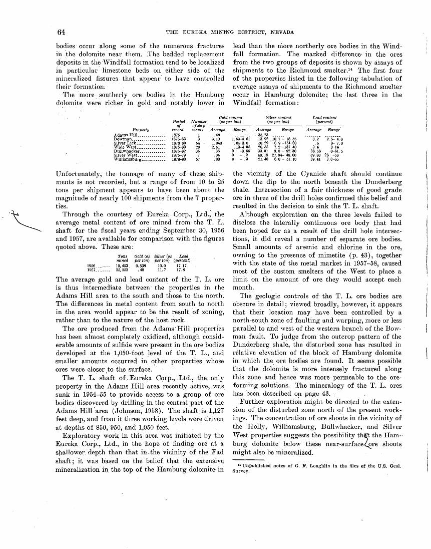
--~
64 THE EUREKA MINING DISTRICT, NEVADA
bodies· occur along some of the numerous fractures ii1 . 'the dolomite. near them. The bedded replacement deposits in the ·Windfall formation tend to be localized 1n particular- ·limestone beds on either side of the minerafized fissures that appear' to have cont~·olled their foi'ma.tio.n. ·
·The more . southerly ore bodies in the Hamburg dolomite were richer in gold and notably lower In
lead than the rriore northerly ore bodies in the. 'Vindfall formation. The marked diffei·ence· · in the ores from·the two groups of deposits is shown by assays of shipments to the Richmond smelter.14 The first four of the properties listed in the following· tabulation of average assays of shipments to the Richmond smelter occur In Hamburg dolomite; the -last three in the Windfall formation :
Gold content Silver content Lead content Period Number (oz per ton) (oz per ton) (percent)
of of ship-Property record ments Average
Adams HilL _____________ 1875 1 1. 69 :Bowman _________________ 1876-83 3 3.10 Silver Lick _______________ 1878-80 54 1.043 Wide West__ _____________ 1875-83 29 2. 51 Bullwhacker _____________ 1876-82 36 .36 Silver West_ _____________ 1875-79 7 .04 Williamsburg _____________ 1878-83 57 .03
Unfortunately, the tonna.ge of many of these shipments is not recorded, but a range of from 10 to 25 tons per shipment appears to have been about the magnitude of nearly 100 shipments from the ·7 proper-ties. · ·
Through the courtesy of Eureka Corp., Ltd.; . the average metal content of ore mined from the T. L. shaft for the fiscal years· ending September 30, 1956. and 1957, are available for comparison with the figures quoted above. These are: .
Tons Gold (oz Silver (oz Lead mined per ton) per ton) (percent)
1956 _______ 10,453. 0.538 10.0 17.17 1957 _______ 25,252 .48 11.7 17.8
The average gold and lead content of the T. L. ore is thus intermediate between· the properties in the Adams Hill area to the south and those to the north. The differences in metal content from south to north in the area would appear to be the result of zoning, rather than to the nature of the host rock.
The. ore produced fro.m the Adams· Hill properties has been almost completely o~idized, although considerable amounts of sulfide 'vere present in the ore bodies developed. at the 1,050-foot ~eyel_ of the T. L., and smaller amounts occurred in ~ther. properties whose ores were closer to the surface ...
The T. L. sh~ft of. Eure~a C<;>rp., .Ltd., the. only property in the Adams .Hill area recently active, was. sunk in 1954-55 to provide access to a group of ore bodie!? discovered by drilling in the central .part of the Adams Hill ·area (Johnson, 1958). The shaft. is 1,127 feet deep, and from it th.ree working levels were driven at depths of 850, 950, and 1,050 feet. ·
Explqratory work. in this area. was initiated by th(} Eureka· Corp., Ltd., in the hope. of finding ore at a shallower ·depth than that in. the viQinity of the Fad shaft; it was based on the belief th,at the extensive mineralization in. the top of the Hamburg dolomite· in
Range Average Range Average Range .. 35.23
1. 53-4.61 13.92. io~7-~-is~56 3. 2 2. 5-4.0 . 05-3.0 .50. 29 6. 9 -154.80 .6 0- 7.0 .13-4. 05 26.55 7. 2 -137. 40 3.4 0-14
0 -3.55 33.01 9.0- 92.30 38.58 0-61.5 0 - .2 40.18 27.94- 48.60 39.80 28 -50 0 -.3 21.40 6.0 - 51.10 39.41 3. 0-65
the vicinity of the Cyanide shaft should continue down the dip to the north beneath the Dunderberg shale. Intersection of a fair thickness of good grade ore in three of the drill holes confirmed this belief and resulted in the decision to sink the T .. L. shaft.
Although exploration on the three levels failed to disclose the laterally continuous ore body that had been hoped for as a result of the drill hole intersections, it did reveal a number of separate ore bodies. Small amounts of arsenic and chlorine in the ore, owning to the presence of mimetite ( p. 43), together with the state of the metal market in 1957-5 8, caused most of the custom smelters of the West to place a limit on the amount of ore they would accept each month.
The geologic controls of· the T. L. ore bodies are obscure in detail; viewed broadly, however, it appears that their location may have been controlled by a north-south zone of faulting and warping, more or less parallel to and west of the western br:anch of the Bow- · man fault. To judge from the outcrop pattern of the D:underberg shale, the disturbed zone has resulted in relative elevation of the block o~ Hamburg dolomite in which the ore bodies are found. It seems possible that the dolomite is more intensely fractured along this zone and hence was more permeable to the oreforming solutions. The mineralogy o.f the T. L. ores has been described on page 43.
Further exploratio~1 might be directed to the extension .of the disturbed zone ~1orth ~f the present workings. The concentration of ore shoots in the vicinity of the Holly, Williamsburg; Bullwhacker, and Silver 'Vest properties suggests the possibility th~t the Ham-·· burg dolomite below ·these near-surface~re shoots might also be mineralized.
14 Unpublished notes of G. F. Loughlin in the files of the U.S. Geol. Survey. · · .

MINES AND MINING· 65 RUBY HILL AREA
The Ruby I-Iill area has yielded by far the greater part of the production of the Eureka district. Almost all has come from properties whose workings underlie Ruby I-Iill itself or are located in the wedge of Eldorado dolomite thn.t extends southeastward from Ruby JEll. A much smaller production has come from properties on the ridge west of Zulu Canyon, which was referred to by Curtis ( 1884, p. 19) as ~iineral I-Iill; these are considered here to be within the Ruby I-Iill area. Plate 7 shows the mine workings for which maps are available; all are within sees. 22 and 27, T. 19 N., R. 53 E.
The discovery of ore on the Champion and Buckeye claims on the south side· of Ruby Hill marked the beginning of significant production in the Eureka district, as the ore bodies on these claims \vere large enough and rich enough, to warrant the development of efficient smelting techniques. The two claims became the nucleus o~ the Eureka Consolidated mine, which appears to have been organized in 1871; the Tip Top ~tnd Richmond claims to _the northwest were united to fonn the Richmond :Mining Co. at about the same time. The I\J(, Phoenix, and Jackson, southeast of the Eureka Consolidated, and the Albion, west of the Richmond, became productive a short time later. All six of these mines diseovered and mined irregular replacement ore bodies in the mass of Eldorado dolomite that underlies Ruby Hill. The peak production from the Ruby I-Iill mines was made in 1878; in the early eighties, company work began to be replaced by the "tribute," or lease, system. The closing of the Richmond and Eurek_a Consolidated smelters in the early ·nineties virtually marked the end of the bonanza operations on Ruby I-Iill.
The Eureka and Richmond properties were consolidated as the Richmond-Eureka Mining Co. in 1905. The U.S. Smelting, Refining, and Mining Co. controlled the new company and from 1905 to 1910 shipped a considerable tonnage of ore from the property to the company smelter in Salt Lake Valley. ~£ost of the ore mined during this period ·was composed of old stope fill and of the lower grade material that bordered the bonanza ore bodies previously mined. This materia1 was desirable flux for the siliceous ores then being treated by the smelter. The caved ground on the south slope of Ruby Hill has formed in recent years above the area stoped during this period.
Activity in the Ruby Hill area since 1910 has been chiefly devoted to the exploration of the Eldorado dolomite in the hanging wall of the Ruby Hill fault. Both the Richmond and the Eureka Consolidated· Companies in the early 1880's sought extensions of the ore
613943 0-62-6
bodies then being mined in this downthrown block, but their efforts appear to have been hai1dicapped by water problems on the one hand, _and by a rather widespread feeling on the other that the Ruby Hill fault was premineralization and had acted as a barrier to ore deposition in its hanging wall.
There have been several efforts to explore the hanging wall of the Ruby Hill fault at depth since 1919. The first of. these campaigns w~ts carried out in the Locan shaft area by the Canadian-financed Ruby Hill Development Co., but it ceased work after a relatively short time. Next, the Richmond-Eureka Co. in the twenties unwatered the Locan shaft and sank a diamond-drill hole 760 feet below the Locan 840-foot level.
William Sharp (1947, p. 10-12) has described the i?itial efforts of the Eureka Corp., Ltd., operating since 1937 under a lease from Richmond-Eureka Mining Co., to explore and develop ore bodies at depth in the Ruby Hill area. Five diamond-drill holes, put down by the Eureka Corp. and by the U.S. Bureau of Mines (Binyon, 1946), cut ore at depths of 1,350 to 1,500 feet below the Locan 840-foot .level, from which the drilling was done. These' discoveries led to the sinking of the Fad shaft, 1,430 feet northeast of the Locan; it was started in February of 1942, but because of problems created by World 'V ar II, as well as the necessity of pumping considerable amounts of water, was not completed until nearly 6 years later (~£itchell and Johnson, ·1949).
A level was started at the 2,250-foot level of the Fad shaft, and a crosscut was extended towards the ore bodies cut by the drill holes. A large flow of water was tapped in the crosscut, however, and the shaft was ~o~ded. Since that time, the Eureka Corp. has tried unsuccessfully to unwater the mine. Additional drilling, by rotary and churn drill rigs, has extended the area in which ore intersections have been found but
' the apparent necessity to pump more than 15,000 gallons of water a minute for a protracted period of time prevented development of the ore shoots up to 1960 (p. 60-61). The company's annual report for the year ending September :30, 1958, indicates that nearly $8 million had been spent up to that time.15
The recorded production from the Ruby Hill area, according to Couch and Carpenter ( 1943, p. 62-64), is more than $40 million. They list the following mines or eompanies which have made a production of more than $5,000. A more likely figure for the total produc-
15 In early 1960 an agreement was reached among the Eureka Corp., Ltd., the Richmond Eureka Mining Corp., the Newmont Mining Corp., Cyprus Mines Corp., and Hecla Mining Co. to organize a new company, called the Ruby Hill Mining Co. This new company has (July 1, 1961) carried out an extensive drilling campaign in the area southeast and northeast of the Fad shaft and has, as a result, extended the area
. known to be mineralized. ·

66 THE EUREKA MINING DISTRICT, NEVADA
tion, however, if the assumptions made on page 57 are correct, would be ii1 the neighborhood of .$100 million.
Adams & Farren _____________________________ _ Albion mine-----------------------------------Champion mine ______________________________ _ Cha'llpion & Buckeye ________________________ _ Eureka Consolidated _________________________ _ Eureka Corp.t ________________________________ _ Grant IT'.ine _____________________ ---------------Jackson Consolidated mine ___________________ _ KK Consolidated _____________________________ _ Phoenix Mining Co __________________________ _ Phoenix Silver Mining Co ____________________ _ Richmond-Eureka ____________________________ _ Richmond Mining Co ________________________ _ Ruby Hill Development Co __________________ _ Tip Top Mine ________________________________ _
Period 1871
1881-90 . 1870 ·1867
1873-1906 1937-40 1873-90
1873-1916 1873-83
1873-1913 1872
1871-1939 1873-1905
1920 1871
Tons 553
6, 703 1, 017 1,000
550,455 28,337
681 34,013 79, 210 5, 428 1, 906
294,095 488,081
1, 070 80
Gross yield $14,587 245,305 65,597 54, 720
19, 242,012 305,971 38,913
11.070, 925 2, 001, 126
156,043 34,308
4, 021, 674 15,209,443
10,784 5,079
'l'otals. _ _ __ _ _ _ _ _ _ _ _ _ __ _ _ _ _ _ _ _ _ _ _ __ _ _ _ ___ ____ _ _ _ __ _ _ _ _ 1, 492, 629 $42, 476, 487
t Probably includes production from the Oswego mine in Secret Canyon.
The irregular replacement ore bodies of the Ruby I-Iill area are almost wholly restricted to the brecciated plate of Eldorado dolomite that lies above the upper branch of the Ruby Hill thrust zone. This block of Eldorado dolomite underlies Ruby Hill and extends to the north at depth on the down-faulted hanging wall side of the Ruby Hill fault. Small amounts of ore, however, occur both along the Ruby Hill thrust zone and in the rocks beneath it; the largest of the ore bodies below the thrust was found in the Grant mine, south of Ruby Hill.
The thrust plate of _Eldorado dolomite, like the underlying plate of Prospect. Mountain quartzite, has been folded into a gentle northward-plunging anticline. It is cut by several normal faults, of which the northwesterly striking Ruby Hill fault has been the most important. There apparently has been repeated movement of both preore and postore age along it (p. 23-24). so that the Ruby. IIill fault now forms the boundary between the bonanza ore bodies of the early days and the recently discovered sulfide ore bodies that occur at depth to the north. Many of the smaller normal faults are premineralization and are believed to have acted as mineralizing fissures; they appear to have localized the ore bodies at their intersection with zones of brecciated dolomite along minor thrusts, which are parallel to and above the Ruby Hill thrust zone.
Other large normal faults, such as the major branches of the Jackson-Lawton-Bowman fault zone and the Martin fault (known only in the workings of the Fad shaft), are important economically, in that they not only bound blocks of replaceable dolomite, and hence influence mining, but may also act as either
barriers to, or co~1duits for, ground-water circulation. Branches of the Jackson-Lawton-zone, moreover, in many places appear to have acted as major channelways for the mineralizing solutions ..
The Bowman fault (p. 22-23) forms the west boundary of the structural block in which the Fad shaft ore bodies occur. The core drilling done by the Eureka Corp., Ltd., however, suggests that the . dips of branches of the fault may flatten notably at depth and thereby thin the post-Eldorado form~\tions, as disclosed by the drill holes. Alternatively, the low-dipping faults cut in the drill holes may be minor thrusts intersected by the B~wman at such an angle that part of the normal displacement along the Bowman has been transferred to the thn1sts. Something of this sort is believed to have occurred in the .Bowman mine to the north.
Relatively little of the oxidized ore such as was mined in the past is still visible in the accessible Ruby Hill wor~ings, but it was probably similar mineralogically to the oxidized ore found in recent years in the T. L. shaft. Plumbojarosite, anglesite, cerussite, wulfenite, and mimetite appear to have be~n the. chief lead minerals, and goethite, quartz. and remnants of the dolomite wallrock, the chief constituents of the gangue. Oxidized zinc minerals, according to the unpublished notes of G. F. Loughlin, of the U;S. Geologia! Survey, were moderately abundant ·in the walls of .the ore bodies, but they appear to have been _nowhere sufficiently abundant. to have constituted a zinc ore. Curtis (1884, p. 58) suggests that pyromorphite may have· been present in the ores, but none has been recognized in specimens availaqle to the "\vriter.
As is true of other parts of the district, ores from different parts of the Ruby Hill area contain characteristic. amounts of gold, silver, and lead. Ore from the Grant mine, in the southern part of the area, contained relatively large amounts of silver and lead, for example, and almost no gold. The ore from Ruby Hill proper, however, contained nearly equal values of all three of the valuable metals. Curtis ( 1884, p. 60-61) quotes an analysis by Claudet of the average grade
~ of Richmond ores for 1878 ; the average grade of a number of shipments of ore from the Jackson and Phoenix mines to the Rich~ond smelter, was obtained by G. F. Loughlin in 1914. They are listed in the following tabulation:
Number of shipments
Gold content (oz per ton)
Silver content (oz per ton)
Lead content (percent)
Property Grant. ________ ------- ___ _ Jackson ________ ------_---Phoenix _________________ _ Richmond._-------------
20 49 27 Average for year.
Years 1875-80 1877-80 1879-83 1878
Aver'lge Range 0
. 92 0 -1.91
. 683 . 03-1. 57 1. 59
Average 113.1 29.44 27.78 27.55
Range 29. 0 -311. 79 14. 50-209. 84 10. 65- 72. 10
Average Range 27. 3 11. 5-48. 5 16.65 0 -65 18.6 0 -55.5 33.12

MINES AND MINING 67
The sulfide ore revealed by the drill holes in the hanging \Yall of the Ruby I-Iill fault is roughly comparable in grade to that of the ore bodies mined in the footwall of the fault. Although gold, silver, and lead are present in lesser amounts, the percentage of zinc ~s Yery much larger, and the average value pe~· ton IS
probably not greatly differe~1t from that wluch prevailed in the 1880's. The silver content of the sulfide ore .api)~a.rs to be higher, in relation to both gold and ]end, than that of the oxidized ores, although the data antilable are not abundant enough to be conclusive. If confirmed by subsequent mining experience, howeYer, it would suggest a loss of silver in the. oxidation process. · ·· .
The sulfide minerals found in the sludge and In the cores of the drill holes are few in number. Only pyrite, arsenopyrite, galena, and sphalerite are pr~sent in significant amounts. The lo.cation <?f the drill holes that cut ore is shown in plate 8.
The distribution of the holes cutting sulfide ore has suggested that the ore occurs as nearly flat blanket repl~cement deposits near the base of the Eldorado dolomite thrust plate, and that lie west of, and perhaps are genetically related to, the Jackson normal fault zone. This conclusion, however, probably requires confirmation by mine development, since it implies a distribution of ore materiaUy different· from that in the footwall of the Ruby Hill fault (pi. 4). In any event, whether the ore occurs as continuous blankets, or as a group of separate ore shoots su:ch as ch.aracterized the areas explored in the past century, It seems probable· that a large tonnage of sul~de· ·~re o£. good grade is present below the water table In this regwn._
The Eureka Corp., Ltd., also found another type o£ suHide mineralization in a crosscut driven into the footwall from the 840-foot level of the Locan. The cut penetrated 450 feet of Prospect ~Iount~in · quar~zite before (:!ntering quartz diorite. The quartzite contained throuO'hout small amounts of molybdenite (MoS2). No b
base-metal sulfides were recognized, however. Although only small amounts o£· ore have been
prod'uced from the rocks below the Ruby Hill thrust zone, a block of ground attractive for prosp1ecting may be present immediately belo"r the thrust zone on Ruby :Hill. ·A few of the workings in the Richmond and Albion mines penetrated the block of Hamburg dolomite which lies below the lower branch of the thrust zone: without disclosing any ore, but the physical character of the dolomite appears to be similar to that of the Eldorado in the plate above the thrust. Pro'spectinO' of this I-Iamburg dolomite where some of the mineralized faults and fractures of the upper workings can be projected downward may some day be worthwhile.
PROSPECT RIDGE GROUP
Most of the productive properties in the Prospect Rid O'e trroup of mines are in the west half of sec. 34,
b b 'h T. 19 N., R. 53 E.; and. essentially all of those wit si(Ynificant production lie in the eastern part of this h:lf section. l\1ost of them are high up on either side of the crestline of Prospect Ridge.
The mine workings for which maps were available, or which were sufficiently accessible for tape and compass mapping, are shown on plate 9. The compilation is believed to be fairly complete, but a number of ·the early workings are no longer accessible; this is. particularly true of stoped areas and of the workings above or below the tunnels that wer~ driven as main entries.
Development o£ the mines of this group began somewhat later than in the rest of the district. The deposits that cropp~d out or extended close to the surface were hiO'h on Prospect Ridge and relatively
b .
little explored prior to 1875. After prqduction began, most of the shipments were of small tonnage and high grade. Most shipments were made by pack train to the smelters in Eureka, and the pack trail over which they were transported may still be followed. It lies just west of and below the crest of the ridge and runs from the vicinity of the Silver Connor mine to the head of Zulu Canyon.
Several of the mines in which the ore bodies did not crop out did not become productive until the 1880's, whel). output from Ruby Hill had already begun to decline. Several of these were developed by tunnels several thousand feet long, from which raises or winzes were driven to the ore shoots. The Prospect Mountain, Eureka, Ruby Hill, and Diamond tunnels were driven during this period. They not. only aided in the exploration for these hidden ore bodies, but materially lessened the costs of mining and transportation of the ores mined.
More than half the production of this area has come from the Diamond-Excelsior min~, which isthe name -Commonly applied to the claims now owned by the C~nsolidated-Eureka Co. These claims cover nearly all of the east side of Prospect Ridge at the head of New York Canyon, and some of the west side of the ridge. Most of the output from this mine was made in the 1890's, when rich ores associated with a system of caves above and below the Diamond tunnel level were exploited. The Jumbo Cave (fig. 5) was the largest and most productive; it contained a large mass of oxidized ore of bonanza grade below the rubble which formed, its floor.
Couch and Carpenter ( 1943, p. 62-64) list 24 properties in this area that reported production to the county

68 THE EUREKA MINING DISTRICT, NEVADA
assessor, prior to 1941, of $5,000 or more. A total of 103,308 tons valued at $2,776,177 is attributed to these mines. The individual figures, together with the years over which the production was made, are as follows:
Period of Property production
Alexandria_______________________________________ 1878-1905 Antelope_________________________________________ 1881-87 Banner _________________________ -------___________ 1876-90 Charleston_______________________________________ 1880-81 Dead broke_______________________________________ 1873-97 Delaware_________________________________________ 1877-98 Diamond & Excelsior_ ____________________________ 1897-1936 Diamond Mining 00----------------------------- 1874-97 Distinction_______________________________________ 1913-20 El Dorado________________________________________ 1873-92 Eureka Prospect__________________________________ 1937-39 Eureka Tunnel & Mining Co _____________________ 1881-1901 Excelsior_________________________________________ 1873-97 Industry_________________________________________ 1873-R8 Lemon Mill & Mining CO------------------------ 1874-78 Lord Byron______________________________________ 1885-94 Madrid___________________________________________ 1896-97 Maria __ ------------------------------------------ 1874-85 Metamoras_ ___ _ ____ _ _ _______ __ _ _ __ _ ___ ____ __ _ _ ___ 1874-87 Orange___________________________________________ 1871-73 Pioneer Westside -------------------------------- 1873-94 Prospect Mountain tunneL______________________ 1882-91 Silver Connor____________________________________ 1877-1921 Whip-Poor-Will__________________________________ 1881-91
Tons 1, 585
208 I, 267
94 470 34
12,053 57,800
487 802
8,610 4, 550 1, 759
512 339
2, 613 328 94
1, 424 254 193 939
5, 937 951
nrot!l yield $43,099
8,158 44, 90/i
6, 895 17, 567 14,365
320,02f\ I, 323, 194
25,569 69,781 98,306
206,308 89,762 40,551 8,432
118,578 7,173 6, 431
80,080 21,684 6, 217
29,791 167, 132
22, 173
TotaL_________________________________________________ 103,303 2, 776, 177
The Consolidated Eureka Mining Co. in recent years has carried out extensive exploration in various parts of the Diamond-Excelsior · property. In the years 1954-56 the company shipped 7,825 tons with a ·gross value of $978,465; additional shipments have been made since that time. The total recorded production from the Prospect Ridge group of mines through 1956 is therefore $3,754,642; the actual yield has been in excess of this amount.
The ores mined from this group have occurred as pods, replacement veins, and irregular replacement bodies in brecciated massive dolomite, which to the north is a part of the Eldorado dolomite and to the south is a part of the Hamburg dolomite. The Jackson-Lawton normal-fault zone and the Diamond tunnel · thrust zone bound the mineralized area on the east. The latter structure also appears to limit the ore bodies downward. The masses of ore-bearing dolomite are terminated on the west by the Ruby Hill thrust zone.
The Silver Connor transverse fault roughly bisects the ore-bearing area and separates the Eldorado dolomite on the north from the Hamburg dolomite on the south. It is locally mineralized and may well have been an effective channel through which ore-bearing solutions reached favorable sites for deposition in the dolomites on either side of the fault (p. 50). The Silver Connor appears to be related in time of origin to the thrust faulting (p. 21) and hence is of premineral age.
Probably the Jackson-Lawton normal-fault zone
played an important role in the concentration of ore shoots in this area ( p. 50). It is not itself mineralized, however, and appears to have been most influential in acting as a barrier to the ore-forming solutions and only locally to have been a channel through which the ore solutions traveled.
According to Curtis ( 1884, p. 62-63) the ores of Prospect Ridge were very similar to those of Ruby Hill, although he notes
perhaps there is a greater variety of them. As a rule they contain more siliceous material, and as a class are probably richer than those of the hill. The ores of the Eureka Tunnel * * * differ in several respects from those of Ruby Hill. They are more siliceous, an ore occurring frequently which is composed in great part of quartz; a great deal of the arsenic acid in the yellow carbonate is. replaced by antimonic acid; massive blocks of so-called "black metal," a mixture of sulphide and sulphate of lead carrying considerable silver (sometimes as high as $1,000 to the ton) are often met with; carbonate and oxide of manganese are not uncommon, and quartz crystals are frequently found scattered through the ore. The ores of the mines on the west slope of the mountain are noted for the relatively larger proportion of gold to silver that they contain. Among the richest of these are the ores of the Silver Connor and Williams mines. The ore from the former of these mines contains but little lead. The ore of the Banner Mine (now part of the Diamond-Excelsior mine) is noted for the large amount of silica it contains. It can almost be called a quartz ore. The Dead Broke ore contains considerable argentiferous galena and "black metal."
Some of the silica-rich ores appear to have been mined from quartz-galena-tetrahedrite veins and replacement · bodies ( p. 42) ; at several places in this area, notably in the Banner fissure of the DiamondExcelsior mine, such deposits are exposed in the workings that are accessible.
The evidence now available confirms Curtis' descriptions of the Prospect Ridge ores. Assays of shipments from the Silver Connor and Williams mines, on the western slope of Prospect Ridge, to the Richmond smelter from 1876 through 1883 show a rather uniform high gold, moderate silver, and low lead content. The Eldorado claims (of which there appear to be two, one on either side of Prospect Ridge), yielded ore with not only a high gold content, but also rather high silver and moderate lead content. The ore bodies in the Diamond-Excelsior mine were mined somewhat later; hut one shipment from the .Fourth of July tunnel suggests that these ores had a lower gold content.
The numerical average, and range of the gold, silver, and lead content from these properties is as follows :
Number Gold (oz per ton) Silver (oz per ton) Lead (percent) of ship-menta Average Range Averaqe Range Average Range
Williams mine_-------------------- 18 3. 90 I. 5Q-11. 31 28.56 12- 68.80 1. 51 0-6 Silver Connor mine---------------- 41 2. 9.5 . 33- 7. 85 20.04 6. 6Q- 75.40 .12 0-4 El Dorado mine ___ ----------------- 34 2.87 . 25- 9. 45 56.84 4. 7Q-134. 80 13.81 0-40.5 Fourth of July ___ ------------------ 1 .45 21.60
_________ ,. __ 8.0

MINES AND MINING 69
The ore currently being mined by the Consolidated Eureka Mining Co. confirms the suggestion provided by the old records that the Diamond-Excelsior ores tended to be lower in gold and higher in silver and lead. Nearly 7,000 tons of ore shipped by this company from 1.954 through 1956 averaged 0.751 ounce gold per ton, 39.7 ounces silver per ton, and 28 percent lead.w
'"rhe Consolidated Eureka Mining Co. is the only one presently productive in the Prospect Ridge area. It control$ most of the claims in the area from the Prospect Mounb'tin tunnel south and east to the Fourth of July tunnel. The property of the. company is known locally as the Diamond mine, and much of the exploratory work is carried on through the Diamond tunnel, at the head of New York Canyon.
The holdings of the Consolidated Eureka Co. are built around the claims originally held by the Diamond Mining Co., the first production from ~vhich was reported in 1874. This company apparently- acquired the Excelsior property to the north in 1897, and the combined properties were operated as the Diamond-Excelsior mine until the middle 1930's. Until about the beginning of Worl~ vVar II, activities at the mine were carried on under the name of the Eureka prospect, and a moderate production was made. After the war, a considerable amount of prospecting was done, both by geophysical methods C?n the surface and by diamond drilling underground, by interests connected with the J. I-I. I-Iammond estate and the James E. I-I ogle Co. of Salt Lake City. The present company has its headquarters in Salt Lake City and is reported to be controlled by the I-Iogle Co.
The main access to the workings on the property is through the Diamond tunnel, whose portal is at an altitude of about 7,900 feet. Before reaching the Hamburg dolomite that is the host for the ore bodies, the tunnel cuts the Jackson-Lawton fault a short distance i:rt from the portal and then goes through about 850 feet of deformed beds of the 'V"indfall formation, which make up the Diamond tunnel thrust zone. Workings extend north and west from this point for more than half a mile and reach the surface on the west side of Prospect Ridge close to the Metamoras shaft. Above the tunnel level, there are extensive workings tributary to the Star, M:ackintosh, and Berryman tunnels. These explored both a series of caves that extended from the surface through these higher workings to the Diamond tunnel level and the Banner fissure, a quartz-rich replacement vein.
Jo Consolidated lilureka Mining Co. Annual Heport Year ended Dec. :n, 1950. ·
Workings on the Diamond tunnel level also extend for half a mile to the south beneath the ground explored by the Domonic, Excelsior, and Fourth of July tunnels.
Three interior sl{afts were sunk from the Diamond tunnel: the No. 1 shaft to the north, from which the current \Vork is being serviced; the now-caved No. 2 shaft, which is 1,000 feet to the southwest; and the No. 3 shaft, nearly 1,000 feet south of the No. 2. Levels were driven from each of these shafts, and a winze· was sunk from the 320-foot level of the No. 1 shaft. A crosscut has been driven from this winze to connect with the Prospect Mountain tunnel, whose portal is about 700 feet below that of the Diamond tunnel. The Prospect Mountain tunnel is now ( 1959) used for ore haulage, but the Diamond tunnel continues to be used as the main working entry.
Much of the ore mined in past years on the Con-. solidated Eureka properties was found associated with, and below, groups of interconnected caves. These had a north-south trend, parallel to the major structural features of the area, and plunged gently to the north on the average. There appear to have been at least three such groups, one each in the vici~1ity of the three interior shafts. ·
For the most northerly of the groups, especially, the structural trough formed by the west-dipping Diamond tunnel thrust zone on the east and the eastdipping Diamond fault on the west may have been of major importan~e in localizing the cave groups. The Jumbo ore body, which occurred below the large Jumbo Cave, bottomed in this trough; the relatively impervious shaly beds of the Windfall formation · formed the footwall of the Diamond tunnel thrust
·zone, and the even more impervious Secret Canyon shale lay in the footwall of. the Diamond fault.
The intersection of these two fault zones plunges southward, and some of the first exploratory work done by the Consolidated Eureka Co. was done in the No. 3 shaft area below the Diamond tunnel level in a search for the trough in this area. It .was hoped that a concentration of ore similar to that found below the Jumbo Cave might be found. in. the trough along the downward extension of the southern of the three groups of caves. These hopes were not realized, however.
The most recent exploratory work has been performed in the No. 1 shaft area, where drifting disclosed ore in the footwall of the Diamond fault in the vicinity of the westerly workings of the 300-foot level from this shaft. Subsequent development opened up a northward-plunging oxidized ore shoot that is asso-
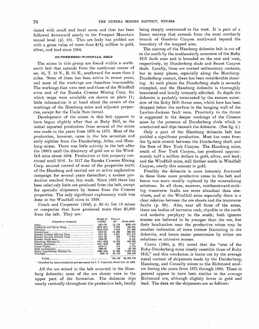
70 THE EUREKA MINING DISTRICT, NEVADA
ciated with small and local caves and that has been followed downward nearly to the Prospect Mountain tunnel level (I)I. 10). This ore body has yielded ore with a gross value of more than $1lj2 million in gold, silver, and lead since 1954.
DUNDERBERG-WINDFALL BELT
The mines in this group are fo~nd 'vithin a north-: south belt that extends from the northwest corner of sec. 25, T. 19 N., R. 53 E., southward for more than 2 miles. '-None of them has been active in recent years, and most of the workings are therefore inaccessible. The workings that were seen and those of the 'Vindfa1l mine and of the Eureka Croesus Mining Corp. for which maps were available are shown on plate 11; little information is at hand about the extent of the workings of the Hamburg mine and adjacent properties, except for the Uncle Sam tunnel.
Development o.f the mines in this belt· appears to have begun slightly after that at Ruby Hill, .as the initial reported production from several of the mines was made in the years from 1870 to 1873. ~{ost of the production, however, came in the late seventies and early eighties from the Dunderberg, Atlas, and Hamburg mines. There was little activity in the belt after the 1890's until the discovery of gold ore at the 'Vindfall mine about 1904. Production at this property contintled until 1916. In 1917 the Eureka Croesus ~fining Corp. secured control of most of the properties north of the Hamburg and carried out mi active exploration campaign for several years thereafter; a modest production resulted from this work. Since 1923 there has been relatively little ore produced from the belt, except for sporadic shipments by lessees from the Croesus properties. The only significant exploratory work was done at the Windfall mine in 1938.
Couch and Carpenter ( 1943, p. 62-4) list 13 mines or companies that have produced more than $5,000 from the belt. They are:
Property or company Atlas ________________ -------_--------------------California and Silver King ______________________ _ Connelly ______ -___ ------------------------------Dunderberf! ________ - ____ "_ ----------------------Eureka Croesus Mining CorP---------------~---Eureka Nevada Mining Corp ___ : ______________ _ Eureka Uncle Sam ______________________________ · Hamburg MiningCO---------------------------Helene Mortimer--------------------------------Home Ticket.. ____ ------------------------------Irish Ambassador ____________ --------------------Ruby Dunderberg Mining Co __________________ _ Windfall•- ____ ----------------------------------
Period of activity 1875-79
1879-1917 1873-1916 1873-93 1917-23 1917-23 1922-23
1871-1923 1871-1918 187o-71 1880-87
188o-1901 1908-16
Totals_-- ____ ---- __ -------- _____ -----------------------
Tons of ore Gross yield 12, 179 $569,419 3,378 108,644 4, 543 177,946
14,293 488,342 5, 817 217,912
218 6, 818 171 6, 521
14,352 433,889 409 7,317 114 5, 176 148 .29,188
27,408 1, 608, 130 65,132 349,428
148,162 $4,008,730
• Modified by data included in private report by J. C. Ingersoll, dated Oct. 12, 1932.
All the ore mined in the belt occur~ed in the Hamburg dolomite; most of the ore shoots were in the upper part of the· formation. The dolomite dips nearly vertically throughout the productive belt, locally
being steeply overturned to the west. It· is part of a linear outcrop that extends from the most northerly branch of Goodwin Canyon southward beyond the boundary of the n1apped area.
The outcrop of the Hamburg dolomite belt is cut off to the north by the southeasterly extension of the Ruby Hill fault zone and is bounded on the east and west, respe~ti vely, by Dunderberg shale and Secret Canyon shale. Locally, these are normal sedimentary contacts, but in many places, especially along the HamburgI?underberg contact, there has been considerable shearing. At such places the Dunderberg shale is severely ci·umpled, and the Hamburg dolomite is thoroughly brecciated and locally intensely silicified. In deptl1 the dolomite is probably tel'minated by the eastern exten~ sion of the Ruby Hill thrust zone, which here has been dropped below the surface in the hanging wall of the Lawton-Jackson fault· zone. Proximity to the thrust is suggest~d in the deeper workings of the Croesus mine by the presence of Dunderberg shale which is overturned and dipsbeneath the dolomite. (See fig. 2.) On~y a part of the Hamburg dolomite belt has
yielded a significant production. ~{ost ha·s come from the lf2-Inile stretch between the Dmiderberg shaft and the floor of New York Canyon. The Hamburg mine, south of New York Canyon, has produced approximately haff a million dollars in gold, silver, and lead; and the 'Vindfall mine, still farther south in Windfall Canyon, nearly this amount in gold.
Possibly the dolomite is more intensely fractured in these three more productive areas in the belt and hence was more readily replaced by the mineralizing solutions. In all three, morever, northeastward-striking transverse faults are more ~bundant than elsewhere, and at the vVindfall mine especially there is a clear relation between the ore shoots and the transverse faults (p. 39). Also, near all three of the areas, there are bodies of intrusive rock, rhyolite to the north and andesite porphyry to the south; both igneous masses are believed to be younger than the ore, but their localization near the productive mines 1nay be another indication of more intense fracturing in the dolomite, and hence easier penetration by either ore solutions or intrusive masses.
Curtis ( 1884, p. 63) noted that the "ores of the Ruby-Dunderberg mine closely resemble those of Ruby Hill," and this conclusion is borne out by the average metal content of shipments made by the Dunderberg, Hamburg, and Connelly mines to the Richmond smelter during the years from 1875 through 1883. These in general appear to have been similar to the average Richmond ore, although slightly lower in gold and lead. The data on the shipments are as follows:
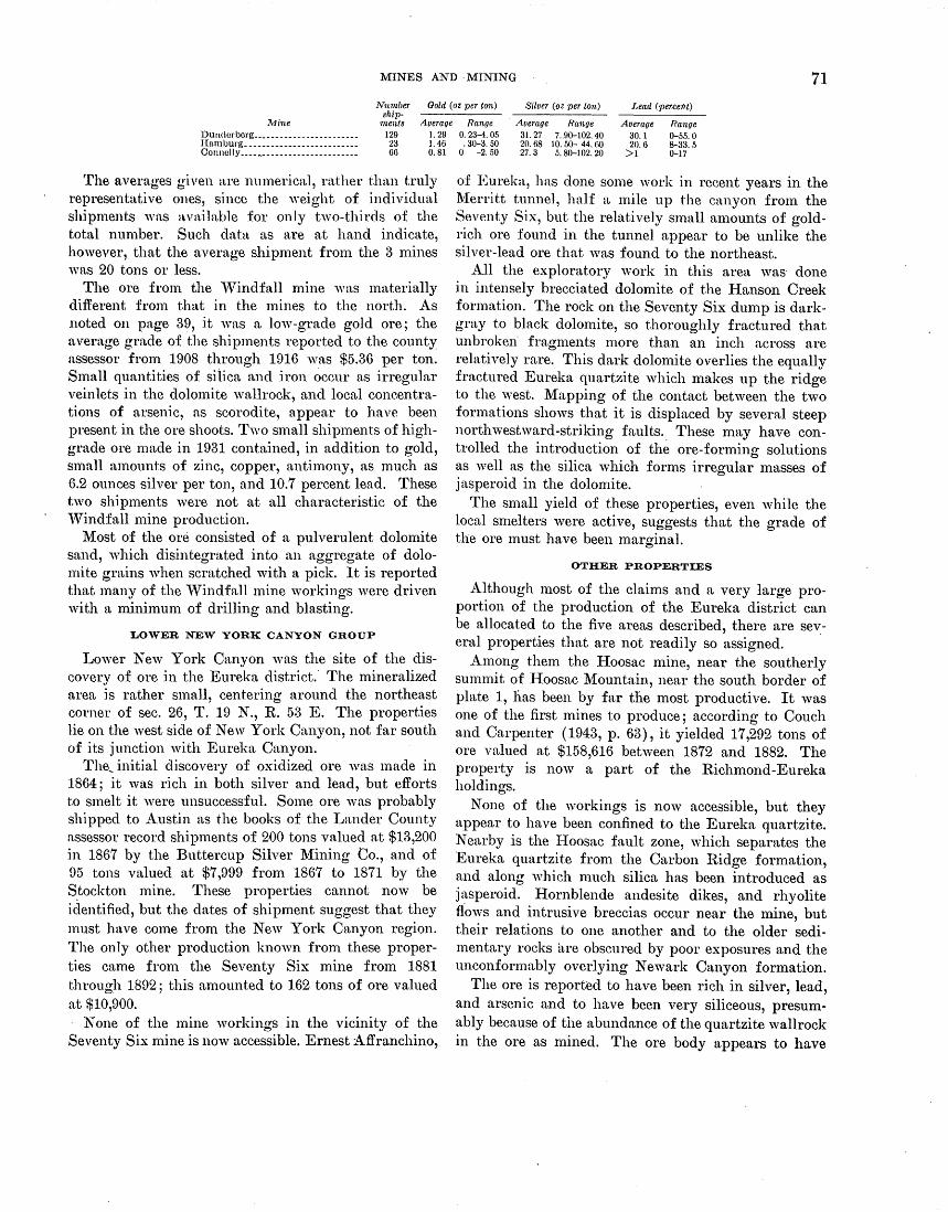
MINES AND ·MINING 71 Number
shi]Jments
Gold (oz ]Jer ton) Silver (oz ]Jer ton) Lead r ]Jer,cent)
Mine Average Range Average Range Average Range Dundcrbcrg _______________________ _ 129 Humburg_------------------------- 23 Connelly ____ ~-_---_-- ______ ---_---- 66
1. 29 0. 23-4. 05 1. 46 . 3o-a. 50 0. 81 0 -2.50
31.27 7 .. 90-102. 40 20.68 10. 50- 44. 60 27. 3 5. 80-102. 20
30.1 0-55.0 20.6 8-33.5
>1 0-17
The averages given are numerical, rather than truly representative ones, since the weight of individual shipments w:ts available for only two-thirds of the total number. Such data as are at hand indicate, however, that the average shipment from the 3 mines was 20 tons or less.
The ore from the 'Vindfall mine was materially different from that in the mines to the north. As .noted on pa.ge 39, it was a low-grade gold ore; the average grade of the shipments reported to the county assessor from 1908 through 1916 was $5.36 per ton. Small quantities of silica and iron occur as irregular vein lets in the dolomite wallrock, and local concentrations of arsenic, as scorodite, appear to have been present in the ore shoots. Two small shipments of highgrade ore made in 1931 contained, in addition to gold, small amounts of zinc, copper, antimony, as much as 6.2 ounces silver per ton, and 10.7 percent lead. These two shipments were not at all characteristic of the 'Vindfall mine production.
Most of the ore consisted of a pulverulent dolomite sand, which disintegrated into an aggregate of dolomite grains when scratched ·with a pick. It is reported that many of the 'Vindfall mine workings were driven with a minimum of drilling and blasting.
LOWER NEW YORK CANYON GROUP
Lower New York Canyon was the site of the discovery of ore in the Eureka district.· The mineralized area is rather small, centering around the northeast corner of sec. 26, T. 19 N., R. 53 E. The properties lie on the west side of New York Canyon, not far south of its junction with Eureka Canyon.
The_ initial discovery of oxidized ore was made in 1864; it was rich in both silver and lead, but efforts to smelt it were unsuccessful. Some ore was probably shipped to Austin as the books of the Lander County assessor record shipments of 200 tons valued at $13,200 in 1867 by the Buttercup Silver l\1ining Co., and of 95 tons valued at $7,999 from 1867 to 1871 by the Stockton mine. These properties cannot now be iclentified, but the dates of shipment suggest that they must have come from the New York Canyon region. The only other production known from these properties came from the Seventy Six mine from 1881 through 1892; this amounted to 162 tons of ore valued at $10,900.
None of the mine workings in the vicinity of the Seventy Six mine is now accessible. Ernest Affranchino,
of Eureka, has done some work in recent years in the l\1erritt tunnel, half a mile up the canyon frmn the Seventy Six, but the relatively small amounts of goldrich ore found in the tunnel appear to be unlike the silver-lead ore that was found to the northeast.
All the exploratory work in this area was· done in intensely brecciated dolomite of the Hanson Creek formation. The rock on the Seventy Six dmnp is darkgray to black dolomite, so thoroughly fractured that unbroken· fragments n1ore than an inch across are relatively rare. This dark dolomite overlies the equally fractured Eureka quartzite which makes up the ridge to the west. Mapping of the contact between the two formations shows that it is displaced by several steep northwestward-striking faults. These may have controlled the introduction of the ore-forming solutions as well as the silica which forms irregular 1nasses of jasperoid in the dolomite.
The small yield of these properties, even while the local smelters were active, suggests that the grade of the ore must have been marginal.
OTHER PROPERTIES
Although most of the claims and a very large proportion of the production of the Eureka district can be allocated to the five areas described, there are several properties that are not readily so assigned.
Among them the Hoosac mine, near the southerly summit of Hoosac Mountain, near the south border of plate 1, has been by far the most productive. It was one of the first mines to produce; according to Couch and Carpenter (1943, p. 63), it yielded 17,292 tons of ore valued at $158,616 between 1872 and 1882. The property is now a part of the Richmond-Eureka holdings.
None of the workings is now accessible, but they appear to have been confined to the Eureka quartzite. Nearby is the Hoosac fault zone, which separates the Eureka quartzite from the Carbon Ridge fonnation, and along which n1uch silica has been introduced as jasperoid. Hornblende andesite dikes, and rhyolite ffows and intrusive breccias occur near the mine, but their relations to one another and to the older sedimentary rocks a.re obscured by poor exposures and the unconformably overlying Newark Canyon formation.
The ore is reported to have been rich in silver, lead, and arsenic and to have been very siliceous, presumably because of the abundance of the quartzite wallrock in the ore as mined. The ore body appears to have

72 THE EUREKA MINING DISTRICT, NEVADA
Granulated rock is banded parallel to fault
..<.........Well-defined crushing
Crushing___,_ ~ EXPLANATION
Iron oxide/ ~ S~tt:ed~ dolomite Somewhat jaspery
Mineralized material
60 dolomite
Elevation +46 ft-X 4-in. quartz vein
50 0 50
Mapped by T. B. NolaQ and J. V. N. Dorr 2d, 1939
N
100 FEET i Crushed zones
Strike and dip of beds or of mineralized material or crushed zones
90+ Vertical crushed zone
FIGURE 15.-Map of Lower Dugout tunnels.
cropped out and to have been localized by a nearly vertical shear zone. In the walls of the old cuts, small amounts of oxidized ore minerals may be seen coating joints in the quartzite. The ore was treated in the company's smelter at Eureka, but apparently with poor success, as Curtis ( 1884, p. 161) reports that Hoosac slag, rich in silica, as well as in metal, was a component of the Richmond smelter charge at the time of his examination.
The Burning lVIoscow mine is also located· near the southern border of the mapped area. It lies south of ·Prospect Peak, on the east side of Rocky Canyon, a tributary of Secret Canyon. At the time of mapping in this region, little could be determined about the ore shoot, which occurs in Eldorado dolomite just east of the Dugout tunnel thrust zone. Considerable jasperoid is exposed nearby, and the geologic setting is not unlike that at the Geddes and Bertrand mine, farther south in Secret Canyon. There has been some activity at the property since the time of examination, but the results of this work are not known.
The Dugout tunnels in Spring Valley at the west base of Prospect Peak, are located on the only property
-within the mapped area that explores the rocks above the Dugout tunnel thrust zone. Couch and Carpenter ( 1943, p. 62) report the production of 502 tons of ore with a gross yield of $42,503 during the period 1874-1936. There are a number of pits and cuts on the property, but only the lower tunnels were accessible in
1939 (fig. 15). The ore occurred as pipes and veins in dolomitized and silicified limestone of the Pogonip group, but there is little information available as to its nature and grade. Some, at least, appears to have been rich in antimony.
REFERENCES CITED
Angel, Myron, ed., 1881, History of Nevada: Oakland, Calif., Thompson and West, 680 p.
Barus, Carl, 1885, The electrical activity of ore bodies: Am. lnst. Mining Engineers Trans., v. 13, p. 417-477.
Binyon, E. 0., 1946, Exploration of the gold, silver, lead, and zinc properties, Eureka Corporation, Eureka Co., Nev.: U.S. Bur. Mines Rept. Inv. 3949, 18 p.
Brown, J. S., 1942, Differential density of ground water as a factor in circulation, oxidation and ore deposition: . Econ. Geology, v. 37, p. 310-317.
Couch, B. F., and Carpenter, J. A., 1943, Nevada's metal and mineral production (1859-1940, inclusive): Nevada Univ. Bull., v. 37, no. 4, Geology and Mining ser., 38, 159 p.
Curtis, J. S.,· 1884, Silver-lead deposits of Eureka, Nev.: U.S. Geol. Survey Mon. 7, 200 p.
David, Lore, 1941, Leptolepsis nevadensis, a new Cretaceous fish: Jour. Paleontology, v. 15, p. 318-321.
Dempsey, J. W., and others, 1951, Geologic and total intensity aeromagnetic map in the vicinity of Eureka, Nevada: U.S. Geol. Survey open-file report.
Easton, W. H., and others, 1953, Revision of stratigraphic units in Great Basin : Am. Assoc. Petroleum Geologists Bull., v. 37, p. 143-151.
Emmons, W. H., 1910, A reconnaissance of some mining camps in Elko, Lander, and Eureka Counties, Nevada: U.S. Geol. Survey Bull. 408, 130 p.

REFERENCES CITED 73
llJugel, A. E .. J., Clayton, It. N., and Epstein, S., 1958, Variations in isotopic composition of o_xygen and carbon ·in Leadville limestone (Mississippian, Colorado) and in its hydrothermal and metamorphic phases: .Jour. Geology, v. 66, [l. 374-393.
Ginnella, V. P., 1!)46, Igneous fusion of tuff at Eureka, Nev. [nhs.] : Geol. Soc. America Bull., v. 57, p. 1251.
Gillnly, .James, 1!)54, :E'urther light on the Roberts thrust, north-central Nevada: Science, v. 119, p. 423.
Hngne, Arnold. 1883, Abstract of report on the geology of the IDurelm district", Nevada: U.S. Geol. Survey 3d Ann. Rept., p. 237-272.
--- 18H2, Geology of the Eureka district, Nev.: U.S. Geol. Survey Mon. 20 (with atlas), 419 p.
Hewett, D. 1!"'., 1935, Manganese oxides and the circulation of ground water [abs.] : 'Vashington Acad. Sci. Jour., v. 25, p. 565-G66.
Hohnes, Arthur, 195H, A revised geological time scale: Edinburgh Geol. Soe. Trans .. v. 17, pt. 3, p. 183-216.
Iddings .. J. P., 18H2, Microscopical petrography of the eruptive rocli:S of the Eureka district, Nev., in Hague, Arnold, Geology of the IDurelm district, Nev.: U.S. Geol. Survey l\Ion. 20, IJ. 337-406.
Ingalls, ,V. R, 1907, 'I'he silver-lead mines of Eureka, Nev.: Eng. Mining .Jour., v. 84, p. 1051-1058.
Jaffe, H. ·w., and others, 1959, r ... ead-alpha deter01inations of accessory minerals of igneous rocks (1953-1957) : U.S. Geol. Survey Bull. 1097-B, p. 65-148.
Johnson, A. C .. 1H58, Shaft-sinking methods and costs at the rr. r .... shaft, Eureka Corp., Ltd., Eureka, Nev.: U.S. Bur. Mines lnf. Circ. 7835, 25 p.
King, Clarence, 1878, Systematic geology: U.S. Geol. Expl. 40th Pnr. Itevt., v. l, 803 p.
Lindgren, 'Valdemar, and Loughlin, G. F., 1919, Geology and ore deposits of the Tintic mining district, Utah: U.S. Geol. Survey Prof. Paper 107, 282 p.
Lovering, '1'. S., and Tweto, 0. L., 1942, Preliminary report on geology nnd ore deposits of the Minturn quadrangle, Colorado: U.S. Geol. Survey open-file report, 115 p.
McKinstry, H. D., 1948, Mining geology: New York, PrenticeHnll, Inc. 239 p.
::\1ucNeil, 1!"'. S., 1939, 1!"'resh-water invertebrates and land plants of Cretaceous age fr~m Eureka, Nev.: .Jour. Paleontology,
V. 13, p. 355-360. Merriam, C. ,V., 1940, Devonian stratigraphy and paleontology
of the Roberts Mountains region, Nev.: Geol. Soc. America Spec." Paper 25, 114 p.
Merriam, C. \V., and Anderson, C. A., 1942, Reconnaissance survey of the Roberts Mountains, Nev.: Geol. Soc. America Bull., v. 53, p. 1675-1728.
Mitchell, G. \V., 1953, Mine drainage at Eureka Corp., Ltd., lDurelm, Nev.: Mining Eng., v. 5, p. 812-817.
Mitchell, G. W., and Johnson, A. C., 1949, Shaft-sinking methods at the Fad shaft, Eureka Corp., Ltd., Eureka, Nev.: U.S. Bur. Mines lnf. Circ. 74H5, 17 p.
Molinelli, Lambert, 1879, Eureka and its resources : Eureka, Nev., Molinelli, Lambert, and Co. ·
Nolan, '1'. B., 1928, A late Paleozoic positive area in Nevada: Am .. Jour. Sci., 5th ser., v. 16, p. 153-161.
Nolan, '1'. B., Merriam, C. \V., and \Villiams, J. Steele, 1956, The stratigraphic section in the vicinity of Eureka, Nev. : U.S. Geol. Survey Prof. Paper 276, 77 p.
Palmer, A. R., 1954, An appraisal of the Great Basin Middle Cambrian trilobites described before 1900: U.S. Geol. Survey Prof. Paper 264-D, p. 55-86.
Park, C. F., Jr., and Cannon, R. S., Jr., 1943, Geology and ore deposits of the Metaline quadrangle, \Vash.: U.S. Geol. Survey Prof. Paper 202, 81 p.
Prescott, Basil, 1926, The underlying principles of the limestone replacement deposits of the Mexican province: Eng. and Mining Jour., v. 122, p. 246-253, 289-296.
Roberts, R. J., Hotz, P. E., Gilluly, James, and Ferguson, H. G., 1958, Paleozoic rocks of north-central Nevada: Am. Assoc. Petroleum Geologists Bull., v. 42, p. 2813-2857.
Schaller, \V. T., and Glass, J. J., 1942, Occurrence of pink zoisite (thulite) in the United States: Am. Mineralogist, v. 27, p. 519-n24.
Sharp, William, 1947, The story of Eureka: Am. Inst. Mining Eng. Tech. Pub. 2196, 12 p.
Simons, F. S., and Mapes V., Eduardo, 1956, Geology and ore deposits of the Zimapan district, State of Hidalgo, Mexico: U.S. Geol. Survey Prof. Paper 284, 128 p.
Spencer, A. C., 1917, The geology and ore deposits of Ely, Nev.: U.S. Geol. Survey Prof. Paper 96, 189 p.
Stuart, W. T., 1955, Pumping test evaluates water problem at Eureka, Nev.: Mining Eng., v. 7, p. 148-156.
·Vanderburg, W. 0., 1938, Reconnaissance of mining districts in Eureka County, Nev.: U.S. Bur. Mines lnf. Circ. 7022, 66 p.
Walcott, C. D., 1884, Paleontology of the Eureka district: U.S. Geol. Survey Mon. 8, 298 p. <
--- 1908a, Nomenclature of some Cambrian Cordilleran formations: Smithsonian Misc. Colln., v. 53, pub. 1812, p. 1-12.
--- 1908b, Cambrian sections of the Cordilleran area : Smithsonian Misc. Colln., v. 53, pub. 1812, p. 166-230.
--- 1923, Nomenclature of some post Cambrian and Cambrian Cordilleran formations.: Smithsonian Misc. Colln., v. 67, no. 8, p. 457-476.
--- 1925, Cambrian geology and paleontology, V, no. 3, Cambrian and Ozarkian trilobites: Smithsonian Misc. Colln., v. 75, no. 3, p. 59-146.
\Vheeler, H. E., and Lemmon, D. M., 1939, Cambrian formations of the Eureka and Pioche districts, Nev.: Nevada Univ. Bull., v. a3, no. 3, Geology and Mining ser., 31, 60 p.
Wisser, Edward, 1927, Oxidation subsidence at Bisbee, Ariz.: Econ. Geology, v. 22, p. 761-790.

,.,

A Page
Acknowledgments .• ---------·--~---------------- 3-4 Adams Hill, Bowman branch----------------~- 23
· control of ore deposition at_ __________ ------- 51 · deposits.___________________________________ 50
Hamburg dolomite.--~--------------------- 8 Jackson-Lawton-Bowman normal-fault sys-
tenL _ _ _ _ _ _ _ __ _ __ __ _ _ __ __ __ _ __ ___ _ _ _ 22
mines. ___ ---------------------------------- 63-64 production ___ ---------------------------·--- 64 quartz porphyry------______________________ 14
Secret Canyon shale------------------------ 7 Shnrp fault.-------------------------------, 25 Windfall formation.------------------------ 9
Albion mine------------------------------------ 65 Albion shaft, landslide hlock near_______________ 25
talus near ________________ -----_____________ 17
Albion smelter ____ ----------------------------- 25 Allanite._______________________________________ 46 Alluvium, Quaternary __________________ --~----- 17-18 A ltemtlon •• -. __________________________________ 52-53
andesites.__________________________________ 15
Dunderberg shale .••• ---------------------- 8 Newark Canyon formation ________________ ·_ 12 quartz diorite ____________________ -----______ 13
qunrtz porphyry----- ___ --- ______ .,.________ 14 Andesite .• _______ • ____ •. _------ _____ ----------- 17 Anglesite ______________________________ 41, 42, 43, 52,66
Antelope Rnnge .• ------------------------------ 9 Antelope Valley limestone .• -------------------- 9 Antler orogeny_-------------------------------- 28 Apatite ••.•. ------ ____ ---_. ___ -- ____ • _____ ---··_. 46
Amgonito. _. ------------· ---------------------- 41 Arsenopyrite_------------------------- 41, 43, 44, 52,67 Atlas mine._----------·------------------------ 70 Azurite ______ .. --·------------------------------ 41
B Bunner fissure ______________________ 38, 39, 42; 50, 68,69
Bannet· fissure stopes, fault-zone replacement cleposits at__________________________ 31
Basalt __________ •. ---- ____ ._------______________ 17
Base-metal ore deposits •. -------------------- 41-45,53 Berrymnn tunneL.---~------------------------ 30,69 Beudantite .. __ • _____________________________ . __ 43, 52 Bibliography _________ • ______ .---- __________ . ___ 72-73
Bindheimite ...• ----------------------------- 42, 43,52 Blocks, concept of separate ... ------------------ 18 Blue Flaggy limestone__________________________ 7 Bluebird dolomite .. ---------------------------- 6 Downum bmnch_________________________ 22-23,50,66
Adatns Hill area •.... ------------------------ 63 Bowman fault, quartz porphyry________________ 14
replacement deposits .. --------------------- 39 Bowman mine •••.• -------------------------- 30, 39,63 Bowman shaft, Bowman branch________________ 23
M:artln fault.. •• ---------------------------- 23 Buckeye claim ••• ------------------------------ 65 Bullwhacker member, Windfall formation______ 9 Bullwhacker mine •• -------------------- 3, 29, 36, 50,64
quartz porphyry ____________ ·---~------------ 14
Burning Moscow mine ..• -----------~---------- 72
Cambrian system (see also under specific for-mations) _______ .----- __ ------------- 5-9
Carbon Hldge formation •••. -------------- 11-12,24,26 contact with hornblende andesite----------- 14 faulting ______ ----------------------.-------- 28 unconformity at base.---------------------- 27-28
INDEX
Page Carbon Ridge-Spring Ridge block _____ 18, 19, 24,26-27 Carboniferous systems (see also under specific
formations). __ ---------------------_ 11 Caribou Hill, Eureka quartzite_________________ 10
Jackson branch _________ ---------------_____ 22 Catlin member, Windfall formation _____ ._______ 9
Cave Canyon, Dugout tunnel thrust zone______ 20 Pro~pcct :Mountain quartzite.--------~----- 5, 20
Cave Canyon fault_ ____ c ____________________ ·___ 25
Caves, open, associated deposits-----------~---- 31,69 relation to ore deposition___________________ 53
Cenozoic rocks, igneous (see also under specific · rocks) ________ ----------------------- 14-17
Cerargyrite ________ . _ ____ ____ _ _ __ __ _ _ _ __ __ _ _ __ _ _ 43
Cerussite _______________ ----------- _______ 41, 42, 43,66 Chainman shale. ____________________________ ~-_ 11, 26
Chalcopyrite ________ ~----------------__________ 13
Champion claim .... ---------.----------~-------- 65 Charter tunneL ___________________ .. __________ 7, 25,30
Prospect Mountain quartzite cut by________ 5 Cherry Spring, Diamond Peak formation _______ 11,26
Claims, number-------------------------------- 61 Clarks Spring member_------------------------ 7, 21
confusion with Bullwhackcr member_______ 9 Secret Canyon shale, alteration by quartz
, diorite______________________________ 13
Climate._---------------- __ -------------------- 2 Clinozoislte____ _ _ _ _ _ _ _ _ ___ ___ _ _ __ _ _ _ _ _ __ __ _ __ __ _ 46
Conical Hill, Chainman shale__________________ 1i Diamond Peak formation___________________ li' Silver Connor transverse fault-------------- 21
Conical Hill anticline___________________________ 26 Connelly mine ____________ ------ ________ ·-_---_ 70
Consolidated Eureka Mining Co_-------------- 68,69 Consolidated mine, drainage____________________ 57 Contact-metasomatic deposits _______________ 39-41,46
Control of ore deposition_---------------------- 51,64 Cretaceous system (see also Newark Canyon
formation) _________________ 12,13-14,28-29
Croesus mine .. -----------------------------~ 30, 51,70 Hamburg dolomite __________________ ·_______ 8
Croesus mine, ore chimneys_------------------- 31 Curtis, J. S., quoted ______________________ 42, 60, 68,70 Cyanide mine ______________________ ~ _____ "----- 30, 63 Cyanide shaft. __________________________ -~_____ 64
D
Dead Broke tunnel, fault-zone replacement deposits____________________________ 38
podlike deposits.--------------------------- 31 Devils Gate limestone ____________________ · ___ 1D-11, 25
Devonian and Silurian systems (see also under specific formations) ______ -------"---- 1o-11
Diamond fault. __ --------·--------------------- 69-70 Diamond mine, open cave deposits_____________ 31
tenor of ore_________________________________ 48
Diamond Mountains.-------------------------- 2 Diamond Peak formation _______________________ 11,26
resemblance of two beds in Newark Canyon formation---------------------·------ 12
Diamond Peak quartzite ... ·-------------------- 11 Diamond tunneL ______________________ 18, 19, 30, 67,69
Jackson-Lawton-Bowman normal-fault sys-tem________________________________ 22
Secret Canyon shale.------------------~---- 7 Windfall formation_________________________ 9
Diamond tunnel thrust zone _____________ 19,28,68,69
channel for ores_____________________________ 50
Page Diamond Valley ______________ ·----------------- 2 Diamond-Excelsior mine __ -------- 3, 6, 30, 31, 41, 42, 50
fault. ____ --_- ___ -----_______________________ · 19
Hamburg dolomite_________________________ 8 production _________ -_---_- _____ ~-__________ 67
tenor of ore .. __________ ------- ____________ ~_ 68-69
veinlike deposits.-------------------------- 38 Diatoms, rhyolite tuff__________________________ 17
Dikes, andesite and basalL-------------------- J7 hornblende andesite ________________________ 14, 71 rhyolite. ____ ---- _________________________ ... 15
Diopside ________ ---------------------- ---~--- 8, 13, 4G Disseminated ore deposits.--------------------- 39 Distribution of irregular replacement deposits.. 31
Distribution of ore bodies.---------------~------ 29-30 Domonic tunneL------------------------------ 69 Drainage, Fad shaft____________________________ 65
Inine. __ --------------------------------- 53, 57-61 Drill holes, Ruby HilL ..... ------------------- 67 Dugout tunnels. ___ ------------------------- 20, 25, 72 Dugout tunnel thrust zone __ ------- 20-21,25, 27, 28, 72 Dunderberg mine ___ ------------~------------ 3, 30, 70
Hamburg dolomite.------------------------ 8 ore bodies __________ ------------------------ 51
Dunderbcrg shaft _______ ·________________________ 70
Dunderberg shale·----~------------------;- 8-9,64,70 control of ore deposttlon. ·------------------ 51 faulting_____________________________________ 19
Dunderberg-Windfall belt----------~----------- 70-71
E
Earth movements, relation to oxidation of ore bodies._____________________________ 53
Eldorado dolomite _______________ 5, 6-7,21, 28, 51, 68, 72
contact with Prospect Mountain quartzite_ 6 faulting _______________________________ 20, 21, 24,28
host rock for ore bodies ________________ 8, 51, 65, 72
ore deposits at contact with Prospect Moun-tain quartzite ________________ ._______ 31
relation to ground water..---------------~-- 60,61 thrust faults ________________________ ------__ 13
thrust plate, replacement deposits at base oL G7 water table ____ -- _______ --------------- __ --- 60
Eldorado tunneL------------------------------ 30 ore bodies in Eldorado dolomite ___________ _
Ely limestone._-------------------------------- 11 Epidote.------------------------------------- 8, 13,46 Eureka Consolidated smelter___________________ 3 Eureka mine _______________________________ _.___ 3
tenor of ore.-------------------------------- 47 Eureka quartzite _______________________________ 10,71
faulting _______________________ ----- _________ 27, 51
host rock for ore bodies_____________________ 51 klippen_____________________________________ 21 unconformity at base_______________________ 27
Eureka tunneL ____________________________ 8, 18, 30,67
Jackson-Lawton-Bowman normal-fault sys-tem._______________________________ 22
rhyolite. _________________ ------____________ 15
Secret Canyon shale________________________ 7 Silver Connor transverse fault._____________ 21
Excelsior tunneL-------~----------------------- 69
F Fad shaft_ _________________________________ 3, 24, 30,65
drainage.----~--- ________ ------_-----_-----_ 60-61 Jackson branch _____________ ·---------------- 22 Martin fault·----------------------------~-- 23,66 Secret Canyon shale________________________ 7
75

76
Page Faults (see also under specific features) __ -------- 15,52
relation to ore bodies _______________________ 49-51
thrust__-------_____________________________ 18 Federal Mining Law, 187L_____________________ 56 Fieldwork__________________ ------------------ 3 Fish Creek Mountains, Spring Valley fault zone. 25 Fish Creek Mountains block ________________ 18, 25,27 Fish Creek Range______________________________ 2 Folds ________________________________________ 18, 23,26
Dunderberg shale _______________________ "__ 8 Geddes limestone___________________________ 7, 20 Secret Canyon shale________________________ 7-8
Form or ore deposits____________________________ 30 Fossils, Carbon Ridge formation________________ 12
Devils Gate limestone______________________ 11 Diamond Peak formation___________________ 11 Dunderberg shale ___ ----------~------------ 8-9 Geddes limestone___________________________ 7 Hamburg dolomite_________________________ 8 Hanson Creek formation___________________ 10 Newark Canyon formation_________________ 12 Pioche shale________________________________ 6 Pogonip group______________________________ 9 Red Rock Canyon_________________________ 17 rhyolite tuff________________________________ 17 Secret Canyon shale________________________ 8
Fourth of July tunneL ______________________ 30,68,69
Fractures, Eldorado dolomite___________________ 6 Eureka quartzite___________________________ 10 Hanson Creek formation___________________ 10 Prospect Mountain quartzite_______________ 5 quartz diorite and Eldorado dolomite_______ 13 Secret Canyon shale________________________ 7-8
G Galena __ --------------------------- 39, 41, 42, 43, 52,67 Garden Valley formation _______________________ 27-28
Garnet_ _____ ------------- __ ----------- __ --- __ 8, 13, 46 Garnet-diopside rock___________________________ 39 Geddes and Bertrand mine_____________________ 72
type' locality of Geddes limestone __________ _ Geddes limestone ______________________________ _
alteration by quartz diorite_________________ 13 contact-metasomatic deposits_______________ 39 folding ____ ----------- ________ ------________ 7, 20 relation to ground water_____________________ 60
Geochemical prospecting __ --------------------- 54 Geography_-----------------------------------Geophysical prospecting________________________ 54 Goethite _________ -----c-- ________ ---------- _____ 43, 66 Gold, in oxidized ore. ___ ----------------------- 44,_ 52 Gold ore, Windfall mine __________________ 39, 41, 44,70 Goodwin Canyon______________________________ 70
Jackson-Lawton-Bowman normal-fault sys-tem________________________________ 22
Goodwin limestone_____________________________ 9
Gordon tunneL __ ------------------------------ 26 Prospect Mountain quartzite cut by________ 5--6
Gorman Hill, folding of Hoosac fault at_________ 26 Goslarite. ________________ -------- ___ ----------- 52 Granite tunneL ___ --------------_______________ 50
Lawton-Bowman fault ___ ------------------ 39 metamorphosed sedimentary rocks_________ 41
Prospect Mountain quartzite cut by-------Grant mine·---------------------·--------------- 30,66 Gravels _____________________________ ---------___ 17
Ground water, relation of Geddes limestone to__ 60 part played in oxidation of ore bodies _______ 52-53
H
Hague, Arnold, quoted_________________________ 14 Halloysite ___________ ------------- __ --- _______ -- 43 Hamburg dolomite __________________ 6, 21, 67, 68,70-71
Adams HilL------------------------------- 63-64 alteration by quartz diorite_________________ 8, 13 contact-metasomatic deposits_______________ 39 contact with quartz diorite _________________ 8,13
disseminated ore deposits___________________ 39 elevation ________ -------- _______ --- ____ ----- 64
INDEX
Page Hamburg dolomite-Continued
faulting __________________________________ 19, 22, 24
host rock for ore bodies __________ 8, 51, 63, 64, 68,70 Windfall gold ore___________________________ 44
Ham burg mine _____ ----------------------- 3, 30, 51, 70 Hamburg dolomite_________________________ 8
Hanson Creek formation _______________________ 24,71 host rock for ore bodies _____________________ 10,51
Helen mine_____________________________________ 30 Helen shaft, Bowman branch___________________ 23 Hematite __________________ ------_______________ 41 Hemimorphite ______________________________ 41, 43, 52
History------_--_---- _________________ -- ____ 2-3, 53-56 Adams Hill mines__________________________ 63 Dunderberg-Windfall belt_ _________________ 7Q-71
lower New York Canyon group_----------- 71 production _________________________________ 56--57
Prospect Ridge mines ______________________ 67-68 Holly Extension mine__________________________ 29 Holly mine _______________________ ~ 3, 9, 29, 36, 50, 63,64
ore controL________________________________ 51 Hoosac fault __________________ 14, 18,24-25,26,28, 51,71
Hoosac mine_---------------------------------- 71 Eureka quattzite cut by____________________ 10 ore controL_________________________________ 51
Hoosac Mountain______________________________ 71
breccia pipes_------------------------------ 16 Chainman shale____________________________ 11 Conical Hill anticline_______________________ 26 Diamond Peak formation___________________ 11 Hoosac fault _______________________ c- _ ___ _ _ _ 24
hornblende andesite________________________ 14 Newark Canyon formation_________________ 12 Pogonip group______________________________ 9 Wiridfall formation_________________________ 9
Hornblende andesite __________________ · 14-1!>, 26--27, 71
Hydrothermal alteration, Hamburg dolomite___ 8
Iddings, J. P., quoted_------------------------- · 14 Igneous rocks, Cenozoic ________________________ 14-17
Cretaceous __ -----------------~------------ 13-14 source of ore (see also under specific rocks) ___ 48-49
Introduction. ___ ------------------------------- 2-4 Iron, in oxidized ore____________________________ 52
J Jackson branch __________________ 22, 23, 24, 28, 50, 51,67
quartz porphyry at_________________________ 14 Jackson mine ________________________________ 30, 31,65
tenor of ore_________________________________ 66 Windfall formation_________________________ 9
Jackson-Lawton-Bowman normal-fault zone____ 20, 21, 22-23, 50, 66, 68, 69
Adams Hill area_____________________________ 63 relation to ore deposition___________________ 23
Jasperoid _________________________________ 12, 63, 71,72
Jumbo Cave _________________________ · ________ 31, 67,69
Jumbo ore shoot________________________________ 30 Jumbo stope____________________________________ 19
K KK mine_______________________________________ 65
L Lava Beds ____ --------------------------------- 22 Lava flows __ -------------------------------- 14, 17, 71 Law, mining ___________________________________ 54-56 Lawton branch ___________________________ 21, 22, 23,50
Lawton shaft___________________________________ 5 Lawton-Jackson fault zone_____________________ 70
Lead, in oxidized ore ___ ------------------------ 52 Leadhlllite. __ ---------------------------------- 41 Legal aspects of mining ______________________ 29,54-56
Limestone, Eldorado dolomite__________________ 6 Limonite __ -- ___ ------- __________ -------________ 41 Locan shaft_ ___________________________ 3, 5, 7, 24, 30,65
drainage ____________________________________ 6Q-61
massive pyrite·-----------------------c----- 49 sulfide mineralization_______________________ 67
Page Lone Mountain dolomite_______________________ 10 Lone Mountain limestone of Hague____________ 10 Lower Coal Measures ___ ----------------------- 11, 12 Lower New York Canyon mines_______________ 71 Lower shale member, Secret Canyon shale ___ _ Lucky Springs, hornblende andesite____________ 14
]\[
McCoy Ridge, Eureka quartzite_______________ 10 hornblende andesite________________________ 14 Newark Canyon formation__________________ 12
Mackintosh tunneL---------------------------- 69 Magnet shaft, Jackson branch__________________ 22 Magnetite ________________________________ 8, 13, 39, 46
Mahogany Hills, Spring Valley fault zone______ 25 Mahogany Hills block _________________________ 18,27
Malachite ____________ ---------_________________ 41 Martin fault_ __________________________________ 23, 66
Merritt tunneL-------------------------------- 71 Mesozoic structural features____________________ 28 Metallurgy ______ ------_________________________ 54
Metals, source __ c ____________ c ________________ • _ 46-49
Metamoras shaft_ ______________________________ 30, 69
Metamorphosed sedimentary rocks, Granite tunneL_____________________________ 41
Mimetlte_ --------------------------- 41, 42, 43, 64, 66
Mineral Hill, quartz diorite_------------------- 13-14 scheelite _________________________ -------- ___ · 39
Mineral Point, Jackson-Lawton-Bowman nor-mal-fault system____________________ 22
Pogonip group ___ -------------------------- 9 quartz porphyry __ ------------------------- 14
Mineralogy of ore deposits ______________________ 41-46
Mines and mining ______________________________ 53-72
Adams HilL_------------------------------ 63-64 claims, number_____________________________ 62
drainage_------------------------------- 53, 57-61 Fad shaft_______________________________ 65
Dunderberg-Windfall belt __________________ 7Q-7l geochemical prospecting____________________ 53
geophysical prospecting __ ------------------ 54 history .. ___________________ ------ ___________ 53-56 legal aspects ________________________________ 54-56
lower New York Canyon group_----------- 71 metallurgy __ ------------------------------- 54 notes on ____________________________________ 61-72
other·properties ____ ------------------------ 71-72 production~ ________________________________ 56--57
Prospect Ridge grouP----------------~----- 67-70 prospecting _____ ------- _____________________ 53-54
rotary drilling______________________________ 53 Ruby Hill area ___________ _. _________________ 65-67
Mississippian system. (See Carboniferous sys-tems.)
Molybdenite __________________________ 5, 41, 43, 52, 67
Mountain shale ___ ----------------------------- 7 Mountain Valley, Devils Gate limestone_______ 10
N Nevada formation______________________________ 10
unconformity at base_______________________ 27
New Windfall shaft, Dunderberg shale at______ 8 New York Canyon _____________________________ 70, 71
claims______________________________________ 67
Geddes limestone and Secret Canyon shale_ 20 Hanson Creek formation___________________ 10 Hoosac fault________________________________ 24 hornblende andesite________________________ 14
Jackson-Lawton-Bowman normal-fault sys-tem________________________________ 22
Ruby Hill normal fault_____________________ 23
Newark Canyon, Pre-, structural features______ 28
Newark Canyon formation_____________________ 12
structural features _________ --------_________ 26
Newark Mountain, rhyolite tuff________________ 16
Ninemile formation ______ .,_-------_------- ____ _

0 Puge
Ordovician system (see also under specific forma-tions) ___ --- __ ----------------------- 9-10
Ore bodies, geologic controls-------------------- 64 On• deposits ____________________________________ 29-53
bnsc-mctaL .• ---- __ ------------------------ 41-46 bedded replacements.---------------------- 36-37 chimneys ___ -------- ___ --------------------- 31 contact-metasomatic _____________________ 39-41,46
disseminated.------------------------------ 39 distribution. ____ --------------------------- 29-30
irregular replacement deposits_--------- 30-31 fault-zone replacement deposits _____________ 37-39 form _____________ --_-----------------·------- 30 host rocks, Eldorado dolomite _________ 6, 51, 65,72
Eureka quartzite ____________ ----------- 10, 51
Ham1mrg dolomite _____ ---------------- 8, 51, 63, 64, 69, 70
Hanson Creek formation. __ -----_ ------ 10, 51 Pogonip group _______ ------------- 9, 51, 63, 72 Windfall formation ___________________ 51, 63,64
~;~~:~~1~~~:~~~ ~ ~:: ~::::::::::::::::::::: ::: :~~: origin ______ -------- __ ----------------------- 48-53 oxidation. ___________ ------_---------------- 52-53 pods _________ ------------------------------- 31. 68 relation to enclosing rocks ______ . ____________ 51-52
relation to faults---------------------------- 49-51 relation to quartz diorite .. ----------- 13,39-41,48 relation to quartz porphyry _________________ 14,49
replacement deposits, h·regular_-- ---------- 3Q-35 tenor __ ------------------------------------- 46-48 Windfall gold ore _____________________ 39,41,44, 70
Orcs miners' classification______________________ 42
Origin of orcs.---------------------------------- 49 Oxidation of ore deposits _________________ 52-53,66,71
p
Page and Corwin mine.------------------------ 9 Paleozoic structural features-------------------- 27-28 Pcnnlnite •• ____ ------.------------------------- 8, 46 PciUlsylvannla system. (See Carboniferous sys-
tems.) Permian system (see also under specific forma
tions)------------------------------- 11-12 PhUllpsburg mine •• ---------------------------- 43 Phoenix mine. __ ---------------------------- 30, 31,65
tenor of ore.-------------------------------- 66 Pilot shale ________ ------------------------------ 10 Pinto Peak, rhyolite •..• -------~---------------- 16 Pioche shale .• ---------------------------------- 6 Plants •••• ---------------------------------- 2, 6, 12,14 Pleistocene structural features__________________ 29
Plug, rhyolite. __ ------- ____ -------------------- 15 Plumbojarosite.-------------------------- 42, 43, 52,66 Pods •• ____ ------------------------------------- 31, 68 Pogonip group (see also under specific forma-
tions)----------------------------- 9-10,51 Adams Hill area ____________________________ 63-64
faulting ______ ------------------------------- 19, 26 host rock for ore bodies ________________ 9, 51, 63,72
klippen ________ ----------------------------- 21 Pogonlp limestone of King______________________ 9 Potts chamber, replacement deposit____________ 31
Precipitation __ ---------------------------------Production ______________________________ 2-3,47,56-57
Adams Hill area ____________________________ 63,64
Dugout tunnels •••• ------------------------ 72 Dunderberg-Windfall belt_ _________________ 70-71
lloosac mine_______________________________ 71 lower New York Canyon group____________ 71
Prospect Ridge mines---------------------- 67-70
~~~~ s~!~~~~~~:::::::::::~:::~::::::::::::~ 65-: Prospect Mountain quartzite _________ 5-6,20, 22, 28,67
faulting __________________________________ 20, 22,24
ore ••• --._.---------------------------------ore deposits at contact or with Eldorado
dolomite ______ ----------------------relation to ground water •• ------------------
43
31 60
INDEX
Page Prospect Mountain tunneL. 18, 19, 20, 27, 30, 67, 69,70
Devils Gate limestone______________________ 10 Pioche shale________________________________ 6 Secret Canyon shale _______ ------ __ ------ __ _ Silver Connor transverse fault._____________ 21
Prospect Peak, Devils Gate limestone .. --------- 10 Dugout tunnel thrust zone·------------~--- 20 Dugout tunnels____________________________ 72 Eureka quartzite___________________________ 10
Hamburg dolomite.------------------------ 8 Pioche shale________________________________ 6 Pogonip group ______ --------------------- •. - 9 Quaternary alluvium_______________________ 17 Ruby Hill thrust zone______________________ 19
Prospect Ridge, Dugout tunnel thrust zone_____ 20 Geddes limestone___________________________ 7 history of mining ___________________________ 67-68 mines and mining __________________________ 67-70
Prospect Mountain quartzite_______________ 5-6
replacement deposits __ --------------------- 31 Ruby Hill thrust zone______________________ 19 Silver Collilor transverse fault._____________ 21 Windfall formation_________________________ 9
Prospect Ridge block (see also specific features)-- 18, 19-26,53
67 Prospecting, favorable ground Ruby Hill area __ Pumping. (See Drainage.) Pyrite _____________ ------------ 8, 13, 39, 43, 46, 49, 52,67
zone, Rogers tunneL----------------------- 41 Pyromorphite .• -------------------------------- 41,66 Pyroxene andesite ____________ ------------------ 17 Pyrrhotite _________________________________ 8, 13, 39,46
Q
Quartz diorite _______________________________ 13, 14,67
effects on Geddes limestone_________________ 7, 13 effects on Hamburg dolomite_______________ 8,13 effects on Secret Canyon shale______________ 13 relation to faulting__________________________ 27 relation to Lawton branch__________________ 22 relation to ore formation ______________ 13,39-41,49
Quartz diorite plug_____________________________ 22
Quartz diorite stock, contact-metasomatic de-posits __________ -------- ___ -------.__ 39
Quartz-galena-tetrahedrite veins ________________ 42,68 Quartz ore _________________ ----~---------------- 42
Quartz porphyry ____ --------------------------- 14 Quaternary sedimentary rocks __________________ 17-18
R
Recent structural features______________________ 29 Red carbonate ________________ i_________________ 42
Red Rock Canyon, fossils •..• -------------~---- 17 References cited.------------------------------- 72-73 Relation or ore bodies to enclosing rocks __ ------ 51-52 Replacement deposits, fault-zone _______________ 37-39
flat blanket_________________________________ 67 Irregular ___________ ------------------_ 3o-35, 66, 68
Replacement or carbonate rocks .. -------------- 51 Replacement or host rock by ore minerals______ 31
Rhyolite_----------------------------------- 15-16,71 Rhyolite breccias_______________________________ 16
Rhyolite tuff_----------------------- __ --------- 16-17 Rhyolite vltrophyre____________________________ 16 Richmond claim________________________________ 65
Richmond mine, drainage______________________ 60 gross value of ores ________ :_________________ 48
mlmetite. _ ----------- ___ -------- __ -------- _ 42 Ruby Hill normal fault_____________________ 24 tenor or ore. _________ • _________________ -- ___ 4 7, 66
Richmond Mountain, andesite and basalt._____ 17 rhyolite tuff________________________________ 16
talus deposits __________ ----------_-------~-- 17
Richmond shaft, Martin.fault.----------------- 23 Richmond-Eureka mine ___________________ 5, 18, 20,50
fracturing of Eldorado dolomite_____________ 6 ore chimneys_______________________________ 31
77 Page
Richmond-Eureka mine-Continued Pioche shale __________________ --------------rhyolite tuff________________________________ 16
o Secret Canyon shale________________________ 7 Richmond mine .. __ --- ___ -- ________ ----- ___ ----
ore tenor _________________________ -_____ -_-_ 47-48
Richmond smelter------------------------- 3, 64, 68, 70 Roberts Mountains formation__________________ 10 Roberts Mountains thrust_ __________________ 18-19,28
Roberts tunneL.-------------------------- 7, 25, 30,39 Prospect Mountain quartzite_______________ 5
Rock formations (see also under specific forma-tions)------ _______________ -- ______ --· 4-18
Rocky Canyon, Burning Moscow mine_________ 72 Dugout tunnel thrust zone_________________ 20
Rogers tunnel, Hamburg dolomite______________ 13 pyrite zone _____ --- _______ -- _____________ --_ 4L
quartz diorite_______________________________ 13 Rotary driliing ____ -- ______ -- ------ _____ -------- 53 Ruby Hill, Eldorado dolomite__________________ 6
Hamburg dolomite_________________________ 8 irregular replacement ore bodies____________ 66 jarositelike minerals________________________ 42 mines ___________ --- ___ ------_-------------- 65-67 mining history_---------------------------- 65 ore bodies in Eldorado dolomite____________ 6 Potts Chamber deposit.--------~----------- 31 production _____ -- ________ -----------------_ 65--oo Prospect Mountain quartzite_______________ 5-6
quartz porphyry ___ ------------------------tenor of ore ____ --- ____ --------------------thrust zone.------:-------------------------
14 66 20
Ruby Hill fault, barrier to ore deposition_______ 65
ore in walls.-------------------------------- · 67 relation to ground water____________________ 60 relation to ore deposits._------------------relation to water table----------------------
Ruby Hill fault zone ___________________________ _
rhyolite __ ----------------------------------Secret Canyon shale _______________________ _
Ruby Hill mines, drainage _____________________ _
sulfide ore.--- __ ------------- __ ------------_
50 59 70 15
57 41
Ruby Hill normal fault _____________ 21, 22,23-24,27, 59 Ruby Hill thrust zone__________________________ 19-
20, 21, 22, 23, 25, 28, 39, 50, 57, 66, 68, 70
Adams HilL_------------------------------ 63 Ruby·Hm tuiUleL_____________________________ 67
s
Sand dolomite (Hamburg dolomite)____________ 8, 44
Scheelite, absence of. •• ,------------------------ 13 Scheelite ore bodies, absence from garnet-diop-
sirle rock ________ ------ ___ ---------- 39
Scorodite __ ---- __ -------------------------------Secret Canyon, Geddes and Bertrand mine ____ _
Geddes limestone ____ -----------------------Secret Canyon shale .• ---------------------type locality for Geddes limestone ... -------
44 72
Secret Canyon shale.----------·------------ 7-8,21, 70 alteration by quartz diorite_________________ 13
contact-metasomatic deposits.-------------- 39 folding ______ ------------------------------- 20
Sedimentary rocks, Quaternary _________________ 17-18
Serpentine ..•. -------------------------------- 8,13, 46 Seventy Six mine ..• -----------·-------------- 2, 30,71
Hanson Creek formation___________________ 10 Sharp fault---------------------------- 17, 22, 23, 24,25 Siderite ______ ----------------------------------- 41 Sill, quartz porphyry___________________________ 14 Silurian and Devonian systems (see also under
Bpecific formations)------------------ 10-11 Silver, in oxidized ore·-----------.---------------. 52 Silver Connor mine ________________________ 3, 30, 67,68
ore bodies in Eldorado dolomite____________ 6 Silver Connor transverse fault _________ 21-22,28,51,68 Silver Lick claims, ore controL_________________ 50 Silver Lick mine ________________________ ------ ·3, 30,63
Silver West claims------------------------------ 63,64

78 Page
Smelting techniques, Eureka ores_~------------- 2, 54 Smithsonite _____ -------~--------- ______________ 41, 52 Sphalerite. _______________________________ 41, 43, 52, 67 Sphene •. -- __ ------ _________________ --_ .
7.·- _ _ _ _ _ 6. 46
Spring Ridge, Diamond Peak formation ____ 7
___ 26 hornblende andesite _______________________ ·____ 14
Spring Valley, Devils Gate limestone___________ 10 Dugout tunnels____________________________ 72
Spring Valley fault of Hague __ ----------------- 25 Spring Valley fault zone ... ---~-------- 18,25-26,27,53 Spring Valley-Prospect Ridge-Sierra fault.------ 18
Star tunneL----------------------------------- 69 Sterling tunneL_-----------------------------__ 30 Stratified limestone ____________________________ _ Stratigraphic section, generalized_______________ 4-5 Structure (see also under specific_ features and
:Folds and Fractures)_-------------- 18-29
Sulfide mineralization, Ruby HilL_-~---------- 67 Sulfide ore ______________________________________ 42,43
Sulphuret ore___________________________________ 42 Sulphur Spring Range _______________ ·___________ 2
T Talus deposits ___ ---------------------__________ li Target Hill, rhyolite____________________________ 15
rhyolite tuff ________ 7
_______________________ 16
Temperature ___ 7
____________________________ .:.. 2 Tenor_~_~ ______________________________________ 47-49·
Prospect Ridge ores._-----~-------~-------- 68 T.L. shaft _______________ ----------------.--- 64
Tetrahedrite_____ _ _ _ _ _ __ _ _ __ _ _ _ _ _ _ _ _ _ _ _ _ _ _ _ _ _ _ _ _ 39
INDEX
Page
Thulite.,---------------------------------- 8,13, 41,46 T .L. shaft _____ -~~·~--- _____ -. 3; .30, 41, 42, 51, 52, 53, 63, 64
drainage ____ --~---- __ : __________________ ·____ 57 Secret Canyon shale _______________________ _
sulfide-rich ore ___ ~-------------------------- 43 tenor of ore ___ -~----________________________ .48
Transportation ________ -~~'---~-_________________ 2 Tremolitc _______________ ~ _____ ·___ _ _ __ _ __ _ _ _____ 7, 47
Trilobites, Geddes limestone .. :________________ 7
u Uncle Sam tunneL·---------------------~--- 30,51, 70 Uplift, relation to oxidation of ore bodies_______ 53 Upper Coal Measures _______ -~ __ -~ __ --~--______ 12
v Vegetation. ___________________ -·----~- _______ 2, 6, 12, 14 Veins, replacement. ____________________________ 68, 69 Vera Cruz claim ______________________ ·__________ 63
Vinini formation. ____ -------------- ________ ~-__ 11
.W
Wabash tunnel, fault-zone replacement de-posits _________________________ ~_____ 38
Wales shaft_ ____ ------------ ____________ -,i- ~--- __ 50 Water. (See Drainage.) Whistler Mountain ____________________________ _
White Mountain, Dugout tunnel thrust zone___ 20
White Pine shale of Hague ___ ----------~--~:· _____ · · 11
Wide West claim------------~------------------ 63
0
Page Williams mine__________________________________ 68 Williamsburg property_________________________ 64 Windfall Canyon, Chainman shale_____________ 11
Conical Hill antincline ___ ----.-------------- 26 Diamond Peak formation___________________ 11 Eureka quartzite ___________________ -________ 10
Geddes limestone and Secret Canyon shale_ 20 hornblende andesite ________________ ·________ 14
Ruby Hill thrust zone _______ ~-------------- 19 Windfall formation_____________________________ 9
Adams HilL _______________________________ 63-£4
faulting_____________________________________ 19 host rock for ore bodies __________________ 51, 63,64 Prospect Ridge_____________________________ 69
Windfall gold ore·------------------"----- 39, 41, 44,70 .Windfall mine·----------------c----- 3, 15, 30, 51, 70,71
disseminated deposits______________________ 39 . Hamburg dolomite ________________ ~--------. hornblende andesite________________________ 14
Wulfenite. ___ ---------------------------- 41, 43, 52,66
y
Yellow carbonate __ . __ ---------------------:-----
z Zinc ___________________________________________ _
in oxidized ores ____________________________ _
Zircon ____ -------------------- ______ ------ _____ _ Z.oisite ________________________________ · _________ _ Zulu Canyon, faulting _______________ · __________ _
Lawton branch ____ -------------------------Prospect Mountain quartzite ______________ _
42
66 52 46
8, 46 20 22
5

/
'£he U.S. Geological Survey Library has catalogued this publication as follows:
Nolan, Thomas Brennan, 1901-trict, Nevada. 1962. (Cont.)
The Eureka mining dis-
1-. Mines and mineral resources-Nevada-Eureka Co. 2. Mines and mining-Nevada-Eureka Co. 3. Ore-deposits-Nevada-Eureka Co. I. Nevada. State Bureau of Mines .. II. Title. (Series)
Nolan, Thomas Brennan, 1901-The Eureka mining district, Nevada .. "\Vashington, U.S.
Govt. Print. Off., 1962.
iv, 78 p. illus., maps, diagrs., tables. 29 em. (U.S. Geological Survey. Professional paper 406)
Part of illustrative matter folded, part colored, part in pocket. Prepared in cooperation with the Nevada State Bureau of Mines. Bibliography: p. 72-73.