The Early Days before Bent Tree – Part 1 The Old Dude … Early Days before Bent Tree – Part 1...
12
The Early Days before Bent Tree – Part 1 The Old Dude Ranch Don & Diane Wells Having either received land in the Georgia Land Lottery of 1832 or purchased it from those who had, pioneers began moving into the area of what is now Pickens County after the Cherokees were removed and sent west to Oklahoma on the Trail of Tears in 1838. Griffith, Tate, Champion, West, Padgett, Pendley, Pettitt, Darnell, Fields, Mullinax, Hendrix and others were early pioneer family names that are still recognized today. Collectively they might be referred to as the mountain people since they moved into the hills, hollers and mountain ridges of Grassy Knob, known today as Oglethorpe Mountain. Some were Scotch Irish, some English, some French and some from other heritages. They were all self-sufficient people who could make a living in the mountains, doing what ever was needed to make ends meet. Throughout the 1800’s and into the early 1900’s these hardy souls occupied the region. Gradually most of them became related through marriage. Changes in lifestyle began as the railroad moved into the area bringing new industries and the Marble companies begin mining that valuable resource. Some of the mountain folks began selling their land holdings and moving down to where jobs could be found. Some were able to continue to pay the taxes on their land, but others could not. Sam Tate was one who acquired many acres of mountain land in tax sales. The first major acquisition of Grassy Knob was by John Hendrix and his relatives, John and Joshua Darnell. They had traveled to Californian during the gold rush in 1849. Having found gold they returned to the mountains to buy up thousands of acres at $0.25 an acre. Part of this land is where Bent Tree is now located. Hendrix Mountain is named for John Hendrix. At the start of the 20 th Century, the area of Grassy Knob, Hendrix and Mole Mountains was sparsely populated with few roads. By 1910, that all began to change. In 1911, Charles H. Whittington from Fulton County was one of the first “outsiders” to buy up property in the area of what is now Bent Tree. Part of the land he acquired was purchased from that previously purchased by John Hendrix and his Darnell relatives. Whittington purchased 380 acres from Charles Darnell in January. At that same time he also purchased 1,355 acres from Levi Darnell. The Darnell land sold for a little over $10.00/acre. It is reported that his wife, Laura, was in poor health. Thinking that the clean, clear, mountain air would be good for her, Charles built a mansion which later became known as the Dude Ranch. Lillie Mae Pendley, whose father began working at the Dude Ranch when he was thirteen years old, and where she visited many times as a child, described it as a place full of wonders. She said that it was very large. The living room was 40 feet by 40 feet with an enormous fireplace that could hold an 8 foot log. She went on to say that there were fourteen rooms, and a porch that was fourteen feet wide and high off the ground. There were six showers and two indoor toilets! Water was
Transcript of The Early Days before Bent Tree – Part 1 The Old Dude … Early Days before Bent Tree – Part 1...
The Early Days before Bent Tree – Part 1The Old Dude Ranch
Don & Diane Wells
Having either received land in the Georgia Land Lottery of 1832 or purchased it from those who had, pioneers began moving into the area of what is now Pickens County after the Cherokees were removed and sent west to Oklahoma on the Trail of Tears in 1838. Griffith, Tate, Champion, West, Padgett, Pendley, Pettitt, Darnell, Fields, Mullinax, Hendrix and others were early pioneer family names that are still recognized today. Collectively they might be referred to as the mountain people since they moved into the hills, hollers and mountain ridges of Grassy Knob, known today as Oglethorpe Mountain. Some were Scotch Irish, some English, some French and some from other heritages. They were all self-sufficient people who could make a living in the mountains, doing what ever was needed to make ends meet.
Throughout the 1800’s and into the early 1900’s these hardy souls occupied the region. Gradually most of them became related through marriage. Changes in lifestyle began as the railroad moved into the area bringing new industries and the Marble companies begin mining that valuable resource. Some of the mountain folks began selling their land holdings and moving down to where jobs could be found. Some were able to continue to pay the taxes on their land, but others could not. Sam Tate was one who acquired many acres of mountain land in tax sales.
The first major acquisition of Grassy Knob was by John Hendrix and his relatives, John and Joshua Darnell. They had traveled to Californian during the gold rush in 1849. Having found gold they returned to the mountains to buy up thousands of acres at $0.25 an acre. Part of this land is where Bent Tree is now located. Hendrix Mountain is named for John Hendrix. At the start of the 20th Century, the area of Grassy Knob, Hendrix and Mole Mountains was sparsely populated with few roads. By 1910, that all began to change.
In 1911, Charles H. Whittington from Fulton County was one of the first “outsiders” to buy up property in the area of what is now Bent Tree. Part of the land he acquired was purchased from that previously purchased by John Hendrix and his Darnell relatives. Whittington purchased 380 acres from Charles Darnell in January. At that same time he also purchased 1,355 acres from Levi Darnell. The Darnell land sold for a little over $10.00/acre. It is reported that his wife, Laura, was in poor health. Thinking that the clean, clear, mountain air would be good for her, Charles built a mansion which later became known as the Dude Ranch. Lillie Mae Pendley, whose father began working at the Dude Ranch when he was thirteen years old, and where she visited many times as a child, described it as a place full of wonders. She said that it was very large. The living room was 40 feet by 40 feet with an enormous fireplace that could hold an 8 foot log. She went on to say that there were fourteen rooms, and a porch that was fourteen feet wide and high off the ground. There were six showers and two indoor toilets! Water was
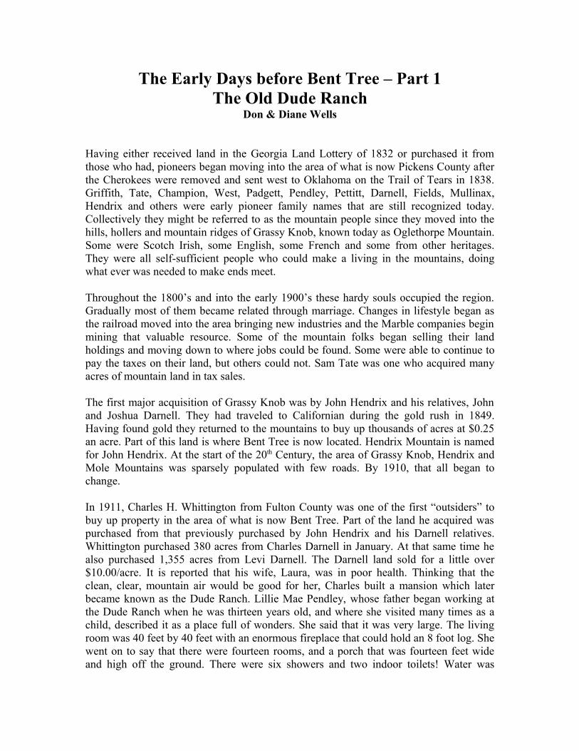
Whittington Advertisement in Atlanta Georgian and News
gravity fed down the mountain from Buck Skull Springs in order to provide continually running water in the house. Lillie Mae remembers there being a Monark stove in the large kitchen where meals were prepared. Some of the early Monark stoves had a side unit through which pipes ran to heat water which was stored in a tank. She remembers there was a large tank behind the stove. Gas lanterns provided light. There were servant quarters in the house who undoubtedly handled the meal preparation and cleaning. In addition to the main house there was a guest house called “Twin Oaks.” Lillie Mae said that the house was a sight to see for those who lived on the mountain and had very little, most of whom lived in small one to two room cabins.
In Pickens County in the early 1900’s there were other large and impressive homes such as the Pink Marble house in Tate and the Henry Dewar house in Nelson. These mansion, however, were build on main roads and near towns. The Whittington place, way back up in the hills on a dirt mountain road was different. Just getting the building materials, fine furniture and other items into the site must have presented many problems. One would assume that a spectacular mansion such as the Whittington’s would have attracted the Pickens Progress to write a story and publish a picture about it but nothing has been found. The Pickens County Heritage Book has no pictures of the Dude Ranch either although some information is available and no relatives have been located that might have known more about the Dude Ranch.
What has been found though are news articles in the Atlanta Georgian and News published in the early 1900’s. They shed some light on this rather extravagant adventure in the North Georgian Mountains. The January 9, 1911 issue of the paper had a half page advertisement placed by Mr. C.H. Whittington. The headlines said, “Any man by paying 8 1/3 cents a day can own a farm. Just two and a half hours ride from Atlanta, in the
beautiful Sapphire Country of North Georgia, 4,000 ft. above the sea, recognized as one of the healthiest spots in the world and famous for its apples and poultry.” The ink wasn’t even dry in the court house records when he began offering land at $12 an acre, which he was in the process of buying at $10 and acre. Mr. Whittington bought 3,880 acres in January 1911 in what is now Bent Tree and the Grassy Knob District and later bought another 235 acres. This land adventure would seem to have been rather risky and later it proved to be so. Charles Whittington, however, was in the high risk land speculation business.
The June 7, 1910 issue of the Atlanta Georgian and News reported that Charles Whittington was named Cuban Consul to Atlanta and that he was Secretary/Treasurer of the Aurora Colony Company and the Guarantee Live Stock Company. The Aurora Colony Company was selling land in Cuba for $1,500 for five acres with the speculation that you could get a return of $3,000 per year from fruit sales on your land. The Guarantee Live Stock Company also was involved in land dealings in Cuba.
The Early Days before Bent Tree – Part 2The Old Dude Ranch
Don & Diane Wells
Charles Whittington had a plan when he bought a good bit of land in Pickens County. He was going to become rich. However, just like Sam Tate’s land adventure in creating Tate Mountain Estates about 15 years later, Charles may well have gone broke.Charles invested heavily in infrastructure to show potential buyers. He wanted them to know that this was the place to come. He built the Dude Ranch. Along with the main house there was a separate guesthouse, Twin Oaks; a large barn; and a concrete cold storage cellar for perishable food. He piped water down hill from Buck Skull Springs so that the house could have constantly running water and indoor showers and bathrooms. Many of his business friends were invited to come to the mountains to enjoy the fresh air in hopes that they would buy property. Lillie Mae Pendley told us about her uncle, Hardy Champion, who was the conductor on the L&M Railroad to Jasper. Since travel by car from Atlanta was a bit difficult, many of the Whittington’s visitors probably rode with Hardy to the Tate Station. From there they could then be easily transported to the mountain ranch.
Possibly to help pay for all the expenses of owning this large ranch, Whittington initially started raising hogs. He did well for a couple of years, but then disease hit and they lost all the hogs. It may have been after the hog-raising catastrophe that Charles turned his enterprise into a “Dude Ranch.” Friends came not only from Atlanta but also from other areas. Horseback riding lessons were offered to the inexperienced. Those who already knew how to ride enjoyed the pleasure of riding the mountain trails. Vernie Champion, Lillie Mae’s father, helped teach people to ride and to do barrel jumping. On weekends, the quests enjoyed parties. There was music and dancing as well as card games. Vernie’s notes said that the parties sometimes got out of hand.
It is speculated that things didn’t go as planned for Charles and his wife Laura. There are no recorded land sales of the Whittington property to others from the time he bought it in 1911-1914 until 1917. By 1917, the war in Europe had officially become WW1. In America rationing had become a way of life. Money was short and what interest there might have been in visiting the mountains to buy land, disappeared. In 1917 at the age of 39, Charles was drafted and his Pickens County adventure continued taking a turn for the worst. Before leaving for the war, Charles transferred all of the mountain property including all livestock and equipment to his wife, Laura. A year later, possibly due to financial problems, Laura began selling the mountain property back to the people from whom Charles had initially bought it. The Whittington’s sold the land for much less that they had paid for it. An interesting paperwork aspect of these land sales in early 1918 is that on one sale Laura is listed as being from Fulton County. A month later, on another sale, she is listed as being from Oklahoma. Even though records show that Charles and Laura lived in Fulton County, Charles, in his 1912 purchase of land, also claims to be from Oklahoma.
No data could be found as to when Charles returned from the war, but one would assume that, having sold all of their Pickens’ County land, they would live in Atlanta or some other area. Not so! The 1920 census for Pickens County list the Whittington’s as living in the Grassy Knob District probably at the ranch, now called the GladJoe Inn, It was named after their two daughters Gladys and Josephine. There are no courthouse records showing that the Whittington’s had repurchased the land that Laura sold in 1918. How they remained on the property and continued to operate it as an Inn is anyone’s guess.
The country’s recovery from the war took time. For the Whittington’s, still living in Pickens County, time was against them. County record do not show the land Laura had sold back to the “mountain folk” being returned to the Whittington’s; but on April 11, 1921, the court records do show that Laura, with Charles as a witness, sold LL189 to Sam Tate for approximately $4 an acre, far less than what they paid originally. A year later in March 1922, Laura sold LL 315 to Sam Tate for $2 per acre.
Even though they had sold some of their acreage, the Whittingtons still resided at the GladJoe Inn. The Pickens Progress of January 1923 reported that: “Emily Josephine Whitington and Mr. Glee Brock Thompson were happily married in Atlanta on Wednesday December 20, 1922.” The news article went on to say that Emily was the youngest daughter of Mr. & Mrs. Charles Whittington of GladJoe Inn in Pickens County. The Whittington’s continued operating their off-the-beaten-path Inn until September of 1924 when they sold their remaining 1,355 acres property, including the Dude Ranch / GladJoe Inn to Sam Tate. Sadly their grand schemes and dreams came to a crashing end. Sam Tate paid them $3 an acre for land and buildings that they had initially purchased for $10 an acre. The 1930 census shows the Whittington’s living in Jonesboro City, GA in Clayton County near where Charles was born. He is listed as unemployed.
Dropping GladJoe and renaming it the Dude Ranch, Sam Tate factored the property into his plans for the building of Tate Mountain Estates. The Pickens Progress of June 1928 carried the announcement of his land adventure. He invited his Atlanta friends to come

to the mountains hoping they would want to be a part of the great Tate Estates. The February 12, 1931 Pickens Progress announced Sam Tate’s plans for expansion of the New Dude Ranch. The Progress reported that, “The New Dude Ranch is being built on the Old Whittington Place. The main building, which is just across the branch from the old Whittington home, will have accommodations for sixty people and barns are being built for sixty horses. The old Whittington house has been repaired and enlarged for the reception of guests. Mrs. Blink Drummond will be in charge of the ranch.”
It is doubtful that the improvements to the Dude Ranch were ever completed. In the book, “Friendships of the Trail, The History of the Georgia Appalachian Trail Club, 1930-1980” it was written that in 1938 members of the club carried a new sign to the southern terminus of the Appalachian Trail “up an old road from the abandoned Dude Ranch.” Sam Tate’s financial troubles with the Tate Mountain Estates and his death in 1938 meant the end of the plans for the Dude Ranch. William Darnell reported that his family lived in the Dude Ranch in the late 1930’s possibly before it was abandoned. There are some reports that a Waters family lived there in the 1940’s. It probably burned to the ground in the late 1940’s.
Today, the Dude Ranch cannot be accurately located because of the land disturbance caused by the building of Bent Tree. It was probably located somewhere between what is now the Bent Tree Administration building and hole #5/6 on the golf course.
The Early Days before Bent Tree – Part 3The CCC Camp
Don & Diane Wells
The Whittington’s sold the Old Dude Ranch to Sam Tate in 1924. By 1928, he was announcing plans for improving the Dude Ranch and for building his Tate Mountain Estates. However, those plans were greatly impacted by the Great Depression of 1929. With that financial disaster, Sam faced many problems including foreclosure of his mountain empire. With many people out of work by the late 1929’s, Franklin D. Roosevelt was swept into office as the new President in 1932 under the New Deal promises. One of his New Deal Programs was the Civilian Conservation Corps (CCC).
The CCC was a public works relief program for unemployed, unmarried men, ages 17–25. They were paid $30 a month of which $25 was sent home to their parents. It provided unskilled manual labor jobs related to the conservation and development of natural resources in rural lands owned by federal, state and local governments. For the most part, the CCC workers were employed to build structures on highways, parks and in forest lands. Pickens County did not have any government land where the CCC could set up a camp. Sam Tate, with his influence, did manage to have a camp established in his mountain community. Professor Perrow, a leader at the Pickens CCC Camp, stated in the November 16, 1938 Pickens Progress that, “the State Forest Service established the camp here at the request of the Pickens County Timber Association.” What the article failed to say is that the land where the camp was built belonged to Sam Tate and it was adjacent to

Typical CCC Barracks in 1930’s
the Old Dude Ranch. Further, the area where the CCC workers built roads and improvements was mostly the 10,000 acres of land owned by Sam Tate.
The CCC Camp was established on July 21, 1933. It was known as Camp #1449 with an address associated with the Tate Post Office and Train Station. The Pickens Progress announced on June 15, 1933 that, “A Reforestration camp will be established in Pickens County by July and there will be a total of 250 men at the camp including 180 men from Camp Benning.” The article went on to say that, “The work will include protection of the standing timber, construction of fire brakes, building telephone lines, roads and trails.” Young men were selected from each local county to participate in the camp. Twenty young men were selected from a group of 60 applicants from Pickens County and began their employment in July 1933.
Initially, the camp had tents to house the young men. The Army officers and civilians who assisted in training lived in some of the houses associated with the Old Dude Ranch. One of the first projects to be built at the camp was the mess hall and bunkroom. Lillie Mae Pendley said her father, Vernie Champion, helped build the camp. He described the mess hall/bunk house as being 60 feet wide and about 300 feet long. No evidence of where the building was located can be found today but it is estimated to have been near the current Bent Tree Administration building. The structure was probably a wood building with a metal roof. Unfortunately, no one can be found that has a picture of the building.
The June 29, 1933 Pickens Progress reported on the work plans for the CCC men at the Tate Camp. Two third class roads were to be built initially with one allowing access to Mt Oglethorpe from the camp on the west side of the mountain. Another road was to be built from the mountain peak eastward to the Tate Mountain School. From there it was to go on and connect with the state highway at Marble Hill. Four other roads/trails were also planned. These included a road from Burnt Mt. to Amicalola Falls in Dawson County; a road from Burnt Mt. through the Johntown’s area (north of Fausett Lake) and back to the county line on Sassafras Mt; a road from Burnt Mt. across Landsdown Mountain to Wolf Knob in Gilmer County; and a road from Burnt Mt. to the summit of Sharptop Mt. The CCC group was also to recondition the road from Burnt Mt. to the Cartecay section of Gilmer County.

Professor Perrow, the chief surveyor for Sam Tate, was hired as a teacher for the CCC Camp. He taught the young men how to lay out roads and to build them as well as the fundamentals of surveying. The men were also taught writing, problem solving in business arithmetic, and best practices in timber management, erosional control and water resources management in night classes
Lillie Mae Pendley told us that when she was a little girl growing up in their family cabin below the CCC Camp, the young men of the camp would come down to visit her older sister who Lillie Mae described as a “looker.” The young men would purchase some of Lillie Mae father’s peach brandy and they would give Lillie Mae a nickel or dime to crawl through the cat hole in the door so they could have some privacy visiting with her sister. The camp probably existed on the mountain until about 1942 when WW II started and there was no need to create jobs for young men any more. They were now being drafted into the war.
Everett and Claudine Milford rented the CCC Camp building as a dance hall after the camp was shut down but that didn’t last long. The mess hall was later used to raise chickens before it finally fell into complete disrepair and had to be torn down. Josh Fitts and other men took down the mess hall probably in the late 1940’s to salvage the building materials and rock foundation. By the early 1950’s when Kenneth West was delivering the mail in the area of Mole, Hendrix and Oglethorpe Mountains, he said that none of the CCC Camp or Old Dude Ranch could be found.
Another 25 years passed before anyone else tried again to develop the mountain area. That was when Bent Tree got its start.

Pelton Wheel
The Early Days before Bent Tree – Part 4Other Mountain Happenings
Don & Diane Wells
There are many stories, most not well-known, about this mountain area that can be shared. Parts 1- 3 of this series told about the Old Dude Ranch and the CCC Camp. We hope you find the ones we have chosen for parts 4 and 5 also interesting.
Water Power for the Marble MillsOne of Pickens County’s natural resources is marble. The deposits of marble are reported to be five to seven miles long, one/half mile wide and as deep as 2,000 feet. Henry Fitzsimmons established the first marble quarries and mill in the 1830’s. But it was not until the 1883, when the railroad arrived in Pickens County, that mining marble became a big business. The Georgia Marble Company was organized in 1884 and others, including the Southern Marble Company at Marble Hill, GA, soon followed.
Mining marble required power to run the machinery. Some of this power was supplied by water transported to the marble mill from what is now Bent Tree’s Oglethorpe, Hendrix and Mole Mountains. Stone, An Illustrated Magazine, Volume X, Dec 1894 to May 1895 reporting on the Southern Marble Company operations said that, “Power for the mill which contained five gang saws and two rip saws is supplied with water. A reservoir was constructed two hundred feet above the mill and waters of numerous mountain streams about two miles away are conveyed through ditches and pipes to the site. From here the water runs through a pipe gradually diminishing in size until it is finally discharged through a two inch nozzle against a Pelton undershot wheel and power enough is furnished thereby to drive the mill and the electric light plant.” Buck Skull and other springs located on the southern side Oglethorpe Mountain were the water sources mentioned in this report. Buck Skull was also the water source for the Old Dude Ranch. In order to maintain a gravity flow some of the ditches were very deep. Lillie Mae Pendley, who grew up on the southern slopes of the mountain in the 1930’s, told us about playing with her friends in the ditches that ran to the mill. The USGS map of Pickens County shows a lake off of Cove Road near Cowart Mountain Road that today is called the Georgia Marble Company Lake. This is probably the lake built to store the water for the marble mills.

The Oglethorpe MonumentSam Tate became President of the Georgia Marble Company in the early 1900’s. Under his leadership the company became one of the most important industries in GA as well as in the United States. He was a man of vision with a passion for accomplishing new endeavors outside of his marble industry. Beginning in the late 1800’s and into the early 1900’s, he bought land stretching from Burnt Mountain to Oglethorpe Mountain. By 1928 he owned about 10,000 acres. In 1928, he started building the Tate Mountain Estates which he envisioned to be “the best mountain resort community east of the Mississippi River.” He planned to put this mountain area on the map.”
He petitioned the GA Legislature and the US Congress to change the name of the main mountain from Grassy Knob to Oglethorpe Mountain, named for the founder of GA. He wanted to erect a marble monument in honor of General Oglethorpe on top of the mountain. The GA Marble Company would build the monument and donate it and a five acre site to the state. He also wanted the monument area set aside as a state park but the area was not big enough to qualify. The monument, 38 feet high, was carved by Mr. Jimmy Watt of the Nelson Georgia Marble Plant. In order to transport the monument to the top of Mt. Oglethorpe, Tate had to complete the Burnt Mt. Road to Tate Estates and then build a road along the top of the mountain ridge to the monument location. The date for the monument dedication was initially set for July 1930 but the road was not complete by then and neither was the Connehaynee Lodge where Tate planned to house all of the dignitaries who were going to be at the ceremony.
J. B. Hill, in a personal account of his experience with Sam Tate in selecting the site for the monument, reported in the November 7, 1991 Pickens Progress that all was ready by August 1930 and that L.C. Bearden and his crew got the monument to the top of Mt. Oglethorpe using the roads build by Sam Tate. Unfortunately, this major feat was not recorded with pictures. The Monument was placed in August and September of 1930 and dedicated on October 23, 1930. The ceremony was recorded in the Pickens Progress.The monument was set in a sixteen-foot circle outlined in native stones stacked two feet high. The view, seen from the top of one of the highest mountains in north Georgia, was remarkable. Many people from Pickens County and elsewhere came to see the structure. Unfortunately, after Tate died in 1938, much of his land was either sold to others or lost to foreclosure. Vandals and lighting began to destroy the Monument. Rescued in 1999, the Monument was removed from the mountain. After a two-year period of repair, it was re-erected in downtown Jasper in 2001.
The Start of the Appalachian TrailIn the early 1930’s at the same time Sam Tate was building the Tate Mountain Estates, a group of hikers nationwide were planning the route of the Appalachian Trail, first proposed by Benton MacKaye in 1921. This group, known as the Appalachian Trail Conference, had sub-groups planning the trail in each state. For GA, the group was known as the Georgia Appalachian Trail Club (GATC). Several options under consideration by this group were to end the trail near Lookout Mountain or in the Cohutta Mountains, but Sam Tate stepped in. His influence was unstoppable. He inserted himself into their planning and gave them the rights to build the trail on his mountain land.
Money was even donated to help build some of the trail structures. Sam wanted to the trail to go by the Connehaynee Lodge as well as his Tate Mountain Estates. Since this was all on private land, many members of the trail committee did not want the trail to end there. They felt that the wilderness aspect of the trail would be destroyed. However, the decision to put the terminus of the trail at Oglethorpe Mountain was finally made. The trail opened there in the early 1930’s.
The Early Days before Bent Tree – Part 5Don & Diane Wells
The Appalachian Trail – Here Today but Gone TomorrowIn 1921 Benton MacKaye proposed the building of a hiking trail that would reach from Georgia to Maine. The trail along the Appalachian Mountains was to be a “Wilderness experience.” Appalachian Trail Clubs under the Appalachian Trail Conference were formed to manage the planning and building of the trail through each state. Deciding just where the trail should go was difficult, especially in Georgia. Connecting the trail route from Georgia to North Carolina or Tennessee was as major issue. The book, Friendships of the Trail, The History of the Georgia Appalachian Trail Club 1930-1980 provides an interesting account of many of the meetings held between the planners in the early days as they tried to determine the location of the trail.
The Great Smokey Mountains Club, as well as Benton MacKaye, wanted the trail to follow the Great Smokey Mountains entering GA either at Lookout Mountain or the Cohutta Mountains. Col. Sam Tate and others wanted it to end on the top of his newly named Oglethorpe Mountain. He was successful. In 1930 the Appalachian Trail Conference voted to have the trail enter GA at Bly Gap east of Hiawassee, GA on the Blue Ridge Mountains, then cross Tray, Blood, Hawk, and Springer Mountains and terminate at Oglethorpe Mountain in Pickens County. In hindsight, it might have been better to have followed Benton MacKaye’s advice as the trail lasted less than 30 years in Pickens and Dawson Counties before it was moved to Springer Mountain.
Col. Sam Tate, who had been a man of vision and influence, died in 1938. By the late 1940’s his Tate Mountain Estates, an initial one million dollar endeavor, sold at auction on the Courthouse steps for a mere $10,000. By 1949-50, the 3rd Edition of the Appalachian Trail Guide stated that, “All that remains of the once extensive Tate Mountain Estates is a group of summer homes which are located around the lake.” The Guide went on the say that the road from Tate Estates to Mt. Oglethorpe was blocked with tree downfalls and was in disrepair. It also said that the access trail to Mt. Oglethorpe from the south passed by the abandoned Dude Ranch which eventually fell into ruin and finally burned to the ground. The Guide mentioned an old cabin that was all that remained of the CCC camp and, in spite of all Col Tate’s efforts, the terminus of the Appalachian Trail was soon to be moved to Springer Mountain. In the decade of the 1950’s, much of the mountain lands of Pickens and Dawson County that lay outside of the National Forests was purchased by timber harvesting companies and chicken farmers.
Timber was harvested off of the mountain areas which greatly impacted the wilderness feel. Chicken ranchers began setting up major operations in order to raise chickens away from the public. In the area where Sassafras Mountain Estates is currently located as well as all along the ridge line from Burnt Mountain to Oglethorpe Mountain, long chicken houses were erected with little concern for the environment. Also, moonshining was big business in Pickens and Dawson County and some of it was produced in parts of the mountain region. In fact, to some of the “old timers,” Sassafras Mountain between Burnt and Oglethorpe Mountains was called “Moonshine Mountain. It is said that the moonshiners were not hospitable to the trail walkers. The destroyed wilderness and the possibility of being shot at greatly impacted the use of Appalachian Trail in our area.
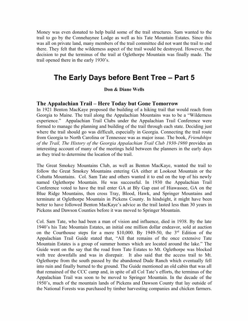
Map from the 1949 Appalachian Trail Guide
By 1956, numerous reports were being written by members of the Georgia Appalachian Trail Club (GATC) and others about moving the terminus of the trail to Springer Mountain. In 1958, the Appalachian Trail Conference voted to relocate the terminus of
the Appalachian Trail. Part of the trail in Dawson County which was on state and federal land remained as the Approach Trail to Springer Mountain which today begins in Amicalola State Park.
Those who built the Appalachian Trail in Pickens and Dawson Counties may have considered themselves trail blazers. But, they were not the first to open trails on these mountain ridges. The Cherokees were here before them and they had trails along these ridges as far back as the 1700’s or even earlier. The Cherokees sometimes used bent trees to mark their trails or point out places to find water, shelter and other things. Some of these Marker Trees can still be found today along the pathways leading up to Oglethorpe Mountain. and north along the ridgeline toward Ellijay, a major Indian Town. Several of these Marker Trees have been cored in order to age them. The oldest Marker Tree cored to date is 1768! Many others are dated in the late 1700’s and early 1800’s. These trees tell a story of those that went before us along these ridges and trails when this area was truly a wilderness. Two hundred years of man’s impact on theses forested lands have changed the wilderness, not for the better. Some of it still remains but for how long?


![Dude-Workshop_v08_public_PDF [Kompatibilitätsmodus]](https://static.fdocuments.in/doc/165x107/5864bbd11a28ab0e30944317/dude-workshopv08publicpdf-kompatibilitaetsmodus.jpg)