The Design of a New Satellite-Based Mission: An Overview of CLARREO
20
The Design of a New Satellite-Based Mission: An Overview of CLARREO Sunday Group Meeting Presentation Daniel Feldman June 29, 2008
description
The Design of a New Satellite-Based Mission: An Overview of CLARREO. Sunday Group Meeting Presentation Daniel Feldman June 29, 2008. Outline. NRC Decadal Survey Recommendations Motivation for CLARREO CLARREO Design Science & Engineering in Support of CLARREO Future Work. - PowerPoint PPT Presentation
Transcript of The Design of a New Satellite-Based Mission: An Overview of CLARREO

The Design of a New Satellite-Based Mission: An Overview of CLARREO
Sunday Group Meeting PresentationDaniel FeldmanJune 29, 2008

Outline
• NRC Decadal Survey Recommendations• Motivation for CLARREO• CLARREO Design• Science & Engineering in Support of CLARREO• Future Work

NRC Decadal Survey• Title: Earth Science and Applications from Space: National Imperatives for the Next Decade & Beyond• 20-member Space Studies Board• 17 recommended missions
– ASCENDS: active CO2 sensing– ACE: aerosol-cloud-ecosystems– CLARREO: absolutely calibrated radiances– DESDynl: InSAR surface characterization – XOVWM: ocean wind measurements– GEO-CAPE: geostationary air pollution monitoring– GACM: O3 & air pollutant measuring for chemical weather– GRACE-II: gravitational field variability– HYSPIRI: hyperspectral infrared imager– ICESAT-II: ice sheet thickness– LIST: Lidar surface topography– GSPRO: GPS radio occultation– PATH: precipitation & humidity– SCLP: snow melt & accumulation– SMAP: soil moisture characterization– SWOT: freshwater storage and ocean topography– 3D-Winds:3-dimensional tropospheric winds

CLARREO Motivation• Predicting earth’s
climate response to CO2 increases is non-trivial• IPCC FAR models
produce range of results
• Models & data disagree
• Recent data are of high quality & can reveal model deficiencies.
From IPCC FAR

Atmospheric Energy Balance
5
From Liou, 2002

CLARREO Motivation• 20+ year measurement campaign for
broadband TOA energy balance: ERBE + CERES

CLARREO Motivation• Measurements at different wavelengths
provide an extra dimension of analysis.
From Anderson, 2007

CLARREO Motivation• Changes in different atmospheric constituents
can be described by IR spectra.• Changes in spectra over long time-periods
track the earth’s response to CO2 forcing.

CLARREO Motivation• Feedback processes are essential for robust
climate model predictions.From Anderson, 2007

CLARREO motivation• CLARREO: Climate Absolute Radiance
& Reflectivity Observatory (Anderson, et al 2004)
• Spectrally-resolved IR measurements from space describe the forcing & response of the climate system
• Establishing long-term trend ≠ precise daily measurements– Satellite instruments detectors drift.– Accuracy tied to NIST standards can
help to establish trends.• CLARREO slated to contain
spectrally-resolved SW & LW measurements w/100 km footprint
From Wielicki, 2007

CLARREO Motivation• Trend analysis requires a long-term, accurate dataset.
From Anderson, 2007

CLARREO Design Questions
• Mission design balances cost considerations with science objectives.
• Questions of instrument quantity, type, spectral coverage, resolution, orbit, and footprint size must be addressed.
• Some designs are expensive and/or infeasible from an engineering perspective.
• Orbital simulations can address the utility of a proposed instrument.

CLARREO Design
• FTS instrument– Advantages: Good spectral response characterization,
imaging capability, small & simple instrument layout– Disadvantages: Stray light, polarization sensitivity,
difficult noise characterization• Gallium phase-transition black-body• Quantum cascade laser for black-body emissivity• Rotation of scene mirror introduces polarization
that modulates instrument gain

CLARREO Orbital SimulationsFrom Kirk-Davidoff, 2007

CLARREO Orbital Simulations
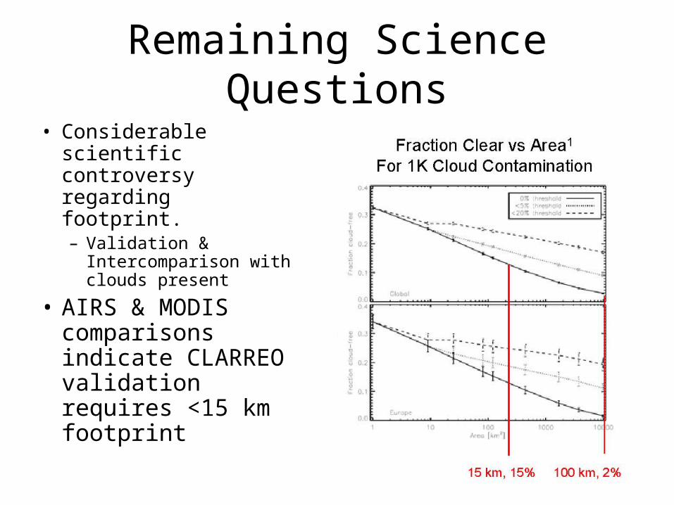
Remaining Science Questions• Considerable scientific
controversy regarding footprint.– Validation &
Intercomparison with clouds present
• AIRS & MODIS comparisons indicate CLARREO validation requires <15 km footprint

FIRST: Far Infrared Spectroscopy of the Troposphere
• FIRST is a test-bed for CLARREO
• NASA IIP FTS w/ 0.6 cm-1 unapodized resolution, ±0.8 cm scan length
• 5-200 μm (2000 – 50 cm-1) spectral range
• NeDT goal ~0.2 K (10-60 μm), ~0.5 K (60-100 μm)
• 10 km IFOV, 10 multiplexed detectors
• Balloon-borne & ground-based observations
17
FIRSTAIRS AIRS

Test Flight on September 18, 2006
18
AQUA MODIS L1B RGB Image
AIRS FootprintsFIRST Balloon
CloudSat/CALIPSO Footprint Track Test flightTest flight

FIRST and AIRS Cloud Signatures
19
• Instrument collocation• FIRST balloon-borne spectra• AIRS• MODIS
• FIRST residuals are consistent with clouds ~ 5 km, CER ~ 6 μm
CloudDetected !
Test flightTest flight

Conclusions
• NRC Decadal Survey recommended the implementation of several low-risk high-yield satellite missions.
• CLARREO represents an effort to establish long-term trends for climate indicators from a space-based platform
• Some design questions have been settled, others are being researched
• Engineering CLARREO requirements will be difficult, though flight-models such as FIRST provide a heuristic approach to addressing serious issues.