THE AVALON GREEN ALLEY NETWORK DEMONSTRATION...
88
THE AVALON GREEN ALLEY NETWORK DEMONSTRATION PROJECT Lessons Learned from Previous Projects for Green Alley Development in Los Angeles & Beyond Luskin School of Public Affairs +
Transcript of THE AVALON GREEN ALLEY NETWORK DEMONSTRATION...

the avalon green alley network Demonstration project
Lessons Learned from Previous Projects for Green Alley Development in Los Angeles & Beyond
Luskin School
of
Public Affairs
+

Luskin School
of
Public Affairs

The avalon green alley neTwork DemonsTraTion ProjecT
Lessons Learned from Previous Projects for Green Alley Development in Los Angeles & Beyond
March 2015
+

AcknowledgmentsThe authors would like to thank The Trust for Public Land for their support of this research. Special appreciation goes to Holly Elwell, Laura Ballock and Tori Kjer for their vision, thoughtful feedback and generously lending their time while sharing information. While too many to name, the authors also thank the managers of the other green alley projects and programs described in this report.
UclA lUskin center for innovAtionEstablished with a gift from Renee and Meyer Luskin, the UCLA Luskin Center for Innovation unites scholars with civic leaders to advance policy, planning and technological solutions to pressing environmental issues. Initiative areas include the Complete Streets Initiative, which focuses on achieving more livable, complete streets and other routes for people to travel safely regardless of their transportation mode, ability or age.
The following researchers from UCLA contributed to this report:
Rachel Lindt, Project Manager and Lead Author
Colleen Callahan, Project Director and Editor J.R. DeShazo, Director, Luskin CenterElizabeth Bieber, Copy Editor
the trUst for pUblic lAndThis report is commissioned by The Trust for Public Land, a U.S. national, nonprofit organization that conserves land for people to enjoy as parks, gardens, natural areas and open space. The report tells the story of the Avalon Green Alley Network Demonstration project. This project is part of The Trust for Public Land’s Parks for People initiative, which focuses on collaborations with underserved, park-poor communities to ensure that everyone has parks, gardens, playgrounds, trails and other natural places within a ten-minute walk from home.1 The Avalon Project is also part of The Trust for Public Land’s Climate-Smart Cities Program and Green Infrastructure Program, as an example of how green infrastructure can be woven into the built environment to promote climate resiliency.2
for more informAtionContact the UCLA Luskin Center for Innovation: www.innovation.luskin.ucla.edu/Copyright 2014 by the Regents of the University of California, Los Angeles. All rights reserved.
Printed in the United States.
Cover page image credit: SALT Landscape ArchitectsInside cover image credit: The Trust for Public Land and SALT Landscape Architects
Chapter 4. Lessons Learned from the Avalon Green Alley Network Demonstration Project
Introduction 68Laying the Foundation 69 Partnerships and Funding 70Design and Permitting 74Challenge, Creative Solution and Unique Opportunity 82Conclusion 85
tAble of contents
Chapter 1. Introduction
Purpose of this Report 10Report Overview and Methods 11Rationale 12Green Alley Basics 14A Green Alley Framework 15
Chapter 2. Broader Context: Project and Program Examples from Across North America
Introduction 19Environmental Focus
• Chicago’s Green Alley Program 20• Sun Valley’s Elmer Paseo Stormwater Improvements Project 22
Economic Focus • Hollywood’s East Cahuenga Alley Revitalization Project 24
Social Focus • Seattle’s Alley Network Project 26 • Boyle Heights’ Alley Reclamation 28
Multi-Foci • Austin’s Green Alley Initiative and Demonstration Project 30
Chapter 3. The Avalon Green Alley Network Demonstration Project
Introduction 37Overview and Importance 38Status 38Rationale 40Goals 41Steps to Alley Transformation 42 1) Laying the Foundation with 43
a) Research and Pre-Design Studies 43b) Political and Municipal Support 44c) Ongoing and Integrated Community Outreach and Engagement 46
2) Partnerships and Funding 483) Design and Permitting; 52
Next Steps 594) Construction and Implementation 595) Maintenance and Stewardship 616) Monitoring and Evaluation 63
Thinking Big: Going Beyond the Avalon Green Alley Network Demonstration Project 64

list of figUresFigure 1: South Los Angeles in the context of the County of Los Angeles; The Avalon Project site location in South Park neighborhoodImage Credit: The Trust for Public Land 10
Figure 2: Current conditions of an alley in the South Park neighborhood of South Los AngelesImage Credit: The Trust for Public Land 11
Figure 3: Alley density in the city of Los Angeles, by subregionImage Credit: J.P. Newell et al. (2010) 12
Figure 4: Density in the Avalon Green Alley Network Demonstration Project site areaImage Credit: The Trust for Public Land 13
Figure 5: Green alley frameworkImage Credit: Authors 16
Figure 6: Chicago alley with impermeable pavement and poor drainage before improvementsImage Credit: The City of Chicago Green Alley Handbook 20
Figure 7: Chicago green alley with permeable pavement that reduces flooding in a cost-effective manner Image Credit: The City of Chicago Green Alley Handbook 21
Figure 8: Flooding in Elmer Paseo before improvementsImage Credit: The Council for Watershed Health 22
Figure 9: Elmer Paseo after improvementsImage Credit: The Council for Watershed Health 23
Figure 10 The East Cahuenga Alley before revitalizationImage Credit: The Department of Public Works, The City of Los Angeles 24
Figure 11: The East Cahuenga Alley after revitalizationImage Credit: Sarah McPherson Besley, Hollywood Business Improvement District 25
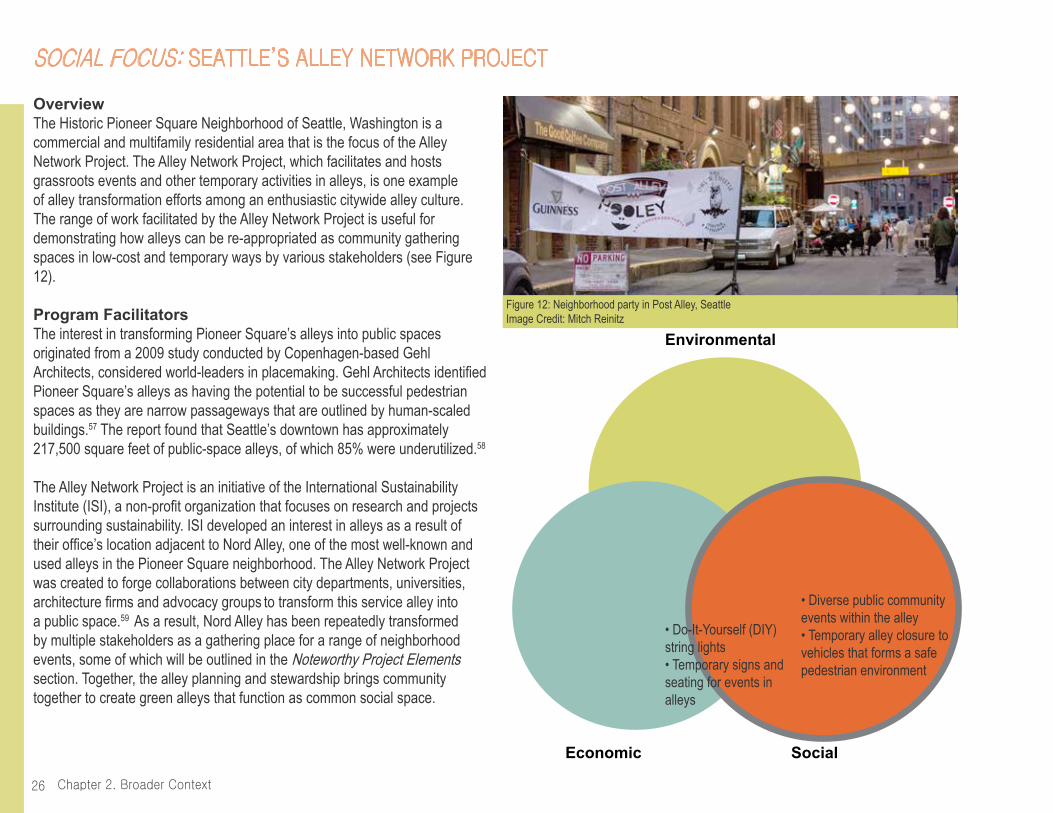
Figure 12: Neighborhood party in Post Alley, SeattleImage Credit: Mitch Reinitz 26
Figure 13: World Cup in Nord Alley 2010Image Credit: Jordan Lewis 27
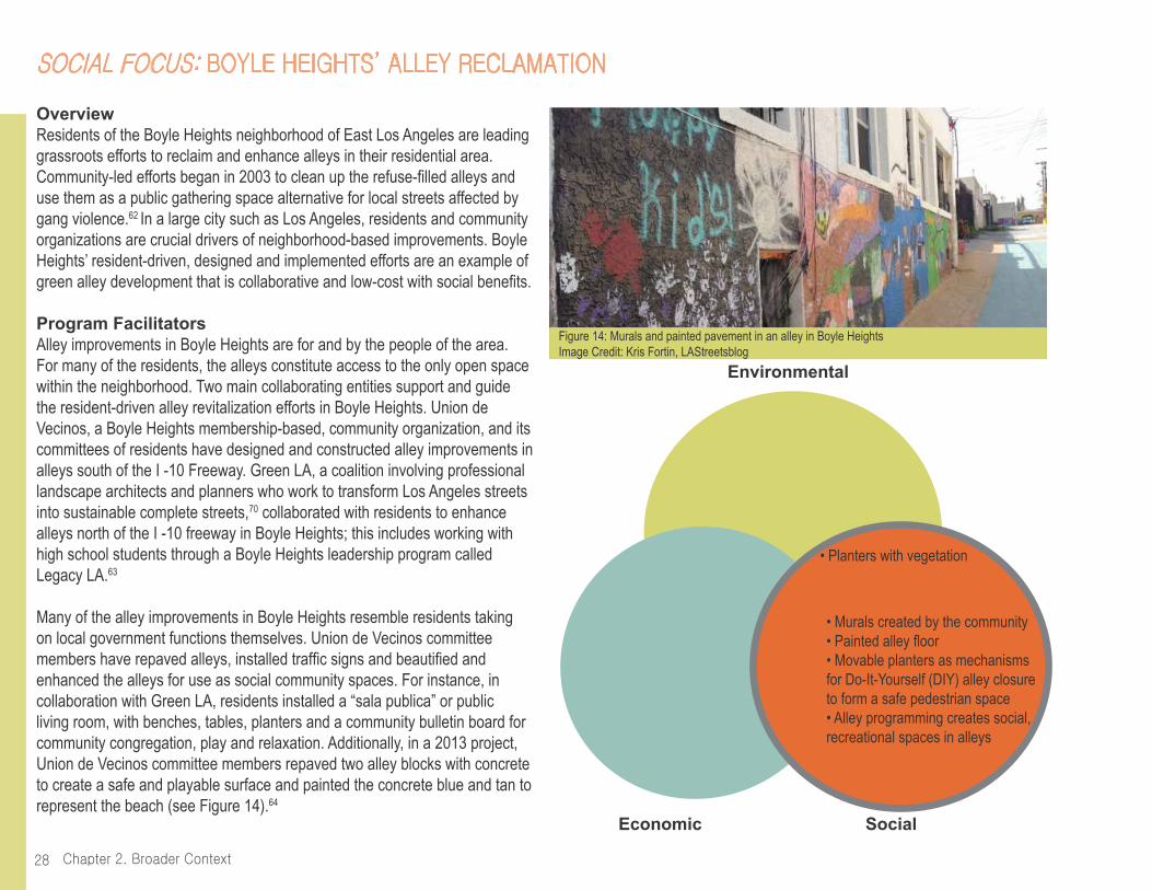
Figure 14: Murals and painted pavement in an alley in Boyle HeightsImage Credit: Kris Fortin, LAStreetsblog 28
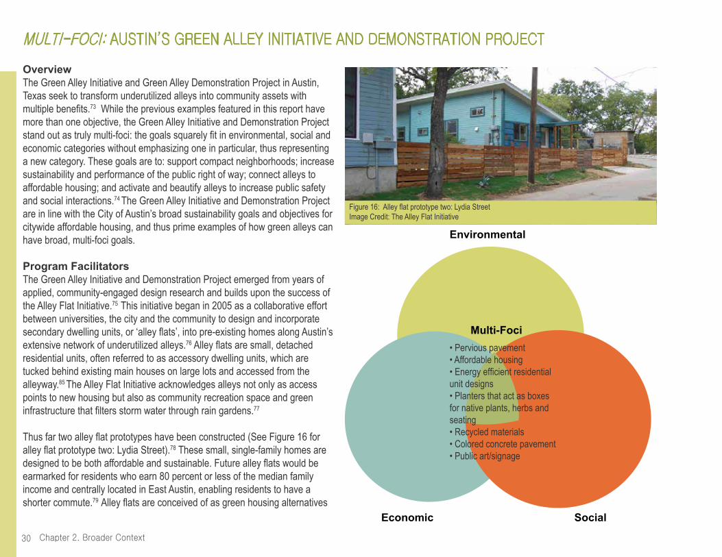
Figure 15: Painted alley floor in Boyle HeightsImage Credit: Boyle Heights Beat 29 Figure 16: Alley flat prototype two: Lydia StreetImage Credit: The Alley Flat Initiative 30
Figure 17: Before and after view of alley with multi-functional planters and native landscaping, along with community membersImage Credit: The City of Austin, Office of Sustainability 31
Figure 18: Planters in Guadalupe neighborhood alley in East Austin, designed and constructed by University of Austin studentsImage Credit: University of Texas at Austin 32
Figure 19: Conceptual rendering of the Green Alley Demonstration ProjectImage Credit: The City of Austin, Office of Sustainability 32
Figure 20: Conceptual rendering of the Avalon ProjectImage Credit: SALT Landscape Architects 37
Figure 21: Community residents cleaning an alley in the Avalon Project site Image Credit: The Trust for Public Land 38
Figure 22: The Avalon Project siteImage Credit: The Trust for Public Land and SALT Landscape Architects 39 Figure 23: Level of park need in the City of Los Angeles with circleindicating the boundaries of the South Park neighborhood Image Credit: The Trust for Public Land 2014 ParkScore© Index 40

Figure 24: Existing conditions of an alley in the South Park neighborhoodwith standing water Image Credit: The Trust for Public Land 41
Figure 25: Existing conditions of an alley in the South Park neighborhoodwith illegal dumpingImage Credit: The Trust for Public Land 43
Figure 26: Gated alley in the city of Los AngelesImage Credit: theeastsiderla.com 44 Figure 27: Early analysis of the Avalon Project site area showing a lack of street treesImage Credit: The Trust for Public Land and SALT Landscape Architects 45
Figure 28: The Trust for Public Land presenting images of options for the Avalon Project to gain feedbackImage Credit: The Trust for Public Land 46
Figure 29: Interactive flip books presenting green alley options to residentsImage Credit: The Trust for Public Land 47
Figure 30: The Los Angeles Police Department, Community-Policy Advisory Board, Newton Division participating in community event in an alley in the Avalon Project site areaImage Credit: The Trust for Public Land 48
Figure 31: ‘No Dumping’ Spanish sign posted in alleys in the Avalon Project site areaImage Credit: The Trust for Public Land 49
Figure 32: U.S. Representative Lucille Roybal-Allard and Los Angeles City Councilman Curren Price, whose respective districts encompass the Avalon Project site, with students and faculty of Maya Angelou Community High School, the Avalon Green Alley Green Team and The Trust for Public Land staffImage Credit: The Trust for Public Land 49
Figure 33: Alley clean up in an Avalon Project alley siteImage Credit: The Trust for Public Land 50
Figure 34: Two examples of green alley scenarios developed by the City of Los Angeles’ Green Alley SubcommitteeImage Credit: The City of Los Angeles 52
Figure 35: Conceptual rendering of the Avalon ProjectImage Credit: SALT Landscape Architects 53
Figure 36: Conceptual rendering of the T-shaped alley, pedestrian-only zone located in the northeastern corner of the networkImage Credit: SALT Landscape Architects 55
Figure 37: Priortization of streetscape improvementsImage Credit: The Trust for Public Land and SALT Landscape Architects 56
Figure 38: Conceptual rendering of the Avalon Project’s permeable paving and catch basins Image Credit: SALT Landscape Architects 57
Figure 39: Conceptual rendering of vine plantingsImage Credit: SALT Landscape Architects 58
Figure 40: Construction details of the vine plantingsImage Credit: SALT Landscape Architects 58
Figure 41: Community residents participating in a tree care workshopImage Credit: The Trust for Public Land 60
Figure 42: Community residents and project partners removing trash from South Park neighborhood’s alleysImage Credit: The Trust for Public Land 61
Figure 43: Members of the Avalon Green Alley Team maintainingalleys in the Avalon Project’s site areaImage Credit: The Trust for Public Land 62
Figure 44: Existing conditions of alleys in South Los AngelesImage Credit: The Trust for Public Land 64
Figure 45: Conceptual rendering of the Avalon ProjectImage Credit: SALT Landscape Architects 68

Figure 46: Christmastime posada (potluck)Image Credit: The Trust for Public Land 69
Figure 47: Boyle Heights resident sweeping in a revitalized green alleyImage Credit: Boyle Heights Beat 70
Figure 48: Avalon Green Alley Team t-shirtImage Credit: The Trust for Public Land 71
Figure 49: Community residents and project partners connecting with local police forceImage Credit: The Trust for Public Land 71
Figure 50: The City of Chicago’s Green Alley HandbookImage Credit: The City of Chicago 72
Figure 51: Grand opening of the EaCa Alley in Hollywood with city officials and project partnersImage Credit: The Beverly Press 73
Figure 52: DIY string lighting in an alley in Seattle, Washington.Image Credit: Mitch Reinitz 74
Figure 53: Graphic of dark sky compliant alley light fixtureImage Credit: The City of Chicago 74
Figure 54: Alley closure, gained through permits from the City of Seattle, allow for events in Seattle’s alleys Image Credit: Kari Quaas 75
Figure 55: Resident-designed and constructed movable planterImage Credit: Kris Fortin/ LAStreetsblog 76
Figure 56: Movable planters add greenery and help block vehicle access to alley during alley eventsImage Credit: Kris Fortin/ LAStreetsblog 76
Figure 57: Grasscrete image and diagramImage Credit: Sustainable Paving Systems, LLC; The City of Los Angeles 77
Figure 58: A team of stakeholders and residents painting the walls of Elmer PaseoImage Credit: Urban Applications 78
Figure 59: Stamped pavement decal in Chicago’s green alleysImage Credit: Kate A. Ekman 78
Figure 60: Birthday party held in a Boyle Heights alley with the help of movable plastic chairsImage Credit: Kris Fortin/LAStreetsblog 79
Figure 61: Lightweight and moveable additional seating for restaurants adjacent to EaCa AlleyImage Credit: Sarah McPherson- Besley, Hollywood Business Improvement District 79
Figure 62: Reception for adjacent gallery in a Seattle, Washington alleyImage Credit: Mira Poling 80
Figure 63: Conceptual rendering of the Avalon ProjectImage Credit: SALT Landscape Architects 81
Figure 64: Design exploration for features of the Avalon ProjectImage Credit: The Trust for Public Land 82
Figure 65: An alley in South Los Angeles with potential for transformation Image Credit: The Trust for Public Land 85
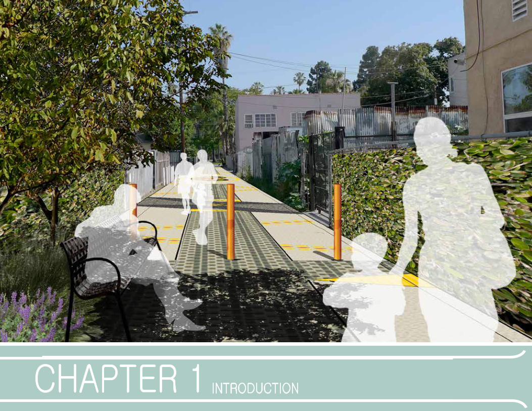
chapter 1 introdUction
Chapter 1. Introduction10
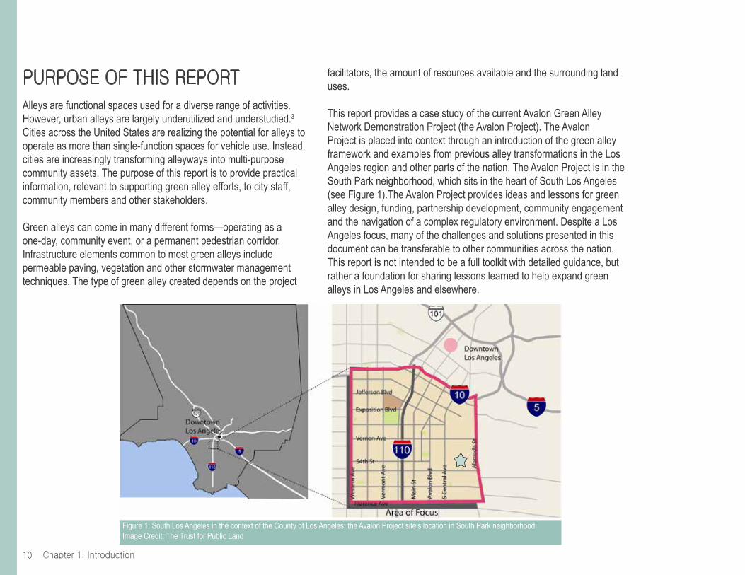
pUrpose of this reportAlleys are functional spaces used for a diverse range of activities. However, urban alleys are largely underutilized and understudied.3 Cities across the United States are realizing the potential for alleys to operate as more than single-function spaces for vehicle use. Instead, cities are increasingly transforming alleyways into multi-purpose community assets. The purpose of this report is to provide practical information, relevant to supporting green alley efforts, to city staff, community members and other stakeholders.
Green alleys can come in many different forms—operating as a one-day, community event, or a permanent pedestrian corridor. Infrastructure elements common to most green alleys include permeable paving, vegetation and other stormwater management techniques. The type of green alley created depends on the project
facilitators, the amount of resources available and the surrounding land uses.
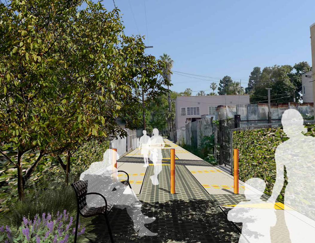
This report provides a case study of the current Avalon Green Alley Network Demonstration Project (the Avalon Project). The Avalon Project is placed into context through an introduction of the green alley framework and examples from previous alley transformations in the Los Angeles region and other parts of the nation. The Avalon Project is in the South Park neighborhood, which sits in the heart of South Los Angeles (see Figure 1).The Avalon Project provides ideas and lessons for green alley design, funding, partnership development, community engagement and the navigation of a complex regulatory environment. Despite a Los Angeles focus, many of the challenges and solutions presented in this document can be transferable to other communities across the nation. This report is not intended to be a full toolkit with detailed guidance, but rather a foundation for sharing lessons learned to help expand green alleys in Los Angeles and elsewhere.
Figure 1: South Los Angeles in the context of the County of Los Angeles; the Avalon Project site’s location in South Park neighborhoodImage Credit: The Trust for Public Land
11Chapter 1. Introduction
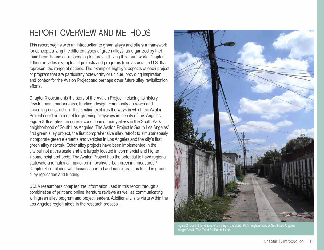
report overview And methodsThis report begins with an introduction to green alleys and offers a framework for conceptualizing the different types of green alleys, as organized by their main benefits and corresponding features. Utilizing this framework, Chapter 2 then provides examples of projects and programs from across the U.S. that represent the range of options. The examples highlight aspects of each project or program that are particularly noteworthy or unique, providing inspiration and context for the Avalon Project and perhaps other future alley revitalization efforts.
Chapter 3 documents the story of the Avalon Project including its history, development, partnerships, funding, design, community outreach and upcoming construction. This section explores the ways in which the Avalon Project could be a model for greening alleyways in the city of Los Angeles. Figure 2 illustrates the current conditions of many alleys in the South Park neighborhood of South Los Angeles. The Avalon Project is South Los Angeles’ first green alley project, the first comprehensive alley retrofit to simultaneously incorporate green elements and vehicles in Los Angeles and the city’s first green alley network. Other alley projects have been implemented in the city but not at this scale and are largely located in commercial and higher income neighborhoods. The Avalon Project has the potential to have regional, statewide and national impact on innovative urban greening measures.4 Chapter 4 concludes with lessons learned and considerations to aid in green alley replication and funding.
UCLA researchers compiled the information used in this report through a combination of print and online literature reviews as well as communicating with green alley program and project leaders. Additionally, site visits within the Los Angeles region aided in the research process.
Figure 2: Current conditions of an alley in the South Park neighborhood of South Los AngelesImage Credit: The Trust for Public Land

Chapter 1. Introduction12
rAtionAleWith a dearth of open space in urban environments in the U.S., innovative strategies have emerged to re-imagine and re-adapt public space and infrastructure. Municipalities, community organizations, citizens and private businesses are helping to transform underutilized spaces for vehicles into multi-purpose places for people. Examples include installing green infrastructure, pedestrian plazas and parklets, which are small urban parks. Parklets are created by converting parking spots or other underutilized spaces primarily meant for cars, into places for active and passive recreation.4
Historically, alleys were a key urban design feature of post WWII cities, used for milk and coal delivery and vehicular access to the back entrance of properties.5 Today alleys are still used for vehicle access, including municipal services and deliveries, but many have become ignored or feared for being locations for illicit activities, refuse and illegal dumping. Communities across the nation are beginning to examine how such an abundant infrastructural element could be transformed to realize more benefits.
In the past decade, interests in alleys have increased at the same that there have been advancements in sustainability and green infrastructure. Together these forces have manifested into an informal movement to develop “green” alleys.6 Examples include Chicago’s green alleys with stormwater infiltration and strategies for flooding abatement; Seattle’s community events and activities held in the historic and central business district’s alleys and; Los Angeles’ revitalized commercial alley in the Hollywood Entertainment District. These projects and programs, among many others, have clearly expanded upon the trash-receptacle and municipal service delivery function of alleys and capitalized on their multi-functional potential.
The potential is enormous in cities like Los Angeles. The city of Los Angeles has approximately 900 linear miles of alleys amounting to about three square miles—twice the size of New York’s Central Park (see Figure 3).7 South Los Angeles alone contains about 300 linear miles of alleys, or approximately 30% of all the alleys in the city of Los Angeles. Many alleys in South Los Angeles,
Figure 3: Alley density in the city of Los Angeles, by subregionImage Credit: J.P. Newell et al. (2010)

13Chapter 1. Introduction
however, are currently misused as unsanctioned dumping grounds for trash, and are in a degraded state with the second highest “flood complaint density” in the city due to the aging stormwater infrastructure and lack of permeable surfaces.8
There is significant need for solutions to a lack of open space. The National Recreation and Parks Association recommends 10 acres of park space per 1,000 residents,9 however, Los Angeles’ park space is 38 percent below the national recommendation with 6.2 acres of park space per 1,000 residents.10 South Los Angeles is significantly worse still as its park space is 96 percent below the national recommendation with 0.42 acres of park space per 1,000 residents.11 Not surprisingly, in this park-poor area, prevalence of obesity is high; approximately one in three adults in South Los Angeles are obese.12
The Avalon Project aims to retrofit nearly a mile of alleys in a South Los Angeles neighborhood that is particularly park-poor and densely populated (See Figure 4). After years of planning, fundraising, conducting community outreach and designing, the Avalon Project is slated to break ground in early 2015. Additionally, the South Los Angeles Green Alley Master Plan is in progress and expected to finish in 2015. The Master Plan includes the Avalon Project and additional plans for green alleys in South Los Angeles.
As diverse stakeholders embrace alleys to address a myriad of issues, now more than ever, it is important to understand the range of possibilities. This report presents a framework for doing so. In addition, this report is timely in its use of the framework to learn about key projects, including the Avalon Project. If the Avalon Project is scaled up to the city or county level, there could be substantial benefits for adjacent communities and the region.
A framework for green alley improvements is a new offering at a time when cities across the country are embracing multi-benefit green infrastructure and developing green infrastructure master plans. Cities, like Los Angeles, are moving towards policies that require all future street and alley projects to incorporate green infrastructure.13
Figure 4: Density in the Avalon Green Alley Network Demonstration Project site areaImage Credit: The Trust for Public Land
S San Pedro St
S San Pedro St
Towne Ave
E 49th StE 49th St
E 50th St
W 51st St
W 53rd St E 53rd St
E 54th St E 54th St
W 55th St
E 51st St E 51st St
E 52nd St
W Slauson AveE Slauson Ave
W 52nd St
E 52nd St
E 52nd Pl
E 48th St
W 48th St
E 47th St
E 46th St
W 47th Pl
Census Tract
2293South Park
Census Tract
2294.20Census Tract
2294.10
Census Tract
22921200 dwellings110.5 acres
145.1 acres
1348 dwellings122.8 acres
922 dwellings135.7 acres
1014 dwellings
S Main St
Wall St
W 47th St
to Exposition Park & Downtown
to I-110 Harbor Freeway to MTA Blue Line
S Avalon Blvd
McKinley Ave
Wadsw
orth Ave
S Central Ave
the Trust for Public Land
Avalon Green AlleySouth Los Angeles, CA
ProjectSite
Nearby Census Tracts
Project Site
Map
ped
by P
ease
Pre
ss C
arto
grap
hy fo
r the
Tru
st fo
r Pub
lic L
and
Total housing units = 4484 unitsTotal acreage = 514.1 acres
US Census Bureau: http://quickfacts.census.gov/qfd/states/06/06037lk.htmlby census tract. Characteristics 2005-2009
November 9, 2011, v12
0 200 400 600 800 1000 feet
0 0.25 mile

Chapter 1. Introduction14
green Alley bAsics
For the purposes of this document, the following definition of green alleys will be used:
Green alleys expand upon single-purpose infrastructure of alleys and convert underutilized alleyways into community assets and resources for environmental, economic and social benefits.
More specifically, green alleys can be defined as those that activate the public space for more than vehicular use and garbage disposal and involve a combination of environmental/ environmental health, economic, and social purposes. Depending on the motivations and needs of those spearheading the project, green alleys can achieve a variety of these objectives and be composed of a range of corresponding features. Green alleys should be tailored to meet a community and project’s unique characteristics. Here are some of the characteristics that will impact green alley development:
• Main objective: Motivations for green alleys can be to achieve economic, social, environmental or multiple benefits.
• Project or Program facilitator(s) and funding: The lead entities in green alley revitalization can include any combination of 1) grassroots community organizations and/or residents, 2) non-governmental organizations, 3) business-led public-private partnerships, 4) city agencies, such as departments of transportation, public works or planning and 5) elected officials such as city council members.
• Surrounding land use: Both commercial and residential land uses can support green alleys.
• Desired duration: Efforts can range from initiating a one-day community event in an alley space, to a pilot project, to an institutionalized long-term program.
• Scale: Efforts can focus on a single alley, a neighborhood network of alleys, or a citywide network of alleys.
This range of green alley outcomes will be further explained and visualized in Chapters 2 and 3.
15Chapter 1. Introduction
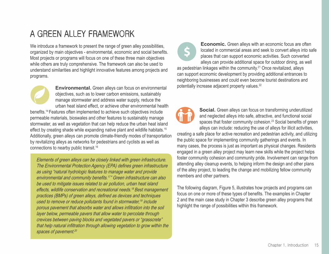
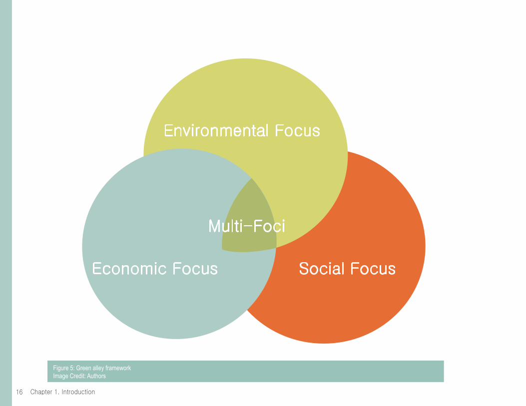
A green Alley frAmeworkWe introduce a framework to present the range of green alley possibilities, organized by main objectives - environmental, economic and social benefits. Most projects or programs will focus on one of these three main objectives while others are truly comprehensive. The framework can also be used to understand similarities and highlight innovative features among projects and programs.
Environmental. Green alleys can focus on environmental objectives, such as to lower carbon emissions, sustainably manage stormwater and address water supply, reduce the urban heat island effect, or achieve other environmental health
benefits.14 Features often implemented to achieve such objectives include permeable materials, bioswales and other features to sustainably manage stormwater, as well as vegetation that can help reduce the urban heat island effect by creating shade while expanding native plant and wildlife habitats.15
Additionally, green alleys can promote climate-friendly modes of transportation by revitalizing alleys as networks for pedestrians and cyclists as well as connections to nearby public transit.16
Elements of green alleys can be closely linked with green infrastructure. The Environmental Protection Agency (EPA) defines green infrastructure as using “natural hydrologic features to manage water and provide environmental and community benefits.17” Green infrastructure can also be used to mitigate issues related to air pollution, urban heat island effects, wildlife conservation and recreational needs.18 Best management practices (BMPs) of green alleys, defined as devices and techniques used to remove or reduce pollutants found in stormwater,19 include porous pavement that absorbs water and allows infiltration into the soil layer below, permeable pavers that allow water to percolate through crevices between paving blocks and vegetated pavers or “grasscrete” that help natural infiltration through allowing vegetation to grow within the spaces of pavement.20
Economic. Green alleys with an economic focus are often located in commercial areas and seek to convert alleys into safe places that can support economic activities. Such converted alleys can provide additional space for outdoor dining, as well
as pedestrian linkages within the community.21 Once revitalized, alleys can support economic development by providing additional entrances to neighboring businesses and could even become tourist destinations and potentially increase adjacent property values.22
Social. Green alleys can focus on transforming underutilized and neglected alleys into safe, attractive, and functional social spaces that foster community cohesion.23 Social benefits of green alleys can include: reducing the use of alleys for illicit activities,
creating a safe place for active recreation and pedestrian activity, and utilizing the public space for implementing community gatherings and events. In many cases, the process is just as important as physical changes. Residents engaged in a green alley project may learn new skills while the project helps foster community cohesion and community pride. Involvement can range from attending alley cleanup events, to helping inform the design and other plans of the alley project, to leading the change and mobilizing fellow community members and other partners.
The following diagram, Figure 5, illustrates how projects and programs can focus on one or more of these types of benefits. The examples in Chapter 2 and the main case study in Chapter 3 describe green alley programs that highlight the range of possibilities within this framework.
$
Chapter 1. Introduction16
environmental focus
economic focus social focus
multi-foci
Figure 5: Green alley frameworkImage Credit: Authors

17Chapter 1. Introduction
endnotesAcknowledgments 1 “Parks for People The Trust for Public Land.” Parks for People The Trust for Public Land. Web. 13 Aug. 2014. 2 “Climate-Smart Cities.” The Trust for Public Land. N.p., n.d. Web. 30 July 2014.; “State of California Urban Greening Grant Program Proposal.” The Trust for Public Land. 2011.3 Clay, Grady, and Barnett, Jonathan. Being a Disquisition upon the Origins, Natural Disposition and Occurrences in the American Scene of Alleys ... a Hidden Resource ... Louisville, Ky.: G. Clay, 1978. Print.
Chapter 1. Introduction4 Sideris, Anastasia, Callahan, Colleen and Brozen,Madeline. Reclaiming the Right of Way: A Toolkit for Creating and Implementing Parklets. Los Angeles, 2012. Print.; “State of California Urban Greening Grant Program Proposal.” The Trust for Public Land. 2011.5 Martin, Michael David. “The Case for Residential Back-alleys: A North American Perspective.” Journal of Housing and the Built Environment 17 (2002): 145-71. Web.6 Cassidy, Arly, Newell, Josh and Wolch, Jennifer. Transforming Alleys into Green Infrastructure for Los Angeles. Rep. Los Angeles: Center for Sustainable Cities, U of Southern California, 2008. Print.7 Newell, Joshua P., Seymour, Mona, Yee,Thomas, Renteria, Jennifer, Travis Longcore, Wolch, Jennifer R., and Shishkovsky, Anne. “Green Alley Programs: Planning for a Sustainable Urban Infrastructure?” Elsevier (2012): n. pag. Web. 1 July 2014. <http:// dx.doi.org/10.1016/j.cities.2012.07.004>.8 Ibid.9 Chau, Haan-Fawn. Green Infrastructure for Los Angeles: Addressing Urban Runoff and Water Supply Through Low Impact Development. Rep. N.p.: n.p., 2009. California Water Board. Web. 6 Aug. 2014).10 Ibid.; The Trust for Public Land ParkScore© index11 The Trust for Public Land 2011 City Parks Facts. Web. 20 June 2014.12 Chau, Haan-Fawn. Green Infrastructure for Los Angeles: Addressing Urban Runoff and Water Supply Through Low Impact Development. Rep. N.p.: n.p., 2009. California Water Board. Web. 6 Aug. 2014.13 Ibid.
14 Ibid.15 Cassidy, Arly, Newell, Josh and Wolch, Jennifer. Transforming Alleys into Green Infrastructure for Los Angeles. Rep. Los Angeles: Center for Sustainable Cities, U of Southern California, 2008. Print.; Fialko, Mary, and Hampton, Jennifer. Seattle Integrated Alley Handbook: Activating Alleys for a Lively City. Rep. N.p.: n.p., n.d. Green Futures Research & Design Lab Resources. UW Green Futures Lab, Scan Design Foundation and Gehl Architects. Web. 30 July 2014.16 Downtown Seattle Public Space & Public Life. Rep. N.p.: n.p., 2009. Gehl Architects, City of Seattle and International Sustainability Institute. Web. 3 July 2014.; Cassidy, Arly, Newell, Josh and Wolch, Jennifer. Transforming Alleys into Green Infrastructure for Los Angeles. Rep. Los Angeles: Center for Sustainable Cities, U of Southern California, 2008. Print.; The Trust for Public Land Climate-Smart Cities Report.17 Cassidy, Arly, Newell, Josh and Wolch, Jennifer. Transforming Alleys into Green Infrastructure for Los Angeles. Rep. Los Angeles: Center for Sustainable Cities, U of Southern California, 2008. Print18 “Green Infrastructure.” Water: Green Infrastructure. United States Environmental Protection Act, n.d. Web. 8 Aug. 2014.19 Chau, Haan-Fawn. Green Infrastructure for Los Angeles: Addressing Urban Runoff and Water Supply Through Low Impact Development. Rep. N.p.: n.p., 2009. California Water Board. Web. 6 Aug. 2014).20 Ibid.21 “Green Infrastructure.” Water: Green Infrastructure. United States Environmental Protection Act, n.d. Web. 8 Aug. 2014.22 Burgos, Lila, and Sarkisian, Tamar. East Cahuenga Alley Revitalization Project: Best Practices for a Creating Pedestrian-Friendly Urban Alley. Rep. Los Angeles: Los Angeles Sustainability Collaborative, 2013. Los Angeles Sustainability Collaborative. Web. 30 June 2014.23 Ibid.24 Transforming Alleys into Green Infrastructure for Los Angeles. Rep. Los Angeles: Center for Sustainable Cities, U of Southern California, 2008. Print.
Chapter page image credit: SALT Landscape Architects
chapter 2 broAder context: project And progrAm exAmples from Across north AmericA

19Chapter 2. Broader Context
introdUctionTo contextualize the Avalon Green Alley Network Demonstration Project highlighted in Chapter 3, Chapter 2 first introduces other green alley projects and programs from the Los Angeles region and beyond. These examples are organized by utilizing the framework introduced in Chapter 1. As such, each project or program is highlighted for its: 1) environmental focus; 2) economic focus; 3) social focus or; 4) in the case of a truly comprehensive program, its multi-foci objectives. This is not to imply that most of the projects only have one focus area and one corresponding set of benefits and features. Rather, the aim is to highlight particularly distinct strengths and corresponding features of select projects that inspired the Avalon Project and/or could inform future green alley efforts.
UCLA researchers examined many project and program examples and ultimately selected six examples from across the U.S. These following examples were selected based on 1) respective unique elements that collectively form a typology of possibilities for green alleys; 2) availability of public information; 3) potential for interviews with project or program managers and; 4) geographic variation:
Environmental Focus• Chicago’s Green Alley Program• Sun Valley’s Elmer Paseo Stormwater Improvements Project
Economic Focus• Hollywood’s East Cahuenga Alley Revitalization
Social Focus• Seattle’s Alley Network Project• Boyle Heights’ Alley Reclamation
Multi-foci• Austin’s Green Alley Initiative and Demonstration Project
To supplement these six featured examples, Chapter 2 also mentions other noteworthy green alley projects and programs at the end of each category.
The information presented in this report provides a snapshot in time. Information, particularly the monetary figures of new projects, may change in the future as more information becomes publicly available.
Chapter 2. Broader Context20
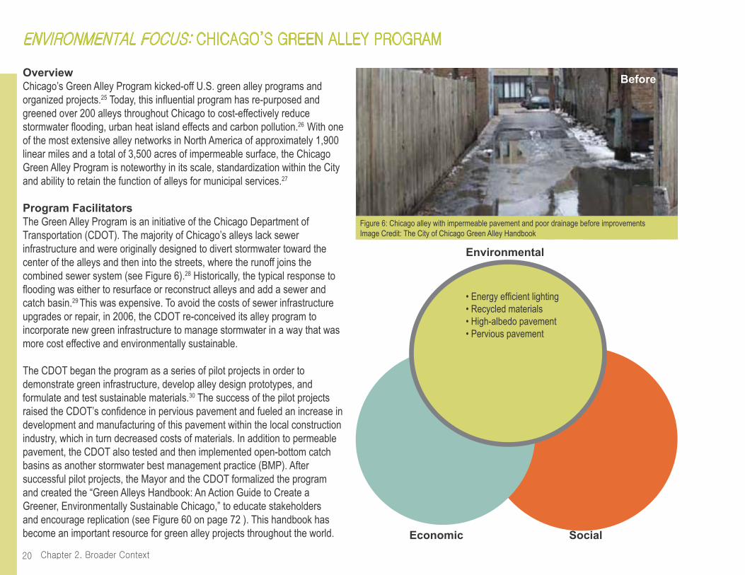
OverviewChicago’s Green Alley Program kicked-off U.S. green alley programs and organized projects.25 Today, this influential program has re-purposed and greened over 200 alleys throughout Chicago to cost-effectively reduce stormwater flooding, urban heat island effects and carbon pollution.26 With one of the most extensive alley networks in North America of approximately 1,900 linear miles and a total of 3,500 acres of impermeable surface, the Chicago Green Alley Program is noteworthy in its scale, standardization within the City and ability to retain the function of alleys for municipal services.27
Program FacilitatorsThe Green Alley Program is an initiative of the Chicago Department of Transportation (CDOT). The majority of Chicago’s alleys lack sewer infrastructure and were originally designed to divert stormwater toward the center of the alleys and then into the streets, where the runoff joins the combined sewer system (see Figure 6).28 Historically, the typical response to flooding was either to resurface or reconstruct alleys and add a sewer and catch basin.29 This was expensive. To avoid the costs of sewer infrastructure upgrades or repair, in 2006, the CDOT re-conceived its alley program to incorporate new green infrastructure to manage stormwater in a way that was more cost effective and environmentally sustainable.
The CDOT began the program as a series of pilot projects in order to demonstrate green infrastructure, develop alley design prototypes, and formulate and test sustainable materials.30 The success of the pilot projects raised the CDOT’s confidence in pervious pavement and fueled an increase in development and manufacturing of this pavement within the local construction industry, which in turn decreased costs of materials. In addition to permeable pavement, the CDOT also tested and then implemented open-bottom catch basins as another stormwater best management practice (BMP). After successful pilot projects, the Mayor and the CDOT formalized the program and created the “Green Alleys Handbook: An Action Guide to Create a Greener, Environmentally Sustainable Chicago,” to educate stakeholders and encourage replication (see Figure 60 on page 72 ). This handbook has become an important resource for green alley projects throughout the world.
environmentAl focUs: chicAgo’s green Alley progrAm
• Energy efficient lighting• Recycled materials• High-albedo pavement• Pervious pavement
Environmental
SocialEconomic
Figure 6: Chicago alley with impermeable pavement and poor drainage before improvementsImage Credit: The City of Chicago Green Alley Handbook
Before

21Chapter 2. Broader Context
Noteworthy Program ElementsChicago’s program is particularly notable for the strong leadership from its department of transportation. Examples of this leadership include:
• CDOT’s ownership of the Green Alley Program. The CDOT finances and has streamlined the development of green alley conversions in the city. The CDOT’s ownership has enabled green alleys to become routine and implemented on a widespread scale throughout the city and has encouraged their integration into broader city-wide initiatives. Since the creation of the Green Alley Program, every commercial and residential alley that the CDOT has reconstructed has been “green,” using one or more of
the materials tested in the original five pilots (for an example of one of the implemented green alleys, see Figure 7). The standardization and support of green alleys has led to their widespread implementation and integration. The program is a permanent environmental initiative within the CDOT’s green infrastructure initiatives, which includes the implementation of a full range of environmental best practices addressing water, energy, materials and waste, climate and air quality, urban ecology, beauty and community.31
• The integration of green alleys into broader city-wide initiatives. Green alleys are integrated into the City’s Climate Action Plan as well as the CDOT’s Sustainable Urban Infrastructure Policies and Guidelines.32
Most recently, the CDOT has included alleys in their Make Way for People initiative, which seeks to implement and support creative public right-of-way reclamation. As the program facilitator, the CDOT’s motivation is to build upon the Green Alley Program and enable the use of city alleys as People Alleys, a term for alleys that can be used as temporary spaces for events, placemaking and economic development.33
Funding and Implementation DetailsInitial funding, estimated to be $900,000, was allocated to the Streetscape and Sustainable Design section of the Project Development Division within the CDOT for green alley research, material development, pilot projects and creation of the Handbook. After this initial funding, the program was integrated into the City of Chicago’s “Menu Improvement Plan,” which allocates funds to the 50 wards to create ward-specific budgets for capital improvements and discretionary funds. This model enables each ward to decide how to spend the money based on projects listed on a “menu” of available improvements. These improvements include items such as streetlights, bike lanes, and of course, green alleys.
Figure 7: Chicago green alley with permeable pavement that reduces flooding in a cost-effective manner Image Credit: The City of Chicago Green Alley Handbook
After

Chapter 2. Broader Context22
OverviewThe Elmer Paseo Stormwater Improvements Project is located in a residential neighborhood in the San Fernando Valley of Los Angeles. Prior to this project’s completion in 2012, the alleyway in this neighborhood was generally degraded, a location for undesirable activity, and subject to flooding even during small storms (see Figure 8).34 Yet, the Elmer Paseo was an important pedestrian passageway connecting residences to the neighborhood churches, schools and services.35 Given this, the Paseo was selected as an improvement site with project goals including to reduce flooding, increase safety as a pedestrian passageway and add green space and habitat for local wildlife and plants.41 Although the main impetus for the project was to provide these environmental benefits, the success of multiple partnerships produced many additional social benefits, including creating a location for community art projects and public space.
Program FacilitatorsThe Council for Watershed Health, a Los Angeles region-based non-profit organization focused on watershed research and analysis, was the lead entity on this project as part of their Water Augmentation Study (WAS). The WAS is a long-term research project focused on the potential to increase local water supplies and reduce urban runoff pollution by increasing infiltration of stormwater runoff.36
Many other community, city and regional partners supported the implementation of the Elmer Paseo. Residents of the Elmer Avenue Neighborhood provided input on the design of the project, by actively participating in planning workshops.37 Collaborators at the city-level included the offices of the two local council members as well as the Los Angeles Department of Water and Power, the Bureau of Sanitation and the Bureau of Engineering. These three city departments contributed both funds and implementation support. Additional support came from the Los Angeles-based environmental non-profit TreePeople.
The Elmer Paseo was part of a larger neighborhood effort the addresses flooding and provides other environmental benefits. This larger effort is
environmentAl focUs: sUn vAlley’s elmer pAseo stormwAter improvements project
• Pervious concrete pavement• Infiltration trench• Bioswale• Native plants
Environmental
SocialEconomic
Figure 8: Flooding in Elmer Paseo before improvementsImage Credit: The Council for Watershed Health
• Murals on walls of the Paseo
Before
23Chapter 2. Broader Context
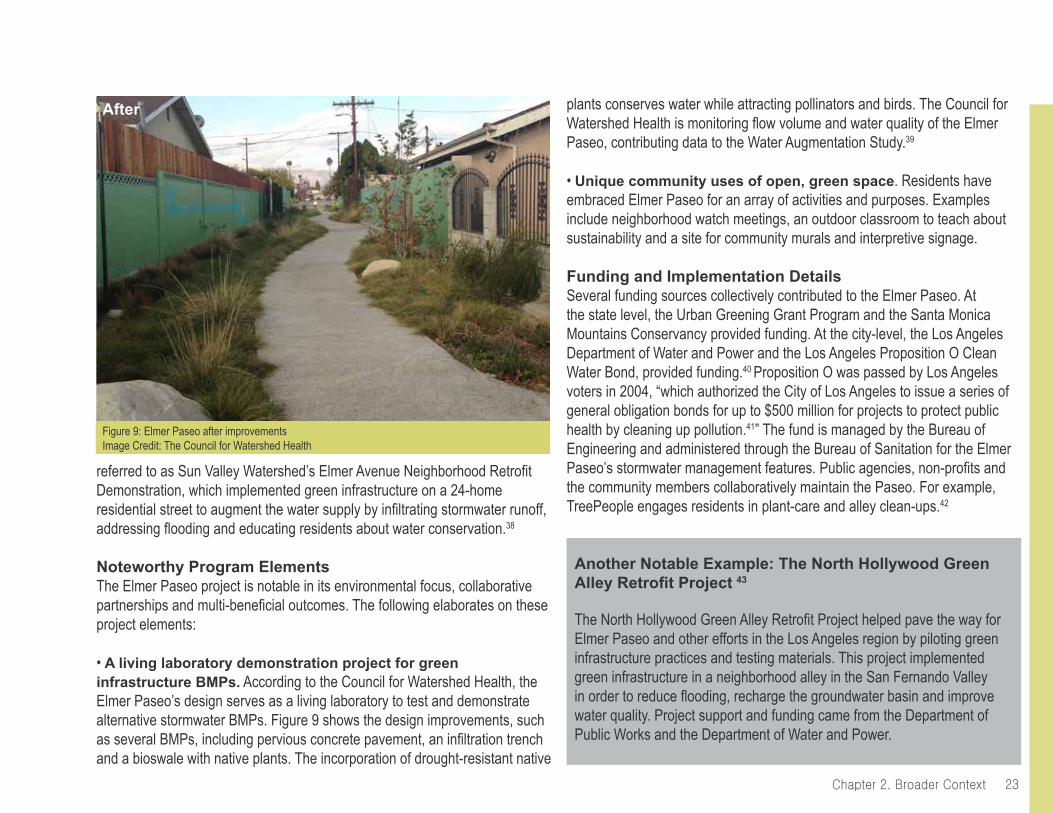
plants conserves water while attracting pollinators and birds. The Council for Watershed Health is monitoring flow volume and water quality of the Elmer Paseo, contributing data to the Water Augmentation Study.39
• Unique community uses of open, green space. Residents have embraced Elmer Paseo for an array of activities and purposes. Examples include neighborhood watch meetings, an outdoor classroom to teach about sustainability and a site for community murals and interpretive signage.
Funding and Implementation DetailsSeveral funding sources collectively contributed to the Elmer Paseo. At the state level, the Urban Greening Grant Program and the Santa Monica Mountains Conservancy provided funding. At the city-level, the Los Angeles Department of Water and Power and the Los Angeles Proposition O Clean Water Bond, provided funding.40 Proposition O was passed by Los Angeles voters in 2004, “which authorized the City of Los Angeles to issue a series of general obligation bonds for up to $500 million for projects to protect public health by cleaning up pollution.41” The fund is managed by the Bureau of Engineering and administered through the Bureau of Sanitation for the Elmer Paseo’s stormwater management features. Public agencies, non-profits and the community members collaboratively maintain the Paseo. For example, TreePeople engages residents in plant-care and alley clean-ups.42
Another Notable Example: The North Hollywood Green Alley Retrofit Project 43
The North Hollywood Green Alley Retrofit Project helped pave the way for Elmer Paseo and other efforts in the Los Angeles region by piloting green infrastructure practices and testing materials. This project implemented green infrastructure in a neighborhood alley in the San Fernando Valley in order to reduce flooding, recharge the groundwater basin and improve water quality. Project support and funding came from the Department of Public Works and the Department of Water and Power.
referred to as Sun Valley Watershed’s Elmer Avenue Neighborhood Retrofit Demonstration, which implemented green infrastructure on a 24-home residential street to augment the water supply by infiltrating stormwater runoff, addressing flooding and educating residents about water conservation.38
Noteworthy Program ElementsThe Elmer Paseo project is notable in its environmental focus, collaborative partnerships and multi-beneficial outcomes. The following elaborates on these project elements:
• A living laboratory demonstration project for green infrastructure BMPs. According to the Council for Watershed Health, the Elmer Paseo’s design serves as a living laboratory to test and demonstrate alternative stormwater BMPs. Figure 9 shows the design improvements, such as several BMPs, including pervious concrete pavement, an infiltration trench and a bioswale with native plants. The incorporation of drought-resistant native
Figure 9: Elmer Paseo after improvements Image Credit: The Council for Watershed Health
After
Chapter 2. Broader Context24
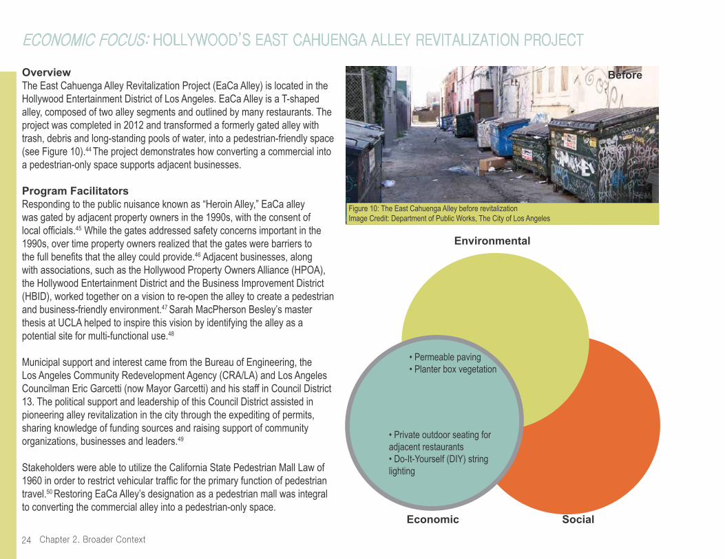
OverviewThe East Cahuenga Alley Revitalization Project (EaCa Alley) is located in the Hollywood Entertainment District of Los Angeles. EaCa Alley is a T-shaped alley, composed of two alley segments and outlined by many restaurants. The project was completed in 2012 and transformed a formerly gated alley with trash, debris and long-standing pools of water, into a pedestrian-friendly space (see Figure 10).44 The project demonstrates how converting a commercial into a pedestrian-only space supports adjacent businesses.
Program FacilitatorsResponding to the public nuisance known as “Heroin Alley,” EaCa alley was gated by adjacent property owners in the 1990s, with the consent of local officials.45 While the gates addressed safety concerns important in the 1990s, over time property owners realized that the gates were barriers to the full benefits that the alley could provide.46 Adjacent businesses, along with associations, such as the Hollywood Property Owners Alliance (HPOA), the Hollywood Entertainment District and the Business Improvement District (HBID), worked together on a vision to re-open the alley to create a pedestrian and business-friendly environment.47 Sarah MacPherson Besley’s master thesis at UCLA helped to inspire this vision by identifying the alley as a potential site for multi-functional use.48
Municipal support and interest came from the Bureau of Engineering, the Los Angeles Community Redevelopment Agency (CRA/LA) and Los Angeles Councilman Eric Garcetti (now Mayor Garcetti) and his staff in Council District 13. The political support and leadership of this Council District assisted in pioneering alley revitalization in the city through the expediting of permits, sharing knowledge of funding sources and raising support of community organizations, businesses and leaders.49
Stakeholders were able to utilize the California State Pedestrian Mall Law of 1960 in order to restrict vehicular traffic for the primary function of pedestrian travel.50 Restoring EaCa Alley’s designation as a pedestrian mall was integral to converting the commercial alley into a pedestrian-only space.
economic focUs: hollywood’s eAst cAhUengA Alley revitAlizAtion project
Environmental
SocialEconomic
• Private outdoor seating for adjacent restaurants• Do-It-Yourself (DIY) string lighting
Figure 10: The East Cahuenga Alley before revitalizationImage Credit: Department of Public Works, The City of Los Angeles
• Permeable paving• Planter box vegetation
Before
25Chapter 2. Broader Context
made possible through the active business community’s involvement. One example is how the HBID and Homeowners Alliances’ assumed responsibility for maintenance and repair of the permeable pavers, which in the City of Los Angeles, is the necessary condition for implementing a non-standard material.52 As a green, renovated and public space, EaCa Alley is also used for other economic activities, including the Cahuenga Corridor Market for artists to sell their wares and the Spice Alley event, which features food, music and vendors.
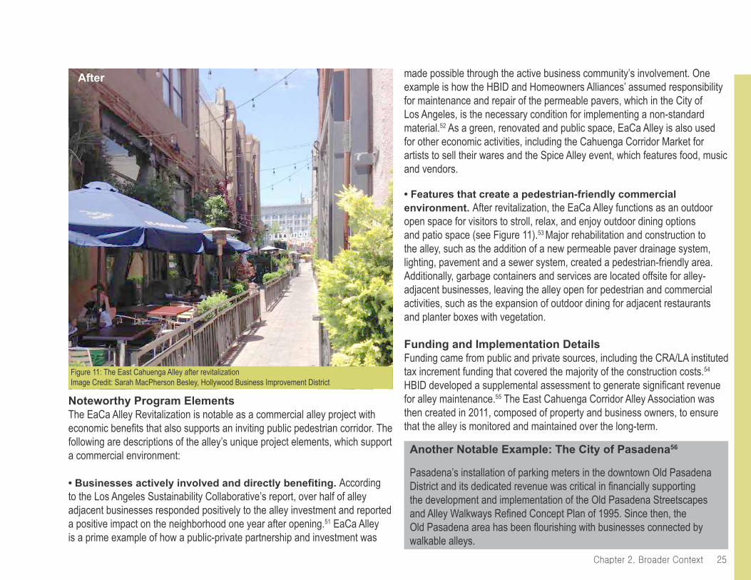
• Features that create a pedestrian-friendly commercial environment. After revitalization, the EaCa Alley functions as an outdoor open space for visitors to stroll, relax, and enjoy outdoor dining options and patio space (see Figure 11).53 Major rehabilitation and construction to the alley, such as the addition of a new permeable paver drainage system, lighting, pavement and a sewer system, created a pedestrian-friendly area. Additionally, garbage containers and services are located offsite for alley-adjacent businesses, leaving the alley open for pedestrian and commercial activities, such as the expansion of outdoor dining for adjacent restaurants and planter boxes with vegetation.
Funding and Implementation DetailsFunding came from public and private sources, including the CRA/LA instituted tax increment funding that covered the majority of the construction costs.54
HBID developed a supplemental assessment to generate significant revenue for alley maintenance.55 The East Cahuenga Corridor Alley Association was then created in 2011, composed of property and business owners, to ensure that the alley is monitored and maintained over the long-term.
Another Notable Example: The City of Pasadena56
Pasadena’s installation of parking meters in the downtown Old Pasadena District and its dedicated revenue was critical in financially supporting the development and implementation of the Old Pasadena Streetscapes and Alley Walkways Refined Concept Plan of 1995. Since then, the Old Pasadena area has been flourishing with businesses connected by walkable alleys.
Noteworthy Program ElementsThe EaCa Alley Revitalization is notable as a commercial alley project with economic benefits that also supports an inviting public pedestrian corridor. The following are descriptions of the alley’s unique project elements, which support a commercial environment:
• Businesses actively involved and directly benefiting. According to the Los Angeles Sustainability Collaborative’s report, over half of alley adjacent businesses responded positively to the alley investment and reported a positive impact on the neighborhood one year after opening.51 EaCa Alley is a prime example of how a public-private partnership and investment was
Figure 11: The East Cahuenga Alley after revitalizationImage Credit: Sarah MacPherson Besley, Hollywood Business Improvement District
After
Chapter 2. Broader Context26
OverviewThe Historic Pioneer Square Neighborhood of Seattle, Washington is a commercial and multifamily residential area that is the focus of the Alley Network Project. The Alley Network Project, which facilitates and hosts grassroots events and other temporary activities in alleys, is one example of alley transformation efforts among an enthusiastic citywide alley culture. The range of work facilitated by the Alley Network Project is useful for demonstrating how alleys can be re-appropriated as community gathering spaces in low-cost and temporary ways by various stakeholders (see Figure 12).
Program FacilitatorsThe interest in transforming Pioneer Square’s alleys into public spaces originated from a 2009 study conducted by Copenhagen-based Gehl Architects, considered world-leaders in placemaking. Gehl Architects identified Pioneer Square’s alleys as having the potential to be successful pedestrian spaces as they are narrow passageways that are outlined by human-scaled buildings.57 The report found that Seattle’s downtown has approximately 217,500 square feet of public-space alleys, of which 85% were underutilized.58
The Alley Network Project is an initiative of the International Sustainability Institute (ISI), a non-profit organization that focuses on research and projects surrounding sustainability. ISI developed an interest in alleys as a result of their office’s location adjacent to Nord Alley, one of the most well-known and used alleys in the Pioneer Square neighborhood. The Alley Network Project was created to forge collaborations between city departments, universities, architecture firms and advocacy groups to transform this service alley into a public space.59 As a result, Nord Alley has been repeatedly transformed by multiple stakeholders as a gathering place for a range of neighborhood events, some of which will be outlined in the Noteworthy Project Elements section. Together, the alley planning and stewardship brings community together to create green alleys that function as common social space.
sociAl focUs: seAttle’s Alley network project
Environmental
SocialEconomic
• Diverse public community events within the alley• Temporary alley closure to vehicles that forms a safe pedestrian environment
Figure 12: Neighborhood party in Post Alley, SeattleImage Credit: Mitch Reinitz
• Do-It-Yourself (DIY) string lights• Temporary signs and seating for events in alleys

27Chapter 2. Broader Context
Noteworthy Program ElementsAlong with auxiliary efforts by the Seattle Department of Transportation and police department to keep the alleys clean and safe, the Alley Network Project contributes to Seattle alleys as vibrant public spaces. The following elaborates the Alley Network Project’s unique socially focused elements:
• Robust and diverse programming within the alleys. Since 2008, more than 8,000 people have attended alley events as part of the Alley Network Project. Alley events and projects have included parties at First Thursday Art Walk, lighting installations, a poetry carnival, “Alley Cat” pet adoption event, holiday caroling, film screenings, World Cup and Tour de France viewing, as seen in Figure 13, and many more.60
• The creation of a step-by-step guide on how to obtain an alley event permit. One of the Alley Network Project’s unique contributions to civic-driven alley events and projects is the way in which the organization has increased access to understanding the City of Seattle’s street use permits
for alley closure. The “Alley Event Handbook,” created by the ISI, has helped to guide alley programming for use by public space experts, community organizers, marketing professionals and students as public spaces, stages and galleries. This handbook provides instructions on obtaining necessary permits that are specific to the City of Seattle, a sample permission letter and helpful information for planning a successful alley event.
• Successful temporary efforts have inspired permanent efforts. The success of the Alley Network Project’s temporary events have influenced the ISI to create and support physical alley improvements within Pioneer Square. The Alley Corridor Project, created in 2013 and funded by the City of Seattle Department of Neighborhood, involves a cost-effective design to restore alley surfaces and implement lighting for Pioneer Square’s alleys.
Funding and Implementation DetailsThrough leveraging funding from government, private foundations and local businesses, like the City of Seattle Neighborhood Matching Funds program and Historic South Downtown, the Alley Network Project helps unite people and provides financial support to create installations and host events in Pioneer Square’s alleys.
The Alley Network Project’s events and activities in Pioneer Square’s alleys are possible due to the City of Seattle’s implementation of the Clear Alley Program in 2009. The Program removed all dumpsters located in Pioneer Square’s alleys and replaced them with trash bags and a daily trash pick-up service. The result of removing large dumpsters is the creation of clear and open alleys that can be used for pedestrian walkways, neighborhood events and additional commercial storefronts.61
Figure 13: World Cup in Nord Alley 2010Image Credit: Jordan Lewis
Chapter 2. Broader Context28
OverviewResidents of the Boyle Heights neighborhood of East Los Angeles are leading grassroots efforts to reclaim and enhance alleys in their residential area. Community-led efforts began in 2003 to clean up the refuse-filled alleys and use them as a public gathering space alternative for local streets affected by gang violence.62 In a large city such as Los Angeles, residents and community organizations are crucial drivers of neighborhood-based improvements. Boyle Heights’ resident-driven, designed and implemented efforts are an example of green alley development that is collaborative and low-cost with social benefits.
Program FacilitatorsAlley improvements in Boyle Heights are for and by the people of the area. For many of the residents, the alleys constitute access to the only open space within the neighborhood. Two main collaborating entities support and guide the resident-driven alley revitalization efforts in Boyle Heights. Union de Vecinos, a Boyle Heights membership-based, community organization, and its committees of residents have designed and constructed alley improvements in alleys south of the I -10 Freeway. Green LA, a coalition involving professional landscape architects and planners who work to transform Los Angeles streets into sustainable complete streets,70 collaborated with residents to enhance alleys north of the I -10 freeway in Boyle Heights; this includes working with high school students through a Boyle Heights leadership program called Legacy LA.63
Many of the alley improvements in Boyle Heights resemble residents taking on local government functions themselves. Union de Vecinos committee members have repaved alleys, installed traffic signs and beautified and enhanced the alleys for use as social community spaces. For instance, in collaboration with Green LA, residents installed a “sala publica” or public living room, with benches, tables, planters and a community bulletin board for community congregation, play and relaxation. Additionally, in a 2013 project, Union de Vecinos committee members repaved two alley blocks with concrete to create a safe and playable surface and painted the concrete blue and tan to represent the beach (see Figure 14).64
sociAl focUs: boyle heights’ Alley reclAmAtion
Environmental
SocialEconomic
• Murals created by the community• Painted alley floor• Movable planters as mechanisms for Do-It-Yourself (DIY) alley closure to form a safe pedestrian space• Alley programming creates social, recreational spaces in alleys
Figure 14: Murals and painted pavement in an alley in Boyle HeightsImage Credit: Kris Fortin, LAStreetsblog
• Planters with vegetation

29Chapter 2. Broader Context
community events and social activities including movie nights, birthday parties, as seen in Figure 60 on page 79, dances and monthly mercaditos, which are small markets with vendors. Green LA’s work with the Boyle Heights-based high school leadership program, Legacy LA, also uses the alleys as educational opportunities for students to design a green alley, create murals and learn how to maintain the space.68
Funding and Implementation DetailsDue to the DIY (Do-it-Yourself) and resident-driven nature of the efforts, the alley revitalization in Boyle Heights is largely implemented without permits. This strategy allows for swift improvements in an area that has experienced what Rasmussen Cancian describes as many years of municipal neglect.69
Some alley events have been visited by the Los Angeles Police Department, but only one event was closed down by the LAPD due to a lack of permits.70
Noteworthy Program ElementsBoyle Heights’ alley reclamation efforts are noteworthy in their creative and community-driven strategies to achieve social benefits. The following elaborates on the unique elements of Boyle Heights’ alley efforts:
• Incremental improvements, social benefits. Over a decade-long progression of improvement has led to pot hole filling, alley repaving, installing traffic signs, pedestrian lighting, painting murals on walls and pavement, as seen in Figures 14 and 15, planting vegetation and installing benches and shade structures,65 as well as an excitement and momentum within the community where now approximately 20 alleys have been revitalized.66 Landscape architect and collaborator Steve Rasmussen Cancian of Green LA communicates that one key objective of alley efforts is to develop innovative approaches that increase the use-value of alleys for current residents, many of whom have been in the area for entire lifetimes, without increasing the exchange-value of the neighborhood for potential gentrifiers.67
• Programming and expanded uses in the alleys. Alley reclamation efforts in Boyle Heights have resulted in the creation of inviting spaces for
Figure 15: Painted alley floor in Boyle HeightsImage Credit: Boyle Heights Beat Other Notable Examples
Montreal71
The City of Montreal in the Canadian province of Quebec is another example of citizen-driven efforts to green residential alleys. Citizens who wish to create a green alley in their neighborhood must apply to their local eco-district, a neighborhood-based organization located throughout the city. The eco-district mobilizes residents while residents organize and perform the work and maintenance for the green alleys.
San Francisco Living Alleys Initiative72
The San Francisco Planning Department’s Living Alleys Initiative is a notable city-led and citizen-driven example to the design and implementation of a network of alleys. The SF Planning Department is currently working on the Market Octavia Living Alleys Project, which builds upon the success of previous alley efforts. The City defines living alleys as a narrow, low-volume traffic street that is designed to focus on livability, instead of parking and traffic, and primarily used for pedestrians and bicyclists as well as space for social uses.
Chapter 2. Broader Context30
OverviewThe Green Alley Initiative and Green Alley Demonstration Project in Austin, Texas seek to transform underutilized alleys into community assets with multiple benefits.73 While the previous examples featured in this report have more than one objective, the Green Alley Initiative and Demonstration Project stand out as truly multi-foci: the goals squarely fit in environmental, social and economic categories without emphasizing one in particular, thus representing a new category. These goals are to: support compact neighborhoods; increase sustainability and performance of the public right of way; connect alleys to affordable housing; and activate and beautify alleys to increase public safety and social interactions.74 The Green Alley Initiative and Demonstration Project are in line with the City of Austin’s broad sustainability goals and objectives for citywide affordable housing, and thus prime examples of how green alleys can have broad, multi-foci goals.
Program FacilitatorsThe Green Alley Initiative and Demonstration Project emerged from years of applied, community-engaged design research and builds upon the success of the Alley Flat Initiative.75 This initiative began in 2005 as a collaborative effort between universities, the city and the community to design and incorporate secondary dwelling units, or ‘alley flats’, into pre-existing homes along Austin’s extensive network of underutilized alleys.76 Alley flats are small, detached residential units, often referred to as accessory dwelling units, which are tucked behind existing main houses on large lots and accessed from the alleyway.85 The Alley Flat Initiative acknowledges alleys not only as access points to new housing but also as community recreation space and green infrastructure that filters storm water through rain gardens.77
Thus far two alley flat prototypes have been constructed (See Figure 16 for alley flat prototype two: Lydia Street).78 These small, single-family homes are designed to be both affordable and sustainable. Future alley flats would be earmarked for residents who earn 80 percent or less of the median family income and centrally located in East Austin, enabling residents to have a shorter commute.79 Alley flats are conceived of as green housing alternatives
Environmental
SocialEconomic
mUlti-foci: AUstin’s green Alley initiAtive And demonstrAtion project
Multi-Foci• Pervious pavement• Affordable housing• Energy efficient residential unit designs• Planters that act as boxes for native plants, herbs and seating• Recycled materials• Colored concrete pavement• Public art/signage
Figure 16: Alley flat prototype two: Lydia StreetImage Credit: The Alley Flat Initiative
31Chapter 2. Broader Context
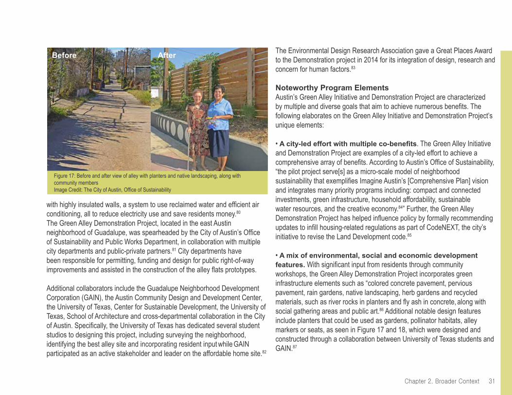
with highly insulated walls, a system to use reclaimed water and efficient air conditioning, all to reduce electricity use and save residents money.80
The Green Alley Demonstration Project, located in the east Austin neighborhood of Guadalupe, was spearheaded by the City of Austin’s Office of Sustainability and Public Works Department, in collaboration with multiple city departments and public-private partners.81 City departments have been responsible for permitting, funding and design for public right-of-way improvements and assisted in the construction of the alley flats prototypes.
Additional collaborators include the Guadalupe Neighborhood Development Corporation (GAIN), the Austin Community Design and Development Center, the University of Texas, Center for Sustainable Development, the University of Texas, School of Architecture and cross-departmental collaboration in the City of Austin. Specifically, the University of Texas has dedicated several student studios to designing this project, including surveying the neighborhood, identifying the best alley site and incorporating resident input while GAIN participated as an active stakeholder and leader on the affordable home site.82
The Environmental Design Research Association gave a Great Places Award to the Demonstration project in 2014 for its integration of design, research and concern for human factors.83
Noteworthy Program ElementsAustin’s Green Alley Initiative and Demonstration Project are characterized by multiple and diverse goals that aim to achieve numerous benefits. The following elaborates on the Green Alley Initiative and Demonstration Project’s unique elements:
• A city-led effort with multiple co-benefits. The Green Alley Initiative and Demonstration Project are examples of a city-led effort to achieve a comprehensive array of benefits. According to Austin’s Office of Sustainability, “the pilot project serve[s] as a micro-scale model of neighborhood sustainability that exemplifies Imagine Austin’s [Comprehensive Plan] vision and integrates many priority programs including: compact and connected investments, green infrastructure, household affordability, sustainable water resources, and the creative economy.84” Further, the Green Alley Demonstration Project has helped influence policy by formally recommending updates to infill housing-related regulations as part of CodeNEXT, the city’s initiative to revise the Land Development code.85
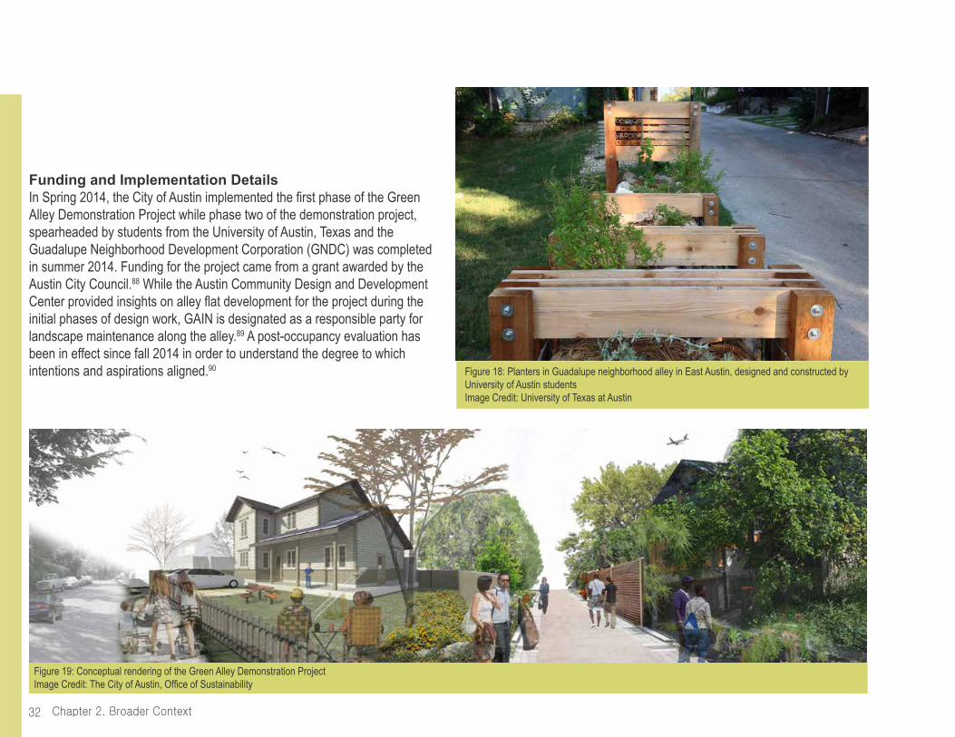
• A mix of environmental, social and economic development features. With significant input from residents through community workshops, the Green Alley Demonstration Project incorporates green infrastructure elements such as “colored concrete pavement, pervious pavement, rain gardens, native landscaping, herb gardens and recycled materials, such as river rocks in planters and fly ash in concrete, along with social gathering areas and public art.86 Additional notable design features include planters that could be used as gardens, pollinator habitats, alley markers or seats, as seen in Figure 17 and 18, which were designed and constructed through a collaboration between University of Texas students and GAIN.87
Figure 17: Before and after view of alley with planters and native landscaping, along with community members Image Credit: The City of Austin, Office of Sustainability
Before After
Chapter 2. Broader Context32
Figure 19: Conceptual rendering of the Green Alley Demonstration ProjectImage Credit: The City of Austin, Office of Sustainability
Funding and Implementation DetailsIn Spring 2014, the City of Austin implemented the first phase of the Green Alley Demonstration Project while phase two of the demonstration project, spearheaded by students from the University of Austin, Texas and the Guadalupe Neighborhood Development Corporation (GNDC) was completed in summer 2014. Funding for the project came from a grant awarded by the Austin City Council.88 While the Austin Community Design and Development Center provided insights on alley flat development for the project during the initial phases of design work, GAIN is designated as a responsible party for landscape maintenance along the alley.89 A post-occupancy evaluation has been in effect since fall 2014 in order to understand the degree to which intentions and aspirations aligned.90 Figure 18: Planters in Guadalupe neighborhood alley in East Austin, designed and constructed by
University of Austin studentsImage Credit: University of Texas at Austin

33Chapter 2. Broader Context
endnotesChicago’s Green Alley Program25 Transforming Alleys into Green Infrastructure for Los Angeles. Rep. Los Angeles: Center for Sustainable Cities, U of Southern California, 2008. Print.26 “UCLA Research: Chicago Green Alley Program Case Study.” Message to Janet Attarian. 7 Sept. 2014. E-mail.27 The Chicago Green Alley Handbook: An Action Guide to Create a Greener, Environmentally Sustainable Chicago. Rep. Chicago Department of Transportation, 2010. City of Chicago, Department of Transportation. Web. 20 June 2014.28 Attarian, Janet L. “Greener Alleys.” United States Department of Transportation - Federal Highway Administration: Public Roads 73.6 (May/ June 2010): n. pag. FHWA-HRT-10-004. Web. 12 Sept. 2014. <http://www.fhwa.dot.gov/publications/publicroads/10mayjun/05.cfm>.29 Ibid.30 Ibid.31 “Green Alleys.” City Service: Streets, Alleyways and Sidewalks. City of Chicago, Department of Transportation, n.d. Web. 10 July 2014.32 Attarian, Janet L. “Greener Alleys.” United States Department of Transportation - Federal Highway Administration: Public Roads 73.6 (May/ June 2010): n. pag. FHWA-HRT-10-004. Web. 12 Sept. 2014. <http://www.fhwa.dot.gov/publications/publicroads/10mayjun/05.cfm>; “Green Alleys.” City Service- Streets, Alleyways and Sidewalks. City of Chicago, Department of Transportation, n.d. Web. 10 July 2014.33 “People Alleys.” Make Way for People. City of Chicago, Department of Transportation, n.d. Web. 13 Sept. 2014.
Sun Valley’s Elmer Paseo Stormwater Improvements Project34 Belden, Edward, MESM, and Morris, Kristy, Ph.D. The Council for Watershed Health. The Elmer Avenue Neighborhood Demonstration Project: Measuring the Success of Green Infrastructure. Rep. N.p.: n.p., n.d. Print.35 Alduenda, Eileen. Researcher/ Project Manager for the Council for Watershed Health. Telephone interview. 23 July 2014.36 Steele, Nancy L.C., Comp. The Los Angeles & San Gabriel Rivers
Watershed Council. N.p., n.d. Web.37 Alduenda, Eileen. Researcher/ Project Manager for the Council for Watershed Health. Telephone interview. 23 July 2014.38 Belden, Edward, MESM, and Morris, Kristy, Ph.D. The Council for Watershed Health. The Elmer Avenue Neighborhood Demonstration Project: Measuring the Success of Green Infrastructure. Rep. N.p.: n.p., n.d. Print.36 http://watershedhealth.org/programsandprojects/was.aspx39 Ibid.40 Ibid.41 “City of Los Angeles Bond Measure O.” City of Los Angeles Bond Measure O. City of Los Angeles Stormwater Program, n.d. Web. 21 Jan. 2015.42 Ibid.43 “Follow the Green Paved Alleys: City of Los Angeles Stormwater Program.” City of Los Angeles Stormwater Program. 1 Jan. 2011. Web. 5 Oct. 2014. <http://www.lastormwater.org/blog/2011/01/follow-the-green-paved-alleys>.; United States of America and People of the State of California ex rel. California Regional Water Quality Control Board, Los Angeles Region v. City of Los Angeles. United States District Court for the Central District of California. Civil Action No. 01-191-RSWL. (Filed 23 July 2013); Drayse, Rebecca. “Stormwater: Stormwater: A water supply opportunity A water supply opportunity Urban Water Reuse Partnership Project between TreePeople Urban Water Reuse Partnership Project between TreePeople and the Los Angeles Department of Water and Power and the Los A.” State Water Board and the Water-Energy Climate Action Team Climate Change Scoping Plan Implementation Workshop, Measure W-4: Urban Water Reuse. TreePeople and the Los Angeles Departmento of Water and Power. 17 June 2009. Lecture.
Hollywood’s East Cahuenga Alley Revitalzation Project44 Besley, Sarah. Associate Executive Director of the Hollywood Business Improvement District. E-mail interview. 27 Aug. 2014.45 Burgos, Lila and Sarkisian,Tamar. East Cahuenga Alley Revitalization Project: Best Practices for Creating a Pedestrian-Friendly Urban Alley. October 2013. Los Angeles Sustainability Collaborative. 46 Besley, Sarah. Associate Executive Director of the Hollywood Business
Chapter 2. Broader Context34
Improvement District. E-mail interview. 27 Aug. 2014.De La Fuente, Carlos. Project Manager of the Street & Stormwater Divisionof the Bureau of Engineering, Dept. of Public Works in the City of Los Angeles. Personal interview. 15 July 2014.47 Burgos, Lila and Sarkisian,Tamar. East Cahuenga Alley Revitalization Project: Best Practices for Creating a Pedestrian-Friendly Urban Alley. October 2013. Los Angeles Sustainability Collaborative.48 Besley, Sarah. Associate Executive Director of the Hollywood Business Improvement District. E-mail interview. 27 Aug. 2014.49 De La Fuente, Carlos. Project Manager of the Street & Stormwater Divisionof the Bureau of Engineering, Dept. of Public Works in the City of Los Angeles. Personal interview. 15 July 2014.50 Burgos, Lila and Sarkisian,Tamar. East Cahuenga Alley Revitalization Project: Best Practices for Creating a Pedestrian-Friendly Urban Alley. October 2013. Los Angeles Sustainability Collaborative. 51 De La Fuente, Carlos. Project Manager of the Street & Stormwater Divisionof the Bureau of Engineering, Dept. of Public Works in the City of Los Angeles. Personal interview. 15 July 2014.; In the City of Los Angeles, there is a policy in place that allows for the implementation of permeable pavement under the condition that non-city entities assume responsibility for maintenance and repairs. 52 Belvins, Aaron. “From Crime and Grime to Wine and Dine.” Park Labrea News/ Beverly Press. 1 Mar. 2012. Web. 21 Jan. 2015. <http://beverlypress.com/2012/03/from-crime-and-grime-to-wine-and-dine/>.53 Newell, J. P., et al. Green Alley Programs: Planning for a sustainable urban infrastructure? J. Cities (2012), http://dx.doi.org/10.1016/j.cities.2012.07.004.54 Ibid.55 Besley, Sarah. Associate Executive Director of the Hollywood Business Improvement District. E-mail interview. 27 Aug. 2014.; Burgos, Lila and Sarkisian,Tamar. East Cahuenga Alley Revitalization Project: Best Practices for Creating a Pedestrian-Friendly Urban Alley. October 2013. Los Angeles Sustainability Collaborative.56The City of Pasadena. Old Pasadena Streetscapes and Alley Walkways Refined Concept Plan. Adopted by City Council on July 24,1995.
Seattle’s Alley Network Project57 Gehl Architects and the City of Seattle, Department of Transportation. Downtown Seattle Public Spaces & Public Life. Rep. N.p.: n.p., 2012. Print.58 Fialko, Mary, and Hampton, Jennifer, in Collaboration with Gehl Architects, UW Green Futures Lab, and Scan Design Foundation. Seattle Alley Integrated Handbook: Activating Alleys for a Lively City. Rep. N.p.: n.p., 2011. Print.59 These stakeholders include the University of Washington Green Futures Lab, local architecture and landscape architecture firms, the Alliance for Pioneer Square, Feet First, the Seattle Parks Foundation, the Seattle Department of Transportation and Pratt Fine Arts Institute.60 “About the Alleys.” Alley Network Project. N.p., 2010. Web. 2 July 2014.61 The City of Seattle. CleanScapes Clear Alleys. Web. 10 July 2014. <http://www.cleanscapes.com/clearalley.html>.
Boyle Heights’ Alley Reclaimation63 Cancian, Steve Rasmmusen. E-mail interview. 6 Sept. 2014.64 “About Living Streets LA.” Living Streets LA. N.p., n.d. Web. 21 Jan. 2015.65 Harper, Holly. Green LA Landscape Architect.Telephone interview. 10 Sept. 201466 Cancian, Steve Rasmmusen. E-mail interview. 6 Sept. 2014.; Fortin, Kris. “Boyle Heights Residents Give Alleys a Facelift to Promote Safety in Their Community.” Boyle Heights Beat 21 Mar. 2013: n. pag. Print.67 Harper, Holly. Green LA Landscape Architect. Telephone interview. 10 Sept. 201468 Cancian, Steve Rasmmusen. Telephone interview. 6 Sept. 2014.69 Harper, Holly. Green LA Landscape Architect. Telephone interview. 10 Sept. 201470 Cancian, Steve Rasmmusen. Telephone interview. 6 Sept. 2014.71 “Guide Verdir.” Ruelle Verte. N.p., 16 Aug. 2008. Web. 05 Mar. 2015.; O’Shea, Michael. Telephone interview. 26 July 2014.72 “Market & Octavia Area Plan.” San Francisco Planning Department :. N.p., n.d. Web. 05 Mar. 2015.; San Francisco Planning Department. Market & Octavia: An Area Plan of the General Plan of the City and County of San Francisco. 2010.; Winslow, David. Telephone interview. 30 July 2014.

35Chapter 2. Broader Context
Austin’s Green Alley Initiative and Demonstration Project73 “The Green Alley Initiative.” Office of Sustainability, City of Austin. N.p., n.d. Web.74 Athens, Lucia. Chief Sustainability Officer, Office of Sustainability for the City of Austin. E-mail interview. 20 Sept. 2014.75 “2014 Place Research: Green Alley Demonstration Project.” The Environmental Design Research Association. EDRA, n.d. Web. 21 Jan. 2015.76 “Vision.” The Alley Flat Initiative. N.p., n.d. Web.77 Ibid. 78 Ibid.79 Ibid.80 Green Alley Demonstration Project. Rep. Center for Sustainable Development: City of Austin, n.d. Web. 2 July 2014.81 Ibid.82 “Green Alley Demonstration Project.” Office of Sustainability, City of Austin. N.p., 2012. Web.83 Wilson, Barbara Brown, Connor Bryan, and Jane Winslow, eds. Public Interest Design, Summer Course Series: 2011. Rep. Austin, Texas: Public Interest Design, 2011. Print.84 “Green Alley Demonstration Project.” Office of Sustainability, City of Austin. N.p., 2012. Web.85 Ibid.86 Green Alley Demonstration Project. Rep. Center for Sustainable Development: City of Austin, n.d. Web. 2 July 2014.87 Ibid. 88 Ibid.89 Snyder, Emery Reif. “Council Looks to Continue ‘Greening’ East Austin Alleys.” Council Looks to Continue ‘Greening’ East Austin Alleys. KUT.org, 6 June 2013. Web. 05 Mar. 2015.90 “The Environmental Design Research Association.” EDRA. N.p., 2014. Web. 05 Mar. 2015.
Chapter page image credit: City of Austin, Office of Sustainability
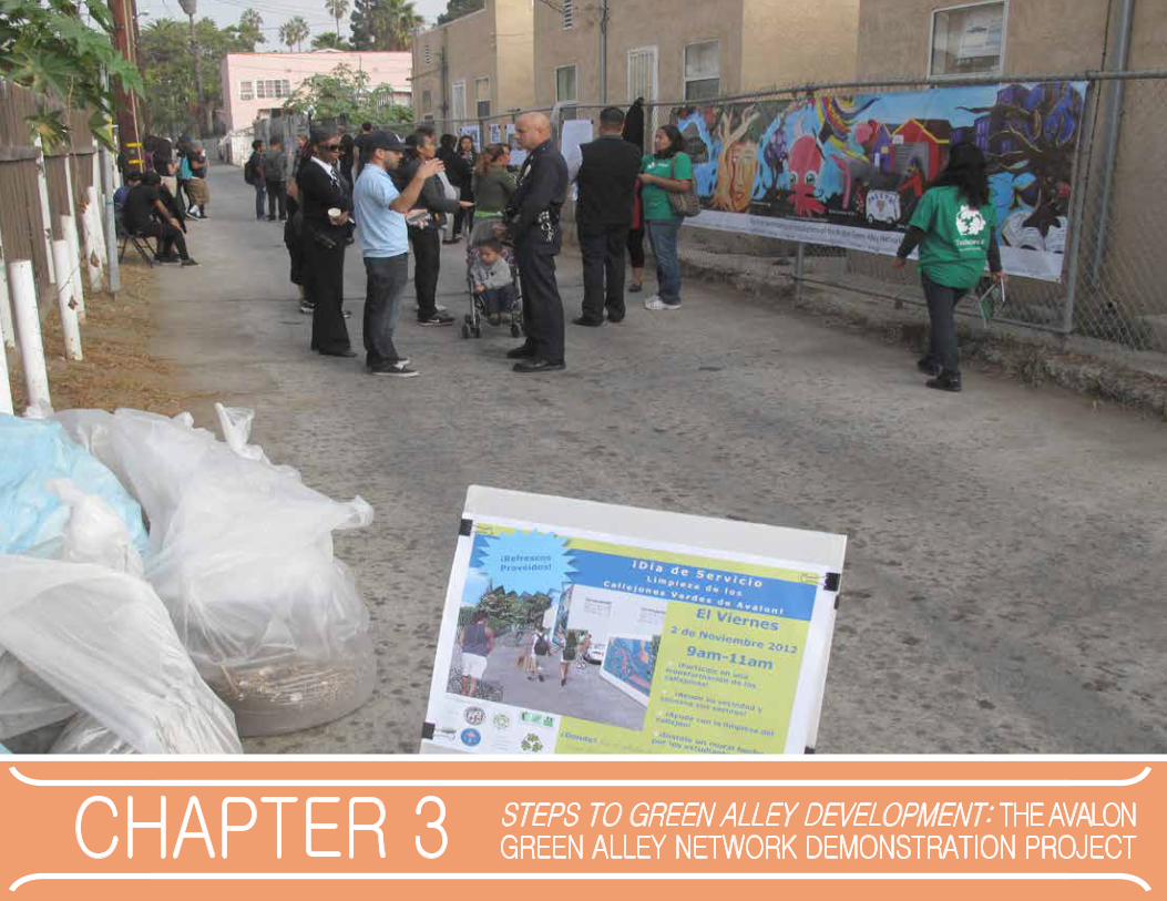
chapter 3 steps to green Alley development: the AvAlon green Alley network demonstrAtion project

37Chapter 3. The Avalon Project
introdUctionThis chapter provides a case study of the Avalon Green Alley Network Demonstration Project for the purpose of guiding future action and potentially informing other alley revitalization efforts. The Avalon Project is a pilot project in South Los Angeles. In partnership with the City of Los Angeles, The Trust for Public Land is leading this collaborative effort to green a network of alley segments within a residential neighborhood of the area (see Figure 20).
The chapter begins with an overview of the Avalon Project, including its significance, goals and the community context for those goals. Next, the main section of this chapter tells the story of the Avalon Project, breaking down the project into main steps typical of alley revitalization efforts. The authors then describe the South Los Angeles Green Alley Master Plan and potential opportunities for other future green alley efforts.
Figure 20: Conceptual rendering of the Avalon ProjectImage Credit: SALT Landscape Architects

chapter 3. the Avalon project38
stAtUsMany years of organizing, community engagement, planning, and more have gone into the Avalon Green Alley Network Demonstration Project. This work creates an important foundation for the physical construction scheduled for 2015. While many physical improvements are still to come as of the writing of this report, community residents are already actively involved in transforming the selected alleys, such as alley clean ups, as Figure 21 illustrates.
overview And importAnceAlthough other alley projects have been built in Los Angeles, the Avalon Green Alley Network Demonstration Project represents many firsts. It is the first alley revitalization project in the high-density, working-class area of South Los Angeles, the first comprehensive alley retrofit to simultaneously incorporate green elements and vehicles in Los Angeles and the city’s first retrofitted green alley network. The Trust for Public Land and other project proponents offer the Avalon project as a replicable model for maximizing the potential for alleys as open space to meet multiple community needs. The Avalon Project also provides lessons about the importance of community participatory design as well as ideas for the innovative re-use of existing infrastructure to meet public health and ecological needs.95
The Avalon Project will transform six alley segments that create a network and a connection between residential homes and community amenities, including the local schools, parks, and local grocery store. The multi-benefit Avalon Green Alley Network spans an approximately 35-acre neighborhood and is comprised of six city blocks and alleyways. Each alley ranges from approximately 1/4 to 1/3 acre, which creates a combined total of 1.8 acres.96
The project area is bordered by Vernon Avenue to the north, Central Avenue to the east, Slauson Avenue to the south and the Harbor Freeway (110) to the west (see Figure 22). As a demonstration project, two of the six alleys within the network are targeted as full green infrastructure retrofits, totaling 0.61 acres. In addition, the entire network will be planted with nearly 150 street trees.97
Figure 21: Community residents cleaning an alley in the Avalon Project site Image Credit: The Trust for Public Land
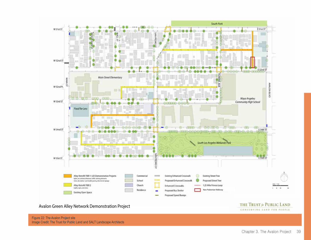
39Chapter 3. The Avalon Project
Avalon Green Alley Network Demonstration Project
New Pedestrian Walkway
Figure 22: The Avalon Project siteImage Credit: The Trust for Public Land and SALT Landscape Architects
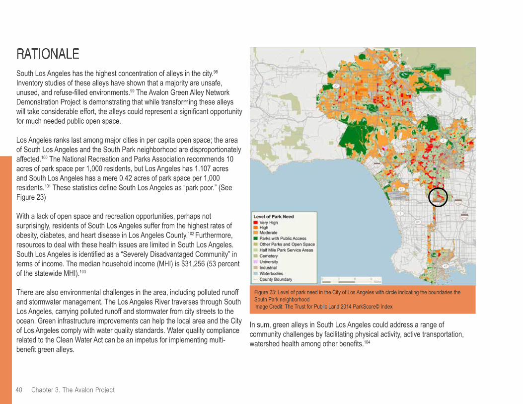
chapter 3. the Avalon project40
rAtionAleSouth Los Angeles has the highest concentration of alleys in the city.98
Inventory studies of these alleys have shown that a majority are unsafe, unused, and refuse-filled environments.99 The Avalon Green Alley Network Demonstration Project is demonstrating that while transforming these alleys will take considerable effort, the alleys could represent a significant opportunity for much needed public open space.
Los Angeles ranks last among major cities in per capita open space; the area of South Los Angeles and the South Park neighborhood are disproportionately affected.100 The National Recreation and Parks Association recommends 10 acres of park space per 1,000 residents, but Los Angeles has 1.107 acres and South Los Angeles has a mere 0.42 acres of park space per 1,000 residents.101 These statistics define South Los Angeles as “park poor.” (See Figure 23)
With a lack of open space and recreation opportunities, perhaps not surprisingly, residents of South Los Angeles suffer from the highest rates of obesity, diabetes, and heart disease in Los Angeles County.102 Furthermore, resources to deal with these health issues are limited in South Los Angeles. South Los Angeles is identified as a “Severely Disadvantaged Community” in terms of income. The median household income (MHI) is $31,256 (53 percent of the statewide MHI).103
There are also environmental challenges in the area, including polluted runoff and stormwater management. The Los Angeles River traverses through South Los Angeles, carrying polluted runoff and stormwater from city streets to the ocean. Green infrastructure improvements can help the local area and the City of Los Angeles comply with water quality standards. Water quality compliance related to the Clean Water Act can be an impetus for implementing multi-benefit green alleys.
In sum, green alleys in South Los Angeles could address a range of community challenges by facilitating physical activity, active transportation, watershed health among other benefits.104
Figure 23: Level of park need in the City of Los Angeles with circle indicating the boundaries the South Park neighborhood Image Credit: The Trust for Public Land 2014 ParkScore© Index
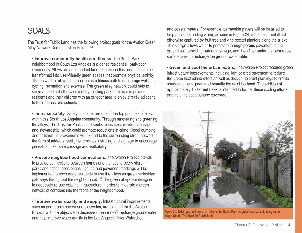
41Chapter 3. The Avalon Project
goAlsThe Trust for Public Land has the following project goals for the Avalon Green Alley Network Demonstration Project:105
• Improve community health and fitness. The South Park neighborhood in South Los Angeles is a dense residential, park-poor community. Alleys are an important land resource in this area that can be transformed into user-friendly green spaces that promote physical activity. The network of alleys can function as a fitness path to encourage walking, cycling, recreation and exercise. The green alley network could help to serve a need not otherwise met by existing parks; alleys can provide residents and their children with an outdoor area to enjoy directly adjacent to their homes and schools.
• Increase safety. Safety concerns are one of the top priorities of alleys within this South Los Angeles community. Through renovating and greening the alleys, The Trust for Public Land seeks to increase residential usage and stewardship, which could promote reductions in crime, illegal dumping, and pollution. Improvements will extend to the surrounding street network in the form of added streetlights, crosswalk striping and signage to encourage pedestrian use, safe passage and walkability.
• Provide neighborhood connections. The Avalon Project intends to provide connections between homes and the local grocery store, parks and school sites. Signs, lighting and pavement markings will be implemented to encourage residents to use the alleys as green pedestrian pathways throughout the neighborhood.106 The green alleys are designed to adaptively re-use existing infrastructure in order to integrate a green network of corridors into the fabric of the neighborhood.
• Improve water quality and supply. Infrastructural improvements, such as permeable pavers and bioswales, are planned for the Avalon Project, with the objective to decrease urban run-off, recharge groundwater and help improve water quality in the Los Angeles River Watershed
and coastal waters. For example, permeable pavers will be installed to help prevent standing water, as seen in Figure 24, and direct rainfall not otherwise captured by fruit tree and vine pocket planters along the alleys. This design allows water to percolate through porous pavement to the ground soil, providing natural drainage, and then filter under the permeable surface layer to recharge the ground water table.
• Green and cool the urban matrix. The Avalon Project features green infrastructure improvements including light colored pavement to reduce the urban heat island effect as well as drought tolerant plantings to create shade and help green and beautify the neighborhood. The addition of approximately 150 street trees is intended to further these cooling efforts and help increase canopy coverage.
Figure 24: Existing conditions of an alley in the South Park neighborhood with standing water Image Credit: The Trust for Public Land
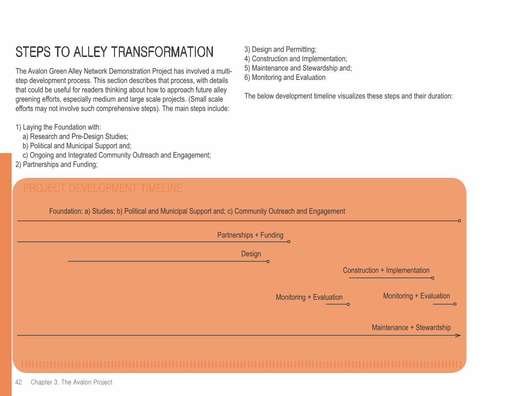
chapter 3. the Avalon project42
project development timeline
2009 201520122010 2011 2013 2014
Foundation: a) Studies; b) Political and Municipal Support and; c) Community Outreach and Engagement
Partnerships + Funding
Design
2016
Construction + Implementation
Monitoring + Evaluation
Maintenance + Stewardship
Monitoring + Evaluation
2017
steps to Alley trAnsformAtionThe Avalon Green Alley Network Demonstration Project has involved a multi-step development process. This section describes that process, with details that could be useful for readers thinking about how to approach future alley greening efforts, especially medium and large scale projects. (Small scale efforts may not involve such comprehensive steps). The main steps include:
1) Laying the Foundation with: a) Research and Pre-Design Studies;b) Political and Municipal Support and;c) Ongoing and Integrated Community Outreach and Engagement;
2) Partnerships and Funding;
3) Design and Permitting;4) Construction and Implementation;5) Maintenance and Stewardship and;6) Monitoring and Evaluation
The below development timeline visualizes these steps and their duration:

43Chapter 3. The Avalon Project
Foundation: a) Studies; b) Political and Municipal Support and; c) Community Outreach and Engagement
1. Laying the Foundation
Conducting research, building political and municipal support, and focusing on community outreach and engagement were key first steps to development of the Avalon Green Alley Network Demonstration Project.
Research and Pre-Design StudiesResearch and data helped spur general interest in alleys in Los Angeles and laid the foundation for efforts on the Avalon Project. These research efforts included:
• The University of Southern California’s Center for Sustainable Cities (CSC) published “Transforming Alleys into Green Infrastructure in Los Angeles (2008),” which sparked the idea of alleys as usable space and locations for green infrastructure. This report included physical inventories of alleys in Los Angeles, which identified the benefits of green alleys and made several policy recommendations. One main policy recommendation was to develop a Green Alleys Program and Subcommittee within the City’s Green Streets Committee to facilitate green alley implementation.107
• The Cal Poly Pomona Landscape Architecture graduate student studio and the Los Angeles Community Redevelopment Agency (CRA/LA) collaborated to produce a Vision Plan for South Los Angeles in 2008, which included alley improvements. Out of this process, the CRA/LA identified the South Park neighborhood as one of the priority locations for improvements. The CRA/LA referred to the Avalon Project at this time as the “Eco-Alley Walk” in South Los Angeles.
• The Trust for Public Land and the CRA/LA conducted studies to assess what was possible for alleys in South Los Angeles. This included looking at how other cities developed green alleys. In addition, The Trust for Public Land and the CRA/LA conducted feasibility studies to better understand existing conditions in the South Park neighborhood of South Los Angeles, as seen in Figure 29. This involved studying pedestrian and vehicle circulation, examining adjacent intersections and determining potential alley segments for closures
to vehicles. One study found that the project site had a significant lack of street trees, faded crosswalks, an absence of Americans with Disabilities Act (ADA)108 accessible sidewalk ramps and inconsistent lighting in the alleys, among others. Research also identified three segments for closure, based on surveying residents’ comfort levels and projecting the impact that alley closure would have on residents’ use of the alleys for parking and accessing their properties and garages.
Overall the findings helped determine that an alley network project was possible due to the proximity of the alley segments and nearby amenities. As a result, the scope of the project widened to include an alley network that could increase connectivity within the area and function as alternative pedestrian passageways.
Figure 25: Existing conditions of an alley in the South Park neighborhood with illegal dumping Image Credit: The Trust for Public Land
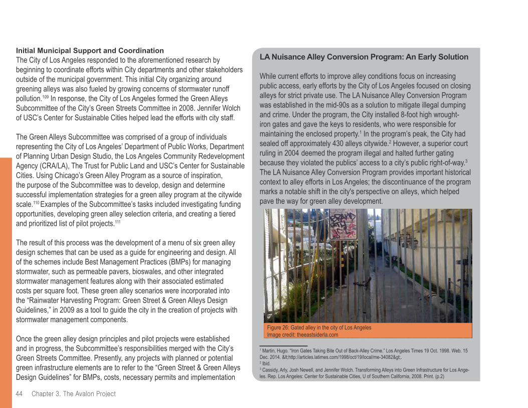
chapter 3. the Avalon project44
LA Nuisance Alley Conversion Program: An Early Solution
While current efforts to improve alley conditions focus on increasing public access, early efforts by the City of Los Angeles focused on closing alleys for strict private use. The LA Nuisance Alley Conversion Program was established in the mid-90s as a solution to mitigate illegal dumping and crime. Under the program, the City installed 8-foot high wrought-iron gates and gave the keys to residents, who were responsible for maintaining the enclosed property.1 In the program’s peak, the City had sealed off approximately 430 alleys citywide.2 However, a superior court ruling in 2004 deemed the program illegal and halted further gating because they violated the publics’ access to a city’s public right-of-way.3 The LA Nuisance Alley Conversion Program provides important historical context to alley efforts in Los Angeles; the discontinuance of the program marks a notable shift in the city's perspective on alleys, which helped pave the way for green alley development.
1 Martin, Hugo. “Iron Gates Taking Bite Out of Back-Alley Crime.” Los Angeles Times 19 Oct. 1998. Web. 15 Dec. 2014. <http://articles.latimes.com/1998/oct/19/local/me-34082>.2 Ibid.3 Cassidy, Arly, Josh Newell, and Jennifer Wolch. Transforming Alleys into Green Infrastructure for Los Ange-les. Rep. Los Angeles: Center for Sustainable Cities, U of Southern California, 2008. Print. (p.2)
Initial Municipal Support and CoordinationThe City of Los Angeles responded to the aforementioned research by beginning to coordinate efforts within City departments and other stakeholders outside of the municipal government. This initial City organizing around greening alleys was also fueled by growing concerns of stormwater runoff pollution.109 In response, the City of Los Angeles formed the Green Alleys Subcommittee of the City’s Green Streets Committee in 2008. Jennifer Wolch of USC’s Center for Sustainable Cities helped lead the efforts with city staff.
The Green Alleys Subcommittee was comprised of a group of individuals representing the City of Los Angeles’ Department of Public Works, Department of Planning Urban Design Studio, the Los Angeles Community Redevelopment Agency (CRA/LA), The Trust for Public Land and USC’s Center for Sustainable Cities. Using Chicago’s Green Alley Program as a source of inspiration, the purpose of the Subcommittee was to develop, design and determine successful implementation strategies for a green alley program at the citywide scale.110 Examples of the Subcommittee’s tasks included investigating funding opportunities, developing green alley selection criteria, and creating a tiered and prioritized list of pilot projects.111
The result of this process was the development of a menu of six green alley design schemes that can be used as a guide for engineering and design. All of the schemes include Best Management Practices (BMPs) for managing stormwater, such as permeable pavers, bioswales, and other integrated stormwater management features along with their associated estimated costs per square foot. These green alley scenarios were incorporated into the “Rainwater Harvesting Program: Green Street & Green Alleys Design Guidelines,” in 2009 as a tool to guide the city in the creation of projects with stormwater management components.
Once the green alley design principles and pilot projects were established and in progress, the Subcommittee’s responsibilities merged with the City’s Green Streets Committee. Presently, any projects with planned or potential green infrastructure elements are to refer to the “Green Street & Green Alleys Design Guidelines” for BMPs, costs, necessary permits and implementation
Figure 26: Gated alley in the city of Los AngelesImage credit: theeastsiderla.com
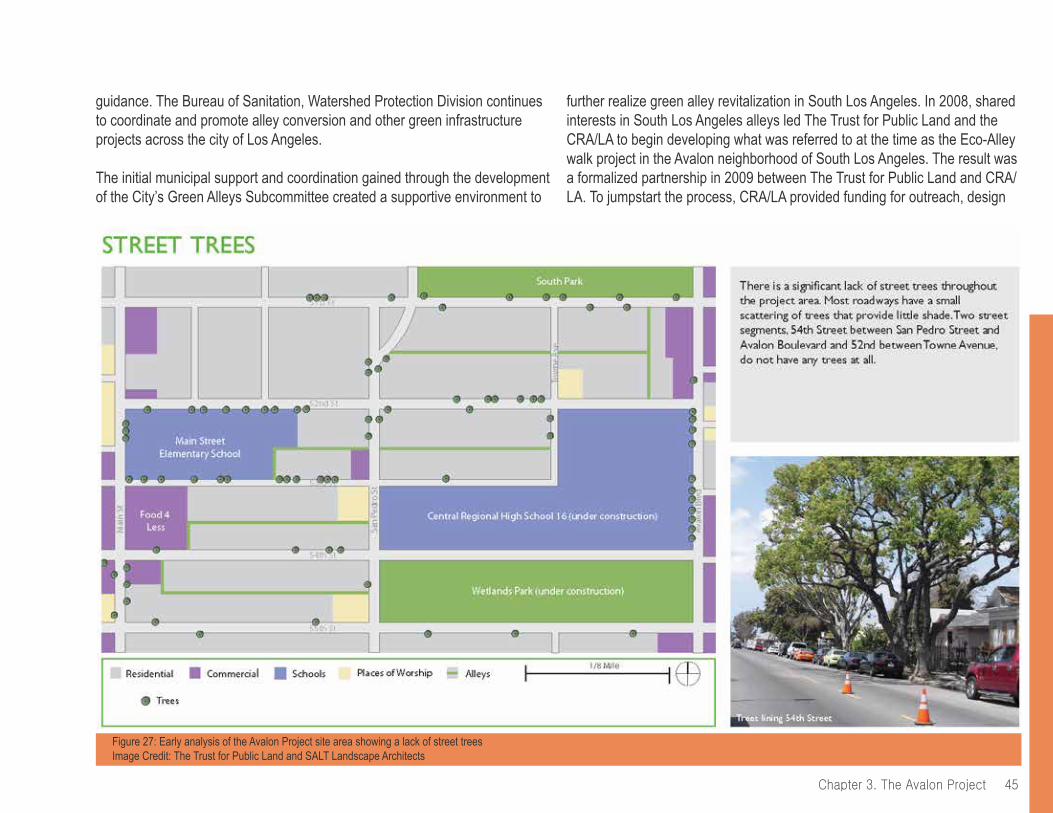
45Chapter 3. The Avalon Project
guidance. The Bureau of Sanitation, Watershed Protection Division continues to coordinate and promote alley conversion and other green infrastructure projects across the city of Los Angeles.
The initial municipal support and coordination gained through the development of the City’s Green Alleys Subcommittee created a supportive environment to
Figure 27: Early analysis of the Avalon Project site area showing a lack of street trees Image Credit: The Trust for Public Land and SALT Landscape Architects
further realize green alley revitalization in South Los Angeles. In 2008, shared interests in South Los Angeles alleys led The Trust for Public Land and the CRA/LA to begin developing what was referred to at the time as the Eco-Alley walk project in the Avalon neighborhood of South Los Angeles. The result was a formalized partnership in 2009 between The Trust for Public Land and CRA/LA. To jumpstart the process, CRA/LA provided funding for outreach, design
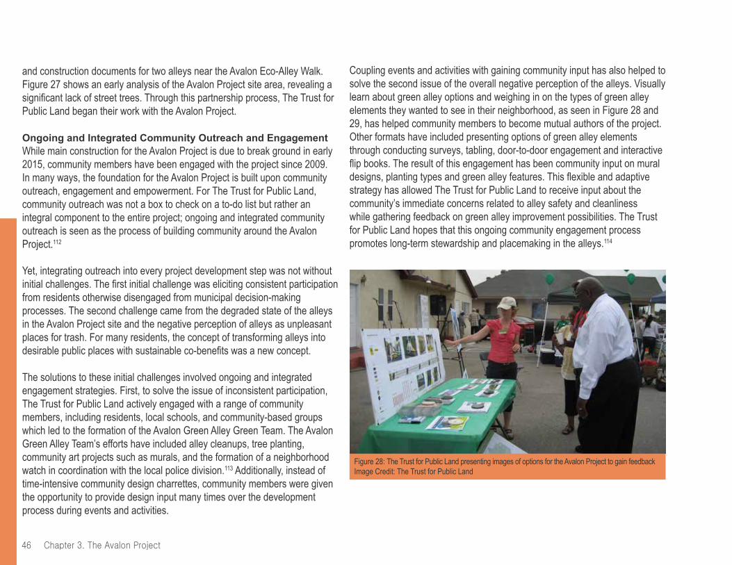
chapter 3. the Avalon project46
and construction documents for two alleys near the Avalon Eco-Alley Walk. Figure 27 shows an early analysis of the Avalon Project site area, revealing a significant lack of street trees. Through this partnership process, The Trust for Public Land began their work with the Avalon Project.
Ongoing and Integrated Community Outreach and EngagementWhile main construction for the Avalon Project is due to break ground in early 2015, community members have been engaged with the project since 2009. In many ways, the foundation for the Avalon Project is built upon community outreach, engagement and empowerment. For The Trust for Public Land, community outreach was not a box to check on a to-do list but rather an integral component to the entire project; ongoing and integrated community outreach is seen as the process of building community around the Avalon Project.112
Yet, integrating outreach into every project development step was not without initial challenges. The first initial challenge was eliciting consistent participation from residents otherwise disengaged from municipal decision-making processes. The second challenge came from the degraded state of the alleys in the Avalon Project site and the negative perception of alleys as unpleasant places for trash. For many residents, the concept of transforming alleys into desirable public places with sustainable co-benefits was a new concept.
The solutions to these initial challenges involved ongoing and integrated engagement strategies. First, to solve the issue of inconsistent participation, The Trust for Public Land actively engaged with a range of community members, including residents, local schools, and community-based groups which led to the formation of the Avalon Green Alley Green Team. The Avalon Green Alley Team’s efforts have included alley cleanups, tree planting, community art projects such as murals, and the formation of a neighborhood watch in coordination with the local police division.113 Additionally, instead of time-intensive community design charrettes, community members were given the opportunity to provide design input many times over the development process during events and activities.
Coupling events and activities with gaining community input has also helped to solve the second issue of the overall negative perception of the alleys. Visually learn about green alley options and weighing in on the types of green alley elements they wanted to see in their neighborhood, as seen in Figure 28 and 29, has helped community members to become mutual authors of the project. Other formats have included presenting options of green alley elements through conducting surveys, tabling, door-to-door engagement and interactive flip books. The result of this engagement has been community input on mural designs, planting types and green alley features. This flexible and adaptive strategy has allowed The Trust for Public Land to receive input about the community’s immediate concerns related to alley safety and cleanliness while gathering feedback on green alley improvement possibilities. The Trust for Public Land hopes that this ongoing community engagement process promotes long-term stewardship and placemaking in the alleys.114
Figure 28: The Trust for Public Land presenting images of options for the Avalon Project to gain feedbackImage Credit: The Trust for Public Land
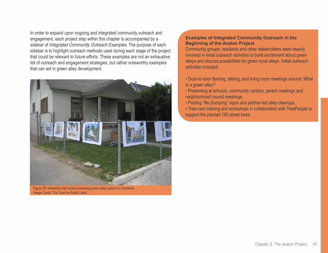
47Chapter 3. The Avalon Project
Examples of Integrated Community Outreach in the Beginning of the Avalon ProjectCommunity groups, residents and other stakeholders were heavily involved in initial outreach activities to build excitement about green alleys and discuss possibilities for green local alleys. Initial outreach activities included:
• Door-to-door flyering, tabling, and living room meetings around: What is a green alley?• Presenting at schools, community centers, parent meetings and neighborhood council meetings.• Posting “No Dumping” signs and partner-led alley cleanups.• Tree-care training and workshops in collaboration with TreePeople to support the planted 150 street trees.
In order to expand upon ongoing and integrated community outreach and engagement, each project step within this chapter is accompanied by a sidebar of Integrated Community Outreach Examples. The purpose of each sidebar is to highlight outreach methods used during each stage of the project that could be relevant to future efforts. These examples are not an exhaustive list of outreach and engagement strategies, but rather noteworthy examples that can aid in green alley development.
Figure 29: Interactive flip books presenting green alley options to residents Image Credit: The Trust for Public Land

chapter 3. the Avalon project48
2. Partnerships and Funding Steps
A myriad of partnerships has set the foundation for the Avalon Green Alley Network Demonstration Project to accomplish the diverse range of goals and features.
Funding and Municipal Partnerships Early in the development of the Avalon Green Alley Network Demonstration Project, The Trust for Public Land established partnerships with multiple City agencies to align the project with Citywide green infrastructure development and to create strong inter-agency collaboration. As previously mentioned, CRA/LA was The Trust for Public Land’s main City agency partner, until the 2012 dissolution of community redevelopment agencies in California, including the CRA/LA. This partnership was key in jumpstarting the Avalon Project in terms of providing seed money and coordinating the project with other Citywide policy and planning efforts.115 After the dissolution of the CRA/LA, the Bureau of Sanitation, Watershed Protection Division (BOS WPD) became The Trust for Public Land’s primary City partner. BOS WPD’s main objective is water quality, therefore, BOS WPD’s ownership of the Avalon Project centers on the stormwater management components. Other municipal partnerships included:
• City of Los Angeles Department of Planning• City of Los Angeles Department of Transportation• City of Los Angeles Department of Public Works - Bureaus of Engineering and Street Services• The inter-agency City of Los Angeles Green Streets Committee116 and Green Alley Subcommittee117
• Los Angeles Fire and the Los Angeles Police Department, including the Newton Division (see Figure 30).• The Los Angeles Mayor’s Office of Community Beautification (supplied materials for alley cleanups with the community as well as permission to reprint the city’s ‘No Dumping’ sign in English and Spanish, as seen in Figure 31).
Figure 30: The Los Angeles Police Department, Community-Policy Advisory Board, Newton Division participating in community event in an alley in the Avalon Project site areaImage Credit: The Trust for Public Land

49Chapter 3. The Avalon Project
Political and municipal support has been a critical component of the Avalon Project. Council member Price’s entrance into office in July 2013 and his associated focus on alleys in District 9 significantly nurtured the project. This partnership, along with other significant partners, can be seen in Figure 32. Furthermore, the partnership with BOS WPD enabled robust stormwater management elements with the alleys due to their support, expertise and access to funding. This specific partnership has helped The Trust for Public Land to apply and secure grants related to stormwater management (See the Partial List of Funding Sources on page 51 for these and other funding sources).
Figure 31: ‘No Dumping’ Spanish sign posted in alleys in the Avalon Project site areaImage Credit: The Trust for Public Land
While some of the listed municipal partnerships were initially challenging to foster, all of the aforementioned partners engaged in early-stage concept and planning meetings to identify the Avalon Project as a potential model effort.123 As a non-profit organization approaching the City about an unprecedented green alley network, The Trust for Public Land had to develop, navigate and demonstrate the authorization process, which took multiple coordination meetings, time and patience. This experience is further clarified in the Partnerships and Funding section in on pages 70 and 71.
Figure 32: U.S. Representative Lucille Roybal-Allard and Los Angeles City Councilman Curren Price, whose respective districts encompass the Avalon Project site, with students and faculty of Maya Angelou Community High School, the Avalon Green Alley Green Team and The Trust for Public Land staffImage Credit: The Trust for Public Land

chapter 3. the Avalon project50
Other Partnerships and Funding118
The following additional partners collaborated with The Trust for Public Land on various outreach, advocacy and design elements of the Avalon Project:
• Los Angeles Conservation Corps (LACC): The LACC Clean and Green Division helped The Trust for Public Land to organize alley cleanups (See Figure 36). They are the primary partners for street tree planting and near-term watering.
• The Coalition for Responsible Community Development (CRCD): The CRCD is a nonprofit community development organization in South Los Angeles who has worked with The Trust for Public Land on alley cleanups, including graffiti abatement. They are part of a long-term maintenance strategy for aspects of the green alleys.
• Community Health Council (CHC)/ Coalition for an Active South Los Angeles (CASLA): The CASLA, a branch of CHC, advocated for the Avalon Project by highlighting it as a priority project for community health and promoting the project to South Los Angeles residents and partner organizations.
• TreePeople: This environmental nonprofit connects Los Angeles residents to the environment through tree plantings and tree-care activities. TreePeople partnered with The Trust for Public Land to form the Avalon Green Alley Green Team, training residents to care for and plant trees and co-hosting several tree care and planting days in the neighborhood.
• Maya Angelou Community High School and Main Street Elementary School: Located within the Avalon Project and part of the participatory design process, school students participate in cleanups. The Trust for Public Land intends to collaborate with the schools and facilitate the integration of the Avalon Project features into their core curriculum.
Figure 33: Student cleaning up an alley in an Avalon Project alley siteImage Credit: The Trust for Public Land
• Jefferson High School: This adjacent high school formally hosted a Green Design Academy and also has a green alley project. Jefferson High School partnered with The Trust for Public Land on outreach activities (see Figure 33).
• California State Polytechnic University, Pomona, College of Environmental Design, 606 Design Studio: The design studio, held in 2009, assisted The Trust for Public Land in the early conceptual design of the Avalon Project.
• Council for Watershed Health: Monitoring and evaluation of water quality, both before and after project implementation.
• Consultants and vendors: SALT Landscape Architects, Breen Engineering civil engineers and Byer Geotechnical are Los Angeles-based consulting firms that developed preliminary and final designs for the project. (A private company will also be hired for the construction phase).

51Chapter 3. The Avalon Project
A Partial List of Funding Sources119
Creating a prioritization strategy for improvements was important to establishing a fundable construction budget. This funding strategy has led to a plan that does not apply the full range of greening and design elements to every alley in the network; instead, the system allows The Trust for Public Land to apply design features to select alley segments that fulfill certain funding qualifications and thereby meet overall programmatic objectives. Funding the select alley segments of the Avalon Project through grants, as seen below, has led to a phased construction. This is in part due to the fact that grant funding was not achievable for all phases simultaneously. Therefore, the project’s implementation is broken down into three phases for construction.
Public Funding:• City of Los Angeles Community Redevelopment Agency• State of California Urban Greening Grant Program• State of California Water Resources Control Board – Stormwater Grant Program, Rounds One and Two• State of California Coastal Conservancy• City of Los Angeles Proposition O• LA County Proposition A
Private Funding:• The JIB Fund Community Building Initiative• LA2050, an initiative of the Goldhirsh Foundation• The National Fish and Wildlife Foundation• Wells Fargo• The Trust for Public Land
Examples of Integrated Community Outreach During the Partnerships and Funding Phase
Developing multiple partnerships at varying levels with the South Los Angeles area and the broader city was crucial to advancing the Avalon Project. Diverse project elements has attracted a myriad of support from many types of stakeholders to:
• Organize and facilitate monthly platicas, informal talks and lectures, through partnerships with the Maya Angelou High School and TreePeople, a Los Angeles-based environmental non-profit. TreePeople provided structure, content and expertise around tree planting and The Trust for Public Land provided information and education around how residents can green their alleys. The resulting platicas curriculum included a monthly meeting centered on tree planting and green alleys.• Develop the Avalon Green Alley Green Team to lead green alleys Days of Service for alley clean-ups. Members earn a Green Team T-shirt, as seen in Figure 48 on page 71, after attending five events or platicas, which helps to create cohesion and excitement around the Avalon Project.• Facilitate graffiti abatement in partnership with CRCD and the Los Angeles Conservation Corps.
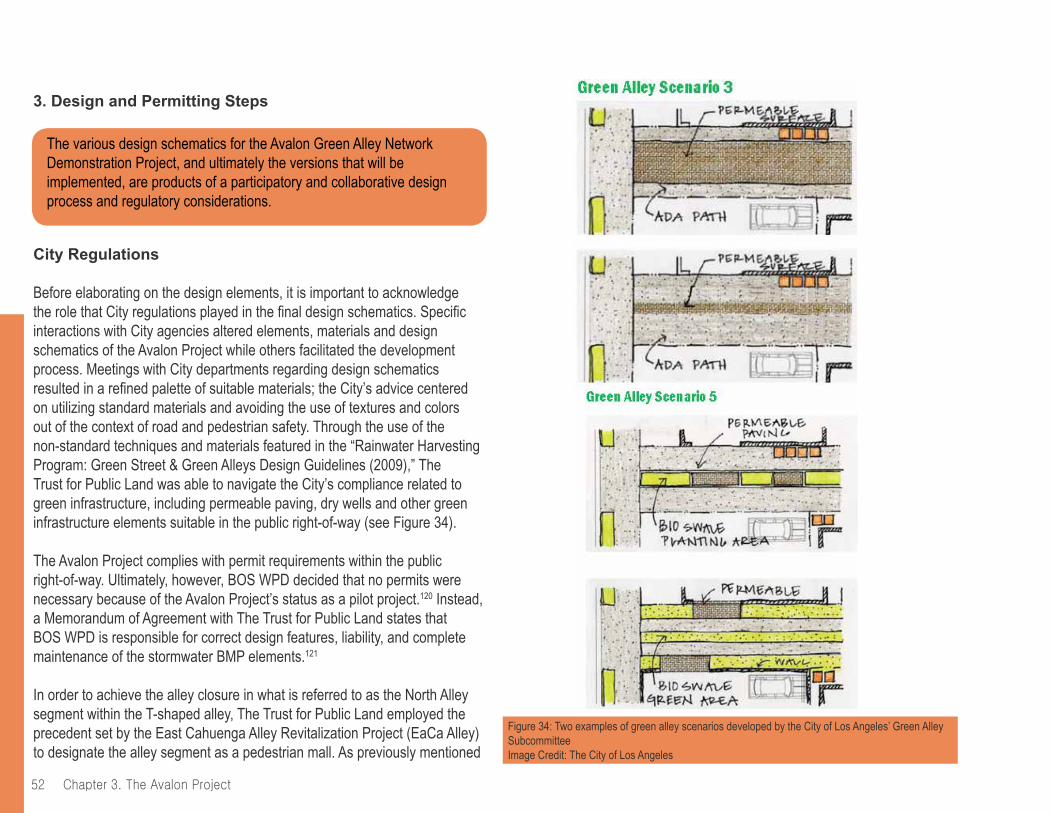
chapter 3. the Avalon project52
3. Design and Permitting Steps
City Regulations
Before elaborating on the design elements, it is important to acknowledge the role that City regulations played in the final design schematics. Specific interactions with City agencies altered elements, materials and design schematics of the Avalon Project while others facilitated the development process. Meetings with City departments regarding design schematics resulted in a refined palette of suitable materials; the City’s advice centered on utilizing standard materials and avoiding the use of textures and colors out of the context of road and pedestrian safety. Through the use of the non-standard techniques and materials featured in the “Rainwater Harvesting Program: Green Street & Green Alleys Design Guidelines (2009),” The Trust for Public Land was able to navigate the City’s compliance related to green infrastructure, including permeable paving, dry wells and other green infrastructure elements suitable in the public right-of-way (see Figure 34).
The Avalon Project complies with permit requirements within the public right-of-way. Ultimately, however, BOS WPD decided that no permits were necessary because of the Avalon Project’s status as a pilot project.120 Instead, a Memorandum of Agreement with The Trust for Public Land states that BOS WPD is responsible for correct design features, liability, and complete maintenance of the stormwater BMP elements.121
In order to achieve the alley closure in what is referred to as the North Alley segment within the T-shaped alley, The Trust for Public Land employed the precedent set by the East Cahuenga Alley Revitalization Project (EaCa Alley) to designate the alley segment as a pedestrian mall. As previously mentioned
The various design schematics for the Avalon Green Alley Network Demonstration Project, and ultimately the versions that will be implemented, are products of a participatory and collaborative design process and regulatory considerations.
Figure 34: Two examples of green alley scenarios developed by the City of Los Angeles’ Green Alley SubcommitteeImage Credit: The City of Los Angeles
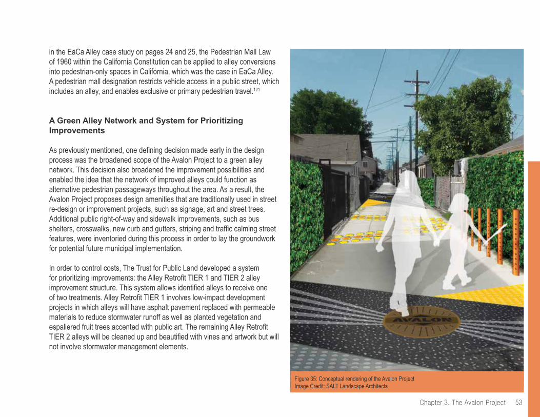
53Chapter 3. The Avalon Project
in the EaCa Alley case study on pages 24 and 25, the Pedestrian Mall Law of 1960 within the California Constitution can be applied to alley conversions into pedestrian-only spaces in California, which was the case in EaCa Alley. A pedestrian mall designation restricts vehicle access in a public street, which includes an alley, and enables exclusive or primary pedestrian travel.121
A Green Alley Network and System for Prioritizing Improvements
As previously mentioned, one defining decision made early in the design process was the broadened scope of the Avalon Project to a green alley network. This decision also broadened the improvement possibilities and enabled the idea that the network of improved alleys could function as alternative pedestrian passageways throughout the area. As a result, the Avalon Project proposes design amenities that are traditionally used in street re-design or improvement projects, such as signage, art and street trees. Additional public right-of-way and sidewalk improvements, such as bus shelters, crosswalks, new curb and gutters, striping and traffic calming street features, were inventoried during this process in order to lay the groundwork for potential future municipal implementation.
In order to control costs, The Trust for Public Land developed a system for prioritizing improvements: the Alley Retrofit TIER 1 and TIER 2 alley improvement structure. This system allows identified alleys to receive one of two treatments. Alley Retrofit TIER 1 involves low-impact development projects in which alleys will have asphalt pavement replaced with permeable materials to reduce stormwater runoff as well as planted vegetation and espaliered fruit trees accented with public art. The remaining Alley Retrofit TIER 2 alleys will be cleaned up and beautified with vines and artwork but will not involve stormwater management elements.
Figure 35: Conceptual rendering of the Avalon ProjectImage Credit: SALT Landscape Architects
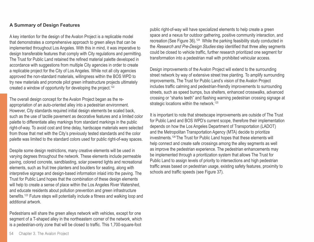
chapter 3. the Avalon project54
A Summary of Design Features
A key intention for the design of the Avalon Project is a replicable model that demonstrates a comprehensive approach to green alleys that can be implemented throughout Los Angeles. With this in mind, it was imperative to design transferable features that comply with City regulations and permitting. The Trust for Public Land retained the refined material palette developed in accordance with suggestions from multiple City agencies in order to create a replicable project for the City of Los Angeles. While not all city agencies approved the non-standard materials, willingness within the BOS WPD to try new materials and promote pilot green infrastructure projects ultimately created a window of opportunity for developing the project.122
The overall design concept for the Avalon Project began as the re-appropriation of an auto-oriented alley into a pedestrian environment. However, City standards required initial design elements be scaled back, such as the use of tactile pavement as decorative features and a limited color palette to differentiate alley markings from standard markings in the public right-of-way. To avoid cost and time delay, hardscape materials were selected from those that met with the City’s previously tested standards and the color palette was limited to the standard colors used for public right-of-way spaces.
Despite some design restrictions, many creative elements will be used in varying degrees throughout the network. These elements include permeable paving, colored concrete, sandblasting, solar powered lights and recreational elements, such as fruit tree planters and boulders for seating, along with interpretive signage and design-based information inlaid into the paving. The Trust for Public Land hopes that the combination of these design elements will help to create a sense of place within the Los Angeles River Watershed, and educate residents about pollution prevention and green infrastructure benefits.123 Future steps will potentially include a fitness and walking loop and additional artwork.
Pedestrians will share the green alleys network with vehicles, except for one segment of a T-shaped alley in the northeastern corner of the network, which is a pedestrian-only zone that will be closed to traffic. This 1,700-square-foot
public right-of-way will have specialized elements to help create a green space and a nexus for outdoor gathering, positive community interaction, and recreation (See Figure 36).124 While the parking feasibility study conducted in the Research and Pre-Design Studies step identified that three alley segments could be closed to vehicle traffic, further research prioritized one segment for transformation into a pedestrian mall with prohibited vehicular access.
Design improvements of the Avalon Project will extend to the surrounding street network by way of extensive street tree planting. To amplify surrounding improvements, The Trust for Public Land’s vision of the Avalon Project includes traffic calming and pedestrian-friendly improvements to surrounding streets, such as speed bumps, bus shelters, enhanced crosswalks, advanced crossing or “sharks teeth” and flashing warning pedestrian crossing signage at strategic locations within the network.125
It is important to note that streetscape improvements are outside of The Trust for Public Land and BOS WPD’s current scope, therefore their implementation depends on how the Los Angeles Department of Transportation (LADOT) and the Metropolitan Transportation Agency (MTA) decide to prioritize investments.126 The Trust for Public Land hopes that these elements will help connect and create safe crossings among the alley segments as well as improve the pedestrian experience. The pedestrian enhancements may be implemented through a prioritization system that allows The Trust for Public Land to assign levels of priority to intersections and high pedestrian traffic areas based on pedestrian usage, existing safety features, proximity to schools and traffic speeds (see Figure 37).
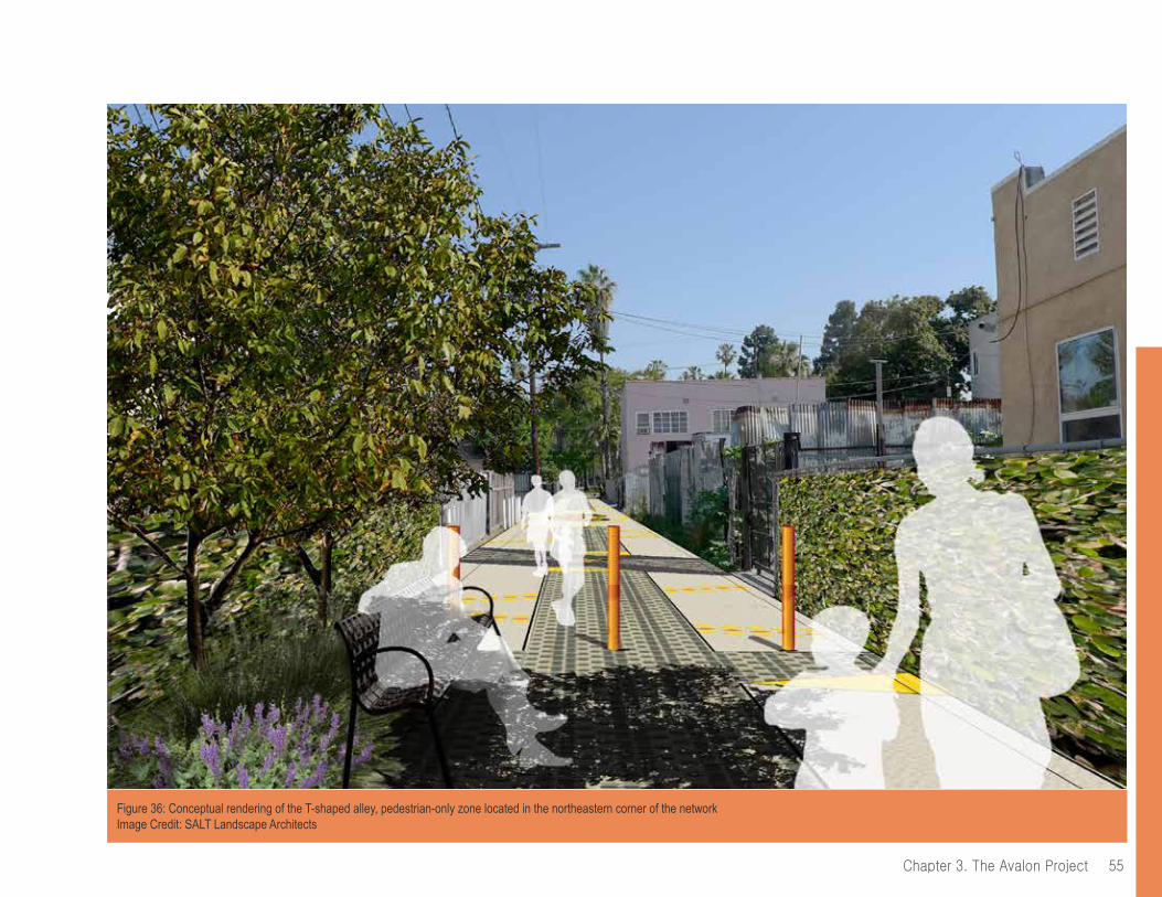
55Chapter 3. The Avalon Project
Figure 36: Conceptual rendering of the T-shaped alley, pedestrian-only zone located in the northeastern corner of the networkImage Credit: SALT Landscape Architects
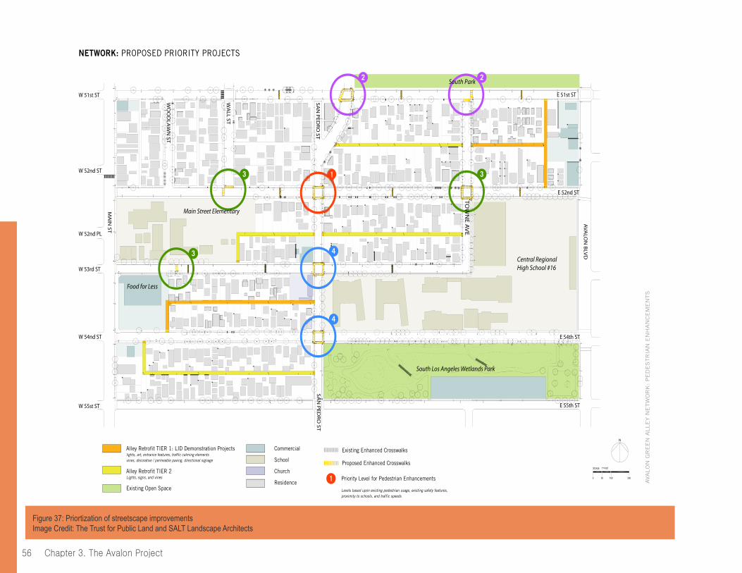
chapter 3. the Avalon project56
6NETWORK: PROPOSED PRIORITY PROJECTS
AVA
LO
N G
RE
EN
ALLE
Y N
ETW
OR
K: P
ED
ES
TR
IAN
EN
HA
NC
EM
EN
TS
2 2
4
4
1 33
3
MA
IN ST
WO
OD
LAW
N ST
WA
LL ST
SAN
PED
RO
ST
W 51st ST
W 52nd ST
W 52nd PL
W 53rd ST
W 54nd ST
W 55st ST
E 54th ST
E 52nd ST
E 51st ST
SAN
PED
RO
ST
E 55th ST
AVA
LON
BLV
D
TOW
NE A
VE
Main Street Elementary
Food for Less
South Los Angeles Wetlands Park
South Park
Central Regional High School #16
Alley Retrofit TIER 1: LID Demonstration Projectslights, art, entrance features, traffic calming elementsvines, decorative / permeable paving, directional signage
Alley Retrofit TIER 2Lights, signs, and vines
Existing Open Space
Commercial
School
Church
Residence
Proposed Enhanced Crosswalks
Priority Level for Pedestrian Enhancements
Levels based upon existing pedestrian usage, existing safety features, proximity to schools, and traffic speeds
Existing Enhanced Crosswalks
1
Figure 37: Priortization of streetscape improvementsImage Credit: The Trust for Public Land and SALT Landscape Architects

57Chapter 3. The Avalon Project
A Summary of Stormwater BMPs
The inclusion of robust stormwater BMPs in the Avalon Project design is in part due to the City of Los Angeles’ expanded interest in stormwater management over the lifetime of the project.127 This interest further increased after a Supreme Court ruling on Los Angeles’ stormwater pollution and new regional projections for climate change and reduced California water supply.128
The most visible stormwater BMP to be implemented consists of the removal and replacement of impervious asphalt with light-colored, high albedo permeable pavers and concrete (see Figure 38). The permeable interlocking pavement system will collect stormwater runoff via a four-foot-deep, subsurface infiltration trench, providing temporary storage prior to infiltration into the soil below. Any stormwater draining from the block not otherwise captured in the permeable paving, as well as water captured through catch basins connecting to intersecting streets, will guide flows to dry wells. Dry
wells consist of subsurface chambers to capture, provide inline filtration and infiltrate runoff from accumulated stormwater. They are a cost-effective strategy to provide maximum capture and storage volume in a limited space.129
By the time the Avalon Green Alley Network Project is built out, the retrofitted green alleys will minimally capture and infiltrate over 76,000 gallons of stormwater each time it rains, which represents the first flush (first 3/4-inches) or most polluted runoff for each rain event. Roughly speaking, up to two million gallons of stormwater could be captured and infiltrated each year, based on an average annual rainfall of 12 inches for the Los Angeles area.
Combined with the planting areas, these BMPs can help reduce pressure on the existing storm drain system, clear alleys of stagnant wet spots and foul odors, replenishing groundwater stores through infiltration, thus improving water quality to downstream receiving waters such as the Los Angeles River and coastal areas.130 Water not captured in permeable paving or infiltrated in dry wells will help water trees and vines planted along the side of alleys (see Figures 39 and 40).
Figure 38: Conceptual rendering of the Avalon Project’s permeable paving and catch basins Image Credit: SALT Landscape Architects
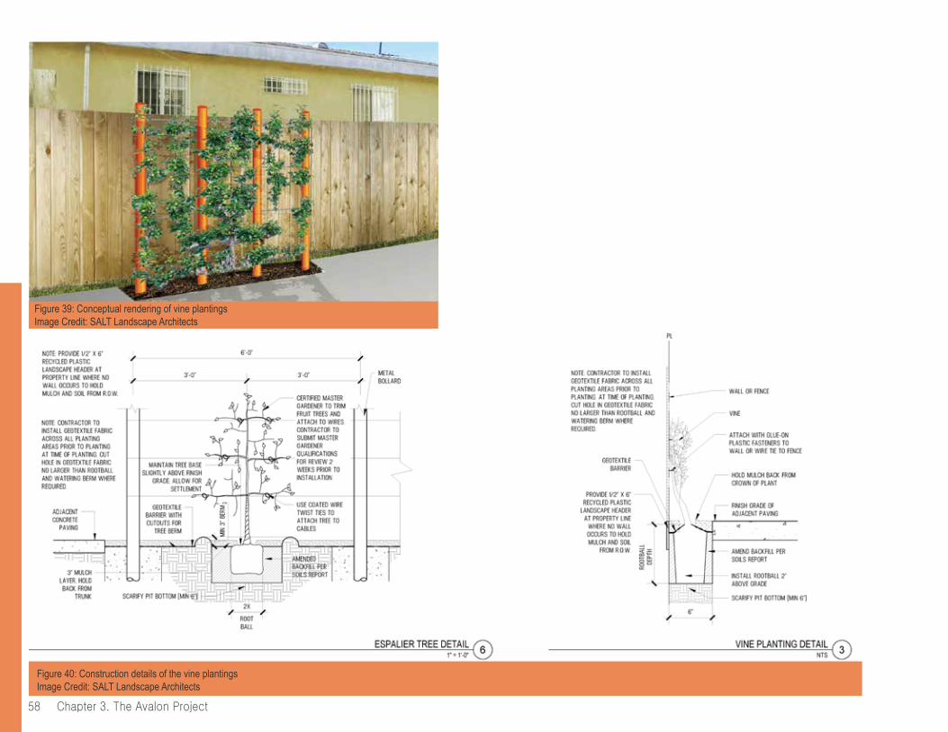
chapter 3. the Avalon project58
Figure 40: Construction details of the vine plantingsImage Credit: SALT Landscape Architects
Figure 39: Conceptual rendering of vine plantingsImage Credit: SALT Landscape Architects
59Chapter 3. The Avalon Project
Next StepsThe following planned steps are not yet implemented and thus the details could be subject to change. Nevertheless, these steps are included in this report because they are integral to creating an impactful and comprehensive green alley project.
4. Construction and Implementation Steps
Construction for the Avalon Project begins in early 2015 and will be implemented in three phases due to the nature of funding through multiple grant sources.
As the City’s lead partner, The Trust for Public Land hired several private sub-contractors for the project’s design, construction and engineering. A general contractor will complete the construction under private contract. While the Avalon Project has three construction phases, it is important to note that other green alley project or program’s construction phase can be implemented in a single phase. The following elaborates on the elements included in each construction phase:
Phase 1: Avalon Green Alley South.131 Phase 1 includes construction of the TIER 1 L-shaped alley in the southwestern corner of the network, located between W 53rd street and W 54th street and Main Street and San Pedro Street. Phase 1 involves the construction of three BMPs to capture and infiltrate runoff from the surrounding block and intersecting streets via catch basin intercepts; a drywell system; over 2,200 SF of interlocking permeable pavers overlying an infiltration trench and; vines and fruit trees in planters.• Avalon South’s Total Stormwater Volume Managed (per 0.75” rainfall) = 47,771 gallons (or 6,386 cubic feet)• Drainage Area = 4.44 acres
Phase 2 and 3: Avalon Green Alley North.132 Phase 2 includes construction of the pedestrian-only segment of the TIER 1 T-shaped alley in the northeastern corner of the network, located between E 51st street and E 52nd street and Avalon Blvd and Towne Avenue, and directly adjacent to the
Examples of Integrated Community Outreach during the Design and Permitting Phase
The community was very involved in project design. Through offering suitable choices that were driven by permitting considerations, The Trust for Public Land was able to receive community design input. Residents informed the process by responding to different images of green alleys and deciding if they liked certain elements through:
• Participatory design feedback in a 10-minute interview format.• Attending free neighborhood-wide events held by The Trust for Public Land and partners that included Christmas posadas (potlucks), end-of-school BBQs and Earth Day Tree-Planting, and potentially becoming interested and invested in the project.• Joining the Avalon Green Team (which expanded at this time from seven to 20 members).
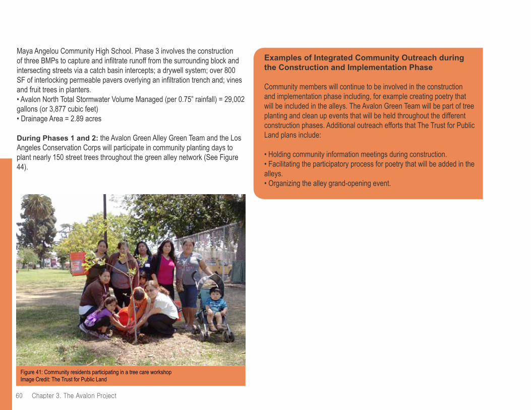
chapter 3. the Avalon project60
Examples of Integrated Community Outreach during the Construction and Implementation Phase
Community members will continue to be involved in the construction and implementation phase including, for example creating poetry that will be included in the alleys. The Avalon Green Team will be part of tree planting and clean up events that will be held throughout the different construction phases. Additional outreach efforts that The Trust for Public Land plans include:
• Holding community information meetings during construction.• Facilitating the participatory process for poetry that will be added in the alleys.• Organizing the alley grand-opening event.
Maya Angelou Community High School. Phase 3 involves the construction of three BMPs to capture and infiltrate runoff from the surrounding block and intersecting streets via a catch basin intercepts; a drywell system; over 800 SF of interlocking permeable pavers overlying an infiltration trench and; vines and fruit trees in planters.• Avalon North Total Stormwater Volume Managed (per 0.75” rainfall) = 29,002 gallons (or 3,877 cubic feet)• Drainage Area = 2.89 acres
During Phases 1 and 2: the Avalon Green Alley Green Team and the Los Angeles Conservation Corps will participate in community planting days to plant nearly 150 street trees throughout the green alley network (See Figure 44).
Figure 41: Community residents participating in a tree care workshopImage Credit: The Trust for Public Land
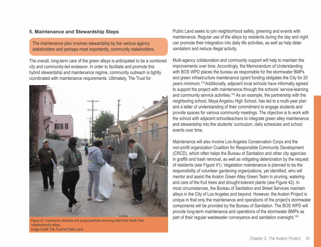
61Chapter 3. The Avalon Project
5. Maintenance and Stewardship Steps
The maintenance plan involves stewardship by the various agency stakeholders and perhaps most importantly, community stakeholders.
The overall, long-term care of the green alleys is anticipated to be a combined city and community-led endeavor. In order to facilitate and promote this hybrid stewardship and maintenance regime, community outreach is tightly coordinated with maintenance requirements. Ultimately, The Trust for
Public Land seeks to join neighborhood safety, greening and events with maintenance. Regular use of the alleys by residents during the day and night can promote their integration into daily life activities, as well as help deter vandalism and reduce illegal activity.
Multi-agency collaboration and community support will help to maintain the improvements over time. Accordingly, the Memorandum of Understanding with BOS WPD places the bureau as responsible for the stormwater BMPs and green infrastructure maintenance (grant funding obligates the City for 20 years minimum.133 Additionally, adjacent local schools have informally agreed to support the project with maintenance through the schools’ service-learning and community service activities.134 As an example, the partnership with the neighboring school, Maya Angelou High School, has led to a multi-year plan and a letter of understanding of their commitment to engage students and provide spaces for various community meetings. The objective is to work with the school with adjacent schoolteachers to integrate green alley maintenance and stewardship into the students’ curriculum, daily schedules and school events over time.
Maintenance will also involve Los Angeles Conservation Corps and the non-profit organization Coalition for Responsible Community Development (CRCD), which often helps the Bureau of Sanitation and other city agencies in graffiti and trash removal, as well as mitigating deterioration by the request of residents (see Figure 41). Vegetation maintenance is planned to be the responsibility of volunteer gardening organizations, yet identified, who will mentor and assist the Avalon Green Alley Green Team in pruning, watering and care of the fruit trees and drought-tolerant plants (see Figure 42). In most circumstances, the Bureau of Sanitation and Street Services maintain alleys in the City of Los Angeles and beyond. However, the Avalon Project is unique in that only the maintenance and operations of the project’s stormwater components will be provided by the Bureau of Sanitation. The BOS WPD will provide long-term maintenance and operations of the stormwater BMPs as part of their regular wastewater conveyance and sanitation oversight.135
Figure 42: Community residents and project partners removing trash from South Park neighborhood’s alleysImage Credit: The Trust for Public Land

chapter 3. the Avalon project62
Examples of Integrated Community Outreach: Maintenance and Stewardship
Through sharing the multi-benefits of green alleys and facilitating active community participation throughout the development steps, The Trust for Public Land has created a framework to guide the community with long-term stewardship of the green alleys. With community members already engaged, maintenance and stewardship are planned to coincide to support and care for the green alleys. Examples of community outreach at this step are:
• Maintenance provided by Maya Angelou High School through the integration of standards-based content about green alleys into their curriculum.• Provision of training to the Avalon Green Alley Green Team, a group that meets monthly in support of the project, to prepare them as green alley stewards: tree planting and tree maintenance, community education on bulky item pickup, event organizing (see Figure 43).• Facilitating an increase in participation and stewardship through Avalon Green Alley Days of Service and other events approximately two to three times per year in the alleys.
Figure 43: Members of the Avalon Green Alley Team maintaining alleys in the Avalon Project’s site areaImage Credit: The Trust for Public Land
63Chapter 3. The Avalon Project
6. Monitoring and Evaluation Steps
Monitoring and evaluation is crucial for quantifying the effects of the improvements of the Avalon Project and determining its overall success. Data gained from these steps can help to promote further green alley development.
The Trust for Public Land and the Council for Watershed Health (CWH) will conduct pre- and post- implementation evaluation and monitoring for the purposes of quantifying green alley benefits. These steps are expected to help provide measurable outcomes and replicable solutions for the implementation of stormwater infiltration in other densely developed neighborhoods across Los Angeles. The CWH will provide an analysis based on monitoring the stormwater infiltration components and collecting water samples. The CWH will also analyze the effects of the proposed BMPs on water quality and water supply as well as document the operations and maintenance needs of the BMPs.136 Monitoring and Evaluation is planned for six months prior to construction and 12 months after construction completion.
Monitoring and evaluation plans also include measuring social and educational impacts, public health improvements, greenhouse gas reduction, and increased biological diversity through the implementation of monitoring equipment, neighborhood surveys and interviews with residents and students.137 The Trust for Public Land plans to survey the community during these evaluation periods to ask questions, like those seen in the sidebar, that help to quantify the changes created by the implementation of the project.
Integrated Community Outreach: Monitoring and Evaluation
The community outreach during the Monitoring and Evaluation steps will revolve around interviewing residents through pre- and post- implementation evaluation. One of the planned methods of collecting information from residents includes surveys to present questions in an attempt to measure the social, educational, economic, public health and environmental improvements. Examples of planned survey questions about alley use and quality include the following:138
Generally, how often do you use the alleys in your neighborhood? (Check one)o Daily o A few times per week o Once per week/a few times per month o Monthlyo A few times per year o Never
Are there specific concerns you have about the alleys in your neighborhood or reasons you do not use them? (Check all that apply) o Desired features are not available o Safety concerns o Maintenance issues o Traffic (driving cars or parking)o Other:
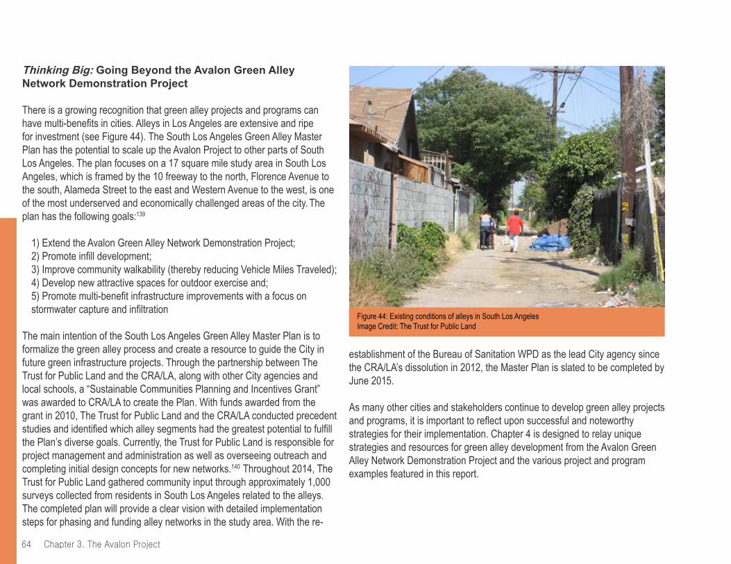
chapter 3. the Avalon project64
Thinking Big: Going Beyond the Avalon Green Alley Network Demonstration Project
There is a growing recognition that green alley projects and programs can have multi-benefits in cities. Alleys in Los Angeles are extensive and ripe for investment (see Figure 44). The South Los Angeles Green Alley Master Plan has the potential to scale up the Avalon Project to other parts of South Los Angeles. The plan focuses on a 17 square mile study area in South Los Angeles, which is framed by the 10 freeway to the north, Florence Avenue to the south, Alameda Street to the east and Western Avenue to the west, is one of the most underserved and economically challenged areas of the city. The plan has the following goals:139
1) Extend the Avalon Green Alley Network Demonstration Project; 2) Promote infill development; 3) Improve community walkability (thereby reducing Vehicle Miles Traveled);4) Develop new attractive spaces for outdoor exercise and; 5) Promote multi-benefit infrastructure improvements with a focus on stormwater capture and infiltration
The main intention of the South Los Angeles Green Alley Master Plan is to formalize the green alley process and create a resource to guide the City in future green infrastructure projects. Through the partnership between The Trust for Public Land and the CRA/LA, along with other City agencies and local schools, a “Sustainable Communities Planning and Incentives Grant” was awarded to CRA/LA to create the Plan. With funds awarded from the grant in 2010, The Trust for Public Land and the CRA/LA conducted precedent studies and identified which alley segments had the greatest potential to fulfill the Plan’s diverse goals. Currently, the Trust for Public Land is responsible for project management and administration as well as overseeing outreach and completing initial design concepts for new networks.140 Throughout 2014, The Trust for Public Land gathered community input through approximately 1,000 surveys collected from residents in South Los Angeles related to the alleys. The completed plan will provide a clear vision with detailed implementation steps for phasing and funding alley networks in the study area. With the re-
establishment of the Bureau of Sanitation WPD as the lead City agency since the CRA/LA’s dissolution in 2012, the Master Plan is slated to be completed by June 2015.
As many other cities and stakeholders continue to develop green alley projects and programs, it is important to reflect upon successful and noteworthy strategies for their implementation. Chapter 4 is designed to relay unique strategies and resources for green alley development from the Avalon Green Alley Network Demonstration Project and the various project and program examples featured in this report.
Figure 44: Existing conditions of alleys in South Los AngelesImage Credit: The Trust for Public Land
65Chapter 3. The Avalon Project
endnotes95 “State of California Urban Greening Grant Program Proposal.” The Trust for Public Land. 201196 “Green Infrastructure for the Avalon Green Alley Demonstration Project.” The Trust for Public Land. 2014.97 Ibid 98 “State of California Urban Greening Grant Program Proposal.” The Trust for Public Land. 201199 Combined Report for CF 05-0752 Alternative Street Surfacing Materials; Green Streets; CF 08-0102 Green Alleys. October 15, 2008100 Chau, Haan-Fawn. Green Infrastructure for Los Angeles: Addressing Urban Runoff and Water Supply Through Low Impact Development. Rep. N.p.: n.p., 2009. California Water Board. Web. 6 Aug. 2014.101 Ibid; South Los Angeles Green Alleys Master Plan Grant Application. August, 2010102 Los Angeles County Public Health, August 2006 and 2006103 Ibid.104 Combined Report for CF 05-0752 Alternative Street Surfacing Materials; Green Streets; CF 08-0102 Green Alleys. October 15, 2008105 State of California Urban Greening Grant Program Proposal.” The Trust for Public Land. 2011.106 Ballock, Laura. Project Manager for the Parks for People program for The Trust for Public Land. In-person interview. 4 Sept. 2014.107 Rainwater Harvesting Program: Green Street & Green Alleys Design Guidelines.” 1st edition. City of Los Angeles in partnership with Sanitation Department of Public Works and Watershed Protection Division. September 4, 2009.108 Title II of the ADA requires state and local governments to make pedestrian crossings accessible to people with disabilities by providing curb ramps.that meet specific standards for width, slope, cross slope, placement, and other features (http://www.ada.gov/pcatoolkit/chap6toolkit.htm)109 “Rainwater Harvesting Program: Green Street & Green Alleys Design Guidelines.” 1st edition. City of Los Angeles in partnership with Sanitation Department of Public Works and Watershed Protection Division. September 4, 2009.
110 Combined Report for CF 05-0752 Alternative Street Surfacing Materials; Green Streets; CF 08-0102 Green Alleys. October 15, 2008111 Ibid.112 Ballock, Laura. Project Manager for the Parks for People program for The Trust for Public Land. In-person interview. 4 Sept. 2014.113 Ibid.114 State of California Water Resources Control Board Grant Program Proposal.” The Trust for Public Land. 2013.115 State of California Urban Greening Grant Program Proposal.” The Trust for Public Land. 2011116 A team of experts from the city of Los Angeles’ Departments of Planning and Public Works117 Comprised of members from the Board of Public Works; Bureau of Sanitation; CRA/LA; Department of Planning; and USC Center Sustainability118 “State of California Urban Greening Grant Program Proposal.” The Trust for Public Land. 2011119 “Funding Sources for the Avalon Green Alley Demonstration Project.” The Trust for Public Land. 2014.120 Ballock, Laura. Project Manager for the Parks for People program for The Trust for Public Land. In-person interview. 4 Sept. 2014.121 Ibid.; California Codes (shc:11000-11011).” CA Codes (shc:11000-11011). N.p., n.d. Web. 21 Jan. 2015.122 Ballock, Laura. Project Manager for the Parks for People program for The Trust for Public Land. In-person interview. 4 Sept. 2014.123 State of California Urban Greening Grant Program Proposal.” The Trust for Public Land. 2011124 Ibid.125 “Avalon Green Alley Network Pedestrian Improvements Report.” The Trust for Public Land. 2014126 Ballock, Laura. Project Manager for the Parks for People program for The Trust for Public Land. In-person interview. 4 Sept. 2014.127 Ibid.128 Ibid.129 Ibid.130 State of California Urban Greening Grant Program Proposal.” The Trust for
chapter 3. the Avalon project66
Public Land. 2011131 “Green Infrastructure for the Avalon Green Alley Demonstration Project.” The Trust for Public Land. 2014.132 Ibid.133 Ibid.134 Ballock, Laura. Project Manager for the Parks for People program for The Trust for Public Land. In-person interview. 4 Sept. 2014.135 “State of California Water Resources Control Board Grant Program Proposal.” The Trust for Public Land. 2013.136 Ibid.137 Ibid.138 “Draft Survey Questions for the Avalon Green Alley Network Demonstration Project.” The Trust for Public Land. 2014139 South Los Angeles Green Alleys Master Plan Grant Application. August, 2010140 “State of California Water Resources Control Board Grant Program Proposal.” The Trust for Public Land. 2013.
Chapter page image credit: The Trust for Public Land
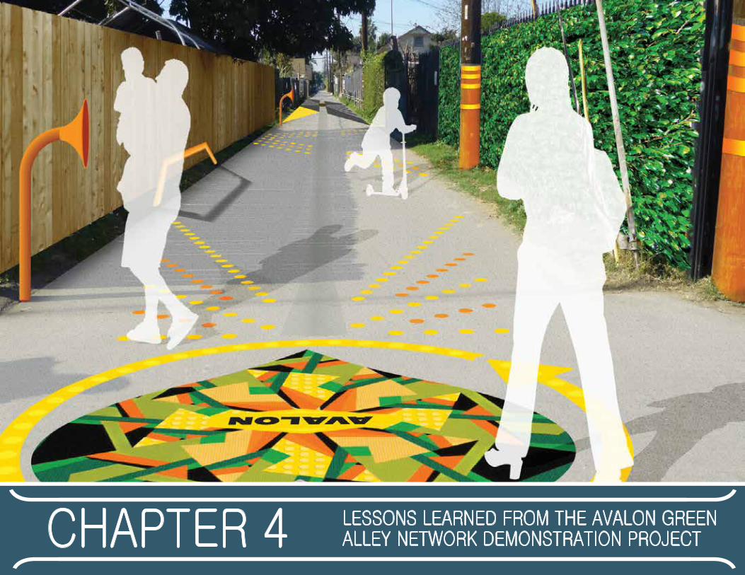
chapter 4 lessons leArned from the AvAlon green Alley network demonstrAtion project
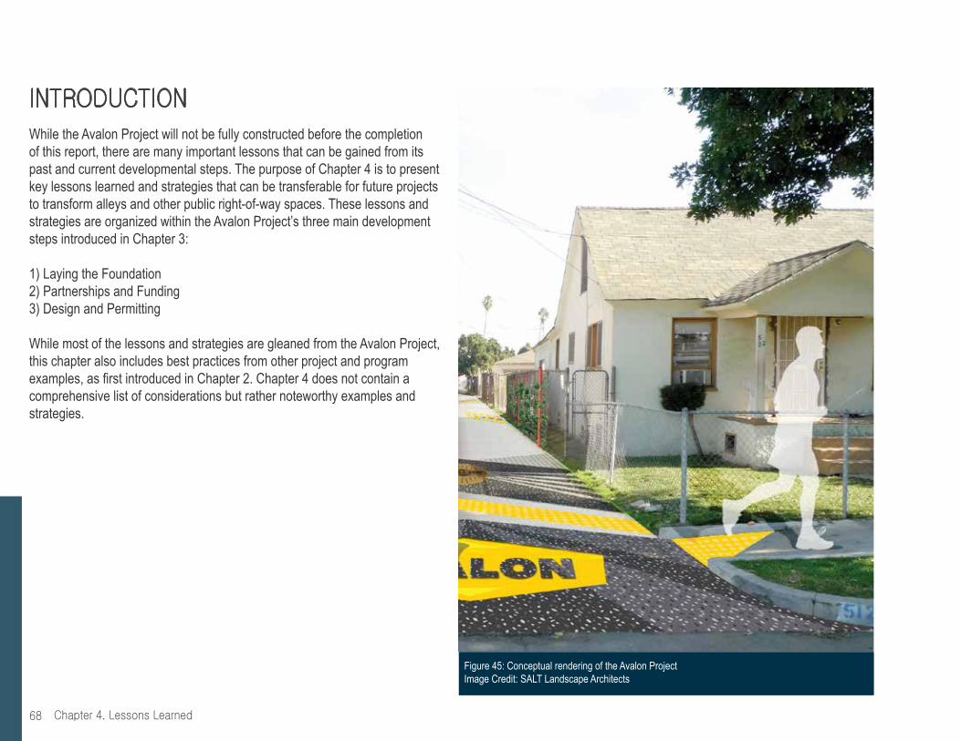
Chapter 4. Lessons Learned68
introdUctionWhile the Avalon Project will not be fully constructed before the completion of this report, there are many important lessons that can be gained from its past and current developmental steps. The purpose of Chapter 4 is to present key lessons learned and strategies that can be transferable for future projects to transform alleys and other public right-of-way spaces. These lessons and strategies are organized within the Avalon Project’s three main development steps introduced in Chapter 3:
1) Laying the Foundation2) Partnerships and Funding3) Design and Permitting
While most of the lessons and strategies are gleaned from the Avalon Project, this chapter also includes best practices from other project and program examples, as first introduced in Chapter 2. Chapter 4 does not contain a comprehensive list of considerations but rather noteworthy examples and strategies.
Figure 45: Conceptual rendering of the Avalon ProjectImage Credit: SALT Landscape Architects

69Chapter 4. Lessons Learned
1) Laying the Foundation
• Do your research. Research and data can help spur overall interest in transforming alleys, which is the case for Los Angeles. Here, university-driven research and design efforts helped initiate collaborations including the City’s Green Alley Sub-committee and subsequent actions that helped pave the way for the Avalon Green Alley Network. Additionally, initial research identified South Los Angeles as a park-poor neighborhood, which shaped the idea to transform a network of alleys into green open spaces for community and recreational purposes.
• Know the site. Site-specific studies can be an important next step. The Trust for Public Land conducted feasibility studies to assess current physical conditions of local alleys and identify which ones might be appropriate as part of the project network site.
• Develop objectives that align with city goals. Aligning the design of a green alley project with city guidelines and standards is clearly important for city approval but in addition, alignment with city goals and programs can contribute to obtaining funding and other important types of project support. In the early stages of development, The Trust for Public Land initiated multiple coordination meetings with several Los Angeles City departments to establish municipal support and to align the project with Citywide green infrastructure development. For example, the Avalon Project’s stormwater management features were designed to help address the City of Los Angeles’ Total Maximum Daily Load (TMDL) compliance for municipal stormwater programs with the Environmental Protection Agency for the Los Angeles River.
• Lead activities and events to encourage residents to become long-term stakeholders. A group of stakeholders that is part of the design and development process can also be part of the long-term maintenance plan. Community members involved in these early stages of the project will also have a role in the maintenance and long-term care of the alley network. For example, Alley Days of Service in the Avalon neighborhood will continue to involve alley clean up, graffiti abatement and community building. Other events, such as the Christmastime posada (potluck) and school events, as seen in Figure 46, have helped to create a social environment within the alley and ultimately increase alley usage. By integrating activities and events with maintenance, lead entities can encourage fun community participation.
Figure 46: Christmastime posada (potluck) Image Credit: The Trust for Public Land
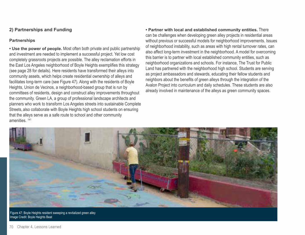
Chapter 4. Lessons Learned70
2) Partnerships and Funding
Partnerships
• Use the power of people. Most often both private and public partnership and investment are needed to implement a successful project. Yet low cost completely grassroots projects are possible. The alley reclamation efforts in the East Los Angeles neighborhood of Boyle Heights exemplifies this strategy (see page 28 for details). Here residents have transformed their alleys into community assets, which helps create residential ownership of alleys and facilitates long-term care (see Figure 47). Along with the residents of Boyle Heights, Union de Vecinos, a neighborhood-based group that is run by committees of residents, design and construct alley improvements throughout the community. Green LA, a group of professional landscape architects and planners who work to transform Los Angeles streets into sustainable Complete Streets, also collaborate with Boyle Heights high school students on ensuring that the alleys serve as a safe route to school and other community amenities. 141
• Partner with local and established community entities. There can be challenges when developing green alley projects in residential areas without previous or successful models for neighborhood improvements. Issues of neighborhood instability, such as areas with high rental turnover rates, can also affect long-term investment in the neighborhood. A model for overcoming this barrier is to partner with local established community entities, such as neighborhood organizations and schools. For instance, The Trust for Public Land has partnered with the neighborhood high school. Students are serving as project ambassadors and stewards, educating their fellow students and neighbors about the benefits of green alleys through the integration of the Avalon Project into curriculum and daily schedules. These students are also already involved in maintenance of the alleys as green community spaces.
Figure 47: Boyle Heights resident sweeping a revtialized green alley Image Credit: Boyle Heights Beat

71Chapter 4. Lessons Learned
• Transform local stakeholders into an established alley support team. The Trust for Public Land built community partners within the vicinity of the Avalon Green Alley Network Demonstration project because of the lack of existing community organizations. With TreePeople as a partner, The Trust for Public Land helped to transform the core group of stakeholders within the community into the Avalon Green Alley Team. Residents who come to five events or meetings an Avalon Green Alley Team receive a t-shirt, pictured in Figure 48, as recognition for their support and efforts. The Trust for Public Land has found that the simple element of a t-shirt has helped to form a movement within the community; Green Team members have a sense of identity and the beginnings of potential stewardship for future green alleys.
• Partner with municipal officials and departments. Finding a “local champion who invites collaboration and expanded ownership142” can be a challenging step in the green alley development process. Before planning for and implementing green alleys, it is important to think about city leadership. Make sure to talk to local elected officials and be prepared to succinctly explain the benefits that your proposal can bring to their constituents. It is important to think about what is already happening in city or county departments and their programs that could can integrate alleys into the conversation. The City of Chicago’s Green Alley Program and the City of Austin’s Green Alley Initiative demonstrate that green alleys can be institutionalized into city departments, such as public works, transportation and sustainability bureaus.
• Specifically involve the local police force. The local police force in South Los Angeles, the Los Angeles Police Department (LAPD) Newton Division, expressed initial skepticism towards the Avalon Project. However, by taking a participatory and educational approach to conveying the current uses and potential benefits of greening the alleys, the LAPD Newton Division became one of Avalon Project’s early key supporters that helped the effort to gain credibility (see Figure 49).143
Figure 48: Avalon Green Alley Team t-shirt Image Credit: The Trust for Public Land
Figure 49: Community residents and project partners connecting with local police force Image Credit: The Trust for Public Land
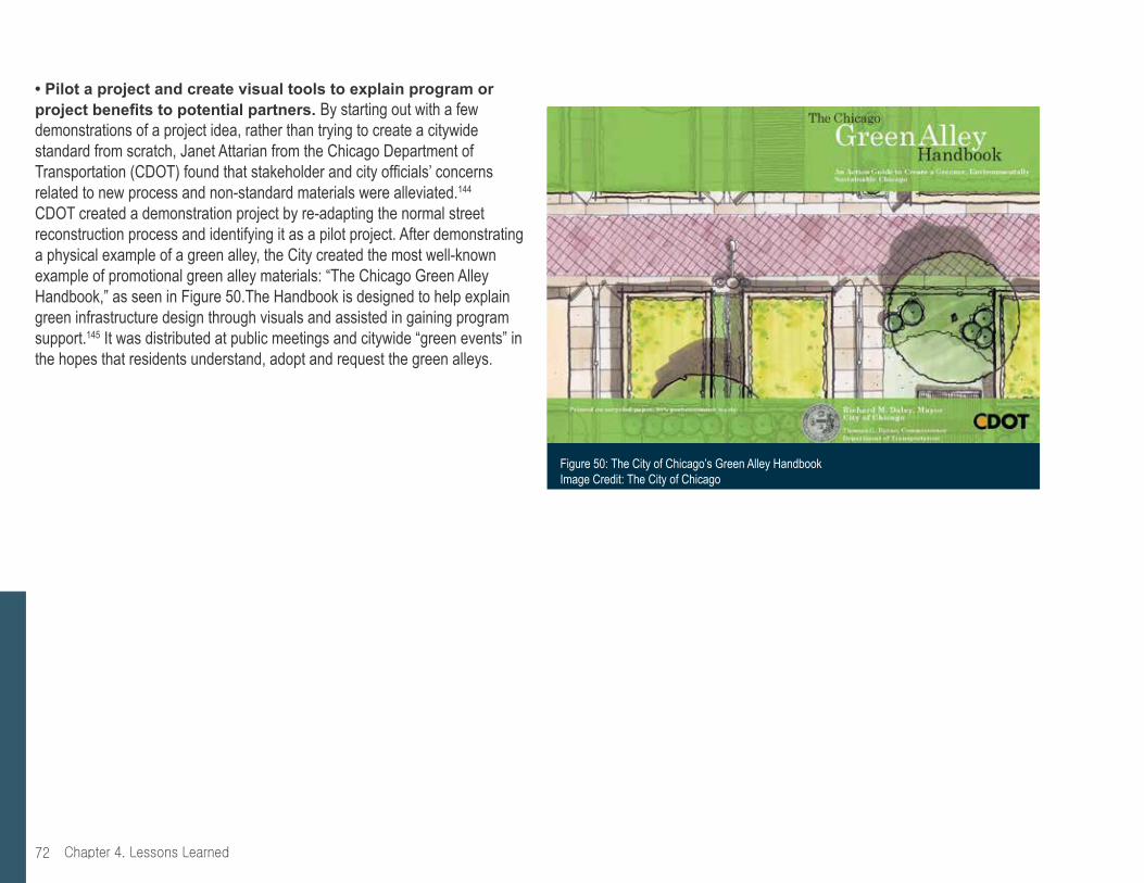
Chapter 4. Lessons Learned72
• Pilot a project and create visual tools to explain program or project benefits to potential partners. By starting out with a few demonstrations of a project idea, rather than trying to create a citywide standard from scratch, Janet Attarian from the Chicago Department of Transportation (CDOT) found that stakeholder and city officials’ concerns related to new process and non-standard materials were alleviated.144
CDOT created a demonstration project by re-adapting the normal street reconstruction process and identifying it as a pilot project. After demonstrating a physical example of a green alley, the City created the most well-known example of promotional green alley materials: “The Chicago Green Alley Handbook,” as seen in Figure 50.The Handbook is designed to help explain green infrastructure design through visuals and assisted in gaining program support.145 It was distributed at public meetings and citywide “green events” in the hopes that residents understand, adopt and request the green alleys.
Figure 50: The City of Chicago’s Green Alley Handbook Image Credit: The City of Chicago

73Chapter 4. Lessons Learned
Funding
• Partner with local businesses, business improvement districts or property owner alliances for support and funding. Green alleys can have economic benefits, including attracting pedestrian traffic, encouraging commercial activities and potentially increasing property values. If green alley development is framed as an economic development project, the effort can potentially be supported, funded and operated by surrounding commercial entities. The East Cahuenga Alley Revitalization Project (EaCa Alley), (see page 24 for further detail), is a commercial green alley with support and involvement from the Hollywood Property Owners Alliance (HPOA), the Hollywood Entertainment District and the Business Improvement District (BID) (see Figure 51).
• Develop a tiered system for improvements and create an achievable budget. While it is possible to obtain funding for an entire green alley project from a single source, if a project or program is multi-faceted, it may be necessary to develop a multi-faceted funding strategy. The Trust for Public Land developed a tiered system for design features, knowing that every alley segment could not receive the same level of improvements, thus prioritizing resources within a limited but achievable budget. For example, while TIER 1 alleys will have asphalt pavement replaced with permeable materials to reduce stormwater runoff as well as planted vegetation and espaliered fruit trees accented with public art, TIER 2 alleys will only be cleaned up and beautified with vines and artwork. The Trust for Public Land also plans to construct the green alleys in three difference phases because grant funding came in at different times for different components of the larger project. Funding sources includes a mix of local, state and federal grants as well as foundation grants.
• Municipal-led efforts will want to engage local residents through localized funding. Distributing funds to small, manageable geographies can enable customized, resident-driven green alley development. Examples of this funding strategy can be seen in the City of Chicago’s allocation of capital funds to its 50 wards, or neighborhoods. Residents within the wards vote on a menu of options for local improvements, including green alleys. Through developing and implementing green alleys in neighborhoods or districts in manners that encourage participation and design feedback, community members can also take on green alley stewardship.
Figure 51: Grand opening of the EaCa Alley in Hollywood with city officials and project partnersImage Credit: The Beverly Press
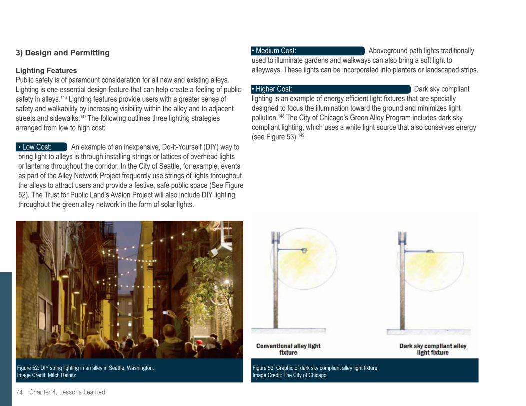
Chapter 4. Lessons Learned74
• Medium Cost: Aboveground path lights traditionally used to illuminate gardens and walkways can also bring a soft light to alleyways. These lights can be incorporated into planters or landscaped strips.
• Higher Cost: Dark sky compliant lighting is an example of energy efficient light fixtures that are specially designed to focus the illumination toward the ground and minimizes light pollution.148 The City of Chicago’s Green Alley Program includes dark sky compliant lighting, which uses a white light source that also conserves energy
(see Figure 53).149
3) Design and Permitting
Lighting FeaturesPublic safety is of paramount consideration for all new and existing alleys. Lighting is one essential design feature that can help create a feeling of public safety in alleys.146 Lighting features provide users with a greater sense of safety and walkability by increasing visibility within the alley and to adjacent streets and sidewalks.147 The following outlines three lighting strategies arranged from low to high cost:
• Low Cost: An example of an inexpensive, Do-it-Yourself (DIY) way to bring light to alleys is through installing strings or lattices of overhead lights or lanterns throughout the corridor. In the City of Seattle, for example, events as part of the Alley Network Project frequently use strings of lights throughout the alleys to attract users and provide a festive, safe public space (See Figure 52). The Trust for Public Land’s Avalon Project will also include DIY lighting throughout the green alley network in the form of solar lights.
Figure 53: Graphic of dark sky compliant alley light fixture Image Credit: The City of Chicago
Figure 52: DIY string lighting in an alley in Seattle, Washington. Image Credit: Mitch Reinitz

75Chapter 4. Lessons Learned
Figure 54: Alley closure, gained through permits from the City of Seattle, allow for events in Seattle’s alleys Image Credit: Kari Quaas
Other Safety Features
Whether an alley operates as a pedestrian-only space or as a shared street, it is important to include design features that make the intended users and uses of the alley clear.
• Low Cost: Orange cones and DIY signs communicating an alley’s function can be a simple, low-cost safety measure. For example, when Seattle’s Alley Network Project facilitates alley closures for events and projects, the International Sustainability Institute and other organizers obtain necessary alley closure permits and post signs, cones, and other visual safety barricades to denote alley closure to vehicle access (see Figure 54).
• Medium Cost: Re-painting a faded crosswalk or adding a painted pattern to a preexisting crosswalk can help create safe connections among green alleys. The Trust for Public Land has identified and prioritized crosswalks within the Avalon Project site so that outside stakeholders can implement improvements in the future. Along with crosswalk enhancements, The Trust for Public Land recommends implementing a suite of pedestrian enhancements to the Avalon Project and its environs to help create safe, pedestrian and cyclist-friendly spaces.
• Higher Cost: Installing fixed or removable bollards or signs outside of the alley can help to demarcate the space and communicate the alley’s function. The Avalon Project incorporates removable bollards for the purpose of added pedestrian safety as well as extensive street tree planting.157

Chapter 4. Lessons Learned76
Sustainable Green Features
Green features can range from light vegetation to sophisticated stormwater management infrastructure. Such sustainable green features can help to create an inviting public space for people to walk, bike, play and build community.
• Low Cost: Planters with native vegetation can support biodiversity, reduce irrigation needs and provide aesthetic value to the project. Building planters can be low-cost and simpler to maintain than full landscaping. Boyle Heights’ residents built movable planters while also providing mechanisms for blocking vehicle access to alleys during events (see Figures 55 and 56). The Avalon Project is planting fruit-producing vines to add greenery and provide residents with fresh fruit without impeding vehicle access.
Figure 56: Movable planters add greenery and help block vehicle access to alley during alley events Image Credit: Kris Fortin/LAStreetsblog
Figure 55: Resident-designed and constructed movable planter Image Credit:: Kris Fortin/LAStreetsblog
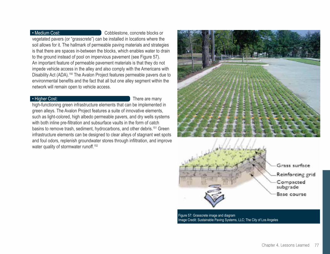
77Chapter 4. Lessons Learned
Figure 57: Grasscrete image and diagram Image Credit: Sustainable Paving Systems, LLC; The City of Los Angeles
• Medium Cost: Cobblestone, concrete blocks or vegetated pavers (or “grasscrete”) can be installed in locations where the soil allows for it. The hallmark of permeable paving materials and strategies is that there are spaces in-between the blocks, which enables water to drain to the ground instead of pool on impervious pavement (see Figure 57). An important feature of permeable pavement materials is that they do not impede vehicle access in the alley and also comply with the Americans with Disability Act (ADA).150 The Avalon Project features permeable pavers due to environmental benefits and the fact that all but one alley segment within the network will remain open to vehicle access.
• Higher Cost: There are many high-functioning green infrastructure elements that can be implemented in green alleys. The Avalon Project features a suite of innovative elements, such as light-colored, high albedo permeable pavers, and dry wells systems with both inline pre-filtration and subsurface vaults in the form of catch basins to remove trash, sediment, hydrocarbons, and other debris.151 Green infrastructure elements can be designed to clear alleys of stagnant wet spots and foul odors, replenish groundwater stores through infiltration, and improve water quality of stormwater runoff.152
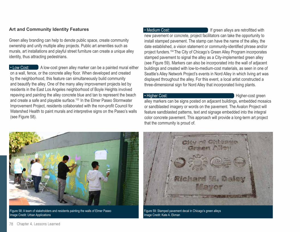
Chapter 4. Lessons Learned78
• Medium Cost: If green alleys are retrofitted with new pavement or concrete, project facilitators can take the opportunity to install stamped pavement. The stamp can have the name of the alley, the date established, a vision statement or community-identified phrase and/or project funders.154 The City of Chicago’s Green Alley Program incorporates stamped pavement to signal the alley as a City-implemented green alley (see Figure 59). Markers can also be incorporated into the wall of adjacent buildings and created with low-to-medium-cost materials, as seen in one of Seattle’s Alley Network Project’s events in Nord Alley in which living art was displayed throughout the alley. For this event, a local artist constructed a three-dimensional sign for Nord Alley that incorporated living plants.
• Higher Cost: Higher-cost green alley markers can be signs posted on adjacent buildings, embedded mosaics or sandblasted imagery or words on the pavement. The Avalon Project will feature sandblasted patterns, text and signage embedded into the integral color concrete pavement. This approach will provide a long-term art project that the community is proud of.
Art and Community Identity Features
Green alley branding can help to denote public space, create community ownership and unify multiple alley projects. Public art amenities such as murals, art installations and playful street furniture can create a unique alley identity, thus attracting pedestrians.
• Low Cost: A low-cost green alley marker can be a painted mural either on a wall, fence, or the concrete alley floor. When developed and created by the neighborhood, this feature can simultaneously build community and beautify the alley. One of the many alley improvement projects led by residents in the East Los Angeles neighborhood of Boyle Heights involved repaving and painting the alley concrete blue and tan to represent the beach and create a safe and playable surface.153 In the Elmer Paseo Stormwater Improvement Project, residents collaborated with the non-profit Council for Watershed Health to paint murals and interpretive signs on the Paseo’s walls (see Figure 58).
Figure 58: A team of stakeholders and residents painting the walls of Elmer Paseo Image Credit: Urban Applications
Figure 59: Stamped pavement decal in Chicago’s green alleys Image Credit: Kate A. Ekman
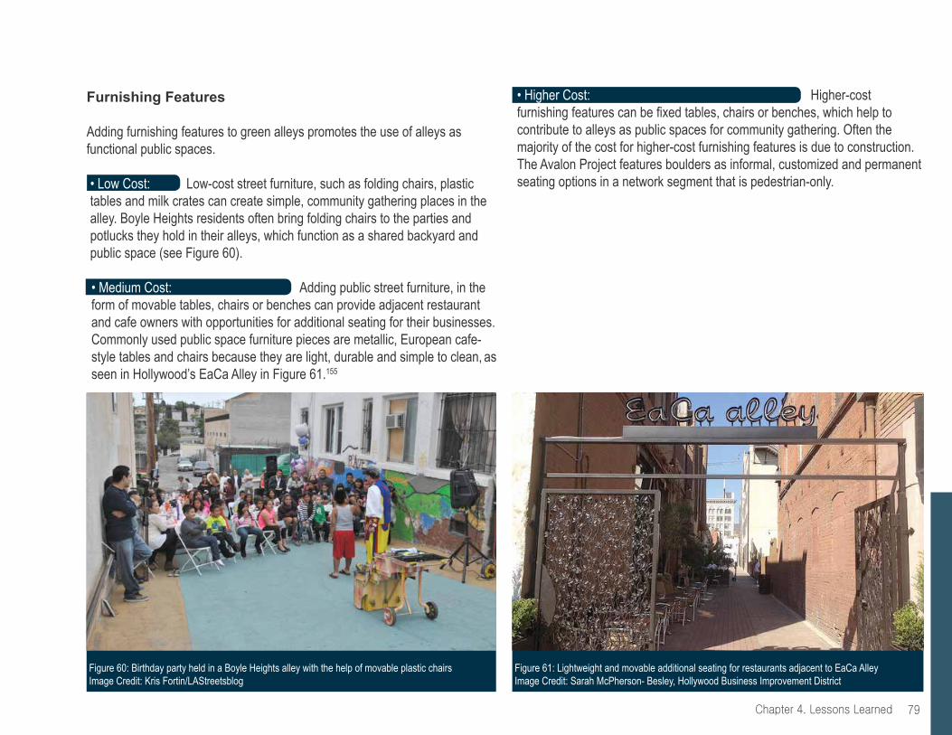
79Chapter 4. Lessons Learned
• Higher Cost: Higher-cost furnishing features can be fixed tables, chairs or benches, which help to contribute to alleys as public spaces for community gathering. Often the majority of the cost for higher-cost furnishing features is due to construction. The Avalon Project features boulders as informal, customized and permanent seating options in a network segment that is pedestrian-only.
Figure 60: Birthday party held in a Boyle Heights alley with the help of movable plastic chairs Image Credit: Kris Fortin/LAStreetsblog
Figure 61: Lightweight and movable additional seating for restaurants adjacent to EaCa Alley Image Credit: Sarah McPherson- Besley, Hollywood Business Improvement District
Furnishing Features
Adding furnishing features to green alleys promotes the use of alleys as functional public spaces.
• Low Cost: Low-cost street furniture, such as folding chairs, plastic tables and milk crates can create simple, community gathering places in the alley. Boyle Heights residents often bring folding chairs to the parties and potlucks they hold in their alleys, which function as a shared backyard and public space (see Figure 60).
• Medium Cost: Adding public street furniture, in the form of movable tables, chairs or benches can provide adjacent restaurant and cafe owners with opportunities for additional seating for their businesses. Commonly used public space furniture pieces are metallic, European cafe-style tables and chairs because they are light, durable and simple to clean, as seen in Hollywood’s EaCa Alley in Figure 61.155

Chapter 4. Lessons Learned80
Permitting
• Design a temporary, pilot or demonstration project. Obtaining city permits is among the most cited challenges in project implementation. Building in the public right-of-way, like alleyways, involves specific processes and designated city departments. Standardization within public right-of-way projects makes it challenging for stakeholders outside of city departments to instigate and participate in improvement efforts. First approaching your green alley efforts as a pilot or temporary demonstration can help overcome concerns among city departments and ultimately streamline permitting and institutionalize a green alley program. The Avalon Project took this approach.
• Build the process to develop green alleys if there isn’t one already. Developing green alleys is not always a challenging undertaking if there is a designated process in place. If there is a clear process for implementing green alleys, project facilitators simply follow the steps. This was not the case for The Trust for Public Land in the creation of the Avalon Project. As a non-profit organization approaching the City about a first-of-its-kind project with elements that deviate from the standard processes of public right-of-way projects, The Trust for Public Land had to navigate and demonstrate the approval process. The result of this process is a better understanding of City regulations, processes and parameters for future green alley projects. While the Avalon Project complies with permit requirements of various City departments, The Trust for Public Land has found that there are significant challenges that need addressing when obtaining permitting for wide-scale replication across the city.
Figure 62: Reception for adjacent gallery in a Seattle, Washington alley Image Credit: Mira Poling
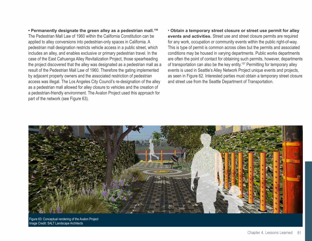
81Chapter 4. Lessons Learned
• Permanently designate the green alley as a pedestrian mall.156 The Pedestrian Mall Law of 1960 within the California Constitution can be applied to alley conversions into pedestrian-only spaces in California. A pedestrian mall designation restricts vehicle access in a public street, which includes an alley, and enables exclusive or primary pedestrian travel. In the case of the East Cahuenga Alley Revitalization Project, those spearheading the project discovered that the alley was designated as a pedestrian mall as a result of the Pedestrian Mall Law of 1960. Therefore the gating implemented by adjacent property owners and the associated restriction of pedestrian access was illegal. The Los Angeles City Council’s re-designation of the alley as a pedestrian mall allowed for alley closure to vehicles and the creation of a pedestrian-friendly environment. The Avalon Project used this approach for part of the network (see Figure 63).
• Obtain a temporary street closure or street use permit for alley events and activities. Street use and street closure permits are required for any work, occupation or community events within the public right-of-way. This is type of permit is common across cities but the permits and associated conditions may be housed in varying departments. Public works departments are often the point of contact for obtaining such permits, however, departments of transportation can also be the key entity.157 Permitting for temporary alley events is used in Seattle’s Alley Network Project unique events and projects, as seen in Figure 62. Interested parties must obtain a temporary street closure and street use from the Seattle Department of Transportation.
Figure 63: Conceptual rendering of the Avalon Project Image Credit: SALT Landscape Architects

Chapter 4. Lessons Learned82
chAllenges, solUtions And opportUnitiesThe following page offers a visual tool summarizing key lessons learned from the Avalon Green Alley Network Demonstration Project. The objective is to summarize current development to help support future green alley projects overcome challenges. The Avalon Project turned challenges into opportunities, as the following graphic illustrates.
Design Exploration
Figure 64: Design exploration for features of the Avalon Project Image Credit: The Trust for Public Land

83Chapter 4. Lessons Learned
Alleys were places known for illegal dumping, and gang activity.
Engage the Avalon Green Team to improve alley cleanliness, post “No Dumping” signs during cleaning events and partner with Maya Angelou High School to paint murals on alley network walls.
Cleaner and clearer alleys that promote local stewardship prior to physical improvements.
The degraded state of the alleys made it difficult for residents to look beyond existing conditions and imagine green, improved alleys.
Organize and facilitate monthly platicas, or informal talks or lectures, to provide visuals of green alley possibilities and share information on how residents can green their alleys.
A community-shaped green alley network with amenities and designs that reflect residents’ preferences.
A lack of existing community organizations within the area to collaborate with as project partners.
Directly engage with and empower local residents. One way to reach youth is to partner with local schools. Give residents opportunities to shape the project and drive efforts forward.
Resident-led Alley Days of Service cleaning events evolved and expanded into the Avalon Green Alley Team - a resident-driven group of community members who lead cleaning events and tree planting throughout the area.
chAllenge solUtion opportUnity
Incomplete parameters and criteria for an innovative, first-of-its-kind residential green alley network within the City of Los Angeles.
Develop and define parameters and criteria through multiple coordination meetings with various city departments.
A development process that can promote green alley network replication throughout the city of Los Angeles.
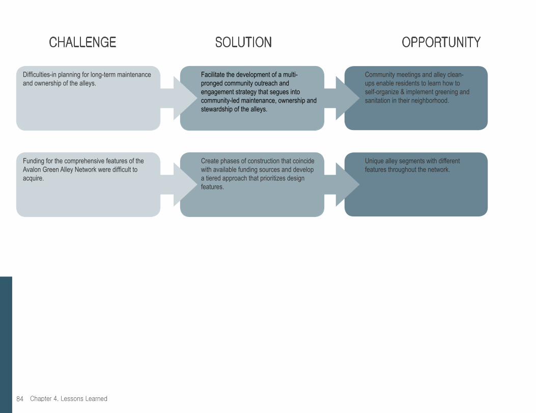
Chapter 4. Lessons Learned84
Difficulties-in planning for long-term maintenance and ownership of the alleys.
Facilitate the development of a multi-pronged community outreach and engagement strategy that segues into community-led maintenance, ownership and stewardship of the alleys.
Community meetings and alley clean-ups enable residents to learn how to self-organize & implement greening and sanitation in their neighborhood.
Funding for the comprehensive features of the Avalon Green Alley Network were difficult to acquire.
Create phases of construction that coincide with available funding sources and develop a tiered approach that prioritizes design features.
Unique alley segments with different features throughout the network.
chAllenge solUtion opportUnity
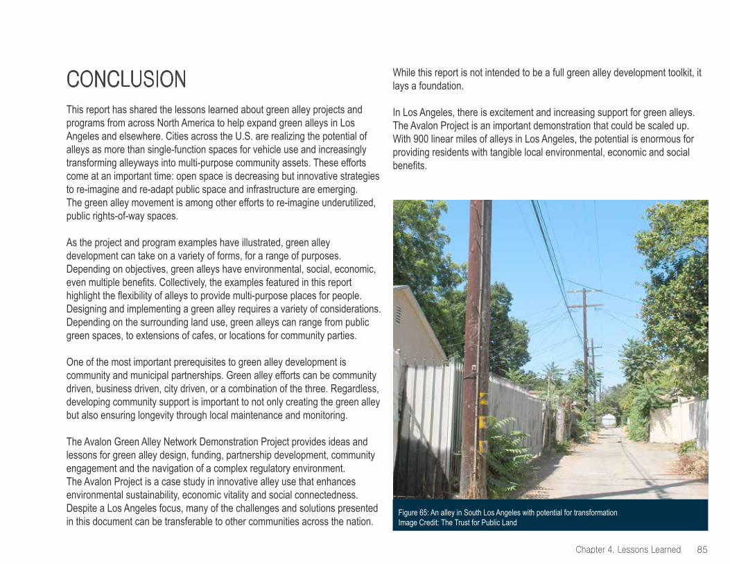
opportUnityconclUsionThis report has shared the lessons learned about green alley projects and programs from across North America to help expand green alleys in Los Angeles and elsewhere. Cities across the U.S. are realizing the potential of alleys as more than single-function spaces for vehicle use and increasingly transforming alleyways into multi-purpose community assets. These efforts come at an important time: open space is decreasing but innovative strategies to re-imagine and re-adapt public space and infrastructure are emerging. The green alley movement is among other efforts to re-imagine underutilized, public rights-of-way spaces.
As the project and program examples have illustrated, green alley development can take on a variety of forms, for a range of purposes. Depending on objectives, green alleys have environmental, social, economic, even multiple benefits. Collectively, the examples featured in this report highlight the flexibility of alleys to provide multi-purpose places for people. Designing and implementing a green alley requires a variety of considerations. Depending on the surrounding land use, green alleys can range from public green spaces, to extensions of cafes, or locations for community parties.
One of the most important prerequisites to green alley development is community and municipal partnerships. Green alley efforts can be community driven, business driven, city driven, or a combination of the three. Regardless, developing community support is important to not only creating the green alley but also ensuring longevity through local maintenance and monitoring.
The Avalon Green Alley Network Demonstration Project provides ideas and lessons for green alley design, funding, partnership development, community engagement and the navigation of a complex regulatory environment. The Avalon Project is a case study in innovative alley use that enhances environmental sustainability, economic vitality and social connectedness. Despite a Los Angeles focus, many of the challenges and solutions presented in this document can be transferable to other communities across the nation.
While this report is not intended to be a full green alley development toolkit, it lays a foundation.
In Los Angeles, there is excitement and increasing support for green alleys. The Avalon Project is an important demonstration that could be scaled up. With 900 linear miles of alleys in Los Angeles, the potential is enormous for providing residents with tangible local environmental, economic and social benefits.
85
Figure 65: An alley in South Los Angeles with potential for transformation Image Credit: The Trust for Public Land
chapter 4. lessons learned

endnotes141 “About Living Streets LA.” Living Streets LA. N.p., n.d. Web. 21 Jan. 2015.142 “A Tale of Three Alleys: Integrating Green Infrastructure in Diverse Neighborhoods.” American Landscape Architects Annual Meeting handout. 2013.143 Ballock, Laura. Project Manager for the Parks for People program for The Trust for Public Land. In-person interview. 4 Sept. 2014.144 Arvidson, Adam. “Unseen Green.” Treeline: The Story of Your Land. Landscape Architecture, September, 2008, 2008. Web. 21 Jan. 2015.145 Ibid.146 “Urban Street Design Guide.” Green Alley. National Association of City Transportation Official, n.d. Web. 21 Jan. 2015.147 Cassidy, Arly, Newell, Josh Newell, and Wolch, Jennifer. Transforming Alleys into Green Infrastructure for Los Angeles. Rep. Los Angeles: Center for Sustainable Cities, U of Southern California, 2008. Print148 Ibid.149 “Green Alley Program Handbook: An Action Guide to Create a Greener, Environmentally Sustainable Chicago.” The City of Chicago, Department of Transportation. 2010150 Ballock, Laura. Project Manager for the Parks for People program for The Trust for Public Land. In-person interview. 4 Sept. 2014151 “NOAA Federal Funding Opportunity Grant.” The Trust for Public Land Climate Smart Cities Initiative: City of Los Angeles Green Alley Network Assessment Project. 152 Ballock, Laura. Project Manager for the Parks for People program for The Trust for Public Land. In-person interview. 4 Sept. 2014153 Cancian, Steve Rasmmusen. Telephone interview. 6 Sept. 2014154 Burgos, Lila and Sarkisian,Tamar. East Cahuenga Alley Revitalization Project: Best Practices for Creating a Pedestrian-Friendly Urban Alley. October 2013. Los Angeles Sustainability Collaborative. 155 Ibid; Loukaitou-Sideris, Anastasia, Callahan, Colleen and Brozen, Madeline. Reclaiming the Right of Way: A Toolkit for Creating and Implementing Parklets. Rep. Los Angeles: UCLA Luskin School of Public Affairs, September 2012. Print.156 Burgos, Lila and Sarkisian,Tamar. East Cahuenga Alley Revitalization Project:
Best Practices for Creating a Pedestrian-Friendly Urban Alley. October 2013. Los Angeles Sustainability Collaborative.; California Codes (shc:11000-11011).” CA Codes (shc:11000-11011). N.p., n.d. Web. 21 Jan. 2015.157 Stenning, Liz and Somers, Nikki. “Alley Event Handbook.” The Alley Network Project. 2012
Chapter page image credit: SALT Landscape ArchitectsBack cover page image credit: SALT Landscape Architects
86 chapter 4. lessons learned