Testing the US Integrated Ocean Observing System Data Discovery and Distribution Infrastructure with...
13
Testing the US Integrated Ocean Observing System Data Discovery and Distribution Infrastructure with Real-World Problems Derrick Snowden 1 , Rich Signell 2 , Kelly Knee 3 , Will Koeppen 4 , John Kupiec 5 , Andy Bird 3 , Bob Fratantonio 3 , Kyle Wilcox 4 1 NOAA/US Integrated Ocean Observing System Program 2 USGS 3 RPS/Applied Science Associates 4 LMI Inc 5 Axiom Data Science LLC IN32A-02 #AGU14: github.com/ioos/system- test 1 usioosgov @usioosgov
-
Upload
clifford-richards -
Category
Documents
-
view
213 -
download
0
Transcript of Testing the US Integrated Ocean Observing System Data Discovery and Distribution Infrastructure with...
1
Testing the US Integrated Ocean Observing System Data Discovery and Distribution Infrastructure with Real-World
Problems
Derrick Snowden1, Rich Signell2, Kelly Knee3, Will Koeppen4, John Kupiec5, Andy Bird3, Bob Fratantonio3, Kyle Wilcox4
1 NOAA/US Integrated Ocean Observing System Program 2 USGS3 RPS/Applied Science Associates 4 LMI Inc5 Axiom Data Science LLC
IN32A-02 #AGU14: github.com/ioos/system-test
usioosgov
@usioosgov
IN32A-02 #AGU14: github.com/ioos/system-test
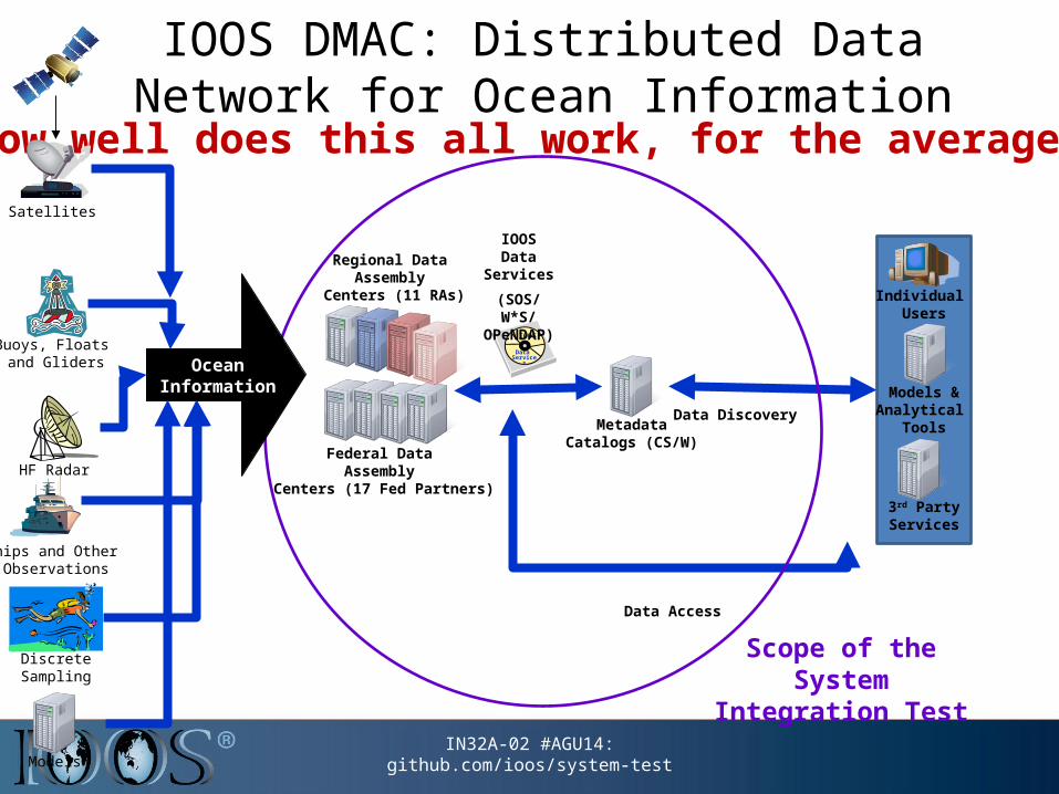
Individual Users
3rd PartyServices
Models &Analytical
Tools
Federal Data Assembly
Centers (17 Fed Partners)
Regional Data Assembly
Centers (11 RAs)
Data Access
MetadataCatalogs (CS/W)
Data Discovery
IOOS
Data Services
IOOS Data Services
(SOS/ W*S/ OPeNDAP)
Scope of the System Integration Test
IOOS DMAC: Distributed Data Network for Ocean Information
How well does this all work, for the average user?
Ships and Other Observations
Discrete Sampling
Models
Satellites
HF Radar
Buoys, Floats and Gliders Ocean
Information
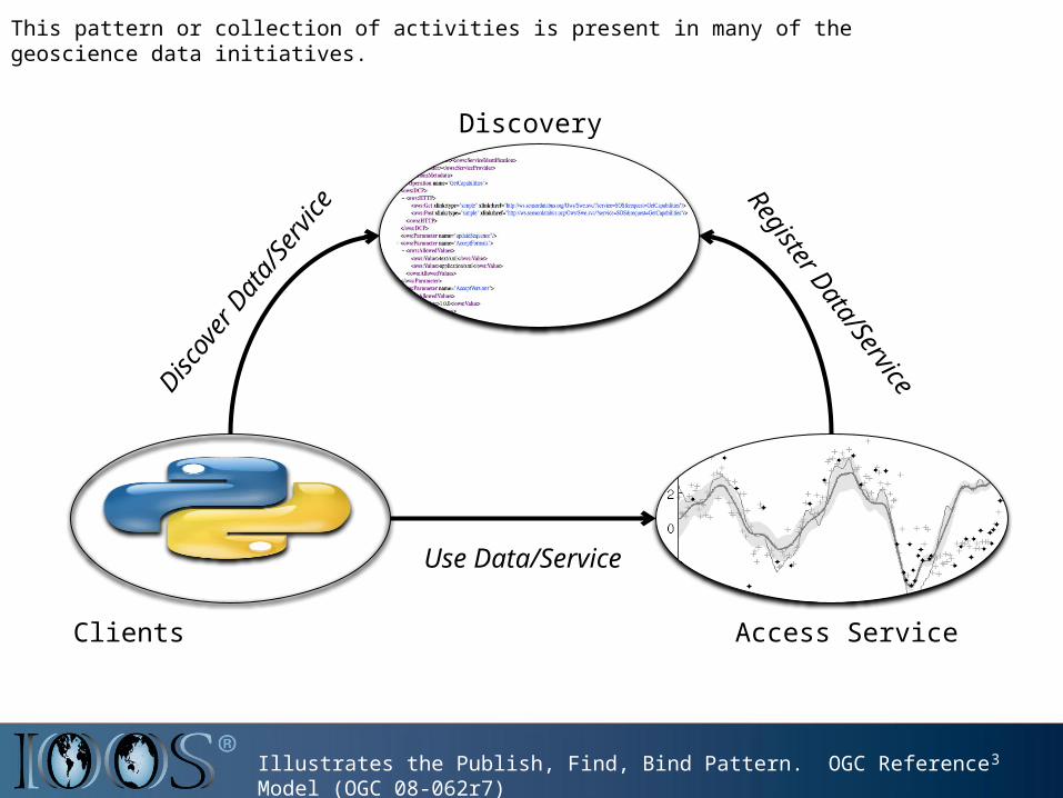
This pattern or collection of activities is present in many of the geoscience data initiatives.
3Illustrates the Publish, Find, Bind Pattern. OGC Reference Model (OGC 08-062r7)
Discov
er D
ata/
Servic
e Register D
ata/ServiceDiscovery
Use Data/Service
Access ServiceClients

IN32A-02 #AGU14: github.com/ioos/system-test
Theme based approach to testing the DMAC system
1. Baseline assessment of service capabilities
2. Extreme Events: e.g. severe storms
3. Species and Habitat
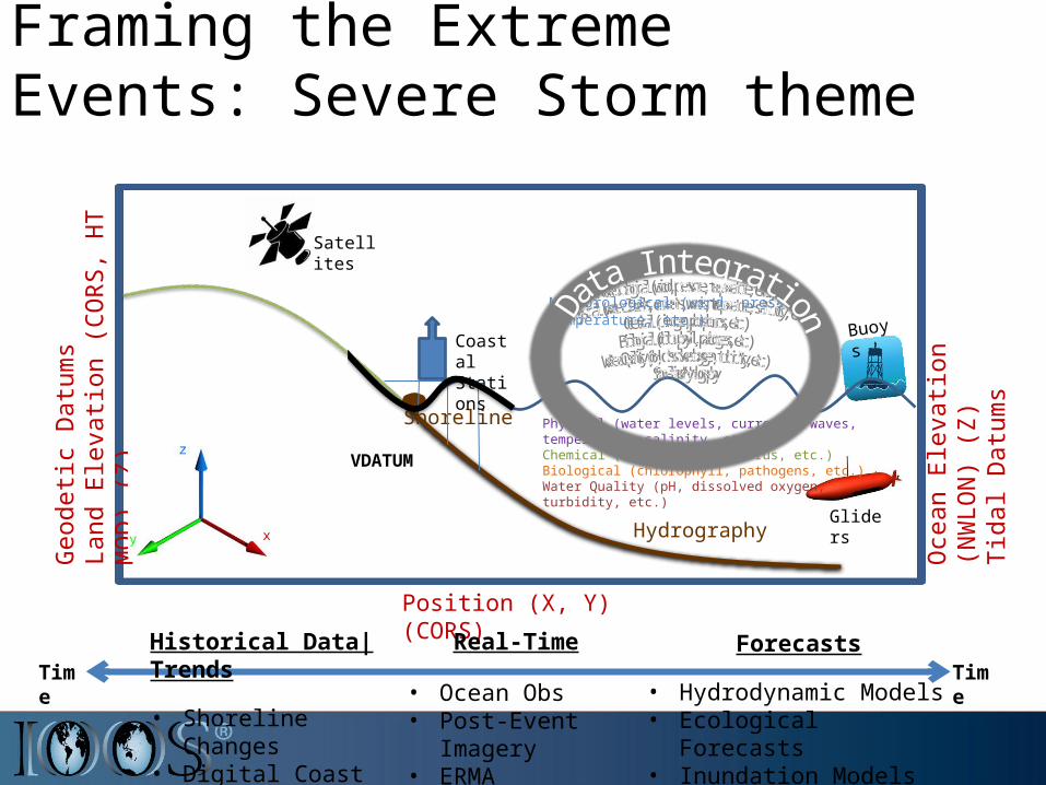
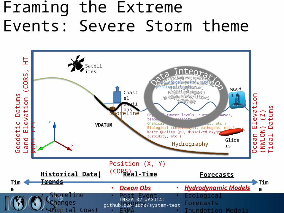
GlidersHydrography
Shoreline
Framing the Extreme Events: Severe Storm theme
Oce
an E
leva
tion
(NW
LON
) (Z)
Tida
l Dat
ums
Geo
detic
Dat
ums
Land
Ele
vatio
n (C
ORS
, HT
MO
D) (
Z)
Position (X, Y) (CORS)
Physical (water levels, currents, waves, temperature, salinity, etc.)Chemical (nitrogen, phosphorus, etc.)Biological (chlorophyll, pathogens, etc.)Water Quality (pH, dissolved oxygen, turbidity, etc.)
BuoysCoastal Stations
VDATUM
TimeTimeHistorical Data|Trends
• Shoreline Changes• Digital Coast• Sea Level Trends
Forecasts
• Hydrodynamic Models• Ecological Forecasts• Inundation Models
Real-Time
• Ocean Obs• Post-Event Imagery• ERMA
Meteorological (wind, pressure, temperature, etc.)
Satellites
IN32A-02 #AGU14: github.com/ioos/system-test
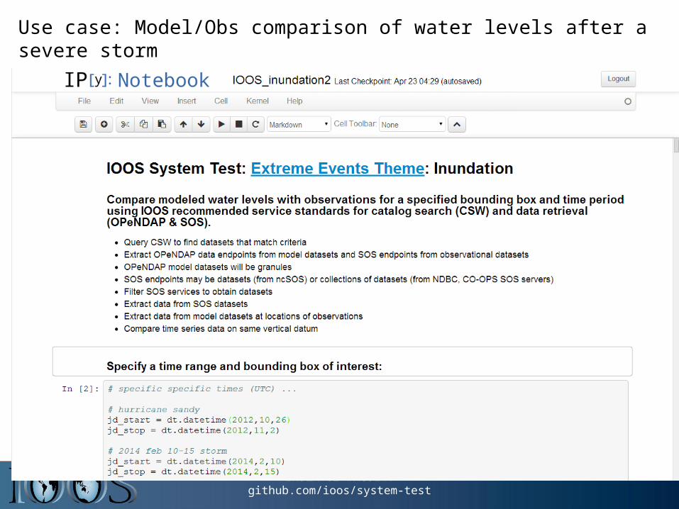
Use case: Model/Obs comparison of water levels after a severe storm
IN32A-02 #AGU14: github.com/ioos/system-test
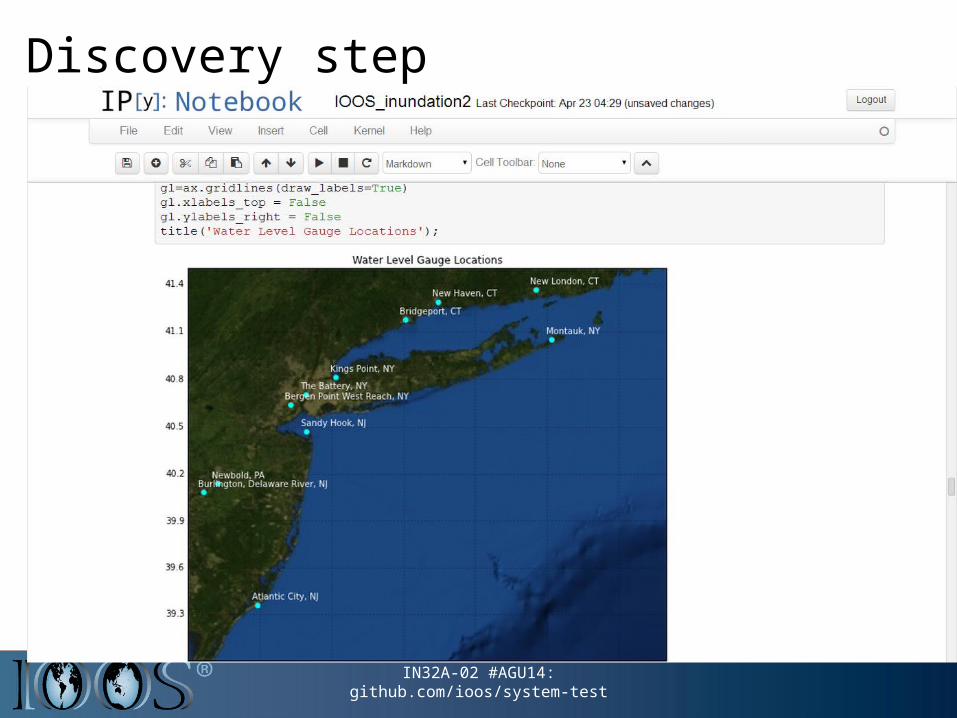
Discovery step

Access and Use step

Selected Results from Water Level Notebook
• Registration of missing model results in Service Registry
• Corrected improper aggregation and metadata at CO-OPS
• Identified mean model bias (e.g. 40 cm for FVCOM)
• Introduction of vertical datum metadata concepts into CF discussion
• Identification (and partial fix) of software treatment of free surfaces
https://github.com/ioos/system-test/issues/82
11
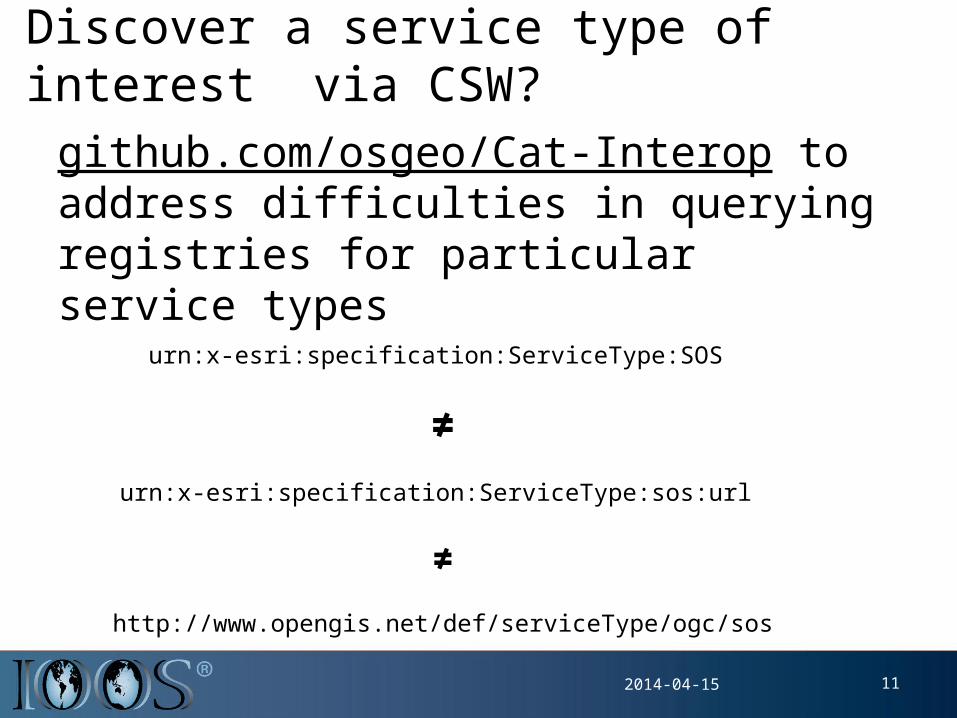
Discover a service type of interest via CSW?
github.com/osgeo/Cat-Interop to address difficulties in querying registries for particular service types
2014-04-15
urn:x-esri:specification:ServiceType:SOS
≠
urn:x-esri:specification:ServiceType:sos:url
≠
http://www.opengis.net/def/serviceType/ogc/sos
12
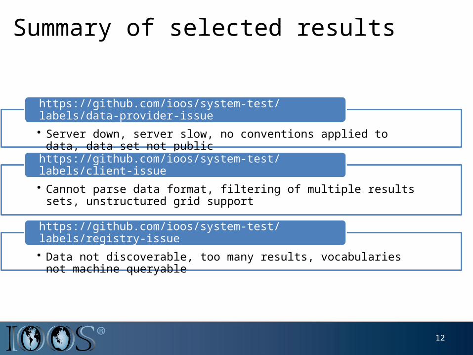
Summary of selected results
• Server down, server slow, no conventions applied to data, data set not public
https://github.com/ioos/system-test/labels/data-provider-issue
• Cannot parse data format, filtering of multiple results sets, unstructured grid support
https://github.com/ioos/system-test/labels/client-issue
• Data not discoverable, too many results, vocabularies not machine queryable
https://github.com/ioos/system-test/labels/registry-issue
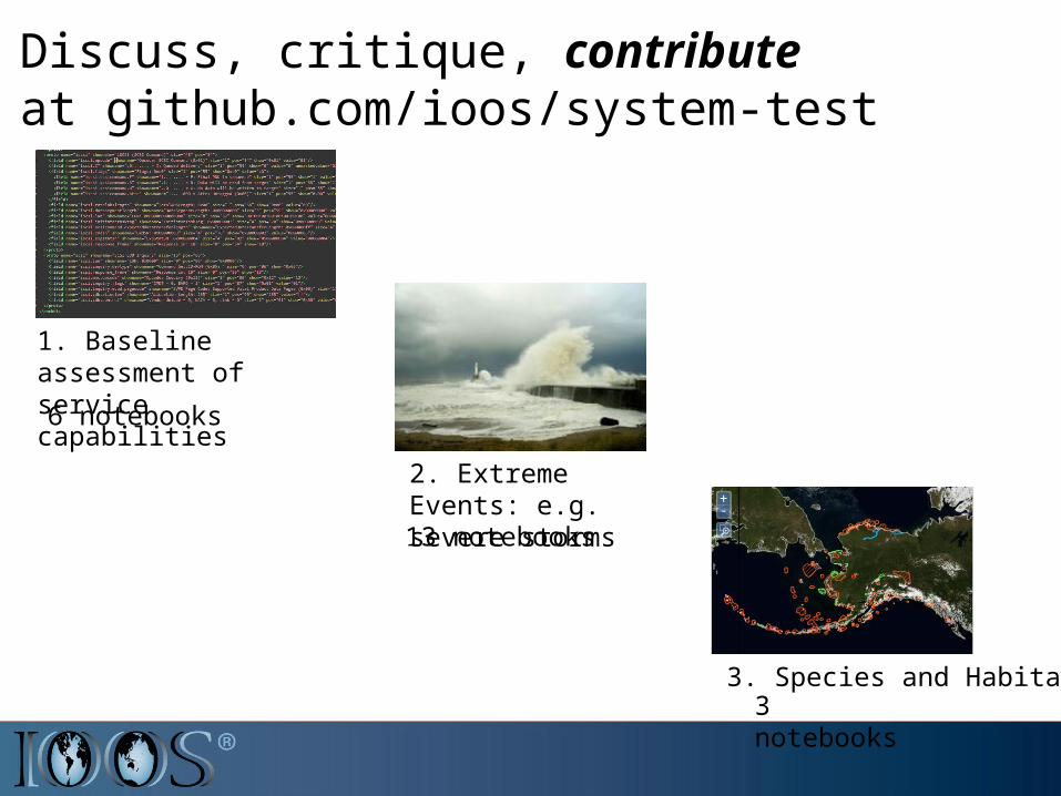
Discuss, critique, contribute at github.com/ioos/system-test
1. Baseline assessment of service capabilities
2. Extreme Events: e.g. severe storms
3. Species and Habitat
6 notebooks
13 notebooks
3 notebooks
![[Karl L. Signell] Makam Modal Practice in Turkish](https://static.fdocuments.in/doc/165x107/553ef245550346136d8b467e/karl-l-signell-makam-modal-practice-in-turkish.jpg)