
Theory of Plate Tectonics Plate Tectonics Plate Boundaries Causes of Plate Tectonics.
Upload
puputrahsetyoCategory
view
215download
1description

Tectonics of Molucca Sea
Of seismicity, bathymetry and magmatism
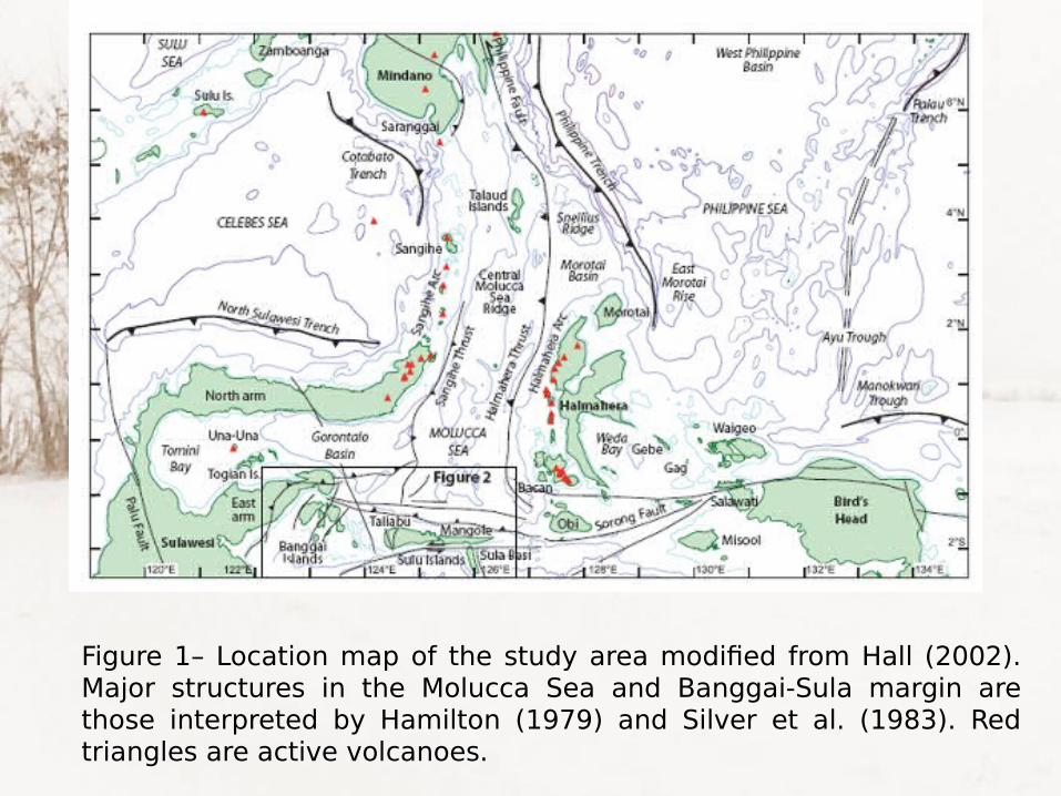
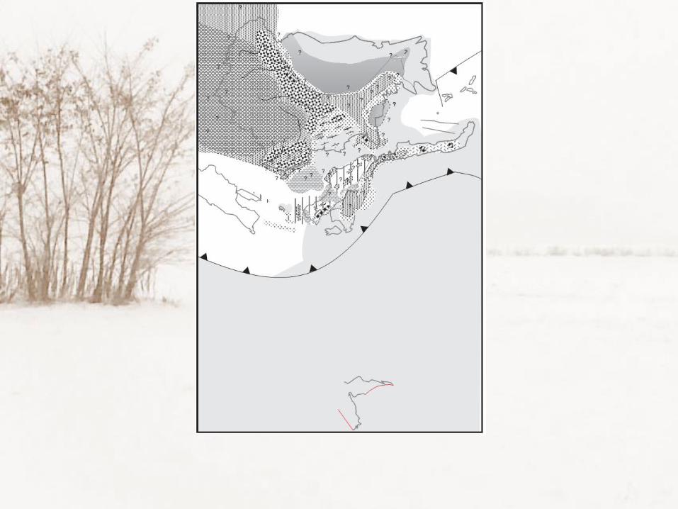
Figure 1– Location map of the study area modified from Hall (2002). Major structures in the Molucca Sea and Banggai-Sula margin are those interpreted by Hamilton (1979) and Silver et al. (1983). Red triangles are active volcanoes.
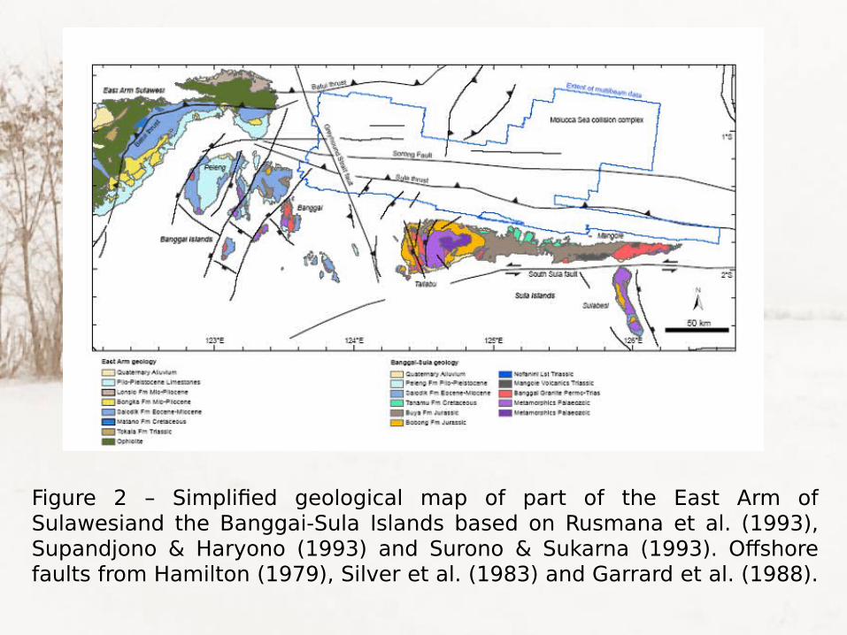
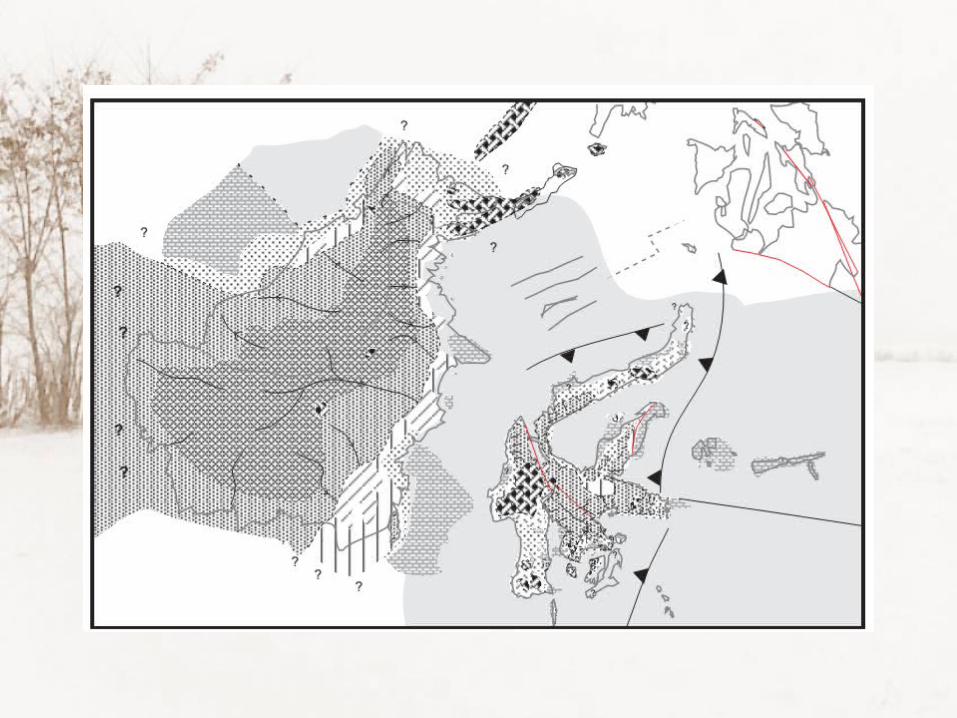
Figure 2 – Simplified geological map of part of the East Arm of Sulawesiand the Banggai-Sula Islands based on Rusmana et al. (1993), Supandjono & Haryono (1993) and Surono & Sukarna (1993). Offshore faults from Hamilton (1979), Silver et al. (1983) and Garrard et al. (1988).

Model laut MalukuHamilton
Telah berkembang subduksi ke arah timur (di sebelah timur Minahasa dan subduksi ke arah barat (di se-belah barat Halmahera), yang men-dorong subducting plate dengan 2 Benioff zone yang berlawanan arah (gambar bawah).
Di masa mendatang daerah ini akan mengalami subsidense (penurunan), sehingga Laut Maluku akan semakin dalam.
Secara geodinamika, gerakan ini mungkin agak sukar terakomodasi karena harus ada subsidence pada lempeng yang bawah.
Figure 3 from Waluyo, 1991
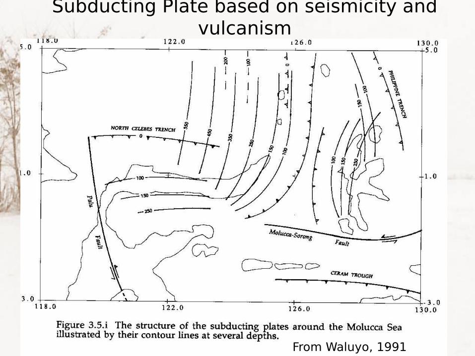
Subducting Plate based on seismicity and vulcanism
From Waluyo, 1991

Segmentation based on seismicity

Segmentation based on seismicity

Kemiringan subducting plate segmen M01-M05Di bawah segmen M04 dan M05 (Teluk Gorontalo), juga dijumpai 2 subduksi yang saling bertemu dan tenggelam bersama, seperti yang dijumpai di Banda arc.
Subduksi ini berasal dari palung Sulawesi Utara yang berarah selatan-tenggara dan dari sebelah timur-tenggara Minahasa yang berarah barat-baratlaut.
Tetapi sistem tektonik ini agak berbeda dengan yang di Banda arc, karena 2 subduksi di sana berjarak cukup jauh (dipisahkan oleh semenanjung Minahasa). Sedang di Banda arc langsung bertemu dan tenggelam bersama.
Dua subduksi yang bertemu di bawah segmen M04 dan M05 ini mungkin berhubungan dengan keberadaan Cekungan Gorontalo yang sangat dalam.
Gunung Una-una terletak di segmen M02 berhubungan dengan subduksi dari utara.

Kemiringan subducting plate segmen M06-M09
Di bawah segmen M06-M09 (Seb utara Minahasa), dijum-pai subduksi dari sebelah timur , dg Benioff zone yang berkembang dg ideal, sampai kedalaman 600 km.
Di bawah segmen yang paling utara (M06), walaupun agak spekulatif, dapat disimpulkan adanya subduksi yang lebih kecil disebelah barat sub-duksi utama. Keberadaan sub- duksi ini diperkuat oleh ada- nya sebuah gunungapi di Laut Sulawesi.

Kemiringan subducting plate segmen M10-M13
Di bawah sektor M10-M13 (Minahasa), subduksi dari timur masih terlihat dengan jelas, bahkan di bawah segmen M12 mencapai kedalaman 500 km.
Mulai di bawah segmen M11 ke selatan-baratdaya sampai segmen M13, tampak subduksi yg tidak begitu dalam dari arah barat. Subduksi ini terjadi di palung Sulawesi Utara yang berarah tenggara.

Kemiringan subducting plate segmen M14-M18
Segmen M14-M18 meliput pulau Hal-mahera dari M14 di utara sampai M18 di selatan.
Subduksi dari sebelah barat Halma-hera terlihat jelas di semua segmen.
Semua gunungapi di Halmahera barat tampaknya berhubungan dengan sub-duksi dari barat ini.
Telah berkembang subduksi di timur pulau Halmahera ke arah barat yang sudah mencapai kedalaman hampir 200 km (di bawah segmen M16)
Dua subduksi yang bertemu dan teng- gelam bersama juga terjadi di sana. Tapi jarak garis antara 2 subduksi di sana lebih besar dari pada yang di Gorontalo.
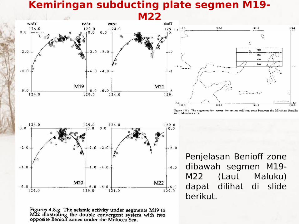
Kemiringan subducting plate segmen M19-M22
Penjelasan Benioff zone dibawah segmen M19-M22 (Laut Maluku) dapat dilihat di slide berikut.

Dua sistem konvergen dengan Benioff zone yang berlawanan
• Di bawah segmen M19-M22, yaitu di bawah Laut Maluku, telah terjadi peristiwa tektonik yang istimewa, yaitu adanya dua subduksi (sistem konvergen) dengan Benioff zones yang berlawanan arah.
• Walaupun hal ini mungkin sangat langka, tetapi keberadaannya tidak pernah diperdebatkan, mengingat aktivitas seismiknya yang sangat jelas seperti yang terlihat di bawah segmen M19-M20.
• Adanya 2 deretan gunung api, yaitu di Minahasa yang melengkung ke barat dan di Halmahera yang melengkung ke timur, menunjukkan bahwa di antara Minahasa dan Halmahera (Laut Maluku) harus ada 2 subduksi yang berarah ke barat dan ke timur.
• Ternyata sistem seperti ini juga dijumpai di Irian, tapi dengan stage (fase) yang lebih tua.

Model laut Maluku Model WaluyoTidak ada subduksi baru yang ber-kembang di sana. Subduksi yang ada tetap yang kearah barat dan timur dari sistem konvergen dengan 2 Benioff zone yang berlawanan arah.Overiding (subducted) plates, Minahasa dan Halmahera akan saling mendekat cenderung akan naik ke atas subducting plate dengan 2 benioff zone yang berlawanan.Kedua plate tersebut akhirnya akan bertumbukan, sehingga terbentuk pegunungan lipatan di daerah tersebut, sehingga daerah terse-but akan mengalami uplift (peng-angkatan). Secara geodinamik gerakan ini akan sangat mudah terakomodasi.
Figure 4, from Waluyo, 1991

Tectonics of Banggai-Sula

Figure 1– Location map of the study area modified from Hall (2002). Major structures in the Molucca Sea and Banggai-Sula margin are those interpreted by Hamilton (1979) and Silver et al. (1983). Red triangles are active volcanoes.
The north Banggai-Sula study area is located in the eastern part of Indonesia which is known for its geological complexity in the zone of convergence between the Pacific, Philippine Sea, Indo-Australian and Eurasian plates. It includes the Banggai-Sula microcontinent in the south, the East Arm of Sulawesi and Gorontalo Bay in the west, and the Molucca Sea Collision Zone to the north. The Banggai-Sula microcontinent has been interpreted to have separated from Australia in the Mesozoic (Hamilton, 1979; Pigram et al., 1985; Garrard et al., 1988) before it collided with the East Arm of Sulawesi proposed by different authors to be Middle Miocene (Simandjuntak, 1986), Middle Miocene to Pliocene (Garrard et al., 1988), Late Miocene (Hamilton, 1979), or end Miocene (Davies, 1990). The boundary and relationship between the Banggai-Sula microcontinent and the area to the north are still not well known.

Figure 2 – Simplified geological map of part of the East Arm of Sulawesiand the Banggai-Sula Islands based on Rusmana et al. (1993), Supandjono & Haryono (1993) and Surono & Sukarna (1993). Offshore faults from Hamilton (1979), Silver et al. (1983) and Garrard et al. (1988).

Figure 5. A. Location of seismic lines and outline of the area covered by the multibeam image. B. Coloured image of multibeam bathymetric map. (Ferdiand et al, 2010)

A. Lineament map based on the high resolution multibeam image of seabed surface.
B. B. Interpreted structural map based on the multibeam image and seismic lines. (Ferdiand et al, 2010)

A. Oblique view of fault surface remaining after north-dipping Mesozoic sequence of BanggaiSula margin detached on bedding surface and slid north to leave debris field at foot of slope.
B. South-vergent thrusts terminating NW-SE-trending dextral strike-slip fault system at foot of Banggai-Sula margin.
C. Carbonate platform, now at 1 km water depth, in NW part of study area. Note that a different colour scheme is used for this image to enhance sea floor features; depths are from 1 to 2.8 km.
D. Part of deformed Molucca Sea collision complex.
Images of different parts of the area covered by the multibeam survey
(Ferdiand et al, 2010)

New structural map of the study area In the NE, thrusts at the southern side ofthe Molucca Sea collision complex are interpreted to link to the north to the East Sangihe and Halmahera Thrusts. The dextral Balantak Fault crosses Poh Head and then horsetails into a number of splays terminated in E- to ENE-trending thrusts. The Poh Fault is a north-vergent thrust zone at the northern edge of deformed Mesozoic rocks of the Banggai-Sulamargin. There is no major E-W strand of the sinistral Sorong strike-slip fault nor is there a NWtrending Greyhound Strait Fault in the study area.
(Ferdiand et al, 2010)

Tectonic of Sulawesi

Prominent Tectonic Features
1. North Sulawesi trench.
2. Palu fault
3. Sadang fault
4. Gunungapi Una-una
5. Banggai & Sula islands
6. Selayar island
7. Gorontalo basin
8. Sulawesi divided as:
a. South arm
b. South East arm
c. East arm
d. North arm

Sesar Palu-Koro dan Selat Makasar
Palu-Koro Fault is an active left lateral fault crossing Palu at Central Sulawesi continues towards SE. Hamilton 1988 this fault observed clearly onland Sulawesi and continues to Makasar strait, suggested crossing the subduction zone at northern Sulawesi. At Teluk Palu fault might no longer traced.
Hamilton: spreading (MOR) at Makasar strait, Sulawesi moving away from Kalimantan. The spreading is not visible in seismic activity. Dt the size is relatively small, or speading is no longer active.

Subduction from West
0-70 km 75-125 km 100-200 km
Based on seismicity subduction zone developed from west of sulawesi towards eastern part: Benioff zone at the western part reaches only until ~70km.
Shallow EQs west of Palu fault might be due to Sadang fault.

Mekanisme sumber sesar
Palu-Koro
Predominantly strike slip (Waluyo, 1992)
Left lateral N-NW or S-SE selatan-tenggara, P axis is E-SE or W-NW

Tectonics map af Sulawesi
(Hamilton, 1988)
Tectonics of Sulawesi (Hamilton 1988)
• The four arms of Sulawesi complex tectonic process of the area.
• At North and South arms (West Sulawesi): Cretaceous subduction complexes, overlaid by Paleogene continental shelf and Neogene sedimentary rocks and volcanic intrusion (granite).
• At East and South East arms: late Miocene, ophiolite dan subduction complexes.
• The lateral distribution of subduction complexes in Sulawesi (east and west) ini, interpreated as the occurrence of migration to the east of subduction complexes migrasi at Cenozoic. This is superimposed with rifting of Sulawesi from Kalimantan dan prolongation of the young subduction from the north Sulawesi.

Western arc
Cretaceous subduction complex• Two small outcrops of basement complex south arm, SE
part, ultramafic dan metamorphic rocks exposed. Metamorphic trending NW,Cretaceous.
• Melanges exposed at south arm, consists of chaotically intercalated and broken rocks/formation. Similar Melanges outcropped at Sadang fault, early Cretaceous.
Paleogene shelf Strata• Top: facies turbudite lower Paleogene • Bottom: shelf layered Upper Paleogene and lower
Miocene.

• Complex region (junction of Eurasia, Indo-Australian, Pacific plates)
• Eastern Borneo and Western Sulawesi accreted onto SWern Borneo by Cenozoic (Hall 1996, Metcalfe 1998)
• Subduction of Indian ocean plate, Philippine sea and Molucca sea responsible for the progressive collison and accretion of fragments of continental and and oceanin crust along the eastern margin of Sundaland throught out Cenozoic.
• Number of sedimentary basins and deep marginal basins formed as a result of Tertiary extension and subsidence. Metcalfe, 2011

Simplified geology map of Borneo, Moss and Wilson (1998)

Borneo and Sulawesi (the relation)
Moss and Wilson (1998)


Bibliography
• Ferdian et al, 2010, A STRUCTURAL RE-EVALUATION OF THE NORTH BANGGAI-SULA AREA, EASTERN INDONESIA IPA Proceeding
• Metcalfe 2010, Tectonic framework and Phanerozoic evolution of Sundaland, Gondwana Research 19 (2011) 3–21
• Moss and Wilson 1998, Biogeographic implications of the Tertiary paleogeographic evolution of Sulawesi and Borneo
• Diktat Kuliah Tektonik Indonesia, Waluyo