TASMANIA DEPARTMENT OF RESOURCES & ENERGY€¦ · geological maps, as both present ... work....
62
TASMANIA DEPARTMENT OF RESOURCES & ENERGY DIVISION OF MINES AND MINERAL RESOURCES URBAN GEOLOGICAL MAPPING PROJECT REPORT 1 Engineering geology of the Greater Hobart area by P. J. Hofto, D. J. Sloane, and B. D. Weldon DIVISION OF MINES AND MINERAL RESOURCES, PO BOX 56, ROSNY PARK, TASMANIA 7018 1991
Transcript of TASMANIA DEPARTMENT OF RESOURCES & ENERGY€¦ · geological maps, as both present ... work....

TASMANIA DEPARTMENT OF RESOURCES & ENERGY
DIVISION OF MINES AND MINERAL RESOURCES
URBAN GEOLOGICALMAPPING PROJECT
REPORT 1
Engineering geology ofthe Greater Hobart area
by P. J. Hofto, D. J. Sloane, and B. D. Weldon
DIVISION OF MINES AND MINERAL RESOURCES, PO BOX 56, ROSNY PARK, TASMANIA 7018
1991

2 URBAN ENGINEERING GEOLOGICAL MAPPING PROJECT

CONTENTS
INTRODUCTION … … … … … … … … … … … … … … … … … … … … … … … … … … … … 5
Engineering Geology Maps … … … … … … … … … … … … … … … … … … … … … … … … 5
Previous Reports … … … … … … … … … … … … … … … … … … … … … … … … … … … … 5
Acknowledgements … … … … … … … … … … … … … … … … … … … … … … … … … … … 6
MAP DESCRIPTION AND DEFINITION … … … … … … … … … … … … … … … … … … … … … 7
Soil … … … … … … … … … … … … … … … … … … … … … … … … … … … … … … … … 7
Workability/rippability … … … … … … … … … … … … … … … … … … … … … … … … … … 7
Hazards … … … … … … … … … … … … … … … … … … … … … … … … … … … … … … 7
Landslides … … … … … … … … … … … … … … … … … … … … … … … … … … … … … 7
Erosion … … … … … … … … … … … … … … … … … … … … … … … … … … … … … … 7
Septic Tank Suitability … … … … … … … … … … … … … … … … … … … … … … … … … … 9
Groundwater … … … … … … … … … … … … … … … … … … … … … … … … … … … … … 9
PERMIAN SEDIMENTS … … … … … … … … … … … … … … … … … … … … … … … … … … 10
Geology … … … … … … … … … … … … … … … … … … … … … … … … … … … … … … 10
Soils … … … … … … … … … … … … … … … … … … … … … … … … … … … … … … … 10
Resources and Land Use … … … … … … … … … … … … … … … … … … … … … … … … … 10
Hazards … … … … … … … … … … … … … … … … … … … … … … … … … … … … … … 10
Septic Tank Suitability … … … … … … … … … … … … … … … … … … … … … … … … … … 12
Groundwater … … … … … … … … … … … … … … … … … … … … … … … … … … … … … 12
TRIASSIC SEDIMENTS … … … … … … … … … … … … … … … … … … … … … … … … … … 13
Geology … … … … … … … … … … … … … … … … … … … … … … … … … … … … … … 13
Soils … … … … … … … … … … … … … … … … … … … … … … … … … … … … … … … 13
Resources and Land Use … … … … … … … … … … … … … … … … … … … … … … … … … 13
Hazards … … … … … … … … … … … … … … … … … … … … … … … … … … … … … … 13
Septic Tank Suitability … … … … … … … … … … … … … … … … … … … … … … … … … … 15
Groundwater … … … … … … … … … … … … … … … … … … … … … … … … … … … … … 15
JURASSIC DOLERITE … … … … … … … … … … … … … … … … … … … … … … … … … … … 17
Geology … … … … … … … … … … … … … … … … … … … … … … … … … … … … … … 17
Soils … … … … … … … … … … … … … … … … … … … … … … … … … … … … … … … 17
Resources and Land Use … … … … … … … … … … … … … … … … … … … … … … … … … 17
Hazards … … … … … … … … … … … … … … … … … … … … … … … … … … … … … … 19
Septic Tank Suitability … … … … … … … … … … … … … … … … … … … … … … … … … … 19
Groundwater … … … … … … … … … … … … … … … … … … … … … … … … … … … … … 19
TERTIARY BASALT … … … … … … … … … … … … … … … … … … … … … … … … … … … 21
Geology … … … … … … … … … … … … … … … … … … … … … … … … … … … … … … 21
Soils … … … … … … … … … … … … … … … … … … … … … … … … … … … … … … … 21
Resources and Land Use … … … … … … … … … … … … … … … … … … … … … … … … … 21
Hazards … … … … … … … … … … … … … … … … … … … … … … … … … … … … … … 21
Septic Tank Suitability … … … … … … … … … … … … … … … … … … … … … … … … … … 22
Groundwater … … … … … … … … … … … … … … … … … … … … … … … … … … … … … 22
TERTIARY SEDIMENTS … … … … … … … … … … … … … … … … … … … … … … … … … … 23
Geology … … … … … … … … … … … … … … … … … … … … … … … … … … … … … … 23
Soils … … … … … … … … … … … … … … … … … … … … … … … … … … … … … … … 23
Resources and Land Use … … … … … … … … … … … … … … … … … … … … … … … … … 23
Hazards … … … … … … … … … … … … … … … … … … … … … … … … … … … … … … 23
Septic Tank Suitability … … … … … … … … … … … … … … … … … … … … … … … … … … 25
Groundwater … … … … … … … … … … … … … … … … … … … … … … … … … … … … … 25
QUATERNARY SEDIMENTS … … … … … … … … … … … … … … … … … … … … … … … … 26
Geology … … … … … … … … … … … … … … … … … … … … … … … … … … … … … … 26
Talus, scree and slope deposits … … … … … … … … … … … … … … … … … … … … … … 26
Stable and mobile dune sand … … … … … … … … … … … … … … … … … … … … … … … 26
GREATER HOBART AREA 3

Raised-beach sand … … … … … … … … … … … … … … … … … … … … … … … … … … 26
Alluvium, gravel, sand and clay … … … … … … … … … … … … … … … … … … … … … … 26
Beach sand, estuarine sand and clay … … … … … … … … … … … … … … … … … … … … 26
Windblown sand sheets … … … … … … … … … … … … … … … … … … … … … … … … … 26
Resources and Land Use … … … … … … … … … … … … … … … … … … … … … … … … … … 26
Hazards … … … … … … … … … … … … … … … … … … … … … … … … … … … … … … … … 27
Septic Tank Suitability … … … … … … … … … … … … … … … … … … … … … … … … … … … 27
Groundwater … … … … … … … … … … … … … … … … … … … … … … … … … … … … … … 27
REFERENCES … … … … … … … … … … … … … … … … … … … … … … … … … … … … … 28
APPENDIX 1: Chart of workability/rippability (Modified from Leaman, 1971b) … … … … … … … … … 29
APPENDIX 2: Information legend from Engineering Geology maps (Hofto, 1990) … … … … … … … … 30
APPENDIX 3: Unified soil classification system (from Moon, 1980) … … … … … … … … … … … … 32
APPENDIX 4: Water bore database summary … … … … … … … … … … … … … … … … … … … … 34
APPENDIX 5: Construction materials database summary … … … … … … … … … … … … … … … … 39
APPENDIX 6: Site investigation reference point summary … … … … … … … … … … … … … … … … 45
LIST OF PLATES
1. Permian bedrock, shallow weathering — Sky Farm Road, Glenorchy … … … … … … … … … … … 11
2. Sandy gravel slope deposits over Permian bedrock — Turnip Fields, Fern Tree … … … … … … … … 11
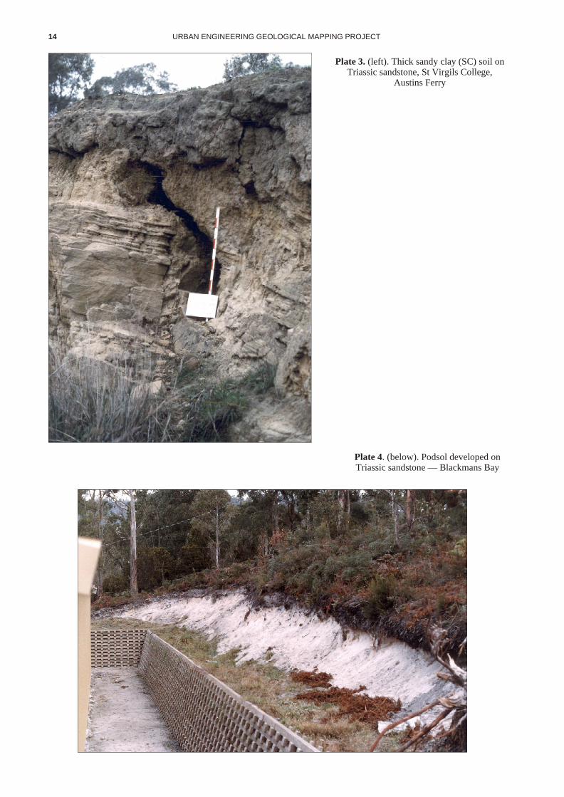
3. Thick sandy clay (SC) soil on Triassic sandstone — St Virgils College, Austins Ferry … … … … … … 14
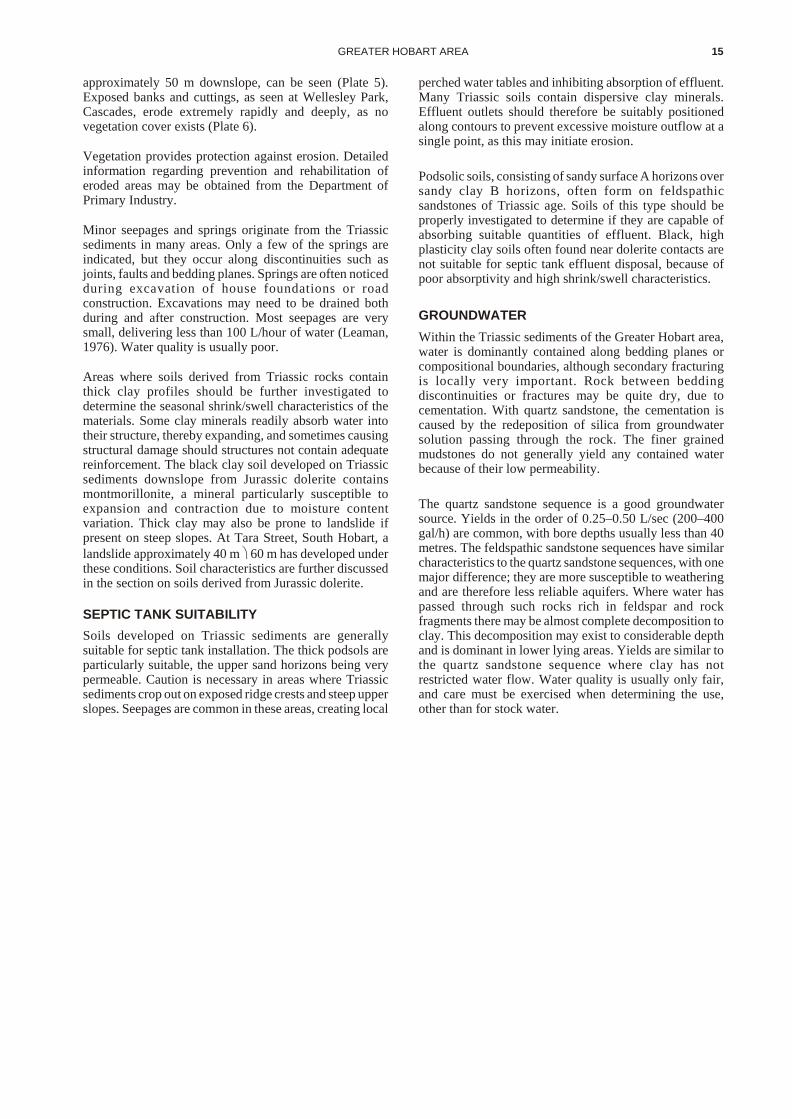
4. Podsol, developed on Triassic sandstone — Blackmans Bay … … … … … … … … … … … … … … 14
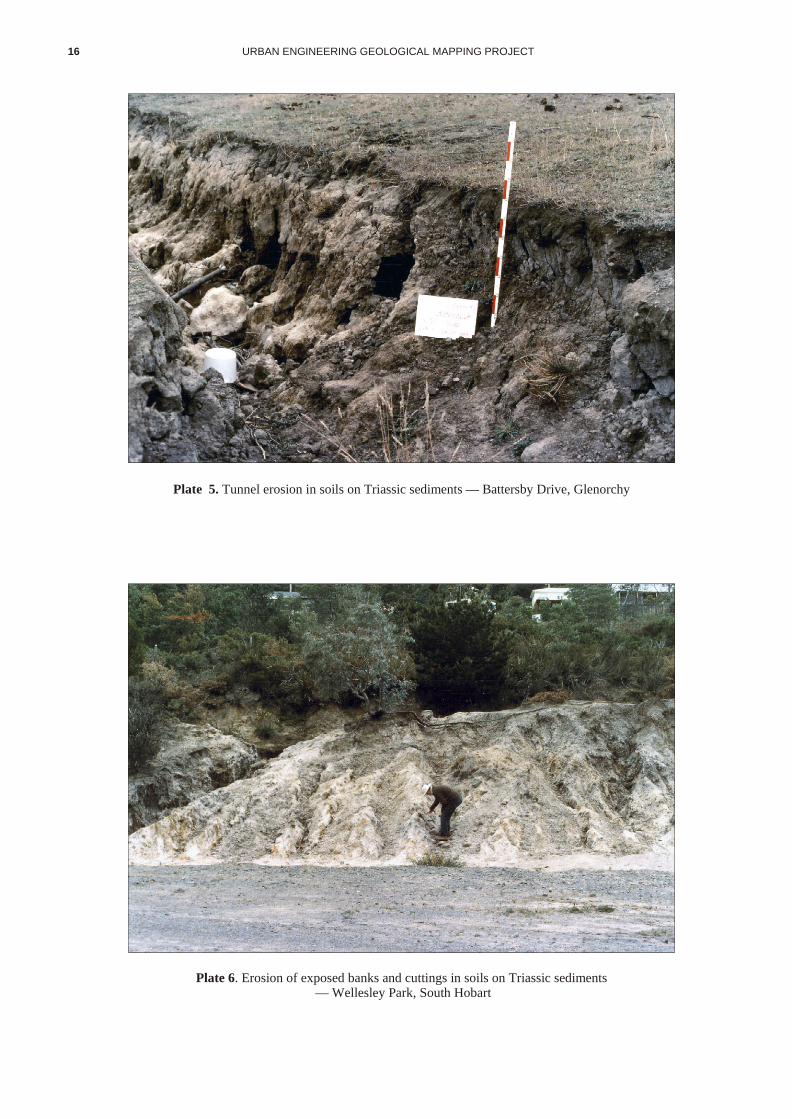
5. Tunnel erosion in soils on Triassic sediments — Battersby Drive, Glenorchy … … … … … … … … … 16
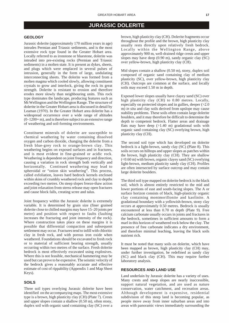
6. Erosion of exposed banks and cuttings in Triassic sediments — Wellesley Park, Cascades … … … … 16
7. Brown clay (CH) soil on dolerite bedrock — Domain … … … … … … … … … … … … … … … … 18
8. Brown sandy clay (SC) soil on dolerite bedrock — Caroda Court, Howrah … … … … … … … … … 18
9. Black clay (CH) soil on dolerite bedrock — Nicholas Drive, Lower Sandy Bay … … … … … … … … 20
10. Shallow landslide in dolerite soil — Goat Hills, Glenorchy … … … … … … … … … … … … … … 20
11. Gully erosion in Tertiary sediments — Droughty Point … … … … … … … … … … … … … … … … 20
12. Gully erosion in Tertiary sediments — Droughty Point … … … … … … … … … … … … … … … … 20
4 URBAN ENGINEERING GEOLOGICAL MAPPING PROJECT

INTRODUCTION
The Geodata Project was jointly funded by the CityCouncils of Hobart, Clarence and Glenorchy, by theMunicipality of Kingborough, and by the Division ofMines and Mineral Resources. The two-year projectendeavoured to produce applied geological data andexplanatory notes for use as base information whenplanning urban development in the above municipalities. It must be stated that the information provides a generaloverview and in no way should be considered as replacingsite-specific information and investigation.
This publication was produced in conjunction with two1:25 000 Engineering Geology Maps covering the GreaterHobart area. Together they provide basic geological andgeotechnical information and advice for engineers,planners and local government personnel.
The Appendices to this report contain summarisedinformation from the Division of Mines and MineralResources published and unpublished reports anddatabases. The databases contain summaries ofgeotechnical, construction material and groundwaterinformation, as well as reports concerning site-specificinvestigations.
Increasing regulation within the building industry andplanning authorities, and the ever present question ofliability, has meant that more emphasis will now be placedon specific building codes. For example, AustralianStandard 2870-1986, Residential Slabs and Footings,outlines general design principles for foundationconditions commonly found in Australia. The buildingauthorities, in this case the cities and municipalities, areexpected to provide preliminary advice on siteclassification. The easiest way to provide this advice is byproducing an engineering geology map which shows sitecharacteristics. It must be stressed however that these maps present only preliminary site classification andinformation, and in no way negate the need forindividual site investigations by competent specialists.
ENGINEERING GEOLOGICAL MAPS
Engineering Geological Maps have much in common withgeological maps, as both present information about thegeological environment. However engineers or plannersmay require more specific information. Conventionalgeological maps group units of similar age and origin.Engineering geological maps commonly includedescriptions and qualifications of specific physical andengineering properties of rocks and soils, as well asinformation concerning groundwater conditions. Theymay also indicate how soils and rocks may behave withrespect to erosion and instability.
Geological maps provided the fundamental basis for theengineering geological mapping. Reconnaissance of thearea, assessment of available information and the additionof new geological, geomorphological and geodynamicdata form the basis of the accompanying engineeringmaps. Samples were collected for laboratory study, andgeneral survey mapping was supplemented by geophysical information and subsurface sampling using portable drillsand augers. Type sections were logged, sampled andphotographed for later reference. Detailed field mapping
and sampling were also undertaken in areas designated formajor development or regions with recognisedgeotechnical problems. The maps were produced at a scaleof 1:25 000, using the Department of Environment andPlanning 1:25 000 topographic maps as bases. Thisengineering geological survey aimed to produce maps onwhich units are defined by engineering properties. Theboundaries of these units generally follow rock-typeboundaries, but may bear no relation to either geologicalstructure or stratigraphic boundaries. Many stratigraphicand structural boundaries within main units have beenexcluded on the accompanying maps for this reason.Recognition of rock and soil boundaries was often difficult in the field because changes in the character of rocks andsoil are often gradational and can occur both horizontallyand vertically. Other boundaries may be covered by slopedeposits or fill, and topsoil subsequently placed there.
Faulting of geological units may be of fundamentalimportance to the engineer. However, the position of afault is often only inferred from the field relations of therocks, and therefore its position can only be mappedapproximately. A fault may be shown on geological mapsas a single line, but may in fact be a series of shears. If thefault occurs in brittle rocks it may result in broken zones,while in clays very little disruption may be apparent. Thebearing strength of fault-zone material over the width ofthe fault should be determined, and if necessary, variationsmade to foundation specifications as differentialcompaction may occur. Although Tasmania is seismicallyquiet, there is always risk involved when building on major fault zones.
As the enlargement of maps showing approximatelydetermined boundaries may increase the inherent errors ofmapping and promote unjustified confidence, the faultpositions shown on the accompanying engineeringgeological maps may only be approximate. Only majorfaults are shown. The position of these faults has beentransferred from the appropriate 1:50 000 Geological Atlas map. These latter maps should be referred to for morecomplete fault information.
PREVIOUS REPORTS
The Tasmania Department of Mines Geological AtlasSeries maps and Explanatory Reports for Hobart (Leaman, 1972, 1976), Sorell (Gulline, 1983, 1984) andKingborough (Farmer, 1981, 1985) provide the basegeological information for the engineering geologicalmaps. Leaman (1972) produced a series of engineeringgeological maps covering most of the Hobart Quadrangle.Much of the information contained on these maps has beenincorporated into this publication and accompanyingmaps, particularly technical data regarding bedrockconditions and rippability. This publication and theaccompanying maps seek to revise and expand Leaman’swork.
Resource maps of soils have been produced by the CSIRO(Dimmock, 1957; Loveday, 1955) and more recently bythe Department of Primary Industry (Davies, 1988). Thelatter publication provides valuable information relatingsoil depth to topographic position.
GREATER HOBART AREA 5

Underground Water Supply Papers 3 (Nye, 1924) and 7(Leaman, 1971) report on the groundwater resources of the Richmond–Bridgewater–Sandford District, and the CoalRiver Basin respectively. They provide informationrelating geological units to groundwater bore yield andquality.
The recently published Geological Survey BulletinLandslides and Land Use Planning by A. L. Telfer (Telfer, 1988) provides general information and advice for LocalGovernment personnel concerning unstable andpotentially unstable land.
The published Survey Papers, Technical Reports andUnpublished Reports of the Division of Mines and Mineral Resources, together with Department of Primary Industryand Municipal technical reports, record significant dataabout specific sites and previous investigations. Relevantinformation points are marked on the accompanying mapsfor future reference.
Other information was obtained from four Division ofMines and Mineral Resources databases: Boris — waterbore register; Conmat — construction materials register;Cars — engineering correspondence register; andDirtwork — laboratory analysis register.
ACKNOWLEDGEMENTS
This draft document has been produced from an originalsubmission by P. J. Hofto. Appendices 4, 5 and 6 wereprepared by B. D. Weldon from Division of Mines andMineral Resources databases.
D. J. Sloane has edited and made contributions to thisdocument.
The text was typed by Jan Howie and the final version ofthe draft was produced by Michael Dix using theDivision’s Desktop Publishing facilities.
6 URBAN ENGINEERING GEOLOGICAL MAPPING PROJECT
MAP DESCRIPTION AND DEFINITION
SOIL
To most people, soil is the uppermost layer of the ground,in which plants grow. To the engineer soil includes allunconsolidated material down to bedrock — materialwhich can be dug with a pick. There may be a gradualtransition between residual soil and the underlyingbedrock. The boundary between a very stiff soil and a veryweak rock is somewhat arbitrarily equated with anunconfined compressive strength of about 700 kPa.
The engineer is therefore interested in soil propertieswhich affect:
(i) the support that the soil provides for any building(bearing capacity);
(ii) the stability and erodibility of slopes, both naturalslopes or those in cuttings;
(iii) the lateral and vertical pressure that the soil exertsagainst any structure;
(iv) the ease of excavation of the soil.
WORKABILITY/RIPPABILITY
A chart of workability/rippability is presented in Appendix 1 and on the accompanying maps. This chart, modifiedafter Leaman (1971b), indicates the rippability and relatedseismic velocity of rock units when fresh and dry. Wet andweathered rock or soil behave in varying ways,proportionate to the moisture content, joint frequency andextent of weathering. This chart should therefore be usedas a guide, tempered by the knowledge that local moisturecontent, degree of fracturing, and weathering conditionswill control the exact values.
CONSTRUCTION MATERIALS
The Division of Mines and Mineral Resources maintains adatabase, Conmat, which lists registered currentlyoperating and abandoned quarries and pits. Thisinformation is summarised in Appendix 5 and crossreferenced to the maps. Conmat provides data on the typeof quarry, reserves, ease of excavation, material use, andland tenure.
HAZARDS
Landslides
Landslides are not generally a major problem in theGreater Hobart area. However some landslides, such asthose at Hone Road Rosetta, Casuarina CrescentBerriedale, and Channel Highway Taroona, have causeddamage or threatened property. Known landslides areindicated on the maps, and many of these are recorded inMines Division technical and unpublished reports. Furtherlandslides may occur with changing land use, and this listshould in no way be considered complete. Both currentlyactive and ancient or fossil landslides are indicated wherethey have been identified. A depth to bedrock overprintindicates those soils with thicknesses of less than onemetre. Thick accumulations of potentially unstable soil areusually either not in dangerous topographic situations, orare remote from building zones.
The recently published Geological Survey Bulletin 63Landslides and Land Use Planning by A. L. Telferprovides general information and advice on potentiallyunstable land for local government personnel. Althoughlandslides are not a major problem in the Greater Hobartarea, they do exist, have threatened, damaged, anddestroyed man-made structures, and disfigured andsignificantly reduced the value of many natural landforms.
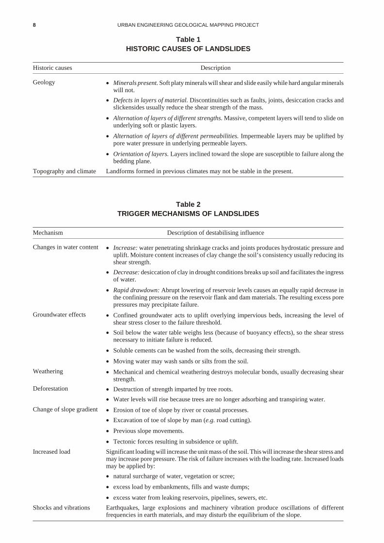
Telfer (1988) suggests that slope failures occur under twocategories of unique sets of conditions, namely, historiccauses and trigger mechanisms. The correct diagnosis ofthese conditions is essential in formulating remedial andpreventative measures.
Telfer (1988) considers that historic causes (Table 1) arepre-existing geological, climatic and slope conditions,conducive to the formation of landslides or areas ofpotential instability. Trigger mechanisms (Table 2) arefactors which can transform an area of potential instabilityinto a landslide in a comparatively short space of time.
These conditions are interrelated and infinitely variable inproportion. Their identification is essential to preventdevelopment of potential landslide areas, and to assist inthe rehabilitation of existing ones.
Any area that is sloping and underlain by thickaccumulations of clay may be subject to landslides.Fortunately, in southern Tasmania, clay soils tend to berelatively thin, resulting in a lower landslide risk, andallowing most structures to be founded on competentbedrock. However some thick accumulations of clay soilare present, and where these lie on slopes, usuallyexceeding approximately 15°, then there is risk oflandslide. It must be noted that landslides may still occuron slopes of much less than 15° if appropriate historiccauses and trigger mechanisms exist (Plate 10).
These conditions are more common in areas underlain byJurassic dolerite derived colluvium or slope deposits thanother geological rock types in the Greater Hobart area.Elsewhere in the State, landslides occur in Tertiarysediments, weathered basalt, and deeply-weatheredPermian mudstone and Triassic sediments.
Erosion
Areas of tunnel and gully erosion are indicated on theaccompanying maps. The problem of these eroded anddegraded areas should be addressed and the areasrehabilitated.
Tunnel and subsequent gully erosion are often prominenton flats and lower slopes. These forms of erosion are oftena direct consequence of increased surface and subsurfacewater flow due to the removal of vegetation. Waterinfiltrates into the surface sandy A horizon and is deflecteddownslope at the top of the B horizon because of themarked contrast in permeability from sand to clayey sandor clay. The clay is often dispersive and is thereforeremoved in colloidal solution, forming tunnels. Collapsedsections of tunnel erosion may eventually join up, forminga continuous gully section. Gully erosion may also resultfrom the direct erosion of streams or water channels caused
GREATER HOBART AREA 7
8 URBAN ENGINEERING GEOLOGICAL MAPPING PROJECT
Table 1
HISTORIC CAUSES OF LANDSLIDES
Historic causes Description
Geology · Minerals present. Soft platy minerals will shear and slide easily while hard angular minerals will not.
· Defects in layers of material. Discontinuities such as faults, joints, desiccation cracks andslickensides usually reduce the shear strength of the mass.
· Alternation of layers of different strengths. Massive, competent layers will tend to slide onunderlying soft or plastic layers.
· Alternation of layers of different permeabilities. Impermeable layers may be uplifted bypore water pressure in underlying permeable layers.
· Orientation of layers. Layers inclined toward the slope are susceptible to failure along thebedding plane.
Topography and climate Landforms formed in previous climates may not be stable in the present.
Table 2
TRIGGER MECHANISMS OF LANDSLIDES
Mechanism Description of destabilising influence
Changes in water content · Increase: water penetrating shrinkage cracks and joints produces hydrostatic pressure anduplift. Moisture content increases of clay change the soil’s consistency usually reducing itsshear strength.
· Decrease: desiccation of clay in drought conditions breaks up soil and facilitates the ingress of water.
· Rapid drawdown: Abrupt lowering of reservoir levels causes an equally rapid decrease inthe confining pressure on the reservoir flank and dam materials. The resulting excess porepressures may precipitate failure.
Groundwater effects · Confined groundwater acts to uplift overlying impervious beds, increasing the level ofshear stress closer to the failure threshold.
· Soil below the water table weighs less (because of buoyancy effects), so the shear stressnecessary to initiate failure is reduced.
· Soluble cements can be washed from the soils, decreasing their strength.
· Moving water may wash sands or silts from the soil.
Weathering · Mechanical and chemical weathering destroys molecular bonds, usually decreasing shearstrength.
Deforestation · Destruction of strength imparted by tree roots.
· Water levels will rise because trees are no longer adsorbing and transpiring water.
Change of slope gradient · Erosion of toe of slope by river or coastal processes.
· Excavation of toe of slope by man (e.g. road cutting).
· Previous slope movements.
· Tectonic forces resulting in subsidence or uplift.
Increased load Significant loading will increase the unit mass of the soil. This will increase the shear stress and may increase pore pressure. The risk of failure increases with the loading rate. Increased loadsmay be applied by:
· natural surcharge of water, vegetation or scree;
· excess load by embankments, fills and waste dumps;
· excess water from leaking reservoirs, pipelines, sewers, etc.
Shocks and vibrations Earthquakes, large explosions and machinery vibration produce oscillations of differentfrequencies in earth materials, and may disturb the equilibrium of the slope.

by increased water flow. These eroded gullies can exceedfive metres in depth, seven metres in width, and run for tens of metres. A large gully at Scotts Road, Risdon Vale hasbeen used as a dumping area for car bodies and contains inexcess of twenty wrecks. Once tunnels and gullies havebeen formed, often after a single intense rain period, theyare very difficult and expensive to control.
Vegetation provides protection against erosion. Itincreases the shear strength of the soil mantle by rootbinding, decreases surface and subsurface water runoff byincreased evapotranspiration from the canopy, protectssoil from the full impact of raindrops, and utilises a portionof the moisture to sustain plant life. Erosion preventionpractices include contour farming, strip cropping, andterracing in agriculture, and the correct planning, design,and construction of roads, amenities, and their associateddrainage. These practices disrupt surface water flow,reduce flow velocity, and disperse output loci.
SEPTIC TANK SUITABILITY
The present discussion, and the relevant discussionsconcerning the geological units, attempts only to outlinethe general suitability of land in the Greater Hobart areawith respect to septic tank effluent disposal. Specificdetails concerning septic tank operations and thetechniques utilised when confronted with problem sitesmay be obtained from Septic Tank Installation inTasmania (Patterson, 1982) and from local HealthSurveyors.
Site constraints affecting septic tank suitability include:
(a) soil permeability; determined by porosity, grain size,aggregation, clay type and content, and soil structure.Specially designed percolation tests should be used bythe Health Surveyor to analyse individual sites.
(b) depth to bedrock; adequate depth of suitable soil isnecessary to absorb effluent.
(c) depth to water table; Shallow water tables may inhibitabsorption, and contaminating groundwater reservesis wasteful and potentially dangerous.
(d) slope; the degree and type of slope may indicatedrainage and construction problems. Concave slopescause surface runoff to converge, while convex slopesdisperse the runoff.
(e) area of effective disposal site; sites that do not fall intosuitable limits for the above criteria may need to be“extended” to provide an adequate area of absorptivesoil.
GROUNDWATER
According to Leaman (1971a), the vacant spaces whichgroundwater may occupy within rocks determine thehydrological characteristics or properties of that rock. Themore spaces there are, the greater will be the storagecapacity of the rock; the better the interconnection, thehigher the permeability.
Hydrological properties of a particular rock unit may bedivided into primary and secondary properties. Primaryhydrological properties are those which formed at the same time as the rock. These properties include the porosity ofthe rock and the presence of bedding planes. Secondaryhydrological properties develop at some stage after theformation of the rock and are usually related to fracturing.Secondary properties may develop in two stages; theformation of openings by physical or geological processes(joints, faults, intrusions of igneous rocks) and themodification of these openings by the action of circulatingwater and weathering. The suitability of a particular site for an extractable groundwater resource depends on afavourable combination of the above processes andconditions. Hydrological properties therefore control theoccurrence, storage and movement of groundwater in most rocks, and are developed as a result of the action ofcomplex geological, chemical, organic and climaticconditions.
Groundwater information for the Greater Hobart area iscontained in the Division of Mines and Mineral Resourcesdatabase Boris, which contains information regardingdepth to water table, quality, yield rates, and depth ofbores, and is available to the public. The position of thesewater bores is marked on the accompanying maps and boredetails are summarised in Appendix 4. Known seepagesand springs are also indicated. These are concentrated atunit boundaries and discontinuities, and generally yieldless than 0.03–0.06 L/sec of mostly poor-quality water.Such seepages and springs may initiate landslides or causeundermining of structures. Specific information regardingchemical analysis of groundwater should be obtained fromthe relevant underground water supply paper. A briefsummary of the groundwater characteristics of theindividual geological units common in the Greater Hobartarea is included within this text.
Any site investigations which provide geotechnicalinformation or refer to specific reports or papers aremarked on the accompanying maps. This information isavailable from the Division of Mines and MineralResources, and is presented in abbreviated form inAppendix 6.
GREATER HOBART AREA 9

PERMIAN SEDIMENTS
GEOLOGY
The oldest exposed rocks in the Hobart area are of Permianage (approximately 250 million years) and consist of a finesandstone, coarse siltstone and fossiliferous mudstonesequence, with occasional thin conglomerate andlimestone beds. The total thickness of the exposed Permian rocks is approximately 600 m, and they generally dipslightly to the west (5–10°). Locally, east of Mt Faulknerand Mt Wellington, blocks of Permian sediments dipslightly to the east with some dips exceeding 20°. Uponexcavation, minor slippage of whole blocks is possible,especially where dips exceed 10°–20° and are steeper thanthe natural slope angle.
Weathering of Permian rocks is usually uniform andshallow (Plate 1). This enables foundations to beexcavated to fresh rock or rock of acceptable stability.Fretting of surface outcrops is common, and locally unitsmay weather deeply to clay (CH) or gravelly clay (GC).
Limestone units tend to weather deeply and quickly inzones of high joint intensity, producing clay bands.Occasionally this may precipitate block failure,particularly when the moisture within the clay-filled jointsis confined, resulting in high pore pressures.
Joint frequency in Permian sediments is usually 3–4 permetre but this may increase to 12–16 per metre in thevicinity of faults or where thermally affected by theintrusion of igneous rocks. These joints usually remainopen although, as mentioned, joints in limestone units tendto be infilled with clay. Permian sediments, and especiallylimestone units, are hard and brittle but because they arewell jointed they are usually easily worked usingexplosives and mechanical hammers, followed by ripping.
The accompanying table of workability/rippability(modified after Leaman, 1971b) relates the difficulty ofexcavation with the seismic velocity of fresh rock(Appendix 1). Shallow seismic refraction surveys aretherefore often used as an investigation tool when costingexcavation proposals.
SOILS
Exposed ridge crests and upper slopes typically containshallow (<0.40 m) grey-brown, gravelly, silty sand (SM)developed on bedrock. Surface outcrop is common. Flattopped crests and upper slopes may have shallow (<0.60m) gravelly, duplex soils consisting of grey-brown,organic silty sand (SC) over yellow-brown, mediumplasticity clay/clayey sand (SC) on bedrock. Duplex soilshave a marked contrast in clay content between surface and subsurface horizons, the lower horizons having the higherclay content. These soils may be locally deep (1.50 m) onsteep, exposed slopes. Mid and lower slopes commonlycontain similar duplex soil but they are usually deeper(1.20–1.40 m).
Thick (>2.0 m) silty, sandy gravels (GM) often exist onsteep south and south-east facing slopes. These slopedeposits have previously been loosely termed ‘talus’(Plate 2). Lower slopes and flat areas often contain a deep(>1.10 m) duplex soil consisting of light-grey, organic,
silty sand (SM–SC) sometimes with minor clay contentover a grey, medium plasticity clay/sandy clay (CH) thatmay have a light-brown mottle at depth. Soils may begradational rather than duplex on drainage flats. Asummary of laboratory-derived soil characteristics ispresented within the spread sheet on the accompanyingmaps, and in Appendix 2.
RESOURCES AND LAND USE
The majority of land underlain by Permian sediments isundeveloped natural bushland, especially west of the River Derwent. Hills and upper slopes are generally used forwater catchment, registered Recreation Areas, and minoragricultural practices. Many quarries, mostly disused,exist in these areas. They are marked on the accompanyingmaps, and referred to in more detail in the ConstructionMaterials Register (Conmat) which is summarised inAppendix 5.
The material has been quarried for a variety of uses. Thelimestone is not pure enough for commercial cementmanufacture, but the mudstone and siltstone are suitablefor road base material and bind well when crushed andcompacted at optimum moisture content. Some minorbrickwork clay and small quantities of building stone havebeen extracted, although no commercial operations existtoday.
Middle slopes are also used for minor grazing andcropping, and are starting to be developed as fringesubdivisions. Lower slopes and flats have been extensively cleared for subdivision and agricultural purposes. Theseinclude grazing, orchards and some cropping, althoughsuch land is considered too poor for very intensivecropping.
HAZARDS
Soils on Permian sediments are particularly susceptible toerosion. Areas cleared of natural vegetation, or with asparse understorey, provide little resistance to sheet, tunnel and gully erosion. Sheet erosion generally occurs onhilltops or upperslopes, underlain by thin silty sands (SM)and gravels (GM) with a minor clay component. Thesethin, nutrient-depleted soils support only sparse openwoodland with very little understorey to bind surfacesoils.Tunnel and subsequent gully erosion are oftenprominent on flats and lower slopes. These forms oferosion are often a direct consequence of increased surfaceand subsurface water flow due to the removal ofvegetation.
Laboratory tested samples of Permian soils vary indispersivity, some being strongly dispersive, others lessso. Gully erosion may also result from the direct erosion ofstreams or water channels caused by increased water flow.These eroded gullies can exceed five metres in depth,seven metres in width, and run for tens of metres. A largegully at Scotts Road, Risdon Vale has been used as adumping area for car bodies and contains in excess oftwenty wrecks. Once tunnels and gullies have beenformed, often after a single intense rain period, they arevery difficult and expensive to control.
10 URBAN ENGINEERING GEOLOGICAL MAPPING PROJECT

GREATER HOBART AREA 11
Plate 2. Sandy gravel slope deposits on Permian bedrock — Turnip Fields, Fern Tree
Plate 1. Shallow weathering of Permian mudstone — Sky Farm Road, Glenorchy

Further detailed information regarding remedial work andrehabilitation may be obtained from the Department ofPrimary Industry.
Shallow landslides often occur in weathered Permianmaterial on slopes greater than 18°. It is therefore generally accepted that these areas are not suitable for normalsubdivision, although individual houses may be built ifsited and constructed correctly. Active slides areuncommon in naturally vegetated areas, although benttrees and small scallops in the ground surface indicate thatsoil creep is active on steep, vegetated slopes. Landslideson Permian-derived material occur in several locationssuch as Turnip Fields and Fern Tree but are most prevalentaround Glenlusk. “They range from shallow soil slips, afew metres wide, to slips 50 m wide and 4 m deep. Slipshave been reported to occur suddenly and typically form aspoon-shaped depression with a bulging toe accompaniedby a short mud flow.” (Knights, 1976).
Where recent landslides occur they can be attributed tooversteepening by excavation, clearing vegetation fromthe slope, or the redirection of drainage paths. On thenorthern slopes of Goat Hills scarps of ancient, deeplyseated, rotational landslides cover several hundred squaremetres. The age of these landslides is unknown, but theyshow no signs of recent instability. They are characterisedby deep weathering, and the material may be subject tosmall-scale movements on steep, exposed slopes.
Similar deposits often occur at the base of steep south andsouth-east facing slopes. This talus or slump depositmaterial may be several metres thick and contain angularfragments of bedrock in a sand/silt/clay matrix. These soils will all settle slightly under load, and seasonalexpansion/shrinkage may also cause problems if themoisture content is changed during development.
The excavation of material in areas of steeply dippingPermian bedrock may require caution. Instability mayoccur when the bedrock dip exceeds 10–20°, is steeperthan the ground slope angle, and dips in the same directionas the slope. Excavation in these areas may cause wholeblocks of bedrock to slip out along bedding planes.Therefore, on the side of an excavation where the dip of the rock is into the excavation, the slope of the face will need to be less and benched more often than on the opposing face.
On the opposing face the rocks will dip into the face of theexcavation and will therefore be naturally more stable. Injointed rocks allowance must also be made for the attitudeand dip of joints, as these discontinuities will determine the size of blocks which may drop from the face.
Seepages and springs flowing from geological boundariesor discontinuities (faults, joints and bedding planes) mayalso exacerbate the dip/slope problem. Unloading of soiland the upper rock layers may allow erosion of joint fillmaterial, increasing the flow of water through thediscontinuities. This may necessitate the drainage ofexcavations both during and after construction,particularly if the construction is for a permanent structuresuch as a house or roadway.
SEPTIC TANK SUITABILITY
Soils developed on Permian sediments vary in both typeand thickness, and therefore also in suitability for septictanks. They are, however, generally suitable. Caution isnecessary in areas of steep slope, as soils may be shallow,seepages common, and erosion (sheet, tunnel and gully)may occur if effluent outflow is concentrated in a smallarea. Erosion may be particularly prevalent if the soilcontains dispersive clay minerals, and slopes are cleared of natural vegetation. Locally thick accumulations of claywithin the soil profile may significantly reducepermeability, and therefore the ability to absorb necessaryquantities of effluent.
GROUNDWATER
Permian sediments within the Greater Hobart area aregenerally excellent aquifers. The water is dominantlycontained in fractures or bedding planes, althoughvariations in lithology do affect the porosity at specificlocations. Yields are normally in the range from 0.25–0.65L/sec (200–500 gallons/hour) and bore depths of morethan 40 m are rarely required. Leaman (1971a) suggestedthat bores exceeding 30 m depth yield little extragroundwater because fractures tend to be sealed withpyrite or closed tight. More recently, deeper bores yieldinggood quantities of groundwater have cast doubt on thissuggestion. The quality of the water is usually fair toexcellent, and although mostly unsuitable for directirrigation, is usually more than adequate for stock andother general purposes.
12 URBAN ENGINEERING GEOLOGICAL MAPPING PROJECT

TRIASSIC SEDIMENTS
GEOLOGY
Triassic sediments, approximately 200 million years old,conformably overlie the Permian units in the GreaterHobart area, and may be divided into two associations. The older association consists of a sequence of well-sortedquartz sandstone with interbedded mudstone and shale.These units contain varying proportions of mica, feldsparand graphite, and have a thickness in excess of 400 metres.The second, or younger association, consists of at least150 m of white feldspathic sandstone and micaceousmudstone, often containing rock fragments and sometimescoal. The Triassic units generally dip slightly to the west(5–10°), although locally fault-bound blocks have dips inexcess of 20°.
Triassic sediments tend to weather irregularly as a result ofvariations in the nature of rock layers. The sandstone unitsexhibit a thick and gradational weathering profile, largelyof clayey sand (SC). The mudstones are particularlysusceptible to weathering, often forming thick clayhorizons. Weathering may be variable in thickness, withclay extending to several metres in depth (Plate 3). Thisfactor should be considered when designing andexcavating foundations. Even loading should be ensured,or foundations taken down to hard rock, to maintainstability.
Joint frequency in the Triassic sediments is commonly lessthan 1 to 2 per metre, but increasing in areas of intensefaulting. The Triassic sediments are not generally brittle,but in areas of intense fracturing they tend to weatherdeeply very quickly. This often produces clay-filled joints,and the resulting confined water may need to be drainedprior to loading the unit. Differential compaction may alsooccur over these weathered, fractured zones. It is thereforeimportant to determine their extent, and to design supportaccordingly. The sandstone units may be difficult toexcavate in areas of low joint frequency, requiring carefuluse of explosives and mechanical hammers. Mudstonestend to be friable and easily excavated.
SOILS
Exposed ridge crests typically contain shallow (<0.30 m),often stony, black to dark yellow-brown organic sand andsilty sand (SM) on bedrock. Bedrock often crops out andmay be present as small cliffs, sometimes weathering toleave shallow caves. Steep upper slopes have similar soilsto the crest, although they may be locally deeper andoccasionally contain brown, medium plasticity clay(CL–CH). Mid and lower slopes may host one of two soils,depending on the nature of the underlying sediments.
Highly siliceous and permeable Triassic sediments tend todevelop deep (>1.40 m), dark-grey uniform sands (SP)over leached yellow-brown sands (SP) (Plate 4). Thesesoils have previously been described as podsols onmudstone by Dimmock (1957) and Loveday (1955).
Sandstone containing feldspar and/or other clay formingminerals forms podsolic soils, commonly a deep (>1.40 m)duplex soil with a dark-grey, organic silty sand (SM) over a brown to grey medium-plasticity sandy clay (SC). Thesurface layer of fine sand is common to both soils, and is
similar in nature to Quaternary windblown sand, makingaccurate boundary identification difficult. Both sand typeshave been extensively mined.
Thick (>2.0 m) accumulations of clayey sand (SC) andclay (CH) often exist at the base of steep slopes. Thesefootslope deposits develop because of the uneven nature of weathering and increase in moisture content where claysare present, and the downslope movement of soil.
Flat areas have a deep (>1.40 m) gradational soildominated by medium plasticity clayey sand (SC). Thismay be overlain by organic sand and clay. Black,high-plasticity clay (CH) may overlie Triassic sedimentsdownslope of dolerite intrusions. These dolerite-derivedsoils have crept downslope, mixing with the Triassic clay,making the dolerite/sandstone boundary difficult to locate. A summary of laboratory-determined soil characteristics is presented on the accompanying maps and in Appendix 2.
RESOURCES AND LAND USE
Land underlain by Triassic sediments is used for a varietyof activities. Ridge crests and steep slopes are often leftunder natural vegetation, and used for recreation and water catchment purposes. Subdivisions are encroaching intothese areas, but are more commonly situated on flatterground. Middle and lower slopes are used for grazing andminor cropping, although increasing numbers of largeacreage subdivisions are decreasing agricultural activities.Sandy soils derived from Triassic rocks are generallynutrient deficient, because of leaching, and extensive useof fertilisers is necessary when cultivating.
Although only small-scale quarries are still in operation,extensive areas have been developed for sand mining,especially in the Kingborough and Clarence areas. Severalquarries for sandstone building stone were once workedbut have since been abandoned. Crushed rock and claymay be used for brickmaking and road foundations.Further information is available from the ConstructionMaterials Register, a summary of which appears inAppendix 5.
HAZARDS
Soils developed on Triassic sediments are not particularlysusceptible to erosion unless areas have been cleared ofnatural vegetation, or have a sparse understorey, thusproviding little protection from sheet, tunnel and gullyerosion. Sheet erosion is not common because of the deepsandy (SP) soils. Where outcrop does occur, as small cliffsand exposed blocks, the dark, sandy soil is usuallyfree-draining and unlikely to initiate the surface flownecessary for sheet erosion. Tunnel and subsequent gullyerosion does exist on lower slopes and flat areas underlainby Triassic sediments but it is not prevalent. This erosion is the direct consequence of increased water flow due todevegetation in areas where surface sands are underlain byclay. Laboratory tested samples of Triassic soils vary indispersivity, some samples being classified as highlydispersive. Tunnel and gully erosion within soils derivedfrom Triassic rocks tends to remain small scale comparedwith Permian sediments. At Battersby Drive, Glenorchy,tunnels up to 1.5 m in depth and apparently extending
GREATER HOBART AREA 13
14 URBAN ENGINEERING GEOLOGICAL MAPPING PROJECT
Plate 4. (below). Podsol developed onTriassic sandstone — Blackmans Bay
Plate 3. (left). Thick sandy clay (SC) soil on Triassic sandstone, St Virgils College,
Austins Ferry
approximately 50 m downslope, can be seen (Plate 5).Exposed banks and cuttings, as seen at Wellesley Park,Cascades, erode extremely rapidly and deeply, as novegetation cover exists (Plate 6).
Vegetation provides protection against erosion. Detailedinformation regarding prevention and rehabilitation oferoded areas may be obtained from the Department ofPrimary Industry.
Minor seepages and springs originate from the Triassicsediments in many areas. Only a few of the springs areindicated, but they occur along discontinuities such asjoints, faults and bedding planes. Springs are often noticedduring excavation of house foundations or roadconstruction. Excavations may need to be drained bothduring and after construction. Most seepages are verysmall, delivering less than 100 L/hour of water (Leaman,1976). Water quality is usually poor.
Areas where soils derived from Triassic rocks containthick clay profiles should be further investigated todetermine the seasonal shrink/swell characteristics of thematerials. Some clay minerals readily absorb water intotheir structure, thereby expanding, and sometimes causingstructural damage should structures not contain adequatereinforcement. The black clay soil developed on Triassicsediments downslope from Jurassic dolerite containsmontmorillonite, a mineral particularly susceptible toexpansion and contraction due to moisture contentvariation. Thick clay may also be prone to landslide ifpresent on steep slopes. At Tara Street, South Hobart, alandslide approximately 40 m ö 60 m has developed underthese conditions. Soil characteristics are further discussedin the section on soils derived from Jurassic dolerite.
SEPTIC TANK SUITABILITY
Soils developed on Triassic sediments are generallysuitable for septic tank installation. The thick podsols areparticularly suitable, the upper sand horizons being verypermeable. Caution is necessary in areas where Triassicsediments crop out on exposed ridge crests and steep upper slopes. Seepages are common in these areas, creating local
perched water tables and inhibiting absorption of effluent.Many Triassic soils contain dispersive clay minerals.Effluent outlets should therefore be suitably positionedalong contours to prevent excessive moisture outflow at asingle point, as this may initiate erosion.
Podsolic soils, consisting of sandy surface A horizons over sandy clay B horizons, often form on feldspathicsandstones of Triassic age. Soils of this type should beproperly investigated to determine if they are capable ofabsorbing suitable quantities of effluent. Black, highplasticity clay soils often found near dolerite contacts arenot suitable for septic tank effluent disposal, because ofpoor absorptivity and high shrink/swell characteristics.
GROUNDWATER
Within the Triassic sediments of the Greater Hobart area,water is dominantly contained along bedding planes orcompositional boundaries, although secondary fracturingis locally very important. Rock between beddingdiscontinuities or fractures may be quite dry, due tocementation. With quartz sandstone, the cementation iscaused by the redeposition of silica from groundwatersolution passing through the rock. The finer grainedmudstones do not generally yield any contained waterbecause of their low permeability.
The quartz sandstone sequence is a good groundwatersource. Yields in the order of 0.25–0.50 L/sec (200–400gal/h) are common, with bore depths usually less than 40metres. The feldspathic sandstone sequences have similarcharacteristics to the quartz sandstone sequences, with onemajor difference; they are more susceptible to weatheringand are therefore less reliable aquifers. Where water haspassed through such rocks rich in feldspar and rockfragments there may be almost complete decomposition toclay. This decomposition may exist to considerable depthand is dominant in lower lying areas. Yields are similar tothe quartz sandstone sequence where clay has notrestricted water flow. Water quality is usually only fair,and care must be exercised when determining the use,other than for stock water.
GREATER HOBART AREA 15
16 URBAN ENGINEERING GEOLOGICAL MAPPING PROJECT
Plate 6. Erosion of exposed banks and cuttings in soils on Triassic sediments — Wellesley Park, South Hobart
Plate 5. Tunnel erosion in soils on Triassic sediments — Battersby Drive, Glenorchy
JURASSIC DOLERITE
GEOLOGY
Jurassic dolerite (approximately 170 million years in age)intrudes Permian and Triassic sediments, and is the mostextensive rock type found in the Greater Hobart area.Locally referred to as ironstone or bluestone, dolerite wasintruded into pre-existing rocks (Permian and Triassicsediments) in a molten state. It is present as dykes, sheets,and plugs which were emplaced in several pulses ofintrusion, generally in the form of large, undulatinginterconnecting sheets. The dolerite was formed from amolten magma which cooled slowly, allowing constituentcrystals to grow and interlock, giving the rock its greatstrength. Dolerite is resistant to erosion and thereforeerodes more slowly than neighbouring units. This rocktype dominates the landscape, producing features such asMt Wellington and the Wellington Range. The structure ofdolerite in the Greater Hobart area is discussed in detail byLeaman (1970). In the Greater Hobart area dolerite has awidespread occurrence over a wide range of altitudes(0–1200+ m), and is therefore subject to an extensive range of weathering and soil-forming environments.
Constituent minerals of dolerite are susceptible tochemical weathering by water containing dissolvedoxygen and carbon dioxide, changing the dolerite from afresh blue-grey rock to orange-brown clay. Thisweathering begins on exposed surfaces and in fractures,and is most evident in fine-grained or acidic rock.Weathering is dependent on joint frequency and direction,causing a variation in rock strength both vertically andhorizontally. Continued weathering may lead tospheroidal or “onion skin weathering”. This process,called exfoliation, leaves hard bedrock kernels enclosedwithin skins of crumbly weathered rock and clay to depthsexceeding two metres. On steep slopes freeze-thaw actionand joint relaxation from stress release may open fracturesand cause block falls, creating scree and talus.
Joint frequency within the Jurassic dolerite is extremelyvariable. It is determined by grain size (finer graineddolerite close to chilled margins may have 15–20 joints permetre) and position with respect to faults (faultingincreases the fracturing and joint intensity of the rock).Where construction takes place on these margins it ispossible that differential compaction and subsequentsettlement may occur. Fractures tend to infill with chloriticclay in fresh rock, and with porous iron oxide whenweathered. Foundations should be excavated to fresh rockor to material of sufficient bearing strength, usuallyoccurring within two metres of the surface. Fresh doleritebedrock is most effectively excavated using explosives.Where this is not feasible, mechanical hammering may beused but can prove to be expensive. The seismic velocity of the bedrock gives a reasonably accurate and effectiveestimate of cost of rippability (Appendix 1 and Map SheetKeys).
SOILS
Three soil types overlying Jurassic dolerite have beenidentified on the accompanying maps. The most extensivetype is a brown, high plasticity clay (CH) (Plate 7). Crestsand upper slopes contain a shallow (0.50 m), often stony,duplex soil with organic sand containing clay (SC) over a
brown, high plasticity clay (CH). Dolerite fragments occurthroughout the profile and the brown, high plasticity clayusually rests directly upon relatively fresh bedrock.Local ly within the Well ington Range, aboveapproximately 900 m, well-drained ridge crests and upperslopes may have deep (0.90 m), sandy organic clay (SC)over yellow-brown, high plasticity clay (CH).
Mid slopes contain a shallow (0.50 m), stony, duplex soilcomposed of organic sand containing clay of mediumplasticity (SC), over yellow-brown, high plasticity clay(CH). Outcrops are common at the surface, and locallysoils may exceed 1.50 m in depth.
Exposed lower slopes usually have clayey sand (SC) overhigh plasticity clay (CH) to 0.80 metres. Locally,especially on protected slopes and in gullies, deeper (>2.0m) in situ and clay soils derived from upslope may causestability problems. These soils often contain large doleriteboulders, and it may therefore be difficult to determine thedepth to competent bedrock. Flatter areas and drainageflats may have deep (>1.40 m) gradational soils withorganic sand containing clay (SC) overlying brown, highplasticity clay (CH).
The second soil type which has developed on doleritebedrock is a light-brown, sandy clay (SC) (Plate 8). Thissoils occurs on hilltops and upper slopes as patches withinthe brown, high plasticity clay (CH). They are shallow(<0.60 m) with brown, organic clayey sand (SC) overlyinglight-brown, medium plasticity sandy clay (CH). Profilesare often intersected by surface outcrop and may containlarge dolerite boulders.
The third soil type mapped on dolerite bedrock is the blacksoil, which is almost entirely restricted to the mid andlower portions of east and south-facing slopes. The A orsurface horizon consists of black, high-plasticity organicclay containing montmorillonite and kaolinite. Agradational boundary with a yellowish-brown, stony clayoccurs at approximately 0.50 metres. Bedrock is usuallyencountered at less than 0.70 m depth (Plate 9). Freecalcium carbonate usually occurs in joints and fractures inthe bedrock, sometimes in sufficient amounts to form amarl in this horizon of weathered rock below the clay. Thepresence of free carbonate indicates a dry environment,and therefore minimal leaching, leaving the black soilsnutrient rich.
It must be noted that many soils on dolerite, which havebeen mapped as brown, high plasticity clay (CH) may,under further investigation, be redefined as sandy clay(SC) and black clay (CH). This may require furtherlaboratory analysis.
RESOURCES AND LAND USE
Land underlain by Jurassic dolerite has a variety of uses.Many crests and steep slopes are nearly inaccessible,support natural vegetation, and are used as natureconservation, water catchment, and recreation areas.Although development is expensive, residentialsubdivision of this steep land is becoming popular, aspeople move away from inner suburban areas and intoareas with panoramic views immediately surrounding the
GREATER HOBART AREA 17

18 URBAN ENGINEERING GEOLOGICAL MAPPING PROJECT
Plate 8. (below). Brown, sandy clay (SC) soilon dolerite bedrock — Caroda Court, Howrah
Plate 7. (left). Brown clay (CH) soilon dolerite bedrock —
Allambee Crescent, Glebe

port of Hobart. Middle and lower slopes are used forgrazing, minor cropping, and fringe subdivision. Soils aregenerally too poor for intensive cropping although, aspreviously mentioned, the black clay is nutrient rich andcan sustain crops if water is available. Although notextensive, flat areas underlain by dolerite arepredominantly used for agricultural purposes but are prone to waterlogging.
Jurassic dolerite is extensively quarried; crushed,unweathered rock is an excellent concrete aggregate, fill,and road-surfacing material. Weathered material may beused in road foundations. Some building stone has beenextracted, but the fresh rock is extremely hard and difficultto shape.
Further information regarding construction materials isavailable in summarised form in Appendix 5.
HAZARDS
Landslides on Jurassic dolerite bedrock occur at DroughtyPoint, Taroona, Dynnyrne, and Glenorchy.
A landslide on the south-eastern slopes of Goat Hills atGlenorchy (Plate 10) is shallow and small in area (10 m ö30 m). It has apparently been caused by material beingremoved from the base of the slope by excess water flowdown an adjacent stream, caused by water being releasedfrom town water supply pipes.
North of Ten Mile Hill, fragmented dolerite materialformed during ancient landslide activity underlies unitsmapped as brown clay on Jurassic dolerite. Thesefragmented materials are several metres thick and theirstability should be further investigated prior todevelopment, even though they appear to be presentlystable.
Dolerite-derived soils contain the clay mineral kaolinite.Kaolinite forms f rom the decomposi tion ofaluminosilicates, especially feldspar, and when wet has anextremely low strength, thereby “flowing” and mobilisingthe soil and contributing to slope failure.
Soils derived from Jurassic dolerite are sometimes subjectto strong seasonal shrinkage and expansion, depending ontheir moisture content. Each of the three dolerite soil typescontain certain clay minerals in varying quantities. Theseclay minerals determine the behaviour of the soil undercertain moisture conditions. Mass movement of soil isoften attributed to the montmorillonite content.
Black clay on dolerite bedrock contains very highpercentages of montmorillonite, and is thereforeparticularly prone to seasonal volume changes because ofshrink/swell characteristics. The other dolerite-derivedsoils are also expansive to some extent. The resulting soil
movement may be sufficient to destroy poorly reinforcedconcrete slabs and footings.
Destruction of, or damage to, man-made structures is oftencaused by differential expansion and contraction of the soil beneath the structure or building. This may be caused byvariations in moisture content of the soil. For example, thearea beneath the centre of a concrete slab will eventuallyreach a constant moisture content, whilst the moisturecontent beneath the outer portions of the slab varies as aresult of seasonal effects and introduced conditions, suchas garden watering.
Differential expansion and contraction may also occurwhen a structure is founded on more than one materialtype. This may occur when a portion of a structure is tied tobedrock whilst another section is underlain by soil.Specific building codes outline the precautions to be takenwhen constructing in areas underlain by expansive clays.In the Greater Hobart area, most structures can be foundedon material of suitable bearing strength, eliminating manyof the above problems; in most cases the depth of the mostexpansive black clay on dolerite is less than one metre.
Dolerite bedrock is usually stable when exposed incuttings, trenches or tunnels. Soil and soft, weatheredmaterial should always be removed from the top of cutfaces. Dolerite lacks the stability of bedded rocks becauseof the variability of jointing frequency and direction. Caremust therefore be exercised, as large block failures arecommon, as seen on the Southern Outlet cutting atTolmans Hill. Water seepage from freshly exposed andopen joints may compound the problem.
SEPTIC TANK SUITABILITY
Soils developed on Jurassic dolerite are generally notsuitable for standard septic tank installation. However with suitable modification to the mode of effluent disposal, they may prove viable. The soils have a high clay componentand therefore low permeability. Exposed ridge crests andsteep slopes often have very shallow soils, and bedrockexposures are common. Black clay (CH) soils developedon Jurassic dolerite have extremely low permeability andare subject to significant volume variation depending onmoisture content because of their high shrink/swellcharacteristics. Such soils are not suitable for normal septic tank installation.
GROUNDWATER
Unweathered dolerite has a porosity of less than 1%. Anycontained water is consequently found in fractures.Providing weathering is not extreme or has not produced agravelly material which retains the original rock texture,then porosity and permeability may be considerablyincreased. Dolerite in the Greater Hobart area is dominated by vertical or near-vertical joints and is topographicallyunsuitable for groundwater recovery unless drilled toextreme depths.
GREATER HOBART AREA 19

20 URBAN ENGINEERING GEOLOGICAL MAPPING PROJECT
Plate 10. (below). Shallow landslide in dolerite soil — Goat Hills, Glenorchy
Plate 9. (left). Black clay (CH) soil ondolerite bedrock — Nicholas Drive,
Lower Sandy Bay

TERTIARY BASALT
GEOLOGY
Tertiary basalt occurs sporadically in the Greater Hobartarea. Sutherland notes (in Leaman, 1976) that the basaltlavas range in composition from saturated to moreunder-saturated and alkaline rock types. The basalt lavasissued from more than twenty centres, structurally locatedmainly on, or near, faults and dolerite margins. Thevolcanoes originally erupted over an irregular landscape,similar to that of the present day.
For the purpose of this study and to simplify nomenclaturefor engineers and planners, all lavas will be considered asone mapped unit. This is not an unreasonable assumption,considering the minor occurrences of basalt in the GreaterHobart area. Basalt is an extrusive rock, which flowed outonto the pre-existing ground surface in a molten state as alava, solidifying as it cooled. A variety of volcanic material may be associated with the extrusive process, includingtuff, pumice and basalt scoria. These materials have notbeen mapped separately. Basalt is the fine-grainedchemical equivalent of dolerite, having many similaritiesin engineering and soil-forming properties. The mostobvious similarities are the immense strength and hardness of the fresh bedrock, and the resistance of the rock toerosion. Remnant volcanic plugs and lava flows thereforeoften form dominant landscape features.
The constituent minerals of basalt are susceptible tochemical weathering by water containing dissolvedoxygen and carbon dioxide, causing the infilling offractures and vesicles with iron oxide, and changing thebasalt from a fresh blue-grey rock to orange-brown clay.This weathering begins in fractures, and is thereforedependent on joint frequency and direction, whichtherefore causes great variation in both the vertical andhorizontal extent of weathering.
Foundations should be excavated to bedrock of suitablestrength, usually found within 1.50 m of the surface.Variation may also be experienced in the rates and type ofweathering, depending on the physical and chemicalcomposition of associated extrusive material (tuff, pumiceetc.). It is therefore important to investigate the weatheringstate sufficiently at individual sites in order to ensureadequate foundation stability.
Joint frequency within Tertiary basalt is variable, and isdetermined by grain size (finer grained basalt close tochilled margins may have 15–20 joints per metre), andposition with respect to faults (faulting increases thefracturing and joint intensity of the rock). Whereconstruction takes place on these margins it is possible thatdifferential settlement may occur. Fractures tend to infillwith clay in fresh rock, and iron oxide when weathered.Fresh basaltic bedrock is most effectively excavated usingexplosives. Where this is not feasible mechanicalhammering may be used, but can prove to be expensive orineffective in areas of low fracture intensity. The seismicvelocity of the bedrock gives a reasonably accurateeffective estimate of the rippability cost (Appendix 1).
SOIL
Exposed stony ridge crests and upper slopes have a brown,shallow (<0.5 m), uniform, high-plasticity organic clay(OH) overlying bedrock. Surface outcrop is common.Occasionally the organic clay may be overlain by darkbrown, clayey sand (SC). Lower slopes and flat areas havea deeper (>0.60 m) duplex soil, with a dark brown to black,high plasticity organic clay (CH) overlying a dark,yellow-grey clay (CH) on bedrock. Locally these profilesmay exceed 1.50 m in depth. Drainage flats contain a deep(>1.40 m) gradational soil consisting of sandy organic clay (OH) over brown, high plasticity clay (CH). Basaltbedrock is probably the most soil-nutrient rich of allbedrocks in the Greater Hobart area; it is a very capablesupplier of plant mineral nutrients. Formed in a similarenvironment to the black soils on dolerite, minimalleaching has left the soil profile nutrient-rich.
RESOURCES AND LAND USE
Tertiary basalts and the soils derived from them only occuras small isolated bodies in the Greater Hobart area,therefore specific and extensive use of these fertile soils islimited. Much of the basalt areas are used for residentialdevelopment, the most recent example being theHuntingfield development in the KingboroughMunicipality. Rural land is predominantly used forgrazing, although some more extensive cropping isundertaken where water supplies are sufficient. Whenfresh and suitably crushed, Tertiary basalt may be used forroad surfacing and general aggregate. An extensive list ofconstruction material locations is available in theConstruction Materials Register Conmat (Appendix 5).
HAZARDS
Because of the relatively minor occurrence of Tertiarybasalt and consequent hazards associated with the unit inthe Greater Hobart area, this discussion will be of a generaland brief nature. Caution is necessary when confrontedwith material mapped as Tertiary basalt, because of theconsiderable variation in nature and therefore weathering.The material around volcanic necks is particularlyvariable, consisting of a solid basalt core surrounded bymore porous flow basalt, with interbedded tuff and breccia. It is therefore necessary to examine foundation conditionscarefully and to determine accurately the variation inbedrock composition around volcanic necks, prior toconstruction.
Soils derived from Tertiary basalt are subject to similarseasonal shrink/swell problems as dolerite-derived soils(refer to the Hazards section concerning Jurassic dolerite).The resulting problems associated with differentialsettlement are also similar to those on dolerite but aremagnified by the greater weathering variation displayed by Tertiary basalts. This variation may be extreme, bothvertically and horizontally, and should be determined byintense site investigation.
The comments in the Hazards section of Jurassic doleriteregarding landslide are also particularly relevant toTertiary basalt. As with dolerite, any slopes, particularly ifsteep and underlain by thick accumulations of clay soil, are at risk of landslide, particularly when one or more triggermechanisms (Table 1 and 2) are active.
GREATER HOBART AREA 21

SEPTIC TANK SUITABILITY
Septic tank installation in soils derived from Tertiary basalt is not common, due to the localised occurrences of basalt in the Greater Hobart area. The clay soils developed on lowerslopes and flat areas generally have a low permeability,while upper slopes and exposed ridge crests have shallowsoils. Locally thick, clayey sand soils may be capable ofabsorbing sufficient effluent, if the disposal system isproperly designed.
GROUNDWATER
Because of the minimal occurrence of basalt in the GreaterHobart area, the groundwater potential is unknown.Studies of areas where basalt is more dominant suggestthat water is contained in both vesicular openings andvertical joints. However the basalt is not regarded as asignificant aquifer in the Hobart area, and investigations of basaltic aquifers nearby suggest that water quality wouldbe poor.
22 URBAN ENGINEERING GEOLOGICAL MAPPING PROJECT

TERTIARY SEDIMENTS
GEOLOGY
Two sub-units of Tertiary sediments have been mapped onthe engineering geological maps of the Greater Hobartarea.
The most extensive unit consists of probable valley-fillsediments primarily found in the eroded fault troughs ofthe Derwent and Coal River Valleys. These sedimentsconsist of variably coloured clayey sand, fine sand andagglomerate and, according to Leaman (1976), are presentin thicknesses exceeding 100 metres. Locally, at Taroonaand Droughty Point, the unit may contain large brokenboulders or weathered fragmented blocks of dolerite andPermian sediments. Leaman (1976) suggests that thesemay be late-stage landslide deposits, the Permian rockfragments being included due to crumbling of theunderlying mudstone. A complex history of erosion anddeposition is implied by the form, altitude and composition of many Tertiary sediments. Basalt flows interdigitate with the sediments. The clays within the matrix of thesesediments are of medium plasticity, and of moderate tohigh dispersivity. These sediments are present in largebasins in the lower reaches of the River Derwent atMoonah and Sandy Bay, and the Coal River at Pittwaterand Acton. Smaller isolated deposits occur at Selfs Point,Droughty Point, Lauderdale, Whitewater Creek andMargate.
The smaller, second sub-unit of the Tertiary sedimentsconsists of deposits of silica stone and minor agglomerate.Silica stone or “greybilly” is present at Calverts Lagoonand in several isolated spots near Margate. It consists ofwhite-grey quartz-rich sand and granule-pebbleconglomerate cemented into a hard unit by secondarysilica. It was formed by the passage of molten basaltic lavaover superficial deposits of water-logged sand and gravel,and is characterised by its extreme hardness and glassyappearance.
The Tertiary sediments are usually only slightly weatheredbut occasionally the erosional effects caused by variationsin weathering are significant and are discussed in detail inthe following section on Hazards. Some of the clays arehighly dispersive and therefore disintegrate when exposedto surface and subsurface water flow. This may lead totunnel, and eventually gully erosion, as seen at DroughtyPoint. Tertiary sediments are easily excavated bymachinery, although the initial breaking of the hardergreybilly unit may require repeated effort.
SOILS
Determining and qualifying the nature and extent of soilson unconsolidated sediments is difficult, as the boundarydividing the two is not always clear. Such is also the casefor any of the younger Quaternary sediments. Thedefinition of soil previously stated includes “allunconsolidated material down to bedrock-material whichcan be dug with a pick”. Using this definition strictly, allunits of Quaternary age, and some of the Tertiarysediments, may be considered as soil or regolith (anincoherent mantle of rock fragments, soil, blown sand, oralluvium resting on bedrock). The engineer must thereforeconsider and analyse the properties of the soil or regoliths
which affect support, stability, lateral and vertical pressureexerted by the unit structure, and ease of excavation.Generally however, the soils overlying these mapped unitsconsist of shallow (0.50 m) medium plasticity sandy clay(SC) and grey organic sand (SP). In places the underlyingsediments may be exposed, with no developed soil profilepresent.
RESOURCES AND LAND USE
Although not particularly fertile, land underlain byTertiary sediments is used predominantly for agriculturaluses, particularly grazing. Some of the area remains undernatural vegetation. Minor quarrying has taken place inareas underlain by Tertiary sediments, operations beingconfined to minor extractions of sand, gravel, and clayused in brick making.
HAZARDS
Areas underlain by Tertiary sediments are mostly used forimproved pasture, and are therefore usually devoid ofnatural vegetation. This has made the soils susceptible totunnel and gully erosion in the Greater Hobart area, theworst example being the Droughty Point region. HereTertiary sediments are present as channel infill deposits,occurring extensively from Cartwright Point around toTranmere Point. Plates 11 and 12 indicate the extent of theerosion, with channels exceeding seven metres in widthand five metres in depth. In their present state and extentthey are dangerous to both grazing stock and man, as theextensive tunnel systems, sometimes very difficult tolocate, are continually collapsing, forming long gullies.Once the tunnel and gully erosion has extensivelydeveloped the process of rehabilitation and regenerationbecomes complex, time consuming, and very expensive.However for the land to be developed, the problems mustbe addressed and solutions found and implemented.
The regional extent of the moderately to highly dispersivesoil units is at present unknown. There may be severalareas underlain by these soils which have not been locatedby field mapping. Such areas should be identified prior todevelopment. Extensive shallow drilling programmes andselected geophysical techniques may prove valuableexploration tools at Droughty Point.
Locations have been seen where the planting of trees hasinhibited the extension of the tunnel and gully erosion.Extensive planting of vegetation may be an important toolwhen rehabilitating the eroded areas at Droughty Point.Further detailed information regarding remedial work andrehabilitation may be obtained from the Department ofPrimary Industry.
Landslides may also occur in Tertiary sediments. Alandslide at Taroona occurs partly in Tertiary sediments.The Channel Highway has been displaced at or near thehead or crown scarp of the landslide. The slide has alsocaused damage to several dwellings, walkways, fences and stormwater drains. The poorly consolidated sedimentsprovide little resistance when subjected to massmovement, strongly indicating the need to thoroughlyinvestigate areas underlain by these sediments, especiallywhen they occur on moderate to steep slopes. Regional
GREATER HOBART AREA 23

24 URBAN ENGINEERING GEOLOGICAL MAPPING PROJECT
Plate 12. Gully erosion in Tertiary sediments — Droughty Point.
Plate 11. Gully erosion in Tertiary sediments — Droughty Point.

investigation may be necessary as well as the investigationof individual development sites, as the landslides may starta significant distance upslope.
Other small landslides on the foreshore at Taroona areaggravated by significant portions of the base or toe of thelandslides being removed by cliff erosion and undercutting at the foreshore by the River Derwent. The removal of toesupport can be a significant factor in initiating oraccelerating landslide movement (Table 2).
Tertiary sediments contain expansive clay minerals whichreadily absorb water, making them susceptible to seasonalexpansion and contraction. These effects may be locallysignificant, and reinforced foundations and otherconstruction precautions must be considered. Variations in sediment composition may also cause differentialcompaction when the soils are loaded. Excavations andcuttings should not be left exposed indefinitely, as theymay be easily eroded. However as Tertiary sedimentsusually occur in flatter areas, the requirement forexcavation is minimal. Potential expansive soil problemsmay exist in these areas; these conditions sometimes occurat locations such as Taroona.
SEPTIC TANK SUITABILITY
The great variation in sediment and soil type within theTertiary sediments means that careful individual siteclassification by competent specialists is necessary. Areasof high clay content may be unsuitable because of lowpermeabilities, or susceptibility to tunnel and gully erosion should the clay be dispersive. Perched water tables mayinhibit effluent absorption in some areas, and pollution ofboth surface water and groundwater may result. Perchedwater tables may occur in areas where there are variationsin the permeability of underlying soils or sediments.Impermeable clay layers may inhibit the downwardinfiltration of water, causing localised raised water tables,above the level of the regional water table. Extensive use of modified effluent disposal systems may be necessary inthese areas.
GROUNDWATER
Although the overall porosity of the Tertiary sedimentsmay be 20–30%, water has only been recovered from sandand gravel. The clays yield no water. Yields may be in theorder of 0.25–0.50 L/sec (200–400 gal/hr), but waterquality is poor. Although it may be used for watering stock, the water is unsuitable for domestic purposes or irrigation.
GREATER HOBART AREA 25

QUATERNARY SEDIMENTS
GEOLOGY
Talus, scree and slope deposits
Talus, scree and slope deposits have been grouped together on the accompanying maps. These deposits can bedescribed as the accumulation of fragments resulting fromthe mechanical weathering of bedrock; the material isformed in situ or as a result of transport downslope bygravity over a short distance, and deposits usually take theform of accumulations of coarse debris at the foot of cliffsand steep slopes. The ground slope adopts the angle ofrepose for the material, usually 25–35°. Scree usuallyconsists of pebbles and boulders but is devoid of finermaterial such as clay and soil. Talus usually contains morethat 10% soil. However both scree and talus have had fineparticles removed by percolating water. Slope deposits, asrecognised on the accompanying maps, are similar to screeand talus but include clay, silt and sand as matrix material.
In the Greater Hobart area talus, scree and slope depositsmay be derived from Permian sediments, Triassicsediments, dolerite, and basalt. By far the most extensivedeposits are those occurring downslope of doleriteoutcrop. The minor deposits derived from the Permian andTriassic sediments and basalts have been included withinthe Soils section of the individual units. The mappeddeposits comprise angular blocks of dolerite up to 4 m indiameter, sometimes in a clay/sand/gravel matrix, usuallyoccurring at high altitudes about mountains and hillscapped with dolerite. Localised smaller deposits may existin lower areas at the base of smaller dolerite features (e.g.Rushy Lagoon, Sandford, and Summerleas). The doleriteblocks exhibit little weathering, and developed “soils” areinsignificant in extent and not usually of concern to theengineer. Excavation within these deposits can be difficult, depending on the size of the boulders. This material can beextremely unstable and deep cuttings should be avoided;failure may occur if substantial surface water reaches steepslopes or embankments.
Landslides in talus, scree and slope deposits mostly occurat high altitudes and on steep slopes. The deposits have ahigh porosity and permeability, are poorly sorted, usuallyclay rich, and are capable of mass movement when wet.
Stable and mobile dune sand
Dune sands are generally associated with many presentbeaches, i.e. Kingston, Nutgrove, Bellerive, Howrah,Seven Mile, Roches, Cremorne, Clifton, Calverts, Hope,South Arm, Mitchells, Musks, Gorringes, Huxleys, andRichardsons. The dunes are small, localised, and showlittle, if any, soil development.
Raised-beach sand
Raised-beach sand deposits are present on the Seven MileBeach spit, South Arm spit, and at several locations aroundSouth Arm. Smaller localised deposits exist at Snug Bay.These deposits generally occur in areas close to presentbeaches. They often form a series of low beach ridgeswhich may contain broken shell fragments. Soildevelopment is minimal.
Alluvium, gravel, sand and clay
Deposits of alluvium occur at Montrose, Margate, Snugand various minor localities in the Greater Hobart area.They are usually less than two metres thick and are foundbordering most of the larger streams. Several differenttypes of deposit have been grouped under this heading,including some deposits where land has reclaimed bydepositing fill. The alluvium deposits may therefore becomposed of clay, sand or gravel, or any combination ofthe three. Gravel deposits are dominantly derived fromdolerite, and are extensively quarried for fill and road basematerial.
Beach sand, estuarine sand and clay
Well-developed beaches have formed in south-eastTasmania in response to the small average tidal range. AtRalphs Bay extensive tidal flats, in excess of one kilometre in width at low tide, have developed. Similar but lessextensive units occur in North West Bay.
Windblown sand sheets
Windblown sand deposits occur extensively in the easternportion of the Greater Hobart area at South Arm, Sandford, Mortimer Bay, Seven Mile Beach and Lauderdale. Soilsdeveloped on Quaternary windblown sand are very similarto soils developed on Triassic sediments.
When observed in profile, two broad subdivisions ofwindblown sand deposits may be recognised by the degreeof soil development. A series of aeolian sand depositsoccur at Seven Mile Beach, to the east of Half Moon Bay,and extend through the settlement at South Arm toimmediately east of Fort Hill. Dune topography is evident,broken shells are present, and the sand has little soildevelopment. At Lauderdale, on the South Arm peninsula,and in various minor locations, the windblown sand isessentially featureless, with no distinct dune morphology.Podsol soils develop on this sand, and consist of a darkhumic-rich, surface A1 horizon and a lower, bleached A2
horizon overlying an iron-rich B2 horizon. Groundwaterpodsols have developed in some areas, characterised byvery thick, cemented iron-rich “coffee rock” B2 horizons.These soils can only be differentiated when examined inprofile. It is important to identify the soil types, as thegroundwater podsol can often cause problems with septictank and household effluent disposal, as infiltration may be restricted at the B2 “coffee rock” horizon. This is the casein many locations at South Arm. In all areas wherefoundations cannot be tied to bedrock, some settlementand differential compaction can be expected. Foundationsshould therefore be designed accordingly.
RESOURCES AND LAND USE
Land underlain by Quaternary sediments and associatedsoils has varied uses, associated with the nature of thesediments. Talus, scree and slope deposits are present inareas of very restricted use to the developer. These areasare predominantly used for nature conservation, watercatchment and recreational pursuits. Alluvium, clay, sandand gravel occur in many isolated locations, and thereforehave not been described with reference to a particular landuse category. The various sand types, covering extensive
26 URBAN ENGINEERING GEOLOGICAL MAPPING PROJECT

areas within the Greater Hobart area, are used for grazing,minor cropping, orcharding, sand mining, forestry (pineplantations), nature conservation, recreation, holidayhome development and, more recently, residentialsubdivision. Sand mined from Quaternary sediments isused extensively for concrete manufacture and glassmaking. A summary of quarrying operations is presentedin Appendix 5.
HAZARDS
Of all the Quaternary age deposits, talus, scree and slopedeposits are the most susceptible to instability. Instabilityis generally related to the clay type and content of thedeposits. The clay content is often unpredictable, as theoccurrence of numerous surface pebbles and boulders does not always reflect the conditions at depth, where bouldercontent may be low.
The talus and other slope deposits may also show littleevidence of surface streams but may have water flowing atdepth, along the interface between the deposit and theunderlying bedrock.
The presence of clay and groundwater, in conjunction with steep surface slopes, may cause instability. Excavationsmust therefore be examined for stability, and suitableretaining structures provided if required. Anydevelopment of these areas should recognise potentialinstability, both at the planning and development andbuilding stage.
Other areas of potential instability may occur wherealluvial deposits are exposed in stream banks, particularlywhere the banks are steep or undercut by the stream.
Sandy Quaternary-age deposits are not generally prone toinstability or erosion by water, apart from areas adjacent tostreams, rivers or the sea. Localised wave erosion doesoccur in coastal areas.
Wind erosion is a potential hazard in exposed areasunderlain by sand deposits. Sand-sized particles are easilytransported by wind. The removal of vegetation by fire orother means, particularly on previously stabilised dunesand sand sheets, may initiate wind erosion forming ‘blowouts’. Sometimes these ‘blow outs’ are in the form ofcrescent-shaped dunes which can be subsequently difficult to stabilise.
SEPTIC TANK SUITABILITY
Areas underlain by talus, scree and slope deposits are notgenerally suitable for development, and although amodified system may be utilised in some situations, theseareas are generally unsuitable for septic tank installation.
Other, more sandy, Quaternary sediments are better suitedfor the installation of septic tanks. Groundwater qualityshould be monitored carefully, as effluent can penetrate togreat depths of permeable sand, destroying this valuablewater resource. In areas previously thought to contain soils with a sand A horizon and sand B horizon some soils withsand A horizons and clay B horizons have developed.These may be unsuitable for normal septic tankinstallation, and are almost impossible to map from surface exposure. Test pits are the most suitable investigative toolin these situations.
GROUNDWATER
Provided that they are of sufficient thickness for a watertable to exist within them, alluvial deposits found in valleyfloors adjacent to streams can be excellent suppliers ofgroundwater. Similar comments apply to sand deposits inthe Seven Mile Beach and South Arm areas. Groundwatercan be obtained from shallow bores in dunes and sandsheets. Deeper bores tend to produce saline water. A claylayer within the sand deposit may separate good qualitywater from saline water. Many successful shallow spearbores have been installed in the Clarence Municipality,although quality and yield are extremely variable.
GREATER HOBART AREA 27

REFERENCES
DAVIES, J. B. 1988. Land Systems of Tasmania Region 6: South,East and Midlands — A Resource Classification Survey.Department of Agriculture, Tasmania.
DIMMOCK, G. M. 1957. Reconnaissance soil map of Tasmania.Sheet 75. Brighton. Div. Rep. Div. Soils CSIRO Aust. 2/57.
FARMER, N. 1981. Geological atlas 1:50 000 series. Sheet 88(8311N). Kingborough. Department of Mines, Tasmania.
FARMER, N. 1985. Geological atlas 1:50 000 series. Sheet 88(8311N). Kingborough. Explan. Rep. geol. Surv. Tasm.
GULLINE, A. B. 1983. Geological atlas 1:50 000 series. Sheet 83(8412S). Sorell. Department of Mines, Tasmania.
GULLINE, A. B. 1984. Geological atlas 1:50 000 series. Sheet 83(8412S). Sorell. Explan. Rep. geol. Surv. Tasm.
HOFTO, P. J. 1990. Urban geological mapping project series.Maps 1 and 2 (Provisional). Greater Hobart area. Departmentof resources and Energy, Tasmania.
KNIGHTS, C. J. 1976. Landslips in the Glenlusk Valley. Unpubl.Rep. Dep. Mines Tasm. 1976/63.
LEAMAN, D. E. 1970. Dolerite intrusion, Hobart district. Ph.D.thesis, University of Tasmania : Hobart.
LEAMAN, D. E. 1971a. The geology and ground water resourcesof the Coal River basin. Undergr. Wat. Supply Pap. Tasm. 7.
LEAMAN, D. E. 1971b. Hobart engineering geology map series.Department of Mines, Tasmania.
LEAMAN, D. E. 1972. Geological atlas 1:50 000 series. Sheet 82(8312S). Hobart. Department of Mines, Tasmania.
LEAMAN, D. E. 1976. Geological atlas 1:50 000 series. Sheet 82(8312S). Hobart. Explan. Rep. geol. Surv. Tasm.
LOVEDAY, J. 1955. Reconnaissance soils map of Tasmania.Sheet 82 – Hobart. Div. Rep. Div. Soils CSIRO Aust. 13/55.
MOON, A. T. 1980. Notes on engineering logging of soils androcks. Unpubl. Rep. Dep. Mines Tasm. 1980/1.
NYE, P. B. 1924. The underground water resources of theRichmond–Bridgewater–Sandford district. Undergr. Wat.Supply Pap. Tasm. 3.
PATTERSON, R. B. 1982. Septic tank installation in Tasmania.Department of Health, Tasmania.
STANDARDS ASSOCI ATION OF AUSTRALI A . 1986.AS2870-1986. Residential slabs and footings. StandardsAssociation of Australia : North Sydney.
TELFER, A. L. 1988. Landslides and land use planning. Bull.geol. Surv. Tasm. 63.
28 URBAN ENGINEERING GEOLOGICAL MAPPING PROJECT
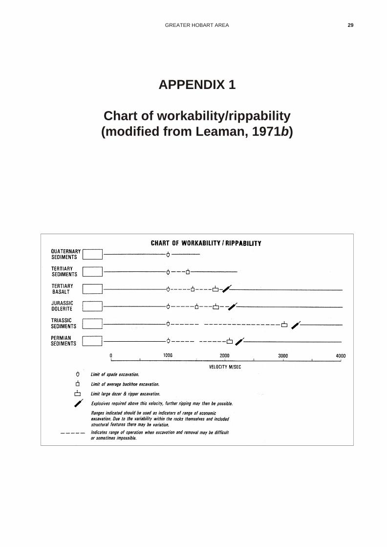
GREATER HOBART AREA 29
APPENDIX 1
Chart of workability/rippability(modified from Leaman, 1971b)

30 URBAN ENGINEERING GEOLOGICAL MAPPING PROJECT
APPENDIX 2
Information legend fromEngineering Geology maps
(Hofto, 1990)

GREATER HOBART AREA 31
~ . ~ . • 1 ~J ~ - ~l C o H h 1 ., e ~ , o~ ii " z!:: ~~
, . , . ~~ ~~ ~ ~ ~ ~ oc , ,
~~ ~Q
~ , ~ . ~
~ co _ ,~ < :~ ~~ ~~ ~ ~ ~~ I .!,~ .;~ , • , ~ ~ .!
, , ~:: .; ~~ c:i~ .' .' ~~ ~~ c:i~ c:i~ c:it:! o~ ~o
~=
z~ Hl ! . =I l> ! , , ,i _~ Ii :§ ;l z~ "S ".8 liI - . • .s.a~1! c- h~i' ~ if ·S ] 1!J:l:! ~.::::! t~t;~ ~ .; tti!~'! ~= ~i~"''!! ~: '! ~... ·l ~ .!H l!~ ,. f'~' }-~~ '~"l:l~~t~ .{! it iI ~~
",- .j;! ~ .. i: ~;:~ I!: "H '~H '~~h t' "l i i~ is ~ .~ ';,;
• i":I !~h ~~ l'r,'; ::.!! "! 11 d'l ~ ! 's IH i Ph' . ~ .. ~~~ .~ ~~ <..;~ .. ~§~ Hd, ~ § s .ut! "'..... ' .a i:: un.! ::: • !
, .. ~ u l~ ~ ~ • , l l
, l~ , '"I ]d,liI ~ • .! .! .! .! f~ l~~ ' i 0 ~j ::: -:!:!~ .. ... -s
~ •
& J. It 11!~ Hl It 1', i 1 .' ~ ,i a:! ·i !> Wh t!'! !' h ll~ i 0
l ~ H ~ ~. , . iii 2 ~ c -l~ .li N
1 i :!! ti ·§ 1 .uq , . lH c hH H % iJll! ~ P;j' OO;j' .e:;~ .. of '! i ... .!! ll-i ... l! . " ",l'! !II ~_
~ ~ ~ • ' s~ , ~l • • i~1
' s] ' ~l ~~H~t i.~1 ~~t ~ ~~1~"-i If!~~~ .... = !l ~ ~ , - i:"" ~ -;: § - , " d~ - , t;; 4 ~ 0 -'1 • • z lj! !J~I u
0 ,
~ • ffi " . -= l i • • j • " • • ., •
, , ., , , • • • • • ". .-". • ,
'i · 1 i 1 4
, I'~ i ~ ~i " ~ , , - ;; , - i > t
., ~ .~ ~~ i-H:! " • • .. 7' , , , ,
~ , ,
~ !l ~ ~ <at; • .0 • ... ::; '" J-" 5 ,* :iilfl , .~ t;; ~~ ~ · '- ~~
, , , , 0 :!~ .- • • • ~~ ~
;;
h .' ~ 71 , ~ '11 " , ~ ~ .!:.,!, • • .n , , .:. ' , , ,
" o. o. • • • 00 o.
~ 0 " ~ " " ~ " • , • ·0 • • .. ~ ~ii ,0
• ~"> , ·0 ~ ~ " . ' • " j
~r .~ t 1 1 lot, 1> , t~ l ·~ l~
il H ·'t z 1 h W~i ~i· · 0 H :~ " , "i
~~ i: .... =.! ~ i if :~ !! rl~' .. H ' . t!i :i .11 p "I' u ! t i! ., • 'i ia ! ::: i. ; ,; }H "t>1 · I! Jl
0 .~ • • <1 11: il ;- .- l~"t ~ i~ P' H
. , ":''''1: ii l , I -i ~1i ~~~ i!HO! ;; ~ ~ 1
.:::f li< ~i ili HH ~ t Jisa t ~ .. • • h l -.j L ~ .~ ~ I I I I "''' ~d-a ·1i. '" :a.~ ..
1 .~t li. .1Ii: :! lj~ll • 1
,1 ~i] ill -;;~ .1Ii: .;- pi i 'it 1::!- ~lo" ... ..!li ~~i~t lHl i ~ ! . n; l'
~~. :i !tllt 1 !' "'J I pI ' jHi !~r "i
1 ·iii'::: · li~ 1 < il, L ·5o .r~ ~ll.H ~ ~I!l z • -. in :: ·1 ~ i i 0
~ ·1 1 ~ fI ' 101 . ,~ WH " !i:l · t ~ 1 1 ., <~ • B! iIIi"ll;,; .. ! , 1 rq ~ 1 !! ~~ .~ ~il"i u
1 .. ] ~(! "2 l{! .l l l .~ ::: • 1 ! ' .• ilf· 'I, hut 0 f l I 1 ! -:l .lit t, ,< ~; ! jHl " ';; II .i 50 ." ~ !it. .Hi ': ·i ;: ~~ls. ~11!!.i~ lOU. i< • =
I I I I kJ~ I D D ~ D D .. _t.
,\;~;~
AIlVNUHlno AIlVUIl31 :JISSVllnr :JISSVllll NVIWII3cl

32 URBAN ENGINEERING GEOLOGICAL MAPPING PROJECT
APPENDIX 3
Unified Soil Classification system (from Moon, 1980)

GREATER HOBART AREA 33
! J ,
"1"'1"""< .~~ ., ... n b"!.,n',..,, "'U ..... , .. D'08 ~S 'n ~ ' ~9 .... ~ .... " ~/OO " ... '~I1~;.J'~ ' (1: " < 'dS · I.\S 'd9 ..... ~ I
" "" ~~OO ","", ' ... , ...... ""J.I ...... " 3 "'1\ ""~ ~tO(l " ... , ... , ...... 'to<; " • • .,_,
-"
. o
OU ~ ",~n
S"l~V "'9 N"o'lU
""" " jO I""""'" "'IG O!:JaI<kI1/ $3Nlj
>ti l ..... 1l ... "1' '''()
I. " " S •. '~ Sill ...... ~ u"", ,.e"1 ""'poI'l ...... oo Ie II ... ""~I "'''1'1
SH,WIlP
~11>''''''0'''. OOQ t)_"""
S3""~ Hl lM SON'I' S
(-s_'~ :;a) ww ~ U'IIl .. II ...... "'m:>olJ, ~"""'~ I" U.~ UO"IjI "un
~UNYS
I~""'S :)IJ? ON W! WLU 'W·O U'~I lWBI OJ 1""'I" W '" IJ~U ""41 O>C\'l
~llOS U3NIIIIl!J 3SI:I"I'O :O
I ,
18'''S 00l '01\1 Sill u,w ~lO 0 UWu' ~ .. '"" ~I.'u Ie I,"" ""41 .,o~
Sl lOS 03NI .. 1,I8 31\1 'j

34 URBAN ENGINEERING GEOLOGICAL MAPPING PROJECT
APPENDIX 4
Water bore database summary
Ref Owner Location AMG Quad Card Rock Year Depth DWS SWL Cased Yield TDS Cond Anal DrillerNo. Coords No.
1 Royal Tas. Hobart 526752544 82 139 A 83 56 40 0.25 1800 1 MDBot. Gardens
2 H. Calvert Lauderdale 540752516 82 7 4 63 39.6 7.6 6.1 12.2 0.32 3143 MD
3 G. Casimaty Acton View 539252542 82 16 3 56 43 30.8 0.25 MDCambridge
4 G. Casimaty Cambridge 529052545 82 17 3 56 33.8 21.2 19.5 0.24 MD
5 G. Casimaty Cambridge 539352543 82 18 3 56 33.5 21.3 10.7 0.25 MD
6 Gregg Cambridge 535352593 82 29 2 56 10.8 MD
7 Kennedy Cambridge 537252573 82 52 42 4.6 Army
8 Kennedy Cambridge 537152575 82 53 A 24 11 Army
9 Kennedy Cambridge 537352576 82 54 A 24 11 11 0.04 Army
10 Kennedy Cambridge 537352577 82 55 2 24 26.2 11 Army
11 Kennedy Cambridge 537152577 82 57 Army
12 P. Manning Cambridge 536352600 82 64 A 79 39.7 12.5 6.1 3.7 1.9 1390 1 Richards
13 L. Matthews Cambridge 534752590 82 65 3 81 26.8 9.1 7.3 1.1 TDC
14 D. Martin Cambridge 538252568 82 71 2 61 22 13.7 15.7 0.32 MD
15 E. Sutcliffe Cambridge 538352551 82 78 2 61 51.8 0.02 MD
16 E. Sutcliffe Cambridge 538352551 82 79 2 61 57.9 MD
17 E. Sutcliffe Cambridge 538352551 82 80 2 61 57.9 MD
18 A. Wicks Rokeby 539352508 82 85 2 60 45.7 6.1 9.9 0.1 MD
19 S. Ward Sandford 539252439 82 89 B 80 48.8 TDC
20 S. Ward Sandford 539552441 82 90 B 80 45.7 TDC
21 G. Casimaty Cambridge 539052556 82 94 3 56 25 22.6 0 0.25 4886 1 MD
22 Gregg Cambridge 535452592 82 96 2 56 24.1 23.8 19.8 0.4 1222 1 MD
23
24 L. Matthews Cambridge 534752590 82 100 3 81 31.7 26.8 9.1 31.7 2.15 1010 1 TDC
25 H. Manson Rokeby 535652507 82 101 4 63 37.8 18.3 6.5 0.08 44117 1 MD
26 R. McKay Cambridge 536452582 82 102 26.8 16.2 1571 1
27 D. Martin Cambridge 538252575 82 103 2 61 24.1 12.2 0.3 13.9 0.13 4919 1 MD
28 E. Sutcliffe Cambridge 538252551 82 106 3 61 44.2 38.1 21.3 5.6 0.19 2706 1 MD
29 D. Crosswell Sandford 539652404 82 126 4 81 54.9 24.4 18.3 54.9 2.15 TDC
30 P.R & C.M Sandford 540252408 82 129 4 81 79.3 24.4 18.3 79.3 0.74 1930 1 TDCLazenby & Son
31 O’Brian Sandford 537352456 82 135 4 82 40 20 0.6 4160 1 TDC
32 D. Burn Clifton Beach 543352402 83 1 0 68 12.8 11.3 3.7 0.38 TD
33 B. Contencin Sandford 542052433 83 4 2 36.6 SD
34 Griffiths Sandford 540952428 83 11 4 81 39.6 32.3 18.3 39.6 0.5 SD
35 R. Patterson Sandford 544152418 83 20 4 80 35.4 TDC
36 R. Patterson Sandford 541152433 83 21 2 82 36.6 SD
37 T. Pipkin 7 Mile Beach 541152543 83 24 02 56 38.4 MD
38 K. Rycroft Sandford 541052427 83 26 4 82 41.6 36.6 41.6 0.38 SD
39 J. A. Stones Narrawa 541052427 83 33 4 82 37.2 32.3 17.7 37.2 0.75 SDClifton Beach
40
41
42 C. Cane Clifton Beach 543052403 83 54 2 60 11 10.4 10.1 0.2 MD
43 D. Damoth Clifton Beach 542552401 83 55 0 67 18.3 0.2 TD
44 A. Morrisby Cremorne 542852443 83 56 2 60 13.7 10.7 0.12 MD
45 E. J. Watson Clifton Beach 542152396 83 57 4C 60 31.4 MD
46 E. J. Watson Clifton Beach 542152397 83 58 4 64 7.6 TD
47 B. Wiggins Clifton Beach 543252404 83 59 2 61 10.7 6.1 10.4 0.12 MD
48 Tasmania Cambridge 541252590 83 85 3 0 76.2 0.75 PhillipsGolf Club
GREATER HOBART AREA 35

49 J. Fught Half Moon 533052381 88 43 81 15.2 7 4.9 15.2 0.4 SDBay, South Arm
50
51 J. Smit Half Moon 533552378 88 99 82 18.3 3.1 1.8 18.3 0.5 SDBay, South Arm
52 N. Lucas Kingston 522352422 82 58 3 62 21.3 12.2 12.2 0.5 MD
53 T. Pearsall Kingston 523752401 82 74 3 64 30.5 6.1 9.8 0.38 MD
54
55
56
57 J. Krause Electrona 520752338 88 64 64 23.8 12.2 6.1 0.3 1428 MD
58 N. Worsley Margate 520552361 88 118 69 13.4 MONO
59 N. Worsley Margate 520752374 88 119 69 2.1 MONO
60 N. Worsley Margate 520352373 88 120 69 4.3 MONO
61 H. Thompson Beach Road 521752359 88 133 64 29.4 7.6 13.7 0.43 MDMargate
62 Tasmania Golf Barilla Bay 541452593 UR 73/64 0 84 51.2 24.4 11 24.4 5.05 2660 4700 11Club
63 Hampton Clifton Beach 541452408 UR 73/69 04
64 Edwards South Arm 533752360 UR 76/30 0 73 3 3
65 Fenton South Arm 533852381 03 76 11 1.5 1.5
66 Fenton South Arm 534052381 UR 76/11 04 76 2.3 2.3 0.5 500 1 MD
67 Robb South Arm 534152355 UR 72/33 0 72
68 McKay Cambridge 535852588 UR 87/50 3 87 73 48.8 2.13 0.37 2
69 South Arm South Arm 534152360 UR 87/41 0 87 7.6 5.08 6.8 0.17 2Primary School
70 Keenan South Arm 534152367 UR 83/51 01 83 6
71 Assman Mortimer Bay 539952422 UR 76/25 02 76 12
72 Young Roches Beach 539552512 UR 75/12 3 75Road
73
74
75
76 Royal Hobart Seven Mile 540352554 UR 84/32 02 84 14 2Golf Club Beach
77 Royal Hobart Seven Mile 540452547 UR 81/3 01 81 13.3 2.2 0.55 512 830Golf Club Beach
78 Brooks Tinderbox Road526152365 UR 73/87 34 73
79
80 Kingston Golf Kingston 526052415 UR 84/61 01 84 7 2 1.1 700Club
81
82 Hobart Show Derwent Park 523352577 82 148 C 84 29 13.7 GSDSociety
83 H & J Calvert Opossum Bay 532952410 82 150 1P 84 39.6 34.1 36 1.5 GSD
84 Grubb Sandford 533452390 82 155 3 85 61 27.4 12.2 22.7 1 S&M
85 Carter Opossum Bay 532952403 82 158 3 84 54.8 GSD
86 Richmond Cambridge 536452593 82 159 3 87 66 42 MDGolf Club
87 Grubb Opossum Bay 533152390 82 162 4 87 90 MD
88 Seabrook Opossum Bay 532752390 82 165 4 87 72 63 72 MD
89 Seabrook Opossum Bay 532752390 82 166 4 87 72 59 72 MD
90 Essex Rifle Range 538552428 82 169 4 88 78 30 6 MDRoad
91 Edwards Cambridge 534952597 82 170 3 88 42 28 42 MD
36 URBAN ENGINEERING GEOLOGICAL MAPPING PROJECT
Ref Owner Location AMG Quad Card Rock Year Depth DWS SWL Cased Yield TDS Cond Anal DrillerNo. Coords No.

92 University of Sandy Bay 526952497 82 172 B 87 48.8 24.4 ART 42.7 GSDTasmania
93 Tucceri Cambridge 535552587 82 173 4 88 60 MD
94 Tucceri Cambridge 535552587 82 174 4 88 54 24 54 MD
95 Mollon Blackmans 525352373 88 72 3 82 70.1 35.1 SDBay
96 Manning South Arm 533752377 88 73 0 82 18.3 18.3 4.6 18.3 SD
97 Waterworth Margate 521752357 88 121 C 63 3.7 TD
98 Clarence South Arm 533952357 88 140 14 77 4.9 MONOCouncil
99 Lewis South Arm 533652346 88 183 4 84 61 54.3 0.19 GSD
100 Dutch South Arm 534552377 88 192 4 87 72 MD
101 Eaton Tinderbox Rd 527252346 88 193 C 87 109.7 15.2 109.7 GSD
GREATER HOBART AREA 37
Ref Owner Location AMG Quad Card Rock Year Depth DWS SWL Cased Yield TDS Cond Anal DrillerNo. Coords No.
All depths in metres All analyses in mg/L All conductivities in mS/cm All yields in L/sec
LEG END
Ref No. map reference number SWL Standing Water Level (m)
AMG AMG co-ordinates Case Depth of casing (m)
Quad Quadrangle number Yield Yield of bore (litres/second)
Card Division of Mines reference card number TDS Total Dissolved Solids (mg/L)
Rock Rock type (see key below) Cond Conductivity of water (mS/cm)
Year Year hole drilled Anal Number of water samples analysed
Depth Total depth drilled (m) Driller Hole drilled by (see below)
DWS Depth Water Struck (m)
DRILLING COM PANY
TDC Tasmanian Drilling Company
SD Southern Drillers
MD Mines Department
TD Tasmanian Drillers
S&M Stevens & McCall
GSD Gerald Spaulding Drillers
MONO
RICHARDS
PHILLIPS
ARMY
GE OL OGY
0 Coastal sands 5 Mathinna sediments A Precambrian dolomite1 Quaternary alluvium 6 Ordovician B Tertiary basalt2 Tertiary sediments 7 Gordon Limestone C Jurassic dolerite3 Triassic 8 Cambrian D Granite4 Permian 9 Precambrian

ANALYSES OF WATER SAMPLES
Sample No. 1 12 21 22 24 25 26 27 28 30 31 62 66 68 69 77
pH 7.6 7.7 7.9 8.2 7.6 7.8 9 7.8 8.3 7.2 6.4 6.2 7 7.2 7 7.6
Conductivity (mS/cm) 2260 1750 650 8 1470 0 0 0 0 3100 3600 4700 3030 490 830
Item (mg/l)
CO3 0 0 0 58 0 325 41 40 0
HCO3 595 560 404 390 570 0 337 379 365 435 35 130 210 740 85 430
Cl 720 470 2320 386 315 1906 632 2450 1200 840 1870 1470 590 710 83 115
SO4 32 54 247 39 26 305.9 50 215 81 145 220 46 220 92 43 46
SiO2 40 62 36 47 44 48.4 17 32 49 20 80 13 16
Ca 73 51 274 85 76 123.8 51 133 164 84 14 90 58 78 3.3 120
Mg 190 66 414 103 80 252 88 260 235 68 120 125 58 110 1.8 14
Fe 0.1 0.1 0 0 0.1 0 0 0 0 0.1 0.1 0.1 5.6 0.1 0.1 0.1
Al 0.2 0.2 0 0 0.2 1.2 0 0 0 0.2 0.2 0.2 0.2 0.2 0.2
K 7.3 14 18.5 3.5 3.7 0 8 17.5 8 9.8 25 52 8.3 10.5 2 3.8
Na 300 280 806 229 175 4013 416 1213 477 580 720 690 420 620 115 78
TDS 1800 1390 4886 1222 1010 44117 1571 4919 2706 1930 4160 2830 1560 1930 350 620
Alkalinity (as CaCO3) 485 470 329 464 465 0 379 377 411 355 105 170 600 70 350
Hardness (Permanent) 480 0 2059 172 0 0 110 1025 965 490 500 630 380 43 357
Hardness (Temporary) 486 400 329 464 519 0 379 377 411 30 105 170 600 15.5 350
38 URBAN ENGINEERING GEOLOGICAL MAPPING PROJECT

GREATER HOBART AREA 39
NO SITE REFERENCE NUMBER ON MAP
REF NO DATABASE REFERENCE NUMBER
TE LAND TENURE
NP National Park
CA Conservation Area
SF State Forest
FH Freehold
CL Crown Land
OT Other
US PLANNING AUTHORITY LAND USE
QP Quarrying permitted
QN Quarrying not permitted
QD Quarrying discretionary
RES RESERVES (tonnes)
NOT Not determined
NIL <1 000
SML 1 000–10 000
MED 10 000–1 000 000
LGE 1 000 000–1 000 000 000
VST >1 000 000 000
OPS OPERATIONAL STATUS
FOP Fully operational
OCC Occasional
ABN Abandoned
NEW New area
COL COLOUR
LT Light
DK Dark
WH White
BK Black
GR Grey
YL Yellow
BR Brown
RD Red
MO Mottled
EX EXTRACTABILITY
BH Backhoe
EX Excavator
DZ Bulldozer (D9)
BL Blasting
USC UNIFIED SOIL CLASSIFICATION
SYSTEM GROUP SYMBOL
See Appendix 3
USES USES
CA Crushed aggregate
RS Road sub-base
RB Road base course
RA Road admixture
RW Road wearing (sealed)
RU Road unsealed
RH Road hotmix sand
CC Concrete coarse aggregate
CF Concrete fine aggregate
CP Concrete pipe
CB Concrete block
CT Concrete tile
LW Lightweight aggregate
SM Sand mortar
SF Sand filtration
SN Sand foundry
SG Sand glass
SB Sand brick
SD Sand bedding
BC Brick clay
EC Earthenware clay
PC Porcelain clay
FC Filter clay
BS Building stone
HM Heavy mineral
SI Silica
QL Quick lime production
QU QUALITY
M Marginal
S Satisfactory
E Excellent
GP GEOPHYSICS
Y Yes
N No
DR DRILLING
Y Yes
N No
LA LABORATORY
Y Yes
N No
APPENDIX 5
Construction materials database summary

Site Ref No. Co-Ords Locality Occupier M LEASE TE US RES OPS COL EX USCS USES QU GP DR LA
1 82018 525152574 Lutana Crown fh qn sml abn dz ca s n n n
2 82021 520552570 Glenorchy G. Quon Construction 751P/M fh qn med fop bl ca s n n y
3 82022 520652548 Limekiln Weily & Sons, G. J. 603P/M fh qn med fop bl ca s n n y
4 82055 517352584 Glenlusk fh qp sml abn dz GM rs s n n n
5 82056 518352590 Collinsvale fh qp nil abn dz GM rs s n n n
6 82057 517852626 Claremont Ward, P. fh qp sml occ dz GM rs s n n n
7 82058 518752628 Claremont Vicary, M. F.& Zantuc 628P/M fh qn nil abn dz GM rs s n n n
8 82059 517752639 Granton Rayner, H. fh qp sml abn dz GM-GP rs s n n y
9 82060 520952550 Tolosa Street Weily, G. J. fh qn abn dz GP rs m n n n
10 82073 519352586 Berriedale Jaques, R. E. fh qp nil abn dz GM-SM rs s n n n
11 82074 520352617 Claremont Crown cl qn sml fop dz GW-GP rs s n n y
12 82084 519152608 Chigwell Jay, K. C. fh qn sml occ dz GP-GC rs s n n n
13 82089 517452622 Berriedale Road Ward, P. fh qp sml occ GP rs,ru s n n y
14 82131 520252646 Austins Ferry Hobart Brick Co. fh qp br dz bc s n n n
15 82133 518152620 Claremont Woolnough, E. (ex) qp med new dz bc n n n
16 518952587 Goats Hill Berriedale not abn dz rs
17 519052549 Knights Creek reservoir lge abn bl ca,bs s
18 520052649 Ten Mile Hill sml abn bl bc s
19 522252620 Claremont Golf Club
20 518152642 Black Snake Lane fh med abn bl ql s
21 517752648 Black Snake Lane fh med abn bl ql s
22 525552572 fh med abn bl qs s
23 524652515 W end Poets Road lge abn bl bs s
24 525752542 N Domain lge abn bl ca s
25 526252535 S Domain lge abn bl ca s
26 82005 525152488 Proctors Saddle Bain, M. fh qn med abn dz GW rb,rw,ru s n n y
27 82023 523952529 Giblin Street Eiszele Estate fh qn med occ bl ca n n y
28 82035 524852484 Proctors Saddle Bain, M. fh qn med abn dz GC rs s n n n
29 82036 524752480 Southern Outlet Council cl qp sml abn dz rs,rb,rw,ru s n n n
30 82037 525352490 Proctors Road Bain, M. fh qn sml abn dz ca s n n n
31 82038 525152487 Proctors Saddle Bain, M. fh qp nil abn dz GP rs,rb,rw,ru s n n n
32 82039 522052478 Fern Tree Council fh qp med abn dz GP-GC rs s n n n
33 82040 525352497 Dynnyrne fh qn sml abn bl ca s n n n
34 82070 525252480 Proctors Road Crown cl qn med abn bl GP ca s n n n
40
UR
BA
N E
NG
INE
ER
ING
GE
OL
OG
ICA
L M
AP
PIN
G P
RO
JE
CT
Site Ref No. Co-Ords Locality Occupier M LEASE TE US RES OPS COL EX USCS USES QU GP DR LA
35 82071 522052521 Pottery Road fh qn sml abn dz GP rs s n n n
36 82072 524152488 Ridgeway Road Council cl qn med abn dz GP rs s n n n
37 82082 523452482 Ridgeway Road Council cl qn sml abn dz GP-GC rs s n n n
38 82094 523552526 Giblin Street Eiszele Estate fh qn med occ dz GC-GP rs s n n n
39 82095 525652493 Proctors Road Buckley, A. D. & Weily fh qn med abn bl ca s n n n
40 82132 524652522 Knocklofty Crisp & Gunn (ex) fh qn nil abn br dz bc n n n
41 82137 523852544 New Town Hobart Brick Co. qn dz bc n n n
42
43
44
45
46 82012 534852572 Cambridge Crown fh qp nil abn dz SC rs,rb,ru m n n y
47 82013 537852493 South Arm Road Crown/Reynolds, C. D. fh qp nil abn dz rs,ru m n n n
48 82014 535052568 Cambridge McConnen, H. fh qp sml abn dz GM rs s n n y
49 82015 533752542 Mornington Johnson, C. R. 646P/M fh qp med fop dz GW rs,rb,rw,ru s n n y
50 82016 527452597 Risdon Risdon Tavern fh qn sml occ dz GW-GC rs,rb,rw,ru s n n y
51 82017 534852478 Droughty Point Tas Finance Agency fh qp med abn dz GC rs m n n n
52 82019 537352541 Mt Rumney Crow, P. M. fh qp med occ dz GP rs s n n y
53 82020 535852552 Mt Rumney Graham, W. A. fh qp sml occ dz GP-GC rs s n n y
54 82024 530652575 Flagstaff Gully Pioneer Quarries 677P/M fh qp med fop bl ca s n n n
55 82027 529252534 Rosny Hill PWD cl qn med abn bl ca s n n n
56 82029 533052565 Stringy Bark Gully Crown cl qn med abn dz SC rs,rb,ru s n n y
57 82030 533552568 Barilla Rivulet cl qn sml abn dz SC rs,rb,ru s n n n
58 82031 534152515 Rokeby Road Goodwin, C. E. estate 648P/M fh qp med fop dz GC-SC rs,rw,ru s n n n
59 82032 532352553 Warrane Von Bibra, K. fh qp sml abn dz SC rs,rw,ru s n n n
60 82033 533052553 Warrane fh qn nil abn dz SC rs s n n n
61 82034 531752557 Warrane Von Bibra, K. cl qp nil abn dz SC rs,rw,ru s n n n
62 82075 527452582 Risdon Cove PWD fh qp med abn dz GC rs m n n n
63 82076 526852595 Bowen Park Clarence Commission fh qp nil abn GP-GC rs m n n n
64 82078 526652618 lge abn bl CA-BS
65 82081 536052598 Cambridge Manning 909P/M fh qp sml occ dz GP rs s n n y
66 82083 530652568 Flagstaff Gully Clarence Commission cl qn med abn dz ca,rs s n n y
67 82085 535352568 Cambridge McConnen, T. fh qn sml abn GP rs s n n n
68 82087 534452550 Mt Rumney Andrews, C. L. fh qn nil abn GP rs s n n n
GR
EA
TE
R H
OB
AR
T A
RE
A4
1

Site Ref No. Co-Ords Locality Occupier M LEASE TE US RES OPS COL EX USCS USES QU GP DR LA
69 82088 540752439 Sandford Morrisby, G. R. 970P/M fh qp med fop dz GC-GP rs s n n y
70 82097 537652567 Cambridge Walpole, T. fh qp nil abn gr bh SP sd s n n y
71 82098 539252523 Lauderdale Lowe, V. fh qp nil gr bh SP sm,sd s n n y
72 82099 540452464 Sandford Calvert, A. H. & P. H. 860P/M fh qp sml fop gr bh SP sm,sd s n n n
73 82100 540352454 Sandford Calvert, A. H. 860P/M fh qp sml abn yl SP sm,sd n n n
74 82104 539952480 Lauderdale Clarence Council cl qp not new bh SP-ML sm,sd s n y y
75 82118 539552527 Acton Road Toronto Pastoral Co. fh qp sml abn wh,gr SP sm,sd s n n y
76 82119 535152547 Mt Rumney fh qn med abn bh SP sm,sd s n n n
77 82120 540752448 Sandford Morrisby, G. L. 809P/M fh qp sml occ wh,yl bh SC-SP sm n n y
78 82121 540052394 Sandford Lazenby, E. H. & J. 808P/M fh qp med abn wh bh SP sn s n n y
79 82122 540352400 Sandford ACI 813P/M fh qp med occ wh bh SP sn s n n y
80 82123 539452400 Sandford Lazenby, E. H. 808P/M fh qp sml occ wh bh SP sn s n n n
81 82124 540152407 Sandford ACI 813P/M fh qp med fop wh bh SP sn n n y
82 82134 534752549 Tunnel Hill fh qn med new dz bc n n n
83 82135 534952540 Mt Rumney fh qp lge dz bc n n n
84 82138 540852390 Sandford fh qp not new yl ex bc n y y
85 83020 542752455 Cremorne E. O. Calvert fh med dz GC-SC rs m n n y
86 83023 540952432 Cremorne Crown cl sml occ dz GP-GC rs m n n n
87 83038 544752408 Clifton Beach Clifton Beach P/L fh bh SP sg,sd n n n
88 83039 541852464 Cremorne A. R. & R. L. May 807P/M fh med occ bh SP-SC sg,sd n n n
89 83041 541852549 Seven Mile Beach Loongana Sawmills 804P/M fh med abn bh SP sm,sg,sd n n y
90 83042 540952583 Seven Mile Beach Commonwealth cl sml occ bh SP-SC sm s n n y
91 83043 540952469 Lauderdale P. H. Calvert 860P/M fh sml fop bh SM sm,sd n n n
92 83044 541052476 Lauderdale P. H. Calvert 860P/M fh sml abn bh SP-SM sm,sd n n n
93 83045 542452464 Cremorne R. J. Millington fh nil abn bh SP sm n n n
94 88065 539852364 South Arm Long, C. cl qn sml abn wh SP cf,sd m n n y
95 88066 539452380 South Arm Werner, R. fh qp sml new bh SP sd s n n y
96 88067 538452356 South Arm Males, G. L. 784P/M fh qp med fop bh SW-SP rh,cf s n n y
97 88068 539652364 South Arm Gelibrand Estate fh qn nil abn wh bh SP cf n n y
98 88069 536552352 South Arm Calvert, D. G. 800P/M fh qp med fop br bh SP rh,cf n n y
99 88072 534452343 South Arm Calvert, D. G. 810P/M fh qp sml abn bh SP rh,cf n n y
100 89015 540952389 Musks Road Castle, K. J. & M. 1094P/M fh qp sml abn dz GM rb,ru s n n n
101 89018 541852378 Musks Road Watson, A. P. 864P/M fh sml abn ex SP sg n n y
102 89019 541052365 Calverts Beach Crown of qn med new ex SP sg n n y
42
UR
BA
N E
NG
INE
ER
ING
GE
OL
OG
ICA
L M
AP
PIN
G P
RO
JE
CT

Site Ref No. Co-Ords Locality Occupier M LEASE TE US RES OPS COL EX USCS USES QU GP DR LA
103 89020 541252366 Calverts Beach Watson, A. P. 864P/M fh qp sml fop ex SP-SM sg n n y
104 89021 541252376 Musks Road C. Martin Constructions 864P/M fh qp sml abn ex SP sg n n y
105 526952572 Shag Bay lge abn bl
106 529852596 Risdon Vale sml abn dz rs
107 531252535 Mornington Hill lge abn bl bs
108 533752520 Minow Street Dam sml abn dz rs
109 533252550 Tunnel Hill sml abnm dz rs
110 533252553 Tunnel Hill sml abn dz rs
111 533452561 Tunnel Hill sml abn dz rs
112 534952564 Tasman Hwy Cambridge lge abn be ca
113 534152570 Hobdens Road Cambridge sml abn dz rs
114 528552612 Risdon Brook Dam sml abn dz rs
115 540152364 Calverts Beach lge abn bh cf
116 533452350 Fort Direction Road nil abn dz rs
117 538552371 Ralphs Bay med abn bl
118 534052391 South Arm
119
120 82001 522052448 Summerleas Road Kingborough Council fh qp med occ dz GP ra,ru s n n y
121 82002 525852427 Proctors Road Kingborough Council cl qp sml abn dz GP rs s n n n
122 82006 525252447 Proctors Road cl qp sml abn dz GW-GM rs,rb,rw,ru s n n y
123 82007 526052434 Proctors Road Bones, I. M. fh qp med abn dz GC rs s n n y
124 82061 525652427 Proctors Road Pioneer Concrete fh qn nil abn dz GC rs m n n n
125 82096 525752407 Kingston fh qn sml abn wh bh SM sd s n n n
126 82101 524652398 Boronia Hill Pearsall, T. fh qn sml abn bh SP sm,sd s n n n
127 82102 525452393 Blackmans Bay Quinn, L. 943P/M fh qn sml occ gr bh SP sm,sd n n y
128 82126 523652408 Kingston Hobart Brick Co. 820P/M fh qn abn yl,br ex CL sb n n n
129 82128 526552424 Bonnet Hill Kruse, H. D & D. I. 884P/M fh qp med fop br dz bs s n n n
130 82136 523252408 Kingston fh qp ex bc,ec n n n
131 88003 527652340 Tinderbox Hale, E. M. 873P/M fh qp sml abn dz GW-GC rb,ru m n n y
132 88018 527152340 Tinderbox Hale, E. M. 873P/M fh qp med occ dz GP-GC rs,ru m n n y
133 88019 527152340 Tinderbox Hale, E. M. 873P/M fh qp med occ dz GP rs,ru m n n n
134 88024 527052342 Tinderbox Kingborough Council cl qp med abn dz GP rs,ru m n n y
135 88030 520052311
136 88033 525452368 Howden Taylor, W. 874P/M fh qp med occ dz GW-GM rb,ru s n n y
GR
EA
TE
R H
OB
AR
T A
RE
A4
3

Site Ref No. Co-Ords Locality Occupier M LEASE TE US RES OPS COL EX USCS USES QU GP DR LA
137 88038 521552356 Margate Kingborough Council cl qn nil abn dz rs,ru n n n
138 88053 521452339 Barretta Marine Board cl med fop dz SP-GP rb,ru s n n n
139 88054 523452386 Blackmans Bay Hazell Brothers fh qp sml abn dz GC rs n n n
140 88059 525352364 Howden fh qn nil abn dz rs n n n
141 88060 524852363 Howden Hazell Brothers 882P/M fh qp sml abn rd dz CL be s n n n
142 88061 524252358 Howden Hazell Brothers 882P/M fh qp med fop yl CL sb s n n n
143 88073 521452339 Margate Marine Board cl qp med fop bh SP cc n n y
144 88074 525452385 Blackmans Bay fh qn nil abn gr bh SP-SM cf,sm,sd n n y
145 88075 525352384 Blackmans Bay fh qp sml abn gr bh SP sm m n n n
146 88076 524452382 Blackmans Bay fh qp sml abn gr bh SC cf,sm,sd n n n
147 88077 523452382 Blackmans Bay fh qp sml abn bh SP-SM cf,sm,sd n n n
148 88078 524152363 Howden Hazell Brothers fh qn sml abn bh SP-SM cf,sm,sd n n n
149 88080 521352302 Lower Snug Crown cl qp sml abn SC sm n n n
150 521352340 Barretta (Electrona tip)
151 523852387 Coffee Creek
152 525452396 Boronia Hill Kingston
153 520252410 Leslie Vale (Sth Out. Road)
154 524352436 Firthside (Sth Out. Road)
155 523552436 Labell Alliance
156 524652479 Mt Nelson
157 520052413 Sandfly
158 520752641 Ten Mile Hill
159 528852598 Risdon Vale
160 533052596 Craigow Hill
161 532752549 UPR 1973/21
44
UR
BA
N E
NG
INE
ER
ING
GE
OLO
GIC
AL M
AP
PIN
G P
RO
JE
CT

GREATER HOBART AREA 45
APPENDIX 6
Site investigation reference point summary
No Site investigation reference number
COORD AMG co-ordinate 4 digit easting, 5 digit northing
REF Source of information1 P. Terry soil survey, 19832 P. Terry soil survey, 19843 R. Woolley soil survey, 1983D Dirtwork, Department of Mines
laboratory and XRD analysisUR Unpublished Report, Department
of MinesMD Mines Department internal report ?TR Technical Report, Department
of MinesH209 P. Hofto site reference point
ROCK Rock typeTs Tertiary sedimentsQsa Quaternary sandQs Quaternary sedimentsPs Permian sedimentsTb Tertiary basaltJd Jurassic doleriteTrs Triassic sediments
USC Unified Soil Classification System groupsymbol
PROFILE Description of soil profileA & B — sample location
MC Moisture Content (%)
LL Liquid Limit (%)
PL Plastic Limit (%)
PI Plasticity Index (%)
LS Linear Shrinkage (%)
Dis Dispersivity — Emerson Class Number
Veloc Seismic refraction velocity (m/sec)
Rip RippabilityR rippableM marginalB blasting
Const Construction materialsCA Crushed aggregateRG Road gravel
G/W Groundwater occurrence
Slope Slope angle (degrees)
Erod ErodabilityL LowP PoorM ModerateE Expansive soilsG GullyT TunnelC Cliff/coastalS SheetF Foreshore
Septic Septic tank suitabilityP PoorM ModerateL LowMG MarginalG Good
Stabil Stability of siteS StableM MarginalMD ModerateC CreepU Unstable
Drill Drill information
Comment general comments about site
XRD X-Ray Diffraction analysis (semi-quantitative)
No LO CA TION COORD REF ROCK DEPTH USC PRO FILE
1 17 Victoria Esplanade,Bellerive
529552522 2 Ps CL 0–110 mm orange/brown sandy CLAY
CL 110–450 mm brown sandy CLAY
CH 450–760 mm brown CLAY
2 Bellerive Battery, GunningStreet, Bellerive
529852520 2 Ps 0.48 OL 0–300 mm brown organic clayey SAND
SW 300–480 mm brown gravelly SAND
480 mm+ weathered SILTSTONE
3 1 Beach Street, Bellerive 530852525 2 Qsa ML 0–50 mm brown Organic SAND
SP 50–640 mm brown SAND
SC 640–820 mm grey SAND
4 1 km before Mt Rumneysummit, Cambridge
536052545 2 Jd 1.6 CL 0–200 mm brown silty CLAY
CH 200–400 mm brown CLAY A
CH 400–1600 mm brown gravelly CLAY
1600 mm+ DOLERITE bedrock
6 Recreation Ground at rear of124 Carella Street, Howrah
533652590 2 Ps ML 0–300 mm brown SILT
CL 300–450 mm brown silty CLAY
CL 450–900 mm grey/brown CLAY A
7 Southern end Droughty PointRoad, Rokeby
535552575 2 Jd 1.5 CL 0–200 mm silty CLAY
CH 200–450 mm brown gravelly CLAY
CH 450–850 mm brown silty CLAY A
9 Second Bluff, WentworthStreet, Howrah
531552520 2 Trs 1.5 OL 0–350 mm grey organic silty SAND
SP 350–760 mm brown SAND
CL 760–1000 mm orange/brown sandy CLAY A
10 Corner Cambridge Road andClarence Street, Bellerive
530052530 2 Trs 0.9 OH 0–450 mm grey organic silty CLAY
SP 450–600 mm brown SAND
CL 600–900 mm orange sandy CLAY
13 Cambridge Rd opposite hotel,Cambridge
535052568 2 Jd 1 ML 0–300 mm brown clayey SILT A
14 Mt Mather, Sandford 538552475 2 Ps 1 OL 0–100 mm grey/black organic SILT
CH 100–450 mm grey gravelly CLAY A
15 Opposite HEC substationDroughty Point Road, Rokeby
535952497 2 Ts OL 0–120 mm grey/black sandy SILT
CH 120–250 mm yellow/brown CLAY A
CH 250–550 mm yellow/brown sandy CLAY
16 Opposite Police Academy,South Arm Road, Rokeby
537652493 2 Jd 1 CL 0–100 mm grey gravelly silty CLAY
CH 100–250 mm grey gravelly CLAY A
CH 250–450 mm orange/grey gravelly CLAY
17 Rear of Rokeby Tavern,Rokeby
536652502 2 Ps 1.2 CL 0–100 mm grey organic sandy CLAY
CL 100–200 mm orange/brown gravelly CLAY
CL 200–500 mm brown gravel sandy CLAY A
CL 500–700 mm white/grey gravelly CLAY
21 Corner Nankoor Cres. andWarren Crt, Howrah
531952534 2 Trs 1.5 SM 0–450 mm grey organic SILT
CL 450–900 mm+ yellow sandy CLAY A
22 Junction Sports Ground andBounty Street, Warrane
526852554 2 Trs 0.9 OL 0–100 mm black/brown organic SILT
CL 100–250 mm brown gravelly sandy CLAY
CH 250–900 mm orange/brown sandy CLAY A
900 mm+ weathered BEDROCK
24 North end of Flagstaff GullyReservoir, Flagstaff Gully
530752555 2 Ps 0.6 OL 0–100 mm brown organic clayey SILT
CH 100–600 mm orange/brown sandy CLAY A
600 mm+ weathered SILTSTONE
25 16 Musgrove Road, GeilstonBay
528152568 2 Tb 1 OL 0–50 mm black organic clayey SILT
CH 50–270 mm orange/brown sandy CLAY A
46a AP PEN DIX 6 46b
No. MC LL PL PI LS Dis Veloc Rip Const G/W Slope Erod Sep tic Stabil Drill Comment1
1 1600 R 3 S P S
2 1600 R 11 TG P S
3 450 R 1 L P S
4 2300 M 15 L P S/M
46 20
6 1700 R 8 TG P S
45 20 25 16 XRD A mont:90-95% kaolin:0-5%
7
52 14
9 1100 R 4 CC P S
46 * 14
10 1700 R 4 L P S
13 21 38 16 22 15 2400 M 7 L M S
14 1700 R 7 TGS P/MG S
27 54 * 14 XRD A mont:30-35% kaolin:60-65%
15 800 R P S
13 48 9 39 14
16 1400 R 10 L P S/M
26 32 20 12 10 XRD A mont:90-95% kaolin:5-10%
17 1600 R 3 L MG S
14 31 10 21 14 XRD A mont:40-45% kaolin:55-60%
21 1700 R 15 TG P S
19 35 * 10
22 1700 R 6 TG MG/P S
26 63 17 46 18 XRD A kaolin:85-90% gibbsite:10-15%
24 2100 M 6 TG P S
30 67 19 48 20 XRD A mont:60-65% kaolin:30-35% feldspar:trace
25 1900 R 2 L P S
27 69 20 49 20 XRD A mont:90-95% kaolin:5-10%

47a AP PEN DIX 6 47b
No. MC LL PL PI LS Dis Veloc Rip Const G/W Slope Erod Sep tic Stabil Drill Comment1
26 2300 M 4 SG P S
17 27 * 6 XRD A mont:15-20% kaolin:5-10% illite:65-70%
27 1600 R 4 L M S
23 68 15 53 20 XRD A mont:90-95% kaolin:5-10%
28 2300 M 4 SG P S
29 1700 R 2 TG P S
22 66 12 54 20
25 63 15 48 17 XRD B mont:95-100% kaolin:trace
30 1100 R 3 TG P S
25 66 18 48 12 XRD A mont:30-35% kaolin:65-70%
31 35 75 20 55 28 1800 R 25 M P M XRD A mont:95-100% kaolin:trace
27 65 20 45 18 B mont:95-100% kaolin:trace
32 1100 R 6 TG P S
33 80 16 64 18
33 1100 R 4 TG P S
31 75 17 58 15 XRD A mont:95-100% kaolin:trace
37 1500 R L P S
32 90 22 68 20 XRD A mont:10-15% kaolin:10-15% illite:70-75%
38 1900 R 5 L L S
39 97 19 78 33 XRD A mont:60-65% kaolin:35-40%
42 1800 R 1 L P S
35 76 22 54 21
43 1100 R 10 TG P S
22 54 12 42 11 XRD A mont:90-95% kaolin:0-5%
44A 800 R P P S
16 56 10 46 12 XRD A mont:90-95% kaolin:5-10% lapidacrocite tr.
46 1700 R 15 STG P/MG S
47 1200 R 5 TG P S
54 45 11 34 14 XRD A mont:60-65% kaolin:35-40%
48 1900 R 5 L M S
14 35 12 23 11 XRD A mont:60-65% kaolin:35-40%
No LO CA TION COORD REF ROCK DEPTH USC PRO FILE
26 Bedlam Walls, Geilston Bay 527452570 2 Ps 0.35 ML 0–100 mm grey gravelly clayey SILT
CL 100–350 mm grey gravelly silty CLAY A
350 mm+ weathered SILTSTONE
27 Church Point, Risdon 525952586 2 Jd 1 ML 0–100 mm grey/black clayey SILT
CH 100–500 mm brown sandy CLAY A
28 HEC Substation, SugarloafRoad, Risdon Vale
528352585 2 Ps 0.3 ML 0–150 mm brown gravelly clayey SILT
CL 150–300 mm grey gravelly silty CLAY A
300 mm+ weathered SILTSTONE
29 Corner Murtons Road and East Derwent Highway, WoodvilleBay
523652617 2 Trs 1 OH 0–100 mm black silty CLAY
CH 100–250 mm brown silty CLAY A
CH 250–380 mm brown CLAY
CH 380–580 mm white/brown sandy CLAY B
30 East Derwent Highway aboveWoodville Bay, Otago Bay
523252654 2 Trs 1.5 OL 0–100 mm brown organic sandy SILT
CL 100–200 mm black silty CLAY
CH 200–800 mm brown CLAY A
CH 800–900 mm grey/brown gravelly CLAY
31 East Derwent Highway, OtagoBay
524152608 2 Jd 1.5 CH 0–250 mm brown CLAY A
CH 250–750 mm brown CLAY
CH 750–900 mm yellow gravelly CLAY B
32 Cleburne Point, Risdon Cove 525852594 2 Trs 1 GP 0–100 mm GRAVEL
CL 100–300 mm brown sandy CLAY
OL 300–600 mm black organic SILT
CH 600–700 mm brown sandy CLAY A
33 Eastern end Bowen Bridge,Risdon Cove
525252596 2 Trs OL 0–200 mm black organic sandy SILT
CH 200–400 mm brown sandy CLAY
CH 400–800 mm brown CLAY A
SC 800–900 mm yellow/brown clayey SAND
37 Seven Mile Beach Road,Seven Mile Beach
540052540 2 Jd 1.5 OL 0–100 mm brown organic clayey SILT
CL-CH 100–300 mm black silty CLAY
CH 300–800 mm brown CLAY A
38 Northeast of junction of ActonRoad and Acton Drive.
538052504 2 Tb 1 OL 0–200 mm red/brown organic clay SILT
CH 200–500 mm red/brown sandy CLAY
CH 500–520 mm red/brown gravelly CLAY
42 Corner Colebrook Road andRichmond Golf Club,Cambridge
536052587 2 Trs 0.7 CL 0–250 mm brown silty CLAY
CH 250–700 mm yellow/brown/green CLAY A
OL 700 mm+ SANDSTONE bedrock
43 50 m east of corner ColebrookRoad and Richmond GolfClub, Cambridge
536252589 2 Trs 1 0–300 mm grey organic SAND
CH 300–500 mm brown sandy CLAY A
SC 500–750 mm brown clayey SAND
44 Corner Acton Road andTasman Highway, Cambridge
537252525 2 Ts ML 0–200 mm brown SILT
CH 200–600 mm grey/brown sandy CLAY A
SC 600–800 mm white/brown clayey SAND
46 300 m east of Mines Div.Store, Mornington
533252544 2 Ps 1 ML 0–200 mm grey SILT
CL 200–300 mm orange/grey gravelly CLAY
47 Mines Division Store,Mornington Road, Mornington
532952544 2 Trs ML 0–250 mm grey rock flour SILT
CL 250–800 mm grey/brown sandy CLAY A
SC 800–1000 mm white/grey clayey SAND
48 Half distance along Pass Road, Rokeby
534652530 2 Tb/Ps 2 OL 0–200 mm black organic sandy SILT
SC 200–450 mm grey clayey SAND
CH 450–900 mm orange/brown sandy CLAY A
SC 900–1100 mm grey/orange clayey SAND

No LO CA TION COORD REF ROCK DEPTH USC PRO FILE
49 18 Tollard Court, Rokeby 535052510 2 Tb 1 OH 0–120 mm black organic SILT
GC 120–200 mm red/brown clayey GRAVEL
CH 200–650 mm mottled brown CLAY A
GP 650–700 mm red/brown fine GRAVEL
50 Reservoir northeast of Rokeby 534552511 2 Tb 1.5 MH 0–200 mm red/brown gravelly SILT
CH 200–750 mm brown sandy CLAY A
CH 750–900 mm brown gravelly CLAY
51 Corner Tranmere Road andRokeby Road, Howrah
533052523 2 Jd 1.5 OL 0–200 mm black organic sandy SILT
CH 200–750 mm brown sandy CLAY A
CH 750–820 mm brown gravelly CLAY
52 Aintree, Pass Road,Mornington
534452539 2 Trs OL 0–150 mm grey organic SILT
SP 150–200 mm white SAND
CH 200–1100 mm grey/orange CLAY A
53 Corner Norma Street andSirius Street, Howrah
532952531 2 Jd 1.5 OL 0–100 mm black organic clayey SILT
CH 100–200 mm brown/black CLAY A
CH 200–800 mm brown CLAY B
GC 800–900 mm brown clayey GRAVEL
54 Corner Minerva Street andCorinth Street, Howrah
533652513 2 Jd 1.5 ML 0–200 mm red/brown SILT
CH-GC 200–650 mm red/brown gravelly CLAY A
GC 650–750 mm brown clayay GRAVEL
62 Restdown Point, Otago Bay 523252610 2 Jd 1.5 CH 0–800 mm red/brown CLAY A
CH 800–1100 mm green/brown CLAY B
63 Park off Golf Links Road,Lindisfarne
529052657 2 Trs OL 0–150 mm brown organic silty SAND
CL 150–600 mm orange/brown sandy CLAY A
64 Opposite 26 Rosny Esplanade,Montagu Bay
528852538 2 Jd 1.5 OL 0–250 mm black organic SILT
CH 250–700 mm red/brown gravelly CLAY A
65 Opposite 80 Rosny Esplanade,Rosny Point
528652527 2 Jd 0.5 CH 0–300 mm red/brown silty CLAY A
66 3 York Street, Bellerive 530352530 2 Trs 1.5 OL 0–350 mm black organic SILT
CL 350–990 mm brown sandy CLAY A
SC 990–1050 mm grey/brown clayey SAND
67 South end Negara Crescent,Goodwood
523852588 2 Tb 1 GM 0–200 mm unconsolidated fill GRAVEL
CH 200–500 mm green brown CLAY A
68 23 Negara Crescent,Goodwood
524252585 2 Tb 1 CH 0–400 mm brown sandy CLAY A
69 662 Nelson Road, Mt Nelson 527552470 2 Jd 1 OL 0–250 mm brown organic clayey SILT
CH 250–600 mm orange/brown sandy CLAY A
GM 600–700 mm yellow sandy GRAVEL
70 Corner Huon Highway andSummerleas Road, Kingston
523352427 2 Tb 1.5 MH-CH 0–250 mm clayey SILT/silty CLAY A
CH 250–800 mm red/brown sandy CLAY B
72 North of Cades Spur, HuonHighway, Kingston
521252425 2 Tb 1 CH 0–150 mm brown silty CLAY
CH 150–600 mm brown gravelly CLAY A
73 Berriedale Bowling Club,Berriedale
521052600 2 Trs 1.5 OL 0–300 mm grey organic sandy SILT
CH 300–450 mm grey/brown CLAY A
CH 450–700 mm brown CLAY B
CH 700–850 mm brown sandy CLAY
74 6 Austins Ferry Road, AustinsFerry
520852635 2 Trs OL 0–100 mm black organic silty LOAM
OH 100–250 mm black organic silty CLAY
CH 250–800 mm brown sandy CLAY A
75 North end of Goulds Lagoon,Hestercombe Road, AustinsFerry
519452654 2 Jd 1.5 OH 0–100 mm black organic SILT
CH 100–800 mm black CLAY A
48a AP PEN DIX 6 48b
No. MC LL PL PI LS Dis Veloc Rip Const G/W Slope Erod Sep tic Stabil Drill Comment1
49 1900 R 4 L M S
36 101 20 81 XRD A mont:80-85% kaolin:35-40%
50 1900 R 5 L P S
30 115 20 95 20 XRD A mont:55-60% kaolin:40-45%
51 1500 R 3 L P S
20 64 13 51 18 XRD A mont:85-90% kaolin:10-15%
52 1100 R 5 L P S
88 20 68 25
53 1800 R 22 L P MD
30 75 20 55 27 XRD A mont:90-95% kaolin:5-10%
23 110 20 90 20 B mont:90-95% kaolin 5-10%
54 1400 R 18 L M S
17 52 14 38 17 XRD A mont:85-90% kaolin:10-15%
62 38 123 17 106 20 1600 R 4 L P S XRD A mont:95-100% kaolin:0-5%
24 96 30 66 19
63 1700 R 2 TG P S
49 * XRD A mont:95-100%
64 1800 R 4 L MG S
23 108 21 87 28 XRD A mont:75-80% kaolin:20-25%
65 35 64 20 44 19 2400 M 5 L P S
66 1700 R 1 L P S
18 50 14 36 9 XRD A mont:5-10% kaolin:85-90% illite:trace
67 1800 R L P S
32 89 17 72 15 XRD A mont:60-65% kaolin:35-40%
68 20 82 18 64 18 1900 R 1 L P S XRD A mont:90-95% kaolin:0-5% illite:0-5%
69 2400 M 15 L MG S/M
31 76 14 62 21 XRD A mont:50-55% kaolin:45-50%
70 34 140 34 106 20 1800 R 3 L M S XRD A mont:90-95% kaolin:5-10%
49 104 24 80 25 B mont:95-100% kaolin:trace
72 1900 R 12 L P M/U
18 67 18 49 17 XRD A mont:95-100% kaolin:0-5%
73 1700 R 1 L P S
23 76 27 49 20 XRD A mont:trace kaolin:5-10% illite:75-80%
25 63 26 37 10 B mont:trace kaolin:0-5% illite:90-95%
74 1600 R 1 L P S
20 78 12 66 20 XRD A mont:70-75% kaolin:5-10% illite:15-20%
75 2000 M 2 L P S
33 113 29 84 28 XRD A mont:99-100% kaolin:trace

No LO CA TION COORD REF ROCK DEPTH USC PRO FILE
76 1.5 km up Black Snake Lane,Granton
518252655 2 Trs OH 0–250 mm black organic silty CLAY A
CH 250–550 mm brown sandy CLAY
78 Opposite 30 NubeenaCrescent, Taroona
528752445 2 Ts OL 0–100 mm black silty CLAY
CH 100–600 mm black CLAY A
CH 600–900 mm white/brown sandy CLAY B
79 31 Lynden Road, Bonnet Hill,Taroona
526552428 2 Jd 1 OL 0–100 mm brown organic SILT
CH 100–400 mm brown gravelly CLAY A
GC 400–450 mm brown/white clayey GRAVEL
80 Junction Channel Highway and Lynden Road, Bonnet Hill
526852430 2 Trs SM 0–300 mm grey silty SAND
CL 300–600 mm brown silty CLAY A
81 Corner Maddocks Road andChannel Highway, Kingston
523052395 2 Tb 1.5 ML-CL 0–200 mm brown sandy SILT/sandy CLAY
CH 200–450 mm red/brown gravelly CLAY
CH 450–750 mm brown CLAY A
85 Under power lines west ofStrickland Avenue, MarlynRoad, Cascades
522152500 2 Ps 1 OL 0–150 mm grey organic silty SAND
CL 150–850 mm orange/brown sandy CLAY A
CH 850–1000 mm brown orange CLAY B
1000 mm+ weathered SILTSTONE
87 Opposite 91 SummerleasRoad, Ferntree
521552475 2 Ps CH 0–500 mm brown CLAY A
GC 500–600 mm brown clayey GRAVEL
88 Ferntree end of SummerleasRoad, Ferntree
522052465 2 Jd 1 CH 0–300 mm black/brown CLAY A
GC/CH 300–600 mm brown clayey GRAVEL/CLAY
89 Youth Camp, Scotts Road,Summerleas
521852448 2 Ps 0.9 OL 0–300 mm grey/white organic SILT
CL 300–600 mm orange/grey sandy CLAY
CH 600–900 mm white/grey CLAY
900 mm+ weathered SILTSTONE
90 153 Waterworks Road,Dynnyrne
524652496 2 Trs OH 0–500 mm black/brown organic CLAY
CH 500–1000 mm green/brown sandy CLAY A
91 Corner Tagg Street and HallStreet, Ridgeway
523252470 2 Jd 1.5 CH 0–350 mm grey/orange silty CLAY
CH 350–1000 mm orange sandy CLAY A
92 Upper Reservoir, WaterworksRoad, Dynnyrne
523452485 2 Trs SC 0–1000 mm grey clayey SAND
93 3 Ballard Street, Glenorchy 521752567 2 Qs MH 0–300 mm black/grey clayey SILT
CH 300–750 mm brown CLAY A
CH 750–1100 mm orange sandy CLAY B
94 Opposite 188 Chapel Street,Glenorchy
520852562 2 Ps OH 0–200 mm grey/brown organic SILT
CL 200–400 mm red/brown sandy CLAY A
GC 400–900 mm brown clayey GRAVEL
95 Corner Albert Rd and BrookerAve, Moonah
525352558 2 Ts CH 0–350 mm black/brown CLAY A
CH 350–750 mm brown/green CLAY B
96 East of Risdon Golf Links,Risdon Road, Lutana
525752567 2 Trs OL 0–200 mm black organic SILT
CH 200–450 mm black CLAY A
GC 450–700 mm brown clayey GRAVEL
MH 700–950 mm black SILT
97 100 Lennox Avenue, Lutana 525252572 2 Jd 1.5 OL 0–200 mm black organic clayey SILT
CH 200–700 mm brown CLAY A
CH 700–750 mm orange/brown CLAY B
98 Top Giblin Street, Mt Stuart 523852532 2 Jd 0.65 CH 0–550 mm brown CLAY A
CH 550–650 mm yellow/brown gravelly CLAY
650 mm+ DOLERITE bedrock
49a AP PEN DIX 6 49b
No. MC LL PL PI LS Dis Veloc Rip Const G/W Slope Erod Sep tic Stabil Drill Comment1
76 34 98 24 74 20 1400 R 2 TG P S XRD A mont:90-95% kaolin:5-10%
78 1400 R 3 L P S
35 71 25 46 22 XRD A mont:90-95% kaolin:0-5%
40 82 37 45 21 B mont:90-95% kaolin:0-5%
79 2200 M 10 L MG S
19 80 31 49 22 XRD A mont:70-75% kaolin:15-20% feldspar:trace
80 1700 R 6 TG P S
19 62 23 39 18
81 1900 R 2 L P S
29 86 21 65 14 XRD A mont:99-100%
85 1700 R 5 SG P S
18 38 33 5 10 XRD A mont:15-20% kaolin:75-80% illite:0-5%
31 72 20 52 17 B mont:5-10% kaolin:80-85% illite:5-10%
87 43 98 24 74 25 1700 R 2 TG P S XRD A mont:65-70% kaolin:30-35%
88 33 66 25 41 20 2200 M 4 L P S XRD A mont:35-40% kaolin 55-60%
89 37 90 33 57 21 1700 R 5 TGS MG S XRD A mont:0-5% kaolin:75-80% illite:15-20%
90 1200 R 23 TG P M/U
35 91 27 64 20 XRD A mont:85-90% kaolin:10-15%
91 1800 R L P S
40 96 22 74 15 XRD A mont:65-70% kaolin:30-35%
92 23 63 15 48 12 1700 R 10 TG P S XRD A mont:90-95% kaolin:0-5%
93 500 R P P S
20 49 18 31 15 XRD A mont:50-55% kaolin:45-50%
25 40 22 18 10 B mont:70-75% kaolin:15-20% illite:5-10%
94 1200 R 1 P M S
26 52 18 34 17 XRD A mont:50-55% kaolin:45-50%
95 80 24 56 26 2000 R 3 L P S XRD A mont:80-85% kaolin 15-20%
27 87 14 73 22 B mont:80-85% kaolin 15-20%
96 1500 R 4 TG P S
27 78 23 55 21 XRD A mont:95-100% kaolin:0-5%
97 2200 R 6 E P S/M
32 99 25 74 21 XRD A mont:90-95% kaolin:5-10%
29 85 14 71 23 B mont:95-100% kaolin 0-5%
98 41 96 27 69 23 2400 M 28 L P M XRD A mont:90-95% kaolin:5-10%
27 70 17 53 18 B mont:85-90% kaolin:10-15%

No LO CA TION COORD REF ROCK DEPTH USC PRO FILE
99 End Gregson Avenue, NewTown
524052546 2 Trs OL 0–150 mm black organic sandy SILT
MH 150–300 mm brown clayey SILT
CH 300–800 mm yellow/brown CLAY A
100 St Johns Avenue, New Town 524352552 2 Jd 1.5 OL 0–150 mm black organic SILT
CH 150–300 mm brown silty CLAY
SC 300–450 mm grey clayey SAND
CH 450–1000 mm orange/brown CLAY A
101 3 Sinclair Street, New Town 523952554 2 Jd 1.5 CL 0–150 mm grey/brown silty CLAY
CH 150–600 mm green/brown CLAY A
102 400 m northwest of junction,Collinsvale Road andMolesworth Road, Glenlusk
516352580 2 Ps 1 ML 0–400 mm brown gravelly SILT
CL 400–500 mm white/grey CLAY
108 191 Davey Street, Hobart 526152509 2 Ts OL 0–350 mm black organic sandy SILT
CH 350–1050 mm brown gravelly CLAY A
109 10 Milles Street, Dynnyrne 515052580 2 Jd 1.5 OL 0–400 mm black/brown organic SAND
CH 400–800 mm brown gravelly CLAY A
110 13 Hillborough Road,Cascades
524052504 2 Trs SP 0–300 mm grey/brown SAND
CH 300–700 mm orange/brown CLAY A
SC 700 mm+ orange/brown clayey SAND
111 North end of WaterworksRoad, Dynnyrne
525652500 2 Jd 1 CH 0–200 mm black CLAY A
CH 200–400 mm brown gravelly CLAY B
112 111 King Street, Sandy Bay 526152505 2 Ts OL 0–300 mm black organic silty CLAY
CH 300–700 mm brown/green CLAY A
SC 700–800 mm brown clayey SAND
113 University, Churchill Avenue,Sandy Bay
526552495 2 Jd/Ts CH 0–300 mm black CLAY
CH 300–550 mm brown/green CLAY A
CH 550–1350 mm brown CLAY B
SC 1350 mm+ brown clayey SAND
114 26 Red Chapel Avenue, SandyBay
527852487 2 Ts CH 0–100 mm black silty CLAY
CH 100–550 mm sandy CLAY A
115 36 Clutha Place, South Hobart 524052499 2 Trs 0.55 OL 0–100 mm grey organic SILT
CL 100–550 mm yellow/brown sandy CLAY A
550 mm+ SANDSTONE bedrock
116 HCC Council Depot, HuonRoad, Cascades
523252496 2 Trs OL 0–300 mm grey organic SILT
CH 300–400 mm yellow/brown CLAY A
117 End Tara Street, South Hobart 524552509 2 Trs SM 0–150 mm grey/brown sandy SILT
CH 150–700 mm yellow/brown CLAY A
CH 700 mm+ brown CLAY
118 Opposite 130 Forest Road,South Hobart
525052512 2 Trs 1.5 OL 0–50 mm grey sandy LOAM
SC 50–1000 mm yellow/orange clayey SAND
119 Opposite 14 Clift Street, MtStuart
524352527 2 Trs CH 0–400 mm grey/brown sandy CLAY A
CH 400–850 mm white/orange CLAY B
120 35 Ogilvie Street, Mt Stuart 524052534 2 Jd 1 CL 0–150 mm black silty CLAY
CH 120–400 mm brown CLAY A
CH 400–1000 mm orange/brown sandy CLAY B
1000 mm+ DOLERITE bedrock
121 400 Liverpool Street, SouthHobart
525652512 2 Jd 1 MH 0–200 mm black clayey SILT
CH 200–500 mm yellow/brown CLAY A
CH-GC 500–550 mm gravel CLAY/clayey GRAVEL
50a AP PEN DIX 6 50b
No. MC LL PL PI LS Dis Veloc Rip Const G/W Slope Erod Sep tic Stabil Drill Comment1
99 1100 R 15 TG P S/M
29 72 23 49 15 XRD A mont:95-100%
100 1800 R 3 MG S
17 55 14 41 16 XRD A mont:75-80% kaolin:20-25%
101 1400 R 8 P S
47 114 30 84 28 XRD A mont:85-90% kaolin:10-15%
102 19 42 32 10 6 1700 R 7 TG P/MG S/M
108 1400 R 2 L P S
31 82 25 57 22 XRD A mont:90-95% kaolin:5-10%
109 2400 R 28 G P M
21 69 34 35 21 XRD A mont:70-75% kaolin:25-30%
110 1200 R 4 TG P S
26 80 22 58 17 XRD A mont:50-55% kaolin:15-20% illite:20-25%
111 21 65 22 43 22 1600 R 5 P S XRD B mont:75-80% kaolin:20-25%
21 75 22 53 21
112 1600 R 2 L P S
18 64 15 49 17 XRD A mont:95-100% kaolin trace
113 1500 R 10 P M
34 99 26 73 16 XRD A mont:95-100% kaolin:trace
36 99 22 77 17 B mont:95-100% kaolin 0-5%
114 1800 R 15 L P S/M
25 57 20 37 15 XRD A mont:95-100% kaolin:0-5%
115 2000 M 8 TG P S
25 43 26 17 11 XRD A mont:85-90% kaolin:5-10% illite:trace
116 1700 R 8 TG P S
23 66 29 37 13 XRD A mont:30-35% kaolin:trace illite:65-70%
117 2000 M 25 TG P M/U
22 62 26 36 17 XRD A mont:25-30% kaolin:55-60% illite:15-20%
118 1800 R 8 SG P S XRD A mont:40-45% kaolin:40-45% illite:20-25%
19 51 25 26 14
119 22 51 22 29 7 2000 M 35 TG P M/U XRD A mont:95-100% kaolin:trace
28 57 15 42 11 B mont:90-95% kaolin:5-10%
120 2400 M 9 L P S
30 80 30 50 21 XRD A mont:95-100% kaolin:trace
32 59 28 31 13 B mont:95-100% kaolin:trace
121 1900 R 18 M
83 23 60 16

No. LO CA TION COORD REF ROCK DEPTH USC PRO FILE
122 356 Murray Street, NorthHobart
525652526 2 Jd/Trs OL 0–200 mm brown organic clayey SILT
CH 200–700 mm brown CLAY A
CH 700–1150 mm red/orange sandy CLAY B
123 Northern end of KnockloftyTerrace, West Hobart
524852524 2 Trs 1 SC 0–200 mm brown clayey SAND
GC 200–1000 mm brown clayey GRAVEL A
1000 mm+ weathered SANDSTONE
124 59 Arthur Street, North Hobart 525352526 2 Jd CL 0–600 mm yellow/brown sandy CLAY
SC 600–1800 mm brown clayey SAND A
125 11 Church Street, NorthHobart
526252526 2 Trs 1 OL 0–100 mm brown/black organic SILT
CH 100–800 mm red/brown sandy CLAY
126 5 Kendrick Court, Dynnyrne 525652501 2 Ts OL 0–120 mm black organic clayey SILT
CH 120–300 mm black/brown silty CLAY A
CH 300–600 mm green/brown silty CLAY B
CH 600–700 mm yellow/brown sandy CLAY
127 10 Maxwell Street, WestMoonah
523652565 2 Ts SM 0–120 mm grey/black organic SAND
CH 120–720 mm brown sandy CLAY A
CH 720–1000 mm brown CLAY
128 160 Main Road, Moonah 522852572 2 Ts OL 0–800 mm black organic silty CLAY A
GW 800–1200 mm grown well graded GRAVEL
CH 1200–1800 mm green/black CLAY B
CH 1800–2500 mm brown CLAY
129 Elwick Racecourse,Goodwood
523052584 2 Tb 1.5 CH 0–500 mm brown CLAY A
130 12 Third Avenue, Springfield 523252566 2 Jd 1.5 CL 0–100 mm black/brown sandy CLAY
CH 100–650 mm black CLAY A
CH 650–850 mm white/brown CLAY B
131 West end of Bently Road,Lenah Valley
522052555 2 Jd 1 CL 0–100 mm brown black silty CLAY
CH 100–700 mm brown CLAY A
CH-GC 700–750 mm brown gravelly CLAY/GRAVEL
132 11 Knoll Street, Glenorchy 523152576 2 Ts SM 0–500 mm grey silty SAND
CH 500–950 mm grey sandy CLAY A
133 North of junction Box HillRoad and Lamond Drive,Claremont
519652615 2 Trs 1.5 SM 0–300 mm grey/brown silty SAND
SC-CH 300–600 mm clayey SAND/sandy CLAY A
134 Junction Abbotsfield Road and Russell Road, Claremont
518152623 2 Ps 1 ML 0–500 mm grey SILT
CH 500–1000 mm orange/grey CLAY A
1000 mm+ weathered SILTSTONE
135 84 Abbotsfield Road,Claremont
519652624 2 Trs 1 CL 0–250 mm brown silty CLAY
CL 250–600 mm grey/brown CLAY A
136 Junction Gillies Road andHilton Road, Austins Ferry
519152640 2 Jd CH 0–700 mm black CLAY A
CH 700–1000 mm brown CLAY B
139 Wakehurst Road Council Gateat Poimena Reserve, AustinsFerry
520252633 2 Jd 1.5 CL 0–150 mm black silty CLAY
CH 150<900 mm black CLAY A
140 Retirement Village, CadburyPoint, Claremont
521252627 2 Tb 0.65 CL 0–300 mm brown gravelly silty CLAY A
CH 300–650 mm brown CLAY B
650 mm+ BASALT bedrock
141 Retirement Village, CadburyPoint, Claremont
521352625 2 Tb 2 CH 0–600 mm grey sandy CLAY A
GP 600–1200 mm brown coarse GRAVEL
CH 1200–1800 mm grey silty CLAY B
142 31 Falcon Street, Chigwell 521152612 2 Trs CL 0–650 mm orange/grey sandy CLAY
51a AP PEN DIX 6 51b
No. MC LL PL PI LS Dis Veloc Rip Const G/W Slope Erod Sep tic Stabil Drill Comment1
122 1800 R 7 L P S
45 23 22 16
58 22 36 17 XRD B mont:45-50% kaolin:30-35% illite:15-20%
123 1600 R 8 STG P S
51 26 25 13 XRD A mont:trace kaolin:20-25% illite:70-80%
124 1900 R 5 L MG S
88 42 46 13 XRD A mont:95-100% kaolin:0-5%
125 94 30 64 26 1700 R 2 L P S
126 1800 R 7 L P S
117 30 87 22 XRD A mont:85-90% kaolin:10-15%
37 111 32 79 19 B mont:80-85% kaolin:15-20%
127 1700 R L P S
26 97 17 80 15 XRD A mont:65-70% kaolin:30-35%
128 16 59 18 41 11 1800 R 4 L P S XRD A mont:95-100% kaolin:0-5%
37 82 19 63 17 B mont:95-100% kaolin:0-5%
129 20 77 19 58 16 1900 R 2 L M S XRD A mont:90-95% kaolin:5-10%
130 1800 R 2 L MG S
39 97 27 70 28 XRD A mont:95-100% kaolin:0-5%
44 100 34 66 20 B mont:100%
131 2400 M 7 L P S
21 57 25 32 19 XRD A mont:95-100% kaolin:0-5%
132 1500 R 1 L M S
31 86 25 61 23 XRD A mont:85-90% kaolin:5-10% illite:0-5%
133 1700 R 7 TG P S
17 60 19 41 14
134 1700 R 7 TG P S
21 97 20 77 25
135 1700 R 2 TG P S
14 43 17 26 17
136 35 111 29 82 27 1900 R 2 L P S XRD A mont:100%
35 104 22 82 23 B mont:95-100% kaolin:0-5%
139 1900 R 12 L P S
40 105 29 76 23 XRD A mont:85-90% kaolin:10-15%
140 23 56 15 41 14 2200 M 12 L P S/M XRD A mont:95-100% kaolin:0-5%
47 110 38 72 24 B mont:85-90% kaolin:10-15%
141 14 78 19 59 19 1900 R 5 L M S XRD A mont:50-55% kaolin:45-50%
19 114 24 90 20 B mont:60-65% kaolin:35-40%
142 12 33 25 8 10 1700 R 4 L P S XRD A mont:0-5% kaolin:70-75% illite:20-25%
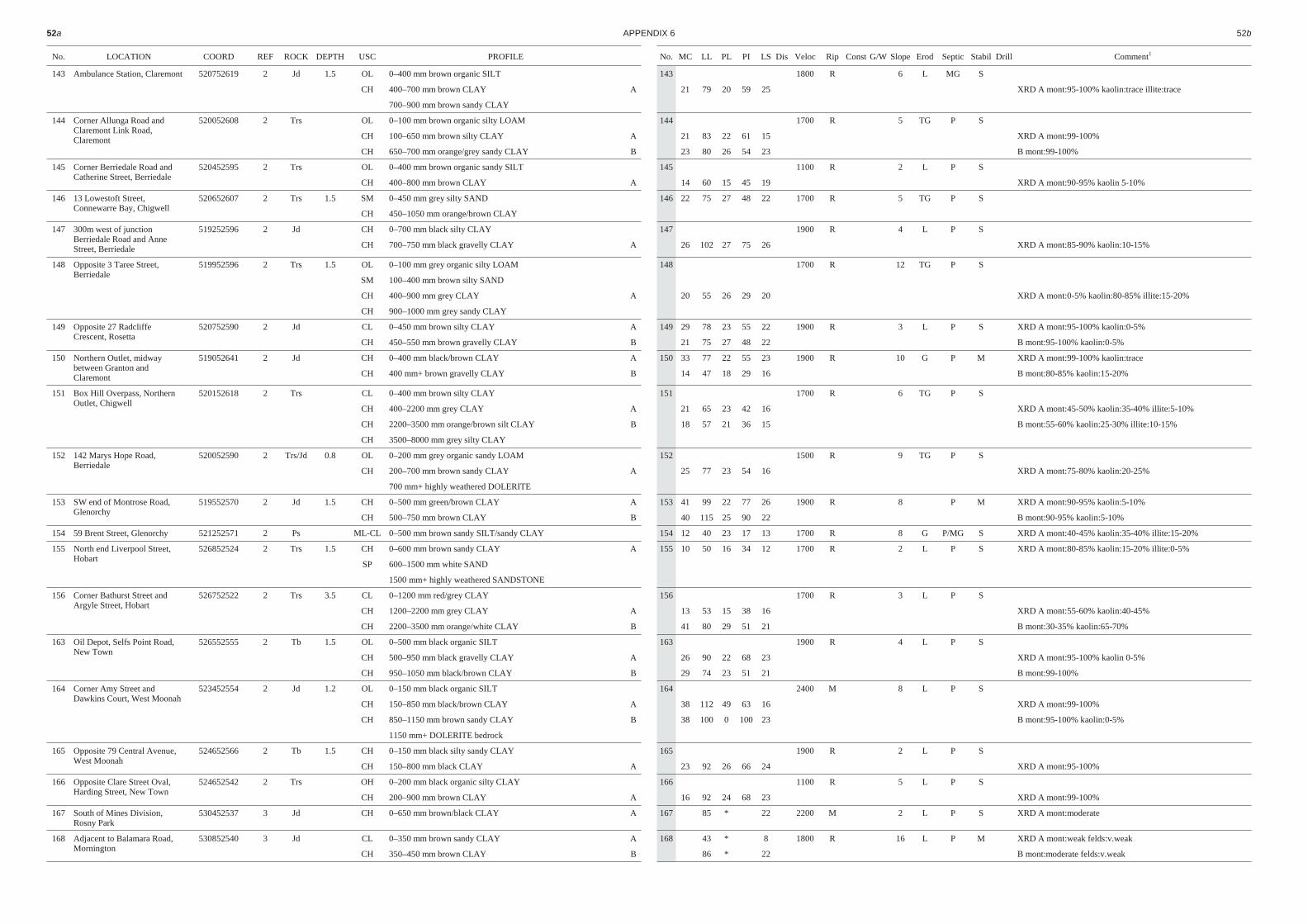
No. LO CA TION COORD REF ROCK DEPTH USC PRO FILE
143 Ambulance Station, Claremont 520752619 2 Jd 1.5 OL 0–400 mm brown organic SILT
CH 400–700 mm brown CLAY A
700–900 mm brown sandy CLAY
144 Corner Allunga Road andClaremont Link Road,Claremont
520052608 2 Trs OL 0–100 mm brown organic silty LOAM
CH 100–650 mm brown silty CLAY A
CH 650–700 mm orange/grey sandy CLAY B
145 Corner Berriedale Road andCatherine Street, Berriedale
520452595 2 Trs OL 0–400 mm brown organic sandy SILT
CH 400–800 mm brown CLAY A
146 13 Lowestoft Street,Connewarre Bay, Chigwell
520652607 2 Trs 1.5 SM 0–450 mm grey silty SAND
CH 450–1050 mm orange/brown CLAY
147 300m west of junctionBerriedale Road and AnneStreet, Berriedale
519252596 2 Jd CH 0–700 mm black silty CLAY
CH 700–750 mm black gravelly CLAY A
148 Opposite 3 Taree Street,Berriedale
519952596 2 Trs 1.5 OL 0–100 mm grey organic silty LOAM
SM 100–400 mm brown silty SAND
CH 400–900 mm grey CLAY A
CH 900–1000 mm grey sandy CLAY
149 Opposite 27 RadcliffeCrescent, Rosetta
520752590 2 Jd CL 0–450 mm brown silty CLAY A
CH 450–550 mm brown gravelly CLAY B
150 Northern Outlet, midwaybetween Granton andClaremont
519052641 2 Jd CH 0–400 mm black/brown CLAY A
CH 400 mm+ brown gravelly CLAY B
151 Box Hill Overpass, NorthernOutlet, Chigwell
520152618 2 Trs CL 0–400 mm brown silty CLAY
CH 400–2200 mm grey CLAY A
CH 2200–3500 mm orange/brown silt CLAY B
CH 3500–8000 mm grey silty CLAY
152 142 Marys Hope Road,Berriedale
520052590 2 Trs/Jd 0.8 OL 0–200 mm grey organic sandy LOAM
CH 200–700 mm brown sandy CLAY A
700 mm+ highly weathered DOLERITE
153 SW end of Montrose Road,Glenorchy
519552570 2 Jd 1.5 CH 0–500 mm green/brown CLAY A
CH 500–750 mm brown CLAY B
154 59 Brent Street, Glenorchy 521252571 2 Ps ML-CL 0–500 mm brown sandy SILT/sandy CLAY
155 North end Liverpool Street,Hobart
526852524 2 Trs 1.5 CH 0–600 mm brown sandy CLAY A
SP 600–1500 mm white SAND
1500 mm+ highly weathered SANDSTONE
156 Corner Bathurst Street andArgyle Street, Hobart
526752522 2 Trs 3.5 CL 0–1200 mm red/grey CLAY
CH 1200–2200 mm grey CLAY A
CH 2200–3500 mm orange/white CLAY B
163 Oil Depot, Selfs Point Road,New Town
526552555 2 Tb 1.5 OL 0–500 mm black organic SILT
CH 500–950 mm black gravelly CLAY A
CH 950–1050 mm black/brown CLAY B
164 Corner Amy Street andDawkins Court, West Moonah
523452554 2 Jd 1.2 OL 0–150 mm black organic SILT
CH 150–850 mm black/brown CLAY A
CH 850–1150 mm brown sandy CLAY B
1150 mm+ DOLERITE bedrock
165 Opposite 79 Central Avenue,West Moonah
524652566 2 Tb 1.5 CH 0–150 mm black silty sandy CLAY
CH 150–800 mm black CLAY A
166 Opposite Clare Street Oval,Harding Street, New Town
524652542 2 Trs OH 0–200 mm black organic silty CLAY
CH 200–900 mm brown CLAY A
167 South of Mines Division,Rosny Park
530452537 3 Jd CH 0–650 mm brown/black CLAY A
168 Adjacent to Balamara Road,Mornington
530852540 3 Jd CL 0–350 mm brown sandy CLAY A
CH 350–450 mm brown CLAY B
52a AP PEN DIX 6 52b
No. MC LL PL PI LS Dis Veloc Rip Const G/W Slope Erod Sep tic Stabil Drill Comment1
143 1800 R 6 L MG S
21 79 20 59 25 XRD A mont:95-100% kaolin:trace illite:trace
144 1700 R 5 TG P S
21 83 22 61 15 XRD A mont:99-100%
23 80 26 54 23 B mont:99-100%
145 1100 R 2 L P S
14 60 15 45 19 XRD A mont:90-95% kaolin 5-10%
146 22 75 27 48 22 1700 R 5 TG P S
147 1900 R 4 L P S
26 102 27 75 26 XRD A mont:85-90% kaolin:10-15%
148 1700 R 12 TG P S
20 55 26 29 20 XRD A mont:0-5% kaolin:80-85% illite:15-20%
149 29 78 23 55 22 1900 R 3 L P S XRD A mont:95-100% kaolin:0-5%
21 75 27 48 22 B mont:95-100% kaolin:0-5%
150 33 77 22 55 23 1900 R 10 G P M XRD A mont:99-100% kaolin:trace
14 47 18 29 16 B mont:80-85% kaolin:15-20%
151 1700 R 6 TG P S
21 65 23 42 16 XRD A mont:45-50% kaolin:35-40% illite:5-10%
18 57 21 36 15 B mont:55-60% kaolin:25-30% illite:10-15%
152 1500 R 9 TG P S
25 77 23 54 16 XRD A mont:75-80% kaolin:20-25%
153 41 99 22 77 26 1900 R 8 P M XRD A mont:90-95% kaolin:5-10%
40 115 25 90 22 B mont:90-95% kaolin:5-10%
154 12 40 23 17 13 1700 R 8 G P/MG S XRD A mont:40-45% kaolin:35-40% illite:15-20%
155 10 50 16 34 12 1700 R 2 L P S XRD A mont:80-85% kaolin:15-20% illite:0-5%
156 1700 R 3 L P S
13 53 15 38 16 XRD A mont:55-60% kaolin:40-45%
41 80 29 51 21 B mont:30-35% kaolin:65-70%
163 1900 R 4 L P S
26 90 22 68 23 XRD A mont:95-100% kaolin 0-5%
29 74 23 51 21 B mont:99-100%
164 2400 M 8 L P S
38 112 49 63 16 XRD A mont:99-100%
38 100 0 100 23 B mont:95-100% kaolin:0-5%
165 1900 R 2 L P S
23 92 26 66 24 XRD A mont:95-100%
166 1100 R 5 L P S
16 92 24 68 23 XRD A mont:99-100%
167 85 * 22 2200 M 2 L P S XRD A mont:moderate
168 43 * 8 1800 R 16 L P M XRD A mont:weak felds:v.weak
86 * 22 B mont:moderate felds:v.weak
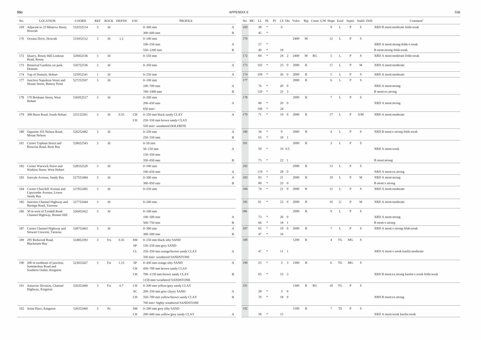
No. LO CA TION COORD REF ROCK DEPTH USC PRO FILE
169 Adjacent to 23 Minerva Street,Howrah
533252514 3 Jd 0–300 mm A
300–600 mm B
170 Oceana Drive, Howrah 533452512 3 Jd 1.2 0–100 mm
100–550 mm A
550–1200 mm B
172 Quarry, Rosny Hill LookoutRoad, Rosny
529452536 3 Jd 0–550 mm
173 Botanical Gardens car park,Domain
526752536 3 Jd 0–350 mm A
174 Top of Domain, Hobart 525952541 1 Jd 0–250 mm A
177 Junction Napoleon Street andSloane Street, Battery Point
527252507 3 Jd 0–100 mm
100–700 mm A
700–1900 mm B
178 170 Brisbane Street, WestHobart
526052517 3 Jd 0–200 mm
200–650 mm A
650 mm+
179 308 Huon Road, South Hobart 525152501 3 Jd 0.55 CH 0–250 mm black sandy CLAY A
CH 250–550 mm brown sandy CLAY
550 mm+ weathered DOLERITE
180 Opposite 355 Nelson Road,Mount Nelson
526252482 3 Jd 0–250 mm A
250–550 mm B
181 Corner Topham Street andRiawena Road, Rose Bay
528652543 3 Jd 0–50 mm
50–150 mm A
150–350 mm
350–650 mm B
182 Corner Warwick Street andWatkins Street, West Hobart
528552520 3 Jd 0–100 mm
100–650 mm A
183 Sunvale Avenue, Sandy Bay 527552484 3 Jd 0–300 mm A
300–850 mm B
184 Corner Churchill Avenue andLipscombe Avenue, LowerSandy Bay
527852485 3 Jd 0–250 mm
185 Junction Channel Highway and Baringa Road, Taroona
527752444 3 Jd 0–500 mm
186 50 m west of Tyndall RoadChannel Highway, Bonnet Hill
526452422 3 Jd 0–100 mm
100–500 mm A
500–750 mm B
187 Corner Channel Highway andStewart Crescent, Taroona
528752463 3 Jd 0–300 mm A
300–500 mm B
189 295 Redwood Road,Blackmans Bay
524852393 3 Trs 0.35 SM 0–150 mm black silty SAND
SP 150–250 mm grey SAND
CL 250–350 mm orange/brown sandy CLAY A
350 mm+ weathered SANDSTONE
190 200 m southeast of junction,Summerleas Road andSouthern Outlet, Kingston
523652427 3 Trs 1.15 SP 0–450 mm orange silty SAND A
CH 450–700 mm brown sandy CLAY
CH 700–1150 mm brown sandy CLAY B
1150 mm+weathered SANDSTONE
191 Antarctic Division, ChannelHighway, Kingston
526352460 3 Trs 0.7 CH 0–200 mm yellow/grey sandy CLAY
SC 200–350 mm grey clayey SAND A
CH 350–700 mm yellow/brown sandy CLAY B
700 mm+ highly weathered SANDSTONE
192 Jerim Place, Kingston 526352460 3 Ps SM 0–200 mm grey silty SAND
CH 200–600 mm yellow/grey sandy CLAY A
53a AP PEN DIX 6 53b
No. MC LL PL PI LS Dis Veloc Rip Const G/W Slope Erod Sep tic Stabil Drill Comment1
169 38 * 6 9 L P S XRD B mont:moderate felds:weak
45 *
170 2400 M 12 L P S
57 * XRD A mont:strong felds:v.weak
40 * 18 B mont:strong felds:weak
172 84 * 24 2 2400 M RG 5 L P S XRD A mont:moderate felds:weak
173 102 * 25 0 2000 R 17 L P M XRD A mont:moderate
174 109 * 26 0 2000 R 5 L P S XRD A mont:moderate
177 2000 R 6 L P S
76 * 20 0 XRD A mont:strong
120 * 25 3 B mont:ex.strong
178 2000 R 7 L P S
86 * 20 0 XRD A mont:strong
106 * 24
179 71 * 19 0 2000 R 17 L P S/M XRD A mont:moderate
180 34 * 0 2000 R 4 L P S XRD B mont:v.strong felds:weak
65 * 18 1
181 2000 R 3 L P S
59 * 19 0.5 XRD A mont:weak
73 * 22 1 B mont:strong
182 2000 R 13 L P S
119 * 28 0 XRD A mont:ex.strong
183 83 * 21 2000 R 19 L P M XRD A mont:strong
88 * 23 0 B mont:v.strong
184 74 * 21 0 2000 R 12 L P S XRD A mont:moderate
185 81 * 22 0 2000 R 16 G P M XRD A mont:moderate
186 2000 R 9 L P S
73 * 20 0 XRD A mont:strong
66 * 18 1 B mont:v.strong
187 65 * 19 0 2000 R 7 L P S XRD A mont:v.strong felds:weak
47 * 16
189 1200 R 4 TG MG S
47 * 11 1 XRD A mont:v.weak kaolin:moderate
190 25 * 3 3 1300 R 6 TG MG S
65 * 15 3 XRD B mont:ex.strong kaolin:v.weak felds:weak
191 1300 R RG 18 TG P S
28 * 3 0
70 * 18 0 XRD B mont:ex.strong
192 1500 R 7 TS P S
58 * 15 XRD A mont:weak kaolin:weak

No. LO CA TION COORD REF ROCK DEPTH USC PRO FILE
193 9 Mirramar Park, KingstonHeights
526452397 3 Ps 1 SM 0–200 mm grey sandy SILT
SM 200–500 mm yellow/grey sandy SILT A
CH 500–800 mm yellow/grey silty CLAY B
194 400 m west of TasmanHighway and Acton Road,Cambridge
536552569 3 Tb CL 0–150 mm grey/brown silty CLAY
CH 150–550 mm brown sandy CLAY A
195 Junction Southern Outlet andSummerleas Road, Kingston
523352426 3 Tb 1 CL 0–100 mm brown silty CLAY
CH 100–450 mm red/brown CLAY A
196 Browns Road Bridge, Southern Outlet, Kingston
525252426 3 Tb 0.5 ML 0–200 mm grey/brown clayey SILT
CH 200–500 mm yellow/brown sandy CLAY A
500 mm+ extremely weathered BASALT
197 Northwest of SouthernOutlet/Channel Highwayjunction, Firthside
524552427 3 Ps 0.4 ML 0–150 mm grey clayey SILT A
CH 150–400 mm grey silty CLAY B
400 mm+ highly weathered SILTSTONE
198 Junction Southern Outlet andMount Nelson Road, MountNelson
525152483 3 Ps 0.5 CL 0–150 mm grey sandy silty CLAY
CH 150–500 mm yellow/brown sandy CLAY A
500 mm+ highly weathered SILTSTONE
199 Wellesley Park, South Hobart 524252501 3 Trs 0.85 SP 0–150 mm yellow/grey SAND
CH 150–350 mm yellow/grey sandy CLAY A
CH 350–850 mm yellow/grey CLAY B
850 mm+ slightly weathered SANDSTONE
200 Opposite 19 Waverley Street,Bellerive
531452533 3 Trs 0.9 SM 0–350 mm grey silty SAND
CL 350–900 mm yellow/brown sandy CLAY A
900 mm+ slightly weathered SANDSTONE
201 Opposite 17 Merindah Street,Howrah
533752517 3 Ps 0.7 ML 0–400 mm grey clayey SILT
CH 400–700 mm grey/black sandy CLAY A
700 mm+ highly weathered SILTSTONE
202 Junction Pass Road andGoodwins Road, Rokeby
534852516 3 Tb 0.4 CH 0–400 mm brown sandy CLAY A
400 mm+ highly weathered BASALT
203 Quarry west of Acton Road,South Arm Road junction,Lauderdale
538352493 3 Ps 0.6 ML 0–200 mm grey sandy clayey SILT A
CH 200–600 mm grey gravelly silty CLAY B
600 mm+ highly weathered SILTSTONE
205 Magazine, Blinking BillyPoint, Taroona
529052483 3 Tb 0.2 CH 0–200 mm brown silty gravelly CLAY A
200 mm+ highly weathered BASALT
206 500 m west of HuonRoad/Strickland Avenuejunction, Cascades
522152490 3 Ps 0.85 SM 0–200 mm grey sandy SILT
SM 200–850 mm yellow/grey sandy SILT A
850 mm+ highly weathered MUDSTONE
207 Sandy Bay Rivulet east ofTurnip Fields
523052495 3 Trs SM-SP 0–150 mm yellow/grey SAND
CH 150–350 mm orange/yellow sandy CLAY A
CH 350–1000 mm yellow/brown sandy CLAY B
208 Junction CambridgeRoad/Banks Street,Mornington
531652546 3 Trs 0.8 SM 0–250 mm yellow/grey silty SAND
SC 250–350 mm yellow/grey clayey SAND
CH 350–800 mm yellow/orange sandy CLAY A
800 mm+ highly weathered SANDSTONE
209 Southern end of Natone Street, cliff face, Lindisfarne Point
528152554 3 Tb 0.55 CL 0–550m brown sandy silty CLAY A
550 mm+ highly weathered BASALT
210 Opposite 16 Tianna Road,Lindisfarne
258652562 3 Ps 0.85 SM 0–250 mm grey sandy SILT A
ML 250–850 mm grey gravel clayey SILT B
850 mm+ highly weathered SILTSTONE
54a AP PEN DIX 6 54b
No. MC LL PL PI LS Dis Veloc Rip Const G/W Slope Erod Sep tic Stabil Drill Comment1
193 1400 R 9 TS P S
30 * 8
52 * 15 3 XRD B mont:trace kaolin:moderate
194 1900 R 4 L P S
90 * 31 1 XRD A mont:moderate
195 2200 M 4 L P S
135 * 34 1 XRD A mont:ex.strong
196 2200 M 3 L P S
84 * 32 1 XRD A mont:v.strong
197 29 * 4 1800 R 5 TG MG S XRD B mont:v.weak kaolin:v.weak
70 * 16 0
198 1900 R 2 TGS P S
118 * 25 0 XRD A mont:moderate kaolin:v.weak
199 1500 R 13 TGS P M
84 * 18 XRD A mont:weak kaolin:weak illite:moderate
89 * 20 0 B mont:v.weak kaolin:weak illite:moderate
200 1600 R 10 TG P/MG S
34 * 8 3 XRD A mont:weak kaolin:v.weak illite:weak
201 1700 R 11 TS P/MG S
58 * 17 0 XRD A mont:weak kaolin:trace
202 58 * 21 0 2000 M 5 L P S
203 39 * 8 1900 R 7 TS P/MG S XRD A mont:v.weak kaolin:trace
63 * 18 0.5 B mont:weak
205 71 * 13 2300 M 13 L P S
206 1800 R 19 TGS M M
28 * 2
207 1700 R 7 TG P S
85 * 18
86 * 20 0 XRD B mont:weak kaolin:trace illite:trace
208 1800 R 3 L MG S
56 * 13 0 XRD A mont:trace kaolin:weak
209 46 * 12 0 2200 R 70 F P U
210 18 * 0 2000 R 17 TG MG S/M
41 * 12 1 XRD B mont:weak kaolin:trace

No. LO CA TION COORD REF ROCK DEPTH USC PRO FILE
211 13 Malunna Road,Lindisfarne
528952564 3 Trs 0.4 SP 0–150 mm grey SAND
CH 150–400 mm orange/brown sandy CLAY A
400 mm+ slightly weathered SANDSTONE
212 50 m east of 48 SalvatorRoad, West Hobart
524852513 3 Trs 1.2 SM 0–150 mm brown gravelly silty SAND
SC 150–250 mm orange/grey clayey SAND A
250–1200 mm grey/brown sandy CLAY B
1200 mm+ slightly weathered SANDSTONE
213 Elizabeth College, ElizabethStreet, North Hobart
526052534 3 Trs 1.35 ML 0–100 mm grey sandy clayey SILT
CH 100–950 mm yellow/green sandy CLAY A
CH 950–1350 mm yellow/brown sandy CLAY B
1350 mm+ highly weathered MUDSTONE
214 Northeast end of McCrobiesGully Tip, Cascades
523452516 3 Ps 0.7 CH 0–300 mm grey/brown sandy CLAY A
CH 300–700 mm yellow/green sandy CLAY B
700 mm+ highly weathered SANDSTONE
215 South end Acton Road,Lauderdale
538852499 3 Ps SM 0–300 mm grey sandy SILT
CH 300–500 mm yellow/grey silty CLAY A
CH 500–1100 mm yellow/brown sandy CLAY B
216 Junction Acton Road andActon Drive, Acton
539352531 3 Trs 1.1 SM 0<150 mm orange/grey silty SAND
SC 150–250 mm orange clayey SAND
CL 250–1100 mm yellow/orange sand CLAY A
1100 mm+ slightly weathered SANDSTONE
217 Junction Acton Road andActon Drive, Acton
538852547 3 Tb 0.3 ML 0–300 mm brown gravelly clayey SILT A
300 mm+ highly weathered BASALT
218 Upton Creek, Acton Road,Cambridge
538452563 3 Ts CH 0–100 mm black sandy CLAY
CH 100–800 mm yellow/green sandy CLAY A
220 Single Hill, Roches Beach 540952517 D
223 Casimaty, Taroona 528952463 D
224 Casimaty, Taroona 529052462 D
225 Bardia Court, Single Hill 540352517 D 0–600 mm
650–750 mm
226 Acton Road 539352517 D 650–850 mm
850–1250 mm
227 Acton Road 539152523 D 550–900 mm
900–1500 mm
228 Kirra Road 540852513 D 0–350 mm
350–700 mm
700 mm–
230 Bardia Court, Single Hill 540552519 D 0–500 mm
231 Roches Beach Road 540052512 D
232 Roches Beach Road 539952511 D 0–350 mm
350 mm–
233 Tara Drive 538252519 D 600–2100 mm
234 Seven Mile Beach Road 540252530 D 100–1000 mm
235 5 Jefferson Court,Lutana
525452569 D
236 89 Doyle Avenue, LenahValley
523652541 D 2400–3400 mm
3400–4300 mm
4300–5200 mm
240 Waterworks Road 525152496 D
55a AP PEN DIX 6 55b
No. MC LL PL PI LS Dis Veloc Rip Const G/W Slope Erod Sep tic Stabil Drill Comment1
211 1600 R 9 TG P S
66 * 17 0 XRD A mont:weak kaolin:trace
212 1600 R 25 TG P M
28 * 6 XRD A kaolin:weak illite:weak
39 * 12 B kaolin:v.weak illite:weak
213 1600 R 5 L P S
77 * 23 XRD A mont:strong
65 * 14 3 B mont:v.strong
214 59 * 20 0 1800 R 15 TGS P S XRD A mont:v.strong
56 * 13 0 B mont:v.strong
215 1700 R 4 TG P S
54 * 22 3 XRD A mont:moderate kaolin:v.weak
72 * 23 2 B mont:strong kaolin:weak
216 1600 R 7 L MG/P S
49 * 11 XRD A kaolin:moderate illite:strong
217 54 * 12 2200 M 9 L P S
218 1200 R 1 G P S
86 * 21 2 XRD A mont:ex.strong
220 38 15 23 10 3 XRD mont:95 q:5
223 66 27 39 18 XRD mont:90 kaol:10
224 51 23 28 14 XRD mont:95 kaol:5
225 68 16 52 14
47 17 30 9 XRD mont:95 kaol:5
226 73 18 55 16 XRD mont:10 kaol:85 iron:5
32 15 17 7
227 45 16 29 8 XRD mont:10 kaol:75 g:15
38 18 20 9 XRD mont:5 kaol:90 ill:5
228 26 17 9 5
35 16 9 7 XRD mont:55 kaol:25 ill:20
29 19 10 5
230 96 23 73 22 XRD mont:100
231 37 13 24 8 XRD mont:30 kaol:70
232 23 11 12 4
32 13 9 7 XRD mont:30 kaol:70
233 41 16 25 7
234 32 14 18 6 XRD mont:20 kaol:45 ill:25 f:5 q:5
235 73 17 56 20 XRD mont:100
100 21 79 27 XRD mont:100
236 79 19 60 22
61 17 44 18 XRD mont:25 kaol:25 ill:45 f:5
60 19 41 17
240 87 23 64 21 XRD mont:90 kaol:10
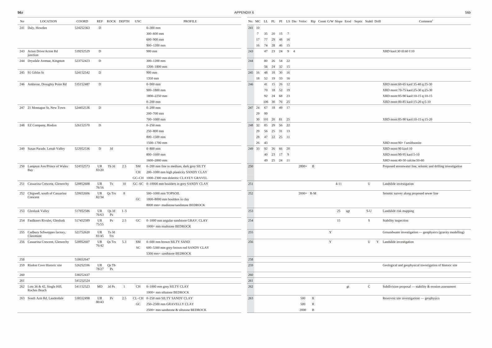
No LO CA TION COORD REF ROCK DEPTH USC PRO FILE
241 Daly, Howden 524252363 D 0–300 mm
300–600 mm
600–900 mm
900–1200 mm
243 Acton Drive/Acton Rdjunction
539252529 D 900 mm
244 Drysdale Avenue, Kingston 523752423 D 300–1200 mm
1200–1800 mm
245 91 Giblin St 524152542 D 900 mm
1350 mm
246 Ambrose, Droughty Point Rd 535152487 D 0–900 mm
900–1800 mm
1800–2250 mm
0–200 mm
247 21 Montague St, New Town 524452536 D 0–200 mm
200–700 mm
700–1000 mm
248 EZ Company, Risdon 526152570 D 0–250 mm
250–800 mm
800–1500 mm
1500–1700 mm
249 Susan Parade, Lenah Valley 522952536 D Jd 0–800 mm
800–1600 mm
1600–2000 mm
250 Lampton Ave/Prince of WalesBay
524552573 UR83/20
Tb Jd 2.5 SM 0–200 mm fine to medium, dark grey SILTY
CH 200–1000 mm high plasticity SANDY CLAY
GC–CH 1000–2300 mm doleritic CLAYEY GRAVEL
251 Casuarina Crescent, Glenorchy 520852608 UR76/16
Ts 10 GC–SC 0–10000 mm boulders in grey SANDY CLAY
252 Chigwell, south of CasuarinaCrescent
520652606 UR82/34
Qs Trs 8 500–1000 mm TOPSOIL
GC 1000–8000 mm boulders in clay
8000 mm+ mudstone/sandstone BEDROCK
253 Glenlusk Valley 517852586 UR76/63
Qs JdPs
1–5
254 Faulkners Rivulet, Glenlusk 517452589 UR75/55
Ps 2.5 GC 0–1000 mm angular sandstone GRAV. CLAY
1000+ mm mudstone BEDROCK
255 Cadbury Schweppes factory,Claremont
521752620 UR81/45
Ts JdTrs
256 Casuarina Crescent, Glenorchy 520952607 UR76/42
Qs Trs 5.3 SM 0–600 mm brown SILTY SAND
SC 600–5300 mm grey-brown-red SANDY CLAY
5300 mm+ sandstone BEDROCK
258 518652647
259 Risdon Cove Historic site 526252596 UR78/27
Qs TbPs
260 538252437
261 541252524
262 Lots 36 & 42, Single Hill,Roches Beach
541152523 MD Jd Ps 1 CH 0–1000 mm grey SILTY CLAY
1000+ mm siltstone BEDROCK
263 South Arm Rd, Lauderdale 538552498 UR80/43
Ps 2.5 CL–CH 0–250 mm SILTY SANDY CLAY
GC 250–2500 mm GRAVELLY CLAY
2500+ mm sandstone & siltstone BEDROCK
56a AP PEN DIX 6 56b
No. MC LL PL PI LS Dis Veloc Rip Const G/W Slope Erod Sep tic Stabil Drill Comment1
241 10
7 35 20 15 7
17 77 29 48 16
16 74 28 46 15
243 47 23 24 9 4 XRD kaol:30 ill:60 f:10
244 80 26 54 22
56 24 32 15
245 16 48 18 30 16
18 52 19 33 16
246 41 15 26 12 XRD mont:60-65 kaol 35-40 q:25-30
70 18 52 19 XRD mont:70-75 kaol:25-30 q:25-30
92 24 68 23 XRD mont:85-90 kaol:10-15 q:10-15
106 30 76 25 XRD mont:80-85 kaol:15-20 q:5-10
247 24 67 18 49 17
29 99
30 101 20 81 25 XRD mont:85-90 kaol:10-15 q:15-20
248 32 85 29 56 22
29 56 25 31 13
28 47 22 25 11
26 43 XRD mont:90+ f smithsonite
249 33 92 26 66 20 XRD mont:90 kaol:10
40 23 17 9 XRD mont:90-95 kaol:5-10
49 25 24 11 XRD mont:40-50 calcite:50-60
250 2800+ B Proposed stormwater line, seismic and drilling investigation
251 4-11 U Landslide investigation
252 2000+ R-M Seismic survey along proposed sewer line
253 25 sgt S-U Landslide risk mapping
254 15 S Stability inspection
255 Y Groundwater investigation — geophysics (gravity modelling)
256 Y U Y Landslide investigation
258
259 Geological and geophysical investigation of historic site
260
261
262 gt C Subdivision proposal — stability & erosion assessment
263 500 R Reservoir site investigationt — geophysics
500 R
2000 B

No LO CA TION COORD REF ROCK DEPTH USC PRO FILE
264 Risdon Cove Historic site 526452596 UR78/38
Tb Ps 10 0–2000 mm unconsolidated SILT
UR79/33
2000+ mm moderately compact SILT
12000 mm siltstone BEDROCK
265A EZ Risdon, woodworking shop 525552578 MD Jd 1 0–100 mm CONCRETE
CH 100–250 mm red-brown plastic CLAY
250–1700 mm yellow-brown SANDY CLAY
265B Marion Court, Pilchers Hill 529852561 UR79/38
Trs
266 East Risdon Road, SugarloafHill
527952584 UR75/40
Trs Ps 0–1800 mm soil and weathered ROCK
1800+ mm open jointed PERMIAN ROCK
267 Lanena Street, Warrane 530752538 UR82/16
Jd 0–1200 mm soil and dolerite BOULDERS
1200–2500 mm weathered DOLERITE
2500+ mm fresh DOLERITE
268 Koluri Court, Lindisfarne 528252554 UR77/08
Tb 0–1000 mm SOIL
1000+ mm weathered BASALT
270 Adjacent Bellerive BypassInterchange, Mornington
533152544 UR75/27
Ps 0–400 mm grey SILTY SAND
UR75/51
400–3000 mm talus and GRAVEL
3000+ mm silstone and sandstone BEDROCK
272 541052427
273 535052514
275 524352540
276 Derwent River—Elwick Bay toMacquarie Point
527452551 UR75/23
Qs JdTrs
20–50 uncompacted SILT and GRAVEL compacted SAND, CLAY,GRAVEL SANDSTONE BEDROCK
277 Derwent River— BedlamWalls to Rock Cod/WoodmanPoint
527052569 UR73/93
Tb TrsPs
30 0–30m SILT
30+m BEDROCK
278 Huon Road, Ferntree 520552471 UR73/48
Trs SOLIFLUCTION DEPOSITS
279 Liverpool Crescent, WestHobart
524952510 UR77/13
Jd Trs 1
280 Shannuck Drive, West Hobart 524852519 UR86/31
Trs 1 CH 0–1100 mm brown-grey plastic CLAY
CH 1100–1300 mm red CLAY
1300 mm– brown shale BEDROCK
281 Macquarie Point seweragetreatment plant
527552524 UR76/48
Jd 0–6200 mm FILL
6200 mm– fresh dolerite BEDROCK
282 Strickland Avenue, Hobart 521652493 UR77/40
Qs TALUS
PS SILTSTONE BEDROCK
283 Telephone Exchange, DaveySt
526652515 UR77/24
Trs 2 CH 0–2000 mm CLAY FILL
2000 mm– SANDSTONE BEDROCK
284 Wilmslow Avenue, New Town 525152554 MD Ts 11.5 CL 0–1800 mm black SILTY CLAY
SC 1800–11500 mm CLAYEY SAND
11500 mm– BEDROCK
285 Kings car park, Argyle St,Hobart
526752521 UR87/29
Trs 5.5 0–2400 mm GRAVEL & SAND FILL
2400–5500 mm SANDY CLAY & BOULDERS
5500 mm– SANDSTONE BEDROCK
286 Grays Road, Ferntree 520452471 UR73/50
Ps 1 GM 0–1000 mm silty GRAVEL
1000 mm– mudstone BEDROCK
287 K-Mart site, New Town 524952549 UR73/28
Jd 1
288 Central Marine, Prince ofWales Bay
524352577 UR77/30
Tb 1 CL 0–1000 mm unconsolidated SILT
1000 mm– basalt BEDROCK
57a AP PEN DIX 6 57b
No. MC LL PL PI LS Dis Veloc Rip Const G/W Slope Erod Sep tic Stabil Drill Comment1
264 480 R Historical site investigationt — geophysics
1400 R
2200 B
265A
Foundation investigationt — ground heave
32 85 29 56 22
29 56 25 31 13
265B
Y Groundwater seepages
266 915 R Seismic refraction surveyt — road cutting
3000 B
267 350-600 R Proposed reservoir investigationt — geophysics
1000-1800 R
3000+ B
268 c U Foreshore instability
270 300-700 R Foundation investigationt — proposed building
1000-2000 R Geology and geophysics
3000+ B
272
273
275
276 Geological evaluation of potential crossing sites over theDerwent River
277 1500 R Geophysical investigation of proposed river crossing
3000+ B
278 S Stability assessment — proposed house site
279 22 g S Stability assessment — proposed subdivision
280 20 gt Soil erosion — proposed subdivision
281 Y Foundation investigation
282 sf CU Road failure
283 400-700 R Y Foundation investigation
2000+ R
284 315-450 R Y Foundation investigation
750-890 R
3000+ B
285 Y Foundation investigation
286 Y 12 Investigation of drainage problem
287 Foundation classification
288 1000 R Over water seismic refraction survey

No LO CA TION COORD REF ROCK DEPTH USC PRO FILE
289 Old gas works site, lowerMacquarie St
527152523 UR86/18
Jd 2.3 GC 0–2300 mm boulders in SANDY CLAY
2300 mm– dolerite BEDROCK
290 Old quarry, Poets Rd, WestHobart
525052516 UR81/2
Trs 1 SC 0–1000 mm plastic yell–brown SANDY CLAY
1000 mm– sandstone and siltsone BEDROCK
291 41 Louden St, South Hobart 524252509 MD Jd 1.2 CH 0–1200 mm brown plastic CLAY
Trs 1200 mm– sandstone BEDROCK
293 Tolmans Hill, Hobart Southern Outlet Road
525452493 UR73/14
Jd
294A 525052510
294B Tunnel Hill, Hobart EasternOutlet Road
533952550 UR73/67
Ts SM SAND
Ps mudstone, siltstone & sandstone BEDROCK
295 72 Wentworth St, SouthHobart
524952504 MD Trs CH yellow CLAY
296 70 Strickland Avenue, SouthHobart
523252502 MD Qs Ps ML gravelly SILT
297 Lynton Avenue 525452502 MD Trs
298 35A Liverpool Crescent, WestHobart
525252510 MD Jd 2 GC 0–2000 mm doleritic GRAVELLY CLAY
299 692 Sandy Bay Road, SandyBay
529252480 MD Ts CL 0–300 mm dark grey–black SILTY CLAY
CH 300–500 mm boulders in dark grey CLAY
GC 500–900 mm dol. & mudst. GRAVELLY CLAY
300 Selfs Point, proposed depot 525752558 MD Ts Tb 3.3 0–3300 mm FILL
3300 mm– BASALT
58a AP PEN DIX 6 58b
No. MC LL PL PI LS Dis Veloc Rip Const G/W Slope Erod Sep tic Stabil Drill Comment1
289 350-470 R Y Foundation investigation, geophysics, drilling
900+ R
290 10-12
g S Stability assessment — old quarry faces
291 20 S Stability assessment
293 Stability assessment — road cuttings
294A
294B
65-85
Stability assessment — road cuttings
295 U Expansive soil and drainage problem
296 House damage — differential settlement & drainage problem
297 U Inspection of a landslide site
298 20-25
?U Stability assessment
299 S Stability assessment — test pits
300 350-400 R Y Foundation investigation
1800-1900 R

No LO CA TION COORD REF ROCK DEPTH USC PRO FILE
301 McRobies Rd, Louden Stintersection, South Hobart
523952508 MD Trs 1 0–1000 mm SAND
1000 mm– weathered BEDROCK
302 Salamanca Arts Centre,Salamanca Place
526952515 MD Jd CLAY over dolerite BEDROCK
303 32 Romilly St, South Hobart 525252498 MD Jd FILL over dolerite BEDROCK
304 42–44 Bramble St, Ridgeway 523552469 MD Jd 1 thin SILTY soil over dolerite BEDROCK
305 820 Sandy Bay Rd, Sandy Bay 529352471 MD Jd 1-2.5 GC 0–2500 mm high plasticity GRAVELLY CLAY
2500 mm– weathered dolerite BEDROCK
306 Lot 66, Susan Parade, LenahValley
522952535 MD Jd 0–800 mm dark brown friable CLAY
800 mm– dolerite boulders in CLAY
307 197 Waterworks Rd, Dynnyrne 524352495 MD Trs CLAYEY SAND & SANDY CLAY
308 155 Waterworks Rd, Dynnyrne 524552496 MD Jd dark brown/black CLAY
309 152 Waterworks Rd, Dynnyrne 524552496 MD Jd 1.5 0–1500 mm unconsolidated SOIL
1500 mm– dolerite BEDROCK
310 102 Waterworks Rd, Dynnyrne 525152497 MD Jd
311 52/54 Waterworks Rd,Dynnyrne
525452498 MD Jd 1 CH 0–500 mm black CLAY
CH 500–1000 mm yellow-brown SANDY CLAY
GC 1000 mm– weathered dolerite BEDROCK
312 28A Waterworks Rd,Dynnyrne
525552500 MD Jd 0.7 CH 0–250 mm black high plasticity CLAY
GC 250–700 mm brown-black GRAVELLY CLAY
700 mm– weathered dolerite BOULDERS
313 4 Tara St, South Hobart 524452508 MD Trs SAND with CLAY over sandstone BEDROCK
314 Australian CommonwealthCarbide Works, Electrona
521352323 UR74/70
Tb Trs 14.9 0–3500 mm sand, sandy clay FILL
3500–14900 mm SAND
14900 mm– sandstone BEDROCK
315 Taroona High School &foreshore area
528252441 UR76/68
Qs Ts
316 Carinya St, Blackmans Bay 528952454 UR82/28
Trs SM 0–300 mm brown-black SILTY SAND
CH 300–1100 mm yellow-orange plastic CLAY
CL 1100–1800 mm grey mottled SANDY CLAY
SC 1800–2000+mm yellow brown CLAYEY SAND
317 Norwood Ave/Belhaven Ave,Taroona
528552451 UR77/35
Ts OH 0–900 mm black peaty CLAY
CH 900–1800 mm dark grey plastic CLAY
318 Channel Highway,Taroona — reservoir site
528452453 UR76/55
Ps grey topsoil with cobbles & boulders
pebbly sandstone & mudstone BEDROCK
319 Taroona High School,Belhaven Ave, Taroona
528552451 UR77/36
Ts CH 0–900 mm green grey plastic CLAY
CH 900–4600 mm green grey plastic CLAY
CH 4600–5500 mm brown plastic CLAY
SC 5500–7300 mm fawn brown SANDY CLAY
320 near Riverdowns Drive,Margate
521252362 UR79/24
Ps 0–172 m Woody Island Siltstone
172–306 m Basal Tillite
306–331+ m Dolerite
321 Harts Hill, Margate 520552342 UR79/25
Ps 0–30 m Harts Hill Limestone
30–70 m Hickman Formation
70–100+ m Bundella Mudstone
322 Woodbridge Hotel,Woodbridge
520352337 UR75/25
Ps
323 Karingal Court, Taroona 528952455 MD Ts
324 Taroona High School, Taroona 528752452 UR76/12
Ts
59a AP PEN DIX 6 59b
No. M LL PL PI LS Dis Veloc Rip Const G/W Slope Erod Sep tic Stabil Drill Comment1
301 g SCM Site inspection — subdivision proposal
302 Site inspection — stability of old quarry face
303 MU Site inspection — building
304 MB S Site inspection — building
305 13-22 U Site inspection — proposed building
306 33 92 26 66 20 12 S Site inspection — proposed building
expansive soils
307 8-10 sg S Site inspection — erosion problems
308 22-27 g SC Site inspection — building & erosion damage
309 350-1400 R 20-25 CU Site inspection — earthflow
2000-3000 MB geophysics — seismic refraction survey
310 15-20 U Site inspection — landslide
311 18-25 SM Site inspection — foundations, slope stability
312 g SM Site inspection — development proposal
313 15 P U Site inspection — proposed subdiv. (landslide area)
314 610-900 R Foundation investigation — drilling, geophysics
915-1830 R
2135-3000+ MB
315 30 fc SU Site inspection — marine erosion
316 S Site investigatione — expansive soils
24 69 24 45 17
17
317 44 83 17 65 26 Y Site investigatione — expansive soils
47
318 R 12.5 S Site inspection — proposed reservoir site
B
319 U Site investigation — landslide
320 Y Geological investigation — stratigraphic diamond drill hole
321 Y Geological investigation — stratigraphic diamond drill holes
322 Y Site inspection — siting of water bore
323 5-10 M Site inspection — slope stability
324 8 SC Site inspection — expansive soil, slope stability

No LO CA TION COORD REF ROCK DEPTH USC PRO FILE
325 Bonnet Hill, Taronga Rd,Channel Highway area
526952430 UR76/60
Jd 0.9–1.3
CH 0–400 mm black plastic CLAY
CH 400–900 mm yellowish CLAY
900 mm– weathered dolerite BEDROCK
326 Bonnet Hill, Channel Highway 526952425 UR77/34
Jd TrsPs
1–2
327 Dunns Creek, Kingston 524352432 UR79/30
Ps siltstone & minor sandstone
328 see site 319
329 North West Bay 523052362 UR73/30
Ts JdTrs
14 -9 to -14 m depth MUD
-14 m weathered dolerite BEDROCK
331 Tyndall Beach, Kingston 527052419 Trs
333 Hutchins St, Kingston 525452411 Trs
334 36A Auburn Rd, Kingston 525752409 MD Trs
336 near Whitewater Creek,Kingston
522652413 UR75/74
Ts JdTrs Ps
1–3 SM 0–200 mm grey sandy LOAM
CH 200–1000 mm brown CLAY
1000–2800 mm weathered dolerite BEDROCK
337 Boronia Hill, Kingston 524252403 UR75/74
Trs 2–5 SM 0–300 mm grey-black sandy LOAM
SP 300–800 mm grey-white SAND
SC 800–2500 mm yellow-brown SANDY CLAY
2500 mm– clayey sandstone BEDROCK
338 Turnip Fields 522752491 H036 Ps 1.5+ SM 0–200 mm TOPSOIL
200 mm– clay and boulders in SILTY GRAVEL
339 520752473 H189
340 533652460 C034
341 Opossum Bay Beach 532752398 Qsa
342 Gordons Hill Road,Lindisfarne
529652556 C001 Trs 3.7+ 0–800 mm dark grey SAND & FILL
800–1400 mm light grey SAND
1400–3700 mm grey-yellow CLAYEY SAND
343 Roebourne Rd, Old Beach 523852612 C006 Trs 0.4 CH 0–400 mm some sand in plastic CLAY
400 mm– sandstone/siltstone BEDROCK
344A Government Hills 526952586 Ps
344B
6 Bayfield St, Rosny Park 530152538 C002 Jd 0.8 CH 0–800 mm brown/black plastic CLAY
346 524952579 H047
347 Bathurst St, car park 526352521 MD Jd Trs 2.5+ GC 0–400 mm CLAYEY GRAVEL
CH 400–1600 mm SANDY CLAY
SC 1600–2500 mm CLAYEY SAND
2500 mm– sandstone BEDROCK
348 524352526 H019
349 521752489 H152
350 Nicholas St, Lower Sandy Bay 528352478 H001 CH 0–800 mm brown high plasticity CLAY
800 mm– dolerite BEDROCK
351 528652472 H229
352 525452496 H166
353 Davey Place, South Hobart 525652504 Jd
354 Kings car park, Argyle St,Hobart
526852521 UR87/29
Ts Trs 0–2400 mm gravel & sand FILL
2400–5400 mm boulders in CLAY
5400 mm– sandstone BEDROCK
355 Oak Hill, Rosetta 519952581 Jd
356 near Lowestoft, Main Rd,Berriedale
520352602 G093 Ts CH 0–700 mm black high plasticity CLAY
CH 700–1500 mm yellow-brown plastic CLAY
60a AP PEN DIX 6 60b
No. M LL PL PI LS Dis Veloc Rip Const G/W Slope Erod Sep tic Stabil Drill Comment1
325 16-19 CU Site investigation — subdivision proposal
landslide, expansive soils
326 11-26 Mg/G SC Site investigation — subdivision proposal
327 Site investigation — damsite, geophysics
328
329 1500 R Site investigation — marine seismic refraction survey
3000+ B
331 Y gt P S Site reference point
333
334 t S Site inspection — erosion & seepages
336 460 R Site investigation — proposed cemetery site
870-1300 R
1600-2530 RM
337 460 R Site investigation — proposed cemetery site
460 R
1990-3065 RB
338 Site reference point
339 Site reference point
340 Site reference point
341 c P U Foreshore erosion — destruction of boat sheds
342 Site reference point
343 Site reference point
344A
M sgt P S Site reference point
344B
Site reference point
346 Site reference point
347 Site investigation — building foundations
348 Site reference point
349 Site reference point
350 Site reference point
351 Site reference point
352 Site reference point
353 20+ P MD Site reference point
354 Y Site inspection — building foundations
355 g P U Site reference point
356 g Site reference point
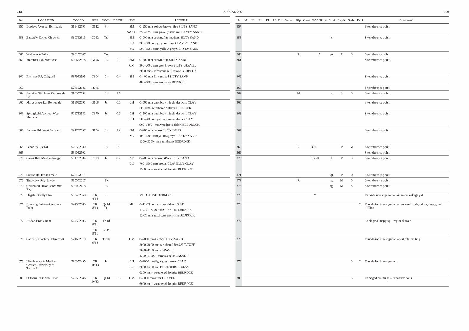
No LO CA TION COORD REF ROCK DEPTH USC PRO FILE
357 Dooleys Avenue, Berriedale 519452591 G112 Ps SM 0–250 mm yellow-brown, fine SILTY SAND
SW/SC 250–1250 mm gravelly sand in CLAYEY SAND
358 Battersby Drive, Chigwell 519752613 G082 Trs SM 0–200 mm brown, fine-medium SILTY SAND
SC 200–500 mm grey, medium CLAYEY SAND
SC 500–1500 mm+ yellow-grey CLAYEY SAND
360 Whitestone Point 520152647 Trs
361 Montrose Rd, Montrose 520652578 G146 Ps 2+ SM 0–300 mm brown, fine SILTY SAND
GM 300–2000 mm grey brown SILTY GRAVEL
2000 mm– sandstone & siltstone BEDROCK
362 Richards Rd, Chigwell 517952595 G104 Ps 0.4 SM 0–400 mm fine grained SILTY SAND
400–1000 mm sandstone BEDROCK
363 524552586 H046
364 Junction Glenlusk/ Collinsvale Rd
518352592 Ps 1.5
365 Marys Hope Rd, Berriedale 519652591 G108 Jd 0.5 CH 0–500 mm dark brown high plasticity CLAY
500 mm– weathered dolerite BEDROCK
366 Springfield Avenue, WestMoonah
522752552 G170 Jd 0.9 CH 0–500 mm dark brown high plasticity CLAY
CH 500–900 mm yellow-brown plastic CLAY
900–1400+ mm weathered dolerite BEDROCK
367 Barossa Rd, West Moonah 521752557 G154 Ps 1.2 SM 0–400 mm brown SILTY SAND
SC 400–1200 mm yellow/grey CLAYEY SAND
1200–2200+ mm sandstone BEDROCK
368 Lenah Valley Rd 520552530 Ps 2
369 534052502
370 Caves Hill, Meehan Range 531752584 C020 Jd 0.7 SP 0–700 mm brown GRAVELLY SAND
GC 700–1500 mm brown GRAVELLY CLAY
1500 mm– weathered dolerite BEDROCK
371 Smiths Rd, Risdon Vale 528452611
372 Tinderbox Rd, Howden 525552327 Tb
373 Gellibrand Drive, MortimerBay
539052418 Ps
375 Flagstaff Gully Dam 530452568 TR8/18
Ps MUDSTONE BEDROCK
376 Dowsing Point— CourtoysPoint
524952585 TR8/19
Qs JdTrs
ML 0–11270 mm unconsolidated SILT
11270–13720 mm CLAY and SHINGLE
13720 mm sandstone and shale BEDROCK
377 Risdon Brook Dam 527552603 TR9/11
Tb Jd
TR9/11
Trs Ps
378 Cadbury’s factory, Claremont 521652619 TR9/18
Ts Tb GM 0–2000 mm GRAVEL and SAND
2000–3000 mm weathered BASALT/TUFF
3000–4300 mm ?GRAVEL
4300–11300+ mm vesicular BASALT
379 Life Science & MedicalCentres, University ofTasmania
526352495 TR10/13
Jd CH 0–2000 mm light grey-brown CLAY
GC 2000–6200 mm BOULDERS & CLAY
6200 mm– weathered dolerite BEDROCK
380 St Johns Park New Town 523552546 TR10/13
Qs Jd 6 GM 0–6000 mm river GRAVEL
6000 mm– weathered dolerite BEDROCK
61a AP PEN DIX 6 61b
No. M LL PL PI LS Dis Veloc Rip Const G/W Slope Erod Sep tic Stabil Drill Comment1
357 Site reference point
358 t Site reference point
360 R 7 gt P S Site reference point
361 Site reference point
362 Site reference point
363 Site reference point
364 M s L S Site reference point
365 Site reference point
366 Site reference point
367 Site reference point
368 R 30+ P M Site reference point
369 Site reference point
370 15-20 l P S Site reference point
371 gt P U Site reference point
372 R g M S Site reference point
373 sgt M S Site reference point
375 Y Damsite investigation – failure on leakage path
376 Y Foundation investigation – proposed bridge site geology, anddrilling
377 Geological mapping – regional scale
378 Foundation investigation – test pits, drilling
379 S Y Foundation investigation
380 S Damaged buildings – expansive soils
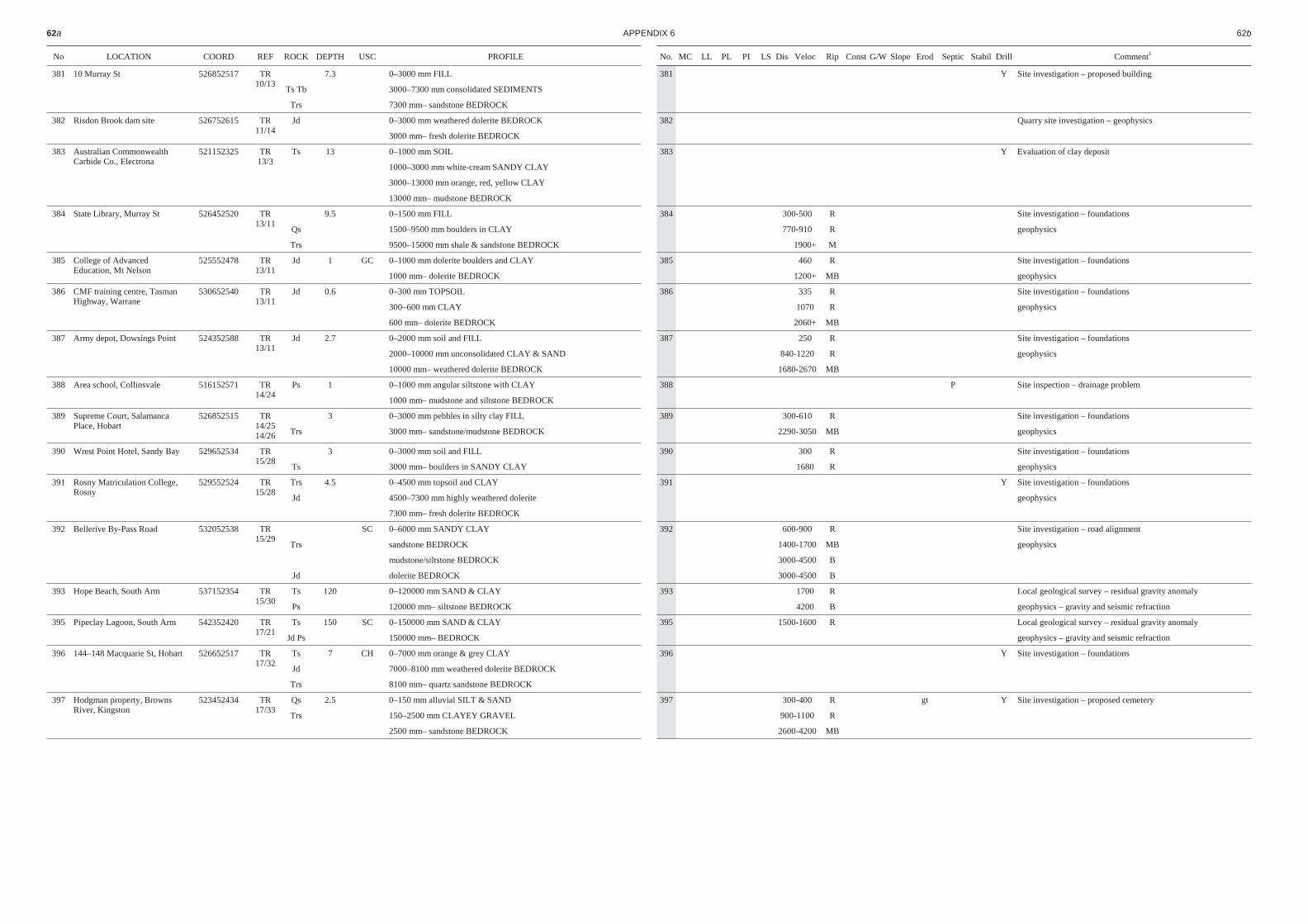
No LO CA TION COORD REF ROCK DEPTH USC PRO FILE
381 10 Murray St 526852517 TR10/13
7.3 0–3000 mm FILL
Ts Tb 3000–7300 mm consolidated SEDIMENTS
Trs 7300 mm– sandstone BEDROCK
382 Risdon Brook dam site 526752615 TR11/14
Jd 0–3000 mm weathered dolerite BEDROCK
3000 mm– fresh dolerite BEDROCK
383 Australian CommonwealthCarbide Co., Electrona
521152325 TR13/3
Ts 13 0–1000 mm SOIL
1000–3000 mm white-cream SANDY CLAY
3000–13000 mm orange, red, yellow CLAY
13000 mm– mudstone BEDROCK
384 State Library, Murray St 526452520 TR13/11
9.5 0–1500 mm FILL
Qs 1500–9500 mm boulders in CLAY
Trs 9500–15000 mm shale & sandstone BEDROCK
385 College of AdvancedEducation, Mt Nelson
525552478 TR13/11
Jd 1 GC 0–1000 mm dolerite boulders and CLAY
1000 mm– dolerite BEDROCK
386 CMF training centre, TasmanHighway, Warrane
530652540 TR13/11
Jd 0.6 0–300 mm TOPSOIL
300–600 mm CLAY
600 mm– dolerite BEDROCK
387 Army depot, Dowsings Point 524352588 TR13/11
Jd 2.7 0–2000 mm soil and FILL
2000–10000 mm unconsolidated CLAY & SAND
10000 mm– weathered dolerite BEDROCK
388 Area school, Collinsvale 516152571 TR14/24
Ps 1 0–1000 mm angular siltstone with CLAY
1000 mm– mudstone and siltstone BEDROCK
389 Supreme Court, SalamancaPlace, Hobart
526852515 TR14/2514/26
3 0–3000 mm pebbles in silty clay FILL
Trs 3000 mm– sandstone/mudstone BEDROCK
390 Wrest Point Hotel, Sandy Bay 529652534 TR15/28
3 0–3000 mm soil and FILL
Ts 3000 mm– boulders in SANDY CLAY
391 Rosny Matriculation College,Rosny
529552524 TR15/28
Trs 4.5 0–4500 mm topsoil and CLAY
Jd 4500–7300 mm highly weathered dolerite
7300 mm– fresh dolerite BEDROCK
392 Bellerive By-Pass Road 532052538 TR15/29
SC 0–6000 mm SANDY CLAY
Trs sandstone BEDROCK
mudstone/siltstone BEDROCK
Jd dolerite BEDROCK
393 Hope Beach, South Arm 537152354 TR15/30
Ts 120 0–120000 mm SAND & CLAY
Ps 120000 mm– siltstone BEDROCK
395 Pipeclay Lagoon, South Arm 542352420 TR17/21
Ts 150 SC 0–150000 mm SAND & CLAY
Jd Ps 150000 mm– BEDROCK
396 144–148 Macquarie St, Hobart 526652517 TR17/32
Ts 7 CH 0–7000 mm orange & grey CLAY
Jd 7000–8100 mm weathered dolerite BEDROCK
Trs 8100 mm– quartz sandstone BEDROCK
397 Hodgman property, BrownsRiver, Kingston
523452434 TR17/33
Qs 2.5 0–150 mm alluvial SILT & SAND
Trs 150–2500 mm CLAYEY GRAVEL
2500 mm– sandstone BEDROCK
62a AP PEN DIX 6 62b
No. MC LL PL PI LS Dis Veloc Rip Const G/W Slope Erod Sep tic Stabil Drill Comment1
381 Y Site investigation – proposed building
382 Quarry site investigation – geophysics
383 Y Evaluation of clay deposit
384 300-500 R Site investigation – foundations
770-910 R geophysics
1900+ M
385 460 R Site investigation – foundations
1200+ MB geophysics
386 335 R Site investigation – foundations
1070 R geophysics
2060+ MB
387 250 R Site investigation – foundations
840-1220 R geophysics
1680-2670 MB
388 P Site inspection – drainage problem
389 300-610 R Site investigation – foundations
2290-3050 MB geophysics
390 300 R Site investigation – foundations
1680 R geophysics
391 Y Site investigation – foundations
geophysics
392 600-900 R Site investigation – road alignment
1400-1700 MB geophysics
3000-4500 B
3000-4500 B
393 1700 R Local geological survey – residual gravity anomaly
4200 B geophysics – gravity and seismic refraction
395 1500-1600 R Local geological survey – residual gravity anomaly
geophysics – gravity and seismic refraction
396 Y Site investigation – foundations
397 300-400 R gt Y Site investigation – proposed cemetery
900-1100 R
2600-4200 MB