TASHKENT IN CHANGE - TRANSFORMATION OF THE URBAN STRUCTURE · TASHKENT IN CHANGE - TRANSFORMATION...
32
TASHKENT IN CHANGE - TRANSFORMATION OF THE URBAN STRUCTURE ANETTE GANGLER – HEINZ NAGLER – FRANK SCHWARTZE – ECKHART RIBBECK Uzbekistan became independent in 1991 and has since then undergone profound structural change both in the urban and rural areas, with urban structural change being particularly representative of a dynamic region in which several cultural areas overlap. The history of the city is characterized by frequent changes of power and political systems, ranging from oriental and Islamic origins to the Russian and socialist hegemony up to present-day private economies and structures. This urban development change was the focus of a joint research project promoted by the VW Stiftung. The institutions involved included the national Academy of Arts of Uzbekistan (Institute of Arts Research), the Technical University of Brandenburg, Cottbus (Chair for Urban Development and Design), and the University of Stuttgart (Institute of Urban Planning). The study has three parts: (1) The transformation of traditional old city quarters (Anette Gangler), (2) Tashkent as a subject of change in urban development and architectural concepts (Frank Schwartze and Heinz Nagler), and (3) The core city of Tashkent - current development (Eckart Ribbeck). The main question focused on the development of urban planning and architecture of Uzbek cities from fundamental Islamic orientation through Russian colonization and Soviet modernization up to the search for a new identity in a world characterized by globalization. I. THE TRADITIONAL OLD CITY Historic overview Over a period of more than 2000 years, a cultural landscape developed in the region where Tashkent is found today that was characterized by one of the oldest amalgamation of states of Central Asia - the ancient rule of Sogdiana. Greek and Roman authors referred to this area as the "land of the thousand cities", and for many centuries Sogdian merchants controlled the "Silk Road" and thus also the trade between China, the Near East and Europe. The urbanization of the oasis proceeded from the south-west (Shastepa) towards the north-east (Ming-Orik) along a genuinely branched network of canals. This network was supplied with water by the Bozsu canal or the Chirchiq river (Fig. 1) / (Fig. 2). When Central Asia came under the sway of Islam, the first capital of the principality of Chach, Ming-Orik (or Shash or Madinat ash-Shash) was destroyed in the 8th century, however, the area enjoyed another time of prosperity under the rule of the Samanid dynasty. Binkat, the new capital, was built to the north-west of the pre-Islamic city along the streams of the Bozsu. According to al-Muqaddasi, Binkat was generously laid out - hardly any house was supposed to be without a garden, stable, and vineyard. Binkat consisted of a walled Shahristan bordered by a citadel in the north where the Friday Mosque was also located. This structure was surrounded by two rings of suburbs (Rabad) with big markets and residential quarters. The wall around the outer Rabad approximately corresponded to the size of Tashkent in the 19 th century. In the early 13 th century, the city was destroyed and did not recapture significance as an important strategic place until it came under the rule of the Timurids headed by Timur (1370-1405). The erection of monumental buildings and mausoleums symbolized the glory of
Transcript of TASHKENT IN CHANGE - TRANSFORMATION OF THE URBAN STRUCTURE · TASHKENT IN CHANGE - TRANSFORMATION...

TASHKENT IN CHANGE - TRANSFORMATION OF THE URBAN STRUCTURE ANETTE GANGLER – HEINZ NAGLER – FRANK SCHWARTZE – ECKHART RIBBECK Uzbekistan became independent in 1991 and has since then undergone profound structural change both in the urban and rural areas, with urban structural change being particularly representative of a dynamic region in which several cultural areas overlap. The history of the city is characterized by frequent changes of power and political systems, ranging from oriental and Islamic origins to the Russian and socialist hegemony up to present-day private economies and structures. This urban development change was the focus of a joint research project promoted by the VW Stiftung. The institutions involved included the national Academy of Arts of Uzbekistan (Institute of Arts Research), the Technical University of Brandenburg, Cottbus (Chair for Urban Development and Design), and the University of Stuttgart (Institute of Urban Planning). The study has three parts: (1) The transformation of traditional old city quarters (Anette Gangler), (2) Tashkent as a subject of change in urban development and architectural concepts (Frank Schwartze and Heinz Nagler), and (3) The core city of Tashkent - current development (Eckart Ribbeck). The main question focused on the development of urban planning and architecture of Uzbek cities from fundamental Islamic orientation through Russian colonization and Soviet modernization up to the search for a new identity in a world characterized by globalization. I. THE TRADITIONAL OLD CITY
Historic overview Over a period of more than 2000 years, a cultural landscape developed in the region where Tashkent is found today that was characterized by one of the oldest amalgamation of states of Central Asia - the ancient rule of Sogdiana. Greek and Roman authors referred to this area as the "land of the thousand cities", and for many centuries Sogdian merchants controlled the "Silk Road" and thus also the trade between China, the Near East and Europe. The urbanization of the oasis proceeded from the south-west (Shastepa) towards the north-east (Ming-Orik) along a genuinely branched network of canals. This network was supplied with water by the Bozsu canal or the Chirchiq river (Fig. 1) / (Fig. 2). When Central Asia came under the sway of Islam, the first capital of the principality of Chach, Ming-Orik (or Shash or Madinat ash-Shash) was destroyed in the 8th century, however, the area enjoyed another time of prosperity under the rule of the Samanid dynasty. Binkat, the new capital, was built to the north-west of the pre-Islamic city along the streams of the Bozsu. According to al-Muqaddasi, Binkat was generously laid out - hardly any house was supposed to be without a garden, stable, and vineyard. Binkat consisted of a walled Shahristan bordered by a citadel in the north where the Friday Mosque was also located. This structure was surrounded by two rings of suburbs (Rabad) with big markets and residential quarters. The wall around the outer Rabad approximately corresponded to the size of Tashkent in the 19th century.
In the early 13th century, the city was destroyed and did not recapture significance as an important strategic place until it came under the rule of the Timurids headed by Timur (1370-1405). The erection of monumental buildings and mausoleums symbolized the glory of
the city that later on continued with the construction of the Gumbasi Barak-Khan Mausoleum and Medressa and the Kukeldash Medressa. On the inside of a newly erected outer wall, a typical Central Asian, Islamic city developed whose spatial structure was characterized by the network of long-distance trails leading radially into the city centre. The residential quarters (Makhallas) that had originally been separated grew together into a dense cluster of courtyard houses accessible from dead-end streets. The monuments located in the core of the historic city, the citadel and the outer walls disappeared in the 19th century, only the remainders of a bazaar were preserved in the city centre. Tashkent finally lost its independence in the year 1808 when it was conquered by the Khanate of Kokand. The Kokand rulers built a new outer wall 8 meters high and 14 kilometres long with 12 gates. This wall also enclosed the new citadel (Urda) to the east of the river Anhor and had some exits leading to the orchards and kitchen gardens (Mausa) which formed a broad belt used for agriculture. The ground itself was owned by the Makhallas until the Russian conquest.
In pre-Mongolian times, Tashkent had already been one of the biggest cities in Central Asia, and became one of the largest oriental cities in the mid-19th century. The city floor space within the boundaries of the wall amounted to approx. 1,400 hectares, offering protection to 100,000 inhabitants. From the middle ages until the 19th century, the city developed into four districts (dakha): Sheikhantaur, Sibzar, Kukcha and Beshagach. Each of these districts occupied one section of the outer wall and had three gates. The four dakhas were subdivided into more than 200 makhallas that were organized according to professional and ethnic affiliation. The makhallas constituted the smallest local unit of self-administration and had their own standards and rules. An elected Council of the Elders, which was presided by an Aksakal, ruled on all tasks to be done and was also responsible for the defence of the city. The makhallas had their own commercial and cultural centre (Gusar) that was normally located on the main street and included a market place with a caravansary, a tea house, a blacksmith etc. Each makhalla had a well and a mosque which normally was not entitled to host the Friday prayer. The image of the oriental-Islamic cities changed in the mid-19th century when they were conquered by the Russians. The multi-faceted oasis culture was replaced by a monoculture consisting of cotton fields. The citadel and the outer walls were torn down so that the Russians could expand the city in 1870 according to the plans drawn up by military engineer A. Makharov following the model of European cities. In contrast to the “additive” growth of oriental cities, streets converging radially in a star shape and standardized building blocks then formed the new city. The result was a dual city, i.e. the coexistence of the traditional old city and the representative new city, resulting in a dramatic loss of functions of the old city (Fig. 3). In 1920, the Turkestan Autonomous Soviet Socialist Republic was proclaimed, with Tashkent becoming its capital in 1930. Social transformation was most striking when the markets and mosques were closed and increasing pressure was exerted on the historic city centre. At the same time, Russian expansions to the city as well as uncontrolled settlements around the city periphery grew, a development that was also promoted by the fact that the agricultural areas previous owned by the community (Mausa) became private property. In addition, growing industrialization and a serious lack of housing accelerated a rapid urbanization which was characterized by the uniform urban model of a “functional city” according to Soviet preferences.

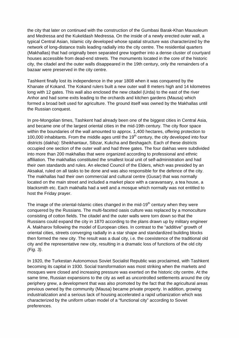
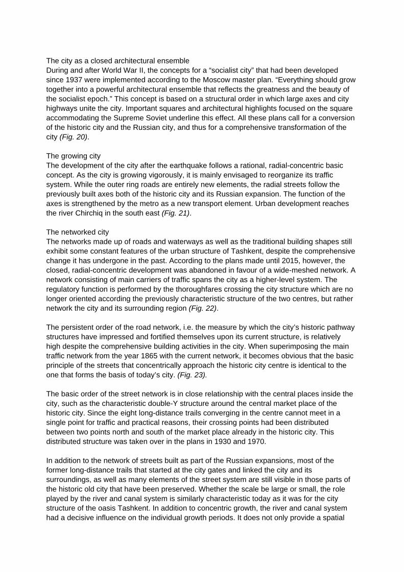
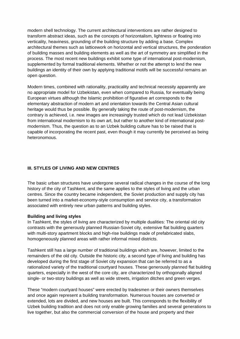
The first master plans were drawn up in 1929-33, the origins of which dated back to the English garden city. More master plans based on the model of the Moscow master plan followed in 1933-37. However, many of these plans could not be implemented before the 1950s and thereafter. What all plans had in common was the attempt to erect regular building blocks, squares and parks in place of the historic city, resulting in the large parks and tree-lined avenues characteristic of Tashkent. The socialist plans placed special importance on a spacious topography including natural water courses and canals. Broad urban axes and ring roads were planned - and implemented for the first time in 1943 when the city boulevard (Navoi Street) was built - in order to link the new industrial complexes with the standardized residential quarters (raions) as well as the new urban districts to the city centre and the old centre. After the 1966 earthquake, the master plans won back their significance, including plans to completely modify the old city centre. Three new axes were built in the centre of the old city, linking the Chorsu market with the centre of the new town. The demolition of the old, traditional market (1986) and the bold dome structure of the modern Chorsu market are examples of this large-scale urban transformation. Only one-third of the formerly huge historic old city centre - mostly in the north-eastern area - has been rudimentarily preserved to-date (Fig. 4). The Sibzar old city quarter Sibzar is one of the four historic dakhas where the consequences of the master plans are particularly evident. The new ring structure built according to the model of Moscow caused architects Semenov and others to convert the street system aligned to access the market place in the old city into broad radial streets that continue providing access to the quarter today (Saghbon, Foroby and Khorasaroy Street). Despite the destructive interventions in the complex structures of the quarters, the traditional residential quarters survived between the new axes (Fig. 5). The earthquake destroyed around one quarter of the buildings existing at the time, leaving 76,000 families or 300,000 people homeless. When the city was reconstructed, the intention was to convert even the old city into a modern, functional, Soviet style urban structure. New urban quarters (raions and micro-raions) consisting of 4- to 9-story buildings were to replace the old city quarters. The inhabitants of the old city were offered two alternatives - either to move into an apartment in one of the new apartment buildings, or to build a new house on a lot in the west of the city. The demolition and transformation of the old city was completed from east to west and continued until Uzbekistan finally became independent (1991). A similar experience was made in the old city quarter to the west of Sibzar. In Sibzar, a new building quarter was “punched” into the old city, whereas the old city structure was basically preserved in the western part, despite some small-scale conversions (Fig. 6) / (Fig. 7). The traditional quarters comprising 1- to 2-story courtyard houses are accessed from dead-end streets, the houses open towards the courtyard while their outer façades are closed. The family’s privacy is protected by the subdivision into an external courtyard for guests (Tashkari) and an inner family courtyard (Ichkari). In summer time, the daily family life takes place in the courtyard. Typical structures include mezzanine floors at different levels in the basement because here it is warmer in winter time and cooler during summer time. Access to the rooms is quite variable because there are different courtyard, terrace and roof levels. Broad driveways offering room for everyday life provide access to the houses. The building shapes

and materials (clay and wood) are optimally adapted to the extreme climatic conditions prevailing (Fig. 8) / (Fig. 9) / (Fig. 10). The eastern development area of Sibzar shows the socialist “raion” and “micro-raion” planning concepts which stipulated exact standards for the distribution of the 4- to 9-story residential buildings. The area is 50 hectares in size and bordered by 9-story apartment buildings along the street, with building heights dropping to 4 to 5 stories towards the old city. The southern makhalla (Yangi Sibzar) comprises 13 apartment blocks whose inhabitants were moved here from their houses in the old city after 1976. Another district (Stary Sibzar) consists of 19 apartment blocks. The 9-story blocks were built in 1982 and intended for people coming from other districts of the city. Compared to the traditional structure of courtyard houses, the number of inhabitants has more than doubled. Today, around 20,000 to 25,000 people live in this area (Fig. 11) / (Fig. 12) / (Fig. 13). Independence created new conditions for residential buildings, in particular, privatization of residential building activities resulted in manifold demolition, conversion and new building projects both in the oriental-Islamic old city and in the large settlements and apartment blocks made of prefabricated slabs during the socialist era. In the old city quarters, lots are subdivided and built upon, normally with two- to three-story buildings. New shops are also established. This flexibility of the houses has a long tradition in Uzbekistan and makes it easier for families to adapt to new economic and social conditions. But also the building blocks erected during the socialist era subject to many types of change. Balconies and loggias are converted into living spaces, and the apartments on the ground floor become shops or other commercial establishments. The apartment complexes are built in semicircles and oriented towards the inside of the circle. The public space between the buildings, that makes up around one half of the area investigated, does not have a specific use or design. Except schools and child care centres, socialist planning did not provide for landscaped public spaces or private open spaces. After having gained independence, however, some of the open spaces were occupied by the inhabitants and converted into private green and garden spaces. Thus, the apartments on the ground floor nowadays often have their own garden space, but the inhabitants of the upper stories have also secured private gardens in the “second row”. These gardens, as well as improvised garages and small halls that serve as community rooms, have thus become new units of space that have been assigned to the individual makhallas and can be accessed from a new road network. The entrances to the building blocks are directed towards the access roads, some of which have been converted into dead end streets. New neighbourhoods or makhallas emerged when some of the entrances were relocated to the other side of the building block (Fig. 14) / (Fig. 15) / (Fig. 16). As in the old city in ancient times, the makhalla organizations play an important role in the reorganization of the apartment complexes and the conversion of the open spaces. Even though neighbourhoods today are no longer determined by family ties because everyone can buy an apartment in the respective area, many traditional elements have been preserved. It is the makhalla organization that resolves family matters, organizes community life and maintains neighbourhood relationships. Hence, the makhallas continue to be a central element of local development and are recognized by the government. Rules of procedure have been established for decision-making and for public spending. The local organizations may decide fairly independently, e.g., concerning the establishment of shops and private services as well as the allocation of open spaces and the organization of festivities.

During the past few years, spatial quarter structures have emerged that correspond to the traditional quarter structures of the old city in some respects. Thus, these “new” social forms and transformation processes also testify to the steadiness and sustainability of historic structures. In the course of searching for a new urban development and identity, this could be an important signal for future urban planning activities. II. CITYSCAPE AND ARCHITECTURE Spatial images - the city’s basic structure The urban development and architectural processes of Tashkent are characterized by a number of different development lines, breaks and traditions. For this reason, this metropolis in Central Asia does not present a homogeneous picture. Especially during the last quarter of the 20th century, enormous expansion and conversion processes were completed in the city, mainly in the form of concentric growth around the dual centre formed by the old city and the Russian colonial city, as well as the internal transformation. The spatial images and planning models as an expression of certain cultural and moral concepts spring are the result of planning models that have been characterized by European concepts since the Russian conquest and can be described by some basic types: The Central Asian-Islamic city In 1865, the city was radially organized and clearly defined by the outer wall and the market place in the middle of the old city. Until 1865, the city grew concentrically whenever the outer wall was moved further out, and growth was determined by the long-distance trails leading radially into the city centre. Canals supplied the growing city with water, and the citadel (Urda) overlooked the most important long-distance trail leading east to Kokand (Fig. 17). The Russian-European representative city The layout of the new Russian city and its two expansions until 1905 is based on two spatial images: the classical grid of the first expansion and the modern, radial-concentric semicircle constructed during the second expansion phase that bears some elements of European baroque style. Both structures make up a clearly defined network that sets the framework of the individual building activities. Both expansions are closely related to the nearby old city and the citadel. The main axis links the old and the new citadel where two boulevards branch off to the east that are aligned to the long-distance trails leading east. The central functions of the new establishment - churches and market places - are located on these two boulevards. The old outer wall in the north limits the expansion, without being adapted to the orthogonal shape. The second expansion follows the course of the wall in north-south direction. Thus, the semicircular shape leads the important long-distance trails coming from the south-east to a centralized, representative square (Fig. 18). The functional city The spatial image considerably changed during the 10 years that followed the foundation of the Uzbek SSR. The fields next to the Russian expansions were filled, mainly in the direction of the railroad, and the concept of a closed urban system was abandoned. The settlements stretched along the railroad in a linear urban development. This corresponds to the ideal plans for industrialized cities developed by Leonidov and others in the spirit of “disurbanism” after 1928. (Fig. 19).
The city as a closed architectural ensemble During and after World War II, the concepts for a “socialist city” that had been developed since 1937 were implemented according to the Moscow master plan. “Everything should grow together into a powerful architectural ensemble that reflects the greatness and the beauty of the socialist epoch.” This concept is based on a structural order in which large axes and city highways unite the city. Important squares and architectural highlights focused on the square accommodating the Supreme Soviet underline this effect. All these plans call for a conversion of the historic city and the Russian city, and thus for a comprehensive transformation of the city (Fig. 20). The growing city The development of the city after the earthquake follows a rational, radial-concentric basic concept. As the city is growing vigorously, it is mainly envisaged to reorganize its traffic system. While the outer ring roads are entirely new elements, the radial streets follow the previously built axes both of the historic city and its Russian expansion. The function of the axes is strengthened by the metro as a new transport element. Urban development reaches the river Chirchiq in the south east (Fig. 21). The networked city The networks made up of roads and waterways as well as the traditional building shapes still exhibit some constant features of the urban structure of Tashkent, despite the comprehensive change it has undergone in the past. According to the plans made until 2015, however, the closed, radial-concentric development was abandoned in favour of a wide-meshed network. A network consisting of main carriers of traffic spans the city as a higher-level system. The regulatory function is performed by the thoroughfares crossing the city structure which are no longer oriented according the previously characteristic structure of the two centres, but rather network the city and its surrounding region (Fig. 22). The persistent order of the road network, i.e. the measure by which the city’s historic pathway structures have impressed and fortified themselves upon its current structure, is relatively high despite the comprehensive building activities in the city. When superimposing the main traffic network from the year 1865 with the current network, it becomes obvious that the basic principle of the streets that concentrically approach the historic city centre is identical to the one that forms the basis of today’s city. (Fig. 23). The basic order of the street network is in close relationship with the central places inside the city, such as the characteristic double-Y structure around the central market place of the historic city. Since the eight long-distance trails converging in the centre cannot meet in a single point for traffic and practical reasons, their crossing points had been distributed between two points north and south of the market place already in the historic city. This distributed structure was taken over in the plans in 1930 and 1970. In addition to the network of streets built as part of the Russian expansions, most of the former long-distance trails that started at the city gates and linked the city and its surroundings, as well as many elements of the street system are still visible in those parts of the historic old city that have been preserved. Whether the scale be large or small, the role played by the river and canal system is similarly characteristic today as it was for the city structure of the oasis Tashkent. In addition to concentric growth, the river and canal system had a decisive influence on the individual growth periods. It does not only provide a spatial

subdivision of the individual units of the city, but whenever a waterway was crossed, a new era of building development started. Transformation of the city centre The transformation of the city centre - comprising the Islamic old city and the Russian city expansion from the 19th century - into the centre of the metropolis that was supposed to symbolize the strength of the Soviet Union was one of the main purposes of architecture and urban planning not only in Tashkent. The 1939 master plan provided for the construction of a new centre by linking the old city and the new city through two city highways (Navoi Street and Uzbekistanskaya Street). After the earthquake, a stable ground plan was devised for the Central Asian metropolis which was provided with rich urban squares and connecting city highways for a long period of time. One focus was on the conversion of the Red Square (formerly Sobornaya Square or Cathedral Square). The intention was to create an ensemble consisting of government buildings and a Lenin monument and to erect representative high-rise buildings on this central government square. Two varieties were proposed: one in the area of the old city, on Almasar Square, the other one provided for a reconstruction of Red Square, i.e. the former Cathedral Square from the Russian expansion. According to the 1946 competition, the concept of broadening the Red Square towards the south and north was accepted. The transformation of the city centre also focused on the Voskresensky market, the central market place of the Russian city expansion in the 19th century. The existing structures were torn down in 1932 because they no longer complied with modern requirements. At the same time, the demolition also served to drive away private traders in order to strengthen the state monopoly in trade and the newly set up market places. This change was difficult to explain to the citizens. Naturally, the national theatre built in the 1940s was not capable of being as attractive as the former market place. This city district did not win back its traditional function until the ZUM department store was built in 1964. In 1975, a detailed plan for redesigning the city centre was presented that strived for an “organic union” between architecture, climate and national-historic traditions in the sense of a “green oasis”. This plan resumed the idea conceived in the 1930s to link the structures of the old city and the new city. Three central axes, Navoi Street in the north, the “Esplanade” green axis in the middle, and the Uzbekistan Street in the south were to link the two centres around the location of the old market place and the central square of the new Russian city. Both city highways were planned to form the western end of the centre with dominant high-rise buildings to be erected (Fig. 24). The entire building/spatial structure of the Russian city expansion and the dense Islamic old city were to become an open, flowing space with some dispersed solitary buildings. A ring consisting of ten ‘golden squares’ linking the outer parts of the city and the centre was included in this concept. (Fig. 25). In the east, the Red Square, which was renamed Lenin Square (1) and is the central location of the Russian city expansion, performs this function. It accommodates government buildings and buildings with public functions, such as the Academy Building or the Komsomol Building. The large, open square is the main spatial element of the city structure and became the immaterial city centre (Fig. 26) / (Fig. 27) / (Fig. 28).

Another central square that still dominates the urban structure is the Friendship of Peoples Square that is surrounded by 9-12 story residential blocks. The Palace of the Friendship of Peoples (1979 - 1982) is a powerful, multifunctional cultural building that forms part of a large ensemble around the square with an impressive monument to the Friendship of Peoples in its centre. The building itself has a rectangular floor plan and opens up towards all four sides of the square. Its architectural concept lies in the interpretation of the motifs of national building style. Opposite the Friendship of Peoples Square, there is Hordy Square on the same axis. The Friendship of Peoples Square (2) and Hordy Square (3) form a double square ensemble that is bordered by the Circus in the north and the Palace of the Friendship of Peoples in the south. The Circus (1975 - 1976) on Hordy Square is equipped with high-quality design elements including a fountain, flight of steps and designed green spaces. The primary and most striking feature of the Circus is its blue dome visible from long distances which refers to the historic blue domes of the Medressas and mosques of Amir Timur (1336-1405). The sculptural character of the building corresponds to the synthesis of ambitious monocoque construction, Soviet industrial architecture and Uzbek popular art (Fig. 29). With their dominant buildings, the Friendship of Peoples Square (2), Hordy Square (3) and Chorsu Square (4) are the western borders of the central urban ensemble. The market place located in this area was replaced by a new Uzbek style building consisting of several blue-tiled domed buildings (Fig. 30). A smaller scale was chosen for Courage Square (5) with the Museum of the Friendship of Peoples, Aybek Square (6) and Cosmonaut Square (7) on the southern end of Lenin Street. Other squares in Tashkent that were built like satellites around the centre include Alimdzhana Square (8) in the north-east of the Russian city ensemble, and Hamsy Square (9) on the arterial road to the south west of the Friendship of Peoples Square. For the purposes of urban planning, all of these squares are important points of reference and traffic nodes. Seven out of ten squares have a metro station, with traffic nodes at several levels featured by four of them. In addition, all of these squares have a spacious pedestrians’ zone and spaces for service facilities. Transformation of architecture The transformation of the Tashkent city centre does not only become evident from the city structure, but also from the reinterpretation of public buildings. Tashkent is searching for an identity of its own and formal autonomy. The photogenicity and symbolism of architecture and urban planning play a very specific role in this context. The public new buildings erected after 1990 considerably differ from those built in the 1970s/1980s. They cite the blue domes found on the buildings created by Amir Timur. One example is the Amir Timur Museum that was built as a round temple by architect A. Turdyev in 1996. A turquoise ribbed dome sits enthroned on a strong cornice supported by columns in traditional design with stalactite-ornamented capitals. The building reflects the current attitude towards building culture which is also found in the Uzbek parliament (Oliy Majlis) which was built by Valerij Akopjanyan in 1997 in a rectangular temple shape with a blue Timuride cupola and a mirror glass façade consisting of gold-tinted glass. The local administration (Hokimat) built in 1999 by architect Farhad Tursunow as a long stretched-out solitary building with a blue dome as well as the monument commemorating the victims of Stalinism (1997) built by Valerij Akopjanyan, which was designed as a small, round temple

without a core building (Monopteros) and presents another temple shape, also testify to this concept (Fig.31) / (Fig. 32) / (Fig. 33).
The transformation of existing buildings also expresses a new understanding of architecture as a carrier of state representation. A comparison of historic pictures and recent photographs of the façades of major buildings shows the amount of change and architectural interventions during the past few decades.
One striking example is the State Museum of Arts of the Republic of Uzbekistan (1974, Abdulov, A. Nikiforova). On a picture taken in 1977, its basic structure consists of a clear building block. A seven-story exhibition cube tops an elevated base, an artificially modelled landscape elevation. The joining element of both levels is the three-dimensional entrance area. The square shape was selected as the formal element of the cube’s façade which - grid-like - enables both a horizontal and a vertical interpretation. The overall impression is that of a building that appears stretched horizontally due to the abstract façade design characterized by addition and a horizontal series of façade elements, without denying its vertical, soaring orientation. An “open corner design” consisting of four façade panels breaks up the general homogeneity of the cube. The heavy cornice in the entrance area is supported by thoroughly styled, self-supporting, mushroom-shaped pillars. The abstract building theme of bearing and loading is symbolized by the sculpture of the carrier. The condition present in 2004 shows an entirely reshaped building. The high-tension state of equilibrium between horizontal and vertical, between open and closed, between carrying and loading - all of the abstract design features were abandoned in favour of a tripartite structure of the building that is apparently standing safely on the ground. The introduction of the figurative, stylistically indeterminable elements of pillars and arc-shaped windows that recede behind a large-surface mirror glass façade transform an energetic, abstract building cube into a citation of a simple temple of art (Fig. 34) / (Fig. 35). The building occupied by the Council of Ministers on the south side of Lenin Square (1967, main architect B. Mesentsev and others), which accommodated the Council of Ministers of the Uzbek SSR, the national Plan Committee of the Republic and the Supreme Soviet of the Uzbek SSR until the year 1991 and became the seat of the cabinet of ministers of the Republic after 1991, had been transformed from a seemingly floating edifice into a rather heavy, monumental structure by the year 2004 (Fig. 36) / (Fig. 37). The role played by architecture is of a symbolic, pictorial significance in the country’s search for its own, Uzbek identity, and the reinterpretation and conversion of the buildings in the city centre of Tashkent is to be recognized as a conscious expression of the new political and moral concepts. Nevertheless, no homogeneous, uniform new architectural attitude has been identified in the townscape of Tashkent. In particular, the modern glass buildings, the investors’ architecture in commercial buildings, can be clearly distinguished from the newly built or converted government buildings. This is especially demonstrated by the ensemble on Lenin square, the most important square during Soviet times in terms of urban planning. Lenin square as a central element of urban design has experienced a planned change and in some parts even radical reinterpretation as regards its urban and architectural design and its symbolic fit. Modern architecture from the 1970s and 80s is broadly rejected and revised. The buildings from the 1970s and 80s were characterized by abstract ideas of modernism and an additional, formal enrichment by local motifs. The typical pandjaras, the diaphanous wooden walls in arabesque shapes were enlarged in scale and skilfully transformed into concrete elements and modern folded-plate structures. Historic cupola motifs were combined with the
modern shell technology. The current architectural interventions are rather designed to transform abstract ideas, such as the concepts of horizontalism, lightness or floating into verticality, heaviness, grounding of the building structure by adding a base. Complex architectural themes such as latticework on horizontal and vertical structures, the ponderation of building masses and building elements as well as the art of symmetry are simplified in the process. The most recent new buildings exhibit some type of international post-modernism, supplemented by formal traditional elements. Whether or not the attempt to lend the new buildings an identity of their own by applying traditional motifs will be successful remains an open question. Modern times, combined with rationality, practicality and technical necessity apparently are no appropriate model for Uzbekistan, even when compared to Russia, for eventually being European virtues although the Islamic prohibition of figurative art corresponds to the elementary abstraction of modern art and orientation towards the Central Asian cultural heritage would thus be possible. By generally taking the route of post-modernism, the contrary is achieved, i.e. new images are increasingly trusted which do not lead Uzbekistan from international modernism to its own art, but rather to another kind of international post-modernism. Thus, the question as to an Uzbek building culture has to be raised that is capable of incorporating the recent past, even though it may currently be perceived as being heteronomous. III. STYLES OF LIVING AND NEW CENTRES The basic urban structures have undergone several radical changes in the course of the long history of the city of Tashkent, and the same applies to the styles of living and the urban centres. Since the country became independent, the Soviet production and supply city has been turned into a market-economy-style consumption and service city, a transformation associated with entirely new urban patterns and building styles. Building and living styles In Tashkent, the styles of living are characterized by multiple dualities: The oriental old city contrasts with the generously planned Russian-Soviet city, extensive flat building quarters with multi-story apartment blocks and high-rise buildings made of prefabricated slabs, homogeneously planned areas with rather informal mixed districts. Tashkent still has a large number of traditional buildings which are, however, limited to the remainders of the old city. Outside the historic city, a second type of living and building has developed during the first stage of Soviet city expansion that can be referred to as a rationalized variety of the traditional courtyard houses. These generously planned flat building quarters, especially in the west of the core city, are characterized by orthogonally aligned single- or two-story buildings as well as wide streets, irrigation ditches and green verges. These “modern courtyard houses” were erected by tradesmen or their owners themselves and once again represent a building transformation. Numerous houses are converted or extended, lots are divided, and new houses are built. This corresponds to the flexibility of Uzbek building tradition and does not only enable growing families and several generations to live together, but also the commercial conversion of the house and property and their

speculative exploitation. As a result, the tendency to increase the building density in the flat building quarters through extensions and by building additional stories grows, normally resulting in two- to three-story buildings. In the course of structural change in the inner city, these large flat building districts close to the city centre are an important - or maybe even the most important - potential for redevelopment (Fig. 38) / (Fig. 39) / (Fig. 40) / (Fig. 41). The 4-story brick houses from the early Soviet period had meant a complete abandonment of the heritage of an oriental city. The functional garden city with collective living styles and generous public spaces was the overall concept. This living style can be found throughout the core city. Today, the building blocks oriented towards the south-east or south-west are often located in real residential parks with lush trees ensuring a tolerable microclimate in summer. These old apartments have also been privatized, and since then, numerous improvised conversions have changed the houses; moreover, they are in a bad state of repair and require high efforts to be saved - a fact that raises the question as to the future of these outdated quarters. As in the flat building districts, these areas also offer many urban planning opportunities, including renovation, new buildings or redevelopment. Quarters consisting of buildings made from prefabricated slabs 4 or 9 stories high that date from later periods are equally found in many parts of the core city. Like the older brick houses, the apartment blocks are oriented towards the south-east or south-west and form landscaped courtyards - a further development of the socialist garden city that was designed to streamline land consumption, building density and development. Even though the blocks made of prefabricated slabs are two or three decades younger than the old brick houses, many of them are in a similarly bad condition. The thin slabs are not adapted to the extreme climate in Central Asia, making apartments uncomfortable when it’s hot or cold. However, housing shortage in the capital city will prevent this generation of buildings from being simply torn down, especially since the older apartment blocks still constitute an almost privileged style of living because they are well integrated into the city and equipped with urban facilities. The quarters comprising more recent blocks made from prefabricated slabs are much more concentrated with buildings reaching up to 20 stories high. They are not only found in the Soviet new city, but also - as evidenced by the example of Sibzar - in the historic city where they contrast very strongly with the traditional houses. These functional high-rise building slices, some of which are decorated with ornate façade elements, are the last generation of socialist residential building activities and subject to the same dramatic change as the other styles of living, for example, through commercial conversion of the ground floors, changes to the façade elements and private appropriation of the free spaces (Fig. 42) / Fig. 43) / (Fig. 44). Exclusive residential areas are a new phenomenon of the post-Soviet city. These privileged areas are the result of a conversion and gentrification of districts with older flat buildings, or built on new lots designated and marketed by the city. These lots are normally 600 square meters in size and walled all around. The building style is something in between a courtyard house and a villa, and the façades also show a mixture of traditional and modern stylistic elements. The new exclusive residential areas are an indication of a social-spatial segregation that has begun in the capital a long time ago, but will certainly gain in momentum in the future. It is becoming obvious that there is considerable need for planning and for action in almost all urban zones - no matter whether they incorporate traditional courtyard houses, flat buildings or high-rise buildings from the tsarist or Soviet eras - if the processes of spontaneous change

and conversion emerging in all of these quarters are to be properly channelled. This would require a clear urban planning concept for the renewal or conversion of these important urban zones that also includes traffic and the technical infrastructure (Fig. 45). New centres The Russian colonial city had a “European” centre for the Russian immigrants as well as a traditional market place for the local population. Thus, a colonial city of the tsar empire was based on a clear ethnic and cultural segregation very similar to French or English colonial rule. This situation dramatically changed when the October Revolution converted the country into a dependent Soviet Republic in 1918. The vision was a classless socialist city with the tsarist city and the oriental city obstructing this aim. The principal centre mainly had political and cultural functions. To-date, there is few commercial activity in the city centre where mainly government, administration and cultural buildings are located. Supply with commercial goods was decentralized and distributed among individual city quarters or raions which had their own schools, sports grounds and state shops. Since the independence, new stakeholders have taken possession of the “socialist city”. New shops emerge all over the place, even basement rooms are turned into restaurants, Internet cafés, video shops and hairdressers’ shops. A wave of small and medium-sized start-ups has caught hold of the capital city and even penetrates the apartment block and courtyard house quarters. At the same time, large modern commercial complexes can be seen in the city. The centre built in Russian times continues to be dominated by representative government and cultural buildings, so that commercialization is fairly limited in this area. Lively entertainment and recreational activities have only developed on the so-called “Broadway”. There still are considerable space reserves on which central business districts can develop, some of which have resulted from the demolition of Russian colonial buildings. The ZUM department store continues to be the largest commercial facility. A more vigorous economic activity will also result in higher commercial pressure on the old centre, as can be seen already now in the surroundings of the “Broadway”. An urban planning concept that ensures a balance between monument protection and new buildings, culture and commerce in this historic zone would be urgently required, with the obvious aim to largely reserve the Russian-Soviet old city for universities and culture, politics and administration, entertainment and tourism, in order to preserve historic continuity while maintaining the attractiveness of the city centre. With the national bank, the Intercontinental Hotel and a new congress and exhibition building in which a new mall has also been installed, a small “cosmopolitan centre” is developing next to the TV tower which will probably be further extended. The entire Amir Timur Street is upgraded and converted into a modern, busy urban axis that is increasingly filling with international hotels and modern commercial buildings, such as the new City Business Complex, demonstrating that a new “elitist sector” is formed in the northern core city that will certainly radiate to its greater surroundings and the nearby residential quarters. In the course of a more or less “controlled market economy”, new shops and services spring up in the whole city, occupying most of the main roads, but also advancing inside the flat building areas and the apartment building quarters. Some sections of the inner ring have already turned into important commercial corridors. These linear centres have generally established spontaneously in strategic positions in order to supply the north, east and south of the core city with their goods and services. Therefore, it can be expected that these corridors will be further consolidated and expanded, with a considerable impact on the streetscape and the cityscape in these zones as well as the traffic streams (Fig. 46) / (Fig. 47).

Structural change also affects the traffic. Although Tashkent has two modern metro lines, the population largely depends on overcrowded buses or is forced to organize private transportation. There are hardly any bottlenecks in road traffic at present because the oversized streets are not yet fully occupied. Still, new urban hubs emerge at the metro stations. A new “axis” is developing south of the old centre along a metro line. There, a band of modern business buildings has formed over a length of two kilometres, where the building height is limited to a few stories only because of the vicinity of the metro tunnel. This new business district has a spacious promenade that will become a vibrant boulevard in the long term. At the Oibek metro station, the commercial district is more concentrated, and 10-story apartment buildings place an entirely new accent on the core city (Fig. 48). The traditional market place in the old city was damaged by an earthquake in 1966 and replaced with the new Chorsu market. The huge domed hall accommodating the spice market is an important landmark in the centre of the capital city. Other halls are home to other specialist markets, and trading also goes on everywhere in the open. The huge, traditional bazaar is becoming a gigantic market for cheap goods. The enormous crowd moving through the market every day turns the Chorsu market into one of the few places in Tashkent where an exotic supply of goods and busy oriental life make up an attractive tourist site. For clothes, the Ipodrom market in the south east is an important centre of supply which serves as a “textile department store” for the poorer segments of the population and at the same time as an important centre of provision for the small traders from the surrounding region. In two oversized halls, one of which accommodates the “Uzbek market” and the other one the “Korean market”, several hundred market stalls offer almost identical imported goods. In the south-east of the core city, near the large aircraft factory, there is an improvised second-hand market. The book market in the old city centre where books are often sold for a living is a characteristic element of functional change of the centres. Different niches emerge in the capital city which will most likely be conquered by informal trade in the long term. Urban planning transformation 1991-2005 - Conclusions Dramatic interventions by urban planning activities are nothing new in Tashkent. The construction of the Russian colonial city meant a rigorous transformation of the urban structure, and the same applies to Soviet plans seeking to realize the model of an egalitarian socialist garden city in an oriental context. During World War II, the armaments industry gave new momentum to modernization that made Tashkent grow into a metropolis and industrialized city. The 1966 earthquake marked another caesura in the city’s history because the devastating event offered Soviet planners the opportunity to tear down major parts of the old city and replace them with quarters of apartment buildings made from prefabricated slabs. Since the independence in 1991, the capital has been subject to new radical change. The political upheaval, the change from the socialist planned economy towards a modern city management, is also reflected by urban planning. How will this city oasis with a population of several million develop in the long term? Population growth in the capital city is limited due to the massive migration after the independence. However, around 60% of the population still live in the countryside where similar radical changes as in the city are to be expected in the future, and the increasing population in the cities resulting from the rural exodus must be given employment and housing. Unprofitable state-owned enterprises and kolkhozes will disappear or will be privatized, but

the conversion from agricultural land into urban building lots is difficult because of a complicated legal situation, so that the core city will be under more pressure. New centres will form spontaneously, quarters will be converted, commercialized or concentrated. It seems that the transformation from a socialist production and supply city into a modern service and consumption oriented city is a basically spontaneous development. The same applies to the emergence of new centres, although a subdivision into a rich and a poor trading and supply system is becoming quite obvious. On the one hand, you will find modern sub centres with an international orientation, and on the other hand, cheap trade will escalate that has found important hubs in the Chorsu and Ipodrom market places. In addition, there will be countless small shops and service providers chaotically distributed throughout the city that will turn the main streets into commercial corridors. The question as to a dominant Central Business District, a future “downtown city” serving as a focal point for a market-oriented urban development seems to remain open. Urban planning could follow up current trends in this respect, for example, by upgrading the Russian-Soviet old city into a central cultural and tourist district, development of an international “World City Centre” in the northern core city and development of the commercial axes in the north, east and south. Socialist provision of housing has collapsed and will be replaced with a commercial housing market. This will result in land speculation, changes in use, concentration and verticalization in many urban districts, even though this has not yet become obvious everywhere. New styles of building and living also manifest themselves, especially modern hotels, apartment buildings and exclusive residential areas that had not previously existed in Tashkent. Numerous conversions and new building activities are taking place in many parts of the city, especially in the flat building quarters situated in convenient locations. The oriental city centre is also affected by this trend and runs the risk of losing its historic character. As in other post-socialist cities, a social-spatial segregation is surfacing that will subdivide the capital city into “good” and “bad” zones in the long term. The northern core city shows clear signs of gentrification whereas desolate industrial wasteland dominates the picture in the south. For the time being, however, no-one can tell the future course of the line of segregation, and which urban districts will be upgraded or downgraded. This will depend on the future of the large quarters characterized by multi-story houses and apartment buildings made from prefabricated slabs. If the previous status of these multi-story and apartment buildings can be preserved, large areas of the capital city could be kept stable. However, if these quarters become subject to neglect, decay and migration, urban planning will be faced with a problem that will be difficult to solve and would mean a considerable burden for the future development of the capital city. The question as to new overall concepts for urban planning which could serve as a medium- and long-term guideline for city planners in Tashkent remains both urgent and open for this reason. A planning forecast must always include looking back at the history of the city in order to preserve urban continuity and strengthen cultural identity. The purpose of the present study was to contribute to such a forecast and can be presented in short extracts at this point only.

Figures:
Fig. 1 Water network of the Tashkent oasis
Fig. 2 Chaihana
Fig. 3 Map of the city of Tashkent, 1905
Fig. 4 Satellite image of Tashkent
Fig. 5 Historic photograph
Fig. 6 Tashkent old city

Fig. 7 Old city alley in Tashkent
Fig. 8 Old city house and backyard
Fig. 9 Old city house and backyard

Fig. 10 Tashkent house acc. to A. Ziyaev
Fig. 15 Apartment blocks surrounding an inner open space
Fig. 14 Open space, Sibzar
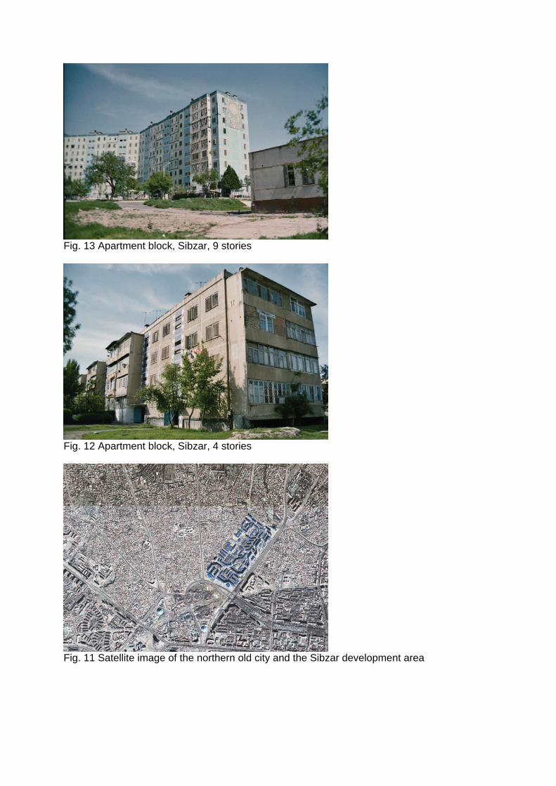
Fig. 13 Apartment block, Sibzar, 9 stories
Fig. 12 Apartment block, Sibzar, 4 stories
Fig. 11 Satellite image of the northern old city and the Sibzar development area

Fig. 16 Delimitation of an entrance area as a parking zone
Fig. 17 City structure, status in 1865

Fig. 18 City structure, status in 1905
Fig. 19 City structure, status in 1930

Fig. 20 City structure, status in 1950
Fig. 21 City structure, status in 1970
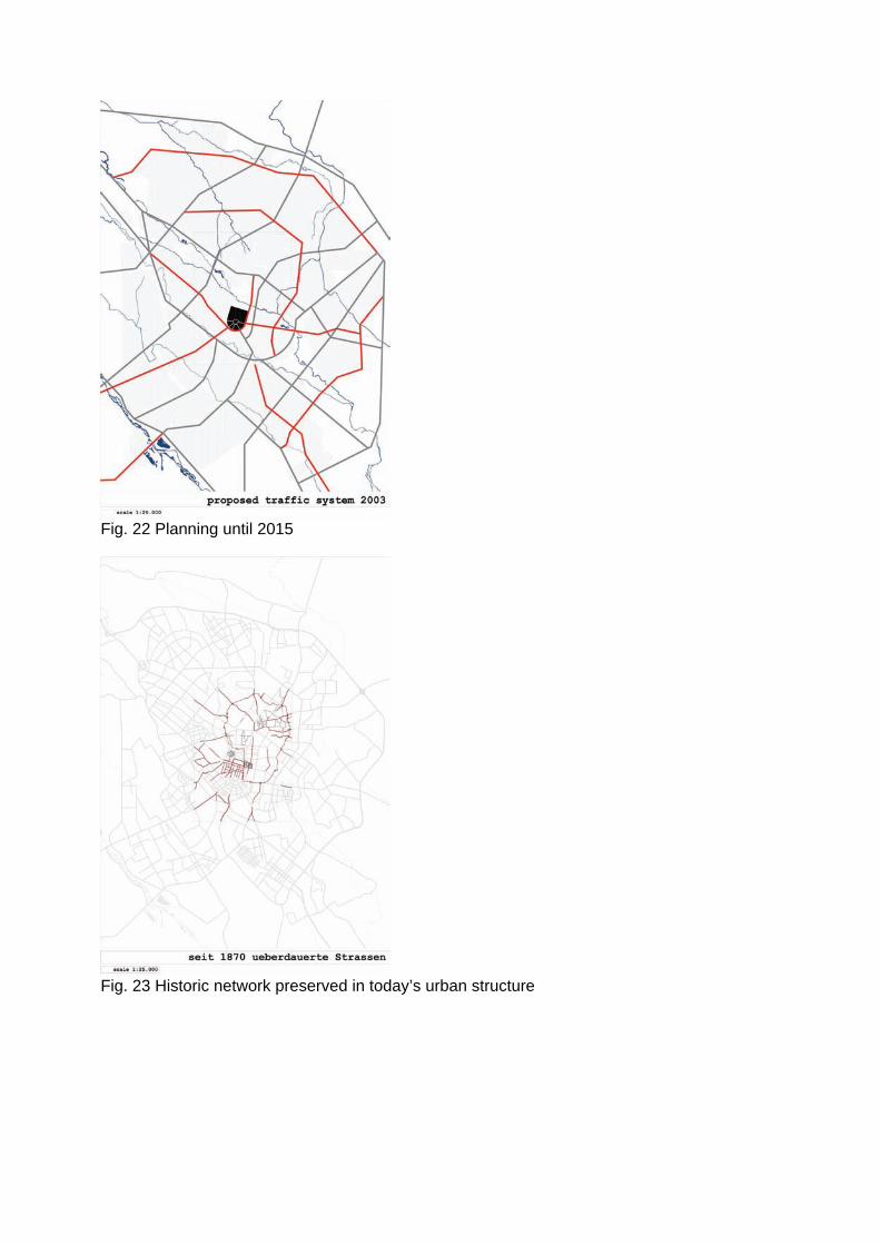
Fig. 22 Planning until 2015
Fig. 23 Historic network preserved in today’s urban structure

Fig. 24 Map of city centre, 1975
Fig. 25 The ring of the “ten golden squares”
Fig. 26 Lenin Square and Lenin Monument
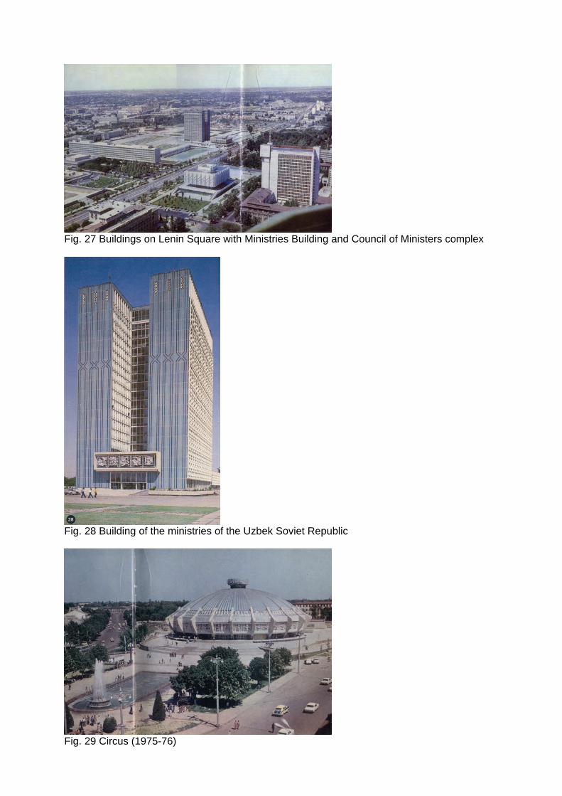
Fig. 27 Buildings on Lenin Square with Ministries Building and Council of Ministers complex
Fig. 28 Building of the ministries of the Uzbek Soviet Republic
Fig. 29 Circus (1975-76)

Fig. 30 Chorsu market [ Bild fehlt ] Fig. 31 Timur Museum
Fig. 32 Oliy Majlis
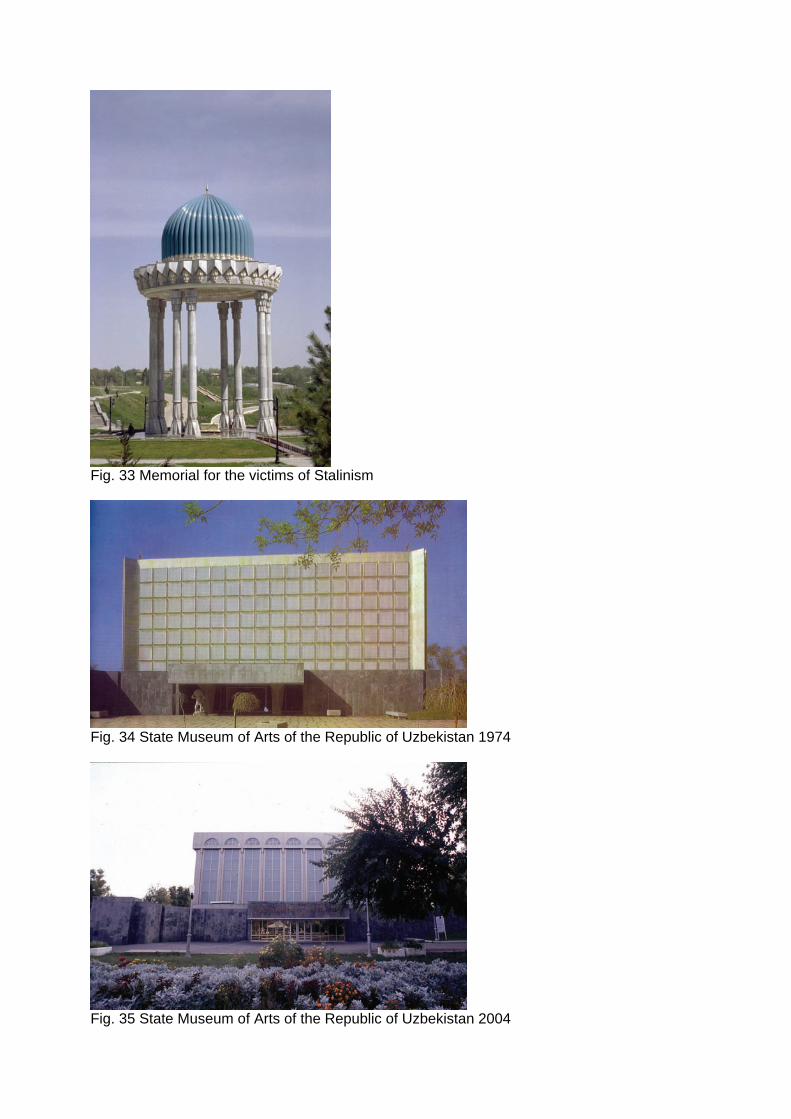
Fig. 33 Memorial for the victims of Stalinism
Fig. 34 State Museum of Arts of the Republic of Uzbekistan 1974
Fig. 35 State Museum of Arts of the Republic of Uzbekistan 2004

Fig. 36 Building of the Council of Ministers, 1967
Fig. 37 Meeting of the Ministers of the Republic, 2004
Fig. 38 Satellite image of Bekobod

Fig. 39 Inner courtyard with garden
Fig. 40 Photograph of Bekobod
Fig. 41 Photograph of Bekobod

Fig. 42 Chilinzor
Fig. 43 Privatized open space

Fig. 44 Converted sun protection façade elements in 9-story apartment buildings
Fig. 45 Rustavelli Villa
Fig. 46 Satellite image [ Bild fehlt ] Fig. 47 New CBD at TV tower

Fig. 48 Oibek metro station