Table of Contents - Oregon...fire plans or by participating in countywide activities for prevention...
57
Transcript of Table of Contents - Oregon...fire plans or by participating in countywide activities for prevention...

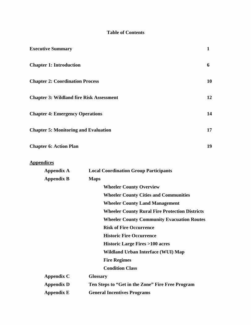
Table of Contents
Executive Summary 1
Chapter 1: Introduction 6
Chapter 2: Coordination Process 10
Chapter 3: Wildland fire Risk Assessment 12
Chapter 4: Emergency Operations 14
Chapter 5: Monitoring and Evaluation 17
Chapter 6: Action Plan 19
Appendices
Appendix A Local Coordination Group Participants
Appendix B Maps
Wheeler County Overview
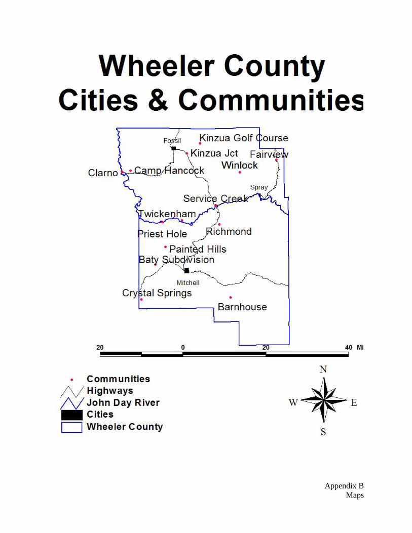
Wheeler County Cities and Communities
Wheeler County Land Management
Wheeler County Rural Fire Protection Districts
Wheeler County Community Evacuation Routes
Risk of Fire Occurrence
Historic Fire Occurrence
Historic Large Fires >100 acres
Wildland Urban Interface (WUI) Map
Fire Regimes
Condition Class
Appendix C Glossary
Appendix D Ten Steps to “Get in the Zone” Fire Free Program
Appendix E General Incentives Programs

Signatures: As required by the HFRA, the undersigned representatives of the Wheeler County Court, Wheeler County Fire Defense Board and Oregon Department of Forestry acknowledge that they have reviewed and agree with the contents of this plan. Wheeler County Court _______________________________________________________ __________ Jeanne Burch, Wheeler County Judge Date _______________________________________________________ __________ John Asher, Wheeler County Commissioner Date _______________________________________________________ __________ Ken Bond, Wheeler County Commissioner Date Wheeler County Fire Defense Board Chief _______________________________________________________ __________ Rick Shaffer, Wheeler Co Fire Defense Board Chief Date Oregon Department of Forestry _______________________________________________________ __________ Robert Young, District Forester, Central Oregon District Date
EXECUTIVE SUMMARY
Recent fires in Oregon and across the western United States have increased public awareness over the potential losses to life, property, and natural and cultural resources that fire can pose.
The Wheeler County Community Wildfire Protection Plan (CWPP) is the result of a countywide effort initiated to reduce wildland fire risk to communities and their citizens, the environment, and quality of life within Wheeler County. Citizens, fire districts, county staff or elected officials, and agency representatives have worked together to create a plan that would be successful in implementing fuels reduction projects, fire prevention education campaigns, and other fire-related programs.
See Appendix A for a list of participants of the Wheeler County LCG
Plan Adoption
To ensure recognition by the public, as well as partner agencies and organizations, The Local Coordinating group presented this Wheeler County Community Wildfire Protection Plan (WCCWPP) to the County Court for adoption on (INSERT date)
While the Wheeler County Community Wildfire Protection Plan provides a foundation and resources for understanding wildland fire risk and opportunities to reduce potential losses from wildland fire, individual communities, fire districts and neighborhoods can take local action by developing community-specific fire plans or by participating in countywide activities for prevention and protection.
The Healthy Forests Restoration Act of 2003 recommends that communities develop a Community Wildfire Protection Plan, as does the FEMA Disaster Mitigation Act of 2000. With formal adoption of this plan, Wheeler County is more competitive for funding that may assist with plan implementation. Furthermore, adoption of this plan highlights the partnerships between fire districts, local government, community-based organizations and public agencies. The result of this partnership brings direction to the federal agencies for which communities are a priority for fuel treatment on federally managed and non-federal lands.
Sustaining Fire Plan Efforts
In the past, there has been limited awareness about the investment required to maintain fire protection. From fuels reduction, education and prevention to evacuation, citizens must have the information and resources to be active participants in reducing their risk to wildland fire. For many years, there has been a reliance on insurance, local government, fire service, federal agencies and many other types of organizations to aid us when disaster strikes. The WCCWPP encourages citizens to take an active role in identifying needs, developing strategies and implementing solutions to address wildland fire risk by assisting with the development of local community wildfire protection plans and participating in countywide fire prevention activities. Citizen action may be cleaning up brush around homes, installing new smoke detectors, volunteering to be a part of auxiliary, attending community meetings, and/or passing along information on fire prevention to neighbors and friends. With the WCCWPP as a foundation, community wildfire plans and local action can guide successful implementation of fire hazard reduction and protection efforts in the County.
Development of the Wheeler County Community Wildfire Protection Plan has been no small task. Building a partnership and cooperative environment between “community based” organizations, fire districts, local government and the public land management agencies has been the first step in identifying and prioritizing measures to reduce wildfire risk. Maintaining this cooperation with the public is a long-term effort that requires commitment of all partners involved.
Wheeler County is committed to supporting the rural fire districts and communities in their fire protection efforts, both short and long-term. The County will continue to provide support in maintaining countywide risk assessment information and emergency management coordination. In 2006, The Local CWPP Coordination Group will work on implementing the wildfire plan by working with fire districts, community organizations and public agencies to coordinate fuels reduction projects with existing dollars
Page 1 of 25
through the National Fire Plan. The WCCWPP will focus on public meetings, education campaign; strengthen emergency management and evacuation procedures. WCCWPP partners will also focus on refining long-term strategies to maintain fire protection activities in the County. Annual meetings of the local coordinating group and annual open house meetings will continue to take place.
Wheeler County Community Wildfire Protection Plan Mission, Goals, Objectives
Developed by the local coordinating group comprised of rural fire protection districts, local government, state and federal agencies, and community-based organizations, the plan mission is to reduce the risk from wildland fire to life, property and natural resources in the County.
Goals
• Protect against potential losses to life, property and natural resources from wildland fire;
• Build and maintain active participation from each Fire Protection District;
• Set realistic expectations for reducing wildland fire risk;
• Identify actions for fire protection;
• Access and utilize federal and other grant dollars;
• Identify incentives for fire protection and community participation;
• Promote visible projects and program successes;
• Monitor the changing conditions of wildland fire risk and citizen action over time;
• Institutionalize fire-related programs and sustain community efforts for fire protection;
• Establish and maintain escape route and adjacent corridors.
To address the complex range of issues within the WCCWPP, it became clear early in the planning process that broader and diverse participation was needed for success. Through public meetings and invitations to organizations and stakeholders in the county, sub categories were formed to develop objectives and implement actions to support the plan. Objectives within sub categories are described below.
Category Objective
General · Provide oversight to all activities related to the WCCWPP
· Ensure representation and coordination
· Develop and refine goals for fire protection in Wheeler County
· Develop a long-term structure for sustaining efforts of the WCCWPP
Risk Assessment
· Identify Communities-at-Risk in the Wildland-Urban Interface
· Develop and conduct a wildland fire risk assessment
· Identify hazardous fuels treatment projects
Fuels Reduction
· Identify strategies for coordinating fuels treatment projects at a landscape scale
· Provide special need citizens with an opportunity to participate in programs
Emergency Management
· Strengthen emergency management, response and evacuation
· Coordinate between County government and local fire districts
Information and outreach
· Develop strategies for increasing citizen awareness and action for fire prevention
· Reach out to all citizens in the county
Page 2 of 25

County Profile
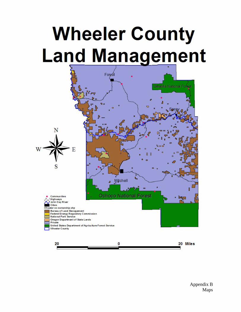
Based on the 2000 Census, there are 1,547 people residing in Wheeler County accounting for 653 households. The economy in Wheeler Co is tied closely to the land. Given the rugged terrain intermixed fertile valleys the three main stays (irrigated farming, cattle ranches, and timber) are intertwined throughout. In recent years, recreation has proven itself as an important aspect of Wheeler County's economy. The total area of Wheeler County is approximately 1,715 square miles, a little more than one million acres of vast peaks and valleys, of which about 341,267 acres is privately owned forestland and about 311,264 acres, nearly 1/3 of the land mass, managed by federal, state, and county agencies for the public good.
Management Acres
Private Lands (Residential, Ranches, Timber Companies, etc.) 781,216
US Department of Interior, Bureau of Land Management 137,448
National Parks Service 4,885
Federal Energy Regulatory Commission 3,403
USDA Forest Service, Umatilla NF & Ochoco NF 163,469
Wheeler County 502
State of Oregon, Division of State Lands & Dept of Fish & Wildlife
5,178
Total 1,096,101
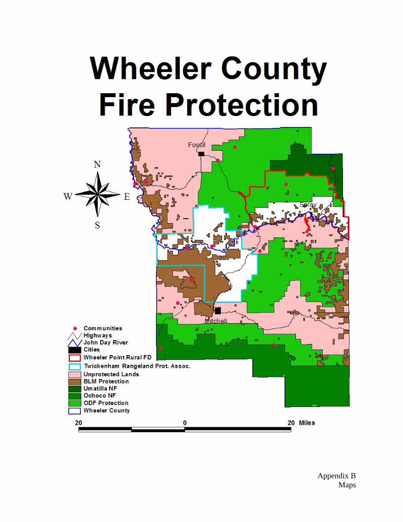
Within the county boundary there are (3) incorporated cities with fire departments, Fossil, Spray, and Mitchell. All three are operated with volunteer fire fighters. In addition, there is Wheeler Point rural fire protection district and Twickenham Rangeland Protection Association within the county, both of which are strictly volunteer as well. Also, there are a couple communities and/or populated areas that do not have structural fire departments including Richmond, Twickenham, and Cougar Mtn.
There are nine (9) organizations that provide wildland fire protection in Wheeler County, comprised of 1 Rural Fire District, 3 city fire departments, 1 Rangeland Protection Association, the BLM (Bureau of Land Management), USFS (United States Forest Service), BIA (Bureau of Indian Affairs) and ODF (Oregon Department of Forestry). The John Day and Prineville airports have single engine air tankers (SEATs) available during the summer fire season. There are helicopter rappel bases at Ukiah and John Day.
Oregon Department of Forestry, Wheeler County, and USFS/BLM are in a partnership to suppress wildland fires, and operate under a “closest forces” concept. ODF is responsible for protection of private lands, county and State of Oregon lands within the Forest Protection District. The USFS, Umatilla and Ochoco National Forests, plus BLM work with the ODF to locate the closest fire crew to an ignition and dispatch for initial attack. ODF and the USFS have mutual aid agreements with the rural and city fire districts/departments within Wheeler County that allow for assistance to be provided regardless of jurisdiction.
See Land Management Map in Appendix B See Wheeler County Rural Fire Protection Districts Map in Appendix B
Page 3 of 25
Wildland Fire Risk Assessment
The Wheeler County Community Wildfire Protection Plan wildland fire risk assessment analyzes the potential losses to life, property and natural resources. Objectives of the risk assessment are to identify Communities at-Risk and the Wildland-Urban Interface, develop and conduct a wildland fire risk assessment, and identify and prioritize hazardous fuels treatment projects. The analysis takes into consideration a combination of factors defined below:
Risk: Potential and frequency for wildland fire ignitions (based on past occurrences)
Hazard: Conditions that may contribute to wildland fire (fuels, slope, aspect, elevation, and weather)
Values: People, property, community infrastructure, natural and other resources that could suffer losses in a wildfire event.
Protection Capability: Ability to mitigate losses, prepare for, respond to, and suppress wildland and structural fires.
Structural Vulnerability: Characteristics influencing the vulnerability of structures during a wildland fire event (roof type and building materials, access to the structure, and whether or not there is defensible space or fuels reduction around the structure.)
Communities at Risk
The Federal Register has listed cities and areas in the United States that are a risk to urban interface fires. This list includes (0) locations in Wheeler County.
In recent years the population of Wheeler County has moved further and further into traditional resource land including forested lands. This has produced a significant increase in threats to life and property and has pushed existing fire protection beyond its original or current design capabilities.
Many Wheeler County property owners could use assistance identifying the problems they face. Information on risk reduction and mitigation to offset the fire hazards on their property is essential.
Hazardous Fuels Reduction Objectives
Action 1. Identify fuels treatment projects on lands using the risk data. 2. Utilize risk assessment information in applications for National Fire Plan grants and other
fuels reduction dollars. 3. Review how grant dollars for fuels reduction projects are administered. Make changes to
the program so that they are more directed towards landscape scale treatments. 4. Develop long-term strategies for maintenance of fuels reduction 5. Focus Strategic planning for hazardous fuels treatment projects on evacuation
routes/corridors. (County Roads/FS Roads/State Hwys/Public Access Roads/Private Drives)
6. Promote information and outreach through all fuels reduction programs to ensure strong community involvement in fuels reduction and wildland fire prevention projects.
Page 4 of 25

Fuels Treatment Areas
The State, County, Rural and City fire districts, community organizations and agency partners have worked together to identify fuel treatment areas. This process includes examining the risk assessment maps and strategic planning units and using local knowledge and information gathered during community meetings to identify the most appropriate places to prioritize for treatment. Consideration is given to areas where the federal agencies have planned fuels reduction projects in order to achieve the landscape scale treatment.
Monitoring Strategy
The primary objective of the local coordinating group is to provide guidance for all elements of planning and implementation of the Wheeler County Community Wildfire Protection Plan. The local coordinating group will continue to provide oversight through meetings and coordination with the fire protection agencies and the communities at risk in Wheeler County.
Page 5 of 25
CHAPTER 1: INTRODUCTION
On a normal summer day in Wheeler County you can find many residents checking the skies for a building thunderhead or a plume of smoke. Wildland fire has impacted the county since long before the first settler moved into the area.
Environment and Natural Resources
Wheeler County, established on February 17, 1899 from portions of Grant, Gilliam, and Crook counties, was named for Henry Wheeler who operated the first stage line through the county. Wheeler County covers 1,713 square miles and contains just under 1.1 million acres of largely varied terrain. The timbered tracts that line the northern and southern edges of the county and scattered throughout the east half, give way to the rugged sparsely vegetated John Day River Canyon which bisects the county near its waist from east to west.
Two National Forests, covering nearly 1/3 of the county, lie within its borders, the Umatilla in the NE and Ochoco along the southern edge. Surrounding the edges of the National Forests are private forests dominated by Ponderosa Pine with areas of mixed conifer. The timber quickly transitions with the elevation into rolling and rugged prairies, juniper woodlands, and sagebrush landscapes. Scattered throughout all of these different vegetations is livestock and their associated ranches and agricultural land with the main crop being hay.
The elevation in Wheeler Co varies as much as the seasons. The magnificent John Day River has carved through the rock and soil forming a canyon 2,600 feet deep with the lowest point in the county lying along the river near 1,500 feet. The mountains to the north in contrast peak over 5,100 feet which are dwarfed by the mountains to the south which nearly reach 7,000 feet.
Wheeler County is internationally known for its outstanding depository of prehistoric fossils, As such, there are three units of the John Day Fossil Beds National Monument within the county.
Strategy
Wheeler County has lived with fire since the county was first established in 1899. Fire has been a major tool in shaping the existing forest and other plant communities since long before the country was settled. Lightning and humans will always contribute to fire starts during all conditions dry or wet. Of the three fire behavior components (fuel, weather, topography), fuels are the one variable that humans can easily influence and modify. With this in mind, this plan is aimed at reducing fire effects by reducing fuel loading and to produce conditions, in case of fire, that are considered manageable during most conditions and to improve initial attack capabilities for all types of fires.
1. The number one goal of this plan is to provide for the protection of the public and create a safe work environment for fire suppression forces. With the reduction of wildland fuels we move closer to achieving the goal of all structures surviving an on-coming fire.
2. Everyone involved with this plan must work together to successfully manage hazardous fuels within and near the communities. Those included are association groups, Federal agencies, Local Agencies, local and state fire protection districts, private industrial timberland owners, and private land and home owners.
3. There are often weather conditions where high temperatures, single digit humidity’s, and strong winds occur simultaneously. Under these conditions prevention through communication to reduce fire start potential is the only protection for communities from wildland fire effects. These conditions can lead to plume dominant fires which create their own burning conditions and are literally unmanageable and can become catastrophic.
4. The key to making this plan work will be increasing public awareness through informational programs. This county is a typical Eastern Oregon county with small cities scattered throughout with a population of people living in homes scattered outside the city limits.
Page 6 of 25
These homes are located in all fuel types. Some are snuggled in the timber adjacent to the forest. Others are in the lower elevations of grass/juniper/sagebrush climate. Distance from any type of fire protection is one of the biggest problems for these homes and access. Depending upon the day, suppression response times could be as long as 1 hour.
Fire Policies and Programs
There are various local, state and federal programs and policies related to community fire planning and fire protection. Most recently, the Healthy Forests Restoration Act, signed into law by President Bush in 2003, calls for the development of Community Wildfire Protection Plans for all communities at risk from wildland fire. This section describes these requirements, as well as related County, state and federal programs.
Healthy Forest Restoration Act (HFRA) / Healthy Forest Initiative (HFI)
In 2002 the President announced the Healthy Forest Initiative (HFI) designed to identify and remove barriers to the implementation of projects that were developed to restore the health of the national forests. HFI was focused on renewed efforts to be more effective and efficient in carrying out restoration projects. Under HFI, new categorical exclusions were developed to allow the federal agencies to move more quickly through National Environmental Policy Act (NEPA) under appropriate circumstances, streamlined administrative review processes for NEPA, and created new regulations under the Endangered Species Act for National Fire Plan projects to streamline consultation with federal regulatory agencies. It also set the stage for extensive discussion between the administration and Congress that resulted in new legislation addressing forest health.
Congress enacted the Healthy Forest Restoration Act in November 2003. It provides new tools and additional authorities to treat more federally-managed acres more quickly to expedite our restoration goal. It strengthens public participation and provides incentives for local communities to develop community protection plans. It limits the complexity of environmental analyses for hazard reduction projects, provides more effective appeals process and instructs the Courts that are being asked to halt projects, to balance the short-term affects of implementing the projects against the harm from undue delay and long term benefits of a restored forest.
Title I of the HFRA addresses vegetation treatments on certain types of National Forest System and Bureau of Land Management lands that are at risk of wildland fire or insect and disease epidemics.
This title:
• Encourages streamlined environmental analysis of HFRA projects;
• Provides for administrative review of proposed HFRA projects on National Forest System lands before decisions are issued;
• Contains requirements governing the maintenance and restoration of old-growth forest stands when the Forest Service and BLM conduct HFRA projects in such stands;
• Requires HFRA projects in the Forest Service and BLM to maximize retention of larger trees in areas other than old-growth stands, consistent with the objective of restoring fire-resilient stands and protecting at-risk communities and Federal lands;
• Encourages collaboration between Federal agencies and local communities when community wildfire protection plans are prepared;
• Requires using at least 50% of the dollars allocated to HFRA projects to protect communities at risk of wildland fire;
• Requires performance to be monitored when agencies conduct hazardous-fuel reduction projects and encourages multiparty monitoring that includes communities and other stakeholders; and
Page 7 of 25

• Encourages courts that consider a request for an injunction on an HFRA-authorized project to balance environmental effects of undertaking the project against the effects of failing to do so.
Title III of the Act also encourages the development of Community Wildfire Protection Plans under which communities will designate their Wildland Urban Interface (WUI), where HFRA projects may take place. Half of all fuel reduction projects under the HFRA will occur in the community protection zone as defined by HFRA. HFRA also encourages biomass energy production through grants and assistance to local communities to create market incentives for removal of otherwise valueless forest material.
National Fire Plan and 10-Year Comprehensive Strategy
The National Fire Plan (NFP) was established after a landmark fire season in 2000 with the intent of actively responding to severe wildland fires and their impacts to communities while assuring sufficient firefighting capacity for the future. The NFP is a long-term commitment intended to help protect human lives, communities and natural resources, while fostering cooperation and communication among federal agencies, states, local governments, tribes and interested publics. The NFP focuses on 1) fire suppression and protection, 2) restoration/rehabilitation, 3) hazardous fuels reduction, 4) community assistance, and 5) accountability. The Oregon and Washington NFP Strategy Team sees reduction of unnatural hazardous fuel levels that threaten communities and forest ecosystems as the foundation principle for dealing with fire risks (NFP Strategy Team 2002). Most NFP funding in Oregon goes to wildland fire preparedness and hazardous fuel treatment (USDI and USDA 2003).
The National Fire Plan is a long-term investment that will help protect communities and natural resources, and most importantly, the lives of firefighters and the public. It is a long-term commitment based on cooperation, and collaboration, communication among federal agencies, states, local governments, tribes and interested publics. The federal wildland fire management agencies worked closely with these partners to prepare a 10-Year Comprehensive Strategy, completed in August 2001. The National Fire Plan calls for the development of Community Fire Plans to aid in effectively implementing NFP goals.
Senate Bill 360: Oregon Forestland-Urban Interface Fire Protection Act
The Oregon Forestland-Urban Interface Fire Protection Act of 1997 (SB360) is intended to facilitate development of and effective WUI protection system in Oregon by 1) establishing policies regarding WUI protection, 2) defining the WUI in Oregon and establishing a process and system for classifying the interface, 3) establishing standards for WUI property owners so they can manage or minimize fire hazards and risks, and 4) providing the means for establishing adequate, integrated fire protections systems in WUI areas, including information and prevention efforts. This act is only pertinent to areas within ODF’s protection boundaries and is going to be implemented in all of these areas across the state by 2011.
Oregon Statewide Land Use Planning Goal 7
The intent of Oregon Statewide Land Use Planning Goal 7 for Areas Subject to Natural Hazards is to protect people and property from natural hazards. Goal 7 directs local governments to adopt comprehensive plans (inventories, policies and implementing measures) to reduce risk to people and property from natural hazards. Goal 7 also indicates that new hazard inventory information provided by federal and state agencies shall be reviewed by the Oregon Department of Land Conservation and Development (DLCD) in consultation with affected state and local government representatives. After such consultation, the DLCD shall notify local governments if the new hazard information requires a local response. Local governments shall respond to new inventory information on natural hazards within 36 months after being notified by the DLCD, unless extended by the Department. – (http://www.lcd.state.or.us/LCD/docs/goals/goal7) In relationship to ODF, as new data is identified, and particularly high hazard areas identified through Senate Bill 360, local governments will need to address the provisions of Goal 7.)
Page 8 of 25
Federal Emergency Management Agency Disaster Mitigation Act of 2000
Federal Emergency Management Agency (FEMA) requirements under Title 44 CFR Part 201 of the Disaster Mitigation Act of 2000. This legislation specifies criteria for state and local hazard mitigation planning which require local and Indian tribal governments applying for Pre-Disaster Mitigation (PDM) funds to have an approved local mitigation plan. These may include county-wide or multi-jurisdictional plans as long as all jurisdictions adopt the plan. Activities eligible for funding include management costs, information dissemination, planning, technical assistance, and mitigation projects.
Page 9 of 25

CHAPTER 2: COORDINATION PROCESS Coordinating Groups
There are two major committees that deal with all aspects of fire emergencies in Wheeler County. The Fire Defense Board is represented by all the municipal fire departments, Oregon State Fire Marshal’s office, Rangeland Association, and Rural Protection District. The second is under the Master Agreement and Operating Plan between the Federal Wildland Fire agencies and the States of Oregon and Washington.
Community outreach will be done through both of these groups. There are many homes and structures that are in danger from possible wildland fire. Many of these homes are situated in risk areas due to the desire for seclusion. It will be a major hurdle to contact these land owners and inform them about defensible space or convince them it is a necessary objective. Emergency operations will also cover these possibilities.
Gaining committee representation
The WCCWPP Local Coordinating Group (LCG) began conducting outreach with community-based organizations throughout the County. The WCCWPP Local Coordinating Group invited all organizations, business or residents with an interest in working on fire-related issues to participate.
The LCG began by ODF conducting meetings with all of the fire districts, the Forest Service, and BLM. This process resulted in each of the agencies appointing at least one person to the WCCWPP Local Coordinating Group. Agencies directed field officers, fuels management specialists, fire prevention staff and others to participate.
Executive Committee The Executive Committee is responsible for Documentation and Filing of the Wheeler County Community Wildfire Protection Plan. Members of the Executive Committee include: Members Representing; Wheeler County Court Wheeler County Fire Defense Board Oregon Department of Forestry Local Coordinating Group The Local Coordinating Group is responsible for providing guidance to all elements of planning and implementation of the Wheeler County Community Wildfire Protection Plan. It also coordinates the priority of communities at risk and projects. Members of the Local Coordinating Group include: Members Representing;
Wheeler County Court Wheeler County Fire Defense Board Oregon Dept. of Forestry representing State Agencies: ODF&W Federal Agencies: USFS Umatilla & Ochoco NF, NPS Community Leaders County Agencies
Page 10 of 25

Local Coordinating Group Responsibilities;
Actions Timeline Outcomes Gain representation and involvement from RFPD Short-term Active participation by each RFPD Access and utilize federal dollars while they are available Short-term Continued federal funding for fuels
reduction Set realistic expectations for reducing wildland fire risk Ongoing Increased public awareness about wildland
fire
Coordinate priorities for funding Ongoing Achieve landscape treatment and equitable distribution
Promote visible projects and program successes Ongoing Increased awareness Find funding to support efforts Long-term Increased Funding Identify incentives for fire protection and community participation Long-term Increased citizen action
Engage insurance companies Long-term Insurance industry investment in activitiesPromote local investment (property, infrastructure, business) Long-term Increased economic development
Citizen Involvement
The heart of the Wheeler County Community Wildfire Protection Plan is the interest, and long-term involvement of residents in reducing wildland fire risk around their homes and in their community. Informing citizens and providing tools and resources that enable people to prepare for wildland fire will have lasting effects to building resilience to wildland fire and capacity for communities to work together toward common goals. Providing tools, information and resources that enable citizens to understand, prepare for, recover from, and learn to live with wildfire can have long-lasting effects in building resilience to catastrophic wildfire. This can also increase the capacity for communities to work together toward common goals.
Community Risk Assessment
Understanding the risk of wildfire to people, property and natural resources is an essential starting point for identifying priorities for treatment. The Wheeler County risk assessment includes a comprehensive analysis of risk, hazard, values, structural vulnerability, and protection capabilities. Values are defined in many ways and by many different agencies and programs (for example, the National Association of State Foresters, the Healthy Forests Restoration Act, the National Fire Plan, and the BLM Risk Assessment Model (RAMs), among others.)
Page 11 of 25

CHAPTER 3: Wildland Fire Risk Assessment Fire Occurrence - History of fire within the community Fire is an important disturbance mechanism in many of the ecosystems in Wheeler County. The number of these fires, from 1986 to 2003, ranged from (27) in 1988 to (78) in 1987 with a total of 846 fires during this time period burning more than 67,000 acres. (20) Fires burned 300 acres or more during that period and of those, (3) were 5000 acres or more. (Due to inconsistent tracking of historic fire data, the chart below is incomplete for fire numbers and acreage burnt) Many of the significant fire events in Wheeler County occur as a result of dry lightning storms. Wide spread dry lightning is fairly frequent, occurring approximately every one to three years. These episodes can causes 50-100 ignitions in one day requiring suppression.
Wheeler County 1986 to 2003
Size Class Acres Number of Fire
A 0-.24 66 acres 595
B .25-9.9 330 acres 202 C 10-99.9 1,351 acres 40 D 100-299.9 2,393 acres 14 E 300-999.9 9,321 acres 12 F 1000-4999.9 19,645 acres 10
G 5000-9999.9 7,900 acres 1
H 10,000+ 45,450 acres 3
Total 86,456 acres 877
See Historic Fire Occurrence Map in Appendix B
See Previous Large Fire Map in Appendix B
Wildland Urban Interface (WUI)
The boundaries of the Wildland Urban Interface are based on the actual distribution of structures and communities adjacent to or intermixed with wildland fuels.
Fuel reduction treatments are designed to protect human communities from wildland fires as well as minimize the spread of fires that might originate in urban areas. The management objective in the wildland-urban interface zone is to enhance fire suppression capabilities by modifying fire behavior inside the zone and providing a safe and effective area for fire suppression activities.
See WUI Map in Appendix B
Page 12 of 25
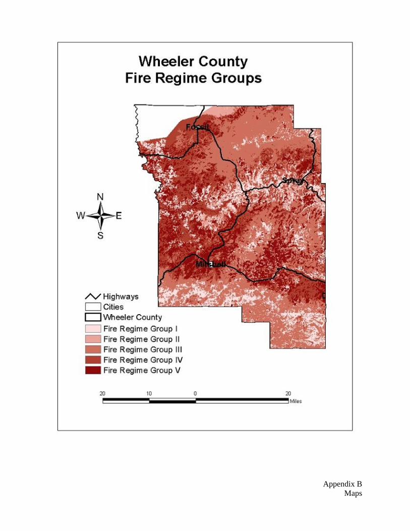
Fire Regime and Condition Class Fire Regime Codes Description I 0-35+ years, low severity fires II 0-35+ years, stand-replacement fires III 35-100+ years, mixed severity fires IV 35-100+ years, stand replacement fires V 200+ years, stand replacement fires
The Fire Regimes are described in terms of frequency and severity and represent pre-settlement, historic fire processes. Fire Regimes I and II represent frequent fire return intervals. The 0-35+ years, low severity fire regime (I) occurs mostly forested land. The 0-35+ years, stand replacement fire regime (II) occurs mostly on grasslands and shrublands. Fire Regime III, IV, V have longer intervals and occur on forestlands, shrublands, and grasslands. Condition Class Codes Description
I Fire frequencies are within or near the historical range, and have departed from historical frequencies by no more than one return interval.
II One or more fire return intervals have been missed, possibly resulting in increased fire sizes and intensities and decreased landscape mosaics and diversity.
III Multiple fire return intervals have been missed resulting in dramatic departure from historical conditions.
Condition Class refers to how close an ecosystem is to its historic Fire Regime. As fire return intervals are missed, the ecosystem is altered and can lead to more severe fires when fire does return, having more severe damage to an ecosystem.
See Fire Regime / Condition Class Maps in Appendix B
Page 13 of 25
CHAPTER 4: Emergency Operations
Wildland Fire Suppression Procedures
Currently all wildland fires on protected lands within Wheeler County are aggressively suppressed. This is done through a Master Cooperative Fire Protection Agreement. This agreement consists of four organizations:
John Day Unit, Central Oregon District, ODF, (with Mutual Aid Agreements with all cities and rural Fire Departments)
Umatilla National Forest, USFS
Ochoco National Forest, USFS
Prineville District, BLM
Wildland fire fighting organizations have a multitude of support resources. Movement of federal; resources are coordinated through local dispatch centers and the Northwest Coordination Center (NWCC) in Portland, Oregon. State resource movement is coordinated through local dispatch centers, the ODF-Salem Coordination Center and the WDNR dispatch office in Olympia, Washington
Tribal Resources
Indian tribal resources are available through the use of existing Bureau of Indian Affairs/Tribal Cooperative agreements.
Inmate Resources
Oregon Department of Forestry has an agreement with Oregon Department of Corrections for the use of inmate resources to fight fires and support fire suppression activities. The use of inmates is available through the Master Cooperative Fire Protection Agreement to other agencies.
International Resources Mexico, Canada
The use of international resources is available through the Northwest Compact and Annual Operations Guidelines and International Agreements in the National Mobilization Guide.
There are two types of initial attack available; one is by air, the other by land. There are several areas within the county, mostly on public land that are road less due to the rugged topography. Initial attack in these areas is mainly by air. Redmond, Oregon houses a smoke jumper and retardant base, also LaGrande, Oregon has an air tanker base. Prineville airport has a light helicopter for fire response. The John Day Airport has a helibase equipped with rappellers and a small engine air tanker (SEAT). All of these fire support facilities are fully capable of initial attack on fires that are not obtainable by any roads. Again, as conditions become worse due to drying or multiple fires, these organizations can call in more support from other areas, even outside the state/region. Areas with road system access have all types of agency people and equipment available to them. The USFS has (4) engines and (1) 5-person hand crew working out of Tupper and 6 engines dispatched out of Prineville but stationed at work centers in surrounding counties. The BLM has 11 engines and 1 water tender also dispatched out of Prineville but stationed at work centers in the surrounding counties. The ODF has a total of 15 engines scattered throughout the area including two in Heppner, two in Monument, one in Mitchell, and two in Fossil. Wheeler County and the Fire Defense Board have several engines along with personnel and heavy equipment scattered about the county for fire suppression.
There is also a very large work force in the contracting arena that can be called upon. Contracting equipment consists of dozers, lowboys, water tenders, engines and 20 person crews, and personnel with specialized talents.
Page 14 of 25

If a fire goes beyond the initial attack capabilities of the local resources there are special groups that can be ordered to take over the suppression responsibilities. Theses are known as Incident Management Teams, and have the ability to set up and do all the functions needed to suppress the fire in a more or less self-sufficient manner.
Central Oregon IMT, Blue Mountain IMT, Oregon Department of Forestry IMT’s and Pacific Northwest National IMT’s are all partially staffed by local agency personnel.
If the fire is large enough it would strip the county of all its capable initial attack resources and leave the area vulnerable to new starts. The Incident Management Team will set up a small city type camp with the capabilities of feeding and housing hundreds of resources. The “Team” supports the crews with equipment and supplies to safely suppress the fire. The important factor is the team uses outside agency help and contractors so local forces can be released back to their regular initial attack duties.
Though all these resources mentioned above are available to all the Fire Agencies in the County, due to the lack of funding within the local Municipal and Rural Fire Departments and the Rangeland Association, only the Wildand Fire Agency (ODF, USFS, BLM) engines and crews would be available to these Departments and Association for initial attack at no cost through mutual aid agreements. The aerial support, incident management teams, and contract equipment would cost these departments and association more than they would be able to afford, therefore, wouldn’t be a viable option for them for without either state or federal agency assistance.
Also established in Wheeler County is the Twickenham Rangeland Protection Association. This association is made up of several landowners/managers in the Twickenham area who are organized with the sole purpose as to extinguish rangeland fires within their 120,000 + acre protection area. Most of the landownership within their protection area is of private ownership, but they can respond to fires on federal ownership in order to protect their private protection responsibilities. This association is formed under the Oregon Department of Forestry and is eligible for FEPP equipment to be used to suppress these fires. They also have mutual aid agreements with ODF and the City and Rural Fire Districts which allows them to assist outside of their response area or others to assist within it.
Unprotected Lands
Wheeler County has 326,331 acres of wildlands with no organized fire protection. Fires in these areas have historically been suppressed by local landowners affected by the fire or other fire protection agencies protecting their protected lands. Most of this unprotected land is rangeland with intermixed areas of Juniper woodlands and sagebrush. Also, the structures which are scattered about these unprotected wildlands are unprotected as well. Given the nature of these unprotected lands and structures, suppression is a neighbor helping neighbor scenario.
Unprotected Structures
Within Wheeler County, there is a mix of wildland protection and rural fire protection. In most cases, if a property has wildland protection, it doesn’t necessarily have structure protection if there is a structure on the property. The Wildland Fire Agencies, USFS, ODF, & BLM, and the Rangeland Protection Association only provide wildland protection and no structure protection. Only an established Structural Fire Department can suppress structure fires. In Wheeler County, there are 4 of these departments but 3 of which are municipal and only provide protection within their city limits. The fourth department is Wheeler Point Rural. Therefore, the only structures that are protected within Wheeler County lie within the city limits of Spray, Fossil, or Mitchell, or are within the protection boundary of Wheeler Point Rural. All other structures in Wheeler County are unprotected.
Conflagration Act
In the event a large amount of structures are threatened by a Wildland fire in an area protected by a city or rural fire department, the Wheeler Fire Defense Board Chief can request of the Oregon State Fire Marshall to request the Governor to declare an emergency and evoke the Conflagration Act mobilization.
Page 15 of 25
In area outside of city and rural fire departments, the County Court can request of the Governor to declare an emergency and evoke the Conflagration Act mobilization. This will make available structural resources along with Structural IMT’s through the Oregon State Fire Marshal’s office immediately to protect those structures.
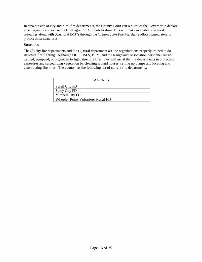
Structures
The (3) city fire departments and the (1) rural department are the organizations properly trained to do structure fire fighting. Although ODF, USFS, BLM, and the Rangeland Association personnel are not trained, equipped, or organized to fight structure fires, they will assist the fire departments in protecting exposures and surrounding vegetation by cleaning around houses, setting up pumps and locating and constructing fire lines. The county has the following list of current fire departments:
AGENCY
Fossil City FD Spray City FD Mitchell City FD Wheeler Point Volunteer Rural FD
Page 16 of 25

CHAPTER 5: Monitoring and Evaluation
Assessing Benefits and Costs of Mitigation
Many federal grant programs require benefit/cost analysis of proposed actions. This ensures that the investment will yield greater benefits than the investment costs. The benefits of planning, mitigation and preparedness for wildland fire, however, can be difficult to quantify. It can be difficult to put a monetary number to the value of human, environmental, cultural and other social resources.
The Wheeler County LCG emphasizes developing priorities of action for hazardous fuels treatment, education, emergency management and biomass utilization. The process to develop these priorities has included a technical risk assessment and collection of community input on values. The plan also takes into consideration the fact that low-income, elderly, disabled and other citizens with special needs may require extra assistance or resources to take fire protection actions. All of these values should be considered in developing priorities and assessing the costs and benefits of projects.
When applying for grants that require benefit/cost analysis, there are resources available through FEMA and other agencies that can assist in quantifying these costs and benefits.
Plan Oversight
The primary objective of the Local Coordinating Group is to provide guidance for all elements of planning and implementation of the Wheeler County Community Wildfire Protection Plan. The Local Coordinating Group will continue to provide oversight through review of the plan and meetings with the local agencies and interested parties.
Monitoring
The purpose of this monitoring strategy is to track implementation of activities and evaluate how well the goals of the WCCWPP are being met over time. Monitoring measures progress over time so that we can understand how well our objectives are being met. The data we gather will provide in status and trends of the WCCWPP.
The following are the types of monitoring:
· Implementation Monitoring: Did you do what you said you would do?
· Effectiveness Monitoring: Did treatments meet objectives?
· Verification Monitoring: Evaluates whether our objectives helped to meet broad WCCWPP goals. Did our actions lead to the outcomes we expected?
Each functional element of the Wheeler County Community Wildfire Protection Plan (risk assessment, fuels reduction, emergency management, and education and outreach) provides monitoring tasks for recommended action items. Table 5.1 provides a summary of monitoring task for each of these functional areas that the LCG will conduct.
Page 17 of 25
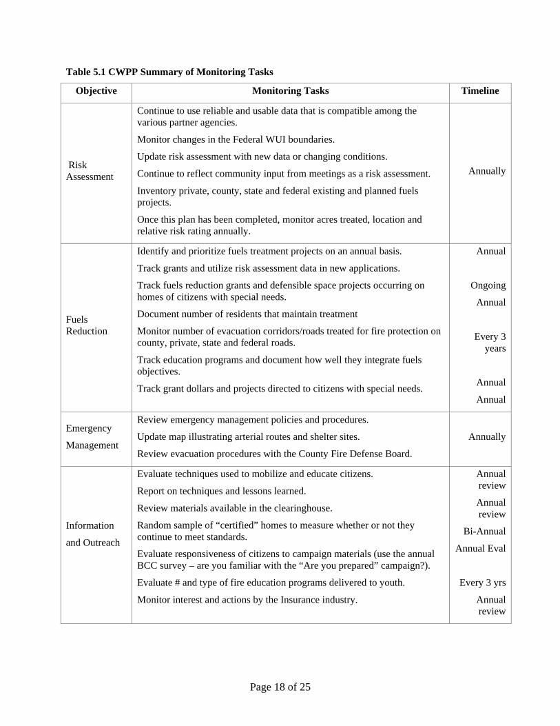
Table 5.1 CWPP Summary of Monitoring Tasks
Objective Monitoring Tasks Timeline
Risk Assessment
Continue to use reliable and usable data that is compatible among the various partner agencies.
Monitor changes in the Federal WUI boundaries.
Update risk assessment with new data or changing conditions.
Continue to reflect community input from meetings as a risk assessment.
Inventory private, county, state and federal existing and planned fuels projects.
Once this plan has been completed, monitor acres treated, location and relative risk rating annually.
Annually
Fuels Reduction
Identify and prioritize fuels treatment projects on an annual basis.
Track grants and utilize risk assessment data in new applications.
Track fuels reduction grants and defensible space projects occurring on homes of citizens with special needs.
Document number of residents that maintain treatment
Monitor number of evacuation corridors/roads treated for fire protection on county, private, state and federal roads.
Track education programs and document how well they integrate fuels objectives.
Track grant dollars and projects directed to citizens with special needs.
Annual
Ongoing
Annual
Every 3 years
Annual
Annual
Emergency
Management
Review emergency management policies and procedures.
Update map illustrating arterial routes and shelter sites.
Review evacuation procedures with the County Fire Defense Board.
Annually
Information
and Outreach
Evaluate techniques used to mobilize and educate citizens.
Report on techniques and lessons learned.
Review materials available in the clearinghouse.
Random sample of “certified” homes to measure whether or not they continue to meet standards.
Evaluate responsiveness of citizens to campaign materials (use the annual BCC survey – are you familiar with the “Are you prepared” campaign?).
Evaluate # and type of fire education programs delivered to youth.
Monitor interest and actions by the Insurance industry.
Annual review
Annual review
Bi-Annual
Annual Eval
Every 3 yrs
Annual review
Page 18 of 25
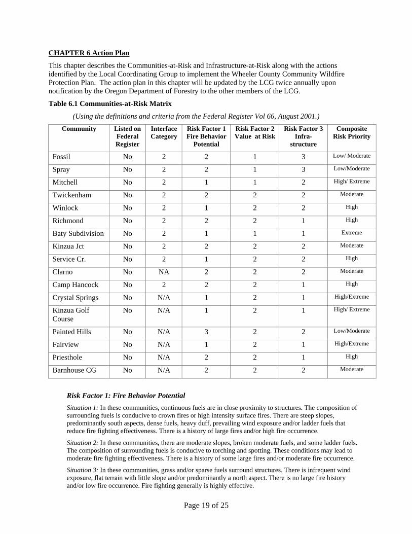
CHAPTER 6 Action Plan
This chapter describes the Communities-at-Risk and Infrastructure-at-Risk along with the actions identified by the Local Coordinating Group to implement the Wheeler County Community Wildfire Protection Plan. The action plan in this chapter will be updated by the LCG twice annually upon notification by the Oregon Department of Forestry to the other members of the LCG.
Table 6.1 Communities-at-Risk Matrix
(Using the definitions and criteria from the Federal Register Vol 66, August 2001.)
Community Listed on Federal Register
Interface Category
Risk Factor 1 Fire Behavior
Potential
Risk Factor 2 Value at Risk
Risk Factor 3 Infra-
structure
Composite Risk Priority
Fossil No 2 2 1 3 Low/ Moderate
Spray No 2 2 1 3 Low/Moderate
Mitchell No 2 1 1 2 High/ Extreme
Twickenham No 2 2 2 2 Moderate
Winlock No 2 1 2 2 High
Richmond No 2 2 2 1 High
Baty Subdivision No 2 1 1 1 Extreme
Kinzua Jct No 2 2 2 2 Moderate
Service Cr. No 2 1 2 2 High
Clarno No NA 2 2 2 Moderate
Camp Hancock No 2 2 2 1 High
Crystal Springs No N/A 1 2 1 High/Extreme
Kinzua Golf Course
No N/A 1 2 1 High/ Extreme
Painted Hills No N/A 3 2 2 Low/Moderate
Fairview No N/A 1 2 1 High/Extreme
Priesthole No N/A 2 2 1 High
Barnhouse CG No N/A 2 2 2 Moderate
Risk Factor 1: Fire Behavior Potential Situation 1: In these communities, continuous fuels are in close proximity to structures. The composition of surrounding fuels is conducive to crown fires or high intensity surface fires. There are steep slopes, predominantly south aspects, dense fuels, heavy duff, prevailing wind exposure and/or ladder fuels that reduce fire fighting effectiveness. There is a history of large fires and/or high fire occurrence.
Situation 2: In these communities, there are moderate slopes, broken moderate fuels, and some ladder fuels. The composition of surrounding fuels is conducive to torching and spotting. These conditions may lead to moderate fire fighting effectiveness. There is a history of some large fires and/or moderate fire occurrence.
Situation 3: In these communities, grass and/or sparse fuels surround structures. There is infrequent wind exposure, flat terrain with little slope and/or predominantly a north aspect. There is no large fire history and/or low fire occurrence. Fire fighting generally is highly effective.
Page 19 of 25
Page 20 of 25
Risk Factor 2: Values at Risk Situation 1: This situation most closely represents a community in an urban interface setting. The setting contains a high density of homes, businesses, and other facilities that continue across the interface. There is a lack of defensible space where personnel can safely work to provide protection. The community watershed for municipal water is at high risk of being burned compared to other watersheds within that geographic region. There is a high potential for economic loss to the community and likely loss of housing units and/or businesses. There are unique cultural, historical or natural heritage values at risk.
Situation 2: This situation represents an intermix or occluded setting, with scattered areas of high-density homes, summer homes, youth camps, or campgrounds that are less than a mile apart. This situation would cover the presence of lands at risk that are described under State designations such as impaired watersheds, or scenic byways. There is a risk of erosion or flooding in the community if vegetation burns.
Risk Factor 3: Infrastructure Situation 1: In these communities, there are narrow dead end roads, steep grades, one way in and/or out routes, no or minimal fire fighting capacity, no fire hydrants, no surface water, no pressure water systems, no emergency operations group, and no evacuation plan in an area surrounded by a fire-conducive landscape.
Situation 2: In these communities, there are limited access routes, moderate grades, limited water supply, and limited fire fighting capability in an area surrounded by a scattered fire conducive landscape.
Situation 3: In these communities, there are multiple entrances and exits that are well equipped for fire trucks, wide loop roads, fire hydrants, open water sources (pools, creeks, and lakes), an active emergency operations group, and an evacuation plan in place in an area surrounded by a fireproof landscape. The Secretaries will work collaboratively with States, Tribes, local communities, and other interested parties to develop a ranking process to focus fuel reduction activities by identifying communities most at risk. Public input is welcome on the form a ranking system should take, as is input on measures that may be useful to assess the impacts of fuels treatment projects.
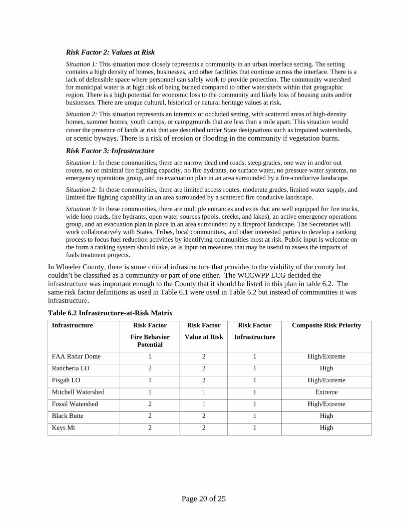
In Wheeler County, there is some critical infrastructure that provides to the viability of the county but couldn’t be classified as a community or part of one either. The WCCWPP LCG decided the infrastructure was important enough to the County that it should be listed in this plan in table 6.2. The same risk factor definitions as used in Table 6.1 were used in Table 6.2 but instead of communities it was infrastructure.
Table 6.2 Infrastructure-at-Risk Matrix
Infrastructure Risk Factor
Fire Behavior Potential
Risk Factor
Value at Risk
Risk Factor
Infrastructure
Composite Risk Priority
FAA Radar Dome 1 2 1 High/Extreme
Rancheria LO 2 2 1 High
Pisgah LO 1 2 1 High/Extreme
Mitchell Watershed 1 1 1 Extreme
Fossil Watershed 2 1 1 High/Extreme
Black Butte 2 2 1 High
Keys Mt 2 2 1 High

The transportation system in Wheeler County has lots of variance in quality. Throughout the county there are two lane paved roads/highways connecting communities along with single lane paved roads and maintained gravel roads connecting homesteads to the paved roads/highways. In the more remote areas of the county, there are single lane gravel and native surface roads that are frequently used, some of which are maintained year round while others are only maintained seasonally or not at all. Throughout the county there is risk of wildfire and a need for well maintained and identified transportation routes to evacuate communities in a timely manner. Table 6.3 lists the evacuation routes for Wheeler County communities and the improvements that are needed to make them reliable when in need.
Table 6.3 Evacuation Routes
Road # Road Name Community Approx.
Miles Road Description Road Improvements
Hwy 19 John Day Highway Fossil, Spray, Kinzua
Jct, Service Cr 50.2 Hwy 19 from Co Line in NW to Co line in SE
Hwy 26 Hwy 26
Mitchell, Baty Subdivision,
Barnhouse CG 47 Hwy 26 from CO in SW to Co line in SE
Hwy 207 Hwy 207
Spray, Mitchell, Twickenham,
Richmond, Fairview CG 40
Hwy 207 from Hwy 26 to County line in North
Parrish Cr. Rd Spray, Richmond 26.6 From Spray S. to Hwy 26 Pave 18 miles after reconstructing the base
Six Shooter Rd Richmond
12.4 From Hwy 207 to Parish Cr Rd
Gravel 10 miles with 6” lift, improve turnouts and sight on corners
Kinzua Rd Kinzua Jct, Golf
Course 6 From Hwy 19 to Kinzua
Hoover Cr Rd Kinzua Jct, Golf Course, Fossil 4.6 From Kinzua to Hwy 19 Improve turnouts, gravel with 6” lift
Hwy 218 Hwy 218 Clarno, Camp
Hancock 19.6 From Hwy 19 to JD River @ Clarno
Winlock Rd Winlock, Spray
16.4 From Hwy 19 to Kahler Basin Rd Pave 10 miles after reconstructing the base
Alder Cr. Rd Winlock, Service Cr 8.9 From Winlock Rd to Hwy 19
Kahler Basin Rd Spray, Winlock
10.1 From Hwy 19 to Hwy 207
Rowe Cr Rd Twickenham, Service
Cr 15 From Hwy 19 to Twickenham
Page 21 of 25
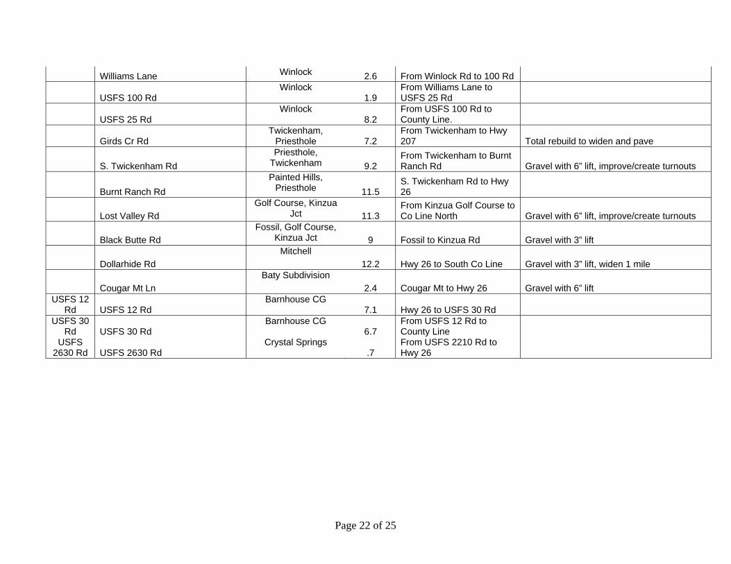
Williams Lane Winlock 2.6 From Winlock Rd to 100 Rd
USFS 100 Rd Winlock
1.9 From Williams Lane to USFS 25 Rd
USFS 25 Rd Winlock
8.2 From USFS 100 Rd to County Line.
Girds Cr Rd Twickenham,
Priesthole 7.2 From Twickenham to Hwy 207 Total rebuild to widen and pave
S. Twickenham Rd Priesthole,
Twickenham 9.2 From Twickenham to Burnt Ranch Rd Gravel with 6” lift, improve/create turnouts
Burnt Ranch Rd Painted Hills,
Priesthole 11.5 S. Twickenham Rd to Hwy 26
Lost Valley Rd Golf Course, Kinzua
Jct 11.3 From Kinzua Golf Course to Co Line North Gravel with 6” lift, improve/create turnouts
Black Butte Rd Fossil, Golf Course,
Kinzua Jct 9 Fossil to Kinzua Rd Gravel with 3” lift
Dollarhide Rd Mitchell
12.2 Hwy 26 to South Co Line Gravel with 3” lift, widen 1 mile
Cougar Mt Ln Baty Subdivision
2.4 Cougar Mt to Hwy 26 Gravel with 6” lift USFS 12
Rd USFS 12 Rd Barnhouse CG
7.1 Hwy 26 to USFS 30 Rd USFS 30
Rd USFS 30 Rd Barnhouse CG
6.7 From USFS 12 Rd to County Line
USFS 2630 Rd USFS 2630 Rd
Crystal Springs .7
From USFS 2210 Rd to Hwy 26
Page 22 of 25
WWWHHHEEEEEELLLEEERRR CCCOOOUUUNNNTTTYYY CCCOOOMMMMMMUUUNNNIITTTYYY WWWIIILLLDDDFFFIIRRREEE PPPRRROOOTTTEEECCCTTTIIOOONNN PPPLLLAAANNN AAACCCTTTIIOOONNN PPPLLLAAANNN &&& PPPRRRIIIOOORRRIITTTIIEEESSS I I I I I I
I J I
I
RII
2006 2007 2008AAACCCTTTIIOOONNNSSS PPPRRROOOJJEEECCCTTTSSS CCCOOOMMMMMMUUUNNNIITTTYYY HHHAAAZZZAAARRRDDD
RRRAAATTTIINNNGGG
PPPRRII OOORRRII TTT YYY
RRREEESSSPPPOOONNNSSSIIIBBBLLLEEE AAAGGGEEENNNCCCYYY
YYYEEEAAARRR
22000066
YYYEEEAAARRR
22000077
YYYEEEAAARRR
22000088
FFFUUUEELL HHHAAAZZZAAARRRDDD RRREEDDDUUUCCCTTTIIOOONNN EL E I
On Federal Lands Prescribed Burning Several High 1 BLM, USFS X X X
Snowshoe Fuel Break Several High 1 USFS X X X
On Non-Federal Lands County Wide Several Communities
High 1 ODF, Landowners,
County
* * *
Defensible Space Wheeler Co Winlock, Kinzua Jct, Service Cr, Kinzua Golf Course
High 1 ODF & Landowners
* * *
WWWAAATTTEEERRR SSOOOUUURRRCCCEEE DDDEEEVVVEEELLLOOOPPMMMEEENNNTTT S P Water source development
Several Communities
High 1 ODF, Landowners,
USFS, & BLM
* * *
SSSAAAFFEEETTTYYY CCCOOORRRRRRIIDDDOOORRRSSS/ EVACUATION ROUTES
F I Hwy 19 Several Communities
High 2 ODF * * *
Hwy 207 Several Communities
High 2 ODF & FS * * *
Parrish Cr Rd Spray, Richmond, Mitchell
High 2 ODF * * *
Six Shooter Richmond High 2 ODF * * *
Hoover Cr Rd Kinzua Golf Course, Kinzua
Jct, Fossil
High 2 ODF * * *
Winlock Rd Winlock, Spray High 2 ODF * * *
Page 23 of 25
AAACCCTTTIIIOOONNNSSS PPPRRROOOJJJEEECCCTTTSSS CCCOOOMMMMMMUUUNNNIIITTTYYY HHHAAAZZZAAARRRDDD
RRRAAATTTIIINNNGGG
PPP RRR III OOORRR III TTT YYY
RRREEESSSPPPOOONNNSSSIIIBBBLLLEEE AAAGGGEEENNNCCCYYY
YYYEEEAAARRR
222000000666
YYYEEEAAARRR
222000000777
YYYEEEAAARRR
222000000888
Rowe Cr Rd Twickenham, Service Cr
High 2 ODF * * *
Dollarhide Rd Mitchell High/Extreme 2 ODF & FS * * *
Lost Valley Rd Golf Course, Kinzua Jct
High 2 ODF * * *
EEEVVAACCUUAATTIIOOONNN RRROOUUTTEE DDDEEEVVVEEELLLOOOPPPEEEMMMEEENNNTTT
VACUAT I OUTE Notch Rd Winlock High 2 County * * *
SSSTTTRRRAAATTTEEEGGGIICCC CCCOOOMMMMMMUUUNNNIITTTYYY FFFI RRREEE BBBRRREEEAAAKKKSS
I I IIS
See Safety Corridors above.
* * *
CCCOOOMMMMMMUUUNNNIICCCAAATTTII OOONNN SSSIITTTEEE I I I Cell Service All High 1 County * * *
PPPUUUBBLLIICCC IINNNFFFOOORRRMMMAAATTTIIOOONNN BLI I I
Signing Fire Prevention Signing, seasonally as appropriate
All n/a 1 All # # #
Media Contacts All n/a 1 All # # #
Grade School presentation All n/a 1 Fire Prevention Coop/ OSFM # # #
Outdoor School presentations All n/a 1 All # # #
Civic Group presentations All n/a 1 All # # #
Landowner contacts All n/a 1 ODF, Comm. , Rural
# # #
Fair displays All n/a 1 Fire Prevention Coop/ OSFM # # #
Fire Free training All n/a 1 Fire Prevention Coop/ OSFM
# # #
Fire Prevention Newspaper Insert All n/a 1 Fire Prevention # # #
Page 24 of 25
Page 25 of 25
AAACCCTTTIIIOOONNNSSS PPPRRROOOJJJEEECCCTTTSSS CCCOOOMMMMMMUUUNNNIIITTTYYY HHHAAAZZZAAARRRDDD
RRRAAATTTIIINNNGGG
PPP RRR III OOORRR III TTT YYY
RRREEESSSPPPOOONNNSSSIIIBBBLLLEEE AAAGGGEEENNNCCCYYY
YYYEEEAAARRR
222000000666
YYYEEEAAARRR
222000000777
YYYEEEAAARRR
222000000888
Coop/ OSFM
Public Information Brochures All n/a 1 ODF, County, OSFM, BLM, USFS, Rurals,
Cities
* * *
SSSTTTRRRUUUCCCTTTUUURRREEE IIGGGNNNIITTTAAABBBIILLLII TTTYYY I I I I All n/a 1
Burning Permits All n/a 1 ODF, City, Rural
# # #
Notifications of Operation All n/a 1 ODF # # #
Building Permit Review All n/a 1 Building Codes # # #
Permitting All n/a 1 County Planning/
Building Codes
# # #
Enforcement All n/a 1 ODF, City, Rural, Sheriff,
Fire Chief
# # #
X Funded * Pending Funding # On going Priorities: 1 (Highest), 2 (Moderate), 3 (Lower)

Appendix A LCG Participants
Appendix A
WCCWPP Local Coordination Group
Participants
Appendix A LCG Participants
LCG Participants: Jeanne Burch; Wheeler County Judge Dustin Gustaveson; Oregon Department of Forestry Jeff Bell; Central Oregon Fire Management Service Lisa Clark; Central Oregon Fire Management Service Dale Boyd; Umatilla National Forest Rick Shaffer; Wheeler County Fire Defense Board Chief Marj Sharp; Wheeler County Emergency Management Sarah Colvin; Oregon State Fire Marshal’s Office Bill Wyatt; Wheeler Point Volunteer Fire Association Mal Hawley; Twickenham Rangeland Protection Association Scott Field; Spray Fire Department Joan Field; Spray Fire Department Marcia Epley; Wheeler Point Volunteer Fire Association Robin Ordway; Wheeler County Road Department Hank Falcon; Umatilla National Forest Theressa Ward; Wheeler County Planning Department Ann Walker; Oregon Department of Forestry

Appendix B Maps
Appendix B
MAPS

Appendix B Maps
Appendix B Maps
Appendix B Maps
Appendix B Maps

Appendix B Maps

Appendix B Maps

Appendix B Maps

Appendix B Maps

Appendix B Maps
Appendix B Maps

Appendix B Maps
Appendix C Glossary
Appendix C
Glossary
Appendix C Glossary
Glossary
Definitions and Policies - This section provides a summary of policies and definitions of Communities at Risk, wildland urban interface, and defensible space.
Wildfire Risk Assessment Policy/Source Definition Fire Plan Risk: the potential and frequency for wildfire ignitions (based on past occurrences)
Hazard: the conditions that may contribute to wildfire (fuels, slope, aspect, elevation and weather) Values: the people, property, natural resources and other resources that could suffer losses in a wildfire event. Protection Capability: the ability to mitigate losses, prepare for, respond to and suppress wildland and structural fires. Structural Vulnerability: the elements that affect the level of exposure of the hazard to the structure (roof type and building materials, access to the structure, and whether or not there is defensible space or fuels reduction around the structure.)
Communities at Risk Policy/Source Definition Healthy Forests Restoration Act
Title I – Hazardous Fuel Reduction on Federal Land, SEC. 101. Definitions: (1) AT-RISK COMMUNITY.—The term ‘‘at-risk community’’ means an area— (A) that is comprised of— (I) an interface community as defined in the notice entitled ‘‘Wildland Urban Interface Communities Within the Vicinity of Federal Lands That Are at High Risk From Wildfire’’ issued by the Secretary of Agriculture and the Secretary of the Interior in accordance with title IV of the Department of the Interior and Related Agencies Appropriations Act, 2001 (114 Stat. 1009) (66 Fed. Reg. 753, January 4, 2001); or (ii) a group of homes and other structures with basic infrastructure and services within or adjacent to Federal land; (B) in which conditions are conducive to a large-scale wildland fire disturbance event; (C) for which a significant threat to human life or property exists as a result of a wildland fire disturbance event.
National Association of State Foresters Identifying and Prioritizing Communities at Risk
In June 2003, the National Association of State Foresters developed criteria for identifying and prioritizing communities at risk. Their purpose was to provide national, uniform guidance for implementing the provisions of the “Collaborative Fuels Treatment Program.” The intent was to establish broad, nationally compatible standards for identifying and prioritizing communities at risk, while allowing for maximum flexibility at the state and regional level. NASF defines ‘Community at Risk’ as “a group of people living in the same locality and under the same government” (The American Heritage Dictionary of the English Language, 1969). They also state that ‘a community is considered at risk from wildland fire if it lies within the wildland/urban interface as defined in the federal register (FR Vol. 66, No. 3, Pages 751-154, January 4, 2001).’ NASF suggests identifying communities at risk on a state-by-state basis with the involvement of all organizations with wildland fire protection responsibilities (state, local, tribal, and federal) along with other interested cooperators, partners, and stakeholders. They suggest using the 2000 census data (or other suitable means) identify all communities in the state that are in the wildland urban interface and that

Appendix C Glossary
are at risk from wildland fire, regardless of their proximity to federal lands.
Federal Register /Vol.66, No.160 /Friday, August 17, 2001 /Notices
In January 2001, then Agriculture Secretary Dan Glickman and Interior Secretary Bruce Babbitt released a proposed list of communities eligible for enhanced federal wildfire prevention assistance. The preliminary list of over 4000 communities included many that are near public lands managed by the federal government. The initial definition of urban wildland interface and the descriptive categories used in this notice are modified from ‘‘A Report to the Council of Western State Foresters— Fire in the West—The Wildland/Urban Interface Fire Problem’’ dated September 18, 2000. Under this definition, ‘‘the urban wildland interface community exists where humans and their development meet or intermix with wildland fuel.’’ There are three categories of communities that meet this description. Generally, the Federal agencies will focus on communities that are described under categories 1 and 2. For purposes of applying these categories and the subsequent criteria for evaluating risk to individual communities, a structure is understood to be either a residence or a business facility, including Federal, State, and local government facilities. Structures do not include small improvements such as fences and wildlife watering devices. Category 1. Interface Community: The Interface Community exists where structures directly abut wildland fuels. There is a clear line of demarcation between residential, business, and public structures and wildland fuels. Wildland fuels do not generally continue into the developed area. The development density for an interface community is usually 3 or more structures per acre, with shared municipal services. Fire protection is generally provided by a local government fire department with the responsibility to protect the structure from both an interior fire and an advancing wildland fire. An alternative definition of the interface community emphasizes a population density of 250 or more people per square mile. Category 2. Intermix Community: The Intermix Community exists where structures are scattered throughout a wildland area. There is no clear line of demarcation; wildland fuels are continuous outside of and within the developed area. The development density in the intermix ranges from structures very close together to one structure per 40 acres. Fire protection districts funded by various taxing authorities normally provide life and property fire protection and may also have wildland fire protection responsibilities. An alternative definition of intermix community emphasizes a population density of between 28–250 people per square mile. Category 3. Occluded Community: The Occluded Community generally exists in a situation, often within a city, where structures abut an island of wildland fuels (e.g., park or open space). There is a clear line of demarcation between structures and wildland fuels. The development density for an occluded community is usually similar to those found in the interface community, but the occluded area is usually less than 1,000 acres in size. Fire protection is normally provided by local government fire depts.
A Definition of Community, James A. Kent / Kevin Preister
“A community is a geographic place that is characterized by natural systems such as watersheds, cultural attachment and human geographic boundaries. Physical, biological, social, cultural, and economic forces create natural boundaries that distinguish one community from another. The importance is in recognizing the unique beliefs, traditions, and stories that tie people to a specific place, to land and to social/kinship networks. It is a naturally defined human geographic area within

Appendix C Glossary
which humans and nature rely on shared resources. People from outside this place can effectively contribute to its stewardship by providing relevant information and/or participating through relating their own values associated with geographic place. Community is defined by the informal systems and to the degree the formal systems are tied to the informal it becomes part of a community definition. Both have a distinct function. Informal systems are horizontal. They maintain culture, take care of people and are concerned with survival. They thrive on openness, honesty, and the idea that people want to do what is right for each other and the broader society. Formal systems are vertical and they serve centralized political, ideological, and economic functions. They contribute resources and legal structure to community change. Formal meetings alone do not constitute community communication or decision making functions.” http://www.ntc.blm.gov/partner/community.html
Firewise Definition of Community
“According to Webster's dictionary, a community is ‘a body of people living in one place or district...and considered as a whole’ or ‘a group of people living together and having interests, work, etc. in common’. Homeowner associations and similar entities are the most appropriate venue for the Firewise Communities/USA recognition program. These smaller areas within the wildland/urban interface offer the best opportunities for active individual homeowner commitment and participation, which are vital to achieving and maintaining recognition status.” http://www.firewise.org/usa/
Executive Order NO. 04- 04 Oregon Office of Rural Policy and Rural Policy Advisory Committee
Office of Rural Policy and Rural Policy Advisory Committee -Frontier Rural – A geographic area that is at least 75 miles by road from a community of less than 2000 individuals. It is characterized by an absence of densely populated areas, small communities, individuals working in their communities, an economy dominated by natural resources and agricultural activities, and a few paved streets or roads. -Isolated Rural – A geographic area that is at least 100 miles by road from a community of 3000 or more individuals. It is characterized by low population density (fewer than five people per square mile), an economy of natural resources and agricultural activity, large areas of land owned by the state or federal government and predominately unpaved streets. -Rural – A geographic area that is at least 30 miles by road from an urban community (50,000 or more). It is characterized by some commercial business, two or fewer densely populated areas in a county, an economy changing from a natural resource base to more commercial interests and reasonable, but not immediate access to health care. -Urban Rural – A geographic area that is at least 10 miles by road from an urban community. It is characterized by many individuals community to an urban area to work or shop, an economy with few natural resource and agricultural activities, easy and immediate access to health care services and numerous paved streets and roads. http://governor.oregon.gov/Gov/pdf/ExecutiveOrder04-04.pdf
Wildland Urban Interface Policy/Source Definition Federal Register /Vol.66, No.160 /Friday, August 17,2001 /Notices
The Federal Register states, "the urban-wildland interface community exists where humans and their development meet or intermix with wildland fuel." This definition is found in the Federal Register Vol.66, Thursday, January 4, 2001, Notices; and in "Fire in the West, the Wildland/Urban Interface Fire Problem", A Report for the Western States Fire Managers, September 18, 2000.

Appendix C Glossary
10-Year Comprehensive Strategy
A Collaborative Approach for Reducing Wildland Fire Risks to Communities and the Environment: 10-Year Comprehensive Strategy (August 2001) “The line, area, or zone where structures and other human development meet or intermingle with undeveloped wildland or vegetative fuels” (Glossary of Wildland Fire Terminology, 1996). http://www.fireplan.gov/content/reports/?LanguageID=1
Senate Bill 360:
Senate Bill 360: Forestland Urban Interface Protection Act of 1997. Forestland Urban Interface 477.015 Definitions. (1) As used in ORS 477.015 to 477.061, unless the context otherwise requires, "forestland-urban interface" means a geographic area of forestland inside a forest protection district where there exists a concentration of structures in an urban or suburban setting.
NFPA 1144
NFPA 1144: Standard for Protection of Life and Property from Wildfire 2002 Edition Wildland/Urban Interface is an area where improved property and wildland fuels meet at a well-defined boundary. Wildland/urban intermix is an area where improved property and wildland fuels meet with no clearly defined boundary. http://www.nfpa.org/catalog/home/OnlineAccess/1144/1144.asp
Defensible/Survivable Space Policy/Source Definition Home Ignition Zones – “Wildland- Urban Fire—A different approach”
Recent research focuses on indications that the potential for home ignitions during wildfires including those of high intensity principally depends on a home’s fuel characteristics and the heat sources within 100-200 feet adjacent to a home (Cohen 1995; Cohen 2000; Cohen and Butler 1998). This relatively limited area that determines home ignition potential can be called the home ignition zone. http://firelab.org/fbp/fbresearch/wui/pubs.htm (Jack D. Cohen)
NFPA 1144 NFPA Publication 1411 defines defensible space as “An area as defined by the AHJ (typically with a width of 9.14 m (30 ft) or more) between an improved property and a potential wildland fire where combustible materials and vegetation have been removed or modified to reduce the potential for fire on improved property spreading to wildland fuels or to provide a safe working area for fire fighters protecting life and improved property from wildland fire.
OAR 629-044- 1085: Fuel Break Requirements
(1) The purpose of a fuel break is to: (a) Slow the rate of spread and the intensity of an advancing wildfire; and (b) Create an area in which fire suppression operations may more safely occur. (2) A fuel break shall be a natural or a human-made area where material capable of allowing a wildfire to spread: (a) Does not exist; or (b) Has been cleared, modified, or treated in such a way that the rate of spread and the intensity of an advancing wildfire will be significantly reduced. (3) A primary fuel break shall be comprised of one or more of the following: (a) An area of substantially non-flammable ground cover. Examples include asphalt, bare soil, clover, concrete, green grass, ivy, mulches, rock, succulent ground cover, or wildflowers. (b) An area of dry grass which is maintained to an average height of less than four inches. (c) An area of cut grass, leaves, needles, twigs, and other similar flammable materials, provided such materials do not create a continuous fuel bed and are in compliance with the intent of subsections 1 and 2 of this rule. (d) An area of single specimens or isolated groupings of ornamental shrubbery, native trees, or other plants, provided they are: (A) Maintained in a green condition; (B) Maintained substantially free of dead plant material; (C) Maintained free of ladder fuel; (D) Arranged and maintained in such a way that minimizes the possibility a wildfire can spread to adjacent vegetation; and (E) In compliance with the intent of subsections (1) and (2) of this rule.

Appendix C Glossary
(4) A secondary fuel break shall be comprised of single specimens or isolated groupings of ornamental shrubbery, native trees, or other plants, provided they are: (a) Maintained in a green condition; (b) Maintained substantially free of dead plant material; (c) Maintained free of ladder fuel; (d) Arranged and maintained in such a way that minimizes the possibility a wildfire can spread to adjacent vegetation; and (e) In compliance with the intent of subsections 1 and 2 of this rule. http://arcweb.sos.state.or.us/rules/1102_Bulletin/1102_ch629_bulletin.html
Senate Bill 360: Forestland Urban Interface Protection Act of 1997. Fuel Break Distance
Total Fuel Break Distance Classification Fire Resistant Roofing Non-Fire Resistant RoofingLOW No Requirement No Requirement MODERATE 30 feet 30 feet HIGH 30 feet 50 feet Extreme & High Density Extreme 50 feet 100 feet
Is Your Home Protected from Wildfire Disaster? A Homeowner’s Guide to Wildfire Retrofit, Institute for Business and Home Safety
A survivable space is an area of reduced fuels between your home and the untouched wildland. This provides enough distance between the home and a wildfire to ensure that the home can survive without extensive effort from either you or the fire department. One of the easiest ways to establish a survivable space is to use the zone concept. Zone 1: Establish a well-irrigated area around your home. In a low hazard area, it should extend a minimum of 30 feet from your home on all sides. As your hazard risk increases, a clearance of between 50 and 100 feet or more may be necessary, especially on any downhill sides of the lot. Plantings should be limited to carefully spaced indigenous species. Zone 2: Place low-growing plants, shrubs and carefully spaced trees in this area. Maintain a reduced amount of vegetation. Your irrigation system should also extend into this area. Trees should be at least 10 feet apart, and all dead or dying limbs should be trimmed. For trees taller than 18 feet, prune lower branches within six feet of the ground. No tree limbs should come within 10 feet of your home. Zone 3: This furthest zone from your home is a slightly modified natural area. Thin selected trees and remove highly flammable vegetation such as dead or dying trees and shrubs. How far Zones 2 and 3 extend depends upon your risk and your property’s boundaries. In a low hazard area, these two zones should extend another 20 feet or so beyond the 30 feet in Zone 1. This creates a modified landscape of over 50 feet total. In a moderate hazard area, these two zones should extend at least another 50 feet beyond the 50 feet in Zone 1. This would create a modified landscape of over 100 feet total. In a high hazard area, these two zones should extend at least another 100 feet beyond the 100 feet in Zone 1. This would create a modified landscape of over 200 feet total. http://www.ibhs.org/publications/view.asp?id=130
Living with Fire: A Guide for the Homeowner
This guide, distributed in Oregon through the Pacific Northwest Wildfire Coordinating Group, provides information on creating effective defensible space and guidelines illustrated below. Defensible Space
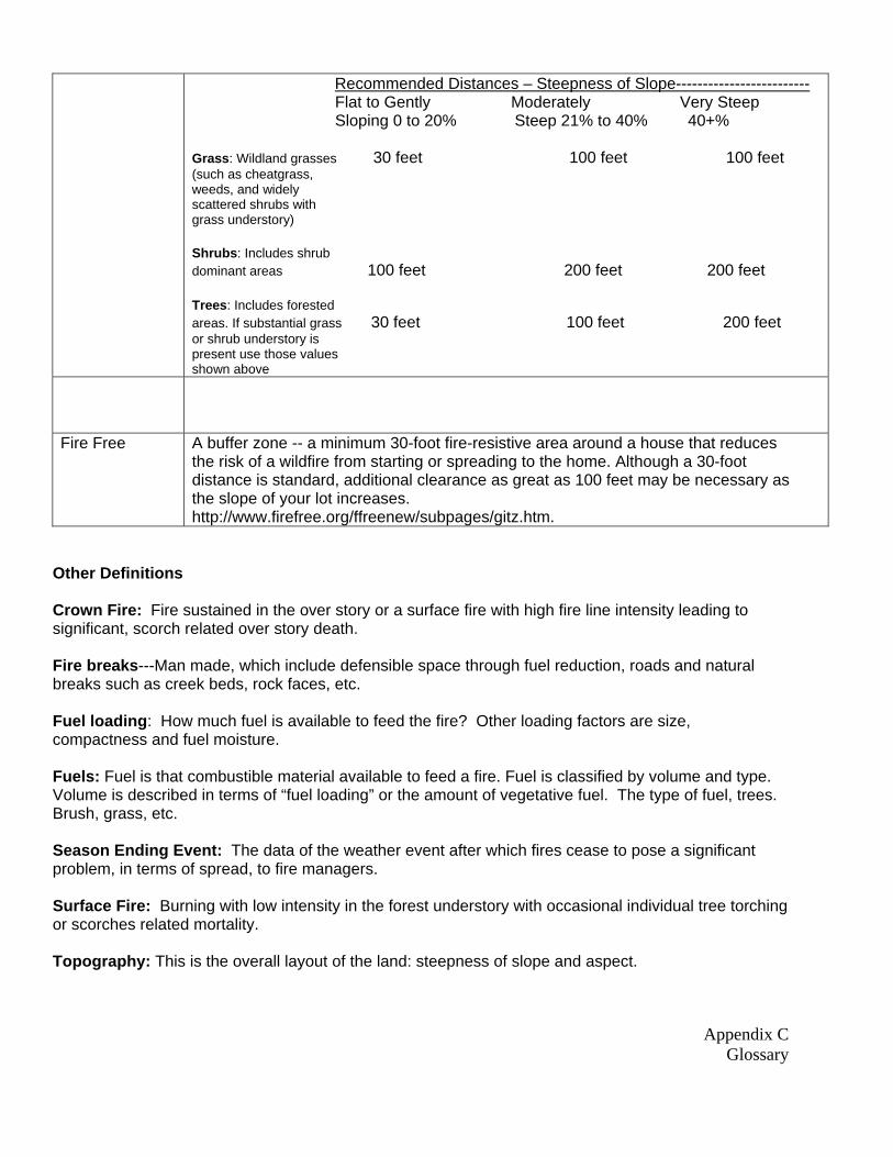
Appendix C Glossary
Recommended Distances – Steepness of Slope------------------------- Flat to Gently Moderately Very Steep Sloping 0 to 20% Steep 21% to 40% 40+% Grass: Wildland grasses 30 feet 100 feet 100 feet (such as cheatgrass, weeds, and widely scattered shrubs with grass understory) Shrubs: Includes shrub dominant areas 100 feet 200 feet 200 feet Trees: Includes forested areas. If substantial grass 30 feet 100 feet 200 feet or shrub understory is present use those values shown above
Fire Free A buffer zone -- a minimum 30-foot fire-resistive area around a house that reduces the risk of a wildfire from starting or spreading to the home. Although a 30-foot distance is standard, additional clearance as great as 100 feet may be necessary as the slope of your lot increases. http://www.firefree.org/ffreenew/subpages/gitz.htm.
Other Definitions Crown Fire: Fire sustained in the over story or a surface fire with high fire line intensity leading to significant, scorch related over story death. Fire breaks---Man made, which include defensible space through fuel reduction, roads and natural breaks such as creek beds, rock faces, etc. Fuel loading: How much fuel is available to feed the fire? Other loading factors are size, compactness and fuel moisture. Fuels: Fuel is that combustible material available to feed a fire. Fuel is classified by volume and type. Volume is described in terms of “fuel loading” or the amount of vegetative fuel. The type of fuel, trees. Brush, grass, etc. Season Ending Event: The data of the weather event after which fires cease to pose a significant problem, in terms of spread, to fire managers. Surface Fire: Burning with low intensity in the forest understory with occasional individual tree torching or scorches related mortality. Topography: This is the overall layout of the land: steepness of slope and aspect.

Appendix C Glossary
Vehicle access: Is access in and out possible for the type of initial attack or protection vehicle needed including space for more than one vehicle, turn-around space, and appropriate bridges and gates capable of accommodating firefighting vehicles. Water sources: Many rural residential areas lack large water storage or pumping facilities, putting a higher demand on firefighting resources which have large water tank capabilities. Weather: Major concerns are: yearly moisture accumulations, humidity, wind, temperatures and lightning frequency/occurrence.
Acronyms BLM: Bureau of Land Management CFR: Code of Federal Regulations CWPP: Community Wildfire Protection Plan (Healthy Forests Restoration Act) DEQ: Department of Environmental Quality DOI: Department of Interior EPA: Environmental Protection Agency FEMA: Federal Emergency Management Agency FS: Forest Service GIS: Geographic Information System HFRA: Healthy Forest Restoration Act HFI: Healthy Forest Initiative HUC: Hydrologic Unit Code ICS: Incident Command System NFP: National Fire Plan and 10-Year Comprehensive Strategy NPS: National Park Service ODF: Oregon Department of Forestry ODOT: Oregon Department of Transportation OEM: Office of Emergency Management (State) OSP: Oregon State Police T & E: Threatened and Endangered Species USDA: United States Department of Agriculture USDI: United States Department of Interior WFSA : Wildland Fire Situation Analysis

Appendix D “Get in the Zone” Fire Free Program
Appendix D
“Get in the Zone”
Fire Free Program

Appendix D “Get in the Zone” Fire Free Program
Ten Steps to “Get in the Zone!” – FireFree Program – http://www.firefree.org
1. Define your defensible space. Defensible space is a buffer zone, a minimum 30-foot fire-resistive area around your house that reduces the risk of a wildfire from starting or spreading to your home. Formed by following the critical steps outlined below, defensible space depends on clearing flammable material away from your home and replacing it with fire-resistive vegetation. Although a 30-foot distance is standard, additional clearance as great as 100 feet may be necessary as the slope of your lot increases. Defensible space not only helps protect your home in the critical minutes it takes a fire to pass, it also gives firefighters an area to work in. During a large-scale fire, when many homes are at risk, firefighters must focus on homes they can safely defend. 2. Reduce flammable vegetation, trees and brush around your home. When needed, replace flammable landscaping with fire-resistive counterparts. Choose plants with loose branch habits, non-resinous woody material, high moisture content in leaves, and little seasonal accumulation of dead vegetation. Ask your local home and garden center about which varieties possess these and other fire-resistive traits.
3. Remove or prune trees. If you live in a wooded area, reduce the density of surrounding forest by removing or thinning overcrowded or small-diameter trees. Check with local agencies for guidelines on tree removal before clearing or thinning your property. Be sure to prune low-hanging branches to keep a ground fire from climbing into upper branches. Limbing up these "ladder fuels" cuts the chances of a ground fire climbing into tree canopies. 4. Cut grass and weeds regularly. Fire spreads rapidly in dry grass and weeds. Mow grasses and other low vegetation and keep them well-watered, especially during periods of high fire danger. 5. Relocate wood piles and leftover building materials. Stack all wood, building debris and other burnable materials at least 30 feet from your home and other buildings. Then clear away flammable vegetation within 10 feet of wood/debris piles as an additional safeguard against the spread of wildfire. 6. Keep it clean. (Your roof and yard, we mean!) Clear pine needles, leaves and debris from your roof, gutters and yard to eliminate an ignition source for tinder-dry vegetation. Remove dead limbs and branches within 10 feet of your chimney and deck. Tidying-up is especially important during the hot, arid months of fire season when a single spark can lead to an inferno. 7. Signs, addresses and access. Easy-to-read road signs and address numbers that are visible from the road allow firefighters to find your home quickly during a wildfire or other emergency. Safe, easy access to your property includes two-way roads that can accommodate emergency vehicles and give them space to turn around. Bridges should support the weight of emergency vehicles. Driveways should also be trimmed of peripheral vegetation to allow emergency equipment to reach your house. Contact your local fire agency for recommendations on access and signage. 8. Rate your roof. Your roof is the most vulnerable part of your house in a wildfire. If you have a wood shake roof, consider treatment or replacement to make it more fire-resistive. If you have a fireplace or woodstove, install an approved spark arrestor on your chimney to prevent sparks from reaching
Appendix D “Get in the Zone” Fire Free Program
your roof or flammable vegetation. 9. Recycle yard debris and branches. Check into alternative disposal methods like composting or recycling. Burning may be restricted or not allowed in your community, and should only be used as a last resort. Always contact your local fire agency for current burning regulations before striking a match! 10. What to do when a wildfire strikes. Monitor your local radio and television stations for fire reports and evacuation procedures and centers. Keep an emergency checklist handy and prepare to evacuate if your neighborhood is threatened. Proper preparation includes closing all windows and doors, arranging garden hoses so they can reach any area of your house, and packing your car for quick departure.
Protecting Your Home from Wildland Fire http://www.nifc.gov/preved/protecthome.html
Every year many families unnecessarily lose their homes and possessions to wildland fire. These losses can be minimized if homeowners take the time to become aware of safety measures to help protect their homes and complete some effective actions. Use Fire Resistant Building Material - "The Best Thing That You Can Do" The roof and exterior structure of your dwelling should be constructed of non-combustible or fire resistant materials such as fire resistant roofing materials, tile, slate, sheet iron, aluminum, brick, or stone. Wood siding, cedar shakes, exterior wood paneling, and other highly combustible materials should be treated with fire retardant chemicals.
Maintain a Survivable Space - "Things you can do today" Clean roof surfaces and gutters of pine needs, leaves, branches, etc., regularly to avoid
accumulation of flammable materials.
Remove portions of any tree extending within 10 feet of the flue opening of any stove or chimney.
Maintain a screen constructed of non-flammable material over the flue opening of every chimney or stovepipe. Mesh openings of the screen should not exceed 1/2 inch.
Landscape vegetation should be spaced so that fire can not be carried to the structure or surrounding vegetation.
Remove branches from trees to height of 15 feet.
A fuel break should be maintained around all structures.
Dispose of stove or fireplace ashes and charcoal briquettes only after soaking them in a metal pail of water.
Store gasoline in an approved safety can away from occupied buildings.
Propane tanks should be far enough away from buildings for valves to be shut off in case of fire. Keep area clear of flammable vegetation.
All combustibles such as firewood, picnic tables, boats, etc. should be kept away from structures.
Garden hose should be connected to outlet.
Addressing should be indicated at all intersections and on structures.
All roads and driveways should be at least 16 feet in width.
Have fire tools handy such as: ladder long enough to reach the roof, shovel, rake and bucket for water.
Each home should have at least two different entrance and exit routes.
Appendix E Incentive Programs
Appendix E
Incentive Programs

Appendix E Incentive Programs
General Incentives Programs The following information was summarized from "Incentive Programs for Resource Management and Conservation" (OSU Extension Publication #EC1119) and other sources. This lists the major incentive programs available to assist communities and landowners with the management of their communities. These programs are not limited to the issues of Communities at Risk and are able to provide similar types of cost share opportunities on private lands in all areas of Wheeler County. Many other programs exist in addition to those listed. There are specialized / targeted incentive programs (National Fire Plan, Blue Mt. / Pacific Coast Demonstration Projects, etc) are not covered in this general summary. Major Incentive Programs available to Family Forestland Owners in Oregon: >Forest Stewardship Program (FSP) --- cost shares consultant written / ODF approved stewardship plans -- apply with your local ODF Stewardship Forester using FLEP application form. >Forest Resource Trust (FRT) --- loan / grant to cover costs (normally 100% of costs) to convert underproducing forest land or marginal agricultural land into conifer forest. Applies only to DF "high" Site 4 or better sites. Apply by completing FRT application form at local ODF offices. >Forest Land Enhancement Program (FLEP) --- cost shares a variety of upland forestry practices (site prep, tree planting, non-commercial thinning, release, etc.) Apply with local ODF Stewardship Forester using FLEP application form.** Projects are funded from one "pot" of funds in Salem. Funds are allocated to applications that arrive in Salem on a first come, first served basis, by priority. Unused funds continually recycle back into the "pot" as projects are completed or cancelled. In addition, we anticipate that "new" funds will be made available to Oregon in late 2005. >Oregon 50% Underproducing Forest Land Conversion Tax Credit -- state tax credit on cost of converting underproducing forestland (brush land and low value / low volume forest) to well stocked forest. Apply by completing tax credit form and submitting it to the local ODF Stewardship Forester. (The form is available on the ODF/Private & Community Forests web site or at the local ODF office.) The state tax credit is available to qualified landowners and projects on a continuous basis. Proposed projects should be pre-qualified by the local ODF Stewardship Forester. >Afforestation Incentive (OAR 629-611 Forest Practices Rules) - Provides landowners an incentive to convert parcels of idle land or land in other uses to commercial forest use. Provides assurance that no state forest practices regulation will prohibit harvesting most of the planted timber established and grown as the first crop rotation. Contact the local ODF Stewardship Forester for more information.
Appendix E Incentive Programs
>Federal (10%) reforestation tax credit --- federal tax credit on cost of most afforestation or reforestation projects is available for project work completed before October 22, 2004. For reforestation / afforestation work done after October 21, 2004, landowners can "deduct" a certain amount of project expenses. (Note: The 10% federal tax credit has been repealed but landowners will be able to deduct some reforestation / afforestation expenses going forward from now.) Landowners need to contact the IRS or their tax professional to get the required forms and properly utilize this incentive. Additional Information can be found at: www.timbertax.org >Environmental Quality Incentives Program (EQIP) -- can cost share a wide variety of agricultural and forestry practices. However, availability of funding for upland forestry practices depends on a number of woodland owners applying for EQIP funding and actively participating in local EQIP working group. Apply for EQIP funds at local NRCS (Natural Resource Conservation Service) office. >Watershed Improvement Grants (OWEB) --- cost shares riparian (usually near stream or in-stream) work - check with local watershed counsel and / or SWCD (Soil & Water Conservation District). Grant applications are available on-line at OWEB or at the local SWCD office. >Wildlife Habitat Incentives Program (WHIP) -- cost shares a variety of wildlife enhancement practices which can include forest establishment and thinning for wildlife purposes. Apply with local NRCS office. >Conservation Reserve Program (CRP) -- cost shares a variety of conservation practices on agricultural land including forest establishment and thinning. Pays rental on acres enrolled for ten to fifteen years. Apply at local FSA (Farm Services Agency) office. Funding is available. >Conservation Reserve Enhancement Program (CREP) -- cost shares primarily riparian and wet land improvement projects on agricultural land. Practices include riparian forest buffer establishment. Pays rental on acres enrolled for ten to fifteen years. Apply at local FSA office. Community Fire Assistance Volunteer Fire Assistance (VFA): Assistance to Volunteer Fire Departments for equipment & supplies. Contact the local ODF office. Rural Fire Assistance (RFA): Assistance to Rural Fire organizations for equipment and supplies. Contact the local ODF office. Federal Excess Personal Property program (FEPP): Provides federal excess equipment and supplies to city & rural fire departments for firefighting purposes. Contact the local ODF office. Other Programs Special funding for Insect & Disease control. The cost share amounts varies depending on the acreage owned. It varies from 33% to 50%, with the larger landowners being eligible for only 33% of the costs. Contact the local ODF office. Title II, funding is available from the county court for projects to enhance forest objectives. Contact the County Court.

Additional Incentive Programs to assist Communities and Private Landowners
Cost Share Program Objective Contact Agency Forest Stewardship Program (FSP) Develop Stewardship/Management Plans for
Private landowners Oregon Department of Forestry
Forest Resource Trust (FRT) Convert underproducing forestland or marginal agricultural land into conifer forest, high site 4 or better sites
Oregon Department of Forestry
Forest Land Enhancement Program (FLEP) Cost share site prep, tree planting, non-commercial thinning, and release.
Oregon Department of Forestry
Oregon 50% Underproducing Forest Land Conversion Tax Credit
Convert underproducing forestland to well stocked forest.
Oregon Department of Forestry
Afforestion Incentive Converts parcels of idle to commercial forest use. Oregon Department of Forestry Federal (10%) reforestation tax credit Federal tax credit on cost of reforestation projects IRS or tax professional Environmental Quality Incentives Program (EQIP)
Wide variety of forestry practices Natural Resource Conservation Service (NRCS)
Watershed Improvement Grants (OWEB) Riparian work and protection of water quality which can include upland forestry work.
Soil Water Conservation District(SWCD)
Wildlife Habitat Incentives Program (WHIP) Wildlife enhancement practices which can include forest establishment and thinning for wildlife.
Natural Resource Conservation Service (NRCS)
Conservation Reserve Program (CRP) Conservation practices on agricultural land including forest establishment and thinning.
Farm Service Agency (FSA)
Conservation Reserve Enhancement Program(CREP)
Riparian improvement projects including forest buffer establishment.
Farm Service Agency (FSA)
Volunteer Fire Assistance (VFA) Grant assistance to volunteer fire departments for equipment and supplies.
Oregon Department of Forestry
Rural Fire Assistance (RFA) Grant assistance to city and rural fire departments in communities of less than 10,000 population for equipmentand supplies.
Oregon Department of Forestry
Federal Excess Personal Property Program
Appendix E Incentive Programs
(FEPP) Federal excess equipment and supplies to city and rural fire departments for firefighting purposes.
Oregon Department of Forestry
Special Insect & Disease Control Cost share assistance to landowners to control insect and disease infestations.
Oregon Department of Forestry
Title II Funding for forest health projects County Government