
T1 2 tectonica_placas2
40
PLATES TECTONIC Earth, our changing planet
-
Upload
josuecienciasnaturales -
Category
Education
-
view
342 -
download
0
Transcript of T1 2 tectonica_placas2
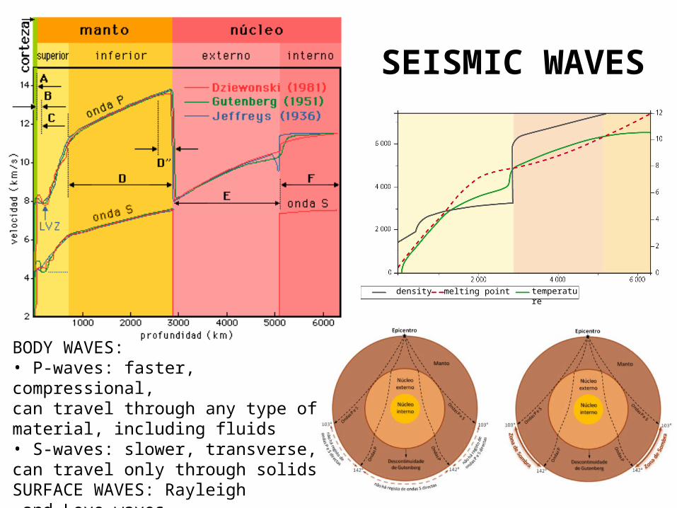
SEISMIC WAVES
BODY WAVES:• P-waves: faster, compressional,can travel through any type of material, including fluids• S-waves: slower, transverse, can travel only through solidsSURFACE WAVES: Rayleigh and Love waves
density temperaturemelting point
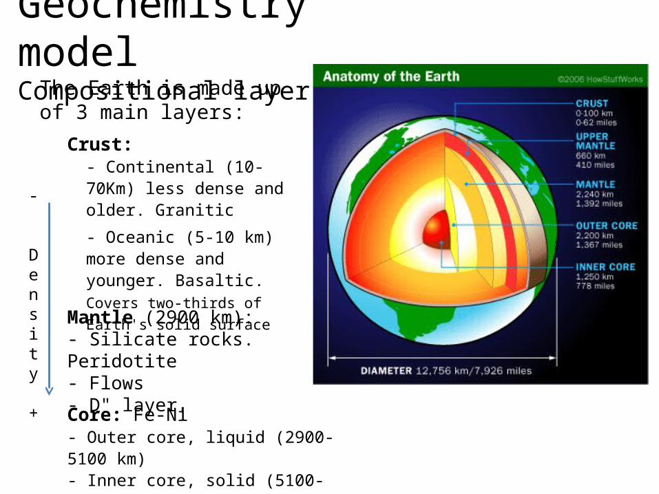
Geochemistry modelCompositional layers
The Earth is made up of 3 main layers:
Crust:- Continental (10-70Km) less dense and older. Granitic
- Oceanic (5-10 km) more dense and younger. Basaltic. Covers two-thirds of Earth's
solid surface
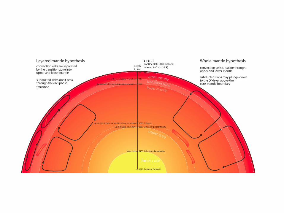
Mantle (2900 km):- Silicate rocks. Peridotite- Flows- D" layer.
Core: Fe-Ni- Outer core, liquid (2900- 5100 km)- Inner core, solid (5100- 6370 km)
-
Density +
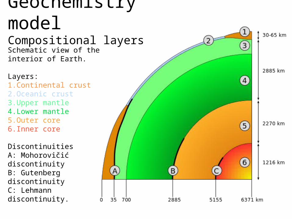
Geochemistry modelCompositional layers
Schematic view of the interior of Earth.
Layers: 1.Continental crust 2.Oceanic crust 3.Upper mantle 4.Lower mantle 5.Outer core 6.Inner core
DiscontinuitiesA: Mohorovičić discontinuity B: Gutenberg discontinuity C: Lehmann discontinuity.
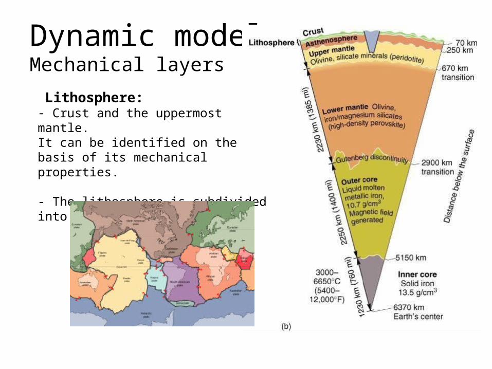
Dynamic modelMechanical layers
Lithosphere:- Crust and the uppermost mantle.It can be identified on the basis of its mechanical properties.
- The lithosphere is subdivided into tectonic plates.
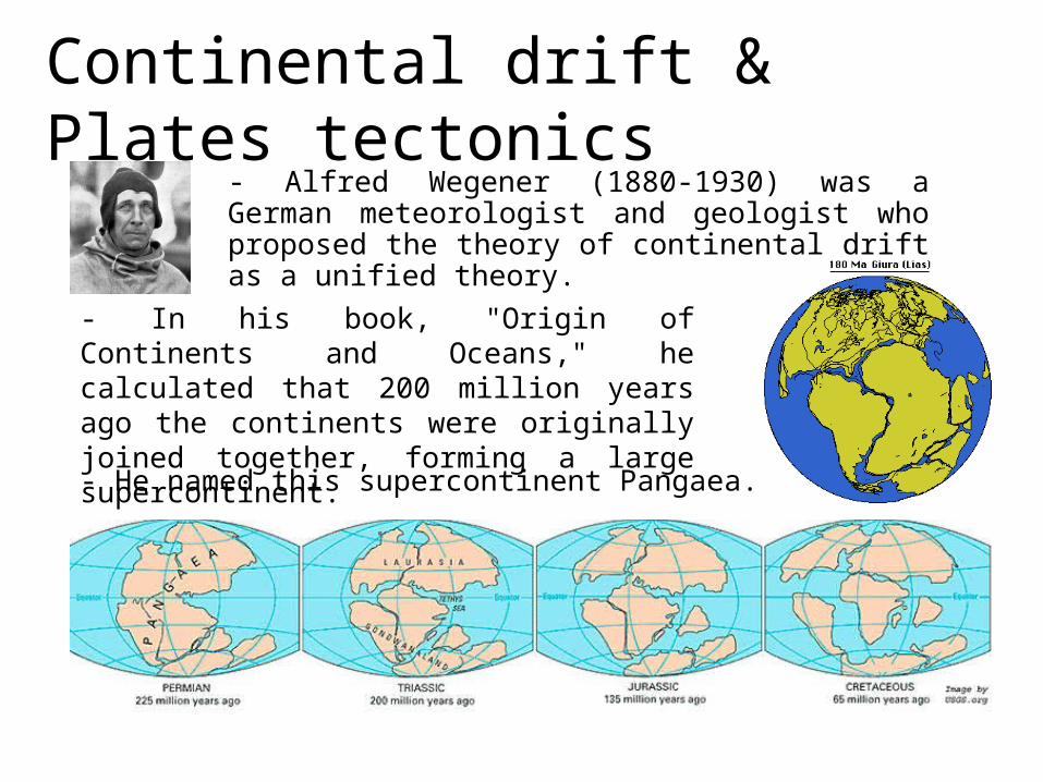
Continental drift & Plates tectonics- Alfred Wegener (1880-1930) was a German meteorologist and geologist who proposed the theory of continental drift as a unified theory.
- In his book, "Origin of Continents and Oceans," he calculated that 200 million years ago the continents were originally joined together, forming a large supercontinent.
- He named this supercontinent Pangaea.
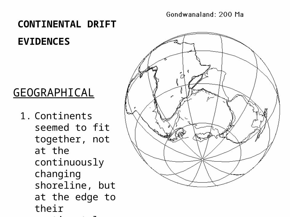
1. Continents seemed to fit together, not at the continuously changing shoreline, but at the edge to their continental shelves.
CONTINENTAL DRIFT
EVIDENCES
GEOGRAPHICAL
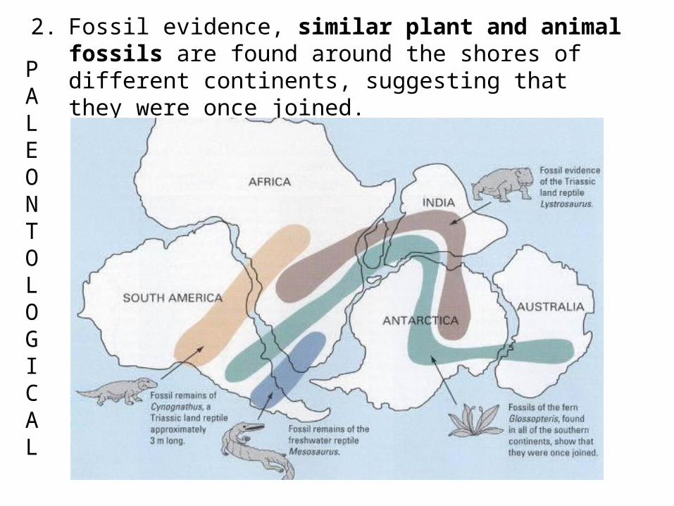
2. Fossil evidence, similar plant and animal fossils are found around the shores of different continents, suggesting that they were once joined.P
ALEONTOLOGICAL
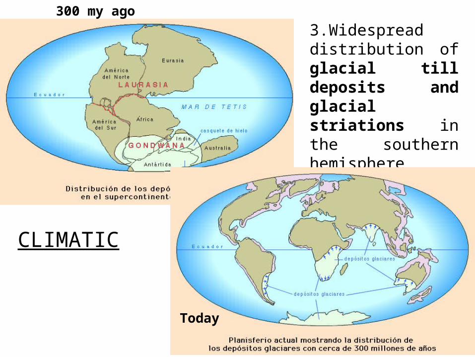
3.Widespread distribution of glacial till deposits and glacial striations in the southern hemisphere
300 my ago
CLIMATIC
Today
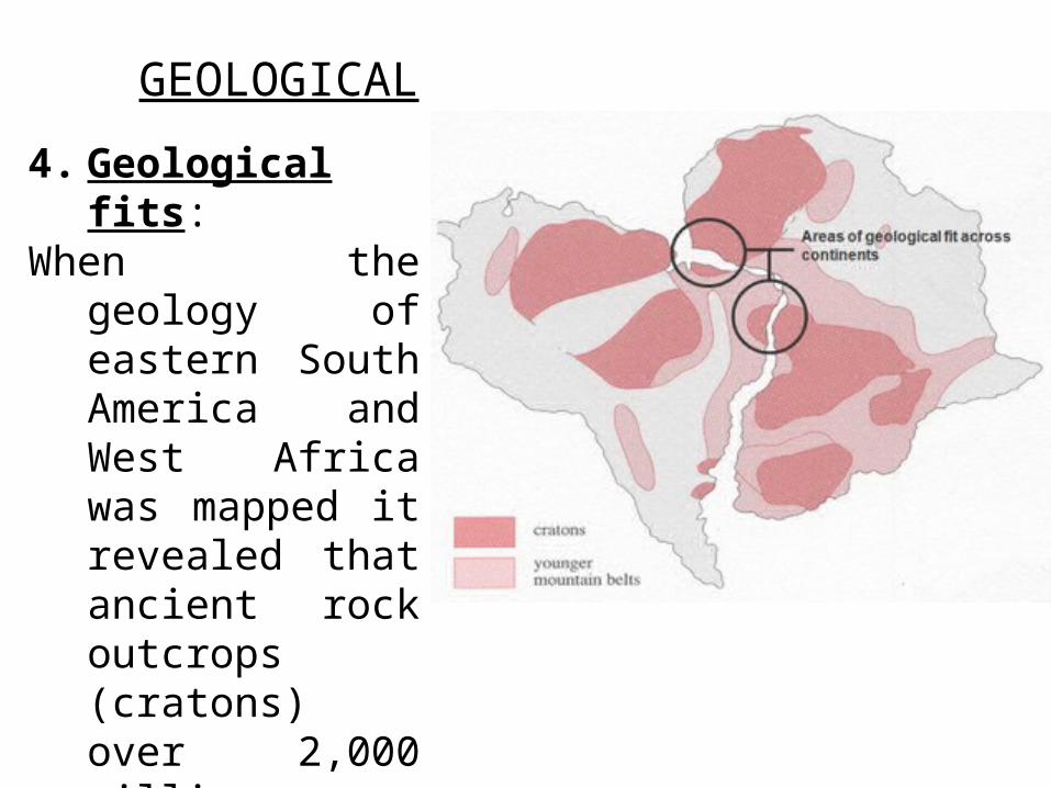
4. Geological fits:When the geology of
eastern South America and West Africa was mapped it revealed that ancient rock outcrops (cratons) over 2,000 million years old were continuous from one continent to the other.
GEOLOGICAL
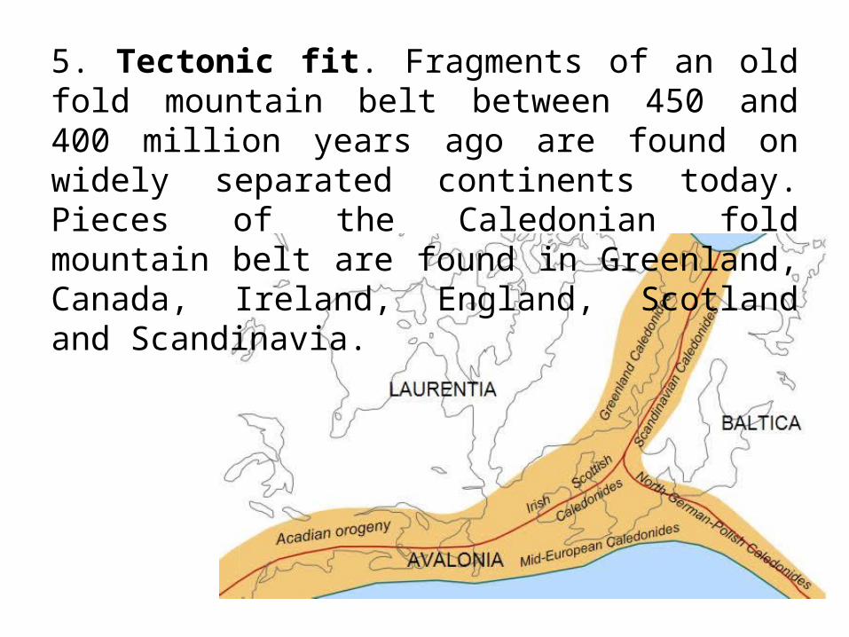
5. Tectonic fit. Fragments of an old fold mountain belt between 450 and 400 million years ago are found on widely separated continents today. Pieces of the Caledonian fold mountain belt are found in Greenland, Canada, Ireland, England, Scotland and Scandinavia.
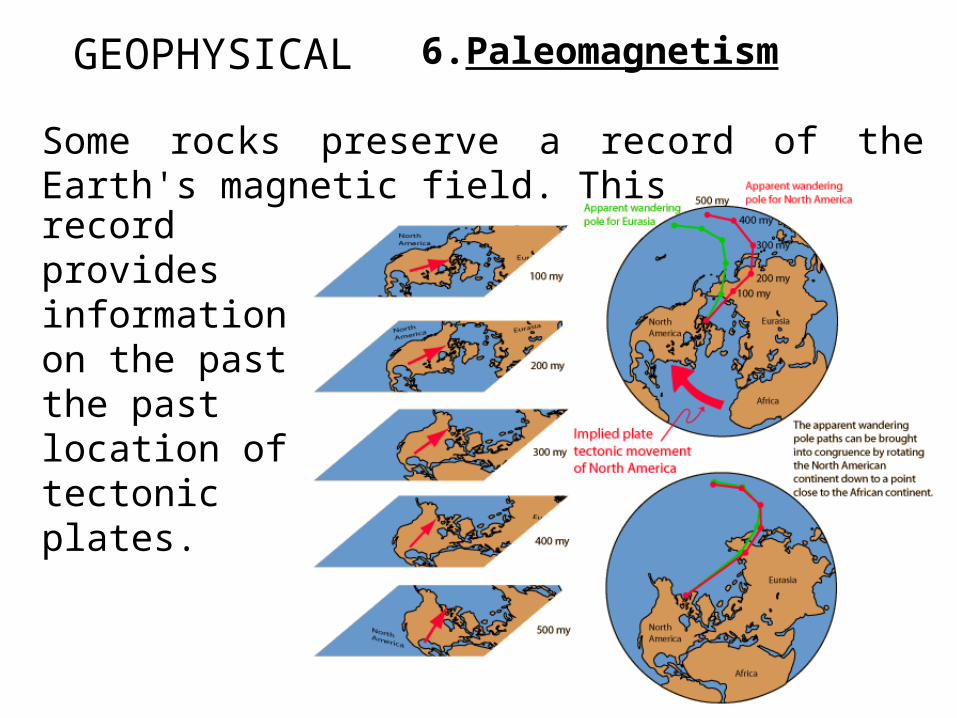
6.PaleomagnetismGEOPHYSICAL
Some rocks preserve a record of the Earth's magnetic field. Thisrecord provides information on the past the past location of tectonic plates.
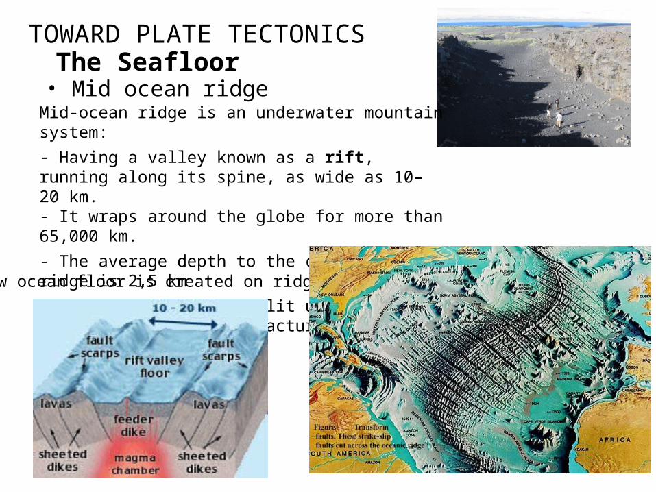
TOWARD PLATE TECTONICSThe Seafloor
• Mid ocean ridge
New ocean floor is created on ridges
Mid-ocean ridge is an underwater mountain system:
- Having a valley known as a rift, running along its spine, as wide as 10–20 km.- It wraps around the globe for more than 65,000 km.
- The average depth to the crest of the ridge is 2,5 km
- Oceanic ridges are split up by transform faults and fracture zones.
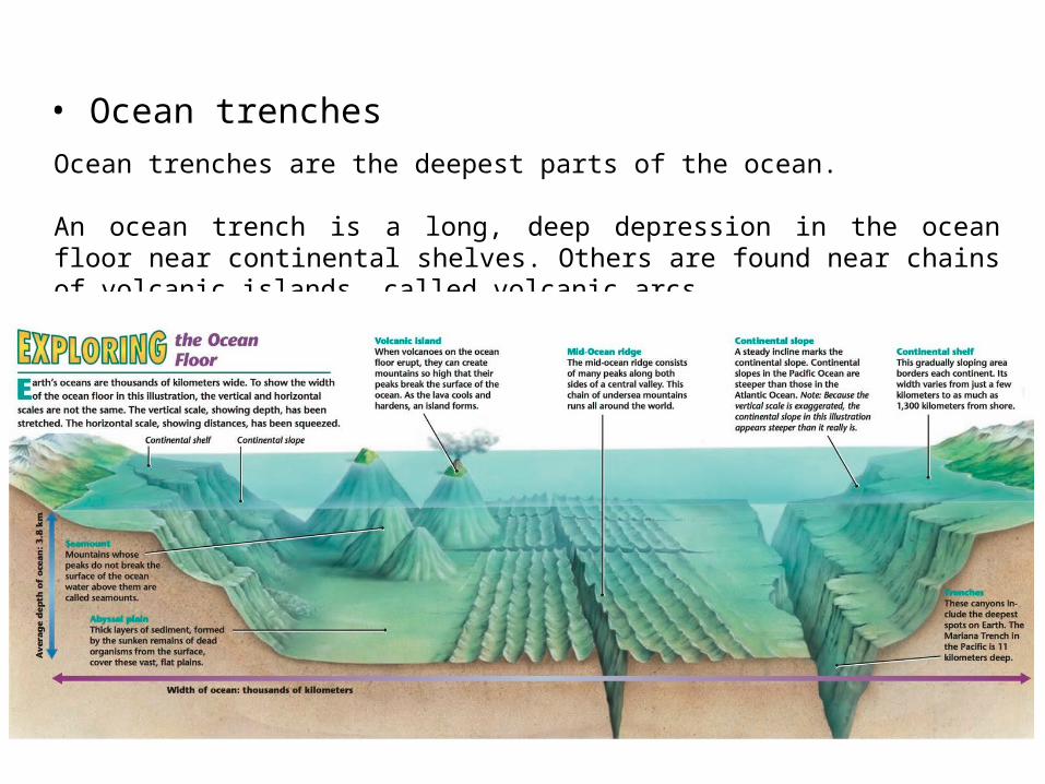
• Ocean trenches
Ocean trenches are the deepest parts of the ocean.
An ocean trench is a long, deep depression in the ocean floor near continental shelves. Others are found near chains of volcanic islands, called volcanic arcs.
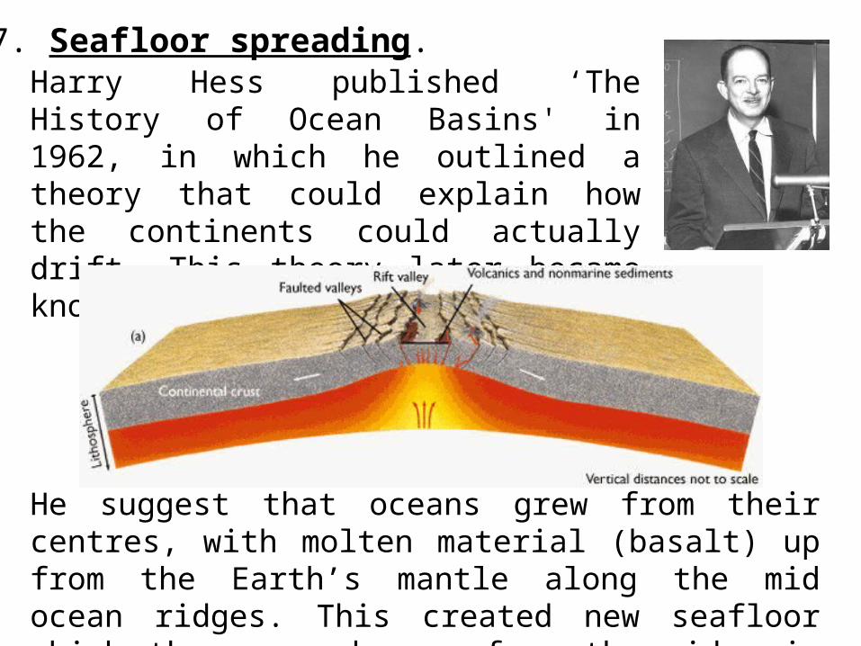
Harry Hess published ‘The History of Ocean Basins' in 1962, in which he outlined a theory that could explain how the continents could actually drift. This theory later became known as ‘Sea Floor Spreading'.
7. Seafloor spreading.
He suggest that oceans grew from their centres, with molten material (basalt) up from the Earth’s mantle along the mid ocean ridges. This created new seafloor which then spread away from the ridge in both directions.

7. Seafloor spreading.
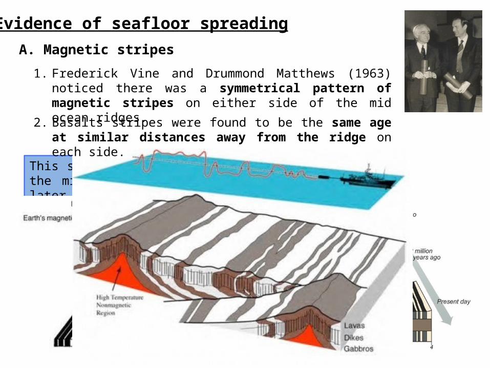
Evidence of seafloor spreading
1. Frederick Vine and Drummond Matthews (1963) noticed there was a symmetrical pattern of magnetic stripes on either side of the mid ocean ridges.
This suggested that the ocean floor was created at the mid ocean ridges, then was split in half by later activity and pushed sideways.
2. Basalts stripes were found to be the same age at similar distances away from the ridge on each side.
A. Magnetic stripes
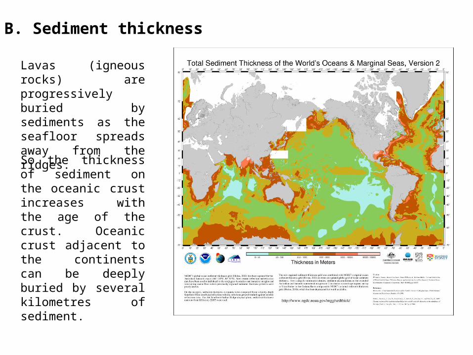
Lavas (igneous rocks) are progressively buried by sediments as the seafloor spreads away from the ridges.
So the thickness of sediment on the oceanic crust increases with the age of the crust. Oceanic crust adjacent to the continents can be deeply buried by several kilometres of sediment.
B. Sediment thickness
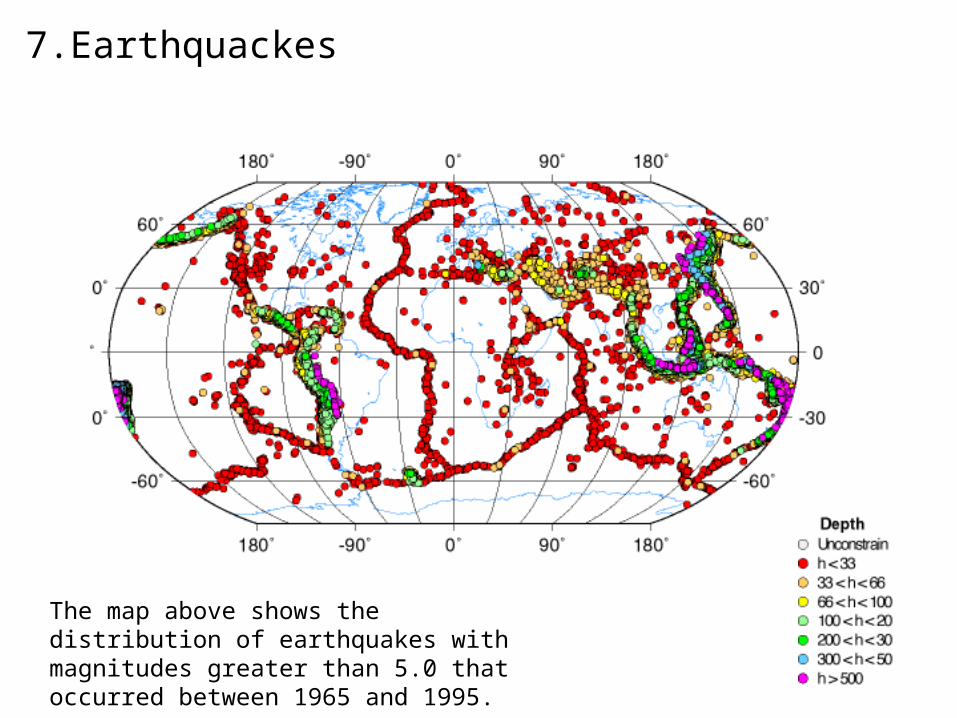
7.Earthquackes
The map above shows the distribution of earthquakes with magnitudes greater than 5.0 that occurred between 1965 and 1995.
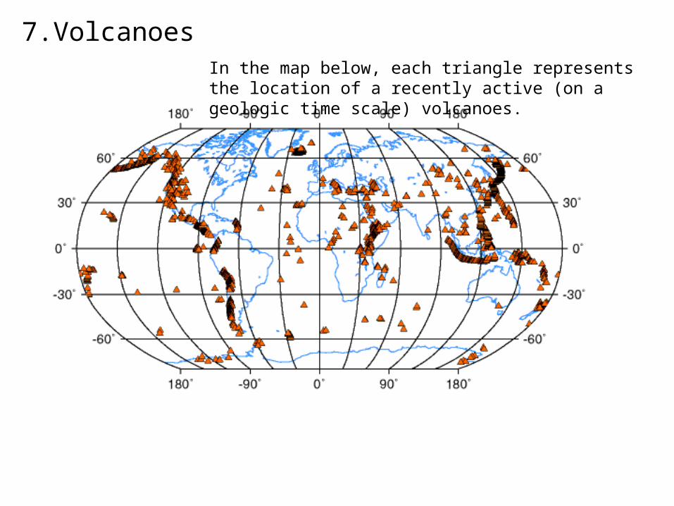
7.VolcanoesIn the map below, each triangle represents the location of a recently active (on a geologic time scale) volcanoes.
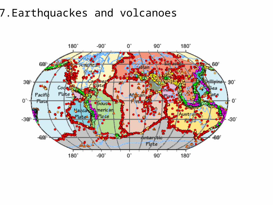
7.Earthquackes and volcanoes
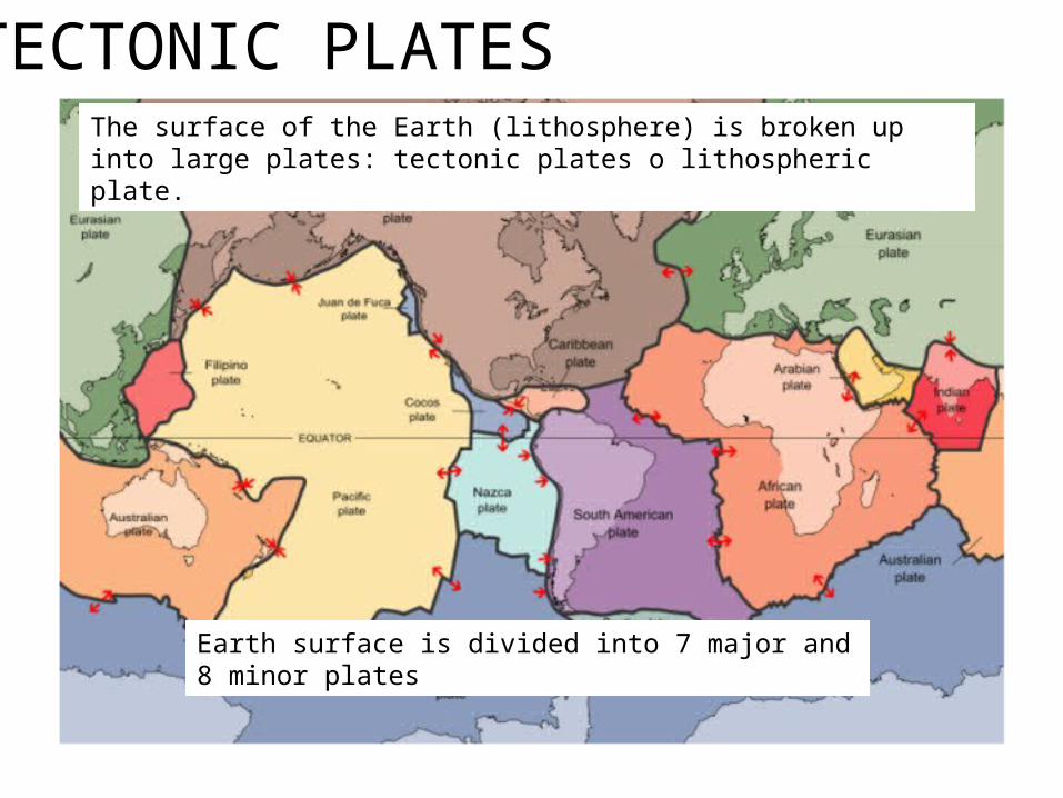
TECTONIC PLATESThe surface of the Earth (lithosphere) is broken up into large plates: tectonic plates o lithospheric plate.
Earth surface is divided into 7 major and 8 minor plates
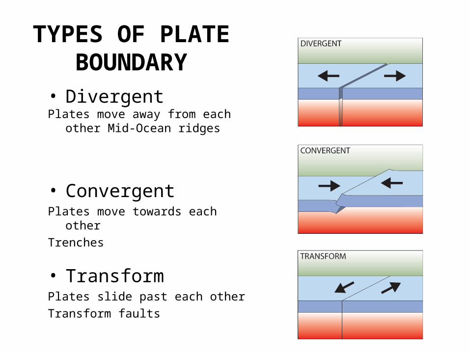
• DivergentPlates move away from each other
Mid-Ocean ridges
TYPES OF PLATE
BOUNDARY
• ConvergentPlates move towards each other
Trenches
• TransformPlates slide past each other
Transform faults
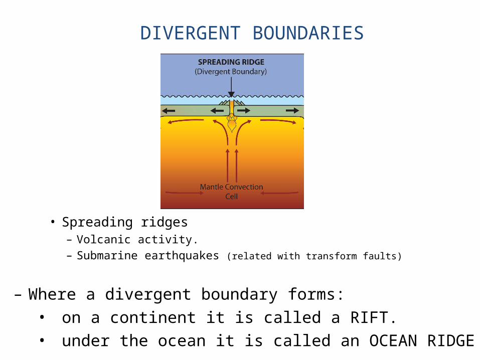
• Spreading ridges– Volcanic activity.– Submarine earthquakes (related with transform faults)
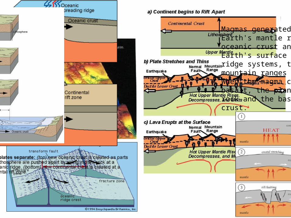
DIVERGENT BOUNDARIES
– Where a divergent boundary forms:• on a continent it is called a RIFT.• under the ocean it is called an OCEAN RIDGE

• Iceland has a divergent plate boundary running through its middle
Iceland: An example of continental rifting
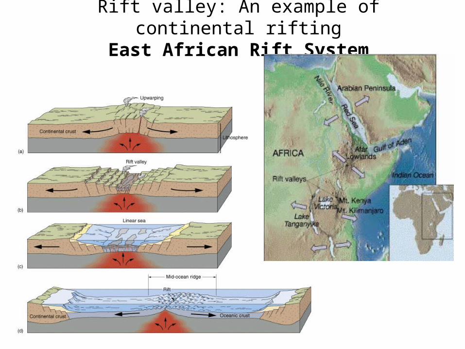
Rift valley: An example of continental riftingEast African Rift System
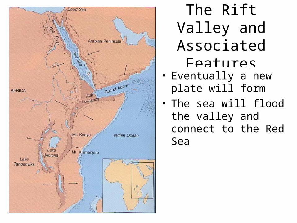
The Rift Valley and Associated Features
• Eventually a new plate will form
• The sea will flood the valley and connect to the Red Sea
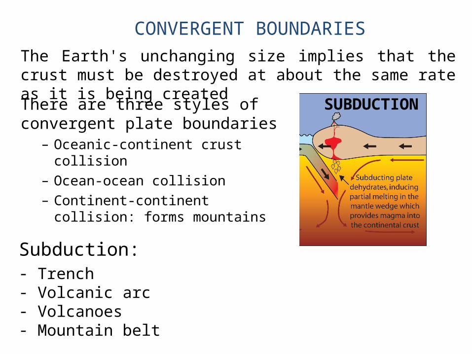
CONVERGENT BOUNDARIES
SUBDUCTIONThere are three styles of convergent plate boundaries
– Oceanic-continent crust collision– Ocean-ocean collision– Continent-continent collision: forms
mountains
The Earth's unchanging size implies that the crust must be destroyed at about the same rate as it is being created
Subduction:- Trench- Volcanic arc- Volcanoes- Mountain belt
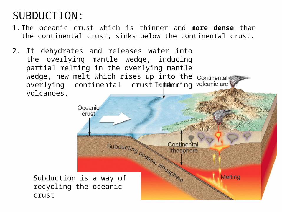
SUBDUCTION:1. The oceanic crust which is thinner and more dense than the
continental crust, sinks below the continental crust.2. It dehydrates and releases water into the overlying
mantle wedge, inducing partial melting in the overlying mantle wedge, new melt which rises up into the overlying continental crust forming volcanoes.
Subduction is a way of recycling the oceanic crust
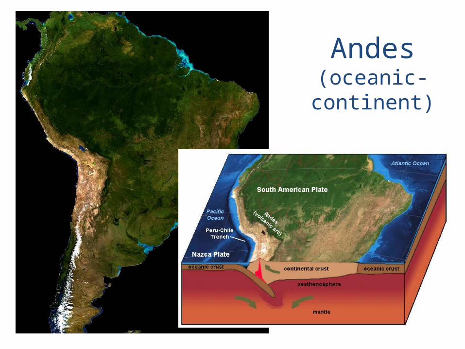
Andes(oceanic-continent)
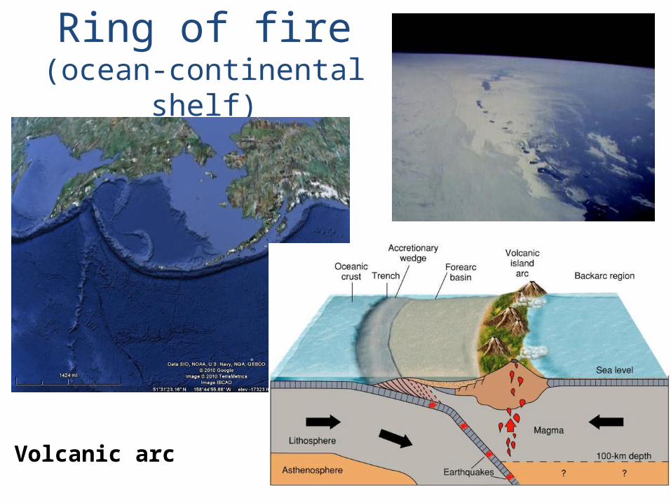
Ring of fire(ocean-continental shelf)
Volcanic arc
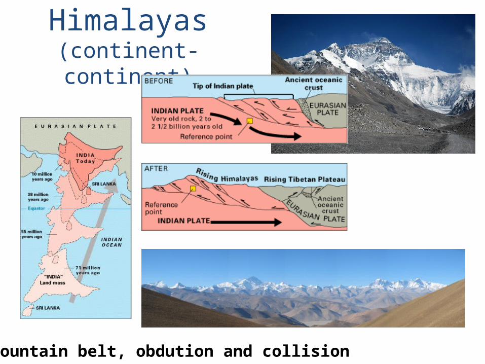
Himalayas(continent-continent)
Mountain belt, obdution and collision

TRANSFORM BOUNDARIES
The zone between two plates sliding horizontally past one another.
Most transform faults are found on the ocean floor. However, a few occur on land, for example the San Andreas.
They commonly offset the active spreading ridges, producing zig-zag plate margins.
They are generally defined by shallow earthquakes.

San Andreastransform fault
6.7 Northridge earthquake 1994
7.8 earthquake 1906
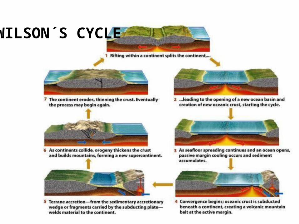
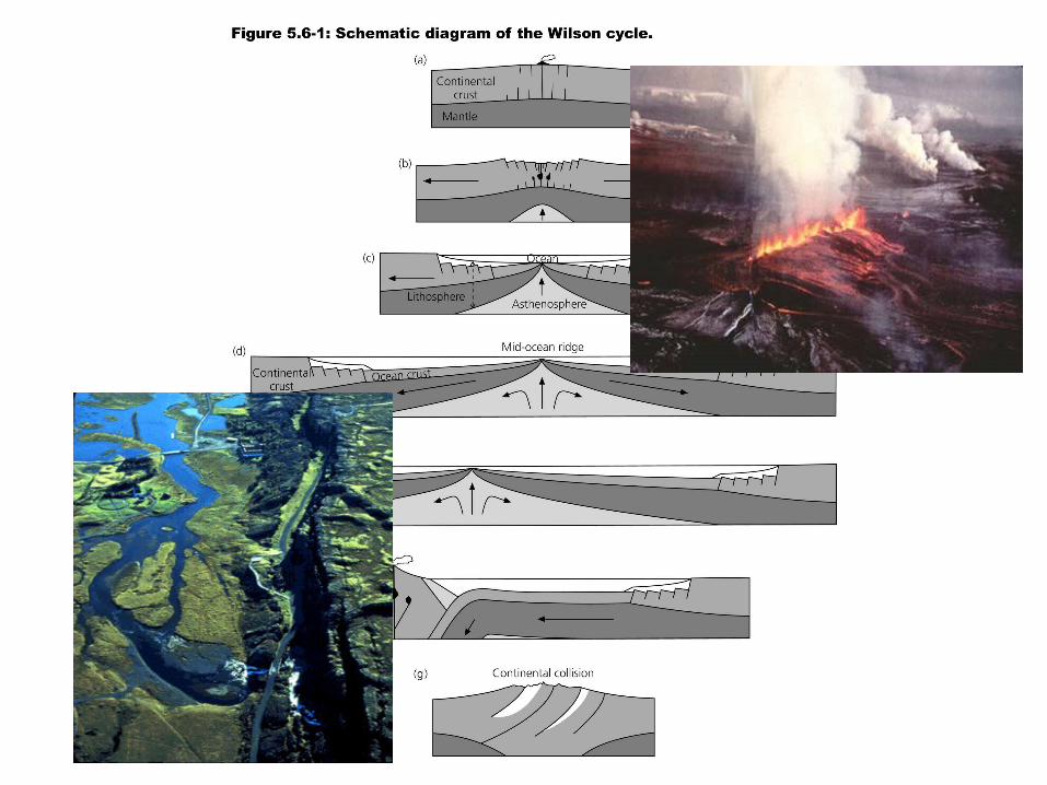
WILSON´S CYCLE
Magmas generated by melting of Earth's mantle rise up below the oceanic crust and erupt on Earth's surface at mid-ocean ridge systems, the longest mountain ranges in the world. When the magma cools it forms basalt, the planet's most-common rock and the basis for oceanic crust.
Look next links about structure and composition of Earth
• The Geological Society: Plate tectonics• Smithsonian National Museum of Natural
History: The dynamic Earth.