
t HARBOURS AND PORTS
72
?«m> >yz)(+* is)C~*z '-* <-^-* ^ t ii 1-: HARBOURS AND PORTS OF LAKE ONTARIO, 1\ V SERIES OF Cll VIMS. ACCOMPANIED BY A DESCRIPTION OF EACH; TOGETHER WITH THE LIGHTHOUSES, HARBOUR LIGHTS, DEPTH OF WATER, COURSES AND DISTANCES, dfcc, &fi. ® COMPILED FKo\i AUTHENTIC S0UECE9, UK CHARTS OF CAPTAIN OWEN AND LIEUT: HERBERT, FROM RECENT SURVEYS, 1 as well as LROM PERSONAL OBSERVATIONS. 1 i 1 BY KDWARl) M. HDDDER M. L> COMMODORE OP THE ROV.Vt CANADIAN \APHT Cl.fU. TORONTO: MACLEAR & CO., 1G, KING STREET EAST.
Transcript of t HARBOURS AND PORTS
?«m> >yz)(+* is)C~*z '-* <-^-* ^
t ii 1-:
HARBOURS AND PORTSOF
LAKE ONTARIO,1\ V SERIES OF Cll VIMS. ACCOMPANIED BY A DESCRIPTION OF EACH;
TOGETHER WITH THE
LIGHTHOUSES, HARBOUR LIGHTS, DEPTH OF WATER,COURSES AND DISTANCES, dfcc, &fi.
®
COMPILED FKo\i AUTHENTIC S0UECE9,
UK CHARTS OF CAPTAIN OWEN AND LIEUT: HERBERT,
FROM RECENT SURVEYS,
1
as well as
LROM PERSONAL OBSERVATIONS.
1
i
1
BY KDWARl) M. HDDDER M. L>
COMMODORE OP THE ROV.Vt CANADIAN \APHT Cl.fU.
TORONTO:MACLEAR & CO., 1G, KING STREET EAST.
The EDITH and LORNE PIERCECOLLECTION ofCANADIANA
Queen's University at Kingston
Purchased CANAt>lANAfrom the , ,
Chancellor COLLCCTIONRichardson QUeCN'SMemorial ^
Fund UNlVeRSlT?AT RlNQSTON
ONTARIO CANADA
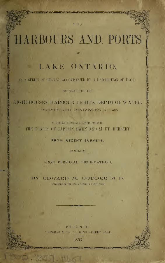
THE
HARBOURS AND PORTSOF
LAKE ONTARIO,
I2ST A. SERIES OE CHARTS,
ACCOMPANIED BY A DESCRIPTION OF EACH;
TOGETHER WITH THE LIGHTHOUSES, HARBOUR LIGHTS, DEPTHOF WATER, COURSES AND DISTANCES, &c. &c.
COMPILED FROM AUTHENTIC SOURCES, THE CHARTS OF CAPT. OWENAND LIEUT. HERBERT, FROM RECENT SURVEYS,
AS WELL AS
FROM PERSONAL OBSERVATIONS.
BY EDWAPvD M. HODDER, M.D.,
COMMODORE OF THE ROYAL CANADIAN YACHT CLUB.
TORONTO:MACLEAR & CO., 16 KING STREET EAST,
1857.

Digitized by the Internet Archive
in 2012 with funding from
Queen's University - University of Toronto Libraries
http://archive.org/details/harboursportsoflOOhodd
PBEFACE
lN offering this little work to the public, at the earnest solicitation of several of the
Captains of schooners navigating these waters, I have been actuated solely by a desire
to supply a want which I have frequently heard lamented, by all those with whom I
have conversed on the subject.
Fully aware of the many deficiencies and imperfections which exist in it, yet I
venture on its publication, confident in its general correctness.
The materials I have derived from such authentic sources as have been within myreach, from the Admiralty Chart of Captain Owen, R.N., corrected to 1851, from
surveys by the Corps of Topographical Engineers of the United States, and from
information obtained from some of the oldest and most experienced Sailors on the
Lake. And here let me express my warmest thanks to Captain Carr of the Maple
Leaf, Captain Young of the Chief Justice, Captain W. Bate of the Schooner Water
Witch, and others, who have most kindly seconded my efforts by giving me every
information in their power.
I have myself visited every Port, with the exception of Sackett's Harbour and Port
Ontario, and have sketched the entrances to them, taken their compass bearings,
soundings, &c. &c, but from the want of the time requisite, as well as a practical
knowledge in the use of surveying instruments, the charts must be looked upon only
in the light of mere sketches, not drawn to any definite or particular scale.
The distances from port to port may appear great, when compared with those
which have commonly been acknowledged as correct ; I have, however, carefully taken
them from Captain Owen's Survey, and preferred giving them as by him laid down.
I shall consider myself most happy if my humble attempt should stimulate some
abler head than mine to improve upon and complete a task, which I am well aware I
have only commenced ; and it will gratify me still more, if through any effort of mine
a single life is saved, or the smallest craft that navigates this noble Lake is preserved
from wreck.
DEDICATION.
For the Members of the Royal Canadian Yacht Club, this little work has been
compiled, and to them it is dedicated, in the hope that it may not only interest, but
also excite and encourage in them a taste for that invigorating, truly British pastime,
and manly sport, Yachting, and make it rival in their affections the glorious game of
Cricket, the Hunt, or the Gun : to the love and encouragement of these, may not Old
England mainly attribute the courage and daring, the athletic frames, and hardiness of
her sons ? for let it not be forgotten, that the effeminacy of a people is the surest
forerunner of the decay of a nation.
May it also be useful to them, by giving such sure and accurate information relative
to the various Harbours and Ports on Lake Ontario, as may create in them a fondness
or cruising, from the conviction, that in any weather they can speedily reach some
haven of refuge, where their gallant little Barks may, in shelter and in safety, ride
out the fiercest storm.
By their sincere Friend,
THE AUTHOR.
Toronto, April, 1857
HARBOURS AND PORTS.
NOTICE.—The depth of water given in the various Ports is the mean or average depth taken in
the month of August: at the opening of the navigation in the spring, when the Lake level is higher,
this average will be exceeded by from ten to fifteen inches ; in the autumn, before the rainy season
sets in, it will be decreased from six to twelve inches.
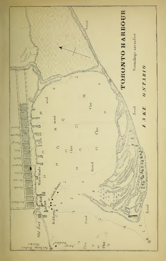
TORONTO HARBOUR, OR BAY.
This spacious anchorage is without doubt the best natural harbour on Lake Ontario.
It is nearly circular, being formed by the main land on the north, and by a long, low,
and narrow spit of sand, on the east, south, and south-west, called the Peninsular or
Island ; it extends in a south-westerly direction from the highlands in the township of
Scarboro', and terminates in a point which suddenly turns to the north opposite the
Old Garrison, and upon which trees of stunted growth are thickly scattered : thus is
enclosed a beautiful basin of about two and a half miles in diameter, capable of
containing a great number of vessels.
LIGHTHOUSE.
The south-west extremity of this island is called Gibraltar Point, on which is
erected the Lighthouse, 66 feet high, having a fixed bright light.
CHANNEL.
The entrance to the harbour is by a narrow channel at its north-west corner
between the Queen's Wharf and a row of buoys south thereof, which are placed in
about ten feet water. The present channel is 300 feet wide, and about 600 or 700 feet
long, having an average depth of 11 feet ; but owing to the extreme narrowness of this
passage, large and heavily laden vessels often find it difficult, sometimes impossible, to
beat in or out against a head wind.
This channel, however, is being widened from year to year by the constant use of
the dredge ; and I believe it is the intention of the Harbour Master to continue this
useful work until a clear available space of 400 feet has been obtained.
HARBOUR LIGHTS.
On the Queen's Wharf are placed the Harbour Lights—the northenmost a fixed
red light, the other a bright beacon light on the western extremity of the pier. Theselights when brought into line indicate the entrance to the channel. They bear
N. by W. of the lighthouse on Gibraltar Point.
3bznc
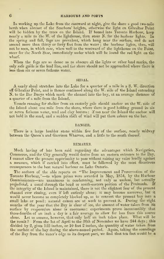
6 HARBOURS AND PORTS
In working up the Lake from the eastward at night, give the shore a good two-mile
berth when abreast of the Scarboro' heights, otherwise the light on Gibraltar Point
will be hidden by the trees on the Island. If bound into Toronto Harbour, keepnearly a mile to the W. of the lighthouse, then steer N. for the harbour lights. Inthe spring and fall, fogs are prevalent, which hang near the surface, and do not
ascend more than thirty or forty feet from the water ; the harbour lights, then, will
not be seen, in which case, when well to the westward of the lighthouse on the Point,
steer for the North Star, immediately under which will be iound the red light on the
wharf.
When the fogs are so dense as to obscure all the lights or other land marks, the
only safe guide is the lead line, and tue shore should not be approached where there is
less than six or seven fathoms water.
SHOAL.
A sandy shoal stretches into the Lake for a quarter of a mile in a S. W. direction
off Gibraltar Point, and is thence continued along the W. side of the Island extending
N. to the Bar Buoys which mark the channel into the bay, at an average distance of
a quarter of a mile from the Island.
Vessels running for shelter from an easterly gale should anchor on the W. side of
the Island about one mile from the shore, where there is good holding ground in six
or seven fathoms water, mud and clay bottom : if too near the Island the anchor will
not hold in the sand, and a sudden shift of wind will put them ashore on the bar.
DANGER.
There is a large boulder stone within five feet of the surface, nearly midwaybetween the Queen's and Garrison Wharves, and a little to the south thereof.
REMARKS.
Much having of late been said regarding the advantages which Navigation,
Commerce, and the City generally would derive from an eastern entrance to the Bay,
I cannot allow the present opportunity to pass without raising my voice loudly against
a measure, which if carried into effect, must be followed by the most disastrous
consequences to the best natural harbour on Lake Ontario.
The authors of the able reports on "The Improvement and Preservation of the
Toronto Harbour,"—to whom prizes were awarded in May, 1854, by the Harbour
Commissioners—are unanimous in condemning, not only as useless, but actually
prejudicial, a canal through the bend or south-eastern portion of the Peninsula. If
the integrity of the Island is maintained, there is not the slightest fear of the present
channel ever closing, even if left entirely alone; it may become narrower, but it
would never become so completely blocked up, as to convert the present bay into a
small lake or pond: natural causes are at work to prevent it. During the eight
months of the year that the Bay is clear of ice, the amount of water taken from its
surface by evaporation alone is enormous : experiments prove incontestibly that
three-fourths of an inch a day is a fair average to allow for loss from this source
alone. Let us assume, however, that only half an inch takes place. What will be
the result ? From the 1st of April to the 30th of November we have 244 days ; this
divided by 2, gives 122 inches, or 10 feet 2 inches, the quantity of water taken from
the surface of the bay during the above-named period. Again, taking the soundings
of the Bay from the water's edge to its deepest part, we find that ten feet would be a
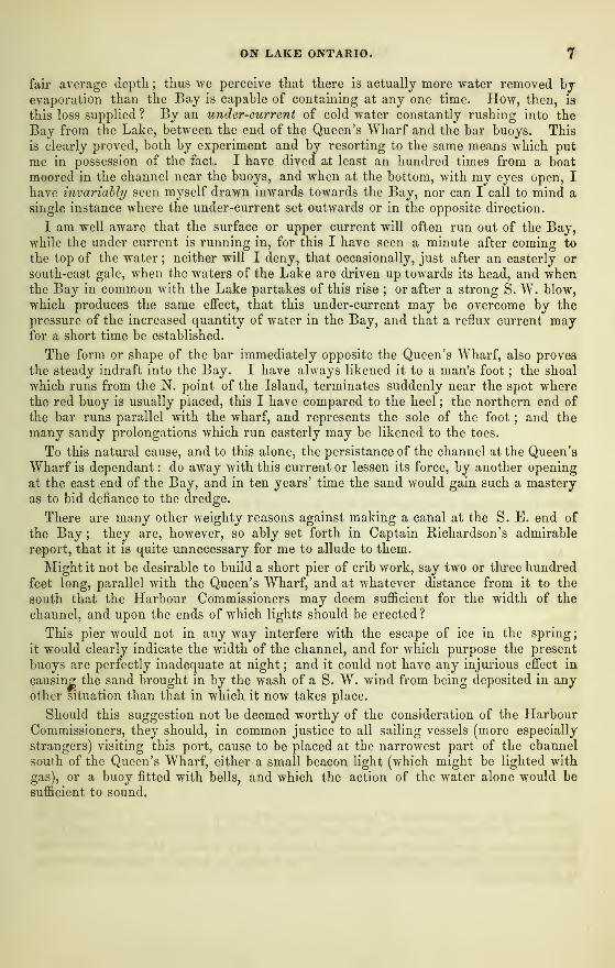
ON LAKE ONTARIO. 7
fair average depth ; thus we perceive that there is actually more water removed byevaporation than the Bay is capable of containing at any one time. How, then, is
this loss supplied ? By an under-current of cold water constantly rushing into the
Bay from the Lake, between the end of the Queen's Wharf and the bar buoys. This
is clearly proved, both by experiment and by resorting to the same means which put
me in possession of the fact. I have dived at least an hundred times from a boat
moored in the channel near the buoys, and when at the bottom, with my eyes open, I
have invariably seen myself drawn inwards towards the Bay, nor can I call to mind a
single instance where the under-current set outwards or in the opposite direction.
I am well aware that the surface or upper current will often run out of the Bay,while the under current is running in, for this I have seen a minute after coming to
the top of the water ; neither will I deny, that occasionally, just after an easterly or
south-east gale, when the waters of the Lake are driven up towards its head, and whenthe Bay in common with the Lake partakes of this rise ; or after a strong S. W. blow,
which produces the same effect, that this under-current may be overcome by the
pressure of the increased quantity of water in the Bay, and that a reflux current mayfor a short time be established.
The form or shape of the bar immediately opposite the Queen's Wharf, also proves
the steady indraft into the Bay. I have always likened it to a man's foot ; the shoal
which runs from the N. point of the Island, terminates suddenly near the spot wherethe red buoy is usually placed, this I have compared to the heel ; the northern end of
the bar runs parallel with the wharf, and represents the sole of the foot ; and the
many sandy prolongations which run easterly may be likened to the toes.
To this natural cause, and to this alone, the persistance of the channel at the Queen's
Wharf is dependant : do away with this current or lessen its force, by another opening
at the east end of the Bay, and in ten years' time the sand would gain such a masteryas to bid defiance to the dredge.
There are many other weighty reasons against making a canal at the S. E. end of
the Bay ; they are, however, so ably set forth in Captain Richardson's admirable
report, that it is quite unnecessary for me to allude to them.
Might it not be desirable to build a short pier of crib work, say two or three hundred
feet long, parallel with the Queen's Wharf, and at whatever distance from it to the
south that the Harbour Commissioners may deem sufficient for the width of the
channel, and upon the ends of which lights should be erected ?
This pier would not in any way interfere with the escape of ice in the spring
;
it would clearly indicate the width of the channel, and for which purpose the present
buoys are perfectly inadequate at night ; and it could not have any injurious effect in
causing the sand brought in by the wash of a S. W. wind from being deposited in anyother situation than that in which it now takes place.
Should this suggestion not be deemed worthy of the consideration of the HarbourCommissioners, they should, in common justice to all sailing vessels (more especially
strangers) visiting this port, cause to be placed at the narrowest part of the channel
south of the Queen's Wharf, either a small beacon light (which might be lighted with
gas), or a buoy fitted with bells, and which the action of the water alone would be
sufficient to sound.
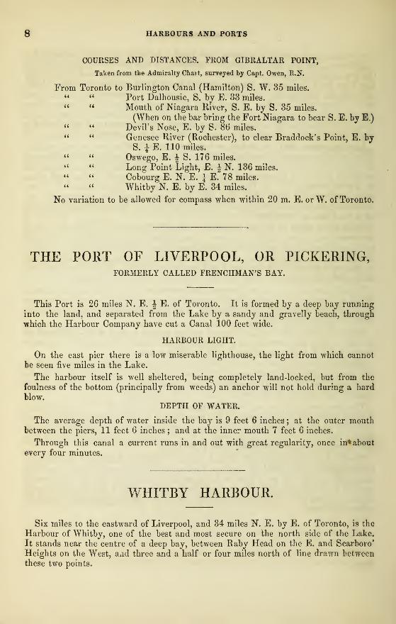
8 HARBOURS AND PORTS
COURSES AND DISTANCES. FROM GIBRALTAR POINT,
Taken from the Admiralty Chart, surveyed by Capt. Owen, R.N.
From Toronto to Burlington Canal (Hamilton) S. W. 35 miles." Port Dalhousie, S. by E. 33 miles." Mouth of Niagara River, S. E. by S. 35 miles.
(When on the bar bring the Fort Niagara to bear S. E. by E.)" Devil's Nose, E. by S. 8b* miles." Genesee River (Rochester), to clear Braddock's Point, E. by
S. J E. 110 miles." Oswego, E. J S. 176 miles." Long Point Light, E. | N. 136 miles." Cobourg E. N. E. J E. 78 miles." Whitby N. E. by E. 34 miles.
No variation to be allowed for compass when within 20 m. E. or W. of Toronto.
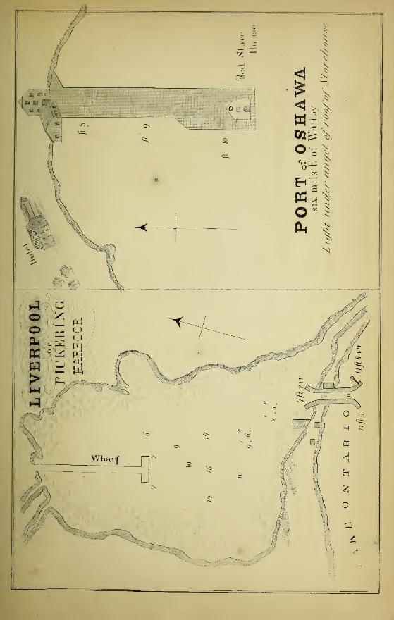
THE PORT OF LIVERPOOL, OR PICKERING,FORMERLY CALLED FRENCHMAN'S BAY.
This Port is 26 miles N. E. \ E. of Toronto. It is formed by a deep bay running
into the land, and separated from the Lake by a sandy and gravelly beach, through
which the Harbour Company have cut a Canal 100 feet wide.
HARBOUR LIGHT.
On the east pier there is a low miserable lighthouse, the light from which cannot
be seen five miles in the Lake.
The harbour itself is well sheltered, being completely land-locked, but from the
foulness of the bottom (principally from weeds) an anchor will not hold during a hard
blow.DEPTH OF WATER.
The average depth of water inside the bay is 9 feet 6 inches ; at the outer mouthbetween the piers, 11 feet 6 inches ; and at the inner mouth 7 feet 6 inches.
Through this canal a current runs in and out with great regularity, once in* about
every four minutes.
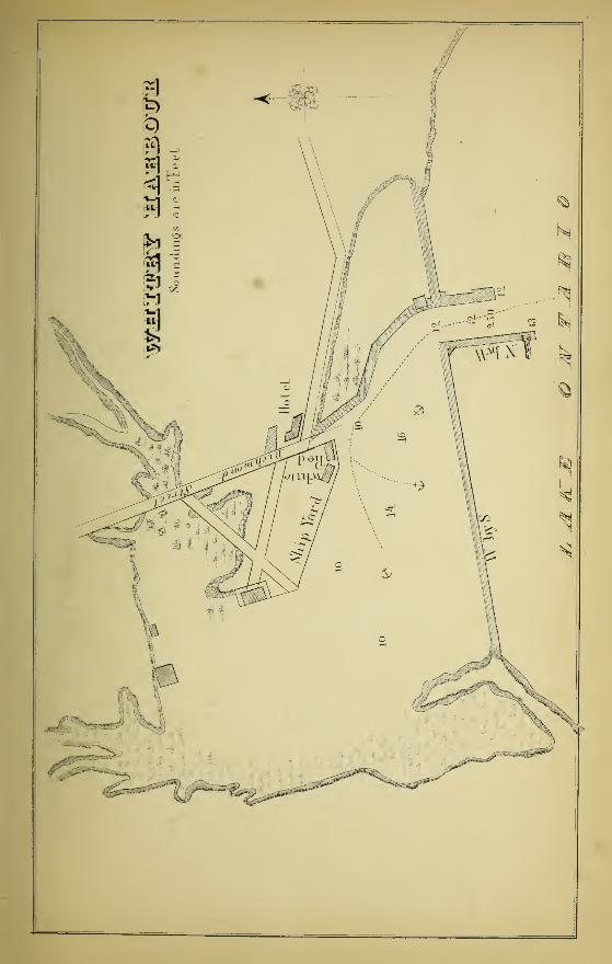
WHITBY HARBOUR.
Six miles to the eastward of Liverpool, and 34 miles N. E. by E. of Toronto, is the
Harbour of Whitby, one of the best and most secure on the north side of the Lake.
It stands near the centre of a deep bay, between Raby Head on the E. and Scarboro'
Heights on the West, a*id three and a half or four miles north of line drawn betweenthese two points.
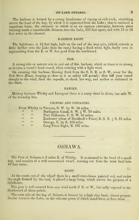
ON LAKE ONTARIO.
The harbour is formed by a strong breakwater of rip-rap or crib-work, stretching
across the head of the bay, by which it is separated from the Lake; thus is enclosed a
capacious basin, the entrance to which is at its eastern extremity, between piers
running south a considerable distance into the Lake, 250 feet apart, and with 13 or 14
feet water in the channel.
HARBOUR LIGHT.
The lighthouse is 12 feet high, built on the end of the west pier, (which extends a
little further into the Lake than the east,) having a fixed white light, badly seen in
approaching from the E. or W. but good from the southward.
TIDE.
A strong tide or current sets in and out of this harbour, which at times is so strong
as to turn a vessel's head round, when entering with a light wind.
On entering this harbour, blowing fresh from the S. S. E. or S. W., steer for the
Red Stcre House, keeping as close to it as safety will permit; then luff your vessel
sharply to the wind, back the topsails, to check her way, and anchor as indicated in
the chart.
DANGER.
Midway between Whitby and Liverpool there is a nasty shoal in shore, one mile W.of the township line.
COURSES AND DISTANCES.
From Whitby to Toronto, S. W. by W. 34 miles.
" " Burlington Canal, S. W. \ W. 70 miles." " Port Dalhousie, S. S. W. 55 miles,
" " Rochester (clear of Braddock's Point) E. S. E. J S, 93 miles." Oswego, E. by S. 153 miles.
" " Long Point Light, E. 107 miles.
OSHAWA
The Port of Oshawa is 6 miles E. of Whitby. It is situated in the bend of a smallbay, and consists of a well constructed wharf, running out from the main land into10 feet water.
LIGHT.
At the south end of the wharf there is a small store-house painted red, and underthe angle formed by the roof, is placed a large lamp, which serves the purpose of alighthouse.
This port is well secured from any wind north if E. or W., but sadly exposed to theSouthward of these points.
The west side of the bay of Oshawa is formed by a high clay bank, almost perpen-dicular towards the Lake, on the extreme point of which stand three or four trees.
10 PORTS AND HARBOURS
DANGER.
The E. point is called Oshawa Island, bearing S. by E. from the wharf: the waterhere is very shoal, and a reef of large boulders extends into the Lake S. E. for 300or 400 yards, which must be given a wide berth.
From the point of land about midway between Whitby and Oshawa, there is anotherreef of large boulders running out E. S. E. into the Lake.
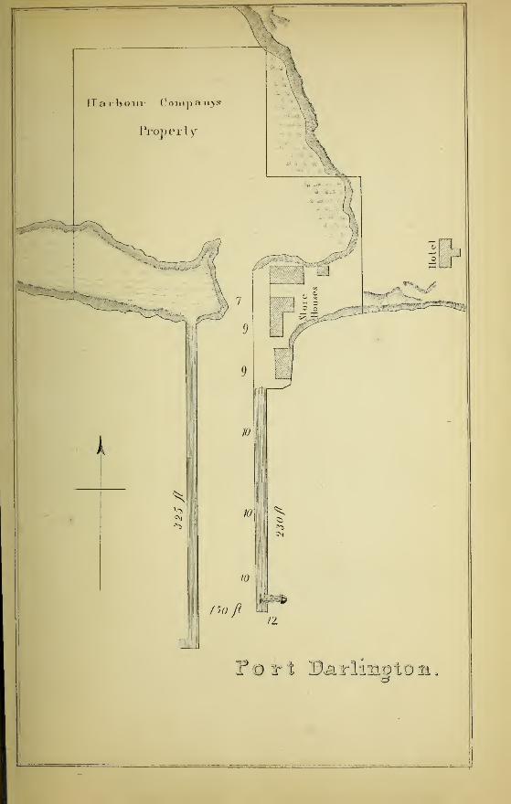
PORT DARLINGTON.
The Port of Darlington is 8 miles to the eastward of Oshawa, 50 miles E. N. E. ofToronto, and 29 miles W. by S. of Cobourg.
The Harbour Company have much improved this snug little port, by extending the
piers into 12 feet water, and dredging the land locked basin within, where vessels
drawing 9 feet or less may lie in safety in any weather.
The W. pier extends about 50 feet farther south than the E. pier, whereby the roll
of the Lake during a S. W. blow is materially broken.
LIGHT.
A lighthouse is erected on the E. pier ; but, although the light is bright and good,
it, in common with most of the Harbour lights on the Canada side, is far too low to
be seen at any great distance in the Lake.
RABY HEAD.
One and a half miles W. of Darlington is the high, perpendicular, and bluff clay
point called Raby Head. Near the Lake it is destitute of trees or bushes, but farther
back stands a farm house and barn, surrounded by several lofty poplars and other
trees.
Neither the buildings or the trees can be seen from the Lake when due south of
Raby Head.
Darlington is the Port of Bowman ville, from which it is distant two miles ; the
Grand Trunk Railway Station is within half a mile of this thriving harbour.
For Courses, &c, see Bond Head.
BOND HEAD, OR PORT OF NEWCASTLE.
Between 4 and 5 miles E. by N. of Darlington is the Port of Bond Head. It con-
sists of a wharf run out into 10 feet water ; but from its exposed situation can only be
approached in fine weather, or when the wind is off shore.
ON LAKE ONTARIO. 11
DANGER.
Four miles E. of this port there is a large boulder some distance in the Lake, called
the Peach Stone, and 4 miles E. of this, again, there is a reef of boulders extending
200 or 300 yards into the Lake in a southerly direction, off a headland.
COURSE.
In running from Darlington to Port Hope or Cobourg, steer E. J N. for 18 or 20miles to avoid these dangers, giving the shore a good mile berth; then N. E. byE. J E. for Port Hope, and E. N. E. | E. for Cobourg.
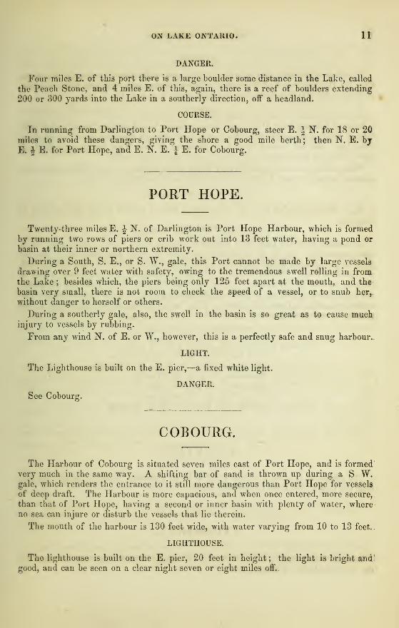
PORT HOPE
Twenty-three miles E. J N. of Darlington is Port Hope Harbour, which is formedby running two rows of piers or crib work out into 13 feet water, having a pond or
basin at their inner or northern extremity.
During a South, S. E., or S. W., gale, this Port cannot be made by large vessels
drawing over 9 feet water with safety, owing to the tremendous swell rolling in fromthe Lake ; besides which, the piers being only 125 feet apart at the mouth, and the
basin very small, there is not room to check the speed of a vessel, or to snub her,,
without danger to herself or others.
During a southerly gale, also, the swell in the basin is so great as to cause muchinjury to vessels by rubbing.
From any wind N. of E. or W., however, this is a perfectly safe and snug harbour..
LIGHT.
The Lighthouse is built on the E. pier,—a fixed white light.
DANGER.
See Cobourg.
COBOURG.
The Harbour of Cobourg is situated seven miles east of Port Hope, and is formedvery much in the same way. A shifting bar of sand is thrown up during a S W.gale, which renders the entrance to it still more dangerous than Port Hope for vessels
of deep draft. The Harbour is more capacious, and when once entered, more secure,
than that of Port Hope, having a second or inner basin with plenty of water, whereno sea can injure or disturb the vessels that lie therein.
The mouth of the harbour is 130 feet wide, with water varying from 10 to 13 feet..
LIGHTHOUSE.
The lighthouse is built on the E. pier, 20 feet in height ; the light is bright andgood, and can be seen on a clear night seven or eight miles off..
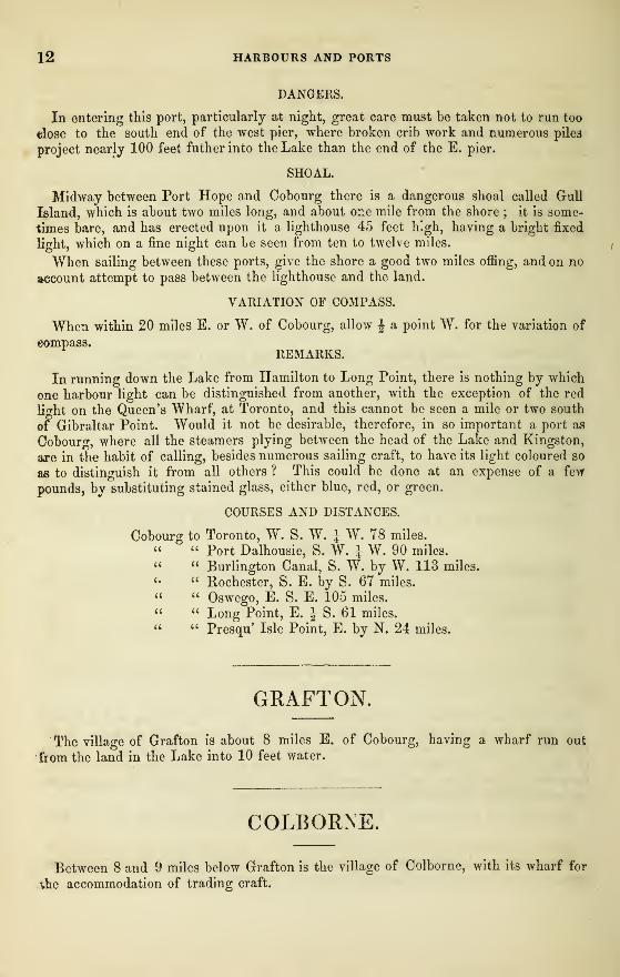
12 HARBOURS AND PORTS
DANGERS.
In entering this port, particularly at night, great care must be taken not to run too
close to the south end of the west pier, where broken crib work and numerous pile3
project nearly 100 feet father into the Lake than the end of the E. pier.
SHOAL.
Midway between Port Hope and Cobourg there is a dangerous shoal called Gull
Island, which is about two miles long, and about one mile from the shore ; it is some-
times bare, and has erected upon it a lighthouse 45 feet high, having a bright fixed
light, which on a fine night can le seen from ten to twelve miles.
When sailing between these ports, give the shore a good two miles offing, and on no
account attempt to pass between the lighthouse and the land.
VARIATION OF COMPASS.
When within 20 miles E. or W. of Cobourg, allow J a point W. for the variation of
eompass.REMARKS.
In running down the Lake from Hamilton to Long Point, there is nothing by which
one harbour light can be distinguished from another, with the exception of the red
light on the Queen's Wharf, at Toronto, and this cannot be seen a mile or two south
of Gibraltar Point. Would it not be desirable, therefore, in so important a port as
Cobourg, where all the steamers plying between the head of the Lake and Kingston,
are in the habit of calling, besides numerous sailing craft, to have its light coloured so
as to distinguish it from all others ? This could be done at an expense of a few
pounds, by substituting stained glass, either blue, red, or green.
COURSES AND DISTANCES.
Cobourg to Toronto, W. S. W. i W. 78 miles." " Port Dalhousie, S. W. J W. 90 miles." " Burlington Canal, S. W. by W. 113 miles.«• " Rochester, S. E. by S. 67 miles." " Oswego, E. S. E. 105 miles." " Long Point, E. J S. 61 miles." " Presqu Isle Point, E. by N. 24 miles.
GRAFTON.
The village of Grafton is about 8 miles E. of Cobourg, having a wharf run out
torn the land in the Lake into 10 feet water.
COLBORNE.
Between 8 and 9 miles below Grafton is the village of Colborne, with its wharf for
the accommodation of trading craft.
ON LAKE ONTARIO. 13
Both these ports are exposed to the heavy seas of the Lake, and afford no shelter
to vessels, except when the wind is off shore, or to the northward of E. or W. Thevillages themselves being small, they offer no inducement to the numerous Lake steamers
to touch at their ports, and which are frequented only by small schooners carrying
wood, or in the fall of the year, produce of different kinds.
DANGER.
One mile W. of Colborne there is a projecting point of land called Ogden's Point,
off which is a reef of boulders.
In approaching the Port of Colborne from the Westward, care must be taken to
give this point a wide berth.
COURSES AND DISTANCES.
From Cobourg to Colborne, E. by N. lb' miles.
" Colborne to Presq' Isle Point, E. by S. 8 miles.
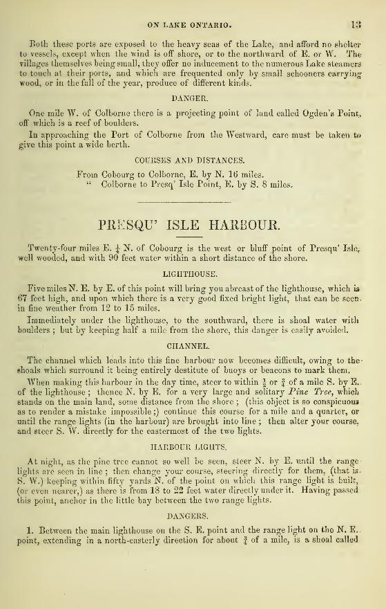
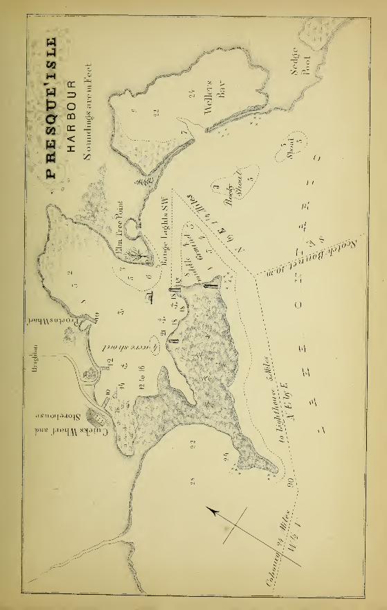
PRESQU' ISLE HARBOURTwenty-four miles E. J N. of Cobourg is the west or bluff point of Presqu' Isle,
well wooded, and with 90 feet water within a short distance of the shore.
LIGHTHOUSE.
Five miles N. E. by E. of this point will bring you abreast of the lighthouse, which is
67 feet high, and upon which there is a very good fixed bright light, that can be seer^
in fine weather from 12 to 15 miles.
Immediately under the lighthouse, to the southward, there is shoal water with
boulders ; but by keeping half a mile from the shore, this danger is easily avoided.
CHANNEL.
The channel which leads into this fine harbour now becomes difficult, owing to the
shoals which surround it being entirely destitute of buoys or beacons to mark them.
"When making this harbour in the day time, steer to wTithin J or f of a mile S. by E,
of the lighthouse ; thence N. by E. for a very large and solitary Pine Tree, which
stands on the main land, some distance from the shore;
(this object is so conspicuous
as to render a mistake impossible ;) continue this course for a mile and a quarter, or
until the range lights (in the harbour) are brought into line ; then alter your course,
and steer S. W. directly for the eastermost of the two lights.
HARBOUR LIGHTS,
At night, as the pine tree cannot so well be seen, steer N. by E. until the range
lights are seen in line ; then change your course, steering directly for them, (that is-
S. W.) keeping within fifty yards N. of the point on which this range light is built,
(or even nearer,) as there is from 18 to 22 feet water directly under it. Having passed:
this point, anchor in the little bay between the two range lights.
DANGERS.
1. Between the main lighthouse on the S. E. point and the range light on the N. E„.
point, extending in a north-easterly direction for about f of a mile, is a shoal called
14 HARBOURS AND PORTS
the " Middle Ground" having only from 4 to 6 ft. water on it, and formed of coarse
gravel, sand, and mud. Captain Halbutt, who has traded to this port for many years,
told me, that when the Lake is high, he is in the habit of taking his schooner across
this shoal, through a channel close to the two lights, his vessel, when laden, drawing9 feet.
2. To the north of the lighthouse built on the N. E. point, running out from the
main land, there is a low, marshy spit, destitute of timber, but easily recognised by a
large dead Elm tree, bearing due N. of the lighthouse : from this point, extendingwest and south-west, there is another formidable shoal, upon which the Passport got
ashore on 29th October, 1856.
I have called this, Elm Tree Point and Shoal : the channel between the beaconlight, middle ground, and elm tree shoal, is about J a mile wide.
3. W. N. W. of the second range light, there is another small shoal called, " FourAcre Shoal" nearly half a mile from the shore, but with plenty of water all round it.
The existence of this shoal renders it hazardous at night to stretch too far into the
bay beyond the second range light.
4. Two miles E. S. E. of the main lighthouse, there is a dangerous rocky shoal in
the Lake, with only from 3 to 5 feet water upon it. It is to the eastward of the
course steered from the lighthouse for the Scotch Bonnet ; and one mile S. E. of this,
again, there is another but smaller shoal.
These shoals would materially obstruct the entrance into Weller's Bay.
SCOTCH BONNET LIGHTHOUSE.
The Board of Works have just completed an excellent lighthouse on Egg Island, or
the Scotch Bonnet, which is one mile S. S. W. of Nicholas Island. It was lighted
for the first time in September, 1856. A bright fixed light, bearing S. E. of Presqu'
Isle Light. Can be seen 13 miles.
REMARKS.
This nearly land locked haven of refuge, when once entered, is perfectly secure from
every wind or sea ; there is plenty of water with good holding ground ; its dimensions
are ample for the whole navy of the Lake ; it is well lighted ; it is easily entered with
any wind, except from the N. W. ; and when it blows from this quarter, shelter is
easily obtained in many other places;
yet, from the want of a few beacons or buoys,
vessels often keep the open Lake, or run for much less secure places, rather than face
the dangers of the shoals.
COURSES AND DISTANCES.
From Lighthouse to Presqu' Isle Point, S. W. by W. 5 miles.
" Presqu' Isle Point to Cobourg, W. \ S. 24 miles." " Lighthouse to Scotch Bonnet, S. E. 10 miles.
" Lighthouse to Genesee River, S. \ E. 60 miles.
" Scotch Bonnet to Long Point, E. by S. 25 miles.
WELLER'S BAY.
" The Underwriters, Forwarders, Shipmasters, and others interested in the naviga-
tion of Lake Ontario are about to petition the Government for the construction of a
ON LAKE ONTARIO. 15
Harbour at Weller's Bay, in the County of Prince Edward. An opening one hundred
rods wide, with a channel one hundred and fifty feet wide and fourteen feet deep, has
within a few years past, been made through the beach from the Lake to Weller's Bay,
which is said to be capable of sheltering all the vessels which navigate Ontario. Theentrance to the harbour of Presqu' Isle is difficult and frequently attended with
casualties, and it is justly considered necessary to construct a harbour at the place
mentioned, which the mariner can safely enter in a storm. Several vessels, as our
readers know, were driven ashore within a few miles of Weller's Bay, or, rather the
opening leading into it, which might have been saved, had the entrance been known to
the masters.
There can be no doubt that the Government will entertain the prayer of the pe-
titioners, and immediately take proper steps to erect a Harbour of Refuge to our fresh
water seamen, that will serve to encourage them in their arduous and dangerous
calling.
In fact, " it is the duty of Government to render every aid in facilitating and advanc-
ing the interests of marine investments, which contribute so largely to the revenue of
the Province and the convenience of the people ; and we feel confident the object will
be acceded to without any circumlocution or useless delays."
—
Kingston News,Jan. 7, 1857.
If the entrance to Weller's Bay was not rendered more dangerous than the entrance
to Presqu' Isle Harbour, by the existence of the two shoals to which I have above al-
luded, the prayer of the petitioners would, in all probability, have the favourable con-
sideration of the Government ; but the existence of these two formidable shoals at the
very entrance of the bay, exposed as they also are to the full sweep of the Lake,
during a south or south-west wind, (the very winds which would render it necessary
for vessels to run into Weller's Bay for shelter,) would, I conceive, be an insuperable
objection to the expenditure of so large a sum of public money as it would require to
make this bay an efficient harbour of refuge during a dark and stormy night.
Far better would it be to petition the Government to expend one fourth of the sumin improving the entrance into Presq' Isle, and which is already well lighted. Theshoals, bad as they are, are so land-locked and protected from the heavy surge of the
sea, as hardly to endanger any vessel which might be so unfortunate as to get agroundon them.
The shoals opposite the entrance to Weller's Bay are rocky, and have only fromr3 to 5 feet water on them : they are also so exposed, that any vessel running ashore onthem during a gale, must soon go to pieces.
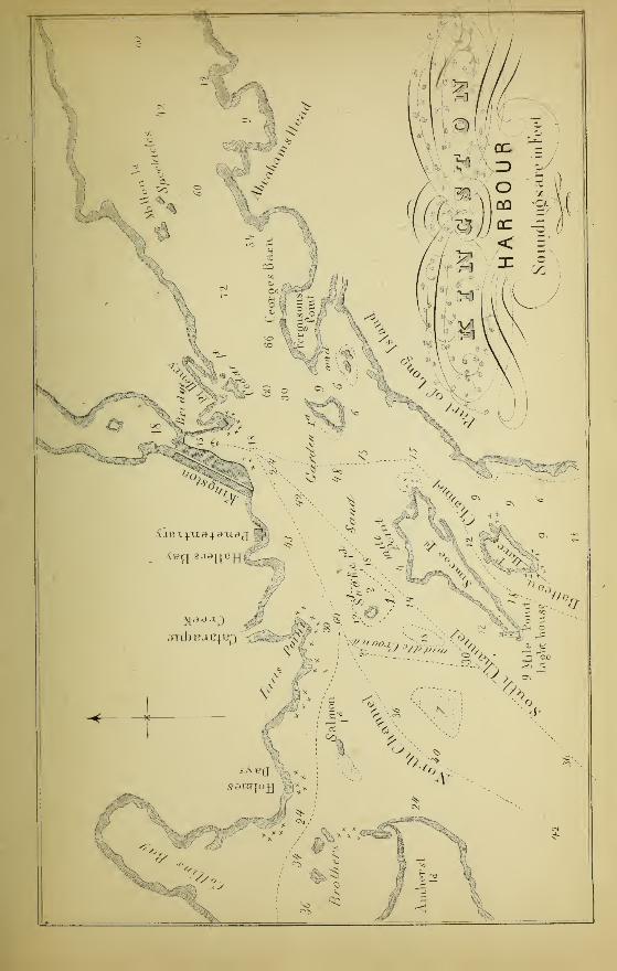
KINGSTON HARBOUR
Kingston Harbour, next to the Bay of Toronto is the best natural harbour on LakeOntario ; the approach to it, however, is intricate—consequently, dangerous.
It is situated at the N. E. corner of Lake Ontario, just where the Lake terminates
and the River St. Lawrence begins.
CHANNELS.
There are three channels by which it may be made.
1st. The Batteau Channel between Wolfe or Long Island, and Simcoe or GageIsland : this is generally used by small craft only, having in several places little morethan two fathoms water.
16 HARBOURS AND PORTS
2nd. South Channel, between Simcoe or Gage Island and Snake Island ; here, also,
the water becomes shoal, having only 2} fathoms.
3rd. North Channel, which is the best : it runs between Snake Island and the mainLand, which, although it increases the distance a little, is by far the safest, havingfrom 4 to 10 fathoms water in it.
From South Bay Point in Prince Edward's District on the west, to Stoney Point inNew York State on the east, the navigation of the Lake is interrupted by numerousislands, shoals, and rocks, which renders the approach to Kingston Harbour danger-ous to vessels unacquainted with it.
SOUTH CHANNEL.
In making this harbour from any of the western ports of the Lake, steer for the Mid-Channel between the Real and the False Ducks ; then alter the course to N. E. J E.
7
which will take the vessel through the south channel direct to Kingston Harbour.
Should there be a head wind, make this course the base line, never passing it to thesouthward, but stand oif and on to the northward and eastward until inside Nine MilePoint on Simcoe Island; keep close to Four Mile Point, (on Simcoe Island,) leavingSnake Island, which may be known by a single tall elm tree, and upon which theBoard of Works are about to erect a lighthouse,) bearing N. W. or to the left ; fromthence the course is clear to Kingston.
In running along Simcoe Island from Nine Mile Point Lighthouse* to Four MilePoint, do not follow the curve of the island, as the water becomes very shoal.
NORTH CHANNEL.
Should the North Channel be preferred, when inside Nine Mile Point Lighthouse,steer due North till midway between snake Island and the main land : this course will
clear a shoal bearing N. W. of the lighthouse, and give Snake Island a good half-mile
berth to the eastward, thence due east into the harbour.
In making Kingston from Oswego, two courses may be taken. Due N. will takeyou to Nine Mile Point, clearing the Ducks, leaving them to the westward, and PigeonIsland and Charity Shoal to the eastward.
North by West (which is the best course) will take to mid-channel, between theTrue and False Ducks.
DUCKS LIGHT.
At night the stationary bright light of the False Ducks will be first seen ; but mthe day time, South Bay Point, which is high bushy land, will be seen before the
Ducks.
SOUTH BAY POINT.
Should a gale be coming, up from the W. or S. W., good anchorage and shelter canbe obtained inside South Bay Point : to make it, keep to the eastward of the OuterDrake Island, and to the north of the Inner Drake (the False Ducks) and anchor off"
the N. E. point, or run alongside a small wharf which will be found there
UPPER GAP.
If obliged to run for shelter behind South Bay Point, Kingston may afterwards be
made by passing through the Upper Gap ; that is, between Indian Point on the West,
* The Lighthouse (m Nine Mile Point is 45 feet high, and furnis-hed with a good stationary. bright light.
ON LAKE ONTARIO. 17
and Amherst Island to the East. Steer N. by E. till between Amherst Island and
the main land, then E. N. E. till North of the Brothers, thence E. to Kingston.
REAL DUCK.
Shelter and good anchorage can also be obtained inside or to the N. E. of the Real
Duck Island.
Note.—There is a channel between South Bay Point and the Outer Drake, which,
however, should not be attempted except with a leading wind, in fine weather, and by
a good pilot, as a dangerous shoal exists between this island and the point
COURSES AND DISTANCES.
Kingston to Snake Island, S. W. by W., 4 miles.« Nine Mile Point, S. W. by S., 8J miles." Mid Channel between True and False Ducks, S. W. J W. 27 m.
Nine Mile Point to South Bay Point, S. W. by W. 26 miles." " W. end of Galloo Island (Lighthouse) S. by E. J E. 23 m_
Mid Channel between Ducks to Long Point, W. S. W. 25 miles." " " Oswego, S. by E. 40 miles." " " Genesee, S. W. 75 miles." " " Port Dalhousie, W. S. W. 165 miles.
From Long Point Light to Toronto, W. by S. 136 miles.
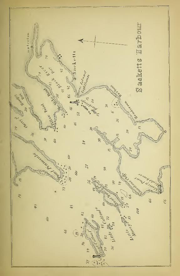
SACKETT'S HAEBOUR
I have not visited this Harbour, and I have experienced some difficulty in obtaining
authentic information respecting it ; that which is here given, however, can be relied
upon.
It is not a port of so much importance in a mercantile point of view as many others,
although, from the great depth of water in the bay, its secure and sheltered position,
and tolerably easy access, it should be ranked amongst the best on the Lake. Theserecommendations, together with its capabilities of being strongly fortified, have induced
the Government of the United states to make it their Naval Depot or Arsenal.
SITUATION.
It is situated on the south shore of Black River Bay, an arm of the Lake running;
several miles inland, having point Peninsula bearing W. by N. about nine miles, Great
Stoney Island and Great Galloo Island, bearing W. by S. eleven and fifteen miles
respectively.
LIGHTHOUSE.
The lighthouse is built on a rock called Horse Island, at the South-Western point of
Black River Bay, one and a half miles W. of the Harbour ; it has a good fixed bright
light. The lighthouse on the Galloo Island is at its S. W. end, bearing W. by S. f S.^
distant 21 miles.
18 HAREOURS AND PORTS
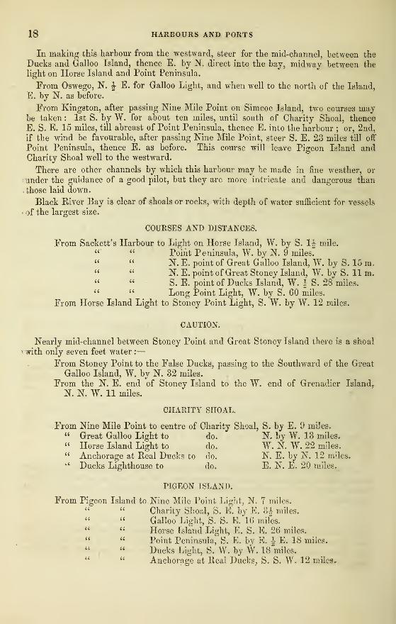
In making this harbour from the westward, steer for the mid-channel, between the
Ducks and Galloo Island, thence E. by N. direct into the bay, midway between the
light on Horse Island and Point Peninsula.
From Oswego, N. J E. for Galloo Light, and when well to the north of the Island,
E. by N. as before.
From Kingston, after passing Nine Mile Point on Simcoe Island, two courses maybe taken : 1st S. by W. for about ten miles, until south of Charity Shoal, thence
E. S. E. 15 miles, till abreast of Point Peninsula, thence E. into the harbour ; or, 2nd,
if the wind be favourable, after passing Nine Mile Point, steer S. E. 23 miles till off
Point Peninsula, thence E. as before. This course will leave Pigeon Island andCharity Shoal well to the westward.
There are other channels by which this harbour may be made in fine weather, or
under the guidance of a good pilot, but they are more intricate and dangerous than
those laid down.
Black River Bay is clear of shoals or rocks, with depth of water sufficient for vessels
of the largest size.
COURSES AND DISTANCES.
From Sackett's Harbour to Light on Horse Island, W. by S. 1J mile." " Point Peninsula, W. by N. 9 miles." " N. E. point of Great Galloo Island, W. by S. 15 m," " N. E. point of Great Stoney Island, W. by S. 11 m." " S. E. point of Ducks Island, W. J S. 28 miles." " Long Point Light, W. by S. 60 miles.
From Horse Island Light to Stoney Point Light, S. W. by W. 12 miles.
CAUTION.
Nearly mid-channel between Stoney Point and Great Stoney Island there is a shoal
with only seven feet water :
—
From Stoney Point to the False Ducks, passing to the Southward of the Great
Galloo Island, W. by N. 32 miles.
From the N. E. end of Stoney Island to the W. end of Grenadier Island?
N. N. W. 11 miles.
CHARITY SHOAL.
From Nine Mile Point to centre of Charity Shoal, S. by E. 9 miles.
" Great Galloo Light to do. ' N. by W. 13 miles.
" Horse Island Light to do. W. N. W. 22 miles.
" Anchorage at Real Ducks to do. N. E. by N. 12 miles,*' Ducks Lighthouse to do. E. N. E. 20 miles.
PIGEON ISLAND.
From Pigeon Island to Nine Mile Point Light, N. 7 miles.
Charity Shoal, S. E. by E. 3|- miles.
Galloo Light, S. S. E. 16 miles." " Horse Island Light, E. S. E. 26 miles." " Point Peninsula, S. E. by E. J E. 18 miles.
" Ducks Light, S. W. by W. 18 miles." " Anchorage at Real Ducks, S. S. W. 12 miles.
ON LAKE ONTARIO. 19
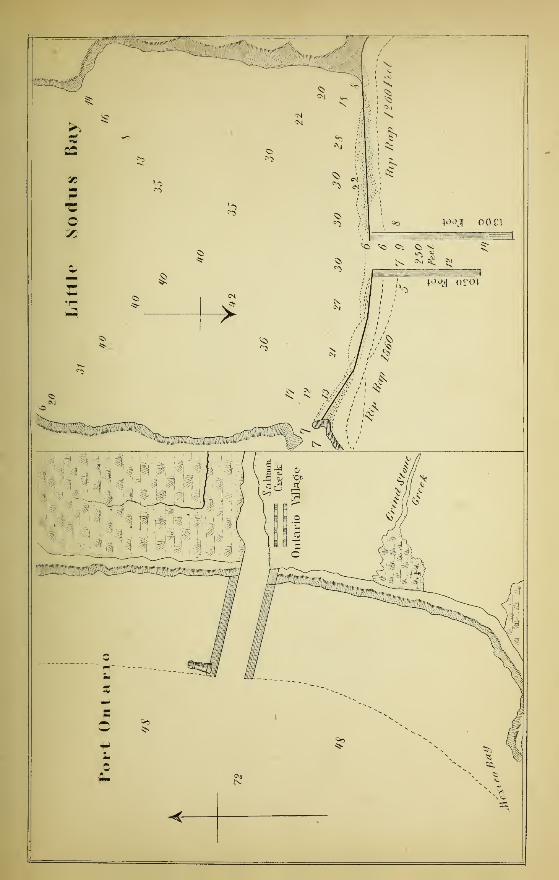
PORT ONTARIO.
Twenty miles N. E. by E. of Oswego, and N. of Mexico Bay, is Port Ontario onSalmon Creek, a place of no considerable importance, yet possessed of a good harbour,which is entered between piers running W. 1ST. W. a considerable distance into theLake.
LIGHT.
The Lighthouse is on the N. pier end, is 52 feet high, having a fixed bright light.
The land both north and south of it is very low, and cannot be seen at any greatdistance ; there is, however, good depth of water in every direction.
I have not been into this port, and have been unable to obtain reliable informationas to the soundings inside the harbour.
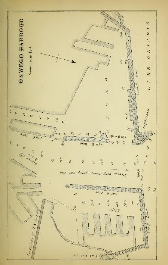
OSWEGO HARBOUR.
This excellent Port is in a great measure reclaimed from the Lake by skilful
engineering, and at an enormous expense. It is situated at the mouth of the OswegoRiver, and protected from the heavy seas caused by westerly and north-west gales bywalls of solid masonry.
Capacious as are the basins, slips, and other parts of the harbour, they are even nowbarely sufficient for the accommodation of the numerous steamers, propellers, andschooners, which bring their valuable cargoes from all parts of the Upper Lakes to this
busy and prosperous city.
The enterprising merchants and citizens of Oswego, aware of the insufficient
accommodation afforded to the shipping visiting their port, are now engaged in devising
plans for the enlargement and improvement of this important harbour : amongst these
may be mentioned
—
1st. The construction of a pier from a point 1 J miles west, to a point north of the
lighthouse, 800 or 1,000 feet in the Lake.
2nd. A similar harbour east of the river and north of the Fort.
3rd. The construction of a lock to admit vessels into the pond above the dam, 500feet wide, and one mile long.
The river Oswego has its source very near the head of the Mohawk ; it passes
through Lake Oneida, and in its course to Lake Ontario receives the Seneca River,
besides the waters of several less streams and many small lakes. The waters from
tfcese in the spring and fall of the year so greatly swell and increase its current, that
sailing vessels are unable to stem it, except when favoured by a strong northerly breeze.
To obviate this difficulty, numerous small but powerful tug boats are constantly
plying about the mouth of the harbour, and when a large and heavily laden schooner
comes within a mile or so of the port, they run out, seize upon their helpless prey, andconduct it alongside the wharf or warehouse to which it may be consigned, with as
much ease and precision as a carriage can be driven up to a street door.
20 PORTS AND HARBOURS
There are no rocks or shoals to be feared in approaching this port ; the only-
dangers consist in the very heavy sea, which rolls into the harbour during a westerly
blow, and the want of room to manoeuvre or work a vessel when inside.
LIGHTHOUSE.
The lighthouse is built on the west pierris 32 feet high, and has a very good bright
fixed light.
COMPASS.
When within twenty miles East or West of Oswego, allow 1° or 1° 30' West for
variation of compass.
COURSES AND DISTANCES.
From Oswego to Kingston :—Due N. will take inside Real Ducks to Nine Mile
Point on Simcoe Island, which has a fixed light, 56 miles.
N. by W., which is the best course, will take to the light of False Ducksf
40 miles, then N. E. \ E. for Kingston Harbour, 30 miles.*
From Oswego to Big Sodus Bay, W. S. W. \ S. 32 miles.4i Genesee River, W. by S. J S. 66 miles." Port Dalhousie, W. till abreast of Thirty Mile Creek, thea
S. S. W. 164 miles." Toronto, W. J N. 172 miles." Cobourg, W. N. W. 105 miles." Long Point, N. W. J W. 48 miles.
LITTLE SODUS BAY.
About sixteen miles S. W. of Oswego is Little Sodus, an inlet or bay of considerable
extent, and with depth of water sufficient for the largest class vessels that sail on the
Lakes. Unfortunately, however, the water in the channel does not exceed an average
of six feet, so that this otherwise secure basin is almost useless.
The entrance is between piers 250 feet apart, run out 1300 feet in the Lake, into
fourteen feet water. The depth of water inside the bay ranges from twenty-five feet
to forty feet. There is no lighthouse.
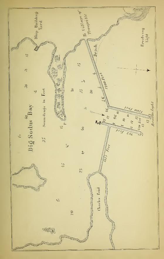
BIG SODUS BAY-
Thirty-two miles W. S. W. J S. of Oswego, and thirty-six miles E. JN. of GeneseeRiver is Big Sodus Bay, the most capacious and best harbour on the south shore of
Lake Ontario.
It is entered from the Lake by a channel 470 feet wide, between piers which extend
out into thirteen feet water.
* In the daytime, when steering for the False Ducks, the high bushy land of South Bay Point will b©seen before the lighthouse, but at night, the light "will be visible first.
ON LAKE ONTARIO. 21
HARBOUR LIGHT.
The pier on the W. side is 1,200 feet long, and has on its northern extremity a fixed
bright beacon light; that on the E. is nearly 1,000 feet long.
The average depth of water in mid-channel is ten feet, but immediately on entering
the bay, the depth increases from twenty-five to 40 feet, with good holding ground.
Should the wind blow heavily from the northward, round the wooded and bushy spit
marked P. in the Chart, and anchor where indicated ; here the vessel is protected from
^very wind or sea.
LIGHTHOUSE.
The lighthouse, which is 66 feet high, is built on a hill about three-quarters of a
mile due W. of the beacon light on the pier end. It is a good revolving light easily
seen ten or twelve miles in the Lake.
This picturesque and fine harbour runs south or into the land for about six miles,
and in its widest part is upwards of three miles. It is but little frequented, being used
principally for ship-building purposes ; the timber, however, is nearly exhausted.
Several small islands are situated at the upper or S. end of the bay, and a village,
where provisions can be obtained, is reached by following the crib-work on the west
side towards the lighthouse.
CURRENT,
A strong current sets out of the bay about 2J knots.
COURSES.
Brown's Point bears W. by N. 8 miles, and Nine-mile Point (west of Oswego)E. N. E. J N. 23 miles.
Note.—This port cannot be mistaken at night, as it has the only revolving light
between Port Dalhousie and Oswego.
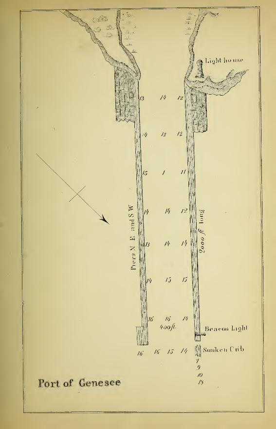
GENESEE RIVER.
The port of Genesee, leading to the City of Rochester, is situated on the W. side ofthe emboucheur of the Genesee River.
It is protected from the violence of the Lake gales by piers about 2,000 feet long,
running N. E. and S. W. into the Lake, and 400 feet apart. The river is narrow andtortuous, rendering it difficult to beat up ; but the wharves, when once reached, afford
«every accommodation and shelter.
LIGHTS.
The beacon light is on the end of the W. pier ; the range or main lighthouse is 83feet high, and built on the hill side ; these must be brought in line to shew thedirection of the west pier. Both these lights are bright and stationary.
In making this port from the westward, bring the pier light to bear S. S. E., and inrunning into the harbour, keep the pier light a little more than a vessel's length to theeastward of the lighthouse.
22 HARBOURS AND PORTS
DANGER.
About twenty feet off the end of the W. pier there are some piles and a sunken crib,
which must be given a wide berth.
Note.—In Owen's and Herbert's Charts, a shoal having only eight feet of water is
laid down, midway between Braddock's Point and the pier ends. This supposed dangerhas no existence, there being plenty of water everywhere to within a short distance ofthe shore.
COURSES AND DISTANCES.
From Genesee River to Presqu' Isle, N. J W. 60 miles." " Mid-channel between Real and False Ducks, N. E. 75 m." " Galloo Island Lighthouse, N. E \ E. 87 miles." " Oswego E. by N. \ N. 66 miles." " Braddock's Point, N. W. by W. 10 miles.
From Braddock's Point to Port Dalhousie, first W. by N. till opposite OakOrchard Creek, then W. by S. 90 miles.
" " Toronto, W. by N. J W., 110 miles." " Cobourg, N. W. by N. 67 miles.
COMPASS.
When off Rochester, allow 1° for variation of compass.
OAK ORCHARD CREEK.
From the mouth of the Genesee River to the mouth of the Niagara River, there is
not a port or harbour where a vessel drawing six feet or upwards can enter, the only
boat harbour being Oak Orchard Creek, 35 miles W. of Rochester, and 52 miles E. of
Niagara.
The entrance to this Creek is between two piers running N. and S. into 6 feet 6 in.
water, and 160 feet wide. The west pier is 844 feet long, the east 734 feet j the basin
or pond within has plenty of water and is well secured.
There is no lighthouse or wharf light.
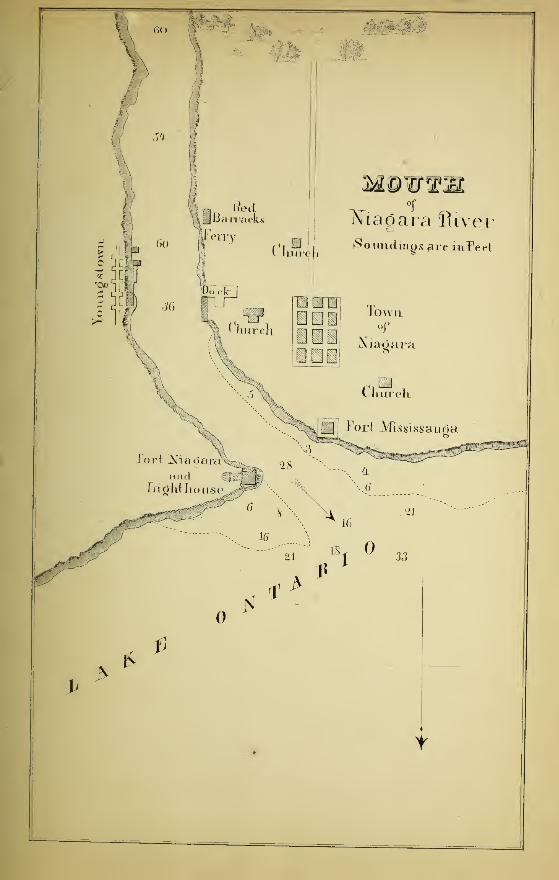
NIAGARA RIVER,
The waters from all the Upper Lakes, after coming over the falls of Niagara,,
descend the river for about seven miles in a rapid and turbulent manner as far as*
Queenston ; the stream there becomes wider and deeper, and admits of free navigation
for vessels of any size, until it empties itself into Lake Ontario, at a point S. E. by S.
of Toronto, 87 miles W. of the Genesee, and 12 miles to, the eastward of Port
Dalhousie. ^
ON LAKE ONTARIO. 23
At its mouth this river is about 1000 yards across, with from 20 to 40 feet water,
and consequently it affords an easy entrance for shelter, and good anchorage during a
storm.
The town of Niagara is a mile S. of Fort Mississauga, on its W. bank, where there
are extensive wharves ; and the village of Youngstown, which is nearly opposite
Niagara on the east side has also good wharves and accommodation for shipping.
LIGHTHOUSE.
The lighthouse is 78 feet high, and placed on the top of Fort Niagara, which is
built on the E. side of the mouth of the river. It has a bright stationary light, which
can be seen ten or twelve miles off.
On entering this river, keep near its centre, and bring Fort Niagara to bear
S. E. by E. When TV. or W. by S. of the Fort, the shores become bold, and may be
approached to within a short distance, especially on the E. side.
With a northerly wind meeting the current, there is a short chopping sea on the bar.
DANGERS.
Extending into the Lake for about a mile N. W. of Fort Niagara is a shoal with
only six feet of water on it, and under Fort Mississauga on the TV. bank there is
another shoal, extending E. N. and N. W.
COURSES AND DISTANCES.
From Niagara River to Port Dalhousie, TV. by S. 12 miles.
" " Burlington Canal, W. § N. 42 miles." " Oakville, W. N. TV. 38 miles." " Toronto, N. TV. by N. 35 miles." " Cobourg, N. E. 80 miles.« " Long Point, E. N. E. 126 miles." " Mid Channel between Real and False Ducks, E. N. E.
IE.
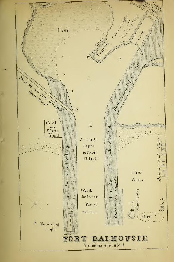
PORT DALHOUSIE,
To sailing vessels, this is without doubt the most important Port on the Lake. Everyvessel bound to or from the Upper Lakes is obliged to pass through the WellandCanal, and consequently to enter or leave this Port. It has the advantage of beingeasily made in any weather, and with any wind.
LIGHTHOUSE.
It is furnished with an excellent Lighthouse, built on the end of the east pier,containing a revolving bright light.
There are no shoals or dangers of any kind to be feared in approaching PortDalhousie
;the only caution requisite for a sailor, is to guard against standing inside
24 HARBOURS AND PORTS
the range of the West Pier in working in, as between it and the remains of an oldwharf there are two rocks and a shoal (all below water) on which he would put hisvessel ashore. The piers run N. and S. to the bend, thence to the lock N. E. andS. W. ; they are about 3,000 feet long, 200 feet apart, with an average depth of 12feet water. The basin or pond to the east of the steam-boat landing is too shoal to beof any service, and it reflects no little discredit upon the Commissioners for allowingso much valuable space to be lost, when at a comparatively small cost the capacity ofthis important port could be so greatly improved.
It has been told me as a fact, that between three and four miles N. or N. by W. ofthe lighthouse, the compass dips, and for a short time becomes so disturbed as not tobe relied upon. I have not been able to verify this, but shall feel much obliged to anyof the Captains frequenting this Port, communicating to me the result of their
experience.
COURSES AND DISTANCES.
From Port Dalhousie to Burlington Canal, W. f N. 32 miles." Oakville, N. W. by N. 32 miles." Toronto, N. by W. 33 miles.
" " Whitby, N. 2*. E. 55 miles.
" " Long Point, E. N. E. 136 miles." " Mid-channel between Real and False Ducks, E. by" " i N. 174 miles.
" " Niagara River, E. by N. 12 miles." " Devil's Nose, E. by N. J N.
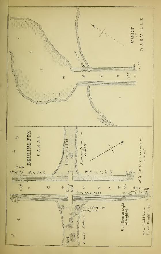
PORT OF HAMILTON & BURLINGTON CANAL,
The Port of Hamilton occupies the extreme Western end or head of Lake Ontario
;
it is separated from the Lake by a long low ridge of sand and gravel, resembling the
Peninsula opposite Toronto. This ridge stretches across from the northern to the
Southern Shore in a S. S. E. direction, converting that portion which is to the westinto a large bay, called Burlington Bay, the entrance to which is by means of a Canalupwards of half a mile long, with an average width of 200 feet.
Unlike most canals, or piers entering a harbour, the width is not uniform, the
entrance from the Lake being its widest part, that into Burlington Bay its narrowest
;
the former is 225 feet wide, the latter 130 ; while at the ferry (or about its centre) it
is 150 feet across. During the year 1856 several alterations and repairs have beenmade. Additional crib-work has been added to the eastern or Lake extremity of the
South Pier, 300 feet in length, and considerably higher than the old work. Instead of
following the old line, or N. E. J E., the new part runs a more northerly course, or
nearly N. E. by N., which has had the effect of making the entrance still more difficult
than it was before, particularly when the wind is strong from the east or south.
I have heard from persons residing on the spot, that it is next to impossible for
sailing vessels to enter this canal during a gale from the E. or S. E. without coming in
contact with the end of the north pier, whereby the weaker of the two is likely to be
-seriously damaged; to obviate this catastrophe, however, several oak piles have been
ON LAKE ONTARIO. 25
driven into the bottom, which serve the purpose of a fender, and materially lessen the
concussion that would otherwise take place.
The same wise arrangement has been made at the opening into the bay, except that
the new work is added to the north pier, and the fenders to the south.
The old lighthouse which stood near the centre of the canal on the isthmus wasdestroyed by fire, and a new one has been erected on the east end of the south pier,
with a stationary bright light, the old beacon light not being used.
The depth of water at the entrance from the Lake is variable, owing to a deposit
taking place during an easterly or south-east blow ; it is, however, never less than
eleven feet.
Burlington Bay is upwards of five miles long, and about three miles wide, with fromtwenty to forty feet of water, except near its edges. There is good holding groundimmediately inside the canal.
COURSES AND DISTANCES.
From the Canal to Toronto, N. E. 35 miles." " Whitby, N. E. \ E. 70 miles." " Niagara River, E. J S. 42 miles." " Port Dalhousie, E. I S. 32 miles.
OAKVILLE
The Port of Oakville is 22 miles W. \ S. of Toronto, and 14 miles N. E. by N. oi
Burlington Canal.
The piers, which are about 100 feet apart, run nearly N. and S. in the Lake, into
twelve feet water. Within there is a basin, which if properly dredged would afford
excellent shelter and accommodation to a large number of vessels. As it now exists,
there is little more than a channel by which schooners of 200 tons are enabled to run
up to the storehouse to load or unload.
LIGHTHOUSE.
The lighthouse is built on the East Pier ; although forty feet high, it is so bad as to
be scarcely visible six or seven miles in the Lake.
DANGERS.
Between this port and Port Credit there is a shoal, and numerous large boulders
extend a considerable distance out from the shore, which should not be approachednearer than a mile.
COURSES AND DISTANCES.
From Oakville to Toronto, N. E. \ E. 22 miles." Burlington Canal, S. W. by S. 14 miles." Port Dalhousie, S. E. by S. 32 miles." Niagara, E. N. E. 40 miles.
Devil's Nose, E. \ S. 100 miles." Long Point, E. by N. 155 miles.
26 HARBOURS AND PORTS
PORT CREDIT.
This port resembles Oakville in its construction, the piers being run out into deep
water; the pond or basin within is large, and would accommodate a large fleet of
schooners ; the want of a dredge, however, renders it almost useless. This port is 12miles S. W. by W. of Toronto, and 10 miles N. E. by N. of Oakville.
LIGHTHOUSE.
The lighthouse is on the E. pier, low and bad, and not even lighted with that
regularity which the safety of vessels trading to the port absolutely demands.
WELLINGTON SQUARE, AND NELSON OR BRONTE.
These small ports are situated between Oakville and the Burlington Canal. Their
wharves run out into ten feet water, but from their exposed situation, except when the
wind is off shore, they are rarely visited, except by the smallest class of coasting
vessels.
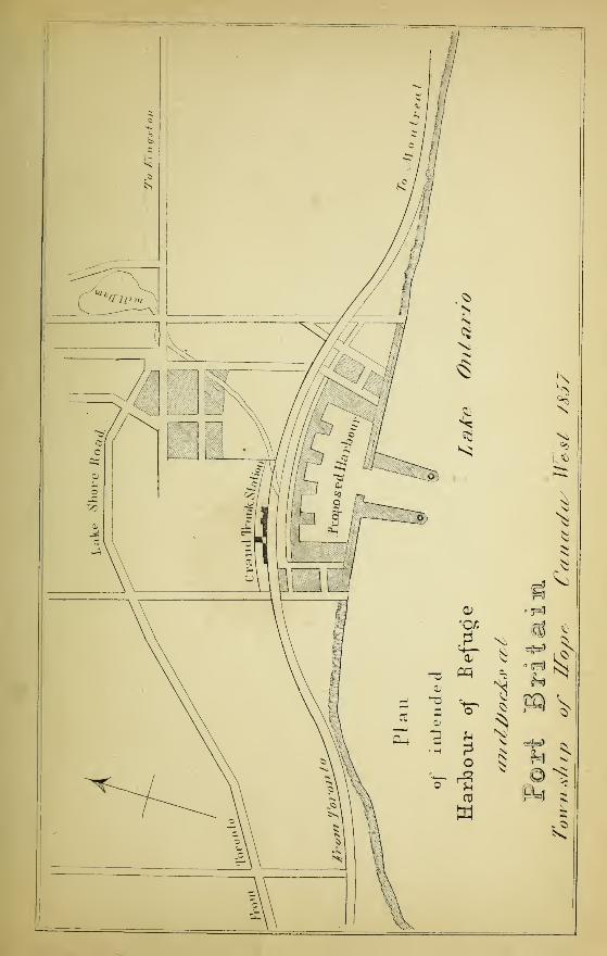
PORT BRITAIN
Having been favoured by J. Morrell, Esq., the President of the Port Britain
Harbour Company, with a detailed account of the works now in progress, and having
received a copy of the Report, drawn up by E. G. O'Brien, Esq., and Captain
Weatherley, for the President and Directors of the Company, it affords me great
pleasure to be able to lay before the public an authentic account of this excellent
Harbour of Refuge.
I am also indebted to Messrs. Armstrong, Hime, and Beere, for an excellent
Photographic Plan of the Harbour, of which I have availed myself.
Port Britain is situated in the centre of the Township of Hope, in the County of
Durham, about sixty miles to the eastward of Toronto, four miles west of Port Hope,and nearly opposite the City of Rochester.
The great advantages to be derived from this Harbour, will arise from the splendid
anchorage afforded by a blue clay bottom, entirely free of boulders, which is not to beattained to the eastward of this port, and which under any extremity will form a safe
and secure refuge for all vessels navigating the Lake, protected as it is by the bluffs
both to the eastern and western limits of the harbour, and will thus form a shelter for
any vessel, in the almost impossible event of her inability to obtain the shelter of the
piers or harbour itself.
ON LAKE ONTARIO. 27
The Inner Harbour will be formed by the natural basin, having an area of about 15
acres, with 12 feet depth of water ; and the Outer Harbour will be formed by piers
extending about 700 feet from the shore into the Lake, 300 feet apart at the entrance,
with 14 feet depth of water, enclosing a surface of six acres, and thus available to
vessels of any draught navigating the Lakes. There will also be lights on both pier
ends.
The progress of these works has been so rapid, that the outer harbour will be
accessible to vessels by the middle of June, and I am informed that a portion of the
inner harbour will be completed so as to afford every accommodation to shipping for
the fall trade.
It is not, however, the intention of the Company to complete the whole of the inner
harbour immediately, their principal object being to ensure a secure Harbour of
Refuge, extensive enough to meet the present exigencies of commeree, leaving the
completion of the work, until such time as the rapidly increasing trade of the country
may require.
Extracts from the Report of E. G. O'Brien, Esq., and Captain Weatlierley.
"I first directed my attention to the anchoring ground, both outside and within the
intended basin, good holding ground being essential to a harbour of refuge, andwithout which no place can be safely used as a trading port. This condition of a goodharbour I found fulfilled more satisfactorily than I anticipated. * * *
* * The bottom, both outside and within, as it will be when cleaned out
to a depth of about fifteen feet, is a clay, and as far as I could ascertain, free from
boulders, making the best holding ground possible. The construction of the harbour,
as shewn by the plans, I consider preferable to any of the artificial ports which I have
Been ; being not only more safe, but much larger than any other on that part of the
coast of Lake Ontario. Opening wide east and west within, it allows the entrance
between the piers extending south into the Lake to be made more direct and wider
than would otherwise be safe ; and again, the piers protecting this entrance, diverging
from each other as they approach the inner harbour, give the wave rolling in, room to
spread, and thereby lessen its force.
For all commercial purposes, it possesses the great advantage of ample room for
wharves, stores, ship-yards, or lumber-yards, with the Grand Trunk Railroadrunning along its entire length, and accessible at all points.
The whole is surrounded by an amphitheatre of rising ground, at such a distance as
to allow the freest circulation of air, and at the same time afford sufficient protection
from westerly, northerly, and easterly winds."
EXTRACTFROM
" AN ACT TO COMPEL VESSELS TO CARRY A LIGHT DURING THE NIGHTAND TO MAKE SUNDRY PROVISIONS T<
OF THE WATERS OF THIS PROVINCE/ 7
MAKE SUNDRY PROVISIONS TO REGULATE THE NAVIGATION
14 & 15 Victoria, CnAr. 126.
Passed, August, 1851.
1. * * * * * * And it is hereby enacted by the authority of the
same, That all Steamboats, whether propelled wholly or in part by steam, while navigating the
waters of Upper Canada, shall be provided during the night with lights, to be exhibited andaffixed as follows :
—
When under weigh—a white light on flag-staff aft, a bright white light on the foremast heada green light on the starboard bow, a red light on the port bow, to be fitted with inboard screens.
When at anchor, a common bright light at foremast head, as illustrated and explained in the
Schedule A.
That Schooners and other sailing vessels shall be provided during the night with lights, to beexhibited and affixed as follows :
—
When sailing before the wind, a pale light, ~)
When sailing on the starboard tack, a red light, V on the Pawl bit, or Knight head.
When sailing on the larboard tack, a green light,)
When at anchor, a pale light in the foremast rigging.
Sailing Vessels running before the wind, or with the wind free, and making a Steamer's
light dead a-head, shall pass on the starboard side ; but if to avoid jibing their mainsail, or for
any other good reason, they shall wish to pass on the larboard side, then shall show their green
light, indicating that they are on the larboard tack, when the Steamer will pass under the
Vessel's stern.
In case of two Sailing Vessels approaching one another on opposite tacks, the vessel on the
starboard tack shall keep the wind, and the one on the larboard tack shall keep away, always
when tacking ship at night, shifting the light.
A Vessel in distress shall show both red and green lights.
2. And be it enacted, That any such Steamboat, Schooner, or Vessel as aforesaid, shall beprovided with a Fog Horn or a Bell, of a weight not less than twenty pounds, which it shall bethe duty of the Master, or person commanding such Steamboat, Schoone^ or Vessel, under the
penalty in the seventh section of the said recited Act contained, to cause to be sounded or rungat regular intervals of not less than five minutes at a time, with an intermission of two minutes,
during the time that any such steamboat, schooner, or other vessel as aforesaid shall be in a fog.
11. And be it enacted, That if any damage to any person or property shall be sustained in
consequence of the non-observance of any of the provisions contained in this Act, the same shall
in all Courts of Justice be deemed, in the absence of proof to the contrary, to have been caused
by the wilful default of the Master or other person having charge of such Steamboat, Schooner,
or other vessel as aforsaid; and the owner thereof in all civil proceedings, and such Master or
other person in all proceedings, whether civil or criminal, shall be subject to the legal conse-
quences of such default.
30 EXTRACT FROM NAVIGATION ACT.
12. And be it enacted, That the penalties imposed by this Act maybe sued for by information
or action of debt, in the name of Her Majesty, in any Court of Record of competent jurisdiction,
and one-half of such penalty shall be paid to the informer.
SCHEDULE A.
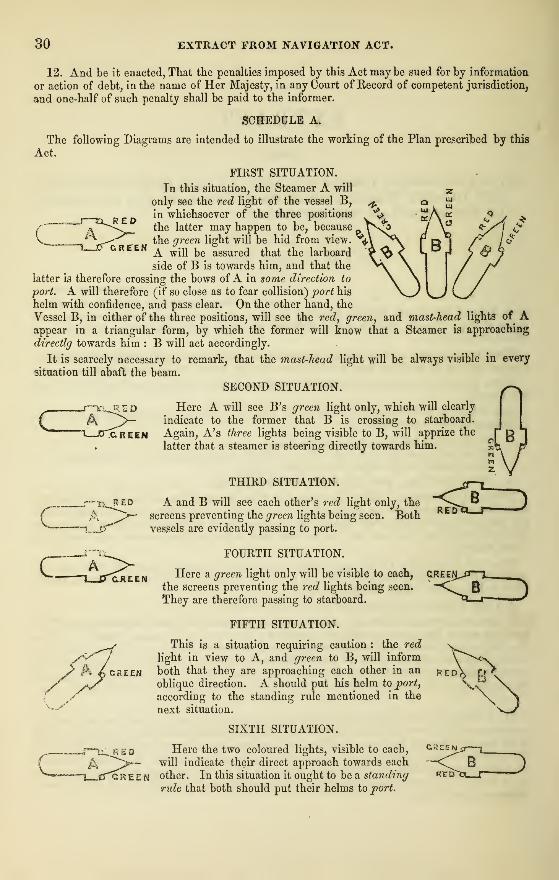
The following Diagrams are intended to illustrate the working of the Plan prescribed by this
Act.
FIRST SITUATION.
L_ ARED
GREEN
In this situation, the Steamer A will
only see the red light of the vessel B,
in whichsoever of the three positions
the latter may happen to be, because
the green light will be hid from view.
A will be assured that the larboard
side of B is towards him, and that the
latter is therefore crossing the bows ofA in some direction to
port. A will therefore (if so close as to fear collision) port his
helm with confidence, and pass clear. On the other hand, the
Vessel B, in either of the three positions, will see the red, green, and mast-head lights of Aappear in a triangular form, by which the former will know that a Steamer is approaching
directlg towards him : B will act accordingly.
It is scarcely necessary to remark, that the mast-head light will be always visible in every
situation till abaft the beam.
SECOND SITUATION.
Here A will see B's green light only, which will clearly
indicate to the former that B is crossing to starboard.
Again, A's three lights being visible to B, will apprize the
latter that a steamer is steering directly towards him.
G.KEEN
A CRZZH
THIRD SITUATION.
A and B will see each other's red light only, the
screens preventing the green lights being seen. Bothvessels are evidently passing to port.
FOURTH SITUATION.
Here a green light only will be visible to each,
the screens preventing the red lights being seen.
They are therefore passing to starboard.
FIFTH SITUATION.
This is a situation requiring caution : the red
light in view to A, and green to B, will inform
both that they are approaching each other in an
oblique direction. A should put his helm to port,
according to the standing rule mentioned in the
next situation.
SIXTH SITUATION.
§B
RED
CREE
B
RED
REO Here the two coloured lights, visible to each,
^ ^>—- will indicate their direct approach towards each
green other. In this situation it ought to be a standing
rule that both should put their helms to port.
GREEN
ROYAL HUMANE SOCIETY'S DIRECTIONS
FOR THE
REOCYERY OF THE APPARENTLY DROWNED.
CAUTIONS.
Avoid all rough usage.—Never hold the body up by the feet.
—
Nor roll the body on casks.—-
Nor rub the body with salt or spirits.—Nor inject tobacco smoke or infusion of tobacco.
METHODS OF TREATMENT.
1. Support the body carefully, with the head and shoulders in a raised position.
2. Strip the body, and rub it dry; then wrap it in hot blankets, and place it in a. warm bed.
3. Wipe and cleanse the mouth and nostrils.
4. In order to restore the natural warmth of the body: Move a heated covered warming panover the back and spine.—Put bladders or bottles of hot water or heated bricks to the pit of the
stomach, the arm pits, between the thighs, and to the soles of the feet.—Foment the body with
hot ilanuels ; but, if possible,—Immerse the body in a warm bath as hot as the hand can bear
without pain, as this is preferable to the other means for restoring warmth.—Rub the bodybriskly with the hand ; do not, however, suspend the use of the other means at the same time.
5. Apply sal volatile or hortshorn to the nostrils ; if the power of swallowing be returned,
small quantities of warm wine or weak brandy and water may be given ; the patient should be
kept in bed, and a disposition to sleep encouraged. Great care is requisite to maintain the
restored vital actions, and at the same time to prevent undue excitement. The treatment is to
be persevered in for three or four hours. It is an erroneous opinion, that persons are irrecover-
able because life does not soon make its appearance.
MaCLEAR, THOMAS & CO., PRINTERS, KING STREET EAST, TORONTO.
h
<©•-
'-•-«i


TIaivboiir Ocmrpairys'
Properly
bfa
For! Patiiia©to a


* fl
esnoi^a^o^
F^F^m^^sj Ink,


/* /2
12 n
15 / //
ft / /2
13 ft Ik
ft 15 15
'CO
1^
ft
ft
Cm
16 ft ft
tfoofb Beacon Light
16 * I* " l^^enCTib
Port of Genesee
7
910
ft

$>

Sounclniri aremTeet


TRIP BOOKS.
MALLEAR & 00. have on hand a supply of Trip Books, of approved form, suitable f<
Schooners, &c.
ABSTRACT BOOKSFor fehe use of Steamers and other Graft sailing on the Lakes. These Books are admirably
adapted to the purposes for which they are intended.
CHARTS.Charts of Lake Ontario and Lake Huron, from Bayfield's, Owen's, and Herbert's Survey:
STATIONERY.A complete assortment of Writing Papers, and every article in that line, («» meet the
requirements of the public. Forwarders' Books furnished in every style at short notice,
N. B.—Patterns always kept.
MAOLEAE & CO.,
16, King Street East, Toronto.