Symeogmbh White Paper Container Terminals
12
SYMEO_White Paper Container Terminal_EN.doc Page 1 of 12 White Paper New Technologies for Vehicle Position Detection in Container Terminals Integrating multiple technologies and measuring methods helps optimize the availability and the precision of position detection Whether by sea, by rail, or on the road — to a large extent, goods moved worldwide travel in containers. Container terminals form the hubs of national and international trade. Operators, logistics providers, manufacturers, trading companies, and customers depend on efficient, robust container handling processes. Advanced terminal operating systems (TOS) lay the base for these. However, to enable correct and transparent mapping of the goods’ movements and storage locations in software, as consistent position detection of the containers as possible across the entire terminal is needed 7 days a week and 24 hours a day. Several technologies have established themselves in container terminals for this purpose that determine the containers’ storage locations and movements indirectly by means of position detection of the transporting vehicles such as straddle carriers, container handlers, reach stackers, or terminal tractors. Comparatively fragile optical systems (rotating laser measurement) are today being superseded by considerably more rugged und versatile GPS and microwave systems. A further trend is that modern systems combine and integrate multiple technologies in order to optimize the accuracy and availability of position detection under the specific surroundings and process conditions found at container terminals. Although varying technologies are used for position detection depending on the given situation and surrounding conditions, a prerequisite is that in no case this will lead to any problems with integration into the higher level TOS used in terminals. Therefore, absolute position data are transmitted in standardized formats and across standard interfaces irrespective of the particular measuring method used. Following, key requirements for position detection in container terminals are described and it is exemplified how different measuring methods can be combined to form a state-of-the-art system solution.
Transcript of Symeogmbh White Paper Container Terminals

SYMEO_White Paper Container Terminal_EN.doc Page 1 of 12
White Paper
New Technologies for Vehicle Position Detection in Container Terminals Integrating multiple technologies and measuring methods helps optimize the availability and the precision of position detection
Whether by sea, by rail, or on the road — to a large extent, goods moved worldwide travel in containers. Container terminals form the hubs of national and international trade. Operators, logistics providers, manufacturers, trading companies, and customers depend on efficient, robust container handling processes.
Advanced terminal operating systems (TOS) lay the base for these. However, to enable correct and transparent mapping of the goods’ movements and storage locations in software, as consistent position detection of the containers as possible across the entire terminal is needed 7 days a week and 24 hours a day. Several technologies have established themselves in container terminals for this purpose that determine the containers’ storage locations and movements indirectly by means of position detection of the transporting vehicles such as straddle carriers, container handlers, reach stackers, or terminal tractors.
Comparatively fragile optical systems (rotating laser measurement) are today being superseded by considerably more rugged und versatile GPS and microwave systems. A further trend is that modern systems combine and integrate multiple technologies in order to optimize the accuracy and availability of position detection under the specific surroundings and process conditions found at container terminals. Although varying technologies are used for position detection depending on the given situation and surrounding conditions, a prerequisite is that in no case this will lead to any problems with integration into the higher level TOS used in terminals. Therefore, absolute position data are transmitted in standardized formats and across standard interfaces irrespective of the particular measuring method used.
Following, key requirements for position detection in container terminals are described and it is exemplified how different measuring methods can be combined to form a state-of-the-art system solution.

SYMEO_White Paper Container Terminal_EN.doc Page 2 of 12
1 Requirements for Position Detection in Container Terminals Position detection in container terminals makes specific demands on the design of the solutions to be employed.
- Robust, maintenance free and non wearing Measuring systems mounted on vehicles in container terminals are exposed to extreme strain. Here, hostile weather conditions for electronics in open air storage facilities should be mentioned first: heat, cold, rain, mist, and dust. Add to that vibration, intense in many cases, whenever containers and vehicles are moved. Accordingly, high requirements apply to protection standards for casings and systems. Measuring methods must prove insensitive to disturbing influences. For radio based methods, the broad spectrum and intensive use of highly diverse communication equipment found in sea ports might be mentioned here as an example. Radio based systems should for example not operate within the 2.4 GHz band, which is covered by the 802.11 standard and is widely used for wireless network (WLAN) communication. In many container terminals, work continues 24/7 — that is, around the clock. Down times for maintenance and repair are hardly acceptable. Therefore, position detection systems must operate continuously without any wear or need for maintenance.
- Seamless position detection Logistics processes and the enormous volume of goods movements in container terminals make consistent detection of all vehicle and container movements a must. In order to ensure this continuously over time, real time detection and transfer of position data is standard today. The reason is that each and every delay will reduce transparency at the control center and lead to errors and inefficiencies within the logistics processes. From a technical view, detection over the whole terminal area proves to be considerably more difficult. In many cases, container terminals stretch across huge areas, possibly intersected by other spaces, that have to be covered completely and at the same time cost-effectively by the measuring systems. Local “shadowing” for example by highly stacked containers, gantry cranes, other crane equipment, buildings, or ships constitute additional challenges. For the reason that systems based on lasers, radio waves, and GPS require an uninterrupted line of “sight”, additional sensor equipment has to be installed for precise measurements in shadowed areas.
- Measuring accuracy
Accuracy requirements in the container terminal area are rather moderate compared to other applications in the field of position detection: In most cases, a measuring accuracy of ±50 cm will suffice to guarantee exact tracing of container movements. This facilitates combining different measuring methods, so to be able to leverage redundancies and guarantee higher availability levels.

SYMEO_White Paper Container Terminal_EN.doc Page 3 of 12
- Scalability
In order to future-proof position detection investments, the systems employed for this purpose should be scalable. On one hand, this means that the systems should not be subject to range constraints or else the system’s coverage should be extensible rapidly and with little effort. On the other hand, this also implies the ability to measure the movements and positions of the largest possible number of different vehicles consistently, simultaneously, and independently of each other. Moreover, a further scalability requirement is increasingly gaining centre stage: The systems should be combinable with other technologies and sensor equipment. Reasons are firstly to be able to integrate additional functionality and secondly to facilitate migration to future technologies.
- Versatile mountability Special purpose vehicles of very different kinds are used to move the containers in the terminal. Position detection of containers takes place indirectly by means of the vehicle movements; therefore, antennas, sensors, electronics, and computer modules should be mountable on the vehicles in a flexible way. This is an often neglected requirement that, if failed to be kept in mind in the product selection process, can lead to high costs or even to accuracy or availability limitations in extreme cases.
- System and process integration As technically complex position detection may be, the employed solutions are only subsystems of higher level IT systems that on their part help control the logistics processes in the container terminal. In consequence, position detection should be rapidly and flexibly integratable in overall IT solutions. There is a definite tendency that the closer systems are to common industry standards with their data formats (TCP/IP, RS-232, etc.) and hardware (computers, connectors, etc.), the easier their integration will be to bring about. If position detection uses different types of sensors, it is advisable to implement position detection as a separate layer in the solution architecture. In this case the position detection subsystem acts as a service for the overall solution. Irrespective of which sensor equipment is being used or how many sensor systems are combined for determining the vehicle’s position at any given time, the position detection system will always deliver its data in the same format at one single interface. The “smart” subsystem undertakes the task of integrating and fine tuning the various sensor systems. A design of this kind considerably reduces the overall system’s complexity.
- Other requirements In order to streamline the processes in the container terminal further, numerous additional demands are today being made on the systems, which were originally only employed for position detection. Some of these additional requirements are position detection “spin-off products”. Taking individual vehicles’ position data into consideration, collision prevention systems or area blocking can be implemented quite easily — either as simple warning systems or with access to telematics subsystems that subsequently bring the vehicle to a halt automatically. In other cases, computer and wireless units on the vehicles are used for integrating additional features or for networking with the TOS. Common examples include operator information, operating hours, determining maintenance intervals or vehicle signals such as twist lock open/closed, load detection, or lifting heights.

SYMEO_White Paper Container Terminal_EN.doc Page 4 of 12
2 Application Example 1: Vehicle Position Detection Using Symeo D-GPS
2.1 Design This D-GPS based positioning system is composed of mobile Symeo D-GPS combined receivers (fig. 1) on the vehicles and a D-GPS reference station installed stationary. Two GPS antennas are mounted on each vehicle so to enable to determine the vehicle’s orientation at any time as well. The two GPS antennas and the D-GPS receiver are mounted on the vehicle’s highest possible point (on top of straddle carriers and cranes, end of boom in case of reach stackers). A wireless ZigBee connection or a data cable is used to transfer data from the D-GPS receiver to the computer module in the operator’s cab. The Symeo D-GPS combined receiver offers the advantage of being retrofittable with LPR for system enhancements (see chapters 3 and 4 for details).
Fig. 1: Symeo D-GPS enabling position detection of vehicles and cranes
In addition, a D-GPS reference station is installed on the container terminal premises to compensate for positioning errors of GPS due to atmospheric effects. This reference station calculates atmospheric disturbance values and transmits an appropriate correcting signal to the overall system. In this way, an accuracy of ±50 cm can be achieved provided that GPS signals from a sufficient number of satellites are gathered. The electronic Symeo D-GPS components are integrated in IP65 housings in a vibration resistant way and feature robust plug connections for antennas and data communication. Available vehicle signals such as twist lock open/closed, from load detection sensors, or lift mast or reach stacker boom height can be integrated via an I/O device into the positioning system’s data protocol enabling their transfer to the higher-level TOS concurrently with the position data.

SYMEO_White Paper Container Terminal_EN.doc Page 5 of 12
2.2 Application Fields for D-GPS in Practice Position detection solely with the help of D-GPS is applicable for container terminals where good visibility to the satellites can be guaranteed at all times and from all storage locations. Particularly in small and mid-size intermodal container terminals and goods transfer facilities on railway lines, practical experiences have been very positive. Low investment volumes are the major advantage of this option: Since GPS signals are virtually free to use, no additional signaling devices need to be purchased and installed, apart from the D-GPS unit. As the terminal grows, additional areas can be developed rapidly and without large expenditure.
The position detection for reach stackers and gantry cranes at the Rail Cargo Austria container terminal in Wels, Austria described below is an example for the Symeo D-GPS solution.
Fig. 2: Symeo D-GPS system on reach stackers (example: Rail Cargo Austria, Wels terminal)
Fig. 3: Reach stacker equipped with DGPS, load detection sensors and ZigBee communication

SYMEO_White Paper Container Terminal_EN.doc Page 6 of 12
Shadowing sets limits to this application. For example, in areas beneath gantry cranes, in close proximity to container vessels or next to factory or building walls as well as in areas where container stacking heights greatly exceed the vehicles’ GPS antenna mounting heights only a limited availability of GPS signals can be expected. For this reason, D-GPS systems alone will not offer sufficient availability to be able to support the logistics processes and the TOS in an optimal manner in larger container terminals.
3 Application Example 2: Position Detection Using Symeo Local Positioning Radar (LPR)
3.1 Design The basic principle is: The LPR on-board unit determines the position of a vehicle by measuring the distance between LPR antennas on this vehicle and LPR transponders installed stationary. A free line of sight from the antennas on the vehicles to at least three transponders must be ensured to enable accurate position detection. Symeo LPR is a radio based solution. Its systems use the free 5.8 GHz ISM (Industrial, Scientific, Medical) band. Position detection is effected with the help of delay time measurement of signals exchanged between transponders and base stations mounted on the vehicles. One LPR base station and two LPR antennas are mounted on each vehicle to enable position detection by means of the radio based LPR system. LPR transponders are mounted in intervals of approx. 150–200m on existing pillars or lamp posts in the container terminal. The LPR transponders only need a power supply. Networking or interconnecting the transponders by cable is not necessary.
Building a measuring cell network
The LPR system is set up to form individual cells. A cell consists of six transponders and one cell master. These enable to cover all vehicles fitted with LPR in an area of approx. 80,000 m2. Any number of such cells can be laid out, making it possible to position all vehicles within the area covered at the same time. The vehicles use all cells within reach to detect their positions. Transponders and cell masters are mounted on lamp posts.
Fig. 4: Symeo LPR enabling position detection of vehicles and cranes

SYMEO_White Paper Container Terminal_EN.doc Page 7 of 12
Vehicles of varying heights (6–16m) can all be covered by mounting the transponders at a height of approx. 12m. Due to its cell based structure, the LPR system can be expanded to arbitrary large areas. The system delivers vehicle and crane position data with an accuracy of up to ±10–15 cm with a measurement rate of up to 30 measurements per second independent of the number of cranes or vehicles operating within any one measurement cell. The measurement data are provided directly on the vehicle via a TCP/IP-Interface.
Fig. 5: LPR antennas mounted on a straddle carrier and transponder fixed to a lamp post (example:
HHLA, Burchardkai, Hamburg)
3.2 Application Fields for Symeo LPR in Practice In practice, position detection using Symeo LPR achieves considerably higher availability and accuracy levels compared to pure D-GPS solutions. The reason is that with LPR systems, unlike GPS, in areas where there is very low signal strength, the signal availability can be improved simply by installing additional LPR transponders. It is therefore possible, for instance, to cover vehicles inside of halls, beneath roofing or next to house walls without difficulty as well by installing transponders appropriately, at very limited additional cost. The LPR system has even proven itself favorable in practice for detecting vehicle positions underneath ship-to-shore cranes, often used in applications also in combination with GPS positioning.
In order to determine the position of a vehicle underneath a ship-to-shore crane (fig. 7), both the gantry crane’s absolute position and the vehicle's position in relation to the gantry crane are simultaneously recorded using LPR. The gantry crane is fitted with a base station enabling detection of its absolute position. This way, the gantry crane is covered within a LPR cell. Four transponders are mounted on the bottom side of the gantry crane; this in turn enables to cover all vehicles equipped with LPR reliably underneath the gantry crane as well.

SYMEO_White Paper Container Terminal_EN.doc Page 8 of 12
Fig. 6: Example of LPR components installed for position detection of vehicles beneath ship-to-shore
cranes (example: HHLA, Burchardkai, Hamburg)
Fig. 7: LPR components (base station, 6dbi Antenna, and transponder)
SYMEO_White Paper Container Terminal_EN.doc Page 9 of 12
4 Application Example 3: Position Detection Using a Symeo LPR/D-GPS Combined System
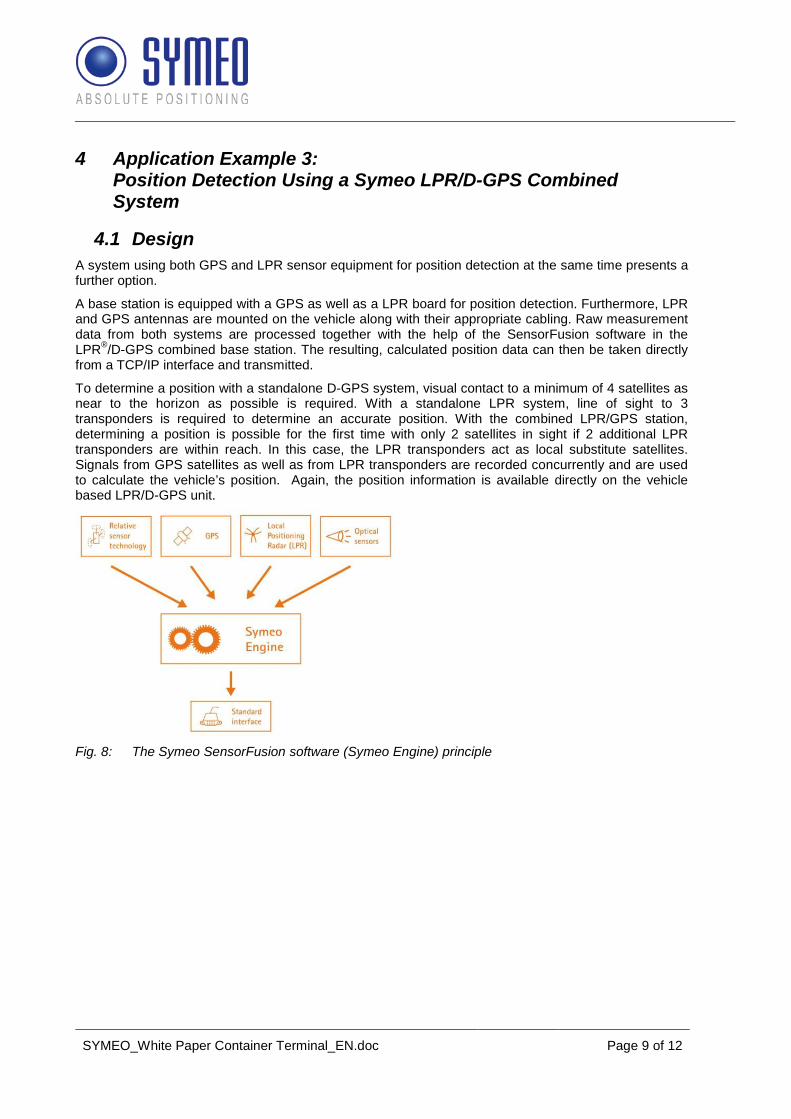
4.1 Design A system using both GPS and LPR sensor equipment for position detection at the same time presents a further option. A base station is equipped with a GPS as well as a LPR board for position detection. Furthermore, LPR and GPS antennas are mounted on the vehicle along with their appropriate cabling. Raw measurement data from both systems are processed together with the help of the SensorFusion software in the LPR®/D-GPS combined base station. The resulting, calculated position data can then be taken directly from a TCP/IP interface and transmitted. To determine a position with a standalone D-GPS system, visual contact to a minimum of 4 satellites as near to the horizon as possible is required. With a standalone LPR system, line of sight to 3 transponders is required to determine an accurate position. With the combined LPR/GPS station, determining a position is possible for the first time with only 2 satellites in sight if 2 additional LPR transponders are within reach. In this case, the LPR transponders act as local substitute satellites. Signals from GPS satellites as well as from LPR transponders are recorded concurrently and are used to calculate the vehicle’s position. Again, the position information is available directly on the vehicle based LPR/D-GPS unit.
Fig. 8: The Symeo SensorFusion software (Symeo Engine) principle

SYMEO_White Paper Container Terminal_EN.doc Page 10 of 12
Fig. 9: Example of reach stacker positioning with Symeo LPR/GPS combined system This system allows highly cost-effective and extensive position detection coverage.
Fig. 10: LPR/D-GPS combined base station
4.2 Application Fields for the Symeo LPR/GPS Combined System in Practice
The major advantage of a combined system lies in its ability to achieve an extensive coverage very cost-effectively. Depending on the storage line-up and on GPS signal availability, only in areas that are difficult to cover with GPS an additional installation of LPR transponders is required. These include critical areas beneath gantry cranes, next to buildings, and inside of halls. The combined signal analysis enables reliable and exact tracking of container movements even in a terminal environment where visual contact to a sufficient number of LPR transponders or GPS satellites cannot always be guaranteed.

SYMEO_White Paper Container Terminal_EN.doc Page 11 of 12
Areas with very good GPS availability — dedicated open spaces or service areas, for example — can do without LPR transponders or only have a very coarse grid laid out for them so to save cost. Resultingly, LPR/GPS combined systems are especially efficient when used for large-area container terminals with greatly varying storage line-ups in individual subareas.
5 Application Example 4: Extending a Symeo LPR/D-GPS Combined System with Additional Relative Sensors
5.1 Design The Symeo LPR/D-GPS combined system can be connected with other sensor technologies in order to ensure sufficiently exact and available position detection even in narrow, angled aisles surrounded by very high container stacks (e.g., empty containers). This enables accurate position detection of reach stackers even in areas that are completely shadowed from LPR and GPS signals. A special feature of this is that as the Symeo SensorFusion software running on the Symeo LPR/D-GPS combined base station already combines measurement data from Symeo absolute sensor equipment (LPR, GPS) with relative sensor equipment measurement data (laser, inertial sensors, vehicle sensors), the higher level TOS will receive the position data in their usual standardized protocol form. The grade of technical complexity this combination of sensor equipment involves has no effect on the TOS — resulting in a low level of integration complexity on this side.
Fig. 11: Symeo LPR/GPS combined system with additional Symeo incremental sensor equipment Additional sensor equipment — 2D laser scanners
Each vehicle used in the critical storage areas is fitted with a laser and a controller unit. The laser scans the surroundings and uses the scan data to calculate distances to landmark points (e.g., containers). When the vehicle moves, these landmark points move in relation to the vehicle and this is used to deduce and calculate position changes. In most cases, there is no need to affix additional reference labels or map the surroundings.

SYMEO_White Paper Container Terminal_EN.doc Page 12 of 12
Additional sensor equipment — inertial sensors
An additional inertial sensor is installed in the vehicle mounted combined LPR/D-GPS unit. The sensor measures accelerations of relative movements in all three axes allowing it to calculate position changes. This enables to deduce the vehicle’s position from its movements for a limited time span when GPS satellites are shadowed off. In this case again, no additional installations on the infrastructure in the terminal are needed.
5.2 Application Fields for the Symeo LPR/GPS Combined System with Relative Movement Sensor Equipment in Practice
Due to its technical scalability, Symeo position detection can cover even highly critical areas in large container terminals without interruption. For any incremental sensor equipment needed, its data is analyzed on the level of the Symeo subsystem and with the help of the flexible Symeo FusionEngine software. Which kind of sensor equipment happens to be used for position detection in which storage area or on which vehicle is of no importance for the higher level system (TOS) — the required position data are transmitted in a uniform format at all times.
6 Conclusion Uniform as containers may be, specific conditions and storage line-ups will vary all the more in different terminals. The best results in the sense of complete and highly available position detection in container terminals can be achieved with the help of an intelligent combination of various types of absolute and relative movement sensor equipment. At the same time, a combination of GPS and LPR can help reduce the cost of building an overall system in many container terminals — without having to compromise regarding the reliability, accuracy, or availability of the position detection. This again confirms an technological trend: Suppliers with a clear business focus on integral solutions for terminal operators and TOS suppliers essentially have a competitive advantage. Partners are growing in relevance who can offer real life experience with highly diverse sensor types for the industry/application at hand and can combine and integrate them into intelligent subsystems in a scalable way. --------------------------------------------------------------------------
Symeo GmbH
Symeo GmbH develops and markets products and solutions for precise and contact-free positioning of vehicles, cranes and objects, for distance measurement and for anti-collision systems. Symeo’s products are robustly designed for applications in harsh industrial environments.
Symeo’s Local Positioning Radar (LPR) offers a wireless and real-time-capable measurement system that is ideally suited for industrial applications. Symeo has many years of experience in the development of cost-efficient and customer-specific industrial solutions on the basis of LPR technology and in the combination of LPR with other contactless sensor technology (e.g., optical systems, inertial sensor technology, GPS).
The company delivers standardised products and complete solutions to system integrators, original
equipment manufacturers (OEMs) and end customers worldwide.
Head office: Symeo GmbH, Prof.-Messerschmitt-Strasse 3, 85579 Neubiberg, Germany
Telephone: +49 89 6607796-0, Fax: +49 89 6607796-190
E-mail: [email protected], Website: www.symeo.com