SWFSC Antarctic UAS Mission Briefing Wayne Perryman, Jefferson Hinke and Douglas Krause.
17
SWFSC Antarctic UAS Mission Briefing Perryman, Jefferson Hinke and Douglas Krause
-
Upload
randolf-frank-morton -
Category
Documents
-
view
215 -
download
0
Transcript of SWFSC Antarctic UAS Mission Briefing Wayne Perryman, Jefferson Hinke and Douglas Krause.

SWFSC Antarctic UAS Mission Briefing
Wayne Perryman, Jefferson Hinke and Douglas Krause

SWFSC UAS Program - Background• Field scientists responsible for monitoring protected
species populations face several challenges– Observers vary significantly in their ability to estimate
numbers of animals in large groups– Determining size and shape information is often either
dangerous or not possible• Manned aircraft platform of choice for collecting aerial
photographs when available• Some areas where not available, too expensive, or
safety requirements make them inefficient• About 5 years ago we decided to determine whether
small UAS were a viable alternative?

GOAL: To develop a small, affordable, effective and reliable aerial imaging
system that can be safely operated by scientists in the field

System Criteria
• Selected multi engine copters because they were designed to be photographic platforms, VTOL capability, and their electronics and software systems make them easy to fly
• Require systems that can be flown by scientists because logistics of remote operations don’t allow for addition of “pilots” and their added cost to field teams

Platform Selection Approaches
Aircraft First Approach• Review commercial
platforms and select the system that provided best combination of endurance and imaging system
• Md4-1000 microdrones• Excellent camera• 45 minutes endurance
Camera First Approach• Aerial Imaging Solutions • Small company with about 3
decades of experience at building imaging systems for sampling protected species
• Started with a camera and then built a customized open source aircraft around it

Flight testing at MacDill AFB, Tampa,FL
Focus of efforts were testing of aircraft, stick time for pilots, testing imaging systems
UAS Brief – Training and Testing
•Resolution testing was done with an RST-704, Series C medium contrast resolution target
•Resolution=alt/focal length * combined width of bar and space for smallest target resolved

Area of Operations

Decision Point
• About two weeks prior to putting all our gear on a ship headed to Chile, Don LeRoi and I were talking about conditions we would encounter in the Antarctic
• Size disparity between platforms obvious and we were a little concerned about how the small quad would handle the camera in windy conditions
• Both felt that something between the two birds might be worth a look

Antarctic Experience 2011• Md4-1000 was our
primary sampling platform
• After successfully completing all preflight tests bird crashed on first flight
• Later learned that the company had installed a part backwards
• So now what do we do?
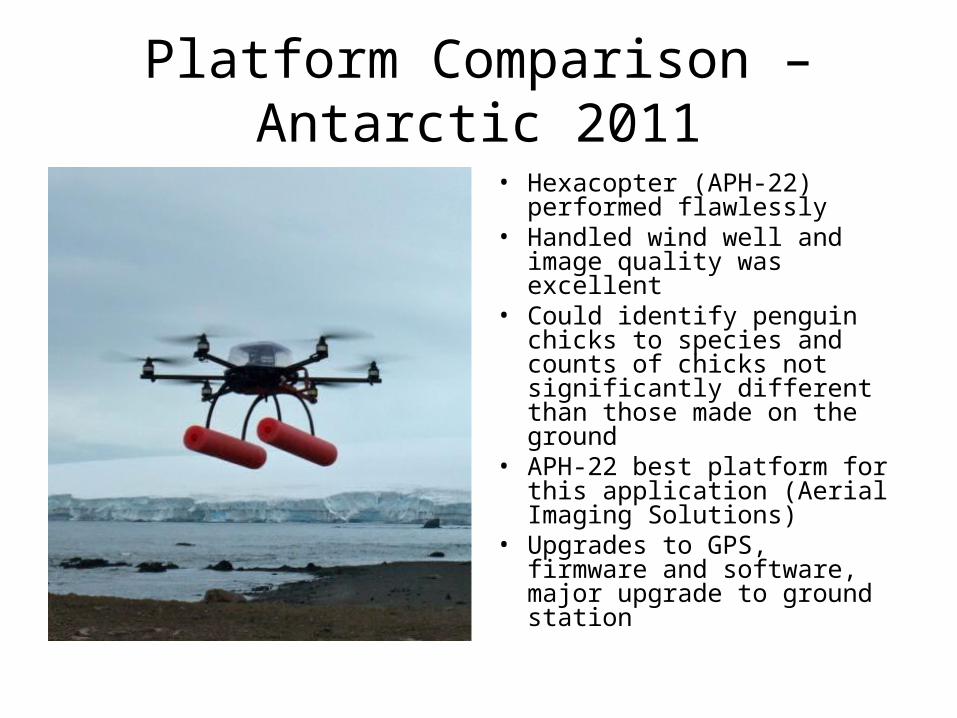
Platform Comparison – Antarctic 2011
• Hexacopter (APH-22) performed flawlessly
• Handled wind well and image quality was excellent
• Could identify penguin chicks to species and counts of chicks not significantly different than those made on the ground
• APH-22 best platform for this application (Aerial Imaging Solutions)
• Upgrades to GPS, firmware and software, major upgrade to ground station

The AIS System

Pilot Training
• Submitted a proposed training plan to AOC
• AeroSim hexacopter simulator training (Plan 4 hrs; accomplished 10hrs 15 min each)
• Hangar flying (5 hrs each)
• Camp Roberts, trip # 1 (1.25 hrs each)

Resolution – Footprint – Ground Resolved Distance
• Camera is like any other sensor in that you have to do some objective testing to evaluate performance
• For aerial cameras there are standard targets that provide quantitative data
• Measure resolution before attempting a mission

Image Foot Print (17 mm lens)
200 ft
300 ft
100 ft

Image Foot Print (45 mm lens)17 mm lens, 300 ft
200 ft
100 ft

Mission Goals
Counts/Mapping Penguins Leopard Seals, Size and Shape

The Sky is the Limit