SURVEYING OUR PUBLIC LANDS - Bureau of Land Management · lund surveying were significant in...
21
, Bureau of Land Management SURVEYING OUR PUBLIC LANDS 2002
Transcript of SURVEYING OUR PUBLIC LANDS - Bureau of Land Management · lund surveying were significant in...
,
Bureau of Land Management
SURVEYING OUR PUBLIC LANDS
2002

.. Your oiJsen'lItiollS are to be taken I\';,h greal paills alit! accuracy. 10 be emered distillctly (lml
intelligibly for OI11ers liS well as yourself to comprehend alllhe elements necessary. I\'ith the
aid of fhe usual tables. to fix (he /oriwde and longitude of the p/tlces at which they were
raken. ,. - TlIOIIIlI5 Jefferson
SURVEYING OUR PUBLIC LANDS SlNCE 1785

52L s the Nation's princip<ll conservation agency. the Department of the Interior has basic responsibilities for wnter. fi sh, wild li fe. mineral. land. park. and recreational resources . As America's "Department of Natural Resources," Interior works to nssure the wisest choice in managing all of our resources so lhal each wi ll fu ll y contribute to a better United States - now and in the future.
The Bureau of Land Management (BLM) is part of the United Stmes Department of the Interior. Its responsibi lities encompass 262 million acres of public lands and managi ng 300 million acres of mineral ri ghts. BLM also maintains the legal status for 331 million acres of reservations created from public lands. such as the nalional p<lrks. national wi ldlife refuges. and national forests. <lnd provides mineral and cadastral services for 56 million acres of Indian lands.
BLM was cSlnbli shed on July 16, 1946, by thc consolidalion of the General Land Office (created in 18 12) and the Grazing Service (crcated in 1939 frol11 the Grazing Division. which was created in 1934). Much of the hi story of the exploration and development of the public land states appears on the pages of BLM's records. As steward of nearly half ofall federally managed. lands, BLM's primary purpose is wisely balancing the use of natural resources. These resources. besides the land itself, include minerals (oil and gas). forests , range. recrealiomll opportunities, wild life, and soil and water. BLM mmwges these lands through communication, cooperation. and consultation, all in the service of conservation - building on ils strengths. especially ils ability 10 resolve competing demands at the grass roots level.
To manage these resources. BLM must be able to locate the increasingly valuable areas of land with which it has been entrusted.
BLM' s C'ldastml Survey Progrmn is responsible for the crenting. restoring, marking. defining. and managing survey records of these lands. Cadastntl Survey is also responsible for the official boundary surveys and survey records management for all federal agencies, trib:ll govemments, and Indian Allotments. Together these entities manage more than 700 million acres.

History ...
Land surveyi ng dates back to ancient times. More tlmn one civ ili zat ion recognized the need for marking the boundaries of land for tuxation as well as for defining j ust where one ownership beg ins and another ends.
The Egyptians. with their great expertise and accuracy in building pyramidS more than 7.000 years ago. must have possessed the techniques and instruments to perfonn surveys comparable in precision to present day requi rements. In fact the Egyptians were very much involved in property su rveys since land boundaries along the Ni le River were annua ll y lost from flooding. and resurveys we re constantly needed.
Most modem BLM monuments have an inscription which reads: UNLAWFUL TO DISTURB. Such warn ings are reall y not new. Babylonian bound;.\ry stoncs set about 3500 years ago contained not only geographica l infonmllion and the surveyor' s name, but also numerous curses on anyone daring enough to move the monument 1
There were several other notable surveyi ng endeavors in earlier limes, including the Roman rectangular plo ts laid out with the four-armed groma instrument: William the Conqueror's land surveys of England wi th their resultant "Doomsday Book"; and the pyramid, road. city. and bridge related surveys of the 11th to 14th cenlllry Incas.
In early day Americ.l. sevemltypes of surveys were perfonned using state·of·the·art instruments. calling mainly on mathematicians. astronomers. and navi · gators to perform as land su rveyors. Most of these earli er surveys were of the metes and bounds type. meaning they were estab li shed by distunces and directions that were not in accord with a regular pattern.
Surveying was oflen listed among the accomplishments of notable scientific and public figurcs in late 18th century America. When the Penns and Calvens rei.\ched an impasse over the boundary between Pennsylvania and Maryland, they asked Britain's Astronomer Royal to send ·· ... some able mmhcmati cians ... of great integrity." If the Astronomcr Royal did not confe r immortality upon Charles Mason and Jeremiah Dixon. he conrerred it upon the boundary they surveyed. David Rittenhouse. a largely selftaught mathematician. astronomer. and instnllnent maker, was involved in half the boundary surveys of British America.
When Thomas Jefferson came to draft the Land Ordinance of 1785. he brought not only his accomplishments in law, political philosophy. and architecture. but also the heritage of hi s noted surveyor fmher. Peter Jefferson. and hi s own experience as a Virginia surveyor.

land hold ings which surveyi ng fees had helped him acquire. and the frequent employment of hi s surveying ~ki lls fo r the benefit of hi s military command in laying ou t fort ifications and topographical mapping, made it possible for George Washington to serve as Revolutionary Commander· in · Chief and the nalion 's first pres ident.
It remained for the late 1700s for the begi nning of what was to become the most ambitious program of land disposal. ownership recording. and on-the· ground boundary marking that has ever occurred. Described as a "marvel of simplic ity," the United Stales rectangular survey was designed to layout I-mile square parcels over all of the federal land oUl"ide of the ori gina l 13 colonies and their western territories. With changes to Thomas Jefferson's original proposal for a rectangular survey, Congress enacted the land Ordinance of 1785. It set in motion a sequence Ihaltied ule New England rectangular survey to the southern penchant for individual sett lement.
Two military engineers, Colonel Henry Bouquet and Thomas Hutchins. were also among the contributors. Hutchins. as Geographer of the Uni ted States, eMabli shcd the Poi nt of Begi nning where the west boundary of Pennsylvania crossed the north bank of the Ohio River (near present day East liverpool , Ohio). Absolom Mart in, of New Jersey, completed the first township in 1786.
Under the princ iples of lhe Land Ordinance, 1.5 billion acres have been surveyed into 6-mile square townships, each with 36-mile square sections, resulting in easi ly understood land descriptions to exped ite land transfers and promotc security of title . The design is at once both complex and simple. The accomplishment is grand - 2.6 million section corners, each a mile apart. These comers have
2
resorted from a vast cumula tive expendilllre of human energy in carrying trrlnsits, dragging chains, lifting sl<ldia rods . cutt ing trail s, settling mountains, cmplacing monuments, digging pits, and blazing witness trees.
The Land Ord inance of 1785 developed three new theories in land administration. First was the principle of "survey before settl elllcnl." Second was the princ iple of a mathemutic.dly des igned plan to be fo llowed throughout the entire area of the public domain. And thi rd was the creation of a standard land unit. a section of uniform shape and area, with boundaries marked on the ground. These planned fea tu res were not used within the ori ginal colonies in Americ •• where land loca tions were made in irregular form and lacked an orderly design.
In 18 12, Congress establi shed the General Land Office (G LO) as a bureau of the Treasury Department "to superintend, execute, and perform all such acts ... respecting the public lands ...... Before then. the public domain workload was handled by the Treasury Department. but a more focused land management agency was needed. The Surveyor General post, wi th responsibility for contracting surveys to private surveyors. however. rem<tined independent of the GLO.
Edward Tiffin of Oh io was appoi nted the first commiss ioner of the GlO. Tiffin 's contributions to lund surveying were sign ificant in consolidming and organizing lund and survey records. Later as a Surveyor Gencml. he des igned a pl ttn of correction lines to solve the troublesome problem of conform· ing a rectangu lar pattern to a round earth.
The first lands were surveyed between the Appala· ch ian Mount:.lins and the Miss issippi Ri ver. an area that seven of the states had ceded to the new nation.
•
Growth of the Public Domain ... ,
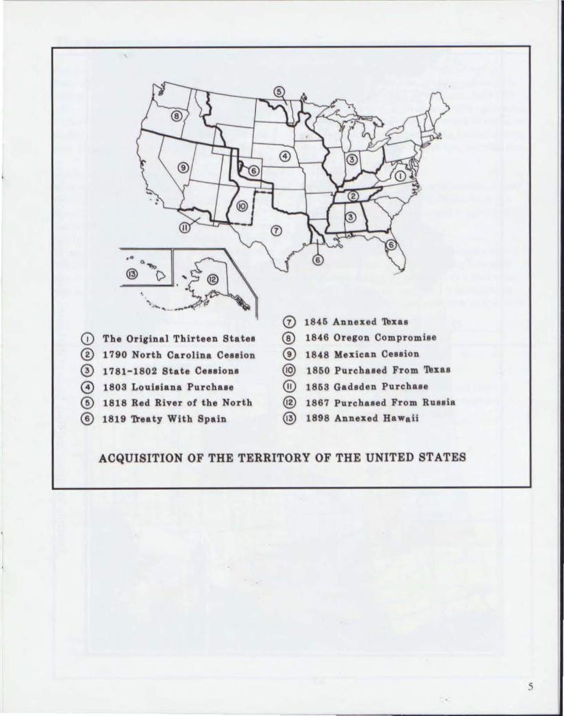
In 1803 President Thomas j efferson arranged to buy a large amount of land from France. Known as the Louisiana Purchase. thi s transaction amounted to morc than 500 million acres and included most of the land from the Miss issippi Ri ver WeSllQ the Rocky Mountains. except for Tex<ls. The Louisiana Purchase castlhe Un ited Slates $23 million.
In 1819the United States purchased Florida from Spain. Texas became part of the U,S. in 1845. A year later the United Stales signed a treaty with Greal Britain. The treaty. known :.lS the Oregon Compromise, added the arc'l that now includes the states of Oregon, Washington. nnd Idaho.
In 1848. just I year before the di scovery of gold in Califomia. the United States obll.li ned from Mexico the lands that are now the states of Cnlifornia. Nevada, Utah, and parIs of Arizoml. New Mex ico. Wyoming. and Colorado. The Gadsden Purchase in 1853 added what is now southern Arizona.
The last large <lddit ion to the Unites States came in 1867, whe n the United States purchased Alaska from Russia. The area of Alaska amounted to more than 375 million acres (about one-fifth the area of the rest of the United States). Alaska co!!t $7 mil lion . With these additions. the public domain shetched from the west boundary of Pennsylvania to the Paci fic Ocean. froll1 thc Canadii.lIl border to the Gu lf of Mexico and included Florida and Alaska . Allogether it embraced over 1.8 billion acres.
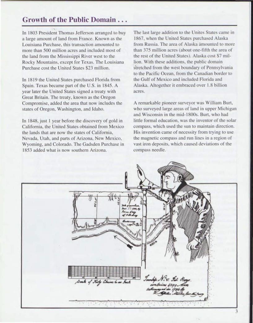
A remarkable pioneer surveyor was William Burt. who surveyed large areas of I ~md in upper Michigan and Wisconsin in the mid-ISOOs. Burt. who had little fo rmal education. W~IS the inventor of the solar compass. which used lhe sun to maintain direction. His invention came of necess it y from trying to use the magnet ic compass and run lines in a region of vast iron deposits. which caused deviations of the compass needle.
3

-x--
Solar Compass illI'ellfed by Wiffjol1l Burl, U.S. Deputy Sun'eyor. in Ille mid 1800s
The expiormion and survey of the western lands continued with many ora l and writlcn accounts by curious surveyors of colorfu l descriptions of the nature of a new land. and tales of hardship, misery. and financial loss. One 1852 field note record of an Iowa survey reads •· ... one of my mcn was accidentally shot yesterday and died aimosl instantly." The notes continue wi th bearings and di stances 10 the stricken man's grave.
Until 1910. public land surveys in c<lch state or territory were generally administered by fedcf<ll surveyors-general , who contracted with authoril..cd deputy surveyors to perform the work. The survey general often wrote sets of instructions to the deputies to specify the method of survey and the accuracies expected. But it gradually became evident that officially authorized surveying procedures nceded to be consolidated. An Oregon Manual of Surveying Instruction was published in 1851 , and revised by the GLO in 1855 for nmional use. Later manuals were issued in 187 1, 1881, 1890,1894, 1902,1930, 1947 (BLM), and 1973 (BLM).
Toward the end of the 19th century several signs pointed to the need for new management. Almost from the beginning, a U.S. Surveyor General was appointed for each territory and slate. Under genera l
4
instructions from the Commissioner of the GLD in Washington , the Surveyor General contracted with depUly ~urveyors. often after competitive bid. The deputy surveyor hired the crews. purchased the supplies. and supervised the fieldwork.
Whe n public land survey ing covered prairies, open bench land. and other relative ly accessible land. surveyors competed for such job~. As surveying embraced fragmentary , rOllgh, and isolated are'lS, con tractors found it hard to bid and keep costs within the limits prescribed by law.
Resurveys became increasingly necessary as a growing proportion of careless, fraudulent, and sometimes practic.ll1y mythical surveys surfaced as the public lands were occupied. Prospective contractors found it difficult to bid on resurvey work because it was hard to estimate the amount and character of the work. A change to contracting by the d.IY brought ~ome improvement. But ultimately the law was changed to provide for the direct hire of professional surveyors and their ass istants at a specified salary .
Stable pay and profe:-.sional pride was thus substituted for contractors beginning July 1, 19 10. Improved surveys at little extr;t cost soon justified those who advocated the direct hire of professionals in surveying.
CLO .wrvey crew in lIeserl soul/I1Vesl. circa 193005
,
® •
,-. @ .... (>
,
CD The OrieiDal Thirteen Statu
® 1790 North Carolina Ce .. ton
o 1781-1802 State Ce .. ion.
o 1803 Louiaiana Purchaae
® 1818 Red River of the North
® 1819 n •• ty With Spain
<!) 18.6 Annexed Tex ••
® 1846 Oregon Compromise
® 18"8 Mexican Cenion
@) 1860 Purchaaed From 'I\Ixas
® 1863 Gad . den Purchu.
@ 1867 Purcbued From Ruuia
@ 1898 Annexed Hawaii
ACQUISITION OF THE TERRITORY OF THE UNITED STATES
5
• . , '0,
.~~ __ 0
, • • ,
I I • .- •
•
, • ,
• •
•
•
c
!
• " I
----_1.:_
E
•• . , I , ,
'\~-I "
\
x , .\
,
,
• •
•
n
•
,
, , , . \ • I
• • T
"
I.
•
•
• , , •
\ • • , • \
•
• < X , . I
Principle Meridians and Base Lines of the United States Public Land Surveys
•
T
•
,
...... 01'&/111 ..... ~ ..........
PRINCIPAL MIRIDIANS
,
... IASI LINES
..V II .,MO
'11 , u."" .U, •• " ' ''C 1,.,00 IV "''''
-.! ,

•
The Recta{lgular Survey System ...
Our present system of pub lic land survey retains the basic elements sel forth in the Ordinance of 1785. refi ned by later legis lation and regulations.
Under the cadastral system. the publ ic domain is ploued into a grid of squa res. each 6 miles 10 the side . These squares are called "townships."
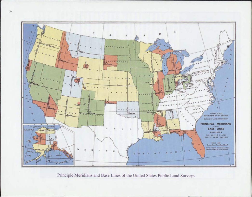
Before any di stance can be measured. the surveyor must de fine an initial point. From that initia l point two lines are run , one north-south, the other eastwest. The north -south line becomes a principal meridian and is given a namc- the Sail Lake Meridiall , for example. The Salt Lake Meridian intersects its baseline althe southeast corner of the Mormon Temple grounds in downtown Salt Lake City. The east-west line becomes the baseline for the meridian (see map, p~lge 6).
TOWNSHIP GRID
z ' '" is - , '" "' ~
• • '" BASE LINE fA ...
• • , • • ~ , , • •
~ :-- "',h.1 PoInl
'" n. ~ ",w
U • • z • -'" .. , , • SOUTH .. " .. ~
~ 8
" »
•
• .. " N
"
Working along the principal meridian and the baseline. the surveyor sets township corners at 6-mile intervals, and then, by ex tens ion. marks the tract off into a grid . Each of the 6-mile squares is a township of 36 square miles. or about 23.040 acres. A~lY specific township can then be located according to its relationship to its principal meridian and baseline.
Because of the shape of the earth. meridi ans come closer together as they extend toward the North Po le. To adjust for thi s convergence, correcti on lines are run every 24 miles.
The surveyor f11l1her di vides the township into sections of I-mile squares containing 640 acres. Individual sections are identified by a numbering system that starts with section I in the northeast corner of the township and ends with secti on 36 in the southeast corner.
• • Working from a princ ipalmcridan and baseline . the surveyor marks off the township lines into grids of 36 square mi les.
, , ,
" " " SECTION 14 .. , / " , " n 'f • ,.-' .-
" \.0., M ,,- " ," t1.
"" ,,' ! • » ~ " ; i"
.. ,'I ..... ',. -, I ..... --:.1--- ~ 1-''1· .... ~
~ \ wnships are futher divided into sections of I square mi le 'S: )"''' """"" I
i To . (640 <lcres). Sections are then numbered from 1 to 36 .
7
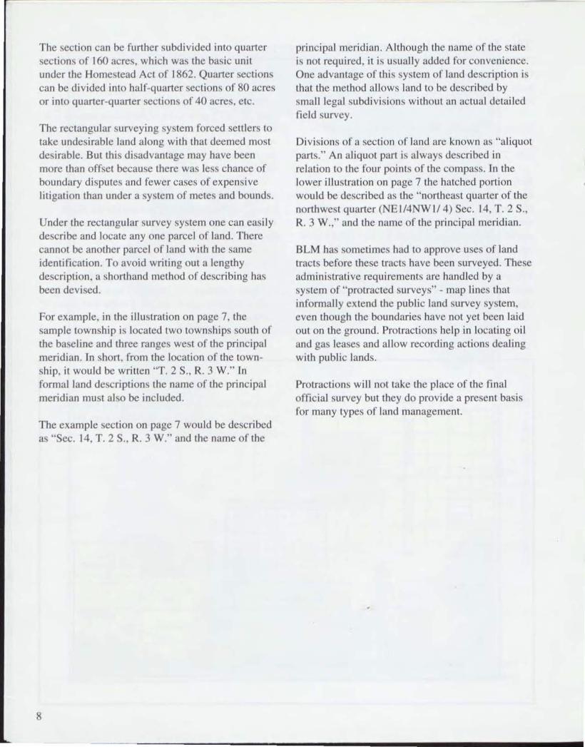
The sec ti on can be further subdi vided into quarter sections of 160 acres, which was the basic unit under the Homestead Act of 1862. Quarter sect ions can be divided into half-quarter sections of 80 acres or into quarter-quarter sections of 40 acres, etc.
The rectangular survey ing system forced senlers to take undesirable land along with that deemed most desirable. But thi s disadvantage may have been more than offset because there was less chance of boundary disputes and fewer cases of expensive litigation than under a system of metes and bounds.
Under the rectangular survey system one can easily describe and locate anyone parcel of land. There cannot be another parcel of land with the same identificati on. To avoid wri ting ou t a length y description , a shorthand method of describing has been devised.
For example. in the illustration on page 7, the sample township is located two townships south of the baseline and three ranges west of the principal meridian. In short. from the locati on of the LOwnship, il would be written "T. 2 S .• R. 3 W." In formal land des(; riptions the name of the principal meridian must also be included.
The example section on page 7 would be described as "Sec. 14, T. 2 S., R, 3 W." and the name of the
8
principal meridian . Although the name of the state is nOi required. it is usually added for convenience. One advantage of thi s system of land description is thatlhe method allows land to be described by small legal subdi visions wi thout an actua l detailed field survey.
Di visions of a section of land are known as "aliquot parts," An a liquot pan is always described in re lat ion to the four points of the compass. In the lower illustration on page 7 the hatched portion would be described as the "northeast quarter of the northwest quarter (NE 1/4NW 1/4) Sec. 14. T. 2 5., R, 3 W.," and the name of the principal meridian .
BLM has sometimes had to approve uses of land tracts before these tracts have been surveyed. These udministrative requirements arc handled by a system of "protracted surveys" - map lines that infonnally ex tend the public land survey system, even though the boundaries have not yet been laid out on the ground. Protractions help in locating oil and gas leases and allow recording actions dealing with public lands.
Protractions will not take the place of the final offi cial survey but they do provide a present basis ror many types of land management.

I
The Federal Land Surveyor ... Surveyors are usually within one of three groups. Geodetic surveyors measure the shape and size of lhe earth . Topographic su rveyors locate and map the earth 's features. including its contours. water bodies. roads and bui ldings. Cadastral surveyors lay out and mark property boundaries according to lega l requirements and doctrines.
Today. BLM has about 250 pennanent cadastral surveyors to augment thi s corps of professionals. BLM also employs seasonal survey aids and techni cians who operate surveying instruments. cuI brush. climb hills. maintain equipment . and set permanent monuments. Several other government agencies also employ professional cadastral surveyors for specialized work such as land line location and boundary management .
Trave l and long stays away from home oflices are commonplace for BlM field surveyors. A good degree of self~reliance is a desirable allribute of surveyor party chiefs, who often must make inde~
pendent deci sions on both techn ical and crew m~magement mailers. Personnel management and log istica l abilities are sometimes critical (such as for a 6-month Alaskan field camp operation).
BlM surveyors go 10 and frolll work sites on j ust about anything that moves. including by foot, horseback. four~wheel drive vehicle. he li copter. and boat. Survey work is ca rri ed on anywhere in the United States from the ArilOna desen s to the Alaskan tundra. along the edge of a large water body. or in a dense forest on the sides of tl western mountain . Cadast ral surveys fall into two main categori es origina l surveys and resurveys. Since most of the land in the lower 48 S13tcs has al ready been orig inally surveyed. most original survey work today is carried on in Alaska, quite often in remote, road less areas.
Resurveys have always been needed in marking the public lands to restore obliterated or lost original survey lines. Permanent statutory authority for resurveys was given to the GlO by Congress in 1909. Resurveys are now the 1ll0St cha lle nging and complex projects for BlM surveyors.
•
Comer MOtlllmelll. Ti,e e:wcllocaliml ofille comer is stllmped Otl lOp. Tile bottom is spread Ollt to pre\'elll pulling the POlt from the ground. Congress llilthori:ed tile lise o/metal mom/melll.s i1l 1908. Slolle alld wood mOrl/llI/elllS were mainly used
before Illell.
By law. however, no resurvey can impair the bona fide land ri ghts of affected claimants. Comers established in original cadastral surveys arc forever II xed in pos ition even though they may not fall prec isely at ;.l stated bearing and di stance from a previous point. Today's cadtlstral surveyor must we igh many kinds of evidence to ensure the protection of privtlle rights.
In recent yea rs. modem technology has replaced the traditional "chain" measuring tape with electronic
9

instruments. Microwave. li ght wave, laser beam. photogrammetry. gyroscopic orientmions. and e lectromagnetic satelli te signals are among the scien tific media integrated in the cadastra l surveyor's array of working tools.
New, highl y sophisticated survey ing techniqucs range from ''Total Station" concepts where all a.d muthal and distance data are automatica ll y rccorded for later computcr process ing. 10 Global Pos itioning SySlem-Rc<ll Time Kinematic systems, which give continuous ly updated coordinates of the surveyor's posi tion. BLM in Alaska uses th is sate ll i te-ba~ed system to ra pidly meet the survey demand of mill ions of acres of land scheduled for transfer under the Nati ve Claims and Alaska Statehood Acts.
Computer-a ided draft ing has replaced the tradi tional manual mcthods of plait ing the boundari es that were measured by the surveyor. Computers also calculate coordinates, or lati tude and longitude.
10
for survey corners. These coordinates are incorporated into the BLM 's Public L,md Survey System! Geographic Coord inate Data BOIse and allow the Public Land Survey System to be shown on maps using geograph ic in formation system (GIS) technologies. The system and data base are the foundation for parcel-based land information syste ms. which will allow mapping and analysis of resource and cultural informat ion that relates to the land. " Field to fini sh" will no longer end <ltthe survey plat. but at any map that shows the Public Land Survey System cadastral themc.
The phy!iical challenge to the cadastral surveyor of lay ing boundaries across the lerrain remains. The mental Challenges are increasing. The future survey of our public lands will call for technica ll y adept surveyors who are willing to integ rate the wisdom and experience of their predecessors with the expand ing knowledge and uses of the scientific. lega l. and managerial regimes.
•

,
SHORT LIST OF SURVEYING TERMS
Be~l ring Tree - A marked tree used as a comer accessory. it s di stance and directi o n from the corner being recorded. Bearing trees are marked by prescribed eUl s into the ir trunks: the species and size of the trees arc al so recorded.
Corner - A point o n the earth, determined by the surveying process, which defines all ex tremity on a boundary.
Field Noles - The offic ial wri llen record or lhe survey. certified by the fie ld surveyor and approved by proper authority. Originally. fie ld notes were prepared by hand but arc now computer gCllcITItcd.
MCllnder Line - A traverse of the margi n or a permanent natural body or water.
Monument - The physical object which marks the location of a corner point.
Original Survey - A cadastral survey lhat creates land boundaries and marks them for the fi rstl imc.
Plat c. As used technically by BLM. a graph ic rcprescntation drawn to scale showing the actual survey as descri bed in the olTiciallie ld notes.
Resurvey - Cadastral survey to ident ify and remark the boundaries of lands tlmt were establi shed by an earli er survey.
T raverse - A sequence of lengths and directions of lines connecting a series of statio ns.
Witness Corner - A mo numented point usua ll y o n the true line of the survey near a corner point which cannot be physically occupied or which falls at a place subject to destruction by the elements. The witness corner is a reference to the true corner point.
11
l

12
./l:iJrU.. ~f /r( d..1f'-.kn. -a ___ .L .. M"'4
~7P-· ..,f.,~ ,f'/T .bIT i.~7 4r./.~./--f,
'.1.& #.~ ~~L,t&=;;~<7&«4'.o&9'7'"J.J'-Irtr~~,~ ,( ~ ~ ~.A-:~ "n . ,,- .
~. L_ ~.u,:/~~I~~-;>'~ «- 11.1-
JH-h_" d-"'''~ A.-''. ~ _ /.r'/.J7"W9.~~ 1 • 4.. . .,d- 7 'c .r;, • •
" .LOC ..,
tJ "'tr l~~4<ld4~~~~'-~~<AA-L<- .....f: t . 9'-/ff.
77 J..r-r"~~¥7-:·zf.u-...£~&. ~J. ff.1'-/. e.
.z;. L..z;:;;:. --. .l-~'- ~n:~ .4'''';''''',;(;.
r-,j(# r~~.%'~: 4-· '-U:~I y-.II",?.£.. .L..c~ 11-o..-r-,
~~LI If.z...t;-- L . ..L,f cy. ~ .J
I:.u~ /7 ':N -!
Handwrillen field notes of an original cadastral survey in Oregon (1855)
"
•

... • YnJoJJhtjv:bDJ(W/j o ;";"'f"~ $",1 ~;-//l'ln"ll(' . ;'n,/vJ/tw .
.'
• • • . ...... .«._.= ..: t
Original survey plat of an Oregon township (1855)

4 .30
9.10
26.030
14
2
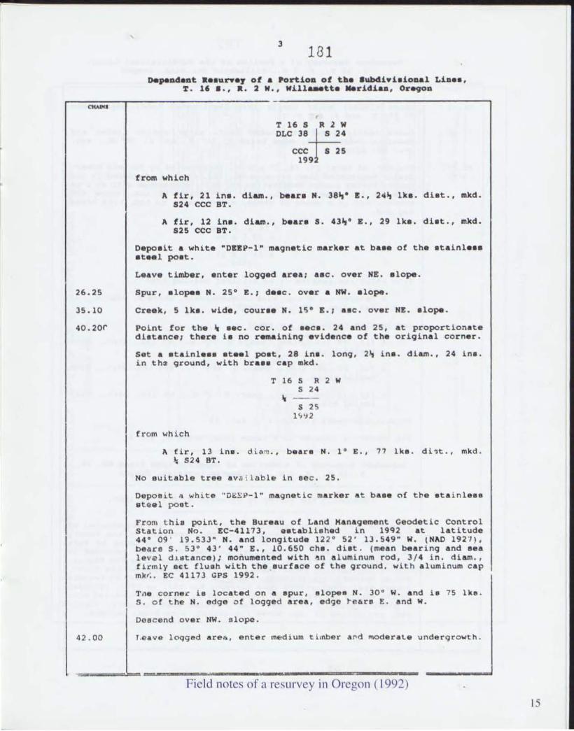
180 DepeDdaDt. RI.aurYa, of • PortiOD of t. ... aYbdl.iaioQal LiD •• ,
'f. II, a., a. 1 w., Willaaett. "'ridi.", OregoD
(R •• toring the aurvay by Oanl.1 and Matthew O.C. Murphy, in 1854, the r~num.nt.tlun by J&mea E. Jelley, in 1965,
and the r •• urvey by La.tar I. Fiach.c, in 1981-82)
a8g1nn1no at the cor. of •• ca. 19, 24, 25 .n~ 3D, on the E. bdy. of the Tp., monumentad with an iron poat, 2~ lna. diem., firmly •• t, projecting 4 ina. above the ground (with an iron pipe, 2 ina. dlam., 4 foot 10n9. lying alono_ ida). with br ••• crp mkd.
THiS R 2 W R 1 W S¥4 s19
S 25 S 30 19 5
from which the remain. of an ori9inal b •• tinq tr ••
A tir atump, 38 lna. diam., b •• r. N. 30· W., 19 Ike. diet., with ecrib. mark. R1W T16S 525 vJ,.aibla on cpon blaze.
and a b •• ring tra. reported by Jelley
A fir, 12 ine. dia.tn., beare N. 13· E., 11 Ike. dlet., with healed blaze.
and the remain. of bearinQ tre •• mkd. by Jelley
A tir enag, 8 in •. diam., b.ar. S. 11· E., 11~ 1k •. diet . , with h.a1.d blaza.
A fir, 11 in • . diam., bear. S. 40· W., 2~~ 1ke. di.t., with healed blaze. (R.cord, S . 31~· W.)
and a b.aring tree mkd. by riecher
A fir, 32 ine . diam., b.are N. 12,· W., 19~ 1ke . diet., with healed blaze. (Record, 81 lk •. )
and a new b •• ring tree
,. fir, 24 in •. d.\.am . , b •• r. S . 48" · E., 50 Ike. di ll· , ., mkd. T16S JUW S30 ST.
N. 89 · 48' OOM W., bet .• e~e . 24 and 25.
Deacend over NW. alope, throuQh medium timber and modecate undergrowth .
Crayeled road, 20 lke. wide, b.ars N. 10· E . and S . 10 · W.
Creek. 10 1ke. wide, couree N. 10· E.; a.c. avec NE. elope.
Point toc the cro •• ing c-10eing cor . ot .ece. 24 and 25, at intereection wit h the !. bdy. at Donation Land Claim No . 38.
s.t a atalnle •• steMl poet, 28 in8 . long, 2~ i n • . diem., 2 4 ir. s . i n the ground, with b ra •• c ap mkd.
Field notes of a resurvey in Oregon ( 1992)
""""
26.25
35. 10
40.20r
42 . 00
, l
Ill1
DepeD4.D~ ••• vrw.~ of • PortiOD of the lubdi.iaio.al LiD •• , 1' . l' •.•• • 2 W. , will ... tt .... ridiao , Or~D
from which
T16S Rlw DLe 3SF'.
ecc s 25
'" A fir, 21 in •. diam., bear. N. J8~· E., 24~ Ike . diet., mkd.
524 eec ST .
A fir, 12 Ina . diam ., b •• r_ S . 43~ · E., 29 Ike. diet ., mkd . 625 eec ST.
Dapoait • white "DEEP-l" m_lil"etic marker at ba •• of the ata Lnl ••• at •• l poat .
Leava timber, enter l099~ area ; •• C. over HE. elope .
Spur. elope. N. 25· E.; d •• c. over & NW • • lo~.
Cre.k, 5 Ike. wide, eour •• N. 15- E.; •• e. ovar HE .• lo~.
Point for the ••• c . cor. of •• c • . 24 and 25, at proportionate diet_nce; thera i . no renainLnq avidence of the original cornaro
Set. ata i ni ••• at •• l poat, 28 ina. 10"9. 2 ~ ina . d i am ., 24 i n •. in ths 9cound. with br ••• c ap mkd.
from which
T 16 5 R 2 '" S 2 4
S2S 1 ~ 'J 2
A. fi r. 13 in • . d i.lom. , bear. N . 1 - E., ?? lke . di'J t., mkd . lc' 5 2 4 BT.
No e uitable tree avs i l nble 1n aec . 25 .
Deposit d ",hite " 01=:£ 1'- 1 " magnetic marker a t ba.e ('I f U'e . t a i nt ••• IIII tQel po.t.
Fro m thi. point, the Bureau at Land Hanaqement Geodetic Control Station No. EC-411?3, •• t abl l.had 1 n 19~ 2 at latitude 44 - 09 ' 19 . 53J" N. and longitude 122- 52 ' lJ,549 " W. IHAD 192 '1), beare S , 53- 43 ' 44" S., 10.650 c he. diet . (mean bearing and aaa level d~.t.nce); monumented with ~n alUminUm rod, 3 / 4 i n . diam . • tirlnly e€t flush with the eurtace ot the qround, with aluminum cap mk r;. EC 41173 GPS 1992.
Tne corner i. loca t ed o n a .pur , elopes N. 30- W. and i. 1 5 lke. S . o f ~h. N. edge o t logged area, edgD ~e6re E. and W.
Doa c end over NW. sl ope.
Leave loqged areli, enter medium t.l .nbol" a ro d moderat.a I.InderQc o wt:h .
----~----~-~'--~----~~--~~ Field notes or a resurvey in Oregon ( 1992)
15

16
4
182 o.peo4.at ••• ur..J ot • Portioa 01 tbe aWDd!yiaioDal LiD •• ,
T. 16 a • ••. 2 W •• Will ... tt. Mer_diaD, Or~D
r-~<~,w.~.--~---------------------------------------------------'
61:1. !O
77 .60
aO .40G
Le.ve timber, enl or nea rly level cultlvated land, eclqa bear. N. ~O· E. and S. 40~ W.
Leave n •• rly level cultivated land, ent er medium timbe r and moderAte undergr.owth, edg8 b •• r. N. 70· W. and S. 70· S.; •• c. over NIL .lo~ .
The cor. of •• ca. 23, 24, 25 .lId 26, perpetuated by Kall:1ath Robert I&all, Regietered Land Surveyor No. 952, in 191.4, recorded in t: la County Survey Corner A •• toration No. 9826, monumentad with an 1.:on pipe , 1 in. diu. I f i rmly •• t, projecting 12 ina. above the qroun1. aud in a mound of atone, 4 foot b ••• , to top. I.U.n br •• e cap mkd.
T 16 5 R 2 W
r.~J ~4 S 26 1 S 25
1~84
fL '\fTI wh l.c h the remaine '. t An o riJinal bearinQ t ree
,. ctpr:ayed L .... atu",p. e1.:O:. indetern.lnate, b.ara S. 451,- E. , 33 lite. oiiet . • no :; ... :-ka vieibl".
I and ~arln9 treow mkd. by Ezell
A fir, 19 il,,,. diam .• be.re N. 77- E., 63 Ike. diet., wi th healed blazu.
,. fir, 20 in • •• Ham., bear. S. 48"- 1'., .3&, ike. di •• t., with h •• led bl;:u.e .
,. tir, le ine. diam. , bear') S 3 - w .• (,9 Ike. ",iat., with healed blau~.
No euiLable treee av~ilab! e .. ~ 8ac. 23.
The corner ~ a 10c;:aLed i n a hlRce lin ... bean .. N. and S
--------------------------------DapaD~.nt R~aurvoy of • Portion of Donation Land Clat. "0 . l8.
T . 16 S • • R. :I: W. , Willa.etta ' · .. ridien. Or~9nD
(Reotorin; the aurvey by Jarem i ah H. Dick in 18SS :
From the S-!'E cor. ot Donation LAnd CL Ain. ',0. 38, parpetu .. t p J by C. H. Collier , C<,unty Sucveyor . in 1906 reco rded i n the County Survey Corner R",atoration Nco . 347; ; ur'. hor perpetuated by Nick Jull~no . Reqietered Profeeai elal Engineer N~ . 344Q. recorded in lhe Coun ty Sur vey Yil _ ~o. 533; further perpo~ua~ed by Tom S4ulJC, county Engineerl nt;; technician l . i n 1980, r~corded i n the Count-} Survey Cor not' ~J'Jtoratlo n ~:o . 86 40; t Ul:'thar p.:Jrpetuatad r 'l Kenneth R~bect Ezell, Reqiete r.d ~and ~urveynl:' No . 9~1 . in 199 1, recorded l ~ the County Survoy Corner Reutor.tion No . 11~1~; monu~nted with a pIalltic pipe, 2 l/ 4 ln a. di.llm., tilled wittJ c unc re t c, linnly •• t. project in9 10 _n8. abov e ttJe Ql:'ound. wlth hr~ •• ~AP mkd .
~--~----------~-------.-=~~----~.===
Field noles of a resu rvey in Oregon ( 1992)
I
J
•
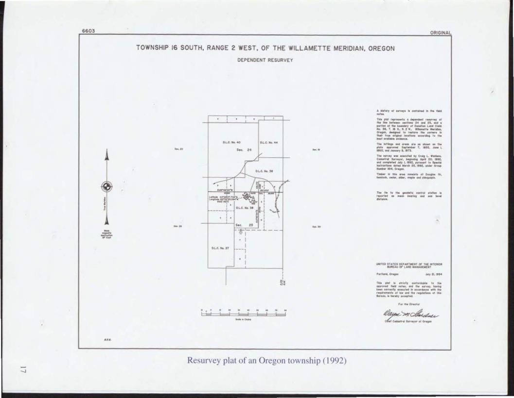
6603
I I
ORIGINAL
TOWNSHIP 16 SOUTH, RANGE 2 WEST, OF THE WILLAMETTE MERIDIAN, OREGON
DEPEHD£NT RESURVEY
, , , , ,
~kW ~k_ _. - .. _.
X~k. --:-' , / - .: ., ( .- --=-~~
, • , -"'". ..~ " , , ~k.
, ----..,...- -j ' -, , , , • " - u , , --~I ~--
. I ~" .'
I ---1
. I
, , , p ,.
_.-
Resurvey plat of an Oregon town,hip ( 1992)
--'''--._ .''--No ... . __ ._ ,_ .. .... _-" ........ . _ .... _, .. - .... .... ........ '" "' 1 •. _--" .-.-_. ----- ,, ----... __ .. _ ... . _ ... ---_ •. __ . ---"' .... - ...... -- ....... '- --.0_. __ 10 . ... -_Mt·-'''_''_ --_111. __ .... ---_._"'- "--. ------..... .. .. __ ._. _ ..... _-----
"" .... "' - _ .. .. ----_ .. _----"'---.. . __ ..... _ .. _ .. -... _ ....... -... .. -

,
The chain is the unit of linear measurement for the survey of the public
lands as prescribed by law. All returns of measurement in the rectangular
system are made in the true horizontal distance in links. chains, and miles.
The onl y exception to thi s rule are speci al requirement s for measurement
in feet in mineral surveys and townsite surveys.
BlMJWO-GI-02-()03- 142Q
LINEAR MEASUREMENT
I Chain = 100 Links or 66 Feet
I Mile = 80 Chains or 5.280 Feet
I Mile = 1.6 1 Kilometers
AREA MEASUREME T
I Acre = 10 Sq. Chains or 43.560 Sq. Feet
I Square Mile = 640 Acres
2.47 Acres = I Hectar