Sunset Fee District Nexus Study - Placer County, CA
16
Sunset Fee District Nexus Study Traffic Impact Fee Program Update Page 1 Introduction Since 1996 Placer County has implemented a Countywide Traffic Impact Fee Program (Fee Program) and Capital Improvement Program (CIP) to help fund transportation infrastructure projects throughout the County (Placer County Code Section 15.28). The Fee Program consists of 11 fee districts, including the Sunset Fee District. As shown in Figure 1, the Sunset Fee District is generally located north of the City of Roseville and west of State Route (SR) 65. The Sunset Fee District has the same geographic boundary as the Sunset Area Plan (SAP) and includes the Placer Ranch Specific Plan (PRSP). Figure 1: Sunset Fee District Boundary Placer County is proposing to update the SAP, including the PRSP. This update to the Sunset Fee District is designed to facilitate the transportation infrastructure improvements needed to accommodate future development’s traffic demand. The intent of the program is to provide a system by which future development can
Transcript of Sunset Fee District Nexus Study - Placer County, CA

Sunset Fee District Nexus Study Traffic Impact Fee Program Update
Page 1
Introduction
Since 1996 Placer County has implemented a Countywide Traffic Impact Fee Program (Fee Program) and Capital Improvement Program (CIP) to help fund transportation infrastructure projects throughout the County (Placer County Code Section 15.28). The Fee Program consists of 11 fee districts, including the Sunset Fee District. As shown in Figure 1, the Sunset Fee District is generally located north of the City of Roseville and west of State Route (SR) 65. The Sunset Fee District has the same geographic boundary as the Sunset Area Plan (SAP) and includes the Placer Ranch Specific Plan (PRSP).
Figure 1: Sunset Fee District Boundary
Placer County is proposing to update the SAP, including the PRSP. This update to the Sunset Fee District is designed to facilitate the transportation infrastructure improvements needed to accommodate future development’s traffic demand. The intent of the program is to provide a system by which future development can
Sunset Fee District Nexus Study Traffic Impact Fee Program Update
Page 2
contribute their proportional share of the cost of infrastructure needed as a result of that future development. The funds will be collected by Placer County and expended on infrastructure included in the program, as funding becomes available. The purpose of this nexus study is to demonstrate that the Sunset District Traffic Impact Fee Program complies with the requirements of the Mitigation Fee Act (also known as Assembly Bill (AB) 1600 or California Government Code Section 66000 et seq.).
The SAP, which includes the PRSP project site, encompasses nearly 8,500 acres in unincorporated south Placer County. The SAP identifies a high density mix of labor and employment land use with an emphasis on innovation and creativity. The PRSP includes a mixed-use town center, commercial and office uses, and a diverse housing mix. Based on market analysis, the SAP is expected to build out over 80+ years. This Traffic Impact Fee Program includes the full buildout of the backbone roadway infrastructure needed to serve full buildout of the SAP and PRSP. For more information on the SAP and PRSP, refer to the plan documents and environmental impact report.
Upon adoption, the Sunset District Traffic Impact Fee Program will be incorporated into the Countywide Fee Program and the CIP. This program will replace the existing Sunset District fee in the Fee Program. The County has collected fees from new development in the Sunset Fee District since adoption of the Fee program in 1996. The funds collected thus far will remain in the Sunset Fee District trust fund after adoption of this update and be used for construction of the projects on the current fee program project list.
In addition to the Countywide Fee Program, new development in the SAP is also subject to several other transportation fee programs, including the Highway 65 Joint Powers Authority (JPA) fee program, the South Placer Regional Transportation Authority (SPRTA) regional fee program, the Tier II fee program (PRSP only), and the City of Roseville/Placer County (City/County) traffic fee program. Each program is described below.
The Highway 65 JPA is comprised of Placer County, City of Roseville, and City of Rocklin. This fee program funds improvements to the following interchanges on SR 65: Galleria Boulevard/Stanford Ranch Road, Pleasant Grove Boulevard, Blue Oaks Boulevard, and Sunset Boulevard.
SPRTA is a JPA comprised of Placer County, City of Roseville, City of Rocklin, and City of Lincoln. The fee program funds transportation projects that are of regional significance, including widening Sierra College Boulevard, SR 65, Auburn Folsom Road, the Lincoln Bypass, HOV lanes on Interstate 80 (I-80), in addition to interchange improvements at I-80/Douglas Boulevard, I-80/Atlantic Street, I-80/Rocklin Road, and I-80/SR 65.
SPRTA also administers the Tier II fee program, which applies to specific growth areas in Placer County, City of Roseville, City of Rocklin, and City of Lincoln. The Tier II fee is imposed on new development in specific geographic areas through development agreements. The PRSP is the only area in the SAP that will be
Sunset Fee District Nexus Study Traffic Impact Fee Program Update
Page 3
subject to the Tier II fee. The Tier II fee funds the future construction of Placer Parkway and the environmental review of the I-80/SR 65 interchange project.
The City/County traffic fee program is a joint fee program with the City ofRoseville. The program funds improvements to Baseline Road and the WalergaRoad Bridge at Dry Creek.
Future Development
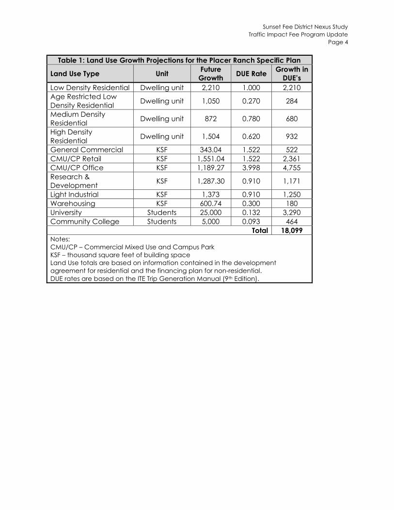
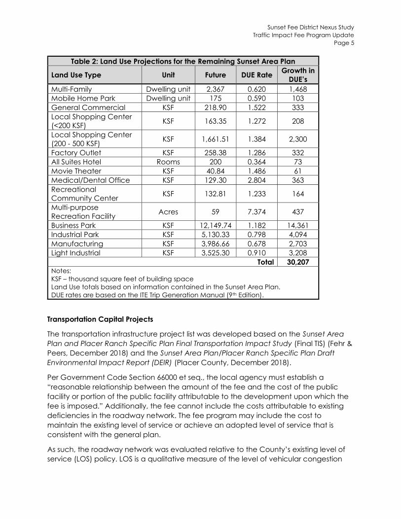
The SAP and PRSP details the land use growth projections for the Sunset Fee District. This district establishes the fee based on buildout of the SAP. The growth projections for the PRSP were developed from the draft development agreement, because it provided the best available data. The growth projections for the remainder of the SAP were developed from the plan document.
Consistent with the Countywide Fee Program, the land use growth projections are converted into Dwelling Unit Equivalents (DUE’s). A DUE is a numerical value used to equate the traffic demand characteristics of various land use types to a single family dwelling unit. The DUE rate for a particular land use category accounts for the number of trips generated, average trip length, and pass-by/diverted trips. The DUE conversion rates are based on the Institute for Transportation Engineer’s (ITE) Trip Generation Manual (9th Edition) and are contained in the Countywide Traffic Fee Program Schedule.
Tables 1 and 2 display the land use growth projections, DUE rates, and growth in DUE’s for the PRSP and SAP, respectively. Note that the land use growth projections include only future land use and do not include existing land use in the SAP area.
Sunset Fee District Nexus Study Traffic Impact Fee Program Update
Page 4
Table 1: Land Use Growth Projections for the Placer Ranch Specific Plan Future Growth in
Land Use Type Unit DUE Rate Growth DUE’s
Low Density Residential Dwelling unit 2,210 1.000 2,210 Age Restricted Low
Dwelling unit 1,050 0.270 284 Density Residential Medium Density
Dwelling unit 872 0.780 680 Residential High Density
Dwelling unit 1,504 0.620 932 Residential General Commercial KSF 343.04 1.522 522 CMU/CP Retail KSF 1,551.04 1.522 2,361 CMU/CP Office KSF 1,189.27 3.998 4,755 Research &
KSF 1,287.30 0.910 1,171 Development Light Industrial KSF 1,373 0.910 1,250 Warehousing KSF 600.74 0.300 180 University Students 25,000 0.132 3,290 Community College Students 5,000 0.093 464
Total 18,099 Notes: CMU/CP – Commercial Mixed Use and Campus Park KSF – thousand square feet of building space Land Use totals are based on information contained in the development agreement for residential and the financing plan for non-residential. DUE rates are based on the ITE Trip Generation Manual (9th Edition).
Sunset Fee District Nexus Study Traffic Impact Fee Program Update
Page 5
Table 2: Land Use Projections for the Remaining Sunset Area Plan Growth in
Land Use Type Unit Future DUE Rate DUE’s
Multi-Family Dwelling unit 2,367 0.620 1,468 Mobile Home Park Dwelling unit 175 0.590 103 General Commercial KSF 218.90 1.522 333 Local Shopping Center
KSF 163.35 1.272 208 (<200 KSF) Local Shopping Center
KSF 1,661.51 1.384 2,300 (200 - 500 KSF) Factory Outlet KSF 258.38 1.286 332 All Suites Hotel Rooms 200 0.364 73 Movie Theater KSF 40.84 1.486 61 Medical/Dental Office KSF 129.30 2.804 363 Recreational
KSF 132.81 1.233 164 Community Center Multi-purpose
Acres 59 7.374 437 Recreation Facility Business Park KSF 12,149.74 1.182 14,361 Industrial Park KSF 5,130.33 0.798 4,094 Manufacturing KSF 3,986.66 0.678 2,703 Light Industrial KSF 3,525.30 0.910 3,208
Total 30,207 Notes: KSF – thousand square feet of building space Land Use totals based on information contained in the Sunset Area Plan. DUE rates are based on the ITE Trip Generation Manual (9th Edition).
Transportation Capital Projects
The transportation infrastructure project list was developed based on the Sunset Area Plan and Placer Ranch Specific Plan Final Transportation Impact Study (Final TIS) (Fehr & Peers, December 2018) and the Sunset Area Plan/Placer Ranch Specific Plan Draft Environmental Impact Report (DEIR) (Placer County, December 2018).
Per Government Code Section 66000 et seq., the local agency must establish a “reasonable relationship between the amount of the fee and the cost of the public facility or portion of the public facility attributable to the development upon which the fee is imposed.” Additionally, the fee cannot include the costs attributable to existing deficiencies in the roadway network. The fee program may include the cost to maintain the existing level of service or achieve an adopted level of service that is consistent with the general plan.
As such, the roadway network was evaluated relative to the County’s existing level of service (LOS) policy. LOS is a qualitative measure of the level of vehicular congestion
Sunset Fee District Nexus Study Traffic Impact Fee Program Update
Page 6
from a motorists’ perspective. LOS ranges from LOS A (free flowing traffic, least vehicular delay) to LOS F (gridlock, over-capacity conditions). The Placer County General Plan (May 2013) establishes a minimum of LOS C for County roadway and intersections, except within one-half mile of state highways, where LOS D is acceptable. However, with the adoption of the SAP, the following policy becomes effective:
Policy TM-1.2: The County shall maintain a level of service (LOS) E standard at major intersections within the Plan area, as defined by the Department of Public Works and Facilities. The major roadways within the Plan area (Figure 2-1 Circulation Diagram [of the Sunset Area Plan]) are planned to operate acceptably and further analysis will not be required except on a case-by-case basis where specific factors will be considered (e.g. proposed rezone). Analysis shall conform to the Placer County Transportation Impact Analysis Guidelines.
According to the Final TIS, none of the intersections or roadways within the SAP operate unacceptably under existing conditions. As such, there are no existing deficiencies in the roadway network.
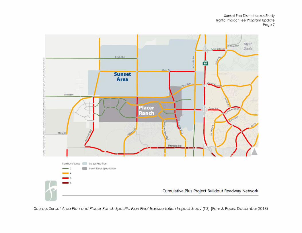
The Sunset District fee program includes all of the major roadway capacity-increasing projects needed to accommodate the new development in the SAP and PRSP, according to the established LOS policy in the Sunset Fee District. Refer to Appendix A for the for the LOS results. Figure 2 displays the ultimate roadway network for the Sunset Fee District. The Sunset District Fee Program does not include transportation infrastructure funded by other fee programs, such as Placer Parkway. All infrastructure is needed as a result of the new development in the SAP. Local roadways are not included in the fee program, because development projects will be responsible for their funding and construction.
The traffic fee includes the cost of the project applicable to new development. Additional funding sources have been identified, such as frontage improvement funding from land developers and fair share contributions from the United Auburn Indian Community (UAIC) and City of Roseville Specific Plans. Refer to the CIP project list in Appendix B for more information.
A select link analysis was performed to determine the origin and destination of vehicles using the roadways that cross the PRSP and SAP boundaries. Both Foothills Boulevard and Fiddyment Road serve a significant amount of regional traffic. On Foothills Boulevard, the frontage improvements funded by developers outside this fee program offset the cost of the project that is not attributable to new development in the SAP. On Fiddyment Road north of Athens Avenue, there are no frontage improvements assumed in the CIP. Since this segment of Fiddyment Road was shown to carry approximately 50% regional traffic and 50% traffic from SAP, the project cost attributable to the traffic fee has been reduced to 50% of the overall project cost.
Sunset Fee District Nexus Study Traffic Impact Fee Program Update
Page 7
Figure 2
Source: Sunset Area Plan and Placer Ranch Specific Plan Final Transportation Impact Study (TIS) (Fehr & Peers, December 2018)
Sunset Fee District Nexus Study Traffic Impact Fee Program Update
Page 8
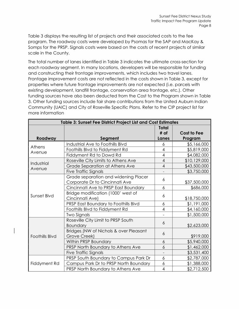
Table 3 displays the resulting list of projects and their associated costs to the fee program. The roadway costs were developed by Psomas for the SAP and MacKay & Somps for the PRSP. Signals costs were based on the costs of recent projects of similar scale in the County.
The total number of lanes identified in Table 3 indicates the ultimate cross-section for each roadway segment. In many locations, developers will be responsible for funding and constructing their frontage improvements, which includes two travel lanes. Frontage improvement costs are not reflected in the costs shown in Table 3, except for properties where future frontage improvements are not expected (i.e. parcels with existing development, landfill frontage, conservation area frontage, etc.). Other funding sources have also been deducted from the Cost to the Program shown in Table 3. Other funding sources include fair share contributions from the United Auburn Indian Community (UAIC) and City of Roseville Specific Plans. Refer to the CIP project list for more information
Table 3: Sunset Fee District Project List and Cost Estimates
Roadway Segment
Total # of
Lanes Cost to Fee
Program
Athens Avenue
Industrial Ave to Foothills Blvd 6 $5,166,000 Foothills Blvd to Fiddyment Rd 4 $5,819,000 Fiddyment Rd to Dowd Rd 4 $4,082,000
Industrial Avenue
Roseville City Limits to Athens Ave 4 $10,129,000 Grade Separation at Athens Ave 4 $43,500,000 Five Traffic Signals - $3,750,000
Sunset Blvd
Grade separation and widening Placer Corporate Dr to Cincinnati Ave
6 $37,500,000
Cincinnati Ave to PRSP East Boundary 6 $686,000 Bridge modification (1000’ west of Cincinnati Ave)
6 $18,750,000
PRSP East Boundary to Foothills Blvd 6 $1,191,000 Foothills Blvd to Fiddyment Rd 4 $4,160,000 Two Signals - $1,500,000
Foothills Blvd
Roseville City Limit to PRSP South Boundary
6 $2,623,000
Bridges (NW of Nichols & over Pleasant Grove Creek)
6 $919,000
Within PRSP Boundary 6 $5,940,000 PRSP North Boundary to Athens Ave 6 $1,462,000 Five Traffic Signals - $3,531,400
Fiddyment Rd PRSP South Boundary to Campus Park Dr 6 $2,787,000 Campus Park Dr to PRSP North Boundary 6 $1,388,000 PRSP North Boundary to Athens Ave 4 $2,712,500
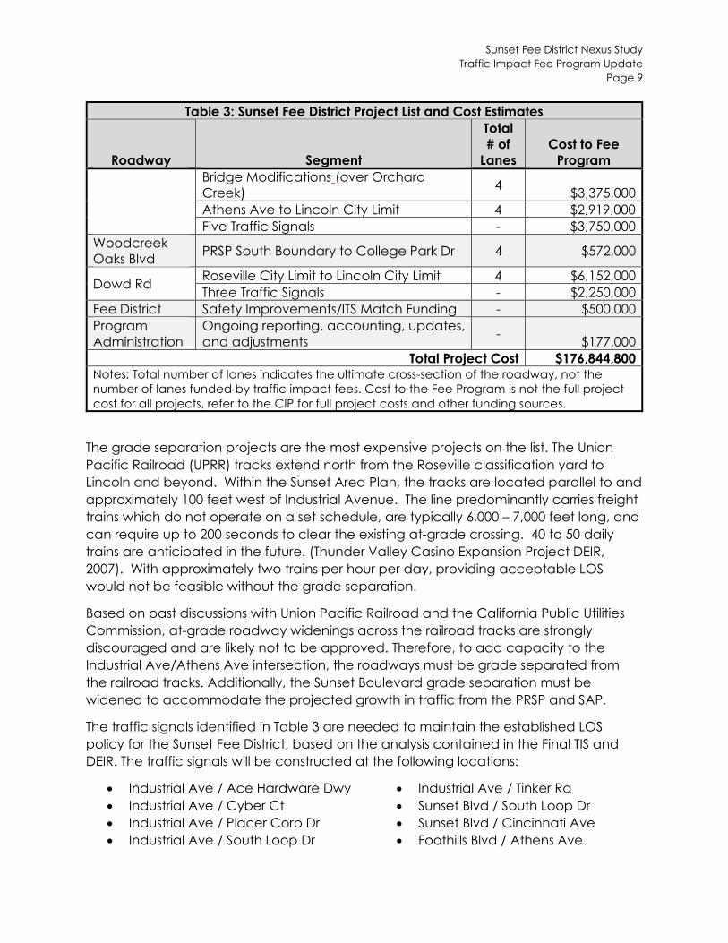
Table 3: Sunset Fee District Project List and Cost Estimates
Roadway Segment Lanes
Total # of
Cost to Fee
Program Bridge Creek) Modifications (over Orchard
4 $3,375,000
Athens Ave to Lincoln City Limit 4 $2,919,000 Five Traffic Signals - $3,750,000
Woodcreek Oaks Blvd
PRSP South Boundary to College Park Dr 4 $572,000
Dowd Rd Roseville City Limit to Lincoln City Limit 4 $6,152,000
Three Traffic Signals - $2,250,000 Fee District Safety Improvements/ITS Match Funding - $500,000
Program Administration
Ongoing reporting, and adjustments
accounting, updates, -
$177,000 Total Project Cost $176,844,800
Notes: Total number of lanes indicates the ultimate cross-section of the roadway, not number of lanes funded by traffic impact fees. Cost to the Fee Program is not the full
cost for all projects, refer to the CIP for full project costs and other funding sources.
the project
Sunset Fee District Nexus Study Traffic Impact Fee Program Update
Page 9
The grade separation projects are the most expensive projects on the list. The Union Pacific Railroad (UPRR) tracks extend north from the Roseville classification yard to Lincoln and beyond. Within the Sunset Area Plan, the tracks are located parallel to and approximately 100 feet west of Industrial Avenue. The line predominantly carries freight trains which do not operate on a set schedule, are typically 6,000 – 7,000 feet long, and can require up to 200 seconds to clear the existing at-grade crossing. 40 to 50 daily trains are anticipated in the future. (Thunder Valley Casino Expansion Project DEIR, 2007). With approximately two trains per hour per day, providing acceptable LOS would not be feasible without the grade separation.
Based on past discussions with Union Pacific Railroad and the California Public Utilities Commission, at-grade roadway widenings across the railroad tracks are strongly discouraged and are likely not to be approved. Therefore, to add capacity to the Industrial Ave/Athens Ave intersection, the roadways must be grade separated from the railroad tracks. Additionally, the Sunset Boulevard grade separation must be widened to accommodate the projected growth in traffic from the PRSP and SAP.
The traffic signals identified in Table 3 are needed to maintain the established LOS policy for the Sunset Fee District, based on the analysis contained in the Final TIS and DEIR. The traffic signals will be constructed at the following locations:
Industrial Ave / Ace Hardware Dwy Industrial Ave / Tinker Rd Industrial Ave / Cyber Ct Sunset Blvd / South Loop Dr Industrial Ave / Placer Corp Dr Sunset Blvd / Cincinnati Ave Industrial Ave / South Loop Dr Foothills Blvd / Athens Ave
Sunset Fee District Nexus Study Traffic Impact Fee Program Update
Page 10
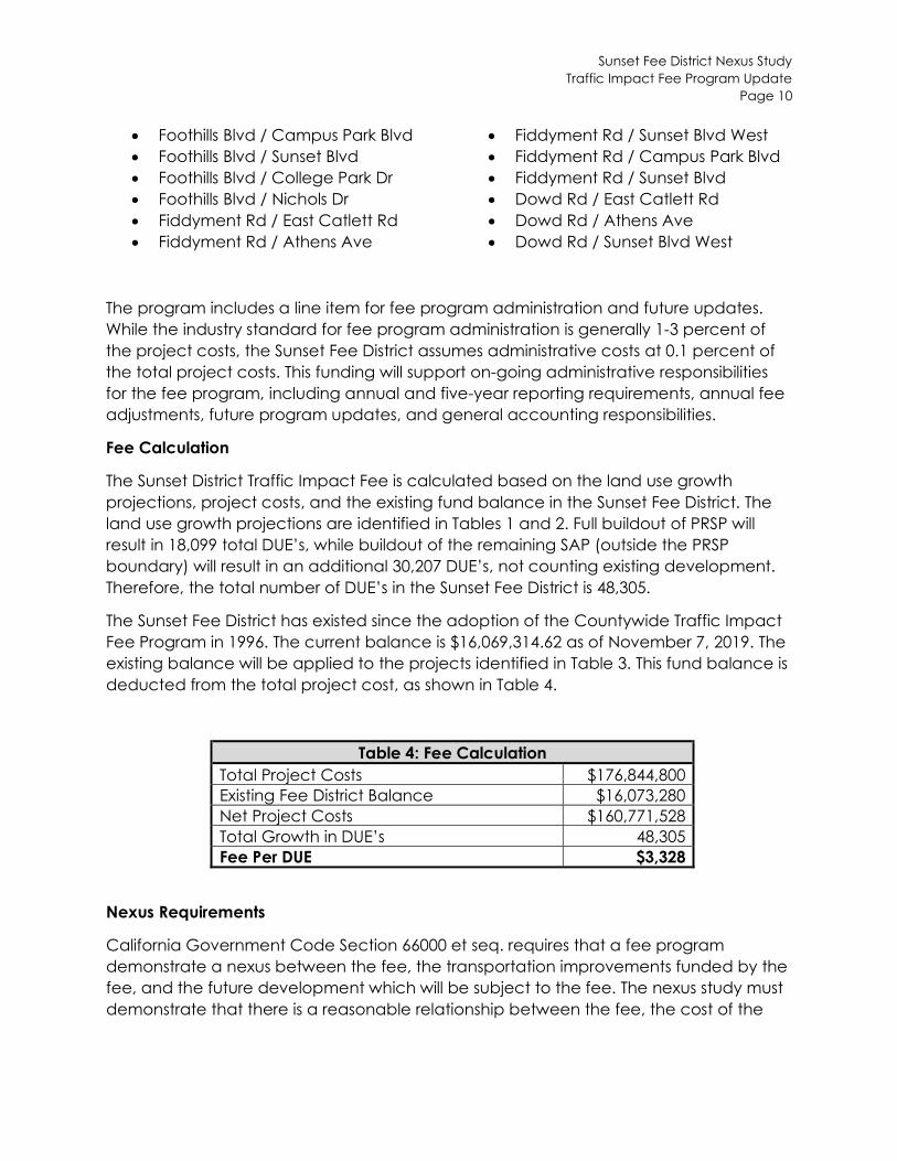
Foothills Blvd / Campus Park Blvd Fiddyment Rd / Sunset Blvd West Foothills Blvd / Sunset Blvd Fiddyment Rd / Campus Park Blvd Foothills Blvd / College Park Dr Fiddyment Rd / Sunset Blvd Foothills Blvd / Nichols Dr Dowd Rd / East Catlett Rd Fiddyment Rd / East Catlett Rd Dowd Rd / Athens Ave Fiddyment Rd / Athens Ave Dowd Rd / Sunset Blvd West
The program includes a line item for fee program administration and future updates. While the industry standard for fee program administration is generally 1-3 percent of the project costs, the Sunset Fee District assumes administrative costs at 0.1 percent of the total project costs. This funding will support on-going administrative responsibilities for the fee program, including annual and five-year reporting requirements, annual fee adjustments, future program updates, and general accounting responsibilities.
Fee Calculation
The Sunset District Traffic Impact Fee is calculated based on the land use growth projections, project costs, and the existing fund balance in the Sunset Fee District. The land use growth projections are identified in Tables 1 and 2. Full buildout of PRSP will result in 18,099 total DUE’s, while buildout of the remaining SAP (outside the PRSP boundary) will result in an additional 30,207 DUE’s, not counting existing development. Therefore, the total number of DUE’s in the Sunset Fee District is 48,305.
The Sunset Fee District has existed since the adoption of the Countywide Traffic Impact Fee Program in 1996. The current balance is $16,069,314.62 as of November 7, 2019. The existing balance will be applied to the projects identified in Table 3. This fund balance is deducted from the total project cost, as shown in Table 4.
Table 4: Fee Calculation Total Project Costs $176,844,800 Existing Fee District Balance $16,073,280 Net Project Costs $160,771,528 Total Growth in DUE’s 48,305 Fee Per DUE $3,328
Nexus Requirements
California Government Code Section 66000 et seq. requires that a fee program demonstrate a nexus between the fee, the transportation improvements funded by the fee, and the future development which will be subject to the fee. The nexus study must demonstrate that there is a reasonable relationship between the fee, the cost of the
Sunset Fee District Nexus Study Traffic Impact Fee Program Update
Page 11
improvements, and the transportation impact of future development. More specifically, the nexus study must:
Identify the purpose of the fee. Identify the use to which the fee is to be applied. If the use is financing public
facilities, the facilities must be identified. Determine how there is a reasonable relationship between the fee’s use and the
type of development project on which the fee is imposed. Determine how there is a reasonable relationship between the need for a public
facility and the type of development project on which the fee is imposed. Demonstrate a reasonable relationship between the amount of the fee and the
cost of public facility or portion of the public facility attributable to the development on which the fee is imposed.
The requirements of the nexus study are outlined below.
Identify the Purpose of the Fee
The Traffic Impact Fee for the Sunset Fee District will fund the roadway and circulation improvements needed to serve new development in the Sunset Fee District and provide convenient and safe access to the fee district.
Identify the Use of the Fee
The fee will be used to fund needed new roadways, bridge modifications, intersection improvements, grade-separated crossings, and roadway widenings, as identified in this nexus study. The fee may be used for all stages of project implementation, including planning, environmental, right-of-way acquisition, design, and construction. Additionally, the fee will fund administrative responsibilities and requirements of the fee program.
Determine Reasonable Relationship between the Fee’s Use and Type of Development
The fee will be used to fund capacity-increasing roadway infrastructure needed to serve new development. The development of new residential and non-residential land use will result in increased vehicular traffic, resulting in the need for additional roadway capacity and new roadways. Each new development in the Sunset Fee District will benefit from the roadway infrastructure funded by the fee. The infrastructure is needed to maintain the applicable levels of service standards in the Sunset Fee District.
Determine Reasonable Relationship between the Need for the Facility and Type of Development
The development of new residential and non-residential land use will result in increased vehicular traffic, resulting in the need for additional roadway capacity and new roadways. The additional roadway capacity is needed to maintain the established level of service standards for roadways in the Sunset Fee District.
Sunset Fee District Nexus Study Traffic Impact Fee Program Update
Page 12
Determine Reasonable Relationship between the Amount of the Fee and the Cost of or Portion of the Facility Attributed to the Development on which the Fee is Imposed
The amount of the fee and cost of new facilities are apportioned to each land use based on their relative contribution to increased vehicular traffic using the DUE rates. Each land use type is converted to DUE’s, according to the trip generation rate of the land use. This ensures that the fee imposed is proportional to the traffic generated by each land use.
Implementation
If adopted, the updated fee will go into effect 60 days after adoption. Traffic fees are paid with the issuance of a building permit. This fee will supersede the existing Countywide Traffic Impact Fee in the Sunset Fee District. Refer to the Countywide Traffic Fee Program document for more information about implementation.
This fee program will be subject to the reporting requirements of California Government Code Section 66000 et seq.
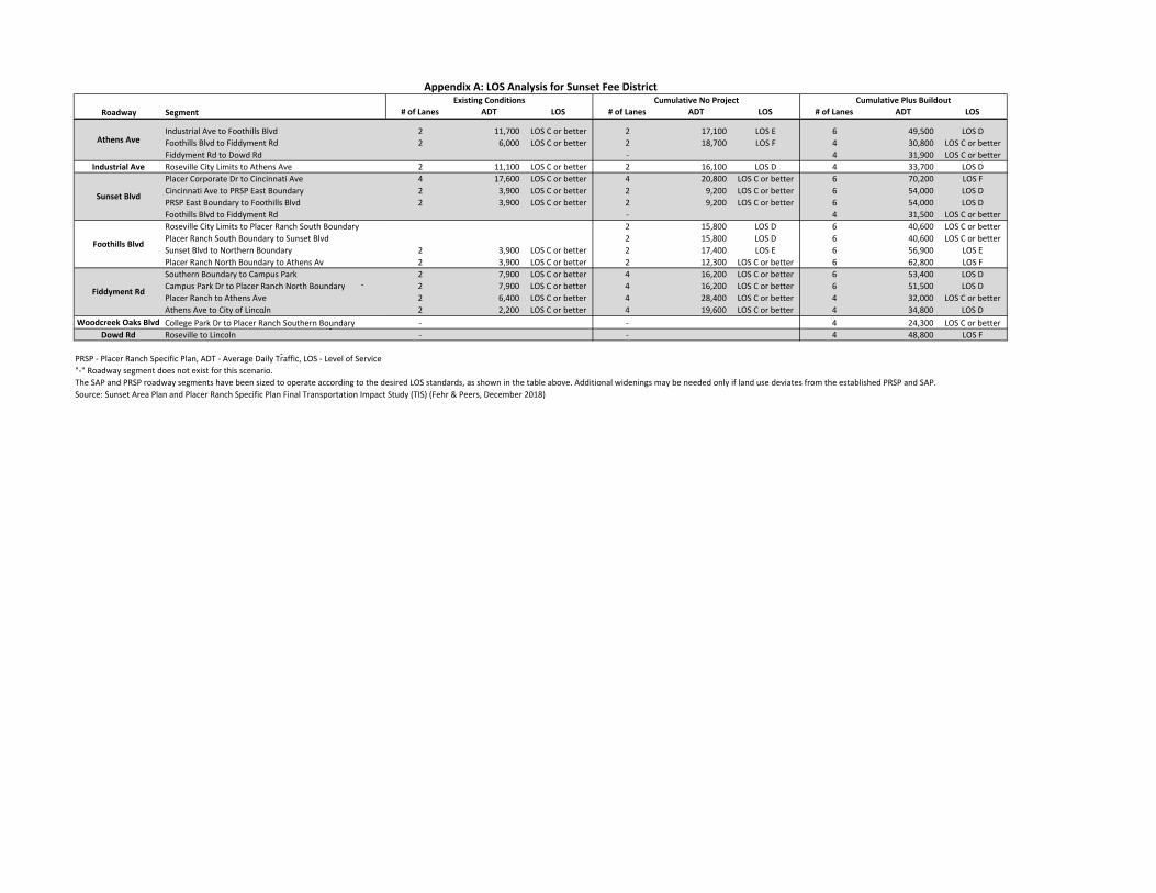
Appendix A: LOS Analysis for Sunset Fee District
Roadway Segment # of Lanes Existing Conditions
ADT LOS # of Lanes Cumulative No Project
ADT LOS # of Lanes Cumulative Plus Buildout
ADT LOS
Industrial Ave to Foothills Blvd Athens Ave Foothills Blvd to Fiddyment Rd
Fiddyment Rd to Dowd Rd
2 2
‐
11,700 6,000
LOS C or better LOS C or better
2 2 ‐
17,100 LOS E 18,700 LOS F
6 4 4
49,500 LOS D 30,800 LOS C or better 31,900 LOS C or better
Industrial Ave Roseville City Limits to Athens Ave 2 11,100 LOS C or better 2 16,100 LOS D 4 33,700 LOS D Placer Corporate Dr to Cincinnati Ave 4 17,600 LOS C or better 4 20,800 LOS C or better 6 70,200 LOS F Cincinnati Ave to PRSP East Boundary Sunset Blvd PRSP East Boundary to Foothills Blvd
2 2
3,900 3,900
LOS C or better LOS C or better
2 2
9,200 LOS C or better 9,200 LOS C or better
6 6
54,000 LOS D 54,000 LOS D
Foothills Blvd to Fiddyment Rd
‐
‐ 4 31,500 LOS C or better Roseville City Limits to Placer Ranch South Boundary
‐
2 15,800 LOS D 6 40,600 LOS C or better Placer Ranch South Boundary to Sunset BlvdFoothills Blvd Sunset Blvd to Northern Boundary
‐
2 3,900 LOS C or better 2 2
15,800 LOS D 17,400 LOS E
6 6
40,600 LOS C or better 56,900 LOS E
Placer Ranch North Boundary to Athens Av 2 3,900 LOS C or better 2 12,300 LOS C or better 6 62,800 LOS F Southern Boundary to Campus Park 2 7,900 LOS C or better 4 16,200 LOS C or better 6 53,400 LOS D Campus Park Dr to Placer Ranch North Boundary Fiddyment Rd Placer Ranch to Athens Ave
2 2
7,900 6,400
LOS C or better LOS C or better
4 4
16,200 LOS C or better 28,400 LOS C or better
6 4
51,500 LOS D 32,000 LOS C or better
Athens Ave to City of Lincoln 2 2,200 LOS C or better 4 19,600 LOS C or better 4 34,800 LOS D Woodcreek Oaks Blvd College Park Dr to Placer Ranch Southern Boundary ‐ ‐ 4 24,300 LOS C or better
Dowd Rd Roseville to Lincoln ‐ ‐ 4 48,800 LOS F
PRSP ‐ Placer Ranch Specific Plan, ADT ‐ Average Daily Traffic, LOS ‐ Level of Service "‐" Roadway segment does not exist for this scenario. The SAP and PRSP roadway segments have been sized to operate according to the desired LOS standards, as shown in the table above. Additional widenings may be needed only if land use deviates from the established PRSP and SAP. Source: Sunset Area Plan and Placer Ranch Specific Plan Final Transportation Impact Study (TIS) (Fehr & Peers, December 2018)
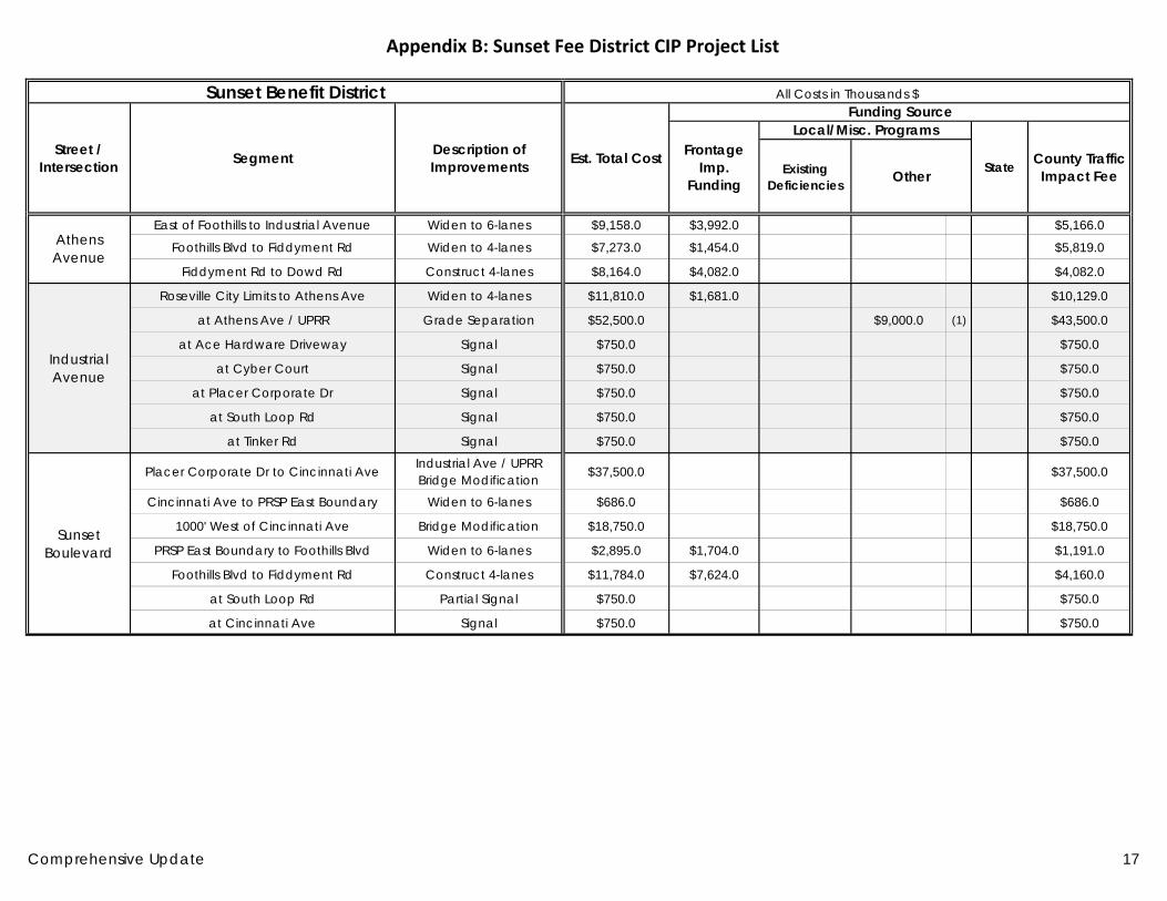
Appendix B: Sunset Fee District CIP Project List
Sunset Benefit District All Costs in Thousands $
Street / Intersection Segment Description of
Improvements Est. Total Cost
Funding Source
Frontage Imp.
Funding
Local/Misc. Programs
State County Traffic Impact FeeExisting
Deficiencies Other
Athens Avenue
East of Foothills to Industrial Avenue Widen to 6-lanes $9,158.0 $3,992.0 $5,166.0
Foothills Blvd to Fiddyment Rd Widen to 4-lanes $7,273.0 $1,454.0 $5,819.0
Fiddyment Rd to Dowd Rd Construct 4-lanes $8,164.0 $4,082.0 $4,082.0
Industrial Avenue
Roseville City Limits to Athens Ave Widen to 4-lanes $11,810.0 $1,681.0 $10,129.0
at Athens Ave / UPRR Grade Separation $52,500.0 $9,000.0 (1) $43,500.0
at Ace Hardware Driveway Signal $750.0 $750.0
at Cyber Court Signal $750.0 $750.0
at Placer Corporate Dr Signal $750.0 $750.0
at South Loop Rd Signal $750.0 $750.0
at Tinker Rd Signal $750.0 $750.0
Sunset Boulevard
Placer Corporate Dr to Cincinnati Ave Industrial Ave / UPRR Bridge Modification $37,500.0 $37,500.0
Cincinnati Ave to PRSP East Boundary Widen to 6-lanes $686.0 $686.0
1000' West of Cincinnati Ave Bridge Modification $18,750.0 $18,750.0
PRSP East Boundary to Foothills Blvd Widen to 6-lanes $2,895.0 $1,704.0 $1,191.0
Foothills Blvd to Fiddyment Rd Construct 4-lanes $11,784.0 $7,624.0 $4,160.0
at South Loop Rd Partial Signal $750.0 $750.0
at Cincinnati Ave Signal $750.0 $750.0
Comprehensive Update 17
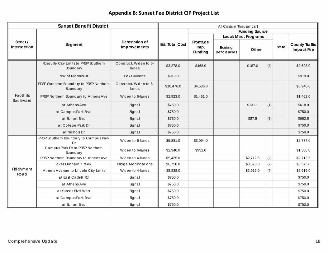
Appendix B: Sunset Fee District CIP Project List
Sunset Benefit District All Costs in Thousands $
Street / Intersection Segment Description of
Improvements Est. Total Cost
Funding Source
Frontage Imp.
Funding
Local/Misc. Programs
State County Traffic Impact FeeExisting
Deficiencies Other
Foothills Boulevard
Roseville City Limits to PRSP Southern Boundary
Construct/Widen to 6-lanes $3,278.0 $468.0 $187.0 (3) $2,623.0
NW of Nichols Dr Box Culverts $919.0 $919.0
PRSP Southern Boundary to PRSP Northern Boundary
Construct/Widen to 6-lanes $10,476.0 $4,536.0 $5,940.0
PRSP Northern Boundary to Athens Ave Widen to 6-lanes $2,923.0 $1,461.0 $1,462.0
at Athens Ave Signal $750.0 $131.1 (1) $618.9
at Campus Park Blvd Signal $750.0 $750.0
at Sunset Blvd Signal $750.0 $87.5 (1) $662.5
at College Park Dr Signal $750.0 $750.0
at Nichols Dr Signal $750.0 $750.0
Fiddyment Road
PRSP Southern Boundary to Campus Park Dr Widen to 6-lanes $5,881.0 $3,094.0 $2,787.0
Campus Park Dr to PRSP Northern Boundary Widen to 6-lanes $2,340.0 $952.0 $1,388.0
PRSP Northern Boundary to Athens Ave Widen to 4-lanes $5,425.0 $2,712.5 (2) $2,712.5 over Orchard Creek Bridge Modifications $6,750.0 $3,375.0 (2) $3,375.0
Athens Avenue to Lincoln City Limits Widen to 4-lanes $5,838.0 $2,919.0 (2) $2,919.0
at East Catlett Rd Signal $750.0 $750.0
at Athens Ave Signal $750.0 $750.0
at Sunset Blvd West Signal $750.0 $750.0
at Campus Park Blvd Signal $750.0 $750.0
at Sunset Blvd Signal $750.0 $750.0
Comprehensive Update 18
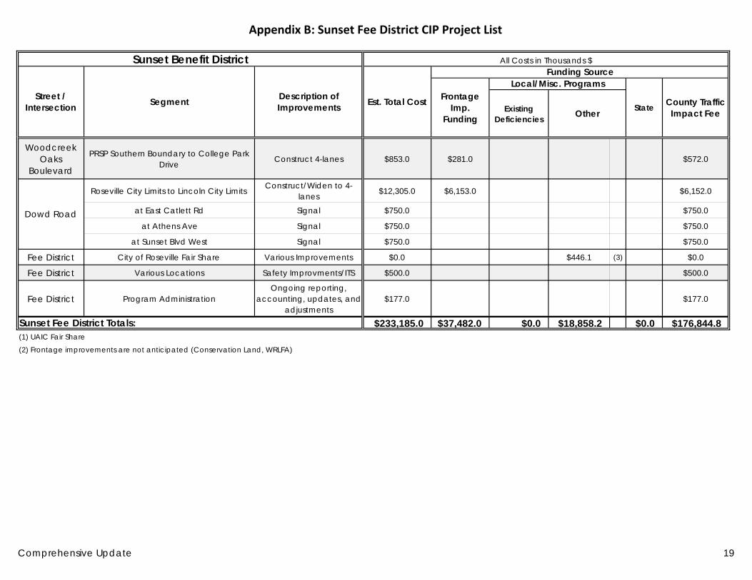
Appendix B: Sunset Fee District CIP Project List
Sunset Benefit District All Costs in Thousands $
Street / Intersection Segment Description of
Improvements Est. Total Cost
Funding Source
Frontage Imp.
Funding
Local/Misc. Programs
State County Traffic Impact FeeExisting
Deficiencies Other
Woodcreek Oaks
Boulevard
PRSP Southern Boundary to College Park Drive Construct 4-lanes $853.0 $281.0 $572.0
Dowd Road
Roseville City Limits to Lincoln City Limits Construct/Widen to 4-lanes $12,305.0 $6,153.0 $6,152.0
at East Catlett Rd Signal $750.0 $750.0
at Athens Ave Signal $750.0 $750.0
at Sunset Blvd West Signal $750.0 $750.0
Fee District City of Roseville Fair Share Various Improvements $0.0 $446.1 (3) $0.0
Fee District Various Locations Safety Improvments/ITS $500.0 $500.0
Fee District Program Administration Ongoing reporting,
accounting, updates, and adjustments
$177.0 $177.0
Sunset Fee District Totals: $233,185.0 $37,482.0 $0.0 $18,858.2 $0.0 $176,844.8 (1) UAIC Fair Share
(2) Frontage improvements are not anticipated (Conservation Land, WRLFA)
Comprehensive Update 19