Summerhill - meath.ie · Summerhill Architectural Conservation Area Statement of Character Lotts...
56
Summerhill Architectural Conservation Area statement Of Character December 2009
Transcript of Summerhill - meath.ie · Summerhill Architectural Conservation Area Statement of Character Lotts...

1Summerhill Architectural Conservation Area Statement of Character
Summerhill Architectural Conservation Area
statement Of Character
December 2009

Published by Meath County Council, County Hall, Navan, Co. Meath.
All rights reserved. No part of this book may be reprinted or reproduced or utilised in any electronic, mechanical or other means, now known or hereafter invented, including photocopying and recording, or otherwise, without either the prior written permission of the Publishers or a licence permitting restricted copying in Ireland issued by the Irish Copyright Licensing Agency Ltd, The Irish Writers centre, 19 Parnell Square, Dublin 1.
All photographs copyright of Meath County Council unless otherwise attributed.
© Meath County Council 2009.
Includes Ordnance Survey Ireland data reproduced under OSi Licence number 2009/31/CCMA Meath County Council. Unauthorised reproduction infringes Ordnance Survey Ireland and Government of Ireland copyright.
The extract from William Larkin’s map of 1812 has been reproduced with the permission of the Library Service of Meath County Council.
Historic photographs are reproduced with kind permission of the Irish Architectural Archive and the Local Studies Section of Navan County Library.
ISBN 978-1-900923-15-6Design and typeset by Legato Design, Dublin 1

Summerhill
Architectural Conservation Area
Statement of Character
Lotts Architecture and Urbanism with Michael O’Neill
On behalf of Meath County Council and
County Meath Heritage Forum
An action of the County Meath Heritage Plan 2007-2011 supported by Meath County Council and the Heritage Council

In 2007 Meath County Council adopted the County Meath Heritage Plan 2007-2011, prepared by the County Heritage Forum, following extensive consultation with stakeholders and the public. The Heritage Forum is a partnership between local and central government, state agencies, heritage and community groups, NGOs local business and development, the farming sector, educational institutions and heritage professionals. The Heritage plan is a cross-agency strategic plan which aims to identify, promote, enhance and conservation Meath’s rich heritage. It is an action of the Heritage Plan to evaluate the character of Architectural Conservation Areas (ACAs) in the county.
It is an objective of the county Meath Development Plan 2007-2013 to carry out an appraisal of existing and proposed Architectural Conservation Areas (ACAs) during the lifetime of the plan. This publication describes the special character of Summerhill ACA and will be a useful guide for the public and local authority. We would sincerely like to thank all those who contributed to this project and to the Heritage Council for providing funding.
Cllr. William Carey Mr. Tom Dowling Mr. Seamus MacGabhannCathaoirleach County Manager Cathaoirleach Meath County Council Meath County Council County Meath Heritage Forum
Foreword
i Summerhill Architectural Conservation Area Statement of Character

1
1.0 Introduction
2.0 Location & boundary of the Architectural Conservation Area
3.0 Schedule of protected structures & recorded monuments
4.0 Development Plan zoning & objectives
5.0 Historical development of the area
6.0 Character overview of Longwood ACA
7.0 Street by street appraisal
8.0 Summary of significant views & vistas
9.0 Summary of special character
10.0 Implications for planning and development
Contents
Summerhill Architectural Conservation Area Statement of Character

2Summerhill Architectural Conservation Area Statement of Character
1.0 Introduction
The towns, villages and landscapes of Co. Meath contain areas of architectural, historical and cultural interest, whose character is derived from the grouping of structures and open spaces, and their setting in the landscape. These areas of particular heritage value may develop and change with time, but their special character is considered worthy of protection. Planning legislation allows a planning authority to include objectives in its Development Plan to preserve the character of a place, area, group of structures or townscapes that are of special architectural, historical, archaeological, artistic, cultural, scientific, social or technical interest or value, or contribute to the appreciation of protected structures. Such areas are known as Architectural Conservation Areas (ACAs) and may include the following:
• groups of structures of distinctiveness, visual richness or historical importance
• the setting and exterior appearance of structures that are of special interest, but the interiors of which do not merit special protection
• the setting of a protected structure where this is more extensive than its curtilage
• designed landscapes, for example, urban parks, historic demesnes, cemeteries or industrial sites
• groups of structures which form dispersed but unified entities but which are not within the curtilage of a single dominant structure.
An ACA could therefore include a terrace of houses, a streetscape, a town centre or an ensemble related to a specific building type, such as a mill or a country house. The significance of buildings within an ACA lies in their positive contribution to the character and cultural importance of the group and their protection relates to their external appearance and associated external spaces. The objective of the ACA designation is to guide change within an area and ensure that future development
is carried out in a manner sympathetic to the special character of the historic place. Works to the exterior of a structure within an ACA only qualify as exempted development if the works do not affect the character of the exterior or that of neighbouring structures or open spaces. Whilst Alterations, extensions and new build are allowed within an ACA but any new development should respect or enhance the special character of the area and should be carried out in consultation with the Planning Department of Meath County Council, following the usual planning application process.There are currently eighteen ACAs designated in Co. Meath. This document is one in a series which identifies the special character of individual ACAs and gives advice and guidance to those seeking planning permission, such as homeowners, developers and planning professionals, on the type of works that would be acceptable within that particular ACA, to avoid loss or negative impact to its special character.
Introduction
3Summerhill Architectural Conservation Area Statement of Character
2.0 Location & Boundary of the Architectural Conservation Area
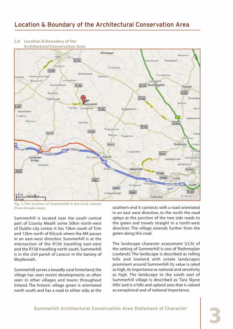
Fig. 1: The location of Summerhill in the local context (from Google maps)
Summerhill is located near the south central part of County Meath some 50km north-west of Dublin city centre. It lies 10km south of Trim and 12km north of Kilcock where the M4 passes in an east-west direction. Summerhill is at the intersection of the R156 travelling east-west and the R158 travelling north south. Summerhill is in the civil parish of Laracor in the barony of Moyfenrath.
Summerhill serves a broadly rural hinterland, the village has seen recent developments so often seen in other villages and towns throughout Ireland. The historic village green is orientated north south and has a road to either side, at the
southern end it connects with a road orientated in an east west direction, to the north the road splays at the junction of the two side roads to the green and travels straight in a north-west direction. The village extends further from the green along this road. The landscape character assessment (LCA) of the setting of Summerhill is one of ‘Rathmoylan Lowlands’. The landscape is described as rolling hills and lowland with estate landscapes prominent around Summerhill. Its value is rated as high, its importance as national and sensitivity as high. The landscape to the south east of Summerhill village is described as ‘Tara Skyne Hills’ and is a hills and upland area that is valued as exceptional and of national importance.
Location & Boundary of the Architectural Conservation Area

4Summerhill Architectural Conservation Area Statement of Character
Fig. 2: Aerial view of Summerhill village and demesne
Location & Boundary of the Architectural Conservation Area

5Summerhill Architectural Conservation Area Statement of Character
2.1 ACA Boundary
The ACA boundary for Summerhill encompasses the estate village and its central green, the entrance to Summerhill House to the south of the green and the narrowing into the Trim Road to the north. The boundaries either side of the green are set according to the depth of individual plots. The boundaries of the ACA are delineated on the accompanying Figure 3.
The following streets and thoroughfares are located partly or wholly within the boundaries of the ACA:
Trim Road (part of ), The Village Green, Kilcock Road (part of ), Enfield Road Road (part of )Elm Grove (part of )Elm Court (part of ) Beech Croft (part of )
Fig.3: Boundary of Summerhill ACA
Location & Boundary of the Architectural Conservation Area

6Summerhill Architectural Conservation Area Statement of Character
3.0 Schedule of Protected Structures & Recorded Monuments
There are a number of protected structures within the boundaries of the Summerhill ACA that are protected under Part IV of the Planning & Development Act 2000. A protected structure is a structure or part of a structure that a Planning Authority considers to be of special interest from an architectural, historical, archaeological, artistic, cultural, scientific, social or technical point of view. The full extent of a protected structure includes the land lying within the curtilage of the protected structure and other structures within that curtilage and their interiors. The concept of curtilage is not defined by legislation, but is understood to be the parcel of land immediately associated with that structure and which is or was in use for the purposes of the structure. The Record of Protected Structures (RPS) is contained in the Meath County Development Plan 2007-2013, Appendix V.
The Record of Monuments and Places lists structures and sites of archaeological heritage. The schedule is available to the public at the Planning Office of Meath County Council, Teagasc Offices and Town Councils and on the internet on the website of the National Monuments Services, Department of Environment, Heritage and Local Government (www.archaeology.ie).
Schedule of Protected Structures & Recorded Monuments

7Summerhill Architectural Conservation Area Statement of Character
3.1Protected Structures
Within the boundary of the Summerhill ACA there are seven protected structures comprising: a 18th century demesne gate entrance; uniform terraces of 19th century houses of large scale; detached 19th century residential and commercial buildings; a terraced 20th century house, and street furniture.
• RPS No. MH 043- 200: Detached 4-bay, 2 storey estate worker’s house, New Road
• RPS No. MH 043- 201: Detached 5-bay, 2 storey house, now a pub, Trim Road
• RPS No. MH 043- 202: Cast-iron water pump
• RPS No. MH 043- 203: Stone gate piers and walls, Village Green
• RPS No. MH 043- 205: Terraced 3-bay, 3 storey house, Village Green
• RPS No. MH 043- 206: Terraced 5-bay, 3 storey house, Village Green
A 5-bay, 2 storey house stands 1km to the east of the ACA that was a dower house to Summerhill House and is part of the larger group of the main house and village. (RPS MH 043-209 refers.)
3.2 Recorded Monuments
The following archaeological sites, features and artefacts within the ACA for Summerhill are protected by National Monument legislation as they are listed as Recorded Monuments in the Record of Monuments and places:
• RMP Ref. ME043-020001 Cross, Summerhill
• RMP Ref. ME043-021002 Armorial Plaque
3.3 Historic Gardens and Designed Landscapes
The NIAH Historic Gardens and Designed Landscapes of Ireland records the existence of the landscape to the south of the ACA:
• ME-49-844477: Summerhill House, Summerhill
Schedule of Protected Structures & Recorded Monuments
8Summerhill Architectural Conservation Area Statement of Character
4.0 Development Plan Zoning & Objectives
The Meath County Development Plan 2001-2007 has been superseded by the Meath County Development Plan 2007-2013. The Summerhill Local Area Plan was adopted on the 28th of April 2009. Detailed policies and objectives are prescribed in the aforementioned plans. In considering new development within this LAP area the policies and objectives prescribed in the Meath County Development Plan 2007-2013 and the Summerhill Local Area Plan 2009-2015 are of relevance.
Development Plan Zoning & Objectives
9Summerhill Architectural Conservation Area Statement of Character
5.0 Historical development of the area
The earliest reference to the same Summerhill for this area appears to be in a confirmatory grant to Dr. Henry Jones, dated to 1666, which refers to ‘Knock, alias Summerhill’. The medieval Irish name for the area was either Drumsawry or Knocksawry, Cnoc-Samhruidh, the latter name used in an unpublished poem of a Franciscan friar in a manuscript dated 1626. In administrative documents of the medieval and early modern period the area was referred to as ‘the Knock’ or ‘Lynch’s Knock’.
The Lynch name associated with this area was that of an old Anglo-Norman family, the FitzLeons, tenants in chief of the De Lacy lordship of Meath. The name, variously spelt FitzLeon, de Leyns, transmogrified into Lynch over the centuries.
The earliest documentary evidence associating the Lynch’s with Summerhill in particular is a document of 1485, which refers to Christopher Leynce of the Knock. ‘Peter Lynch of the Knock’ was among the list of the ‘Marchers’ of the English Pale in 1524. He held his castle and lands at the Knock as tenant to his feudal chief, Wellesley, of Dangan Castle (due north of Summerhill). The Pale boundary here was defined along a line from Trim through Dangan demesne to Kilcock.
Castle and wayside cross
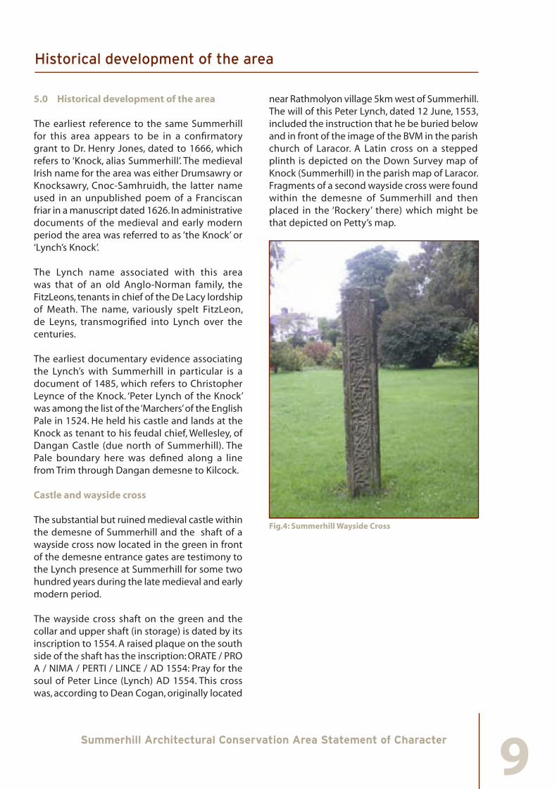
The substantial but ruined medieval castle within the demesne of Summerhill and the shaft of a wayside cross now located in the green in front of the demesne entrance gates are testimony to the Lynch presence at Summerhill for some two hundred years during the late medieval and early modern period.
The wayside cross shaft on the green and the collar and upper shaft (in storage) is dated by its inscription to 1554. A raised plaque on the south side of the shaft has the inscription: ORATE / PRO A / NIMA / PERTI / LINCE / AD 1554: Pray for the soul of Peter Lince (Lynch) AD 1554. This cross was, according to Dean Cogan, originally located
near Rathmolyon village 5km west of Summerhill. The will of this Peter Lynch, dated 12 June, 1553, included the instruction that he be buried below and in front of the image of the BVM in the parish church of Laracor. A Latin cross on a stepped plinth is depicted on the Down Survey map of Knock (Summerhill) in the parish map of Laracor. Fragments of a second wayside cross were found within the demesne of Summerhill and then placed in the ‘Rockery’ there) which might be that depicted on Petty’s map.
Fig.4: Summerhill Wayside Cross
Historical development of the area

10Summerhill Architectural Conservation Area Statement of Character
Fig.5: Lynch’s Castle
Fig.6: Photograph of Lynch’s Castle, c.1900
The castle within the demesne in described in the marriage settlement between Peter Lynch (grandson of the above Peter) and Jennet, sister of Oliver Plunkett, of Karstown, County Louth. This document dated 8 April, 1609, described “the new castle in the said Knock, and the great barn next adjoining the foresaid with the haggard place, with convenient or sufficient way of passage to carry and recarry corn, turf, wood and other necessaries, with cars, carts, or otherwise thereunto; and the house or messuage with the backside thereunto belonging and next adjoining unto the said castle, without [outside] the wall of the said haggard that Christopher Wakely lately held”.
This document is a reminder that many ancillary buildings could be attached to a masonry castle which have not survived, leaving the probably
misleading impression of isolated castles or tower houses in today’s landscape. It is also likely that an earlier route passed closer to the castle, later enclosed within the demesne.
The sixteenth-century castle at Summerhill has a four-storey tower measuring 10m by 8m with the second storey vaulted. The spiral staircase in the NW corner has a newel and gunloops. The upper levels have fireplaces in the south wall and latrines on the north. There are fine upper windows with dished spandrels and hoodmoulds. Attached to the SW corner is a later range, possibly T-plan, bearing a plaque with the O’Neill arms commemorating the priest Luke Wye with the date 1636: PRAY FOR THE / SOULE of LUKE / [ ]WYE[ ] PRIEST / 1636. Contains mullioned windows, the projecting tower to the west contained the wooden staircase. It is now covered in dense ivy. This early Jacobean building is worthy of further study. Carefully stripped of ivy and vegetation it would provide an excellent eye-catcher within the walls of the demesne.
Gerald Lynch, son of Peter Lynch was the last member of that family to hold the Knock/Summerhill. He forfeited the Summerhill estates in 1642 following the rebellion of the previous year. In June 1642 the castle, variously called Lynche’s Knock and Knocklinch was besieged by the Earl of Ormonde. All the defenders except the women were executed when the castle fell. Gerald Lynch apparently was not present during the siege. In 1652 Dungandstown and ‘the town and lands of Knock and its parcels, lately belonging to Gerald Lynds, a rebel outlawed and attained of Treason’, Agher and several more townlands were granted to Dr. Henry Jones.
Jones was the son of the bishop of Killaloe, was himself made bishop of Clogher and Chancellor of Trinity College Dublin. During the Civil War period, 1642-1652, he became Scoutmaster-General in Cromwell’s army. The land grant was thus a reward for his services in addition to his salary and expenses during the period. In Petty’s Down Survey Map of Laracor parish, there is an exact delineation of the Knock, with its three square towers, two of which are
Historical development of the area

11Summerhill Architectural Conservation Area Statement of Character
shown as unroofed and somewhat ruined. The accompanying report stated that “There is in the Knock a fair house, repairing, and an old castle in repair; some very good wood, one mill in repair, there is also a town through which the road from Trim to Kilcock lies”. The Civil Survey also records an old chapel, a stone quarry and ‘divers cabins’ at Knock. Jones thus repaired the castle.
Following the Restoration of Charles II, Jones’s possessions and career might have seemed insecure. He was, however, as Bishop of Clogher “absolved… from his irregularity” and in 1661 Charles issued Letters Patent appointing him Bishop of Meath, where his new property was located. He was also made a Privy Councellor for Ireland. Despite a protracted campaign by Gerald Lynch to have his estates restored, Jones retained the estates granted during the Commonwealth. A confirmatory grant from the Crown, dated 1666, confirmed Jones with the title to the “Knock, alias Summerhill, with its parcels, Moige and Knockbeg” and several other pieces of land.
As noted above Jones repaired the castle at Summerhill. According to Bishop Dopping’s Episcopal visitation of Meath c.1685, the church and chancel of the parish church at Laracor were out of repair and that Bishop Jones (his immediate predecessor) provided or provided for services at Summerhill every Sunday. In a later 1697 visitation Dopping reported that Summerhill alias Knock chapel had been built and consecrated by Jones in 1669. This church does not survive – unless it was incorporated in the mausoleum built by Langford in 1781. A church or chapel at Summerhill is not mentioned by Bishop Ellis in his visitation c.1731.
Langfords at Summerhill
Sometime following the confirmation by the Crown of his Meath holdings in 1666, Jones sold Summerhill to Sir Hercules Langford. The Rowley connection with Meath began in 1671 when Sir John Rowley M.P. married Mary the only child and heir of Sir Hercules Langford of Summerhill and his wife Mary Upton. The Rowleys settled in Ireland in the early part of the seventeenth
century and probably came to Ireland with Chichester as Lord Deputy. Sir John Rowley and Mary Langford had only one son and one daughter. The son, Hercules Rowley, married his cousin Frances Upton of Castle Upton, Co. Antrim, in 1705. It must have been he who inherited from Sir Hercules Langford whose will was proven in 1683. Hercules Rowley had sat in Parliament since 1703, sharing the representation of the County of Derry with Speaker William Conolly. He had one son born about 1714 in Summerhill and who was later entitled the Hon. Hercules Langford Rowley. This son, the Hon. Hercules, married in 1732 his cousin, the Hon. Elizabeth Ormsby Upton, the daughter and heir of Clotworthy Upton who died in the same year. A date within a year or two of this advantageous marriage is given as the date of the transformation of Summerhill demesne and estate village.
Summerhill
The location, to the south of Lynch’s castle and on a more elevated site approached by a long dramatic avenue was undoubtedly chosen to dominate the area. The English architect Cockerell considered ‘few sites more magnificently chosen’. The house at Summerhill was probably designed by Sir Edward Lovett Pearce in collaboration with Richard Castle who carried it out after Pearce’s death.
Historical development of the area

12Summerhill Architectural Conservation Area Statement of Character
Fig.7: Photograph from Vanishing Country Houses of Ireland (IAA)
The house consisted of a large two-storey seven-bay block with a Corinthian giant order framing the three central bays, two massive square towers at each end, and great arched chimneystacks suggesting the influence of Sir John Vanburgh in whose office Pearce had trained. The main block was joined by curving two-storey wings to end pavilions with shallow domes. Beyond these were further massive two-storey pavilions of four bays, with single, large, low central stacks. Beyond these again were pedimented triumphal arches. Had it survived there is no doubt because of its monumentality – captured in photographs – and the fact that Pearce was the architect, it would be the most visited eighteenth-century building outside the capital.
The building suffered many vicissitudes. Burnt, perhaps accidentally, during the 1798 rebellion, it was apparently not put fully back into repair until 1870 when John McCurdy was employed as architect. Accounts of visitors in the early nineteenth century point up its former grandeur suggesting that it was falling into dilapidation for some long period of time. In fact in 1851 crippling debts forced Lord Langford to put the estate up for sale but was able to retain it when a sufficiently long line of credit was found to satisfy the petitioners in the case.
A more devastating event was the complete burning of the house on the 4th February 1921 during the War of Independence. The house was ‘reduced to a mass of blackened ruins’ with the complete loss of its contents. The estimated cost of the damage was £200,000. The motivation behind the burning of Summerhill seems to be in keeping with two major attributes of Summerhill, its size and location. A report issued from Dublin Castle claimed that the vacated Summerhill had been burned by the IRA in order to prevent military occupation by British forces. A second reason was its strategic position, located as it was ‘on high ground which commanded one of the routes to the west. The Auxiliaries with field glasses, could have swept the country’. In September 1921, a claim for £100,000 was made at Trim quarter sessions for Summerhill and £30,000 for its contents. However only £65,000 was awarded for the house and £11,000 for contents. Given the size of the proposed award, the matter was referred to the Compensation Commission which eventually awarded £43,500 in damages, with no obligation to rebuild. Maurice Craig described it as follows: ‘It stood for many years after that event, if anything more splendid in ruin than in life, for its architecture, and particularly that of the domed towers, had the gift of running grandly to ruin’. The cut stone was sold off in the late 1950s and the robbed wall cores were bulldozed into the ground in the following decade. Only the pedimented archways to the extreme left and right survive indicative of the former massive scale.
Historical development of the area

13Summerhill Architectural Conservation Area Statement of Character
Fig.8: Plan and Elevation of Summerhill from Maurice Craig, The Architecture of Ireland
Arthur Young in his tour of Ireland 1776-79, visited Summerhill and described it as follows: “The country is cheerful and rich; and if the Irish cabins continue like what I have hereto seen, I shall not hesitate to pronounce their inhabitants as well off as most English cottagers. They are built of mud wall 18 inches or 2 feet thick and well thatched, which are far warmer than the clay walls in England. Here are few cottars without a cow and sometimes two. A belly full invariably of potatoes and generally turf from fuel from a bog. It is true they have not always chimneys to their cabins, the door serving for that and window too. Every cottage swarms with poultry and most of them have pigs. The plantation and ornamental grounds at Summerhill are extensive and form a fine environ, spreading over the hills and having a noble appearance from the high lands above the bog. The house is large and handsome wit an elegant hall, a cube of 30 feet, and many very good and convenient apartments.”
Historical development of the area
14Summerhill Architectural Conservation Area Statement of Character
Fig.9: Summerhill from Lithograph accompanying Sale details 11, July 1851. in Mary Cecelia Lyons, Illustrated Encumbered Estates Ireland, 1850-1905
Fig.10: Summerhill, pavilion tower. Photo Maurice Craig
Summerhill village
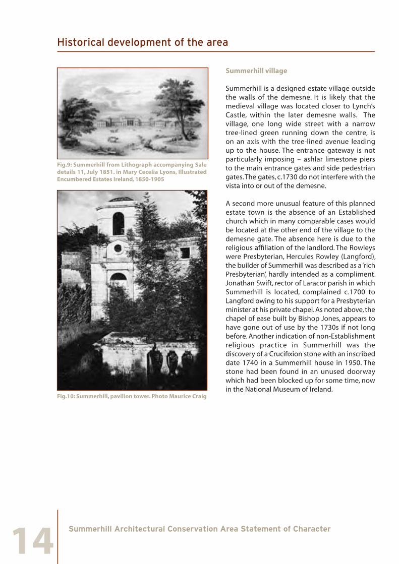
Summerhill is a designed estate village outside the walls of the demesne. It is likely that the medieval village was located closer to Lynch’s Castle, within the later demesne walls. The village, one long wide street with a narrow tree-lined green running down the centre, is on an axis with the tree-lined avenue leading up to the house. The entrance gateway is not particularly imposing – ashlar limestone piers to the main entrance gates and side pedestrian gates. The gates, c.1730 do not interfere with the vista into or out of the demesne.
A second more unusual feature of this planned estate town is the absence of an Established church which in many comparable cases would be located at the other end of the village to the demesne gate. The absence here is due to the religious affiliation of the landlord. The Rowleys were Presbyterian, Hercules Rowley (Langford), the builder of Summerhill was described as a ‘rich Presbyterian’, hardly intended as a compliment. Jonathan Swift, rector of Laracor parish in which Summerhill is located, complained c.1700 to Langford owing to his support for a Presbyterian minister at his private chapel. As noted above, the chapel of ease built by Bishop Jones, appears to have gone out of use by the 1730s if not long before. Another indication of non-Establishment religious practice in Summerhill was the discovery of a Crucifixion stone with an inscribed date 1740 in a Summerhill house in 1950. The stone had been found in an unused doorway which had been blocked up for some time, now in the National Museum of Ireland.
Historical development of the area

15Summerhill Architectural Conservation Area Statement of Character
Fig.11: Down Survey, location of Summerhill (north to bottom of map)
The older houses in the village date to the later eighteenth and early nineteenth century. In the demesne are the ruins of a Gothic mausoleum which had a dedication tablet which read: ‘This beautiful building was designed and executed by the Right Honerable Hercules Langford Rowley in 1781 when he had it dedicated as a general burying place for his Langford Rowley family at Summerhill and any or all of his attached friends who lived respected and useful lives’. This tangible link to the area is further bolstered by the seeking and the granting of patents for a fair at Summerhill to H.L. Rowley by George III in 1780. Carlisle, writing in 1810, recorded that at Summerhill there were four fairs: 30th April for Dry Cows, 9th June and 22nd September for Sheep and Calves and the 25th November for fat cattle. This succinctly summarises the role of cattle fattening and drystock in Meath in the late eighteenth and into the nineteenth century. The granting of patents for fairs most likely coincided with the planned development of the
village. Lewis, writing some thirty years later, said that Summerhill contained 49 houses and 331 inhabitants, had a constabulary police station and a Presbyterian meeting house.
Fig.12: Summerhill from William Larkin’s Map of County Meath, 1812. in Arnold Horner, Mapping Meath in the early 19th century.
William Larkin’s Map of Meath in 1812 shows a fully developed and landscaped demesne at Summerhill. Outside the main gates a wide single street is clearly depicted with houses on both sides. Towards the north end an enclosed green is depicted and more intriguingly a substantial building in the centre in front of the gates. The 1st edition OS map also shows a building in front of the entrance gates. This clearly indicates that the demesne gates as originally placed were not directly in front of the green. While Larkin’s map indicates an avenue due south from the gates to the house, this is not recorded on the OS 1st edition. However, on the 2nd edition of the OS map, dated 1884, not only is an avenue from the gates to the house clearly depicted, the main gates were moved slightly west to align with the village green. By the time of the 3rd edition, 1912, the avenue has become tree-lined as it is today.
Historical development of the area

16Summerhill Architectural Conservation Area Statement of Character
Fig 13: Summerhill Village and Demesne, Ordnance Survey 1st Edition, 1836/7
On the east side of the green are a number of substantial terraced town houses – three, four and five bays wide and two and three storeys high, with a lower, long two-storey four bay house with projecting porch. It is likely that it was thatched and may have been a common building type in the green. The gate lodge beside the entrance gate also has a windbreak porch.
Historical development of the area

17Summerhill Architectural Conservation Area Statement of Character
Fig 14: Summerhill Village and Demesne, Ordnance Survey 2nd Edition, 1909/12
Historical development of the area

18Summerhill Architectural Conservation Area Statement of Character
Fig.15. Summerhill c.1960 from The History and Folklore of Coole and Summerhill
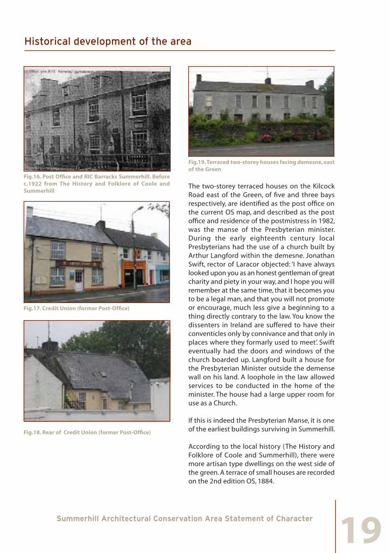
The RIC Barracks was burned in 1922 and subsequently demolished. Two single-storey terraced houses are now on its site. The Post Office building survives and is now in use as the Credit Union. The historic postcard (Fig.16) shows dormers on both barracks and post-office (since removed), a feature found on another house on this side of the Green.
Historical development of the area
19Summerhill Architectural Conservation Area Statement of Character
Fig.16. Post Office and RIC Barracks Summerhill. Before c.1922 from The History and Folklore of Coole and Summerhill
Fig.17. Credit Union (former Post-Office)
Fig.18. Rear of Credit Union (former Post-Office)
Fig.19. Terraced two-storey houses facing demesne, east of the Green
The two-storey terraced houses on the Kilcock Road east of the Green, of five and three bays respectively, are identified as the post office on the current OS map, and described as the post office and residence of the postmistress in 1982, was the manse of the Presbyterian minister. During the early eighteenth century local Presbyterians had the use of a church built by Arthur Langford within the demesne. Jonathan Swift, rector of Laracor objected: ‘I have always looked upon you as an honest gentleman of great charity and piety in your way, and I hope you will remember at the same time, that it becomes you to be a legal man, and that you will not promote or encourage, much less give a beginning to a thing directly contrary to the law. You know the dissenters in Ireland are suffered to have their conventicles only by connivance and that only in places where they formarly used to meet’. Swift eventually had the doors and windows of the church boarded up. Langford built a house for the Presbyterian Minister outside the demense wall on his land. A loophole in the law allowed services to be conducted in the home of the minister. The house had a large upper room for use as a Church.
If this is indeed the Presbyterian Manse, it is one of the earliest buildings surviving in Summerhill.
According to the local history (The History and Folklore of Coole and Summerhill), there were more artisan type dwellings on the west side of the green. A terrace of small houses are recorded on the 2nd edition OS, 1884.
Historical development of the area
20Summerhill Architectural Conservation Area Statement of Character
Fig.20. Artisan type dwellings on the west side of the Green
Fig.21. New Road, south side, protected structure
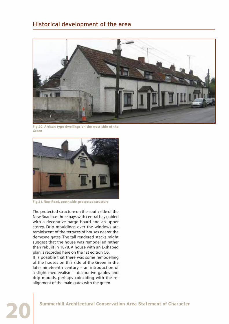
The protected structure on the south side of the New Road has three bays with central bay gabled with a decorative barge board and an upper storey. Drip mouldings over the windows are reminiscent of the terraces of houses nearer the demesne gates. The tall rendered stacks might suggest that the house was remodelled rather than rebuilt in 1878. A house with an L-shaped plan is recorded here on the 1st edition OS. It is possible that there was some remodelling of the houses on this side of the Green in the later nineteenth century – an introduction of a slight medievalism – decorative gables and drip moulds, perhaps coinciding with the re-alignment of the main gates with the green.
Historical development of the area
21Summerhill Architectural Conservation Area Statement of Character
6.0 Character overview of Summerhill ACA
This section provides a brief description of the designated ACA under the following headings: layout; socio-economic functions; building types and materials.
6.1 Layout
The street pattern within Summerhill reflects the planned estate layout associated with Summerhill demesne to the south. The house was built in the 1730s and demolished in 1970. The axis of mature trees within the demesne is continued by the buildings to either side of the Village Green. Many of the houses were built for estate workers and have similar architectural details to their elevations.
The main open space within the ACA is the rectangular space enhanced by the tree-lined green within it. This narrows to the north where the roads to either of the Village Green join and continue at an angle to the north-west.
A distinctive feature is the use of terrace houses to either side of the Village Green. Those on the east side are grander Georgian houses and those on the west small scale Victorian or later workers houses with narrow gardens to the rear. Both terraces open directly to the footpath with no front gardens or set-backs.
The terrace to the east has a back lane (Elm Grove) parallel to the Village Green with an access way connecting the two midway along the terrace (Elm Court). The depth of this block is less than the width of the Village Green space between the terrace buildings. No access way exists to the rear of the western terrace and historical maps indicate that this was always the case.
A housing estate is connected to the east of the ACA but is relatively isolated in its relationship to the main space of the Village Green and is suburban in character.
6.2 Socio-Economic Functions
The town of Summerhill serves a rural hinterland and is a dormitory town and service centre for a primarily commuter based residential population. Its role and function has been determined by its proximity to Dublin. It provides a variety of services to the local population. 6.3 Building types and Materials
There are four common building typologies found in Summerhill ACA.
• Early Twentieth-century residential terrace houses
• Nineteenth-century detached residences
• Eighteenth century residential terrace houses
• Landscape architectural features
The prevailing building materials are limestone, in exposed random rubble and rock-cut form and painted plaster applied to facades and chimneys. Many of the smaller houses have similar plaster frame features around the windows. Timber was originally used for windows and doors and as such forms standard elements of the archetypal shop-fronts. Some buildings within the ACA retain their natural slate roofs which add to the visual richness of the area.
Character overview of Summerhill ACA

22Summerhill Architectural Conservation Area Statement of Character
Fig.22: Small terrace houses to the west of the Village Green
Fig.23: Large terrace houses to the east of the Village Green
Character overview of Summerhill ACA

23Summerhill Architectural Conservation Area Statement of Character
7.0 Street by street appraisal
All of the streets included within the boundary of the ACA contain buildings and other elements that are a positive contribution to the character of Summerhill. This section provides a brief description of each street and open area within the ACA boundary under the following headings:
•ArchitecturalCharacterandBuildingUses
This is an appraisal of various buildings along a street, in a laneway or courtyard and within private grounds. Its character is identified through historical use, design, scale and building materials. It also refers to the use of the buildings on the street and how they influence the special character of that area.
•QualityandTreatmentofOpenSpace
Spatial quality is defined by the relationship between buildings and the street, how each street relates to each other and the open space within the area. Included in this section is an inventory of extant street furniture and historic street surface treatment. It also refers to the manner in which a site is enclosed; for example, walls, hedges, railings and gates.
7.1 The southern boundary of the ACA
7.1.1 Architectural Character and Building Uses
The southern boundary of the ACA is defined by an east-west road that passes the southern end of the Village Green.
To the south side of the road are the grounds and entrance of Summerhill demesne on axis with the Village Green with the tree lined avenue to the former house. To the east of the entrance is single-storey gate lodge set back from the road. Further to the east is a suburban type house, also set back form the road, this house is beyond the boundary of the ACA. After this there are no further structures along the road. To the west of the entrance there are no structures within the ACA.
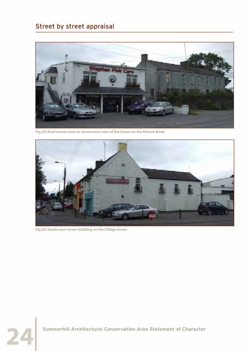
The corner to the southern end of the Village Green is undefined on the west side, here there is presently no building and site works are underway. Further west are a row of suburban type houses set far back form the Enfield Road.To the east side the gable and rear extension of an end of terrace two-storey house faces south onto the Kilcock Road. It is set back from the footpath and has a number of windows at first floor level. To the east of this is a functional modern free standing and two-storey building in use as a car showrooms with a large set back on the west side that provides access to a large shed to the rear of the building. The showroom building borders the west side of Elm Grove, a lane perpendicular to the Kilcock road. East of Elm Grove there are two terraced two-storey four bay houses with slate pitched roofs and timber sash windows. They have fine front gardens and long rear gardens, have a noble air and are architecturally reminiscent of the buildings on the east side of the Village Green.
Street by street appraisal
24Summerhill Architectural Conservation Area Statement of Character
Fig.24: Row houses and car showrooms east of the Green on the Kilcock Road
Fig.25: South east corner building on the Village Green
Street by street appraisal

25Summerhill Architectural Conservation Area Statement of Character
Fig. 26: Terraced house on Kilcock Road
Fig. 27: Lodge house on Kilcock Road
Street by street appraisal

26Summerhill Architectural Conservation Area Statement of Character
7.1.2 Quality and Treatment of Open Space
The space at the southern end of the Village Green is terminated by a large set of limestone gate piers and walls that frame a tree lined avenue that continues to the south on axis with the Green. The gates are set back and give a grand effect to the entrance.
Fig.28: Entrance to Summerhill Demesne
Fig.29: Stone demesne wall at the gate lodge onthe Kilcock Road
Fig.30: Stone wall and metal gates to the houses opposite
Street by street appraisal
27Summerhill Architectural Conservation Area Statement of Character
The stone demesne walls continue east and west of the gate entrance around the estate grounds. To the east they are broken by the gate lodge entrance with piers and a metal gate. The stone wall is echoed by that of the double houses diagonally opposite the gate lodge.
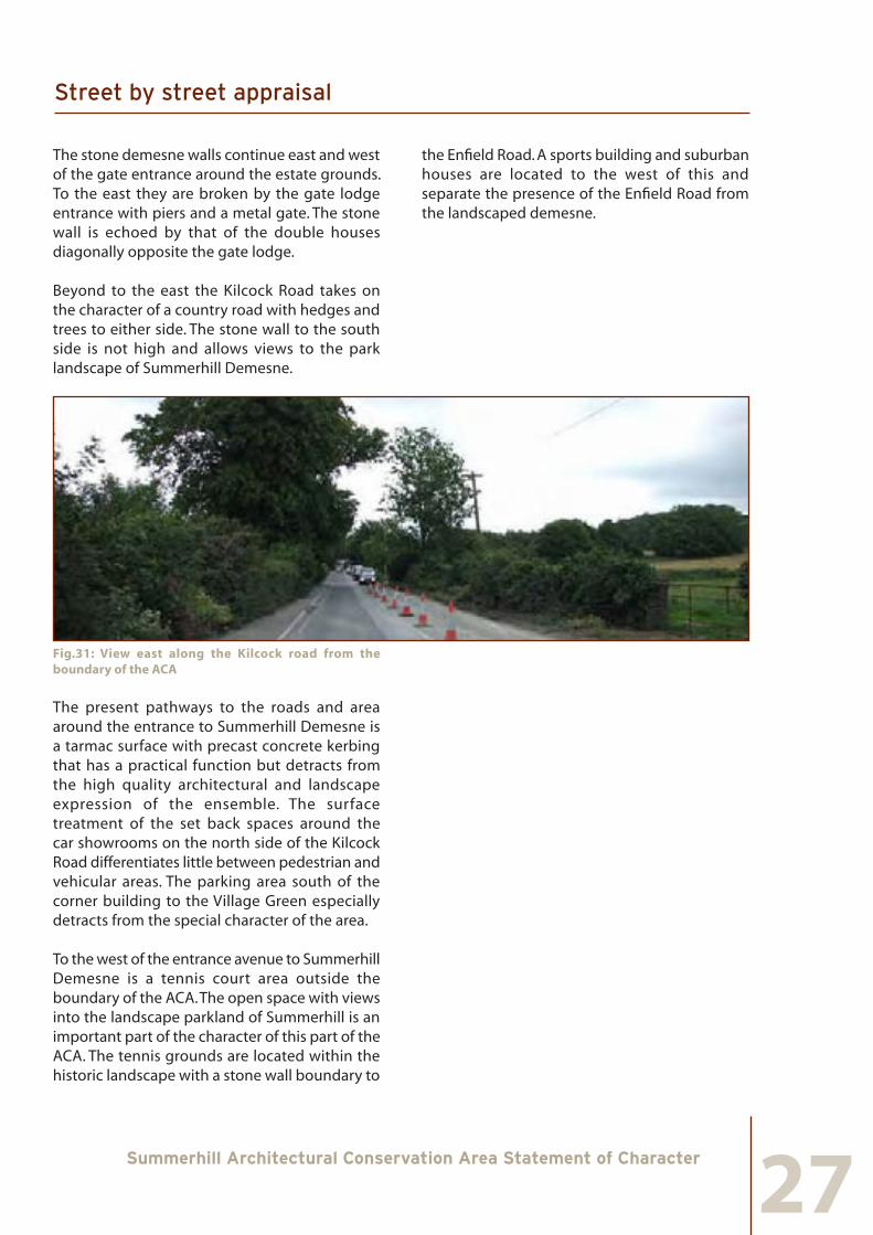
Beyond to the east the Kilcock Road takes on the character of a country road with hedges and trees to either side. The stone wall to the south side is not high and allows views to the park landscape of Summerhill Demesne.
Fig.31: View east along the Kilcock road from the boundary of the ACA
The present pathways to the roads and area around the entrance to Summerhill Demesne is a tarmac surface with precast concrete kerbing that has a practical function but detracts from the high quality architectural and landscape expression of the ensemble. The surface treatment of the set back spaces around the car showrooms on the north side of the Kilcock Road differentiates little between pedestrian and vehicular areas. The parking area south of the corner building to the Village Green especially detracts from the special character of the area.
To the west of the entrance avenue to Summerhill Demesne is a tennis court area outside the boundary of the ACA. The open space with views into the landscape parkland of Summerhill is an important part of the character of this part of the ACA. The tennis grounds are located within the historic landscape with a stone wall boundary to
the Enfield Road. A sports building and suburban houses are located to the west of this and separate the presence of the Enfield Road from the landscaped demesne.
Street by street appraisal

28Summerhill Architectural Conservation Area Statement of Character
Fig.32: View east along the Kilcock road from the boundary of the ACA
7.2 The Village Green
7.2.1 Architectural Character and Building Uses
This space and the defining buildings to either side is the defining element at the heart of the ACA. It stretches from the entrance to Summerhill demesne in the south northwards where it narrows and bends to the north-west to become the Trim Road.
The architectural character is a mixture of three-storey Georgian terrace houses, two-storey nineteenth and twentieth century free standing and single-storey terrace houses. The function is still largely residential with some services in the form of shops and offices.
The west side buildings are smaller in scale. This area is quiet and has little through traffic compared to the east side. The southern end
lacks definition and is an empty building site at the moment. A row of seven single-storey workers houses with dormers gives most definition to the southern part of this side of the Green. They have rendered walls brick chimneys and tiled roofs. The windows have Tudor style plasterwork frames above the main windows to the street. Although they are heavily altered with no remaining original windows they do provide a sense of unity to the Village Green that is part of its special character.
To the north of these there are a number of vacant sites of similar size to those in the terrace. A single storey bungalow has been built set back from the street line with elevations of brick and windows and doors of uPVC, it also has a large gable facing the street. Architecturally it is alien to the buildings on the Village Green and has a negative impact on the special character of the ACA.
At the northern end of the west side of the Village Green that is parallel to the east side are two sets of attached single-storey houses with dormers. They are similar in architectural expression and in their condition to the terrace of seven houses to the south. The gaps between these houses and their neighbours give views to rear yard and garden situations of poor visual quality. A large shed has been built to the rear of the northernmost couple of houses that is out of scale with their residential character.
Street by street appraisal

29Summerhill Architectural Conservation Area Statement of Character
Fig.33: Terrace houses to the south-west of the Village Green
Fig.34: Double houses at the north west-side of the Village Green
The east side of the Green has grander buildings and the road is busy. At the southern side a terrace of three two storey houses define the end and corner situation. These have pitched roofs with some slate and are in use as commercial premises. They have been heavily altered with some remaining exterior features.
Street by street appraisal

30Summerhill Architectural Conservation Area Statement of Character
Fig.35: Village Green; terrace of houses at the south east corner
Fig.36: Village Green; double houses south of Elm Court
Fig.37: Village Green; double houses north of Elm Court
North of these and south of Elm Court are two attached single-storey houses with hipped tiled roofs and rendered elevations. Despite their cottage size, they have a regular and formal expression sympathetic to the Village Green setting.
North of Elm Court, two recent two-storey terrace houses exist. Though they follow the street line and have a pitched roof, their architectural expression and details are not sympathetic to the character of the Village Green.
A further four buildings belong to this part of the terrace. Two buildings in the centre are three-storey Georgian houses, one is five-bay with a rendered façade and a square fanlight to the entrance door, the other is three-bay with an exposed stone elevation and a curved fanlight to the main door. Both houses have rendered chimneys and slate roofs. North of these is a four-bay two storey house with a slate roof, the elevation is of exposed stone with a square fanlight to the entrance door. These three houses are formal in character but this is softened by mixing of heights and rhythm (4:3:5) that is an essential ingredient to the formal but village character of Summerhill.
Street by street appraisal

31Summerhill Architectural Conservation Area Statement of Character
Fig.38: Village Green; large terrace houses
Fig.39: Village Green; north end of the east side terrace
A two-storey building to the north of the terrace does not conform to the scale and rhythm of the three structures to the south but perhaps relates more to the two attached houses south of Elm Court in architectural expression. Except for the recent structure north of Elm Court the buildings on the east side of the Village Green are an interesting collection of scales and architectural expression, formality, rhythm and function. Residential use survives with retail and office uses. The fact that they are accessed directly from the pavement with no set backs, railings or gardens gives them immediacy associated with village street settings.
Street by street appraisal

32Summerhill Architectural Conservation Area Statement of Character
7.2.2 Quality and Treatment of Open Space
The green space in the centre of the Village Green is orientated to the landscape park setting of Summerhill Demesne. Though the landscape originally did not have a straight avenue with accompanying trees, Summerhill House stood on axis with the village open space.
At present the green is largely a raised grass area with bordering stone walls and some trees to either side. A sunken area exists to the south end which is otherwise at street level. Though the green offers seclusion from surrounding traffic, it is cluttered in areas with small scale trees and shrub planting of suburban rather than village character, this also weakens its relationship to the large scale landscape setting of Summerhill Demesne. An important aspect of the green is its transparency when looking from the pathways to either terrace in order to appreciate the buildings from afar. The north end of the Green is separated from the triangular narrowing towards the Trim Road by a small cross road for traffic.
Fig.40: The Village Green seen from the south
Fig.41: The Village Green seen from the south
Street by street appraisal

33Summerhill Architectural Conservation Area Statement of Character
Fig.42: The Village Green facing towards Summerhill Demesne
None of the original paving or kerbing remains or is visible. The present pathways in front of the buildings have a practical function but they detract from the high quality architectural and landscape expression of the ensemble. The same applies to the pathways within the park itself.
7.3 Laneways to the east of the Village Green
7.3.1 Architectural Character and Building Uses
There are no buildings of any architectural quality in this part of the ACA that support its special character. Most of the buildings are recent and used as residences. The exception is the side, rear elevation and rear garden and walls of the double houses at the eastern end of the ACA on the Kilcock Road. A stone gable also remains of a building midway on the western side of Elm Grove that is of interest to the historical layout of the rear of buildings on the Village Green.
Fig 43: Elm Court, view from the Village Green
Fig 44: Elm Grove, view from the Kilcock Road
Street by street appraisal

34Summerhill Architectural Conservation Area Statement of Character
7.3.2 Quality and Treatment of Open Space
At present the lanes are more interesting than the buildings on them. They are an interesting contrast to the more formal open space of the Village Green and lead into quiet and intimate areas.
Fig 45: Elm Grove, surviving stone gable and rural village lane character
The surface treatment is unbound with no separation of pedestrian and traffic surfaces. Though poor quality, this is a remnant of to the rural village character of this part of the ACA.
7.4 North of the Village Green to the Trim and New Road Junction
7.4.1 Architectural Character and Building Uses
A number of different structures are arranged in an informal manner on the east side of the space between north of the Village Green proper and the junction between New Road and the Trim Road. To the south a petrol station building stands in line with the terrace, a canopy and free-standing signage stands in front of this. These detract substantially from the views of the east side of the Village Green terrace when seen from the north and south. A number of ancillary structures stand to the north of the service station building in a wide open forecourt area.
To the north of the service station is the road entrance to the Beechcroft housing estate and north of this again is a two-storey in use as a supermarket. It is in a vernacular style but with uPVC windows and rainwater goods and suburban roof detailing that are not in keeping with the character of the ACA.
Shaw’s Pub stands at the north of the ACA at the junction of the Trim Road and the New Road. It is separated from the supermarket to the south by a large open car park area. A new two-storey structure is being erected in line with the pub to the north. The pub is a two-storey building with a pitched slate roof and is a protected structure. It stands in a key position in the village at the end of the view from the New Road to the west and plays an important role in announcing the village to those arriving from that direction. Its architectural expression is typical of the village character of Summerhill.
Street by street appraisal

35Summerhill Architectural Conservation Area Statement of Character
Fig 46: Service station to the north-east of the Village Green
Fig 47: Shaw’s Pub
There are a number of diverse structures located on west side of the road between the Village Green and the junction to the New Road in an informal manner. To the south is an ESB station surrounded by a fence. North of this is a suburban style single storey yellow brick house with a front garden setback and free-standing side garage in the same style that jars with the village character of Summerhill. A two storey five bay police station with rendered facades and pitched slate roof stands at the corner to the New Road. It was built by the
OPW in 1948 and has a semi-official architectural expression typical of police stations from that period. Though set back from road it fulfils an important role of giving definition to the corner by means of its two-storey height and being set at an angle equal to both the New Road and the Trim Road.
Street by street appraisal

36Summerhill Architectural Conservation Area Statement of Character
Fig 48: Former estate worker’s house on the New Road
A series of structures stand to the southern side of the New Road to the west of the police station. They belong to the original structures built in the village and the western most building retains architectural features such as plaster frame features above the windows that are found elsewhere in the ACA.
A large modern structure stands at the north corner of the junction and an earlier structure may be integrated into this. It is very prominent when looking to and from the ACA. Its composition and detailing refer to vernacular forms but these are resolved in an unhappy manner that is not in keeping with the special character of the ACA.
7.4.2 Quality and Treatment of Open Space.
Traditionally the Village Green had been rectangular in form and stopped in line with the south side of the petrol station structure. A small slip road remains in the area of this line and a green space continues in triangular form where the roads to either side of the Village Green converge. A Celtic cross memorial stands at the wide end of the triangle. The grass area is almost level with the road and is marked by kerbing, bollards and chains. It is uncluttered in
comparison with part of the Village Green and it is unfortunate that it is cut off by the slip road as this discourages pedestrian access.
To the west of space the boundary treatment is often suburban rather than rural village in character with brick piers and wooden fencing. The area around the ESB substation is undefined with an assortment of fencing, screen planting, poles and street furniture and these are unsuitable for the public character of this site. None of the original paving or kerbing remains or is visible. The present pathways in front of the buildings have a practical function but they detract from the high quality architectural and landscape expression of the ensemble.
Street by street appraisal

37Summerhill Architectural Conservation Area Statement of Character
Fig 49: North end of the Village Green landscaped area
Fig 50: Slip road
Fig 51: Boundary treatment around the ESB substation
To the east the boundary treatment is largely undefined with large areas devoted to car parking and access to car parks between buildings. The tarmac road surface in front of Shaw’s Pub continues to the elevation with no footpath, change of level or other demarcation. The area in front of the car park between Shaw’s Pub and the supermarket has a narrow footpath made of concrete. The area in front of the supermarket has a raised path laid out in concrete pavers. In all these areas much provision has been made for car parking on the street and in the car park. A fine chestnut tree stands at the rear of Shaw’s Pub, gives some quality of character to the space and is attractive when seen from the road, but it is surrounded by refuse, bottle banks and cars.
The entrance to Beechcroft housing estate is by a wide road south of the supermarket and north of the petrol station. It is tree lined with small scale suburban trees with grass verges that fade out at the meeting point to the Village Green. The dense canopy of small scale trees and the fact that the road curves to the estate beyond allow no visual contact from the Village Green. This kind of street connection is suburban in character and is alien to the character of village streets typical for villages such as Summerhill. It further reinforces the lack of any meaningful boundary definition along this side of the street. The situation is made no better in front of the petrol station, here there is no differentiation between road and forecourt and no demarcation of a pedestrian way. In general the present boundary and pathway treatment in front of the buildings on the east side of the street north of the Village Green have a practical function for cars only and this detracts greatly from the high quality architectural and landscape expression of the ACA.
Street by street appraisal

38Summerhill Architectural Conservation Area Statement of Character
8.0 Summary of significant views & vistas
The importance of the long historic development of the routes through Summerhill lends meaning to the views in and out of the village. The flat topography allows long views and the raised topography to the site of the former Summerhill House is also of importance in the views.
The significant views and vistas are:
• The view along the Trim Road looking south into the ACA
• The view along the New Road looking east into the ACA
• The views looking north and south to either side of the Village Green and the views from one side of the Green to the other.
• The view to and from the tree lined axis of the avenue to Summerhill House
• The views into and out of the ACA along the Kilcock and Enfield Roads
• The view into Elm Grove from the Kilcock Road
• The view into Elm Court from the Village Green
Summary of significant views & vistas

39Summerhill Architectural Conservation Area Statement of Character
9.0 Summary of Special Character
There are a number of interrelated elements which contribute to the special character of Summerhill ACA. These are:
1. its long historical development associated with Lynch’s Castle and later with Summerhill House and Demesne, often very strongly registered in the layout of the road pattern in the larger area and in the village itself
2. the strong relationship between the landscaped demesne of Summerhill House and the village with its own green open space
3. the wide and generous size of the space in the green area and in the street space to the north
4. the absence of a church in a prominent position in the layout of the village
5. the existence of a network of lanes behind the eastern terrace on the Village Green
6. the definition given to the open Village Green space by rows of terrace houses to either side
7. the direct relationship of these terraces and other buildings in the ACA to public open space with no front gardens or setbacks
8. the uniformity of architectural expression in the larger terrace houses, in the two storey detached and terraced houses and the single-storey terraced estate workers houses
9. the mix of sizes of terraced houses and plots with different numbers of bays that give a character of informality in an otherwise formal and simple layout
10. the use of limited numbers of materials for facades (stucco) and roofs (slate or tiles) and timber for windows and doors
11. the use of dormer windows in both some of the small and large terrace houses
12. the existence of large mature trees throughout the ACA that act as backdrops to the buildings seen from different viewpoints
Summary of Special Character

40Summerhill Architectural Conservation Area Statement of Character
Fig 52: Summerhill ACA, Character Plan
Summary of Special Character

41Summerhill Architectural Conservation Area Statement of Character
10.0 Implications for Planning and Development
The objective of Architectural Conservation Area designation is to protect the special character of an area through rigorous control and positive management of any changes made to the built environment. Under the Planning & Development Act 2000 there is a requirement to obtain planning permission for all development works which do not constitute exempted development. Section 4 of the Planning & Development Act 2000 lists developments which are constituted as exempt, for the purposes of the Act. With regard to Architectural Conservation Areas it is important to take into account Section 4(1)(h) of the Act which states that the following shall be exempted development:
“Development consisting of the carrying out of works for the maintenance, improvement or other alteration of any structure, being works which affect only the interior of the structure or which do not materially affect the external appearance of the structure so as to render the appearance inconsistent with the character of the structure or of the neighbouring structures”.
Protected structures:
Planning permission is required for all works that would materially affect the character of a protected structure, or any element of the structure including its curtilage, which contributes to its special character. Under Section 57 of the Planning & Development Act 2000 an owner/occupier may request a declaration from Meath County Council as to whether any works they propose require planning permission. A declaration issued under this section sets out the type of works the Planning Authority considers would or would not affect the character of a structure or any elements thereof, which contributes to its special interest.
Non-protected structures:
Owners and occupiers of non-protected structures located within the Summerhill Village Architectural Conservation Area should be aware that works, which in the opinion of the Planning Authority would materially affect the character of the Architectural Conservation Area will require specific grant of planning permission under Section 82(1) of the Planning & Development Act 2000.
10.1 Works requiring planning permission
10.1.1 External walls
The majority of building facades in Summerhill have a render or plaster finish with stone and plaster details. Many of the existing facades have had their original lime mortar pointing removed and replaced with an unsuitable cement based mortar. This type of repointing would be deemed unacceptable by the Planning Authority and the restoration of suitable render will be encouraged. The painting of natural stone, brick or unpainted render-finished structures can damage the special character of the ACA and would not be deemed acceptable. Use of modern paints which can be detrimental to the building’s fabric, or the sand blasting of external surfaces which may lead to porosity and water ingress are also unacceptable. Dramatic use of colour for facades and façade details should be avoided in order to allow buildings to act harmoniously with one another, this is especially important in terrace situations.
Implications for Planning and Development

42Summerhill Architectural Conservation Area Statement of Character
10.1.2 Roofs
The roofscape of the Summerhill Village ACA is significant and is part of its integral special character. Original elements should be retained where possible, and repaired and reused rather than replaced. The following works require planning permission:
• The removal of the original roofing material such as natural slate and ridge tiles. Their replacement with modern materials like fibre-cement tiles will not be deemed suitable by the local authority.
• The removal of existing chimney-stacks and early terra-cotta or clay pots or other features of the roofscape such as cast-iron gutters and down-pipes.
• The removal of timber bargeboards and other eaves details and their replacement in a material other than the existing.
• The installation of roof lights or dormer windows on the front or prominent elevation of a structure, visible from the public realm. There is a tradition of dormer windows within some parts only of the Summerhill Village ACA that area associated with small scale estate workers housing and their installation into other structures will not be deemed appropriate by the local authority.
• The erection of, or alterations to, externally mounted signs and advertisements at roof level, including banners.
• The provision of awnings, canopies, flags and flagpoles.
• The erection of solar panels, TV satellite dishes, communication antennae or support structures for same. These are considered to have a highly negative impact on the character of the area and should be avoided when visible from the public realm. Where existing aerials have become redundant they should be removed.
10.1.3 Window and door openings
The buildings within the ACA of Summerhill Village retain few original window and doors, a large number of windows have been replaced with uPVC or timber windows of inappropriate design. Original elements should be retained where possible, and repaired and reused rather than replaced. The following works require planning permission:
• The alteration or enlargement of original openings.
• The removal of original timber and metal windows, and their replacement with modern, artificial materials such as uPVC and aluminium.
• The removal of stone sills and doorsteps.
• The removal of fanlights and original timber doors, and their replacement with modern, artificial materials such as uPVC and aluminium.
• Repairs to historic windows and doors should be carried out following consultation with the conservation officer of Meath County Council.
10.1.4 Commercial frontage
Planning permission is required for the alteration of commercial frontages whether the structure is within an ACA or not. However alterations within the ACA boundaries will be assessed on the impact of the proposed design on its adjoining and surrounding structures, having regard to scale proportion, material and details. The overall aim in the design of new shop fronts should be to reinforce the unity and integrity of the whole elevation. The following guidance should be adhered to:
• High quality, durable materials should be used, such as stone, brick, timber, vitrolite tile and glass, rather than artificial contemporary materials.
• Fascia boards should be in proportion
Implications for Planning and Development

43Summerhill Architectural Conservation Area Statement of Character
to the shop front and colours should be complementary to those of the building and adjoining structures.
• New and extended shop fronts should never obscure architectural details of the original structure, such as sills, stringcourses, eaves details, windows and doorways.
• The windows to the main façade of the shop front should be of clear glass and not used as a surface for advertisements or other coloured signage.
• While outdoor advertising is necessary for commercial activity, new signage must not detract from the special character and visual amenity of the ACA. Endeavours should be made by other owners and occupiers of commercial premises to maintain an appropriate style, which complements extant historic structures. This practice should continue where possible and hand painted signs will be encouraged. The use of corporate signage will depend on its compatibility with adjoining buildings, but plastic box signs and the use of incompatible colours on shop fronts is strongly discouraged by the Planning Authority. This is most pertinent in the case of certain commercial premises such as fast-food outlets, bookmakers, amusement arcades and phone call centres.
• Planning permission will be required for external vending machines, ATMS, newspaper receptacles, and storage boxes and bays. All commercial premises should endeavour to limit the clutter of temporary external retail furniture such as, external heaters, various bins, menu-boards, seating and tables and ensure that these elements do not detract from the special character of the ACA.
• Awnings should be traditional in style and retractable, and made of a heavy duty natural material rather than plastic.
• Where security is an issue, the design of security shutters and grilles should complement rather than negatively impact on the structure. Metal roller blinds with visible boxes are not acceptable within the
ACA boundaries. Shutters can be positioned discreetly behind the fascia board or lattice grills may be positioned behind the shop window. Security shutters should never cover the whole commercial frontage but only the vulnerable glazed areas and should be painted or finished in colour to complement the rest of the exterior. Where external security screens are deemed acceptable they should be of transparent open chain-link grille design rather solid or perforated shutters, which are not transparent when viewed obliquely.
• Separate access to the upper floors of the buildings should be maintained where existing and commercial uses that bring vitality to upper floor areas will be encouraged.
10.1.5 New build
New development within the ACA of Summerhill Village such as extensions, including porch extensions to the front of buildings, infill sites and all new build that impacts on the street facing elevations of buildings that are visible from the public realm and that impact on the curtilage of existing protected structures, including those not visible from the public realm. Designation as an ACA puts an obligation on prospective developers to produce a very high standard of design, which should contribute to the visual enhancement of the area while respecting its physical character. The following guidance regarding new development should be adhered to:
• The concept of the direct imitation of earlier styles is not always appropriate but if this model is to be followed then the elevation treatment of the new development should be well-proportioned and built with respect for its context. Buildings should follow the eaves heights, roof pitches and building lines which predominate in the respective streets and should employ windows of matching proportions and alignment. Materials should be of good visual quality and durability.
Implications for Planning and Development

44Summerhill Architectural Conservation Area Statement of Character
Features which are not found amongst the historic buildings of the town should be avoided. These include projecting eaves, fascia and soffit boards, dormer windows and roof windows, standard- issue concrete cills or copings, top-hung casement windows, pressed aluminium gutters or uPVC features of any kind. Roofs should be covered with natural slate, terra-cotta decorative elements, lead or other roofing which enhances the character of the ACA.
• High quality contemporary architectural design that is complimentary to the character of the ACA is acceptable but the development of any infill sites within the ACA, particularly of part of a street terrace, will require a very sensitive design approach and should positively contribute to the character of the area. A design impact statement providing justification for the proposal in terms of design concept, scale, materials and proportions should accompany such an application.
• New buildings should take into account existing building lines and plots in order to retain the existing grain and character of the ACA. See also the following section (10.1.6) on the amalgamation of sites.
• Extensions should be kept to the rear of properties and be of an appropriate scale, built with suitable materials and finishes. Ridge lines to buildings should not be exceeded or broken by rear extensions. Extensions to the side or front of street-front structures within the ACA, will not be encouraged by the local authority as these could be particularly detrimental to the character of Summerhill Village.
10.1.6 Amalgamation of structures, properties and sites
The amalgamation of structures requires planning permission regardless of whether they are located in an ACA or not, unless it involves reversing the subdivision of what had originally been a single dwelling. Proposals for the amalgamation of properties within the ACA should take into consideration the impact of changing or extending the existing plot sizes on the streetscape. Original entrances should remain in use. The amalgamation of sites within the ACA, especially with an increased density should respect the scale, mass, height and design of not just the adjoining buildings but of the entire streetscape. This will require sensitive planning and design treatment in order to complement the fine grain of the established streetscape. A design impact statement providing justification for the proposal should accompany such applications.
10.1.7 Demolition works
Proposals to demolish structures of architectural merit within the ACA, whether it is a protected structure or not will require planning permission. Demolition will normally only be permitted where the structure makes no material contribution to the character or appearance of the area. There will be a presumption in favour of retaining structures that make a positive contribution to the character of the area. Where permission is sought for demolition on the ground of structural defects or failure, a report containing annotated photographs and drawings will be required. The report is to be produced by a suitably qualified and experienced professional regarding the existing condition. As part of the justification for any demolition within the ACA on structural grounds, details will be required of repairs and remedial works usually carried out in similar circumstances and details of why they are not deemed suitable in this case.
Implications for Planning and Development

45Summerhill Architectural Conservation Area Statement of Character
10.1.8 Boundary Treatments
Removal of original railings, gates, gate piers and boundary walls, whether visible from the public realm or not, require planning permission. Most buildings with the Summerhill Village ACA have street frontages but some on the Green and at the junction of the New Road and Trim Road are bounded by stone walls, which add to the special character of the village. Where these still exist they should be retained. In the instance where a section of a boundary wall has been removed in order to provide a new entrance to a property or site, the broken edges of the original wall piece should be finished appropriately and never left in a ruinous state.
Removal of mature trees and planting of significance will require planning permission.
Fig 53: Boundary treatment examples at the Village Green and Kilcock Road
Implications for Planning and Development

46Summerhill Architectural Conservation Area Statement of Character
10.1.9 External Lighting
Proposals for the illumination during night-time hours of certain buildings and landmark features within Summerhill Village ACA should be agreed beforehand with Meath County Council. The method of lighting, i.e. type of fitting, fixing method and type of light would need to be specified by the applicant in seeking permission and should be designed so that it does not result in light pollution or negatively impact on other structures in the ACA.
10.1.11 Preservation of views
The significant views are outlined in this document. It is vital to the special character of the village that these views are preserved and any works within the ACA should not adversely impact or block these views.
10.2 Works not requiring planning permission
10.2.1 Internal Alterations
The ACA designation does not prevent internal changes or re-arrangements to structures which are not listed as protected structures within the ACA, provided that these changes do not impact on the exterior of the structure. However, all internal changes must comply with current building regulations.
10.2.1 Works to the public realm
Generally, works to the public realm will be carried out by Meath County Council or major utility and service providers, and may be exempt from planning permission. However, prior to commencement of the works, consultation with the Conservation Office of Meath County Council will be required, to ensure that these works enhance and improve the special character of the ACA and do not negatively impact on it. The following areas will require careful consideration:Works to public footpaths, including the preservation of historical street surfaces such as original kerbing. New pavements should
not be of poured concrete or tarmacadam with reconstituted stone kerbing, but should reflect the natural materials of the village. When cobble-lock style paving is used it should be of an appropriate scale, colour and detail to complement the character of the village. The choice of material for paving should complement other paved areas to avoid a patchwork effect. Service ducts and manhole covers should be kept to a minimum and be integrated with an appropriate paving system as much as possible. The installation and location of utility boxes, such as large ESB metre boxes, should be given careful consideration with regard to their position within the ACA and the impact of its colour and massing on the adjoining boundary treatment and surrounding buildings. Painted finishes of muted colour rather than galvanised finish should be considered. Retention and preservation of all surviving items of street furniture, which contribute to the special character of the ACA, such as original lamp standards, cast-iron water pumps and post boxes. New street furniture when provided will be of high quality reflecting the character of the ACA.Changes to traffic management and parking within the ACA. This should take into account its ACA designation and seek to preserve and enhance the character of the area in the design and provision of parking meter machines, signage, ramps, renewed surface treatment and pavement layout. Suitable design of public signage, in particular tourist information will be encouraged. A traffic study should be considered for the Square to reduce the number of parked cars directly in the square and along footpaths. Vehicles clutter the space and create significant pedestrian and visual barriers between the north and south side of the Square. Street parking at right angles in front of buildings within the ACA should be discouraged as these form considerable visual and pedestrian barriers. Long parking bays should be kept to a minimum in order to allow footpaths to have good defining lines. Entrances to parking areas and side roads should be clearly defined to avoid vehicles driving across paths at will or degrading corners. New street-lighting should be in a manner which
Implications for Planning and Development

47Summerhill Architectural Conservation Area Statement of Character
enhances the village. The lighting should not obstruct the significant views within the ACA The removal of redundant distribution poles, wires and services which hang across the streets or deface commercial frontages and residential terraces should be promoted. Equally, initiatives to place overhead service underground will be supported and facilitated where possible.
Fig 54: New Road; lack of pedestrian path and building front area
Fig 55: Village Green east; proliferation of car parking
Fig 56: Village Green east; proliferation of off-road car parking
Fig 57: Village Green east; proliferation of off-road car parking
• Landscaping should be respectful of the simplicity and scale of the space in the ACA. Fussy and small scale planting should be avoided. Replacement trees should be of an appropriate size and existing trees well maintained and monitored for decay.
Implications for Planning and Development

48Summerhill Architectural Conservation Area Statement of Character
10.2.3 Maintenance & repairs to non-protect-ed structures only Planning permission is not required for regular maintenance works and genuine repairs within this ACA (such as roof, rainwater goods or window repairs) as long as original materials are retained where they exist, or where replacement is necessary that it is on a like-for-like basis.
Please note that some of the works listed in Section 10.0 and all its subsections above require planning permission irrespective of whether the area is protected or not, but are included to highlight the need for careful consideration of the design of the proposed works. This is to ensure that they do not impact negatively on the special character of the area. The list is not in itself a comprehensive list of all works, in all circumstances that require planning permission, but identifies those works that would impact on the character of the ACA. Development works would still have to adhere to the general provisions of the Planning and Development Acts 2000-2006 and Planning Regulations. The area planner and conservation officer of Meath County Council can be consulted if there is any doubt as to whether planning permission is required or not.
Implications for Planning and Development

49Summerhill Architectural Conservation Area Statement of Character
Notes

50Summerhill Architectural Conservation Area Statement of Character
Notes

51Summerhill Architectural Conservation Area Statement of Character
Notes

52Summerhill Architectural Conservation Area Statement of Character
Slane VillageArchitectural Conservation Area
Character Appraisal