Summary of Integrated Corridor Management (ICM ... Support System Roles of simulation Evaluation of...
29
François Dion, PhD [email protected] June 7, 2013 Summary of Integrated Corridor Management (ICM) Development Efforts - United States -
Transcript of Summary of Integrated Corridor Management (ICM ... Support System Roles of simulation Evaluation of...

François Dion, PhD [email protected] June 7, 2013
Summary of Integrated Corridor Management (ICM) Development Efforts
- United States -

Summary of ICM Efforts
Corridor Corridor Type Lead Agencies
Activities
I-15 Diego Suburban SANDAG • ConOps and System Requirements developed in 2008 • Simulation evaluation in 2009-2010 • System launched in spring 2013 • Currently in evaluation phase
US-75 Dallas Suburban/urban
DART • ConOps and System Requirements developed in 2008 • Simulation evaluation in 2009-2010 • System launched in spring 2013 • Currently in evaluation phase
I-80 Bay Area
Suburban/urban
MTC / Caltrans
• ConOps developed in 2010 • Project groundbreaking in October 2012 • Project expected to be completed summer 2015
I-95 / I-395 Virginia
Rural, Suburban & Urban
Virginia DOT
• ConOps development initiated in 2012 • Currently developing deployment plan & partnerships
I-394 Minneapolis
Suburban/urban MinnesotaDOT
• ConOps and System Requirements developed in 2008 • Simulation evaluation in 2009 • No apparent activity since 2009
I-270 Maryland
Suburban Maryland DOT
• ConOps and System Requirements developed in 2008 • No apparent activity since 2008
2

I-15 San Diego 3

Corridor 4
21-mile section of I-15 corridor north of San Diego I-15 freeway
General-purpose traffic lanes Barrier-separated 4-lane managed lane system with
moveable barrier Dynamic toll pricing on managed lanes
Parallel arterials Center City Parkway (Escondido) Pomerado Road (Poway/San Diego) Black Mountain Road/ Kearny Villa Road (San Diego)
Transit services MTS bus network NCTD bus network NCTD Sprinter Commuter Rail
ICM Elements
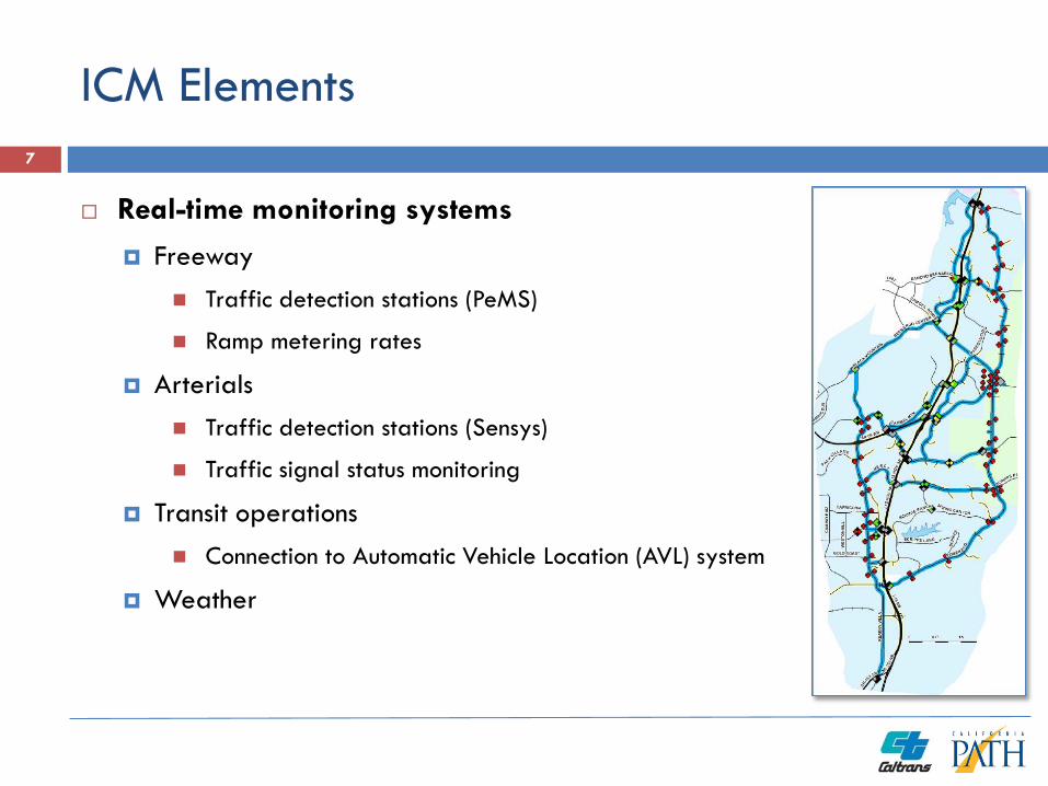
Real-time monitoring systems Freeway
Traffic detection stations (PeMS)
Ramp metering rates
Arterials Traffic detection stations (Sensys)
Traffic signal status monitoring
Transit operations Connection to Automatic Vehicle Location (AVL) system
Weather
7

ICM Elements
Freeway operations Traffic-responsive on-ramp metering
I-15 HOT Managed Lane System Northbound/southbound lane configuration
Toll-free access policy
Arterial operations Traffic-responsive signal control
Arterial/freeway ramp traffic signal coordination
Transit operations Vehicle rerouting around incidents
Service increase in response to event/incidents
8

ICM Elements
Traveler information Integrated, multi-modal traveler information service
Comparative travel times along alternate routes
Real-time park-and-ride availability
511 mobile applications
Changeable message signs along I-15
Trailblazer signs along arterials
9

Decision Support System
Development of response plans in response to observed congestion and/or identified events/incidents
Response plans developed online using a rule-based decision process relying on sets of predetermined potential actions
Evaluation of developed candidate response plans using simulation
Control recommendations to system operators
10
Express Lanes
• Not used• Action Plan 1• Action Plan 2
Transit
• Action Plan 1• Action Plan 2
Traveler Information
• Action Plan 1• Action Plan 2• Action Plan 3• Action Plan 4
Traffic Signal Timing
• Action Plan 1• Action Plan 2• Action Plan 3• Action Plan 4
Ramp Metering
• Action Plan 1• Action Plan 2• Action Plan 3• Action Plan 4

Decision Support System
Role of simulation Evaluation of current network conditions
Projection of network operations over next 15, 30, 45 and 60 minutes Do nothing scenario
6 to 12 alternate response plans
Simulation using Aimsun Online Microscopic simulation model considering the
behavior of individual vehicles
11

US-75 Dallas 12

Corridor
20-mile section of US-75 corridor northeast of downtown Dallas US-75 freeway
General-purpose lanes
HOV lanes north of I-635
Parallel arterials Freeway frontage roads
Greenville Avenue
Coit Road
Transit services DART Bus Network
DART Light Rail
13

ICM Elements
System monitoring Bluetooth sensors along freeway and two
diversion routes (40 locations, every 1-2 miles)
Parking availability at 5 park-and-ride lots
Light rail train location and passenger count
Weather monitoring
Data sharing Implementation of regional information
exchange network (SmartNET)
16
Traffic Detection Plan
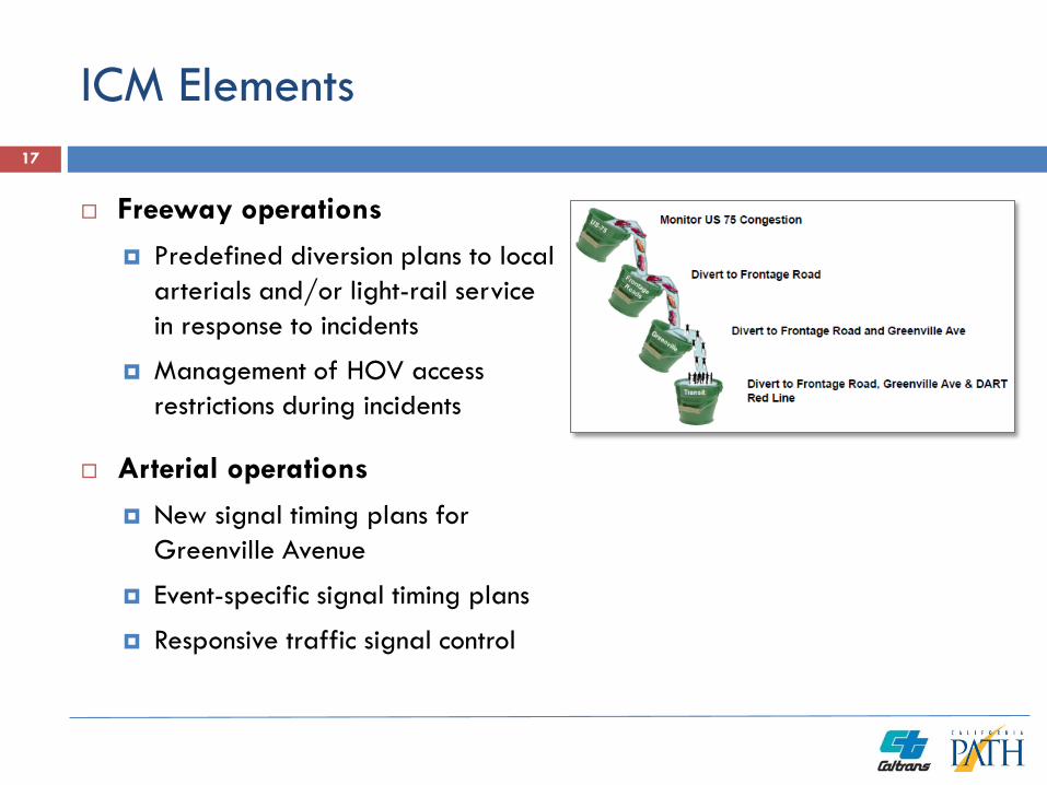
ICM Elements
Freeway operations Predefined diversion plans to local
arterials and/or light-rail service in response to incidents
Management of HOV access restrictions during incidents
Arterial operations New signal timing plans for
Greenville Avenue
Event-specific signal timing plans
Responsive traffic signal control
17

ICM Elements
Traveler information First multimodal 511 system in Texas
Real-time transit vehicle information Vehicle location Next stop arrival time Available capacity
Parking availability information on CMS signs and 511 systems 5 park-and-ride lots along the LRT red line
Links to social media (Facebook, Twitter)
Exploration of sponsorship options
18
RSS for Media (Events, Link Data)
ALERT System
Public Website
Interactive Voice Response (IVR)
My511 Mobile App
Links to Social Medias

SmartFusion/SmartNet Systems
SmartNET Regional information exchange
network
SmartFusion Data Fusion Engine
Receives and publishes data to the regional center-to-center and other external systems
Feeds data to the 511 Systems and Decision Support System
20
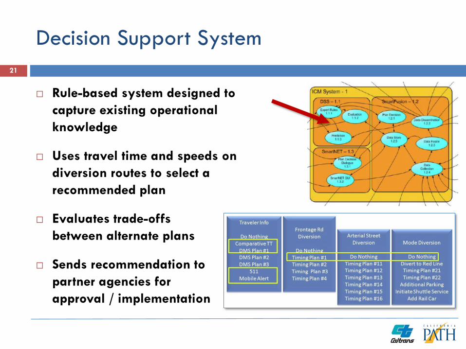
Decision Support System
Rule-based system designed to capture existing operational knowledge
Uses travel time and speeds on diversion routes to select a recommended plan
Evaluates trade-offs between alternate plans
Sends recommendation to partner agencies for approval / implementation
21
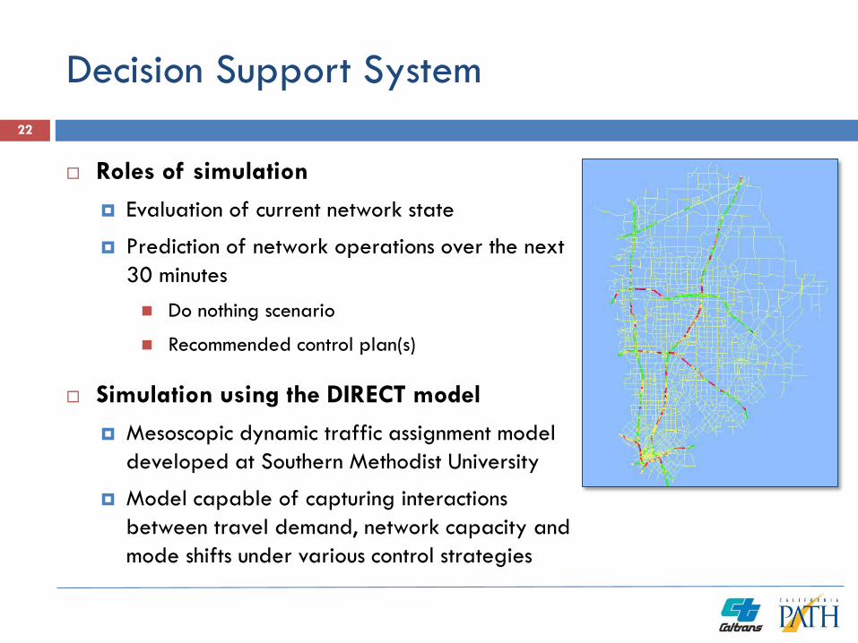
Decision Support System
Roles of simulation Evaluation of current network state
Prediction of network operations over the next 30 minutes Do nothing scenario
Recommended control plan(s)
Simulation using the DIRECT model Mesoscopic dynamic traffic assignment model
developed at Southern Methodist University
Model capable of capturing interactions between travel demand, network capacity and mode shifts under various control strategies
22

I-80 Bay Area 23

Corridor
20-miles section of I-80 from Bay Bridge to Carquinez Bridge
Transportation networks I-80 freeway
General-purpose traffic lanes
HOV lanes
Parallel arterial San Pablo Avenue
Transit services AC Transit bus network
BART subway network
24

ICM Elements
Freeway operations Adaptive ramp metering
Coordinated ramp meters Maximum queue detection Meter bypass for HOV vehicles
Lane use management system Ability to close lanes ahead of incidents
Variable advisory speed signs Provision of speed recommendations
ahead of incidents and congestion areas
Additional CCTV cameras
28

ICM Elements
Arterial operations Traffic signal system upgrade Enhanced traffic detection along San Pablo Avenue Signal synchronization/optimization Implementation of traffic signal flush plan to improve
capacity during major incidents/events Trailblazer signs to help guide traffic naturally
rerouting through San Pablo during incidents Traffic signal preemption for first responders
Transit operations Transit signal priority at signalized intersections Transit signal priority at HOV freeways on-ramps
29

ICM Elements
Traveler information Displaying of traffic and transit information on
freeway dynamic display boards showing
Trailblazer signs along arterials to help traffic go back to the freeway
Highway advisory radio
Integration with Bay Area 511 system and East Bay SMART Corridors
Directions to transit facilities
Real-time parking availability (future element)
30

I-95/I-395 Virginia 31

Corridor
52-mile section of I-95/I-395 between Spotsylvania and 14th Street Bridge near Washington DC I-95/I-395 freeway
General purpose traffic lanes Reversible two-lane HOV facility in middle of freeway
north of Dumfries (northern half of corridor)
Parallel arterials US-1 convenient alternate south of Woodridge
Transit services Commuter rail along entire corridor Various bus services
Park-and-ride 40,771 spaces within corridor
Ridesharing services Carpools / Vanpools 6400 daily “slugs” (2008) Real-time ridesharing pilot
32
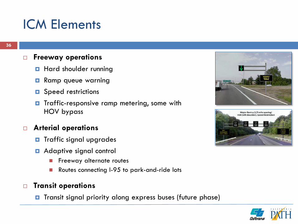
ICM Elements
Freeway operations Hard shoulder running Ramp queue warning Speed restrictions Traffic-responsive ramp metering, some with
HOV bypass
Arterial operations Traffic signal upgrades Adaptive signal control
Freeway alternate routes Routes connecting I-95 to park-and-ride lots
Transit operations Transit signal priority along express buses (future phase)
36

ICM Elements
Traveler information Integrated, multi-modal single information
gateway
Real-time park-and-ride space availability information on freeways and approach routes
Comparative travel times for travel on freeway, arterials, transit
Personalized multi-modal real-time trip planning
Mobile applications
Information kiosks
37

System Functional Architecture 38

Performance Measurement/Decision Support System
Planned as a future system element
Expected to use of simulation to assess the performance of alternate strategies
39

System Deployment Strategy 40