Suggested Day Hikes - Massachusetts
8
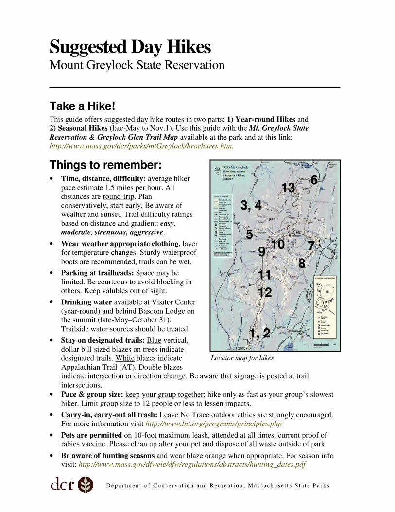
Department of Conservation and Recreation, Massachusetts State Parks Suggested Day Hikes Mount Greylock State Reservation Take a Hike! This guide offers suggested day hike routes in two parts: 1) Year-round Hikes and 2) Seasonal Hikes (late-May to Nov.1). Use this guide with the Mt. Greylock State Reservation & Greylock Glen Trail Map available at the park and at this link: http://www.mass.gov/dcr/parks/mtGreylock/brochures.htm. Things to remember: • Time, distance, difficulty: average hiker pace estimate 1.5 miles per hour. All distances are round-trip . Plan conservatively, start early. Be aware of weather and sunset. Trail difficulty ratings based on distance and gradient: easy, moderate, strenuous, aggressive. • Wear weather appropriate clothing, layer for temperature changes. Sturdy waterproof boots are recommended, trails can be wet . • Parking at trailheads: Space may be limited. Be courteous to avoid blocking in others. Keep valubles out of sight. • Drinking water available at Visitor Center (year-round) and behind Bascom Lodge on the summit (late-May–October 31). Trailside water sources should be treated. • Stay on designated trails: Blue vertical, dollar bill-sized blazes on trees indicate designated trails. White blazes indicate Appalachian Trail (AT). Double blazes indicate intersection or direction change. Be aware that signage is posted at trail intersections. • Pace & group size: keep your group together ; hike only as fast as your group’s slowest hiker. Limit group size to 12 people or less to lessen impacts. • Carry-in, carry-out all trash: Leave No Trace outdoor ethics are strongly encouraged. For more information visit http://www.lnt.org/programs/principles.php • Pets are permitted on 10-foot maximum leash, attended at all times, current proof of rabies vaccine. Please clean up after your pet and dispose of all waste outside of park. • Be aware of hunting seasons and wear blaze orange when appropriate. For season info visit: http://www.mass.gov/dfwele/dfw/regulations/abstracts/hunting_dates.pdf Locator map for hikes 1, 2 3, 4 5 6 7 8 9 10 11 12 13
Transcript of Suggested Day Hikes - Massachusetts
D e p a r t m e n t o f C o n s e r v a t i o n a n d R e c r e a t i o n , M a s s a c h u s e t t s S t a t e P a r k s
Suggested Day Hikes Mount Greylock State Reservation
Take a Hike! This guide offers suggested day hike routes in two parts: 1) Year-round Hikes and
2) Seasonal Hikes (late-May to Nov.1). Use this guide with the Mt. Greylock State
Reservation & Greylock Glen Trail Map available at the park and at this link:
http://www.mass.gov/dcr/parks/mtGreylock/brochures.htm.
Things to remember: • Time, distance, difficulty: average hiker
pace estimate 1.5 miles per hour. All
distances are round-trip. Plan
conservatively, start early. Be aware of
weather and sunset. Trail difficulty ratings
based on distance and gradient: easy,
moderate, strenuous, aggressive.
• Wear weather appropriate clothing, layer
for temperature changes. Sturdy waterproof
boots are recommended, trails can be wet.
• Parking at trailheads: Space may be
limited. Be courteous to avoid blocking in
others. Keep valubles out of sight.
• Drinking water available at Visitor Center
(year-round) and behind Bascom Lodge on
the summit (late-May–October 31).
Trailside water sources should be treated.
• Stay on designated trails: Blue vertical,
dollar bill-sized blazes on trees indicate
designated trails. White blazes indicate
Appalachian Trail (AT). Double blazes
indicate intersection or direction change. Be aware that signage is posted at trail
intersections.
• Pace & group size: keep your group together; hike only as fast as your group’s slowest
hiker. Limit group size to 12 people or less to lessen impacts.
• Carry-in, carry-out all trash: Leave No Trace outdoor ethics are strongly encouraged.
For more information visit http://www.lnt.org/programs/principles.php
• Pets are permitted on 10-foot maximum leash, attended at all times, current proof of
rabies vaccine. Please clean up after your pet and dispose of all waste outside of park.
• Be aware of hunting seasons and wear blaze orange when appropriate. For season info
visit: http://www.mass.gov/dfwele/dfw/regulations/abstracts/hunting_dates.pdf
Locator map for hikes
1, 2
3, 4
5
6
7
8 9
10
11
12
13

D e p a r t m e n t o f C o n s e r v a t i o n a n d R e c r e a t i o n , M a s s a c h u s e t t s S t a t e P a r k s
Part 1
Year-round Hikes Suggested Day Hikes, Mount Greylock State Reservation The following hikes are accessible in all seasons. Prior to travelling on trails in winter please
refer to the suggested winter safety tips:
http://www.mass.gov/dcr/parks/mtGreylock/downloads/winterSafetyTips.pdf
Trailhead at 30 Rockwell Road in Lanesborough (01237): 42°33'12.47"N, 73°12'42.55"W
1 Rounds Rock Trek
Distance: 6.9 miles (11 km), Time: 5-6 hours,
Elevation gain: 920 ft. (280 meters), Ability: moderate
Hike through former 1800s farmland, now a northern
hardwood forest, to the knob of Rounds Rock. Find heath-
like openings and impressive scenic views south and west
across the Berkshires and the Catskill Mountains.
From Visitors Center parking take Bradley Farm Trail to
Northrup Trail (0.8 mi.). Continue on Northrup Trail (2.4
mi.) to Rounds Rock Trail connector on upslope. Bear
right onto Rounds Rock Trail and follow to vistas and
Rockwell Road (0.5 mi.). Cross road and return via
Woodason Spring and Bradley Farm Trails to Visitors
Center (3 mi.).
2 Bradley Farm Trail Distance: 1.8 miles (2.9 km), Time: 90 minutes,
Elevation gain: 424 ft. (129 meters), Ability: easy
This easy loop features a look at the
former agricultural use of the land and
subsequent forest succession. This is a
featured Healthy Heart Trails hike to
promote better health. For more
information visit:
http://www.mass.gov/dcr/recreate/hht/index.htm
Use this link to access a self-guided brochure to the Bradley Farm Interpretive Trail:
http://www.mass.gov/dcr/parks/mtGreylock/downloads/bradleyFarmSelfGuidedTrail.pdf
Visitor Center, Lanesborough
D e p a r t m e n t o f C o n s e r v a t i o n a n d R e c r e a t i o n , M a s s a c h u s e t t s S t a t e P a r k s
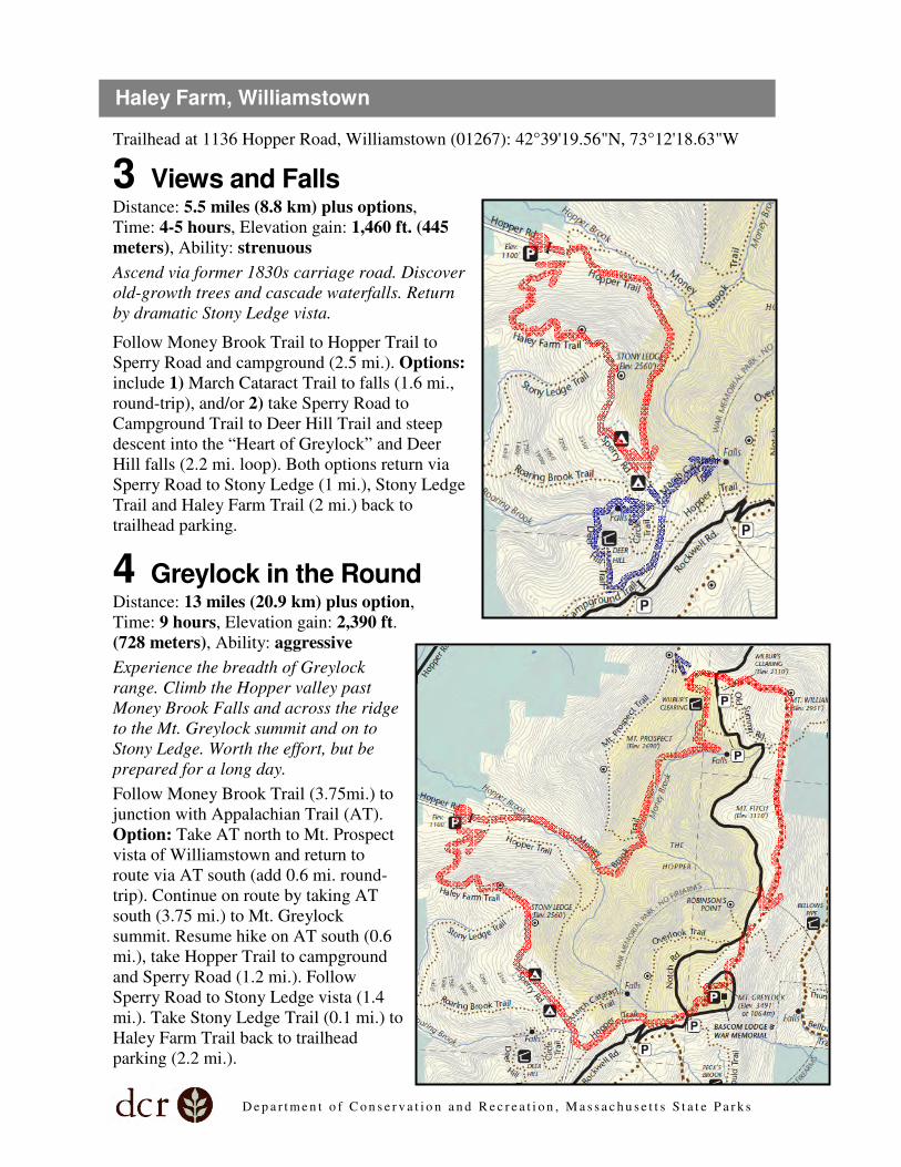
Trailhead at 1136 Hopper Road, Williamstown (01267): 42°39'19.56"N, 73°12'18.63"W
3 Views and Falls Distance: 5.5 miles (8.8 km) plus options,
Time: 4-5 hours, Elevation gain: 1,460 ft. (445
meters), Ability: strenuous
Ascend via former 1830s carriage road. Discover
old-growth trees and cascade waterfalls. Return
by dramatic Stony Ledge vista.
Follow Money Brook Trail to Hopper Trail to
Sperry Road and campground (2.5 mi.). Options:
include 1) March Cataract Trail to falls (1.6 mi.,
round-trip), and/or 2) take Sperry Road to
Campground Trail to Deer Hill Trail and steep
descent into the “Heart of Greylock” and Deer
Hill falls (2.2 mi. loop). Both options return via
Sperry Road to Stony Ledge (1 mi.), Stony Ledge
Trail and Haley Farm Trail (2 mi.) back to
trailhead parking.
4 Greylock in the Round Distance: 13 miles (20.9 km) plus option,
Time: 9 hours, Elevation gain: 2,390 ft.
(728 meters), Ability: aggressive
Experience the breadth of Greylock
range. Climb the Hopper valley past
Money Brook Falls and across the ridge
to the Mt. Greylock summit and on to
Stony Ledge. Worth the effort, but be
prepared for a long day.
Follow Money Brook Trail (3.75mi.) to
junction with Appalachian Trail (AT).
Option: Take AT north to Mt. Prospect
vista of Williamstown and return to
route via AT south (add 0.6 mi. round-
trip). Continue on route by taking AT
south (3.75 mi.) to Mt. Greylock
summit. Resume hike on AT south (0.6
mi.), take Hopper Trail to campground
and Sperry Road (1.2 mi.). Follow
Sperry Road to Stony Ledge vista (1.4
mi.). Take Stony Ledge Trail (0.1 mi.) to
Haley Farm Trail back to trailhead
parking (2.2 mi.).
Haley Farm, Williamstown
D e p a r t m e n t o f C o n s e r v a t i o n a n d R e c r e a t i o n , M a s s a c h u s e t t s S t a t e P a r k s
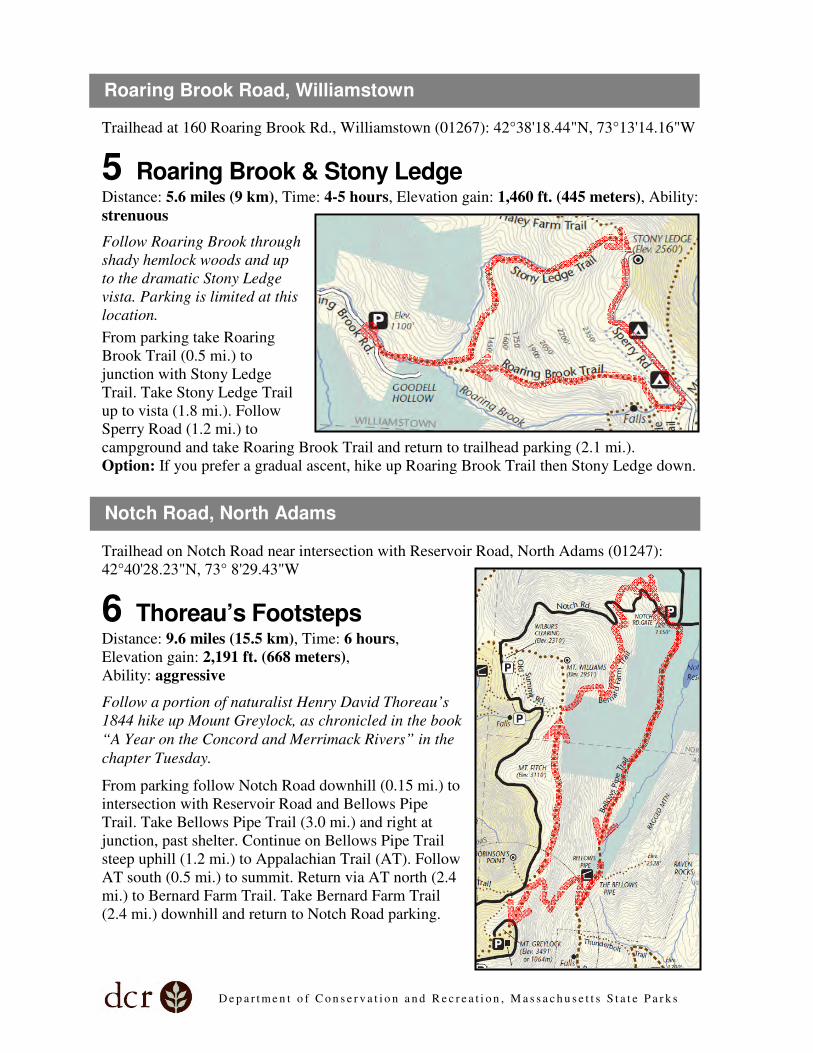
Trailhead at 160 Roaring Brook Rd., Williamstown (01267): 42°38'18.44"N, 73°13'14.16"W
5 Roaring Brook & Stony Ledge Distance: 5.6 miles (9 km), Time: 4-5 hours, Elevation gain: 1,460 ft. (445 meters), Ability:
strenuous
Follow Roaring Brook through
shady hemlock woods and up
to the dramatic Stony Ledge
vista. Parking is limited at this
location.
From parking take Roaring
Brook Trail (0.5 mi.) to
junction with Stony Ledge
Trail. Take Stony Ledge Trail
up to vista (1.8 mi.). Follow
Sperry Road (1.2 mi.) to
campground and take Roaring Brook Trail and return to trailhead parking (2.1 mi.).
Option: If you prefer a gradual ascent, hike up Roaring Brook Trail then Stony Ledge down.
Trailhead on Notch Road near intersection with Reservoir Road, North Adams (01247):
42°40'28.23"N, 73° 8'29.43"W
6 Thoreau’s Footsteps Distance: 9.6 miles (15.5 km), Time: 6 hours,
Elevation gain: 2,191 ft. (668 meters),
Ability: aggressive
Follow a portion of naturalist Henry David Thoreau’s
1844 hike up Mount Greylock, as chronicled in the book
“A Year on the Concord and Merrimack Rivers” in the
chapter Tuesday.
From parking follow Notch Road downhill (0.15 mi.) to
intersection with Reservoir Road and Bellows Pipe
Trail. Take Bellows Pipe Trail (3.0 mi.) and right at
junction, past shelter. Continue on Bellows Pipe Trail
steep uphill (1.2 mi.) to Appalachian Trail (AT). Follow
AT south (0.5 mi.) to summit. Return via AT north (2.4
mi.) to Bernard Farm Trail. Take Bernard Farm Trail
(2.4 mi.) downhill and return to Notch Road parking.
Roaring Brook Road, Williamstown
Notch Road, North Adams
D e p a r t m e n t o f C o n s e r v a t i o n a n d R e c r e a t i o n , M a s s a c h u s e t t s S t a t e P a r k s
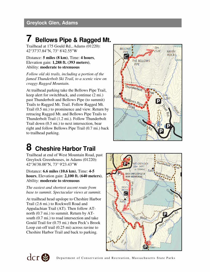
7 Bellows Pipe & Ragged Mt. Trailhead at 175 Gould Rd., Adams (01220):
42°37'37.84"N, 73° 8'42.55"W
Distance: 5 miles (8 km), Time: 4 hours,
Elevation gain: 1,288 ft. (393 meters),
Ability: moderate to strenuous
Follow old ski trails, including a portion of the
famed Thunderbolt Ski Trail, to a scenic view on
craggy Ragged Mountain.
At trailhead parking take the Bellows Pipe Trail,
keep alert for switchback, and continue (2 mi.)
past Thunderbolt and Bellows Pipe (to summit)
Trails to Ragged Mt. Trail. Follow Ragged Mt.
Trail (0.5 mi.) to prominence and view. Return by
retracing Ragged Mt. and Bellows Pipe Trails to
Thunderbolt Trail (1.2 mi.). Follow Thunderbolt
Trail down (0.5 mi.) to next intersection, bear
right and follow Bellows Pipe Trail (0.7 mi.) back
to trailhead parking.
8 Cheshire Harbor Trail Trailhead at end of West Mountain Road, past
Greylock Greenhouses, in Adams (01220):
42°36'38.00"N, 73° 9'23.43"W
Distance: 6.6 miles (10.6 km), Time: 4-5
hours, Elevation gain: 2,100 ft. (640 meters),
Ability: moderate to strenuous
The easiest and shortest ascent route from
base to summit. Spectacular views at summit.
At trailhead head upslope to Cheshire Harbor
Trail (2.6 mi.) to Rockwell Road and
Appalachian Trail (AT). Then follow AT-
north (0.7 mi.) to summit. Return by AT-
south (0.7 mi.) to road intersection and take
Gould Trail for (0.75 mi.) then Peck’s Brook
Loop cut-off trail (0.25 mi) across ravine to
Cheshire Harbor Trail and back to parking.
Greylock Glen, Adams
D e p a r t m e n t o f C o n s e r v a t i o n a n d R e c r e a t i o n , M a s s a c h u s e t t s S t a t e P a r k s
Part 2
Seasonal Hikes Suggested Day Hikes, Mount Greylock State Reservation The following hikes are accessible from late-May through November 1, when the parkway to
the summit is open during the “summer” recreation season.
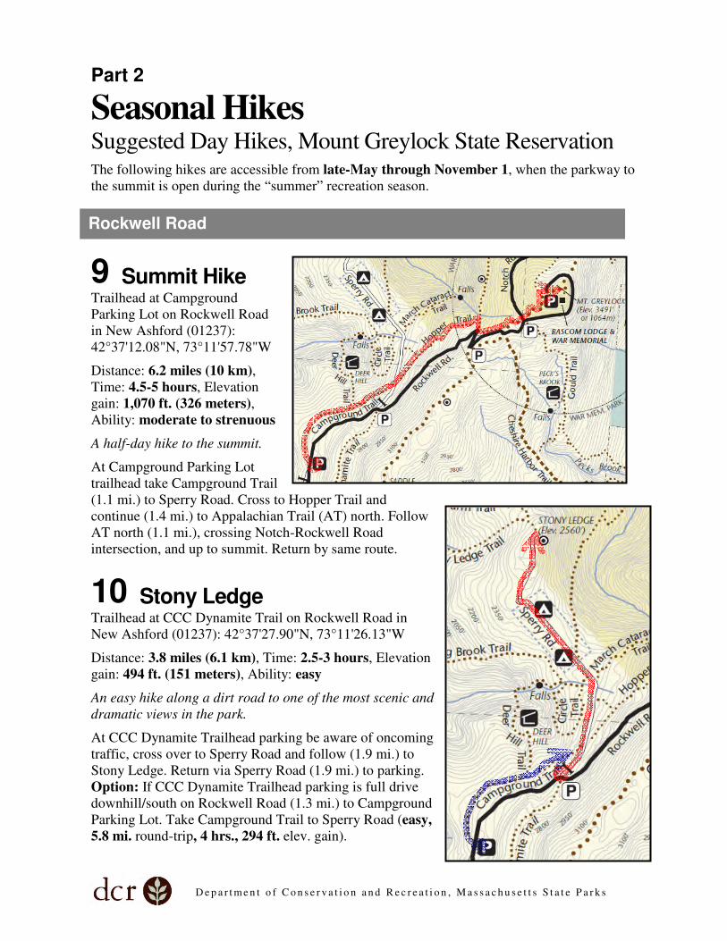
9 Summit Hike Trailhead at Campground
Parking Lot on Rockwell Road
in New Ashford (01237):
42°37'12.08"N, 73°11'57.78"W
Distance: 6.2 miles (10 km),
Time: 4.5-5 hours, Elevation
gain: 1,070 ft. (326 meters),
Ability: moderate to strenuous
A half-day hike to the summit.
At Campground Parking Lot
trailhead take Campground Trail
(1.1 mi.) to Sperry Road. Cross to Hopper Trail and
continue (1.4 mi.) to Appalachian Trail (AT) north. Follow
AT north (1.1 mi.), crossing Notch-Rockwell Road
intersection, and up to summit. Return by same route.
10 Stony Ledge Trailhead at CCC Dynamite Trail on Rockwell Road in
New Ashford (01237): 42°37'27.90"N, 73°11'26.13"W
Distance: 3.8 miles (6.1 km), Time: 2.5-3 hours, Elevation
gain: 494 ft. (151 meters), Ability: easy
An easy hike along a dirt road to one of the most scenic and
dramatic views in the park.
At CCC Dynamite Trailhead parking be aware of oncoming
traffic, cross over to Sperry Road and follow (1.9 mi.) to
Stony Ledge. Return via Sperry Road (1.9 mi.) to parking.
Option: If CCC Dynamite Trailhead parking is full drive
downhill/south on Rockwell Road (1.3 mi.) to Campground
Parking Lot. Take Campground Trail to Sperry Road (easy,
5.8 mi. round-trip, 4 hrs., 294 ft. elev. gain).
Rockwell Road

D e p a r t m e n t o f C o n s e r v a t i o n a n d R e c r e a t i o n , M a s s a c h u s e t t s S t a t e P a r k s
11 Jones Nose to Summit
Trailhead at Jones Nose on Rockwell
Road in Cheshire (01225):
42°36'5.96"N, 73°12'1.34"W
Distance: 8.5 miles (13.5 km), Time:
5.5-6 hours, Elevation gain: 1,303 ft.
(397 meters), Ability: strenuous to
aggressive
Hike the ridge through the boreal forest
to the summit.
From parking area take Jones Nose
Trail uphill (1.2 mi.) to Appalachian
Trail (AT). Follow AT north (2.9 mi.)
to Mt. Greylock summit. Return via AT
south to Hopper Trail (0.7 mi.). Follow
Hopper Trail (1.2 mi.) to Sperry Road.
Left or uphill on Sperry Road (0.3 mi.)
to Rockwell Road. Cross Rockwell
Road to CCC Dynamite Trail and
follow (1.6 mi.) to Jones Nose Trail.
Right on Jones Nose Trail downhill (0.6
mi.) to trailhead parking.
12 Rounds Rock & Jones Nose Loop Trailhead at Rounds Rock on Rockwell Road in
Cheshire (01225): 42°35'34.52"N, 73°11'49.04"W
Distance: 2.8 miles (km), Time: 2-2.5 hours,
Elevation gain: 217 ft. (66 meters), Ability: easy to
moderate
A mix of open and wooded trail with vistas from
Rounds Rock and Jones Nose.
From parking area on Rockwell Road cross over
road, be aware of oncoming traffic, and take Rounds
Rock Trail to connector trail, left or west, and down
slope to Northrup Trail (0.7 mi.). Right or north on
Northrup Trail (1.1 mi.) and cross Rockwell Road to
Jones Nose parking lot. Option: get some elevation
on the Jones Nose Trail for scenic views south.
Return via Woodason Spring Trail south (1 mi.) to
Rounds Rock trailhead parking.
Rockwell Road, continued

D e p a r t m e n t o f C o n s e r v a t i o n a n d R e c r e a t i o n , M a s s a c h u s e t t s S t a t e P a r k s
13 Wilbur’s Clearing to Summit Trailhead on Notch Road in North Adams (01247):
42°40'9.71"N, 73°10'3.72"W
Distance: 6.9 miles (11.1 km), Time: 4.5-5 hours,
Elevation gain: 1,172 ft. (357 meters), Ability:
moderate to strenuous
Follow the Appalachian Trail south along the ridge to
the summit of Greylock. Return via a portion of the
former 1860 carriage route to the summit.
At trailhead parking take connector trail east (0.2 mi.) to
Appalachian Trail (AT) south and continue on AT south
(3.3 mi.) to Mt. Greylock summit. Return via AT north
(2.4 mi.) to Old Summit Road trail. Take Old Summit
Road trail to AT connector trail and trailhead parking
(1.0 mi.).
More Hikes? For additional seasonal day hikes visit the Mount Greylock Scenic Byway webpage. These
hikes correspond with an auto tour through the park:
http://www.byways.org/explore/byways/2569/
To customize your own hike visit Mount Greylock Hiking Trail Mileages:
http://www.mass.gov/dcr/parks/mtGreylock/downloads/greyTrailmiles.pdf
MOUNT GREYLOCK STATE RESERVATION
Department of Conservation and Recreation
P.O. Box 138, Lanesborough, MA 01237
(413) 499-4262/4263 UPDATED 09/2011
Notch Road