Suburban Catchment Area 4 Picnicking - Redland City · Suburban Catchment Area 4. SCA 4 makes up...
54
Suburban Catchment Area 4 SCA 4 makes up the southern mainland suburbs— Thornlands, Victoria Point and Redland Bay. A map of the catchment and neighbourhoods can be found at Figure 11-61. Expected population growth between 2006 and 2026 is 19,626 people or 53.5%. Most of the population growth will occur in Thornlands and about 43% of these people are expected to live in medium density style accommodation. Victoria Point is the commercial heart of the southern suburbs with extensive shopping facilities. The catchment is also the gateway to Coochiemudlo Island and the Southern Moreton Bay Islands. Provision of the SCA desired service standard Every SCA has a desired service standard that Council attempts to achieve (see Section 8 for detail). The following discussion applies the desired service standard to SCA 4. Figure 11-61: Map of neighbourhoods in Catchment 4 Picnicking Picnicking facilities, including barbecues and public toilets for large groups is provided in the following parks: • Cascade Gardens • Les Moore Park • Nev Stafford Park • Point Talburpin Park • Sel Outridge Park • Victoria Point Recreation Reserve • W. H. Yeo Park There is a barbecue and picnic setting along the Jack Gordon Pathway but there are no toilets. Recommendation Crystal Waters Park has picnic facilities for large groups and a playground that engages children for an extended period. This park requires toilets to support the existing infrastructure that encourages long stays. Weinam Creek Wetlands Corridor parks plan recommends picnicking, barbecues and a public toilet. Exercising dogs off-leash Dog off-leash areas are provided as shown in Table 11-2. 31 30 29 32 35 37 38 33 36 39 40 41 43 44 45 46 Suburb catchment area 4 181
Transcript of Suburban Catchment Area 4 Picnicking - Redland City · Suburban Catchment Area 4. SCA 4 makes up...

Suburban Catchment Area 4SCA 4 makes up the southern mainland suburbs—Thornlands, Victoria Point and Redland Bay. A map of the catchment and neighbourhoods can be found at Figure 11-61.
Expected population growth between 2006 and 2026 is 19,626 people or 53.5%. Most of the population growth will occur in Thornlands and about 43% of these people are expected to live in medium density style accommodation.
Victoria Point is the commercial heart of the southern suburbs with extensive shopping facilities. The catchment is also the gateway to Coochiemudlo Island and the Southern Moreton Bay Islands.
Provision of the SCA desired service standardEvery SCA has a desired service standard that Council attempts to achieve (see Section 8 for detail). The following discussion applies the desired service standard to SCA 4.
Figure 11-61: Map of neighbourhoods in Catchment 4
PicnickingPicnicking facilities, including barbecues and public toilets for large groups is provided in the following parks:
• Cascade Gardens• Les Moore Park• Nev Stafford Park• Point Talburpin Park• Sel Outridge Park• Victoria Point Recreation Reserve• W. H. Yeo Park
There is a barbecue and picnic setting along the Jack Gordon Pathway but there are no toilets.
RecommendationCrystal Waters Park has picnic facilities for large groups and a playground that engages children for an extended period. This park requires toilets to support the existing infrastructure that encourages long stays.
Weinam Creek Wetlands Corridor parks plan recommends picnicking, barbecues and a public toilet.
Exercising dogs off-leashDog off-leash areas are provided as shown in Table 11-2.
313029
32
35
37
38
3336
39 40
41
43
44 45
46
S u b u r b c a t c h m e n t a r e a 4 181

RecommendationsSeparate areas for small dogs will be added to the following dog off-leash areas over time:
• Fodder Forest DOLA• Les Moore Park DOLA• Main Street Park DOLA• Manning Esplanade DOLA
Subject to a substantial enlargement of the swimming enclosure, dogs could be allowed to swim in the Orchard Beach Foreshore (North) swimming enclosure.
Access to natureBushwalking is available in many reserves and conservation areas in the catchment with key locations being:
• Weippin Street Conservation Area• Point Halloran Conservation Area
Additionally, the Eprapah Scout Environmental Education Centre is available to the public to walk along its creek areas and rainforest.
RecommendationWhen it is time for asset renewal of the Orchard Beach Foreshore (North) swimming enclosure it should be substantially enlarged to meet the needs of population growth as well as its popularity.
Develop the Baythorn Nature Belt parklands as a nature-based recreation park.
Wedding and ceremoniesCouncil takes bookings for weddings and ceremonies in public open space.
In this catchment the most frequent bookings are for;
• W. H. Yeo Park • Cascade Gardens—both in Victoria Point
RecommendationOf these two popular venues only Cascade Gardens has a purpose-built pergola for these functions.
− consider a formalised ceremony space for W. H Yeo Park.
Skateboard riding and BMXRamp parks are provided as detailed in the Redland City Ramp Park Strategy 2008. Current facilities are located at Thornlands, Victoria Point and Redland Bay.
The recommendations of the Redland City Ramp Park Strategy concerning these facilities include:• Redland Bay—generally an excellent medium sized
facility that could be improved by: − removing and replacing the vert wall with a quarter pipe − building a BMX runout ramp to the eastern side of
the large half-pipe − expanding the park to cope with population growth
• Thornlands—generally a very good facility that has been improved by recent additions. Outstanding improvements suggested in the strategy include:
− a car park − minor improvements to landscaping and the rear of
platforms• Victoria Point—an older facility that has some strengths
than can be built upon. Drainage and leaf litter are significantproblemsthatCouncilneedstoaddress.Facility improvements include:
− a half-pipe − a street course/ beginner’s area − additional night lighting
Sporting codesThe following sporting activities can be played or undertaken in SCA 4 primarily in Council sport parks.
• AFL• baseball• cricket• equestrian• golf• netball• rugby league• rugby union• tennis
Location Size Fencing Small Dog AreaUnfenced Fenced
CharlieBucklerSportsfield(RedlandBay) Very small SMain Street Park (cnr Gordon Road, Redland Bay) Medium STalburpin Esplanade, Point Talburpin, Redland Bay Small SManning Esplanade (Thornlands) Medium SRobert Mackie Park (Thornlands) Large S SFodder Forest (Victoria Point) Large SLes Moore Park (Victoria Point) Large S
Table 11-2: Dog off-leash areas within the Catchment
R e d l a n d C i t y C o u n c i l O p e n S p a c e S t r a t e g y 2 0 2 6182

Sport park master plans
Master plans have been developed for the following sites where sport is played1:
• Pinklands Sporting Complex master plan was prepared in 2006 but needs to be reviewed given the Cleveland-Redland Bay Road widening and associated opportunities that now presents
• Sel Outridge Park had a master plan adopted in 2011• CharlieBucklerSportsfield
All-abilities playCouncil aims to have a destination level, all-abilities play facility in each catchment. There is no facility at this level in SCA 4.
Recommendation• Future development of destination park Victoria Point
Recreation Reserve should incorporate an All Abilities Playground
• Popular Sel Outridge Park in Redland Bay should also be considered a suitable location for all abilities play.
Festival spaceCouncil aims to provide one festival and event space per SCA. The following spaces are suited to events:
• Sel Outridge Park• Victoria Point Recreation Reserve
Sporting parks such as Pinklands Sporting Complex, Ern and AlmaDowlingMemorialParkandCharlieBucklerSportfieldswould also are suited to certain types of events.
Parking would be an issue at most of these locations.
Park user comfortCouncil aims to provide a public toilet in every community park. Public toilets are currently available in the following parks:
• Cascade Gardens• Les Moore Park• Nev Stafford Park• Sel Outridge Park• Victoria Point Recreation Reserve• W. H. Yeo Park• Point Talburpin Park• William Stewart Park
RecommendationThe following parks should be provided with public toilets when demand requires:
• Crystal Waters Park• Orana Esplanade Foreshore Park at the Point
O’Halloran Road end - to support walking and cycling• within the Weinam Creek Corridor (possible two spread
along the corridor)
Walking and cycling1 The park may also have recreation, conservation or other functions that have also been included in the master plan
Council aims to provide footpaths on main roads in the SCA. There are many footpaths in place some of the key sections that are missing include:
• Cleveland-Redland Bay Road − a long section near the yet-to-be-developed
Southeast Thornlands − BoundaryStreetnearCharlieBucklerSportfields
• the northern end of Point O’Halloran Road• Meissner Street—Weinam Street, Redland Bay• western end of School of Arts Road, Redland Bay• western end of German Church Road, Redland Bay
Indoor community activitiesCommunity Halls will be upgraded and managed as per the Community Halls Review 2010.
The Victoria Point, Redland Bay and Thornlands catchment is a high priority area for investment in community infrastructure. Population growth is expected to concentrate in this area, and these suburbs service the bay islands as well. ‘Building the Education Revolution’ halls have been or will be built at Victoria Point State School, St Rita’s Primary School, Thornlands State School, Redland Bay State School, Redlands District Special School and Faith Lutheran College.
Recommendations for Council’s community halls• Victoria Point—develop as a community hub or service
centre• Redland Bay—incorporate into the proposed cultural,
tourism and learning hub• Thornlands—retain as is
Commercial activities in open spaceCouncil will consider expanded commercial use opportunities in community and destination parks.
RecommendationCommercial use assessments should be undertaken in the following parks:
• Cascade Gardens• CharlieBucklerSportsfield• Ern and Alma Dowling Memorial Park• Les Moore Park• Pinklands Sporting Complex• Point Talburpin Park• Sel Outridge Park• Victoria Point Recreation Reserve• W. H. Yeo Park• William Stewart Park
In the future, when the parks are developed, spaces within the Weinam Creek Wetlands such as Fielding Park and SchoolofArtsSportsfieldshouldbeassessed.
S u b u r b c a t c h m e n t a r e a 4 183

Water-based recreationThere are several boat ramps to Moreton Bay throughout the catchment including:
• Redland Bay (Banana Street) Weinam Creek—north bank• Redland Bay (Moores Road) off Esplanade• Point Talburpin beach launching (Torquay Rd at the
point)• Victoria Point (Colburn Avenue—north-west of jetty)
Victoria Point Recreation Reserve• Victoria Point (Masters Avenue) south of Victoria Point Jetty
It is also possible to launch a small boat from an area near Tucker Reserve at Point Talburpin though there is no formed ramp.
Small craft can be launched from most foreshore parks.
AfishingplatformhasrecentlybeenconstructedintoEprapahCreek for better access. Fishing is available from the banks and foreshores of a number of parks.
There is one swimming enclosure in Redland Bay along the Orchard Beach Foreshore. The area is known as Rusters Reserve and can be accessed via stairs from the corner of Moores Road and the Esplanade. Recent consultation with the community on the Weinam Creek Wetlands has indicated that the swimming enclosure is very popular particularly with children and many would like to see the enclosure enlarged and consideration be given to allowing dogs to swim inside the netting as well.
Swimming is also popular (at high tide) in Yeo Park.
RecommendationInvestigation should be made into the suitability of other sites in Redland Bay and Victoria Point for swimming enclosures. The increasing population, popularity of the existing enclosure and the lack of other public swimming pools warrants this investigation.
Destination park (T1)The destination park (T1) in the catchment is Victoria Point Recreation Reserve.
Community parks (T2)The following parks are recommended to be the community level (T2) parks:
• Cascade Gardens• Les Moore Park• Point Talburpin Park• Sel Outridge Park• W. H. Yeo Park• William Stewart Park• Weinam Creek Corridor Parklands, as a whole (a parks
plan shows the extent of the parklands)• A community park is shown in the Kinross Road
Structure Plan area.• A community park will be provided on land purchased by
Council within the Southeast Thornlands Structure Plan area.
School facilitiesWithin the catchment there are nine schools that may offer opportunitiesforcommunityuseoffieldsandbuildings.Ofthese schools:
• six are primary schools• three are high schools
Outdoor recreation opportunitiesThe Community can participate in the following outdoor recreation activities in this SCA:
• bird watching and nature study• BMX and skateboard riding• boating, kayaking and canoeing along Eprapah and
Moogurrapum Creeks and in Moreton Bay• bushwalking, canoeing, climbing and abseiling, rope
courses - Kindilan Outdoor Education and conference centre—privately run Girls Guides outdoor recreation and environmental education centre.
• bushwalking in urban conservation reserves and Eprapah Scout Environmental Education Centre
• fishing• mountain bike riding in conservation reserves and on
unformed road reserves• on and off road cycling• picnicking in bush and urban parkland settings
Signature experiences and locations• access to Moreton Bay, Coochiemudlo Island and the
Southern Moreton Bay Islands• Point Halloran Conservation Area (a Brisbane Top 30
urban walk)• the southern end of Eddie Santaguiliana Way• Weinam Creek Wetlands and extensive parkland areas
linked by walkways and bridges• Historic Redland Bay Hotel - noted for water views• Kindilan Outdoor Education and conference centre—
privately run Girls Guides outdoor recreation and environmental education centre.
Importantly, it should be noted:
1. the activities recommended for each park will be delivered in a priority order
2. the overall time frame for delivery of the strategy’s recommendations is 14 years (2012—2026)
3. many of the embellishments will not be provided until the existing asset in the park is due for renewal and replacement
4. the recommendations will inform the asset management program of Council which has, as a priority, management and renewal of existing assets
R e d l a n d C i t y C o u n c i l O p e n S p a c e S t r a t e g y 2 0 2 6184

Adventure JourneyAdventure journeys utilise the existing network of concrete paths in conjunction with proposed path extensions and links that enable the journeys to loop,
The focus on the adventure journey is to provide options for the local and neighbouring residents to explore their surroundings in a fun and exciting way either on foot or on bicycles.
Furthermore, by creating separate journeys, the residents can alternate between each journey or link them all together to create one large journey.
Figures 11-62 to 11-64 show the proposed play journeys for Thornlands (including an area of Cleveland South), Victoria Point and Redland Bay.
S u b u r b c a t c h m e n t a r e a 4 185

Figure 11-62: Play journey’s planned in Victoria Point
R e d l a n d C i t y C o u n c i l O p e n S p a c e S t r a t e g y 2 0 2 6186

Figure 11-63: Play journey’s planned in Redland Bay
S u b u r b c a t c h m e n t a r e a 4 187

Figure 11-64: Play journey’s planned in South Cleveland and Thornlands
R e d l a n d C i t y C o u n c i l O p e n S p a c e S t r a t e g y 2 0 2 6188

Neighbourhood 29DescriptionNeighbourhood 29 (319 ha) is in the north-west of Thornlands. South Street is the border in the north, Panorama Drive in the east and Boundary Road in the south. In the west the boundary is made up of Hilliards Creek and a small section of Redland Bay Road.
Existing urban development is largely contained against the eastern boundary of the neighbourhood. The Kinross Road Structure Plan area is encompassed within the neighbourhood and the population will grow substantially in coming years.
Land useThe neighbourhood is generally urban residential or low density residential with detached housing (see Figure 11-65). The housing developments in the north and the south will merge over time.
There is no medium density development currently in the neighbourhood. The Kinross Road Structure Plan Area (KRSPA)proposestwokeyareasofmediumdensity,firstlyalong Boundary Road and also in the centre of the area.
Open space issuesOpen space has been retained along a drainage corridor, aheadwatertributaryofHilliardsCreek,thatissufficientlywide in most parts to provide linear recreation as well as park
Figure 11-65: Extract map from Redland Planning Scheme
S u b u r b c a t c h m e n t a r e a 4 189

Figure 11-66: Open space areas in Neighbourhood 29
Boardwalk in the Rushwood Creek Corridor
R e d l a n d C i t y C o u n c i l O p e n S p a c e S t r a t e g y 2 0 2 6190

nodes. It is important that this corridor is extended as new subdivisions occur. Existing open space is shown in Figure 11-66.
There are only two open space areas in this neighbourhood due to minimal development to date. Not all the desired service standards can be achieved in these two parks. It is important that as development proceeds Council acquires open space that is suitable for the remaining recreational activities not yet provided.
The Rushwood Creek Corridor in the south offers a boardwalk experience in the wetlands. The wetlands are part of the stormwater management system but with the addition of the boardwalk they have become a valuable part of the recreation system. The Corridor also has a small playground, barbecue area, seating and paths but has very little capacity for additional uses.
An additional larger community park will be created within the Kinross Road Structure Plan Area (see the breakout box).
Access issuesThe residential areas in the north and south are not connected but will be with the redevelopment of the farmland.
Access is good within the two residential areas, despite the presence of a central drainage and open space corridor.
Walking access across the neighbourhood is generally easy. Theterrainisrelativelyflatwithfewsteepgrades.Whilethereare few concrete paths the footpaths are wide, and with low kerbs, crossing between the street and the footpath is safe.
Recommended key actionsSome of the proposed key actions to meet the desired standards of service for this neighbourhood are:
• Hilliards Creek − ensure that a recreation corridor is obtained along
the tributary as further development takes place so that eventually there is a pathway from north to south across the neighbourhood
− as the western section of the neighbourhood (KRSPA) is progressed, a pathway system needs to be developed to link into the Hilliards Creek tributary pathway system described above
• Lorikeet Drive Park − add natural play elements to the playground
• Rushwood Creek Corridor − upgrade the toddler playground with additional
elements• new Community Park
− provide a site for a community garden − provide a dog off-leash area − provide physical activity stations and a basketball court − provide a multi-aged playground − provide a teenager hangout space − provide a kickabout space − provide a BMX or ramp park
• new Neighbourhood Parks − provide a multi-aged playground in each park − provide a picnic shelter, tables and seats
Kinross Road Structure Plan Vision
The Kinross Road Structure Plan Area (KRSPA) will be a sustainable, integrated and well planned urban community accommodating a range of dwelling types, integrated movement and public open space networks and a range of local community, commercial and retail facilities. The KRSPA has a distinct sense of place and community built upon a strong respect for the natural environment includingHilliardsCreek,floodaffectedareas,bushlandhabitats and fauna movement corridors.
The integration of land uses and transport infrastructure will ensure the community enjoys a range of travel choices including pedestrian and cycle networks, public transport and private vehicles. Internal linkages ensure good access to the Mixed Use Local Centre Precinct, Community Facilities Precinct and Greenspace Precinct. External linkages ensure strong connectivity to higher order retail, employment and community facilities at Cleveland, Capalaba and Victoria Point.
The KRSPA will be characterised by an extensive network of public open space. Land along Hilliards Creek is core habitat for koala populations and other native fauna and is protected from development. Other greenspace corridors supplement this core habitat, providing a connected network of open space that divides the KRSPA into urban and natural areas. Urban areas within the KRSPA will be attractive and functional neighbourhoods with convenient walkable access to public transport. The Mixed Use Local Centre Precinct, in combination with the Community Facilities Precinct and local recreation park creates a community hub and focal point for the urban community.
UrbanformintheKRSPAistypifiedbyarangeofresidential densities and building heights, with the greatest densities located in proximity to the Mixed Use Local Centre Precinct
At a Special Meeting held on 6 October 2011, Council resolved to write to the Minister of the Department of Local Government and Planning seeking approval to adopt the revised Kinross Road Structure Plan After considering the revised Structure Plan, the Minister will advise Council whether it may adopt the Structure Plan as an amendment to the Redlands Planning Scheme
S u b u r b c a t c h m e n t a r e a 4 191

Neighbourhood 30DescriptionNeighbourhood 30 (270 ha) is in central Thornlands. South Street is the border in the north, Panorama Drive in the west and Ziegenfusz Road in the south though a small pocket adjacent to Carmel College south of Ziegenfusz Road is also included1. In the east Redland Bay Road is the boundary.
Land useThe neighbourhood is urban residential with an area of low density residential in the north-west—all housing is detached housing (see Figure 11-67).
The neighbourhood is essentially fully developed with little undeveloped land remaining. As such the population should remain relatively stable in coming years.
Open space issuesWilliam Stewart Park, off Vintage Drive, is a good example of a park that meets the needs of many people in a neighbourhood. The park has activities for teenagers, toddlers,primaryschoolagedchildren,walkers,fitnessseekers, sporting users and a public toilet. Most people lookingforphysicalactivityinanoutdoorsettingwillfind
1 The rural residential lots adjacent to this pocket of development are not included as they are outside the Urban Footprint and are not likely to be redeveloped in the medium term
Figure 11-67: Extract map from Redland Planning Scheme
R e d l a n d C i t y C o u n c i l O p e n S p a c e S t r a t e g y 2 0 2 6192

Figure 11-68: Open space areas in Neighbourhood 30
the space, or facilities, in William Stewart Park to meet their needs. Should this park be more formally linked to Crystal Waters Park in future years then it will be even more functional for residents—as will Crystal Waters Park. Existing open space areas are shown in Figure 11-68.
Access issuesWalking or cycling access across the neighbourhood is generallyeasy.Theterrainisrelativelyflatwithfewsteepgrades.
There are concrete paths on key streets and in major parks. Minor streets are quiet and people are able to share the road or use the grassed footpaths.
Recommended key actionsSome of the proposed key actions to meet the desired standards of service for this neighbourhood are:
• Crystal Waters Park − investigate developing a pathway from Crystal
Waters Park along the drainage easement to William Stewart Park to formally link these two important parks. As part of the assessment establish if the path can be aligned under the Vintage Drive bridge to avoid the need to cross this road
• William Stewart Park − consider creating water features along the drainage
line as part of a water quality improvement program and beautifying the park, in the drainage line
− assessforcommercialusessuchasfitnesstrainers• Anniversary Park
− remove the playground when it needs replacing as the park is centrally located between Crystal Waters Park(whichhasasignificantplayground)andAbbotsleigh Street Park and is not required.
− this park is for ‘quiet contemplation’ and a community garden should it be required
− retain the natural areas• Abbotsleigh Street Park
− to further improve its appeal as a meeting place for young people
− develop as a physical activity park
S u b u r b c a t c h m e n t a r e a 4 193

− add goal posts to create a kick-about space − provide a shelter or other gathering point − replace the half-court with a full court when it is time
to replace the asset• Tuna Court Park
− do not replace the play equipment when it has reached the end of its life
− consider the park for a fenced or unfenced dog off leash area (three sides are already fenced)
• Conley Avenue Park − add a small playground to Conley Avenue Park2
as the adjacent pocket of residential development does not have ready access to parkland
• Park Street Road Reserve − remove the swing from Park Street Road Reserve
2 this may be one of the playgrounds relocated from elsewhere
Children in Crystal Waters Park
R e d l a n d C i t y C o u n c i l O p e n S p a c e S t r a t e g y 2 0 2 6194

Neighbourhood 31DescriptionNeighbourhood 31 (296 ha) is located in north-east Thornlands. South Street is the border in the north, Redland Bay Road is the boundary in the east and Pinklands Sports Complex and Pinklands Bushland Refuge are the boundary in the south.
Land useThis neighbourhood is essentially urban residential with detached housing (see Figure 11-69). In the north-east there is a small pocket of medium density at the corner of South Street and Redland Bay Road.
There are pockets of land, particularly in the south of the neighbourhood, that are undeveloped. These can be expected to be developed in coming years growing the population in the neighbourhood.
Open space issuesWithin this neighbourhood, the open space has divided the residential areas into pockets (see Figure 11-70). However, the open space areas, while often serving drainage and conservationfunctions,aresufficientlywidetomaintainpathsalong the edges and occasionally crossing over. There are also park nodes within these vegetated corridors that lend themselves to nature-based play.
Figure 11-69: Extract map from Redland Planning Scheme
S u b u r b c a t c h m e n t a r e a 4 195

Nature-based play nodes have been proposed to provide play nodes for children along nature corridors.
As development occurs in the south it will be important to extend Baythorn Drive Nature Belt to the south and link up the pathway system with existing paths to create extended walking and cycling circuits.
Access issuesWalking or cycling access across the neighbourhood is easy. Theterrainisrelativelyflatwithfewsteepgradesandthereare extensive, well-connected pathways.
As discussed above the wide, connected green corridors are good vehicles for walking and cycling access and this neighbourhood is well provided. Paths in existing areas are generally well connected. As developments take place in the south, and east, it will be important that corridors are obtained to allow the path systems to be completed including circuits.
Figure 11-70: Open space areas in Neighbourhood 31
Recommended key actionsSome of the proposed key actions to meet the desired standards of service for this neighbourhood are:
• Potias Place Park − remove the playground − the park is located very close to Ribonwood Street
Park (across the road) and the playground in here is more interesting and engaging for toddlers and primary school aged children
− once the playground is removed maintain Portia Place Park for quiet contemplation only
• Ribbonwood Street Park − add some small natural play elements − upgrade the play elements for toddlers − upgrade the play elements for primary school-aged
play• Jewel Place Park
− has an important role in allowing easy access through the neighbourhood
− continue to provide a space for quiet contemplation − enhanced the space some sandstone blocks that
can act as seats as well as a small play structure for young children’s play
• Pinklands Sports Complex − implement the recommendations of the Pinklands
Sports Complex master plan• Manning Esplanade Park
− is the only park in the cluster of housing in the north-east of this neighbourhood. The park
R e d l a n d C i t y C o u n c i l O p e n S p a c e S t r a t e g y 2 0 2 6196

currently has a dog off-leash area (connected by paths to other parts of the neighbourhood) and a small playground.
− provide small natural play elements such as sandstone blocks and to the south of the dog off-leash area
− provide some goal posts to create a kick-about space
• Primrose Drive Park − is an attractive park with a playground and open
areas − improve access to the park from the south a small
bridge across the drainage channel needs to be constructed and linked into the pathway system.
− add some natural play elements to the playground − provide a football goal in the open area for active
play• George Thorn Drive Conservation Area (the cleared
area) − provide goals to create a kick-about space − provide nature-based play − assess for a community garden site (subject to an
environmental assessment concerning water run-off into the wetlands)
• Baythorn Drive Nature Belt − is well treed with a mix of mature exotic and native
trees that make an inviting and cool space—particularly desirable in summer
View of the new Baythorn Drive Nature Belt
− A path has already been built into the space and Council has plans to extend this as further subdivision occurs to the south ensuring a loop through this space.
− the visitor experience would be improved by providing a barbecue and some seats
Shortfall − A park for assessment for commercial use could not
been found
S u b u r b c a t c h m e n t a r e a 4 197

Figure 11-71: Extract map from Redland Planning Scheme
Neighbourhood 32DescriptionNeighbourhood 32 (238 ha) is located in Thornlands. It runs east-west for over three kilometres but is relatively narrow at about one kilometre at the widest point.
Boundary Road, Cleveland-Redland Bay Road, Panorama Drive and Ziegenfusz Road are the borders to the neighbourhood.
Land useThe neighbourhood is park residential, except for two retirement villages—Lake Sherrin Retirement Village and Filandia Retirement Village (see Figure 11-71).
There are no urban residential developments. However, the South-east Thornlands Structure Plan envisages some urban residential and medium density development in the east of the neighbourhood where Cleveland-Redland Bay Road and Boundary Road intersect.
Open space issuesThe only public open space in the neighbourhood is conservation lands (see Figure 11-72). There are no recreation parks, sport parks or similar in the neighbourhood as this style of development relies on private open space for recreation.
R e d l a n d C i t y C o u n c i l O p e n S p a c e S t r a t e g y 2 0 2 6198

It is important that as urban residential development proceeds that open space is secured for the residents. The South-east Thornlands Structure Plan addresses this need (see Figure 11-73) with the provision of one T3 neighbourhood park. Note: there are three local parks (T3 Neighbourhood equivalent parks) located across the Structure Plan area with one in this neighbourhood.
Access issuesBeing a park residential development, access across the neighbourhood is unlike that in an urban residential setting.
Most access is via the road system—either using cars, bicycles or walking on or against the road where it is safe to do so.
When development proceeds in the South-east Thornlands Structure Plan area access needs to be established as the detailed design is developed such that residents can easily and safely access the open space areas. Corridors for access and Community Purposes land are proposed in the Structure Plan to address this need.
Figure 11-72: Open space areas in Neighbourhood 32
Recommended key actions• new Neighbourhood Park
− provide a larger multi-aged playground, examples of such parks can be found, particularly in Melbourne. Figure 11-74 shows some examples of high intensity parks in developing areas of Melbourne.
− provide picnic shelters, tables and seats and BBQ’s − provide a path system for bike/trike riding and
walking − a community garden maybe able to be developed in
some of the other open space areas
S u b u r b c a t c h m e n t a r e a 4 199

'WL
'WL
'WL
2a
3
2a
1
3
2a
3
2
2a
2a
3
BOUNDARY
ROAD
CLEVELANDREDLAND
BAYRO
AD
BEVERIDGE
ROAD
COLBURN
AVENUE
3a
2
2
2
23
3
3
33
4c
4a
4e
4f4e
4f
4e4d
4e
4e
4b
4f
3
2a
2a
3a
4b
5
2
3
3a 3a
Produced byLand Use Planning
REDLAND CITY COUNCIL
No
Vehi
cle
Acc
ess
toLu
keSt
reet
1:10,0000 100 200 300 400 500 600 700
Meters
´
Precinct and Sub-Precinct Descriptions
1. Mixed Use - Local Centre2. Housing
2a Attached Housing3. Medium Density Housing
3a Medium Density Housing(Eprapah Creek)
4. Greenspace Network4a Coastal Corridor4b Eprapah Creek Corridor4c Pinklands Reserve Corridor4d Thornlands Creek Corridor4e Bushland Living4f Flood Prone Area -
Central Open Space5. Rural Non-urban
Map 1 - Landuse PrecinctsPrecincts
'WL Local Park
Road widening/landscaping/acoustic treatments
District Park
South east ThornlandsStructure Plan Area
Greenspace Network
Housing
Medium Density Housing
Mixed Use - Local Centre
Rural Non-urban
Figure 11-73: Southeast Thornlands Structure Plan
R e d l a n d C i t y C o u n c i l O p e n S p a c e S t r a t e g y 2 0 2 6200

Figure 11-74: Example images from a Melbourne park
S u b u r b c a t c h m e n t a r e a 4 201
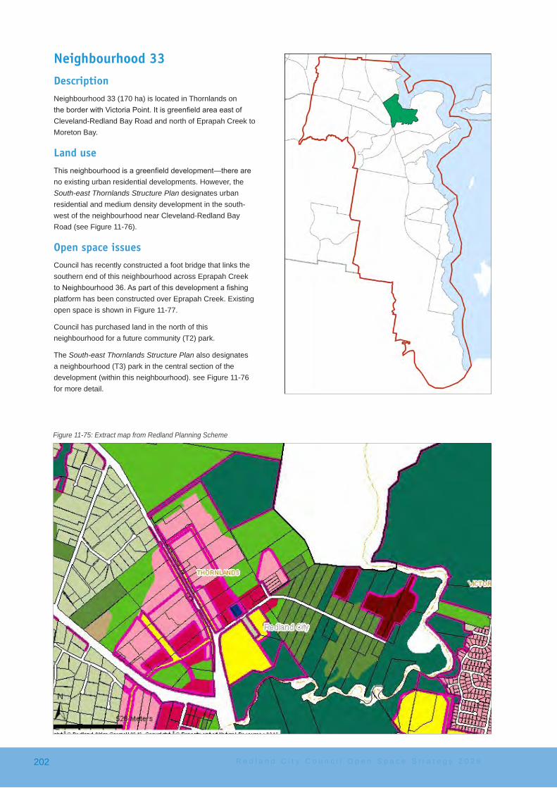
Neighbourhood 33DescriptionNeighbourhood 33 (170 ha) is located in Thornlands on theborderwithVictoriaPoint.ItisgreenfieldareaeastofCleveland-Redland Bay Road and north of Eprapah Creek to Moreton Bay.
Land useThisneighbourhoodisagreenfielddevelopment—thereareno existing urban residential developments. However, the South-east Thornlands Structure Plan designates urban residential and medium density development in the south-west of the neighbourhood near Cleveland-Redland Bay Road (see Figure 11-76).
Open space issuesCouncil has recently constructed a foot bridge that links the southern end of this neighbourhood across Eprapah Creek toNeighbourhood36.Aspartofthisdevelopmentafishingplatform has been constructed over Eprapah Creek. Existing open space is shown in Figure 11-77.
Council has purchased land in the north of this neighbourhood for a future community (T2) park.
The South-east Thornlands Structure Plan also designates a neighbourhood (T3) park in the central section of the development (within this neighbourhood). see Figure 11-76 for more detail.
Figure 11-75: Extract map from Redland Planning Scheme
R e d l a n d C i t y C o u n c i l O p e n S p a c e S t r a t e g y 2 0 2 6202

'WL
'WL
'WL
2a
3
2a
1
3
2a
3
2
2a
2a
3
BOUNDARY
ROAD
CLEVELANDREDLAND
BAYRO
AD
BEVERIDGE
ROAD
COLBURN
AVENUE
3a
2
2
2
23
3
3
33
4c
4a
4e
4f4e
4f
4e4d
4e
4e
4b
4f
3
2a
2a
3a
4b
5
2
3
3a 3a
Produced byLand Use Planning
REDLAND CITY COUNCIL
No
Vehi
cle
Acc
ess
toLu
keSt
reet
1:10,0000 100 200 300 400 500 600 700
Meters
´
Precinct and Sub-Precinct Descriptions
1. Mixed Use - Local Centre2. Housing
2a Attached Housing3. Medium Density Housing
3a Medium Density Housing(Eprapah Creek)
4. Greenspace Network4a Coastal Corridor4b Eprapah Creek Corridor4c Pinklands Reserve Corridor4d Thornlands Creek Corridor4e Bushland Living4f Flood Prone Area -
Central Open Space5. Rural Non-urban
Map 1 - Landuse PrecinctsPrecincts
'WL Local Park
Road widening/landscaping/acoustic treatments
District Park
South east ThornlandsStructure Plan Area
Greenspace Network
Housing
Medium Density Housing
Mixed Use - Local Centre
Rural Non-urban
Figure 11-76: Southeast Thornlands Structure Plan
S u b u r b c a t c h m e n t a r e a 4 203

The neighbourhood is connected by pedestrian and cycle bridge to Neighbourhood 36 to the south.
Recommended key actionsThe two parks that will be developed within this community have to provide the full suite of service standards. Careful design will be required to ensure the delivery of the activities while providing attractive and functional open space areas.
• new South East Thornlands Community Park − prepare a park plan for the design and layout of
theactivitiestomaximisethebenefitofthelandallocation
− provide an allocation the in the 10 year capital program to develop both the community and neighbourhood park
− the community park to provide the following; − a shaded multi-age playground − a dog off leash area − a small ramp park and BMX track − physical activities - basketball court (full size),
fitnessstations − picnic areas for larger groups − public toilets − landscaping − a community garden maybe able to be developed
on other open space with the neighbourhood• new Neighbourhood Park
− provide a toddler playground − provide a picnic shelter and tables and seats
Figure 11-77: Open space areas in Neighbourhood 33
R e d l a n d C i t y C o u n c i l O p e n S p a c e S t r a t e g y 2 0 2 6204
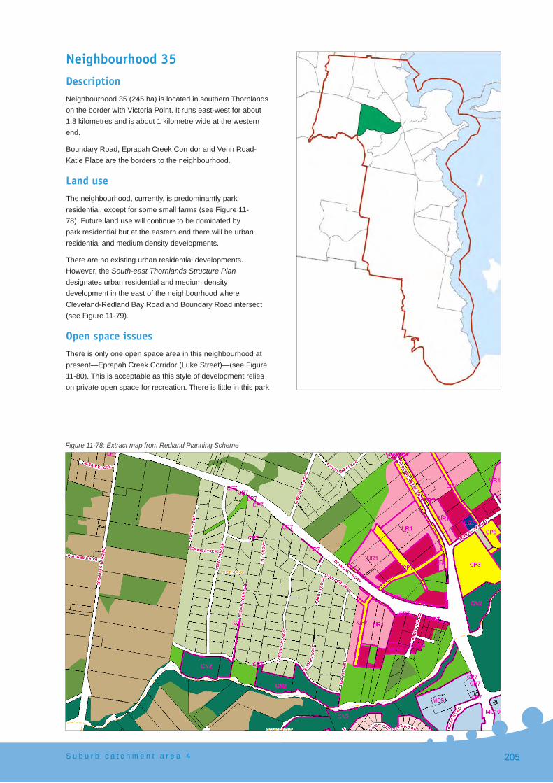
Neighbourhood 35DescriptionNeighbourhood 35 (245 ha) is located in southern Thornlands on the border with Victoria Point. It runs east-west for about 1.8 kilometres and is about 1 kilometre wide at the western end.
Boundary Road, Eprapah Creek Corridor and Venn Road-Katie Place are the borders to the neighbourhood.
Land useThe neighbourhood, currently, is predominantly park residential, except for some small farms (see Figure 11-78). Future land use will continue to be dominated by park residential but at the eastern end there will be urban residential and medium density developments.
There are no existing urban residential developments. However, the South-east Thornlands Structure Plan designates urban residential and medium density development in the east of the neighbourhood where Cleveland-Redland Bay Road and Boundary Road intersect (see Figure 11-79).
Open space issuesThere is only one open space area in this neighbourhood at present—Eprapah Creek Corridor (Luke Street)—(see Figure 11-80). This is acceptable as this style of development relies on private open space for recreation. There is little in this park
Figure 11-78: Extract map from Redland Planning Scheme
S u b u r b c a t c h m e n t a r e a 4 205

'WL
'WL
'WL
2a
3
2a
1
3
2a
3
2
2a
2a
3
BOUNDARY
ROAD
CLEVELANDREDLAND
BAYRO
AD
BEVERIDGE
ROAD
COLBURN
AVENUE
3a
2
2
2
23
3
3
33
4c
4a
4e
4f4e
4f
4e4d
4e
4e
4b
4f
3
2a
2a
3a
4b
5
2
3
3a 3a
Produced byLand Use Planning
REDLAND CITY COUNCIL
No
Vehi
cle
Acc
ess
toLu
keSt
reet
1:10,0000 100 200 300 400 500 600 700
Meters
´
Precinct and Sub-Precinct Descriptions
1. Mixed Use - Local Centre2. Housing
2a Attached Housing3. Medium Density Housing
3a Medium Density Housing(Eprapah Creek)
4. Greenspace Network4a Coastal Corridor4b Eprapah Creek Corridor4c Pinklands Reserve Corridor4d Thornlands Creek Corridor4e Bushland Living4f Flood Prone Area -
Central Open Space5. Rural Non-urban
Map 1 - Landuse PrecinctsPrecincts
'WL Local Park
Road widening/landscaping/acoustic treatments
District Park
South east ThornlandsStructure Plan Area
Greenspace Network
Housing
Medium Density Housing
Mixed Use - Local Centre
Rural Non-urban
Figure 11-79: Southeast Thornlands Structure Plan
R e d l a n d C i t y C o u n c i l O p e n S p a c e S t r a t e g y 2 0 2 6206

Figure 11-80: Open space areas in Neighbourhood 35
except a set of swings and a large open space area suitable for ball games and community events.
The South-east Thornlands Structure Plan recognises the need for a neighbourhood park when redevelopment proceeds.
The design of the road structure indicates that the existing park, off Luke Street, will not be connected by road to the development area. In this case it will be desirable for there to be a parkland development linking the two sites.
Access issuesBeing a park residential development most access is via the road system—either using cars, bicycles or walking on or against the road where it is safe to do so.
When development proceeds in the South-east Thornlands Structure Plan area access needs to be established as the detailed design is developed such that residents can easily and safely access the open space areas. Corridors for access and Community Purposes land are proposed in the Structure Plan to address this need. As mentioned above, access from the new open space area to the Eprapah Creek Corridor (Luke Street) parkland would greatly improve the value of parkland in the neighbourhood.
The new parkland will have more recreation elements than the existing Eprapah Creek Corridor (Luke Street) park and will allow the residents of the park living area to access those elements should they want to. Alternatively, linking the two
areas will give the residents in the urban settled areas a safe off-road walk.
Access across Eprapah Creek to the Victoria Point Lakeside shopping Centre (with Library and Bus Station) would be desirable, particularly for younger people and commuters.
Recommended key actions• new Neighbourhood Park
− provide a large multi-aged playground, examples of such parks can be found, particularly in Melbourne. Figure 11-74 shows some examples of high intensity parks in developing areas of Melbourne.
− provide picnic shelters, tables and seats and BBQ’s − provide a path system for bike/trike riding and
walking − a community garden maybe able to be developed in
some of the other open space areas The proposed key actions to meet the desired standards of service for this neighbourhood are:
• Eprapah Creek Corridor - Luke Street Park − ensure that the new open space area in the South-
east Thornlands Structure Plan area links to this park
− assess whether the Eprapah Creek Corridor - Luke Street Park is suitable as an unfenced dog off-leash area
− investigate a pedestrian bridge across Eprapah Creek to link the neighbourhood to Victoria Point Lakeside Shopping Centre
S u b u r b c a t c h m e n t a r e a 4 207
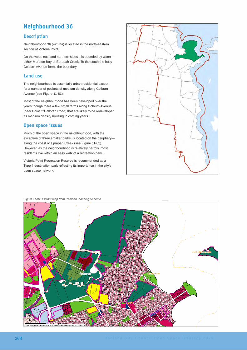
Neighbourhood 36DescriptionNeighbourhood 36 (426 ha) is located in the north-eastern section of Victoria Point.
On the west, east and northern sides it is bounded by water—either Moreton Bay or Eprapah Creek. To the south the busy Colburn Avenue forms the boundary.
Land useThe neighbourhood is essentially urban residential except for a number of pockets of medium density along Colburn Avenue (see Figure 11-81).
Most of the neighbourhood has been developed over the years though there a few small farms along Colburn Avenue (near Point O’Halloran Road) that are likely to be redeveloped as medium density housing in coming years.
Open space issuesMuch of the open space in the neighbourhood, with the exception of three smaller parks, is located on the periphery—along the coast or Eprapah Creek (see Figure 11-82). However, as the neighbourhood is relatively narrow, most residents live within an easy walk of a recreation park.
Victoria Point Recreation Reserve is recommended as a Type1destinationparkreflectingitsimportanceinthecity’sopen space network.
Figure 11-81: Extract map from Redland Planning Scheme
R e d l a n d C i t y C o u n c i l O p e n S p a c e S t r a t e g y 2 0 2 6208

The Egret Colony Wetlands is a major feature and paths around the site allow access to be maintained.
Point Halloran Conservation Area offers a natural area experience with a board walk into the wetlands of Eprapah Creek.
The Eprapah Scout Environmental Education Centre is 39 ha of privately owned1 bushland on the corner of Colburn Avenue and Cleveland Redland Bay Road, Victoria Point. It is one of nine sites recognised as Scouting World Centres of Excellence for Nature and the Environment. The site has a visitors’ centre and a museum. The trails, which traverse rainforest and mangrove environments, are open to the public “at all times for quiet enjoyment of the vegetation and wildlife2”.
The Redlands Social Infrastructure Strategy 2009 recognises the Eprapah Scout Environmental Education Centre as a possible location for a community living hub which seeks community and environmental outcomes through broad partnerships involving community, government and business.
CascadeGardensPark’swaterfeatureneedssignificantmaintenance in the very near future. Prior to this happening a parks plan should be developed.
1 Owned by Scouts Australia Qld2 Information on sign near entry
Figure 11-82: Open space areas in Neighbourhood 36
Access issuesExcept on main roads there are few footpaths in urban areas. For the most part though residents can walk to the connected path system that meanders around the periphery of the neighbourhood within 5—10 minutes walk (with many even less). Open space areas and walkways help to connect cul-de-sac developments.
The pathway system is part of the Moreton Bay Cycleway. In places it is not as wide as is preferred and Council will upgrade the pathway to three metres wide, where possible, over time.
Access to the coast, or Eprapah Creek is very good for the most part. Only in one section, between Wilson Esplanade and White Street, has residential development been allowed to extend to the water’s edge rendering the foreshore inaccessible to the public.
The Eprapah Creek Section of the Moreton Bay Cycleway hasonedifficultsection.Thepathway,headingnorth,currently ends at Aspect Drive just north of Cassie Court. It restarts at Bill Scudamore-Smith Park but on the ground it is not obvious how to navigate between the two points without direction. Council has planned a new alignment for this section that includes some boardwalks and has programmed itfordeliveryinthe2012-2013financialyear.
Council has recently constructed a bridge over Eprapah Creek linking Cameron Court Park north into the newly developing Neighbourhood 33 that will allow, eventually, for
S u b u r b c a t c h m e n t a r e a 4 209

Walking the dog in Orana Street Park
very extensive walks or bicycle rides. The bridge is part of the Moreton Bay Cycleway.
Other mattersCascade Gardens has a ceremony rotunda and is a popular venue for weddings and ceremonies.
The neighbourhood has two dog off-leash areas, both on the pathway system, so the neighbourhood is well serviced in comparison to others.
Recommended key actionsThe proposed key actions to meet the desired standards of service for this neighbourhood are:
• Bill Scudamore-Smith Park − addasmallnatureplayfeatureunderthefigtrees − provide some goals for ball kicking
• Orana Street Park − address the extensive drainage issues consider
deck platforms around the playground - make it a fun play feature i.e. like a ship at sea
• Les Moore Park − provide physical activity stations − provide a path link from Albert Street near the
dog off-leash area to the coastal walkway on the eastern side of the park
− provide a kick about space − assess park for commercial use
• Eprapah Creek Corridor—Aspect Drive section − the large cleared area (about the size of a football
field)isthepreferredlocationforanyfuturecommunity garden
− provide a kick about space• Cascade Gardens Park
− provide a half-court• complete the footpath on the northern side of Colburn
Avenue between Wilson Esplanade as this will allow access to Victoria Point Recreation Reserve without the need to cross over to the southern side of Colburn Avenue
• proceed with the development of a pathway link along Eprapah Creek between Aspect Drive and Bill Scudamore-Smith Park
• develop a path from Illidge Road (near Kintyre Street) across Eprapah Creek to the path on the western side. This will allow the adjacent community to easily connect into the extensive walking path network
• Victoria Point Recreation Reserve − investigate options for further commercial
development (e.g. a restaurant) − provide challenging play activities for primary
and secondary children on the upper level of the Reserve
R e d l a n d C i t y C o u n c i l O p e n S p a c e S t r a t e g y 2 0 2 6210
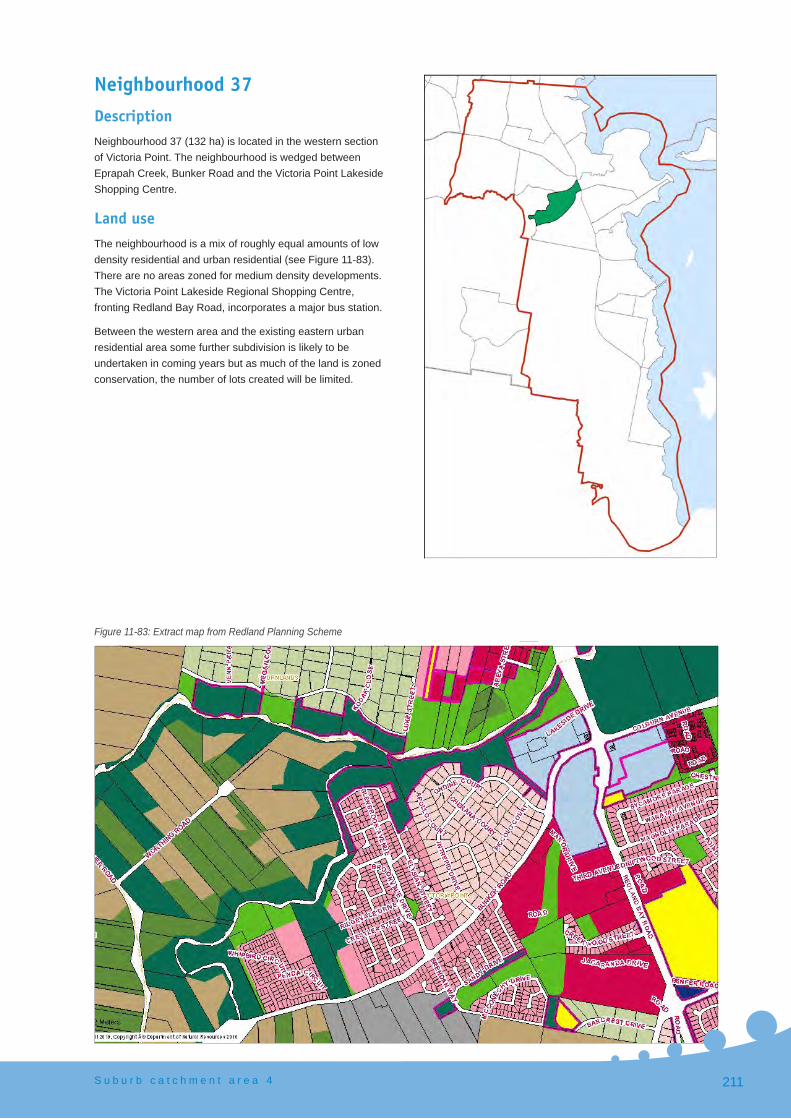
Neighbourhood 37DescriptionNeighbourhood 37 (132 ha) is located in the western section of Victoria Point. The neighbourhood is wedged between Eprapah Creek, Bunker Road and the Victoria Point Lakeside Shopping Centre.
Land useThe neighbourhood is a mix of roughly equal amounts of low density residential and urban residential (see Figure 11-83). There are no areas zoned for medium density developments. The Victoria Point Lakeside Regional Shopping Centre, fronting Redland Bay Road, incorporates a major bus station.
Between the western area and the existing eastern urban residential area some further subdivision is likely to be undertaken in coming years but as much of the land is zoned conservation, the number of lots created will be limited.
Figure 11-83: Extract map from Redland Planning Scheme
S u b u r b c a t c h m e n t a r e a 4 211

Figure 11-84: Open space areas in Neighbourhood 37
Open space issuesThere are two recreation parks in the neighbourhood. The second, Liriope Place Park, is a new dedicated park from a recent sub-division and not currently showing in the map1 (see Figure 11-84).
The Bunker Road Bushland Refuge has some cleared areas. Given the lack of recreation open space in this neighbourhood it is recommended that at least some of this area be retained as open space for a kick-about area. A community garden site is still to be found.
Access issuesThere is an existing pathway along Eprapah Creek Corridor from the Victoria Point Lakeside Shopping Centre to Brookvale Drive. There is a gap then until Liriope Place Park. Council is currently planning an alignment to continue this pathway.
The pathway along the northern side of Bunker Road back to Victoria Point Lakeside Shopping Centre is also substantially complete. There are two segments totalling about 350m that are missing that need to be completed.
Other mattersThere are no facilities such as a half-court or skate facilities for older children in the neighbourhood and no obvious place
1 The park is not shown on Figure 11-84 as, despite being developed, ownership has not yet been transferred to Council
to put any. However, the Eprapah Creek pathway links safely east to Cascade Gardens that has a variety of facilities for this age group.
Recommended key actionsThe proposed key actions to meet the desired standards of service for this neighbourhood are:
• ensure that the Eprapah Creek Corridor Walkway is linked between Brookvale Drive and Liriope Place Park. The footpath along Bunker Road also needs to link as part of any subdivision or other works so that a circuit around the neighbourhood is created for access to the shopping centre, bus station, library and other community facilities
• Brookvale Park: − provide goal posts to create a kick-about space − provide play elements for primary school-aged
children − create a meeting place shelter for young people − build a half basketball court
• Bunker Road Bushland Refuge -part of the cleared area − consider an area for a community garden − consider a fenced dog off-leash area
• Liriope Park − provide goals to create a small kick-about space
Shortfall − Within this neighbourhood there are no parks that
are considered suitable for commercial activities.
R e d l a n d C i t y C o u n c i l O p e n S p a c e S t r a t e g y 2 0 2 6212

Neighbourhood 38DescriptionNeighbourhood 38 (252 ha) is located in the south-west of Victoria Point. The neighbourhood is wedged between Bunker Road, Redland Bay Road and Double Jump Road as well as Clay Gully.
In the north of the neighbourhood is the Victoria Point Regional Shopping Centre.
Land useThe neighbourhood is a mix of development types from rural non-urban to medium density (with retirement villages dominating this land use) and shopping centres.
As can be seen in Figure 11-85 the rural non-urban zoning (shaded brown) dominates the southern and western portion of the neighbourhood. This area is used for small lot farms at present.
The grey shaded area is the Bunker Road Emerging Urban Community for which Council is currently preparing a structure plan. The structure plan is likely to be released for community comment in 2012. This community is proposed to be an urban community with a population of approximately 400 people.
Figure 11-85: Extract map from Redland Planning Scheme
S u b u r b c a t c h m e n t a r e a 4 213
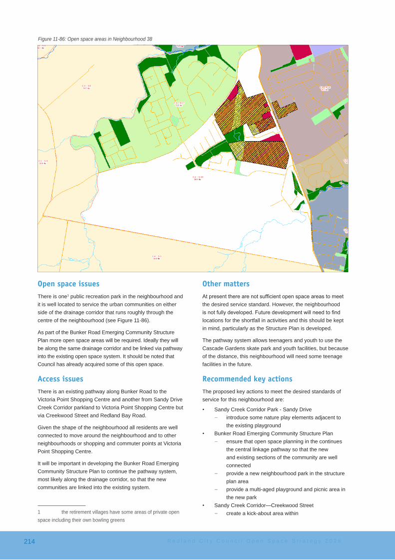
Figure 11-86: Open space areas in Neighbourhood 38
Open space issuesThere is one1 public recreation park in the neighbourhood and it is well located to service the urban communities on either side of the drainage corridor that runs roughly through the centre of the neighbourhood (see Figure 11-86).
As part of the Bunker Road Emerging Community Structure Plan more open space areas will be required. Ideally they will be along the same drainage corridor and be linked via pathway into the existing open space system. It should be noted that Council has already acquired some of this open space.
Access issuesThere is an existing pathway along Bunker Road to the Victoria Point Shopping Centre and another from Sandy Drive Creek Corridor parkland to Victoria Point Shopping Centre but via Creekwood Street and Redland Bay Road.
Given the shape of the neighbourhood all residents are well connected to move around the neighbourhood and to other neighbourhoods or shopping and commuter points at Victoria Point Shopping Centre.
It will be important in developing the Bunker Road Emerging Community Structure Plan to continue the pathway system, most likely along the drainage corridor, so that the new communities are linked into the existing system.
1 the retirement villages have some areas of private open space including their own bowling greens
Other mattersAtpresenttherearenotsufficientopenspaceareastomeetthe desired service standard. However, the neighbourhood isnotfullydeveloped.Futuredevelopmentwillneedtofindlocations for the shortfall in activities and this should be kept in mind, particularly as the Structure Plan is developed.
The pathway system allows teenagers and youth to use the Cascade Gardens skate park and youth facilities, but because of the distance, this neighbourhood will need some teenage facilities in the future.
Recommended key actionsThe proposed key actions to meet the desired standards of service for this neighbourhood are:
• Sandy Creek Corridor Park - Sandy Drive − introduce some nature play elements adjacent to
the existing playground• Bunker Road Emerging Community Structure Plan
− ensure that open space planning in the continues the central linkage pathway so that the new and existing sections of the community are well connected
− provide a new neighbourhood park in the structure plan area
− provide a multi-aged playground and picnic area in the new park
• Sandy Creek Corridor—Creekwood Street − create a kick-about area within
R e d l a n d C i t y C o u n c i l O p e n S p a c e S t r a t e g y 2 0 2 6214

ShortfallFind open space areas for the shortfall in activities including:
• a community garden• a dog off-leash area• a teenage hangout space• a natural area experience, most likely in conservation
areas that will be acquired• a commercial use area
Some of these shortfalls may be addressed within the Bunker Road Structure Plan area.
S u b u r b c a t c h m e n t a r e a 4 215
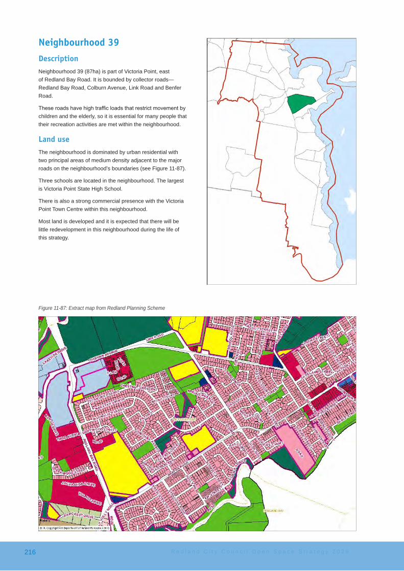
Neighbourhood 39DescriptionNeighbourhood 39 (87ha) is part of Victoria Point, east of Redland Bay Road. It is bounded by collector roads—Redland Bay Road, Colburn Avenue, Link Road and Benfer Road.
Theseroadshavehightrafficloadsthatrestrictmovementbychildren and the elderly, so it is essential for many people that their recreation activities are met within the neighbourhood.
Land useThe neighbourhood is dominated by urban residential with two principal areas of medium density adjacent to the major roads on the neighbourhood’s boundaries (see Figure 11-87).
Three schools are located in the neighbourhood. The largest is Victoria Point State High School.
There is also a strong commercial presence with the Victoria Point Town Centre within this neighbourhood.
Most land is developed and it is expected that there will be little redevelopment in this neighbourhood during the life of this strategy.
Figure 11-87: Extract map from Redland Planning Scheme
R e d l a n d C i t y C o u n c i l O p e n S p a c e S t r a t e g y 2 0 2 6216

Open space issuesRecreation parks are well distributed in the neighbourhood, and mostly developed with a basic level of embellishment (see Figure 11-88).
Therearefivetoddlerplaygroundsandastheyarewellspaced, they need to be retained. Four of these also have play elements for older children.
There are no teenage-focussed facilities in the neighbourhood. However, the pathway system makes it relatively easy, and safe1, to access the Cascade Gardens youth facilities just north of Colburn Avenue, for those young people attracted to skate board and BMX bike riding.
Access issuesA path circumnavigates the neighbourhood linking residents into the schools, shopping centres, sports clubs and other community facilities. Two missing path links at Ern and Alma Dowling Memorial Park would assist in connecting residents to points of interest.
There is some concern about children having to walk on busy Magnolia Parade to get to school due to the lack of a footpath.
Recommended key actionsThe proposed key actions to meet the desired standards of service for this neighbourhood are:
1 There is a signalled crossing point on Colburn Avenue
Figure 11-88: Open space areas in Neighbourhood 39
• Parklands Court Park: − develop a natural playground in the small bushland
remnant − extend the pathway across the drain so that the
playgrounds are accessible from the linear pathway running through the park
• Duncan Jenkins Eucalypt Park − a community garden may be able to be located
here• Ern and Alma Dowling Memorial Park,
− investigate a pathway across the Memorial Park, near the drainage line, to connect the paths to the north and south of the park
− continue the pathway from the Memorial Park through to Sycamore Parade Park.
− add new elements to the existing physical activity stations
• Poinciana Avenue Park: − provide a fenced DOLA − provide a meeting place for young people − install two pergolas to service these two activities − consider rubbish bins in this area because of the
highpedestriantraffic(youngpeoplefromschool) − upgrade the playground to make it more
challenging and interesting − providefitnessactivitystations
S u b u r b c a t c h m e n t a r e a 4 217
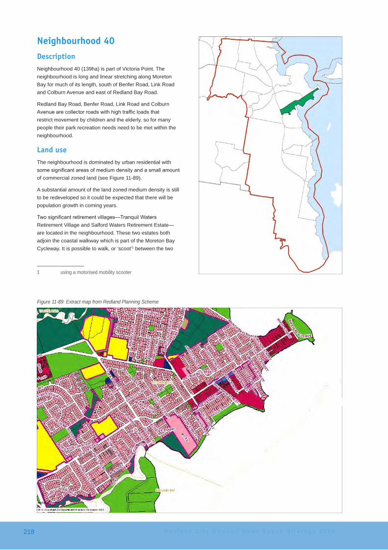
Neighbourhood 40DescriptionNeighbourhood 40 (139ha) is part of Victoria Point. The neighbourhood is long and linear stretching along Moreton Bay for much of its length, south of Benfer Road, Link Road and Colburn Avenue and east of Redland Bay Road.
Redland Bay Road, Benfer Road, Link Road and Colburn Avenuearecollectorroadswithhightrafficloadsthatrestrict movement by children and the elderly, so for many people their park recreation needs need to be met within the neighbourhood.
Land useThe neighbourhood is dominated by urban residential with somesignificantareasofmediumdensityandasmallamountof commercial zoned land (see Figure 11-89).
A substantial amount of the land zoned medium density is still to be redeveloped so it could be expected that there will be population growth in coming years.
Twosignificantretirementvillages—TranquilWatersRetirement Village and Salford Waters Retirement Estate—are located in the neighbourhood. These two estates both adjoin the coastal walkway which is part of the Moreton Bay Cycleway. It is possible to walk, or ‘scoot’1 between the two
1 using a motorised mobility scooter
Figure 11-89: Extract map from Redland Planning Scheme
R e d l a n d C i t y C o u n c i l O p e n S p a c e S t r a t e g y 2 0 2 6218

sites and observation indicates that many residents are doing this.
There are no schools located in the neighbourhood.
Open space issuesRecreation parks are biased to the east of this neighbourhood (see Figure 11-90). There is one developed recreation park in the west of the neighbourhood.
There are no teenage-focussed facilities in the neighbourhood. However, the pathway system makes it relatively easy to access the Cascade Gardens youth facilities, for those young people attracted to skate board and BMX bike riding.
Victoria Point Recreation Reserve has been included in Neighbourhood 36 but it is just as easily accessed from this neighbourhood. This Type 1 destination park provides many recreation functions with high level playgrounds, picnicking, fishingandotheractivities.
Access issuesThe Salford Waters Retirement Village is a physical barrier to east-west movement across the neighbourhood. Its shape effectively prevents linear movement through the neighbourhood. The only way to walk, cycle or drive from one side of this neighbourhood to the other, past this Village, is to use Colburn Avenue, the neighbourhood’s boundary.
The Benfer Road—Link Road—Colburn Avenue road network is important in linking this neighbourhood. There is no coastal
Figure 11-90: Open space areas in Neighbourhood 40
walkway across the neighbourhood. It does exist in part, but because of various constraints, including access, it has not been constructed along the length of the neighbourhood, particularly in the western section.
As this missing section is part of the Moreton Bay Cycleway Council has given consideration to a boardwalk link from the western end of Salford Waters Park to Glen Road Park through Glen Road Wetlands, a distance of approximately 400 metres. The Moreton Bay Cycleway would continue from here through Moogurrapum Creek Corridor—Robin Parade Park before crossing Moogurrapum Creek to near the Redland Bay Golf Course before joining the Jack Gordon Pathway through to Redland Bay.
Within the neighbourhood there are some pathways but they arenotsignificant.Therearefootpathsbutfewconcretepaths.Most streets are quiet so it is envisaged that residents often walk on the street edge.
Other mattersW. H. Yeo Park is popular for wedding and ceremony bookings.
S u b u r b c a t c h m e n t a r e a 4 219
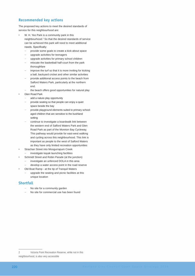
Recommended key actionsThe proposed key actions to meet the desired standards of service for this neighbourhood are:
• W. H. Yeo Park is a community park in this neighbourhood.2 So that the desired standards of service can be achieved this park will need to meet additional needs.Specifically:
− provide some goals to create a kick-about space − upgrade activities for teenagers − upgrade activities for primary school children − relocate the basketball half-court from the park
thoroughfare − improve the turf so that it is more inviting for kicking
a ball, backyard cricket and other similar activities − provide additional access points to the beach from
Salford Waters Park, particularly at the northern end.
− the beach offers good opportunities for natural play• Glen Road Park
− add a nature play opportunity − provide seating so that people can enjoy a quiet
space beside the bay − provide playground elements suited to primary school-
aged children that are sensitive to the bushland setting
− continue to investigate a boardwalk link between the western end of Salford Waters Park and Glen Road Park as part of the Moreton Bay Cycleway. This pathway would provide for east-west walking and cycling across this neighbourhood. This link is important as people to the west of Salford Waters as they have only limited recreation opportunities
• Strachan Street into Moogurrapum Creek − investigate kayak launching facilities
• Schmidt Street and Robin Parade (at the junction) − investigate an unfenced DOLA in this area − develop a water access point in the road reserve
• Old Boat Ramp - at the tip of Tranquil Waters − upgrade the seating and picnic facilities at this
unique location
Shortfall − No site for a community garden − No site for commercial use has been found
2 Victoria Point Recreation Reserve, while not in this neighbourhood, is also very accessible
R e d l a n d C i t y C o u n c i l O p e n S p a c e S t r a t e g y 2 0 2 6220

Neighbourhood 41DescriptionNeighbourhood 41 (174ha) is in the north of the suburb of RedlandBay.Theneighbourhoodisdefinedbygreenspace(including Redland Bay Golf Course) and Moogurrapum Creek in the north, Redland Bay Road in the west, Boundary StreetdefiningthesouthernboundaryandMoretonBaydefiningtheeasternboundary.
Land useThe neighbourhood is dominated by urban residential with almost no medium density or commercial zoning (see Figure 11-91).
The neighbourhood is not yet fully developed. There are some small farms and some undeveloped lots. Some larger lots may also be subdivided in coming years.
There are no schools located in the neighbourhood.
Open space issuesThe Redland Bay Golf Club course is the largest tract of open space in the neighbourhood and it is a single purpose private club and only members are able to access this area (see Figure 11-92).
The Moogurrapum Creek, its tributaries and other drainage lines provide linear open space through the neighbourhood.
Figure 11-91: Extract map from Redland Planning Scheme
S u b u r b c a t c h m e n t a r e a 4 221

CharlieBucklerSportsfieldisalargemulti-sportfacilitylocated in the south-west. The sport facilities meet the needs of users from the SCA and other parts of the city for sport but it also has an important neighbourhood role. The park has a half-court, bmx jumps and a dog off-leash area for pet owners. Also, there is an undeveloped area on the western side of the site that is essentially unused (though it is mowed). Thisareaissignificantlyelevatedabovethesurroundinglandscape and, consequently, has no casual surveillance from adjacent areas. The future use of the part of the site lies in sporting use but it will most likely be limited to playing or training facilities with minimal infrastructure given its lack of visibility.
A site for a community garden, on existing open space, has not been found through this analysis.
Penrose Street Park is on the western side of Moogurrapum Creek in this neighbourhood. Penrose Street Park currently provides toddler and primary play activities and will do into the future.
Residents can also cross the creek to Pinelands Circuit Park playground which is mainly a toddler playground. As this playground is meeting the needs of so many people it is recommended that it be upgraded over time.
Figure 11-92: Open space areas in Neighbourhood 41
Access issuesThe Jack Gordon Pathway links foreshore conservation areas along the coast from the Redland Bay Golf Club to Sel Outride Park in the neighbourhood to the south. The pathway has been extended to run along North Street adjacent to the Redland Bay Golf Club and then down Main Street to Boundary Road. The path connects residents east of Moogurrapum Creek. While the pathway is not recognised as a recreation park (it is Foreshore Conservation area) it provides opportunities for extensive walking, views to Moreton Bay and barbecue and picnics.
The residents west of Moogurrapum Creek are connected into the east section of the neighbourhood by a pathway (bridge) from Pinelands Circuit to Anita Street as well as a pathway along Boundary Street.
R e d l a n d C i t y C o u n c i l O p e n S p a c e S t r a t e g y 2 0 2 6222
Recommended key actionsThe proposed key actions to meet the desired standards of service for this neighbourhood are:
• Wes Armstrong Park − improve the seating in to make it more relaxed,
suited to all ages and designed for meeting people and conversation
• Moreton Bay Cycleway − investigate developing the missing link that will
extend north from the Jack Gordon Pathway around the Redland Bay Golf Club across Moogurrapum Creek to parkland on the north side
• CharlieBucklerSportfield − seek additional sporting use of the upper level area
of but infrastructure should be minimised as there is no casual surveillance of this area
• Pinelands Circuit Park − upgrade the playground at as it is the primary
playground for a large number of residents − provide play items to cater for primary school aged
children − provide natural play elements
• Jack Gordon Pathway − addfitnessstationsalongtheinthevicinityofGray
Street so that exercisers have beautiful views of Moreton Bay
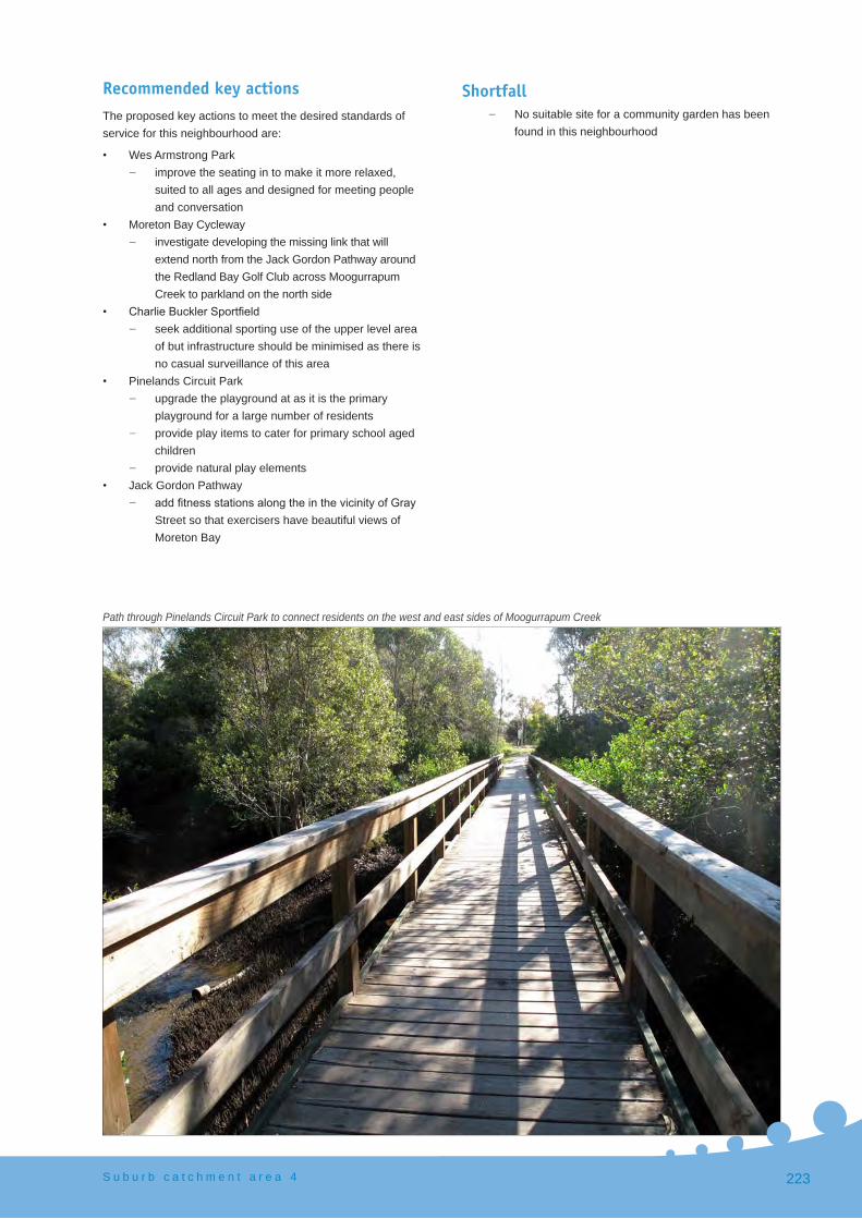
Path through Pinelands Circuit Park to connect residents on the west and east sides of Moogurrapum Creek
Shortfall − No suitable site for a community garden has been
found in this neighbourhood
S u b u r b c a t c h m e n t a r e a 4 223

Neighbourhood 43DescriptionNeighbourhood 43 (282ha) is the central area of Redland Bay stretching from Cleveland-Redland Bay Road—Gordon Road east to the bay.
Land useThe neighbourhood is largely developed with a number of subdivisions underway or likely to proceed in the short term.
The Planning Scheme allows for urban residential and asignificantamountofmediumdensity(thoughlargelyundeveloped at this point) near the bay and the commercial areas of Redland Bay (see Figure 11-93).
Figure 11-93: Extract map from Redland Planning Scheme
R e d l a n d C i t y C o u n c i l O p e n S p a c e S t r a t e g y 2 0 2 6224
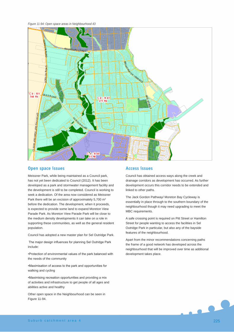
Open space issuesMeissner Park, while being maintained as a Council park, has not yet been dedicated to Council (2012). It has been developed as a park and stormwater management facility and the development is still to be completed. Council is working to seek a dedication. Of the area now considered as Meissner Park there will be an excision of approximately 5,700 m2 before the dedication. The development, when it proceeds, is expected to provide some land to expand Moreton View Parade Park. As Moreton View Parade Park will be close to the medium density developments it can take on a role in supporting these communities, as well as the general resident population.
Council has adopted a new master plan for Sel Outridge Park.
ThemajordesigninfluencesforplanningSelOutridgeParkinclude:
•Protectionofenvironmentalvaluesoftheparkbalancedwiththe needs of the community
•Maximisationofaccesstotheparkandopportunitiesforwalking and cycling
•Maximisingrecreationopportunitiesandprovidingamixof activities and infrastructure to get people of all ages and abilities active and healthy
Other open space in the Neighbourhood can be seen in Figure 11-94.
Figure 11-94: Open space areas in Neighbourhood 43
Access issuesCouncil has obtained access ways along the creek and drainage corridors as development has occurred. As further development occurs this corridor needs to be extended and linked to other paths.
The Jack Gordon Pathway/ Moreton Bay Cycleway is essentially in place through to the southern boundary of the neighbourhood though it may need upgrading to meet the MBC requirements.
A safe crossing point is required on Pitt Street or Hamilton Street for people wanting to access the facilities in Sel Outridge Park in particular, but also any of the bayside features of the neighbourhood.
Apart from the minor recommendations concerning paths the frame of a good network has developed across the neighbourhood that will be improved over time as additional development takes place.
S u b u r b c a t c h m e n t a r e a 4 225

Recommended key actionsThe proposed key actions to meet the desired standards of service for this neighbourhood are:
• Lanyard Place Park − over time upgrade the play elements for primary
school aged children − add a soccer goal for kick about − build a pathway from Lanyard Place through the
park to Spinnaker Circuit• Nev Stafford Park
− when the Sel Outridge master plan is delivered, including a substantial playground, remove the playground. These two parks are very close.
− Nev Stafford Park should be focused on quiet activities and enjoying the bay.
− finishthepathwayconnectionthroughthewateredge of the park
• Gordon Road Wetland − develop a small natural play element in the cleared
space off Falkirk Parade (south)• Lime Street Wetlands (northern subdivision)
− provide a fully fenced toddler play park • Emperor Drive Park
− provide a primary school aged playground to appeal to a wider age group as there are no other park playgrounds in this locale
• Mill Street Park − add two seats in to encourage a ‘quiet
contemplation’ environment• develop a path from Meissner Park through Pitt Street
Wetlands to Pitt Street and then crossing over to connect with the path in Weinam Street to give access to the ramp park and Sel Outridge Park
• develop a path from Emperor Drive Park through the bushland to German Church Road (approximately 240 m)
• as development proceeds in the north-west of the neighbourhood:
− maintain the pathway network between Gordon Road and Boundary Street, so that it eventually links through to Boundary Street along the Moogurrapum Creek Corridor
• As there is limited access to recreation activities in parkland west of the Moogurrapum Creek Corridor
• establish a new park in the vicinity of the southern end of Falkirk Parade (north) for toddler and primary play with associated picnic facilities.
R e d l a n d C i t y C o u n c i l O p e n S p a c e S t r a t e g y 2 0 2 6226

Neighbourhood 44DescriptionNeighbourhood 44 (81 ha) is a compact area in Redland Bay bounded by Gordon Road in the north, German Church Road in the west, School of Arts Road in the south and Queen Street in the east.
The neighbourhood has a central green space associated with the Moogurrapum Creek corridor. The creek corridor divides the neighbourhood into two spaces which need to be linked as development continues.
Land useThis neighbourhood is dominated by urban residential with no medium density zoning (see Figure 11-95). An area of industry zoning in the north fronting German Church Road has not yet been developed.
There are no schools or commercial developments in the neighbourhood.
The farming areas are likely to be developed over time into urban residential or general industry. The trees planted around the nursery are reaching maturity and provide a green corridor through the neighbourhood. This green belt has been preserved within the Planning Scheme and from a recreation perspective, offers an opportunity for a walking in a shaded and attractive setting.
Figure 11-95: Extract map from Redland Planning Scheme
S u b u r b c a t c h m e n t a r e a 4 227

Open space issuesThere are four key recreation open space areas in the neighbourhood,andatpresent,onlyonehasanysignificantdevelopment.
There is only one playground, which is designed primarily for toddlers within the neighbourhood. There are no playgrounds or activities for older children. The playground, in Potts Place Park, is not centrally located and does not have ready access from the eastern sections of the neighbourhood.
Council has developed a small nature-based playground in the Moogurrapum Creek Corridor—Pelorus Street open spacewhichpartlyaddressesthedeficit.
Future open space will be required to meet, as far as possible,thedeficitofdesiredstandardofserviceactivitiesand embellishments in this neighbourhood.
Figure 11-96: Open space areas in Neighbourhood 44
Access issuesAs mentioned previously, the green belt of trees surrounding the nursery will make an attractive location for a recreation pathway when development occurs and will help in connecting the residents through to Gordon Road.
Movement from this neighbourhood to the east, across Queen Streetisverydifficult.QueenStreetisabusyroadandthereare no pedestrian crossings. The only crossing points are at the busy intersections, including two roundabouts, which are difficulttosafelycrossexceptforthe‘fleet-of-foot’.
R e d l a n d C i t y C o u n c i l O p e n S p a c e S t r a t e g y 2 0 2 6228

Recommended key actionsThe proposed key actions to meet the desired standards of service for this neighbourhood are:
• Bedarra Street Park − develop a playground for toddlers − develop a playground for primary school aged
children − develop a meeting place for young people with for
example a space net• Moogurrapum Creek Corridor—Pelorus Street parkland
− providefitnessactivitystationsclosetothepathway − ensure a walking and cycling link across the
Moogurrapum Creek corridor to link the two communities on opposite sides of the Creek
• Connecting Bedarra Park and Potts Parade Park − develop a walking and cycle path system through
the treed green belt when it is in Council’s control. The path should be designed to link these parks and the nature play element proposed for Moogurrapum Creek Corridor—Pelorus Street to create a play journey
• provide a safe pedestrian crossing of Queen Street and when resources and demand allow
• Jack Gordon Park: − build a path through the park as there is evidence
of considerable use as a thoroughfare − add a horizontal traverse wall
• Potts Place Park − provide primary school-aged play elements
Shortfalls• as development proceeds Council will need to acquire
land for new parkland and to meet the following activity requirements as a minimum:
− a dog off-leash area (fenced or unfenced) − a community garden − an area for commercial use opportunities
S u b u r b c a t c h m e n t a r e a 4 229

Neighbourhood 45DescriptionNeighbourhood 45 (170 ha) along with Neighbourhood 46, are the southernmost neighbourhoods included in the Redland Open Space Strategy 2026—the neighbourhoods mark the limit of current and expected urban settlement to 2026.
The neighbourhood is long (over 3kms) but quite narrow (generally less than 700 metres wide). This is typical of coastal neighbourhoods that are focussed on the bay. Movement tends to be linear moving up and down the coast but not far inland.
Land useThe Planning Scheme zoning in this neighbourhood is predominantly urban residential with a small amount of low density residential (see Figure 11-97).
Open space issuesGreen space is overwhelming located along the coast or in the Weinam Creek Corridor in the north or the Torquay Creek Corridor in the south (see Figure 11-98).
The Weinam Creek Wetland corridor, recently master planned (2012), extends south into Neighbourhood 46. The Weinam Creek riparian area is important for recreation, movement, drainage and conservation.
Figure 11-97: Extract map from Redland Planning Scheme
R e d l a n d C i t y C o u n c i l O p e n S p a c e S t r a t e g y 2 0 2 6230

The new master plan proposes:
• an extensive shared pathway network that will connect the community into the Seven Cs network
• safer road crossings to encourage linear movement through the whole corridor
• a number of new nature play opportunities along a pathway to create a play journey
• stormwaterbio-filters• opportunities to interact with nature (e.g. bird hides)• youth elements including a half-court (existing) and kick-
about areas• a site for a community garden• extensive revegetation
Point Talburpin Park provides teenage play facilities already there including a kick-about space, cricket practice nets and bmx jumps.
Figure 11-98: Open space areas in Neighbourhood 45 Recommended key actionsThe proposed key actions to meet the desired standards of service for this neighbourhood are:
• Orchard Beach Foreshore − place physical activity stations in the open space
corridor along the edge of Moreton Bay. − the upper sections of Wilson Park have good views
of the bay and are connected by pathway to other areas of the neighbourhood so it would make a pleasant place to exercise
− continue to negotiate with the property owner to agree suitable arrangements to connect the ‘missing link’ along the foreshore between Orchard Beach Foreshore (north) and Wilson Park (within Orchard Beach Foreshore South)
− develop a pathway extension from the end of the path in Orchard Beach Foreshore (south) through to Point Talburpin Park
• Tucker Reserve (Torquay Road) − sealthecarparkalongfromandinstallafish
cleaning table• Point Talburpin Park
− upgrade the playground with elements for primary school aged children.
− remove one set of swings if space is required − provide a new basketball half-court
• Junee Street Park − could be suitable for a community garden
• Weinam Creek Wetlands Community Park − implement the master plan over time − provide nature play opportunities − develop a community garden − upgrade or extend the path system − provide safe road crossings
S u b u r b c a t c h m e n t a r e a 4 231
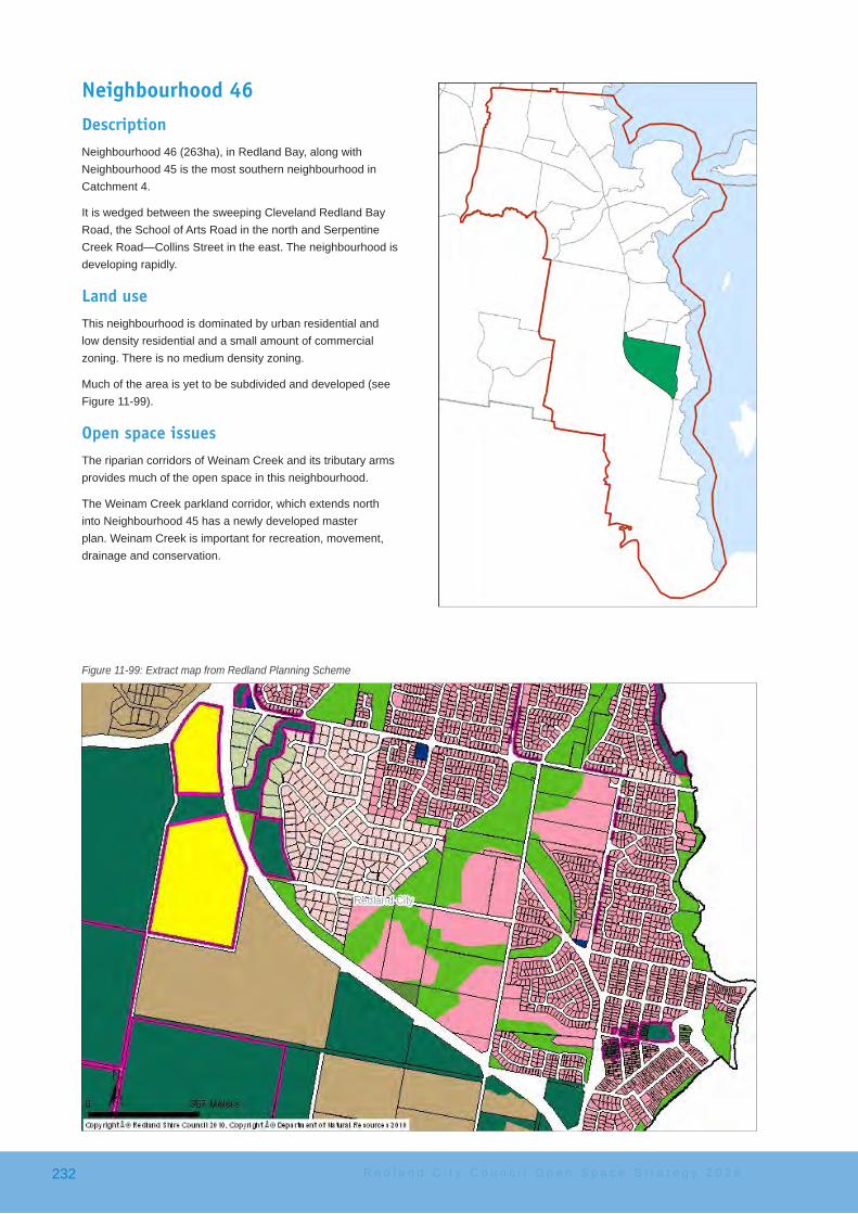
Neighbourhood 46DescriptionNeighbourhood 46 (263ha), in Redland Bay, along with Neighbourhood 45 is the most southern neighbourhood in Catchment 4.
It is wedged between the sweeping Cleveland Redland Bay Road, the School of Arts Road in the north and Serpentine Creek Road—Collins Street in the east. The neighbourhood is developing rapidly.
Land useThis neighbourhood is dominated by urban residential and low density residential and a small amount of commercial zoning. There is no medium density zoning.
Much of the area is yet to be subdivided and developed (see Figure 11-99).
Open space issuesThe riparian corridors of Weinam Creek and its tributary arms provides much of the open space in this neighbourhood.
The Weinam Creek parkland corridor, which extends north into Neighbourhood 45 has a newly developed master plan. Weinam Creek is important for recreation, movement, drainage and conservation.
Figure 11-99: Extract map from Redland Planning Scheme
R e d l a n d C i t y C o u n c i l O p e n S p a c e S t r a t e g y 2 0 2 6232

The draft master plan proposes:
• an extensive shared pathway network that will connect the community into the Seven Cs network
• safer road crossings to encourage linear movement through the whole corridor
• a number of new nature play opportunities along a pathway to create a play journey
• stormwaterbio-filters• opportunities to interact with nature (e.g. bird hides)• youth elements including a half-court (existing) and kick-
about areas• a site for a community garden• extensive rehabilitation
Access issuesAt present access across the entire neighbourhood is difficultgiventhetimingofthedevelopments.However,the framework of a pathway network is being laid as developments proceed. In the future, the open space and drainage corridor network will provide a functional pathway system to move about the neighbourhood.
Figure 11-100: Open space areas in Neighbourhood 46
Recommended key actionsThe proposed key actions to meet the desired standards of service for this neighbourhood are:
• DenhamBoulevardPark(SchoolofArtsSportfield) − provide shade and shelter near the basketball
half-court − proceed with the implementation of the master plan
for the Weinam Creek Wetlands Community Park − the master plan should be used to assess future
development applications − activities that the master plan needs to provide for
include: − opportunities for natural play − an unfenced dog off-leash area along (the closed
section) Donald Road − a community garden site − continuation of the pathway network − safe crossings to major roads along the Weinam
Creek Wetlands Community Parkland system
Shortfall − there is no location for a community garden at
present, this maybe be solved through future sub-divisions
S u b u r b c a t c h m e n t a r e a 4 233

R e d l a n d C i t y C o u n c i l O p e n S p a c e S t r a t e g y 2 0 2 6234