Study Overview - January 2013
2
01.15.2013 Corridor Summary e I-35W North Managed Lanes Corridor Study extends from downtown Minneapolis to Forest Lake. e purpose of the study is to identify preferred managed lane concepts as well as improvement strategies at spot locations along the corridor. A Technical Advisory Committee, consisting of local, county, state, and federal representatives, meets every other month to provide recommendations and feedback on the study process. I-35W North Managed Lanes Corridor Study Study Overview - January 2013 35E 35W 35 35W 694 94 94 MINNESOTA 36 MINNESOTA 280 MINNESOTA 65 MINNESOTA 61 MINNESOTA 97 10 14 Columbus Lino Lakes Circle Pines Lex ington Blaine New Brighton Shoreview Arden Hills Mounds view Roseville Minneapolis St. Anthony Columbus Lino Lakes Circle Pines Forest Lake Forest Lake New Brighton Lex ington Blaine Shoreview Roseville Minneapolis St. Anthony Arden Hills Mounds view 35E 35W 35 35W 694 94 MINNESOTA 36 MINNESOTA 280 MINNESOTA 65 MINNESOTA 61 MINNESOTA 97 10 14 Columbus Lino Lakes Circle Pines Lex ington Blaine New Brighton Shoreview Arden Hills Mounds view Roseville Minneapolis St. Anthony Columbus Lino Lakes Circle Pines Forest Lake Forest Lake New Brighton Lex ington Blaine Shoreview Roseville Minneapolis St. Anthony Arden Hills Mounds view Pavement Preservation Bridge Preservation For more information please visit: www.dot.state.mn.us/metro/projects/ i35wstudy Bill Goff Minnesota Department of Transportation Metro Division – Waters Edge 1500 West County Road B-2 Roseville, MN 44113 651.234.7797 [email protected] Todd Polum SRF Consulting Group, Inc. One Carlson Parkway, Suite 150 Plymouth, MN 55447 763.475.0010 [email protected] e elements included in the managed lane vision were selected based on the results of operations modeling, benefit-cost analysis, and secondary screening process. • Managed lanes between downtown Minneapolis and Lexington Avenue • Interchange improvements at I-35W and TH 10 north junction • Interchange improvements along I-35W at I-694 • TH 36 eastbound improvements • North ramp access at Hennepin Avenue • Managed lane direct connections to downtown Minneapolis I-35W Corridor Vision Implementation Plan Benefits • High Occupancy Toll Lanes • Provide for faster, safer and more reliable travel options • Travel benefits for transit, carpoolers, motorcycles and MnPASS customers What are Managed Lanes? I-35W North Managed Lanes Corridor Study Ultimate vision implemented over time in a series of smaller projects • Timing of improvements coordinated with identified pavement and bridge preservation investments • Provide transit benefits and congestion free choice at each stage • Spot improvements help reduce congestion and improve safety By constructing the I-35W Managed Lane Vision in Phases, the project will: • Provide congestion relief and transit advantages sooner • Reduce the length of time each segment of highway is under construction • Save over $160M by coordinating activities with preservation needs I-35W Corridor Implementation Plan I-35W Vision Cost Summary
Transcript of Study Overview - January 2013

01.15.2013
Corridor SummaryThe I-35W North Managed Lanes Corridor Study extends from downtown Minneapolis to Forest Lake. The purpose of the study is to identify preferred managed lane concepts as well as improvement strategies at spot locations along the corridor. A Technical Advisory Committee, consisting of local, county, state, and federal representatives, meets every other month to provide recommendations and feedback on the study process.
I-35W North Managed Lanes Corridor Study
Study Overview - January 2013
35E35W
35
35W
694
94
94
MINNESOTA
36
MINNESOTA
280
MINNESOTA
65
MINNESOTA
61
MINNESOTA
97
10
14
Columbus
Lino Lakes
CirclePines
Lexington
Blaine
NewBrighton
Shoreview
ArdenHills
Moundsview
Roseville
Minneapolis
St.Anthony
Columbus
Lino Lakes
CirclePines
Forest LakeForest Lake
NewBrighton
Lexington
Blaine
Shoreview
Roseville
Minneapolis
St.Anthony
ArdenHills
Moundsview
Pavement Preservation
Bridge Preservation
For more information please visit:www.dot.state.mn.us/metro/projects/i35wstudy Bill GoffMinnesota Department of TransportationMetro Division – Waters Edge1500 West County Road B-2Roseville, MN [email protected] Todd PolumSRF Consulting Group, Inc.One Carlson Parkway, Suite 150Plymouth, MN [email protected]
The elements included in the managed lane vision were selected based on the results of operations modeling, benefit-cost analysis, and secondary screening process.
•Managed lanes between downtown Minneapolis and Lexington Avenue
• Interchange improvements at I-35W and TH 10 north junction
• Interchange improvements along I-35W at I-694
•TH 36 eastbound improvements
•North ramp access at Hennepin Avenue
•Managed lane direct connections to downtown Minneapolis
I-35W Corridor Vision
Implementation Plan Benefits •High Occupancy Toll Lanes
•Provide for faster, safer and more reliable travel options
•Travel benefits for transit, carpoolers, motorcycles and MnPASS customers
What are Managed Lanes?
I-35W North Managed Lanes Corridor Study
Ultimate vision implemented over time in a series of smaller projects
•Timing of improvements coordinated with identified pavement and bridge preservation investments
• Provide transit benefits and congestion free choice at each stage
• Spot improvements help reduce congestion and improve safety
By constructing the I-35W Managed Lane Vision in Phases, the project will:
• Provide congestion relief and transit advantages sooner
•Reduce the length of time each segment of highway is under construction
• Save over $160M by coordinating activities with preservation needs
I-35W Corridor Implementation Plan
I-35W Vision Cost Summary
2
1
3
4
35E35W
35
35W
694
94
94
MINNESOTA
36
MINNESOTA
280
MINNESOTA
65
MINNESOTA
61
MINNESOTA
97
10
14
Columbus
Lino Lakes
CirclePines
Lexington
Blaine
NewBrighton
Shoreview
ArdenHills
Moundsview
Roseville
Minneapolis
St.Anthony
Columbus
Lino Lakes
CirclePines
Forest LakeForest Lake
NewBrighton
Lexington
Blaine
Shoreview
Roseville
Minneapolis
St.Anthony
ArdenHills
Moundsview
I-35W North Managed Lanes Corridor Study
I-35W Managed Lane Vision
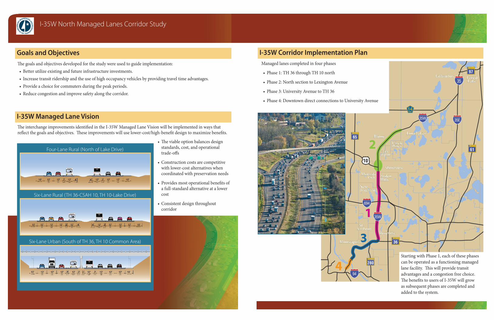
Goals and ObjectivesManaged lanes completed in four phases
• Phase 1: TH 36 through TH 10 north
• Phase 2: North section to Lexington Avenue
• Phase 3: University Avenue to TH 36
• Phase 4: Downtown direct connections to University Avenue
The interchange improvements identified in the I-35W Managed Lane Vision will be implemented in ways that reflect the goals and objectives. These improvements will use lower-cost/high-benefit design to maximize benefits.
•The viable option balances design standards, cost, and operational trade-offs
•Construction costs are competitive with lower-cost alternatives when coordinated with preservation needs
• Provides most operational benefits of a full-standard alternative at a lower cost
•Consistent design throughout corridor
Starting with Phase 1, each of these phases can be operated as a functioning managed lane facility. This will provide transit advantages and a congestion free choice. The benefits to users of I-35W will grow as subsequent phases are completed and added to the system.
The goals and objectives developed for the study were used to guide implementation:•Better utilize existing and future infrastructure investments.• Increase transit ridership and the use of high occupancy vehicles by providing travel time advantages.• Provide a choice for commuters during the peak periods.•Reduce congestion and improve safety along the corridor.
I-35W Corridor Implementation Plan
Four-Lane Rural (North of Lake Drive)
Six-Lane Rural (TH 36-CSAH 10, TH 10-Lake Drive)
Six-Lane Urban (South of TH 36, TH 10 Common Area)