Study of Ancient Water Storage System on Forts in Nashik … of... · Study of Ancient Water...
13
1 NATIONAL SEMINR ON WATER & CULTURE, HAMPI, BELLARY DIST. 25-27 JUNE 2007 Study of Ancient Water Storage System on Forts in Nashik District of Maharashtra Shriram Vaijapurkar 1 , Siddharth Vaijapurkar 2# 1: Assistant Research Officer, Maharashtra Engineering Research Institute (MERI), Nashik, Maharashtra. E-mail:[email protected] 2:Lecturer, K. K. W. Institute of Engineering Education and Research, Nashik, Maharashtra. E-mail: [email protected] Abstract India has a rich heritage of water conservation. Wells and Kunda in Rajasthan, Bandharas and lakes in Maharashtra, Bandhis in M.P, Kuhal in Himachal, Eiris in Tamilnadu, and the most spectacular, Aahar and Piain in Bihar…..all this add to the techniques of ancient time which were used for irrigation and water supply. Many of them are in working today also, with full proficiency. These traditional systems are the gift of the knowledge, ambience and society of a particular location. These systems are not only supplying water but also holding perfect balance between environment and human beings. All these systems works on the principle of experience, which is their power and essence of fruitfulness! [1] The traditional system doesn’t prove to be non-useful. These are different than that of constructed and maintained by the government agencies. Modern water supply systems are costly and may interfere the environment. The water available from those systems is used for farming and other commercial works. Modern techniques posses a negative image in the mind of common man and society. It is also the fact that these systems have made farmers and society, a dependent on Government. Water is a great power of development. If equal, society-oriented, and sensible development is desired, we must recharge these traditional systems and strengthen it. Traditional systems have to be modified with the new scale of time and technology, appropriate repair and maintenance is necessary. Local techniques must be developed to solve these problems. Keeping above points in mind, a study of water storage system on the forts in Nashik district of Maharashtra State was carried out. To explore the facts and their technical details one exploration campaign was arranged, during which, a large number of remains pertaining to the water supply schemes were studied. These includes open channels, remains of small bunds, water tanks, wells, number of small and big cisterns and reservoirs, and remains of artificial lakes at different contours, etc. Can we use these water bodes for betterment of community? There are thousands of villages in Maharashtra, having topography similar to that of a fort i.e. located on a hillock or mountain and established on downthrow side of a hill. If the fort can yield good and sufficient amount of water, why cant these villages and hamlets? Hence by studying the details of water supply, distribution, collection, storage, one
-
Upload
truongcong -
Category
Documents
-
view
224 -
download
3
Transcript of Study of Ancient Water Storage System on Forts in Nashik … of... · Study of Ancient Water...

1
NATIONAL SEMINR ON WATER & CULTURE, HAMPI,
BELLARY DIST. 25-27 JUNE 2007
Study of Ancient Water Storage System on Forts in Nashik
District of Maharashtra
Shriram Vaijapurkar1, Siddharth Vaijapurkar
2#
1: Assistant Research Officer, Maharashtra Engineering Research Institute (MERI), Nashik, Maharashtra.
E-mail:[email protected]
2:Lecturer, K. K. W. Institute of Engineering Education and Research, Nashik, Maharashtra.
E-mail: [email protected]
Abstract
India has a rich heritage of water conservation. Wells and Kunda in Rajasthan,
Bandharas and lakes in Maharashtra, Bandhis in M.P, Kuhal in Himachal, Eiris in
Tamilnadu, and the most spectacular, Aahar and Piain in Bihar…..all this add to the
techniques of ancient time which were used for irrigation and water supply. Many of them
are in working today also, with full proficiency. These traditional systems are the gift of the
knowledge, ambience and society of a particular location. These systems are not only
supplying water but also holding perfect balance between environment and human beings.
All these systems works on the principle of experience, which is their power and essence of
fruitfulness![1]
The traditional system doesn’t prove to be non-useful. These are different than that of
constructed and maintained by the government agencies. Modern water supply systems are
costly and may interfere the environment. The water available from those systems is used for
farming and other commercial works. Modern techniques posses a negative image in the
mind of common man and society. It is also the fact that these systems have made farmers
and society, a dependent on Government. Water is a great power of development. If equal,
society-oriented, and sensible development is desired, we must recharge these traditional
systems and strengthen it. Traditional systems have to be modified with the new scale of time
and technology, appropriate repair and maintenance is necessary. Local techniques must be
developed to solve these problems.
Keeping above points in mind, a study of water storage system on the forts in Nashik
district of Maharashtra State was carried out. To explore the facts and their technical details
one exploration campaign was arranged, during which, a large number of remains pertaining
to the water supply schemes were studied. These includes open channels, remains of small
bunds, water tanks, wells, number of small and big cisterns and reservoirs, and remains of
artificial lakes at different contours, etc. Can we use these water bodes for betterment of
community? There are thousands of villages in Maharashtra, having topography similar to
that of a fort i.e. located on a hillock or mountain and established on downthrow side of a
hill. If the fort can yield good and sufficient amount of water, why cant these villages and
hamlets? Hence by studying the details of water supply, distribution, collection, storage, one
2
can find the ways to conserve water at the similar topography. Various details were observed
regarding the water storage system and distribution of the same. The details include
collection system, conservation system, distribution system, calculations regarding the water
supply.
1. INTRODUCTION:
Water …a vital element of life! Since ancient time, water is inspiring living being for
their betterment and fulfillment of dreams. Maharashtra is decorated by mountains and hills
of Sahayadri. All the past generations (before 100years from now) were administered and
disciplined through forts only. All the kingdom of Maharashtra has survived due to these
forts and their impregnable construction! The strength of Marathas was their ableboard fort
and fortresses. Due to the strong forts , Mughals and other powerful empires have tried hard
to get hold of the Deccan plateau. The difficult topography of the land and mountains has
helped the local kings to keep their subjects and property untouched by the foreign attack.
During the centuries, Maharashtra was subjected to various changes regarding the rulers and
administration, at some even of a radical-nature. During its long elegant journey with time, it
witnessed the era of grandeur along with the era of frustration. Once it was a booming
metropolitan state full with public and private structures, temples, mosques, gardens, bazaars
etc. But because of the loss of the Royal patronage it lost its earlier grandeur. The scattered
heaps of ruins remind us of the glory of the yester years. However at present, these forts
appear like a deserted necropolis. Even the bastions, balekilas, and the palaces are full of
graves and tombs.
These forts served their kings loyally and nobly with their strong arms and coats, at
the same time, they conserved springs of sweet water at their heart! These springs gave
essence of life for those who battled hard for their state and kingdom .Not only life, but also a
touch of heal for their lives and soul when the great worriers lost their lives for the
Motherland and Culture!
The presented paper is an attempt to explore these springs and water bodies along
with their technical facts. Our culture, tradition and a rich heritage teach us lot many new
techniques of water conservation and harvesting of rainwater. The need of hour is to have the
deep sense of responsibility, a searching vision and an erg to explore these facts.
2. THE OBJECTIVE
Studying the topic of water storage system on forts is a nice experience though living
in the 21st century. The challenges laid down by the new era are much difficult. At the same
time our heritage and tradition posses right power to face these challenges and to overcome
the same. It is said that without firm foundation, one can’t even walk. In the same way,
neglecting our tradition and heritage, would certainly demoralize our efforts of water
conservation in the modern world. When one comes across the sincere and smart efforts done
by our forefathers, for the storage and distribution of water, admiringly bows down his head
at feet of this supreme intelligence. The hidden potential within these systems is to be
explored.
For the sake of Example, in Rajasthan, one can find number of well-like structures
covered with an oval shaped lid. Both have been constructed with masonry and neatly

3
maintained. To way-out curiosity, if one peeps in he would find a large tank full of water! It
is a system made for storage of rainwater. A large amount of rainwater present would
certainly satisfy the need of people and cattle for next year. This gives an admiring and
astonishing experience to know that a society can make the environment at his command and
that too, before at least a century.[2]
Maharashtra have a curse of being short of
water, though there is a large amount of rain
occurring every year in rainy season, for a single
drop of water the housewife must walk at a distance
of 2 to 5 km daily. A community, having a great
heritage of rainwater harvesting, requires walking
thousands of meters for even the drinking water. A
country where, rain is worshiped as a God, burns for
a single drop of water?
These questions arise in mind and then a
smart point floats. Can we use these naturally
occurring water bodes for betterment of community?
There are thousands of villages having
topography similar to that of a fort i.e. located on
a hillock or mountain also established on
downthrow side of a hill. If the fort can yield
good and sufficient amount of water, why cant
these villages and hamlets? Hence by studying the details of water supply, distribution,
collection, storage, one can find water and conserve the same in the similar topography. Thinking on the same line, study campaign was carried out in the forts around Nashik.
Various details were observed regarding the water storage system and distribution of the
same. The details include collection system, conservation system, distribution system,
calculations regarding the water supply.
3. BRIEF ON FORTS OF MAHATASHTRA
3.1 History of Maharashtra [3]
A rough timeline of the state of Maharashtra according to the Chief ruler under
whose empire the overall region survived, can be drawn as:Yadavas(1187-1294), Khilji(1295-
1320), Tughlaq(1320-1343), Nizamshahi of Ahmednagar(1490-1635), Marathas(1635-1780).
In between the Nizamshahi period, Mughals were in power in large part of region. During
these ups and downs of grandeur and frustration, the forts were subjected to various
constructional changes, as each ruling dynasty had a specific motive behind its possession.
For example Yadavas wanted to defend it against their political rivals namely the Hoyasalas
and the Kakatiyas. Hence they converted it into a stronghold in its real sense. On the other
hand , Muhammad Tughlaq wanted to develop these forts on the lines of an imperial centers
as he was impressed by its geographical and strategical location. But soon they discovered
that it is very difficult to handle the system of forts through sole administration. Hence they
resolved one new technique to rule these forts. It was Watandari –Subhedari method. Which
yielded the fruits to Nizamshahi, while keeping its roots in the Marathas and their loyal army.
According to this method, the ownership was given to an influenced person . This would be
the Watandar of the fort and the surrounding area of the same. A number of similar

4
Watandars were produced. This resulted in self fulfillment of the whole area and the biggest
advantage to Nizam was the inter-battling spirit of these Watandars, which would keep them
as enemies of each others but at the same time they surrender their faith to the King. Hence it
was an easy move for the kings.
During the same era, Mughals treated Maharashtra as the entrance to Deccan and
derived maximum benefit out of the internal strife. As a result, it was exposed to the Islamic
precept for more than three centuries and during this Islamic hiatus the fort and township
were subjected to modification for several intervals. Hence to understand the nature of
different phases of occupation, it is necessary to analyze the relative history of the fort and
the township.
3.2 History Of Nashik Pertaining To Forts Since a long time, the rich culture of India has acquainted Nashik, the place where
lord Rama stayed and a place of Kumbh Mela. The pilgrimage and religious importance
grown, the city started gaining its importance and holy image through thousands of minds in
India. The city started vivid and vital religious programes (vidhis) obviously, it was (and is)
visited by thousands of visitors every now and then. In ancient time, Dharma being the main
concern about every issue, to protect the religious places and cities was the main
responsibility of the administration and the kings. Hence to safeguard this city and its
surroundings a series of forts and fortresses were erected, these forts can be studied for
further details.
The city is being located beneath the mountains and hills of Sahayadri. The famous
Pandav-caves and Chamar caves are well known for their Buddhist heritage and carvings.
They give a chief and elegant proof for the bygone richness of Nashik and villages around.
As they thrust command over large area including Nashik, a purpose of keeping watch is also
being fulfilled. Construction and erecting period of both caves is same. Though the caves
and carvings give relevance to Buddhism and allied panthas, main basic purpose was to keep
watch. No armed soldiers were set up on these places. But the nearby fort of Ramshej, was
constructed for collection of tax on road and goods. Ramshej holds the way to Gujarath and
Baghlan. Hence it is an important place to control the pathway leading to and dispatching
from Nashik. On the top of all the three hills, one can find good amount of water. There are
underground tanks of different kinds and method of construction in different in each one.
Details of the same are given later.
3.3 Water supply On Forts The history of town-planning and water supply in India commences from the first
cycle of Indian urbanization. It is evident from the towns unearthed so far that water supply
is one of the significant constituent of town-planning throughout the ages. As far as the
Hindu town-planning and water supply are concerned, most of the ancient and medieval
towns are situated either on the banks of rivers, lakes or artificial tanks or reservoirs[4]
. Hence
water was no problem for them. Almost all forts in Sahayadri are the best example of the
medieval defense technology. By providing the artificial means of defense, the problem of
protection was solved to some extent. However it gave birth to a more serious problem i.e.
the problem of water supply, because most of these forts are situated in and around the
naturally protected area.

5
To explore the facts and their technical details one exploration campaign was
arranged. During exploration campaign, a large number of remains pertaining to the water
supply schemes were seen. These includes open channels, ruminant of small bunds, water
tanks, wells, number of small and big cisterns and reservoirs, and remains of artificial lakes
at different contours etc. This suggest that various water supply schemes were implemented.
The principle objective is to find the links among the remains. Different Kings and their
technicians have implemented different schemes according to their knowledge and beliefs.
But amongst all, the water collection systems implemented during Islamic Era are the most
spectacular one. They have really worked on the topography and maximum benefits out of
the rainfall and the groundwater available.
3.4 Water supply in Shivaji Era Shivaji Era commences from 1630 A.D. to 1681 A.D. When the entire India was
under Mughal Empire, the sheer and honest Marathas were struggling in Deccan to keep their
culture and heritage alive. It was the part of country which whole-heartedly devoted their
lives and prosperity at the feet of their beloved King… Shivaji.
But doing this type of revolution against a great empire needs great power. It needs a true
patriotic mind, healing support of peoples
and strong arms of soldiers. All this is
outcome of clean faith to your country and
your mother-land. Adding to all above
things, Shivaji was fortunate enough to have
a chain of about 300 forts at his command.
The forts which can fight for a long time and
with loyal heart!. These forts are located at
and around the difficult peaks of Sahayadri.
Shivaji having known all the nooks and
corners of this strong range, derived
FIG 1: Water reservoir on Raigad maximum benefit of these hilly terrain and
defeated his enemy with a very few loyal army. During his life time, he repaired, constructed,
and rebuilt many of the forts in and around Maharashtra. All the kingdom of Chatrapati was
administrated through forts only. Not only for the sake of administration, but also keeping
safety point of view, capital of ‘Swarajya’ was located on fort (Rajgad, and Raigad.1674).
Every fort was an independent town. It was a place where all the needed things were
kept ready. Large amount of grocery, armors, goods of day-to-day wants etc. were kept
handy. The reason behind doing all was that at any time enemy can have a cruel attack. At
and on attack, the fort in charge (Kiledars) used to close all the gates and means of
communications. On this front, the fort is a small town surrounded by the enemy. So the
inside storage of food, water arms etc. has to be sufficient for the peoples fighting and living
for and on the same. For this purpose, they need to have good storage of drinking water also.
Water (with good quality and quantity) being the basic need, and has to be fulfilled at any
cost. The storage should be sufficient at emergency. (it is known that forts were battled for
the period of 8 to 10 months also. So it is obvious that, a good storage is essential). It is true
that it is impossible to carry water from bottom of a peak to top by man power or any
mechanism. Hence the total demand water must be fulfilled on the fort itself.

6
The means used for satisfying the total water demand were underground water tanks,
reservoirs, cisterns, and some artificial lakes. Generally it is found that the stone quarries for
the construction of the fort were converted in to the lake. Here, after the stone demand being
fulfilled for the construction of the fort and walls, the excavated ground portion was blasted
at greater depth. The blasting is so arranged that it would generate crakes which will allow
the flow of water. By providing sufficient amounts of underground cracks and channels it
was possible to bring groundwater in the lake. Another resource was the storage of rainwater
which is available in the rainy season. The arrangement of the cisterns is done in such a way
that the surface runoff would automatically be diverted to the cistern and it will recharge the
same. But this technique is useful where good rainfall is assured and constructions of such
cisterns are economical.
4. GEOLOGICAL ASPECT [5]
Movement of ground water takes place under gravity through rocks which have
textures and structures favorable for its movement. Rocks in which water can flow easily are
called pervious rocks. These are porous sediments with large pores such as sandstone and
conglomerates and nonporous igneous and metamorphic rocks with open interconnected
joints along which water can easily flow. Rocks through which water cannot easily flow are
called impervious. These are nonporous rocks which are massive i.e. free from joints or
jointed nonporous rocks in which joints are not open and interconnected and also fine grained
porous rocks like shale which are impervious because their pores are too small to allow free
movement of water through it. For making a rock pervious, the mere presence of openings is
not enough. Their size and arrangement must be such that continuous through channels are
available for the passage of water. The condition most suitable for the storage of ground
water is the occurrence of a pervious layer enclosed between two impervious layers, one
above and one below. By the folding and faulting of such a set of beds various structures are
produced in which water is kept confined in the pervious layer by impervious layers. The
commonest of such structures and the most suitable for the formation of a groundwater
reservoir is a syncline.
Groundwater often finds a natural outlet under favorable structural conditions and
flows out from the ground. If water flows out at a single point it is called as spring, and
called as a seepage if there is a general oozing out of water along a line. The commonest of
the springs are the contact springs, which issue where the contact of a pervious water bearing
layer with an underlying impervious layer is intercepted by a slope. Water percolating in the
pervious rock cannot sink further when it meets the impervious rock below, and flows under
gravity along the watertight top of the impervious layer until it issues at the surface a contact
spring. In the Deccan Trap are contact springs issue on hillsides where laterite or compact
jointed basalt is underlain by amygdaloidal basalt. As the streams in the Deccan Trap area
are rejuvenated they flow in rocky channels with alluvial terraces at higher levels. Water
seeping in to the alluvial flows over the basalt, and appears as a contact spring where the
contact between alluvium and basalt is intercepted by the valley slope. The fair weather flow
of perennial streams is provided largely by such contact springs. Springs also issue at the
contact of weathered sheet jointed basalt with the underlying fresh amygdaloidal basalt.
5. TECHNICAL ASPECT [6]

7
5.1 Fort of Salher (1581 M) 5.1.1 Introduction: The range running west to east, of the Mausam river is dominated by
Salher fort. This is the highest hill fort in Sahayadri . It is steep and well-fortified. The view
from the top is one of the finest in the region. There is a huge cave and a water tank a little
below the top. This is the second highest peak in the Sahayadri (after Kalsubai). And one of
the three peaks above 5000fts. Historically Salher is an important landmark. It witnessed
many battles, the chef one being its capture by the Maratha army in 1671. Salher is located in
Satana Taluka of Nashik district . Vaghambe is the base village.
FIG 2: Map of Fort Salher and the water tank in the pictorial view
5.2 Water Collection System: A huge water tank was seen on the fort. Approximate
dimentions:30m×20m×5m.). A number of small streams collected in tank gathering water
from all over the fort area. A small cistern was also seen. All the water was seem to be stored
in the tank itself.
5.3 Geographical Details: The top area of the fort can be divided in two parts. One on
them is the topmost part (Appx. Area = 0.5k.m. sq..)and the second one is the are including
the lake and caves(2.0 km. sq.) The weathered laterite (Murum) was seen all over the area of
the fort and amygdaloidal basalt was seen as the chief rock.
5.4 Calculations: When asked about the past population on the fort and the allied
information, the local people said that around 200 people were there of fort when it was used
for administration. They also added that there is a floating population of around 500 when
there is festival and fair of Lord Parshurama of fort.
Let us assume that the population living on the fort was 300.
Let the daily demand be =150lit /day
Total volume per day = 150×300 = 45,000lit/day
= 45 M3/day.
Available water in Tank = 3000 M3.
Sufficient for around 70 day .
No distribution system was seen.
5.2 Fort of Alang (1492M)

8
5.2.1 General: The fort of Alang is the best example of utilization of Protection due to
Geographic conditions and location. It takes a long way to reach up to the top. Three fourth
of the fort has to be traversed at least 3 ties at different levels to reach the top. There is a
series of water tanks arranged in circular fashion. Alang is located in Igatpuri Tehsil of
Nashik district. The base village is Ambewadi which is 20k.m. away from Igatpuri.
5.2.2 Water Collection System: There are several water cisterns in circular shape . The
water percolating inside is seen. The temperature of the water is surprisingly cold.
Approximate volume of each cistern is about 60cu.meter. Traces of laterite were seen at the
top. The remaining rock patch is of compact basalt. The noticing fact is that the cistern
founded in the rock yielding good amount of water though the basalt is predominant.
FIG 3: Map of Fort Alang: The series of water tanks
5.2.3 Population and Water supply: The exact population figures are not available.
But the people say that there were not much population on this fort. It was the fort built for
keeping watch on the area nearby. It is having a series of water tanks located on the north
edge of the fort. These series are spectacularly arranged to form inter connectivity and
separation at the same time.
5.3 Mulher Fort (1415 M): 5.3.1 Introduction: Mulher was the Capital of Baglan king, Rathore. Being the place of
Capital it has to serve a lot of population, resulting in large storage of Water. Mulher is
FIG 4: Ganesh Tmple, Mulher
9
located in the low rainfall area of Nashik District its a part of Satana Tehsil of Nashik
District. It’s located at around 1415 m from MSL.
5.3.2 Water Collection: The fort water collection system is an excellent example of
rainwater collection system and water conservation. The Triangular shaped fort is divided in
three parts. The tanks and lake is located at the end of the slopes so that almost all of the
water can be collected in the tanks. Three Cisterns, one big lake on the top and a well
constructed well can be seen on the top. The lake is having a beautiful temple of lord
Ganesh.
5.3.4 Calculations: Looking at the huge water storage on the forts, it can be calculated that it
is sufficient for consumption of around 300 people for a period of three months.
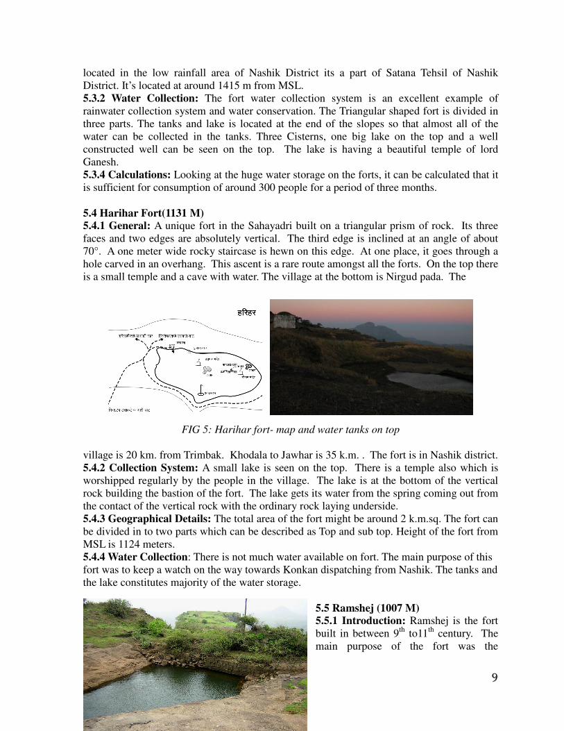
5.4 Harihar Fort(1131 M) 5.4.1 General: A unique fort in the Sahayadri built on a triangular prism of rock. Its three
faces and two edges are absolutely vertical. The third edge is inclined at an angle of about
70°. A one meter wide rocky staircase is hewn on this edge. At one place, it goes through a
hole carved in an overhang. This ascent is a rare route amongst all the forts. On the top there
is a small temple and a cave with water. The village at the bottom is Nirgud pada. The
FIG 5: Harihar fort- map and water tanks on top
village is 20 km. from Trimbak. Khodala to Jawhar is 35 k.m. . The fort is in Nashik district.
5.4.2 Collection System: A small lake is seen on the top. There is a temple also which is
worshipped regularly by the people in the village. The lake is at the bottom of the vertical
rock building the bastion of the fort. The lake gets its water from the spring coming out from
the contact of the vertical rock with the ordinary rock laying underside.
5.4.3 Geographical Details: The total area of the fort might be around 2 k.m.sq. The fort can
be divided in to two parts which can be described as Top and sub top. Height of the fort from
MSL is 1124 meters.
5.4.4 Water Collection: There is not much water available on fort. The main purpose of this
fort was to keep a watch on the way towards Konkan dispatching from Nashik. The tanks and
the lake constitutes majority of the water storage.
5.5 Ramshej (1007 M) 5.5.1 Introduction: Ramshej is the fort
built in between 9th
to11th
century. The
main purpose of the fort was the

10
collection of tax on the way to Khandesh and Gujrath. Good safety arrangements have been
made by making the wall of rock perfectly vertical along the periphery of the fort. The fort
gains its important because of its location, as it holds the way dispatching from and arriving
to Nashik. A small temple is seen on the top. Beside this temple the cistern is located. The
town at the base is Ashewadi. It is 8k.m away from Nashik.
5.5.2 Water collection system: There is a reservoir on the top of the fort. A small cistern
(2m×3m×1.5m) is seen on the way towards top. The location of the reservoir and the cistern
are on the same vertical line. The cistern has good amount of water even in summer also. It
derives the same through the contact springs of the rocks. The water percolating in the
cistern can be seen.
5.5.3 Volumetric analysis: Approximate Volume available in the reservoir = (10×10×15/2) × 2.5 = 1875 M
3.
Approximate Volume Drinking water available in the cistern = 2.5×3.5×2 = 17.5 M3.
Roughly estimated for 100 persons = 1875000/(100×150) = 125 days .
5.6 Ankai (970 M) -Tankai (857 M) 5.6.1 Introduction: These twin hills for a part of the Chandwad range. A prominent fortified
entrance is a sign of its strength. Its location is perfect for the command upon Manmad
Range. The construction of entrances is an example of peculiar intelligence of civil
engineering expertise. The rock is completely eroded on all the sides that it presents
perfectly perpendicular walls on all its four faces. There is a big temple, a mosque and a tank
on the top. The Balikilla is in good condition. A number of small tanks are seen on the top of
both the forts. Height from mean sea level is around 1000 meters. The fort of Ankai can be
reached from the railway station of Manmad. It is located 8k.m. away from the town of
Manmad. The base village is Ankai.
FIG 6: The huge lakes on fort Ankai-Tankai
5.6.2 Water Storage System: The lake on the top collects its water from the surface runoff
occurring during the rainy season. But the water cisterns located derives the same from the
groundwater available in the rock. All the tanks were full of water.
5.6.3 Geographical Details: The forts are like tow tables kept beside each other. The top is
flat and is like a table plane. Amygdaloidal Basalt is the main prominent rock. A lot of Sills

11
and Fissures are seen throughout the fort. The area covered is around 10 k.m. sq. in all.
There is a small peak at the top of Tankai fort.
5.6.4 Volumetric Analysis: It was seen that a large amount of water is available on the fort .
The water present in the lake and the cisterns is sufficient to fulfill the demand of a large
amount of population. A Fountain was also seen at the balekilla, which was in the destructed
state. This shows that there was no problem of water-supply.
5.6.5 Fountain Water Supply: The inlet to the fountain tank were seen which were directed
towards the lake outside the balekilla . Hence it can be concluded that the water was brought
from the lake and using gravity, the fountain was made.
6. ANALYSIS OF DATA:
System of water supply during the Shivaji Era was almost same throughout his
Empire. A certain amount of water was fixed to every person according to his post in the
administration. Every person would get that much amount of water only. This water was
being carried manually from the lake to individuals. There was a special division in
administration which used to look after the work of these carriers only. In local language,
these carriers were called as ‘Panke’. They were given wedges according to their workload
and the person they offer their service. Upon the entire forts considered, no where water
distribution system was found. But at some places like Fort of Salher and Fort of Ankai-
Tankai, some channels were seen diverging from the places of bathing and domestic washing
.Hence it can be said that though water distribution system was not implemented, water
disposal system was implemented at some places.
At many places it was seen that both rainwater and groundwater were
harvested. The groundwater was tapped through the cisterns which were made in the
rock yielding good amount of water. And regarding the rainwater, open tanks were dug
or constructed to collect the runoff. Another important point is that the local Kings and their subordinates were not
interested in building the water distribution system for more availability of water. It seems
that concept of water availability was much different than that of the concept imparted by
Islamic Empires. This might be because of the fact that bathing is given as a prime and
luxurious touch in Islamic culture. But that of Marathi culture doesn’t treat it as a luxury, but
functional utility was given the prime importance. At the same time, Kings of Rajputs used to
have their baths as an administration process and given through importance as that of the
Darbaars and general meetings.
Hence it can be concluded that demand of water and its use was, to a greater extent, a
function of the origin of king and the traditions which they follows .Hence the design of
collection systems and distribution of the same used to change according to the Kings an
their tradition.
7. CONCLUSION:
Traditional systems doesn’t mean that they are old and not useful. These are different
than that of constructed and maintained by the government agencies. The modern systems
are costly and some times may cause harm to environment. The water available from those
systems is used for farming and other commercial works. Modern techniques do posses a
12
negative image in the mind of common man and society. It is also the truth that these
systems have made the farmers and other society , a dependents on Government.
Water is a great power of development. If we want equal, society-oriented, and sensible
development, we have to recharge these traditional systems and must strengthen the same.
Some of the important points can be summed up as follows:
# Necessity of Modification: Traditional systems have to be modified with the new scale of
time and technology. They were to fulfill the need of less population and hence cannot be
enough for today’s busted one. Hence appropriate repair and maintenance is necessary.
# Local technologies: It is the need of time to have new techniques developed in our country
only. The logic and techniques developed in western countries are according to their
environment and causes harm to ours. Hence local technologies must be developed to solve
the problems.
# Involvement of common man: The most suitable comment for the new and modern aids
is that they don’t allow the common man to take part in the process, though these systems are
made for him! A common farmer may take whole interest when he feels that the system is
for him and himself only in the person to look after the same.
# Finance and Investments: The rural and common man is a poor fellow at this front.
Though their experience is a vast sea, they don’t have a single drop of money to invest in
such type of systems. Hence government and NGOs have to take lead in such matter.
# Human resources: Development of human resources is a must. It is necessary to develop
the whole resources along with the water. Hence the need of time is to train the peoples to
participate in governmental administration and activities.
# Rainwater harvesting: It as felt that, rainwater harvesting is the Mantra for the new
millennium . There is no pollution, no transportation cost, less storage cost etc has made this
technique an essential one. There is a lot of scope in country like India. One must realize the
same and make effort in appropriate direction.
# Collection of information: The first step of the work is to have some knowledge of
current situations. This is the field which can change the primary speed and can govern the
post perpetual need of the systems. Collection of recent information and sorting out the same
is a must for the forthcoming development.
8. REFERENCES:
[1] Vaijapurkar S, ‘A study of water storage system on forts in Shivaji Era’ A
Report submitted to Pune University, in the fulfillment of requirement of Bachelors
degree in Civil Engineering, May 2003.
[2] Agrawal A. Narayan S, ‘Dying Wisdom: Rise, Fall and Potential of India's
Traditional Water Harvesting System’, Center for Science and Environment, New
Delhi, India, 1998
[3] Gazetteer of India, Gazetteer Department, Government of Maharashtra, 1972.
[4] Morwanchikar S, ‘Few Glimpses of Indian Water and Culture’, National workshop on
Traditional Wisdom in Water Management, Nashik, Oct 2005.
[5] Gupte R.B, A Text Book of Engineering Geology, PVG Publication.
[6] Sahyadri Pustak Samiti, ‘Sangati Sahyadricha’, Sahyadri Publications, June 1995.

13