Stratigraphy and Reservoir Characterization of the …publications.gov.sk.ca/documents/310/93878-A-4...
20
Saskatchewan Geological Survey 1 Summary of Investigations 2015, Volume 1 Stratigraphy and Reservoir Characterization of the Upper Devonian Duperow Formation, Southeastern Saskatchewan Chao Yang 1 Parts of this publication may be quoted if credit is given. It is recommended that reference to this publication be made in the following form: Yang, C. (2015): Stratigraphy and reservoir characterization of the Upper Devonian Duperow Formation, southeastern Saskatchewan; in Summary of Investigations 2015, Volume 1, Saskatchewan Geological Survey, Saskatchewan Ministry of the Economy, Miscellaneous Report 2015-4.1, Paper A-4, 20p. Abstract This paper presents a broad overview of hydrocarbon drilling activity, production, stratigraphy, reservoir petrology and characteristics of the Upper Devonian Duperow Formation in southeastern Saskatchewan. Log-to-core correlation of the pay zones, core examination and thin-section study were undertaken in the Midale Duperow pool area to improve understanding of oil reservoirs in the Duperow Formation. The Duperow Formation in southeastern Saskatchewan records shallowing-upward cycles from subtidal to intertidal sedimentation, including bioclast-rich wacke-packstone, stromatoporoid boundstone and peloidal wackestone, grading upward to more restricted supratidal limestone, dolomudstone and evaporite. It is subdivided into the Saskatoon, Wymark and Seward members, in ascending order. The Saskatoon Member ranges in thickness from 15 to 37 m and is over 50 m thick locally. The Wymark Member is 69 to 145 m thick and is further subdivided into informal lower, middle and upper units, with thicknesses ranging from 7 to 19 m, 30 to 74 m, and 20 to 61 m, respectively. In some areas, the upper Wymark unit is terminated by the Flat Lake Evaporite, which is mostly halite and ranges in thickness from 1 to 30 m. The thickness of the Seward Member ranges from 31 to 67 m. As of December 31, 2015, Duperow reservoirs yielded 167 x 10 3 cubic metres (1 million barrels) of oil from nine wells in southeastern Saskatchewan. The producing zone in the Midale Duperow pool is in the heavily dolomitized wackestone in the lowermost cycle of the upper unit of the Wymark Member. Core and thin-section studies show that the dominant type of porosity in the dolomitized wackestone is intercrystalline, which is enhanced by molds and vugs formed by dissolution. Porosities are altered by recrystallized dolomite, as well as replacement and infilling by anhydrite and calcite. Total porosity ranges from 6 to 22%, with an average of 13%, and permeability is up to 393 millidarcies. Core analyses, in conjunction with thin-section study, log-to-core correlation and construction of structure maps of the pay zone, suggest that dolomitization enhanced porosity, and associated structure closures may be the most effective factors for oil accumulation. Keywords: stratigraphy, isopach map, reservoir characterization, Devonian, Duperow Formation, southeast Saskatchewan 1. Introduction The Duperow Formation is a Late Devonian (Frasnian) carbonate-evaporite stratigraphic unit that was deposited on an epicratonic platform of the Williston Basin, mostly in Saskatchewan, North Dakota and Montana (Kent, 1968; Dunn, 1975; Wilson and Pilatzke, 1985; McCracken and Kreis, 2003). The Duperow Formation is the oldest stratigraphic unit of the Saskatchewan Group (Figure 1). It is one of the major oil-producing stratigraphic zones in North Dakota, where oil is produced from stratigraphic traps in the central Williston Basin, from structural traps along the Nesson anticline, from combination traps on the Billings anticline, and from unconformity traps on the eastern flank of the Cedar Creek anticline (Altschuld and Kerr, 1982; Pilatzke et al., 1985; North Dakota Government, 2011; North Dakota Geological Survey, 2016). Other than the lowermost 10%, the Duperow Formation in Saskatchewan is laterally equivalent to the Woodbend Group, which includes the hydrocarbon-producing Leduc Formation reefs of the 1 Saskatchewan Ministry of the Economy, Saskatchewan Geological Survey, 1000-2103 11th Avenue, Regina, SK S4P 3Z8 Although the Saskatchewan Ministry of the Economy has exercised all reasonable care in the compilation, interpretation and production of this product, it is not possible to ensure total accuracy, and all persons who rely on the information contained herein do so at their own risk. The Saskatchewan Ministry of the Economy and the Government of Saskatchewan do not accept liability for any errors, omissions or inaccuracies that may be included in, or derived from, this product.
Transcript of Stratigraphy and Reservoir Characterization of the …publications.gov.sk.ca/documents/310/93878-A-4...

Saskatchewan Geological Survey 1 Summary of Investigations 2015, Volume 1
Stratigraphy and Reservoir Characterization of the Upper Devonian Duperow Formation, Southeastern Saskatchewan
Chao Yang 1 Parts of this publication may be quoted if credit is given. It is recommended that reference to this publication be made in the following form: Yang, C. (2015): Stratigraphy and reservoir characterization of the Upper Devonian Duperow Formation, southeastern Saskatchewan; in Summary of
Investigations 2015, Volume 1, Saskatchewan Geological Survey, Saskatchewan Ministry of the Economy, Miscellaneous Report 2015-4.1, Paper A-4, 20p.
Abstract This paper presents a broad overview of hydrocarbon drilling activity, production, stratigraphy, reservoir petrology and characteristics of the Upper Devonian Duperow Formation in southeastern Saskatchewan. Log-to-core correlation of the pay zones, core examination and thin-section study were undertaken in the Midale Duperow pool area to improve understanding of oil reservoirs in the Duperow Formation.
The Duperow Formation in southeastern Saskatchewan records shallowing-upward cycles from subtidal to intertidal sedimentation, including bioclast-rich wacke-packstone, stromatoporoid boundstone and peloidal wackestone, grading upward to more restricted supratidal limestone, dolomudstone and evaporite. It is subdivided into the Saskatoon, Wymark and Seward members, in ascending order. The Saskatoon Member ranges in thickness from 15 to 37 m and is over 50 m thick locally. The Wymark Member is 69 to 145 m thick and is further subdivided into informal lower, middle and upper units, with thicknesses ranging from 7 to 19 m, 30 to 74 m, and 20 to 61 m, respectively. In some areas, the upper Wymark unit is terminated by the Flat Lake Evaporite, which is mostly halite and ranges in thickness from 1 to 30 m. The thickness of the Seward Member ranges from 31 to 67 m.
As of December 31, 2015, Duperow reservoirs yielded 167 x 103 cubic metres (1 million barrels) of oil from nine wells in southeastern Saskatchewan. The producing zone in the Midale Duperow pool is in the heavily dolomitized wackestone in the lowermost cycle of the upper unit of the Wymark Member. Core and thin-section studies show that the dominant type of porosity in the dolomitized wackestone is intercrystalline, which is enhanced by molds and vugs formed by dissolution. Porosities are altered by recrystallized dolomite, as well as replacement and infilling by anhydrite and calcite. Total porosity ranges from 6 to 22%, with an average of 13%, and permeability is up to 393 millidarcies. Core analyses, in conjunction with thin-section study, log-to-core correlation and construction of structure maps of the pay zone, suggest that dolomitization enhanced porosity, and associated structure closures may be the most effective factors for oil accumulation.
Keywords: stratigraphy, isopach map, reservoir characterization, Devonian, Duperow Formation, southeast Saskatchewan
1. Introduction The Duperow Formation is a Late Devonian (Frasnian) carbonate-evaporite stratigraphic unit that was deposited on an epicratonic platform of the Williston Basin, mostly in Saskatchewan, North Dakota and Montana (Kent, 1968; Dunn, 1975; Wilson and Pilatzke, 1985; McCracken and Kreis, 2003). The Duperow Formation is the oldest stratigraphic unit of the Saskatchewan Group (Figure 1). It is one of the major oil-producing stratigraphic zones in North Dakota, where oil is produced from stratigraphic traps in the central Williston Basin, from structural traps along the Nesson anticline, from combination traps on the Billings anticline, and from unconformity traps on the eastern flank of the Cedar Creek anticline (Altschuld and Kerr, 1982; Pilatzke et al., 1985; North Dakota Government, 2011; North Dakota Geological Survey, 2016). Other than the lowermost 10%, the Duperow Formation in Saskatchewan is laterally equivalent to the Woodbend Group, which includes the hydrocarbon-producing Leduc Formation reefs of the
1 Saskatchewan Ministry of the Economy, Saskatchewan Geological Survey, 1000-2103 11th Avenue, Regina, SK S4P 3Z8 Although the Saskatchewan Ministry of the Economy has exercised all reasonable care in the compilation, interpretation and production of this product, it is not possible to ensure total accuracy, and all persons who rely on the information contained herein do so at their own risk. The Saskatchewan Ministry of the Economy and the Government of Saskatchewan do not accept liability for any errors, omissions or inaccuracies that may be included in, or derived from, this product.
Saskatchewan Geological Survey 2 Summary of Investigations 2015, Volume 1
Alberta Basin (Stoakes, 1992; Switzer et al., 1994). Compared to the Leduc Formation reefs in Alberta and the Duperow Formation in North Dakota, there has been a much smaller volume of hydrocarbons produced from Duperow strata in Saskatchewan, which may partly be due to the poor understanding of this play.
Figure 1 – Devonian stratigraphy of southeastern Saskatchewan, and internal stratigraphy of the Duperow Formation (location of type well, Longview et al Midale 101/12-02-007-11W2; 97H209, is shown in Figure 14). The objective of this study is to map the members of the Duperow Formation in the study area (Townships 1 to 15, Ranges 1 to 25W2; Figure 2) of southeastern Saskatchewan, and to study reservoir characteristics of the Midale Duperow pool. This study is based on analysis of geophysical well logs for over 800 wells; examination of 5 cores; study of 16 thin sections from 8 wells; and compilation of core analysis data from 140 samples reported in 11 wells. To better understand the spatial distribution of each member, isopach maps were generated based on analysis of their geophysical well-log responses. A list of wells with cores and thin sections examined for this paper are shown in Table 1.

Saskatchewan Geological Survey 3 Summary of Investigations 2015, Volume 1
Figure 2 – Map illustrating the distribution of the Duperow Formation and the geographic setting of the shallow-marine, semi-restricted “Duperow Embayment”, a south-southeast-oriented gulf connected to the deeper Alberta Basin in the west, which is edged by the West Alberta Ridge (modified from Kissling and Ehrets, 1984; Ehrets and Kissling, 1985; Switzer et al., 1994). The study area is shown as a green rectangle. Table 1 – List of cored wells, thin sections and analyzed core used for this study. Well locations are displayed in Figures 11 and 14.
Well ID Licence Number
Depth of Cored Interval (m)
Oil Well Core Examined
No. of Thin
Sections Examined
No. of Core Analyses Reported
141/14-12-007-11W2 03J253 1855.0 - 1873.0 x x 5 13
141/15-12-007-11W2 03F509 1856.0 - 1874.0 x x 3 17
191/05-02-007-11W2 97I258 1880.0 - 1906.2 x 1 12 131/11-12-007-11W2 07B143 1851.0 - 1869.0 x 1 15
101/16-10-003-25W2 52E045 2205.8 - 2243.3 2261.3 - 2318.0
x
121/09-03-007-11W2 97E084 1877.0 - 1895.0 1 191/04-02-007-11W2 97I261 1883.4 - 1894.2 2 101/09-32-007-06W2 85E289 1727.0 - 1745.0 2 142/13-02-007-11W2 97J138 1880.0 - 1887.0 1 141/03-08-001-11W2 85B212 2412.5 - 2425.9 8 101/13-03-001-15W2 66E011 2456.7 - 2475.0 24 121/07-29-006-11W2 96J008 1907.0 - 1925.0 4 191/16-34-006-11W2 97I261 1847.8 - 1894.2 10 121/06-33-007-08W2 85G136 1736.0 - 1772.1 2 121/03-11-007-11W2 97K183 1872.4 - 1884.8 6 102/15-28-012-02W2 67F054 1321.0 - 1339.3 29

Saskatchewan Geological Survey 4 Summary of Investigations 2015, Volume 1
2. Drilling Activity and Production Oil has been produced from the Upper Devonian Duperow Formation in southeastern Saskatchewan since 1997. As of December 31, 2015, Duperow Formation reservoirs have yielded 167 x 103 cubic metres (m3) (1 million barrels) of oil from nine wells (Figure 3, Table 2). Eight of these wells are located in the Midale Duperow pool (Township 7, Range 11W2), which was discovered in 1997. The first horizontal well into the Duperow Formation, Longview Midale 191/04-02-007-11W2; 98D042, drilled in 1998, is also the leading producing well in the Duperow Formation, having produced 37 x 103 m3 of oil to the end of December 2015. The Duperow Formation, however, remains underexplored, with only 39 wells perforated in the strata in the study area, although over 800 wells have been drilled through the formation. Although the volume of oil produced from the Duperow is significantly less than that produced from Mississippian beds, the number of wells, especially horizontal wells, drilled into the Duperow Formation plays in southeastern Saskatchewan is considerably less than the number drilled into Mississippian producing horizons (Yang, 2012). This fact highlights the potential for future discoveries of oil in the Upper Devonian Duperow Formation.
Figure 3 – Duperow Formation oil production and number of oil wells into the formation in southeast Saskatchewan from 1997 to year-end 2015. Note the decline of production in recent years, which is due to the natural decline of oil wells, a lack of new oil wells drilled and the suspension of some oil wells as a result of low oil prices. Table 2 – List of oil wells producing from the Duperow Formation in southeastern Saskatchewan. Well locations are shown in Figure 14. Susp = suspended, Act = active.
Well ID Licence Number
Well Name Cumulative Oil
Production (m3)
Pay Zone Depth (m)
First Year of Production
Well Status
101/07-27-007-06W2 00H085 Northrock Kisbey South Re 7-27-7-6
2298.9 1646.5 - 1716.5 2000 Susp oil well
191/04-02-007-11W2 98D042 Longview et al Midale Hz 4A6-2-1C4-2-7-11
37 369.4 1890.7 1998 Susp oil well
141/13-02-007-11W2 97H209 Longview et al Midale 13-2-7-11
21 784.1 1879 - 1885 1997 Susp oil well

Saskatchewan Geological Survey 5 Summary of Investigations 2015, Volume 1
Well ID Licence Number
Well Name Cumulative Oil
Production (m3)
Pay Zone Depth (m)
First Year of Production
Well Status
141/14-12-007-11W2 03J253 ARC (Sask) Midale 14-12-7-11
35 851.2 1856.5 - 1863 2003 Act oil well
141/15-12-007-11W2 03F509 ARC (Sask) Midale 15-12-7-11
24 052.1 1860 - 1866.5 2003 Act oil well
132/02-13-007-11W2 02I016 Bison Midale 2-13T-7-11 16 624.7 1857.3 - 1865 2002 Susp oil well 111/03-13-007-11W2 03K198 Bison Midale 3-13T-7-11 9431.9 1856 - 1863 2003 Susp oil well 191/06-13-007-11W2 04A149 Bison Midale Hz 2B2-13-
4B6-13-7-11 8105.6 1859 2004 Susp oil well
191/08-13-007-11W2 03B263 Bison Midale 4Hz 6A2-13-2B8-13-7-11
10 801.6 1860.1 2003 Susp oil well
3. Stratigraphy and Lithology Duperow Formation strata record a rhythmic shallowing-upward or brining-upward sedimentation from normal-marine subtidal carbonates to restricted supratidal dolomudstone and evaporite (Wilson, 1965; Dunn, 1975; Ehrets and Kissling, 1985; Wilson and Pilatzke, 1985; Cen and Hersi, 2006a, 2006b; Cen, 2009; Eggie et al., 2012). The Duperow Formation was deposited in a south-southeast-oriented shallow-marine inner platform embayment setting that extended southeasterly from southeastern Saskatchewan and western Manitoba, beyond the Canada–US border into North Dakota, South Dakota and eastern Montana (Figure 2). To the northwest, the embayment is connected to the Alberta Basin, where the Duperow Formation transitions into reefs and open-marine carbonates (Kissling and Ehrets, 1984; Ehrets and Kissling, 1985).
In southeastern Saskatchewan, the Duperow Formation is conformably underlain by the Souris River Formation and overlain by the Birdbear Formation (Figure 1; Dunn, 1975; Cen and Hersi, 2006a). The thickness of the Duperow Formation within the study area ranges from 112 to 233 m. The Duperow Formation is subdivided into, in ascending order, the Saskatoon, Wymark and Seward members. The Wymark Member is further informally subdivided into lower, middle and upper units, and the Flat Lake Evaporite (Kent, 1968, 1984, 1998; Cen and Hersi, 2006a, 2006b; Cen, 2009).
Based on analysis of geophysical well logs, and examination of core and thin sections, each member of the Duperow Formation consists of rhythmic layers of sedimentation that contain laterally extensive carbonates and evaporites. The boundaries between the members can best be recognized on gamma ray logs, as in Figure 1, where there is an abrupt change from around 15 API to between 40 and 70 API at the contact between each member. In core, the contacts between members are commonly placed between the base of a mudstone or argillaceous limestone/dolomudstone and the top of halite, or anhydrite, or anhydrite interlayered with dolostone.
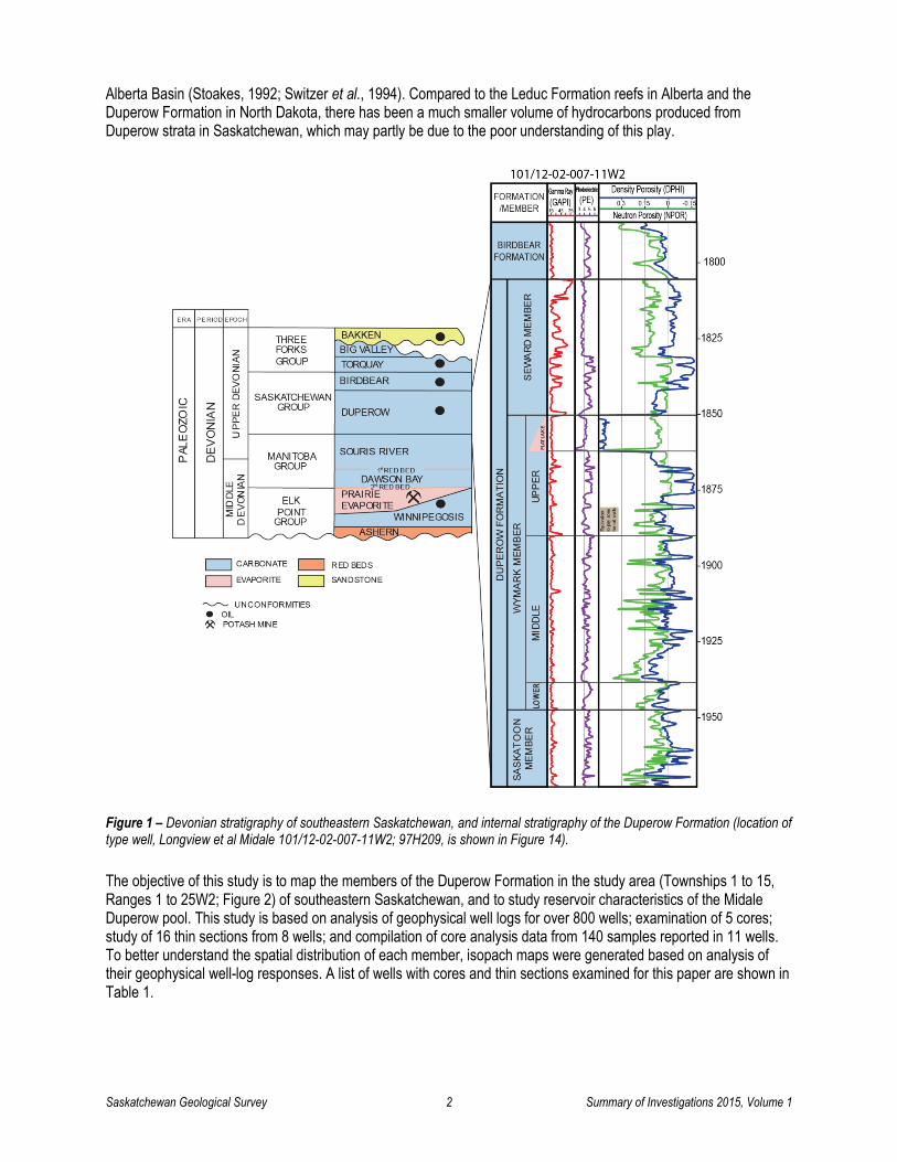
a) Saskatoon Member In the study area, the Saskatoon Member consists of several incomplete to complete lithological cycles that contain, in ascending order, massive to mottled argillaceous dolomudstone (Figure 4A); bioclastic (skeletal) wacke-packstone (Figure 4B); peloidal wackestone; and dolostone interbedded with nodular to thinly bedded anhydrite. Diverse fauna, including brachiopods, bivalves, corals, crinoids, algae and rare stromatoporoids, are observed in the bioclastic (skeletal) wacke-packstone. The isopach map of the Saskatoon Member (Figure 5) shows a regional thickening in a northwestward direction. The thickness of the Saskatoon Member ranges mostly from 15 to 37 m, with an average of 24.8 m. It is over 50 m thick locally in Township 2, Range 15W2.

Saskatchewan Geological Survey 6 Summary of Investigations 2015, Volume 1
Figure 4 – Core photographs of representative lithologies from the Duperow Formation, well Sohio Standard Gap No. 1 101/16-10-003-25W2; 52E045. Photos A and B are of the Saskatoon Member; photos C, D, E and F are of the Wymark Member. The scale in all photos is in centimetres. A) Mottled (red arrows) argillaceous dolomudstone (at depth 2315.7 m). B) Bioclastic (skeletal) wacke-packstone (at depth 2306.5 m). C) Stromatoporoid (Amphipora) boundstone (at depth 2282.4 m). D) Packstone with stromatoporoids (blue arrows), corals (green arrow), crinoids (red arrows), and algae (black arrow) (at depth 2283.9 m). E) Wackestone with bivalves (blue arrows) and gastropods (red arrows) (at depth 2241.0 m). F) Dolostone interbedded with nodular to thinly bedded anhydrite (at depth 2273.2 m).
Saskatchewan Geological Survey 7 Summary of Investigations 2015, Volume 1
Figure 5 – Isopach map of the Saskatoon Member. T = Township, R = Range, ‘+’ symbols show locations of wells in the study area. Contour interval is 1 m.
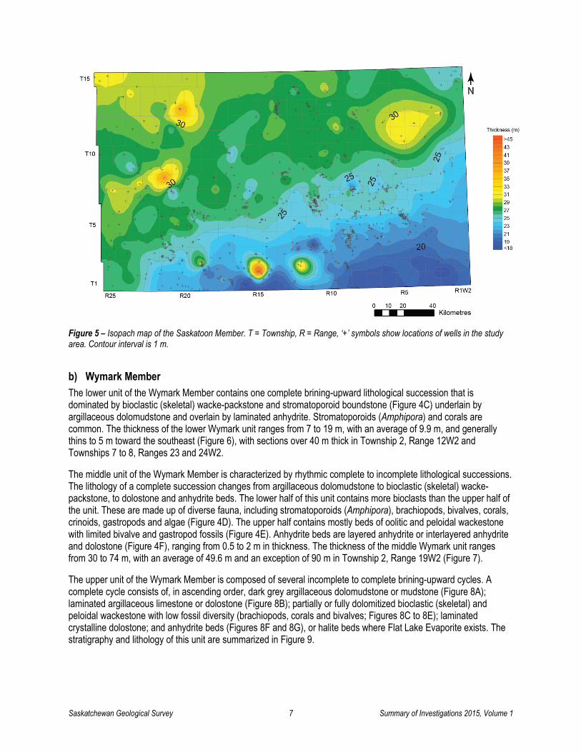
b) Wymark Member The lower unit of the Wymark Member contains one complete brining-upward lithological succession that is dominated by bioclastic (skeletal) wacke-packstone and stromatoporoid boundstone (Figure 4C) underlain by argillaceous dolomudstone and overlain by laminated anhydrite. Stromatoporoids (Amphipora) and corals are common. The thickness of the lower Wymark unit ranges from 7 to 19 m, with an average of 9.9 m, and generally thins to 5 m toward the southeast (Figure 6), with sections over 40 m thick in Township 2, Range 12W2 and Townships 7 to 8, Ranges 23 and 24W2.
The middle unit of the Wymark Member is characterized by rhythmic complete to incomplete lithological successions. The lithology of a complete succession changes from argillaceous dolomudstone to bioclastic (skeletal) wacke-packstone, to dolostone and anhydrite beds. The lower half of this unit contains more bioclasts than the upper half of the unit. These are made up of diverse fauna, including stromatoporoids (Amphipora), brachiopods, bivalves, corals, crinoids, gastropods and algae (Figure 4D). The upper half contains mostly beds of oolitic and peloidal wackestone with limited bivalve and gastropod fossils (Figure 4E). Anhydrite beds are layered anhydrite or interlayered anhydrite and dolostone (Figure 4F), ranging from 0.5 to 2 m in thickness. The thickness of the middle Wymark unit ranges from 30 to 74 m, with an average of 49.6 m and an exception of 90 m in Township 2, Range 19W2 (Figure 7).
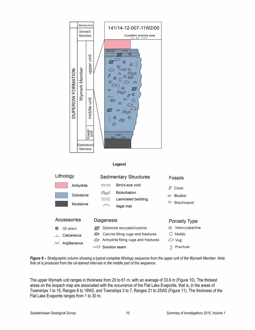
The upper unit of the Wymark Member is composed of several incomplete to complete brining-upward cycles. A complete cycle consists of, in ascending order, dark grey argillaceous dolomudstone or mudstone (Figure 8A); laminated argillaceous limestone or dolostone (Figure 8B); partially or fully dolomitized bioclastic (skeletal) and peloidal wackestone with low fossil diversity (brachiopods, corals and bivalves; Figures 8C to 8E); laminated crystalline dolostone; and anhydrite beds (Figures 8F and 8G), or halite beds where Flat Lake Evaporite exists. The stratigraphy and lithology of this unit are summarized in Figure 9.

Saskatchewan Geological Survey 8 Summary of Investigations 2015, Volume 1
Figure 6 – Isopach map of the lower unit of the Wymark Member. T = Township, R = Range, ‘+’ symbols show locations of wells in the study area. Contour interval is 1 m.
Figure 7 – Isopach map of the middle unit of the Wymark Member. T = Township, R = Range, ‘+’ symbols show locations of wells in the study area. Contour interval is 2 m.

Saskatchewan Geological Survey 9 Summary of Investigations 2015, Volume 1
Figure 8 – Core photographs of the upper unit of the Wymark Member of the Duperow Formation. The scale in all photos is in centimetres. Photos A to F are taken from well ARC (Sask) Midale 141/14-12-007-11W2; 03J253. A) Mudstone at a depth of 1865.95 m. B) Laminated argillaceous very fine- to fine-crystalline dolostone, at a depth of 1865.3 m. C) Fossiliferous dolowackestone with brachiopods, at a depth of 1862.5 m. D) Fossiliferous dolowackestone, at a depth of 1860.75 m, showing selective dissolution of fossil fragments and the dissolution vugs partially or fully filled by anhydrite. E) Bioturbated dolowackestone, at a depth of 1859.5 m. The fully dolomitized wackestone with limited fossil diversity (photos C to E) suggests a relatively restricted intertidal depositional environment. F) Transition from algal laminated fine- to medium-crystalline dolostone with algal domes (red arrows) and bird’s-eye voids (blue arrows) to anhydrite beds (black arrow), suggesting depositional environments from lower supratidal algal mat to upper supratidal sabkha. Photo taken at 1857.5 m depth. G) Nodular chicken-wire anhydrite. Sample location: well ARC (Sask) Midale 141/15-12-007-11W2; 03F509, at a depth of 1860.0 m.
Saskatchewan Geological Survey 10 Summary of Investigations 2015, Volume 1
Figure 9 – Stratigraphic column showing a typical complete lithology sequence from the upper unit of the Wymark Member. Note that oil is produced from the oil-stained intervals in the middle part of the sequence.
The upper Wymark unit ranges in thickness from 20 to 61 m, with an average of 33.6 m (Figure 10). The thickest areas on the isopach map are associated with the occurrence of the Flat Lake Evaporite, that is, in the areas of Townships 1 to 15, Ranges 8 to 19W2, and Townships 3 to 7, Ranges 21 to 25W2 (Figure 11). The thickness of the Flat Lake Evaporite ranges from 1 to 30 m.

Saskatchewan Geological Survey 11 Summary of Investigations 2015, Volume 1
Figure 10 – Isopach map of the upper unit of the Wymark Member. T = Township, R = Range, ‘+’ symbols show locations of wells in the study area. Contour interval is 2 m.
Figure 11 – Isopach map of the Flat Lake Evaporite. T = Township, R = Range, ‘+’ symbols show locations of wells in the study area. Contour interval is 2 m.

Saskatchewan Geological Survey 12 Summary of Investigations 2015, Volume 1
c) Seward Member The Seward Member, which is conformably overlain by the Birdbear Formation, is argillaceous. It is dominated by bioclastic and peloidal wackestone/packstone, dolomudstone and argillaceous dolostone. Fossils are limited to brachiopods, gastropods, bivalves and crinoids. The lower half of the Seward Member contains more anhydrite than the upper half. The thickness of the Seward Member ranges from 31 to 67 m, with an average of 46.2 m (Figure 12).
Figure 12 – Isopach map of the Seward Member. T = Township, R = Range, ‘+’ symbols show locations of wells in the study area. Contour interval is 2 m.
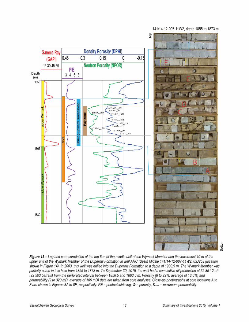
4. Petrology, Diagenesis and Reservoir Characterization of the Midale Duperow Pool Duperow Formation oil is primarily produced from dolomitized wackestone in the upper unit of the Wymark Member, which, in the Midale Duperow pool (Township 7, Range 11W2; see Figure 2) of southeast Saskatchewan, ranges in depth from 1856 to 1891 m. Duperow Formation oils are generally sweet light oil with low API gravities of 39 to 43° API, and low sulphur contents of 0.2 to 0.4%. Pour point values for Duperow Formation oil range from -60 to -33°C. Detailed core examination and log-to-core correlations from the area show that the pay zone occurs in the middle part of the first sedimentation cycle of the upper Wymark unit (Figure 13). The dolomitized wackestone and medium-crystalline dolostone in this portion of the unit (Figures 8C to 8E) are the major reservoir rocks in the Midale Duperow pool, with porosities ranging from 6 to 22% (average of 13%), and permeability ranging from 2 to 393 millidarcies (mD) (average of 93 mD). The reservoir rocks of the Duperow Formation are capped by non-permeable anhydrite beds. The structure map for the top of the pay zone in the Midale pool area (Figure 14) shows the association of oil accumulation with small-scale structural closures.
Saskatchewan Geological Survey 13 Summary of Investigations 2015, Volume 1
Figure 13 – Log and core correlation of the top 8 m of the middle unit of the Wymark Member and the lowermost 10 m of the upper unit of the Wymark Member of the Duperow Formation in well ARC (Sask) Midale 141/14-12-007-11W2; 03J253 (location shown in Figure 14). In 2003, this well was drilled into the Duperow Formation to a depth of 1900.9 m. The Wymark Member was partially cored in this hole from 1855 to 1873 m. To September 30, 2015, the well had a cumulative oil production of 35 851.2 m3 (22 503 barrels) from the perforated interval between 1856.5 and 1863.0 m. Porosity (8 to 22%, average of 13.5%) and permeability (9 to 320 mD, average of 106 mD) data are taken from core analyses. Close-up photographs at core locations A to F are shown in Figures 8A to 8F, respectively. PE = photoelectric log, Φ = porosity, Kmax = maximum permeability.

Saskatchewan Geological Survey 14 Summary of Investigations 2015, Volume 1
Figure 14 – Structure map of the top of pay zone in the upper unit of the Wymark Member. Note the association of oil-producing wells with small-scale structural closures. T = Township, R = Range, ‘+’ symbols show locations of wells in the study area. Contour interval is 1 m.
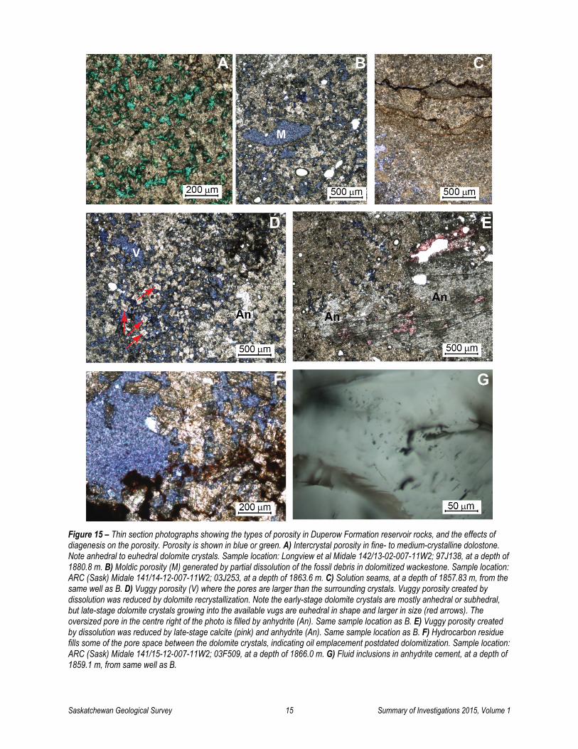
Analysis of photoelectric (PE) geophysical well logs shows that oil-producing wells have a PE value of approximately 3 in the pay zone of the upper Wymark unit (Figure 13) and non-producing wells have PE values between 3.5 and 5 at a corresponding stratigraphic interval (see Figure 1), suggesting that dolomitization is more intensive in producing areas. The replacement of calcite by dolomite is also confirmed by thin-section examination within Duperow Formation reservoir rocks of the Midale Duperow pool. Oil-producing wells have better porosity in crystalline dolostones (Figure 15A) and dolomitized wacke-packstone (Figure 15B) where dolomite has replaced calcite. The pervasive dolomitization is thought to have occurred in the early stage of diagenesis, possibly shortly after burial (Kissling, 1982) and significant intercrystalline porosity was created during dolomitization. Solution seams are common (Figure 15C), suggesting solution compaction during burial processes. Locally, intercrystalline porosity has been enhanced by dolomite dissolution to form vuggy porosity where the pores are much larger than the surrounding crystals (Figure 15D). Dissolution is considered to have occurred in the meteoric environment (Cen, 2009) as a result of an influx of fresh groundwater during the latest Mississippian to the Middle Triassic, when the basin was subjected to uplift and erosion. Vuggy porosity was reduced by dolomite recrystallization, indicated by late-stage, larger euhedral dolomite crystals growing into the available vuggy pore space (Figure 15D). During a later stage of diagenesis, some solution-enlarged intercrystalline, vuggy, moldic and fracture porosity was reduced by precipitation of anhydrite (Figures 15D and 15E) or, locally, calcite (Figure 15E) and halite, as observed in cores. Hydrocarbon residue fills intercrystalline porosity between dolomite crystals (Figure 15F), suggesting oil migration postdated dolomitization. These diagenetic features strongly influence porosity and permeability and thus play a very important role in the variability of reservoir quality. The major diagenetic events, their effects on reservoir porosity and permeability are summarized in Table 3.
Saskatchewan Geological Survey 15 Summary of Investigations 2015, Volume 1
Figure 15 – Thin section photographs showing the types of porosity in Duperow Formation reservoir rocks, and the effects of diagenesis on the porosity. Porosity is shown in blue or green. A) Intercrystal porosity in fine- to medium-crystalline dolostone. Note anhedral to euhedral dolomite crystals. Sample location: Longview et al Midale 142/13-02-007-11W2; 97J138, at a depth of 1880.8 m. B) Moldic porosity (M) generated by partial dissolution of the fossil debris in dolomitized wackestone. Sample location: ARC (Sask) Midale 141/14-12-007-11W2; 03J253, at a depth of 1863.6 m. C) Solution seams, at a depth of 1857.83 m, from the same well as B. D) Vuggy porosity (V) where the pores are larger than the surrounding crystals. Vuggy porosity created by dissolution was reduced by dolomite recrystallization. Note the early-stage dolomite crystals are mostly anhedral or subhedral, but late-stage dolomite crystals growing into the available vugs are euhedral in shape and larger in size (red arrows). The oversized pore in the centre right of the photo is filled by anhydrite (An). Same sample location as B. E) Vuggy porosity created by dissolution was reduced by late-stage calcite (pink) and anhydrite (An). Same sample location as B. F) Hydrocarbon residue fills some of the pore space between the dolomite crystals, indicating oil emplacement postdated dolomitization. Sample location: ARC (Sask) Midale 141/15-12-007-11W2; 03F509, at a depth of 1866.0 m. G) Fluid inclusions in anhydrite cement, at a depth of 1859.1 m, from same well as B.

Saskatchewan Geological Survey 16 Summary of Investigations 2015, Volume 1
Table 3 – The major diagenetic events in the Duperow Midale pool area, and their effects on reservoir porosity and permeability.
Major Diagenetic Event
Timing Effect on Porosity and Permeability Characterization
Dolomitization Shortly after burial Increased porosity due to formation of intercrystalline pore space
Massive dolomitization altering original depositional fabrics
Compaction During burial Reduced porosity Solution seams Dissolution Pre-Cretaceous
uplift and erosion Increased porosity and permeability due to
formation of molds, vugs, fractures Molds, large-size pores, vugs and
fractures Dolomite
recrystallization Reburial Decreased porosity and permeability by reducing
pore space and blocking pore throats Larger-size euhedral dolomite
crystals growing into vugs Calcite, anhydrite and
halite cementation Reburial Decreased porosity and permeability by reducing
pore space and blocking pore throats Vug-filling calcite, anhydrite and
halite
Fluid inclusions are observed in thin section in anhydrite cement (Figure 15G), however, fluid inclusion microthermometry study is required to obtain temperature, pressure and fluid composition information of anhydrite precipitation.
5. Summary of Core Analyses A total of 140 core analyses reported from 11 wells in the study area (2 oil-producing wells and 9 non-producing wells; Table 1) were used to examine the characteristics of rock properties—including porosity, permeability and grain density—of all three members of the Duperow Formation. Figure 16A is a plot of maximum permeability versus porosity for all 140 reported core analyses. The porosity values for both oil-producing and non-producing wells are highly variable, ranging from 0.2 to 22%, with an average of 9.5% (Figure 16A). Most (83%) of the maximum permeability values are between 0.01 and 100 mD, with an average of 70 mD and a maximum of about 400 mD. Oil-producing wells have a minimum porosity of 5%. There is no distinguishable difference between oil-producing wells and non-producing wells for the maximum permeability.
A plot of horizontal versus vertical permeability (Figure 16B) shows that oil-producing wells have better vertical permeability than horizontal permeability, while non-producing wells have better horizontal permeability than vertical permeability. The vertical fractures may contribute to improvement of connectivity for migration of dolomitization fluid, development of dissolution vugs and accumulation of hydrocarbons.
Grain density values range from 2575 to 2865 kg/m3, and show a general trend of increasing grain density with increasing porosity (Figure 16C). All grain density values from the core in this study are lower than that of anhydrite (2950 kg/m3), implying that there is limited anhydrite within these samples. Grain density values lower than the standard densities of pure limestone (2710 kg/m3) and sandstone (2610 kg/m3) may be caused by the presence of lower density organic materials and halite, which are observed in the cores. The cores from oil-producing wells have grain densities ranging from 2750 to 2850 kg/m3, which are within the range for pure calcite (2710 kg/m3) to pure dolomite (2870 kg/m3), suggesting that the reservoir rocks are composed of dominantly calcite and dolomite, and the percentage of dolomite increases with increasing grain density toward that of pure dolomite.
Dolomitization has improved the reservoir porosity, as shown by an obvious correlation between grain density and porosity (Figure 16C). This finding agrees with the thin-section observations discussed above.
Figure 16D shows an excellent correlation between porosity and bulk density for samples from the oil-producing wells. This relationship could be significant, and potentially useful for calculating porosity using bulk density measurements from geophysical well logs when core analysis is not available.

Saskatchewan Geological Survey 17 Summary of Investigations 2015, Volume 1
Figure 16 – Comparison of rock properties for oil-producing and non-producing wells in the Duperow Formation, based on reported core analyses of 140 samples from 11 cored wells in the study area: A) porosity (%) vs maximum permeability (millidarcies (mD)); B) horizontal permeability (mD) vs vertical permeability (mD); C) porosity (%) vs grain density (kg/m3): note that the porosity increases with increasing grain density; D) porosity (%) vs bulk density (kg/m3): note the excellent correlation between porosity and bulk density for oil-producing wells.
6. Discussion The source of Duperow Formation oil has not yet been established because of limited data. Organic-rich intervals in the Duperow Formation tend to be very thin and occur within both carbonate and evaporite units (Fowler et al., 2001, 2002). The available data indicate that organic-rich intervals (total organic content (TOC) >5 wt. %) in the Duperow Formation with Type I organic matter occur in areas west of the Third Meridian. In southeastern Saskatchewan, intervals with mixed Type III-II to Type II organic matter that are less organic-rich (TOC <3.5 wt. %) have also been reported (Li et al., 1998; Fowler et al., 2001, 2003). Organic-rich samples (TOC 3.9 wt. %) have been identified in the Duperow Formation in Manitoba (Chow et al., 2013), although kerogen type is not identified. Duperow Formation source rocks and petroleum systems in the US Williston Basin have been studied by Jarvie (2001) and Lillis (2013), with reported TOC values averaging 3.02 wt. % and Type II kerogen identified. In North Dakota, Duperow Formation oils are generally waxy, with moderate gravity and low sulphur content. The average values of pour point, gravity and sulphur content are 13°C, 38.7° API, and 0.2 wt. %, respectively, based on 122 samples (Jarvie, 2001; Lillis, 2013).

Saskatchewan Geological Survey 18 Summary of Investigations 2015, Volume 1
However, no oil-source correlation between the Duperow Formation source rocks and oils has been established, so the source of the oil in the Duperow Formation remains hypothetical.
Tmax values (420 to 437°C) indicate that the Duperow Formation is generally immature to marginally mature in southern Saskatchewan (Fowler et al., 2001, 2002, 2003; Stasiuk et al., 2002). Further organic geochemistry studies are required to identify if the Duperow Formation oil is self-sourced or if it is derived from the same source rocks as the oil within the Birdbear and Winnipegosis formations in southeastern Saskatchewan.
7. Summary The Duperow Formation in southeastern Saskatchewan is composed of cyclic shallowing-upward sequences from bioclast-rich wacke-packstone, stromatoporoid boundstone and peloidal wackestone, grading upward to dolomudstone and evaporite lithofacies. It is subdivided into the Saskatoon, Wymark and Seward members, with thicknesses ranging from 15 to 37 m, 69 to 145 m, and 31 to 67 m, respectively. In some areas (Townships 1 to 15, Ranges 8 to 19W2 and Townships 3 to 7, Ranges 21 to 25W2), the Wymark Member is terminated by the Flat Lake Evaporite, which is mostly halite and ranges in thickness from 1 to 30 m.
Current oil production from the Duperow Formation in southeastern Saskatchewan is mainly from dolostone reservoirs of the upper unit of the Wymark Member, associated with small low-relief structural closures. The reservoir rock of the Duperow Midale pool ranges in depth from 1856 to 1891 m, and is identified as brown dolostone with mostly intercrystalline porosity. Dolomitization plays a very important role in increasing porosity and permeability. Vuggy, moldic and open-fracture porosities enhanced by dissolution are common. The vugs and fractures are, in places, partially or fully filled by anhydrite, calcite and halite cements. Total porosity ranges from 6 to 22%, with an average of 13%, and permeability is up to 393 mD.
8. Acknowledgments The author wishes to express her appreciation to Fran Haidl for comments and suggestions for improvement of this paper. Thanks are also extended to Arden Marsh and Heather Brown for their thorough reviews and edits.
9. References Altschuld, N. and Kerr, S.D., Jr. (1982): Mission Canyon and Duperow reservoirs of the Billings Nose, Billings County, North
Dakota; in Fourth International Williston Basin Symposium, Christopher, J.E. and Kaldi, J. (eds.), Saskatchewan Geological Society, Special Publication No. 6, p.103-112.
Cen, X.C. (2009): Stratigraphy, sedimentology and reservoir characterization of an inner platform carbonate-evaporite sequence: the Late Devonian Duperow Formation of southeastern Saskatchewan, Canada; M.Sc. thesis, University of Regina, Regina, Saskatchewan, 152p.
Cen, X.C. and Salad Hersi, O. (2006a): A revised lithostratigraphic framework and characteristics of the Upper Devonian Duperow Formation, southern Saskatchewan; in Summary of Investigations 2006, Volume 1, Saskatchewan Geological Survey, Saskatchewan Industry and Resources, Miscellaneous Report 2006-4.1, Paper A-9, 17p. URL<http://economy.gov.sk.ca/adx/aspx/adxGetMedia.aspx?DocID=11849,11458,11455,11228,3385,5460,2936,Documents&MediaID=36694&Filename=Cen%26SaladHersi1litho.pdf>.
Cen, X.C. and Salad Hersi, O. (2006b): Sedimentology, microfacies analysis, and depositional setting of the Late Devonian Duperow Formation, southeastern Saskatchewan; in Summary of Investigations 2006, Volume 1, Saskatchewan Geological Survey, Saskatchewan Industry and Resources, Miscellaneous Report 2006-4.1, Paper A-10, 18p. URL<http://economy.gov.sk.ca/adx/aspx/adxGetMedia.aspx?DocID=11849,11458,11455,11228,3385,5460,2936,Documents&MediaID=36695&Filename=cen%26saladhersi2sed.pdf>.

Saskatchewan Geological Survey 19 Summary of Investigations 2015, Volume 1
Chow, N., Bates, K., Eggie, L. and McDonald, D. (2013): Resource potential of the Devonian Winnipegosis and Duperow formations in SW Manitoba; talk presented at 2013 Williston Basin Petroleum Conference, April 30 to May 2, 2013, Regina, Saskatchewan. URL<http://wbpc.ca/pub/documents/archived-talks/2013/Chow%20WBPC%202013_N%20Chow_for%20posting.pdf> [accessed 5 January 2016].
Dunn, C.E. (1975): The Upper Devonian Duperow Formation in Southeastern Saskatchewan; Saskatchewan Department of Mineral Resources, Saskatchewan Geological Survey, Report 179, 151p.
Eggie, L., Chow, N. and Nicolas, M. (2012): Lithofacies analysis and reservoir potential of the Duperow Formation (Upper Devonian), Williston Basin, southwestern Manitoba; talk presented at CSPG/CSEG/CWLS Joint Annual Meeting, Geoconvention 2012 – Vision, May 14 to 18, 2012, Calgary, Alberta. URL<http://www.cspg.org/cspg/documents/Conventions/Archives/Annual/2012/195_GC2012_Lithofacies_Analysis_and_Reservoir_Potential_of_the_Duperow.pdf> [accessed 18 January 2016].
Ehrets, J.R. and Kissling, D.L. (1985): Deposition, diagenesis and paleostructural control of Duperow and Birdbear (Nisku) reservoirs, Williston Basin; in Rocky Mountain Carbonate Reservoirs, Longman, M.W., Stanley, K.W., Lindsay, R.F. and Eby, D.E. (eds.), Society of Economic Paleontologists and Mineralogists, Core Workshop No. 7, August 10-11, 1985, Golden, Colorado, p.183-216.
Fowler, M.G., Obermajer, M. and Stasiuk, L.D. (2003): Rock-Eval/TOC data for Devonian potential source rocks, Western Canada Sedimentary Basin; Geological Survey of Canada, Open File 1579, 1 CD-ROM.
Fowler, M.G., Stasiuk, L.D., Hearn, M. and Obermajer, M. (2001): Devonian hydrocarbon source rocks and their derived oils in the Western Canada Sedimentary Basin; Bulletin of Canadian Petroleum Geology, v.49, p.117-148.
Fowler, M.G., Stasiuk, L.D., Obermajer, M., Hearn, M. and Osadetz, K.G. (2002): Devonian-aged organic-rich rocks and oils in the Saskatchewan portion of the Williston Basin; talk presented at GAC/MAC Annual Meeting, May 27 to 29, 2002, Saskatoon, Saskatchewan. URL<http://gac.esd.mun.ca/gac_2002/search_abs/sub_program.asp?sess=98&form=10&abs_no=152> [accessed 29 December 2015].
Jarvie, D.M. (2001): Williston Basin petroleum systems: inferences from oil geochemistry and geology; The Mountain Geologist, v.38, p.19-41.
Kent, D.M. (1968): The Geology of the Upper Devonian Saskatchewan Group and Equivalent Rocks in Western Saskatchewan and Adjacent Areas; Saskatchewan Department of Mineral Resources, Saskatchewan Geological Survey, Report 99, 224p.
Kent, D.M. (1984): Carbonate and associated rocks of the Williston Basin: their origin, diagenesis, and economic potential; notes from a short course held May 14-15, 1985, Denver, Colorado, Society of Economic Paleontologists and Mineralogists, Rocky Mountain Section, Denver, Colorado, 137p.
Kent, D.M. (1998): Diagenetically altered stromatoporoid banks: seals for dolomicrite reservoirs in Birdbear and Duperow rocks of southern Saskatchewan; in Eighth International Williston Basin Core Workshop Volume, Kreis, L.K. (ed.), Saskatchewan Geological Society, Special Publication No. 13A, p.105-142.
Kissling, D.L. (1982): Diagenetic scenarios for porosity evolution in Devonian Duperow carbonates, Montana and North Dakota; in Fourth International Williston Basin Symposium, Christopher, J.E. and Kaldi, J. (eds.), Saskatchewan Geological Society, Special Publication No. 6, p.101.
Kissling, D.L. and Ehrets, J.R. (1984): Depositional models for the Duperow and Birdbear formations: implications for correlation and exploration; Addendum to Saskatchewan Geological Society Special Publication No. 7, Oil and Gas in Saskatchewan, Lorsong, J.A. and Wilson, M.A. (eds), extended abstract.
Li, M., Osadetz, K.G., Obermajer, M., Fowler, M.G., Snowdon, L.R. and Christensen, R. (1998): Organic geochemical indications of post-Devonian magmatic intrusions in southeastern Saskatchewan; in Eighth International Williston Basin Symposium Volume, Christopher, J.E., Gilboy, C.F., Paterson, D.F. and Bend, S.L. (eds.), Saskatchewan Geological Society, Special Publication No.13, p.179-188.
Lillis, P.G. (2013) Review of oil families and their petroleum systems of the Williston Basin; The Mountain Geologist, v.50, p.5-31. URL<https://profile.usgs.gov/myscience/upload_folder/ci2014Jun2414240541241Lillis_2013_MntG.pdf> [accessed 28 March 2016].

Saskatchewan Geological Survey 20 Summary of Investigations 2015, Volume 1
McCracken, A.D. and Kreis, L.K. (2003): A preliminary report of Upper Devonian conodonts from the Birdbear and Duperow formations of southeastern Saskatchewan; in Summary of Investigations 2003, Volume 1, Saskatchewan Geological Survey, Saskatchewan Industry and Resources, Miscellaneous Report 2003-4.1, Paper A-6, 14p. URL<http://economy.gov.sk.ca/adx/aspx/adxGetMedia.aspx?DocID=11834,11458,11455,11228,3385,5460,2936,Documents&MediaID=36574&Filename=mccracken.pdf>.
North Dakota Geological Survey (2016): Overview of the Petroleum Geology of the North Dakota Williston Basin; URL<https://www.dmr.nd.gov/ndgs/Resources/> [accessed 22 January 2016].
North Dakota Government (2011): 2011 North Dakota Oil Production by Formation; URL<https://www.dmr.nd.gov/oilgas/stats/2011Formation.pdf> [accessed 22 January 2016].
Pilatzke, R.H., Fischer, D.W. and Pilatzke, C.L. (1985): Stratigraphic controls on Duperow production in Williston Basin, Montana and North Dakota; American Association of Petroleum Geologists Bulletin, v.69, no.5, p.860.
Stasiuk, L.D., Fowler, M.G. and Obermajer, M. (2002): Thermal maturation and organic facies of potential hydrocarbon source rocks within Devonian and Mississippian strata, northern Williston Basin, Saskatchewan; talk presented at GAC/MAC Annual Meeting, May 27 to 29, 2002, Saskatoon, Saskatchewan.
Stoakes, F.A. (1992); Wabamun megasequence; Chapter 10 in Devonian-Early Mississippian Carbonates of the Western Canada Sedimentary Basin: A Sequence Stratigraphic Framework, Wendte, J., Stoakes, F.A. and Campbell, C.V. (eds.), SEPM Short Course Notes, v.28, p.225-239.
Switzer, S.B., Holland, W.G., Christie, D.S., Graf, G.C., Hedinger, A.S., McAuley, R.J., Wierzbicki, R.A. and Packard, J.J. (1994): Devonian Woodbend-Winterburn strata of the Western Canada Sedimentary Basin; Chapter 12 in Geological Atlas of the Western Canada Sedimentary Basin, Mossop, G.D. and Shetson, I. (comps.), Canadian Society of Petroleum Geologists and Alberta Research Council. URL<http://www.ags.gov.ab.ca/publications/wcsb_atlas/a_ch12/ch_12.html> [accessed 30 January 2016].
Wilson, J.L. (1965): Carbonate-evaporite cycles in the lower Duperow Formation of Williston Basin; Bulletin of Canadian Petroleum Geology, v.15, p.230-312.
Wilson, J.L. and Pilatzke, R.H. (1985): Carbonate-evaporite cycles in lower Duperow Formation of Williston Basin; American Association of Petroleum Geologists Bulletin, v.69, no.5, p.870-871.
Yang, C. (2012): Hydrocarbon play ranking and production trends in Saskatchewan to year end 2011; in Summary of Investigations 2012, Volume 1, Saskatchewan Geological Survey, Saskatchewan Ministry of the Economy, Miscellaneous Report 2012-4.1, Paper A-4, 22p. URL<http://economy.gov.sk.ca/SOI2012V1_A4>.