
STORMWATER MANAGEMENT REVIEW GUIDEBOOK
12
STORMWATER MANAGEMENT REVIEW GUIDEBOOK For more information contact: Collier County Development Review (239) 252-2400 2800 N. Horseshoe Drive, Naples, FL 34104 Photo credits: Jerry Kurtz. P.E.
Transcript of STORMWATER MANAGEMENT REVIEW GUIDEBOOK

STORMWATER MANAGEMENTREVIEW GUIDEBOOK
For more information contact: Collier County Development Review (239) 252-24002800 N. Horseshoe Drive, Naples, FL 34104
Photo credits: Jerry Kurtz. P.E.


OVERVIEW OF STORMWATER MANAGEMENT REVIEW
COLLIER COUNTY ENGINEERING REVIEW SECTION The term “stormwater management” refers to a set of comprehensive strategies for addressing stormwater quantity and stormwater quality issues associated with land development. An overall goal of stormwater management is for the conditions after development to be consistent with, or better than, the conditions prior to development.
The Collier County Engineering Review Section is within the Development Review Division of the Growth Management Department. The Engineering Review Section staff reviews the design of stormwater management systems during the development review process. These systems must be designed so that the volume, rate, timing, and pollutant load of stormwater runoff after development is compliant with federal, state, and local regulations.
ABOUT THIS GUIDEBOOKThis Guidebook provides owners, developers, and design professionals with an overview of stormwater management in Collier County, including the regulations, system planning, design, and references to assist in the permitting of stormwater management systems through the County’s review process.
APPLICABILITYGenerally, this Guidebook references the practices and processes that apply to stormwater management design review in unincorporated Collier County. Stormwater management design review applies to Site Development Plans (SDPs) as well as subdivisions, which are subject to Plans and Plat (PPL) review.
New development or redevelopment projects valued at 50% or more of the site’s existing value, or increase of impervious area by more than 50%, must comply with applicable criteria and requirements referenced in this Guidebook.
This is only a Guidebook and not a legal document or ordinance. This document is a supplement to the County’s Land Development Code, Code of Laws and Ordinances, Administrative Code, and other policies and regulations, not a substitute. The information in this Guidebook is not all-inclusive and is only provided to assist with the stormwater management review process.
This Guidebook is a reference tool meant to highlight some of the primary topics that must be considered and addressed during the stormwater management review process for most typical applications for development or redevelopment.
For questions or further information, please contact the Collier County Engineering Review staff at (239) 252-2400.
Page 1
NOTE ABOUT REVIEW AGENCY JURISDICTION:• In general, stormwater management related
review, approval, inspection, and permitting for most projects in Collier County is through the South Florida Water Management District (SFWMD) and Collier County. Issuance of an Environmental Resource Permit (ERP) by the SFWMD is required for most projects within the County.
• For the purposes of SFWMD permitting, projects under 10 acres in total size with less than 2 acres of impervious area and no wetlands may be eligible for an FDEP self-certification (commonly called a “10/2” general permit). There are also exemptions for individual single-family, duplex, triplex, and quadraplex residences.
GUIDEBOOK AT-A-GLANCE
Section 1: What you should know to develop a property• This regulatory overview is an orientation to
various agencies and reference materials that govern stormwater management systems.
Section 2: Planning your site’s stormwater management system• Explanations are provided for the foundations of
the stormwater management system design: site context, discharge rates, control elevation, and water quality criteria.
Section 3: Designing the stormwater management system• Descriptions of the necessary hydrologic modeling,
outfall design, and pipe sizing are provided.
Section 4: The permitting process• A checklist is provided to help in preparing plans
and submittal material for review.

Page 2
The County has stormwater management policies and regulations to implement federal and state regulations in the context of local conditions and to serve local needs. Collier County’s regulations that address stormwater management, flood control, and water quality issues are found in these documents:
The Florida Department of Environmental Protection (FDEP) is responsible for enacting and administering stormwater management regulations in Florida. State stormwater management rules originate with the Florida Water Resources Act of 1972, which is implemented through Florida Statutes Chapter 373 and Florida Administrative Code 62-25 and 40E-4.
The DEP delegates the authority of regulation and permitting of Florida’s stormwater rules to five regional water management districts. The SFWMD is the FDEP agency that oversees water resources from Orlando to the Florida Keys, including Collier County. The primary source for water management design guidance and regulation is the Environmental Resource Permit Applicant’s Handbook Volume II for use within the Geographic Limits of the South Florida Water Management District (2014), commonly referenced as the “ERP Handbook.”
The Environmental Resource Permit (ERP) is the primary state permit that authorizes the activities that alter and affect the groundwater or surface water including wetlands. Issuance of an ERP by the SFWMD is required for development projects within Collier County. There are three types of ERP’s: General, Conceptual, and Individual. Under a General Permit, a self-certification is available for small projects without wetland impacts. For specific information regarding ERPs visit the SFWMD website at https://www.sfwmd.gov.
The Big Cypress Basin (BCB) is a subsidiary of the SFWMD and is responsible for conveyance infrastructure in Collier County. The BCB Board and the associated Service Center manage a network of 162 miles of primary canals, 45 water control structures, and four pumping facilities.
In Collier County, the BCB office is responsible for issuing right-of-way permits for connections into their network of primary canals for discharge authorization. These permits are only issued if the design is consistent with the SFWMD Big Cypress Basin Right-of-Way permitting manual.
Section 1: What you should know to develop a property...
CODE OF LAWS AND ORDINANCESChapter 22 , Article IV, Excavation contains Collier County excavation regulations.Chapter 62 contains the County’s floodplain management rules and water management design standards.Chapter 90, Article II, Water Resources Management contains permitting requirements and allowable post-development discharge rates, most recently updated by Ordinance 2017-19.
LAND DEVELOPMENT CODE Section 3.07.00 Interim Watershed Management. This section references discharge rates that are listed in Section 90-41 of the Code of Laws and Ordinances.Section 6.05.00 Water Management Systems and Drainage Improvements Standards contains the standards for stormwater management system design within subdivisions (PPLs) or developments (SDPs).development discharge rates, most recently updated by Ordinance 2017-19.
FDEP
BIG CYPRESS
BASIN
REGULATORY OVERVIEW
At the planning stage of your project, it is important to identify key factors that will affect the design of your stormwater management system. Site location and geographic context impact how the stormwater system should be designed. To plan the site and the stormwater system, begin by identifying the site’s geographic context, allowable discharge rates, control elevation and water quality criteria as described further below.
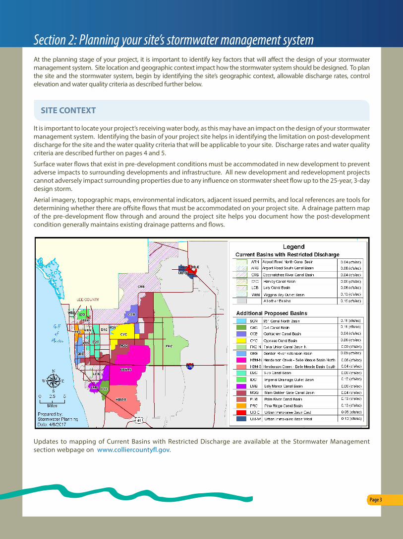
It is important to locate your project’s receiving water body, as this may have an impact on the design of your stormwater management system. Identifying the basin of your project site helps in identifying the limitation on post-development discharge for the site and the water quality criteria that will be applicable to your site. Discharge rates and water quality criteria are described further on pages 4 and 5.
Surface water flows that exist in pre-development conditions must be accommodated in new development to prevent adverse impacts to surrounding developments and infrastructure. All new development and redevelopment projects cannot adversely impact surrounding properties due to any influence on stormwater sheet flow up to the 25-year, 3-day design storm.
Aerial imagery, topographic maps, environmental indicators, adjacent issued permits, and local references are tools for determining whether there are offsite flows that must be accommodated on your project site. A drainage pattern map of the pre-development flow through and around the project site helps you document how the post-development condition generally maintains existing drainage patterns and flows.
Updates to mapping of Current Basins with Restricted Discharge are available at the Stormwater Management section webpage on www.colliercountyfl.gov.
Page 3
SITE CONTEXT
Section 2: Planning your site’s stormwater management system

Collier County uses stormwater master plans and watershed management plans to continually update their stormwater and drainage basin mapping and discharge rate criteria. These maps can be found on the Stormwater Management Section webpage on www.colliercountyfl.gov.
Identifying the basin of your project site helps in identifying the limitation on post-development discharge for the site. The primary means of achieving a balance in the pre-development and post-development discharges is through the design and construction of the appropriate stormwater management features (berms, control structures, and onsite storage facilities for attenuation).
The maximum allowable discharge rate that applies to the project is based on a stormwater event of a 3-day duration and 25-year return frequency unless otherwise specified by previous SFWMD permits or SFWMD criteria, see Collier County Code of Ordinances Section 90-41 for allowable post-development discharge formulas for Collier County canals.
Note that downstream considerations, such as inadequate conveyance capacity to the receiving water body, must also be reviewed and addressed.
The control elevation is the lowest elevation that surface water will leave the site in the post development condition and is the elevation of the lowest part of the orifice or slot in the control structure. The control elevation should emulate the average wet season water table, should be the elevation of the lakes during the wet season, and is also the elevation necessary to maintain healthy wetland systems.
Establishing the control elevation for a development site typically involves review of the site’s ecological indicators and control elevations of adjacent developments.
Page 4
DISCHARGE RATES
CONTROL ELEVATION
Section 2: Planning your site’s stormwater management system
25 YEAR3 DAY STORM
MAXIMUM DISCHARGE
RATE IS DETERMINED BY
25 YEAR 3 DAY
STORM EVENT
DETENTION AND RETENTION – WHAT’S THE DIFFERENCE?
Detention storage allows discharge below the 25-year, 3-day storm elevation, and retention does not.
• A detention pond or storage area provides for flow of water which is usually accomplished through a control structure.
• Retention facilities retain stormwater on site and do not discharge off the site. The only discharge from retention facilities below the 25-year, 3-day storm elevation is through natural infiltration and fluctuation of the groundwater.

Presumptive criteria outlined in the ERP Handbook presume that detaining the first inch of runoff volume, or two-and-a-half inches times the percent impervious area over the site, whichever is greater, is adequate for compliance with state water quality standards. This volume must be discharged slowly at a rate that does not exceed half an inch in a 24 hour period through a bleed-down orifice that is no less than 3” in diameter.
Per LDC Section 3.07.00, Interim Watershed Management regulations, 150% of the water quality volumetric requirements of the Water Management District’s ERP Handbook must be met within the boundaries of the stormwater treatment system, excluding County required native vegetation preserves, which are not allowed to be incorporated into the stormwater quality treatment system.
Page 5
Section 2: Planning your site’s stormwater management system
WATER QUALITY CRITERIA
CONTROLSTRUCTURE
CONTROLELEVATION
OUTFALL
12”
RETENTIONVOLUME
6”{
DRY RETENTION
CORRUGATED METAL BAFFLE
(SKIMMER)
CONTROLSTRUCTURE
CORRUGATED METAL BAFFLE
(SKIMMER)
CONTROLELEVATION
12”OUTFALL
DRY DETENTION
{6”6”{
The water quality volumetric requirements may be reduced by 25% if the detention is dry.
The water quality volumetric requirements may be reduced by 50% for projects using retention.
COMMERCIAL OR INDUSTRIAL ZONED PROJECTS:Provide at least ½-inch of dry detention or retention pretreatment as part of the required retention/detention, unless reasonable assurances can be offered that hazardous materials will not enter the project’s surface water management system. Such assurances may include deed restrictions on sale, property occupancy, recorded lease agreements, local government restrictive codes, ordinances, licenses, engineered containment systems, etc.
NOTE ABOUT IN-GROUND PERCOLATION TYPE RETENTION SYSTEMS:Rock trenches, exfiltration trenches or beds, infiltrator type systems, gallery type systems, etc., shall not be used to achieve water quality retention for residential subdivisions. Rear yard open retention systems shall likewise not be designed to achieve water quality retention. All retention systems for projects designed after January 1, 2002, shall be on common property owned and maintained by a homeowners’ association or similar entity.

Using parameters and criteria identified in the project planning stage as described earlier in this guidebook, design of the stormwater management system for all areas within subdivisions or developments, including lots, streets, and alleys must be modeled and then depicted on plans for review by Collier County.
A hydrologic routing model must be run on software accepted by the SFWMD and Collier County to simulate the impact of a 10-year/one-day, 25-year/ three-day, and 100-year/three-day design storm event on the project site. All site paving, grading and drainage plans are based on the results of the hydrologic routing model.
The designer’s model must account for the elevations of the berm, roadway, and building finished floors, while factoring in the allowable discharge rate and water quality treatment requirements identified in the project planning stage.
The minimum elevations must be set at the surface water levels of the following design storm events:
MINIMUM ELEVATION FOR: STORM FREQUENCY STORM DURATION
Roads and parking lot travelways 25 years 3 days
Parking areas 10 years 1 day
Buildings in FEMA-designated floodplains
Minimum elevation based on most restrictive criteria of the Florida Building
Code or Collier County Code of Ordinances.
Buildings outside FEMA-designated floodplains 100 years 3 days
Stormwater runoff must be conveyed to positive outfalls that can be permanently maintained, both practically and legally. Outfalls to existing waterways, canals, preserve or conservation areas, lakes or storm sewers are acceptable provided a professional engineering study demonstrates that such receiving systems have adequate capacity and legal access for the proposed quantity and quality of the additional flow.
The County has specific standards for design and permitting the project outfall, including the following:
• For outfall ditches and open channels, side slopes no steeper than four to one (or two to one with rip rap outside the right-of-way) will be allowed. Protection against scour and erosion must be provided.
• Permitted roadside swales may be crossed by swaled driveways or culverted driveways. A Right-of-Way permit is necessary for review and approval of the design of driveways and culverts or any other facilities to be constructed within the right-of-way.
Page 6
Section 3: Designing the stormwater management system
MODELING
OUTFALLS
Secondary pipes that are not interconnects between lakes or detention facilities must be sized to accommodate the 10-year, one-hour storm event. This rainfall event equals approximately 3.3 inches of rainfall per hour according to the Florida Department of Transportation equations for rainfall distribution for critical design events for the Zone 8 geographic area where Collier County is located.
Where drainage plans provide for the collection of stormwater in underground pipes, inlets and other appurtenances for conveyance to an intermediate or ultimate outfall, the following minimum design criteria apply:
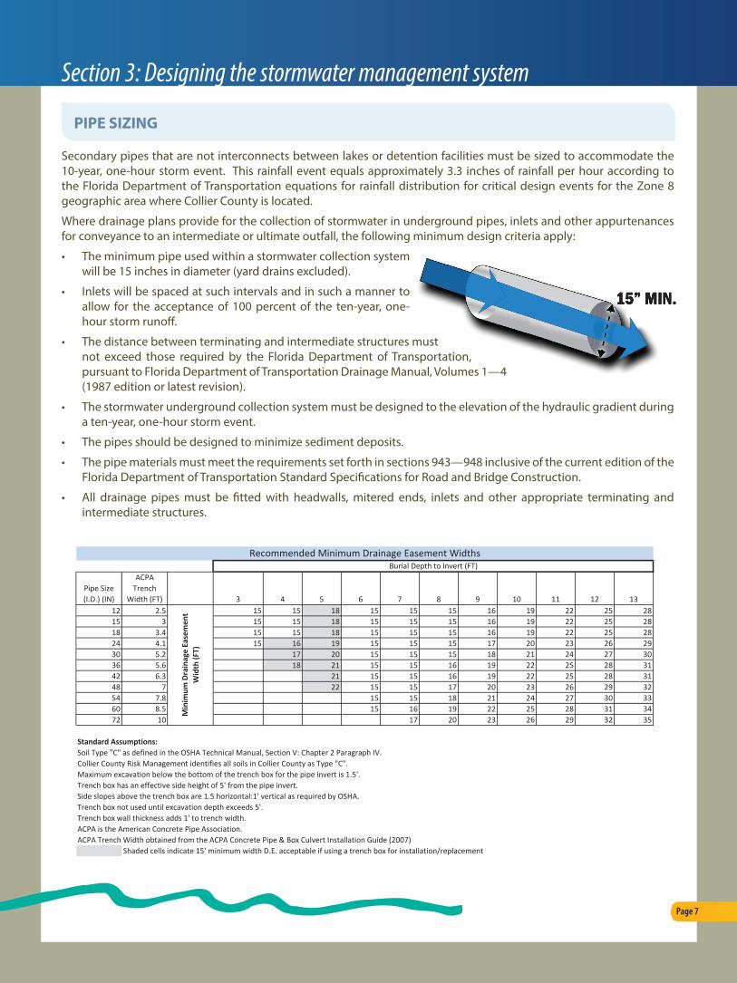
• The minimum pipe used within a stormwater collection system will be 15 inches in diameter (yard drains excluded).
• Inlets will be spaced at such intervals and in such a manner to allow for the acceptance of 100 percent of the ten-year, one-hour storm runoff.
• The distance between terminating and intermediate structures must not exceed those required by the Florida Department of Transportation, pursuant to Florida Department of Transportation Drainage Manual, Volumes 1—4 (1987 edition or latest revision).
• The stormwater underground collection system must be designed to the elevation of the hydraulic gradient during a ten-year, one-hour storm event.
• The pipes should be designed to minimize sediment deposits.
• The pipe materials must meet the requirements set forth in sections 943—948 inclusive of the current edition of the Florida Department of Transportation Standard Specifications for Road and Bridge Construction.
• All drainage pipes must be fitted with headwalls, mitered ends, inlets and other appropriate terminating and intermediate structures.
Page 7
Section 3: Designing the stormwater management system
PIPE SIZING
DRAFT 9-28-11
Pipe Size (I.D.) (IN)
ACPA Trench
Width (FT) 3 4 5 6 7 8 9 10 11 12 1312 2.5 15 15 18 15 15 15 16 19 22 25 2815 3 15 15 18 15 15 15 16 19 22 25 2818 3.4 15 15 18 15 15 15 16 19 22 25 2824 4.1 15 16 19 15 15 15 17 20 23 26 2930 5.2 17 20 15 15 15 18 21 24 27 3036 5.6 18 21 15 15 16 19 22 25 28 3142 6.3 21 15 15 16 19 22 25 28 3148 7 22 15 15 17 20 23 26 29 3254 7.8 15 15 18 21 24 27 30 3360 8.5 15 16 19 22 25 28 31 3472 10 17 20 23 26 29 32 35
Standard Assumptions:Soil Type "C" as defined in the OSHA Technical Manual, Section V: Chapter 2 Paragraph IV. Collier County Risk Management identifies all soils in Collier County as Type "C".Maximum excavation below the bottom of the trench box for the pipe invert is 1.5'.Trench box has an effective side height of 5' from the pipe invert.Side slopes above the trench box are 1.5 horizontal:1' vertical as required by OSHA.Trench box not used until excavation depth exceeds 5'.Trench box wall thickness adds 1' to trench width.ACPA is the American Concrete Pipe Association.ACPA Trench Width obtained from the ACPA Concrete Pipe & Box Culvert Installation Guide (2007)
Shaded cells indicate 15' minimum width D.E. acceptable if using a trench box for installation/replacement
Min
imum
Dra
inag
e Ea
sem
ent
Wid
th (F
T)
Burial Depth to Invert (FT)Recommended Minimum Drainage Easement Widths

Section 4: The permitting process
The submittal of a PPL or SDP is required to include the following information subject to review by the County engineering stormwater reviewer:
Right-of-Way permit # is necessary for review and approval of the design of driveways and culverts or any other facilties in the ROW
Excavation Permit Application, as applicable
Drainage Plan and an Engineering Report signed and sealed by a Florida Professional Engineer.
Drain pipe calculations must be signed and sealed by a Professional Engineer.
The route of off-site discharge must be shown to the nearest canal.
Provide an Engineer’s certification that the receiving system has been inspected and is adequate.
Soil borings must be provided.
A minimum 15-foot wide drainage easement must be provided for drainage infrastructure.
Finished floor elevation must be at least 18” above road or at 100 year storm elevation.
Plans must indicate internal roadways and parking aisles are at a 25 year, 3 day storm stage.
Parking areas must be at a 10 year, 24 hour storm stage.
Provide wet season water table elevations on cross sections.
Lake cross section should show a maximum of 4:1 slope graded from the existing grade to a breakpoint at least 10 feet below the control elevation. Below this breakpoint, the slope shall be no steeper than 2:1. See Code of Ordinances Section 22-112 for more on side slopes.
Design and plan elevations must be in NAVD datum.
The entity responsible for maintenance of infrastructure and stormwater management system must be on plans.
Detention ponds must discharge through a structure with a bleed-down.
Slopes must adhere to landscaping and engineering standards in the Slope Table found in LDC Section 4.06.05.J.
A minimum 20-foot wide access easement must be provided from a lake maintenance easement to the nearest public right-of-way.
Include on plans “NOTE: The approval of these construction plans does not authorize construction of required improvements which are inconsistent with easement of record.”
Erosion control details, access, stabalization, and silt fence locations must be on a separate sheet.
Page 8
PLAN SUBMITTAL

NOTES


