Status and Management Recommendations foruser Reyes National Seashore . ... NPS Director’s Orders...
88
Status and Management Recommendations for Arctostaphylos virgata (Marin Manzanita) in Point Reyes National Seashore Prepared by Dr. V. T. Parker in cooperation with National Park Service staff of Point Reyes National Seashore, Fire Management Division November 2007
-
Upload
trinhtuong -
Category
Documents
-
view
219 -
download
3
Transcript of Status and Management Recommendations foruser Reyes National Seashore . ... NPS Director’s Orders...

Status and Management
Recommendations
for
Arctostaphylos virgata
(Marin Manzanita)
in
Point Reyes National Seashore
Prepared by Dr. V. T. Parker in cooperation with National Park Service staff of Point Reyes National Seashore, Fire Management Division November 2007


Status and Management Recommendations for A. virgata Page i
November 2007
Status and Management Recommendations for
Arctostaphylos virgata
in Point Reyes National Seashore
November 2007
Summary ......................................................................................................... 1
I. Introduction................................................................................................ 3
A. Goals and Objectives..................................................................................... 3
B. Planning and Policy Guidance......................................................................... 4 1. National Park Service Management Policies.................................................. 4 2. NPS Director’s Orders................................................................................. 5
a. Director’s Order #77, Natural Resources .................................................. 5 b. Director’s Order #18, Fire Management ................................................... 6
3. PRNS Fire Management Plan....................................................................... 6
II. Status of Arctostaphylos virgata ............................................................... 9
A. Description................................................................................................... 9
B. Current Taxonomic Status ........................................................................... 16
C. Habitat Type .............................................................................................. 16 a. Maritime Chaparral ............................................................................... 17 b. Maritime Fog Climate............................................................................ 18
III. Fire Ecology and Population Dynamics .................................................. 21
A. Response to Fire......................................................................................... 21
B. Population Dynamics ................................................................................... 22
IV. Range of Species..................................................................................... 25
A. Range and Distribution of Arctostaphylos virgata Populations ......................... 25 1. San Geronimo Ridge (MMWD) .................................................................. 26 2. South side of Mt. Tamalpais, Head of the Canyon to Muir Woods (Mt.
Tamalpais State Park and Muir Woods National Monument) ........................ 26 3. Bolinas Ridge (MMWD, GGNRA) ................................................................ 26 4. Inverness Ridge (PRNS, Tomales Bay State Park, Private holdings).............. 27
a. Seahaven Subdivision and Tomales Bay State Park ................................. 27 b. Shallow Beach Subdivision .................................................................... 28 c. Northern Inverness Ridge Outside the Vision Fire Perimeter..................... 28 d. Southern Inverness Ridge ..................................................................... 28 e. Inverness Ridge Vision Fire Perimeter .................................................... 29
Page ii Status and Management Recommendations for A. virgata
B. Summary of Total Range and Extent of Arctostaphylos virgata populations...... 31
C. Comparisons of Populations in PRNS vs. Other Locations................................ 32
D. Existing Threats to Populations .................................................................... 33
E. Potential, Future Concerns........................................................................... 34
V. Management RecommendationsFor Arctostaphylos virgata in PRNS ...... 35
A. Current Management Practices for Arctostaphylos virgata............................... 35 1. Wildland Urban Interface Projects on Non-Federal Lands ............................ 35 2. Trail Maintenance in PRNS........................................................................ 36 3. Roadside Maintenance in PRNS................................................................. 36 4. Fuel Reduction Projects in PRNS ............................................................... 36
a. Bolinas Ridge Fire Road ........................................................................ 37 b. Inverness Ridge Trail Wildland Urban Interface....................................... 37
5. Prescribed Burning in PRNS ...................................................................... 38 6. Other Operations in PRNS ........................................................................ 39
B. Recommended Best Management Practices (BMPs) ....................................... 39 1. Routine Trail Maintenance ........................................................................ 39 2. Roadside Fuel Reduction, Mowing and Maintenance ................................... 40 3. Clearing for Fuel Reduction Zones in PRNS ................................................ 40
a. Bolinas Ridge ....................................................................................... 41 b. Inverness Ridge Trail Site ..................................................................... 43
4. Recommendations for BMPs for Prescribed Burning .................................... 46 5. Recommendations to Pursue Proactive Population Management .................. 46 6. Recommended Monitoring Protocol ........................................................... 46
a. Demographic Monitoring ....................................................................... 47 b. Compliance Monitoring ......................................................................... 47
7. Recommendations for Research Topics...................................................... 48
VI. Literature Cited....................................................................................... 51
November 2007

Status and Management Recommendations for A. virgata Page iii
LIST OF APPENDICES
APPENDIX A -- Evolution, Plant Status and Relationships within the Genus ................ 55
APPENDIX B -- Ceanothus species found in range of Arctostaphylos virgata............... 61
APPENDIX C -- Minutes: Workshop on Arctostaphylos virgata................................... 69
APPENDIX D -- Arctostaphylos virgata Pruning Guidelines ........................................ 79
LIST OF FIGURES
FIGURE 1—Arctostaphylos virgata in flower ............................................................ 10
FIGURE 2—Line drawings of Arctostaphylos virgata ................................................. 11
FIGURE 3—Arctostaphylos virgata in young fruit ..................................................... 12
FIGURE 4—Close-up of Arctostaphylos virgata in flower ........................................... 13
FIGURE 5—Characteristics of Arctostaphylos virgata bark......................................... 14
FIGURE 6—Arctostaphylos virgata in a Pinus muricata woodland in PRNS.................. 17
FIGURE 7—Influence of fog in maritime chaparral ................................................... 19
FIGURE 8—Global Distribution of Arctostaphylos virgata .......................................... 25
FIGURE 9—Arctostaphylos virgata on Inverness Trail near Drakes View Rd................ 30
FIGURE 10—Aerial view of Inverness Trail with large population of A. virgata............ 44
LIST OF TABLES
TABLE 1—Estimate of Arctostaphylos virgata population .......................................... 32
TABLE 2—Estimated population by management responsibility ................................. 32
November 2007

Page iv Status and Management Recommendations for A. virgata
November 2007

Status and Management Recommendations for A. virgata Page 1
November 2007
Status and Management Recommendations for
Arctostaphylos virgata
in Point Reyes National Seashore
November 2007
SUMMARY
The Point Reyes National Seashore (PRNS) and the northern district of Golden Gate National Recreation Area (GGNRA), both units of the National Park Service (NPS), support populations of Arctostaphylos virgata, Marin manzanita, an endemic plant found only in western Marin County. A. virgata is considered a species fairly endangered in California by the California Native Plant Society (CNPS)*, a non-profit organization with recognized expertise in the status of plant species state-wide. Several areas of the park supporting A. virgata are also under consideration for fuel reduction projects, routine trail maintenance, routine roadside clearing or park actions. The NPS seeks to ensure the viability of the species within the park by avoiding or minimizing adverse impacts to the A. virgata to the extent feasible and to implement wise resource management practices for its benefit. To this end, NPS staff at PRNS contracted for a survey of the populations of A. virgata within the park in 2006, and in 2007, contracted for this report, to provide recommendations to the NPS on best management practices (BMPs) to follow when implementing projects, strategies for long-term stewardship and monitoring of the species and research topics that would be worthwhile for management purposes to pursue.
This report explores the overall status, ecology, overall distribution and threats to A. virgata. It describes the distribution of the species within NPS lands, other protected lands and privately held parcels in the Inverness and Bolinas vicinity. The report describes current and proposed NPS management actions in A. virgata habitat and makes recommendations for best management practices to follow during project implementation and for park-wide population management. Finally the report makes recommendations to PRNS for monitoring techniques and research opportunities.
* A. virgata is rated by the CNPS Online Inventory as a 1.B-2 plant species (as “fairly endangered in California”.

Page 2 Status and Management Recommendations for A. virgata
November 2007

Status and Management Recommendations for A. virgata Page 3
November 2007
I. INTRODUCTION
This report compiles current information on the species and presents recommendations to NPS staff at PRNS to follow when working in those areas of the two parks supporting Marin manzanita (Arctostaphylos virgata)†. The report is being prepared in response to the PRNS Fire Management Plan (FMP) which anticipated work in these areas of PRNS and identified the need for management guidelines for the species which is listed as “fairly endangered” in California by the CNPS in its Online Inventory of Rare Plants. FMP projects were previously assessed for potential effect in a Final Environmental Impact Statement (FEIS) and Record of Decision, adopted in October, 2004. Incorporating guidelines for the management of Marin manzanita will ensure that implementation of the NPS projects will conform to the conclusions reached in the FEIS regarding potential impacts to Marin manzanita from FMP projects. The recommendations would also be applied, wherever effective, to populations of the Mason’s ceanothus (Ceanothus masonii) and/or glory brush ceanothus (Ceanothus gloriosus var. exaltatus), rare plants that co-occur in the park with Marin manzanita.
A. Goals and Objectives
Marin manzanita (Arctostaphylos virgata) is a rare chaparral species that is of special management concern at PRNS. It has no federal or state status, but it is a Marin County endemic listed by the CNPS as “fairly endangered” (designation 1B.2 in the online 7th edition of the CNPS Inventory of Rare and Endangered Plant, www.cnps.org). Marin manzanita is known from fewer than 20 occurrences, including the southern slope of Mt. Tamalpais and Inverness and Bolinas Ridges in PRNS. The species is an obligate seeder and reproduced well after the 1995 Vision Fire in the park. Since that time, there is anecdotal evidence that the species is declining in PRNS as individuals are being overtopped by rapidly growing Bishop Pine, blue blossom ceanothus and other species.
Planning Goal. As PRNS plans for FMP projects, routine trail maintenance and other work in areas of the park with Marin manzanita, it is important that BMPs are used by park staff and contractors to ensure the protection and perpetuation of the species.
Planning Objectives. The report will provide to the NPS:
a compendium of the state of current knowledge on the Marin manzanita and the two ceanothus species (based on existing literature),
the input of recognized specialists on the ecology and management of the species on important questions regarding their management,
an assessment of whether active management is needed to benefit the species,
† Due to the physical proximity of the northern lands of GGNRA to PRNS, the northern lands are managed by PRNS per an agreement between the two parks.

Page 4 Status and Management Recommendations for A. virgata
recommendations for BMPs to use when implementing the range of NPS projects that could affect the species,
recommendations for monitoring the populations and for monitoring the effectiveness of the BMPs, and
recommendations for future management-focused research topics that would benefit A. virgata or the rare Ceanothus species.
B. Planning and Policy Guidance
1. National Park Service Management Policies
The management of the national park system and NPS programs is guided by the U.S. Constitution, public laws, treaties, proclamations, executive orders, regulations, and directives of the Secretary of the Interior, the Assistant Secretary for Fish and Wildlife and Parks and the Director of the NPS. All NPS policy must be consistent with these higher authorities.
NPS policy is presented in the 2006 edition of the NPS Management Policies. The Management Policies set the framework and provide direction for all management decisions in the 391 units of the NPS. The policy language may give general or specific direction; it may prescribe the process through which decisions are made, how an action is to be accomplished, or the results to be achieved. The Management Policies represent the highest of a three tiered directives system governing national park management.
The Policies give specific direction for the management of plant and animal species listed under the federal Endangered Species Act. Less specific language is used in Policy 4.4.2.3 to describe NPS guidance for the management of species considered in jeopardy or warranting special management concern by state regulations or lists prepared by organizations with strong repute and expertise, such as the plants listed in the CNPS Inventory. The development of this report stems from the direction given in Policy 4.4.2.3:
“The National Park Service will inventory, monitor, and manage state and locally listed species in a manner similar to its treatment of federally listed species to the greatest extent possible. In addition, the Service will inventory other native species that are of special management concern to parks (such as rare, declining, sensitive, or unique species and their habitats) and will manage them to maintain their natural distribution and abundance.
The Service will determine all management actions for the protection and perpetuation of federally, state, or locally listed species through the park management planning process, and will include consultation with lead federal and state agencies as appropriate.”
November 2007

Status and Management Recommendations for A. virgata Page 5
The Management Policies comply with Federal Wildland Fire Management Policy (2001) which requires the federal land management agencies to have Fire Management Plan meeting current federal requirements for all units under their jurisdiction. PRNS adopted an updated FMP in 2004 after several years of document preparation.
The role of fire in enhancing natural systems, such as habitat for A. virgata, is addressed by Policy 4.5 (page 73):
“Naturally ignited fire, including the smoke it produces, is part of many of the natural systems that are being sustained in parks. Such natural systems contain plant and animal communities that are characterized as fire-adapted or fire-dependent….. Other park natural systems are characterized by a natural absence or very low frequency of fire. These systems are at risk of losing their ecological integrity when the natural fire regime is subjected to human interference.”
The Management Policies encourages the development of fire management programs that focus on park resource management objectives, rather than hazard reduction, with the caveat that firefighter and public safety are the paramount priorities of wildland fire management and cannot be compromised to meet resource objectives.
2. NPS Director’s Orders
a. Director’s Order #77, Natural Resources
Under the three tiered NPS Directives System, Level 2 guidance is provided in Director’s Orders issued by the NPS Director which provide direction on implementation of one of the broader issue areas addressed in the Management Policies. The Director’s Orders are also used to update the Management Policies between the publishing dates of the broader policy document. Since the Management Policies were recently reissued in 2006, many of the Director’s Orders are not yet updated and are inconsistent with the newer Management Policies. Where there are inconsistencies between Director’s Orders and Management Policies guidance, the latter should be followed and the former can be disregarded until updated.
In many cases, the level 2 guidance in Director’s Orders are further supplemented by handbooks or reference manuals, the third tier in the Directives System. These reference manuals provide NPS field employees with compilations of legal references, operating policies, standards, procedures, general information, recommendations, and examples to assist them in carrying out the Management Policies and Director’s Orders.
Both the Director’s Order (DO #77-8, Endangered Species) and the Reference Manual (RM#77, Endangered, Threatened and Rare Management Species) that would address management of locally listed species are in preparation and not available for this report.
November 2007

Page 6 Status and Management Recommendations for A. virgata
b. Director’s Order #18, Fire Management
Director’s Order 18 and Reference Manual #18 expand upon Management Policies for wildland fire management. Federally-listed species are repeatedly called out as an important consideration when planning or implementing the fire management program. The only specific references to rare species that are not federally listed, such as A. virgata, is as a type of resource to be included when developing fire effects monitoring plans and Burned Area Emergency Restoration (BAER) plans.
3. PRNS Fire Management Plan
The FMP, as an NPS planning document, required compliance with the National Environmental Policy Act (NEPA). An EIS was prepared on the FMP and the preferred alternative was selected for implementation through the Record of Decision signed by the Pacific West Regional Director on October 29, 2004. Subsequent to the NEPA process, PRNS staff prepared the FMP based on the selected alternative. The FMP is an operational manual for PRNS fire staff with direction on responding to wildland fires, conducting prescribed burns, planning vegetation management projects and meeting administrative recordkeeping requirements.
In conformance with Management Policies, the NEPA documentation for the FMP addressed the management of locally listed species such as Arctostaphylos virgata noting that the species is highly dependent on fire for long-term reproductive success. The FMP describes its CNPS status adding that the species is listed as a federal Species of Concern by the Sacramento Office of the U.S. Fish and Wildlife Service (USFWS). The Sacramento Office defines “species of concern” as an informal term used by the USFWS and not defined in the federal Endangered Species Act to refer to species that USFWS staff believes are declining or appear to be in need of concentrated conservation actions.
The FMP lists A. virgata as present in 5 of the 11 fire management units (FMUs) at PRNS. The FMUs are the basic planning block for an FMP and define an area proposed for fire management actions sharing attributes of geography, vegetation, level of risk and resource enhancement needs. A. virgata is present in the following FMUs: Inverness Ridge, Limantour, Wilderness South, Palomarin and Bolinas Ridge. With the exception of Bolinas Ridge, which has a dense population of A. virgata in the southern portion of the FMU, the majority of the populations are in FMUs which burned in the 1995 Vision Fire; remnant, more decadent populations persist in FMUs outside the 1995 fire perimeter.
The FMP alternative adopted through the NEPA process included the possibility of conducting smaller, research-related prescribed burns at the southern portion of the Bolinas FMU to determine the effects of prescription burning on A. virgata and Ceanothus masonii as well as invasive velvet grass. Though not ruled out for the future, PRNS fire staff does not anticipate conducting this research burn in the next five years. The adopted alternative also suggested that limited acreage research burns be considered for the Inverness Ridge and Wilderness South FMUs in areas with A. virgata.
November 2007

Status and Management Recommendations for A. virgata Page 7
The FMP further suggests that mechanical means could be employed in the Wilderness South FMU to assess the effects of decreasing shading by adjacent trees on decadent stands of A. virgata.
The following mitigation measures from the FMP contribute to protection of A. virgata during planning and implementation of FMP projects.
G-1. To ensure that implementation of fire management plan actions conforms to findings of this impact assessment, subsequent fire year plans and individual projects will be subject to NPS project review. Prior to approval, all projects will be submitted through an NPS internal review process wherein an interdisciplinary team will evaluate if the potential effects of the proposed projects are adequately addressed through the FMP NEPA process. Conformance to the conclusions in the FMP EIS will be documented for the NEPA record. If the team finds that the project has major new environmental effects not addressed in this EIS or effects greater than those described in this EIS, a separate environmental process will be conducted.
V-1. “Pre”-Treatment Measures
• Individual prescribed burns will be conducted within the framework of a multidisciplinary planning effort. Personnel from fire management and from resource management will work together to identify areas that are expected to benefit from prescribed burning. Existing data on the response of plant communities in the Seashore to fire will be consolidated and analyzed to determine optimal areas, configurations, and times for burns. Clear objectives will be developed for prescribed burns that will include measurable parameters to determine the effects of the burns on vegetation. Following burns, vegetation will be analyzed to determine the effects of the burn, which will aid in future burn planning.
• Prescribed burns will be conducted at a time of year when introduction or spread of non-native plants will be minimized, and mortality of non-native plant species will be maximized.
• Whenever possible, existing roads or trails will be used as firebreaks for prescribed burns and for wildland fire suppression.
• Vegetation managers will work with fire management staff to develop maps of areas that support plant communities of special management concern (e.g., uncommon communities, wetlands, riparian areas, dunes, areas with no non-native plants that need to be kept intact, areas with highly invasive non-native plants that should not be spread) so fire personnel can attempt to avoid such areas when making decisions about fire management tactics.
November 2007

Page 8 Status and Management Recommendations for A. virgata
V-5. In Bishop Pine
• Follow-up non-native plant monitoring and removal will be conducted to remove new recruits that come into the site in years following prescribed burning or mechanical treatments.
• Prescribed burning in Bishop Pine stands will occur only if the burns can be conducted under conditions that will result in germination and recruitment of new stands of Bishop Pine. Relatively cool fires under moist conditions may not meet this objective.
• Initially, prescribed burns in Bishop Pine forest habitat will be small and will be carefully monitored to ensure burn objectives (= recruitment and long-term maintenance of Bishop pine and associated native species without introduction of invasive non-native plant species) are being met.
November 2007

Status and Management Recommendations for A. virgata Page 9
II. STATUS OF ARCTOSTAPHYLOS VIRGATA
Arctostaphylos species are members of the subfamily Arbutoideae in the family Ericaceae. Arctostaphylos virgata is a locally endemic species principally found on the Pt. Reyes peninsula, with some outlying populations on Bolinas Ridge, and sparsely on the south slope of Mt. Tamalpais and the south slopes of San Geronimo Ridge.
A. Description
Arctostaphylos virgata is an erect shrub, ranging from 1-5 m in height. Plants lack a burl at the base of the stem and have smooth red bark on the larger stems; stems of the current year are densely glandular hairy. Leaves are ascending, overlapping, with petioles 2-4 mm, and blades 3-5 cm long by 1-2.5 cm wide. The general shape is narrowly oblong-ovate to oblong lanceolate, with the base of the leaf truncate to slightly lobed and the leaf tip acute. The margin of the leaf is entire, and leaves are relatively flat and isofacial (similar in color and pubescence on both surfaces with stomata on both surfaces). Leaves are bright green and more or less shiny, and often sparsely glandular-hairy and sometimes papillate. The inflorescence is usually a raceme but can be branched. When immature, the inflorescence axis is short and concealed by long, leaf-like bracts. The flowering inflorescence stem is densely glandular hairy, with narrow, glandular-hairy and leaf-like bracts at the base of flowers, 8-20 mm in length, with flowers on a pedicel 3-8 mm in length. The white flowers are five-merous, conic to urn-shaped, with a glandular-hairy ovary. The fruit is a drupe; when mature, the spheric fruit is depressed at the attachment to the pedicel, and at the opposite side from the pedicel at the base of the former style. The outer fruit surface (exocarp) is dry, densely glandular, and dull reddish in color, the inner pulp (mesocarp) is dry and mealy, and the 3-8 seeds are covered in a hard, bony material and are usually separate from each other. Arctostaphylos virgata is illustrated in Figures 1-4. It is a diploid species within the genus (2n = 26).
November 2007

Page 10 Status and Management Recommendations for A. virgata
Figure 1. Arctostaphylos virgata in flower. Petals are fused into a corolla, conic to urn-
shaped. Flowers are 5-merous (parts in multiples of 5). Photo by V.T. Parker.
November 2007

Status and Management Recommendations for A. virgata Page 11
Figure 2. Line drawings of Arctostaphylos virgata from Alice Eastwood’s original publication
of the species in Trees and shrubs: illustrations of new or little known ligneous plants (C. S. Sargent, ed., 1905). 1. A flowering branch. 2. A flower (enlarged). 3. A flower with the fused corolla laid open, enlarged). 4. A stamen, enlarged. 5. A fruiting branch. 6 & 7. Nutlets, enlarged, illustrating the bony cover from the outside (6.) and broken apart showing two radial surfaces. While the leaf, stem, and fruit glandularity are suggested in the drawing, only in the past 20 years has the shape of the immature inflorescence gained importance.
November 2007
Page 12 Status and Management Recommendations for A. virgata
Figure 3. Arctostaphylos virgata in young fruit. Note, the sticky glandular hairs on the fruit
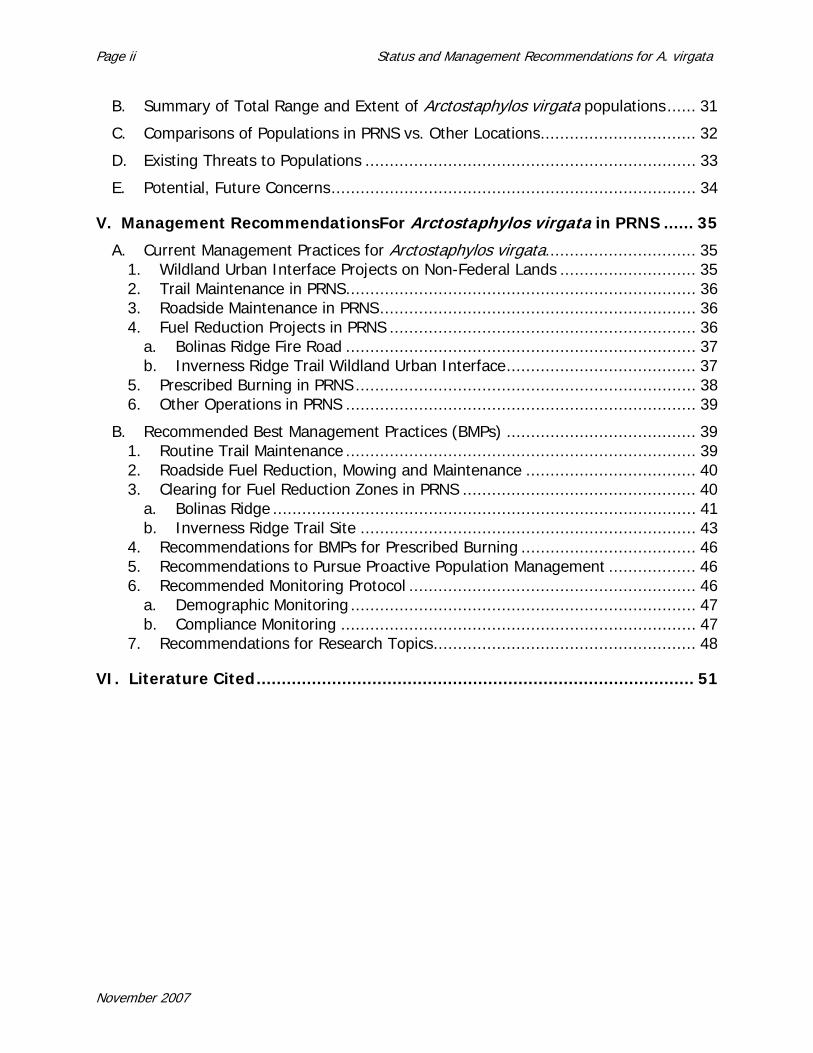
are quite noticeable in this photo. The hairs are present on the ovary in flower, and stay on the surface through fruit maturity. Also note that the fruit, while approximately spheric, has a depression at the base of the fruit, corresponding to where the style attached to the ovary in flower (styles still attached). There is also a depression where the fruit attaches to the pedicel holding the fruit to the inflorescence. The glandular pubescence and shape of the fruit are key morphological characters to identifying this species. Photo by V.T. Parker.
November 2007
Status and Management Recommendations for A. virgata Page 13
Figure 4. Close-up of Arctostaphylos virgata in flower. Note in this photo the glandular
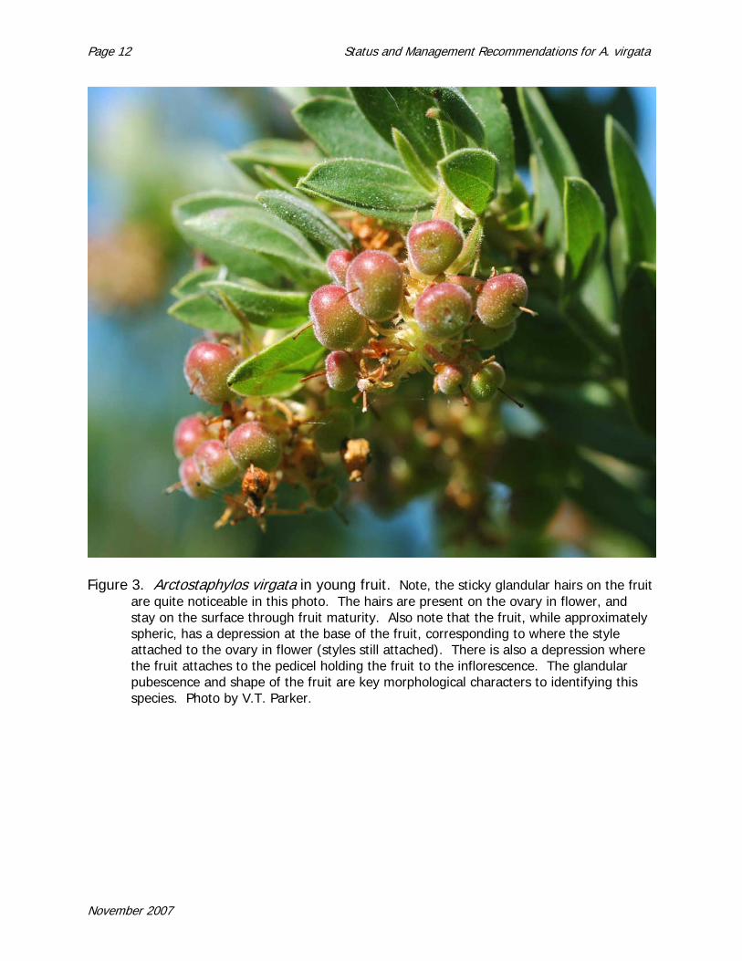
hairs that cover the leafy bracts at the base of each flower (upper right-most flower has the bract over the top) cover the leaves (obvious on the edges) and the young stems. Using a 14x hand lens, stomata are visible on both surfaces of the leaf. Photo by V.T. Parker.
November 2007
Page 14 Status and Management Recommendations for A. virgata
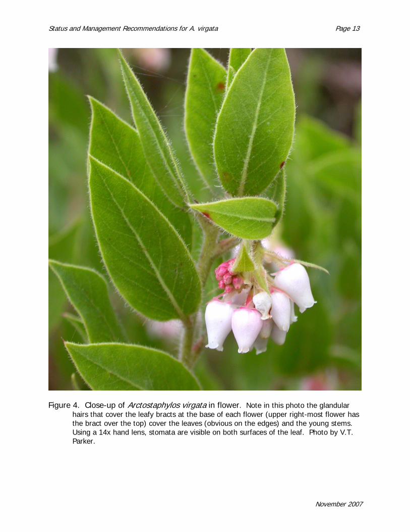
Figure 5. A key character of A. virgata is the smooth red bark on the older stems, and the lack of an enlarged burl at the base of the plant. In this photo, the woody stems are growing, causing new bark growth, which appears as small curls in the bark. Later in the season, the bark will be completely smooth. Another species at Pt. Reyes, Arctostaphylos glandulosa subsp. cushingiana also has smooth red bark, but has a large burl at the base of the plant. The burl of that species is sometimes buried beneath litter. Photo by V.T. Parker.
November 2007

Status and Management Recommendations for A. virgata Page 15
KEY to Arctostaphylos species on Pt. Reyes Peninsula, Bolinas Ridge, and the south slope of Mt. Tamalpais within the range of Arctostaphylos virgata. (Adapted from Parker, Vasey and Keeley, in press). 1. Plants sprouting after fire, typically with burls either at base of stem or epicormic burls where stems root
2. Leaf surfaces differ in hue and/or hairiness, stomata largely to completely restricted to lower leaf surface (leaves bifacial). Plants prostrate, with epicormic burls, fruit spheric, leaves usually oblanceolate, sometimes narrow elliptic (Marin Co., San Mateo Co., California; common from Mt. Vision north)…..->A. uva-ursi1
2’ Leaf surfaces similar in hue and hairiness, stomata on both surfaces, sometimes less on upper (leaves isofacial). Plants erect shrubs, 1-3 m, fruit depressed globose.
3. Twigs, infl axis, and infl bracts with glandular hairs. Leaves green to yellow-green, elliptic to ovate, with long glandular hairs, imm infl usually with some leaf-like bracts, at least at base of infl. (common on Bolinas Ridge and Mt. Tamalpais)…..->A. glandulosa subsp. glandulosa 3’ Twigs, infl axis, and infl bracts lacking glandular hairs. Leaves slightly hairy yellow-green to dark green, lower inflorescence bracts foliaceous or reduced. Fruit slightly flattened. (common subsp. in Pt. Reyes, also frequent on Mt. Tamalpais) …..->A. glandulosa subsp. cushingiana
1’ Plants lacking burls or woody platforms, not sprouting after a fire
4. Leaf surfaces different in hue and/or pubescence, stomata generally restricted to lower leaf surface (leaves bifacial)
5. Plants erect shrubs, 1-3 m. Flower petals and sepals in four parts; fruit small and breaking apart when mature; infl axis thread-like with well-spaced buds concentrated distally; floral bracts appressed and approx. same size as buds. Bark smooth, red (Marin Co. to Santa Cruz Co, California; common on Bolinas Ridge and summer fog zone on the south slope of Mt. Tamalpais; formerly called A. nummularia in part)…..->A. sensitiva 5’ Plants prostrate. Flower petals and sepals in five parts. Fruit 6-8mm, spheric, reddish. Leaf oblanceolate or narrow-elliptic in shape, leaf base wedge-shaped (widespread in boreal and coastal regions of North America, near Pt. Reyes lighthouse)…..->A. uva-ursi2
4’ Leaf surfaces similar in hue and/or pubescence, stomata (if visible) on both surfaces (leaves isofacial)
6. Imm infl consisting of scale-like bracts, bracts not primarily leaf-like, esp toward tip. Branchlet and bract hairs densely tomentose, imm infl bract tips appressed, not spreading, usually a 1-3 branched panicle (serpentines in s Marin, California; formerly called A. hookeri subsp. montana)…..->A. montana subsp. montana 6’ Imm infl with bracts generally large and leaf-like, at least in part
7. Leaves grey canescent (matted hairy or felt-like) on both surfaces when young, may be sparse with age. Ovary densely white hairy, glandular or not, flowers pink or white. Plants without glandular hairs on stems, leaves or fruit. (widespread in mountainous
November 2007

Page 16 Status and Management Recommendations for A. virgata
north and central coast ranges, California; on ridges above fog line, south slope of Mt. Tamalpais)…..->A. canescens subsp. canescens
7’ Leaves bright green, glandular hairy. Stems, leaves, inflorescence stems and ovary glandular hairy. Fruit glandular hairy when mature. (coastal Marin Co, California)…..->A. virgata
B. Current Taxonomic Status
Alice Eastwood (1905) first named Arctostaphylos virgata from populations along the south slope of Mt. Tamalpais. Her original description suggests that this species had a large population at the lower part of Boot-jack Trail on the south slope of Mt. Tamalpais. Recent surveys have only found one individual still living in this area (M. Vasey, J. Chapman, personal comm.). Eastwood also described its distribution as the hills west of Tomales Bay.
Treatments following the early discovery period of Arctostaphylos species continued to recognize A. virgata. The principal treatments in the early half of the 20th century were McMinn’s (1939) An illustrated manual of California Shrubs and Adams (1940) extensive systematic publication of Arctostaphylos. Subsequent work has built on these treatments, and A. virgata has remained throughout.
All current treatments of Arctostaphylos (Wells 1993, 2000, Parker et al. in press) consider Arctostaphylos virgata a distinct species. Some morphological characteristics suggest a relationship to a widespread species, A. columbiana (all Arctostaphylos names follow the Jepson Manual of Higher Plants of California, 2nd Ed [Parker et al. in press]; other names follow the 1st edition), which ranges from Mendocino County to British Columbia, and to an endemic of Monterey County, A. montereyensis. Wells’ last treatment (Wells 2000) indicated a relationship to coastal species from the San Francisco Bay Area south to the Channel Islands that have auriculate lobed leaves and are found in foggy, maritime climates. Additionally, Arctostaphylos virgata may not always produce dormant flowering inflorescences contemporaneous with new stem growth in the spring, but may wait until the fall. Only one other species, Arctostaphylos pringlei, fails to produce immature, dormant inflorescences in the spring (Keeley 1997; Vasey and Parker 1999). This suggests an alternative hypothesis, that Arctostaphylos virgata may be related to A. pringlei, a species distributed at higher elevations in southern California (A. pringlei subsp. drupacea) and in Arizona mountains that usually received occasional summer rainfall (A. pringlei subsp. pringlei).
C. Habitat Type
Arctostaphylos virgata is found as a chaparral or forest margin species (Figure 6). Edaphically, it is distributed on old, resource poor granites (Montara granite) or old Franciscan derived sandstones. The vegetation with which it is found is characterized by nutrient poor acidic soil, foggy moderated climates, and wildfire.
November 2007

Status and Management Recommendations for A. virgata Page 17
FIGURE 6. Arctostaphylos virgata in a Pinus muricata (Bishop Pine) woodland on Point Reyes.
On Bolinas Ridge, San Geronimo Ridge and Mt. Tamalpais, A. virgata is found in maritime chaparral at the edge of mixed evergreen forests.
a. Maritime Chaparral
Maritime chaparral represents a plant community of special concern because of the high density of narrowly distributed endemic species (the California Coastal Commission considers it an Environmentally Sensitive Habitat). From Mendocino County to the Channel Islands, this chaparral community is patchily distributed associated with forests edges or odd soils. Local communities appear to have a unique combination of species. Lower Bolinas Ridge, for example, contains 3 species of Arctostaphylos, A. glandulosa subsp. glandulosa, A. virgata, and A. sensitiva, while across the valley, Inverness Ridge contains A. glandulosa subsp. cushingiana, A. virgata and A. x repens. While A. glandulosa subsp. glandulosa and subsp. cushingiana are wide-spread taxa, A. x repens is found only on Inverness Ridge. A. virgata is locally restricted to foggy areas and A. sensitiva is only found in foggy maritime chaparral from Bolinas Ridge south to the Santa Cruz Mountains. Similarly, Bolinas Ridge contains Ceanothus gloriosus var. exaltatus, C. foliosus, and C. thrysiflorus while Inverness Ridge includes C. gloriosus subsp. porrectus and C. thyrsiflorus. Ceanothus thyrsiflorus and C. foliosus are distributed in the central coastal zone while C. gloriosus subsp. porrectus is endemic to Point Reyes and C. gloriosus var. exaltatus occurs from Bolinas Ridge to Mendocino County in patchy, small populations. Almost 43 of the 62 species of Arctostaphylos globally are found in the maritime zone of the California central coast. Arctostaphylos is
November 2007
Page 18 Status and Management Recommendations for A. virgata
characterized by a large number of taxa (species or subspecies) that are highly restricted in distribution; of these 66 local endemic taxa (out of 96 total taxa), 50 (73%) are restricted to the maritime zone. Around one third of Ceanothus taxa globally are also restricted to this same region. The species, restricted to maritime chaparral are differentially CNPS list 1B or State- or federally-listed species (e.g., among the Federally-listed maritime Arctostaphylos species are the Presidio manzanita, A. montana subsp. ravenii [formerly A. hookeri subsp. ravenii], A. pallida [pallid manzanita], and A. confertiflora [Santa Rosa Island manzanita]). Other rare plant species are also restricted to maritime chaparral (e.g., Chorizanthe pungens var. pungens and Centromadia parryi subsp. congdonii in Monterey Co.)
Other areas of maritime chaparral exhibit similar patterns of high diversity with a high proportion of rare and endemic plants. The Monterey Bay region contains 12 local endemics in Arctostaphylos, including Arctostaphylos glutinosa, A. pajaroensis, and A. montereyensis. In addition to these 12 taxa, other species restricted to maritime chaparral but more widely distributed are also found, including A. sensitiva and A. crustacea subsp crustacea. Information about maritime chaparral in the Monterey region can be found in Griffin (1978), Greenlee and Langenheim (1990), Holl et al. (2000), Van Dyke et al. (2001), and Parker and Vasey (2005). The San Luis Obispo region south to northern Santa Barbara County also has similar high endemism in chaparral restricted to maritime influences (Wells 1962; Davis et al. 1988, 1989, Tyler 1996, Tyler and Odion 1996, Odion 2000, Odion and Davis 2000, Odion and Tyler 2002).
b. Maritime Fog Climate
Critically, the range of A. virgata is characterized by summer fog and relatively cool temperatures. Historically, while other parts of Marin County have dramatically different average summer and winter temperatures with a seasonal range of about 11 degrees C (20 degrees F), Pt. Reyes, Bolinas Ridge and nearby sites in which A. virgata grows have similar average summer and winter temperatures with a seasonal range of less of 3 degrees C (5 deg. F) (Howell 1970). This maritime climate is an important aspect of these coastal plant communities (Griffin 1978). Howell (1970) comments that Marin County has two distinct life zones (after Merriam) defined by the coastal maritime climate and the interior climate. Characterizing the maritime influence in Marin are Pinus muricata, Pseudotsuga menziesii, Sequoia sempervirens, as well as many shrubs, including Corylus californica, Ribes menziesii, Rubus parviflorus, Ceanothus thrysiflorus and Vaccinium ovatum (Howell 1970). Other chaparral species restricted to maritime climates include Arctostaphylos virgata, A. sensitiva, and the various Ceanothus gloriosus subspecies. From Mendocino to Santa Barbara Cos., the immediate coastline is impacted to a greater or lesser degree by fog, and creates a transitional area between the Pacific Coast maritime climate (of coastal Washington to northern California) and the southern California or interior Mediterranean climate; in the transitional area, fog moderates the summer-dry stressful conditions (Azevedo and Morgan 1974, Kreissman 1991, Dallman 1998) (Figure 7).
November 2007

Status and Management Recommendations for A. virgata Page 19
Figure 7. Influence of fog is critical to maritime chaparral areas and many of the species that
characterize the adjacent forests.
November 2007

Page 20 Status and Management Recommendations for A. virgata
November 2007

Status and Management Recommendations for A. virgata Page 21
III. FIRE ECOLOGY AND POPULATION DYNAMICS
A. Response to Fire
Maritime chaparral may contain a large number of rare species and be confined to foggy, cooler conditions for California, but the dynamics of the vegetation are driven by a fire regime dominated by canopy wildfire like other chaparral regions. Maritime chaparral is associated with closed-cone species that are restricted to the immediate coast, like P. muricata, P. radiata, Cupressus abramsiana, C. goveniana, C. macrocarpa and with the serotinous P. attenuata, and the resprouting trees of the mixed evergreen forest. A diversity of life history responses occurs among all the species that are a part of maritime chaparral (e.g., Keeley 2000, Keeley and Zedler 1978, Keeley et al. 2006, Parker 1987a, b, 1990, 1993). The principal life history types illustrated in these studies are annual plants dependent on persistent dormant soil seed banks, herbaceous perennials, obligate sprouting woody species, facultative sprouting woody species and obligate seeding woody species. Three of these life history types depend on fire for stimulation of their seed banks for reproduction: the annuals, the facultative sprouting woody species, and the obligate seeding woody species. The herbaceous perennial species do not seem to do well except in the post-fire environment, while the obligate sprouting woody species reproduce in older stands of chaparral (see Keeley 2000).
Arctostaphylos and Ceanothus each contain two types of species in terms of their life histories: one group of species that contain burls or root crowns with dormant buds that permit resprouting after fire, and another that are unable to resprout after fire or cutting and are killed by fire (Keeley and Zedler 1978, Keeley 1991, Parker and Kelly 1989). The former are called facultative sprouters and the latter obligate seeders. The name ‘facultative sprouter’ means that they tend to survive fire and sprout new aboveground growth quickly while also having seeds in a dormant persistent soil seed bank that responds to a stimulus from a fire. Obligate seeders refer to the fact that adults are killed by fire and populations reestablish from persistent soil seed banks.
Facultative plants can resprout after fire or cutting and also have persistent soil seed banks. This life history type is not as speciose within Arctostaphylos or Ceanothus, but facultative seeders are often dominant species. In Marin County, only Arctostaphylos glandulosa subspecies, some of the A. uva-ursi populations, and Adenostoma fasciculatum (chamise) illustrate this life history type.
The plants that are killed by fire and depend on dormant seeds banks are the obligate seeders. Generally, they take several years to nearly 10 years before they begin producing seeds. Following that time period, seeds that are not found by rodents and other seed predators are slowly added to the soil, eventually reaching a depth at which they can survive a fire. It is not clear how long it takes to produce a persistent soil seed bank in which seeds are buried deep enough to survive fire. Seeds that fall to the ground suffer from high rates of seed predation (Keeley and Hays 1976, Kelly and Parker 1990, O’Niel and Parker 2005). Models of chaparral dynamics that vary the
November 2007

Page 22 Status and Management Recommendations for A. virgata
timing of seed survival following fire in the soil seed banks of obligate seeders indicate extreme shifts in the dynamics of the vegetation through time (Syphard et al. 2006). Examples of obligate seeders in western Marin include Arctostaphylos virgata, A. sensitiva on Bolinas Ridge and Mt. Tamalpais, A. montana and A. canescens on Mt. Tamalpais, Ceanothus gloriosus varieties, Ceanothus thyrsiflorus, Ceanothus jepsonii and Ceanothus cuneatus. Pinus muricata and other closed cone pines and cypresses in California are also obligate seeders, being killed by fire and relying on a persistent seed bank held in serotinous cones on the trees.
In both Arctostaphylos and Ceanothus, both life history types disperse seed locally and create dormant, persistent soil seed banks (Keeley 1977, 1986, 1991, Parker and Kelly 1989, Kelly and Parker 1990, Zammit and Zedler 1988, 1993, 1994, O’Neil and Parker 2005). These seeds are stimulated by the effects of fire, although the mechanisms differ. For Ceanothus, seeds are stimulated by a heat pulse that travels through the soil column after a fire passes. The heat pulse changes an area on the seed (where it originally was attached inside the ovary), causing a collapse of some cells and permitting water to enter the seeds. This releases the seeds from dormancy for once water enters the seed, the seed expands rapidly, cracking open the seed coat and permitting the embryo to germinate into a seedling. For Arctostaphylos, the seeds do absorb a small amount of water each growing season, but do not break dormancy and germinate unless they receive a physiological stimulus from chemicals found in smoke.
Other woody species in this vegetation illustrate a third life history type, obligate sprouters. Shrub oak species like Quercus wislizenii var frutescens or Q. durata, and other species like Heteromeles arbutifolia (toyon), Rhamnus californica, and Vaccinium ovatum are all burned back to the ground surface; resprout following fire, but lack persistent soil seed banks. Generally, they establish seedlings in older chaparral vegetation that may slowly reach the canopy.
B. Population Dynamics
For Arctostaphylos virgata, as for all species with persistent, fire-stimulated soil seed banks, new individuals establish only after fire. Seedlings are generally not very shade tolerant, and are favored by the high light, high water stress environments in post-fire chaparral compared to other species found in chaparral. Obligate sprouters (e.g, Quercus or Heteromeles) establish new individuals in closed vegetation.
Obligate seeders like Arctostaphylos virgata experience non-overlapping generations at a site in the dynamics of their populations. Fire kills off the adult population, but stimulates a new cohort of individuals that reestablish the next generation. This means that all individuals in a population are of the same age. Any loss of individuals permanently reduces the population until the next fire. For these types of species, the smaller the population, the smaller its range or density, the poorer its response following the next fire.
Facultative seeders generally lose very few individuals to wildfire unless the intensity is of high magnitude. Seedling response from the soil seed bank is usually much lower
November 2007

Status and Management Recommendations for A. virgata Page 23
than obligate seeders (Keeley and Zedler 1978) and establishment of seedlings does not guarantee recruitment of new individuals into the population, as resprouting individuals may remove resources too rapidly for new seedlings to successfully establish. Overall, facultative seeders like Arctostaphylos glandulosa experience only a small percentage flux in their population from fire to fire in open chaparral habitat. The exception comes in maritime areas in which chaparral is often slowly invaded by trees which shade out and kill the facultative seeders. This may permanently restrict their populations or ranges, as their response from seed banks is often poor.
Obligate sprouters experience a population dynamic much like facultative sprouters in many circumstances, with small percentage changes in open chaparral habitat, but considerable loss of individuals as trees invade. One difference is that they have greater shade tolerance and often persist if the trees are not in high density. Also, the shaded forest may facilitate recruitment of new individuals in older stands of trees. Consequently, many of these species are considered members of multiple types of plant communities.
November 2007

Page 24 Status and Management Recommendations for A. virgata
November 2007
Status and Management Recommendations for A. virgata Page 25
IV. RANGE OF SPECIES
A. Range and Distribution of Arctostaphylos virgata Populations
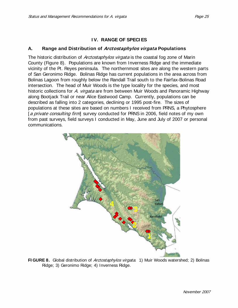
The historic distribution of Arctostaphylos virgata is the coastal fog zone of Marin County (Figure 8). Populations are known from Inverness Ridge and the immediate vicinity of the Pt. Reyes peninsula. The northernmost sites are along the western parts of San Geronimo Ridge. Bolinas Ridge has current populations in the area across from Bolinas Lagoon from roughly below the Randall Trail south to the Fairfax-Bolinas Road intersection. The head of Muir Woods is the type locality for the species, and most historic collections for A. virgata are from between Muir Woods and Panoramic Highway along Bootjack Trail or near Alice Eastwood Camp. Currently, populations can be described as falling into 2 categories, declining or 1995 post-fire. The sizes of populations at these sites are based on numbers I received from PRNS, a Phytosphere [a private consulting firm] survey conducted for PRNS in 2006, field notes of my own from past surveys, field surveys I conducted in May, June and July of 2007 or personal communications.
12
34
FIGURE 8. Global distribution of Arctostaphylos virgata. 1) Muir Woods watershed; 2) Bolinas Ridge; 3) Geronimo Ridge; 4) Inverness Ridge.
November 2007

Page 26 Status and Management Recommendations for A. virgata
1. San Geronimo Ridge (MMWD)
Two collections from San Geronimo Ridge are part of the Consortium of California Herbaria (ucjeps.Berkeley.edu/consortium/). Additional collections are at California Academy of Sciences. These collections date from the 1930’s and are from the ridgeline. A note on one of the labels indicates the plants were being shaded out by Douglas-fir. Surveys I conducted in the early 1990’s surveys found no plants remaining along the ridgeline in the sites visited on San Geronimo Ridge. (The survey area on San Geronimo Ridge was restricted to the part of the watershed managed by the Marin Municipal Water District (MMWD). I found some plants along south-facing ridges running from the top downslope toward the lake. Most of these areas were subject to tree invasion at that time. I would estimate the population remaining along the south-facing slopes of San Geronimo Ridge to be less than 20 individuals.
2. South side of Mt. Tamalpais, Head of the Canyon to Muir Woods (Mt. Tamalpais State Park and Muir Woods National Monument)
Extensive numbers of collections found in a variety of herbaria indicate that the type area had a large population at one time. Collections are mainly from as low as 500 ft in elevation up to Panoramic Road along Bootjack Trail, Alice Eastwood Camp, Sierra Trail or the Gravity Track. Recent surveys of the area were able to locate only 3 remaining living individuals along with a number of shaded dead individuals (J. Chapman, M. Vasey, pers. comm.). A generous estimate would be 20 individuals surviving in the area.
3. Bolinas Ridge (MMWD, GGNRA)
Historic collections and known populations along Bolinas Ridge start around the intersection of Fairfax-Bolinas Road with the Bolinas Ridge Fire Road, and are north to near Randall Trail, either along the crest or on the west-facing slopes of ridges. At the southern end, 4 individuals are known along a west-running ridgeline with a fire break that was to be the southern boundary for a possible prescribed fire in the 1990’s. A number of Ceanothus masonii individuals are at this same site, most of which have been lost to shading by Douglas-fir or to widening of the fire break. While large manzanita populations are found on the next 3 west-facing ridges, no A. virgata have been found there. A few C. masonii can be found near the top of the ridge in GGNRA lands, within 3-10 m (9 to 30 feet) of the Fire Road; some of these are tagged. Along the Bolinas Ridge Fire Road, a number of individuals of A. virgata can be found from that first site to the McCurdy Trail, many of which are flagged (but many other A. glandulosa have also been flagged, so I’m not certain of the purpose of the flagging). Only a few A. virgata are within 5-10 m of the road, often in association with Ceanothus masonii or C. gloriosus var. exaltatus, in the stretch leading north to a recently built PG&E service road. North of the PG&E service road, where the road turns sharply to the west, approximately 20 individuals can be found north of the road (presumably on the MMWD or east side of the Fire Road) mixed with 5 or so individuals of Ceanothus
November 2007

Status and Management Recommendations for A. virgata Page 27
gloriosus var. exaltatus. Farther north of this site a few hundred meters, the road enters a forest; a few large A. virgata can be found mixed with mimicking A. glandulosa along the boundary both before and after the forest patch. No more individuals are found along the Fire Road itself after that point, as much of the area is forested and lacks shrubs. Recent Tanbark Oak dieback areas might contain seed banks, so these sites should be observed if prescribed fires are run through the sites for fuel reduction.
Arctostaphylos virgata is found on some of the west-facing ridges dropping down from the main ridgeline in this area. The McCurdy Trail is the center of the area, and has a population within 25 m of the top, and patchily downslope for the next 160 m downslope in elevation (400 m to 240 m elevation; 1300 ft to 790 ft elevation). Off the Trail, out of 40 randomly placed plots (for elevations between the lowest and highest occurrences), A. virgata was found 40% of the time with only a few individuals in each case. This suggests a small population of around 100-200 individuals for this slope. The next two ridges north also contain A. virgata, but only about 25 individuals each. The area is heavily vegetated with dense chaparral was difficult to move through so downhill areas were not searched and could possibly contain more individuals. To the south of McCurdy trail, along a ridge with an illegal trail, is a relatively large population similar in distribution and size to the adjacent McCurdy trail site.
4. Inverness Ridge (PRNS, Tomales Bay State Park, Private holdings)
The populations along Inverness Ridge represent the largest proportion of the global Arctostaphylos virgata population. Individuals can be found on both the western and eastern slopes of Inverness Ridge, both of which receive considerable fog. The population breaks up into 5 clusters as treated below.
Toward the northern end of Inverness Ridge, individuals can be found in Tomales Bay State Park, Seahaven Estates, and other sites north of Sir Francis Drake Boulevard where it crosses Inverness Ridge. Most of these areas have not burned in a considerable time and no extensive stands are found. Plants are described as declining or being shaded-out.
a. Seahaven Subdivision and Tomales Bay State Park
A rare plant survey in support of the Seahaven Subdivision Fuel Reduction Zone was conducted on February 25 and 26, 2003. The full length of the 100-foot wide zone was examined to the extent feasible given slope, poison oak and density of the vegetation. The proposed treatment zone extends from the Shell Beach parking lot west to Sir Francis Drake. Arctostaphylos virgata was documented at 10 locations along the survey route, approximately 308 plants in total. Two locations were on State Park land (approximately 7 plants). The remaining eight locations were in the Seahaven community (approximately 301 plants). In many of these locations the plants were unhealthy, with partially dead crowns and exhibiting a decumbent growth form. It appears that the manzanita may be dying off, perhaps as a result of being shaded out by overstory trees. Patches of up to 50 dead plants were observed.
November 2007
Page 28 Status and Management Recommendations for A. virgata
b. Shallow Beach Subdivision
Approximately 147 Arctostaphylos virgata within 7 locations were identified, mapped with GPS and flagged to identify the plants to the landscape crews. All plants were within 10 feet of the principal access road.
Summary. The total population in this area is probably around 500 individuals, based on a survey of some of the trails within Tomales Bay State Park, as well as the two above surveys.
c. Northern Inverness Ridge Outside the Vision Fire Perimeter
Just south of Sir Francis Drake Blvd, near the crest and toward the east, are about eight known locations; these are mostly near the PRNS park boundary, within Tomales Bay State Park, or in private holdings. Populations are sparse and declining in many cases from shade. A mature, vigorous cluster of A. virgata is along the upper 0.5 mile of Vision Road mainly on the north (upslope) side of the road benefiting from the lack of shading downslope due to the presence of the road. The downslope side of the road is a more heavily vegetated drainage with fewer A. virgata visible. A larger population exists on the ridge above Perth Drive within the state park. Total population size for all these sites is estimated to be about 500 individuals.
An important caveat of these locations is that near the top of Vision Road next to the PRNS boundary along the road side, and above Perth Drive on the next ridge south are two locations which Tom Howell originally described as A. cushingiana forma repens (Howell 1945). In Howell’s article, he describes the near prostrate habit of this plant being A. cushingiana selected by ecological conditions of the habitat and even specifically dismisses the possibility of hybridization. Later, in a table of chromosome counts in the genus, Wells (1968) classified forma repens as a hybrid form indicating his interpretation that Howell bases his name on hybrid individuals. In his later treatments, he includes A. x repens within his treatment of A. uva-ursi, in contrast to Howell’s interpretation (e.g., Wells 2000) of forma repens being derivative of A. cushingiana (A. glandulosa subsp. cushingiana). Wells (1968) provides a diploid chromosome count for Howell’s forma repens, even though he describes it as of hybrid origin from two tetraploid parents. As no statistically probable genetic process could achieve this, and if it is in fact a diploid, then it could well represent a distinct, and extremely rare, entity worthy of taxonomic recognition (see Parker et al. 2007). More importantly, it could shed insight into evolutionary origins of some of the tetraploid sprouting species. Special care should be taken with this entity, especially along the roadcuts and ridgelines where it is found.
d. Southern Inverness Ridge
At the southernmost end of Inverness Ridge, just north of the town of Bolinas, are some 14-20 historic locations of Arctostaphylos virgata, from near Bolinas north to Crystal Lake, Mud Lake and the vicinity. Recent surveys of these areas by Phytosphere for PRNS indicate many sites have no or few living individuals and others are shaded
November 2007
Status and Management Recommendations for A. virgata Page 29
with increasing Douglas-fir cover. From Phytosphere notes, the total of all of these populations is estimated to be less than 200 individuals.
e. Inverness Ridge Vision Fire Perimeter
Between these older populations at the northern and southern end of Inverness Ridge, are two areas that were mostly or completely burned in the 1995 fire. East of Limantour Road, south of the Clem Miller Environmental Education Center is a large population bisected in part by Fire Lane Trail. This is an unusual population for the soils (discussed by Phytosphere) and for the fact that the associated vegetation is coastal prairie and low density coastal scrub. The A. virgata plants are large and healthy, with a few scattered Douglas-fir established within the stand. This population alone is around 200-250 individuals.
North of this site and centered on the main ridge of Inverness Ridge is a cluster of some 17-20 locations in the PRNS database, most of which are in private holdings in the Paradise Ranch Estates of Inverness surrounding Drake’s View Drive. In the neighborhoods, along the roadsides or roadcuts are scattered individuals or clusters of individuals, altogether numbering less than 100 individuals. Near the top of Drake’s View Drive within the boundaries of the 1995 fire and principally within the park boundaries are some larger populations of A. virgata.
Along Inverness Ridge Trail within PRNS, some 300-600 m north of its intersection with Drakes View Trail and south of Point Reyes Hill is a patchy population that appears to have some parts that were burned in 1995 and some that escaped the fire. This population is not extensive, scattered along and upslope to the east of the Trail. Additional plants have been found farther from the Trail on illegally constructed trails leading to housing. Nonetheless, some 50-100 individuals exist here, mostly within 5-15 m of the trail.
Down Drake’s View Trail about 270 m from its intersection with Inverness Ridge Trail is a large population of Arctostaphylos virgata on the northwest side of the trail, about 450-600 m2 in extent (Figure 9). This population established after the 1995 fire and remains quite dense with about 2500-3000 individuals estimated to be present. On either side of the population downtrail another kilometer or uptrail back to the Inverness Ridge Trail, only a few scattered individuals were found. These were all in the process of being shaded out by a dense thicket of post-fire Pinus muricata (bishop pine). These trees are dense enough to make passage among them impossible or difficult at best; the pines are already at least twice the height of any Arctostaphylos plants.
South of the intersection with Drakes View Trail, the Inverness Ridge Trail supports another dense population of Arctostaphylos virgata between the public trail access parking site near Buck’s Point and where the trail hits Sunnyside Drive near the PG&E road that connects to Elisabeth Court Road. The population was extensive here and careful measurements of the population size were made. To estimate the population size, the population was divided into 3 groups, plants immediately along the trail, the
November 2007
Page 30 Status and Management Recommendations for A. virgata
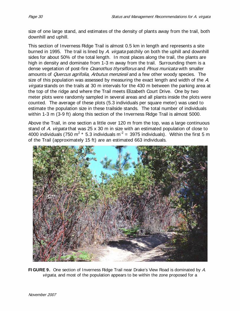
size of one large stand, and estimates of the density of plants away from the trail, both downhill and uphill.
This section of Inverness Ridge Trail is almost 0.5 km in length and represents a site burned in 1995. The trail is lined by A. virgata patchily on both the uphill and downhill sides for about 50% of the total length. In most places along the trail, the plants are high in density and dominate from 1-3 m away from the trail. Surrounding them is a dense vegetation of post-fire Ceanothus thyrsiflorus and Pinus muricata with smaller amounts of Quercus agrifolia, Arbutus menziesii and a few other woody species. The size of this population was assessed by measuring the exact length and width of the A. virgata stands on the trails at 30 m intervals for the 430 m between the parking area at the top of the ridge and where the Trail meets Elizabeth Court Drive. One by two meter plots were randomly sampled in several areas and all plants inside the plots were counted. The average of these plots (5.3 individuals per square meter) was used to estimate the population size in these trailside stands. The total number of individuals within 1-3 m (3-9 ft) along this section of the Inverness Ridge Trail is almost 5000.
Above the Trail, in one section a little over 120 m from the top, was a large continuous stand of A. virgata that was 25 x 30 m in size with an estimated population of close to 4000 individuals (750 m2 * 5.3 individuals m-2 = 3975 individuals). Within the first 5 m of the Trail (approximately 15 ft) are an estimated 663 individuals.
FIGURE 9. One section of Inverness Ridge Trail near Drake’s View Road is dominated by A.
virgata, and most of the population appears to be within the zone proposed for a
November 2007

Status and Management Recommendations for A. virgata Page 31
fuelbreak treatment. The 0.5 km section of the trail contains the largest extant population.
To estimate potential densities of A. virgata in this stand beyond from the first several meters, 6-belt transects were randomly placed along the Trail using a random number table. Four of these went downhill (odd numbers selected) and two went uphill (even numbers selected). The number of individuals of A. virgata were counted in 5 x 5 meter plots to estimate the number of individuals near the Trail (roughly 0-5 m, 5-10 m, and 10-15 m perpendicular to the Trail). Individuals of A. virgata were patchily distributed away from the Trail, with numbers of individuals in the last 5 x 5 m plots ranging from 0-22 individuals. Average densities from these 3 sections of the belt transects were used to estimate potential size of the population along the Trail separate from the Trailside stands and the one large stand above the Trail. The estimated density of A. virgata was 0.81 individuals per m2 in the first 5 m from the Trail (first 15 ft), 0.40 in the second 5 m, and 0.36 in the third 5 m section.
Using these densities, and combining these data with the above estimates, the size of the population along this 430 m length of the Inverness Ridge Trail is a little over 12,000 individuals. This represents the largest extant population of A. virgata globally, or over two thirds of all known living individuals. About 6400 individuals are found within the first 5 m (15 ft) of the trail or 58% of the local population, in excess of a third of the global population.
B. Summary of Total Range and Extent of Arctostaphylos virgata populations
While the population sizes given above represent only best estimates, they do give appropriate rankings for the sizes of populations and allow interpretation of the global extent of Arctostaphylos virgata.
In areas that have not been subject to fire in the last 50-60 years, Arctostaphylos virgata populations are declining. The area above Muir Woods was the type locality and was extensively collected prior to the 1940’s. Now only a few individuals can be found due to the increase in forest cover, especially Douglas-fir. Regionally, areas have been lost in the last two decades to invasion of former chaparral stands by Douglas-fir (Pseudotuga menziesii) along San Geronimo Ridge, Bolinas Ridge and parts of Inverness Ridge (Horton et al. 1999, Dunne and Parker 1999). Only within the section of Inverness Ridge that burned in the 1995 fire are there new and dense populations of Arctostaphylos virgata.
The global population size of Arctostaphylos virgata is estimated to be close to 17,000 individuals (Table 1).
November 2007

Page 32 Status and Management Recommendations for A. virgata
TABLE 1. Estimates of population sizes of Arctostaphylos virgata based on field data, observations, or notes and data supplied by Point Reyes National Seashore such as the Phytosphere survey. Numbers listed are the larger of estimates given in the text.
Estimated Population Size
Location
20 San Geronimo Ridge 20 Mt. Tamalpais above Muir Woods 600 Bolinas Ridge
Inverness Ridge 500 N. of Sir Francis Drake Blvd 500 Just S. of Sir Francis Drake Blvd
15,000 Inverness Ridge/Drake’s View region 250 Fire Lane Trail 200 Southern Inverness Ridge
17,090 TOTAL
C. Comparisons of Populations in PRNS vs. Other Locations
Most of the individuals of Arctostaphylos virgata lie in lands managed by PRNS. To provide an impression of the proportion, Table 2 divides the population clusters mentioned above into areas managed by PRNS and other agencies or private holdings.
TABLE 2. Estimates of population sizes of Arctostaphylos virgata based on field data, observations, or notes and data supplied by PRNS such as the Phytosphere survey. Numbers listed are the larger of estimates given in the text. Data are the same as in Table 1, separating out PRNS-managed locations.
Estimated Population
Size PRNS
managed
Estimated Population
Size other
management
Location
0 20 San Geronimo Ridge 0 20 Mt. Tamalpais above Muir Woods
550 50 Bolinas Ridge Inverness Ridge 0 500 N. of Sir Francis Drake Blvd
200 300 Just S. of Sir Francis Drake Blvd 14,500 500 Inverness Ridge/Drake’s View region
250 0 Fire Lane Trail 200 0 Southern Inverness Ridge
15,700 1390 TOTAL
November 2007
Status and Management Recommendations for A. virgata Page 33
Table 2 suggests that PRNS has management control over 92% of the extant populations of Arctostaphylos virgata, principally due to the large and highly dense post-fire populations.
D. Existing Threats to Populations
Currently, the greatest adverse impact has been the increase in the density and cover of Douglas-fir throughout the range of the species. This has resulted in declining populations at almost all locations, but especially above Muir Woods, San Geronimo Ridge, Bolinas Ridge and the southern part of Inverness Ridge. The fact that Arctostaphylos virgata and Pseudotsuga menziesii share mutualistic fungi contributes to the invasion and establishment of Douglas-fir in the stands of manzanita (Horton et al. 1999, Dunne and Parker 1999).
The loss of A. virgata also is exacerbated by its distribution. Arctostaphylos virgata is differentially associated with the edges of forests and not with open chaparral areas. Consequently, these tend to be the first sites invaded by trees from the forests. Along Bolinas Ridge, this can be observed clearly, as most individuals remaining are adjacent to forest patches, roadways and trails while the extensive stands of A. sensitiva and A. glandulosa subsp. glandulosa are found farther away in most cases.
This process can be described on the one hand as a natural process of forest invasion into chaparral at this latitude, but also as an anthropogenic process in that natural wildfires have been suppressed in the region. The first MMWD Vegetation Management Plan (1995) had a section on wildfire history that mentioned the ignition of 6 fires by lightning in 1969 along Bolinas Ridge. These were suppressed by firefighters. Had the fires not been put out, Arctostaphylos virgata might have a considerably larger population along the Ridge, and the Douglas-fir a much smaller population. The suppression of natural fire regimes is a principal contributing factor to the decline of A. virgata.
Another threat is the coincidence of the distribution of this species (principally along ridges) and the tendency of humans to place houses, fire roads and trails along ridges. A large number of individuals of A. virgata, C. masonii and, C. gloriosus var. exaltatus that formerly were found along Bolinas Ridge in the 1980’s have disappeared perhaps due to road-side clearing and/or shading. Some individual A. virgata along Inverness Ridge Trail in PRNS appear dead and show evidence of having been poorly pruned.
Another threat is global climate change. At this point, the direction climate may take along the coast is not clear, although the Superintendent of PRNS (Neubacher 2007) testified to Congress recently that in two of the last three years, there was a considerable drop in the number of fog days at the park. Counter to this is that less fog and more heat may provide more opportunity for wildland fire that might regenerate populations of the species.
November 2007
Page 34 Status and Management Recommendations for A. virgata
E. Potential, Future Concerns
Trail maintenance, trail rerouting, and fire management projects by PRNS for fuel reduction or firefighter access (Agee et al. 2000) at PRNS could directly impact populations of A. virgata because of the differential distribution along ridgelines coincident with trails, road and housing. These reduction treatments could also open up the habitat to nonnative and invasive species (Zedler and Scheid 1988, D’Antonio et al. 1993, Tyler and Odion 1996, Holl et al. 2000, Merriam et al. 2006). Fuel breaks have been specifically studied in the context of invasive species, and fuel breaks within chaparral sites contained more invasives than forest sites, and hand cut fuel breaks were among the most invaded (Merriam et al. 2006).
In addition to PRNS projects, park staff has noted that the Inverness Ridge Trail in the vicinity of Paradise Ranch Estates is frequently subject to ad hoc pruning by trail users. More worrying are the extensive, illegal side trails that have been constructed by unknown persons taking off from the Inverness Ridge Trail northeast through extensive patches of A. virgata, ending up at a private parcel at Paradise Ranch Estates. In 2006, substantial damage was done to several A. virgata populations on Bolinas Ridge by unsanctioned mountain bike trail construction and trail clearing and growing plot clearance by large-scale marijuana growers operating at considerable distances from established trails. This resulted in the loss of and/or damage to many individual plants. Law enforcement staff makes every possible effort to apprehend any individuals engaged in these destructive and illegal activities.
A secondary impact from the invasion on nonnative species in these fuel breaks is the potential for significant modifications of fire regimes (Brooks et al. 2004). Common invasives, especially nonnative grasses, usually bring a finer fuel that increases the potential for fires (D’Antonio and Vitousek 1992, D’Antonio 2000, Brooks et al. 2004). Increases in fire frequency would begin to degrade the plant communities involved in maritime chaparral and closed-cone bishop pine forest, especially the dominant, obligate seeders in these systems (Syphard et al. 2006).
Besides direct removal of individuals and the possible facilitation of invasive species, fuel management by the reduction of Arctostaphylos virgata populations may have considerable long term impact. The populations within the burn perimeter of the Vision Fire are only twelve years old (2007). They are obligate seeders, meaning they have to have time to build up their dormant, persistent, soil seed banks in order to reseed and survive fires. There are no data on how long species like this need for a seed bank to accumulate that can successfully maintain future populations, but estimates have ranged in the 10-20 year or more ranges (Keeley 1977, Parker and Kelly 1989, Zedler 1995, Syphard et al. 2006). With no data on seed bank accumulation specifically for A. virgata, it could be that 20 or more years may be required for an adequate seed back to build up. Under this scenario, impacts to plants prior to 20 years could have long-lasting impacts on both the quantity of seeds and the genetic variation in the seed bank.
November 2007
Status and Management Recommendations for A. virgata Page 35
V. MANAGEMENT RECOMMENDATIONS
FOR ARCTOSTAPHYLOS VIRGATA IN PRNS
A. Current Management Practices for Arctostaphylos virgata
Current management for A. virgata takes two tacks: full avoidance of impacts to the species wherever feasible or, where avoidance is not feasible, implementation of the pruning guidelines developed for A. virgata.
1. Wildland Urban Interface Projects on Non-Federal Lands
The current management practices for A. virgata were originally developed by PRNS staff that had the responsibility of providing environmental clearance for fuel reduction projects on private lands and roads that received NPS funding through the wildland urban interface (WUI) program of the National Fire Plan. Many of these projects in the Inverness Area were on lands supporting A. virgata.
The National Fire Plan projects were implemented from 2002 to 2006. Environmental clearance included National Environmental Policy Act (NEPA) conformance and consultations with the US Fish and Wildlife Service which administers the Endangered Species Act (ESA). Though CNPS species do not have legal status under NEPA, PRNS followed the guidance in the NPS Management Policies which do recommend consideration be given to state and locally-listed species within the parks. PRNS staff applied this same guidance to proposed projects on private lands and developed mitigation measures for A. virgata.
Since many of the Inverness projects involved roadside fuel reduction and shaded fuel breaks, A. virgata was frequently encountered during pre-project surveys. Where A. virgata comprised most or much of the roadside or ridgeline vegetation, adequate fuel reduction could only be successful if A. virgata could be pruned to reduce overall fuel loading. The pruning guidelines were developed by NPS botanists and reviewed by experts from academia and the CNPS. The pruning guidelines are included as Appendix D to this report.
Pruning has the advantage of reducing fuel near the ground surface, yet permitting the plants to survive, to continue to reproduce and to continue adding seed to a soil seed bank. Risks are that plants may get over-pruned and die back on occasion. Plants along Vision Road appeared to be vigorous 2 years following pruning but, along Inverness Ridge Trail, poorly executed pruning has resulted in dead and dying plants along the trail corridor. It’s difficult to determine if badly pruned plants are the result of PRNS annual trail maintenance or independent pruning by park visitors.
The pruning guidelines were applied to shaded fuel breaks on the boundary of the Seahaven subdivision and Tomales Bay State Park, the westernmost parcels of Paradise Ranch Estates, the much of the northern boundary of Paradise Ranch Estates. Roadside fuel reduction was carried out in Paradise Ranch Estates, on Vision Road,
November 2007

Page 36 Status and Management Recommendations for A. virgata
within the Seahaven subdivision, the Shell Beach subdivision and along many other shorter residential roads in northern Inverness. The following mitigation measures applied to projects that did not permit the removal of individual A. virgata shrubs but permitted complete avoidance or pruning per the pruning guidelines (see Appendix D).
NPS staff will coordinate with the Project Manager to conduct training for contractor crews before beginning of work.
The Project Manager will ensure that the guidance developed by the NPS for pruning Arctostaphylos virgata is strictly followed.
Definitive identification of the manzanita species will be the responsibility of the NPS monitor.
[Paradise Ranch Estates Fuel Reduction] The Project Manager will ensure that no trimming of Arctostaphylos virgata plants occurs with the sole exception of where plants overhang the actual roadway.
2. Trail Maintenance in PRNS
PRNS staff is directed to use the pruning guidelines for trails, such as the Inverness Ridge Trail, that require cutting back A. virgata. Trimming in 2006-2007 appears not to have conformed to this guidance as poorly made cuts were in evidence when visited by PRNS staff and the contractor during a site visit in preparation for this report. The ad-hoc pruning may also be the result of unsanctioned pruning by hikers and horseback riders. Trails in areas with Marin manzanita are maintained by PRNS trails staff using hand tools such as chainsaws, loppers and clippers and performed in accordance with the PRNS Pruning Guidelines.
3. Roadside Maintenance in PRNS
Roadside mowing along paved roads in PRNS is conducted either by Marin County crews or PRNS maintenance staff. Park staff has seen individual A. virgata plants that have been damaged or destroyed by routine roadside maintenance of paved roads performed by Marin County. For unpaved roads, such as the MMWD side of the Bolinas Ridge Fire Road, MMWD and NPS have flagged A. virgata plants prior to treating the roadside with a rotating mastication blade. Crews were instructed to have one member looking ahead of flagged plants to notify the operator and ensure that no machine cuts would be made A. virgata. A proposed project for the NPS side of Bolinas Ridge Fire Road is designed to accomplish routine road maintenance objectives as well fuel reduction objectives along the ridge top. This project is further described below.
4. Fuel Reduction Projects in PRNS
PRNS is considering the following fuel reduction projects for Bolinas Ridge Fire Road and the Inverness Ridge Trail from the trail corridor east to the boundary of the park and private parcels in Paradise Ranch Estates. These fuel reduction areas would require maintenance on a multi-year interval depending on vegetation growth rates subsequent to the initial project.
November 2007

Status and Management Recommendations for A. virgata Page 37
a. Bolinas Ridge Fire Road
The west side of the Bolinas Ridge Fire Road is managed by the NPS; the MMWD manages the east side of the Fire Road. The Fire Road is at the top of slope leading up from Highway One. This ridge could be critical for preventing fire spread either east from Olema Valley or west from MMWD lands. The traffic levels along Highway One make this roadway a potential source for either an inadvertent (machinery derived), or deliberate ignition (cigarette toss, arson) which could spread rapidly upslope through the fine fuels towards the Bolinas Fire Road and the watershed lands and residential areas beyond. Although there is a lower likelihood of ignition on the east side of the ridge, under typical fire weather conditions, easterly, or foehn, winds could bring fire down into Olema Valley across Bolinas Ridge from MMWD property. Because this ridge provides a potential holding point for fire spread in either direction and also provides important access, the NPS fuels technician proposes to create a zone of reduced fuels – a shaded fuel break -- at the top of slope. This fuel break will serve as defensible space, with reduced fuel loading, from which a suppression action could be staged by firefighters.
For this fuel break, the fire management fuels specialist proposes to selectively reduce vegetation within 60 feet of the fire road in areas forested with Douglas-fir and within 30 feet of the fire roads in areas where the roadway is bordered with chaparral. In the forested areas, trees would be thinned and limbed up to reduce fire spread into tree crowns. In chaparral, selective removal of plants would favor retaining A. virgata and rare ceanothus species wherever feasible to achieve the necessary reduction in fuel loading to meet project objectives. Work would be conducted by the NPS fuels crew using hand tools such as chainsaws, pole saws, and loppers. Debris would be processed by a chipper and chips broadcast on site.
The fuel break would extend from the intersection with Bolinas-Fairfax Road on the south end to its terminus at Sir Francis Drake Blvd. on the north end. All areas of potential habitat along the Bolinas Ridge Fire Road have been surveyed for A. virgata. Only the first three miles on the southern end of the ridge from Bolinas-Fairfax Road intersection to the junction with McCurdy Trail has A. virgata. Most of the A. virgata individuals along this section are found in chaparral habitat.
b. Inverness Ridge Trail Wildland Urban Interface
At the western end of Paradise Ranch Estates, PRNS fire management staff proposes to reduce fuel densities from the Inverness Ridge Trail east to the boundary with private parcels. Fuel reduction would take the form of thinning stands of Bishop Pine reproduction and Ceanothus thyrsiflorus and/or cutting to create cleared areas between discrete denser smaller stands of these species to reduce overall fuel continuity and loading in this interface area between homes and edge of the park. Cut vegetation could be chipped and broadcast onsite or be piled in stacks for burning during the winter. In the majority of this ~5-8 acre area, there is sufficient pine and ceanothus to avoid having to thin A. virgata. In thickets of A. virgata where other plant species
November 2007

Page 38 Status and Management Recommendations for A. virgata
would not provide adequate fuel reduction, the NPS proposed that A. virgata would be pruned or wholly removed to achieve the necessary fuel reduction.
Fuel reduction along the Inverness Ridge Trail is also proposed by the NPS to provide ingress for its firefighters in the event of a wildfire with potential to burn into Paradise Ranch Estates. The ingress would provide firefighters with an anchor point from which to construct a wider fire line and/or from which to set a backing fire downslope. The trail ingress also would intersect an emergency vehicle egress route that will be constructed from a previously cleared PGE maintenance corridor under a power line that connects the end of Elizabeth Court to Sunnyside Drive, providing an evacuation route for residents that would connect the extreme western edge of the subdivision to the wider safer fire road in PRNS.
The proposed project would reduce the density of vegetation on both sides of this 2.4 kilometer (1.5 mile) stretch of trail. Approximately 0.25 kilometers of the trail has a significant A. virgata population on both sides. Because of the large number of A. virgata in this section, a definitive design for fuel reduction zone was not selected pending the recommendations from the A. virgata workshop held in June, 2007. The minimum prescription needed for the purposes of the PRNS fire management branch would be selective clearing of plants, favoring A. virgata and any rare ceanothus species, 10 feet on either side of the Inverness Ridge Trail. Where A. virgata is retained within the first 10 feet of the Trail, vegetation would be cleared within a radius roughly equivalent to the height of the A. virgata plant retained. So a 6-foot tall A. virgata located within 10 feet of the Inverness Ridge Trail would have a clearing of approximately 6 feet encircling it.
Maintenance to the PGE power line corridor from the end of Elizabeth Court to Sunnyside Drive would not require pruning or removal of A. virgata. Vegetation is primarily Bishop Pine, ceanothus and huckleberry.
In areas where homes are closer than 100 feet to the PRNS boundary, a radius sufficient to provide the homeowner 100 feet of reduced fuels would be cleared on the PRNS side of the boundary. Clearing the required defensible space for homes was not expected to result in the removal of individual A. virgata plants. Clearance within private parcels is the responsibility of the property owner. For example, if a home is 20 feet from the PRNS boundary, the park would selectively clear vegetation within a radius that provides the additional 80 feet of defensible space. Four homes are adjacent to this portion of the trail and three are sited at the top of slope above the Inverness Ridge Trail. All homes are among those rebuilt following the 1995 Vision Fire.
5. Prescribed Burning in PRNS
A fire line was previously cut through A. virgata on Bolinas Ridge in the late 1990’s or early 2000’s in anticipation of a prescribed burn that was never conducted. There are currently no plans for a prescribed burn in areas of the park with A. virgata. Restricted acreage research burns would be permissible under the current FMP.
November 2007
Status and Management Recommendations for A. virgata Page 39
6. Other Operations in PRNS
Future maintenance projects, such as trail rerouting, or road maintenance could occur in areas with A. virgata. These could require pruning and/or removal of plants for implementation.
B. Recommended Best Management Practices (BMPs)
1. Routine Trail Maintenance
Along recreational trails, plants will continue to grow into the trail area. Current trail maintenance efforts should be effective with a few modifications. The guidelines implemented along the upper portion of Vision Road appear effective in pruning particular individuals that occur along trails. Because these plants can grow tall, pruning should be permitted to create a canopy of manzanita over the trails. Plants other than A. virgata should be thinned first; among trees, bishop pine should be thinned first, retaining Quercus agrifolia (coast live oak) and Arbutus menziesii (madrone) differentially. One area of contention in the one-day expert workshop is fuel reduction along the Inverness Trail. Workshop participants felt that the trail should be left as a recreational trail and not relied on as a firefighter access trail because of its distance from the adjacent residences. If access during fires is required, then the trail could be moved upslope (See recommendations under fuel reduction zones for an alternative). Plants in some areas (Bolinas fire road) require flagging; biologists should accompany trail maintenance crews on Inverness Ridge Trail, Drake’s View Trail and other sites. Note that trail relocation may have other significant impacts. Specific additional recommendations are to utilize current practices with these modifications:
a. Portions of trails containing Arctostaphylos virgata (or other species of concern) should be mapped by GPS coordinates and GIS maps.
b. Individual plants and stretches of plants should be clearly flagged prior to the beginning of any work that could impact rare plants.
c. These mapped sections of trails should be designated “trail areas of special concern”. Crews should be provided with maps indicating these sections so they will know where special mitigation measures are required. Crews should be trained prior to any work at the site concerning the importance of these plants, their locations in the park, rare plants identification, the implementation of mitigation measures, and monitoring requirements.
d. Monitors should be present when routine maintenance goes into these sections of trails.
November 2007

Page 40 Status and Management Recommendations for A. virgata
2. Roadside Fuel Reduction, Mowing and Maintenance
Roadside fuel reduction requires advance flagging of Arctostaphylos virgata along Sir Francis Drake Road‡; Mt. Vision Road, subdivision roads within the communities of Inverness and Inverness Park and the Bolinas Ridge Fire Road. Ceanothus masonii and C. gloriosus var. exaltatus also occur along Bolinas Ridge and require flagging as well. Onsite monitoring of fuels crews by a botanist will be critical given the loss of considerable number of individuals during the last 20 years along Bolinas Ridge Fire Road. Pruning guidelines for A. virgata may be effective in these areas (see Appendix D). These should not be implemented on Ceanothus species given their greater sensitivity to these actions without research conducted prior to these actions. Given the sparse number of individuals of all species of special concern (A. virgata, Ceanothus species) along roadsides, all individuals should be conserved and left fully intact. Any plant density goals within the treated roadside should focus on other plant species. Overshading, especially of the Ceanothus species, should be prevented. Because roadside maintenance generally involves heavy equipment, biological monitors should accompany those working with masticating equipment. Active training of crews prior to their deployment might be advantageous to provide understanding of special tactics, what and how to avoid these plants. In addition to current practices, these additional actions are recommended:
a. Sites along roads containing Arctostaphylos virgata (or other species of concern) should be mapped by GPS coordinates and GIS maps.
b. Individual plants and stretches of plants should be clearly flagged prior to the beginning of any work that could impact rare plants.
c. These mapped sections of trails should be designated “trail areas of special concern”. Crews should be provided with maps indicating these sections so they will know to apply special mitigation measures. Crews should be trained prior to any work at the site concerning the importance of these plants, their locations in the park, rare plants identification, the implementation of mitigation measures, and monitoring requirements.
d. Monitors should be present when routine maintenance goes into these sections of trails.
e. Overshading trees should be pruned where feasible to prevent shading of the shrub species of concern.
3. Clearing for Fuel Reduction Zones in PRNS
Recommendations here will focus on two sites, the Bolinas Ridge Fire Road and the Inverness Ridge Trail below the closest houses in Paradise Ranch Estates. Most of the following recommendations were developed in the one-day expert workshop (see
‡ In the past, notification to NPS staff prior to mowing has not occurred in time to allow flagging in advance of mowing and plants have been impacted.
November 2007

Status and Management Recommendations for A. virgata Page 41
Appendix C). These areas contain populations of Arctostaphylos virgata, Ceanothus gloriosus var. exaltatus, and Ceanothus masonii. Most workshop participants were concerned that fuel management was taking a priority over a limited and rare biological resource, especially given that participants noted that fire fighters would not be likely to use either the fire road or the trail except under a rare moderate fire condition fanned by prevailing winds.
a. Bolinas Ridge
Workshop participants questioned the value of fuel management along much of Bolinas Ridge Fire Road. The MMWD does not plan to reduce fuels along their side of the Bolinas Ridge Fire Road beyond the roadside clearing requirements in the State Fire Code 4290 and CCR 1270; this considerably reduces the potential for developing defensive space along the fire road.
Treatment options for Bolinas Ridge Fire Road discussed by the workshop focal group were: 1) do nothing; 2) conduct a minimal fuel maintenance program by impacting shrub communities only 10-14 feet away from the edges of the road; or 3) the current proposed actions of clearing/thinning to 30’ in chaparral with clearing/thinning/limbing to 60’ within forests. While forest clearing, thinning and limbing was not an issue among workshop participants, the significant impact on the limited Ceanothus populations was a strong concern. Whether or not isolated individuals, even if flagged, would survive through time, was a debated issue. Because most of A. virgata populations are no longer located within 30 ft of the fire road, impacts on A. virgata would be minimal.
The workshop participants as a whole felt the Bolinas Ridge Fire Road is not effective defensible space in the event of a catastrophic fire. Its strategic benefit is in the protection of the MMWD watershed to the east of the Fire Road and as a location to start a backfire. Option 2 seemed a compromise; however, this option has all the problems of option 3 and provides little benefit for fire fighters. Generally, the group felt option 1 (do nothing other than meeting current state fire codes), as a fuel management tactic, was the best approach.
Workshop participants felt the proposed management activities for the forested sites would not be an issue, with the caveat that Arctostaphylos virgata individuals are concentrated at the edges of these forest patches, and need to be monitored and carefully considered during any fuel clearing activities. Biologists should flag all plants prior to any activities and should accompany crews, even during routine road maintenance.
While workshop participants felt the fire road was not an effective defensive space, the proposed clearing of chaparral areas was not viewed as a problem for A. virgata populations (because of the few individuals affected), but there was more concern about the Ceanothus populations. Because the populations of C. masonii and C. gloriosus var. exaltatus are concentrated within 30 ft of the fire road, fuel management activities would potentially have a substantial, and cumulative, impact on these species.
November 2007

Page 42 Status and Management Recommendations for A. virgata
Ceanothus species also produce persistent soil seed banks that are fire-stimulated by heat; participants expressed concern about a number of issues that lack critical data, such as whether sufficient heat from a wild fire in a cleared management areas would reestablish post-fire populations. Because of their limited extent, some workshop participants felt that areas containing Ceanothus individuals could just be left alone as isolated patches of vegetation while other chaparral areas could be cleared.
As mentioned in the section on Proactive Management Recommendations, the workshop felt that with the declining Ceanothus populations, due to both natural processes of shading and thinning, and road maintenance activities, that other mitigations or research strategies might be considered. For example, the Ceanothus masonii populations have declined precipitously in the last 15-20 years. Fuel cutting along the road edge, followed by prescribed burning might achieve both biological enhancements and fuel issues. Potential negative impacts of such management enhancements might be future trends in the populations, limiting their recovery, as the principal populations are concentrated adjacent to the road, and would always be in a zone requiring fuel reduction under the current fuel management proposal.
The workshop group felt that experiments on clearing, soil disturbance, burning at a smaller scale at first, using an adaptive management approach should be considered before any large scale action of any type occurred. Sites (with multiple block replicates) could be cleared to the ground (as in proposed management), thinned, and have nothing done prior to prescribed burning to assess the longer term impacts of fuels management on the resilience of these populations. Workshop participants stressed that mitigation should be a stipulation for any action, especially given C. masonii is a state listed plant, and C. gloriosus var. exaltatus is also globally declining throughout its range.
NPS staff offered that firebox burning could be a research option but that fire management staff was not planning any large scale broadcast burns for the west side of Bolinas Ridge due to the difficulties presented by the terrain, general inaccessibility of this ridge area, high fuel loading and the extreme value of the resources at risk (watershed to drinking water and residential areas) in case a prescribed fire should escape.
Given these circumstances, the following recommendations are made:
a. As recommended under routine road maintenance; all A. virgata, C. masonii, and C. gloriosus var. exaltatus individuals within 30 ft of the road should be mapped and GPS coordinates determined for generating GIS maps.
b. The best approach, given the plans for the MMWD side of the fire road, would be to do nothing other than normal maintenance.
c. Because no conflict was found with clearing within forested sites, as long as monitors are present and sites containing plants of concern are mapped and
November 2007

Status and Management Recommendations for A. virgata Page 43
individuals flagged in advance of the project start, work in these areas could proceed.
d. Because Ceanothus populations are declining, fuel management goals (short-term) and plant enhancement goals could be simultaneously met using prescribed burning as discussed under Proactive Management Recommendations. The problem is balancing the difficulty of conducting a large enough prescribed burn at this site that would be safe, and the increased animal impacts on seedlings in small burns (up to 100% mortality due to herbivory). PRNS might investigate the feasibility of using a series of sequential small prescribed burns that get carried out along the ridgetop (like large firebox burns), the burns potentially would simultaneously enhance the populations of Ceanothus species, while meeting (exceeding) fuel reduction goals in those areas. If conducted, a series of small burns during prescribed conditions that, added together, might make a ‘large’ burn, is one alternative. These would have to be conducted within the same dormant season, and under conditions that would sufficiently heat the soil to stimulate seed banks of Ceanothus (heat-stimulated). Fuel could be cut and stacked to dry prior to burning, as long as trees and other large pieces were removed to prevent excessive soil fire intensities.
b. Inverness Ridge Trail Site
The focal group discussing fuel management in the 0.5 km stretch of the Inverness Ridge Trail associated with 2 houses on Drake’s View Road came up with a number of options: 1) do nothing; 2) conduct fuel reduction along the boundary adjacent to private property, rather than along the trail; 3) thin/clear to 30’ adjacent to roads; 4) radically thin trail near the houses; 5) clear/thin to 10’ on the current trail; and 6) relocate trail and fuelbreak downslope below the A. virgata populations or along the property line.
The final recommendation by the workshop was to relocate the proposed project upslope to the boundary with private parcels to allow the fuel reduction zone to build upon existing defensible space around the structures (see Figure 9, section A). From the topographic and boundary maps used at the workshop, it appeared that sufficient access for emergency vehicles was provided by this “top of ridge” fuel reduction zone along the common boundary that would serve access purposes for fire crews in the event of a moderate fire approaching Paradise Ranch Estates from the west. In the opinion of the workshop participants, siting at the top of the slope provided safer and more effective ingress/egress for firefighters and for residents while avoiding the loss of 60% of the large population of A. virgata along the Trail. The potential impact to A. virgata from the current NPS proposal was determined by the participants to be unacceptably adverse considering the CNPS rating of this species.
November 2007

Page 44 Status and Management Recommendations for A. virgata
Workshop participants did not otherwise object to thinning (even radical thinning) of Ceanothus thrysiflorus, Pinus muricata and other species below the houses in the areas near the current and proposed roads. Developing the PG&E road for an egress for residents was considered acceptable and appropriate, depending on the density of Arctostaphylos virgata in the areas. Park staff indicated that thinning of the ‘triangle’ area at the end of Elisabeth Court (Figure 9, section B) would need to be considered along with the opening of the PG&E road; workshop participants agreed, depending on the density of A. virgata in the stand.
FIGURE 10. Aerial view of the section of Inverness Ridge Trail containing a large
Arctostaphylos virgata population. Road at top is Drake’s View Road, Sunnyside Drive is at bottom, and Elizabeth Court runs parallel to trail. Section label A is recommendation fuel reduction zone. Section labeled B is another potential fuel reduction zone, depending on density of A. virgata populations. Former PG&E access road lies between areas A and B.
November 2007

Status and Management Recommendations for A. virgata Page 45
Nonetheless, any management action other than no action will have a significant impact on the manzanita population at this site. Workshop participants suggested that there should be some compensatory mitigation. Mitigation might involve enhancing the single large population down the Drake’s View Trail by clearing back pines and other species from the edges of the population, removing pines inside the manzanita population, and allowing normal thinning to occur. Similarly, the population along the Inverness Ridge Trail below the houses could be enhanced by thinning or otherwise removing species other than the Marin Manzanita downslope of the trail to aid in the growth and maturity of the current population, which likely does not yet have a viable soil seed bank that could survive a fire. Thus, recommendations for the Inverness Ridge Trail section between the end of Drake’s View Rd and Sunnyside would be:
a. Leave trail as recreational resource rather than developing it as a fire road.
b. Move fuel reduction/fire-fighter access zone upslope to the boundary with private property to build upon defensible space there and provide the greatest benefits to the homeowners and a safer ingress to firefighters. The Inverness Trail could still be accessible to firefighters on foot, ATV or Bobcat to use to start a backfire.
c. Areas along the boundaries should be surveyed for manzanita and individuals
mapped, as well as along the PG&E access road and the ‘triangle’ area prior to any fuel reduction.
d. In sections of the fuel reduction zone containing A. virgata, use the proposed
approach (originally for the trail) of differentially leaving A. virgata plants and removing other species, in sites too dense for that, thinning to 1x the height of plants and otherwise using pruning guidelines.
e. Whenever PRNS staff or contractors are pruning or removing A. virgata,
biologists and monitors should be present.
f. Mitigation for impact on A. virgata should be developed, including the original trail area and the large stand on Drake’s View Trail.
g. Following any fuel reduction activities, areas of the boundary containing A.
virgata (or Ceanothus gloriosus var. porrectus which may also be there) should be re-mapped and individuals have GPS coordinates.
h. Educational contacts with neighbors should be made to prevent any further trail
pruning or wholesale cutting or fuel reduction actions on park lands except by park employees or contractors.
November 2007

Page 46 Status and Management Recommendations for A. virgata
4. Recommendations for BMPs for Prescribed Burning (planning, site preparation, and day of burn)
See Fuel Reduction/Proactive management recommendations below. 5. Recommendations to Pursue Proactive Population Management If
Warranted
a. Biologists should participate in trail maintenance activities in locations that potentially have rare plants. For example, along both Inverness Ridge Trail and Drake’s View Trail (and especially the latter), considerable numbers of A. virgata have been poorly trimmed or completely removed and stacked. A large amount of cut debris (in some areas mostly A. virgata) along the Drake’s View Trail has been stacked off-trail, in some cases on top of A. virgata individuals. (Ties in with the next recommendation.)
b. Proactive population management was considered at the one-day expert workshop and generated some discussion. Enhancing A. virgata populations away from treatment areas was considered. For example, a large, post-Vision Fire population exists on Drake’s View Trail that has considerable numbers of Bishop Pine within and along the edges. Participants felt that thinning out the pines and reducing their density along the edges would greatly improve the long-term viability of this population. This activity would also heighten awareness among trail maintenance crews of the value of these plants. Other locations with declining populations beneath forest canopies were considered ‘research projects’.
c. While experts did not think fuel management would achieve any effective goals for fire fighting in relation to it’s potential impact on plant populations, the workshop overall felt that PRNS should proactively enhance the populations of Ceanothus masonii and C. gloriosus var. exaltatus along Bolinas Ridge. Should effective, sequential small prescribed burns get carried out along the ridgetop, the burns potentially would simultaneously enhance the populations of Ceanothus species, while meeting (exceeding) fuel reduction goals in those areas. At issue, is the difficulty of conducting a large prescribed burn at this site, and the increased animal impacts on seedlings in small burns (up to 100% mortality due to herbivory). If conducted, a series of small burns during prescribed conditions that, together, might make a ‘large’ burn, is one alternative. These would have to be conducted within the same dormant season, and under conditions that would sufficiently heat the soil to stimulate seed banks of Ceanothus (heat-stimulated).
6. Recommended Monitoring Protocol
The following recommendations were developed in the one-day expert workshop. The Monitoring protocols are divided into two separate categories. Demographic monitoring protocols are for understanding long-term dynamics of populations. Compliance
November 2007
Status and Management Recommendations for A. virgata Page 47
monitoring protocols are to determine impacts from projects on populations that are wholly or in part within the boundaries of the project area.
a. Demographic Monitoring
Demographic monitoring is aimed at understanding trends in the entire population or known populations of a particular species. The focus is on the distribution, abundance and health or vigor of those populations.
1. To monitor distribution, individuals or populations should be mapped with GPS coordinates. Because of the limited distribution of Arctostaphylos virgata, all populations should be surveyed, not only those within PRNS management (Inverness Ridge and Bolinas Ridge) but also above Muir Woods on Mt. Tamalpais and on San Geronimo Ridge. This includes working off-trails as much as possible to conduct surveys. Escorts may be needed to survey areas on Bolinas Ridge, e.g., in areas where illegal activities are known to have occurred. Sites should be monitored every 5 years. Priority would be given to those populations likely to change the most (plants threatened by obvious overtopping from taller species, for example).
2. Changes in abundance can be monitored by setting up permanent plots and conducting a complete census within plots, using personal ID tags on trails and off-trails (with GPS points) for more isolated individuals. Surveying every 5 years would give trends, with changes in frequency depending on other issues, such as obvious shifts in the health of the population or other site changes.
3. Protocols already exist for assessing shrub vigor, for example the CNPS 1-5 rating of full-leafed out canopy to few leaves remaining to dead plants. Health/vigor would be determined at the same time as distribution/abundance data would be collected.
b. Compliance Monitoring
Compliance monitoring would focus on the survival of individuals in project sites.
1. Should fuel reduction be conducted in areas containing focal plants, such as Arctostaphylos virgata or any of the key Ceanothus species, then all individuals should be flagged. Individuals would ideally be provided with individual ID tags for future assessment. Notes would be taken on all actions impacting plants, for example, if they are pruned, when they are pruned, and subsequent survival rates.
2. Vigor assessment should be conducted prior to and following treatments. Subsequently, individuals should be re-assessed for delayed mortality or changes in vigor at 6 months and again at 1 year to be able to adjust or redesign projects before next treatment.
November 2007
Page 48 Status and Management Recommendations for A. virgata
3. Monitoring of flagged individuals through time will determine if or how many flagged plants were damaged/cut down through accidents or by non-park individuals.
4. Changes in the environment resulting from any project activity may affect longer term health of plants, but the direction of that impact (positive or negative) is not known. One strong consideration is to assign a single person to monitor changes, and to chaperone work crews.
5. Finally, management actions could have the potential to facilitate the introduction of invasive species or other impacts (illegal bicycle use following fuel reduction). Assessment and recording of emerging threats to flagged population areas should be conducted more frequently than normal population assessment, for example, new invasive plant or animal species, erosion, new unauthorized trails, etc.
7. Recommendations for Research Topics
Research topics were also developed in the one-day expert workshop. Discussions within the focal group and in open workshop presentation were on research projects that could provide both short-term and long-term answers that managers need to enhance and maintain Arctostaphylos virgata and similar types of species. Below, the results of these discussions are divided into several categories:
Basic background studies or conservation efforts
a. A baseline project that should be considered is to develop a vegetation history for the region and how sites have changed through time.
b. Seed banking at the Rancho Santa Ana seed bank facility.
Population or Ecological Studies of Arctostaphylos virgata or background for management efforts
a. A series of projects involving seed banks were suggested as of high priority. One proposed topic would be to determine sizes of seed banks in older, declining, or completely shaded out populations. The question is, how large are the seed banks, to what extent are there viable seeds remaining, and how long might the seeds remain viable in the soil, prior to a wildfire, before the population goes locally extinct. Any set of experiments would be to determine how long it takes for seed banks to develop in post-fire stands. In the literature, models using 20 yr vs. 25 yr as the time to a reasonable seed bank that can survive fire and reestablish a population show great sensitivity to that 5 year difference. Current post-fire (Vision Fire) populations of A. virgata are only 11 yrs old. Should management be reducing their populations at a time that seed banks have not yet reestablished?
b. A series of demographic based research projects would investigate germination requirements, conceptual demographic models and mechanisms for recruitment
November 2007

Status and Management Recommendations for A. virgata Page 49
(including field experiments) that would realistically permit establishing new populations. Related to the seed bank studies (item #1) would be seed bank projects investigating the rate and variation in seed production and seed fall, and factors relating to seeds surviving predation and other issues long enough to get incorporated into seed banks.
c. Some workshop participants were curious about the population genetics of the different sites, and whether there was much genetic variation among sites. This would have large implications for management. If genetic diversity was large within a post-Vision Fire stand, then thinning could be removing more adaptive combinations. If populations differed considerably, then 1) seed banking at Rancho Santa Ana, and 2) enhancement of declining populations might be a higher priority. On the other hand, if genetic diversity is relatively low within or among populations, then mitigation at one site may be considered more effective for the species globally.
d. What are mechanisms of recruitment and what are realistic options for management? What are the germination requirements? Clearly this species is an obligate seeder and so the general aspects are known. More specifically, can germination be simulated (permitting easier management or mitigation efforts) and how well do seedlings compete with other post-fire responses of species.
e. Seed rain pre- versus post-treatment. In sites in which thinning occurs or is proposed, experiments could determine rates of seed production prior to treatment, and monitor them afterwards. The question concerns whether thinning reduces the potential for seed set (fruit set) and whether there is a larger impact on the potential for seed bank production through time. Thinning may reduce or increase the amount of seed production depending on what processes are limiting in any one year.
Research projects as background for mitigation
a. Another research project might focus on the feasibility of establishing new populations by outplanting. Questions would include, what kinds of habitats might support populations to predict successful locations, what are the characteristics of current suitable sites, how might sites change in the future? Prioritizing sites as potentially high success, moderate and marginal would aid in this process. Described by participants as ‘defensible space for endangered species,’ this project would also have long-term benefits by allowing predictions of how global climate change might impact the overall health and vigor of A. virgata populations, regardless of what managers might do.
b. As thinning out of pines or Douglas-firs in some sites is recommended as mitigation measures for impacts to the Marin Manzanita populations from fire projects, one experiment that should be conducted would be whether the manzanita populations thrive better under full sun versus partial shading from pines. Is there an ideal thinning of overstory that maximizes seed production?
November 2007

Page 50 Status and Management Recommendations for A. virgata
If along the lower slopes of Bolinas Ridge, for example, declining populations of A. virgata were ‘enhanced’ by removal of overtopping tree canopies, how would the established, older plants respond? What would be their survival and reproductive rates compared to similar but untreated areas?
c. Related to establishing new populations is the potential to stimulate existing seed banks and establish a new population from natural seed sources. At issue are the trade-offs involved between size and management control of the treatment area (presumably a prescribed burn) versus processes that would be enhanced by small treatment areas like herbivory. Perhaps current management (no particular action) has more benefits in the long run, as long as wildfire returns to the site before loss of viability of seed banks.
d. Are there benefits to thinning/trail maintenance? Can thinning improve individual longevity/vigor? This would be related to the impact of thinning and pruning on seed production and seed bank formation.
November 2007
Status and Management Recommendations for A. virgata Page 51
VI. LITERATURE CITED
Adams, J.E. 1940. A systematic study of the genus Arctostaphylos Adanson. Jour. Elisha Mitchell Sci. Soc. 56: 1-62.
Anderson, E. 1948. Hybridization of the habitat. Evolution 2: 1-9.
Anderson, E. 1949. Introgressive hybridization. Chapman & Hall.
Axelrod, D. I. 1950. Studies in late Tertiary paleobotany. Carnegie Institution of Washington Publication 590, Washington, D. C.
Axelrod, D. I. 1981. Holocene climatic changes in relation to vegetation disjunction and speciation. Amer. Nat. 117: 847-870.
Axelrod, D. I. 1989. Age and origin of chaparral. In: S. C. Keeley (ed.) The California Chaparral: Paradigms reexamined, pp. 7-19. Nat. Hist. Museum of LA Co.; Los Angeles, CA.
Azevedo, T.E. and D.L. Morgan. 1974. Fog Precipitation in Coastal California Forests. Ecology. 55:1135-1141
Bond, W.J. and J.J. Midgley. 2003. The evolutionary ecology of sprouting in woody plants. Int. J. Plant Sci. 164: S103-S114.
Boykin, L. M., M. C. Vasey, V. T. Parker, and R. Patterson. 2005. Two lineages of Arctostaphylos (Ericaceae) identified using the Internal Transcribed Spacer (ITS) region of the nuclear genome. Madroño 52: 139-147.
Chaney, R. W. and H. L. Mason. 1934. A Pleistocene flora from Santa Cruz Island, California. In Studies of the Pleistocene paleobotany of California. Carnegie Institution of Washington, U.S.A.
Dallman, P.R. 1998. Plant life in the world’s Mediterranean climates. UC Press, Berkeley.
Detling, L.E. 1961. The chaparral formation of southwestern Oregon, with considerations of its postglacial history. Ecology 42: 348-357.
Dobzhansky, T. 1953. Natural hybrids of two species of Arctostaphylos in the Yosemite region of California. Heredity 7:73-79.
Donley, M.W., S. Allan, P. Caro and C.P. Patton. 1979. Atlas of California. Pacific Book Center, Culver City; 191 p.
Eastwood, A. 1905. Arctostaphylos virgata. In: C. S. Sargent (ed.) Trees and shrubs: illustrations of new or little known ligneous plants, pp. 203-205.
Eastwood, A. 1934. A revision of Arctostaphylos with key and descriptions. Leafl. West. Bot. 1: 105-127.
Gottlieb, L. 1968. Hybridization between Arctostaphylos viscida and A. canescens in Oregon. Brittonia 20:83-93.
Hardig, T. M. , P. S. Soltis, D. E. Soltis. 2000. Diversification of the North American shrub genus Ceanothus (Rhamnaceae): conflicting phylogenies from nuclear ribosomal DNA and chloroplast DNA. American Journal of Botany 87: 108-123.
November 2007

Page 52 Status and Management Recommendations for A. virgata
Hileman, L., V. T. Parker and M C. Vasey. 2001. Phylogeny and biogeography of Arbutoideae (Ericaceae); implications for the Madrean-Tethyan hypothesis. Systematic Botany 26: 131-143.
Howell, J. T. 1970. Marin Flora, 2nd edition. University of California Press, Berkeley and Los Angeles, CA.
Ingram, B. L. and D. J. DePaola. 1993. A 4300 yr Strontium-isotope record of estuarine paleosalinity and freshwater inflow record of San Francisco Bay, California. Earth and Planet Sci. Lett. 119: 103-119.
Keeley, J.E. 1976. Morphological evidence of hybridization between Arctostaphylos glauca and A. pungens (Ericaceae). Madroño 23: 427-434.
Keeley, J.E. 1991. Seed germination and life history syndromes in the California chaparral. Botanical Review 57: 81-116.
Keeley, J.E. 1997. Absence of nascent inflorescences in Arctostaphylos pringlei. Madroño 44:109-111
Keeley, J.E. and P.H. Zedler. 1978. Reproduction of chaparral shrubs after fire: a comparison of sprouting and seeding strategies. Am. Midl. Nat. 99: 142-161.
Kennett, J.P. and B.L. Ingram. 1995a. Paleoclimatic evolution of the Santa Barbara Basin during the last 20 ky: Marine evidence from Hole 893A. In: J. P. Kennett, J. G. Baldauf and M. Lyle (eds.) Proc. of the Ocean Drilling Program 146 (Part 2): 309-328.
Kennett, J.P. and B.L. Ingram. 1995b. A 20,000 yr record of ocean circulation and climate change from the Santa Barbara Basin. Nature 377: 510-514.
Kreissman, B. 1991. California: An Environmental Atlas & Guide. Bear Klaw Press. Davis, California.
LaMarche, V.C. Jr, H.A. Mooney. 1967. Altithermal timberline advance in western U.S. Nature 213: 980-982.
Markos, S. E., V. T. Parker, L. Hileman, and M. Vasey. 1999. Phylogeny of the Arctostaphylos hookeri complex (Ericaceae) based on nrDNA sequence data from the ITS region. Madroño 45: 187-199.
Mason, H. L. 1934. Pleistocene flora of the Tomales Formation. Carnegie Institution of Washington Publication 415: 81-179.
McMinn, H.E. 1939. An illustrated manual of California shrubs. J.W. Stacey, San Francisco, CA.
Munz, P.A., D.D. Keck. 1959. A California Flora. UC Press, Berkeley.
Munz, P.A., D.D. Keck. 1974. Supplement to A California Flora. UC Press, Berkeley.
Nobs, M.A. 1963. Experimental studies on species relationships in Ceanothus. Carnegie Inst. Washington Publ. 623. 94 pp.
Parker, V.T. in review. Evolution and radiation of Arctostaphylos and Ceanothus in California chaparral. Fremontia.
Parker, V.T. and MC. Vasey. 2004. Arctostaphylos gabilanensis, a newly described auriculate-leaved manzanita from the Gabilan Mountains, California. Madroño 51: 322-325.
November 2007

Status and Management Recommendations for A. virgata Page 53
Parker, V.T. and V.R. Kelly. 1989. Seed banks in California chaparral and other Mediterranean climate shrublands. In, M. A. Leck, V. T. Parker and R. L. Simpson (eds) Ecology of Soil Seed Banks., pp. 231-255. Academic Press, NY.
Parker, V.T., MC. Vasey, J.E. Keeley. 2007. Taxonomic revisions in the genus Arctostaphylos (Ericaceae). Madroño 54: 148-155.
Parker, V.T., MC. Vasey, J.E. Keeley. in press. Arctostaphylos. The Jepson Manual of Higher Plants of California. 2nd Edition. University of California Press, Berkeley.
Potts, R., A.K. Behrensmeyer. 1992. Late Cenozoic terrestrial ecosystems. In: A.K. Behrensmeyer, J.D.Damuth, W.A. DiMichele, R. Potts, H-D.Sues, S.L. Wing. 1992. Terrestrial ecosystems through time; pp. 419-519.
Raven, P. H. and D. I. Axelrod. 1978. Origin and relationships of the California flora. UC Publ. Bot 72. Univ. Calif. Press, Berkeley.
Schierenbeck, K.A., G.L. Stebbins, and R.W. Patterson. 1992. Morphological and cytological evidence for polyphyletic allopolyploidy in Arctostaphylos mewukka (Ericaceae). Pl. Syst. Evol. 179: 187-205.
Schmid, R., T.E. Mallory, and J.M. Tucker. 1968. Biosystematic evidence for hybridization between Arctostaphylos nissenana and A. viscida. Brittonia 20: 34-43.
Seehausen, O. 2004. Hybridization and adaptive radiation. Trends Ecol.Evol. 19:198-207.
Stebbins, G.L. 1947. Types of polyploids: their classification and significance. Adv. in Genetics 1: 403-429.
Stebbins, G.L. 1950. Variation and evolution in plants. Columbia Univ. Press; NY.
Stebbins, G.L. 1957. The role of hybridization in evolution. Proc. Am. Philos. Soc. 103: 231-251.
Stebbins, G.L. 1971. Chromosomal Evolution in Higher Plants. (New York: Addison-Wesley).
Stebbins, G.L. 1974. Flowering plants: evolution above the species level. Harvard University Press, Cambridge, MA.
Stebbins, G.L. 1980. Polyploidy in plants: Unresolved problems and prospects. Pp. 495-520. In W. H. Lewis (ed.), Polyploidy: Biological relevance. Plenum Press New York.
Stebbins, G.L. 1982. Perspectives in evolutionary theory. Evolution 36: 1109-1118.
Stebbins, G.L., J. Major. 1965. Endemism and speciation in the California flora. Ecological Monographs 35: 1-35.
Templeton, A.R. 1981. Mechanisms of speciation; a population genetic approach. Ann. Rev. Ecol. Syst. 12: 23-48.
Vasey, M.C. and V.T. Parker. 1999. Nascent inflorescences in Arctostaphylos pringlei: response to Keeley and Wells. Madroño 46:51-54.
Wahlert, G. 2005. Phylogenic inference of the genus Arctostaphylos (Ericaceae) using a nuclear and chloroplast gene. Master’s Thesis, Dept Biology, San Francisco State University.
Wells, P.V. 1993. Arctostaphylos. In J.C.Hickman (ed.) The Jepson Manual: Higher Plants of California, pp. 545-563. UC Press, Berkeley.
Wells, P.V. 2000. The manzanitas of California. Published by author.
November 2007

Page 54 Status and Management Recommendations for A. virgata
Wolfe, J.A. 1985. Distribution of major vegetational types during the Tertiary. In: E.T. Sundquist and W.S. Broecker (eds.) The carbon cycle and atmospheric CO2: Natural variations archean to present, pp 357-375. Am. Geophysical Union Monograph 32.
November 2007

Status and Management Recommendations for A. virgata Page 55
APPENDIX A Evolution, Plant Status and Relationships within the Genus
Arctostaphylos – general characteristics. Arctostaphylos (Arbutoideae, Ericaceae) is a recently evolved genus (Hileman et al. 2001), that contains nearly 100 currently recognized taxa (species and subspecies) of shrubs and small trees (Wells 2000, Parker et al. in press). Species of Arctostaphylos generally occur at one of two chromosome ploidy levels (diploid or tetraploid) and in two life history types. One life history type survives fire and resprouts from burls at the base of the main stem (sprouters) while the second life history type lacks burls and is killed by fire (obligate seeders). For both life history types, seeds are dispersed as dormant propagules and accumulate in persistent soil seed banks until stimulated to germinate by a wildfire (Parker and Kelly 1989). Nearly all species of Arctostaphylos have all or a portion of their distribution range within the California Floristic Province. These species are found in a diversity of climates (coastal Mediterranean, maritime fog, inland xeric, high montane), a diversity of communities (sand dunes, chaparral, forest edge, woodlands) and a variety of soil types (serpentines and ultramaphics, volcanics, sandstones, dolomites, oxisols, sands). Arctostaphylos is a classic example of a genus that has radiated in the California flora and illustrates multiple examples of contemporary research issues in systematics and speciation through its combination of high species diversity, endemism, various ploidy levels, different life histories, and recent origin. History of the genus Arctostaphylos evolved at least as far back as the Miocene, 15 million years ago (Stebbins and Major 1965; Raven and Axelrod 1978, Parker in manuscript), which corresponds to a mid-Miocene global warming (Wolfe 1985; Potts and Behrensmeyer 1992). Ten species closely resembling modern taxa are considered to occur in California fossil floras from the Pliocene (approximately 5.4 – 1.6 million years ago) (Chaney and Mason 1934; Mason, 1934; Axelrod 1950). The fossil record indicates that the genus underwent a major radiation in the Pleistocene (1.8 MYA – 10,000 YA) beginning 1.5 MYA based on an increased number of species not seen previously in the fossil record (Raven and Axelrod 1978). This radiation began at about the same time the Mediterranean climate began in California (Raven and Axelrod 1978). Evolution in Arctostaphylos (and another speciose genus in California containing obligate seeders, Ceanothus) corresponded to the new opportunities for speciation as the whole region was folded, faulted, elevated and dissected following the late Pliocene (Axelrod 1981, 1989). As summer-dry Mediterranean climates arose and spread, numerous taxa were eliminated from the region (Axelrod 1989) opening up areas into which chaparral species could spread. Several researchers have suggested that during this time obligate seeders diversified and hybridized to produce clusters of closely related species. The abundance of taxa in Arctostaphylos and Ceanothus result from a mutual interrelationship between fire and life history characteristics in areas of marked
November 2007

Page 56 Status and Management Recommendations for A. virgata
topography and edaphic diversity that became available only in the late Cenozoic (Nobs 1963, Stebbins 1971, Raven and Axelrod 1978, Axelrod 1989). Recent history. While the origin of a Mediterranean-climate, the incredible topographic diversification, and climatic fluctuations produced opportunities for the radiation of new species of Arctostaphylos, many species may still be of dramatically recent origin. A series of climatic fluctuations as recent as the Holocene has been proposed to have had a major impact on patterns of diversification in Arctostaphylos (e.g., Stebbins 1971, 1982, Raven and Axelrod 1978). These climatic fluctuations resulted in the expansion of chaparral north into the Columbia River Basin, followed by a retreat back into California (Detling 1961), stimulating migration for populations adapted to narrow climatic conditions and bringing previously allopatric populations into contact. During such times of rapid change, not only are populations rapidly advance to follow climatic shifts, but they also leave behind relictual populations. Hybridization becomes possible between formerly separated populations as their migrants and relicts overlap, and new recombinants may have a better set of adaptations to local conditions than their progenitors (Anderson 1948, 1949, Stebbins 1950, Stebbins 1957, Templeton 1981, Seehausen 2004). For example, data suggests the San Francisco Bay area was a forested river valley during glacial periods (Axelrod 1989). As glaciers retreated, climates rapidly shifted to conditions generally similar to today’s climate, followed by a rapid shift to much drier and warmer conditions that lasted until around 4000 YBP (xerothermic, altithermic or hypsithermic period; LaMarche and Mooney 1967, Axelrod 1981, 1989, Ingram and DePaola 1993, Kennett and Ingram 1995a, 1995b) subsequently changing back to similar conditions to those currently. Species of Arctostaphylos and Ceanothus were especially favored during this recent xerothermic period (Stebbins and Major 1965, Stebbins 1971, Axelrod 1989) as forests and woodlands retreated to moister sites and fires swept the tree communities. Currently, the San Francisco Bay to Monterey region contains 42 species or subspecies of Arctostaphylos, 32 of which are narrow endemics to sites that were probably forested only 10-20,000 YBP. Ceanothus exhibits a similar pattern in the same region, although not as species rich (Nobs 1963). Stebbins (1982) estimated that the maximum age for many of these narrowly endemic species is 10,000 to 20,000 years. Relict stands of forest, woodland, and savanna within broad tracts of chaparral today attest to the spread of chaparral (Axelrod 1981, 1989). Hybridization and recombination under ecological selection has been given as the principal hypothesis that could account for the rapid radiation in the region (Stebbins 1950, 1971, Nobs 1963, Raven and Axelrod 1978, Axelrod 1981, 1989). As Axelrod (1989) indicated, not only are most of the obligate seeders narrow endemics, but “it is understandable that many of the nonsprouting taxa probably are of Late Pliocene-Quaternary age, a view consistent with the “difficult” taxonomy they present, as well as the numerous varieties recognized in some species.”
November 2007
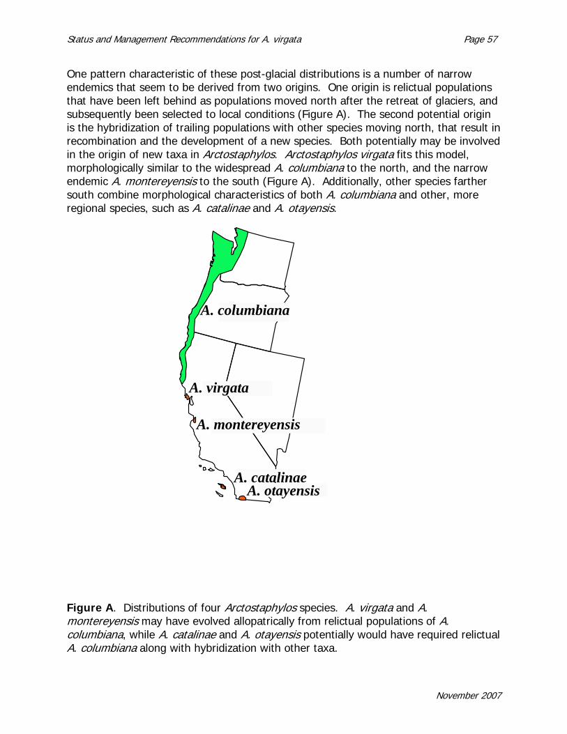
Status and Management Recommendations for A. virgata Page 57
One pattern characteristic of these post-glacial distributions is a number of narrow endemics that seem to be derived from two origins. One origin is relictual populations that have been left behind as populations moved north after the retreat of glaciers, and subsequently been selected to local conditions (Figure A). The second potential origin is the hybridization of trailing populations with other species moving north, that result in recombination and the development of a new species. Both potentially may be involved in the origin of new taxa in Arctostaphylos. Arctostaphylos virgata fits this model, morphologically similar to the widespread A. columbiana to the north, and the narrow endemic A. montereyensis to the south (Figure A). Additionally, other species farther south combine morphological characteristics of both A. columbiana and other, more regional species, such as A. catalinae and A. otayensis.
A. columbiana
A. otayensis A. catalinae
A. virgata
A. montereyensis
Figure A. Distributions of four Arctostaphylos species. A. virgata and A. montereyensis may have evolved allopatrically from relictual populations of A. columbiana, while A. catalinae and A. otayensis potentially would have required relictual A. columbiana along with hybridization with other taxa.
November 2007

Page 58 Status and Management Recommendations for A. virgata
Molecular Sequence Phylogeny. Determining evolutionary relationships (phylogeny) is important in assessing the potential for adaptation, and for managing gene flow among populations. Molecular data recently have been used to reconstruct the evolutionary patterns of both Arctostaphylos and Ceanothus. At this point, a phylogenetic analysis of Arctostaphylos has been derived from ITS nrDNA sequence data (DNA that represents the internal transcribed spacer region of the nuclear ribosome) (Markos et al. 1999, Hileman et al. 2001, Boykin et al. 2005, Wahlert 2005). Evolutionary patterns based on the DNA differ considerably from Wells’ treatments of Arctostaphylos in terms of relationships among species, and subgeneric breakdowns (e.g., Wells 1993, 2000). Figure B illustrates the most current phylogeny containing almost all the taxa, both diploids and tetraploids. One ‘taxon’ is indicated as the ‘grey-leaf haplotype’ and represents 44 different species or subspecies that share the same sequence even though they are morphologically and ecologically quite diverse (Wahlert 2005). Arctostaphylos virgata is found within the ‘grey-leaf haplotype.’ One characteristic of the nuclear ribosomal DNA region is that there are multiple sites within a plant’s genome; populations rapidly undergo a process called ‘concerted evolution,’ which simply means that all individuals rapidly come to have the same sequence; variants are eliminated. If hybridization is a source of new genetic diversity in the origin of species, patterns of relationships will be more difficult to interpret.
November 2007

Status and Management Recommendations for A. virgata Page 59
Figure B. These two trees represent a model of evolution in Arctostaphylos (phylogenies). These phylogenies are based on DNA sequences from a region of the nuclear ribosome sequence that acts as a spacer between sites coding for ribosomal subunits (The ITS region, or internally transcribed spacer region). These phylogenies are based on samples from all species found within Arctostaphylos (Wahlert 2005, Boykin et al. 2005). Arctostaphylos virgata is found within a cluster called the ‘Grey Leaf Haplotype’ that represents a large number of species with the same sequence. Each tree is based on a different statistical evolutionary model, either maximum parsimony or maximum likelihood (ML) with polymorphic taxa removed. (A) Strict consensus of 6420 most parsimonious trees. Bootstrap values given above branches; jackknife values below branches. (B) ML tree. Numbers above branches indicate significant branch support; the larger the number the stronger the support.
November 2007

Page 60 Status and Management Recommendations for A. virgata
Two principal patterns are apparent in the structure of this phylogeny:
1) A two clade structure is the principal feature in the Arctostaphylos phylogeny (Fig.7). This means that the genus appears to be divided into two evolutionary branches, within which species are more closely related to one another than between branches. These trees have relatively high statistical support (posterior probabilities from 70-100 and bootstrap support) for the clade branches (Markos et al. 1999, Boykin et al. 2005, Wahlert 2005). What’s important about his is that sites with two diploid species are almost always from different clades. This suggests that considerable reproductive barriers exist between the two clades, although not complete (Dobhanzky 1953, Gottlieb 1968, Schmid et al. 1968, Keeley 1976, Parker and Vasey, unpublished data). At Point Reyes and the nearby vicinity, in the small clade are A. uva-ursi at Point Reyes, and A. sensitiva along Bolinas Ridge and the fog zone of Mt. Tamalpais. From the larger clade are the diploids A. virgata at Pt. Reyes and nearby, and A. canescens along ridges on the south slope of the top of Mt. Tamalpais, A. montana on the serpentines, and the tetraploid A. glandulosa (both subspecies) in the region. Notice that the diploids from one clade are allopatrically distributed, while the tetraploid A. glandulosa overlaps with diploids of both clades. 2) A second distinctive feature of this phylogeny is how little differentiation in sequence occurs among species within a clade. This pattern suggests, among other things, either a very recent origin or considerable introgression (gene flow) among species followed by concerted evolution of the ribosomal genes. Ceanothus displays a similar difficult phylogeny, with two clades separated by many differences, and shallow branches within a clade (Hardig et al. 2000). Similar to a phylogeny based on ITS for Ceanothus (Hardig et al. 2000), in some cases geographically close taxa have more genetic similarity than sister taxa with distinct morphological apomorphies (e.g., 4-merous A. mendocinoensis and A. nummularia versus A. sensitiva). Within both Arctostaphylos and Ceanothus, there have been a large numbers of species of recent origin, probably since the last glacial. Further work utilizing single or low copy genes should be able to yield better insight into the relationships and evolutionary pathways of species in Arctostaphylos. This approach would also potentially illustrate sources of gene flow or parents of species derived from historical hybrid
November 2007
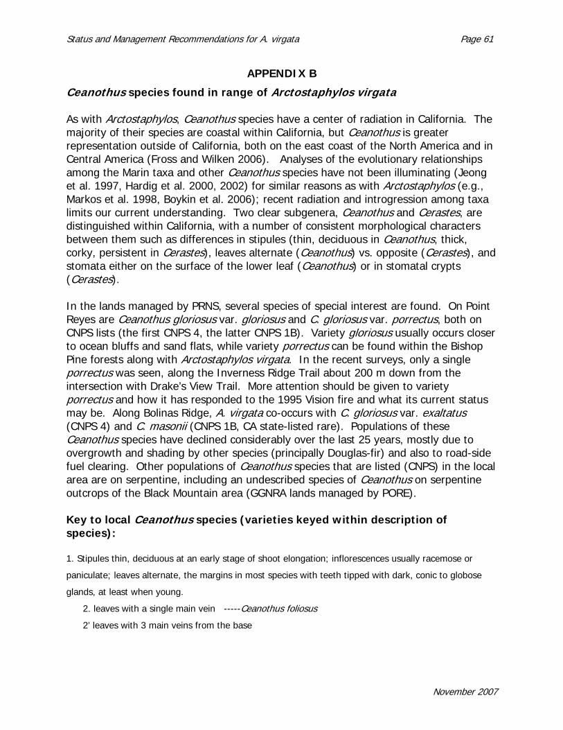
Status and Management Recommendations for A. virgata Page 61
APPENDIX B
Ceanothus species found in range of Arctostaphylos virgata As with Arctostaphylos, Ceanothus species have a center of radiation in California. The majority of their species are coastal within California, but Ceanothus is greater representation outside of California, both on the east coast of the North America and in Central America (Fross and Wilken 2006). Analyses of the evolutionary relationships among the Marin taxa and other Ceanothus species have not been illuminating (Jeong et al. 1997, Hardig et al. 2000, 2002) for similar reasons as with Arctostaphylos (e.g., Markos et al. 1998, Boykin et al. 2006); recent radiation and introgression among taxa limits our current understanding. Two clear subgenera, Ceanothus and Cerastes, are distinguished within California, with a number of consistent morphological characters between them such as differences in stipules (thin, deciduous in Ceanothus, thick, corky, persistent in Cerastes), leaves alternate (Ceanothus) vs. opposite (Cerastes), and stomata either on the surface of the lower leaf (Ceanothus) or in stomatal crypts (Cerastes). In the lands managed by PRNS, several species of special interest are found. On Point Reyes are Ceanothus gloriosus var. gloriosus and C. gloriosus var. porrectus, both on CNPS lists (the first CNPS 4, the latter CNPS 1B). Variety gloriosus usually occurs closer to ocean bluffs and sand flats, while variety porrectus can be found within the Bishop Pine forests along with Arctostaphylos virgata. In the recent surveys, only a single porrectus was seen, along the Inverness Ridge Trail about 200 m down from the intersection with Drake’s View Trail. More attention should be given to variety porrectus and how it has responded to the 1995 Vision fire and what its current status may be. Along Bolinas Ridge, A. virgata co-occurs with C. gloriosus var. exaltatus (CNPS 4) and C. masonii (CNPS 1B, CA state-listed rare). Populations of these Ceanothus species have declined considerably over the last 25 years, mostly due to overgrowth and shading by other species (principally Douglas-fir) and also to road-side fuel clearing. Other populations of Ceanothus species that are listed (CNPS) in the local area are on serpentine, including an undescribed species of Ceanothus on serpentine outcrops of the Black Mountain area (GGNRA lands managed by PORE). Key to local Ceanothus species (varieties keyed within description of species): 1. Stipules thin, deciduous at an early stage of shoot elongation; inflorescences usually racemose or
paniculate; leaves alternate, the margins in most species with teeth tipped with dark, conic to globose
glands, at least when young.
2. leaves with a single main vein -----Ceanothus foliosus
2’ leaves with 3 main veins from the base
November 2007
Page 62 Status and Management Recommendations for A. virgata
3. Current year’s branchlets usually angled often with prominently longitudinal ridges along the
distal internodes -----Ceanothus thyrsiflorus
3’ Current year’s branchlets smooth and cylindrical, not prominently angled or ridged
4. leaf blades usually wavy, sometimes slightly folded lengthwise and weakly concave above,
petioles 1-3 mm long -----Ceanothus foliosus
4’ leaf blades usually flat or slightly convex above, petioles 3-7 mm long -----Ceanothus
oliganthus
1’ Stipules thick and persistent, becoming knob-like and corky, their upper leaf-like portions
disintegrating; inflorescences usually umbellate, solitary or in dense clusters; leaves opposite, the
margins either entire, denticulate or with pale, opaque spinulose teeth.
5. leaf blades with sharply spinulose teeth, leaf blades holly-like, at least above the middle -----
Ceanothus jepsonii
5’ leaf blades margins entire or denticulate, but with the teeth not sharply tipped (not holly-like)
6. leaf blades usually entire margins, if toothed, then fewer than 5 teeth, unevenly or remotely
distributed -----Ceanothus cuneatus
6’ leaf blades denticulate, the teeth evenly distributed along the margin, above the middle or
near the apex -----Ceanothus gloriosus (including C. masonii)
Species descriptions (based on Wilken in Fross and Wilken 2006): Ceanothus cuneatus; Subgenus Cerastes. Erect shrubs, 1-3 m tall; crown open to somewhat dense, hemispheric to broadly obovoid, sometimes mound-like or flat-topped, rarely mat-like; main branches ascending to widely spreading; distal branchlets stiff to somewhat flexible, their internodes 5-21 (-25) mm long, smooth, gray to grayish brown, apressed puberulent to short-villous or tomenthulose, sometimes glabrous; mature bark gray to grayish brown. Stipules thick, persistent, 1-2 mm wide, leaves opposite, evergreen, evenly spaced or clustered at nodes, sessible or the petioles to 2 mm long. Leaf blades 5-25 (-29) mm long, 4-15 (-18) mm wide, oblanceolate to broadly elliptic or orbicular, flat or slightly folded, thick, stiff, one-veined; upper surfaces green, sparsely appressed-puberulent or stigulose to glabrous; lower surfaces paled to grayish green, appearing glabrous except for microscopic tomentulose patches between the secondary veins, the veins often sparsely strigulose; tips obtuse, rounded, or weakly notched; bases tapered to obtuse; margins plane, entire or dentate to denticulate with 3-13 pinulose teeth per leaf. Inflorescences in upper axils of 1- to 3-year old branchlets, umbellate, subsessile, 6-18 mm long; peduncles 2-5 mm long; peduncles and rachises puberulent. Pedicels 4-10 mm long, glabrous; sepals and petals five; perianth and disks white, lavender, or pale blue, sometimes pink. Fruits 4.5-9 mm wide, weakly lobed, brown; lobes smooth, horned above the middle; horns 0.5-2 mm long, erect, smooth to somewhat wrinkled.
November 2007

Status and Management Recommendations for A. virgata Page 63
Ceanothus cuneatus is a broadly defined and widespread taxon. It occurs in the Coast and Cascade ranges, from Benton and Linn Counties, Oregon, south to the lower western slopes of the Sierra Nevada, Coast, Transverse and Peninsular Ranges of California, and the Sierra Juarez and Sierra San Pedro Martir of Baja California, Mexico. This species has considerable morphological and ecological variation (McMinn 1942). Howell (1940) noted geographically consistent variation in pubescence on young branchlets. Ceanothus cuneatus var. cuneatus includes plants with white flowers and entire, oblanceolate to narrowly obovate leaves. Their shape typically ranges from hemi-spheric to obovoid, often with erect to ascending stems and rounded crowns. Variety ramulosus has been applied to plants with lavender to blue flowers and broadly elliptic to broadly obovate, sometimes orbicular leaves, blades 6-19 mm long, with entire to few-toothed margins. The leaf tips on such plants vary from rounded to truncate or slightly notched. Their distribution is restricted to elevations less than 500 m (1650 ft) in coastal mountains from Mendocino County south to the mountains north of San Francisco Bay (including Marin) and disjunctly in coastal San Luis Obispo and Santa Barbara Counties (Hoover 1970). Other varieties also exist, but are outside the range of Marin County. Key to Ceanothus cuneatus varieties in Marin County 1. Most leaf blades oblanceolate to obovate, usually with their length 2 or more times their width, flowers white -----Ceanothus cuneatus var. cuneatus 1’ Most leaf blades broadly elliptic or broadly obovate to orbicular, their length usually less than 2 times their width, sometimes with 1-5 teeth; flowers blue -----Ceanothus cuneatus var. ramulosus Ceanothus foliosus var. foliosus; Subgenus Ceanothus. Erect shrubs, sometimes low growing, 0.5-3.5 (4) m tall; crown open to dense, hemispheric to broadly obovoid, sometimes mound- or mat-like; main branches ascending to spreading; distal branchlets flexible, their internodes 5-14 mm long, smooth, greenish to reddish green, sometimes glaucous, short-villous; mature bark brown. Stipules thin, deciduous. Leaves alternate, the smaller ones often clustered near the base of the lateral shoots, evergreen; petioles 1-3 mm long. Leaf blades 5-19 (-24) mm long, 4-10 (-14) mm wide, elliptic to somewhat oblanecolate or oblong-elliptic, flat to more often wavy, sometimes floded (concave above), somewhat leathery, one-veined, sometimes weakly 3-veined from the base; upper surfaces dark green, glabrous to sparsely puberulent; lower surfaces grayish green, short-villous to glabrous, the veins sparsely to densely short-villowus; tips obuse; bases obtuse to rounded; margins plane to somewhat revolute, entire to denticulate; teeth 31-42 per leaf, with sessile to subsessile, globose to subglobose glands. Inflorescences in upper axils of 1- or 2- year old branchlets, subumbellate to racemose, 6-19 (-27) mm long. Sepals and petals five; perianth and
November 2007

Page 64 Status and Management Recommendations for A. virgata
disks pale to deep blue or purplish blue. Fruits 3-4 mm wide, globose to weakly lobed, slightly viscid when young, dark brown; lobes smooth to weakly ridged; horns absent. This smaller Ceanothus can be found frequently along the Bolinas Ridge fire road as it responds well to disturbance, and is too short to compete in the more mature chaparral off-road. Ceanothus gloriosus and C. masonii; Subgenus Cerastes. Erect, spreading or prostrate shrubs, 0.1-4m tall; crown somewhat open to dense, broadly obovoid, sometimes mound= or mat-like; main branches ascending to widely spreading; distal branchlets flexible to somewhat stiff, their internodes 7-25 (-35) mm long, smooth to angled distally, green to brown or purplish brown, short-villous or puberulent, becoming glabrous; mature bark brown. Stipules thick, persistent, 2.5-4.5 mm wide, often confluent. Leaves opposite, evergreen, evenly spaced, sometimes ascending or erect, subsessile; petioles 1-4 mm long. Leaf blades 7-43 mm long, 4-25 mm wide, broadly elliptic to broadly obovate, sometimes orbicular, flat to slightly wavy, thick, stiff, one-veined; upper surfaces dark green, glabrous, somewhat shiny; lower surfaces green, sparsely strigulose to glabrous, except for microscopic tomentulose patches between the secondary veins; times rounded to truncate or notched; bases tapered to somewhat rounded; margins plane, sometimes thickened, dentate; teeth 9-31 per leaf, spinulose. Inflorescences in upper axils of 1- to 3-year old branchlets, umbellate to subumbellate, 8-16 mm long, sessile to subsessile; peduncles 1-5 m long; penducles and rachses puberulent, becoming glabrous. Pedicels 4-9 mm long, glabrous; speals and petals five; perianth and disks deep blue to bluish purple. Fruits 4-6 mm wide, globase to weakly loabed, viscid to slightly viscid when young, dark brown to black; loabes smooth, sometimes weakly righed, horned above the middle; horns erect, 1-2 mm long, smooth to slightly wrinkled. Prostrate plants, usually less than 30 cm tall, which occur on consolidated sediments of coastal bluffs from Humboldt County south to Marin County are treated as variety gloriosus (Point Reyes ceanothus, glory mat). Erect shrubs, 1-4 m tall, with ascending to widely spreading, elongate branches, belong to variety exaltatus (Navarro ceanothus, glory bush). These plants occur on interior slopes of the North Coast Range from Humboldt County south to Marin County at elevations of 50-500 m (165 – 1650 ft). Both varieties have relatively broad obovate or suborbicular leaf blades with 13-35 teeth per blade. Mound-like plants (30-40 cm high) with leaf blades 10-19 mm long and margins with 9-19 teeth were named variety porrectus. Ceanothus masonii is restricted to the southern end of Bolinas Ridge. Ceanothus masonii is closely related to C. gloriosus and thought by some to be of hybrid origin between variety exaltatus and C. cuneatus var. ramulosus (Nobs 1963). McMinn (1942) considered C. masonii to be closely related to C. gloriosus, especially variety exaltatus, which occurs just north of C. masonii on Bolinas Ridge. Most leaf blades of C. gloriosus var. exaltatus are 13-43 mm long, while those of C. masonii are 7-21 mm long. Nobs
November 2007

Status and Management Recommendations for A. virgata Page 65
(1963) provided evidence showing considerable overlap in many of the characters between the two taxa. Current populations of both C. gloriosus var. exaltatus and C. masonii along Bolinas Ridge are a small fraction of their former size, principally due to shading out by taller plants, mostly Douglas-fir. Varieties of Ceanothus gloriosus and Ceanothus masonii 1. Plants prostrate, mat- to mound-like, less than 0.5 m tall, the main branches spreading to weakly ascending.
2. Most leaf blades broadly obovate to suborbicular, 23-341 mm long, 17-24 mm wide, with 13-31 teeth -----C. gloriosus var. gloriosus 2’ Most leaf blades obovate, narrowly obovate, or oblong-obovate, 10-21 mm long, 5-15 mm wide, with 9-19 teeth -----C. gloriosus var. porrectus
1’ Plants erect, hemispheric to obovoid, 0.5-2 (-3.5) m tall, the main branches ascending to erect.
3. Most leaf blades broadly obovate to suborbicular, sometimes oblong-obovate, 13-43 mm long, 17-22 mm wide, with 13-35 teeth, terminal branches somewhat equal and relatively short, diverging outward and somewhat rigid. -----C. gloriosus var. exaltatus 3’ Most leaf blades obovate to narrowly obovate, 7-21 mm long, 4-13 mm wide, with 9-17 teeth; terminal branches of variable length, ascending to spreading and somewhat flexible -----C. masonii
Ceanothus jepsonii var. jepsonii; Subgenus Cerastes. Erect shrubs 0.5-1 m tall; crown somewhat dense, usually broadly obovoid, sometimes hemispheric or flat-topped; main branches ascending to widely spreading; distal branchlets stiff, their internodes 6-20 mm long, smooth or slightly angled, reddish brown, becoming grayish, appressed-puberulent, glabrous with age, mature bark gray to grayish brown. Stipules thick, persistent, 1.5-2 mm wide. Leaves opposite, evergreen, evenly spaced, somewhat curved and deflexed, subsessile or petioles to 2 mm long. Leaf blades 10-20 mm long, 8-12 mm wide, elliptic to oblong, almost flat to concace above and convex below, often wavy, thick, stiff, one-veined; upper surfaces light green, glabrous; lower surfaces pale yellowish green, appearing glabrous except for microscopic tomentulose patches between the secondary veins; tips sharply acute or rounded; bases rounded; margins thick or slightly revolute, dentate, teeth 7-11 per leaf, sharply spinulose. Inflorescences in upper axils of 1- or 2-year-old branchlets, umbellate, 10-15 mm long sessile to subsessile, peducles 3-10 mm long; peduncles and rachises puberulent. Pedicels 4-8 mm long, glabrous; sepals and petals six, rarely eight; perianth blue to purple blue, the disks often darker. Fruits 5-7 mm wide, globose to weakly lobed, dark brown; lobes
November 2007

Page 66 Status and Management Recommendations for A. virgata
weakly ridged, horned above the middle; horns 1-3 mm long, erect, conspicuously wrinkled. Seeds about 4 mm long, ellipsoid, slightly compressed, dark brown to back. Ceanothus jepsonii occurs in two varieties. The variety jepsonii is found on slopes and ridges on ultramafic, serpentine substrates almost exclusively in Marin County. Variety albiflorus is similar in structure to variety jepsonii, but has white flowers. It occurs from Mendocino and Tehama counties south to Napa and Sonoma. Variety jepsonii occurs adjacent to historic areas with Arctostaphylos virgata near Boot Jack Camp on the south slope of Mt. Tamalpais, and the southern end of Bolinas Ridge. Ceanothus oliganthus; Subgenus Ceanothus. Erect shrubs, often arborescent, 1.5-3.5 m tall; crown open to somewhat dense, obovoid; main branches erect to ascending; distal branchlets what flexible to rigid but not spine-like, their internodes 7-19 mm long, smooth to rough, grayish green to reddish brown, densely to moderately short-villous; mature bark grown or grayish brown. Stipules thin, deciduous. Leaves alrernate, evergreen, evenly spaced; petioles 3-7 mm long. Leaf blades 11-30 mm long, 8-25 mm wide, ovate to elliptic, flat, somewhat leathery, three veined from the base; upper surfaces dark green, almost glabrous to sparsely short-villous, the veins often more densely short-villous; lower surfaces pale green, sometime glaucous, sparsely to densely short-villous, especially on the veins; tips acute to obtuse; bases rounded to subcordate; margins plane, denticulate; teeth 19-71 per leaf, usually with broadly conic to subglobose glands. Inflorescences terminal or in upper axils of 1- or 2-year-old branchlets, racemose, sometimes umbel like, 13-35 mm long, peduncles 5-17 mm long; peduncles and rachises puberultent to short-villous. Pedicels 4-11 mm long, glarous; sepals and petals five; perianth and disks pale to dark or purplish blue, rarely white. Fruits 4-7 mm wide, weakly to deeply lobed, slightly viscid when young, brown to dark brown; lobes smooth, sometimes somewhat wrinkled, ridged at or slightly above the middle or with a dorsal, glandular bulge; horns absent. These taxa are widespread in the Coast Ranges, south to the Transverse and northern Peninsular Ranges of California. The two varieties can intergrade where they meet, and hybrids with other taxa from the same subgenus are reported. Variety sorediatus appears to be the common local variety within the range of Arctostaphylos virgata, but within the Mt. Tamalpais watershed rather than the Point Reyes peninsula. Key to local varieties of Ceanothus oliganthus 1. Branchlet internodes and upper surfaces of leaf blades puberulent to short-villous -----C. oliganthus var. oliganthus 1’ Branchlet internodes and upper surfaces of leaf blades subglabrous to sparsely puberulent -----C. oliganthus var. sorediatus Ceanothus thyrsiflorus; Subgenus Ceanothus. Erect, spreading, sometimes arborescent, to 6 m tall; crown open to compact, oblanceolate to obovoid, sometimes mound-like. Distal branchlets flexible to somewhat stiff, their internodes 12-30 mm
November 2007

Status and Management Recommendations for A. virgata Page 67
long, angled near the tips, green, glabrous to sparsely puberulent; mature bark gray to grayish brown. Stipules thin, deciduous. Leaves alternate, evergreen, evenly spaced; petioles 3-9 mm long. Leaf blades 10-39 mm long, 6-25 mm wide, narrowly to broadly elliptic or ovate, flat, somewhat leathery, three-veined from the base; upper surfaces dark green, glabrous; lower surfaces pale green, sparsely to moderately puberulent or short-villous, the veins often more puberulent than the surfaces between the veins, sometimes stigulose; tips obtuse, bases obtuse to rounded; margins plane to slightly revolute, weakly dentibulate or serrulate with 23-48 teeth per leaf, tipped with broadly conic to subglobose glands when young. Inflorescences terminal or in upper axils of 1- or 2-year-old branchlets, racemose to paniculate, open to somewhat dense, 15-53 (-75) mm long; peduncles 12-33 mm long; peduncles and rachises sparsely puberulent to glabrous. Pedicels 5-8 mm long, glabrous; sepals and petals fire; perianth and disks violet-blue to blue, rarely white. Fruits 2.5-4 mm wide, lobed, viscid when young, dark brown to black; lobes smooth, ridges and horns absent. This widespread species is found on slopes, ridges and flats, on sandy or rocky soils. Found within coastal scrub and maritime chaparral and frequently associated with forests edges or woodlands. Outer coast ranges from inside Oregon south to Monterey for variety thyrsiflorus. In Wilken’s treatment (Fross and Wilken 2006), C. thyrsiflorus now includes variety griseus, the dominant form from Monterey south to Point Conception, Santa Barbara Co (with one disjunct population in NW Baja California, Mexico). This is the common Ceanothus associated with Arctostaphylos virgata within Point Reyes. After the 1995 Vision fire, this species established from dormant persistent seed banks in great numbers, even in sites from which it was not previously known.
November 2007

Page 68 Status and Management Recommendations for A. virgata
November 2007

Status and Management Recommendations for A. virgata Page 69
APPENDIX C
Minutes: Workshop on Arctostaphylos virgata
at Point Reyes National Seashore
6 June 2007, Ft Mason, San Francisco Attendees: Wendy Poinsot (PRNS), Alison Forrestel (PRNS), Tom Parker (SFSU), Gene Colley, (CA Dept Fish & Game), Bruce Delgado (BLM, Ft. Ord), Grey Hayes (Elkhorn Slough NERR), Jon Keeley (USGS, Three Rivers Research Lab), Janet Klein (MMWD), Doreen Smith (Marin CNPS), Mike Vasey (SFSU, UCSC), Jane Rodgers (PRNS), Sue Fritzke (GGNRA), Michael Chassee (GGNRA).
I. Presentations: 1. Introduction: Wendy Poinsot Summary: In the context of Arctostaphylos virgata, the park faces species protection vs. fuels management. Questions to consider: Is active management needed? What best management practices would be recommended? How should we inventory, monitor and manage? To what extent can we maintain natural distribution and abundance? At the same time that parks are entrusted with maintaining populations of rare plants, as federal land managers, they are mandated to reduce federal liability by reducing the risk of wildfires on federal lands in the wildland urban interface (WUI) from spreading to private property. This liability reduction typically involves implementing mechanical fuel reduction projects on both sides of the WUI boundary. In the case of PRNS, this is where populations of Marin manzanita intersect with proposals to mechanically reduce fuels. 2. Current Management Practices: Alison Forrestel A. Trail maintenance: follows standard guidelines for fuel reduction. For sites with
sensitive species, and A. virgata in particular, pruning guidelines have been developed by the NPS in consultation with CNPS. The guideline framework is ‘no removal’, limbing up along major stems, leaving sufficient living branches for health and survival of individuals.
B. Roadside maintenance follows fire department standards and State Fire Code
guidelines (CA Public Resources Code 4290/Code of California Regulations 1270). . C. Fire behavior map: modeling of fire behavior in different areas suggests extreme
fire behavior possible at two locations, at Bolinas Ridge and along Inverness Ridge, especially near the town of Inverness.
November 2007

Page 70 Status and Management Recommendations for A. virgata
Fuel reduction work proposed for Bolinas Ridge Fire Road would remove or reduce the density of vegetation up to 60 ft from the NPS side of the Fire Road in forested areas, (0 ft to 15 ft removing all small trees and shrubs and limbing, while from 15 ft -60 ft limbing lower branches of trees), and clearing and thinning up to 30 ft along the NPS side of the Fire Road in shrub-dominated areas, while flagging and retaining A. virgata, Ceanothus masonii, and Ceanothus gloriosus var. exaltatus individuals. Bolinas Ridge Fire Road is considered an important access road and potential site for firefighters to stage a suppression effect that would slow or halt fire progress. . Fuel reduction proposed for a fuel break along the Inverness Ridge Trail would address high fuel loading in NPS lands adjacent to Paradise Ridge Estates and Elisabeth Court. Proposed here is to clear fuels 10 ft on either side of the Trail, thinning to one plant per 4 m2 (thinning to a distance equal to one plant height between individuals), preferentially retaining Arctostaphylos virgata. Also potentially thinning up to 100 ft in some areas associated with Elisabeth Court and widening an old PG&E maintenance road as an alternative escape route for some residents. 3. Status of Arctostaphylos virgata populations, abundance and distribution, status of Ceanothus masonii and Ceanothus gloriosus var. exaltatus populations: Tom Parker Arctostaphylos virgata is a maritime species endemic to Marin County. Populations are historically distributed in 4 areas: above Muir Woods, San Geronimo Ridge, Bolinas Ridge and Inverness Ridge. Surveys of the Muir Woods watershed indicates only a few remaining individuals; others have succumbed to forest growth, overtopping and shading. Similar conditions can be found on San Geronimo Ridge and much of Bolinas and Inverness Ridges. These can all be considered ‘old growth’ sites for this chaparral species, the most recent fire having occurred 60 years ago. The post-Vision Fire area along Inverness Ridge and some associated secondary ridges exhibit some high-density, fire-initiated populations. The area with the largest number of individuals occurs on Inverness Ridge near the intersection with Drake’s View Trail. In one stretch to the north of the intersection, a large population of several hundreds of individuals occurs; one post-fire stand along Drake’s View Trail alone contains roughly several thousand individuals, and along Inverness Ridge Trail between the intersection with Drake’s View Trail south to where the trail crosses an unimproved road is a high density population numbering roughly 12,000 individuals. A global estimate for the total A. virgata population is a little over 17,000 individuals. Approximately 92% of these are on property managed by PRNS. Therefore, approximately two-thirds of the global population (or roughly 12,000 plants) occur on the single stretch of Inverness Ridge Trail below two houses on Drake’s View Road.
November 2007

Status and Management Recommendations for A. virgata Page 71
The minimum prescription proposed for the purposes of the PRNS fire management branch would be selective clearing of plants, favoring A. virgata and any rare ceanothus species, 10 feet on either side of the Inverness Ridge Trail. Where A. virgata is retained within the first 10 feet of the Trail, vegetation would be cleared within a radius roughly equivalent to the height of the A. virgata plant retained. So a 6-foot A. virgata located within 10 feet of the Inverness Ridge Trail would have a clearing of approximately 6 feet encircling it. Based on this proposal, roughly 40% of A. virgata of this largest remaining population (or 28% of the global population) would be eliminated as a result of the project. The management fuel reduction framework for Bolinas Ridge would have a minor impact on A. virgata, but approximately 90% of current known individuals of the two Ceanothus species on Bolinas Ridge would occur within the management zone. Assuming that flagging individuals proves ineffective in protecting the plants due to accidents or illegal activities, isolated individuals of the Ceanothus populations would be impacted.
II. Discussion of Presentations (morning session) Summary of principal points: Under extreme fire behavior, the consensus of the group was that neither Bolinas Ridge Fire Road nor the zone of reduced fuels along the Inverness Ridge Trail would be adequate defensible spaces for fire fighters to launch suppression actions in the event of a fire, especially one with an intensity equivalent to the 1995 Vision Fire. Bolinas Ridge: The Marin Municipal Water District (MMWD) does not plan to reduce fuels along their side of the Bolinas Ridge fire road beyond the roadside clearing requirements in the State Fire Code 4290 and CCR 1270. Discussion was wide-ranging and tended towards questioning the value of fuel management in that location. While forest clearing, thinning and limbing wasn’t an issue, the significant impact on the limited Ceanothus populations was a strong concern. Whether or not isolated individuals, even if flagged, would survive through time, was a debated issue. Inverness Ridge Trail: Inverness Ridge Trail was the focus of the majority of the discussion throughout the morning. The fact that the Arctostaphylos virgata population here represents roughly 60% of the total extant global population was a major concern. The proposal to clear and thin along the trail below the 2 houses on Drake’s View would result in losses of approximately 40% of the 12,000 plants in this largest known remaining stand (or 28% of the global population). Most participants were concerned that fuel management was taking a priority over a limited and rare biological resource, especially given that participants noted that fire fighters would not be likely to use the trail except under a rare moderate fire condition fanned by prevailing winds. Of concern were unknown amounts of A. virgata in
November 2007

Page 72 Status and Management Recommendations for A. virgata
adjacent areas, such as the areas around the PG&E road, the ‘triangle’, and the slopes above the road. If the numbers of individuals were low in these adjacent areas, most participants felt this was a reasonable fire safety action. Other issues were the degree to which pruned individuals would successfully survive, expand their canopies, compensate in seed production, etc. While roadside pruning on nearby Vision Road resulted in seemingly successful survival and growth, this contrasted with recent pruning evident along Inverness Trail, though it is likely that this pruning was unauthorized pruning by unknown persons rather than by the Seashore’s trail maintenance staff. An alternative fuel management proposal was suggested by workshop participants, in which the trail below the houses would be left as a recreational/biological resource, and that the park boundary with the houses would be thinned or cleared instead. While a number of A. virgata would also be impacted by this action, participants noted that this alternative yielded a number of benefits. Specifically, a much smaller proportion of the A. virgata population would be impacted and the boundary clearing would occur at the top of the ridge, with the clearings associated with the houses behind that area. Fuel management along the ridge top would translate into a more effective defensible space for fire fighters and residents alike with a smaller impact on A. virgata. Given the degree of potential impacts, discussion at the workshop focused on mitigation for some time. As A. virgata and the Ceanothus species on Bolinas Ridge are all fire-stimulated species, small prescribed burning projects were discussed. However, it was pointed out that small projects tend to experience large impacts by herbivores, and thus would require fencing or other management actions to facilitate successful establishment and survival of seedlings. Generally, the discussion regarded small-scale projects as less than effective.
III. Afternoon Discussion Groups:
For each of the topics below, a subset of the workshop conducted a focal group discussion, working on specific objectives. Following those focused meetings, presentations were made to the workshop as a whole. The information below reflects the workshop discussions. Monitoring
The discussion developed two different objectives for monitoring: demographic and compliance monitoring. Demographic monitoring is aimed at understanding trends in the entire population or known populations of a particular species. The focus is on the distribution, abundance and health or vigor of those populations.
November 2007

Status and Management Recommendations for A. virgata Page 73
a. To monitor distribution, individuals or populations should be mapped with GPS coordinates. Because of the limited distribution of Arctostaphylos virgata, all populations should be surveyed, not only those within PRNS management (Inverness Ridge and Bolinas Ridge) but also above Muir Woods on Mt. Tamalpais and on San Geronimo Ridge. This includes working off-trails as much as possible to conduct surveys. Escorts may be needed to survey areas on Bolinas Ridge, e.g., in areas where illegal activities are known to have occurred. Sites should be monitored every 5 years. Priority would be given to those populations likely to change the most (plants threatened by obvious overtopping from taller species, for example).
b. Changes in abundance can be monitored by setting up permanent plots and conducting a complete census within plots, using personal ID tags on trails and off-trails (with GPS points) for more isolated individuals. Surveying every 5 years would give trends, with changes in frequency depending on other issues, such as obvious shifts in the health of the population or other site changes.
c. Protocols already exist for assessing shrub vigor, for example the CNPS 1-5
rating of full-leafed out canopy to few leaves remaining to dead plants. Health/vigor would be determined at the same time as distribution/abundance data would be collected.
Compliance monitoring would focus on the survival of individuals in project sites.
6. Should fuel reduction be conducted in areas containing focal plants, such as Arctostaphylos virgata or any of the key Ceanothus species, then all individuals should be flagged. Individuals would ideally be provided with individual ID tags for future assessment. Notes would be taken on all actions impacting plants, for example, if they are pruned, when they are pruned, and subsequent survival rates.
7. Vigor assessment should be conducted prior to and following treatments.
Subsequently, individuals should be re-assessed for delayed mortality or changes in vigor at 6 months and again at 1 year to be able to adjust or redesign projects before next treatment.
8. Monitoring of flagged individuals through time will determine if or how
many flagged plants were damaged/cut down through accidents or by non-park individuals.
9. Changes in the environment resulting from any project activity may affect
longer term health of plants, but the direction of that impact (positive or negative) is not known. One strong consideration is to assign a single person to monitor changes, and to chaperone work crews.
November 2007
Page 74 Status and Management Recommendations for A. virgata
10. Finally, management actions could have the potential to facilitate the
introduction of invasive species or other impacts (illegal bicycle use following fuel reduction). Assessment and recording of emerging threats to flagged population areas should be conducted more frequently than normal population assessment, for example, new invasive plant or animal species, erosion, new unauthorized trails, etc.
Fuel Management Projects: For the two areas of focus, Inverness Ridge and Bolinas Ridge, a focal group, and then the whole workshop discussed alternative fuel management actions at both sites. Bolinas Ridge. Treatment options discussed by the focal group were: 1) do nothing; 2) conduct a minimal fuel maintenance program by impacting shrub communities only 10-14 feet away from the edges of the road; or 3) the current proposed actions of clearing/thinning to 30’ in chaparral with clearing/thinning/limbing to 60’ within forests. The discussion with the whole workshop revolved around a number of issues. The group as a whole felt the Bolinas Ridge Fire Road is not effective defensible space in the event of a catastrophic fire. Its strategic benefit is in the protection of the MMWD watershed to the east of the Road and as a location to start a backfire. Option 2 seemed a compromise with all the problems of option 3 and little benefit. Generally, the group felt option 1, as a fuel management tactic, was the best approach. Workshop participants felt the proposed management activities for the forested sites would not be an issue, with the caveat that Arctostaphylos virgata individuals are concentrated at the edges of these forest patches, and need to be carefully considered. During implementation it will be important to clearly flag rare plants and have a monitor present during implementation. While participants felt the fire road was not an effective defensive space, the proposed clearing of chaparral areas was not viewed as a problem for A. virgata populations (because of the few individuals affected), but there was more concern about the Ceanothus populations. Because the populations of C. masonii and C. gloriosus var. exaltatus are concentrated within 30 ft of the fire road, fuel management activities would potentially have a substantial impact on these species. Ceanothus species also produce persistent soil seed banks that are fire-stimulated by heat; participants expressed concern about unknown issues, such as whether sufficient heat from a wild fire in the cleared management areas would reestablish post-fire populations. Because of their limited extent, some workshop participants felt that areas containing Ceanothus individuals could just be left alone as isolated patches of vegetation while other chaparral areas could be cleared.
November 2007

Status and Management Recommendations for A. virgata Page 75
On the other hand, the group felt that with the declining Ceanothus populations, due to both natural processes of shading and thinning, and road maintenance activities, that other mitigations or research strategies might be considered. For example, the Ceanothus masonii populations have declined precipitously in the last 15-20 years. Fuel cutting along the road edge followed by prescribed burning might achieve both biological enhancements and fuel issues. Potential negative impacts of such management enhancements might be future trends in the populations, limiting their recovery, as the principal populations are concentrated adjacent to the road, and would always be in a zone requiring fuel reduction under the current fuel management proposal. The workshop group felt that experiments on clearing, soil disturbance, burning at a smaller scale at first, using an adaptive management approach should be considered before any large scale action of any type occurred. Sites (with multiple block replicates) could be cleared to the ground (as in proposed management), thinned, and have nothing done prior to prescribed burning to assess the longer term impacts of fuels management on the resilience of these populations. Workshop participants stressed that mitigation should be a stipulation for any action, especially given C. masonii is a state listed plant, and C. gloriosus var. exaltatus is also globally declining throughout its range. NPS staff offered that firebox burning could be a research option but that fire management staff was not planning any large scale broadcast burns for the west side of Bolinas Ridge due to the difficulties presented by the terrain, general inaccessibility of this ridge area, high fuel loading and the extreme value of the resources at risk (watershed to drinking water and residential areas) in case a prescribed fire should escape. Inverness Ridge Trail site. The focal group discussing fuel management in the 0.5 km stretch of the Inverness Ridge Trail associated with 2 houses on Drake’s View Road came up with a number of options: 1) do nothing; 2) conduct fuel reduction along the boundary adjacent to private property, rather than along the trail; 3) thin/clear to 30’ adjacent to roads; 4) radically thin trail near the houses; 5) clear/thin to 10’ on the current trail; and 6) relocate trail and fuelbreak downslope below the A. virgata populations or along the property line. Discussions ended up repeating the morning session conclusions. These were that the favored idea was to develop the fuel break along the property lines of the houses and other private property. This has the advantages of limiting potential fire damage to the houses to a greater degree than clearing beside the trail, is more effective in reducing federal liability, as well as providing improved defensible space for the firefighters. Developing the PG&E road for an egress for residents was acceptable, depending on the density of Arctostaphylos virgata in the areas. Workshop participants did not otherwise object to thinning (even radical thinning) of Ceanothus thrysiflorus, Pinus
November 2007
Page 76 Status and Management Recommendations for A. virgata
muricata and other species below the houses in the areas near the current and proposed roads. Nonetheless, any management action other than no action will have a significant impact on the manzanita population at this site. Workshop participants suggested that there should be some compensatory mitigation. Mitigation might involve enhancing the single large population down the Drake’s View Trail by clearing back pines and other species from the edges of the population, removing pines inside the manzanita population, and allowing normal thinning to occur. Similarly, the population along the Inverness Ridge Trail below the houses could be enhanced by thinning or otherwise removing species other than the Marin Manzanita downslope of the trail to aid in the growth and maturity of the current population, which likely does not yet have a viable soil seed bank that could survive a fire. The final recommendation by the workshop was to relocate the proposed project upslope to the boundary with private parcels to allow the fuel reduction zone to build upon existing defensible space around the structures. From the topographic and boundary maps used at the workshop, it appeared that sufficient access for emergency vehicles was provided by this “top of ridge” fuel reduction zone along the common boundary that would serve access purposes for fire crews in the event of a moderate fire approaching Paradise Ranch Estates from the west. In the opinion of the workshop, the top of slope siting provided safer and more effective ingress/egress for firefighters and for residents while avoiding the loss of 60% of the large population of A virgata along the Trail. The potential impact to A. virgata from the current NPS proposal was determined by the participants to be unacceptably adverse considering the CNPS rating of this species. Research Projects: Discussion within the focal group and in open workshop presentation were on research projects that could provide both short-term and long-term answers that managers need to enhance and maintain Arctostaphylos virgata and similar types of species.
1. A series of projects involving seed banks were suggested as of high priority. One proposed topic would be to determine sizes of seed banks in older, declining, or completely shaded out populations. The question is, how large are the seed banks, to what extent are there viable seeds remaining, and how long might the seeds remain viable in the soil, prior to a wildfire, before the population goes locally extinct. Any set of experiments would be to determine how long it takes for seed banks to develop in post-fire stands. In the literature, models using 20 yr vs 25 yr as the time to a reasonable seed bank that can survive fire and reestablish a population show great sensitivity to that 5 year difference. Current post-fire (Vision Fire) populations of A. virgata are only 11 yrs old. Should
November 2007
Status and Management Recommendations for A. virgata Page 77
management be reducing their populations at a time that seed banks have not yet reestablished?
2. Another research project might focus on the feasibility of establishing new
populations by outplanting. Questions would include, what kinds of habitats might support populations to predict successful locations, what are the characteristics of current suitable sites, how might sites change in the future? Prioritizing sites as potentially high success, moderate and marginal would aid in this process. Described by participants as ‘defensible space for endangered species,’ this project would also have long-term benefits by allowing predictions of how global climate change might impact the overall health and vigor of A. virgata populations, regardless of what managers might do.
3. A baseline project that should be considered is to develop a vegetation history
for the region and how sites have changed through time.
4. A series of demographic based research projects would investigate germination requirements, conceptual demographic models and mechanisms for recruitment (including field experiments) that would realistically permit establishing new populations. Related to the seed bank studies (item #1) would be seed bank projects investigating the rate and variation in seed production and seed fall, and factors relating to seeds surviving predation and other issues long enough to get incorporated into seed banks.
5. As thinning out of pines or Douglas-firs in some sites is recommended as
mitigation measures for impacts to the Marin Manzanita populations from fire projects, one experiment that should be conducted would be whether the manzanita populations thrive better under full sun versus partial shading from pines. Is there an ideal thinning of overstory that maximizes seed production? If along the lower slopes of Bolinas Ridge, for example, declining populations of A. virgata were ‘enhanced’ by removal of overtopping tree canopies, how would the established, older plants respond? What would be their survival and reproductive rates compared to similar but untreated areas?
6. Related to establishing new populations is the potential to stimulate existing seed
banks and establish a new population from natural seed sources. At issue are the trade-offs involved between size and management control of the treatment area (presumably a prescribed burn) versus processes that would be enhanced by small treatment areas like herbivory. Perhaps current management (no particular action) has more benefits in the long run, as long as wildfire returns to the site before loss of viability of seed banks.
7. Some workshop participants were curious about the population genetics of the
different sites, and whether there was much genetic variation among sites.
November 2007

Page 78 Status and Management Recommendations for A. virgata
8. What are mechanisms of recruitment and what are realistic options for
management? What are the germination requirements?
9. Are there benefits to thinning/trail maintenance? Can thinning improve individual longevity/vigor?
10. Seed rain pre- versus post-treatment. In sites in which thinning occurs or is
proposed, experiments could determine rates of seed production prior to treatment, and monitor them afterwards. The question concerns whether thinning reduces the potential for seed set (fruit set) and whether there is a larger impact on the potential for seed bank production through time. Thinning may reduce or increase the amount of seed production depending on what processes are limiting in any one year.
11. Seed banking at the Rancho Santa Ana seed bank facility.
November 2007

Status and Management Recommendations for A. virgata Page 79
APPENDIX D
Arctostaphylos virgata Pruning Guidelines for Inverness Area Fuel Reduction Projects
NPS Wildland Urban Interface Funding Program
PORE PR 03-17 9/18/03 OBJECTIVES: 1. To reduce fuel loading in large and/or dense stands of Arctostaphylos virgata (ARVI)
without compromising the survival of individual ARVI plants. 2. Pruning will result in tall, slender plants with thin, open crowns. PROTOCOL: 1. Pruning should conform to ANSI 300 standards. 2. All pruned ARVI must have a structurally sound main trunk/primary stem. 3. Pruning must not result in plants that are unbalanced in a way that threatens their
structural integrity. Specifically, pruning must not result in lion’s tails (top-heavy branches that may split or break, or cause the plant to list in a manor that may result in uprooting).
4. Vigorous foliage, buds, and/or branches must be left to ensure the plant’s survival. 5. Remove branches using a clean base cut, a smooth cut made at a node. A clean base cut
will help minimize the chance of infection by fungi or other pathogens. Making the cut at a node will improve the visual appearance by minimizing the presence of stubs. Note: It has been observed that base cuts may cause a scar (dead tissue) to form on the trunk around the collar of the branch. This should be considered when pruning several branches in a whorl to avoid girdling.
6. Remove dead wood. Larger/older plants with complex branch systems Erect plants: • Identify primary stems (prominent, large diameter, erect stems that will form the main
architecture of the pruned plant) (Figure 1). • Remove lower branches to create tall, slender plants with thin open crowns. • Vigorous branches with green bark near the tips of the primary stems should be left. These
branches are visually distinct from the lower branches with brown peeling bark (Figure 2). • It may be necessary to leave some of the lower branches on the primary stem to ensure the
pruned plant will be balanced. These secondary branches can be pruned using the same guidelines that apply to pruning primary stems.
Procumbent plants: • Identify one to several large erect secondary stems and prune these stems according to
guidelines for primary stems (Figure 3). Smaller/younger plants, with simple erect growth form Small plants may not need to be pruned. However, if pruning is necessary, follow guidelines for large/older erect plants above.
November 2007

Page 80 Status and Management Recommendations for A. virgata
November 2007
Figure 1. Primary Stem of ARVI
Figure 1. Primary stem of ARVI.

Status and Management Recommendations for A. virgata Page 81
Figure 2. Branch of ARVI showing the vigorous green stems near the tip of the branch that should be left on the plant, and the brown peeling bark on the lower stem.
November 2007

Page 82 Status and Management Recommendations for A. virgata
November 2007
Figure 3. ARVI with lateral growth. The area indicated above is an erect secondary branch that should be left on the plant and pruned according to guidelines for primary stems.