
3 POLAR COMMUNICATIONS: STATUS AND RECOMMENDATIONS … · POLAR COMMUNICATIONS: STATUS AND...
42
h POLAR COMMUNICATIONS: STATUS AND RECOMMENDATIONS Report of the Science Working Group 3_ INMARSAT ATS-3 C. McMURDO SOUTH POLE NIMBUS-7 LANDSAT https://ntrs.nasa.gov/search.jsp?R=19910021045 2018-07-16T15:14:11+00:00Z
Transcript of 3 POLAR COMMUNICATIONS: STATUS AND RECOMMENDATIONS … · POLAR COMMUNICATIONS: STATUS AND...
hPOLAR COMMUNICATIONS:STATUS AND RECOMMENDATIONS
Report of the Science Working Group
3_
INMARSAT
ATS-3
C.
McMURDO
SOUTH POLE
NIMBUS-7LANDSAT
https://ntrs.nasa.gov/search.jsp?R=19910021045 2018-07-16T15:14:11+00:00Z


POLAR COMMUNICATIONS:STATUS AND RECOMMENDATIONS
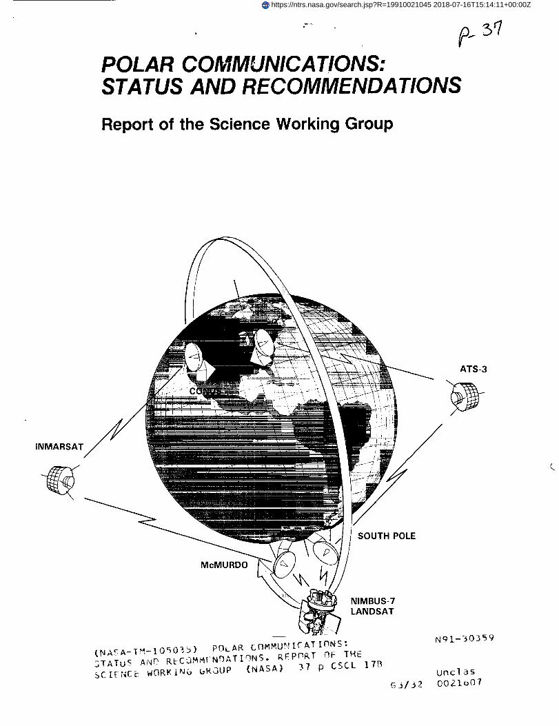
Cover: Schematic of current polar satellite
communication links depicting data transfer within
Antarctica to the continental United States (CONUS).


POLAR COMMUNICATIONS:STATUS AND RECOMMENDATIONS
Report of the Science Working Group
Edited by
T. J. RosenbergUniversity of Maryland
K. C. JezekNASA Headquarters
December 1987
NASANational Aeronautics andSpace Administration
Goddard Space Flight CenterGreenbelt, Maryland 20771
PRE'CEDING PAGE BLANK NOT FILMED [II
This report was prepared for publication by Janet Witte, of Nova University, and printed
by the Nova University Press, Fort Lauderdale, Florida, under NASA purchase orderS-90102-D.

Foreword
In order to assess the communication requirements of the polar researchcommunity in the United States, NASA convened a Science Working Group (SWG)comprised of representatives of the principal scientific and operational disciplinescurrently active in polar work. A two-day workshop was held at NASA Headquartersstarting on August 27, 1986. The members of the SWG were:
E. ChiangJ. R. ClynchM. ComberiateJ. DionneJ. H. Doolittle
G. DuckworthJ. C. Fowler
D. HornK. C. Jezek*J. A. KelmelisM. A. Pomerantz
R. PophamT. J. RosenbergC. R. StearnsI. M. Whillans
National Science Foundation
University of Texas at Austin
Goddard Space Flight CenterNational Science FoundationLockheed Palo Alto Research
Laboratories
Massachusetts Institute of TechnologyIncorporated Research Institutions for
SeismologyOffice of Naval Research
NASA HeadquartersU. S. Geological SurveyBartol Research InstituteNOAA/NESDIS
University of MarylandUniversity of WisconsinOhio State University
Additional contributors to this report were:
R. BindschadlerR. Butler
L. LutzB. G. Mendonca
A. Shaw
Goddard Space Flight CenterIncorporated Research Institutions for
SeismologyUniversity of MarylandNOAA/Environmental Research
Laboratories
System ARGOS
*Now at U.S.A. Cold Regions Research and Engineering Laboratory and Thayer
School of Engineering, Dartmouth College.
V

Abstract
This report summarizes the capabilities of existing communication links within thepolar regions, as well as between the polar regions and the continental United States.The report goes on to place these capabilities in the context of the objectives ofprincipal scientific disciplines active in polar research and, in particular, of howdiscipline scientists both utilize and are limited by present technologies. Based on anassessment of the scientific objectives potentially achievable with improved
communication capabilities, the report concludes with a list of requirements on andrecommendations for communication capabilities necessary to support polar science
over the next ten years.
YI
Executive Summary
To meet the communications needs ofthe researchand operationalcommunities
activein the polar regions,the National Aeronautics and Space Administration
(NASA), National ScienceFoundation (NSF), National Oceanic and Atmospheric
Administration(NOAA), and Department ofDefense (DOD) are investigatingnew
conceptsin satellitecommunications technology. New systems with increased
capacityand reliabilityare being sought to respond to escalatingcommunications
demands imposedby theincreasingawarenesson thepartofthesciencecommunity of
the importance of the polar regionsin globalprocessesand by the strategicand
economic emphasis placedon the polar regions by the commercial and militarysectors.
In order to gauge the needs of the user community, a two-day workshop was held atNASA Headquarters in August 1986. Participants representing a sampling of themajor disciplines currently active in polar research as well as communicationsengineers and agency representatives were in attendance. The thrusts of the meetingwere first, to evaluate the capability of existing communications systems to meet thedemand of the user community over the next five years, and, second, to compile a listof user requirements that could be the focus for the design and implementation ofimproved systems.
This report is a summary of the proceedings of that workshop. Based on acompilation of users' scientific and operational objectives and consequentrequirements, an evaluation of existing systems, and a consideration of newtechnologies with potential for successful development, the working group hasassembled a list of recommendations. These recommendations detail the elements
essential to a practical communications system that the working group believes thefederal agencies could initiate in order to prepare for communications demands likelyto be realized during the next ten years.

Contents
I. Introduction .................................. 1
I1. Background on Communication Systems ............ 4A. HF Radio ................................... 4
B. System ARGOS .............................. 4C. Advanced Satellite Systems ..................... 5
III. Impact of Communications Technology on Polar Science
A. Upper Atmosphere Physics .....................
1212
B. Astronomy and Astrophysics .................... 16
C. Solid Earth Geophysics . ....................... 18
D. Geodesy ................................... 20
E. Oceanography ............................... 22
F. Glaciology .................................. 24
G. Polar Meteorology ............................ 25
IV. Recommendations ............................. 28
References ...................................... 29
Figures
1. Geostationary and polar-orbiting satellite coveragein the northern and southern hemispheres .......... 3
2. Sea ice data buoy ............................ 5
3. Applications Technology Satellite 3 (ATS-3) ........ 84. Prototype Automatic Geophysical Station ........... 15
5. Proposed high altitude balloon experiment .......... 16
6. Solar telescope .............................. 17
7. Amplitude spectrum of Earth's free oscillations ....... 21
8. Drifting buoy tracks in the Arctic ice pack ........... 239. Automatic Weather Station ...................... 26
Tables
1. ARGOS equipment capacity .....................2. Antarctica data links ...........................
3. Voice and data transmission requirements ..........
6
10
13
1-26 ! 1-17
PRECEDING PAGE BLANK NOT FILMED IX


I. Introduction
An increasing awareness of the important role the Earth's polar regions play in
global dynamics is prompting vigorous scientific, commercial and military inquiryinto the land, ocean and atmosphere of the polar regions. In turn, the questions
spawned by these initial investigations have led to expanding requirements to send
people and supplies to the Arctic and Antarctic in order to carry out the long-term
programs identified as essential to understanding polar processes. To more effectively
use the resources available for these projects and to maximize the efficiency of
workers in the field, the technologies for managing and conducting large-scale
programs at the poles are coming under careful scrutiny. In particular, the
communications systems presently operational for polar work are being re-evaluated
under the pressure of practical considerations such as facilitating message traffic
between an investigator and his home institution, as well as the trend towards
telemetry of data from remote and/or unmanned stations. Of special interest are new
methods that speed data flow, increase the probability of success for an experimentand reduce the level of risk to the experimenter, provide for interactive experiments
and ultimately deploy remotely controlled instruments.
For most of the past twenty years, the polar research community has been
adequately served by conventional communications systems - essentially high-
frequency radio links that relied on ionospheric bounce to enable communications
both within the polar regions and beyond them. But more recently, the increasing
costs in maintaining manned and unmanned facilities at the poles, increasing field
party activity well apart from main installations, and the desire to implement a moreinteractive environment between workers at the poles and scientists in other parts of
the world are prompting federal agencies in the United States as well as agencies inCanada and Europe to seek new, more reliable and higher capacity systems
(Interagency Arctic Research Policy Committee, 1987).
In order to assess the communications requirements of the polar research
community in the United States, NASA assembled a team of investigators
representing a sampling of the principal scientific and operational disciplines
currently active in polar work. The primary objective of the team was to compile a list
of communications requirements that, if implemented, would facilitate meeting their
disciplines' present and future scientific objectives. The task was bounded first by
inviting communications engineers able to argue the feasibility of implementing
proposed concepts, and further by imposing two constraints: (1) projects were
restricted to those outside the limit of geostationary satellite coverage (see Figure 1),
and (2) projects were restricted to those polar programs that are within view of
geostationary satellites but have requirements that exceed the capabilities of the
present geostationary satellite network.
Within this framework, the working group first set out to evaluate the present
communications networks, including both voice circuits utilizing HF radio and data
links such as System ARGOS. From there, concepts under development and test alsowere discussed. They included the systems currently operated by NSF to access the
geostationary and polar-orbiting satellites for high-volume data links from SouthPole Station to McMurdo Station and from McMurdo Station to the continental
United States.
A consequence of the discussion led to the formulation of a list of communications
requirements emphasizing the need for voice and high-volume data channels and
communications capability both within the polar regions and away from the polar
regions. This list, combined with the activities envisioned by the group as highly
probable over the next ten years, forms the basis for the recommendations that this
science working group is posing to the agencies.
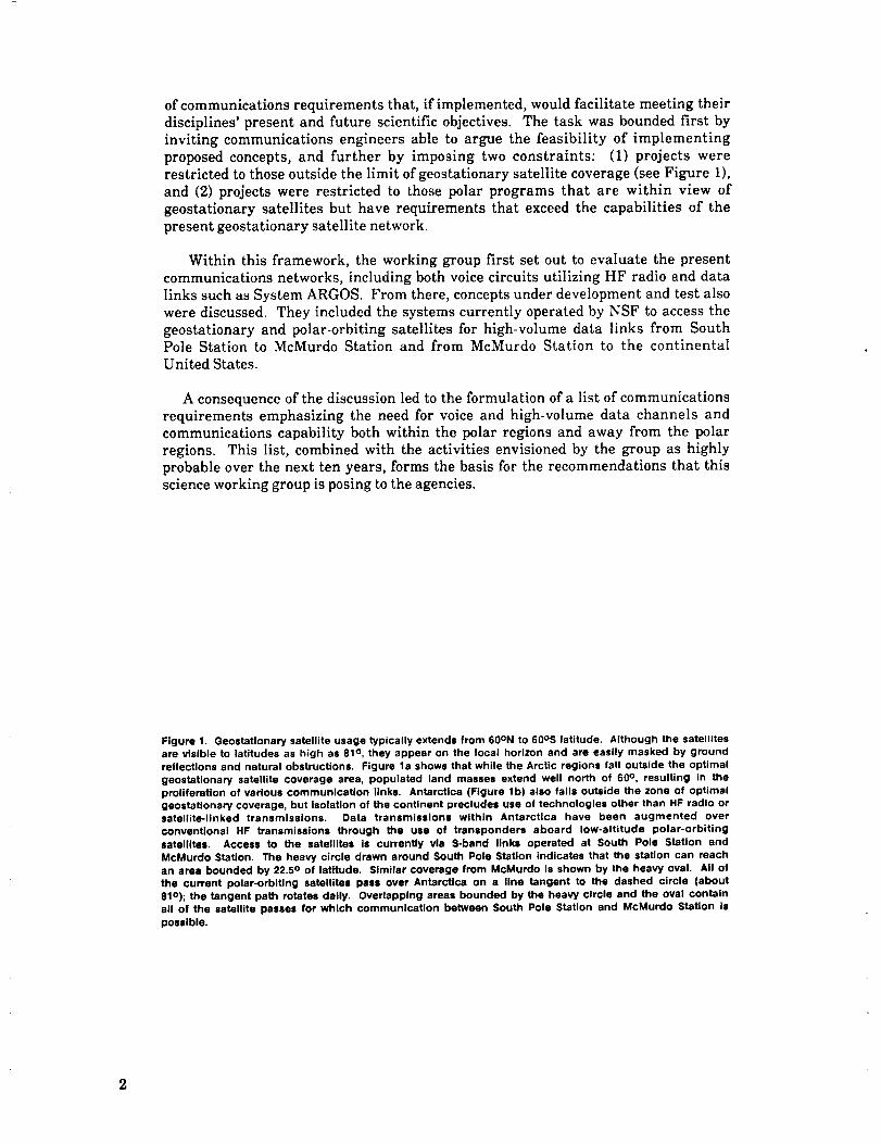
Figure 1. GeostaUonary satellite usage typically extends from 60ON to 60os latitude. Although the satellitesare visible to latitudes as high as 81 ° , they appear on the local horizon and are easily masked by ground
reflections and natural obstructions. Figure la shows that while the Arctic regions fall outside the optimal
geostationary satellite coverage area, populated land masses extend well north of 60 °, resulting in the
proliferation of various communication links. Antarctica (Figure lb) also falls outside the zone of optimalgeostationary coverage, but Isolation of the continent precludes use of technologies other than HF radio orsatellite-linked transmissions. Data transmissions within Antarctica have been augmented over
conventional HF transmissions through the use of transponders aboard low-altitude polar-orbiting
satellites. Access to the satellites is currently via S-band links operated at South Pole Station and
McMurdo Station. The heavy circle drawn around South Pole Station indicates that the station can reach
an area bounded by 22.5 ° of latitude. Similar coverage from McMurdo is shown by the heavy oval. All of
the current polar-orbiting satellites pass over Antarctica on a line tangent to the dashed circle (about
81o); the tangent path rotates daily. Overlapping areas bounded by the heavy circle and the oval contain
all of the satellite passes for which communication between South Pole Station and McMurdo Station is
possible.
St Matthew
Figure 1A
Figure 1 B
II. Background on Communication Systems
A. HF Radio
Two generic types of communications networks can be identified for the polarregions. These are networks that relay information within the polar regions andthose that connect the poles with the rest of the world. Until recently, the same kindof high-frequency (HF) radio technology (3 to 30 MHz) was used to construct bothnetworks. HF radio has proved to be a usable but not entirely satisfactory solution formonitoring activities of field parties and for dispatching very limited amounts of dataand regular message traffic from the poles to, for example, the continental UnitedStates. With increasing numbers of investigators in the field (the total participatingin the United States Antarctic Research Program in 1960 was 130; in 1986 thenumber was 350), and with commensurate strains on support schedules for those
investigators, the limitations of HF radio are being reached. The dilemma with HFradio communications is a fundamental one associated with variable propagationcharacteristics and unpredictable bounce paths. Indeed it is not uncommon for an
investigator, working in the vicinity of Ross Island, Antarctica, to be unable to contactMcMurdo Station directly, instead having to relay messages through either SouthPole Station or, if possible, ships at sea. Furthermore, data transmission rates arelow, only about 55 bits per second. While it is clear that HF radio operation willremain a fundamental element in polar communications, reliance on HF radio as thesole technique for voice and data traffic is directly impacting the size, scope, andefficiency of the kinds of scientific activities that investigators and agency sponsorsare now calling for.
B. System ARGOS
Relaying small amounts of data a few times per day from unmanned instrumentedplatforms using the ARGOS system onboard NOAA spacecraft has proved to be aviable option for many investigators, particularly in the Arctic. Polar oceanographershave made good use of ARGOS to relay data from drifting buoys deployed in the polarice pack (Figure 2), and polar meteorologists have adapted the technique for use withsensor packages left on the Antarctic Plateau. ARGOS itself is a French instrument
4

integratedintoa NOAAsatellite,with acomplementarysuiteof UnitedStatesandFrenchgroundstationsandcomputercentersundertheresponsibilityof theFrenchSpaceAgency.Datadownlinkedfrom ARGOSis receivedat oneof threereceivingsites,processedand thendistributedoverconventionalcommunicationsnetworks.Dataaretypicallydeliveredwithdelaysofseveralhoursfromthetimeofreception.
Figure 2. Several drifting sea ice buoys awaiting later deployment in the Weddell Sea. Buoys record
temperature and pressure. Data are telemetered from the buoy via the Nimbus-7 Random Access
Measurement System. (Photo courtesy of S.F. Ackley.)
A key advantage of ARGOS is its ability to determine the geographical position ofthe transmitting platform. ARGOS accomplishes this by processing the Dopplerfrequency shift in the transmitted signal. Message lengths are up to 256 bits and maybe transmitted several times a day. The principal limitation of ARGOS is the lowdata rate (about 0.1 bit per second). The ARGOS equipment capacity is described inTable 1.
C. Advanced Satellite Systems
The current use of satellites for Antarctic communications is one that has evolved
over the last five years, utilizing available commercial and government-operatedgeosynchronous and polar-orbiting satellites to facilitate the United States AntarcticProgram's administrative, science, and personnel communications requirements. Thedevelopment was spurred on by the rapid increases in both the volume of data and thevalue inherent in obtaining the data in near real time over the course of an entireyear. Prior to the integration of satellite transmission capabilities into Antarcticprograms, data analysis would lag behind data collection by about one year as a resultof the limited access to the continent imposed by climatic conditions.
_v
ORIGINAL PAGE
BLACK AND WHITE PHOTOGRAPH
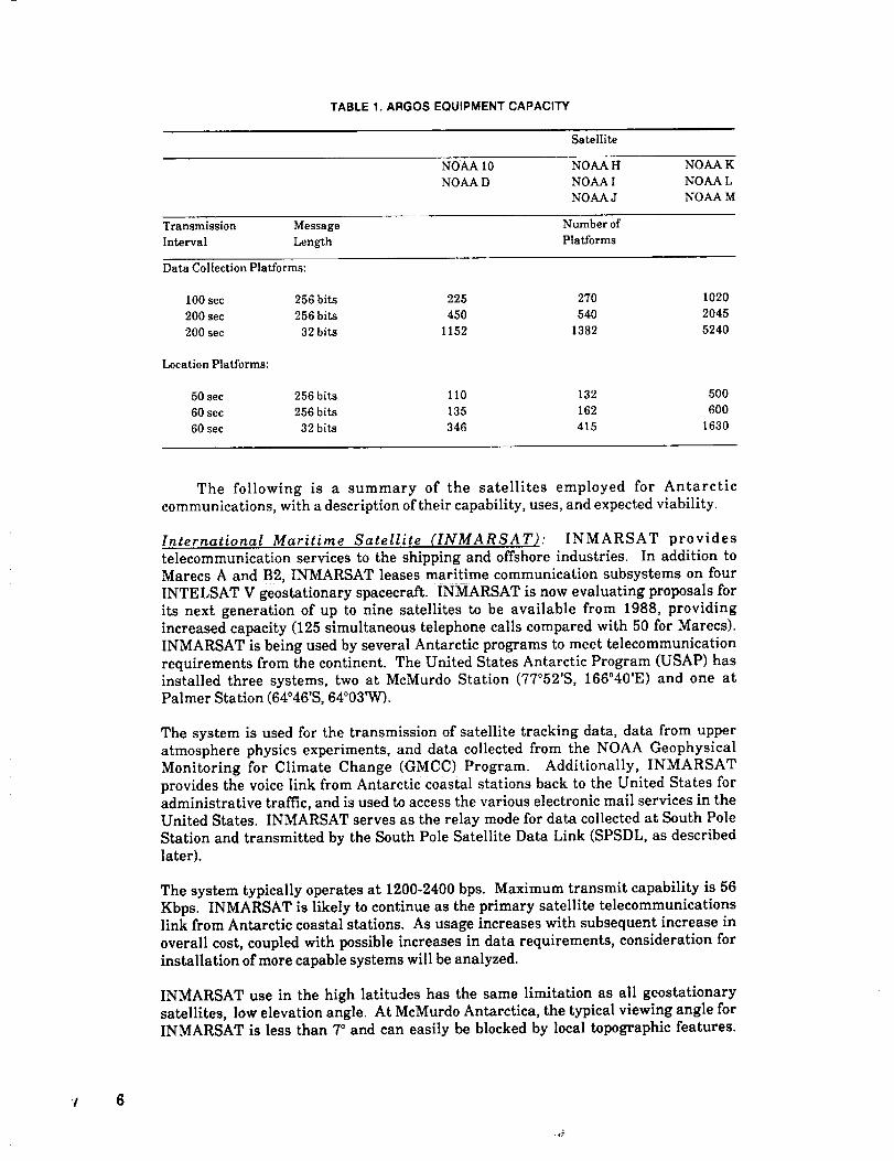
TABLE 1. ARGOS EQUIPMENT CAPACITY
Satellite
NOAA 10 NOAA H NOA.A K
NOAA D NOAA ! NOAA L
NOA.A J NOAA M
Transmission Message Number of
Interval Length Platforms
Data Collection Platforms:
100sec 256bi_ 225 270 1020
200sec 256bi_ 450 540 2045
200sec 32bi_ 1152 1382 5240
Location Platforms:
50sec 256 b[_ I10 132 500
60sec 256 bi_ 135 162 600
60sec 32bi_ 346 415 1630
The following is a summary of the satellites employed for Antarcticcommunications, with a description of their capability, uses, and expected viability.
International Maritime Satellite (INMARSAT): INMARSAT providestelecommunication services to the shipping and offshore industries. In addition toMarecs A and B2, INMARSAT leases maritime communication subsystems on fourINTELSAT V geostationary spacecraft. INMARSAT is now evaluating proposals forits next generation of up to nine satellites to be available from 1988, providingincreased capacity (125 simultaneous telephone calls compared with 50 for Marecs).INMARSAT is being used by several Antarctic programs to meet telecommunicationrequirements from the continent. The United States Antarctic Program (USAP) hasinstalled three systems, two at McMurdo Station (77°52'S, 166°40'E) and one atPalmer Station (64°46'S, 64°03'W).
The system is used for the transmission of satellite tracking data, data from upperatmosphere physics experiments, and data collected from the NOAA GeophysicalMonitoring for Climate Change (GMCC) Program. Additionally, INMARSATprovides the voice link from Antarctic coastal stations back to the United States foradministrative traffic, and is used to access the various electronic mail services in theUnited States. INMARSAT serves as the relay mode for data collected at South Pole
Station and transmitted by the South Pole Satellite Data Link (SPSDL, as describedlater).
The system typically operates at 1200-2400 bps. Maximum transmit capability is 56Kbps. INMARSAT is likely to continue as the primary satellite telecommunicationslink from Antarctic coastal stations. As usage increases with subsequent increase in
overall cost, coupled with possible increases in data requirements, consideration forinstallation of more capable systems will be analyzed.
INMARSAT use in the high latitudes has the same limitation as all geostationarysatellites, low elevation angle. At McMurdo Antarctica, the typical viewing angle forINMARSAT is less than 7° and can easily be blocked by local topographic features.
't 6

Thishas happened at McMurdo Station when the position of the active satellite waschanged, forcing a relocation of the ground station and considerably complicatingoperations.
Satellites in geostationary orbits that have intentional nonzero inclinations, or thatdrift into a slightly inclined orbit, have viewing angles that vary over a few degrees(see items 2 and 3 below). This allows a higher viewing angle at some times of the dayand a lower angle (often below the horizon) at others. Typically, the time of day at
which the maximum viewing angle occurs precesses, moving one whole day per year.This can have a significant impact on data communications that have a fixed dailyschedule.
Lincoln Experimental Satellite 9 (LES-9): LES-9 was placed into service in May 1978.It was established as a network used for government communications between fixedand mobile earth stations. LES-9 has a diurnal motion swinging north and southabout 180 from the 0° latitude at a nominal longitude of 105°W. Satellite location andorbital inclination permit about six hours of visibility from McMurdo and South PoleStations. At present, the network is operated in the UHF band at half-duplex forvoice communications. It is planned to include data transmission limited to 1200 bpsin the near future. Use for Antarctic/Arctic communications, however, can bepreempted without warning for high-priority military requirements.
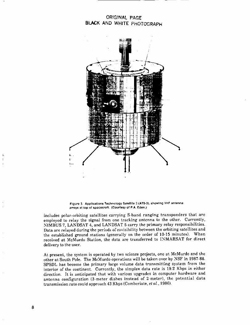
Applications Te.chnolo#v Satellite 3 (ATS-3): ATS-3 (shown in Figure 3) was placedinto service in 1967. The satellite is located at 1050 west longitude. As of January1985, the orbit inclination of ATS-3 is 10.6 °. The inclination of the orbit plane iscurrently increasing at approximately 0.50 per year. The control center for the ATSnetwork is operated under a project office contract with the University of Miami andis split-funded between NSF and NASA. The satellite services a wide range of users.Recently service has expanded to the Antarctic research community as the satellitebecomes visible to the polar stations due to its changing orbital inclination.
ATS-3 services Palmer, South Pole, McMurdo, and Siple Stations in Antarctica, andprovides voice communications and data transmission capabilities (1200 bps) to thecontinental United States (CONUS). The service time window varies betweenstations according to location in Antarctica to a minimum of about four hours at SouthPole Station. The continued use of ATS-3 is attractive for several reasons.
It is (1) user friendly, requiring only simple antennas and basic computer hardwareand software to operate the system; (2) a system with a centralized CONUS datadistribution network established which facilitates usage and encourages newapplications; and (3) inexpensive to the user and to the funding agencies. With anynew systems, the operating model of ATS-3 should be considered in further planningand development.
South Pole Satellite Data Link (SPSDL): This system was established in 1984 todemonstrate how polar-orbiting satellites could be used routinely to send highvolumes of scientific data across Antarctica at low error rates (cover). The system wasdesigned to handle relatively high-speed digital transfer of data (9.6 Kbps) from theAmundsen-Scott South Pole Station (90°S) to McMurdo Station, Antarctica (77°52'S),for transmission back to the continental United States via commercial
geosynchronous satellites.
To effect this transfer, two ground-based tracking antennas are used, one located atSouth Pole Station and the other at McMurdo Station. The space segment system
7
ORIGINAL PAGE
BLACK AND WHITE PHOTOGRAPH
/'/!
Figure 3. Applications Technology Satellite 3 (ATS-3), showing VHF antenna
arrays at top of spacecraft, (Courtesy of P.A. Eden.)
includes polar-orbiting satellites carrying S-band ranging transponders that are
employed to relay the signal from one tracking antenna to the other. Currently,
NIMBUS 7, LANDSAT 4, and LANDSAT 5 carry the primary relay responsibilities.
Data are relayed during the periods of covisibility between the orbiting satellites and
the established ground stations (generally on the order of 10-15 minutes). Whenreceived at McMurdo Station, the data are transferred to INMARSAT for direct
delivery to the user.
At present, the system is operated by two science projects, one at McMurdo and theother at South Pole. The McMurdo operations will be taken over by NSF in 1987-88.
SPSDL has become the primary large-volume data transmitting system from the
interior of the continent. Currently, the simplex data rate is 19.2 Kbps in either
direction. It is anticipated that with various upgrades in computer hardware and
antenna configuration (3-meter dishes instead of 2-meter), the potential data
transmission rate could approach 43 Kbps (Comberiate, et al., 1986).

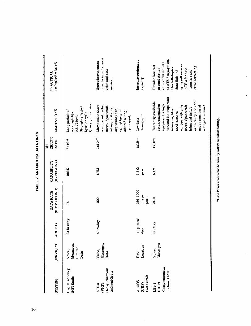
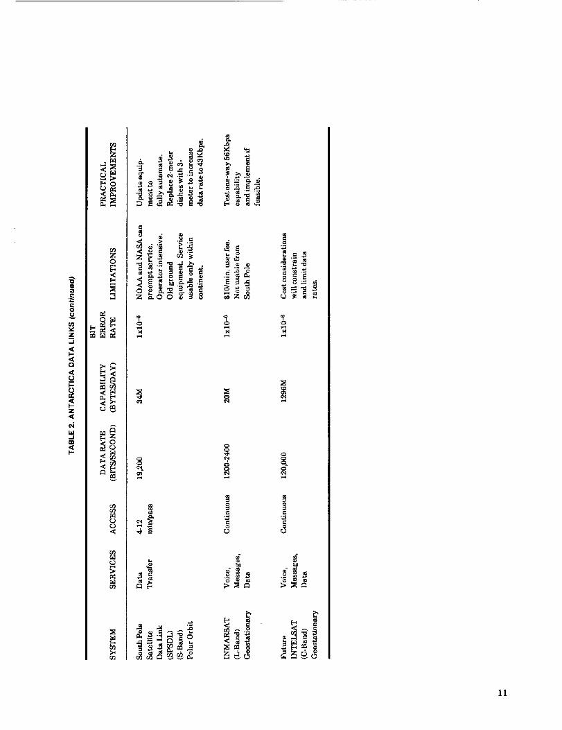
In summary, as Table 2 shows, the current Antarctic telecommunications
capabilityisa mix ofsystems employing existingsatelliteand surfacecapabilities.
The federalgovernment has taken the leadby making thesesystems availableand
the scientificcommunity has responded,in some cases,by designingand installing
the hardware necessarytoemploy thesenew capabilitiesand quicklyadapting their
experimentstotakeadvantageofnear realtime receiptofdata.
Unfortunately,thesesystemsare vulnerabletounannounced disruptionsorfailurein service.With the exceptionof the INMARSAT system, the satellitesbeingemployed have exceeded or soon willexceed theirdesignlifetimes.In some cases(LES-9,SPSDL), use is"piggybacked"on satelliteswith other primary missions,which furtheraggravatesthe concernabout servicedisruptions.Because existingsystemshave been employed to meet the immediate polarcommunication demands,and hence arelimitedtotheoriginaldesigncriteriaofthoseparticularsatellites,itisunlikelythat the existingsystems can be significantlyexpanded to accommodatefuturedemands inpolartelecommunications.
In addition to the systems described above, several other novel technologies, suchas meteorburst and HF packet radio, are under study. These technologies aredescribed in the report on ocean data telemetry prepared by M. Briscoe for the Officeof Naval Research (Briscoe, 1986). It seems unlikely at this time that any one of theseapproaches alone will fulfill the future needs of the polar community.
9
(n
z,_1
i-<a
,<_u
,<I'-Z,<
m<I-
z
["0
r_
<
L_" 0_
v<_
"r_4
_D
'3
o
_o
=.
,.c
.c
33
P,
10
q_:3
0
(n
z..J
<I-<o
<U
n-,<I-z,<
uJ._1a3<I--
,-,;>_0
zO
,<
o_
<
;>
..o
_ _._._ _-_
o_
_°
o
5_
_3
11
III. Impact of Communications Technologyon Polar Science
The scope and intensity of scientific inquiry in the polar regions is directly coupledto the ability to communicate within and away from the high latitudes. In this sectionwe present a brief summary of the primary scientific questions currently beingaddressed utilizing existing communications systems, and suggest scientific
questions that could be addressed given the assumption of enhanced communicationscapabilities maturing over the next ten years. Current use of voice and datatransmission and anticipated future requirements are summarized by discipline inTable 3.
A. Upper Atmosphere Physics
The focus of research is on the transport of energy from the solar wind into the
magnetosphere and the eventual dissipation of a portion of this energy into the upperatmosphere. Energy is dissipated through the loss of trapped energetic particles,which leads to enhanced ionization of the upper atmosphere, and by the Joule heatingfrom ionospheric currents driven by magnetospheric electric fields. Understandingthe physical processes (e.g., plasma instabilities, wave-particle interactions) thatcontrol the transport, energization, and loss of particles is one of the fundamentalscientific objectives of this research. Equally important are the practical applicationsof this work in such areas as radio communication at ELF to HF frequencies.
Coordination of much of the upper atmospheric physics activities at South Pole,Siple, and McMurdo Stations is handled by the University of Maryland, because it hasprovided the primary digital data acquisition systems for recording the multi-sensorgroundbased data (e.g., riometers, magnetometers, photometers, ELF-VLF receivers).
Current applications of satellite transmission technology employ the VHFtransponder on the ATS-3 satellite for the purpose of: (1} transmitting the multi-sensor data from Antarctica, (2} transferring specialized analysis software to
Antarctica, and (3) conducting interactive problem solving.
12

u)_-.zuJ:Eu.J_c
0ILlrr
Z0
U)
z
I.-<I-,-<ooZ<u,/
o
.Jm<
0
0
r.r.1
0
5r_
0Z<
0
0
c_
_o
O0
E_ E_
<<
0
CQ ¢_
e!. el.
c!, e!.
c-q
CO q_¢,q ¢,q
i!
13

The transmitted data are used to produce low-resolutlon survey plots forverification of data quality and performance of instrumentation, for enablingidentification of periods of special interest (for which requests can then be made totransmit data at higher time resolution), and for responding and contributing tospecial coordinated study campaigns. Current transmission rates for this purposeaverage 10 Kbytes per day.
The transfer of specialized analysis software is currently at the rate of 100 Kbytesper year. Computer systems management and software installation can be performedremotely in the case of the Siple station facility via an interactive full-duplex datalink.
Interactive problem solving is carried out mainly via the 15 KHz bandwidth voicechannel on ATS-3. This has been particularly helpful when equipment problemsarise that the field operator cannot readily diagnose and fix. Another valuable use ofthe voice link is program coordination between Siple and Mistassini (the magneticconjugate point in Canada) for interactive wave experiments with the Siple VLFtransmitter.
The need for coordinated simultaneous observations of the upper atmosphere from
multiple groundbased sites with an increased spatial resolution has resulted in thedevelopment of unmanned Automatic Geophysical Stations (AGS) for use inAntarctica (see Figure 4). An AGS provides shelter, power, heat, and data acquisitionfor several experiments and is designed to operate for a year at a time withoutservicing. Plans to establish as many as six AGS sites in Antarctica over the next fiveyears are currently being explored by the National Science Foundation Division ofPolar Programs. Interest has also been expressed for deploying AGS facilities forresearch in Arctic regions.
The nature of potential parameters sensed by AGS experiments requires a datavolume that far exceeds the capabilities of currently available systems such asARGOS or HF communication paths. Most of the planned unmanned stations will belocated at high latitudes from which line-of-sight telemetry to geostationary satellitesis precluded. Terrestrial communications links are not practical from any of theAntarctic AGS sites. As a result, the AGS facilities are forced to record a full year ofdata at each remote site. This places a limitation on the volume of data generated byeach instrument and also has the disadvantage that the data are inaccessible untilthe site is revisited at the end of the year. Installation and visitation require
significant expenditure of logistic resources that can be ultimately conserved by thedevelopment of fully automated expendable systems that can telemeter all data to arelay base.
AGS data communications require that no steerable antenna be used at the remotesites and that the integrated power usage be low. A UHF communication channel
using an omnidirectional antenna is recommended. It is envisioned that the UHFdata would be relayed over the horizon by the satellite to a manned station wherelocal review, recording and forwarding out of Antarctica by S-band telemetry couldoccur. It will be necessary for the satellite to command a remote site to initiate a datatransfer. In addition, the unmanned stations could be commanded through thesatellites to alter the operating modes and allow interactive control of experimentswhereby operating decisions could be based on a review of data either in real-time or
on subsequent satellite passes.
14

ORIGINAL PAGE
._J_,CK AND WHITE PHOTOGii.AI-'I,1
\
Figure 4. Prototype Automatic Geophysical Observatory operated at South Pole Station.
photometers look out through dome at the top.
Auroral
The current requirements for data acquisition using the AGS result in a total dailydata acquisition of about 30 Mbits per station. A modest expansion of the dataacquisition rates to accommodate additional and higher rate experiments could bringthe daily data volume up to 100 Mbits per station. Such an increase would provide themeans for greater time resolution studies of geophysical phenomena and wouldpermit bringing out higher spatial resolution images of the optical aurora fromgroundbased instruments.
Manned stations in Antarctica routinely record broadband VLF radio noise with abandwidth of many kilohertz. Because of the huge volume of data that results, it isnot now practical to observe this important geophysical parameter in this format atthe unmanned sites. However, a channel in the voice band of a polar orbiting satellitewould give a means for relaying such broadband data from an AGS. Voice band datacould be stored by audio recorders for playback during satellite passes. A two-minutecontact with each station on each satellite pass would be sufficient to relay about oneminute of VLF data for each hour. Future needs could increase the voice band data
volume by a factor of four with contacts occurring twice as frequently using a secondpolar-orbiting satellite.
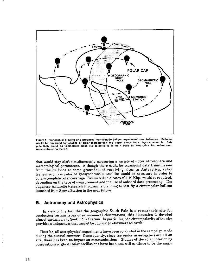
Regarding future applications, the possibility of circumpolar balloon flights alsomust be considered (Figure 5). These would be launches of instrumented payloads
15
\
SYOWA
.......iii _iiiPOLAR CAP
GEOGRAPHIC |SOUTH JPOLE GEOMAGNETIC
POLE
_MCMURDO /
STATION /
/
Figure 5. Conceptual drawing of a proposed high-altitude balloon experiment over Antarctica. Balloons
would be equipped for studies of polar meteorology and upper atmosphere physics research. Data
potentially could be telemetered back via satellite to a main base In Antarctica for subsequent
retransmlssion to the U,S.
that would stay aloft simultaneously measuring a variety of upper atmosphere and
meteorological parameters. Although there could be occasional data transmissionfrom the balloons to some groundbased receiving sites in Antarctica, relay
transmission via polar or geosynchronous satellite would be necessary in order to
obtain complete polar coverage. Estimated data rates of 1-10 Kbps would be required,
depending on the type of measurement and the use of onboard data processing. The
Japanese Antarctic Research Program is planning to test fly a circumpolar balloonlaunched from Syowa Station in the near future.
B. Astronomy and Astrophysics
In view of the fact that the geographic South Pole is a remarkable site for
conducting certain types of astronomical observations, this discussion is devoted
almost exclusively to South Pole Station. In particular, the circumpolarity of the sky
provides a uniqueness that cannot be duplicated elsewhere on earth.
Thus far,allastrophysical experiments have been conducted in the campaign mode
during the austral summer. Consequently, since the senior investigators are all on
site,there has been no impact on communications. Studies of the solar interiorby
observations ofglobal solar oscillationshave been and will continue to be the major
16
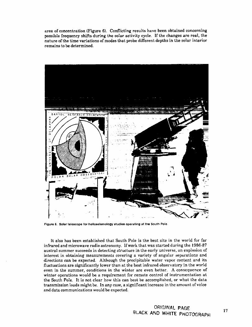
areaofconcentration(Figure6). Conflictingresultshave been obtainedconcerning
possiblefrequencyshiftsduringthe solaractivitycycle.Ifthechanges are real,the
natureofthe timevariationsofmodes thatprobedifferentdepthsinthe solarinterior
remains tobe determined.
Figure 6. Solar telescope for helioselsmology studies operating at the South Pole.
It also has been established that South Pole is the best site in the world for far
infrared and microwave radio astronomy. If work that was started during the 1986-87austral summer succeeds in detecting structure in the early universe, an explosion ofinterest in obtaining measurements covering a variety of angular separations anddirections can be expected. Although the precipitable water vapor content and itsfluctuations are significantly lower than at the best infrared observatory in the worldeven in the summer, conditions in the winter are even better. A consequence ofwinter operations would be a requirement for remote control of instrumentation atthe South Pole. It is not clear how this can best be accomplished, or what the data
transmission loads might be. In any case, a significant increase in the amount of voiceand data communications would be expected.
ORIGINAL PAGE
BLACK AND WHITE PHOTOGRAPH17
These same considerations apply to observations of stellar oscillations, whichrequire a large telescope (_30") capable of operating in the winter. Here, we canenvisage instrumentation similar to that designed for operation in space. Theapplication of the revolutionary new techniques for studying the solar interior to awide variety of stellar objects can be expected to foster the need for a remotelycontrolled telescope at the South Pole.
The field of ultra-high-energy gamma ray astronomy also probably will flourish in
the years ahead, if, as expected, the first such experiment, which will becomeoperational at the beginning of 1988, detects interesting cosmic ray sources in thesouthern skies. In this case, the communications requirements are rather welldefined, since real-time control and transmission are not required.
For the sake of completeness, we include a brief comment about the cosmic rayobservations that have been conducted since 1959 to yield a unique data base forstudies of the large-scale structure of the heliosphere. The data transmission andcommunications requirements of this program are modest indeed and have no impacton long-range planning of Antarctic communications.
C. Solid Earth Geophysics
The South Pole is a unique place at which to observe seismic events. It isseismically quiet, making it useful to observe events located elsewhere in the worldwithout having local noise interfere with data acquisition. In addition, seismicenergy from elsewhere in the world is focused toward the South Pole by rift linesrunning longitudinally on the earth. The relatively small number of other seismicstations in the southern hemisphere makes the South Pole particularly critical foranalyzing observed events in the southern hemisphere. Indeed, geophysical programsrely on data from the South Pole to such an extent that it affects the determination ofevery epicenter in the southern hemisphere; it is certainly one of the most importantstations in the world. To take advantage of this unique location for some studies, acontinuous digital recording is required. For most purposes, however, data limited toimmediate events would be of great benefit.
A broadband vertical (BBZ) component seismometer yields 17 Mbits per day (20bits per sample, 20 samples per second). With some data compression, this could becut to about 8 Mbits per day. Two long-period horizontal (LPH) components at 1sample per second would add 3.5 Mbits per day, or perhaps 2 Mbits per day withcompression. Record readers at the South Pole could select seismic events to betransmitted each day. (Tractor noise would limit the usefulness of an automatic eventdetector.) Because there is no local seismicity, we would expect the real seismic
events to occupy less than 5% of the record each day. Thus, a BBZ and two LPHchannels would reduce to (17M + 2 x 3.5M) x 5% = 1.2 Mbits per day, which could besent at any time during the day following recording of the events. If thecommunication system has a 9.6 Kbps capability, this would require about twominutes.
In addition to South Pole Station, there are three stations in the Arctic that wouldbe logical candidates for a similar data transmission system: Alert (82.5°N) andMould Bay (76.2°N) in Canada, and Kingsbay, Spitzbergen (78.9°N). At present,voice-grade communications are intermittent with Kingsbay; the capability for data-grade quality is unknown. Further investigation is needed to determine whetherimprovements are possible with geosynchronous satellites. The primary importanceof these stations is for monitoring seismicity on the northern segment of the mid-
18

Atlantic ridgeand its Arctic extension. Unlike Antarctica, the north polar region isseismically active.
Near real-time digital data from these four remote stations would be a significantadvance in operational capability, as well as an important contribution to theworldwide seismic data base. In fact, the USGS has already successfully testedsending seismic data via the ATS-3 link from the South Pole to Malabar, Florida. TheATS-3 serves as an alternative backup route for the data that are currently being sentby the South Pole Satellite Data Link. Unfortunately, both systems are notpermanent and rely on satellites that are not dedicated solely to the use of the polarscientific community. This can have adverse effects, as has occurred in the past withtiming and availability of transponder use.
The National Science Foundation Continental Lithosphere Program recentlysponsored a new initiative for a 100-station permanent global seismographic network,and a 1000-station portable seismographic network, to support research in global andlithospheric seismology. The major tasks under the program include, in addition tothe development and deployment of the permanent and portable data acquisitionsystems, the concurrent development of the facilities necessary to collect, process anddistribute the seismic data to research organizations throughout the world. Thefacilities established through this NSF-sponsored initiative will significantly improvethe seismic data base for research and are expected to serve as the principal source ofteleseismic earthquake data for the next 25 years or more.
Initially, the data will be recorded on magnetic media and shipped back to a datacollection center in the U.S. However, the final plans call for the data to betransmitted back to the data collection center via satellite. This new network will
replace the existing obsolete global analog network with modern, high quality digitalinstrumentation. Each station will record continuous broadband (0-5 Hz) three-
component seismic data, with a dynamic range of 140 dB.
The initial plan for establishing a global network divides the surface of the Earthinto 128 blocks of roughly equal area. Of these 128 blocks, 115 contain land massessuitable for placement of seismograph stations. Twenty-five of the blocks will beoccupied by existing or planned networks. This leaves 90 blocks still to be occupied inorder to achieve the desired station density. Most of these already have operatingseismograph stations, so that the principal task will be to upgrade existing stationswith new sensors and digital electronics. This will probably take about ten years tocomplete.
Six stations of the global network will definitely be above 72 ° latitude. There maybe up to 20 additional stations at latitudes that preclude reliable communicationswith standard communications satellites. These stations, along with some of thestations located on islands in the middle of ocean basins, may require special types ofcommunications links not available with current commercial satellites.
The data rates for a station are relatively modest. Depending upon the type ofstation, the rates can vary from 160 Mbits to 800 Mbits per day for each station.Because of the worldwide distribution of station locations and the need to get all of thedata to a central facility, it may be necessary to utilize several differentcommunications systems.
Development of the global network is being implemented by the IncorporatedResearch Institution for Seismology (IRIS), which operates a number of seismic
19
stations in the polar regions: Alert, Canada; College, Alaska; Kevo, Finland; and
South Pole, Antarctica. Alert and South Pole are gravimeter sites for measuring theEarth's free oscillations. Alaska and Finland are sites of three-component very broad-
band (VBB) seismometers. None of these stations currently possesses telemetry
capabilities. The digital data are recorded on magnetic tape and routinely - or in the
case of South Pole, expediently - mailed to the data collection facilities in the UnitedStates.
Within the next five years, IRIS will have VBB seismic stations operating in
Spitzbergen and Greenland, and the South Pole and Alert sites will be upgraded to
VBB response. These stations produce three data rate channels for each of the three
components of ground motion: broadband - 20 samples per second (sps), long-period - 1
sps, very-long-period - 0.1 sps. Additionally, the IRIS stations have six optional
channels for 100 sps very-short-period and log-gain data plus 12 auxiliary channelsfor environmental, state-of-health, and other geophysical data.
The data rates vary depending upon the configuration and instrumentation, but
they range from about 1000 Kbps to about 6000 Kbps continuous (data compression
has been taken into account). Thus, uplink telemetry for polar-orbiting satellites
needs to be of the order of 1 Mbps.
The science that these seismic stations contribute to Arctic and Antarctic research
is multifold and includes: (1) the transition from oceanic to continental regimes in
Northeast Asia, (2) continental margin seismicity and the effects of glaciation, (3) the
evolution of northern Alaska, and (4) detection of seismicity in the deep Arctic basin
and Antarctica. On a global scale, all of these stations are important to the overall
coverage of the Earth's seismicity. Further, the South Pole station plays a unique role
in the study of the Earth's free oscillations, as it is the only place (other than the
North Pole) where mode-splitting due to the Earth's rotation does not occur (Figure 7).
D. Geodesy
Geodetic research, conducted by the Applied Research Laboratories of the
University of Texas and the U.S. Geological Survey, is an on-going activity atMcMurdo and South Pole Stations. The principal work of the University of Texas
centers around the collection of data derived from Doppler beacon transmitters
onboard polar-orbiting navigational and geodetic research spacecraft. Subsequentreduction of the collected data provides continual monitoring of the position of these
orbiting spacecraft, with an accuracy in the meter range.
Utilization of the positional information extends into a diverse field of applications.
Navigational beacons provide point positioning for both maritime navigation andterrestrial surveying. Use of very accurate point positioning has played a key role in
the study of plate tectonics, ice flow dynamics, and other similar disciplines. Detailed
knowledge of geodetic research spacecraft position is significant in the interpretation
of data collected by these spacecraft for the investigation of ionospheric and earth
magnetic field effects. Fine-scale mapping of the Earth's gravitational field, derived
from accurate determination of spacecraft position, has been instrumental in the
development of earth gravity models.
Collection, and subsequent transmission, of data to the United States for reduction
is a continuous process based on a 24-hour cyclic loop, repeated seven days per week,
365 days per year. Data collected during a 24-hour UT day must be transmitted for
20

OJ2
0.1O
oID
=_ 0.041
O,
E
0.o6
o
°--.j o.o4
0.02
1977 Indonesian Earthquake
0 0
I I
O2 0.4 O$
2.4
2.0
_ 1.2
¢
25 o8
0.4
o
0 0 _ O _
I I i
I" I'
0.6 t.0 _.2
f97_', 23t, s, f4,4o.o Brasilia, Brazil
2 0.4 O6
Frequency
O.a
(mHz)
SPA fg_,z31,$,_o,_o.o South Pole, Antarctica
Figure 7. Amplitude spectrum of the Earth's free oscillations, showing mode splitting effects (e.g., OS3)
observed in Brazil as compared to its absence at the South Pole for the 1977 Indonesian earthquake.
(Courtesy of G. Masters.)
reduction within 12 hours after the end of the UT day of collection. Data arrivingafter the 1200 UT cutoff is not usable. Reliable, timely transmission of data istherefore as vital to project operations as is the primary data collection. Quality of thedata is directly affected by the bit error rate (BER) of the communication system. Themaximum tolerable BER is on the order of 10 5. Typical daily data blocks transmitted
21
bygeodetic research are on the order of 150-200 Kbytes. Future requirements couldincrease this to 300 Kbytes per day with peaks of as much as 650 Kbytes per day.
In summary, geodetic research requires a high reliability data communicationsystem usable in the 0000 UT to 1200 UT timeframe with a BER better than 105. Anyenhancement of the Antarctic data communications capabilities that improves
reliability, usability, or BER is of direct benefit to this research and will aid inaccomplishing project goals.
E. Oceanography
The unique focus of Arctic oceanography is to understand the growth, motion and
decay of sea ice, and how sea ice modulates the interaction between the relativelywarm polar ocean and the cold atmosphere. Such research is pertinent to issues suchas the production of deep ocean water as related to global ocean circulation, and theneed to operate in an economically and strategically important part of the globe.
Arctic oceanographic data are currently collected by manned camps, buoys, ships,aircraft, and satellites (Figure 8). Because high costs preclude the development ofmany continuously manned sites for acquisition of synoptic data, much effort goeseither to servicing simple data collection buoys or to occupying many remote sites intime sequence with aircraft. An alternative approach is near real-time data collectionfrom semi-autonomous expendable buoys and other instrumentation systems thatallow monitoring of the data quality. This solution to Arctic data acquisitionproblems could be implemented by satellite telemetry systems. Three possible Arcticprograms that would use a proposed satellite telemetry system are discussed below.
ARAMP. (Arctic Remote Autonomous Measurement Platform). The Marginal IceZone Experiment (MIZEX) is a study of the air/sea/ice interaction at the boundarybetween the ice-covered regions of the central Arctic and the North Atlantic. A majorproblem addressed by the MIZEX program is the generation of mesoscale eddies andinternal waves and their influence on acoustic sound propagation, generation ofambient acoustic noise, and ice kinematics. This effort involves understanding and
modeling the environmental data and relating it to acoustic data. Because theacoustic signals propagate from a large region to the measurement point, non-localeffects require synoptic measurements of the environment and the acoustics.Therefore, the MIZEX program is sponsoring the development of the ARAMP buoys toreduce the need for manned ships and ice camps. These data could be more completely
and efficiently collected by semi-autonomous buoys, but the data storagerequirements are immense. The Arctic is especially difficult, because not only aregeosynchronous satellites not available, but high-density data storage systems do notperform well in the cold. The need for increased data telemetry in the Arctic is very
apparent for this application.
A total of 50 buoys is proposed, yielding 23 KBytes/dayfouoy (an equivalent •continuous data rate of less than 3 baud). This would require 23 seconds of satellite
time per day per platform to dump at a 10 kbaud rate. This is well beyond thecapabilities of ARGOS. The expanded capability could require as much as 2Mbytes/day, or an equivalent data rate of 230 baud. This would require 33 minutes ofsatellite time per day per platform.
ARCTIC SOFAR DRIFTER PROGRAM. The purposeoftheSOFAR DrifterProgram
is to track ocean currents at depth in the Fram Strait,which is essential to
22

150°
\
821
180° 150°
3807 3805 •
3809
"3819
30°W 0° 30°E
120'
90°
60°
Figure 8. Trajectories of ARGOS buoyl within the Arctic Ice pack for the year 1982. (Courtesy of R. Colony.)
understanding the heat and mass flux between the Arctic and temperate oceans, and
ice dynamics along the east coast of Greenland. This program has been scaled down so
that it can be carried out using the ARGOS system to relay data on the underwater
drifters. A more ambitious program could be in place if greater data capacity were
available on the satellite telemetry link. Given the current crowding in this ARGOS
footprint, expansion of the program may be difficult without new telemetry
capabilities.
The current requirements for this program are five surface buoys at two ARGOS
ID's/buoy/constellation; 40 sub-surface drifters/constellation]l.5 bytes/day; six
bytes/day/dri_Cter supplying two locations/day and one measurement of temperature or
depth per day. This totals 1500 bytes/day/surface buoy/40 drifter constellation.
23

This can be handled by two ARGOS ID's per surface buoy, with one new
message/hour. Increased capacity would allow additional groups of 40 drifters to be
tracked and would relay back more environmental data.
ARCTIC ACOUSTIC TOMOGRAPHY. This program uses acoustic transmissionsbetween underwater transceivers to measure travel-time anomalies. These anomalies
are then interpreted by inversion methods to yield information about the three-
dimensional underwater sound-speed structure. Tomography uses wave phenomena
to penetrate the ocean rather than a large collection of research vessels or physically
autonomous buoys. By measuring the integrated effects of the ocean over a large
number of paths, tomographic reconstruction methods can allow calculation of sound
speed maps, temperature structure maps, fluctuation (kinetic energy} structure maps
of large-scale currents in three dimensions, and surface wave energy maps in twodimensions.
Currently, all of the data are recorded on-site by the tomography transceivers. Thisis not desirable because of the (up to one year) delay in data retrieval. In addition, if
tomographic systems are to be used in an operational sense, then near real-time
acquisition is necessary.
Arctic tomography is very difficult, because the procedure typically requires large
and stable bottom-mounted moorings. Because of the ice cover, there are two possible
solutions: (1) bottom-mounted moorings that communicate with satellites having
lasers located in the blue-green wavelength window passed by seawater, and (2)
drifting transceivers that locate themselves accurately using the Global Positioning
System (GPS). Direct communication with the satellite from a bottom-mounted
mooring may have to be done with a surface drifting intermediary, as is done in the
SOFAR program, but details for acquisition still must be developed. The driftingtransceiver method places additional volume demands on the data collection system,
because coherent averaging for signal enhancement must be done with knowledge ofthe relative drift between the source and the receiver. This disallows a great deal of
the internal processing typically carried out in the buoy itself in temperate bottom-
moored experiments.
F. Glaciology
The polar ice sheets are one of the least explained and most poorly understood
components of the global climate system. As well as reacting to changes in global
climate by accumulating or releasing reservoirs of fresh water, the ice sheets are
hypothesized to play active roles in affecting climate. Indeed, instabilities in the flowof the West Antarctic Ice Streams are conjectured to be of fundamental importance to
the state of the entire ice sheet, potentially determining whether the ice sheet grows
or shrinks.
Since much of the research currently conducted on the ice sheet is done during the
summer via surface parties, communication needs are slightly different from those of
other disciplines.
Three separate communication needs can be identified. In terms of their
importance, they are (1) signaling an emergency, (2] communications required by thescientists for the efficient conduct of field research, and (3) communications for the
linking of Antarctica to the rest of the world. Antarctica is a harsh and sometimes
dangerous environment. Clearly, the safety of all field parties must be a prime
24

concern. Field parties are not safe ifthey cannot contact rescue forces at a base
station at any time. This requirement isfilledby the SARSAT/COSPAS system, a
network of satellitesthat continuously monitor the earth'ssurface for transmissions
from personal locatorbeacons (PLB). The PLB isactivated with the flipof a switch,
and the alertsignal,along with the beacon location,can be automatically forwarded
tothe main U.S. stationin McMurdo tobegin the rescue. Ifthis system passes testing
in the McMurdo area, scheduled forJanuary 1987, itshould be adopted for any future
Antarctic fieldparty.
In the area of field communications, the most important requirement is reliablevoice communication between a remote field party and either another remote field
party or an aircraft or major base. Efficient use of field time and logistics depends on
reliable communications. Often, the determination of a daily operations plan can
require the collected inputs of a number of isolated field parties whose only means ofcommunication is the radio. Poor communication can tie down field parties or waste
logistic effort, both of which are very costly factors in Antarctica and hinder the
efficient conduct of science. The current complement of aging HF radios does not
provide a reliable voice link and invites a variety of problems.
The final area in which improved communication would benefit Antarctic researchis the transmission of data either to an Antarctic station or back to the United States.
Data collection, storage, and transmission have become extremely commonplace. Theavailability of synoptic data from automatic weather stations spaced around the
Antarctic continent for planning aircraft operations has obvious advantages.
Transmission of these and other data (such as subsurface temperatures or water
pressures in ice streams) from remote, instrumented sites year-round would greatly
aid the scientist by providing data that were hitherto unavailable. While some of
these data may be collected by on-site storage devices, their transmission back to the
scientist not only provides a more certain means of collecting high-investment data,
but also may obviate the need to return to the instrument site as often or at all, thus
easing the logistic burden of Antarctic science.
G. Polar Meteorology
Routine meteorological observations in the polar regions support both operationaland scientific activities. To accommodate requirements for timely observations at an
increasing number of locations, instruments are being adapted to telemeter data back
to central receiving sites. A description of three such programs, one using System
ARGOS to transmit data from automatic weather stations, one using the ATS-3 link
at South Pole, and a proposed program, follows.
ARGOS. Automatic weather stations (AWS) measure surface pressure, air
temperature, wind speed, and wind direction and transmit the data to satellites for
interrogation by ground stations. The data are used to study the barrier wind along
the Transantarctic Mountains, vertical motion and sensible and latent heat flux from
the Ross Ice Shelf, katabatic flow, and propagating weather systems at the South
Pole. The weather stations also provide meteorological support for aircraft operations
at McMurdo Station, as well as for remote field sites. Data transmission is via system
ARGOS at 200-second intervals updated every ten minutes (Figure 9).
ATS-3.. The Geophysical Monitoring for Climate Change (GMCC) Division of NOAA
has established an experiment at the South Pole to monitor and analyze the buildup of
trace greenhouse gases and aerosols in the atmosphere that can impact global
25

ORIGINAL PAGE
BLACK AND WHITE PHOTOGRAPFt
i
!
Figure 9. Automatic Weather Station being deployed on the Ross Ice Shelf. Wind speed and direction,
surface pressure, and air temperature are recorded and telemetered back to the U.S. via polar-orbiting
satellites equipped with the ARGOS system.
climate. The South Pole station is one of four baseline observatories operated by
NOAA to provide data to ascertain whether a long-term change in the composition of
the atmosphere is occurring.
The GMCC program at present measures and analyzes more than twentyindividual time series of data at each of the GMCC observatories. Data are collected
in varied formats, ranging from high-density continuous recordings on magnetic datatapes to handwritten entries on data forms. It is necessary that all of these data bereceived in a timely manner in Boulder, Colorado, where individual principalinvestigators process and analyze the data and disseminate the results. Because ofthe long period of time during which the South Pole Station is closed to air traffic,data transmission by satellite communication is critical for timely analysis, checks,and quality control of the continuous measurements being made by the GMCCDivision atthe South Pole. Timely review of the data is necessary to detect onsets of
atmospheric phenomena that define changes, seasonalities, and sources or sinks oftrace constituents in the atmosphere.
The GMCC DivisionusestheATS-3 and theATS VAX system atMalabar, Florida,
to transmitdata and English textcommunication from the South Pole to Boulder,
26

Colorado. Both data and messages are forwarded automatically to the computercenter in Boulder. The transmissions are downloaded from the computer center to anIBM PC in the GMCC Division, where they are logged and distributed to the
individual project investigators.
Currently,about 20 percentofthe totalGMCC trafficisin textcommunicationsthatare used formeasurement instructions,changes, troubleshootingand timely
evaluationofdataand measurement protocol.At present,theGMCC Division'sdata
transmissionvolume amounts toabout i Mbyte permonth.
The current ATS-3 window at 1200 baud has been adequate for these purposes, butis not sufficient for transmission of the entire data set collected at the South Pole
(approximately 10 Mbytes). In order to transmit more data from the GMCC programto Boulder, either a higher baud rate or a longer window would be necessary.Additionally, the GMCC Division's research effort could be improved significantly tothe extent that voice communications could be upgraded and expanded. Because ofthe remoteness of the station from Boulder and the harshness of the environment at
the South Pole, the measurement instruments and measurement protocol requireconstant attention and interaction between the GMCC South Pole staff and the
principal investigators in Boulder. Voice communications have proven to be the bestand quickest way to do this.
IMAGE DATA. To the extent that meteorological data collected on the continent canbe summarized and processed in near-real time and sent to a central location for
global dissemination, a more meaningful interpretation of the GMCC data could bemade on a more timely basis. Such information also could be used by investigators inAntarctica to steer and initiate measurement protocols dictated by anticipatedchanges or onsets in atmospheric phenomena. To that end, a future requirementmight be the retransmission of image data acquired over the Antarctic by polar-orbiting satellites.
Each of the NOAA polar-orbiting satellites passes over some part of Antarcticaabout every 102 minutes, making slightly more than 14 passes per day for eachsatellite in orbit. Two satellites usually are operational at any one time. Onboardsensors include the Tiros Operational Vertical Sounder, consisting of a HighResolution Infrared Radiation Sounder, the Stratospheric Sounding Unit, and theMicrowave Sounding Unit. In addition, there are an Advanced Very High ResolutionRadiometer and an ARGOS-based Data Collection System. Each of the five onboardtape recorders can store one full orbit of global area coverage data at reducedresolution, 10 minutes of local area coverage data, and 250 minutes of low bit rateinstrument data. The satellites can be received at McMurdo, Antarctica, for about 13minutes out of each orbit when the satellite is within 5700 kilometers of the station.
Of the more than 14 orbits per day over Antarctica, 11 or 12 can be received atMcMurdo. The satellite scans 1100 kilometers on each side of the suborbital point
perpendicular to the direction of travel. Given maximum practical coverage, nearlythe entire Antarctic continent will be in view once every 24 hours.
At present, McMurdo Station acquires data available for forecasting at fullresolution (1.1 kilometers) and at a rate of about 7.3 Gbits per day. (Limited low-resolution data collected by onboard tape recorders are already available in the U.S.from the National Climate Center.) Should a greater demand materialize for rapiddissemination of these full-resolution data, then data selection will be required tolimit retransmission volumes out of McMurdo to practical levels.
27
IV. Recommendations
Based on the science objectives and commensurate communications requirementsdiscussed in the preceding sections, the Science Working Group has compiled thefollowing list of specifications that it deems critical to meeting the polar researchcommunity's communications needs for the next ten years. These items are asynthesis of the tables presented in the preceding section and are judged both as beingthe most essential elements of a next-generation communications system as well asbeing practical, given present and projected technologies. It is worth noting that,given appropriate communications hardware initiatives, flights of opportunity, suchas the NOAA K, L, M series or NASA's component of the International Solar
Terrestrial Program, could be considered as candidate platforms for communicationdevices over the next five years. Development of small commercial satellite programs
may provide additional opportunities.
(1) System data capacities of 50 Mbits/day will satisfy most individual disciplinerequirements; a few disciplines will require on the order of 500 Mbits/day.
(2) Both voice and data links should be implemented.
(3) Coverage should extend within the polar regions and from the polar regions tothe continental United States. Particular attention needs to be focused on thevoice and data transmission requirements of remote field parties.
(4) Following the model of current ATS-3 satellite usage, any new system should
be user friendly (simple antennas and basic hardware and software), operatethrough a centralized data distribution network, and be inexpensive to theuser.
28
References
Briscoe,M.G., 1986. Status Report on Ocean Data Telemetry. Woods Hole
OceanographicInstitutionReportWHO1-86-17, 71 pp.
Comberiate,M., E. Chiang, and R. Popham, 1986. A conceptforwide band global
communications. EOS, Vol.67,No. 31,602-603.
InteragencyArcticResearch PolicyCommittee (IARPC), 1987. United StatesArctic
ResearchPlan. NationalScienceFoundation Report87-55,334pp.
29