STATEMENT OF SWANSEA COUNCIL FOR … · H6 – GYPSY AND TRAVELLER SITE C1 ER3 - GREEN WEDGE -...
24
STATEMENT OF SWANSEA COUNCIL FOR LDP EXAMINATION Additional Information: Flood Risk & Mitigation on Allocated Sites 6 December 2017 Martin Nicholls Director of Place Phil Holmes Head of Planning and City Regeneration
-
Upload
nguyenlien -
Category
Documents
-
view
221 -
download
0
Transcript of STATEMENT OF SWANSEA COUNCIL FOR … · H6 – GYPSY AND TRAVELLER SITE C1 ER3 - GREEN WEDGE -...

1 | P a g e
STATEMENT OF SWANSEA COUNCIL
FOR LDP EXAMINATION
Additional Information:
Flood Risk & Mitigation
on Allocated Sites
6 December 2017
Martin Nicholls Director of Place
Phil Holmes
Head of Planning and City Regeneration

2 | P a g e
STATEMENT BY SWANSEA COUNCIL FOR THE SWANSEA LOCAL DEVELOPMENT PLAN (LDP) EXAMINATION Additional Information: Flood Risk and Mitigation on Allocated Sites ___________________________ This statement has been produced by Swansea Council (hereafter ‘the Council’) in order to provide additional information to assist and inform the Swansea LDP Examination, in advance of the scheduled Pre-Hearing Meeting. The statement is submitted to address the initial points raised by the Examination Inspectors in relation to this issue, and demonstrate the robustness of the Swansea LDP having regard to the evidence that underpins relevant policies and proposals. ___________________________ The Council will submit a further statement of evidence relating to Flood Risk matters in advance of the scheduled hearing session on this matter, which will address any further questions arising from the Inspectors.

3 | P a g e
Table of contents
Contents
1.0 Introduction ....................................................................................................... 4
2.0 Time line of LDP Consultations and Updates to the DAM. ............................... 4
3.0 All LDP Designations within Food Zone C ........................................................ 5
4.0 Assessment of LDP allocations within Flood Zone C ....................................... 6
5.0 Confirmed List of Affected Sites ..................................................................... 22

4 | P a g e
1.0 Introduction 1.1 This statement has been prepared in response to the letter dated 23rd October
2017 from the Planning Inspectors to the Council (ED001). The Inspectors’ letter requests from the Council more information in relation to the extent to which allocated or safeguarded sites are subject to flood risk, and whether the consequences of flooding can be adequately mitigated.
1.2 This statement responds to the specific points raised in ED001, that the
following should be clarified for all allocated sites which currently accommodate part of a C flood zone:
Clarification of the relevant flood zone(s) (i.e. C1 and/or C2);
Confirmation as to whether site capacity assessments for proposed vulnerable uses have excluded these areas, or whether evidence is available to justify development within the C1 or C2 flood zones; and
Any likely mitigation measures required; whether these have been agreed with NRW (or if discussions are on-going); and any potential impacts on deliverability
1.3 Also provided in this statement is an update on the Stage 3 Flood
Consequence Assessment (FCA) which is being prepared for the proposed Gypsy and Traveller site allocation at Pant y Blawdd Road.
1.4 Lastly, information is provided as to the extent of the C1 or C2 flood zones
within the site at Railway Terrace, Gorseinon, and an explanation of whether any identified needs arising over the Plan period could be accommodated on unconstrained parts of this unallocated site, and/or potential contingency measures implemented.
2.0 Time line of LDP Consultations and Updates to the DAM 2.1 The Development Advice Map (hereafter referred to as the DAM) shows areas
at risk of flooding for the purposes of land-use planning. The DAM should be used alongside Planning Policy Wales and Technical Advice Note (TAN) 15 to guide new development away from areas at risk of flooding wherever possible. Together, they form a precautionary framework to guide planning decisions. It is important to recognise that the DAM and therefore the extent of the flood zones is periodically updated and that an update has occurred during the Plan preparation.
Table 1: Key LDP consultations compared with the available DAM data
LDP Consultation Document
LDP Consultation closing date
DAM Publication Date
Candidate Sites Register 16/1/2015 May 2015
LDP Draft Proposals Map 16/1/2015 May 2015
LDP Deposit Plan 31/8/2016 May 2015

5 | P a g e
2.2 At the time of writing the latest version of the DAM was published in October 2017, herein referred to as ‘the latest version of the DAM’. The responsibility of publication of the map has transferred from Welsh Government (WG) to Natural Resources Wales (NRW). NRW now publish updates to the DAM, based on their extreme flood outlines (Zone C), and the British Geological Survey 10k Superficial Geology data (Zone B). From March 2017, Zone C is updated quarterly to align with NRW’s extreme flood outline updates.
2.3 In advance of the publication of the latest version of the DAM, NRW published
a booklet named ‘change maps’ which highlighted likely amendments to C1 zones. The Council reviewed this booklet in February 2017 and its contents informed the Council’s decision to include the sites in the Deposit LDP, as submitted for Examination.
3.0 All LDP Designations within Food Zone C 3.1 As stated above, the latest version of the DAM was published in October 2017,
which was after the submission of the Deposit LDP for Examination. The full list of allocated sites that are affected by Flood Zone C designations are set out in the table below.
Table 2: LDP designations within Flood Zone C (based on the latest version October 2017 DAM data)
LDP Allocation Flood Zone C
SD A: SOUTH OF GLANFFRWD ROAD, PONTARDDULAIS
C1/C2
SD B: LAND NORTH OF GARDEN VILLAGE C2
SD G: NORTHWEST OF M4 J46, LLANGYFELACH C2
SD H: NORTH OF WAUNARLWYDD/FFORESTFACH C2
SD I: SWANSEA VALE C1/C2
SD J: SWANSEA CENTRAL AREA C1/C2
SD K: FABIAN WAY CORRIDOR C2
H1.14 - LAND ADJACENT TO HEOL LAS, BIRCHGROVE C2
H1.23 - FORMER CEFN GORWYDD COLLIERY, GORWYDD ROAD, GOWERTON
C2
H1.24 - LAND AT WEST STREET, GORSEINON C2
H1.25 - LAND TO SOUTH OF HIGHFIELD/LOUGHOR ROAD
C2
H1.32 - LAND EAST OF CARREG TEILO, PONTARDDULAIS
C1/C2
H1.49 - LAND AT CADLE, PENTREGETHIN ROAD, FFORESTFACH, SWANSEA
C2
H6 – GYPSY AND TRAVELLER SITE C1
ER3 - GREEN WEDGE - PONTLLIW C2
ER3 - GREEN BELT - GOWERTON C2

6 | P a g e
4.0 Assessment of LDP allocations within Flood Zone C 4.1 The following section provides a comprehensive review of each allocated site
affected by Flood Zone C in the latest version of the DAM. Information relating to an update on the FCA for the proposed Gypsy and Traveller Site, as outlined in paragraph 1.3, is provided in paragraphs 4.48 – 4.52 under the heading of H6 Gypsy and Traveller Site.
SD A: SOUTH OF GLANFFRWD ROAD, PONTARDDULAIS
4.2 The smaller allocation to the west of the larger site contains DAM Flood Zone
C1. The larger site has Flood Zone C2 along its eastern boundary. 4.3 The Council are aware of the C1/C2 Zones on SD A and can confirm that the
development advice zones will have no impact on site capacity or deliverability. 4.4 These specific areas will in large part remain undeveloped and part of the multi-
functional green infrastructure network. In some exceptional circumstances proposals for TAN 15 ‘less vulnerable development’ could be considered, where the justification tests set out in the TAN are fully met. This approach has informed the Council’s site specific policy for this strategic development area (LDP Policy Reference SD A refers), as well as the masterplanning undertaken by the developer as part of its pre-application work.
4.5 This position will also be confirmed in the separate Statement for the Swansea
LDP Examination relating to SD A.

7 | P a g e
SD B: Land North Of Garden Village 4.6 There is a small area of Flood Zone C2 in the North West corner of the
Strategic Site. 4.7 The Council are aware of the C2 Zone on SD B. However, the extent of the C2
Zone has slightly expanded in the latest version of the DAM. This relatively small area will have no significant impact on the development and the Council can confirm that the development advice zone will have no impact on site capacity or deliverability.
4.8 These specific areas will remain undeveloped and part of the multi-functional
green infrastructure network. This approach has informed the Council’s site specific policy for this strategic development area (LDP Policy Reference SD B refers), as well as the masterplanning undertaken by the developer as part of its planning application which is currently being considered by the Council.

8 | P a g e
SD G: Northwest of M4 J46, Llangyfelach 4.9 There is a very small area of Flood Zone C2 in the South East corner of the
Strategic Site, which follows the River Llan. 4.10 The Council are aware of the C2 Zone on SD G and can confirm that the
development advice zone will have no impact on site capacity or deliverability. 4.11 These specific areas will remain undeveloped and part of the multi-functional
green infrastructure network and are on the very edge of the SDA boundary. 4.12 This position will also be confirmed in the separate Statement for the Swansea
LDP Examination relating to SD G Northwest of M4 J46, Llangyfelach.

9 | P a g e
SD H: North of Waunarlwydd/Fforestfach 4.13 There are two areas of Flood Zone C2 on the Strategic Site, the largest area is
in the western part of the site with a smaller linear area in the east. 4.14 The Council are aware of the C2 Zone on SD H and can confirm that the
development advice zone will have no impact on site capacity or deliverability. 4.15 These specific areas will in large part remain undeveloped and part of the multi-
functional green infrastructure network or, as part of the ongoing masterplanning work, are proposed for ‘less vulnerable development’ where the justification tests set out in the TAN are fully met. This approach has informed the Council’s site specific policy for this strategic development area (LDP Policy Reference SD H refers), as well as the masterplanning undertaken by the developer as part of its pre-application work.
4.16 This position will also be confirmed in the separate Statement for the Swansea
LDP Examination relating to SD H North of Waunarlwydd/Fforestfach.

10 | P a g e
SD I: Swansea Vale
4.17 The Strategic Site has a significant coverage of Flood Zone C1, though this has reduced slightly in the latest version of the DAM. The C2 designation towards the north of the site (former Park and Ride), adjacent to the River Tawe, has been expanded to incorporate the flood alleviation area which is part of the relatively recent flood defence improvements (Lower Swansea Valley Flood Risk scheme).
4.18 The Council are aware of the C1/C2 Zones on SD I and the designations have
informed the Council’s established masterplan for Swansea Vale, which has been formulated following detailed engagement with NRW, and forms the basis for the LDP policy and concept plan. The latest version of the masterplan designates the land affected by C2 flood risk towards the north of the site (former Park and Ride) as Green Infrastructure. The residential extension to Tregof Village falls outside of C1 and C2 flood designations. The residential allocations east of Walters Road are affected by C1 flood risk zones and are the subject of an on-going FCA. Subsequent updates to the masterplan will be in accordance with the findings set out in the FCA. It is noted in the Phasing and Delivery of Housing and Employment Sites Statement that the capacity of these sites off Walters Road are likely to be reduced in light of the anticipated findings from the FCA.
4.19 This position will also be confirmed in the separate Statement for the Swansea
LDP Examination relating to SD I: Swansea Vale.
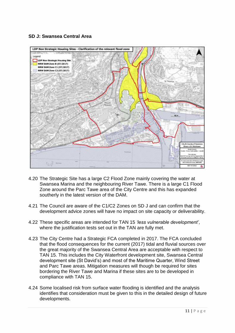
11 | P a g e
SD J: Swansea Central Area
4.20 The Strategic Site has a large C2 Flood Zone mainly covering the water at
Swansea Marina and the neighbouring River Tawe. There is a large C1 Flood Zone around the Parc Tawe area of the City Centre and this has expanded southerly in the latest version of the DAM.
4.21 The Council are aware of the C1/C2 Zones on SD J and can confirm that the
development advice zones will have no impact on site capacity or deliverability. 4.22 These specific areas are intended for TAN 15 ‘less vulnerable development’,
where the justification tests set out in the TAN are fully met. 4.23 The City Centre had a Strategic FCA completed in 2017. The FCA concluded
that the flood consequences for the current (2017) tidal and fluvial sources over the great majority of the Swansea Central Area are acceptable with respect to TAN 15. This includes the City Waterfront development site, Swansea Central development site (St David’s) and most of the Maritime Quarter, Wind Street and Parc Tawe areas. Mitigation measures will though be required for sites bordering the River Tawe and Marina if these sites are to be developed in compliance with TAN 15.
4.24 Some localised risk from surface water flooding is identified and the analysis
identifies that consideration must be given to this in the detailed design of future developments.

12 | P a g e
4.25 The FCA identifies that climate change will see deeper flooding and high
velocities in localised areas such as Parc Tawe and the Maritime Quarter in the longer term, with increased consequences from tidal flood risk and increased risk of defence overtopping.
4.26 To address the findings of the FCA, the Council has made (through a Cabinet
paper1) a formal commitment to develop a Strategic Flood Risk Management Strategy for the Swansea Central Area. This commitment will ensure that existing communities and future development of the area remain viable.
SD K: Fabian Way Corridor
4.27 The Strategic Site has three separate areas of C2 Flood Zone. The largest
covers the water at the Prince of Wales dock and there is a small area to the east of Queen’s Dock. The remaining C2 Zone is on Swansea Bay, adjacent to the Swansea Bay Campus in the neighbouring Local Authority. Previously, there was a small area of C1 Flood Zone near the River Tawe but this has been removed in the latest version of the DAM (October 2017).
4.28 The Council are aware of the C2 Zone on SD K and can confirm that the
development advice zones have informed the formulation of the concept plan in terms of the proposed layouts and uses for the SDA and will have no impact on site capacity or deliverability. These specific areas are intended for TAN 15 ‘less vulnerable development’.
1 The Management of Future Risks of Flooding from the Effects of Climate Change, 20th October 2016.

13 | P a g e
4.29 It should also be noted that whilst it is recognised that some parts of the site are identified as being at risk of flooding (tidal) and that the site, at present, does not benefit from adequate flood defences, this and the associated potential for flooding could change in the future, either as a result of development proposals or through off site works. In particular, the proposed Tidal Lagoon has the potential to significantly change the risks associated with flooding.
H1.14 - Land Adjacent to Heol Las, Birchgrove
4.30 The allocation is now almost entirely within the DAM Flood Zone C2 having
regard to the latest flood risk maps. 4.31 At the Deposit stage the site was partly within Flood Zone C1 and all
representations received during the statutory 6 week public consultation period on the Deposit LDP reflected this. NRW’s ‘Change Map’ highlighted that the part C1 Zone would become C2 but it did not inform the Council that the entire site would become C2 as in the latest version of the DAM.
4.32 In light of the new C2 Zone on the whole of the site, in-line with National
Planning Policy, it is proposed that if the site promoter is unable to demonstrate how the flood risk could be suitably mitigated then the site should not now be allocated for residential development in the Plan. No units are currently attributed to this site in the housing delivery trajectory.
14 | P a g e
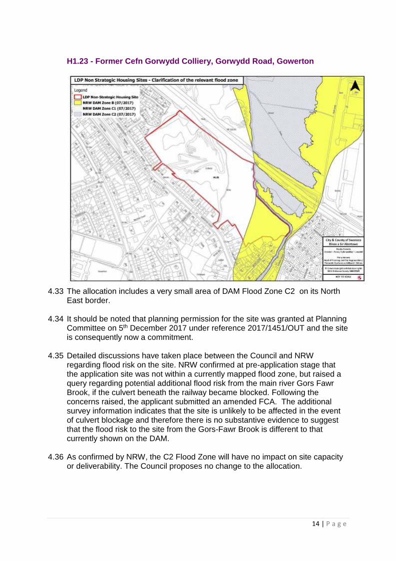
H1.23 - Former Cefn Gorwydd Colliery, Gorwydd Road, Gowerton
4.33 The allocation includes a very small area of DAM Flood Zone C2 on its North
East border. 4.34 It should be noted that planning permission for the site was granted at Planning
Committee on 5th December 2017 under reference 2017/1451/OUT and the site is consequently now a commitment.
4.35 Detailed discussions have taken place between the Council and NRW
regarding flood risk on the site. NRW confirmed at pre-application stage that the application site was not within a currently mapped flood zone, but raised a query regarding potential additional flood risk from the main river Gors Fawr Brook, if the culvert beneath the railway became blocked. Following the concerns raised, the applicant submitted an amended FCA. The additional survey information indicates that the site is unlikely to be affected in the event of culvert blockage and therefore there is no substantive evidence to suggest that the flood risk to the site from the Gors-Fawr Brook is different to that currently shown on the DAM.
4.36 As confirmed by NRW, the C2 Flood Zone will have no impact on site capacity
or deliverability. The Council proposes no change to the allocation.

15 | P a g e
H1.24 - Land at West Street, Gorseinon
4.37 The allocation is very slightly encroached by C2 Flood Zone on its eastern boundary.
4.38 At the Deposit stage there was no C2 Flood Zone adjacent to the site but the
latest version has changed significantly. However, there is only a slight encroachment onto the allocation.
4.39 In light of this, the Council proposes no change to the allocation.

16 | P a g e
H1.25 - Land to South of Highfield/Loughor Road, Kingsbridge
4.40 The eastern side of the allocation is almost entirely within the DAM Flood Zone
C2. 4.41 At the Deposit stage the site contained no C2 Zone but it did border a small C2
Zone on and around the River Lliw. The large increase in the C2 Zone was not highlighted in NRW’s Change Map.
4.42 A significant proportion of the site has now been classified as C2 Flood Risk,
which in-line with National Planning Policy, makes this area of the land unsuitable for residential development. This could impact on the suitability of the potential layout of the remaining site and compound a further problem that access cannot easily be achieved to the site following the completion of the adjacent housing development without allowing an access point through. If the site promoter is unable to demonstrate how the flood risk could be suitably mitigated and a sustainable housing scheme delivered on the remaining land, then it is proposed that the site should not now be allocated for residential development in the Plan. No units are currently attributed to this site in the housing delivery trajectory.
17 | P a g e
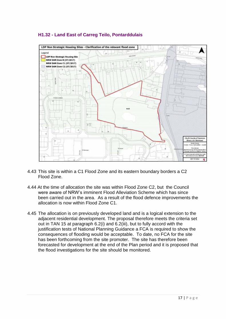
H1.32 - Land East of Carreg Teilo, Pontarddulais
4.43 This site is within a C1 Flood Zone and its eastern boundary borders a C2
Flood Zone. 4.44 At the time of allocation the site was within Flood Zone C2, but the Council
were aware of NRW’s imminent Flood Alleviation Scheme which has since been carried out in the area. As a result of the flood defence improvements the allocation is now within Flood Zone C1.
4.45 The allocation is on previously developed land and is a logical extension to the
adjacent residential development. The proposal therefore meets the criteria set out in TAN 15 at paragraph 6.2(i) and 6.2(iii), but to fully accord with the justification tests of National Planning Guidance a FCA is required to show the consequences of flooding would be acceptable. To date, no FCA for the site has been forthcoming from the site promoter. The site has therefore been forecasted for development at the end of the Plan period and it is proposed that the flood investigations for the site should be monitored.
18 | P a g e
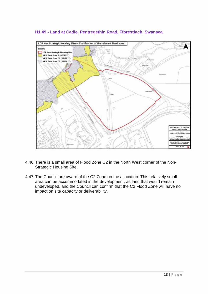
H1.49 - Land at Cadle, Pentregethin Road, Fforestfach, Swansea
4.46 There is a small area of Flood Zone C2 in the North West corner of the Non-
Strategic Housing Site. 4.47 The Council are aware of the C2 Zone on the allocation. This relatively small
area can be accommodated in the development, as land that would remain undeveloped, and the Council can confirm that the C2 Flood Zone will have no impact on site capacity or deliverability.

19 | P a g e
H6 – Gypsy and Traveller Site
4.48 The allocation is within a C1 Flood Zone as outlined in the DAM. 4.49 The Council is aware of the C1 Zone and allocated the land on the basis that
the proposal falls under the definition of highly vulnerable development that can be justified in Zone C1 in-line with Technical Advice Note 15: Development and Flood Risk (TAN 15), subject to an assessment of the consequences of flooding being acceptable.
An Update on the Stage 3 Flood Consequences Assessment
4.50 A Scoping FCA Report is being prepared by an independent consultant. The
latest version of the report was submitted to the Council in September 2017. At the time of writing a final version of the report has not been accepted and approved through a formal Council procedure.
4.51 The FCA has considered flood risk at the site from all water sources. The
outputs from the technical work highlight that flood risk from tidal source, groundwater and artificial sources is negligible within the area and that the proposed development is located within Flood Zone 3. The site benefits from flood defences with a high standard of protection, however the work has highlighted there is flood risk from defence overtopping in a 0.1% probability event as well as from a breach of the existing defence. This is the same scenario as that which applies to the wider areas of Swansea Vale that are protected by this same flood defence.

20 | P a g e
4.52 It is anticipated that the Final Report of the FCA will inform the statement to be
prepared for the LDP Examination Hearing Session, and will confirm matters relating to anticipated hazards, precise water depths anticipated, specific ‘avoidance areas’ within the site arising from modelling, the role of flood warning alert measures and evacuation plans, and any relevant mitigation measures against the existing flood risk such as potential compensatory flood storage.
ER3 – Green Wedge – Pontlliw
4.53 The Green Wedge is very slightly encroached by C2 Flood Zone on its north western boundary.
4.54 The Council are aware of the C2 Flood Zone on the allocation. 4.55 Justification for the Green Wedge designation at this location is provided in
EB014, ‘Green Belt and Green Wedge Designation – June 2016’. Given the future potential for changes to the DAM, it is not considered that Flood Zone C areas provide the necessary level of protection to permanently protect against development that could affect the openness of the land and lead to settlement coalescence.
4.56 In light of this, the Council proposes no amendment to the Green Wedge at
Pontlliw.

21 | P a g e
ER3 - Green Belt – Gowerton
4.57 There is significant C2 Flood Zone overlapping the Green Belt in Gowerton and
moving north towards Kingsbridge. The C2 Zone also moves easterly following the River Llan towards Waunarlwydd.
4.58 The Council are aware of the C2 Flood Zone on the allocation. 4.59 Justification for the Green Wedge designation at this location is provided in
EB014, ‘Green Belt and Green Wedge Designation – June 2016’. Given the future potential for changes to the DAM, it is not considered that Flood Zone C areas provide the necessary level of protection to permanently protect against development that could affect the openness of the land and lead to settlement coalescence.

22 | P a g e
5.0 Confirmed List of Affected Sites 5.1 The following table confirms the sites and allocations within the Deposit LDP
that are affected by Flood Zone areas, and the Council’s intended course of action having regard to the preceding paragraphs.
Table 3: Summary of affected sites and Council actions
LDP Allocation Flood Zone
Council Action
SD A: SOUTH OF GLANFFRWD ROAD, PONTARDDULAIS
C1/C2 No Change
SD B: LAND NORTH OF GARDEN VILLAGE C2 No Change
SD G: NORTHWEST OF M4 J46, LLANGYFELACH
C2 No Change
SD H: NORTH OF WAUNARLWYDD/FFORESTFACH
C2 No Change
SD I: SWANSEA VALE C1/C2 Review site capacity
SD J: SWANSEA CENTRAL AREA C1/C2 No Change
SD K: FABIAN WAY CORRIDOR C2 No Change
H1.14 - LAND ADJACENT TO HEOL LAS, BIRCHGROVE
C2 Review Site
H1.23 - FORMER CEFN GORWYDD COLLIERY, GORWYDD ROAD, GOWERTON
C2 No Change. Site is now a commitment
H1.24 - LAND AT WEST STREET, GORSEINON
C2 No Change
H1.25 - LAND TO SOUTH OF HIGHFIELD/LOUGHOR ROAD
C2 Review Site
H1.32 - LAND EAST OF CARREG TEILO, PONTARDDULAIS
C1/C2 No Change
H1.49 - LAND AT CADLE, PENTREGETHIN ROAD, FFORESTFACH, SWANSEA
C2 No Change
H6 – GYPSY AND TRAVELLER SITE C1 No Change
ER3 - GREEN BELT - PONTLLIW C2 No Change
Flood Mitigation Measures 5.2 All allocations that the Council propose ‘no change’ to will need to accord with
LDP policies. In particular; RP4 Avoidance of Flood Risk, ER1 Climate Change and RP 1: Safeguarding Public Health and Natural Resources.

23 | P a g e
5.3 In order to avoid the risk of flooding, development will not be permitted in areas at risk of fluvial, pluvial, coastal and reservoir flooding, unless it can be demonstrated that the development can be justified in line with national guidance and is supported by a technical assessment that verifies that the new development is designed to alleviate the threat and consequences of flooding.
5.4 Development that would result in significant risk to: life; human health and well-
being; property; controlled waters; or the natural and historic environment, will not be permitted.
Railway Terrace, Gorseinon 5.5 The LDP, at paragraph 2.5.44, identifies that the current immediate need for
Travelling Showpeople pitches could be accommodated at the established site at Railway Terrace, Gorseinon.
5.6 The Council’s latest Gypsy Traveller Accommodation Assessment (GTAA
2015)2 identifies that the residents have leased the land for over twenty years and wish to remain living there. They have had short-term leases based on temporary planning consents. Due to the expiry of their lease and planning permission, based on advice from the Welsh Government, the residents have been classified as being resident at an Unauthorised Development, and included in the Table of Estimated Need for Residential Site Pitches.
2 Gypsy Traveller Accommodation Assessment 2015, Swansea Council

24 | P a g e
5.7 A planning application has been submitted regarding the site to the Council for the retention of use of land for residential, winter quarters for travelling fun fair, storage of ancillary vehicles and fair equipment (planning application reference 2015/0910).
5.8 The above map highlights the most recent published version of the DAM (October 2017). Railway Terrace, and surrounding land, is within the C2 Flood Zone. The Council can confirm that the C2 Zone has remained the same since at least May 2015. The site is therefore classed as being within an area of floodplain, without significant flood defence infrastructure, defined as C2 and Paragraph 6.2 of TAN 15 states that highly vulnerable development in Zone C2 should not be permitted. The planning application is being considered, and the applicant has been advised to consider whether they wish to provide more information in terms of the acceptability of consequences of a flood event before the application is determined.