STATE ROUTE 74 COMPREHENSIVE CORRIDOR STUDY · Pete Frisina, Fayette County Phil Mallon, Fayette...
91
i This draft version of the State Route 74 Comprehensive Corridor Study is provided for public and stakeholder comment starting Monday, October 22, 2018 and ending Monday, November 26, 2018. During this period of time, please submit your comments electronically to [email protected] or via mail to Fayette County Public Works (115 McDonough Road Fayetteville, GA 30214). Comments received will be reviewed and considered by the study team in preparing the final version of the plan. Thank you! STATE ROUTE 74 COMPREHENSIVE CORRIDOR STUDY This draft version of the State Route 74 Comprehensive Corridor Study is provided for public and stakeholder comment starting Monday, October 22, 2018 and ending Monday, November 26, 2018. During this period of time, please submit your comments electronically to [email protected] or via mail to Fayette County Public Works (115 McDonough Road Fayetteville, GA 30214). Comments received will be reviewed and considered by the study team in preparing the final version of the plan. Thank you!
Transcript of STATE ROUTE 74 COMPREHENSIVE CORRIDOR STUDY · Pete Frisina, Fayette County Phil Mallon, Fayette...

iThis draft version of the State Route 74 Comprehensive Corridor Study is provided for public and stakeholder comment starting Monday, October 22, 2018 and ending Monday, November 26, 2018. During this period of time, please submit your comments
electronically to [email protected] or via mail to Fayette County Public Works (115 McDonough Road Fayetteville, GA 30214). Comments received will be reviewed and considered by the study team in preparing the final version of the plan. Thank you!
STATE ROUTE 74COMPREHENSIVE CORRIDOR STUDY
This draft version of the State Route 74 Comprehensive Corridor Study is provided for public and stakeholder comment starting Monday, October 22, 2018 and ending
Monday, November 26, 2018. During this period of time, please submit your comments electronically to [email protected] or via mail to Fayette County Public Works (115 McDonough Road Fayetteville, GA 30214). Comments received will be reviewed and considered by the study team in preparing the final version of the plan. Thank you!

ii
STATE ROUTE 74COMPREHENSIVE CORRIDOR STUDY
This draft version of the State Route 74 Comprehensive Corridor Study is provided for public and stakeholder comment starting Monday, October 22, 2018 and ending Monday, November 26, 2018. During this period of time, please submit your comments
electronically to [email protected] or via mail to Fayette County Public Works (115 McDonough Road Fayetteville, GA 30214). Comments received will be reviewed and considered by the study team in preparing the final version of the plan. Thank you!
ACKNOWLEDGMENTSStakeholder Committee
Aileen Daney, Atlanta Regional Commission
Al Smith, Coweta County Commission
Andrew Spiliotis, Atlanta Regional Commission
Audrey Johnson, Atlanta Regional Commission
Cheryl Foster, City of Union City
Daniel Studdard, Atlanta Regional Commission
Don Williams, MARTA
Donna M. Gayden, City of Fairburn
Edlin Regis, GDOT
Elizabeth Carr-Hurst , City of Fairburn
Ellis Still, City of Union City
Eric Dial, Town of Tyrone
Eric Maxwell, Fayette County Commission
Harland Smith, GDOT
Hattie Portis-Jones, City of Fairburn
Jared Lombard, Atlanta Regional Commission
Joan Young, Fayette County Development Authority
Joddie Gray, AICP, South Fulton CID
Joe Robison, Fayette County
Jonathan Lynn, Town of Tyrone
Jonathan Rorie , City of Peachtree City
Kalanos Johnson, City of Union City
Keith Larson, Bike Fayette
Kim Schnoes, Fayette County Chamber of Commerce
Lankston Johnson, Georgia Department of
Transportation
Larry Owens, City of Senoia
Lester Thompson, City of Fairburn
Lonnie Ferguson, City of Union City
Mark Sanders, South Fulton CID
Mark Shugart, Saben LLC
Marlene V. Delgadillo Canizares, Georgia
Department of Transportation
Marty Ross, South Fulton CID Board/US Foods Atlanta
Mike Warrix, City of Peachtree City
Paige Muh, Fayette County Chamber of Commerce
Pete Frisina, Fayette County
Phil Mallon, Fayette County
Phil Peevy, Georgia Department of Transportation
Phillip Trocquet, Town of Tyrone
Randy Padgett, City of Senoia
Robb Pitts, Fulton County Commission
Ryan Sager, MARTA
Samir Abdullahi, Fulton County/Select Fulton
Stanford Taylor, GDOT
Stephanie Taylor , Georgia Commute Options
Steve Rapson, Fayette County
Steven Gulas, Corridor Property Owner
Tarika Peeks, City of Fairburn
Vanessa Fleisch, City of Peachtree City
Vivian Canizares , Georgia Department of
Transportation
William Edwards, City of South Fulton
William H. Shell, City of Palmetto
Fayette County Board Of CommissionersEric Maxwell, Chairman,
District 1
Randy Ognio, Vice Chairman, District 2
Steve Brown, District 3
Charles D. Rousseau, District 4
Charles W. Oddo, District 5
Peachtree City Council
Vanessa Fleish, Mayor
Phil Prebor, Post 1
Mike King, Post 2
Keviv Madden, Post 3
Teddy Ernst, Post 4
Town of Tyrone Council
Eric Dial, Mayor
Linda Howard, Post 1
Ryan Housley, Post 2
Ken Matthews, Post 3
Gloria Furr, Post 4
City of Fairburn Council
Elizabeth Carr-Hurst, Mayor
James Whitmore, Mayor Pro Tem
Linda J. Davis
Alex Heath
Pat Pallend
Hattie Portis-Jones
Ulysses Smallwood

iiiThis draft version of the State Route 74 Comprehensive Corridor Study is provided for public and stakeholder comment starting Monday, October 22, 2018 and ending Monday, November 26, 2018. During this period of time, please submit your comments
electronically to [email protected] or via mail to Fayette County Public Works (115 McDonough Road Fayetteville, GA 30214). Comments received will be reviewed and considered by the study team in preparing the final version of the plan. Thank you!
Prepared by:
with assistance from:
In partnership with:

iv
STATE ROUTE 74COMPREHENSIVE CORRIDOR STUDY
This draft version of the State Route 74 Comprehensive Corridor Study is provided for public and stakeholder comment starting Monday, October 22, 2018 and ending Monday, November 26, 2018. During this period of time, please submit your comments
electronically to [email protected] or via mail to Fayette County Public Works (115 McDonough Road Fayetteville, GA 30214). Comments received will be reviewed and considered by the study team in preparing the final version of the plan. Thank you!
TABLE OF CONTENTSintroduction .............................................................................2
establishing a vision ................................................................6
existing corridor conditions ....................................................12
assessing future needs ...........................................................30
corridor plan ..........................................................................54
action plan .............................................................................74

vThis draft version of the State Route 74 Comprehensive Corridor Study is provided for public and stakeholder comment starting Monday, October 22, 2018 and ending Monday, November 26, 2018. During this period of time, please submit your comments
electronically to [email protected] or via mail to Fayette County Public Works (115 McDonough Road Fayetteville, GA 30214). Comments received will be reviewed and considered by the study team in preparing the final version of the plan. Thank you!
APPENDICESa: community engagementb: traffic volume count datab: intersection analysis synchro outputc: detailed development guidelines matrixd: future turning movement countse: intersection control evaluation summaries
2This draft version of the State Route 74 Comprehensive Corridor Study is provided for public and stakeholder comment starting Monday, October 22, 2018 and ending Monday, November 26, 2018. During this period of time, please submit your comments
electronically to [email protected] or via mail to Fayette County Public Works (115 McDonough Road Fayetteville, GA 30214). Comments received will be reviewed and considered by the study team in preparing the final version of the plan. Thank you!
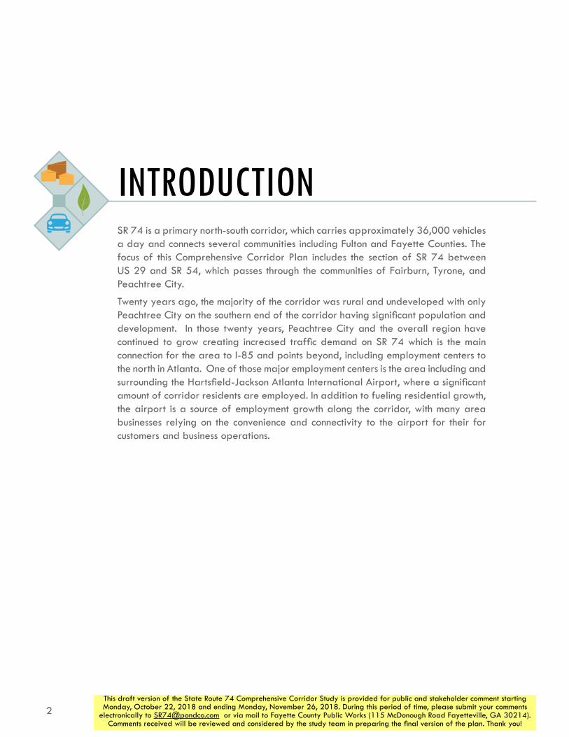
INTRODUCTIONSR 74 is a primary north-south corridor, which carries approximately 36,000 vehicles a day and connects several communities including Fulton and Fayette Counties. The focus of this Comprehensive Corridor Plan includes the section of SR 74 between US 29 and SR 54, which passes through the communities of Fairburn, Tyrone, and Peachtree City.
Twenty years ago, the majority of the corridor was rural and undeveloped with only Peachtree City on the southern end of the corridor having significant population and development. In those twenty years, Peachtree City and the overall region have continued to grow creating increased traffic demand on SR 74 which is the main connection for the area to I-85 and points beyond, including employment centers to the north in Atlanta. One of those major employment centers is the area including and surrounding the Hartsfield-Jackson Atlanta International Airport, where a significant amount of corridor residents are employed. In addition to fueling residential growth, the airport is a source of employment growth along the corridor, with many area businesses relying on the convenience and connectivity to the airport for their for customers and business operations.

3This draft version of the State Route 74 Comprehensive Corridor Study is provided for public and stakeholder comment starting Monday, October 22, 2018 and ending Monday, November 26, 2018. During this period of time, please submit your comments
electronically to [email protected] or via mail to Fayette County Public Works (115 McDonough Road Fayetteville, GA 30214). Comments received will be reviewed and considered by the study team in preparing the final version of the plan. Thank you!
85
85
85
20
20
75
75
285285
Tyrone
Peachtree City
Fairburn
74
54
54
34
92
Fayette Co.
Fulton Co.
Coweta Co.
Douglas Co.
Cobb Co.
DeKalb Co.
Henry Co.
Hartsfield-Jackson Atlanta
International Airport
Downtown Atlanta
29
Study Corridor’s Position in Region
INTRODUCTION
N

4
STATE ROUTE 74COMPREHENSIVE CORRIDOR STUDY
This draft version of the State Route 74 Comprehensive Corridor Study is provided for public and stakeholder comment starting Monday, October 22, 2018 and ending Monday, November 26, 2018. During this period of time, please submit your comments
electronically to [email protected] or via mail to Fayette County Public Works (115 McDonough Road Fayetteville, GA 30214). Comments received will be reviewed and considered by the study team in preparing the final version of the plan. Thank you!
purposeDespite the ongoing growth along the corridor, there are still large tracts of land that are undeveloped allowing for scenic views, a relatively rural feel, and limited intersections. Recognizing the ongoing development of the area and accompanying traffic growth, the SR 74 Gateway Coalition was formed to include representatives from Peachtree City, Town of Tyrone, City of Fairburn, Fayette County, and the South Fulton Community Improvement District (SFCID). With assistance from neighboring communities who utilize the corridor (including the City of Senoia, Coweta County, and Fulton County), partnering agencies (such as the Georgia Department of Transportation and Atlanta Regional Commission), and civic organizations (such as the Fayette County Chamber of Commerce), the SR 74 Gateway Coalition supported the development of a comprehensive corridor study to proactively anticipate future growth and develop a corridor plan for SR 74. Emerging over the course of the study process, overall goals of the study included:
»» Establish a Unified Vision for the Corridor
»» Understand Long-Term Transportation Needs
»» Address Congestion and Future Growth
»» Provide Capacity to Maintain Corridor Mobility
Beginning in the Summer of 2017, the SR 74 Comprehensive Corridor Study consisted of four overall phases to address these overall goals.

5This draft version of the State Route 74 Comprehensive Corridor Study is provided for public and stakeholder comment starting Monday, October 22, 2018 and ending Monday, November 26, 2018. During this period of time, please submit your comments
electronically to [email protected] or via mail to Fayette County Public Works (115 McDonough Road Fayetteville, GA 30214). Comments received will be reviewed and considered by the study team in preparing the final version of the plan. Thank you!
document organizationThe following plan document is structured similarly to the study process:
establishing a visionThe study process included a variety of outreach techniques to develop an overarching vision for the future of the corridor. This outreach included participation from a combination of corridor communities’ elected officials, staffs, and residents. The desire for increased mobility in the corridor emerged as the most important element for consideration for the future of the corridor, though other elements such as accessibility, active mode transportation, and aesthetics were viewed as important too.
existing corridor conditionsBuilding from the established Vision, the study team performed a comprehensive review of conditions along the corridor to understand travel demand, traffic operations, employment patterns, corridor access, and development regulations in the corridor’s jurisdictions.
assessing future needsHaving established existing conditions on the corridor, future conditions along the corridor were anticipated including future travel demand, likely future traffic operations, and consideration of other plans and studies in the area. This process culminated in the use of an Intersection Control Evaluation (ICE) analysis to identify alternatives.
corridor planThe ICE analysis identified what is referred to as a superstreet concept for the SR 74 corridor. This concept is anticipated to accommodate future traffic demand without widening of the corridor through a series of innovative intersection designs. These intersection designs also interface with other expressed goals for the corridor including improving safety, addressing active mode transportation, managing parcel access equity, and will work hand in hand with suggested unified development regulations for the corridor.
action planAdding to the recommendations, the Action Plan identifies a series of next steps for advocacy to implement the recommended initiatives along the corridor.
INTRODUCTION
6This draft version of the State Route 74 Comprehensive Corridor Study is provided for public and stakeholder comment starting Monday, October 22, 2018 and ending Monday, November 26, 2018. During this period of time, please submit your comments
electronically to [email protected] or via mail to Fayette County Public Works (115 McDonough Road Fayetteville, GA 30214). Comments received will be reviewed and considered by the study team in preparing the final version of the plan. Thank you!
ESTABLISHING A VISIONThe vision for the SR 74 corridor was a result of an extensive development process used by the project team. The first section of this chapter presents the various outreach activities conducted, and the following section discusses the vision that emerged from this process.
outreach activitiesCommunity engagement for this corridor study included a stakeholder committee, engagement directly with the public, and connections with other groups in the area. More detailed summaries and materials from these various outreach activities are presented in Appendix A.
listening sessionAs part of developing a Stakeholder Committee, a listening session was conducted with the SR 74 Gateway Coalition on June 20th, 2017 to discuss goals for the corridor. A variety of topics were mentioned by Gateway Coalition members as important in developing a vision for the SR 74 Corridor.

7This draft version of the State Route 74 Comprehensive Corridor Study is provided for public and stakeholder comment starting Monday, October 22, 2018 and ending Monday, November 26, 2018. During this period of time, please submit your comments
electronically to [email protected] or via mail to Fayette County Public Works (115 McDonough Road Fayetteville, GA 30214). Comments received will be reviewed and considered by the study team in preparing the final version of the plan. Thank you!
stakeholder committeeA Stakeholder Committee was developed to provide input and feedback regarding the corridor vision, needs, and study recommendations. Rooted in the members of the SR 74 Gateway Coalition, several additional organizations and representatives were invited to participate in the Stakeholder Committee:
The stakeholder committee met four times throughout the course of the study:
Meeting #1, July 25, 2017: This meeting served as the formal kickoff for the SR 74 Corridor Study, and the first official gathering of the Stakeholder Committee. The meeting began with a formal presentation of the project followed by an in-depth discussion regarding the corridor vision.
Meeting #2, December 8, 2017: This meeting was conducted in an ‘open-house’ format, with four stations that included project information and exercises for the committee to participate in.
»» The background and community engagement station provided information regarding the project schedule and information on existing conditions along the corridor (i.e. traffic volumes, employment and population statistics, etc.).
»» In the vision station, stakeholders were presented with the refined goals and objectives of the vision from the previous meeting and asked to indicate their agreement.
»» As part of the assessment station, stakeholders were also asked to provide feedback on various growth scenarios developed to project traffic volumes along the corridor in 2040.
»» Stakeholders were asked to indicate their top three bottleneck locations, intersection treatment preferences, and areas where mobility and/or accessibility should be prioritized as part of the feedback station.
Meeting #3: June 21, 2018: This meeting consisted of a formal presentation of the emerging recommendation of a superstreet concept along the corridor. After the presentation, the stakeholder committee was shown a roll-plot of the corridor that indicated the location of each recommended improvement. Committee members were encouraged to provide additional feedback to assist in finalizing the recommendations.
Meeting #4: September 20, 2018: During the final stakeholder committee meeting, finalized recommendations were presented to the stakeholder committee, for any additional input prior to the drafting of the plan.
»» Atlanta Regional Commission
»» Bike Fayette
»» City of Fairburn
»» City of Palmetto
»» City of Senoia
»» City of South Fulton
»» City of Union City
»» Coweta County
»» Fayette County
»» Fayette County Chamber of Commerce
»» Fulton County
»» Georgia Department of Transportation
»» Key corridor property owners
»» MARTA
»» Peachtree City
»» South Fulton Community Improvement District
»» Town of Tyrone
ESTABLISHING A VISION

8
STATE ROUTE 74COMPREHENSIVE CORRIDOR STUDY
This draft version of the State Route 74 Comprehensive Corridor Study is provided for public and stakeholder comment starting Monday, October 22, 2018 and ending Monday, November 26, 2018. During this period of time, please submit your comments
electronically to [email protected] or via mail to Fayette County Public Works (115 McDonough Road Fayetteville, GA 30214). Comments received will be reviewed and considered by the study team in preparing the final version of the plan. Thank you!
online surveyAn online survey was developed to obtain a variety of input from the community. This 9-question survey asked respondents questions regarding their use of the corridor, areas of need, and potential improvements. The survey was launched in October 2017 and provided to the stakeholder committee to distribute among their respective networks. The survey received 468 responses.
community meetingsTwo rounds of public meetings were held during the Corridor Study process. Both rounds, each comprised of two meetings, were held in ‘open house’ formats where attendees could visit various stations and participate in exercises at their convenience. Additional information from these meetings – including photos, scans, and exercise results – can be found in Appendix A.
Round 1 Open Houses: The first two meetings were held in early March 2018. During these meetings, attendees were provided general information regarding the corridor study, and participated in three exercises geared at identifying bottleneck locations, prioritizing access and mobility, and establishing a vision for the corridor.
Round 2 Open Houses: The second round of meetings was held in July 2018. These open houses presented findings from the technical analysis of the study, and emerging recommendations for the corridor.

9This draft version of the State Route 74 Comprehensive Corridor Study is provided for public and stakeholder comment starting Monday, October 22, 2018 and ending Monday, November 26, 2018. During this period of time, please submit your comments
electronically to [email protected] or via mail to Fayette County Public Works (115 McDonough Road Fayetteville, GA 30214). Comments received will be reviewed and considered by the study team in preparing the final version of the plan. Thank you!
ESTABLISHING A VISION | OUTREACH ACTIVITIES

10
STATE ROUTE 74COMPREHENSIVE CORRIDOR STUDY
This draft version of the State Route 74 Comprehensive Corridor Study is provided for public and stakeholder comment starting Monday, October 22, 2018 and ending Monday, November 26, 2018. During this period of time, please submit your comments
electronically to [email protected] or via mail to Fayette County Public Works (115 McDonough Road Fayetteville, GA 30214). Comments received will be reviewed and considered by the study team in preparing the final version of the plan. Thank you!
ESTABLISHING A VISION
key vision statements A fundamental component of the SR 74 Corridor Study was establishing a collective vision for the corridor among the various stakeholders. To create a vision that reflected the views of both the stakeholder committee and public, several exercises were conducted at several points during the study to develop the vision.
top improvement typesUsing the information collected during the listening session, the project team organized preliminary input into six broad categories:
»» Access Management
»» Accessibility
»» Aesthetics & Signage
»» Alternative Travel Modes
»» Development Patterns
»» Mobility
»» Other
The stakeholder committee was asked to indicate which categories were most important to them using 10 dots. Following the meeting, the results of the exercise were tallied and weighted, and are shown above.
The online survey featured a similar question which asked participants to rank to rank these six categories from most important (#1) to least important (#6). The results, shown below, show that the public feels even more strongly than the stakeholders committee that mobility is a top priority.
Category Number of DotsMobility 42
Access Management 42Accessibility 40
Development Patterns 34Aesthetics and Signage 31
Alternative Travel Models 22
Top Improvement Categories from Stakeholder Meeting #1
Results of Online Survey Question about Most Important Improvement Types
Mobility
Accessibility
Access Management
Development Patterns
Alternative Travel Modes
Aesthetics and Signage
Average Rank
1.8
2.8
3.3
3.7
4.5
4.7
Portion of Respondents who ranked the category:
#1 #6#2 #5#3 #4
11This draft version of the State Route 74 Comprehensive Corridor Study is provided for public and stakeholder comment starting Monday, October 22, 2018 and ending Monday, November 26, 2018. During this period of time, please submit your comments
electronically to [email protected] or via mail to Fayette County Public Works (115 McDonough Road Fayetteville, GA 30214). Comments received will be reviewed and considered by the study team in preparing the final version of the plan. Thank you!
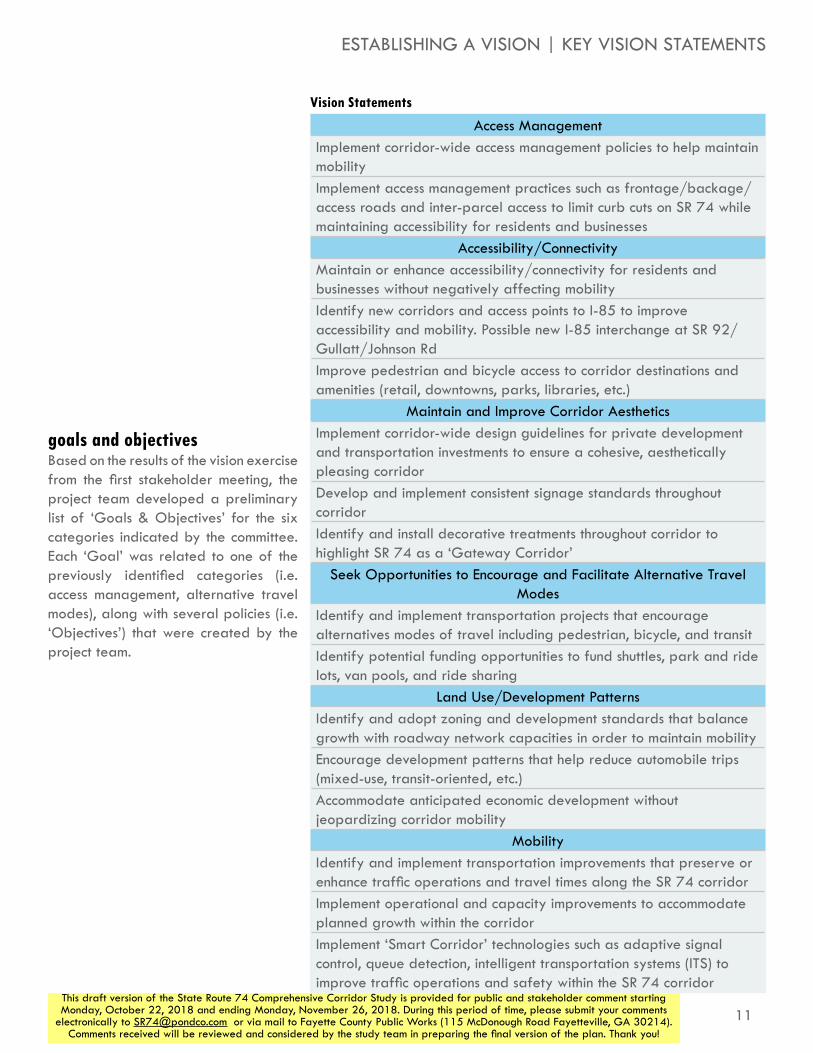
Vision Statements
Access ManagementImplement corridor-wide access management policies to help maintain mobilityImplement access management practices such as frontage/backage/access roads and inter-parcel access to limit curb cuts on SR 74 while maintaining accessibility for residents and businesses
Accessibility/ConnectivityMaintain or enhance accessibility/connectivity for residents and businesses without negatively affecting mobilityIdentify new corridors and access points to I-85 to improve accessibility and mobility. Possible new I-85 interchange at SR 92/Gullatt/Johnson RdImprove pedestrian and bicycle access to corridor destinations and amenities (retail, downtowns, parks, libraries, etc.)
Maintain and Improve Corridor AestheticsImplement corridor-wide design guidelines for private development and transportation investments to ensure a cohesive, aesthetically pleasing corridorDevelop and implement consistent signage standards throughout corridorIdentify and install decorative treatments throughout corridor to highlight SR 74 as a ‘Gateway Corridor’
Seek Opportunities to Encourage and Facilitate Alternative Travel Modes
Identify and implement transportation projects that encourage alternatives modes of travel including pedestrian, bicycle, and transitIdentify potential funding opportunities to fund shuttles, park and ride lots, van pools, and ride sharing
Land Use/Development PatternsIdentify and adopt zoning and development standards that balance growth with roadway network capacities in order to maintain mobilityEncourage development patterns that help reduce automobile trips (mixed-use, transit-oriented, etc.)Accommodate anticipated economic development without jeopardizing corridor mobility
MobilityIdentify and implement transportation improvements that preserve or enhance traffic operations and travel times along the SR 74 corridorImplement operational and capacity improvements to accommodate planned growth within the corridorImplement ‘Smart Corridor’ technologies such as adaptive signal control, queue detection, intelligent transportation systems (ITS) to improve traffic operations and safety within the SR 74 corridor
goals and objectivesBased on the results of the vision exercise from the first stakeholder meeting, the project team developed a preliminary list of ‘Goals & Objectives’ for the six categories indicated by the committee. Each ‘Goal’ was related to one of the previously identified categories (i.e. access management, alternative travel modes), along with several policies (i.e. ‘Objectives’) that were created by the project team.
ESTABLISHING A VISION | KEY VISION STATEMENTS

12This draft version of the State Route 74 Comprehensive Corridor Study is provided for public and stakeholder comment starting Monday, October 22, 2018 and ending Monday, November 26, 2018. During this period of time, please submit your comments
electronically to [email protected] or via mail to Fayette County Public Works (115 McDonough Road Fayetteville, GA 30214). Comments received will be reviewed and considered by the study team in preparing the final version of the plan. Thank you!
EXISTING CORRIDOR CONDITIONSexisting travel volumes and demandSR 74 is a primary route through western Fayette County and southern Fulton County, which provides the primary access to I-85 and the regional transportation network for many residents and businesses, connecting the communities of Fairburn, Tyrone and Peachtree City. GDOT counts from year 2016 show 33,000 to 36,000 vehicles per day south of I-85 and between 19,000 and 20,000 vehicles per day north of I-85. The map to the right shows volumes on SR 74 and nearby roadways, estimated from the Atlanta Regional Commission’s (ARC’s) Activity-Based Travel Demand Model (TDM), in year 2015. SR 74 is one of the most utilized roads in the area, dwarfed only by I-85, with comparable volumes on SR 54 to the south and Palmetto Road/Tyrone Road in the center of the corridor.
To better understand corridor traffic operations, twenty-four major intersections shown on the far right were specifically analyzed. Of these, four had been counted as part of recent studies (these are marked on the list below with an asterisk *). Turning movement counts at the remaining twenty intersections were performed on Tuesday, October 17, 2017. Complete count data is included in Appendix B. Analyzed intersections are shown to the far right, and are listed below:
»» SR 74 and SW Broad Street/US 29 Ramp
»» SR 74 and McLarin Road Ramp
»» SR 74 and Senoia Road (north)
»» SR 74 and I-85 Southbound Ramps
»» SR 74 and I-85 Northbound Ramps*
»» SR 74 and Oakley Industrial Boulevard
»» SR 74 and Harris Road
»» SR 74 and Meadow Glen Parkway
»» SR 74 and Landrum Road/Milam Road
»» SR 74 and Kirkley Road/Westbourne Drive
»» SR 74 and Laurelmont Drive/Sandy Creek Road*
»» SR 74 and Peggy Lane/Jenkins Road
»» SR 74 and Carriage Oaks Drive
»» SR 74 and Palmetto Road/Tryone Road
»» SR 74 and E Crestwood Road
»» SR 74 and Dogwood Trail
»» SR 74 and Crabapple Lane/N Peachtree Parkway*
»» SR 74 and Ardenlee Parkway/Georgian Park
»» SR 74 and Kedron Drive (north)
»» SR 74 and Senoia Road (south)/Lexington Pass
»» SR 74 and Kedron Drive (south)
»» SR 74 and Wisdom Road
»» SR 74 and Aberdeen Parkway
»» SR 74 and SR 54*

13This draft version of the State Route 74 Comprehensive Corridor Study is provided for public and stakeholder comment starting Monday, October 22, 2018 and ending Monday, November 26, 2018. During this period of time, please submit your comments
electronically to [email protected] or via mail to Fayette County Public Works (115 McDonough Road Fayetteville, GA 30214). Comments received will be reviewed and considered by the study team in preparing the final version of the plan. Thank you!
Daily Traffic Volumes, Year 2015, ARC Travel Demand Model
85
Tyrone
Peachtree City
Fairburn
N
milam rd
sandy creek rd
jenkins rd
tyrone rd
palmetto rd
Fayette Co
Fulton Co
Coweta Co
Cow
eta Co
dogwood trl
seno
ia rd
oakley ind blvd
n peachtree pkwy
74
54
29
Analyzed Intersections
85
Tyrone
Peachtree City
Fairburn
milam rd
sandy creek rd
jenkins rd
tyrone rd
palmetto rd
Fayette CoFulton Co
Coweta CoC
oweta C
o
dogwood trl
seno
ia rd
oakley ind blvd
n peachtree pkwy
74
54
29
N
5,000
10,000
20,000
50,000
Average Vehicles Per Day
EXISTING CORRIDOR CONDITIONS

14
STATE ROUTE 74COMPREHENSIVE CORRIDOR STUDY
This draft version of the State Route 74 Comprehensive Corridor Study is provided for public and stakeholder comment starting Monday, October 22, 2018 and ending Monday, November 26, 2018. During this period of time, please submit your comments
electronically to [email protected] or via mail to Fayette County Public Works (115 McDonough Road Fayetteville, GA 30214). Comments received will be reviewed and considered by the study team in preparing the final version of the plan. Thank you!
level of service At a corridor level, the TDM can also be used to estimate congestion along roadways as shown on the facing maps. These maps use Level of Service (LOS) to measure congestion. LOS is reported as a letter, from A through F, related to the amount of congestion experienced at a certain location. Generally speaking an LOS of A through D is considered acceptable, while LOS of E or F are considered less desirable, with infrastructure improvements often needed to improve the movement of traffic. The model indicates that most of the corridor is relatively well served, with moderate levels of congestion during both the morning and evening peak periods, primarily leading up to and away from the I-85 interchange.

15This draft version of the State Route 74 Comprehensive Corridor Study is provided for public and stakeholder comment starting Monday, October 22, 2018 and ending Monday, November 26, 2018. During this period of time, please submit your comments
electronically to [email protected] or via mail to Fayette County Public Works (115 McDonough Road Fayetteville, GA 30214). Comments received will be reviewed and considered by the study team in preparing the final version of the plan. Thank you!
Level of Service, Year 2015 AM Period, ARC Travel Demand Model
Level of Service, Year 2015 PM Period, ARC Travel Demand Model
EXISTING CORRIDOR CONDITIONS | LEVEL OF SERVICE
85
Tyrone
Peachtree City
Fairburn
N
milam rd
sandy creek rd
jenkins rd
tyrone rd
palmetto rd
Fayette Co
Fulton Co
Coweta Co
Cow
eta Co
dogwood trl
seno
ia rd
oakley ind blvd
n peachtree pkwy
74
54
29
85
Tyrone
Peachtree City
Fairburn
N
milam rd
sandy creek rd
jenkins rd
tyrone rd
palmetto rd
Fayette Co
Fulton Co
Coweta Co
Cow
eta Co
dogwood trl
seno
ia rd
oakley ind blvd
n peachtree pkwy
74
54
29

16
STATE ROUTE 74COMPREHENSIVE CORRIDOR STUDY
This draft version of the State Route 74 Comprehensive Corridor Study is provided for public and stakeholder comment starting Monday, October 22, 2018 and ending Monday, November 26, 2018. During this period of time, please submit your comments
electronically to [email protected] or via mail to Fayette County Public Works (115 McDonough Road Fayetteville, GA 30214). Comments received will be reviewed and considered by the study team in preparing the final version of the plan. Thank you!
85
Tyrone
Peachtree City
Fairburn
N
milam rd
sandy creek rd
jenkins rd
tyrone rd
palmetto rd
Fulton Co
Coweta Co
dogwood trl
seno
ia rd
oakley ind blvd
n peachtree pkwy
74
54
29
12
3
45678
9
1011
12
13
14
15
16
17
18
19
2021
22
24
Analyzed Intersections by Current Control Type
23
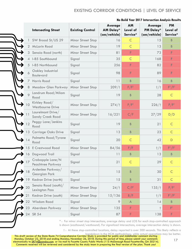
Deeper analysis is typically needed to understand specific conditions and operations at a given intersection. For this study, detailed intersection-level analyses were performed using Trafficware’s Synchro software for twenty-four intersections. Raw output of the intersection analyses performed are included in Appendix B, while the results are shown to the right. Similar to the TDM results, intersection congestion is the most pronounced near the I-85 interchange at the I-85 ramp intersections and Oakley Industrial Boulevard. Also, the intersection with SR 54 experiences very high levels of congestion. Several of the side streets that are currently stop-controlled at SR 74 experience substantial delays along the corridor as well.
17This draft version of the State Route 74 Comprehensive Corridor Study is provided for public and stakeholder comment starting Monday, October 22, 2018 and ending Monday, November 26, 2018. During this period of time, please submit your comments
electronically to [email protected] or via mail to Fayette County Public Works (115 McDonough Road Fayetteville, GA 30214). Comments received will be reviewed and considered by the study team in preparing the final version of the plan. Thank you!
Intersecting Street Existing ControlAverage
AM Delay* (sec/vehicle)
AM Level of Service*
Average PM Delay*
(sec/vehicle)
PM Level of Service*
1 SW Broad St/US 29 Minor Street Stop 16 C 15 B
2 McLarin Road Minor Street Stop 19 C 13 B
3 Senoia Road (north) Minor Street Stop 81 F 73 F
4 I-85 Southbound Signal 35 C 168 F
5 I-85 Northbound Signal 256 F 82 F
6Oakley Industrial Boulevard
Signal 98 F 89 F
7 Harris Road Signal 11 B 16 B
8 Meadow Glen Parkway Minor Street Stop 209/† F/F† †/† F†/F†
9Landrum Road/Milam Road
Signal 19 B 28 C
10Kirkley Road/Westbourne Drive
Minor Street Stop 274/† F/F† 226/† F/F†
11Laurelmont Drive/Sandy Creek Road
Minor Street Stop 16/221 C/F 27/29 D/D
12Peggy Lane/Jenkins Road
Signal 19 B 21 C
13 Carriage Oaks Drive Signal 13 B 23 C
14Palmetto Road/Tyrone Road
Signal 20 C 42 D
15 E Crestwood Road Minor Street Stop 84/56 F/F †/† F†/F†
16 Dogwood Trail Signal 11 B 13 B
17Crabapple Lane/N Peachtree Parkway
Signal 21 C 29 C
18Ardenlee Parkway/Georgian Park
Signal 15 B 30 C
19 Kedron Drive (north) Signal 15 B 31 C
20Senoia Road (south)/Lexington Pass
Minor Street Stop 24/† C/F† 135/† F/F†
21 Kedron Drive (south) Minor Street Stop 15/136 B/F †/† F†/F†
22 Wisdom Road Signal 9 A 14 B
23 Aberdeen Parkway Minor Street Stop 135 F † F†
24 SR 54 Signal 87 F 138 F
No Build Year 2017 Intersection Analysis Results
EXISTING CORRIDOR CONDITIONS | LEVEL OF SERVICE
* : For minor street stop intersections, average delay and LOS for each stop-controlled approach is shown (eastbound/westbound). For signalized intersections, average intersection delay is shown.
† : At these stop-controlled locations, delay reported is over 300 seconds. This likely reflects a breakdown in the HCM methodology, while actual operations may be better.
18
STATE ROUTE 74COMPREHENSIVE CORRIDOR STUDY
This draft version of the State Route 74 Comprehensive Corridor Study is provided for public and stakeholder comment starting Monday, October 22, 2018 and ending Monday, November 26, 2018. During this period of time, please submit your comments
electronically to [email protected] or via mail to Fayette County Public Works (115 McDonough Road Fayetteville, GA 30214). Comments received will be reviewed and considered by the study team in preparing the final version of the plan. Thank you!
employment patternsWithin one mile of the study corridor, there are approximately 16,000 jobs (LEHD, 2015). Major industries include Accommodation and Food Services (14% of all employment), Retail Trade (13%), Wholesale Trade (12%), and Manufacturing (9%). The southern end of the study corridor, at SR 54, is a major hub for employment in the region, with a high concentration of retail, and services, mixed with offices and schools and other public services. The I-85 interchange is an increasingly busy employment center, with highway-oriented developments (gas stations, fast food restaurants, hotels, etc.) opening along SR 74, with residential areas, manufacturing, and warehousing facilities present just off the corridor. The study corridor also serves as a major route to other employment areas via I-85. Likewise, south of SR 54, there is a concentration of manufacturing and warehousing uses, which similarly occurs east and west of SR 74 near I-85.

19This draft version of the State Route 74 Comprehensive Corridor Study is provided for public and stakeholder comment starting Monday, October 22, 2018 and ending Monday, November 26, 2018. During this period of time, please submit your comments
electronically to [email protected] or via mail to Fayette County Public Works (115 McDonough Road Fayetteville, GA 30214). Comments received will be reviewed and considered by the study team in preparing the final version of the plan. Thank you!
85
Tyrone
Peachtree City
Fairburn
N
milam rd
sandy creek rd
jenkins rd
tyrone rd
palmetto rd
Fayette Co
Fulton Co
Coweta Co
Cow
eta Co
dogwood trl
seno
ia rd
oakley ind blvd
n peachtree pkwy
74
54
29
EXISTING CORRIDOR CONDITIONS | EMPLOYMENT PATTERNS
Employment (2015)
Source: US Census Bureau Longitudinal Employer-Household Dynamics, 2015
10 jobs50 jobs
100 jobs
Jobs at a location

20
STATE ROUTE 74COMPREHENSIVE CORRIDOR STUDY
This draft version of the State Route 74 Comprehensive Corridor Study is provided for public and stakeholder comment starting Monday, October 22, 2018 and ending Monday, November 26, 2018. During this period of time, please submit your comments
electronically to [email protected] or via mail to Fayette County Public Works (115 McDonough Road Fayetteville, GA 30214). Comments received will be reviewed and considered by the study team in preparing the final version of the plan. Thank you!
Commute Direction for Those Who Live Within One Mile of Study Corridor (2015)
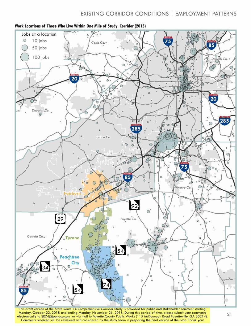
SR 74 also serves as a path to workplaces for those who live along it. The map to the right shows the workplaces of the approximately 13,000 people who live within one mile of the study corridor. The most concentrated area of employment is the area near Hartsfield-Jackson Atlanta International Airport. While not as densly concentrated, twice as many residents actually work in Tyrone or Peachtree City as work in or near the airport. Additional concentrations of jobs are found in Downtown, Midtown, and Buckhead Atlanta, as well as closer to Fayetteville and all around the southern and western parts of the Metropolitan Atlanta region.
The location of these job hubs means that many workers travel substantial distances for their daily commute. Approximately 3,400 workers (27%) are lucky enough to live and work within ten miles. However, 8,300 workers (65%) work between ten and fifty miles away from home, with the remaining 1,000 workers (8%) living more than fifty miles from their workplace. The majority (65%) of workplaces for these residents are either north or northeast of their homes, which suggests a heavy reliance on SR 74 and/or I-85 to get between work and home.
N
S
EW
Source: US Census Bureau Longitudinal Employer-Household Dynamics, 2015
5,900commuters
1,000commuters500
commuters
500commuters
300commuters
2,300commuters
1,300commuters
900commuters
21This draft version of the State Route 74 Comprehensive Corridor Study is provided for public and stakeholder comment starting Monday, October 22, 2018 and ending Monday, November 26, 2018. During this period of time, please submit your comments
electronically to [email protected] or via mail to Fayette County Public Works (115 McDonough Road Fayetteville, GA 30214). Comments received will be reviewed and considered by the study team in preparing the final version of the plan. Thank you!
Work Locations of Those Who Live Within One Mile of Study Corridor (2015)
10 jobs50 jobs
100 jobs
Jobs at a location
85
85
85
20
20
75
75
285285
Tyrone
Fairburn
74
54
54
34
92
Fayette Co.
Fulton Co.
Coweta Co.
Douglas Co.
Cobb Co.
DeKalb Co.
Henry Co.
29
EXISTING CORRIDOR CONDITIONS | EMPLOYMENT PATTERNS
Peachtree City
22
STATE ROUTE 74COMPREHENSIVE CORRIDOR STUDY
This draft version of the State Route 74 Comprehensive Corridor Study is provided for public and stakeholder comment starting Monday, October 22, 2018 and ending Monday, November 26, 2018. During this period of time, please submit your comments
electronically to [email protected] or via mail to Fayette County Public Works (115 McDonough Road Fayetteville, GA 30214). Comments received will be reviewed and considered by the study team in preparing the final version of the plan. Thank you!
85
Tyrone
Peachtree City
Fairburn
milam rd
sandy creek rd
jenkins rd
tyrone rd
palmetto rd
Fayette CoFulton Co
Coweta CoC
oweta C
o
dogwood trl
seno
ia rd
oakley ind blvd
n peachtree pkwy
74
54
29
N
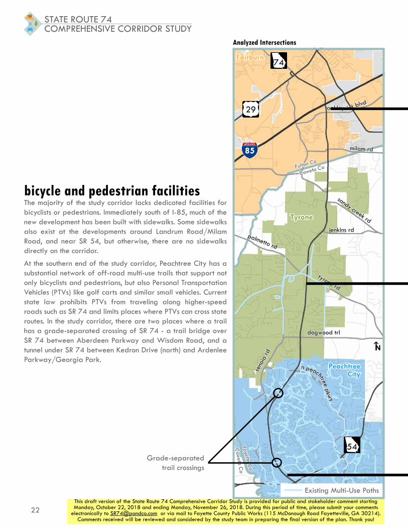
bicycle and pedestrian facilitiesThe majority of the study corridor lacks dedicated facilities for bicyclists or pedestrians. Immediately south of I-85, much of the new development has been built with sidewalks. Some sidewalks also exist at the developments around Landrum Road/Milam Road, and near SR 54, but otherwise, there are no sidewalks directly on the corridor.
At the southern end of the study corridor, Peachtree City has a substantial network of off-road multi-use trails that support not only bicyclists and pedestrians, but also Personal Transportation Vehicles (PTVs) like golf carts and similar small vehicles. Current state law prohibits PTVs from traveling along higher-speed roads such as SR 74 and limits places where PTVs can cross state routes. In the study corridor, there are two places where a trail has a grade-separated crossing of SR 74 - a trail bridge over SR 74 between Aberdeen Parkway and Wisdom Road, and a tunnel under SR 74 between Kedron Drive (north) and Ardenlee Parkway/Georgia Park.
Analyzed Intersections
Grade-separated trail crossings
Existing Multi-Use Paths

23This draft version of the State Route 74 Comprehensive Corridor Study is provided for public and stakeholder comment starting Monday, October 22, 2018 and ending Monday, November 26, 2018. During this period of time, please submit your comments
electronically to [email protected] or via mail to Fayette County Public Works (115 McDonough Road Fayetteville, GA 30214). Comments received will be reviewed and considered by the study team in preparing the final version of the plan. Thank you!
EXISTING CORRIDOR CONDITIONS | BICYCLE AND PEDESTRIAN FACILITIES
In the Tyrone area, much of the corridor has a rural feel and bicycle and
pedestrian facilities are not common
In Peachtree City, active mode transportation is separated from the SR 74 Corridor via multi-use paths
Though intermittent, sidewalks and pedestrian crossing features are
available near the I-85 interchange

24
STATE ROUTE 74COMPREHENSIVE CORRIDOR STUDY
This draft version of the State Route 74 Comprehensive Corridor Study is provided for public and stakeholder comment starting Monday, October 22, 2018 and ending Monday, November 26, 2018. During this period of time, please submit your comments
electronically to [email protected] or via mail to Fayette County Public Works (115 McDonough Road Fayetteville, GA 30214). Comments received will be reviewed and considered by the study team in preparing the final version of the plan. Thank you!
corridor accessThe number, density, and type of access points along a corridor can have profound impacts on its operation and safety. Corridors with fewer access points and/or less permissive access points are generally safer and operate more efficiently for vehicles travelling longer distances along them. In contrast, corridors with more access points and/or more permissive access points are typically more convenient for drivers who are making shorter trips onto and off of the corridor, but have higher risk of crashes and are less efficient for vehicles travelling along them.
SR 74 features a wide grassy median for much of its length within the study area, which effectively limits the number of full access points on the corridor. There are thirty locations within the twelve mile study corridor where a vehicle can make all movements to/from an intersecting street or driveway. These access points are spread fairly evenly, with a concentration in the immediate vicinity of the I-85 interchange. Additionally, there are sixty-nine locations where the only access to an intersecting street or driveway is a right turn from SR 74 onto the street/driveway and a right turn from the street/driveway onto SR 74. These kinds off access are more concentrated where developments exist, especially immediately south of I-85, south of Milam Road, and between Kedron Drive (south) and SR 54.
Access
MobilityFreeway
Major Arterial
Minor Arterial
Major Collector
Minor Collector
Local Street

25This draft version of the State Route 74 Comprehensive Corridor Study is provided for public and stakeholder comment starting Monday, October 22, 2018 and ending Monday, November 26, 2018. During this period of time, please submit your comments
electronically to [email protected] or via mail to Fayette County Public Works (115 McDonough Road Fayetteville, GA 30214). Comments received will be reviewed and considered by the study team in preparing the final version of the plan. Thank you!
EXISTING CORRIDOR CONDITIONS | CORRIDOR ACCESS
85
Tyrone
Peachtree City
Fairburn
N
milam rd
sandy creek rd
jenkins rd
tyrone rd
palmetto rd
Fulton Co
Coweta Co
dogwood trl
seno
ia rd
oakley ind blvd
n peachtree pkwy
74
54
29
85
Tyrone
Peachtree City
Fairburn
N
milam rd
sandy creek rd
jenkins rd
tyrone rd
palmetto rd
Fayette Co
Fulton Co
Coweta Co
Cow
eta Co
dogwood trl
seno
ia rd
oakley ind blvd
n peachtree pkwy
74
54
29
Locations of Full Access Points Locations of Partial/Restricted Access Points
Access Points
Traffic Signal
Other Full-Access Median Opening
Partial Access Points
Right In/Right Out
Ramp Access

26
STATE ROUTE 74COMPREHENSIVE CORRIDOR STUDY
This draft version of the State Route 74 Comprehensive Corridor Study is provided for public and stakeholder comment starting Monday, October 22, 2018 and ending Monday, November 26, 2018. During this period of time, please submit your comments
electronically to [email protected] or via mail to Fayette County Public Works (115 McDonough Road Fayetteville, GA 30214). Comments received will be reviewed and considered by the study team in preparing the final version of the plan. Thank you!
safetyIn order to evaluate crash patterns and safety risks in the study corridor, crash data was retreived from the Georgia Electronic Accident Reporting System (GEARS) database. Data from this database was used to examine overall crash patterns. As shown in the table below, based on crash data from 2013 through 2017, the study corridor experienced lower crash rates (457 crashes per 100 million vehicle-miles traveled) than the average for similar types of roads throughout Georgia (628 crashes per 100 million vehicle-miles traveled).
The map immediately to the right shows where crashes occurred more and less frequently. The highest concentrations of crashes occur at major cross streets, including the I-85 interchange and at SR 54. However, we can also see higher crash occurences near Carriage Oaks Drive and Crabapple Lane/N Peachtree Parkway. The table on the opposite page shows crashes by severity near each analyzed intersection. Of note, the intersections of SR 74 with the I-85 southbound ramps, Oakley Industrial Boulevard, and SR 54 had intersection crash rates higher than the statewide average.
85
Tyrone
Peachtree City
Fairburn
milam rd
sandy creek rd
jenkins rd
tyrone rd
palmetto rd
Fayette CoFulton Co
Coweta CoC
oweta C
o
dogwood trl
seno
ia rd
oakley ind blvd
n peachtree pkwy
74
54
29
N
Heat Map of Crashes on Study Corridor
Study Corridor Crash Statistics (2013-2017)
Total Crashes 3,332
Crashes per 100 Million Vehicle-Miles of Travel 457
Statewide Crash Rate Average for Non-Freeway Principal Arterials in Urban Areas (2016)
628
Angle 500
Head On 44
Rear End 1,759
Sideswipe - Same Direction 370
Sideswipe - Opposite Direction 34
Not a Collision with a Motor Vehicle 245
Other/Unclassified 380
Property Damage Only 2,826
Crashes with Injuries 500
Crashes with Fatalities 6
Crash Frequency
Fewer crashes
More crashes

27This draft version of the State Route 74 Comprehensive Corridor Study is provided for public and stakeholder comment starting Monday, October 22, 2018 and ending Monday, November 26, 2018. During this period of time, please submit your comments
electronically to [email protected] or via mail to Fayette County Public Works (115 McDonough Road Fayetteville, GA 30214). Comments received will be reviewed and considered by the study team in preparing the final version of the plan. Thank you!
Crashes by Intersection and Severity
85
Tyrone
Peachtree City
Fairburn
N
milam rd
sandy creek rd
jenkins rd
tyrone rd
palmetto rd
Fulton Co
Coweta Co
dogwood trl
seno
ia rd
oakley ind blvd
n peachtree pkwy
74
54
29
12
3
45678
9
1011
12
13
14
15
16
17
18
19
2021
22
24
23
Prop
erty
Dam
age
Onl
y C
rash
es
Inju
ry C
rash
es
Fata
l Cra
shes
Tota
l Cra
shes
1 SW Broad St/US 29 8 4 0 12
2 McLarin Road 8 2 0 10
3 Senoia Road (north) 8 3 0 11
4 I-85 Southbound 239 36 0 275
5 I-85 Northbound 155 16 0 171
6 Oakley Industrial Boulevard 356 57 1 414
7 Harris Road 158 32 0 190
8 Meadow Glen Parkway 33 7 0 40
9 Landrum Road/Milam Road 67 17 0 84
10Kirkley Road/Westbourne Drive
14 2 0 16
11Laurelmont Drive/Sandy Creek Road
37 5 0 42
12 Peggy Lane/Jenkins Road 32 4 0 36
13 Carriage Oaks Drive 26 3 1 30
14 Palmetto Road/Tyrone Road 30 8 0 38
15 E Crestwood Road 8 2 0 10
16 Dogwood Trail 15 4 0 19
17Crabapple Lane/N Peachtree Parkway
67 15 0 82
18Ardenlee Parkway/Georgian Park
52 19 0 71
19 Kedron Drive (north) 52 6 0 58
20Senoia Road (south)/Lexington Pass
25 6 1 32
21 Kedron Drive (south) 23 17 0 40
22 Wisdom Road 54 24 0 78
23 Aberdeen Parkway 43 8 0 51
24 SR 54 375 54 0 429
EXISTING CORRIDOR CONDITIONS | SAFETY
Note: Some crashes on the corridor have occurred in segments between intersections

28
STATE ROUTE 74COMPREHENSIVE CORRIDOR STUDY
This draft version of the State Route 74 Comprehensive Corridor Study is provided for public and stakeholder comment starting Monday, October 22, 2018 and ending Monday, November 26, 2018. During this period of time, please submit your comments
electronically to [email protected] or via mail to Fayette County Public Works (115 McDonough Road Fayetteville, GA 30214). Comments received will be reviewed and considered by the study team in preparing the final version of the plan. Thank you!
analysis of development regulationsDevelopment Regulations across all three jurisdictions were also considered to understand which elements have the potential to promote a sense of uniformity along the corridor. The project team began by conducting a detailed analysis of current development codes in all three municipalities for nineteen development categories, included in Appendix C. After compiling this detailed matrix, the project team developed a more condensed version, shown here, identifying six categories that were considered to have the greatest potential for cross-jurisdictional cooperation to promote uniformity along the corridor.
City of Fairburn Town of Tyrone City of Peachtree City
Acc
ess
Man
agem
ent
Highway 74 Overlay District: Seconary road networks that channel traffic between developments is encouraged. One driveway per existing parcel. Landscaping of secondary road networks (i.e. boulevard) are provided lot coverage bonuses (10%); sidewalks for pedestrian access (w natural features preserved); gasoline stations only at signalized intersections
Every building should be on lot abutting public street or has access to street via easement. All parking facilities should have access to public street. Every subdivision should have access via a public or private street.
Every subdivision shall have acces via public/private street. Fencing/signage at intersection of any private driveway to a street is prohibimited that will impede vibility within 25 ft.
Fro
nt S
etba
cks
R-1:60'; R-2: 50', R-3: 45', R-4: 35'; O-1, C-1, M-1:35'
R-20: 100', R-18, R-12: 80' from major thoroughfare, 55' from residential street, O-1: 80' from major thoroughfare, 55' from residential street, C-2: 50' from public street, M-1: 100' from major thoroughfare
R-1: Building (40') Parking (20'), O-1: Building (40'), Parking (20')
Park
ing
Retail/Commercial: 1 space per 200 sq ft GLA
Residential: 2 spaces per dwelling unit; Commercial: One Space per 2,000 sq ft of GLA,
Residential: Single-Family: 2 spaces per dwelling unit, Office/Commercial: 1 space per 250 sq ft GLA.
Side
wal
k St
anda
rds Required on all street frontages,
regardless of zoning district; minimum width of 5', ADA compliant
Required in all residential developments on both sides of sreets; minimum width of 4', ADA compliant
Must meet or exceed ADA and AASHTO standards; min. 2' wide grass strip between back of curb and front edge of sidewalk

29This draft version of the State Route 74 Comprehensive Corridor Study is provided for public and stakeholder comment starting Monday, October 22, 2018 and ending Monday, November 26, 2018. During this period of time, please submit your comments
electronically to [email protected] or via mail to Fayette County Public Works (115 McDonough Road Fayetteville, GA 30214). Comments received will be reviewed and considered by the study team in preparing the final version of the plan. Thank you!
EXISTING CORRIDOR CONDITIONS | ANALYSIS OF DEVELOPMENT REGULATIONSG
reen
spac
e
Guide to Sustainabiliy in Municipal Operations (2009): "No Net Loss of Trees": Encourage development of "Single-Family Cluster District" - supporting protection of greenspace and enhanced lanscape ammenities, "in-lieu-of-fee program" for developments not in compliance w/ existing landscaping ordinances. Georgia Highway 74 District: Minimum 35 ft landscaped buffer to Highway 74 ROW in retail and commercial development. Minimum 45 ft landscape buffer in office development.
Arterials/major collectors: Minimum of 60' between ROW and property line; Minor collectors: Minimum 25' between ROW and property line; Designated as "Town Greenspace Area".
Peachtree City Tree Fund: Receives payments by property owners in lieu of planting trees towards tree bank to maintain tree canopy.
Sign
age
C-2 Zoning - One freestanding or monument sign, max. 50 sq. ft., max. height 20', wall signs max. 10% of gross wall area or 150 sq. ft.; Planned Centers in C-2 Zoning - max. 100 sq. ft. freestanding or monument sign for each street frontage, max. height 20', wall signs max. 10% of gross wall area or 150 sq. ft.
One freestanding sign per parcel - max. 6' height, 10' width, not to exceed 40 sq. ft. in area; multiple businesses on parcel - one freestanding sign, max. 7' height, 10' width, not to exceed 60 sq. ft. in area; external illumination only; one wall sign not to exceed 1.5 sq. ft. per linear foot of the front length of building, if linear frontage of a bldg. or portion thereof occupied is 100' or less, the max. size of a wall sign is 70 sq. ft.; if linear frontage of a bldg. or portion thereof occupied is in excess of 100', max. size of wall sign is 150 sq. ft.
Public Use, all districts: One monument sign not greater than 32 sq ft and five ft high. Residential (not multi-fam): One sign not greater than 15 ft and higher than 5 ft. Setback of at least five ft. Subdivision: Not larger than 24 sq ft.
Bloc
k A
rea
and
Leng
th
NoneSuggested that blocks shall not be greater than 1,800 ft. nor less than 600 ft. in length
Suggested that blocks shall be not greater than 1,800 ft. nor less than 600' in length
City of Fairburn Town of Tyrone City of Peachtree City

30This draft version of the State Route 74 Comprehensive Corridor Study is provided for public and stakeholder comment starting Monday, October 22, 2018 and ending Monday, November 26, 2018. During this period of time, please submit your comments
electronically to [email protected] or via mail to Fayette County Public Works (115 McDonough Road Fayetteville, GA 30214). Comments received will be reviewed and considered by the study team in preparing the final version of the plan. Thank you!
ASSESSING FUTURE NEEDS
forecasting future travelIn order to anticipate future traffic needs and identify the best improvements to accommodate those needs, we must estimate how much traffic will grow. In order to estimate future growth, two primary sources are commonly used: historic trends and Travel Demand Model (TDM) outputs. Historic trend analyses use count data, reported by GDOT, to use an area’s past as a suggested way to grow. An area’s TDM uses projections about housing, employment, and trip-making characteristics to anticipate how traffic in an area will grow.
employment and population changeARC produces projections of residential populations and of jobs for the entire Metropolitan Atlanta region. By comparing these projections to current information from the US Census Bureau, we can see substantial increases in employment projected to the north and east of SR 74, along I-85 and into Fairburn. Additional increases can be seen at the southern end, in Peachtree City. Population increases are more heavily projected in the area in and near Tyrone, at the center of the corridor.

31This draft version of the State Route 74 Comprehensive Corridor Study is provided for public and stakeholder comment starting Monday, October 22, 2018 and ending Monday, November 26, 2018. During this period of time, please submit your comments
electronically to [email protected] or via mail to Fayette County Public Works (115 McDonough Road Fayetteville, GA 30214). Comments received will be reviewed and considered by the study team in preparing the final version of the plan. Thank you!
85
Tyrone
Peachtree City
Fairburn
N
milam rd
sandy creek rd
jenkins rd
tyrone rd
palmetto rd
Fulton Co
Coweta Co
dogwood trl
seno
ia rd
oakley ind blvd
n peachtree pkwy
74
54
29
85
Tyrone
Peachtree City
Fairburn
N
milam rd
sandy creek rd
jenkins rd
tyrone rd
palmetto rd
Fayette CoFulton Co
Coweta CoC
oweta C
o
dogwood trl
seno
ia rd
oakley ind blvd
n peachtree pkwy
74
54
29
10 jobs50 jobs
100 jobs
Jobs at a location
Population Density (ppl. per acre)
< 1
1-5
5-10
> 10
2010 Population Density and Employment Concentrations
2040 Population Density and Employment Concentrations
ASSESSING FUTURE NEEDS | FORECASTING FUTURE TRAVEL
32
STATE ROUTE 74COMPREHENSIVE CORRIDOR STUDY
This draft version of the State Route 74 Comprehensive Corridor Study is provided for public and stakeholder comment starting Monday, October 22, 2018 and ending Monday, November 26, 2018. During this period of time, please submit your comments
electronically to [email protected] or via mail to Fayette County Public Works (115 McDonough Road Fayetteville, GA 30214). Comments received will be reviewed and considered by the study team in preparing the final version of the plan. Thank you!
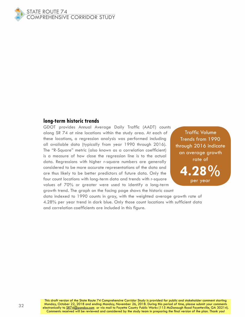
long-term historic trendsGDOT provides Annual Average Daily Traffic (AADT) counts along SR 74 at nine locations within the study area. At each of these locations, a regression analysis was performed including all available data (typically from year 1990 through 2016). The “R-Square” metric (also known as a correlation coefficient) is a measure of how close the regression line is to the actual data. Regressions with higher r-square numbers are generally considered to be more accurate representations of the data and are thus likely to be better predictors of future data. Only the four count locations with long-term data and trends with r-square values of 70% or greater were used to identify a long-term growth trend. The graph on the facing page shows the historic count data indexed to 1990 counts in gray, with the weighted average growth rate of 4.28% per year trend in dark blue. Only those count locations with sufficient data and correlation coefficients are included in this figure.
Traffic Volume Trends from 1990
through 2016 indicate an average growth
rate of
4.28% per year

33This draft version of the State Route 74 Comprehensive Corridor Study is provided for public and stakeholder comment starting Monday, October 22, 2018 and ending Monday, November 26, 2018. During this period of time, please submit your comments
electronically to [email protected] or via mail to Fayette County Public Works (115 McDonough Road Fayetteville, GA 30214). Comments received will be reviewed and considered by the study team in preparing the final version of the plan. Thank you!
Long-Term Traffic Volume Trends (1990-2015)
Historic Count Data
Average Weighted Growth Trend
ASSESSING FUTURE NEEDS | FORECASTING FUTURE TRAVEL

34
STATE ROUTE 74COMPREHENSIVE CORRIDOR STUDY
This draft version of the State Route 74 Comprehensive Corridor Study is provided for public and stakeholder comment starting Monday, October 22, 2018 and ending Monday, November 26, 2018. During this period of time, please submit your comments
electronically to [email protected] or via mail to Fayette County Public Works (115 McDonough Road Fayetteville, GA 30214). Comments received will be reviewed and considered by the study team in preparing the final version of the plan. Thank you!
short-term historic trendsIn many cases, macroeconomic and broader regional influences can create more complicated trends over time. As such, it can be useful to analyze trends over a shorter term, to understand current growth trends in the area. In order to do this, an exercise identical to the previous one was undertaken, but only using data from year 2010 through year 2016. The results of this exercise are shown in the table and figure on the facing page. Based on the five locations with trends with r-square values of 70% or greater, an average growth rate of 5.90% is observed in these short-term trends. This indicates that more recent traffic growth has been at a higher rate than overall traffic growth since 1990.
Traffic Volume Trends from 2010
through 2016 indicate an average growth
rate of
5.90% per year

35This draft version of the State Route 74 Comprehensive Corridor Study is provided for public and stakeholder comment starting Monday, October 22, 2018 and ending Monday, November 26, 2018. During this period of time, please submit your comments
electronically to [email protected] or via mail to Fayette County Public Works (115 McDonough Road Fayetteville, GA 30214). Comments received will be reviewed and considered by the study team in preparing the final version of the plan. Thank you!
Short-Term Traffic Volume Trends (2010-2016)
Historic Count Data
Average Weighted Growth Trend
ASSESSING FUTURE NEEDS | FORECASTING FUTURE TRAVEL

36
STATE ROUTE 74COMPREHENSIVE CORRIDOR STUDY
This draft version of the State Route 74 Comprehensive Corridor Study is provided for public and stakeholder comment starting Monday, October 22, 2018 and ending Monday, November 26, 2018. During this period of time, please submit your comments
electronically to [email protected] or via mail to Fayette County Public Works (115 McDonough Road Fayetteville, GA 30214). Comments received will be reviewed and considered by the study team in preparing the final version of the plan. Thank you!
TDM volume trendsPredicted volumes from years 2015 and 2040 were taken from ARC’s regional travel demand model at the same nine locations that GDOT has taken counts. The model indicates an average 2015 ADT of approximately 22,100 vehicles per day and an average 2040 ADT of approximately 28,800 vehicles per day, which reflects a linear growth of approximately 1.22% per year.
The regional Travel Demand Model (TDM)
suggests a volume growth rate of
1.22% per year when
anticipating future conditions

37This draft version of the State Route 74 Comprehensive Corridor Study is provided for public and stakeholder comment starting Monday, October 22, 2018 and ending Monday, November 26, 2018. During this period of time, please submit your comments
electronically to [email protected] or via mail to Fayette County Public Works (115 McDonough Road Fayetteville, GA 30214). Comments received will be reviewed and considered by the study team in preparing the final version of the plan. Thank you!
Travel Demand Model Traffic Volumes in Years 2015 and 2040
Indexed Volumes
Average Weighted Growth Rate
ASSESSING FUTURE NEEDS | FORECASTING FUTURE TRAVEL

38
STATE ROUTE 74COMPREHENSIVE CORRIDOR STUDY
This draft version of the State Route 74 Comprehensive Corridor Study is provided for public and stakeholder comment starting Monday, October 22, 2018 and ending Monday, November 26, 2018. During this period of time, please submit your comments
electronically to [email protected] or via mail to Fayette County Public Works (115 McDonough Road Fayetteville, GA 30214). Comments received will be reviewed and considered by the study team in preparing the final version of the plan. Thank you!
TDM travelshed growthIn addition to examining the growth in traffic predicted by the model directly on the corridor, the travel demand model can be used to estimate change in the number of trips made in the areas that use SR 74. To do this, the model is used to identify the origin and destination areas (TAZs) of trips that use SR 74 at specific locations. The total number trips generated and attracted by those TAZs in year 2015 and year 2040 can then be determined and used as a way to predict growth in all traffic that may consider SR 74 an option. The map below shows a representation of traffic volumes that use SR 74 near the I-85 interchange, and shows how the concentration of trips origins and destinations varies across the region in year 2015. The map on the facing page shows those TAZs that have an
Travelshed Area and Volumes of Traffic that Travels through SR 74
Fewer Trips | More Trips
85
85
20
75
285
285
Tyrone
Fairburn
74
54
54
92Fayette Co.
Fulton Co.
Coweta Co.
Douglas Co.
Henry Co.
29
Peachtree City

39This draft version of the State Route 74 Comprehensive Corridor Study is provided for public and stakeholder comment starting Monday, October 22, 2018 and ending Monday, November 26, 2018. During this period of time, please submit your comments
electronically to [email protected] or via mail to Fayette County Public Works (115 McDonough Road Fayetteville, GA 30214). Comments received will be reviewed and considered by the study team in preparing the final version of the plan. Thank you!
impact on the SR 74 corridor, and is colored to show how trip making to and from those TAZs is anticipated to change from year 2015 to year 2040.
»» 2015 Travelshed-Generated Trips: 10.69 million
»» 2040 Travelshed-Generated Trips: 13,83 million
»» Annual linear growth rate: 1.18% per year
The regional Travel Demand Model (TDM) suggests that total trips generated within the
SR 74 travelshed will increase by
1.18% per year between now and the year 2040
Change in Trips Generated for SR 74 Travelshed
Greater Increase in Trips Generated
Change in Trips Generated per TAZ, 2015-2040
Dec
reas
e
85
85
20
75
285
285
Tyrone
Fairburn
74
54
54
92Fayette Co.
Fulton Co.
Coweta Co.
Douglas Co.
Henry Co.
29
ASSESSING FUTURE NEEDS | FORECASTING FUTURE TRAVEL
Peachtree City

40
STATE ROUTE 74COMPREHENSIVE CORRIDOR STUDY
This draft version of the State Route 74 Comprehensive Corridor Study is provided for public and stakeholder comment starting Monday, October 22, 2018 and ending Monday, November 26, 2018. During this period of time, please submit your comments
electronically to [email protected] or via mail to Fayette County Public Works (115 McDonough Road Fayetteville, GA 30214). Comments received will be reviewed and considered by the study team in preparing the final version of the plan. Thank you!
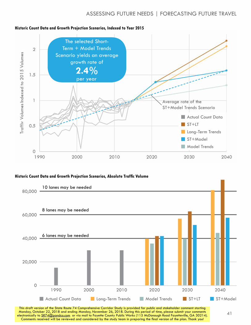
traffic volume growth scenariosBased on these analyses, a few projection options present themselves. If it is assumed that the long-term historic trends will bear out in the next 20-25 years, the long-term trend rate can be applied to current volumes to project future volumes. If it is expected that growth will be stronger than long-term trends suggest for several years, short-term trends can be applied for the first few years, with long-term trends being applied after that.
Similarly, the model trend growth rate can be applied if it is assumed that the regional travel demand model does a reasonable job of anticipating future regional growth. Alternatively, the short-term growth rate may be appropriate to assume for a few years, assuming stronger than estimated growth in the near future, with model trends applied further out.
Based on these assumptions, four projection strategies were created. In the combined projections, the short-term growth rate was applied for 6 years because the trends were calculated over a 6 year period. However, different assumptions about how long that level of growth is sustainable could be made, changing the projection outputs. The four projections strategies created are as follows:
»» Long-Term Trends: 4.28% per year growth applied consistently
»» Model Trends: 1.20% per year growth applied consistently
»» Short-Term + Long-Term Trends: 5.90% per year growth applied for 6 years, followed by 4.28% per year applied afterwards
»» Short-Term + Model Trends: 5.90% per year growth applied for 6 years, followed by 1.20% per year applied afterwards.
In order to help visualize how these projections compare to historic traffic growth along the corridor, the top facing graph shows all historic count data on SR 74 in grey, followed by the four projection strategies (all indexed to year 2015 volumes, for simplicity). The facing graphic on the bottom shows these same projection strategies applied to an average corridor ADT volume.
Based on a year 2016 average ADT of 33,700, the projection scenarios would result in the following year 2040 ADTs:
»» Long-Term Trends: 80,500 vpd
»» Model Trends: 44,300 vpd
»» Short-Term + Long-Term Trends: 89,300 vpd
»» Short-Term + Model Trends: 57,200 vpd
The historic trends observed have shown an exceptionally high rate of growth in traffic volume along the corridor. Much of this growth has occurred as previously undeveloped areas along the corridor have been developed. While plenty of undeveloped land still exists along and around the study corridor, it is unreasonable to expect that the high rate of growth seen over the last twenty-five years will continue in a sustained manner for the next twenty years. A comparable growth rate may occur during certain periods of growth, like the one that is occurring currently, but will likely not be consistent for a long period of time. For this reason, neither the Long-Term Trends nor the Short-Term + Long-Term Trends scenarios were considered realistic for projecting future travel volumes.
However, there is no indication that current growth trends will end in the immediate future, and plenty of developable land exists along the study corridor. The Model Trends scenario indicates a level of traffic growth much lower than what history suggests. Because of this, the Model Trends scenario was considered not aggressive enough. The Short-Term + Model Trends reflects a continuation of the current period of growth the corridor is experiencing, while also incorporating an understanding that this rate of growth is unlikely to be sustained for twenty or more years. As such, it was chosen as the traffic volume growth methodology for this study.
41This draft version of the State Route 74 Comprehensive Corridor Study is provided for public and stakeholder comment starting Monday, October 22, 2018 and ending Monday, November 26, 2018. During this period of time, please submit your comments
electronically to [email protected] or via mail to Fayette County Public Works (115 McDonough Road Fayetteville, GA 30214). Comments received will be reviewed and considered by the study team in preparing the final version of the plan. Thank you!
80,000
60,000
40,000
20,000
01990 2000 2010 2020 2030 2040
Actual Count Data Long-Term Trends Model Trends ST+LT ST+Model
Actual Count Data
Long-Term Trends
Model Trends
ST+LT
ST+Model
6 lanes may be needed
8 lanes may be needed
10 lanes may be needed
Historic Count Data and Growth Projection Scenarios, Indexed to Year 2015
Historic Count Data and Growth Projection Scenarios, Absolute Traffic Volume
Average rate of the ST+Model Trends Scenario
ASSESSING FUTURE NEEDS | FORECASTING FUTURE TRAVEL
The selected Short-Term + Model Trends
Scenario yields an average growth rate of
2.4%per year

42
STATE ROUTE 74COMPREHENSIVE CORRIDOR STUDY
This draft version of the State Route 74 Comprehensive Corridor Study is provided for public and stakeholder comment starting Monday, October 22, 2018 and ending Monday, November 26, 2018. During this period of time, please submit your comments
electronically to [email protected] or via mail to Fayette County Public Works (115 McDonough Road Fayetteville, GA 30214). Comments received will be reviewed and considered by the study team in preparing the final version of the plan. Thank you!
Understanding Future Corridor Traffic ConditionsUsing the “Short-Term + Model Trends” traffic growth methodology, projected traffic volumes at all study intersections were created for the years 2020 and 2040. These intersection volumes are included in Appendix D.
“No Build” LOSThese volumes were analyzed under the existing roadway configuration to predict how much congestion will exist if no infrastructure improvements are made. The results of these analyses are shown in the table to the right and on the following page. Even in the year 2020, with relatively little traffic growth added, several intersections begin to experience LOS E and F conditions during both the morning and evening peak periods. In year 2040 congestion increases further with almost all analyzed intersections at LOS F during the evening peak period.
85
Tyrone
Peachtree City
Fairburn
N
milam rd
sandy creek rd
jenkins rd
tyrone rd
palmetto rd
Fulton Co
Coweta Co
dogwood trl
seno
ia rd
oakley ind blvd
n peachtree pkwy
74
54
29
12
3
45678
9
1011
12
13
14
15
16
17
18
19
2021
22
24
Analyzed Intersections by Current Control Type
23

43This draft version of the State Route 74 Comprehensive Corridor Study is provided for public and stakeholder comment starting Monday, October 22, 2018 and ending Monday, November 26, 2018. During this period of time, please submit your comments
electronically to [email protected] or via mail to Fayette County Public Works (115 McDonough Road Fayetteville, GA 30214). Comments received will be reviewed and considered by the study team in preparing the final version of the plan. Thank you!
ASSESSING FUTURE NEEDS | UNDERSTANDING FUTURE CORRIDOR CONDITIONS
Intersecting Street Existing ControlAverage
AM Delay* (sec/vehicle)
AM Level of Service*
Average PM Delay*
(sec/vehicle)
PM Level of Service*
1 SW Broad St/US 29 Minor Street Stop 20 C 19 C
2 McLarin Road Minor Street Stop 28 C 15 C
3 Senoia Road (north) Minor Street Stop 261 F 232 F
4 I-85 Southbound Signal 69 E 235 F
5 I-85 Northbound Signal 349 F 128 F
6Oakley Industrial Boulevard
Signal 128 F 244 F
7 Harris Road Signal 14 B 25 C
8 Meadow Glen Parkway Minor Street Stop †/† F†/F† †/† F†/F†
9Landrum Road/Milam Road
Signal 31 C 128 F
10Kirkley Road/Westbourne Drive
Minor Street Stop †/† F†/F† †/† F†/F†
11Laurelmont Drive/Sandy Creek Road
Minor Street Stop 20/† C/F† 40/63 E/F
12Peggy Lane/Jenkins Road
Signal 53 D 57 E
13 Carriage Oaks Drive Signal 17 B 92 F
14Palmetto Road/Tyrone Road
Signal 28 C 155 F
15 E Crestwood Road Minor Street Stop †/160 F†/F †/† F†/F†
16 Dogwood Trail Signal 14 B 18 B
17Crabapple Lane/N Peachtree Parkway
Signal 42 D 44 D
18Ardenlee Parkway/Georgian Park
Signal 19 B 42 D
19 Kedron Drive (north) Signal 19 B 41 D
20Senoia Road (south)/Lexington Pass
Minor Street Stop 46/† E/F† †/† F†/F†
21 Kedron Drive (south) Minor Street Stop 17/† C/F† †/† F†/F†
22 Wisdom Road Signal 12 B 38 D
23 Aberdeen Parkway Minor Street Stop † F† † F†
24 SR 54 Signal 130 F 200 F
No Build Year 2020 Intersection Analysis Results
* : For minor street stop intersections, average delay and LOS for each stop-controlled approach is shown (eastbound/westbound). For signalized intersections, average intersection delay is shown.
† : At these stop-controlled locations, delay reported is over 300 seconds. This likely reflects a breakdown in the HCM methodology, while actual operations may be better.

44
STATE ROUTE 74COMPREHENSIVE CORRIDOR STUDY
This draft version of the State Route 74 Comprehensive Corridor Study is provided for public and stakeholder comment starting Monday, October 22, 2018 and ending Monday, November 26, 2018. During this period of time, please submit your comments
electronically to [email protected] or via mail to Fayette County Public Works (115 McDonough Road Fayetteville, GA 30214). Comments received will be reviewed and considered by the study team in preparing the final version of the plan. Thank you!
85
Tyrone
Peachtree City
Fairburn
N
milam rd
sandy creek rd
jenkins rd
tyrone rd
palmetto rd
Fulton Co
Coweta Co
dogwood trl
seno
ia rd
oakley ind blvd
n peachtree pkwy
74
54
29
12
3
45678
9
1011
12
13
14
15
16
17
18
19
2021
22
24
Analyzed Intersections by Current Control Type
23
In year 2040, congestion has only increased further. In the afternoon period, most intersections are operating at LOS F, indicating a decisive need for change before this time.
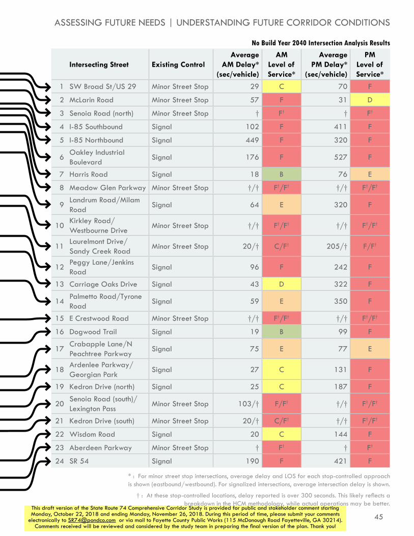
45This draft version of the State Route 74 Comprehensive Corridor Study is provided for public and stakeholder comment starting Monday, October 22, 2018 and ending Monday, November 26, 2018. During this period of time, please submit your comments
electronically to [email protected] or via mail to Fayette County Public Works (115 McDonough Road Fayetteville, GA 30214). Comments received will be reviewed and considered by the study team in preparing the final version of the plan. Thank you!
ASSESSING FUTURE NEEDS | UNDERSTANDING FUTURE CORRIDOR CONDITIONS
Intersecting Street Existing ControlAverage
AM Delay* (sec/vehicle)
AM Level of Service*
Average PM Delay*
(sec/vehicle)
PM Level of Service*
1 SW Broad St/US 29 Minor Street Stop 29 C 70 F
2 McLarin Road Minor Street Stop 57 F 31 D
3 Senoia Road (north) Minor Street Stop † F† † F†
4 I-85 Southbound Signal 102 F 411 F
5 I-85 Northbound Signal 449 F 320 F
6Oakley Industrial Boulevard
Signal 176 F 527 F
7 Harris Road Signal 18 B 76 E
8 Meadow Glen Parkway Minor Street Stop †/† F†/F† †/† F†/F†
9Landrum Road/Milam Road
Signal 64 E 320 F
10Kirkley Road/Westbourne Drive
Minor Street Stop †/† F†/F† †/† F†/F†
11Laurelmont Drive/Sandy Creek Road
Minor Street Stop 20/† C/F† 205/† F/F†
12Peggy Lane/Jenkins Road
Signal 96 F 242 F
13 Carriage Oaks Drive Signal 43 D 322 F
14Palmetto Road/Tyrone Road
Signal 59 E 350 F
15 E Crestwood Road Minor Street Stop †/† F†/F† †/† F†/F†
16 Dogwood Trail Signal 19 B 99 F
17Crabapple Lane/N Peachtree Parkway
Signal 75 E 77 E
18Ardenlee Parkway/Georgian Park
Signal 27 C 131 F
19 Kedron Drive (north) Signal 25 C 187 F
20Senoia Road (south)/Lexington Pass
Minor Street Stop 103/† F/F† †/† F†/F†
21 Kedron Drive (south) Minor Street Stop 20/† C/F† †/† F†/F†
22 Wisdom Road Signal 20 C 144 F
23 Aberdeen Parkway Minor Street Stop † F† † F†
24 SR 54 Signal 190 F 421 F
No Build Year 2040 Intersection Analysis Results
* : For minor street stop intersections, average delay and LOS for each stop-controlled approach is shown (eastbound/westbound). For signalized intersections, average intersection delay is shown.
† : At these stop-controlled locations, delay reported is over 300 seconds. This likely reflects a breakdown in the HCM methodology, while actual operations may be better.

46
STATE ROUTE 74COMPREHENSIVE CORRIDOR STUDY
This draft version of the State Route 74 Comprehensive Corridor Study is provided for public and stakeholder comment starting Monday, October 22, 2018 and ending Monday, November 26, 2018. During this period of time, please submit your comments
electronically to [email protected] or via mail to Fayette County Public Works (115 McDonough Road Fayetteville, GA 30214). Comments received will be reviewed and considered by the study team in preparing the final version of the plan. Thank you!
considerations of other plansTo ensure a broad understanding of expected, planned, and desired changes coming to the study area, a review of other plans in the area was conducted. Broadly, these plans either focus on transportation investments, or on land use policies in the area.
transportation plansSouth Fulton CTPThe South Fulton Comprehensive Transportation Plan update was completed in November of 2013. The plan examined transportation needs across municipalities in the southern portion of Fulton County, including Fairburn. The plan identified the need for improvements in the portion of SR 74 near I-85, as well as additional bicycle and pedestrian infrastructure. As a result, several vehicular and bicycle/pedestrian projects along the SR 74 corridor were recommended, including an interchange improvement project at SR 74 and I-85, as well as bike lanes along Senoia Road from West Broad Street to SR 74 in Fairburn. The Southern Fulton CTP is anticipated to be updated in 2019.
South Fulton CID Multimodal Transportation StudyThe recently completed South Fulton CID Multimodal Transportation Study examined the quality and efficiency of transportation infrastructure within the SFCID boundary – of which a portion is along the SR 74 Corridor. The following table shows project recommendations for the SR 74 corridor.
Multimodal StudyFinal Plan and Study Recommendations
April 30, 2018
outh fu lton Comprehensive Transportation Plan
fRecommendations ReportNovember 2013 1
November 2013
The South Fulton Comprehensive Transportation Plan of Fulton County
Recommendations Report
In Collaboration With:City of Chattahoochee Hills
City of College ParkCity of East Point
City of FairburnCity of HapevilleCity of Palmetto
City of Union City
ID Name/Description
R-181SR 74 at Milam Road Intersection Improvements
R-192SR 74 from I-85 to Fayette County Fiber Installation
R-197Harris Road West Extension from Senoia Road to Oakley Industrial Boulevard
R-198Milam Road from SR 74 to Fayette County upgrade to 12’ lanes with curb and gutter
R-201 SR 74 at Senoia Road Roundabout
ID Name/Description
CID-12ASR 74 at McLarin Road ramp intersection improvements
CID-12BSR 74 at US 29 ramp intersection improvements
CID-12CDevelop ITS to alert trucks to presence of a train blocking McLarin Road
CID-12DDevelop a truck staging area where trucks can wait when a train is blocking McLarin Road
CID-16AOakley Industrial Boulevard at SR 74 intersection improvements
CID-16BExtension of Ella Lane to Oakley Industrial Boulevard
CID-18A10-foot multi-use path on SR 74 from City Lake Road to Milam Road
CID-18B10-foot multi-use path on SR 74 from City Lake Road to US 29
CID-21A Extend MARTA route 89 to SR 74
CID-21BModify proposed MARTA route 889 to exclude Oakley Road and extend to SR 74
CID-22 Expand SR 74 Park and Ride lot
CID-35AResurface Oakley Industrial Boulevard from SR 74 to Fayetteville Drive
CID-35BResurface Oakley Industrial Boulevard from SR 74 to Bohannon Road
Relevant Projects from the South Fulton CTP (2013)
Relevant Projects from the South Fulton CID Multimodal Transportation Study (2018)

47This draft version of the State Route 74 Comprehensive Corridor Study is provided for public and stakeholder comment starting Monday, October 22, 2018 and ending Monday, November 26, 2018. During this period of time, please submit your comments
electronically to [email protected] or via mail to Fayette County Public Works (115 McDonough Road Fayetteville, GA 30214). Comments received will be reviewed and considered by the study team in preparing the final version of the plan. Thank you!
ASSESSING FUTURE NEEDS | CONSIDERATIONS OF OTHER PLANS
Fayette County Comprehensive Transportation Plan (2010)The last update to the Fayette County Comprehensive Transportation Plan, Fayette Forward, was completed in 2010. This update included an assessment of the entire county’s transportation network. In addition to recommending this SR 74 Corridor Study, Fayette Forward also recommended an intersection improvement at SR 54, which is included in the regional transportation plan, and discussed below. An update to the Fayette County CTP is currently in progress and is expected to be completed by the end of 2018. This update will also include the Fayette Master Path Plan, which will specifically provide recommendations for creating an efficient and expansive path network throughout Fayette County.
Regional Transportation Plan (RTP)As the Atlanta region’s metropolitan planning organization, ARC creates and updates a Regional Transportation Plan (RTP) that provides a long-range blueprint for regional transportation spending throughout the region. The RTP currently includes two projects along the study corridor:
»» I-85 Interchange (FS-AR-182): This project covers the area from City Lake Road to Landrum Road/Milam Road and includes substantial interchange improvements to the I-85 interchange at SR 74. This project in currently in concept development and it expected to include a multi-use path on the east side of SR 74, a widening of SR 74 to six lanes at the southern end and eight lanes at the interchange, and new interchange ramps to improve the flow of traffic.
»» SR 54 Intersection Improvements (RTP #: XXXXX): GDOT is currently working on identifying and designing intersection improvements at SR 74 and SR 54 in Peachtree City. This major intersection will likely need a significant improvement, and grade-separation or a continuous flow intersection have been previously considered.

48
STATE ROUTE 74COMPREHENSIVE CORRIDOR STUDY
This draft version of the State Route 74 Comprehensive Corridor Study is provided for public and stakeholder comment starting Monday, October 22, 2018 and ending Monday, November 26, 2018. During this period of time, please submit your comments
electronically to [email protected] or via mail to Fayette County Public Works (115 McDonough Road Fayetteville, GA 30214). Comments received will be reviewed and considered by the study team in preparing the final version of the plan. Thank you!
land use plansFayette County Comprehensive Plan (2017)Fayette County’s most recent comprehensive plan was completed in 2017 by the county’s Planning and Zoning Department. Several of the goals and objectives highlighted in the plan’s transportation and land use elements mirror the vision outlined for the SR 74 corridor. The goals and objectives in the transportation element underscore the efficiency of the county’s transportation network and addition of bicycle and pedestrian facilities as important factors to be considered.
The plan identifies the SR 74 North Overlay District as a significant area for development in the county, given its proximity to Interstate 85 and location between Peachtree City and Tyrone. The plan provides recommendations for the SR 74 North Overlay District within the Corridor Study Area in two locations:
»» SR 74 North West Side:
»» SR 74 North-East Side Special Development District
Peachtree City Comprehensive Plan Update (2017) As the most recent jurisdiction along the SR 74 corridor to update its comprehensive plan, The City of Peachtree City completed its update in 2017. The update included a revision of the policies related to its transportation element. The indicated transportation goal of the plan was to “establish and maintain a comprehensive transportation system that provides safe and convenient circulation through and around the city.” Several of the related transportation policies are similar to what is envisioned for the SR 74 corridor. These policies include:
»» Continue to maximize the utilization of public road infrastructure by limiting direct driveway access to arterial and collector roads
»» Encourage alternative modes such as walking, bicycling, and driving golf-carts by providing a comprehensive system of multi-use paths and facilities connecting all the villages and activity centers in the City
Fairburn Comprehensive Plan (2015)The City of Fairburn completed a revision to its comprehensive plan in 2015. Community participation was an important component of the plan’s update, as a variety of outreach events were held to ensure that the public’s opinion was adequately represented in the update. The updated plan identified the need for a joint Highway 74 study as a Land Use goal, in addition to the following policies
»» Make Highway 74 mixed use with retail, compact homes and townhouses while still meeting the demand for goods and services for the traveling public
»» Locate sit down restaurants and entertainment along Highway 74 near the southern city limit
»» Locate high end office at 74/85 interchange
Fayette County Comprehensive Plan
2017 -2040

49This draft version of the State Route 74 Comprehensive Corridor Study is provided for public and stakeholder comment starting Monday, October 22, 2018 and ending Monday, November 26, 2018. During this period of time, please submit your comments
electronically to [email protected] or via mail to Fayette County Public Works (115 McDonough Road Fayetteville, GA 30214). Comments received will be reviewed and considered by the study team in preparing the final version of the plan. Thank you!
Tyrone Comprehensive Growth and Development Plan (2017)The Town of Tyrone completed an update to its comprehensive plan in 2017. The SR 74 corridor was indicated by stakeholders as a “Point of Attention,” specifically regarding issues of connectivity. The area in the northern part of Tyrone surrounding SR 74 was given the designation of “Highway 74 Community Gateway” Character Area. The plan emphasizes greenspace conservation as well as interparcel connectivity and access management as suitable development practices for the character area. These practices align with what was developed for the corridor vision.
85
Tyrone
Peachtree City
Fairburn
N
milam rd
sandy creek rd
jenkins rd
tyrone rd
palmetto rd
Fulton Co
Coweta Co
dogwood trl
seno
ia rd
oakley ind blvd
n peachtree pkwy
74
54
29
Character Areas Normalized by Land Use Type(s)
COMPREHE N S IVE GRO WTH& DEVE L O PME N T PL AN
2 0 1 7 T E N - Y E A R U P D A T E
This document was developed by the Town of Tyrone in conjunction with the Atlanta Regional Commission using funds
provided by the state of Georgia. Photos provided by Gobi photography.
Character Areas Normalized by Land Use Type(s)
Residential
Commercial - General
Commercial - Retail
Commercial - Office
Industrial
Mixed Use
Commercial and Residential
Conservation
ASSESSING FUTURE NEEDS | CONSIDERATIONS OF OTHER PLANS

50
STATE ROUTE 74COMPREHENSIVE CORRIDOR STUDY
This draft version of the State Route 74 Comprehensive Corridor Study is provided for public and stakeholder comment starting Monday, October 22, 2018 and ending Monday, November 26, 2018. During this period of time, please submit your comments
electronically to [email protected] or via mail to Fayette County Public Works (115 McDonough Road Fayetteville, GA 30214). Comments received will be reviewed and considered by the study team in preparing the final version of the plan. Thank you!
intersection control evaluation processAs part of our identification and study of potential intersection improvements on the SR-74 corridor, our team followed the Intersection Control Evaluation (ICE) process used by the Georgia Department of Transportation. The ICE process is a two-phase approach to first identify and shortlist conventional and alternative intersection control alternatives, and then to evaluate those shortlisted alternatives based on cost, operational and safety benefits, potential environmental impacts and stakeholder acceptance. The result of the process is a technical determination of the most appropriate intersection control improvements that can be recommended and prioritized as short- and long-term projects. The ICE process was completed and documented for all study intersections except for those that already have improvements identified as part of other regional projects (from I-85 southbound ramps through Milam Road, and SR 54). ICE process documentation is included in Appendix E.
This process recommended a series of intersection improvements including Restricted Crossing U-Turn (RCUT) intersections, J-Turn intersection, and Median U-Turn intersections. The configurations and operations of the innovative intersections are described more fully in the Corridor Plan chapter. These intersection configurations were then analyzed with the same year 2040 traffic volumes used for the no build analysis.
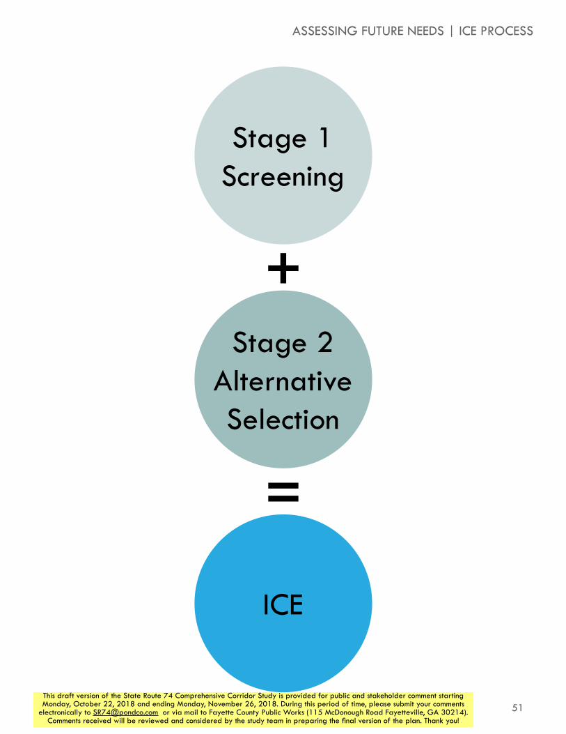
51This draft version of the State Route 74 Comprehensive Corridor Study is provided for public and stakeholder comment starting Monday, October 22, 2018 and ending Monday, November 26, 2018. During this period of time, please submit your comments
electronically to [email protected] or via mail to Fayette County Public Works (115 McDonough Road Fayetteville, GA 30214). Comments received will be reviewed and considered by the study team in preparing the final version of the plan. Thank you!
ASSESSING FUTURE NEEDS | ICE PROCESS
Stage 1Screening
ICE
Stage 2Alternative Selection
+
=

52
STATE ROUTE 74COMPREHENSIVE CORRIDOR STUDY
This draft version of the State Route 74 Comprehensive Corridor Study is provided for public and stakeholder comment starting Monday, October 22, 2018 and ending Monday, November 26, 2018. During this period of time, please submit your comments
electronically to [email protected] or via mail to Fayette County Public Works (115 McDonough Road Fayetteville, GA 30214). Comments received will be reviewed and considered by the study team in preparing the final version of the plan. Thank you!
2040 build LOSThe table to the right shows the results of the traffic analysis conducted in year 2040 conditions with the intersection configurations recommended by the ICE process. All intersections see at least some reduction in congestion, though some intersections and approaches remain at LOS E or F. Despite significant improvements to average delay experienced by vehicles at those locations, yhe dramatic improvements seen at most locations show that this superstreet concept can yield significant improvements for SR 74, without widening the roadway.
85
Tyrone
Peachtree City
Fairburn
N
milam rd
sandy creek rd
jenkins rd
tyrone rd
palmetto rd
Fulton Co
Coweta Co
dogwood trl
seno
ia rd
oakley ind blvd
n peachtree pkwy
74
54
29
12
3
45678
9
1011
12
13
14
15
16
17
18
24
Analyzed Intersections by Current Control Type
23

53This draft version of the State Route 74 Comprehensive Corridor Study is provided for public and stakeholder comment starting Monday, October 22, 2018 and ending Monday, November 26, 2018. During this period of time, please submit your comments
electronically to [email protected] or via mail to Fayette County Public Works (115 McDonough Road Fayetteville, GA 30214). Comments received will be reviewed and considered by the study team in preparing the final version of the plan. Thank you!
ASSESSING FUTURE NEEDS | 2040 BUILD LOS
Intersecting Street Proposed ControlAverage
AM Delay* (sec/vehicle)
AM Level of Service*
Average PM Delay*
(sec/vehicle)
PM Level of Service*
1 SW Broad St/US 29 Signal 21 C 14 B
2 McLarin Road Signal 11 B 9 A
3 Senoia Road (north) Signal 12 B 15 B
4 I-85 Southbound Signal 8 A 13 B
5 I-85 Northbound Signal 109 F 35 D
6Oakley Industrial Boulevard
Signal 25 C 39 D
7 Harris Road Signal 12 B 26 C
8 Meadow Glen Parkway Minor Street Stop 93/24 F/C †/† F†/F†
9Landrum Road/Milam Road
Signal 34 C 215 F
10Kirkley Road/Westbourne Drive
J-Turn 31/23 D/C †/35 F†/D
11Laurelmont Drive/Sandy Creek Road
RCUT 16 B 50 D
12Peggy Lane/Jenkins Road
RCUT 30 C 26 C
13 Carriage Oaks Drive RCUT 9 A 42 D
14Palmetto Road/Tyrone Road
MUT 14 B 56 E
15 E Crestwood Road J-Turn 24/20 C/C 73/25 F/C
16 Dogwood Trail RCUT 12 B 21 C
17Crabapple Lane/N Peachtree Parkway
RCUT 19 B 24 C
18Ardenlee Parkway/Georgian Park
RCUT 9 A 23 C
19 Kedron Drive (north) RCUT 11 B 17 B
20Senoia Road (south)/Lexington Pass
RCUT 12 B 22 C
21 Kedron Drive (south) J-Turn 20/31 C/D 35/81 D/F
22 Wisdom Road Signal 15 B 48 D
23 Aberdeen Parkway Signal 9 A 50 D
24 SR 54 Signal 116 F 310 F
Build Year 2040 Intersection Analysis Results
* : For minor street stop intersections, average delay and LOS for each stop-controlled approach is shown (eastbound/westbound). For signalized intersections, average intersection delay is shown.
† : At these stop-controlled locations, delay reported is over 300 seconds. This likely reflects a breakdown in the HCM methodology, while actual operations may be better.

54This draft version of the State Route 74 Comprehensive Corridor Study is provided for public and stakeholder comment starting Monday, October 22, 2018 and ending Monday, November 26, 2018. During this period of time, please submit your comments
electronically to [email protected] or via mail to Fayette County Public Works (115 McDonough Road Fayetteville, GA 30214). Comments received will be reviewed and considered by the study team in preparing the final version of the plan. Thank you!
CORRIDOR PLANsuperstreet conceptBoth conventional and alternative intersection types were considered in the ICE analysis, and several intersection types repeatedly were identified as the best intersection improvement alternatives. As the majority of the SR-74 corridor has a wide (44-foot) grass median, future capacity needs along the corridor can be met by adding additional travel lanes in each direction within the existing median. However, the conventional widening approach is both costly and detrimental to vehicle progression along the corridor. The dominant volumes at most intersections along the corridor is through traffic, and when multi-phase signal improvements are frequent along the corridor, congestion and delay can quickly build.
As an alternative to conventional widening, the ICE analysis showed versions of the “Superstreet” concept to be a superior intersection improvement alternative. The Superstreet concept, is a combination of innovative intersection improvements. These include Restricted Crossing U-Turn (RCUT) signalized intersections and J-Turn unsignalized intersections. Median U-Turn intersections and Continuous Green T intersections are also sometimes part of a Superstreet (though the latter was not recommended on SR 74). The Superstreet concept can be applied as individual intersection improvements but operates better as a continual corridor concept. Not only do motorists become more familiar with a consistent corridor treatment, but signal progression can be best achieved if all signalized intersections are operating with reduced signal phases.
restricted crossing u-turn and j-turn intersectionsThese intersection variants both use directional crossovers in the wide median to indirectly serve left turning vehicles at intersections. This allows the main intersection crossing to operate with fewer signal phases (reduced from four phases for a conventional intersection to two in an RCUT), thus allotting more green time for the dominant through volumes. The graphic on top of the facing page illustrates the superstreet geometric and operational concept. J-Turn intersections are similar in operation, but are not signalized.
median u-turn intersectionsThe Median U-turn concept, illustrated at the bottom of the facing page, prohibits all left turns, from the side streets and the mainline, but permits the through movement on both roads. This still simplifies signal operations to two phases, increasing the amount of green time available to the through movements. This intersection configuration may be more appropriate in areas with high through volumes on the side street, which may cause congestion in an RCUT/J-Turn intersection.
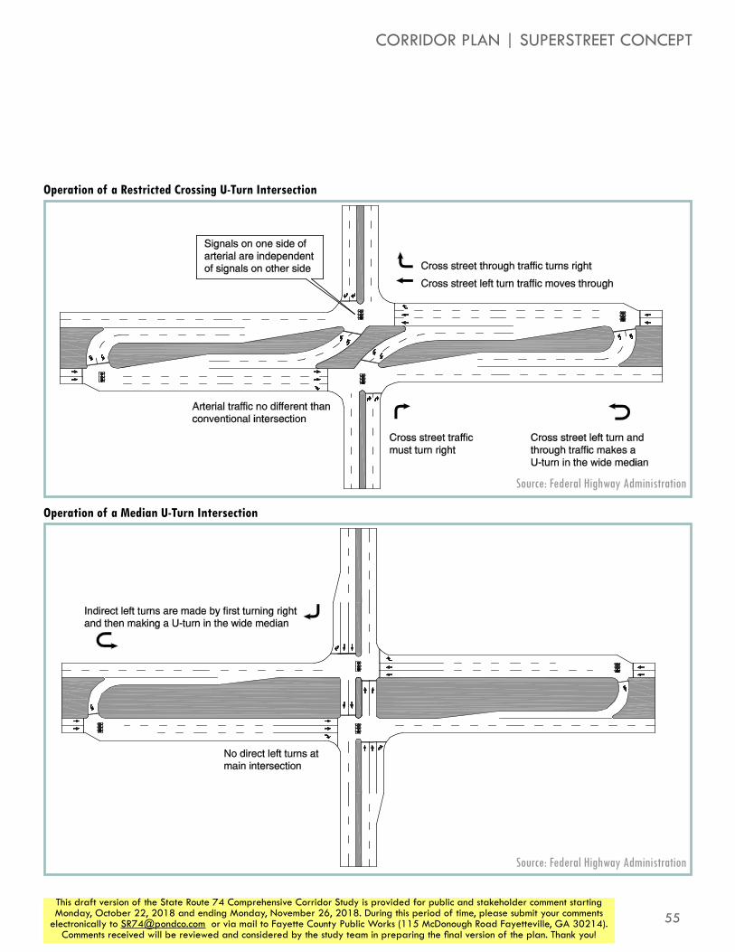
55This draft version of the State Route 74 Comprehensive Corridor Study is provided for public and stakeholder comment starting Monday, October 22, 2018 and ending Monday, November 26, 2018. During this period of time, please submit your comments
electronically to [email protected] or via mail to Fayette County Public Works (115 McDonough Road Fayetteville, GA 30214). Comments received will be reviewed and considered by the study team in preparing the final version of the plan. Thank you!
Restricted Crossing U-turn Informational Guide
5
Exhibits 1-1 through 1-3 illustrate examples of the three types of RCUT intersections.
Exhibit 1-1. Example of a RCUT intersection with signals.
Exhibit 1-2. Example of a RCUT intersection with stop-control.
Median U-Turn Informational Guide
4
Similarly, vehicles on the minor street that would typically turn left at a signalized intersection with the major street are directed to turn right onto the major street, make a U-turn movement at the same directional crossover 500 to 600 feet downstream, and then proceed through the main crossing street. The signals at the main crossing intersection (that permit only through and right-turn movements from both streets) and the signals at the U-turn crossovers (that osculate between through traffic on the major street and U-turn movements) are coordinated to minimize stops and delays to both through and turning traffic. Exhibit 1-1 illustrates an example of a MUT intersection with two signals at the main intersection. Exhibit 1-2 illustrates an example of aMUT intersection with one signal at the main intersection.
Exhibit 1-1. Example of a MUT intersection.
Operation of a Restricted Crossing U-Turn Intersection
Operation of a Median U-Turn Intersection
Source: Federal Highway Administration
Source: Federal Highway Administration
CORRIDOR PLAN | SUPERSTREET CONCEPT
56
STATE ROUTE 74COMPREHENSIVE CORRIDOR STUDY
This draft version of the State Route 74 Comprehensive Corridor Study is provided for public and stakeholder comment starting Monday, October 22, 2018 and ending Monday, November 26, 2018. During this period of time, please submit your comments
electronically to [email protected] or via mail to Fayette County Public Works (115 McDonough Road Fayetteville, GA 30214). Comments received will be reviewed and considered by the study team in preparing the final version of the plan. Thank you!
benefits of a superstreet corridorThere are wide-ranging benefits to Superstreet concepts. The following identify some of the advantages that have been studied and are directly relevant to the SR 74 corridor.
SafetyCompared to a conventional intersection form with permissive or protected left-turn signal phasing, signalized RCUT intersections reduce the decision-making burden for motorists. The Superstreet intersection reduces intersection conflict points (points within the intersection where vehicle paths conflict and may result in crashes). At four-leg intersections, Superstreets have 14 conflict points compared to 32 at a conventional intersection.
Empirical studies of constructed unsignalized Superstreet (J-turn) intersections in three states have showed a decrease in the total number of crashes and a more significant reduction in the number of injury crashes compared to the previous conventional intersection.
Intersections converted to unsignalized J-Turns show even greater safety benefits. The NCDOT Safety Evaluation Group performed Spot Safety Studies at various locations where conventional intersections and/or median crossovers were converted to unsignalized J-Turn intersections. This empirical study showed the effect the modifications had on the collision patterns at the subject intersection over a three-year period.
Pedestrians and BicyclesThe Superstreet intersection reduces the total number of vehicle-pedestrian conflict points compared to a conventional intersection and creates shorter, more direct paths crossing the intersection. The standard method of crossing the main roadway (US-74) by means of a Z-crossing, illustrated in Figure _. A “Z” crossing allows all desired pedestrian movements at an intersection. Crossing the minor street is similar to a conventional intersection, but vehicle/pedestrian conflicts are reduced due to the restriction of left turns from the minor street. Crossing the main intersection may require crossing the minor street on both sides of the roadway, but the crosswalk is placed in between the direct left turn movements so pedestrians are protected from vehicle conflicts.
Bicycles on the major roadway travel though a Superstreet intersection in the same manor as at a conventional intersection but they have more green time to pass through and fewer bicycle-vehicle conflict points. There are three ways to serve minor street through and left-turn bicyclists: 1) follow pedestrian path, 2) follow vehicle path and 3) include direct bicycle crossings through a gap in the median. The choice of crossing with pedestrians or motorists will likely depend on the distance to the U-turn crossover and the experience of the rider.

57This draft version of the State Route 74 Comprehensive Corridor Study is provided for public and stakeholder comment starting Monday, October 22, 2018 and ending Monday, November 26, 2018. During this period of time, please submit your comments
electronically to [email protected] or via mail to Fayette County Public Works (115 McDonough Road Fayetteville, GA 30214). Comments received will be reviewed and considered by the study team in preparing the final version of the plan. Thank you!
Restricted Crossing U-turn Informational Guide
52
Exhibit 4-1. Conflict point comparison.
Conflict PointsNumber of Intersection Legs Conventional RCUT
3 9 74 32 14
Exhibit 4-2. Vehicular conflict points at a four-approach conventional intersection.
Exhibit 4-3. Vehicular conflict points at a four-approach RCUT intersection.
Restricted Crossing U-turn Informational Guide
32
This chapter describes the unique characteristics of the four primary non-auto modes (pedestrians, bicyclists, transit, and heavy vehicles) that should be considered when analyzing and designing RCUT intersections. Understanding and identify the various users and their needs within the RCUT configuration will guide planning and design decisions at a given intersection location.
PEDESTRIANS
RCUT intersections require pedestrian crossings that differ from conventional intersections. More movements are unsignalized, and there are a greater percentage vehicles turning right. The RCUT intersection’s wide geometric footprint can make it challenging to accommodate pedestrians but the short cycle lengths associated with RCUT intersection operations can help make pedestrian movements more comparable to crossing times at conventional intersections.
Pedestrian crossings at RCUT intersections must be accessible for all users, including those with visual impairments. Therefore, the provisions for pedestrians must take into account the need to communicate crossing patterns in non-visual ways, using wayfinding techniques that are discussed in the PROWAG.(22) This may include audible devices, channelization, and separation and detectable delineation of the pedestrian route and crossing.
At this time, the most common means of serving pedestrians at a RCUT intersection is a “Z” crossing treatment. Exhibit 3-1 shows a “Z” crossing treatment.
Exhibit 3-1. Pedestrian movements in a RCUT intersection.
A “Z” crossing allows all six desired pedestrian movements at an intersection. The two minor street crossings (A to B, C to D) are made similarly to a conventional intersection. Three of the movements (A to C, B to D, and A to D) require pedestrians to take a longer, unconventional route. The sixth movement (B to C) requires pedestrians to take a shorter, unconventional route.
Conflict Points in Conventional Intersections and RCUT/J-Turn Intersections
Pedestrian Crossing Patterns
Source: Federal Highway Administration
Source: Federal Highway Administration
CORRIDOR PLAN | SUPERSTREET CONCEPT

58
STATE ROUTE 74COMPREHENSIVE CORRIDOR STUDY
This draft version of the State Route 74 Comprehensive Corridor Study is provided for public and stakeholder comment starting Monday, October 22, 2018 and ending Monday, November 26, 2018. During this period of time, please submit your comments
electronically to [email protected] or via mail to Fayette County Public Works (115 McDonough Road Fayetteville, GA 30214). Comments received will be reviewed and considered by the study team in preparing the final version of the plan. Thank you!
Operations The reduction in signal phases allow increased green time to be given to the major street, greatly improving operations for through vehicles. Studies have shown Superstreets reduce network travel times by 25- to 40-percent compared to conventional intersections. Recent experience includes the conversion of a 3.5-mile section of US-281 in San Antonio from a four-lane divided con-ventional roadway to a four-lane Superstreet corridor. A before-and-after study measured operational changes on US-281, including travel times, speeds, and traffic volumes on midweek days . As shown in the table below, the RCUT intersections substantially decreased travel time and increased travel speeds on US-281 on a short 3.5-mile corridor.
20 sec
60 sec
15 sec
25 sec
Typical Conventional Intersection Operations
US 281 in San Antonio, Texas, Before and After RCUT Intersection Installation
MetricBefore RCUT
After RCUT
Southbound travel time (morning rush
hour)23.3 min. 13.9 min.
Southbound average speed
(morning rush hour)16 mph 20 mph
Northbound travel time (evening rush
hour)19.2 min. 12.7 min.
Northbound average speed
(evening rush hour)19 mph 29 mph
Traffic count (vehicles per day)
60,100 – 74,000
63,600 – 81,500

59This draft version of the State Route 74 Comprehensive Corridor Study is provided for public and stakeholder comment starting Monday, October 22, 2018 and ending Monday, November 26, 2018. During this period of time, please submit your comments
electronically to [email protected] or via mail to Fayette County Public Works (115 McDonough Road Fayetteville, GA 30214). Comments received will be reviewed and considered by the study team in preparing the final version of the plan. Thank you!
90 sec
30 sec
Studies have shown that Superstreets reduce network travel times by 25% to 40% over
conventional intersections
Restricted Crossing U-Turn Intersection Operations
When converted to a Superstreet intersection,
the mainline through movement is given more time, making for faster
travel along the corridor
CORRIDOR PLAN | SUPERSTREET CONCEPT

60
STATE ROUTE 74COMPREHENSIVE CORRIDOR STUDY
This draft version of the State Route 74 Comprehensive Corridor Study is provided for public and stakeholder comment starting Monday, October 22, 2018 and ending Monday, November 26, 2018. During this period of time, please submit your comments
electronically to [email protected] or via mail to Fayette County Public Works (115 McDonough Road Fayetteville, GA 30214). Comments received will be reviewed and considered by the study team in preparing the final version of the plan. Thank you!
Access ManagementSuperstreets applied consistently along a corridor convert minor roadway and driveways to right-in/right-out intersections (with downstream U-turn crossovers for left turns), resulting in significant progression benefits along a managed corridor. Superstreets can also be used to control speeds along a corridor. Areas with multiple access points and high pedestrian activity may choose to use lower speeds.
Superstreet corridors can also accommodate more signals than a conventional intersection corridor, while still producing lower through vehicle delays, due to the efficient progression of the signalized RCUT intersections. Signals for driveways or side streets may be installed without introducing significant extra delay for arterial through movement, and crossovers can be moved within generous limits to accommodate access needs for current or future development needs.
CostA Superstreet intersection will be more expensive to construct than a conventional intersection due to extra signals and controllers, and extra pavement at the crossovers. However, if no additional right-of-way is needed (i.e. the corridor already has sufficient width for the median U-turn corridors), the cost of Superstreet improvements can be substantially less than adding additional through lanes in the corridor (i.e. conventional widening). Often the operational gains of Superstreet intersection negate the need for a costly widening project, and in some cases, interchange projects have been delayed or canceled in lieu of an at-grade Superstreet project.
While improvement costs differ widely based on specific project location and needs, a rule of thumb is that traditional widening cost between $1M and $2M per lane mile added (excluding ROW costs); a full Superstreet intersection can cost between $500K and $750K, with individual crossovers in the range of $200K (also excluding ROW costs). Applying these generic costs to the 12-mile SR 74 corridor, a conventional widening (adding one lane in each direction at $1.5M/mile) would cost $36M. A superstreet corridor (assuming 20 signalized RCUT intersections at $650K each and another 24 individual crossovers at $200K each) would cost $17.8M, a 50% savings in cost compared to a conventional widening.
Large Truck AccommodationsConcerns are often raised about Superstreet impacts to trucks and land uses along the corridor. Superstreet intersections can be designed to accommodate U-turn that accommodate large truck paths. Where there is an insufficient median width to accommodate truck turning paths, bulbouts can be included to provide the additional turning path needs.
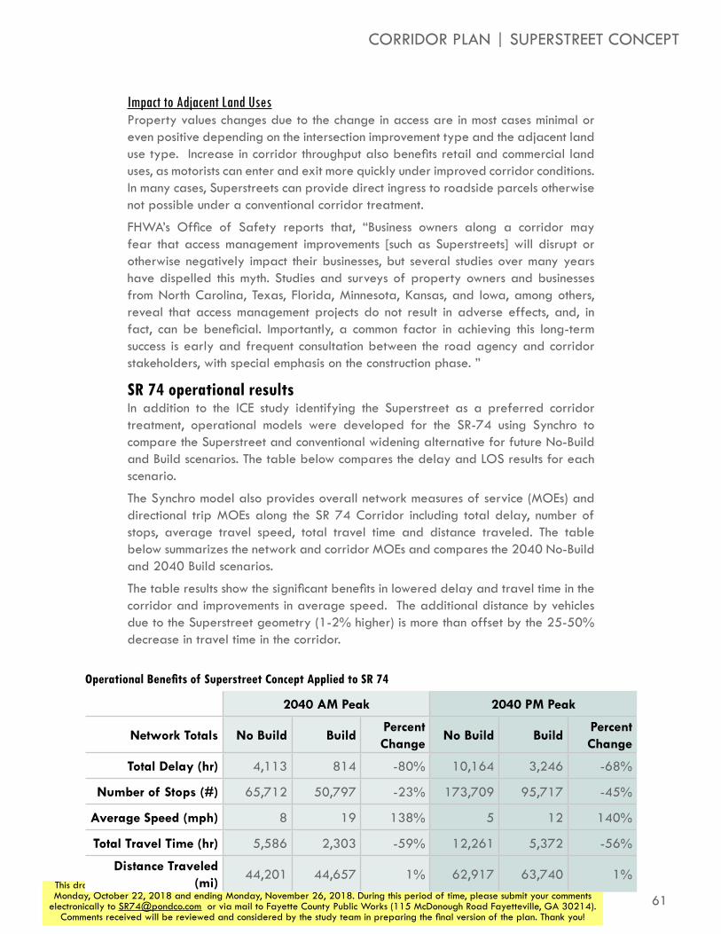
61This draft version of the State Route 74 Comprehensive Corridor Study is provided for public and stakeholder comment starting Monday, October 22, 2018 and ending Monday, November 26, 2018. During this period of time, please submit your comments
electronically to [email protected] or via mail to Fayette County Public Works (115 McDonough Road Fayetteville, GA 30214). Comments received will be reviewed and considered by the study team in preparing the final version of the plan. Thank you!
Impact to Adjacent Land UsesProperty values changes due to the change in access are in most cases minimal or even positive depending on the intersection improvement type and the adjacent land use type. Increase in corridor throughput also benefits retail and commercial land uses, as motorists can enter and exit more quickly under improved corridor conditions. In many cases, Superstreets can provide direct ingress to roadside parcels otherwise not possible under a conventional corridor treatment.
FHWA’s Office of Safety reports that, “Business owners along a corridor may fear that access management improvements [such as Superstreets] will disrupt or otherwise negatively impact their businesses, but several studies over many years have dispelled this myth. Studies and surveys of property owners and businesses from North Carolina, Texas, Florida, Minnesota, Kansas, and Iowa, among others, reveal that access management projects do not result in adverse effects, and, in fact, can be beneficial. Importantly, a common factor in achieving this long-term success is early and frequent consultation between the road agency and corridor stakeholders, with special emphasis on the construction phase. ”
SR 74 operational resultsIn addition to the ICE study identifying the Superstreet as a preferred corridor treatment, operational models were developed for the SR-74 using Synchro to compare the Superstreet and conventional widening alternative for future No-Build and Build scenarios. The table below compares the delay and LOS results for each scenario.
The Synchro model also provides overall network measures of service (MOEs) and directional trip MOEs along the SR 74 Corridor including total delay, number of stops, average travel speed, total travel time and distance traveled. The table below summarizes the network and corridor MOEs and compares the 2040 No-Build and 2040 Build scenarios.
The table results show the significant benefits in lowered delay and travel time in the corridor and improvements in average speed. The additional distance by vehicles due to the Superstreet geometry (1-2% higher) is more than offset by the 25-50% decrease in travel time in the corridor.
2040 AM Peak 2040 PM Peak
Network Totals No Build BuildPercent Change
No Build BuildPercent Change
Total Delay (hr) 4,113 814 -80% 10,164 3,246 -68%
Number of Stops (#) 65,712 50,797 -23% 173,709 95,717 -45%
Average Speed (mph) 8 19 138% 5 12 140%
Total Travel Time (hr) 5,586 2,303 -59% 12,261 5,372 -56%
Distance Traveled (mi)
44,201 44,657 1% 62,917 63,740 1%
Operational Benefits of Superstreet Concept Applied to SR 74
CORRIDOR PLAN | SUPERSTREET CONCEPT

62
STATE ROUTE 74COMPREHENSIVE CORRIDOR STUDY
This draft version of the State Route 74 Comprehensive Corridor Study is provided for public and stakeholder comment starting Monday, October 22, 2018 and ending Monday, November 26, 2018. During this period of time, please submit your comments
electronically to [email protected] or via mail to Fayette County Public Works (115 McDonough Road Fayetteville, GA 30214). Comments received will be reviewed and considered by the study team in preparing the final version of the plan. Thank you!
Project ID Description
ACM-01New interparcel connection between 361 SR 74 and 375 SR 74
ACM-02New interparcel connection between 357 SR 74 and 361 SR 74
INT-01Improve SR 74 at US 29 ramp with repaving, refreshed pavement parkings, and acceleration lane for trucks turning onto US 29 southbound
INT-02 Signalize intersection of SR 74 and US 29 ramp
INT-03Improve SR 74 at McLarin Road ramp with repaving, channelization island, and self-illuminated signs directing drivers to CSX
INT-04Create acceleration lane on SR 74 for vehicles turning left from Senoia Rd
INT-05
Install raised medians on the Oakley Industrial Boulevard east and west approaches to remove conflicting vehicle movements. Add dual lefts on the western approach of Oakley Industrial Boulevard. Extend Ella Ln to Oakley Industrial Blvd to newly faciliate restricted movements at Oakley Industrial Boulevard and SR 74.
INT-06 J-Turn intersection at Thompson Road
INT-07Addition of left in and u-turn on SR 74 at Wendell Coffee Golf & Event Center
INT-08J-Turn intersection at Kirkley Road/Westbourne Drive
INT-09Upgrade existing J-Turn at Laurelmont Drive/Sandy Creek Road to RCUT, including new northern u-turn south of Kirkley Road
INT-10Install RCUT intersection at Peggy Lane/Jenkins Road
INT-11Install right in/right out access from Senoia Road to SR 74 northbound between Carriage Oaks Drive and Jenkins Road
INT-12 Install RCUT intersection at Carriage Oaks Drive
INT-13Install MUT intersection at Palmetto Road/Tyrone Road
INT-14 Install J-Turn intersection at E Crestwood Road
INT-15 Install RCUT intersection at Dogwood Trail
INT-16Install J-Turn intersection at Dogwood Church driveway
INT-17Install RCUT intersection at Crabapple Lane/N Peachtree Parkway
INT-18Install RCUT intersection at Ardenlee Parkway/Georgian Park
INT-19 Install RCUT intersection at Kedron Drive (north)
INT-20Install RCUT intersection at Senoia Road (south)/Lexington Pass
INT-21 Install J-Turn intersection at Kedron Drive (south)
INT-22 Install J-Turn intersection at Dunham Square
INT-23Add second westbound left turn lane to Wisdom Road at SR 74
INT-24New "extended J-Turn" with left in, no left out at Wisdom Pointe Shopping Center and Commerce Drive; and u-turn modifications at Wisdom Road
INT-25 Signalize intersection with Aberdeen Parkway
INT-26 Signalize intersection with Senoia Road (north)
INT-27 Signalize intersection with McLarin Road ramp
OTH-01Develop truck staging lot to divert trucks waiting for CSX train to clear tracks
OTH-02Develop ITS system to alert trucks to presence of train blocking roadway as they exit I-85 onto SR 74
OTH-03Resurface Oakley Industrial Boulevard from SR 74 to Bohannon Road
OTH-04Resurface Oakley Industrial Boulevard from SR 74 to Fayetteville Road
RDW-01Extend Howell Avenue from SR 74 to Bohannon Road
RDW-02New backage roadway west of SR 74 from Harris Road to Landrum Road
RDW-03New backage roadway east of SR 74 from Meadow Glen Parkway (connecting to existing roadway) to Milam Road
RDW-04Extend Meadow Glen Road east to Plantation Road
Project ID Description
All Vehicular Recommendations
vehicular recommendationsIn order to improve the mobility of the SR 74 while preserving accessibility, a number of specific recommendations for improvements along the SR 74 corridor have been constructed. The recommendations shown below and to the right are the result of previous studies, ICE analysis, and additional analysis of the corridor and its needs.
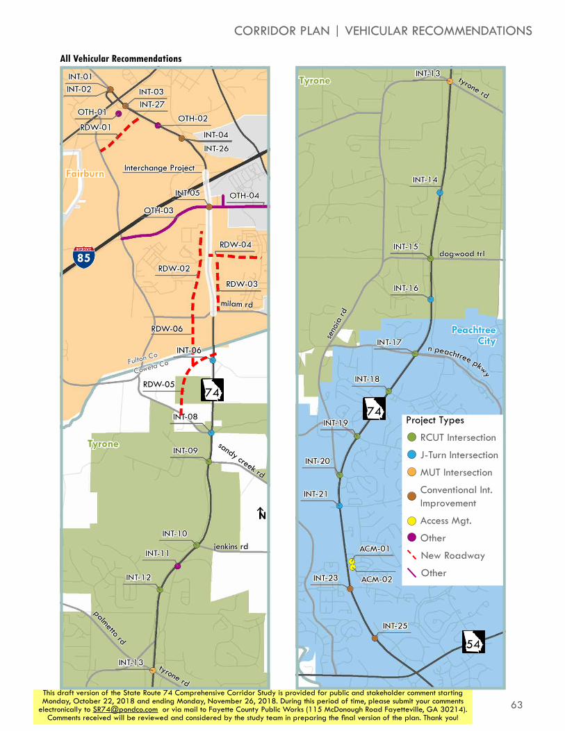
63This draft version of the State Route 74 Comprehensive Corridor Study is provided for public and stakeholder comment starting Monday, October 22, 2018 and ending Monday, November 26, 2018. During this period of time, please submit your comments
electronically to [email protected] or via mail to Fayette County Public Works (115 McDonough Road Fayetteville, GA 30214). Comments received will be reviewed and considered by the study team in preparing the final version of the plan. Thank you!
85
Tyrone
Fairburn
N
milam rd
sandy creek rd
jenkins rd
tyrone rd
palmetto rd
74
Fulton Co
Coweta Co
Tyrone
Peachtree City
N
tyrone rd
dogwood trl
seno
ia rd
n peachtree pkwy
74
54
All Vehicular Recommendations
CORRIDOR PLAN | VEHICULAR RECOMMENDATIONS
Interchange Project
Project Types
RCUT Intersection
J-Turn Intersection
MUT Intersection
Conventional Int. Improvement
Access Mgt.
Other
New Roadway
Other
RDW-05
RDW-06
INT-06

64
STATE ROUTE 74COMPREHENSIVE CORRIDOR STUDY
This draft version of the State Route 74 Comprehensive Corridor Study is provided for public and stakeholder comment starting Monday, October 22, 2018 and ending Monday, November 26, 2018. During this period of time, please submit your comments
electronically to [email protected] or via mail to Fayette County Public Works (115 McDonough Road Fayetteville, GA 30214). Comments received will be reviewed and considered by the study team in preparing the final version of the plan. Thank you!
access managementWhile the superstreet concept supports improved traffic operations and flows at intersections, it is also an access management tool in that it controls where and how access to intersection roads and adjacent properties work. Building off of the superstreet concept are several other access management tools and initiatives that should be considered as indicated in the list below. Please note, that the “Framework for Corridor Consistency” on Page 74 is a component of the implementation tool for these access management strategies.
»» Limiting driveway connections
»» Where driveway connections exist or are constructed, access should generally be limited to a right-in/right out with the possibility of allowing left turns in.
»» Interparcel connections and backage roads to minimize the amount of localized short distance trips on SR 74 should be required or at the least incentivized. A handful of specific initiatives in support of this concept have been identified and are shown below.
»» Support and promote local businesses through shared and uniform signage at driveway connection points
Project ID
Description
ACM-02 New interparcel connection between 357 SR 74 and 361 SR 74
ACM-01 New interparcel connection between 361 SR 74 and 375 SR 74
RDW-02 New backage roadway west of SR 74 from Harris Road to Landrum Road
RDW-03New backage roadway east of SR 74 from Meadow Glen Parkway (connecting to existing roadway) to Milam Road
RDW-05New roadway from Kirkley Road west of SR 74 to SR 74 south of Fulton/Fayette County line
RDW-06 New roadway connecting RDW-02 to RDW-05

65This draft version of the State Route 74 Comprehensive Corridor Study is provided for public and stakeholder comment starting Monday, October 22, 2018 and ending Monday, November 26, 2018. During this period of time, please submit your comments
electronically to [email protected] or via mail to Fayette County Public Works (115 McDonough Road Fayetteville, GA 30214). Comments received will be reviewed and considered by the study team in preparing the final version of the plan. Thank you!
Access
Mobility
Freeway
Major Arterial
Minor Arterial
Major Collector
Minor Collector
Local Street
CORRIDOR PLAN | ACCESS MANAGEMENT

66
STATE ROUTE 74COMPREHENSIVE CORRIDOR STUDY
This draft version of the State Route 74 Comprehensive Corridor Study is provided for public and stakeholder comment starting Monday, October 22, 2018 and ending Monday, November 26, 2018. During this period of time, please submit your comments
electronically to [email protected] or via mail to Fayette County Public Works (115 McDonough Road Fayetteville, GA 30214). Comments received will be reviewed and considered by the study team in preparing the final version of the plan. Thank you!
bicycles and pedestriansIn addition to vehicular travel, the corridor plan considers improvements for active transportation modes. Because SR 74 is a high-speed, high-volume roadway, and out of a desire to connect with existing trail networks in both Peachtree City and Tryone, as well as future regional trail network, the bulk of bicycle and pedestrian recommendations are multi-use paths. These recommendations are accompanied by crossing improvements and a state bicycle route.
multi-use path considerationsWhen planning and designing multi-jurisdictional paths, it can be important to maintain certain consistent elements throughout to help with user orientation. However, it is also important to allow elements along the path to vary, to reflect the differences in the natural and cultural environments around them. The graphics to the right show some specific features of a trail that may be important along SR 74 to ensure a cohesive facility and provides an experience authentic to each of the communities it connects.
One major consideration for a multi-use path in this area is the ability to serve not only pedestrians and bicyclists, but also users of Personal Transportation Vehicles (PTVs) such as golf carts. The trail network in Peachtree City supports these vehicles and has created a strong culture of PTV use, and allows residents to make many short trips in these smaller vehicles. However, GDOT has placed restrictions on PTV usage in their right of way along state routes, such as SR 74. Due to these restrictions, it may be necessary to construct a PTV-supportive path outside of the state-owned right of way, on easements on privately held lands, or on right of way owned by other agencies. The process to assemble the necessary easements and land may create an undue burden on the schedule and/or budget of such a project, which may tip the scales in favor of building a more traditional path within GDOT’s right of way.
crossing improvementsIn addition to the multi-use trail itself, the corridor plan recommends grade-seperated crossings of SR 74 for bicyclists and pedestrians. These crossings provide the safest crossing experience available, and provide opportunities for placemaking, with bridges in some communities used for signs or gateways to communities. RCUT intersections provide a pedestrian crossing experience that is almost entirely protected by the traffic signal, enhancing safety at all intersection crossings as well.
bicycle routePalmetto Road and Tyrone Road are part of an initiative to create statewide bicycle connectivity. As hosts to Georgia Bike Route 15, they provide part of a connection from the Florida border, south of Valdosta, to Acworth. As such, the corridor plans recommends a specific evaluation of what can be done on this corridor to make these roads more bike friendly.
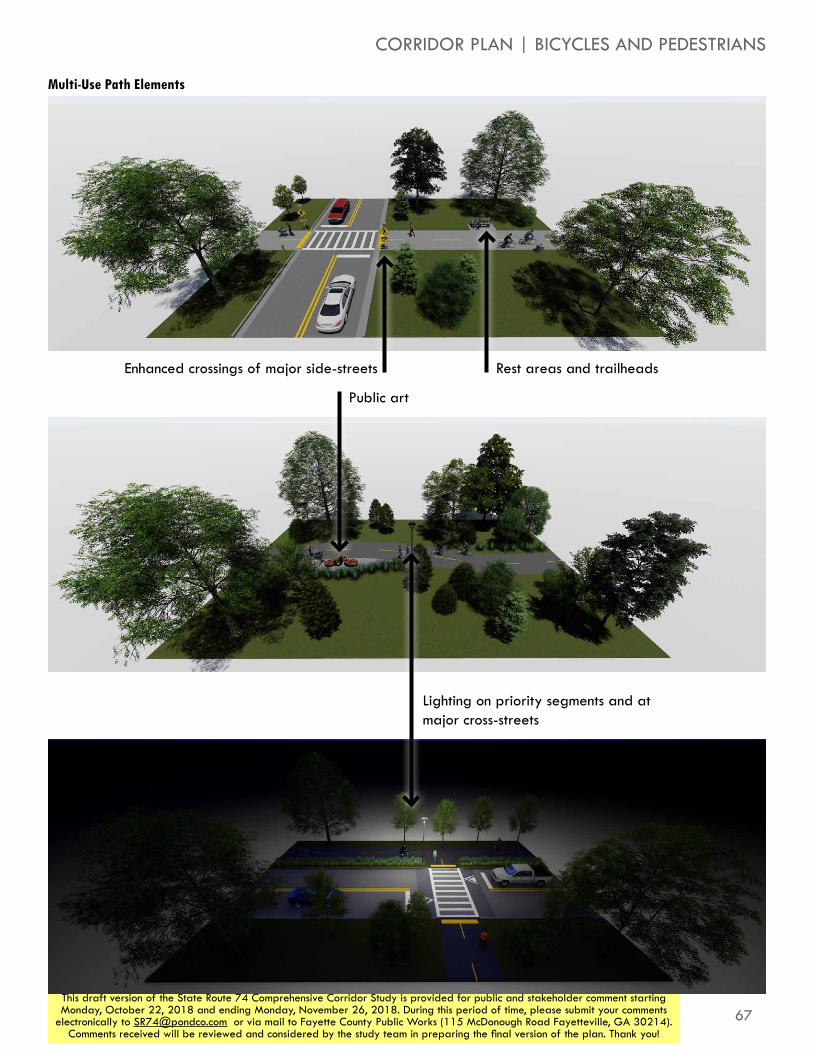
67This draft version of the State Route 74 Comprehensive Corridor Study is provided for public and stakeholder comment starting Monday, October 22, 2018 and ending Monday, November 26, 2018. During this period of time, please submit your comments
electronically to [email protected] or via mail to Fayette County Public Works (115 McDonough Road Fayetteville, GA 30214). Comments received will be reviewed and considered by the study team in preparing the final version of the plan. Thank you!
CORRIDOR PLAN | BICYCLES AND PEDESTRIANS
Multi-Use Path Elements
Enhanced crossings of major side-streets
Public art
Lighting on priority segments and at major cross-streets
Rest areas and trailheads
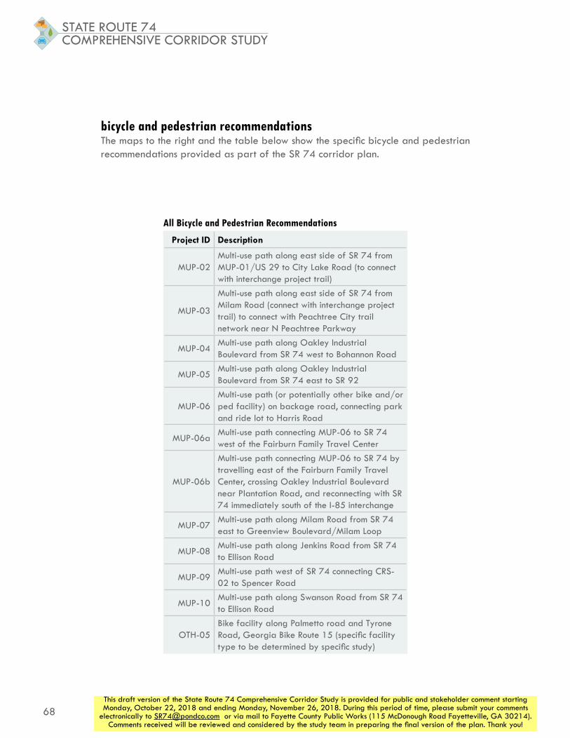
68
STATE ROUTE 74COMPREHENSIVE CORRIDOR STUDY
This draft version of the State Route 74 Comprehensive Corridor Study is provided for public and stakeholder comment starting Monday, October 22, 2018 and ending Monday, November 26, 2018. During this period of time, please submit your comments
electronically to [email protected] or via mail to Fayette County Public Works (115 McDonough Road Fayetteville, GA 30214). Comments received will be reviewed and considered by the study team in preparing the final version of the plan. Thank you!
Project ID Description
MUP-02Multi-use path along east side of SR 74 from MUP-01/US 29 to City Lake Road (to connect with interchange project trail)
MUP-03
Multi-use path along east side of SR 74 from Milam Road (connect with interchange project trail) to connect with Peachtree City trail network near N Peachtree Parkway
MUP-04Multi-use path along Oakley Industrial Boulevard from SR 74 west to Bohannon Road
MUP-05Multi-use path along Oakley Industrial Boulevard from SR 74 east to SR 92
MUP-06Multi-use path (or potentially other bike and/or ped facility) on backage road, connecting park and ride lot to Harris Road
MUP-06aMulti-use path connecting MUP-06 to SR 74 west of the Fairburn Family Travel Center
MUP-06b
Multi-use path connecting MUP-06 to SR 74 by travelling east of the Fairburn Family Travel Center, crossing Oakley Industrial Boulevard near Plantation Road, and reconnecting with SR 74 immediately south of the I-85 interchange
MUP-07Multi-use path along Milam Road from SR 74 east to Greenview Boulevard/Milam Loop
MUP-08Multi-use path along Jenkins Road from SR 74 to Ellison Road
MUP-09Multi-use path west of SR 74 connecting CRS-02 to Spencer Road
MUP-10Multi-use path along Swanson Road from SR 74 to Ellison Road
OTH-05Bike facility along Palmetto road and Tyrone Road, Georgia Bike Route 15 (specific facility type to be determined by specific study)
bicycle and pedestrian recommendationsThe maps to the right and the table below show the specific bicycle and pedestrian recommendations provided as part of the SR 74 corridor plan.
All Bicycle and Pedestrian Recommendations

69This draft version of the State Route 74 Comprehensive Corridor Study is provided for public and stakeholder comment starting Monday, October 22, 2018 and ending Monday, November 26, 2018. During this period of time, please submit your comments
electronically to [email protected] or via mail to Fayette County Public Works (115 McDonough Road Fayetteville, GA 30214). Comments received will be reviewed and considered by the study team in preparing the final version of the plan. Thank you!
85
Tyrone
Fairburn
N
landrum rd
sandy creek rd
jenkins rd
tyrone rd
palmetto rd
74
Fulton Co
Coweta Co
Tyrone
Peachtree City
N
tyrone rd
dogwood trl
seno
ia rd
n peachtree pkwy
74
54
All Bicycle and Pedestrian Recommendations
CORRIDOR PLAN | BICYCLES AND PEDESTRIANS
29
Interchange Project
Project Types
Grade-Separated Crossings
Other
Multi-Use Path
Other
Existing Multi-Use Path

70
STATE ROUTE 74COMPREHENSIVE CORRIDOR STUDY
This draft version of the State Route 74 Comprehensive Corridor Study is provided for public and stakeholder comment starting Monday, October 22, 2018 and ending Monday, November 26, 2018. During this period of time, please submit your comments
electronically to [email protected] or via mail to Fayette County Public Works (115 McDonough Road Fayetteville, GA 30214). Comments received will be reviewed and considered by the study team in preparing the final version of the plan. Thank you!
transit and travel demand managementTransit service and travel demand management (TDM) can provide useful alternatives to driving alone that can reduce traffic congestion and stress associated with travel by reducing the total amount of vehicular travel that occurs in an area. The northern piece of the study corridor is within Fulton County, and is thus within the MARTA service area. Below are some policies that SR 74 communities should consider to best promote these alternative travel modes. The map and table to the right show specific transit recommendations, which center on providing service to the new Park and Ride lot being built by South Fulton CID along SR 74.
promote the new park and ride lot and carpooling optionsPeachtree City, Tyrone, Fairburn, Fayette County, and the South Fulton CID should coordinate and collaborate through the SR 74 Coalition to promote the park and ride on SR 74. Initially, this includes promoting the upcoming grand opening in official communications such as social media, newsletters, and websites. This promotion should include encouragement for carpools to register through Georgia Commute Options for rewards, guaranteed rides home, and other programming.
promote and incentivize the use of vanpool servicesWorking through the SR 74 Coalition, Peachtree City, Tyrone, Fairburn, Fayette County, and the South Fulton CID should promote and encourage vanpool formation. This includes promotion through official communication channels and consideration of subsidy assistance for private vanpool service to include incentive offers for interested participants, such as “one month free/try it” and/or applicable reimbursements.
implement workplace commute optionsWorking through the SR 74 Coalition, Peachtree City, Tyrone, Fairburn, Fayette County, and the South Fulton CID should promote and encourage workplace commute options through coordination with the Georgia Commute Options program to assist area employers with creating programs and policies. Benefits are broad and include such factors as reductions in vehicular traffic demand and better employee retention and job satisfaction. Consideration for these programs and policies include potential collaboration and incentive packages with Transportation Network Companies (TNC) such as Lyft and Uber, promotion of walking and biking (that should be coordinated with physical investments in active transportation mode infrastructure), and broad promotion of previously cited initiatives such as carpools, vanpools, and the promotion of the Park and Ride Lot.
connect MARTA to the new park and ride lotExtend and modify MARTA routes as identified in the South Fulton CID Multi Modal Plan:
»» CID-20 which extends MARTA Route 181 to SR 74 including a turnaround at the park and ride lot (TRA-01)
»» CID-21A which extends MARTA Route 89 to SR 74 including a turnaround at the park and ride lot (TRA-02)
»» CID -21B which modifies Route 889 to use Oakley Industrial Boulevard instead of Oakley Road and includes a turnaround at the park and ride lot (TRA-03)

71This draft version of the State Route 74 Comprehensive Corridor Study is provided for public and stakeholder comment starting Monday, October 22, 2018 and ending Monday, November 26, 2018. During this period of time, please submit your comments
electronically to [email protected] or via mail to Fayette County Public Works (115 McDonough Road Fayetteville, GA 30214). Comments received will be reviewed and considered by the study team in preparing the final version of the plan. Thank you!
Project ID Description
TRA-01Extend Route 181 from its current turnaround near Fairburn to continue down Broad Street/US 29, then travel south on SR 74 to turn around at the new Park and Ride facility on SR 74 at the power line easement
TRA-02Extend Route 89 from its current turnaround near Atlanta Metro Studios to continue along Oakley Industrial Boulevard, then travel south on SR 74 to turn around at the new Park and Ride facility on SR 74 at the power line easement
TRA-03Extend proposed Route 889 from its currently planned turnaround at Oakley Industrial Boulevard, Harris Road, and Plantation Road to continue south of SR 74 to turn around at the new Park and Ride facility on SR 74 at the power line easement
CORRIDOR PLAN | TRANSIT AND TDM
Route 181 Continues to East Point Station
Route 889 Would Continue to South Fulton Park & Ride
SR 74 Park and Ride Lot
Existing MARTA route
Proposed MARTA route
Route 89 Continues to
College Park Station
oakley industrial boulevard
harris road
29
74
85
Transit Recommendations
Transit Recommendations
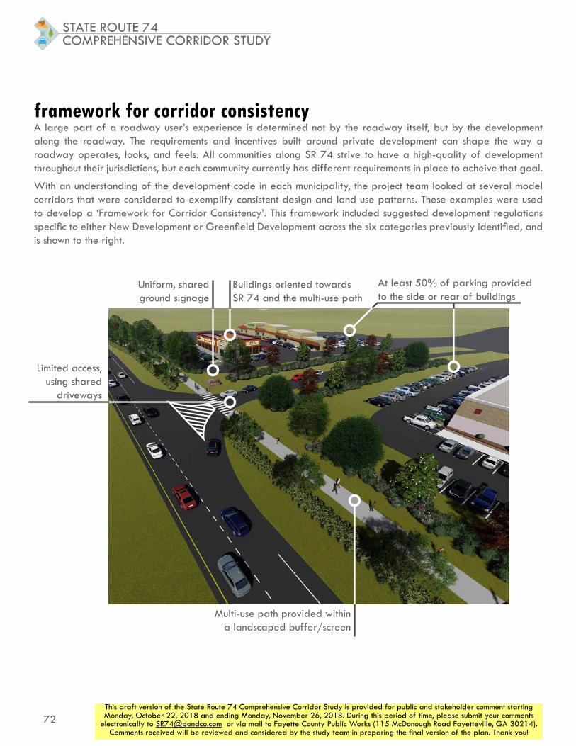
72
STATE ROUTE 74COMPREHENSIVE CORRIDOR STUDY
This draft version of the State Route 74 Comprehensive Corridor Study is provided for public and stakeholder comment starting Monday, October 22, 2018 and ending Monday, November 26, 2018. During this period of time, please submit your comments
electronically to [email protected] or via mail to Fayette County Public Works (115 McDonough Road Fayetteville, GA 30214). Comments received will be reviewed and considered by the study team in preparing the final version of the plan. Thank you!
framework for corridor consistencyA large part of a roadway user’s experience is determined not by the roadway itself, but by the development along the roadway. The requirements and incentives built around private development can shape the way a roadway operates, looks, and feels. All communities along SR 74 strive to have a high-quality of development throughout their jurisdictions, but each community currently has different requirements in place to acheive that goal.
With an understanding of the development code in each municipality, the project team looked at several model corridors that were considered to exemplify consistent design and land use patterns. These examples were used to develop a ‘Framework for Corridor Consistency’. This framework included suggested development regulations specific to either New Development or Greenfield Development across the six categories previously identified, and is shown to the right.
At least 50% of parking provided to the side or rear of buildings
Limited access, using shared
driveways
Uniform, shared ground signage
Buildings oriented towards SR 74 and the multi-use path
Multi-use path provided within a landscaped buffer/screen

73This draft version of the State Route 74 Comprehensive Corridor Study is provided for public and stakeholder comment starting Monday, October 22, 2018 and ending Monday, November 26, 2018. During this period of time, please submit your comments
electronically to [email protected] or via mail to Fayette County Public Works (115 McDonough Road Fayetteville, GA 30214). Comments received will be reviewed and considered by the study team in preparing the final version of the plan. Thank you!
Greenfield Development Redevelopment
Access Management
Reduce/require interparcel connectivity. Require shared access driveways with uniform
signage. Secondary roadway network (i.e. backage raods) should enhance access
Discourage construction of additional driveways if there is access to the roadway network via an existing driveway on parcel. Encourage closing of redundant driveway
access.
Block Area and Length
Suggested minimum block length of 600 feet.
Front Setback/Greenspace
Require undisturbed tree buffer area. 30 feet for nonresidential development and 50 feet for residential development - along SR 74. Buffer/setback area can include multi-use
trail
Retain undisturbed/tree buffer area as close to new development standards as
permissable. In lieu of/addition to tree uffer, allow for minimum landscaped buffer of 15 feet with berm/screen. Buffer/setback area
can include multi-use trail
ParkingEncourage placement of minimum of 50% of parking on side of rear of new developments
New parking in excess of 50% of total is encouraged to be placed to the side of rear
of developments
Sidewalk Standards
Require placement of 5 foot wide sidewalk on west side of corridor and connecting roads and 10 foot wide trail on east side. Include minimum 2 foot grass strip/other buffer between sidewalk/trail and roadway. In areas where sidewalk can connect to multi-use trail, provide
wider sidewalk to accommodate bicyclists and pedestrians (~10 feet)
SignageRequire use of ground signs with consistent and uniform aesthetic among municipalities to
promote uniform placemaking and business promotion along the corridor.
CORRIDOR PLAN | FRAMEWORK FOR CORRIDOR CONSISTENCY
Development Guidelines for Corridor Consistency
74This draft version of the State Route 74 Comprehensive Corridor Study is provided for public and stakeholder comment starting Monday, October 22, 2018 and ending Monday, November 26, 2018. During this period of time, please submit your comments
electronically to [email protected] or via mail to Fayette County Public Works (115 McDonough Road Fayetteville, GA 30214). Comments received will be reviewed and considered by the study team in preparing the final version of the plan. Thank you!
ACTION PLANprioritization processIn order to begin to lay out an action plan for the corridor, projects were prioritized based on input received and on their technical performance.
bottlenecksTwo forms of public input were used to prioritize corridor plan projects based on the desires of the community: bottlenecks and vision statements.
At the first round of community meetings, attendees were provided with three dots and asked to place them on the areas along or near the study corridor where they experienced the worst bottlenecks. Projects were assigned a score based on the number of received bottlenecks they are near.
vision statementsDuring the community engagement process, both the stakeholder group and the broader community were presented with the series of vision statements shown to the right. These groups were asked to assign a set number of dots to the statements based on what they felt was most important along the study corridor. Based on the portion of total dots assigned to each objective statement, a value was assigned to each. Each project was then evaluated to determine which objectives the project would work towards, and a total score created based on the sum of the appropriate values.
bottlenecks prioritization
technical analysis
vision statements

75This draft version of the State Route 74 Comprehensive Corridor Study is provided for public and stakeholder comment starting Monday, October 22, 2018 and ending Monday, November 26, 2018. During this period of time, please submit your comments
electronically to [email protected] or via mail to Fayette County Public Works (115 McDonough Road Fayetteville, GA 30214). Comments received will be reviewed and considered by the study team in preparing the final version of the plan. Thank you!
ACTION PLAN | PRIORITIZATION PROCESS
Access ManagementImplement corridor-wide access management policies to help maintain mobilityImplement access management practices such as frontage/backage/access roads and inter-parcel access to limit curb cuts on SR 74 while maintaining accessibility for residents and businesses
Accessibility/ConnectivityMaintain or enhance accessibility/connectivity for residents and businesses without negatively affecting mobilityIdentify new corridors and access points to I-85 to improve accessibility and mobility. Possible new I-85 interchange at SR 92/Gullatt/Johnson RdImprove pedestrian and bicycle access to corridor destinations and amenities (retail, downtowns, parks, libraries, etc.)
Maintain and Improve Corridor AestheticsImplement corridor-wide design guidelines for private development and transportation investments to ensure a cohesive, aesthetically pleasing corridorDevelop and implement consistent signage standards throughout corridorIdentify and install decorative treatments throughout corridor to highlight SR 74 as a ‘Gateway Corridor’
Seek Opportunities to Encourage and Facilitate Alternative Travel Modes
Identify and implement transportation projects that encourage alternatives modes of travel including pedestrian, bicycle, and transitIdentify potential funding opportunities to fund shuttles, park and ride lots, van pools, and ride sharing
Land Use/Development PatternsIdentify and adopt zoning and development standards that balance growth with roadway network capacities in order to maintain mobilityEncourage development patterns that help reduce automobile trips (mixed-use, transit-oriented, etc.)Accommodate anticipated economic development without jeopardizing corridor mobility
MobilityIdentify and implement transportation improvements that preserve or enhance traffic operations and travel times along the SR 74 corridorImplement operational and capacity improvements to accommodate planned growth within the corridorImplement ‘Smart Corridor’ technologies such as adaptive signal control, queue detection, intelligent transportation systems (ITS) to improve traffic operations and safety within the SR 74 corridor
85
Tyrone
Peachtree City
Fairburn
N
milam rd
sandy creek rd
jenkins rd
tyrone rd
palmetto rd
Fulton Co
Coweta Co
dogwood trl
seno
ia rd
oakley ind blvd
n peachtree pkwy
74
54
29
Bottleneck Locations Received Vision Statements

76
STATE ROUTE 74COMPREHENSIVE CORRIDOR STUDY
This draft version of the State Route 74 Comprehensive Corridor Study is provided for public and stakeholder comment starting Monday, October 22, 2018 and ending Monday, November 26, 2018. During this period of time, please submit your comments
electronically to [email protected] or via mail to Fayette County Public Works (115 McDonough Road Fayetteville, GA 30214). Comments received will be reviewed and considered by the study team in preparing the final version of the plan. Thank you!
technical scoresIn addition to scores assigned based on public input, part of the prioritization process used technical analysis to differentiate projects. Due to the different needs they serve, vehicular projects were evaluated based on different criteria than bicycle and pedestrian projects.
Vehicular scoring was based on the following:
»» Current (year 2017) traffic volumes during the morning and afternoon peak hours
»» Current (year 2017) intersection delay
»» Crash history (2013-2017)
»» Future (year 2040) intersection delay in the no-build scenario
»» Future (year 2040) reduction in intersection delay provided by the improvement
All bicycle and pedestrian projects were evaluated based on the population and employment characteristics of areas within half a mile of each project. Retail employment was also used in order to estimate which projects were near concentrations of retail, a frequent attractor of trips made with active modes. Finally, a metric was constructed to identify projects that exist in areas where all three of these components are present in equal amounts. For example, while one area may have high population, but low employment, another may have more modest population, but also modest employment present. The latter area is likely more conducive to a bicycle and pedestrian improvement becacuse the residential population is close enough to workplaces that walking or biking is a reasonable option.
Bicycle and pedestrian projects were scored based on:
»» Total population in half-mile radius (based on 2010 census)
»» Total employment in half-mile radius (based on 2016 LEHD data)
»» Retail employment in half-mile radius (used to estimate locations of retail, based on 2016 LEHD data)
»» A measure constructed to prioritize areas where the above were all present over areas in which only employment or residential population are present
Some projects, including new roadways and treatments at minor intersections, do not have a tangible, measurable impact on the corridor, but are still important for maintaining connectivity, improving mobility, and increasing safety along the corridor. These projects have not been given a technical score, and their overall prioritization score is based only on the bottlenecks and vision statements scores they received.
The table to the right and on the following page shows all of the prioritization scores received by project, sorted by total prioritization score.

77This draft version of the State Route 74 Comprehensive Corridor Study is provided for public and stakeholder comment starting Monday, October 22, 2018 and ending Monday, November 26, 2018. During this period of time, please submit your comments
electronically to [email protected] or via mail to Fayette County Public Works (115 McDonough Road Fayetteville, GA 30214). Comments received will be reviewed and considered by the study team in preparing the final version of the plan. Thank you!
ACTION PLAN | PRIORITIZATION PROCESS
Prioritization Results
Project ID Description
Tech
nica
l Sc
ore
Goa
ls S
core
Bottl
enec
ks
Scor
e
Prio
ritiz
atio
n Sc
ore
INT-05
Install raised medians on the Oakley Industrial Boulevard east and west approaches to remove conflicting vehicle movements. Add dual lefts on the western approach of Oakley Industrial Boulevard. Extend Ella Ln to Oakley Industrial Blvd to newly faciliate restricted movements at Oakley Industrial Boulevard and SR 74.
10.0 10.0 7.7 9.4
MUP-03Multi-use path along east side of SR 74 from Milam Road (connect with interchange project trail) to connect with Peachtree City trail network near N Peachtree Parkway
10.0 7.1 10.0 9.3
RDW-03New backage roadway east of SR 74 from Meadow Glen Parkway (connecting to existing roadway) to Milam Road
N/A 8.4 8.6 8.5
INT-08 J-Turn intersection at Kirkley Road/Westbourne Drive 7.2 10.0 6.8 7.8
MUP-05 Multi-use path along Oakley Industrial Boulevard from SR 74 east to SR 92 5.9 7.1 8.8 6.9
INT-14 Install J-Turn intersection at E Crestwood Road 8.7 10.0 0.0 6.8
TRA-01Extend Route 181 from its current turnaround near Fairburn to continue down Broad Street/US 29, then travel south on SR 74 to turn around at the new Park and Ride facility on SR 74 at the power line easement
N/A 3.5 9.8 6.7
INT-13 Install MUT intersection at Palmetto Road/Tyrone Road 4.7 10.0 6.8 6.5
OTH-04 Resurface Oakley Industrial Boulevard from SR 74 to Fayetteville Road N/A 4.3 8.8 6.5
INT-20 Install RCUT intersection at Senoia Road (south)/Lexington Pass 8.1 10.0 0.0 6.5
TRA-02Extend Route 89 from its current turnaround near Atlanta Metro Studios to continue along Oakley Industrial Boulevard, then travel south on SR 74 to turn around at the new Park and Ride facility on SR 74 at the power line easement
N/A 3.5 9.3 6.4
TRA-03Extend proposed Route 889 from its currently planned turnaround at Oakley Industrial Boulevard, Harris Road, and Plantation Road to continue south of SR 74 to turn around at the new Park and Ride facility on SR 74 at the power line easement
N/A 3.5 9.3 6.4
INT-09Upgrade existing J-Turn at Laurelmont Drive/Sandy Creek Road to RCUT, including new northern u-turn south of Kirkley Road
3.1 10.0 9.1 6.3
INT-17 Install RCUT intersection at Crabapple Lane/N Peachtree Parkway 3.7 10.0 7.7 6.3
INT-10 Install RCUT intersection at Peggy Lane/Jenkins Road 3.9 10.0 6.8 6.2
MUP-04 Multi-use path along Oakley Industrial Boulevard from SR 74 west to Bohannon Road 4.7 7.1 7.7 6.1
MUP-06bMulti-use path connecting MUP-06 to SR 74 by travelling east of the Fairburn Family Travel Center, crossing Oakley Industrial Boulevard near Plantation Road, and reconnecting with SR 74 immediately south of the I-85 interchange
5.2 7.1 6.8 6.1
OTH-03 Resurface Oakley Industrial Boulevard from SR 74 to Bohannon Road N/A 4.3 7.7 6.0
OTH-05Bike facility along Palmetto road and Tyrone Road, Georgia Bike Route 15 (specific facility type to be determined by specific study)
3.0 7.1 9.6 5.7
INT-25 Signalize intersection with Aberdeen Parkway 5.7 10.0 0.0 5.3
INT-15 Install RCUT intersection at Dogwood Trail 2.2 10.0 6.8 5.3
INT-21 Install J-Turn intersection at Kedron Drive (south) 5.2 10.0 0.0 5.1
INT-06 J-Turn intersection at Thompson Road N/A 10.0 0.0 5.0
INT-07 Addition of left in and u-turn on SR 74 at Wendell Coffee Golf & Event Center N/A 10.0 0.0 5.0
INT-11Install right in/right out access from Senoia Road to SR 74 northbound between Carriage Oaks Drive and Jenkins Road
N/A 10.0 0.0 5.0

78
STATE ROUTE 74COMPREHENSIVE CORRIDOR STUDY
This draft version of the State Route 74 Comprehensive Corridor Study is provided for public and stakeholder comment starting Monday, October 22, 2018 and ending Monday, November 26, 2018. During this period of time, please submit your comments
electronically to [email protected] or via mail to Fayette County Public Works (115 McDonough Road Fayetteville, GA 30214). Comments received will be reviewed and considered by the study team in preparing the final version of the plan. Thank you!
INT-16 Install J-Turn intersection at Dogwood Church driveway N/A 10.0 0.0 5.0
INT-22 Install J-Turn intersection at Dunham Square N/A 10.0 0.0 5.0
INT-24New "extended J-Turn" with left in, no left out at Wisdom Pointe Shopping Center and Commerce Drive; and u-turn modifications at Wisdom Road
N/A 10.0 0.0 5.0
OTH-01 Develop truck staging lot to divert trucks waiting for CSX train to clear tracks N/A 10.0 0.0 5.0
INT-01Improve SR 74 at US 29 ramp with repaving, refreshed pavement parkings, and acceleration lane for trucks turning onto US 29 southbound
N/A 10.0 0.0 5.0
INT-03Improve SR 74 at McLarin Road ramp with repaving, channelization island, and self-illuminated signs directing drivers to CSX
N/A 10.0 0.0 5.0
INT-04 Create acceleration lane on SR 74 for vehicles turning left from Senoia Rd N/A 10.0 0.0 5.0
MUP-01Multi-use path along north side of Broad Street/US 29, connecting SR 74 to Downtown Fairburn
5.8 7.1 0.0 4.7
INT-12 Install RCUT intersection at Carriage Oaks Drive 4.2 10.0 0.0 4.6
RDW-01 Extend Howell Avenue from SR 74 to Bohannon Road N/A 8.8 0.0 4.4
RDW-05 New roadway from Kirkley Road west of SR 74 to SR 74 south of Fulton/Fayette County line N/A 8.8 0.0 4.4
RDW-06 New roadway connecting RDW-02 to RDW-05 N/A 8.8 0.0 4.4
MUP-07 Multi-use path along Milam Road from SR 74 east to Greenview Boulevard/Milam Loop 1.3 7.1 7.7 4.4
INT-19 Install RCUT intersection at Kedron Drive (north) 3.4 10.0 0.0 4.2
INT-26 Signalize intersection with Senoia Road (north) 3.4 10.0 0.0 4.2
RDW-02 New backage roadway west of SR 74 from Harris Road to Landrum Road N/A 8.4 0.0 4.2
RDW-04 Extend Meadow Glen Road east to Plantation Road N/A 8.4 0.0 4.2
CRS-04Grade-seperated bicycle and pedestrian crossing south of Crabapple Lane/N Peachtree Parkway to provide connection to Crabapple Lane Elementary School
4.8 7.1 0.0 4.2
INT-18 Install RCUT intersection at Ardenlee Parkway/Georgian Park 3.3 10.0 0.0 4.1
INT-23 Add second westbound left turn lane to Wisdom Road at SR 74 3.3 10.0 0.0 4.1
CRS-03Pedestrian crossing improvements at intersection of N Peachtree Parkway and Georgian Park to provide crossing across Peachtree Parkway
4.7 7.1 0.0 4.1
MUP-06Multi-use path (or potentially other bike and/or ped facility) on backage road, connecting park and ride lot to Harris Road
4.6 7.1 0.0 4.1
ACM-01 New interparcel connection between 361 SR 74 and 375 SR 74 N/A 7.7 0.0 3.9
ACM-02 New interparcel connection between 357 SR 74 and 361 SR 74 N/A 7.7 0.0 3.9
MUP-06a Multi-use path connecting MUP-06 to SR 74 west of the Fairburn Family Travel Center 4.1 7.1 0.0 3.8
MUP-09 Multi-use path west of SR 74 connecting CRS-02 to Spencer Road 3.7 7.1 0.0 3.6
MUP-02Multi-use path along east side of SR 74 from MUP-01/US 29 to City Lake Road (to connect with interchange project trail)
3.4 7.1 0.0 3.5
MUP-10 Multi-use path along Swanson Road from SR 74 to Ellison Road 3.2 7.1 0.0 3.4
CRS-01 Grade-seperated bicycle and pedestrian crossing at/near Meadow Glen Parkway 3.0 7.1 0.0 3.3
OTH-02Develop ITS system to alert trucks to presence of train blocking roadway as they exit I-85 onto SR 74
N/A 6.2 0.0 3.1
CRS-02 Grade-seperated bicycle and pedestrian crossing north of Carriage Oaks Drive 2.6 7.1 0.0 3.1
Project ID Description
Tech
nica
l Sc
ore
Goa
ls S
core
Bottl
enec
ks
Scor
e
Prio
ritiz
atio
n Sc
ore
Prioritization Results (continued)
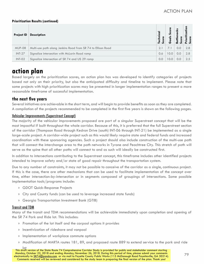
79This draft version of the State Route 74 Comprehensive Corridor Study is provided for public and stakeholder comment starting Monday, October 22, 2018 and ending Monday, November 26, 2018. During this period of time, please submit your comments
electronically to [email protected] or via mail to Fayette County Public Works (115 McDonough Road Fayetteville, GA 30214). Comments received will be reviewed and considered by the study team in preparing the final version of the plan. Thank you!
action planBased largely on the prioritization scores, an action plan has was developed to identify categories of projects based not only on their priority, but also the anticipated difficulty and timeline to implement. Please note that some projects with high prioritization scores may be presented in longer implementation ranges to present a more reasonable timeframe of successful implementation.
the next five yearsSeveral initiatives are achievable in the short term, and will begin to provide benefits as soon as they are completed. A compilation of the projects recommended to be completed in the first five years is shown on the following pages.
Vehicular Improvements (Superstreet Concept)The majority of the vehicular improvements proposed are part of a singular Superstreet concept that will be the most impactful if built throughout the whole corridor. Because of this, it is preferred that the full Superstreet section of the corridor (Thompson Road through Kedron Drive (south) INT-06 through INT-21) be implemented as a single large-scale project. A corridor-wide project such as this would likely require state and federal funds and increased coordination with these sponsoring agencies. Such a project should also include construction of the multi-use path that will connect the interchange area to the path networks in Tyrone and Peachtree City. This stretch of path will serve as the spine that all other paths will connect to and as such will ideally be constructed first.
In addition to intersections contributing to the Superstreet concept, this timeframe includes other identified projects intended to improve safety and/or state of good repair throughout the transportation system.
Due to any number of constraints, it may not be possible to conceive of the corridor as a single, continuous project. If this is the case, there are other mechanisms that can be used to facilitate implementation of the concept over time, either intersection-by-intersection or in segments composed of groupings of intersections. Some possible implementation tools/programs include:
»» GDOT Quick-Response Projects
»» City and County funds (can be used to leverage increased state funds)
»» Georgia Transportation Investment Bank (GTIB)
Transit and TDMMany of the transit and TDM recommendations will be achievable immediately upon completion and opening of the SR 74 Park and Ride lot. This includes:
»» Promotion of the lot itself and the carpool options it provides
»» Incentivization of rideshare and vanpool
»» Implementation of workplace commute options
»» Modification of MARTA routes 181, 89, and proposed route 889 to extend service to the park and ride lot
ACTION PLAN
Project ID Description
Tech
nica
l Sc
ore
Goa
ls S
core
Bottl
enec
ks
Scor
e
Prio
ritiz
atio
n Sc
ore
Prioritization Results (continued)
MUP-08 Multi-use path along Jenkins Road from SR 74 to Ellison Road 2.1 7.1 0.0 2.8
INT-27 Signalize intersection with McLarin Road ramp 0.6 10.0 0.0 2.8
INT-02 Signalize intersection of SR 74 and US 29 ramp 0.0 10.0 0.0 2.5

80
STATE ROUTE 74COMPREHENSIVE CORRIDOR STUDY
This draft version of the State Route 74 Comprehensive Corridor Study is provided for public and stakeholder comment starting Monday, October 22, 2018 and ending Monday, November 26, 2018. During this period of time, please submit your comments
electronically to [email protected] or via mail to Fayette County Public Works (115 McDonough Road Fayetteville, GA 30214). Comments received will be reviewed and considered by the study team in preparing the final version of the plan. Thank you!
Five-Year ProjectsProject
IDDescription Total Cost
INT-01Improve SR 74 at US 29 ramp with repaving, refreshed pavement parkings, and acceleration lane for trucks turning onto US 29 southbound
$250,000
INT-03Improve SR 74 at McLarin Road ramp with repaving, channelization island, and self-illuminated signs directing drivers to CSX
$40,000
INT-04Create acceleration lane on SR 74 for vehicles turning left from Senoia Rd
$150,000
INT-05
Install raised medians on the Oakley Industrial Boulevard east and west approaches to remove conflicting vehicle movements. Add dual lefts on the western approach of Oakley Industrial Boulevard. Extend Ella Ln to Oakley Industrial Blvd to newly faciliate restricted movements at Oakley Industrial Boulevard and SR 74.
$430,000
INT-06 J-Turn intersection at Thompson Road $370,000
INT-07Addition of left in and u-turn on SR 74 at Wendell Coffee Golf & Event Center
$300,000
INT-08J-Turn intersection at Kirkley Road/Westbourne Drive
$493,000
INT-09Upgrade existing J-Turn at Laurelmont Drive/Sandy Creek Road to RCUT, including new northern u-turn south of Kirkley Road
$125,000
INT-10Install RCUT intersection at Peggy Lane/Jenkins Road
$793,000
INT-12Install RCUT intersection at Carriage Oaks Drive
$893,000
INT-13Install MUT intersection at Palmetto Road/Tyrone Road
$970,000
INT-14 Install J-Turn intersection at E Crestwood Road $593,000
INT-15 Install RCUT intersection at Dogwood Trail $793,000
INT-16Install J-Turn intersection at Dogwood Church driveway
$370,000
INT-17Install RCUT intersection at Crabapple Lane/N Peachtree Parkway
$893,000
INT-18Install RCUT intersection at Ardenlee Parkway/Georgian Park
$893,000
INT-19 Install RCUT intersection at Kedron Drive (north) $893,000
INT-20Install RCUT intersection at Senoia Road (south)/Lexington Pass
$793,000
INT-21 Install J-Turn intersection at Kedron Drive (south) $62,121*
INT-22 Install J-Turn intersection at Denham Square $370,000
Corridor Development RegulationsDue to ongoing and increasing development pressures and activities along the SR 74 corridor, the early implementation of consistent development regulations along the corridor will have an outsize impact on the corridor for the future.
It would be most effective for all communities to enact a multi-jurisdictional overlay district, which would ensure identical regulations in all communities along the corridor. The SR 74 Gateway Coalition could serve as a useful framework to develop the language of this overlay based on recommendations presented in this study and to pursue consistent adoption by all relevant jurisdictions and agencies.
It is also possible for each individual municipality to construct a mechanism for implementation that works better with the unique needs present in their community and is most compatible with their development code. If this course is taken, it will be very important to ensure communication and cooperation between the communities to create consistency in the regulations passed. If regulations vary between the communities, much of the benefit of this exercise would be lost.
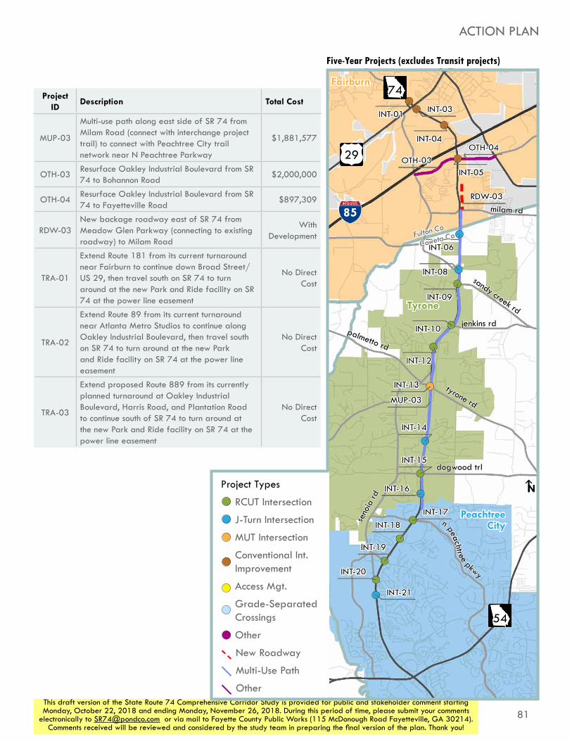
81This draft version of the State Route 74 Comprehensive Corridor Study is provided for public and stakeholder comment starting Monday, October 22, 2018 and ending Monday, November 26, 2018. During this period of time, please submit your comments
electronically to [email protected] or via mail to Fayette County Public Works (115 McDonough Road Fayetteville, GA 30214). Comments received will be reviewed and considered by the study team in preparing the final version of the plan. Thank you!
MUP-03
Multi-use path along east side of SR 74 from Milam Road (connect with interchange project trail) to connect with Peachtree City trail network near N Peachtree Parkway
$1,881,577
OTH-03Resurface Oakley Industrial Boulevard from SR 74 to Bohannon Road
$2,000,000
OTH-04Resurface Oakley Industrial Boulevard from SR 74 to Fayetteville Road
$897,309
RDW-03New backage roadway east of SR 74 from Meadow Glen Parkway (connecting to existing roadway) to Milam Road
With Development
TRA-01
Extend Route 181 from its current turnaround near Fairburn to continue down Broad Street/US 29, then travel south on SR 74 to turn around at the new Park and Ride facility on SR 74 at the power line easement
No Direct Cost
TRA-02
Extend Route 89 from its current turnaround near Atlanta Metro Studios to continue along Oakley Industrial Boulevard, then travel south on SR 74 to turn around at the new Park and Ride facility on SR 74 at the power line easement
No Direct Cost
TRA-03
Extend proposed Route 889 from its currently planned turnaround at Oakley Industrial Boulevard, Harris Road, and Plantation Road to continue south of SR 74 to turn around at the new Park and Ride facility on SR 74 at the power line easement
No Direct Cost
85
Tyrone
Peachtree City
Fairburn
N
milam rd
sandy creek rd
jenkins rd
tyrone rd
palmetto rd
Fulton Co
Coweta Co
dogwood trl
seno
ia rd
n peachtree pkwy
74
54
29
Five-Year Projects (excludes Transit projects)
ACTION PLAN
Project ID
Description Total Cost
Project Types
RCUT Intersection
J-Turn Intersection
MUT Intersection
Conventional Int. Improvement
Access Mgt.
Grade-Separated Crossings
Other
New Roadway
Multi-Use Path
Other

82
STATE ROUTE 74COMPREHENSIVE CORRIDOR STUDY
This draft version of the State Route 74 Comprehensive Corridor Study is provided for public and stakeholder comment starting Monday, October 22, 2018 and ending Monday, November 26, 2018. During this period of time, please submit your comments
electronically to [email protected] or via mail to Fayette County Public Works (115 McDonough Road Fayetteville, GA 30214). Comments received will be reviewed and considered by the study team in preparing the final version of the plan. Thank you!
the next ten yearsDue to the substantial scope of the projects set for the first five years, it is likely that implementation of all these projects will not be complete and open for use at the end of five years. It is expected that many of those improvements will still be ongoing through the duration of the next ten years. Projects specifically called out in this implementation window include those that provide additional congestion improvements and high-priority multi-use paths that build off of the path along SR 74 to extend the network.
Ten-Year ProjectsProject
IDDescription Total Cost
CRS-03Pedestrian crossing improvements at intersection of N Peachtree Parkway and Georgian Park to provide crossing across Peachtree Parkway
$50,000
INT-11Install right in/right out access from Senoia Road to SR 74 northbound between Carriage Oaks Drive and Jenkins Road
$250,000
INT-23Add second westbound left turn lane to Wisdom Road at SR 74
$361,000
INT-24
New "extended J-Turn" with left in, no left out at Wisdom Pointe Shopping Center and Commerce Drive; and u-turn modifications at Wisdom Road
$593,000
INT-25 Signalize intersection with Aberdeen Parkway $477,000
MUP-01Multi-use path along north side of Broad Street/US 29, connecting SR 74 to Downtown Fairburn
$1,174,108
MUP-04Multi-use path along Oakley Industrial Boulevard from SR 74 west to Bohannon Road
$288,410
MUP-05Multi-use path along Oakley Industrial Boulevard from SR 74 east to SR 92
$232,272
MUP-06b
Multi-use path connecting MUP-06 to SR 74 by travelling east of the Fairburn Family Travel Center, crossing Oakley Industrial Boulevard near Plantation Road, and reconnecting with SR 74 immediately south of the I-85 interchange
$256,690
OTH-01Develop truck staging lot to divert trucks waiting for CSX train to clear tracks
$500,000
OTH-02Develop ITS system to alert trucks to presence of train blocking roadway as they exit I-85 onto SR 74
$1,000,000
RDW-01Extend Howell Avenue from SR 74 to Bohannon Road
$1,350,511

83This draft version of the State Route 74 Comprehensive Corridor Study is provided for public and stakeholder comment starting Monday, October 22, 2018 and ending Monday, November 26, 2018. During this period of time, please submit your comments
electronically to [email protected] or via mail to Fayette County Public Works (115 McDonough Road Fayetteville, GA 30214). Comments received will be reviewed and considered by the study team in preparing the final version of the plan. Thank you!
ACTION PLAN
85
Tyrone
Peachtree City
Fairburn
N
milam rd
sandy creek rd
jenkins rd
tyrone rd
palmetto rd
Fulton Co
Coweta Co
dogwood trl
seno
ia rd
n peachtree pkwy
74
54
29
Ten-Year Projects
Project Types
RCUT Intersection
J-Turn Intersection
MUT Intersection
Conventional Int. Improvement
Access Mgt.
Grade-Separated Crossings
Other
New Roadway
Multi-Use Path
Other

84
STATE ROUTE 74COMPREHENSIVE CORRIDOR STUDY
This draft version of the State Route 74 Comprehensive Corridor Study is provided for public and stakeholder comment starting Monday, October 22, 2018 and ending Monday, November 26, 2018. During this period of time, please submit your comments
electronically to [email protected] or via mail to Fayette County Public Works (115 McDonough Road Fayetteville, GA 30214). Comments received will be reviewed and considered by the study team in preparing the final version of the plan. Thank you!
ACTION PLAN
the next twenty yearsThis timeframe includes projects that are most beneficial when combined with projects already completed in the previous timeframes; projects that will require significant implementation timelines due to cost, land acquisition, or some other constraint; or those that will solve challenges that are relatively mild in the present and will become severe only as growth continues to happen in the future.
Twenty-Year ProjectsProject
IDDescription Total Cost
CRS-01Grade-seperated bicycle and pedestrian crossing at/near Meadow Glen Parkway
$191,400
CRS-02Grade-seperated bicycle and pedestrian crossing north of Carriage Oaks Drive
$191,400
CRS-04
Grade-seperated bicycle and pedestrian crossing south of Crabapple Lane/N Peachtree Parkway to provide connection to Crabapple Lane Elementary School
$191,400
INT-02Signalize intersection of SR 74 and US 29 ramp
$477,000
INT-26 Signalize intersection with Senoia Road (north) $477,000
INT-27 Signalize intersection with McLarin Road ramp $477,000
MUP-02Multi-use path along east side of SR 74 from MUP-01/US 29 to City Lake Road (to connect with interchange project trail)
$343,171
MUP-06Multi-use path (or potentially other bike and/or ped facility) on backage road, connecting park and ride lot to Harris Road
$189,660
MUP-06a
Multi-use path connecting MUP-06 to SR 74 west of the Fairburn Family Travel Center
$45,724
MUP-07Multi-use path along Milam Road from SR 74 east to Greenview Boulevard/Milam Loop
$274,286
MUP-08Multi-use path along Jenkins Road from SR 74 to Ellison Road
$305,527
MUP-09Multi-use path west of SR 74 connecting CRS-02 to Spencer Road
$131,128
MUP-10Multi-use path along Swanson Road from SR 74 to Ellison Road
$239,334
OTH-05Bike facility along Palmetto road and Tyrone Road, Georgia Bike Route 15 (specific facility type to be determined by specific study)
TBD
RDW-04Extend Meadow Glen Road east to Plantation Road
$1,350,511
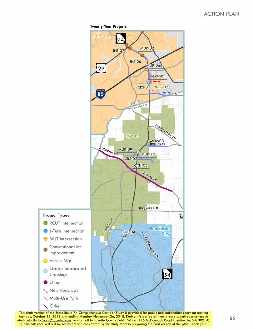
85This draft version of the State Route 74 Comprehensive Corridor Study is provided for public and stakeholder comment starting Monday, October 22, 2018 and ending Monday, November 26, 2018. During this period of time, please submit your comments
electronically to [email protected] or via mail to Fayette County Public Works (115 McDonough Road Fayetteville, GA 30214). Comments received will be reviewed and considered by the study team in preparing the final version of the plan. Thank you!
85
Tyrone
Peachtree City
Fairburn
N
milam rd
sandy creek rd
jenkins rd
tyrone rd
palmetto rd
Fulton Co
Coweta Co
dogwood trl
seno
ia rd
n peachtree pkwy
74
54
29
ACTION PLAN
Twenty-Year Projects
Project Types
RCUT Intersection
J-Turn Intersection
MUT Intersection
Conventional Int. Improvement
Access Mgt.
Grade-Separated Crossings
Other
New Roadway
Multi-Use Path
Other

86
STATE ROUTE 74COMPREHENSIVE CORRIDOR STUDY
This draft version of the State Route 74 Comprehensive Corridor Study is provided for public and stakeholder comment starting Monday, October 22, 2018 and ending Monday, November 26, 2018. During this period of time, please submit your comments
electronically to [email protected] or via mail to Fayette County Public Works (115 McDonough Road Fayetteville, GA 30214). Comments received will be reviewed and considered by the study team in preparing the final version of the plan. Thank you!
timed with developmentCertain projects are unlikely to be completed through typical methods of public works simply constructing a new facility. These projects are more likely to be completed as development or redevelopment occurs along the corridor. This category primarily includes new roadways and access management facilities.
With Development Projects
Project ID
Description Total Cost
ACM-02New interparcel connection between 357 SR 74 and 361 SR 74
With Development
ACM-01New interparcel connection between 361 SR 74 and 375 SR 74
With Development
RDW-02New backage roadway west of SR 74 from Harris Road to Landrum Road
With Development
RDW-05New roadway from Kirkley Road west of SR 74 to SR 74 south of Fulton/Fayette County line
With Development
RDW-06 New roadway connecting RDW-02 to RDW-05With
Development

87This draft version of the State Route 74 Comprehensive Corridor Study is provided for public and stakeholder comment starting Monday, October 22, 2018 and ending Monday, November 26, 2018. During this period of time, please submit your comments
electronically to [email protected] or via mail to Fayette County Public Works (115 McDonough Road Fayetteville, GA 30214). Comments received will be reviewed and considered by the study team in preparing the final version of the plan. Thank you!
ACTION PLAN
85
Tyrone
Peachtree City
Fairburn
N
milam rd
sandy creek rd
jenkins rd
tyrone rd
palmetto rd
dogwood trl
seno
ia rd
n peachtree pkwy
74
54
29
With Development Projects
Project Types
RCUT Intersection
J-Turn Intersection
MUT Intersection
Conventional Int. Improvement
Access Mgt.
Grade-Separated Crossings
Other
New Roadway
Multi-Use Path
Other
RDW-05
RDW-06