Spatial Analysis of Shell Midden Camps at La Jovita ... · the Baja California peninsula, just at...
34
Pacific Coast Archaeological Society Quarterly, Volume 54, Numbers 3 and 4 Spatial Analysis of Shell Midden Camps at La Jovita, Ensenada, Baja California María Flores Hernández and Manuel Eduardo Pérez Rivas Abstract An archaeological research program for shell midden sites at La Jovita, north of Ensenada in northwestern Baja California, has been carried out since 2011 under the auspices of Mexico’s Instituto Nacional de Antropología e Historia. The studies have addressed the distribution of 46 Yuman and pre-Yuman sites within a regional con- text. Settlement patterns and mobility have been examined through analyses of the functions and activities indicated by the sites’ features, artifacts, and faunal remains; their settings with respect to topography, geology, hydrology, and access to other resources; and their relation to local and trans-peninsular routes of travel. Links to ethnographically attested patterns of social organization, territoriali- ty, and cosmogony are also discussed. Introduction Since 2011, the Dirección de Salvamento Arque- ológico of the Instituto Nacional de Antropología e Historia (INAH) has conducted research in the north- western coastal region of Baja California, associated with the construction of a thermoelectric plant. As a result, data have been obtained from 46 shell midden (conchero) camps whose occupation extended from the end of the La Jolla complex (7500–3000 BP) and continued during the Hakataya or Yuman complex (3000–250 BP). The great extent and stratigraphic complexity of the studied contexts led to the refinement of a method- ology for data acquisition and analysis supported by geographic information systems, in order to under- stand the settlement pattern, as well as the distribution patterns of recovered artifacts. As a frame of reference, a community structure model based on the clan organization of the chumuls, or shumuls (also called simuls, cimuls, etc.), is assumed, with territories and resources exploited by its members and in which the La Jovita shell middens acquired rel- evance within the regional subsistence pattern, along with specific territoriality rules that gave meaning and social representation to the environment’s natural and cultural features. The spatial distributions of lithic artifacts, ceramic sherds, and clusters of mollusk shells indicate that the studied shell midden camps joined together the ac- tivities of both work camps and habitation areas. The stratigraphical record shows repetition over time of activities on the occupation floors and the preserving of sets of objects (such as hearths, manos and hammer stones) suggesting the marking of these spaces and recognition of some kind of exclusivity or belonging over them by family groups that maintained them- selves during extended stays throughout the year. Location of the Study Area The study area is situated on the northwest coast of the Baja California peninsula, just at the northern edge of Ensenada de Todos los Santos, about 2 km northwest of the place known as Punta Salsipuedes, in the municipio (county) of Ensenada. The land where most of the work has been carried out is 882 m long and 301 m wide, with its main axis in
Transcript of Spatial Analysis of Shell Midden Camps at La Jovita ... · the Baja California peninsula, just at...

Pacific Coast Archaeological Society Quarterly, Volume 54, Numbers 3 and 4
Spatial Analysis of Shell Midden Camps at La Jovita, Ensenada, Baja CaliforniaMaría Flores Hernández and Manuel Eduardo Pérez Rivas
Abstract
An archaeological research program for shell midden sites at La Jovita, north of Ensenada in northwestern Baja California, has been carried out since 2011 under the auspices of Mexico’s Instituto Nacional de Antropología e Historia. The studies have addressed the distribution of 46 Yuman and pre-Yuman sites within a regional con-text. Settlement patterns and mobility have been examined through analyses of the functions and activities indicated by the sites’ features, artifacts, and faunal remains; their settings with respect to topography, geology, hydrology, and access to other resources; and their relation to local and trans-peninsular routes of travel. Links to ethnographically attested patterns of social organization, territoriali-ty, and cosmogony are also discussed.
Introduction
Since 2011, the Dirección de Salvamento Arque-ológico of the Instituto Nacional de Antropología e Historia (INAH) has conducted research in the north-western coastal region of Baja California, associated with the construction of a thermoelectric plant. As a result, data have been obtained from 46 shell midden (conchero) camps whose occupation extended from the end of the La Jolla complex (7500–3000 BP) and continued during the Hakataya or Yuman complex (3000–250 BP).
The great extent and stratigraphic complexity of the studied contexts led to the refinement of a method-ology for data acquisition and analysis supported by geographic information systems, in order to under-stand the settlement pattern, as well as the distribution patterns of recovered artifacts.
As a frame of reference, a community structure model based on the clan organization of the chumuls, or shumuls (also called simuls, cimuls, etc.), is assumed, with territories and resources exploited by its members and in which the La Jovita shell middens acquired rel-evance within the regional subsistence pattern, along with specific territoriality rules that gave meaning and social representation to the environment’s natural and cultural features.
The spatial distributions of lithic artifacts, ceramic sherds, and clusters of mollusk shells indicate that the studied shell midden camps joined together the ac-tivities of both work camps and habitation areas. The stratigraphical record shows repetition over time of activities on the occupation floors and the preserving of sets of objects (such as hearths, manos and hammer stones) suggesting the marking of these spaces and recognition of some kind of exclusivity or belonging over them by family groups that maintained them-selves during extended stays throughout the year.
Location of the Study Area
The study area is situated on the northwest coast of the Baja California peninsula, just at the northern edge of Ensenada de Todos los Santos, about 2 km northwest of the place known as Punta Salsipuedes, in the municipio (county) of Ensenada. The land where most of the work has been carried out is 882 m long and 301 m wide, with its main axis in
PCAS Quarterly 54(3&4)
Flores and Pérez2
cultural complexes are intimately linked with those of the subsistence pattern. Thus, the objectives were oriented to address aspects of the occupational se-quence related to the La Jolla and Hakataya or Yuman complexes, linked with the coastal economies, lithic complexes, and burial patterns with which they have been characterized.
The work with the Thermoelectric Plant in the La Jovita area made it possible to record 43 additional shell midden camps and update the information on another two (Conchero C-01-RACAL and Conchero La Jovita), both inside Lots 22 and 23, on the periph-ery (Figure 2). The recorded camps have dimensions ranging from 10 m2 to 12,223 m2, with an average value of 1,438 m2. The larger ones (C-01-RACAL, C-006, C-016, and Conchero 10, or Conchero de las Cuevas) are located at distances from the coast that range between 100 and 900 m. Small shell midden camps have also been documented at distances up to 4.3 km from the coast, indicating patterns of regional settlement, where different factors intervene, including travel routes through extensive areas. In all, excava-tions have been carried out at 16 shell midden camps.
To record the data in all the stages and phases of the salvage project at the plant, GPS technology, total sta-tion, database management, GIS software, and LIDAR data integration were used.
Issues and Objectives
One of the research project’s main objectives was to understand the various factors that conditioned the set-tlement pattern of the ancient inhabitants of northwest Baja California. Some of the issues that emerge in this topic are the following: What were the importance and function of the shell midden camps within a great-er system of periodic mobility and use of different geographic regions and sources of resources? Were these occasional seasonal camps, or are there elements to support more prolonged patterns of seasonality
a southwest-northeast orientation. The total area is 23.26 ha and includes two lots, 22 and 23. On the northwest half of the land, Lot 22, the CCC (Central de Ciclo Combinado) La Jovita and a distribution substation were built. The land adjoins the sea to the southwest in a rocky border, which is the lower part of a first terrace formed by a volcanic dike. This dike is one in a set of at least five main dikes that rise in a general direction from southwest to northeast on a gentle slope of the land surface (Figure 1).
Archaeological Salvage at CCC Baja California III (La Jovita)
The salvage program was originated because of the construction of a combined-cycle thermoelectric plant (36 CC Baja California III, La Jovita). It evolved in response to construction project needs. The first stage was developed in 2011, when Lots 22 and 23 of La Jovita were involved and 11 shell midden camps were excavated. In the second stage, at the end of 2013, explorations were carried out at Concheros 01-RA-CAL and C-05. During 2015 another six shell midden camps and a shelter were addressed. Finally, toward the end of 2016, excavations were conducted at two previously investigated shell middens (C-007 and C-019) and at another that had not been previously detected (C-032).
In all stages, surface reconnaissance, topographic surveying, and extensive excavations were carried out. Additionally, for the work supporting the plant, sur-face exploration was conducted in surrounding areas up to 9 km from the coast.
The research was based on an approach that assumes that the origins, settlement, and migration of hunter gatherer groups in the study region are closely linked to a subsistence economy dependent on the availabil-ity of resources offered naturally by an environment in which the factor of climatic variability is signifi-cant. Under this premise, it is argued that changes in

PCAS Quarterly 54(3&4)
Spatial Analysis of Shell Midden Camps at La Jovita, Ensenada, Baja California 3
Figu
re 1
. Gen
eral
pla
n of
La
Jovi
ta, B
aja
Cal
iforn
ia.

PCAS Quarterly 54(3&4)
Flores and Pérez4
Figu
re 2
. She
ll m
idde
ns re
cord
ed a
t La
Jovi
ta.

PCAS Quarterly 54(3&4)
Spatial Analysis of Shell Midden Camps at La Jovita, Ensenada, Baja California 5
and recurrence? Was the appropriation of resources controlled exclusively by a single group of people, or were places involved that could be exploited by groups differing culturally, ethnically, and linguistical-ly? Did the relevant geographic and cultural features constitute true symbolic territorial markers as well as resource use areas?
Based on the analysis of the shell middens’ placement and this area’s importance in a wider regional context and the sites’ links to interior valley and mountain sites, this article aims to provide some information on the settlement patterns. As a start, the association of two relevant features of the terrain linked to an inten-sive human occupation (Conchero C-007 and Conche-ro 10) seems to correlate with the strategic importance of La Jovita for the subsistence of human groups in Baja California’s northwest.
Hypothetically, it is assumed that the settlement fea-tures or components that generally make up the areas of activity analytically composing a camp or locality inhabited by a community have usually been dispersed throughout a geographic region in hunter-gatherer so-cieties. Thus, for example, in the domain of habitation, where basic social activities and interrelationships occur, its components are distributed in relation to the areas of resource use, so that the same family or band may have as many seasonal dwellings as their areas of extraction for the resources that are exploited in a year. Similarly, social activities and activities of social cohesion, such as religious ceremonies and rituals, may be focused on several sites and not necessarily correspond to the places most suitable for hunting or harvesting. Therefore, shell midden camps are one part, linked to a wider regional system.
One of the problems in responding to some propos-als is the early extermination of indigenous groups and their languages from the southern part of the Baja California peninsula. This has made it difficult to reconstruct precisely their linguistic affiliations
and the territories they occupied. However, there are interesting proposals concerning peninsular patterns by authors such as Massey (1949), Meigs (1939), Michelsen (1977, 1991), Ochoa (1978a), Bendímez (1987), Laylander (1991), and Morales (2016), with respect to the groups’ community and territorial orga-nization, clan organization, patrilineality, and exoga-my. The chumuls, or shumuls, split into bands during the season of transhumance, and attempts have been made to reconstruct their distributions (Massey 1949; Michelsen 1977; Ochoa 1978a; Laylander 1991). Ac-cording to those studies, the La Jovita area was within the territory of the Kwatl Kumiai chumul.
Although there are variants in their characterization, the chumuls did not represent homogeneous linguistic groupings, but were communities that were entitled by kinship to certain territories, which they defended, if necessary. Their locations did not correspond only to places where the band was located, but to more extensive areas, frequently including more than one settlement (Morales 2016:73).
With regard to territoriality, in this research we assume that human groups require a vital space to perpetuate themselves and to establish rights over it to guarantee their survival. The rules for establishing control over this physical space are what is known as territoriality and may be exclusive or not, such as enjoyment, pos-session, ownership, delimitation, etc. Following Sack (1991:194–203), territoriality operates through various strategies that allow human groups to classify, rank, communicate, and reinforce control over a physical space, and these strategies are closely interwoven in social relationships giving meaning and shaping a physical and ritual conception of the environment.
Characteristics of the Shell Midden Camps
The archaeological occupations are characterized by accumulations of mollusk remains and lithic artifacts resulting from activities of extraction, processing,

PCAS Quarterly 54(3&4)
Flores and Pérez6
and consumption of food; hence their designation as “shell midden camps.” At La Jovita, these camps are stratified, having floors and occupation levels, the lat-ter defined by arrangements consisting of shells, rock concentrations, hearths, grinding stones, flaked tools, and lithic and shell wastes.
The occupation sequence is complex, with an average thickness of 1 m, and nine to 12 identified strata, along with numerous animal burrow intrusions. By virtue of some recovered lithic materials, the chronology of some shell middens can be traced back to the Archaic period, specifically to the La Jolla complex (7500–3000 BP). However, the results of the stratigraphic analysis and some preliminary dates seem to indicate that the great majority of the upper strata of the La Jovita shell middens belong to the last half of the Hakataya or Yuman complex (3000–250 BP). Dating with project materials has yielded calibrated radiocar-bon dates ranging from AD 1080–1310 (950 ± 30 BP) to AD 1480–1690 (420 ± 30 BP; see Robles 2013:29).
The occupation sequence consists of two main groups of deposits, which are differentiated not only by their stratigraphic positions but mainly by their degree of compaction and color. The earlier group comprises three layers on average, corresponding to occupation episodes, and is informally called “compact shell,” whose characteristic is high compaction and an abundance of small shell fragments, along with some whole specimens. In addition to the yellowish-brown color that distinguishes it, it seems to contain a little more clay than the “late shell midden” and “calcium carbonate” layers. It should be mentioned that this last component may be the one that causes the layer’s high degree of compaction and hardness (Figure 3).
The foregoing is based on the fact that the group of “compact shell” layers, assumed until now to be the oldest, are associated with a “very compact yellowish” soil, similar to what is known colloquially as tepetate and which contains a significant amount of carbonate.
This layer is superimposed on a group of deposits of this type of soil, as in the case of the site Conchero C-004 (Figure 4). In other cases, this soil, in addition to being the main matrix of the said group, is directly superimposed on bedrock, which was observed in most of the shell midden camps.
The second group of layers, the “late shell midden,” is much less compact. Among other factors, this is due to the deposits’ younger age, to less exposure to erosive elements, and mainly to differences in the sediments, that is, less “yellowish” soil. The macroscopic analysis of the layers, whose colors range from light brown to grayish brown, showed a greater quantity of silt; fine, medium, and coarse sand; sparse clay; and a greater amount of organic matter, as well as fragments of shells and whole shells. The “late shell midden” group consists of four to six layers (episodes of occupation); in general, they are very unstable layers, with a high degree of animal activity, attested by the large number of tunnels and burrows (Figure 5).
In general, all the shell middens showed these two groups of layers. In some cases, a gradation between both groups was clearly seen, that is to say, starting with soft, very unstable layers with low compaction that become more and more compact, breaking in small lumps, until reaching greater hardness, where the fragments of shell also become tiny, although some whole shells are also recorded, especially of aba-lone (Haliotis). It is common for the lower layers of the “late shell midden” to show concentrations of rock with evidence of burning (hearths), as well as signifi-cant arrangements of shells (usually Haliotis, Astraea undosa, and Mytilus californianus) and lithic artifacts, a situation that identifies specific activity areas in the middens (Figure 6).
An interesting fact that relates not only to the spe-cific activity areas inside the shell middens but also to the repetition of these tasks over time is that often the hearths are associated with two or more floors

PCAS Quarterly 54(3&4)
Spatial Analysis of Shell Midden Camps at La Jovita, Ensenada, Baja California 7
Figure 3. (a–b) Conchero C-04, stratigraphy in which are seen the late shell midden and compact shell midden layers; (c) Con-chero C-07, late shell midden and compact shell midden layers.
or levels of occupation, where associated artifacts (mano-hammers) have been observed in characteristic positions that seem to suggest some type of “marking” left by the mobile populations, perhaps as indicators of territoriality (Figure 6).
At the Concheros C1-RACAL, C-04, C-05, C-06, and C-07, hearths were excavated showing several stages of use or construction associated with several occupation floors detected in excavation and strati-graphic profiles. At the centers of these fireplaces and in their last stage of use, one or more hammer stones were deposited that protrude from the other stones that integrate the hearth. Additionally, in the shell middens C-06, C-07 Camino, C-09, and Conchero 10 de la Cuevas, mano-hammers were documented as
being arranged in specific places such as small shelters and cavities in the rock, which is consistent with the behavior of people who return periodically to the same place and leave their utensils in the usual locations. On the other hand, at Conchero C-04, particular shell arrangements were detected, highlighted with Astraea undosa, forming landmarks of some kind.
The surface and excavation data in the project allow us to propose that there is a differentiation and spe-cialization of functions of some shell middens. For example, Conchero C-023 is characterized by the presence of numerous grinding areas, almost all made on the rock outcrop’s surface, indicative of a repeated and specialized activity. Hohenthal (2001:150–157) described the use of metates not only to prepare plant

PCAS Quarterly 54(3&4)
Flores and Pérez8
Figure 4. Profile of Conchero C-04: compact midden and tepetate layer.
foods, but also to grind meat and dried fish. Table 1 shows a proposal concerning the functions of the La Jovita shell middens, based on the data so far avail-able (Figure 7).
Settlement Pattern and the Importance of La Jovita
An essential aspect of the data analysis was to define the hierarchy of the La Jovita area for the pre-Hispanic groups that inhabited it and the factors that determined the occupation. It was found that relevance was not only related to the proximity of water sources, such as the mouth of the Jatay arroyo and seasonal arroyos, but also to the potential of coastal resources. The flow
of water masses in the California Current, as well as coastal upwelling events that provide deep, cold, nutrient-rich water, favor the development of various species of fish and mollusks (Gobierno del Estado de Baja California 2001).
The area between Jatay arroyo and Punta Salsipudes presents a high density of shell midden camps, located at short distances from each other. For the Bajamar area alone, Fonseca (2013:74) has updated informa-tion corresponding to 104 sites that shows two main clusters: one located northwest of the Cañada del Diablo, close to water sources, and the other in the southwest portion, very close to the shell middens of La Jovita.

PCAS Quarterly 54(3&4)
Spatial Analysis of Shell Midden Camps at La Jovita, Ensenada, Baja California 9
Figure 5. (a–c) Conchero C-04; (d) Conchero C-07, where late shell midden layers are seen.
For its part, at La Jovita, in addition to the 43 shell middens recorded by the projects of the DSA-INAH, about 39 more may be counted that were recorded by previous projects. Excavation data point to the intensive exploitation of a rather small group of mol-lusk species characteristic of rocky intertidal settings. Basically, the predominant species are Mytilus califor-nianus (California mussel) and Haliotis cracherodii (black abalone). In smaller proportions, Haliotis ful-gens (green abalone), Lottia gigantea (giant limpet), and Astraea undosa (wavy turban) stand out. Analysis of oxygen isotopes applied to Mytilus californianus shells suggest that human groups that settled at La Jovita’s shell midden camps before AD 1500 collected mollusks during the entire year, and the later groups after that date did it seasonally, possibly in the spring
when marine upwelling events occur (Robles 2013). This situation is in accordance with the prolifera-tion of activity areas within the middens, suggesting prolonged and recurrent settlement at different times of the year.
The Positioning of Habitation Camps
Topographic data in conjunction with LIDAR data from INEGI allowed us to understand more accurate-ly the spatial relationships of the shell middens with respect to their elevation, drainages, natural slopes, and proximity to water sources. These details were more perceptible thanks to the emphasis given to the topographic record, which provided detailed infor-mation on the shapes, dimensions, and topographic

PCAS Quarterly 54(3&4)
Flores and Pérez10
Figure 6. (a–b) Conchero C-07, hearths with several occupation floors; (c) Conchero C-04, hearths; (d) Conchero C-04, arrangements of shell and lithic materials.
characteristics of the shell concentrations and associ-ated features.
A frequent characteristic was that most of the La Jo-vita shell middens, except Conchero 10 and Conchero de las Cuevas, are located in rocky areas with gentle slopes of less than 16°. On average, the middens are located at an elevation of about 69 m asl, although the largest shell middens are located at elevations ranging from 15 to 86 m, particularly at the edge of the volca-nic dikes that form terraces.
The geospatial analysis showed a consistent asso-ciation between the shell midden camps and rock
outcrops with the potential to serve as temporary shelters, as well as the frequent presence of certain types of vegetation, especially manzanita (Arcto-staphyllos glandulosa).
Location at strategic points on the land’s natural ele-vations and in proximity to intermittent water sources undoubtedly were important factors in the size and distribution of the shell middens occupied by La Jovi-ta’s ancient inhabitants. The ravines and intermittent arroyos seem to form part of a subsystem in which the most extensive shell middens are located in the high-est places and flanking the main streams. As examples, there are La Jovita’s central shell midden, Conchero

PCAS Quarterly 54(3&4)
Spatial Analysis of Shell Midden Camps at La Jovita, Ensenada, Baja California 11
Con
cher
oA
rea
(m2 )
Peri
met
er(m
)A
ltitu
de(m
asl
) S
ite T
ype
Loc
atio
nA
ssoc
iatio
nsG
roup
Exc
avat
edN
otes
C-0
1 R
A-
CA
L12
,223
508
66ha
bita
tion,
civ
ic,
relig
ious
betw
een
drai
nage
sm
ano,
hea
rth3
yes
very
larg
e; h
earth
; ass
oc. w
/ 2 d
rain
ages
; dee
p de
posi
ts w
/ he
arth
s, cl
uste
rs o
f roc
k &
shel
l
C-0
0641
1325
943
habi
tatio
n,
relig
ious
dike
edg
e,
ravi
ne b
ank
man
os, h
earth
2ye
sla
rge;
ass
oc. w
/ out
crop
, sle
epin
g sh
elte
rs
C-0
1640
6327
867
habi
tatio
n,
relig
ious
dike
edg
e,
near
dra
inag
e3
yes
deep
dep
osit;
bur
ial r
epor
ted
by G
arcí
a &
Ovi
lla
Con
cher
o10
Cue
vas
4057
281
87ha
bita
tion,
civ
ic,
relig
ious
dike
’s b
ase,
st
eep
slop
e
man
os,
shel
ves,
hear
thN
Eno
deep
dep
osit
in c
aves
’ int
erio
r; cl
uste
rs &
arr
ange
men
ts o
f m
ano-
ham
mer
-abr
ader
s; sp
ill o
f foo
d w
aste
s exc
lusi
vely
in a
rea
avai
labl
e fo
r hab
itatio
n; a
ppea
rs to
be
site
ded
icat
ed e
xclu
sive
ly
to su
bsis
tenc
e-as
soc.
ritu
al a
ctiv
ity
C-0
0839
1127
215
habi
tatio
n,
coas
tal r
esou
rce
extra
ctio
n
plai
n ne
ar
coas
t1
yes
larg
e, sh
allo
w
Con
cher
o La
Jo
vita
3111
248
60ha
bita
tion
heig
ht fl
anke
d by
arr
oyos
2la
rge,
dee
p; a
bund
ant s
urfa
ce m
ater
ials
C-0
0130
0126
721
habi
tatio
n,
coas
tal r
esou
rce
extra
ctio
n
dike
edg
e ne
ar
coas
t, be
twee
n ar
royo
s1
nola
rge,
on
gent
le sl
oop,
abu
ndan
t sur
face
shel
l
C-0
0727
7020
540
habi
tatio
n, c
ivic
, re
ligio
us
depr
essi
on, b
e-tw
een
ravi
ne
& a
rroy
osm
ano,
hea
rth2
yes
very
dee
p; p
rom
inen
t roc
ky o
utcr
op; a
ctiv
ity a
reas
; seq
uenc
e of
as
h la
yers
; hea
rths i
n va
rious
stag
es; u
niqu
e ar
tifac
ts
Con
cher
o 03
C
amin
o27
5121
073
habi
tatio
npl
ain
besi
de
arro
yo
near
G
roup
3
nobe
side
seas
onal
arr
oyo,
nea
r Con
cher
o C
-01-
RA
CA
L
C-0
0325
2020
829
habi
tatio
n,
coas
tal r
esou
rce
extra
ctio
n
dike
, bes
ide
ravi
ne1
noon
upp
er p
art o
f dik
e, a
bund
ant s
hell
& li
thic
s dis
pers
ed in
fan
on st
eep
slop
e
C-0
2719
4619
373
habi
tatio
npl
ain
near
ar
royo
3no
C-0
2618
2818
170
lithi
c w
orks
hop
plai
n3
yes
shal
low
; man
ufac
turin
g fr
om p
ebbl
es
C-0
0417
5715
654
habi
tatio
n, c
ivic
, re
ligio
us
dike
edg
e,
head
of r
avin
e &
arr
oyo
man
o, h
earth
2ye
sla
rge;
dee
p; a
ssoc
. w/ r
ock
rings
C-0
1416
3616
713
habi
tatio
n,
coas
tal r
esou
rce
extra
ctio
n
near
coa
st &
ra
vine
1no
on e
dge
of ra
vine
& a
rroy
o
Tabl
e 1.
She
ll M
idde
n C
amps
Rec
orde
d in
La
Jovi
ta d
urin
g th
e In
vest
igat
ions
by
DS
A-IN
AH
. In
Des
cend
ing
Ord
er o
f Are
a.

PCAS Quarterly 54(3&4)
Flores and Pérez12
Con
cher
oA
rea
(m2 )
Peri
met
er(m
)A
ltitu
de(m
asl
) S
ite T
ype
Loc
atio
nA
ssoc
iatio
nsG
roup
Exc
avat
edN
otes
Con
cher
o 02
C
amin
o14
3315
883
habi
tatio
npl
ain
besi
de
arro
yo
near
G
roup
3
noon
edg
e of
seas
onal
arr
oyo;
nea
r Con
cher
o C
-01-
RA
CA
L
C-0
0914
0115
329
habi
tatio
n,
relig
ious
dike
edg
e,
besi
de ra
vine
1ye
son
hig
h pa
rt of
dik
e; a
ssoc
. w/ a
ltere
d ou
tcro
p w
/ sle
epin
g sh
elte
rs; e
xcav
atio
n re
cove
red
pipe
frag
men
t
Con
cher
o 07
C
amin
o12
1716
715
2ha
bita
tion,
re
ligio
uspl
ain
on d
ike
edge
mam
o in
ni
che
4ye
sas
soc.
w/ r
ock
outc
rop
w/ n
iche
; man
o-ha
mm
er w
ithin
C-0
1211
2413
510
habi
tatio
n,
coas
tal r
esou
rce
extra
ctio
n
plai
n ne
ar
mar
ine
terr
ace
edge
1ye
sab
unda
nt sh
ell;
asso
c. w
/ roc
k sh
elte
rs fo
r sle
epin
g
C-0
0210
5613
610
habi
tatio
n,
coas
tal r
esou
rce
extra
ctio
n
near
coa
st &
ra
vine
1no
abun
dant
shel
l
C-0
0510
4714
364
habi
tatio
n,
relig
ious
plai
n as
soc.
w/
arro
yo, n
ext t
o C
-01-
RA
CA
L m
ano,
hea
rth3
yes
larg
e; a
ssoc
. w/ r
ock
outc
rop
& n
umer
ous o
vens
C-0
1910
4614
549
habi
tatio
ndi
ke e
dge,
as-
soc.
w/ r
avin
e &
arr
oyo
2ye
sla
rge;
hea
rths &
rock
arr
ange
men
ts
C-0
1188
311
212
habi
tatio
n,
coas
tal r
esou
rce
extra
ctio
n
plai
n ne
ar
coas
t1
yes
C-0
1582
111
558
lithi
c w
orks
hop
low
er h
illsi
de
asso
c. w
/ ar
royo
2ye
ssh
allo
w; p
ebbl
e w
orks
hop
C-0
2579
310
553
lithi
c w
orks
hop
rock
out
crop
, ar
ea o
f run
off
2ye
ssh
allo
w; p
ebbl
e w
orks
hop
C-0
1377
911
211
habi
tatio
n,
coas
tal r
esou
rce
extra
ctio
n
near
coa
st &
ra
vine
1no
C-0
2053
810
340
habi
tatio
ndi
ke e
dge,
as-
soc.
w/ a
rroy
o2
no
C-0
1051
510
013
lithi
c w
orks
hop
plai
n ne
ar
coas
t1
yes
shal
low
; peb
ble
wor
ksho
p
C-0
3243
396
16ha
bita
tion
near
coa
st &
ra
vine
1ye
sbu
ried
mid
den
w/o
ut su
rfac
e m
ater
ial
Tabl
e 1.
Con
tinue
d.

PCAS Quarterly 54(3&4)
Spatial Analysis of Shell Midden Camps at La Jovita, Ensenada, Baja California 13
Con
cher
oA
rea
(m2 )
Peri
met
er(m
)A
ltitu
de(m
asl
) S
ite T
ype
Loc
atio
nA
ssoc
iatio
nsG
roup
Exc
avat
edN
otes
C-0
2343
378
48m
illin
g st
atio
npl
ain
asso
c. w
/ ra
vine
2no
asso
c. w
/ roc
k ou
tcro
p us
ed fo
r sem
i-flat
wor
king
surf
aces
&
mill
ing;
trac
es o
f wea
r; se
mi-r
ecta
ngul
ar sp
ace
delim
ited
by
roug
h st
ones
C-0
2140
983
37un
dete
rmin
edpl
ain
asso
c.
w/ C
-007
&
ravi
ne2
no
C-0
1740
083
52ha
bita
tion
plai
n, ro
ck
outc
rop
2no
Con
cher
o 09
C
amin
o30
685
144
habi
tatio
nhi
ll be
side
ar-
royo
& ra
vine
NE
no
C-0
2830
583
66un
dete
rmin
edpl
ain
NE
no
C-0
1828
867
50ha
bita
tion
plai
n2
no
C-0
2224
866
38un
dete
rmin
edpl
ain
2no
Com
cher
o 08
C
amin
o16
952
157
habi
tatio
npl
ain
at d
ike
edge
4no
C-0
2414
246
44un
dete
rmin
eddi
ke e
dge,
pl
ain
2no
Con
cher
to 0
4 C
amin
o12
242
70ha
bita
tion
plai
n be
side
ar
royo
3no
Con
cher
o 05
C
amin
o11
744
159
habi
tatio
npl
ain
besi
de
dike
NE
no
C-0
2910
239
69un
dete
rmin
edpl
ain
asso
c. w
/ C
-027
NE
no
C-0
3091
4977
unde
term
ined
plai
nN
Eno
C-0
3184
3812
7un
dete
rmin
edpl
ain
asso
c. w
/ di
ke e
dge
NE
no
Con
cher
o 08
C
amin
o75
3316
2ha
bita
tion
plai
n be
side
di
ke4
no
Con
cher
o LT
5630
271
look
out
high
poi
nt o
n ac
cess
rout
eas
soc.
w/
arro
yoN
Eno
shal
low
; spa
rse
shel
l & li
thic
s; so
uth
of sm
all v
alle
y de
scen
d-in
g to
coa
st
Con
cher
o R
210
1228
2lo
okou
thi
gh p
oint
on
acce
ss ro
ute
asso
c. w
/ ar
royo
NE
nosh
allo
w; s
pars
e sh
ell &
lith
ics;
nor
th o
f sm
all v
alle
y de
scen
d-in
g to
coa
st
rock
ring
36
53ha
bita
tion
dike
edg
e,
plai
nne
ar C
onch
e-ro
La
Jovi
ta2
noro
ck ri
ng so
uth
of C
onch
ero
La Jo
vita
Tabl
e 1.
Con
tinue
d.

PCAS Quarterly 54(3&4)
Flores and Pérez14
Figure 7. (a–c) Details of Conchero C-23; (d) plan view of Conchero C-23.
La Jovita, Concheros C-004, C-006, and C-007, and Conchero 01-RACAL.
Likewise, the geographical analysis reveals that the ra-vine crossing La Jovita’s Lots 22 and 23 from northeast to southwest and ending at the coast was a determinant in the shell middens’ distribution, especially those that show significant size, depth of cultural deposits, or more complex distributions of artifacts, a probable reflection of greater intensity and recurrence in food extraction and consumption activities and possibly a greater persistence of human occupation over time. In summary, it was pos-sible to define a recurrent pattern in the location of the shell midden sites that share the following features:
• Association with channels and areas that capture and retain moisture. The mainly intermittent channels run through drainages that may be associated with major fractures of the fault system crossing the northern area of the peninsula (Fig-ure 8, channels marked with black lines).
• Association with rock formations of various heights and magnitudes, which correspond to the sides of volcanic dikes (Figure 8, location of shell midden camps associated with the sides of the volcanic dikes, which are indicated by dark gray lines).
• Association with topographic depressions. These depressions, formed on a kind of bank between dike and dike, are the spaces that capture and retain

PCAS Quarterly 54(3&4)
Spatial Analysis of Shell Midden Camps at La Jovita, Ensenada, Baja California 15
Figu
re 8
. Vol
cani
c di
kes
and
chan
nels
in th
e La
Jov
ita a
rea.

PCAS Quarterly 54(3&4)
Flores and Pérez16
moisture (Figure 8, upper cross section to the coastline in which dark lines indicate the locations of shell midden camps associated with the depres-sions that form between the volcanic dikes).
An analysis of “areas of influence” reinforced the identification of shell midden clusters, following as a guiding axis the above-mentioned ravine and the topog-raphy. Using a parameter of 30 m equidistance, three main clusters of shell middens are observed (Figure 9).
The first cluster (Concheros C-001, C-002, C-003, C-008, C-009, C-010, C-011, C-012, C-013, C-014, and C-032), distributed between the plain near the coast and the first natural step or terrace, flanks the small rocky bay that allows easy access to the coast.
The second main cluster (Concheros C-004, C-006, C-007, C-015, C-017, C-018, C-019, C-020, C-021, C-022, C-023, C-024, C-025, and Conchero La Jovita) extends from the ravine’s head, just before reaching the land’s second natural terrace. Particularly notable in this arrangement are Concheros C-004, C-006, and C-007. The first two are associated with outcrops and natural stone enclosures that were probably used as temporary shelters and for performing some domestic activities, judging by the presence of metates, hearths, and lithic artifacts. The uniqueness of Conchero C-007 merits a separate mention and seems to be associated with functions of ritual and social cohesion. The mid-dens in this cluster are more complex and have deeper deposits compared to those of the first cluster.
The third cluster consists of a series of shell middens located on the flat part of the fourth terrace and at the foot of the fifth step or volcanic dike, which is more abrupt than the previous ones. It incorporates Concheros C-005, C-016, C-026, C-027, Conchero 01-RACAL, and Conchero 04 Camino. At a distance of slightly more than 30 m, there also are Conchero 03 Camino and Conchero 04 Camino. In this set, Conchero 01-RACAL stands out due to its large size
and its location in a small sub-basin fed by a seasonal arroyo.
The Markers and Focal Points of the Settlement Pattern at La Jovita: Conchero C-007, Conche-ro 10 or Conchero de las Cuevas, and Conchero 01-RACAL
Within the sets of shell middens described above, three middens stand out because of their strategic loca-tion on the land and/or because of their size. Analyses of travel routes highlight their function as distinctive elements and integrators of the settlement system.
Conchero C-007 presents a distinctive feature: a linear outcropping of weathered basaltic columns that overlook the surrounding landscape, forming a kind of ridge. Due to its relative narrowness and height, “enclosures” or shelters were not identified inside. However, toward the northwest side of the outcrop, just on the side of the ravine, there is on the surface a platform of medium-sized rocks accompanied by metates and lithic artifacts, indicating areas of activity. Most of the shell midden camp, which has a kidney shape, is located to the southeast of the outcrop. On its eastern and southern sides, it is demarcated by the channel of a seasonal arroyo that traces a curved line. The limits of the midden were defined based on the extent of gray soil and the abundance of lithic material and shell on the surface.
Conchero C-007 is one of La Jovita’s outstanding ar-chaeological elements, whose distinctive feature is the linear outcropping of weathered basaltic columns that overlook the surrounding area. The outcrop constitutes a landmark in the local landscape and protects an area of activity associated with possible ritual functions, indicated by the presence of a possible highly erod-ed circular petroglyph. Rock formations of this type usually have special significance within Native cos-mogony as markers of physical and symbolic space. Some of the most prominent social representations

PCAS Quarterly 54(3&4)
Spatial Analysis of Shell Midden Camps at La Jovita, Ensenada, Baja California 17
Figu
re 9
. Ana
lysi
s of
are
as o
f infl
uenc
e an
d sh
ell m
idde
n gr
oupi
ngs.

PCAS Quarterly 54(3&4)
Flores and Pérez18
for the Kumeyaay are rocks: Peña Blanca; Nejí; the crematorium; the strip of undulating white fragmented rock that resembles a snake’s trail and its head; the stone “where the old people talked”; as well as the “stone woman” (Ochoa 1977:49; Garduño 2015:109, 134–136, 140–143). For generations, the Kumeyaay have created social representations that give meaning to their existence and their physical environment, as-signing to the rocks tasks and identities that they have transmitted to their descendants through oral history (Tapia and Grijalva 2012:149).
The rock outcrop of Conchero C-007 is related to the group of monoliths called “piedras macho” (“male rocks”) by Garduño (2017:94–97) and associated with stories of people turned to stone. The great similarity is emphasized between the Conchero C-007 outcrop and the “Roca Persona” or Ui’ipá rock, documented at Ha’a rancho, on parcels west of Nejí. According to information from Aurora Meza, the rock was an Indian who fled from a calamity in ancient times and was turned to stone (Gamble and Wilken-Robertson 2008:140, Figure 9).
The excavations carried out in the 2011 and 2016 seasons at Conchero C-007 indicate the importance and prolonged occupation of this place. The testing showed a deep deposit that reached 90 cm, with up to 13 occupation layers. This shell midden had a particularly dark (sooty) matrix, with densities of shell and lithic remains greater than at the other shell middens. Also noteworthy are the large amount of flaking wastes and the variety of raw materials used, including basalt, obsidian, jasper, quartz, rock crystal, and felsic rock. The presence of rock concentrations with thermal altering and evidence of superposition through several layers are indicative of the recurrent use of activity areas. Within these contexts, there also are significant numbers of hearths, and in two of them “arrangements” of mano-hammers were observed. The presence of early artifacts in the deeper strata also sug-gests a prolonged occupational sequence.
In short, it can be established that Conchero C-007 unites favorable conditions for its occupation with cer-tain peculiarities that probably held a singular mean-ing for the Native groups: a) the rock formation easily distinguishable at a distance; b) the concentration of distinct contexts located in a semicircular depression delimited by the semicircular volcanic dike; c) its location on the edge of the main ravine and the arroyo that partially surrounds it; d) moisture conditions, the topography of the terrain (depressed and confined area), and the accumulation of sediments resulting from human activity produced the growth of usable plant species, such as manzanita or even oak, the latter unusual on the coast.
Another distinctive feature of the La Jovita set-tlement pattern is Conchero 10, associated with a complex of caves. This camp was found during the reconnaissance for a prospective access road to the thermoelectric power station. Because of this, only surface recording was done. It is located about 600 m northwest of Lots 22 and 23, at the foot of the volcanic dike that makes up the fifth elevation or natural terrace of the land from the coast, about 86 m asl, and from which the horizon is dominated. The site covers an area of 4,057 m2, with a slope of about 20°. There is a considerable amount of whole shell and lithic waste on the surface. The settlement of this shell midden in four caves in the wall of a volcanic rock deposit that runs from southeast to northwest is very unusual. This pattern of occupation is due to the fact that down slope from the caves there are a fan-shaped dispersion, abundant food residues, lithic artifacts, and other cultural materials interspersed among the bushes that cover the fan.
Regarding the matrix of the caves, the conditions of the rock’s cooling gave rise to the formation of a deposit of “foliated” appearance, whose fragments break off in slabs relatively easily. Only three of the four caves showed evidence of a substantial human occupation. The thickness of the cultural deposit is

PCAS Quarterly 54(3&4)
Spatial Analysis of Shell Midden Camps at La Jovita, Ensenada, Baja California 19
estimated to range between 1 and 1.4 m on average, only inside the caves. This estimate was based on one of the looting pits that were observed inside Cave 2. Due to the short time available, it was not possible to make a detailed survey of each cave’s dimensions and particular characteristics.
At first glance, each cave showed important details to consider in future exploration, as well as in measures to guarantee its preservation, since no similar caves have been reported in the nearby area. Due to the quantity, type, quality, and distribution of the observed materials, it was decided not to impact the interior deposits as far as possible. Due to the foliated char-acteristics of the rock that forms them, it is possible that Caves 1, 2, and 3 have been adapted and gradu-ally enlarged. The deposit’s slabs are detached with little effort, which has also led to the formation of a series of “shelves” both inside and outside the caves. In these caves, we observed artifacts consisting of mano-hammers and/or polisher-hammers, which were possibly used to remove material from the rock. On some protrusions from the caves’ walls, surfaces with clear traces of wear were observed.
As in other La Jovita camps, in one of the caves was seen an assemblage of mano-hammers that are associ-ated with a concentration of rocks and slabs from roof collapse, partially covering the concentration of arti-facts and some milling surfaces, as if it were a matter of leaving signs or marks of how the area was left at the time of moving to the mountains. This information allows us to state that this place is not exactly a habita-tion area in the strict sense, since the profusion of materials observed both inside and outside the caves makes us consider that there were collective activities repeated there and with different ideological meanings for the community. One of these activities has to do with the repeated storage of objects of ideological importance, not only lithic artifacts, but also perish-able materials. Ethnographic data contain numerous references of caves used to protect ritual elements
such as the “Dios Chico” (ñipumjo among the Kiliwa), the capes of human hair (pachugos), and the scalps of warriors, among other objects. Very illustrative is the work of Álvarez de Williams (1975), who refers to ceremonies among the Paipai, Cocopa, and Kiliwa in which these objects are used and to their relationship with caves. From our point of view, the following quotation can be related not only with the cult of the dead but also with the management of the territory, at the same time indicating a continuous occupation of the sites on the coast, among them caves with certain characteristics.
This “little god” was placed behind the cen-tral cape and was not considered as sacred as the capes themselves. The culmination of the ceremony took place when the shaman, to the rhythm of a turtle shell rattle, began to look for the dead. The spirit of the shaman detached itself from his body, to go to the mountains, to the tinajas, under the earth, or into heaven, after the paiajases (spirits) of those who had died since the last ñiwey. Although the shaman’s spirit was outside his body, the rattles continued to move, but without making a sound. At last, the dead having been found by the shaman, they arrived at the tiwa, they frightened him and made him “die” for a while, while a paia-jase from among the newcomers entered his body. Some of those present put a pipe in the mouth of the “dead” shaman, and the paiajase occupying the body began to speak in a strange language that only certain people understood; the others broke down in tears, hearing the dead man’s voice. Although all the paiajases were there, only one of them spoke through the mouth of the sorcerer. Everyone present heard his voice, but only the sorcerer could see the paiajase. It could order: “look for such a thing in such a cave,” and the people on looking found it. While

PCAS Quarterly 54(3&4)
Flores and Pérez20
those things were lost, the dead did not go away, even though their staying hurt peo-ple, but when the things appeared, the dead could leave and not come back [Álvarez de Williams 1975:79–80].
Conchero 10 and its caves constitute a significant point not only because of its uniqueness but also for its strategic location, since the caves dominate all the La Jovita shell middens and a good part of those of Bajamar. The volcanic dike’s wall is visible from a considerable distance, becoming a reliable geographi-cal landmark and probably a useful and strategic point for getting to the coast from higher locations and vice versa. This assumption is reinforced by the spatial analysis summarized in the following section.
Additionally, in Kumeyaay oral tradition there is a persistent figure of the Giant Snake (Maihaowit) that gives rise to the lineages and knowledge. The stories point out that this snake came from the sea and had returned to it, leaving traces in the territory of its presence. It is mentioned at Juntas de Neji that a winged snake lived in the cave of Peña Blanca and came from beyond the sea. Among the Paipai at Santa Catarina, a large snake that came from the sea, along the coast from Ensenada or through the Valle de Guadalupe, is mentioned as coming out of a cave (Garduño 2017:97).
Finally, although it does not stand out topographically, Conchero C-01-RACAL is the most extensive site of all those recorded so far, with an estimated area of 12,223 m2. This shell midden has a prominent posi-tion on the fourth volcanic terrace and is practically central within the third cluster of middens defined by proximity. This shell midden was partially tested in 2005 (Berkovich and Solís 2005; Drakík 2005), and several sets of hearths were found. In 2013, during the construction of the access road to the thermoelectric power station, it was possible to make a pair of test excavations in its margins.
Conchero C-01-RACAL has been defined as an exten-sive camp located in a semi-flat area, flanked by two drainages, where contexts corresponding to various activities were observed, including:
• preparation and consumption of food• manufacturing of lithic artifacts• use for shelter and as an overnight resting place• some ritual activity
During the exploration, at least seven occupational episodes were distinguished. Contexts related to food preparation and consumption were recorded, repre-sented by rock concentrations in the form of semicir-cular hearths, accompanied by ashes and shell frag-ments. Among these is one in particular that was re-corded on the southwestern edge of the shell midden, where a working tool, a mano-hammer, was found resting on its vertical axis in a sparse ash residue. This tool was in the middle of some medium-sized rocks (Figure 10). Similar arrangements were recorded at Concheros C-05, C-06, and C-19 (Figure 11).
Analysis of Travel Routes
In order to understand the spatial relationship of the shell middens at local and regional levels, several analyses of least-cost routes were carried out, initially considering the factors of topography and vegetation. At the local level, the optimal routes of each shell midden site were calculated, along with the others in the area of La Jovita. The analysis confirmed the local significance of Conchero C-01-RACAL as a focal point. The results show this shell midden camp as a central node in communication with the middens lo-cated on the fourth terrace (buffer or area of influence of Cluster 3). Towards the southern clusters, the routes show a linear chain in the southwest direction, parallel to the main ravine (Figure 12).
On the other hand, the conformation of routes from Conchero C-007 also shows its strategic situation,

PCAS Quarterly 54(3&4)
Spatial Analysis of Shell Midden Camps at La Jovita, Ensenada, Baja California 21
Figure 10. Conchero 01-RACAL, hearth and mano/hammer; (a) photo; (b) stratigraphic profile; (c) 3D reconstruction.
since the roads to all the other shell middens show a uniform radial pattern (Figure 13). This not only reaffirms its preeminent location, but also those of the middens that form Cluster 2 (Figure 9), just around the head of the intermittent arroyo. In this case, not only the camp’s favorable location but also the rocky promontory used as a symbolic mark of its importance are brought together.
The case of Conchero 10 and its caves is more unusu-al. Its location at a higher level and separated from the analyzed shell midden clusters shows a different pat-tern, with different route branches that communicate with the La Jovita clusters and to the coast Although
Bajamar shell midden data have not been integrated, access to these sites would probably have followed a radial and uniform pattern toward the coast, which supports the assumption that this camp is of region-al importance, dominating and facilitating people’s access to coastal resources (Figure 14). As we will see later, Conchero 10 and its caves constitute an essential point of passage for the regional routes between the inland area and the shell middens on the coast.
Regional Routes
In a previous study (Flores and Pérez 2018), the results of a GIS analysis of least-cost routes were

PCAS Quarterly 54(3&4)
Flores and Pérez22
Figure 11. Other examples of arrangements of artifacts: (a) C-05 hearth and mano-hammer; (b) C-19 hearth with mano-ham-mer fragment placed in center; (c) C-05 mano-hammer placed in the center of a hearth; (d) C-06 arrangement of hearth and mano-hammers; (e) arrangement of Astraea undosa shells.
presented, looking at the La Jovita camps’ possible links with other sites in the mountains and inter-montane valleys. Considering the chumul scheme, in which La Jovita is located as part of the Kwatl kumiai chumul, a possible Kumeyaay affiliation for the shell middens during their final phase of occupation is assumed.1 For the analysis, the present-day Native communities of San José de la Zorra and San Anto-nio Necua (where several archaeological sites have been reported) were used as focal points to establish a least-cost route to the coast, taking into consideration the land’s topographic difficulties and vegetation. On a larger scale, other possible travel routes crossing the peninsula were considered. The points of origin were
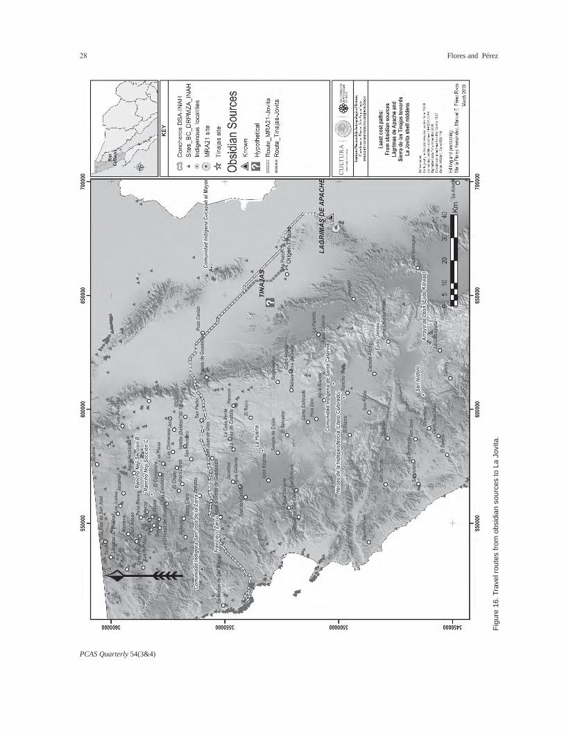
identified thanks to the identification of the obsidian sources found in two main deposits located near Baja California’s east coast, Las Tinajas and Lágrimas de Apache, for some obsidian artifacts recovered from La Jovita (Panich et al. 2017; Panich 2018). Accordingly, hypothetical routes from these sources to La Jovita were tested.
For these least-cost models, the locations of Conchero C-007 and Conchero 10 were considered as desti-nation points, resulting in two routes that are each subdivided into two branches to reach their destina-tion points. These routes show a linkage between the stratified distribution of shell midden sites and the key

PCAS Quarterly 54(3&4)
Spatial Analysis of Shell Midden Camps at La Jovita, Ensenada, Baja California 23
Figu
re 1
2. T
rave
l rou
tes
from
Con
cher
o 1-
RA
CA
L.

PCAS Quarterly 54(3&4)
Flores and Pérez24
Figu
re 1
3. T
rave
l rou
tes
from
Con
cher
o C
-07.

PCAS Quarterly 54(3&4)
Spatial Analysis of Shell Midden Camps at La Jovita, Ensenada, Baja California 25
Figu
re 1
4. T
rave
l rou
tes
from
Con
cher
o 10
, or C
onch
ero
de la
s C
ueva
s.

PCAS Quarterly 54(3&4)
Flores and Pérez26
points in the mountain and valley sites. Although the location of intermediate archaeological sites was not included in the generation of the model, the coincid-ing of these routes with the distribution of previously recorded sites is suggestive. In particular, the coin-cidence of the routes with the shell middens farthest from the coast is indicative of a well-established route, perhaps guarded and controlled to access the resources of this portion of the coast. Additionally, the juncture of the route coming from San José de la Zorra (along the Zorra ravine) and the one originating in San Antonio Necua (which crosses Valle de Guadalupe) at Conchero 10 reinforces the importance of this camp’s location in the regional context (Figure 15).
The comparison of these routes with the possible access routes from the peninsula’s east coast (Sierra de las Tinajas and Sierra de Las Pintas) shows greater agreement with the one that passes through San Anto-nio Necua, in the eastern extreme of Valle de Guada-lupe This route crosses the center of this valley, pass-ing through the community of Francisco Zarco. At the end of the valley, it shifts towards the west, crossing a series of small high points before reaching the plateau where the Pescadero site is located. Approximately 1.5 km northwest of this site, the route divides in two. A first stretch follows the plateau’s edge and descends through an opening between the mountainous heights before reaching the La Jovita area. The second route goes farther north, following the course of a small valley, passing over two heights formed by volcanic chains (in a northwest-southeast direction) to reach again the archaeological sites of El Quemado, La Terraza I and II, and Mesa de Jatay, to divert there to the series of steps where Conchero 10 is located. This route passes right between the recorded shell middens most distant from the coast, Conchero LT and Con-chero R2. This confirms the viability of this route for the Yuman groups (Figure 16).
The routes obtained have points in common with the oral history of the Kumeyaay, who still remember
traveling within their territory according to the harvest season of some food or for fishing. For access to their resources, the Indians were tracing a path to places where wild foods were present: acorns, pine nuts, aga-ve, fruits, and seasonal seeds, and where rabbits, deer, and rats could be found. They knew the land well, since they had traversed it, collecting fruits, hunting, and going down by the mountains and the valley to the Pacific Ocean as far as Jatay (Rosarito) for marine products (Santiago 2005:38, cited in Tapia and Grijal-va 2012:137).
In order to verify the consistency of this information with the hierarchy and clusters of the La Jovita shell middens, an additional analysis was carried out. This took as destinations the locations of all the recorded shell middens and as a starting point San Antonio Necua, considered as an intermediate point on an ideal trans-peninsular route. This time the LIDAR digital elevation model of INEGI was used, which has a high-er resolution (5 m). Similar general trajectories were obtained, but the particular paths to the other shell middens show a branching that fits with the identified clusters and the location of Concheros 10, C-01-RA-CAL, and C-007. This new analysis highlights that the route coming through the Mesa del Tigre and passing near the small Concheros R2 and LT is the ideal one to reach Conchero 10 de las Cuevas. On the other hand, the route near the coastal cliff, by El Pescadero, communicates through two branches with Clusters 2 and 3, where Concheros C-007 and C-01-RACAL, respectively, are located (Figures 17 and 18).
Final Conclusions
Based on the community structure model of the chumul or shumul, La Jovita shell middens acquire significance within a regional subsistence pattern in which the Yuman groups established specific territori-ality rules giving social meaning to the geographical environment’s natural and cultural features. Following Michelsen (1991), this appropriation of space and its

PCAS Quarterly 54(3&4)
Spatial Analysis of Shell Midden Camps at La Jovita, Ensenada, Baja California 27
Figu
re 1
5. T
rave
l rou
tes
from
Nat
ive
com
mun
ities
to L
a Jo
vita
.
PCAS Quarterly 54(3&4)
Flores and Pérez28
Figu
re 1
6. T
rave
l rou
tes
from
obs
idia
n so
urce
s to
La
Jovi
ta.

PCAS Quarterly 54(3&4)
Spatial Analysis of Shell Midden Camps at La Jovita, Ensenada, Baja California 29
Figu
re 1
7. R
oute
from
San
Ant
onio
Nec
ua to
the
La J
ovita
she
ll m
idde
ns.

PCAS Quarterly 54(3&4)
Flores and Pérez30
Figu
re 1
8. D
etai
l of r
oute
from
San
Ant
onio
Nec
ua to
the
La J
ovita
she
ll m
idde
ns.

PCAS Quarterly 54(3&4)
Spatial Analysis of Shell Midden Camps at La Jovita, Ensenada, Baja California 31
resources was intimately linked to occupation and exploitation by family units that were probably subdi-visions of a chumul.
The spatial analysis carried out so far indicates that the location of the shell midden camps was not random, but rather that there is a settlement pat-tern in which different components were taken into account, such as access to specific coastal resources, topographic situation, vegetation, water sources, and circulation points at local and regional levels. Being locations with some planning, it is reasonable to assume that the use of these sites was maintained and reinforced by their inhabitants through various mechanisms. Although further research is required, we suppose that it is reasonable to assume that the observed distribution and stratification of the shell middens is also related to the social and kin compo-sition of the family groups that lived at La Jovita and that the appropriation and exploitation of the environ-ment was conditioned by the links and membership with major organizational units.
The data obtained indicate that at the studied shell midden camps activities associated with both work camps and habitation camps converge, and a tenta-tive classification can be established based on their characteristics and possible functions (Table 1). For the sequence of episodes of occupation that has been called “late shell midden,” it can be established that the formation of the shell middens was not the product of a single event, but of continuous and repeated occupations. The repetition of activities over time and the systematic preservation of sets of objects (such as clusters of manos and hammers associated with hearths) suggest a marking and recognition of rights of use over these spaces on the part of family groups (see for example, Laylander 2014 about redundancy patterns), which maintained themselves during pro-longed stays or arrived several times a year, which at the same time suggests little climatic variability during the period of occupation.
The wide distribution of the contexts and the stra-tigraphy of the occupations can also be considered indicative of the concentration of a significant number of family groups gathered over time, with different objectives that had to do with the biological and social reproduction of the group. Camps with these charac-teristics had the function of bringing the community together in aspects of organizational strategies, in addition to other events that may have been inciden-tal but that united the population. One example is Conchero C-23, where grinding activities were carried out by groups larger than a nuclear family. Character-istics and location of camps such as C-07 suggest also activities beyond the domestic or mere subsistence level. The shell middens’ clusters and their function-al differentiation obtained through spatial analysis may be related to occupation by extended family groups, probably reflecting what the missionaries called “rancherías,” possibly subdivisions of the same chumul and identified by the Kiliwa as masel’ko’wá (Ochoa 1978b:146–148). The three clusters of camps based on spatial proximity analysis are consistent with this analysis.
The first cluster of shell middens is closest to the coast and composed mainly of work camps oriented to the exploitation of coastal resources. Cluster 2 stands out; the middens with greater depth and complexity in their deposits are located there, and their position allowed them to control access to an important source of water and a direct route to the coast through the ravine around which they were formed. In addition, we find specialized contexts (C-23) or particularly distinctive ones (C-04, C-07). The third cluster is located on the higher terraces; within it as the central focus is Con-chero C-01-RACAL, largest in area of all the recorded middens and dominating a pair of intermittent arroyos.The analysis of possible routes of internal circulation reinforces the cohesion of the identified clusters. It highlights the position of Conchero 10 or Conchero de las Cuevas as the distribution point toward La Jovita and the Bajamar shell middens, and it connects easily

PCAS Quarterly 54(3&4)
Flores and Pérez32
with the interior, coinciding with the regional least-cost paths coming from Valle Guadalupe. This camp and its caves, together with Conchero C-007’s rocky outcrop, are distinctive elements in the landscape that probably functioned as markers of the chumul’s symbolic and ritual space, as well as of its use rights. The morphological resemblance of the rocky outcrop to the so-called “person rocks” makes sense within the indigenous groups’ concepts of territoriality, in which the presence or residence of individuals of the group reaffirms use rights. Therefore, when the myth of the person turned into stone becomes materialized in the indigenous imaginary, the territorial marker acquires value within the Yuman communities’ cosmogony, as Garduño (2017) has demonstrated between the mod-ern Kumeyaay of Neji and San Antonio Necua.
In the regional and trans-peninsular context, the least-cost analysis shows a future perspective to explore links between archaeological sites on a larger scale and to discern the implicit social relationships in the circulation of some types of goods, such as obsidian. The work so far shows an articulation between the stratified distribution of shell middens and the key points in the sierra and the valleys. The coincidence of these hypothetical routes with the distribution of previously recorded sites is suggestive of well-estab-lished paths similar to those documented by Hohen-thal (2001) at the middle of the twentieth century. In particular, the routes’ coincidence with the shell mid-dens farthest from the coast is indicative of a secure route, perhaps guarding and controlling access to the resources of this portion of the coast.
Finally, even with the systematic extermination and acculturation suffered by the Baja California peninsu-la’s Native groups since the Spanish conquest, traits and oral traditions have persisted to the present and allow us to formulate models to try to understand the origin, development, and cosmogony of these popu-lations in pre-Hispanic times. Regarding the Yuman groups cultural legacy, the development of the coastal
strip for real estate, tourism, and industrial purposes leads to an imperative need for the academic commu-nity to reassess their cultural and archaeological her-itage now at risk and to offer measures for its proper study, recovery, and protection.
Endnote
1. Some linguists and anthropologists have identified the inhabitants of San Antonio Necua as Tipai, closely related to the Kumeyaay. However, its inhabitants identify themselves as Cochimí, perhaps as a conse-quence of being brought together during the mission period (see Garduño 2015:127–128).
References Cited
Álvarez de Williams, Anita1975 Primeros pobladores de Baja California: in-
troducción a la antropología de la península. Talleres Gráficos del Gobierno del Estado de Baja California, Mexicali.
Bendímez, Julia1987 Antecedentes históricos de los indígenas
de Baja California. Estudios Fronterizos 14:11–46.
Berkovich, César, and B. Solís2005 Salvamento arqueológico energía Costa
Azul: reporte de excavación y análisis de material arqueológico, planteamientos met-odológicos y resultados. Centro INAH Baja California, Mexicali.
Drakík Ballivián, Danilo2005 Informe técnico salvamento arqueológico
Costa Azul, Lote 20. In Salvamento arque-ológico Costa Azul, Lote 20, Informe Técnico 2-121, by Arturo Márquez Alameda, pp. 57–101. Instituto Nacional de Antropología e Historia, Mexico City.
Flores Hernández, María, and Manuel E. Pérez Rivas2018 Posibles rutas de comunicación transpen-
insular en el territorio yumano: análisis

PCAS Quarterly 54(3&4)
Spatial Analysis of Shell Midden Camps at La Jovita, Ensenada, Baja California 33
geográfico y rutas de menor costo en el norte de Baja California. Ponencia presen-tada en Balances y Perspectivas sobre la Antropología e Historia de Baja California, Ensenada.
Fonseca Ibarra, Enah2013 Baja California Shell Midden Camps: Simi-
larities and Differences, Research in Process. Proceedings of the Society for California Archaeology 27:73–83.
Gamble, Lynn H., and Michael Wilken-Robertson2008 Kumeyaay Cultural Landscapes of Baja Cal-
ifornia’s Tijuana River Watershed. Journal of California and Great Basin Anthropology 28(2):127–151.
Garduño, Everardo2015 Yumanos. Pueblos Indígenas de México en el
Siglo XXI, Vol.1. Comisión Nacional para el Desarrollo de los Pueblos Indígenas, Mexico City.
2017 Cartografía simbólica sobre el territorio tradi-cional de los kumiai. Desacatos 55:90–109.
Gobierno del Estado de Baja California2001 Programa regional de desarrollo urbano,
turístico y ecológico del Corredor Tijuana Rosarito Ensenada (COCOTREN). Periódico Oficial del Estado de Baja California, No-vember 16, 2001, Vol. 108, No. 50.
Hohenthal, William D., Jr.2001 Tipai Ethnographic Notes: A Baja California
Indian Community at Mid Century. Ballena Press, San Diego
Laylander, Don1991 Organización comunitaria de los yumanos
occidentales: una revisión etnográfica y prospecto arqueológico. Estudios Fronterizos 24&25:31–60.
2014 Redundancy, Avoidance and Ideology in Prehistoric Southern California. Proceedings of the Society for California Archaeology 28:326–339.
Massey, William C.1949 Tribes and Languages of Baja California.
Southwestern Journal of Anthropology 5(3):272–307.
Meigs, Peveril, III1939 The Kiliwa Indians of Lower California.
Ibero-Americana 15. University of California Press, Berkeley.
Michelsen, Ralph1977 The Territoriality of the Native Americans in
the Northern Highlands of Baja California. Baja California Symposium 15. San Diego.
1991 La territorialidad del indígena americano de la tierra alta del norte de la Baja California. Estudios Fronterizos 24&25:151–160.
Morales Cortez, Ana Paola2016 Cochimíes, indios del norte: etnohistoria y
patrimonio cultural del desierto central de Baja California, siglo XVIII al presente. Unpublished Master’s thesis, El Colegio de la Frontera Norte, Tijuana.
Ochoa Zazueta, Jesús Ángel1977 Pi-’á o’mat k’miai wi: ésta es la escritura
k’miai. Universidad Autónoma de Baja Cali-fornia, Mexicali.
1978a El sistema numeral en las lenguas vernáculas norpeninsulares y el sistema básico de los cochimí-laymón. Calafia 3(5):19–48.
1978b Los kiliwa y el mundo se hizo así. Instituto Nacional Indigenista, Mexico City.
Panich, Lee M.2018 Provenance Analysis of Obsidian Artifacts
from La Jovita, Baja California, Mexico. Department of Anthropology, Santa Clara University, California.
Panich, Lee M., M. Steven Shackley, and Antonio Porcayo Michelini
2017 A Reassessment of Archaeological Obsidian from Southern Alta California and Northern Baja California, California Archaeology 9:1:53–77.

PCAS Quarterly 54(3&4)
Flores and Pérez34
Robles Montes, Mayra del Carmen2013 Temporalidad, patrones de explotación y
significado ambiental de los moluscos en el conchero de La Jovita, Baja California. Unpublished Master’s thesis, Universidad Autónoma de Baja California, Ensenada.
Sack, Robert D.1991 El significado de la territorialidad. Región e
historia en México (1750–1850), edited by P. Pérez Herrero, pp.194–204, Instituto Mora and Universidad Autónoma Metropolitana, México.
Santiago Guerrero, L. Bibiana2005 La gente al pie del Cuchumá: memoria
histórica de Tecate. Instituto de Investiga-ciones Históricas, Universidad Autónoma de Baja California, Tijuana.
Tapia Landeros, Alberto, and Aidé Grijalva2012 El imaginario colectivo kumiai y sus recursos
naturales. Estudios Fronterizos 25:131–156.