Southeast Brazilian Folded Province: Field Excursions of...
16
Journal of Geosciences, Osaka City University Vol. 44, Art. I, p, 1-16, March, 2001 Southeast Brazilian Folded Province: Field Excursions of Arac;uai and Ribeira Belts In 1999 Masaru YOSHIDA l , Benjamin B. Bley BRITO NEVES 2 and Ginaldo CAMPANHA 2 lDepartment of Geosciences, Faculty of Science, Osaka City University, Osaka 558-8585, Japan [email protected] (Present address: Gondwana Institute for Geology and Environ- ment, Hashimoto 648-0091, Japan. [email protected]) 21nstitute of Geosciences, University of Sao Paulo, Sao Paulo, Brazil. [email protected] (BBN), gc@usp. br (GC) Abstract Geological field observations were conducted in Brasiliano fold belts in southeastern Brazil, includ- ing the Ara,<uai and Ribeira belts. The Ara,<uai Belt is characterized by the following tectonic domains from the west to the east: the stable Archaean San Francisco Craton, the thin-skinned tectonic domain composed of overfolded thin cover of the'Neoproterozoic San Francisco Supergroup, the thick-skinned tectonic domain composed of the Mesoproterozoic Espinha,<o Supergroup, and the back land domain composed of the possi ble Archaean/Paleoproterozoic basement. The survey route covered two tra verses in southern and central part of the belt. The Ribeira Belt is characterized by Mesoproterozoic clastic sequence and has a principally symmet- ric signature in their structure and depositional environments from the west to the east; the backland domain composed of possible pre-Ribeira basement, the ftaiacoca Group characterized by the continental and pericratonic carbonaceous sediments, the Votuverava and Ribeira groups composed of distal shelf and oceanic sediments, the Capiru Formation and Setuva Group composed of carbonaceous and coarse clastic continental shelf sediments, and the backland domain composed of the basement granite/mig- matite. Extensive Brasiliano granites develop throughout the terrain. All the strata are intensely folded, and cleavage and foliation develop throughout, which dip northwest, being conformable to the general asymmetric fold styles and supposed northeasterly vergence. Through the present study, good outcrops of major geologic units mentioned above were observed, ascertaining general agreement with recent tectonic interpretations of these belts. Field observations for about 60 outcrops and rock samples of about 50 pieces collected through the present study are planned to be utilized for future studies. Key-words: Brasiliano belts; Brasiliano Orogeny; Ara,<uai Belt; Ribeira Belt; Adamastor Suture; Mantiquiera Province. INTRODUCTION In southeastern Brazil, Proterozoic mobile belts are identified several tens of km inland, running paral- lel to the Atlantic coast (Fig. I). They were previous- ly designated, as a total, the Ribeira Belt (Almeida et aI., 1973). However, they are recently identified to form separate mobile belts of different origin (Campa- hna and Sadowski, 1999). They are, from the north to the south, the Ara,<uai, Alto Rio Grande (recent authors do not use this name and include to the Ribeira Belt), Ribeira (sensu stricto; this belt is also called the Apiai Fold Belt by Basei et aI., 2000) and Dom Feliciano belts, and are together called the Southeastern Brazil Folded Province (Almeida et a!., 1976) or the Mantiqueira Province (Almeida et a!., 1981). Conprehensive reviews of these Brasiliano belts were recently given by Pedrosa-Soares and Viedemann (2000), Trouw et al. (2000), Basei et al.
Transcript of Southeast Brazilian Folded Province: Field Excursions of...

Journal of Geosciences, Osaka City University
Vol. 44, Art. I, p, 1-16, March, 2001
Southeast Brazilian Folded Province:
Field Excursions of Arac;uai and Ribeira Belts In 1999
Masaru YOSHIDA l, Benjamin B. Bley BRITO NEVES 2 and Ginaldo CAMPANHA 2
lDepartment of Geosciences, Faculty of Science, Osaka City University, Osaka 558-8585, Japan
[email protected] (Present address: Gondwana Institute for Geology and Environ
ment, Hashimoto 648-0091, Japan. [email protected])
21nstitute of Geosciences, University of Sao Paulo, Sao Paulo, Brazil. [email protected] (BBN),
gc@usp. br (GC)
AbstractGeological field observations were conducted in Brasiliano fold belts in southeastern Brazil, includ
ing the Ara,<uai and Ribeira belts. The Ara,<uai Belt is characterized by the following tectonic domains
from the west to the east: the stable Archaean San Francisco Craton, the thin-skinned tectonic domain
composed of overfolded thin cover of the'Neoproterozoic San Francisco Supergroup, the thick-skinned
tectonic domain composed of the Mesoproterozoic Espinha,<o Supergroup, and the back land domain
composed of the possi ble Archaean/Paleoproterozoic basement. The survey route covered two tra verses
in southern and central part of the belt.
The Ribeira Belt is characterized by Mesoproterozoic clastic sequence and has a principally symmet
ric signature in their structure and depositional environments from the west to the east; the backland
domain composed of possible pre-Ribeira basement, the ftaiacoca Group characterized by the continental
and pericratonic carbonaceous sediments, the Votuverava and Ribeira groups composed of distal shelf
and oceanic sediments, the Capiru Formation and Setuva Group composed of carbonaceous and coarse
clastic continental shelf sediments, and the backland domain composed of the basement granite/mig
matite. Extensive Brasiliano granites develop throughout the terrain. All the strata are intensely folded,
and cleavage and foliation develop throughout, which dip northwest, being conformable to the general
asymmetric fold styles and supposed northeasterly vergence.
Through the present study, good outcrops of major geologic units mentioned above were observed,
ascertaining general agreement with recent tectonic interpretations of these belts. Field observations for
about 60 outcrops and rock samples of about 50 pieces collected through the present study are planned
to be utilized for future studies.
Key-words: Brasiliano belts; Brasiliano Orogeny; Ara,<uai Belt; Ribeira Belt; Adamastor Suture;
Mantiquiera Province.
INTRODUCTION
In southeastern Brazil, Proterozoic mobile belts
are identified several tens of km inland, running paral
lel to the Atlantic coast (Fig. I). They were previous
ly designated, as a total, the Ribeira Belt (Almeida et
aI., 1973). However, they are recently identified to
form separate mobile belts of different origin (Campa
hna and Sadowski, 1999). They are, from the north to
the south, the Ara,<uai, Alto Rio Grande (recent
authors do not use this name and include to the
Ribeira Belt), Ribeira (sensu stricto; this belt is also
called the Apiai Fold Belt by Basei et aI., 2000) and
Dom Feliciano belts, and are together called the
Southeastern Brazil Folded Province (Almeida et a!.,
1976) or the Mantiqueira Province (Almeida et a!.,
1981). Conprehensive reviews of these Brasiliano
belts were recently given by Pedrosa-Soares and
Viedemann (2000), Trouw et al. (2000), Basei et al.

2 Sourheasr Brazilian Folded Province: Field Excursions of Ara(:uai and Ribeira Belrs in 1999
or without younger cover sequence. Further to the
east, granitic masses and ophiolitic rocks of Brasiliano
cycle occur, suggesting the development of a Brasiliano
subduction belt there.
The Southern Traverse Section of the Ara~uai BeltBelo Horizonte is the third or fourth biggest city
in Brazil, which was initially welfared by the big
production of iron from the Paleoproterozoic Minas
Belt (greenstone belt) lying just south of the city.
Lagoa Santa, lying about 40 km north of Belo Hor
izonte, is underlain by limestone sequence (the base of
the Bambui Group). A beautiful lake originated in
the carst depression adores the centre of the city.
From this city, we made an eastward traverse covering
all the above domains.
Fig. I Outline of Proterozoic fold belts of SouthAmerica and Africa (Campanha andSadowski, 1999)Shaded areas show Brasiliano belts. I:Ribeira, 2: Dom Feliciano, 3: Gariep, 4:Damara, 5: Kaoko, 6: Alto Rio Grande, 7:Araguai, 8: Brasilia, 9: West Congo, 10:Borborema, II: Araguaia, 12: Paraguai, 13:Sierras Pampeanas. Crossed area is cratons.A: Amazon, C: Congo, K: Kalahari, P:Supposed Parana, RP: Rio de La Plata, SF:Sao Francisco, W: West Africa. Framedareas near letter 6 and I are referred to Figs2 and 10 respectively.
, \')
-- .....,.'-,\
"-, \,x x x \
',@,' '), ,
x X Jt \
' ..... /e; , J- /, ,/
\' ,/\~./
o
THEARA(UAIFOLDBELT
(2000), and Campos Neto (2000).
In A ugust to September 1999, the sen lor author
had a chance of visiting the Ara~uai (10 days) and
Ribeira (4 days) belts with students of the Universidad
de Sao Paulo and Benjamin B. Bley Brito Neves, one
of the co-authors. Both of these belts run principally
between pre-Brasiliano cratons to the west and east.
The Southeastern Brazil Folded Province, in general, is
considered to form the suture of the past Adamastor
Ocean, which runs generally at the boundary between
the South American and African shields.
Geologic Outline of the Ara~uai Fold BeltThe Arac;uai Fold Belt lies at the eastern margin
of the Sao Francisco Craton (cf., Fig. I) which con
tinues to the Congo Craton eastward (Martins-Neto,
1993: Brito eves, et a!., 1995). A small continental
block, the Guanhaes Block, is situated to the east of the
Arac;uai Belt. The Arac;uai Belt is the inland fold belt
composed of Meso- to Neoproterozoic metasediments
affected by the Brasiliano orogeny. This belt is re
presented by four tectonic domains as follows from the
west to the east (Brito Neves, et aI., 1995, 1996) (Figs.
2, 3 and 4).
The westernmost domain is the stable foreland
with a thin (about 300 meters thick) and undisturbed
Neoproterozoic continental cover and shelf sequence
(Macauva and Bambui groups of the Sao Francisco
Supergroup (Dardenne, 1978 and Martins- Neto, 1993)underl ai n by the A rchaean (gran itic- m igmati tic rocks
of the Basement Complex, ca 2.7-3.1 Ga) and possible
Paleo proterozoic (meta-supracrustal sequence of the
Rio Parauna Supergroup) basement. The second
domain is controlled by the thin-skin tectonics com
posed of the Sao Francisco Supergroup, which is
strongly folded in overturned and recumbent styles and
is underlain by the Archaean and Paleoproterozoic
ba ement. To the east occurs the third domain com
posed mostly of the thick Mesoproterozoic supracrus
tal sequence (the Espinha~o Supergroup, Martins-
eto, 1993) underlain by the Archaean basement (ca
2.5 Ga). This domain is characterized by the thick
skin tectonics and the basement is also reworked
(refolded) and rejuvenated giving K-Ar ages ofca 0.5
0.8 Ga. Further to the east, the backland of the fold
belt occurs. This domain is composed of the base
ment granite-migmatite of ca 2.5 Ga and Paleoproter
ozoic greenstone sequence, all of which are partly
affected by Brasi Iiano rework ing, and associ ated wit h

Masaru YOSHIDA, Benjamin B. Bley BRITO NEVES and Ginaldo CAMPANHA 3
+
++
-I- +Hanzante
+ D + + +
~ Macaubas GrouP
~ Bambui Group, undisturbed
~.•.~Bambui Group,••• Strongly disturbed
~ Espinhasso Super Group
~ Pan-African Granites
IT] Pre-Espinhasso basement
/' Thrust fault
+
+
+
+ ++ + +
+ + ++ + +
+ + +4-
+ be Bela
km40
N
o
1---- '"T---.~••oBo m + + +Despacho
+ + +
Fig. 2 Outline of the Ara,<uai Fold Belt and the excursion route (Compiled from CompanhiaMineradora de Minas Gerais, 1994). Straight line connecting Curvelo-Sabinopolis shows thetransect given in Fig. 3. Dotted line: excursion route, Thick Chain: supposed tectonicboundary, Thick line: fault. Straight line connecting Curvelo-Sabinopolis shows the transectgiven in Fig. 3.
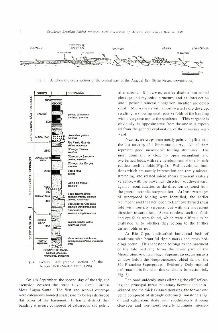
4 Southeast Brazilian Folded Province: Field Excursions oj AraplOi and Ribeira Belts in 1999
CURVELOPRESIDENTEJUSCELINO GOUVEIA SERRO SABINOPOLIS
+ + +
R. das Velhas
iR. Parouoa
~~ .-- .- .-,.: .
+
R. Guonnoes
a 5 ISllm
Fig. 3 A schematic cross section of the central part of the Ara~uai Belt (Brito Neves, unpublished)
alternations. It however, carnes distinct horizontal
cleavage and mylonitic structure, and an intersection
and a possible mineral elongation lineation are devel
oped. Micro shears with a northwesterly dip develop,
resulting in showing small passive folds of the banding
with a vergence top to the southeast. This vergence is
obviously the opposite sense from the one as is expect
ed from the general explanation of the thrusting west
ward.
Next six outcrops were mostly pelitic phyllite with
the last outcrop of a limestone quarry. All of them
represen t good mesoscopic fold ing structures. The
most dominant is close to open recumbent and
overturned folds, with rare development of smalI- scale
rootless isoclinal folds (Fig. 5). Well developed linea
tions which are mostly intersection and rarely mineral
stretching, and related micro shears represent easterly
vergence, with the movement direction southwestward,
again in contradiction to the direction expected from
the general tectonic interpretation. At least two stages
of superposed folding were identified, the earlier
recumbent and the later, open to tight overturned shear
fold with westerly vergence, but with the movement
direction towards east. Some rootless isoclinal folds
and eye folds were found, which were difficult to be
evaluated as to whether they belong to the further
earlier folds or not.
At Rio Cipo, undisturbed horizontal beds of
sandstone with beautiful ripple marks and cross bed
dings occur. This sandstone belongs to the basement
of the fold belt and forms the lower part of the
Mesoproterozoic Espinhac;;o Supergroup occurring as a
window below the Neoproterozoic folded skin of the
Sao Francisco Supergroup. Evidently, Only ruptural
deformation is found in this sandstone formation (cr.,
Fig. 3).
The road suddenly starts climbing the cliff reflect
ing the principal thrust boundary between the thin
skinned and the thick skinned domains, the former one
being composed of strongly deformed limestone (Fig.
6) and calcareous shale with southeasterly dipping
cleavages and west-southwesterly plunging intersec-
FORMAQAo
seficila-quartzo xislosquertzilOS, tililos
peliloS. carDOnarOSarcdsios. arenitos
dlsmictiros, peliros.arenitos
Rio Pardo Grandesiltilos, do/om/ros
C6rrego Pereiraarenilos
C6rrego da Bandeirapelilos, areniros
C6rrego dos Borgesarenilos
Santa Ritapelilos
xislos verdes, vulcAnicas.fonna90es femleras. quartzilos.tililos
Galho do MiguelarenilOS
Sopa-Brumadinho:conglomerados. aremros,petilOs, vulcAnicas
SAo JoAo da Chapadaareniros. conglomeradosBandeirinhaaremros. conglomerados
General stratigraphic section of theAra¥uai Belt (Martin- Neto. 1998)
GRUPOouenUzc(cru.o BAMBUi,C(enoa.::JcrClcrwa.::Jen
o0c(J:Za:enwoa.::JcrClcrwa.::Jen
c(Z
.::Jc(cr~oii:Clen
PEDRO -~"-;;-:~-PEREIRA ~ ~-x;.;,-
--+----0 ~ ~+++'t?+
COMPLEXO BASALgranilos. gnaisses.
migmalilos. anfibolilos
Fig. 4
On 4th September, the second day of the trip, the
excursion covered the route Lagoa Santa-Cardeal
Mota-Lagoa Santa. The first and second outcrops
were calcareous banded shale, said to be less disturbed
flat cover of the basement. It has a distinct thin
banding structure composed of calcareous and pelitic

Masaru YOSHIDA, Benjamin B. Bley BRITO NEVES and Ginaldo CAMPA HA
Fig. 5 Recumbent and superposed overturned folds of calcareous shale of the SantaHelena Formation. (Roadside outcrop between Belo Horizonte and CaroealMota)
5
Fig. 6 Isoclinal (sheath?) fold superimposed by small shear fold developed in the crystallinelimestone of the Sete Lagoas Formation (vev da Noiva Quarry, just east of Rio Cipo)

6 Southeast Brazilian Folded Province: Field Excursions of Arar;uai and Ribeira Belts in 1999
. tion and stretching mineral lineations. This part is
sandwiched between the undisturbed sandstone of the
Rio Cipo below and the disturbed sandstone/shale
alteration above. The Espinhac;;o sandstones are very
well weathered, appearing as if not the arenites, but
arkosic to felsitic, because of deep and total soft
weathering. Hard quartzite was only rarely met with.
The third day (Sept. 5th) covered the route Lagoa
Santa-Conceic;;ao do Mato Dentro-Sabinopolis
Serro- Diamantina. It includes the deformed sand
stone formations of the Espinhac;;o Supergroup, all of
which carried ESE stretching lineation. North of
Lagoa-San-ta,-beautiful peneplains of Post Gondwana,
Sud Americana, Velhas, and Paraguasu were observed.
An outcrop within the Espinhac;;o Supergroup was thedeformed felsic sandstone on the north of the town
called Cardeal Mota. This location was at the foot of
stone statue of Mr. ]uquinha du FloI', famous in this
region and history says that he constantly gave flowers
to travelers who just passed through the locality.At one locality 5-km southeast of Conseic;;ao do
Mato Dentro, strongly phyllonitic psamo-pelitic schist
crops out, which was explained to be the deformed
rhyolite. Numerous tiny and idiomorphic tourmaline
characteristically develop randomly along the cleavage
plane which is mostly composed of elongate quartz
and sericite. Below this layer occur psamo-pelitic
(upper) and psammitic (lower) layers of some meters
thick. In the near-horizontally laminated quartz-fel
dspathic sandstone of the lower psammitic layer, manydeformation structures including rootless isoclinal
folds and shear folds were scarcely found, the former
having near- horizontal hinges trending nearly N-S.
In contrast, the upper psammo-pelitic layer, at a
glance, appeared to be very much disturbed, strongly
phyllitic, and quartz augens of various sizes occur,
which included very coarse grained chlorite-mica clots
and minor sulphides. The phyllite carries dominant
slickenside and stretching lineations plunging ESE.
The Northern Traverse Section of the Ara~uai Belt
In the afternoon of the third day, we turned theroute northward and drove about 80 km, and enteredinto the backland terrain composed of basement gran
ite migmatite situated east of the Arac;;uai Belt.At about I km south of the town Serra, there
crops out an ultramafic body, now metamorphosedmostly into talk schist. This rock is considered to beeither the early Proterozoic greenstone belt or the
Neoproterozoic ophiolite. This rock carried steep
banding possibly of the original igneous structure and
steep E-W cleavage with near-vertical westerly mineral
and intersection lineations.
Two outcrops next to the ultramafic schist were
the basement migmatitic gneiss and granodiorite occur
ring near the Sabinopolis town. The first one carriedsi milar foliation and lineation as the ultramafic rock
mentioned above. This rock has been dated by Rb-Sr
whole rock isochron and U-Pb zircon methods, as ca
2.5 Ga, and K-Ar method as ca 550-600 Ma. The
second one was pi nk K -feldspar porphyritic biotite
granodiorite carrying characteristic mafic porphyro
clast now completely recrystallized into flattened
aggregates of fine-grained biotite. The last stop, at
the town Pedro Lessa, about 20 km west of Serro, was
a diabase dyke trending N-S. Badelyite from the dike
gave ca 910 Ma U - Pb age. This diabase is interpreted
as a part of the Tonian Taphrogenesis, responsible for
the fusion of Rodinia (Brito Neves, personal communi
cation).
The night was at the Diamantina City. The
Centro de Geologia Eschweg of Universitad de Minas
Gerais was our residence, which was founded as a
memorial of the veteran geologist of Brazil, Dr. W.L.
von Eschweg.
On the fourth day (Sept. 6th), we went northeast
from Diamantina, covering the route Diamantina
Couto de Magalhaes de Minas-Senador Mourao-Sao
Gonc;;alo do Rio Preto-San do Modestino Conc;;alves
Itamaramdiba-Diamantina. To the northeast from
Diamantina, the entire Sao Francisco Supergroup andthe eastern backland basement were visited. The first
stop near Diamantina was the Espinhac;;o metasand
stone, carrying N -S schistosity with moderate ESE
plunging mineral lineation.
The second. outcrop near the town of Couto
Magalhaes de Minas was the diamictite. It carries
ENE trending and steeply to gently dipping foliation
composed of flat clasts of limestone and biotite schist
possibly reflecting the primary bedding which might
have been affected by later deformation. Faint gently
dipping cleavage trending nearly N-S develops
throughout.After the diamictite, strongly deformed meta
arenitic sandstone/argillite alternations occur, fol
lowed by strongly deformed meta-argillites with
numerous quartz veins. The above change of sedimentary sequences is considered to represent thechange from the proximal to the distal conditions of
the turbidite developed at the continental margin ofthe Sao Francisco Craton lying west. All the above
metasupracrustal sequences carry strong deformation

Masaru YOSHIDA, Benjamin B. Bley BRITO NEVES and Ginaldo CAMPANHA 7
Fig. 7 Westerly vergent gentle asymmetric fold of sandstone bed, Galho do Miguel Formation (about l8-kmwest of Diamantina)
structures including foliation, folding and veining. A
quartz vein paralleling the banding represented dis
tinct rootless isoclinal folds with a northerly vergence.
Some other folding structures show NNW or NNE
plunging hinges, and NNW mineral and intersection
lineations develop dominantly.
Last three outcrops were basement rocks. At the
floor of the Ara~uai River, crops out so called green
schist, appearing to be the semi-schistose graywacke.
Next outcrop was altered biotite granodiorite with
weak schistosity dipping gently east. Faint cleavage
trending NE and dipping SE was identified. The last
one, near the town of Modestino, 48 km WSW of
Itamarandiba, carried distinct schistosity dipping
gently ESE and lineation plunging gently ENE.
On the fifth Day (Sept. 7th), the excursion covered
the route Diamantina-Conselheiro Mata-Sopa-Guin
da-Diamantina. Eight outcrops of the Espinha~o
Supergroup to the west of Diamantina were visited.
Arenitic sandstone of the Galho do Miguel Group
only cropped out, and pelitic formations were all
denuded to form the South American Peneplain, over
which the weathered iron-manganese ore deposit for
med. Two among 8 outcrops vis~ted on this day are
worth noting below.
Sandstone layers showing beautiful gentle folds
with distinct axial cleavage-fractures were observed,
forming a hill at about 18-km west of Diamantina on
the road to Conselheiro Mata. This is a classicalexample of asymmetric gentle folding with northwest
erly vergence (Fig. 7). The sandstone layer carry
distinct cross bedd ing structu re, which marks also a
good example of flexural slip movement of the strata.
Here, both the bedding and cleavage run N-S. Bed
ding is gently waving, and the cleavage is almost
constantly dipping steeply east.
At a road side outcrop just west ofDatas, about 25
km SSW of Diamantina, very interesting examples of
elongated pebbles and sheath-like structure plunging
ESE 40°-60° were observed (Fig. 8). Rootless drag
isoclinal folds with hinges plunging gently southward
apparently showing the west northwestward thrust
movement also develop. Thus this outcrop represents
both the kinematic axis a and b by the lineation
composed of pebble and mineral stretching, and fold
hinges respectively.
On the sixth day (Sept. 8th), we went southwest,
covering Diamanti na-Gouveia-] nimutaba-Curvelo
(overnight). The route covered the thick-skinned
Espinha~o Supergroup in the east and the thin- skin
ned Sao Francisco Supergroup in the west. The first
highlight of the day was the recognition of the thrust
nappe of the basement, over some kilometers thick,
occurring about I km west of Genveia. The nappe is
overlain, from the top to the bottom, by the Galho do
Miguel Sandstone, Sopa-Brumadinho, and Sao Joan
do Chapade formations, and is underlain by the same
sequence of formations. At the lowest horizon of the
overlying sequences, i.e., on the thrust boundary with
the basement, strongly foliated and lineated aluminous
schist associated with aluminous granitic pegmatite
occurs which is said to carry gem- quality kyanite.
The country meta-argillites are very aluminous and
appear to carry altered kyanite.
After this outcrop were mostly shale with minor
conglomerate and limestone of the upper Espinha~o
Supergroup, all of which carry good easterly cleavage
and some ~pen to gentle folds. Vergence and move
ment direction were mostly west-north westward, th us
conformable w'ith a general tectonic interpretation (e.

8 Southeast Brazilian Folded Province: Field Excursions of Ara9uai and Ribeira Belts in 1999
Fig. 8 Lineated conglomerate of the Sopa-Brumadinho Formation(just east of Datas)
Fig. 9 Flat-lying stromatolitic limestone of the Seta Lagoas Formation,riverside of Rio Sao Fransisco (27 km west of Bom Despacho)
g., Brito Neves et aI., 1995, 1996), in contrast to the
observations of the earlier phase of the excursion.
At about 25 km east of the Rio Cipo crossing, the
thick-skin tectonics represented by the Espinhac;o
Supergroup changed into the thin-skin tectonics for
med by the Sao Francisco Supergroup. The
Mucauvas and Bambui group rocks, most of which are
shale and pelitic sandstone, carry distinct westerly
dipping cleavage and are both very weakly to non
metamorphosed.
On the 7th day (Sept. 9th), the excursion covered
the route Curvelo-Pompeu-Bon Despacho-Campo
Belo (overnight). This route traverses from the thin
skinned tectonic domain to the basement domain with
shallow and undisturbed Neoproterozoic Macauvas
and Bambui groups.
The city of Curvelo is underlain by the unoxidized
shale of the Santa Malena Formation of the Bambui
Group; a working quarry for this slate was met with at
about 28 km west of the city. At about 50 km west of
Masaru YOSHIDA, Benjamin B. B1ey BRITO NEVES and Ginaldo CAMPANHA 9
Curvelo, the cover sequence changes into completely
undisturbed, mostly f1at-lying shallow platformal sedi
ments mostly of possible vervite, limestone (Fig. 9),
and calcareous shale of the Santa Helena Formation
and the Lagoa do Jacare Formation. At the town
Bom Despacho, possible vervite of the Macauvas
assemblage with sporadic granitic boulders yielded
interesting outcrop giving an impression as if of the
very weathered unconformity. Basement gneissose
granodiorite of possible Archaean with some mig
matitic affinities occurs at about 13 km west of Bom
Despacho.
The 8th day (September 10th) covered the route
Belo Campo-Sao Paulo. The first tens of kilometers
were just the driving over the flat-lying limestone of
the Sete Lagoas Formation and diamictite of the
Macauvas Group. The excursion arrived In Sao
Paulo at 15:00 in the afternoon.
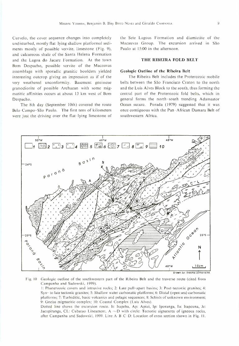
THE RIBEIRA FOLD BELT
Geologic Outline of the Ribeira BeltThe Ribeira Belt includes the Proterozoic mobile
belts between the Sao Francisco Craton to the north
and the Luis Alves Block to the south, thus forming the
central part of the Proterozoic fold belts, which in
general forms the north-south trending Adamastor
Ocean sllture. Porada (1979) suggested that it was
once contiguous with the Pan-African Damara Belt of
southwestern Africa.
24°5
25°S
50 0 W
belf'
pel!
s \ f'13 el
49°W 46°W
N
r! lOkm !
Drown by: Thelma Samoro/98.
Fig. 10 Geologic outline of the southwestern part of the Ribeira Belt and the traverse route (cited fromCampanha and Sadowski, 1999).I: Phanerozoic covers and intrusive rocks; 2: Late pull-apart basins; 3: Post-tectonic granites; 4:Syn- to late tectonic granites; 5: Shallow water carbonatic platforms; 6: Distal (open sea) carbonaticplatforms; 7: Turbiditic, basic volcanics and pelagic sequences; 8: Schists of unknown environment;9: Gneiss migmatitic complex; 10: Coastal Complex (Luis Alves).Dotted line shows the excursion route. It: Itapeba, Ap: Apiai, Ip: Iporanga, Iu: ltapeuna, Jc:Jacupiranga, CL: Cubatao Lineament, A ~D with circle: Tectonic signatures of igneous rocks,
after Campanha and Sadowsk i, 1999. Li ne A - B-C- D: Location of cross section shown in Fig. II.

10 Southeast Brazilian Folded Province: Field Excursions of AraplQi and Ribeiro Belts in 1999
NW
AItapirapua Fault
+ + \7- - +
+
+
Quarenta-OltavaFault
SE
B
ITAIACOCA GROUP TR~S C6RREGOS GRANITE + AGUA CLARA FORMATION
B cQuarenta-Oltava
FaultIrr
Lanclnha rFault \'
...14I--------------~HI~I4t_---------_lI*M_--------H
LAJEADO SUBGROUP RIBEIRA SUBGROUP SETUVA + CAPIRUGROUPS
c o
.P ~"""Ix x \
I
i Lanclnha . CubatOoi/ Fault
0·~~~~~~~_:_T,_:_~~~P?I-
GNEISS MIGMATITIC COMPLEX+ SETUVA GROUP
COASTAL COMPLEX
- 5km
Cross sections legends;
~ granites ~ conglomerates. breccias. sandstones
~ limestones
fun_oj pelitic rocks
c==J sandstones
~ basic rocks
CZJ gneiss· mlgmatltlc rocks
CJ charnockltlc rocks
Fig. II Generalized cross section of the traverse section of the southern Ribeira Belt (cited fromCampanha and Sadowski, 1999)
The Ribeira Belt has a general symmetric organi
zation (Campanha and Sadowski, 1999); from the
northwest to the southeast (Figs. 10, 11), the backland
basement composed of a supposed Parana Craton
(Archaean?), the Mesoproterozoic to Neoproterozoic
Assungui Supergroup composed of continental shelf
deposits (ltaiacoca Group), distal shelf and oceanic
deposits (Agua Clara Formation and Votuverava
Group) and continental shelf deposit (Capiru Forma
tion and Setuva Group) (Fig. 12), and the foreland

Masaru YOSHIDA, Benjamin B. Bley BRITO NEVES and Ginaldo CAMPANHA
VOTUVERAVA GROUP,...--------1\'-----__""1
11
ITAIACOCAGROUP
LEGEND
AGUA CLARAFORMATION
LAJEADOSUBGROUP
RIBEIRASUBGROUP
21
20 . h.. '.<:':"",1 9 1":y:r.:;:;:";:"";:-"rT'.-::.=~;::.._.-:;:-.'"rT'.'""..'7.('.:
:.:-~:~:~ ,;,; 18
1 7 -<>- -<>- -<>---------.?------ ~_-<>-~_-<>-~__L
CAPIRUFORMATION
(GROUP?) ANDSETUVA GROUP
G metabasic rocks
(meta) sandstones
(meta) limestones
(meta) shallow waterlimestones
pelitic rocks
G metavolcanic (felsic) rocks
1-=-= I carbonatlc pelitic rocks
§=;; I (meta) breccias
D (meta) conglomerates
1-<>- _<>_-<>-1 gneiss and migmatites
Fig. 12 General stratigraphic section of the Ribeira Belt (cited from Campanha and Sadowski, 1999).A distinct symmetric signature in sedimentary facies, i.e., proximal-distal-proximal from northwestern (left two columns of the figure), central (Votuverava Group, central two), to southeastern(rightmost column) is found in this figure.
basement Apiai Domain which is considered to be the
northern extension of the Rio de La Plata Craton.
All rocks of the above units are cut across by the vast
amount of granitic masses of the Brasiliano age. All
the geologic units mentioned above suffered thrusting
with an eastward vergence. Upright gentle to open
folds of later generation develop throughout, some part
of which changes into the overturned type with an
eastward vergence. Late stage (ca 500 Ma) escape
structures create distinct strike slip faults often along
the previous thrust faults, and some sedimel)tary units
within pull- apart basins were identified. All the
sediments suffered low to middle grade metamorphism,
the latter is assumed to be caused as a result of superpo
sition by the granite intrusions. Dolomite sills of the
Brasiliano age are also found intruding into the distal
sedimentary piles.
The Southern Traverse Section of the Ribeira Belt
In 1999, I had a chance of visiting the southern
part of the Ribeira Belt (cf. Figs. 10, II, 12) for four
days from August 24th to 27th, escorted by Ginaldo A.
da C. Campanha, one of the co-authors. The traverse
of the Ribeira Belt from west to east was made from
Itapeva to Jacupiranga, and an about 100-km cross
section of the belt was observed. The route included
a traverse from the Parana Basi n to the east coast
through the Ribeira Mountains and the Ribeira River
(cf. Figs 13, 14).
During the first day (August 24th) and early half
of the second day, the northern domain composed of
large calc alkaline granitoid complexes and shallow
shelf sequence of the Itaiacoca Group were observed,
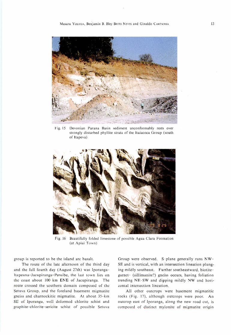
along the route Itapeva-Apiai. At a phyllite quarry
for ceramic material, some kilometer southeast of
!tapeva, f1at-lying Devonian strata of the Parana Basin
sediment (the Gondwana) covered the strongly distur
bed phyllite of the Itaiacoca Group with a distinct
unconformity (Fig. 15). Quartzite occurring at about
5 km SE of Jtapeva is hard, carrying f1at and horizontal
cleavage. Other outcrops observed were limestone
with either or both stromatolite and oolite structures,

12 Southeast Brazilian Folded Province: Field Excursions of Arafuai and Ribeira Belts in 1999
Fig. 13 Mountain range of the Ribeira Belt (east of Iporanga)
Fig. 14 The Ribeira River west of Itapeuna
partly with strong phyllitic structure and alternated
with dolerite sills near the Itapirapua lineament.
Within the wide zone of granites, medium grained and
massive, pi nk K-feldspar porphyritic biotite hornblende granite, and weakly schistose small-grained biotitegranite were observed, these granites belonging to the
calc-alkaline Brasiliano granites.
The later half of the second day and most of thethird day covered the central domain composed of theshelf and deep water Agua Clara Formation and theVotuverava Group. The route was Apiai-Iporanga
Barra do Turvo-Iporanga. They are calcareous shale,limestone and quartz-feldspathic sandstone. S-
planes dip variably and gentle southwesterly plunging
intersection lineations are more or less common.Most of sediments in this domain represent distinct s-I
structures and partly suffered late thermal effect, showing sporadic development of porphyroblasts of biotite,chloritoid, and/or garnet.
Beautifully folded limestone outcrops were observed at Apiai Town, along the railway (Fig. 16). The
axial surface of the fold trends NE-SW and dipssteeply west, with its hinge plunging gently southwest.
A Brasiliano dolerite dike was observed, intruding
the sandstone sequence of the Lajeado Subgroup nearIporanga. The metabasite within the Ribeira Sub-
Masaru YOSHIDA, Benjamin B. Bley BRITO NEVES and Ginaldo CAMPANHA
Fig. 15 Devonian Parana Basin sediment unconformably rests overstrongly disturbed phyllite strata of the ltaiacoca Group (southof ltapeva)
Fig. 16 Beautifully folded limestone of possible Agua Clara Formation(at Apiai Town)
13
group is reported to be the island arc basalt.
The route of the late afternoon of the third day
and the full fourth day (August 27th) was lporanga
Itapeuna-Jacupiranga-Peruibe, the last town lies on
the coast about IOO-km ENE of Jacupiranga. The
route crossed the southern domain composed of the
Setuva Group, and the foreland basement migmatite
gneiss and charnockitic migmatite. At about 3S-km
SE of lporanga, well deformed chlorite schist and
graphite-chlorite-sericite schist of possible Setuva
Group were observed. S-plane generally runs NW
SE and is vertical, with an intersection lineation plung
ing mildly southeast. Further southeastward, biotite
garnet- (sillimanite?) gneiss occurs, having foliation
trending NE-SW and dipping mildly NW and hori
zontal intersection lineation.
All other outcrops were basement migmatiticrocks (Fig. 17), although outcrops were poor. An
outcrop east of lporanga, along the new road cut, iscomposed of distinct mylonite of migmatite origin

14 Southeast Brazilian Folded Province: Field Excursions of Ara~uai and Ribeira Belts in 1999
Fig. 17 Basement migmatitic rocks (northeast of Jacupiranga)
Fig. 18 Mylonite of granitic rocks origin, developed along the CubatanoLineament (northeast of Jacupiranga)
(Fig. 18), with syntectonic pink granite/pegmatite
veInS and pools. This outcrop is situated on the
Cubatao Lineament running generally at the boundary
between the central to southern domains. After about
50-km drive towards northeast, coastal outcrops east of
Peruibe (cf. Fig.I), composed of charnockitic mig
matite were visited. Major structure runs generally
N- S. Labradoritic pegmatite occurs as the matrix of
the migmatite, and fragments of folded charnockitic/
enderbitic gneisses are embedded within it, being rotat
ed randomly.
DISCUSSION AND SUMMARY
Geological field observations in Brasiliano fold
belts in southeastern Brazil, including Ara~uai Fold
Belt for 10 days and Ribeira Fold Belt for 4 days were
conducted. The Ara~uai Belt is characterized by the
following different tectonic units from the west to the
east (Brito Neves et a!., 1995, 1996). The stable Sao
Francisco Craton with sporadic occurrences of Neo
proterozoic continental cover and shelf sequence (the
Macauva and Bambui groups of the Sao Francisco
Supergroup), the thin-skinned tectonic domain com-

Masaru YOSHIDA, Benjamin B. Bley BRITO NEVES and Ginaldo CAMI'ANHA 15
posed of over folded thin cover composed of the Sao
Francisco Supergroup which is underlain by reworked
Archaean basement, the thick-skinned tectonic
domain composed of folded and faulted thick distal
sediments of the Mesoproterozoic Espinha~o Super
group, which is juxtaposed to the east the back land
domain composed of the possible Archaean/Paleo
proterozoic basement..
Brito Neves et al. (1995, 1996) stressed that the
Ara~uai Belt suffered compressional tectonics by the
collision of the Archaean cratons on both sides, thus
resulting in the structural style as mentioned above
with the westward vergence. Their tectonic scheme
appeares to be a reasonable explanation through the
present observations, with some provisional comments
given below.
(I) Vergence of folds. The westerly vergence was
recognized throughout. However, there were several
observations in the thin-skinned tectonic domain that
the easterly vergence clearly develops, which does not
conform to the westerly vergence of previous interpre
tation. This evidence needs to be interpreted in the
tectonic model above.
(2) Heterogeneity in the intensity of deformations.
Strongly lineated structures observed at some places
might require an interpretation within a regional/local
tectonic domain, considering the heterogeneity of
deformations within the study area.
(3) Two stages of glaciations. Vervite-like thinly
lam inated cl ayey sedi ments wi th sporad ic gran ite/
migmatite boulders observed at the lower horizon of
the Bambui Group is possibly the glacial sediment. [f
it is the case, it results in the occurrence of two hori
zons of glacial deposits in foreland domain of the
Arac;uai terrain. A detailed study is awaited on this
poi nt.
The Ribeira Belt has a principally symmetric
signature from the west to the east as follows as
pointed out by Campanha and Sadowski (1999). The
backland domain composed of possible pre-Ribeira
basement of Parana Craton, the [taiacoca Group which
is mostly continental and pericratonic sediments, the
Votuverava and Ribeira groups composed of distal
shelf and oceanic sediments, the Capiru Formation
and Setuva Group composed of carbonaceous and
coarse cl astic con ti nental shel f sedi ments, a nd the
backland domain composed of the basement granite/
migmatite possibly referred to the northern extension
of the Rio de La Plata Craton. Extensive Brasiliano
granites characteristically develop throughout the ter
raIn. Through the present observations, following
points can be pointed out which may have important
meaning in the interpretation of tectonic characteriza
tion of the Ribeira Belt.
(I) General development, although not homogene
ous in intensity, of cleavage structures with a westerly
dip, suggesting the asymmetric overturned style of
mega-folds in the belt are conformable with the struc
tural scheme presented by Campanha and Sadowski
(1999).
(2) Almost all lineations observed are intersection
lineations, and have horizontal or gentle plunges.
Only a few lineation having a dip plunge, or with a
signature of stretching was observed. Further detailed
structural observations on the Sand L structures may
improve the kinematic interpretation of the Ribeira
Belt.
(3) Sudden change in metamorphic grade for the
western half of the belt appears to reflect considerable
displacement among the belt.
(4) The greenschist developed in the western part
of the belt represents, at a glance, similar appearance
with the high-pressure type schist elsewhere in the
world. Detailed petrological examinations with
regards to the metamorphic facies series of the belt
from the very low- grade to the higher-grade portions
of the Ribeira Belt may provide important information
in examining the tectonic model of this belt.
Acknowledgement
Constructive review by M. Santosh and T. Kano
are very much acknowledged. Support by Osaka City
University, FAPESP and Instituto de Geociencias de
Universidad de Sao Paulo made the senior author
possible to study in Brazil for the present field survey.
This paper is a contribution to IGCP-368, Gondwana
Research Group and Gondwana Institute of Geology
and Envitonment. A part of the expenses of the
present study was defrayed by the Grant-in-Aid,
MONBUSHO General Scientific Research Nos.
11894012 and 11304031.
References
Almeida, F.F.M.de, Amaral, G., Cordani, U.G., and
Kawashita, K. (1973) The Precambrian evolution
of South American cratonic margin, south of
Amazon. [n The Ocean Basins and Margins,411- 446.
Almeida, F.F.M. de, Hasui, Y. and Brito Neves, B.B.
(1976) The upper Precambrian of South America.

16 Southeast Brazilian Folded Province: Field Excursions of Arapwi and Ribeira Belts in 1999
sao Paulo, Boletim IG, IGUSP, 7,45-80.
Almeida, F.F.M., Hasui, Y., Brito Neves, B.B. and
Fuck, R.A. (1981) Brazilian structural provinces:
an introduction. Earth Sci. Rev., 17 (1-2), 1-29.
Basei, M.A.S., Siga Jr. 0., Masquelin, H., Harara, O.
M., Reis Neto, J.M. and Precizzi P., F. (2000) The
Dom Feliciano Belt of Brazil and Uruguay and its
Foreland domain, Rio de La Plata Craton. In:
Cordani, U.G., Milani, E.1., Thomazfilho, A. and
Campos, D.A., (Eds.), Tectonic Evolution ofSouth America, 31 st IGC, Rio de Janeiro, 311
-334.
Brito Neves, B.B., Nelson, J.M., and Botelho, N. (1995)
A tafrogeneses estaterian a nos blocos Paleoproter
ozoicos da America do Sule Processos subse
quentes. Geonomos, 3 (2), 1-21.
Brito Neves, B.B., Winge, M., and Carneiro, M.A.
(1996) Orogeneses precedendo e tafrogenese
sucedendo Rodinia na America do SuI. BoletimfG- USP, Ser. Cientifica, 27, 1-40.
Campanha, G. A. C. and Sadowski, G. R. (1999)
Tectonics of the southern portion of the Ribeira
Belt (Apiai domain), Precambrian Res., 98, 31-51.
Campos Neto, M. da C. (2000) Orogenic systems from
southwestern Gondwana: An approach to
Braziliano-Plan African cycle and orogenic col
lage in southeastern Brazil. In: Cordani, U.G.,
Milani, E.J., Thomazfilho, A. and Campos, D.A.
(Eds.), Tectonic Evolution of South America, 31 st
IGC, Rio de Janeiro, 335-365.
Companhia Mineradora de Minas Gerais, Recursos
Minerais Governo de Minas Gerais (1994) MapaGeologico do Estado de Minas Gerais, I:
Manuscript received September 18, 2000.Revised manuscript accepted January 31, 2001.
1,000,000.
Dardenne, M.A. (1978) Sintese sobre a estratigrafia do
grupo Bambuino Brasil central. Anais do XXX
Congo Bras. Geologia, Recife-Pe, vol. 2, 597-610.
Matins-Neto, M.A. (1993) The sedimentary Evolutionof a Proterozoic Rift Basin: The Basa Espinha90Supergroup, Southern Serra do Espinhasso,Minas Gerais, Brazil. Ph. D. Thesis, Freiburg
University, Germany, 154 pages.
Martins-Neto, M.A. (1998) Supergrupo Espinhac;:o em
Minas Gerais: Registrode uma bacia rift-sag do
Paleo/Mesoproterozoico. Revista Brasileira deGeosciencias, 28, 151-168.
Pedrosa-Soares, A.C. and Wiedemann-Leonardos, C.
M. (2000) Evolution of the Arac;:uai Belt and its
connectin to the Ribeira Belt, eastern Brazil. In:
Cordani, U.G., Milani, E.1., Thomazfilho, A. and
Campos, D.A. (Eds.), Tectonic Evolution ofSouth America, 31 st IGC, Rio de Janeiro, 265
-285.
Porada, H. (1979) The Damara-Ribeira Orogen of the
Pan-African-Brasilian cycle in Namibia (south
West Africa) and Brazil as interpretation in terms
of continental collision. Tectonophysics, 57, 237
265.
Trouw, R., Heibron, M., Ribeiro, A., Paciullo, F.,
Valeriano, C.M., Almeida, J.C.H., Tupinamba, M.
and Andreis, R.R. (2000) The Central segment of
the Ribeira Belt. In: Cordani, U.G., Milani, E.J.,
Thomazfilho, A. and Campos, D.A. (Eds.),
Tectonic Evolution of South A merica, 3[St IGC,
Rio de Janeiro, 287-310.