Soil Survey of Griggs County, North Dakota · General Soil Map (STATSGO) The general soil map...
383
United States Department of Agriculture Natural Resources Conservation Service In cooperation with North Dakota Agricultural Experiment Station, North Dakota Cooperative Extension Service, and North Dakota State Soil Conservation Committee Soil Survey of Griggs County, North Dakota The soil properties and interpretations included in this survey were current as of 1991. The most current information is available through the Natural Resources Conservation Service Soil Data Mart Website at http://soildatamart.nrcs.usda.gov/ and/or the Natural Resources Conservation Service Web Soil Survey at http://websoilsurvey.nrcs.usda.gov/app.
Transcript of Soil Survey of Griggs County, North Dakota · General Soil Map (STATSGO) The general soil map...

United StatesDepartment ofAgriculture
Natural ResourcesConservationService
In cooperation with NorthDakota AgriculturalExperiment Station, NorthDakota CooperativeExtension Service, andNorth Dakota State SoilConservation Committee
Soil Survey ofGriggs County,North Dakota
The soil properties and interpretations included in this survey were current as of 1991. The most currentinformation is available through the Natural Resources Conservation Service Soil Data Mart Website athttp://soildatamart.nrcs.usda.gov/ and/or the Natural Resources Conservation Service Web Soil Survey athttp://websoilsurvey.nrcs.usda.gov/app.


General Soil Map (STATSGO)
The general soil map immediately preceding the detailed soil maps shows the survey areadivided into groups of associated soils called general soil map units. This map is useful inplanning use and management of large areas.
To find information about your area of interest, locate that area on the map,identify the name of the map unit in the area on the color-coded maplegend, and then refer to the description of the area.
Detailed Soil Maps
The detailed soil maps are foundin the packet accompanying thebook. These maps can be usefulin planning the use andmanagement of small areas.
To find information about yourarea of interest, locate that areaon the Index to Map Sheets,which precedes the soil maps.Note the number of the mapsheet and turn to that sheet.
Locate your area of interest onthe map sheet. Note the map unitsymbol that is in that area. Turn tothe Contents, which lists the mapunits by symbol and name andshows the page where each mapunit is described.
The Contents shows which table has data on a specific land use for each detailed soil map unit. Also see theContents for sections of this publication that may address your specific needs.
For additional information concerning the use of soil surveys refer to North Dakota State University ExtensionService Bulletin 60, “Soil Survey: The Foundation for Productive Natural Resource Management,” (Seelig, 1993)and to the USDA-NRCS publication “From the Surface Down: An Introduction to Soil Surveys for AgronomicUse,” (Broderson, 1991).
3
How to Use This Soil Survey

4
Additional information about the Nation’s natural resources is available on theNatural Resources Conservation Service home page on the World Wide Web. Theaddress is http://www.nrcs.usda.gov (click on “Technical Resources” ).
This soil survey is a publication of the National Cooperative Soil Survey, a joint effortof the United States Department of Agriculture and other federal agencies, stateagencies, including the Agricultural Experiment Station, and local agencies. The NaturalResources Conservation Service (formerly the Soil Conservation Service) hasleadership for the federal part of the National Cooperative Soil Survey.
Major fieldwork for this soil survey was completed in 1991. Soil names anddescriptions were approved in 1991. Unless otherwise indicated, statements in thispublication refer to conditions in the survey area in 1987 to 1991. This survey was madecooperatively by the Natural Resources Conservation Service, the North DakotaAgricultural Experiment Station, North Dakota Cooperative Extension Service, andNorth Dakota State Soil Conservation Committee. It is part of the technical assistancefurnished to the Griggs County Soil Conservation District. Financial assistance wasprovided by the Griggs County Board of Commissioners.
Soil maps in this survey may be copied without permission. Enlargement of thesemaps, however, could cause misunderstanding of the detail of mapping. Maps may notshow the small areas of contrasting soils that could have been shown at a larger scale.
The U.S. Department of Agriculture (USDA) prohibits discrimination in all its programsand activities on the basis of race, color, national origin, gender, religion, age, disability,political beliefs, sexual orientation, and marital or family status. (Not all prohibited basesapply to all programs.) Persons with disabilities who require alternative means forcommunication of program information (Braille, large print, audiotape, etc.) shouldcontact USDA’s TARGET Center at (202) 720-2600 (voice and TDD).
To file a complaint of discrimination, write USDA, Director, Office of Civil Rights,Room 326W, Whitten Building, 14th and Independence Avenue, SW, Washington, DC20250-9410 or call (202) 720-5964 (voice or TDD). USDA is an equal opportunity providerand employer.
Cover: Sunflowers on an area of Heimdal and Emrick soils. The field shelterbelts help controlwind erosion.

5
Cover ....................................................................... 1How to Use This Soil Survey ................................. 3Contents .................................................................. 5Foreword ................................................................. 9Where to Get Updated Information ..................... 10General Nature of the Survey Area ..................... 11
History ................................................................ 11Physiography, Relief, and Drainage .................. 11Land Uses .......................................................... 12Climate ............................................................... 12
How This Survey Was Made ................................ 12Survey Procedures .............................................. 13Table 1.—Temperature and Precipitation .......... 15Table 2.—Freeze Dates in Spring and Fall ......... 16Table 3.—Growing Season .................................. 16General Soil Map Units (STATSGO) ................... 17
15—Swenoda-Hecla-Wyndmere Association,level and undulating .................................... 18
28—Binford-Coe-Brantford Association, level togently rolling ................................................ 19
29—Binford-Divide-Marysland Association,level and undulating .................................... 20
40—Hamerly-Barnes-Tonka Association, levelto gently rolling ............................................ 21
43—Svea-Hamerly-Buse Association, level togently rolling ................................................ 22
46—Barnes-Svea-Hamerly Association, levelto gently rolling ............................................ 24
51—Svea-Cresbard-Hamerly Association, leveland undulating ............................................. 26
55—Emrick-Heimdal-Fram Association, levelto gently rolling ............................................ 27
56—Fram-Heimdal-Emrick Association, leveland undulating ............................................. 28
57—Heimdal-Emrick-Esmond Association,level to steep ............................................... 29
182—Hamerly-Barnes-Tonka Association, verystony, level and undulating .......................... 31
183—LaDelle-Buse-Barnes-Edgeley Association,level to steep ............................................... 32
Detailed Soil Map Units ........................................ 3561—Arveson fine sandy loam ............................ 36
Contents
118—Barnes-Buse loams, 3 to 6 percentslopes .......................................................... 36
120—Barnes-Buse loams, 6 to 9 percentslopes .......................................................... 37
156—Barnes-Svea loams, 3 to 6 percentslopes .......................................................... 38
167—Bearden silt loam ..................................... 38296—Brantford loam, 0 to 3 percent slopes ...... 39314—Buse-Barnes loams, 9 to 15 percent
slopes .......................................................... 39319—Buse-Barnes loams, 15 to 35 percent
slopes .......................................................... 40391—Cavour-Cresbard loams, 0 to 3 percent
slopes .......................................................... 40450—Colvin silt loam ......................................... 41511—Divide loam, 0 to 3 percent slopes ........... 42536—Eckman-Zell silt loams, 6 to 9 percent
slopes .......................................................... 42539—Edgeley loam, 0 to 3 percent slopes ........ 43541—Edgeley loam, 3 to 6 percent slopes ........ 43569—Embden fine sandy loam ......................... 44579—Embden-Egeland fine sandy loams, 1 to
6 percent slopes .......................................... 44595—Emrick-Cathay loams, 0 to 3 percent
slopes .......................................................... 45597—Emrick-Heimdal loams, 0 to 3 percent
slopes .......................................................... 45605—Esmond-Heimdal loams, 9 to 15 percent
slopes .......................................................... 46753—Fram-Wyard loams, 0 to 3 percent
slopes .......................................................... 47769—Gardena silt loam, 0 to 3 percent
slopes .......................................................... 47773—Gardena-Eckman silt loams, 3 to 6
percent slopes ............................................. 48881—Hamerly-Tonka complex, 0 to 3 percent
slopes .......................................................... 48884—Hamerly-Wyard loams, 0 to 3 percent
slopes .......................................................... 49893—Harriet silt loam ........................................ 49988—Heimdal-Emrick loams, 3 to 6 percent
slopes .......................................................... 50

6
998—Heimdal-Esmond loams, 6 to 9 percentslopes .......................................................... 51
1001—Heimdal-Esmond loams, 15 to 35percent slopes ............................................. 51
1015—Kensal loam ........................................... 521062—LaDelle silty clay loam, 0 to 3 percent
slopes .......................................................... 521108—Larson-Cathay loams, 0 to 3 percent
slopes .......................................................... 531188—Ludden silty clay .................................... 531189—Ludden silty clay, saline ......................... 541221—Maddock-Hecla loamy fine sands, 1 to
6 percent slopes .......................................... 541267—Marysland loam ...................................... 551268—Marysland loam, wet .............................. 551427—Parnell silty clay loam ............................ 561454—Wyndmere fine sandy loam, loamy
substratum, 0 to 3 percent slopes ............... 561466—Pits, sand and gravel ............................. 571710—Southam silty clay loam ......................... 571762—Svea-Barnes loams, 0 to 3 percent
slopes .......................................................... 571765—Svea-Buse loams, 3 to 6 percent
slopes .......................................................... 581766—Svea-Buse loams, 6 to 9 percent
slopes .......................................................... 591769—Svea-Cresbard loams, 0 to 3 percent
slopes .......................................................... 591781—Swenoda fine sandy loam, 0 to 3
percent slopes ............................................. 601843—Towner loamy fine sand, 0 to 6 percent
slopes .......................................................... 601883—Vallers-Parnell complex ......................... 611886—Hamerly and Vallers loams, saline, 0 to
3 percent slopes .......................................... 611970—Walum sandy loam ................................ 621978—Water ...................................................... 632118—Fram-Tonka complex, 0 to 3 percent
slopes .......................................................... 632121—Ferney loam, 0 to 3 percent slopes ........ 642151—Binford-Coe sandy loams, 0 to 6
percent slopes ............................................. 64
2152—Coe-Binford complex, 6 to 25 percentslopes .......................................................... 65
2153—Edgeley-Kloten-Esmond complex, 9 to35 percent slopes ........................................ 66
2156—Lamoure and Rauville silt loams ............ 662157—Maddock-Esmond-Embden complex,
6 to 15 percent slopes ................................. 672158—Velva fine sandy loam, 0 to 6 percent
slopes .......................................................... 682159—Walsh silty clay loam, 1 to 6 percent
slopes .......................................................... 682196—Bearden and Colvin silt loams, saline .... 692197—Edgeley-Kloten complex, 6 to 9 percent
slopes .......................................................... 692198—Hamar-Hecla loamy fine sands .............. 702199—Hamerly-Barnes-Tonka complex, 0 to
6 percent slopes, very stony........................ 712200—Letcher-Swenoda fine sandy loams, 0
to 3 percent slopes ...................................... 712201—Stirum-Arveson, saline, fine sandy
loams ........................................................... 722202—Swenoda-Barnes fine sandy loams, 3
to 6 percent slopes ...................................... 722203—Swenoda-Barnes fine sandy loams, 6
to 9 percent slopes ...................................... 732204—Walsh silty clay loam, 6 to 9 percent
slopes .......................................................... 742205—Zell-Eckman silt loams, 9 to 25 percent
slopes .......................................................... 74Table 4.—Acreage and Proportionate Extent of
the Soils ............................................................ 76Formation and Classification of the Soils .......... 79
Formation of the Soils ........................................ 79Classification of the Soils ................................... 81
Table 5.—Classification of the Soils ................... 83Soil Series and Their Morphology ...................... 85
Arveson Series .................................................. 85Banks Series ...................................................... 86Barnes Series .................................................... 86Bearden Series .................................................. 87Binford Series .................................................... 87Brantford Series ................................................. 88

7
Buse Series ....................................................... 89Cathay Series .................................................... 89Cavour Series .................................................... 90Coe Series ......................................................... 91Colvin Series ...................................................... 92Cresbard Series ................................................. 92Darnen Series .................................................... 93Dickey Series ..................................................... 94Divide Series ...................................................... 94Eckman Series ................................................... 95Edgeley Series ................................................... 96Egeland Series .................................................. 96Embden Series .................................................. 97Emrick Series ..................................................... 98Enloe Series ...................................................... 99Esmond Series ................................................ 100Fairdale Series ................................................. 100Ferney Series .................................................. 101Fossum Series ................................................. 102Fram Series ..................................................... 103Gardena Series ................................................ 103Gilby Series ..................................................... 104Great Bend Series ........................................... 105Grimstad Series ............................................... 106Hamar Series ................................................... 107Hamerly Series ................................................ 107Harriet Series ................................................... 108Hecla Series .................................................... 109Heimdal Series ................................................ 110Kensal Series ................................................... 110Kloten Series ................................................... 111LaDelle Series ................................................. 111Lamoure Series ............................................... 112Lankin Series ................................................... 112Larson Series ................................................... 113Lemert Series .................................................. 114Letcher Series .................................................. 115Lindaas Series ................................................. 116Ludden Series.................................................. 117Maddock Series ............................................... 117Manfred Series ................................................ 118Marysland Series ............................................. 119
Mekinock Series .............................................. 119Nutley Series ................................................... 120Ojata Series ..................................................... 121Overly Series ................................................... 122Parnell Series .................................................. 123Rauville Series ................................................. 123Rosewood Series ............................................. 124Ryan Series ..................................................... 125Serden Series .................................................. 125Sinai Series ...................................................... 126Sioux Series ..................................................... 127Southam Series ............................................... 127Stirum Series ................................................... 128Svea Series ..................................................... 129Swenoda Series ............................................... 129Tiffany Series ................................................... 130Tonka Series .................................................... 131Towner Series .................................................. 132Vallers Series ................................................... 133Velva Series ..................................................... 133Walsh Series .................................................... 134Walum Series .................................................. 135Wyard Series ................................................... 135Wyndmere Series ............................................ 136Zell Series ........................................................ 137
Agronomy ........................................................... 139Cropland Limitations and Management ........... 139Erosion Factors ................................................ 143Prime Farmland and Other Important
Farmland ................................................... 143Productivity Indexes and Crop Yield
Estimates ................................................... 144Land Capability Classification .......................... 144Pasture and Hayland Interpretations ............... 145Management of Saline and Sodic Soils ........... 147Soil Quality ....................................................... 149Woodland, Windbreaks and Environmental
Plantings .................................................... 151Table 6.—Potential Cropland Limitations and
Hazards ........................................................... 154Table 7.—Map Unit Productivity Index and
Farmland Designation ................................... 167
8 Soil Survey
Table 8.—Yields Per Acre of Crops .................. 171Table 9.—Interpretive Groupings Report ......... 176Table 10.—Windbreak Suitability Groups ........ 181Rangeland ........................................................... 189
Range Sites ..................................................... 189Range Site Plant Community, Composition,
and Production .......................................... 193Range Condition .............................................. 194Range Management ........................................ 194
Table 11.—Range Sites ...................................... 195Table 12.— Range Site Descriptions ................ 201Recreation ........................................................... 219Table 13.—Recreational Development ............. 221Wildlife Habitat ................................................... 229Table 14.—Wildlife Habitat ................................ 231Engineering ........................................................ 239
Building Site Development .............................. 239Sanitary Facilities............................................. 240Waste Management ......................................... 241Construction Materials ..................................... 242
Issued 2002
Water Management ......................................... 243Table 15.—Building Site Development ............. 245Table 16.—Sanitary Facilities ............................ 254Table 17.—Construction Materials ................... 263Table 18.—Water Management ......................... 272Soil Properties .................................................... 283
Engineering Index Properties .......................... 283Physical Properties .......................................... 284Chemical Properties ........................................ 285Water Features ................................................ 286Soil Features .................................................... 287Hydric Soils ...................................................... 288
Table 19.—Engineering Index Properties ........ 290Table 20.—Physical Properties of the Soils ..... 306Table 21.—Chemical Properties of the Soils ... 315Table 22.—Water Features ................................ 324Table 23.—Soil Features .................................... 344Table 24.—Hydric Soils List .............................. 350References .......................................................... 365Glossary .............................................................. 369

9
This soil survey contains information that can be used in land-planning programs inGriggs County. It contains predictions of soil behavior for selected land uses. Thesurvey also highlights limitations and hazards inherent in the soil, improvementsneeded to overcome the limitations, and the impact of selected land uses on theenvironment.
This soil survey is designed for many different users. Farmers, ranchers, foresters,and agronomists can use it to evaluate the potential of the soil and the managementneeded for maximum food and fiber production. Planners, community officials,engineers, developers, builders, and home buyers can use the survey to plan land use,select sites for construction, and identify special practices needed to ensure properperformance. Conservationists, teachers, students, and specialists in recreation, wildlifemanagement, waste disposal, and pollution control can use the survey to help themunderstand, protect, and enhance the environment.
Great differences in soil properties can occur within short distances. Some soils areseasonally wet or subject to flooding. Some are shallow to bedrock. Some are toounstable to be used as a foundation for buildings or roads. Clayey or wet soils arepoorly suited to use as septic tank absorption fields. A high water table makes a soilpoorly suited to basements or underground installations.
These and many other soil properties that affect land use are described in this soilsurvey. Broad areas of soils are shown on the STATSGO general soil map. The locationof each soil is shown on the detailed soil maps. Each soil in the survey area isdescribed. Information on specific uses is given for each soil. Help in using thispublication and additional information are available at the local office of the NaturalResources Conservation Service or the Cooperative Extension Service.
Thomas E. JewettState ConservationistNatural Resources Conservation Service
Foreword

10
Where to Get Updated InformationThe soil properties and interpretations included in this survey were current as of 1991.
The most current information is available through the Natural Resources ConservationService Soil Data Mart Website at http://soildatamart.nrcs.usda.gov/ and/or the NaturalResources Conservation Service Web Soil Survey athttp://websoilsurvey.nrcs.usda.gov/app.
Additional information is available from the Natural Resources Conservation ServiceField Office Technical Guide in Cooperstown, North Dakota, or online atwww.nrcs.usda.gov/technical/efotg. The data in the Field Office Technical Guide areupdated periodically.
Additional information about soils and about NRCS is available through the NorthDakota NRCS Web page at www.nd.nrcs.usda.gov.
For further information please contact:
USDA-Natural Resources Conservation ServiceCooperstown Field Office805 Lenham Avenue SWP.O. Box 526Cooperstown, North Dakota 58425-0526Telephone: (701) 797-2240Fax: (701) 797-3646

11
General Nature of the Survey AreaGRIGGS COUNTY is in the northeastern part of North
Dakota (fig. 1). The county has a total area of 458,400acres, or 716 square miles. It has 5,200 acres of waterin bodies of more than 40 acres in size. The countyseat and largest town is Cooperstown.
History
The first recorded settlements in the area wereestablished in the 1880s. Additional informationconcerning the history and development of GriggsCounty has been published by the Griggs CountyHistorical Committee (1976).
The first soil survey of a part of Griggs County(approximately 228 square miles) was published in1906 (Kocher and Hurst, 1906). A general soil map ofthe county was published in 1968 (Patterson, et al.1968). The present survey provides additionalinformation and larger scale maps and shows the soilsin more detail.
Physiography, Relief, and Drainage
The county is part of the Central Black GlaciatedPlains of the Northern Great Plains Spring Wheat
Region (USDA-SCS, 1981). Nearly all of Griggs Countylies within the Drift Prairie physiographic district of theCentral Lowland Province. The county consists mostlyof gently undulating areas covered mainly by glacialdeposits (Bluemle, 1975).
Figure 1. Location of Griggs County in North Dakota.
Elevation in the county ranges from 1,730 feet in thenorthwestern part to less than 1,450 feet in thesoutheastern part of the county (Downey andArmstrong, 1977). Local relief rarely exceeds 100 feet/mile. The county is within the Sheyenne-Red RiverBasin.
Soil Survey of
Griggs County, North DakotaManuscript by Earnest L. Jensen, Natural Resources Conservation Service.
Fieldwork by Earnest L. Jensen, Willie J. Terry, Gordon Gilmore, Robert Murphy,Norman Prochnow, Natural Resources Conservation Service; Donald D. Opdahl andDavid V. Wroblewski, professional soil classifiers and Stoneman-Landers Inc., soilsurvey contractor.
United States Department of Agriculture, Natural Resources Conservation Service,in cooperation withNorth Dakota Agricultural Experiment Station, North Dakota Cooperative ExtensionService, North Dakota State Soil Conservation Committee, North Dakota StateDepartment of Transportation, and the Griggs County Soil Conservation District.
Map finishing by the North Dakota State Soil Conservation Committee.

12 Soil Survey
Land Uses
Farming and ranching are the main economicenterprises. The principal crops are spring wheat,barley, sunflower, and dry edible beans (Beard andWaldhous, 1997). The Griggs County Soil ConservationDistrict was organized in 1945.
The soils in the county are mostly very deep andwell suited to cropland, except the hilly to steep soilswhich are best suited to rangeland or pastureland. Thesoil parent material is mostly of glacial origin, withsignificant glaciolacustrine, till, and glaciofluvialdeposits. Many of the soils are susceptible to wind orwater erosion. A significant acreage of soils are wetand ponded and produce or have produced habitat forwetland wildlife.
About 86 percent of the area is cropland, and14 percent is rangeland, hayland, or other land(USDA-SCS, 1992). Irrigation is limited to a smallarea underlain by aquifers. Additional informationrelated to agriculture in Griggs County can be found inCensus of Agriculture (USDA-NASS, 1999). Additionalinformation concerning the ground water resources inGriggs County has been compiled by Downey andArmstrong (1977).
Climate
The climate of Griggs County is subhumid. The areais usually quite warm in summer with frequent spells ofhot weather and occasional cool days. It is very cold inwinter, when arctic air frequently surges over the area.Most precipitation falls in late spring and early summer.
Table 1, “Temperature and Precipitation,” gives dataon temperature and precipitation for the survey area asrecorded at Cooperstown, North Dakota, in the period1961 to 1990. Table 2, “Freeze Dates in Spring andFall,” shows probable dates of the first freeze in fall andthe last freeze in spring. Table 3, “Growing Season,”provides data on length of the growing season.
In January, the average temperature is -4 degrees F,and the average daily minimum temperature is -6degrees F. In July, the average temperature is 70degrees F, and the average daily maximumtemperature is 84 degrees F.
Growing degree days are shown in Table 1. They areequivalent to “heat units.” During the month, growingdegree days accumulate by the amount the averagetemperature each day exceeds a base temperature (40degrees F). The normal monthly accumulation is usedto schedule single or successive plantings of a cropbetween the last freeze in spring and the first freeze infall.
The average annual total precipitation in the countyis about 20 inches. Of this, about 15 inches, or 75percent, usually falls in April through September. Thegrowing season for commonly grown crops falls withinthis period. Rainfall amounts occurring in 2 years out of10 are also shown on Table 1. This information is usefulin designing a management system for wet and dryyears.
Average annual snowfall is 34 inches. The averagerelative humidity in July is 54 percent. The sun shines71 percent of the possible time in July and 45 percentof the time in November. The sun shines an average of59 percent of the possible time annually. The prevailingwind is from the northwest. The average annualwindspeed is 11.5 miles per hour (Jensen, 1972).
How This Survey Was MadeThis survey was made to provide information about
the soils and miscellaneous areas in the survey area.The information includes a description of the soils andmiscellaneous areas and a discussion of the suitability,limitations, and management of the soils andmiscellaneous areas for specified uses. Soil scientistsobserved the steepness, length, and shape of theslopes; the general pattern of drainage; the kinds ofcrops and native plants; and the kinds of bedrock. Theydug many holes to study the soil profile, which is thesequence of natural layers, or horizons, in a soil. Theprofile extends from the surface down to theunconsolidated material in which the soil formed. Theunconsolidated material is devoid of roots and otherliving organisms and has not been changed bybiological activity.
Soils and miscellaneous areas in the survey areaare in an orderly pattern that is related to the geology,landforms, relief, climate, and natural vegetationof the area. Each kind of soil and miscellaneous areais associated with a particular kind or segment of thelandscape. By observing the soils and miscellaneousareas in the survey area and relating their position tospecific segments of the landscape, soil scientistsdevelop a concept, or model, of how the soils wereformed. Thus, during mapping, this model enables soilscientists to predict with a considerable degree ofaccuracy the kind of soil or miscellaneous area at aspecific location on the landscape.
Individual soils on the landscape commonly mergeinto one another as their characteristics graduallychange. To construct an accurate map, however, soilscientists must determine boundaries between thesoils. They can observe only a limited number of soilprofiles. Nevertheless, these observations,

Griggs County, North Dakota 13
supplemented by an understanding of the soil-vegetation-landscape relationships, are sufficient toverify predictions of the kinds of soil in an area and todetermine the boundaries.
Soil scientists recorded characteristics of the soilprofiles they studied. They noted color, texture, size,and shape of soil aggregates, kind and amount of rockfragments, distribution of plant roots, soil reaction, andother features that enable them to identify soils (fig. 2).After describing the soils in the survey area anddetermining their properties, the soil scientistsassigned the soils to taxonomic classes (units).Taxonomic classes are concepts. Each taxonomicclass has a set of soil characteristics with preciselydefined limits. The classes are used as a basis forcomparison and to classify soils systematically. SoilTaxonomy (Soil Survey Staff, 1975), the system oftaxonomic classification used in the United States, isbased mainly on the kind and character of soilproperties and the arrangement of horizons within theprofile. After soil scientists classified and named thesoils in the survey area, they compared individual soilswith similar soils in the same taxonomic class in otherareas so they could confirm data and assembleadditional data based on experience and research.
While a soil survey is in progress, samples of someof the soils in the area are collected for laboratoryanalyses and for engineering tests. Soil scientistsinterpret data from these analyses and tests as well asfield-observed characteristics and soil properties todetermine expected behavior of soils under differentuses. Interpretations for the soils are field testedthrough observation of the soils in different uses andunder different levels of management. Someinterpretations are modified to fit local conditions, andsome new interpretations may be developed to meetlocal needs. Data are assembled from other sources,such as research information, production records, andfield experience of specialists. For example, data oncrop yields under defined levels of management areassembled from farm records and from field or plotexperiments on the same kinds of soil.
Predictions about soil behavior are based not onlyon soil properties but also on such variables as climateand biological activity. Soil conditions are predictableover long periods of time, but they are not predictablefrom year to year. For example, soil scientists canpredict with a fairly high degree of accuracy that agiven soil will have a high water table within certaindepths in most years, but they cannot predict a highwater table will always be at a specific level in the soilon a specific date.
After soil scientists located and identified thesignificant natural bodies of soil in the survey area,
they drew the boundaries of these bodies on aerialphotographs and identified each as a specific map unit.Aerial photographs show trees, buildings, fields, roads,and rivers, all of which help in locating boundariesaccurately.
The descriptions, names, and delineations of thesoils in this survey area do not fully agree with those ofthe soils in adjacent survey areas. Differences are theresult of a better knowledge of soils, modifications inseries concepts, or variations in the intensity ofmapping or in the extent of the soils in the surveyareas.
Survey ProceduresThe general procedures used to make this survey
are described in the National Soil Survey Handbook(Soil Survey Staff,1996b) and the Soil Survey Manual(Soil Survey Staff,1993). The Major Soils of NorthDakota (Omodt, et al., 1968), Soil Taxonomy (Soil
Figure 2. Profile of Hamerly loam. The dark-colored surfacelayer surface layer is underlain by a light colored layerthat has an accumulation of lime.

14 Soil Survey
Survey Staff, 1975), and Land Resource Regions andMajor Land Resource Areas of the United States(USDA-SCS, 1981), were among the references used.The procedures used in determining the nature andcharacteristics of the soils are described under theheading “How This Survey Was Made.”
All soil mapping was done on field sheets developedfrom high-altitude black and white aerial photographsfrom the National High Altitude Photography (NHAP)Program. The scale of the field sheets was 1:24,000or 2.64 inches to the mile. Detail of these field sheetswas checked with older aerial photography, colorinfrared photography, and in some instances,topographic maps. The soil maps are published onfull quadrangle orthophotography.
Soil delineations were drawn on field sheets bytraversing the land on foot, by pickup with mountedhydraulic soil probe, or by all-terrain vehicle. Traverseswere planned to cross all major landforms and were atintervals close enough to locate contrasting soil areasof about 3 to 5 acres. Soils were examined to a depthof 3 to 5 feet, depending on the kind of soil. Soilproperties, including color, texture, structure,horizonation, and presence of salts and stones wereexamined.
All map units were characterized for soil variabilityby transecting representative areas. A transect is aseries of detailed soil examinations done in a mapunit delineation to determine the range of compositionof various kinds of soil and soil properties. Onetransect was required for each 1,000 acres of the unitmapped.
Data collected from the transects were used todetermine map unit names and establish the range ofcomposition of soil in each map unit. A statisticalmethod explained by Brubaker and Hallmark (1991)was used for the analyses. This method predicts, at a90 percent confidence level, the average compositionin the county for each named map unit component andsimilar soil will be between the range given in the mapunit description.
Each soil map unit was documented by at least onepedon description for each soil series identified in itsname. Soil pedons were sampled for soilcharacterization or engineering test data. The soilanalyses were made by the Natural ResourcesConservation Service’s Soil Survey Laboratory atLincoln, Nebraska and the North Dakota StateDepartment of Transportation’s Materials and ResearchLaboratory.

Griggs County, North Dakota 15
Table 1.—Temperature and Precipitation
(Recorded in the period 1961-90 at Cooperstown, North Dakota.)
_______________________________________________________________________________
Temperature Precipitation
_____________________________________________________________________
2 years in 10 2 yrs in 10
will have avg will have average
_____________ no. of ___________ number of
Month avg avg avg max min growing avg less more days with
daily daily temp. temp. degree than than 0.10 inch
max min >than <than days* (in.) (in.) (in.) or more_______________________________________________________________________________
January 16.1 -4.4 5.9 44 -34 0 0.57 0.26 0.91 1
February 22.8 1.8 12.3 48 -31 0 0.41 0.14 0.66 1
March 36.1 15.9 26.0 64 -19 15 0.96 0.51 1.42 3
April 54.6 30.3 42.5 85 6 157 1.65 0.50 2.68 4
May 69.4 42.2 55.8 92 22 495 2.37 1.12 3.45 5
June 78.2 52.1 65.2 94 36 652 3.40 1.73 4.86 6
July 84.0 56.9 70.4 99 42 945 3.13 1.42 4.60 6
August 82.4 54.3 68.4 99 37 876 2.58 1.16 3.80 4
September 70.9 44.0 57.4 94 24 521 2.33 0.74 3.63 4
October 58.1 33.4 45.7 83 13 225 1.21 0.28 1.95 2
November 36.9 17.7 27.3 66 -13 20 0.70 0.21 1.14 2
December 20.9 1.8 11.3 49 -29 0 0.54 0.29 0.79 2
Yearly :
Average 52.5 28.8 40.7 —— —— —— — — — —
Extreme 104 -36 — 101 -34 —— — — — —
Total — — — —— —— 4,006 19.85 16.67 22.89 40
______________________________________________________________________________
* A growing degree day is a unit of heat available for plant growth. Itcan be calculated by adding the maximum and minimum daily temperatures,dividingthe sum by 2, and subtracting the temperature below which growth is minimal forthe principal crops in the area (Threshold: 40.0 deg. F)

16
Table 2.—Freeze Dates in Spring and Fall
(Recorded in the period 1961-90 at Cooperstown, North Dakota.)
________________________________________________________________________
Temperature
____________________________________________
Probability 24F or lower 28F or lower 32F or lower
________________________________________________________________________
Last freezing temperature
in spring :
1 year in 10 later than— May 11 May 18 May 30
2 year in 10 later than— May 6 May 14 May 25
5 year in 10 later than— April 25 May 5 May 15
First freezing temperature
in fall :
1 yr in 10 earlier than— September 24 September 15 September 7
2 yr in 10 earlier than— September 30 September 20 September 12
5 yr in 10 earlier than— October 10 September 30 September 20
________________________________________________________________________
Table 3.—Growing Season
(Recorded in the period 1961-90 at Cooperstown, North Dakota.)
_________________________________________________________________________
Daily Minimum Temperature
_____________________________________________
Probability # days > 24F # days > 28F # days > 32F
9 years in 10 137 124 107
8 years in 10 144 130 113
5 years in 10 157 142 126
2 years in 10 171 155 139
1 year in 10 178 161 146
________________________________________________________________________

17
The general soil map which precedes the detailedsoil maps was derived from STATSGO (State SoilGeographic Data Base). STATSGO (USDA-NRCS,1994) is a small scale digital general soil map of NorthDakota and an accompanying data base. It showsbroad areas that have a distinctive pattern of soils,relief, and drainage. These similar areas are delineatedinto general soil map units or soil associations. Eachsoil association is a unique natural landscape.Typically, they consist of one or more major soils orcomponents and some minor soils or components. Thesoils making up an association can occur in anotherassociation but in a different pattern. The STATSGOmap can be used to compare the suitability of largeareas for general land uses. Areas of soils suitable fora practice or use can be identified on the map.Likewise, areas that are not suitable can be identified.Broad interpretive groups can be developed usingSTATSGO data. STATSGO maps are designed to beused primarily for multi-county and state resourceevaluation and planning. Interpretive tables and mapscan be prepared for North Dakota, or for smaller areaswithin the state. STATSGO maps can be used as partof a geographic information system (GIS).
The STATSGO map was compiled by generalizingmore detailed soil survey maps. Information on thegeology, topography, vegetation, and climate was also
considered in the development of this map. The database contains information on each association’sacreage and composition. It also contains soilproperties and interpretive data.
Maps were compiled at a scale of 1:250,000(1 inch=4 miles). The smallest delineations are about1,500 acres in size. STATSGO maps are preparednationwide at the same scale and join across countyand state boundaries. The maps meet nationalstandards for mapping conventions and scale.Because of its small scale, the map is not suitable forplanning the management of a farm or field or forselecting a site for a road or building. The soils in anyone association differ from place to place in slope,depth, drainage, and other characteristics that affectmanagement.
Descriptions for STATSGO associations in GriggsCounty begin on page 18. The composition of thenamed components in the association descriptionincludes soils that are similar in properties andbehavioral patterns. Not all minor components arelisted.
The North Dakota STATSGO map and data base aremaintained by the USDA-NRCS Soils staff inBismarck, North Dakota. For more information on theuse of STATSGO, or on the availability of interpretivetables and maps, contact the state NRCS office.
General Soil Map Units (STATSGO)

18 Soil Survey
15—Swenoda-Hecla-Wyndmere Association, level and undulating
Description
These soil areas are level to undulating. They haveoccasional gentle rises, knolls, swales, anddepressions. The dominant soils are on moderatelycoarse and coarse textured glacial outwash and deltaicdeposits. Glacial till is exposed in some areas. Mostareas of this association are used for cultivated crops.
Swenoda soils are on slightly elevated rises. Thecoarse-textured Hecla soils are on flats and swales.Wyndmere soils are on level and gentle, convexpositions. Buse and Barnes soils are on convex sideslopes of higher knolls and ridges. They formed inglacial till. Cathay soils are on the gentle, lower slopesor concave footslopes. Parnell soils are in depressions
and potholes. The Wyndmere and Buse soils have aprominent “high lime” layer which is within plow depthin many areas. This light-colored, limy material oftenis exposed and mixed with dark surface soil bycultivation.
Major Limitations for Agricultural Use
Wind erosion is the main limitation for agriculture.These soils have limited water holding capacity andmay be droughty. For additional information concerningthese soils see “Detailed Map Unit Descriptions” and“Series Descriptions.” For information concerning thelimitations and hazards for agriculture see Table 6.
SURFACE SLOPE PERCENTTEXTURE* PERCENT DRAINAGE** COMPOSITION
MAJOR COMPONENTS
Swenoda FSL 0-6 MW 40-45Hecla LFS 0-6 MW 15-20Wyndmere FSL 0-3 SP 10-15
MINOR COMPONENTS
Buse L 9-15 W 5-10Barnes L 3-6 W 5-10Cathay L 0-3 MW 1-5Parnell SICL 0-1 VP 1-5
* LFS,loamy fine sand; FSL,fine sandy loam; L,loam; SICL,silty clay loam** VP,very poor; SP,somewhat poor; MW,moderately well; W,well

Griggs County, North Dakota 19
Description
These soil areas consist of level to gently rollingtopography with knolls, elongated ridges, andoccasional depressions. The dominant soils aremoderately coarse and medium textured. They formedin shaly glacial outwash. Most areas of this associationare used for cultivated crops.
Binford and Brantford soils are on flats, side slopes,and broad convex crests of knolls and ridges. Theshallow Coe soils are on crests of knolls and ridgesand on shoulder slopes surrounding depressions.Divide soils are on gentle, convex positions and flatsadjacent to depressions. Kensal soils are on lower sideslopes, swales, and broad flats. Colvin soils are onbroad, low flats adjacent to depressions and potholes.Southam soils are in depressions and potholes. TheBinford, Brantford, Coe, Divide, and Kensal soils are
underlain by layers of sand and gravel. The Divide,Colvin, and Coe soils have a prominent “high lime”layer which is within plow depth in many areas. Thislight-colored, limy material often is exposed and mixedwith dark surface soil by cultivation.
Major Limitations for Agricultural Use
Wind erosion is the main limitation for agriculture.These soils have limited water holding capacity andmay be droughty. Wind erosion may be a hazard. Someareas may have periods of wetness and ponding in thespring and after heavy rainfall. For additionalinformation concerning these soils see “Detailed MapUnit Descriptions” and “ Series Descriptions.” Forinformation concerning the limitations and hazards foragriculture see Table 6.
28—Binford-Coe-Brantford Association, level to gently rolling
SURFACE SLOPE PERCENTTEXTURE* PERCENT DRAINAGE** COMPOSITION
MAJOR COMPONENTS
Binford SL 1-9 SE 25-30Coe SL 1-9 E 20-25Brantford L 0-6 W 10-15
MINOR COMPONENTS
Divide L 0-3 SP 5-10Kensal L 0-3 MW 5-10Colvin SIL 0-1 P 1-5Southam SICL 0-1 VP 1-5
* SL,sandy loam; L,loam;SIL,silt loam; SICL,silty clay loam** VP,very poor; P,poor; SP,somewhat poor; MW,moderately well; W,well; SE,somewhat excessive; E,excessive

20 Soil Survey
29—Binford-Divide-Marysland Association, level and undulating
SURFACE SLOPE PERCENTTEXTURE* PERCENT DRAINAGE** COMPOSITION
MAJOR COMPONENTS
Binford SL 0-6 SE 25-30Divide L 0-3 SP 25-30Marysland L 0-1 P/VP 10-15
MINOR COMPONENTS
Coe SL 0-6 E 5-10Brantford L 0-6 W 5-10Southam SICL 0-1 VP 5-10Maddock LFS 1-6 W 0-5
* LFS,loamy fine sand; SL,sandy loam; L,loam; SICL,silty clay loam** VP,very poor; P,poor; SP,somewhat poor; W,well; SE,somewhat excessive; E,excessive
Description
These soil areas are on level to undulatinglandscapes which have occasional swales anddepressions. The dominant soils are medium texturedand formed in shaly glaciofluvial deposits. Most areasof this association are used for cultivated crops.
Binford and Brantford soils are on flats and gentlerises. Divide soils are on flats and gentle, convexpositions adjacent to depressions. Marysland soilsoccur on flats and gentle, concave positions indrainageways. Southam soils are in depressions andpotholes. Maddock soils are intermingled with areas ofthe Binford and Brantford soils. The Binford, Brantford,Divide, and Marysland soils are underlain by sand andgravel. The Divide and Marysland soils have a
prominent “high lime” layer which is within plow depthin many areas. This light-colored, limy material oftenis exposed and mixed with dark surface soil bycultivation.
Major Limitations for Agricultural Use
Many of these soils have limited water holdingcapacity and may be droughty. Wind erosion maybe a hazard on some soils. Some areas may haveperiods of wetness and ponding in the spring andafter heavy rainfall. For additional informationconcerning these soils see “Detailed Map UnitDescriptions” and “Series Descriptions.” Forinformation concerning the limitations and hazardsfor agriculture see Table 6.

Griggs County, North Dakota 21
Description
These soil areas are level to gently rolling. Theyconsist of many low, irregularly shaped knolls withshort slopes. Numerous swales, rises, poorly draineddepressions, and a few prominent marshes are alsopresent. The dominant soils formed in medium texturedglacial till and alluvium. Most areas of this associationare used for cultivated crops.
Hamerly soils are on gentle, convex positionsadjacent to depressions and on flats. Barnes soils areon the plane and convex side slopes of knolls andridges. Tonka soils are in shallow depressions. Vallerssoils are on broad low flats adjacent to depressionsand potholes. Parnell soils are in depressions andpotholes. Buse soils are on the convex crests andsummits. Binford soils are intermingled with the Barnes
soils and are underlain with shaly sand and gravel.The Buse, Hamerly, and Vallers soils have a prominent“high lime” layer which is within plow depth in manyareas. This light-colored, limy material oftenis exposed and mixed with dark surface soil bycultivation.
Major Limitations for Agricultural Use
These areas generally have periods of wetness andponding in the spring and after heavy rainfall. Winderosion is a concern on some soils. For additionalinformation concerning these soils see “Detailed MapUnit Descriptions” and “ Series Descriptions.” Forinformation concerning the limitations and hazards foragriculture see Table 6.
40—Hamerly-Barnes-Tonka Association, level to gently rolling
SURFACE SLOPE PERCENTTEXTURE* PERCEN DRAINAGE** COMPOSITION
MAJOR COMPONENTS
Hamerly L 0-3 SP 35-40Barnes L 1-9 W 30-35Tonka SIL 0-1 P 10-15
MINOR COMPONENTS
Vallers L 0-1 P 5-10Parnell SICL 0-1 VP 5-10Buse L 3-6 W 1-5Binford SL 0-6 SE 1-5
* SL,sandy loam; L,loam; SIL,silt loam; SICL,silty clay loam** VP,very poor; P,poor; SP,somewhat poor; W,well; SE,somewhat excessive

22 Soil Survey
Description
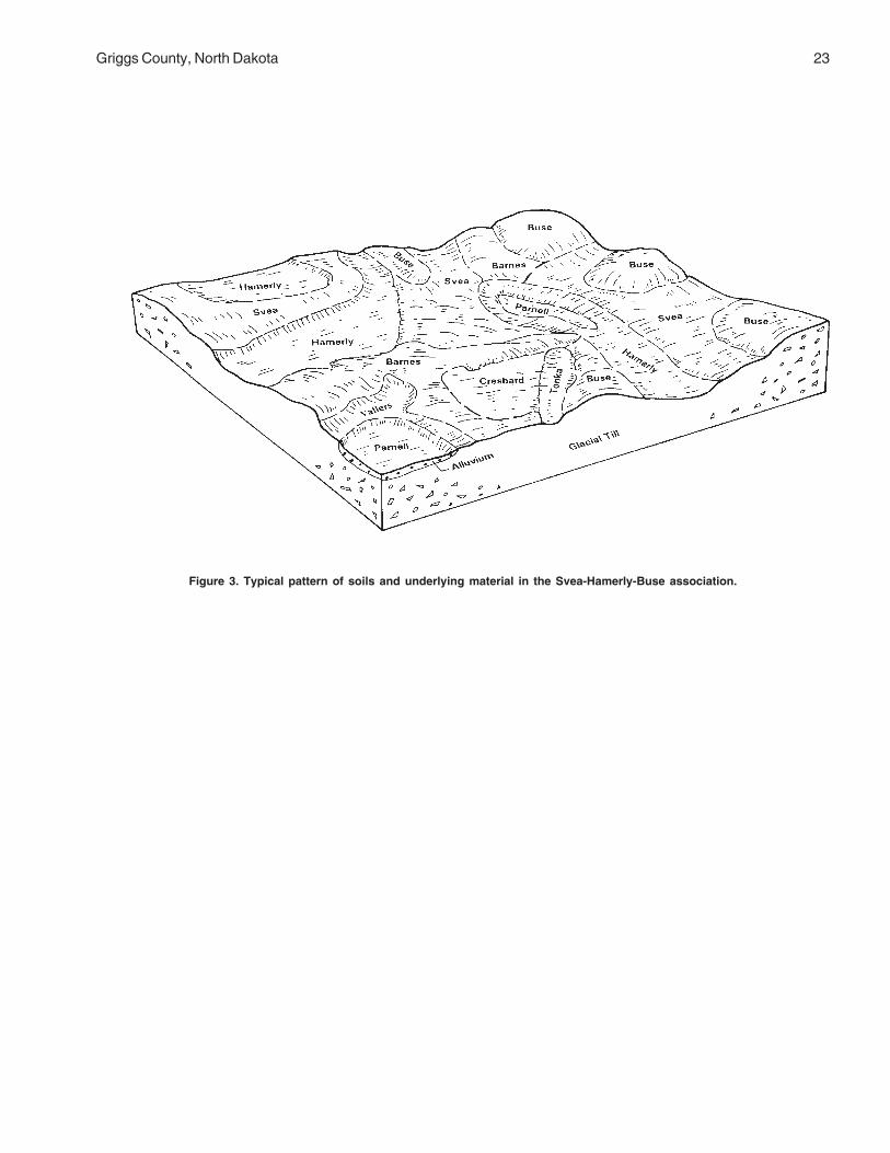
These soil areas are level to gently rolling. Theyconsist of many, irregularly shaped knolls with shortslopes. Poorly drained depressions and a fewprominent marshes are also present. The dominantsoils are on medium textured glacial till (fig. 3). Mostareas of this association are used for cultivated crops.
Svea soils are on lower side slopes, footslopes, andflats. Hamerly soils are on gentle convex positionsadjacent to depressions and on flats. Buse soils are onthe convex crests and summits of knolls and ridges.Vallers soils are on broad, low flats adjacent todepressions and potholes. Cresbard soils are on thegentle, lower slopes or on concave side slopes andfootslopes of knolls and ridges. Parnell and Tonka soils
are in depressions and potholes. The Buse, Hamerly,and Vallers soils have a prominent “high lime” layerwhich is within plow depth in many areas. This light-colored, limy material often is exposed and mixed withdark surface soil by cultivation.
Major Limitations for Agricultural Use
Wind and water erosion are concerns on some soils.Portions of these areas generally have periods ofwetness and ponding in the spring and after heavyrainfall. For additional information concerning thesesoils see “Detailed Map Unit Descriptions” and “ SeriesDescriptions.” For information concerning thelimitations and hazards for agriculture see Table 6.
43—Svea-Hamerly-Buse Association, level to gently rolling
SURFACE SLOPE PERCENTTEXTURE* PERCENT DRAINAGE** COMPOSITION
MAJOR COMPONENTS
Svea L 0-9 MW 30-35Hamerly L 0-3 SP 15-20Buse L 3-9 W 15-20
MINOR COMPONENTS
Vallers L 0-3 P 5-10Cresbard L 0-3 MW 5-10Parnell SICL 0-1 VP 1-5Tonka SIL 0-1 P 1-5
* L,loam; SIL,silt loam; SICL,silty clay loam** VP,very poor; P,poor; SP,somewhat poor; MW,moderately well; W,well
Griggs County, North Dakota 23
Figure 3. Typical pattern of soils and underlying material in the Svea-Hamerly-Buse association.

24 Soil Survey
Description
These soil areas consist of level to gently rollingtopography with knolls, discontinuous ridges, anddepressions. A few prominent marshes are alsopresent. The dominant soils formed in medium texturedglacial till. Nearly all the surface runoff drains intodepressions (fig. 4). Most areas of this association areused for cultivated crops.
Barnes soils are on the gentle, convex side slopesand broad, convex crests of knolls and ridges. Sveasoils are on lower side slopes and flats. Hamerly soilsare on gentle, convex positions adjacent todepressions and on flats. Buse soils are on crests andsummits of knolls and ridges. Parnell and Tonka soilsare in depressions and potholes. Cavour soils are onthe gentle, lower slopes intermingled with the Barnes
and Svea soils. The Hamerly and Buse soils have aprominent “high lime” layer which is within plow depthin many areas. This light-colored, limy material often isexposed and mixed with dark surface soil bycultivation.
Major Limitations for Agricultural Use
Wind and water erosion are concerns on some soils.Portions of these areas have periods of wetness andponding in the spring and after heavy rainfall. Foradditional information concerning these soils see“Detailed Map Unit Descriptions” and “ SeriesDescriptions.” For information concerning thelimitations and hazards for agriculture see Table 6.
46—Barnes-Svea-Hamerly Association, level to gently rolling
SURFACE SLOPE PERCENTTEXTURE* PERCENT DRAINAGE** COMPOSITION
MAJOR COMPONENTS
Barnes L 1-9 W 40-45Svea L 0-6 MW 20-25Hamerly L 0-3 SP 15-20
MINOR COMPONENTS
Buse L 3-9 W 5-10Parnell SICL 0-1 VP 1-5Tonka SIL 0-1 P 1-5Cavour L 0-3 MW 1-5
* L,loam; SIL,silt loam; SICL,silty clay loam** VP,very poor; P,poor; SP,somewhat poor; MW,moderately well; W,well

Griggs County, North Dakota 25
Figure 4. Typical pattern of soils and underlying material in the Barnes-Svea-Hamerly association.

26 Soil Survey
Description
These soil areas are level and undulating. Theyhave many low, irregularly-shaped rises separated byshallow swales and a few depressions. The dominantsoils formed in medium textured glacial till. Most areasof this association are used for cultivated crops.
Svea soils are on lower side slopes and flats.Cresbard soils have root restrictive subsoils and areassociated with the Svea soils. Hamerly soils are ongentle, convex positions adjacent to depressions andon flats. Parnell soils are in depressions and potholes.Buse soils are on convex crests of knolls and ridges.Edgeley and Maddock soils are intermingled with theSvea soils. The Hamerly and Buse soils have a
prominent “high lime” layer which is within plow depthin many areas. This light-colored, limy material oftenis exposed and mixed with dark surface soil bycultivation.
Major Limitations for Agricultural Use
These areas have few limitations for agriculturalpurposes. Wind erosion is a concern on some soils.Portions of these areas have periods of wetness andponding in the spring and after heavy rainfall. Foradditional information concerning these soils see“Detailed Map Unit Descriptions” and “ SeriesDescriptions.” For information concerning thelimitations and hazards for agriculture see Table 6.
51—Svea-Cresbard-Hamerly Association, level and undulating
SURFACE SLOPE PERCENTTEXTURE* PERCENT DRAINAGE** COMPOSITION
MAJOR COMPONENTS
Svea L 0-6 MW 40-45Cresbard L 0-6 MW 30-35Hamerly L 0-3 SP 10-15
MINOR COMPONENTS
Parnell SICL 0-1 VP 1-5Buse L 3-6 W 1-5Edgeley L 3-6 W 1-5Maddock LFS 1-6 W 1-5
* LFS, loamy fine sand; L,loam; SICL,silty clay loam** VP,very poor; SP,somewhat poor; MW,moderately well; W,well

Griggs County, North Dakota 27
Description
These soil areas are level to gently rolling. Theyconsist of many low, irregularly shaped knolls withshort slopes. Numerous swales, rises, ridges, andpoorly drained depressions are also present. Thedominant soils formed in medium textured glacial till.Most areas of this association are used for cultivatedcrops.
Emrick soils are on lower side slopes and flats.Heimdal soils are on side slopes of knolls and rises.Fram soils are on gentle, convex positions adjacent todepressions and on flats. Colvin and Tonka soils are indepressions and potholes. Cathay soils are in slightlyconcave areas associated with the Emrick andHeimdal soils. Stirum soils are on broad flats. The
Fram and Colvin soils have a prominent “high lime”layer which is within plow depth in many areas. Thislight-colored, limy material often is exposed and mixedwith dark surface soil by cultivation.
Major Limitations for Agricultural Use
These areas have few limitations for agriculturalpurposes. Wind erosion is a concern on some soils.Portions of these areas have periods of wetness andponding in the spring and after heavy rainfall. Foradditional information concerning these soils see“Detailed Map Unit Descriptions” and “ SeriesDescriptions.” For information concerning thelimitations and hazards for agriculture see Table 6.
55—Emrick-Heimdal-Fram Association, level to gently rolling
SURFACE SLOPE PERCENTTEXTURE* PERCENT DRAINAGE** COMPOSITION
MAJOR COMPONENTS
Emrick L 0-6 MW 35-40Heimdal L 0-9 W 25-30Fram L 0-3 SP 15-20
MINOR COMPONENTS
Colvin SIL 0-1 P 5-10Tonka SIL 0-1 P 1-5Cathay L 0-3 MW 1-5Stirum FSL 0-3 P 1-5
* FSL, fine sandy loam; L,loam; SIL,silt loam** P,poor; SP,somewhat poor; MW,moderately well; W,well

28 Soil Survey
Description
These soil areas are level and undulating. Theyconsist of many low, irregularly shaped knolls withshort slopes. Numerous swales, rises, and poorlydrained depressions are also present. The dominantsoils formed in medium textured glacial till. Most areasof this association are used for cultivated crops.
Fram soils are on gentle, convex positions adjacentto depressions and on flats. Heimdal soils are on theplane and convex side slopes of knolls and ridges.Emrick soils are on lower side slopes and flats. Tonkasoils are in depressions and potholes. Vallers, salinesoils are on broad low flats adjacent to depressionsand potholes. Esmond soils are on convex summitsand knolls. Binford soils are intermingled with areas of
the Heimdal soils and are underlain with shaly sandand gravel. The Esmond, Fram, and Vallers soils havea prominent “high lime” layer which is within plow depthin many areas. This light-colored, limy material often isexposed and mixed with dark surface soil bycultivation.
Major Limitations for Agricultural Use
These areas generally have periods of wetness andponding in the spring and after heavy rainfall. Winderosion is a concern on some soils. For additionalinformation concerning these soils see “Detailed MapUnit Descriptions” and “ Series Descriptions.” Forinformation concerning the limitations and hazards foragriculture see Table 6.
56—Fram-Heimdal-Emrick Association, level and undulating
SURFAC SLOPE PERCENTEXTURE* PERCENT DRAINAGE** COMPOSITION
MAJOR COMPONENTS
Fram L 0-3 SP 45-50Heimdal L 0-6 W 20-25Emrick L 0-6 MW 10-15
MINOR COMPONENTS
Tonka SIL 0-1 P 1-5Vallers, saline L 0-3 P 1-5Esmond L 6-15 W 1-5Binford FSL 1-6 SE 1-5
* FSL,fine sandy loam; L,loam; SIL,silt loam** P,poor; SP,somewhat poor; MW,moderately well; W,well; SE,somewhat excessive

Griggs County, North Dakota 29
Description
These soil areas are level to steep. They consist ofirregularly shaped knolls and ridges with manyintermingled areas with gentle slopes and swales. Afew prominent depressions are also present. Thedominant soils formed in medium textured glacial till(fig. 5). Steep areas are used for range and the rest ofthe association is mostly used for cultivated crops.
Heimdal soils are on the plane and convex sideslopes of knolls and ridges. Emrick soils are on lowerside slopes and flats. Esmond soils are on the convexcrests and summits of knolls and ridges. Larson soilsare on the gentle lower slopes and flats. Parnell soilsare in depressions and potholes. Binford soils areintermingled throughout the landscape and are
underlain with shaly sand and gravel. Fram soils areon gentle convex positions adjacent to depressionsand on flats. The Esmond and Fram soils have aprominent “high lime” layer which is within plow depthin many areas. This light-colored, limy material often isexposed and mixed with dark surface soil bycultivation.
Major Limitations for Agricultural Use
Water erosion is a concern on these areas. Winderosion is a concern on some soils. For additionalinformation concerning these soils see “Detailed MapUnit Descriptions” and “Series Descriptions.” Forinformation concerning the limitations and hazards foragriculture see Table 6.
57—Heimdal-Emrick-Esmond Association, level to steep
SURFACE SLOPE PERCENTTEXTURE* PERCENT DRAINAGE** COMPOSITION
MAJOR COMPONENTS
Heimdal L 3-25 W 35-40Emrick L 0-6 MW 20-25Esmond L 9-35 W 15-20
MINOR COMPONENTS
Larson L 0-3 MW 5-10Parnell SICL 0-1 VP 5-10Binford SL 0-6 SE 1-5Fram L 0-3 SP 1-5
* SL,sandy loam; L,loam; SICL,silty clay loam** VP,very poor; SP,somewhat poor; MW,moderately well; W,well; SE,somewhat excessive

30 Soil Survey
Figure 5. Typical pattern of soils and underlying material in the Heimdal-Emrick-Esmond association.

Griggs County, North Dakota 31
182—Hamerly-Barnes-Tonka Association, very stony, level and undulating
SURFACE SLOPE PERCENTTEXTURE* PERCENT DRAINAGE** COMPOSITION
MAJOR COMPONENTS
Hamerly L 0-3 SP 45-50Barnes L 0-6 W 30-35Tonka SIL 0-1 P 10-15
MINOR COMPONENTS
Swenoda FSL 0-3 MW 1-5Vallers L 0-1 P 1-5Parnell SICL 0-1 VP 1-5Buse L 15-35 W 1-5
* FSL,fine sandy loam; L,loam; SIL, silt loam; SICL,silty clay loam** VP,very poor; P,poor; SP,somewhat poor; MW,moderately well; W,well
Description
These level and undulating soil areas are very stony.They consist of many low, irregularly shaped rises,numerous swales, and poorly drained depressions. Thedominant soils formed in medium textured glacial tilland fine textured alluvium. Most areas of thisassociation are used for rangeland.
Hamerly soils are on gentle convex positionsadjacent to depressions and on flats. Barnes soils areon the plane and convex side slopes of rises. Tonkaand Parnell soils are in depressions and potholes.
Swenoda soils are on flats. Vallers soils are on broadlow flats adjacent to depressions and potholes. Busesoils occupy steeper prominent knolls in the area.
Major Limitations for Agricultural Use
These areas are very stony. They also have periodsof wetness and ponding in the spring and after heavyrainfall. For additional information concerning thesesoils see “Detailed Map Unit Descriptions” and “ SeriesDescriptions.” For information concerning thelimitations and hazards for agriculture see Table 6.
32 Soil Survey
183—LaDelle-Buse-Barnes-Edgeley Association, level to steep
SURFACE SLOPE PERCENTTEXTURE* PERCENT DRAINAGE** COMPOSITION
MAJOR COMPONENTS
LaDelle SICL 0-6 MW 30-35Buse L 6-35 W 20-25Barnes L 3-15 W 15-20Edgeley L 9-35 W 10-15
MINOR COMPONENTS
Sioux GRL 9-25 E 5-10Rauville SIL 0-1 VP 1-5Nutley SIC 2-15 W 1-5
* GRL,gravelly loam; L,loam; SIL, silt loam; SICL,silty clay loam; SIC,silty clay** VP,very poor; MW,moderately well; W,well; E,excessive
Description
These soil areas consist of level valley flood plainsand the adjacent steep valley side slopes of theSheyenne River Valley (fig. 6). The dominant soils aremedium textured glacial till, alluvium, and residuum.Most areas of this association are used for rangelandand wildlife habitat.
LaDelle and Rauville soils are on flood plains. Buseand Barnes soils are on the upper valley side slopes.Edgeley soils are intermingled with the Barnes soils onplane side slopes and are underlain by shale bedrock.Sioux soils are on remnant terraces on valley side
slopes and are underlain by sand and gravel. Nutleysoils are on the lower side slopes.
Major Limitations for Agricultural Use
Water erosion and steep slopes are concerns onthese areas. The LaDelle and Rauville soils havepotential for flooding. The Edgeley and Sioux soils maybe droughty. For additional information concerningthese soils see “Detailed Map Unit Descriptions” and“Series Descriptions.” For information concerning thelimitations and hazards for agriculture see Table 6.

Griggs County, North Dakota 33
Figure 6. Typical pattern of soils and underlying material in the LaDelle-Buse-Barnes-Edgeley association.
SiouxBarnes
LaDelle
Barnes
LaDelle
Rauville
Barnes
Barnes
BuseNutley
Buse
Edg
eley
Nu
tley
Glaciofluvial Deposits
Glacial TillShale
Alluvium
Glacial Till
Shale


35
Map units on the detailed soil maps represent soilsor miscellaneous areas in the survey area. The mapunit descriptions in this section, along with the soilmaps and interpretive tables, can be used to determinethe suitability and potential of a soil for specific uses.They also can be used to plan the managementneeded for those uses.
A map unit delineation on the detailed soil mapsrepresents an area on the landscape and consists ofone or more soils or miscellaneous areas. The soils ormiscellaneous areas are called map unit components.The map unit descriptions in this section describe thesetting of the map unit or where on the landscapenamed map unit components can be found. Thecomposition, or the proportion, of various soils ormiscellaneous areas of a map unit determine how amap unit is named.
A map unit is identified according to the taxonomicclassification of the dominant soils or miscellaneousareas. Within a taxonomic class there are preciselydefined limits for the properties of the soils. On thelandscape, however, soils and miscellaneous areasare natural phenomena, and they have thecharacteristic variability of all natural phenomena.Thus, the range of some observed properties mayextend beyond the limits defined for a taxonomic class.Areas of soils of a single taxonomic class rarely, ifever, can be mapped without including areas of othertaxonomic classes. Consequently, every map unit ismade up of the soils or miscellaneous areas for whichit is named and some included areas that belong toother taxonomic classes.
Most included soils have properties similar to thoseof the dominant soil or soils in the map unit, and thusthey do not affect use and management. These arecalled similar soils. They may or may not be mentionedin the map unit description. Other included soils andmiscellaneous areas, however, have properties andbehavioral characteristics divergent enough to affectuse or to require different management. These arecalled contrasting or dissimilar soils. They generally arein small areas and could not be mapped separatelybecause of the scale used. Some small areas of
strongly contrasting soils or miscellaneous areas areidentified by a special symbol on the maps. Includedsoils or miscellaneous areas are mentioned in the mapunit descriptions. Soil interpretations in this manuscriptare for named map unit components only.
A few included areas may not have been observed,and consequently they are not mentioned in thedescriptions, especially where the pattern was socomplex that it was impractical to make enoughobservations to identify all the soils and miscellaneousareas on the landscape.
The presence of included areas in a map unit in noway diminishes the usefulness or accuracy of the data.The objective of mapping is not to delineate puretaxonomic classes but rather to separate thelandscape into segments that have similar use andmanagement requirements. The delineation of suchlandscape segments on the map provides sufficientinformation for the development of resource plans, butif intensive use of small areas is planned, onsiteinvestigation is needed to define and locate the soilsand miscellaneous areas.
The map unit descriptions on the following pagesgive a range in composition for the named map unitcomponents and similar soils. They also give theaverage component composition of named, similar, anddissimilar soils.
Soils that have profiles that are almost alike makeup a soil series. Except for minor differences in textureof the surface layer or underlying layers, all the soils ofa series have major horizons that are similar incomposition, thickness, and arrangement.
Soils of one series can differ in texture of thesurface layer or of underlying layers. They also candiffer in slope, stoniness, salinity, wetness, degree oferosion, and other characteristics that affect their use.On the basis of such differences, a soil series isdivided into soil phases. Most of the areas shown onthe detailed soil maps are phases of soil series. Thename of a soil phase commonly indicates a featurethat affects use or management. For example, Heclaloamy fine sand, 0 to 3 percent slopes, is one of thephases of the Hecla series.
Detailed Soil Map Units

36 Soil Survey
A complex consists of two or more soils ormiscellaneous areas in such an intricate pattern or insuch small areas that they cannot be shown separatelyon the maps. The pattern and proportion of the soils ormiscellaneous areas are somewhat similar in all areas.Hamerly-Tonka complex, 0 to 3 percent slopes, is anexample.
An undifferentiated group is made up of two ormore soils that could be mapped individually but aremapped as one unit because similar interpretationscan be made for use and management. The patternand proportion of the soils in the mapped areas arenot uniform. An area can be made up of only oneof the major soils, or it can be made up of all ofthem. Bearden and Colvin silt loams, saline, is anundifferentiated group in this survey area.
This survey includes miscellaneous areas. Suchareas have little or no soil material and support littleor no vegetation. Pits, gravel and sand, is an example.Miscellaneous areas are shown on the soil maps.Some that are too small to be shown are identified byspecial symbols on the soil maps.
The map unit descriptions on the following pagesgive information on each named component.Information such as surface layer texture, depthclass, and drainage class are included. There is alsoinformation concerning the management of the mapunit.
An identifying symbol precedes the map unit namein each map unit description. This symbol is used toidentify delineations on the soil maps.
Table 4, “Acreage and Proportionate Extent ofthe Soils,” gives the acreage and proportionateextent of each map unit in the survey area. Additionalinformation about each named component and mapunit inclusion can be found in “Soil Series and TheirMorphology.” Hydric soils information can be foundin the section “Hydric Soils.” Table 24 “Hydric SoilList” indicates the map unit components with hydricconditions. Other tables give properties of the soilsand the limitations, capabilities, and potentials formany uses. The “Glossary” defines many of theterms used in describing the soils or miscellaneousareas.
61—Arveson fine sandy loam
Setting
These soils occur on plane or concave slopes on flatsand in swales on lake plains.
Map Unit Composition (percent)
Named ComponentsArveson and similar soils: 80 to 95
Average Component CompositionArveson: 63Tiffany: 18Arveson, saline: 5Wyndmere: 5Hamar, poorly drained: 3Rosewood, very poorly drained: 3Manfred: 3
Named Component Description
ArvesonSurface layer texture: Fine sandy loamDepth class: Very deep (more than 60 inches)Drainage class: Poorly drainedSlope: 0 to 1 percentFlooding: NoneWater table: Seasonal
Notes: In places the texture of the Arveson soils belowa depth of 40 inches is gravelly sand.
Detailed soil descriptions for all map unit componentsare included in alphabetical order in the section “SoilSeries and Their Morphology.” Additional informationspecific to this map unit, such as USDA textures,permeability, and soil reaction, is available in the “SoilProperties” section.
Management
Major use: Cropland
For cropland limitations and hazards see Table 6. Forinformation about managing this map unit, see thefollowing sections:
AgronomyEngineeringRangelandRecreationSoil PropertiesWildlife Habitat
118—Barnes-Buse loams, 3 to 6 percentslopes
Setting
Barnes soils occur on plane side slopes on rises. Busesoils occur on convex shoulder slopes and summits onrises. These soils occur on till plains.

Griggs County, North Dakota 37
Map Unit Composition (percent)
Named ComponentsBarnes and similar soils: 45 to 65Buse and similar soils: 25 to 50
Average Component CompositionBarnes: 41Buse: 37Svea: 15Hamerly: 3Parnell: 1Tonka: 1Vallers: 1Langhei: 1
Named Component Description
BarnesSurface layer texture: LoamDepth class: Very deep (more than 60 inches)Drainage class: Well drainedSlope: 3 to 6 percentFlooding: NoneWater table: None
BuseSurface layer texture: LoamDepth class: Very deep (more than 60 inches)Drainage class: Well drainedSlope: 3 to 6 percentFlooding: NoneWater table: None
Notes: Some places are very stony and other placeshave many shale fragments. Some areas have sandand gravel soils on summits. Also included are narrowsteep areas adjacent to drainageways and some gentlyrolling areas.
Detailed soil descriptions for all map unit componentsare included in alphabetical order in the section “SoilSeries and Their Morphology.” Additional informationspecific to this map unit, such as USDA textures,permeability, and soil reaction, is available in the “SoilProperties” section.
Management
Major use: Cropland
For cropland limitations and hazards see Table 6. Forinformation about managing this map unit, see thefollowing sections:
AgronomyEngineeringRangelandRecreationSoil PropertiesWildlife Habitat
120—Barnes-Buse loams, 6 to 9 percentslopes
Setting
Barnes soils occur on plane side slopes on ridges andknolls. Buse soils occur on convex shoulder slopesand summits on ridges and knolls. These soils occuron till plains.
Map Unit Composition (percent)
Named ComponentsBarnes and similar soils: 45 to 65Buse and similar soils: 30 to 50
Average Component Composition,Barnes: 37Buse: 40Svea: 16Brantford: 2Langhei: 2Hamerly: 1Parnell: 1Tonka: 1
Named Component Description
BarnesSurface layer texture: LoamDepth class: Very deep (more than 60 inches)Drainage class: Well drainedSlope: 6 to 9 percentFlooding: NoneWater table: None
BuseSurface layer texture: LoamDepth class: Very deep (more than 60 inches)Drainage class: Well drainedSlope: 6 to 9 percentFlooding: NoneWater table: None
Notes: Some places are very stony and other placeshave many shale fragments. Also included are narrowsteep areas adjacent to drainageways and some rollingareas.
Detailed soil descriptions for all map unit componentsare included in alphabetical order in the section “SoilSeries and Their Morphology.” Additional informationspecific to this map unit, such as USDA textures,permeability, and soil reaction, is available in the “SoilProperties” section.
Management
Major use: Cropland

38 Soil Survey
For cropland limitations and hazards see Table 6. Forinformation about managing this map unit, see thefollowing sections:
AgronomyEngineeringRangelandRecreationSoil PropertiesWildlife Habitat
156—Barnes-Svea loams, 3 to 6 percentslopes
Setting
Barnes soils occur on convex summits on rises. Sveasoils occur on concave footslopes on rises. Thesesoils occur on till plains.
Map Unit Composition (percent)
Named ComponentsBarnes and similar soils: 40 to 65Svea and similar soils: 20 to 45
Average Component CompositionBarnes: 53Svea: 33Buse: 7Hamerly: 3Tonka: 2Parnell: 1Wyard: 1
Named Component Description
BarnesSurface layer texture: LoamDepth class: Very deep (more than 60 inches)Drainage class: Well drainedSlope: 3 to 6 percentFlooding: NoneWater table: None
SveaSurface layer texture: LoamDepth class: Very deep (more than 60 inches)Drainage class: Moderately well drainedSlope: 3 to 6 percentFlooding: NoneWater table: Seasonal
Notes: Some places are very stony and other placeshave many shale fragments. Some areas have sandand gravel soils on summits. Also included are narrowsteep areas adjacent to drainageways and some gentlyrolling areas.
Detailed soil descriptions for all map unit componentsare included in alphabetical order in the section “SoilSeries and Their Morphology.” Additional informationspecific to this map unit, such as USDA textures,permeability, and soil reaction, is available in the “SoilProperties” section.
Management
Major Use: Cropland
For cropland limitations and hazards see Table 6. Forinformation about managing this map unit, see thefollowing sections:
AgronomyEngineeringRangelandRecreationSoil PropertiesWildlife Habitat
167—Bearden silt loam
Setting
These soils occur on plane slopes on flats on lakeplains.
Map Unit Composition (percent)
Named ComponentsBearden and similar soils: 55 to 80
Average Component CompositionBearden: 62Perella: 15Overly: 13Bearden, saline: 5Colvin: 2Wyndmere: 2Enloe: 1
Named Component Description
BeardenSurface layer texture: Silt loamDepth class: Very deep (more than 60 inches)Drainage class: Somewhat poorly drainedSlope: 0 to 1 percentFlooding: NoneWater table: Seasonal
Notes: In places the texture of the substratum of theBearden soils is fine sand or sand and gravel.
Detailed soil descriptions for all map unit componentsare included in alphabetical order in the section “SoilSeries and Their Morphology.” Additional information

Griggs County, North Dakota 39
specific to this map unit, such as USDA textures,permeability, and soil reaction, is available in the “SoilProperties” section.
Management
Major Use: Cropland
For cropland limitations and hazards see Table 6. Forinformation about managing this map unit, see thefollowing sections:
AgronomyEngineeringRangelandRecreationSoil PropertiesWildlife Habitat
296—Brantford loam, 0 to 3 percentslopes
Setting
These soils occur on flats on outwash plains.
Map Unit Composition (percent)
Named ComponentsBrantford and similar soils: 75 to 90
Average Component CompositionBrantford: 76Vang: 12Binford: 5Coe: 4Divide: 1Kensal: 1Renshaw: 1
Named Component Description
BrantfordSurface layer texture: LoamDepth class: Very deep (more than 60 inches)Drainage class: Well drainedSlope: 0 to 3 percentFlooding: NoneWater table: None
Notes: In some places the texture of the surface layerof the Brantford soil is gravelly sandy loam. In someplaces the texture below a depth of 40 inches is loamand a stone line is present. In other areas the surfaceis stony.
Detailed soil descriptions for all map unit componentsare included in alphabetical order in the section “Soil
Series and Their Morphology.” Additional informationspecific to this map unit, such as USDA textures,permeability, and soil reaction, is available in the “SoilProperties” section.
Management
Major Use: Cropland
For cropland limitations and hazards see Table 6. Forinformation about managing this map unit, see thefollowing sections:
AgronomyEngineeringRangelandRecreationSoil PropertiesWildlife Habitat
314—Buse-Barnes loams, 9 to 15 percentslopes
Setting
Buse soils occur on convex shoulder slopes andsummits on ridges and knolls. Barnes soils occur onplane side slopes on ridges and knolls. These soilsoccur on till plains.
Map Unit Composition (percent)
Named ComponentsBuse and similar soils: 40 to 65Barnes and similar soils: 30 to 50
Average Component CompositionBuse: 51Barnes: 24Svea: 17Hamerly: 4Coe: 1Lamoure: 1Maddock: 1Tonka: 1
Named Component Description
BuseSurface layer texture: LoamDepth class: Very deep (more than 60 inches)Drainage class: Well drainedSlope: 9 to 15 percentFlooding: NoneWater table: None

40 Soil Survey
BarnesSurface layer texture: LoamDepth class: Very deep (more than 60 inches)Drainage class: Well drainedSlope: 9 to 15 percentFlooding: NoneWater table: None
Notes: Some places are very stony and other placeshave many shale fragments. Some areas adjacent todrainageways are steeper.
Detailed soil descriptions for all map unit componentsare included in alphabetical order in the section “SoilSeries and Their Morphology.” Additional informationspecific to this map unit, such as USDA textures,permeability, and soil reaction, is available in the “SoilProperties” section.
Management
Major Use: Cropland
For cropland limitations and hazards see Table 6. Forinformation about managing this map unit, see thefollowing sections:
AgronomyEngineeringRangelandRecreationSoil PropertiesWildlife Habitat
319—Buse-Barnes loams, 15 to 35percent slopes
Setting
Buse soils occur on convex shoulder slopes andsummits on ridges and knolls. Barnes soils occur onplane side slopes on ridges and knolls. These soilsoccur on till plains.
Map Unit Composition (percent)
Named ComponentsBuse and similar soils: 40 to 65Barnes and similar soils: 30 to 55
Average Component CompositionBuse: 43Barnes: 24Svea: 18Langhei: 9
Lamoure: 2Vang: 2Coe: 1Maddock: 1
Named Component Description
BuseSurface layer texture: LoamDepth class: Very deep (more than 60 inches)Drainage class: Well drainedSlope: 15 to 35 percentFlooding: NoneWater table: None
BarnesSurface layer texture: LoamDepth class: Very deep (more than 60 inches)Drainage class: Well drainedSlope: 15 to 25 percentFlooding: NoneWater table: None
Notes: Some places are very stony. Other places mayhave many shale fragments. Some areas aremoderately sloping or strongly sloping.
Detailed soil descriptions for all map unit componentsare included in alphabetical order in the section “SoilSeries and Their Morphology.” Additional informationspecific to this map unit, such as USDA textures,permeability, and soil reaction, is available in the “SoilProperties” section.
Management
Major Use: Rangeland or wildlife habitat
For cropland limitations and hazards see Table 6. Forinformation about managing this map unit, see thefollowing sections:
AgronomyEngineeringRangelandRecreationSoil PropertiesWildlife Habitat
391—Cavour-Cresbard loams, 0 to 3percent slopes
Setting
Cavour soils occur on flats. Cresbard soils occur onconvex slopes on rises. These soils occur on till plains.

Griggs County, North Dakota 41
Map Unit Composition (percent)
Named ComponentsCavour and similar soils: 30 to 55Cresbard and similar soils: 25 to 50
Average Component CompositionCavour: 36Cresbard: 37Svea: 11Ferney: 7Hamerly, saline: 4Hamerly: 3Edgeley: 1Tonka: 1
Named Component Description
CavourSurface layer texture: LoamDepth class: Very deep (more than 60 inches)Drainage class: Moderately well drainedSlope: 0 to 3 percentFlooding: NoneWater table: SeasonalSalt affected: Saline within 30 inchesSodium affected: Sodic within 30 inches
CresbardSurface layer texture: LoamDepth class: Very deep (more than 60 inches)Drainage class: Moderately well drainedSlope: 0 to 3 percentFlooding: NoneWater table: SeasonalSodium affected: Sodic within 30 inches
Notes: In some places the substratums of these soilsdo not have redoximorphic features. Some of thesesoils may have many shale fragments.
Detailed soil descriptions for all map unit componentsare included in alphabetical order in the section “SoilSeries and Their Morphology.” Additional informationspecific to this map unit, such as USDA textures,permeability, and soil reaction, is available in the “SoilProperties” section.
Management
Major Use: Cropland
For cropland limitations and hazards see Table 6. Forinformation about managing this map unit, see thefollowing sections:
AgronomyEngineeringRangelandRecreation
Soil PropertiesWildlife Habitat
450—Colvin silt loam
Setting
These soils occur on plane slopes on flats on lakeplains.
Map Unit Composition (percent)
Named ComponentsColvin and similar soils: 75 to 95
Average Component CompositionColvin: 81Perella: 7Marysland: 3Colvin, very poorly drained: 3Bearden: 2Fram: 2Wyndmere: 2
Named Component Description
ColvinSurface layer texture: Silt loamDepth class: Very deep (more than 60 inches)Drainage class: Poorly drainedSlope: 0 to 1 percentFlooding: NoneWater table: Seasonal
Notes: In places this soil is very poorly drained andmay be saline.
Detailed soil descriptions for all map unit componentsare included in alphabetical order in the section “SoilSeries and Their Morphology.” Additional informationspecific to this map unit, such as USDA textures,permeability, and soil reaction, is available in the “SoilProperties” section.
Management
Major Use: Hay, pasture, range, or wetland wildlifehabitat
For cropland limitations and hazards see Table 6. Forinformation about managing this map unit, see thefollowing sections:
AgronomyEngineeringRangelandRecreationSoil PropertiesWildlife Habitat

42 Soil Survey
511—Divide loam, 0 to 3 percent slopes
Setting
These soils occur on flats on outwash plains.
Map Unit Composition (percent)
Named ComponentsDivide and similar soils: 80 to 95
Average Component CompositionDivide: 74Wyrene: 14Marysland: 5Hamerly: 3Wyard: 2Fram: 1Hamar: 1
Named Component DescriptionDivide
Surface layer texture: LoamDepth class: Very deep (more than 60 inches)Drainage class: Somewhat poorly drainedSlope: 0 to 3 percentFlooding: NoneWater table: Seasonal
Notes: In places the depth to sand and gravel in theDivide soil may be less than 20 inches. In other placesthe depth to accumulated lime is more than 16 inches.Some areas may be saline.
Detailed soil descriptions for all map unit componentsare included in alphabetical order in the section “SoilSeries and Their Morphology.” Additional informationspecific to this map unit, such as USDA textures,permeability, and soil reaction, is available in the “SoilProperties” section.
Management
Major Use: Cropland
For cropland limitations and hazards see Table 6. Forinformation about managing this map unit, see thefollowing sections:
AgronomyEngineeringRangelandRecreationSoil PropertiesWildlife Habitat
536—Eckman-Zell silt loams, 6 to 9percent slopes
Setting
Eckman soils occur on plane side slopes on ridges andknolls. Zell soils occur on convex shoulder slopes andsummits on ridges and knolls. These soils occur onlake plains.
Map Unit Composition (percent)
Named ComponentsEckman and similar soils: 40 to 65Zell and similar soils: 30 to 55
Average Component CompositionEckman: 29Zell: 44Gardena: 18Overly: 4Coe: 2Bearden: 1Colvin: 1Maddock: 1
Named Component Description
EckmanSurface layer texture: Silt loamDepth class: Very deep (more than 60 inches)Drainage class: Well drainedSlope: 6 to 9 percentFlooding: NoneWater table: None
ZellSurface layer texture: Silt loamDepth class: Very deep (more than 60 inches)Drainage class: Well drainedSlope: 6 to 9 percentFlooding: NoneWater table: None
Notes: In places the texture of these soils below adepth of 40 inches is sandy. In other places the slopesare steeper.
Detailed soil descriptions for all map unit componentsare included in alphabetical order in the section “SoilSeries and Their Morphology.” Additional informationspecific to this map unit, such as USDA textures,permeability, and soil reaction, is available in the “SoilProperties” section.

Griggs County, North Dakota 43
Management
Major Use: Cropland
For cropland limitations and hazards see Table 6. Forinformation about managing this map unit, see thefollowing sections:
AgronomyEngineeringRangelandRecreationSoil PropertiesWildlife Habitat
539—Edgeley loam, 0 to 3 percent slopes
Setting
These soils occur on flats on till plains.
Map Unit Composition (percent)
Named ComponentsEdgeley and similar soils: 70 to 90
Average Component CompositionEdgeley: 83Walsh: 6Barnes: 3Cresbard: 3Kloten: 2Hamerly, saline: 2Svea: 1
Named Component Description
EdgeleySurface layer texture: LoamDepth class: Moderately deep (20 to 40 inches)Drainage class: Well drainedSlope: 0 to 3 percentFlooding: NoneWater table: None
Notes: In places the depth to bedrock in the Edgeleysoil is greater than 40 inches.
Detailed soil descriptions for all map unit componentsare included in alphabetical order in the section “SoilSeries and Their Morphology.” Additional informationspecific to this map unit, such as USDA textures,permeability, and soil reaction, is available in the “SoilProperties” section.
Management
Major Use: Cropland
For cropland limitations and hazards see Table 6. Forinformation about managing this map unit, see thefollowing sections:
AgronomyEngineeringRangelandRecreationSoil PropertiesWildlife Habitat
541—Edgeley loam, 3 to 6 percent slopes
Setting
These soils occur on convex slopes on rises on tillplains.
Map Unit Composition (percent)
Named ComponentsEdgeley and similar soils: 80 to 95
Average Component CompositionEdgeley: 84Kloten: 8Svea: 2Walsh: 2Brantford: 2Vang: 1Cresbard: 1
Named Component Description
EdgeleySurface layer texture: LoamDepth class: Moderately deep (20 to 40 inches)Drainage class: Well drainedSlope: 3 to 6 percentFlooding: NoneWater table: None
Notes: In places the depth to bedrock in the Edgeleysoils is greater than 40 inches.
Detailed soil descriptions for all map unit componentsare included in alphabetical order in the section “SoilSeries and Their Morphology.” Additional informationspecific to this map unit, such as USDA textures,permeability, and soil reaction, is available in the “SoilProperties” section.
Management
Major Use: Cropland

44 Soil Survey
For cropland limitations and hazards see Table 6. Forinformation about managing this map unit, see thefollowing sections:
AgronomyEngineeringRangelandRecreationSoil PropertiesWildlife Habitat
569—Embden fine sandy loam
Setting
These soils occur on flats on lake plains.
Map Unit Composition (percent)
Named ComponentsEmbden and similar soils: 75 to 95
Average Component CompositionEmbden: 69Embden, gravelly substratum: 15Maddock: 5Egeland: 4Tiffany: 3Wyndmere: 2Perella: 2
Named Component Description
EmbdenSurface layer texture: Fine sandy loamDepth class: Very deep (more than 60 inches)Drainage class: Moderately well drainedSlope: 0 to 1 percentFlooding: NoneWater table: Seasonal
Notes: In some places the surface texture of theEmbden soils is loam. In places the substratum of theEmbden soils below a depth of 40 inches is loam, siltloam, or silty clay loam.
Detailed soil descriptions for all map unit componentsare included in alphabetical order in the section “SoilSeries and Their Morphology.” Additional informationspecific to this map unit, such as USDA textures,permeability, and soil reaction, is available in the “SoilProperties” section.
Management
Major Use: Cropland
For cropland limitations and hazards see Table 6. Forinformation about managing this map unit, see thefollowing sections:
AgronomyEngineeringRangelandRecreationSoil PropertiesWildlife Habitat
579—Embden-Egeland fine sandy loams,1 to 6 percent slopes
Setting
Embden soils occur on flats. Egeland soils occur onconvex slopes on rises. These soils occur on lakeplains.
Map Unit Composition (percent)
Named ComponentsEmbden and similar soils: 45 to 70Egeland and similar soils: 20 to 45
Average Component CompositionEmbden: 58Egeland: 29Divide: 4Binford: 3Zell: 3Wyndmere: 1Glyndon: 1Tiffany: 1
Named Component Description
EmbdenSurface layer texture: Fine sandy loamDepth class: Very deep (more than 60 inches)Drainage class: Moderately well drainedSlope: 1 to 6 percentFlooding: NoneWater table: Seasonal
EgelandSurface layer texture: Fine sandy loamDepth class: Very deep (more than 60 inches)Drainage class: Well drainedSlope: 1 to 6 percentFlooding: NoneWater table: None

Griggs County, North Dakota 45
Notes: In some places the surface texture of thesesoils is loam. In places the texture below a depth of 40inches is loam, silt loam, or silty clay loam.
Detailed soil descriptions for all map unit componentsare included in alphabetical order in the section “SoilSeries and Their Morphology.” Additional informationspecific to this map unit, such as USDA textures,permeability, and soil reaction, is available in the “SoilProperties” section.
Management
Major Use: Cropland
For cropland limitations and hazards see Table 6. Forinformation about managing this map unit, see thefollowing:
AgronomyEngineeringRangelandRecreationSoil PropertiesWildlife Habitat
595—Emrick-Cathay loams, 0 to 3 percentslopes
Setting
Emrick soils occur on convex slopes on rises. Cathaysoils occur on flats. These soils occur on till plains.
Map Unit Composition (percent)
Named ComponentsEmrick and similar soils: 50 to 75Cathay and similar soils: 20 to 40
Average Component CompositionEmrick: 49Cathay: 28Heimdal: 11Larson: 7Towner : 2Esmond: 1Fram: 1Tonka: 1
Named Component Description
EmrickSurface layer texture: LoamDepth class: Very deep (more than 60 inches)Drainage class: Moderately well drainedSlope: 0 to 3 percentFlooding: None
Water table: SeasonalCathay
Surface layer texture: LoamDepth class: Very deep (more than 60 inches)Drainage class: Moderately well drainedSlope: 0 to 3 percentFlooding: NoneWater table: SeasonalSodium affected: Sodic within 30 inches
Notes: Some soils have many shale fragmentsthroughout the profile. In some areas the texture of theEmrick and Cathay soils below a depth of 40 inches issandy. In other places the substratum does not haveredoximorphic features.
Detailed soil descriptions for all map unit componentsare included in alphabetical order in the section “SoilSeries and Their Morphology.” Additional informationspecific to this map unit, such as USDA textures,permeability, and soil reaction, is available in the “SoilProperties” section.
Management
Major Use: Cropland
For cropland limitations and hazards see Table 6. Forinformation about managing this map unit, see thefollowing sections:
AgronomyEngineeringRangelandRecreationSoil PropertiesWildlife Habitat
597—Emrick-Heimdal loams, 0 to 3percent slopes
Setting
Emrick soils occur on flats. Heimdal soils occur onconvex slopes on rises. These soils occur on till plains.
Map Unit Composition (percent)
Named ComponentsEmrick and similar soils: 35 to 60Heimdal and similar soils: 30 to 55
Average Component CompositionEmrick: 48Heimdal: 40Fram: 4

46 Soil Survey
Wyard: 3Esmond: 2Tonka: 1Tiffany: 1Lanona: 1
Named Component Description
EmrickSurface layer texture: LoamDepth class: Very deep (more than 60 inches)Drainage class: Moderately well drainedSlope: 0 to 3 percentFlooding: NoneWater table: Seasonal
HeimdalSurface layer texture: LoamDepth class: Very deep (more than 60 inches)Drainage class: Well drainedSlope: 0 to 3 percentFlooding: NoneWater table: None
Notes: In some places the texture of the Emrick andHeimdal soils below a depth of 40 inches is sandy.
Detailed soil descriptions for all map unit componentsare included in alphabetical order in the section “SoilSeries and Their Morphology.” Additional informationspecific to this map unit, such as USDA textures,permeability, and soil reaction, is available in the “SoilProperties” section.
Management
Major Use: Cropland
For cropland limitations and hazards see Table 6. Forinformation about managing this map unit, see thefollowing sections:
AgronomyEngineeringRangelandRecreationSoil PropertiesWildlife Habitat
605—Esmond-Heimdal loams, 9 to 15percent slopes
Setting
Esmond soils occur on convex shoulder slopes andsummits on ridges and knolls. Heimdal soils occur onplane side slopes on ridges and knolls. These soilsoccur on till plains.
Map Unit Composition (percent)
Named ComponentsEsmond and similar soils: 35 to 60Heimdal and similar soils: 30 to 55
Average Component CompositionEsmond: 46Heimdal: 28Emrick: 15Binford: 4Coe: 4Maddock: 1Tonka: 1Wyard: 1
Named Component Description
EsmondSurface layer texture: LoamDepth class: Very deep (more than 60 inches)Drainage class: Well drainedSlope: 9 to 15 percentFlooding: NoneWater table: None
HeimdalSurface layer texture: LoamDepth class: Very deep (more than 60 inches)Drainage class: Well drainedSlope: 9 to 15 percentFlooding: NoneWater table: None
Notes: Some places are very stony. In other areas theslopes may be steeper.
Detailed soil descriptions for all map unit componentsare included in alphabetical order in the section “SoilSeries and Their Morphology.” Additional informationspecific to this map unit, such as USDA textures,permeability, and soil reaction, is available in the “SoilProperties” section.
Management
Major Use: Cropland
For cropland limitations and hazards see Table 6. Forinformation about managing this map unit, see thefollowing sections:
AgronomyEngineeringRangelandRecreationSoil PropertiesWildlife Habitat

Griggs County, North Dakota 47
753—Fram-Wyard loams, 0 to 3 percentslopes
Setting
Fram soils occur on flats. Wyard soils occur onconcave slopes in swales. These soils occur on tillplains.
Map Unit Composition (percent)
Named ComponentsFram and similar soils: 60 to 80Wyard and similar soils: 10 to 30
Average Component CompositionFram: 70Wyard: 20Tonka: 3Emrick: 2Divide: 2Heimdal: 1Wyndmere, saline: 1Vallers: 1
Named Component Description
FramSurface layer texture: LoamDepth class: Very deep (more than 60 inches)Drainage class: Somewhat poorly drainedSlope: 0 to 3 percentFlooding: NoneWater table: Seasonal
WyardSurface layer texture: LoamDepth class: Very deep (more than 60 inches)Drainage class: Somewhat poorly drainedSlope: 0 to 1 percentFlooding: NoneWater table: Seasonal
Detailed soil descriptions for all map unit componentsare included in alphabetical order in the section “SoilSeries and Their Morphology.” Additional informationspecific to this map unit, such as USDA textures,permeability, and soil reaction, is available in the “SoilProperties” section.
Management
Major Use: Cropland
For cropland limitations and hazards see Table 6. Forinformation about managing this map unit, see thefollowing sections:
Agronomy
EngineeringRangelandRecreationSoil PropertiesWildlife Habitat
769—Gardena silt loam, 0 to 3 percentslopes
Setting
These soils occur on flats on lake plains.
Map Unit Composition (percent)
Named ComponentsGardena and similar soils: 75 to 90
Average Component CompositionGardena: 56Overly: 25Eckman: 11Glyndon: 3Bearden: 2Lindaas: 2Zell: 1
Named Component Description
GardenaSurface layer texture: Silt loamDepth class: Very deep (more than 60 inches)Drainage class: Moderately well drainedSlope: 0 to 3 percentFlooding: NoneWater table: Seasonal
Notes: In places the Gardena soil is saline. In otherplaces the texture of the substratum is fine sand orcoarser.
Detailed soil descriptions for all map unit componentsare included in alphabetical order in the section “SoilSeries and Their Morphology.” Additional informationspecific to this map unit, such as USDA textures,permeability, and soil reaction, is available in the “SoilProperties” section.
Management
Major Use: Cropland
For cropland limitations and hazards see Table 6. Forinformation about managing this map unit, see thefollowing sections:
AgronomyEngineering

48 Soil Survey
RangelandRecreationSoil PropertiesWildlife Habitat
773—Gardena-Eckman silt loams, 3 to 6percent slopes
Setting
Gardena soils occur on plane or concave side slopesand footslopes on rises. Eckman soils occur onconvex summits on rises. These soils occur on lakeplains.
Map Unit Composition (percent)
Named ComponentsGardena and similar soils: 30 to 55Eckman and similar soils: 25 to 50
Average Component CompositionGardena: 35Eckman: 28Great Bend: 12Overly: 9Bearden: 7Zell: 7Colvin: 1Lankin: 1
Named Component Description
GardenaSurface layer texture: Silt loamDepth class: Very deep (more than 60 inches)Drainage class: Moderately well drainedSlope: 3 to 6 percentFlooding: NoneWater table: Seasonal
EckmanSurface layer texture: Silt loamDepth class: Very deep (more than 60 inches)Drainage class: Well drainedSlope: 3 to 6 percentFlooding: NoneWater table: None
Notes: In places the texture of the substratum of thesesoils is fine sand or coarser.
Detailed soil descriptions for all map unit componentsare included in alphabetical order in the section “SoilSeries and Their Morphology.” Additional information
specific to this map unit, such as USDA textures,permeability, and soil reaction, is available in the “SoilProperties” section.
Management
Major Use: Cropland
For cropland limitations and hazards see Table 6. Forinformation about managing this map unit, see thefollowing sections:
AgronomyEngineeringRangelandRecreationSoil PropertiesWildlife Habitat
881—Hamerly-Tonka complex, 0 to 3percent slopes
Setting
Hamerly soils occur on flats. Tonka soils occur onconcave slopes in depressions. These soils occur ontill plains.
Map Unit Composition (percent)
Named ComponentsHamerly and similar soils: 40 to 60Tonka and similar soils: 25 to 50
Average Component CompositionHamerly: 44Tonka: 37Wyard: 9Vallers: 4Parnell: 3Cresbard: 1Hamerly, saline: 1Svea: 1
Named Component Description
HamerlySurface layer texture: LoamDepth class: Very deep (more than 60 inches)Drainage class: Somewhat poorly drainedSlope: 0 to 3 percentFlooding: NoneWater table: Seasonal

Griggs County, North Dakota 49
TonkaSurface layer texture: Silt loamDepth class: Very deep (more than 60 inches)Drainage class: Poorly drainedSlope: 0 to 1 percentFlooding: NoneWater table: SeasonalPonding: Very long
Notes: Some areas are undulating. Other areas may bevery stony. In some places the substratums are sandand gravel.
Detailed soil descriptions for all map unit componentsare included in alphabetical order in the section “SoilSeries and Their Morphology.” Additional informationspecific to this map unit, such as USDA textures,permeability, and soil reaction, is available in the “SoilProperties” section.
Management
Major Use: Cropland
For cropland limitations and hazards see Table 6. Forinformation about managing this map unit, see thefollowing sections:
AgronomyEngineeringRangelandRecreationSoil PropertiesWildlife Habitat
884—Hamerly-Wyard loams, 0 to 3 percentslopes
Setting
Hamerly soils occur on flats. Wyard soils occur onconcave slopes in swales. These soils occur on tillplains.
Map Unit Composition (percent)
Named ComponentsHamerly and similar soils: 40 to 65Wyard and similar soils: 20 to 45
Average Component CompositionHamerly: 52Wyard: 33Tonka: 7Vallers: 3Divide: 2
Barnes: 1Hamerly, saline: 1Fram: 1
Named Component Description
HamerlySurface layer texture: LoamDepth class: Very deep (more than 60 inches)Drainage class: Somewhat poorly drainedSlope: 0 to 3 percentFlooding: NoneWater table: Seasonal
WyardSurface layer texture: LoamDepth class: Very deep (more than 60 inches)Drainage class: Somewhat poorly drainedSlope: 0 to 1 percentFlooding: NoneWater table: Seasonal
Notes: Some areas are undulating.
Detailed soil descriptions for all map unit componentsare included in alphabetical order in the section “SoilSeries and Their Morphology.” Additional informationspecific to this map unit, such as USDA textures,permeability, and soil reaction, is available in the “SoilProperties” section.
Management
Major Use: Cropland
For cropland limitations and hazards see Table 6. Forinformation about managing this map unit, see thefollowing sections:
AgronomyEngineeringRangelandRecreationSoil PropertiesWildlife Habitat
893—Harriet silt loam
Setting
These soils occur on plane or concave slopes indrainageways on till plains.
Map Unit Composition (percent)
Named ComponentsHarriet and similar soils: 85 to 95
50 Soil Survey
Average Component CompositionHarriet: 52Manfred: 21Colvin, saline: 15Stirum: 5Ojata: 4Colvin, very poorly drained: 2Bearden: 1
Named Component Description
HarrietSurface layer texture: Silt loamDepth class: Very deep (more than 60 inches)Drainage class: Poorly drainedSlope: 0 to 1 percentFlooding: OccasionalWater table: SeasonalSalt affected: Saline within 30 inchesSodium affected: Sodic within 30 inches
Notes: In places the accumulated lime in the Harrietsoils is below a depth of 16 inches. Some places areunderlain by shale.
Detailed soil descriptions for all map unit componentsare included in alphabetical order in the section “SoilSeries and Their Morphology.” Additional informationspecific to this map unit, such as USDA textures,permeability, and soil reaction, is available in the “SoilProperties” section.
Management
Major Use: Hay, pasture, range, or wetland wildlifehabitat
For cropland limitations and hazards see Table 6. Forinformation about managing this map unit, see thefollowing sections:
AgronomyEngineeringRangelandRecreationSoil PropertiesWildlife Habitat
988—Heimdal-Emrick loams, 3 to 6percent slopes
Setting
Heimdal soils occur on convex summits on rises.Emrick soils occur on concave footslopes on rises.These slopes occur on till plains.
Map Unit Composition (percent)
Named ComponentsHeimdal and similar soils: 45 to 70Emrick and similar soils: 15 to 40
Average Component CompositionHeimdal: 58Emrick: 28Esmond: 7Coe: 2Fram: 2Binford: 1Cathay: 1Wyard: 1
Named Component Description
HeimdalSurface layer texture: LoamDepth class: Very deep (more than 60 inches)Drainage class: Well drainedSlope: 3 to 6 percentFlooding: NoneWater table: None
EmrickSurface layer texture: LoamDepth class: Very deep (more than 60 inches)Drainage class: Moderately well drainedSlope: 3 to 6 percentFlooding: NoneWater table: None
Notes: Some places are very stony. In other areas theslopes are steeper.
Detailed soil descriptions for all map unit componentsare included in alphabetical order in the section “SoilSeries and Their Morphology.” Additional informationspecific to this map unit, such as USDA textures,permeability, and soil reaction, is available in the “SoilProperties” section.
Management
Major Use: Cropland
For cropland limitations and hazards see Table 6. Forinformation about managing this map unit, see thefollowing sections:
AgronomyEngineeringRangelandRecreationSoil PropertiesWildlife Habitat
Griggs County, North Dakota 51
998—Heimdal-Esmond loams, 6 to 9percent slopes
Setting
Heimdal soils occur on plane side slopes on ridges andknolls. Esmond soils occur on convex shoulder slopesand summits on ridges and knolls. These soils occuron till plains.
Map Unit Composition (percent)
Named ComponentsHeimdal and similar soils: 40 to 65Esmond and similar soils: 20 to 45
Average Component CompositionHeimdal: 38Esmond: 32Emrick: 18Maddock: 5Binford: 3Coe: 2Fram: 1Vallers: 1
Named Component Description
HeimdalSurface layer texture: LoamDepth class: Very deep (more than 60 inches)Drainage class: Well drainedSlope: 6 to 9 percentFlooding: NoneWater table: None
EsmondSurface layer texture: LoamDepth class: Very deep (more than 60 inches)Drainage class: Well drainedSlope: 6 to 9 percentFlooding: NoneWater table: None
Notes: Some places are very stony. In other areas theslopes are steeper.
Detailed soil descriptions for all map unit componentsare included in alphabetical order in the section “SoilSeries and Their Morphology.” Additional informationspecific to this map unit, such as USDA textures,permeability, and soil reaction, is available in the “SoilProperties” section.
Management
Major Use: Cropland
For cropland limitations and hazards see Table 6. Forinformation about managing this map unit, see thefollowing sections:
AgronomyEngineeringRangelandRecreationSoil PropertiesWildlife Habitat
1001—Heimdal-Esmond loams, 15 to 35percent slopes
Setting
Heimdal soils occur on plane side slopes on ridges andknolls. Esmond soils occur on convex shoulder slopesand summits on ridges and knolls. These soils occuron till plains.
Map Unit Composition (percent)
Named ComponentsHeimdal and similar soils: 40 to 65Esmond and similar soils: 25 to 45
Average Component CompositionHeimdal: 31Esmond: 33Emrick: 25Sioux: 5Maddock: 3Binford: 1Coe: 1Dickey: 1
Named Component Description
HeimdalSurface layer texture: LoamDepth class: Very deep (more than 60 inches)Drainage class: Well drainedSlope: 15 to 25 percentFlooding: NoneWater table: None
EsmondSurface layer texture: LoamDepth class: Very deep (more than 60 inches)Drainage class: Well drainedSlope: 15 to 35 percentFlooding: NoneWater table: None

52 Soil Survey
Notes: Some places are very stony. Other areas maybe moderately sloping or strongly sloping.
Detailed soil descriptions for all map unit componentsare included in alphabetical order in the section “SoilSeries and Their Morphology.” Additional informationspecific to this map unit, such as USDA textures,permeability, and soil reaction, is available in the “SoilProperties” section.
Management
Major Use: Rangeland or wildlife habitat
For cropland limitations and hazards see Table 6. Forinformation about managing this map unit, see thefollowing sections:
AgronomyEngineeringRangelandRecreationSoil PropertiesWildlife Habitat
1015—Kensal loam
Setting
These soils occur on flats on outwash plains.
Map Unit Composition (percent)
Named ComponentsKensal and similar soils: 80 to 95
Average Component CompositionKensal: 79Walum: 8Overly: 5Binford: 4Gardena: 2Coe: 1Divide: 1
Named Component Description
KensalSurface layer texture: LoamDepth class: Very deep (more than 60 inches)Drainage class: Moderately well drainedSlope: 0 to 1 percentFlooding: NoneWater table: Seasonal
Detailed soil descriptions for all map unit componentsare included in alphabetical order in the section “Soil
Series and Their Morphology.” Additional informationspecific to this map unit, such as USDA textures,permeability, and soil reaction, is available in the “SoilProperties” section.
Management
Major Use: Cropland
For cropland limitations and hazards see Table 6. Forinformation about managing this map unit, see thefollowing sections:
AgronomyEngineeringRangelandRecreationSoil PropertiesWildlife Habitat
1062—LaDelle silty clay loam, 0 to 3percent slopes
Setting
These soils occur on flats on flood plains.
Map Unit Composition (percent)
Named ComponentsLaDelle and similar soils: 65 to 85
Average Component CompositionLaDelle: 67Wahpeton: 15LaPrairie: 7Ludden: 4Rauville: 4Velva: 2Lamoure: 1
Named Component Description
LaDelleSurface layer texture: Silty clay loamDepth class: Very deep (more than 60 inches)Drainage class: Moderately well drainedSlope: 0 to 3 percentFlooding: OccasionalWater table: Seasonal
Detailed soil descriptions for all map unit componentsare included in alphabetical order in the section “SoilSeries and Their Morphology.” Additional informationspecific to this map unit, such as USDA textures,permeability, and soil reaction, is available in the “SoilProperties” section.

Griggs County, North Dakota 53
Management
Major Use: Cropland
For cropland limitations and hazards see Table 6. Forinformation about managing this map unit, see thefollowing sections:
AgronomyEngineeringRangelandRecreationSoil PropertiesWildlife Habitat
1108—Larson-Cathay loams, 0 to 3percent slopes
Setting
Larson soils occur on flats. Cathay soils occur onplane or convex slopes on rises. These soils occur ontill plains.
Map Unit Composition (percent)
Named ComponentsLarson and similar soils: 30 to 55Cathay and similar soils: 25 to 50
Average Component CompositionLarson: 42Cathay: 32Fram: 8Emrick: 7Tonka: 4Ferney: 4Fram, saline: 2Esmond: 1
Named Component Description
LarsonSurface layer texture: LoamDepth class: Very deep (more than 60 inches)Drainage class: Moderately well drainedSlope: 0 to 3 percentFlooding: NoneWater table: SeasonalSalt affected: Saline within 30 inchesSodium affected: Sodic within 30 inches
CathaySurface layer texture: LoamDepth class: Very deep (more than 60 inches)Drainage class: Moderately well drainedSlope: 0 to 3 percent
Flooding: NoneWater table: SeasonalSodium affected: Sodic within 30 inches
Notes: Some places have many shale fragments. Inother areas the texture of the Larson and Cathay soilsbelow a depth of 40 inches is sandy. In some areas thesubstratums do not have redoximorphic features.
Detailed soil descriptions for all map unit componentsare included in alphabetical order in the section “SoilSeries and Their Morphology.” Additional informationspecific to this map unit, such as USDA textures,permeability, and soil reaction, is available in the “SoilProperties” section.
Management
Major Use: Cropland
For cropland limitations and hazards see Table 6. Forinformation about managing this map unit, see thefollowing sections:
AgronomyEngineeringRangelandRecreationSoil PropertiesWildlife Habitat
1188—Ludden silty clay
Setting
These soils occur on flats on flood plains.
Map Unit Composition (percent)
Named ComponentsLudden and similar soils: 80 to 95
Average Component CompositionLudden: 87Ludden, saline: 6LaDelle: 4Rauville: 2Lamoure: 1
Named Component Description
LuddenSurface layer texture: Silty clayDepth class: Very deep (more than 60 inches)Drainage class: Poorly drainedSlope: 0 to 1 percentFlooding: OccasionalWater table: Seasonal

54 Soil Survey
Detailed soil descriptions for all map unit componentsare included in alphabetical order in the section “SoilSeries and Their Morphology.” Additional informationspecific to the map unit, such as USDA textures,permeability, and soil reaction, is available in the “SoilProperties” section.
Management
Major Use: Cropland
For cropland limitations and hazards see Table 6. Forinformation about managing this map unit, see thefollowing sections:
AgronomyEngineeringRangelandRecreationSoil PropertiesWildlife Habitat
1189—Ludden silty clay, saline
Setting
These soils occur on flats on flood plains.
Map Unit Composition (percent)
Named ComponentsLudden and similar soils: 70 to 85
Average Component CompositionLudden: 64Ludden, nonsaline: 22Ryan: 11LaDelle: 1Lamoure: 1Rauville: 1
Named Component Description
Surface layer texture: Silty clayDepth class: Very deep (more than 60 inches)Drainage class: Poorly drainedSlope: 0 to 1 percentFlooding: OccasionalWater table: SeasonalSalt affected: Saline within 30 inches
Detailed soil descriptions for all map unit componentsare included in alphabetical order in the section “SoilSeries and Their Morphology.” Additional informationspecific to this map unit, such as USDA textures,permeability, and soil reaction, is available in the “SoilProperties” section.
Management
Major Use: Hay, pasture, range, or wetland wildlifehabitat
For cropland limitations and hazards see Table 6. Forinformation about managing this map unit, see thefollowing sections:
AgronomyEngineeringRangelandRecreationSoil PropertiesWildlife Habitat
1221—Maddock-Hecla loamy fine sands, 1to 6 percent slopes
Setting
Maddock soils occur on plane or convex slopes onrises. Hecla soils occur on flats. These soils occur onoutwash plains.
Map Unit Composition (percent)
Named ComponentsMaddock and similar soils: 50 to 70Hecla and similar soils: 20 to 40
Average Component CompositionMaddock: 47Hecla: 25Serden: 11Towner: 4Maddock, fine sandy loam: 4Coe: 3Esmond: 3Dickey: 3
Named Component Description
MaddockSurface layer texture: Loamy fine sandDepth class: Very deep (more than 60 inches)Drainage class: Well drainedSlope: 1 to 6 percentFlooding: NoneWater table: None
HeclaSurface layer texture: Loamy fine sandDepth class: Very deep (more than 60 inches)Drainage class: Moderately well drainedSlope: 1 to 3 percentFlooding: NoneWater table: Seasonal

Griggs County, North Dakota 55
Notes: In places the texture of the Maddock and Heclasoils is coarse sand throughout.
Detailed soil descriptions for all map unit componentsare included in alphabetical order in the section “SoilSeries and Their Morphology.” Additional informationspecific to this map unit, such as USDA textures,permeability, and soil reaction, is available in the “SoilProperties” section.
Management
Major Use: Cropland
For cropland limitations and hazards see Table 6. Forinformation about managing this map unit, see thefollowing sections:
AgronomyEngineeringRangelandRecreationSoil PropertiesWildlife Habitat
1267—Marysland loam
Setting
These soils occur on flats on outwash plains.
Map Unit Composition (percent)
Named ComponentsMarysland and similar soils: 80 to 95
Average Component CompositionMarysland: 86Marysland, saline, very poorly drained: 4Colvin: 3Vallers: 3Divide: 3Wyrene: 1
Named Component Description
MaryslandSurface layer texture: LoamDepth class: Very deep (more than 60 inches)Drainage class: Poorly drainedSlope: 0 to 1 percentFlooding: NoneWater table: Seasonal
Notes: In places the accumulated lime in theMarysland soils is below a depth of 16 inches. In otherplaces the depth to sand and gravel is less than 20inches. Some areas may be stony.
Detailed soil descriptions for all map unit componentsare included in alphabetical order in the section “SoilSeries and Their Morphology.” Additional informationspecific to this map unit, such as USDA textures,permeability, and soil reaction, is available in the “SoilProperties” section.
Management
Major Use: Cropland
For cropland limitations and hazards see Table 6. Forinformation about managing this map unit, see thefollowing sections:
AgronomyEngineeringRangelandRecreationSoil PropertiesWildlife Habitat
1268—Marysland loam, wet
Setting
These soils occur on concave slopes in depressionson outwash plains.
Map Unit Composition (percent)
Named ComponentsMarysland and similar soils: 85 to 95
Average Component CompositionMarysland: 61Colvin, very poorly drained: 16Marysland, poorly drained: 11Lamoure: 7Southam: 3Divide: 1Tiffany: 1
Named Component Description
MaryslandSurface layer texture: LoamDepth class: Very deep (more than 60 inches)Drainage class: Very poorly drainedSlope: 0 to 1 percentFlooding: NoneWater table: Seasonal
Notes: In places the depth to sand and gravel is lessthan 20 inches. Some areas are saline or stony.
Detailed soil descriptions for all map unit componentsare included in alphabetical order in the section “SoilSeries and Their Morphology.” Additional information
56 Soil Survey
specific to this map unit, such as USDA textures,permeability, and soil reaction, is available in the “SoilProperties” section.
Management
Major Use: Hay, pasture, range, or wetland wildlifehabitat
For cropland limitations and hazards see Table 6. Forinformation about managing this map unit, see thefollowing sections:
AgronomyEngineeringRangelandRecreationSoil PropertiesWildlife Habitat
1427—Parnell silty clay loam
Parnell soils occur on concave slopes in depressionson till plains.
Map Unit Composition (percent)
Named ComponentsParnell and similar soils: 75 to 90
Average Component CompositionParnell: 74Vallers: 10Grano: 7Colvin, very poorly drained: 4Hamerly: 2Tonka: 2Southam: 1
Named Component Description
ParnellSurface layer texture: Silty clay loamDepth class: Very deep (more than 60 inches)Drainage class: Very poorly drainedSlope: 0 to 1 percentFlooding: NoneWater table: SeasonalPonding: Very long
Detailed soil descriptions for all map unit componentsare included in alphabetical order in the section “SoilSeries and Their Morphology.” Additional informationspecific to this map unit, such as USDA textures,permeability, and soil reaction, is available in the “SoilProperties” section.
Management
Major Use: Hay, pasture, range, or wetland wildlifehabitat
For cropland limitations and hazards see Table 6. Forinformation about managing this map unit, see thefollowing sections:
AgronomyEngineeringRangelandRecreationSoil PropertiesWildlife Habitat
1454—Wyndmere fine sandy loam, loamysubstratum, 0 to 3 percent slopes
Setting
These soils occur on flats on lake plains.
Map Unit Composition (percent)
Named ComponentsWyndmere and similar soils: 70 to 90
Average Component CompositionWyndmere: 62Wyrene: 9Divide: 8Tiffany, somewhat poorly drained: 7Embden: 6Hamar, poorly drained: 5Arveson: 3
Named Component Description
WyndmereSurface layer texture: Fine sandy loamDepth class: Very deep (more than 60 inches)Drainage class: Somewhat poorly drainedSlope: 0 to 3 percentFlooding: NoneWater table: Seasonal
Detailed soil descriptions for all map unit componentsare included in alphabetical order in the section “SoilSeries and Their Morphology.” Additional informationspecific to this map unit, such as USDA textures,permeability, and soil reaction, is available in the “SoilProperties” section.
Management
Major Use: Cropland

Griggs County, North Dakota 57
For cropland limitations and hazards see Table 6. Forinformation about managing this map unit, see thefollowing sections:
AgronomyEngineeringRangelandRecreationSoil PropertiesWildlife Habitat
1466—Pits, sand and gravel
Setting
These soils occur on till plains.
Map Unit Composition (percent)
Named ComponentsPits, sand and gravel: 90
Average Component CompositionPits, sand and gravel: 90Sioux: 4Water: 3Arvilla: 3
Named Component Description
Definition: Areas from which soil and gravel havebeen removed. Some areas have been smoothedand overburden material replaced.
Surface layer texture: Extremely gravelly sandDepth class: Very deep (more than 60 inches)Drainage class: Excessively drainedSlope: 0 to 60 percentFlooding: NoneWater table: None
For information about managing this map unit, see thefollowing sections:
AgronomyEngineeringRangelandRecreationSoil PropertiesWildife Habitat
1710—Southam silty clay loam
Setting
These soils occur on concave slopes in depressionson till plains.
Map Unit Composition (percent)
Named ComponentsSoutham and similar soils: 80 to 95
Average Component CompositionSoutham: 79Parnell: 11Vallers: 5Water: 2Colvin, very poorly drained: 2Colvin, saline: 1
Named Component Description
Surface layer texture: Silty clay loamDepth class: Very deep (more than 60 inches)Drainage class: Very poorly drainedSlope: 0 to 1 percentFlooding: NoneWater table: SeasonalPonding: Very longSalt affected: Saline within 30 inches
Notes: In some places sand and gravel are below adepth of 18 inches in the Southam soils. These areasare usually ponded with 1 to 5 feet of water.
Detailed soil descriptions for all map unit componentsare included in alphabetical order in the section “SoilSeries and Their Morphology.” Additional informationspecific to this map unit, such as USDA textures,permeability, and soil reaction, is available in the “SoilProperties” section.
Management
Major Use: Wetland wildlife habitat
For cropland limitations and hazards see Table 6. Forinformation about managing this map unit, see thefollowing sections:
AgronomyEngineeringRangelandRecreationSoil PropertiesWildife Habitat
1762—Svea-Barnes loams, 0 to 3 percentslopes
Setting
Svea soils occur on plane slopes on flats. Barnes soilsoccur on convex slopes on rises. These soils occur ontill plains.
58 Soil Survey
Map Unit Composition (percent)
Named ComponentsSvea and similar soils: 40 to 65Barnes and similar soils: 25 to 45
Average Component CompositionSvea: 52Barnes: 33Hamerly: 9Tonka: 2Wyard: 2Cresbard: 1Vang: 1
Named Component Description
SveaSurface layer texture: LoamDepth class: Very deep (more than 60 inches)Drainage class: Moderately well drainedSlope: 0 to 3 percentFlooding: NoneWater table: Seasonal
BarnesSurface layer texture: LoamDepth class: Very deep (more than 60 inches)Drainage class: Well drainedSlope: 0 to 3 percentFlooding: NoneWater table: None
Notes: Some places are very stony. Other places havemany shale fragments. Some areas have sand andgravel soils on summits. Other areas may be gentlyundulating. The substratum of the Svea soils does nothave redoximorphic features in all areas.
Detailed soil description for all map unit componentsare included in alphabetical order in the section “SoilSeries and Their Morphology.” Additional informationspecific to this map unit, such as USDA textures,permeability, and soil reaction, is available in the “SoilProperties” section.
Management
Major Use: Cropland
For cropland limitations and hazards see Table 6. Forinformation about managing this map unit, see thefollowing sections:
AgronomyEngineeringRangelandRecreationSoil PropertiesWildlife Habitat
1765—Svea-Buse loams, 3 to 6 percentslopes
Setting
Svea soils occur on concave footslopes on rises.Buse soils occur on convex summits on rises. Thesesoils occur on till plains.
Map Unit Composition (percent)
Named ComponentsSvea and similar soils: 35 to 60Buse and similar soils: 25 to 50
Average Component CompositionSvea: 40Buse: 35Barnes: 11Hamerly: 7Tonka: 4Brantford: 1Parnell: 1Swenoda: 1
Named Component Description
SveaSurface layer texture: LoamDepth class: Very deep (more than 60 inches)Drainage class: Moderately well drainedSlope: 3 to 6 percentFlooding: NoneWater table: Seasonal
BuseSurface layer texture: LoamDepth class: Very deep (more than 60 inches)Drainage class: Well drainedSlope: 3 to 6 percentFlooding: NoneWater table: None
Notes: Some places are very stony. Other places havemany shale fragments. Some areas have narrow steepareas adjacent to drainageways. Other areas are gentlyrolling.
Detailed soil descriptions for all map unit componentsare included in alphabetical order in the section “SoilSeries and Their Morphology.” Additional informationspecific to this map unit, such as USDA textures,permeability, and soil reaction, is available in the “SoilProperties” section.
Management
Major Use: Cropland

Griggs County, North Dakota 59
For cropland limitations and hazards see Table 6. Forinformation about managing this map unit, see thefollowing sections:
AgronomyEngineeringRangelandRecreationSoil PropertiesWildlife Habitat
1766—Svea-Buse loams, 6 to 9 percentslopes
Setting
Svea soils occur on concave foot slopes on ridges andknolls. Buse soils occur on convex shoulder slopesand summits on ridges and knolls. These soils occuron till plains.
Map Unit Composition (percent)
Named ComponentsSvea and similar soils: 30 to 55Buse and similar soils: 30 to 55
Average Component CompositionSvea: 35Buse: 42Barnes: 12Hamerly: 6Tonka: 2Brantford: 1Parnell: 1Towner: 1
Named Component Description
SveaSurface layer texture: LoamDepth class: Very deep (more than 60 inches)Drainage class: Well drainedSlope: 6 to 9 percentFlooding: NoneWater table: None
BuseSurface layer texture: LoamDepth class: Very deep (more than 60 inches)Drainage class: Well drainedSlope: 6 to 9 percentFlooding: NoneWater table: None
Notes: Some places are very stony. Other places havemany shale fragments. Some areas have narrow steep
areas adjacent to drainageways. Other areas arerolling.
Detailed soil descriptions for all map unit componentsare included in alphabetical order in the section “SoilSeries and Their Morphology.” Additional informationspecific to this map unit, such as USDA textures,permeability, and soil reaction, is available in the “SoilProperties” section.
Management
Major Use: Cropland
For cropland limitations and hazards see Table 6. Forinformation about managing this map unit, see thefollowing sections:
AgronomyEngineeringRangelandRecreationSoil PropertiesWildlife Habitat
1769—Svea-Cresbard loams, 0 to 3percent slopes
Setting
Svea soils occur on convex slopes on rises. Cresbardsoils occur on flats. These soils occur on till plains.
Map Unit Composition (percent)
Named ComponentsSvea and similar soils: 30 to 55Cresbard and similar soils: 30 to 55
Average Component CompositionSvea: 35Cresbard: 38Barnes: 10Hamerly: 6Cavour: 6Buse: 2Ferney: 2Tonka: 1
Named Component Description
SveaSurface layer texture: LoamDepth class: Very deep (more than 60 inches)Drainage class: Moderately well drainedSlope: 0 to 3 percentFlooding: NoneWater table: Seasonal
60 Soil Survey
CresbardSurface layer texture: LoamDepth class: Very deep (more than 60 inches)Drainage class: Moderately well drainedSlope: 0 to 3 percentFlooding: NoneWater table: SeasonalSodium affected: Sodic within 30 inches
Notes: Some places are underlain by sand and gravel.Some areas have many shale fragments.
Detailed soil descriptions for all map unit componentsare included in alphabetical order in the section “SoilSeries and Their Morphology.” Additional informationspecific to this map unit, such as USDA textures,permeability, and soil reaction, is available in the “SoilProperties” section.
Management
Major Use: Cropland
For cropland limitations and hazards see Table 6. Forinformation about managing this map unit, see thefollowing sections:
AgronomyEngineeringRangelandRecreationSoil PropertiesWildlife Habitat
1781—Swenoda fine sandy loam, 0 to 3percent slopes
Setting
These soils occur on flats on till plains.
Map Unit Composition (percent)
Named ComponentsSwenoda and similar soils: 75 to 90
Average Component CompositionSwenoda: 63Lanona: 20Towner: 5Svea: 5Fram: 3Tiffany: 3Buse: 1
Named Component Description
SwenodaSurface layer texture: Fine sandy loamDepth class: Very deep (more than 60 inches)Drainage class: Moderately well drainedSlope: 0 to 3 percentFlooding: NoneWater table: Seasonal
Notes: In some places the texture of the subsoil orsubstratum is sandy.
Detailed soil descriptions for all map unit componentsare included in alphabetical order in the section “SoilSeries and Their Morphology.” Additional informationspecific to this map unit, such as USDA textures,permeability, and soil reaction, is available in the “SoilProperties” section.
Management
Major Use: Cropland
For cropland limitations and hazards see Table 6. Forinformation about managing this map unit, see thefollowing sections:
AgronomyEngineeringRangelandRecreationSoil PropertiesWildlife Habitat
1843—Towner loamy fine sand, 0 to 6percent slopes
Setting
These soils occur on plane or convex slopes on flatsand rises on till plains.
Map Unit Composition (percent)
Named ComponentsTowner and similar soils: 70 to 90
Average Component CompositionTowner: 71Maddock: 14Swenoda: 7Tiffany soils: 3Barnes: 2Hamar, poorly drained: 2Grimstad: 1

Griggs County, North Dakota 61
Named Component Description
TownerSurface layer texture: Loamy fine sandDepth class: Very deep (more than 60 inches)Drainage class: Moderately well drainedSlope: 0 to 6 percentFlooding: NoneWater table: Seasonal
Detailed soil descriptions for all map unit componentsare included in alphabetical order in the section “SoilSeries and Their Morphology.” Additional informationspecific to this map unit, such as USDA textures,permeability, and soil reaction, is available in the “SoilProperties” section.
Management
Major Use: Cropland
For cropland limitations and hazards see Table 6. Forinformation about managing this map unit, see thefollowing sections:
AgronomyEngineeringRangelandRecreationSoil PropertiesWildlife Habitat
1883—Vallers-Parnell complex
Setting
Vallers soils occur on flats. Parnell soils occur onconcave slopes in depressions. These soils occur ontill plains.
Map Unit Composition (percent)
Named ComponentsVallers and similar soils: 35 to 60Parnell and similar soils: 30 to 55
Average Component CompositionVallers: 41Parnell: 41Hamerly: 5Vallers, saline: 4Marysland: 3Southam: 3Perella: 2Tonka: 1
Named Component Description
VallersSurface layer texture: LoamDepth class: Very deep (more than 60 inches)Drainage class: Poorly drainedSlope: 0 to 1 percentFlooding: NoneWater table: Seasonal
ParnellSurface layer texture: Silty clay loamDepth class: Very deep (more than 60 inches)Drainage class: Very poorly drainedSlope: 0 to 1 percentFlooding: NoneWater table: SeasonalPonding: Very long
Notes: In some areas, the Vallers soils are very stony.
Detailed soil descriptions for all map unit componentsare included in alphabetical order in the section “SoilSeries and Their Morphology.” Additional informationspecific to this map unit, such as USDA textures,permeability, and soil reaction, is available in the “SoilProperties” section.
Management
Major Use: Hay, pasture, range, or wetland wildlifehabitat
For cropland limitations and hazards see Table 6. Forinformation about managing this map unit, see thefollowing sections:
AgronomyEngineeringRangelandRecreationSoil PropertiesWildlife Habitat
1886—Hamerly and Vallers loams, saline, 0to 3 percent slopes
Setting
Hamerly and Vallers soils occur on flats. These soilsoccur on till plains.
62 Soil Survey
Map Unit Composition (percent)
Named ComponentsHamerly and similar soils: 20 to 80Vallers and similar soils: 20 to 80
Average Component CompositionHamerly: 44Vallers: 44Tonka: 5Parnell: 3Wyard: 2Cavour: 1Ferney: 1
Named Component Description
HamerlySurface layer texture: LoamDepth class: Very deep (more than 60 inches)Drainage class: Somewhat poorly drainedSlope: 0 to 3 percentFlooding: NoneWater table: SeasonalSalt affected: Saline within 30 inches
VallersSurface layer texture: LoamDepth class: Very deep (more than 60 inches)Drainage class: Poorly drainedSlope: 0 to 1 percentFlooding: NoneWater table: SeasonalSalt affected: Saline within 30 inches
Notes: Some places are strongly saline. In someplaces the texture of the substratum of the Vallers andHamerly soils is sand or gravel. Some areas areundulating.
Detailed soil descriptions for all map unit componentsare included in alphabetical order in the section “SoilSeries and Their Morphology.” Additional informationspecific to this map unit, such as USDA textures,permeability, and soil reaction, is available in the “SoilProperties” section.
Management
Major Use: Cropland
For cropland limitations and hazards see Table 6. Forinformation about managing this map unit, see thefollowing sections:
AgronomyEngineeringRangeland
RecreationSoil PropertiesWildlife Habitat
1970—Walum sandy loam
Setting
These soils occur on flats on outwash plains.
Map Unit Composition (percent)
Named ComponentsWalum and similar soils: 75 to 90
Average Component CompositionWalum: 83Wyrene: 8Embden: 3Coe: 2Divide: 2Fram: 1Vallers: 1
Named Component Description
WalumSurface layer texture: Sandy loamDepth class: Very deep (more than 60 inches)Drainage class: Moderately well drainedSlope: 0 to 1 percentFlooding: NoneWater table: Seasonal
Detailed soil descriptions for all map unit componentsare included in alphabetical order in the section “SoilSeries and Their Morphology.” Additional informationspecific to this map unit, such as USDA textures,permeability, and soil reaction, is available in the “SoilProperties” section.
Management
Major Use: Cropland
For cropland limitations and hazards see Table 6. Forinformation about managing this map unit, see thefollowing sections:
AgronomyEngineeringRangelandRecreationSoil PropertiesWildlife Habitat
Griggs County, North Dakota 63
1978—Water
Setting
The soils associated with this map unit occur on tillplains. Water occurs in depressions and streams.
Map Unit Composition (percent)
Named ComponentsWater: 90 percent
Average Component CompositionWater: 90Colvin, poorly drained: 5Southam: 5
Named Component Description
Definition: Areas, including ponds, lakes, streams,and reservoirs, that are covered with water in mostyears during the period that is warm enough for plantsto grow or longer.
Management
For information about managing this map unit, see thefollowing sections:
AgronomyEngineeringRangelandRecreationSoil PropertiesWildlife Habitat
2118—Fram-Tonka complex, 0 to 3percent slopes
Setting
Fram soils occur on flats. Tonka soils occur onconcave slopes in depressions. These soils occur ontill plains.
Map Unit Composition (percent)
Named ComponentsFram and similar soils: 45 to 65Tonka and similar soils: 25 to 45
Average Component CompositionFram: 48Tonka: 34Wyard: 8Heimdal: 4Vallers: 3Parnell: 1Wyndmere: 1Glyndon: 1
Named Component Description
FramSurface layer texture: LoamDepth class: Very deep (more than 60 inches)Drainage class: Somewhat poorly drainedSlope: 0 to 3 percentFlooding: NoneWater table: Seasonal
TonkaSurface layer texture: Silt loamDepth class: Very deep (more than 60 inches)Drainage class: Poorly drainedSlope: 0 to 1 percentFlooding: NoneWater table: SeasonalPonding: Very long
Notes: Some places are very stony or saline. Someareas are undulating. In other places the textures of thesubstratums of the Fram and Tonka soils are sand andgravel.
Detailed soil descriptions for all map unit componentsare included in alphabetical order in the section “SoilSeries and Their Morphology.” Additional informationspecific to this map unit, such as USDA textures,permeability, and soil reaction, is available in the “SoilProperties” section.
Management
Major Use: Cropland
For cropland limitations and hazards see Table 6. Forinformation about managing this map unit, see thefollowing sections:
AgronomyEngineeringRangelandRecreationSoil PropertiesWildlife Habitat

64 Soil Survey
2121—Ferney loam, 0 to 3 percent slopes
Setting
These soils occur on flats on till plains.
Map Unit Composition (percent)
Named ComponentsFerney and similar soils: 55 to 80
Average Component CompositionFerney: 58Hamerly, saline: 18Cavour: 7Manfred: 6Wyard: 6Cresbard: 4Marysland, saline: 1
Named Component Description
FerneySurface layer texture: LoamDepth class: Very deep (more than 60 inches)Drainage class: Somewhat poorly drainedSlope: 0 to 3 percentFlooding: NoneWater table: SeasonalSalt affected: Saline within 30 inchesSodium affected: Sodic within 30 inches
Notes: In some places the substratum does not haveredoximorphic features. Some places have many shalefragments.
Detailed soil descriptions for all map unit componentsare included in alphabetical order in the section, “SoilSeries and Their Morphology.” Additional informationspecific to this map unit, such as USDA textures,permeability, and soil reaction, is available in the “SoilProperties” section.
Management
Major Use: Cropland
For cropland limitations and hazards see Table 6. Forinformation about managing this map unit, see thefollowing sections:
AgronomyEngineeringRangelandRecreationSoil PropertiesWildlife Habitat
2151—Binford-Coe sandy loams, 0 to 6percent slopes
Setting
Binford and Coe soils occur on plane or convex slopeson flats and rises. These soils occur on outwashplains.
Map Unit Composition (percent)
Named ComponentsBinford and similar soils: 45 to 70Coe and similar soils: 20 to 45
Average Component CompositionBinford: 46Coe: 32Brantford: 12Vang: 5Divide: 2Kensal: 1Marysland: 1Walum: 1
Named Component Description
BinfordSurface layer texture: Sandy loamDepth class: Very deep (more than 60 inches)Drainage class: Somewhat excessively drainedSlope: 0 to 6 percentFlooding: None
CoeSurface layer texture: Sandy loamDepth class: Very deep (more than 60 inches)Drainage class: Excessively drainedSlope: 0 to 6 percentFlooding: None
Notes: In places the substratum of the Binford and Coesoils has less than 20 percent shale. In some placesthe texture below a depth of 40 inches may be loamy.In some areas the texture of the surface is gravellysandy loam.
Detailed soil descriptions for each map unit componentare included in alphabetical order in the section “SoilSeries and Their Morphology.” Additional informationspecific to this map unit, such as USDA textures,permeability, and soil reaction, is available in the “SoilProperties” section.
Management
Major Use: Cropland (fig. 7)
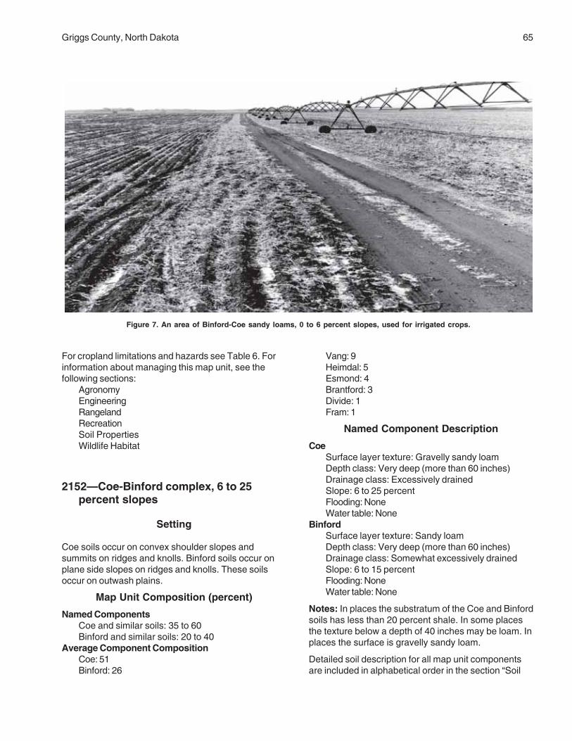
Griggs County, North Dakota 65
For cropland limitations and hazards see Table 6. Forinformation about managing this map unit, see thefollowing sections:
AgronomyEngineeringRangelandRecreationSoil PropertiesWildlife Habitat
2152—Coe-Binford complex, 6 to 25percent slopes
Setting
Coe soils occur on convex shoulder slopes andsummits on ridges and knolls. Binford soils occur onplane side slopes on ridges and knolls. These soilsoccur on outwash plains.
Map Unit Composition (percent)
Named ComponentsCoe and similar soils: 35 to 60Binford and similar soils: 20 to 40
Average Component CompositionCoe: 51Binford: 26
Vang: 9Heimdal: 5Esmond: 4Brantford: 3Divide: 1Fram: 1
Named Component Description
CoeSurface layer texture: Gravelly sandy loamDepth class: Very deep (more than 60 inches)Drainage class: Excessively drainedSlope: 6 to 25 percentFlooding: NoneWater table: None
BinfordSurface layer texture: Sandy loamDepth class: Very deep (more than 60 inches)Drainage class: Somewhat excessively drainedSlope: 6 to 15 percentFlooding: NoneWater table: None
Notes: In places the substratum of the Coe and Binfordsoils has less than 20 percent shale. In some placesthe texture below a depth of 40 inches may be loam. Inplaces the surface is gravelly sandy loam.
Detailed soil description for all map unit componentsare included in alphabetical order in the section “Soil
Figure 7. An area of Binford-Coe sandy loams, 0 to 6 percent slopes, used for irrigated crops.
66 Soil Survey
Series and Their Morphology.” Additional informationspecific to this map unit, such as USDA textures,permeability, and soil reaction, is available in the “SoilProperties” section.
Management
Major Use: Cropland
For cropland limitations and hazards see Table 6. Forinformation about managing this map unit, see thefollowing sections:
AgronomyEngineeringRangelandRecreationSoil PropertiesWildlife Habitat
2153—Edgeley-Kloten-Esmond complex,9 to 35 percent slopes
Setting
Edgeley soils occur on plane side slopes on ridges.Kloten soils occur on convex shoulder slopes onridges. Esmond soils occur on convex summits onridges. These soils occur in valleys.
Map Unit Composition (percent)
Named ComponentsEdgeley and similar soils: 45 to 65Kloten and similar soils: 15 to 35Esmond and similar soils: 5 to 20
Average Component CompositionEdgeley: 53Kloten: 23Esmond: 10Walsh: 4Coe: 2Egeland: 2Nutley: 2Lamoure, channeled: 2Mekinock: 2
Named Component Description
EdgeleySurface layer texture: Silt loamDepth class: Moderately deep (20 to 40 inches)Drainage class: Well drainedSlope: 9 to 25 percent
Flooding: NoneWater table: None
KlotenSurface layer texture: Silt loamDepth class: ShallowDrainage class: Well drainedSlope: 9 to 35 percentFlooding: NoneWater table: None
EsmondSurface layer texture: LoamDepth class: Very deep (more than 60 inches)Drainage class: Well drainedSlope: 9 to 35 percentFlooding: NoneWater table: None
Notes: In some places bedrock in the Edgeley soils isbetween a depth of 40 to 60 inches. Some places arevery stony. These soils are subject to slumpingand soil creep.
Detailed soil descriptions for all map unit componentsare included in alphabetical order in the section “SoilSeries and Their Morphology.” Additional informationspecific to this map unit, such as USDA textures,permeability, and soil reaction, is available in the “SoilProperties” section.
Management
Major Use: Rangeland or wildlife habitat
For cropland limitations and hazards see Table 6. Forinformation about managing this map unit, see thefollowing sections:
AgronomyEngineeringRangelandRecreationSoil PropertiesWildlife Habitat
2156—Lamoure and Rauville silt loams
Setting
Lamoure and Rauville soils occur on plane or concaveslopes in drainageways. These soils occur on floodplains.

Griggs County, North Dakota 67
Map Unit Composition (percent)
Named ComponentsLamoure and similar soils: 20 to 80Rauville and similar soils: 20 to 80
Average Component CompositionLamoure: 62Rauville: 28Marysland: 3Velva: 3Divide: 1Harriet: 1Vallers: 1Fairdale: 1
Named Component Description
LamoureSurface layer texture: Silt loamDepth class: Very deep (more than 60 inches)Drainage class: Poorly drainedSlope: 0 to 1 percentFlooding: FrequentWater table: Seasonal
RauvilleSurface layer texture: Silt loamDepth class: Very deep (more than 60 inches)Drainage class: Very poorly drainedSlope: 0 to 1 percentFlooding: FrequentWater table: Seasonal
Detailed soil descriptions for all map unit componentsare included in alphabetical order in the section “SoilSeries and Their Morphology.” Additional informationspecific to this map unit, such as USDA textures,permeability, and soil reaction, is available in the “SoilProperties” section.
Management
Major Use: Hay, pasture, range, or wetland wildlifehabitat
For cropland limitations and hazards see Table 6. Forinformation about managing this map unit, see thefollowing sections:
AgronomyEngineeringRangelandRecreationSoil PropertiesWildlife Habitat
2157—Maddock-Esmond-Embdencomplex, 6 to 15 percent slopes
Setting
Maddock soils occur on plane or convex side slopeson ridges and knolls. Esmond soils occur on convexshoulder slopes and summits on ridges and knolls.Embden soils occur on concave slopes on ridges andknolls. These soils occur on moraines.
Map Unit Composition (percent)
Named ComponentsMaddock and similar soils: 45 to 65Esmond and similar soils: 15 to 40Embden and similar soils: 5 to 20
Average Component CompositionMaddock: 45Esmond: 20Embden: 11Serden: 9Heimdal: 7Hecla: 4Binford: 2Coe: 1Ulen: 1
Named Component Description
MaddockSurface layer texture: Loamy fine sandDepth class: Very deep (more than 60 inches)Drainage class: Well drainedSlope: 6 to 15 percentFlooding: NoneWater table: None
EsmondSurface layer texture: LoamDepth class: Very deep (more than 60 inches)Drainage class: Well drainedSlope: 6 to 15 percentFlooding: NoneWater table: None
EmbdenSurface layer texture: Fine sandy loamDepth class: Very deep (more than 60 inches)Drainage class: Well drainedSlope: 6 to 9 percentFlooding: NoneWater table: None

68 Soil Survey
Notes: In places the texture of the surface is finesandy loam or sandy loam. In other places the textureof the Maddock soils is coarse sand throughout. Inplaces the texture of the Embden soils below a depthof 40 inches is loam, silt loam, or silty clay loam.Some areas have steeper slopes or are very stony.
Detailed soil descriptions for all map unit componentsare included in alphabetical order in the section “SoilSeries and Their Morphology.” Additional informationspecific to this map unit, such as USDA textures,permeability, and soil reaction, is available in the “SoilProperties” section.
Management
Major Use: Rangeland or wildlife habitat
For cropland limitations and hazards see Table 6. Forinformation about managing this map unit, see thefollowing sections:
AgronomyEngineeringRangelandRecreationSoil PropertiesWildlife Habitat
2158—Velva fine sandy loam, 0 to 6percent slopes
Setting
These soils occur on plane or convex slopes on flatsand rises on flood plains.
Map Unit Composition (percent)
Named ComponentsVelva and similar soils: 70 to 90
Average Component CompositionVelva: 81Banks: 9Rauville: 4Lamoure: 3Tiffany: 1LaDelle: 1Water: 1
Named Component Description
VelvaSurface layer texture: Fine sandy loamDepth class: Very deep (more than 60 inches)Drainage class: Well drainedSlope: 0 to 6 percent
Flooding: OccasionalWater table: None
Notes: Some places are somewhat poorly drained.
Detailed soil descriptions for all map unit componentsare included in alphabetical order in the section “SoilSeries and Their Morphology.” Additional informationspecific to this map unit, such as USDA textures,permeability, and soil reaction, is available in the “SoilProperties” section.
Management
Major Use: Hay, pasture, or range
For cropland limitations and hazards see Table 6. Forinformation about managing this map unit, see thefollowing sections:
AgronomyEngineeringRangelandRecreationSoil PropertiesWildlife Habitat
2159—Walsh silty clay loam, 1 to 6 percentslopes
Setting
These soils occur on concave footslopes in valleys.
Map Unit Composition (percent)
Named ComponentsWalsh and similar soils: 70 to 90
Average Component CompositionWalsh: 64Barnes: 16Sinai: 9Nutley: 8Kensal: 1Binford: 1Edgeley: 1
Named Component Description
WalshSurface layer texture: Silty clay loamDepth class: Very deep (more than 60 inches)Drainage class: Well drainedSlope: 1 to 6 percentFlooding: NoneWater table: None

Griggs County, North Dakota 69
Detailed soil descriptions for all map unit componentsare included in alphabetical order in the section “SoilSeries and Their Morphology.” Additional informationspecific to this map unit, such as USDA textures,permeability, and soil reaction, is available in the “SoilProperties” section.
Management
Major Use: Cropland
For cropland limitations and hazards see Table 6. Forinformation about managing this map unit, see thefollowing sections:
AgronomyEngineeringRangelandRecreationSoil PropertiesWildlife Habitat
2196—Bearden and Colvin silt loams,saline
Setting
Bearden and Colvin soils occur on flats. These soilsoccur on lake plains.
Map Unit Composition (percent)
Named ComponentsBearden and similar soils: 20 to 80Colvin and similar soils: 20 to 80
Average Component CompositionBearden: 35Colvin: 47Bearden, nonsaline: 8Colvin, nonsaline: 4Harriet: 2Exline: 2Colvin, saline, very poorly drained: 1Perella: 1
Named Component Description
BeardenSurface layer texture: Silt loamDepth class: Very deep (more than 60 inches)Drainage class: Somewhat poorly drainedSlope: 0 to 1 percentFlooding: NoneWater table: SeasonalSalt affected: Saline within 30 inches
ColvinSurface layer texture: Silt loamDepth class: Very deep (more than 60 inches)Drainage class: Poorly drainedSlope: 0 to 1 percentFlooding: NoneWater table: SeasonalSalt affected: Saline within 30 inches
Notes: Some places are strongly saline. In someplaces the texture of the substratum is sand or gravel.Some areas may be undulating.
Detailed soil descriptions for all map unit componentsare included in alphabetical order in the section “SoilSeries and Their Morphology.” Additional informationspecific to this map unit, such as USDA textures,permeability, and soil reaction, is available in the “SoilProperties” section.
Management
Major Use: Cropland
For cropland limitations and hazards see Table 6. Forinformation about managing this map unit, see thefollowing sections:
AgronomyEngineeringRangelandRecreationSoil PropertiesWildlife Habitat
2197—Edgeley-Kloten complex, 6 to 9percent slopes
Setting
Edgeley soils occur on plane side slopes on ridges andknolls. Kloten soils occur on convex shoulder slopeson ridges and knolls. These soils occur on till plains.
Map Unit Composition (percent)
Named ComponentsEdgeley and similar soils: 55 to 80Kloten and similar soils: 15 to 35
Average Component CompositionEdgeley: 61Kloten: 22Heimdal: 6Nutley: 3Walsh: 3Cavour: 2

70 Soil Survey
Emrick: 2Darnen: 1
Named Component Description
EdgeleySurface layer texture: LoamDepth class: Moderately deep (20 to 40 inches)Drainage class: Well drainedSlope: 6 to 9 percentFlooding: NoneWater table: None
KlotenSurface layer texture: Silt loamDepth class: ShallowDrainage class: Well drainedSlope: 6 to 9 percentFlooding: NoneWater table: None
Notes: In places bedrock in the Edgeley soils isbetween 40 to 60 inches.
Detailed soil descriptions for all map unit componentsare included in alphabetical order in the section “SoilSeries and Their Morphology.” Additional informationspecific to this map unit, such as USDA textures,permeability, and soil reaction, is available in the “SoilProperties” section.
Management
Major Use: Cropland
For cropland limitations and hazards see Table 6. Forinformation about managing this map unit, see thefollowing sections:
AgronomyEngineeringRangelandRecreationSoil PropertiesWildlife Habitat
2198—Hamar-Hecla loamy fine sands
Setting
Hamar soils occur on plane slopes in depressions andon flats. Hecla soils occur on flats. These soils occuron outwash plains.
Map Unit Composition (percent)
Named ComponentsHamar and similar soils: 60 to 80Hecla and similar soils: 15 to 35
Average Component CompositionHamar: 61Hecla: 20Ulen: 11Arveson: 2Wyndmere: 2Towner 2Letcher: 1Fossum: 1
Named Component Description
HamarSurface layer texture: Loamy fine sandDepth class: Very deep (more than 60 inches)Drainage class: Somewhat poorly drainedSlope: 0 to 1 percentFlooding: NoneWater table: Seasonal
HeclaSurface layer texture: Loamy fine sandDepth class: Very deep (more than 60 inches)Drainage class: Moderately well drainedSlope: 0 to 1 percentFlooding: NoneWater table: Seasonal
Notes: In some places the texture of the Hamar andHecla soils below a depth of 40 inches is gravellysand.
Detailed soil descriptions for all map unit componentsare included in alphabetical order in the section “SoilSeries and Their Morphology.” Additional informationspecific to this map unit, such as USDA textures,permeability, and soil reaction, is available in the “SoilProperties” section.
Management
Major Use: Cropland
For cropland limitations and hazards see Table 6. Forinformation about managing this map unit, see thefollowing sections:
AgronomyEngineeringRangeland

Griggs County, North Dakota 71
RecreationSoil PropertiesWildlife Habitat
2199—Hamerly-Barnes-Tonka complex, 0to 6 percent slopes, very stony
Setting
Hamerly soils occur on flats. Barnes soils occur onconvex slopes on rises. Tonka soils occur on concaveslopes in depressions. These soils occur on till plains.
Map Unit Composition (percent)
Named ComponentsHamerly and similar soils: 40 to 65Barnes and similar soils: 20 to 45Tonka and similar soils: 5 to 20
Average Component CompositionHamerly: 30Barnes: 22Tonka: 10Vallers: 19Emrick: 11Parnell: 3Hamerly, saline: 2Cresbard: 2Cavour: 1
Named Component Description
HamerlySurface layer texture: Stony loamDepth class: Very deep (more than 60 inches)Drainage class: Somewhat poorly drainedSlope: 0 to 3 percentFlooding: NoneWater table: Seasonal
BarnesSurface layer texture: Very stony loamDepth class: Very deep (more than 60 inches)Drainage class: Well drainedSlope: 0 to 6 percentFlooding: NoneWater table: None
TonkaSurface layer texture: Very stony silt loamDepth class: Very deep (more than 60 inches)Drainage class: Poorly drainedSlope: 0 to 1 percentFlooding: NoneWater table: SeasonalPonding: Very long
Notes: Some places are extremely stony.
Detailed soil descriptions for all map unit componentsare included in alphabetical order in the section “SoilSeries and Their Morphology.” Additional informationspecific to this map unit, such as USDA textures,permeability, and soil reaction, is available in the “SoilProperties” section.
Management
Major Use: Rangeland or wildlife habitat
For cropland limitations and hazards see Table 6. Forinformation about managing this map unit, see thefollowing sections:
AgronomyEngineeringRangelandRecreationSoil PropertiesWildlife Habitat
2200—Letcher-Swenoda fine sandyloams, 0 to 3 percent slopes
Setting
Letcher soils occur on flats. Swenoda soils occur onplane side slopes on rises. These slopes occur on tillplains.
Map Unit Composition (percent)
Named ComponentsLetcher and similar soils: 35 to 60Swenoda and similar soils: 30 to 55
Average Component CompositionLetcher: 43Swenoda: 24Lanona: 16Cathay: 5Lemert: 4Stirum: 3Wyndmere: 3Towner: 2
Named Component Description
LetcherSurface layer texture: Fine sandy loamDepth class: Very deep (more than 60 inches)Drainage class: Moderately well drainedSlope: 0 to 3 percentFlooding: NoneWater table: Seasonal

72 Soil Survey
Sodium affected: Sodic within 30 inchesSwenoda
Surface layer texture: Fine sandy loamDepth class: Very deep (more than 60 inches)Drainage class: Moderately well drainedSlope: 0 to 3 percentFlooding: NoneWater table: Seasonal
Detailed soil descriptions for all map unit componentsare included in alphabetical order in the section “SoilSeries and Their Morphology.” Additional informationspecific to this map unit, such as USDA textures,permeability, and soil reaction, is available in the “SoilProperties” section.
Management
Major Use: Cropland
For cropland limitations and hazards see Table 6. Forinformation about managing this map unit, see thefollowing sections:
AgronomyEngineeringRangelandRecreationSoil PropertiesWildlife Habitat
2201—Stirum-Arveson, saline, fine sandyloams
Setting
Stirum and Arveson soils occur on flats. These soilsoccur on lake plains.
Map Unit Composition (percent)
Named ComponentsStirum and similar soils: 35 to 60Arveson and similar soils: 25 to 50
Average Component CompositionStirum: 40Arveson: 28Marysland, saline: 9Manfred: 6Hamar, poorly drained: 6Gilby, saline: 5Letcher: 3Marysland: 3
Named Component Description
StirumSurface layer texture: Fine sandy loamDepth class: Very deep (more than 60 inches)Drainage class: Poorly drainedSlope: 0 to 1 percentFlooding: NoneWater table: SeasonalSalt affected: Saline within 30 inchesSodium affected: Sodic within 30 inches
ArvesonSurface layer texture: Fine sandy loamDepth class: Very deep (more than 60 inches)Drainage class: Poorly drainedSlope: 0 to 1 percentFlooding: NoneWater table: SeasonalSalt affected: Saline within 30 inches
Notes: Some areas are somewhat poorly drained.
Detailed soil descriptions for all map unit componentsare included in alphabetical order in the section “SoilSeries and Their Morphology.” Additional informationspecific to this map unit, such as USDA textures,permeability, and soil reaction, is available in the “SoilProperties” section.
Management
Major Use: Cropland
For cropland limitations and hazards see Table 6. Forinformation about managing this map unit, see thefollowing sections:
AgronomyEngineeringRangelandRecreationSoil PropertiesWildlife Habitat
2202—Swenoda-Barnes fine sandy loams,3 to 6 percent slopes
Setting
Swenoda soils occur on concave footslopes on rises.Barnes soils occur on convex summits on rises. Thesesoils occur on till plains.

Griggs County, North Dakota 73
Map Unit Composition (percent)
Named ComponentsSwenoda and similar soils: 35 to 60Barnes and similar soils: 20 to 45
Average Component CompositionSwenoda: 43Barnes: 33Gardena: 9Buse: 6Binford: 3Towner: 3Maddock: 2Tonka: 1
Named Component Description
SwenodaSurface layer texture: Fine sandy loamDepth class: Very deep (more than 60 inches)Drainage class: Moderately well drainedSlope: 3 to 6 percentFlooding: NoneWater table: Seasonal
BarnesSurface layer texture: Fine sandy loamDepth class: Very deep (more than 60 inches)Drainage class: Well drainedSlope: 3 to 6 percentFlooding: NoneWater table: None
Notes: Some places are very stony. Other places havemany shale fragments. Some areas adjacent todrainageways are steeper. Other areas are gentlyrolling.
Detailed soil descriptions for all map unit componentsare included in alphabetical order in the section “SoilSeries and Their Morphology.” Additional informationspecific to this map unit, such as USDA textures,permeability, and soil reaction, is available in the “SoilProperties” section.
Management
Major Use: Cropland
For cropland limitations and hazards see Table 6. Forinformation about managing this map unit, see thefollowing sections:
AgronomyEngineeringRangelandRecreationSoil PropertiesWildlife Habitat
2203—Swenoda-Barnes fine sandy loams,6 to 9 percent slopes
Setting
Swenoda soils occur on concave footslopes. Barnessoils occur on convex shoulder slopes and summits.These soils occur on knobs on till plains.
Map Unit Composition (percent)
Named ComponentsSwenoda and similar soils: 35 to 60Barnes and similar soils: 25 to 50
Average Component CompositionSwenoda: 47Barnes: 36Buse: 11Maddock: 2Coe: 1Towner: 1Binford: 1Vallers: 1
Named Component Description
SwenodaSurface layer texture: Fine sandy loamDepth class: Very deep (more than 60 inches)Drainage class: Well drainedSlope: 6 to 9 percentFlooding: NoneWater table: None
BarnesSurface layer texture: Fine sandy loamDepth class: Very deep (more than 60 inches)Drainage class: Well drainedSlope: 6 to 9 percentFlooding: NoneWater table: None
Notes: Some places are very stony. Other places havemany shale fragments. Some areas adjacent todrainageways are steeper. Some areas are rolling.
Detailed soil descriptions for all map unit componentsare included in alphabetical order in the section “SoilSeries and Their Morphology.” Additional informationspecific to this map unit, such as USDA textures,permeability, and soil reaction, is available in the “SoilProperties” section.
Management
Major Use: Cropland

74 Soil Survey
For cropland limitations and hazards see Table 6. Forinformation about managing this map unit, see thefollowing sections:
AgronomyEngineeringRangelandRecreationSoil PropertiesWildlife Habitat
2204—Walsh silty clay loam, 6 to 9 percentslopes
Setting
These soils occur on concave foot slopes in valleys.
Map Unit Composition (percent)
Named ComponentsWalsh and similar soils: 70 to 90
Average Component CompositionWalsh: 56Sinai: 18Barnes: 11Nutley: 7Edgeley: 5Wahpeton: 2Vang: 1
Named Component Description
WalshSurface layer texture: Silty clay loamDepth class: Very deep (more than 60 inches)Drainage class: Well drainedSlope: 6 to 9 percentFlooding: NoneWater table: None
Detailed soil descriptions for all map unit componentsare included in alphabetical order in the section “SoilSeries and Their Morphology.” Additional informationspecific to this map unit, such as USDA textures,permeability, and soil reaction, is available in the “SoilProperties” section.
Management
Major Use: Cropland
For cropland limitations and hazards see Table 6. Forinformation about managing this map unit, see thefollowing sections:
AgronomyEngineeringRangelandRecreationSoil PropertiesWildlife Habitat
2205—Zell-Eckman silt loams, 9 to 25percent slopes
Setting
Zell soils occur on convex shoulder slopes andsummits. Eckman soils occur on plane side slopes.These soils occur on ridges and knolls on lake plains.
Map Unit Composition (percent)
Named ComponentsZell and similar soils: 50 to 75Eckman and similar soils: 25 to 45
Average Component CompositionZell: 60Eckman: 20Gardena: 9Emrick: 4Maddock: 3Great Bend: 2Coe: 1Esmond: 1
Named Component Description
ZellSurface layer texture: Silt loamDepth class: Very deep (more than 60 inches)Drainage class: Well drainedSlope: 9 to 25 percentFlooding: NoneWater table: None
EckmanSurface layer texture: Silt loamDepth class: Very deep (more than 60 inches)Drainage class: Well drainedSlope: 9 to 15 percentFlooding: NoneWater table: None
Notes: Some places have steeper slopes.
Detailed soil descriptions for all map unit componentsare included in alphabetical order in the section “Soil

Griggs County, North Dakota 75
Series and Their Morphology.” Additional informationspecific to this map unit, such as USDA textures,permeability, and soil reaction, is available in the “SoilProperties” section.
Management
Major Use: Hay, pasture, or range
For cropland limitations and hazards see Table 6. Forinformation about managing this map unit, see thefollowing sections:
AgronomyEngineeringRangelandRecreationSoil PropertiesWildlife Habitat
76 Soil Survey
Table 4.—Acreage and Proportionate Extent of the Soils
__________________________________________________________________________________________________________________
Map Soil name Acres PercentSymbol__________________________________________________________________________________________________________________
61 Arveson fine sandy loam 1,395 0.3118 Barnes-Buse loams, 3 to 6 percent slopes 9,750 2.1120 Barnes-Buse loams, 6 to 9 percent slopes 3,460 0.8156 Barnes-Svea loams, 3 to 6 percent slopes 20,025 4.4167 Bearden silt loam 6,645 1.4296 Brantford loam, 0 to 3 percent slopes 4,895 1.1314 Buse-Barnes loams, 9 to 15 percent slopes 2,140 0.5319 Buse-Barnes loams, 15 to 35 percent slopes 5,175 1.1391 Cavour-Cresbard loams, 0 to 3 percent slopes 4,250 0.9450 Colvin silt loam 4,225 0.9511 Divide loam, 0 to 3 percent slopes 20,110 4.4536 Eckman-Zell silt loams, 6 to 9 percent slopes 1,300 0.3539 Edgeley loam, 0 to 3 percent slopes 1,345 0.3541 Edgeley loam, 3 to 6 percent slopes 1,305 0.3569 Embden fine sandy loam 930 0.2579 Embden-Egeland fine sandy loams, 1 to 6 percent slopes 2,025 0.4595 Emrick-Cathay loams, 0 to 3 percent slopes 3,085 0.7597 Emrick-Heimdal loams, 0 to 3 percent slopes 5,930 1.3605 Esmond-Heimdal loams, 9 to 15 percent slopes 8,965 2.0753 Fram-Wyard loams, 0 to 3 percent slopes 9,950 2.2769 Gardena silt loam, 0 to 3 percent slopes 1,390 0.3773 Gardena-Eckman silt loams, 3 to 6 percent slopes 2,790 0.6881 Hamerly-Tonka complex, 0 to 3 percent slopes 23,265 5.1884 Hamerly-Wyard loams, 0 to 3 percent slopes 49,315 10.8893 Harriet silt loam 1,375 0.3988 Heimdal-Emrick loams, 3 to 6 percent slopes 27,520 6.0998 Heimdal-Esmond loams, 6 to 9 percent slopes 11,395 2.51001 Heimdal-Esmond loams, 15 to 35 percent slopes 6,785 1.51015 Kensal loam 2,215 0.51062 LaDelle silty clay loam, 0 to 3 percent slopes 8,465 1.81108 Larson-Cathay loams, 0 to 3 percent slopes 1,460 0.31188 Ludden silty clay 720 0.21189 Ludden silty clay, saline 285 *1221 Maddock-Hecla loamy fine sands, 1 to 6 percent slopes 6,890 1.51267 Marysland loam 4,140 0.91268 Marysland loam, wet 1,745 0.41427 Parnell silty clay loam 3,890 0.81454 Wyndmere fine sandy loam, loamy substratum, 0 to 3 percent slopes 2,270 0.51466 Pits, sand and gravel 425 *1710 Southam silty clay loam 9,135 2.01762 Svea-Barnes loams, 0 to 3 percent slopes 13,430 2.91765 Svea-Buse loams, 3 to 6 percent slopes 4,360 1.01766 Svea-Buse loams, 6 to 9 percent slopes 1,265 0.31769 Svea-Cresbard loams, 0 to 3 percent slopes 6,730 1.51781 Swenoda fine sandy loam, 0 to 3 percent slopes 10,860 2.41843 Towner loamy fine sand, 0 to 6 percent slopes 5,095 1.11883 Vallers-Parnell complex 9,020 2.01886 Hamerly and Vallers loams, saline, 0 to 3 percent slopes 11,890 2.61970 Walum sandy loam 8,130 1.81978 Water 3,300 0.72118 Fram-Tonka complex, 0 to 3 percent slopes 3,235 0.72121 Ferney loam, 0 to 3 percent slopes 4,685 1.02151 Binford-Coe sandy loams, 0 to 6 percent slopes 31,730 6.92152 Coe-Binford complex, 6 to 25 percent slopes 10,150 2.22153 Edgeley-Kloten-Esmond complex, 9 to 35 percent slopes 11,320 2.52156 Lamoure and Rauville silt loams 4,205 0.92157 Maddock-Esmond-Embden complex, 6 to 15 percent slopes 2,380 0.52158 Velva fine sandy loam, 0 to 6 percent slopes 1,055 0.22159 Walsh silty clay loam, 1 to 6 percent slopes 3,850 0.82196 Bearden and Colvin silt loams, saline 4,170 0.92197 Edgeley-Kloten complex, 6 to 9 percent slopes 555 0.1

Griggs County, North Dakota 77
Table 4.—Acreage and Proportionate Extent of the Soils--(continued)
____________________________________________________________________________________________________________________
Map Soil name Acres PercentSymbol____________________________________________________________________________________________________________________
2198 Hamar-Hecla loamy fine sands 1,845 0.42199 Hamerly-Barnes-Tonka complex, 0 to 6 percent slopes, very stony 8,460 1.82200 Letcher-Swenoda fine sandy loams, 0 to 3 percent slopes 460 0.12201 Stirum-Arveson, saline, fine sandy loams 2,660 0.62202 Swenoda-Barnes fine sandy loams, 3 to 6 percent slopes 7,845 1.72203 Swenoda-Barnes fine sandy loams, 6 to 9 percent slopes 1,405 0.32204 Walsh silty clay loam, 6 to 9 percent slopes 1,100 0.22205 Zell-Eckman silt loams, 9 to 25 percent slopes 830 0.2 ____________________ Total 458,400 100.0________________________________________________________________________________________________________________
*less than 0.1 percent


79
This section relates the soils in the survey area tothe major factors of soil formation and describes thesystem of soil classification.
Formation of the SoilsSoil forms through processes acting on deposited or
accumulated geologic material. Characteristics of thesoil at any given point are determined by (1) thephysical and mineralogical composition of the parentmaterial; (2) the climate under which the soil materialhas accumulated and existed since accumulation; (3)the plant and animal life on and in the soil; (4) therelief, or lay of the land; and (5) the length of time thatforces of soil formation have acted on the soil material.
Climate and plant and animal life are active factorsof soil formation. They act on the parent material thathas accumulated through the weathering of geologicaldeposits and slowly change it to a natural body thathas genetically related horizons. The effects of climateand plant and animal life are conditioned by relief.Finally, time is needed for changing the parent materialinto soil. Some time is always required for thedifferentiation of soil horizons. Usually, a long time isrequired for the development of distinct horizons.
The factors of soil formation are so closelyinterrelated in their effects on the soil that fewgeneralizations can be made regarding the effects ofany one factor unless conditions are specified for theother four. Many of the processes of soil developmentare unknown.
Parent Material
Parent material is the unconsolidated mass inwhich a soil forms. It determines the limits of thechemical and mineralogical composition of the soil.The soils of Griggs County formed in glacial drift. Theadvancing glacier picked up rocks and soil, ground andmixed them, and deposited the material as the glacierreceded. Some soils, such as Barnes and Svea,formed in unsorted material, or glacial till. Some soilssuch as Overly and Bearden formed in glaciolacustrinedeposits, or glacial material deposited by water inglacial lakes. Other soils, such as Binford and Coe,
formed in glaciofluvial deposits, or material depositedby glacial meltwater.
Although the parent materials are of common glacialorigin, their properties vary greatly, sometimes withinsmall areas, depending on how the materials weredeposited.
Geologically, Griggs County is located at theeastern edge of the Williston Basin, and is underlain byPaleozoic and Mesozoic rocks that dip gently to thewest. The Cretaceous aged Greenhorn, Carlile,Niobrara, and Pierre Formations lie directly beneath theGlacial Drift. The Pierre Formation is exposed inseveral places along the Sheyenne River. It consists ofmedium gray, massive to fissile, noncalcareous shaleand siltstone. Pierre Formation is highly weathered inmost exposures (Bluemle, 1975). A few soils, such asEdgley and Kloten, did not form from glacial drift.These soils formed in material weathered from thePierre Formation.
Several processes have been involved in theformation of soils in Griggs County. These processesare accumulation of organic matter; solution, transfer,and removal of calcium carbonates and bases; andliberation and translocation of silicate clay minerals. Inmost soils more than one of these processes havebeen active in horizon differentiation.
The parent materials in which most of the soilsdeveloped initially contained generous amounts ofcalcium and magnesium carbonate minerals. Theseminerals have been dissolved by water and removedfrom the upper horizons of the soil profile. Pure water isnot an effective agent for dissolving calcium andmagnesium carbonates. These minerals are onlyslightly soluble in pure water, but become moderatelysoluble and dissolve much more rapidly in a weak acid.The respiratory activity of plants is a significant factorin dissolving calcium and magnesium carbonates. Asplants respire, they give off carbon dioxide. Carbondioxide dissolves in water to form a weak carbonic acidsolution. This facilitates dissolving calcium andmagnesium carbonates in the soil.
In a dissolved state, calcium and magnesium are inthe form of ions that have a positive net electricalcharge. Calcium and magnesium ions are essentialelements in plant nutrition, and can either be taken up
Formation and Classification of the Soils

80 Soil Survey
by plant roots or carried away (leached) with movingsoil water. Some of the calcium and magnesium ionsare leached from the soil profiles. “Seep” sites alongsteep slopes that have deposits of recentlyprecipitated calcium and magnesium carbonatesprovide evidence of leaching.
A large number of the calcium and magnesium ionsthat dissolved from carbonate mineral ions aretranslocated to upper soil horizons by a cyclicalprocess of root uptake and ultimate release when plantmaterial decomposes. As vegetation decays, positivelycharged calcium and magnesium ions move downwardwith water to the upper horizons of soil profiles. Therethey are held by the electrostatic forces of negativelycharged clay particles and are again available for plantuptake.
Climate
Climate has direct and indirect effects on theformation of soils. Precipitation, temperature, and winddirectly affect the weathering and reworking of soilmaterial. The climate indirectly affects soil formationthrough its effects on the amount and kind ofvegetation and animal life on or in the soil.
In addition to weathering soil material, precipitationand temperature affect the leaching and redistributionof carbonates and clay particles and the accumulationof organic matter in the soil. Freezing and thawing helpbreak down soil particles in the parent material,thereby providing more surface area for chemicalprocesses. Cool temperatures affect the content oforganic matter by slowing the decay of plant materialand animal remains.
Griggs County has a continental, subhumid climatecharacterized by long, cold winters and short, warmsummers. The soil is generally frozen to a depth of 3 to6 feet from November to April. During this time, exceptfor some effects of frost action, the soil formingprocesses are mostly dormant. Most of theprecipitation falls during the growing season and isdistributed in an erratic pattern. It is during this part ofthe year that soil forming processes influenced byclimate are most active. The climate is fairly uniformthroughout the county.
Living Organisms
Soils in Griggs County formed mainly undergrassland vegetation. Grasses provide a plentifulsupply of organic matter, which improves the chemicaland physical properties of the soil. Fibrous roots ofthese grasses penetrate the soil to a depth of severalfeet, making it more porous and more granular. As a
result of these changes in the soil, less water runs offthe surface and more moisture is available forincreased microbiological activity. Decay of plantsimproves the available water capacity, tilth, and fertilityof the soil. Decayed organic matter, accumulating overlong periods, gives the surface layer its dark color.
On somewhat poorly drained and moderately welldrained, nearly level soils, such as Bearden, Embden,Hamerly, and Svea, the native vegetation is mainly talland medium-sized grasses. Principal grasses are bigbluestem, switchgrass, indiangrass, and littlebluestem.
On well drained and excessively drained, nearlylevel to steep soils, such as Buse and Coe, short andmedium-sized grasses are dominant. Among thesegrasses are green needlegrass, western wheatgrass,little bluestem, sideoats grama, plains muhly, and bluegrama.
On the poorly drained and very poorly drained,depressional soils such as Colvin, Parnell, and Tonka,the vegetation consists of tall grasses, reeds,rivergrass, slough sedge, American mannagrass,northern reedgrass, and prairie cordgrass.
Micro-organisms have important effects on soilformation because they feed on undecomposedorganic matter and convert it into humus from whichplants can obtain nutrients for growth. Bacteria anddifferent kinds of fungi attack leaves and other formsof organic matter. Insects, earthworms, and smallburrowing animals help mix the humus with the soil.
Human activities greatly affect soil formation.Management measures can alter soil drainage. Theycan help to control erosion, thus maintaining fertility.Poor management can increase the susceptibility toerosion and thus result in an unproductive soil.
Topography
Most of Griggs County is level to undulating, butsome areas are rolling to steep. Many poorly drainedand very poorly drained soils in depressions receiverunoff from higher elevations. The steepest areas areend moraines and breaks around rivers anddrainageways. Local differences in relief within asquare mile range from less than 10 feet to 100 feet.
Relief influences the formation of soil through itseffect on drainage, runoff, and erosion. Manydifferences in the soils of this county result from theirtopographic position. Among these differences aredrainage, thickness of the A horizon, content oforganic matter, color, features of the subsoil, thicknessof the solum, and degree of horizon differentiation.
Runoff is rapid on steep slopes, and only a smallpercentage of the rainfall penetrates the soil. Under

Griggs County, North Dakota 81
these conditions, there is little moisture for plantgrowth and soil development. The soils on steeperslopes are thin and low in organic matter content. Theyhave weak horizonation. Examples are the Buse andZell soils.
Soils on nearly level to rolling slopes are moderatelywell drained and well drained. Moisture is sufficient tosupport good stands of mixed native grasses, and thesoils have well developed profiles characterized by ablack to very dark gray A horizon and a brown to verydark brown B horizon. Examples are the Barnes andHeimdal soils. Most of the moderately well drainedsoils occur on level or slightly concave areas. Theygenerally have a thicker A horizon, a darker colored Bhorizon, and a greater depth to lime than those onconvex, undulating, or rolling landscapes. Examplesare the Swenoda and Svea soils.
Depressional areas that receive large amounts ofrunoff from higher elevations have somewhat poor tovery poor natural drainage. Soils formed in depressionsvary widely in profile development, depending on thedegree of wetness. Parnell and Tonka soils, which arein shallow depressions, exhibit an advanced degree ofhorizonation because of alternate wet and dry cyclesthat occur in these depressions. These soils haveproperties much like soils from areas of much higherprecipitation. They are examples of soils in whichtranslocated clays have accumulated in the Bt horizon.Gleying, or the reduction and transfer of iron, hasoccurred to some degree in all of the very poorly tosomewhat poorly drained soils in the county. In thesenaturally wet soils, this process has had a significantinfluence on horizon differentiation. The gray color andredoximorphic features of the subsoil indicate theredistribution of reduced iron oxides. Southam soils,which are in deep depressions, are nearly continuouslywet and have a thick surface layer and carbonatesthroughout. Horizonation in these soils is minimal andmostly the result of sedimentary rather than soil-forming processes.
Most of the surface in Griggs County is coveredwith Wisconsin-aged glacial drift. The glacial drift iscomprised of glaciofluvial deposits, glaciolacustrinedeposits, and glacial till. There are countless small andlarge potholes in the glacial plain in Griggs County thatdo not have an outlet to any established drainagechannel. During years of high snowfall and rain, wateris trapped in these depressions.
Large areas of Griggs County were influenced bywater running from the glacier that resulted in thedeposition of sand and gravel that is of poor quality forconstruction purposes. Soils in this area includeBinford and Coe. Several gravel pits are found in thisarea and sand and gravel are being mined. These
materials are used mainly for surfacing secondaryroads and as a base for paved highways. On-siteinvestigation is needed because the quality of thedeposits varies. Excess silt or clay and a high shalecontent are common limitations for the use of thesedeposits.
After the glaciers receded, streams carved valleysinto the till plain. The Sheyenne River is a glacialmeltwater developed valley. It was formed when GlacialLake Souris, which had developed in the North Centralpart of the state, drained into Glacial Lake Agassiz atthe end of the Pleistocene period. The Sheyenne Riverformed an extensive terrace system about 50 to 70feet above the present flood plain.
Time
The formation of soil is a very slow process. Muchtime is required for the processes of soil formation toact on the parent material and to form distinct horizonswithin the soil profile. Approximately 12,000 years havepassed since the glacier receded from Griggs County(Bluemle, 1975). In geological terms, the soils in thecounty are young.
More time has been available for the formation ofBarnes soils on glacial till plains than for the formationof Lamoure soils on flood plains. The forces of soilformation have been continually acting on the parentmaterial of the Barnes soils; however, Lamoure soilsare continually gaining new parent material at thesurface as a result of flooding. Barnes soils have welldefined horizons whereas Lamoure soils have lessdistinct horizons.
Classification of the SoilsThe system of soil classification used by the
National Cooperative Soil Survey has six categories(Soil Survey Staff, 1975, 1996a). Beginning with thebroadest, these categories are the order, suborder,great group, subgroup, family, and series.Classification is based on soil properties observed inthe field or inferred from those observations or fromlaboratory measurements. Table 5, “Classification ofthe Soils” shows the classification of the soils in thesurvey area. The categories are defined in the followingparagraphs.
ORDER. Eleven soil orders are recognized. Thedifferences among orders reflect the dominant soil-forming processes and the degree of soil formation.Each order is identified by a word ending in sol. Anexample is Mollisol.
SUBORDER. Each order is divided into subordersprimarily on the basis of properties that influence soil

82 Soil Survey
genesis and are important to plant growth or propertiesthat reflect the most important variables within theorders. The last syllable in the name of a suborderindicates the order. An example is Boroll (Bor, meaningcool, plus oll, from Mollisol).
GREAT GROUP. Each suborder is divided into greatgroups on the basis of close similarities in kind,arrangement, and degree of development of pedogenichorizons; soil moisture and temperature regimes; andbase status. Each great group is identified by the nameof a suborder and by a prefix that indicates a propertyof the soil. An example is Haploboroll (Hapl, meaningminimal horizonation, plus boroll, the suborder of theMollisols that has a frigid temperature regime).
SUBGROUP. Each great group has a typicsubgroup. Other subgroups are intergrades orextragrades. The typic is the central concept of thegreat group; it is not necessarily the most extensive.Intergrades are transitions to other orders, suborders,or great groups. Extragrades have some properties thatare not representative of the great group but do notindicate transitions to any other known kind of soil.Each subgroup is identified by one or more adjectives
preceding the name of the great group. The adjectiveUdic identifies the subgroup that has a udic moistureregime. An example is Udic Haploborolls.
FAMILY. Families are established within a subgroupon the basis of physical and chemical properties andother characteristics that affect management.Generally, the properties are those of horizons belowplow depth where there is much biological activity.Among the properties and characteristics consideredare particle-size class, mineral content, temperatureregime, depth of the root zone, consistence, moistureequivalent, slope, and permanent cracks. A familyname consists of the name of a subgroup preceded byterms that indicate soil properties. An example is fine-loamy, mixed Superactive Udic Haploborolls.
SERIES. The series consists of soils that havesimilar horizons in their profile. The horizons are similarin color, texture, structure, reaction, consistence,mineral and chemical composition, and arrangement inthe profile. The texture of the surface layer or of thesubstratum can differ within a series. An example isthe Barnes series.

Griggs County, North Dakota 83
Table 5.—Classification of the Soils
_______________________________________________________________________________________________________________________________________
Soil name Family or higher taxonomic class_____________________________________________________________________________________________________________________________________
Arveson Coarse-loamy, mixed, superactive, frigid Typic Calciaquolls Banks* Sandy, mixed, frigid Typic Ustifluvents Barnes Fine-loamy, mixed, superactive Udic Haploborolls Bearden Fine-silty, mixed, superactive, frigid Aeric Calciaquolls Binford Sandy, mixed Udic Haploborolls Brantford Fine-loamy over sandy or sandy-skeletal, mixed, superactive Udic
Haploborolls Buse Fine-loamy, mixed, superactive Udic Calciborolls Cathay Fine-loamy, mixed, superactive Glossic Udic Natriborolls Cavour Fine, smectitic Udic Natriborolls Coe Sandy-skeletal, mixed Udorthentic Haploborolls Colvin Fine-silty, mixed, superactive, frigid Typic Calciaquolls Cresbard Fine, smectitic Glossic Udic Natriborolls Darnen* Fine-loamy, mixed, superactive Pachic Udic Haploborolls Dickey* Sandy over loamy, mixed, superactive Udorthentic Haploborolls Divide Fine-loamy over sandy or sandy-skeletal, mixed, superactive, frigid
Aeric Calciaquolls Eckman Coarse-silty, mixed, superactive Udic Haploborolls Edgeley Fine-loamy, mixed, superactive Udic Haploborolls Egeland Coarse-loamy, mixed, superactive Udic Haploborolls Embden Coarse-loamy, mixed, superactive Pachic Udic Haploborolls Emrick Coarse-loamy, mixed, superactive Pachic Udic Haploborolls Enloe* Fine, smectitic, frigid Argiaquic Argialbolls Esmond Coarse-loamy, mixed, superactive Udic Calciborolls Fairdale* Fine-loamy, mixed, superactive, calcareous, frigid Mollic Udifluvents Ferney Fine, smectitic Leptic Natriborolls Fossum Sandy, mixed, calcareous, frigid Typic Endoaquolls Fram Coarse-loamy, mixed, superactive, frigid Aeric Calciaquolls Gardena Coarse-silty, mixed, superactive Pachic Udic Haploborolls Gilby* Fine-loamy, mixed, superactive, frigid Aeric Calciaquolls Great Bend* Fine-silty, mixed, superactive Udic Haploborolls Grimstad* Sandy over loamy, mixed, superactive, frigid Aeric Calciaquolls Hamar Sandy, mixed, frigid Typic Endoaquolls Hamerly Fine-loamy, mixed, superactive, frigid Aeric Calciaquolls Harriet Fine, smectitic, frigid Typic Natraquolls Hecla Sandy, mixed Aquic Haploborolls Heimdal Coarse-loamy, mixed, superactive Udic Haploborolls Kensal Fine-loamy over sandy or sandy-skeletal, mixed, superactive Aquic
Haploborolls Kloten Loamy, mixed, superactive, shallow Udorthentic Haploborolls LaDelle Fine-silty, mixed, superactive Cumulic Udic Haploborolls Lamoure Fine-silty, mixed, superactive, calcareous, frigid Cumulic Endoaquolls Lankin* Fine-loamy, mixed, superactive Pachic Udic Haploborolls Larson Fine-loamy, mixed, superactive Udic Natriborolls Lemert* Coarse-loamy, mixed, superactive Leptic Natriborolls Letcher Coarse-loamy, mixed, superactive Udic Natriborolls Lindaas* Fine, smectitic, frigid Typic Argiaquolls Ludden Fine, smectitic, frigid Typic Endoaquerts Maddock Sandy, mixed Udorthentic Haploborolls Manfred * Fine-loamy, mixed, superactive, frigid Typic Natraquolls Marysland Fine-loamy over sandy or sandy-skeletal, mixed, superactive, frigid
Typic Calciaquolls Mekinock* Fine, smectitic Leptic Natriborolls Nutley* Fine, smectitic, frigid Chromic Hapluderts Ojata* Fine-silty, mixed, superactive, frigid Typic Calciaquolls Overly* Fine-silty, mixed, superactive Pachic Udic Haploborolls

84
Table 5.—Classification of the Soils--(continued)
______________________________________________________________________________________________________________________________________
Soil name Family or higher taxonomic class______________________________________________________________________________________________________________________________________
Parnell Fine, smectitic, frigid Vertic Argiaquolls Rauville Fine-silty, mixed, superactive, calcareous, frigid Cumulic
Endoaquolls Rosewood* Sandy, mixed, frigid Typic Calciaquolls Ryan* Fine, smectitic, frigid Typic Natraquerts Serden* Mixed, frigid Typic Udipsamments Sinai* Fine, smectitic, frigid Typic Hapluderts Sioux* Sandy-skeletal, mixed Udorthentic Haploborolls Southam Fine, smectitic, calcareous, frigid Cumulic Vertic
Endoaquolls Stirum Coarse-loamy, mixed, superactive, frigid Typic Natraquolls Svea Fine-loamy, mixed, superactive Pachic Udic Haploborolls Swenoda Coarse-loamy, mixed, superactive Pachic Udic Haploborolls Tiffany* Coarse-loamy, mixed, superactive, frigid Typic Endoaquolls Tonka Fine, smectitic, frigid Argiaquic Argialbolls Towner Sandy over loamy, mixed, superactive Udorthentic
Haploborolls Vallers Fine-loamy, mixed, superactive, frigid Typic Calciaquolls Velva Coarse-loamy, mixed, superactive Fluventic Haploborolls Walsh Fine-loamy, mixed, superactive Pachic Udic Haploborolls Walum Sandy, mixed Aquic Haploborolls Wyard Fine-loamy, mixed, superactive, frigid Typic Epiaquolls Wyndmere Coarse-loamy, mixed, superactive, frigid Aeric
Calciaquolls Zell Coarse-silty, mixed, superactive Udic Calciborolls
______________________________________________________________________________________________________________________________________
* Occur as minor components only

85
In this section, each soil series recognized in thesurvey area is described. The descriptions are arrangedin alphabetical order.
Characteristics of the soil and the material in whichit formed are identified for each series. A pedon, asmall three-dimensional area of soil, that is typical ofthe series in the survey area is described. The detaileddescription of each soil horizon follows standards inthe Soil Survey Manual (Soil Survey Staff, 1993).Many of the technical terms used in the descriptionsare defined in Soil Taxonomy (Soil Survey Staff, 1975)and Keys to Soil Taxonomy (Soil Survey Staff, 1996a).Unless otherwise stated, colors in the descriptions arefor moist soil and effervescence refers to disseminatedlime throughout the horizon. Following the pedondescription is the range of important characteristics ofthe soil series.
Arveson Series
Depth Class: Very deepDrainage Class: Poorly drainedPermeability: Moderate in the upper part and rapidin the lower partLandform: Lake plainsParent material: Glaciolacustrine depositsSlope: 0 to 1 percentNotes: These soils are highly calcareous.
Taxonomic class: Coarse-loamy, mixed, superactive,frigid Typic Calciaquolls
Typical Pedon:Arveson fine sandy loam, 1,180 feet north and 1,500feet west of the southeast corner of sec. 1, T. 144 N, R.60 W.
Ap—0 to 9 inches; black (10YR 2/1) fine sandy loam,very dark gray (10YR 3/1) dry; weak mediumsubangular blocky structure; slightly hard and veryfriable; slightly sticky and slightly plastic; commonvery fine and few fine roots; strong effervescence;moderately alkaline; clear wavy boundary.
Bkg1—9 to 16 inches; dark gray (5Y 4/1) fine sandyloam, gray (5Y5/1) dry; weak coarse prismaticstructure parting to moderate coarse subangular
blocky; hard and friable; slightly sticky and slightlyplastic; common very fine and fine roots; violenteffervescence; moderately alkaline; gradual wavyboundary.
Bkg2—16 to 23 inches; olive gray (5Y 5/2) fine sandyloam, light gray (5Y 7/1) dry; weak coarseprismatic structure parting to moderate coarsesubangular blocky; hard and friable; slightly stickyand slightly plastic; few very fine roots; violenteffervescence; moderately alkaline; gradual wavyboundary.
Bkg3—23 to 39 inches; olive gray (5Y 5/2) fine sandyloam, light gray (5Y 7/1) dry; weak mediumsubangular blocky structure; slightly hard andfriable; slightly sticky and slightly plastic; few veryfine roots; violent effervescence; moderatelyalkaline; gradual wavy boundary.
C1—39 to 47 inches; olive gray (5Y 5/2) loamy finesand, light olive gray (5Y 6/2) dry; moderatemedium prominent strong brown (7.5YR 5/6)redoximorphic concentrations; massive; soft andvery friable; nonsticky and nonplastic; strongeffervescence; moderately alkaline; gradual wavyboundary.
C2—47 to 60 inches; olive gray (5Y 5/2) loamy finesand, light olive gray (5Y 6/2) dry; many mediumprominent strong brown (7.5YR 5/6) redoximorphicconcentrations; massive; soft and very friable;nonsticky and nonplastic; moderately alkaline.
Range in Characteristics
Mollic epipedon thickness: 8 to 23 inchesSalinity: The soil is saline in some map units.
Ap horizon:Hue: 10YR or 2.5YValue: 2 or 3
Bkg horizon:Hue: 10YR, 2.5Y or 5YValue: 3 to 5, 4 to 7 dryTexture: fine sandy loam or loamNotes: The lower part is loamy fine sand in some
pedons.
Soil Series and Their Morphology
86 Soil Survey
C horizon:Hue: 2.5Y or 5YValue: 4 to 6, 5 to 7 dryChroma: 1 or 2Texture: fine sand, loamy fine sand, or fine sandy
loam
Banks Series
Depth class: Very deepDrainage class: Excessively drainedPermeability: RapidLandform: Flood plainsParent material: AlluviumSlope: 0 to 6 percent
Taxonomic class: Sandy, mixed, frigid TypicUstifluvents
Typical pedon: (Outside Griggs County)Banks very fine sandy loam, 2,165 feet east and1,585 feet south of the northwest corner of sec. 5,T. 140 N., R. 81 W.
A—0 to 4 inches; dark grayish brown (2.5Y 4/2) veryfine sandy loam, light brownish gray (2.5Y 6/2) dry;weak medium granular structure; very friable;common roots; slight effervescence throughout(HCl, unspecified); slightly alkaline; abrupt wavyboundary.
C1—4 to 30 inches; grayish brown (2.5Y 5/2) fine sand,light brownish gray (2.5Y 6/2) dry; single grain;loose; few roots; slight effervescence throughout(HCl, unspecified); slightlt alkaline; abrupt wavyboundary.
C2—30 to 60 inches; dark grayish brown (2.5Y 4/2)loamy fine sand, light brownish gray (2.5Y 6/2) dry;single grain; loose; slight effervescence throughout(HCl, unspecified); slightly alkaline; very thin (1/8to 1/2 inch) bands of silt and very fine sand.
Range in Characteristics
Depth to lime: less than 10 inches10 to 40 inch particle-size control section: mainlystrata of loamy fine sand, fine sand, or sandNotes: Some pedons have Ab horizons and somepedons have AC horizons.
A horizon:Texture: ranges from sand to silty clay
C horizon:Texture: loamy fine sand, fine sand, or sand
Barnes Series
Depth Class: Very deepDrainage Class: Well drainedPermeability: Moderately slowLandform: Till plainsParent material: Glacial tillSlope: 0 to 25 percent
Taxonomic class: Fine-loamy, mixed, superactiveUdic Haploborolls
Typical Pedon:Barnes loam, in an area of Barnes-Svea loams, 3 to 6percent slopes, 2,100 feet west and 2,510 feet south ofthe northeast corner of sec. 12, T. 144 N., R. 58 W.
Ap—0 to 9 inches; very dark gray (10YR 3/1) loam,dark gray (10YR 4/1) dry; moderate mediumsubangular blocky structure; slightly hard andfriable; slightly sticky and slightly plastic; manyvery fine and fine roots; about 2 percent gravel;neutral; abrupt smooth boundary.
Bw—9 to 14 inches; very dark grayish brown (10YR3/2) loam, dark grayish brown (10YR 4/2) dry; weakmedium prismatic structure parting to moderatemedium subangular blocky; slightly hard andfriable; slightly sticky and slightly plastic; commonvery fine and fine roots; about 3 percent gravel;neutral; clear wavy boundary.
Bk—14 to 28 inches; light olive brown (2.5Y 5/4) loam,light yellowish brown (2.5Y 6/4) dry; weak mediumsubangular blocky structure; slightly hard andfriable; slightly sticky and slightly plastic; few fineroots; about 4 percent gravel; violenteffervescence; moderately alkaline; gradual wavyboundary.
C—28 to 60 inches; light olive brown (2.5Y 5/4) loam,light yellowish brown (2.5Y 6/4) dry; massive;slightly hard and friable; slightly sticky and slightlyplastic; about 4 percent gravel; strongeffervescence; moderately alkaline.
Range in Characteristics
Mollic epipedon thickness: 7 to 14 inchesNotes: Some pedons have BCk horizons.
Ap horizon:Value: 2 or 3, 3 or 4 dryTexture: loam or fine sandy loam
Bw horizon:Hue: 10YR or 2.5Y

Griggs County, North Dakota 87
Value: 3 or 4, 4 to 6 dryChroma: 2 to 4Texture: loam or clay loam
Bk horizon:Hue: 10YR or 2.5YValue: 4 to 6, 5 to 7 dryChroma: 2 to 4Texture: loam or clay loam
C horizon:Value: 4 or 5, 5 to 7 dryChroma: 2 to 4Texture: loam or clay loam
Bearden Series
Depth Class: Very deepDrainage Class: Somewhat poorly drainedPermeability: Moderately slowLandform: Lake plainsParent material: Glaciolacustrine depositsSlope: 0 to 1 percentNotes: These soils are highly calcareous.
Taxonomic class: Fine-silty, mixed, superactive, frigidAeric Calciaquolls
Typical Pedon:Bearden silt loam, 1,350 feet north and 125 feet eastof the southwest corner of sec. 13, T. 146 N., R. 59 E.
Ap—0 to 9 inches; black (10YR 2/1) silt loam, verydark gray (10YR 3/1) dry; moderate mediumsubangular blocky structure; soft and friable;slightly sticky and slightly plastic; many fine andvery fine roots; slight effervescence; slightlyalkaline; abrupt smooth boundary.
ABk—9 to 14 inches; very dark gray (10YR 3/1) siltloam, dark gray (10YR 4/1) dry; weak coarsesubangular blocky structure; slightly hard andfriable; slightly sticky and slightly plastic; commonfine and very fine roots; slight effervescence;moderately alkaline; clear wavy boundary.
Bk—14 to 20 inches; dark grayish brown (2.5Y 4/2) siltloam, grayish brown (2.5Y 5/2) dry; weak coarsesubangular blocky structure; slightly hard andfriable; slightly sticky and slightly plastic; commonfine and very fine roots; common fine masses oflime; violent effervescence; moderately alkaline;gradual wavy boundary.
C1—20 to 42 inches; light olive brown (2.5Y 5/4) siltloam, light yellowish brown (2.5Y 6/4) dry; commonmedium distinct light brownish gray (2.5Y 6/2)
redoximorphic depletions; massive; hard and firm;slightly sticky and slightly plastic; few fine andvery fine roots; strong effervescence; moderatelyalkaline; gradual wavy boundary.
C2—42 to 54 inches; olive brown (2.5Y 4/4) silt loam,light olive brown (2.5Y 5/4) dry; common finedistinct light brownish gray (2.5Y 6/2)redoximorphic depletions; massive; hard and firm;slightly sticky and slightly plastic; strongeffervescence; moderately alkaline; gradual wavyboundary.
C3—54 to 60 inches; olive brown (2.5Y 4/4) silt loam,light olive brown (2.5Y 5/4) dry; common finedistinct light brownish gray (2.5Y 6/2)redoximorphic depletions; massive; hard and firm;slightly sticky and slightly plastic; slighteffervescence; moderately alkaline.
Range in Characteristics
Mollic epipedon thickness: 7 to 20 inchesSalinity: The soil is saline in some map units.
Ap horizon:Hue: 10YR or 2.5YValue: 2 or 3, 3 to 5 dry
Bk horizon:Hue: 10YR or 2.5YValue: 3 to 5, 5 to 7 dryChroma: 1 to 4Texture: silt loam or silty clay loam
C horizon:Texture: silt loam or silty clay loam
Binford Series
Depth Class: Very deepDrainage Class: Somewhat excessively drainedPermeability: Moderately rapidLandform: Outwash plainsParent material: Glaciofluvial depositsSlope: 0 to 15 percent
Taxonomic class: Sandy, mixed Udic Haploborolls
Typical Pedon:Binford sandy loam, in an area of Binford-Coe sandyloams, 0 to 6 percent slopes, 105 feet west and 215feet south of the northeast corner of sec. 14, T. 148 N.,R. 59 W.
Ap—0 to 8 inches; black (10YR 2/1) sandy loam, darkgray (10YR 4/1) dry; weak medium granularstructure; soft and friable; slightly sticky and

88 Soil Survey
nonplastic; many very fine and few fine roots;about 5 percent gravel; about 8 percent shale inthe 0.1 to 76 mm fraction; neutral; clear wavyboundary.
Bw1—8 to 12 inches; very dark gray (10YR 3/1) sandyloam, dark gray (10YR 4/1) dry; moderate mediumprismatic structure parting to moderate mediumsubangular blocky; soft and friable; slightly stickyand nonplastic; common very fine roots; about 5percent gravel; about 10 percent shale in the 0.1 to76 mm fraction; slightly alkaline; gradual wavyboundary.
Bw2—12 to 17 inches; olive brown (2.5Y 4/4) sandyloam, light olive brown (2.5Y 5/4) dry; moderatemedium prismatic structure parting to moderatemedium subangular blocky; soft and friable; slightlysticky and nonplastic; common very fine roots;about 5 percent gravel; about 15 percent shale inthe 0.1 to 76 mm fraction; slightly alkaline; clearwavy boundary.
2C—17 to 60 inches; dark grayish brown (10YR 4/2)gravelly coarse sand, grayish brown (10YR 5/2)dry; single grain; loose; nonsticky and nonplastic;about 30 percent gravel; about 55 percent shale inthe 0.1 to 76 mm fraction; strong effervescence;slightly alkaline.
Range in Characteristics
Mollic epipedon thickness: 7 to 16 inchesDepth to sand and gravel: 14 to 25 inchesNotes: Some pedons have 2Bw or 2Bk horizons.
Ap horizon:Value: 2 or 3, 3 to 5 dry
Bw horizon:Value: 2 to 4, 4 to 6 dry
2C horizon:Value: 4 or 5, 5 or 6 dryChroma: 2 to 4Notes: It has 20 to 70 percent shale in the 0.1 to
76 mm fraction. It averages 5 to 35 percentgravel.
Brantford Series
Depth Class: Very deepDrainage Class: Well drainedPermeability: Moderate in the upper part and veryrapid in the lower partLandform: Outwash plainsParent material: Glaciofluvial depositsSlope: 0 to 3 percent
Taxonomic class: Fine-loamy over sandy or sandy-skeletal, mixed, superactive Udic Haploborolls
Typical Pedon:Brantford loam, 0 to 3 percent slopes, 160 feet northand 715 feet east of the southwest corner of sec. 18, T. 147 N., R. 60 W.
Ap—0 to 8 inches; black (10YR 2/1) loam, dark gray(10YR 4/1) dry; weak coarse granular structure;slightly hard and friable; slightly sticky andslightly plastic; common very fine and fineroots; about 5 percent gravel; neutral; clearwavy boundary.
Bw1—8 to 12 inches; very dark gray (10YR 3/1)loam, dark grayish brown (10YR 4/2) dry; moderatemedium prismatic structure partingto moderate medium subangular blocky; slightlyhard and friable; slightly sticky and slightlyplastic; common very fine roots; about 5 percentgravel; neutral; gradual wavy boundary.
Bw2—12 to 15 inches; dark brown (10YR 3/3) loam,brown (10YR 5/3) dry; weak medium prismaticstructure parting to moderate medium subangularblocky; slightly hard and friable; slightly stickyand slightly plastic; few very fine and fine roots;about 5 percent gravel; neutral; clear wavyboundary.
2C1—15 to 42 inches; dark grayish brown (2.5Y 4/2)very gravelly coarse sand, light brownish gray(2.5Y 6/2) dry; single grain; loose; nonsticky andnonplastic; about 50 percent gravel; about 60percent shale in the 0.1 to 76 mm fraction; strongeffervescence; moderately alkaline; diffuse wavyboundary.
2C2—42 to 60 inches; dark grayish brown (10YR 4/2)very gravelly coarse sand, light brownish gray(10YR 6/2) dry; single grain; loose; nonsticky andnonplastic; about 45 percent gravel; about 40percent shale in the 0.1 to 76 mm fraction; strongeffervescence; moderately alkaline.
Range in Characteristics
Mollic epipedon thickness: 8 to 16 inchesDepth to sand and gravel: 14 to 20 inchesNotes: Some pedons have a 2Bw or 2Bk horizon.They are gravelly loam or gravelly sandy loam.
Ap horizon:Value: 2 or 3, 3 or 4 dry
Bw horizon:Value: 3 or 4

Griggs County, North Dakota 89
2C horizonValue: 4 or 5, 5 or 6 dryChroma: 2 to 4Notes: It has 20 to 85 percent shale in the 0.1 to
76 mm fraction. It averages 20 to 60 percentgravel.
Buse Series
Depth Class: Very deepDrainage Class: Well drainedPermeability: Moderately slowLandform: Till plainsParent material: Glacial tillSlope: 3 to 35 percentNotes: These soils are highly calcareous.
Taxonomic class: Fine-loamy, mixed, superactiveUdic Calciborolls
Typical Pedon:Buse loam, in an area of Barnes-Buse loams, 3 to 6percent slopes, 1,525 feet west and 550 feet north ofthe southeast corner of sec. 13, T. 144 N., R. 58 W.
Ap—0 to 7 inches; very dark gray (10YR 3/1) loam,dark gray (10YR 4/1) dry; moderate mediumgranular structure; slightly hard and friable; slightlysticky and slightly plastic; common very fine andfine roots; about 4 percent gravel; slightly alkaline;abrupt wavy boundary.
Bk1—7 to 14 inches; grayish brown (2.5Y 5/2) loam,light brownish gray (2.5Y 6/2) dry; weak coarseprismatic structure parting to moderate mediumsubangular blocky; slightly hard and friable; slightlysticky and slightly plastic; few very fine and fineroots; about 4 percent gravel; few fine masses oflime; violent effervescence; moderately alkaline;clear wavy boundary.
Bk2—14 to 24 inches; light brownish gray (2.5Y 6/2)loam, light gray (2.5Y 7/2) dry; moderate coarsesubangular blocky structure; slightly hard andfriable; slightly sticky and slightly plastic; few veryfine roots; about 4 percent gravel; few mediummasses of lime; violent effervescence; moderatelyalkaline; clear wavy boundary.
C—24 to 60 inches; light olive brown (2.5Y 5/4) loam,light yellowish brown (2.5Y 6/4) dry; massive;slightly hard and friable; slightly sticky and slightlyplastic; about 4 percent gravel; strongeffervescence; moderately alkaline.
Range in Characteristics
Mollic epipedon thickness: 7 to 10 inches
Ap horizon:Value: 2 or 3, 4 or 5 dry
Bk horizon:Hue: 10YR or 2.5YValue: 4 to 6Chroma: 2 to 4Texture: loam or clay loam
C horizon:Hue: 10YR, 2.5Y, or 5YValue: 4 to 6, 5 to 7 dryChroma: 2 to 5Texture: loam or clay loam
Cathay Series
Depth Class: Very deepDrainage Class: Moderately well drainedPermeability: Moderately slowLandform: Till plainsParent material: Glacial tillSlope: 0 to 3 percentNotes: These soils are sodic.
Taxonomic class: Fine-loamy, mixed, superactiveGlossic Udic Natriborolls
Typical Pedon:
Cathay loam, in an area of Larson-Cathay loams, 0 to3 percent slopes, 2,570 feet east and 2,485 feet southof the northwest corner of sec. 19, T. 148 N., R. 59 W.
Ap—0 to 8 inches; black (10YR 2/1) loam, very darkgray (10YR 3/1) dry; weak medium subangularblocky structure; slightly hard and friable; slightlysticky and slightly plastic; common very fine andfew fine roots; about 2 percent gravel; neutral;abrupt smooth boundary.
E/B—8 to 10 inches; very dark grayish brown (10YR3/2) (E) and very dark gray (10YR 3/1) (B) loam,dark grayish brown (10YR 4/2) (E) and dark gray(10YR 4/1) (B) dry; moderate coarse platy structureparting to moderate medium subangular blocky;slightly hard and friable; slightly sticky and slightlyplastic; common very fine and few fine roots; about3 percent gravel; neutral; gradual wavy boundary.
Btn1—10 to 17 inches; very dark grayish brown (10YR3/2) clay loam, dark grayish brown (10YR 4/2) dry;

90 Soil Survey
moderate medium prismatic structure parting tomoderate medium angular blocky; hard and firm;sticky and plastic; few very fine roots; manydistinct clay films and organic matter coats onfaces of peds and in pores; dark gray (10YR 4/1)uncoated silt and sand grains on the tops andsides of prisms; about 6 percent gravel; neutral;gradual wavy boundary.
Btn2—17 to 22 inches; dark brown (10YR 4/3) clayloam, brown (10YR 5/3) dry; moderate mediumprismatic structure parting to moderate mediumangular blocky; hard and firm; sticky and plastic;few very fine roots; common distinct clay films andorganic matter coats on faces of peds; about 2percent gravel; neutral; gradual wavy boundary.
Bk—22 to 34 inches; grayish brown (2.5Y 5/2) loam,light gray (2.5Y 7/2) dry; weak medium prismaticstructure parting to moderate medium subangularblocky; slightly hard and friable; slightly sticky andslightly plastic; few very fine roots; about 7 percentgravel; common fine masses of lime; violenteffervescence; moderately alkaline; gradual wavyboundary.
C—34 to 60 inches; light olive brown (2.5Y 5/3) loam,light yellowish brown (2.5Y 6/4) dry; commonmedium distinct olive yellow (2.5Y 6/6)redoximorphic concentrations and few mediumfaint light brownish gray (2.5Y 6/2) redoximorphicdepletions; massive; slightly hard and friable;slightly sticky and slightly plastic; about 10 percentgravel; strong effervescence; moderately alkaline.
Range in Characteristics
Mollic epipedon thickness: 10 to 24 inchesNotes: Some pedons have E or B/E horizons.
Ap horizon:Value: 2 or 3, 3 or 4 dry
Btn horizon:Hue: 10YR or 2.5YValue: 4 to 6Chroma: 2 to 4Texture: loam or clay loam
Bk horizon:Value: 4 to 6, 5 to 7 dryChroma: 2 to 4
C horizon:Hue: 10YR, 2.5Y, or 5YValue: 4 or 5, 5 or 6 dryChroma: 2 to 4
Cavour Series
Depth Class: Very deepDrainage Class: Moderately well drainedPermeability: SlowLandform: Till plainsParent material: Glacial tillSlope: 0 to 3 percentNotes: These soils are sodic.
Taxonomic class: Fine, smectitic Udic Natriborolls
Typical Pedon:Cavour loam, in an area of Cavour-Cresbard loams, 0to 3 percent slopes, 1,525 feet west and 1,170 feetnorth of the southeast corner of sec. 33, T. 144 N.,R. 61 W.
Ap—0 to 6 inches; black (10YR 2/1) loam, very darkgray (10YR 3/1) dry; weak medium subangularblocky structure; slightly hard and friable; slightlysticky and slightly plastic; many very fine andcommon fine roots; about 4 percent gravel; neutral;abrupt smooth boundary.
A—6 to 8 inches; black (10YR 2/1) loam, very darkgray (10YR 3/1) dry; weak coarse platy structureparting to moderate medium subangular blocky;slightly hard and friable; slightly sticky and slightlyplastic; many very fine and common fine roots;about 2 percent gravel; neutral; abrupt wavyboundary.
E—8 to 10 inches; very dark grayish brown (10YR 3/2)loam, grayish brown (10YR 5/2) dry; moderatecoarse platy structure; slightly hard and veryfriable; slightly sticky and slightly plastic; commonvery fine and few fine roots; about 1 percent gravel;neutral; clear wavy boundary.
Btn—10 to 20 inches; very dark gray (10YR 3/1) siltyclay loam, dark gray (10YR 4/1) dry; moderatecoarse columnar structure parting to strong coarseangular blocky; very hard and firm; very sticky andvery plastic; common very fine and few finecompressed roots on ped faces; many distinct clayfilms on faces of peds and in pores; very darkgrayish brown (10YR 3/2) uncoated sand and siltgrains on top of columns; about 2 percent gravel;slightly alkaline; gradual wavy boundary.
Bkyz—20 to 27 inches; dark gray (10YR 4/1) loam,gray (10YR 5/1) dry; moderate medium subangularblocky structure; slightly hard and friable; slightlysticky and slightly plastic; about 2 percent gravel;common fine salt and gypsum crystals; strong

Griggs County, North Dakota 91
effervescence; moderately alkaline; gradual wavyboundary.
Bk—27 to 39 inches; grayish brown (2.5Y 5/2) loam,light gray (2.5Y 7/2) dry; common fine prominentyellow (2.5Y 7/6) redoximorphic concentrations;massive; slightly hard and friable; slightly stickyand slightly plastic; about 10 percent gravel;common fine masses of lime; strongeffervescence; moderately alkaline; gradual wavyboundary.
C—39 to 60 inches; light olive brown (2.5Y 5/4) loam,light yellowish brown (2.5Y 6/4) dry; common finedistinct light gray (2.5Y 7/2) redoximorphicdepletions and yellow (2.5Y 7/6) redoximorphicconcentrations; massive; slightly hard and friable;slightly sticky and slightly plastic; about 14 percentgravel; strong effervescence; moderately alkaline.
Range in Characteristics
Mollic epipedon thickness: 9 to 30 inchesDepth to gypsum or other salts: 16 to 40 inches
A horizon:Value: 2 to 4, 3 to 6 dry
E horizon:Value: 2 to 4, 3 to 6 dryChroma: 1 or 2
Btn horizon:Value: 2 to 4, 3 to 5 dryChroma: 1 to 3Texture: clay loam, silty clay, or silty clay loam
Bk horizon:Texture: loam or clay loam
C horizon:Value: 4 or 5, 5 to 7 dryChroma: 2 to 4
Coe Series
Depth Class: Very deepDrainage Class: Excessively drainedPermeability: Moderately rapid in the upper part andvery rapid in the lower partLandform: Outwash plainsParent material: Glaciofluvial depositsSlope: 0 to 25 percent
Taxonomic class: Sandy-skeletal, mixed UdorthenticHaploborolls
Typical Pedon:Coe sandy loam, in an area of Binford-Coe sandyloams, 0 to 6 percent slopes, 185 feet west and 180feet south of the northeast corner of sec. 14, T. 148 N.,R. 59 W.
Ap—0 to 8 inches; black (10YR 2/1) sandy loam, darkgray (10YR 4/1) dry; weak coarse granularstructure; slightly hard and very friable; slightlysticky and nonplastic; many very fine and fineroots; about 8 percent gravel; about 15 percentshale in the 0.1 to 76 mm fraction; violenteffervescence; slightly alkaline; abrupt smoothboundary.
C1—8 to 12 inches; dark grayish brown (2.5Y 4/2) verygravelly loamy coarse sand, light brownish gray(2.5Y 6/2) dry; single grain; loose; nonsticky andnonplastic; common very fine and fine roots; about35 percent gravel; about 60 percent shale in the0.1 to 76 mm fraction; slight effervescence; slightlyalkaline; gradual wavy boundary.
C2—12 to 32 inches; dark grayish brown (2.5Y 4/2)very gravelly coarse sand, light brownish gray(2.5Y 6/2) dry; single grain; loose; nonsticky andnonplastic; few very fine and fine roots; about 45percent gravel; about 70 percent shale in the 0.1 to76 mm fraction; slight effervescence; slightlyalkaline; gradual wavy boundary.
C3—32 to 60 inches; dark grayish brown (2.5Y 4/2)very gravelly coarse sand, light brownish gray(2.5Y 6/2) dry; single grain; loose; nonsticky andnonplastic; about 40 percent gravel; about 50percent shale in the 0.1 to 76 mm fraction; slighteffervescence; slightly alkaline.
Range in Characteristics
Mollic epipedon thickness: 7 to 12 inchesDepth to sand and gravel: 6 to 14 inchesNotes: Some pedons have BK horizons.
Ap horizon:Value: 2 or 3 , 3 to 5 dryTexture: sandy loam or gravelly sandy loam
C horizon:Value: 4 to 6, 5 to 7 dryTexture: very gravelly loamy coarse sand, very
gravelly coarse sand, or gravelly sandNotes: It has 20 to 70 percent shale in the 0.1 to
76 mm fraction. It average 35 to 65 percentgravel.

92 Soil Survey
Colvin Series
Depth Class: Very deepDrainage Class: Poorly drainedPermeability: Moderately slowLandform: Lake plainsParent material: Glaciolacustrine depositsSlope: 0 to 1 percentNotes: These soils are highly calcareous.
Taxonomic class: Fine-silty, mixed, superactive, frigidTypic Calciaquolls
Typical Pedon:Colvin silt loam, 1,085 feet south and 815 feet west ofthe northeast corner of sec. 7, T. 148 N., R. 61 W.
A—0 to 10 inches; black (10YR 2/1) silt loam, verydark gray (10YR 3/1) dry; moderate mediumsubangular blocky structure; slightly hard andfriable; slightly sticky and slightly plastic; manyfine and very fine roots; strong effervescence;slightly alkaline; clear wavy boundary.
ABk—10 to 16 inches; very dark gray (10YR 3/1) siltloam, gray (10YR 5/1) dry: weak coarse subangularblocky structure; hard and friable; slightly stickyand slightly plastic; common fine and very fineroots; few fine masses of lime; violenteffervescence; moderately alkaline; clear wavyboundary.
Bkg—16 to 30 inches; dark gray (5Y 4/1) silt loam,light gray (5Y 7/1) dry; weak coarse subangularblocky structure; hard and friable; slightly stickyand slightly plastic; few fine and very fine roots;few fine masses of lime; violent effervescence;moderately alkaline; clear wavy boundary.
Cg—30 to 60 inches; olive gray (5Y 5/2) silt loam, lightgray (5Y 7/2) dry; many fine prominent light olivebrown (2.5Y 5/4) redoximorphic concentrations;massive; hard and friable; slightly sticky andslightly plastic; strong effervescence; moderatelyalkaline.
Range in Characteristics
Mollic epipedon thickness: 7 to 24 inchesSalinity: The soil is saline in some map units.
A horizon:Hue: 10YR, 2.5Y, 5Y, or neutralValue: 2 or 3, 3 or 4 dryChroma: 1 or less
Bkg horizon:Hue: 10YR, 2.5Y, 5Y, or neutralValue: 3 to 7, 5 to 8 dry
Chroma: 2 or lessTexture: silt loam or silty clay loam
Cg horizon:Texture: silt loam or silty clay loam
Cresbard Series
Depth Class: Very deepDrainage Class: Moderately well drainedPermeability: SlowLandform: Till plainsParent material: Glacial tillSlope: 0 to 3 percentNotes: These soils are sodic.
Taxonomic class: Fine, smectitic Glossic UdicNatriborolls
Typical Pedon:Cresbard loam, in an area of Cavour-Cresbard loams, 0to 3 percent slopes, 1,220 feet west and 1,170 feetnorth of the southeast corner of sec. 33, T. 144 N.,R. 61 W.
Ap—0 to 8 inches; black (10YR 2/1) loam, very darkgray (10YR 3/1) dry; weak medium subangularblocky structure; slightly hard and friable; slightlysticky and slightly plastic; many very fine andcommon fine roots; about 3 percent gravel; neutral;abrupt smooth boundary.
A—8 to 12 inches; black (10YR 2/1) loam, very darkgray (10YR 3/1) dry; weak medium subangularblocky structure parting to weak coarse platy;slightly hard and friable; slightly sticky and slightlyplastic; many very fine and common fine roots;about 3 percent gravel; neutral; clear wavyboundary.
B/E—12 to 16 inches; black (10YR 2/1) silty clay loam,very dark gray (10YR 3/1) dry; moderate mediumprismatic structure parting to moderate mediumangular blocky; hard and firm; slightly sticky andslightly plastic; common very fine and few fineroots; dark gray (10YR 4/1) clean silt and sandcoatings on faces of peds; about 1 percent gravel;neutral; clear wavy boundary.
Btn1—16 to 20 inches; black (10YR 2/1) silty clay,very dark gray (10YR 3/1) dry; weak mediumprismatic structure parting to moderate mediumangular blocky; hard and firm; sticky and plastic;common very fine roots; many distinct clay filmsand organic matter coats on faces of peds and inpores; about 1 percent gravel; neutral; gradualwavy boundary.

Griggs County, North Dakota 93
Btn2—20 to 25 inches; very dark gray (10YR 3/1) siltyclay, dark gray (10YR 4/1) dry; moderate mediumprismatic structure parting to weak mediumangular blocky; hard and firm; sticky and plastic;common very fine roots; common distinct clayfilms and organic matter coats on faces of peds;about 1 percent gravel; slightly alkaline; gradualwavy boundary.
Btn3—25 to 32 inches; dark grayish brown (10YR 4/2)silty clay, light brownish gray (10YR 6/2) dry;moderate medium prismatic structure parting toweak medium angular blocky; hard and firm;slightly sticky and slightly plastic; few fine roots;few distinct clay films and organic matter coats onfaces of peds; about 4 percent gravel; moderatelyalkaline; gradual wavy boundary.
Bk—32 to 43 inches; grayish brown (2.5Y 5/2) loam,light gray (2.5Y 7/2) dry; common fine distinctolive yellow (2.5Y 6/6) redoximorphicconcentrations; massive; slightly hard and friable;slightly sticky and slightly plastic; about 10 percentgravel; few fine masses of lime; strongeffervescence; moderately alkaline; gradual wavyboundary.
C—43 to 60 inches; light olive brown (2.5Y 5/3) loam,light yellowish brown (2.5Y 6/3) dry; common finedistinct light gray (2.5Y 7/2) redoximorphicdepletions and yellow (2.5Y 7/6) redoximorphicconcentrations; massive; slightly hard and friable;slightly sticky and slightly plastic; about 8 percentgravel; strong effervescence; moderately alkaline.
Range in Characteristics
Mollic epipedon thickness: 12 to 28 inchesNotes: Some pedons have Btz horizons.
A horizon:Value: 2 or 3, 3 or 4 dry
B/E horizon:Texture: clay loam or silty clay loam
Btn horizon:Hue: 10YR or 2.5YChroma: 1 to 3Texture: clay loam or silty clay
Bk horizon:Value: 4 to 6, 5 to 7 dryChroma: 2 to 4Texture: clay loam or loam
C horizon:Hue: 10YR, 2.5Y, or 5Y
Value: 4 to 6, 5 to 7 dryChroma: 2 to 4Texture: clay loam or loam
Darnen Series
Depth class: Very deepDrainage class: Moderately well drainedPermeability: ModerateLandform: ValleysParent material: Glacial tillSlope: 3 to 6 percent
Taxonomic class: Fine-loamy, mixed, superactivePachic Udic Haploborolls
Typical pedon: (Outside Griggs County)Darnen loam, 2,550 ft. west and 150 ft. north of thesoutheast corner of sec. 29, T. 122 N., R. 42 W.
Ap—0 to 8 inches; black (10YR 2/1) loam, very darkgray (10YR 3/1) dry; weak fine subangular blockystructure; friable; neutral; abrupt smooth boundary.
A—8 to 24 inches; black (10YR 2/1) loam, very darkgray (10YR 3/1) dry; weak fine subangular blockystructure; friable; many fine pores; neutral; clearsmooth boundary.
AB—24 to 29 inches; very dark grayish brown (10YR3/2) loam, dark grayish brown (10YR 4/2) dry; weakfine subangular blocky structure; friable; many finepores; neutral; clear smooth boundary.
Bw1—29 to 34 inches; dark grayish brown (10YR 4/2)loam; weak fine subangular blocky structure;friable; neutral; gradual smooth boundary.
Bw2—34 to 60 inches; dark grayish brown (2.5Y 4/2)loam; weak fine subangular blocky structure;friable; strong effervescence throughout (HCl,unspecified); slightly alkaline; gradual smoothboundary.
Range in Characteristics
Mollic epipedon thickness: 24 to 48 inchesDepth to lime: 20 to 60 inchesNotes: Some pedons have up to 5 percent rockfragments below 30 inches. Some pedons have a Bkhorizon and/or a C horizon.
A horizon:Texture: loam, silt loam, sandy loam, or clay loam
Bw horizon:Texture: loam or clay loam

94 Soil Survey
Dickey Series
Depth class: Very deepDrainage class: Well drainedPermeability: Rapid in the upper part and moderatein the lower partLandform: Till plainsParent material: Eolian over glacial tillSlope: 1 to 25 percent
Taxonomic class: Sandy over loamy, mixed,superactive Udorthentic Haploborolls
Typical pedon: (Outside Griggs County)Dickey loamy fine sand, 650 feet south and 100 feetwest of the northeast corner of sec. 5, T. 153 N.,R. 74 W.
A—0 to 12 inches; very dark gray (10YR 3/1) loamyfine sand, dark gray (10YR 4/1) dry; weak finesubangular blocky structure parting to weak finegranular; soft and very friable; nonsticky andnonplastic; common fine roots throughout; slightlyalkaline; clear wavy boundary.
Bw1—12 to 20 inches; brown (10YR 4/3) loamy finesand, brown (10YR 5/3) dry; weak very coarseprismatic structure parting to weak fine andmedium subangular blocky; soft and very friable;nonsticky and nonplastic; few fine rootsthroughout; neutral; clear wavy boundary.
Bw2—20 to 30 inches; brown (10YR 4/3) fine sand,brown (10YR 5/3) dry; single grain; nonsticky andnonplastic; few fine roots throughout; neutral;abrupt wavy boundary.
2Bk—30 to 42 inches; light olive brown (2.5Y 5/4)loam, light brownish gray (2.5Y 6/2) dry; moderatemedium subangular blocky structure; slightly hardand friable; slightly sticky and slightly plastic;common lime concretions throughout; violenteffervescence throughout (HCl, unspecified);moderately alkaline; gradual wavy boundary.
2C—42 to 60 inches; olive brown (2.5Y 4/4) loam, lightbrownish gray (2.5Y 6/2) dry; weak mediumsubangular blocky structure; hard and friable;slightly sticky and slightly plastic; strongeffervescence throughout (HCl, unspecified);moderately alkaline.
Range in Characteristics
Mollic epipedon thickness: 7 to 16 inchesDepth to glacial till: 20 to 40 inches
Notes: Some pedons have AC, BC, or C horizonsabove the 2C horizon. Some pedons have 2BChorizons.
A horizon:Texture: loamy fine sand, loamy sand, fine sandy
loam, or sandy loam
Bw horizon:Texture: loamy fine sand, fine sand, or loamy sand
2C horizon:Texture: loam, clay loam, silt loam, or silty clayNotes: It contains up to 10 percent rock fragments.
A thin stone, cobble, or gravel line is at theupper boundary of the 2C horizon in somepedons.
Divide Series
Depth Class: Very deepDrainage Class: Somewhat poorly drainedPermeability: Moderate in the upper part and veryrapid in the lower partLandform: Outwash plainsParent material: Glaciofluvial depositsSlope: 0 to 3 percentNotes: These soils are highly calcareous.
Taxonomic class: Fine-loamy over sandy or sandy-skeletal, mixed, superactive, frigid Aeric Calciaquolls
Typical Pedon:Divide loam, 0 to 3 percent slopes, 2,150 feet east and55 feet south of the northwest corner of sec. 32,T. 146 N., R. 60 W.
Ap—0 to 9 inches; black (10YR 2/1) loam, very darkgray (10YR 3/1) dry; weak fine and mediumsubangular blocky structure; slightly hard andfriable; slightly sticky and slightly plastic; manyvery fine and fine roots; about 1 percent gravel;strong effervescence; slightly alkaline; clear wavyboundary.
Bk1—9 to 16 inches; dark grayish brown (2.5Y 4/2)loam, light brownish gray (2.5Y 6/2) dry; weakmedium and coarse subangular blocky structure;slightly hard and friable; slightly sticky and slightlyplastic; common very fine and fine roots; about 1percent gravel; violent effervescence; moderatelyalkaline; clear wavy boundary.
Bk2—16 to 24 inches; light brownish gray (2.5Y 6/2)loam, white (2.5Y 8/2) dry; few fine distinct lightolive brown (2.5Y 5/4) redoximorphic
Griggs County, North Dakota 95
concentrations; weak medium and coarsesubangular blocky structure; slightly hard andfriable; slightly sticky and slightly plastic; few veryfine and fine roots; about 1 percent gravel; violenteffervescence; moderately alkaline; gradual wavyboundary.
2C1—24 to 28 inches; dark yellowish brown (10YR 4/6)sandy loam, brownish yellow (10YR 6/6) dry; fewfine prominent light brownish gray (2.5Y 6/2)redoximorphic depletions; massive; soft and veryfriable; slightly sticky and nonplastic; few veryfine roots; about 10 percent gravel; slighteffervescence; slightly alkaline; gradual wavyboundary.
2C2—28 to 37 inches; dark grayish brown (2.5Y 4/2)gravelly loamy coarse sand, light brownish gray(2.5Y 6/2) dry; single grain; loose; nonsticky andnonplastic; about 20 percent gravel; slighteffervescence; slightly alkaline; gradual wavyboundary.
2C3—37 to 56 inches; olive brown (2.5Y 4/4) coarsesand, light yellowish brown (2.5Y 6/4) dry; singlegrain; loose; nonsticky and nonplastic; about 5percent gravel; slight effervescence; slightlyalkaline; clear wavy boundary.
2C4—56 to 60 inches; dark grayish brown (2.5Y 4/2)gravelly coarse sand, light brownish gray (2.5Y6/2) dry; single grain; loose; nonsticky andnonplastic; about 20 percent gravel; slighteffervescence; slightly alkaline.
Range in Characteristics
Mollic epipedon thickness: 7 to 18 inchesDepth to sand and gravel: 20 to 40 inchesNotes: Some pedons have 2Bk horizons.
Ap horizon:Hue: 10YR or 2.5YValue: 2 or 3, 3 to 5 dry
Bk horizon:Hue: 10YR or 2.5YValue: 3 to 6, 5 to 8 dryChroma: 1 or 2
2C horizon:Hue: 10YR, 2.5Y, or 5YValue: 4 or 5, 5 to 7 dryChroma: 2 to 4Notes: It has 20 to 70 percent shale in the 0.1 to
76 mm fraction. It averages 5 to 30 percentgravel.
Eckman Series
Depth Class: Very deepDrainage Class: Well drainedPermeability: ModerateLandform: Lake plainsParent material: Glaciolacustrine depositsSlope: 3 to 15 percent
Taxonomic class: Coarse-silty, mixed, superactiveUdic Haploborolls
Typical Pedon:Eckman silt loam, in an area of Gardena-Eckmansilt loams, 3 to 6 percent slopes, 2,630 feet northand 165 feet east of the southwest corner of sec. 18,T. 145 N., R. 58 W.
Ap—0 to 8 inches; black (10YR 2/1) silt loam, verydark gray (10YR 3/1) dry; moderate mediumgranular structure; slightly hard and friable;slightly sticky and slightly plastic; many fineand very fine roots; neutral; clear smoothboundary.
Bw1—8 to 14 inches; very dark grayish brown(10YR 3/2) silt loam, dark grayish brown(10YR 4/2) dry; weak coarse prismatic structureparting to moderate medium subangular blocky;slightly hard and friable; slightly sticky and slightlyplastic; many fine and very fine roots; neutral;clear wavy boundary.
Bw2—14 to 19 inches; dark grayish brown (10YR 4/2)silt loam, grayish brown (10YR 5/2) dry; moderatemedium prismatic structure parting to moderatefine subangular blocky; slightly hard and friable;slightly sticky and slightly plastic; common fineand very fine roots; slightly alkaline; clear wavyboundary.
Bk—19 to 27 inches; light olive brown (2.5Y 5/4) siltloam, pale yellow (2.5Y 7/4) dry; weak coarsesubangular blocky structure; soft and very friable;slightly sticky and slightly plastic; few fine andvery fine roots; few fine masses of lime; violenteffervescence; moderately alkaline; clear wavyboundary.
C1—27 to 38 inches; light olive brown (2.5Y 5/4)silt loam, light yellowish brown (2.5Y 6/4) dry;massive; slightly hard and friable; slightlysticky and slightly plastic; strong effervescence;moderately alkaline; clear wavy boundary.

96 Soil Survey
C2—38 to 60 inches; light olive brown (2.5Y 5/4) siltloam, light yellowish brown (2.5Y 6/4) dry;massive; soft and very friable; slightly sticky andslightly plastic; strong effervescence; moderatelyalkaline.
Range in Characteristics
Mollic epipedon thickness: 7 to 16 inchesDepth to lime: 10 to 36 inches
Bw horizon:Hue: 10YR or 2.5YValue: 3 to 5, 4 to 6 dry
Bk horizon:Hue: 10YR or 2.5YValue: 5 or 6, 6 to 8 dryChroma: 2 to 4Texture: silt loam, very fine sandy loam, or loam
C horizonTexture: silt loam, very fine sandy loam, or loam
Edgeley Series
Depth Class: Moderately deepDrainage Class: Well drainedPermeability: ModerateLandform: Till plains and valleysParent material: Colluvium, glacial till, and materialsweathered from shale bedrockSlope: 0 to 35 percent
Taxonomic class: Fine-loamy, mixed, superactiveUdic Haploborolls
Typical Pedon:Edgeley loam, 3 to 6 percent slopes, 1,410 feet westand 1,020 feet south of the northeast corner of sec. 15,T. 147 N., R. 58 W.
Ap—0 to 8 inches; black (10YR 2/1) loam, dark gray(10YR 4/1) dry; weak coarse granular structure;slightly hard and friable; slightly sticky and slightlyplastic; common very fine and fine and fewmedium roots; about 4 percent gravel; neutral; clearsmooth boundary.
Bw—8 to 15 inches; dark brown (10YR 4/3) loam,brown (10YR 5/3) dry; moderate medium prismaticstructure parting to moderate medium subangularblocky; slightly hard and friable; slightly sticky andslightly plastic; common fine roots; about 3 percentgravel; neutral; clear wavy boundary.
Bk1—15 to 24 inches; grayish brown (2.5Y 5/2) loam,light brownish gray (2.5Y 6/2) dry; weak coarse
subangular blocky structure; slightly hard andfriable; slightly sticky and slightly plastic; few fineroots; about 3 percent gravel; few medium massesof lime; slight effervescence; slightly alkaline;gradual wavy boundary.
Bk2—24 to 32 inches; grayish brown (2.5Y 5/2) loam,light gray (2.5Y 7/2) dry; weak coarse subangularblocky structure; slightly hard and friable; slightlysticky and slightly plastic; few fine roots; about 3percent gravel; common medium masses of lime;strong effervescence; moderately alkaline; gradualwavy boundary.
2Cr1—32 to 39 inches; olive gray (5Y 4/2) weatheredshale bedrock, light olive gray (5Y 6/2) dry; fewroots in partings and on the surface of individualshale channers; few medium masses of lime;gradual wavy boundary.
2Cr2—39 to 60 inches; olive gray (5Y 4/2) weatheredshale bedrock, light olive gray (5Y 6/2) dry.
Range in Characteristics
Mollic epipedon thickness: 7 to 16 inchesDepth to bedrock: 20 to 40 inchesNotes: Some pedons do not have Bk horizons. Somepedons have C horizons.
Ap horizon:Value: 2 or 3, 3 or 4 dryTexture: loam or silt loam
Bw horizon:Hue: 10YR or 2.5YValue: 2 to 4, 4 to 6 dryChroma: 2 or 3Texture: loam, silty clay loam, clay loam, or silt
loam
Bk horizon:Value: 4 or 5Chroma: 1 or 2Texture: silt loam, very fine sandy loam, or loam
2Cr horizon:Hue: 2.5Y or 5YValue: 4 or 5, 6 or 7 dryChroma: 2 or 3
Egeland Series
Depth Class: Very deepDrainage Class: Well drainedPermeability: Moderately rapidLandform: Lake plains

Griggs County, North Dakota 97
Parent material: Glaciolacustrine and glaciofluvialdepositsSlope: 1 to 6 percent
Taxonomic class: Coarse-loamy, mixed, superactiveUdic Haploborolls
Typical Pedon:Egeland fine sandy loam, in an area of Embden-Egeland fine sandy loams, 1 to 6 percent slopes, 550feet north and 2,350 feet west of the southeast cornerof sec. 18, T. 148 N., R. 60 W.
Ap—0 to 9 inches; black (10YR 2/1) fine sandy loam,dark gray (10YR 4/1) dry; weak fine granularstructure; slightly hard and very friable; slightlysticky and nonplastic; common very fine roots;neutral; abrupt smooth boundary.
Bw1—9 to 14 inches; very dark gray (10YR 3/1) finesandy loam, gray (10YR 5/1) dry; weak mediumprismatic structure parting to weak mediumsubangular blocky; slightly hard and very friable;slightly sticky and nonplastic; common very fineroots; neutral; clear smooth boundary.
Bw2—14 to 25 inches; olive brown (2.5Y 4/3) finesandy loam, light olive brown (2.5Y 5/3) dry; weakmedium prismatic structure parting to weakmedium subangular blocky; slightly hard and veryfriable; slightly sticky and nonplastic; few very fineroots; about 1 percent gravel; neutral; gradual wavyboundary.
Bw3—25 to 31 inches; olive brown (2.5Y 4/4) finesandy loam, light yellowish brown (2.5Y 6/4) dry;weak medium prismatic structure parting to weakmedium subangular blocky; slightly hard and veryfriable; slightly sticky and nonplastic; few very fineroots; about 2 percent gravel; neutral; clear wavyboundary.
Bw4—31 to 40 inches; olive brown (2.5Y 4/4) finesandy loam, light yellowish brown (2.5Y 6/4) dry;weak medium subangular blocky structure; softand very friable; nonsticky and nonplastic; neutral;gradual wavy boundary.
Bk—40 to 50 inches; light olive brown (2.5Y 5/4) loamyfine sand, pale yellow (2.5Y 7/4) dry; single grain;loose; nonsticky and nonplastic; about 2 percentgravel; common fine masses of lime; violenteffervescence; moderately alkaline; clear wavyboundary.
C—50 to 60 inches; olive brown (2.5Y 4/4) loamy finesand, light yellowish brown (2.5Y 6/4) dry; single
grain; loose; nonsticky and nonplastic; slighteffervescence; slightly alkaline.
Range in Characteristics
Mollic epipedon thickness: 8 to 16 inches
Ap horizon:Value: 2 or 3, 3 or 4 dryTexture: loam or silt loam
Bw horizon:Value: 2 to 5, 4 to 6 dry
Bk horizon:Value: 4 or 5, 5 to 7 dryChroma: 2 to 4
C horizon:Value: 4 or 5, 5 to 7 dryChroma: 3 or 4
Embden Series
Depth Class: Very deepDrainage Class: Moderately well and well drainedPermeability: Moderately rapidLandform: Lake plains and morainesParent material: Glaciolacustrine and glaciofluvialdepositsSlope: 0 to 9 percent
Taxonomic class: Coarse-loamy, mixed, superactivePachic Udic Haploborolls
Typical PedonEmbden fine sandy loam, 2,090 feet north and 2,515feet west of the southeast corner of sec. 6, T. 148 N.,R. 61 W.
Ap—0 to 8 inches; black (10YR 2/1) fine sandy loam,very dark gray (10YR 3/1) dry; moderate mediumsubangular blocky structure; slightly hard and veryfriable; slightly sticky and slightly plastic; manyvery fine and few fine roots; neutral; abrupt smoothboundary.
A—8 to 16 inches; very dark gray (10YR 3/1) finesandy loam, dark gray (10YR 4/1) dry; weakcoarse subangular blocky structure; slightly hardand friable; slightly sticky and slightly plastic;common very fine and few fine roots; neutral; clearwavy boundary.
Bw1—16 to 22 inches; very dark grayish brown (10YR3/2) fine sandy loam, dark brown (10YR 3/3) dry;weak medium prismatic structure parting to weakmedium subangular blocky; slightly hard and
98 Soil Survey
friable; slightly sticky and slightly plastic; manyvery fine and few fine roots; neutral; clear wavyboundary.
Bw2—22 to 33 inches; very dark grayish brown (10YR3/2) fine sandy loam, dark brown (10YR 3/3) dry;weak medium prismatic structure parting to weakmedium subangular blocky; slightly hard andfriable; slightly sticky and slightly plastic; few veryfine roots; neutral; clear wavy boundary.
Bw3—33 to 38 inches; dark yellowish brown (10YR 4/4)fine sandy loam, yellowish brown (10YR 5/4) dry;weak medium prismatic structure parting to weakmedium subangular blocky; slightly hard and veryfriable; slightly sticky and slightly plastic; few veryfine roots; neutral; clear wavy boundary.
C1—38 to 53 inches; olive brown (2.5Y 4/4) fine sandyloam, light yellowish brown (2.5Y 6/4) dry;massive; slightly hard and very friable; slightlysticky and nonplastic; slightly alkaline; gradualwavy boundary.
C2—53 to 60 inches; olive brown (2.5Y 4/4) fine sandyloam, light yellowish brown (2.5Y 6/4) dry; few fineprominent light olive gray (5Y 6/2) redoximorphicdepletions and strong brown (7.5YR 5/6)redoximorphic concentrations; massive; slightlyhard and very friable; slightly sticky and nonplastic;slightly alkaline.
Range in Characteristics
Mollic epipedon thickness: 16 to 35 inchesNotes: Some pedons have Bk horizons.
Bw horizon:Hue: 10YR or 2.5YValue: 2 to 4Chroma: 1 to 4
C horizon:Hue: 2.5Y or 5YValue: 4 to 6, 5 to 7 dryChroma: 2 to 4Texture: fine sandy loam or loamy fine sand
Emrick Series
Depth Class: Very deepDrainage Class: Well drainedPermeability: ModerateLandform: Till plainsParent material: Glacial tillSlope: 0 to 6 percent
Taxonomic class: Coarse-loamy, mixed, superactivePachic Udic Haploborolls
Typical Pedon:Emrick loam, in an area of Heimdal-Emrick loams,3 to 6 percent slopes, 580 feet north and 2,200 feetwest of the southeast corner of sec. 27, T. 148 N.,R. 61 W.
Ap—0 to 8 inches; black (10YR 2/1) loam, very darkgray (10YR 3/1) dry; weak coarse granularstructure; soft and friable; slightly sticky andslightly plastic; many very fine and fine and fewmedium roots; about 4 percent gravel; neutral;clear wavy boundary.
A—8 to 13 inches; black (10YR 2/1) loam, very darkgray (10YR 3/1) dry; moderate medium granularstructure; soft and friable; slightly sticky andslightly plastic; many very fine, common fine, andfew medium roots; about 4 percent gravel; neutral;clear wavy boundary.
Bw1—13 to 21 inches; very dark grayish brown (10YR3/2) loam, grayish brown (10YR 5/2) dry; moderatemedium prismatic structure parting to moderatemedium subangular blocky; slightly hard andfriable; slightly sticky and slightly plastic; commonvery fine and fine roots; about 4 percent gravel;neutral; gradual wavy boundary.
Bw2—21 to 32 inches; dark grayish brown (2.5Y 4/2)loam, grayish brown (2.5Y 5/2) dry; moderatemedium prismatic structure parting to moderatecoarse subangular blocky; slightly hard and friable;slightly sticky and slightly plastic; common veryfine roots; about 4 percent gravel; neutral; clearwavy boundary.
Bk—32 to 45 inches; pale brown (10YR 6/3) loam, lightgray (10YR 7/2) dry; weak coarse subangularblocky structure; slightly hard and friable; slightlysticky and slightly plastic; few fine roots; about 4percent gravel; common medium masses of lime;violent effervescence; moderately alkaline; gradualwavy boundary.
C—45 to 60 inches; brown (10YR 5/3) loam, palebrown (10YR 6/3) dry; massive; slightly hardand friable; slightly sticky and slightly plastic;about 4 percent gravel; strong effervescence;moderately alkaline.
Range in Characteristics
Mollic epipedon thickness: 16 to 30 inchesNotes: Some pedons have BCk horizons.
Griggs County, North Dakota 99
A horizon:Value: 2 or 3, 3 or 4 dry
Bw horizon:Chroma: 2 or 3
Bk horizon:Value: 4 to 6, 5 to 8 dryChroma: 2 to 4
C horizon:Value: 4 or 5, 5 to 7 dryChroma: 2 to 4Texture: fine sandy loam or loamy fine sand
Enloe Series
Depth class: Very deepDrainage class: Poorly drainedPermeability: SlowLandform: Lake plainsParent material: Glaciolacustrine depositsSlope: 0 to 1 percent
Taxonomic class: Fine, smectitic, frigid ArgiaquicArgialbolls
Typical pedon: (Outside Griggs County)Enloe silty clay loam, 800 feet east and 310 feet northof the southwest corner of sec. 17, T. 135 N., R. 48 W.
Ap—0 to 8 inches; black (10YR 2/1) silty clay loam,dark gray (10YR 4/1) dry; cloddy structure partingto strong very fine and fine granular; very hard andfirm; moderately sticky and very plastic; commonfine roots throughout; many fine pores; mediumacid; abrupt smooth boundary.
E—8 to 14 inches; very dark gray (10YR 3/1) silty clayloam, gray (10YR 6/1) dry; weak coarse prismaticstructure parting to moderate thin platy; hard andfriable; moderately sticky and moderately plastic;few fine roots throughout; common fine pores;medium acid; dark gray (10YR 4/1) uncoated siltand sand grains on faces of peds; abrupt wavyboundary.
Btg1—14 to 18 inches; black (5Y 2/1) clay, very darkgray (5Y 3/1) dry; very dark gray (5Y 3/1) crushedand rubbed and dark gray (5Y 4/1) crushed, dry;moderate very coarse prismatic structure partingto strong very fine and fine angular blocky;extremely hard and very firm; very sticky and veryplastic; few fine roots throughout; common finepores; slightly acid; abrupt wavy boundary.
Btg2—18 to 29 inches; very dark gray (5Y 3/1) clay,dark gray (5Y 4/1) dry; dark gray (5Y 4/1), crushed,gray (5Y 5/1) dry; moderate very coarse prismaticstructure parting to strong fine angular blocky;extremely hard and very firm; very sticky and veryplastic; few fine roots throughout; common finepores; faces of peds are shiny when moist;slickensides in lower part; neutral; clear wavyboundary.
Btg3—29 to 40 inches; dark gray (5Y 4/1) clay, gray(5Y 6/1) dry; moderate very coarse prismaticstructure parting to strong very fine and fineangular blocky; extremely hard and very firm; verysticky and very plastic; few fine roots throughout;common fine and medium pores; faces of pedshave shiny pressure coatings; slickensides crosshorizon at an angle of 10 to 15 degrees fromvertical; slight effervescence throughout (HCl,unspecified); slightly alkaline; gradual wavyboundary.
Bkg—40 to 60 inches; olive gray (5Y 4/2) clay, lightolive gray (5Y 6/2) dry; few fine olive brown (2.5Y4/4) and common fine light yellowish brown (2.5Y6/4) redoximorphic concentrations and commonfine gray (5Y 6/1) redoximorphic depletions;moderate fine and medium angular blockystructure; extremely hard and firm; very sticky andvery plastic; few fine roots throughout; commonfine pores; few fine lime concretions; slighteffervescence throughout (HCl, unspecified);slightly alkaline.
Range in Characteristics
Mollic epipedon thickness: 7 to 14 inchesDepth to the E horizon: 7 to 14 inchesNotes: Some pedons contain glacial till below adepth of 40 inches. Some pedons have a Cg horizon.
Ap horizon:Texture: silty clay loam or silty clay.
E horizon:Texture: silty clay loam or silty clay
Btg horizon:Notes: It has 45 to 60 percent clay.
Bkg horizon:Texture: silty clay or clay.Notes: It has a calcium carbonate equivalent of 6
to 20 percent.
100 Soil Survey
Esmond Series
Depth Class: Very deepDrainage Class: Well drainedPermeability: ModerateLandform: Till plains, moraines, and valleysParent material: Glacial tillSlope: 6 to 35 percentNotes: These soils are highly calcareous.
Taxonomic class: Coarse-loamy, mixed, superactiveUdic Calciborolls
Typical Pedon:Esmond loam, in an area of Heimdal-Esmond loams,6 to 9 percent slopes, 530 feet east and 740 feetnorth of the southwest corner of sec. 27, T. 148 N.,R. 61 W.
Ap—0 to 4 inches; black (10YR 2/1) loam, dark gray(10YR 4/1) dry; weak medium subangular blockystructure; slightly hard and friable; slightly stickyand slightly plastic; many very fine and commonfine roots; about 5 percent gravel; slighteffervescence; slightly alkaline; clear wavyboundary.
A—4 to 8 inches; black (10YR 2/1) loam, dark gray(10YR 4/1) dry; moderate medium subangularblocky structure; slightly hard and friable; slightlysticky and slightly plastic; many very fine andcommon fine roots; about 5 percent gravel; slighteffervescence; slightly alkaline; clear wavyboundary.
Bk—8 to 20 inches; grayish brown (2.5Y 5/2) loam,light gray (2.5Y 7/2) dry; moderate mediumprismatic structure parting to moderate mediumsubangular blocky; slightly hard and friable;slightly sticky and slightly plastic; common veryfine roots; about 5 percent gravel; commonmedium masses of lime; violent effervescence;moderately alkaline; clear wavy boundary.
C1—20 to 38 inches; olive brown (2.5Y 4/4) loam, lightbrownish gray (2.5Y 6/2) dry; massive; slightly hardand friable; slightly sticky and slightly plastic;about 7 percent gravel; strong effervescence;moderately alkaline; gradual wavy boundary.
C2—38 to 60 inches; olive brown (2.5Y 4/4) loam, paleolive (5Y 6/3) dry; massive; slightly hard and veryfriable; slightly sticky and slightly plastic; about 9percent gravel; strong effervescence; moderatelyalkaline.
Range in Characteristics
Mollic epipedon thickness: 7 to 10 inches
A horizon:Value: 2 or 3, 3 to 5 dry
Bk horizon:Hue: 10YR or 2.5YValue: 4 to 6, 5 to 7 dryChroma: 2 to 4
C horizon:Value: 4 or 5, 5 to 7 dryChroma: 2 to 4
Fairdale Series
Depth class: Very deepDrainage class: Moderately well drainedPermeability: ModerateLandform: Flood plainsParent material: AlluviumSlope: 0 to 6 percentNotes: These soils are calcareous.
Taxonomic class: Fine-loamy, mixed, superactive,calcareous, frigid Mollic Udifluvents
Typical pedon: (Outside Griggs County)Fairdale silt loam,1,850 feet south and 250 feet east ofthe northwest corner of sec. 6, T. 155 N., R. 52 W.
Ap—0 to 7 inches; very dark brown (10YR 2/2) siltloam, grayish brown (10YR 5/2) dry; moderate fineand medium subangular blocky structure; hard andfriable; slightly sticky and slightly plastic; few fineroots throughout; many fine pores; slighteffervescence throughout (HCl, unspecified);slightly alkaline; abrupt smooth boundary.
C1—7 to 10 inches; dark grayish brown (10YR 4/2) andvery dark grayish brown (10YR 3/2) silt loam, lightbrownish gray (2.5Y 6/2) dry; weak mediumsubangular blocky structure; hard and friable;slightly sticky and slightly plastic; few fine andcoarse roots throughout; common fine pores; fewworm casts; few fragments of snail shells; slighteffervescence throughout (HCl, unspecified);slightly alkaline; abrupt smooth boundary.
C2—10 to 16 inches; very dark grayish brown (10YR3/2) silt loam, grayish brown (10YR 5/2) dry;moderate fine and medium subangular blockystructure; hard and friable; slightly sticky and

Griggs County, North Dakota 101
slightly plastic; few fine and coarse rootsthroughout; many fine pores; few worm casts; fewsnail shells; slight effervescence throughout (HCl,unspecified); slightly alkaline; clear smoothboundary.
C3—16 to 48 inches; dark grayish brown (2.5Y 4/2) andbrown (10YR 5/3) stratified silt loam and very finesandy loam, light brownish gray (2.5Y 6/2) andvery pale brown (10YR 7/3) dry; weak medium andcoarse subangular blocky structure; slightly hardand friable; slightly sticky and slightly plastic; fewfine roots throughout; common fine pores; few fineirregular white (10YR 8/1) masses of lime and fewfine brown (7.5YR 5/4) masses of ironaccumulation; slight effervescence throughout(HCl, unspecified); moderately alkaline; clearsmooth boundary.
Ab1—48 to 60 inches; very dark brown (10YR 2/2) andvery dark gray (10YR 3/1) silty clay loam, darkgrayish brown (10YR 4/2) dry; moderate fine andmedium subangular blocky structure; hard andfriable; moderately sticky and moderately plastic;few fine roots throughout; common fine pores; fewfine brown (7.5YR 5/4) masses of ironaccumulation; slight effervescence throughout(HCl, unspecified); moderately alkaline; clearsmooth boundary.
Ab2—60 to 67 inches; black (10YR 2/1) and olivebrown (2.5Y 4/3) silty clay loam, dark gray (10YR4/1) dry; massive; hard and friable; moderatelysticky and moderately plastic; many fine irregularwhite (10YR 8/1) masses of lime; slighteffervescence throughout (HCl, unspecified);moderately alkaline; clear smooth boundary.
C’1—67 to 80 inches; brown (10YR 4/3) and grayishbrown (2.5Y 5/2) silty clay loam, light yellowishbrown (2.5Y 6/3) dry; massive; hard and firm;moderately sticky and moderately plastic; manyfine white (10YR 8/1) masses of lime; strongeffervescence throughout (HCl, unspecified);moderately alkaline.
Range in Characteristics
Depth to the Ab horizon: Greater than 12 inchesNotes: Some pedons have sand below a depth of 40inches.
Ap horizon:Texture: silt loam, loam, fine sandy loam, very fine
sandy loam, silty clay loam, silty clay, or clayloam
C horizon:Texture: averages loam or silt loam above a depth
of 60 inches
Ab horizon:Notes: Some pedons do not have an Ab horizon.
Ferney Series
Depth Class: Very deepDrainage Class: Somewhat poorly drainedPermeability: Very slowLandform: Till plainsParent material: Glacial tillSlope: 0 to 3 percentNotes: These soils are saline-sodic.
Taxonomic class: Fine, smectitic Leptic Natriborolls
Typical Pedon:Ferney loam, 0 to 3 percent slopes, 335 feet south and430 feet east of the northwest corner of sec. 10, T. 148N., R. 60 W.
E—0 to 5 inches; very dark gray (10YR 3/1) loam,dark gray (10YR 4/1) dry; weak medium platystructure; slightly hard and friable; slightly stickyand slightly plastic; many very fine and few fineroots; about 3 percent gravel; neutral; abruptsmooth boundary.
Btn—5 to 8 inches; very dark brown (10YR 2/2) clayloam, very dark grayish brown (10YR 3/2) dry;strong medium columnar structure parting tostrong fine angular blocky; hard and firm; stickyand plastic; many very fine and few fine roots oncompressed ped faces; many distinct clay filmsand organic matter coats on faces of peds and inpores; gray (10YR 5/1) coatings of silt and sandon tops of columns; about 3 percent gravel;moderately alkaline; clear wavy boundary.
Btnz—8 to 13 inches; dark brown (10YR 3/3) clayloam, dark brown (10YR 4/3) dry; moderatemedium prismatic structure parting to strong fineangular blocky; hard and firm; sticky and plastic;common very fine and fine roots on ped faces;common distinct clay films and organic mattercoats on faces of peds and in pores; about 2percent gravel; many fine flecks and filamentsof salt; moderately alkaline; clear smoothboundary.
Bkyz1—13 to 19 inches; light olive brown (2.5Y 5/3)clay loam, pale yellow (2.5Y 7/3) dry; weak coarse

102 Soil Survey
prismatic structure parting to weak mediumsubangular blocky; hard and firm; sticky andplastic; few very fine roots; about 3 percent gravel;common fine flecks of salt; common nests ofgypsum crystals; few fine masses of lime; violenteffervescence; strongly alkaline; gradual wavyboundary.
Bkyz2—19 to 25 inches; olive brown (2.5Y 4/3) clayloam, light yellowish brown (2.5Y 6/3) dry; weakcoarse subangular blocky structure; hard and firm;sticky and plastic; about 3 percent gravel; commonfine flecks of salt; common nests of gypsumcrystals; few fine masses of lime; violenteffervescence; strongly alkaline; clear smoothboundary.
Bkyz3—25 to 34 inches; olive brown (2.5Y 4/3) clayloam, pale yellow (2.5Y 7/3) dry; common mediumfaint dark grayish brown (2.5Y 4/2) redoximorphicdepletions and few medium distinct yellowishbrown (10YR 5/4) redoximorphic concentrations;weak coarse subangular blocky structure; hard andfirm; sticky and plastic; about 5 percent gravel; fewfine flecks of salt; common nests of gypsumcrystals; few fine masses of lime; strongeffervescence; moderately alkaline; clear wavyboundary.
C—34 to 60 inches; light olive brown (2.5Y 5/3) clayloam, pale yellow (2.5Y 7/3) dry; common finedistinct olive gray (5Y 4/2) redoximorphicdepletions and few fine prominent yellowish brown(10YR 5/6) redoximorphic concentrations; massive;hard and friable; slightly sticky and slightly plastic;about 8 percent gravel; strong effervescence;moderately alkaline.
Range in Characteristics
Mollic epipedon thickness: 7 to 15 inchesDepth to gypsum or other salts: 5 to 16 inchesNotes: Some pedons have an A horizon.
E horizon:Value: 3 or 4, 4 to 7 dryChroma:1 or 2
Btn horizon:Hue:10YR or 2.5YValue: 2 to 4, 3 to 5 dryChroma: 1 to 3
Bk horizon:Value: 4 to 6, 5 to 7 dry
Chroma: 2 to 4Texture: loam or clay loam
C horizon:Value: 4 or 5, 5 to 8 dryChroma: 2 to 4Texture: loam or clay loam
Fossum Series
Depth class: Very deepDrainage class: Poorly drainedPermeability: RapidLandform: Lake plainsParent material: Glaciolacustrine depositsSlope: 0 to 1 percentNotes: These soils are calcareous.
Taxonomic class: Sandy, mixed, calcareous, frigidTypic Endoaquolls
Typical pedon: (Outside Griggs County)Fossum sandy loam, 1,100 feet east and 160 feetsouth of the northwest corner of sec. 25, T. 122 N.,R. 40 W.
Ap—0 to 8 inches; black (10YR 2/1) sandy loam,very dark gray (10YR 3/1) dry; weak finesubangular blocky structure; friable; slighteffervescence throughout (HCl, unspecified);moderately alkaline; abrupt smooth boundary.
A1—8 to 13 inches; very dark gray (N 3/0) loamy sand,dark gray (N 4/0) dry; massive; veryfriable; strong effervescence throughout (HCl,unspecified); moderately alkaline; clear smoothboundary.
A2—13 to 21 inches; very dark grayish brown (2.5Y3/2) sand, dark grayish brown (2.5Y 4/2) dry;single grain; loose; common fine faint gray(5Y 5/1) redoximorphic depletions and brown(10YR 5/3) redoximorphic concentrations;strong effervescence throughout (HCl,unspecified); moderately alkaline; clear smoothboundary.
Cg1—21 to 26 inches; olive gray (5Y 5/2) fine sand;single grain; loose; common medium distinctlight olive brown (2.5Y 5/6) redoximorphicconcentrations; strong effervescence throughout(HCl, unspecified); moderately alkaline; clear wavyboundary.

Griggs County, North Dakota 103
Cg2—26 to 60 inches; light olive gray (5Y 6/2) finesand; single grain; loose; common coarseprominent brownish yellow (10YR 6/8)redoximorphic concentrations; strongeffervescence on upper surfaces of peds orrocks (HCl, unspecified); moderately alkaline.
Range in Characteristics
Mollic epipedon thickness: 10 to 24 inchesDepth to lime: 0 to 10 inchesDepth to loamy fine sand or coarser material: lessthan 20 inchesNotes: Some pedons have a Bk horizon, but it has acalcium carbonate equivalent of less than 15 percent.Some pedons have glacial till or up to 35 percentgravel below a depth of 40 inches.
A horizon:Texture: loamy sand, loamy fine sand, sandy
loam, fine sandy loam, or loamNotes: The texture of the lower part can also be
sand or fine sand. The calcium carbonateequivalent is less than 15 percent.
Cg horizon:Texture: sand, fine sand, loamy sand, or loamy
fine sand
Fram Series
Depth Class: Very deepDrainage Class: Poorly drainedPermeability: ModerateLandform: Till plainsParent material: Glacial tillSlope: 0 to 3 percentNotes: These soils are highly calcareous.
Taxonomic class: Coarse-loamy, mixed, superactive,frigid Aeric Calciaquolls
Typical Pedon:Fram loam, in an area of Fram-Wyard loams,0 to 3 percent slopes, 400 feet east and 530 feetnorth of the southwest corner of sec. 31, T. 145 N.,R. 59 W.
Ap—0 to 9 inches; black (10YR 2/1) loam, very darkgray (10YR 3/1) dry; weak coarse granularstructure; soft and friable; slightly sticky andslightly plastic; many very fine and fine roots;about 3 percent gravel; slightly alkaline; abruptsmooth boundary.
Ak—9 to 18 inches; very dark grayish brown (10YR3/2) loam, grayish brown (10YR 5/2) dry; moderatemedium subangular blocky structure; slightly hardand friable; slightly sticky and slightly plastic;common very fine and fine and few medium roots;about 3 percent gravel; common fine and mediummasses of lime; strong effervescence; slightlyalkaline; clear wavy boundary.
Bk—18 to 27 inches; light brownish gray (2.5Y 6/2)loam, white (2.5Y 8/2) dry; weak coarse subangularblocky structure; soft and friable; slightly stickyand slightly plastic; few very fine and fine roots;about 3 percent gravel; common fine masses oflime; violent effervescence; moderately alkaline;clear wavy boundary.
C—27 to 60 inches; olive brown (2.5Y 4/4) loam, lightyellowish brown (2.5Y 6/4) dry; many fine distinctlight olive brown (2.5Y 5/6) redoximorphicconcentrations and grayish brown (2.5Y 5/2)redoximorphic depletions; massive; slightly hardand friable; slightly sticky and slightly plastic;about 3 percent gravel; slight effervescence;slightly alkaline.
Range in Characteristics
Mollic epipedon thickness: 7 to 20 inchesNotes: Some pedons have a Bky or BCk horizon.
Ap horizon:Value: 2 or 3, 3 or 4 dry
Ak horizon:Value: 2 or 3, 3 to 5 dry
Bk horizon:Hue: 10YR or 2.5YValue: 4 to 6, 5 to 8 dryChroma: 1 to 4
C horizon:Value: 4 or 5, 5 to 7 dryChroma: 2 to 4
Gardena Series
Depth Class: Very deepDrainage Class: Moderately well drainedPermeability: ModerateLandform: Lake plainsParent material: Glaciolacustrine depositsSlope: 0 to 6 percent
104 Soil Survey
Taxonomic class: Coarse-silty, mixed, superactive,frigid Pachic Udic Haploborolls
Typical Pedon:Gardena silt loam, 0 to 3 percent slopes, 250 feetnorth and 525 feet east of the southwest corner ofsec. 18, T. 145 N., R. 58 W.
Ap—0 to 9 inches; black (10YR 2/1) silt loam, verydark gray (10YR 3/1) dry; weak fine granularstructure; slightly hard and friable; slightly stickyand slightly plastic; many fine and very fine roots;neutral; clear smooth boundary.
Bw1—9 to 18 inches; very dark gray (10YR 3/1) siltloam, dark gray (10YR 4/1) dry; moderate mediumprismatic structure parting to moderate mediumsubangular blocky; hard and friable; slightly stickyand slightly plastic; many fine and very fine roots;neutral; clear wavy boundary.
Bw2—18 to 24 inches; very dark grayish brown (10YR3/2) silt loam, grayish brown (10YR 5/2) dry; weakmedium prismatic structure parting to moderatemedium subangular blocky; hard and friable;slightly sticky and slightly plastic; common fineand very fine roots; slightly alkaline; clear wavyboundary.
Bk1—24 to 29 inches; grayish brown (2.5Y 5/2) siltloam, light gray (2.5Y 7/2) dry; weak coarsesubangular blocky structure; soft and very friable;slightly sticky and slightly plastic; few fine andvery fine roots; few fine masses of lime; violenteffervescence; moderately alkaline; gradual wavyboundary.
Bk2—29 to 37 inches; light olive brown (2.5Y 5/4) siltloam, pale yellow (2.5Y 7/4) dry; weak coarsesubangular blocky structure; slightly hard andfriable; slightly sticky and slightly plastic; few fineand very fine roots; few fine masses of lime; strongeffervescence; moderately alkaline; gradual wavyboundary.
C—37 to 60 inches; light olive brown (2.5Y 5/4) siltloam, light yellowish brown (2.5Y 6/4) dry; fewfine distinct light brownish gray (2.5Y 6/2)redoximorphic depletions; massive; slightly hardand friable; slightly sticky and slightly plastic;strong effervescence; moderately alkaline.
Range in Characteristics
Mollic epipedon thickness: 16 to 40 inchesDepth to lime: 20 to 40 inches
Ap horizon:Value: 2 or 3, 3 or 4 dry
Bw horizon:Hue: 10YR or 2.5YValue: 2 to 4, 3 to 5 dryChroma: 1 to 3
Bk horizon:Hue: 10YR or 2.5YValue: 4 to 6, 5 to 7 dryTexture: silt loam or very fine sandy loam
C horizon:Texture: silt loam or very fine sandy loam
Gilby Series
Depth class: Very deepDrainage class: Somewhat poorly drainedPermeability: Moderately slowLandform: Till plainsParent material: Glaciofluvial deposits over glacial tillSlope: 0 to 3 percentNotes: These soils are highly calcareous.
Taxonomic class: Fine-loamy, mixed, superactive,frigid Aeric Calciaquolls
Typical pedon: (Outside Griggs County)Gilby loam, 1,150 feet north and 250 feet eastof the southwest corner of sec. 12, T. 156 N.,R. 55 W.
Ap—0 to 6 inches; black (10YR 2/1) loam, very darkgray (10YR 3/1) dry; weak fine subangular blockystructure; friable; common roots throughout; manyfine pores; strong effervescence throughout (HCl,unspecified); slightly alkaline; abrupt smoothboundary.
A—6 to 10 inches; black (10YR 2/1) loam, dark gray(10YR 4/1) dry; few fine faint very dark gray (10YR3/1) redoximorphic concentrations; moderatemedium subangular blocky structure; friable; strongeffervescence throughout (HCl, unspecified);moderately alkaline; clear smooth boundary.
Bk1—10 to 18 inches; gray (10YR 5/1) loam, lightgray (10YR 7/1) dry; weak medium prismaticand medium and fine subangular blocky structure;friable; violent effervescence throughout (HCl,unspecified); moderately alkaline; clear wavyboundary.

Griggs County, North Dakota 105
Bk2—18 to 24 inches; olive (5Y 5/3) very fine sandyloam, light gray (2.5Y 7/2) dry; few medium distinctyellowish brown (10YR 5/4) redoximorphicconcentrations; weak coarse subangular blockystructure; friable; violent effervescence throughout(HCl, unspecified); moderately alkaline; gradualwavy boundary.
C1—24 to 33 inches; light olive brown (2.5Y 5/4) veryfine sandy loam, pale yellow (2.5Y 7/4) dry; fewfine faint light brownish gray (2.5Y 6/2)redoximorphic depletions and distinct yellowishbrown (10YR 5/4) redoximorphic concentrations;massive; friable; violent effervescence throughout(HCl, unspecified); moderately alkaline; abruptwavy boundary.
2C2—33 to 60 inches; light olive brown (2.5Y 5/4),olive gray (5Y 4/2), and light brownish gray(2.5Y 6/2) clay loam; many medium prominentreddish brown (2.5YR 5/3) redoximorphicconcentrations; massive; firm; common gypsumcrystals; strong effervescence throughout (HCl,unspecified); moderately alkaline; few pebblesand stones; few small shale fragments.
Range in Characteristics
Mollic epipedon thickness: 7 to 15 inchesDepth to glacial till: 20 to 40 inchesPercent rock fragments: up to 10 percent pebbles,cobbles and stonesNotes: Some pedons have a thin layer of sandy,gravelly, or stony material at the contact between theC and 2C horizon. Some pedons have a 2Bk, 2Bky,or 2By horizon.
A horizon:Texture: loam, silt loam, or silty clay loam
Bk horizon:Texture: loam, silt loam, very fine sandy loam, or
clay loam
C horizon:Texture: very fine sandy loam, loam, or silt loam
2C horizonTexture: loam or clay loam
Great Bend Series
Depth class: Very deepDrainage class: Well drainedPermeability: Moderately slowLandform: Lake plains
Parent material: Galciolacustrine depositsSlope: 3 to 15 percent
Taxonomic class: Fine-silty, mixed, superactive UdicHaploborolls
Typical pedon: (Outside Griggs County)Great Bend silt loam, 1,100 feet south and 130 feeteast of the northwest corner of sec. 29, T. 122 N.,R. 62 W.
Ap—0 to 8 inches; very dark gray (10YR 3/1) silt loam, grayish brown (10YR 5/2) dry; weak finegranular structure; slightly hard and friable;common fine roots throughout; neutral; abruptsmooth boundary.
Bw—8 to 13 inches; very dark grayish brown (10YR3/2) silty clay loam, grayish brown (10YR 5/2) dry;weak coarse prismatic structure parting to weakmedium subangular blocky; slightly hard andfriable; few fine roots throughout; neutral; clearwavy boundary.
Bk1—13 to 17 inches; light olive brown (2.5Y 5/4)silt loam, pale yellow (2.5Y 7/4) dry; weak coarseprismatic structure parting to weak mediumsubangular blocky; slightly hard and very friable;few roots throughout; many fine pores; strongeffervescence throughout (HCl, unspecified);slightly alkaline; clear wavy boundary.
Bk2—17 to 29 inches; light olive brown (2.5Y 5/4)silt loam, pale yellow (2.5Y 7/4) dry; weakcoarse and medium subangular blocky structure;slightly hard and very friable; few roots throughout;many fine pores; few fine gypsum threads;violent effervescence throughout (HCl,unspecified); moderately alkaline; gradual wavyboundary.
C1—29 to 46 inches; light yellowish brown (2.5Y 6/4)and olive brown (2.5Y 4/4) silt loam, light gray(2.5Y 7/2) and light olive brown (2.5Y 5/4) dry;massive; slightly hard and friable; strongeffervescence throughout (HCl, unspecified);moderately alkaline; gradual wavy boundary.
C2—46 to 60 inches; light yellowish brown (2.5Y 6/4)silt loam, pale yellow (2.5Y 8/2) dry; commonfine distinct yellowish brown (10YR 5/6) andstrong brown (7.5YR 5/6) redoximorphicconcentrations; massive; slightly hard and friable;few fine iron-manganese concretions and few finegypsum threads; strong effervescence throughout(HCl, unspecified); moderately alkaline.

106 Soil Survey
Range in Characteristics
Mollic epipedon thickness: 7 to 16 inchesDepth to lime: 10 to 32 inchesNotes: Stratified loamy sand or glacial till is below adepth of 40 inches in some pedons.
Ap horizon:Texture: silt loam or silty clay loam
Bw horizon:Texture: silt loam or silty clay loam
Bk horizon:Texture: silt loam or silty clay loam
C horizon:Texture: silt loam or silty clay loamNotes: The calcium carbonate equivalent ranges
from 10 to 26 percent. It is varved with thinstrata of very fine sand to clay in the lower partof some pedons.
Grimstad Series
Depth class: Very deepDrainage class: Somewhat poorly drainedPermeability: Moderately rapid in the upper part andmoderate in the lower partLandform: Till plainsParent material: Glaciofluvial deposits over glacial tillSlope: 0 to 3 percentNotes: These soils are highly calcareous.
Taxonomic class: Sandy over loamy, mixed,superactive, frigid Aeric Calciaquolls
Typical pedon: (Outside Griggs County)Grimstad sandy loam, 1,425 feet west and 285 feetsouth of the northeast corner of sec. 2, T. 145 N.,R. 45 W.
Ap—0 to 9 inches; black (10YR 2/1) sandy loam, darkgray (10YR 4/1) dry; weak very fine subangularblocky structure; very friable; few roots throughout;few very dark brown (10YR 2/2) worm casts; strongeffervescence throughout (HCl, unspecified);slightly alkaline; abrupt smooth boundary.
Bk1—9 to 14 inches; dark grayish brown (10YR 4/2)loamy fine sand; weak fine granular structure; veryfriable; few roots throughout; strong effervescencethroughout (HCl, unspecified); many very darkgrayish brown (10YR 3/2) tongues and masses oflime disseminated throughout; slightly alkaline;gradual smooth boundary.
Bk2—14 to 22 inches; grayish brown (2.5Y 5/2) loamysand; weak fine granular structure; very friable; fewroots throughout; few dark yellowish brown (10YR4/4) coatings on mineral grains in lower part;common dark grayish brown (10YR 4/2) masses ofmanganese accumulation; violent effervescencethroughout (HCl, unspecified); slightly alkaline;clear wavy boundary;
C1—22 to 28 inches; light olive brown (2.5Y 5/4) loamyfine sand; common fine faint light yellowish brown(2.5Y 6/4) and few coarse distinct brown (10YR4/3) redoximorphic concentrations; massive; loose;few roots throughout; slight effervescencethroughout (HCl, unspecified); about 2 percentgravel in lower part; slightly alkaline; clear smoothboundary.
2C2—28 to 32 inches; brownish yellow (10YR 6/6) finesandy loam; massive; very friable; few rootsthroughout; common fine prominent light olivebrown (2.5Y 5/4) redoximorphic concentrations andlight brownish gray (2.5Y 6/2) redoximorphicdepletions; about 2 percent gravel; slighteffervescence throughout (HCl, unspecified);slightly alkaline; clear smooth boundary.
2C3—32 to 60 inches; light brownish gray (2.5Y 6/2)fine sandy loam; common fine faint light gray (2.5Y7/2) redoximorphic depletions and many fineprominent yellowish brown (10YR 5/6)redoximorphic concentrations; few fine reddishbrown concretions; massive; very friable; about 5percent gravel; strong effervescence throughout(HCl, unspecified); moderately alkaline.
Range in Characteristics
Mollic epipedon thickness: 7 to 16 inchesDepth to lime: Occurs throughout the soilPercent rock fragments: None in most horizons abovethe 2C horizonDepth to glacial till: 20 to 40 inches
Ap horizon:Texture: loamy sand, loamy fine sand, loamy very
fine sand, sandy loam, fine sandy loam, veryfine sandy loam, or loam.
C horizon:Notes: It contains 0 to 10 percent rock fragments.
2C horizon:Notes: A thin pebble band is at the top of the
horizon in some pedons.

Griggs County, North Dakota 107
Hamar Series
Depth Class: Very deepDrainage Class: Somewhat poorly drainedPermeability: RapidLandform: Outwash plainsParent material: EolianSlope: 0 to 1 percent
Taxonomic class: Sandy, mixed, frigid TypicEndoaquolls
Typical Pedon:Hamar loamy fine sand, in an area of Hamar-Heclaloamy fine sands, 2,400 feet north and 2,260 feet eastof the southwest corner of sec. 6, T. 145 N., R. 59 W.
Ap—0 to 9 inches; black (10YR 2/1) loamy fine sand,very dark gray (10YR 3/1) dry; weak coarsesubangular blocky structure; soft and very friable;nonsticky and nonplastic; many fine and very fineroots; neutral; abrupt smooth boundary.
A1—9 to 13 inches; black (10YR 2/1) loamy fine sand,very dark gray (10YR 3/1) dry; common finedistinct dark yellowish brown (10YR 3/4)redoximorphic concentrations; weak coarsesubangular blocky structure; soft and very friable;nonsticky and nonplastic; common fine and veryfine roots; neutral; gradual wavy boundary.
A2—13 to 17 inches; very dark gray (10YR 3/1) loamyfine sand, dark gray (10YR 4/1) dry; common finedistinct dark yellowish brown (10YR 3/4)redoximorphic concentrations; weak coarsesubangular blocky structure; soft and very friable;nonsticky and nonplastic; common fine and veryfine roots; neutral; clear wavy boundary.
AB—17 to 25 inches; very dark grayish brown (2.5Y3/2) loamy fine sand, grayish brown (2.5Y 5/2) dry;many medium distinct light brownish gray (2.5Y6/2) redoximorphic depletions and commonmedium distinct light olive brown (2.5Y 5/4)redoximorphic concentrations; weak coarsesubangular blocky structure; soft and very friable;nonsticky and nonplastic; few fine and very fineroots; slightly alkaline; clear wavy boundary.
Bk—25 to 46 inches; light brownish gray (2.5Y 6/2)loamy fine sand, white (2.5Y 8/2) dry; many fineprominent light gray (N 7/0) redoximorphicdepletions and distinct light olive brown (2.5Y 5/4)redoximorphic concentrations; weak coarsesubangular blocky structure; soft and very friable;nonsticky and nonplastic; few fine masses of lime;
violent effervescence; moderately alkaline; clearwavy boundary.
C—46 to 60 inches; grayish brown (2.5Y 5/2) loamyfine sand, light brownish gray (2.5Y 6/2) dry; manyfine distinct light olive brown (2.5Y 5/4)redoximorphic concentrations and faint lightbrownish gray (2.5Y 6/2) redoximorphic depletions;single grain; loose; nonsticky and nonplastic;strong effervescence; moderately alkaline.
Range in Characteristics
Mollic epipedon thickness: 10 to 20 inchesDepth to lime: 22 to 40 inches
A horizon:Hue: 10YR or 2.5YValue: 3 to 5 dryChroma: 1 or 2
Bk horizon:Hue: 10YR or 2.5YValue: 3 to 6, 5 to 8 dryChroma: 1 or 2Texture: loamy fine sand, loamy sand, or fine sand
C horizon:Texture: loamy fine sand, loamy sand, or fine sand
Hamerly Series
Depth Class: Very deepDrainage Class: Poorly drainedPermeability: Moderately slowLandform: Till plainsParent material: Glacial tillSlope: 0 to 3 percentNotes: These are highly calcareous soils.
Taxonomic class: Fine-loamy, mixed, superactive,frigid Aeric Calciaquolls
Typical Pedon:Hamerly loam, in an area of Hamerly-Wyard loams,0 to 3 percent slopes, 265 feet north and 2,400 feetwest of the southeast corner of sec. 31, T. 144 N.,R. 61 W.
Ap—0 to 10 inches; black (10YR 2/1) loam, very darkgray (10YR 3/1) dry; weak medium granularstructure; slightly hard and friable; slightly stickyand slightly plastic; common very fine and fineroots; about 3 percent gravel; very slighteffervescence; slightly alkaline; clear smoothboundary.

108 Soil Survey
ABk—10 to 15 inches; very dark gray (10YR 3/1) loam,dark gray (10YR 4/1) dry; moderate mediumsubangular blocky structure; slightly hard andfriable; slightly sticky and slightly plastic; few veryfine roots; about 3 percent gravel; common finemasses of lime; strong effervescence; moderatelyalkaline; gradual wavy boundary.
Bk1—15 to 21 inches; grayish brown (2.5Y 5/2) loam,light gray (2.5Y 7/2) dry; moderate mediumsubangular blocky structure; slightly hard andfriable; slightly sticky and slightly plastic; few veryfine roots; about 3 percent gravel; many finemasses of lime; violent effervescence; moderatelyalkaline; gradual wavy boundary.
Bk2—21 to 29 inches; olive (5Y 5/3) loam, pale yellow(5Y 7/3) dry; moderate medium subangular blockystructure; slightly hard and friable; slightly stickyand slightly plastic; about 3 percent gravel;common fine masses of lime; strongeffervescence; moderately alkaline; gradual wavyboundary.
C1—29 to 38 inches; light olive brown (2.5Y 5/4) loam,light yellowish brown (2.5Y 6/4) dry; few finedistinct yellowish brown (10YR 5/4) redoximorphicconcentrations; massive; slightly hard and friable;slightly sticky and slightly plastic; about 4 percentgravel; strong effervescence; slightly alkaline;gradual wavy boundary.
C2—38 to 52 inches; light olive brown (2.5Y 5/4) loam,pale yellow (2.5Y 7/4) dry; few fine distinctyellowish brown (10YR 5/4) redoximorphicconcentrations; massive; slightly hard and friable;slightly sticky and slightly plastic; about 5 percentgravel; strong effervescence; slightly alkaline;gradual wavy boundary.
C3—52 to 60 inches; olive brown (2.5Y 4/4) loam, lightyellowish brown (2.5Y 6/4) dry; few fine prominentyellowish brown (10YR 5/6) redoximorphicconcentrations; massive; slightly hard and friable;slightly sticky and slightly plastic; about 5 percentgravel; slight effervescence; slightly alkaline.
Range in Characteristics
Mollic epipedon thickness: 7 to 16 inchesSalinity: The soil is saline in some map units.Notes: Some pedons have a BCk horizon.
Ap horizon:Hue: 10YR or 2.5YValue: 2 or 3, 3 or 4 dry
ABk horizon:Hue: 10YR or 2.5YValue: 2 or 3, 3 or 4 dryChroma: 1 or 2
Bk horizon:Hue: 10YR, 2.5Y, or 5YValue: 3 to 6, 4 to 8 dryChroma: 1 to 4Texture: loam or clay loam
C horizon:Hue: 10YR, 2.5Y, or 5YValue: 4 to 6, 5 to 7 dryChroma: 2 to 4Texture: loam or clay loam
Harriet Series
Depth Class: Very deepDrainage Class: Poorly drainedPermeability: SlowLandform: Till plainsParent material: AlluviumSlope: 0 to 1 percentNotes: These soils are saline-sodic.
Taxonomic class: Fine, smectitic, frigid TypicNatraquolls
Typical Pedon:Harriet silt loam, 2,305 feet south and 650 feet east ofthe northwest corner of sec. 18, T. 147 N., R. 59 W.
E—0 to 2 inches; very dark gray (10YR 3/1) silt loam,dark gray (10YR 4/1) dry; weak fine platy structure;soft and friable; slightly sticky and slightly plastic;many very fine and few fine roots; neutral; abruptsmooth boundary.
Btn1—2 to 7 inches; very dark gray (10YR 3/1) siltyclay, dark gray (10YR 4/1) dry; moderate coarsecolumnar structure parting to moderate coarseangular blocky; very hard and firm; sticky andplastic; common very fine and few fine roots onped faces; many distinct clay films and organicmatter coats on faces of peds and in pores; darkgray (10YR 4/1) coatings of silt and sand on topsof columns; slightly alkaline; clear wavy boundary.
Btn2—7 to 10 inches; very dark gray (5Y 3/1) siltyclay, dark gray (5Y 4/1) dry; moderate coarseprismatic structure parting to moderate mediumangular blocky; very hard and firm; sticky and
Griggs County, North Dakota 109
plastic; common very fine roots; common distinctclay films and organic matter coats on faces ofpeds and in pores; moderately alkaline; gradualwavy boundary.
Bkz1—10 to 18 inches; dark gray (5Y 4/1) silty clay,gray (5Y 5/1) dry; moderate coarse prismaticstructure parting to moderate medium subangularblocky; very hard and firm; sticky and plastic; fewvery fine roots; common fine flecks and threads ofsalts; few fine masses of lime; violenteffervescence; strongly alkaline; gradual wavyboundary.
Bkz2—18 to 35 inches; olive gray (5Y 5/2) silty clay,light olive gray (5Y 6/2) dry; common mediumprominent olive yellow (2.5Y 6/6) redoximorphicconcentrations; weak coarse prismatic structureparting to moderate coarse subangular blocky;very hard and firm; sticky and plastic; common fineflecks and threads of salts; few fine masses oflime; violent effervescence; moderately alkaline;gradual wavy boundary.
C1—35 to 47 inches; olive gray (5Y 5/2) silty clay, lightolive gray (5Y 6/2) dry; common medium distinctgrayish brown (2.5Y 5/2) redoximorphic depletionsand many medium prominent olive yellow (2.5Y6/6) redoximorphic concentrations; massive; veryhard and firm; sticky and plastic; strongeffervescence; moderately alkaline; gradual wavyboundary.
C2—47 to 60 inches; olive (5Y 5/3) silty clay loam,pale olive (5Y 6/3) dry; common medium distinctgrayish brown (2.5Y 5/2) redoximorphic depletionsand many medium prominent olive yellow (2.5Y6/6) and light olive brown (2.5Y 5/6) redoximorphicconcentrations; massive; very hard and firm; stickyand plastic; strong effervescence; moderatelyalkaline.
Range in Characteristics
Mollic epipedon thickness: 8 to 16 inchesDepth to gypsum or other salts: 5 to 11 inchesNotes: Some pedons have an A horizon.
E horizon:Value: 3 or 4, 4 to 7 dry
Btn horizon:Value: 2 to 4, 4 or 5 dryChroma: 1 to 2
C horizon:Hue: 2.5Y or 5Y
Value: 4 or 5, 5 to 7 dryChroma: 1 to 3
Hecla Series
Depth Class: Very deepDrainage Class: Moderately well drainedPermeability: RapidLandform: Outwash plainsParent material: EolianSlope: 0 to 3 percent
Taxonomic class: Sandy, mixed Aquic Haploborolls
Typical Pedon:Hecla loamy fine sand, in an area of Maddock-Heclaloamy fine sands, 1 to 6 percent slopes, 890 feetsouth and 2,360 feet east of the northwest corner ofsec. 22, T. 146 N., R. 58 W.
Ap—0 to 10 inches; black (10YR 2/1) loamy fine sand,very dark gray (10YR 3/1) dry; weak coarsesubangular blocky structure; soft and very friable;nonsticky and nonplastic; many very fine and fineroots; neutral; clear smooth boundary.
A—10 to 25 inches; black (10YR 2/1) loamy fine sand,very dark gray (10YR 3/1) dry; weak coarsesubangular blocky structure; soft and very friable;nonsticky and nonplastic; common very fine andfine roots; neutral; clear wavy boundary.
AC—25 to 32 inches; very dark grayish brown (10YR3/2) loamy fine sand, grayish brown (10YR 5/2)dry; weak medium subangular blocky structure;soft and very friable; nonsticky and nonplastic;few very fine and fine roots; neutral; clear wavyboundary.
C1—32 to 40 inches; dark brown (10YR 4/3) loamyfine sand, pale brown (10YR 6/3) dry; commonfine distinct light brownish gray (10YR 6/2)redoximorphic depletions and few medium faintdark yellowish brown (10YR 4/4) redoximorphicconcentrations; single grain; loose; nonsticky andnonplastic; slight effervescence; slightly alkaline;clear wavy boundary.
C2—40 to 60 inches; grayish brown (10YR 5/2) finesand, light gray (10YR 7/2) dry; common mediumfaint light brownish gray (10YR 6/2) redoximorphicdepletions and distinct dark yellowish brown(10YR 4/4) redoximorphic concentrations; singlegrain; loose; nonsticky and nonplastic; slighteffervescence; slightly alkaline.

110 Soil Survey
Range in Characteristics
Mollic epipedon thickness: 10 to 20 inches
A horizon:Value: 2 or 3
AC horizon:Value: 2 or 3, 3 to 5 dryChroma: 1 or 2Texture: loamy fine sand or fine sand
C horizon:Hue: 10YR or 2.5YValue: 3 to 5, 5 to 7 dryChroma: 2 to 4
Heimdal Series
Depth Class: Very deepDrainage Class: Well drainedPermeability: ModerateLandform: Till plainsParent material: Glacial tillSlope: 0 to 25 percent
Taxonomic class: Coarse-loamy, mixed, superactiveUdic Haploborolls
Typical Pedon:Heimdal loam, in an area of Heimdal-Emrick loams, 3to 6 percent slopes, 335 feet north and 2,150 feet westof the southeast corner of sec. 27, T. 148 N., R. 61 W.
Ap—0 to 7 inches; black (10YR 2/1) loam, dark gray(10YR 4/1) dry; weak medium subangular blockystructure; soft and friable; slightly sticky andslightly plastic; many very fine roots; about 4percent gravel; neutral; abrupt smooth boundary.
Bw—7 to 14 inches; dark brown (10YR 3/3) loam,brown (10YR 5/3) dry; weak medium prismaticstructure parting to moderate medium subangularblocky; soft and friable; slightly sticky and slightlyplastic; common very fine roots; about 4 percentgravel; neutral; clear wavy boundary.
Bk—14 to 30 inches; grayish brown (2.5Y 5/2) loam,light gray (2.5Y 7/2) dry; weak coarse subangularblocky structure; soft and friable; slightly stickyand slightly plastic; about 4 percent gravel;common medium masses of lime; violenteffervescence; moderately alkaline; gradual wavyboundary.
C—30 to 60 inches; light olive brown (2.5Y 5/4) loam,light yellowish brown (2.5Y 6/4) dry; massive;
slightly hard and friable; slightly sticky and slightlyplastic; about 4 percent gravel; few fine masses oflime; strong effervescence; moderately alkaline.
Range in Characteristics
Mollic epipedon thickness: 7 to 16 inchesNotes: Some pedons have a BCk horizon.
Ap horizon:Value: 2 or 3, 3 or 4 dry
Bw horizon:Hue: 10YR or 2.5YValue: 3 to 5, 4 to 6 dryChroma: 2 to 4
Bk horizon:Value: 4 or 5, 4 to 7 dryChroma: 2 to 4
C horizon:Value: 4 to 6, 6 or 7 dryChroma: 2 to 4
Kensal Series
Depth Class: Very deepDrainage Class: Moderately well drainedPermeability: Moderate over rapidLandform: Outwash plainsParent material: Glaciofluvial depositsSlope: 0 to 1 percent
Taxonomic class: Fine-loamy over sandy or sandyskeletal, mixed, superactive Aquic Haploborolls
Typical Pedon:Kensal loam, 2,505 feet north and 550 feet west of thesoutheast corner of sec. 24, T. 147 N., R. 61 W.
Ap—0 to 9 inches; black (10YR 2/1) loam, very darkgray (10YR 3/1) dry; slightly hard and friable;slightly sticky and slightly plastic; many fine andvery fine roots; neutral; abrupt smooth boundary.
Bw1—9 to 14 inches; very dark grayish brown (2.5Y3/2) loam, dark grayish brown (2.5Y 4/2) dry;moderate medium prismatic structure parting tomoderate medium subangular blocky; slightly hardand friable; slightly sticky and slightly plastic;many fine and very fine roots; few pebbles; neutral;clear wavy boundary.
Bw2—14 to 19 inches; dark grayish brown (2.5Y 4/2)loam, grayish brown (2.5Y 5/2) dry; few mediumdistinct light olive brown (2.5Y 5/6) redoximorphicconcentrations and faint light brownish gray (2.5Y

Griggs County, North Dakota 111
6/2) redoximorphic depletions; moderate mediumprismatic structure parting to moderate mediumsubangular blocky; slightly hard and friable; slightlysticky and slightly plastic; common fine and veryfine roots; about 2 percent gravel; neutral; clearwavy boundary.
2Bw3—19 to 23 inches; dark grayish brown (2.5Y 4/2)gravelly sandy loam, light brownish gray (2.5Y 6/2)dry; common fine faint light brownish gray (2.5Y6/2) redoximorphic depletions and distinct lightolive brown (2.5Y 5/4) redoximorphicconcentrations; weak coarse subangular blockystructure; slightly hard and very friable; slightlysticky and nonplastic; few fine and very fine roots;about 15 percent gravel; about 25 percent shale inthe 0.1 to 76 mm fraction; neutral; clear wavyboundary.
2C—23 to 60 inches; grayish brown (2.5Y 5/2) gravellycoarse sand, light brownish gray (2.5Y 6/2) dry;single grain; loose; nonsticky and nonplastic; about30 percent gravel; about 55 percent shale in the0.1 to 76 mm fraction; slight effervescence; slightlyalkaline.
Range in Characteristics
Mollic epipedon thickness: 7 to 16 inchesDepth to sand and gravel: 20 to 38 inches
Ap horizon:Value: 2 or 3, 3 to 5 dry
Bw horizon:Hue: 10YR or 2.5YChroma: 2 or 3Notes: It averages 5 to 20 percent gravel.
2C horizon:Notes: It has more than 20 percent shale in the 0.1
to 76 mm fraction. It averages 5 to 20 percentgravel.
Kloten Series
Depth Class: ShallowDrainage Class: Well drainedPermeability: ModerateLandform: Till plains and valleysParent material: Weathered shaleSlope: 6 to 35 percent
Taxonomic class: Loamy, mixed, superactive, shallowUdorthentic Haploborolls
Typical Pedon:Kloten silt loam, in an area of Edgeley-Kloten-Esmondcomplex, 9 to 35 percent slopes, 1,290 feet southand 395 feet west of the northeast corner of sec. 15,T. 147 N., R. 58 W.
A—0 to 11 inches; very dark gray (10YR 3/1) silt loam,dark gray (10YR 4/1) dry; weak medium subangularblocky structure; slightly hard and friable; slightlysticky and slightly plastic; many very fine and fineroots; about 12 percent shale channers; neutral;clear wavy boundary.
Cr—11 to 60 inches; dark gray (5Y 4/1) weatheredshale bedrock, gray (5Y 5/1) dry.
Range in Characteristics
Mollic epipedon thickness: 7 to 10 inchesDepth to bedrock: 9 to 20 inchesNotes: Some pedons have an AC horizon.
A horizon:Hue: 10YR or 2.5YValue: 2 or 3, 3 to 5 dry
LaDelle Series
Depth Class: Very deepDrainage Class: Moderately well drainedPermeability: Moderately slowLandform: Flood plainsParent material: AlluviumSlope: 0 to 3 percent
Taxonomic class: Fine-silty, mixed, superactiveCumulic Udic Haploborolls
Typical Pedon:LaDelle silty clay loam, 0 to 3 percent slopes,225 feet east and 390 feet north of the southwestcorner of sec. 10, T. 145 N., R. 58 W.
Ap—0 to 9 inches; black (10YR 2/1) silty clay loam,very dark gray (10YR 3/1) dry; weak coarsegranular structure; slightly hard and firm; stickyand plastic; common very fine and fine roots;neutral; clear wavy boundary.
A—9 to 23 inches; black (10YR 2/1) silty clay loam,very dark gray (10YR 3/1) dry; weak coarsegranular structure; slightly hard and firm; stickyand plastic; common very fine and fine roots;neutral; gradual wavy boundary.
112 Soil Survey
Bw—23 to 34 inches; very dark gray (10YR 3/1) siltyclay loam, dark gray (10YR 4/1) dry; weak coarseprismatic structure parting to weak coarsesubangular blocky; slightly hard and firm; stickyand plastic; few very fine and fine roots; slightlyalkaline; gradual wavy boundary.
Ab—34 to 43 inches; very dark grayish brown (10YR3/2) silty clay loam, dark grayish brown (10YR 4/2)dry; weak coarse subangular blocky structure;slightly hard and firm; sticky and plastic; slightlyalkaline; abrupt smooth boundary.
Bwb—43 to 60 inches; dark grayish brown (10YR 4/2)silty clay loam, light brownish gray (10YR 6/2) dry;weak coarse subangular blocky structure; hard andfirm; sticky and plastic; few very fine and fineroots; slightly alkaline.
Range in Characteristics
Mollic epipedon thickness: 17 to 45 inchesNotes: Some pedons have a C horizon
A horizon:Value: 2 or 3
Lamoure Series
Depth Class: Very deepDrainage Class: Poorly drainedPermeability: ModerateLandform: Flood plainsParent material: AlluviumSlope: 0 to 1 percentNotes: These soils are calcareous.
Taxonomic class: Fine-silty, mixed, superactive,calcareous, frigid Cumulic Endoaquolls
Typical Pedon:Lamoure silt loam, in an area of Lamoure and Rauvillesilt loams, 2,600 feet east and 400 feet south of thenorthwest corner of sec. 9, T. 146 N., R. 61 W.
A1—0 to 9 inches; black (10YR 2/1) silt loam, darkgray (10YR 4/1) dry; moderate very fine granularstructure; soft and friable; sticky and plastic; manyvery fine roots; strong effervescence; moderatelyalkaline; clear wavy boundary.
A2—9 to 18 inches; black (10YR 2/1) silty clay loam,dark gray (10YR 4/1) dry; moderate mediumsubangular blocky structure; slightly hard andfriable; sticky and plastic; common very fine roots;strong effervescence; moderately alkaline; gradualwavy boundary.
Ag—18 to 30 inches; very dark gray (5Y 3/1) silty clayloam, gray (5Y 5/1) dry; weak medium subangularblocky structure; slightly hard and friable; stickyand plastic; few very fine roots; strongeffervescence; moderately alkaline; gradual wavyboundary.
Cg—30 to 60 inches; dark gray (5Y 4/1) silty clayloam, light gray (5Y 6/1) dry; massive; slightly hardand firm; sticky and plastic; strong effervescence;moderately alkaline.
Range in Characteristics
Mollic epipedon thickness: 24 to 40 inches
A horizon:Value: 3 to 5 dry
Cg horizon:Hue: 2.5Y, 5Y, or neutralValue: 3 to 6, 5 to 8 dryChroma: 2 or lessTexture: silty loam or silty clay loam
Lankin Series
Depth class: Very deepDrainage class: Moderately well drainedPermeability: Moderately slowLandform: Till plainsParent material: Glaciolacustrine deposits over glacialtillSlope: 1 to 3 percent
Taxonomic class: Fine-loamy, mixed, superactivePachic Udic Haploborolls
Typical pedon: (Outside Griggs County)Lankin loam, 825 feet east and 110 feet north ofsouthwest corner of sec. 8, T. 156 N., R. 54 W.
A—0 to 11 inches; black (10YR 2/1) loam, very darkgray (10YR 3/1) dry; weak medium and coarsesubangular blocky structure parting to weak veryfine subangular blocky; slightly hard and friable;slightly sticky and slightly plastic; common rootsthroughout; many fine pores; neutral; clear smoothboundary.
Bw1—11 to 17 inches; very dark brown (10YR 2/2)loam, very dark grayish brown (10YR 3/2) dry;weak coarse prismatic structure parting to weakand moderate medium subangular blocky; hard andfriable; slightly sticky and slightly plastic; fewroots; common fine pores; neutral; gradual smoothboundary.

Griggs County, North Dakota 113
Bw2—17 to 21 inches; very dark grayish brown (10YR3/2) loam, dark grayish brown (10YR 4/2) dry;common fine faint gray (5Y 5/1) and few finedistinct grayish brown (2.5Y 5/2) redoximorphicdepletions; weak coarse prismatic structure partingto weak fine subangular blocky; hard and friable;slightly sticky and slightly plastic; few rootsthroughout; common fine pores; slightly alkaline;clear wavy boundary.
2Bw3—21 to 24 inches; very dark grayish brown (2.5Y3/2) loam, grayish brown (2.5Y 5/2) dry; weak fineand medium subangular blocky structure; slightlyhard and friable; slightly sticky and slightly plastic;lime concretions around stones and few masses oflime; slightly effervescent throughout (HCl,unspecified); 1 percent gravel and 1 percentstones; intermittent lenses of sand; slightlyalkaline; clear irregular boundary.
2Bk—24 to 38 inches; light brownish gray (2.5Y 6/2)clay loam, pale yellow (2.5Y 8/2) dry; commonmedium distinct gray (5Y 5/1) and common fineprominent olive gray (5Y 5/2) redoximorphicdepletions and common medium distinct olivebrown (2.5Y 4/4) and common fine prominentyellowish brown (10YR 5/4) redoximorphicconcentrations; weak fine and medium subangularblocky structure; hard and firm; slightly sticky andslightly plastic; about 5 percent rock fragments;violent effervescence throughout (HCl,unspecified); moderately alkaline; gradual wavyboundary.
2C—38 to 60 inches; light olive brown (2.5Y 5/4) clayloam, light yellowish brown (2.5Y 6/4) dry; manymedium prominent gray (5Y 5/1) redoximorphicdepletions and many medium prominent yellowishbrown (10YR 5/6) redoximorphic concentrations;massive; very hard and firm; moderately sticky andmoderately plastic; slight effervescence throughout(HCl, unspecified); moderately alkaline.
Range in Characteristics
Depth to glacial till: 20 to 40 inchesNotes: A sandy, gravelly, or stony layer is at thecontact between the glaciolacustrine deposits and theglacial till in most pedons. Some pedons have a Bkhorizon.
Bw horizon:Texture: loam, silt loam, or clay loam
2Bw horizon:Notes: Some pedons do not have a 2Bw horizon
2Bk horizon:Texture: loam or clay loam
2C horizon:Texture: loam or clay loamNotes: It contains 2 to 10 percent rock fragments.
Larson Series
Depth Class: Very deepDrainage Class: Moderately well drainedPermeability: Slow in the upper part and moderatein the lower partLandform: Till plainsParent material: Glacial tillSlope: 0 to 3 percentNotes: These soils are sodic.
Taxonomic class: Fine-loamy, mixed, superactiveUdic Natriborolls
Typical Pedon:Larson loam, in an area of Larson-Cathay loams, 0to 3 percent slopes, 2,480 feet south and 2,570feet east of the northwest corner of sec. 19, T. 148 N.,R. 59 W.
Ap—0 to 6 inches; black (10YR 2/1) loam, very darkgray (10YR 3/1) dry; weak medium subangularblocky structure; slightly hard and friable; slightlysticky and slightly plastic; many very fine and fewfine roots; about 1 percent gravel; neutral; abruptsmooth boundary.
E—6 to 8 inches; very dark gray (10YR 3/1) loam,grayish brown (10YR 5/2) dry; moderate coarsesubangular blocky structure parting to weakmedium platy; slightly hard and friable; slightlysticky and slightly plastic; common very fine andfew fine roots; about 1 percent gravel; neutral;clear wavy boundary.
Btn1—8 to 13 inches; very dark grayish brown (10YR3/2) clay loam, dark grayish brown (10YR 4/2) dry;moderate medium and coarse columnar structureparting to moderate medium angular blocky; veryhard and firm; sticky and plastic; common veryfine compressed roots on ped faces; manydistinct clay films and organic matter coats onfaces of peds and in pores; light brownish gray

114 Soil Survey
(10YR 6/2) uncoated sand and silt grains on topsof columns; about 1 percent gravel; slightlyalkaline; gradual wavy boundary.
Btn2—13 to 17 inches; dark grayish brown (10YR 4/2)clay loam, grayish brown (10YR 5/2) dry; moderatemedium prismatic structure parting to moderatemedium angular blocky; hard and firm; sticky andplastic; common very fine compressed roots onped faces; common distinct clay films on faces ofpeds; about 2 percent gravel; moderately alkaline;gradual wavy boundary.
Btkny—17 to 21 inches; dark grayish brown (10YR 4/2)clay loam, grayish brown (10YR 5/2) dry; moderatemedium prismatic structure parting to moderatecoarse subangular blocky; hard and friable; slightlysticky and slightly plastic; few very fine roots; fewdistinct clay films on faces of peds; about 5percent gravel; common fine nests of gypsum;strong effervescence; strongly alkaline; gradualwavy boundary.
Bk—21 to 43 inches; light olive brown (2.5Y 5/3) loam,pale yellow (2.5Y 7/3) dry; hard and friable; slightlysticky and slightly plastic; few very fine roots;about 5 percent gravel; common fine masses oflime; violent effervescence; strongly alkaline;gradual wavy boundary.
C—43 to 60 inches; light olive brown (2.5Y 5/3) loam,light yellowish brown (2.5Y 6/3) dry; common finefaint light brownish gray (2.5Y 6/2) redoximorphicdepletions and prominent yellowish brown (10YR5/8) redoximorphic concentrations; hard and friable;slightly sticky and slightly plastic; about 5 percentgravel; strong effervescence; moderately alkaline.
Range in Characteristics
Mollic epipedon thickness: 9 to 26 inchesNotes: Some pedons have a Bky horizon.
Ap horizon:Value: 2 or 3, 3 to 5 dry
E horizon:Hue: 10YR to 2.5YValue: 2 to 4, 5 to 7 dryChroma: 1 to 3
Btn horizon:Value: 2 to 4Chroma: 1 to 3
Bk horizon:Value: 4 or 5, 5 to 7 dryChroma: 2 or 3
C horizon:Value: 4 or 5, 5 to 7 dryChroma: 2 to 4
Lemert Series
Depth class: Very deepDrainage class: Somewhat poorly drainedPermeability: SlowLandform: Till plainsParent material: Glaciofluvial depositsSlope: 0 to 3 percentNotes: These soils are saline-sodic.
Taxonomic class: Coarse-loamy, mixed, superactiveLeptic Natriborolls
Typical pedon: (Outside Griggs County)Lemert sandy loam, 2,540 feet north and 900 feetwest of the southeast corner of sec. 36, T. 149 N.,R. 65 W.
A—0 to 3 inches; black (10YR 2/1) sandy loam, verydark gray (10YR 3/1) dry; weak medium granularstructure; slightly hard and very friable; slightlysticky and slightly plastic; common fine rootsthroughout; neutral; abrupt smooth boundary.
Btn1—3 to 7 inches; black (10YR 2/1) sandy loam,dark gray (10YR 4/1) dry; strong medium columnarstructure parting to strong medium subangularblocky; extremely hard and firm; moderately stickyand moderately plastic; few fine roots throughout;few clay films on faces of peds and in pores; 1percent gravel; strongly alkaline; gradual wavyboundary.
Btn2—7 to 12 inches; very dark gray (10YR 3/1) sandyloam, dark gray (10YR 4/1) dry; strong mediumprismatic structure parting to strong mediumsubangular blocky; extremely hard and firm;moderately sticky and moderately plastic; few fineroots throughout; common clay films on faces ofpeds; few rock fragments as much as 5 mm insize; strong effervescence throughout (HCl,unspecified); light gray (10YR 7/1) diffuse lime oninterior of peds; very strongly alkaline; clear wavyboundary.
Bky—12 to 17 inches; light gray (N 7/0) loam, white(N 8/0) dry; few fine distinct light olive brown(2.5Y 5/6) redoximorphic concentrations; weakmedium prismatic structure parting to moderatemedium subangular blocky; hard and friable;moderately sticky and moderately plastic; few fine

Griggs County, North Dakota 115
roots throughout; gray (N 5/0) coats on faces ofpeds; 1 percent gravel; few nests of gypsum andfew masses of lime; violent effervescencethroughout (HCl, unspecified); strongly alkaline;gradual wavy boundary.
Bkyz—17 to 22 inches; light brownish gray (2.5Y 6/2)loam, light gray (N 7/0) dry; weak mediumprismatic structure parting to moderate mediumsubangular blocky; hard and friable; moderatelysticky and moderately plastic; few fine rootsthroughout; 1 percent gravel; common finegypsum crystals and few masses of lime;violent effervescence throughout (HCl,unspecified); very strongly alkaline; clearwavy boundary.
2C1—22 to 49 inches; olive brown (2.5Y 4/4) coarsesand, light olive brown (2.5Y 5/4) dry; single grain;loose; nonsticky and nonplastic; 10 percent gravel;slight effervescence throughout (HCl, unspecified);strongly alkaline; clear wavy boundary.
3C2—49 to 60 inches; dark grayish brown (2.5Y 4/2)clay loam, light brownish gray (2.5Y 6/2) dry;massive; hard and firm; moderately sticky andmoderately plastic; slight effervescence throughout(HCl, unspecified); moderately alkaline.
Range in Characteristics
Depth to sandy material: 20 to 40 inchesNotes: Some pedons have a sandy loam or fine sandyloam E horizon. Some pedons have Bkz, Bz, or BChorizons. Some pedons have a fine sandy loam Chorizon instead of 2C and 3C horizons.
A horizon:Texture: sandy loam or fine sandy loam
Btn horizon:Texture: sandy loam, fine sandy loam, or loam
Bky horizon:Texture: loam or sandy loam
2C horizon:Texture: coarse sand, sand, loamy fine sand, or
fine sandNotes: It contains up to 20 percent gravel.
Letcher Series
Depth Class: Very deepDrainage Class: Moderately well drainedPermeability: Slow over moderate
Landform: Till plainsParent material: Glacial tillSlope: 0 to 3 percentNotes: These soils are sodic.
Taxonomic class: Coarse-loamy, mixed, superactiveUdic Natriborolls
Typical Pedon:Letcher fine sandy loam, in an area of Letcher-Swenoda fine sandy loams, 0 to 3 percent slopes, 990feet west and 2,100 feet north of the southeast cornerof sec. 31, T. 148 N., R. 59 W.
Ap—0 to 8 inches; black (10YR 2/1) fine sandy loam,dark gray (10YR 4/1) dry; weak medium subangularblocky structure; slightly hard and very friable;slightly sticky and slightly plastic; many very fineand few fine roots; about 1 percent gravel; neutral;abrupt smooth boundary.
E—8 to 9 inches; very dark brown (10YR 2/2) finesandy loam, dark grayish brown (10YR 4/2) dry;moderate medium subangular blocky structureparting to moderate coarse platy; slightly hard andvery friable; slightly sticky and slightly plastic;common very fine and few fine roots; neutral; clearsmooth boundary.
Btn—9 to 18 inches; very dark grayish brown (10YR3/2) fine sandy loam, dark grayish brown (10YR4/2) dry; moderate coarse columnar structureparting to moderate medium angular blocky; veryhard and firm; slightly sticky and slightly plastic;few very fine and fine roots; many distinct clayfilms and organic matter coats on faces of pedsand in pores; about 2 percent gravel; neutral;gradual wavy boundary.
Btnz—18 to 28 inches; dark olive brown (2.5Y 3/3) finesandy loam, olive brown (2.5Y 4/3) dry; moderatemedium prismatic structure parting to moderatemedium angular blocky; very hard and firm; slightlysticky and slightly plastic; few very fine and fineroots; few distinct clay films and organic mattercoats on faces of peds; about 8 percent gravel;common fine flecks of salt; few fine masses oflime; slightly alkaline; gradual wavy boundary.
2Bkz—28 to 34 inches; light olive brown (2.5Y 5/3)loam, light yellowish brown (2.5Y 6/3) dry;moderate medium subangular blocky structure;hard and firm; slightly sticky and slightly plastic;few very fine roots; about 10 percent gravel;common fine flecks of salt; few fine masses of

116 Soil Survey
lime; violent effervescence; moderately alkaline;gradual wavy boundary.
2Bk—34 to 47 inches; olive brown (2.5Y 4/3) loam,light yellowish brown (2.5Y 6/3) dry; commonmedium distinct olive yellow (2.5Y 6/6)redoximorphic concentrations; massive; hard andfriable; slightly sticky and slightly plastic; about10 percent gravel; few fine masses of lime; strongeffervescence; moderately alkaline; gradual wavyboundary.
2C—47 to 60 inches; olive brown (2.5Y 4/3) loam,light yellowish brown (2.5Y 6/3) dry; commonmedium distinct dark red (2.5YR 3/6) and paleyellow (2.5Y 7/4) redoximorphic concentrations;massive; hard and friable; slightly sticky andslightly plastic; about 12 percent gravel; slighteffervescence; moderately alkaline.
Range in Characteristics
Mollic epipedon thickness: 10 to 30 inches
Ap horizon:Value: 2 or 3, 3 or 4 dry
E horizon:Value: 2 to 4, 4 or 5 dryChroma: 1 or 2
Btn horizon:Value: 3 or 4, 4 or 5 dry
2Bk horizon:Value: 5 or 6 dryChroma: 2 or 3
2C horizon:Value: 4 to 6, 5 to 7 dryChroma: 2 to 4Texture: loam or clay loam
Lindaas Series
Depth class: Very deepDrainage class: Poorly drainedPermeability: SlowLandform: Lake plainsParent Material: Glaciolacustrine depositsSlope: 0 to 1 percent
Taxonomic class: Fine, smectitic, frigid TypicArgiaquolls
Typical pedon: (Outside Griggs County)Lindaas silty clay loam, 1,745 feet west and 290 feetnorth of the southeast corner of sec. 4, T. 144 N.,R. 49 W.
Ap—0 to 7 inches; black (10YR 2/1) silty clay loam,very dark gray (10YR 3/1) dry; weak mediumsubangular blocky structure parting to moderatefine granular; hard and friable; moderately stickyand moderately plastic; few fine roots throughout;common pores; neutral; abrupt smooth boundary.
A—7 to 15 inches; black (10YR 2/1) silty clay loam,very dark gray (10YR 3/1) dry; weak coarsesubangular blocky structure parting to moderatemedium platy; hard and friable; moderately stickyand moderately plastic; few fine roots throughout;common pores; neutral; clear wavy boundary.
Bt—15 to 27 inches; very dark gray (10YR 3/1) siltyclay, dark gray (10YR 4/1) dry; moderate mediumprismatic structure parting to moderate fine angularblocky; hard and firm; very sticky and very plastic;few fine roots throughout; common pores; organicstains and clay films on faces of prisms and pores;slightly alkaline; clear irregular boundary.
Bk—27 to 37 inches; light brownish gray (2.5Y 6/2)silty clay loam, light gray (2.5Y 7/2) dry; few finedistinct very dark gray (10YR 3/1) and few finedistinct yellowish brown (10YR 5/4) redoximorphicconcentrations; weak coarse prismatic structure;slightly hard and friable; moderately sticky andmoderately plastic; violent effervescencethroughout (HCl, unspecified); moderately alkaline;gradual wavy boundary.
Cg—37 to 60 inches; light olive gray (5Y 6/2) silt loam,light gray (5Y 7/2) dry; few fine distinct very darkgray (10YR 3/1) and few fine distinct strong brown(7.5YR 5/6) redoximorphic concentrations; weakvery coarse prismatic structure parting to weakmedium platy; slightly hard and friable; slightlysticky and slightly plastic; slight effervescencethroughout (HCl, unspecified); moderately alkaline.
Range in Characteristics
Mollic epipedon thickness: Greater than 16 inchesDepth to lime: 18 to 35 inchesNotes: Clayey material is below a depth of 40 inches insome pedons.
A horizon:Texture: silt loam, clay loam, or silty clay loam
Bt horizon:Texture: silty clay or clay
Bk horizon:Texture: silt loam or silty clay loam
Cg horizon:Texture: silt loam, clay loam, or silty clay loam

Griggs County, North Dakota 117
Ludden Series
Depth Class: Very deepDrainage Class: Poorly drainedPermeability: SlowLandform: Flood plainsParent material: AlluviumSlope: 0 to 1 percentNotes: These soils are calcareous.
Taxonomic class: Fine, smectitic, frigid TypicEndoaquerts
Typical Pedon:Ludden silty clay, 500 feet east and 150 feet south ofthe northwest corner of sec. 18, T. 148 N., R. 58 W.
Ap—0 to 9 inches; black (10YR 2/1) silty clay, darkgray (10YR 4/1) dry; moderate medium subangularblocky structure; very hard and firm; sticky andplastic; many very fine and fine roots; very slighteffervescence; slightly alkaline; abrupt smoothboundary.
A—9 to 17 inches; black (10YR 2/1) silty clay, darkgray (10YR 4/1) dry; moderate medium angularblocky structure; very hard and firm; sticky andvery plastic; many very fine and fine roots; cracksto 1/2 inch wide extend throughout; slighteffervescence; slightly alkaline; gradual smoothboundary.
Bw1—17 to 28 inches; black (10YR 2/1) silty clay, darkgray (10YR 4/1) dry; moderate fine angular blockystructure; very hard and firm; sticky and veryplastic; few very fine and fine roots; cracks filledwith A material to 1/4 inch wide extend to a depthof about 24 inches; slight effervescence; slightlyalkaline; gradual smooth boundary.
Bw2—28 to 35 inches; black (10YR 2/1) silty clay, darkgray (10YR 4/1) dry; moderate fine angular blockystructure; very hard and firm; sticky and veryplastic; few very fine and fine roots; few finemasses of lime; slight effervescence; slightlyalkaline; gradual wavy boundary.
BCg—35 to 42 inches; very dark gray (5Y 3/1) siltyclay, gray (5Y 5/1) dry; massive; very hard andfirm; sticky and very plastic; common fine massesof lime; slight effervescence; slightly alkaline;gradual wavy boundary.
Cg—42 to 60 inches; dark gray (5Y 4/1) silty clay, lightgray (5Y 6/1) dry; massive; very hard and firm;sticky and very plastic; common fine masses oflime; strong effervescence; slightly alkaline.
Range in Characteristics
Mollic epipedon thickness: 24 to 48 inches.Salinity: The soil is saline in some map units.
A horizon:Value: 2 or 3, 3 to 5 dry
Bw horizon:Hue: 10YR, 2.5Y, or 5YValue: 2 to 4, 4 to 6 dryChroma: 1 or 2
Cg horizon:Hue: 2.5Y or 5YValue: 3 to 5, 4 to 6 dryChroma: 1 or 2Texture: silty clay, clay, or clay loam
Maddock Series
Depth Class: Very deepDrainage Class: Well drainedPermeability: RapidLandform: Outwash plains and morainesParent material: EolianSlope: 1 to 15 percent
Taxonomic class: Sandy, mixed UdorthenticHaploborolls
Typical PedonMaddock loamy fine sand, in an area of Maddock-Hecla loamy fine sands, 1 to 6 percent slopes, 2,385feet west and 700 feet south of the northeast corner ofsec. 22, T. 146 N., R. 58 W.
Ap—0 to 11 inches; black (10YR 2/1) loamy fine sand,very dark gray (10YR 3/1) dry; weak coarsegranular structure; soft and very friable; nonstickyand nonplastic; many very fine and fine roots;neutral; abrupt smooth boundary.
Bw—11 to 21 inches; dark brown (10YR 4/3) loamy finesand, pale brown (10YR 6/3) dry; weak coarsesubangular blocky structure; soft and very friable;nonsticky and nonplastic; common very fine andfine roots; neutral; gradual wavy boundary.
C1—21 to 53 inches; brown (10YR 5/3) loamy finesand, very pale brown (10YR 7/3) dry; single grain;loose; nonsticky and nonplastic; slightly alkaline;gradual wavy boundary.
C2—53 to 60 inches; grayish brown (10YR 5/2) finesand, light gray (10YR 7/2) dry; single grain; loose;nonsticky and nonplastic; slight effervescence;slightly alkaline.

118 Soil Survey
Range in Characteristics
Mollic epipedon thickness: 10 to 16 inchesNotes: Some pedons have a fine sand or loamy finesand AC horizon.
Ap horizon:Value: 2 or 3, 3 or 4 dry
Bw horizon:Value: 3 or 4, 5 or 6 dryChroma: 2 or 3Texture: fine sand or loamy fine sand
C horizon:Value: 4 or 5, 6 or 7 dryChroma: 2 to 4
Manfred Series
Depth class: Very deepDrainage class: Poorly drainedPermeability: SlowLandform: Till plainsParent material: Glacial tillSlope: 0 to 1 percentNotes: These soils are saline-sodic.
Taxonomic class: Fine-loamy, mixed, superactive,frigid Typic Natraquolls
Typical pedon: (Outside Griggs County)Manfred silty clay loam, 2,100 feet east and 50 feetnorth of the southwest corner of sec. 17, T. 156 N.,R. 58 W.
A—0 to 10 inches; black (5Y 2/1) silty clay loam, verydark gray (N 3/0) dry; moderate fine and mediumsubangular blocky structure; very hard and firm;moderately sticky and moderately plastic; commonroots throughout; slight effervescence throughout(HCl, unspecified); moderately alkaline; abruptirregular boundary.
Btng—10 to 13 inches; dark olive gray (5Y 3/2) siltyclay loam, dark gray (5Y 4/1) dry; few fine distinctolive brown (2.5Y 4/4) redoximorphicconcentrations; strong fine angular blockystructure; very hard and firm; very sticky and veryplastic; clay films on faces of peds; strongeffervescence throughout (HCl, unspecified);moderately alkaline; clear irregular boundary.
Bkg—13 to 23 inches; olive gray (5Y 5/2) sandy clayloam, light olive gray (5Y 6/2) dry; many fine
prominent yellowish brown (10YR 5/6)redoximorphic concentrations; weak mediumangular blocky structure parting to moderate finegranular; very hard and friable; moderately stickyand moderately plastic; few iron and manganeseconcretions; about 5 percent by volume fine gravel;violent effervescence throughout (HCl,unspecified); moderately alkaline; clear wavyboundary.
BCg—23 to 30 inches; olive gray (5Y 5/2) sandy clayloam, light olive gray (5Y 6/2) dry; many fineprominent yellowish brown (10YR 5/6)redoximorphic concentrations; weak mediumangular blocky structure parting to moderate finegranular; friable; 10 percent gravel; strongeffervescence throughout (HCl, unspecified); fewiron and manganese concretions; moderatelyalkaline; clear wavy boundary.
Cg1—30 to 48 inches; olive gray (5Y 5/2) clay loam,gray (5Y 6/1) dry; many fine prominent yellowishbrown (10YR 5/6) redoximorphic concentrations;massive; very hard and firm; moderately sticky andmoderately plastic; strong effervescencethroughout (HCl, unspecified); 5 percent gravel;moderately alkaline; gradual wavy boundary.
Cg2—48 to 60 inches; olive brown (2.5Y 4/4) clayloam, light yellowish brown (2.5Y 6/4) dry; commonfine prominent gray (N 5/0) redoximorphicdepletions; massive; very hard and firm;moderately sticky and moderately plastic; strongeffervescence throughout (HCl, unspecified);moderately alkaline.
Range in Characteristics
Notes: Some pedons have an O horizon up to 4 inchesthick on the surface. Some pedons have an E horizon.Some pedons have Byz or Bkz horizons.
A horizon:Texture: loam, clay loam, silt loam, or silty clay
loam
Btng horizon:Texture: clay loam or silty clay loam
Bkg horizon:Texture: clay loam, loam, sandy clay loam, silt
loam, or silty clay loam
Cg horizon:Texture: loam, sandy clay loam, clay loam, or silty
clay loam

Griggs County, North Dakota 119
Marysland Series
Depth Class: Very deepDrainage Class: Poorly and very poorly drainedPermeability: ModerateLandform: Outwash plainsParent material: Glaciofluvial depositsSlope: 0 to 1 percentNotes: These soils are highly calcareous.
Taxonomic class: Fine-loamy over sandy or sandy-skeletal, mixed, superactive, frigid Typic Calciaquolls
Typical Pedon:Marysland loam, 150 feet east and 1,315 feetsouth of the northwest corner of sec. 31, T. 147 N.,R. 60 W.
Ak—0 to 8 inches; very dark gray (10YR 3/1) loam,gray (10YR 5/1) dry; weak fine and mediumgranular structure; slightly hard and friable; slightlysticky and plastic; many very fine and fine roots;violent effervescence; moderately alkaline; clearwavy boundary.
Bkg—8 to 15 inches; dark gray (N 4/0) clay loam, gray(N 6/0) dry; weak medium and coarse subangularblocky structure; slightly hard and friable; stickyand plastic; many very fine and fine roots; about 3percent gravel; violent effervescence; moderatelyalkaline; clear wavy boundary.
Cg1—15 to 26 inches; olive gray (5Y 5/2) loam, lightgray (5Y 7/2) dry; common medium prominent lightolive brown (2.5Y 5/6) redoximorphicconcentrations; massive; hard and friable; slightlysticky and slightly plastic; common very fine andfine roots; about 10 percent gravel; slighteffervescence; moderately alkaline; clear wavyboundary.
2Cg2—26 to 30 inches; olive gray (5Y 5/2) gravellysandy loam, light gray (5Y 7/2) dry; many mediumprominent light olive brown (2.5Y 5/6)redoximorphic concentrations; massive; slightlyhard and friable; slightly sticky and nonplastic;about 30 percent gravel; slight effervescence;moderately alkaline; gradual wavy boundary.
2Cg3—30 to 42 inches; olive gray (5Y 5/2) gravellyloamy coarse sand, light gray (5Y 7/2) dry; manymedium prominent light olive brown (2.5Y 5/6)redoximorphic concentrations; single grain; loose;nonsticky and nonplastic; about 30 percent gravel;slight effervescence; moderately alkaline; clearwavy boundary.
2Cg4—42 to 60 inches; dark grayish brown (2.5Y 4/2)gravelly coarse sand, light brownish gray (2.5Y6/2) dry; many medium prominent yellowish brown(10YR 5/4) redoximorphic concentrations; singlegrain; loose; nonsticky and nonplastic; about 25percent gravel; slight effervescence; moderatelyalkaline.
Range in Characteristics
Mollic epipedon thickness: 7 to 30 inchesDepth to sand and gravel: 20 to 40 inches
Ak horizon:Hue: 10YR, 2.5Y, or neutralValue: 2 or 3Chroma: 1 or less
Bkg horizon:Hue: 2.5Y or neutralValue: 3 or 4, 5 to 7 dryChroma: 2 or less
Cg horizon:Hue: 2.5Y or 5YValue: 4 or 5, 5 to 7 dryChroma: 1 or 2Notes: Some pedons do not have a Cg horizon.
2Cg horizon:Value: 3 to 5Chroma: 1 or 2Notes: It has 20 to 70 percent shale in the 0.1 to
76 mm fraction. It averages 15 to 30 percentgravel.
Mekinock Series
Depth class: Moderately deepDrainage class: Moderately well drainedPermeability: Very slowLandform: Till plains and valleysParent material: Glacial till and weathered shaleSlope: 6 to 15 percentNotes: These soils are saline-sodic.
Taxonomic class: Fine, smectitic Leptic Natriborolls
Typical pedon: (Outside Griggs County)Mekinock loam, 875 feet east and 200 feet southof the northwest corner of sec. 6, T. 163 N., R. 57 W.
E—0 to 2 inches; very dark gray (10YR 3/1) loam, gray(10YR 6/1) dry; moderate thin platy structure;slightly hard and friable; slightly sticky and slightly
120 Soil Survey
plastic; common fine and medium roots throughout;moderately acid; abrupt smooth boundary.
Btn—2 to 11 inches; very dark grayish brown (2.5Y3/2) clay, dark grayish brown (2.5Y 4/2) dry; strongcoarse columnar structure parting to strongmedium angular blocky; extremely hard and veryfirm; very sticky and very plastic; few fine rootsbetween peds; many distinct clay films on facesof peds and light gray (10YR 7/2) silt coats ontops of columns; moderately alkaline; clearsmooth boundary.
Btnyz—11 to 16 inches; dark grayish brown (2.5Y 3/2)clay, dark grayish brown (2.5Y 4/2) dry; strongcoarse prismatic structure parting to strong fineand medium angular blocky; very hard and veryfirm; very sticky and very plastic; few very fineroots between peds; common distinct clay films onfaces of peds; common fine masses of salt andgypsum; slight effervescence throughout (HCl,unspecified); moderately alkaline; clear smoothboundary.
2C—16 to 25 inches; dark olive gray (5Y 3/2) clay,light olive gray (5Y 6/2) dry; massive; very hardand firm; very sticky and very plastic; few fineroots throughout; massive with few laminationscharacteristic of the shale bedrock; common finemasses of salt and gypsum; slightly alkaline;gradual wavy boundary.
2Cr—25 to 60 inches; dark gray (5Y 4/1) weatheredbedrock, gray (5Y 6/1) dry; common prominentdark reddish brown (5YR 3/4) concretions.
Range in Characteristics
Depth to gypsum or other salts: 7 to 16 inches.Depth to bedrock: 20 to 40 inchesNotes: Some pedons have an A horizon. Some pedonshave a Byz or BC horizon.
E horizon:Texture: loam or clay loam
Btn horizon:Texture: clay, silty clay, or clay loam
2C horizon:Notes: It has up to 15 percent shale fragments.
2Cr horizon:Notes: It consists of weathered shale bedrock.
Nutley Series
Depth class: Very deepDrainage class: Well drainedPermeability: SlowLandform: Lake plainsParent material: Glaciolacustrine depositsSlope: 0 to 25 percentNotes: These soils are calcareous.
Taxonomic class: Fine, smectitic, frigid ChromicHapluderts
Typical pedon: (Outside Griggs County)Nutley silty clay, 360 feet south and 250 feet east ofthe northwest corner of sec. 8, T. 121 N., R. 58 W.
Ap—0 to 7 inches; black (10YR 2/1) silty clay, darkgray (10YR 4/1) dry; moderate fine granularstructure; slightly hard and friable; moderatelysticky and moderately plastic; slight effervescencethroughout (HCl, unspecified); moderately alkaline;abrupt smooth boundary.
Bss—7 to 20 inches; dark grayish brown (2.5Y 4/2)clay, light brownish gray (2.5Y 6/2) dry; weakcoarse prismatic structure parting to moderatevery fine and fine angular blocky; hard and firm;moderately sticky and moderately plastic; fewintersecting slickensides; slight effervescencethroughout (HCl, unspecified); moderately alkaline;gradual wavy boundary.
Css—20 to 48 inches; olive (5Y 5/3) clay, pale yellow(5Y 7/3) dry; common fine prominent yellowishred (5YR 4/6) redoximorphic concentrations andcommon fine distinct gray (5Y 5/1) redoximorphicdepletions; weak fine angular blocky structure;very hard and firm; very sticky and moderatelyplastic; fine tongues of dark gray (10YR 4/1) andblack (10YR 2/1); few intersecting slickensides;strong effervescence throughout (HCl,unspecified); moderately alkaline; diffuse wavyboundary.
C—48 to 60 inches; olive (5Y 5/3) clay, pale yellow(5Y 7/3) dry; many medium prominent yellowishred (5YR 4/6) redoximorphic concentrations andmany medium distinct gray (5Y 5/1) redoximorphicdepletions; weak fine and medium angular blockystructure; very hard and firm; very sticky andmoderately plastic; strong effervescencethroughout (HCl, unspecified); moderately alkaline.

Griggs County, North Dakota 121
Range in Characteristics
Mollic epipedon thickness: 7 to l6 inchesDepth to lime: 0 to 10 inches10 to 40 inch particle-size control section: silty clay,silty clay loam, or clayNotes: When the soil is dry, cracks 1/2 to 2 incheswide and several feet long extend downward throughthe B horizon. Some pedons have a BC or Bk horizon.
Ap horizon:Texture: silty clay loam, silty clay, clay, or clay
loam
Bss horizon:Texture: clay, silty clay, or silty clay loam
C horizon:Texture: clay, silty clay, or silty clay loamNotes: It has gypsum in some pedons.
Ojata Series
Depth class: Very deepDrainage class: Poorly drainedPermeability: Moderately slowLandform: Till plainsParent material: AlluviumSlope: 0 to 1 percentNotes: These soils are highly calcareous and saline.
Taxonomic class: Fine-silty, mixed, superactive, frigidTypic Calciaquolls
Typical pedon: (Outside Griggs County)Ojata silty clay loam, 1,000 feet east and 200 feetnorth of the southwest corner of sec. 24, T. 152 N.,R. 51 W.
Apz—0 to 8 inches; black (N 2/0) silty clay loam, darkgray (N 4/0) dry; weak very fine subangular blockystructure; hard and friable; moderately sticky andmoderately plastic; few fine roots throughout; fewfine salt crystals; strong effervescence throughout(HCl, unspecified); slightly alkaline; abrupt smoothboundary.
Bkz—8 to 20 inches; gray (5Y 6/1) silt loam, lightgray (5Y 7/1) dry; many fine and medium distinctdark gray (5Y 4/1) redoximorphic concentrations;weak fine subangular blocky structure; hard andfriable; slightly sticky and slightly plastic; fewvery fine roots throughout; cracks filled with Amaterial extend to 18 inches; few fine salt crystals;
violent effervescence throughout (HCl,unspecified); moderately alkaline; clear wavyboundary.
C1—20 to 32 inches; dark grayish brown (2.5Y 4/2)stratified silt loam, light yellowish brown (2.5Y 6/4)dry; common fine and medium distinct gray (5Y5/1) redoximorphic depletions and common fineand medium distinct yellowish brown (10YR 5/6)redoximorphic concentrations; weak finesubangular blocky structure; slightly hard andfriable; slightly sticky and slightly plastic; few fineroots throughout; slight effervescence throughout(HCl, unspecified); strongly alkaline; gradual wavyboundary.
C2—32 to 47 inches; dark grayish brown (2.5Y 4/2)stratified silt loam, pale yellow (2.5Y 7/4) dry;common fine and medium distinct gray (2.5Y 6/1)redoximorphic depletions and few fine distinct darkyellowish brown (10YR 4/4) redoximorphicconcentrations; weak fine subangular blockystructure; soft and friable; slightly sticky andslightly plastic; slight effervescence throughout(HCl, unspecified); strongly alkaline; gradual wavyboundary.
C3—47 to 60 inches; dark grayish brown (2.5Y 4/2) andolive brown (2.5Y 4/4) silt loam, pale yellow (2.5Y7/4) and light yellowish brown (2.5Y 6/4) dry;common fine and medium distinct gray (5Y 5/1)redoximorphic depletions; weak fine subangularblocky structure; soft and friable; slightly stickyand slightly plastic; common medium dark reddishbrown (5YR 3/4) (iron-manganese) concretions;common large masses of gypsum crystals; slighteffervescence throughout (HCl, unspecified);moderately alkaline.
Range in Characteristics
Mollic epipedon thickness: 7 to 16 inches.Notes: The mollic epipedon has an electricalconductivity of more than 16 mmhos/cm. Somepedons have an ABk or ABkz horizon. Some pedonshave a Bky horizon. Some pedons have stratifiedcoarser or finer glaciolacustrine deposits or glacial tillbelow a depth of 40 inches.
Apz horizon:Texture: silt loam, silty clay loam, loam, or
clay loam
Bkz horizon:Texture: silt loam or silty clay loam

122 Soil Survey
C horizon:Texture: silt loam or silty clay loamNotes: It has salt accumulations in some
pedons.
Overly Series
Depth class: Very deepDrainage class: Moderately well drainedPermeability: Moderately slowLandform: Lake plainsParent material: Glaciolacustrine depositsSlope: 0 to 9 percent
Taxonomic class: Fine-silty, mixed, superactivePachic Udic Haploborolls
Typical pedon: (Outside Griggs County)Overly silty clay loam, 300 feet east and 150 feetsouth of the northwest corner of sec. 18, T. 155 N.,R. 53 W.
Ap—0 to 5 inches; black (10YR 2/1) silty clay loam,very dark gray (10YR 3/1) dry; moderate finegranular structure; hard and friable; slightly stickyand slightly plastic; common fine roots throughout;many fine pores; neutral; abrupt smooth boundary.
A—5 to 10 inches; black (10YR 2/1) silty clay loam,very dark gray (10YR 3/1) dry; moderate mediumand coarse angular blocky structure parting tomoderate fine subangular blocky; hard and friable;moderately sticky and slightly plastic; commonroots throughout; many fine pores; neutral; clearwavy boundary.
Bw—10 to 17 inches; very dark brown (10YR 2/2) siltyclay loam, dark gray (10YR 4/1) dry; moderatemedium prismatic structure parting to moderatefine angular blocky; very hard and firm; moderatelysticky and moderately plastic; few roots; commonfine pores; clay films on faces of peds; segregatedlime in a few pores and root channels in the lowerpart; slightly alkaline; clear wavy boundary.
Bk1—17 to 20 inches; very dark grayish brown (2.5Y3/2) silty clay loam, grayish brown (2.5Y 5/2) dry;few fine faint brown (10YR 4/3) redoximorphicdepletions; moderate fine subangular blockystructure; hard and friable; moderately sticky andslightly plastic; few fine roots throughout; manyfine pores; strong effervescence throughout (HCl,unspecified); moderately alkaline; gradual wavyboundary.
Bk2—20 to 28 inches; light olive brown (2.5Y 5/4)silty clay loam, light yellowish brown (2.5Y 6/4)dry; few faint yellowish brown (10YR 5/4)redoximorphic concentrations; moderate fineand medium subangular blocky structure; hardand friable; moderately sticky and slightly plastic;few fine roots throughout; common fine pores;strong effervescence throughout (HCl,unspecified); moderately alkaline; gradualwavy boundary.
Bk3—28 to 38 inches; olive brown (2.5Y 4/4) siltyclay loam, light yellowish brown (2.5Y 6/4) dry;few fine light gray (5Y 7/1) redoximorphicdepletions and few fine light yellowish brown(10YR 6/4) redoximorphic concentrations;moderate very fine subangular blocky structure;hard and friable; moderately sticky and slightlyplastic; few roots throughout; common fine pores;strong effervescence throughout (HCl,unspecified); moderately alkaline; clear wavyboundary.
C—38 to 60 inches; light yellowish brown (2.5Y 6/4)dry, pale olive (5Y 6/3) dry, gray (5Y 6/1) dry, andyellowish brown (10YR 5/6) dry silt loam and siltyclay loam; very hard and firm; moderately stickyand moderately plastic; laminated; gray (5Y 6/1)redoximorphic depletions and yellowish brown(10YR 5/6) dry prominent redoximorphicconcentrations in the lower part; moderatelyalkaline.
Range in Characteristics
Mollic epipedon thickness: 16 to 40 inches10 to 40 inch particle-size control section: siltyclay loam, silt loam, or clay loamNotes: Some pedons have BC or BCk horizons. Strataof sand or clay are below a depth of 40 inches in somepedons.
A horizon:Texture: silty clay loam, silt loam, clay loam,
loam, or silty clay
Bw horizon:Texture: silty clay loam or silt loam
Bk horizon:Texture: silty clay loam or silt loam
C horizon:Texture: silty clay loam, clay loam, silt loam,
or silty clay

Griggs County, North Dakota 123
Parnell Series
Depth Class: Very deepDrainage Class: Very poorly drainedPermeability: SlowLandform: Till plainsParent material: AlluviumSlope: 0 to 1 percent
Taxonomic class: Fine, smectitic, frigid VerticArgiaquolls
Typical Pedon:Parnell silty clay loam, 150 feet west and 955 feetnorth of the southeast corner of sec. 14, T. 144 N.,R. 59 W.
A—0 to 9 inches; black (10YR 2/1) silty clay loam,very dark gray (10YR 3/1) dry; weak fine andmedium subangular blocky structure; slightly hardand friable; slightly sticky and slightly plastic;many very fine and fine roots; neutral; clear wavyboundary.
Bt1—9 to 40 inches; black (10YR 2/1) silty clay loam,very dark gray (10YR 3/1) dry; moderate mediumprismatic structure parting to moderate mediumsubangular blocky; hard and firm; sticky andplastic; common very fine and fine roots; commonfaint clay films on faces of peds; neutral; gradualwavy boundary.
Bt2—40 to 49 inches; black (10YR 2/1) silty clay loam,dark gray (10YR 4/1) dry; moderate mediumsubangular blocky structure; very hard and firm;sticky and plastic; few fine roots; few faint clayfilms on faces of peds; neutral; gradual wavyboundary.
Cg—49 to 60 inches; gray (5Y 5/1) silty clay loam, lightgray (5Y 6/1) dry; common medium prominent oliveyellow (2.5Y 6/8) redoximorphic concentrations;massive; very hard and firm; slightly sticky andslightly plastic; slight effervescence; slightlyalkaline.
Range in Characteristics
Mollic epipedon thickness: 24 to 50 inchesNotes: Some pedons have an O horizon up to 4 inchesthick. Some pedons have an E horizon up to 4 inchesthick.
A horizon:Hue: 10YR, 2.5Y, 5Y, or neutralValue: 2 or 3, 3 to 5 dryChroma: 1 or less
Bt horizon:Hue: 10YR, 2.5Y, or 5YValue: 2 to 4, 3 to 5 dryChroma: 1 or 2Texture: silty clay or silty clay loam
Cg horizon:Hue: 2.5Y or 5YValue: 4 or 5, 5 or 6 dryChroma: 1 or 2Texture: silty clay, silty clay loam, or clay loam
Rauville Series
Depth Class: Very deepDrainage Class: Very poorly drainedPermeability: ModerateLandform: Flood plainsParent material: AlluviumSlope: 0 to 1 percentNotes: These soils are calcareous.
Taxonomic class: Fine-silty, mixed, superactive,calcareous, frigid Cumulic Endoaquolls
Typical Pedon:Rauville silt loam, in an area of Lamoure and Rauvillesilt loams, 1,090 feet south and 160 feet west of thenortheast corner of sec. 22, T. 146 N., R. 61 W.
A1—0 to 4 inches; black (10YR 2/1) silt loam, darkgray (10YR 4/1) dry; moderate medium granularstructure; slightly hard and friable; slightly stickyand slightly plastic; many very fine and fine andcommon coarse roots; few fine snail shellfragments; slight effervescence; slightly alkaline;gradual wavy boundary.
A2—4 to 28 inches; very dark gray (10YR 3/1) siltloam, gray (10YR 5/1) dry; weak coarse subangularblocky structure; slightly hard and friable; slightlysticky and slightly plastic; common very fine andfine and few coarse roots; few fine snail shellfragments; strong effervescence; moderatelyalkaline; gradual wavy boundary.
A3—28 to 41 inches; very dark gray (10YR 3/1) siltloam, gray (10YR 5/1) dry; common mediumdistinct dark yellowish brown (10YR 3/4)redoximorphic concentrations; weak coarsesubangular blocky structure; slightly hard andfriable; slightly sticky and slightly plastic; few veryfine and fine roots; few fine snail shell fragments;slight effervescence; moderately alkaline; gradualwavy boundary.
124 Soil Survey
C—41 to 60 inches; black (10YR 2/1) loam, gray (10YR5/1) dry; massive; slightly hard and friable; slightlysticky and slightly plastic; few fine snail shellfragments; strong effervescence; moderatelyalkaline.
Range in Characteristics
Mollic epipedon thickness: 24 to more than 60inchesNotes: Some pedons have an O horizon up to 4inches thick.
A horizon:Hue: 10YR to 2.5Y, or neutralValue: 3 to 5 dryChroma: 1 or less
C horizon:Hue: 10YR or neutralValue: 2 to 5, 5 to 7 dryChroma: 1 or lessTexture: silty clay loam, silt loam, or loam
Rosewood Series
Depth class: Very deepDrainage class: Poorly drainedPermeability: Moderately rapidLandform: Lake plainsParent material: Glaciolacustrine depositsSlope: 0 to 1 percentNotes: These soils are highly calcareous.
Taxonomic class: Sandy, mixed, frigid TypicCalciaquolls
Typical pedon: (Outside Griggs County)Rosewood fine sandy loam, 350 feet north and 1,000feet west of the southeast corner of sec. 27, T. 153 N.,R. 44 W.
Ap—0 to 8 inches; black (10YR 2/1) fine sandy loam,dark gray (10YR 4/1) dry; weak fine and mediumsubangular blocky structure; very friable; few veryfine roots throughout; 2 percent gravel; violenteffervescence throughout (HCl, unspecified);slightly alkaline; abrupt smooth boundary.
Bkg1—8 to 11 inches; gray (5Y 5/1) fine sandy loam;common medium distinct light brownish gray(2.5Y 6/2) and common medium distinct darkgrayish brown (2.5Y 4/2) redoximorphicconcentrations; weak medium subangular blockystructure; very friable; few very fine roots
throughout; 2 percent gravel; violent effervescencethroughout (HCl, unspecified); moderately alkaline;abrupt wavy boundary.
Bkg2—11 to 18 inches; grayish brown (2.5Y 5/2) finesandy loam; few medium distinct light yellowishbrown (2.5Y 6/4) redoximorphic concentrations;weak fine and medium subangular blockystructure; very friable; 2 percent gravel; violenteffervescence throughout (HCl, unspecified);moderately alkaline; clear smooth boundary.
Cg1—18 to 23 inches; light brownish gray (2.5Y 6/2)fine sand; single grain; loose; 5 percent gravel;strong effervescence throughout (HCl,unspecified); slightly alkaline; clear smoothboundary.
Cg2—23 to 47 inches; light gray (2.5Y 7/2) finesand; common coarse prominent olive yellow(2.5Y 6/6) and yellowish brown (10YR 5/6)redoximorphic concentrations; single grain; loose;2 percent gravel; strong effervescence throughout(HCl, unspecified); slightly alkaline; clear wavyboundary.
Cg3—47 to 60 inches; light brownish gray (2.5Y 6/2)fine sand; common medium prominent yellowishbrown (10YR 5/6) and many coarse prominentolive yellow (2.5Y 6/6) redoximorphicconcentrations; single grain; loose; 5 percentgravel; slight effervescence throughout (HCl,unspecified); slightly alkaline.
Range in Characteristics
Mollic epipedon thickness: 7 to 16 inches10 to 40 inch particle-size control section: Containsless than 10 percent gravelDepth to sandy material: Less than 20 inchesNotes: Strata up to 6 inches thick with up to 25percent gravel occur in the lower sandy material insome pedons.
Ap horizon:Texture: fine sandy loam, loamy fine sand, or
sandy loam
Bkg horizon:Texture: fine sandy loam, sandy loam, loamy
fine sand, loamy sand, or fine sand
Cg horizon:Texture: fine sand, sand, or coarse sandNotes: It is loamy fine sand or loamy sand in
the upper part in some pedons.

Griggs County, North Dakota 125
Ryan Series
Depth class: Very deepDrainage class: Poorly drainedPermeability: Very slowLandform: Flood plainsParent material: AlluviumSlope: 0 to 1 percentNotes: These soils are saline-sodic.
Taxonomic class: Fine, smectitic, frigid TypicNatraquerts
Typical pedon: (Outside Griggs County)Ryan silty clay, 1,810 feet south and 1,735 feet westof the northeast corner of sec. 36, T. 132 N., R. 60 W.
E—0 to 2 inches; black (10YR 2/1) silty clay, dark gray(10YR 4/1) dry; weak thin platy and angular blockystructure; very hard and firm; moderately stickyand moderately plastic; common fine rootsthroughout; moderately alkaline; abrupt smoothboundary.
Btn1—2 to 4 inches; black (10YR 2/1) silty clay, darkgray (5Y 4/1) dry; strong medium and coarsecolumnar structure parting to strong fine angularblocky; top of columns coated with gray (5Y 5/1)silt coatings; very hard and firm; very sticky andvery plastic; few fine roots throughout; many faintclay films on faces of peds; strongly alkaline; clearsmooth boundary.
Btn2—4 to 8 inches; black (10YR 2/1) silty clay, darkgray (5Y 4/1) dry; moderate medium and coarseprismatic structure parting to strong fine angularblocky; very hard and firm; very sticky and veryplastic; common fine roots throughout; many faintclay films on faces of peds; slight effervescencethroughout (HCl, unspecified); strongly alkaline;clear wavy boundary.
Bg1—8 to 22 inches; black (10YR 2/1) silty clay, darkgray (N 4/0) dry; weak coarse prismatic structureparting to moderate fine subangular blocky; veryhard and firm; very sticky and very plastic; few fineroots throughout; few lime masses; common finesalt crystals; strong effervescence throughout(HCl, unspecified); strongly alkaline; gradualwavy boundary.
Bg2—22 to 36 inches; black (10YR 2/1) silty clay,dark gray (N 4/0) dry; weak medium prismaticstructure parting to moderate medium subangularblocky; very hard and firm; very sticky and very
plastic; few lime masses; common fine saltcrystals; strong effervescence throughout (HCl,unspecified); strongly alkaline; gradual wavyboundary.
Cg—36 to 60 inches; very dark gray (5Y 3/1) silty clay,gray (N 5/0) dry; massive; very hard and firm; verysticky and very plastic; common fine gypsumcrystals; few fine lime masses; strongeffervescence throughout (HCl, unspecified);strongly alkaline.
Range in Characteristics
Mollic epipedon thickness: 20 to 50 inchesDepth to lime: 0 to 10 inchesNotes: Where uncultivated, the combined thicknessof the A and E horizons is less than 5 inches. Somepedons have a Btnz, Bk, or Bkz horizon. Coarsertextured deposits are below a depth of 40 inches insome pedons.
E horizon:Texture: loam, silt loam, silty clay loam, or silty
clay
Btn horizon:Texture: clay or silty clay
Bg and Cg horizons:Texture: silty clay, clay, or silty clay loam
Serden Series
Depth class: Very deepDrainage class: Excessively drainedPermeability: RapidLandform: Outwash plains and morainesParent material: EolianSlope: 1 to 15 percent
Taxonomic class: Mixed, frigid Typic Udipsamments
Typical pedon: (Outside Griggs County)Serden loamy fine sand, 375 feet south and 65 feetwest of the northeast corner of sec. 4, T. 135 N.,R. 51 W.
A—0 to 3 inches; black (10YR 2/1) loamy fine sand,very dark gray (10YR 3/1) dry; moderate finegranular structure; very friable; nonsticky andnonplastic; common fine roots throughout; neutral;clear smooth boundary.
AC—3 to 8 inches; very dark brown (10YR 2/2) finesand, dark grayish brown (10YR 4/2) dry; single
126 Soil Survey
grain; loose; nonsticky and nonplastic; few fineroots throughout; neutral; clear smooth boundary.
C—8 to 60 inches; dark grayish brown (10YR 4/2) finesand, grayish brown (10YR 5/2) dry; single grain;loose; nonsticky and nonplastic; few fine roots to30 inches; neutral.
Range in Characteristics
Depth to lime: 36 to more than 60 inches
A horizon:Texture: sand, loamy sand, loamy fine sand, or
fine sand
C horizon:Notes: The texture averages sand in some pedons.
Sinai Series
Depth class: Very deepDrainage class: Moderately well drainedPermeability: Very slowLandform: Lake plainsParent material: ColluviumSlope: 0 to 9 percent
Taxonomic class: Fine, smectitic, frigid TypicHapluderts
Typical pedon: (Outside Griggs County)Sinai silty clay, 740 feet west and 310 feet south ofthe northeast corner of sec. 4, T. 124 N., R. 55 W.
Ap—0 to 7 inches; black (10YR 2/1) silty clay, verydark gray (10YR 3/1) dry; weak medium subangularblocky structure parting to moderate mediumgranular; slightly hard and friable; moderatelysticky and moderately plastic; few fine rootsthroughout; slightly acid; abrupt smooth boundary.
A—7 to 12 inches; black (10YR 2/1) silty clay, verydark gray (10YR 3/1) dry; moderate mediumsubangular blocky structure parting to moderatemedium granular; cracks 1/2 inch to 1 inch wide;very hard and firm; moderately sticky andmoderately plastic; few fine roots throughout;slightly acid; clear smooth boundary.
Bss—12 to 23 inches; very dark grayish brown (10YR3/2) silty clay, dark gray (10YR 4/1) dry; moderatemedium prismatic structure parting to moderatemedium subangular blocky; hard and firm; verysticky and very plastic; few fine roots throughout;
surface of peds are shiny; tongues of very darkgray (10YR 3/1) moist, 1/8 inch to over 2 inchesthick are common; few intersecting slickensides;neutral; clear wavy boundary.
Bkss1—23 to 33 inches; dark grayish brown (2.5Y 4/2)silty clay, light brownish gray (2.5Y 6/2) dry;moderate medium prismatic structure parting tomoderate medium subangular blocky; hard andfirm; moderately sticky and moderately plastic;tongues of very dark gray (10YR 3/1) moist, 1/8inch to over 2 inches thick; few intersectingslickensides; strong effervescence throughout(HCl, unspecified); moderately alkaline; clearwavy boundary;
Bkss2—33 to 42 inches; dark grayish brown (2.5Y 4/2)silty clay, light gray (2.5Y 7/2) dry; few mediumprominent yellowish brown (10YR 5/6)redoximorphic concentrations; moderate mediumprismatic structure; very hard and firm; moderatelysticky and moderately plastic; few intersectingslickensides; common fine and mediumaccumulations of lime; strong effervescencethroughout (HCl, unspecified); moderately alkaline;gradual wavy boundary.
C—42 to 60 inches; dark grayish brown (2.5Y 4/2)silty clay, light brownish gray (2.5Y 6/2) dry; fewcoarse prominent yellowish brown (10YR 5/6)redoximorphic concentrations; massive; veryhard and firm; moderately sticky and moderatelyplastic; few fine nests of gypsum; slighteffervescence throughout (HCl, unspecified);moderately alkaline.
Range in Characteristics
Mollic epipedon thickness: 16 to 25 inchesDepth to lime: 17 to 35 inchesNotes: When the soil is dry, cracks 1/8 inch to 2inches wide and several feet long extend downwardthrough the B horizon.
A horizon:Texture: silty clay, silty clay loam, or clay
Bss and Bkss horizons:Texture: silty clay or clay
C horizon:Texture: silty clay or clayNotes: It is stratified with layers of silty clay
loam, clay loam, and silt loam in some pedons.

Griggs County, North Dakota 127
Sioux Series
Depth class: Very deepDrainage class: Excessively drainedPermeability: Very rapidLandform: Till plainsParent material: Glaciofluvial depositsSlope: 0 to 35 percent
Taxonomic class: Sandy-skeletal, mixed UdorthenticHaploborolls
Typical Pedon: (Outside Griggs County)Sioux loam, 1,200 feet west and 2,375 feet south ofthe northeast corner of sec. 33, T. 126 N., R. 53 W.
A—0 to 5 inches; black (10YR 2/1), broken face,loam, dark gray (10YR 4/1), broken face, dry;weak fine and medium granular structure; soft andvery friable; many fine roots throughout; slightlyalkaline; clear smooth boundary.
AC—5 to 8 inches; very dark grayish brown (10YR3/2), broken face, gravelly loam, grayish brown(10YR 5/2), broken face, dry; weak coarsesubangular blocky structure; soft and veryfriable; common fine roots throughout; slighteffervescence throughout (HCl, unspecified);moderately alkaline; clear smooth boundary.
C—8 to 60 inches; brown (10YR 5/3) and darkyellowish brown (10YR 4/4) very gravelly sand,light brownish gray (10YR 6/2) and pale brown(10YR 6/3) dry; single grain; loose; masses oflime on undersides of pebbles in the upper part;slight effervescence throughout (HCl, unspecified);moderately alkaline.
Range in Characteristics
Mollic epipedon thickness: 7 to 14 inchesDepth to lime: 3 to 10 inches10 to 40 inch particle-size control section: containsmore than 35 percent gravelDepth to sand and gravel: 6 to 14 inchesNotes: Some pedons have Bk horizons.
Southam Series
Depth Class: Very deepDrainage Class: Very poorly drainedPermeability: SlowLandform: Till plains
Parent material: AlluviumSlope: 0 to 1 percentNotes: These soils are calcareous.
Taxonomic class: Fine, smectitic, calcareous, frigidCumulic Vertic Endoaquolls
Typical Pedon:Southam silty clay loam, 225 feet east and 515 feetsouth of the northwest corner of sec. 18, T. 144 N.,R. 61 W.
Oe—0 to 3 inches; black (N 2/0), very dark gray (10YR3/1) dry; partially decomposed stems, leaves, androots; many very fine and fine, common medium,and few coarse roots; abrupt smooth boundary.
Ag1—3 to 13 inches; black (5Y 2/1) silty clay loam,dark gray (5Y 4/1) dry; weak fine subangularblocky structure; slightly hard and friable; slightlysticky and slightly plastic; many very fine and fine,and few medium and coarse roots; common fineand medium snail shell fragments; slighteffervescence; slightly alkaline; clear wavyboundary.
Ag2—13 to 20 inches; black (5Y 2/1) silty clay, darkgray (5Y 4/1) dry; massive; hard and firm; verysticky and very plastic; many very fine and fineroots; common fine and medium snail shellfragments; few fine masses of lime; slighteffervescence; moderately alkaline; gradual wavyboundary.
Ag3—20 to 41 inches; black (5Y 2/1) silty clay, darkgray (5Y 4/1) dry; massive; very hard and veryfirm; very sticky and very plastic; few very fine andfine roots; common fine and medium snail shellfragments; few medium masses of lime; strongeffervescence; slightly alkaline; gradual wavyboundary.
Ag4—41 to 51 inches; very dark gray (5Y 3/1) siltyclay loam, dark gray (5Y 4/1) dry; massive; veryhard and very firm; very sticky and very plastic;common fine masses of lime; violenteffervescence; moderately alkaline; gradual wavyboundary.
Cg—51 to 60 inches; olive gray (5Y 4/2) silty clayloam, light olive gray (5Y 6/2) dry; many mediumprominent dark brown (7.5YR 4/4) redoximorphicconcentrations; massive; very hard and firm; verysticky and very plastic; slight effervescence;moderately alkaline.

128 Soil Survey
Range in Characteristics
Mollic epipedon thickness: 24 to 60 inches
Oe horizon:Notes: It ranges from 1 to 5 inches thick.
Ag horizon:Hue: 2.5Y, 5Y, or neutralValue: 3 or 4 dryChroma: 2 or less
Cg horizon:Hue: 2.5Y, 5Y, or neutralValue: 3 to 7, 4 to 8 dryChroma: 2 or lessNotes: Some pedons do not have a Cg horizon.
Stirum Series
Depth Class: Very deepDrainage Class: Poorly drainedPermeability: Moderately slow in the upper part andrapid in the lower partLandform: Lake plainsParent material: Glaciolacustrine depositsSlope: 0 to 1 percentNotes: These soils are saline-sodic.
Taxonomic class: Coarse-loamy, mixed, superactivefrigid Typic Natraquolls
Typical Pedon:Stirum fine sandy loam, in an area of Stirum-Arveson,saline, fine sandy loams, 2,060 feet north and 1,475feet west of the southeast corner of sec. 14, T. 146 N.,R. 60 W.
Ap—0 to 8 inches; black (10YR 2/1) fine sandy loam,very dark gray (10YR 3/1) dry; weak finesubangular blocky structure; slightly hard andvery friable; slightly sticky and slightly plastic;many very fine and fine roots; moderately alkaline;abrupt smooth boundary.
Btkng1—8 to 13 inches; gray (5Y 5/1) fine sandyloam, light gray (5Y 7/1) dry; strong coarseprismatic structure parting to moderate mediumangular blocky; very hard and friable; slightlysticky and slightly plastic; common very fine andfine roots on ped faces; common distinct clayfilms and organic matter coats on faces of pedsand in pores; violent effervescence; very stronglyalkaline; clear wavy boundary.
Btkng2—13 to 23 inches; gray (5Y 5/1) fine sandyloam, light gray (5Y 7/1) dry; moderate mediumprismatic structure parting to weak mediumsubangular blocky; very hard and friable; slightlysticky and slightly plastic; few very fine and fineroots; few distinct clay films and organic mattercoats on faces of peds and in pores; few finemasses of lime; violent effervescence; verystrongly alkaline; gradual irregular boundary.
Bkg1—23 to 32 inches; gray (5Y 6/1) fine sandyloam, light gray (5Y 7/1) dry; common fineprominent light olive brown (2.5Y 5/3)redoximorphic concentrations; massive; hardand very friable; slightly sticky and nonplastic;strong effervescence; very strongly alkaline;clear smooth boundary.
Bkg2—32 to 43 inches; light olive gray (5Y 6/2)loamy fine sand, light gray (5Y 7/2) dry; few fineprominent dark brown (7.5YR 3/2) and (7.5YR 3/4)redoximorphic concentrations; single grain; slightlyhard and loose; nonsticky and nonplastic; strongeffervescence; very strongly alkaline; abruptsmooth boundary.
Cg1—43 to 47 inches; light olive gray (5Y 6/2) coarsesandy loam, light gray (5Y 7/2) dry; commonmedium prominent dark brown (7.5YR 3/2) and(7.5YR 3/4) redoximorphic concentrations; singlegrain; slightly hard and loose; nonsticky andnonplastic; about 8 percent gravel; slighteffervescence; very strongly alkaline; clearsmooth boundary.
Cg2—47 to 60 inches; olive gray (5Y 5/2) loamy sand,light gray (5Y 7/2) dry; common medium prominentdark brown (7.5YR 3/2) and (7.5YR 3/4)redoximorphic concentrations; single grain; loose;nonsticky and nonplastic; slight effervescence;strongly alkaline.
Range in Characteristics
Mollic epipedon thickness: 7 to 15 inches
Ap horizon:Value: 2 or 3, 3 to 5 dry
Btkng horizon:Value: 3 to 5, 4 to 7 dryChroma: 1 or 2
Cg horizonValue: 4 to 6, 5 to 8 dryChroma: 2 to 4

Griggs County, North Dakota 129
Svea Series
Depth Class: Very deepDrainage Class: Moderately well drainedPermeability: Moderately slowLandform: Till plainsParent material: Glacial tillSlope: 0 to 9 percent
Taxonomic class: Fine-loamy, mixed, superactivePachic Udic Haploborolls
Typical Pedon:Svea loam, in an area of Barnes-Svea loams, 3 to 6percent slopes, 2,310 feet west and 2,590 feet southof the northeast corner of sec. 12, T. 144 N., R. 58 W.
Ap—0 to 10 inches; black (10YR 2/1) loam, dark gray(10YR 4/1) dry; moderate medium subangularblocky structure; slightly hard and very friable;slightly sticky and slightly plastic; many veryfine and fine roots; about 1 percent gravel; neutral;clear smooth boundary.
A—10 to 18 inches; black (10YR 2/1) loam, dark gray(10YR 4/1) dry; moderate fine subangular blockystructure; slightly hard and friable; slightly stickyand slightly plastic; many very fine and fine roots;about 2 percent gravel; neutral; clear wavyboundary.
Bw1—18 to 24 inches; very dark grayish brown(10YR 3/2) loam, dark grayish brown (10YR 4/2)dry; moderate medium prismatic structure partingto moderate medium subangular blocky; slightlyhard and friable; slightly sticky and slightly plastic;common very fine and fine roots; about 4 percentgravel; neutral; clear wavy boundary.
Bw2—24 to 28 inches; dark grayish brown (2.5Y 4/2)loam, grayish brown (2.5Y 5/2) dry; moderatemedium prismatic structure parting to moderatemedium subangular blocky; slightly hard andfriable; slightly sticky and slightly plastic; commonvery fine and fine roots; about 4 percent gravel;neutral; clear wavy boundary.
Bk—28 to 36 inches; light olive brown (2.5Y 5/4) loam,pale yellow (2.5Y 7/4) dry; weak mediumsubangular blocky structure; slightly hard andfriable; slightly sticky and slightly plastic; about 4percent gravel; common medium masses of lime;violent effervescence; moderately alkaline; gradualwavy boundary.
C—36 to 60 inches; light olive brown (2.5Y 5/4) loam,light yellowish brown (2.5Y 6/4) dry; few finedistinct light olive brown (2.5Y 5/6) redoximorphicconcentrations; massive; hard and friable; slightlysticky and slightly plastic; about 4 percent gravel;strong effervescence; moderately alkaline.
Range in Characteristics
Mollic epipedon thickness: 16 to more than 26inchesNotes: Some pedons have a BC or BCk horizon.
A horizon:Value: 2 or 3, 3 to 5 dry
Bw horizon:Value: 2 to 4, 3 to 5 dryChroma: 1 to 4Texture: loam or clay loam
Bk horizon:Hue: 10YR or 2.5YValue: 4 to 6, 6 to 8 dryChroma: 2 to 4Texture: loam or clay loam
C horizon:Value: 4 or 5, 5 or 6 dryChroma: 2 to 4
Swenoda Series
Depth Class: Very deepDrainage Class: Moderately well drainedPermeability: Moderately rapid in the upper part andmoderately slow in the lower partLandform: Till plainsParent material: Glaciofluvial deposits over glacial tillSlope: 0 to 9 percent
Taxonomic class: Coarse-loamy, mixed, superactivePachic Udic Haploborolls
Typical Pedon:Swenoda fine sandy loam, 0 to 3 percent slopes, 135feet west and 1,750 feet south of the northeast cornerof sec. 34, T. 147 N., R. 58 W.
Ap—0 to 9 inches; black (10YR 2/1) fine sandy loam,very dark gray (10YR 3/1) dry; weak coarsegranular structure; slightly hard and very friable;slightly sticky and slightly plastic; many very fineand fine roots; neutral; clear smooth boundary.
130 Soil Survey
A—9 to 13 inches; black (10YR 2/1) fine sandy loam,very dark gray (10YR 3/1) dry; moderate mediumsubangular blocky structure; slightly hard and veryfriable; slightly sticky and slightly plastic; manyvery fine and fine roots; neutral; clear wavyboundary.
Bw1—13 to 19 inches; very dark grayish brown (10YR3/2) fine sandy loam, grayish brown (10YR 5/2)dry; weak coarse prismatic structure parting tomoderate medium subangular blocky; slightly hardand very friable; slightly sticky and slightly plastic;common very fine and fine roots; slightly alkaline;clear wavy boundary.
Bw2—19 to 29 inches; dark yellowish brown (10YR 4/4)fine sandy loam, light yellowish brown (10YR 6/4)dry; weak coarse prismatic structure parting tomoderate medium subangular blocky; slightly hardand very friable; slightly sticky and slightly plastic;few very fine and fine roots; slightly alkaline;gradual wavy boundary.
Bw3—29 to 33 inches; dark brown (10YR 4/3) finesandy loam, pale brown (10YR 6/3) dry; weakcoarse subangular blocky structure; slightly hardand very friable; slightly sticky and slightly plastic;few very fine and fine roots; about 2 percent gravel;slightly alkaline; clear wavy boundary.
2Bk—33 to 39 inches; grayish brown (2.5Y 5/2) loam,light gray (2.5Y 7/2) dry; common fine prominentyellowish brown (10YR 5/4) redoximorphicconcentrations; weak coarse subangular blockystructure; soft and friable; slightly sticky andslightly plastic; about 4 percent gravel; violenteffervescence; moderately alkaline; clear wavyboundary.
2C—39 to 60 inches; olive brown (2.5Y 4/4) loam, lightyellowish brown (2.5Y 6/4) dry; common finedistinct light brownish gray (2.5Y 6/2)redoximorphic depletions and light olive brown(2.5Y 5/6) redoximorphic concretions; massive;slightly hard and friable; slightly sticky and slightlyplastic; about 4 percent gravel; slighteffervescence; moderately alkaline.
Range in Characteristics
Mollic epipedon thickness: 16 to 30 inches
Depth to glacial till: 20 to 40 inchesNotes: Some pedons have a 2Bw horizon.
A horizon:Value: 2 or 3, 3 to 5 dry
Bw horizon:Hue: 10YR or 2.5YValue: 4 to 6 dry
2Bk horizon:Value: 4 to 6, 6 to 8 dryChroma: 2 to 4Notes: Some pedons do not have a 2Bk horizon.
2C horizon:Hue: 10YR or 2.5YValue: 4 or 5, 6 or 7 dryChroma: 2 to 4
Tiffany Series
Depth class: Very deepDrainage class: Somewhat poorly drainedPermeability: Moderately rapidLandform: Lake plainsParent material: Glaciolacustrine depositsSlope: 0 to 1 percent
Taxonomic class: Coarse-loamy, mixed, superactive,frigid Typic Endoaquolls
Typical pedon: (Outside Griggs County)Tiffany fine sandy loam, 550 feet south and 330 feeteast of the northwest corner of sec. 23, T. 151 N.,R. 54 W.
Ap—0 to 10 inches; black (10YR 2/1) fine sandy loam,very dark gray (10YR 3/1) dry; moderate mediumsubangular blocky structure parting to weak finegranular; slightly hard and very friable; slightlysticky and nonplastic; common very fine rootsthroughout; many fine pores; slightly acid; abruptsmooth boundary.
A—10 to 15 inches; very dark gray (10YR 3/1) finesandy loam, dark gray (10YR 4/1) dry; many finedistinct brown (10YR 4/3) redoximorphicconcentrations; moderate medium subangularblocky structure; slightly hard and very friable;slightly sticky and slightly plastic; few very fineroots throughout; common medium pores; clearwavy boundary.
AC—15 to 23 inches; dark grayish brown (2.5Y 4/2)fine sandy loam, light brownish gray (2.5Y 6/2) dry;many medium prominent dark yellowish brown

Griggs County, North Dakota 131
(10YR 4/4) redoximorphic concentrations; weakmedium subangular blocky structure; slightlyhard and very friable; slightly sticky and nonplastic;few very fine roots throughout; common fine pores;few fine iron-manganese concretions; clear wavyboundary.
C1—23 to 36 inches; olive brown (2.5Y 4/4) finesandy loam, light yellowish brown (2.5Y 6/3) dry;many medium prominent strong brown (7.5YR 5/6)and few fine distinct dark gray (10YR 4/1)redoximorphic concentrations; weak mediumsubangular blocky structure parting to weak finegranular; slightly hard and very friable; slightlysticky and nonplastic; few very fine rootsthroughout; common fine pores; slighteffervescence (HCl, unspecified); few fine blackiron-manganese concretions; slight effervescencein lower part; clear wavy boundary;
C2—36 to 60 inches; light olive brown (2.5Y 5/4) andlight brownish gray (2.5Y 6/2) stratified fine sandyloam, loamy fine sand, and loamy very fine sand,pale yellow (2.5Y 7/4) and light gray (2.5Y 7/2)dry; many fine and medium prominent red (2.5YR5/6), yellowish brown (10YR 5/6), and very darkbrown (10YR 2/2) redoximorphic concentrations andolive gray (5Y 5/2) redoximorphic depletions;massive; slightly hard and very friable; nonstickyand nonplastic; slight effervescence throughout(HCl, unspecified); few fine iron-manganeseconcretions.
Range in Characteristics
Mollic epipedon thickness: 10 to 24 inchesDepth to lime: 20 to more than 60 inches10 to 40 inch particle-size control section: averagesfine sandy loam to silt loamNotes: Some pedons have a Bw or Bk horizon. Somepedons have loamy, silty, or clayey materials below adepth of 40 inches.
A horizon:Texture: fine sandy loam, sandy loam, loam, very
fine sandy loam, or silt loam
AC horizon:Notes: The horizon has redoximorphic features
and they increase in number and distinctnesswith depth.
Tonka Series
Depth Class: Very deepDrainage Class: Poorly drained
Permeability: SlowLandform: Till plainsParent material: Alluvium over glacial tillSlope: 0 to 1 percent
Taxonomic class: Fine, smectitic, frigid ArgiaquicArgialbolls
Typical Pedon:Tonka silt loam, in an area of Hamerly-Tonka complex,0 to 3 percent slopes, 600 feet west and 2,330 feetsouth of the northeast corner of sec. 32, T. 144 N.,R. 61 W.
Ap—0 to 7 inches; black (10YR 2/1) silt loam, verydark gray (10YR 3/1) dry; moderate coarsesubangular blocky structure; hard and firm; slightlysticky and slightly plastic; many very fine and fineand few medium and coarse roots; neutral; clearsmooth boundary.
A—7 to 11 inches; black (10YR 2/1) silt loam, verydark gray (10YR 3/1) dry; moderate mediumsubangular blocky structure; hard and firm; slightlysticky and slightly plastic; many very fine and fineand few medium and coarse roots; neutral; clearwavy boundary.
E—11 to 17 inches; dark grayish brown (10YR 4/2) siltloam, light brownish gray (10YR 6/2) dry; many finedistinct dark grayish brown (2.5Y 4/2)redoximorphic depletions; moderate thin platystructure; slightly hard and friable; slightly stickyand nonplastic; common very fine and fine and fewmedium roots; neutral; clear wavy boundary.
Bt—17 to 30 inches; very dark gray (10YR 3/1) siltyclay, gray (10YR 5/1) dry; many fine distinct darkgrayish brown (2.5Y 4/2) redoximorphic depletions;weak coarse prismatic structure parting to weakcoarse angular blocky; very hard and very firm;very sticky and plastic; few very fine roots; manyfaint clay films on faces of peds; neutral; clearwavy boundary.
2BCg—30 to 40 inches; olive gray (5Y 5/2) clay loam,light olive gray (5Y 6/2) dry; many fine prominentolive brown (2.5Y 4/4) redoximorphicconcentrations; weak coarse subangular blockystructure; hard and firm; slightly sticky and slightlyplastic; about 4 percent gravel; slightly alkaline;gradual wavy boundary.
2Cg—40 to 60 inches; gray (5Y 5/1) loam, light gray(5Y 6/1) dry; many medium prominent olive brown(2.5Y 4/4) redoximorphic concentrations; massive;slightly hard and friable; slightly sticky and slightly

132 Soil Survey
plastic; about 4 percent gravel; very slighteffervescence; slightly alkaline.
Range in Characteristics
Notes: Some pedons have a Bk horizon. Some pedonshave a silt loam or silty clay loam Cg horizon.
A horizon:Value: 2 or 3, 3 or 4 dry
E horizon:Hue: 10YR or 2.5YValue: 3 to 5, 5 to 7 dryChroma: 1 or 2
Bt horizon:Hue: 10YR or 2.5YValue: 2 to 4, 4 to 6 dryChroma: 1 or 2Texture: silty clay loam, silty clay, clay, or clay
loam
2BCg horizon:Hue: 2.5Y or 5YValue: 4 or 5, 5 to 7 dryChroma: 1 or 2Notes: Some pedons do not have a 2BCg horizon.
2Cg horizon:Hue: 2.5Y or 5YValue: 5 or 6, 6 or 7 dryChroma: 1 or 2
Towner Series
Depth Class: Very deepDrainage Class: Moderately well drainedPermeability: Rapid in the upper part and moderatelyslow in the lower partLandform: Till plainsParent material: Eolian over glacial tillSlope: 0 to 6 percent
Taxonomic class: Sandy over loamy, mixed,superactive Udorthentic Haploborolls
Typical Pedon:Towner loamy fine sand, 0 to 6 percent slopes, 995feet north and 675 feet west of the southeast cornerof sec. 33, T. 147 N., R. 58 E.
Ap—0 to 9 inches; black (10YR 2/1) loamy fine sand,very dark gray (10YR 3/1) dry; weak coarsesubangular blocky structure; soft and very friable;slightly sticky and nonplastic; many fine and veryfine roots; neutral; clear smooth boundary.
A—9 to 16 inches; very dark gray (10YR 3/1) loamyfine sand, dark gray (10YR 4/1) dry; weak coarsesubangular blocky structure; soft and very friable;slightly sticky and nonplastic; common fine andvery fine roots; neutral; gradual wavy boundary.
Bw1—16 to 22 inches; very dark grayish brown(2.5Y 3/2) loamy fine sand, dark grayish brown(2.5Y 4/2) dry; weak coarse subangular blockystructure; soft and very friable; nonsticky andnonplastic; few fine and very fine roots; slightlyalkaline; clear wavy boundary.
Bw2—22 to 30 inches; olive brown (2.5Y 4/4) loamyfine sand, light olive brown (2.5Y 5/4) dry; weakcoarse subangular blocky structure; soft andvery friable; nonsticky and nonplastic; few fineand very fine roots; slightly alkaline; clear wavyboundary.
Bw3—30 to 35 inches; olive brown (2.5Y 4/4) loamyfine sand, light olive brown (2.5Y 5/4) dry; fewfine prominent pale brown (10YR 6/3)redoximorphic concentrations and common finefaint light olive brown (2.5Y 5/4) redoximorphicdepletions; weak coarse subangular blockystructure; soft and very friable; nonsticky andnonplastic; few fine and very fine roots; slightlyalkaline; clear wavy boundary.
2Bk—35 to 46 inches; light olive brown (2.5Y 5/4)loam, pale yellow (2.5Y 7/4) dry; common finedistinct light olive brown (2.5Y 5/6) redoximorphicconcentrations; massive; hard and firm; slightlysticky and slightly plastic; about 5 percent gravel;many fine masses of lime; violent effervescence;moderately alkaline; clear wavy boundary.
2C—46 to 60 inches; olive brown (2.5Y 4/4) loam,light yellowish brown (2.5Y 6/4) dry; commonmedium distinct light olive brown (2.5Y 5/6)redoximorphic concentrations; massive; hard andfirm; slightly sticky and slightly plastic; about 5percent gravel; few fine masses of lime; strongeffervescence; moderately alkaline.
Range in Characteristics
Mollic epipedon thickness: 16 to 30 inchesDepth to glacial till: 20 to 40 inches
Bw horizon:Hue: 10YR or 2.5YValue: 3 to 5, 4 to 6 dryChroma: 1 to 4Texture: loamy sand, loamy fine sand, or fine
sand

Griggs County, North Dakota 133
2C horizon:Texture: loam, clay loam, silty clay loam, or silt
loam
Vallers Series
Depth Class: Very deepDrainage Class: Poorly drainedPermeability: Moderately slowLandform: Till plainsParent material: Glacial tillSlope: 0 to 1 percentNotes: These soils are highly calcareous.
Taxonomic class: Fine-loamy, mixed, superactive,frigid Typic Calciaquolls
Typical Pedon:Vallers loam, in an area of Vallers-Parnell complex,1,000 feet south and 1,600 feet west of the northeastcorner of sec. 21, T. 147 N., R. 59 W.
A1—0 to 6 inches; black (10YR 2/1) loam, dark gray(10YR 4/1) dry; moderate medium granularstructure; slightly hard and friable; slightly stickyand slightly plastic; many fine and commonmedium roots; about 2 percent gravel; slighteffervescence; slightly alkaline; gradual smoothboundary.
A2—6 to 12 inches; very dark gray (10YR 3/1) loam,gray (10YR 5/1) dry; moderate coarse granularstructure; slightly hard and friable; slightly stickyand slightly plastic; many fine and few mediumroots; about 2 percent gravel; slight effervescence;slightly alkaline; clear wavy boundary.
Bkg—12 to 32 inches; gray (5Y 5/1) loam, light gray(5Y 7/1) dry; few fine prominent light olive brown(2.5Y 5/4) redoximorphic concentrations; moderatemedium and coarse subangular blocky structure;hard and friable; slightly sticky and slightly plastic;few fine roots; about 5 percent gravel; manymedium and coarse masses of lime; violenteffervescence; moderately alkaline; gradual wavyboundary.
Cg—32 to 60 inches; dark gray (5Y 4/1) loam, gray(5Y 6/1) dry; many medium prominent strongbrown (7.5YR 5/6) redoximorphic concentrations;massive; hard and friable; slightly sticky andslightly plastic; about 8 percent gravel; commonmedium masses of lime; strong effervescence;moderately alkaline.
Range in Characteristics
Mollic epipedon thickness: 7 to 20 inchesSalinity: The soil is saline in some map units.Notes: Some pedons have a BCkg horizon.
A horizon:Hue: 10YR, 2.5Y, 5Y, or neutralValue: 3 to 5 dryChroma: 1 or less
Bkg horizon:Hue: 10YR, 2.5Y, or 5YValue: 3 to 6, 4 to 8 dryChroma: 1 or 2
Cg horizon:Hue: 2.5Y or 5YValue: 4 to 7, 5 to 8 dryChroma: 1 to 3Texture: loam or clay loam
Velva Series
Depth Class: Very deepDrainage Class: Well drainedPermeability: Moderately rapidLandform: Flood plainsParent material: AlluviumSlope: 0 to 6 percent
Taxonomic class: Coarse-loamy, mixed, superactiveFluventic Haploborolls
Typical Pedon:Velva fine sandy loam, 0 to 6 percent slopes, 1,600feet west and 605 feet north of the southeast cornerof sec. 23, T. 145 N., R. 60 W.
Ap—0 to 9 inches; very dark gray (10YR 3/1) finesandy loam, dark gray (10YR 4/1) dry; weakmedium granular structure; soft and very friable;slightly sticky and nonplastic; many very fine andfine roots; neutral; abrupt smooth boundary.
A—9 to 15 inches; black (10YR 2/1) fine sandy loam,very dark gray (10YR 3/1) dry; weak coarsegranular structure; slightly hard and friable; slightlysticky and slightly plastic; common very fine andfine roots; slight effervescence; slightly alkaline;clear wavy boundary.
C1—15 to 23 inches; dark grayish brown (2.5Y 4/2) finesandy loam, light brownish gray (2.5Y 6/2) dry;massive; slightly hard and friable; slightly stickyand slightly plastic; few very fine and fine roots;

134 Soil Survey
strong effervescence; moderately alkaline; gradualwavy boundary.
C2—23 to 41 inches; dark grayish brown (2.5Y 4/2) finesandy loam, grayish brown (2.5Y 5/2) dry;massive; slightly hard and friable; slightly stickyand slightly plastic; few very fine and fine roots;strong effervescence; moderately alkaline; gradualwavy boundary.
C3—41 to 55 inches; dark grayish brown (2.5Y 4/2)loam, grayish brown (2.5Y 5/2) dry; massive;slightly hard and friable; slightly sticky and slightlyplastic; few very fine and fine roots; strongeffervescence; moderately alkaline; clear wavyboundary.
Ab—55 to 60 inches; very dark grayish brown (2.5Y3/2) sandy loam, dark grayish brown (2.5Y 4/2) dry;massive; slightly hard and friable; slightly stickyand slightly plastic; strong effervescence;moderately alkaline.
Range in Characteristics
Mollic epipedon thickness: 9 to 16 inchesNotes: Some pedons have an AC or a Bw horizon.Some pedons do not have an Ab horizon.
A horizon:Value: 3 to 5 dry
C horizon:Hue: 10YR or 2.5YValue: 3 to 5, 4 to 7 dryChroma: 2 to 4
Ab horizon:Notes: Some pedons do not have an Ab horizon.
Walsh Series
Depth Class: Very deepDrainage Class: Well drainedPermeability: Moderately slowLandform: ValleysParent material: ColluviumSlope: 1 to 9 percent
Taxonomic class: Fine-loamy, mixed, superactivePachic Udic Haploborolls
Typical Pedon:Walsh silty clay loam, 1 to 6 percent slopes, 250 feetsouth and 210 feet west of the northeast corner ofsec. 1, T. 146 N., R. 58 W.
Ap—0 to 8 inches; black (10YR 2/1) silty clay loam,very dark gray (10YR 3/1) dry; weak mediumsubangular blocky structure; hard and friable;sticky and plastic; many very fine and few fineroots; about 6 percent shale channers; neutral;abrupt smooth boundary.
Bw1—8 to 17 inches; black (10YR 2/1) silty clayloam, very dark gray (10YR 3/1) dry; weak coarseprismatic structure parting to moderate coarsesubangular blocky; very hard and firm; stickyand plastic; common very fine and few fine roots;about 5 percent shale channers; neutral; gradualwavy boundary.
Bw2—17 to 25 inches; very dark gray (10YR 3/1)silty clay loam, dark gray (10YR 4/1) dry; weakcoarse prismatic structure parting to moderatecoarse subangular blocky; very hard and firm;sticky and plastic; common very fine and fewfine roots; about 5 percent shale channers;neutral; gradual wavy boundary.
Bw3—25 to 36 inches; dark grayish brown (2.5Y 4/2)silty clay loam, grayish brown (2.5Y 5/2) dry;weak medium prismatic structure parting tomoderate coarse subangular blocky; very hardand firm; sticky and plastic; common very fineroots; about 5 percent shale channers; neutral;gradual wavy boundary.
C1—36 to 44 inches; dark gray (5Y 4/1) silty clayloam, gray (5Y 5/1) dry; moderate mediumsubangular blocky structure; very hard and firm;sticky and plastic; about 5 percent shale channers;slightly alkaline; gradual wavy boundary.
C2—44 to 60 inches; olive gray (5Y 4/2) silty clayloam, olive gray (5Y 5/2) dry; moderate mediumsubangular blocky structure; very hard and firm;sticky and plastic; about 5 percent shale channers;slight effervescence; slightly alkaline.
Range in Characteristics
Mollic epipedon thickness: 16 to 30 inches
Ap horizon:Value: 2 or 3, 3 or 4 dry
Bw horizon:Value: 3 to 6 dry
C horizon:Hue: 2.5Y or 5YValue: 4 to 6, 5 to 7 dryTexture: clay loam or silty clay loam

Griggs County, North Dakota 135
Walum Series
Depth Class: Very deepDrainage Class: Moderately well drainedPermeability: Moderately rapid in the upper part andvery rapid in the lower partLandform: Outwash plainsParent material: Glaciofluvial depositsSlope: 0 to 1 percent
Taxonomic class: Sandy, mixed Aquic Haploborolls
Typical Pedon:Walum sandy loam, 2,290 feet east and 480 feet southof the northwest corner of sec. 27, T. 146 N., R. 60 W.
Ap—0 to 10 inches; black (10YR 2/1) sandy loam, verydark gray (10YR 3/1) dry; weak coarse subangularblocky structure; soft and friable; slightly stickyand nonplastic; common very fine and fine roots;about 5 percent gravel; neutral; clear smoothboundary.
Bw—10 to 16 inches; very dark grayish brown (10YR3/2) sandy loam, dark grayish brown (10YR 4/2)dry; weak coarse prismatic structure parting tomoderate medium subangular blocky; soft andfriable; slightly sticky and nonplastic; few veryfine and fine roots; about 5 percent gravel; neutral;clear wavy boundary.
2Bw2—16 to 22 inches; very dark grayish brown (2.5Y3/2) gravelly sandy loam, light brownish gray (2.5Y6/2) dry; common fine distinct light olive brown(2.5Y 5/4) redoximorphic concentrations; weakcoarse prismatic structure parting to weak coarsesubangular blocky; soft and friable; slightly stickyand nonplastic; few very fine and fine roots; about15 percent gravel; neutral; clear wavy boundary.
2Bk—22 to 30 inches; dark grayish brown (2.5Y 4/2)loamy sand, light brownish gray (2.5Y 6/2) dry;common medium distinct light olive brown (2.5Y5/4) redoximorphic concentrations and faint lightbrownish gray (2.5Y 6/2) redoximorphic depletions;single grain; loose; nonsticky and nonplastic;strong effervescence; moderately alkaline; clearwavy boundary.
2C—30 to 60 inches; olive gray (5Y 4/2) gravellycoarse sand, olive gray (5Y 5/2) dry; commonmedium distinct light olive brown (2.5Y 5/4)redoximorphic concentrations and faint lightbrownish gray (2.5Y 6/2) redoximorphic depletions;single grain; loose; nonsticky and nonplastic; about
25 percent gravel; about 60 percent shale inthe 0.1 to 76 mm fraction; slight effervescence;slightly alkaline.
Range in Characteristics
Mollic epipedon thickness: 7 to 16 inches.Depth to sand and gravel: 14 to 25 inchesNotes: The sand and gravel material averages 20 to 85percent shale in the 0.1 to 76 mm fraction. It has 20 to50 percent gravel.
Ap horizon:Value: 2 or 3, 3 or 4 dry
Bw and 2Bw horizons:Value: 2 to 4Chroma: 2 or 3
2Bk horizon:Hue: 2.5Y or 5YValue: 4 to 6, 6 or 7 dryChroma: 2 to 4
C horizon:Hue: 2.5Y or 5YValue: 4 or 5, 5 to 7 dryChroma: 1 or 2
Wyard Series
Depth Class: Very deepDrainage Class: Somewhat poorly drainedPermeability: ModerateLandform: Till plainsParent material: Glacial tillSlope: 0 to 1 percent
Taxonomic class: Fine-loamy, mixed, superactive,frigid Typic Epiaquolls
Typical PedonWyard loam, in an area of Hamerly-Wyard loams, 0 to3 percent slopes, 265 feet north and 2,225 feet west ofthe southeast corner of sec. 31, T. 144 N., R. 61 W.
Ap—0 to 10 inches; black (10YR 2/1) loam, very darkgray (10YR 3/1) dry; weak medium subangularblocky structure; slightly hard and friable; slightlysticky and slightly plastic; common very fine roots;neutral; clear wavy boundary.
A—10 to 15 inches; black (10YR 2/1) loam, very darkgray (10YR 3/1) dry; moderate medium subangularblocky structure; slightly hard and friable; slightly

136 Soil Survey
sticky and slightly plastic; few very fine roots;neutral; clear wavy boundary.
Bw—15 to 21 inches; very dark grayish brown (2.5Y3/2) loam, dark grayish brown (2.5Y 4/2) dry; fewfine distinct olive brown (2.5Y 4/4) redoximorphicconcentrations; moderate coarse prismaticstructure parting to moderate medium subangularblocky; slightly hard and friable; slightly sticky andslightly plastic; few very fine roots; slightly alkaline;clear wavy boundary.
Bk—21 to 35 inches; light brownish gray (2.5Y 6/2)loam, white (2.5Y 8/2) dry; few fine distinct paleyellow (2.5Y 7/4) redoximorphic concentrations;weak coarse prismatic structure parting tomoderate fine subangular blocky; slightly hard andfriable; slightly sticky and slightly plastic; manyfine masses of lime; violent effervescence; slightlyalkaline; gradual wavy boundary.
C1—35 to 42 inches; light olive brown (2.5Y 5/4) loam,light yellowish brown (2.5Y 6/4) dry; few finedistinct light olive brown (2.5Y 5/6) redoximorphicconcentrations; massive; slightly hard and friable;slightly sticky and slightly plastic; common finemasses of lime; strong effervescence; slightlyalkaline; gradual wavy boundary.
C2—42 to 60 inches; light olive brown (2.5Y 5/4) loam,light yellowish brown (2.5Y 6/4) dry; few finedistinct light olive brown (2.5Y 5/6) redoximorphicconcentrations; massive; slightly hard and friable;slightly sticky and slightly plastic; slighteffervescence; slightly alkaline.
Range in Characteristics
Mollic epipedon thickness: 16 to 24 inches
A horizon:Value: 2 or 3, 3 to 5 dry
Bw horizon:Hue: 10YR or 2.5YValue: 2 to 4, 4 to 6 dryChroma: 1 to 4
Bk horizon:Value: 4 to 6, 5 to 8 dryChroma: 2 to 4
C horizon:Hue: 2.5Y or 5YValue: 4 to 6, 5 to 7 dryChroma: 2 to 4
Wyndmere Series
Depth Class: Very deepDrainage Class: Somewhat poorly drainedPermeability: Moderately rapid in the upper part andmoderately slow in the lower partLandform: Lake plainsParent material: Glaciolacustrine depositsSlope: 0 to 3 percentNotes: These soils are highly calcareous.
Taxonomic class: Coarse-loamy, mixed, superactive,frigid Aeric Calciaquolls
Typical Pedon:Wyndmere fine sandy loam, loamy substratum,0 to 3 percent slopes, 750 feet south and 1,220 feetwest of the northeast corner of sec. 7, T. 148 N.,R. 61 W.
Ap—0 to 9 inches; black (10YR 2/1) fine sandyloam, very dark gray (10YR 3/1) dry; weakcoarse granular structure; slightly hard and veryfriable; slightly sticky and slightly plastic; manyvery fine and fine roots; strong effervescence;slightly alkaline; abrupt smooth boundary.
ABk—9 to 14 inches; very dark gray (10YR 3/1) finesandy loam, dark gray (10YR 4/1) dry; weakcoarse prismatic structure parting to moderatecoarse subangular blocky; slightly hard and veryfriable; slightly sticky and slightly plastic;common very fine and fine roots; violenteffervescence; moderately alkaline; clear wavyboundary.
Bk—14 to 28 inches; dark grayish brown (2.5Y 4/2)fine sandy loam, light brownish gray (2.5Y 6/2)dry; moderate coarse prismatic structure partingto weak coarse subangular blocky; soft and veryfriable; slightly sticky and slightly plastic; commonvery fine and fine roots; common fine masses oflime; violent effervescence; moderately alkaline;clear wavy boundary.
C1—28 to 37 inches; light olive brown (2.5Y 5/3) finesandy loam, light yellowish brown (2.5Y 6/3) dry;many fine distinct light olive brown (2.5Y 5/6)redoximorphic concentrations and faint grayishbrown (2.5Y 5/2) redoximorphic depletions;massive; slightly hard and very friable; slightlysticky and slightly plastic; few very fine and fineroots; strong effervescence; moderately alkaline;gradual wavy boundary.

Griggs County, North Dakota 137
C2—37 to 42 inches; light olive brown (2.5Y 5/4) loamyfine sand, light yellowish brown (2.5Y 6/4) dry;many fine distinct light olive brown (2.5Y 5/6)redoximorphic concentrations and grayish brown(2.5Y 5/2) redoximorphic depletions; single grain;soft and very friable; nonsticky and nonplastic; fewvery fine roots: strong effervescence; moderatelyalkaline; clear wavy boundary.
2C3—42 to 60 inches; olive brown (2.5Y 4/4) loam,light yellowish brown (2.5Y 6/4) dry; many finedistinct light olive brown (2.5Y 5/6) redoximorphicconcentrations and many medium distinct grayishbrown (2.5Y 5/2) redoximorphic depletions;massive; hard and friable; slightly sticky andslightly plastic; strong effervescence; moderatelyalkaline.
Range in Characteristics
Mollic epipedon thickness: 7 to 16 inches
Ap horizon:Value: 2 or 3, 3 to 5 dry
Bk horizon:Value: 3 to 6, 4 to 8 dryChroma: 1 or 2
C horizon:Hue: 10YR or 2.5YValue: 4 to 6, 5 to 8 dryChroma: 2 to 4
2C horizon:Hue: 10YR or 2.5YValue: 4 to 6, 5 to 7 dryChroma: 2 to 4
Zell Series
Depth Class: Very deepDrainage Class: Well drainedPermeability: ModerateLandform: Lake plainsParent material: Glaciolacustrine depositsSlope: 6 to 25 percentNotes: These soils are highly calcareous.
Taxonomic class: Coarse-silty, mixed, superactiveUdic Calciborolls
Typical Pedon:Zell silt loam, in an area of Eckman-Zell silt loams,6 to 9 percent slopes, 200 feet north and 400 feeteast of the southwest corner of sec. 13, T. 147 N.,R. 58 W.
Ap—0 to 8 inches; very dark gray (10YR 3/1) siltloam, dark gray (10YR 4/1) dry; weak coarsesubangular blocky structure; soft and veryfriable; slightly sticky and slightly plastic; manyfine and very fine roots; slight effervescence;slightly alkaline; abrupt smooth boundary.
Bk—8 to 20 inches; light olive brown (2.5Y 5/4) siltloam, pale yellow (2.5Y 7/4) dry; weak coarsesubangular blocky structure; soft and very friable;slightly sticky and slightly plastic; common fineand very fine roots; violent effervescence;moderately alkaline; gradual wavy boundary.
C1—20 to 39 inches; olive brown (2.5Y 4/4) siltloam, light yellowish brown (2.5Y 6/4) dry;massive; soft and very friable; slightly stickyand slightly plastic; few fine and very fine roots;strong effervescence; moderately alkaline;gradual wavy boundary.
C2—39 to 60 inches; olive brown (2.5Y 4/4) siltloam, light yellowish brown (2.5Y 6/4) dry;massive; soft and very friable; slightly stickyand slightly plastic; slight effervescence;moderately alkaline.
Range in Characteristics
Mollic epipedon thickness: 7 to 16 inches
Ap horizon:Value: 2 or 3, 3 to 5 dry
Bk horizon:Hue: 10YR or 2.5YValue: 3 to 6, 5 to 8 dryChroma: 2 to 4Texture: silt loam or very fine sandy loam
C horizon:Texture: silt loam, loam, or very fine sandy loam

139
About 86 percent of Griggs County is cultivated. In1996, acreage planted of the principal close-growncrops were as follows: spring wheat, 130,000 acres;durum wheat, 1,500 acres; winter wheat, 700 acres;barley, 65,000 acres; oats, 2,400 acres; and flax, 1,600acres. The main row crops were sunflowers, beans,corn, and potatoes. Sunflowers were planted on 23,900acres, dry edible beans on 10,000 acres; soybeans on3,000 acres; corn on 6,000 acres; and potatoes on1,500 acres. Alfalfa and other hay crops were plantedon 16,000 acres. Small acreages were planted tocanola, mustard, lentils, millet, and safflower (Beardand Waldhaus, 1997).
Cropland limitations and general managementpractices needed for crops and hay and pasture arediscussed in this section. Soil interpretive groups usedby the Natural Resources Conservation Service forimportant farmlands, soil productivity indexes, landcapability, pasture and hay, and windbreaks areexplained. Soil quality and the management of salineand sodic soils are also discussed.
Planners of management systems for individualfields or farms should consider obtaining specificinformation from the local office of the NaturalResources Conservation Service or the CooperativeExtension Service.
Cropland Limitations and Management
Management concerns affecting the use of detailedmap units in the survey area for crops are shown inTable 6, “ Potential Cropland Limitations and Hazards.”The primary concerns in managing cropland areconserving moisture, controlling wind and watererosion, and maintaining or improving soil fertilityand tilth.
Moisture at planting time is critical to the successof the crop during the growing season. In years wherethe amount of available soil moisture is low at plantingtime, crop success for the year is greatly reduced.Measures that reduce evaporation and runoff rates,increase the rate of water infiltration, and control weedsconserve moisture.
Applying conservation tillage and conservationcropping systems, farming on the contour,
stripcropping, establishing field windbreaks, trappingsnow, and leaving crop residue on the surface alsoconserve moisture. When fallow is used to carrymoisture over to the next season, a cover of cropresidue is essential during winter to guard againstmoisture loss and erosion.
Wind erosion may be a hazard on most of the soilsin Griggs County. It is severe on the coarse texturedand moderately coarse textured soils, such as Binford,Coe, Embden, Hecla, Maddock, Swenoda, and Walum.It is also a severe hazard on Arveson, Bearden, Buse,Colvin, Divide, Esmond, Fram, Hamerly, Lamoure,Marysland, Vallers, Wyndmere, and Zell soils. Thesesoils have a relatively high content of lime and aresusceptible to wind erosion in the spring if they havebeen bare throughout the winter. Because of freezingand thawing, soil structure can break down, resulting inaggregates that are susceptible to movement. Nearlyall soils can be damaged by wind erosion if they arenot protected by residue.
Water erosion is a severe hazard on gently rollingand steeper soils, such as Barnes, Binford, Buse,Esmond, Kloten, and Zell. The hazard is greatest whenthe surface is bare.
Conservation practices that control both wind andwater erosion are those that maintain a protectivecover on the surface. An example is a conservationtillage system that keeps a protective amount ofcrop residue on the surface. Applications of approvedherbicides can help to eliminate the need for summerfallow tillage. Cover crops are also effective incontrolling both wind and water erosion. Fieldwindbreaks, annual vegetative barriers, andstripcropping help to control wind erosion. Inclusionof grasses and legumes in the cropping sequence,grassed waterways, diversions, terraces, contourfarming, and field stripcropping across the slope helpto control water erosion. A management system thatincludes several measures is the best means ofprotecting the soil. For example, conservation tillagecan control soil blowing during years when the amountof crop residue is adequate, but windbreaks are neededduring years when the amount of residue is low.
Measures effective in maintaining or improving soilfertility and tilth include utilizing a nutrient management
Agronomy
140 Soil Survey
system that includes applying fertilizer, both organicand inorganic, including manure; incorporating cropresidue or green manure crops into the soil; and usingproper crop rotations. Wind and water erosion reduceproductivity of soils. If the surface layer is lost, mostof the available plant nutrients also are lost. As aresult, applications of fertilizer are needed to maintainadequate crop production.
Of equal concern is the loss of organic matterthrough erosion. Soil structure, water infiltration,available water capacity, and tilth are all negativelyaffected by this loss. As organic matter is lost andthe subsoil is exposed and tilled, the remaining soilbecomes increasingly susceptible to both wind andwater erosion. Controlling erosion helps prevent lossof organic matter and plant nutrients and helpsmaintain productivity. The level of fertility may bereduced even in areas where erosion is controlled.All soils used for crops generally respond well to anutrient management system. Proper managementof soils includes measures that maintain good tilth.These measures are especially needed on the Cavourand Letcher soils which have a sodic subsoil and onthe Ludden soils that have a silty clay surface layer.Measures that maintain the content of organic matterare very important if good tilth is to be maintained.The traditional practice of clean-tilled summer fallowcontributes to the loss of organic matter because itincreases the susceptibility to erosion.
Additional limitations and management practicesare as follows:
Alkalinity. This limitation reduces availability ofselected nutrients and is associated with restrictedseedling emergence and water infiltration. Thislimitation can be reduced with a nutrient managementsystem and timely tillage operations. Tilling when thesoil is neither too wet nor too dry helps to maintaintilth and prevent surface compaction. Maintaining cropresidue on the surface and adding organic material tothe plow layer help increase organic matter, preventsurface crusting, and maintain or improve tilth andfertility.
This limitation exists if the soil’s pH is more than7.8 at the surface.
Areas of rock outcrop. These areas are usuallynot accessible for cultivation and generally areunsuited to cultivated crops and hay and pasture.Farming around these areas may reduce the impactof this limitation on farming operations.
This limitation exists if “rock outcrop” is includedin the name of the map unit.
Channels. These areas consist of meanderingstreams and oxbows. Most areas are isolated bystreams or are irregularly shaped and often have
standing water in the spring. These areas generallyare unsuited to cultivated crops.
This limitation exists if “channeled” is included inthe name of the map unit.
Dense layer. This limitation slows water infiltrationand restricts root penetration. It can be managed byusing a cropping system that includes deep-rootedlegumes, such as alfalfa and sweetclover, and deeptillage to improve root and water penetration.Incorporating organic material into the soil also helps toimprove root and water penetration.
This limitation exists if the bulk density is greaterthan 1.7 in any soil layer.
Depth to rock. This limitation restricts rooting depth.It can be managed by planting shallow-rooted,moisture-efficient crops adapted to the area. Amoisture conservation program may be effective onthese areas. Some areas that are less than 20 inchesto bedrock are not suitable for cultivated crops.
This limitation exists if soft or hard bedrock is withina depth of 40 inches.
Depth to sand and gravel. This limitation restrictsrooting depth and may increase the potential forpesticide and nutrient leaching. It can be managed byplanting shallow-rooted, moisture-efficient cropsadapted to the area. A moisture conservation programmay be effective in these areas. Some areas less than12 inches to sand and gravel are not suitable forcultivated crops.
This limitation exists if there is more than 35percent gravel in any soil layer at a depth of less than40 inches.
Excessive saturated hydraulic conductivity.This limitation may cause deep leaching of nutrientsand pesticides. A nutrient and pesticide managementsystem with a moisture conservation program, whichincludes following pesticide labels and fertilizingbased on soil nutrient tests, can help manage theseareas. Some areas may be unsuitable for cultivatedcrops.
This limitation exists if the saturated hydraulicconductivity of any soil layer is 6 inches per hour ormore.
Flooding. This limitation can affect the timelyseeding and survival of crops. In some situationsthis limitation can be managed by protecting the soilfrom flooding by diking or by building water retentionstructures and by planting vegetation that is adaptedto flooded conditions. Some areas may be unsuitablefor cultivated crops or protection measures may notbe economical.
This limitation exists if the map unit is eitheroccasionally flooded for long or very long periods orfrequently flooded.

Griggs County, North Dakota 141
Gullies. This limitation makes cultivation difficultand hazardous. Generally, gullies are so deep thatextensive reshaping is necessary for most uses. Theygenerally are unsuited to cultivated crops, hay, andpasture.
This limitation exists if “gullied” is included in thename of the map unit.
High sodium content. This limitation restricts root,air, and water penetration in the subsoil. It may causepoor tilth and compaction. Tillage at the propermoisture content helps to maintain tilth. Tillage thatloosens the dense, sodic subsoil or growing deep-rooted legumes, such as alfalfa and sweetclover, mayimprove soil physical conditions. For additionalinformation about managing these soils see“Management of Saline and Sodic Soils.”
This limitation exists if the sodium adsorption ratio(SAR) is more than 15 within a depth of 30 inches or ifthe soil is classified as an Aridic, Borollic, Leptic,Typic, Udic, or Vertic Natriboroll.
High water table. Wetness in undrained areas candelay tillage, seeding, and harvest operations in mostyears and prevent them in some years. Drained areasare suited to cultivated crops but locating suitabledrainage outlets generally is difficult. Planting cropsthat are tolerant to wetness minimizes the impact ofthe high water table.
This limitation exists if the water table is within adepth of 36 inches.
Lime content. High lime content at the surface maycause increased wind erosion and surface crusting. Itmay also reduce availability of selected nutrients. Thislimitation can be managed by a system ofconservation tillage that leaves crop residue on thesurface, field windbreaks, stripcropping, and annualbuffer strips to help control wind erosion. Fieldwindbreaks planted on slopes greater than 8 percentmay contribute to water erosion by concentratingspring runoff. Crops may respond well to a nutrientmanagement system that includes additions ofphosphate fertilizer.
This limitation exists if the soil is assigned to winderodibility group 4L or averages more than 5 percentCaCO
3 equivalent in the upper 10 inches.
Limited available water capacity. This limitationreduces the capacity of the soil to retain moisture forplant use. A moisture conservation program can helpmanage these areas.
This limitation exists if the available water capacitycalculated to a depth of 60 inches or to a root-limitinglayer is 8.5 inches or less or the electrical conductivity(EC) is more than 8 at less than 30 inches and the soilis moderately well drained or better.
Limited organic matter. This limitation may causean increase in surface crusting and reduce the soil’snatural fertility. Soil organic matter can be managed byutilizing a nutrient management system, incorporatingcrop residue or green manure crops into the soil, andusing proper crop rotations.
This limitation exists if the content of organic matteris 1 percent or less in the surface layer.
Pesticide and nutrient leaching. This limitationincreases the hazard of contaminating aquifers,springs, and local water tables. A nutrient and pesticidemanagement system with a moisture conservationprogram, which includes following pesticide labels andfertilizing based on soil nutrient tests, can helpmanage these areas. Some areas may be unsuitablefor cultivated crops.
This limitation exists if the depth to the water tableis less than 48 inches, depth to bedrock is less than60 inches, or saturated hydraulic conductivity of anysoil layer is 6 inches per hour or more.
Pesticide and nutrient runoff. This limitationincreases the hazard of contaminating surfacewaters such as lakes, ponds, streams, and rivers.It can be managed with nutrient, pesticide, andconservation tillage systems which include leavingcrop residue on the surface, following pesticidelabels, and fertilizing based on soil nutrient testing.Limiting row crops on slopes of more than 8 percentreduces the rate of runoff of pesticides and nutrients.Runoff from upland areas can concentrate pesticideson ponded soils. Draining ponded areas mayadversely affect the receiving surface waters.
This limitation exists if the soil is occasionallyflooded or frequently flooded; is subject to ponding;is assigned to hydrologic group C or D and has aslope of more than 2 percent; is assigned to hydrologicgroup A and has a slope of more than 6 percent;or is assigned to hydrologic group B, has a slope of3 percent or more, and has a K factor of more than0.17.
Ponding. This limitation can affect the timelyseeding, harvesting, and survival of crops. Because ofwetness and ponding, this soil generally is unsuited tocultivated crops, hay and pasture, and range.
This limitation exists if ponding occurs on the soil.Poor tilth and compaction. This limitation restricts
seedling emergence and water infiltration. It can bemanaged by timely tillage operations, maintaining cropresidue on the surface, and adding organic material tothe plow layer to increase soil organic matter. Acropping system that includes deep-rooted legumes,such as alfalfa and sweetclover, may improve root andwater penetration.

142 Soil Survey
This limitation exists if the upper 10 inches ofthe soil has more than 35 percent clay; has lessthan 1 percent organic matter; or has SAR of 5 ormore.
Restricted saturated hydraulic conductivity. Thislimitation restricts root penetration and water saturatedhydraulic conductivity. It can be managed with timelytillage operations and by using a cropping system thatincludes deep-rooted legumes, such as alfalfa andsweetclover, to improve root and water penetration.Incorporating organic material into the soil also helpsto improve root and water penetration.
This limitation exists if saturated hydraulicconductivity is 0.06 inch per hour or less within adepth of 40 inches.
Root limiting. This limitation reduces theeffectiveness of roots when the soil dries andincreases moisture stress during extended dryperiods. It can be managed with a cropping systemthat includes deep-rooted legumes, such as alfalfaand sweetclover, and deep tillage to improve rootand water penetration in the subsoil. Tillage whenthe soil is neither too wet nor too dry helps to maintaintilth. A moisture conservation system may bebeneficial. For additional information about managingthese soils see “Management of Saline and SodicSoils.”
This limitation exists if the soil is classified as aGlossic or Glossic Udic Natriboroll.
Salt content. This limitation interferes with plantgrowth by restricting nutrient uptake and reducingavailable water. Using nutrient management andmoisture conservation systems and growing salt-tolerant crops, such as barley, can help manage theseareas. For additional information about managing thesesoils see “Management of Saline and Sodic Soils.”
This limitation exists if the soil has an EC of morethan 4 in the surface layer or more than 8 within adepth of 30 inches.
Slick spots. The surface of these areas is non-vegetated and tends to puddle upon wetting. Slickspots are restrictive to air, water, and roots. Theseareas are best suited to range. Because of the denseand massive layers, they generally are unsuited tocultivated crops, hay, and pasture. For additionalinformation about managing these soils see“Management of Saline and Sodic Soils.”
This limitation exists if “Slick spot” is included inthe name of the map unit.
Slope. This limitation increases the potential foraccelerated water erosion unless conservationfarming practices are applied.
This limitation exists if the upper slope range of themap unit is more than 8 percent.
Soil slumping. This limitation indicates apotential for mass soil movement. These areasgenerally are unsuited to cultivated crops, hay,and pasture.
This limitation exists if the slope is more than35 percent and the surface or subsoil has morethan 35 percent clay; or if bedrock is at a depth ofless than 60 inches and the subsoil contains morethan 35 percent clay and slope is more than 25percent; or if “slumped” is a modifier of any namedcomponent of the map unit.
Surface crusting. This limitation restrictsseedling emergence and water infiltration. It canbe managed with a system of conservation tillagethat leaves crop residue on the surface and byincorporating organic material into the surfacelayer.
This limitation exists if the surface texture is silt,silt loam, silty clay loam, or very fine sandy loamand the surface layer organic matter content is lessthan 3 percent; or if the surface texture is loamy veryfine sand, very fine sandy loam, fine sandy loam,sandy loam, sandy clay loam, loam, clay loam, silt,silt loam, or silty clay loam and the surface layerCalcium Carbonate Equivalent (CaCO
3) is equal to or
greater than 1; or if the upper 10 inches has a SARof 4 or more.
Surface rock fragments. This limitation adverselyaffects the use of mechanical equipment for cultivationand causes rapid wear of tillage equipment and difficultseedbed preparation. It cannot be easily overcome.These areas are generally unsuited to cultivated crops,hay, and pasture.
This limitation exists if the texture of the surfacelayer includes any rock fragment modifier except forgravelly or channery and “surface stones” are notalready indicated as a limitation.
Surface stones. This limitation restricts normalcultivation practices. These areas are generallyunsuited to cultivated crops, hay, and pasture.Economic removal of the surface stones generallyis not feasible.
This limitation exists if the surface layer textureincludes stony or bouldery modifiers or if “stony” or“bouldery” are included in the map unit name.
Water erosion. This limitation indicates anincreased hazard of water erosion. This limitationcan be managed by a system of conservation tillagethat leaves crop residue on the surface, contourstripcropping, and grassed waterways in areas whererunoff concentrates.
This limitation exists if the surface K factor (soilerodibility factor) multiplied by the upper slope percentis more than 2.

Griggs County, North Dakota 143
Wind erosion. This limitation indicates an increasedhazard of wind erosion. This limitation can be managedby using a system of conservation tillage that leavescrop residue on the surface, field windbreaks,stripcropping, annual crop barriers, and a croppingsequence that includes grass-legume hay.
This limitation exists if the wind erodibility group is1, 2, 3, 4, or 4L.
Erosion Factors
Soil erosion factors are used with other informationto estimate the amount of soil lost through water andwind erosion. The procedure for predicting soil loss isuseful in guiding and comparing the selection of soiland water conservation practices. The soil erodibilityfactors (K and Kf), the soil-loss tolerance factor (T),wind erodibility index (I) and wind erodibility groups(WEG) are described in “Physical Properties” in the“Soil Properties” section. Additional information aboutsoil factors affecting wind and water erosion can beobtained from local offices of the Natural ResourcesConservation Service or the Cooperative ExtensionService.
Prime Farmland and Other ImportantFarmland
In this section, prime farmland and other importantfarmland are defined. The map units in the survey areathat are considered prime farmland, prime farmlandwhere drained, additional farmland of statewideimportance, or other land are listed on Table 7, “MapUnit Productivity Index and Farmland Designation.”Most map units have minor areas or inclusions that donot meet the listed farmland designation. Moreinformation about the criteria for prime farmland andother important farmland can be obtained at the localoffice of the Natural Resources Conservation Service.
Prime farmland is one of several kinds of importantfarmland defined by the U.S. Department of Agriculture.It is of major importance in meeting the Nation’s short-and long-range needs for food and fiber. Because thesupply of high-quality farmland is limited, the U.S.Department of Agriculture recognizes that responsiblelevels of government, as well as individuals, shouldencourage and facilitate the wise use of our Nation’sprime farmland.
Prime farmland, as defined by the U.S. Departmentof Agriculture, is land that has the best combination ofphysical and chemical characteristics for producingfood, feed, forage, fiber, and oilseed crops and isavailable for these uses. It could be cultivated land,
pasture, forest land, or other land, but it is not urban,built-up land, or water areas. The soil qualities, growingseason, and moisture supply are those needed for awell managed soil to produce sustained high yields ofcrops in an economic manner.
Prime farmland has an adequate and dependablesupply of moisture from precipitation or irrigation, afavorable temperature and growing season, acceptableacidity or alkalinity, an acceptable salt and sodiumcontent, and few or no rocks. It is permeable to waterand air. It is not excessively erodible, not saturatedwith water for long periods, not frequently floodedduring the growing season, or it is protected fromflooding. The slope ranges mainly from 0 to 6 percent.
Soils with a seasonal high water table may qualifyas prime farmland where this limitation is overcome bydrainage measures. Onsite evaluation is necessary todetermine the effectiveness of corrective measures.
A recent trend in land use in some parts of thenation has been the loss of some prime farmland toindustrial and urban uses. The loss of prime farmlandto other uses puts pressure on marginal lands, whichgenerally are more erodible, droughty, and lessproductive.
About 245,400 acres, or nearly 54 percent of thesurvey area, meets the requirements for primefarmland. The location of each map unit is shown onthe detailed soil maps. The soil qualities that affect useand management are described in the section “DetailedMap Units” and “Soil Series and Their Morphology.”
Additional Farmland of Statewide Importance
Some areas, other than areas of prime farmland, areof statewide importance in the production of food, feed,fiber, forage, and oilseed crops. The criteria used indefining and delineating these areas are determined byappropriate state and federal agencies. Generally,additional farmland of statewide importance includesareas that nearly meet the criteria for prime farmlandand that economically produce high yields of cropswhen treated and managed with acceptable farmingmethods. Some areas can produce as high a yield asareas of prime farmland if conditions are favorable.
Other Land
Lands not meeting the criteria for Prime Farmland orAdditional Farmland of Statewide Importance areplaced into Other Land on Table 7, “Map UnitProductivity Index and Farmland Designation.”
This group includes Additional Farmland of LocalImportance, Unique Farmland, and Other Land. Thesefarmlands may have agricultural or nonagriculturaluses.
144 Soil Survey
Productivity Indexes and Crop YieldEstimates
Productivity indexes are relative ratings of theability of a soil to produce a particular crop yieldin comparison to other soils. They are useful inestimating long-term average crop yields, comparingthe production capacity of soils, and in analyzingvarious economic impacts. Productivity indexes areshown in Table 7, “Map Unit Productivity Index andFarmland Designation.” The average yields per acrethat can be expected of the principal crops grown inthe county under a high level of management areshown in Table 8, “Yields per Acre of Crops.”Productivity indexes are given for drained conditionsand, where applicable, undrained conditions.
Productivity indexes are based on soil propertiesimportant to crop production. Knowledgeable andexperienced soil scientists, conservationists, anduniversity researchers developed the indexes. Theyused results from field trials, demonstrations, andrecords, and experiences of producers (Ulmer andPatterson, 1988 a, b, c). In North Dakota, productivityindexes are based on long-term average spring wheatproduction. Similar and contrasting map unit inclusionsare considered along with the named map unitcomponents when the productivity index is calculated.The index ranges from 0, which indicates no long termeconomic production, to 100, which indicates thehighest potential production. Productivity indexes andyields are based on the best available information, butthey are difficult to determine for soils with variableproperties such as salinity, sodicity, and degree ofdrainage.
In Griggs County, a productivity index of 100 wasconsidered equal to a long term average yield of 40bushels per acre of spring wheat. Multiplying theproductivity index by 40 and dividing the product by100 converts the index number to a figure representingthe expected long-term average yield per acre. Forexample, map unit 156 Barnes-Svea loams, 3 to 6percent slopes, has a productivity index of 83. Thisnumber multiplied by 40 and then divided by 100converts to 33, which is the expected long-termaverage yield of spring wheat in bushels per acre forthis map unit. In any given year, yields may be higheror lower than those indicated in the table because ofvariations in management, rainfall, and otherproduction and climatic factors. Estimated yieldsreflect the productive capacity of each soil for each ofthe principal crops. Yields are likely to increase as newproduction technology is developed. Productivity of agiven soil compared with that of other soils, however,is not likely to change.
Management needed to obtain the indicated yieldsof the various crops depends on the kind of soil andthe crop. Management can include nutrientmanagement systems, moisture conservation, andconservation tillage.
Crops other than those shown in the table are grownin the survey area, but estimated yields are not listedbecause the acreage of such crops is small. The localoffice of the Natural Resources Conservation Serviceor the Cooperative Extension Service can provideinformation about the management and productivity ofthe soils for those crops.
Land Capability Classification
Land capability classification shows, in a generalway, the suitability of soils for most kinds of fieldcrops. Crops that require special management areexcluded. Soils are grouped according to theirlimitations for field crops, the risk of damage if theyare used for crops, and the way they respond tomanagement. Criteria used in grouping the soils donot take into account extensive and generallyexpensive landforming that would change slope,depth, or other characteristics of the soils, nor dothey include unlikely major reclamation projects.Capability classification is not a substitute forinterpretations designed to show suitability andlimitations of groups of soils for rangeland, woodland,or engineering purposes. The capability classificationof each map unit is given in Table 9, “InterpretiveGroupings Report.”
In the land capability system, as described in “LandCapability Classification” (USDA-SCS, 1961), soilsgenerally are grouped at three levels: capability class,subclass, and unit. Only class and subclass are usedin this survey. Capability classes are given for drainedconditions and, where applicable, undrained conditions.
Capability classes, the broadest groups, aredesignated by numerals 1 through 8. The numeralsindicate progressively greater limitations and narrowerchoices for practical use. The classes are defined asfollows:
Class 1 soils have few limitations that restrict theiruse.
Class 2 soils have moderate limitations that reducethe choice of plants or require moderate conservationpractices.
Class 3 soils have severe limitations that reduce thechoice of plants or require special conservationpractices, or both.
Class 4 soils have very severe limitations thatreduce the choice of plants or require very carefulmanagement, or both.
Griggs County, North Dakota 145
Class 5 soils are not likely to erode but have otherlimitations, such as wetness, that are impractical toremove and limit their use.
Class 6 soils have severe limitations that makethem generally unsuitable for cultivation.
Class 7 soils have very severe limitations thatmake them unsuitable for cultivation.
Class 8 soils and miscellaneous areas havelimitations that nearly preclude their use forcommercial crop production.
Capability subclasses are designated by addingthe letter, “E, W, S,” or “C,” to the class numeral, forexample, 2E. The letter “E” shows the main hazard isthe risk of erosion unless a close-growing plant coveris maintained; “W” shows that water in or on the soilinterferes with plant growth or cultivation (in some soilswetness can be partly corrected by artificial drainage);“S” shows the soil is limited mainly because it isdroughty, stony, or saline; and “C,” used in only someparts of the United States, shows the chief limitationis climate that is very cold or very dry.
There are no subclasses in class I because soils ofthis class have few limitations. Class 5 contains onlythe subclasses indicated by “W, S,” or “C” because thesoils in class 5 are subject to little or no erosion. Theyhave other limitations that restrict their use mainly topasture, rangeland, woodland, wildlife habitat, orrecreation. There are no subclasses in class 8.
Pasture and Hayland Interpretations
Pasture is land devoted to the production of adaptedintroduced or native forage plants for grazing bylivestock. Hayland is land primarily used for theproduction of hay from long-term stands of adaptedforage plants. Both pasture and hayland receivecultural treatments to enhance forage quality andyields. Because of the relatively short growing season,some producers have established cool-season tamepasture to complement the forage produced onrangeland and to extend the grazing season in thespring and fall.
Generally, large amounts of hay are needed tomaintain livestock through the long, harsh winters. Haywas harvested on about 16,000 acres in Griggs Countyin 1996 (Beard and Waldhaus, 1997).
Proper pasture or hayland management is essentialfor the production of high-quality forage, stand survival,and erosion control. Proper grazing management onpastureland during the growing season helps plantsmaintain sufficient and vigorous top and root growth forsustained production. Brush and weed control is
essential in many areas. Fertilizer increases productionand enhances longevity of stands. Rotation grazingand renovation also are important managementpractices.
Soils are assigned to pasture and hayland groupsaccording to their suitability for production of forageunder intensive management. Soils in each suitabilitygroup are similar enough to be suited to the samespecies of grasses or legumes. They also have similarmanagement concerns, productivity levels, andlimitations and hazards.
Pasture and hayland suitability groups are given inTable 9, “Interpretive Groupings Report.” They are givenfor drained conditions and, where applicable, undrainedconditions. The local office of the Natural ResourcesConservation Service or of the Cooperative ExtensionService can provide information on adapted varietiesand forage yields.
Pasture and Hayland Groups
The following paragraphs describe the Pasture andHayland Groups in Major Land Resource Area (MLRA)55B, which includes Griggs County. They specify theproduction potential under improved management andlist representative adapted species for each group. Thenotations in parenthesis following the group name aresuitability group reference symbols, often used in lieuof the name.
Clayey. (A4) These soils are deep and well,moderately well, and somewhat poorly drained. Theyare moderately fine and fine textured soils on uplands.They have few limitations for the management andgrowth of adapted plants. Production potential is high.Suitable forage species include smooth bromegrass,Russian wildrye, intermediate wheatgrass, westernwheatgrass, green needlegrass, big bluestem,indiangrass, switchgrass, alfalfa, and sweetclover.
Clayey Subsoils. (F1) These soils are deep andmoderately well and well drained. They are medium tofine textured soils on uplands. They have a claypanthat is a moderate restriction to root growth. Otherwise,these soils have few limitations for the managementand growth of adapted plants. Production potential ismoderate to high. Suitable forage species includesmooth bromegrass, Russian wildrye, intermediatewheatgrass, western wheatgrass, green needlegrass,switchgrass, alfalfa, and sweetclover.
Claypan. (G1) These soils are deep and somewhatpoorly to well drained. They are moderately coarse tofine textured soils on uplands. The claypan is densewith very little root penetration. Typically, these soilsare strongly alkaline in the claypan and below. Thesesoils are saline below 16 inches. Production potential

146 Soil Survey
is low. Suitable forage species include westernwheatgrass, thickspike wheatgrass, pubescentwheatgrass, slender wheatgrass, alfalfa, andsweetclover.
Limy Subirrigated. (A5) These soils are deep andsomewhat poorly drained. They are moderately coarseto moderately fine textured, calcareous soils onuplands. They typically have a water table at about 1.5to 3.5 feet during spring and early summer. The hazardof wind erosion is a concern during establishment.Production potential is high. Suitable forage speciesinclude big bluestem, indiangrass, switchgrass, littlebluestem, smooth bromegrass, intermediatewheatgrass, pubescent wheatgrass, tall wheatgrass,slender wheatgrass, sweetclover, and birdsfoot trefoil.
Loamy and Silty. (A1) These soils are deep andmostly well and moderately well drained. They aremedium textured soils on uplands. They have fewlimitations for the management and growth of adaptedplants. Production potential is high. Suitable foragespecies include smooth bromegrass, meadowbromegrass, intermediate wheatgrass, pubescentwheatgrass, switchgrass, indiangrass, big bluestem,sideoats grama, slender wheatgrass, alfalfa, andsweetclover.
Moderately Deep Silty. (F2) These soils aremoderately deep and well drained. They are mediumand moderately fine textured soils on uplands.Weathered siltstone or shale bedrock is at depths of20 to 40 inches. Root penetration is limited by bedrock.Production potential is moderate to high. Suitableforage species include smooth bromegrass, meadowbromegrass, intermediate wheatgrass, pubescentwheatgrass, western wheatgrass, green needlegrass,sideoats grama, switchgrass, big bluestem, alfalfa,and sweetclover.
Overflow and Run-On. (A3) These soils are deepand well to moderately well drained. They aremoderately coarse to fine textured soils on flood plainsor upland swales and in drainageways. Landscapes aretypically plane or concave and receive run-on waterfrom adjacent areas. Some soils are subject toflooding. Soils in this group have few limitations foradapted plants. Production potential is high. Suitableforage species include smooth bromegrass, meadowbromegrass, intermediate wheatgrass, pubescentwheatgrass, Russian wildrye, western wheatgrass,thickspike wheatgrass, big bluestem, indiangrass,switchgrass, alfalfa, and sweetclover.
Saline. (G4) These soils are deep and somewhatpoorly and poorly drained. They are coarse to finetextured, saline soils on flats and in swales. Theavailable water capacity is moderate because of
salinity. Adapted plant species are those with moderateto high salt tolerance. Severely affected areas will needto be seeded and then mulched to reduce saltconcentrations during seedling establishment. Thebetter suited forage species include tall wheatgrass,slender wheatgrass, western wheatgrass, beardlesswildrye, alkali sacaton, alsike clover, and sweetclover.Late fall, dormant seedings are recommended.
Sands. (A7) These soils are deep and moderatelywell to excessively drained. They are coarse texturedsoils on uplands and flood plains. Wind erosion is asevere hazard during establishment and renovation.Production potential is moderate to high. Speciesselection is limited for pasture and hayland. Suitableforage species include sand bluestem, prairiesandreed, little bluestem, intermediate wheatgrass,pubescent wheatgrass, and alfalfa.
Sands Soils. (H5) These soils are deep andmoderately well to excessively drained. They are verysandy soils. The soils have a severe wind erosionhazard and are very droughty. They are low in organicmatter and very fragile. Blowouts are common. Thesesoils are not suited to pasture and hayland planting.Cultivated areas should be converted to rangeland.
Sandy. (A6) These soils are deep and well andmoderately well drained. They are moderately coarsetextured soils on uplands and flood plains. The hazardof wind erosion is a concern during establishment andrenovation. Production potential is high. Speciesselection is somewhat limited. Suitable forage speciesinclude green needlegrass, slender wheatgrass,western wheatgrass, intermediate wheatgrass,pubescent wheatgrass, prairie sandreed, sandbluestem, switchgrass, alfalfa, and sweetclover.
Shallow. (H4) These soils are shallow and well toexcessively drained. They are coarse to fine texturedsoils on uplands. They are less than 20 inches toweathered bedrock and have a severe water erosionhazard. They are not suited to pasture and haylandplantings. Cultivated areas should be converted torangeland.
Shallow to Gravel. (B1) These soils are deep andwell to excessively drained. They are medium tocoarse textured soils on outwash plains. They typicallyhave gravel and/or coarse sand at depths from 14 to24 inches. These soils are droughty. Productionpotential is moderate. Only drought-tolerant speciessuch as crested wheatgrass, sideoats grama, littlebluestem, slender wheatgrass, intermediatewheatgrass, and alfalfa should be planted.
Sodic-Saline. (G3) These soils are deep and poorlydrained. They are moderately coarse to fine texturedclaypan soils. These soils occur in drainageways,

Griggs County, North Dakota 147
basins, and upland depressions. They typically arestrongly alkaline and saline. Plant selection is limitedbecause of the wetness, salinity, and alkalinity.Production potential ranges from low to moderate.Establishment is difficult, so mulching isrecommended on more severely affected areas.Suitable forage species include tall wheatgrass,western wheatgrass, slender wheatgrass, Russianwildrye, beardless wildrye, switchgrass, alkali sacaton,alsike clover, and sweetclover. Late fall, dormantseedings are recommended.
Steeply Sloping. (H3) These soil areas are onslopes that average 25 percent or greater. Watererosion is a very severe hazard. These soils are notsuited to pasture and hayland plantings. Cultivatedareas should be converted to rangeland.
Stony. (H2) These are stony, very stony andextremely stony soils. They are not suited to pastureand hayland plantings. Cultivated areas that have hadstone removal should be treated the same as the non-stony phase of the same soil in regard to pasture andhayland planting.
Strongly Saline. (H1) These are deep, poorlydrained, moderately fine textured, strongly saline soils.High salinity makes it extremely difficult to establishgrass stands. They are not suited to pasture andhayland plantings. Cultivated areas should beconverted to rangeland.
Thin Claypan. (G2) These soils are deep andsomewhat poorly to well drained. They are medium tofine textured thin claypan soils on uplands. Theclaypan is very dense with very little root penetration.Typically they are strongly alkaline in the claypan andbelow. They are saline within 16 inches of the surface.Production potential is very low to low. Speciesselection is extremely limited. The best suited foragespecies include western wheatgrass, slenderwheatgrass, and beardless wildrye. Where cultivated,returning these soils to rangeland may be a betteralternative than pasture or hayland.
Thin Upland. (A2) These soils are deep and welland excessively drained. They are medium texturedsoils on uplands. They are on ridges, knobs, and otherconvex positions subject to runoff. The hazards of windand water erosion are a concern during establishment.Production potential is moderate. Suitable foragespecies include smooth bromegrass, intermediatewheatgrass, crested wheatgrass, western wheatgrass,slender wheatgrass, little bluestem, sideoats grama,and alfalfa.
Very Shallow to Gravel. (B2) These soils are deepand well to excessively drained. They are medium tomoderately coarse textured soils on outwash plainsand scoria topped buttes. They typically have coarse
sand and gravel or shattered porcelanite at depths ofless than 14 inches. These soils are very droughty.Production potential is low and species selection isseverely limited. Suitable species include thickspikewheatgrass, crested wheatgrass, little bluestem, andsideoats grama. Where cultivated, returning these soilsto rangeland may be a better alternative than pastureor hayland.
Wet. (C1) These soils are deep and poorly drained.They are coarse to fine textured soils on flood plainsor low areas on till and lake plains. Wetness limitsselection of locally adapted forage plants. Productionpotential is high to very high. Select plant species onthe basis of flooding tolerance or inundation tolerance.Suitable species include reed canarygrass, creepingfoxtail, big bluestem, switchgrass, indiangrass,meadow foxtail, and alsike clover.
Wetland. (H6) These soils are deep and very poorlydrained. They are coarse to fine textured soils. Theyare usually too wet for cultivation and are not suited topasture and hayland plantings unless drained. Ifdrained, treat the same as the “Wet” pasture andhayland group.
Management of Saline and Sodic Soils
Saline and sodic soils make up about 6 percent ofGriggs County. Saline soils make up about 4 percent ofthe area, or about 17,675 acres; sodic soils make upabout 0.5 percent, or about 2,480 acres; and saline-sodic soils make up about 1.6 percent or 7,390 acres.
Saline soils have a high concentration of solublesalts, or salts that dissolve in water. Saline soils inGriggs County are phases of the Arveson, Bearden,Colvin, Hamerly, Ludden, and Vallers series.
Saline soils generally develop in areas of restricteddrainage, such as those adjacent to sloughs andwaterways. Where drainage is poor, salts rise with thewater table and are concentrated near the surface. Thissalt buildup is reduced by plants and a surface cover.The plant roots use the soil water before it can reachthe surface and before the salts accumulate. Thesurface cover prevents evaporation at the surface, theupward movement of water in the soil, and theconcentration of salts at the surface (Seelig andRichardson, 1991).
Plants growing on saline soils absorb salts from thesoil water. Excess amounts of certain salts mayinterfere with plant growth. High concentrations ofsome salts are toxic to certain plants. Some saltscause nutritional imbalances or deficiencies byrestricting the uptake or availability of certain plantnutrients. Detecting salinity by visual observations inthe field is difficult. The salts are generally not visible

148 Soil Survey
during much of the growing season, particularly whenthe soil is moist. Flecks, threads, or masses of solublesalts are usually visible when the soil is dry (fig. 8).Laboratory analysis or special field instruments areneeded to determine the actual degree of salinity insoils.
Crop response, particularly during periods of soilmoisture stress, is a useful indicator of the degree ofsalinity in saline soils. For instance, a small grain cropgrowing on saline soils tends to be stunted and hasfewer tillers than small grain on nonsaline soils.Strongly saline soils are best suited to native grassesor to salt-tolerant introduced grasses. Slightly saline ormoderately saline soils can produce salt-tolerant cropsand forage. Barley is the most salt-tolerant of the smallgrains. Of the forage crops, tall wheatgrass, westernwheatgrass, and alfalfa are salt tolerant once they areestablished. Continuous cropping is beneficial becauseit reduces evaporation and salt accumulation in thesurface layer.
Sodic soils are characterized by a high content ofexchangeable sodium which adheres to the clayparticles in the soil (Seelig and Richardson, 1991). Thesodic soils in Griggs County are phases of the Cathay,Cavour, Cresbard, Ferney, Lemert, Letcher, andMekinock series. Locally, sodic soils are known as“black alkali,” “slick spots,” “pan spots,” or “gumbo.”
Sodic soils develop in a complex pattern with a verydistinct microrelief. The physical and chemicalproperties of these soils differ markedly within veryshort distances. In many areas the distance betweenthe sodic soils and the surrounding soils that havenormal physical properties is only a few feet.
Sodic soils developed in areas of saline soils thatcontained large quantities of sodium salts. Over a longperiod, usually centuries, as the water table lowers,precipitation gradually leaches the salts from thesurface to lower horizons. During this leaching process,the clay in the soil becomes saturated with sodium,disperses, and moves downward with the percolatingwater. As the moving clay concentrates, a dense,sodic subsoil forms (fig. 9). The dense subsoil is hardwhen dry, sticky when wet, and nearly impervious toroots, water, and air. Examples are the Cavour andLemert soils.
As the leaching by soil water continues, thesodium is gradually moved lower in the soil profileand eventually is carried below rooting depth. Theresult is a more manageable soil, such as Cathayand Cresbard soils. If the leaching process continuesand nearly all of the sodium is removed from theprofile, the soil eventually changes into a nonsodicsoil. This change requires a long period, usuallycenturies.
Figure 8. An area of Ludden silty clay, saline. Bare areas and white salt crusts are comonly found in this map unit.

Griggs County, North Dakota 149
If plowed, sodic soils are characterized by a surfacelayer that is sticky when wet and hard and cloddy whendry. A crust forms easily at the surface. The chemicaland physical properties of these soils are unfavorablefor plant growth. The harmful effects of the propertieson plants generally increase as the sodium contentincreases. The effects of the reduced amount of wateravailable to plants are more harmful than the toxiceffect of the sodium. The plants also are affected bythe depth to the dense subsoil.
Identification of sodic soils in cultivated fieldscommonly is difficult because many of the physicalcharacteristics, such as columnar structure, have beenaltered by tillage. Crop response, particularly duringperiods of soil moisture stress, is a useful indicator ofthe level of sodicity in a soil. Crops grown on soils withvarying amounts of sodium exhibit varying heights andstages of development. If the level of sodicity is veryhigh, the crop cannot grow. The effects of sodium oncrop growth are influenced by weather conditions,stage of crop growth, and soil moisture status. A
measure of the effect of sodicity on vegetative growthis not necessarily a reliable measure of crop yields. Inmany areas the yields of barley and wheat are affectedless than the vegetative growth of these crops.
Variability of sodic soils can cause managementproblems. Soils that have a dense, sodic subsoil nearthe surface are better suited to grass than to smallgrain and sunflowers. Timely tillage is an importantmanagement need in areas of sodic soils. These areasshould be tilled and seeded only when the moisturecontent is favorable. If worked when too wet, the soilspuddle and crust. If the soils are tilled when too dry,tillage and seeding implements cannot easily penetratethe soils. Deep plowing and chemical amendments canhelp to reclaim sodic soils, but they may not befeasible. To be effective, deep tillage should reachbelow the sodic subsoil and mix several inches of theunderlying material with the subsoil and topsoil.Depending on the soil, tillage to a depth of 15 to 36inches may be needed. Any reclamation of sodic soilsis a long-term endeavor. Complete reclamation maynever be achieved. Onsite investigation is needed toconfirm the feasibility of deep tillage in a particulararea.
Saline-sodic soils develop in areas of restricteddrainage where salts rise with the water table but wheresome downward leaching of clay and some saturationwith sodium are evident and a dense, sodic subsoilhas formed. Examples are the Harriet and Stirum soils.The management needs and crop responses on thesesoils are a combination of those on saline soils andthose on sodic soils.
Additional information about management orreclamation of saline and sodic soils is available fromthe Natural Resources Conservation Service, the NorthDakota Agricultural Experiment Station, and theCooperative Extension Service (Franzen, et. al., 1994).
Soil Quality
Definition of Soil Quality
Soil quality is the ability of a soil to function withinits surroundings, support plant and animal productivity,and maintain or enhance water and air quality. This isalso referred to as soil health.
Functions of Soil
Soil is a living, dynamic resource. It has biological,chemical, and physical properties which are continuallychanging. Soil provides a physical, chemical, and
Figure 9. A dense, sodic subsoil that restricts thepenetration of roots.

150 Soil Survey
biological environment for the exchange of water, air,and nutrients necessary for living organisms.
Soil controls the movement of rainfall or irrigationwater on the land. Some of the water runs off the soiland directly enters surface water drainage systems.The remaining water either evaporates or infiltrates thesoil. There it is stored and used for plant growth orpercolates through the soil into the ground water. Thiscontrol of water flow affects the movement of solublematerials, such as nitrate nitrogen and pesticides,through the environment.
Soil regulates biological activity and chemicalexchanges. This affects nutrient cycling, plant growth,and decomposition of organic materials. Soil also actsas a filter to protect the quality of water and air. Itprovides mechanical support and a rootingenvironment for living organisms.
Soil quality can be viewed in two ways: In the firstview, some soils are better suited than others toperform specific functions. For example, soils that areshallow to bedrock are poorly suited for supportingdeep-rooted crops or trees. Soils high in sand andgravel content may have an inherently poor quality forfiltering septic system wastes. Alternatively, thesesame soils may have a high quality or suitability forroad and street construction. This view of soil quality isuseful when comparing soils and is often used toevaluate the suitability of soils for specific uses.
The second view of soil quality relates to thedynamic nature of soils. Even though a soil may havea certain ability or level of quality for a specific activity,it may be functioning at a level below its inherentcapability. This may be due to past disturbance orcurrent management systems. For example, a farmingsystem that does not protect the surface layer fromerosion may result in soil erosion and loss of organicmatter, nutrients, and other beneficial properties. Inmost cases, the eroded soil functions at less than itsoriginal potential for crop production. Its condition orhealth is considered impaired or lower in quality. Inanother example, a soil in a wetland, if drained orcovered with sediment from nearby uplands, may notserve as effectively as a filter as it would in its naturalcondition.
Importance of Soil Quality to Landowners
Soil quality has a direct affect on plant growth andproductivity for crop, range, hay, and woodlandproduction. It affects how water moves into andthrough the soil. Maintaining or enhancing soil qualitycan help reduce the negative effects of soil erosion.Increasing soil quality can reduce the movement of
nitrates and other chemicals to adjacent water bodiesand ground water. Maintaining a high level of soilquality will ensure the soil resource is sustained for thefuture.
Many soils have undergone a degradation of theirinherent quality through past agricultural operations.However, improved management practices, such asconservation tillage, implementing nutrient andmoisture management systems, and establishment ofriparian buffers or windbreaks can improve soil quality.As a rule, management practices that maintain avegetative cover on the soil, return the maximumpractical amount of residue, and minimize soildisturbance (tillage), will result in higher levels of soilquality.
Degradation of soil quality can have negative effectson the soil resource and costly offsite impacts. Soilerosion and the consequential deposition of sedimentby wind or water are examples. Other negative effectsof soil degradation include: compaction and loss ofgranular structure of surface soil layers, reduction ofinfiltration rates and organic matter levels, andformation of surface crusts. Degradation of soils canalso lead to nutrient loss or imbalances, pesticidecarryover, and reduced biological activity.
Soil Quality Indicators
The quality of most soils can be improved over timeif managed properly. Key indicators of soil quality canbe observed and monitored periodically to ensure thequality of the soil is maintained or enhanced.
Soil quality indicators are soil properties orprocesses that can be monitored to establish changesin the soil. Indicators can be categorized into fourgeneral groups: visual (sensory), physical, chemical,and biological.
Visual indicators may be obtained from observationor photographic interpretation. Exposure of subsoils,change in soil color, ephemeral gullies, ponding, plantresponse, and surface crusting are a few examples.Visual evidence can be a clear indication that soilquality is changing in either a negative or a positiveway. The senses of feel and smell can also be used toevaluate certain soil properties.
Physical indicators are usually obtained byobservation or field and laboratory analyses. Theyinclude topsoil thickness, bulk density, porosity,aggregate stability, texture, crusting, and compaction.These indicators reflect factors affecting root growth,soil biological activity, seedling emergence, andinfiltration or movement of water and air within the soil.
Chemical indicators usually require sampling andfield or laboratory analyses. They include
Griggs County, North Dakota 151
measurements of pH, salinity, organic matter,phosphorus concentrations, cation-exchange capacity,and nutrients. The chemical condition of soil affectssoil-plant relationships, water quality, bufferingcapacities, and mobility of nutrients and contaminants.
Biological indicators may be obtained byobservation or measurement. They includemeasurements of micro- and macro-organisms andtheir activities. Respiration rates to detect microbialdecomposition of organic matter and populations ofbacteria, fungi, earthworms, nematodes, and mites canbe used as biological indicators of soil quality.
Soil quality can be monitored through observationand/or measurement of key soil quality indicators. Soilquality score cards and a test kit (USDA-Soil QualityInstitute, 1998) are available to assist in theassessment process. The monitoring program shouldinclude several indicators and take into considerationthe time of year that sites are monitored, stage of cropgrowth, and location within the field where observationsare made.
Monitoring soil quality should primarily be used todetect trends that are measurable over a 1- to 10-yearperiod. Monitoring trends determines whether the soil isimproving, degrading, or remaining steady under thecurrent management system. This allows landmanagers to detect problems before undesired andpossibly irreversible loss of soil quality occurs.
The local office of the Natural ResourcesConservation Service, Soil Conservation District, orCooperative Extension Service can help establish aplan for monitoring soil quality.
Woodland, Windbreaks andEnvironmental Plantings
Griggs County has approximately 3,400 acres ofnative woodland (Jakes and Smith, 1982). Most of thiswoodland is found around Red Willow Lake and in thevalleys of the Sheyenne River and its tributaries. Thewooded area around Red Willow Lake is mostly onareas of Emrick, Esmond, and Heimdal soils. Thewoodland on the side slopes of the river valley isprimarily on areas of Edgeley, Esmond, and Klotensoils. The woodland on the bottomlands is mostly onareas of LaDelle soils.
The woodland types around Red Willow Lake are buroak, green ash, and American elm. Boxelder is foundin some areas. The understory species include redosierdogwood, common chokecherry, snowberry, andvarious willow species.
The forest type along the Sheyenne River is dividedinto two main types. The woodland on the side slopes
is primarily bur oak and green ash. Green ashpredominates on the lower slopes with bur oakdominating the upper slopes. Other trees and shrubsassociated with these major tree species are commonchokecherry and snowberry. The bottomland foresttype is primarily bur oak, American elm, and greenash. Other less common species include boxelderand American basswood. The understory vegetationincludes gooseberry and common chokecherry.
Windbreaks protect livestock, buildings, andyards from wind and snow. They also protect fruittrees and gardens and they furnish habitat for wildlife.Several rows of low- and high-growing broadleaf andconiferous trees and shrubs provide the mostprotection.
Field windbreaks are narrow tree/shrub rowsinterspersed with cropland at specified intervals.Field windbreaks oriented perpendicular to theprevailing winds are the most efficient. Intervalsdepend on the erodibility of the soil. Field windbreaksprotect cropland and crops from wind, help to keepsnow on fields, and provide food and cover for wildlife.
Environmental plantings help to beautify andscreen houses and other buildings and to abate noise.The plants, mostly evergreen shrubs and trees, areclosely spaced. To ensure plant survival, a healthyplanting stock of suitable species should be plantedproperly on a well prepared site and maintained in goodcondition.
The following items should be considered before aplanting is made: purpose of the planting, suitability ofvarious species of trees and shrubs to the soils andclimate, location and design of the windbreak, andselection of hardy seedlings. Planting stock should befrom parent material originally from the Northern GreatPlains or southern Canadian Prairie Provinces. If theseitems are not considered, a poor, unsuccessfulwindbreak may result.
Establishment of a windbreak or an environmentalplanting and growth of trees and shrubs also dependson suitable site preparation and adequate maintenanceafter the trees and shrubs are planted. Grasses andweeds should be eliminated before the trees andshrubs are planted and competing ground cover shouldbe controlled for the life of the windbreak. Competitionfrom sod-forming grasses will greatly harm, andsometimes kill, tree and shrub plantings. Somereplanting may be necessary during the first two yearsafter the trees and shrubs are planted.
Windbreaks are often planted on land that did notoriginally support trees. Knowledge of how treesperform on such land can be gained only by observingand recording the performance of trees that have been

152 Soil Survey
planted and have survived. Many popular windbreakspecies are not indigenous to the areas in which theyare planted.
Each tree or shrub species has certain climatic andphysiographic limits. Within these parameters, a tree orshrub may grow well or grow poorly, depending on thecharacteristics of the soil.
Windbreak suitability groups consist of soils inwhich the kinds and degrees of hazards and limitationsthat affect the survival and growth of trees and shrubsin windbreaks are similar. They are a guide for selectingspecies best suited for different kinds of soils.Windbreak suitability groups are shown for each soil inTable 9, “Interpretive Groupings Report.” They are givenfor drained conditions and, where applicable, undrainedconditions.
Each tree or shrub has definable potential heightsin a given physiographic area and under a givenclimate. Accurate definitions of potential heights arenecessary when a windbreak is planned and designed.
Table 10, “Windbreak Suitability Groups,” shows theheight locally grown trees and shrubs are expected toreach in 20 years on various soils. Estimates in thistable are based on measurements and observations ofestablished plantings that have been given adequatecare. They can be used as a guide in planningwindbreaks and screens. Additional information onplanning windbreaks and screens and planting andcaring for trees and shrubs can be obtained from localoffices of the Natural Resources Conservation Service,the Cooperative Extension Service, or from a nursery.
The following paragraphs describe the windbreaksuitability groups.
Group 1. These are very deep, well to somewhatpoorly drained soils that receive beneficial moisturefrom favorable landscape positions, flooding, orrunoff from adjacent land. They may also have abeneficial seasonally high water table during thespring. Competition from grass and weeds is theprincipal concern in establishing and managingtrees and shrubs. Occasionally, somewhat poorlydrained soils may have excessive water for somespecies.
Group 1K. These are very deep, calcareous, well tosomewhat poorly drained soils on low rises nearwetlands that receive beneficial moisture fromfavorable landscape positions or have a beneficialseasonally high water table during the spring. Highcalcium carbonate content will have an effect on theselection of species on soils in this group. Competitionfrom grass and weeds is the principal concern inestablishing and managing trees and shrubs.Occasionally, somewhat poorly drained soils may have
excessive water for some species. Wind erosion is aconcern on these soils.
Group 2. Soils in this group are very deep, poorly orvery poorly drained and excessively wet or pondedduring the spring or overflow periods. Wetness anddrainage will have an effect on the selection of tree andshrub species for soils in this group. Competition fromgrass and weeds is the principal concern inestablishing and managing trees and shrubs. Springplanting may be delayed because of wet conditions.Wind erosion is a concern on the sandy and organicsoils in this group.
Group 2H. Soils in this group are very deep,have an organic mat about 24 inches thick, arepoorly or very poorly drained and excessively wetor ponded during the spring or overflow periods.Wetness and drainage will have an effect on theselection of tree and shrub species for soils in thisgroup. Competition from grass and weeds is theprincipal concern in establishing and managing treesand shrubs. Spring planting may be delayed becauseof wet conditions. Wind erosion is a concern on thesesoils.
Group 2K. Soils in this group are very deep,calcareous, poorly or very poorly drained, on rims ofpotholes and broad flats that are excessively wet orponded during the spring or overflow periods. Wetness,high calcium carbonate content, and drainage will havean effect on the selection of tree and shrub species forsoils in this group. Competition from grass and weedsis the principal concern in establishing and managingtrees and shrubs. Spring planting may be delayedbecause of wet conditions. Wind erosion is a concernon these soils.
Group 3. Soils in this group are very deep, welldrained, loamy textured soils with moderate andmoderately slow saturated hydraulic conductivity onuplands. Competition from grass and weeds is theprincipal concern in establishing and managing treesand shrubs on these soils. Water erosion is a concernon the gently sloping to moderately steep areas.
Group 4. Soils in this group are moderately deepto very deep, have loamy surface textures with clayeysubsoils, have slow or very slow saturated hydraulicconductivity, and occur on uplands. High clay contenthas an effect on the selection of tree and shrubspecies for these soils. Competition from grass andweeds is the principal concern in establishing andmanaging trees and shrubs on these soils. Watererosion is a concern on the gently sloping tomoderately steep areas.
Group 4C. Soils in this group are moderatelydeep to very deep, clayey throughout, have slow or

Griggs County, North Dakota 153
very slow saturated hydraulic conductivity, andoccur on uplands. High clay content has an effecton the selection of tree and shrub species for thesesoils. Competition from grass and weeds is theprincipal concern in establishing and managingtrees and shrubs on these soils. Wind erosion isa concern on these soils and water erosion is aconcern on the gently sloping to moderately steepareas.
Group 5. Soils in this group are very deep withloamy and sandy textures. This group typicallyincludes soils that normally have adequate soilmoisture. Competition from grass and weeds andabrasion from wind erosion are the principal concernsin establishing and managing trees and shrubs onthese soils.
Group 6D. Soils in this group are well drained,mostly loamy textured, and moderately deep overbedrock and other cemented layers that can severelyrestrict root growth. They have low or moderateavailable water capacity. Droughtiness will have aneffect on the selection of tree and shrub species foruse on these soils. Competition from grass and weedsis the principal concern in establishing and managingtrees and shrubs on these soils. Water erosion is aconcern on the gently sloping to moderately steepareas. Supplemental watering may be needed forestablishment.
Group 6G. Soils in this group are well drained,mostly loamy textured, and moderately deep oversand and gravel. The sand and gravel can restrictroot growth and reduce available water capacity.Droughtiness will have an effect on the selection oftree and shrub species for use on these soils.Competition from grass and weeds is the principalconcern in establishing and managing trees andshrubs on these soils. Water erosion is a concernon the gently sloping to moderately steep areas.Supplemental watering may be needed forestablishment.
Group 7. Soils in this group are very deep,excessively to moderately well drained, and sandytextured. They typically have low to very low availablewater capacity and do not normally have adequatemoisture. Drought conditions and abrasion from winderosion are the principal concerns in establishing andmanaging trees and shrubs on these soils. Specializedsite preparation and planting methods (vegetationbetween the rows is normally left undisturbed) areneeded to establish trees and shrubs. Supplementalwatering may be essential for successfulestablishment.
Group 8. Soils in this group are calcareous at ornear the surface. They do not receive beneficialmoisture from run-on, flooding, or seasonal highwater tables. High calcium carbonate contentand competition from grass and weeds are theprincipal concerns in establishing and managingtrees and shrubs on these soils. Wind erosion isa concern on these soils and water erosion is aconcern on gently sloping to moderately steepareas.
Group 9C. Soils in this group are clayey andaffected by salinity and/or sodicity. These soilsdo not have a seasonal high water table.Concentrations of salt will severely affect theestablishment, vigor, and growth of trees andshrubs on these soils.
Group 9L. Soils in this group are loamy andaffected by salinity and/or sodicity. These soilsdo not have a seasonal high water table.Concentrations of salt will severely affect theestablishment, vigor, and growth of trees andshrubs on these soils.
Group 9W. Soils in this group are affectedby salinity and/or sodicity and have a high watertable. Concentrations of salt will severely affectthe establishment, vigor, and growth of trees andshrubs on these soils.
Group 10. Soils in this group have one or morecharacteristics such as soil depth, texture, drainage,channeled phases, available water capacity, slope,or salt toxicity which severely limit planting, survival,or growth of trees and shrubs. Soils in this group areusually not recommended for farmstead and feedlotwindbreaks, field windbreaks, and plantings forrecreation and wildlife. However, onsite investigationsmay reveal tree and shrub plantings can be madewith special treatments (hand planting, no till planting,scalp planting, specialized site preparation, drainage,or other specialized treatments). Selection of speciesmust be tailored to soil conditions existing at eachsite.
All soils on moderately steep, steep, or very steepslopes (generally 15 percent or greater) and soilsthat are generally too wet, too shallow, or have otherseverely restrictive conditions fall into group 10.When an onsite investigation reveals a plantingcan be made on a soil in group 10, species should beselected from the most comparable windbreaksuitability group. For example, for a shallow soil overbedrock, trees or shrubs would be selected fromgroup 6D; an excessively wet soil would most closelymatch group 2.

154 Soil Survey
Table 6.—Potential Cropland Limitations and Hazards
(See text for a description and criteria of the limitations and hazards listed inthis table)___________________________________________________________________________________ Map Symbol and Component Name Cropland Limitations and Hazards___________________________________________________________________________________
61: Arveson Alkalinity
Excessive saturated hydraulic conductivityHigh water tableLime contentPesticide and nutrient leachingSurface crustingWind erosion
118: Barnes Pesticide and nutrient runoff
Buse AlkalinityLime contentPesticide and nutrient runoffSurface crustingWind erosion
120:Barnes Pesticide and nutrient runoff
SlopeWater erosion
Buse AlkalinityLime contentPesticide and nutrient runoffSlopeSurface crustingWater erosionWind erosion
156: Barnes Pesticide and nutrient runoff
Svea Pesticide and nutrient leachingPesticide and nutrient runoff
167: Bearden Alkalinity
High water tableLime contentPesticide and nutrient leachingSurface crustingWind erosion
296: Brantford Depth to sand and gravel
Excessive saturated hydraulic conductivityLimited available water capacityPesticide and nutrient leaching
314: Buse Alkalinity
Lime contentPesticide and nutrient runoffSlopeSurface crustingWater erosionWind erosion
Barnes Pesticide and nutrient runoffSlopeWater erosion

Griggs County, North Dakota 155
Table 6.—Potential Cropland Limitations and Hazards--(continued)
(See text for a description and criteria of the limitations and hazards listed inthis table)___________________________________________________________________________________ Map Symbol and Component Name Cropland Limitations and Hazards___________________________________________________________________________________
319: Buse Alkalinity
Lime contentPesticide and nutrient runoffSlopeSurface crustingWater erosionWind erosion
Barnes Pesticide and nutrient runoffSlopeWater erosion
391: Cavour High sodium content
Limited available water capacityPesticide and nutrient leachingPesticide and nutrient runoffPoor tilth and compactionRestricted saturated hydraulic conductivitySalt contentSurface crusting
Cresbard Pesticide and nutrient leachingPesticide and nutrient runoffRoot limiting
450: Colvin Alkalinity
High water tableLime contentPesticide and nutrient leachingSurface crustingWind erosion
511: Divide Alkalinity
Depth to sand and gravelExcessive saturated hydraulic conductivityHigh water tableLime contentPesticide and nutrient leachingSurface crustingWind erosion
536: Eckman Pesticide and nutrient runoff
SlopeWater erosion
Zell AlkalinityLime contentPesticide and nutrient runoffSlopeSurface crustingWater erosionWind erosion

156 Soil Survey
Table 6.—Potential Cropland Limitations and Hazards--(continued)
(See text for a description and criteria of the limitations and hazards listed inthis table)___________________________________________________________________________________ Map Symbol and Component Name Cropland Limitations and Hazards___________________________________________________________________________________
539: Edgeley Depth to rock
Limited available water capacityPesticide and nutrient leachingRestricted saturated hydraulic conductivity
541: Edgeley Depth to rock
Limited available water capacityPesticide and nutrient leachingPesticide and nutrient runoffRestricted saturated hydraulic conductivity
569: Embden Excessive saturated hydraulic conductivity
Limited available water capacityPesticide and nutrient leachingWind erosion
579: Embden Excessive saturated hydraulic conductivity
Limited available water capacityPesticide and nutrient leachingPesticide and nutrient runoffWind erosion
Egeland Excessive saturated hydraulic conductivityLimited available water capacityPesticide and nutrient leachingPesticide and nutrient runoffWind erosion
595: Emrick Pesticide and nutrient leaching
Cathay Pesticide and nutrient leachingPesticide and nutrient runoffRoot limiting
597: Emrick Pesticide and nutrient leaching
Heimdal None
605: Esmond Alkalinity
Lime contentPesticide and nutrient runoffSlopeSurface crustingWater erosionWind erosion
Heimdal Pesticide and nutrient runoffSlopeWater erosion

Griggs County, North Dakota 157
Table 6.—Potential Cropland Limitations and Hazards--(continued)
(See text for a description and criteria of the limitations and hazards listed inthis table)___________________________________________________________________________________ Map Symbol and Component Name Cropland Limitations and Hazards___________________________________________________________________________________
753: Fram Alkalinity
High water tableLime contentPesticide and nutrient leachingSurface crustingWind erosion
Wyard High water tablePesticide and nutrient leaching
769: Gardena Excessive saturated hydraulic conductivity
Pesticide and nutrient leaching
773: Gardena Excessive saturated hydraulic conductivity
Pesticide and nutrient leachingPesticide and nutrient runoff
Eckman Pesticide and nutrient runoff
881: Hamerly Alkalinity
High water tableLime contentPesticide and nutrient leachingPesticide and nutrient runoffSurface crustingWind erosion
Tonka High water tablePesticide and nutrient leachingPesticide and nutrient runoffPondingRestricted saturated hydraulic conductivity
884: Hamerly Alkalinity
High water tableLime contentPesticide and nutrient leachingPesticide and nutrient runoffSurface crustingWind erosion
Wyard High water tablePesticide and nutrient leaching
893: Harriet Alkalinity
FloodingHigh sodium contentHigh water tableLime contentLimited available water capacityPesticide and nutrient leachingPesticide and nutrient runoffPoor tilth and compactionRestricted saturated hydraulic conductivitySalt contentSurface crusting

158 Soil Survey
Table 6.—Potential Cropland Limitations and Hazards--(continued)
(See text for a description and criteria of the limitations and hazards listed inthis table)___________________________________________________________________________________ Map Symbol and Component Name Cropland Limitations and Hazards___________________________________________________________________________________
988: Heimdal Pesticide and nutrient runoff
Emrick Pesticide and nutrient leachingPesticide and nutrient runoff
998: Heimdal Pesticide and nutrient runoff
SlopeWater erosion
Esmond AlkalinityLime contentPesticide and nutrient runoffSlopeSurface crustingWater erosionWind erosion
1001: Heimdal Pesticide and nutrient runoff
SlopeWater erosion
Esmond AlkalinityLime contentPesticide and nutrient runoffSlopeSurface crustingWater erosionWind erosion
1015: Kensal Depth to sand and gravel
Excessive saturated hydraulic conductivityLimited available water capacityPesticide and nutrient leaching
1062: LaDelle Pesticide and nutrient leaching
Pesticide and nutrient runoff
1108: Larson High sodium content
Limited available water capacityPesticide and nutrient leachingPesticide and nutrient runoffPoor tilth and compactionRestricted saturated hydraulic conductivitySalt contentSurface crusting
Cathay Pesticide and nutrient leachingPesticide and nutrient runoffRoot limiting
1188: Ludden Alkalinity
FloodingHigh water tableLime content

Griggs County, North Dakota 159
Table 6.—Potential Cropland Limitations and Hazards--(continued)
(See text for a description and criteria of the limitations and hazards listed inthis table)___________________________________________________________________________________ Map Symbol and Component Name Cropland Limitations and Hazards___________________________________________________________________________________
1188:(con’t) Ludden Pesticide and nutrient leaching
Pesticide and nutrient runoffPoor tilth and compactionRestricted saturated hydraulic conductivityWind erosion
1189: Ludden, saline Alkalinity
FloodingHigh water tableLime contentLimited available water capacityPesticide and nutrient leachingPesticide and nutrient runoffPoor tilth and compactionRestricted saturated hydraulic conductivitySalt contentWind erosion
1221: Maddock Excessive saturated hydraulic conductivity
Limited available water capacityPesticide and nutrient leachingWind erosion
Hecla Excessive saturated hydraulic conductivityLimited available water capacityPesticide and nutrient leachingWind erosion
1267: Marysland Alkalinity
Depth to sand and gravelExcessive saturated hydraulic conductivityHigh water tableLime contentPesticide and nutrient leachingSurface crustingWind erosion
1268: Marysland, wet Alkalinity
Depth to sand and gravelExcessive saturated hydraulic conductivityHigh water tableLime contentPesticide and nutrient leachingPesticide and nutrient runoffPondingSurface crustingWind erosion
1427: Parnell High water table
Pesticide and nutrient leachingPesticide and nutrient runoffPondingPoor tilth and compactionRestricted saturated hydraulic conductivity

160 Soil Survey
Table 6.—Potential Cropland Limitations and Hazards--(continued)
(See text for a description and criteria of the limitations and hazards listed inthis table)___________________________________________________________________________________ Map Symbol and Component Name Cropland Limitations and Hazards___________________________________________________________________________________
1454: Wyndmere Alkalinity
Excessive saturated hydraulic conductivityHigh water tableLime contentPesticide and nutrient leachingSurface crustingWind erosion
1466: Pits, sand and gravel Alkalinity
Depth to sand and gravelExcessive saturated hydraulic conductivityLime contentLimited available water capacityLimited organic matterPesticide and nutrient leachingPesticide and nutrient runoffSlopeSurface rock fragmentsWater erosion
1710: Southam Alkalinity
High water tableLime contentPesticide and nutrient leachingPesticide and nutrient runoffPondingPoor tilth and compactionRestricted saturated hydraulic conductivitySalt contentSurface crustingWind erosion
1762: Svea Pesticide and nutrient leaching
Barnes None
1765: Svea Pesticide and nutrient leaching
Pesticide and nutrient runoff
Buse AlkalinityLime contentPesticide and nutrient runoffSurface crustingWind erosion
1766:Svea Pesticide and nutrient runoff
SlopeWater erosion
Buse AlkalinityLime contentPesticide and nutrient runoffSlopeSurface crustingWater erosionWind erosion
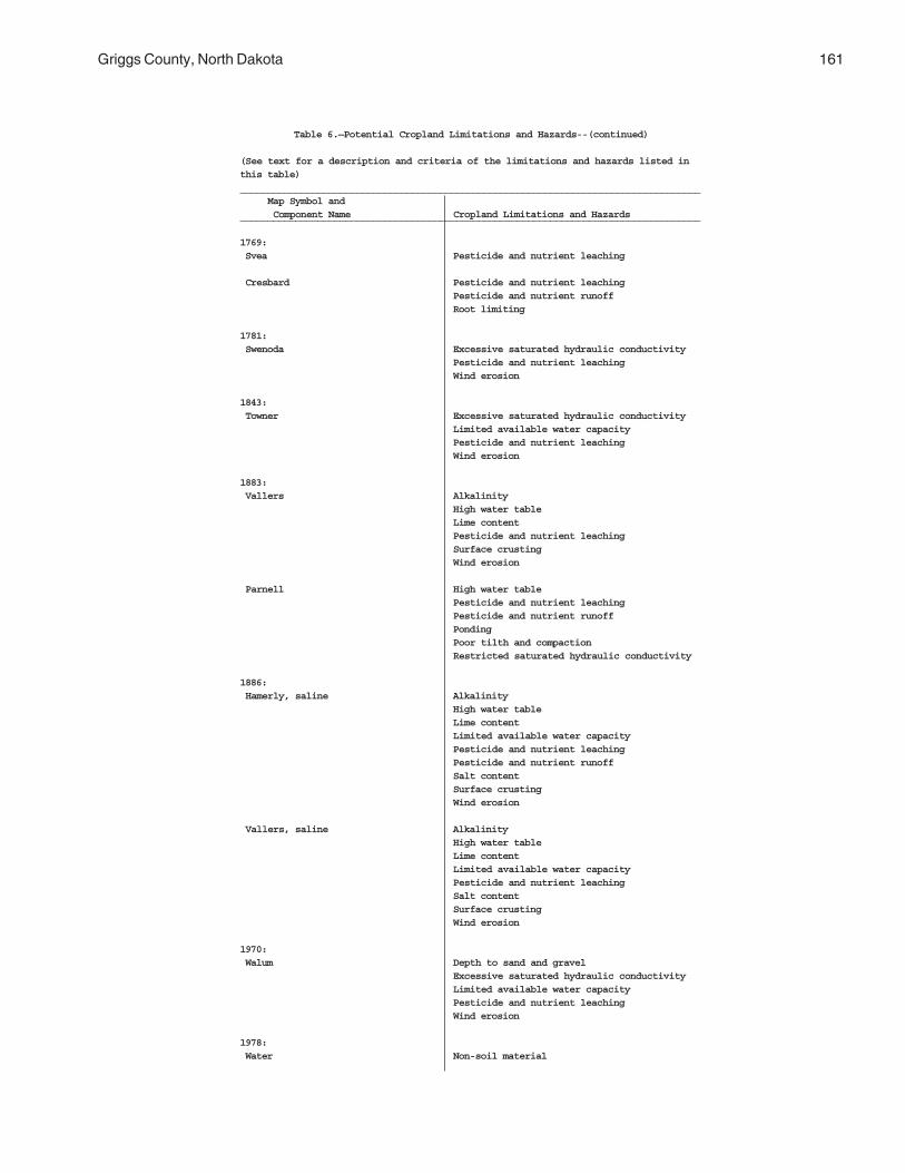
Griggs County, North Dakota 161
Table 6.—Potential Cropland Limitations and Hazards--(continued)
(See text for a description and criteria of the limitations and hazards listed inthis table)___________________________________________________________________________________ Map Symbol and Component Name Cropland Limitations and Hazards___________________________________________________________________________________
1769: Svea Pesticide and nutrient leaching
Cresbard Pesticide and nutrient leachingPesticide and nutrient runoffRoot limiting
1781: Swenoda Excessive saturated hydraulic conductivity
Pesticide and nutrient leachingWind erosion
1843: Towner Excessive saturated hydraulic conductivity
Limited available water capacityPesticide and nutrient leachingWind erosion
1883: Vallers Alkalinity
High water tableLime contentPesticide and nutrient leachingSurface crustingWind erosion
Parnell High water tablePesticide and nutrient leachingPesticide and nutrient runoffPondingPoor tilth and compactionRestricted saturated hydraulic conductivity
1886: Hamerly, saline Alkalinity
High water tableLime contentLimited available water capacityPesticide and nutrient leachingPesticide and nutrient runoffSalt contentSurface crustingWind erosion
Vallers, saline AlkalinityHigh water tableLime contentLimited available water capacityPesticide and nutrient leachingSalt contentSurface crustingWind erosion
1970: Walum Depth to sand and gravel
Excessive saturated hydraulic conductivityLimited available water capacityPesticide and nutrient leachingWind erosion
1978: Water Non-soil material
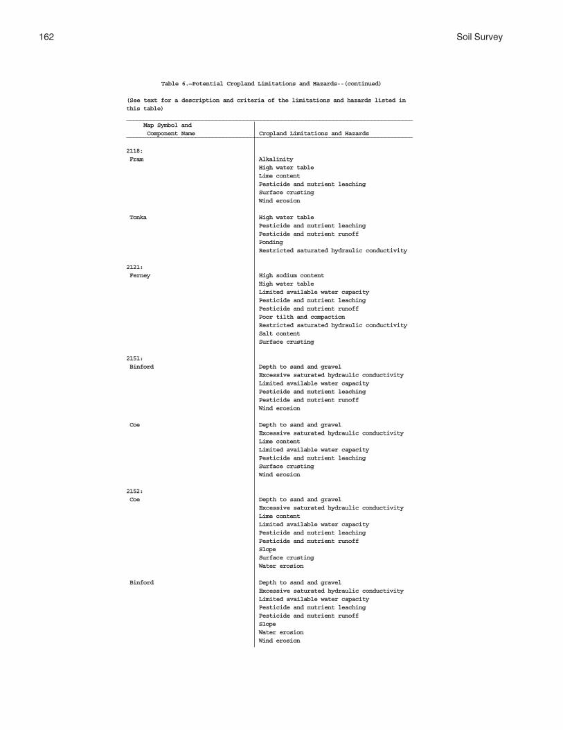
162 Soil Survey
Table 6.—Potential Cropland Limitations and Hazards--(continued)
(See text for a description and criteria of the limitations and hazards listed inthis table)___________________________________________________________________________________ Map Symbol and Component Name Cropland Limitations and Hazards___________________________________________________________________________________
2118: Fram Alkalinity
High water tableLime contentPesticide and nutrient leachingSurface crustingWind erosion
Tonka High water tablePesticide and nutrient leachingPesticide and nutrient runoffPondingRestricted saturated hydraulic conductivity
2121: Ferney High sodium content
High water tableLimited available water capacityPesticide and nutrient leachingPesticide and nutrient runoffPoor tilth and compactionRestricted saturated hydraulic conductivitySalt contentSurface crusting
2151: Binford Depth to sand and gravel
Excessive saturated hydraulic conductivityLimited available water capacityPesticide and nutrient leachingPesticide and nutrient runoffWind erosion
Coe Depth to sand and gravelExcessive saturated hydraulic conductivityLime contentLimited available water capacityPesticide and nutrient leachingSurface crustingWind erosion
2152: Coe Depth to sand and gravel
Excessive saturated hydraulic conductivityLime contentLimited available water capacityPesticide and nutrient leachingPesticide and nutrient runoffSlopeSurface crustingWater erosion
Binford Depth to sand and gravelExcessive saturated hydraulic conductivityLimited available water capacityPesticide and nutrient leachingPesticide and nutrient runoffSlopeWater erosionWind erosion

Griggs County, North Dakota 163
Table 6.—Potential Cropland Limitations and Hazards--(continued)
(See text for a description and criteria of the limitations and hazards listed inthis table)___________________________________________________________________________________ Map Symbol and Component Name Cropland Limitations and Hazards___________________________________________________________________________________
2153: Edgeley Depth to rock
Limited available water capacityPesticide and nutrient leachingPesticide and nutrient runoffRestricted saturated hydraulic conductivitySlopeSoil slumpingWater erosion
Kloten AlkalinityDepth to rockLimited available water capacityPesticide and nutrient leachingPesticide and nutrient runoffRestricted saturated hydraulic conductivitySlopeSoil slumpingWater erosion
Esmond AlkalinityLime contentPesticide and nutrient runoffSlopeSurface crustingWater erosionWind erosion
2156: Lamoure Alkalinity
FloodingHigh water tableLime contentPesticide and nutrient leachingPesticide and nutrient runoffSurface crustingWind erosion
Rauville AlkalinityFloodingHigh water tableLime contentPesticide and nutrient leachingPesticide and nutrient runoffSurface crustingWind erosion
2157: Maddock Excessive saturated hydraulic conductivity
Limited available water capacityPesticide and nutrient leachingPesticide and nutrient runoffSlopeWater erosionWind erosion

164 Soil Survey
Table 6.—Potential Cropland Limitations and Hazards--(continued)
(See text for a description and criteria of the limitations and hazards listed inthis table)___________________________________________________________________________________ Map Symbol and Component Name Cropland Limitations and Hazards___________________________________________________________________________________
2157:(con’t) Esmond Alkalinity
Lime contentPesticide and nutrient runoffSlopeSurface crustingWater erosionWind erosion
Embden Excessive saturated hydraulic conductivityLimited available water capacityPesticide and nutrient leachingPesticide and nutrient runoffSlopeWind erosion
2158: Velva Excessive saturated hydraulic conductivity
Pesticide and nutrient leachingPesticide and nutrient runoffSurface crustingWind erosion
2159: Walsh Pesticide and nutrient runoff
2196: Bearden, saline Alkalinity
High water tableLime contentLimited available water capacityPesticide and nutrient leachingSalt contentSurface crustingWind erosion
Colvin, saline AlkalinityHigh water tableLime contentLimited available water capacityPesticide and nutrient leachingSalt contentSurface crustingWind erosion
2197: Edgeley Depth to rock
Limited available water capacityPesticide and nutrient leachingPesticide and nutrient runoffRestricted saturated hydraulic conductivitySlopeWater erosion
Kloten AlkalinityDepth to rockLimited available water capacityPesticide and nutrient leachingPesticide and nutrient runoffRestricted saturated hydraulic conductivitySlopeSurface crustingWater erosion

Griggs County, North Dakota 165
Table 6.—Potential Cropland Limitations and Hazards--(continued)
(See text for a description and criteria of the limitations and hazards listed inthis table)___________________________________________________________________________________ Map Symbol and Component Name Cropland Limitations and Hazards___________________________________________________________________________________
2198: Hamar Excessive saturated hydraulic conductivity
High water tablePesticide and nutrient leachingWind erosion
Hecla Excessive saturated hydraulic conductivityLimited available water capacityPesticide and nutrient leachingWind erosion
2199: Hamerly Alkalinity
High water tableLime contentPesticide and nutrient leachingPesticide and nutrient runoffSurface crustingSurface stones
Barnes Pesticide and nutrient runoffSurface stones
Tonka High water tablePesticide and nutrient leachingPesticide and nutrient runoffPondingRestricted saturated hydraulic conductivitySurface stones
2200: Letcher Excessive saturated hydraulic conductivity
High sodium contentLimited available water capacityPesticide and nutrient leachingPesticide and nutrient runoffPoor tilth and compactionRestricted saturated hydraulic conductivitySalt contentSurface crustingWind erosion
Swenoda Excessive saturated hydraulic conductivityPesticide and nutrient leachingWind erosion
2201: Stirum Alkalinity
Excessive saturated hydraulic conductivityHigh sodium contentHigh water tableLime contentLimited available water capacityPesticide and nutrient leachingPoor tilth and compactionSalt contentSurface crustingWind erosion

166 Soil Survey
Table 6.—Potential Cropland Limitations and Hazards--(continued)
(See text for a description and criteria of the limitations and hazards listed inthis table)___________________________________________________________________________________ Map Symbol and Component Name Cropland Limitations and Hazards___________________________________________________________________________________
2201:(con’t) Arveson, saline Alkalinity
Excessive saturated hydraulic conductivityHigh water tableLimited available water capacityPesticide and nutrient leachingSalt contentSurface crustingWind erosion
2202: Swenoda Excessive saturated hydraulic conductivity
Pesticide and nutrient leachingPesticide and nutrient runoffWind erosion
Barnes Excessive saturated hydraulic conductivityPesticide and nutrient leachingPesticide and nutrient runoffWind erosion
2203: Swenoda Excessive saturated hydraulic conductivity
Pesticide and nutrient leachingPesticide and nutrient runoffSlopeWind erosion
Barnes Excessive saturated hydraulic conductivityPesticide and nutrient leachingPesticide and nutrient runoffSlopeWind erosion
2204: Walsh Pesticide and nutrient runoff
SlopeWater erosion
2205: Zell Alkalinity
Lime contentPesticide and nutrient runoffSlopeSurface crustingWater erosionWind erosion
Eckman Pesticide and nutrient runoffSlopeWater erosion ____________________________________________________________________________________

Griggs County, North Dakota 167
Table 7.—Map Unit Productivity Index and Farmland Designation
(Dashes (--) indicate an assignment has not been made. Entries in ( )
are for undrained conditions.)
______________________________________________________________________________
Spring Wheat
Map Productivity
Symbol Index Farmland Designation___________________________________________________________________________________
61 51 (29) Prime farmland where drained
118 66 Prime farmland
120 52 Additional farmland of statewide importance
156 83 Prime farmland
167 89 Prime farmland
296 50 Other land
314 39 Other land
319 17 Other land
391 61 Other land
450 70(40) Prime farmland where drained
511 63 Prime farmland
536 50 Additional farmland of statewide importance
539 79 Prime farmland
541 65 Prime farmland
569 70 Prime farmland
579 64 Prime farmland
595 78 Additional farmland of statewide importance
597 84 Prime farmland
605 33 Other Land
753 84 Prime farmland where drained

168 Soil Survey
Table 7.—Map Unit Productivity Index and Farmland Designation--(continued)
(Dashes (--) indicate an assignment has not been made. Entries in () are for
undrained conditions.)
___________________________________________________________________________________
Spring Wheat
Map Productivity
Symbol Index Farmland Designation___________________________________________________________________________________
769 95 Prime farmland
773 83 Prime farmland
881 84(65) Prime farmland where drained
884 84 Prime farmland where drained
893 21 Other land
988 79 Prime farmland
998 47 Additional farmland of statewide importance
1001 21 Other land
1015 57 Additional farmland of statewide importance
1062 94 Prime farmland
1108 52 Other Land
1188 68(41) Prime farmland where drained
1189 33(27) Other land
1221 39 Other land
1267 60(31) Prime farmland where drained
1268 52(12) Other Land
1427 72(22) Other Land
1454 66 Prime farmland
1466 -- Other land
1710 54(6) Other land

Griggs County, North Dakota 169
Table 7.—Map Unit Productivity Index and Farmland Designation--(continued)
(Dashes (--) indicate an assignment has not been made. Entries in () are for
undrained conditions.)
___________________________________________________________________________________
Spring Wheat
Map Productivity
Symbol Index Farmland Designation___________________________________________________________________________________
1762 92 Prime farmland
1765 69 Prime farmland
1766 53 Additional farmland of statewide importance
1769 82 Additional farmland of statewide importance
1781 76 Prime farmland
1843 46 Other land
1883 70(34) Other land
1886 44(40) Other land
1970 51 Additional farmland of statewide importance
1978 -- Water
2118 85(69) Prime farmland where drained
2121 35 Other land
2151 38 Prime farmland when irrigated
2152 21 Other land
2153 23 Other land
2156 51(31) Other land
2157 28 Other land
2158 61 Prime farmland
2159 85 Prime farmland
2196 40(38) Other land
2197 44 Other land
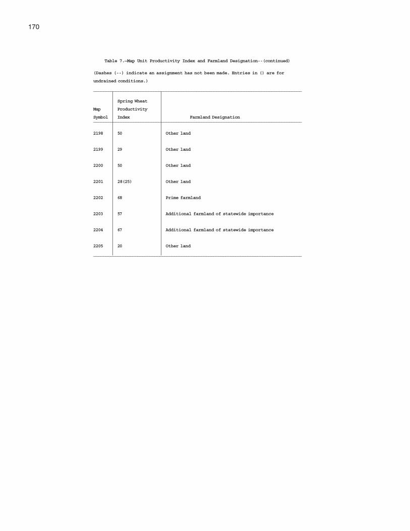
170
Table 7.—Map Unit Productivity Index and Farmland Designation--(continued)
(Dashes (--) indicate an assignment has not been made. Entries in () are for
undrained conditions.)
___________________________________________________________________________________
Spring Wheat
Map Productivity
Symbol Index Farmland Designation___________________________________________________________________________________
2198 50 Other land
2199 29 Other land
2200 50 Other land
2201 28(25) Other land
2202 68 Prime farmland
2203 57 Additional farmland of statewide importance
2204 67 Additional farmland of statewide importance
2205 20 Other land
_____________________________________________________________________________________
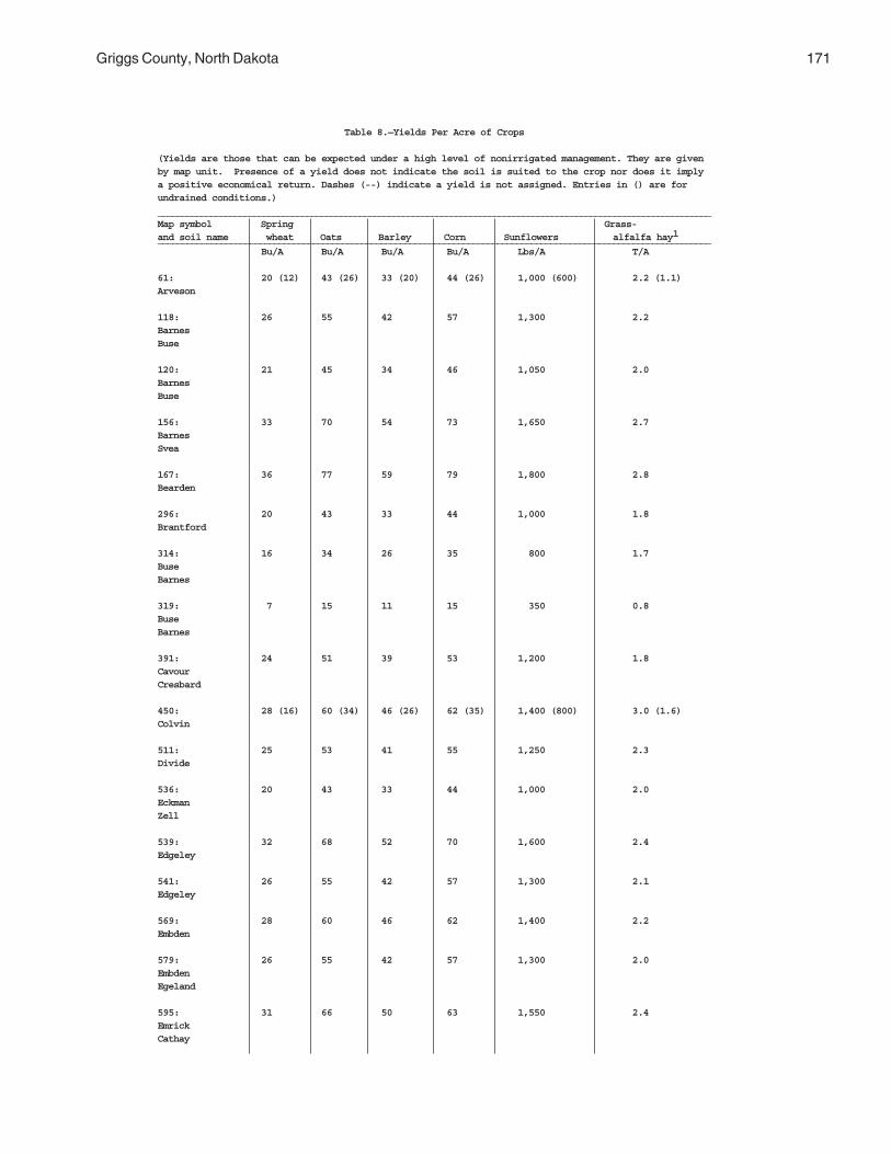
Griggs County, North Dakota 171
Table 8.—Yields Per Acre of Crops
(Yields are those that can be expected under a high level of nonirrigated management. They are givenby map unit. Presence of a yield does not indicate the soil is suited to the crop nor does it implya positive economical return. Dashes (--) indicate a yield is not assigned. Entries in () are forundrained conditions.)___________________________________________________________________________________________________________________Map symbol Spring Grass-and soil name wheat Oats Barley Corn Sunflowers alfalfa hay1__________________________________________________________________________________________________________________ Bu/A Bu/A Bu/A Bu/A Lbs/A T/A
61: 20 (12) 43 (26) 33 (20) 44 (26) 1,000 (600) 2.2 (1.1)Arveson
118: 26 55 42 57 1,300 2.2BarnesBuse
120: 21 45 34 46 1,050 2.0BarnesBuse
156: 33 70 54 73 1,650 2.7BarnesSvea
167: 36 77 59 79 1,800 2.8Bearden
296: 20 43 33 44 1,000 1.8Brantford
314: 16 34 26 35 800 1.7BuseBarnes
319: 7 15 11 15 350 0.8BuseBarnes
391: 24 51 39 53 1,200 1.8CavourCresbard
450: 28 (16) 60 (34) 46 (26) 62 (35) 1,400 (800) 3.0 (1.6)Colvin
511: 25 53 41 55 1,250 2.3Divide
536: 20 43 33 44 1,000 2.0EckmanZell
539: 32 68 52 70 1,600 2.4Edgeley
541: 26 55 42 57 1,300 2.1Edgeley
569: 28 60 46 62 1,400 2.2Embden
579: 26 55 42 57 1,300 2.0EmbdenEgeland
595: 31 66 50 63 1,550 2.4EmrickCathay

172 Soil Survey
Table 8.—Yields Per Acre of Crops--(continued)
(Yields are those that can be expected under a high level of nonirrigated management. They are givenby map unit. Presence of a yield does not indicate the soil is suited to the crop nor does it implya positive economical return. Dashes (--) indicate a yield is not assigned. Entries in () are forundrained conditions.)____________________________________________________________________________________________________________________Map symbol Spring Grass-and soil name wheat Oats Barley Corn Sunflowers alfalfa hay1__________________________________________________________________________________________________________________ Bu/A Bu/A Bu/A Bu/A Lbs/A T/A
597: 34 72 55 75 1,700 2.9EmrickHeimdal
605: 13 28 21 29 650 1.4EsmondHeimdal
753: 34 72 55 75 1,700 2.6FramWyard
769: 38 81 62 84 1,900 2.8Gardena
773: 33 70 54 73 1,650 2.6GardenaEckman
881: 34 (26) 72 (55) 55 (42) 76 (57) 1,700 (1,300) 2.7 (2.7)HamerlyTonka
884: 34 72 55 75 1,700 2.6HamerlyWyard
893: 8 17 13 18 400 0.8Harriet
988: 32 68 52 70 1,600 2.7HeimdalEmrick
998: 19 40 31 42 950 2.0HeimdalEsmond
1001: 8 17 13 18 400 0.7HeimdalEsmond
1015: 23 49 37 51 1,150 1.9Kensal
1062: 38 81 62 84 1,900 3.0LaDelle
1108: 21 45 34 46 1,050 1.6LarsonCathay
1188: 27 (16) 57 (34) 44 (26) 59 (36) 1,350 (800) 2.8 (1.4)Ludden
1189: 13 (11) 28 (23) 21 (18) 39 (24) 650 (550) 1.3 (1.0)Ludden, saline

Griggs County, North Dakota 173
Table 8.—Yields Per Acre of Crops--(continued)
(Yields are those that can be expected under a high level of nonirrigated management. They aregiven by map unit. Presence of a yield does not indicate the soil is suited to the crop nor doesit imply a positive economical return. Dashes (--) indicate a yield is not assigned. Entries in() are for undrained conditions.)____________________________________________________________________________________________________________________________________Map symbol Spring Grass-and soil name wheat Oats Barley Corn Sunflowers alfalfa hay1__________________________________________________________________________________________________________________ Bu/A Bu/A Bu/A Bu/A Lbs/A T/A
1221: 16 34 26 35 800 1.8MaddockHecla
1267: 24 (12) 51 (26) 39 (20) 53 (26) 1,200 (600) 2.7 (1.3)Marysland
1268:Marysland, wet 21 (5) 45 (11) 34 (8) 46 (11) 1,050 (250) 2.4 (0.5)
1427: 29 (9) 62 (19) 47 (15) 64 (20) 1,450 (450) 3.0 (1.0)Parnell
1454: 26 55 42 57 1,300 2.4Wyndmere
1466: --- --- --- --- --- ---Pits, sand and gravel
1710: 22 (2) 47 (4) 36 (3) 43 (4) 1,100 (100) 2.1 (0.2)Southam
1762: 37 79 60 31 1,850 2.9SveaBarnes
1765: 28 60 46 62 1,400 2.2SveaBuse
1766: 21 45 34 46 1,050 2.0SveaBuse
1769: 33 70 54 73 1,650 2.5SveaCresbard
1781: 30 64 49 66 1,500 2.4Swenoda
1843: 18 38 29 40 900 1.8Towner
1883: 26 (14) 60 (30) 46 (23) 62 (31) 1,400 (700) 3.1 (1.6)VallersParnell
1886: 18 (16) 38 (34) 29 (26) 40 (36) 900 (800) 1.9 (1.8)Hamerly, salineVallers, saline
1970: 20 43 33 44 1,000 1.8Walum
1978: --- --- --- --- --- ---Water

174 Soil Survey
Table 8.—Yields Per Acre of Crops--(continued)
(Yields are those that can be expected under a high level of nonirrigated management. They aregiven by map unit. Presence of a yield does not indicate the soil is suited to the crop nordoes it imply a positive economical return. Dashes (--) indicate a yield is not assigned.Entries in () are for undrained conditions.)___________________________________________________________________________________________________________________Map symbol Spring Grass-and soil name wheat Oats Barley Corn Sunflowers alfalfa hay1__________________________________________________________________________________________________________________ Bu/A Bu/A Bu/A Bu/A Lbs/A T/A
2118: 34 (28) 72 (60) 55 (46) 75 (62) 1,700 (1,400) 2.7 (2.7)FramTonka
2121: 14 30 23 31 700 1.2Ferney
2151: 15 32 24 33 750 1.4BinfordCoe
2152: 8 17 13 18 400 0.7CoeBinford
2153: 9 19 15 20 450 1.9EdgeleyKlotenEsmond
2156: 20 (12) 43 (26) 33 (20) 44 (26) 1,000 (600) 2.1 (1.2)LamoureRauville
2157: 11 23 18 24 550 1.2MaddockEsmondEmbden
2158: 24 51 39 53 1,200 2.7Velva
2159: 34 72 55 75 1,700 2.8Walsh
2196: 16 (15) 34 (32) 26 (24) 35 (33) 800 (750) 1.7 (1.5)Bearden, salineColvin, saline
2197: 18 38 29 40 900 1.8EdgeleyKloten
2198: 20 43 33 44 1,000 2.0HamarHecla
2199: 12 26 20 26 600 1.0HamerlyBarnesTonka

Griggs County, North Dakota 175
Table 8.—Yields Per Acre of Crops--(continued)
(Yields are those that can be expected under a high level of nonirrigated management. They aregiven by map unit. Presence of a yield does not indicate the soil is suited to the crop nordoes it imply a positive economical return. Dashes (--) indicate a yield is not assigned.Entries in () are for undrained conditions.)___________________________________________________________________________________________________________________Map symbol Spring Grass-and soil name wheat Oats Barley Corn Sunflowers alfalfa hay1__________________________________________________________________________________________________________________ Bu/A Bu/A Bu/A Bu/A Lbs/A T/A
2200: 20 43 33 44 1,000 1.9LetcherSwenoda
2201: 10 21 16 22 500 0.8StirumArveson, saline
2202: 27 57 44 59 1,350 2.5SwenodaBarnes
2203: 23 49 37 51 1,150 2.3SwenodaBarnes
2204: 27 57 44 59 1,350 2.6Walsh
2205: 8 17 13 18 400 0.7ZellEckman
_______________________________________________________________________________________________________
1Yield estimates for adapted species.

176 Soil Survey
Table 9.—Interpretive Groupings Report
(Dashes (-—) indicate an interpretive group is not assigned. Entries in () are forundrained conditions.)_______________________________________________________________________________________Map Symbol Land Windbreak and Pasture and hayland capability suitability soil name suitability group class group_______________________________________________________________________________________
61:Arveson Limy Subirrigated A5 2W(4W) 1K(2K)
(Wet C1)
118:Barnes Loamy and Silty A1 2E 3Buse Thin Upland A2 3E 8
120:Barnes Loamy and Silty A1 3E 3Buse Thin Upland A2 4E 8
156:Barnes Loamy and Silty A1 2E 3Svea Overflow and Run-On A3 2E 1
167:Bearden Limy Subirrigated A5 2E 1K
296:Brantford Shallow to Gravel B1 3S 6G
314:Buse Thin Upland A2 6E 10Barnes Loamy and Silty A1 4E 3
319:Buse Steeply Sloping H3 7E 10Barnes Loamy and Silty A1 6E 10
391:Cavour Claypan G1 4S 9LCresbard Clayey Subsoils F1 2S 4
450: Limy Subirrigated A5 2W (4W) 1K (2K)Colvin (Wet C1)
511:Divide Limy Subirrigated A5 3S 1K
536:Eckman Loamy and Silty A1 3E 3Zell Thin Upland A2 4E 8
539:Edgeley Moderately Deep Silty F2 2S 6D
541:Edgeley Moderately Deep Silty F2 2E 6D
569:Embden Sandy A6 3E 1
579:Embden Sandy A6 3E 1Egeland Sandy A6 3E 5
595:Emrick Overflow and Run-On A3 2E 1Cathay Clayey Subsoils F1 3S 3

Griggs County, North Dakota 177
Table 9.—Interpretive Groupings Report--(continued)
(Dashes (-—) indicate an interpretive group is not assigned. Entries in () are forundrained conditions.)_______________________________________________________________________________________Map Symbol Land Windbreak and Pasture and hayland capability suitability soil name suitability group class group_______________________________________________________________________________________
597:Emrick Overflow and Run-On A3 2E 1Heimdal Loamy and Silty A1 2E 3
605:Esmond Thin Upland A2 6E 10Heimdal Loamy and Silty A1 4E 3
753:Fram Limy Subirrigated A5 2E 1KWyard Overflow and Run-On A3 2C 1
769:Gardena Loamy and Silty A1 2C 1
773:Gardena Overflow and Run-On A3 2E 1Eckman Loamy and Silty A1 2E 3
881:Hamerly Limy Subirrigated A5 2E 1KTonka Clayey A4 (Wet C1) 2W(4W) 1(2)
884:Hamerly Limy Subirrigated A5 2E 1KWyard Overflow and Run-On A3 2C 1
893:Harriet Sodic-Saline G3 6S 10
988:Heimdal Loamy and Silty A1 2E 3Emrick Overflow and Run-On A3 2E 1
998:Heimdal Loamy and Silty A1 3E 3Esmond Thin Upland A2 4E 8
1001:Heimdal Loamy and Silty A1 6E 10Esmond Steeply Sloping H3 7E 10
1015:Kensal Shallow to Gravel B1 3S 6G
1062:LaDelle Overflow and Run-On A3 2C 1
1108:Larson Claypan G1 4S 9LCathay Clayey Subsoils F1 3S 3
1188:Ludden Clayey A4 (Wet C1) 2W(4W) 4C(2K)
1189:Ludden, saline Saline G4 3S 9W

178 Soil Survey
Table 9.—Interpretive Groupings Report--(continued)
(Dashes (—) indicate an interpretive group is not assigned. Entries in () are forundrained conditions.)_______________________________________________________________________________________Map Symbol Land Windbreak and Pasture and hayland capability suitability soil name suitability group class group_______________________________________________________________________________________
1221:Maddock Sands A7 4E 7Hecla Sands A7 4E 7
1267:Marysland Limy Subirrigated A5 2W(4W) 1K(2K)
(Wet C1)
1268:Marysland, wet Wet C1 (Wetland H6) 3W(5W) 2K(10)
1427:Parnell Wet C1 (Wetland H6) 3W(5W) 2 (10)
1454:Wyndmere Limy Subirrigated A5 3E 1K
1466:Pits, sand —-- 8S —-- and gravel
1710:Southam Wet C1 (Wetland H6) 3W(8W) 2K(10)
1762:Svea Overflow and Run-On A3 2C 1Barnes Loamy and Silty A1 2C 3
1765:Svea Overflow and Run-On A3 2E 1Buse Thin Upland A2 3E 8
1766:Svea Loamy and Silty A1 3E 3Buse Thin Upland A2 4E 8
1769:Svea Overflow and Run-On A3 2C 1Cresbard Clayey Subsoils F1 2S 4
1781:Swenoda Sandy A6 3E 1
1843:Towner Sands A7 4E 7
1883:Vallers Limy Subirrigated A5 2W(4W) 1K(2K)
(Wet C1)Parnell Wet C1 (Wetland H6) 3W(5W) 2K(10)
1886:Hamerly, saline Saline G4 3S 9WVallers, saline Saline G4 3S 9W
1970:Walum Sandy A6 3E 6G
1978:Water —-- —-- —--

Griggs County, North Dakota 179
Table 9.—Interpretive Groupings Report--(continued)
(Dashes (—-) indicate an interpretive group is not assigned. Entries in () are forundrained conditions.)_______________________________________________________________________________________Map Symbol Land Windbreak and Pasture and hayland capability suitability soil name suitability group class group_______________________________________________________________________________________
2118:Fram Limy Subirrigated A5 2E 1KTonka Clayey A4 (Wet C1) 2W(4W) 2(10)
2121:Ferney Thin Claypan G2 6S 10
2151:Binford Shallow to Gravel B1 3E 6GCoe Very Shallow to Gravel B2 6S 10
2152:Coe Very Shallow to Gravel B2 7S 10Binford Shallow to Gravel B1 6E 6G
2153:Edgeley Moderately Deep Silty F2 6E 6DKloten Shallow H4 7E 10Esmond Steeply Sloping H3 7E 10
2156:Lamoure Limy Subirrigated A5 2W(4W) 1K(2K)
(Wet C1)Rauville Wet C1 (Wetland H6) 3W(5W) 2K(10)
2157:Maddock Sands A7 6E 7Esmond Thin Upland A2 6E 10Embden Sandy A6 4E 5
2158:Velva Sandy A6 3E 5
2159:Walsh Overflow and Run-On A3 2E 1
2196:Bearden, saline Saline G4 3S 9WColvin, saline Saline G4 3S 9W
2197:Edgeley Moderately Deep Silty F2 3E 6DKloten Shallow H4 6E 10
2198:Hamar Sands A7 4E 1Hecla Sands A7 4E 7
2199:Hamerly Stony H2 6S 10Barnes Stony H2 6S 10Tonka Stony H2 6S 10
2200:Letcher Claypan G1 4S 9LSwenoda Sandy A6 3E 1
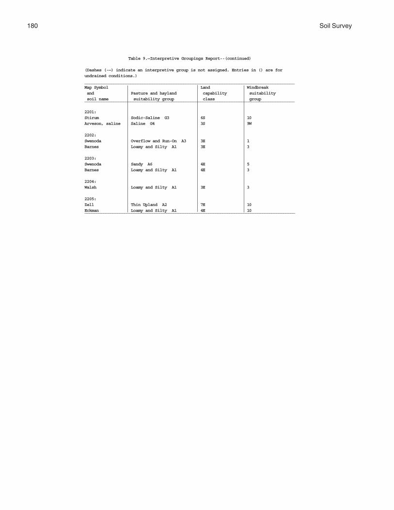
180 Soil Survey
Table 9.—Interpretive Groupings Report--(continued)
(Dashes (-—) indicate an interpretive group is not assigned. Entries in () are forundrained conditions.)_______________________________________________________________________________________Map Symbol Land Windbreak and Pasture and hayland capability suitability soil name suitability group class group_______________________________________________________________________________________
2201:Stirum Sodic-Saline G3 6S 10Arveson, saline Saline G4 3S 9W
2202:Swenoda Overflow and Run-On A3 3E 1Barnes Loamy and Silty A1 3E 3
2203:Swenoda Sandy A6 4E 5Barnes Loamy and Silty A1 4E 3
2204:Walsh Loamy and Silty A1 3E 3
2205:Zell Thin Upland A2 7E 10Eckman Loamy and Silty A1 4E 10__________________________________________________________________________________________

Griggs County, North Dakota 181
Table 10.—Windbreak Suitability Groups
Expected Shrub Heights at 20 Years
(Dashes (--) indicate the species are not expected to perform adequately on these suitabilitygroups under most conditions.)_______________________________________________________________________________________________Species Windbreak Suitability Groups __________________________________________________________
1 1K 2 2K 2H 3_______________________________________________________________________________________________
ft. ft. ft. ft. ft. ft.
Almond, Russian 4-6 3-4 3-5 3-4 -— 4-6Buffaloberry, Silver 8-12 8-12 -— -— -— 9-12Caragana (Peashrub, Siberian) 8-10 8-10 7-8 -— -— 8-10Cherry, Europian Bird (Mayday) 10-15 -— 10-15 -— -— 10-12Cherry, Nanking 6-8 -— 4-6 -— -— 5-7Cherry, Mongolian 5-6 -— 4-6 -— -— 4-6Cherry, Western Sand 4-6 -— -— -— -— 4-6Cotoneaster, Peking 8-10 7-9 8-10 -— -— 7-9Cotoneaster, Europian 10-12 9-11 8-12 -— -— 7-9Currant, Golden 5-7 -— 4-6 -— -— 5-6Dogwood, Redosier 6-8 -— 6-8 -— -— 5-7Forsythia, ‘Meadowlark’ 7-11 6-8 -— -— -— 7-9Honeysuckle, Amur 8-10 7-9 -— -— -— 7-9Honeysuckle, Blueleaf ‘Freedom’ 7-9 6-8 -— -— -— 6-8Honeysuckle, Tatarian 8-10 7-9 -— -— -— 8-10Indigo, False 7-9 6-8 7-9 7-9 -— 5-7Juneberry (Serviceberry) 6-8 -— 5-7 -— -— 5-7Lilac, Common 10-12 10-12 8-10 8-10 -— 8-10Lilac, Late 10-12 8-10 10-12 8-10 -— 8-10Plum, American 7-9 -— 6-7 -— -— 7-9Rose, Species 4-5 4-5 4-5 -— -— 4-5Sea-buckthorn 8-10 8-10 -— -— -— 6-8Silverberry 6-8 5-6 -— -— -— 5-7Sumac, Skunkbush 5-9 4-7 5-8 -— -— 5-9Willow, Sandbar 7-9 6-8 7-10 6-8 -— 6-8Viburnum, Nannyberry 12-16 -— 12-14 -— -— 10-12

182 Soil Survey
Table 10.—Windbreak Suitability Groups--(continued)
Expected Shrub Heights at 20 Years
(Dashes (--) indicate the species are not expected to perform adequately on these suitabilitygroups under most conditions.)_______________________________________________________________________________________________Species Windbreak Suitability Groups __________________________________________________________
4 4C 5 6D 6G 7_______________________________________________________________________________________________
ft. ft. ft. ft. ft. ft.
Almond, Russian 4-5 4-5 3-4 -— -— -—Buffaloberry, Silver 7-8 7-8 4-7 4-6 4-6 -—Caragana (Peashrub, Siberian) 7-8 5-6 7-9 6-8 6-8 6-8Cherry, Europian Bird (Mayday) 10-12 8-10 8-10 6-8 4-6 4-6Cherry, Nanking 4-5 4-5 4-5 -— -— -—Cherry, Mongolian 4-6 4-6 4-5 -— -— -—Cherry, Western Sand -— -— 4-6 3-5 3-5 3-5Cotoneaster, Peking 6-7 5-7 6-7 -— -— -—Cotoneaster, Europian 9-10 8-9 8-10 -— -— -—Currant, Golden 3-5 3-5 5-6 -— -— -—Dogwood, Redosier 4-6 4-6 —- -— -— -—Forsythia, ‘Meadowlark’ -— -— 6-8 -— -— -—Honeysuckle, Amur 7-9 7-9 6-8 -— -— -—Honeysuckle, Blueleaf ‘Freedom’ 6-8 6-8 5-7 4-6 4-6 4-6Honeysuckle, Tatarian 7-8 7-8 6-7 5-7 5-7 5-7Indigo, False -— -— -— -— -— -—Juneberry (Serviceberry) 5-6 5-6 -— -— -— -—Lilac, Common 6-8 5-7 7-9 5-7 5-7 -—Lilac, Late 7-9 7-9 -— -— -— -—Plum, American 6-8 6-8 5-7 -— -— -—Rose, Species 4-5 3-4 3-4 2-4 2-4 2-4Sea-buckthorn 6-8 6-8 5-7 4-6 4-6 4-6Silverberry -— -— 5-7 4-6 4-6 4-6Sumac, Skunkbush 4-7 4-7 5-9 6-7 6-7 6-7Willow, Sandbar 5-6 5-6 -— -— -— -—Viburnum, Nannyberry -— -— 8-10 -— -— -—

Griggs County, North Dakota 183
Table 10.—Windbreak Suitability Groups--(continued)
Expected Shrub Heights at 20 Years
(Dashes (--) indicate the species are not expected to perform adequately on these suitabilitygroups under most conditions.)_______________________________________________________________________________________________Species Windbreak Suitability Groups __________________________________________________________
8 9C 9W 9L 10_______________________________________________________________________________________________
ft. ft. ft. ft. ft. .
Almond, Russian -— -— -— -— -—Buffaloberry, Silver 4-5 4-5 -— 4-5 -—Caragana (Peashrub, Siberian) 4-5 4-5 -— 4-5 -—Cherry, Europian Bird (Mayday) -— -— -— -— -—Cherry, Nanking -— -— -— -— -—Cherry, Mongolian -— -— -— -— -—Cherry, Western Sand -— -— -— -— -—Cotoneaster, Peking -— -— -— -— -—Cotoneaster, Europian -— -— -— -— -—Currant, Golden -— 3-4 3-4 3-4 -—Dogwood, Redosier —- -— -— -— -—Forsythia, ‘Meadowlark’ -— -— -— -— -—Honeysuckle, Amur -— -— -— -— -—Honeysuckle, Blueleaf ‘Freedom’ 4-5 4-5 -— 4-5 -—Honeysuckle, Tatarian 5-6 5-6 -— 5-6 -—Indigo, False -— -— -— -— -—Juneberry, (Serviceberry) -— -— -— -— -—Lilac, Common 5-6 5-6 -— 5-6 -—Lilac, Late -— -— -— -— -—Plum, American -— -— -— -— -—Rose, Species -— -— -— -— -—Sea-buckthorn 4-5 4-5 -— 4-5 -—Silverberry 3-5 3-5 -— 3-5 -—Sumac, Skunkbush 3-4 3-4 -— 3-4 -—Willow, Sandbar -— -— -— -— -—Viburnum, Nannyberry -— -— -— -— -—

184 Soil Survey
Table 10.—Windbreak Suitability Groups--(continued)
Expected Deciduous Tree Heights at 20 Years
(Dashes (--) indicate the species are not expected to perform adequately on these suitabilitygroups under most conditions.)_______________________________________________________________________________________________Species Windbreak Suitability Groups __________________________________________________________
1 1K 2 2K 2H 3_______________________________________________________________________________________________
ft. ft. ft. ft. ft. ft.
Apricot, Species 16-20 15-18 -— -— -— 15-17Ash, Black 20-24 17-20 19-22 17-20 -— 18-22Ash, Green 21-26 19-24 21-26 19-24 -— 20-25Aspen, Quaking 27-32 22-27 27-32 22-27 -— -—Boxelder 20-25 -— 16-20 -— -— 19-24Chokecherry, Common 11-14 9-12 9-11 7-9 -— 10-12Cottonwood, Species 45-50 40-45 43-48 35-40 -— -—Crabapple, Species 18-20 -— 17-20 -— -— 17-19Elm, Japanese 29-35 24-30 -— -— -— 29-35Elm, Siberian 28-35 28-35 28-32 28-35 -— 26-32Hackberry, Common 20-25 18-23 20-25 18-23 -— 20-25Hawthorn, Arnold 10-12 8-10 9-11 6-8 -— 9-11Hawthorn, Downy 10-12 8-10 9-11 6-8 -— 9-11Honeylocust 20-25 18-20 20-25 -— -— 18-20Maple, Amur 12-14 -— 9-11 -— -— 11-12Maple, Tatarian 12-14 -— 9-11 -— -— 11-12Oak, Bur 20-25 18-23 -— -— -— 18-20Olive, Russian 15-19 15-19 15-19 15-19 -— 15-19Pear, Ussurian(Harbin) 16-18 -— 14-16 -— -— 16-18Poplar, Hybrid Species 50-55 -— 45-50 -— -— -—Poplar, White 33-40 33-35 33-35 33-35 -— 25-30Walnut, Black 22-28 -— -— -— -— 17-21Willow, Laurel 30-35 20-25 30-35 20-25 20-25 -—Willow, White 30-35 20-25 30-35 20-25 20-25 -—

Griggs County, North Dakota 185
Table 10.—Windbreak Suitability Groups--(continued)
Expected Deciduous Tree Heights at 20 Years
(Dashes (--) indicate the species are not expected to perform adequately on these suitabilitygroups under most conditions.)_______________________________________________________________________________________________Species Windbreak Suitability Groups __________________________________________________________
4 4C 5 6D 6G 7_______________________________________________________________________________________________
ft. ft. ft. ft. ft. ft.
Apricot, Species -— -— -— -— -— -—Ash, Black -— -— -— -— -— -—Ash, Green 18-20 18-20 15-19 14-18 14-18 -—Aspen, Quaking -— -— -— -— -— -—Boxelder -— -— -— -— -— -—Chokecherry, Common 8-10 7-9 8-10 7-9 7-9 -—Cottonwood, Species -— -— -— -— -— -—Crabapple, Species 12-14 10-12 12-15 -— -— -—Elm, Japanese 26-30 26-30 26-30 19-22 19-22 -—Elm, Siberian 24-26 24-26 20-25 17-22 17-22 -—Hackberry, Common 16-18 16-18 15-18 -— -— -—Hawthorn, Arnold 7-9 7-9 8-10 6-8 6-8 -—Hawthorn, Downy 7-9 7-9 8-10 6-8 6-8 -—Honeylocust -— -— 15-18 -— -— -—Maple, Amur -— -— -— -— -— -—Maple, Tatarian -— -— -— -— -— -—Oak, Bur 14-16 13-15 18-20 -— -— -—Olive, Russian 12-14 12-14 12-15 11-14 11-14 -—Pear, Ussurian(Harbin) 11-13 11-13 11-13 -— -— -—Poplar, Hybrid Species -— -— -— -— -— -—Poplar, White -— -— -— -— -— -—Walnut, Black -— -— -— -— -— -—Willow, Laurel -— -— -— -— -— -—Willow, White -— -— -— -— -— -—

186 Soil Survey
Table 10.—Windbreak Suitability Groups--(continued)
Expected Deciduous Tree Heights at 20 Years
(Dashes (--) indicate the species are not expected to perform adequately on these suitabilitygroups under most conditions.)_______________________________________________________________________________________________Species Windbreak Suitability Groups __________________________________________________________
8 9C 9W 9L 10_______________________________________________________________________________________________
ft. ft. ft. ft. ft.
Apricot, Species -— -— -— -— -—Ash, Black -— -— -— -— -—Ash, Green 12-16 9-11 9-10 9-13 -—Aspen, Quaking -— -— -— -— -—Boxelder -— -— -— -— -—Chokecherry, Common -— -— -— -— -—Cottonwood, Species -— -— -— -— -—Crabapple, Species -— -— -— -— -—Elm, Japanese 19-21 11-15 -— 11-15 -—Elm, Siberian 14-18 10-12 -— 10-12 -—Hackberry, Common -— -— -— -— -—Hawthorn, Arnold -— -— -— -— -—Hawthorn, Downy -— -— -— -— -—Honeylocust -— -— -— -— -—Maple, Amur -— -— -— -— -—Maple, Tatarian -— -— -— -— -—Oak, Bur -— -— -— -— -—Olive, Russian 11-14 6-8 6-8 8-10 -—Pear, Ussurian(Harbin) -— 8-9 -— -— -—Poplar, Hybrid Species -— -— -— -— -—Poplar, White -— -— -— -— -—Walnut, Black -— -— -— -— -—Willow, Laurel -— -— -— -— -—Willow, White -— -— -— -— -—

Griggs County, North Dakota 187
Table 10.—Windbreak Suitability Groups--(continued)
Expected Conifer Heights at 20 Years
(Dashes (--) indicate the species are not expected to perform adequately on these suitabilitygroups under most conditions.)_______________________________________________________________________________________________Species Windbreak Suitability Groups __________________________________________________________
1 1K 2 2K 2H 3_______________________________________________________________________________________________
ft. ft. ft. ft. ft. ft.
Arborvitae, Siberian 12-15 10-12 12-15 10-13 -— 8-11Juniper, Rocky Mountain 12-15 10-12 11-13 8-9 -— 12-15Larch, Siberian 18-22 -— -— -— -— 17-21Pine, Ponderosa 18-22 15-17 17-19 -— -— 18-22Pine, Scotch 18-20 -— 16-18 -— -— 18-20Redcedar, Eastern 12-15 10-12 11-13 8-9 -— 12-15Spruce, Black Hills 17-20 -— 15-18 -— -— 12-15Spruce, Colorado Blue 17-20 -— 15-18 -— -— 15-19Spruce, White 17-20 -— 15-18 -— -— 15-19
Table 10.— Windbreak Suitability Groups--(continued)
Expected Conifer Heights at 20 Years
(Dashes (--) indicate the species are not expected to perform adequately on these suitabilitygroups under most conditions.)_______________________________________________________________________________________________Species Windbreak Suitability Groups __________________________________________________________
4 4C 5 6D 6G 7_______________________________________________________________________________________________
ft. ft. ft. ft. ft. ft.
Arborvitae, Siberian 7-10 7-10 -— -— -— -—Juniper, Rocky Mountain 10-12 10-12 11-13 9-11 9-11 7-9Larch, Siberian -— -— 15-19 -— -— -—Pine, Ponderosa 16-17 16-17 16-20 11-16 11-16 11-15Pine, Scotch -— -— -— -— -— -—Redcedar, Eastern 10-12 10-12 11-13 9-11 9-11 8-10Spruce, Black Hills 13-15 13-15 -— -— -— -—Spruce, Colorado Blue 13-15 13-15 -— -— -— -—Spruce, White 13-15 13-15 -— -— -— -—

188
Table 10.—Windbreak Suitability Groups--(continued)
Expected Conifer Heights at 20 Years
(Dashes (--) indicate the species are not expected to perform adequately on these suitabilitygroups under most conditions.)_______________________________________________________________________________________________Species Windbreak Suitability Groups __________________________________________________________
8 9C 9W 9L 10_______________________________________________________________________________________________
ft. ft. ft. ft. ft.Arborvitae, Siberian -— -— -— -— -—Juniper, Rocky Mountain 6-8 6-7 5-6 6-7 -—Larch, Siberian -— -— -— -— -—Pine, Ponderosa 11-15 8-10 -— 8-10 -—Pine, Scotch -— -— -— -— -—Redcedar, Eastern 7-9 6-7 5-6 6-7 -—Spruce, Black Hills -— -— -— -— -—Spruce, Colorado Blue -— -— -— -— -—Spruce, White -— -— -— -— -—

189
Rangeland makes up about 45,000 acres or 10percent of the land in Griggs County. The majority ofrangeland is on rolling to steep dissected till plains andassociated wetlands and in stream valleys and onoutwash plains. The soils are generally unsuited topoorly suited for cultivated crops. Rangeland is usedprimarily for grazing by domestic livestock; however, italso provides wildlife habitat, watershed protection,recreational areas, and aesthetic value.
Rangeland is defined as land on which the nativevegetation (historic climax or natural potential plantcommunity) is predominantly grass, grasslike plants,forbs, and shrubs. Rangeland includes naturalgrasslands, savannas, marshes, and wet meadows.Cultural treatments, such as fertilization andcultivation, generally are not used or needed tomaintain productivity of rangeland. The compositionand production of the plant community are largelydetermined by soil, climate, topography, and grazinginfluences.
Range Sites
In areas that have similar climate and topography,differences in the kind and amount of vegetationproduced on rangeland are closely related to the kindof soil.
Soils vary in their capacity to produce grass andother native plants. Soils that produce similar kinds,proportion, and amounts of vegetation are grouped intoa range site.
Range Site is a distinctive kind of rangeland thatproduces a characteristic natural plant communitythat differs from natural plant communities on otherrange sites in kind, amount, and proportion of rangeplants. Over time, the combination of plants bestsuited to a particular soil and climate has becomeestablished. In the absence of excessive disturbances,this group of plants is the natural plant community orclimax community for the site. Natural plantcommunities are not static but vary slightly from yearto year and place to place. The natural potential plantcommunity is generally, but not always, the mostproductive and diverse combination of plants that mayoccur on a site.
The relationship between soils and vegetation wasdetermined during this survey. In most cases, rangesites can be determined directly from the soil map. Soilproperties that affect moisture supply and plantnutrients have the greatest influence on theproductivity of range sites. Soil reaction, salt content,and a seasonal high water table are also important.Many different range sites occur in the survey area.Range sites for each map unit component underundrained conditions are given in Table 11, “RangeSites.“
The following paragraphs describe soil andlandscape features and limitations associated with therange sites in Major Land Resource Area (MLRA) 55B.Some of these range sites may not occur in GriggsCounty.
Clayey range site. These are very deep, well andmoderately well drained, moderately fine and finetextured soils. Saturated hydraulic conductivity is slowor very slow. Available water capacity is high. This siteis on nearly level to gently rolling glacial till plains, lakeplains, and terraces of large streams. Slope rangesfrom 1 to 9 percent.
Site retrogression results in a decrease in theabundance of such plants as western wheatgrass,porcupinegrass, green needlegrass, and prairiejunegrass. The plants that usually increase under theseconditions are needleandthread, blue grama, fringedsagewort, and upland sedges. Further deteriorationmay result in a dominance of blue grama, uplandsedges, western ragweed, and fringed sagewort, andinvasion of Kentucky bluegrass.
Very few problems affect management of this site.The water infiltration rate is slow. As a result, anadequate cover of vegetation is needed to help reducerunoff.
Claypan range site. These are very deep,moderately well and well drained soils. They havemoderately coarse to moderately fine textured surfacelayers underlain by a sodic subsoil. The subsoils aremoderately coarse to fine textured and are high insodium. Saturated hydraulic conductivity is very slowand available water capacity is moderate. This site ison nearly level to undulating glacial till plains and lakeplains. Slope ranges from 0 to 6 percent.
Rangeland

190 Soil Survey
Site retrogression generally results in a decrease inthe abundance of such plants as green needlegrass,prairie junegrass, needleandthread, and westernwheatgrass. The plants that tend to increase inabundance under retrogression include inlandsaltgrass, blue grama, Sandberg bluegrass, uplandsedges, and fringed sagewort. Further deteriorationresults in a dominance of blue grama, inland saltgrass,upland sedges, fringed sagewort, broom snakeweed,and annual forbs.
This site is easily damaged by mismanagement.Because of a dense subsoil and the content of salts inthe soil, reestablishing the vegetation is difficult indenuded areas. Management that maintains anabundance of the climax species will maintainproduction and protect the soil from erosion.
Limy Subirrigated range site. These are very deepsoils that are typically somewhat poorly drained, butinclude some moderately well drained soils. They havea loamy fine sand to silty clay loam surface layer andtypically have a water table at about 1.5 to 3.5 feetduring the spring and early summer. These soils have alayer high in lime within 16 inches of the surface. Thissite is on level, nearly level, and gently sloping glaciallake plains, glacial till plains, and outwash plains.Slope ranges from 0 to 6 percent.
Site retrogression usually results in a decrease inthe abundance of plants such as big bluestem,indiangrass, switchgrass, and Maximilian sunflower.Little bluestem usually increases initially in abundanceunder these conditions, but it eventually decreaseswith more severe deterioration. Further deteriorationresults in a dominance of Baltic rush, commonspikerush, annual grasses and forbs, and invasion ofKentucky bluegrass.
Generally, no major problems affect management.The dominant warm-season grasses on this siteprovide high-quality forage and wildlife habitat late inthe growing season.
Overflow range site. These are very deep,moderately well and well drained, moderate tomoderately fine textured soils that regularly receiveadditional run-on from surrounding uplands or flooding.Saturated hydraulic conductivity is moderate andavailable water capacity is high to very high. This siteoccurs on nearly level swales and depressions onglacial till plains and on stream terraces and floodplains. Slope ranges from 0 to 3 percent.
Site retrogression results in a decrease in theabundance of plants such as big bluestem, greenneedlegrass, prairie dropseed, and switchgrass. Theplants that increase in abundance under theseconditions are western wheatgrass, blue grama, sunsedge, and fescue sedge. Further deterioration results
in a dominance of blue grama and sedges, andinvasion of Kentucky bluegrass.
As a result of flooding and the upland runoffreceived by this site, it is very productive whenproperly managed.
Saline Lowland range site. These are very deep,somewhat poorly and poorly drained, medium and finetextured saline soils. Also included are some saline-sodic soils. This range site receives additional waterfrom ground water seepage and/or run-on. Surfacelayers commonly are saline. Saturated hydraulicconductivity is moderate to very slow and availablewater capacity is moderate. This site occurs on shallowbasins and lake plains and on low terraces and bottomlands along streams. Slope ranges from 0 to 3 percent.
Site retrogression results in a decrease in theabundance of such plants as Nuttall alkaligrass,slender wheatgrass, and western wheatgrass. Theplants that increase in abundance under theseconditions are inland saltgrass, alkali muhly, foxtailbarley, and mat muhly. Further deterioration results in adominance of inland saltgrass, foxtail barley,silverweed cinquefoil, and western dock.
A high content of salts and a moderate availablewater capacity limit production on this site. Propermanagement of the adapted salt-tolerant plants willmaintain optimum production. If the plant communityhas been severely damaged, however, the siterecovers slowly. Wind and water erosion are hazards indenuded areas. Stock water ponds on this sitefrequently contain salty water.
Sands range site. These are very deep, well orexcessively drained, coarse textured soils. Saturatedhydraulic conductivity is rapid and available watercapacity is low to moderate. Soils on this site arehighly susceptible to wind erosion. This site is onnearly level to steep outwash and delta plains. Sloperanges from 1 to 35 percent.
Site retrogression generally results in a decrease inthe abundance of such plants as prairie sandreed,sand bluestem, and leadplant amorpha. The plants thatincrease in abundance under these conditions are sanddropseed, blue grama, needleandthread, uplandsedges, and forbs. Further deterioration results in adominance of blue grama, upland sedges, annualforbs, fringed sagewort, green sagewort, cudweedsagewort, and prairie rose.
The limited available water capacity and the hazardof wind erosion are concerns in managing this site. Inseverely disturbed areas, blowouts are common. Thevegetation responds rapidly to improved management.
Sandy range site. These are very deep, welldrained, moderately coarse textured soils. Saturatedhydraulic conductivity is moderately rapid and available

Griggs County, North Dakota 191
water capacity is moderate. These soils are friable andsusceptible to wind erosion. This site is on nearly levelto rolling glacial till plains, lake plains, and outwashplains. Slope ranges from 1 to 15 percent.
Site retrogression generally results in a decrease inthe abundance of such plants as western wheatgrass,green needlegrass, prairie sandreed, and leadplantamorpha. The plants that increase under theseconditions are needleandthread, blue grama, uplandsedges, sand dropseed, and annual forbs. Furtherdeterioration results in a dominance of blue grama,upland sedges, and forbs, such as western yarrow,green sagewort, and fringed sagewort.
Moderate available water capacity is a concern inmanaging this site. Also, wind erosion is a hazard indenuded areas. Management that maintains anabundance of the climax species results in aproductive natural plant community and provides agood protective plant cover.
Sandy Claypan range site. These are very deep,somewhat poorly drained soils. They have moderatelycoarse textured surface layers underlain by a sodicsubsoil. The subsoils are moderately coarse to mediumtextured and are high in sodium. Saturated hydraulicconductivity is very slow and available water capacityis low. This site is on nearly level outwash and lakeplains. Slope ranges from 0 to 3 percent.
Site retrogression results in a decrease in theabundance of such plants as western wheatgrass andneedleandthread. The plants that increase inabundance under these conditions are blue grama,upland sedges, and fringed sagewort. Furtherdeterioration results in a dominance of blue grama,upland sedges, fringed sagewort, annual forbs, andannual grasses.
The soils have a dense, sodic subsoil and limitedavailable water capacity. The site is fragile, and thenatural plant community can deteriorate rapidly.Management that maintains a protective plant coverwill control erosion.
Shallow Clay range site. These are shallow, finetextured soils overlying weathered shales at less than20 inches. They are well drained. Permeability is slowor very slow and available water capacity is very low.This site occurs on undulating to very steep uplands.Slope ranges from 3 to 35 percent.
Low available water capacity limits production onthis site. The site is fragile and the plant communitycan deteriorate rapidly. The plant community should bekept near its potential and maintained in a high state ofvigor in order to optimize use of available moisture.
Site retrogression results in a decrease in theabundance of plants such as western wheatgrass,green needlegrass, plains muhly, and prairie junegrass.
The plants that increase in abundance under theseconditions are blue grama, needleandthread, Sandbergbluegrass, needleleaf sedge, and other upland sedges.Further deterioration may result in an abundance ofshortgrasses, fringed sagewort, upland sedges, andundesirable forbs and shrubs.
Shallow to Gravel range site. These are shallow,moderately coarse and medium textured soils overlyingsand and gravel at about 20 inches. They aresomewhat excessively drained. Saturated hydraulicconductivity is moderate over moderately rapid andavailable water capacity is low. This site occurs onnearly level to steep outwash plains and streamterraces. Slope ranges from 1 to 25 percent.
Site retrogression results in a decrease in theabundance of such plants as green needlegrass,western wheatgrass, plains muhly, and prairiejunegrass. The plants that increase in abundance underthese conditions are blue grama, red threeawn, andupland sedges. Further deterioration results in adominance of blue grama, upland sedges, annualforbs, and fringed sagewort.
Low available water capacity limits production onthis site. The site is fragile, and the plant communitycan deteriorate rapidly. The plant community shouldbe kept near its potential, and maintained in a highstate of vigor, in order to optimize use of availablemoisture.
Silty range site. These are moderately deep andvery deep, well drained, medium and moderately finetextured soils. Saturated hydraulic conductivity ismoderate and available water capacity is high or veryhigh. This site is on nearly level to steep glacial tillplains, lake plains, and high stream terraces. Sloperanges from 1 to 25 percent.
Site retrogression generally results in a decrease inthe abundance of such plants as green needlegrass,prairie junegrass, western wheatgrass, andporcupinegrass. The plants that increase in abundanceunder these conditions are needleandthread, bluegrama, threadleaf sedge, needleleaf sedge, and fringedsagewort. Further deterioration results in a dominanceof blue grama, threadleaf sedge, needleleaf sedge,fringed sagewort, and other forbs. Kentucky bluegrassoften invades as conditions deteriorate.
Generally, no major problems affect management ofthis site. In the more sloping areas, however, gulliescan form in denuded areas.
Subirrigated range site. These are very deep,somewhat poorly and poorly drained, moderatelycoarse to moderately fine textured soils. These soilshave a high water table which keeps the rooting zonemoist for most of the growing season. Saturatedhydraulic conductivity is moderate to moderately slow

192 Soil Survey
and available water capacity is high. This site is onflats and in depressions and drainageways on glacialtill plains, lake plains, and outwash plains. Sloperanges from 0 to 3 percent.
Site retrogression results in a decrease in theabundance of such plants as big bluestem,switchgrass, prairie cordgrass, northern reedgrass,indiangrass, and little bluestem. The plants thatincrease in abundance under these conditions are matmuhly, fowl bluegrass, Baltic rush, common spikerush,and various forbs. Further deterioration results in adominance of Kentucky bluegrass, other shortgrasses, grasslike plants, and forbs.
The high percentage of warm-season species onthis site can provide high quality forage and wildlifehabitat late in the growing season.
Subirrigated Sands range site. These are verydeep, somewhat poorly drained, coarse textured soils.Saturated hydraulic conductivity is rapid and availablewater capacity is low. This site occurs on nearly levelor undulating delta plains. Slope ranges from 0 to 6percent.
Site retrogression results in a decrease in theabundance of such plants as big bluestem,switchgrass, porcupinegrass, and Maximiliansunflower. The plants that increase in abundance underthese conditions are sedges, undesirable forbs, andquaking aspen. Kentucky bluegrass is a commoninvader on this site. When the canopy of quaking aspenapproaches 100 percent, the understory is dominatedby sedges and shrubs.
The high percentage of warm-season species onthis site can provide high-quality forage and wildlifehabitat late in the growing season. The combination ofgrasses, sedges, forbs, shrubs, and trees provides adiversity of wildlife habitat and lends variety and fallcolor to the landscape. Because of the wide variationin canopy cover, forage production may differ onindividual areas of this site. Wind erosion is a concern.It can be controlled by maintaining or reestablishing theclimax grasses.
Thin Claypan range site. These are very deep,somewhat poorly to moderately well drained soils. Thesurface layer is thin, moderately coarse to moderatelyfine textured, and underlain by a dense sodic subsoil.The subsoils are moderately coarse to fine texturedand high in sodium. Saturated hydraulic conductivity isvery slow and available water capacity is low tomoderate. This site is on nearly level to rolling glacialtill plains and lake plains. Slope ranges from 0 to 9percent.
Site retrogression usually results in a decrease inthe abundance of such plants as western wheatgrass,
prairie junegrass, and needleandthread. Plants thatincrease in abundance under these conditions are bluegrama, inland saltgrass, Sandberg bluegrass, andalkali muhly. Further deterioration results in adominance of short grasses, sedges, fringed sagewort,broom snakeweed, and other forbs.
Because of the dense subsoil and high content ofsubsoil salts, productivity is quite low on this site.Ponds constructed on this site are likely to be salty.
Thin Sands range site. These are very deep,excessively drained, coarse textured soils that have athin surface horizon. Saturated hydraulic conductivityis rapid and available water capacity is low or very low.These soils are highly susceptible to wind erosion andrequire careful management. This site is on nearly levelto very steep glacial outwash plains and wind-workeddelta plains. Slope ranges from 1 to 50 percent.
Site retrogression results in a decrease in theabundance of such plants as prairie sandreed, prairiejunegrass, little bluestem, sideoats grama, and sandbluestem. The plants that increase in abundance underthese conditions are sand dropseed and uplandsedges. Further deterioration results in a dominance ofupland sedges, blue grama, and various forbs andinvasion of Kentucky bluegrass.
This site is very fragile. It is subject to wind erosionif the vegetation is damaged by overgrazing or the soilis denuded. Blowouts are common in disturbed areas.Proper management will maintain protective cover andoptimum production.
Thin Upland range site. These very deep, welldrained, medium and moderately fine textured soilshave a thin surface horizon. Saturated hydraulicconductivity is moderately slow and available watercapacity is high. This site is on gently sloping to verysteep glacial till uplands. Slope ranges from 3 to 50percent.
Site retrogression results in a decrease in theabundance of such plants as little bluestem,needleandthread, and sideoats grama. The plants thatincrease in abundance under these conditions are bluegrama, red threeawn, upland sedges, and variousforbs. Further deterioration results in a dominance ofblue grama, upland sedges, and fringed sagewort.
Generally, no major problems affect management ofthis site. Wind and water erosion are a problem indenuded areas. In the more sloping areas, however,gullies can form along trails.
Very Shallow range site. These are very shallowsoils over sand and gravel. They are moderately coarseto medium textured soils underlain by sand and gravelat about 10 inches. They are excessively drained.Saturated hydraulic conductivity is rapid and available

Griggs County, North Dakota 193
water capacity is very low. This site is on nearly levelto steep outwash plains and terraces. Slope rangesfrom 1 to 35 percent.
Site retrogression results in a decrease in theabundance of such plants as needleandthread, westernwheatgrass, and plains muhly. The plants that increasein abundance under these conditions are blue grama,red threeawn, sand dropseed, and upland sedges.Further deterioration results in a dominance of bluegrama, red threeawn, upland sedges, and various forbsand shrubs.
Available water capacity is very low on this site.Water erosion is a hazard in the more sloping areas.Gullies can form along trails and in denuded areas.Productivity can be maintained by proper managementof the dominant mid-grasses.
Wet Meadow range site. These are very deep,poorly drained, medium and fine textured soils that arebriefly flooded in the spring and summer. The soils dryat the surface by midsummer but have water in theroot zone. This site occurs in swales and depressionson glacial till plains, glacial lake plains, and outwashchannels. The site normally receives additional waterfrom surface runoff and/or underground seepage. Sloperanges from 0 to 3 percent.
Site retrogression results in a decrease in theabundance of slim sedge, wooly sedge, northernreedgrass, prairie cordgrass, and switchgrass. Theplants that increase in abundance under theseconditions are fescue sedge, common spikerush,Baltic rush, mat muhly, and fowl bluegrass. Furtherdeterioration results in a dominance of low-growingsedges, short grasses, western dock, and Canadathistle.
This site is easily damaged when it is wet. Grazingduring wet periods results in compaction, trampling,and root shearing. The site also is an excellent sourceof high quality prairie hay.
Wetland range site. These are very deep, verypoorly drained soils. Soil texture has little affect as tothe kind of vegetation on the site. Water stands overthe surface for a major part of the growing season.Saturated hydraulic conductivity of these soils is slowand available water capacity is high. This site is indepressions in glacial till plains, lake basins, andoutwash channels. This site normally receivesadditional amounts of water from surface run-onand/or underground seepage. Slope is commonlyless than 1 percent.
Site retrogression results in a decrease in theabundance of such plants as rivergrass, slough sedge,prairie cordgrass, and northern reedgrass. The plantsthat increase in abundance under these conditions are
slim sedge, Baltic rush, common spikesedge, andAmerican sloughgrass. Further deterioration results ina dominance of Baltic rush, common spikesedge, andMexican dock.
This site is easily damaged when it is wet.Grazing during wet periods results in soil compaction,trampling, and root shearing. Climax vegetation and theimportant wetland wildlife values are maintained underproper management.
Range Site Plant Community,Composition, and Production
Characteristic vegetation, species composition,total annual production, and stocking rates bycondition class are shown in Table 12, “Range SiteDescriptions.”
The characteristic vegetation consists of grasses,grasslikes, forbs, shrubs, and trees that dominate thenatural potential plant community on each range site.The plant species within these groups are listed bycommon name. Under composition by weight, theexpected percentage of the total annual production isgiven for each major species and groups of minorspecies making up the characteristic vegetation.
The range site description helps interpret theecological and utilitarian values of a given site,including grazing, wildlife habitat, watershed protection,recreation, and others.
Total annual production is the amount ofvegetation that can be expected to grow annually onwell managed rangeland, supporting the potentialnatural plant community. It includes all vegetation,whether or not palatable to grazing animals. It includesthe current year’s herbaceous growth, as well asgrowth of leaves, twigs, and fruit of woody plants. Itdoes not include the increase in stem diameter of treesand shrubs. Potential production depends on the kindof range site. Current production depends on therangeland condition and the amount of moistureavailable to the plants during the growing season.Production is expressed in pounds per acre of air-dryherbage for favorable, average, and unfavorableyears, as determined by the amount and distribution ofprecipitation and the temperatures favorable to growingconditions.
Stocking Rates are based on production andexpressed as animal-unit months per acre forexcellent, good, fair, and poor range conditionclasses. Animal-Unit Month (AUM) is the amount offorage required monthly by an animal unit, generallydescribed as one mature cow and one calf up to 6months old.

194 Soil Survey
Range Condition
Range condition indicates the present compositionof the plant community on a range site in relation to theclimax vegetation. Range condition is determined bycomparing the present plant community with thenatural potential plant community on a particular rangesite. The more closely the existing communityresembles the potential community, the higher therange condition. Range condition is an ecological ratingonly, not a forage value rating. Range condition isexpressed as excellent, good, fair, or poor, dependingon how closely the present plant community resemblesthe natural potential plant community. Excellentindicates that 76 to 100 percent of the present plantcommunity is the same as the climax vegetation;good, 51 to 75 percent; fair, 26 to 50 percent; andpoor, 25 percent or less.
In some cases the plant community found on a sitemay not look similar to the potential plant communitydescribed in Table 12. This is usually due to a lowercondition class, reflecting past disturbances, or insome cases long-term exclusion from grazing or fire.Abnormal disturbances that change the natural plantcommunity include prolonged overgrazing or season-long grazing, excessive or untimely burning, erosion,and plowing. Under these circumstances, some of theclimax plants decrease in proportion while othersincrease. Also, plants which were not part of theoriginal native plant community may invade the site.A very severe disturbance, such as plowing, cancompletely destroy the natural plant community,resulting in dominance of annuals or weedy perennialsof a lower plant successional status. If the plantcommunity has not deteriorated significantly, iteventually can return to a higher condition classunder proper range management.
Range Management
Range management requires a knowledge of thekinds of soils and of the potential natural plantcommunity. It also requires an evaluation of thepresent range condition and trend. The primaryobjective in range management is to manipulategrazing in such a manner that the plants growing on
a site are similar in kind and amount to the potentialnatural plant community for that site. Suchmanagement generally results in the optimumproduction and diversity of vegetation, suppression ofundesirable brush and weeds, conservation of water,and control of erosion. Sometimes, however, a rangecondition somewhat below the potential meets forageneeds, provides wildlife habitat, and protects soil andwater resources.
Ecologically sound range management maintainsexcellent or good range condition. Water is conserved,yields are optimized, and soils are protected. Animportant management concern is recognizing thechanges in the plant community that take placegradually and that can be misinterpreted or overlooked.Growth encouraged by heavy rainfall, for example,may lead to the conclusion that the range is in goodcondition when actually the plant cover is weedyand the long-term trend is toward lower production.On the other hand, some rangeland that has beengrazed closely for a short period may have adegraded appearance that temporarily obscures itsquality and ability to recover rapidly.
Rangeland can recover from prolongedovergrazing or other disturbance, if the climaxspecies have not been completely eliminated fromthe plant community. Generally an adequatepopulation of climax plants remains to restore therangeland to excellent condition through soundgrazing management. In areas where the climaxplant community has been severely disturbed ordestroyed, range seeding can accelerate improvementin range condition. Seeding the proper climax speciesalso can restore productive rangeland on areas ofdepleted or low quality cropland or pastureland. Brushsuppression, water developments, fencing, and othermechanical practices may be needed to facilitateproper grazing management for range improvementon some rangeland. Proper grazing management isthe key to maintaining or improving the productivityand diversity of rangeland.
For additional information about rangelandmanagement, contact the local Natural ResourcesConservation Service or Cooperative ExtensionService office.

Griggs County, North Dakota 195
Table 11.—Range Sites
(Dashes (--) indicate an interpretive group is not assigned.Range sites are for undrained conditions.)________________________________________________________________Map symbol and soil name Range site name________________________________________________________________
61:Arveson Wet Meadow
118:Barnes SiltyBuse Thin Upland
120:Barnes SiltyBuse Thin Upland
156:Barnes SiltySvea Overflow
167:Bearden Limy Subirrigated
296:Brantford Shallow to Gravel
314:Buse Thin UplandBarnes Silty
319:Buse Thin UplandBarnes Silty
391:Cavour ClaypanCresbard Silty
450:Colvin Wet Meadow
511:Divide Limy Subirrigated
536:Eckman SiltyZell Thin Upland
539:Edgeley Silty
541:Edgeley Silty
569:Embden Sandy
579:Embden OverflowEgeland Sandy

196 Soil Survey
Table 11.—Range Sites--(continued)
(Dashes (--) indicate an interpretive group is not assigned.Range sites are for undrained conditions.)________________________________________________________________Map symbol and soil name Range site name________________________________________________________________
595:Emrick OverflowCathay Clayey
597:Emrick OverflowHeimdal Silty
605:Esmond Thin UplandHeimdal Silty
753:Fram Limy SubirrigatedWyard Overflow
769:Gardena Silty
773:Gardena OverflowEckman Silty
881:Hamerly Limy SubirrigatedTonka Wet Meadow
884:Hamerly Limy SubirrigatedWyard Overflow
893:Harriet Saline Lowland
988:Heimdal SiltyEmrick Overflow
998:Heimdal SiltyEsmond Thin Upland
1001:Heimdal SiltyEsmond Thin Upland
1015:Kensal Shallow to Gravel
1062:LaDelle Silty
1108:Larson ClaypanCathay Silty
1188:Ludden Wet Meadow

Griggs County, North Dakota 197
Table 11.—Range Sites--(continued)
(Dashes (--) indicate an interpretive group is not assigned.Range sites are for undrained conditions.)________________________________________________________________Map symbol and soil name Range site name________________________________________________________________
1189:Ludden, saline Saline Lowland
1221:Maddock SandsHecla Sands
1267:Marysland Wet Meadow
1268:Marysland, wet Wetland
1427:Parnell Wetland
1454:Wyndmere Limy Subirrigated
1466:Pits, sand and gravel --
1710:Southam --
1762:Svea OverflowBarnes Silty
1765:Svea OverflowBuse Thin Upland
1766:Svea SiltyBuse Thin Upland
1769:Svea OverflowCresbard Silty
1781:Swenoda Sandy
1843:Towner Sands
1883:Vallers Wet MeadowParnell Wetland
1886:Hamerly, saline Saline LowlandVallers, saline Saline Lowland
1970:Walum Sandy

198 Soil Survey
Table 11.—Range Sites--(continued)
(Dashes (--) indicate an interpretive group is not assigned.Range sites are for undrained conditions.)________________________________________________________________Map symbolandsoil name Range site name________________________________________________________________
1978:Water --
2118:Fram Limy SubirrigatedTonka Wet Meadow
2121:Ferney Thin Claypan
2151:Binford Shallow to GravelCoe Very Shallow
2152:Coe Very ShallowBinford Shallow to Gravel
2153:Edgeley SiltyKloten Shallow ClayEsmond Thin Upland
2156:Lamoure Wet MeadowRauville Wetland
2157:Maddock SandsEsmond Thin UplandEmbden Sandy
2158:Velva Sandy
2159:Walsh Overflow
2196:Bearden, saline Saline LowlandColvin, saline Saline Lowland
2197:Edgeley SiltyKloten Shallow Clay
2198:Hamar Subirrigated SandsHecla Sands
2199:Hamerly Limy SubirrigatedBarnes SiltyTonka Wet Meadow

Griggs County, North Dakota 199
Table 11.—Range Sites--(continued)
(Dashes (--) indicate an interpretive group is not assigned.Range sites are for undrained conditions.)________________________________________________________________Map symbolandsoil name Range site name________________________________________________________________
2200:Letcher Sandy ClaypanSwenoda Sandy
2201:Stirum SubirrigatedArveson, saline Saline Lowland
2202:Swenoda OverflowBarnes Silty
2203:Swenoda SandyBarnes Silty
2204:Walsh Silty
2205:Zell Thin UplandEckman Silty______________________________________________________________________

200 Soil Survey
Table 12.— Range Site Descriptions
Clayey Range Site
___________________________________________________________________________________________________Plant Community___________________________________________________________________________________________________
Characteristic Common Name Composition Vegetation By Weight
(percent)______________________________________________________________________________________________________
Grasses and Grasslikes Green Needlegrass 20(70% to 90% of Total) Western Wheatgrass 35
Other Perennial Grasses 10Bearded Wheatgrass 5Porcupinegrass 5Blue Grama 5
Needleandthread *Plains Reedgrass * 10Prairie Dropseed *Prairie Junegrass *
Needleleaf Sedge *Penn Sedge * TraceOther Sedges/Rushes *
Forbs Cudweed Sagewort *(5% to 15% of Total) Fringed Sagewort *
Goatsbeard *Prairie Coneflower * 10Scarlet Globemallow *Silverleaf Scurfpea *Western Yarrow *Other Perennial Forbs *
Shrubs and Trees Prairie Rose *(5% to 15% of Total) Western Snowberry * 5
Other Perennial Shrubs *
Total Annual Production (Excellent Condition) _____________________________________________________ Climatic Condition Pounds Per Acre (dry)
Favorable 2600 to 2900Average 2250 to 2550Unfavorable 1900 to 2200
Stocking Rates _______________________________________________________ Condition Class **AUM Per Acre Per Year
Excellent 0.75 to 1.00 Good 0.50 to 0.75 Fair 0.25 to 0.50 Poor 0.10 to 0.25
*Indicates the composition for species group **Animal units per month

Griggs County, North Dakota 201
Table 12.— Range Site Descriptions--(continued)
Claypan Range Site
___________________________________________________________________________________________________Plant Community___________________________________________________________________________________________________
Characteristic Common Name Composition Vegetation By Weight
(percent)___________________________________________________________________________________________________
Grasses and Grasslikes Western Wheatgrass 25(70% to 90% of Total) Blue Grama 15
Green Needlegrass 10Needleandthread 10Prairie Junegrass 5Bearded Wheatgrass 5
Inland Saltgrass *Porcupinegrass * 5Tumblegrass *Other Perennial Grasses *
Needleleaf Sedge *Penn Sedge * 10Other Sedge/Rushes *
Forbs Fringed Sagewort *(5% to 15% of Total) Mousear Chickweed *
Rush Skeletonplant * 10Scarlet Globemallow *Silverleaf Scurfpea *Western Yarrow *Other Perennial Forbs *
Shrubs and Trees Broom Snakeweed *(5% to 15% of Total) Prairie Rose * 5
Other Perennial Shrubs *
______________________________________________________________________________________________________________
Total Annual Production (Excellent Condition) _____________________________________________________ Climatic Condition Pounds Per Acre (dry)
Favorable 2000 to 2250 Average 1700 to 1950 Unfavorable 1450 to 1650
Stocking Rates _______________________________________________________ Condition Class **AUM Per Acre Per Year
Excellent 0.53 to 0.70 Good 0.35 to 0.53 Fair 0.18 to 0.35 Poor 0.10 to 0.18
*Indicates the composition for species group **Animal units per month

202 Soil Survey
Table 12.— Range Site Descriptions--(continued)
Limy Subirrigated Range Site
___________________________________________________________________________________________________Plant Community___________________________________________________________________________________________________
Characteristic Common Name Composition Vegetation By Weight
(percent)___________________________________________________________________________________________________
Grasses and Grasslikes Little Bluestem 45(70% to 90% of Total) Big Bluestem 15
Indiangrass * 10Switchgrass *
Green Needlegrass *Needleandthread *Slender Wheatgrass * 10Western Wheatgrass *Other Perennial Grasses *
Rushes * 10Sedge Species *
Forbs American Licorice *(5% to 15% of Total) Goldenrod Species *
Maximillian Sunflower * 10Stiff Sunflower *Other Perennial Forbs *
Shrubs and Trees(0% of Total)
_______________________________________________________________________________________________________
Total Annual Production (Excellent Condition) _____________________________________________________ Climatic Condition Pounds Per Acre (dry)
Favorable 4300 to 4800 Average 3700 to 4200 Unfavorable 3100 to 3600
Stocking Rates _______________________________________________________ Condition Class **AUM Per Acre Per Year
Excellent 1.20 to 1.60 Good 0.80 to 1.20 Fair 0.40 to 0.80 Poor 0.10 to 0.40
*Indicates the composition for species group **Animal units per month

Griggs County, North Dakota 203
Table 12.— Range Site Descriptions--(continued)
Overflow Range Site
___________________________________________________________________________________________________Plant Community___________________________________________________________________________________________________
Characteristic Common Name Composition Vegetation By Weight
(percent)___________________________________________________________________________________________________
Grasses and Grasslikes Big Bluestem 30(70% to 90% of Total) Bearded Wheatgrass 5
Green Needlegrass 5Porcupinegrass 5Prairie Cordgrass 5Prairie Dropseed 5Switchgrass 5Western Wheatgrass 5
Canada Wildrye *Needleandthread * 5Northern Reedgrass *
Indiangrass *Mat Muhly * 5Tall Dropseed *
Blue Grama * 5Other Perennial Grasses *
Fescue Sedge *Penn Sedge * 5Other Sedges/Rushes *
Forbs Cudweed Sagewort *(5% to 15% of Total) Fringed Sagewort *
Heath Aster *Maximillian Sunflower *Silverleaf Scurfpea * 10Wild Blue Lettuce *Woolly Goldenrod *Other Sedges/Rushes *
Shrubs and Trees Western Snowberry *(5% to 15% of Total) Prairie Rose * 5
Other Shrubs *
_________________________________________________________________________________________________________________
Total Annual Production (Excellent Condition) _____________________________________________________ Climatic Condition Pounds Per Acre (dry)
Favorable 3600 to 4000 Average 3175 to 3575 Unfavorable 2750 to 3150
Stocking Rates _______________________________________________________ Condition Class **AUM Per Acre Per Year
Excellent 1.05 to 1.40 Good 0.70 to 1.05 Fair 0.35 to 0.70 Poor 0.10 to 0.35
*Indicates the composition for species group **Animal units per month

204 Soil Survey
Table 12.— Range Site Descriptions--(continued)
Saline Lowland Range Site
___________________________________________________________________________________________________Plant Community___________________________________________________________________________________________________
Characteristic Common Name Composition Vegetation By Weight
(percent)___________________________________________________________________________________________________
Grasses and Grasslikes Western Wheatgrass 45(70% to 90% of Total) Slender Wheatgrass 15
Inland Saltgrass 10Nuttall Alkaligrass 5
Alkali Cordgrass *Foxtail Cordgrass *Mat Muhly * 10Plains Bluegrass *Other Perennial Grasses *
Prairie Bulrush * 5Other Sedges/Rushes *
Forbs Alkali Plantain *(5% to 15% of Total) Silverweed * 10
Western Dock *Other Perennial Forbs *
Shrubs and Trees(0% of Total)
____________________________________________________________________________________________________
Total Annual Production (Excellent Condition) _____________________________________________________ Climatic Condition Pounds Per Acre (dry)
Favorable 3200 to 3500 Average 2850 to 3150 Unfavorable 2500 to 2800
Stocking Rates _______________________________________________________ Condition Class **AUM Per Acre Per Year
Excellent 0.90 to 1.20 Good 0.60 to 0.90 Fair 0.30 to 0.60 Poor 0.10 to 0.30
*Indicates the composition for species group **Animal units per month

Griggs County, North Dakota 205
Table 12.— Range Site Descriptions--(continued)
Sands Range Site
___________________________________________________________________________________________________Plant Community___________________________________________________________________________________________________
Characteristic Common Name Composition Vegetation By Weight
(percent)___________________________________________________________________________________________________
Grasses and Grasslikes Prairie Sandreed 25(70% to 90% of Total) Needleandthread 10
Blue Grama 5Porcupinegrass 5Sand Bluestem 5Western Wheatgrass 5
Bearded Wheatgrass *Canada Wildrye * 15Little Bluestem *Sand Dropseed *
Green Needlegrass *Prairie Junegrass * 10Other Perennial Grasses *
Penn Sedge *Threadleaf Sedge * 10Other Sedges/Rushes *
Forbs Fringed Sagewort *(5% to 15% of Total) Green Sagewort *
Hairy Goldaster *Purple Coneflower * 15Purple Prairieclover *Stiff Goldenrod *Other Perennial Forbs *
Shrubs and Trees Leadplant Amorpha *(5% to 15% of Total) Prairie Rose * 5
Other Perennial Shrubs *
_____________________________________________________________________________________________________
Total Annual Production (Excellent Condition) _____________________________________________________ Climatic Condition Pounds Per Acre (dry)
Favorable 2950 to 3300 Average 2575 to 2925 Unfavorable 2200 to 2550
Stocking Rates _______________________________________________________ Condition Class **AUM Per Acre Per Year
Excellent 0.83 to 1.10 Good 0.55 to 0.83 Fair 0.28 to 0.55 Poor 0.10 to 0.28
*Indicates the composition for species group **Animal units per month

206 Soil Survey
Table 12.— Range Site Descriptions--(continued)
Sandy Range Site
___________________________________________________________________________________________________Plant Community___________________________________________________________________________________________________
Characteristic Common Name Composition Vegetation By Weight
(percent)___________________________________________________________________________________________________
Grasses and Grasslikes Prairie Sandreed 25(70% to 90% of Total) Needleandthread 15
Blue Grama 5Green Needlegrass 5Porcupinegrass 5Western Wheatgrass 5
Bearded Wheatgrass *Prairie Dropseed *Prairie Junegrass * 10Little Bluestem *Sand Dropseed *Other Perennial Grasses *
Penn Sedge *Threadleaf Sedge * 10Other Sedges/Rushes *
Forbs Cudweed Sagewort *(5% to 15% of Total) Fringed Sagewort *
Goatsbeard *Green Sagewort *Heath Aster * 15Western Ragweed *Western Yarrow *Woolly Goldenrod *Other Perennial Forbs *
Shrubs and Trees Leadplant Amorpha *(5% to 15% of Total) Prairie Rose * 5
Other Shrubs *
___________________________________________________________________________________________________________
Total Annual Production (Excellent Condition) _____________________________________________________ Climatic Condition Pounds Per Acre (dry)
Favorable 2850 to 3200 Average 2475 to 2825 Unfavorable 2100 to 2450
Stocking Rates _______________________________________________________ Condition Class **AUM Per Acre Per Year
Excellent 0.83 to 1.10 Good 0.55 to 0.83 Fair 0.28 to 0.55 Poor 0.10 to 0.28
*Indicates the composition for species group **Animal units per month

Griggs County, North Dakota 207
Table 12.— Range Site Descriptions--(continued)
Sandy Claypan Range Site
___________________________________________________________________________________________________Plant Community___________________________________________________________________________________________________
Characteristic Common Name Composition Vegetation By Weight
(percent)___________________________________________________________________________________________________
Grasses and Grasslikes Western Wheatgrass 35(70% to 90% of Total) Blue Grama 20
Needleandthread 20
Prairie Junegrass * 5Other Perennial Grasses *
Sun Sedge * 5Threadleaf Sedge *
Forbs Fringed Sagewort *(5% to 15% of Total) Rush Skeletonplant *
Scarlet Globemallow * 5Other Perennial Forbs *
Shrubs and Trees Silver Sagebrush *(5% to 15% of Total) Western Snowberry * 10
Other Shrubs *
_____________________________________________________________________________________________________
Total Annual Production (Excellent Condition) _____________________________________________________ Climatic Condition Pounds Per Acre (dry)
Favorable 3200 to 3700 Average 2600 to 3100 Unfavorable 2000 to 2500
Stocking Rates _______________________________________________________ Condition Class **AUM Per Acre Per Year
Excellent 0.83 to 1.10 Good 0.55 to 0.83 Fair 0.28 to 0.55 Poor 0.10 to 0.28
*Indicates the composition for species group **Animal units per month

208 Soil Survey
Table 12.— Range Site Descriptions--(continued)
Shallow Clay Range Site
___________________________________________________________________________________________________Plant Community___________________________________________________________________________________________________
Characteristic Common Name Composition Vegetation By Weight
(percent)___________________________________________________________________________________________________
Grasses and Grasslikes Western Wheatgrass 15(70% to 90% of Total) Green Needlegrass 15
Needleandthread 10Blue Grama 5Plains Muhly 5Sideoats Grama 5
Little Bluestem 5Porcupinegrass 5
Prairie Deopseed * TracePrairie Junegrass *
Red Threeawn * 10Other Perennial Grasses *
Penn Sedge *Threadleaf Sedge * 10Other Sedges/Rushes *
Forbs Black Samson *(5% to 15% of Total) Cudweed Sagewort *
Fringed Sagewort *Hairy Goldaster *Purple Prairieclover * 10Rush Skeletonplant *Stiff Sunflower *Other Perennial Forbs *
Shrubs and Trees Prairie Rose *(5% to 15% of Total) Western Snowberry * 5
Buffaloberry *Other Perennial Shrubs *
_____________________________________________________________________________________________________
Total Annual Production (Excellent Condition) _____________________________________________________ Climatic Condition Pounds Per Acre (dry)
Favorable 1850 to 2000 Average 1600 to 1750 Unfavorable 1350 to 1500
Stocking Rates _______________________________________________________ Condition Class **AUM Per Acre Per Year
Excellent 0.53 to 0.70 Good 0.35 to 0.53 Fair 0.18 to 0.35 Poor 0.10 to 0.18
*Indicates the composition for species group **Animal units per month

Griggs County, North Dakota 209
Table 12.— Range Site Descriptions--(continued)
Shallow to Gravel Range Site
___________________________________________________________________________________________________Plant Community___________________________________________________________________________________________________
Characteristic Common Name Composition Vegetation By Weight
(percent)___________________________________________________________________________________________________
Grasses and Grasslikes Needleandthread 25(70% to 90% of Total) Western Wheatgrass 20
Blue Grama 10Green Needlegrass 10Bearded Wheatgrass 5
Plains Muhly *Porcupinegrass * 5Prairie Junegrass *Red Threeawn *Other Perennial Grasses *
Penn Sedge *Threadleaf Sedge * 10Other Sedges/Rushes*
Forbs Dotted Gayfeather *(5% to 15% of Total) Fringed Sagewort *
Hoods Phlox *Rush Skeletonplant * 10Scarlet Globemallow *Woolly Goldenrod *Other Perennial Forbs *
Shrubs and Trees Prairie Rose *(5% to 15% of Total) Western Snowberry * 5
Other Perennial Shrubs *
_____________________________________________________________________________________________________
Total Annual Production (Excellent Condition) _____________________________________________________ Climatic Condition Pounds Per Acre (dry)
Favorable 1900 to 2100 Average 1650 to 1850 Unfavorable 1400 to 1600
Stocking Rates _______________________________________________________ Condition Class **AUM Per Acre Per Year
Excellent 0.53 to 0.70 Good 0.35 to 0.53 Fair 0.18 to 0.35 Poor 0.10 to 0.18
*Indicates the composition for species group **Animal units per month

210 Soil Survey
Table 12.— Range Site Descriptions--(continued)
Silty Range Site
___________________________________________________________________________________________________Plant Community___________________________________________________________________________________________________
Characteristic Common Name Composition Vegetation By Weight
(percent)___________________________________________________________________________________________________
Grasses and Grasslikes Western Wheatgrass 20(70% to 90% of Total) Green Needlegrass 10
Needleandthread 10Other Perennial Grasses 10Blue Grama 5Porcupinegrass 5Bearded Wheatgrass 5
Big Bluestem *Prairie Dropseed * 5Prairie Junegrass *Sideoats Grama *
Needleleaf Sedge *Penn Sedge * 10Other Sedges/Rushes *
Forbs Cudweed Sagewort *(5% to 15% of Total) Dotted Gayfeather *
Fringed Sagewort *Heath Aster * 15Silverleaf Scurfpea *Stiff Sunflower *Western Yarrow *Woolly Goldenrod *Other Perennial Forbs *
Shrubs and Trees Prairie Rose *(5% to 15% of Total) Western Snowberry * 5
Other Shrubs *
____________________________________________________________________________________________________
Total Annual Production (Excellent Condition) _____________________________________________________ Climatic Condition Pounds Per Acre (dry)
Favorable 2800 to 3150 Average 2400 to 2750 Unfavorable 2000 to 2350
Stocking Rates _______________________________________________________ Condition Class **AUM Per Acre Per Year
Excellent 0.83 to 1.10 Good 0.55 to 0.83 Fair 0.28 to 0.55 Poor 0.10 to 0.28
*Indicates the composition for species group **Animal units per month

Griggs County, North Dakota 211
Table 12.— Range Site Descriptions--(continued)
Subirrigated Range Site
___________________________________________________________________________________________________Plant Community___________________________________________________________________________________________________
Characteristic Common Name Composition Vegetation By Weight
(percent)___________________________________________________________________________________________________
Grasses and Grasslikes Big Bluestem 40(70% to 90% of Total) Switchgrass 20
Prairie Cordgrass 5Little Bluestem 5
Indiangrass *Northern Reedgrass * 5Slender Wheatgrass *Western Wheatgrass *
Canada Wildrye *Tall Dropseed * 5Other Perennial Grasses *
Fescue Sedge *Slim Sedge * 5Woolly Sedge *
Baltic Rush *Common Spikerush * 5Other Sedges/Rushes *
Forbs Cinquefoil *(5% to 15% of Total) Field Mint *
Heath Aster *Maximillian Sunflower * 10Tall Goldenrod *Tall White Aster *Other Sedges/Rushes *
Shrubs and Trees(0% of Total)
_____________________________________________________________________________________________________
Total Annual Production (Excellent Condition) _____________________________________________________ Climatic Condition Pounds Per Acre (dry)
Favorable 4350 to 4750 Average 3925 to 4325 Unfavorable 3500 to 3900
Stocking Rates _______________________________________________________ Condition Class **AUM Per Acre Per Year
Excellent 1.28 to 1.70 Good 0.85 to 1.28 Fair 0.43 to 0.85 Poor 0.10 to 0.43
*Indicates the composition for species group **Animal units per month

212 Soil Survey
Table 12.— Range Site Descriptions--(continued)
Subirrigated Sands Range Site
___________________________________________________________________________________________________Plant Community___________________________________________________________________________________________________
Characteristic Common Name Composition Vegetation By Weight
(percent)___________________________________________________________________________________________________
Grasses and Grasslikes Switchgrass 20(70% to 90% of Total) Big Bluestem 15
Porcupinegrass 5Prairie Cordgrass 5
Bluejoint Reedgrass *Mat Muhly * 5Other Perennial Grasses *
Sedge Species * 25Other Sedges/Rushes *
Forbs Maximillian Sunflower *(5% to 15% of Total) Cudweed Sagewort * 10
Western Ragweed *
Shrubs and Trees Western Snowberry *(5% to 15% of Total) Willow Species * 10
Spirea *Prairie Rose *Quaking Aspen 5
_____________________________________________________________________________________________________
Total Annual Production (Excellent Condition) _____________________________________________________ Climatic Condition Pounds Per Acre (dry)
Favorable 3200 to 3700 Average 2600 to 3100 Unfavorable 2000 to 2500
Stocking Rates _______________________________________________________ Condition Class **AUM Per Acre Per Year
Excellent 0.83 to 1.10 Good 0.55 to 0.83 Fair 0.28 to 0.55 Poor 0.10 to 0.28
*Indicates the composition for species group **Animal units per month
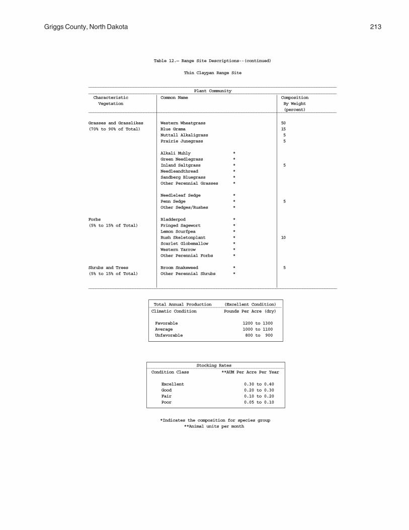
Griggs County, North Dakota 213
Table 12.— Range Site Descriptions--(continued)
Thin Claypan Range Site
___________________________________________________________________________________________________Plant Community___________________________________________________________________________________________________
Characteristic Common Name Composition Vegetation By Weight
(percent)___________________________________________________________________________________________________
Grasses and Grasslikes Western Wheatgrass 50(70% to 90% of Total) Blue Grama 15
Nuttall Alkaligrass 5Prairie Junegrass 5
Alkali Muhly *Green Needlegrass *Inland Saltgrass * 5Needleandthread *Sandberg Bluegrass *Other Perennial Grasses *
Needleleaf Sedge *Penn Sedge * 5Other Sedges/Rushes *
Forbs Bladderpod *(5% to 15% of Total) Fringed Sagewort *
Lemon Scurfpea *Rush Skeletonplant * 10Scarlet Globemallow *Western Yarrow *Other Perennial Forbs *
Shrubs and Trees Broom Snakeweed * 5(5% to 15% of Total) Other Perennial Shrubs *
_____________________________________________________________________________________________________
Total Annual Production (Excellent Condition) _____________________________________________________ Climatic Condition Pounds Per Acre (dry)
Favorable 1200 to 1300 Average 1000 to 1100 Unfavorable 800 to 900
Stocking Rates _______________________________________________________ Condition Class **AUM Per Acre Per Year
Excellent 0.30 to 0.40 Good 0.20 to 0.30 Fair 0.10 to 0.20 Poor 0.05 to 0.10
*Indicates the composition for species group **Animal units per month

214 Soil Survey
Table 12.— Range Site Descriptions--(continued)
Thin Sands Range Site
___________________________________________________________________________________________________Plant Community___________________________________________________________________________________________________
Characteristic Common Name Composition Vegetation By Weight
(percent)___________________________________________________________________________________________________
Grasses and Grasslikes Prairie Sandreed 25(70% to 90% of Total) Little Bluestem 15
Sideoats Grama 10Canada Wildrye 5Sand Bluestem 5Other Perennial Grasses 5
Blue Grama *Green Needlegrass *Needleandthread * 5Prairie Junegrass *Sand Dropseed *Western Wheatgrass *
Needleleaf Sedge * 10Penn Sedge *Other Sedges/Rushes *
Forbs Fringed Sagewort *(5% to 15% of Total) Green Sagewort *
Groundcherry *Hairy Goldaster * 15Lemon Scurfpea *Missouri Golderod *Prairie Spiderwort *Rush Skeletonplant *Other Perennial Forbs *
Shrubs and Trees Leadplant Amorpha *(5% to 15% of Total) Sand Cherry * 10
Woods Rose *Other Perennial Shrubs *
____________________________________________________________________________________________________
Total Annual Production (Excellent Condition) _____________________________________________________ Climatic Condition Pounds Per Acre (dry)
Favorable 2200 to 2400 Average 1900 to 2100 Unfavorable 1700 to 1800
Stocking Rates _______________________________________________________ Condition Class **AUM Per Acre Per Year
Excellent 0.60 to 0.80 Good 0.40 to 0.60 Fair 0.20 to 0.40 Poor 0.10 to 0.20
*Indicates the composition for species group **Animal units per month

Griggs County, North Dakota 215
Table 12.— Range Site Descriptions--(continued)
Thin Upland Range Site
___________________________________________________________________________________________________Plant Community___________________________________________________________________________________________________
Characteristic Common Name Composition Vegetation By Weight
(percent)___________________________________________________________________________________________________
Grasses and Grasslikes Little Blustem 25(70% to 90% of Total) Needleandthread 5
Green Needlegrass 5
Plains Muhly 5Porcupinegrass 5Prairie Dropseed 5Sideoats Grama 5Western Wheatgrass 5Other Perennial Grasses 5
Blue Grama *Prairie Junegrass * TracePrairie Sandreed *Red Threeawn *
Penn Sedge *Threadleaf Sedge * 10Other Sedges/Rushes *
Forbs Dotted Gayfeather *(5% to 15% of Total) Fringed Sagewort *
Missouri Golderod *Pasqueflower * 10Purple Coneflower *Purple Prairieclover *Stiff Goldenrod *Other Perennial Forbs *
Shrubs and Trees Silverberry *(5% to 15% of Total) Western Snowberry * 5
Other Perennial Shrubs *
____________________________________________________________________________________________________
Total Annual Production (Excellent Condition) _____________________________________________________ Climatic Condition Pounds Per Acre (dry)
Favorable 2500 to 2800 Average 2150 to 2450 Unfavorable 1800 to 2100
Stocking Rates _______________________________________________________ Condition Class **AUM Per Acre Per Year
Excellent 0.68 to 0.90 Good 0.45 to 0.68 Fair 0.23 to 0.45 Poor 0.10 to 0.23
*Indicates the composition for species group **Animal units per month

216 Soil Survey
Table 12.— Range Site Descriptions--(continued)
Very Shallow Range Site
___________________________________________________________________________________________________Plant Community___________________________________________________________________________________________________
Characteristic Common Name Composition Vegetation By Weight
(percent)___________________________________________________________________________________________________
Grasses and Grasslikes Needleandthread 30(70% to 90% of Total) Western Wheatgrass 10
Blue Grama 10Bearded Wheatgrass 5Prairie Dropseed 5Prairie Junegrass 5Red Threeawn 5
Plains Muhly *Red Threeawn * 5Sand Dropseed *Other Perennial Grasses *
Penn Sedge *Threadleaf Sedge * 15Other Sedges/Rushes *
Forbs Dotted Gayfeather *(5% to 15% of Total) Fringed Sagewort *
Green Sagewort *Purple Prairieclover * 10Rush Skeletonplant *Western Yarrow *Other Perennial Forbs *
Shrubs and Trees Broom Snakeweed *(5% to 15% of Total) Prairie Rose * 5
Other Perennial Shrubs *
______________________________________________________________________________________________________
Total Annual Production (Excellent Condition) _____________________________________________________ Climatic Condition Pounds Per Acre (dry)
Favorable 1100 to 1200 Average 900 to 1000Unfavorable 800 to 900
Stocking Rates _______________________________________________________ Condition Class **AUM Per Acre Per Year
Excellent 0.30 to 0.40 Good 0.20 to 0.30 Fair 0.10 to 0.20 Poor 0.05 to 0.10
*Indicates the composition for species group **Animal units per month

Griggs County, North Dakota 217
Table 12.— Range Site Descriptions--(continued)
Wet Meadow Range Site
___________________________________________________________________________________________________Plant Community___________________________________________________________________________________________________
Characteristic Common Name Composition Vegetation By Weight
(percent)___________________________________________________________________________________________________
Grasses and Grasslikes Northern Reedgrass 5(70% to 90% of Total) Prairie Cordgrass 5
Fowl Blue Grass *Mat Muhly * 5Switchgrass *Other Perennial Grasses *
Slim Sedge * 70Woolly Sedge *
Baltic Rush *Common Spikerush * 5Fescue Sedge *Other Sedges/Rushes *
Forbs Field Mint *(5% to 15% of Total) Indian Hemp *
Rydberg's Sunflower * 10Tall Goldenrod *Tall White Aster *Other Perennial Forbs *
Shrubs and Trees(0% of Total)
____________________________________________________________________________________________________
Total Annual Production (Excellent Condition) _____________________________________________________ Climatic Condition Pounds Per Acre (dry)
Favorable 4500 to 4800 Average 4100 to 4400Unfavorable 3700 to 4000
Stocking Rates _______________________________________________________ Condition Class **AUM Per Acre Per Year
Excellent 1.35 to 1.80 Good 0.90 to 1.35 Fair 0.45 to 0.90 Poor 0.10 to 0.45
*Indicates the composition for species group **Animal units per month

218
Table 12.— Range Site Descriptions--(continued)
Wetland Range Site
___________________________________________________________________________________________________Plant Community___________________________________________________________________________________________________
Characteristic Common Name Composition Vegetation By Weight
(percent)___________________________________________________________________________________________________
Grasses and Grasslikes American Mannagrass *(70% to 90% of Total) American Slough Grass *
Northern Reedgrass * 5Prairie Cordgrass *Other Perennial Grasses * 5
Baltic Rush *Burreed * 5Common Spikerush *Other Sedged/Rushes *
Beaked Sedge *Slough Sedge * 50Smooth-Cone Sedge *Water Sedge *
Slim Sedge * 5Woolly Sedge *
Forbs Longroot Smartweed *(5% to 15% of Total) Mexican Dock *
Waterparsnip * 5Waterplaintain *Other Perennial Forbs *
Shrubs and Trees Sandbar Willow * Trace(5% to 15% of Total) Willow Species *
___________________________________________________________________________________________________________
Total Annual Production (Excellent Condition) _____________________________________________________ Climatic Condition Pounds Per Acre (dry)
Favorable 6600 to 7000 Average 6100 to 6500Unfavorable 5600 to 6000
Stocking Rates _______________________________________________________ Condition Class **AUM Per Acre Per Year
Excellent 1.95 to 2.60 Good 1.30 to 1.95 Fair 0.65 to 1.30 Poor 0.10 to 0.65
*Indicates the composition for species group **Animal units per month
219
Public areas in the survey area provideopportunities for numerous recreational activities,including: fishing, hiking, bird-watching, and hunting.For information on other recreational activities withinthe survey area contact the North Dakota StateDepartment of Parks and Recreation.
Soils in the survey area are rated in Table 13,"Recreational Development," according to limitationsaffecting their suitability for recreation. The ratings arebased on restrictive soil features, such as wetness,slope, and texture of the surface layer. Susceptibility toflooding is considered. Not considered in the ratings,but important in evaluating a site, are location andaccessibility of the area, size and shape of the area,and its scenic quality, ability of the soil to supportvegetation, access to water, potential waterimpoundment sites, and either access to public sewerlines or the capacity of the soil to absorb septic tankeffluent. Soils subject to flooding are limited, in varyingdegrees, for recreational uses by the duration offlooding and the season when it occurs. Onsiteassessment of the height, duration, intensity, andfrequency of flooding is essential in planningrecreational facilities.
Camp areas are tracts of land used intensively assites for tents, trailers, and campers and for outdooractivities that accompany such sites. These areasrequire site preparation, such as shaping and levelingthe tent and parking areas, stabilizing roads andintensively used areas, and installing sanitary facilitiesand utility lines. Camp areas are subject to heavy foottraffic and some vehicular traffic. Soils are rated on thebasis of soil properties that influence ease ofdeveloping camp areas and performance of the areasafter development. Also considered are soil propertiesthat influence trafficability and promote the growth ofvegetation after heavy use.
Picnic areas are natural or landscaped tracts ofland subject to heavy foot traffic. Most vehicular trafficis confined to access roads and parking areas. Soilsare rated on the basis of soil properties influencingcost of shaping the site, trafficability, and growth ofvegetation after development. The surface of picnic
areas should absorb rainfall readily, remain firm underheavy foot traffic, and not be dusty when dry.
Playgrounds are areas used intensively forbaseball, football, or similar activities. These areasrequire a nearly level soil that is free of stones and canwithstand heavy foot traffic and maintain an adequatecover of vegetation. Soils are rated on the basis of soilproperties influencing the cost of shaping the site,trafficability, and the growth of vegetation. Slope andstoniness are the main concerns in developingplaygrounds. The surface of the playgrounds shouldabsorb rainfall readily, remain firm under heavy foottraffic, and not be dusty when dry.
Paths and trails are areas used for hiking andhorseback riding. The areas should require little or nocutting and filling during site preparation. Soils arerated on the basis of soil properties influencingtrafficability and erodibility. Paths and trails shouldremain firm under foot traffic and not be dusty whendry.
Golf fairways are subject to heavy foot traffic andsome light vehicular traffic. Cutting or filling may berequired. The best soils for use as golf fairways arefirm when wet, are not dusty when dry, and are notsubject to prolonged flooding during the period of use.They have moderate slopes and no stones or boulderson the surface. The suitability of the soil for tees orgreens is not considered in rating the soils.
Interpretative ratings in Table 13 help engineers,planners, and others understand how soil propertiesinfluence recreational uses. Ratings for proposed usesare given in terms of limitations. Only the mostrestrictive features are listed. Other features may limita specific recreational use.
The degree of soil limitation is expressed as slight,moderate, or severe.
Slight means soil properties are generally favorablefor the rated use. Limitations are minor and can beeasily overcome. Good performance and lowmaintenance are expected.
Moderate means soil properties are moderatelyfavorable for the rated use. Limitations can beovercome or modified by special planning, design, or
Recreation

220 Soil Survey
maintenance. During some part of the year, theexpected performance may be less desirable thansoils rated slight.
Severe means soil properties are unfavorable forthe rated use. Examples of limitations are slope,bedrock near the surface, flooding, and a seasonalhigh water table. These limitations generally requiremajor soil reclamation, special design, or intensivemaintenance. Overcoming the limitations generally isdifficult and costly.
Information in Table 13, "Recreational Development,"can be supplemented by other information in thissurvey. For example, interpretations for dwellingswithout basements and for local roads and streetsin Table 15, "Building Site Development," andinterpretations for septic tank absorption fields inTable 16, "Sanitary Facilities," can supplementinformation obtained from Table 13.
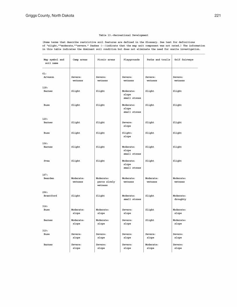
Griggs County, North Dakota 221
Table 13.—Recreational Development
(Some terms that describe restrictive soil features are defined in the Glossary. See text for definitionsof “slight,””moderate,””severe.” Dashes (--)indicate that the map unit component was not rated.) The informationin this table indicates the dominant soil condition but does not eliminate the need for onsite investigation.________________________________________________________________________________________________________________
Map symbol and Camp areas Picnic areas Playgrounds Paths and trails Golf fairways soil name___________________________________________________________________________________________________________
61: Arveson Severe: Severe: Severe: Severe: Severe: wetness wetness wetness wetness wetness
118: Barnes Slight Slight Moderate: Slight Slight slope small stones
Buse Slight Slight Moderate: Slight Slight slope small stones
120: Barnes Slight Slight Severe: Slight Slight slope
Buse Slight Slight Slight: Slight Slight slope
156: Barnes Slight Slight Moderate: Slight Slight slope small stones
Svea Slight Slight Moderate: Slight Slight slope small stones
167: Bearden Moderate: Moderate: Moderate: Moderate: Moderate: wetness percs slowly wetness wetness wetness wetness
296: Brantford Slight Slight Moderate: Slight Moderate: small stones droughty
314: Buse Moderate: Moderate: Severe: Slight Moderate: slope slope slope slope
Barnes Moderate: Moderate: Severe: Slight Moderate: slope slope slope slope
319: Buse Severe: Severe: Severe: Severe: Severe: slope slope slope slope slope
Barnes Severe: Severe: Severe: Moderate: Severe: slope slope slope slope slope

222 Soil Survey
Table 13.—Recreational Development--(continued)
(Some terms that describe restrictive soil features are defined in the Glossary. See text for definitionsof “slight,””moderate,””severe.” Dashes (--) indicate that the map unit component was not rated.) The informationin this table indicates the dominant soil condition but does not eliminate the need for onsite investigation._______________________________________________________________________________________________________________
Map symbol and Camp areas Picnic areas Playgrounds Paths and trails Golf fairways soil name_______________________________________________________________________________________________________________
391: Cavour Severe: Severe: Severe: Slight Severe: excess sodium excess sodium excess sodium excess sodium
Cresbard Severe: Severe: Severe: Slight Severe: excess sodium excess sodium excess sodium excess sodium
450: Colvin Severe: Severe: Severe: Severe: Severe: wetness wetness wetness wetness wetness
511: Divide Moderate: Moderate: Moderate: Moderate: Moderate: percs slowly percs slowly percs slowly wetness wetness wetness wetness wetness
536: Eckman Slight Slight Severe: Slight Slight slope
Zell Slight Slight Severe: Slight Slight slope
539: Edgeley Slight Slight Slight Slight Moderate: depth to rock
541: Edgeley Slight Slight Moderate: Slight Moderate: slope depth to rock depth to rock
569: Embden Slight Slight Slight Slight Slight
579: Embden Slight Slight Moderate: Slight Slight slope
Egeland Slight Slight Moderate: Slight Slight slope
595: Emrick Slight Slight Slight Slight Slight
Cathay Severe: Severe: Severe: Slight Severe: excess sodium excess sodium excess sodium excess sodium
597: Emrick Slight Slight Slight Slight Slight
Heimdal Slight Slight Slight Slight Slight

Griggs County, North Dakota 223
Table 13.—Recreational Development--(continued)
(Some terms that describe restrictive soil features are defined in the Glossary. See text for definitionsof “slight,””moderate,””severe.” Dashes (--) indicate that the map unit component was not rated.) The informationin this table indicates the dominant soil condition but does not eliminate the need for onsite investigation._____________________________________________________________________________________________________________
Map symbol and Camp areas Picnic areas Playgrounds Paths and trails Golf fairways soil name_____________________________________________________________________________________________________________
605: Esmond Moderate: Moderate: Severe: Slight Moderate: slope slope slope slope
Heimdal Moderate: Moderate: Severe: Slight Moderate: slope slope slope slope
753: Fram Moderate: Moderate: Moderate: Moderate: Moderate: wetness wetness wetness wetness wetness
Wyard Severe: Moderate: Severe: Moderate: Moderate: wetness wetness wetness wetness wetness
769: Gardena Slight Slight Slight Slight Slight
773: Gardena Slight Slight Moderate: Slight Slight slope
Eckman Slight Slight Moderate: Slight Slight slope
881: Hamerly Moderate: Moderate: Moderate: Moderate: Moderate: wetness wetness wetness wetness wetness
Tonka Severe: Severe: Severe: Severe: Severe: ponding ponding ponding ponding ponding
884: Hamerly Moderate: Moderate: Moderate: Moderate: Moderate: wetness wetness wetness wetness wetness
Wyard Severe: Moderate: Severe: Moderate: Moderate: wetness wetness wetness wetness wetness
893: Harriet Severe: Severe: Severe: Severe: Severe: flooding excess sodium percs slowly wetness excess sodium percs slowly percs slowly wetness wetness wetness wetness
988: Heimdal Slight Slight Moderate: Slight Slight slope
Emrick Slight Slight Moderate: Slight Slight slope
998: Heimdal Slight Slight Severe: Slight Slight slope

224 Soil Survey
Table 13.—Recreational Development--(continued)
(Some terms that describe restrictive soil features are defined in the Glossary. See text for definitionsof “slight,””moderate,””severe.” Dashes (--) indicate that the map unit component was not rated.) The informationin this table indicates the dominant soil condition but does not eliminate the need for onsite investigation.________________________________________________________________________________________________________________
Map symbol and Camp areas Picnic areas Playgrounds Paths and trails Golf fairways soil name________________________________________________________________________________________________________________
998:(con’t) Esmond Slight Slight Severe: Slight Slight slope
1001: Heimdal Severe: Severe: Severe: Severe: Severe: slope slope slope slope slope
Esmond Severe: Severe: Severe: Moderate: Severe: slope slope slope slope slope
1015: Kensal Slight Slight Slight Slight Slight
1062: LaDelle Severe: Slight Moderate: Slight Moderate: flooding flooding flooding
1108: Larson Severe: Severe: Severe: Slight Severe: excess sodium excess sodium excess sodium excess sodium
Cathay Severe: Severe: Severe: Slight Severe: excess sodium excess sodium excess sodium excess sodium
1188: Ludden Severe: Severe: Severe: Severe: Severe: flooding too clayey too clayey too clayey too clayey too clayey ponding ponding ponding ponding ponding
1189: Ludden, saline Severe: Severe: Severe: Severe: Severe: flooding too clayey too clayey too clayey too clayey too clayey wetness wetness wetness wetness wetness
1221: Maddock Moderate: Moderate: Moderate: Moderate: Moderate: too sandy too sandy slope too sandy droughty too sandy
Hecla Moderate: Moderate: Moderate: Moderate: Moderate: too sandy too sandy slope too sandy droughty too sandy
1267: Marysland Severe: Severe: Severe: Severe: Severe: wetness wetness wetness wetness wetness
1268: Marysland, wet Severe: Severe: Severe: Severe: Severe: ponding ponding ponding ponding ponding

Griggs County, North Dakota 225
Table 13.—Recreational Development--(continued)
(Some terms that describe restrictive soil features are defined in the Glossary. See text for definitionsof “slight,””moderate,””severe.” Dashes (--) indicate that the map unit component was not rated.) The informationin this table indicates the dominant soil condition but does not eliminate the need for onsite investigation.________________________________________________________________________________________________________________
Map symbol and Camp areas Picnic areas Playgrounds Paths and trails Golf fairways soil name________________________________________________________________________________________________________________
1427: Parnell Severe: Severe: Severe: Severe: Severe: ponding ponding ponding ponding ponding
1454: Wyndmere Moderate: Moderate: Moderate: Moderate: Moderate: wetness wetness wetness wetness wetness
1466: Pits, sand and Severe: Severe: Severe: Severe: Severe: gravel slope slope slope slope slope small stones too sandy small stones too sandy small stones
1710: Southam Severe: Severe: Severe: Severe: Severe: ponding ponding ponding ponding ponding
1762: Svea Slight Slight Moderate: Slight Slight small stones
Barnes Slight Slight Moderate: Slight Slight small stones
1765: Svea Slight Slight Moderate: Slight Slight slope small stones
Buse Slight Slight Moderate: Slight Slight slope small stones
1766: Svea Slight Slight Severe: Slight Slight slope
Buse Slight Slight Severe: Slight Slight slope
1769: Svea Slight Slight Moderate: Slight Slight small stones
Cresbard Severe: Severe: Severe: Slight Severe: excess sodium excess sodium excess sodium excess sodium
1781: Swenoda Slight Slight Slight Slight Slight
1843: Towner Moderate: Moderate: Moderate: Moderate: Moderate: too sandy too sandy slope too sandy droughty too sandy
1883: Vallers Severe: Moderate: Severe: Moderate: Moderate: wetness percs slowly wetness wetness wetness wetness

226 Soil Survey
Table 13.—Recreational Development--(continued)
(Some terms that describe restrictive soil features are defined in the Glossary. See text for definitionsof “slight,””moderate,””severe.” Dashes (--) indicate that the map unit component was not rated.) The informationin this table indicates the dominant soil condition but does not eliminate the need for onsite investigation.________________________________________________________________________________________________________________
Map symbol and Camp areas Picnic areas Playgrounds Paths and trails Golf fairways soil name________________________________________________________________________________________________________________
1883:(con’t)Parnell Severe: Severe: Severe: Severe: Severe: ponding ponding ponding ponding ponding
1886: Hamerly, saline Severe: Severe: Severe: Moderate: Severe: excess salt excess salt excess salt wetness excess salt
Vallers, saline Severe: Severe: Severe: Severe: Severe: excess salt excess salt excess salt wetness excess salt wetness wetness wetness wetness
1970: Walum Slight Slight Slight Slight Moderate: droughty
1978: Water --- --- --- --- ---
2118: Fram Moderate: Moderate: Moderate: Moderate: Moderate: wetness wetness wetness wetness wetness
Tonka Severe: Severe: Severe: Severe: Severe: ponding ponding ponding ponding ponding
2121: Ferney Severe: Severe: Severe: Slight Severe: excess sodium excess sodium excess sodium excess sodium
2151: Binford Slight Slight Moderate: Slight Moderate: slope droughty
Coe Slight Slight Moderate: Slight Severe: slope droughty
2152: Coe Severe: Severe: Severe: Moderate: Severe: slope slope slope slope slope small stones small stones small stones small stones droughty
Binford Moderate: Moderate: Severe: Slight Moderate: slope slope slope slope droughty
2153: Edgeley Severe: Severe: Severe: Moderate: Severe: slope slope slope slope slope
Kloten Severe: Severe: Severe: Moderate: Severe: area reclaim area reclaim area reclaim slope area reclaim slope slope slope slope thin layer thin layer thin layer thin layer
Esmond Severe: Severe: Severe: Moderate: Severe: slope slope slope slope slope

Griggs County, North Dakota 227
Table 13.—Recreational Development--(continued)
(Some terms that describe restrictive soil features are defined in the Glossary. See text for definitionsof “slight,””moderate,””severe.” Dashes (--) indicate that the map unit component was not rated.) The informationin this table indicates the dominant soil condition but does not eliminate the need for onsite investigation.________________________________________________________________________________________________________________
Map symbol and Camp areas Picnic areas Playgrounds Paths and trails Golf fairways soil name________________________________________________________________________________________________________________
2156: Lamoure Severe: Severe: Severe: Severe: Severe: flooding wetness flooding wetness flooding wetness wetness wetness
Rauville Severe: Severe: Severe: Severe: Severe: flooding wetness flooding wetness flooding wetness wetness wetness
2157: Maddock Moderate: Moderate: Severe: Moderate: Moderate: slope slope slope too sandy slope too sandy too sandy droughty
Esmond Moderate: Moderate: Severe: Slight Moderate: slope slope slope slope
Embden Slight Slight Severe: Slight Slight slope
2158: Velva Severe: Slight Moderate: Slight Moderate: flooding flooding flooding slope
2159: Walsh Slight Slight Moderate: Slight Slight slope small stones
2196: Bearden, saline Severe: Severe: Severe: Moderate: Severe: excess salt excess salt excess salt wetness excess salt
Colvin, saline Severe: Severe: Severe: Severe: Severe: excess salt excess salt excess salt wetness excess salt wetness wetness wetness wetness
2197: Edgeley Slight Slight Severe: Slight Moderate: slope depth to rock
Kloten Severe: Severe: Severe: Slight Severe: area reclaim area reclaim area reclaim area reclaim thin layer thin layer slope thin layer thin layer
2198: Hamar Severe: Moderate: Severe: Moderate: Moderate: wetness wetness wetness wetness wetness droughty
Hecla Moderate: Moderate: Moderate: Moderate: Moderate: too sandy too sandy too sandy too sandy droughty
2199: Hamerly Moderate: Moderate: Moderate: Moderate: Moderate: percs slowly percs slowly large stones wetness large stones wetness wetness wetness

228
Table 13.—Recreational Development--(continued)
(Some terms that describe restrictive soil features are defined in the Glossary. See text for definitionsof “slight,””moderate,””severe.” Dashes (--) indicate that the map unit component was not rated.) The informationin this table indicates the dominant soil condition but does not eliminate the need for onsite investigation________________________________________________________________________________________________________________
Map symbol and Camp areas Picnic areas Playgrounds Paths and trails Golf fairways soil name________________________________________________________________________________________________________________
2199(con’t): Barnes Slight Slight Severe: Slight Moderate: large stones large stones
Tonka Severe: Severe: Severe: Severe: Severe: ponding ponding ponding ponding ponding
2200: Letcher Severe: Severe: Severe: Slight Severe: excess sodium excess sodium excess sodium excess sodium
Swenoda Slight Slight Slight Slight Slight
2201: Stirum Severe: Severe: Severe: Severe: Severe: excess sodium excess sodium excess sodium ponding excess sodium ponding ponding ponding ponding
Arveson, saline Severe: Severe: Severe: Severe: Severe: excess salt excess salt excess salt wetness excess salt wetness wetness wetness wetness
2202: Swenoda Slight Slight Moderate: Slight Slight slope
Barnes Slight Slight Moderate: Slight Slight slope small stones
2203: Swenoda Slight Slight Severe: Slight Slight slope
Barnes Slight Slight Severe: Slight Slight slope
2204: Walsh Slight Slight Severe: Slight Slight slope
2205: Zell Severe: Severe: Severe: Moderate: Severe: slope slope slope slope slope
Eckman Moderate: Moderate: Severe: Slight Moderate: slope slope slope slope
_________________________________________________________________________________________________________________

229
Soils affect the kind and amount of vegetation thatis available to wildlife for food and cover. They alsoaffect the construction of water impoundments. If food,cover, or water is missing, inadequate, or inaccessible,wildlife will be scarce or will not inhabit the area.
If the soils have potential for habitat development,wildlife habitat can be created or improved by plantingappropriate vegetation, properly managing existingplant cover, and fostering the natural establishment ofdesirable plants.
On Table 14, "Wildlife Habitat," soils in the surveyarea are rated according to their potential for providinghabitat for various kinds of wildlife. This informationcan be used in planning parks, wildlife refuges, naturestudy areas, and other developments for wildlife. It canalso be used for selecting soils suitable forestablishing, improving, or maintaining specificelements of wildlife habitat; and in determining theintensity of management needed for each element ofthe habitat.
The potential of the soil for wildlife habitat is ratedgood, fair, poor or very poor. A rating of goodindicates the kind of habitat is easily established,improved, or maintained. Few or no limitations affectmanagement, and satisfactory results can beexpected. A rating of fair indicates the kind of wildlifehabitat can be established, improved, or maintained inmost places. Moderately intensive management isrequired for satisfactory results. A rating of poorindicates limitations are severe for the designated kindof habitat. Habitat can be created, improved, ormaintained in most places, but management is difficultand must be intensive. A rating of very poor indicatesrestrictions for the element or kind of wildlife habitatare very severe and unsatisfactory results can beexpected. Creating, improving, or maintaining habitat isimpractical or impossible.
The elements of wildlife habitat shown on Table 14are described in the following paragraphs.
Grain and seed crops are domestic grains andseed-producing herbaceous plants used by wildlife.Examples are wheat, rye, oats, corn, and barley.
Grasses and legumes are domestic perennialgrasses and herbaceous legumes planted for wildlifefood and cover. Examples are bromegrass,intermediate wheatgrass, tall wheatgrass, clover, andalfalfa.
Wild herbaceous plants are native or naturallyestablished grasses and forbs, including weeds, thatprovide food and cover for wildlife. Examples arebluestem, goldenrod, blue grama, switchgrass,Maximilian sunflower, and western wheatgrass.
The major soil properties affecting the growth ofgrain and forage crops and wild herbaceous plants aredepth of the root zone, texture of the surface layer, theamount of water available to plants, wetness, salinityor sodicity, and flooding. The length of the growingseason also is important.
Hardwood trees produce nuts or other fruit, buds,catkins, twigs, bark, and foliage that wildlife eat.Examples are oak, poplar, boxelder, green ash, willow,and American elm.
Coniferous plants are cone-bearing trees, shrubs,or ground cover that provide habitat or supply food inthe form of browse, seed, or fruitlike cones. Examplesare pine, spruce, cedar, and juniper.
The major soil properties affecting the growth ofhardwood and coniferous trees and shrubs are depth ofroot zone, the amount of water available to plants, andwetness.
Shrubs are bushy woody plants that produce fruit,buds, twigs, bark, and foliage. Soil properties andfeatures that affect the growth of shrubs are depth ofthe rooting zone, available water capacity, salinity, andsoil moisture. Examples of shrubs are commonchokecherry, buffaloberry, snowberry, juneberry,hawthorn, American plum, and redosier dogwood.
Wetland plants are annual and perennial wildherbaceous plants that grow on moist or wet sites.Submerged or floating aquatic plants are excluded.Wetland plants produce food or cover for wetlandwildlife. Examples of these plants are smartweed,sedges, bulrushes, white top, common reedgrass,saltgrass, prairie cordgrass, and cattail.
Wildlife Habitat

230 Soil Survey
The major soil properties affecting wetland plantsare texture of the surface layer, wetness, acidity oralkalinity, and slope.
Shallow water areas have an average depth of lessthan 5 feet. They are useful as habitat for some wildlifespecies. They are naturally wet areas or are created bydams, levees, or water-control measures in marshes orstreams. Examples are muskrat marshes, waterfowlfeeding areas, wildlife watering developments, beaverponds, and other wildlife ponds.
The major soil properties affecting shallow waterareas are depth to bedrock, wetness, surfacestoniness, slope, and saturated hydraulic conductivity.
Habitat for openland wildlife consists of cropland,pasture, meadows, and areas that are overgrown withgrasses, herbs, and shrubs. These areas produce grainand seed crops, grasses and legumes, and wildherbaceous plants. Wildlife attracted to these areas
include Hungarian partridge, pheasant, sharptailgrouse, meadowlark, lark bunting, cottontail rabbit, andred fox.
Habitat for woodland wildlife consists of areas ofhardwoods or conifers or a mixture of these andassociated grasses, legumes, and wild herbaceousplants. The wildlife attracted to this habitat includethrushes, woodpeckers, owls, tree squirrels, porcupine,raccoon, and deer.
Habitat for wetland wildlife consists of open,marshy or swampy, shallow water areas that supportwater-tolerant plants. The wildlife attracted to thishabitat include ducks, geese, herons, shore birds,muskrat, mink, and beaver.
Habitat for rangeland wildlife consists of areas ofshrubs and wild herbaceous plants. The wildlifeattracted to rangeland include deer, sharptailed grouse,western meadowlark, and David's sparrow.

Griggs County, North Dakota 231
Table 14.—Wildlife Habitat
(Some terms that describe restrictive soil features are defined in the Glossary. See text for definitionsof “good,” “fair”, “poor” and “very poor.” Dashes (--) indicate the map unit component was not rated.) Theinformation in this table indicates the dominant soil condition but does not eliminate the need for onsiteinvestigation.
__________________________________________________________________________________________________________________ Potential for habitat elements Potential as habitat for-- _______________________________________________________________________________________________ Map symbol Grain Wild Open- Wood- Wetland Range- and soil name and Grasses herba- Hard- Conif- Shrubs Wetland Shallow land land wild- land seed and ceous wood erous plants water wild- wild- life wild- crops legumes plants trees plants areas life life life _________________________________________________________________________________________________________________
61: Arveson Poor Fair Fair --- --- Fair Good Good Fair --- Good Fair
118: Barnes Good Good Good Good Good Fair Poor Very Good Good Very Fair poor poor
Buse Fair Good Fair --- --- Fair Very Very Fair --- Very Fair poor poor poor
120: Barnes Fair Good Good Good Good Fair Poor Very Good Good Very Fair poor poor
Buse Fair Good Fair --- --- Fair Very Very Fair --- Very Fair poor poor poor
156: Barnes Good Good Good Good Good Fair Poor Very Good Good Very Fair poor poor
Svea Good Good Good Good Good Fair Poor Very Good Good Very Fair poor poor
167: Bearden Good Good Good Good Good Fair Fair Fair Good Good Fair Fair
296: Brantford Fair Fair Good Fair Fair Poor Poor Poor Fair Fair Very Fair
314: Buse Poor Fair Fair --- --- Fair Very Very Fair --- Very Fair poor poor poor
Barnes Fair Good Good Good Good Fair Very Very Good Good Very Fair poor poor poor
319: Buse Very Very Fair --- --- Fair Very Very Poor --- Very Fair poor poor poor poor poor
Barnes Poor Fair Good Good Good Fair Very Very Fair Good Very Fair poor poor poor

232 Soil Survey
Table 14.—Wildlife Habitat--(continued)
(Some terms that describe restrictive soil features are defined in the Glossary. See text for definitionsof “good,” “fair”, “poor” and “very poor.” Dashes (--) indicate the map unit component was not rated.) Theinformation in this table indicates the dominant soil condition but does not eliminate the need for onsiteinvestigation.
__________________________________________________________________________________________________________________ Potential for habitat elements Potential as habitat for-- _______________________________________________________________________________________________ Map symbol Grain Wild Open- Wood- Wetland Range- and soil name and Grasses herba- Hard- Conif- Shrubs Wetland Shallow land land wild- land seed and ceous wood erous plants water wild- wild- life wild- crops legumes plants trees plants areas life life life _________________________________________________________________________________________________________________
391: Cavour Poor Poor Poor Poor Very Very Very Very Poor Very Very Poor poor poor poor poor poor poor
Cresbard Good Fair Good Fair Very Poor Very Very Good Very Very Good poor poor poor poor poor
450: Colvin Poor Fair Fair Fair Fair Fair Good Good Poor Fair Good Fair
511: Divide Fair Fair Good Good Good Fair Fair Very Fair Good Poor Fair poor
536: Eckman Fair Good Good Good Good Fair Poor Very Good Good Very Fair poor poor
Zell Fair Good Good --- --- Fair Very Very Good --- Very Fair poor poor poor
539: Edgeley Good Good Good Good Good Fair Poor Poor Good Good Very Fair poor
541: Edgeley Good Good Good Good Good Fair Poor Poor Good Good Very Fair poor
569: Embden Fair Good Good Good Good Fair Poor Poor Good Good Poor Fair
579: Embden Fair Good Good Good Good Fair Poor Very Good Good Very Fair poor poor
Egeland Fair Good Good --- --- Fair Very Very Good --- Very Fair poor poor poor
595: Emrick Good Good Good --- --- Fair Poor Poor Good --- Poor Fair
Cathay Fair Good Good --- --- Poor Poor Poor Fair --- Poor Fair
597: Emrick Good Good Good --- --- Fair Poor Poor Good --- Poor Fair
Heimdal Good Good Good --- --- Fair Poor Very Good --- Very Fair poor poor

Griggs County, North Dakota 233
Table 14.—Wildlife Habitat--(continued)
(Some terms that describe restrictive soil features are defined in the Glossary. See text for definitionsof “good,” “fair”, “poor” and “very poor.” Dashes (--) indicate the map unit component was not rated.) Theinformation in this table indicates the dominant soil condition but does not eliminate the need for onsiteinvestigation.
__________________________________________________________________________________________________________________ Potential for habitat elements Potential as habitat for-- _______________________________________________________________________________________________ Map symbol Grain Wild Open- Wood- Wetland Range- and soil name and Grasses herba- Hard- Conif- Shrubs Wetland Shallow land land wild- land seed and ceous wood erous plants water wild- wild- life wild- crops legumes plants trees plants areas life life life _________________________________________________________________________________________________________________
605: Esmond Poor Fair Good --- --- Fair Very Very Fair --- Very Fair poor poor poor
Heimdal Poor Fair Good --- --- Fair Poor Very Fair --- Very Fair poor poor
753: Fram Good Good Good --- --- Fair Fair Poor Good --- Poor Fair
Wyard Good Good Good --- --- Good Fair Fair Good --- Fair Good
769: Gardena Good Good Good Good Good Fair Poor Poor Good Good Poor Fair
773: Gardena Good Good Good Good Good Fair Poor Very Good Good Very Fair poor poor
Eckman Good Good Good Good Good Fair Poor Very Good Good Very Fair poor poor 881: Hamerly Good Good Good Good Good Fair Fair Fair Good Good Fair Fair
Tonka Poor Fair Fair Fair Fair Poor Good Good Poor Fair Good Poor
884: Hamerly Good Good Good Good Good Fair Fair Fair Good Good Fair Fair
Wyard Good Good Good --- --- Good Fair Fair Good --- Fair Good
893: Harriet Poor Poor Fair Poor Poor Very Good Good Poor Poor Good Poor poor
988: Heimdal Good Good Good --- --- Fair Poor Very Good --- Very Fair poor poor
Emrick Good Good Good --- --- Fair Poor Very Good --- Very Fair poor poor
998: Heimdal Fair Good Good --- --- Fair Poor Very Good --- Very Fair poor poor
Esmond Fair Good Good --- --- Fair Poor Very Good --- Very Fair poor poor
1001: Heimdal Poor Fair Good --- --- Fair Poor Very Fair --- Very Fair poor poor

234 Soil Survey
Table 14.—Wildlife Habitat--(continued)
(Some terms that describe restrictive soil features are defined in the Glossary. See text for definitionsof “good,” “fair”, “poor” and “very poor.” Dashes (--) indicate the map unit component was not rated.) Theinformation in this table indicates the dominant soil condition but does not eliminate the need for onsiteinvestigation.
__________________________________________________________________________________________________________________ Potential for habitat elements Potential as habitat for-- _______________________________________________________________________________________________ Map symbol Grain Wild Open- Wood- Wetland Range- and soil name and Grasses herba- Hard- Conif- Shrubs Wetland Shallow land land wild- land seed and ceous wood erous plants water wild- wild- life wild- crops legumes plants trees plants areas life life life__________________________________________________________________________________________________________________
1001:(con’t)Esmond Very Very Good --- --- Fair Very Very Poor --- Very Fair poor poor poor poor poor
1015: Kensal Fair Fair Fair --- --- Poor Poor Poor Fair --- Very Poor poor
1062: LaDelle Good Good Fair --- --- Good Very Very Good --- Very Fair poor poor poor
1108: Larson Poor Poor Poor --- --- Very Poor Poor Poor --- Poor Very poor poor
Cathay Fair Good Good --- --- Poor Poor Poor Fair --- Poor Fair
1188: Ludden Fair Fair Good --- --- Good Poor Good Fair --- Fair Good
1189: Ludden, saline Fair Fair Very --- --- Very Good Good Fair --- Good Very poor poor poor
1221: Maddock Fair Good Good Fair Fair Fair Poor Very Fair Fair Very Fair poor poor
Hecla Fair Good Good --- --- Fair Poor Poor Good --- Poor Fair
1267: Marysland Poor Fair Fair --- --- Fair Good Good Fair --- Good Fair
1268: Marysland, wet Very Poor Poor --- --- Poor Good Good Poor --- Good Poor poor
1427: Parnell Very Poor Poor Very Very Poor Good Good Poor Very Good Poor poor poor poor poor
1454: Wyndmere Fair Good Good Good Good Fair Fair Poor Good Good Poor Fair
1466: Pits, sand and Very Very Very Very Very Very Very Very Very Very Very Very gravel poor poor poor poor poor poor poor poor poor poor poor poor
1710: Southam Very Very Very --- --- Very Good Good Very --- Good Very poor poor poor poor poor poor

Griggs County, North Dakota 235
Table 14.—Wildlife Habitat--(continued)
(Some terms that describe restrictive soil features are defined in the Glossary. See text for definitionsof “good,” “fair”, “poor” and “very poor.” Dashes (--) indicate the map unit component was not rated.) Theinformation in this table indicates the dominant soil condition but does not eliminate the need for onsiteinvestigation.
__________________________________________________________________________________________________________________ Potential for habitat elements Potential as habitat for-- _______________________________________________________________________________________________ Map symbol Grain Wild Open- Wood- Wetland Range- and soil name and Grasses herba- Hard- Conif- Shrubs Wetland Shallow land land wild- land seed and ceous wood erous plants water wild- wild- life wild- crops legumes plants trees plants areas life life life _________________________________________________________________________________________________________________
1762: Svea Good Good Good Good Good Good Poor Poor Good Good Poor Good
Barnes Good Good Good Good Good Fair Poor Very Good Good Very Fair poor poor
1765: Svea Good Good Good Good Good Fair Poor Very Good Good Very Fair poor poor
Buse Fair Good Fair --- --- Fair Very Very Fair --- Very Fair poor poor poor
1766: Svea Fair Good Good Good Good Fair Poor Very Fair Good Very Fair poor poor
Buse Fair Good Fair --- --- Fair Very Very Fair --- Very Fair poor poor poor
1769: Svea Good Good Good Good Good Good Poor Poor Good Good Poor Good
Cresbard Good Fair Good Fair Very Poor Very Very Good Very Very Good poor poor poor poor poor
1781: Swenoda Fair Good Good --- --- Fair Very Very Good --- Very Fair poor poor poor
1843: Towner Fair Good Good Good Good Fair Poor Very Good Good Very Fair poor poor
1883: Vallers Poor Fair Fair --- --- Fair Good Good Fair --- Good Fair
Parnell Very Poor Poor Very Very Poor Good Good Poor Very Good Poor poor poor poor poor
1886: Hamerly, saline Fair Fair Poor Poor Poor Fair Fair Fair Fair Poor Fair Fair
Vallers, saline Poor Fair Very --- --- Very Good Good Poor --- Good Very poor poor poor
1970: Walum Fair Good Good --- --- Fair Fair Very Fair --- Poor Fair poor

236 Soil Survey
Table 14.—Wildlife Habitat--(continued)
(Some terms that describe restrictive soil features are defined in the Glossary. See text for definitionsof “good,” “fair”, “poor” and “very poor.” Dashes (--) indicate the map unit component was not rated.) Theinformation in this table indicates the dominant soil condition but does not eliminate the need for onsiteinvestigation.
__________________________________________________________________________________________________________________ Potential for habitat elements Potential as habitat for-- _______________________________________________________________________________________________ Map symbol Grain Wild Open- Wood- Wetland Range- and soil name and Grasses herba- Hard- Conif- Shrubs Wetland Shallow land land wild- land seed and ceous wood erous plants water wild- wild- life wild- crops legumes plants trees plants areas life life life _________________________________________________________________________________________________________________
1978: Water --- --- --- --- --- --- --- --- --- --- --- ---
2118: Fram Good Good Good --- --- Fair Fair Poor Good --- Poor Fair
Tonka Poor Fair Fair Fair Fair Poor Good Good Poor Fair Good Poor
2121: Ferney Poor Poor Very Poor Very Very Poor Poor Poor Poor Poor Very poor poor poor poor
2151: Binford Fair Good Fair Fair Fair Poor Very Very Fair Fair Very Poor poor poor poor
Coe Poor Poor Fair --- --- Poor Very Very Poor --- Very Fair poor poor poor
2152: Coe Very Poor Fair --- --- Poor Very Very Poor --- Very Fair poor poor poor poor
Binford Fair Good Fair Fair Fair Poor Very Very Fair Fair Very Poor poor poor poor
2153: Edgeley Poor Fair Good Good Good Fair Very Very Fair Good Very Fair poor poor poor
Kloten Very Very Fair Poor Poor Fair Very Very Poor Poor Very Fair poor poor poor poor poor
Esmond Very Very Good --- --- Fair Very Very Poor --- Very Fair poor poor poor poor poor
2156: Lamoure Poor Fair Fair --- --- Fair Good Good Fair --- Good Fair
Rauville Very Poor Fair Poor Very Fair Fair Fair Very Very Fair Fair poor poor poor poor
2157: Maddock Poor Fair Good Fair Fair Fair Very Very Fair Fair Very Fair poor poor poor
Esmond Poor Fair Good --- --- Fair Very Very Fair --- Very Fair poor poor poor
Embden Fair Good Good Good Good Fair Poor Very Good Good Very Fair poor poor

Griggs County, North Dakota 237
Table 14.—Wildlife Habitat--(continued)
(Some terms that describe restrictive soil features are defined in the Glossary. See text for definitionsof “good,” “fair”, “poor” and “very poor.” Dashes (--) indicate the map unit component was not rated.) Theinformation in this table indicates the dominant soil condition but does not eliminate the need for onsiteinvestigation.
__________________________________________________________________________________________________________________ Potential for habitat elements Potential as habitat for-- _______________________________________________________________________________________________ Map symbol Grain Wild Open- Wood- Wetland Range- and soil name and Grasses herba- Hard- Conif- Shrubs Wetland Shallow land land wild- land seed and ceous wood erous plants water wild- wild- life wild- crops legumes plants trees plants areas life life life _________________________________________________________________________________________________________________
2158: Velva Fair Good Fair Good Good Good Poor Very Fair Good Very Fair poor poor
2159: Walsh Good Good Fair Good Good Fair Poor Very Good Good Very Fair poor poor
2196: Bearden, saline Fair Fair Poor Poor Poor Fair Fair Fair Fair Poor Fair Poor
Colvin, saline Poor Fair Poor Fair Fair Fair Good Good Poor Fair Good Poor
2197: Edgeley Fair Good Good Good Good Fair Poor Very Good Good Very Fair poor poor
Kloten Poor Poor Fair Poor Poor Fair Poor Very Poor Poor Very Fair poor poor
2198: Hamar Fair Good Good Fair Fair Fair Fair Very Good Fair Poor Fair poor
Hecla Fair Good Good --- --- Fair Poor Poor Good --- Poor Fair
2199: Hamerly Poor Poor Good Good Good Fair Poor Very Poor Good Very Fair poor poor
Barnes Poor Poor Good Good Good Fair Poor Very Poor Good Very Fair poor poor
Tonka Poor Fair Fair Fair Fair Poor Good Good Poor Fair Good Poor
2200: Letcher Poor Poor Poor Poor Very Very Very Very Poor Very Very Very poor poor poor poor poor poor poor
Swenoda Fair Good Good --- --- Fair Very Very Good --- Very Fair poor poor poor
2201: Stirum Very Very Very Poor Poor Fair Good Fair Very Poor Fair Poor poor poor poor poor
Arveson, saline Poor Fair Very --- --- Very Good Good Poor --- Good Very poor poor poor
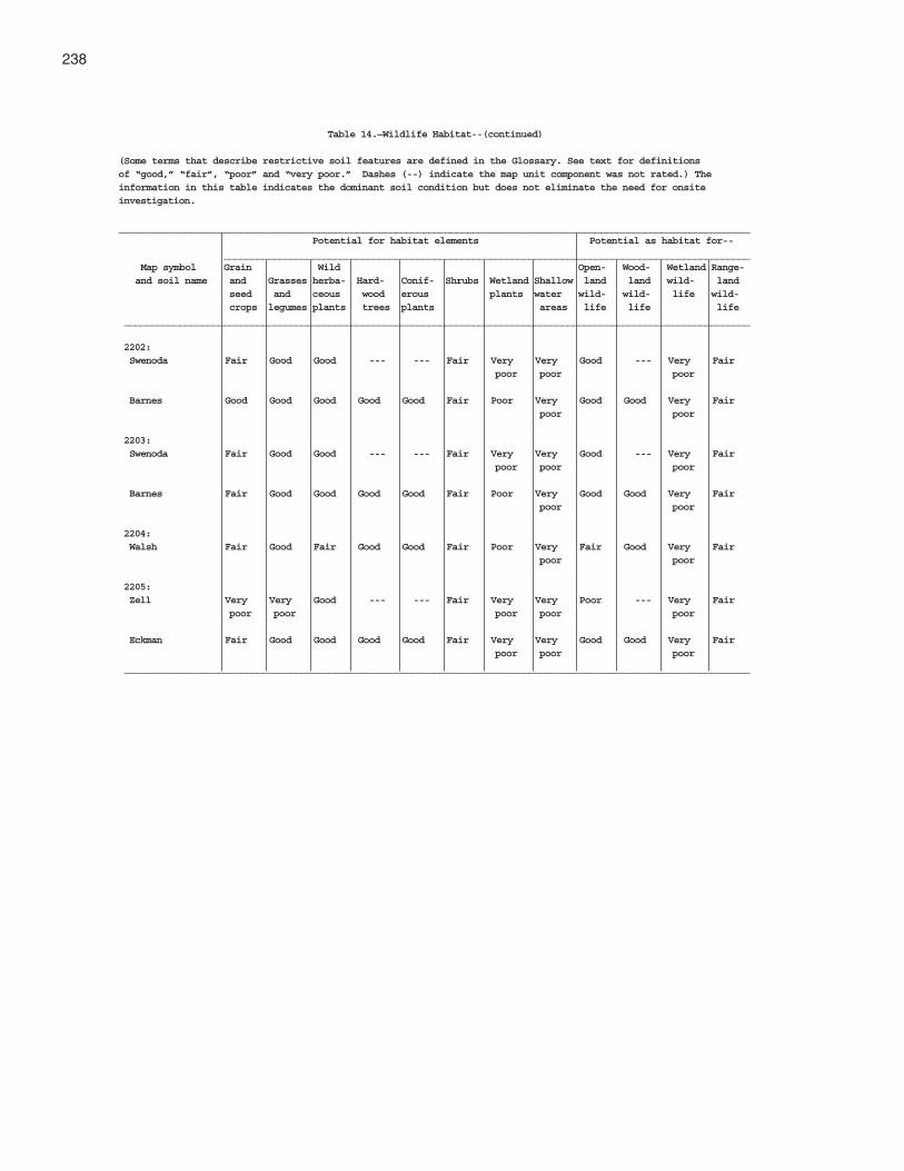
238
Table 14.—Wildlife Habitat--(continued)
(Some terms that describe restrictive soil features are defined in the Glossary. See text for definitionsof “good,” “fair”, “poor” and “very poor.” Dashes (--) indicate the map unit component was not rated.) Theinformation in this table indicates the dominant soil condition but does not eliminate the need for onsiteinvestigation.
__________________________________________________________________________________________________________________ Potential for habitat elements Potential as habitat for-- _______________________________________________________________________________________________ Map symbol Grain Wild Open- Wood- Wetland Range- and soil name and Grasses herba- Hard- Conif- Shrubs Wetland Shallow land land wild- land seed and ceous wood erous plants water wild- wild- life wild- crops legumes plants trees plants areas life life life _________________________________________________________________________________________________________________
2202: Swenoda Fair Good Good --- --- Fair Very Very Good --- Very Fair poor poor poor
Barnes Good Good Good Good Good Fair Poor Very Good Good Very Fair poor poor
2203: Swenoda Fair Good Good --- --- Fair Very Very Good --- Very Fair poor poor poor
Barnes Fair Good Good Good Good Fair Poor Very Good Good Very Fair poor poor
2204: Walsh Fair Good Fair Good Good Fair Poor Very Fair Good Very Fair poor poor
2205: Zell Very Very Good --- --- Fair Very Very Poor --- Very Fair poor poor poor poor poor
Eckman Fair Good Good Good Good Fair Very Very Good Good Very Fair poor poor poor
_________________________________________________________________________________________________________________

239
This section provides information for planning landuses related to urban development and to watermanagement. Soils are rated for various uses, and themost limiting features are identified. Ratings are givenfor building site development, sanitary facilities,construction materials, and water management. Theratings are based on observed performance of the soilsand on the estimated data and test data in the "SoilProperties" section.
Information in this section is intended for land useplanning, for evaluating land use alternatives, and forplanning site investigations prior to design andconstruction. The information, however, has limitations.For example, estimates and other data generally applyonly to that part of the soil within a depth of 5 or 6 feet.Because of the map scale, small areas of differentsoils may be included within the mapped areas of aspecific soil.
The information is not site specific and does noteliminate the need for onsite investigation of the soilsor for testing and analysis by personnel experienced inthe design and construction of engineering works.
Government ordinances and regulations that restrictcertain land uses or impose specific design criteriawere not considered in preparing the information in thissection. Local ordinances and regulations should beconsidered in planning, in site selection, and in design.
Soil properties, site features, and observedperformance were considered in determining the ratingsin this section. During the fieldwork for this soil survey,determinations were made about grain-size distribution,liquid limit, plasticity index, soil reaction, depth tobedrock, hardness of bedrock within 5 or 6 feet of thesurface, soil wetness, depth to a seasonal high watertable, slope, likelihood of flooding, natural soil structureaggregation, and soil density. Data were collectedabout kinds of clay minerals, mineralogy of the sandand silt fractions, and the kind of adsorbed cations.Estimates were made for erodibility, permeability,corrosivity, shrink-swell potential, available watercapacity, and other behavioral characteristics affectingengineering uses.
This information can be used to evaluate thepotential of areas for residential, commercial,industrial, and recreational uses; make preliminaryestimates of construction conditions; evaluatealternative routes for roads, streets, highways,pipelines, and underground cables; evaluate alternativesites for sanitary landfills, septic tank absorption fields,and sewage lagoons; plan detailed onsiteinvestigations of soils and geology; locate potentialsources of gravel, sand, earthfill, and topsoil; plandrainage systems, irrigation systems, ponds, terraces,and other structures for soil and water conservation;and predict performance of proposed small structuresand pavements by comparing the performance ofexisting similar structures on the same or similar soils.
The information in the tables, along with the soilmaps, the soil descriptions, and other data provided inthis survey, can be used to make additionalinterpretations.
Some of the terms used in this soil survey have aspecial meaning in soil science and are defined in the"Glossary."
Building Site Development
Table 15,"Building Site Development," shows thedegree and kind of soil limitations that affect shallowexcavations, dwellings with and without basements,small commercial buildings, local roads and streets,and lawns and landscaping. The limitations areconsidered slight if soil properties and site featuresgenerally are favorable for the indicated use andlimitations are minor and easily overcome; moderate ifsoil properties or site features are not favorable for theindicated use and special planning, design, ormaintenance is needed to overcome or minimize thelimitations; and severe if soil properties or site featuresare so unfavorable or so difficult to overcome thatspecial design, significant increases in constructioncosts, and possibly increased maintenance arerequired. Special feasibility studies may be requiredwhere the soil limitations are severe.
Engineering

240 Soil Survey
Shallow excavations are trenches or holes dug to amaximum depth of 5 or 6 feet for basements, graves,utility lines, open ditches, and other purposes. Theratings are based on soil properties, site features, andobserved performance of the soils. The ease ofdigging, filling, and compacting is affected by the depthto bedrock, a cemented pan, or a very firm denselayer; stone content; soil texture; and slope. The time ofthe year that excavations can be made is affected bythe depth to a seasonal high water table and thesusceptibility of the soil to flooding. The resistance ofthe excavation walls or banks to sloughing or caving isaffected by soil texture and depth to the water table.
Dwellings and small commercial buildings arestructures built on shallow foundations on undisturbedsoil. The load limit is the same as that for single-familydwellings no higher than three stories. Ratings aremade for small commercial buildings withoutbasements, for dwellings with basements, and fordwellings without basements. The ratings are based onsoil properties, site features, and observedperformance of the soils. A high water table, flooding,shrinking and swelling, and organic layers can causethe movement of footings. A high water table, depth tobedrock or to a cemented pan, large stones, andflooding affect the ease of excavation andconstruction. Landscaping and grading that require cutsand fills of more than 5 or 6 feet are not considered.
Local roads and streets have an all-weathersurface and carry automobile and light truck traffic allyear. They have a subgrade of cut or fill soil material; abase of gravel, crushed rock, or stabilized soil material;and a flexible or rigid surface. Cuts and fills generallyare limited to less than 6 feet. The ratings are based onsoil properties, site features, and observedperformance of the soils. Depth to bedrock or to acemented pan, a high water table, flooding, largestones, and slope affect the ease of excavating andgrading. Soil strength (as inferred from the engineeringclassification of the soil), shrink-swell potential,potential for frost action, and depth to a high watertable affect the traffic-supporting capacity.
Lawns and landscaping require soils on which turfand ornamental trees and shrubs can be establishedand maintained. The ratings are based on soilproperties, site features, and observed performance ofthe soils. Soil reaction, a high water table, depth tobedrock or to a cemented pan, the available watercapacity in the upper 40 inches, and the content ofsalts, sodium, and sulfidic materials affect plantgrowth. Flooding, wetness, slope, stoniness, and the
amount of sand, clay, or organic matter in the surfacelayer affect trafficability after vegetation is established.
Sanitary Facilities
Table 16, "Sanitary Facilities," shows the degree andthe kind of soil limitations that affect septic tankabsorption fields, sewage lagoons, and sanitarylandfills. It also shows the suitability of the soils foruse as a daily cover for landfill.
Soil properties are important in selecting sites forsanitary facilities and in identifying limiting soilproperties and site features to be considered inplanning, design, and installation. Soil limitation ratingsof slight, moderate, or severe are given for septictank absorption fields, sewage lagoons, and trench andarea sanitary landfills. Soil suitability ratings of good,fair, and poor are given for daily cover for landfill.
A rating of slight or good indicates that the soilshave no limitations or that the limitations can be easilyovercome. Good performance and low maintenancecan be expected. A rating of moderate or fair indicatesthat the limitations should be recognized but generallycan be overcome by good management or specialdesign. A rating of severe or poor indicates thatovercoming the limitations is difficult or impractical.Increased maintenance may be required.
Septic tank absorption fields are areas in whichsubsurface systems of tile or perforated pipe distributeeffluent from a septic tank into the natural soil. Thecenterline of the tile is assumed to be at a depth of 24inches. Only the part of the soil between depths of 24and 60 inches is considered in making the ratings. Thesoil properties and site features considered are thosethat affect the absorption of the effluent, those thataffect the construction and maintenance of thesystem, and those that may affect public health.
The ratings are based on soil properties, sitefeatures, and observed performance of the soils.Permeability, a high water table, depth to bedrock or toa cemented pan, and flooding affect absorption of theeffluent. Large stones and bedrock or a cemented paninterfere with installation.
Unsatisfactory performance of septic tankabsorption fields, including excessively slowabsorption of effluent, surfacing of effluent, and hillsideseepage, can affect public health. Ground water can bepolluted if highly permeable sand and gravel orfractured bedrock is less than 4 feet below the base ofthe absorption field, if slope is excessive, or if thewater table is near the surface. There must be
Griggs County, North Dakota 241
unsaturated soil material beneath the absorption fieldto filter the effluent effectively. Many local ordinancesrequire that this material be of a certain thickness.
Sewage lagoons are shallow ponds constructed tohold sewage while aerobic bacteria decompose thesolid and liquid wastes. Lagoons should have a nearlylevel floor surrounded by cut slopes or embankmentsof compacted, relatively impervious soil material.Aerobic lagoons generally are designed to hold thesewage within a depth of 2 to 5 feet. Relativelyimpervious soil material for the lagoon floor and sidesis desirable to minimize seepage and contamination oflocal ground water.
Table 16, "Sanitary Facilities" gives ratings for thenatural soil that makes up the lagoon floor. The surfacelayer and, generally, 1 or 2 feet of soil material belowthe surface layer are excavated to provide material forthe embankments. The ratings are based on soilproperties, site features, and observed performance ofthe soils. Considered in the ratings are slope,permeability, a high water table, depth to bedrock or toa cemented pan, flooding, large stones, and content oforganic matter.
Excessive seepage resulting from rapid permeabilityin the soil or a water table that is high enough to raisethe level of sewage in the lagoon causes a lagoon tofunction unsatisfactorily. Pollution results if seepage isexcessive or if floodwater overtops the lagoon. A highcontent of organic matter is detrimental to properfunctioning of the lagoon because it inhibits aerobicactivity. Slope, bedrock, and cemented pans cancause construction problems, and large stones canhinder compaction of the lagoon floor.
Trench sanitary landfill is an area where solidwaste is disposed of by placing refuse in successivelayers in an excavated trench. The waste is spread,compacted, and covered daily with a thin layer of soilthat is excavated from the trench. When the trench isfull, a final cover of soil material at least 2 feet thick isplaced over the landfill. Soil properties that influencethe risk of pollution, the ease of excavation,trafficability, and revegetation are the majorconsiderations in rating the soils.
Area sanitary landfill is an area where solid wasteis disposed of by placing refuse in successive layerson the surface of the soil. The waste is spread,compacted, and covered daily with a thin layer of soilthat is imported from a source away from the site. Afinal cover of soil at least 2 feet thick is placed overthe completed landfill. Soil properties that influencetrafficability, revegetation, and the risk of pollution are
the main considerations in rating the soils for areasanitary landfills.
Both types of landfill must be able to bear heavyvehicular traffic. Both types involve a risk of ground-water pollution. The ratings in Table 16, "SanitaryFacilities" are based on soil properties, site features,and observed performance of the soils. Permeability,depth to bedrock or to a cemented pan, a high watertable, slope, and flooding affect both types of landfill.Texture, stones and boulders, highly organic layers,soil reaction, and content of salts and sodium affecttrench type landfills. Unless otherwise stated, theratings apply only to that part of the soil within a depthof about 6 feet. For deeper trenches, a limitation ratedslight or moderate may not be valid. Onsiteinvestigation is needed.
Daily cover for landfill is the soil material that isused to cover compacted solid waste in an areasanitary landfill. The soil material is obtained offsite,transported to the landfill, and spread over the waste.The suitability of a soil for use as cover is based onproperties that affect workability and the ease ofdigging, moving, and spreading the material over therefuse daily during both wet and dry periods.
Soil texture, wetness, rock fragments, and slopeaffect the ease of removing and spreading the materialduring wet and dry periods. Loamy or silty soils that arefree of large stones or excess gravel are the bestcover for a landfill. Clayey soils are sticky or cloddyand are difficult to spread; sandy soils are subject tosoil blowing.
After soil material has been removed, the soilmaterial remaining in the borrow area must be thickenough over bedrock, a cemented pan, or the watertable to permit revegetation. The soil material used asfinal cover for a landfill should be suitable for plants.The surface layer generally has the best workability,more organic matter, and the best potential for plants.Material from the surface layer should be stockpiled foruse as the final cover.
Waste Management
Soil properties are important when organic waste isapplied as fertilizer and wastewater is applied inirrigated areas. They also are important when the soil isused as a medium for the treatment and disposal ofthe organic waste and wastewater. Unfavorable soilproperties can result in environmental damage.
The use of organic waste and wastewater asproduction resources results in energy and resource

242 Soil Survey
conservation and minimizes the problems associatedwith waste disposal. If disposal is the goal, applying amaximum amount of the organic waste or thewastewater to a minimal area holds costs to aminimum and environmental damage is the mainhazard. If reuse is the goal, a minimum amountshould be applied to a maximum area andenvironmental damage is unlikely.
Interpretations developed for waste managementmay include ratings for manure- and food-processingwaste, municipal sewage sludge, use of wastewaterfor irrigation, and treatment of wastewater by slowrate, overland flow, and rapid infiltration processes.
Specific information regarding waste managementis available at the local office of the Natural ResourcesConservation Service or the Cooperative ExtensionService.
Construction Materials
Table 17, "Construction Materials" gives informationabout the soils as a source of roadfill, sand, gravel,and topsoil. The soils are rated good, fair, or pooras a source of roadfill and topsoil. They are rated as aprobable or improbable source of sand and gravel.
Roadfill is soil material that is excavated in oneplace and used in road embankments in another place.In Table 17, "Construction Materials," the soils arerated as a source of roadfill for low embankments,generally less than 6 feet high and less exacting indesign than higher embankments.
The ratings are for the soil material below thesurface layer to a depth of 5 or 6 feet. It is assumedthat soil layers will be mixed during excavating andspreading. Many soils have layers of contrastingsuitability within their profile. Table 19, “EngineeringIndex Properties,” provides detailed information abouteach soil layer. This information can help to determinethe suitability of each layer for use as roadfill. Theperformance of soil after it is stabilized with lime orcement is not considered in the ratings.
The ratings are based on soil properties, sitefeatures, and observed performance of the soils.The thickness of suitable material is a majorconsideration. The ease of excavation is affected bylarge stones, a high water table, and slope. How wellthe soil performs in place after it has been compactedand drained is determined by its strength (as inferredfrom the engineering classification of the soil) andshrink-swell potential.
Soils rated good contain significant amounts ofsand or gravel, or both. They have at least 5 feet of
suitable material, a low shrink-swell potential, fewcobbles and stones, and slopes of 15 percent or less.Depth to the water table is more than 3 feet. Soils ratedfair are more than 35 percent silt- and clay-sizedparticles and have a plasticity index of less than 10.They have a moderate shrink-swell potential, slopes of15 to 25 percent, or many stones. Depth to the watertable is 1 to 3 feet. Soils rated poor have one or moreof the following characteristics: a plasticity index ofmore than 10, a high shrink-swell potential, manystones, slopes of more than 25 percent, or a watertable at a depth of less than 1 foot. They may havelayers of suitable material, but the material is less than3 feet thick.
Sand and gravel are natural aggregates suitable forcommercial use with a minimum of processing. Theyare used in many kinds of construction. Specificationsfor each use vary widely. In Table 17, "ConstructionMaterials," only the probability of finding material insuitable quantity in or below the soil is evaluated. Thesuitability of the material for specific purposes is notevaluated, nor are factors that affect excavation of thematerial.
The properties used to evaluate the soil as a sourceof sand or gravel are gradation of grain sizes (asindicated by the engineering classification of the soil),the thickness of suitable material, and the content ofrock fragments. Kinds of rock, acidity, and stratificationare given in the soil series descriptions. Gradation ofgrain sizes is given in the table on engineering indexproperties (Table 19).
A soil rated as a probable source has a layer ofclean sand or gravel or a layer of sand or gravel that isas much as 12 percent silty fines. This material mustbe at least 3 feet thick and less than 50 percent, byweight, large stones. All other soils are rated as animprobable source. Fragments of soft bedrock, such asshale and siltstone, are not considered to be sand andgravel.
Topsoil is used to cover an area so that vegetationcan be established and maintained. The upper 40inches of a soil is evaluated for use as topsoil. Alsoevaluated is the reclamation potential of the borrowarea.
Plant growth is affected by toxic material and bysuch properties as soil reaction, available watercapacity, and fertility. The ease of excavating, loading,and spreading is affected by rock fragments, slope, awater table, soil texture, and thickness of suitablematerial. Reclamation of the borrow area is affected byslope, a water table, rock fragments, bedrock, andtoxic material.

Griggs County, North Dakota 243
Soils rated good have friable, loamy material to adepth of at least 40 inches. They are free of stones andcobbles, have little or no gravel, and have slopes ofless than 8 percent. They are low in content of solublesalts, are naturally fertile or respond well to fertilizer,and are not so wet that excavation is difficult.
Soils rated fair are sandy soils, loamy soils thathave a relatively high content of clay, soils that haveonly 20 to 40 inches of suitable material, soils thathave an appreciable amount of gravel, stones, orsoluble salts, or soils that have slopes of 8 to 15percent. The soils are not so wet that excavation isdifficult.
Soils rated poor are very sandy or clayey, haveless than 20 inches of suitable material, have a largeamount of gravel, stones, or soluble salts, have slopesof more than 15 percent, or have a seasonal high watertable at or near the surface.
The surface layer of most soils generally ispreferred for topsoil because of its organic mattercontent. Organic matter greatly increases theabsorption and retention of moisture and nutrients forplant growth.
Water Management
Table 18, "Water Management," gives information onthe soil properties and site features that affect watermanagement. The degree and kind of soil limitationsare given for pond reservoir areas; embankments,dikes, and levees; and aquifer-fed excavated ponds.The limitations are considered slight if soil propertiesand site features generally are favorable for theindicated use and limitations are minor and are easilyovercome; moderate if soil properties or site featuresare not favorable for the indicated use and specialplanning, design, or maintenance is needed toovercome or minimize the limitations; and severe if soilproperties or site features are so unfavorable or sodifficult to overcome that special design, significantincrease in construction costs, and possibly increasedmaintenance are required.
This table also gives for each soil the restrictivefeatures that affect drainage, irrigation, terraces anddiversions, and grassed waterways.
Pond reservoir areas hold water behind a dam orembankment. Soils best suited to this use have lowseepage potential in the upper 60 inches. The seepagepotential is determined by the permeability of the soiland the depth to fractured bedrock or other permeablematerial. Excessive slope can affect the storagecapacity of the reservoir area.
Embankments, dikes, and levees are raisedstructures of soil material, generally less than 20 feethigh, constructed to impound water or to protect landagainst overflow. In Table 18, "Water Management," thesoils are rated as a source of material for embankmentfill. The ratings apply to the soil material below thesurface layer to a depth of about 5 feet. It is assumedthat soil layers will be uniformly mixed and compactedduring construction.
The ratings do not indicate the ability of the naturalsoil to support an embankment. Soil properties to adepth even more than the height of the embankmentcan affect performance and safety of the embankment.Generally, deeper onsite investigation is needed todetermine these properties.
Soil material in embankments must be resistant toseepage, piping, and erosion and have favorablecompaction characteristics. Unfavorable featuresinclude less than 5 feet of suitable material and a highcontent of stones or boulders, organic matter, or saltsor sodium. A high water table affects the amount ofusable material. It also affects trafficability.
Aquifer-fed excavated ponds are pits or dugoutsthat extend to a ground-water aquifer or to a depthbelow a permanent water table. Excluded are pondsthat are fed only by surface runoff and embankmentponds that impound water 3 feet or more above theoriginal surface. Excavated ponds are affected bydepth to a permanent water table, permeability of theaquifer, and quality of the water as inferred from thesalinity of the soil. Depth to bedrock and the content oflarge stones affect the ease of excavation.
Drainage is the removal of excess surface andsubsurface water from the soil. How easily andeffectively the soil is drained depends on the depth tobedrock, to a cemented pan, or to other layers thataffect the rate of water movement; permeability; depthto a high water table or depth of standing water if thesoil is subject to ponding; slope; susceptibility toflooding; subsidence of organic layers; and thepotential for frost action. Excavating and grading andthe stability of ditchbanks are affected by depth tobedrock or to a cemented pan, large stones, slope, andthe hazard of cutbanks caving. The productivity of thesoil after drainage is adversely affected by extremeacidity or by toxic substances in the root zone, suchas salts, sodium, or sulfur. Availability of drainageoutlets is not considered in the ratings.
Irrigation is the controlled application of water tosupplement rainfall and support plant growth. Thedesign and management of an irrigation system areaffected by depth to the water table, the need for

244 Soil Survey
drainage, flooding, available water capacity, intakerate, permeability, erosion hazard, and slope. Theconstruction of a system is affected by large stonesand depth to bedrock or to a cemented pan. Theperformance of a system is affected by the depth ofthe root zone, the amount of salts or sodium, andsoil reaction.
Terraces and diversions are embankments or acombination of channels and ridges constructedacross a slope to control erosion and conservemoisture by intercepting runoff.
Slope, wetness, large stones, and depth tobedrock or to a cemented pan affect the constructionof terraces and diversions. A restricted rooting depth,
a severe hazard of soil blowing or water erosion, anexcessively coarse texture, and restricted permeabilityadversely affect maintenance.
Grassed waterways are natural or constructedchannels, generally broad and shallow, that conductsurface water to outlets at a nonerosive velocity.Large stones, wetness, slope, and depth to bedrockor to a cemented pan affect the construction ofgrassed waterways. A hazard of soil blowing, lowavailable water capacity, restricted rooting depth,toxic substances such as salts or sodium, andrestricted permeability adversely affect the growthand maintenance of the grass after construction.

Griggs County, North Dakota 245
Table 15.—Building Site Development
(Some terms that describe restrictive soil features are defined in the Glossary. See text for definitionsof “slight,” “moderate,” and “severe.” The information in this table indicates the dominant soil conditionbut does not eliminate the need for onsite investigation.)___________________________________________________________________________________________________________________
Map symbol and Shallow Dwellings Dwellings with Small Local roads and Lawns and soil name excavations without basements commercial streets landscaping basements buildings___________________________________________________________________________________________________________________
61: Arveson Severe: Severe: Severe: Severe: Severe: Severe: wetness wetness wetness wetness frost action wetness cutbanks cave wetness
118: Barnes Slight Moderate: Moderate: Moderate: Severe: Slight shrink-swell shrink-swell shrink-swell low strength slope
Buse Slight Moderate: Moderate: Moderate: Severe: Slight shrink-swell shrink-swell shrink-swell low strength slope
120: Barnes Slight Moderate: Moderate: Moderate: Severe: Slight shrink-swell shrink-swell shrink-swell low strength slope
Buse Slight Moderate: Moderate: Moderate: Severe: Slight shrink-swell shrink-swell shrink-swell low strength slope
156: Barnes Slight Moderate: Moderate: Moderate: Severe: Slight shrink-swell shrink-swell shrink-swell low strength slope
Svea Moderate: Moderate: Moderate: Moderate: Severe: Slight wetness shrink-swell shrink-swell shrink-swell low strength wetness slope167: Bearden Severe: Moderate: Severe: Moderate: Severe: Moderate: wetness shrink-swell shrink-swell shrink-swell frost action wetness wetness wetness wetness low strength
296: Brantford Severe: Slight Slight Slight Slight Moderate: cutbanks cave droughty
314: Buse Moderate: Moderate: Moderate: Severe: Severe: Moderate: slope shrink-swell shrink-swell slope low strength slope slope slope
Barnes Moderate: Moderate: Moderate: Severe: Severe: Moderate: slope shrink-swell shrink-swell slope low strength slope slope slope
319: Buse Severe: Severe: Severe: Severe: Severe: Severe: slope slope slope slope low strength slope slope
Barnes Severe: Severe: Severe: Severe: Severe: Severe: slope slope slope slope low strength slope slope

246 Soil Survey
Table 15.—Building Site Development--(continued)
(Some terms that describe restrictive soil features are defined in the Glossary. See text for definitionsof “slight,” “moderate,” and “severe.” The information in this table indicates the dominant soil conditionbut does not eliminate the need for onsite investigation.)___________________________________________________________________________________________________________________
Map symbol and Shallow Dwellings Dwellings with Small Local roads and Lawns and soil name excavations without basements commercial streets landscaping basements buildings___________________________________________________________________________________________________________________
391: Cavour Moderate: Severe: Moderate: Severe: Severe: Severe: too clayey shrink-swell shrink-swell shrink-swell low strength excess sodium wetness wetness shrink-swell
Cresbard Moderate: Severe: Moderate: Severe: Severe: Severe: too clayey shrink-swell shrink-swell shrink-swell low strength excess sodium wetness wetness shrink-swell
450: Colvin Severe: Severe: Severe: Severe: Severe: Severe: wetness wetness wetness wetness frost action wetness low strength wetness
511: Divide Severe: Moderate: Severe: Moderate: Moderate: Moderate: wetness wetness wetness wetness frost action wetness cutbanks cave wetness
536: Eckman Slight Slight Slight Moderate: Severe: Slight slope frost action
Zell Slight Slight Slight Moderate: Severe: Slight slope frost action
539: Edgeley Moderate: Moderate: Moderate: Moderate: Severe: Moderate: depth to rock shrink-swell shrink-swell shrink-swell low strength depth to rock depth to rock
541: Edgeley Moderate: Moderate: Moderate: Moderate: Severe: Moderate: depth to rock shrink-swell shrink-swell shrink-swell low strength depth to rock depth to rock slope
569: Embden Severe: Slight Moderate: Slight Moderate: Slight cutbanks cave wetness frost action
579: Embden Severe: Slight Moderate: Slight Moderate: Slight cutbanks cave wetness frost action
Egeland Severe: Slight Slight Slight Moderate: Slight cutbanks cave frost action
595: Emrick Slight Slight Slight Slight Moderate: Slight frost action
Cathay Moderate: Moderate: Moderate: Moderate: Severe: Severe: wetness shrink-swell shrink-swell shrink-swell low strength excess sodium wetness

Griggs County, North Dakota 247
Table 15.—Building Site Development--(continued)
(Some terms that describe restrictive soil features are defined in the Glossary. See text for definitionsof “slight,” “moderate,” and “severe.” The information in this table indicates the dominant soil conditionbut does not eliminate the need for onsite investigation.)___________________________________________________________________________________________________________________
Map symbol and Shallow Dwellings Dwellings with Small Local roads and Lawns and soil name excavations without basements commercial streets landscaping basements buildings___________________________________________________________________________________________________________________
597: Emrick Slight Slight Slight Slight Moderate: Slight frost action
Heimdal Slight Slight Slight Slight Moderate: Slight frost action
605: Esmond Moderate: Moderate: Moderate: Severe: Moderate: Moderate: slope slope slope slope frost action slope slope
Heimdal Moderate: Moderate: Moderate: Severe: Moderate: Moderate: slope slope slope slope frost action slope slope
753: Fram Severe: Moderate: Severe: Moderate: Severe: Slight wetness wetness wetness wetness frost action
Wyard Severe: Severe: Severe: Severe: Severe: Moderate: wetness wetness wetness wetness frost action wetness
769: Gardena Moderate: Slight Moderate: Slight Severe: Slight wetness wetness frost action
773: Gardena Moderate: Slight Moderate: Moderate: Severe: Slight wetness wetness slope frost action
Eckman Slight Slight Slight Moderate: Severe: Slight slope frost action
881: Hamerly Severe: Moderate: Severe: Moderate: Severe: Moderate: wetness shrink-swell wetness shrink-swell frost action wetness wetness wetness
Tonka Severe: Severe: Severe: Severe: Severe: Severe: ponding shrink-swell shrink-swell shrink-swell low strength ponding ponding ponding ponding shrink-swell ponding
884: Hamerly Severe: Moderate: Severe: Moderate: Severe: Moderate: wetness shrink-swell wetness shrink-swell frost action wetness wetness wetness
Wyard Severe: Severe: Severe: Severe: Severe: Moderate: wetness wetness wetness wetness frost action wetness
893: Harriet Severe: Severe: Severe: Severe: Severe: Severe: wetness flooding flooding flooding flooding excess sodium wetness wetness wetness low strength wetness wetness

248 Soil Survey
Table 15.—Building Site Development--(continued)
(Some terms that describe restrictive soil features are defined in the Glossary. See text for definitionsof “slight,” “moderate,” and “severe.” The information in this table indicates the dominant soil conditionbut does not eliminate the need for onsite investigation.)___________________________________________________________________________________________________________________
Map symbol and Shallow Dwellings Dwellings with Small Local roads and Lawns and soil name excavations without basements commercial streets landscaping basements buildings___________________________________________________________________________________________________________________
988: Heimdal Slight Slight Slight Moderate: Moderate: Slight slope frost action
Emrick Slight Slight Slight Moderate: Moderate: Slight slope frost action
998: Heimdal Slight Slight Slight Moderate: Moderate: Slight slope frost action
Esmond Slight Slight Slight Moderate: Moderate: Slight slope frost action
1001: Heimdal Severe: Severe: Severe: Severe: Severe: Severe: slope slope slope slope slope slope
Esmond Severe: Severe: Severe: Severe: Severe: Severe: slope slope slope slope slope slope
1015: Kensal Severe: Slight Moderate: Slight Severe: Slight cutbanks cave wetness frost action
1062: LaDelle Moderate: Severe: Severe: Severe: Severe: Moderate: flooding flooding flooding flooding flooding flooding wetness frost action low strength
1108: Larson Moderate: Moderate: Moderate: Moderate: Moderate: Severe: wetness shrink-swell shrink-swell shrink-swell frost action excess sodium wetness low strength shrink-swell
Cathay Moderate: Moderate: Moderate: Moderate: Severe: Severe: wetness shrink-swell shrink-swell shrink-swell low strength excess sodium wetness
1188: Ludden Severe: Severe: Severe: Severe: Severe: Severe: ponding flooding flooding flooding low strength too clayey cutbanks cave shrink-swell shrink-swell shrink-swell shrink-swell ponding ponding ponding ponding ponding
1189: Ludden, saline Severe: Severe: Severe: Severe: Severe: Severe: wetness flooding flooding flooding low strength too clayey cutbanks cave shrink-swell shrink-swell shrink-swell shrink-swell wetness wetness wetness wetness wetness
1221: Maddock Severe: Slight Slight Slight Slight Moderate: cutbanks cave droughty

Griggs County, North Dakota 249
Table 15.—Building Site Development--(continued)
(Some terms that describe restrictive soil features are defined in the Glossary. See text for definitionsof “slight,” “moderate,” and “severe.” The information in this table indicates the dominant soil conditionbut does not eliminate the need for onsite investigation.)___________________________________________________________________________________________________________________
Map symbol and Shallow Dwellings Dwellings with Small Local roads and Lawns and soil name excavations without basements commercial streets landscaping basements buildings___________________________________________________________________________________________________________________
1221:(con’t) Hecla Severe: Slight Moderate: Slight Moderate: Moderate: cutbanks cave wetness frost action droughty
1267: Marysland Severe: Severe: Severe: Severe: Severe: Severe: wetness wetness wetness wetness frost action wetness cutbanks cave wetness
1268: Marysland, wet Severe: Severe: Severe: Severe: Severe: Severe: ponding ponding ponding ponding frost action ponding cutbanks cave ponding
1427: Parnell Severe: Severe: Severe: Severe: Severe: Severe: excess humus shrink-swell shrink-swell shrink-swell low strength ponding ponding ponding ponding ponding shrink-swell ponding
1454: Wyndmere Severe: Moderate: Severe: Moderate: Severe: Slight wetness wetness wetness wetness frost action cutbanks cave
1466: Pits, sand and Severe: Severe: Severe: Severe: Severe: Severe: gravel slope slope slope slope slope slope cutbanks cave small stones droughty
1710: Southam Severe: Severe: Severe: Severe: Severe: Severe: ponding shrink-swell shrink-swell shrink-swell low strength ponding ponding ponding ponding shrink-swell ponding
1762: Svea Moderate: Moderate: Moderate: Moderate: Severe: Slight wetness shrink-swell shrink-swell shrink-swell low strength wetness
Barnes Slight Moderate: Moderate: Moderate: Severe: Slight shrink-swell shrink-swell shrink-swell low strength
1765: Svea Moderate: Moderate: Moderate: Moderate: Severe: Slight wetness shrink-swell shrink-swell shrink-swell low strength wetness slope
Buse Slight Moderate: Moderate: Moderate: Severe: Slight shrink-swell shrink-swell shrink-swell low strength slope
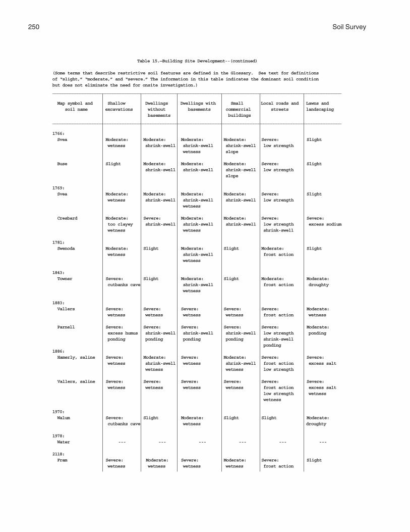
250 Soil Survey
Table 15.—Building Site Development--(continued)
(Some terms that describe restrictive soil features are defined in the Glossary. See text for definitionsof “slight,” “moderate,” and “severe.” The information in this table indicates the dominant soil conditionbut does not eliminate the need for onsite investigation.)___________________________________________________________________________________________________________________
Map symbol and Shallow Dwellings Dwellings with Small Local roads and Lawns and soil name excavations without basements commercial streets landscaping basements buildings___________________________________________________________________________________________________________________
1766: Svea Moderate: Moderate: Moderate: Moderate: Severe: Slight wetness shrink-swell shrink-swell shrink-swell low strength wetness slope
Buse Slight Moderate: Moderate: Moderate: Severe: Slight shrink-swell shrink-swell shrink-swell low strength slope
1769: Svea Moderate: Moderate: Moderate: Moderate: Severe: Slight wetness shrink-swell shrink-swell shrink-swell low strength wetness
Cresbard Moderate: Severe: Moderate: Moderate: Severe: Severe: too clayey shrink-swell shrink-swell shrink-swell low strength excess sodium wetness wetness shrink-swell
1781: Swenoda Moderate: Slight Moderate: Slight Moderate: Slight wetness shrink-swell frost action wetness
1843: Towner Severe: Slight Moderate: Slight Moderate: Moderate: cutbanks cave shrink-swell frost action droughty wetness
1883: Vallers Severe: Severe: Severe: Severe: Severe: Moderate: wetness wetness wetness wetness frost action wetness
Parnell Severe: Severe: Severe: Severe: Severe: Moderate: excess humus shrink-swell shrink-swell shrink-swell low strength ponding ponding ponding ponding ponding shrink-swell ponding1886: Hamerly, saline Severe: Moderate: Severe: Moderate: Severe: Severe: wetness shrink-swell wetness shrink-swell frost action excess salt wetness wetness low strength
Vallers, saline Severe: Severe: Severe: Severe: Severe: Severe: wetness wetness wetness wetness frost action excess salt low strength wetness wetness
1970: Walum Severe: Slight Moderate: Slight Slight Moderate: cutbanks cave wetness droughty
1978: Water --- --- --- --- --- ---
2118: Fram Severe: Moderate: Severe: Moderate: Severe: Slight wetness wetness wetness wetness frost action

Griggs County, North Dakota 251
Table 15.—Building Site Development--(continued)
(Some terms that describe restrictive soil features are defined in the Glossary. See text for definitionsof “slight,” “moderate,” and “severe.” The information in this table indicates the dominant soil conditionbut does not eliminate the need for onsite investigation.)___________________________________________________________________________________________________________________
Map symbol and Shallow Dwellings Dwellings with Small Local roads and Lawns and soil name excavations without basements commercial streets landscaping basements buildings___________________________________________________________________________________________________________________
2118:(con’t) Tonka Severe: Severe: Severe: Severe: Severe: Severe: ponding shrink-swell shrink-swell shrink-swell low strength ponding ponding ponding ponding shrink-swell ponding
2121: Ferney Severe: Moderate: Severe: Moderate: Moderate: Severe: wetness shrink-swell wetness shrink-swell low strength excess sodium wetness wetness shrink-swell wetness
2151: Binford Severe: Slight Slight Slight Slight Moderate: cutbanks cave droughty
Coe Severe: Slight Slight Slight Slight Severe: cutbanks cave droughty
2152: Coe Severe: Severe: Severe: Severe: Severe: Severe: slope slope slope slope slope slope cutbanks cave small stones droughty
Binford Severe: Moderate: Moderate: Severe: Moderate: Moderate: cutbanks cave slope slope slope slope slope droughty
2153: Edgeley Severe: Severe: Severe: Severe: Severe: Severe: slope slope slope slope low strength slope slope
Kloten Severe: Severe: Severe: Severe: Severe: Severe: slope slope slope slope slope area reclaim depth to rock depth to rock slope
Esmond Severe: Severe: Severe: Severe: Severe: Severe: slope slope slope slope slope slope
2156: Lamoure Severe: Severe: Severe: Severe: Severe: Severe: wetness flooding flooding flooding flooding flooding wetness wetness wetness low strength wetness wetness
Rauville Severe: Severe: Severe: Severe: Severe: Severe: wetness flooding flooding flooding flooding flooding cutbanks cave wetness wetness wetness low strength wetness wetness
2157: Maddock Severe: Moderate: Moderate: Severe: Moderate: Moderate: cutbanks cave slope slope slope slope slope droughty

252 Soil Survey
Table 15.—Building Site Development--(continued)
(Some terms that describe restrictive soil features are defined in the Glossary. See text for definitionsof “slight,” “moderate,” and “severe.” The information in this table indicates the dominant soil conditionbut does not eliminate the need for onsite investigation.)___________________________________________________________________________________________________________________
Map symbol and Shallow Dwellings Dwellings with Small Local roads and Lawns and soil name excavations without basements commercial streets landscaping basements buildings___________________________________________________________________________________________________________________
2157:(con’t) Esmond Moderate: Moderate: Moderate: Severe: Moderate: Moderate: slope slope slope slope frost action slope slope
Embden Severe: Slight Slight Moderate: Moderate: Slight cutbanks cave slope frost action
2158: Velva Moderate: Severe: Severe: Severe: Severe: Moderate: flooding flooding flooding flooding flooding flooding
2159: Walsh Slight Moderate: Moderate: Moderate: Severe: Slight shrink-swell shrink-swell shrink-swell low strength
2196: Bearden, saline Severe: Moderate: Severe: Moderate: Severe: Severe: wetness shrink-swell wetness shrink-swell frost action excess salt wetness wetness low strength
Colvin, saline Severe: Severe: Severe: Severe: Severe: Severe: wetness wetness wetness wetness low strength excess salt wetness wetness
2197: Edgeley Moderate: Moderate: Moderate: Moderate: Severe: Moderate: depth to rock shrink-swell shrink-swell shrink-swell low strength depth to rock depth to rock slope
Kloten Severe: Moderate: Severe: Moderate: Moderate: Severe: depth to rock shrink-swell depth to rock shrink-swell low strength area reclaim slope shrink-swell thin layer
2198: Hamar Severe: Severe: Severe: Severe: Moderate: Moderate: wetness wetness wetness wetness frost action wetness cutbanks cave wetness droughty
Hecla Severe: Slight Moderate: Slight Moderate: Moderate: cutbanks cave wetness frost action droughty
2199: Hamerly Severe: Moderate: Severe: Moderate: Severe: Moderate: wetness shrink-swell wetness shrink-swell frost action large stones wetness wetness
Barnes Slight Slight Slight Slight Moderate: Moderate: frost action large stones low strength
Tonka Severe: Severe: Severe: Severe: Severe: Severe: ponding shrink-swell shrink-swell shrink-swell low strength ponding ponding ponding ponding shrink-swell ponding

Griggs County, North Dakota 253
Table 15.—Building Site Development--(continued)
(Some terms that describe restrictive soil features are defined in the Glossary. See text for definitionsof “slight,” “moderate,” and “severe.” The information in this table indicates the dominant soil conditionbut does not eliminate the need for onsite investigation.)___________________________________________________________________________________________________________________
Map symbol and Shallow Dwellings Dwellings with Small Local roads and Lawns and soil name excavations without basements commercial streets landscaping basements buildings___________________________________________________________________________________________________________________
2200: Letcher Moderate: Slight Moderate: Slight Moderate: Severe: wetness wetness frost action excess sodium
Swenoda Moderate: Slight Moderate: Slight Moderate: Slight wetness shrink-swell frost action wetness
2201: Stirum Severe: Severe: Severe: Severe: Severe: Severe: ponding ponding ponding ponding ponding excess sodium cutbanks cave ponding
Arveson, saline Severe: Severe: Severe: Severe: Severe: Severe: wetness wetness wetness wetness frost action excess salt cutbanks cave wetness wetness
2202: Swenoda Moderate: Slight Moderate: Moderate: Moderate: Slight wetness shrink-swell slope frost action wetness
Barnes Slight Moderate: Moderate: Moderate: Moderate: Slight shrink-swell shrink-swell shrink-swell low strength slope shrink-swell
2203: Swenoda Moderate: Slight Moderate: Moderate: Moderate: Slight wetness shrink-swell slope frost action wetness
Barnes Slight Moderate: Moderate: Moderate: Moderate: Slight shrink-swell shrink-swell shrink-swell low strength slope shrink-swell
2204: Walsh Slight Moderate: Moderate: Moderate: Severe: Slight shrink-swell shrink-swell shrink-swell low strength slope
2205: Zell Severe: Severe: Severe: Severe: Severe: Severe: slope slope slope slope frost action slope slope
Eckman Moderate: Moderate: Moderate: Severe: Severe: Moderate: slope slope slope slope frost action slope___________________________________________________________________________________________________________________

254 Soil Survey
Table 16.—Sanitary Facilities
(Some terms that describe restrictive soil features are defined in the Glossary. See text for definitions of“slight,” “good,” and other terms. Dashes (--) indicate the map unit component was not rated. The informationin this table indicates the dominant soil condition but does not eliminate the need for onsite investigation.)_________________________________________________________________________________________________________________
Map symbol and Septic tank Sewage lagoon Trench sanitary Area sanitary Daily cover for soil name absorption fields areas landfill landfill landfill_________________________________________________________________________________________________________________
61: Arveson Severe: Severe: Severe: Severe: Poor: wetness seepage seepage seepage seepage poor filter wetness too sandy wetness too sandy wetness wetness
118: Barnes Severe: Moderate: Moderate: Slight Fair: percs slowly seepage too clayey too clayey slope
Buse Severe: Moderate: Moderate: Slight Fair: percs slowly seepage too clayey too clayey slope
120: Barnes Severe: Severe: Moderate: Slight Fair: percs slowly slope too clayey too clayey
Buse Severe: Severe: Moderate: Slight Fair: percs slowly slope too clayey too clayey
156: Barnes Severe: Moderate: Moderate: Slight Fair: percs slowly seepage too clayey too clayey slope
Svea Severe: Severe: Severe: Severe: Fair: percs slowly wetness wetness wetness too clayey wetness wetness
167: Bearden Severe: Severe: Severe: Severe: Poor: percs slowly wetness too clayey wetness hard to pack wetness wetness too clayey
296: Brantford Severe: Severe: Severe: Severe: Poor: poor filter seepage seepage seepage seepage too sandy small stones too sandy314: Buse Severe: Severe: Moderate: Moderate: Fair: percs slowly slope slope slope slope too clayey too clayey
Barnes Severe: Severe: Moderate: Moderate: Fair: percs slowly slope slope slope slope too clayey too clayey
319: Buse Severe: Severe: Severe: Severe: Poor: percs slowly slope slope slope slope slope
Barnes Severe: Severe: Severe: Severe: Poor: percs slowly slope slope slope slope slope

Griggs County, North Dakota 255
Table 16.—Sanitary Facilities--(continued)
(Some terms that describe restrictive soil features are defined in the Glossary. See text for definitions of“slight,” “good,” and other terms. Dashes (--) indicate the map unit component was not rated. The informationin this table indicates the dominant soil condition but does not eliminate the need for onsite investigation.)_________________________________________________________________________________________________________________
Map symbol and Septic tank Sewage lagoon Trench sanitary Area sanitary Daily cover for soil name absorption fields areas landfill landfill landfill_________________________________________________________________________________________________________________
391: Cavour Severe: Slight Severe: Moderate: Poor: percs slowly excess sodium wetness excess sodium wetness hard to pack
Cresbard Severe: Moderate: Severe: Moderate: Poor: percs slowly wetness excess sodium wetness excess sodium wetness hard to pack
450: Colvin Severe: Severe: Severe: Severe: Poor: percs slowly wetness wetness wetness wetness wetness
511: Divide Severe: Severe: Severe: Severe: Poor: wetness seepage seepage seepage seepage poor filter wetness too sandy wetness small stones wetness too sandy
536: Eckman Moderate: Severe: Slight Slight Good percs slowly slope
Zell Moderate: Severe: Slight Slight Good percs slowly slope
539: Edgeley Severe: Severe: Severe: Severe: Poor: depth to rock depth to rock depth to rock depth to rock hard to pack depth to rock541: Edgeley Severe: Severe: Severe: Severe: Poor: depth to rock depth to rock depth to rock depth to rock hard to pack depth to rock569: Embden Severe: Severe: Severe: Severe: Fair: wetness seepage seepage seepage too sandy wetness wetness wetness wetness
579: Embden Severe: Severe: Severe: Severe: Fair: wetness seepage seepage seepage too sandy wetness wetness wetness wetness
Egeland Slight Severe: Severe: Severe: Fair: seepage seepage seepage too sandy
595: Emrick Moderate: Moderate: Slight Slight Good percs slowly seepage
Cathay Severe: Severe: Severe: Severe: Poor: percs slowly wetness excess sodium wetness excess sodium wetness wetness
597: Emrick Moderate: Moderate: Slight Slight Good percs slowly seepage

256 Soil Survey
Table 16.—Sanitary Facilities--(continued)
(Some terms that describe restrictive soil features are defined in the Glossary. See text for definitions of“slight,” “good,” and other terms. Dashes (--) indicate the map unit component was not rated. The informationin this table indicates the dominant soil condition but does not eliminate the need for onsite investigation.)_________________________________________________________________________________________________________________
Map symbol and Septic tank Sewage lagoon Trench sanitary Area sanitary Daily cover for soil name absorption fields areas landfill landfill landfill_________________________________________________________________________________________________________________
597:(con’t) Heimdal Moderate: Moderate: Slight Slight Good percs slowly seepage
605: Esmond Moderate: Severe: Moderate: Moderate: Fair: percs slowly slope slope slope slope slope
Heimdal Moderate: Severe: Moderate: Moderate: Fair: percs slowly slope slope slope slope slope
753: Fram Severe: Severe: Severe: Severe: Fair: wetness wetness wetness wetness wetness
Wyard Severe: Severe: Severe: Severe: Poor: wetness wetness wetness wetness wetness
769: Gardena Severe: Severe: Severe: Severe: Fair: wetness seepage seepage seepage wetness wetness wetness wetness
773: Gardena Severe: Severe: Severe: Severe: Fair: wetness seepage seepage seepage wetness wetness wetness wetness
Eckman Moderate: Moderate: Slight Slight Good percs slowly seepage slope
881: Hamerly Severe: Severe: Severe: Severe: Fair: percs slowly wetness wetness wetness too clayey wetness wetness
Tonka Severe: Severe: Severe: Severe: Poor: percs slowly ponding too clayey ponding hard to pack ponding ponding too clayey ponding
884: Hamerly Severe: Severe: Severe: Severe: Fair: percs slowly wetness wetness wetness too clayey wetness wetness
Wyard Severe: Severe: Severe: Severe: Poor: wetness wetness wetness wetness wetness
893: Harriet Severe: Severe: Severe: Severe: Poor: flooding flooding flooding flooding hard to pack percs slowly too clayey wetness too clayey wetness wetness wetness

Griggs County, North Dakota 257
Table 16.—Sanitary Facilities--(continued)
(Some terms that describe restrictive soil features are defined in the Glossary. See text for definitions of“slight,” “good,” and other terms. Dashes (--) indicate the map unit component was not rated. The informationin this table indicates the dominant soil condition but does not eliminate the need for onsite investigation.)_________________________________________________________________________________________________________________
Map symbol and Septic tank Sewage lagoon Trench sanitary Area sanitary Daily cover for soil name absorption fields areas landfill landfill landfill_________________________________________________________________________________________________________________
988: Heimdal Moderate: Moderate: Slight Slight Good percs slowly seepage slope
Emrick Moderate: Moderate: Slight Slight Good percs slowly seepage slope
998: Heimdal Moderate: Severe: Slight Slight Good percs slowly slope
Esmond Moderate: Severe: Slight Slight Good percs slowly slope
1001: Heimdal Severe: Severe: Severe: Severe: Poor: slope slope slope slope slope
Esmond Severe: Severe: Severe: Severe: Poor: slope slope slope slope slope
1015: Kensal Severe: Severe: Severe: Severe: Poor: wetness seepage seepage seepage seepage poor filter wetness too sandy wetness small stones wetness too sandy
1062: LaDelle Severe: Severe: Severe: Severe: Fair: flooding flooding flooding flooding too clayey percs slowly wetness
1108: Larson Severe: Severe: Severe: Severe: Poor: percs slowly wetness excess sodium wetness excess sodium wetness wetness
Cathay Severe: Severe: Severe: Severe: Poor: percs slowly wetness excess sodium wetness excess sodium wetness wetness
1188: Ludden Severe: Severe: Severe: Severe: Poor: flooding flooding flooding flooding too clayey percs slowly ponding too clayey ponding ponding ponding ponding
1189: Ludden, saline Severe: Severe: Severe: Severe: Poor: flooding flooding flooding flooding hard to pack percs slowly too clayey wetness too clayey wetness wetness wetness

258 Soil Survey
Table 16.—Sanitary Facilities--(continued)
(Some terms that describe restrictive soil features are defined in the Glossary. See text for definitions of“slight,” “good,” and other terms. Dashes (--) indicate the map unit component was not rated. The informationin this table indicates the dominant soil condition but does not eliminate the need for onsite investigation.)_________________________________________________________________________________________________________________
Map symbol and Septic tank Sewage lagoon Trench sanitary Area sanitary Daily cover for soil name absorption fields areas landfill landfill landfill_________________________________________________________________________________________________________________
1221: Maddock Severe: Severe: Severe: Severe: Poor: poor filter seepage seepage seepage seepage too sandy too sandy
Hecla Severe: Severe: Severe: Severe: Poor: wetness seepage seepage seepage seepage poor filter wetness too sandy wetness too sandy wetness1267: Marysland Severe: Severe: Severe: Severe: Poor: percs slowly seepage seepage seepage seepage wetness wetness wetness wetness small stones too sandy1268: Marysland, wet Severe: Severe: Severe: Severe: Poor: ponding seepage seepage seepage seepage poor filter ponding too sandy ponding too sandy ponding ponding
1427: Parnell Severe: Severe: Severe: Severe: Poor: percs slowly ponding too clayey ponding hard to pack ponding ponding too clayey
1454: Wyndmere Severe: Severe: Severe: Severe: Poor: percs slowly seepage too sandy seepage too sandy wetness wetness wetness wetness
1466: Pits, sand and Severe: Severe: Severe: Severe: Poor: gravel slope seepage seepage seepage seepage poor filter slope slope slope small stones too sandy too sandy
1710: Southam Severe: Severe: Severe: Severe: Poor: percs slowly ponding too clayey ponding hard to pack ponding ponding too clayey ponding1762: Svea Severe: Severe: Severe: Severe: Fair: percs slowly wetness wetness wetness too clayey wetness wetness
Barnes Severe: Moderate: Moderate: Slight Fair: percs slowly seepage too clayey too clayey
1765: Svea Severe: Severe: Severe: Severe: Fair: percs slowly wetness wetness wetness too clayey wetness wetness
Buse Severe: Moderate: Moderate: Slight Fair: percs slowly seepage too clayey too clayey slope

Griggs County, North Dakota 259
Table 16.—Sanitary Facilities--(continued)
(Some terms that describe restrictive soil features are defined in the Glossary. See text for definitions of“slight,” “good,” and other terms. Dashes (--) indicate the map unit component was not rated. The informationin this table indicates the dominant soil condition but does not eliminate the need for onsite investigation.)_________________________________________________________________________________________________________________
Map symbol and Septic tank Sewage lagoon Trench sanitary Area sanitary Daily cover for soil name absorption fields areas landfill landfill landfill_________________________________________________________________________________________________________________
1766: Svea Severe: Severe: Severe: Severe: Fair: percs slowly slope wetness wetness too clayey wetness wetness wetness
Buse Severe: Severe: Moderate: Slight Fair: percs slowly slope too clayey too clayey
1769: Svea Severe: Severe: Severe: Severe: Fair: percs slowly wetness wetness wetness too clayey wetness wetness
Cresbard Severe: Moderate: Severe: Moderate: Poor: percs slowly wetness excess sodium wetness excess sodium wetness hard to pack
1781: Swenoda Severe: Severe: Moderate: Severe: Fair: percs slowly seepage too clayey seepage too clayey wetness wetness wetness wetness
1843: Towner Severe: Severe: Moderate: Severe: Fair: percs slowly seepage too clayey seepage too clayey wetness wetness wetness wetness poor filter
1883: Vallers Severe: Severe: Severe: Severe: Poor: percs slowly wetness wetness wetness wetness wetness
Parnell Severe: Severe: Severe: Severe: Poor: percs slowly ponding too clayey ponding hard to pack ponding ponding too clayey ponding1886: Hamerly, saline Severe: Severe: Severe: Severe: Fair: percs slowly wetness wetness wetness too clayey wetness wetness
Vallers, saline Severe: Severe: Severe: Severe: Poor: percs slowly wetness wetness wetness wetness wetness
1970: Walum Severe: Severe: Severe: Severe: Poor: wetness seepage seepage seepage too sandy poor filter wetness too sandy wetness wetness1978: Water --- --- --- --- ---
2118: Fram Severe: Severe: Severe: Severe: Fair: wetness wetness wetness wetness wetness
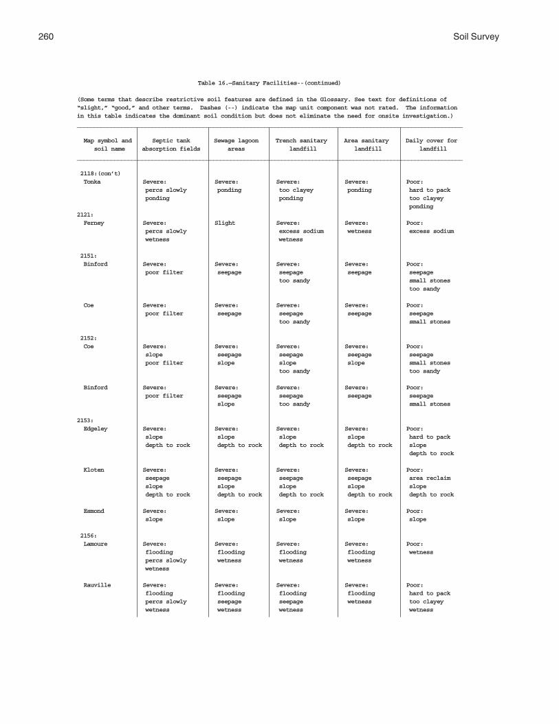
260 Soil Survey
Table 16.—Sanitary Facilities--(continued)
(Some terms that describe restrictive soil features are defined in the Glossary. See text for definitions of“slight,” “good,” and other terms. Dashes (--) indicate the map unit component was not rated. The informationin this table indicates the dominant soil condition but does not eliminate the need for onsite investigation.)_________________________________________________________________________________________________________________
Map symbol and Septic tank Sewage lagoon Trench sanitary Area sanitary Daily cover for soil name absorption fields areas landfill landfill landfill_________________________________________________________________________________________________________________
2118:(con’t) Tonka Severe: Severe: Severe: Severe: Poor: percs slowly ponding too clayey ponding hard to pack ponding ponding too clayey ponding2121: Ferney Severe: Slight Severe: Severe: Poor: percs slowly excess sodium wetness excess sodium wetness wetness
2151: Binford Severe: Severe: Severe: Severe: Poor: poor filter seepage seepage seepage seepage too sandy small stones too sandy
Coe Severe: Severe: Severe: Severe: Poor: poor filter seepage seepage seepage seepage too sandy small stones
2152: Coe Severe: Severe: Severe: Severe: Poor: slope seepage seepage seepage seepage poor filter slope slope slope small stones too sandy too sandy
Binford Severe: Severe: Severe: Severe: Poor: poor filter seepage seepage seepage seepage slope too sandy small stones
2153: Edgeley Severe: Severe: Severe: Severe: Poor: slope slope slope slope hard to pack depth to rock depth to rock depth to rock depth to rock slope depth to rock
Kloten Severe: Severe: Severe: Severe: Poor: seepage seepage seepage seepage area reclaim slope slope slope slope slope depth to rock depth to rock depth to rock depth to rock depth to rock
Esmond Severe: Severe: Severe: Severe: Poor: slope slope slope slope slope
2156: Lamoure Severe: Severe: Severe: Severe: Poor: flooding flooding flooding flooding wetness percs slowly wetness wetness wetness wetness
Rauville Severe: Severe: Severe: Severe: Poor: flooding flooding flooding flooding hard to pack percs slowly seepage seepage wetness too clayey wetness wetness wetness wetness

Griggs County, North Dakota 261
Table 16.—Sanitary Facilities--(continued)
(Some terms that describe restrictive soil features are defined in the Glossary. See text for definitions of“slight,” “good,” and other terms. Dashes (--) indicate the map unit component was not rated. The informationin this table indicates the dominant soil condition but does not eliminate the need for onsite investigation.)_________________________________________________________________________________________________________________
Map symbol and Septic tank Sewage lagoon Trench sanitary Area sanitary Daily cover for soil name absorption fields areas landfill landfill landfill_________________________________________________________________________________________________________________
2157: Maddock Severe: Severe: Severe: Severe: Poor: poor filter seepage seepage seepage seepage slope too sandy too sandy
Esmond Moderate: Severe: Moderate: Moderate: Fair: percs slowly slope slope slope slope slope
Embden Slight Severe: Severe: Severe: Fair: seepage seepage seepage too sandy slope
2158: Velva Severe: Severe: Severe: Severe: Good flooding flooding flooding flooding seepage seepage seepage
2159: Walsh Severe: Moderate: Moderate: Slight Poor: percs slowly seepage too clayey hard to pack slope
2196: Bearden, saline Severe: Severe: Severe: Severe: Fair: percs slowly wetness wetness wetness too clayey wetness wetness
Colvin, saline Severe: Severe: Severe: Severe: Poor: percs slowly wetness wetness wetness wetness wetness
2197: Edgeley Severe: Severe: Severe: Severe: Poor: depth to rock slope depth to rock depth to rock hard to pack depth to rock depth to rock
Kloten Severe: Severe: Severe: Severe: Poor: seepage seepage seepage seepage area reclaim thin layer slope depth to rock depth to rock thin layer depth to rock depth to rock depth to rock
2198: Hamar Severe: Severe: Severe: Severe: Poor: wetness seepage seepage seepage seepage poor filter wetness too sandy wetness too sandy wetness wetness
Hecla Severe: Severe: Severe: Severe: Poor: wetness seepage seepage seepage seepage poor filter wetness too sandy wetness too sandy wetness
2199: Hamerly Severe: Severe: Severe: Severe: Fair: percs slowly wetness wetness wetness too clayey wetness wetness
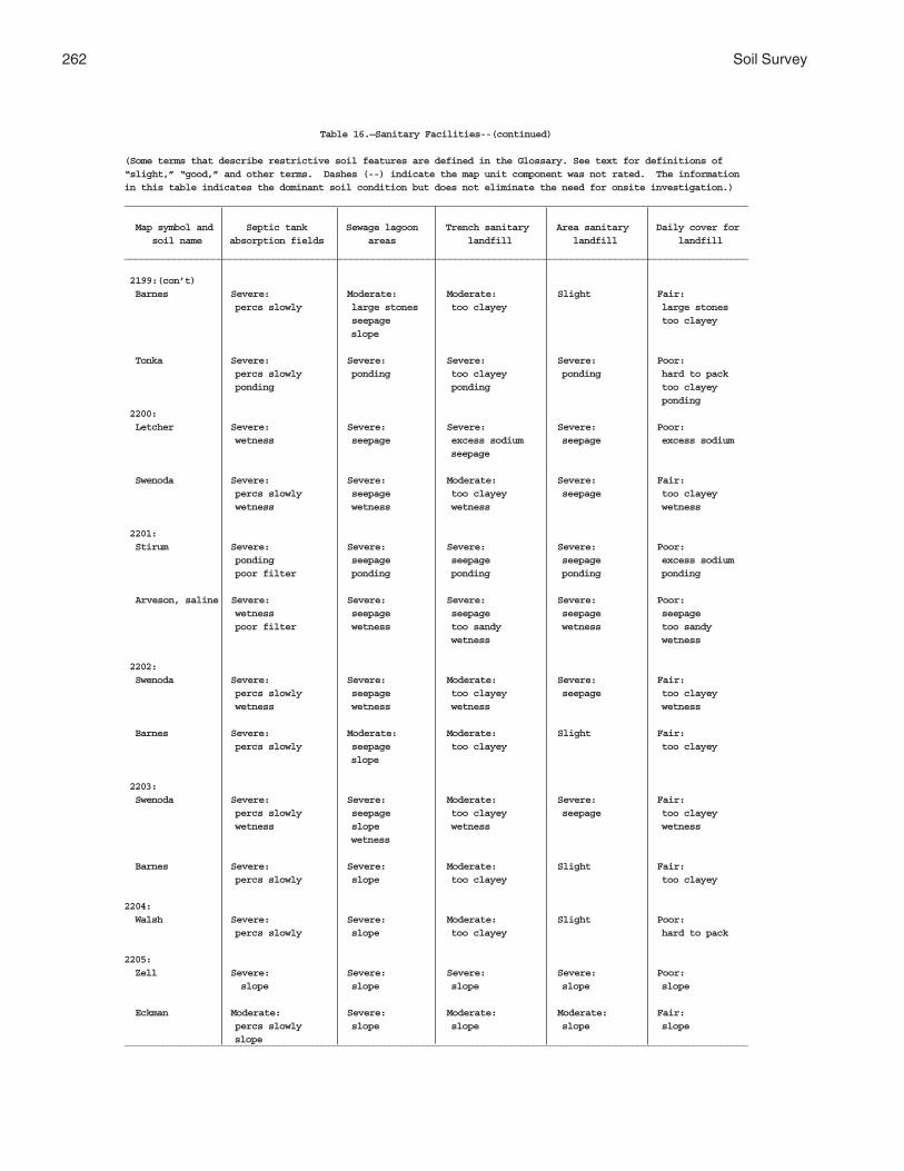
262 Soil Survey
Table 16.—Sanitary Facilities--(continued)
(Some terms that describe restrictive soil features are defined in the Glossary. See text for definitions of“slight,” “good,” and other terms. Dashes (--) indicate the map unit component was not rated. The informationin this table indicates the dominant soil condition but does not eliminate the need for onsite investigation.)_________________________________________________________________________________________________________________
Map symbol and Septic tank Sewage lagoon Trench sanitary Area sanitary Daily cover for soil name absorption fields areas landfill landfill landfill_________________________________________________________________________________________________________________
2199:(con’t) Barnes Severe: Moderate: Moderate: Slight Fair: percs slowly large stones too clayey large stones seepage too clayey slope
Tonka Severe: Severe: Severe: Severe: Poor: percs slowly ponding too clayey ponding hard to pack ponding ponding too clayey ponding 2200: Letcher Severe: Severe: Severe: Severe: Poor: wetness seepage excess sodium seepage excess sodium seepage
Swenoda Severe: Severe: Moderate: Severe: Fair: percs slowly seepage too clayey seepage too clayey wetness wetness wetness wetness
2201: Stirum Severe: Severe: Severe: Severe: Poor: ponding seepage seepage seepage excess sodium poor filter ponding ponding ponding ponding
Arveson, saline Severe: Severe: Severe: Severe: Poor: wetness seepage seepage seepage seepage poor filter wetness too sandy wetness too sandy wetness wetness
2202: Swenoda Severe: Severe: Moderate: Severe: Fair: percs slowly seepage too clayey seepage too clayey wetness wetness wetness wetness
Barnes Severe: Moderate: Moderate: Slight Fair: percs slowly seepage too clayey too clayey slope
2203: Swenoda Severe: Severe: Moderate: Severe: Fair: percs slowly seepage too clayey seepage too clayey wetness slope wetness wetness wetness
Barnes Severe: Severe: Moderate: Slight Fair: percs slowly slope too clayey too clayey
2204: Walsh Severe: Severe: Moderate: Slight Poor: percs slowly slope too clayey hard to pack
2205: Zell Severe: Severe: Severe: Severe: Poor: slope slope slope slope slope
Eckman Moderate: Severe: Moderate: Moderate: Fair: percs slowly slope slope slope slope slope_________________________________________________________________________________________________________________

Griggs County, North Dakota 263
Table 17.—Construction Materials
(Some terms that describe restrictive features are defined in the Glossary. See text for definitions of “good,”“fair,” or other terms. Dashes (--) indicate the map unit component was not rated. The information in this tableindicates the dominant soil condition but does not eliminate the need for onsite investigation.)
__________________________________________________________________________________________________________________
Map symbol and Roadfill Sand Gravel Topsoil soil name_________________________________________________________________________________________________________________
61: Arveson Poor: Probable Improbable: Poor: wetness too sandy wetness
118: Barnes Poor: Improbable: Improbable: Fair: low strength excess fines excess fines small stones
Buse Poor: Improbable: Improbable: Fair: low strength excess fines excess fines small stones too clayey120: Barnes Poor: Improbable: Improbable: Fair: low strength excess fines excess fines small stones
Buse Poor: Improbable: Improbable: Fair: low strength excess fines excess fines small stones too stony156: Barnes Poor: Improbable: Improbable: Fair: low strength excess fines excess fines small stones
Svea Poor: Improbable: Improbable: Fair: low strength excess fines excess fines small stones
167: Bearden Poor: Improbable: Improbable: Fair: low strength excess fines excess fines thin layer shrink-swell
296: Brantford Good Probable Probable Poor: area reclaim small stones too sandy
314: Buse Poor: Improbable: Improbable: Fair: low strength excess fines excess fines slope small stones too clayey
Barnes Poor: Improbable: Improbable: Fair: low strength excess fines excess fines slope small stones
319: Buse Poor: Improbable: Improbable: Poor: low strength excess fines excess fines slope slope
Barnes Poor: Improbable: Improbable: Poor: low strength excess fines excess fines slope
391: Cavour Poor: Improbable: Improbable: Poor: low strength excess fines excess fines excess sodium

264 Soil Survey
Table 17.—Construction Materials--(continued)
(Some terms that describe restrictive features are defined in the Glossary. See text for definitions of “good,”“fair,” or other terms. Dashes (--) indicate the map unit component was not rated. The information in this tableindicates the dominant soil condition but does not eliminate the need for onsite investigation.)
__________________________________________________________________________________________________________________
Map symbol and Roadfill Sand Gravel Topsoil soil name__________________________________________________________________________________________________________________
391:(con’t) Cresbard Poor: Improbable: Improbable: Poor: low strength excess fines excess fines excess sodium too clayey
450: Colvin Poor: Improbable: Improbable: Poor: low strength excess fines excess fines wetness wetness
511: Divide Fair: Probable Probable Poor: wetness area reclaim small stones too sandy
536: Eckman Good Improbable: Improbable: Good excess fines excess fines
Zell Good Improbable: Improbable: Good excess fines excess fines
539: Edgeley Poor: Improbable: Improbable: Poor: low strength excess fines excess fines small stones depth to rock
541: Edgeley Poor: Improbable: Improbable: Poor: low strength excess fines excess fines small stones depth to rock
569: Embden Good Improbable: Improbable: Good excess fines excess fines
579: Embden Good Improbable: Improbable: Good excess fines excess fines
Egeland Good Improbable: Improbable: Fair: excess fines excess fines small stones
595: Emrick Good Improbable: Improbable: Fair: excess fines excess fines small stones
Cathay Fair: Improbable: Improbable: Poor: low strength excess fines excess fines excess sodium shrink-swell
597: Emrick Good Improbable: Improbable: Fair: excess fines excess fines small stones
Heimdal Good Improbable: Improbable: Fair: excess fines excess fines small stones

Griggs County, North Dakota 265
Table 17.—Construction Materials--(continued)
(Some terms that describe restrictive features are defined in the Glossary. See text for definitions of “good,”“fair,” or other terms. Dashes (--) indicate the map unit component was not rated. The information in this tableindicates the dominant soil condition but does not eliminate the need for onsite investigation.)
__________________________________________________________________________________________________________________
Map symbol and Roadfill Sand Gravel Topsoil soil name__________________________________________________________________________________________________________________
605: Esmond Good Improbable: Improbable: Fair: excess fines excess fines slope small stones
Heimdal Good Improbable: Improbable: Fair: excess fines excess fines slope
753: Fram Fair: Improbable: Improbable: Fair: wetness excess fines excess fines small stones
Wyard Fair: Improbable: Improbable: Fair: shrink-swell excess fines excess fines area reclaim wetness small stones
769: Gardena Good Improbable: Improbable: Good excess fines excess fines
773: Gardena Good Improbable: Improbable: Good excess fines excess fines
Eckman Good Improbable: Improbable: Good excess fines excess fines
881: Hamerly Fair: Improbable: Improbable: Fair: low strength excess fines excess fines small stones shrink-swell wetness
Tonka Poor: Improbable: Improbable: Poor: low strength excess fines excess fines too clayey wetness wetness
884: Hamerly Fair: Improbable: Improbable: Fair: low strength excess fines excess fines small stones shrink-swell wetness
Wyard Fair: Improbable: Improbable: Fair: shrink-swell excess fines excess fines area reclaim wetness small stones
893: Harriet Poor: Improbable: Improbable: Poor: low strength excess fines excess fines excess salt wetness too clayey wetness
988: Heimdal Good Improbable: Improbable: Fair: excess fines excess fines small stones
Emrick Good Improbable: Improbable: Fair: excess fines excess fines small stones

266 Soil Survey
Table 17.—Construction Materials--(continued)
(Some terms that describe restrictive features are defined in the Glossary. See text for definitions of “good,”“fair,” or other terms. Dashes (--) indicate the map unit component was not rated. The information in this tableindicates the dominant soil condition but does not eliminate the need for onsite investigation.)
__________________________________________________________________________________________________________________
Map symbol and Roadfill Sand Gravel Topsoil soil name__________________________________________________________________________________________________________________
998: Heimdal Good Improbable: Improbable: Fair: excess fines excess fines small stones
Esmond Good Improbable: Improbable: Fair: excess fines excess fines small stones
1001: Heimdal Fair: Improbable: Improbable: Poor: slope excess fines excess fines slope
Esmond Poor: Improbable: Improbable: Poor: slope excess fines excess fines slope
1015: Kensal Good Probable Probable Poor: area reclaim small stones
1062: LaDelle Poor: Improbable: Improbable: Good low strength excess fines excess fines
1108: Larson Fair: Improbable: Improbable: Poor: low strength excess fines excess fines excess sodium shrink-swell
Cathay Fair: Improbable: Improbable: Poor: low strength excess fines excess fines excess sodium shrink-swell
1188: Ludden Poor: Improbable: Improbable: Poor: low strength excess fines excess fines too clayey shrink-swell wetness wetness
1189: Ludden, saline Poor: Improbable: Improbable: Poor: low strength excess fines excess fines too clayey shrink-swell wetness wetness
1221: Maddock Good Probable Improbable: Poor: too sandy too sandy
Hecla Good Probable Improbable: Poor: too sandy too sandy
1267: Marysland Poor: Probable Probable Poor: wetness area reclaim small stones wetness

Griggs County, North Dakota 267
Table 17.—Construction Materials--(continued)
(Some terms that describe restrictive features are defined in the Glossary. See text for definitions of “good,”“fair,” or other terms. Dashes (--) indicate the map unit component was not rated. The information in this tableindicates the dominant soil condition but does not eliminate the need for onsite investigation.)
__________________________________________________________________________________________________________________
Map symbol and Roadfill Sand Gravel Topsoil soil name__________________________________________________________________________________________________________________
1268: Marysland, wet Poor: Probable Probable Poor: wetness wetness
1427: Parnell Poor: Improbable: Improbable: Poor: low strength excess fines excess fines wetness shrink-swell wetness
1454: Wyndmere Fair: Improbable: Improbable: Fair: thin layer excess fines excess fines thin layer wetness
1466: Pits, sand and Poor: Probable Probable Poor: gravel slope area reclaim small stones too sandy
1710: Southam Poor: Improbable: Improbable: Poor: low strength excess fines excess fines too clayey shrink-swell wetness wetness
1762: Svea Poor: Improbable: Improbable: Fair: low strength excess fines excess fines small stones
Barnes Poor: Improbable: Improbable: Fair: low strength excess fines excess fines small stones
1765: Svea Poor: Improbable: Improbable: Fair: low strength excess fines excess fines small stones
Buse Poor: Improbable: Improbable: Fair: low strength excess fines excess fines small stones too clayey1766: Svea Poor: Improbable: Improbable: Fair: low strength excess fines excess fines small stones
Buse Poor: Improbable: Improbable: Fair: low strength excess fines excess fines small stones too clayey
1769: Svea Poor: Improbable: Improbable: Fair: low strength excess fines excess fines small stones
Cresbard Poor: Improbable: Improbable: Poor: low strength excess fines excess fines excess sodium too clayey
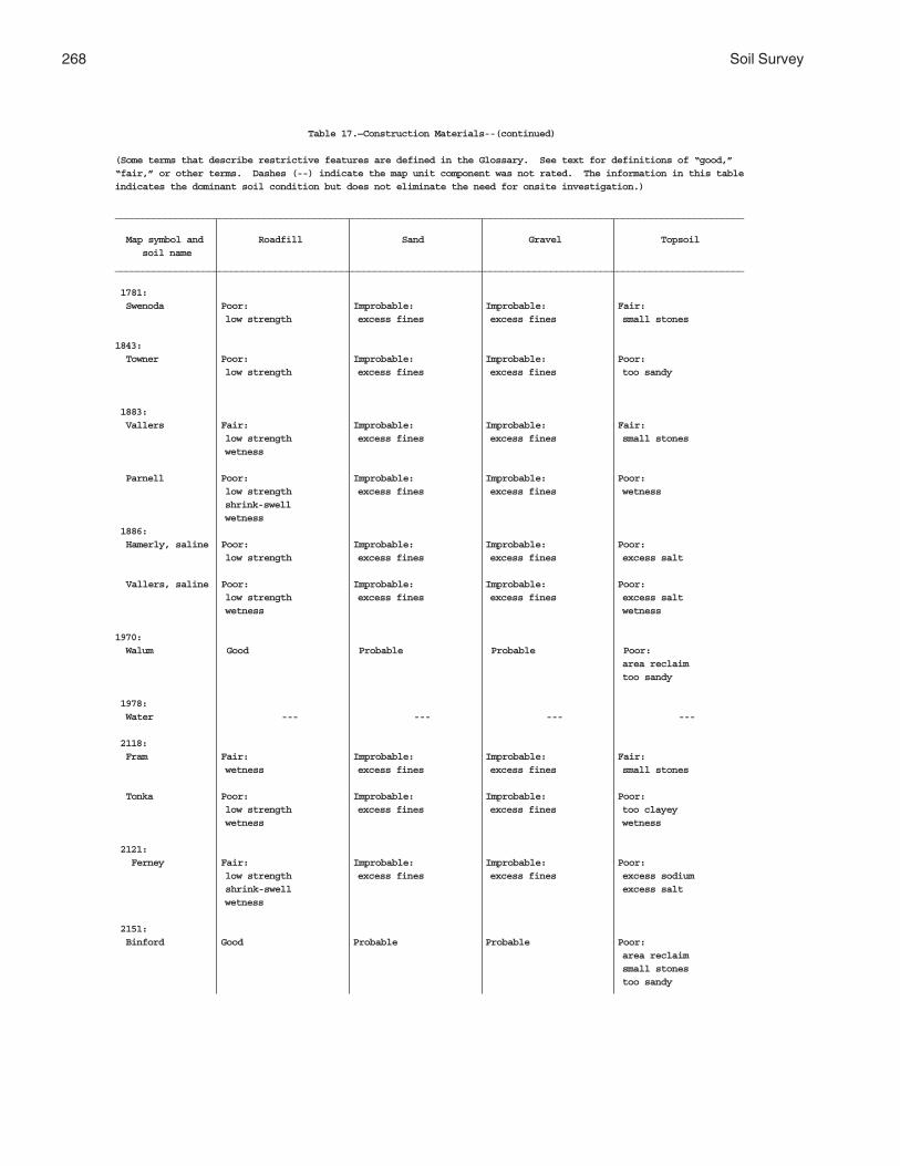
268 Soil Survey
Table 17.—Construction Materials--(continued)
(Some terms that describe restrictive features are defined in the Glossary. See text for definitions of “good,”“fair,” or other terms. Dashes (--) indicate the map unit component was not rated. The information in this tableindicates the dominant soil condition but does not eliminate the need for onsite investigation.)
__________________________________________________________________________________________________________________
Map symbol and Roadfill Sand Gravel Topsoil soil name__________________________________________________________________________________________________________________
1781: Swenoda Poor: Improbable: Improbable: Fair: low strength excess fines excess fines small stones
1843: Towner Poor: Improbable: Improbable: Poor: low strength excess fines excess fines too sandy
1883: Vallers Fair: Improbable: Improbable: Fair: low strength excess fines excess fines small stones wetness
Parnell Poor: Improbable: Improbable: Poor: low strength excess fines excess fines wetness shrink-swell wetness 1886: Hamerly, saline Poor: Improbable: Improbable: Poor: low strength excess fines excess fines excess salt
Vallers, saline Poor: Improbable: Improbable: Poor: low strength excess fines excess fines excess salt wetness wetness
1970: Walum Good Probable Probable Poor: area reclaim too sandy
1978: Water --- --- --- ---
2118: Fram Fair: Improbable: Improbable: Fair: wetness excess fines excess fines small stones
Tonka Poor: Improbable: Improbable: Poor: low strength excess fines excess fines too clayey wetness wetness
2121: Ferney Fair: Improbable: Improbable: Poor: low strength excess fines excess fines excess sodium shrink-swell excess salt wetness
2151: Binford Good Probable Probable Poor: area reclaim small stones too sandy
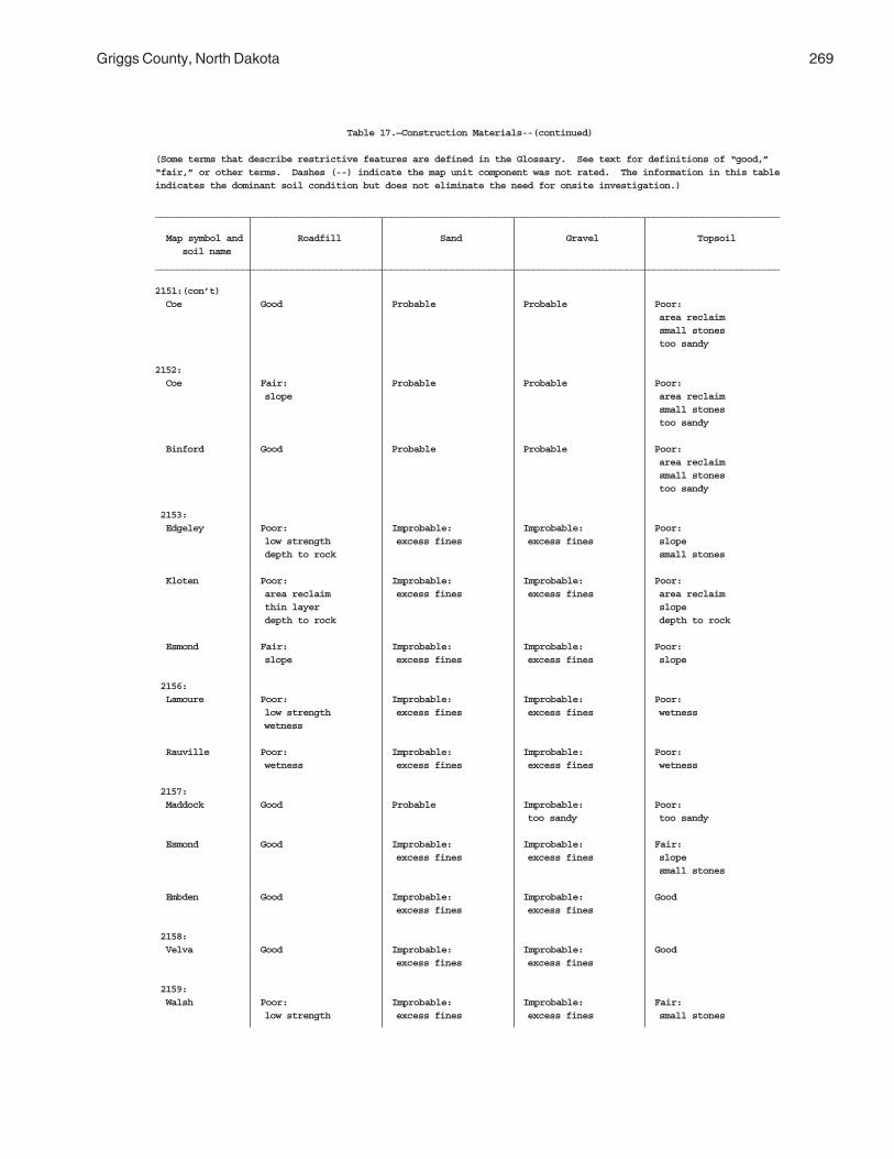
Griggs County, North Dakota 269
Table 17.—Construction Materials--(continued)
(Some terms that describe restrictive features are defined in the Glossary. See text for definitions of “good,”“fair,” or other terms. Dashes (--) indicate the map unit component was not rated. The information in this tableindicates the dominant soil condition but does not eliminate the need for onsite investigation.)
__________________________________________________________________________________________________________________
Map symbol and Roadfill Sand Gravel Topsoil soil name__________________________________________________________________________________________________________________
2151:(con’t) Coe Good Probable Probable Poor: area reclaim small stones too sandy
2152: Coe Fair: Probable Probable Poor: slope area reclaim small stones too sandy
Binford Good Probable Probable Poor: area reclaim small stones too sandy
2153: Edgeley Poor: Improbable: Improbable: Poor: low strength excess fines excess fines slope depth to rock small stones
Kloten Poor: Improbable: Improbable: Poor: area reclaim excess fines excess fines area reclaim thin layer slope depth to rock depth to rock
Esmond Fair: Improbable: Improbable: Poor: slope excess fines excess fines slope
2156: Lamoure Poor: Improbable: Improbable: Poor: low strength excess fines excess fines wetness wetness
Rauville Poor: Improbable: Improbable: Poor: wetness excess fines excess fines wetness
2157: Maddock Good Probable Improbable: Poor: too sandy too sandy
Esmond Good Improbable: Improbable: Fair: excess fines excess fines slope small stones
Embden Good Improbable: Improbable: Good excess fines excess fines
2158: Velva Good Improbable: Improbable: Good excess fines excess fines
2159: Walsh Poor: Improbable: Improbable: Fair: low strength excess fines excess fines small stones
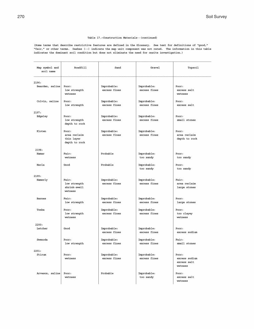
270 Soil Survey
Table 17.—Construction Materials--(continued)
(Some terms that describe restrictive features are defined in the Glossary. See text for definitions of “good,”“fair,” or other terms. Dashes (--) indicate the map unit component was not rated. The information in this tableindicates the dominant soil condition but does not eliminate the need for onsite investigation.)
__________________________________________________________________________________________________________________
Map symbol and Roadfill Sand Gravel Topsoil soil name__________________________________________________________________________________________________________________
2196: Bearden, saline Poor: Improbable: Improbable: Poor: low strength excess fines excess fines excess salt wetness wetness
Colvin, saline Poor: Improbable: Improbable: Poor: low strength excess fines excess fines excess salt
2197: Edgeley Poor: Improbable: Improbable: Poor: low strength excess fines excess fines small stones depth to rock
Kloten Poor: Improbable: Improbable: Poor: area reclaim excess fines excess fines area reclaim thin layer depth to rock depth to rock
2198: Hamar Fair: Probable Improbable: Poor: wetness too sandy too sandy
Hecla Good Probable Improbable: Poor: too sandy too sandy
2199: Hamerly Fair: Improbable: Improbable: Fair: low strength excess fines excess fines area reclaim shrink-swell large stones wetness
Barnes Fair: Improbable: Improbable: Poor: low strength excess fines excess fines large stones
Tonka Poor: Improbable: Improbable: Poor: low strength excess fines excess fines too clayey wetness wetness
2200: Letcher Good Improbable: Improbable: Poor: excess fines excess fines excess sodium
Swenoda Poor: Improbable: Improbable: Fair: low strength excess fines excess fines small stones
2201: Stirum Poor: Improbable: Improbable: Poor: wetness excess fines excess fines excess sodium excess salt wetness
Arveson, saline Poor: Probable Improbable: Poor: wetness too sandy excess salt wetness
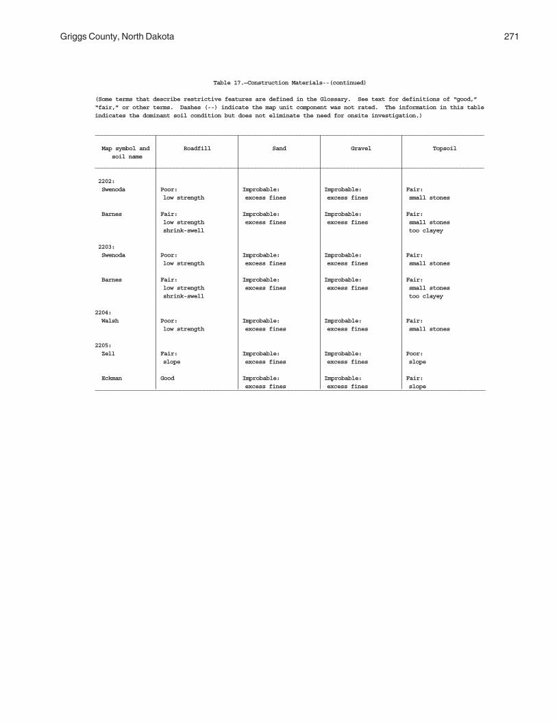
Griggs County, North Dakota 271
Table 17.—Construction Materials--(continued)
(Some terms that describe restrictive features are defined in the Glossary. See text for definitions of “good,”“fair,” or other terms. Dashes (--) indicate the map unit component was not rated. The information in this tableindicates the dominant soil condition but does not eliminate the need for onsite investigation.)
__________________________________________________________________________________________________________________
Map symbol and Roadfill Sand Gravel Topsoil soil name__________________________________________________________________________________________________________________
2202: Swenoda Poor: Improbable: Improbable: Fair: low strength excess fines excess fines small stones
Barnes Fair: Improbable: Improbable: Fair: low strength excess fines excess fines small stones shrink-swell too clayey
2203: Swenoda Poor: Improbable: Improbable: Fair: low strength excess fines excess fines small stones
Barnes Fair: Improbable: Improbable: Fair: low strength excess fines excess fines small stones shrink-swell too clayey
2204: Walsh Poor: Improbable: Improbable: Fair: low strength excess fines excess fines small stones
2205: Zell Fair: Improbable: Improbable: Poor: slope excess fines excess fines slope
Eckman Good Improbable: Improbable: Fair: excess fines excess fines slope___________________________________________________________________________________________________________________

272 Soil Survey
Table 18.—Water Management
(Some terms that describe restrictive soil features are defined in the Glossary. See text for definitions of “slight,”“moderate,” and “severe.” Dashes indicate that the map unit component was not evaluated. The information in this tableindicates the dominant soil condition but does not eliminate the need for onsite investigation.)
___________________________________________________________________________________________________________________________ Limitations for— Features affecting— ________________________________________________________________________________________________________ Map symbol and Pond reservoir Embankments, Aquifer-fed Terraces and Grassed soil name areas dikes, and excavated Drainage Irrigation diversions waterways levees ponds __________________________________________________________________________________________________________________________
61: Arveson Severe: Severe: Severe: Limitation: Limitation: Limitation: Limitation: seepage seepage cutbanks cave frost action wetness too sandy wetness piping cutbanks cave soil blowing wetness wetness soil blowing
118: Barnes Moderate: Severe: Severe: Limitation: Limitation: Limitation: Limitation: seepage piping no water deep to water slope erodes easily erodes easily slope
Buse Moderate: Severe: Severe: Limitation: Limitation: Limitation: Limitation: seepage piping no water deep to water slope erodes easily erodes easily slope
120: Barnes Moderate: Severe: Severe: Limitation: Limitation: Limitation: Limitation: seepage piping no water deep to water slope erodes easily erodes easily slope
Buse Moderate: Severe: Severe: Limitation: Limitation: Limitation: Limitation: seepage piping no water deep to water slope erodes easily erodes easily slope
156: Barnes Moderate: Severe: Severe: Limitation: Limitation: Limitation: Limitation: seepage piping no water deep to water slope erodes easily erodes easily slope
Svea Moderate: Severe: Severe: Limitation: Limitation: Limitation: Limitation: seepage piping slow refill deep to water slope erodes easily erodes easily slope
167: Bearden Moderate: Severe: Severe: Limitation: Limitation: Limitation: Limitation: seepage piping slow refill frost action wetness erodes easily erodes easily wetness percs slowly percs slowly percs slowly wetness
296: Brantford Severe: Severe: Severe: Limitation: Limitation: Limitation: Limitation: seepage seepage no water deep to water droughty large stones large stones too sandy droughty
314: Buse Severe: Severe: Severe: Limitation: Limitation: Limitation: Limitation: slope piping no water deep to water slope erodes easily erodes easily slope slope
Barnes Severe: Severe: Severe: Limitation: Limitation: Limitation: Limitation: slope piping no water deep to water slope erodes easily erodes easily slope slope
319: Buse Severe: Severe: Severe: Limitation: Limitation: Limitation: Limitation: slope piping no water deep to water slope erodes easily erodes easily slope slope

Griggs County, North Dakota 273
Table 18.—Water Management--(continued)
(Some terms that describe restrictive soil features are defined in the Glossary. See text for definitions of “slight,”“moderate,” and “severe.” Dashes indicate that the map unit component was not evaluated. The information in this tableindicates the dominant soil condition but does not eliminate the need for onsite investigation.)
___________________________________________________________________________________________________________________________ Limitations for— Features affecting— ________________________________________________________________________________________________________ Map symbol and Pond reservoir Embankments, Aquifer-fed Terraces and Grassed soil name areas dikes, and excavated Drainage Irrigation diversions waterways levees ponds __________________________________________________________________________________________________________________________
319:(con’t) Barnes Severe: Severe: Severe: Limitation: Limitation: Limitation: Limitation: slope piping no water deep to water slope erodes easily erodes easily slope slope
391: Cavour Slight Severe: Severe: Limitation: Limitation: Limitation: Limitation: excess sodium slow refill deep to water percs slowly erodes easily erodes easily rooting depth percs slowly excess sodium
Cresbard Slight Severe: Severe: Limitation: Limitation: Favorable Limitation: excess sodium slow refill deep to water excess sodium excess sodium percs slowly percs slowly
450: Colvin Moderate: Severe: Severe: Limitation: Limitation: Limitation: Limitation: seepage piping slow refill frost action wetness erodes easily erodes easily wetness wetness wetness
511: Divide Severe: Severe: Severe: Limitation: Limitation: Limitation: Favorable seepage seepage slow refill cutbanks cave wetness too sandy piping cutbanks cave wetness wetness
536: Eckman Moderate: Severe: Severe: Limitation: Limitation: Limitation: Limitation: seepage piping no water deep to water slope erodes easily erodes easily slope
Zell Moderate: Severe: Severe: Limitation: Limitation: Limitation: Limitation: seepage piping no water deep to water slope erodes easily erodes easily slope
539: Edgeley Moderate: Severe: Severe: Limitation: Limitation: Limitation: Limitation: seepage hard to pack no water deep to water depth to rock erodes easily erodes easily depth to rock depth to rock depth to rock
541: Edgeley Moderate: Severe: Severe: Limitation: Limitation: Limitation: Limitation: seepage hard to pack no water deep to water slope erodes easily erodes easily slope depth to rock depth to rock depth to rock depth to rock
569: Embden Severe: Severe: Severe: Limitation: Limitation: Limitation: Favorable seepage seepage cutbanks cave deep to water soil blowing soil blowing piping
579: Embden Severe: Severe: Severe: Limitation: Limitation: Limitation: Favorable seepage seepage cutbanks cave deep to water slope soil blowing piping soil blowing
Egeland Severe: Severe: Severe: Limitation: Limitation: Limitation: Favorable seepage seepage no water deep to water slope too sandy piping soil blowing soil blowing
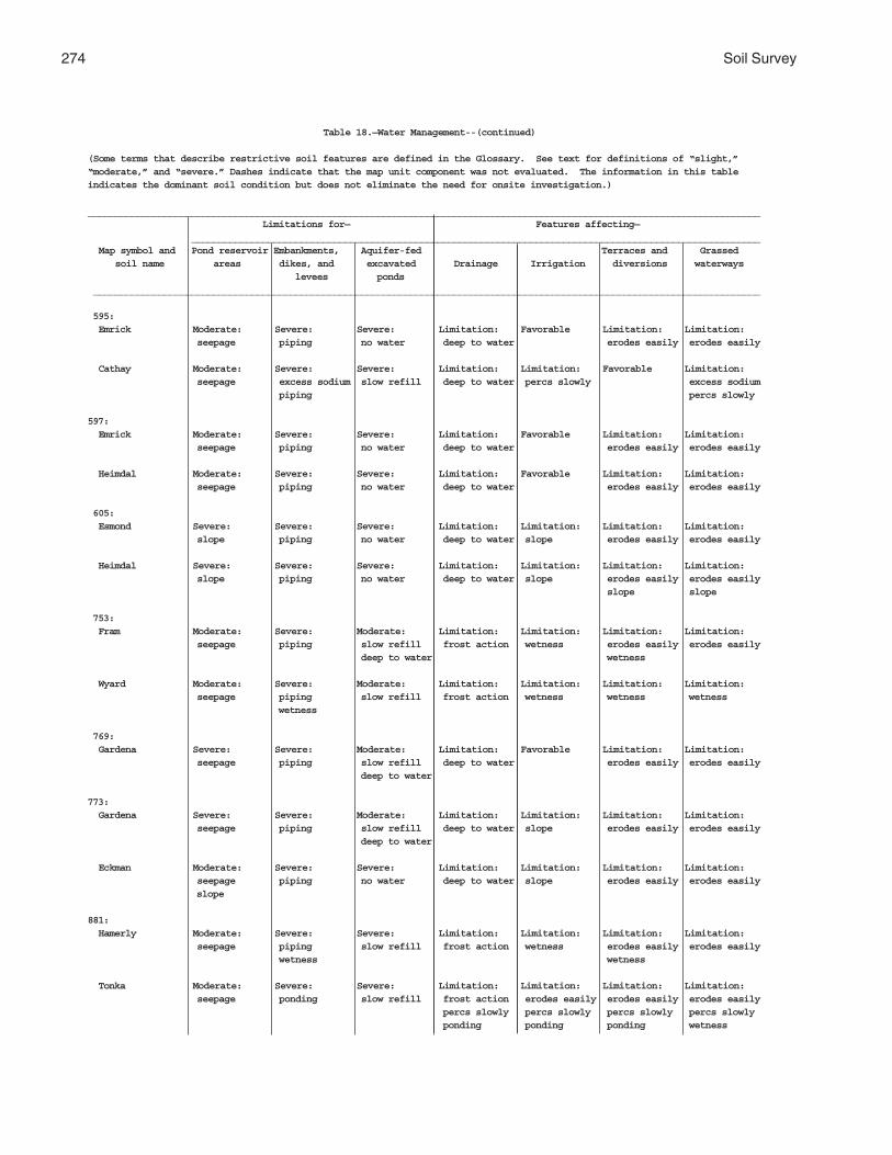
274 Soil Survey
Table 18.—Water Management--(continued)
(Some terms that describe restrictive soil features are defined in the Glossary. See text for definitions of “slight,”“moderate,” and “severe.” Dashes indicate that the map unit component was not evaluated. The information in this tableindicates the dominant soil condition but does not eliminate the need for onsite investigation.)
___________________________________________________________________________________________________________________________ Limitations for— Features affecting— ________________________________________________________________________________________________________ Map symbol and Pond reservoir Embankments, Aquifer-fed Terraces and Grassed soil name areas dikes, and excavated Drainage Irrigation diversions waterways levees ponds __________________________________________________________________________________________________________________________
595: Emrick Moderate: Severe: Severe: Limitation: Favorable Limitation: Limitation: seepage piping no water deep to water erodes easily erodes easily
Cathay Moderate: Severe: Severe: Limitation: Limitation: Favorable Limitation: seepage excess sodium slow refill deep to water percs slowly excess sodium piping percs slowly
597: Emrick Moderate: Severe: Severe: Limitation: Favorable Limitation: Limitation: seepage piping no water deep to water erodes easily erodes easily
Heimdal Moderate: Severe: Severe: Limitation: Favorable Limitation: Limitation: seepage piping no water deep to water erodes easily erodes easily
605: Esmond Severe: Severe: Severe: Limitation: Limitation: Limitation: Limitation: slope piping no water deep to water slope erodes easily erodes easily
Heimdal Severe: Severe: Severe: Limitation: Limitation: Limitation: Limitation: slope piping no water deep to water slope erodes easily erodes easily slope slope
753: Fram Moderate: Severe: Moderate: Limitation: Limitation: Limitation: Limitation: seepage piping slow refill frost action wetness erodes easily erodes easily deep to water wetness
Wyard Moderate: Severe: Moderate: Limitation: Limitation: Limitation: Limitation: seepage piping slow refill frost action wetness wetness wetness wetness
769: Gardena Severe: Severe: Moderate: Limitation: Favorable Limitation: Limitation: seepage piping slow refill deep to water erodes easily erodes easily deep to water
773: Gardena Severe: Severe: Moderate: Limitation: Limitation: Limitation: Limitation: seepage piping slow refill deep to water slope erodes easily erodes easily deep to water
Eckman Moderate: Severe: Severe: Limitation: Limitation: Limitation: Limitation: seepage piping no water deep to water slope erodes easily erodes easily slope
881: Hamerly Moderate: Severe: Severe: Limitation: Limitation: Limitation: Limitation: seepage piping slow refill frost action wetness erodes easily erodes easily wetness wetness
Tonka Moderate: Severe: Severe: Limitation: Limitation: Limitation: Limitation: seepage ponding slow refill frost action erodes easily erodes easily erodes easily percs slowly percs slowly percs slowly percs slowly ponding ponding ponding wetness
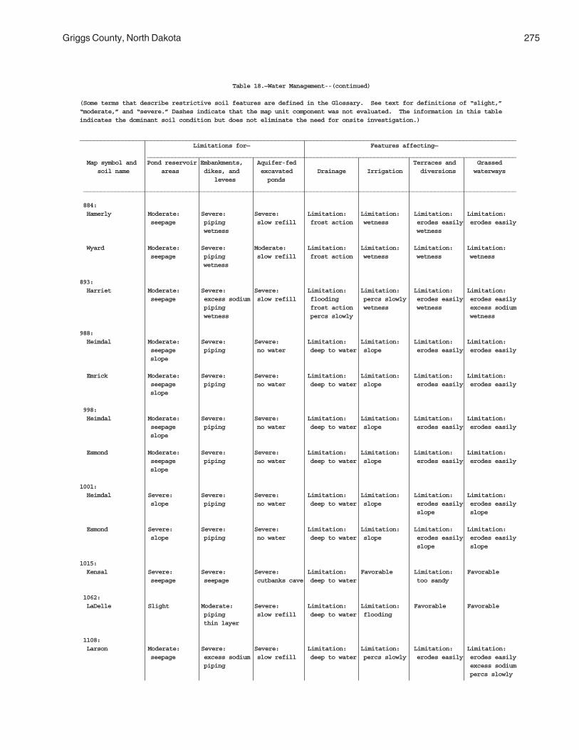
Griggs County, North Dakota 275
Table 18.—Water Management--(continued)
(Some terms that describe restrictive soil features are defined in the Glossary. See text for definitions of “slight,”“moderate,” and “severe.” Dashes indicate that the map unit component was not evaluated. The information in this tableindicates the dominant soil condition but does not eliminate the need for onsite investigation.)
___________________________________________________________________________________________________________________________ Limitations for— Features affecting— ________________________________________________________________________________________________________ Map symbol and Pond reservoir Embankments, Aquifer-fed Terraces and Grassed soil name areas dikes, and excavated Drainage Irrigation diversions waterways levees ponds __________________________________________________________________________________________________________________________
884: Hamerly Moderate: Severe: Severe: Limitation: Limitation: Limitation: Limitation: seepage piping slow refill frost action wetness erodes easily erodes easily wetness wetness
Wyard Moderate: Severe: Moderate: Limitation: Limitation: Limitation: Limitation: seepage piping slow refill frost action wetness wetness wetness wetness
893: Harriet Moderate: Severe: Severe: Limitation: Limitation: Limitation: Limitation: seepage excess sodium slow refill flooding percs slowly erodes easily erodes easily piping frost action wetness wetness excess sodium wetness percs slowly wetness
988: Heimdal Moderate: Severe: Severe: Limitation: Limitation: Limitation: Limitation: seepage piping no water deep to water slope erodes easily erodes easily slope
Emrick Moderate: Severe: Severe: Limitation: Limitation: Limitation: Limitation: seepage piping no water deep to water slope erodes easily erodes easily slope
998: Heimdal Moderate: Severe: Severe: Limitation: Limitation: Limitation: Limitation: seepage piping no water deep to water slope erodes easily erodes easily slope
Esmond Moderate: Severe: Severe: Limitation: Limitation: Limitation: Limitation: seepage piping no water deep to water slope erodes easily erodes easily slope
1001: Heimdal Severe: Severe: Severe: Limitation: Limitation: Limitation: Limitation: slope piping no water deep to water slope erodes easily erodes easily slope slope
Esmond Severe: Severe: Severe: Limitation: Limitation: Limitation: Limitation: slope piping no water deep to water slope erodes easily erodes easily slope slope
1015: Kensal Severe: Severe: Severe: Limitation: Favorable Limitation: Favorable seepage seepage cutbanks cave deep to water too sandy
1062: LaDelle Slight Moderate: Severe: Limitation: Limitation: Favorable Favorable piping slow refill deep to water flooding thin layer
1108: Larson Moderate: Severe: Severe: Limitation: Limitation: Limitation: Limitation: seepage excess sodium slow refill deep to water percs slowly erodes easily erodes easily piping excess sodium percs slowly

276 Soil Survey
Table 18.—Water Management--(continued)
(Some terms that describe restrictive soil features are defined in the Glossary. See text for definitions of “slight,”“moderate,” and “severe.” Dashes indicate that the map unit component was not evaluated. The information in this tableindicates the dominant soil condition but does not eliminate the need for onsite investigation.)
___________________________________________________________________________________________________________________________ Limitations for— Features affecting— ________________________________________________________________________________________________________ Map symbol and Pond reservoir Embankments, Aquifer-fed Terraces and Grassed soil name areas dikes, and excavated Drainage Irrigation diversions waterways levees ponds __________________________________________________________________________________________________________________________
1108:(con’t) Cathay Moderate: Severe: Severe: Limitation: Limitation: Favorable Limitation: seepage excess sodium slow refill deep to water percs slowly excess sodium piping percs slowly
1188: Ludden Slight Severe: Severe: Limitation: Limitation: Limitation: Limitation: hard to pack slow refill flooding percs slowly percs slowly percs slowly ponding percs slowly slow intake ponding wetness ponding ponding
1189: Ludden, saline Slight Severe: Severe: Limitation: Limitation: Limitation: Limitation: hard to pack slow refill flooding percs slowly percs slowly excess salt wetness frost action slow intake wetness percs slowly percs slowly wetness wetness
1221: Maddock Severe: Severe: Severe: Limitation: Limitation: Limitation: Limitation: seepage seepage no water deep to water fast intake too sandy droughty piping slope soil blowing droughty
Hecla Severe: Severe: Severe: Limitation: Limitation: Limitation: Limitation: seepage seepage cutbanks cave deep to water fast intake too sandy droughty piping soil blowing soil blowing droughty
1267: Marysland Severe: Severe: Severe: Limitation: Limitation: Limitation: Limitation: seepage seepage slow refill frost action wetness too sandy wetness wetness cutbanks cave cutbanks cave wetness
1268: Marysland, wet Severe: Severe: Severe: Limitation: Limitation: Limitation: Limitation: seepage seepage cutbanks cave frost action ponding too sandy wetness ponding ponding ponding cutbanks cave
1427: Parnell Slight Severe: Severe: Limitation: Limitation: Limitation: Limitation: hard to pack slow refill frost action percs slowly erodes easily erodes easily ponding percs slowly ponding percs slowly percs slowly ponding ponding wetness
1454: Wyndmere Severe: Severe: Severe: Limitation: Limitation: Limitation: Favorable seepage piping slow refill frost action wetness too sandy cutbanks cave cutbanks cave soil blowing wetness soil blowing
1466: Pits, sand and Severe: Severe: Severe: Limitation: Limitation: Limitation: Limitation: gravel seepage seepage no water deep to water fast intake slope slope slope slope too sandy droughty droughty
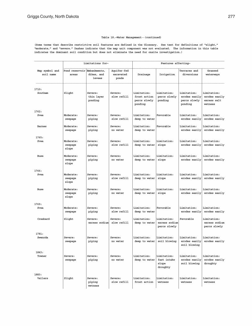
Griggs County, North Dakota 277
Table 18.—Water Management--(continued)
(Some terms that describe restrictive soil features are defined in the Glossary. See text for definitions of “slight,”“moderate,” and “severe.” Dashes indicate that the map unit component was not evaluated. The information in this tableindicates the dominant soil condition but does not eliminate the need for onsite investigation.)
___________________________________________________________________________________________________________________________ Limitations for— Features affecting— ________________________________________________________________________________________________________ Map symbol and Pond reservoir Embankments, Aquifer-fed Terraces and Grassed soil name areas dikes, and excavated Drainage Irrigation diversions waterways levees ponds __________________________________________________________________________________________________________________________
1710: Southam Slight Severe: Severe: Limitation: Limitation: Limitation: Limitation: thin layer slow refill frost action percs slowly erodes easily erodes easily ponding percs slowly ponding percs slowly excess salt ponding ponding wetness
1762: Svea Moderate: Severe: Severe: Limitation: Favorable Limitation: Limitation: seepage piping slow refill deep to water erodes easily erodes easily
Barnes Moderate: Severe: Severe: Limitation: Favorable Limitation: Limitation: seepage piping no water deep to water erodes easily erodes easily
1765: Svea Moderate: Severe: Severe: Limitation: Limitation: Limitation: Limitation: seepage piping slow refill deep to water slope erodes easily erodes easily slope
Buse Moderate: Severe: Severe: Limitation: Limitation: Limitation: Limitation: seepage piping no water deep to water slope erodes easily erodes easily slope
1766: Svea Moderate: Severe: Severe: Limitation: Limitation: Limitation: Limitation: seepage piping slow refill deep to water slope erodes easily erodes easily slope
Buse Moderate: Severe: Severe: Limitation: Limitation: Limitation: Limitation: seepage piping no water deep to water slope erodes easily erodes easily slope
1769: Svea Moderate: Severe: Severe: Limitation: Favorable Limitation: Limitation: seepage piping slow refill deep to water erodes easily erodes easily
Cresbard Slight Severe: Severe: Limitation: Limitation: Favorable Limitation: excess sodium slow refill deep to water excess sodium excess sodium percs slowly percs slowly
1781: Swenoda Severe: Severe: Severe: Limitation: Limitation: Limitation: Limitation: seepage piping no water deep to water soil blowing erodes easily erodes easily soil blowing
1843: Towner Severe: Severe: Severe: Limitation: Limitation: Limitation: Limitation: seepage piping no water deep to water fast intake erodes easily erodes easily slope soil blowing droughty droughty
1883: Vallers Slight Severe: Severe: Limitation: Limitation: Limitation: Limitation: piping slow refill frost action wetness wetness wetness wetness

278 Soil Survey
Table 18.—Water Management--(continued)
(Some terms that describe restrictive soil features are defined in the Glossary. See text for definitions of “slight,”“moderate,” and “severe.” Dashes indicate that the map unit component was not evaluated. The information in this tableindicates the dominant soil condition but does not eliminate the need for onsite investigation.)
___________________________________________________________________________________________________________________________ Limitations for— Features affecting— ________________________________________________________________________________________________________ Map symbol and Pond reservoir Embankments, Aquifer-fed Terraces and Grassed soil name areas dikes, and excavated Drainage Irrigation diversions waterways levees ponds __________________________________________________________________________________________________________________________
1843:(con’t) Parnell Slight Severe: Severe: Limitation: Limitation: Limitation: Limitation: hard to pack slow refill frost action percs slowly erodes easily erodes easily ponding percs slowly ponding percs slowly percs slowly ponding ponding wetness 1886: Hamerly, saline Moderate: Severe: Severe: Limitation: Limitation: Limitation: Limitation: seepage piping slow refill excess salt excess salt erodes easily erodes easily wetness frost action wetness wetness excess salt
Vallers, saline Moderate: Severe: Severe: Limitation: Limitation: Limitation: Limitation: seepage piping slow refill excess salt excess salt erodes easily erodes easily wetness frost action wetness wetness excess salt wetness
1970: Walum Severe: Severe: Severe: Limitation: Limitation: Limitation: Limitation: seepage seepage cutbanks cave deep to water soil blowing too sandy droughty piping droughty soil blowing
1978: Water — — — — — — —
2118: Fram Moderate: Severe: Moderate: Limitation: Limitation: Limitation: Limitation: seepage piping slow refill frost action wetness erodes easily erodes easily deep to water wetness
Tonka Moderate: Severe: Severe: Limitation: Limitation: Limitation: Limitation: seepage ponding slow refill frost action erodes easily erodes easily erodes easily percs slowly percs slowly percs slowly percs slowly ponding ponding ponding wetness
2121: Ferney Slight Severe: Severe: Limitation: Limitation: Limitation: Limitation: excess sodium slow refill excess salt percs slowly percs slowly excess sodium piping percs slowly wetness wetness percs slowly
2151: Binford Severe: Severe: Severe: Limitation: Limitation: Limitation: Limitation: seepage seepage no water deep to water slope too sandy droughty soil blowing soil blowing droughty
Coe Severe: Severe: Severe: Limitation: Limitation: Limitation: Limitation: seepage seepage no water deep to water slope large stones large stones soil blowing too sandy droughty droughty
2152: Coe Severe: Severe: Severe: Limitation: Limitation: Limitation: Limitation: seepage seepage no water deep to water slope large stones large stones slope droughty slope slope too sandy droughty

Griggs County, North Dakota 279
Table 18.—Water Management--(continued)
(Some terms that describe restrictive soil features are defined in the Glossary. See text for definitions of “slight,”“moderate,” and “severe.” Dashes indicate that the map unit component was not evaluated. The information in this tableindicates the dominant soil condition but does not eliminate the need for onsite investigation.)
___________________________________________________________________________________________________________________________ Limitations for— Features affecting— ________________________________________________________________________________________________________ Map symbol and Pond reservoir Embankments, Aquifer-fed Terraces and Grassed soil name areas dikes, and excavated Drainage Irrigation diversions waterways levees ponds __________________________________________________________________________________________________________________________
2152:(con’t) Binford Severe: Severe: Severe: Limitation: Limitation: Limitation: Limitation: seepage seepage no water deep to water slope slope slope slope soil blowing too sandy droughty droughty soil blowing
2153: Edgeley Severe: Severe: Severe: Limitation: Limitation: Limitation: Limitation: slope hard to pack no water deep to water slope erodes easily erodes easily depth to rock slope slope depth to rock depth to rock
Kloten Severe: Severe: Severe: Limitation: Limitation: Limitation: Limitation: seepage piping no water deep to water slope area reclaim area reclaim slope thin layer thin layer slope slope depth to rock depth to rock depth to rock depth to rock
Esmond Severe: Severe: Severe: Limitation: Limitation: Limitation: Limitation: slope piping no water deep to water slope erodes easily erodes easily slope slope
2156: Lamoure Moderate: Severe: Severe: Limitation: Limitation: Limitation: Limitation: seepage wetness slow refill flooding flooding erodes easily erodes easily frost action wetness wetness wetness
Rauville Severe: Severe: Severe: Limitation: Limitation: Limitation: Limitation: seepage hard to pack slow refill flooding flooding wetness wetness wetness cutbanks cave frost action wetness
2157: Maddock Severe: Severe: Severe: Limitation: Limitation: Limitation: Limitation: seepage seepage no water deep to water fast intake slope slope slope piping slope too sandy droughty droughty soil blowing
Esmond Severe: Severe: Severe: Limitation: Limitation: Limitation: Limitation: slope piping no water deep to water slope erodes easily erodes easily slope slope
Embden Severe: Severe: Severe: Limitation: Limitation: Limitation: Favorable seepage seepage no water deep to water slope soil blowing piping soil blowing
2158: Velva Severe: Severe: Severe: Limitation: Limitation: Limitation: Favorable seepage piping no water deep to water slope soil blowing soil blowing
2159: Walsh Moderate: Severe: Severe: Limitation: Limitation: Limitation: Limitation: seepage hard to pack no water deep to water slope erodes easily erodes easily slope piping

280 Soil Survey
Table 18.—Water Management--(continued)
(Some terms that describe restrictive soil features are defined in the Glossary. See text for definitions of “slight,”“moderate,” and “severe.” Dashes indicate that the map unit component was not evaluated. The information in this tableindicates the dominant soil condition but does not eliminate the need for onsite investigation.)
___________________________________________________________________________________________________________________________ Limitations for— Features affecting— ________________________________________________________________________________________________________ Map symbol and Pond reservoir Embankments, Aquifer-fed Terraces and Grassed soil name areas dikes, and excavated Drainage Irrigation diversions waterways levees ponds __________________________________________________________________________________________________________________________
2196: Bearden, saline Moderate: Severe: Severe: Limitation: Limitation: Limitation: Limitation: seepage piping slow refill excess salt excess salt erodes easily erodes easily wetness frost action wetness wetness excess salt
Colvin, saline Moderate: Severe: Severe: Limitation: Limitation: Limitation: Limitation: seepage wetness slow refill frost action erodes easily erodes easily erodes easily percs slowly percs slowly percs slowly excess salt wetness wetness wetness 2197: Edgeley Moderate: Severe: Severe: Limitation: Limitation: Limitation: Limitation: seepage hard to pack no water deep to water slope erodes easily erodes easily slope depth to rock depth to rock depth to rock depth to rock
Kloten Severe: Severe: Severe: Limitation: Limitation: Limitation: Limitation: seepage piping no water deep to water slope area reclaim area reclaim depth to rock thin layer thin layer depth to rock depth to rock depth to rock 2198: Hamar Severe: Severe: Severe: Limitation: Limitation: Limitation: Limitation: seepage seepage cutbanks cave cutbanks cave fast intake too sandy wetness piping wetness wetness droughty wetness droughty soil blowing
Hecla Severe: Severe: Severe: Limitation: Limitation: Limitation: Limitation: seepage seepage cutbanks cave deep to water fast intake too sandy droughty piping soil blowing soil blowing droughty
2199: Hamerly Moderate: Severe: Severe: Limitation: Limitation: Limitation: Limitation: seepage piping slow refill frost action wetness erodes easily erodes easily wetness
Barnes Moderate: Severe: Severe: Limitation: Limitation: Limitation: Limitation: slope piping no water deep to water slope erodes easily erodes easily large stones large stones
Tonka Moderate: Severe: Severe: Limitation: Limitation: Limitation: Limitation: seepage ponding slow refill frost action erodes easily erodes easily erodes easily percs slowly percs slowly percs slowly percs slowly ponding ponding ponding wetness
2200: Letcher Severe: Severe: Severe: Limitation: Limitation: Limitation: Limitation: seepage excess sodium no water deep to water percs slowly soil blowing excess sodium piping percs slowly
Swenoda Severe: Severe: Severe: Limitation: Limitation: Limitation: Limitation: seepage piping no water deep to water soil blowing erodes easily erodes easily soil blowing

Griggs County, North Dakota 281
Table 18.—Water Management--(continued)
(Some terms that describe restrictive soil features are defined in the Glossary. See text for definitions of “slight,”“moderate,” and “severe.” Dashes indicate that the map unit component was not evaluated. The information in this tableindicates the dominant soil condition but does not eliminate the need for onsite investigation.)
___________________________________________________________________________________________________________________________ Limitations for— Features affecting— ________________________________________________________________________________________________________ Map symbol and Pond reservoir Embankments, Aquifer-fed Terraces and Grassed soil name areas dikes, and excavated Drainage Irrigation diversions waterways levees ponds __________________________________________________________________________________________________________________________
2201: Stirum Severe: Severe: Severe: Limitation: Limitation: Limitation: Limitation: seepage seepage slow refill ponding ponding too sandy excess sodium piping cutbanks cave cutbanks cave droughty soil blowing excess salt ponding ponding wetness
Arveson, saline Severe: Severe: Severe: Limitation: Limitation: Limitation: Limitation: seepage seepage cutbanks cave excess salt wetness too sandy excess salt piping frost action soil blowing wetness wetness wetness cutbanks cave droughty soil blowing droughty
2202: Swenoda Severe: Severe: Severe: Limitation: Limitation: Limitation: Limitation: seepage piping no water deep to water slope erodes easily erodes easily soil blowing soil blowing
Barnes Moderate: Severe: Severe: Limitation: Limitation: Limitation: Limitation: slope piping no water deep to water slope erodes easily erodes easily soil blowing soil blowing
2203: Swenoda Severe: Severe: Severe: Limitation: Limitation: Limitation: Limitation: seepage piping no water deep to water slope erodes easily erodes easily soil blowing soil blowing
Barnes Moderate: Severe: Severe: Limitation: Limitation: Limitation: Limitation: slope piping no water deep to water slope erodes easily erodes easily soil blowing soil blowing
2204: Walsh Moderate: Severe: Severe: Limitation: Limitation: Limitation: Limitation: seepage hard to pack no water deep to water slope erodes easily erodes easily slope piping
2205: Zell Severe: Severe: Severe: Limitation: Limitation: Limitation: Limitation: slope piping no water deep to water slope erodes easily erodes easily slope slope
Eckman Severe: Severe: Severe: Limitation: Limitation: Limitation: Limitation: slope piping no water deep to water slope erodes easily erodes easily slope slope
_____________________________________________________________________________________________________________________________________


283
Data relating to soil properties are collected duringthe course of the soil survey. The data and estimatesof soil and water features listed in tables are explainedon the following pages.
Soil properties are determined by or estimated fromthe field examination of soils and laboratory testing.During the survey, many shallow borings are made andexamined to identify and classify soils and delineatethem on soil maps. Samples are taken from sometypical soils and tested in the laboratory to determinephysical and chemical soil properties. Standardlaboratory procedures are followed. Information fromthe laboratory and results from samples from similarsoils in nearby areas are used to verify fieldobservations and properties that cannot be estimatedaccurately in the field. The laboratory analyses alsohelp to characterize key soils.
Estimates of soil properties shown in the tablesinclude the range of soil texture, Atterberg limits,engineering classifications, and other physical andchemical properties of the major layers of each soil.Pertinent soil and water features are also given.
Each soil map unit was documented by at least onepedon description for each soil series identified in itsname. Pedons were sampled for engineering properties.The analyses were made by the North Dakota StateDepartment of Transportation.
Engineering Index Properties
Table 19, "Engineering Index Properties," givesestimates of the engineering classification and range ofindex properties for major layers of each soil in thesurvey area. Most soils have layers of contrastingproperties within the upper 5 or 6 feet.
Depth to the upper and lower boundaries of eachlayer is indicated. The range in depth and informationon other properties of each layer are given in the seriesdescriptions of this publication, under the heading "SoilSeries and Their Morphology."
Texture is given in the standard terms used by theU.S. Department of Agriculture. These terms aredefined according to percentages of sand, silt, and
clay in the fraction of the soil that is less than 2millimeters in diameter. "Loam," for example, is soilthat is 7 to 27 percent clay, 28 to 50 percent silt, andless than 52 percent sand. If the content of particlescoarser than sand is as much as 15 percent, anappropriate modifier is added, for example, "gravelly."Textural terms are defined in the "Glossary."
Classification of the soils is determined accordingto the Unified soil classification system (ASTM, 1993)and the system adopted by the American Associationof State Highway and Transportation Officials(AASHTO, 1986).
The Unified system classifies soils according toproperties that affect their use as constructionmaterial. Soils are classified according to grain-sizedistribution of the fraction less than 3 inches indiameter and according to plasticity index, liquid limit,and organic matter content. Sandy and gravelly soilsare identified as GW, GP, GM, GC, SW, SP, SM, andSC; silty and clayey soils as ML, CL, OL, MH, CH, andOH; and highly organic soils as PT. Soils exhibitingengineering properties of two groups can have a dualclassification, for example, SP-SM.
The AASHTO system classifies soils according tothose properties that affect roadway construction andmaintenance. In this system, the fraction of a mineralsoil that is less than 3 inches in diameter is classifiedin one of seven groups, from A-1 through A-7, on thebasis of grain-size distribution, liquid limit, andplasticity index. Soils in group A-1 are coarse grainedand low in content of fines (silt and clay). At the otherextreme, soils in group A-7 are fine grained. Highlyorganic soils are classified in group A-8 on the basis ofvisual inspection.
If laboratory data are available, the A-1, A-2, and A-7 groups are further classified as A-1-a, A-1-b, A-2-4,A-2-5, A-2-6, A-2-7, A-7-5, or A-7-6.
Rock fragments larger than 10 inches in diameterand 3 to 10 inches in diameter are indicated as apercentage of the total soil on a dry-weight basis. Thepercentages are estimates determined mainly byconverting volume percentage in the field to weightpercentage.
Soil Properties
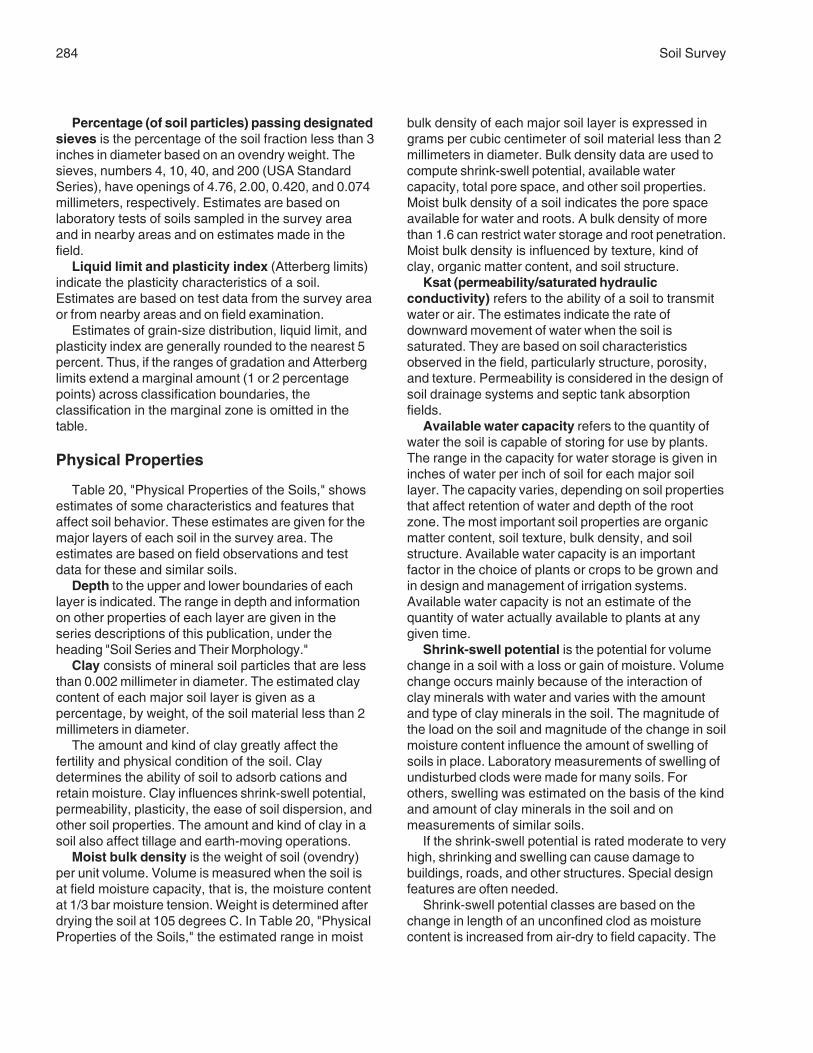
284 Soil Survey
Percentage (of soil particles) passing designatedsieves is the percentage of the soil fraction less than 3inches in diameter based on an ovendry weight. Thesieves, numbers 4, 10, 40, and 200 (USA StandardSeries), have openings of 4.76, 2.00, 0.420, and 0.074millimeters, respectively. Estimates are based onlaboratory tests of soils sampled in the survey areaand in nearby areas and on estimates made in thefield.
Liquid limit and plasticity index (Atterberg limits)indicate the plasticity characteristics of a soil.Estimates are based on test data from the survey areaor from nearby areas and on field examination.
Estimates of grain-size distribution, liquid limit, andplasticity index are generally rounded to the nearest 5percent. Thus, if the ranges of gradation and Atterberglimits extend a marginal amount (1 or 2 percentagepoints) across classification boundaries, theclassification in the marginal zone is omitted in thetable.
Physical Properties
Table 20, "Physical Properties of the Soils," showsestimates of some characteristics and features thataffect soil behavior. These estimates are given for themajor layers of each soil in the survey area. Theestimates are based on field observations and testdata for these and similar soils.
Depth to the upper and lower boundaries of eachlayer is indicated. The range in depth and informationon other properties of each layer are given in theseries descriptions of this publication, under theheading "Soil Series and Their Morphology."
Clay consists of mineral soil particles that are lessthan 0.002 millimeter in diameter. The estimated claycontent of each major soil layer is given as apercentage, by weight, of the soil material less than 2millimeters in diameter.
The amount and kind of clay greatly affect thefertility and physical condition of the soil. Claydetermines the ability of soil to adsorb cations andretain moisture. Clay influences shrink-swell potential,permeability, plasticity, the ease of soil dispersion, andother soil properties. The amount and kind of clay in asoil also affect tillage and earth-moving operations.
Moist bulk density is the weight of soil (ovendry)per unit volume. Volume is measured when the soil isat field moisture capacity, that is, the moisture contentat 1/3 bar moisture tension. Weight is determined afterdrying the soil at 105 degrees C. In Table 20, "PhysicalProperties of the Soils," the estimated range in moist
bulk density of each major soil layer is expressed ingrams per cubic centimeter of soil material less than 2millimeters in diameter. Bulk density data are used tocompute shrink-swell potential, available watercapacity, total pore space, and other soil properties.Moist bulk density of a soil indicates the pore spaceavailable for water and roots. A bulk density of morethan 1.6 can restrict water storage and root penetration.Moist bulk density is influenced by texture, kind ofclay, organic matter content, and soil structure.
Ksat (permeability/saturated hydraulicconductivity) refers to the ability of a soil to transmitwater or air. The estimates indicate the rate ofdownward movement of water when the soil issaturated. They are based on soil characteristicsobserved in the field, particularly structure, porosity,and texture. Permeability is considered in the design ofsoil drainage systems and septic tank absorptionfields.
Available water capacity refers to the quantity ofwater the soil is capable of storing for use by plants.The range in the capacity for water storage is given ininches of water per inch of soil for each major soillayer. The capacity varies, depending on soil propertiesthat affect retention of water and depth of the rootzone. The most important soil properties are organicmatter content, soil texture, bulk density, and soilstructure. Available water capacity is an importantfactor in the choice of plants or crops to be grown andin design and management of irrigation systems.Available water capacity is not an estimate of thequantity of water actually available to plants at anygiven time.
Shrink-swell potential is the potential for volumechange in a soil with a loss or gain of moisture. Volumechange occurs mainly because of the interaction ofclay minerals with water and varies with the amountand type of clay minerals in the soil. The magnitude ofthe load on the soil and magnitude of the change in soilmoisture content influence the amount of swelling ofsoils in place. Laboratory measurements of swelling ofundisturbed clods were made for many soils. Forothers, swelling was estimated on the basis of the kindand amount of clay minerals in the soil and onmeasurements of similar soils.
If the shrink-swell potential is rated moderate to veryhigh, shrinking and swelling can cause damage tobuildings, roads, and other structures. Special designfeatures are often needed.
Shrink-swell potential classes are based on thechange in length of an unconfined clod as moisturecontent is increased from air-dry to field capacity. The

Griggs County, North Dakota 285
classes are low, a change of less than 3 percent;moderate, 3 to 6 percent; and high, more than 6percent. Very high, more than 9 percent, is sometimesused.
Organic matter is the plant and animal residue inthe soil at various stages of decomposition. In Table20, "Physical Properties of the Soils," the estimatedrange in organic matter content is expressed as apercentage, by weight, of the soil material that is lessthan 2 millimeters in diameter.
The content of organic matter in a soil can bemaintained or increased by returning crop residue tothe soil. Organic matter affects available watercapacity, infiltration rates, and tilth. It is a source ofnitrogen and other nutrients for crops.
Erosion factor K indicates the susceptibility of asoil to sheet and rill erosion by water. Soil propertiesthat influence erodibility are those that affect theinfiltration rate, movement of water though the soil,water storage capacity of the soil, and those that allowthe soil to resist dispersion, splashing, abrasion, andthe transporting forces of rainfall and runoff. The mostimportant soil properties are the content of silt, sand,and organic matter and soil structure and permeability.The factor K is one of six factors used in the UniversalSoil Loss Equation (USLE) to predict the average rateof soil loss by sheet and rill erosion in tons per acreper year. The estimates are modified by the presenceof rock fragments. Values of K range from 0.02 to 0.69.The higher the value, the more susceptible the soil isto sheet and rill erosion.
Erosion factor Kf is similar to the erosion factor K,except it indicates the erodibility of only the fine-earthfraction, or the material less than 2 millimeters in size.
Soil-loss tolerance factor T is an estimate of themaximum annual rate of soil erosion by wind or waterthat can occur without affecting crop productivity overa sustained period. The rate is expressed in tons peracre per year. Ratings of 1 to 5 are used depending onsoil properties and prior erosion. The criteria used inassigning a T factor to a soil include maintenance ofan adequate rooting depth for crop production, potentialreduction of crop yields, maintenance of water-controlstructures affected by sedimentation, prevention ofgullying, and the value of nutrients lost througherosion.
Wind erodibility groups (WEG) are made up ofsoils that have similar properties affecting theirresistance to wind erosion in cultivated areas. Thegroups indicate the susceptibility of soil to winderosion. Soils are grouped according to the followingdistinctions:
WEG 1. Coarse sands, sands, fine sands, and veryfine sands. These soils generally are not suitable forcrops. They are extremely erodible, and vegetation isdifficult to establish.
WEG 2. Loamy coarse sands, loamy sands, loamyfine sands, loamy very fine sands, and sapric soilmaterial. These soils are very highly erodible. Cropscan be grown if intensive measures to control winderosion are used.
WEG 3. Coarse sandy loams, sandy loams, finesandy loams, and very fine sandy loams. These soilsare highly erodible. Crops can be grown if intensivemeasures to control wind erosion are used.
WEG 4L. Calcareous loams, silt loams, clay loams,and silty clay loams. These soils are highly erodible.Crops can be grown if intensive measures to controlwind erosion are used.
WEG 4. Clays, silty clays, noncalcareous clayloams, and silty clay loams that are more than 35percent clay. These soils are highly erodible. Crops canbe grown if measures to control wind erosion are used.
WEG 5. Noncalcareous loams and silt loams thatare less than 20 percent clay and sandy clay loams,sandy clays, and hemic soil material. These soils aremoderately erodible. Crops can be grown if measuresto control wind erosion are used.
WEG 6. Noncalcareous loams and silt loams thatare more than 20 percent clay and noncalcareous clayloams that are less than 35 percent clay. These soilsare slightly erodible. Crops can be grown if ordinarymeasures to control wind erosion are used.
WEG 7. Silts, noncalcareous silty clay loams thatare less than 35 percent clay, and fibric soil material.These soils are very slightly erodible. Crops can begrown if ordinary measures to control wind erosion areused.
WEG 8. Soils that are not subject to soil blowingbecause of rock fragments on the surface or becauseof surface wetness.
Wind erodibility index (I) is a numerical valueindicating the potential annual soil loss due to winderosion for a soil under a well defined set of climaticand management conditions. This factor is expressedas the average annual soil loss in tons per acre peryear.
Chemical Properties
Table 21, "Chemical Properties of the Soils," showsestimates of some soil chemical properties that affectsoil behavior. These estimates are given for the majorlayers of each soil in the survey area. The estimates

286 Soil Survey
are based on test data for these and similar soils.These features are described in the followingparagraphs.
Depth to the upper and lower boundaries of eachlayer is indicated. The range in depth and informationon other properties of each layer are given in the seriesdescriptions of this publication, under the heading "SoilSeries and Their Morphology."
Clay consists of mineral soil particles that are lessthan 0.002 millimeter in diameter. The estimated claycontent of each major soil layer is given as apercentage, by weight, of the soil material less than 2millimeters in diameter.
Cation-exchange capacity is the total amount ofexchangeable cations that can be held by the soil,expressed in terms of milliequivalents per 100 gramsof soil at neutrality (pH 7.0) or at some other stated pHvalue. Soils having a low cation-exchange capacityhold fewer cations and may require more frequentapplications of fertilizer than soils having a high cation-exchange capacity. The ability to retain cations helpsto prevent pollution of groundwater.
Soil reaction is a measure of acidity or alkalinityand is expressed as a range in pH values. The range inpH of each major horizon is based on many field tests.For many soils, values have been verified bylaboratory analyses. Soil reaction is important inselecting crops and other plants, in evaluating soilamendments for fertility and stabilization, and indetermining the risk of corrosion.
Calcium carbonate equivalent is the percent ofcarbonates, by weight, in the soil. The availability ofplant nutrients is influenced by the amount ofcarbonates in the soil. Incorporating nitrogen fertilizerinto calcareous soils helps to prevent nitriteaccumulation and ammonium-N volatilization. Calciumcarbonate also affects susceptibility of a soil to winderosion.
Gypsum is given as the percent, by weight, ofhydrated calcium sulfates in the soil. Gypsum ispartially soluble in water and can be dissolved andremoved by water. Soils that have a high content ofgypsum (more than 10 percent) may collapse if thegypsum is removed by percolating water.
Salinity is a measure of soluble salts in the soil atsaturation. It is expressed as the electrical conductivity(EC) of the saturation extract, in millimhos percentimeter at 25 degrees C. Estimates are based onfield and laboratory measurements at representativesites of nonirrigated soils. The salinity of irrigated soilsis affected by the quality of the irrigation water and bythe frequency of water application. Hence, the salinity
of soils in individual fields can differ greatly from thevalue given in the table. Salinity affects the suitabilityof a soil for crop production, the stability of the soil ifused as construction material, and the potential of thesoil to corrode metal and concrete.
Sodium adsorption ratio (SAR) is the measure ofsodium relative to calcium and magnesium in the waterextract from a saturated soil paste. Soils having asodium adsorption ratio of 13 or more may becharacterized by an increased dispersion of organicmatter and clay particles, reduced permeability andaeration, and a general degradation of soil structure.
Water Features
Table 22, "Water Features," gives estimates ofseveral important water features used in land useplanning that involves engineering considerations.These features are described in the followingparagraphs.
Hydrologic soil groups are groups of soils thathave the same runoff potential under similar storm andground cover conditions. Soil properties that affect therunoff potential are those that influence the rate ofinfiltration in a bare soil after prolonged wetting andwhen the soil is not frozen. These properties includethe depth to a seasonal high water table, the intakerate, permeability after prolonged wetting, and thedepth to a very slowly permeable layer. The influencesof ground cover and slope are treated independentlyand are not taken into account in hydrologic soilgroups.
In the definitions of the hydrologic soil groups, theinfiltration rate is the rate at which water enters the soilat the surface and is controlled by surface conditions.The transmission rate is the rate at which water movesthrough the soil and is controlled by properties of thesoil layers.
The four hydrologic soil groups are:Group A. Soils having a high infiltration rate (low
runoff potential) when thoroughly wet. These consistmainly of very deep, well drained to excessivelydrained sands or gravelly sands. These soils have ahigh rate of water transmission.
Group B. Soils having a moderate infiltration ratewhen thoroughly wet. These consist mainly ofmoderately deep or deep, moderately well or welldrained soils that have moderately fine to moderatelycoarse texture. These soils have a moderate rate ofwater transmission.
Group C. Soils having a slow infiltration rate whenthoroughly wet. These consist mainly of soils having a

Griggs County, North Dakota 287
layer that impedes the downward movement of water orsoils that have a moderately fine or fine texture. Thesesoils have a slow rate of water transmission.
Group D. Soils having a very slow infiltration rate(high runoff potential) when thoroughly wet. Theseconsist mainly of clayey soils that have a high shrink-swell potential, soils that have a permanent high watertable, soils that have a claypan or clay layer at or nearthe surface, and soils that are shallow over nearlyimpervious material. These soils have a very slow rateof water transmission.
If a soil is assigned to two hydrologic groups, thefirst letter is for drained areas and the second is forundrained areas.
Water table (seasonal) refers to a zone in the soilthat is at saturation in most years. It is at least 6inches thick, persists in the soil for more than a fewweeks, and is within 6 feet of the surface. Estimates ofwater table depths are based mainly on the evidence ofa saturated zone that exists in a soil, namely acombination of grayish colors or redoximorphicfeatures. Water tables may either be apparent orperched. An apparent water table is indicated by thelevel at which water stands in a freshly dug, unlinedborehole after adequate time is allowed for adjustmentsin the surrounding soil. A perched water table is waterstanding above an unsaturated zone in the soil. Aperched water table may be separated from a lowerwater table by an unsaturated zone. Water tablesusually are perched by textural discontinuities in thesoil profile. A perched water table may be confirmed ifthe water level in a borehole falls when the borehole isextended.
Indicated in Table 22, "Water Features," are theupper limit and lower limit in the depth of the watertable found in the soil in most years. These depthranges are given to the nearest tenth of a foot and arelisted by month. If no water table exists in the soil, noinformation is given.
Ponding is standing water in a closed depression.Unless a drainage system is installed, the water isremoved only by percolation, transpiration, orevaporation. Ponding of soils is classified according tothe depth, duration, frequency, and the beginning andending months in which water is observed.
Surface water depth is the maximum depth ofsurface water that is ponded on the soil.
Ponding duration is the average length of timeof the ponding occurrence. Ponding duration classesare very brief (less than 2 days), brief (2 to 7 days),long (7 to 30 days), or very long (more than 30 days).
Ponding frequency is the number of times pondingoccurs over a period of time. Ponding frequency
classes are none (no reasonable possibility ofponding), rare (ponding unlikely but possible underunusual weather conditions; 0 to 5 percent chanceof ponding in any year); occasional (ponding isexpected infrequently under usual weather conditions;5 to 50 percent chance of ponding in any year); andfrequent (ponding is likely to occur under usualweather conditions; more than 50 percent chance inany year).
Flooding, the temporary covering of the soilsurface by flowing water, is caused by overflow fromstreams or by runoff from adjacent slopes. Shallowwater standing or flowing for short periods after rainfallor snowmelt is not considered flooding. Standing waterin marshes and swamps or in closed depressions isconsidered to be ponding.
Table 22, "Water Features," gives the duration andfrequency of flooding and the time of year whenflooding is most likely to occur. Flooding frequencyclasses are identical to ponding frequency classes.Flooding duration classes are extremely brief (0.1 to 4hours), very brief (4 to 48 hours), brief (2 to 7 days),long (7 to 30 days), and very long (more than 30days). Frequency, duration, and probable dates ofoccurrence are estimated.
The information on flooding is based on evidence inthe soil profile, namely thin strata of gravel, sand, silt,or clay deposited by floodwater; irregular decrease inorganic matter content with increasing depth; and littleor no horizon development.
Also considered in making flooding estimates arelocal information about the extent and level of floodingand the relation of each soil on the landscape tohistoric floods. Information on the extent of floodingbased on soil data is less specific than that providedby detailed engineering surveys that delineate flood-prone areas at specific flood frequency levels.
Soil Features
Table 23, "Soil Features," gives estimates of severalimportant soil features used in land use planning thatinvolves engineering considerations. These featuresare described in the following paragraphs.
Restrictions are nearly continuous soil layers thatsignificantly reduce the movement of water and airthrough the soil or that otherwise provide anunfavorable root environment. Restriction kind is thetype of restriction. Examples of restrictions includebedrock, cemented layers, and dense layers.Restriction thickness is the distance from the top tothe bottom of a restrictive layer. Restriction hardnessrefers to the rupture resistance or strength of the layer.

288 Soil Survey
Potential frost action is the likelihood of upward orlateral expansion of the soil caused by the formation ofsegregated ice lenses (frost heave) and thesubsequent collapse of the soil and loss of strength onthawing. Frost action occurs when moisture moves intothe freezing zone of the soil. Temperature, texture,density, permeability, organic matter content, anddepth to the water table are the most important factorsconsidered in evaluating the potential for frost action. Itis assumed the soil is not insulated by vegetation orsnow and is not artificially drained. Silty and highlystructured, clayey soils that have a high water table inwinter are the most susceptible to frost action. Welldrained, very gravelly, or very sandy soils are the leastsusceptible. Frost heave and low soil strength duringthawing cause damage to pavements and other rigidstructures.
A low potential for frost action indicates that thesoil is rarely susceptible to the formation of ice lenses;a moderate potential indicates that the soil issusceptible to formation of ice lenses, resulting in frostheave and the subsequent loss of soil strength; and ahigh potential indicates that the soil is highlysusceptible to formation of ice lenses, resulting in frostheave and the subsequent loss of soil strength.
Risk of corrosion pertains to potential soil-inducedelectrochemical or chemical action that dissolves orweakens uncoated steel or concrete. The rate ofcorrosion of uncoated steel is related to such factorsas soil moisture, particle-size distribution, acidity, andelectrical conductivity of the soil. The rate of corrosionof concrete is based mainly on the sulfate and sodiumcontent, texture, moisture content, and acidity of thesoil.
Special site examination and design features maybe needed if the combination of factors results in asevere hazard of corrosion. Steel in installations thatintersect soil boundaries or soil layers is moresusceptible to corrosion than steel in installations thatare entirely within one kind of soil or within one soillayer.
For uncoated steel, the risk of corrosion, expressedas low, moderate, or high, is based on soil drainageclass, total acidity, electrical resistivity near fieldcapacity, and electrical conductivity of the saturationextract.
For concrete, the risk of corrosion is alsoexpressed as low, moderate, or high. It is based onsoil texture, acidity, and amount of sulfates in thesaturation extract.
Hydric Soils
Table 24, "Hydric Soils List," shows which map unitshave components that meet the definition of hydricsoils in Griggs County. This table can help in planningland uses; however, onsite investigation isrecommended to determine the hydric soils on aspecific site (National Research Council, 1995; USDA-NRCS, 1996.) Map units that are made up of hydricsoils may have small areas or inclusions, of nonhydricsoils in the higher positions on the landform, and mapunits made up of nonhydric soils may have inclusionsof hydric soils in the lower positions of the landform.
Three essential characteristics of wetlands arehydrophytic vegetation, hydric soils, and wetlandhydrology (Cowardin, et al., 1979; EnvironmentalLaboratory, 1987; National Research Council, 1995;Tiner, 1985). Criteria for each of the characteristicsmust be met for areas to be identified as wetlands.Undrained hydric soils that have natural vegetationshould support a dominant population of ecologicalwetland plant species. Hydric soils that have beenconverted to other uses should be capable of beingrestored to wetlands.
Hydric soils are defined by the National TechnicalCommittee for Hydric Soils (NTCHS) as soils thatformed under conditions of saturation, flooding, orponding long enough during the growing season todevelop anaerobic conditions in the upper part (FederalRegister, 1994). These soils are either saturated orinundated long enough during the growing season tosupport the growth and reproduction of hydrophyticvegetation.
The NTCHS definition identifies general soilproperties that are associated with wetness. In order todetermine whether a specific soil is a hydric soil ornonhydric soil, however, more specific information,such as information about the depth and duration of thewater table, is needed. Thus, criteria which identifythose estimated soil properties unique to hydric soilshave been established (Federal Register, 1995.) Thesecriteria are used to identify a phase of a soil series thatnormally is associated with wetlands. The criteria usedare selected estimated soil properties that aredescribed in "Soil Taxonomy" (Soil Survey Staff, 1975;1996a) and in the "Soil Survey Manual" (Soil SurveyStaff, 1993.)
If soils are wet enough for a long enough period tobe considered hydric, they should exhibit certainproperties that can be easily observed in the field.

Griggs County, North Dakota 289
These visible properties are indicators of hydric soils.The indicators that can be used to make onsitedeterminations of hydric soils in Griggs County arespecified in "Field Indicators of Hydric Soils in theUnited States" (USDA-NRCS, 1996).
Hydric soils are identified by examining anddescribing the soil to a depth of about 20 inches. Thisdepth may be greater if determination of an appropriateindicator so requires. It is always recommended thatsoils be excavated and described as deep asnecessary to understand the redoximorphic processes.
Then, using the completed soil description, soilscientists can compare soil features required by eachhydric soil indicator and specify which indicators havebeen matched with the conditions observed in the soil.The soil can be identified as a hydric soil if one (ormore) of the approved indicators is present.
This survey can be used to locate probable areas ofhydric soils. The hydric soil may have been artificiallydrained or otherwise altered such that it no longersupports a predominance of hydrophytic vegetation.The soil map does not identify drained areas.

290 Soil Survey
Table 19.—Engineering Index Properties
(The symbol < means less than; > means more than. Dashes(-—) indicate that an assignment has not been made.)
______________________________________________________________________________________________________________________________ Classification Fragments Percentage Passing Map symbol Depth USDA texture ___________________________ _____________ sieve number— Liquid Plas- and soil name >10 3-10 ___________________________ limit ticity Unified AASHTO inches inches 4 10 40 200 index _____________________________________________________________________________________________________________________________ In Pct Pct Pct
61: Arveson 0-9 fine sandy SM A-2-4, A-4 — 0-1 100 95-100 55-85 30-50 0-30 NP-7 loam
9-39 fine sandy SC-SM, SM A-4 0 0 100 95-100 60-85 35-50 0-20 NP-5 loam, sandy loam, loam 39-60 fine sand, SM, SC-SM, A-3, A-2, A-4 0 0 100 95-100 50-85 5-50 0-20 NP-5 loamy sand, SP-SM fine sandy loam
118: Barnes 0-9 loam CL, CL-ML A-4, A-6 0 0-5 90-100 85-100 80-100 60-80 25-35 10-20 9-14 loam, clay loam CL-ML, CL A-4, A-6 0 0-5 90-100 85-100 75-95 55-80 25-45 10-25 14-60 loam, clay loam CL, CL-ML A-4, A-6 0 0-5 90-100 85-100 75-95 55-80 25-45 10-25
Buse 0-7 loam CL, CL-ML A-6, A-4 0 0-5 90-100 85-95 70-95 55-90 25-35 10-15 7-60 loam, clay loam CL-ML, CL A-4, A-6, A-7 0 0-5 90-100 85-100 70-90 55-85 25-45 10-25
120: Barnes 0-9 loam CL, CL-ML A-4, A-6 0 0-5 90-100 85-100 80-100 60-80 25-35 10-20 9-14 loam, clay loam CL, CL-ML A-6, A-4 0 0-5 90-100 85-100 75-95 55-80 25-45 10-25 14-60 loam, clay loam CL, CL-ML A-4, A-6 0 0-5 90-100 85-100 75-95 55-80 25-45 10-25
Buse 0-7 loam CL, CL-ML A-4, A-6 0 0-5 90-100 85-95 70-95 55-90 25-35 10-15 7-60 loam, clay loam CL, CL-ML A-4, A-7, A-6 0 0-5 90-100 85-100 70-90 55-85 25-45 10-25
156: Barnes 0-9 loam CL, CL-ML A-6, A-4 0 0-5 90-100 85-100 80-100 60-80 25-35 10-20 9-14 loam, clay loam CL-ML, CL A-4, A-6 0 0-5 90-100 85-100 75-95 55-80 25-45 10-25 14-60 loam, clay loam CL, CL-ML A-4, A-6 0 0-5 90-100 85-100 75-95 55-80 25-45 10-25
Svea 0-18 loam CL, CL-ML A-4, A-6 — 0-5 95-100 85-100 80-95 60-90 25-40 10-20 18-28 loam, silt CL, CL-ML A-4, A-6, A-7 — 0-5 95-100 85-100 80-100 60-90 25-45 10-25 loam, clay loam 28-60 loam, silt CL-ML, CL A-4, A-7, A-6 — 0-5 95-100 85-100 80-100 60-85 25-45 10-25 loam, clay loam
167: Bearden 0-9 silt loam CL, CL-ML A-4, A-6 0 0 100 100 90-100 70-90 30-35 10-15 9-20 silt loam, CL A-4, A-7, A-6 0 0 100 100 90-100 80-95 30-45 10-20 silty clay loam 20-60 silt loam, CL, CL-ML A-6, A-4, A-7 0 0 100 100 90-100 80-95 30-45 10-20 silty clay
296: Brantford 0-8 loam CL-ML, CL A-4 0 0 90-100 85-95 80-90 60-80 20-30 4-10 8-15 loam CL, CL-ML A-6, A-4 0 0 90-100 85-95 80-90 60-80 30-35 10-15 15-60 stratified GM, SM, A-1, A-2, A-3 0 5-25 50-95 30-75 15-60 5-30 15-20 NP-5 loamy sand to SP-SM, GP-GM very gravelly coarse sand

Griggs County, North Dakota 291
Table 19.—Engineering Index Properties--(continued)
(The symbol < means less than; > means more than. Dashes(-—) indicate that an assignment has not been made.)
______________________________________________________________________________________________________________________________ Classification Fragments Percentage Passing Map symbol Depth USDA texture ___________________________ _____________ sieve number— Liquid Plas- and soil name >10 3-10 ___________________________ limit ticity Unified AASHTO inches inches 4 10 40 200 index _____________________________________________________________________________________________________________________________ In Pct Pct Pct
314: Buse 0-7 loam CL, CL-ML A-6, A-4 0 0-5 90-100 85-95 70-95 55-90 25-35 10-15 7-60 loam, clay loam CL, CL-ML A-4, A-6, A-7 0 0-5 90-100 85-100 70-90 55-85 25-45 10-25
Barnes 0-9 loam CL, CL-ML A-4, A-6 0 0-5 90-100 85-100 80-100 60-80 25-35 10-20 9-14 loam, clay loam CL, CL-ML A-4, A-6 0 0-5 90-100 85-100 75-95 55-80 25-45 10-25 14-60 loam, clay loam CL, CL-ML A-4, A-6 0 0-5 90-100 85-100 75-95 55-80 25-45 10-25
319: Buse 0-7 loam CL, CL-ML A-4, A-6 0 0-5 90-100 85-95 70-95 55-90 25-35 10-15 7-60 loam, clay loam CL-ML, CL A-4, A-6, A-7 0 0-5 90-100 85-100 70-90 55-85 25-45 10-25
Barnes 0-9 loam CL, CL-ML A-4, A-6 0 0-5 90-100 85-100 80-100 60-80 25-35 10-20 9-14 loam, clay loam CL, CL-ML A-4, A-6 0 0-5 90-100 85-100 75-95 55-80 25-45 10-25 14-60 loam, clay loam CL, CL-ML A-4, A-6 0 0-5 90-100 85-100 75-95 55-80 25-45 10-25
391: Cavour 0-10 loam MH, ML A-6, A-4, A-7 0 0 100 90-100 85-100 60-85 30-55 5-20 10-20 clay, clay CH, ML, CL, A-6, A-7 0 0 100 90-100 90-100 55-85 35-65 15-30 loam, silty MH clay loam 20-60 clay loam, loam CH, CL A-6, A-7 — 0-5 95-100 90-100 75-100 50-85 35-65 12-35
Cresbard 0-12 loam CL, ML A-4, A-6 0 0 100 100 85-100 60-80 30-40 5-15 12-25 clay loam, CH, CL A-6, A-7 0 0 95-100 90-100 90-100 65-85 30-60 15-30 silty clay, clay 25-32 clay loam, CH, CL A-7 0 0 95-100 90-100 85-100 65-85 40-60 15-30 silty clay, clay 32-60 clay loam, loam CH, CL A-7, A-6 — 0-5 95-100 90-100 85-100 50-80 25-55 10-27
450: Colvin 0-10 silt loam CL, CL-ML A-4, A-6 0 0 100 100 90-100 80-95 30-35 10-15
10-30 silt loam, CL, CL-ML A-7, A-6, A-4 0 0 100 100 90-100 80-95 30-45 10-20 silty clay loam 30-60 loam, silt CL-ML, CL A-4, A-7, A-6 0 0 100 100 90-100 70-95 30-45 10-20 loam, silty clay loam
511: Divide 0-9 loam CL, CL-ML A-4, A-6 0 0-5 95-100 95-100 85-95 60-85 25-35 5-15
9-28 loam, clay CL-ML, CL A-6, A-7 0 0-5 95-100 75-100 55-90 35-80 30-45 10-25 loam, gravelly loam 28-60 stratified sand SP-SM, SM, A-1, A-3, A-2 0 0-5 25-100 15-100 10-70 5-25 0-15 NP-5 to gravelly GP-GM sand
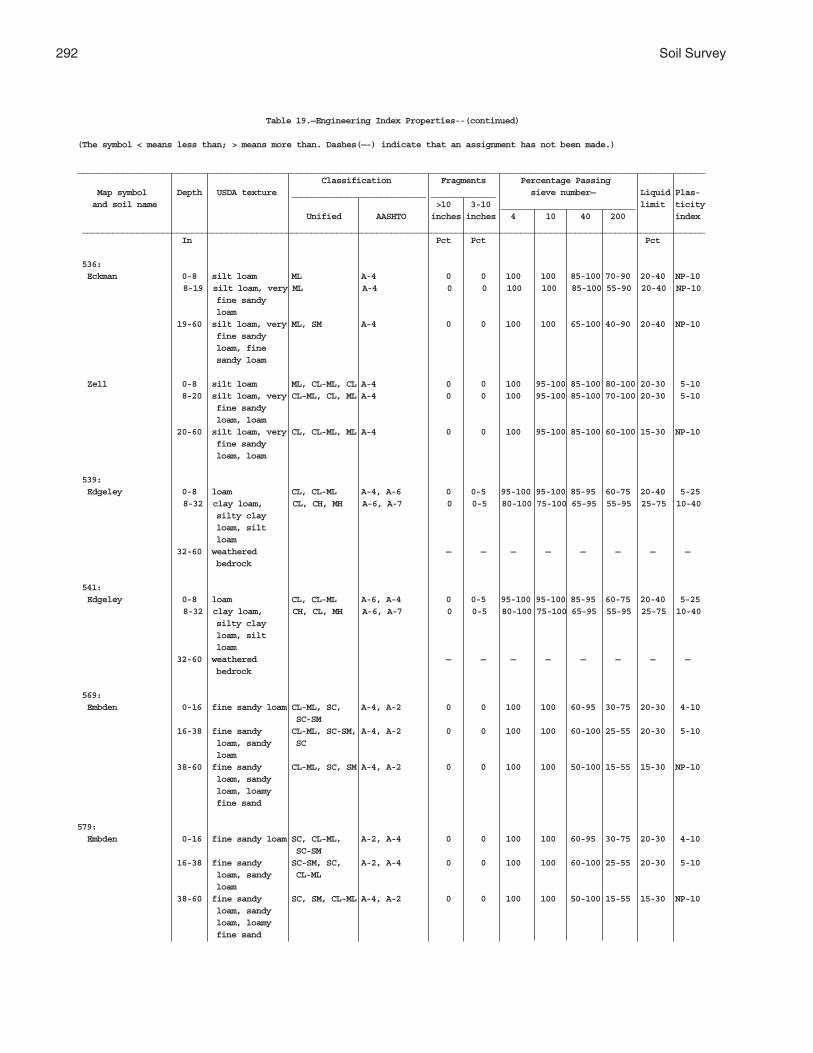
292 Soil Survey
Table 19.—Engineering Index Properties--(continued)
(The symbol < means less than; > means more than. Dashes(—-) indicate that an assignment has not been made.)
______________________________________________________________________________________________________________________________ Classification Fragments Percentage Passing Map symbol Depth USDA texture ___________________________ _____________ sieve number— Liquid Plas- and soil name >10 3-10 ___________________________ limit ticity Unified AASHTO inches inches 4 10 40 200 index _____________________________________________________________________________________________________________________________ In Pct Pct Pct
536: Eckman 0-8 silt loam ML A-4 0 0 100 100 85-100 70-90 20-40 NP-10
8-19 silt loam, very ML A-4 0 0 100 100 85-100 55-90 20-40 NP-10 fine sandy loam 19-60 silt loam, very ML, SM A-4 0 0 100 100 65-100 40-90 20-40 NP-10 fine sandy loam, fine sandy loam
Zell 0-8 silt loam ML, CL-ML, CL A-4 0 0 100 95-100 85-100 80-100 20-30 5-10 8-20 silt loam, very CL-ML, CL, ML A-4 0 0 100 95-100 85-100 70-100 20-30 5-10 fine sandy loam, loam 20-60 silt loam, very CL, CL-ML, ML A-4 0 0 100 95-100 85-100 60-100 15-30 NP-10 fine sandy loam, loam
539: Edgeley 0-8 loam CL, CL-ML A-4, A-6 0 0-5 95-100 95-100 85-95 60-75 20-40 5-25
8-32 clay loam, CL, CH, MH A-6, A-7 0 0-5 80-100 75-100 65-95 55-95 25-75 10-40 silty clay loam, silt loam 32-60 weathered — — — — — — — — bedrock
541: Edgeley 0-8 loam CL, CL-ML A-6, A-4 0 0-5 95-100 95-100 85-95 60-75 20-40 5-25
8-32 clay loam, CH, CL, MH A-6, A-7 0 0-5 80-100 75-100 65-95 55-95 25-75 10-40 silty clay loam, silt loam 32-60 weathered — — — — — — — — bedrock
569: Embden 0-16 fine sandy loam CL-ML, SC, A-4, A-2 0 0 100 100 60-95 30-75 20-30 4-10 SC-SM 16-38 fine sandy CL-ML, SC-SM, A-4, A-2 0 0 100 100 60-100 25-55 20-30 5-10 loam, sandy SC loam 38-60 fine sandy CL-ML, SC, SM A-4, A-2 0 0 100 100 50-100 15-55 15-30 NP-10 loam, sandy loam, loamy fine sand
579: Embden 0-16 fine sandy loam SC, CL-ML, A-2, A-4 0 0 100 100 60-95 30-75 20-30 4-10 SC-SM 16-38 fine sandy SC-SM, SC, A-2, A-4 0 0 100 100 60-100 25-55 20-30 5-10 loam, sandy CL-ML loam 38-60 fine sandy SC, SM, CL-ML A-4, A-2 0 0 100 100 50-100 15-55 15-30 NP-10 loam, sandy loam, loamy fine sand

Griggs County, North Dakota 293
Table 19. Engineering Index Properties--(continued)
(The symbol < means less than; > means more than. Dashes(—-) indicate that an assignment has not been made.)
______________________________________________________________________________________________________________________________ Classification Fragments Percentage Passing Map symbol Depth USDA texture ___________________________ _____________ sieve number— Liquid Plas- and soil name >10 3-10 ___________________________ limit ticity Unified AASHTO inches inches 4 10 40 200 index _____________________________________________________________________________________________________________________________ In Pct Pct Pct
579: (con’t) Egeland 0-9 fine sandy loam SC-SM, SC A-2, A-4 0 0 100 95-100 75-100 30-50 20-30 5-10
9-40 sandy loam, SC-SM, SC A-2, A-4 0 0 95-100 85-100 70-100 15-50 20-30 5-10 fine sandy loam 40-60 loamy sand, SM, SC-SM A-2, A-4 0 0 95-100 85-100 70-100 10-50 15-20 NP-5 loamy fine sand, loamy very fine sand
595: Emrick 0-13 loam ML A-4 0-1 0-1 95-100 95-100 85-100 60-90 0-40 NP-10 13-32 loam ML A-4 0-1 0-1 95-100 95-100 85-95 55-75 0-40 NP-10 32-60 loam, sandy ML, SC, SM A-4, A-6 0-1 0-5 90-100 90-100 60-100 35-90 0-40 NP-10 loam
Cathay 0-10 loam ML, CL, CL-ML A-4 — 0-5 95-100 90-100 75-95 50-95 25-35 5-10 10-22 clay loam, loam CL A-6 — 0-5 95-100 90-100 85-95 60-85 25-40 10-25 22-60 loam ML, CL-ML, CL A-4, A-6 — 0-5 95-100 90-100 85-95 60-75 25-40 3-25
597: Emrick 0-13 loam ML A-4 0-1 0-1 95-100 95-100 85-100 60-90 0-40 NP-10 13-32 loam ML A-4 0-1 0-1 95-100 95-100 85-95 55-75 0-40 NP-10 32-60 loam, sandy ML, SC, SM A-4, A-6 0-1 0-5 90-100 90-100 60-100 35-90 0-40 NP-10 loam
Heimdal 0-7 loam ML A-4 0-1 0-1 95-100 95-100 85-100 60-90 20-40 NP-10 7-14 loam ML A-4 0-1 0-1 95-100 95-100 85-95 60-75 20-40 NP-10 14-60 loam, sandy ML, CL, SC, A-6, A-4 0-1 0-5 95-100 90-100 60-100 35-90 20-40 NP-15 loam, fine SM sandy loam
605: Esmond 0-8 loam ML A-4 — 0-1 95-100 95-100 85-100 60-90 20-40 NP-10 8-60 loam, sandy SC, CL, ML, A-4, A-6 — 0-5 90-100 85-100 60-100 35-90 20-40 NP-15 loam, fine SM sandy loam
Heimdal 0-7 loam ML A-4 0-1 0-1 95-100 95-100 85-100 60-90 20-40 NP-10 7-14 loam ML A-4 0-1 0-1 95-100 95-100 85-95 60-75 20-40 NP-10 14-60 loam, sandy CL, ML, SC, A-4, A-6 0-1 0-5 95-100 90-100 60-100 35-90 20-40 NP-15 loam, fine SM sandy loam
753: Fram 0-18 loam ML A-4 — 0-1 95-100 95-100 85-100 60-90 20-40 NP-10
18-60 sandy loam, ML, SM A-4 — 0-1 95-100 90-100 60-100 35-90 20-40 NP-10 fine sandy loam, loam
Wyard 0-15 loam CL-ML, CL A-7, A-6, A-4 0 0 95-100 90-100 85-100 60-90 25-45 5-25 15-21 loam, silt loam SC, CL, CL-ML A-4, A-6, A-7 0 0 95-100 90-100 80-100 35-85 25-45 5-25 21-35 loam, silt SC, CL-ML, CL A-4, A-7, A-6 0 0-10 95-100 90-100 80-100 35-85 25-45 5-25 loam, clay loam 35-60 loam, sandy CL-ML, ML, A-6, A-4, A-7 0 0-10 95-100 90-100 80-100 35-85 20-45 3-20 loam, clay SC, CL loam

294 Soil Survey
Table 19.—Engineering Index Properties--(continued)
(The symbol < means less than; > means more than. Dashes(-—) indicate that an assignment has not been made.)
______________________________________________________________________________________________________________________________ Classification Fragments Percentage Passing Map symbol Depth USDA texture ___________________________ _____________ sieve number— Liquid Plas- and soil name >10 3-10 ___________________________ limit ticity Unified AASHTO inches inches 4 10 40 200 index _____________________________________________________________________________________________________________________________ In Pct Pct Pct
769: Gardena 0-18 silt loam CL, ML A-4, A-6 0 0 100 100 90-100 70-100 25-40 NP-15 18-60 silt loam, very CL, CL-ML, ML A-4, A-6 0 0 100 100 75-100 55-100 20-40 NP-15 fine sandy loam, loam
773: Gardena 0-18 silt loam CL, ML A-4, A-6 0 0 100 100 90-100 70-100 25-40 NP-15 18-60 silt loam, very CL-ML, CL, ML A-4, A-6 0 0 100 100 75-100 55-100 20-40 NP-15 fine sandy loam, loam
Eckman 0-8 silt loam ML A-4 0 0 100 100 85-100 70-90 20-40 NP-10 8-19 silt loam, very ML A-4 0 0 100 100 85-100 55-90 20-40 NP-10
fine sandy loam 19-60 silt loam, very ML, SM A-4 0 0 100 100 65-100 40-90 20-40 NP-10 fine sandy loam, fine sandy loam
881: Hamerly 0-10 loam CL, CL-ML A-4, A-6 0 0-5 95-100 90-100 80-95 60-90 20-40 5-20 10-29 loam, clay loam CL, CL-ML A-4, A-6, A-7 0 0-5 95-100 90-100 80-95 60-75 20-45 5-25 29-60 loam, clay loam CL, CL-ML A-4, A-6, A-7 0 0-5 95-100 90-100 75-95 55-75 20-45 5-25
Tonka 0-17 silt loam CL, CL-ML A-6, A-4 0-1 0-2 100 95-100 90-100 70-90 35-45 15-25 17-40 silty clay CH, CL A-7, A-6 0-1 0-2 100 95-100 90-100 75-95 50-60 30-40 loam, clay loam, clay 40-60 silty clay CL, CL-ML A-7, A-6, A-4 0-1 0-3 90-100 85-100 60-100 50-90 35-55 15-30 loam, clay loam, loam
884: Hamerly 0-10 loam CL, CL-ML A-4, A-6 0 0-5 95-100 90-100 80-95 60-90 20-40 5-20 10-29 loam, clay loam CL, CL-ML A-4, A-7, A-6 0 0-5 95-100 90-100 80-95 60-75 20-45 5-25 29-60 loam, clay loam CL-ML, CL A-4, A-6, A-7 0 0-5 95-100 90-100 75-95 55-75 20-45 5-25
Wyard 0-15 loam CL-ML, CL A-6, A-7, A-4 0 0 95-100 90-100 85-100 60-90 25-45 5-25 15-21 loam, silt loam CL, SC, CL-ML A-7, A-4, A-6 0 0 95-100 90-100 80-100 35-85 25-45 5-25 21-35 loam, silt CL, SC, CL-ML A-4, A-6, A-7 0 0-10 95-100 90-100 80-100 35-85 25-45 5-25 loam, clay loam 35-60 loam, sandy CL-ML, ML, A-4, A-7, A-6 0 0-10 95-100 90-100 80-100 35-85 20-45 3-20 loam, clay CL, SC loam
893: Harriet 0-2 silt loam CL, CL-ML A-4, A-6 0 0 100 100 90-100 70-90 25-40 5-20 2-10 clay loam, CH, CL A-6, A-7 0 0 100 100 90-100 70-100 35-70 20-40 silty clay loam, silty clay 10-60 loam, silty CH, CL A-6 0 0 100 100 90-100 60-100 25-55 10-30 clay loam, clay loam
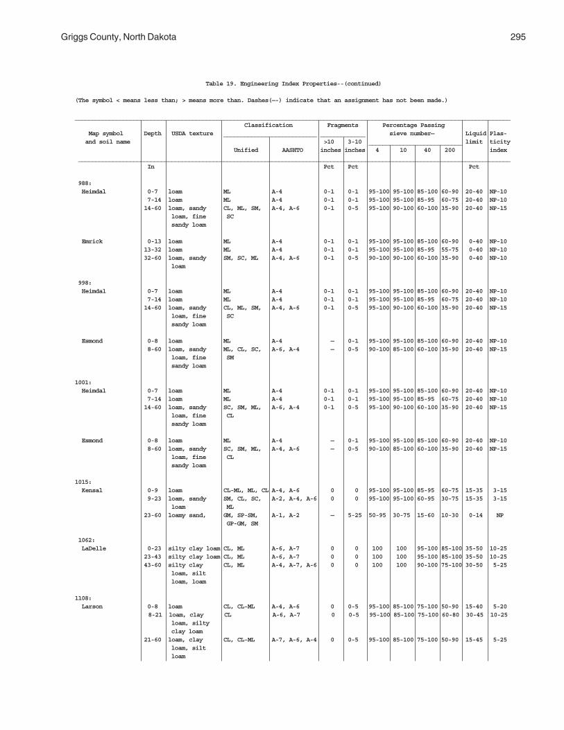
Griggs County, North Dakota 295
Table 19. Engineering Index Properties--(continued)
(The symbol < means less than; > means more than. Dashes(—-) indicate that an assignment has not been made.)
______________________________________________________________________________________________________________________________ Classification Fragments Percentage Passing Map symbol Depth USDA texture ___________________________ _____________ sieve number— Liquid Plas- and soil name >10 3-10 ___________________________ limit ticity Unified AASHTO inches inches 4 10 40 200 index _____________________________________________________________________________________________________________________________ In Pct Pct Pct
988: Heimdal 0-7 loam ML A-4 0-1 0-1 95-100 95-100 85-100 60-90 20-40 NP-10 7-14 loam ML A-4 0-1 0-1 95-100 95-100 85-95 60-75 20-40 NP-10 14-60 loam, sandy CL, ML, SM, A-4, A-6 0-1 0-5 95-100 90-100 60-100 35-90 20-40 NP-15 loam, fine SC sandy loam
Emrick 0-13 loam ML A-4 0-1 0-1 95-100 95-100 85-100 60-90 0-40 NP-10 13-32 loam ML A-4 0-1 0-1 95-100 95-100 85-95 55-75 0-40 NP-10 32-60 loam, sandy SM, SC, ML A-4, A-6 0-1 0-5 90-100 90-100 60-100 35-90 0-40 NP-10 loam
998: Heimdal 0-7 loam ML A-4 0-1 0-1 95-100 95-100 85-100 60-90 20-40 NP-10 7-14 loam ML A-4 0-1 0-1 95-100 95-100 85-95 60-75 20-40 NP-10 14-60 loam, sandy CL, ML, SM, A-4, A-6 0-1 0-5 95-100 90-100 60-100 35-90 20-40 NP-15 loam, fine SC sandy loam
Esmond 0-8 loam ML A-4 — 0-1 95-100 95-100 85-100 60-90 20-40 NP-10 8-60 loam, sandy ML, CL, SC, A-6, A-4 — 0-5 90-100 85-100 60-100 35-90 20-40 NP-15 loam, fine SM sandy loam
1001: Heimdal 0-7 loam ML A-4 0-1 0-1 95-100 95-100 85-100 60-90 20-40 NP-10 7-14 loam ML A-4 0-1 0-1 95-100 95-100 85-95 60-75 20-40 NP-10 14-60 loam, sandy SC, SM, ML, A-6, A-4 0-1 0-5 95-100 90-100 60-100 35-90 20-40 NP-15 loam, fine CL sandy loam
Esmond 0-8 loam ML A-4 — 0-1 95-100 95-100 85-100 60-90 20-40 NP-10 8-60 loam, sandy SC, SM, ML, A-4, A-6 — 0-5 90-100 85-100 60-100 35-90 20-40 NP-15 loam, fine CL sandy loam
1015: Kensal 0-9 loam CL-ML, ML, CL A-4, A-6 0 0 95-100 95-100 85-95 60-75 15-35 3-15 9-23 loam, sandy SM, CL, SC, A-2, A-4, A-6 0 0 95-100 95-100 60-95 30-75 15-35 3-15 loam ML 23-60 loamy sand, GM, SP-SM, A-1, A-2 — 5-25 50-95 30-75 15-60 10-30 0-14 NP GP-GM, SM
1062: LaDelle 0-23 silty clay loam CL, ML A-6, A-7 0 0 100 100 95-100 85-100 35-50 10-25 23-43 silty clay loam CL, ML A-6, A-7 0 0 100 100 95-100 85-100 35-50 10-25 43-60 silty clay CL, ML A-4, A-7, A-6 0 0 100 100 90-100 75-100 30-50 5-25 loam, silt loam, loam
1108: Larson 0-8 loam CL, CL-ML A-4, A-6 0 0-5 95-100 85-100 75-100 50-90 15-40 5-20
8-21 loam, clay CL A-6, A-7 0 0-5 95-100 85-100 75-100 60-80 30-45 10-25 loam, silty clay loam 21-60 loam, clay CL, CL-ML A-7, A-6, A-4 0 0-5 95-100 85-100 75-100 50-90 15-45 5-25 loam, silt loam

296 Soil Survey
Table 19. Engineering Index Properties--(continued)
(The symbol < means less than; > means more than. Dashes(—-) indicate that an assignment has not been made.)
______________________________________________________________________________________________________________________________ Classification Fragments Percentage Passing Map symbol Depth USDA texture ___________________________ _____________ sieve number— Liquid Plas- and soil name >10 3-10 ___________________________ limit ticity Unified AASHTO inches inches 4 10 40 200 index _____________________________________________________________________________________________________________________________ In Pct Pct Pct
1108:(con’t) Cathay 0-10 loam CL, CL-ML, ML A-4 — 0-5 95-100 90-100 75-95 50-95 25-35 5-10 10-22 clay loam, loam CL A-6 — 0-5 95-100 90-100 85-95 60-85 25-40 10-25 22-60 loam CL, CL-ML, ML A-4, A-6 — 0-5 95-100 90-100 85-95 60-75 25-40 3-25
1188: Ludden 0-35 silty clay CH A-7 0 0 100 100 95-100 75-95 50-75 25-50
35-42 silty clay, CH A-7 0 0 100 100 95-100 75-95 50-75 25-50 clay 42-60 silty clay, CH A-7 0 0 100 100 95-100 75-95 50-75 25-50 clay, clay loam
1189: Ludden, saline 0-35 silty clay CH A-7 0 0 100 100 95-100 75-95 50-75 25-50
35-42 silty clay, CH A-7 0 0 100 100 95-100 75-95 50-75 25-50 clay 42-60 silty clay, CH A-7 0 0 100 100 95-100 75-95 50-75 25-50 clay, clay loam
1221: Maddock 0-11 loamy fine SM, SC-SM A-2, A-4 0 0 100 95-100 50-80 15-35 15-20 NP-5 sand
11-60 loamy sand, SC-SM, SM, A-2, A-3 0 0 100 95-100 60-100 5-35 15-20 NP-3 loamy fine SP-SM sand, fine sand
Hecla 0-10 loamy fine SC-SM, SP-SM, A-2 0 0 100 95-100 85-100 12-35 10-20 NP-5 sand SM
10-32 loamy sand, SP-SM, SM, A-2, A-3 0 0 100 95-100 85-100 5-35 10-20 NP-5 loamy fine SC-SM sand, fine sand 32-60 loamy sand, SP-SM, SC-SM, A-3, A-2 0 0 100 95-100 85-100 5-35 10-20 NP-5 fine sand, SM loamy fine sand
1267: Marysland 0-8 loam CL A-4, A-7, A-6 0 0-5 95-100 95-100 85-95 50-80 25-50 10-25
8-30 loam, clay SC, CL A-6, A-7 0 0-5 90-100 85-100 80-95 45-80 20-45 10-20 loam, sandy clay loam 30-60 stratified fine SP-SM, SM, A-1, A-2, A-3 0 0-5 70-95 50-90 35-70 5-20 0-15 NP-5 sand to GP-GM gravelly coarse sand
1268: Marysland, wet 0-8 loam CL A-7, A-6 0 0 95-100 95-100 85-95 50-80 30-50 10-25
8-30 loam, clay CL, SC A-6 0 0 90-100 85-100 80-95 45-80 20-40 10-20 loam, sandy clay loam 30-60 stratified SM, SP-SM A-2, A-1, A-3 0 0 70-95 50-90 35-70 5-20 0-14 NP fine sand to gravelly coarse sand

Griggs County, North Dakota 297
Table 19. Engineering Index Properties--(continued)
(The symbol < means less than; > means more than. Dashes(-—) indicate that an assignment has not been made.)
______________________________________________________________________________________________________________________________ Classification Fragments Percentage Passing Map symbol Depth USDA texture ___________________________ _____________ sieve number— Liquid Plas- and soil name >10 3-10 ___________________________ limit ticity Unified AASHTO inches inches 4 10 40 200 index _____________________________________________________________________________________________________________________________ In Pct Pct Pct
1427: Parnell 0-9 silty clay CH, CL, OL A-7 0 0-1 100 100 95-100 85-100 40-55 20-35 loam
9-49 clay loam, CH, CL A-7 0 0-2 100 95-100 90-100 70-100 50-75 30-50 silty clay loam, silty clay 49-60 clay loam, CL, CH A-7 0 0-2 95-100 90-100 80-95 70-95 50-60 30-40 silty clay loam, silty clay
1454: Wyndmere 0-9 fine sandy ML, SC-SM, A-2, A-4 0 0 100 100 60-80 30-55 10-30 NP-10 loam SC, SM
9-28 sandy loam, SC, SC-SM, A-2, A-4 0 0 100 100 60-90 30-55 10-30 NP-10 fine sandy ML, SM loam 28-42 fine sand, ML, SM A-2, A-4 0 0 100 100 60-100 20-55 0-14 NP loamy fine sand, fine sandy loam 42-60 loam, clay loam CL, CL-ML A-4, A-7, A-6 — 0-5 90-100 85-100 75-100 55-90 20-45 5-30
1466: Pits, sand and 0-6 extremely GW-GM, SW-SM A-1, A-3 0 0-5 25-90 10-65 5-35 0-25 0-15 NP-5 gravel gravelly sand 6-60 extremely GW-GM, SW-SM A-1, A-3 0 0-10 25-90 10-65 5-35 0-25 0-15 NP-5 gravelly sand, extremely gravelly coarse sand, gravelly coarse sandy loam
1710: Southam 0-10 silty clay CH, CL, OL A-7 0 0 100 95-100 90-100 80-100 40-55 20-35 loam
10-48 silty clay, CH, CL A-7 0 0 100 95-100 90-100 85-100 50-65 30-40 clay, silty clay loam 48-60 silty clay, CH, CL, CL-ML A-6, A-7 0 0-1 100 95-100 85-100 60-100 35-65 15-40 silty clay loam, loam
1762: Svea 0-18 loam CL, CL-ML A-4, A-6 — 0-5 95-100 85-100 80-95 60-90 25-40 10-20 18-28 loam, silt CL, CL-ML A-4, A-6, A-7 — 0-5 95-100 85-100 80-100 60-90 25-45 10-25 loam, clay loam 28-60 loam, silt CL, CL-ML A-7, A-4, A-6 — 0-5 95-100 85-100 80-100 60-85 25-45 10-25 loam, clay loam
Barnes 0-9 loam CL, CL-ML A-4, A-6 0 0-5 90-100 85-100 80-100 60-80 25-35 10-20 9-14 loam, clay loam CL, CL-ML A-4, A-6 0 0-5 90-100 85-100 75-95 55-80 25-45 10-25 14-60 loam, clay loam CL-ML, CL A-4, A-6 0 0-5 90-100 85-100 75-95 55-80 25-45 10-25

298 Soil Survey
Table 19. Engineering Index Properties--(continued)
(The symbol < means less than; > means more than. Dashes(-—) indicate that an assignment has not been made.)
______________________________________________________________________________________________________________________________ Classification Fragments Percentage Passing Map symbol Depth USDA texture ___________________________ _____________ sieve number— Liquid Plas- and soil name >10 3-10 ___________________________ limit ticity Unified AASHTO inches inches 4 10 40 200 index _____________________________________________________________________________________________________________________________ In Pct Pct Pct
1765: Svea 0-18 loam CL-ML, CL A-4, A-6 — 0-5 95-100 85-100 80-95 60-90 25-40 10-20 18-28 loam, silt CL, CL-ML A-7, A-6, A-4 — 0-5 95-100 85-100 80-100 60-90 25-45 10-25 loam, clay loam 28-60 loam, silt CL, CL-ML A-6, A-7, A-4 — 0-5 95-100 85-100 80-100 60-85 25-45 10-25 loam, clay loam
Buse 0-7 loam CL, CL-ML A-6, A-4 0 0-5 90-100 85-95 70-95 55-90 25-35 10-15 7-60 loam, clay loam CL, CL-ML A-6, A-4, A-7 0 0-5 90-100 85-100 70-90 55-85 25-45 10-25
1766: Svea 0-18 loam CL, CL-ML A-4, A-6 — 0-5 95-100 85-100 80-95 60-90 25-40 10-20 18-28 loam, silt CL, CL-ML A-4, A-7. A-6 — 0-5 95-100 85-100 80-100 60-90 25-45 10-25 loam, clay loam 28-60 loam, silt CL-ML, CL A-6, A-4, A-7 — 0-5 95-100 85-100 80-100 60-85 25-45 10-25 loam, clay loam
Buse 0-7 loam CL-ML, CL A-4, A-6 0 0-5 90-100 85-95 70-95 55-90 25-35 10-15 7-60 loam, clay loam CL-ML, CL A-4, A-6, A-7 0 0-5 90-100 85-100 70-90 55-85 25-45 10-25
1769: Svea 0-18 loam CL, CL-ML A-4, A-6 — 0-5 95-100 85-100 80-95 60-90 25-40 10-20 18-28 loam, silt CL-ML, CH A-4, A-6, A-7 — 0-5 95-100 85-100 80-100 60-90 25-45 10-25 loam, clay loam 28-60 loam, silt CL-ML, CL A-6, A-7, A-4 — 0-5 95-100 85-100 80-100 60-85 25-45 10-25 loam, clay loam
Cresbard 0-12 loam CL, ML A-4, A-6 0 0 100 100 85-100 60-80 30-40 5-15 12-25 clay loam, CH, CL A-6, A-7 0 0 95-100 90-100 90-100 65-85 30-60 15-30 silty clay, clay 25-32 clay loam, CH, CL A-7 0 0 95-100 90-100 85-100 65-85 40-60 15-30 silty clay, clay 32-60 clay loam, loam CH, CL A-6, A-7 — 0-5 95-100 90-100 85-100 50-80 25-55 10-27
1781: Swenoda 0-13 fine sandy SC-SM, SM A-2, A-4 0 0 100 95-100 70-100 30-50 20-30 5-10 loam
13-33 fine sandy CL-ML, SC-SM A-2, A-4 0 0 100 95-100 60-100 30-60 20-30 5-10 loam, sandy loam, loamy fine sand 33-60 silt loam, CL, CL-ML A-6, A-7 0 0-5 90-100 90-100 75-100 50-95 30-45 10-20 silty clay loam, loam

Griggs County, North Dakota 299
Table 19. Engineering Index Properties--(continued)
(The symbol < means less than; > means more than. Dashes(—-) indicate that an assignment has not been made.)
______________________________________________________________________________________________________________________________ Classification Fragments Percentage Passing Map symbol Depth USDA texture ___________________________ _____________ sieve number— Liquid Plas- and soil name >10 3-10 ___________________________ limit ticity Unified AASHTO inches inches 4 10 40 200 index _____________________________________________________________________________________________________________________________ In Pct Pct Pct
1843: Towner 0-16 loamy fine SC-SM, SM A-2 0 0 100 100 50-80 15-35 15-25 NP-5 sand
16-35 loamy sand, SW-SM, SC-SM, A-3, A-2 0 0 100 95-100 50-100 5-35 15-25 NP-5 loamy fine SM sand, fine sand 35-60 loam, silt CL, CL-ML A-4, A-7, A-6 0 0-5 95-100 90-100 85-100 55-100 25-50 5-30 loam, silty clay loam
1883: Vallers 0-12 loam CL-ML, ML A-4 0-1 0-5 95-100 90-100 80-90 50-80 30-40 4-10 12-32 clay loam, CL A-6 0-1 0-5 95-100 90-100 80-95 50-80 30-40 11-20 silty clay loam, loam 32-60 loam, clay loam CL, CL-ML A-6, A-4 0-1 0-5 95-100 90-100 85-95 60-85 20-40 5-20
Parnell 0-9 silty clay OL, CH, CL A-7 0 0-1 100 100 95-100 85-100 40-55 20-35 loam
9-49 clay loam, CL, CH A-7 0 0-2 100 95-100 90-100 70-100 50-75 30-50 silty clay loam, silty clay 49-60 clay loam, CH, CL A-7 0 0-2 95-100 90-100 80-95 70-95 50-60 30-40 silty clay loam, silty clay
1886: Hamerly, saline 0-10 loam CL, CL-ML A-4, A-6 0 0-5 95-100 90-100 80-95 60-90 25-40 10-20 10-29 loam, clay loam CL-ML, CL A-4, A-6, A-7 0 0-5 95-100 90-100 80-95 60-75 25-45 10-25 29-60 loam, clay loam CL-ML, CL A-4, A-7, A-6 0 0-5 95-100 90-100 80-95 60-75 25-45 10-25
Vallers, saline 0-12 loam CL, CL-ML A-4, A-6 0-1 0-5 95-100 90-100 80-90 65-80 25-40 10-20 12-32 clay loam, CL A-6, A-4, A-7 0-1 0-5 95-100 90-100 80-95 50-80 25-45 10-25 silty clay loam, loam 32-60 loam, clay loam CL-ML, CL A-4, A-6 0-1 0-5 95-100 90-100 85-95 60-75 25-45 10-25
1970: Walum 0-16 sandy loam ML, CL, SC, A-2, A-4 0 0 95-100 90-100 60-85 30-55 15-30 NP-10 SM 16-30 sandy loam, ML, CL-ML, A-2, A-4 0 0 95-100 75-100 50-85 15-55 15-30 NP-7 sand, gravelly SC-SM, SM loamy sand 30-60 sand and gravel SM, SP-SM A-1, A-3, A-2 0 0 70-90 40-85 25-55 5-15 0-20 NP
1978: Water — — — — — — — — — — — —
2118: Fram 0-18 loam ML A-4 — 0-1 95-100 95-100 85-100 60-90 20-40 NP-10
18-60 sandy loam, ML, SM A-4 — 0-1 95-100 90-100 60-100 35-90 20-40 NP-10 fine sandy loam, loam

300 Soil Survey
Table 19. Engineering Index Properties--(continued)
(The symbol < means less than; > means more than. Dashes(-—) indicate that an assignment has not been made.)
______________________________________________________________________________________________________________________________ Classification Fragments Percentage Passing Map symbol Depth USDA texture ___________________________ _____________ sieve number— Liquid Plas- and soil name >10 3-10 ___________________________ limit ticity Unified AASHTO inches inches 4 10 40 200 index _____________________________________________________________________________________________________________________________ In Pct Pct Pct
2118:(con’t) Tonka 0-17 silt loam CL, CL-ML A-4, A-6 0-1 0-2 100 95-100 90-100 70-90 35-45 15-25 17-40 silty clay CL, CH A-6, A-7 0-1 0-2 100 95-100 90-100 75-95 50-60 30-40 loam, clay loam, clay 40-60 silty clay CL, CL-ML A-4, A-6, A-7 0-1 0-3 90-100 85-100 60-100 50-90 35-55 15-30 loam, clay loam, loam
2121: Ferney 0-5 loam CL, CL-ML, ML A-4, A-6 0 0 100 100 85-95 60-85 30-45 6-20
5-13 clay, clay loam CL A-6, A-7 0 0-5 95-100 95-100 85-95 50-80 30-55 10-35 13-60 clay, clay loam CL, ML, SM A-4, A-7, A-6 0 0-5 95-100 95-100 60-95 30-80 35-65 12-35
2151: Binford 0-8 sandy loam SC, SC-SM, SM A-4, A-2 0 0 95-100 95-100 60-95 30-50 15-30 NP-10 8-17 sandy loam, ML, CL, A-2, A-4 0 0 95-100 95-100 60-85 30-60 15-30 NP-10 coarse sandy SC-SM, SM loam, loam 17-60 stratified GM, SP-SM, A-1, A-2 0 5-25 50-95 30-75 15-60 5-30 15-20 NP-5 coarse sand to GP-GM, SM gravelly coarse sand
Coe 0-8 sandy loam CL-ML, SC-SM, A-2, A-4 0 0-5 95-100 95-100 60-80 30-55 15-30 NP-10 SC, SM 8-60 gravelly coarse SM, GM, A-1, A-2, A-3 0 5-25 50-95 30-75 15-60 5-30 15-20 NP-3 sand, gravelly SP-SM, GP-GM loamy coarse sand, very gravelly sand
2152: Coe 0-8 gravelly sandy GC-GM, SC-SM, A-2, A-4 0 0-10 50-80 40-70 30-60 25-50 15-30 NP-10 loam GM, SM 8-60 gravelly coarse SM, GP-GM, A-1, A-2, A-3 0 5-25 50-95 30-75 15-60 5-30 15-20 NP-3 sand, gravelly SP-SM, GM loamy coarse sand, very gravelly sand
Binford 0-8 sandy loam SM, SC, SC-SM A-4, A-2 0 0 95-100 95-100 60-95 30-50 15-30 NP-10 8-17 sandy loam, CL, SC-SM, A-2, A-4 0 0 95-100 95-100 60-85 30-60 15-30 NP-10 coarse sandy SM, ML loam, loam 17-60 stratified SM, SP-SM, A-2, A-1 0 5-25 50-95 30-75 15-60 5-30 15-20 NP-5 coarse sand to GP-GM, GM gravelly coarse sand
2153: Edgeley 0-8 silt loam CL, CL-ML A-4, A-6 0 0-5 95-100 95-100 85-95 60-75 20-40 5-25
8-26 clay loam, CH, CL, MH A-6, A-7 0 0-5 80-100 75-100 65-95 55-95 25-75 10-40 silty clay loam, silt loam 26-60 weathered — — — — — — — — bedrock

Griggs County, North Dakota 301
Table 19. Engineering Index Properties--(continued)
(The symbol < means less than; > means more than. Dashes(-—) indicate that an assignment has not been made.)
______________________________________________________________________________________________________________________________ Classification Fragments Percentage Passing Map symbol Depth USDA texture ___________________________ _____________ sieve number— Liquid Plas- and soil name >10 3-10 ___________________________ limit ticity Unified AASHTO inches inches 4 10 40 200 index _____________________________________________________________________________________________________________________________ In Pct Pct Pct
2153:(con’t) Kloten 0-9 silt loam CL, CL-ML A-4, A-6 0-2 0-10 90-100 90-100 85-95 60-90 20-40 5-20 9-60 weathered — — — — — — — — bedrock
Esmond 0-8 loam ML A-4 — 0-1 95-100 95-100 85-100 60-90 20-40 NP-10 8-60 loam, sandy ML, SC, SM, A-4, A-6 — 0-5 90-100 85-100 60-100 35-90 20-40 NP-15 loam, fine CL sandy loam
2156: Lamoure 0-9 silt loam CL, ML A-7, A-6 0 0 100 100 95-100 85-100 35-50 10-25
9-30 silty clay CL, MH, ML, A-7 0 0 100 100 90-100 60-100 40-70 15-35 loam, silt CH loam 30-60 silty clay CL, ML A-6, A-7 0 0 95-100 95-100 90-100 60-100 30-70 10-35 loam, silt loam, loam
Rauville 0-28 silt loam CL, ML A-6, A-7 0 0 100 100 90-100 80-100 35-50 10-25 28-60 silty clay CL, MH, CH, A-6, A-7 0 0 100 100 90-100 85-100 35-60 15-28 loam, silt ML loam, silty clay
2157: Maddock 0-11 loamy fine sand SC-SM, SM A-2, A-4 0 0 100 95-100 50-80 15-35 15-20 NP-5 11-60 loamy sand, SC-SM, SM, A-3, A-2 0 0 100 95-100 60-100 5-35 15-20 NP-3 loamy fine SP-SM sand, fine sand
Esmond 0-8 loam ML A-4 — 0-1 95-100 95-100 85-100 60-90 20-40 NP-10 8-60 loam, sandy SC, ML, SM, A-4, A-6 — 0-5 90-100 85-100 60-100 35-90 20-40 NP-15 loam, fine CL sandy loam
Embden 0-16 fine sandy loam ML, SM A-2, A-4 0 0 100 100 60-95 30-75 0-35 NP-10 16-38 fine sandy ML, SM A-2, A-4 0 0 100 100 60-100 25-55 0-14 NP loam, sandy loam 38-60 fine sandy SM A-2, A-4 0 0 100 100 50-100 15-50 0-14 NP loam, sandy loam, loamy fine sand
2158: Velva 0-15 fine sandy CL-ML, SM, A-4 0 0 100 100 60-95 35-65 15-25 NP-5 loam ML, SC-SM
15-60 fine sandy ML, SM A-4 0 0 100 100 70-95 40-75 20-30 NP-5 loam, very fine sandy loam, loam

302 Soil Survey
Table 19. Engineering Index Properties--(continued)
(The symbol < means less than; > means more than. Dashes(-—) indicate that an assignment has not been made.)
______________________________________________________________________________________________________________________________ Classification Fragments Percentage Passing Map symbol Depth USDA texture ___________________________ _____________ sieve number— Liquid Plas- and soil name >10 3-10 ___________________________ limit ticity Unified AASHTO inches inches 4 10 40 200 index _____________________________________________________________________________________________________________________________ In Pct Pct Pct
2159: Walsh 0-8 silty clay CL A-6, A-7 0 0 95-100 85-100 80-100 70-90 30-50 10-30 loam
8-60 loam, silt CL, CL-ML, MH A-4, A-7, A-6 0 0 95-100 85-100 80-100 60-95 25-60 5-30 loam, silty clay loam
2196: Bearden, saline 0-9 silt loam CL, CL-ML A-4, A-6 0 0 100 100 90-100 70-90 30-35 10-15 9-20 silt loam, CL-ML, CL A-4, A-6, A-7 0 0 100 100 95-100 80-95 30-45 10-20 silty clay loam 20-60 silt loam, CL-ML, CL A-4, A-7, A-6 0 0 100 100 95-100 80-95 30-45 10-20 silty clay loam, loam
Colvin, saline 0-10 silt loam CL A-6 0 0 100 100 90-100 80-95 20-35 10-20 10-60 silt loam, CL A-6, A-7 0 0 100 100 90-100 80-95 20-50 10-30 silty clay loam
2197: Edgeley 0-8 loam CL-ML, CL A-6, A-4 0 0-5 95-100 95-100 85-95 60-75 20-40 5-25
8-32 clay loam, CH, CL, MH A-6, A-7 0 0-5 80-100 75-100 65-95 55-95 25-75 10-40 silty clay loam, silt loam 32-60 weathered — — — — — — — — bedrock
Kloten 0-9 silt loam CL, CL-ML A-4, A-6 0-2 0-10 90-100 90-100 85-95 60-90 20-40 5-20 9-60 weathered — — — — — — — — bedrock
2198: Hamar 0-17 loamy fine sand SM, SC-SM A-4, A-2 0 0 100 100 85-100 15-40 0-25 NP-5 17-25 loamy fine SC-SM, SM, A-4, A-2 0 0 100 100 70-100 10-40 0-25 NP-5 sand, loamy SP-SM sand, fine sand 25-60 fine sand, SM, SC-SM, A-2 0 0 100 100 70-100 10-35 0-25 NP-5 loamy sand, SP-SM loamy fine sand
Hecla 0-10 loamy fine SC-SM, SP-SM, A-2 0 0 100 95-100 85-100 12-35 10-20 NP-5 sand SM 10-32 loamy sand, SC-SM, SP-SM, A-3, A-2 0 0 100 95-100 85-100 5-35 10-20 NP-5 loamy fine SM sand, fine sand 32-60 loamy sand, SC-SM, SM, A-2, A-3 0 0 100 95-100 85-100 5-35 10-20 NP-5 fine sand, SP-SM loamy fine sand
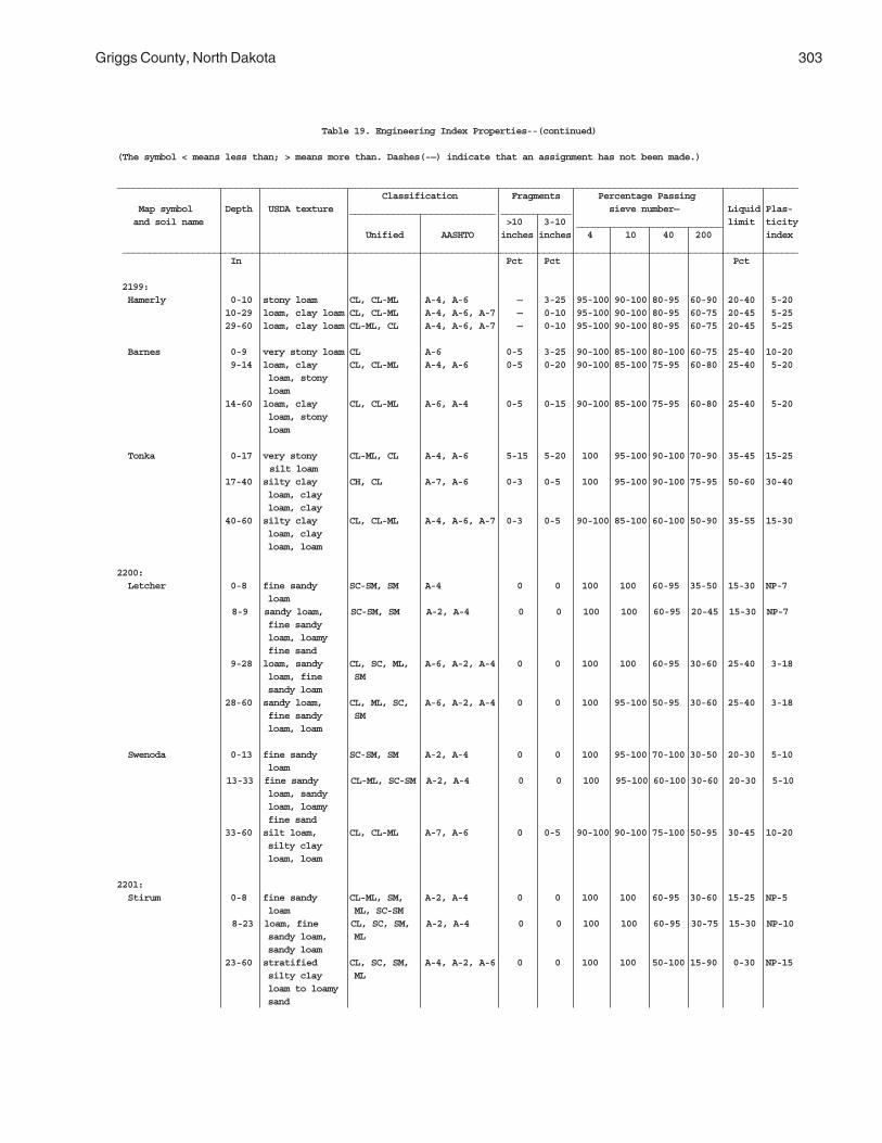
Griggs County, North Dakota 303
Table 19. Engineering Index Properties--(continued)
(The symbol < means less than; > means more than. Dashes(-—) indicate that an assignment has not been made.)
______________________________________________________________________________________________________________________________ Classification Fragments Percentage Passing Map symbol Depth USDA texture ___________________________ _____________ sieve number— Liquid Plas- and soil name >10 3-10 ___________________________ limit ticity Unified AASHTO inches inches 4 10 40 200 index _____________________________________________________________________________________________________________________________ In Pct Pct Pct
2199: Hamerly 0-10 stony loam CL, CL-ML A-4, A-6 — 3-25 95-100 90-100 80-95 60-90 20-40 5-20 10-29 loam, clay loam CL, CL-ML A-4, A-6, A-7 — 0-10 95-100 90-100 80-95 60-75 20-45 5-25 29-60 loam, clay loam CL-ML, CL A-4, A-6, A-7 — 0-10 95-100 90-100 80-95 60-75 20-45 5-25
Barnes 0-9 very stony loam CL A-6 0-5 3-25 90-100 85-100 80-100 60-75 25-40 10-20 9-14 loam, clay CL, CL-ML A-4, A-6 0-5 0-20 90-100 85-100 75-95 60-80 25-40 5-20 loam, stony loam 14-60 loam, clay CL, CL-ML A-6, A-4 0-5 0-15 90-100 85-100 75-95 60-80 25-40 5-20 loam, stony loam
Tonka 0-17 very stony CL-ML, CL A-4, A-6 5-15 5-20 100 95-100 90-100 70-90 35-45 15-25 silt loam
17-40 silty clay CH, CL A-7, A-6 0-3 0-5 100 95-100 90-100 75-95 50-60 30-40 loam, clay loam, clay 40-60 silty clay CL, CL-ML A-4, A-6, A-7 0-3 0-5 90-100 85-100 60-100 50-90 35-55 15-30 loam, clay loam, loam
2200: Letcher 0-8 fine sandy SC-SM, SM A-4 0 0 100 100 60-95 35-50 15-30 NP-7 loam
8-9 sandy loam, SC-SM, SM A-2, A-4 0 0 100 100 60-95 20-45 15-30 NP-7 fine sandy loam, loamy fine sand 9-28 loam, sandy CL, SC, ML, A-6, A-2, A-4 0 0 100 100 60-95 30-60 25-40 3-18 loam, fine SM sandy loam 28-60 sandy loam, CL, ML, SC, A-6, A-2, A-4 0 0 100 95-100 50-95 30-60 25-40 3-18 fine sandy SM loam, loam
Swenoda 0-13 fine sandy SC-SM, SM A-2, A-4 0 0 100 95-100 70-100 30-50 20-30 5-10 loam
13-33 fine sandy CL-ML, SC-SM A-2, A-4 0 0 100 95-100 60-100 30-60 20-30 5-10 loam, sandy loam, loamy fine sand 33-60 silt loam, CL, CL-ML A-7, A-6 0 0-5 90-100 90-100 75-100 50-95 30-45 10-20 silty clay loam, loam
2201: Stirum 0-8 fine sandy CL-ML, SM, A-2, A-4 0 0 100 100 60-95 30-60 15-25 NP-5 loam ML, SC-SM
8-23 loam, fine CL, SC, SM, A-2, A-4 0 0 100 100 60-95 30-75 15-30 NP-10 sandy loam, ML sandy loam 23-60 stratified CL, SC, SM, A-4, A-2, A-6 0 0 100 100 50-100 15-90 0-30 NP-15 silty clay ML loam to loamy sand
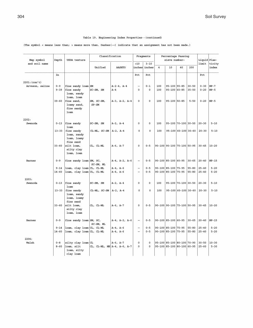
304 Soil Survey
Table 19. Engineering Index Properties--(continued)
(The symbol < means less than; > means more than. Dashes(-—) indicate that an assignment has not been made.)
______________________________________________________________________________________________________________________________ Classification Fragments Percentage Passing Map symbol Depth USDA texture ___________________________ _____________ sieve number— Liquid Plas- and soil name >10 3-10 ___________________________ limit ticity Unified AASHTO inches inches 4 10 40 200 index _____________________________________________________________________________________________________________________________ In Pct Pct Pct
2201:(con’t) Arveson, saline 0-9 fine sandy loam SM A-2-4, A-4 — 0-1 100 95-100 55-85 30-50 0-30 NP-7 9-39 fine sandy SC-SM, SM A-4 0 0 100 95-100 60-85 35-50 0-20 NP-5 loam, sandy loam, loam 39-60 fine sand, SM, SC-SM, A-3, A-2, A-4 0 0 100 95-100 50-85 5-50 0-20 NP-5 loamy sand, SP-SM fine sandy loam
2202: Swenoda 0-13 fine sandy SC-SM, SM A-2, A-4 0 0 100 95-100 70-100 30-50 20-30 5-10 loam
13-33 fine sandy CL-ML, SC-SM A-2, A-4 0 0 100 95-100 60-100 30-60 20-30 5-10 loam, sandy loam, loamy fine sand 33-60 silt loam, CL, CL-ML A-6, A-7 0 0-5 90-100 90-100 75-100 50-95 30-45 10-20 silty clay loam, loam
Barnes 0-9 fine sandy loam SM, SC, A-4, A-2, A-6 — 0-5 90-100 85-100 60-95 30-65 20-40 NP-15 SC-SM, ML 9-14 loam, clay loam CL, CL-ML A-4, A-6 — 0-5 90-100 85-100 75-95 55-80 25-40 5-20 14-60 loam, clay loam CL, CL-ML A-4, A-6 — 0-5 90-100 85-100 75-95 55-80 25-40 5-20
2203: Swenoda 0-13 fine sandy SC-SM, SM A-2, A-4 0 0 100 95-100 70-100 30-50 20-30 5-10 loam
13-33 fine sandy CL-ML, SC-SM A-2, A-4 0 0 100 95-100 60-100 30-60 20-30 5-10 loam, sandy loam, loamy fine sand 33-60 silt loam, CL, CL-ML A-6, A-7 0 0-5 90-100 90-100 75-100 50-95 30-45 10-20 silty clay loam, loam
Barnes 0-9 fine sandy loam SM, SC, A-4, A-2, A-6 — 0-5 90-100 85-100 60-95 30-65 20-40 NP-15 SC-SM, ML 9-14 loam, clay loam CL, CL-ML A-4, A-6 — 0-5 90-100 85-100 75-95 55-80 25-40 5-20 14-60 loam, clay loam CL, CL-ML A-4, A-6 — 0-5 90-100 85-100 75-95 55-80 25-40 5-20
2204: Walsh 0-8 silty clay loam CL A-6, A-7 0 0 95-100 85-100 80-100 70-90 30-50 10-30 8-60 loam, silt CL, CL-ML, MH A-4, A-6, A-7 0 0 95-100 85-100 80-100 60-95 25-60 5-30 loam, silty clay loam
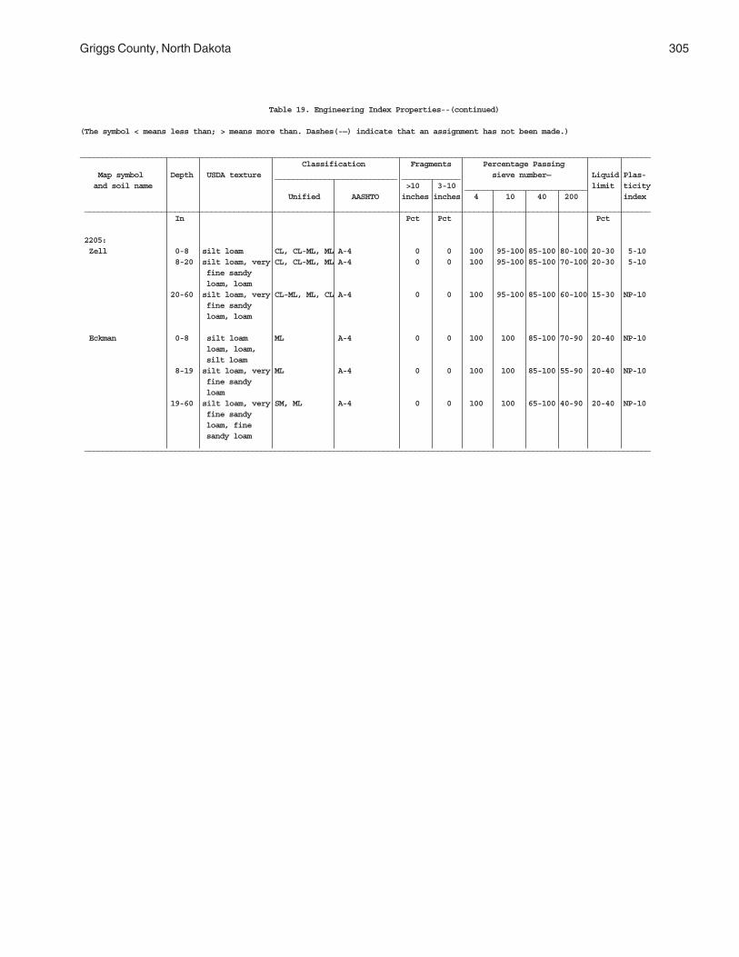
Griggs County, North Dakota 305
Table 19. Engineering Index Properties--(continued)
(The symbol < means less than; > means more than. Dashes(-—) indicate that an assignment has not been made.)
______________________________________________________________________________________________________________________________ Classification Fragments Percentage Passing Map symbol Depth USDA texture ___________________________ _____________ sieve number— Liquid Plas- and soil name >10 3-10 ___________________________ limit ticity Unified AASHTO inches inches 4 10 40 200 index _____________________________________________________________________________________________________________________________ In Pct Pct Pct
2205: Zell 0-8 silt loam CL, CL-ML, ML A-4 0 0 100 95-100 85-100 80-100 20-30 5-10 8-20 silt loam, very CL, CL-ML, ML A-4 0 0 100 95-100 85-100 70-100 20-30 5-10 fine sandy loam, loam 20-60 silt loam, very CL-ML, ML, CL A-4 0 0 100 95-100 85-100 60-100 15-30 NP-10 fine sandy loam, loam
Eckman 0-8 silt loam ML A-4 0 0 100 100 85-100 70-90 20-40 NP-10 loam, loam, silt loam 8-19 silt loam, very ML A-4 0 0 100 100 85-100 55-90 20-40 NP-10 fine sandy loam 19-60 silt loam, very SM, ML A-4 0 0 100 100 65-100 40-90 20-40 NP-10 fine sandy loam, fine sandy loam _____________________________________________________________________________________________________________________________
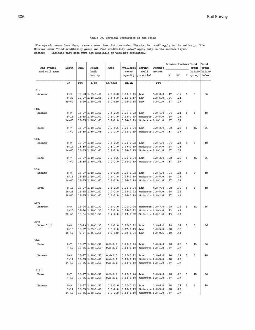
306 Soil Survey
Table 20.—Physical Properties of the Soils
(The symbol< means less than; > means more than. Entries under “Erosion factor—T” apply to the entire profile.Entries under “Wind erodibility group and Wind erodibility index” apply only to the surface layer.Dashes(-—) indicate that data were not available or were not estimated.)
_________________________________________________________________________________________________________________ Erosion factors Wind Wind Map symbol Depth Clay Moist Ksat Available Shrink- Organic _______________ erodi- erodi- and soil name bulk water swell matter bility bility density capacity potential K Kf T group index ________________________________________________________________________________________________________________ In Pct g/cc in/hour In/in Pct
61: Arveson 0-9 10-20 1.25-1.40 2.0-6.0 0.13-0.15 Low 5.0-8.0 .17 .17 4 3 86 9-39 10-27 1.40-1.55 0.6-6.0 0.15-0.17 Low 1.0-5.0 .24 .24 39-60 5-20 1.50-1.65 2.0->20 0.05-0.15 Low 0.0-1.0 .17 .17
118: Barnes 0-9 15-27 1.10-1.50 0.6-2.0 0.20-0.22 Low 3.0-6.0 .24 .24 5 6 48 9-14 18-35 1.20-1.60 0.6-2.0 0.15-0.19 Moderate 2.0-5.0 .28 .28 14-60 18-35 1.30-1.60 0.2-2.0 0.14-0.19 Moderate 0.0-1.0 .37 .37
Buse 0-7 18-27 1.10-1.50 0.2-0.6 0.20-0.24 Low 1.0-3.0 .28 .28 5 4L 86 7-60 18-35 1.30-1.65 0.2-2.0 0.14-0.19 Moderate 0.0-1.0 .37 .37
120: Barnes 0-9 15-27 1.10-1.50 0.6-2.0 0.20-0.22 Low 3.0-6.0 .24 .24 5 6 48 9-14 18-35 1.20-1.60 0.6-2.0 0.15-0.19 Moderate 2.0-5.0 .28 .28 14-60 18-35 1.30-1.60 0.2-2.0 0.14-0.19 Moderate 0.0-1.0 .37 .37
Buse 0-7 18-27 1.10-1.50 0.2-0.6 0.20-0.24 Low 1.0-3.0 .28 .28 5 4L 86 7-60 18-35 1.30-1.65 0.2-2.0 0.14-0.19 Moderate 0.0-1.0 .37 .37
156: Barnes 0-9 15-27 1.10-1.50 0.6-2.0 0.20-0.22 Low 3.0-6.0 .24 .24 5 6 48 9-14 18-35 1.20-1.60 0.6-2.0 0.15-0.19 Moderate 2.0-5.0 .28 .28 14-60 18-35 1.30-1.60 0.2-2.0 0.14-0.19 Moderate 0.0-1.0 .37 .37
Svea 0-18 18-27 1.10-1.30 0.6-2.0 0.20-0.24 Low 4.0-7.0 .28 .32 5 6 48 18-28 18-35 1.30-1.50 0.2-2.0 0.15-0.22 Moderate 2.0-5.0 .28 .32 28-60 18-35 1.30-1.60 0.2-2.0 0.14-0.19 Moderate 0.0-2.0 .37 .43
167: Bearden 0-9 18-26 1.15-1.30 0.6-2.0 0.20-0.24 Moderate 3.0-7.0 .28 .28 5 4L 86 9-20 18-34 1.30-1.35 0.2-2.0 0.16-0.22 Moderate 0.0-3.0 .43 .43 20-60 18-34 1.30-1.50 0.2-2.0 0.13-0.22 Moderate 0.0-1.0 .43 .43
296: Brantford 0-8 10-19 1.10-1.30 0.6-2.0 0.20-0.22 Low 3.0-6.0 .28 .32 3 5 56 8-15 18-27 1.25-1.40 0.6-2.0 0.17-0.19 Low 1.0-3.0 .28 .32 15-60 2-8 1.35-1.65 6.0->20 0.02-0.04 Low 0.0-0.5 .10 .43
314: Buse 0-7 18-27 1.10-1.50 0.2-0.6 0.20-0.24 Low 1.0-3.0 .28 .28 5 4L 86 7-60 18-35 1.30-1.65 0.2-2.0 0.14-0.19 Moderate 0.0-1.0 .37 .37
Barnes 0-9 15-27 1.10-1.50 0.6-2.0 0.20-0.22 Low 3.0-6.0 .24 .24 5 6 48 9-14 18-35 1.20-1.60 0.6-2.0 0.15-0.19 Moderate 2.0-5.0 .28 .28 14-60 18-35 1.30-1.60 0.2-2.0 0.14-0.19 Moderate 0.0-1.0 .37 .37
319: Buse 0-7 18-27 1.10-1.50 0.2-0.6 0.20-0.24 Low 1.0-3.0 .28 .28 5 4L 86 7-60 18-35 1.30-1.65 0.2-2.0 0.14-0.19 Moderate 0.0-1.0 .37 .37
Barnes 0-9 15-27 1.10-1.50 0.6-2.0 0.20-0.22 Low 3.0-6.0 .24 .24 5 6 48 9-14 18-35 1.20-1.60 0.6-2.0 0.15-0.19 Moderate 2.0-5.0 .28 .28 14-60 18-35 1.30-1.60 0.2-2.0 0.14-0.19 Moderate 0.0-1.0 .37 .37

Griggs County, North Dakota 307
Table 20.—Physical Properties of the Soils--(continued)
(The symbol< means less than; > means more than. Entries under “Erosion factor—T” apply to the entire profile.Entries under “Wind erodibility group and Wind erodibility index” apply only to the surface layer.Dashes(-—) indicate that data were not available or were not estimated.)
_________________________________________________________________________________________________________________ Erosion factors Wind Wind Map symbol Depth Clay Moist Ksat Available Shrink- Organic _______________ erodi- erodi- and soil name bulk water swell matter bility bility density capacity potential K Kf T group index ________________________________________________________________________________________________________________ In Pct g/cc in/hour In/in Pct391: Cavour 0-10 18-25 1.10-1.25 0.6-2.0 0.18-0.22 Moderate 2.0-5.0 .37 .37 2 6 48 10-20 35-50 1.25-1.40 <0.06-0.2 0.10-0.16 High 1.5-2.0 .37 .37 20-60 25-35 1.50-1.75 <0.06-0.6 0.11-0.15 Moderate 0.0-0.5 .37 .37
Cresbard 0-12 20-26 1.15-1.30 0.6-2.0 0.17-0.20 Low 2.0-5.0 .32 .32 5 6 48 12-25 35-50 1.20-1.35 <0.06-0.6 0.11-0.14 High 0.5-2.0 .32 .32 25-32 35-50 1.20-1.35 <0.06-0.6 0.11-0.15 High 0.0-0.5 .32 .32 32-60 25-35 1.40-1.60 0.2-0.6 0.16-0.20 Moderate 0.0-0.5 .32 .32
450: Colvin 0-10 18-26 1.15-1.30 0.6-2.0 0.22-0.24 Low 4.0-7.0 .28 .28 5 4L 86 10-30 18-34 1.20-1.50 0.2-2.0 0.16-0.22 Moderate 1.0-4.0 .43 .43 30-60 18-34 1.30-1.50 0.2-2.0 0.16-0.22 Moderate 0.5-1.0 .43 .43
511: Divide 0-9 15-27 1.10-1.40 0.6-2.0 0.20-0.24 Low 2.0-7.0 .24 .24 4 4L 86 9-28 18-35 1.20-1.50 0.2-2.0 0.15-0.19 Moderate 1.0-3.0 .20 .32 28-60 1-10 1.45-1.65 6.0->20 0.02-0.07 Low 0.0-1.0 .10 .15
536: Eckman 0-8 12-18 1.10-1.25 0.6-2.0 0.20-0.24 Low 2.0-6.0 .28 .28 5 5 56 8-19 10-18 1.20-1.60 0.6-2.0 0.17-0.22 Low 0.0-3.0 .43 .43 19-60 10-18 1.20-1.70 0.6-2.0 0.14-0.22 Low 0.0-0.5 .43 .43
Zell 0-8 10-18 1.15-1.30 0.6-2.0 0.20-0.24 Low 2.0-4.0 .32 .32 5 4L 86 8-20 10-18 1.30-1.35 0.6-2.0 0.16-0.22 Low 0.5-2.0 .43 .43 20-60 5-18 1.30-1.50 0.6-2.0 0.15-0.22 Low 0.0-0.5 .43 .43
539: Edgeley 0-8 18-26 1.30-1.40 0.6-2.0 0.20-0.22 Low 3.0-7.0 .32 .32 3 6 48 8-32 18-34 1.30-1.50 0.6-2.0 0.13-0.19 Moderate 0.0-2.0 .37 .37 32-60 — — <0.06-0.2 — — 0.0-0.0 — —
541: Edgeley 0-8 18-26 1.30-1.40 0.6-2.0 0.20-0.22 Low 3.0-7.0 .32 .32 3 6 48 8-32 18-34 1.30-1.50 0.6-2.0 0.13-0.19 Moderate 0.0-2.0 .37 .37 32-60 — — <0.06-0.2 — — 0.0-0.5 — —
569: Embden 0-16 10-18 1.25-1.35 2.0-6.0 0.13-0.18 Low 4.0-7.0 .20 .20 5 3 86 16-38 10-18 1.30-1.60 2.0-6.0 0.12-0.17 Low 1.0-4.0 .24 .24 38-60 5-18 1.40-1.60 2.0-6.0 0.08-0.16 Low 0.0-1.0 .24 .24
579: Embden 0-16 10-18 1.25-1.35 2.0-6.0 0.13-0.18 Low 4.0-7.0 .20 .20 5 3 86 16-38 10-18 1.30-1.60 2.0-6.0 0.12-0.17 Low 1.0-4.0 .24 .24 38-60 5-18 1.40-1.60 2.0-6.0 0.08-0.16 Low 0.0-1.0 .24 .24
Egeland 0-9 10-18 1.25-1.35 2.0-6.0 0.13-0.18 Low 2.0-4.0 .20 .20 5 3 86 9-40 10-18 1.30-1.45 2.0-6.0 0.12-0.17 Low 0.0-2.0 .24 .24 40-60 5-10 1.40-1.65 2.0-6.0 0.08-0.12 Low 0.0-0.5 .17 .17
595: Emrick 0-13 10-18 1.30-1.60 0.6-2.0 0.20-0.24 Low 3.0-8.0 .28 .28 5 5 56 13-32 10-18 1.30-1.60 0.6-2.0 0.17-0.19 Low 1.0-4.0 .28 .28 32-60 7-18 1.40-1.60 0.6-2.0 0.11-0.21 Low 0.0-2.0 .37 .43
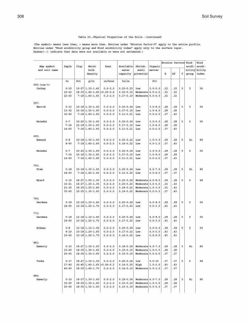
308 Soil Survey
Table 20.—Physical Properties of the Soils--(continued)
(The symbol< means less than; > means more than. Entries under “Erosion factor—T” apply to the entire profile.Entries under “Wind erodibility group and Wind erodibility index” apply only to the surface layer.Dashes(-—) indicate that data were not available or were not estimated.)
_________________________________________________________________________________________________________________ Erosion factors Wind Wind Map symbol Depth Clay Moist Ksat Available Shrink- Organic _______________ erodi- erodi- and soil name bulk water swell matter bility bility density capacity potential K Kf T group index ________________________________________________________________________________________________________________ In Pct g/cc in/hour In/in Pct595:(con’t) Cathay 0-10 10-27 1.10-1.40 0.6-2.0 0.20-0.23 Low 2.0-5.0 .32 .32 5 5 56 10-22 18-35 1.40-1.60 <0.06-0.6 0.16-0.19 Moderate 0.5-2.0 .32 .32 22-60 7-18 1.40-1.60 0.2-2.0 0.17-0.19 Moderate 0.0-0.5 .32 .32
597: Emrick 0-13 10-18 1.30-1.60 0.6-2.0 0.20-0.24 Low 3.0-8.0 .28 .28 5 5 56 13-32 10-18 1.30-1.60 0.6-2.0 0.17-0.19 Low 1.0-4.0 .28 .28 32-60 7-18 1.40-1.60 0.6-2.0 0.11-0.21 Low 0.0-2.0 .37 .43
Heimdal 0-7 10-20 1.30-1.60 0.6-2.0 0.20-0.24 Low 3.0-5.0 .28 .28 5 5 56 7-14 10-18 1.30-1.60 0.6-2.0 0.17-0.19 Low 1.0-4.0 .28 .28 14-60 7-18 1.40-1.60 0.6-2.0 0.11-0.21 Low 0.0-2.0 .37 .43
605: Esmond 0-8 10-18 1.30-1.60 0.6-2.0 0.20-0.22 Low 1.0-3.0 .28 .28 5 4L 86 8-60 7-18 1.40-1.60 0.6-2.0 0.14-0.22 Low 0.0-1.0 .37 .43
Heimdal 0-7 10-20 1.30-1.60 0.6-2.0 0.20-0.24 Low 3.0-5.0 .28 .28 5 5 56 7-14 10-18 1.30-1.60 0.6-2.0 0.17-0.19 Low 1.0-4.0 .28 .28 14-60 7-18 1.40-1.60 0.6-2.0 0.11-0.21 Low 0.0-2.0 .37 .43
753: Fram 0-18 10-18 1.30-1.60 0.6-2.0 0.20-0.24 Low 4.0-7.0 .28 .28 5 4L 86 18-60 7-18 1.40-1.60 0.6-2.0 0.13-0.20 Low 0.0-4.0 .37 .37
Wyard 0-15 18-27 1.00-1.30 0.6-2.0 0.20-0.24 Moderate 4.0-8.0 .28 .28 5 6 48 15-21 18-27 1.20-1.30 0.6-2.0 0.20-0.22 Moderate 3.0-5.0 .32 .43 21-35 18-35 1.20-1.40 0.6-2.0 0.18-0.22 Moderate 1.0-3.0 .32 .43 35-60 15-35 1.30-1.60 0.6-2.0 0.14-0.22 Moderate 0.0-0.5 .37 .43
769: Gardena 0-18 12-18 1.10-1.40 0.6-2.0 0.20-0.24 Low 4.0-8.0 .28 .28 5 5 56 18-60 10-18 1.20-1.70 0.6-2.0 0.17-0.22 Low 0.0-3.0 .43 .43
773: Gardena 0-18 12-18 1.10-1.40 0.6-2.0 0.20-0.24 Low 4.0-8.0 .28 .28 5 5 56 18-60 10-18 1.20-1.70 0.6-2.0 0.17-0.22 Low 0.0-3.0 .43 .43
Eckman 0-8 12-18 1.10-1.25 0.6-2.0 0.20-0.24 Low 2.0-6.0 .28 .28 5 5 56 8-19 10-18 1.20-1.60 0.6-2.0 0.17-0.22 Low 0.0-3.0 .43 .43 19-60 10-18 1.20-1.70 0.6-2.0 0.14-0.22 Low 0.0-0.5 .43 .43
881: Hamerly 0-10 18-27 1.30-1.60 0.6-2.0 0.18-0.24 Moderate 4.0-7.0 .28 .28 5 4L 86 10-29 18-35 1.30-1.60 0.2-2.0 0.15-0.19 Moderate 1.0-3.0 .28 .28 29-60 18-35 1.30-1.60 0.2-2.0 0.15-0.19 Moderate 0.0-0.5 .37 .37
Tonka 0-17 18-27 1.10-1.30 0.6-2.0 0.20-0.24 Low 5.0-10 .37 .37 5 6 48 17-40 35-45 1.40-1.65 <0.06-0.2 0.14-0.20 High 1.0-3.0 .43 .43 40-60 18-39 1.40-1.70 0.2-2.0 0.14-0.19 Moderate 0.0-1.0 .37 .37
884: Hamerly 0-10 18-27 1.30-1.60 0.6-2.0 0.18-0.24 Moderate 4.0-7.0 .28 .28 5 4L 86 10-29 18-35 1.30-1.60 0.2-2.0 0.15-0.19 Moderate 1.0-3.0 .28 .28 29-60 18-35 1.30-1.60 0.2-2.0 0.15-0.19 Moderate 0.0-0.5 .37 .37

Griggs County, North Dakota 309
Table 20.—Physical Properties of the Soils--(continued)
(The symbol< means less than; > means more than. Entries under “Erosion factor—T” apply to the entire profile.Entries under “Wind erodibility group and Wind erodibility index” apply only to the surface layer.Dashes(-—) indicate that data were not available or were not estimated.)
_________________________________________________________________________________________________________________ Erosion factors Wind Wind Map symbol Depth Clay Moist Ksat Available Shrink- Organic _______________ erodi- erodi- and soil name bulk water swell matter bility bility density capacity potential K Kf T group index ________________________________________________________________________________________________________________ In Pct g/cc in/hour In/in Pct884:(con’t) Wyard 0-15 18-27 1.00-1.30 0.6-2.0 0.20-0.24 Moderate 4.0-8.0 .28 .28 5 6 48 15-21 18-27 1.20-1.30 0.6-2.0 0.20-0.22 Moderate 3.0-5.0 .32 .43 21-35 18-35 1.20-1.40 0.6-2.0 0.18-0.22 Moderate 1.0-3.0 .32 .43 35-60 15-35 1.30-1.60 0.6-2.0 0.14-0.22 Moderate 0.0-0.5 .37 .43
893: Harriet 0-2 12-25 1.10-1.40 0.6-2.0 0.20-0.24 Low 3.0-6.0 .37 .37 2 6 48 2-10 35-50 1.20-1.60 0.06-0.2 0.10-0.15 High 1.0-3.0 .37 .37 10-60 18-40 1.20-1.60 0.6-2.0 0.10-0.15 Moderate 0.5-1.0 .37 .37
988: Heimdal 0-7 10-20 1.30-1.60 0.6-2.0 0.20-0.24 Low 3.0-5.0 .28 .28 5 5 56 7-14 10-18 1.30-1.60 0.6-2.0 0.17-0.19 Low 1.0-4.0 .28 .28 14-60 7-18 1.40-1.60 0.6-2.0 0.11-0.21 Low 0.0-2.0 .37 .43
Emrick 0-13 10-18 1.30-1.60 0.6-2.0 0.20-0.24 Low 4.0-9.0 .28 .28 5 5 56 13-32 10-18 1.30-1.60 0.6-2.0 0.17-0.19 Low 1.0-4.0 .28 .28 32-60 7-18 1.40-1.60 0.6-2.0 0.11-0.21 Low 0.0-2.0 .37 .43
998: Heimdal 0-7 10-20 1.30-1.60 0.6-2.0 0.20-0.24 Low 3.0-5.0 .28 .28 5 5 56 7-14 10-18 1.30-1.60 0.6-2.0 0.17-0.19 Low 1.0-4.0 .28 .28 14-60 7-18 1.40-1.60 0.6-2.0 0.11-0.21 Low 0.0-2.0 .37 .43
Esmond 0-8 10-18 1.30-1.60 0.6-2.0 0.20-0.22 Low 1.0-3.0 .28 .28 5 4L 86 8-60 7-18 1.40-1.60 0.6-2.0 0.14-0.22 Low 0.0-1.0 .37 .43
1001: Heimdal 0-7 10-20 1.30-1.60 0.6-2.0 0.20-0.24 Low 3.0-5.0 .28 .28 5 5 56 7-14 10-18 1.30-1.60 0.6-2.0 0.17-0.19 Low 1.0-4.0 .28 .28 14-60 7-18 1.40-1.60 0.6-2.0 0.11-0.21 Low 0.0-2.0 .37 .43
Esmond 0-8 10-18 1.30-1.60 0.6-2.0 0.20-0.22 Low 1.0-3.0 .28 .28 5 4L 86 8-60 7-18 1.40-1.60 0.6-2.0 0.14-0.22 Low 0.0-1.0 .37 .43
1015: Kensal 0-9 18-25 1.10-1.40 0.6-2.0 0.20-0.22 Low 4.0-7.0 .28 .28 4 5 56 9-23 18-25 1.20-1.50 0.6-2.0 0.15-0.19 Low 1.0-4.0 .28 .28 23-60 0-10 1.30-1.60 6.0->20 0.02-0.07 Low 0.0-0.5 .15 .49
1062: LaDelle 0-23 27-35 1.15-1.30 0.2-0.6 0.18-0.22 Moderate 4.0-8.0 .28 .28 5 7 38 23-43 27-35 1.20-1.35 0.2-0.6 0.16-0.20 Moderate 1.0-4.0 .28 .28 43-60 25-35 1.30-1.40 0.2-0.6 0.16-0.20 Moderate 0.0-2.0 .28 .28
1108: Larson 0-8 10-27 1.10-1.40 0.6-2.0 0.16-0.24 Moderate 2.0-5.0 .32 .32 2 5 56 8-21 18-35 1.30-1.60 <0.06-0.2 0.10-0.14 Moderate 1.0-2.0 .32 .32 21-60 10-35 1.30-1.60 0.2-2.0 0.12-0.16 Moderate 0.0-0.5 .37 .37
Cathay 0-10 10-27 1.10-1.40 0.6-2.0 0.20-0.23 Low 2.0-5.0 .32 .32 5 5 56 10-22 18-35 1.40-1.60 <0.06-0.6 0.16-0.19 Moderate 0.5-2.0 .32 .32 22-60 7-18 1.40-1.60 0.2-2.0 0.17-0.19 Moderate 0.0-0.5 .32 .32

310 Soil Survey
Table 20.—Physical Properties of the Soils--(continued)
(The symbol< means less than; > means more than. Entries under “Erosion factor—T” apply to the entire profile.Entries under “Wind erodibility group and Wind erodibility index” apply only to the surface layer.Dashes(-—) indicate that data were not available or were not estimated.)
_________________________________________________________________________________________________________________ Erosion factors Wind Wind Map symbol Depth Clay Moist Ksat Available Shrink- Organic _______________ erodi- erodi- and soil name bulk water swell matter bility bility density capacity potential K Kf T group index ________________________________________________________________________________________________________________ In Pct g/cc in/hour In/in Pct 1188: Ludden 0-35 40-60 1.10-1.30 <0.06-0.2 0.16-0.18 High 4.0-9.0 .28 .28 5 4 86 35-42 40-60 1.20-1.50 <0.06-0.2 0.13-0.16 High 0.5-3.0 .28 .28 42-60 35-60 1.20-1.50 <0.06-0.2 0.13-0.16 High 0.0-0.5 .32 .32
1189: Ludden, saline 0-35 40-60 1.10-1.30 <0.06-0.2 0.12-0.14 High 4.0-8.0 .28 .28 5 4 86 35-42 40-60 1.20-1.50 <0.06-0.2 0.06-0.08 High 0.5-3.0 .28 .28 42-60 35-60 1.20-1.50 <0.06-0.2 0.06-0.08 High 0.0-0.5 .32 .32
1221: Maddock 0-11 2-10 1.20-1.40 2.0->20 0.10-0.12 Low 1.0-2.0 .17 .17 5 2 134 11-60 2-8 1.30-1.50 2.0->20 0.05-0.12 Low 0.0-0.5 .17 .17
Hecla 0-10 2-10 1.10-1.35 2.0->20 0.10-0.12 Low 1.0-3.0 .17 .17 5 2 134 10-32 2-10 1.30-1.50 2.0->20 0.06-0.13 Low 1.0-3.0 .17 .17 32-60 3-8 1.35-1.60 2.0->20 0.05-0.12 Low 0.0-1.0 .17 .17
1267: Marysland 0-8 18-35 1.10-1.30 0.6-2.0 0.17-0.24 Moderate 5.0-8.0 .28 .28 4 4L 86 8-30 18-35 1.35-1.50 0.2-2.0 0.15-0.19 Moderate 1.0-3.0 .28 .28 30-60 1-5 1.45-1.65 6.0->20 0.02-0.07 Low 0.0-0.5 .10 .10
1268: Marysland, wet 0-8 18-30 1.20-1.30 0.6-2.0 0.17-0.22 Moderate 5.0-8.0 .28 .28 4 4L 86 8-30 18-30 1.35-1.50 0.6-2.0 0.15-0.19 Moderate 1.0-3.0 .28 .28 30-60 1-5 1.55-1.65 6.0->20 0.02-0.07 Low 0.0-0.5 .15 .15
1427: Parnell 0-9 27-40 1.10-1.30 0.2-0.6 0.18-0.22 Moderate 6.0-10 .37 .37 5 7 38 9-49 35-60 1.20-1.40 <0.06-0.2 0.13-0.19 High 3.0-5.0 .28 .28 49-60 35-45 1.30-1.50 <0.06-0.2 0.11-0.19 High 0.5-1.0 .28 .28
1454: Wyndmere 0-9 5-15 1.30-1.60 2.0-6.0 0.13-0.18 Low 5.0-8.0 .20 .20 5 3 86 9-28 0-10 1.30-1.70 2.0-6.0 0.12-0.17 Low 1.0-5.0 .20 .20 28-42 0-10 1.30-1.70 2.0-6.0 0.06-0.16 Low 0.0-1.0 .20 .20 42-60 18-35 1.30-1.60 0.2-2.0 0.14-0.22 Moderate 0.0-1.0 .28 .32
1466: Pits, sand and 0-6 5-15 1.20-1.60 6.0->20 0.01-0.04 Low 0.5-1.0 .10 .20 2 8 0 gravel 6-60 0-15 1.20-1.60 6.0->20 0.01-0.04 Low 0.0-0.5 .10 .17
1710: Southam 0-10 27-40 1.10-1.40 0.2-0.6 0.18-0.23 Moderate 5.0-15 .37 .37 5 4L 86 10-48 35-50 1.20-1.50 <0.06-0.2 0.14-0.20 High 1.0-10 .28 .28 48-60 18-50 1.20-1.50 <0.06-0.6 0.13-0.17 High 0.0-3.0 .28 .28
1762: Svea 0-18 18-27 1.10-1.30 0.6-2.0 0.20-0.24 Low 4.0-7.0 .28 .32 5 6 48 18-28 18-35 1.30-1.50 0.2-2.0 0.15-0.22 Moderate 2.0-5.0 .28 .32 28-60 18-35 1.30-1.60 0.2-2.0 0.14-0.19 Moderate 0.0-2.0 .37 .43
Barnes 0-9 15-27 1.10-1.50 0.6-2.0 0.20-0.22 Low 3.0-6.0 .24 .24 5 6 48 9-14 18-35 1.20-1.60 0.6-2.0 0.15-0.19 Moderate 2.0-5.0 .28 .28 14-60 18-35 1.30-1.60 0.2-2.0 0.14-0.19 Moderate 0.0-1.0 .37 .37

Griggs County, North Dakota 311
Table 20.—Physical Properties of the Soils--(continued)
(The symbol< means less than; > means more than. Entries under “Erosion factor—T” apply to the entire profile.Entries under “Wind erodibility group and Wind erodibility index” apply only to the surface layer.Dashes(-—) indicate that data were not available or were not estimated.)
_________________________________________________________________________________________________________________ Erosion factors Wind Wind Map symbol Depth Clay Moist Ksat Available Shrink- Organic _______________ erodi- erodi- and soil name bulk water swell matter bility bility density capacity potential K Kf T group index ________________________________________________________________________________________________________________ In Pct g/cc in/hour In/in Pct
1765: Svea 0-18 18-27 1.10-1.30 0.6-2.0 0.20-0.24 Low 4.0-7.0 .28 .32 5 6 48 18-28 18-35 1.30-1.50 0.2-2.0 0.15-0.22 Moderate 2.0-5.0 .28 .32 28-60 18-35 1.30-1.60 0.2-2.0 0.14-0.19 Moderate 0.0-2.0 .37 .43
Buse 0-7 18-27 1.10-1.50 0.2-0.6 0.20-0.24 Low 1.0-3.0 .28 .28 5 4L 86 7-60 18-35 1.30-1.65 0.2-2.0 0.14-0.19 Moderate 0.0-1.0 .37 .37
1766: Svea 0-18 18-27 1.10-1.30 0.6-2.0 0.20-0.24 Low 4.0-7.0 .28 .32 5 6 48 18-28 18-35 1.30-1.50 0.2-2.0 0.15-0.22 Moderate 2.0-5.0 .28 .32 28-60 18-35 1.30-1.60 0.2-2.0 0.14-0.19 Moderate 0.0-2.0 .37 .43
Buse 0-7 18-27 1.10-1.50 0.2-0.6 0.20-0.24 Low 1.0-3.0 .28 .28 5 4L 86 7-60 18-35 1.30-1.65 0.2-2.0 0.14-0.19 Moderate 0.0-1.0 .37 .37
1769: Svea 0-18 18-27 1.10-1.30 0.6-2.0 0.20-0.24 Low 4.0-7.0 .28 .32 5 6 48 18-28 18-35 1.30-1.50 0.2-2.0 0.15-0.22 Moderate 2.0-5.0 .28 .32 28-60 18-35 1.30-1.60 0.2-2.0 0.14-0.19 Moderate 0.0-2.0 .37 .43
Cresbard 0-12 20-26 1.15-1.30 0.6-2.0 0.17-0.20 Low 2.0-5.0 .32 .32 5 6 48 12-25 35-50 1.20-1.35 <0.06-0.6 0.11-0.14 High 0.5-2.0 .32 .32 25-32 35-50 1.20-1.35 <0.06-0.6 0.11-0.15 High 0.0-0.5 .32 .32 32-60 25-35 1.40-1.60 0.2-0.6 0.16-0.20 Moderate 0.0-0.5 .32 .32
1781: Swenoda 0-13 10-20 1.10-1.35 2.0-6.0 0.13-0.18 Low 3.0-7.0 .20 .20 5 3 86 13-33 10-18 1.30-1.45 2.0-6.0 0.10-0.17 Low 1.0-3.0 .20 .20 33-60 20-35 1.35-1.65 0.2-2.0 0.16-0.22 Moderate 0.0-1.0 .37 .37
1843: Towner 0-16 2-10 1.20-1.40 6.0->20 0.08-0.12 Low 1.0-3.0 .17 .17 5 2 134 16-35 2-10 1.20-1.40 6.0->20 0.06-0.13 Low 0.0-1.0 .17 .17 35-60 18-40 1.30-1.60 0.2-2.0 0.14-0.22 Moderate 0.0-0.5 .43 .43
1883: Vallers 0-12 18-27 1.20-1.35 0.6-2.0 0.22-0.24 Low 5.0-8.0 .28 .28 5 4L 86 12-32 18-35 1.40-1.55 0.2-0.6 0.15-0.19 Moderate 1.0-3.0 .28 .28 32-60 18-35 1.50-1.70 0.2-0.6 0.17-0.19 Low 0.0-1.0 .28 .28
Parnell 0-9 27-40 1.10-1.30 0.2-0.6 0.18-0.22 Moderate 6.0-10 .37 .37 5 7 38 9-49 35-60 1.20-1.40 <0.06-0.2 0.13-0.19 High 3.0-5.0 .28 .28 49-60 35-45 1.30-1.50 <0.06-0.2 0.11-0.19 High 0.5-1.0 .28 .28
1886: Hamerly 0-10 18-27 1.20-1.30 0.6-2.0 0.13-0.16 Low 3.0-6.0 .28 .28 5 4L 86 10-29 18-35 1.30-1.60 0.2-2.0 0.10-0.13 Moderate 1.0-3.0 .28 .28 29-60 18-35 1.30-1.60 0.2-2.0 0.10-0.13 Moderate 0.0-1.0 .37 .37
Vallers 0-12 18-27 1.10-1.40 0.6-2.0 0.14-0.16 Low 5.0-8.0 .24 .24 5 4L 86 12-32 18-35 1.30-1.50 0.2-2.0 0.10-0.13 Moderate 1.0-3.0 .28 .28 32-60 18-35 1.30-1.60 0.2-2.0 0.11-0.13 Moderate 0.0-1.0 .37 .37

312 Soil Survey
Table 20.—Physical Properties of the Soils--(continued)
(The symbol< means less than; > means more than. Entries under “Erosion factor—T” apply to the entire profile.Entries under “Wind erodibility group and Wind erodibility index” apply only to the surface layer.Dashes(-—) indicate that data were not available or were not estimated.)
_________________________________________________________________________________________________________________ Erosion factors Wind Wind Map symbol Depth Clay Moist Ksat Available Shrink- Organic _______________ erodi- erodi- and soil name bulk water swell matter bility bility density capacity potential K Kf T group index ________________________________________________________________________________________________________________ In Pct g/cc in/hour In/in Pct
1970: Walum 0-16 8-18 1.20-1.40 2.0-6.0 0.13-0.15 Low 2.0-4.0 .20 .20 3 3 86 16-30 5-18 1.20-1.50 6.0->20 0.06-0.11 Low 0.0-2.0 .20 .24 30-60 0-10 1.40-1.70 6.0->20 0.02-0.04 Low 0.0-0.5 .10 —
1978: Water — — — — — — — — — - — —
2118: Fram 0-18 10-18 1.30-1.60 0.6-2.0 0.20-0.24 Low 4.0-7.0 .28 .28 5 4L 86 18-60 7-18 1.40-1.60 0.6-2.0 0.13-0.20 Low 0.0-4.0 .37 .37
Tonka 0-17 18-27 1.10-1.30 0.6-2.0 0.20-0.24 Low 5.0-10 .37 .37 5 6 48 17-40 35-45 1.40-1.65 <0.06-0.2 0.14-0.20 High 1.0-3.0 .43 .43 40-60 18-39 1.40-1.70 0.2-2.0 0.14-0.19 Moderate 0.0-1.0 .37 .37
2121: Ferney 0-5 18-26 1.15-1.30 0.6-2.0 0.18-0.20 Low 1.0-3.0 .32 .32 2 6 48 5-13 35-50 1.40-1.60 <0.06-0.2 0.11-0.16 High 0.0-3.0 .32 .32 13-60 35-45 1.40-1.70 <0.06-0.2 0.11-0.16 High 0.0-1.0 .32 .32
2151: Binford 0-8 6-18 1.10-1.35 2.0-6.0 0.13-0.15 Low 2.0-5.0 .20 .20 3 3 86 8-17 6-18 1.30-1.50 2.0-6.0 0.12-0.19 Low 1.0-2.0 .24 .24 17-60 2-8 1.50-1.65 6.0->20 0.02-0.04 Low 0.0-0.5 .10 .20
Coe 0-8 6-18 1.25-1.35 2.0-6.0 0.13-0.15 Low 2.0-4.0 .20 .20 2 3 86 8-60 2-8 1.35-1.65 6.0->20 0.02-0.04 Low 0.0-0.5 .10 .43
2152: Coe 0-8 6-18 1.20-1.40 0.6-6.0 0.10-0.17 Low 1.0-2.0 .15 .32 2 8 0 8-60 2-8 1.35-1.65 6.0->20 0.02-0.04 Low 0.0-0.5 .10 .43
Binford 0-8 6-18 1.10-1.35 2.0-6.0 0.13-0.15 Low 2.0-5.0 .20 .20 3 3 86 8-17 6-18 1.30-1.50 2.0-6.0 0.12-0.19 Low 1.0-2.0 .24 .24 17-60 2-8 1.50-1.65 6.0->20 0.02-0.04 Low 0.0-0.5 .10 .20
2153: Edgeley 0-8 18-26 1.30-1.40 0.6-2.0 0.20-0.22 Low 3.0-7.0 .32 .32 3 6 48 8-26 18-34 1.30-1.50 0.6-2.0 0.13-0.19 Moderate 0.0-2.0 .37 .37 26-60 — — <0.06-0.2 — — 0.0-0.5 — —
Kloten 0-9 18-26 1.30-1.40 0.6-2.0 0.17-0.22 Moderate 3.0-6.0 .32 .32 2 6 48 9-60 — — <0.06-0.2 — — — — —
Esmond 0-8 10-18 1.30-1.60 0.6-2.0 0.20-0.22 Low 1.0-4.0 .28 .28 5 4L 86 8-60 7-18 1.40-1.60 0.6-2.0 0.14-0.22 Low — .37 .43
2156: Lamoure 0-9 20-26 1.10-1.25 0.2-2.0 0.19-0.22 Low 4.0-8.0 .28 .28 5 4L 86 9-30 20-34 1.20-1.35 0.2-2.0 0.17-0.20 Moderate 1.0-3.0 .32 .32 30-60 20-34 1.20-1.35 0.2-2.0 0.17-0.20 Moderate 0.5-1.0 .43 .43

Griggs County, North Dakota 313
Table 20.—Physical Properties of the Soils--(continued)
(The symbol< means less than; > means more than. Entries under “Erosion factor—T” apply to the entire profile.Entries under “Wind erodibility group and Wind erodibility index” apply only to the surface layer.Dashes(-—) indicate that data were not available or were not estimated.)
_________________________________________________________________________________________________________________ Erosion factors Wind Wind Map symbol Depth Clay Moist Ksat Available Shrink- Organic _______________ erodi- erodi- and soil name bulk water swell matter bility bility density capacity potential K Kf T group index ________________________________________________________________________________________________________________ In Pct g/cc in/hour In/in Pct
2156:(con’t) Rauville 0-28 15-26 0.85-1.10 0.6-2.0 0.19-0.22 Low 4.0-10 .28 .28 5 4L 86 28-60 20-45 1.10-1.30 0.2-2.0 0.17-0.20 Moderate 1.0-4.0 .32 .32
2157: Maddock 0-11 2-10 1.20-1.40 2.0->20 0.10-0.12 Low 1.0-2.0 .17 .17 5 2 134 11-60 2-8 1.30-1.50 2.0->20 0.05-0.12 Low 0.0-0.5 .17 .17
Esmond 0-8 10-18 1.30-1.60 0.6-2.0 0.20-0.22 Low 1.0-4.0 .28 .28 5 4L 86 8-60 7-18 1.40-1.60 0.6-2.0 0.14-0.22 Low — .37 .43
Embden 0-16 10-18 1.40-1.60 2.0-6.0 0.13-0.18 Low 4.0-7.0 .20 .20 5 3 86 16-38 10-18 1.40-1.60 2.0-6.0 0.12-0.17 Low 1.0-4.0 .20 .20 38-60 5-18 1.40-1.60 2.0-6.0 0.06-0.16 Low 0.0-1.0 .20 .20
2158: Velva 0-15 7-18 1.20-1.50 0.6-6.0 0.13-0.22 Low 4.0-7.0 .20 .20 5 3 86 15-60 7-18 1.30-1.60 0.6-6.0 0.16-0.22 Low 0.0-4.0 .20 .20
2159: Walsh 0-8 27-35 1.10-1.30 0.6-2.0 0.17-0.23 Moderate 4.0-8.0 .28 .28 5 7 38 8-60 25-35 1.20-1.40 0.2-2.0 0.14-0.22 Moderate 0.0-4.0 .43 .49
2196: Bearden, saline 0-9 18-26 1.15-1.30 0.6-2.0 0.14-0.15 Moderate 3.0-7.0 .28 .28 5 4L 86 9-20 18-34 1.30-1.45 0.2-2.0 0.10-0.14 Moderate 0.0-3.0 .43 .43 20-60 18-34 1.30-1.60 0.2-2.0 0.10-0.14 Moderate 0.0-1.0 .43 .43
Colvin, saline 0-10 18-26 1.20-1.50 0.6-2.0 0.15-0.17 Moderate 4.0-7.0 .37 .37 5 4L 86 10-60 18-34 1.30-1.50 0.2-2.0 0.11-0.15 Moderate 0.0-5.0 .37 .37
2197: Edgeley 0-8 18-26 1.30-1.40 0.6-2.0 0.20-0.22 Low 3.0-7.0 .32 .32 3 6 48 8-32 18-34 1.30-1.50 0.6-2.0 0.13-0.19 Moderate 0.0-2.0 .37 .37 32-60 — — <0.06-0.2 — — 0.0-0.5 — —
Kloten 0-9 18-26 1.30-1.40 0.6-2.0 0.17-0.22 Moderate 3.0-6.0 .32 .32 2 6 48 9-60 — — <0.06-0.2 — — — — —
2198: Hamar 0-17 5-10 1.20-1.30 2.0->20 0.10-0.12 Low 1.0-3.0 .17 .17 5 2 134 17-25 0-7 1.35-1.55 2.0->20 0.10-0.12 Low 0.0-2.0 .17 .17 25-60 0-7 1.45-1.65 2.0->20 0.06-0.08 Low 0.0-0.5 .17 .17
Hecla 0-10 2-10 1.10-1.35 2.0->20 0.10-0.12 Low 1.0-3.0 .17 .17 5 2 134 10-32 2-10 1.30-1.50 2.0->20 0.06-0.13 Low 1.0-3.0 .17 .17 32-60 3-8 1.35-1.60 2.0->20 0.05-0.12 Low 0.0-1.0 .17 .17
2199: Hamerly 0-10 18-27 1.20-1.60 0.6-2.0 0.17-0.22 Moderate 3.0-6.0 .28 .37 5 8 0 10-29 18-35 1.20-1.60 0.6-2.0 0.15-0.19 Moderate 1.0-3.0 .28 .32 29-60 18-35 1.30-1.60 0.2-0.6 0.14-0.19 Moderate 0.0-1.0 .37 .43
Barnes 0-9 18-26 1.20-1.60 0.6-2.0 0.20-0.22 Low 3.0-6.0 .17 .24 5 8 0 9-14 18-35 1.20-1.60 0.6-2.0 0.15-0.19 Low 2.0-5.0 .28 .28 14-60 18-35 1.30-1.60 0.2-0.6 0.14-0.19 Low 0.0-2.0 .37 .37
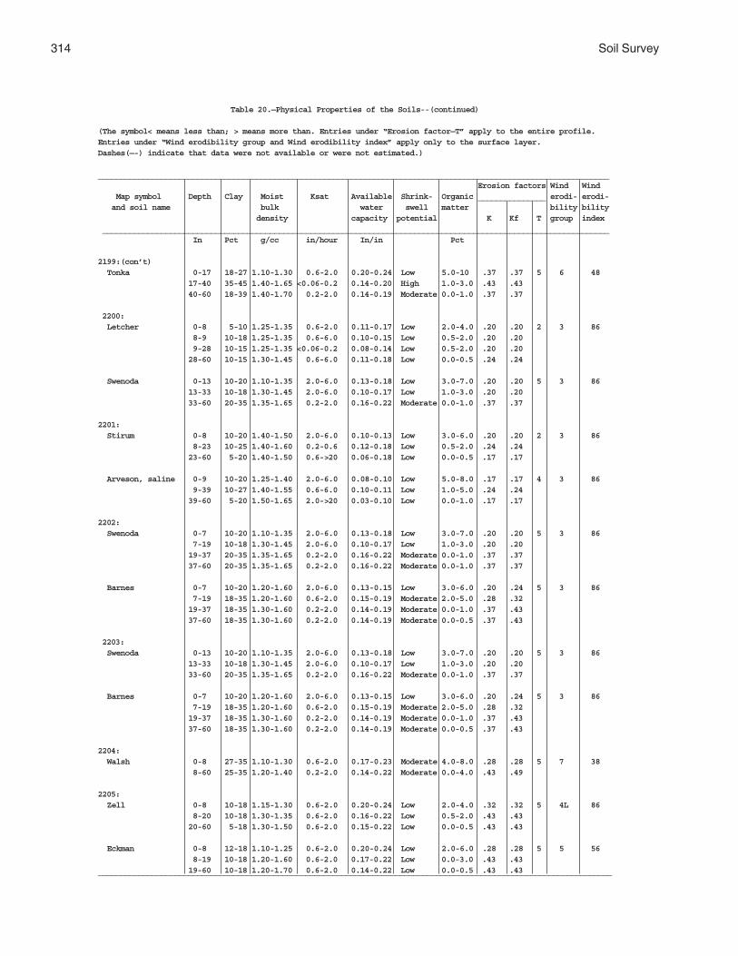
314 Soil Survey
Table 20.—Physical Properties of the Soils--(continued)
(The symbol< means less than; > means more than. Entries under “Erosion factor—T” apply to the entire profile.Entries under “Wind erodibility group and Wind erodibility index” apply only to the surface layer.Dashes(—-) indicate that data were not available or were not estimated.)
_________________________________________________________________________________________________________________ Erosion factors Wind Wind Map symbol Depth Clay Moist Ksat Available Shrink- Organic _______________ erodi- erodi- and soil name bulk water swell matter bility bility density capacity potential K Kf T group index ________________________________________________________________________________________________________________ In Pct g/cc in/hour In/in Pct
2199:(con’t) Tonka 0-17 18-27 1.10-1.30 0.6-2.0 0.20-0.24 Low 5.0-10 .37 .37 5 6 48 17-40 35-45 1.40-1.65 <0.06-0.2 0.14-0.20 High 1.0-3.0 .43 .43 40-60 18-39 1.40-1.70 0.2-2.0 0.14-0.19 Moderate 0.0-1.0 .37 .37
2200: Letcher 0-8 5-10 1.25-1.35 0.6-2.0 0.11-0.17 Low 2.0-4.0 .20 .20 2 3 86 8-9 10-18 1.25-1.35 0.6-6.0 0.10-0.15 Low 0.5-2.0 .20 .20 9-28 10-15 1.25-1.35 <0.06-0.2 0.08-0.14 Low 0.5-2.0 .20 .20 28-60 10-15 1.30-1.45 0.6-6.0 0.11-0.18 Low 0.0-0.5 .24 .24
Swenoda 0-13 10-20 1.10-1.35 2.0-6.0 0.13-0.18 Low 3.0-7.0 .20 .20 5 3 86 13-33 10-18 1.30-1.45 2.0-6.0 0.10-0.17 Low 1.0-3.0 .20 .20 33-60 20-35 1.35-1.65 0.2-2.0 0.16-0.22 Moderate 0.0-1.0 .37 .37
2201: Stirum 0-8 10-20 1.40-1.50 2.0-6.0 0.10-0.13 Low 3.0-6.0 .20 .20 2 3 86 8-23 10-25 1.40-1.60 0.2-0.6 0.12-0.18 Low 0.5-2.0 .24 .24 23-60 5-20 1.40-1.50 0.6->20 0.06-0.18 Low 0.0-0.5 .17 .17
Arveson, saline 0-9 10-20 1.25-1.40 2.0-6.0 0.08-0.10 Low 5.0-8.0 .17 .17 4 3 86 9-39 10-27 1.40-1.55 0.6-6.0 0.10-0.11 Low 1.0-5.0 .24 .24 39-60 5-20 1.50-1.65 2.0->20 0.03-0.10 Low 0.0-1.0 .17 .17
2202: Swenoda 0-7 10-20 1.10-1.35 2.0-6.0 0.13-0.18 Low 3.0-7.0 .20 .20 5 3 86 7-19 10-18 1.30-1.45 2.0-6.0 0.10-0.17 Low 1.0-3.0 .20 .20 19-37 20-35 1.35-1.65 0.2-2.0 0.16-0.22 Moderate 0.0-1.0 .37 .37 37-60 20-35 1.35-1.65 0.2-2.0 0.16-0.22 Moderate 0.0-1.0 .37 .37
Barnes 0-7 10-20 1.20-1.60 2.0-6.0 0.13-0.15 Low 3.0-6.0 .20 .24 5 3 86 7-19 18-35 1.20-1.60 0.6-2.0 0.15-0.19 Moderate 2.0-5.0 .28 .32 19-37 18-35 1.30-1.60 0.2-2.0 0.14-0.19 Moderate 0.0-1.0 .37 .43 37-60 18-35 1.30-1.60 0.2-2.0 0.14-0.19 Moderate 0.0-0.5 .37 .43
2203: Swenoda 0-13 10-20 1.10-1.35 2.0-6.0 0.13-0.18 Low 3.0-7.0 .20 .20 5 3 86 13-33 10-18 1.30-1.45 2.0-6.0 0.10-0.17 Low 1.0-3.0 .20 .20 33-60 20-35 1.35-1.65 0.2-2.0 0.16-0.22 Moderate 0.0-1.0 .37 .37
Barnes 0-7 10-20 1.20-1.60 2.0-6.0 0.13-0.15 Low 3.0-6.0 .20 .24 5 3 86 7-19 18-35 1.20-1.60 0.6-2.0 0.15-0.19 Moderate 2.0-5.0 .28 .32 19-37 18-35 1.30-1.60 0.2-2.0 0.14-0.19 Moderate 0.0-1.0 .37 .43 37-60 18-35 1.30-1.60 0.2-2.0 0.14-0.19 Moderate 0.0-0.5 .37 .43
2204: Walsh 0-8 27-35 1.10-1.30 0.6-2.0 0.17-0.23 Moderate 4.0-8.0 .28 .28 5 7 38 8-60 25-35 1.20-1.40 0.2-2.0 0.14-0.22 Moderate 0.0-4.0 .43 .49
2205: Zell 0-8 10-18 1.15-1.30 0.6-2.0 0.20-0.24 Low 2.0-4.0 .32 .32 5 4L 86 8-20 10-18 1.30-1.35 0.6-2.0 0.16-0.22 Low 0.5-2.0 .43 .43 20-60 5-18 1.30-1.50 0.6-2.0 0.15-0.22 Low 0.0-0.5 .43 .43
Eckman 0-8 12-18 1.10-1.25 0.6-2.0 0.20-0.24 Low 2.0-6.0 .28 .28 5 5 56 8-19 10-18 1.20-1.60 0.6-2.0 0.17-0.22 Low 0.0-3.0 .43 .43 19-60 10-18 1.20-1.70 0.6-2.0 0.14-0.22 Low 0.0-0.5 .43 .43__________________________________________________________________________________________________________________

Griggs County, North Dakota 315
Table 21.—Chemical Properties of the Soils
Dashes(--) indicate that data were not available or were not estimated._____________________________________________________________________________________________________
Map symbol Depth Clay Cation- Soil Calcium Gypsum Salinity Sodium and soil name exchange reaction carbonate adsorption capacity ratio
____________________________________________________________________________________________________ In Pct meq/100g pH Pct Pct mmhos/cm
61: Arveson 0-9 10-20 15-30 7.4-8.4 5-20 --- 0 0 9-39 10-27 5.0-25 7.4-8.4 15-30 --- 0 0 39-60 5-20 2.0-15 7.4-8.4 10-20 --- 0 0-1
118: Barnes 0-9 15-27 10-30 5.6-7.8 0 0 0.0-2.0 0 9-14 18-35 10-30 6.1-7.8 0-3 0 0.0-4.0 0 14-60 18-35 5.0-25 7.4-8.4 10-30 0-1 0.0-4.0 0
Buse 0-7 18-27 10-30 6.6-8.4 1-10 0 0 0 7-60 18-35 5.0-25 7.4-8.4 10-30 0-1 0.0-4.0 0-2
120: Barnes 0-9 15-27 10-30 5.6-7.8 0 0 0.0-2.0 0 9-14 18-35 10-30 6.1-7.8 0-3 0 0.0-4.0 0 14-60 18-35 5.0-25 7.4-8.4 10-30 0-1 0.0-4.0 0
Buse 0-7 18-27 10-30 6.6-8.4 1-10 0 0 0 7-60 18-35 5.0-25 7.4-8.4 10-30 0-1 0.0-4.0 0-2
156: Barnes 0-9 15-27 10-30 5.6-7.8 0 0 0.0-2.0 0 9-14 18-35 10-30 6.1-7.8 0-3 0 0.0-4.0 0 14-60 18-35 5.0-25 7.4-8.4 10-30 0-1 0.0-4.0 0
Svea 0-18 18-27 15-30 6.1-7.8 0 0 0 0 18-28 18-35 10-30 6.6-7.8 0-3 0 0 0 28-60 18-35 10-25 7.4-8.4 3-15 0-1 0.0-4.0 0-2
167: Bearden 0-9 18-26 15-30 7.4-8.4 0-10 0-1 0.0-4.0 0-2 9-20 18-34 5.0-25 7.4-8.4 10-45 0-1 0.0-4.0 0-3 20-60 18-34 5.0-20 7.4-8.4 5-20 0-5 0.0-4.0 0-10
296: Brantford 0-8 10-19 10-25 6.1-7.8 0 0 0 0 8-15 18-27 10-20 6.6-7.8 0-1 0 0 0 15-60 2-8 1.0-5.0 7.4-8.4 5-20 0 0 0
314: Buse 0-7 18-27 10-30 6.6-8.4 1-10 0 0 0 7-60 18-35 5.0-25 7.4-8.4 10-30 0-1 0.0-4.0 0-2
Barnes 0-9 15-27 10-30 5.6-7.8 0 0 0.0-2.0 0 9-14 18-35 10-30 6.1-7.8 0-3 0 0.0-4.0 0 14-60 18-35 5.0-25 7.4-8.4 10-30 0-1 0.0-4.0 0
319: Buse 0-7 18-27 10-30 6.6-8.4 1-10 0 0 0 7-60 18-35 5.0-25 7.4-8.4 10-30 0-1 0.0-4.0 0-2
Barnes 0-9 15-27 10-30 5.6-7.8 0 0 0.0-2.0 0 9-14 18-35 10-30 6.1-7.8 0-3 0 0.0-4.0 0 14-60 18-35 5.0-25 7.4-8.4 10-30 0-1 0.0-4.0 0
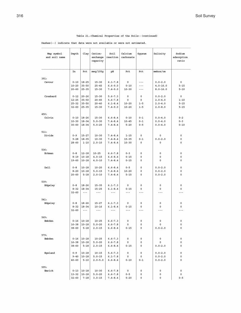
316 Soil Survey
Table 21.—Chemical Properties of the Soils--(continued)
Dashes(--) indicate that data were not available or were not estimated._____________________________________________________________________________________________________
Map symbol Depth Clay Cation- Soil Calcium Gypsum Salinity Sodium and soil name exchange reaction carbonate adsorption capacity ratio
_____________________________________________________________________________________________________ In Pct meq/100g pH Pct Pct mmhos/cm
391: Cavour 0-10 18-25 15-30 6.1-7.8 0 --- 0.0-2.0 0 10-20 35-50 25-45 6.6-9.0 0-10 --- 4.0-16.0 5-15 20-60 25-35 15-30 7.4-9.0 10-30 --- 8.0-16.0 5-10
Cresbard 0-12 20-26 15-30 5.6-7.3 0 0 0.0-2.0 0 12-25 35-50 20-45 5.6-7.8 0 0 2.0-4.0 1-10 25-32 35-50 20-40 6.1-8.4 10-20 1-5 2.0-4.0 5-15 32-60 25-35 15-30 7.4-9.0 10-20 1-5 2.0-8.0 5-15
450: Colvin 0-10 18-26 15-30 6.6-8.4 0-10 0-1 0.0-4.0 0-2 10-30 18-34 5.0-30 7.4-8.4 10-45 0-1 0.0-4.0 0-3 30-60 18-34 5.0-20 7.4-8.4 5-20 0-5 0.0-4.0 0-10
511: Divide 0-9 15-27 10-30 7.4-8.4 1-15 0 0 0 9-28 18-35 10-30 7.4-8.4 15-35 0-1 0.0-2.0 0 28-60 1-10 2.0-10 7.4-8.4 10-30 0 0 0
536: Eckman 0-8 12-18 10-25 6.6-7.8 0-3 0 0 0 8-19 10-18 4.0-15 6.6-8.4 0-15 0 0 0 19-60 10-18 4.0-10 7.4-8.4 0-15 0 0 0
Zell 0-8 10-18 10-20 6.6-8.4 0-5 0 0.0-2.0 0 8-20 10-18 5.0-15 7.4-8.4 10-20 0 0.0-2.0 0 20-60 5-18 2.0-10 7.4-8.4 5-15 0 0.0-2.0 0
539: Edgeley 0-8 18-26 15-35 6.1-7.3 0 0 0 0 8-32 18-34 15-25 6.1-8.4 0-15 0 0 0 32-60 --- --- --- --- --- --- ---
541: Edgeley 0-8 18-26 15-27 6.1-7.3 0 0 0 0 8-32 18-34 10-16 6.1-8.4 0-15 0 0 0 32-60 --- --- --- --- --- --- ---
569: Embden 0-16 10-18 10-25 6.6-7.3 0 0 0 0 16-38 10-18 5.0-20 6.6-7.8 0 0 0 0 38-60 5-18 2.0-15 6.6-8.4 0-15 0 0.0-2.0 0
579: Embden 0-16 10-18 10-25 6.6-7.3 0 0 0 0 16-38 10-18 5.0-20 6.6-7.8 0 0 0 0 38-60 5-18 2.0-15 6.6-8.4 0-15 0 0.0-2.0 0
Egeland 0-9 10-18 10-15 5.6-7.3 0 0 0.0-2.0 0 9-40 10-18 5.0-15 6.1-7.8 0 0 0.0-2.0 0 40-60 5-10 2.0-5.0 6.6-8.4 0-10 0-1 0.0-2.0 0
595: Emrick 0-13 10-18 10-30 6.6-7.8 0 0 0 0 13-32 10-18 5.0-20 6.6-7.8 0-5 0 0 0 32-60 7-18 3.0-15 7.4-8.4 5-20 0 0 0-5

Griggs County, North Dakota 317
Table 21.—Chemical Properties of the Soils--(continued)
Dashes(--) indicate that data were not available or were not estimated._____________________________________________________________________________________________________
Map symbol Depth Clay Cation- Soil Calcium Gypsum Salinity Sodium and soil name exchange reaction carbonate adsorption capacity ratio
____________________________________________________________________________________________________ In Pct meq/100g pH Pct Pct mmhos/cm
595:(con’t) Cathay 0-10 10-27 10-25 6.1-7.8 0 --- 0.0-2.0 0 10-22 18-35 10-25 6.6-8.4 0 --- 4.0-8.0 1-10 22-60 7-18 3.0-10 7.4-9.0 5-20 --- 4.0-8.0 5-15
597: Emrick 0-13 10-18 10-30 6.6-7.8 0 0 0 0 13-32 10-18 5.0-20 6.6-7.8 0-5 0 0 0 32-60 7-18 3.0-15 7.4-8.4 5-20 0 0 0-5
Heimdal 0-7 10-20 20-30 6.1-7.3 0 0 0 0 7-14 10-18 10-25 6.1-7.8 0-5 0 0 0-1 14-60 7-18 5.0-20 7.4-8.4 5-20 0 0 0-5
605: Esmond 0-8 10-18 5.0-15 7.4-8.4 0 --- 0 0 8-60 7-18 3.0-15 7.4-8.4 5-20 --- 0 0
Heimdal 0-7 10-20 20-30 6.1-7.3 0 0 0 0 7-14 10-18 10-25 6.1-7.8 0-5 0 0 0-1 14-60 7-18 5.0-20 7.4-8.4 5-20 0 0 0-5
753: Fram 0-18 10-18 10-25 7.4-8.4 0-25 --- 0 --- 18-60 7-18 5.0-20 7.4-8.4 15-30 --- 0 ---
Wyard 0-15 18-27 15-30 6.6-7.8 0 0 0 0 15-21 18-27 15-25 6.6-7.8 0 0 0 0 21-35 18-35 10-25 7.4-8.4 10-25 0 0 0 35-60 15-35 5.0-20 7.4-8.4 10-20 0 0 0
769: Gardena 0-18 12-18 10-25 6.6-7.8 0-3 0 0 0 18-60 10-18 5.0-15 7.4-8.4 0-15 0-2 0.0-2.0 0-2
773: Gardena 0-18 12-18 10-25 6.6-7.8 0-3 0 0 0 18-60 10-18 5.0-15 7.4-8.4 0-15 0-2 0.0-2.0 0-2
Eckman 0-8 12-18 10-25 6.6-7.8 0-3 0 0 0 8-19 10-18 4.0-15 6.6-8.4 0-15 0 0 0 19-60 10-18 4.0-10 7.4-8.4 0-15 0 0 0
881: Hamerly 0-10 18-27 15-30 6.6-8.4 1-10 0 0.0-2.0 0 10-29 18-35 10-20 7.4-8.4 10-30 0-2 0.0-4.0 0-2 29-60 18-35 10-20 7.4-8.4 5-25 0-2 0.0-4.0 0-2
Tonka 0-17 18-27 20-40 5.6-7.8 0 0 0 0 17-40 35-45 25-40 5.6-7.8 0-1 0-1 0.0-2.0 0-1 40-60 18-39 10-35 6.6-8.4 5-20 0-2 0.0-4.0 0-2
884: Hamerly 0-10 18-27 15-30 6.6-8.4 1-10 0 0.0-2.0 0 10-29 18-35 10-20 7.4-8.4 10-30 0-2 0.0-4.0 0-2 29-60 18-35 10-20 7.4-8.4 5-25 0-2 0.0-4.0 0-2

318 Soil Survey
Table 21.—Chemical Properties of the Soils--(continued)
Dashes(--) indicate that data were not available or were not estimated._____________________________________________________________________________________________________
Map symbol Depth Clay Cation- Soil Calcium Gypsum Salinity Sodium and soil name exchange reaction carbonate adsorption capacity ratio
_____________________________________________________________________________________________________ In Pct meq/100g pH Pct Pct mmhos/cm
884:(con’t) Wyard 0-15 18-27 15-30 6.6-7.8 0 0 0 0 15-21 18-27 15-25 6.6-7.8 0 0 0 0 21-35 18-35 10-25 7.4-8.4 10-25 0 0 0 35-60 15-35 5.0-20 7.4-8.4 10-20 0 0 0
893: Harriet 0-2 12-25 13-30 6.6-8.4 0 0 0.0-2.0 0 2-10 35-50 17-45 7.4-9.0 1-45 0-5 4.0-16.0 13-25 10-60 18-40 10-35 7.9-9.0 10-45 0-5 4.0-16.0 5-20
988: Heimdal 0-7 10-20 10-20 6.1-7.3 0 0 0 0 7-14 10-18 5.0-20 6.1-7.8 0-5 0 0 0-1 14-60 7-18 3.0-15 7.4-8.4 5-20 0 0 0-5
Emrick 0-13 10-18 10-30 6.6-7.8 0 0 0 0 13-32 10-18 5.0-20 6.6-7.8 0-5 0 0 0 32-60 7-18 3.0-15 7.4-8.4 5-20 0 0 0-5
998: Heimdal 0-7 10-20 10-20 6.1-7.3 0 0 0 0 7-14 10-18 5.0-20 6.1-7.8 0-5 0 0 0-1 14-60 7-18 3.0-15 7.4-8.4 5-20 0 0 0-5
Esmond 0-8 10-18 5.0-15 7.4-8.4 0 --- 0 --- 8-60 7-18 3.0-15 7.4-8.4 5-20 --- 0 ---
1001: Heimdal 0-7 10-20 10-20 6.1-7.3 0 0 0 0 7-14 10-18 5.0-20 6.1-7.8 0-5 0 0 0-1 14-60 7-18 3.0-15 7.4-8.4 5-20 0 0 0-5
Esmond 0-8 10-18 5.0-15 7.4-8.4 0 --- 0 0 8-60 7-18 3.0-15 7.4-8.4 5-20 --- 0 0
1015: Kensal 0-9 18-25 15-30 6.6-7.3 0 --- 0 0 9-23 18-25 10-25 6.6-7.3 0-15 --- 0 0 23-60 0-10 0.0-5.0 7.4-8.4 5-20 --- 0 0
1062: LaDelle 0-23 27-35 20-35 6.6-7.8 0 --- 0 0 23-43 27-35 15-30 7.4-8.4 4-25 --- 0.0-4.0 --- 43-60 25-35 10-25 7.4-8.4 4-15 0-2 0.0-4.0 0-1
1108: Larson 0-8 10-27 10-25 6.1-7.3 0 0 0.0-2.0 0 8-21 18-35 10-25 7.4-9.0 1-10 0-2 4.0-16.0 5-15 21-60 10-35 5.0-20 7.9-9.0 10-35 0-4 2.0-8.0 5-10
Cathay 0-10 10-27 10-25 6.1-7.8 0 --- 0.0-2.0 0 10-22 18-35 10-25 6.6-8.4 0 --- 4.0-8.0 1-10 22-60 7-18 3.0-10 7.4-9.0 5-20 --- 4.0-8.0 5-15
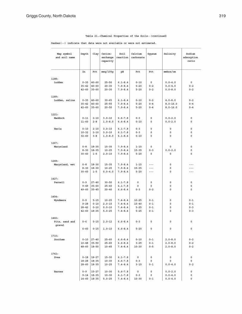
Griggs County, North Dakota 319
Table 21.—Chemical Properties of the Soils--(continued)
Dashes(--) indicate that data were not available or were not estimated._____________________________________________________________________________________________________
Map symbol Depth Clay Cation- Soil Calcium Gypsum Salinity Sodium and soil name exchange reaction carbonate adsorption capacity ratio
_____________________________________________________________________________________________________ In Pct meq/100g pH Pct Pct mmhos/cm
1188: Ludden 0-35 40-60 25-50 6.1-8.4 0-10 0 0.0-4.0 0 35-42 40-60 20-30 7.9-8.4 5-20 0-2 0.0-4.0 0-2 42-60 35-60 20-30 7.9-8.4 5-20 0-2 0.0-8.0 0-2
1189: Ludden, saline 0-35 40-60 30-65 6.1-8.4 0-10 0-2 4.0-8.0 0-2 35-42 40-60 25-55 7.9-8.4 5-20 0-4 8.0-16.0 0-4 42-60 35-60 20-50 7.9-8.4 5-20 0-4 8.0-16.0 0-4
1221: Maddock 0-11 2-10 3.0-10 6.6-7.8 0-3 0 0.0-2.0 0 11-60 2-8 1.0-8.0 6.6-8.4 0-10 0 0.0-2.0 0
Hecla 0-10 2-10 3.0-10 6.1-7.8 0-3 0 0 0 10-32 2-10 3.0-10 6.1-7.8 0-3 0 0 0 32-60 3-8 1.0-8.0 6.1-8.4 0-10 0 0 0
1267: Marysland 0-8 18-35 15-35 7.9-8.4 1-15 0 0 0 8-30 18-35 10-25 7.9-8.4 15-35 0-3 0.0-2.0 0 30-60 1-5 2.0-10 7.9-8.4 5-20 0 0 0
1268: Marysland, wet 0-8 18-30 15-35 7.9-8.4 1-15 --- 0 --- 8-30 18-30 10-25 7.9-8.4 15-35 --- 0 --- 30-60 1-5 0.0-4.0 7.9-8.4 5-20 --- 0 ---
1427: Parnell 0-9 27-40 30-50 6.1-7.8 0 0 0 0 9-49 35-60 25-60 6.1-7.8 0 0 0 0 49-60 35-45 20-40 6.6-8.4 0-3 0-2 0 0
1454: Wyndmere 0-9 5-15 10-25 7.4-8.4 10-25 0-1 0 0-1 9-28 0-10 2.0-15 7.4-8.4 15-40 0-1 0 0-1 28-42 0-10 0.0-10 7.4-8.4 5-25 0-1 0 0-3 42-60 18-35 5.0-25 7.4-8.4 5-25 0-1 0 0-3
1466: Pits, sand and 0-6 5-15 2.0-12 6.6-8.4 0-3 0 0 0 gravel 6-60 0-15 1.0-10 6.6-8.4 5-20 0 0 0
1710: Southam 0-10 27-40 25-60 6.6-8.4 0-10 0-1 2.0-8.0 0-2 10-48 35-50 25-60 6.6-8.4 3-25 0-1 2.0-8.0 0-2 48-60 18-50 10-45 7.4-8.4 10-30 0-5 2.0-8.0 0-2
1762: Svea 0-18 18-27 15-30 6.1-7.8 0 0 0 0 18-28 18-35 10-30 6.6-7.8 0-3 0 0 0 28-60 18-35 10-25 7.4-8.4 3-15 0-1 0.0-4.0 0-2
Barnes 0-9 15-27 10-30 5.6-7.8 0 0 0.0-2.0 0 9-14 18-35 10-30 6.1-7.8 0-3 0 0.0-4.0 0 14-60 18-35 5.0-25 7.4-8.4 10-30 0-1 0.0-4.0 0

320 Soil Survey
Table 21.—Chemical Properties of the Soils--(continued)
Dashes(--) indicate that data were not available or were not estimated._____________________________________________________________________________________________________
Map symbol Depth Clay Cation- Soil Calcium Gypsum Salinity Sodium and soil name exchange reaction carbonate adsorption capacity ratio
_____________________________________________________________________________________________________ In Pct meq/100g pH Pct Pct mmhos/cm
1765: Svea 0-18 18-27 15-30 6.1-7.8 0 0 0 0 18-28 18-35 10-30 6.6-7.8 0-3 0 0 0 28-60 18-35 10-25 7.4-8.4 3-15 0-1 0.0-4.0 0-2
Buse 0-7 18-27 10-30 6.6-8.4 1-10 0 0 0 7-60 18-35 5.0-25 7.4-8.4 10-30 0-1 0.0-4.0 0-2
1766: Svea 0-18 18-27 15-30 6.1-7.8 0 0 0 0 18-28 18-35 10-30 6.6-7.8 0-3 0 0 0 28-60 18-35 10-25 7.4-8.4 3-15 0-1 0.0-4.0 0-2
Buse 0-7 18-27 10-30 6.6-8.4 1-10 0 0 0 7-60 18-35 5.0-25 7.4-8.4 10-30 0-1 0.0-4.0 0-2
1769: Svea 0-18 18-27 15-30 6.1-7.8 0 0 0 0 18-28 18-35 10-30 6.6-7.8 0-3 0 0 0 28-60 18-35 10-25 7.4-8.4 3-15 0-1 0.0-4.0 0-2
Cresbard 0-12 20-26 15-30 5.6-7.3 0 0 0.0-2.0 0 12-25 35-50 20-45 5.6-7.8 0 0 2.0-4.0 1-10 25-32 35-50 20-40 6.1-8.4 10-20 1-5 2.0-4.0 5-15 32-60 25-35 15-30 7.4-9.0 10-20 1-5 2.0-8.0 5-15
1781: Swenoda 0-13 10-20 10-25 6.1-7.3 0 0 0.0-2.0 0 13-33 10-18 5.0-15 6.6-7.8 0 0 0.0-2.0 0 33-60 20-35 2.0-25 7.4-8.4 10-30 0-1 0.0-4.0 0-2
1843: Towner 0-16 2-10 3.0-10 6.6-7.8 0 0 0 0 16-35 2-10 1.0-10 6.6-7.8 0 0 0 0 35-60 18-40 5.0-25 7.4-8.4 10-30 0-2 0.0-2.0 0
1883: Vallers 0-12 18-27 20-40 7.4-8.4 5-10 0-1 0.0-4.0 0 12-32 18-35 10-30 7.4-8.4 15-30 0-2 0.0-4.0 0-5 32-60 18-35 10-20 7.4-8.4 15-30 0-2 0.0-4.0 0-10
Parnell 0-9 27-40 30-50 6.1-7.8 0 0 0 0 9-49 35-60 25-60 6.1-7.8 0 0 0 0 49-60 35-45 20-40 6.6-8.4 0-3 0-2 0 0
1886: Hamerly, saline 0-10 18-27 15-30 7.4-8.4 1-15 0-3 4.0-16.0 0 10-29 18-35 10-30 7.4-8.4 15-35 0-5 4.0-16.0 0-2 29-60 18-35 10-25 7.4-8.4 10-30 0-5 4.0-16.0 0-4
Vallers, saline 0-12 18-27 15-30 7.4-8.4 5-10 0-1 4.0-16.0 0-3 12-32 18-35 10-25 7.4-8.4 15-35 0-3 4.0-16.0 0-5 32-60 18-35 10-20 7.4-8.4 15-30 0-3 4.0-16.0 0-10
1970: Walum 0-16 8-18 5.0-15 6.6-7.3 0 --- 0 --- 16-30 5-18 2.0-15 6.6-7.3 0-15 --- 0 --- 30-60 0-10 0.0-5.0 7.4-8.4 5-20 --- 0 ---

Griggs County, North Dakota 321
Table 21.—Chemical Properties of the Soils--(continued)
Dashes(--) indicate that data were not available or were not estimated._____________________________________________________________________________________________________
Map symbol Depth Clay Cation- Soil Calcium Gypsum Salinity Sodium and soil name exchange reaction carbonate adsorption capacity ratio
_____________________________________________________________________________________________________ In Pct meq/100g pH Pct Pct mmhos/cm
1978: Water --- --- --- --- --- --- --- ---
2118: Fram 0-18 10-18 10-25 7.4-8.4 0-25 --- 0 --- 18-60 7-18 5.0-20 7.4-8.4 15-30 --- 0 ---
Tonka 0-17 18-27 20-40 5.6-7.8 0 0 0 0 17-40 35-45 25-40 5.6-7.8 0-1 0-1 0.0-2.0 0-1 40-60 18-39 10-35 6.6-8.4 5-20 0-2 0.0-4.0 0-2
2121: Ferney 0-5 18-26 15-35 6.1-7.3 0 0 0.0-2.0 0-3 5-13 35-50 20-45 6.6-8.4 0-1 1-3 4.0-16.0 16-21 13-60 35-45 20-40 7.4-9.0 2-15 1-5 8.0-16.0 8-16
2151: Binford 0-8 6-18 5.0-20 5.6-7.8 0 0 0 0 8-17 6-18 5.0-15 5.6-8.4 0-1 0 0 0 17-60 2-8 1.0-5.0 7.4-8.4 5-20 0 0 0
Coe 0-8 6-18 5.0-15 6.6-7.8 0-5 0 0 0 8-60 2-8 1.0-5.0 7.4-8.4 5-20 0 0 0
2152: Coe 0-8 6-18 5.0-15 6.6-7.8 0-5 0 0 0 8-60 2-8 1.0-5.0 7.4-8.4 5-20 0 0 0
Binford 0-8 6-18 5.0-20 5.6-7.8 0 0 0 0 8-17 6-18 5.0-15 5.6-8.4 0-1 0 0 0 17-60 2-8 1.0-5.0 7.4-8.4 5-20 0 0 0
2153: Edgeley 0-8 18-26 15-27 6.1-7.3 0 0 0 0 8-26 18-34 10-16 6.1-8.4 0-15 0 0 0 26-60 --- --- --- --- --- --- ---
Kloten 0-9 18-26 15-25 6.1-8.4 0-5 0 0 0 9-60 --- 10-25 --- --- --- --- ---
Esmond 0-8 10-18 --- 7.4-8.4 --- --- 0 --- 8-60 7-18 --- 7.4-8.4 --- --- 0 ---
2156: Lamoure 0-9 20-26 22-29 7.4-8.4 0-10 0 0.0-4.0 1-2 9-30 20-34 24-31 7.4-8.4 9-20 0 0.0-4.0 1-3 30-60 20-34 20-29 7.4-8.4 9-20 0-1 0.0-4.0 1-3
Rauville 0-28 15-26 15-35 7.4-8.4 5-15 0 0.0-2.0 1-2 28-60 20-45 20-35 7.4-8.4 10-20 0-1 0.0-4.0 1-3
2157: Maddock 0-11 2-10 3.0-10 6.6-7.8 0-3 0 0.0-2.0 0 11-60 2-8 1.0-8.0 6.6-8.4 0-10 0 0.0-2.0 0
Esmond 0-8 10-18 --- 7.4-8.4 --- --- 0 --- 8-60 7-18 --- 7.4-8.4 --- --- 0 ---
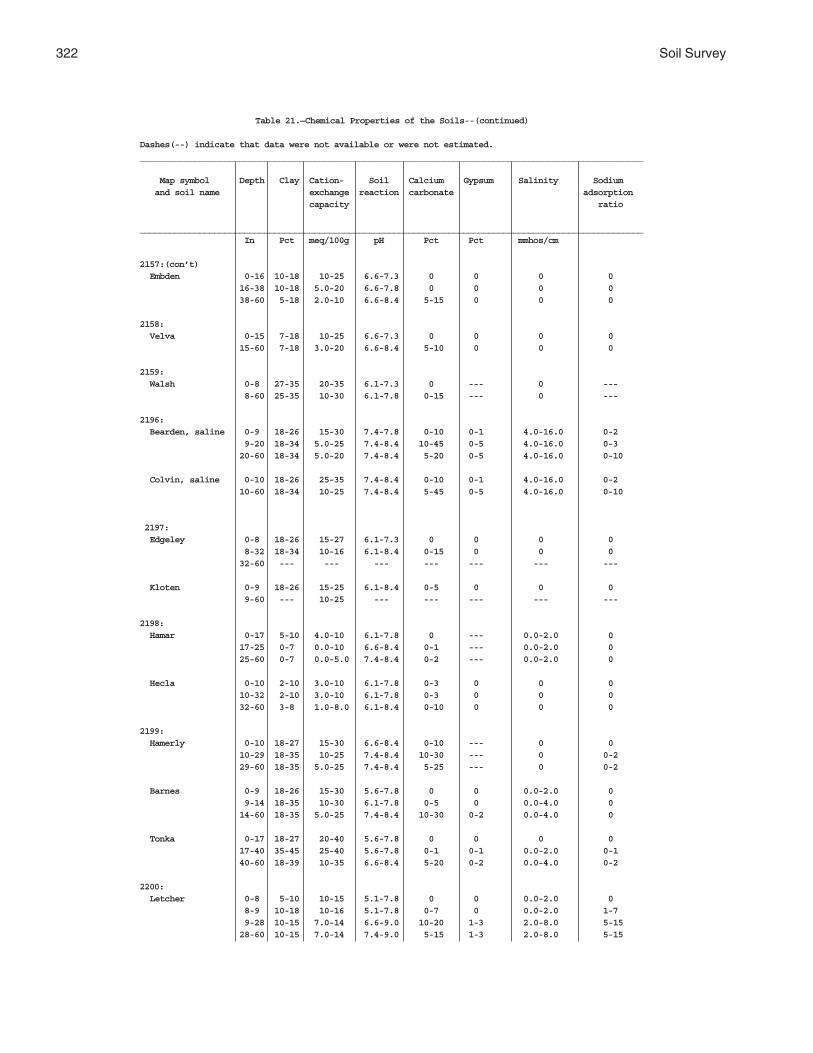
322 Soil Survey
Table 21.—Chemical Properties of the Soils--(continued)
Dashes(--) indicate that data were not available or were not estimated._____________________________________________________________________________________________________
Map symbol Depth Clay Cation- Soil Calcium Gypsum Salinity Sodium and soil name exchange reaction carbonate adsorption capacity ratio
_____________________________________________________________________________________________________ In Pct meq/100g pH Pct Pct mmhos/cm
2157:(con’t) Embden 0-16 10-18 10-25 6.6-7.3 0 0 0 0 16-38 10-18 5.0-20 6.6-7.8 0 0 0 0 38-60 5-18 2.0-10 6.6-8.4 5-15 0 0 0
2158: Velva 0-15 7-18 10-25 6.6-7.3 0 0 0 0 15-60 7-18 3.0-20 6.6-8.4 5-10 0 0 0
2159: Walsh 0-8 27-35 20-35 6.1-7.3 0 --- 0 --- 8-60 25-35 10-30 6.1-7.8 0-15 --- 0 ---
2196: Bearden, saline 0-9 18-26 15-30 7.4-7.8 0-10 0-1 4.0-16.0 0-2 9-20 18-34 5.0-25 7.4-8.4 10-45 0-5 4.0-16.0 0-3 20-60 18-34 5.0-20 7.4-8.4 5-20 0-5 4.0-16.0 0-10
Colvin, saline 0-10 18-26 25-35 7.4-8.4 0-10 0-1 4.0-16.0 0-2 10-60 18-34 10-25 7.4-8.4 5-45 0-5 4.0-16.0 0-10
2197: Edgeley 0-8 18-26 15-27 6.1-7.3 0 0 0 0 8-32 18-34 10-16 6.1-8.4 0-15 0 0 0 32-60 --- --- --- --- --- --- ---
Kloten 0-9 18-26 15-25 6.1-8.4 0-5 0 0 0 9-60 --- 10-25 --- --- --- --- ---
2198: Hamar 0-17 5-10 4.0-10 6.1-7.8 0 --- 0.0-2.0 0 17-25 0-7 0.0-10 6.6-8.4 0-1 --- 0.0-2.0 0 25-60 0-7 0.0-5.0 7.4-8.4 0-2 --- 0.0-2.0 0
Hecla 0-10 2-10 3.0-10 6.1-7.8 0-3 0 0 0 10-32 2-10 3.0-10 6.1-7.8 0-3 0 0 0 32-60 3-8 1.0-8.0 6.1-8.4 0-10 0 0 0
2199: Hamerly 0-10 18-27 15-30 6.6-8.4 0-10 --- 0 0 10-29 18-35 10-25 7.4-8.4 10-30 --- 0 0-2 29-60 18-35 5.0-25 7.4-8.4 5-25 --- 0 0-2
Barnes 0-9 18-26 15-30 5.6-7.8 0 0 0.0-2.0 0 9-14 18-35 10-30 6.1-7.8 0-5 0 0.0-4.0 0 14-60 18-35 5.0-25 7.4-8.4 10-30 0-2 0.0-4.0 0
Tonka 0-17 18-27 20-40 5.6-7.8 0 0 0 0 17-40 35-45 25-40 5.6-7.8 0-1 0-1 0.0-2.0 0-1 40-60 18-39 10-35 6.6-8.4 5-20 0-2 0.0-4.0 0-2
2200: Letcher 0-8 5-10 10-15 5.1-7.8 0 0 0.0-2.0 0 8-9 10-18 10-16 5.1-7.8 0-7 0 0.0-2.0 1-7 9-28 10-15 7.0-14 6.6-9.0 10-20 1-3 2.0-8.0 5-15 28-60 10-15 7.0-14 7.4-9.0 5-15 1-3 2.0-8.0 5-15

Griggs County, North Dakota 323
Table 21.—Chemical Properties of the Soils--(continued)
Dashes(--) indicate that data were not available or were not estimated._____________________________________________________________________________________________________
Map symbol Depth Clay Cation- Soil Calcium Gypsum Salinity Sodium and soil name exchange reaction carbonate adsorption capacity ratio
_____________________________________________________________________________________________________ In Pct meq/100g pH Pct Pct mmhos/cm
2200:(con’t) Swenoda 0-13 10-20 10-25 6.1-7.3 0 0 0.0-2.0 0 13-33 10-18 5.0-15 6.6-7.8 0 0 0.0-2.0 0 33-60 20-35 2.0-25 7.4-8.4 10-30 0-1 0.0-4.0 0-2
2201: Stirum 0-8 10-20 10-25 7.4-8.4 1-10 0 2.0-8.0 0-2 8-23 10-25 5.0-20 7.9-9.0 10-45 0-2 2.0-16.0 5-15 23-60 5-20 2.0-15 7.9-9.0 10-45 0-4 2.0-16.0 5-10
Arveson, saline 0-9 10-20 15-30 7.4-8.4 5-20 0 4.0-16.0 0 9-39 10-27 5.0-25 7.4-8.4 15-30 0-2 4.0-16.0 0 39-60 5-20 2.0-25 7.4-8.4 10-20 0-4 4.0-16.0 0-1
2202: Swenoda 0-7 10-20 10-25 6.1-7.3 0 0 0.0-2.0 0 7-19 10-18 5.0-15 6.6-7.8 0 0 0.0-2.0 0 19-37 20-35 2.0-25 7.4-8.4 10-30 0-1 0.0-4.0 0-2 37-60 20-35 2.0-25 7.4-8.4 10-30 0-1 0.0-4.0 0-2
Barnes 0-7 10-20 10-25 5.6-7.8 0 --- 0.0-2.0 0 7-19 18-35 10-30 6.1-7.8 0-3 --- 0.0-4.0 0 19-37 18-35 5.0-25 7.4-8.4 10-30 --- 0.0-4.0 0 37-60 18-35 5.0-20 7.4-8.4 10-30 --- 0.0-4.0 0
2203: Swenoda 0-13 10-20 10-25 6.1-7.3 0 0 0.0-2.0 0 13-33 10-18 5.0-15 6.6-7.8 0 0 0.0-2.0 0 33-60 20-35 2.0-25 7.4-8.4 10-30 0-1 0.0-4.0 0-2
Barnes 0-9 10-20 10-25 5.6-7.8 0 --- 0.0-2.0 0 9-14 18-35 10-30 6.1-7.8 0-3 --- 0.0-4.0 0 14-60 18-35 5.0-25 7.4-8.4 10-30 --- 0.0-4.0 0
2204: Walsh 0-8 27-35 20-35 6.1-7.3 0 --- 0 --- 8-60 25-35 10-30 6.1-7.8 0-15 --- 0 ---
2205: Zell 0-8 10-18 10-20 6.6-8.4 0-5 0 0.0-2.0 0 8-20 10-18 5.0-15 7.4-8.4 10-20 0 0.0-2.0 0 20-60 5-18 2.0-10 7.4-8.4 5-15 0 0.0-2.0 0
Eckman 0-8 12-18 10-25 6.6-7.8 0-3 0 0 0 8-19 10-18 4.0-15 6.6-8.4 0-15 0 0 0 19-60 10-18 4.0-10 7.4-8.4 0-15 0 0 0_______________________________________________________________________________________________________

324 Soil Survey
Table 22.—Water Features
(Dashes (--) indicate that an assignment has not been made. Depths of layers are in feet)
__________________________________________________________________________________________________________________________ Water Table Ponding Flooding _________________________________________________________________________
Map symbol Hydro- Month Upper Lower Surface Duration Frequency Duration Frequency and soil name logic limit limit water
group depth__________________________________________________________________________________________________________________________
61: Arveson B/D
January 1.5-3.5 > 6.0 --- --- --- --- ---February 1.5-3.5 > 6.0 --- --- --- --- ---March 0.0-1.5 > 6.0 --- --- --- --- ---April 0.0-1.5 > 6.0 --- --- --- --- ---May 0.0-1.5 > 6.0 --- --- --- --- ---June 0.0-1.5 > 6.0 --- --- --- --- ---July 0.0-1.5 > 6.0 --- --- --- --- ---August 1.5-3.5 > 6.0 --- --- --- --- ---September 1.5-3.5 > 6.0 --- --- --- --- ---October 1.5-3.5 > 6.0 --- --- --- --- ---November 1.5-3.5 > 6.0 --- --- --- --- ---December 1.5-3.5 > 6.0 --- --- --- --- ---
118: Barnes B
April 4.0-6.0 > 6.0 --- --- --- --- ---May 4.0-6.0 > 6.0 --- --- --- --- ---June 4.0-6.0 > 6.0 --- --- --- --- ---
Buse BApril 4.0-6.0 > 6.0 --- --- --- --- ---May 4.0-6.0 > 6.0 --- --- --- --- ---June 4.0-6.0 > 6.0 --- --- --- --- ---
120: Barnes B
All months --- --- --- --- --- --- ---
Buse BAll months --- --- --- --- --- --- ---
156: Barnes B
April 4.0-6.0 > 6.0 --- --- --- --- ---May 4.0-6.0 > 6.0 --- --- --- --- ---June 4.0-6.0 > 6.0 --- --- --- --- ---
Svea BJanuary 4.0-6.0 > 6.0 --- --- --- --- ---February 4.0-6.0 > 6.0 --- --- --- --- ---March 4.0-6.0 > 6.0 --- --- --- --- ---April 3.0-5.0 > 6.0 --- --- --- --- ---May 3.0-5.0 > 6.0 --- --- --- --- ---June 3.0-5.0 > 6.0 --- --- --- --- ---July 4.0-6.0 > 6.0 --- --- --- --- ---August 4.0-6.0 > 6.0 --- --- --- --- ---September 4.0-6.0 > 6.0 --- --- --- --- ---October 4.0-6.0 > 6.0 --- --- --- --- ---November 4.0-6.0 > 6.0 --- --- --- --- ---December 4.0-6.0 > 6.0 --- --- --- --- ---
167: Bearden C
January 3.0-5.0 > 6.0 --- --- --- --- ---February 3.0-5.0 > 6.0 --- --- --- --- ---March 3.0-5.0 > 6.0 --- --- --- --- ---April 1.5-3.5 > 6.0 --- --- --- --- ---May 1.5-3.5 > 6.0 --- --- --- --- ---

Griggs County, North Dakota 325
Table 22.—Water Features--(continued)
(Dashes (--) indicate that an assignment has not been made. Depths of layers are in feet)
__________________________________________________________________________________________________________________________ Water Table Ponding Flooding _________________________________________________________________________
Map symbol Hydro- Month Upper Lower Surface Duration Frequency Duration Frequency and soil name logic limit limit water
group depth__________________________________________________________________________________________________________________________
167:(con’t) Bearden June 1.5-3.5 > 6.0 --- --- --- --- ---
July 3.0-5.0 > 6.0 --- --- --- --- ---August 3.0-5.0 > 6.0 --- --- --- --- ---September 3.0-5.0 > 6.0 --- --- --- --- ---October 3.0-5.0 > 6.0 --- --- --- --- ---November 3.0-5.0 > 6.0 --- --- --- --- ---December 3.0-5.0 > 6.0 --- --- --- --- ---
296: Brantford B
April 4.0-6.0 > 6.0 --- --- --- --- ---May 4.0-6.0 > 6.0 --- --- --- --- ---June 4.0-6.0 > 6.0 --- --- --- --- ---
314: Buse B
All months --- --- --- --- --- --- ---
Barnes BAll months --- --- --- --- --- --- ---
319: Buse B
All months --- --- --- --- --- --- ---
Barnes BAll months --- --- --- --- --- --- ---
391: Cavour D
January 4.0-6.0 > 6.0 --- --- --- --- ---February 4.0-6.0 > 6.0 --- --- --- --- ---March 4.0-6.0 > 6.0 --- --- --- --- ---April 3.0-5.0 > 6.0 --- --- --- --- ---May 3.0-5.0 > 6.0 --- --- --- --- ---June 3.0-5.0 > 6.0 --- --- --- --- ---July 4.0-6.0 > 6.0 --- --- --- --- ---August 4.0-6.0 > 6.0 --- --- --- --- ---September 4.0-6.0 > 6.0 --- --- --- --- ---October 4.0-6.0 > 6.0 --- --- --- --- ---November 4.0-6.0 > 6.0 --- --- --- --- ---December 4.0-6.0 > 6.0 --- --- --- --- ---
Cresbard CJanuary 4.0-6.0 > 6.0 --- --- --- --- ---February 4.0-6.0 > 6.0 --- --- --- --- ---March 4.0-6.0 > 6.0 --- --- --- --- ---April 3.0-5.0 > 6.0 --- --- --- --- ---May 3.0-5.0 > 6.0 --- --- --- --- ---June 3.0-5.0 > 6.0 --- --- --- --- ---July 4.0-6.0 > 6.0 --- --- --- --- ---August 4.0-6.0 > 6.0 --- --- --- --- ---September 4.0-6.0 > 6.0 --- --- --- --- ---October 4.0-6.0 > 6.0 --- --- --- --- ---November 4.0-6.0 > 6.0 --- --- --- --- ---December 4.0-6.0 > 6.0 --- --- --- --- ---

326 Soil Survey
Table 22.—Water Features--(continued)
(Dashes (--) indicate that an assignment has not been made. Depths of layers are in feet)
__________________________________________________________________________________________________________________________ Water Table Ponding Flooding _________________________________________________________________________
Map symbol Hydro- Month Upper Lower Surface Duration Frequency Duration Frequency and soil name logic limit limit water
group depth__________________________________________________________________________________________________________________________
450: Colvin C/D
January 1.5-3.5 > 6.0 --- --- --- --- ---February 1.5-3.5 > 6.0 --- --- --- --- ---March 0.0-1.5 > 6.0 --- --- --- --- ---April 0.0-1.5 > 6.0 --- --- --- --- ---May 0.0-1.5 > 6.0 --- --- --- --- ---June 0.0-1.5 > 6.0 --- --- --- --- ---July 0.0-1.5 > 6.0 --- --- --- --- ---August 1.5-3.5 > 6.0 --- --- --- --- ---September 1.5-3.5 > 6.0 --- --- --- --- ---October 1.5-3.5 > 6.0 --- --- --- --- ---November 1.5-3.5 > 6.0 --- --- --- --- ---December 1.5-3.5 > 6.0 --- --- --- --- ---
511: Divide B
January 3.0-5.0 > 6.0 --- --- --- --- ---February 3.0-5.0 > 6.0 --- --- --- --- ---March 3.0-5.0 > 6.0 --- --- --- --- ---April 1.5-3.5 > 6.0 --- --- --- --- ---May 1.5-3.5 > 6.0 --- --- --- --- ---June 1.5-3.5 > 6.0 --- --- --- --- ---July 3.0-5.0 > 6.0 --- --- --- --- ---August 3.0-5.0 > 6.0 --- --- --- --- ---September 3.0-5.0 > 6.0 --- --- --- --- ---October 3.0-5.0 > 6.0 --- --- --- --- ---November 3.0-5.0 > 6.0 --- --- --- --- ---December 3.0-5.0 > 6.0 --- --- --- --- ---
536: Eckman B
All months --- --- --- --- --- --- ---
Zell BAll months --- --- --- --- --- --- ---
539: Edgeley B
All months --- --- --- --- --- --- ---
541: Edgeley C
All months --- --- --- --- --- --- ---
569: Embden B
January 4.0-6.0 > 6.0 --- --- --- --- ---February 4.0-6.0 > 6.0 --- --- --- --- ---March 4.0-6.0 > 6.0 --- --- --- --- ---April 3.0-5.0 > 6.0 --- --- --- --- ---May 3.0-5.0 > 6.0 --- --- --- --- ---June 3.0-5.0 > 6.0 --- --- --- --- ---July 4.0-6.0 > 6.0 --- --- --- --- ---August 4.0-6.0 > 6.0 --- --- --- --- ---September 4.0-6.0 > 6.0 --- --- --- --- ---October 4.0-6.0 > 6.0 --- --- --- --- ---November 4.0-6.0 > 6.0 --- --- --- --- ---December 4.0-6.0 > 6.0 --- --- --- --- ---

Griggs County, North Dakota 327
Table 22.—Water Features--(continued)
(Dashes (--) indicate that an assignment has not been made. Depths of layers are in feet)
__________________________________________________________________________________________________________________________ Water Table Ponding Flooding _________________________________________________________________________
Map symbol Hydro- Month Upper Lower Surface Duration Frequency Duration Frequency and soil name logic limit limit water
group depth__________________________________________________________________________________________________________________________
579: Embden B
January 4.0-6.0 > 6.0 --- --- --- --- ---February 4.0-6.0 > 6.0 --- --- --- --- ---March 4.0-6.0 > 6.0 --- --- --- --- ---April 3.0-5.0 > 6.0 --- --- --- --- ---May 3.0-5.0 > 6.0 --- --- --- --- ---June 3.0-5.0 > 6.0 --- --- --- --- ---July 4.0-6.0 > 6.0 --- --- --- --- ---August 4.0-6.0 > 6.0 --- --- --- --- ---September 4.0-6.0 > 6.0 --- --- --- --- ---October 4.0-6.0 > 6.0 --- --- --- --- ---November 4.0-6.0 > 6.0 --- --- --- --- ---December 4.0-6.0 > 6.0 --- --- --- --- ---
Egeland BApril 4.0-6.0 > 6.0 --- --- --- --- ---May 4.0-6.0 > 6.0 --- --- --- --- ---June 4.0-6.0 > 6.0 --- --- --- --- ---
595: Emrick B
January 4.0-6.0 > 6.0 --- --- --- --- ---February 4.0-6.0 > 6.0 --- --- --- --- ---March 4.0-6.0 > 6.0 --- --- --- --- ---April 3.0-5.0 > 6.0 --- --- --- --- ---May 3.0-5.0 > 6.0 --- --- --- --- ---June 3.0-5.0 > 6.0 --- --- --- --- ---July 4.0-6.0 > 6.0 --- --- --- --- ---August 4.0-6.0 > 6.0 --- --- --- --- ---September 4.0-6.0 > 6.0 --- --- --- --- ---October 4.0-6.0 > 6.0 --- --- --- --- ---November 4.0-6.0 > 6.0 --- --- --- --- ---December 4.0-6.0 > 6.0 --- --- --- --- ---
Cathay CJanuary 4.0-6.0 > 6.0 --- --- --- --- ---February 4.0-6.0 > 6.0 --- --- --- --- ---March 4.0-6.0 > 6.0 --- --- --- --- ---April 3.0-5.0 > 6.0 --- --- --- --- ---May 3.0-5.0 > 6.0 --- --- --- --- ---June 3.0-5.0 > 6.0 --- --- --- --- ---July 4.0-6.0 > 6.0 --- --- --- --- ---August 4.0-6.0 > 6.0 --- --- --- --- ---September 4.0-6.0 > 6.0 --- --- --- --- ---October 4.0-6.0 > 6.0 --- --- --- --- ---November 4.0-6.0 > 6.0 --- --- --- --- ---December 4.0-6.0 > 6.0 --- --- --- --- ---
597: Emrick B
January 4.0-6.0 > 6.0 --- --- --- --- ---February 4.0-6.0 > 6.0 --- --- --- --- ---March 4.0-6.0 > 6.0 --- --- --- --- ---April 3.0-5.0 > 6.0 --- --- --- --- ---May 3.0-5.0 > 6.0 --- --- --- --- ---June 3.0-5.0 > 6.0 --- --- --- --- ---July 4.0-6.0 > 6.0 --- --- --- --- ---

328 Soil Survey
Table 22.—Water Features--(continued)
(Dashes (--) indicate that an assignment has not been made. Depths of layers are in feet)
__________________________________________________________________________________________________________________________ Water Table Ponding Flooding _________________________________________________________________________
Map symbol Hydro- Month Upper Lower Surface Duration Frequency Duration Frequency and soil name logic limit limit water
group depth__________________________________________________________________________________________________________________________
597:(con’t)
Emrick August 4.0-6.0 > 6.0 --- --- --- --- ---September 4.0-6.0 > 6.0 --- --- --- --- ---October 4.0-6.0 > 6.0 --- --- --- --- ---November 4.0-6.0 > 6.0 --- --- --- --- ---December 4.0-6.0 > 6.0 --- --- --- --- ---
Heimdal BApril 4.0-6.0 > 6.0 --- --- --- --- ---May 4.0-6.0 > 6.0 --- --- --- --- ---June 4.0-6.0 > 6.0 --- --- --- --- ---
605: Esmond B
All months --- --- --- --- --- --- ---
Heimdal BAll months --- --- --- --- --- --- ---
753: Fram B
January 3.0-5.0 > 6.0 --- --- --- --- ---February 3.0-5.0 > 6.0 --- --- --- --- ---March 3.0-5.0 > 6.0 --- --- --- --- ---April 1.5-3.5 > 6.0 --- --- --- --- ---May 1.5-3.5 > 6.0 --- --- --- --- ---June 1.5-3.5 > 6.0 --- --- --- --- ---July 3.0-5.0 > 6.0 --- --- --- --- ---August 3.0-5.0 > 6.0 --- --- --- --- ---September 3.0-5.0 > 6.0 --- --- --- --- ---October 3.0-5.0 > 6.0 --- --- --- --- ---November 3.0-5.0 > 6.0 --- --- --- --- ---December 3.0-5.0 > 6.0 --- --- --- --- ---
Wyard BJanuary 3.0-5.0 > 6.0 --- --- --- --- ---February 3.0-5.0 > 6.0 --- --- --- --- ---March 3.0-5.0 > 6.0 --- --- --- --- ---April 1.5-3.5 > 6.0 --- --- --- --- ---May 1.5-3.5 > 6.0 --- --- --- --- ---June 1.5-3.5 > 6.0 --- --- --- --- ---July 3.0-5.0 > 6.0 --- --- --- --- ---August 3.0-5.0 > 6.0 --- --- --- --- ---September 3.0-5.0 > 6.0 --- --- --- --- ---October 3.0-5.0 > 6.0 --- --- --- --- ---November 3.0-5.0 > 6.0 --- --- --- --- ---December 3.0-5.0 > 6.0 --- --- --- --- ---
769: Gardena B
January 4.0-6.0 > 6.0 --- --- --- --- ---February 4.0-6.0 > 6.0 --- --- --- --- ---March 4.0-6.0 > 6.0 --- --- --- --- ---April 3.0-5.0 > 6.0 --- --- --- --- ---May 3.0-5.0 > 6.0 --- --- --- --- ---June 3.0-5.0 > 6.0 --- --- --- --- ---July 4.0-6.0 > 6.0 --- --- --- --- ---August 4.0-6.0 > 6.0 --- --- --- --- ---

Griggs County, North Dakota 329
Table 22.—Water Features--(continued)
(Dashes (--) indicate that an assignment has not been made. Depths of layers are in feet)
__________________________________________________________________________________________________________________________ Water Table Ponding Flooding _________________________________________________________________________
Map symbol Hydro- Month Upper Lower Surface Duration Frequency Duration Frequency and soil name logic limit limit water
group depth__________________________________________________________________________________________________________________________
769:(con’t) Gardena September 4.0-6.0 > 6.0 --- --- --- --- ---
October 4.0-6.0 > 6.0 --- --- --- --- ---November 4.0-6.0 > 6.0 --- --- --- --- ---December 4.0-6.0 > 6.0 --- --- --- --- ---
773: Gardena B
January 4.0-6.0 > 6.0 --- --- --- --- ---February 4.0-6.0 > 6.0 --- --- --- --- ---March 4.0-6.0 > 6.0 --- --- --- --- ---April 3.0-5.0 > 6.0 --- --- --- --- ---May 3.0-5.0 > 6.0 --- --- --- --- ---June 3.0-5.0 > 6.0 --- --- --- --- ---July 4.0-6.0 > 6.0 --- --- --- --- ---August 4.0-6.0 > 6.0 --- --- --- --- ---September 4.0-6.0 > 6.0 --- --- --- --- ---October 4.0-6.0 > 6.0 --- --- --- --- ---November 4.0-6.0 > 6.0 --- --- --- --- ---December 4.0-6.0 > 6.0 --- --- --- --- ---
Eckman BApril 4.0-6.0 > 6.0 --- --- --- --- ---May 4.0-6.0 > 6.0 --- --- --- --- ---June 4.0-6.0 > 6.0 --- --- --- --- ---
881: Hamerly C
January 3.0-5.0 > 6.0 --- --- --- --- ---February 3.0-5.0 > 6.0 --- --- --- --- ---March 3.0-5.0 > 6.0 --- --- --- --- ---April 1.5-3.5 > 6.0 --- --- --- --- ---May 1.5-3.5 > 6.0 --- --- --- --- ---June 1.5-3.5 > 6.0 --- --- --- --- ---July 3.0-5.0 > 6.0 --- --- --- --- ---August 3.0-5.0 > 6.0 --- --- --- --- ---September 3.0-5.0 > 6.0 --- --- --- --- ---October 3.0-5.0 > 6.0 --- --- --- --- ---November 3.0-5.0 > 6.0 --- --- --- --- ---December 3.0-5.0 > 6.0 --- --- --- --- ---
Tonka C/DJanuary 1.5-3.5 > 6.0 --- --- --- --- ---February 1.5-3.5 > 6.0 --- --- --- --- ---March1 0-0 1.0-1.5 0.0-1.0 Very long --- --- --- 1.5-2.0 >6.0April1 0-0 1.0-1.5 0.0-1.0 Very long --- --- ---
1.5-2.0 >6.0May 0.0-1.5 > 6.0 0.0-1.0 Very long --- --- ---June 0.0-1.5 > 6.0 0.0-1.0 Very long --- --- ---July 0.0-1.5 > 6.0 --- --- --- --- ---August 3.0-5.0 > 6.0 --- --- --- --- ---September 1.5-3.5 > 6.0 --- --- --- --- ---October 1.5-3.5 > 6.0 --- --- --- --- ---November 1.5-3.5 > 6.0 --- --- --- --- ---December 1.5-3.5 > 6.0 --- --- --- --- ---

330 Soil Survey
Table 22.—Water Features--(continued)
(Dashes (--) indicate that an assignment has not been made. Depths of layers are in feet)
__________________________________________________________________________________________________________________________ Water Table Ponding Flooding _________________________________________________________________________
Map symbol Hydro- Month Upper Lower Surface Duration Frequency Duration Frequency and soil name logic limit limit water
group depth__________________________________________________________________________________________________________________________
884: Hamerly C
January 3.0-5.0 > 6.0 --- --- --- --- ---February 3.0-5.0 > 6.0 --- --- --- --- ---March 3.0-5.0 > 6.0 --- --- --- --- ---April 1.5-3.5 > 6.0 --- --- --- --- ---May 1.5-3.5 > 6.0 --- --- --- --- ---June 1.5-3.5 > 6.0 --- --- --- --- ---July 3.0-5.0 > 6.0 --- --- --- --- ---August 3.0-5.0 > 6.0 --- --- --- --- ---September 3.0-5.0 > 6.0 --- --- --- --- ---October 3.0-5.0 > 6.0 --- --- --- --- ---November 3.0-5.0 > 6.0 --- --- --- --- ---December 3.0-5.0 > 6.0 --- --- --- --- ---
Wyard BJanuary 3.0-5.0 > 6.0 --- --- --- --- ---February 3.0-5.0 > 6.0 --- --- --- --- ---March 3.0-5.0 > 6.0 --- --- --- --- ---April 1.5-3.5 > 6.0 --- --- --- --- ---May 1.5-3.5 > 6.0 --- --- --- --- ---June 1.5-3.5 > 6.0 --- --- --- --- ---July 3.0-5.0 > 6.0 --- --- --- --- ---August 3.0-5.0 > 6.0 --- --- --- --- ---September 3.0-5.0 > 6.0 --- --- --- --- ---October 3.0-5.0 > 6.0 --- --- --- --- ---November 3.0-5.0 > 6.0 --- --- --- --- ---December 3.0-5.0 > 6.0 --- --- --- --- ---
893: Harriet D
January 1.5-3.5 > 6.0 --- --- --- --- ---February 1.5-3.5 > 6.0 --- --- --- --- ---March 0.0-1.5 > 6.0 --- --- --- --- ---April 0.0-1.5 > 6.0 --- --- --- Long OccasionalMay 0.0-1.5 > 6.0 --- --- --- Long OccasionalJune 0.0-1.5 > 6.0 --- --- --- Long OccasionalJuly 0.0-1.5 > 6.0 --- --- --- --- ---August 1.5-3.5 > 6.0 --- --- --- --- ---September 1.5-3.5 > 6.0 --- --- --- --- ---October 1.5-3.5 > 6.0 --- --- --- --- ---November 1.5-3.5 > 6.0 --- --- --- --- ---December 1.5-3.5 > 6.0 --- --- --- --- ---
988: Heimdal B
April 4.0-6.0 > 6.0 --- --- --- --- ---May 4.0-6.0 > 6.0 --- --- --- --- ---June 4.0-6.0 > 6.0 --- --- --- --- ---
Emrick BJanuary 4.0-6.0 > 6.0 --- --- --- --- ---February 4.0-6.0 > 6.0 --- --- --- --- ---March 4.0-6.0 > 6.0 --- --- --- --- ---April 3.0-5.0 > 6.0 --- --- --- --- ---May 3.0-5.0 > 6.0 --- --- --- --- ---June 3.0-5.0 > 6.0 --- --- --- --- ---July 4.0-6.0 > 6.0 --- --- --- --- ---

Griggs County, North Dakota 331
Table 22.—Water Features--(continued)
(Dashes (--) indicate that an assignment has not been made. Depths of layers are in feet)
__________________________________________________________________________________________________________________________ Water Table Ponding Flooding _________________________________________________________________________
Map symbol Hydro- Month Upper Lower Surface Duration Frequency Duration Frequency and soil name logic limit limit water
group depth__________________________________________________________________________________________________________________________
988:(con’t) Emrick August 4.0-6.0 > 6.0 --- --- --- --- ---
September 4.0-6.0 > 6.0 --- --- --- --- ---October 4.0-6.0 > 6.0 --- --- --- --- ---November 4.0-6.0 > 6.0 --- --- --- --- ---December 4.0-6.0 > 6.0 --- --- --- --- ---
998: Heimdal B
All months --- --- --- --- --- --- ---
Esmond BAll months --- --- --- --- --- --- ---
1001: Heimdal B
All months --- --- --- --- --- --- ---
Esmond B
All months --- --- --- --- --- --- ---
1015: Kensal B
January 4.0-6.0 > 6.0 --- --- --- --- ---February 4.0-6.0 > 6.0 --- --- --- --- ---March 4.0-6.0 > 6.0 --- --- --- --- ---April 3.0-5.0 > 6.0 --- --- --- --- ---May 3.0-5.0 > 6.0 --- --- --- --- ---June 3.0-5.0 > 6.0 --- --- --- --- ---July 4.0-6.0 > 6.0 --- --- --- --- ---August 4.0-6.0 > 6.0 --- --- --- --- ---September 4.0-6.0 > 6.0 --- --- --- --- ---October 4.0-6.0 > 6.0 --- --- --- --- ---November 4.0-6.0 > 6.0 --- --- --- --- ---December 4.0-6.0 > 6.0 --- --- --- --- ---
1062: LaDelle B
January 4.0-6.0 > 6.0 --- --- --- --- ---February 4.0-6.0 > 6.0 --- --- --- --- ---March 4.0-6.0 > 6.0 --- --- --- --- ---April 3.0-5.0 > 6.0 --- --- --- Brief OccasionalMay 3.0-5.0 > 6.0 --- --- --- Brief OccasionalJune 3.0-5.0 > 6.0 --- --- --- Brief OccasionalJuly 4.0-6.0 > 6.0 --- --- --- --- ---August 4.0-6.0 > 6.0 --- --- --- --- ---September 4.0-6.0 > 6.0 --- --- --- --- ---October 4.0-6.0 > 6.0 --- --- --- --- ---November 4.0-6.0 > 6.0 --- --- --- --- ---December 4.0-6.0 > 6.0 --- --- --- --- ---
1108: Larson D
January 4.0-6.0 > 6.0 --- --- --- --- ---February 4.0-6.0 > 6.0 --- --- --- --- ---March 4.0-6.0 > 6.0 --- --- --- --- ---April 3.0-5.0 > 6.0 --- --- --- --- ---

332 Soil Survey
Table 22.—Water Features--(continued)
(Dashes (--) indicate that an assignment has not been made. Depths of layers are in feet)
__________________________________________________________________________________________________________________________ Water Table Ponding Flooding _________________________________________________________________________
Map symbol Hydro- Month Upper Lower Surface Duration Frequency Duration Frequency and soil name logic limit limit water
group depth__________________________________________________________________________________________________________________________
1108:(con’t) Larson May 3.0-5.0 > 6.0 --- --- --- --- ---
June 3.0-5.0 > 6.0 --- --- --- --- ---July 4.0-6.0 > 6.0 --- --- --- --- ---August 4.0-6.0 > 6.0 --- --- --- --- ---September 4.0-6.0 > 6.0 --- --- --- --- ---October 4.0-6.0 > 6.0 --- --- --- --- ---November 4.0-6.0 > 6.0 --- --- --- --- ---December 4.0-6.0 > 6.0 --- --- --- --- ---
Cathay CJanuary 4.0-6.0 > 6.0 --- --- --- --- ---February 4.0-6.0 > 6.0 --- --- --- --- ---March 4.0-6.0 > 6.0 --- --- --- --- ---April 3.0-5.0 > 6.0 --- --- --- --- ---May 3.0-5.0 > 6.0 --- --- --- --- ---June 3.0-5.0 > 6.0 --- --- --- --- ---July 4.0-6.0 > 6.0 --- --- --- --- ---August 4.0-6.0 > 6.0 --- --- --- --- ---September 4.0-6.0 > 6.0 --- --- --- --- ---October 4.0-6.0 > 6.0 --- --- --- --- ---November 4.0-6.0 > 6.0 --- --- --- --- ---December 4.0-6.0 > 6.0 --- --- --- --- ---
1188: Ludden D
January 1.5-3.5 > 6.0 --- --- --- --- ---February 1.5-3.5 > 6.0 --- --- --- --- ---March 0.0-1.5 > 6.0 --- --- --- Long OccasionalApril 0.0-1.5 > 6.0 --- --- --- Long OccasionalMay 0.0-1.5 > 6.0 --- --- --- Long OccasionalJune 0.0-1.5 > 6.0 --- --- --- Long OccasionalJuly 0.0-1.5 > 6.0 --- --- --- Long OccasionalAugust 1.5-3.5 > 6.0 --- --- --- --- ---September 1.5-3.5 > 6.0 --- --- --- --- ---October 1.5-3.5 > 6.0 --- --- --- --- ---November 1.5-3.5 > 6.0 --- --- --- --- ---December 1.5-3.5 > 6.0 --- --- --- --- ---
1189: Ludden, saline D
January 1.5-3.5 > 6.0 --- --- --- --- ---February 1.5-3.5 > 6.0 --- --- --- --- ---March 0.0-1.5 > 6.0 --- --- --- Long OccasionalApril 0.0-1.5 > 6.0 --- --- --- Long OccasionalMay 0.0-1.5 > 6.0 --- --- --- Long OccasionalJune 0.0-1.5 > 6.0 --- --- --- Long OccasionalJuly 0.0-1.5 > 6.0 --- --- --- --- ---August 1.5-3.5 > 6.0 --- --- --- --- ---September 1.5-3.5 > 6.0 --- --- --- --- ---October 1.5-3.5 > 6.0 --- --- --- --- ---November 1.5-3.5 > 6.0 --- --- --- --- ---December 1.5-3.5 > 6.0 --- --- --- --- ---
1221: Maddock A
April 4.0-6.0 > 6.0 --- --- --- --- ---May 4.0-6.0 > 6.0 --- --- --- --- ---June 4.0-6.0 > 6.0 --- --- --- --- ---

Griggs County, North Dakota 333
Table 22.—Water Features--(continued)
(Dashes (--) indicate that an assignment has not been made. Depths of layers are in feet)
__________________________________________________________________________________________________________________________ Water Table Ponding Flooding _________________________________________________________________________
Map symbol Hydro- Month Upper Lower Surface Duration Frequency Duration Frequency and soil name logic limit limit water
group depth__________________________________________________________________________________________________________________________
1221:(con’t) Hecla A
January 4.0-6.0 > 6.0 --- --- --- --- ---February 4.0-6.0 > 6.0 --- --- --- --- ---March 4.0-6.0 > 6.0 --- --- --- --- ---April 3.0-5.0 > 6.0 --- --- --- --- ---May 3.0-5.0 > 6.0 --- --- --- --- ---June 3.0-5.0 > 6.0 --- --- --- --- ---July 4.0-6.0 > 6.0 --- --- --- --- ---August 4.0-6.0 > 6.0 --- --- --- --- ---September 4.0-6.0 > 6.0 --- --- --- --- ---October 4.0-6.0 > 6.0 --- --- --- --- ---November 4.0-6.0 > 6.0 --- --- --- --- ---December 4.0-6.0 > 6.0 --- --- --- --- ---
1267: Marysland B/D
January 1.5-3.5 > 6.0 --- --- --- --- ---February 1.5-3.5 > 6.0 --- --- --- --- ---March 0.0-1.5 > 6.0 --- --- --- --- ---April 0.0-1.5 > 6.0 --- --- --- --- ---May 0.0-1.5 > 6.0 --- --- --- --- ---June 0.0-1.5 > 6.0 --- --- --- --- ---July 0.0-1.5 > 6.0 --- --- --- --- ---August 1.5-3.5 > 6.0 --- --- --- --- ---September 1.5-3.5 > 6.0 --- --- --- --- ---October 1.5-3.5 > 6.0 --- --- --- --- ---November 1.5-3.5 > 6.0 --- --- --- --- ---December 1.5-3.5 > 6.0 --- --- --- --- ---
1268: Marysland, wet B/D
January 0.0-1.0 > 6.0 0.0-1.0 Very long --- --- ---February 0.0-1.0 > 6.0 0.0-1.0 Very long --- --- ---March 0.0-1.0 > 6.0 0.0-1.0 Very long --- --- ---April 0.0-1.0 > 6.0 0.0-1.0 Very long --- --- ---May 0.0-1.0 > 6.0 0.0-1.0 Very long --- --- ---June 0.0-1.0 > 6.0 0.0-1.0 Very long --- --- ---July 0.0-1.0 > 6.0 0.0-1.0 Very long --- --- ---August 0.5-1.0 > 6.0 0.0-0.0 --- --- --- ---September 0.5-1.0 > 6.0 0.0-0.0 --- --- --- ---October 0.5-1.0 > 6.0 0.0-0.0 --- --- --- ---November 0.0-1.0 > 6.0 0.0-1.0 Very long --- --- ---December 0.0-1.0 > 6.0 0.0-1.0 Very long --- --- ---
1427: Parnell C/D
January 0.0 > 6.0 0.0-2.0 Very long --- --- ---February 0.0 > 6.0 0.0-2.0 Very long --- --- ---March 0.0 > 6.0 0.0-2.0 Very long --- --- ---April 0.0 > 6.0 0.0-2.0 Very long --- --- ---May 0.0 > 6.0 0.0-2.0 Very long --- --- ---June 0.0 > 6.0 0.0-2.0 Very long --- --- ---July 0.0 > 6.0 0.0-2.0 Very long --- --- ---August 0.0-1.5 > 6.0 0.0-2.0 Very long --- --- ---September 0.0-1.5 > 6.0 0.0-2.0 Very long --- --- ---October 0.0-1.5 > 6.0 0.0-2.0 Very long --- --- ---November 0.0 > 6.0 0.0-2.0 Very long --- --- ---December 0.0 > 6.0 0.0-2.0 Very long --- --- ---
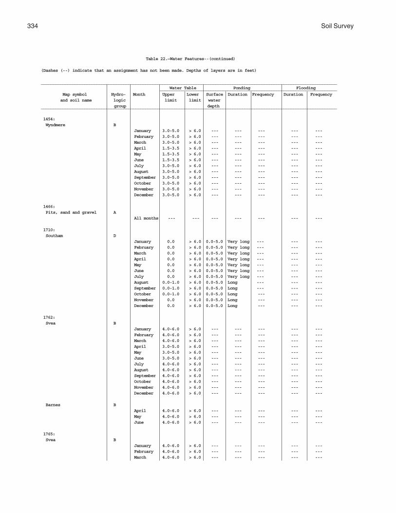
334 Soil Survey
Table 22.—Water Features--(continued)
(Dashes (--) indicate that an assignment has not been made. Depths of layers are in feet)
__________________________________________________________________________________________________________________________ Water Table Ponding Flooding _________________________________________________________________________
Map symbol Hydro- Month Upper Lower Surface Duration Frequency Duration Frequency and soil name logic limit limit water
group depth__________________________________________________________________________________________________________________________
1454: Wyndmere B
January 3.0-5.0 > 6.0 --- --- --- --- ---February 3.0-5.0 > 6.0 --- --- --- --- ---March 3.0-5.0 > 6.0 --- --- --- --- ---April 1.5-3.5 > 6.0 --- --- --- --- ---May 1.5-3.5 > 6.0 --- --- --- --- ---June 1.5-3.5 > 6.0 --- --- --- --- ---July 3.0-5.0 > 6.0 --- --- --- --- ---August 3.0-5.0 > 6.0 --- --- --- --- ---September 3.0-5.0 > 6.0 --- --- --- --- ---October 3.0-5.0 > 6.0 --- --- --- --- ---November 3.0-5.0 > 6.0 --- --- --- --- ---December 3.0-5.0 > 6.0 --- --- --- --- ---
1466: Pits, sand and gravel A
All months --- --- --- --- --- --- ---
1710: Southam D
January 0.0 > 6.0 0.0-5.0 Very long --- --- ---February 0.0 > 6.0 0.0-5.0 Very long --- --- ---March 0.0 > 6.0 0.0-5.0 Very long --- --- ---April 0.0 > 6.0 0.0-5.0 Very long --- --- ---May 0.0 > 6.0 0.0-5.0 Very long --- --- ---June 0.0 > 6.0 0.0-5.0 Very long --- --- ---July 0.0 > 6.0 0.0-5.0 Very long --- --- ---August 0.0-1.0 > 6.0 0.0-5.0 Long --- --- ---September 0.0-1.0 > 6.0 0.0-5.0 Long --- --- ---October 0.0-1.0 > 6.0 0.0-5.0 Long --- --- ---November 0.0 > 6.0 0.0-5.0 Long --- --- ---December 0.0 > 6.0 0.0-5.0 Long --- --- ---
1762: Svea B
January 4.0-6.0 > 6.0 --- --- --- --- ---February 4.0-6.0 > 6.0 --- --- --- --- ---March 4.0-6.0 > 6.0 --- --- --- --- ---April 3.0-5.0 > 6.0 --- --- --- --- ---May 3.0-5.0 > 6.0 --- --- --- --- ---June 3.0-5.0 > 6.0 --- --- --- --- ---July 4.0-6.0 > 6.0 --- --- --- --- ---August 4.0-6.0 > 6.0 --- --- --- --- ---September 4.0-6.0 > 6.0 --- --- --- --- ---October 4.0-6.0 > 6.0 --- --- --- --- ---November 4.0-6.0 > 6.0 --- --- --- --- ---December 4.0-6.0 > 6.0 --- --- --- --- ---
Barnes BApril 4.0-6.0 > 6.0 --- --- --- --- ---May 4.0-6.0 > 6.0 --- --- --- --- ---June 4.0-6.0 > 6.0 --- --- --- --- ---
1765: Svea B
January 4.0-6.0 > 6.0 --- --- --- --- ---February 4.0-6.0 > 6.0 --- --- --- --- ---March 4.0-6.0 > 6.0 --- --- --- --- ---

Griggs County, North Dakota 335
Table 22.—Water Features--(continued)
(Dashes (--) indicate that an assignment has not been made. Depths of layers are in feet)
__________________________________________________________________________________________________________________________ Water Table Ponding Flooding _________________________________________________________________________
Map symbol Hydro- Month Upper Lower Surface Duration Frequency Duration Frequency and soil name logic limit limit water
group depth__________________________________________________________________________________________________________________________
1765:(con’t) Svea April 3.0-5.0 > 6.0 --- --- --- --- ---
May 3.0-5.0 > 6.0 --- --- --- --- ---June 3.0-5.0 > 6.0 --- --- --- --- ---July 4.0-6.0 > 6.0 --- --- --- --- ---August 4.0-6.0 > 6.0 --- --- --- --- ---September 4.0-6.0 > 6.0 --- --- --- --- ---October 4.0-6.0 > 6.0 --- --- --- --- ---November 4.0-6.0 > 6.0 --- --- --- --- ---December 4.0-6.0 > 6.0 --- --- --- --- ---
Buse BApril 4.0-6.0 > 6.0 --- --- --- --- ---May 4.0-6.0 > 6.0 --- --- --- --- ---June 4.0-6.0 > 6.0 --- --- --- --- ---
1766: Svea B
All months --- --- --- --- --- --- ---
Buse BAll months --- --- --- --- --- --- ---
1769: Svea B
January 4.0-6.0 > 6.0 --- --- --- --- ---February 4.0-6.0 > 6.0 --- --- --- --- ---March 4.0-6.0 > 6.0 --- --- --- --- ---April 3.0-5.0 > 6.0 --- --- --- --- ---May 3.0-5.0 > 6.0 --- --- --- --- ---June 3.0-5.0 > 6.0 --- --- --- --- ---July 4.0-6.0 > 6.0 --- --- --- --- ---August 4.0-6.0 > 6.0 --- --- --- --- ---September 4.0-6.0 > 6.0 --- --- --- --- ---October 4.0-6.0 > 6.0 --- --- --- --- ---November 4.0-6.0 > 6.0 --- --- --- --- ---December 4.0-6.0 > 6.0 --- --- --- --- ---
Cresbard CJanuary 4.0-6.0 > 6.0 --- --- --- --- ---February 4.0-6.0 > 6.0 --- --- --- --- ---March 4.0-6.0 > 6.0 --- --- --- --- ---April 3.0-5.0 > 6.0 --- --- --- --- ---May 3.0-5.0 > 6.0 --- --- --- --- ---June 3.0-5.0 > 6.0 --- --- --- --- ---July 4.0-6.0 > 6.0 --- --- --- --- ---August 4.0-6.0 > 6.0 --- --- --- --- ---September 4.0-6.0 > 6.0 --- --- --- --- ---October 4.0-6.0 > 6.0 --- --- --- --- ---November 4.0-6.0 > 6.0 --- --- --- --- ---December 4.0-6.0 > 6.0 --- --- --- --- ---
1781: Swenoda B
January 4.0-6.0 > 6.0 --- --- --- --- ---February 4.0-6.0 > 6.0 --- --- --- --- ---March 4.0-6.0 > 6.0 --- --- --- --- ---April 3.0-5.0 > 6.0 --- --- --- --- ---

336 Soil Survey
Table 22.—Water Features--(continued)
(Dashes (--) indicate that an assignment has not been made. Depths of layers are in feet)
__________________________________________________________________________________________________________________________ Water Table Ponding Flooding _________________________________________________________________________
Map symbol Hydro- Month Upper Lower Surface Duration Frequency Duration Frequency and soil name logic limit limit water
group depth__________________________________________________________________________________________________________________________
1781:(con’t) Swenoda May 3.0-5.0 > 6.0 --- --- --- --- ---
June 3.0-5.0 > 6.0 --- --- --- --- ---July 4.0-6.0 > 6.0 --- --- --- --- ---August 4.0-6.0 > 6.0 --- --- --- --- ---September 4.0-6.0 > 6.0 --- --- --- --- ---October 4.0-6.0 > 6.0 --- --- --- --- ---November 4.0-6.0 > 6.0 --- --- --- --- ---December 4.0-6.0 > 6.0 --- --- --- --- ---
1843: Towner B
January 4.0-6.0 > 6.0 --- --- --- --- ---February 4.0-6.0 > 6.0 --- --- --- --- ---March 4.0-6.0 > 6.0 --- --- --- --- ---April 3.0-5.0 > 6.0 --- --- --- --- ---May 3.0-5.0 > 6.0 --- --- --- --- ---June 3.0-5.0 > 6.0 --- --- --- --- ---July 4.0-6.0 > 6.0 --- --- --- --- ---August 4.0-6.0 > 6.0 --- --- --- --- ---September 4.0-6.0 > 6.0 --- --- --- --- ---October 4.0-6.0 > 6.0 --- --- --- --- ---November 4.0-6.0 > 6.0 --- --- --- --- ---December 4.0-6.0 > 6.0 --- --- --- --- ---
1883: Vallers C
January 1.5-3.5 > 6.0 --- --- --- --- ---February 1.5-3.5 > 6.0 --- --- --- --- ---March 0.0-1.5 > 6.0 --- --- --- --- ---April 0.0-1.5 > 6.0 --- --- --- --- ---May 0.0-1.5 > 6.0 --- --- --- --- ---June 0.0-1.5 > 6.0 --- --- --- --- ---July 0.0-1.5 > 6.0 --- --- --- --- ---August 1.5-3.5 > 6.0 --- --- --- --- ---September 1.5-3.5 > 6.0 --- --- --- --- ---October 1.5-3.5 > 6.0 --- --- --- --- ---November 1.5-3.5 > 6.0 --- --- --- --- ---December 1.5-3.5 > 6.0 --- --- --- --- ---
Parnell C/DJanuary 0.0 > 6.0 0.0-2.0 Very long --- --- ---February 0.0 > 6.0 0.0-2.0 Very long --- --- ---March 0.0 > 6.0 0.0-2.0 Very long --- --- ---April 0.0 > 6.0 0.0-2.0 Very long --- --- ---May 0.0 > 6.0 0.0-2.0 Very long --- --- ---June 0.0 > 6.0 0.0-2.0 Very long --- --- ---July 0.0 > 6.0 0.0-2.0 Very long --- --- ---August 0.0-1.5 > 6.0 0.0-2.0 Very long --- --- ---September 0.0-1.5 > 6.0 0.0-2.0 Very long --- --- ---October 0.0-1.5 > 6.0 0.0-2.0 Very long --- --- ---November 0.0 > 6.0 0.0-2.0 Very long --- --- ---December 0.0 > 6.0 0.0-2.0 Very long --- --- ---
1886: Hamerly, saline C
January 3.0-5.0 > 6.0 --- --- --- --- ---February 3.0-5.0 > 6.0 --- --- --- --- ---March 3.0-5.0 > 6.0 --- --- --- --- ---
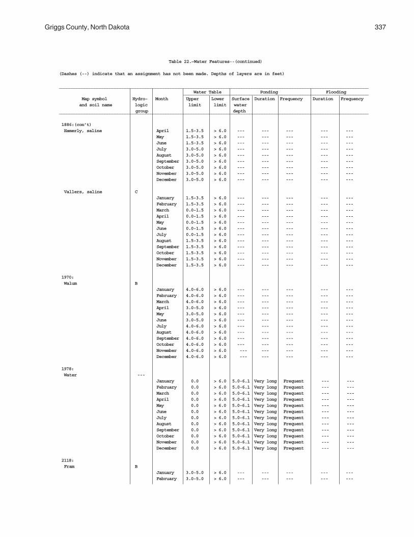
Griggs County, North Dakota 337
Table 22.—Water Features--(continued)
(Dashes (--) indicate that an assignment has not been made. Depths of layers are in feet)
__________________________________________________________________________________________________________________________ Water Table Ponding Flooding _________________________________________________________________________
Map symbol Hydro- Month Upper Lower Surface Duration Frequency Duration Frequency and soil name logic limit limit water
group depth__________________________________________________________________________________________________________________________
1886:(con’t) Hamerly, saline April 1.5-3.5 > 6.0 --- --- --- --- ---
May 1.5-3.5 > 6.0 --- --- --- --- ---June 1.5-3.5 > 6.0 --- --- --- --- ---July 3.0-5.0 > 6.0 --- --- --- --- ---August 3.0-5.0 > 6.0 --- --- --- --- ---September 3.0-5.0 > 6.0 --- --- --- --- ---October 3.0-5.0 > 6.0 --- --- --- --- ---November 3.0-5.0 > 6.0 --- --- --- --- ---December 3.0-5.0 > 6.0 --- --- --- --- ---
Vallers, saline CJanuary 1.5-3.5 > 6.0 --- --- --- --- ---February 1.5-3.5 > 6.0 --- --- --- --- ---March 0.0-1.5 > 6.0 --- --- --- --- ---April 0.0-1.5 > 6.0 --- --- --- --- ---May 0.0-1.5 > 6.0 --- --- --- --- ---June 0.0-1.5 > 6.0 --- --- --- --- ---July 0.0-1.5 > 6.0 --- --- --- --- ---August 1.5-3.5 > 6.0 --- --- --- --- ---September 1.5-3.5 > 6.0 --- --- --- --- ---October 1.5-3.5 > 6.0 --- --- --- --- ---November 1.5-3.5 > 6.0 --- --- --- --- ---December 1.5-3.5 > 6.0 --- --- --- --- ---
1970: Walum B
January 4.0-6.0 > 6.0 --- --- --- --- ---February 4.0-6.0 > 6.0 --- --- --- --- ---March 4.0-6.0 > 6.0 --- --- --- --- ---April 3.0-5.0 > 6.0 --- --- --- --- ---May 3.0-5.0 > 6.0 --- --- --- --- ---June 3.0-5.0 > 6.0 --- --- --- --- ---July 4.0-6.0 > 6.0 --- --- --- --- ---August 4.0-6.0 > 6.0 --- --- --- --- ---September 4.0-6.0 > 6.0 --- --- --- --- ---October 4.0-6.0 > 6.0 --- --- --- --- ---November 4.0-6.0 > 6.0 --- --- --- --- ---December 4.0-6.0 > 6.0 --- --- --- --- ---
1978: Water ---
January 0.0 > 6.0 5.0-6.1 Very long Frequent --- ---February 0.0 > 6.0 5.0-6.1 Very long Frequent --- ---March 0.0 > 6.0 5.0-6.1 Very long Frequent --- ---April 0.0 > 6.0 5.0-6.1 Very long Frequent --- ---May 0.0 > 6.0 5.0-6.1 Very long Frequent --- ---June 0.0 > 6.0 5.0-6.1 Very long Frequent --- ---July 0.0 > 6.0 5.0-6.1 Very long Frequent --- ---August 0.0 > 6.0 5.0-6.1 Very long Frequent --- ---September 0.0 > 6.0 5.0-6.1 Very long Frequent --- ---October 0.0 > 6.0 5.0-6.1 Very long Frequent --- ---November 0.0 > 6.0 5.0-6.1 Very long Frequent --- ---December 0.0 > 6.0 5.0-6.1 Very long Frequent --- ---
2118: Fram B
January 3.0-5.0 > 6.0 --- --- --- --- ---February 3.0-5.0 > 6.0 --- --- --- --- ---

338 Soil Survey
Table 22.—Water Features--(continued)
(Dashes (--) indicate that an assignment has not been made. Depths of layers are in feet)
__________________________________________________________________________________________________________________________ Water Table Ponding Flooding _________________________________________________________________________
Map symbol Hydro- Month Upper Lower Surface Duration Frequency Duration Frequency and soil name logic limit limit water
group depth__________________________________________________________________________________________________________________________
2118:(con’t) Fram March 3.0-5.0 > 6.0 --- --- --- --- ---
April 1.5-3.5 > 6.0 --- --- --- --- ---May 1.5-3.5 > 6.0 --- --- --- --- ---June 1.5-3.5 > 6.0 --- --- --- --- ---July 3.0-5.0 > 6.0 --- --- --- --- ---August 3.0-5.0 > 6.0 --- --- --- --- ---September 3.0-5.0 > 6.0 --- --- --- --- ---October 3.0-5.0 > 6.0 --- --- --- --- ---November 3.0-5.0 > 6.0 --- --- --- --- ---December 3.0-5.0 > 6.0 --- --- --- --- ---
Tonka C/DJanuary 1.5-3.5 > 6.0 --- --- --- --- ---February 1.5-3.5 > 6.0 --- --- --- --- ---March1 0-0 1.0-1.5 0.0-1.0 Very long --- --- --- 1.5-2.0 >6.0April1 0-0 1.0-1.5 0.0-1.0 Very long --- --- ---
1.5-2.0 >6.0May 0.0-1.5 > 6.0 0.0-1.0 Very long --- --- ---June 0.0-1.5 > 6.0 0.0-1.0 Very long --- --- ---July 0.0-1.5 > 6.0 --- --- --- --- ---August 3.0-5.0 > 6.0 --- --- --- --- ---September 1.5-3.5 > 6.0 --- --- --- --- ---October 1.5-3.5 > 6.0 --- --- --- --- ---November 1.5-3.5 > 6.0 --- --- --- --- ---December 1.5-3.5 > 6.0 --- --- --- --- ---
2121: Ferney D
January 3.0-5.0 > 6.0 --- --- --- --- ---February 3.0-5.0 > 6.0 --- --- --- --- ---March 3.0-5.0 > 6.0 --- --- --- --- ---April 1.5-3.5 > 6.0 --- --- --- --- ---May 1.5-3.5 > 6.0 --- --- --- --- ---June 1.5-3.5 > 6.0 --- --- --- --- ---July 3.0-5.0 > 6.0 --- --- --- --- ---August 3.0-5.0 > 6.0 --- --- --- --- ---September 3.0-5.0 > 6.0 --- --- --- --- ---October 3.0-5.0 > 6.0 --- --- --- --- ---November 3.0-5.0 > 6.0 --- --- --- --- ---December 3.0-5.0 > 6.0 --- --- --- --- ---
2151: Binford B
All months --- --- --- --- --- --- ---
Coe AAll months --- --- --- --- --- --- ---
2152: Coe A
All months --- --- --- --- --- --- ---
Binford BAll months --- --- --- --- --- --- ---
2153: Edgeley C
All months --- --- --- --- --- --- ---
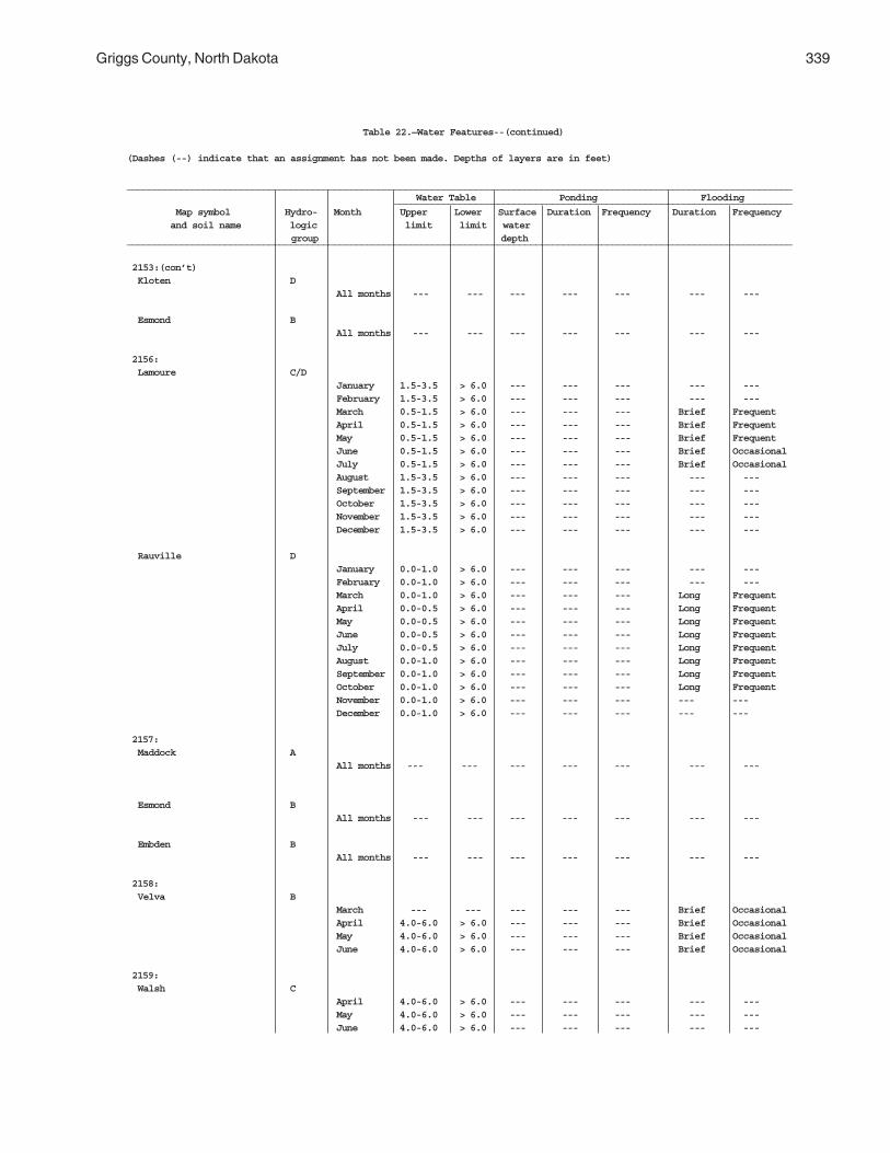
Griggs County, North Dakota 339
Table 22.—Water Features--(continued)
(Dashes (--) indicate that an assignment has not been made. Depths of layers are in feet)
__________________________________________________________________________________________________________________________ Water Table Ponding Flooding _________________________________________________________________________
Map symbol Hydro- Month Upper Lower Surface Duration Frequency Duration Frequency and soil name logic limit limit water
group depth__________________________________________________________________________________________________________________________
2153:(con’t) Kloten D
All months --- --- --- --- --- --- ---
Esmond BAll months --- --- --- --- --- --- ---
2156: Lamoure C/D
January 1.5-3.5 > 6.0 --- --- --- --- ---February 1.5-3.5 > 6.0 --- --- --- --- ---March 0.5-1.5 > 6.0 --- --- --- Brief FrequentApril 0.5-1.5 > 6.0 --- --- --- Brief FrequentMay 0.5-1.5 > 6.0 --- --- --- Brief FrequentJune 0.5-1.5 > 6.0 --- --- --- Brief OccasionalJuly 0.5-1.5 > 6.0 --- --- --- Brief OccasionalAugust 1.5-3.5 > 6.0 --- --- --- --- ---September 1.5-3.5 > 6.0 --- --- --- --- ---October 1.5-3.5 > 6.0 --- --- --- --- ---November 1.5-3.5 > 6.0 --- --- --- --- ---December 1.5-3.5 > 6.0 --- --- --- --- ---
Rauville DJanuary 0.0-1.0 > 6.0 --- --- --- --- ---February 0.0-1.0 > 6.0 --- --- --- --- ---March 0.0-1.0 > 6.0 --- --- --- Long FrequentApril 0.0-0.5 > 6.0 --- --- --- Long FrequentMay 0.0-0.5 > 6.0 --- --- --- Long FrequentJune 0.0-0.5 > 6.0 --- --- --- Long FrequentJuly 0.0-0.5 > 6.0 --- --- --- Long FrequentAugust 0.0-1.0 > 6.0 --- --- --- Long FrequentSeptember 0.0-1.0 > 6.0 --- --- --- Long FrequentOctober 0.0-1.0 > 6.0 --- --- --- Long FrequentNovember 0.0-1.0 > 6.0 --- --- --- --- ---December 0.0-1.0 > 6.0 --- --- --- --- ---
2157: Maddock A
All months --- --- --- --- --- --- ---
Esmond BAll months --- --- --- --- --- --- ---
Embden BAll months --- --- --- --- --- --- ---
2158: Velva B
March --- --- --- --- --- Brief OccasionalApril 4.0-6.0 > 6.0 --- --- --- Brief OccasionalMay 4.0-6.0 > 6.0 --- --- --- Brief OccasionalJune 4.0-6.0 > 6.0 --- --- --- Brief Occasional
2159: Walsh C
April 4.0-6.0 > 6.0 --- --- --- --- ---May 4.0-6.0 > 6.0 --- --- --- --- ---June 4.0-6.0 > 6.0 --- --- --- --- ---
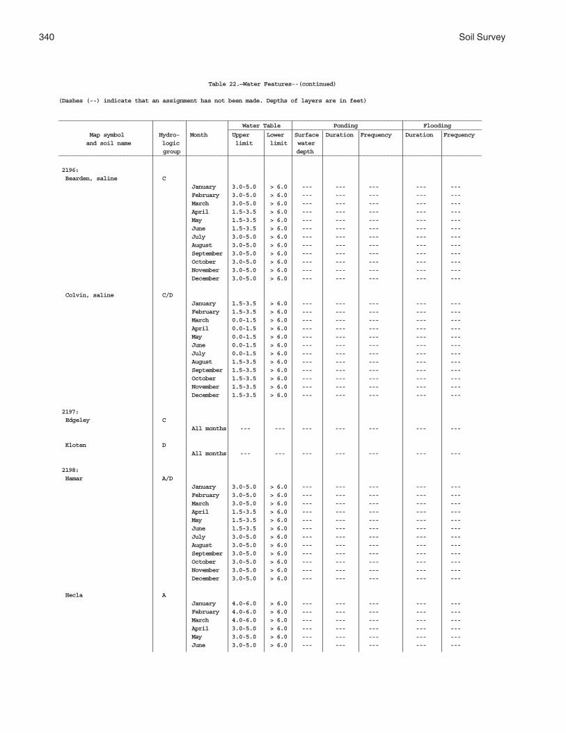
340 Soil Survey
Table 22.—Water Features--(continued)
(Dashes (--) indicate that an assignment has not been made. Depths of layers are in feet)
__________________________________________________________________________________________________________________________ Water Table Ponding Flooding _________________________________________________________________________
Map symbol Hydro- Month Upper Lower Surface Duration Frequency Duration Frequency and soil name logic limit limit water
group depth__________________________________________________________________________________________________________________________
2196: Bearden, saline C
January 3.0-5.0 > 6.0 --- --- --- --- ---February 3.0-5.0 > 6.0 --- --- --- --- ---March 3.0-5.0 > 6.0 --- --- --- --- ---April 1.5-3.5 > 6.0 --- --- --- --- ---May 1.5-3.5 > 6.0 --- --- --- --- ---June 1.5-3.5 > 6.0 --- --- --- --- ---July 3.0-5.0 > 6.0 --- --- --- --- ---August 3.0-5.0 > 6.0 --- --- --- --- ---September 3.0-5.0 > 6.0 --- --- --- --- ---October 3.0-5.0 > 6.0 --- --- --- --- ---November 3.0-5.0 > 6.0 --- --- --- --- ---December 3.0-5.0 > 6.0 --- --- --- --- ---
Colvin, saline C/DJanuary 1.5-3.5 > 6.0 --- --- --- --- ---February 1.5-3.5 > 6.0 --- --- --- --- ---March 0.0-1.5 > 6.0 --- --- --- --- ---April 0.0-1.5 > 6.0 --- --- --- --- ---May 0.0-1.5 > 6.0 --- --- --- --- ---June 0.0-1.5 > 6.0 --- --- --- --- ---July 0.0-1.5 > 6.0 --- --- --- --- ---August 1.5-3.5 > 6.0 --- --- --- --- ---September 1.5-3.5 > 6.0 --- --- --- --- ---October 1.5-3.5 > 6.0 --- --- --- --- ---November 1.5-3.5 > 6.0 --- --- --- --- ---December 1.5-3.5 > 6.0 --- --- --- --- ---
2197: Edgeley C
All months --- --- --- --- --- --- ---
Kloten DAll months --- --- --- --- --- --- ---
2198: Hamar A/D
January 3.0-5.0 > 6.0 --- --- --- --- ---February 3.0-5.0 > 6.0 --- --- --- --- ---March 3.0-5.0 > 6.0 --- --- --- --- ---April 1.5-3.5 > 6.0 --- --- --- --- ---May 1.5-3.5 > 6.0 --- --- --- --- ---June 1.5-3.5 > 6.0 --- --- --- --- ---July 3.0-5.0 > 6.0 --- --- --- --- ---August 3.0-5.0 > 6.0 --- --- --- --- ---September 3.0-5.0 > 6.0 --- --- --- --- ---October 3.0-5.0 > 6.0 --- --- --- --- ---November 3.0-5.0 > 6.0 --- --- --- --- ---December 3.0-5.0 > 6.0 --- --- --- --- ---
Hecla AJanuary 4.0-6.0 > 6.0 --- --- --- --- ---February 4.0-6.0 > 6.0 --- --- --- --- ---March 4.0-6.0 > 6.0 --- --- --- --- ---April 3.0-5.0 > 6.0 --- --- --- --- ---May 3.0-5.0 > 6.0 --- --- --- --- ---June 3.0-5.0 > 6.0 --- --- --- --- ---
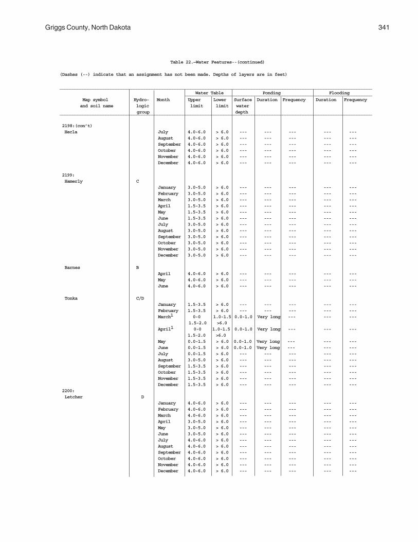
Griggs County, North Dakota 341
Table 22.—Water Features--(continued)
(Dashes (--) indicate that an assignment has not been made. Depths of layers are in feet)
__________________________________________________________________________________________________________________________ Water Table Ponding Flooding _________________________________________________________________________
Map symbol Hydro- Month Upper Lower Surface Duration Frequency Duration Frequency and soil name logic limit limit water
group depth__________________________________________________________________________________________________________________________
2198:(con’t) Hecla July 4.0-6.0 > 6.0 --- --- --- --- ---
August 4.0-6.0 > 6.0 --- --- --- --- ---September 4.0-6.0 > 6.0 --- --- --- --- ---October 4.0-6.0 > 6.0 --- --- --- --- ---November 4.0-6.0 > 6.0 --- --- --- --- ---December 4.0-6.0 > 6.0 --- --- --- --- ---
2199: Hamerly C
January 3.0-5.0 > 6.0 --- --- --- --- ---February 3.0-5.0 > 6.0 --- --- --- --- ---March 3.0-5.0 > 6.0 --- --- --- --- ---April 1.5-3.5 > 6.0 --- --- --- --- ---May 1.5-3.5 > 6.0 --- --- --- --- ---June 1.5-3.5 > 6.0 --- --- --- --- ---July 3.0-5.0 > 6.0 --- --- --- --- ---August 3.0-5.0 > 6.0 --- --- --- --- ---September 3.0-5.0 > 6.0 --- --- --- --- ---October 3.0-5.0 > 6.0 --- --- --- --- ---November 3.0-5.0 > 6.0 --- --- --- --- ---December 3.0-5.0 > 6.0 --- --- --- --- ---
Barnes BApril 4.0-6.0 > 6.0 --- --- --- --- ---May 4.0-6.0 > 6.0 --- --- --- --- ---June 4.0-6.0 > 6.0 --- --- --- --- ---
Tonka C/DJanuary 1.5-3.5 > 6.0 --- --- --- --- ---February 1.5-3.5 > 6.0 --- --- --- --- ---March1 0-0 1.0-1.5 0.0-1.0 Very long --- --- --- 1.5-2.0 >6.0April1 0-0 1.0-1.5 0.0-1.0 Very long --- --- ---
1.5-2.0 >6.0May 0.0-1.5 > 6.0 0.0-1.0 Very long --- --- ---June 0.0-1.5 > 6.0 0.0-1.0 Very long --- --- ---July 0.0-1.5 > 6.0 --- --- --- --- ---August 3.0-5.0 > 6.0 --- --- --- --- ---September 1.5-3.5 > 6.0 --- --- --- --- ---October 1.5-3.5 > 6.0 --- --- --- --- ---November 1.5-3.5 > 6.0 --- --- --- --- ---December 1.5-3.5 > 6.0 --- --- --- --- ---
2200: Letcher D
January 4.0-6.0 > 6.0 --- --- --- --- ---February 4.0-6.0 > 6.0 --- --- --- --- ---March 4.0-6.0 > 6.0 --- --- --- --- ---April 3.0-5.0 > 6.0 --- --- --- --- ---May 3.0-5.0 > 6.0 --- --- --- --- ---June 3.0-5.0 > 6.0 --- --- --- --- ---July 4.0-6.0 > 6.0 --- --- --- --- ---August 4.0-6.0 > 6.0 --- --- --- --- ---September 4.0-6.0 > 6.0 --- --- --- --- ---October 4.0-6.0 > 6.0 --- --- --- --- ---November 4.0-6.0 > 6.0 --- --- --- --- ---December 4.0-6.0 > 6.0 --- --- --- --- ---

342
Table 22.—Water Features--(continued)
(Dashes (--) indicate that an assignment has not been made. Depths of layers are in feet)
__________________________________________________________________________________________________________________________ Water Table Ponding Flooding _________________________________________________________________________
Map symbol Hydro- Month Upper Lower Surface Duration Frequency Duration Frequency and soil name logic limit limit water
group depth__________________________________________________________________________________________________________________________
2200:(con’t) Swenoda B
January 4.0-6.0 > 6.0 --- --- --- --- ---February 4.0-6.0 > 6.0 --- --- --- --- ---March 4.0-6.0 > 6.0 --- --- --- --- ---April 3.0-5.0 > 6.0 --- --- --- --- ---May 3.0-5.0 > 6.0 --- --- --- --- ---June 3.0-5.0 > 6.0 --- --- --- --- ---July 4.0-6.0 > 6.0 --- --- --- --- ---August 4.0-6.0 > 6.0 --- --- --- --- ---September 4.0-6.0 > 6.0 --- --- --- --- ---October 4.0-6.0 > 6.0 --- --- --- --- ---November 4.0-6.0 > 6.0 --- --- --- --- ---December 4.0-6.0 > 6.0 --- --- --- --- ---
2201: Stirum B/D
January 1.5-3.5 > 6.0 --- --- --- --- ---February 1.5-3.5 > 6.0 --- --- --- --- ---March 0.0-1.5 > 6.0 --- --- --- --- ---April 0.0-1.5 > 6.0 --- --- --- --- ---May 0.0-1.5 > 6.0 --- --- --- --- ---June 0.0-1.5 > 6.0 --- --- --- --- ---July 0.0-1.5 > 6.0 --- --- --- --- ---August 1.5-3.5 > 6.0 --- --- --- --- ---September 1.5-3.5 > 6.0 --- --- --- --- ---October 1.5-3.5 > 6.0 --- --- --- --- ---November 1.5-3.5 > 6.0 --- --- --- --- ---December 1.5-3.5 > 6.0 --- --- --- --- ---
Arveson, saline B/DJanuary 1.5-3.5 > 6.0 --- --- --- --- ---February 1.5-3.5 > 6.0 --- --- --- --- ---March 0.0-1.5 > 6.0 --- --- --- --- ---April 0.0-1.5 > 6.0 --- --- --- --- ---May 0.0-1.5 > 6.0 --- --- --- --- ---June 0.0-1.5 > 6.0 --- --- --- --- ---July 0.0-1.5 > 6.0 --- --- --- --- ---August 1.5-3.5 > 6.0 --- --- --- --- ---September 1.5-3.5 > 6.0 --- --- --- --- ---October 1.5-3.5 > 6.0 --- --- --- --- ---November 1.5-3.5 > 6.0 --- --- --- --- ---December 1.5-3.5 > 6.0 --- --- --- --- ---
2202: Swenoda B
January 4.0-6.0 > 6.0 --- --- --- --- ---February 4.0-6.0 > 6.0 --- --- --- --- ---March 4.0-6.0 > 6.0 --- --- --- --- ---April 3.0-5.0 > 6.0 --- --- --- --- ---May 3.0-5.0 > 6.0 --- --- --- --- ---June 3.0-5.0 > 6.0 --- --- --- --- ---July 4.0-6.0 > 6.0 --- --- --- --- ---August 4.0-6.0 > 6.0 --- --- --- --- ---September 4.0-6.0 > 6.0 --- --- --- --- ---October 4.0-6.0 > 6.0 --- --- --- --- ---November 4.0-6.0 > 6.0 --- --- --- --- ---December 4.0-6.0 > 6.0 --- --- --- --- ---

Griggs County, North Dakota 343
Table 22.—Water Features--(continued)
(Dashes (--) indicate that an assignment has not been made. Depths of layers are in feet)
__________________________________________________________________________________________________________________________ Water Table Ponding Flooding _________________________________________________________________________
Map symbol Hydro- Month Upper Lower Surface Duration Frequency Duration Frequency and soil name logic limit limit water
group depth__________________________________________________________________________________________________________________________
2202:(con’t) Barnes B
April 4.0-6.0 > 6.0 --- --- --- --- ---May 4.0-6.0 > 6.0 --- --- --- --- ---June 4.0-6.0 > 6.0 --- --- --- --- ---
2203: Swenoda B
All months --- --- --- --- --- --- ---
Barnes BAll months --- --- --- --- --- --- ---
2204: Walsh C
All months --- --- --- --- --- --- ---
2205: Zell B
All months --- --- --- --- --- --- ---
Eckman BAll months --- --- --- --- --- --- ---
____________________________________________________________________________________________________________________________
1 A perched and apparent water table coexist during these months.

344 Soil Survey
Table 23.—Soil Features
(Dashes(--) indicate that an assignment has not been made.)
_______________________________________________________________________________________________________________ Restrictions Risk of corrosion Map symbol _____________________________________________________ Potential _________________________ and soil name frost action Uncoated Depth Kind Thickness Hardness steel Concrete ______________________________________________________________________________________________________________ In In
61: Arveson --- --- --- --- High High Low
118: Barnes --- --- --- --- Moderate Moderate Low
Buse --- --- --- --- Moderate Moderate Low
120: Barnes --- --- --- --- Moderate Moderate Low
Buse --- --- --- --- Moderate Moderate Low
156: Barnes --- --- --- --- Moderate Moderate Low
Svea --- --- --- --- Moderate High Low
167: Bearden --- --- --- --- High High Low
296: Brantford --- --- --- --- Low Low Low
314: Buse --- --- --- --- Moderate Moderate Low
Barnes --- --- --- --- Moderate Moderate Low
319: Buse --- --- --- --- Moderate Moderate Low
Barnes --- --- --- --- Moderate Moderate Low
391: Cavour --- --- --- --- Moderate High Moderate
Cresbard --- --- --- --- Moderate High Moderate
450: Colvin --- --- --- --- High High Low
511: Divide --- --- --- --- Moderate High Low
536: Eckman --- --- --- --- High Moderate Low
Zell --- --- --- --- High Low Low
539: Edgeley 20-40 Bedrock --- Soft Moderate High Low (paralithic)
541: Edgeley 20-40 Bedrock --- Soft Moderate High Low (paralithic)

Griggs County, North Dakota 345
Table 23.—Soil Features--(continued)
(Dashes(--) indicate that an assignment has not been made.)
_______________________________________________________________________________________________________________ Restrictions Risk of corrosion Map symbol _____________________________________________________ Potential _________________________ and soil name frost action Uncoated Depth Kind Thickness Hardness steel Concrete ______________________________________________________________________________________________________________ In In 569: Embden --- --- --- --- Moderate Moderate Low
579: Embden --- --- --- --- Moderate Moderate Low
Egeland --- --- --- --- Moderate Low Low
595: Emrick --- --- --- --- Moderate High Low
Cathay --- --- --- --- Moderate High Moderate
597: Emrick --- --- --- --- Moderate High Low
Heimdal --- --- --- --- Moderate High Low
605: Esmond --- --- --- --- Moderate High Low
Heimdal --- --- --- --- Moderate High Low
753: Fram --- --- --- --- High High Low
Wyard --- --- --- --- High High Low
769: Gardena --- --- --- --- High Moderate Low
773: Gardena --- --- --- --- High Moderate Low
Eckman --- --- --- --- High Moderate Low
881: Hamerly --- --- --- --- High High Low
Tonka --- --- --- --- High High Low
884: Hamerly --- --- --- --- High High Low
Wyard --- --- --- --- High High Low
893: Harriet --- --- --- --- High High Moderate
988: Heimdal --- --- --- --- Moderate High Low
Emrick --- --- --- --- Moderate High Low
998: Heimdal --- --- --- --- Moderate High Low
Esmond --- --- --- --- Moderate High Low
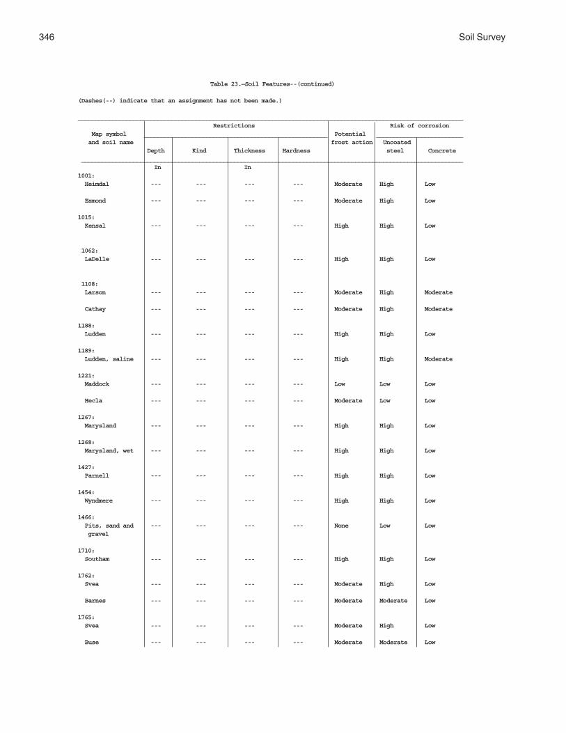
346 Soil Survey
Table 23.—Soil Features--(continued)
(Dashes(--) indicate that an assignment has not been made.)
_______________________________________________________________________________________________________________ Restrictions Risk of corrosion Map symbol _____________________________________________________ Potential _________________________ and soil name frost action Uncoated Depth Kind Thickness Hardness steel Concrete ______________________________________________________________________________________________________________ In In1001: Heimdal --- --- --- --- Moderate High Low
Esmond --- --- --- --- Moderate High Low
1015: Kensal --- --- --- --- High High Low
1062: LaDelle --- --- --- --- High High Low
1108: Larson --- --- --- --- Moderate High Moderate
Cathay --- --- --- --- Moderate High Moderate
1188: Ludden --- --- --- --- High High Low
1189: Ludden, saline --- --- --- --- High High Moderate
1221: Maddock --- --- --- --- Low Low Low
Hecla --- --- --- --- Moderate Low Low
1267: Marysland --- --- --- --- High High Low
1268: Marysland, wet --- --- --- --- High High Low
1427: Parnell --- --- --- --- High High Low
1454: Wyndmere --- --- --- --- High High Low
1466: Pits, sand and --- --- --- --- None Low Low gravel
1710: Southam --- --- --- --- High High Low
1762: Svea --- --- --- --- Moderate High Low
Barnes --- --- --- --- Moderate Moderate Low
1765: Svea --- --- --- --- Moderate High Low
Buse --- --- --- --- Moderate Moderate Low

Griggs County, North Dakota 347
Table 23.—Soil Features--(continued)
(Dashes(--) indicate that an assignment has not been made.)
_______________________________________________________________________________________________________________ Restrictions Risk of corrosion Map symbol _____________________________________________________ Potential _________________________ and soil name frost action Uncoated Depth Kind Thickness Hardness steel Concrete ______________________________________________________________________________________________________________ In In1766: Svea --- --- --- --- Moderate High Low
Buse --- --- --- --- Moderate Moderate Low
1769: Svea --- --- --- --- Moderate High Low
Cresbard --- --- --- --- Moderate High Moderate
1781: Swenoda --- --- --- --- Moderate High Low
1843: Towner --- --- --- --- Moderate High Low
1883: Vallers --- --- --- --- High High Low
Parnell --- --- --- --- High High Low
1886: Hamerly, saline --- --- --- --- High High Moderate
Vallers, saline --- --- --- --- High High Moderate
1970: Walum --- --- --- --- Low High Low
1978: Water --- --- --- --- --- --- ---
2118: Fram --- --- --- --- High High Low
Tonka --- --- --- --- High High Low
2121: Ferney --- --- --- --- Moderate High Moderate
2151: Binford --- --- --- --- Low Low Low
Coe --- --- --- --- Low Low Low
2152: Coe --- --- --- --- Low Low Low
Binford --- --- --- --- Low Low Low
2153: Edgeley 20-40 Bedrock --- Soft Moderate High Low (paralithic)
Kloten 9-20 Bedrock --- Soft Moderate High Low (paralithic)
Esmond --- --- --- --- Moderate High Low

348 Soil Survey
Table 23.—Soil Features--(continued)
(Dashes(--) indicate that an assignment has not been made.)
_______________________________________________________________________________________________________________ Restrictions Risk of corrosion Map symbol _____________________________________________________ Potential _________________________ and soil name frost action Uncoated Depth Kind Thickness Hardness steel Concrete ______________________________________________________________________________________________________________ In In2156: Lamoure --- --- --- --- High High Moderate
Rauville --- --- --- --- High High Moderate
2157: Maddock --- --- --- --- Low Low Low
Esmond --- --- --- --- Moderate High Low
Embden --- --- --- --- Moderate High Low
2158: Velva --- --- --- --- Moderate High Low
2159: Walsh --- --- --- --- Moderate High Low
2196: Bearden, saline --- --- --- --- High High Moderate
Colvin, saline --- --- --- --- High High Moderate
2197: Edgeley 20-40 Bedrock --- Soft Moderate High Low (paralithic)
Kloten 9-20 Bedrock --- Soft Moderate High Low (paralithic)
2198: Hamar --- --- --- --- Moderate High Low
Hecla --- --- --- --- Moderate Low Low
2199: Hamerly --- --- --- --- High High Low
Barnes --- --- --- --- Moderate High Low
Tonka --- --- --- --- High High Low
2200: Letcher --- --- --- --- Moderate High Moderate
Swenoda --- --- --- --- Moderate High Low
2201: Stirum --- --- --- --- Moderate High Moderate
Arveson, saline --- --- --- --- High High Low
2202: Swenoda --- --- --- --- Moderate High Low
Barnes --- --- --- --- Moderate High Low

Griggs County, North Dakota 349
Table 23.—Soil Features--(continued)
(Dashes(--) indicate that an assignment has not been made.)
_______________________________________________________________________________________________________________ Restrictions Risk of corrosion Map symbol _____________________________________________________ Potential _________________________ and soil name frost action Uncoated Depth Kind Thickness Hardness steel Concrete ______________________________________________________________________________________________________________ In In2203: Swenoda --- --- --- --- Moderate High Low
Barnes --- --- --- --- Moderate High Low
2204: Walsh --- --- --- --- Moderate High Low
2205: Zell --- --- --- --- High Low Low
Eckman --- --- --- --- High Moderate Low_________________________________________________________________________________________________________________
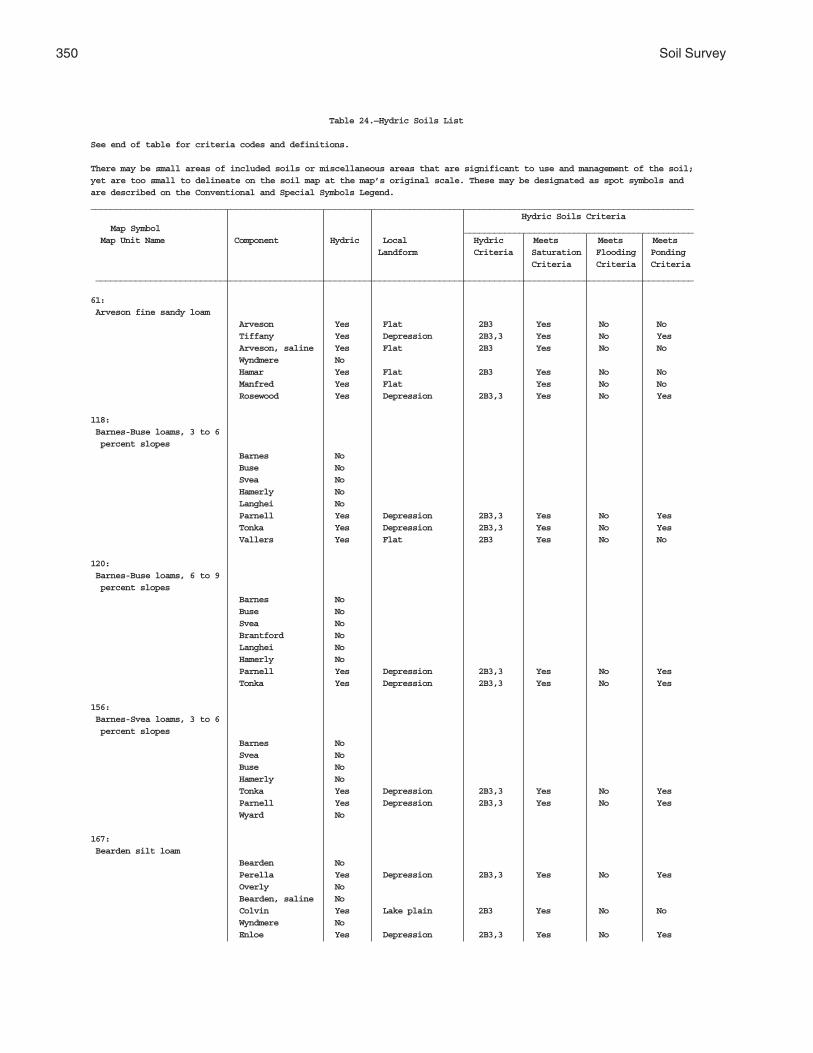
350 Soil Survey
Table 24.—Hydric Soils List
See end of table for criteria codes and definitions.
There may be small areas of included soils or miscellaneous areas that are significant to use and management of the soil;yet are too small to delineate on the soil map at the map’s original scale. These may be designated as spot symbols andare described on the Conventional and Special Symbols Legend._________________________________________________________________________________________________________________________
Hydric Soils Criteria Map Symbol ______________________________________________ Map Unit Name Component Hydric Local Hydric Meets Meets Meets
Landform Criteria Saturation Flooding Ponding Criteria Criteria Criteria
________________________________________________________________________________________________________________________
61: Arveson fine sandy loam
Arveson Yes Flat 2B3 Yes No No Tiffany Yes Depression 2B3,3 Yes No Yes Arveson, saline Yes Flat 2B3 Yes No No Wyndmere No Hamar Yes Flat 2B3 Yes No No Manfred Yes Flat Yes No No Rosewood Yes Depression 2B3,3 Yes No Yes
118: Barnes-Buse loams, 3 to 6 percent slopes
Barnes No Buse No Svea No Hamerly No Langhei No Parnell Yes Depression 2B3,3 Yes No Yes Tonka Yes Depression 2B3,3 Yes No Yes Vallers Yes Flat 2B3 Yes No No
120: Barnes-Buse loams, 6 to 9 percent slopes
Barnes No Buse No Svea No Brantford No Langhei No Hamerly No Parnell Yes Depression 2B3,3 Yes No Yes Tonka Yes Depression 2B3,3 Yes No Yes
156: Barnes-Svea loams, 3 to 6 percent slopes
Barnes No Svea No Buse No Hamerly No Tonka Yes Depression 2B3,3 Yes No Yes Parnell Yes Depression 2B3,3 Yes No Yes Wyard No
167: Bearden silt loam
Bearden No Perella Yes Depression 2B3,3 Yes No Yes Overly No Bearden, saline No Colvin Yes Lake plain 2B3 Yes No No Wyndmere No Enloe Yes Depression 2B3,3 Yes No Yes

Griggs County, North Dakota 351
Table 24.—Hydric Soils List--(continued)
See end of table for criteria codes and definitions.
There may be small areas of included soils or miscellaneous areas that are significant to use and management of the soil;yet are too small to delineate on the soil map at the map’s original scale. These may be designated as spot symbols andare described on the Conventional and Special Symbols Legend._________________________________________________________________________________________________________________________
Hydric Soils Criteria Map Symbol ______________________________________________ Map Unit Name Component Hydric Local Hydric Meets Meets Meets
Landform Criteria Saturation Flooding Ponding Criteria Criteria Criteria
________________________________________________________________________________________________________________________
296: Brantford loam, 0 to 3 percent slopes
Brandtford No Vang No Binford No Coe No Divide No Kensal No Renshaw No
314: Buse-Barnes loams, 9 to 15 percent slopes
Buse No Barnes No Svea No Hamerly No Coe No Lamoure Yes Depression 2B3 Yes No No Maddock No
319: Buse-Barnes loams, 15 to 35 percent slopes
Buse No Barnes No Svea No Langhei No Lamoure Yes Drainageway 2B3 Yes No No Vang No Coe No Maddock No
391: Cavour-Cresbard loams, 0 to 3 percent slopes
Cavour No Cresbard No Svea No Ferney No Hamerly, saline No Hamerly No Edgeley No Tonka Yes Depression 2B3,3 Yes No Yes
450: Colvin silt loam
Colvin Yes Lake plain 2B3 Yes No No Perella Yes Depression 2B3,3 Yes No Yes Colvin, vpd Yes Depression 2B3,3 Yes No Yes Marysland Yes Flat 2B3 Yes No No Bearden No Fram No Wyndmere No

352 Soil Survey
Table 24.—Hydric Soils List--(continued)
See end of table for criteria codes and definitions.
There may be small areas of included soils or miscellaneous areas that are significant to use and management of the soil;yet are too small to delineate on the soil map at the map’s original scale. These may be designated as spot symbols andare described on the Conventional and Special Symbols Legend._________________________________________________________________________________________________________________________
Hydric Soils Criteria Map Symbol ______________________________________________ Map Unit Name Component Hydric Local Hydric Meets Meets Meets
Landform Criteria Saturation Flooding Ponding Criteria Criteria Criteria
________________________________________________________________________________________________________________________
511: Divide loam, 0 to 3 percent slopes
Divide No Wyrene No Marysland Yes Flat 2B3 Yes No No Hamerly No Wyard No Fram No*Hamar, pd Yes Depression 2B3 Yes No No
536: Eckman-Zell silt loams, 6 to 9 percent slopes
Eckman No Zell No Gardena No Overly No Coe No Bearden No Colvin Yes Flat 2B3 Yes No No Maddock No
539: Edgeley loam, 0 to 3 percent slopes
Edgeley No Walsh No Barnes No Cresbard No Hamerly, saline No Kloten No Svea No
541: Edgeley loam, 3 to 6 percent slopes
Edgeley No Kloten No Brantford No Svea No Walsh No Cresbard No Vang No
569: Embden fine sandy loam
Embden No Embden, gravel substratum No Maddock No Egeland No Tiffany Yes Depression 2B3,3 Yes No Yes Perella Yes Depression 2B3,3 Yes No Yes Wyndmere No

Griggs County, North Dakota 353
Table 24.—Hydric Soils List--(continued)
See end of table for criteria codes and definitions.
There may be small areas of included soils or miscellaneous areas that are significant to use and management of the soil;yet are too small to delineate on the soil map at the map’s original scale. These may be designated as spot symbols andare described on the Conventional and Special Symbols Legend._________________________________________________________________________________________________________________________
Hydric Soils Criteria Map Symbol ______________________________________________ Map Unit Name Component Hydric Local Hydric Meets Meets Meets
Landform Criteria Saturation Flooding Ponding Criteria Criteria Criteria
________________________________________________________________________________________________________________________
579: Embden-Egeland fine sandy loams, 1 to 6 percent slopes
Embden No Egeland No Divide No Binford No Zell No Glyndon No Tiffany Yes Depression 2B3,3 Yes No Yes Wyndmere No
595: Emrick-Cathay loams, 0 to 3 percent slopes
Emrick No Cathay No Heimdal No Larson No Towner No Esmond No Fram No Tonka Yes Depression 2B3,3 Yes No Yes
597: Emrick-Heimdal loams, 0 to 3 percent slopes
Emrick No Heimdal No Fram No Esmond No Lanona No Tiffany Yes Depression 2B3,3 Yes No Yes Tonka Yes Depression 2B3,3 Yes No Yes
605: Esmond-Heimdal loams, 9 to 15 percent slopes
Esmond No Heimdal No Emrick No Binford No Coe No Maddock No Tonka Yes Depression 2B3,3 Yes No Yes Wyard No
753: Fram-Wyard loams, 0 to 3 percent slopes
Fram No Wyard No Tonka Yes Depression 2B3,3 Yes No Yes Divide No

354 Soil Survey
Table 24.—Hydric Soils List--(continued)
See end of table for criteria codes and definitions.
There may be small areas of included soils or miscellaneous areas that are significant to use and management of the soil;yet are too small to delineate on the soil map at the map’s original scale. These may be designated as spot symbols andare described on the Conventional and Special Symbols Legend._________________________________________________________________________________________________________________________
Hydric Soils Criteria Map Symbol ______________________________________________ Map Unit Name Component Hydric Local Hydric Meets Meets Meets
Landform Criteria Saturation Flooding Ponding Criteria Criteria Criteria
________________________________________________________________________________________________________________________
753:(continued) Fram-Wyard loams, 0 to 3 percent slopes
Emrick No Heimdal No Vallers Yes Flat 2B3 Yes No No Wyndmere, saline No
769: Gardena silt loam, 0 to 3 percent slopes
Gardena No Overly No Eckman No Glyndon No Bearden No Lindaas Yes Depression 2B3,3 Yes No Yes Zell No
773: Gardena-Eckman silt loams, 3 to 6 percent slopes
Gardena No Eckman No Great Bend No Overly No Bearden No Zell No Colvin Yes Flat 2B3 Yes No No Lankin No
881: Hamerly-Tonka complex, 0 to 3 percent slopes
Hamerly No Tonka Yes Depression 2B3,3 Yes No Yes Wyard No Vallers Yes Flat 2B3 Yes No No Parnell Yes Depression 2B3,3 Yes No Yes Cresbard No Hamerly, saline No Svea No
884: Hamerly-Wyard loams, 0 to 3 percent slopes
Hamerly No Wyard No Tonka Yes Depression 2B3,3 Yes No Yes Vallers Yes Flat 2B3 Yes No No Divide No Barnes No Fram No Hamerly, saline No

Griggs County, North Dakota 355
Table 24.—Hydric Soils List--(continued)
See end of table for criteria codes and definitions.
There may be small areas of included soils or miscellaneous areas that are significant to use and management of the soil;yet are too small to delineate on the soil map at the map’s original scale. These may be designated as spot symbols andare described on the Conventional and Special Symbols Legend._________________________________________________________________________________________________________________________
Hydric Soils Criteria Map Symbol ______________________________________________ Map Unit Name Component Hydric Local Hydric Meets Meets Meets
Landform Criteria Saturation Flooding Ponding Criteria Criteria Criteria
________________________________________________________________________________________________________________________
893: Harriet silt loam
Harriet Yes Drainageway 2B3 Yes No No Manfred Yes Depression 2B3,3 Yes No Yes Colvin, saline Yes Flat 2B3 Yes No No Stirum Yes Depression 2B3,3 Yes No Yes Ojata Yes Drainageway 2B3 Yes No No *Colvin, vpd Yes Depression 2B3,3 Yes No Yes Bearden No
988: Heimdal-Emrick loams, 3 to 6 percent slopes
Heimdal No Emrick No Esmond No Coe No Fram No Binford No Cathay No Wyard No
998: Heimdal-Esmond loams, 6 to 9 percent slopes
Heimdal No Esmond No Emrick No Maddock No Binford No Coe No Fram No Vallers Yes Flat 2B3 Yes No No
1001: Heimdal-Esmond loams, 15 to 35 percent slopes
Esmond No Heimdal No Emrick No Sioux No Maddock No Binford No Coe No Dickey No
1015: Kensal loam
Kensal No Walum No Overly No Binford No Gardena No Coe No Divide No

356 Soil Survey
Table 24.—Hydric Soils List--(continued)
See end of table for criteria codes and definitions.
There may be small areas of included soils or miscellaneous areas that are significant to use and management of the soil;yet are too small to delineate on the soil map at the map’s original scale. These may be designated as spot symbols andare described on the Conventional and Special Symbols Legend._________________________________________________________________________________________________________________________
Hydric Soils Criteria Map Symbol ______________________________________________ Map Unit Name Component Hydric Local Hydric Meets Meets Meets
Landform Criteria Saturation Flooding Ponding Criteria Criteria Criteria
________________________________________________________________________________________________________________________
1062: LaDelle silty clay loam, 0 to 3 percent slopes
LaDelle No Wahpeton No LaPrairie No Ludden Yes Flood plain 2B3 Yes No No Rauville Yes Oxbow 2B3,3 Yes No Yes Velva No Lamoure Yes Flood plain 2B3 Yes No No
1108: Larson-Cathay loams, 0 to 3 percent slopes
Larson No Cathay No Fram No Emrick No Ferney No Tonka Yes Depression 2B3,3 Yes No Yes Fram, saline No Esmond No
1188: Ludden silty clay
Ludden Yes Flood plain 2B3 Yes No No Ludden, saline Yes Flood plain 2B3 Yes No No LaDelle No Rauville Yes Flood plain 2B3,3 Yes No Yes Lamoure Yes Flood plain 2B3 Yes No No
1189: Ludden silty clay, saline
Ludden, saline Yes Flood plain 2B3 Yes No No Ludden, nonsaline Yes Flood plain 2B3 Yes No No Ryan Yes Drainageway 2B3 Yes No No LaDelle No Lamoure Yes Flood plain 2B3 Yes No No Rauville Yes Oxbow 2B3,3 Yes No Yes
1221: Maddock-Hecla loamy fine sands, 1 to 6 percent slopes
Maddock No Hecla No Serden No Maddock No Towner No Coe No Dickey No Esmond No

Griggs County, North Dakota 357
Table 24.—Hydric Soils List--(continued)
See end of table for criteria codes and definitions.
There may be small areas of included soils or miscellaneous areas that are significant to use and management of the soil;yet are too small to delineate on the soil map at the map’s original scale. These may be designated as spot symbols and aredescribed on the Conventional and Special Symbols Legend._________________________________________________________________________________________________________________________
Hydric Soils Criteria Map Symbol ______________________________________________ Map Unit Name Component Hydric Local Hydric Meets Meets Meets
Landform Criteria Saturation Flooding Ponding Criteria Criteria Criteria
________________________________________________________________________________________________________________________
1267: Marysland loam
Marysland Yes Flat 2B3 Yes No No Marysland, saline Yes Depression 2B3,3 Yes No No Colvin Yes Flat 2B3 Yes No No Divide No Wyrene No
1268: Marysland loam, wet
Marysland Yes Depression 2B3,3 Yes No Yes *Colvin, vpd Yes Depression 2B3,3 Yes No Yes *Marysland, pd Yes Flat 2B3 Yes No No Lamoure Yes Flood plain 2B3 Yes No No Southam Yes Depression 3,2B3 Yes No Yes Divide No Tiffany Yes Depression 3,2B3 Yes No Yes
1427: Parnell silty clay loam
Parnell Yes Depression 2B3,3 Yes No Yes Vallers Yes Flat 2B3 Yes No No Grano Yes Depression 2B3,3 Yes No Yes *Colvin, vpd Yes Depression 2B3,3 Yes No Yes Hamerly No Tonka Yes Depression 2B3,3 Yes No Yes Southam Yes Depression 2B3,3 Yes No Yes
1454: Wyndmere fine sandy loam, loamy substratum, 0 to 3 percent slopes
Wyndmere No Wyrene No Divide No *Tiffany, spd No Embden No *Hamar, pd Yes Depression 2B3 Yes No No Arveson Yes Flat 2B3 Yes No No
1466: Pits, sand and gravel
Pits, gravel and sand No Sioux No Arvilla No Water Yes Depression 2B3,3 Yes No Yes

358 Soil Survey
Table 24.—Hydric Soils List--(continued)
See end of table for criteria codes and definitions.
There may be small areas of included soils or miscellaneous areas that are significant to use and management of the soil;yet are too small to delineate on the soil map at the map’s original scale. These may be designated as spot symbols andare described on the Conventional and Special Symbols Legend._________________________________________________________________________________________________________________________
Hydric Soils Criteria Map Symbol ______________________________________________ Map Unit Name Component Hydric Local Hydric Meets Meets Meets
Landform Criteria Saturation Flooding Ponding Criteria Criteria Criteria
________________________________________________________________________________________________________________________
1710: Southam silty clay loam
Southam Yes Depression 2B3,3 Yes No Yes Parnell Yes Depression 2B3,3 Yes No Yes Vallers Yes Flat 2B3 Yes No No *Colvin, vpd Yes Depression 2B3,3 Yes No Yes Water Yes Depression 2B3,3 Yes No Yes Colvin, saline Yes Flat 2B3 Yes No No
1762: Svea-Barnes loams, 0 to 3 percent slopes
Svea No Barnes No Hamerly No Tonka Yes Depression 2B3,3 Yes No Yes Wyard No Cresbard No Vang No
1765: Svea-Buse loams, 3 to 6 percent slopes
Svea No Buse No Barnes No Hamerly No Tonka Yes Depression 2B3,3 Yes No Yes Brantford No Parnell Yes Depression 2B3,3 Yes No Yes Swenoda No
1766: Svea-Buse loams, 6 to 9 percent slopes Svea No
Buse No Barnes No Hamerly No Tonka Yes Depression 2B3,3 Yes No Yes Brantford No Parnell Yes Depression 2B3,3 Yes No Yes Towner No
1769: Svea-Cresbard loams, 0 to 3 percent slopes
Svea No Cresbard No Barnes No Cavour No Hamerly No Buse No Ferney No Tonka Yes Depression 2B3,3 Yes No Yes

Griggs County, North Dakota 359
Table 24.—Hydric Soils List--(continued)
See end of table for criteria codes and definitions.
There may be small areas of included soils or miscellaneous areas that are significant to use and management of the soil;yet are too small to delineate on the soil map at the map’s original scale. These may be designated as spot symbols andare described on the Conventional and Special Symbols Legend._________________________________________________________________________________________________________________________
Hydric Soils Criteria Map Symbol ______________________________________________ Map Unit Name Component Hydric Local Hydric Meets Meets Meets
Landform Criteria Saturation Flooding Ponding Criteria Criteria Criteria
________________________________________________________________________________________________________________________
1781: Swenoda fine sandy loam, 0 to 3 percent slopes
Swenoda No Lanona No Svea No Towner No Fram No Tiffany Yes Depression 2B3 Yes No No Buse No
1843: Towner loamy fine sand, 0 to 6 percent slopes
Towner No Maddock No Swenona No Tiffany No Barnes No *Hamar, pd Yes Depression 2B3 Yes No No Grimstad No
1883: Vallers-Parnell complex
Vallers Yes Flat 2B3 Yes No No Parnell Yes Depression 2B3,3 Yes No Yes Hamerly No Vallers,saline Yes Flat 2B3 Yes No No Marysland Yes Flat 2B3 Yes No No Southam Yes Depression 2B3,3 Yes No Yes Perella Yes Depression 2B3,3 Yes No Yes Tonka Yes Depression 3,2B3 Yes No Yes
1886: Hamerly and Vallers loams, saline, 0 to 3 percent slopes
Hamerly No Vallers Yes Flat 2B3 Yes No No Tonka Yes Depression 2B3,3 Yes No Yes Parnell Yes Depression 3,2B3 Yes No Yes Wyard No Cavour No Ferney No
1970: Walum sandy loam
Walum No Wyrene No Embden No Coe No Divide No Fram No Vallers Yes Flat 2B3 Yes No No

360 Soil Survey
Table 24.—Hydric Soils List--(continued)
See end of table for criteria codes and definitions.
There may be small areas of included soils or miscellaneous areas that are significant to use and management of the soil;yet are too small to delineate on the soil map at the map’s original scale. These may be designated as spot symbols and aredescribed on the Conventional and Special Symbols Legend._________________________________________________________________________________________________________________________
Hydric Soils Criteria Map Symbol ______________________________________________ Map Unit Name Component Hydric Local Hydric Meets Meets Meets
Landform Criteria Saturation Flooding Ponding Criteria Criteria Criteria
________________________________________________________________________________________________________________________
1978: Water
Water Yes Depression 2B3,3 Yes No Yes *Colvin, pd Yes Depression 2B3 Yes No No Southam Yes Depression 2B3,3 Yes No Yes
2118: Fram-Tonka complex, 0 to 3 percent slopes
Fram No Tonka Yes Depression 2B3,3 Yes No Yes Wyard No Heimdal No Vallers Yes Flat 2B3 Yes No No Glyndon No Parnell Yes Depression 2B3,3 Yes No Yes Wyndmere No
2121: Ferney loam, 0 to 3 percent slopes
Ferney No Hamerly, saline No Cavour No Manfred Yes Depression 2B3,3 Yes No Yes Wyard No Cresbard No Marysland, saline Yes Flat 2B3 Yes No No
2151:Binford-Coe sandy loams, 0 to 6 percent slopes
Binford No Coe No Brantford No Vang No Divide No Kensal No Marysland Yes Flat 2B3 Yes No No Walum No
2152:Coe-Binford complex, 6 to 25 percent slopes
Coe No Binford No Vang No Heimdal No Esmond No Brantford No Divide No Fram No

Griggs County, North Dakota 361
Table 24.—Hydric Soils List--(continued)
See end of table for criteria codes and definitions.
There may be small areas of included soils or miscellaneous areas that are significant to use and management of the soil;yet are too small to delineate on the soil map at the map’s original scale. These may be designated as spot symbols andare described on the Conventional and Special Symbols Legend._________________________________________________________________________________________________________________________
Hydric Soils Criteria Map Symbol ______________________________________________ Map Unit Name Component Hydric Local Hydric Meets Meets Meets
Landform Criteria Saturation Flooding Ponding Criteria Criteria Criteria
________________________________________________________________________________________________________________________
2153: Edgeley-Kloten-Esmond complex, 9 to 35 percent slopes
Edgeley No Kloten No Esmond No Walsh No Coe No Egeland No Lamoure, channeled Yes Drainageway 2B3,4 Yes Yes No Mekinock No Nutley No
2156: Lamoure and Rauville silt loams
Lamoure Yes Flood plain 2B3,4 Yes Yes No Rauville Yes Oxbow 2B3,3,4 Yes Yes Yes Marysland Yes Flood plain 2B3,4 Yes Yes No Velva No Divide No Fairdale No Harriet Yes Flood plain 2B3,4 Yes Yes No Vallers Yes Drainageway 2B3,4 Yes Yes No
2157: Maddock-Esmond-Embden complex, 6 to 15 percent slopes
Maddock No Esmond No Embden No Serden No Heimdal No Hecla No Binford No Coe No Ulen No
2158: Velva fine sandy loam, 0 to 6 percent slopes
Velva No Banks No Rauville Yes Oxbow 2B3,3 Yes No Yes Lamoure Yes Flood plain 2B3 Yes No No LaDelle No Tiffany Yes Depression 2B3,3 Yes No Yes Water Yes Channel 2B3,3 Yes No Yes

362 Soil Survey
Table 24.—Hydric Soils List--(continued)
See end of table for criteria codes and definitions.
There may be small areas of included soils or miscellaneous areas that are significant to use and management of the soil;yet are too small to delineate on the soil map at the map’s original scale. These may be designated as spot symbols andare described on the Conventional and Special Symbols Legend._________________________________________________________________________________________________________________________
Hydric Soils Criteria Map Symbol ______________________________________________ Map Unit Name Component Hydric Local Hydric Meets Meets Meets
Landform Criteria Saturation Flooding Ponding Criteria Criteria Criteria
________________________________________________________________________________________________________________________
2159: Walsh silty clay loam, 1 to 6 percent slopes
Walsh No Barnes No Sinai No Nutley No Binford No Edgeley No Kensal No
2196: Bearden and Colvin silt loams, saline
Bearden No Colvin Yes Lake plain 2B3 Yes No No Bearden, nonsaline No Colvin, nonsaline Yes Flat 2B3 Yes No No Exline No Harriet Yes Drainageway 2B3 Yes No No *Colvin, vpd Yes Depression 2B3,3 Yes No Yes Perella Yes Depression 2B3,3 Yes No Yes
2197: Edgeley-Kloten complex, 6 to 9 percent slopes
Edgeley No Kloten No Heimdal No Nutley No Walsh No Cavour No Emrick No Darnen No
2198: Hamar-Hecla loamy fine sands
Hamar No Hecla No Ulen No Arveson Yes Depression 2B3 Yes No No Towner No Wyndmere No Fossum Yes Depression 2B3,3 Yes No Yes Letcher No
2199: Hamerly-Barnes-Tonka complex, 0 to 6 percent slopes, very stony
Hamerly No Barnes No

Griggs County, North Dakota 363
Table 24.—Hydric Soils List--(continued)
See end of table for criteria codes and definitions.
There may be small areas of included soils or miscellaneous areas that are significant to use and management of the soil;yet are too small to delineate on the soil map at the map’s original scale. These may be designated as spot symbols andare described on the Conventional and Special Symbols Legend._________________________________________________________________________________________________________________________
Hydric Soils Criteria Map Symbol ______________________________________________ Map Unit Name Component Hydric Local Hydric Meets Meets Meets
Landform Criteria Saturation Flooding Ponding Criteria Criteria Criteria
________________________________________________________________________________________________________________________
2199:(continued) Hamerly-Barnes-Tonka complex, 0 to 6 percent slopes, very stony
Tonka Yes Depression 2B3,3 Yes No Yes Vallers Yes Flat 2B3 Yes No No Emrick No Parnell Yes Depression 2B3,3 Yes No Yes Cresbard No Hamerly, saline No Cavour No
2200: Letcher-Swenoda fine sandy loams, 0 to 3 percent slopes
Letcher No Swenoda No Lanona No Cathay No Lemert No Stirum Yes Flat 2B3 Yes No No Wyndmere No Towner No
2201: Stirum-Arveson, saline, fine sandy loams
Stirum Yes Lake plain 2B3 Yes No No Arveson Yes Lake plain 2B3 Yes No No Marysland, saline Yes Lake plain 2B3 Yes No No *Vallers Yes Flat 2B3 Yes No No Manfred Yes Depression 2B3,3 Yes No Yes Gilby, saline No Letcher No Marysland Yes Lake plain 2B3 Yes No No
2202: Swenoda-Barnes fine sandy loams, 3 to 6 percent slopes
Swenoda No Barnes No Gardena No Buse No Binford No Towner No Maddock No Tonka Yes Depression 2B3,3 Yes No Yes

364
Table 24.—Hydric Soils List--(continued)
See end of table for criteria codes and definitions.
There may be small areas of included soils or miscellaneous areas that are significant to use and management of the soil;yet are too small to delineate on the soil map at the map’s original scale. These may be designated as spot symbols andare described on the Conventional and Special Symbols Legend._________________________________________________________________________________________________________________________
Hydric Soils Criteria Map Symbol ______________________________________________ Map Unit Name Component Hydric Local Hydric Meets Meets Meets
Landform Criteria Saturation Flooding Ponding Criteria Criteria Criteria
________________________________________________________________________________________________________________________
2203: Swenoda-Barnes fine sandy loams, 6 to 9 percent slopes
Swenoda No Barnes No Buse No Maddock No Binford No Coe No Towner No Vallers Yes Drainageway 2B3 Yes No No
2204: Walsh silty clay loam, 6 to 9 percent slopes
Walsh No Sinai No Barnes No Nutley No Edgeley No Wahpeton No Vang No
2205: Zell-Eckman silt loams, 9 to 25 percent slopes
Zell No Eckman No Gardena No Emrick No Maddock No Great Bend No Coe No Esmond No____________________________________________________________________________________________________________________________
* swp=somewhat poorly drained; pd=poorly drained; vpd=very poorly drained
HYDRIC SOILS CRITERIA CODES AND DEFINITIONS
1. All Histosols, except Folists, or
2. Soils in Aquic suborders, great groups, or subgroups, Albolls suborder, Aquisalids, Pachic subgroups, or Cumulicsubgroups that are:a. somewhat poorly drained with a water table equal to 0.0 foot from the surface during the growing season, orb. poorly drained or very poorly drained and have either: (1) water table equal to 0.0 feet from the surface during the growing season if textures are coarse sand,
sand, or fine sand in all layers within 20 inches or for other soils (2) water table at less than or equal to 0.5 feet from the surface during the growing season if
permeability is equal to or greater than 6.0 inches/hour in all layers within 20 inches, or (3) water table at less than or equal to 1.0 foot from the surface during the growing season if
permeability is less than 6.0 inches/hour in any layer within 20 inches, or
3. Soils that are frequently ponded for long duration or very long duration during the growing season, or
4. Soils that are frequently flooded for long duration or very long duration during the growing season.

365
American Association of State Highway and Transportation Officials. 1986. Standardspecifications for highway materials and methods of sampling and testing. Ed.14, 2 vols.
American Society for Testing and Materials. 1993. Standard classification of soils forengineering purposes. ASTM Stand. D 2487.
Beard, L. W., and E. Waldhous. 1997. North Dakota Agricultural Statistics - 1996. NorthDakota Agric. Stat. Serv., Ag. Statistics No. 66. North Dakota State Universityand USDA-NASS.
Bluemle, J. P. 1975. Geology of Griggs County, North Dakota. North Dakota GeologicalSurvey Bulletin 64, Part I, and North Dakota State Water Commission CountyGroundwater Studies 21, Part I.
Broderson, W., 1991. From the surface down: An introduction to soil surveys foragronomic use. USDA-SCS, National Soil Survey Center, Lincoln, NE.
Brubaker, S.C. and C. T. Hallmark, 1991. A Comparison of Statistical Methods forEvaluating Map Unit Composition. p. 73-88. In M.J. Mausbach and L.P. Wilding(ed.) Spatial Variabilities of Soils and Landforms. SSSA Special PublicationNumber 28 Soil Science Society of America, Inc. Madison, Wisconsin, USA.
Cowardin, L. M., V. Carter, F.C. Golet, and E. T. LaRoe. 1979. Classification of wetlandsand deep-water habitats of the United States. USDI-FWS. FWS/OSB-79/31.
Downey, J.S. and C.A. Armstrong. 1977. Ground Water Resources of Griggs and SteeleCounties, North Dakota. North Dakota Geological Survey, Bull. 64, Part III, andNorth Dakota State Water Commission County Ground Water Studies 21, Part III.
Environmental Laboratory. 1987. Corps of Engineers Wetlands delineation manual. Tech.Rpt. Y-87-1. U.S. Army Engineers Waterways Experiment Station, Vicksburg, MS.
Federal Register. July 13, 1994. Changes in hydric soils of the United States.Washington, DC
Federal Register. February 24, 1995. Hydric soils of the United States, Washington, DC
Franzen, D., C. Fanning, and T. Gregoire. 1994. Managing saline soils in North Dakota.North Dakota Agric. Ext. Serv. Bull. SF-1087.
Griggs County Historical Committee. 1976. Griggs County Heritage. Taylor PublishingCompany, Dallas, Texas.
References

366 Soil Survey
Jakes, Pamela J., and W. Brad Smith. 1982. A second look at North Dakota’s timberland. U.S. Dep. Agric., Forest Serv. Resour. Bull. ND-58.
Jensen, R. E., 1972. Climate of North Dakota. North Dakota State University, Fargo, ND.
Kocher, A.E. and Lewis A. Hurst. 1906. Soil Survey of the Carrington Area, NorthDakota. Bureau of Soils, USDA. U.S. Govt. Print. Office, Washington, D.C.
National Research Council. 1995. Wetlands: Characteristics and boundaries. NationalAcademy Press, Washington, DC.
Omodt, H. W., G. A. Johnsgard, D. D. Patterson, and O. P. Olson. 1968. The major soilsof North Dakota. North Dakota. Agric. Exp. Stn., Bull. 472.
Patterson, D. D., G. A. Johnsgard, M. D. Sweeney, and H. W. Omodt. 1968. Soil surveyreport, county general soil maps, North Dakota. North Dakota Agric. Exp. Stn.,Bull. 473.
Seelig, B. D. 1993. Soil survey: The foundation for productive natural resourcemanagement. North Dakota Agric. Ext. Ser. Bull. 60.
Seelig, B. D. and J. L. Richardson. 1991. Salinity and sodicity in North Dakota soils.North Dakota Agric. Ext. Ser. Bull. EB57.
Soil Survey Staff. 1975. Soil Taxonomy: A basic system of soil classification for makingand interpreting soil surveys. USDA-SCS Agric. Hand. 436, U.S. Govt. Print.Office, Washington, DC.
Soil Survey Staff. 1993. Soil Survey Manual. USDA-SCS. Agric. Hand. 18. U.S. Govt.Print. Office, Washington, DC.
Soil Survey Staff. 1996a. Keys to Soil Taxonomy. Seventh Edition. USDA-NRCS. U.S.Govt. Print. Office, Washington, DC.
Soil Survey Staff. 1996b. National Soil Survey Handbook, Title 430-VI. USDA-NRCS.U.S. Govt. Print. Office, Washington, DC.
Tiner, R.W., Jr. 1985. Wetlands of Delaware. USDI-FWS, Newton Corner, MA andDelaware Department of Natural Resources and Environmental Control, WetlandsSection, Dover, DE.
Ulmer, M.G. and D.D. Patterson. 1988a. Crop yield interpretation for North Dakota: I.Sequential sampling. Soil Surv. Horiz. 29:116-122.
Ulmer, M. G. and D. D. Patterson. 1988b. Crop yield interpretation for North Dakota: II.Field questionnaires: A delphi example. Soil Surv. Horiz. 29: 123-132.
Ulmer, M. G., D. D. Patterson, and J.W. Enz. 1988c. Crop yield interpretation for NorthDakota: III. Long-term empirical models. Soil Surv. Horiz. 29: 132-141.
USDA-National Agricultural Statistics Service. 1999. 1997 Census of Agriculture, U.S.Govt. Print. Offfice, Washington, DC

Griggs County, North Dakota 367
United States Department of Agriculture-Natural Resources Conservation Service. 1994.State Soil Geographic Data Base. Misc. Pub. 1492. USDA-NRCS, Ft. Worth, TX.
United States Department of Agriculture-Natural Resources Conservation Service. 1996.Field Indicators of Hydric Soils in the United States. G.W. Hurt, Whited, P.M.,Pringle, R.F. (eds.). USDA-NRCS, Fort Worth, TX.
United States Department of Agriculture-Soil Conservation Service. 1961. LandCapability Classification. USDA Handb. 210, U.S. Govt. Print. Office, Washington,DC.
United States Department of Agriculture-Soil Conservation Service. 1981. Land resourceregions and major land resource areas of the United States. Agric. Hand. 296, re.ed., U.S. Govt. Print. Office, Washington, DC.
United States Department of Agriculture-Soil Conservation Service. 1992. Field OfficeTechnical Guide. USDA-NRCS, Bismarck, ND.
United States Department of Agriculture-Soil Quality Institute. 1998. Soil quality test kitguide.


369
ABC soil. A soil having an A, a B, and a C horizon.Ablation till. Loose, permeable till deposited during the
final downwasting of glacial ice. Lenses of crudelysorted sand and gravel are common.
AC soil. A soil having only an A and a C horizon.Commonly, such soil formed in recent alluvium oron steep, rocky slopes.
Aeration, soil. The exchange of air in soil with air fromthe atmosphere. The air in a well aerated soil issimilar to that in the atmosphere; the air in a poorlyaerated soil is considerably higher in carbondioxide and lower in oxygen.
Aggregate, soil. Many fine particles held in a singlemass or cluster. Natural soil aggregates, such asgranules, blocks, or prisms, are called peds. Clodsare aggregates produced by tillage or logging.
Alkali (sodic) soil. A soil having so high a degree ofalkalinity (pH 8.5 or higher) or so high a percentageof exchangeable sodium (15 percent or more of thetotal exchangeable bases), or both, that plantgrowth is restricted.
Alluvial fan. The fanlike deposit of a stream where itissues from a gorge upon a plain or of a tributarystream near or at its junction with its main stream.
Alluvium. Material, such as sand, silt, or clay,deposited on land by streams.
Alpha, alpha-dipyridyl. A dye that when dissolved in1N ammonium acetate is used to detect thepresence of reduced iron (Fe II) in the soil. Apositive reaction indicates a type of redoximorphicfeature.
Animal-unit month (AUM). The amount of foragerequired by one mature cow weighingapproximately 1,000 pounds, with or without a calf,for 1 month.
Aquic conditions. Current soil wetness characterizedby saturation, reduction, and redoximorphicfeatures.
Area reclaim (in tables). An area difficult to reclaimafter the removal of soil for construction and otheruses. Revegetation and erosion control areextremely difficult.
Argillic horizon. A subsoil horizon characterized byan accumulation of illuvial clay.
Aspect. The direction in which a slope faces.Association, soil. A group of soils or miscellaneous
areas geographically associated in a characteristicrepeating pattern and defined and delineated as asingle map unit.
Atterberg Limits. A general term that encompassesliquid limit, plastic limit, and shrinkage limit. It isused as an integral part of several engineeringclassification systems.
Available water capacity (available moisturecapacity). The capacity of soils to hold wateravailable for use by most plants. It is commonlydefined as the difference between the amount ofsoil water at field moisture capacity and theamount at wilting point. It is commonly expressedas inches of water per inch of soil. The capacity, ininches, in a 60-inch profile or to a limiting layer isexpressed as:
Very low ........................................................... 0 to 3
Low ................................................................... 3 to 6
Moderate .......................................................... 6 to 9
High ................................................................ 9 to 12
Very high ............................................ More than 12
Badland. Moderately steep to very steep, commonlynonstony, barren land dissected by manyintermittent drainage channels. Badland is mostcommon in semiarid and arid regions wherestreams are entrenched in soft geologic material.Local relief generally ranges from 25 to 500 feet.Runoff potential is very high, and geologic erosionis active.
Basal till. Compact glacial till deposited beneath theice.
Base saturation. The degree to which material havingcation-exchange properties is saturated withexchangeable bases (sum of Ca, Mg, Na, and K),expressed as a percentage of the total cation-exchange capacity.
Bedrock. The solid rock that underlies the soil andother unconsolidated material or that is exposed atthe surface. It may be either lithic (digging with ahand spade impractical) or paralithic (dug withdifficulty with a spade).
Glossary

370 Soil Survey
Blowout. A shallow depression from which all or mostof the soil material has been removed by the wind.A blowout has a flat or irregular floor formed by aresistant layer or by an accumulation of pebbles orcobbles. In some blowouts the water table isexposed.
Bottom land. The normal flood plain of a stream,subject to flooding.
Boulders. Rock fragments larger than 2 feet (60centimeters) in diameter.
Breaks. The steep and very steep broken land at theborder of an upland summit that is dissected byravines.
Brush management. Use of mechanical, chemical, orbiological methods to make conditions favorablefor reseeding or to reduce or eliminate competitionfrom woody vegetation and thus allow understorygrasses and forbs to recover. Brush managementincreases forage production and thus reduces thehazard of erosion. It can improve the habitat forsome species of wildlife.
Butte. An isolated small mountain or hill with steep orprecipitous sides and a top variously flat, rounded,or pointed that may be a residual mass isolated byerosion.
CaCO3 Equivalent. The quantity of carbonate (CO3) in
the soil expressed as CaCO3. This material is
important to the fertility, erosion, available waterholding capacity, and genesis of a soil.
Calcareous soil. A soil containing enough calciumcarbonate (commonly combined with magnesiumcarbonate) to effervesce visibly when treated withcold, dilute hydrochloric acid.
Capillary water. Water held as a film around soilparticles and in tiny spaces between particles.Surface tension is the adhesive force that holdscapillary water in the soil.
Catena. A sequence, or “chain,” of soils on a landscapethat formed in similar kinds of parent material buthave different characteristics as a result ofdifferences in relief and drainage.
Cation. An ion carrying a positive charge of electricity.The common soil cations are calcium, potassium,magnesium, sodium, and hydrogen.
Cation-exchange capacity. The total amount ofexchangeable cations that can be held by the soil,expressed in terms of milliequivalents per 100grams of soil at neutrality (pH 7.0) or at some otherstated pH value. The term, as applied to soils, issynonymous with base-exchange capacity but ismore precise in meaning.
Channery soil material. Soil material that is, byvolume, 15 to 35 percent thin, flat fragments ofsandstone, shale, slate, limestone, or schist as
much as 6 inches (15 centimeters) along thelongest axis. A single piece is called a channer.
Chemical treatment. Control of unwanted vegetationthrough the use of chemicals.
Chiseling. Tillage with an implement having one ormore soil-penetrating points that shatter or loosenhard, compacted layers to a depth below normalplow depth.
Clay. As a soil separate, the mineral soil particles lessthan 0.002 millimeter in diameter. As a soil texturalclass, soil material that is 40 percent or more clay,less than 45 percent sand, and less than 40percent silt.
Clay depletions. Low-chroma zones having a lowcontent of iron, manganese, and clay because ofthe chemical reduction of iron and manganese andthe removal of iron, manganese, and clay. A typeof redoximorphic depletion.
Clay film. A thin coating of oriented clay on thesurface of a soil aggregate or lining pores or rootchannels. Synonyms: clay coating, clay skin.
Claypan. A slowly permeable soil horizon that containsmuch more clay than the horizons above it. Aclaypan is commonly hard when dry and plastic orstiff when wet.
Climax plant community. The stabilized plantcommunity on a particular site. The plant coverreproduces itself and does not change so long asthe environment remains the same.
Coarse textured soil. Sand or loamy sand.Cobble (or cobblestone). A rounded or partly rounded
fragment of rock 3 to 10 inches (7.6 to 25centimeters) in diameter.
Cobbly soil material. Material that is 15 to 35 percent,by volume, rounded or partially rounded rockfragments 3 to 10 inches (7.6 to 25 centimeters) indiameter. Very cobbly soil material has 35 to 60percent of these rock fragments, and extremelycobbly soil material has more than 60 percent.
Collapsed lake plan. A previously nearly level surfacemarking the floor of an extinct lake, filled in bywell-sorted deposits from inflowing streams andunderlain by glacial ice, now having the surfaceconfiguration of the underlying topography as aresult of melting of the glacial ice.
Collapsed outwash plain. A previously broad, flat orgently sloping alluvial sheet of outwash depositedby meltwater streams and underlain by glacial ice,now having the surface configuration of theunderlying topography as a result of melting of theglacial ice.
Colluvium. Soil material or rock fragments, or both,moved by creep, slide, or local wash anddeposited at the base of steep slopes.
Griggs County, North Dakota 371
Complex slope. Irregular or variable slope. Planning orestablishing terraces, diversions, and other water-control structures on a complex slope is difficult.
Complex, soil. A map unit of two or more kinds of soilor miscellaneous areas in such an intricate patternor so small in area that it is not practical to mapthem separately at the selected scale of mapping.The pattern and proportion of the soils ormiscellaneous areas are somewhat similar in allareas.
Concretions. Cemented bodies with crude internalsymmetry organized around a point, a line, or aplane. They typically take the form of concentriclayers visible to the naked eye. Calcium carbonate,iron oxide, and manganese oxide are commoncompounds making up concretions. If formed inplace, concretions of iron oxide or manganeseoxide are generally considered a type ofredoximorphic concentration.
Conglomerate. A coarse grained, clastic rockcomposed of rounded or subangular rockfragments more than 2 millimeters in diameter. Itcommonly has a matrix of sand and finer texturedmaterial. Conglomerate is the consolidatedequivalent of gravel.
Conservation cropping system. Growing crops incombination with needed cultural and managementpractices. In a good conservation cropping system,the soil-improving crops and practices more thanoffset the effects of the soil-depleting crops andpractices. Cropping systems are needed on alltilled soils. Soil-improving practices in aconservation cropping system include the use ofrotations that contain grasses and legumes andthe return of crop residue to the soil. Otherpractices include the use of green manure crops ofgrasses and legumes, proper tillage, adequatefertilization, and weed and pest control.
Conservation tillage. A tillage system that does notinvert the soil and that leaves a protective amountof crop residue on the surface throughout the year.
Consistence, soil. The feel of the soil and the easewith which a lump can be crushed by the fingers.Terms commonly used to describe consistenceare:
Loose ..... noncoherent when dry or moist; does nothold together in a mass.
Friable ..... when moist, crushes easily under gentlepressure between thumb and forefinger andcan be pressed together into a lump.
Firm ..............when moist, crushes under moderatepressure between thumb and forefinger, butresistance is distinctly noticeable.
Plastic .... when wet, readily deformed by moderatepressure but can be pressed into a lump; willform a “wire” when rolled between thumb andforefinger.
Sticky ...... when wet, adheres to other material andtends to stretch somewhat and pull apart ratherthan to pull free from other material.
Hard ... when dry, moderately resistant to pressure;can be broken with difficulty between thumb andforefinger.
Soft ....... when dry, breaks into powder or individualgrains under very slight pressure.
Cemented ........... hard, little affected by moistening.
Contour stripcropping. Growing crops in strips thatfollow the contour. Strips of grass or close-growingcrops are alternated with strips of clean-tilled cropsor summer fallow.
Contrasting soils (Dissimilar soils). Soils that do notshare limits of diagnostic criteria, behave andperform in a similar manner, or have similarconservation needs or management requirementsfor the major land uses in the survey area.
Control section. The part of the soil on whichclassification is based. The thickness variesamong different kinds of soil, but for many it is thatpart of the soil profile between depths of 10 inchesand 40 or 80 inches.
Corrosion. Soil-induced electrochemical or chemicalaction that dissolves or weakens concrete oruncoated steel.
Cover crop. A close-growing crop grown primarily toimprove and protect the soil between periods ofregular crop production, or a crop grown betweentrees and vines in orchards and vineyards.
Cropping system. Growing crops according to aplanned system of rotation and managementpractices.
Crop residue management. Returning crop residueto the soil, which helps to maintain soil structure,organic matter content, and fertility and helps tocontrol erosion.
Cutbanks cave (in tables). The walls of excavationstend to cave in or slough.
Decreasers. The most heavily grazed climax rangeplants. Because they are the most palatable, theyare the first to be destroyed by overgrazing.
Deferred grazing. Postponing grazing or restinggrazing land for a prescribed period.
Delta. A body of alluvium having a surface that isnearly flat and fan shaped; deposited at or nearthe mouth of a river or stream where it enters abody of relatively quiet water, generally a sea orlake.

372 Soil Survey
Dense layer (in tables). A very firm, massive layerthat has a bulk density of more than 1.8 grams percubic centimeter. Such a layer affects the ease ofdigging and can affect filling and compacting.
Depth, soil. Generally, the thickness of the soil overbedrock. Very deep soils are more than 60 inchesdeep over bedrock; deep soils, 40 to 60 inches;moderately deep, 20 to 40 inches; shallow, 10 to20 inches; and very shallow, less than 10 inches.
Depth to rock (in tables). Bedrock is too near thesurface for the specified use.
Diversion (or diversion terrace). A ridge of earth,generally a terrace, built to protect downslopeareas by diverting runoff from its natural course.
Divided-slope farming. A form of field stripcropping inwhich crops are grown in a systematicarrangement of two strips, or bands, across theslope to reduce the hazard of water erosion. Onestrip is in a close-growing crop that providesprotection from erosion, and the other strip is in acrop that provides less protection from erosion.This practice is used where slopes are not longenough to permit a full stripcropping pattern to beused.
Drainage class (natural). Refers to the frequency andduration of wet periods under conditions similar tothose under which the soil formed. Alterations ofthe water regime by human activities, eitherthrough drainage or irrigation, are not aconsideration unless they have significantlychanged the morphology of the soil. Seven classesof natural soil drainage are recognized:
Excessively drained . .... these soils have very highand high hydraulic conductivity and a low water-holding capacity. They are not suited to cropproduction unless irrigated.
Somewhat excessively drained .... these soils havehigh hydraulic conductivity and a low water-holding capacity. Without irrigation, only anarrow range of crops can be grown and yieldsare low.
Well drained ......... these soils have an intermediatewater-holding capacity. They retain optimumamounts of moisture, but they are not wet closeenough to the surface or long enough during thegrowing season to adversely affect yields.
Moderately well drained ... these soils are wet closeenough to the surface or long enough thatplanting or harvesting operations or yields ofsome field crops are adversely affected unlessa drainage system is installed. Moderately welldrained soils commonly have a layer with lowhydraulic conductivity, a wet layer relatively highin the profile, additions of water by seepage, orsome combination of these.
Somewhat poorly drained.. ....... these soils are wetclose enough to the surface or long enough thatplanting or harvesting operations or crop growthis markedly restricted unless a drainagesystem is installed. Somewhat poorly drainedsoils commonly have a layer with low hydraulicconductivity, a wet layer high in the profile,additions of water through seepage, or acombination of these.
Poorly drained .. .. these soils commonly are so wetat or near the surface during a considerablepart of the year that field crops cannot be grownunder natural conditions. Poorly drainedconditions are caused by a saturated zone, alayer with low hydraulic conductivity, seepage,or a combination of these.
Very poorly drained ......... these soils are wet to thesurface most of the time. The wetness preventsthe growth of important crops (except rice)unless a drainage system is installed.
Drainage, surface. Runoff, or surface flow of water,from an area.
Drainageway. An area of ground at a lower elevationthan the surrounding ground and in which watercollects and is drained to a closed depressionor lake or to a drainageway at a lower elevation.A drainageway may or may not have distinctlyincised channels at its upper reaches or throughoutits course.
Draw. A small stream valley that generally is moreopen and has broader bottom land than a ravineor gulch.
Drift. A general term applied to all material transportedby a glacier and deposited directly from the iceor by running water coming from the ice. Driftincludes unstratified material (till) that formsmoraines, and stratified glaciofluvial depositsthat form outwash plains, eskers, kames, varves,and glaciolacustrine sediments. The term isgenerally applied to Pleistocene glacial depositsin areas that no longer contain glaciers.
Drumlin. A low, smooth, elongated oval hill, mound,or ridge of compact glacial till. The longer axis isparallel to the path of the glacier and commonlyhas a blunt nose pointing in the direction fromwhich the ice approached.
Eluviation. The movement of material in true solutionor colloidal suspension from one place to anotherwithin the soil. Soil horizons that have lost materialthrough eluviation are eluvial; those that havereceived material are illuvial.
Endosaturation. A type of saturation of the soil inwhich all horizons between the upper boundaryof saturation and a depth of 2 meters aresaturated.

Griggs County, North Dakota 373
Eolian soil material. Earthy parent materialaccumulated through wind action; commonly refersto sandy material in dunes or to loess in blanketson the surface.
Ephemeral stream. A stream, or reach of a stream,that flows only in direct response to precipitation. Itreceives no long-continued supply from meltingsnow or other source, and its channel is above thewater table at all times.
Episaturation. A type of saturation indicating aperched water table in a soil in which saturatedlayers are underlain by one or more unsaturatedlayers within 2 meters of the surface.
Erosion. The wearing away of the land surface bywater, wind, ice, or other geologic agents and bysuch processes as gravitational creep.
Erosion (geologic). Erosion caused by geologicprocesses acting over long geologic periods andresulting in the wearing away of mountains and thebuilding up of such landscape features as floodplains and coastal plains. Synonym: naturalerosion.
Erosion (accelerated). Erosion much more rapid thangeologic erosion, mainly as a result of human oranimal activities or of a catastrophe in nature,such as a fire, that exposes the surface.
Escarpment. A relatively continuous and steep slopeor cliff breaking the general continuity of moregently sloping land surfaces and resulting fromerosion or faulting. Synonym: scarp.
Esker. A narrow, winding ridge of stratified gravelly andsandy drift deposited by a stream flowing in atunnel beneath a glacier.
Excess fines (in tables). Excess silt and clay in thesoil. The soil does not provide a source of gravel orsand for construction purposes.
Excess lime (in tables). Excess carbonates in the soilthat restrict the growth of some plants.
Excess salts (in tables). Excess water-soluble salts inthe soil that restrict the growth of most plants.
Excess sodium (in tables). Excess exchangeablesodium in the soil. The resulting poor physicalproperties restrict the growth of plants.
Excess sulfur (in tables). Excessive amount of sulfurin the soil. The sulfur causes extreme acidity if thesoil is drained, and the growth of most plants isrestricted.
Fallow. Cropland left idle in order to restoreproductivity through accumulation of moisture.Summer fallow is common in regions of limitedrainfall where cereal grain is grown. The soil is tilledfor at least one growing season for weed controland decomposition of plant residue.
Fan terrace. A relict alluvial fan, no longer a site ofactive deposition, incised by younger and loweralluvial surfaces.
Fast intake (in tables). The rapid movement ofwater into the soil.
Fertility, soil. The quality that enables a soil toprovide plant nutrients, in adequate amountsand in proper balance, for the growth of specifiedplants when light, moisture, temperature, tilth,and other growth factors are favorable.
Fibric soil material (peat). The least decomposedof all organic soil material. Peat contains a largeamount of well preserved fiber that is readilyidentifiable according to botanical origin. Peathas the lowest bulk density and the highestwater content at saturation of all organic soilmaterial.
Field moisture capacity. The moisture content of asoil, expressed as a percentage of the ovendryweight, after the gravitational, or free, water hasdrained away; the field moisture content 2 or 3days after a soaking rain; also called normal fieldcapacity, normal moisture capacity, or capillarycapacity.
Fill slope. A sloping surface consisting of excavatedsoil material from a road cut. It commonly is onthe downhill side of the road.
Fine textured soil. Sandy clay, silty clay, or clay.Flaggy soil material. Material that is, by volume,
15 to 35 percent flagstones. Very flaggy soilmaterial has 35 to 60 percent flagstones, andextremely flaggy soil material has more than60 percent flagstones.
Flagstone. A thin fragment of sandstone, limestone,slate, shale, or (rarely) schist 6 to 15 inches(15 to 38 centimeters) long.
Flooding. The temporary covering of the soil surfaceby flowing water from any source.
Flooding frequency classes:
None ........ 0 percent chance of flooding in any year.
Rare......0 to 5 percent chance of flooding in anyyear.
Occasional ........ 5 to 50 percent chance of floodingin any year.
Frequent.....more than 50 percent chance offlooding in any year.
Flooding duration classes:
Extremely brief ................................ 0.1 to 4.0 hours
Very brief ............................................. 4 to 48 hours
Brief ......................................................... 2 to 7 days
Long ...................................................... 7 to 30 days
Very long .................................... more than 30 days
374 Soil Survey
Flood plain. A nearly level alluvial plain that borders astream and is subject to flooding unless protectedartificially.
Fluvial. Of or pertaining to rivers; produced by riveraction, as a fluvial plain.
Foothill. A steeply sloping upland that has relief of asmuch as 1,000 feet (300 meters) and fringes amountain range or high-plateau escarpment.
Footslope. The bottom of a slope or the lower part ofany elevated landform.
Forb. Any herbaceous plant not a grass or a sedge.Forest cover. All trees and other woody plants
(underbrush) covering the ground in a forest.Forest type. A stand of trees similar in composition
and development because of given physical andbiological factors by which it may be differentiatedfrom other stands.
Fragile (in tables). A soil that is easily damaged byuse or disturbance.
Fragipan. A loamy, brittle subsurface horizon low inporosity and content of organic matter and low ormoderate in clay but high in silt or very fine sand.A fragipan appears cemented and restricts roots.When dry, it is hard or very hard and has a higherbulk density than the horizon or horizons above.When moist, it tends to rupture suddenly underpressure rather than to deform slowly.
Frost action (in tables). Freezing and thawing of soilmoisture. Frost action can damage roads, buildingsand other structures, and plant roots.
Genesis, soil. The mode of origin of the soil. Refersespecially to the processes or soil-forming factorsresponsible for the formation of the solum, or truesoil, from the unconsolidated parent material.
Gilgai. Commonly, a succession of microbasins andmicroknolls in nearly level areas or of microvalleysand microridges parallel with the slope. Typically,the microrelief of clayey soils that shrink and swellconsiderably with changes in moisture content.
Glacial drift. Pulverized and other rock materialtransported by glacial ice and then deposited. Also,the sorted and unsorted material deposited bystreams flowing from glaciers.
Glacial outwash. Gravel, sand, and silt, commonlystratified, deposited by glacial meltwater.
Glacial till. Unsorted, nonstratified glacial driftconsisting of clay, silt, sand, and boulderstransported and deposited by glacial ice.
Glaciofluvial deposits. Material moved by glaciersand subsequently sorted and deposited bystreams flowing from the melting ice. The depositsare stratified and occur as kames, eskers, deltas,and outwash plains.
Glaciolacustrine deposits. Material ranging from fineclay to sand derived from glaciers and depositedin glacial lakes mainly by glacial meltwater. Manydeposits are interbedded or laminated.
Gleyed soil. Soil that formed under poor drainage,resulting in the reduction of iron and otherelements in the profile and in gray colors.
Graded stripcropping. Growing crops in strips thatgrade toward a protected waterway.
Grassed waterway. A natural or constructed waterway,typically broad and shallow, seeded to grass asprotection against erosion. Conducts surface wateraway from cropland.
Gravel. Rounded or angular fragments of rock asmuch as 3 inches (2 millimeters to 7.6centimeters) in diameter. An individual piece isa pebble.
Gravelly soil material. Material that is 15 to 35percent, by volume, rounded or angular rockfragments, not prominently flattened, as muchas 3 inches (7.6 centimeters) in diameter.
Green manure crop (agronomy). A soil-improvingcrop grown to be plowed under in an early stageof maturity or soon after maturity.
Ground water. Water filling all the unblocked poresof the material below the water table.
Gully. A miniature valley with steep sides cut byrunning water and through which water ordinarilyruns only after rainfall. The distinction between agully and a rill is one of depth. A gully generally isan obstacle to farm machinery and is too deep tobe obliterated by ordinary tillage; a rill is of lesserdepth and can be smoothed over by ordinarytillage. A gullied map unit is one that has numerousgullies.
Hard bedrock. Bedrock that cannot be excavatedexcept by blasting or by the use of specialequipment that is not commonly used inconstruction.
Hardpan. A hardened or cemented soil horizon, orlayer. The soil material is sandy, loamy, or clayeyand is cemented by iron oxide, silica, calciumcarbonate, or other substance.
Hemic soil material (mucky peat). Organic soilmaterial intermediate in degree of decompositionbetween the less decomposed fibric material andthe more decomposed sapric material.
High-residue crops. Such crops as small grain andcorn used for grain. If properly managed, residuefrom these crops can be used to control erosionuntil the next crop in the rotation is established.These crops return large amounts of organicmatter to the soil.

Griggs County, North Dakota 375
Hill. A natural elevation of the land surface, rising asmuch as 1,000 feet above surrounding lowlands,commonly of limited summit area and having awell defined outline; hillsides generally have slopesof more than 15 percent. The distinction between ahill and a mountain is arbitrary and is dependent onlocal usage.
Horizon, soil. A layer of soil, approximately parallel tothe surface, having distinct characteristicsproduced by soil-forming processes. In theidentification of soil horizons, an uppercase letterrepresents the major horizons. Numbers orlowercase letters that follow represent subdivisionsof the major horizons. An explanation of thesubdivisions is given in the “Soil Survey Manual.”The major horizons of mineral soil are as follows:
O horizon......an organic layer of fresh anddecaying plant residue.
A horizon......the mineral horizon at or near thesurface in which an accumulation of humidifiedorganic matter is mixed with the mineralmaterial. Also, a plowed surface horizon, mostof which was originally part of a B horizon.
E horizon......the mineral horizon in which the mainfeature is loss of silicate clay, iron, aluminum, orsome combination of these.
B horizon......the mineral horizon below an Ahorizon. The B horizon is in part a layer oftransition from the overlying A to the underlyingC horizon. The B horizon also has distinctivecharacteristics, such as (1) accumulation ofclay, sesquioxides, humus, or a combination ofthese; (2) prismatic or blocky structure; (3)redder or browner colors than those in the Ahorizon; or (4) a combination of these.
C horizon......the mineral horizon or layer, excludingindurated bedrock, that is little affected by soil-forming processes and does not have theproperties typical of the overlying soil material.The material of a C horizon may be either like orunlike that in which the solum formed. If thematerial is known to differ from that in thesolum, an Arabic numeral, commonly a 2,precedes the letter C.
Cr horizon......Soft, consolidated bedrock beneaththe soil.
R layer......Consolidated bedrock beneath the soil.The bedrock commonly underlies a C horizon,but it can be directly below an A or a B horizon.
Hummock. A slight mound or rise of ground above alevel surface; generally of equidimensional shapeand not ridge-like.
Humus. The well decomposed, more or less stablepart of the organic matter in mineral soils.
Hydric soil. Soils that formed under conditions ofsaturation, flooding, or ponding long enough duringthe growing season to develop anaerobicconditions for the upper part.
Hydrologic soil groups. Refers to soils groupedaccording to their runoff potential. The soilproperties that influence this potential are thosethat affect the minimum rate of water infiltrationon a bare soil during periods after prolongedwetting when the soil is not frozen. Theseproperties are depth to a seasonal high watertable, the infiltration rate and permeability afterprolonged wetting, and depth to a very slowlypermeable layer. The slope and the kind of plantcover are not considered but are separate factorsin predicting runoff.
Igneous rock. Rock formed by solidification from amolten or partially molten state. Major varietiesinclude plutonic and volcanic rock. Examplesare andesite, basalt, and granite.
Illuviation. The movement of soil material fromone horizon to another in the soil profile.Generally, material is removed from an upperhorizon and deposited in a lower horizon.
Impervious soil. A soil through which water, air,or roots penetrate slowly or not at all. No soilis absolutely impervious to air and water all thetime.
Increasers. Species in the climax vegetation thatincrease in amount as the more desirable plantsare reduced by close grazing. Increaserscommonly are the shorter plants and the lesspalatable to livestock.
Infiltration. The downward entry of water into theimmediate surface of soil or other material, ascontrasted with percolation, which is movement ofwater through soil layers or material.
Infiltration capacity. The maximum rate at which watercan infiltrate into a soil under a given set ofconditions.
Infiltration rate. The rate at which water penetrates thesurface of the soil at any given instant, usuallyexpressed in inches per hour. The rate can belimited by the infiltration capacity of the soil or therate at which water is applied at the surface.
Intermittent stream. A stream, or reach of a stream,that flows for prolonged periods only when itreceives ground-water discharge or long, continuedcontributions from melting snow or other surfaceand shallow subsurface sources.
Invaders. On range, plants that encroach into an areaand grow after the climax vegetation has beenreduced by grazing. Generally, plants invadefollowing disturbance of the surface.
Iron depletions. Low-chroma zones having a lowcontent of iron and manganese oxide becauseof chemical reduction and removal, but having a

376 Soil Survey
clay content similar to that of the adjacent matrix.A type of redoximorphic depletion.
Irrigation. Application of water to soils to assist inproduction of crops. Methods of irrigation are:
Basin ........... Water is applied rapidly to nearly levelplains surrounded by levees or dikes.
Border. ......... Water is applied at the upper end of astrip in which the lateral flow of water iscontrolled by small earth ridges called borderdikes, or borders.
Controlled flooding .... Water is released at intervalsfrom closely spaced field ditches and distributeduniformly over the field.
Corrugation .......... Water is applied to small, closelyspaced furrows or ditches in fields of close-growing crops or in orchards so that it flows inonly one direction.
Drip (or trickle). ............Water is applied slowly andunder low pressure to the surface of the soil orinto the soil through such applicators asemitters, porous tubing, or perforated pipe.
Furrow ........Water is applied in small ditches madeby cultivation implements. Furrows are used fortree and row crops.
Sprinkler ..... Water is sprayed over the soil surfacethrough pipes or nozzles from a pressuresystem.
Subirrigation ...... Water is applied in open ditches ortile lines until the water table is raised enough towet the soil.
Wild flooding ......... Water, released at high points, isallowed to flow onto an area without controlleddistribution.
K Factor. Soil erodibility factor in the Universal SoilLoss Equation.
Kame. An irregular, short ridge or hill of stratifiedglacial drift.
Knoll. A small, low, rounded hill rising above adjacentlandforms.
Ksat. See saturated hydraulic conductivity.Lacustrine deposit. Material deposited in lake water
and exposed when the water level is lowered orthe elevation of the land is raised.
Lake plain. A surface marking the floor of an extinctlake, filled in by well sorted, stratified sediments.
Landslide. The rapid downhill movement of a massof soil and loose rock, generally when wet orsaturated. The speed and distance of movement,as well as the amount of soil and rock material,vary greatly.
Large stones (in tables). Rock fragments 3 inches(7.6 centimeters) or more across. Large stonesadversely affect the specified use of the soil.
Leaching. The removal of soluble material from soilor other material by percolating water.
Lime. A soil material that consists of precipitatedcalcium or magnesium carbonate.
Liquid limit. The moisture content at which the soilpasses from a plastic to a liquid state.
Loam. Soil material that is 7 to 27 percent clayparticles, 28 to 50 percent silt particles, and lessthan 52 percent sand particles.
Loess. Fine grained material, dominantly of silt-sizedparticles, deposited by wind.
Low-residue crops. Such crops as corn used forsilage, peas, beans, and potatoes. Residue fromthese crops is not adequate to control erosionuntil the next crop in the rotation is established.These crops return little organic matter to the soil.
Low strength. The soil is not strong enough to supportloads.
Masses. Concentrations of substances in the soilmatrix that do not have a clearly defined boundarywith the surrounding soil material and cannot beremoved as a discrete unit. Common compoundsmaking up masses are calcium carbonate, gypsumor other soluble salts, iron oxide, and manganeseoxide. Masses consisting of iron oxide ormanganese oxide generally are considered a typeof redoximorphic concentration.
Mechanical treatment. Use of mechanical equipmentfor seeding, brush management, and othermanagement practices.
Medium textured soil. Very fine sandy loam, loam, siltloam, or silt.
Metamorphic rock. Rock of any origin altered inmineralogical composition, chemical composition,or structure by heat, pressure, and movement.Nearly all such rocks are crystalline.
Mineral soil. Soil that is mainly mineral material andlow in organic material. Its bulk density is morethan that of organic soil.
Minimum tillage. Only the tillage essential to cropproduction and prevention of soil damage.
Miscellaneous area. An area that has little or nonatural soil and supports little or no vegetation.
Moderately coarse textured soil. Coarse sandy loam,sandy loam, or fine sandy loam.
Moderately fine textured soil. Clay loam, sandy clayloam, or silty clay loam.
Mollic epipedon. A thick, dark, humus-rich surfacehorizon (or horizons) that has high base saturationand pedogenic soil structure. It may include theupper part of the subsoil.
Moraine. An accumulation of earth, stones, and otherdebris deposited by a glacier. Some types areterminal, lateral, medial, and ground.
Morphology, soil. The physical makeup of the soil,including the texture, structure, porosity,consistence, color, and other physical, mineral,and biological properties of the various horizons,

Griggs County, North Dakota 377
and the thickness and arrangement of thosehorizons in the soil profile.
Mottling, soil. Irregular spots of different colors thatvary in number and size. Descriptive terms areas follows: abundance - few, common, and many;size - fine, medium, and coarse; and contrast -faint, distinct, and prominent. The sizemeasurements are of the diameter along thegreatest dimension. Fine indicates less than 5millimeters (about 0.2 inch); medium, from 5 to 15millimeters (about 0.2 to 0.6 inch); and coarse,more than 15 millimeters (about 0.6 inch).
Mountain. A natural elevation of the land surface,rising more than 1,000 feet above surroundinglowlands, commonly of restricted summit area(relative to a plateau) and generally having steepsides. A mountain can occur as a single, isolatedmass or in a group forming a chain or range.
Muck. Dark, finely divided, well decomposed organicsoil material. (See Sapric soil material.)
Mudstone. A blocky or massive, fine-grainedsedimentary rock that consists of a mixture ofclay, silt, and sand particles, the proportion ofwhich vary from place to place.
Munsell notation. A designation of color by degrees ofthree simple variables - hue, value, and chroma.For example, a notation of 10YR 6/4 is a color withhue of 10YR, value of 6, and chroma of 4.
Natric horizon. A special kind of argillic horizon thatcontains enough exchangeable sodium to have anadverse effect on the physical condition of thesubsoil.
Neutral soil. A soil having a pH value of 6.6 to 7.3.(See Reaction, soil.)
Nodules. Cemented bodies lacking visible internalstructure. Calcium carbonate, iron oxide, andmanganese oxide are common compounds makingup nodules. If formed in place, nodules of ironoxide or manganese oxide are considered types ofredoximorphic concentrations.
Nutrient, plant. Any element taken in by a plantessential to its growth. Plant nutrients are mainlynitrogen, phosphorus, potassium, calcium,magnesium, sulfur, iron, manganese, copper,boron, and zinc obtained from the soil and carbon,hydrogen, and oxygen obtained from the air andwater.
Organic matter. Plant and animal residue in the soil invarious stages of decomposition. The content oforganic matter in the surface layer is described asfollows:
Very low ................................. less than 0.5 percent
Low ............................................... 0.5 to 1.0 percent
Moderately low ............................. 1.0 to 2.0 percent
Moderate ...................................... 2.0 to 4.0 percent
High .............................................. 4.0 to 8.0 percent
Very high ............................... more than 8.0 percent
Outwash, glacial. Stratified sand and gravel producedby glaciers and carried, sorted, and deposited byglacial meltwater.
Outwash plain. A landform of mainly sandy or coarsetextured material of glaciofluvial origin. An outwashplain is commonly smooth; where pitted, itgenerally is low in relief.
Pan. A compact, dense layer in a soil that impedes themovement of water and the growth of roots. Forexample, hardpan, fragipan, claypan, plowpan, andtraffic pan.
Parent material. The unconsolidated organic andmineral material in which soil forms.
Peat. Unconsolidated material, largely undecomposedorganic matter, that has accumulated underexcess moisture. (See Fibric soil material.)
Ped. An individual natural soil aggregate, such as agranule, a prism, or a block.
Pedon. The smallest volume that can be called “a soil.”A pedon is three dimensional and large enough topermit study of all horizons. Its area ranges fromabout 10 to 100 square feet (1 square meter to 10square meters), depending on the variability of thesoil.
Percolation. The downward movement of waterthrough the soil.
Percs slowly (in tables). The slow movement of waterthrough the soil adversely affects the specifieduse.
Permeability. See saturated hydraulic conductivity(Ksat).
Phase, soil. A subdivision of a soil series based onfeatures that affect its use and management, suchas slope, stoniness, and flooding.
pH value. A numerical designation of acidity andalkalinity in soil. (See Reaction, soil.)
Piping (in tables). Formation of subsurface tunnels orpipelike cavities by water moving through the soil.
Plasticity index. The numerical difference between theliquid limit and the plastic limit; the range ofmoisture content within which the soil remainsplastic.
Plastic limit. The moisture content at which a soilchanges from semisolid to plastic.
Plateau. An extensive upland mass with relatively flatsummit area that is considerably elevated (morethan 100 meters) above adjacent lowlands andseparated from them on one or more sides byescarpments.

378 Soil Survey
Plowpan. A compacted layer formed in the soil directlybelow the plowed layer.
Ponding. Standing water on soils in closeddepressions. Unless the soils are artificiallydrained, the water can be removed only bypercolation or evapotranspiration.
Very brief ........................................ less than 2 days
Brief ......................................................... 2 to 7 days
Long ...................................................... 7 to 30 days
Very long ................................... more than 30 days
Poor filter (in tables). Because of rapid or very rapidpermeability, the soil may not adequately filtereffluent from a waste disposal system.
Poorly graded. Refers to a coarse grained soil or soilmaterial consisting mainly of particles of nearly thesame size. Because there is little difference in sizeof the particles, density can be increased onlyslightly by compaction.
Poor outlets (in tables). Refers to areas wheresurface or subsurface drainage outlets are difficultor expensive to install.
Porcelanite (scoria). Shale and clay that are fused asa result of their proximity to a burning coal vein.
Potential native plant community. See Climax plantcommunity.
Potential rooting depth (effective rooting depth).Depth to which roots could penetrate if the contentof moisture in the soil were adequate. The soil hasno properties restricting the penetration of roots tothis depth.
Prescribed burning. Deliberately burning an area forspecific management purposes, under theappropriate conditions of weather and soil moistureand at the proper time of day.
Productivity, soil. The capability of a soil for producinga specified plant or sequence of plants underspecific management.
Profile, soil. A vertical section of the soil extendingthrough all its horizons and into the parent material.
Proper grazing use. Grazing at an intensity thatmaintains enough cover to protect the soil andmaintain or improve the quantity and quality of thedesirable vegetation. This practice increases thevigor and reproduction capacity of the key plantsand promotes the accumulation of litter and mulchnecessary to conserve soil and water.
Range condition. The present composition of the plantcommunity on a range site in relation to thepotential natural plant community for that site.Range condition is expressed as excellent,good, fair, or poor on the basis of how muchthe present plant community has departed fromthe potential.
Rangeland. Land on which the potential naturalvegetation is predominantly grass, grasslikeplants, forbs, or shrubs suitable for grazing orbrowsing. It includes natural grasslands, savannas,many wetlands, and areas that support certain forband shrub communities.
Range site. An area of rangeland where climate, soil,and relief are sufficiently uniform to produce adistinct natural plant community. A range site isthe product of all the environmental factorsresponsible for its development. It is typified by anassociation of species that differ from those onother range sites in kind or proportion of species ortotal production.
Reaction, soil. A measure of acidity or alkalinity of asoil, expressed in pH values. A soil that tests topH 7.0 is described as precisely neutral in reactionbecause it is neither acid nor alkaline. The degreesof acidity or alkalinity, expressed as pH values,are:
Ultra acid .............................................. less than 3.5
Extremely acid ........................................... 3.5 to 4.4
Very strongly acid ...................................... 4.5 to 5.0
Strongly acid .............................................. 5.1 to 5.5
Moderately acid ......................................... 5.6 to 6.0
Slightly acid ................................................ 6.1 to 6.5
Neutral ....................................................... 6.6 to 7.3
Slightly alkaline ........................................... 7.4 to 7.8
Moderately alkaline .................................... 7.9 to 8.4
Strongly alkaline ........................................ 8.5 to 9.0
Very strongly alkaline ........................ 9.1 and higher
Red beds. Sedimentary strata that are mainly red andare made up largely of sandstone and shale.
Redoximorphic concentrations. Nodules,concretions, soft masses, pore linings, and otherfeatures resulting from the accumulation of iron ormanganese oxide. An indication of chemicalreduction and oxidation resulting from saturation.
Redoximorphic depletions. Low-chroma (2 or less)zones from which iron and manganese oxide or acombination of iron and manganese oxide and clayhas been removed. These zones are indications ofthe chemical reduction of iron resulting fromsaturation.
Redoximorphic features. Redoximorphicconcentrations, redoximorphic depletions, reducedmatrices, a positive reaction to alpha,alpha-dipyridyl, and other features indicating thechemical reduction and oxidation of iron andmanganese compounds resulting from saturation.
Reduced matrix. A soil matrix that has low chroma insitu because of chemically reduced iron (Fe II).The chemical reduction results from nearly

Griggs County, North Dakota 379
continuous wetness. The matrix undergoes achange in hue or chroma within 30 minutes afterexposure to air as the iron is oxidized (Fe III). Atype of redoximorphic feature.
Regolith. The unconsolidated mantle of weatheredrock and soil material on the earth’s surface; theloose earth material above the solid rock.
Relief. The elevations or inequalities of a land surface,considered collectively.
Residuum (residual soil material). Unconsolidated,weathered or partly weathered mineral material thataccumulated as consolidated rock disintegrated inplace.
Retrogression. The process by which rangelandvegetation changes significantly from the naturalpotential plant community. syn., rangedeterioration, site deterioration.
Revised Universal Soil Loss Equation (RUSLE). Anerosion model designed to predict the long termaverage soil loss carried by runoff from specificfield slopes in specified cropping and managementsystems.
Rill. A steep-sided channel resulting from acceleratederosion. A rill generally is a few inches deep andnot wide enough to be an obstacle to farmmachinery.
Rock fragments. Rock or mineral fragments having adiameter of 2 millimeters or more; for example,pebbles, cobbles, stones, and boulders.
Rock outcrop. Exposures of bare bedrock other thanlava flows and rock-lined pits. Most rock outcropsare hard rock.
Root shearing. The cutting, tearing, and disruption ofplant roots by the hooves of animals during grazingwhen the soil is wet and soft.
Rooting depth (in tables). Shallow root zone. The soilis shallow over a layer that greatly restricts roots.
Root zone. The part of the soil that can be penetratedby plant roots.
Runoff. The precipitation discharged into streamchannels from an area. The water that flows off thesurface of the land without sinking into the soil iscalled surface runoff. Water that enters the soilbefore reaching surface streams is called ground-water runoff or seepage flow from ground water.
Saline seep. Areas of nonirrigated soils with restricteddrainage, where salinity has recently developed.
Saline soil. A soil containing soluble salts in anamount that impairs growth of plants. A saline soildoes not contain excess exchangeable sodium.
Saline-sodic soil. A soil containing a combination ofsoluble salts and exchangeable sodium sufficientto interfere with the growth of plants.
Salty water (in tables). Water that is too salty forconsumption by livestock.
Sand. As a soil separate, individual rock or mineralfragments from 0.05 millimeter to 2.0 millimeters indiameter. Most sand grains consist of quartz. As asoil textural class, a soil that is 85 percent or moresand and not more than 10 percent clay.
Sandstone. Sedimentary rock containing dominantlysand-sized particles.
Sapric soil material (muck). The most highlydecomposed of all organic soil material. Muck hasthe least amount of plant fiber, the highest bulkdensity, and the lowest water content at saturationof all organic soil material.
Saturation. Wetness characterized by zero or positivepressure of the soil water. Under conditions ofsaturation, the water will flow from the soil matrixinto an unlined auger hole.
Saturated hydraulic conductivity (Ksat). The qualityof the soil that enables water or air to movedownward through the profile. The rate at which asaturated soil transmits water is accepted as ameasure of this quality. Terms describing saturatedhydraulic conductivity, measured in inches perhour, are as follows:
Extremely slow ................................ 0.0 to 0.01 inch
Very slow ....................................... 0.01 to 0.06 inch
Slow .................................................. 0.06 to 0.2 inch
Moderately slow ................................ 0.2 to 0.6 inch
Moderate ................................ 0.6 inch to 2.0 inches
Moderately rapid ............................ 2.0 to 6.0 inches
Rapid ............................................... 6.0 to 20 inches
Very rapid ................................ more than 20 inches
Scarification. The act of abrading, scratching,loosening, crushing, or modifying the surface toincrease water absorption or to provide a moretillable soil.
Sedimentary rock. Rock made up of particlesdeposited from suspension in water. The chiefkinds of sedimentary rock are conglomerate,formed from gravel; sandstone, formed from sand;shale, formed from clay; and limestone, formedfrom soft masses of calcium carbonate. There aremany intermediate types. Some wind-depositedsand is consolidated into sandstone.
Seepage (in tables). The movement of water throughthe soil. Seepage adversely affects the specifieduse.
Sequum. A sequence consisting of an illuvial horizonand the overlying eluvial horizon. (See Eluviation.)
Series, soil. A group of soils that have profiles that arealmost alike, except for differences in texture of

380 Soil Survey
the surface layer. All the soils of a series havehorizons that are similar in composition, thickness,and arrangement.
Shale. Sedimentary rock formed by the hardening of aclay deposit.
Sheet erosion. The removal of a fairly uniform layer ofsoil material from the land surface by the action ofrainfall and surface runoff.
Shoulder slope. The uppermost inclined surface at thetop of a hillside. It is the transition zone from theback slope to the summit of a hill or mountain. Thesurface is dominantly convex in profile anderosional in origin.
Shrink-swell (in tables). The shrinking of soil whendry and the swelling when wet. Shrinking andswelling can damage roads, dams, buildingfoundations, and other structures. It can alsodamage plant roots.
Silt. As a soil separate, individual mineral particlesthat range in diameter from the upper limit of clay(0.002 millimeter) to the lower limit of very finesand (0.05 millimeter). As a soil textural class, soilthat is 80 percent or more silt and less than 12percent clay.
Siltstone. Sedimentary rock made up of dominantlysilt-sized particles.
Similar soils. Soils that share limits of diagnosticcriteria, behave and perform in a similar manner,and have similar conservation needs ormanagement requirements for the major land usesin the survey area.
Slickensides. Polished and grooved surfacesproduced by one mass sliding past another. Insoils, slickensides may occur at the bases of slipsurfaces on the steeper slopes; on faces ofblocks, prisms, and columns; and in swellingclayey soils, where there is marked change inmoisture content.
Slick spot. A small area of soil having a puddled,crusted, or smooth surface and an excess ofexchangeable sodium. The soil generally is silty orclayey, is slippery when wet, and is low inproductivity.
Slippage (in tables). Soil mass susceptible tomovement downslope when loaded, excavated, orwet.
Slope. The inclination of the land surface from thehorizontal. Percentage of slope is the verticaldistance divided by horizontal distance, thenmultiplied by 100. Thus, a slope of 20 percentis a drop of 20 feet in 100 feet of horizontaldistance. In this survey, classes for simpleslopes are as follows:
Level ................................................... 0 to 1 percent
Level and nearly level ........................ 0 to 3 percent
Nearly level ........................................ 1 to 3 percent
Gently sloping or undulating .............. 3 to 6 percent
Moderately sloping or gently rolling .. 6 to 9 percent
Strongly sloping or rolling ................ 9 to 15 percent
Moderately steep or hilly ............... 15 to 25 percent
Steep .............................................. 25 to 35 percent
Very steep .............................. More than 35 percent
Slope (in tables). Slope is great enough that specialpractices are required to ensure satisfactoryperformance of the soil for a specific use.
Slow intake (in tables). The slow movement of waterinto the soil.
Small stones (in tables). Rock fragments lessthan 3 inches (7.6 centimeters) in diameter.Small stones adversely affect the specifieduse of the soil.
Sodic (alkali) soil. A soil having so high a degreeof alkalinity (pH 8.5 or higher) or so high apercentage of exchangeable sodium (15 percentor more of the total exchangeable bases), orboth, that plant growth is restricted.
Sodicity. The degree to which a soil is affected byexchangeable sodium. Sodicity is expressedas a sodium adsorption ratio (SAR) of a saturationextract, or the ratio of the Na concentrationdivided by the square root of one-half of theCa + Mg concentration. The degrees of sodicityand their respective ratios are:
Slight ................................................... less than 13:1
Moderate ....................................................... 13-30:1
Strong .............................................. more than 30:1
Soft bedrock. Bedrock that can be excavated withtrenching machines, backhoes, small rippers,and other equipment commonly used inconstruction.
Soil. A natural, three-dimensional body at the earth’ssurface. It is capable of supporting plants andhas properties resulting from the integrated effectof climate and living matter acting on earthy parentmaterial, as conditioned by relief over periods oftime.
Soil depth class. The distance from the top of the soilto the underlying bedrock. The distance, in inches,is expressed as:
Very shallow .............................. less than 10 inches
Shallow ............................................. 10 to 20 inches
Moderately deep .............................. 20 to 40 inches
Deep ................................................. 40 to 60 inches
Very deep ............................. greater than 60 inches

Griggs County, North Dakota 381
Soil separates. Mineral particles less than 2millimeters in equivalent diameter and rangingbetween specified size limits. The names andsizes, in millimeters, of separates recognized inthe United States are as follows:
Very coarse sand ...................................... 2.0 to 1.0
Coarse sand .............................................. 1.0 to 0.5
Medium sand ........................................... 0.5 to 0.25
Fine sand ............................................... 0.25 to 0.10
Very fine sand ........................................ 0.10 to 0.05
Silt ......................................................... 0.05 to 0.002
Clay .................................................. less than 0.002
Solum. The upper part of a soil profile, above the Chorizon, in which the processes of soil formationare active. The solum in soil consists of the A, E,and B horizons. Generally, the characteristics ofthe material in these horizons are unlike those ofthe material below the solum. The living roots andplant and animal activities are largely confined tothe solum.
Stones. Rock fragments 10 to 24 inches (25 to 60centimeters) in diameter if rounded or 15 to 24inches (38 to 60 centimeters) in length if flat.
Stony. Refers to a soil containing stones in numbersthat interfere with or prevent tillage.
Stripcropping. Growing crops in a systematicarrangement of strips or bands that providevegetative barriers to wind erosion and watererosion.
Structure, soil. The arrangement of primary soilparticles into compound particles or aggregates.The principal forms of soil structure are - platy(laminated), prismatic (vertical axis of aggregateslonger than horizontal), columnar (prisms withrounded tops), blocky (angular or subangular), andgranular. Structureless soils are either singlegrained (each grain by itself, as in dune sand) ormassive (the particles adhering without any regularcleavage, as in many hardpans).
Stubble mulch. Stubble or other crop residue left onthe soil or partly worked into the soil. It protectsthe soil from wind erosion and water erosion afterharvest, during preparation of a seedbed for thenext crop, and during the early growing period ofthe new crop.
Subsoil. Technically, the B horizon; roughly, the partof the solum below plow depth.
Subsoiling. Tilling a soil below normal plow depth,ordinarily to shatter a hardpan or claypan.
Substratum. The part of the soil below the solum.Subsurface layer. Technically, the E horizon. Generally
refers to a leached horizon lighter in color and
lower in content of organic matter than theoverlying surface layer.
Summer fallow. The tillage of uncropped land duringthe summer to control weeds and allow storageof moisture in the soil for the growth of a latercrop. A practice common in semiarid regions,where annual precipitation is not enough toproduce a crop every year. Summer fallow isfrequently practiced before planting winter grain.
Surface layer. The soil ordinarily moved in tillage, orits equivalent in uncultivated soil, ranging in depthfrom 4 to 10 inches (10 to 25 centimeters).Frequently designated as the “plow layer,” or the“Ap horizon.”
Surface soil. The A, E, AB, and EB horizons,considered collectively. It includes all subdivisionsof these horizons.
Talus. Fragments of rock and other soil materialaccumulated by gravity at the foot of cliffs orsteep slopes.
Taxadjuncts. Soils that cannot be classified in aseries recognized in the classification system.Such soils are named for a series they stronglyresemble and are designated as taxadjuncts tothat series because they differ in ways too smallto be of consequence in interpreting their use andbehavior. Soils are recognized as taxadjuncts onlywhen one or more of their characteristics areslightly outside the range defined for the familyof the series for which the soils are named.
Terminal moraine. A belt of thick glacial drift thatgenerally marks the termination of importantglacial advances.
Terrace. An embankment, or ridge, constructedacross sloping soils on the contour or at a slightangle to the contour. The terrace interceptssurface runoff so that water soaks into the soilor flows slowly to a prepared outlet. A terrace ina field generally is built so that the field can befarmed. A terrace intended mainly for drainagehas a deep channel that is maintained inpermanent sod.
Terrace (geologic). An old alluvial plain, ordinarily flator undulating, bordering a river, a lake, or the sea.
Texture, soil. The relative proportions of sand, silt, andclay particles in a mass of soil. The basic texturalclasses, in order of increasing proportion of fineparticles, are - sand, loamy sand, sandy loam,loam, silt loam, silt, sandy clay loam, clay loam,silty clay loam, sandy clay, silty clay, and clay.The sand, loamy sand, and sandy loam classesmay be further divided by specifying “coarse,”“fine,” or “very fine.”

382
Thin layer (in tables). Otherwise suitable soil materialthat is too thin for the specified use.
Till plain. An extensive area of nearly level toundulating soils underlain by glacial till.
Tilth, soil. The physical condition of the soil as relatedto tillage, seedbed preparation, seedlingemergence, and root penetration.
Toeslope. The lower gentle slope of a hillside. Thelowest part of a footslope.
Too arid (in tables). The soil is dry most of the time,and vegetation is difficult to establish.
Topsoil. The upper part of the soil, which is the mostfavorable material for plant growth. It is ordinarilyrich in organic matter and is used to topdressroadbanks, lawns, and land affected by mining.
Toxicity (in tables). Excessive amount of toxicsubstances, such as sodium or sulfur, thatseverely hinder establishment of vegetation orseverely restrict plant growth.
Trace elements. Chemical elements, for example,zinc, cobalt, manganese, copper, and iron, in soilsin extremely small amounts. They are essential toplant growth.
Universal Soil Loss Equation (USLE). An equationused to design water erosion control systems: A—RKLSPC where A is average annual soil loss intons per acre per year; R is the rainfall factor; K isthe soil erodibility factor; L is the length of slope;S is the percent slope; P is the conservationpractice factor; and C is the cropping andmanagement factor.
Unstable fill (in tables). Risk of caving or sloughingon banks of fill material.
Upland. Land at a higher elevation, in general, thanthe alluvial plain or stream terrace; land above thelowlands along streams.
Valley. An elongated depressional area primarilydeveloped by stream action.
Valley fill. In glaciated regions, material deposited instream valleys by glacial meltwater. Innonglaciated regions, alluvium deposited byheavily loaded streams.
Variegation. Refers to patterns of contrastingcolors assumed to be inherited from the parentmaterial rather than to be the result of poordrainage.
Varve. A sedimentary layer or a lamina or sequenceof laminae deposited in a body of still waterwithin a year. Specifically, a thin pair of gradedglaciolacustrine layers seasonally deposited,usually by meltwater streams, in a glacial lakeor other body of still water in front of a glacier.
Very deep soil. A soil that is more than 60 inchesdeep over bedrock or to other material thatrestricts the penetration of plant rows.
Very shallow soil. A soil that is less than 10 inchesdeep over bedrock or to other material thatrestricts the penetration of plant roots.
Water table. The upper surface of ground water orthat level below the surface where the soil issaturated with water. For soil survey purposes,the depth the water table is observed is within60 inches from the surface.
Apparent ..................... Level at which water standsin a freshly dug, unlined borehole after it hasadequate time for adjustments in thesurrounding soil.
Perched .................. A saturated soil zone above anunsaturated layer in the soil.
Artesian ......... A water table under hydrostatic headbeneath an impermeable layer.
Seasonal ........ A water table within 60 inches of thesurface during the growing season.
Weathering. All physical and chemical changesproduced in rocks or other deposits at or nearthe earth’s surface by atmospheric agents.These changes result in disintegration anddecomposition of the material.
Well graded. Refers to soil material consisting ofcoarse grained particles that are well distributedover a wide range in size or diameter. Such soilnormally can be easily increased in density andbearing properties by compaction. Contrasts withpoorly graded soil.
Wilting point (or permanent wilting point). Themoisture content of soil, on an ovendry basis,at which a plant (specifically a sunflower) wiltsso much that it does not recover when placed in ahumid, dark chamber.
Windsculptured. A land surface of which its form hasbeen changed by action of the wind.

This document is not accessible by screen-reader software. The NaturalResources Conservation Service (NRCS) is committed to making its informationaccessible to all of its customers and employees. If you are experiencingaccessibility issues and need assistance, please contact our Helpdesk by phone at1-800-457-3642 or by e-mail at [email protected]. For assistancewith publications that include maps, graphs, or similar forms of information, youmay also wish to contact our State or local office. You can locate the correct officeand phone number at http://offices.sc.egov.usda.gov/locator/app.
The U.S. Department of Agriculture (USDA) prohibits discrimination in all itsprograms and activities on the basis of race, color, national origin, age, disability, andwhere applicable, sex, marital status, familial status, parental status, religion, sexualorientation, genetic information, political beliefs, reprisal, or because all or a part of anindividual’s income is derived from any public assistance program. (Not all prohibitedbases apply to all programs.) Persons with disabilities who require alternative meansfor communication of program information (Braille, large print, audiotape, etc.) shouldcontact USDA’s TARGET Center at (202) 720-2600 (voice and TDD). To file acomplaint of discrimination write to USDA, Director, Office of Civil Rights, 1400Independence Avenue, S.W., Washington, D.C. 20250-9410, or call (800) 795-3272(voice) or (202) 720-6382 (TDD). USDA is an equal opportunity provider andemployer.
Accessibility Statement