Soil Survey of Pocahontas County, West Virginia County Commission Soil Survey of Pocahontas County,...
301
United States Department of Agriculture Natural Resources Conservation Service In cooperation with West Virginia Agricultural and Forestry Experiment Station; United States Department of Agriculture, Forest Service; and Pocahontas County Commission Soil Survey of Pocahontas County, West Virginia
Transcript of Soil Survey of Pocahontas County, West Virginia County Commission Soil Survey of Pocahontas County,...

United StatesDepartment ofAgriculture
NaturalResourcesConservationService
In cooperation withWest Virginia Agriculturaland Forestry ExperimentStation; United StatesDepartment of Agriculture,Forest Service; andPocahontas CountyCommission
Soil Survey ofPocahontas County,West Virginia


General Soil Map
The general soil map, which is the color map preceding the detailed soil maps, shows the survey area dividedinto groups of associated soils called general soil map units. This map is useful in planning the use andmanagement of large areas.
To find information about your area of interest, locate that area on the map,identify the name of the map unit in the area on the color-coded maplegend, then refer to the section General Soil Map Units for ageneral description of the soils in your area.
Detailed Soil Maps
The detailed soil maps follow thegeneral soil map. These mapscan be useful in planning the useand management of small areas.
To find information about yourarea of interest, locate that areaon the Index to Map Sheets,which precedes the soil maps.Note the number of the mapsheet and turn to that sheet.
Locate your area of interest onthe map sheet. Note the mapunits symbols that are in thatarea. Turn to the Contents, whichlists the map units by symbol andname and shows the page whereeach map unit is described.
The Contents shows which table has data on a specific land use for each detailed soil map unit. Also see theContents for sections of this publication that may address your specific needs.
3
How to Use This Soil Survey

4
Additional information about the Nation’s natural resources is available on theNatural Resources Conservation Service home page on the World Wide Web. Theaddress is http://www.nrcs.usda.gov.
This soil survey is a publication of the National Cooperative Soil Survey, a joint effortof the United States Department of Agriculture and other Federal agencies, Stateagencies including the Agricultural Experiment Stations, and local agencies. TheNatural Resources Conservation Service (formerly the Soil Conservation Service) hasleadership for the Federal part of the National Cooperative Soil Survey.
Major fieldwork for this soil survey was completed in 1990. Soil names anddescriptions were approved in 1992. Unless otherwise indicated, statements in thispublication refer to conditions in the survey area in 1992. This survey was madecooperatively by the Natural Resources Conservation Service; the West VirginiaAgricultural and Forestry Experiment Station; the United States Department ofAgriculture, Forest Service; and the Pocahontas County Commission. The survey ispart of the technical assistance furnished to the Greenbrier Valley Soil ConservationDistrict.
Soil maps in this survey may be copied without permission. Enlargement of thesemaps, however, could cause misunderstanding of the detail of mapping. If enlarged,maps do not show the small areas of contrasting soils that could have been shown at alarger scale.
The United States Department of Agriculture (USDA) prohibits discrimination in itsprograms on the basis of race, color, national origin, sex, religion, age, disability,political beliefs, and marital or familial status. (Not all prohibited bases apply to allprograms.) Persons with disabilities who require alternative means for communicationof program information (Braille, large print, audiotape, etc.) should contact USDA’sTARGET Center at 202-720-2600 (voice and TDD).
To file a complaint, write the Secretary of Agriculture, U.S. Department of Agriculture,Washington, D.C. 20250 or call 1-800-245-6340 (voice) or 202-720-1127 (TDD). USDAis an equal employment opportunity employer.
Cover: A variety of landforms and land uses in the vicinity of Hillsboro, looking northeastwardfrom the lookout tower at Droop Mountain Battlefield State Park.

5
Contents
Cover ....................................................................... 1How to Use This Soil Survey .................................. 3Contents .................................................................. 5Foreword ................................................................. 9General Nature of the County ................................. 11
Settlement .......................................................... 11Farming .............................................................. 12Physiography, Relief, and Drainage .................... 12Climate ............................................................... 12Geology .............................................................. 13
How This Survey Was Made ................................... 16General Soil Map Units ........................................ 19
Dominantly Mesic Soils Formed in AlluviumDerived From Sandstone, Siltstone, Shale,Limestone, or Chert ............................................ 19
1. Potomac-Tioga-Holly ............................. 192. Allegheny-Atkins .................................... 19
Dominantly Mesic Soils Formed inMaterial Derived From Level-BeddedSandstone, Siltstone, Shale, Limestone,or Chert .............................................................. 20
3. Duffield-Lodi-Belmont ............................ 204. Cateache-Shouns-Belmont .................... 20
Dominantly Mesic Soils Formed in MaterialDerived From Folded Sandstone, Siltstone,Shale, Limestone, or Chert ................................. 21
5. Blackthorn-Faywood-Berks .................... 216. Calvin-Shouns ....................................... 217. Berks-Weikert ........................................ 238. Dekalb-Calvin-Mertz-Elliber ................... 23
Dominantly Frigid Soils Formed in MaterialDerived From Level-Bedded Sandstone,Siltstone, and Shale ........................................... 24
9. Mandy-Snowdog-Gauley ....................... 2410. Mandy ................................................... 24
Detailed Soil Map Units ........................................ 27Soil Descriptions ................................................ 28
AlB—Allegheny loam, 3 to 8 percentslopes .................................................... 28
AlC—Allegheny loam, 8 to 15 percentslopes .................................................... 29
At—Atkins silt loam ........................................ 29BaB—Belmont silt loam, 3 to 8 percent
slopes .................................................... 30
BaC—Belmont silt loam, 8 to 15 percentslopes .................................................... 31
BaD—Belmont silt loam, 15 to 25 percentslopes .................................................... 32
BbC—Belmont silt loam, 3 to 15 percentslopes, very rocky .................................. 33
BbE—Belmont silt loam, 15 to 35 percentslopes, very rocky .................................. 35
BbF—Belmont silt loam, 35 to 55 percentslopes, very rocky .................................. 36
BeB—Berks channery silt loam, 3 to8 percent slopes .................................... 37
BeC—Berks channery silt loam, 8 to15 percent slopes .................................. 37
BeD—Berks channery silt loam, 15 to25 percent slopes .................................. 38
BeE—Berks channery silt loam, 25 to35 percent slopes .................................. 39
BfC—Berks channery silt loam, 3 to15 percent slopes, very stony ................ 40
BfE—Berks channery silt loam, 15 to35 percent slopes, very stony ................ 41
BfF—Berks channery silt loam, 35 to55 percent slopes, very stony ................ 42
BgC—Berks-Dekalb complex, 3 to15 percent slopes, very stony ................ 43
BgE—Berks-Dekalb complex, 15 to35 percent slopes, very stony ................ 44
BgF—Berks-Dekalb complex, 35 to55 percent slopes, very stony ................ 45
BhG—Berks, Weikert, and Calvin soils,55 to 80 percent slopes, very stony ....... 46
BlC—Blackthorn channery loam, 3 to15 percent slopes, extremely stony ....... 47
BlE—Blackthorn channery loam, 15 to35 percent slopes, extremely stony ....... 48
BlF—Blackthorn channery loam, 35 to55 percent slopes, extremely stony ....... 49
BoB—Blairton silt loam, 3 to 8 percentslopes .................................................... 49
BrF—Briery-Rock outcrop complex, verysteep ..................................................... 50
CaC—Calvin channery silt loam, 8 to15 percent slopes .................................. 51

6
CbC—Calvin channery silt loam, 3 to15 percent slopes, very stony ................ 52
CbE—Calvin channery silt loam, 15 to35 percent slopes, very stony ................ 54
CbF—Calvin channery silt loam, 35 to55 percent slopes, very stony ................ 55
CdC—Calvin-Dekalb-Berks complex, 3 to15 percent slopes, very stony ................ 56
CdE—Calvin-Dekalb-Berks complex, 15 to35 percent slopes, very stony ................ 57
CdF—Calvin-Dekalb-Berks complex, 35 to55 percent slopes, very stony ................ 58
CeB—Cateache channery silt loam, 3 to8 percent slopes .................................... 59
CeC—Cateache channery silt loam, 8 to15 percent slopes .................................. 60
CeD—Cateache channery silt loam, 15 to25 percent slopes .................................. 62
CfC—Cateache channery silt loam, 3 to15 percent slopes, very stony ................ 63
CfE—Cateache channery silt loam, 15 to35 percent slopes, very stony ................ 64
CfF—Cateache channery silt loam, 35 to55 percent slopes, very stony ................ 65
CfG—Cateache channery silt loam, 55 to80 percent slopes, very stony ................ 66
Ch—Chavies fine sandy loam ........................ 66CuB—Culleoka silt loam, 3 to 8 percent
slopes .................................................... 67CuC—Culleoka silt loam, 8 to 15 percent
slopes .................................................... 68CuD—Culleoka silt loam, 15 to 25 percent
slopes .................................................... 69CuE—Culleoka silt loam, 25 to 35 percent
slopes .................................................... 70CuF—Culleoka silt loam, 35 to 55 percent
slopes .................................................... 71DhC—Dekalb-Hazleton complex, 3 to
15 percent slopes, very stony ................ 71DhE—Dekalb-Hazleton complex, 15 to
35 percent slopes, very stony ................ 73DhF—Dekalb-Hazleton complex, 35 to
55 percent slopes, very stony ................ 74DuB—Duffield silt loam, 3 to 8 percent
slopes .................................................... 75
DuC—Duffield silt loam, 8 to 15 percentslopes .................................................... 76
ElF—Elliber extremely channery silt loam,35 to 55 percent slopes ......................... 77
FaC—Faywood silt loam, 3 to 15 percentslopes, very rocky .................................. 77
FaE—Faywood silt loam, 15 to 35 percentslopes, very rocky .................................. 78
FaF—Faywood silt loam, 35 to 55 percentslopes, very rocky .................................. 79
GaC—Gauley channery sandy loam, 3 to15 percent slopes, extremely stony ....... 80
GaE—Gauley channery sandy loam, 15 to35 percent slopes, extremely stony ....... 81
Ho—Holly silt loam ......................................... 82LeC—Leatherbark silt loam, 0 to
15 percent slopes, very stony ................ 83LlB—Lily loam, 3 to 8 percent slopes ............. 83LlC—Lily loam, 8 to 15 percent slopes ........... 85LlD—Lily loam, 15 to 25 percent slopes ......... 86Lo—Lobdell silt loam ...................................... 87LyB—Lodi silt loam, 3 to 8 percent
slopes .................................................... 88LyC—Lodi silt loam, 8 to 15 percent
slopes .................................................... 89MaB—Macove channery silt loam, 3 to
8 percent slopes .................................... 90MaC—Macove channery silt loam, 8 to
15 percent slopes .................................. 90MaD—Macove channery silt loam, 15 to
25 percent slopes .................................. 91McC—Macove channery silt loam, 3 to
15 percent slopes, very stony ................ 92McE—Macove channery silt loam, 15 to
35 percent slopes, very stony ................ 93MdC—Mandy channery silt loam, 8 to
15 percent slopes .................................. 94MdD—Mandy channery silt loam, 15 to
25 percent slopes .................................. 96MfC—Mandy channery silt loam, 3 to
15 percent slopes, very stony ................ 97MfE—Mandy channery silt loam, 15 to
35 percent slopes, very stony ................ 98MfF—Mandy channery silt loam, 35 to
55 percent slopes, very stony ................ 99

7
MfG—Mandy channery silt loam, 55 to80 percent slopes, very stony .............. 100
Mh—Medihemists, very deep ....................... 101MrB—Mertz channery silt loam, 3 to
8 percent slopes .................................. 101MzC—Mertz channery silt loam, 8 to
15 percent slopes, very stony .............. 103MzE—Mertz channery silt loam, 15 to
35 percent slopes, very stony .............. 104Or—Orrville silt loam .................................... 105Ph—Philo silt loam ....................................... 105Po—Potomac loam ...................................... 106Pt—Potomac very gravelly loam .................. 107Pu—Purdy silt loam ..................................... 108Sc—Sees silt loam ....................................... 108Se—Sensabaugh silt loam ........................... 109ShB—Shouns silt loam, 3 to 8 percent
slopes .................................................. 110ShC—Shouns silt loam, 8 to 15 percent
slopes .................................................. 111SsC—Shouns silt loam, 3 to 15 percent
slopes, extremely stony ....................... 112SsE—Shouns silt loam, 15 to 35 percent
slopes, extremely stony ....................... 113SsF—Shouns silt loam, 35 to 55 percent
slopes, extremely stony ....................... 114SwE—Snowdog silt loam, 15 to
35 percent slopes, extremely stony ..... 114Tg—Tioga fine sandy loam .......................... 115TrC—Trussel silt loam, 3 to 15 percent
slopes, very stony ................................ 116Uf—Udifluvents-Fluvaquents complex ......... 117Us—Udorthents, smoothed .......................... 118WeC—Weikert channery silt loam, 8 to
15 percent slopes ................................ 118WeD—Weikert channery silt loam, 15 to
25 percent slopes ................................ 120WeF—Weikert channery silt loam, 25 to
55 percent slopes ................................ 121Use and Management of the Soils .................... 123
Crops and Pasture ........................................... 123Yields per Acre ............................................. 124Land Capability Classification ...................... 124Prime Farmland ........................................... 125
Woodland Management and Productivity ......... 126
Recreation ........................................................ 128Wildlife Habitat ................................................. 129Engineering ...................................................... 132
Building Site Development ........................... 133Sanitary Facilities ......................................... 133Construction Materials ................................. 135Water Management ...................................... 136
Soil Properties .................................................... 139Engineering Index Properties ........................... 139Physical and Chemical Properties .................... 140Soil and Water Features ................................... 141
Classification of the Soils .................................. 143Soil Series and Their Morphology ......................... 143
Allegheny Series .............................................. 143Atkins Series .................................................... 144Belmont Series ................................................. 145Berks Series ..................................................... 146Blackthorn Series ............................................. 146Blairton Series .................................................. 147Briery Series .................................................... 148Calvin Series .................................................... 149Cateache Series ............................................... 149Chavies Series ................................................. 150Culleoka Series ................................................ 151Dekalb Series ................................................... 151Duffield Series .................................................. 152Elliber Series .................................................... 153Faywood Series ................................................ 154Fluvaquents ...................................................... 154Gauley Series ................................................... 154Hazleton Series ................................................ 155Holly Series ...................................................... 156Leatherbark Series ........................................... 157Lily Series ........................................................ 158Lobdell Series .................................................. 158Lodi Series ....................................................... 165Macove Series ................................................. 166Mandy Series ................................................... 166Medihemists ..................................................... 167Mertz Series ..................................................... 168Orrville Series .................................................. 168Philo Series ...................................................... 169Potomac Series ................................................ 170Purdy Series .................................................... 170Sees Series ...................................................... 171

8
Sensabaugh Series .......................................... 172Shouns Series .................................................. 173Snowdog Series ............................................... 173Tioga Series ..................................................... 174Trussel Series .................................................. 175Udifluvents ....................................................... 176Udorthents ....................................................... 176Weikert Series .................................................. 176
Formation of the Soils ........................................ 179Factors of Soil Formation ................................. 179
Parent Material, Time, and Climate .............. 179Living Organisms ......................................... 179Topography .................................................. 180
Morphology of the Soils .................................... 180References .......................................................... 181Glossary .............................................................. 183Tables .................................................................. 199
Table 1.—Temperature and Precipitation .......... 200Table 2.—Freeze Dates in Spring and Fall ........ 201Table 3.—Growing Season ............................... 202
Table 4.—Acreage and ProportionateExtent of the Soils ...................................... 203
Table 5.—Land Capability and Yields perAcre of Crops and Pasture ......................... 205
Table 6.—Capability Classes andSubclasses ................................................ 210
Table 7.—Prime Farmland ................................ 210Table 8.—Woodland Management .................... 211Table 9.—Woodland Productivity ...................... 222Table 10.—Recreational Development .............. 238Table 11.—Wildlife Habitat ................................ 245Table 12.—Building Site Development .............. 251Table 13.—Sanitary Facilities ........................... 258Table 14.—Construction Materials .................... 266Table 15.—Water Management ........................ 273Table 16.—Engineering Index Properties ......... 278Table 17.—Physical and Chemical
Properties of the Soils ................................ 290Table 18.—Soil and Water Features ................. 295Table 19.—Classification of the Soils ................ 299
Issued 1998

9
This soil survey contains information that affects land use planning in this surveyarea. It contains predictions of soil behavior for selected land uses. The survey alsohighlights soil limitations, improvements needed to overcome the limitations, and theimpact of selected land uses on the environment.
This soil survey is designed for many different users. Farmers, foresters, andagronomists can use it to evaluate the potential of the soil and the management neededfor maximum food and fiber production. Planners, community officials, engineers,developers, builders, and home buyers can use the survey to plan land use, select sitesfor construction, and identify special practices needed to ensure proper performance.Conservationists, teachers, students, and specialists in recreation, wildlifemanagement, waste disposal, and pollution control can use the survey to help themunderstand, protect, and enhance the environment.
Various land use regulations of Federal, State, and local governments may imposespecial restrictions on land use or land treatment. The information in this report isintended to identify soil properties that are used in making various land use or landtreatment decisions. Statements made in this report are intended to help the land usersidentify and reduce the effects of soil limitations that affect various land uses. Thelandowner or user is responsible for identifying and complying with existing laws andregulations.
Great differences in soil properties can occur within short distances. Some soils areseasonally wet or subject to flooding. Some are shallow to bedrock. Some are toounstable to be used as a foundation for buildings or roads. Clayey or wet soils arepoorly suited to use as septic tank absorption fields. A high water table makes a soilpoorly suited to basements or underground installations.
These and many other soil properties that affect land use are described in this soilsurvey. Broad areas of soils are shown on the general soil map. The location of eachsoil is shown on the detailed soil maps. Each soil in the survey area is described.Information on specific uses is given for each soil. Help in using this publication andadditional information are available at the local office of the Natural ResourcesConservation Service or the Cooperative Extension Service.
William J. HartmanState ConservationistNatural Resources Conservation Service
Foreword


11
POCAHONTAS COUNTY is in the southeastern part ofWest Virginia (fig. 1). It has a total area of nearly 942square miles, or 602,600 acres. The ruggedmountainous terrain, where eight rivers find theirsource, lends the county its nickname “birthplace ofrivers.” The Greenbrier River is the major river in thecounty. The population of Pocahontas County in 1990was 8,973. The major enterprises in the county areagriculture, wood industries, small factories, and thetourism industry.
The transportation needs of Pocahontas County areserved by Federal and State highways. U.S. Route 250runs east-west in the northern part of the county, andU.S. Route 219 runs north-south through the center ofthe county. West Virginia Routes 92 and 28 run north-south in the eastern part of the county, and WestVirginia Route 39 runs east-west through the center ofthe county.
This soil survey updates the survey of PocahontasCounty, West Virginia, published in 1938 (Williams andFridley 1938). It provides additional information andhas larger maps, which show the soils in greaterdetail.
General Nature of the CountyThis section provides information about some of
the natural and cultural factors that affect land use inthe county. It describes settlement; farming;physiography, relief, and drainage; climate; andgeology.
Settlement
Pocahontas County was formed in 1821 fromparts of Bath, Pendleton, and Randolph Counties.In 1825, part of Greenbrier County was also addedto Pocahontas County.
In 1749, Jacob Marlin and Steven Sewell settled inwhat is present day Marlinton. Marlin and Sewell, whowere the first English settlers west of the Alleghenies,built their cabin on the low divide between Marlin Runand Knapp’s Creek.
In 1800, about 150 families lived in what is nowPocahontas County according to the census takenthat year. The original county seat was designated asHuntersville in 1822. A special election was held in1891 to authorize moving the location of the countyseat to its present day location of Marlinton(Pocahontas County Historical Society, Inc. 1981).
Soil Survey of
Pocahontas County, West VirginiaBy Donald G. Flegel, Natural Resources Conservation Service
Soils surveyed by Donald G. Flegel1, Mary Ellen Cook, Douglas A. Adamo,James W. Bell, and Quintin R. Johnson, Natural Resources Conservation Service;and Nancy Burt, Linton Wright, Jr., and Nancy Schlachter, Forest Service
Map finishing by D. Paul Amick, Debra Barnette, Linda Handley, and Denise Donelson,Natural Resources Conservation Service
United States Department of Agriculture, Natural Resources Conservation Service,in cooperation withthe West Virginia Agricultural and Forestry Experiment Station; the United StatesDepartment of Agriculture, Forest Service; and the Pocahontas County Commission
1 Donald G. Flegel also surveyed soils as a volunteer for the ForestService.

12 Soil Survey
Farming
In 1987, the county had 379 farms and a total of118,540 acres of farmland (Colyer and Ferrise 1989).Between 1982 and 1987, the total acreage of farmlandin the county decreased by 11,177 acres, but theaverage size of farms increased from 302 acres to313 acres.
The main agricultural enterprises in the county areraising beef cattle and sheep and producing corn,oats, pasture, and hay. Raising cattle provides thegreatest source of farm income. Most farms areoperated on a part-time basis.
Physiography, Relief, and Drainage
Pocahontas County lies in both the EasternAllegheny Plateau and Mountains and the SouthernAppalachian Ridges and Valleys Major Land ResourceAreas. The dividing line between these areas roughlyfollows the west side of the Greenbrier River.
The landforms of the county show the effects oforogenic movement coupled with erosional forces.Elevation, kind and position of rock, position ofdrainage courses, and climate are factors that alsoaffect the type of topography in the county. The plateauand mountain area has nearly horizontal rocks thatcontain many resistant layers at the higher elevations
with more weatherable rock below. This results in adendritic drainage pattern. The ridge and valley area isslightly to strongly folded with resistant layersseparated by large expanses of more weatherablerock. This results in a trellis drainage pattern.
The western part of the county, or plateau andmountain area, is generally higher in elevation andlower in temperature and has a greater amount ofprecipitation than that of the eastern part of the county,or ridge and valley area. As a result of these factors, arugged and complicated relief exists (Price 1929). Thehighest and lowest elevations in the survey area are4,842 feet at Bald Knob on Back Allegheny Mountainand 1,952 feet where the Greenbrier River flows out ofthe county.
Climate
Winters are cold and snowy at the higher elevationsin Pocahontas County. They are also cold in thevalleys, but intermittent thaws preclude a long-lastingsnow cover. Summers are fairly warm on mountainslopes and very warm with occasional very hot days inthe valleys. Rainfall is evenly distributed during theyear, but it is appreciably heavier on the windward,west-facing slopes than in the valleys. Normal annualprecipitation is adequate for all crops, althoughsummer temperatures and the length of the growingseason, particularly at the higher elevations, may beinadequate.
The divide of the Allegheny Mountains, the maintopographic barrier of the Eastern Allegheny Plateauand Mountains, runs through the center of the countyand forms a “rain shadow” that shelters the easternhalf of the county from the prevailing storm systemsthat move from northwest to southeast. For thisreason, climatic data recorded at Snowshoe in thewestern part of the county shows lower averagetemperatures and higher average precipitation thanthe data recorded at Buckeye in the eastern part of thecounty shows.
Table 1 gives data on temperature and precipitationfor the survey area as recorded at Buckeye in theperiod 1961 to 1990 and at Snowshoe in the period1976 to 1992. Although the 16-year data record atSnowshoe is not long enough to generate a normal, itdoes indicate the effects of elevation in the county andadequately represents the contrasting climate. Table 2shows probable dates of the first freeze in fall and thelast freeze in spring. Table 3 provides data on length ofthe growing season.
In winter, the average temperature is 29 degrees Fat Buckeye and 23 degrees at Snowshoe. The averagedaily minimum temperature in winter is 17 degrees at
Figure 1.—Location of Pocahontas County in West Virginia.

Pocahontas County, West Virginia 13
Buckeye and 15 degrees at Snowshoe. The lowesttemperature on record, which occurred at Buckeye onJanuary 21, 1985, is -26 degrees. In summer, theaverage temperature is 68 degrees at Buckeye and62 degrees at Snowshoe. The average daily maximumtemperature in summer is 81 degrees at Buckeye and70 degrees at Snowshoe. The highest recordedtemperature, which occurred at Buckeye onAugust 22, 1983, is 95 degrees.
Growing degree days are shown in table 1. Theyare equivalent to “heat units.” During the month,growing degree days accumulate by the amount thatthe average temperature each day exceeds a basetemperature (40 degrees F). The normal monthlyaccumulation is used to schedule single or successiveplantings of a crop between the last freeze in springand the first freeze in fall.
The total annual precipitation is about 45 inches atBuckeye. Of this, about 23 inches, or nearly52 percent, usually falls in April through September.The growing season for most crops falls within thisperiod. The total annual precipitation is about 57inches at Snowshoe. The heaviest 1-day rainfall duringthe period of record was 3.68 inches at Buckeye onNovember 5, 1985. Thunderstorms occur on about44 days each year, and most occur in summer.Periods of heavy rainfall, which can occur throughoutthe year, and severe thunderstorms in summer cancause flash floods, particularly in narrow valleys.
The average seasonal snowfall is about 39 inchesat Buckeye and about 156 inches at Snowshoe. Thegreatest snow depth at Buckeye at any one timeduring the period of record was 25 inches. On theaverage, 24 days of the year have at least 1 inch ofsnow on the ground. The number of such days variesgreatly from year to year.
The average relative humidity in midafternoon isabout 60 percent. Humidity is higher at night, and theaverage at dawn is about 85 percent. The sun shines65 percent of the time possible in summer and 55percent in winter. The prevailing wind is from thenorthwest. Average windspeed is highest, 8 miles perhour, in spring.
Geology
Gordon Bayles, geologist, Natural Resources ConservationService, and Linda Tracy, geologist, Forest Service, helped toprepare this section.
The surface rocks in the county are of sedimentaryorigin. The county can be divided into four areas thathave somewhat different geologic features.
The area in the headwaters of the Cherry,Cranberry, Williams, Gauley, Elk, and Tygart Valley
Rivers and Shavers Fork of the Cheat River is aneroded plateau where the ridgetops and upper sideslopes are comprised of the Kanawha and New RiverFormations of the Pottsville Group of Pennsylvanianage. The middle and lower side slopes consist of theBluestone, Princeton, Hinton, and BluefieldFormations of the Mauch Chunk Group ofMississippian age. The Pottsville Group on ridgetopsusually consists of sandstone and conglomerate. TheGauley and Leatherbark soils are on this position. ThePottsville Group also includes yellow and brown shaleand siltstone. With the Bluestone and PrincetonFormations of the Mauch Chunk Group, Mandy soilsare on the upper and middle side slopes and Snowdogand Trussel soils are on the foot slopes. The Gilbert,Hughes Ferry, and Sewell coals are the dominantminable seams in the Pottsville Group. Areas in thevicinity of Briery and Sharp Knobs have beenstripmined. Briery soils are in these disturbed areas.The lower side slopes that are in the Hinton andBluefield Formations of the Mauch Chunk Group arecomprised mainly of red siltstone and shale. Cateachesoils are on the side slopes, and Shouns soils are onthe foot slopes.
The west-central part of the county includes theflats along the Greenbrier River to the area previouslydescribed. In the northern part of the county, the areawest of the West Fork of the Greenbrier River and thearea in the vicinity of the head of the East Fork of theGreenbrier River are also included. This area iscomprised, in part, by the Bluefield Formation of theMauch Chunk Group, which in the vicinity of Lobeliaand Jacox exists as olive brown siltstone and shale.Culleoka soils are in this area of the county. Also in theareas of Droop and Woodrow, a massive sandstoneexists that forms large flats having Lily, Dekalb, andBerks soils on them. The Greenbrier Group, whichoccurs directly below the Bluefield Formation, consistsof limestone and calcareous shale. The Greenbrierreaches its maximum exposure in the Hillsboro area,also known as Little Levels. Belmont soils are on theside slopes, and Shouns soils are on foot slopes andbenches. Lodi and Duffield soils are in the rolling areaof Little Levels. The Maccrady Series consistsprimarily of red shale and siltstone and some thin-bedded sandstone. Cateache and Shouns soils are inareas of this geologic deposit. The Pocono Groupconsists of several hard sandstone members that formmany of the ridges and flats near the Greenbrier River.It also includes some shale and siltstone. Berks andDekalb soils are generally on the side slopes, and Lilysoils are in the more level areas. This is especiallyevident in the area of the Brownsburg and AirportRoads. The area near the head of the East Fork of the

14 Soil Survey
Greenbrier River is a Pocono bench. The Mandy,Snowdog, and Trussel soils are in this area.
The remaining two areas are in the eastern half ofthe county. The area containing the oldest rock in thecounty starts at Green Bank and extendssouthwestward generally staying between WestVirginia Routes 28 and 92 and extending down intoGreenbrier County. This area is highly folded and iscomprised of lower Devonian, Silurian, and Ordovicianaged rocks. The Huntersville Chert and the OriskanyFormation, which is comprised of massive sandstone,form the flanks of this area and occasionally outcrop inthe Browns Mountain area because of the extensivefolding that has taken place. Elliber, Dekalb, andHazleton soils are in areas of these geologic deposits.The Helderberg Group is comprised primarily oflimestone. The dominant soil is Faywood. Blackthornsoils are in areas where the limestone has beenblanketed by coarse colluvial material. The Silurianage materials are made up of the Cayugan Series, the
McKenzie Formation, the Clinton Group, and theTuscarora Sandstone. The Cayugan Series iscomprised of thin-bedded, platy limestone, shale, anda sandstone member. Soils are Faywood, Blackthorn,Berks, and Dekalb. The McKenzie Formation consistsof limestone. Faywood and Blackthorn soils are in thisarea. The Clinton Group and the Tuscarora Sandstone,combined with the Ordovician aged Juniata Formation,form the rugged landscape that is mainly on Michael,Brushy, and Beaver Lick Mountains. The Clinton Groupis comprised of shale, sandstone, and what has beencalled “iron stone.” The Tuscarora is a white quartziticsandstone that carries a siliceous cement, whichmakes it the most weather resistant rock in the county(Price 1929). The Juniata Formation, which iscomprised of red shale and sandstone, is the oldestdeposit exposed in the county. It outcrops in a fewsmall areas. Calvin, Dekalb, and Berks soils are onthis rugged landscape.
The last area includes everything east of the
Figure 2.—Schematic cross section of the major geologic strata and dominant soils in Pocahontas County (A-A´).

Pocahontas County, West Virginia 15
Greenbrier River except for the area that extends fromGreen Bank southwestward into Greenbrier County.The material here is of upper and middle Devonianage. It is comprised of the Hampshire Formation, theChemung Group, the Brallier Formation, and theMillboro Shales.
The Hampshire Formation is made up of shale,siltstone, and sandstone. In the central part of thecounty, in the vicinity of Cass, the formation isdominated by red layers, but as the formation extendsto the northeast and southwest from this area,yellowish brown layers dominate. Calvin, Berks,Dekalb, Shouns, and Macove soils are on thisformation. Mandy, Snowdog, and Trussel soils are inthe northeastern section of the county where thisformation occurs.
The Chemung Group is the largest expanse ofgeologic material exposed in the county. It consists of
yellowish brown interbedded sandstone and shale.The sandstone ranges from lenses to massive ledges.Berks, Weikert, and Macove soils are on thisformation. Mandy, Snowdog, and Trussel soils are atthe higher elevations in the northeastern section of thecounty where the Chemung Group outcrops.
The Brallier Formation is comprised mainly of grayshale, but it includes some siltstone and fine grainedsandstone. This formation weathers to form low,rounded hills that parallel the major drains. Weikertsoils are on the residual portions of this geologicformation, and Macove and Allegheny soils are on footslopes and stream terraces, respectively.
The Millboro Shales are comprised of black andgreenish gray fissile shales, some of which are themost erodible rocks in the county. These areas arefrequently covered by alluvial soils, such as Orrville,Lobdell, Tioga, and Potomac soils, and terrace soils,
Figure 3.—Schematic cross section of the major geologic strata and dominant soils in Pocahontas County (A´-A´´).

16 Soil Survey
such as Allegheny and Chavies soils. They are in themain valleys east of the Greenbrier River, alongcreeks such as Knapps Creek, North Fork of AnthonyCreek, Browns Creek, and Deer Creek. Weikert soilsare in the residual areas, which are usually low androlling hills. Many of these areas are also covered withcolluvial material, originating in the lower Devonian,Silurian, and Ordovician Systems. Mertz soils are inthese areas. This is especially evident in the areaseast of Beaver Creek and Cummings Creek Roadsand east of West Virginia Route 28, between Dilley’sMill and Dunmore.
The relationship between soils, geology, andtopography (Price 1929; West Virginia Geological andEconomic Survey 1968) in Pocahontas County isshown in cross sections A-A´ and A´-A´´ (figs. 2 and3).
How This Survey Was MadeThis survey was made to provide information about
the soils and miscellaneous areas in the survey area.The information includes a description of the soils andmiscellaneous areas and their location and adiscussion of their suitability, limitations, andmanagement for specified uses. Soil scientistsobserved the steepness, length, and shape of theslopes; the general pattern of drainage; the kinds ofcrops and native plants; and the kinds of bedrock.They dug many holes to study the soil profile, which isthe sequence of natural layers, or horizons, in a soil.The profile extends from the surface down into theunconsolidated material in which the soil formed. Theunconsolidated material is devoid of roots and otherliving organisms and has not been changed by otherbiological activity.
The soils and miscellaneous areas in the surveyarea are in an orderly pattern that is related to thegeology, landforms, relief, climate, and naturalvegetation of the area. Each kind of soil andmiscellaneous area is associated with a particular kindof landform or with a segment of the landform. Byobserving the soils and miscellaneous areas in thesurvey area and relating their position to specificsegments of the landform, a soil scientist develops aconcept or model of how they were formed. Thus,during mapping, this model enables the soil scientistto predict with a considerable degree of accuracy thekind of soil or miscellaneous area at a specific locationon the landscape.
Commonly, individual soils on the landscape mergeinto one another as their characteristics graduallychange. To construct an accurate soil map, however,
soil scientists must determine the boundaries betweenthe soils. They can observe only a limited number ofsoil profiles. Nevertheless, these observations,supplemented by an understanding of the soil-vegetation-landscape relationship, are sufficient toverify predictions of the kinds of soil in an area and todetermine the boundaries.
Soil scientists recorded the characteristics of thesoil profiles that they studied. They noted color,texture, size and shape of soil aggregates, kind andamount of rock fragments, distribution of plant roots,reaction, and other features that enable them toidentify soils. After describing the soils in the surveyarea and determining their properties, the soilscientists assigned the soils to taxonomic classes(units). Taxonomic classes are concepts. Eachtaxonomic class has a set of soil characteristics withprecisely defined limits. The classes are used as abasis for comparison to classify soils systematically.Soil taxonomy, the system of taxonomic classificationused in the United States, is based mainly on the kindand character of soil properties and the arrangementof horizons within the profile. After the soil scientistsclassified and named the soils in the survey area, theycompared the individual soils with similar soils in thesame taxonomic class in other areas so that theycould confirm data and assemble additional databased on experience and research.
While a soil survey is in progress, samples of someof the soils in the area generally are collected forlaboratory analyses and for engineering tests. Soilscientists interpret the data from these analyses andtests as well as the field-observed characteristics andthe soil properties to determine the expected behaviorof the soils under different uses. Interpretations for allof the soils are field tested through observation of thesoils in different uses and under different levels ofmanagement. Some interpretations are modified to fitlocal conditions, and some new interpretations aredeveloped to meet local needs. Data are assembledfrom other sources, such as research information,production records, and field experience of specialists.For example, data on crop yields under defined levelsof management are assembled from farm records andfrom field or plot experiments on the same kinds ofsoil.
Predictions about soil behavior are based notonly on soil properties but also on such variablesas climate and biological activity. Soil conditionsare predictable over long periods of time, but theyare not predictable from year to year. For example,soil scientists can predict with a fairly high degreeof accuracy that a given soil will have a high water

Pocahontas County, West Virginia 17
table within certain depths in most years, butthey cannot predict that a high water table willalways be at a specific level in the soil on a specificdate.
After soil scientists located and identified thesignificant natural bodies of soil in the survey area,they drew the boundaries of these bodies on aerialphotographs and identified each as a specific mapunit. Aerial photographs show trees, buildings, fields,
roads, and rivers, all of which help in locatingboundaries accurately.
The descriptions, names, and delineations of thesoils in this survey area do not fully agree with thoseof the soils in adjacent survey areas. Differences arethe result of a better knowledge of soils, modificationsin series concepts, or variations in the intensity ofmapping or in the extent of the soils in the surveyareas.


19
The general soil map at the back of this publicationshows broad areas that have a distinctive pattern ofsoils, relief, and drainage. Each map unit on thegeneral soil map is a unique natural landscape.Typically, it consists of one or more major soils ormiscellaneous areas and some minor soils ormiscellaneous areas. It is named for the major soils ormiscellaneous areas. The components of one map unitcan occur in another but in a different pattern.
The general soil map can be used to compare thesuitability of large areas for general land uses. Areasof suitable soils can be identified on the map. Likewise,areas where the soils are not suitable can beidentified.
Because of its small scale, the map is not suitablefor planning the management of a farm or field or forselecting a site for a road or building or other structure.The soils in any one map unit differ from place to placein slope, depth, drainage, and other characteristicsthat affect management.
Dominantly Mesic Soils Formed inAlluvium Derived From Sandstone,Siltstone, Shale, Limestone, or Chert
1. Potomac-Tioga-Holly
Nearly level, very deep, somewhat excessivelydrained, well drained, and poorly drained loamy soilsformed in alluvium derived from sandstone, siltstone,shale, limestone, or chert uplands; on flood plains
The landscape is characterized by broad, nearlylevel flood plains that parallel streams in the surveyarea. Some areas are cut by stream channels that flowonly during periods of high water. Cobbles occurmainly along streams and old stream channels. Thebetter drained soils are mainly parallel and adjacent tothe streams; the wetter soils are mainly farther fromthe streams. The native vegetation is dominantlyhardwoods with some conifers.
This map unit makes up about 3 percent of thesurvey area. It is about 28 percent Potomac soils,14 percent Tioga soils, 13 percent Holly soils, and45 percent soils of minor extent.
The Potomac soils are somewhat excessivelydrained and nearly level. They are on flood plainsand are subject to frequent flooding. They formed inalluvial material washed from acid and limy soils onuplands. They have a dark brown, medium texturedsurface layer and a brown, coarse texturedsubstratum.
The Tioga soils are well drained and nearly level.They are on flood plains and are subject to occasionalflooding. They formed in alluvial material washed fromacid and limy soils on uplands. They have a darkyellowish brown, medium textured surface layer and abrown, medium textured subsoil.
The Holly soils are poorly drained and nearly level.They are on flood plains and are subject to frequentflooding. They formed in alluvial material washed fromacid and limy soils on uplands. They have a very darkgray, medium textured surface layer and a dark gray,grayish brown, and light brownish gray, mediumtextured subsoil.
The minor soils in this map unit are the well drainedSensabaugh, moderately well drained Lobdell, andsomewhat poorly drained Orrville soils on flood plainsand the well drained Allegheny and Chavies soils onterraces.
About 95 percent of this unit is cleared and usedintensively for row crops, hay, or pasture. The woodedareas are generally small in size and parallel thestreams. The main limitation of these soils for mostuses is the flooding.
2. Allegheny-Atkins
Nearly level to strongly sloping, very deep, welldrained and poorly drained loamy soils formed inalluvium of varying age derived from sandstone,siltstone, and shale uplands; on terraces, foot slopes,alluvial fans, and flood plains
The landscape is characterized by broad terracesthat “stairstep” down to narrow flood plains. Someareas are cut by stream channels that flow only duringperiods of high water. The native vegetation isdominantly hardwoods with some conifers.
This map unit makes up about 2 percent of thesurvey area. It is about 40 percent Allegheny soils,
General Soil Map Units

20 Soil Survey
15 percent Atkins soils, and 45 percent soils of minorextent.
The Allegheny soils are well drained and are gentlysloping or strongly sloping. They are on terraces, footslopes, and alluvial fans. They formed in old alluvialmaterial washed from acid soils on uplands. They havea dark brown, medium textured surface layer and adark yellowish brown, strong brown, and dark brown,medium textured subsoil.
The Atkins soils are poorly drained and nearly level.They are on flood plains and are subject to frequentflooding. They formed in alluvial material washed fromacid soils on uplands. They have a dark yellowishbrown, medium textured surface layer and an olivegray and light olive gray, medium textured subsoil.
The minor soils in this map unit are the somewhatexcessively drained Potomac, moderately well drainedPhilo and Lobdell, and somewhat poorly drainedOrrville soils on flood plains and the well drainedChavies and poorly drained Purdy soils on terraces.
About 90 percent of this unit is cleared and usedintensively for row crops, hay, or pasture or forhomesite or community development. Housing andcommunity development can be conveniently locatedin areas of the unit that are not subject to flooding. Thewooded areas are generally on the steeper slopesbetween the gently sloping terraces and the floodplains. The main limitation of these soils for most usesis the flooding.
Dominantly Mesic Soils Formed inMaterial Derived From Level-BeddedSandstone, Siltstone, Shale, Limestone,or Chert
3. Duffield-Lodi-Belmont
Gently sloping to very steep, deep and very deep, welldrained clayey and loamy soils formed in limestoneand some sandstone, siltstone, shale, and chert; onuplands
The landscape is characterized by its relatively vastexpanse of rolling farmland. The map unit is mainly abroad rolling plateau with scattered sinkholes. All ofthe surface drains in the unit become subsurfacedrains before leaving the unit. Rock outcrops andstones are on some of the steeper side slopes. Thenative vegetation is dominantly hardwoods.
This map unit makes up about 1 percent of thesurvey area. It is about 30 percent Duffield soils,29 percent Lodi soils, 19 percent Belmont soils, and22 percent soils of minor extent.
The Duffield soils are deep and well drained. Thesegently sloping and strongly sloping soils are on rolling
hills. They formed in material weathered mainly fromlimestone that includes layers of siltstone and chert.They have a brown, medium textured surface layerand a yellowish brown and strong brown, fine texturedsubsoil.
The Lodi soils are very deep and well drained.These gently sloping and strongly sloping soils are onrolling hills. They formed in material weathered fromlimestone. They have a dark brown, medium texturedsurface layer and a reddish brown and yellowish red,fine textured subsoil.
The Belmont soils are deep and well drained. Thesegently sloping to very steep soils are on benches andside slopes. They formed in material weathered mainlyfrom limestone with some interbedding of sandstone,siltstone, and shale. They have a very dark grayishbrown, medium textured surface layer and a darkyellowish brown and dark brown, medium texturedsubsoil.
The minor soils in this map unit are the well drainedShouns soils on foot slopes and the moderately welldrained Sees soils in upland depressions.
About 95 percent of this unit is cleared and used forgeneral livestock farming with the production of winterforage and cash crops. The unit is also used forhomesite or community development. The woodedareas are small, scattered farm woodlots. The mainlimitations of these soils for most uses are the slope, ashrink-swell potential, slow permeability, and the depthto bedrock.
4. Cateache-Shouns-Belmont
Gently sloping to extremely steep, moderately deep,very deep, and deep, well drained loamy soils formedin siltstone, limestone, shale, and some sandstone; onmountainous uplands and foot slopes
The landscape is characterized by broad, stronglysloping ridgetops; very steep side slopes broken bylong, narrow, moderately steep benches; and gentlysloping to steep foot slopes. Drainageways have cutinto the side slopes forming very steep coves. Stonesand boulders are common in this unit. Sandstone andlimestone outcrops are in bands across some of theslopes. The native vegetation is dominantly northernhardwoods.
This map unit makes up about 24 percent of thesurvey area. It is about 54 percent Cateache soils,23 percent Shouns soils, 19 percent Belmont soils,and 4 percent soils of minor extent.
The Cateache soils are moderately deep and welldrained. These gently sloping to extremely steep soilsare on ridgetops and side slopes. They formed inmaterial weathered from dark reddish brown siltstone,shale, and fine grained sandstone. They have a very

Pocahontas County, West Virginia 21
dark brown, medium textured surface layer and a darkreddish brown and reddish brown, medium texturedsubsoil.
The Shouns soils are very deep and well drained.The gently sloping to very steep soils are on footslopes and benches and in coves. They formed incolluvial or alluvial material derived from sandstone,siltstone, shale, and limestone. They have a very darkgrayish brown, medium textured surface layer and abrown, reddish brown, and dark reddish brown,medium textured subsoil.
The Belmont soils are deep and well drained. Thesegently sloping to very steep soils are on benches andside slopes. They formed in material weathered mainlyfrom limestone with some interbedding of sandstone,siltstone, and shale. They have a very dark grayishbrown, medium textured surface layer and a darkyellowish brown and dark brown, medium texturedsubsoil.
The minor soils in this map unit are the well drainedCulleoka soils on uplands and the well drainedUdorthents in areas that have been disturbed by roadconstruction and urban development.
About 75 percent of this unit is wooded and usedfor timber production, recreational activities, or wildlifehabitat. Sugar maple, American beech, black cherry,northern red oak, and a few red spruce are on theupper two-thirds of the landscape, and black locust,black walnut, and shagbark hickory are on the lowerthird of the landscape. Cleared areas of the unitgenerally follow the limestone geology. Most of thecleared areas are used for pasture with the lesssloping areas being used for the production of winterfeed. A few limestone quarries are in the unit. Themain limitations of these soils for most uses are theslope, the stones on the surface, and downslope soilmovement.
Dominantly Mesic Soils Formed inMaterial Derived From Folded Sandstone,Siltstone, Shale, Limestone, or Chert
5. Blackthorn-Faywood-Berks
Gently sloping to very steep, very deep andmoderately deep, well drained loamy and clayey soilsformed in siltstone, shale, limestone, and sandstone;on mountainous uplands and foot slopes
The landscape is characterized by rolling hills thatgrade to low, sharp ridges or very steep side slopes(fig. 4). Drainageways in this map unit generally sinkbelow the surface because of the cavernous bedrockthat underlies sections of the unit. Limestone outcropsare common on the steep side slopes, and stones are
on the foot slopes. The native vegetation consists ofhardwoods and some conifers.
This map unit makes up about 3 percent of thesurvey area. It is about 47 percent Blackthorn soils,24 percent Faywood soils, 15 percent Berks soils, and14 percent soils of minor extent.
The Blackthorn soils are very deep and welldrained. These strongly sloping to very steep soils areon foot slopes, benches, and side slopes. They formedin colluvial material derived from sandstone and shaleand in the underlying residuum of limestone and limyshales. They have a dark brown, medium texturedsurface layer. The upper part of the subsoil is yellowishbrown and is medium textured, and the lower part ofthe subsoil is strong brown and is fine textured.
The Faywood soils are moderately deep and welldrained. These strongly sloping to very steep soils areon upland flats and side slopes. They formed inmaterial weathered from limestone with someinterbedding of shale and siltstone. Rock outcrops arecommon on these soils. The soils have a brown,medium textured surface layer and a yellowish brownand strong brown, fine textured subsoil.
The Berks soils are moderately deep and welldrained. These gently sloping to very steep soils areon ridgetops and side slopes. They formed in materialweathered from interbedded siltstone, shale, and finegrained sandstone. They have a dark brown, mediumtextured surface layer and a yellowish brown, mediumtextured subsoil.
The minor soils in this map unit are the well drainedDekalb soils on ridgetops and side slopes.
About 45 percent of this map unit is wooded andused for timber production or as wildlife habitat. Thedominant tree species are white, chestnut, and scarletoaks; bitternut, mockernut, shagbark, and pignuthickories; and eastern white pine. Eastern redcedar isin areas of the Faywood soils. Cleared areas of theunit generally follow the limestone geology. The unit isused mainly as pasture or for hay production. Buildinglivestock watering facilities is necessary because ofthe lack of surface water. The main limitations of thesesoils for most uses are the slope, the stones on thesurface, the rock outcrops, and the depth to bedrock.
6. Calvin-Shouns
Gently sloping to extremely steep, moderately deepand very deep, well drained loamy soils formed insiltstone, shale, and sandstone; on mountainousuplands and foot slopes
The landscape is characterized by ruggedmountainous topography. The mountains have beendissected and have strongly contrasting local relief.Very steep side slopes separate long, narrow, strongly

22 Soil Survey
sloping ridgetops that lie parallel to the GreenbrierRiver. Stones and sandstone outcrops are common inthis unit. The outcrops generally are on the easternside of the mountains, directly below the ridgetops.The native vegetation is dominantly hardwoods withsome conifers.
This map unit makes up about 5 percent of thesurvey area. It is about 76 percent Calvin soils,19 percent Shouns soils, and 5 percent soils of minorextent.
The Calvin soils are moderately deep and welldrained. These strongly sloping to extremely steepsoils are on ridgetops and side slopes. They formed inmaterial weathered from dark reddish brown siltstone,shale, and fine grained sandstone. They have a darkreddish brown, medium textured surface layer and areddish brown, medium textured subsoil.
The Shouns soils are very deep and well drained.
These gently sloping to very steep soils are on footslopes and benches and in coves. They formed incolluvial or alluvial material derived from sandstone,siltstone, and shale. They have a very dark grayishbrown, medium textured surface layer and a brown,reddish brown, and dark reddish brown, mediumtextured subsoil.
The minor soils in this map unit are the well drainedBerks soils on uplands.
About 90 percent of this unit is wooded and usedfor timber production, recreational activities, or wildlifehabitat. Oaks and hickories dominate the unit.Chestnut oak and hickories dominate ridgetops andthe upper side slopes that have south aspects. Whiteoak dominates the middle side slopes. Yellow-poplar,red maple, white ash, northern red oak, and easternwhite pine are on north aspects and foot slopes.Cleared areas of the unit are used for pasture,
Figure 4.—Typical landscape in an area of the Blackthorn-Faywood-Berks general soil map unit, east of Dilley’s Mill.

Pocahontas County, West Virginia 23
production of winter feed, and communitydevelopment. The main limitations of these soils formost uses are the slope, the depth to bedrock, and thestones on the surface.
7. Berks-Weikert
Gently sloping to extremely steep, moderately deepand shallow, well drained loamy soils formed insiltstone, shale, and sandstone; on mountainousuplands
The landscape is characterized by highly dissectedtopography. The mountains have sharp, stronglysloping ridgetops that separate very steep, smoothside slopes. Spur ridges from the mountain areadescend to form lower hills having narrow ridges andvery steep side slopes that generally plunge to broadflood plains. The native vegetation is dominantlyhardwoods on the upper slopes and conifers on thelower slopes.
This map unit makes up about 30 percent of thesurvey area. It is about 52 percent Berks soils,32 percent Weikert soils, and 16 percent soils of minorextent.
The Berks soils are moderately deep and welldrained. These gently sloping to extremely steep soilsare on ridgetops and side slopes in the moremountainous areas. They formed in materialweathered from interbedded siltstone, shale, and finegrained sandstone. They have a dark brown, mediumtextured surface layer and a yellowish brown, mediumtextured subsoil.
The Weikert soils are shallow and well drained.These strongly sloping to extremely steep soils are onridgetops and side slopes of the hills. They formed inmaterial weathered from shale, siltstone, and finegrained sandstone. They have a dark brown, mediumtextured surface layer and a yellowish brown, mediumtextured subsoil.
The minor soils in this map unit are the well drainedDekalb and Lily and moderately well drained Blairtonsoils on uplands; the well drained Macove soils on footslopes, benches, and alluvial fans; and the welldrained Udorthents in areas that have been disturbedby road construction or community development.
The majority of this map unit is within MonongahelaNational Forest. About 85 percent of the unit iswooded and used for timber production, recreationalactivities, or wildlife habitat. The Berks soils produce amore valuable stand of timber, dominated by whiteoak, white ash, and eastern white pine. The Weikertsoils produce a less desirable stand of timber,dominated by chestnut oak, white oak, hickories, pitchpine, and, on the lower slopes, eastern white pine.Cleared areas are used for pasture, and areas
adjacent to large expanses of bottom land are beingdeveloped for homesites. The main limitations of thesesoils for most uses are the slope and the depth tobedrock.
8. Dekalb-Calvin-Mertz-Elliber
Gently sloping to very steep, moderately deep andvery deep, well drained loamy soils formed insandstone, siltstone, shale, and chert; on mountainousuplands, benches, and foot slopes
The landscape is characterized by ruggedmountainous topography. A very narrow, high ridge isthe center of this map unit. Very steep side slopes aremet at a lower elevation by knobs that are along boththe western and eastern sides of the high ridge.Stones are in most areas of the unit. Sandstoneoutcrops are along the ridgetops and on the northernand southern side slopes of the knobs. The nativevegetation consists mainly of hardwoods and someconifers. The understory is a very dense growth ofmountain laurel and huckleberry.
This map unit makes up about 4 percent of thesurvey area. It is about 25 percent Dekalb soils,18 percent Calvin soils, 14 percent Mertz soils,14 percent Elliber soils, and 29 percent soils on minorextent.
The Dekalb soils are moderately deep and welldrained. These strongly sloping to very steep soilsare on ridgetops and side slopes. They formed inmaterial weathered mainly from sandstone. Theyhave a very dark grayish brown, medium texturedsurface layer and a yellowish brown, medium texturedsubsoil.
The Calvin soils are moderately deep and welldrained. These strongly sloping to very steep soils areon ridgetops and side slopes. They formed in materialweathered from dark reddish brown siltstone, shale,and fine grained sandstone. They have a dark reddishbrown, medium textured surface layer and a reddishbrown, medium textured subsoil.
The Mertz soils are very deep and well drained.These gently sloping to steep soils are on foot slopesand benches. They formed in cherty colluvium thatcontains varying amounts of sandstone, siltstone, andshale. They have a very dark grayish brown, mediumtextured surface layer and a dark yellowish brown andyellowish brown, medium textured subsoil.
The Elliber soils are very deep and well drained.These very steep soils are on side slopes. Theyformed in material weathered from chert with someinterbedding of sandstone and shale. They have a verydark grayish brown, medium textured surface layerand a yellowish brown, medium textured subsoil.
The minor soils in this map unit are the well drained

24 Soil Survey
Berks and Hazleton soils on ridgetops and sideslopes.
About 95 percent of this unit is wooded and usedfor timber production, recreational activities, or wildlifehabitat. Oaks and hickories dominate the unit.Chestnut oak and hickories dominate ridgetops andthe upper side slopes that have south aspects. Whiteoak dominates the middle side slopes. Yellow-poplar,red maple, white ash, northern red oak, and easternwhite pine are on north aspects and foot slopes.Cleared areas of the unit are used for pasture. Severalchert quarries and a few small sand pits are in areasof the unit. The main limitations of these soils for mostuses are the slope, the stones on the surface, and thedepth to bedrock.
Dominantly Frigid Soils Formed inMaterial Derived From Level-BeddedSandstone, Siltstone, and Shale
9. Mandy-Snowdog-Gauley
Strongly sloping to extremely steep, moderatelydeep and very deep, well drained and moderatelywell drained loamy soils formed in sandstone,siltstone, and shale; on mountainous uplands and footslopes
The landscape is characterized by rough, ruggedmountainous topography. It is a greatly dissected, highplateau that has broad, gently sloping ridgetops andknobs and very steep side slopes. It generally is atelevations of more than 4,000 feet. Several majorstreams have their sources in this map unit.Sandstone outcrops and stones and boulders on thesurface are common. The native vegetation isdominantly red spruce, red maple, yellow birch, andAmerican beech. Also “heath barrens” that aredominated by mountain laurel, huckleberry, blueberry,and great rhododendron are in scattered areas of theunit.
This map unit makes up about 16 percent of thesurvey area. It is about 59 percent Mandy soils,19 percent Snowdog soils, 11 percent Gauley soils,and 11 percent soils of minor extent.
The Mandy soils are moderately deep and welldrained. These strongly sloping to extremely steepsoils are on ridgetops and the upper side slopes. Theyformed in material weathered from interbeddedsiltstone, shale, and fine grained sandstone. Theyhave a very dark brown, medium textured surfacelayer and a dark yellowish brown and yellowish brown,medium textured subsoil.
The Snowdog soils are very deep and moderatelywell drained. These steep soils are on the lower side
slopes, foot slopes, and benches. They formed incolluvium derived from shale, siltstone, and sandstone.They have a very dark brown, medium texturedsurface layer and a dark brown and yellowish brown,medium textured subsoil that is very firm and brittle inthe lower part.
The Gauley soils are moderately deep and welldrained. These strongly sloping to steep soils are onbroad ridgetops under dense stands of red spruce.They formed in material weathered from sandstone.They have a black, coarse textured surface layer and adark reddish brown and strong brown, mediumtextured subsoil.
The minor soils in this map unit are the well drainedBriery soils and Udorthents in disturbed areas, thesomewhat poorly drained Leatherbark soils on broadridgetops, the very poorly drained Medihemists indepressions on broad flats, the poorly drained Trusselsoils on foot slopes and benches, and the well drainedto poorly drained Udifluvents and Fluvaquents on floodplains.
The majority of this map unit is within MonongahelaNational Forest. About 95 percent of the unit iswooded and used for timber production, recreationalactivities, or wildlife habitat. Red spruce is thedominant species on the ridgetops, knobs, and theupper sides slopes that have west aspects. It is usedby rustic fence industries in Pocahontas County andthe surrounding area. Hardwoods are in the moreprotected areas of the unit. Cleared areas are used forski resorts, scenic overlooks, and the production ofhay. The main limitations of these soils for most usesare the slope, the stones on the surface, the depth tobedrock, and a seasonal high water table.
10. Mandy
Gently sloping to extremely steep, moderately deep,well drained loamy soils formed in interbeddedsiltstone, shale, and sandstone; on mountainousuplands
The landscape is characterized by mountainoustopography. It is a greatly dissected high plateau thathas gently sloping ridgetops and knobs and very steepside slopes. The map unit generally is at elevations ofmore than 3,000 feet. The Greenbrier River has itssource in the unit. The native vegetation is northernhardwoods.
This map unit makes up about 12 percent of thesurvey area. It is about 93 percent Mandy soils and7 percent soils of minor extent.
The Mandy soils are moderately deep and welldrained. These strongly sloping to extremely steepsoils are on ridgetops and the upper side slopes. Theyformed in material weathered from interbedded

Pocahontas County, West Virginia 25
siltstone, shale, and fine grained sandstone. Theyhave a very dark brown, medium textured surfacelayer and a dark yellowish brown and yellowish brown,medium textured subsoil.
The minor soils in this map unit are the moderatelywell drained Snowdog soils on the lower side slopes,foot slopes, and benches; the poorly drained Trusselsoils on foot slopes and benches; and the well drainedto poorly drained Udifluvents and Fluvaquents on floodplains.
The majority of this map unit is within MonongahelaNational Forest. About 90 percent of the unit iswooded and used for timber production, recreationalactivities, or wildlife habitat. The dominant timberspecies is American beech. Other species in the unitare sugar maple, red maple, yellow birch, and blackcherry. Several plantations of red pine, Norway spruce,and red spruce are in the unit. The main limitations ofthese soils for most uses are the slope, the stones onthe surface, and the depth to bedrock.


27
Dr. John Sencindiver, professor of agronomy, West VirginiaAgricultural and Forestry Experiment Station, helped to preparethis section. Robert J. Hunsucker, naturalist, assisted in thepreparation of the paragraph describing the dominant forest plantcommunities in each of the map units. The common plant namesgiven in the paragraph and the corresponding scientific names canbe found in the publication “Flora of West Virginia” (Strausbaughand Core n.d.).
The map units delineated on the detailed maps atthe back of this survey represent the soils ormiscellaneous areas in the survey area. The map unitdescriptions in this section, along with the maps, canbe used to determine the suitability and potential of aunit for specific uses. They also can be used to planthe management needed for those uses. Moreinformation about each map unit is given under theheading “Use and Management of the Soils.”
A map unit delineation on a map represents an areadominated by one or more major kinds of soil ormiscellaneous areas. A map unit is identified andnamed according to the taxonomic classification of thedominant soils or miscellaneous areas. Within ataxonomic class there are precisely defined limits forthe properties of the soils. On the landscape, however,the soils and miscellaneous areas are naturalphenomena, and they have the characteristicvariability of all natural phenomena. Thus, the range ofsome observed properties may extend beyond thelimits defined for a taxonomic class. Areas of soils of asingle taxonomic class rarely, if ever, can be mappedwithout including areas of other taxonomic classes.Consequently, every map unit is made up of the soilsor miscellaneous areas for which it is named andsome “included” areas that belong to other taxonomicclasses.
Most included soils have properties similar to thoseof the dominant soil or soils in the map unit, and thusthey do not affect use and management. These arecalled noncontrasting, or similar, inclusions. They mayor may not be mentioned in the map unit description.Other included soils and miscellaneous areas,however, have properties and behavioralcharacteristics divergent enough to affect use or torequire different management. These are calledcontrasting, or dissimilar, inclusions. They generallyare in small areas and could not be mapped
separately because of the scale used. Some smallareas of strongly contrasting soils or miscellaneousareas are identified by a special symbol on the maps.The included areas of contrasting soils ormiscellaneous areas are mentioned in the map unitdescriptions. A few included areas may not have beenobserved, and consequently they are not mentioned inthe descriptions, especially where the pattern was socomplex that it was impractical to make enoughobservations to identify all the soils and miscellaneousareas on the landscape.
The presence of included areas in a map unit in noway diminishes the usefulness or accuracy of the data.The objective of mapping is not to delineate puretaxonomic classes but rather to separate thelandscape into landforms or landform segments thathave similar use and management requirements. Thedelineation of such segments on the map providessufficient information for the development of resourceplans, but if intensive use of small areas is planned,onsite investigation is needed to define and locate thesoils and miscellaneous areas.
An identifying symbol precedes the map unit namein the map unit descriptions. Each description includesgeneral facts about the unit and gives the principalhazards and limitations to be considered in planningfor specific uses.
Soils that have profiles that are almost alike makeup a soil series. Except for differences in texture of thesurface layer, all the soils of a series have majorhorizons that are similar in composition, thickness,and arrangement.
Soils of one series can differ in texture of thesurface layer, slope, stoniness, salinity, degree oferosion, and other characteristics that affect their use.On the basis of such differences, a soil series isdivided into soil phases. Most of the areas shown onthe detailed soil maps are phases of soil series. Thename of a soil phase commonly indicates a featurethat affects use or management. For example, Berkschannery silt loam, 35 to 55 percent slopes, verystony, is a phase of the Berks series.
Some map units are made up of two or more majorsoils or miscellaneous areas. These map units arecomplexes or undifferentiated groups.
Detailed Soil Map Units

28 Soil Survey
A complex consists of two or more soils ormiscellaneous areas in such an intricate pattern or insuch small areas that they cannot be shownseparately on the maps. The pattern and proportion ofthe soils or miscellaneous areas are somewhat similarin all areas. Berks-Dekalb complex, 35 to 55 percentslopes, very stony, is an example.
An undifferentiated group is made up of two ormore soils or miscellaneous areas that could bemapped individually but are mapped as one unitbecause similar interpretations can be made for useand management. The pattern and proportion of thesoils or miscellaneous areas in a mapped area are notuniform. An area can be made up of only one of themajor soils or miscellaneous areas, or it can be madeup of all of them. Berks, Weikert, and Calvin soils, 55to 80 percent slopes, very stony, is an undifferentiatedgroup in this survey area.
Table 4 gives the acreage and proportionate extentof each map unit. Other tables give properties of thesoils and the limitations, capabilities, and potentials formany uses. The Glossary defines many of the termsused in describing the soils or miscellaneous areas.
Soil Descriptions
AlB—Allegheny loam, 3 to 8 percentslopes
This soil is very deep, gently sloping, and welldrained. It is typically on stream terraces, foot slopes,and alluvial fans along the major rivers of the county.
Typically, the surface layer is dark brown loamabout 8 inches thick. The subsoil is about 32 inchesthick. The upper 13 inches is dark yellowish brownloam, the next 9 inches is dark yellowish browngravelly silt loam, the next 4 inches is strong browngravelly loam, and the lower 6 inches is dark brownvery gravelly fine sandy loam. The substratum to adepth of 60 inches or more is strong brown extremelygravelly fine sandy loam.
Included with this soil in mapping are small areas ofthe well drained Macove soils and the poorly drainedPurdy soils. Also included are areas of soils that aremoderately well drained, areas of soils that have agravelly surface layer, and areas of soils that haveslopes of less than 3 percent or more than 8 percent.Included soils make up about 20 percent of the unit.
The available water capacity is moderate to highin the Allegheny soil. Permeability is moderate in thesubsoil. Runoff is medium, and natural fertility is low.In unlimed areas reaction is extremely acid to
strongly acid. Depth to bedrock is more than 60inches.
Most areas of this soil have been cleared of treesand are used for cultivated crops, hay, or pasture.Some are used for urban development, especially inthe area of Green Bank.
This soil is suited to cultivated crops, hay, andpasture. It is used mainly for cultivated crops or hay.The hazard of erosion is moderate in unprotectedareas. It is a management concern. If the soil iscultivated, minimum tillage, cover crops, and acropping system that includes grasses and legumeshelp to increase organic matter content and maintaintilth. Establishing and maintaining a mixture of grassesand legumes and applying a proper grazing systemare management needs in pastured areas. Properstocking rates, a rotation grazing system, anddeferment of grazing help to maintain desirablegrasses and legumes.
The potential productivity for trees is moderatelyhigh on this soil. Erosion on roads, skid trails, and loglandings and plant competition are the majormanagement concerns. Laying out roads and trails ona gentle grade across the slope and seeding andmulching bare areas help to control erosion. Sitepreparation following harvest and the establishment ofnew forest cover as soon as possible reduce plantcompetition.
The dominant plant communities in the overstoryon this soil are northern red oak, eastern white pine,and white oak. The dominant plant communities inthe understory are red maple, white oak, mountainlaurel, witch hazel, hawthorn, and eastern whitepine, and those in the ground cover are ferns,ground pine, teaberry, asters, violets, cinquefoil, andgrasses.
Small stones and the slope are the main limitationson sites for playgrounds. The other recreationaldevelopment activities are not limited by thesefeatures.
This soil has good potential for openland andwoodland wildlife habitat. Leaving small areas of cropsand hay unharvested along fence rows, field margins,and farm ponds provides food and cover for white-tailed deer, ruffed grouse, squirrels, bobwhite quail,cottontail rabbit, and a variety of songbirds.
Few restrictive features affect urban development inareas of this soil. Maintaining a plant cover onconstruction sites, establishing a plant cover inunprotected areas, and properly disposing of surfacewater help to control erosion and sedimentation.
The capability subclass is IIe. The woodlandordination symbol is 4A.

Pocahontas County, West Virginia 29
AlC—Allegheny loam, 8 to 15 percentslopes
This soil is very deep, strongly sloping, and welldrained. It is typically on stream terraces, foot slopes,and alluvial fans along the major rivers of the county.
Typically, the surface layer is dark brown loamabout 8 inches thick. The subsoil is about 32 inchesthick. The upper 13 inches is dark yellowish brownloam, the next 9 inches is dark yellowish browngravelly silt loam, the next 4 inches is strong browngravelly loam, and the lower 6 inches is dark brownvery gravelly fine sandy loam. The substratum to adepth of 60 inches or more is strong brown extremelygravelly fine sandy loam.
Included with this soil in mapping are small areas ofthe well drained Macove and Weikert soils and thepoorly drained Purdy soils. Also included are areas ofsoils that are moderately well drained, areas of soilsthat have a gravelly surface layer, and areas of soilsthat have slopes of less than 8 percent or more than15 percent. Included soils make up about 20 percentof the unit.
The available water capacity is moderate or high inthe Allegheny soil. Permeability is moderate in thesubsoil. Runoff is rapid, and natural fertility is low. Inunlimed areas reaction is extremely acid to stronglyacid. Depth to bedrock is more than 60 inches.
Most areas of this soil have been cleared of treesand are used for cultivated crops, hay, or pasture.Some are used for urban development, especially inthe area of Green Bank.
This soil is suited to cultivated crops, hay, andpasture. It is used mainly for cultivated crops or hay.The hazard of erosion is severe in unprotected areas.It is a management concern. If the soil is cultivated,minimum tillage, cover crops, and a cropping systemthat includes grasses and legumes help to increaseorganic matter content and maintain tilth. Establishingand maintaining a mixture of grasses and legumesand applying a proper grazing system aremanagement needs in pastured areas. Properstocking rates, a rotation grazing system, anddeferment of grazing help to maintain desirablegrasses and legumes.
The potential productivity for trees is moderatelyhigh on this soil. Erosion on roads, skid trails, and loglandings and plant competition are the majormanagement concerns. Laying out roads and trails ona gentle grade across the slope and seeding andmulching bare areas help to control erosion. Sitepreparation following harvest and the establishment ofnew forest cover as soon as possible reduce plantcompetition.
The dominant plant communities in the overstory onthis soil are northern red oak, eastern white pine, andwhite oak. The dominant plant communities in theunderstory are red maple, white oak, mountain laurel,witch hazel, hawthorn, and eastern white pine, andthose in the ground cover are ferns, ground pine,teaberry, asters, violets, cinquefoil, and grasses.
The slope is the main limitation affectingrecreational development in areas of this soil.Excavating the soil in areas used for camping orpicnicking or as playgrounds, establishing paths andtrails on a gentle grade across the slope, and installingdevices to help control surface water reduce thehazard of erosion.
This soil has good potential for openland andwoodland wildlife habitat. Leaving small areas of cropsand hay unharvested along fence rows, field margins,and farm ponds provides food and cover for white-tailed deer, ruffed grouse, squirrels, bobwhite quail,cottontail rabbit, and a variety of songbirds.
The slope is the main limitation affecting mosturban uses. The effects of the slope can be minimizedby designing dwellings so that they conform to thenatural slope of the land and to the setting; landshaping or installing distribution lines for septic tankabsorption fields across the slope; and constructingroads and streets on a gentle grade across the slope.Maintaining a plant cover on construction sites,establishing a plant cover in unprotected areas, andproperly disposing of surface water help to controlerosion and sedimentation.
The capability subclass is IIIe. The woodlandordination symbol is 4A.
At—Atkins silt loam
This soil is very deep, nearly level, and poorlydrained. It is typically on flood plains of the Deer Creekwatershed in the northeastern part of the county andis subject to frequent flooding. Slope ranges from 0 to3 percent.
Typically, the surface layer is dark yellowish brownsilt loam about 4 inches thick. The subsoil is about 21inches thick. The upper 7 inches is olive gray silt loamthat has dark yellowish brown and yellowish brownmottles. The lower 14 inches is light olive gray silt loamthat has light brownish gray and yellowish brownmottles. The substratum extends to a depth of 60inches or more. The upper 8 inches is gray silt loamthat has light yellowish brown, dark yellowish brown,and yellowish brown mottles. The lower part is grayvery gravelly silt loam that has yellowish brownmottles. In some areas the subsoil has olive mottles. Inother areas the solum is thinner.

30 Soil Survey
Included with this soil in mapping are small areas ofthe moderately well drained Philo soils and the welldrained Macove soils. Included soils make up about 20percent of the unit.
The available water capacity is moderate or high inthe Atkins soil. Permeability is slow to moderate in thesubsoil. Runoff is slow, and natural fertility is medium.In unlimed areas reaction is very strongly acid orstrongly acid. The seasonal high water table is within adepth of 1 foot. It restricts the root zone of many typesof plants. Depth to bedrock is more than 60 inches.
Most areas of this soil have been cleared of trees.Most of the acreage is pasture or idle land.
This soil is suited to cultivated crops but is bettersuited to hay or pasture plants that tolerate wetness.The hazard of erosion is slight. The wetness restrictsthe use of most types of farm machinery. If the soil iscultivated, minimizing tillage, including hay in thecropping sequence, delaying tillage until the soil isreasonably dry, and returning crop residue to the soilhelp to maintain fertility and tilth. Proper stocking rates,a rotation grazing system, and deferment of grazinguntil the soil is firm are the major management needsin pastured areas.
The potential productivity for trees that toleratewetness is moderately high on this soil, but only asmall acreage is wooded. The wetness and theflooding are the major management concerns. Loggingshould be deferred during wet periods until the soil isreasonably firm. Using conventional skidder/tractorlogging equipment is not recommended. Haul roadsand landings should be built in adjacent areas of welldrained soils. Constructing haul roads is difficultbecause this soil often is intersected by intermittentstream channels. If haul roads are built in areas of thesoil, some gravel surfacing may be needed. Skiddingequipment should not be operated on this soil.Intermittent stream channels should not be crossedunless proper crossings have been developed.Planting filter strips along streams and seeding bareareas are recommended. Plant competition also is amanagement concern. Site preparation followingharvest and the establishment of new forest cover assoon as possible reduce plant competition.
The dominant plant communities in the overstory onthis soil are pin oak, American sycamore, river birch,red maple, and eastern white pine. The dominant plantcommunities in the understory are brookside alder,black willow, ninebark, Glade St. John’s-wort,winterberry, and swamp rose, and those in the groundcover are grasses, sedges, reeds, mosses, falsehellebore, and skunk cabbage.
The flooding and the wetness are limitationsaffecting recreational development in areas of this soil.
Areas of the included Macove soils have fewerrestrictive features affecting recreational development.
This soil has fair potential for woodland, openland,and wetland wildlife habitat. It can provide habitat forsmall populations of wetland wildlife species, such asred-winged blackbirds, amphibians, and insects.
The flooding and the wetness are the mainlimitations affecting most urban uses. The potential forfrost action is an additional limitation on sites for localroads and streets, and the slow permeability is anadditional limitation on sites for septic tank absorptionfields. Areas of the included Macove soils have fewerrestrictive features affecting most urban uses.
The capability subclass is IIIw. The woodlandordination symbol is 4W.
BaB—Belmont silt loam, 3 to 8 percentslopes
This soil is deep, gently sloping, and well drained. Itis typically on ridgetops and benches west of theGreenbrier River. It is also in an area near the head ofthe East Fork of the Greenbrier River.
Typically, the surface layer is very dark grayishbrown silt loam about 3 inches thick. The subsoil isabout 32 inches thick. The upper 3 inches is darkyellowish brown silt loam, the next 6 inches is darkbrown channery silt loam, the next 11 inches is darkbrown channery silty clay loam, and the lower 12inches is dark brown channery silty clay. Thesubstratum is dark brown very channery silty clay.Gray limestone bedrock is interbedded with darkgrayish brown siltstone bedrock at a depth of about 51inches.
Included with this soil in mapping are a few smallareas of the moderately deep Culleoka and Cateachesoils on ridgetops and the very deep Shouns soils onbenches. Also included are areas of soils that containmore clay in the subsoil, areas of soils that haveslopes of more than 8 percent, and areas of exposedbedrock. Inclusions make up about 15 percent of theunit.
The available water capacity is high in the Belmontsoil. Permeability is moderate in the subsoil. Runoff ismedium, and natural fertility is medium or high. Inunlimed areas reaction is strongly acid to slightly acidin the surface layer and upper part of the subsoil,moderately acid to neutral in the lower part of thesubsoil, and moderately acid to slightly alkaline in thesubstratum. Depth to bedrock ranges from 40 to 60inches.
Most areas of this soil are used for cultivated cropsor hay. A few are used as pasture or woodland.
This soil is suited to cultivated crops, hay, and

Pocahontas County, West Virginia 31
pasture. The hazard of erosion is moderate inunprotected areas. It is a management concern.Applying a system of conservation tillage, cultivatingon the contour, including hay in the croppingsequence, and returning crop residue to the soil helpto control erosion and maintain fertility and tilth. Properstocking rates that help to maintain desirable grassesand legumes and a rotation grazing system are themajor management needs in pastured areas.Supplying water to livestock may be difficult in someareas because of underground channels. Developingsprings and building ponds help to overcome thislimitation in some areas.
The potential productivity for trees is moderatelyhigh on this soil. Erosion on roads, skid trails, and loglandings and plant competition are the majormanagement concerns. If logging roads are used yearround, suitable surfacing material is needed.Unsurfaced roads are soft when the soil is wet andcan be impassable during rainy periods. Operatingwheeled and tracked equipment when the soil is wetresults in excessive rutting. Using special low groundpressure equipment when the soil is wet minimizes thedamage. Adding extra stone during road constructionmay be necessary to help maintain a stable, uniformroad surface. Erosion is a major concern in areas thathave been cut and filled for roads. Establishing a plantcover in these areas helps to control erosion. Layingout roads and trails on a gentle grade across theslope, controlling surface runoff, seeding and mulchingbare areas, and keeping the total mileage of roads andtrails to a minimum also help to control erosion. Sitepreparation following harvest and the establishment ofnew forest cover as soon as possible reduce plantcompetition.
The dominant plant communities in the overstory onthis soil are northern red oak, hickory, Americanbeech, sugar maple, and black walnut. The dominantplant communities in the understory are hickory,American beech, black locust, sassafras, dogwood,and multiflora rose, and those in the ground cover aregrasses, mosses, ferns, and thistles.
The slope and small stones are the main limitationson sites for playgrounds. The effects of theselimitations can be minimized by land shaping to createlevel areas and by removing the stones. The otherrecreational development activities are not limited bythese features.
This soil has good potential for openland andwoodland wildlife habitat. Some areas support amoderate population of large game species, such aswhite-tailed deer and wild turkey, as well as smallgame species, such as mourning dove and ruffedgrouse.
The depth to bedrock and the shrink-swell potentialare the main limitations affecting urban uses. Areas ofthe included Shouns soils have fewer restrictivefeatures affecting most urban uses.
The depth to bedrock and the shrink-swell potentialare the main limitations on sites for dwellings withbasements. The shrink-swell potential is the mainlimitation on sites for dwellings without basements.Building above the bedrock and adding fill materialwhen landscaping minimize the effects of therestrictions caused by the depth to bedrock. Addingextra reinforcement to footings and backfilling withsandy material minimize the damage caused byshrinking and swelling.
The depth to bedrock is a limitation on sites forseptic tank absorption fields. Subdividing lots so thatthey are larger in size may help to include areas ofmore favorable soils in the lots.
Low strength is the main limitation on sites for localroads and streets. Adding suitable base material orutilizing special construction techniques to enhancethe load-bearing capacity of the soil minimizes thedamage caused by low strength.
Erosion is a management concern in areas clearedfor construction. Planning carefully so that only aminimal amount of the soil surface is disturbed andrevegetating during or soon after construction reducethe hazard of erosion. Topsoil should be stockpiled foruse in revegetation.
The capability subclass is IIe. The woodlandordination symbol is 4A.
BaC—Belmont silt loam, 8 to 15 percentslopes
This soil is deep, strongly sloping, and well drained.It is typically on benches and ridgetops west of theGreenbrier River. It is also in an area near the head ofthe East Fork of the Greenbrier River.
Typically, the surface layer is very dark grayishbrown silt loam about 3 inches thick. The subsoil isabout 32 inches thick. The upper 3 inches is darkyellowish brown silt loam, the next 6 inches is darkbrown channery silt loam, the next 11 inches is darkbrown channery silty clay loam, and the lower 12inches is dark brown channery silty clay. Thesubstratum is dark brown very channery silty clay.Gray limestone bedrock is interbedded with darkgrayish brown siltstone bedrock at a depth of about 51inches.
Included with this soil in mapping are a few smallareas of the moderately deep Culleoka and Cateachesoils on side slopes and the very deep Shouns soilson benches. Also included are areas of soils that

32 Soil Survey
contain more clay in the subsoil, areas of soils thathave slopes of less than 8 percent or more than 15percent, and areas of exposed bedrock. Inclusionsmake up about 15 percent of the unit.
The available water capacity is high in the Belmontsoil. Permeability is moderate in the subsoil. Runoff israpid, and natural fertility is medium or high. In unlimedareas reaction is strongly acid to slightly acid in thesurface layer and upper part of the subsoil, moderatelyacid to neutral in the lower part of the subsoil, andmoderately acid to slightly alkaline in the substratum.Depth to bedrock ranges from 40 to 60 inches.
Most areas of this soil are used for cultivated cropsor hay. A few are used as pasture or woodland.
This soil is suited to cultivated crops, hay, andpasture. The hazard of erosion is severe inunprotected areas. It is a management concern.Applying a system of conservation tillage, cultivatingon the contour, including hay in the croppingsequence, and returning crop residue to the soil helpto control erosion and maintain fertility and tilth. Properstocking rates that help to maintain desirable grassesand legumes and a rotation grazing system are themajor management needs in pastured areas.Supplying water to livestock may be difficult in someareas because of underground channels. Developingsprings and building ponds help to overcome thislimitation in some areas.
The potential productivity for trees is moderatelyhigh on this soil. Erosion on roads, skid trails, and loglandings and plant competition are the majormanagement concerns. If logging roads are used yearround, suitable surfacing material is needed.Unsurfaced roads are soft when the soil is wet andcan be impassable during rainy periods. Operatingwheeled and tracked equipment when the soil is wetresults in excessive rutting. Using special low groundpressure equipment when the soil is wet minimizes thedamage. Adding extra stone during road constructionmay be necessary to help maintain a stable, uniformroad surface. Erosion is a major concern in areas thathave been cut and filled for roads. Establishing a plantcover in these areas helps to control erosion. Layingout roads and trails on a gentle grade across theslope, controlling surface runoff, seeding and mulchingbare areas, and keeping the total mileage of roads andtrails to a minimum also help to control erosion. Sitepreparation following harvest and the establishment ofnew forest cover as soon as possible reduce plantcompetition.
The dominant plant communities in the overstory onthis soil are northern red oak, hickory, Americanbeech, sugar maple, and black walnut. The dominantplant communities in the understory are hickory,
American beech, black locust, sassafras, dogwood,and multiflora rose, and those in the ground cover aregrasses, mosses, ferns, and thistles.
The slope is the main limitation affecting mostrecreational development in areas of this soil.Selecting areas of the included soils that are lesssloping for use as sites or land shaping to create lesssloping areas minimizes the effects of the slope.
This soil has good potential for openland andwoodland wildlife habitat. Some areas support amoderate population of large game species, such aswhite-tailed deer and wild turkey, as well as smallgame species, such as mourning dove and ruffedgrouse.
The depth to bedrock, the slope, and the shrink-swell potential are the main limitations affecting mosturban uses. Areas of the included Shouns soils andareas of included soils that are less sloping have fewerrestrictive features affecting most urban uses.
The depth to bedrock, the shrink-swell potential,and the slope are the main limitations on sites fordwellings with basements. The shrink-swell potentialand the slope are the main limitations on sites fordwellings without basements. Building above thebedrock, adding fill material when landscaping, anddesigning dwellings so that they conform to the naturalslope of the land and to the setting minimize theeffects of the restrictions caused by the slope and thedepth to bedrock. Adding extra reinforcement tofootings and backfilling with sandy material minimizethe damage caused by shrinking and swelling.
The depth to bedrock and the slope are the mainlimitations on sites for septic tank absorption fields.Subdividing lots so that they are larger in size mayhelp to include areas of more favorable soils in thelots. Land shaping, installing distribution lines acrossthe slope, or installing an alternate system minimizesthe effects of the restrictions caused by the slope andthe depth to bedrock.
Low strength is the main limitation on sites for localroads and streets. Adding suitable base material orutilizing special construction techniques to enhancethe load-bearing capacity of the soil minimizes thedamage caused by low strength.
The capability subclass is IIIe. The woodlandordination symbol is 4A.
BaD—Belmont silt loam, 15 to 25 percentslopes
This soil is deep, moderately steep, and welldrained. It is typically on benches and side slopeswest of the Greenbrier River. It is also in an area nearthe head of the East Fork of the Greenbrier River.

Pocahontas County, West Virginia 33
Typically, the surface layer is very dark grayishbrown silt loam about 3 inches thick. The subsoil isabout 32 inches thick. The upper 3 inches is darkyellowish brown silt loam, the next 6 inches is darkbrown channery silt loam, the next 11 inches is darkbrown channery silty clay loam, and the lower12 inches is dark brown channery silty clay. Thesubstratum is dark brown very channery silty clay.Gray limestone bedrock is interbedded with darkgrayish brown siltstone bedrock at a depth of about51 inches.
Included with this soil in mapping are a few smallareas of the moderately deep Culleoka and Cateachesoils on side slopes and the very deep Shouns soilson foot slopes. Also included are areas of soils thatcontain more clay in the subsoil, areas of soils thathave slopes of less than 15 percent or more than25 percent, and some areas of exposed bedrock.Inclusions make up about 15 percent of the unit.
The available water capacity is high in the Belmontsoil. Permeability is moderate in the subsoil. Runoff israpid, and natural fertility is medium or high. In unlimedareas reaction is strongly acid to slightly acid in thesurface layer and upper part of the subsoil, moderatelyacid to neutral in the lower part of the subsoil, andmoderately acid to slightly alkaline in the substratum.
Most areas of this soil have been cleared of treesand are used as pasture. A few are wooded.
This soil has limited suitability for cultivated crops. Itis better suited to hay and pasture. The hazard oferosion is severe in unprotected areas. It is amanagement concern. Erosion and overgrazing arethe major management concerns in pastured areas. Ifthe soil is cultivated, applying a system ofconservation tillage, cultivating on the contour,including hay in the cropping sequence, and returningcrop residue to the soil help to control erosion andmaintain fertility and tilth. Proper stocking rates thathelp to maintain desirable grasses and legumes and arotation grazing system are the major managementneeds in pastured areas. Supplying water to livestockmay be difficult in some areas because of sinkholesand underground channels. Developing springs andbuilding ponds help to overcome these limitations insome areas.
The potential productivity for trees is moderatelyhigh on north and south aspects of this soil. Erosionon roads, skid trails, and log landings and plantcompetition are the major management concerns. Iflogging roads are used year round, suitable surfacingmaterial is needed. Unsurfaced roads are soft whenthe soil is wet and can be impassable during rainyperiods. Operating wheeled and tracked equipmentwhen the soil is wet results in excessive rutting. Using
special low ground pressure equipment when the soilis wet minimizes the damage. Adding extra stoneduring road construction may be necessary to helpmaintain a stable, uniform road surface. Erosion is amajor concern in areas that have been cut and filledfor roads. Establishing a plant cover in these areashelps to control erosion. Laying out roads and trails ona gentle grade across the slope, controlling surfacerunoff, seeding and mulching bare areas, and keepingthe total mileage of roads and trails to a minimum alsohelp to control erosion. Site preparation followingharvest and the establishment of new forest cover assoon as possible reduce plant competition.
The dominant plant communities in the overstory onthis soil are northern red oak, hickory, Americanbeech, sugar maple, and black walnut. The dominantplant communities in the understory are hickory,American beech, black locust, sassafras, dogwood,and multiflora rose, and those in the ground cover aregrasses, mosses, ferns, and thistle.
The major limitation affecting recreationaldevelopment is the slope. Laying out hiking trails on agentle grade across the slope helps to overcome theslope and control surface runoff. Land shaping tocreate areas that are less sloping minimizes theeffects of the slope in areas used for other recreationalactivities.
This soil has fair potential for openland wildlifehabitat and good potential for woodland wildlife habitat.Some areas support a moderate population of largegame species, such as black bear, white-tailed deer,and wild turkey, as well as some small game species,such as gray squirrel and ruffed grouse.
The slope is the main limitation affecting mosturban uses. Low strength is an additional limitation onsites for local roads and streets. Areas of the includedShouns soils have fewer restrictions for most urbanuses.
The capability subclass is IVe. The woodlandordination symbol is 4R on north and south aspects.
BbC—Belmont silt loam, 3 to 15 percentslopes, very rocky
This soil is deep, strongly sloping and gentlysloping, and well drained. It is typically on bencheswest of the Greenbrier River. It is also in an area nearthe head of the East Fork of the Greenbrier River.About 2 to 10 percent of the surface is exposedbedrock. Sinkholes are common in some areas.
Typically, the surface layer is very dark grayishbrown silt loam about 3 inches thick. The subsoil isabout 32 inches thick. The upper 3 inches is darkyellowish brown silt loam, the next 6 inches is dark

34 Soil Survey
brown channery silt loam, the next 11 inches is darkbrown channery silty clay loam, and the lower 12inches is dark brown channery silty clay. Thesubstratum is dark brown very channery silty clay.Gray limestone bedrock is interbedded with darkgrayish brown siltstone bedrock at a depth of about51 inches.
Included with this soil in mapping are a few smallareas of the moderately deep Culleoka and Cateachesoils and the very deep Shouns soils. Also includedare areas of soils that are less than 40 inches deepover bedrock, areas where more than 10 percent ofthe surface is exposed bedrock, and areas of soils thathave slopes of more than 15 percent. Inclusions makeup about 20 percent of the unit.
The available water capacity is high in the Belmontsoil. Permeability is moderate in the subsoil. Runoff ismedium or rapid, and natural fertility is medium orhigh. In unlimed areas reaction is strongly acid toslightly acid in the surface layer and upper part of thesubsoil, moderately acid to neutral in the lower part ofthe subsoil, and moderately acid to slightly alkaline inthe substratum. Depth to bedrock ranges from 40 to60 inches.
Most areas of this soil have been cleared of treesand are used as pasture. A few small areas are usedfor hay or are wooded.
This soil is not suited to cultivated crops or hay, butit is suited to pasture. The hazard of erosion ismoderate or severe in unprotected areas. It is amanagement concern. Rock outcrop restricts the useof most types of farm machinery. Erosion andovergrazing are the major management concerns inpastured areas. Proper stocking rates that help tomaintain desirable grasses and legumes and arotation grazing system are the major managementneeds in pastured areas. Supplying water to livestockmay be difficult in some areas because of sinkholesand underground channels. Developing springs andbuilding ponds help to overcome these limitations insome areas.
The potential productivity for trees is moderatelyhigh on this soil. Erosion on roads, skid trails, and loglandings and the equipment limitation are the majormanagement concerns. The rock outcrop limits theuse of equipment. If logging roads are used yearround, suitable surfacing material is needed.Unsurfaced roads are soft when the soil is wet andcan be impassable during rainy periods. Operatingwheeled and tracked equipment when the soil is wetresults in excessive rutting. Using special low groundpressure equipment when the soil is wet minimizes thedamage. Adding extra stone during road constructionmay be necessary to help maintain a stable, uniform
road surface. Erosion is a major concern in areas thathave been cut and filled for roads. Establishing a plantcover in these areas helps to control erosion. Layingout roads and trails on a gentle grade across theslope, controlling surface runoff, seeding and mulchingbare areas, and keeping the total mileage of roads andtrails to a minimum also help to control erosion. Sitepreparation following harvest and the establishment ofnew forest cover as soon as possible reduce plantcompetition.
The dominant plant communities in the overstory onthis soil are northern red oak, hickory, Americanbeech, sugar maple, and black walnut. The dominantplant communities in the understory are hickory,American beech, black locust, sassafras, dogwood,and multiflora rose, and those in the ground cover aregrasses, mosses, ferns, and thistles.
The major limitation affecting recreationaldevelopment is the slope. Land shaping and gradingand designing the facilities so that they conform to thenatural slope of the land minimize the effects of thislimitation.
This soil has good potential for woodland wildlifehabitat. Some areas support a moderate population oflarge game species, such as black bear, white-taileddeer, and wild turkey, as well as some small gamespecies, such as mourning dove and ruffed grouse.
The depth to bedrock, the slope, and the shrink-swell potential are the main limitations affecting mosturban uses. Areas of the included Shouns soils andareas where there is less rock outcrop have fewerrestrictive features affecting most urban uses.
The depth to bedrock, the shrink-swell potential,and the slope are the main limitations on sites fordwellings with basements. The shrink-swell potentialand the slope are the main limitations on sites fordwellings without basements. Building above thebedrock, adding fill material when landscaping, anddesigning dwellings so that they conform to the naturalslope of the land and to the setting minimize theeffects of the restrictions caused by the slope and thedepth to bedrock. Adding extra reinforcement tofootings and backfilling with sandy material minimizethe damage caused by shrinking and swelling.
The depth to bedrock and the slope are the mainlimitations on sites for septic tank absorption fields.Subdividing lots so that they are larger in size mayhelp to include areas of more favorable soils in thelots. Land shaping, installing distribution lines acrossthe slope, or installing an alternate system minimizesthe effects of the restrictions caused by the slope andthe depth to bedrock.
Low strength is the main limitation on sites for localroads and streets. Adding suitable base material or

Pocahontas County, West Virginia 35
utilizing special construction techniques to enhancethe load-bearing capacity of the soil minimizes thedamage caused by low strength.
The capability subclass is VIs. The woodlandordination symbol is 4A.
BbE—Belmont silt loam, 15 to 35 percentslopes, very rocky
This soil is deep, steep and moderately steep, andwell drained. It is typically on benches and side slopeswest of the Greenbrier River. It is also in an area nearthe head of the East Fork of the Greenbrier River.About 2 to 10 percent of the surface is exposedbedrock. Sinkholes are common in some areas.
Typically, the surface layer is very dark grayishbrown silt loam about 3 inches thick. The subsoil isabout 32 inches thick. The upper 3 inches is darkyellowish brown silt loam, the next 6 inches is darkbrown channery silt loam, the next 11 inches is darkbrown channery silty clay loam, and the lower12 inches is dark brown channery silty clay. Thesubstratum is dark brown very channery silty clay.Gray limestone bedrock is interbedded with darkgrayish brown siltstone bedrock at a depth of about51 inches.
Included with this soil in mapping are a few smallareas of the moderately deep Culleoka and Cateachesoils on side slopes and the very deep Shouns soilson foot slopes. Also included are areas of soils that areless than 40 inches deep over bedrock, areas wheremore than 10 percent of the surface is exposedbedrock, and areas of soils that have slopes of lessthan 15 percent or more than 35 percent. Inclusionsmake up about 25 percent of the unit.
The available water capacity is high in the Belmontsoil. Permeability is moderate in the subsoil. Runoff israpid or very rapid, and natural fertility is medium orhigh. In unlimed areas reaction is strongly acid toslightly acid in the surface layer and upper part of thesubsoil, moderately acid to neutral in the lower part ofthe subsoil, and moderately acid to slightly alkaline inthe substratum. The depth to bedrock ranges from 40to 60 inches.
Most areas of this soil have been cleared of treesand are used as pasture. Some are wooded.
This soil is not suited to cultivated crops or hay andis difficult to manage for pasture. The hazard oferosion is severe or very severe in unprotected areas.It is a management concern. The slope and the rocksrestrict the use of most types of farm machinery.Erosion and overgrazing are the major managementconcerns in pastured areas. Proper stocking rates thathelp to maintain desirable grasses and legumes and a
rotation grazing system are the major managementneeds in pastured areas. Supplying water to livestockmay be difficult in some areas because of sinkholesand underground channels. Developing springs andbuilding ponds help to overcome these limitations insome areas. The rock outcrop and the slope restrictthe use of farm machinery.
The potential productivity for trees is moderatelyhigh on north and south aspects of this soil. Erosionon roads, skid trails, and landings, plant competition,and the equipment limitation are the majormanagement concerns. The slope and the rockoutcrop limit the use of equipment. If logging roads areused year round, suitable surfacing material is needed.Unsurfaced roads are soft when the soil is wet andcan be impassable during rainy periods. Operatingwheeled and tracked equipment when the soil is wetresults in excessive rutting. Using special low groundpressure equipment when the soil is wet minimizes thedamage. Adding extra stone during road constructionmay be necessary to help maintain a stable, uniformroad surface. Erosion is a major concern in areas thathave been cut and filled for roads. Establishing a plantcover in these areas helps to control erosion. Layingout roads and trails on a gentle grade across theslope, controlling surface runoff, seeding and mulchingbare areas, and keeping the total mileage of roads andtrails to a minimum also help to control erosion. Sitepreparation following harvest and the establishment ofnew forest cover as soon as possible reduce plantcompetition.
The dominant plant communities in the overstory onthis soil are northern red oak, hickory, white oak,American beech, sugar maple, and black walnut. Thedominant plant communities in the understory arewhite oak, hickory, American beech, black locust,sassafras, dogwood, and multiflora rose, and those inthe ground cover are grasses, mosses, ferns, andthistles.
The slope is the main limitation affectingrecreational development. Laying out hiking trails on agentle grade across the slope helps to overcome theslope and control surface runoff. Land shaping andgrading or designing the facilities so that they conformto the natural slope of the land minimizes the effects ofthe slope in areas used for other recreational activities.
This soil has good potential for woodland wildlifehabitat. Some areas support a moderate population oflarge game species, such as black bear, white-taileddear, and wild turkey, as well as some small gamespecies, such as gray squirrel and ruffed grouse.
The slope, the depth to bedrock, and the shrink-swell potential are the main limitations affecting mosturban uses. Areas of the included Shouns soils and

36 Soil Survey
areas of included soils where slopes are 8 to15 percent and there is less rock outcrop havefewer restrictive features affecting most urbanuses.
The capability subclass is VIIs. The woodlandordination symbol is 4R on north and south aspects.
BbF—Belmont silt loam, 35 to 55 percentslopes, very rocky
This soil is deep, very steep, and well drained. It istypically on side slopes west of the Greenbrier River. Itis also in an area near the head of the East Fork of theGreenbrier River. About 2 to 10 percent of the surfaceis exposed bedrock.
Typically, the surface layer is very dark grayishbrown silt loam about 3 inches thick. The subsoil isabout 32 inches thick. The upper 3 inches is darkyellowish brown silt loam, the next 6 inches is darkbrown channery silt loam, the next 11 inches is darkbrown channery silty clay loam, and the lower12 inches is dark brown channery silty clay. Thesubstratum is dark brown very channery silty clay.Gray limestone bedrock is interbedded with darkgrayish brown siltstone bedrock at a depth of about51 inches.
Included with this soil in mapping are a few smallareas of the moderately deep Culleoka and Cateachesoils on side slopes and the very deep Shouns soilson foot slopes. Also included are areas of soils that areless than 40 inches deep over bedrock, areas wheremore than 10 percent of the surface is exposedbedrock, and areas of soils that have slopes of lessthan 35 percent or more than 55 percent. Inclusionsmake up about 25 percent of the unit.
The available water capacity is high in the Belmontsoil. Permeability is moderate in the subsoil. Runoff isvery rapid, and natural fertility is medium or high. Inunlimed areas reaction is strongly acid to slightly acidin the surface layer and upper part of the subsoil,moderately acid to neutral in the lower part of thesubsoil, and moderately acid to slightly alkaline in thesubstratum. The depth to bedrock ranges from 40 to60 inches.
Most areas of this soil have been cleared of treesand are used as pasture. Some are wooded.
This soil is not suited to cultivated crops or hay andis difficult to manage for pasture. The hazard oferosion is very severe in unprotected areas. It is amanagement concern. The slope and the rocks restrictthe use of most types of farm machinery. Erosion andovergrazing are the major management concerns inpastured areas. Proper stocking rates that help tomaintain desirable grasses and legumes and a
rotation grazing system are the major managementneeds in these areas.
The potential productivity for trees is moderatelyhigh on north and south aspects of this soil. Erosionon roads, skid trails, and landings, plant competition,and the equipment limitation are the majormanagement concerns. The slope and the rockoutcrop limit the use of equipment. If logging roads areused year round, suitable surfacing material is needed.Unsurfaced roads are soft when the soil is wet andcan be impassable during rainy periods. Operatingwheeled and tracked equipment when the soil is wetresults in excessive rutting. Using special low groundpressure equipment when the soil is wet minimizes thedamage. When timber is harvested, the slope restrictsthe use of wheeled and tracked equipment in skiddingoperations. Cable yarding systems generally are saferand disturb the soil less. Adding extra stone duringroad construction may be necessary to help maintaina stable, uniform road surface. Erosion is a majorconcern in areas that have been cut and filled forroads. Establishing a plant cover in these areas helpsto control erosion. Laying out roads and trails on agentle grade across the slope, controlling surfacerunoff, seeding and mulching bare areas, and keepingthe total mileage of roads and trails to a minimum alsohelp to control erosion. Site preparation followingharvest and the establishment of new forest cover assoon as possible reduce plant competition.
The dominant plant communities in the overstory onthis soil are northern red oak, hickory, white oak,American beech, sugar maple, and black walnut. Thedominant plant communities in the understory arewhite oak, hickory, American beech, black locust,sassafras, dogwood, and multiflora rose, and those inthe ground cover are grasses, mosses, ferns, andthistles.
The slope is the main limitation affectingrecreational development. Laying out hiking trails on agentle grade across the slope minimizes the effects ofthe slope and helps to control surface runoff.
This soil has good potential for woodland wildlifehabitat. Some areas support a moderate populationof large game species, such as black bear, white-tailed deer, and wild turkey, as well as some smallgame species, such as gray squirrel and ruffedgrouse.
The slope, the depth to bedrock, and the shrink-swell potential are the main limitations affecting mosturban uses. Less sloping areas of the includedShouns soils would be better suited to urbandevelopment.
The capability subclass is VIIs. The woodlandordination symbol is 4R on north and south aspects.
Pocahontas County, West Virginia 37
BeB—Berks channery silt loam, 3 to8 percent slopes
This soil is moderately deep, gently sloping, andwell drained. It is typically in the eastern half of thecounty on convex ridgetops and broad benches.
Typically, the surface layer is dark brown channerysilt loam about 2 inches thick. The subsoil is yellowishbrown. The upper 2 inches is brown channery siltloam, and the lower 18 inches is very channery siltloam. The substratum is yellowish brown extremelychannery silt loam. Highly weathered, olive siltstonebedrock is at a depth of about 31 inches.
Included with this soil in mapping are many smallareas of the shallow Weikert soils and a few smallareas of the moderately deep Dekalb soils. Alsoincluded are areas of soils that have fewer rockfragments in the profile than the Berks soil, areas ofsoils that are moderately well drained, and areas ofsoils that have slopes of more than 8 percent. Includedsoils make up about 25 percent of the unit.
The available water capacity is very low or low inthe Berks soil. Permeability is moderate or moderatelyrapid in the subsoil. Runoff is medium, and naturalfertility is low. In unlimed areas reaction is extremelyacid to strongly acid. The root zone of some types ofplants is restricted by bedrock at a depth of 20 to 40inches.
Most areas of this soil are used for cultivated cropsor hay. Some are used as pasture or woodland.
This soil is suited to cultivated crops, hay, andpasture. The hazard of erosion is moderate inunprotected areas. It is a management concern.Applying a system of conservation tillage, cultivatingon the contour, including hay in the croppingsequence, and returning crop residue to the soil helpto control erosion and maintain fertility and tilth. Properstocking rates that help to maintain desirable grassesand legumes and a rotation grazing system are themajor management needs in pastured areas.
The potential productivity for trees is moderate onthis soil. Erosion is a management concern whentimber is harvested. Roads should not be used duringwet periods. If roads must be used when the soil iswet, adding gravel to the surface minimizes theformation of ruts. Planting filter strips along streams,controlling surface runoff on roads and landings byinstalling dips, ditches, and water bars, and seedingbare areas help to control erosion.
The dominant plant communities in the overstory onthis soil are northern red oak, white oak, hickory,eastern white pine, red maple, and chestnut oak. Thedominant plant communities in the understory arewhite oak, eastern white pine, eastern hemlock,
common serviceberry, black locust, mountain laurel,huckleberry, witch hazel, maple-leaved viburnum, andstriped maple, and those in the ground cover aregrasses, ferns, wild lily of the valley, partridge berry,hairy disporum, twisted stalk, false Solomon’s seal,and dogbane.
Stoniness is the main limitation affectingrecreational uses, such as camp areas, picnic areas,and playgrounds. Removing the small stonesminimizes this restrictive feature. Standard septic tankabsorption fields may not function properly. Analternate system or a self-contained system, such assealed vault toilets, possibly could be installed. Accessroads need to have a properly designed drainagesystem and a graveled surface if they will be usedduring all kinds of weather. Seeding bare areasfollowing construction reduces the hazard of erosion.
This soil has poor potential for woodland wildlifehabitat and fair potential for openland wildlife habitat.Most areas support some large and small gamespecies, such as black bear, white-tailed deer, wildturkey, and ruffed grouse, which feed on the grassesor insects in these areas.
The depth to bedrock is the main limitation affectingmost urban uses. The effects of the depth to bedrockcan be minimized on sites for dwellings withbasements by building above the bedrock, adding fillmaterial when landscaping, and designing dwellingsso that they conform to the natural slope of the land.The rock, which is soft in most places, can beexcavated with conventional earth moving equipment.
The depth to bedrock is the main limitation on sitesfor septic tank absorption fields. Subdividing lots sothat they are larger in size may help to include areasof more favorable soils in the lots. Installing analternate system may minimize the effects of therestrictions caused by the depth to bedrock.
The capability subclass is IIe. The woodlandordination symbol is 3A.
BeC—Berks channery silt loam, 8 to15 percent slopes
This soil is moderately deep, strongly sloping, andwell drained. It is typically in the eastern half of thecounty on convex ridgetops and broad benches.
Typically, the surface layer is dark brown channerysilt loam about 2 inches thick. The subsoil is yellowishbrown. The upper 2 inches is channery silt loam, andthe lower 18 inches is very channery silt loam. Thesubstratum is yellowish brown extremely channery siltloam. Highly weathered, olive siltstone bedrock is at adepth of about 31 inches.
Included with this soil in mapping are small areas of

38 Soil Survey
the shallow Weikert soils and the moderately deepDekalb soils. Also included are areas of soils that havefewer rock fragments in the profile than the Berks soil,areas of soils that are moderately well drained, andareas of soils that have slopes of less than 8 percentor more than 15 percent. Included soils make up about15 percent of the unit.
The available water capacity is very low or low inthe Berks soil. Permeability is moderate or moderatelyrapid in the subsoil. Runoff is rapid, and natural fertilityis low. In unlimed areas reaction is extremely acid tostrongly acid. The root zone of some types of plants isrestricted by bedrock at a depth of 20 to 40 inches.
Most areas of this soil are used for cultivated cropsor hay. A few are used as pasture or woodland.
This soil is suited to cultivated crops, hay, andpasture. The hazard of erosion is severe inunprotected areas. It is a management concern.Applying a system of conservation tillage, cultivatingon the contour, including hay in the croppingsequence, and returning crop residue to the soil helpto control erosion and maintain fertility and tilth. Properstocking rates that help to maintain desirable grassesand legumes and a rotation grazing system are themajor management needs in pastured areas.
The potential productivity for trees is moderate onthis soil. Erosion on roads, skid trails, and log landingsis a major management concern. Laying out roads andtrails on the contour and seeding and mulching bareareas help to control erosion.
The dominant plant communities in the overstory onthis soil are northern red oak, white oak, hickory,eastern white pine, red maple, and chestnut oak. Thedominant plant communities in the understory arewhite oak, eastern white pine, eastern hemlock,common serviceberry, black locust, mountain laurel,huckleberry, witch hazel, maple-leaved viburnum, andstriped maple, and those in the ground cover aregrasses, ferns, wild lily of the valley, partridge berry,hairy disporum, twisted stalk, false Solomon’s seal,and dogbane.
The slope and small stones are the main limitationsaffecting most recreational development in areas ofthis soil. Selecting areas of the included soils that areless sloping and have fewer rock fragments on thesurface minimizes the effects of these limitations. Landshaping and designing facilities so that they conformto the natural slope of the land minimize the effects ofthe slope.
This soil has fair potential for openland wildlifehabitat and poor potential for woodland wildlife habitat.The woodland wildlife also feed in the cleared areas.The unit supports an abundant population of small and
large game species, especially in the area of BackMountain Road north of Clover Lick.
The depth to bedrock and the slope are the mainlimitations affecting urban uses. Areas of included soilsthat are deeper to bedrock and less sloping are bettersuited to urban development.
The slope is the main limitation on sites fordwellings without basements. The slope and the depthto bedrock are the main limitations on sites fordwellings with basements. Building above the bedrock,adding fill material when landscaping, and designingdwellings so that they conform to the natural slope ofthe land and to the setting minimize the effects of therestrictions caused by the slope and the depth tobedrock. Erosion is a severe hazard in areas clearedfor construction. Revegetating during or soon afterconstruction reduces the hazard of erosion.
The depth to bedrock is the main limitation on sitesfor septic tank absorption fields. Subdividing lots sothat they are larger in size may help to include areasof more favorable soils in the lots. Installing analternate system may minimize the effects of therestrictions caused by the depth to bedrock.
The slope is the main limitation on sites for localroads and streets. Constructing roads and streets on agentle grade across the slope minimizes thisrestrictive feature.
The capability subclass is IIIe. The woodlandordination symbol is 3A.
BeD—Berks channery silt loam, 15 to25 percent slopes
This soil is moderately deep, moderately steep, andwell drained. It is typically in the eastern half of thecounty on convex ridgetops, broad benches, and sideslopes.
Typically, the surface layer is dark brown channerysilt loam about 2 inches thick. The subsoil is yellowishbrown. The upper 2 inches is channery silt loam, andthe lower 18 inches is very channery silt loam. Thesubstratum is yellowish brown extremely channery siltloam. Highly weathered, olive siltstone bedrock is at adepth of about 31 inches.
Included with this soil in mapping are many smallareas of the shallow Weikert soils and a few smallareas of the moderately deep Dekalb soils. Alsoincluded are areas of soils that have fewer rockfragments in the profile than the Berks soil, areas ofsoils that are moderately well drained, and areas ofsoils that have slopes of less than 15 percent or morethan 25 percent. Included soils make up about 25percent of the unit.

Pocahontas County, West Virginia 39
The available water capacity is very low or low inthe Berks soil. Permeability is moderate or moderatelyrapid in the subsoil. Runoff is rapid, and natural fertilityis low. In unlimed areas reaction is extremely acid tostrongly acid. The root zone of some types of plants isrestricted by bedrock at a depth of 20 to 40 inches.
Most areas of this soil are wooded. Some are usedas pasture.
This soil has limited suitability for cultivated crops. Itis better suited to hay and pasture. The hazard oferosion is severe in unprotected areas. It is amanagement concern. If the soil is cultivated, applyinga system of conservation tillage, cultivating on thecontour, including hay in the cropping sequence, andreturning crop residue to the soil help to controlerosion and maintain fertility and tilth. Erosion andovergrazing are the major management concerns inpastured areas. Proper stocking rates that help tomaintain desirable grasses and legumes and arotation grazing system are the major managementneeds in these areas.
The potential productivity for trees is moderate onnorth and south aspects of this soil. Erosion is amanagement concern when timber is harvested. Thelimitations for operability of logging equipment and theconstruction of haul roads and skid roads aremoderate. The limitations for construction of landingsare severe. The most important limiting factor is theslope, which is minimized when soil is excavatedduring the construction of haul roads, skid roads, andlandings. Where possible, landings should beconstructed in less sloping areas of included soils.Roads should not be used during wet periods. If roadsmust be used when the soil is wet, adding gravel to thesurface minimizes the formation of ruts. Planting filterstrips along streams, controlling surface runoff onroads and landings by installing dips, ditches, andwater bars, seeding bare areas, and constructing haulroads and skid roads on a gentle grade across theslope help to control erosion.
The dominant plant communities in the overstory onthis soil are northern red oak, white oak, hickory,eastern white pine, red maple, and chestnut oak. Thedominant plant communities in the understory arewhite oak, eastern white pine, eastern hemlock,common serviceberry, black locust, mountain laurel,huckleberry, witch hazel, maple-leaved viburnum, andstriped maple, and those in the ground cover aregrasses, ferns, wild lily of the valley, partridge berry,hairy disporum, twisted stalk, false Solomon’s seal,and dogbane.
The slope and small stones are the main limitationsaffecting most recreational development in areas ofthis soil. The effects of the slope can be minimized by
land shaping and grading and by designing thefacilities so that they conform to the natural slope ofthe land. The stones should be removed. Standardseptic tank absorption fields may not function properly.An alternate system or a self-contained system, suchas sealed vault toilets, possibly could be installed inthe less sloping areas of the map unit. Access roadsneed to have a properly designed drainage systemand a graveled surface if they will be used during allkinds of weather. Seeding bare areas followingconstruction reduces the hazard of erosion. The soilhas moderate limitations on sites for hiking trails. Theslope is the main restrictive feature. Trails should beestablished on a gentle grade across the slope. Waterbars help to control surface runoff and erosion.
This soil has poor potential for woodland wildlifehabitat. Many areas, however, support abundantpopulations of small and large game species,especially in the Boyer area, the Back Mountain Roadarea north of Cloverlick, and near Watoga State Park.These populations rely heavily on adjacent, moresuitable habitat areas for food and water. The potentialof the soil for wildlife habitat can be improved byconstructing waterholes; seeding abandoned haulroads, skid trails, and landings with grasses andlegumes beneficial to wildlife; and creating openings inthe overstory.
The slope and the depth to bedrock are themain limitations affecting most urban uses. Areasof included soils that are less sloping and deeperto bedrock are better suited to urban development.
The capability subclass is IVe. The woodlandordination symbol is 3R on north and southaspects.
BeE—Berks channery silt loam, 25 to35 percent slopes
This soil is moderately deep, steep, and welldrained. It is typically in the eastern half of the countyon side slopes.
Typically, the surface layer is dark brown channerysilt loam about 2 inches thick. The subsoil is yellowishbrown. The upper 2 inches is channery silt loam, andthe lower 18 inches is very channery silt loam. Thesubstratum is yellowish brown extremely channery siltloam. Highly weathered, olive siltstone bedrock is at adepth of about 31 inches.
Included with this soil in mapping are many smallareas of the shallow Weikert soils and a few smallareas of the moderately deep Dekalb soils. Alsoincluded are areas of soils that have fewer rockfragments in the profile than the Berks soil and areasof soils that have slopes of less than 25 percent or

40 Soil Survey
more than 35 percent. Included soils make up about25 percent of the unit.
The available water capacity is very low or low inthe Berks soil. Permeability is moderate or moderatelyrapid in the subsoil. Runoff is very rapid, and naturalfertility is low. In unlimed areas reaction is extremelyacid to strongly acid. The root zone of some types ofplants is restricted by bedrock at a depth of 20 to40 inches.
Most areas of this soil are wooded. A few are usedas pasture.
This soil is not suited to cultivated crops or hay, butit is suited to pasture. The hazard of erosion is verysevere in unprotected areas. It is a managementconcern. The slope restricts the use of most types offarm machinery. Erosion and overgrazing are themajor management concerns in pastured areas.Proper stocking rates that help to maintain desirablegrasses and legumes and a rotation grazing systemare the major management needs in these areas.
The potential productivity for trees is moderate onnorth and south aspects of this soil. Erosion is amanagement concern when timber is harvested. Thelimitations for operability of logging equipment andconstruction of haul roads and skid roads aremoderate. The limitations for construction of landingsare severe. The most important limiting factor is theslope, which is minimized when soil is excavatedduring the construction of haul roads, skid roads, andlandings. Where possible, landings should beconstructed in less sloping areas of the included welldrained soils. Roads should not be used during wetperiods. If roads must be used when the soil is wet,adding gravel to the surface minimizes the formation ofruts. Planting filter strips along streams, controllingsurface runoff on roads and landings by installing dips,ditches, and water bars, seeding bare areas, andconstructing haul roads and skid roads on a gentlegrade across the slope help to control erosion.
The dominant plant communities in the overstory onthis soil are northern red oak, white oak, hickory,eastern white pine, red maple, and chestnut oak. Thedominant plant communities in the understory arewhite oak, eastern white pine, eastern hemlock,common serviceberry, black locust, mountain laurel,huckleberry, witch hazel, maple-leaved viburnum, andstriped maple, and those in the ground cover aregrasses, ferns, wild lily of the valley, partridge berry,hairy disporum, twisted stalk, false Solomon’s seal,and dogbane.
The slope and small stones are the main limitationsaffecting most recreational development in areas ofthis soil. The effects of the slope can be minimized byland shaping and grading and by designing the
facilities so that they conform to the natural slope ofthe land. The stones should be removed.
This soil has poor potential for woodland wildlifehabitat. Many areas, however, support abundantpopulations of small and large game species,especially in the Boyer area, the Back Mountain Roadarea north of Cloverlick, and near Watoga State Park.These populations rely heavily on adjacent, moresuitable habitat areas for food and water. The potentialof the soil for wildlife habitat can be improved byconstructing waterholes; seeding abandoned haulroads, skid trails, and landings with grasses andlegumes beneficial to wildlife; and creating grassyopenings in the overstory.
The slope and the depth to bedrock are the mainlimitations affecting most urban uses. Areas ofincluded soils that are less sloping and that are deeperto bedrock are better suited to urban development.
The capability subclass is VIe. The woodlandordination symbol is 3R on north and south aspects.
BfC—Berks channery silt loam, 3 to15 percent slopes, very stony
This soil is moderately deep, strongly sloping andgently sloping, and well drained. It is typically in theeastern half of the county on convex ridgetops andbroad benches. Stones cover 1 to 3 percent of thesurface.
Typically, the surface layer is dark brown channerysilt loam about 2 inches thick. The subsoil is yellowishbrown. The upper 2 inches is channery silt loam, andthe lower 18 inches is very channery silt loam. Thesubstratum is yellowish brown extremely channery siltloam. Highly weathered, olive siltstone bedrock is at adepth of about 31 inches.
Included with this soil in mapping are small areas ofthe moderately deep Dekalb soils on the mainridgetops and the shallow Weikert soils on the spurridgetops. Also included are areas of soils that haveslopes of more than 15 percent and areas wherestones cover more than 3 percent of the surface.Inclusions make up about 20 percent of the unit.
The available water capacity is very low or low inthe Berks soil. Permeability is moderate or moderatelyrapid in the subsoil. Runoff is medium or rapid, andnatural fertility is low. In unlimed areas reaction isextremely acid to strongly acid. The root zone of sometypes of plants is restricted by bedrock at a depth of20 to 40 inches.
Most areas of this soil are wooded. Some are usedas pasture.
This soil is not suited to cultivated crops or hay, butit is suited to pasture. The hazard of erosion is

Pocahontas County, West Virginia 41
moderate or severe in unprotected areas. It is amanagement concern. The stones restrict the use ofmost types of farm machinery. Erosion andovergrazing are the major management concerns inpastured areas. Proper stocking rates that help tomaintain desirable grasses and legumes and arotation grazing system are the major managementneeds in these areas.
The potential productivity for trees is moderate onthis soil. Erosion on roads, skid trails, and log landingsis a major management concern. Laying out roads andtrails on the contour and seeding and mulching bareareas help to control erosion.
The dominant plant communities in the overstory onthis soil are northern red oak, white oak, hickory,eastern white pine, red maple, and chestnut oak. Thedominant plant communities in the understory arewhite oak, eastern white pine, eastern hemlock,common serviceberry, black locust, mountain laurel,huckleberry, witch hazel, maple-leaved viburnum, andstriped maple, and those in the ground cover aregrasses, ferns, wild lily of the valley, partridge berry,hairy disporum, twisted stalk, false Solomon’s seal,and dogbane.
Large and small stones and the slope are the mainlimitations on sites for camping and picnicking. Theyprevent this soil from being used as a site forplaygrounds unless extensive excavation isundertaken.
This soil has poor potential for woodland wildlifehabitat. Many areas, however, support an abundantpopulation of small and large game species,especially in the Boyer area, the Back Mountain Roadarea north of Clover Lick, and the area near WatogaState Park.
The stones, the depth to bedrock, and the slope arethe main limitations affecting urban uses. Areas ofincluded soils that are deeper to bedrock and havefewer stones on the surface are better suited to urbandevelopment.
The stones and the slope are the main limitationson sites for dwellings. The depth to bedrock is anadditional limitation on sites for dwellings withbasements. Building above the bedrock, adding fillmaterial when landscaping, and designing dwellingsso that they conform to the natural slope of the landand to the setting minimize the restrictive features.Erosion is a severe hazard in areas cleared forconstruction. Revegetating during or soon afterconstruction reduces the hazard of erosion.
The depth to bedrock is the main limitation on sitesfor septic tank absorption fields. Subdividing lots sothat they are larger in size may help to include areasof more favorable soils in the lots. Installing an
alternate system may minimize the effects of therestrictions caused by the depth to bedrock.
The stones and the slope are the main limitationson sites for local roads and streets. Constructing roadsand streets on the contour and removing the stonesminimize the restrictive features.
The capability subclass is VIs. The woodlandordination symbol is 3A.
BfE—Berks channery silt loam, 15 to35 percent slopes, very stony
This soil is moderately deep, very steep, and welldrained. It is typically in the eastern half of the countyon the upper side slopes and benches. Stones cover1 to 3 percent of the surface.
Typically, the surface layer is dark brown channerysilt loam about 2 inches thick. The subsoil is yellowishbrown. The upper 2 inches is channery silt loam, andthe lower 18 inches is very channery silt loam. Thesubstratum is yellowish brown extremely channery siltloam. Highly weathered, olive siltstone bedrock is at adepth of about 31 inches.
Included with this soil in mapping are small areas ofthe moderately deep Dekalb soils and the shallowWeikert soils. Also included are areas of soils thathave slopes of less than 15 percent or more than35 percent and areas where stones cover more than3 percent of the surface. Inclusions make up about25 percent of the unit.
The available water capacity is very low tomoderate in the Berks soil. Permeability is moderate ormoderately rapid in the subsoil. Runoff is rapid or veryrapid, and natural fertility is low. In unlimed areasreaction is extremely acid to strongly acid. The rootzone of some types of plants is restricted by bedrockat a depth of 20 to 40 inches.
Most areas of this soil are wooded. Some are usedas pasture.
This soil is not suited to cultivated crops or hay andis difficult to manage for pasture. The hazard oferosion is severe or very severe in unprotected areas.It is a management concern. The slope and the stonesrestrict the use of most types of farm machinery.Erosion and overgrazing are the major managementconcerns in pastured areas. Proper stocking rates thathelp to maintain desirable grasses and legumes and arotation grazing system are the major managementneeds in these areas.
The potential productivity for trees is moderate onnorth and south aspects of this soil. Seedling mortalityis a concern on both aspects. Erosion on roads andskid trails is a major management concern. Plantingspecial stock that is larger than usual or planting

42 Soil Survey
containerized seedlings reduces the seedling mortalityrate on south aspects. Laying out roads and skid trailson the contour and seeding these areas help to controlerosion.
The dominant plant communities in the overstory onthis soil are northern red oak, white oak, hickory,eastern white pine, red maple, and chestnut oak. Thedominant plant communities in the understory arewhite oak, eastern white pine, eastern hemlock,common serviceberry, black locust, mountain laurel,huckleberry, witch hazel, maple-leaved viburnum, andstriped maple, and those in the ground cover aregrasses, ferns, wild lily of the valley, partridge berry,hairy disporum, twisted stalk, false Solomon’s seal,and dogbane.
This soil has severe limitations affecting mostrecreational development. Small and large stones andthe slope are the main limitations. Trails can beconstructed, but they should include structures thathelp to control surface water and erosion.Revegetating bare areas reduces the hazard oferosion.
This soil has poor potential for woodland wildlifehabitat. Many areas, however, support an abundantpopulation of small and large game species, especiallyin the Boyer area, the Back Mountain Road area northof Clover Lick, and the area near Watoga State Park.
The slope and the depth to bedrock are the mainlimitations affecting most urban uses.
The capability subclass is VIIs. The woodlandordination symbol is 3R on north and south aspects.
BfF—Berks channery silt loam, 35 to55 percent slopes, very stony
This soil is moderately deep, very steep, and welldrained. It is typically in the eastern half of the countyon side slopes. Stones cover 1 to 3 percent of thesurface.
Typically, the surface layer is dark brown channerysilt loam about 2 inches thick. The subsoil is yellowishbrown. The upper 2 inches is channery silt loam, andthe lower 18 inches is very channery silt loam. Thesubstratum is yellowish brown extremely channery siltloam. Highly weathered, olive siltstone bedrock is at adepth of about 31 inches.
Included with this soil in mapping are small areas ofthe moderately deep Dekalb soils and the shallowWeikert soils. Also included are areas of soils thathave slopes of less than 35 percent or more than55 percent and areas where stones cover more than3 percent of the surface. Inclusions make up about25 percent of the unit.
The available water capacity is very low or low in
the Berks soil. Permeability is moderate or moderatelyrapid in the subsoil. Runoff is very rapid, and naturalfertility is low. In unlimed areas reaction is extremelyacid to strongly acid. The root zone of some types ofplants is restricted by bedrock at a depth of 20 to 40inches.
Most areas of this soil are wooded. Some smallareas are used as pasture.
This soil is not suited to cultivated crops or hay andis difficult to manage for pasture. The hazard oferosion is very severe in unprotected areas. It is amanagement concern. The slope and the stonesrestrict the use of most types of farm machinery.Erosion and overgrazing are the major managementconcerns in pastured areas. Proper stocking rates thathelp to maintain desirable grasses and legumes and arotation grazing system are the major managementneeds in these areas.
The potential productivity for trees is moderate onnorth and south aspects of this soil. Seedling mortalityis a concern on both aspects. The slope limits the useof certain types of logging equipment. Erosion onroads and skid trails is a major management concern.Planting special stock that is larger than usual orplanting containerized seedlings reduces the seedlingmortality rate. Because of the slope, specialequipment and management techniques are neededwhen timber is harvested. Laying out roads and skidtrails on the contour and seeding these areas help tocontrol erosion.
The dominant plant communities in the overstory onthis soil are northern red oak, white oak, hickory,eastern white pine, red maple, and chestnut oak. Thedominant plant communities in the understory arewhite oak, eastern white pine, eastern hemlock,common serviceberry, black locust, mountain laurel,huckleberry, witch hazel, maple-leaved viburnum, andstriped maple, and those in the ground cover aregrasses, ferns, wild lily of the valley, partridge berry,hairy disporum, twisted stalk, false Solomon’s seal,and dogbane.
This soil has severe limitations affecting mostrecreational development. Small and large stones andthe slope are the main limitations. Trails can beconstructed, but they should include structures thathelp to control surface water and erosion.Revegetating bare areas reduces the hazard oferosion.
This soil has poor potential for woodland wildlifehabitat. Many areas, however, support an abundantpopulation of small and large game species, especiallyin the Boyer area, the Back Mountain Road areanorth of Clover Lick, and the area near Watoga StatePark.

Pocahontas County, West Virginia 43
The slope and the depth to bedrock are the mainlimitations affecting most urban uses.
The capability subclass is VIIs. The woodlandordination symbol is 3R on north and south aspects.
BgC—Berks-Dekalb complex, 3 to15 percent slopes, very stony
This map unit consists of strongly sloping andgently sloping, well drained, moderately deep soils onbenches and ridgetops. These soils occur as areas sointermingled that it was not practical to map themseparately. Stones cover 1 to 3 percent of the surface.The unit is about 60 percent Berks soil, 30 percentDekalb soil, and 10 percent other soils.
Typically, the surface layer of the Berks soil is darkbrown channery silt loam about 2 inches thick. Thesubsoil is yellowish brown. The upper 2 inches ischannery silt loam, and the lower 18 inches is verychannery silt loam. The substratum is yellowish brownextremely channery silt loam. Highly weathered, olivesiltstone bedrock is at a depth of about 31 inches.
Typically, the surface layer of the Dekalb soil is verydark grayish brown channery loam about 4 inchesthick. The subsoil is yellowish brown very channeryloam about 22 inches thick. The substratum isbrownish yellow very channery sandy loam. Hardsandstone bedrock is at a depth of about 36 inches.
Included with these soils in mapping are smallareas of the well drained Lily soils and the moderatelywell drained Blairton soils. Also included are areaswhere stones cover more than 3 percent of thesurface and areas of soils that have slopes of morethan 15 percent.
The available water capacity is very low or low inthe Berks soil and very low to moderate in the Dekalbsoil. Permeability is moderate or moderately rapid inthe subsoil of the Berks soil and rapid in the subsoil ofthe Dekalb soil. Runoff is rapid or medium on bothsoils, and natural fertility is low. In unlimed areasreaction is extremely acid to strongly acid. The rootzone of some types of plants is restricted by bedrockat a depth of 20 to 40 inches.
Most areas of these soils are wooded. Some areused as pasture. They are mainly along BackAllegheny Mountain.
These soils are not suited to cultivated crops or hay,but they are suited to pasture. The hazard of erosion inunprotected areas is a management concern. Thestones restrict the use of most types of farmmachinery. Erosion and overgrazing are the majormanagement concerns in pastured areas. Properstocking rates that help to maintain desirable grasses
and legumes and a rotation grazing system are themajor management needs in these areas.
The potential productivity for trees is moderate onthese soils. No major limitations affect harvesting.Roads should not be used during wet periods. If roadsmust be used when the soils are wet, adding gravel tothe surface minimizes the formation of ruts. Plantingfilter strips along streams, installing water bars, andrevegetating disturbed areas help to control erosion.
The dominant plant communities in the overstory onthese soils are northern red oak, white oak, hickory,red maple, and chestnut oak. The dominant plantcommunities in the understory are white oak, easternwhite pine, eastern hemlock, common serviceberry,black locust, mountain laurel, huckleberry, witch hazel,maple-leaved viburnum, and striped maple, and thosein the ground cover are grasses, ferns, wild lily of thevalley, partridge berry, hairy disporum, twisted stalk,false Solomon’s seal, and dogbane.
These soils have severe limitations affecting mostrecreational development. Small and large stones andthe slope are the main limitations. Trails can beconstructed, but they should include structures thathelp to control surface water and erosion.Revegetating bare areas reduces the hazard oferosion.
These soils have poor or fair potential for woodlandwildlife habitat. Many areas, however, provide cover foran abundant population of small and large gamespecies. These populations rely heavily on adjacentareas for food and water. The potential of the soils forwildlife habitat can be improved by constructingwaterholes; seeding abandoned haul roads, skid trails,and landings; and creating openings in the overstoryto promote the growth of ground vegetation.
Stones, the depth to bedrock, and the slope are themain limitations affecting urban uses. Areas ofincluded soils that are deeper to bedrock and havefewer stones on the surface are better suited to urbandevelopment.
The stones and the slope are limitations on sites fordwellings. The depth to bedrock is an additionallimitation on sites for dwellings with basements.Building above the bedrock, adding fill material whenlandscaping, and designing dwellings so that theyconform to the natural slope of the land and to thesetting minimize the effects of the restrictions. Erosionis a severe hazard in areas cleared for construction.Revegetating during or soon after constructionreduces the hazard of erosion.
The depth to bedrock is the restrictive feature ofthese soils for septic tank absorption fields.Subdividing lots so that they are larger in size may

44 Soil Survey
help to include areas of more favorable soils in thelots. Installing an alternate system may minimize theeffects of the restrictions caused by the depth tobedrock.
The stones and the slope are the main limitationsaffecting the use of these soils for local roads andstreets. Constructing roads and streets on the contourand removing the stones minimize the restrictivefeatures.
The capability subclass is VIs. The woodlandordination symbol is 3A.
BgE—Berks-Dekalb complex, 15 to35 percent slopes, very stony
This map unit consists of steep and moderatelysteep, well drained, moderately deep soils on benchesand side slopes. These soils occur as areas sointermingled that it was not practical to map themseparately. Stones cover 1 to 3 percent of the surface.The unit is about 55 percent Berks soil, 35 percentDekalb soil, and 10 percent other soils.
Typically, the surface layer of the Berks soil is darkbrown channery silt loam about 2 inches thick. Thesubsoil is yellowish brown. The upper 2 inches ischannery silt loam, and the lower 18 inches is verychannery silt loam. The substratum is yellowish brownextremely channery silt loam. Highly weathered, olivesiltstone bedrock is at a depth of about 31 inches.
Typically, the surface layer of the Dekalb soil is verydark grayish brown channery loam about 4 inchesthick. The subsoil is yellowish brown very channeryloam about 22 inches thick. The substratum isbrownish yellow very channery sandy loam. Hardsandstone bedrock is at a depth of about 36 inches.
Included with these soils in mapping are smallareas of the well drained Lily and Weikert soils. Alsoincluded are areas where stones cover more than3 percent of the surface and areas of soils that haveslopes of less than 15 percent or more than35 percent.
The available water capacity is very low or low inthe Berks soil and very low to moderate in the Dekalbsoil. Permeability is moderate in the subsoil of theBerks soil and moderately rapid in the substratum. It ismoderately rapid or rapid in the Dekalb soil. Runoff israpid or very rapid on both soils, and natural fertility islow. In unlimed areas reaction is extremely acid tostrongly acid. The root zone of some types of plants isrestricted by bedrock at a depth of 20 to 40 inches.
Most areas of these soils are wooded. Some areused as pasture. They are mainly along BackAllegheny Mountain.
These soils are not suited to cultivated crops or hay
and are difficult to manage for pasture. The hazard oferosion is very severe in unprotected areas. It is amanagement concern. The slope and the stonesrestrict the use of most types of farm machinery.Erosion and overgrazing are the major managementconcerns in pastured areas. Proper stocking rates thathelp to maintain desirable grasses and legumes and arotation grazing system are the major managementneeds in these areas.
The potential productivity for trees is moderate onnorth and south aspects of these soils. The limitationsfor operability of logging equipment and constructionof haul roads and skid trails are moderate. Thelimitations for construction of log landings are severe.The most important limiting factor is the slope, whichis minimized when the soils are excavated during theconstruction of haul roads, skid roads, and landings.Where possible, landings should be constructed inless sloping areas of the included soils. Roads shouldnot be used during wet periods. If roads must be usedwhen the soils are wet, adding gravel to the surfaceminimizes the formation of ruts. Planting filter stripsalong streams, controlling surface runoff on roads andlandings by installing dips, ditches, and water bars,seeding bare areas, and constructing haul roads andskid roads on a gentle grade across the slope help tocontrol erosion.
The dominant plant communities in the overstory onthis soil are northern red oak, white oak, red maple,yellow buckeye, chestnut oak, and black cherry. Thedominant plant communities in the understory arewhite oak, eastern white pine, eastern hemlock,common serviceberry, black locust, mountain laurel,huckleberry, witch hazel, maple-leaved viburnum, andstriped maple, and those in the ground cover aregrasses, ferns, wild lily of the valley, partridge berry,hairy disporum, twisted stalk, false Solomon’s seal,and dogbane.
These soils have severe limitations affecting mostrecreational development. Small and large stones andthe slope are the main limitations. Trails can beconstructed, but they should include structures thathelp to control surface water and erosion.Revegetating bare areas reduces the hazard oferosion.
These soils have poor or fair potential for woodlandwildlife habitat. Many areas, however, provide cover foran abundant population of small and large gamespecies. These populations rely heavily on adjacentareas for food and water. The potential of the soils forwildlife habitat can be improved by constructingwaterholes; seeding abandoned haul roads, skid trails,and landings; and creating openings in the overstoryto promote the growth of ground vegetation.

Pocahontas County, West Virginia 45
Because of the slope, the depth to bedrock, and thestones, these soils are unsuited to urban development.Areas of included soils that are less sloping, aredeeper to bedrock, and have fewer stones on thesurface are better suited to urban uses.
The capability subclass is VIIs. The woodlandordination symbol is 3R on north and south aspects ofthe Berks soil. It is 3R on north aspects of the Dekalbsoil and 2R on south aspects.
BgF—Berks-Dekalb complex, 35 to55 percent slopes, very stony
This map unit consists of very steep, well drained,moderately deep soils on side slopes. These soilsoccur as areas so intermingled that it was not practicalto map them separately. Stones cover 1 to 3 percent ofthe surface. The unit is about 45 percent Berks soil,40 percent Dekalb soil, and 15 percent other soils.
Typically, the surface layer of the Berks soil is darkbrown channery silt loam about 2 inches thick. Thesubsoil is yellowish brown. The upper 2 inches ischannery silt loam, and the lower 18 inches is verychannery silt loam. The substratum is yellowish brownextremely channery silt loam. Highly weathered, olivesiltstone bedrock is at a depth of about 31 inches.
Typically, the surface layer of the Dekalb soil is verydark grayish brown channery loam about 4 inchesthick. The subsoil is yellowish brown very channeryloam about 22 inches thick. The substratum isbrownish yellow very channery sandy loam. Hardsandstone bedrock is at a depth of about 36 inches.
Included with these soils in mapping are smallareas of the well drained Weikert soils. Also includedare areas where stones cover more than 3 percent ofthe surface and areas of soils that have slopes of lessthan 35 percent or more than 55 percent.
The available water capacity is very low or low inthe Berks soil and very low to moderate in the Dekalbsoil. Permeability is moderate or moderately rapid inthe subsoil of the Berks soil and rapid in the subsoil ofthe Dekalb soil. Runoff is very rapid, and naturalfertility is low. In unlimed areas reaction is extremelyacid to strongly acid. The root zone of some types ofplants is restricted by bedrock at a depth of 20 to40 inches.
Most areas of these soils are wooded. Some smallareas are used as pasture.
These soils are not suited to cultivated crops or hayand are difficult to manage for pasture. The hazard oferosion is very severe in unprotected areas. It is amanagement concern. The slope and the stonesrestrict the use of most types of farm machinery.Erosion and overgrazing are the major management
concerns in pastured areas. Proper stocking rates thathelp to maintain desirable grasses and legumes and arotation grazing system are the major managementneeds in these areas.
The potential productivity for trees is moderate onnorth and south aspects of these soils. The limitationsfor operability of logging equipment and theconstruction of haul roads, skid roads, and loglandings are severe. The most important limiting factoris the slope, which is minimized when the soils areexcavated during the construction of haul roads, skidroads, and landings. Where possible, landings shouldbe constructed in less sloping areas of included soils.Roads should not be used during wet periods. If roadsmust be used when the soils are wet, adding gravel tothe surface minimizes the formation of ruts. Plantingfilter strips along streams, controlling surface runoff onroads and landings by installing dips, ditches, andwater bars, seeding bare areas, and constructing haulroads and skid roads on a gentle grade across theslope help to control erosion. Consideration should begiven to using special equipment, such as that usedfor cable yarding, when timber is harvested.
The dominant plant communities in the overstory onthese soils are northern red oak, white oak, red maple,yellow buckeye, chestnut oak, and black cherry. Thedominant plant communities in the understory arewhite oak, eastern white pine, eastern hemlock,common serviceberry, black locust, mountain laurel,huckleberry, witch hazel, maple-leaved viburnum, andstriped maple, and those in the ground cover aregrasses, ferns, wild lily of the valley, partridge berry,hairy disporum, twisted stalk, false Solomon’s seal,and dogbane.
These soils have severe limitations affectingrecreational development. Small and large stones andthe slope are the main limitations. Trails can beconstructed, but they should include structures thathelp to control surface water and erosion.Revegetating bare areas reduces the hazard oferosion.
These soils have poor or fair potential for woodlandwildlife habitat. Many areas of these soils, however,provide cover for an abundant population of small andlarge game species. These populations rely heavily onadjacent areas for food and water. The potential of thesoils for wildlife habitat can be improved by seedingabandoned haul roads, skid trails, and landings and bycreating openings in the overstory to promote thegrowth of ground vegetation.
Because of the slope, the depth to bedrock, and thestones, these soils are unsuited to urban development.The included soils also are unsuited to most urbanuses.

46 Soil Survey
The capability subclass is VIIs. The woodlandordination symbol is 3R on north and south aspects ofthe Berks soil. It is 3R on north aspects of the Dekalbsoil and 2R on south aspects.
BhG—Berks, Weikert, and Calvin soils,55 to 80 percent slopes, very stony
This map unit consists of shallow and moderatelydeep, well drained soils on extremely steep sideslopes in the eastern half of the county. Most of theacreage in the unit is in Monongahela National Forest.Slopes range from 55 to 80 percent but are dominantly55 to 65 percent. Stones cover 1 to 3 percent of thesurface. The soils were mapped together because theyhave no major differences in use and management.The unit is about 35 percent Berks soil, 25 percentWeikert soil, 20 percent Calvin soil, and 20 percentother soils.
Typically, the surface layer of the Berks soil is darkbrown channery silt loam about 2 inches thick. Thesubsoil is yellowish brown. The upper 2 inches ischannery silt loam, and the lower 18 inches is verychannery silt loam. The substratum is yellowishbrown extremely channery silt loam. Highly weathered,olive siltstone bedrock is at a depth of about31 inches.
Typically, the surface layer of the Weikert soil is darkbrown channery silt loam about 1 inch thick. It isunderlain by yellowish brown very channery silt loamabout 5 inches thick. The subsoil also is yellowishbrown very channery silt loam about 5 inches thick.The substratum is brownish yellow extremelychannery silt loam. Multicolored siltstone and shalebedrock is at a depth of about 15 inches.
Typically, the surface layer of the Calvin soil is darkreddish brown channery silt loam about 2 inches thick.The subsoil is reddish brown. The upper 2 inches is siltloam, the next 17 inches is channery silt loam, and thelower 6 inches is extremely channery silt loam. Thesubstratum is reddish brown extremely channery siltloam. Reddish brown, highly weathered siltstonebedrock is at a depth of about 39 inches.
Included with these soils in mapping are smallareas of the sandier Dekalb soils, areas of soilsweathered from cherty material, and areas of soils thatare more than 40 inches deep over bedrock. Alsoincluded are small areas of soils that have slopes ofless than 55 percent or more than 80 percent, areaswhere stones cover less than 1 percent or more than3 percent of the surface, and areas of rock outcrop.
The available water capacity is very low or low inthe Berks soil, very low in the Weikert soil, and low ormoderate in the Calvin soil. Permeability is moderate
or moderately rapid in the subsoil of the Berks soil andmoderately rapid in the subsoil of the Weikert andCalvin soils. Runoff is very rapid on all three soils, andnatural fertility is low. Reaction is extremely acid tostrongly acid in unlimed areas of the Berks soil andvery strongly acid or strongly acid in unlimed areas ofthe Weikert and Calvin soils. The bedrock generally issoft; however, layers of hard bedrock can occur. Thesesoils are susceptible to downslope movement. Thedepth to bedrock ranges from 10 to 20 inches in theWeikert soil and from 20 to 40 inches in the Berks andDekalb soils.
All areas of these soils are wooded. The soils arenot suited to cultivated crops, hay, pasture, or urbandevelopment because of the slope.
The potential productivity for trees is moderate ormoderately high on north aspects of these soils andmoderate on south aspects. The limitations forharvesting timber are severe. The major limitation isthe slope. Erosion is a management concern. Loglandings should be constructed in adjacent, lesssloping areas, such as on ridgetops or benches.Constructing haul roads and skid trails in areas ofthese soils requires a very large amount of excavation,which greatly increases the potential for erosion. Therock outcrop, which is hard and cannot be ripped, is aproblem during road construction in some areas.Where possible, haul roads should be built in adjacent,less sloping areas. If haul roads and skid trails areconstructed on these soils, they should be constructedon a gentle grade across the slope. Full benchconstruction is recommended on haul roads. Plantingwide filter strips along streams, controlling surfacerunoff on roads, trails, and landings by installingditches, dips, and water bars, and seeding bare areashelp to control erosion. Alternate logging systems,such as high lead cable logging, that are adapted tothe slope are recommended when timber is harvested.These systems allow an area to be harvested withoutthe use of skid trails, thus greatly reducing thepotential for erosion.
The dominant plant communities in the overstory onthis soil are northern red oak, white oak, chestnut oak,eastern hemlock, eastern white pine, pitch pine,hickory, red maple, and scarlet oak. The dominantplant communities in the understory are white oak,eastern white pine, eastern hemlock, commonserviceberry, black locust, mountain laurel,huckleberry, witch hazel, maple-leaved viburnum, andstriped maple, and those in the ground cover aregrasses, ferns, wild lily of the valley, partridge berry,hairy disporum, twisted stalk, false Solomon’s seal,and dogbane.
These soils have severe limitations affecting

Pocahontas County, West Virginia 47
recreational development. Trails can be built in areasof the soils; however, construction is difficult. Erosion isa management concern. Trails should be establishedon a gentle grade across the slope. Switchbacks maybe necessary on the trails. Water bars help to controlerosion. Periodic maintenance of the trails isnecessary because the soils from cutbanks sloughonto the trails.
These soils have very poor or fair potential forwoodland wildlife habitat. Because of the extremelysteep slope, game species make limited use of thesoils for food and shelter.
Because of the slope, these soils are unsuited tourban development.
The capability subclass is VIIs. The woodlandordination symbol is 3R on north and south aspects ofthe Berks soil; 2R on north and south aspects of theWeikert soil; and 4R on north aspects of the Calvinsoil and 3R on south aspects.
BlC—Blackthorn channery loam, 3 to15 percent slopes, extremely stony
This soil is very deep, strongly sloping and gentlysloping, and well drained. It is typically on foot slopesand benches in the eastern half of the county. Stonescover 3 to 15 percent of the surface.
Typically, the surface layer is dark brown channeryloam about 4 inches thick. It is overlain by about 1 inchof highly decomposed forest litter and underlain byabout 5 inches of brown very channery loam. Theupper 8 inches of the subsoil is yellowish brown verychannery loam, the next 33 inches is yellowish brownvery channery sandy loam, and the lower 14 inches isstrong brown silty clay.
Included with this soil in mapping are areas of themoderately deep Faywood, Dekalb, Calvin, and Berkssoils, the deep Hazleton soils, and the very deepElliber soils. Also included are areas of soils that havefewer rock fragments in the profile and on the surfacethan the Blackthorn soil and areas of soils that haveslopes of less than 3 percent or more than 15 percent.Included soils make up about 20 percent of the unit.
The available water capacity is moderate in theBlackthorn soil. Permeability is moderate ormoderately rapid in the upper part of the subsoil andmoderately slow or moderate in the lower part. Runoffis medium or rapid, and natural fertility is low ormedium. In unlimed areas reaction is very stronglyacid to moderately acid in the upper part of the soilprofile and very strongly acid or strongly acid in thelower part. Depth to bedrock is more than 60 inches.
Most areas of this soil are wooded. A few smallareas in the vicinity of Dunmore are used as pasture.
This soil is not suited to cultivated crops or hay andis difficult to manage for pasture. The hazard oferosion is moderate or severe in unprotected areas. Itis a management concern. The stones restrict the useof most types of farm machinery. Erosion andovergrazing are the major management concerns inpastured areas. Proper stocking rates that help tomaintain desirable grasses and legumes and arotation grazing system are the major managementneeds in these areas.
The potential productivity for trees is moderatelyhigh on this soil. Plant competition is the onlymanagement concern affecting woodland productivity.Harvest methods that do not remove all of theoverstory or applications of herbicides reduce plantcompetition. Regeneration cuts that leave an isolatedsingle tree or an isolated group of trees are notrecommended. Site preparation following harvest andthe establishment of new forest cover as soon aspossible also reduce plant competition. No majorlimitations affect harvesting. Although the soil isextremely stony, the stones are small enough that theydo not interfere with woodland management activities.Roads should not be used during wet periods. If roadsare used when the soil is wet, adding gravel to thesurface minimizes the formation of ruts. Planting filterstrips along streams, installing water bars, andrevegetating disturbed areas help to control erosion.
The dominant plant communities in the overstory onthis soil are northern red oak, white oak, eastern whitepine, cucumbertree, and black locust. The dominantplant communities in the understory are white pine,black locust, flowering dogwood, and white oak, andthose in the ground cover are mosses, teaberry,grasses, and ferns.
Large and small stones and the slope are the mainlimitations affecting recreational development in areasof this soil. The effects of the slope can be minimizedby land shaping and grading and by designing facilitiesso that they conform to the natural slope of the land.Removing the stones minimizes their effect onrecreational development.
This soil has fair potential for woodland wildlifehabitat and poor potential for openland wildlife habitat.The areas of woodland support fairly large populationsof woodland game species, such as black bear, white-tailed deer, gray and red squirrels, wild turkey, andruffed grouse; and nongame species, such as pileatedwoodpeckers, reptiles, and a wide variety ofsongbirds, especially in the Calvin Price State Forestarea.
The slope and the stones are the main limitationsaffecting urban uses. The slope is a moderatelimitation on sites for dwellings, local roads and

48 Soil Survey
streets, and septic tank absorption fields. Landshaping, installing distribution lines and roads on thecontour, and selecting areas of included soils that areless sloping minimize the restrictions.
The capability subclass is VIIs. The woodlandordination symbol is 4X.
BlE—Blackthorn channery loam, 15 to35 percent slopes, extremely stony
This soil is very deep, steep and moderately steep,and well drained. It is typically on foot slopes andbenches in the eastern half of the county. Stonescover 3 to 15 percent of the surface.
Typically, the surface layer is dark brown channeryloam about 4 inches thick. It is overlain by about 1 inchof highly decomposed forest litter and underlain byabout 5 inches of brown very channery loam. Theupper 8 inches of the subsoil is yellowish brown verychannery loam, the next 33 inches is yellowish brownvery channery sandy loam, and the lower 14 inches isstrong brown silty clay.
Included with this soil in mapping are areas of themoderately deep Faywood, Dekalb, Calvin, and Berkssoils, the deep Hazleton soils, and the very deepElliber soils. Also included are areas of soils that havefewer rock fragments in the profile and on the surfacethan the Blackthorn soil and areas of soils that haveslopes of less than 15 percent or more than35 percent. Included soils make up about 20 percentof the unit.
The available water capacity is moderate in theBlackthorn soil. Permeability is moderate ormoderately rapid in the upper part of the subsoil andmoderately slow or moderate in the lower part. Runoffis rapid or very rapid, and natural fertility is low ormedium. In unlimed areas reaction is very stronglyacid to moderately acid in the upper part of the profileand very strongly acid or strongly acid in the lowerpart. The depth to bedrock is more than 60 inches.
Most areas of this soil are wooded. Some smallareas in the vicinity of Dunmore are used aspasture.
This soil is not suited to cultivated crops or hay andis difficult to manage for pasture. The hazard oferosion is severe or very severe in unprotected areas.It is a management concern. The slope and the stonesrestrict the use of most types of farm machinery.Erosion and overgrazing are the major managementconcerns in pastured areas. Proper stocking rates thathelp to maintain desirable grasses and legumes and arotation grazing system are the major managementneeds in these areas.
The potential productivity for trees is moderatelyhigh on this soil. Plant competition is a moderatelimitation affecting woodland productivity. Harvestmethods that do not remove all of the overstory orapplications of herbicides reduce plant competition.Regeneration cuts that leave an isolated single tree oran isolated group of trees are not recommended. Sitepreparation following harvest and the establishment ofnew forest cover as soon as possible also reduceplant competition. The limitations for operability oflogging equipment and the construction of haul roadsand skid roads are moderate. Although the soil isextremely stony, the stones are small enough that theydo not interfere with woodland management activities.Haul roads, skid trails, and log landings are neededfor equipment accessibility. Erosion is a concern inareas that have been cut and filled for roads.Establishing a plant cover in these areas reduceserosion. Laying out roads and trails on a gentle gradeacross the slope, controlling surface runoff, seedingroads, trails, and landings, and keeping the totalmileage of roads and trails to a minimum also help tocontrol erosion.
The dominant plant communities in the overstory onthis soil are northern red oak, white oak, eastern whitepine, cucumbertree, and black locust. The dominantplant communities in the understory are white pine,black locust, flowering dogwood, and white oak, andthose in the ground cover are mosses, teaberry,grasses, and ferns.
Large and small stones and the slope are the mainlimitations affecting recreational development in areasof this soil. The effects of the slope can be minimizedby land shaping and grading, by designing facilities sothat they conform to the natural slope of the land, andby laying out trails on gentle grades across the slope.Installing water-control structures helps to controlsurface runoff. Removing the stones minimizes theireffect on recreational development.
This soil has fair potential for woodland wildlifehabitat and poor potential for openland wildlife habitat.The areas of woodland support fairly large populationsof woodland game species, such as black bear, white-tailed deer, gray and red squirrels, wild turkey, andruffed grouse; and nongame species, such as pileatedwoodpeckers, reptiles, and a wide variety ofsongbirds, especially in the Calvin Price State Forestarea.
The slope is the main limitation affecting mosturban uses. This soil essentially is not used for urbandevelopment.
The capability subclass is VIIs. The woodlandordination symbol is 4R.

Pocahontas County, West Virginia 49
BlF—Blackthorn channery loam, 35 to55 percent slopes, extremely stony
This soil is very deep, very steep, and well drained.It is typically on foot slopes, benches, and side slopesin the eastern half of the county. Stones cover 3 to 15percent of the surface.
Typically, the surface layer is dark brown channeryloam about 4 inches thick. It is overlain by about 1 inchof highly decomposed forest litter and underlain byabout 5 inches of brown very channery loam. Theupper 8 inches of the subsoil is yellowish brown verychannery loam, the next 33 inches is yellowish brownvery channery sandy loam, and the lower 14 inches isstrong brown silty clay.
Included with this soil in mapping are areas of themoderately deep Faywood, Dekalb, Calvin, and Berkssoils, the deep Hazleton soils, and the very deepElliber soils. Also included are areas of soils that havefewer rock fragments in the profile and on the surfacethan the Blackthorn soil and areas of soils that haveslopes of less than 35 percent or more than55 percent. Included soils make up about 20 percentof the unit.
The available water capacity is moderate in theBlackthorn soil. Permeability is moderate ormoderately rapid in the upper part of the subsoil andmoderately slow or moderate in the lower part. Runoffis very rapid, and natural fertility is low or medium. Inunlimed areas reaction is very strongly acid tomoderately acid in the upper part of the profile andvery strongly acid or strongly acid in the lower part.The depth to bedrock is more than 60 inches.
Most areas of this soil are wooded. A few smallareas are pastured.
This soil is not suited to cultivated crops or hay andis difficult to manage for pasture. The hazard oferosion is very severe in unprotected areas. It is amanagement concern. The slope and the stonesrestrict the use of most types of farm machinery.Erosion and overgrazing are the major managementconcerns in pastured areas. Proper stocking rates thathelp to maintain desirable grasses and legumes and arotation grazing system are the major managementneeds in these areas.
The potential productivity for trees is moderatelyhigh on this soil. Plant competition is a moderatelimitation affecting woodland productivity. Harvestmethods that do not remove all of the overstory orapplications of herbicides reduce plant competition.Regeneration cuts that leave an isolated single tree oran isolated group of trees are not recommended. Sitepreparation following harvest and the establishment ofnew forest cover as soon as possible also reduce
plant competition. The limitations for most loggingoperations are severe on this soil. Although the soil isextremely stony, the stones are small enough that theydo not interfere with woodland management activities.When timber is harvested, the slope and the hazard oferosion restrict the use of wheeled and trackedequipment in skidding operations. Haul roads, skidtrails, and log landings are needed for equipmentaccessibility. Erosion is a major management concernin these areas. It is a severe hazard in areas that havebeen cut and filled for roads. Establishing a plant coverin these areas reduces erosion. Laying out roads andtrails on a gentle grade across the slope, controllingsurface runoff, seeding roads, trails, and landings, andkeeping the total mileage of roads and trails to aminimum also help to control erosion.
The dominant plant communities in the overstory onthis soil are northern red oak, white oak, eastern whitepine, cucumbertree, and black locust. The dominantplant communities in the understory are eastern whitepine, black locust, flowering dogwood, and white oak,and those in the ground cover are mosses, teaberry,grasses, and ferns.
Large and small stones and the slope are the mainlimitations affecting recreational development in areasof this soil. The effects of the slope can be minimizedby land shaping and grading, by designing facilities sothat they conform to the natural slope of the land, andby laying out trails on gentle grades across the slope.Installing water-control structures helps to controlsurface runoff. Removing the stones minimizes theireffect on recreational development.
This soil has fair potential for woodland wildlifehabitat and poor potential for openland wildlife habitat.The areas of woodland support fairly large populationsof woodland game species, such as black bear, white-tailed deer, gray and red squirrels, wild turkey, andruffed grouse; and nongame species, such as pileatedwoodpeckers, reptiles, and a wide variety ofsongbirds, especially in the Calvin Price State Forestarea.
The slope is the main limitation affecting mosturban uses. This soil is not used for urbandevelopment.
The capability subclass is VIIs. The woodlandordination symbol is 4R.
BoB—Blairton silt loam, 3 to 8 percentslopes
This soil is moderately deep, gently sloping, andmoderately well drained. It is on flats and indepressions in the uplands throughout the county.
Typically, the surface layer is dark brown silt loam

50 Soil Survey
about 2 inches thick. The subsoil is about 22 inchesthick. The upper 3 inches is dark yellowish brown siltloam; the next 8 inches is yellowish brown silt loam;the next 6 inches is light olive brown silty clay loamthat has grayish brown, light olive brown, and strongbrown mottles; and the lower 5 inches is light olivebrown very channery silty clay loam that has grayishbrown and strong brown mottles. The substratum isdark grayish brown, light olive brown, and strongbrown extremely channery silt loam. Highly weatheredsiltstone bedrock and fine grained sandstone bedrockis at a depth of about 34 inches.
Included with this soil in mapping are a few smallareas of the well drained Berks, Dekalb, Lily, andShouns soils. Also included are areas of soils thathave slopes of more than 8 percent, areas of soils thathave gray mottles higher in the profile than the Blairtonsoil, areas of soils that have stones on the surface,and areas of soils that are similar to the Blairton soilbut are mapped at elevations having a shorter growingseason than is typical of the Blairton soil. Includedsoils make up about 15 percent of the unit.
The available water capacity is low or moderate inthe Blairton soil. Permeability is moderately slow in thesubsoil. Runoff and natural fertility are medium. Inunlimed areas reaction is extremely acid or verystrongly acid. The root zone of some types of plants isrestricted by the seasonal high water table at a depthof 12 to 24 inches and by bedrock at a depth of 20 to40 inches.
Most areas of this soil have been cleared of treesand are used for cultivated crops, hay, or pasture. Onlya few small areas are wooded.
This soil is suited to cultivated crops, hay, andpasture. The hazard of erosion is moderate inunprotected areas. It is a management concern. Theseasonal high water table may delay cultivation in thespring. If the soil is cultivated, applying a system ofconservation tillage, including hay in the croppingsequence, delaying tillage until the soil is reasonablydry, and returning crop residue to the soil help tomaintain fertility and tilth. Erosion and overgrazing arethe major management concerns in pastured areas.Proper stocking rates, rotation grazing, and deferredgrazing in the spring until the soil is reasonably firmare the major management needs in these areas.
The potential productivity for trees is moderatelyhigh on this soil. Plant competition can be controlledby removing competing vegetation. Equipment shouldnot be operated when the soil is wet and soft.
The dominant plant communities in the overstory onthis soil are northern red oak, white ash, and yellowpoplar. The dominant plant communities in theunderstory are flowering dogwood, mountain laurel,
rhododendron, and huckleberry, and those in theground cover are mosses, teaberry, grasses, andferns.
The wetness is the main limitation affectingrecreational development in areas of this soil. Installinga drainage system in areas used for camping orpicnicking or as playgrounds reduces the wetness.Trails should be located in areas of soils that are notso wet as this soil.
This soil has good potential for openland andwoodland wildlife habitat. Leaving small areas of cropsand hay unharvested along fence rows, field margins,and farm ponds provides food and cover for gamespecies, such as bobwhite quail, cottontail rabbit,Canada goose, and mourning dove, as well as varioussongbirds.
The wetness, the depth to bedrock, the moderatelyslow permeability, and the potential for frost action arethe main limitations affecting most urban uses. Thewetness is the main limitation on sites for dwellings.Installing footer drains and properly designed footers,backfilling with porous material, and selecting areas ofincluded well drained soils for the homesites minimizethese limitations.
The wetness and the potential for frost action arethe main limitations on sites for local roads andstreets. The addition of raised, coarse grained basematerial to frost depth and a surface and subsurfacedrainage system minimize these limitations.
The depth to bedrock and the wetness arelimitations affecting sanitary facilities. Selecting areasof included well drained soils as sites for sanitaryfacilities, installing a drainage system around theabsorption field, or installing a specially designedsystem or an alternate system approved by the countysanitarian may help to minimize these limitations.
The capability subclass is IIw. The woodlandordination symbol is 4A.
BrF—Briery-Rock outcrop complex, verysteep
This map unit consists of a very deep, well drainedBriery soil and areas of Rock outcrop where coal hasbeen surface mined. It is about 70 percent Briery soil,15 percent Rock outcrop, and 15 percent other soils.The Briery soil and the Rock outcrop were mappedtogether because it was not practical to map themseparately at the scale selected for mapping. The unitis mostly on mountain side slopes. It is on nearlyvertical highwalls, nearly level to strongly slopingbenches, and steep to extremely steep outslopes.Areas on the highwalls make up about 15 percent ofthe unit, those on the benches make up about

Pocahontas County, West Virginia 51
45 percent, and those on the outslopes make up about40 percent. The benches are concave and have slopesof 0 to 15 percent. The outslopes are convex and haveslopes of 15 to 80 percent. Stones and bouldersdominantly cover 1 to 3 percent of the surface, but theextent of the coverage in most areas ranges from 1 to15 percent.
Typically, the surface layer of the Briery soil is verydark grayish brown very channery silt loam about 2inches thick. The upper 19 inches of the substratum isdark brown very channery silt loam that has strongbrown and gray lithochromic mottles. The lower part toa depth of more than 60 inches is dark brownextremely channery silty clay loam.
The Rock outcrop occurs as exposures of bedrockthat have resulted from surface mining. The highwallsare vertical or nearly vertical and extend about 15 to75 feet above the benches.
Included in this unit in mapping are areas of soilsthat have bedrock within a depth of 60 inches, smallwet areas on the benches, and areas where stonesand boulders cover less than 1 percent or more than 3percent of the surface.
The available water capacity is low to high in theBriery soil. Permeability is moderate or moderatelyrapid. Runoff is slow or medium on bench slopes andrapid or very rapid on outslopes. Natural fertility ismedium. Reaction is strongly acid to slightly alkaline inunlimed areas of the Briery soil.
Most areas of this unit are wooded. Somereclaimed areas on benches are in grasses andlegumes. The areas of Rock outcrop generally arebarren.
Most areas of this unit are not suited to cultivatedcrops or hay. They are difficult to manage for pasturebecause of the slope, the stoniness, and the shortgrowing season in areas of the Briery soil. In the lesssloping areas on benches, the unit is suited to pasture.Some of these areas are used for the production ofhay. Erosion is a concern if pastured areas areovergrazed. Deferring grazing, applying a rotationgrazing system, applying lime and fertilizer whenneeded, and planting desirable species help toestablish and maintain good forage and controlerosion.
The potential productivity for trees is moderatelyhigh in areas of this unit. The Briery soil is suited toconiferous and deciduous trees. In most areas thetrees are not large enough to harvest for saw logs.Seedling mortality is a hazard. Few limitations affectharvesting in areas on benches. The slope and theRock outcrop are moderate and severe limitationsaffecting harvesting in areas on the highwalls andoutslopes. Erosion is a hazard on steep slopes in the
disturbed areas. Constructing roads on a gentle gradeacross the slope and revegetating disturbed areashelp to control erosion.
The dominant plant communities in the overstoryon this Briery soil are red pine, scotch pine, andblack locust. The dominant plant communities inthe understory are red spruce and yellow birch,and those in the ground cover are grasses andlegumes.
This map unit has severe limitations affecting mostrecreational uses. Large and small stones, the slope,and the Rock outcrop are the major restrictivefeatures.
This map unit has fair potential for woodland wildlifehabitat. Black bear, white-tailed deer, ruffed grouse,and snowshoe hare use these areas for cover and asa source of food.
The main restrictive features of this unit for urbanuses are stones and boulders, the very steepoutslopes, the potential for differential settling, and theRock outcrop. Onsite investigation and testing areneeded to determine the limitations and potentials ofthe unit for most urban uses.
The capability subclass is VIIs. The woodlandordination symbol is 4R.
CaC—Calvin channery silt loam, 8 to15 percent slopes
This soil is moderately deep, strongly sloping, andwell drained. It is typically on ridgetops near theGreenbrier River and on Allegheny Mountain.
Typically, the surface layer is dark reddish brownchannery silt loam about 2 inches thick. The subsoil isreddish brown. The upper 2 inches of the subsoil is siltloam, the next 17 inches is channery silt loam, and thelower 6 inches is extremely channery silt loam. Thesubstratum is reddish brown extremely channery siltloam. Reddish brown, highly weathered siltstonebedrock is at a depth of about 39 inches.
Included with this soil in mapping are a few smallareas of the moderately deep Berks and Dekalb soils.Also included are areas of soils having a solum that isless than 20 inches thick, areas of soils that havestones on the surface, areas of soils that have fewerrock fragments in the profile than the Calvin soil, andareas of soils that have slopes of less than 8 percentor more than 15 percent. Inclusions make up about 20percent of the unit.
The available water capacity is low or moderate inthe Calvin soil. Permeability is moderately rapid in thesubsoil. Runoff is rapid, and natural fertility is low. Inunlimed areas reaction is very strongly acid or stronglyacid. The root zone of some types of plants is

52 Soil Survey
restricted by the bedrock, which generally is soft, at adepth of 20 to 40 inches.
Most areas of this soil have been cleared of treesand are used as pasture. Some are wooded.
This soil is suited to cultivated crops, hay, andpasture. The hazard of erosion is severe inunprotected areas. It is a management concern. If thesoil is cultivated, applying a system of conservationtillage, cultivating on the contour, including hay in thecropping sequence, and returning crop residue to thesoil help to control erosion and maintain fertility andtilth. Proper stocking rates that help to maintaindesirable grasses and legumes, a rotation grazingsystem, and deferment of grazing in the spring untilthe soil is reasonably firm are the major managementneeds in pastured areas.
The potential productivity for trees is moderate onthis soil. Erosion on roads, skid trails, and log landingsand seedling mortality of planted stock are the majormanagement concerns. Laying out roads and trails onthe contour and seeding and mulching bare areas helpto control erosion. Special stock that has a welldeveloped root system, containerized seedlings, andspecial site preparation, such as furrowing, reduce theseedling mortality rate. Planting early in spring to takefull advantage of rainfall also reduces the seedlingmortality rate. Harvest methods that do not fullyremove the overstory increase the seedling survivalrate. The remaining trees provide partial shade forseedlings and thus minimize the loss of moisture. Thelimitations affecting haul roads, skid trails, andlandings are moderate. The major limitations are lowstrength and the slope. A minor amount of excavationon landings and haul roads helps to overcome theslope. Restricting the use of roads and landings duringwet periods and adding gravel to the surface help toincrease soil strength. Planting filter strips alongstreams and water breaks and seeding bare areashelp to control erosion.
The dominant plant communities in the overstory onthis soil are northern red oak, white oak, hickory, redmaple, and black locust. The dominant plantcommunities in the understory are white oak, redmaple, striped maple, rhododendron, witch hazel, hophornbeam, flowering dogwood, and blueberry, andthose in the ground cover are marginal shield ferns,wild sarsaparilla, wild stonecrop, blunt-lobed woodsia,white snakeroot, teaberry, and grasses.
Small and large stones, the slope, and the depth tobedrock are the main limitations affecting recreationaldevelopment in areas of this soil. Excavation isnecessary to create level areas for most recreationaluses. Standard septic tank absorption fields may notfunction properly. An alternate system or a self-
contained system, such as sealed vault toilets, may beused. Access roads need to have a properly designeddrainage system and a graveled surface if they will beused during all kinds of weather. Seeding bare areasfollowing construction reduces the hazard of erosion.No major limitations affect the construction of trails.
This soil has good potential for openland wildlifehabitat and fair potential for woodland wildlife habitat.Many areas support a moderate population of ruffedgrouse; red, gray, and fox squirrels; and numerousother small game species. White-tailed deer andturkey are abundant in areas of the soil. They feed inthe open areas and use the edges for cover.
The depth to bedrock and the slope are the mainlimitations affecting urban development. Areas ofincluded soils that are more than 40 inches deep overbedrock have fewer restrictive features affecting mosturban uses.
The depth to bedrock and the slope are the mainlimitations on sites for dwellings with basements, andthe slope is the main limitation on sites for dwellingswithout basements. Building above the bedrock,adding fill material when landscaping, and designingdwellings so that they conform to the natural slope ofthe land and to the setting minimize the effects of therestrictions caused by the slope and the depth tobedrock. The bedrock is soft in most areas and, inmany cases, can be excavated using standardmethods.
The depth to bedrock is the main limitation on sitesfor septic tank absorption fields. Subdividing lots sothat they are larger in size may help to include areasof more favorable soils in the lots. Installing analternate system may minimize the effects of therestrictions caused by the depth to bedrock.
The slope is the main limitation on sites for localroads and streets. Constructing roads and streets onthe contour and adding coarse grained base materialminimize this restrictive feature.
Erosion is a severe hazard in areas cleared forconstruction. Planning carefully so that only a minimalamount of the soil surface is disturbed andrevegetating during or soon after construction reducethe hazard of erosion. Topsoil should be stockpiled foruse in revegetation.
The capability subclass is IIIe. The woodlandordination symbol is 3A.
CbC—Calvin channery silt loam, 3 to15 percent slopes, very stony
This soil is moderately deep, strongly sloping andgently sloping, and well drained. It is typically onridgetops near the Greenbrier River and on Allegheny

Pocahontas County, West Virginia 53
and Burner Mountains. Stones cover 1 to 3 percent ofthe surface.
Typically, the surface layer is dark reddish brownchannery silt loam about 2 inches thick. The subsoil isreddish brown. The upper 2 inches of the subsoil is siltloam, the next 17 inches is channery silt loam, and thelower 6 inches is extremely channery silt loam. Thesubstratum is reddish brown extremely channery siltloam. Reddish brown, highly weathered siltstonebedrock is at a depth of about 39 inches.
Included with this soil in mapping are a few smallareas of the moderately deep Berks and Dekalb soils.Also included are areas of soils having a solum that isless than 20 inches thick, areas where stones coverless than 1 percent of the surface, areas of soils thathave fewer rock fragments in the profile than theCalvin soil, and areas of soils that have slopes of morethan 15 percent. Inclusions make up about 25 percentof the unit.
The available water capacity is low or moderate inthe Calvin soil. Permeability is moderately rapid in thesubsoil. Runoff is medium or rapid, and natural fertilityis low. In unlimed areas reaction is very strongly acidor strongly acid. The root zone of some types of plantsis restricted by the bedrock, which generally is soft, ata depth of 20 to 40 inches.
Most areas of this soil are wooded. Some havebeen cleared of trees and are used as pasture.
This soil is not suited to cultivated crops or hay, butit is suited to pasture. The hazard of erosion ismoderate or severe in unprotected areas. It is amanagement concern. The stones restrict the use ofmost types of farm machinery. Erosion andovergrazing are the major management concerns inpastured areas. Proper stocking rates that help tomaintain desirable grasses and legumes and arotation grazing system are the major managementneeds in these areas.
The potential productivity for trees is moderate onthis soil. Seedling mortality of planted stock is amanagement concern on south aspects because ofthe droughtiness of the soil. Special stock that has awell developed root system, containerized seedlings,or special site preparation, such as furrowing, reducethe seedling mortality rate. Planting early in spring totake full advantage of rainfall also reduces theseedling mortality rate. Harvest methods that do notfully remove the overstory increase the seedlingsurvival rate. The remaining trees provide partialshade for seedlings and thus minimize the loss ofmoisture. The limitations affecting haul roads, skidtrails, and landings are moderate. The major limitationsare low strength and the slope. A minor amount ofexcavation on landings and haul roads helps to
overcome the slope. Restricting the use of roads andlandings during wet periods and adding gravel to thesurface help to increase soil strength. Planting filterstrips along streams, installing water bars, andseeding bare areas help to control erosion.
The dominant plant communities in the overstory onthis soil are northern red oak, white oak, hickory, redmaple, and black locust. The dominant plantcommunities in the understory are white oak, redmaple, striped maple, rhododendron, witch hazel, hophornbeam, flowering dogwood, and blueberry, andthose in the ground cover are marginal shield ferns,wild sarsaparilla, wild stonecrop, blunt-lobed woodsia,white snakeroot, teaberry, and grasses.
Small and large stones, the slope, and the depth tobedrock are the main limitations affecting recreationaldevelopment. Excavation is necessary to create levelareas for most recreational uses. Standard septic tankabsorption fields may not function properly. Analternate system or a self-contained system, such assealed vault toilets, may be used. Access roads needto have a properly designed drainage system and agraveled surface if they will be used during all kinds ofweather. Seeding bare areas following constructionreduces the hazard of erosion. No major limitationsaffect the construction of trails.
This soil has fair potential for woodland wildlifehabitat. Many areas support a moderate population ofruffed grouse; red, gray, and fox squirrels; andnumerous other small game species. White-tailed deerand turkey are abundant in areas around SenecaState Forest.
The depth to bedrock and the slope are the mainlimitations affecting urban development. Areas ofincluded soils that are more than 40 inches deep overbedrock have fewer restrictive features affecting mosturban uses.
The depth to bedrock and the slope are the mainlimitations on sites for dwellings with basements, andthe slope is the main limitation on sites for dwellingswithout basements. Building above the bedrock,adding fill material when landscaping, and designingdwellings so that they conform to the natural slope ofthe land and to the setting minimize the effects of therestrictions caused by the slope and the depth tobedrock. The bedrock is soft in most areas and, inmany cases, can be excavated.
Erosion is a severe hazard in areas cleared forconstruction. Revegetating during or soon afterconstruction reduces the hazard of erosion.
The depth to bedrock is the main limitation on sitesfor septic tank absorption fields. Subdividing lots sothat they are larger in size may help to include areasof more favorable soils in the lots. Installing an

54 Soil Survey
alternate system may minimize the effects of therestrictions caused by the depth to bedrock.
The slope is the main limitation on sites for localroads and streets. Constructing roads and streets onthe contour and adding coarse grained base materialminimize this restrictive feature.
The capability subclass is VIs. The woodlandordination symbol is 3A.
CbE—Calvin channery silt loam, 15 to35 percent slopes, very stony
This soil is moderately deep, steep and moderatelysteep, and well drained. It is typically on ridgetops andside slopes near the Greenbrier River and onAllegheny and Burner Mountains. Stones cover 1 to 3percent of the surface.
Typically, the surface layer is dark reddish brownchannery silt loam about 2 inches thick. The subsoil isreddish brown. The upper 2 inches of the subsoil is siltloam, the next 17 inches is channery silt loam, and thelower 6 inches is extremely channery silt loam. Thesubstratum is reddish brown extremely channery siltloam. Reddish brown, highly weathered siltstonebedrock is at a depth of about 39 inches.
Included with this soil in mapping are many smallareas of the moderately deep Berks soils and a fewsmall areas of the moderately deep Dekalb soils onridgetops and side slopes. Also included are areas ofsoils that are less than 20 inches deep over bedrock,areas where stones cover less than 1 percent of thesurface, areas of soils that have slopes of less than 15percent or more than 35 percent, and some areas ofexposed bedrock. Inclusions make up about 25percent of the unit.
The available water capacity is low or moderate inthe Calvin soil. Permeability is moderately rapid in thesubsoil. Runoff is rapid or very rapid, and naturalfertility is low. In unlimed areas reaction is verystrongly acid or strongly acid. The root zone of sometypes of plants is restricted by the bedrock, whichgenerally is soft, at a depth of 20 to 40 inches.
Most areas of this soil are wooded. Some havebeen cleared of trees and are used as pasture.
This soil is not suited to cultivated crops or hay andis difficult to manage for pasture. The hazard oferosion is severe or very severe in unprotected areas.It is a management concern. The slope and the stonesrestrict the use of farm machinery. Erosion andovergrazing are the major management concerns inpastured areas. Proper stocking rates that help tomaintain desirable grasses and legumes and arotation grazing system are the major managementneeds in these areas.
The potential productivity for trees is moderatelyhigh on north aspects of this soil and moderate onsouth aspects. The limitations for operability of loggingequipment and the construction of haul roads and skidtrails are moderate. The limitations for construction oflog landings are severe. The major limitations are theslope and low strength. The effects of the slope can beminimized when the soil is excavated during theconstruction of haul roads, skid trails, and landings.Where possible, landings should be constructed in theless sloping areas of the included well drained soils.Restricting the use of roads during wet periods andadding gravel to the surface help to increase strength.Erosion is a management concern. Planting filter stripsalong streams, controlling surface runoff on roads andlandings by installing dips, ditches, and water bars,seeding bare areas, and constructing haul roads andskid trails on a gentle grade across the slope help tocontrol erosion.
The dominant plant communities in the overstory onthis soil are northern red oak, white oak, hickory, redmaple, and black locust. The dominant plantcommunities in the understory are white oak, redmaple, striped maple, rhododendron, witch hazel, hophornbeam, flowering dogwood, and blueberry, andthose in the ground cover are marginal shield ferns,wild sarsaparilla, wild stonecrop, blunt-lobed woodsia,white snakeroot, teaberry, and grasses.
The slope is the major limitation affectingrecreational development in areas of this soil.Excavation is necessary to create level areas forcamping and picnicking and for use as playgrounds.Designing trails and fairways so that they conform tothe natural slope of the land reduces the effects of theslope. The stoniness is a limitation on sites forplaygrounds. The stones should be removed. Standardseptic tank absorption fields may not function properly.Alternate systems or self-contained systems, such assealed vault toilets, can be installed in the less slopingareas. Access roads need to have a properly designeddrainage system and a graveled surface if they will beused during all kinds of weather. Revegetation of baresoils reduces the hazard of erosion.
This soil has fair potential for woodland wildlifehabitat. Many areas support a moderate population ofruffed grouse; red, gray, and fox squirrels; andnumerous other small game species. White-tailed deerand turkey are abundant in areas of this soil aroundSeneca State Forest.
The slope and the depth to bedrock are the mainlimitations affecting most urban uses. Areas ofincluded soils that have slopes of 8 to 15 percent orthat are deeper to bedrock have fewer restrictivefeatures affecting most urban uses.

Pocahontas County, West Virginia 55
The capability subclass is VIIs. The woodlandordination symbol is 4R on north aspects and 3R onsouth aspects.
CbF—Calvin channery silt loam, 35 to55 percent slopes, very stony
This soil is moderately deep, very steep, and welldrained. It is typically on side slopes near theGreenbrier River and on Allegheny and BurnerMountains. Stones cover 1 to 3 percent of the surface.
Typically, the surface layer is dark reddish brownchannery silt loam about 2 inches thick. The subsoil isreddish brown. The upper 2 inches of the subsoil is siltloam, the next 17 inches is channery silt loam, and thelower 6 inches is extremely channery silt loam. Thesubstratum is reddish brown extremely channery siltloam. Reddish brown, highly weathered siltstonebedrock is at a depth of about 39 inches.
Included with this soil in mapping are many smallareas of the moderately deep Berks soils and a fewsmall areas of the moderately deep Dekalb soils onside slopes. Also included are some small areas of thedeep Shouns soils in coves and on foot slopes, areasof soils that are less than 20 inches deep overbedrock, areas where stones cover less than1 percent of the surface, areas of soils that haveslopes of less than 35 percent or more than55 percent, and some areas of exposed bedrock.Inclusions make up about 25 percent of the unit.
The available water capacity is low or moderate inthe Calvin soil. Permeability is moderately rapid in thesubsoil. Runoff is very rapid, and natural fertility is low.In unlimed areas reaction is very strongly acid orstrongly acid. The root zone of some types of plants isrestricted by the bedrock, which generally is soft, at adepth of 20 to 40 inches.
Most areas of this soil are wooded. Somehave been cleared of trees and are used aspasture.
This soil is not suited to cultivated crops or hay andis difficult to manage for pasture. The hazard oferosion is very severe in unprotected areas. It is amanagement concern. The slope and the stonesrestrict the use of most types of farm machinery.Erosion and overgrazing are the major managementconcerns in pastured areas. Proper stocking rates thathelp to maintain desirable grasses and legumes and arotation grazing system are the major managementneeds in these areas.
The potential productivity for trees is moderatelyhigh on north aspects of this soil and moderate onsouth aspects. The limitations for harvesting timber are
severe. The major limitation is the slope. Erosion is amanagement concern. Haul roads and skid trailsshould be constructed on a gentle grade across theslope. Log landings should be constructed in the lesssloping, well drained areas of the included soils.Roads and landings should not be used during wetperiods. If roads are used when the soil is wet, addinggravel to the surface minimizes the formation of rutsand strengthens the roadbed. Controlling surfacerunoff on roads and landings by installing dips,ditches, and water bars, seeding bare areas, plantingfilter strips along streams, and keeping the totalmileage of roads and skid trails to a minimum help tocontrol erosion. A cable logging system also helps tocontrol erosion.
The dominant plant communities in the overstory onthis soil are northern red oak, white oak, hickory, redmaple, and black locust. The dominant plantcommunities in the understory are white oak, redmaple, striped maple, rhododendron, witch hazel, hophornbeam, flowering dogwood, and blueberry, andthose in the ground cover are marginal shield ferns,wild sarsaparilla, wild stonecrop, blunt-lobed woodsia,white snakeroot, teaberry, and grasses.
The slope is the major limitation affectingrecreational development in areas of this soil.Excavation is necessary to create level areas forcamping and picnicking and for use as playgrounds.Designing trails and fairways so that they conform tothe natural slope of the land reduces the effects of theslope. The stoniness is a limitation on sites forplaygrounds. The stones should be removed. Standardseptic tank absorption fields may not function properly.Alternate systems or self-contained systems, such assealed vault toilets, can be installed in the less slopingareas. Access roads need to have a properly designeddrainage system and a graveled surface if they will beused during all kinds of weather. Revegetation of baresoils reduces the hazard of erosion.
This soil has fair potential for woodland wildlifehabitat. Many areas support a moderate population ofruffed grouse; red, gray, and fox squirrels; andnumerous other small game species. White-tailed deerand turkey are abundant on this soil in the areasaround Seneca State Forest.
The slope and the depth to bedrock are the mainlimitations affecting most urban uses. Areas ofincluded soils that are less sloping and deeper tobedrock have fewer restrictive features affecting mosturban uses.
The capability subclass is VIIs. The woodlandordination symbol is 4R on north aspects and 3R onsouth aspects.

56 Soil Survey
CdC—Calvin-Dekalb-Berks complex, 3 to15 percent slopes, very stony
This map unit consists of strongly sloping andgently sloping, well drained, moderately deep soils onbenches, ridgetops, and shoulder slopes, mainly onBeaver Lick Mountain, Brushy Mountain, MichaelMountain, and Browns Mountain. These soils occur asareas so intermingled that it was not practical to mapthem separately. Stones cover 1 to 3 percent of thesurface. The unit is about 45 percent Calvin soil,25 percent Dekalb soil, 20 percent Berks soil, and10 percent other soils.
Typically, the surface layer of the Calvin soil is darkreddish brown channery silt loam about 2 inches thick.The subsoil is reddish brown. The upper 2 inches ofthe subsoil is silt loam, the next 17 inches is channerysilt loam, and the lower 6 inches is extremelychannery silt loam. The substratum is reddish brownextremely channery silt loam. Reddish brown, highlyweathered siltstone bedrock is at a depth of about39 inches.
Typically, the surface layer of the Dekalb soil isvery dark grayish brown channery loam about4 inches thick. The subsoil is yellowish brown verychannery loam about 22 inches thick. The substratumis brownish yellow very channery sandy loam.Hard sandstone bedrock is at a depth of about36 inches.
Typically, the surface layer of the Berks soil is darkbrown channery silt loam about 2 inches thick. Thesubsoil is yellowish brown. The upper 2 inches of thesubsoil is channery silt loam, and the lower 18 inchesis very channery silt loam. The substratum is yellowishbrown extremely channery silt loam. Highly weathered,olive siltstone bedrock is at a depth of about31 inches.
Included with these soils in mapping are areas ofthe well drained Blackthorn and Hazleton soils andareas of soils that do not have stones on the surface.Also included are areas of soils that have slopes ofless than 3 percent or more than 15 percent.
The available water capacity is low or moderate inthe Calvin soil, very low to moderate in the Dekalbsoil, and very low or low in the Berks soil. Permeabilityis moderately rapid in the subsoil of the Calvin soil,rapid in the subsoil of the Dekalb soil, and moderate ormoderately rapid in the subsoil of the Berks soil.Runoff is medium or rapid on all three soils, andnatural fertility is low. Reaction is very strongly acid orstrongly acid in unlimed areas of the Calvin soil andextremely acid to strongly acid in unlimed areas of theDekalb and Berks soils. The root zone of some typesof plants is restricted by bedrock at a depth of 20 to
40 inches. The bedrock underlying the Calvin andBerks soils is rippable.
Most areas of these soils are wooded. They areused for timber production and wildlife habitat.
These soils are not suited to cultivated crops or hay,but they are suited to pasture. The hazard of erosion ismoderate or severe in unprotected areas. It is amanagement concern. The stones restrict the use ofmost types of farm machinery. Erosion andovergrazing are the major management concerns inpastured areas. Proper stocking rates that help tomaintain desirable grasses and legumes and arotation grazing system are the major managementneeds in these areas.
The potential productivity for trees is moderate onthese soils. No major limitations affect harvesting.Roads should not be used during wet periods. If roadsmust be used when the soil is wet, adding gravel to thesurface minimizes the formation of ruts. Planting filterstrips along streams, installing water bars, andrevegetating disturbed areas help to control erosion.Plant competition is a management concern. Harvestmethods that do not remove all of the overstory orapplications of herbicides to control vegetation reduceplant competition. Site preparation following harvestand the establishment of new forest cover as soon aspossible also reduce plant competition. Regenerationcuts that leave single trees or a group of trees are notrecommended.
The dominant plant communities in the overstory onthese soils are northern red oak, white oak, chestnutoak, pitch pine, hickory, red maple, eastern white pine,and black locust. The dominant plant communities inthe understory are mountain laurel, witch hazel,flowering dogwood, sassafras, American chestnut,black locust, striped maple, blueberry, honeysuckle,and blackberry, and those in the ground cover aremarginal shield ferns, wild sarsaparilla, wild stonecrop,blunt-lobed woodsia, white snakeroot, teaberry, andgrasses.
Small and large stones, the slope, and the depth tobedrock are the main limitations affecting mostrecreational development in areas of these soils. Theeffects of the slope can be minimized by land shapingand grading and by designing facilities so that theyconform to the natural slope of the land. Trails can beconstructed, but they should include structures thathelp to control surface water and erosion.Revegetating bare areas reduces the hazard oferosion. The stones should be removed.
These soils have poor or fair potential for woodlandwildlife habitat. Many areas of these soils, however,provide cover for an abundant population of small andlarge game species, especially in the Beaver Lick and

Pocahontas County, West Virginia 57
Brushy Mountain areas. These populations rely heavilyon adjacent areas for food and water. The potential ofthe soils for wildlife habitat can be improved byconstructing waterholes; seeding abandoned haulroads, skid trails, and landings; and creating openingsin the overstory to promote the growth of groundvegetation.
Stones, the depth to bedrock, and the slope are themain limitations affecting most urban uses. Areas ofincluded soils that are deeper to bedrock and havefewer stones on the surface are better suited to urbandevelopment.
The stones and the slope are limitations on sites fordwellings. The depth to bedrock is an additionallimitation on sites for dwellings with basements.Building above the bedrock, adding fill material whenlandscaping, and designing dwellings so that theyconform to the natural slope of the land and to thesetting minimize the effects of the restrictions. Erosionis a severe hazard in areas cleared for construction.Revegetating during or soon after constructionreduces the hazard of erosion.
The depth to bedrock is the main limitation on sitesfor septic tank absorption fields. Subdividing lots sothat they are larger in size may help to include areasof more favorable soils in the lots. Installing analternate system may minimize the effects of therestrictions caused by the depth to bedrock.
The stones and the slope are the main limitationsaffecting the use of these soils for local roads andstreets. Constructing roads and streets on the contourand removing the stones minimize the restrictivefeatures.
The capability subclass is VIs. The woodlandordination symbol is 3A in areas of the Calvin, Berks,and Dekalb soils.
CdE—Calvin-Dekalb-Berks complex, 15 to35 percent slopes, very stony
This map unit consists of steep and moderatelysteep, well drained, moderately deep soils on benchesand side slopes, mainly on Beaver Lick Mountain,Brushy Mountain, Michael Mountain, and BrownsMountain. These soils occur as areas so intermingledthat it was not practical to map them separately.Stones cover 1 to 3 percent of the surface. The unit isabout 35 percent Calvin soil, 30 percent Dekalb soil,20 percent Berks soil, and 15 percent other soils.
Typically, the surface layer of the Calvin soil is darkreddish brown channery silt loam about 2 inches thick.The subsoil is reddish brown. The upper 2 inches is siltloam, the next 17 inches is channery silt loam, and thelower 6 inches is extremely channery silt loam. The
substratum is reddish brown extremely channery siltloam. Reddish brown, highly weathered siltstonebedrock is at a depth of about 39 inches.
Typically, the surface layer of the Dekalb soil is verydark grayish brown channery loam about 4 inchesthick. The subsoil is yellowish brown very channeryloam about 22 inches thick. The substratum isbrownish yellow very channery sandy loam. Hardsandstone bedrock is at a depth of about 36 inches.
Typically, the surface layer of the Berks soil is darkbrown channery silt loam about 2 inches thick. Thesubsoil is yellowish brown. The upper 2 inches of thesubsoil is channery silt loam, and the lower 18 inchesis very channery silt loam. The substratum is yellowishbrown extremely channery silt loam. Highly weathered,olive siltstone bedrock is at a depth of about31 inches.
Included with these soils in mapping are areas ofthe well drained Blackthorn and Hazleton soils andareas of soils that do not have stones on the surface.Also included are areas of soils that have slopes ofless than 15 percent or more than 35 percent.
The available water capacity is low or moderate inthe Calvin soil, very low to moderate in the Dekalbsoil, and very low or low in the Berks soil. Permeabilityis moderately rapid in the subsoil of the Calvin soil,rapid in the subsoil of the Dekalb soil, and moderate ormoderately rapid in the subsoil of the Berks soil.Runoff is rapid or very rapid on all three soils, andnatural fertility is low. Reaction is very strongly acid orstrongly acid in unlimed areas of the Calvin soil andextremely acid to strongly acid in unlimed areas of theDekalb and Berks soils. The root zone of some typesof plants is restricted by bedrock at a depth of 20 to40 inches.
Most areas of these soils are wooded. They areused for timber production and wildlife habitat.
These soils are not suited to cultivated crops or hayand are difficult to manage for pasture. The hazard oferosion is very severe in unprotected areas. It is amanagement concern. The slope and the stonesrestrict the use of most types of farm machinery.Erosion and overgrazing are the major managementconcerns in pastured areas. Proper stocking rates thathelp to maintain desirable grasses and legumes and arotation grazing system are the major managementneeds in these areas.
The potential productivity for trees is moderate ormoderately high on north aspects of these soils andmoderate on south aspects. Plant competition is amanagement concern in areas of the Calvin soil,especially on north-facing slopes. Harvest methodsthat do not remove all of the overstory or applicationsof herbicides reduce plant competition. Site

58 Soil Survey
preparation following harvest and the establishment ofnew forest cover as soon as possible also reduceplant competition. Regeneration cuts that leave anisolated single tree or an isolated group of trees arenot recommended. The limitations for operability oflogging equipment and the construction of haul roadsand skid trails are moderate. The limitations forconstruction of log landings are severe. The slope isthe major management concern. It can be minimizedduring the construction of haul roads, skid roads, andlandings. Where possible, landings should beconstructed in less sloping areas of included soils.Roads should not be used during wet periods. If roadsmust be used when the soils are wet, adding gravel tothe surface minimizes the formation of ruts. Plantingfilter strips along streams, controlling surface runoff onroads and landings by installing dips, ditches, andwater bars, seeding bare areas, and constructing haulroads and skid roads on a gentle grade across theslope help to control erosion.
The dominant plant communities in the overstory onthese soils are northern red oak, white oak, chestnutoak, hickory, eastern white pine, red maple, and pitchpine. The dominant plant communities in theunderstory are mountain laurel, witch hazel, floweringdogwood, sassafras, American chestnut, black locust,striped maple, blueberry, honeysuckle, and blackberry,and those in the ground cover are marginal shieldferns, wild sarsaparilla, wild stonecrop, blunt-lobedwoodsia, white snakeroot, teaberry, and grasses.
Small and large stones and the slope are the mainlimitations affecting recreational development in areasof these soils. The effects of the slope can beminimized by land shaping and grading and bydesigning facilities so that they conform to the naturalslope of the land. Trails can be constructed, but theyshould include structures that help to control surfacewater and erosion. Revegetating bare areas reducesthe hazard of erosion. The stones should be removed.
These soils have poor or fair potential for woodlandwildlife habitat. Many areas of these soils providecover for an abundant population of small and largegame species, especially in the Beaver Lick andBrushy Mountain areas. These populations rely heavilyon adjacent areas for food and water. The potential ofthe soils for wildlife habitat can be improved byconstructing waterholes; seeding abandoned haulroads, skid trails, and landings; and creating openingsin the overstory to promote the growth of groundvegetation.
The slope, the depth to bedrock, and the stones arethe main limitations affecting most urban uses. Thismap unit is not used for urban development. Areas ofincluded soils that are deeper to bedrock and have
fewer stones on the surface are better suited to urbandevelopment.
The capability subclass is VIIs. The woodlandordination symbol is 4R on north aspects of the Calvinsoil and 3R on south aspects; 3R on north aspects ofthe Dekalb soil and 2R on south aspects; and 3R onnorth and south aspects of the Berks soil.
CdF—Calvin-Dekalb-Berks complex, 35 to55 percent slopes, very stony
This map unit consists of very steep, well drained,moderately deep soils on side slopes, mainly onBeaver Lick Mountain, Brushy Mountain, MichaelMountain, and Browns Mountain. These soils occur asareas so intermingled that it was not practical to mapthem separately. Stones cover 1 to 3 percent of thesurface. The unit is about 35 percent Calvin soil,25 percent Dekalb soil, 20 percent Berks soil, and20 percent other soils.
Typically, the surface layer of the Calvin soil is darkreddish brown channery silt loam about 2 inches thick.The subsoil is reddish brown. The upper 2 inches ofthe subsoil is silt loam, the next 17 inches is channerysilt loam, and the lower 6 inches is extremelychannery silt loam. The substratum is reddish brownextremely channery silt loam. Reddish brown, highlyweathered siltstone bedrock is at a depth of about39 inches.
Typically, the surface layer of the Dekalb soil is verydark grayish brown channery loam about 4 inchesthick. The subsoil is yellowish brown very channeryloam about 22 inches thick. The substratum isbrownish yellow very channery sandy loam. Hardsandstone bedrock is at a depth of about 36 inches.
Typically, the surface layer of the Berks soil is darkbrown channery silt loam about 2 inches thick. Thesubsoil is yellowish brown. The upper 2 inches of thesubsoil is channery silt loam, and the lower 18 inchesis very channery silt loam. The substratum is yellowishbrown extremely channery silt loam. Highly weathered,olive siltstone bedrock is at a depth of about31 inches.
Included with these soils in mapping are areas ofthe well drained Blackthorn and Hazleton soils andareas of soils that do not have stones on the surface.Also included are areas of soils that have slopes ofless than 35 percent or more than 55 percent.
The available water capacity is low or moderate inthe Calvin soil and very low to moderate in the Dekalband Berks soils. Permeability is moderately rapid in thesubsoil of the Calvin soil, rapid in the subsoil of theDekalb soil, and moderate or moderately rapid in thesubsoil of the Berks soil. Runoff is very rapid on all

Pocahontas County, West Virginia 59
three soils, and natural fertility is low. Reaction is verystrongly acid or strongly acid in unlimed areas of theCalvin soil and extremely acid to strongly acid inunlimed areas of the Dekalb and Berks soils. The rootzone of some types of plants is restricted by bedrockat a depth of 20 to 40 inches.
Most areas of these soils are wooded. They areused for timber production and wildlife habitat.
These soils are not suited to cultivated crops or hayand are difficult to manage for pasture. The hazard oferosion is very severe in unprotected areas. It is amanagement concern. The slope and the stonesrestrict the use of most types of farm machinery.Erosion and overgrazing are the major managementconcerns in pastured areas. Proper stocking rates thathelp to maintain desirable grasses and legumes and arotation grazing system are the major managementneeds in these areas.
The potential productivity for trees is moderate ormoderately high on north aspects of these soils andmoderate on south aspects. Plant competition is amanagement concern in areas of the Calvin soil,especially on north-facing slopes. Harvest methodsthat do not remove all of the overstory or applicationsof herbicides reduce plant competition. Sitepreparation following harvest and the establishment ofnew forest cover as soon as possible also reduceplant competition. Regeneration cuts that leave anisolated single tree or an isolated group of trees arenot recommended. The limitations for operability oflogging equipment and the construction of haul roadsand skid trails are moderate. The limitations forconstruction of log landings are severe. The slope isthe major management concern. It can be minimizedduring the construction of haul roads, skid roads, andlandings. Where possible, landings should beconstructed in less sloping areas of included soils.Roads should not be used during wet periods. If roadsmust be used when the soils are wet, adding gravel tothe surface minimizes the formation of ruts. Plantingfilter strips along streams, controlling surface runoff onroads and landings by installing dips, ditches, andwater bars, seeding bare areas, and constructing haulroads and skid roads on a gentle grade across theslope help to control erosion.
The dominant plant communities in the overstory onthese soils are northern red oak, white oak, chestnutoak, eastern white pine, hickory, pitch pine, red maple,and black locust. The dominant plant communities inthe understory are mountain laurel, witchhazel,flowering dogwood, sassafras, American chestnut,black locust, blueberry, honeysuckle, striped maple,and blackberry, and those in the ground cover are
marginal shield ferns, wild sarsaparilla, wild stonecrop,blunt-lobed woodsia, white snakeroot, teaberry, andgrasses.
These soils have severe limitations affecting mostrecreational development. Small and large stones andthe slope are the main limitations. Trails can beconstructed, but they should include structures thathelp to control surface water and erosion.Revegetating bare areas reduces the hazard oferosion.
These soils have poor or fair potential for woodlandwildlife habitat. Many areas of these soils, however,provide cover for an abundant population of small andlarge game species, especially in the Beaver Lick andBrushy Mountain areas. These populations rely heavilyon adjacent areas for food and water. The potential ofthe soil for wildlife habitat can be improved byconstructing waterholes; seeding abandoned haulroads, skid trails, and landings; and creating openingsin the overstory to promote the growth of groundvegetation.
The slope, the depth to bedrock, and the stones arethe main limitations affecting urban uses. This mapunit is not used for urban development. Areas ofincluded soils that are deeper to bedrock and havefewer stones on the surface are better suited to urbanuse.
The capability subclass is VIIs. The woodlandordination symbol is 4R on north aspects of the Calvinsoil and 3R on south aspects; 3R on north aspects ofthe Dekalb soil and 2R on south aspects; and 3R onnorth and south aspects of the Berks soil.
CeB—Cateache channery silt loam, 3 to8 percent slopes
This soil is moderately deep, gently sloping, andwell drained. It is typically on ridgetops and bencheswest of the Greenbrier River.
Typically, the surface layer is very dark brownchannery silt loam about 2 inches thick. The subsoil isabout 26 inches thick. The upper 4 inches is darkreddish brown channery silt loam, the next 16 inchesis reddish brown channery silty clay loam, and thelower 6 inches is reddish brown very channery siltyclay loam. The substratum is reddish brown extremelychannery silty clay loam. Highly weathered, darkreddish brown, fractured siltstone bedrock is at adepth of about 32 inches.
Included with this soil in mapping are a few smallareas of the very deep Shouns soils on foot slopes.Also included are areas of soils that are less than20 inches deep over bedrock or more than 40 inches

60 Soil Survey
deep over bedrock and areas of soils that have slopesof more than 8 percent. Included soils make up about15 percent of the unit.
The available water capacity is moderate in theCateache soil. Permeability is moderate in the subsoil.Runoff is medium, and natural fertility is medium orhigh. In unlimed areas reaction is very strongly acid tomoderately acid in the solum and strongly acid ormoderately acid in the substratum. The root zone ofsome types of plants is restricted by the bedrock,which generally is soft, at a depth of 20 to 40 inches.
Most areas of this soil have been cleared of treesand are used as pasture. Some are wooded.
This soil is suited to cultivated crops, hay, andpasture. The hazard of erosion is moderate inunprotected areas. It is a management concern. If thesoil is cultivated, applying a system of conservationtillage, cultivating on the contour, including hay in thecropping sequence, and returning crop residue to thesoil help to control erosion and maintain fertility andtilth. Proper stocking rates that help to maintaindesirable grasses and legumes, a rotation grazingsystem, and deferment of grazing in the spring untilthe soil is reasonably firm are the major managementneeds in pastured areas.
The potential productivity for trees is moderatelyhigh on this soil. Plant competition is the majormanagement concern. Site preparation followingharvest and the establishment of new forest cover assoon as possible reduce plant competition. Generally,no major limitations affect the use of equipment forlogging operations; however, if unsurfaced roads areused during wet periods when the soil is soft,operating wheeled and tracked equipment results inexcessive rutting. Using special low ground pressureequipment when the soil is wet minimizes the damage.Seeding roads, skid trails, and log landings andkeeping the total mileage of roads and skid trails to aminimum help to control erosion.
The dominant plant communities in the overstory onthis soil are northern red oak, black cherry,cucumbertree, American beech, and sugar maple. Thedominant plant communities in the understory arestriped maple, mountain maple, black cherry,American beech, and black locust, and those in theground cover are wood nettle, blue cohosh, whitesnakeroot, jewelweed, columbine, black cohosh,grasses, ferns, and ramps.
Small stones, the slope, and the depth to bedrockare the main limitations affecting most recreationaldevelopment in areas of this soil. The effects of theslope can be minimized by selecting the less slopingareas of the soil for development, by land shaping andgrading, and by designing the facilities so that they
conform to the natural slope of the land. Removing thestones minimizes their effect on recreationaldevelopment.
This soil has good potential for openland andwoodland wildlife habitat. Some areas support amoderate population of ruffed grouse, red and graysquirrels, and other small game species, and largegame species, including black bear, white-tailed deer,and wild turkey.
The depth to bedrock and a shrink-swell potentialare the main limitations affecting most urban uses.Areas of the included Shouns soils and other soils thatare more than 40 inches deep over bedrock havefewer restrictive features affecting most urban uses.
This soil is limited as a site for septic tankabsorption fields because of the depth to bedrock.Septic tank absorption fields may not function properly.The effluent may come to the surface, resulting inunhealthy conditions. Choosing a better suitedalternate site of deeper soils and installing a largerfilter field may help to overcome this limitation.
The depth to bedrock and the shrink-swell potentialare the main limitations on sites for dwellings withbasements. The shrink-swell potential is the mainlimitation on sites for dwellings without basements.The bedrock is soft in most areas and can beexcavated using standard methods. Building above thebedrock and adding fill material when landscapingminimize the effects of the restrictions caused by thedepth to bedrock. Backfilling with coarse texturedmaterial and adding extra reinforcement to the footershelp to prevent the damage caused by shrinking andswelling.
The shrink-swell potential is the main limitation onsites for local roads and streets. The damage causedby shrinking and swelling can be minimized byproviding a coarser grained subgrade or basematerial.
Erosion is a moderate hazard in areas cleared forconstruction. Planning carefully so that only a minimalamount of the soil surface is disturbed andrevegetating during or soon after construction reducethe hazard of erosion. Topsoil should be stockpiled foruse in revegetation.
The capability subclass is IIe. The woodlandordination symbol is 4A.
CeC—Cateache channery silt loam, 8 to15 percent slopes
This soil is moderately deep, strongly sloping, andwell drained. It is typically on ridgetops and bencheswest of the Greenbrier River.
Typically, the surface layer is very dark brown

Pocahontas County, West Virginia 61
channery silt loam about 2 inches thick. The subsoil isabout 26 inches thick. The upper 4 inches is darkreddish brown channery silt loam, the next 16 inchesis reddish brown channery silty clay loam, and thelower 6 inches is reddish brown very channery siltyclay loam. The substratum is reddish brown extremelychannery silty clay loam. Highly weathered, darkreddish brown, fractured siltstone bedrock is at adepth of about 32 inches.
Included with this soil in mapping are a few smallareas of the very deep Shouns soils on foot slopes.Also included are areas of soils that are less than20 inches deep over bedrock or more than 40 inchesdeep over bedrock and areas of soils that have slopesof less than 8 percent or more than 15 percent.Included soils make up about 15 percent of the unit.
The available water capacity is moderate in theCateache soil. Permeability is moderate in the subsoil.Runoff is rapid, and natural fertility is medium or high.In unlimed areas reaction is very strongly acid tomoderately acid in the solum and strongly acid ormoderately acid in the substratum. The root zone ofsome types of plants is restricted by the bedrock,which generally is soft, at a depth of 20 to 40 inches.
Most areas of this soil have been cleared of treesand are used as pasture. Some are wooded.
This soil is suited to cultivated crops, hay, andpasture. The hazard of erosion is severe inunprotected areas. It is a management concern. If thesoil is cultivated, applying a system of conservationtillage, cultivating on the contour, including hay in thecropping sequence, and returning crop residue to thesoil help to control erosion and maintain fertility andtilth. Proper stocking rates that help to maintaindesirable grasses and legumes, a rotation grazingsystem, and deferment of grazing in the spring untilthe soil is reasonably firm are the major managementneeds in pastured areas.
The potential productivity for trees is moderatelyhigh on this soil. Erosion on roads, skid trails, and loglandings and plant competition are the majormanagement concerns. Laying out roads and trails onthe contour and seeding and mulching bare areas helpto control erosion. Site preparation following harvestand the establishment of new forest cover as soon aspossible reduce plant competition. The slope is asevere limitation on log landings, which are needed forequipment accessibility. Erosion is a majormanagement concern on the landings. It is anadditional concern in areas that have been cut andfilled for roads. Establishing a plant cover in theseareas helps to control erosion. Laying out roads andtrails on a gentle grade across the slope, controllingsurface runoff, seeding roads, trails, and landings, and
keeping the total mileage of roads and trails to aminimum also help to control erosion.
The dominant plant communities in the overstory onthis soil are northern red oak, black cherry,cucumbertree, American beech, and sugar maple. Thedominant plant communities in the understory arestriped maple, mountain maple, black cherry,American beech, and black locust, and those in theground cover are wood nettle, blue cohosh, whitesnakeroot, jewelweed, columbine, black cohosh,grasses, ferns, and ramps.
Small stones, the slope, and the depth to bedrockare the main limitations affecting most recreationaldevelopment in areas of this soil. The effects of theslope can be minimized by selecting the less slopingareas of the soil for development, by land shaping andgrading, and by designing the facilities so that theyconform to the natural slope of the land. Removing thestones minimizes their effect on recreationaldevelopment.
This soil has good potential for openland andwoodland wildlife habitat. Some areas support amoderate population of ruffed grouse, red and graysquirrels, and other small game species, and largegame species, including black bear, white-tailed deer,and turkey.
The slope, the depth to bedrock, and a shrink-swellpotential are the main limitations affecting most urbanuses. Areas of the included Shouns soils and othersoils that are more than 40 inches deep over bedrockand have slopes of less than 8 percent have fewerrestrictive features affecting most urban uses.
This soil is limited as a site for septic tankabsorption fields because of the depth to bedrock.Choosing a better suited alternate site of deeper soilsand installing a larger filter field may help to overcomethis limitation.
The slope, the depth to bedrock, and the shrink-swell potential are the main limitations on sites fordwellings with basements. The slope and the shrink-swell potential are the main limitations on sites fordwellings without basements. Designing dwellings sothat they conform to the natural slope of the land andland shaping minimize the effects of the slope. Thebedrock is soft in most areas and can be excavatedusing standard methods. Building above the bedrockand adding fill material when landscaping minimize theeffects of the restrictions caused by the depth tobedrock. Backfilling with coarse textured material andadding extra reinforcement to the footers help toprevent the damage caused by shrinking and swelling.
The slope and the shrink-swell potential are themain limitations on sites for local roads and streets.Constructing roads and streets on a gentle grade

62 Soil Survey
across the slope minimizes the effects of the slope.The damage caused by shrinking and swelling can beminimized by providing a coarser grained subgrade orbase material.
Erosion is a severe hazard in areas cleared forconstruction. Planning carefully so that only a minimalamount of the soil surface is disturbed andrevegetating during or soon after construction reducethe hazard of erosion. Topsoil should be stockpiled foruse in revegetation.
The capability subclass is IIIe. The woodlandordination symbol is 4A.
CeD—Cateache channery silt loam, 15 to25 percent slopes
This soil is moderately deep, moderately steep, andwell drained. It is typically on side slopes, ridgetops,and benches west of the Greenbrier River.
Typically, the surface layer is very dark brownchannery silt loam about 2 inches thick. The subsoil isabout 26 inches thick. The upper 4 inches is darkreddish brown channery silt loam, the next 16 inchesis reddish brown channery silty clay loam, and thelower 6 inches is reddish brown very channery siltyclay loam. The substratum is reddish brown extremelychannery silty clay loam. Highly weathered, darkreddish brown, fractured siltstone bedrock is at adepth of about 32 inches.
Included with this soil in mapping are a few smallareas of the very deep Shouns soils on foot slopes.Also included are areas of soils that are less than20 inches deep over bedrock or more than 40 inchesdeep over bedrock and areas of soils that haveslopes of less than 15 percent or more than25 percent. Included soils make up about 15 percentof the unit.
The available water capacity is moderate in theCateache soil. Permeability is moderate in the subsoil.Runoff is medium or rapid, and natural fertility ismedium or high. In unlimed areas reaction is verystrongly acid to moderately acid in the solum andstrongly acid or moderately acid in the substratum.The root zone of some types of plants is restricted bythe bedrock, which generally is soft, at a depth of 20 to40 inches.
Most areas of this soil have been cleared of treesand are used as pasture. Some are wooded.
This soil has limited suitability for cultivated crops. Itis better suited to hay and pasture. The hazard oferosion is severe in unprotected areas. It is amanagement concern. Erosion and overgrazing arethe major management concerns in pastured areas.
Proper stocking rates that help to maintain desirablegrasses and legumes and a rotation grazingsystem are the major management needs in theseareas.
The potential productivity for trees is moderatelyhigh on this soil. Erosion on roads, skid trails, and loglandings and plant competition are the majormanagement concerns. Laying out roads and trails onthe contour and seeding and mulching bare areas helpto control erosion. Site preparation following harvestand the establishment of new forest cover as soon aspossible reduce plant competition. The slope is asevere limitation on log landings, which are needed forequipment accessibility. Erosion is a majormanagement concern on the landings. It also is aconcern in areas that have been cut and filled forroads. Establishing a plant cover in these areas helpsto control erosion. Laying out roads and trails on agentle grade across the slope, controlling surfacerunoff, seeding roads, trails, and landings, and keepingthe total mileage of roads and trails to a minimum alsohelp to control erosion.
The dominant plant communities in the overstory onthis soil are northern red oak, black cherry,cucumbertree, American beech, and sugar maple. Thedominant plant communities in the understory arestriped maple, mountain maple, black cherry,American beech, and black locust, and those in theground cover are wood nettle, blue cohosh, whitesnakeroot, jewelweed, columbine, black cohosh,grasses, ferns, and ramps.
The slope is the main limitation affectingrecreational development in areas of this soil.Selecting areas that are less sloping and land shapingminimize the effects of the slope in areas used forcamping and picnicking and as playgrounds. Layingout trails on a gentle grade across the slope andinstalling water-control structures minimize the effectsof the slope on paths and trails.
This soil has fair potential for openland wildlifehabitat and good potential for woodland wildlife habitat.Some areas support a moderate population of ruffedgrouse, red and gray squirrels, and other small gamespecies, and large game species, including black bear,white-tailed deer, and wild turkey.
The slope, the depth to bedrock, and slippage arethe main limitations affecting most urban uses. Areasof the included Shouns soils and other soils that aremore than 40 inches deep over bedrock and haveslopes of less than 15 percent have fewer restrictivefeatures affecting most urban uses.
The capability subclass is IVe. The woodlandordination symbol is 4R on north and south aspects.

Pocahontas County, West Virginia 63
CfC—Cateache channery silt loam, 3 to15 percent slopes, very stony
This soil is moderately deep, strongly slopingand gently sloping, and well drained. It is typicallyon ridgetops and benches west of the GreenbrierRiver. Stones cover 1 to 3 percent of the surface.
Typically, the surface layer is very dark brownchannery silt loam about 2 inches thick. The subsoil isabout 26 inches thick. The upper 4 inches is darkreddish brown channery silt loam, the next 16 inchesis reddish brown channery silty clay loam, and thelower 6 inches is reddish brown very channery siltyclay loam. The substratum is reddish brown extremelychannery silty clay loam. Highly weathered, darkreddish brown, fractured siltstone bedrock is at adepth of about 32 inches.
Included with this soil in mapping are a few smallareas of the very deep Shouns soils on foot slopes.Also included are areas of soils that are less than20 inches deep over bedrock or more than 40 inchesdeep over bedrock and areas of soils that have slopesof more than 15 percent. Included soils make up about15 percent of the unit.
The available water capacity is moderate in theCateache soil. Permeability is moderate in the subsoil.Runoff is medium or rapid, and natural fertility ismedium or high. In unlimed areas reaction is verystrongly acid to moderately acid in the solum andstrongly acid or moderately acid in the substratum.The root zone of some types of plants is restricted bythe bedrock, which generally is soft, at a depth of 20 to40 inches.
Most areas of this soil have been cleared of treesand are used as pasture. Some are wooded.
This soil is not suited to cultivated crops or hay, butit is suited to pasture. The hazard of erosion ismoderate or severe in unprotected areas. It is amanagement concern. The stones restrict the use ofmost types of farm machinery. Erosion andovergrazing are the major management concerns inpastured areas. Proper stocking rates that help tomaintain desirable grasses and legumes and arotation grazing system are the major managementneeds in these areas.
The potential productivity for trees is moderatelyhigh on this soil. Erosion on roads, skid trails, and loglandings and plant competition are the majormanagement concerns. Laying out roads and trails onthe contour and seeding and mulching bare areas helpto control erosion. Site preparation following harvestand the establishment of new forest cover as soon aspossible reduce plant competition.
The dominant plant communities in the overstory onthis soil are northern red oak, black cherry,cucumbertree, American beech, and sugar maple. Thedominant plant communities in the understory arestriped maple, mountain maple, black cherry,American beech, and black locust, and those in theground cover are wood nettle, blue cohosh, whitesnakeroot, jewelweed, columbine, black cohosh,grasses, ferns, and ramps.
Small and large stones, the slope, and the depth tobedrock are the main limitations affecting mostrecreational development in areas of this soil. Theeffects of the slope can be minimized by land shapingand grading and by designing facilities so that theyconform to the natural slope of the land. Removing thestones minimizes their effect on recreationaldevelopment.
This soil has good potential for woodland wildlifehabitat. Some areas support a moderate population ofruffed grouse, red and gray squirrels, and other smallgame species, and large game species, includingblack bear, white-tailed deer, and wild turkey.
The depth to bedrock, the slope, and a shrink-swellpotential are the main limitations affecting urbanuses. Areas of the included Shouns soils and othersoils that are more than 40 inches deep over bedrockhave fewer restrictive features affecting most urbanuses.
The depth to bedrock, the shrink-swell potential,and the slope are the main limitations on sites fordwellings with basements. The shrink-swell potentialand the slope are the main limitations on sites fordwellings without basements. Building above thebedrock, adding fill material when landscaping, anddesigning dwellings so that they conform to the naturalslope of the land and to the setting minimize theeffects of the restrictions caused by the slope and thedepth to bedrock. Adding extra reinforcement tofootings and backfilling with sandy material minimizethe damage caused by shrinking and swelling.
The depth to bedrock is the main limitation on sitesfor septic tank absorption fields. Subdividing lots sothat they are larger in size may help to include areasof more favorable soils in the lots. Installing analternate system may minimize the effects of therestrictions caused by the depth to bedrock.
Low strength is the main limitation on sites for localroads and streets. Adding suitable base material orutilizing special construction techniques to enhancethe load-bearing capacity of the soil minimizes thedamage caused by low strength.
The capability subclass is VIs. The woodlandordination symbol is 4A.

64 Soil Survey
CfE—Cateache channery silt loam, 15 to35 percent slopes, very stony
This soil is moderately deep, steep and moderatelysteep, and well drained. It is typically on benches andside slopes west of the Greenbrier River. Stones cover1 to 3 percent of the surface.
Typically, the surface layer is very dark brownchannery silt loam about 2 inches thick. The subsoil isabout 26 inches thick. The upper 4 inches is darkreddish brown channery silt loam, the next 16 inchesis reddish brown channery silty clay loam, and thelower 6 inches is reddish brown very channery siltyclay loam. The substratum is reddish brown extremelychannery silty clay loam. Highly weathered, darkreddish brown, fractured siltstone bedrock is at adepth of about 32 inches.
Included with this soil in mapping are a few smallareas of the moderately deep Gauley and Mandy soilsat the higher elevations and the very deep Shounssoils. Also included are areas of soils that are lessthan 20 inches deep over bedrock or more than40 inches deep over bedrock, areas of soils that haveslopes of less than 15 percent or more than35 percent, and some areas of exposed bedrock.Inclusions make up about 15 percent of the unit.
The available water capacity is moderate in theCateache soil. Permeability is moderate in the subsoil.Runoff is rapid or very rapid, and natural fertility ismedium or high. In unlimed areas reaction is verystrongly acid to moderately acid in the solum andstrongly acid or moderately acid in the substratum.The root zone of some types of plants is restricted bythe bedrock, which generally is soft, at a depth of 20 to40 inches.
Most areas of this soil are wooded. Some havebeen cleared of trees and are used as pasture.
This soil is not suited to cultivated crops or hay andis difficult to manage for pasture. The hazard oferosion is severe or very severe in unprotected areas.It is a management concern. The slope and the stonesrestrict the use of most types of farm machinery.Erosion and overgrazing are the major managementconcerns in pastured areas. Proper stocking rates thathelp to maintain desirable grasses and legumes and arotation grazing system are the major managementneeds in these areas.
The potential productivity for trees is moderatelyhigh on north and south aspects of this soil. The slopeaffects the use of some types of equipment. Erosionon roads and skid trails, seedling mortality on south-facing slopes, and plant competition are the majormanagement concerns. Laying out roads and skidtrails on the contour and seeding bare areas help to
control erosion. Planting special stock that is largerthan usual or planting containerized seedlings reducesthe seedling mortality rate. Site preparation followingharvest and the establishment of new forest cover assoon as possible reduce plant competition. The slopeis the major limitation affecting most loggingoperations. When timber is harvested, the sloperestricts the use of wheeled and tracked equipment inskidding operations. Cable yarding systems generallyare safer and disturb the soil less. Haul roads, skidtrails, and log landings are needed for equipmentaccessibility. Erosion in these areas is a majormanagement concern. If logging roads are used yearround, suitable surfacing material is needed.Unsurfaced roads are soft when the soil is wet andcan be impassable during rainy periods. Operatingwheeled and tracked equipment when the soil is wetresults in excessive rutting. Using special low groundpressure equipment when the soil is wet minimizes thedamage. Adding extra stone during road constructionmay be necessary to help maintain a stable, uniformroad surface. Erosion is a concern in areas that havebeen cut and filled for roads. Establishing a plant coverin these areas helps to control erosion. Laying outroads and trails on a gentle grade across the slope,controlling surface runoff, seeding roads, trails, andlandings, and keeping the total mileage of roads andtrails to a minimum also help to control erosion.
The dominant plant communities in the overstory onthis soil are northern red oak, black cherry,cucumbertree, American beech, and sugar maple. Thedominant plant communities in the understory arestriped maple, mountain maple, black cherry,American beech, and black locust, and those in theground cover are wood nettle, blue cohosh, whitesnakeroot, jewelweed, columbine, black cohosh,grasses, ferns, and ramps.
Large and small stones and the slope are the mainlimitations affecting recreational development in areasof this soil. The effects of the slope can be minimizedby land shaping and grading and by designing facilitiesso that they conform to the natural slope of the land.Removing the stones minimizes their effect onrecreational development.
This soil has good potential for woodland wildlifehabitat. Some areas support a moderate population ofruffed grouse, red and gray squirrels, and other smallgame species, and large game species, includingblack bear, white-tailed deer, and wild turkey.
The slope, the depth to bedrock, and slippage arethe main limitations affecting most urban uses. Areasof included soils that have slopes of 8 to 15 percent orare more than 40 inches deep over bedrock havefewer restrictive features affecting most urban uses.
Pocahontas County, West Virginia 65
The capability subclass is VIIs. The woodlandordination symbol is 4R on north and south aspects.
CfF—Cateache channery silt loam, 35 to55 percent slopes, very stony
This soil is moderately deep, very steep, and welldrained. It is typically on side slopes west of theGreenbrier River. Stones cover 1 to 3 percent of thesurface.
Typically, the surface layer is very dark brownchannery silt loam about 2 inches thick. The subsoil isabout 26 inches thick. The upper 4 inches is darkreddish brown channery silt loam, the next 16 inchesis reddish brown channery silty clay loam, and thelower 6 inches is reddish brown very channery siltyclay loam. The substratum is reddish brown extremelychannery silty clay loam. Highly weathered, darkreddish brown, fractured siltstone bedrock is at adepth of about 32 inches.
Included with this soil in mapping are a few smallareas of the moderately deep Gauley and Mandy soilsat the higher elevations and the very deep Shounssoils. Also included are areas of soils that are lessthan 20 inches deep over bedrock or more than40 inches deep over bedrock, areas of soils that haveslopes of less than 35 percent or more than55 percent, and some areas of exposed bedrock.Inclusions make up about 15 percent of the unit.
The available water capacity is moderate in theCateache soil. Permeability is moderate in the subsoil.Runoff is very rapid, and natural fertility is medium orhigh. In unlimed areas reaction is very strongly acid tomoderately acid in the solum and strongly acid ormoderately acid in the substratum. The root zone ofsome types of plants is restricted by the bedrock,which generally is soft, at a depth of 20 to 40 inches.
Most areas of this soil are wooded. Some havebeen cleared of trees and are used as pasture.
This soil is not suited to cultivated crops or hay andis difficult to manage for pasture. The hazard oferosion is very severe in unprotected areas. It is amanagement concern. The slope and the stonesrestrict the use of most types of farm machinery.Erosion and overgrazing are the major managementconcerns in pastured areas. Proper stocking rates thathelp to maintain desirable grasses and legumes and arotation grazing system are the major managementneeds in these areas.
The potential productivity for trees is moderatelyhigh on north and south aspects of this soil. The slopeaffects the use of some types of equipment. Erosionon roads and skid trails, seedling mortality on southaspects, and plant competition are the major
management concerns. Because of the slope, specialequipment or management techniques are neededwhen timber is harvested. Laying out roads and trailson the contour and seeding bare areas help to controlerosion. Planting special stock that is larger than usualor planting containerized seedlings reduces theseedling mortality rate. Site preparation followingharvest and the establishment of new forest cover assoon as possible reduce plant competition. Poorlogging practices can result in very severe erosion inharvested areas. The slope is the major limitationaffecting most logging operations. When timber isharvested, the slope restricts the use of wheeled andtracked equipment in skidding operations. Cableyarding systems generally are safer and disturb thesoil less. Haul roads, skid trails, and log landings areneeded for equipment accessibility. Erosion in theseareas is a major management concern. If loggingroads are used year round, suitable surfacing materialis needed. Unsurfaced roads are soft when wet andcan be impassable during rainy periods. Operatingwheeled and tracked equipment when the soil is wetresults in excessive rutting. Using special low groundpressure equipment when the soil is wet minimizes thedamage. Adding extra stone during road constructionmay be necessary to help maintain a stable, uniformroad surface. Erosion is a concern in areas that havebeen cut and filled for roads. Establishing a plant coverin these areas helps to control erosion. Laying outroads and trails on a gentle grade across the slope,controlling surface runoff, seeding roads, trails, andlandings, and keeping the total mileage of roads andtrails to a minimum also help to control erosion.
The dominant plant communities in the overstory onthis soil are northern red oak, black cherry,cucumbertree, American beech, and sugar maple. Thedominant plant communities in the understory arestriped maple, mountain maple, black cherry,American beech, and black locust, and those in theground cover are wood nettle, blue cohosh, whitesnakeroot, jewelweed, columbine, black cohosh,grasses, ferns, and ramps.
Small and large stones and the slope are the mainlimitations affecting recreational development in areasof this soil. The effects of the slope can be minimizedby land shaping and grading and by designing facilitiesso that they conform to the natural slope of the land.Removing the stones minimizes their effect onrecreational development.
This soil has good potential for woodland wildlifehabitat. Some areas support a moderate population ofruffed grouse, red and gray squirrels, and other smallgame species, and large game species, includingblack bear, white-tailed deer, and wild turkey.

66 Soil Survey
The slope, the depth to bedrock, and slippage arethe main limitations affecting most urban uses.Because of these limitations, this soil is not used forurban development.
The capability subclass is VIIs. The woodlandordination symbol is 4R on north and south aspects.
CfG—Cateache channery silt loam, 55 to80 percent slopes, very stony
This soil is moderately deep, extremely steep, andwell drained. It is typically on side slopes west of theGreenbrier River. Most of the acreage of the soil is inMonongahela National Forest. Slopes range from55 to 80 percent but are dominantly 55 to 65 percent.Stones cover 1 to 3 percent of the surface.
Typically, the surface layer is very dark brownchannery silt loam about 2 inches thick. The subsoil isabout 26 inches thick. The upper 4 inches is darkreddish brown channery silt loam, the next 16 inchesis reddish brown channery silty clay loam, and thelower 6 inches is reddish brown very channery siltyclay loam. The substratum is reddish brown extremelychannery silty clay loam. Highly weathered, darkreddish brown, fractured siltstone bedrock is at adepth of about 32 inches.
Included with this soil in mapping are a few smallareas of soils that are less than 20 inches deep overbedrock, areas of soils that have slopes of less than55 percent, and areas of rock outcrop. Inclusionsmake up about 20 percent of the unit.
The available water capacity is moderate in theCateache soil. Permeability is moderate in the subsoil.Runoff is very rapid, and natural fertility is medium orhigh. In unlimed areas reaction is very strongly acid tomoderately acid in the solum and strongly acid ormoderately acid in the substratum. The root zone ofsome types of plants is restricted by the bedrock,which generally is soft, at a depth of 20 to 40 inches.The soil is susceptible to downslope movement.
This soil is not suited to cultivated crops, hay,pasture, or urban development because of the slope.All of the acreage of the soil is wooded.
The potential productivity for trees is moderatelyhigh on north and south aspects of this soil. Thelimitations for harvesting timber are severe because ofthe slope. Erosion and instability are managementconcerns. Operating conventional skidder or tractorlogging equipment and constructing roads in areas ofthe soil are not recommended because of the highpotential for erosion and the hazard of mass soilmovement. Alternate logging systems, such as highlead cable logging, that are adapted to the slope arerecommended when timber is harvested. These
systems allow an area to be harvested without the useof skid trails, thus greatly reducing the potential forerosion.
The dominant plant communities in the overstory onthis soil are northern red oak, black cherry,cucumbertree, American beech, and sugar maple. Thedominant plant communities in the understory arestriped maple, mountain maple, black cherry,American beech, and black locust, and those in theground cover are wood nettle, blue cohosh, whitesnakeroot, jewelweed, columbine, black cohosh,grasses, ferns, and ramps.
This soil has severe limitations affectingrecreational development. Erosion and the instability ofcutbanks are management concerns. Trails should notbe established in areas of this soil if alternate locationsare available.
This soil has fair potential for woodland wildlifehabitat. Game species make only limited use of thissoil for food and shelter because of the very steepslope.
This soil has extremely severe limitations for allurban development because of the slope. As a result,it is not used for urban development.
The capability subclass is VIIs. The woodlandordination symbol is 4R on north and south aspects.
Ch—Chavies fine sandy loam
This soil is very deep, nearly level, and well drained.It is on low stream terraces along the Greenbrier Riverand its major tributaries and is subject to rare flooding.The mapped areas are usually elongated. Slopes are0 to 3 percent.
Typically, the surface layer is dark yellowish brownfine sandy loam about 8 inches thick. The subsoil isdark yellowish brown fine sandy loam about 33 inchesthick. The substratum to a depth of 60 inches or moreis dark yellowish brown gravelly fine sandy loam.
Included with this soil in mapping are small areas ofthe well drained Tioga soils, the excessively drainedPotomac soils, the somewhat poorly drained Orrvillesoils, and the poorly drained Holly soils and areas ofsoils that formed on alluvial fans. The Tioga soils areon floodplains, below the Chavies soil. Also includedare soils that are similar to the Chavies soil but have agravelly surface layer. These soils are in upstreamdelineations along the major tributaries. Included soilsmake up about 15 percent of the unit.
The available water capacity is moderate or high inthe Chavies soil. Permeability is moderately rapid inthe subsoil. Runoff is slow or medium, and naturalfertility is medium. In unlimed areas reaction is verystrongly acid to neutral in the upper part of the profile

Pocahontas County, West Virginia 67
and very strongly acid to moderately acid in the lowerpart. The depth to bedrock is more than 60 inches.
Most areas of this soil have been cleared of treesand are used for cultivated crops, hay, or pasture.Some small wooded areas are in MonongahelaNational Forest.
This soil is well suited to cultivated crops, hay, andpasture. The hazard of erosion is slight. Cultivatedcrops can be grown continuously. If the soil iscultivated, minimum tillage, cover crops, and acropping system that includes grasses and legumeshelp to increase organic matter content and maintainfertility and tilth. Establishing and maintaining amixture of grasses and legumes and applying a propergrazing system are management needs in pasturedareas. Proper stocking rates, a rotation grazingsystem, and deferment of grazing help to maintaindesirable grasses and legumes.
The potential productivity for trees is moderatelyhigh on this soil. Only a small acreage is wooded.Removing undesirable vegetation helps whenreestablishing woodland.
The dominant plant communities in the overstory onthis soil are northern red oak, yellow-poplar, redmaple, American sycamore, and eastern white pine,and those in the ground cover are ground pine,grasses, and teaberry. The dominant plant communityin the understory is rhododendron.
This soil has few limitations affecting mostrecreational development. The flooding is a hazard inareas used for camping, and stoniness is a limitationon sites used for playgrounds.
This soil has good potential for openland andwoodland wildlife habitat. Leaving small areas of cropsand hay unharvested along fence rows, field margins,and farm ponds provides food and cover for white-tailed deer, ruffed grouse, squirrel, bobwhite quail,cottontail rabbit, and a variety of songbirds.
The flooding is the major limitation affecting mosturban uses.
The capability class is I. The woodland ordinationsymbol is 4A.
CuB—Culleoka silt loam, 3 to 8 percentslopes
This soil is moderately deep, gently sloping, andwell drained. It is typically on ridgetops and bencheswest of the Greenbrier River.
Typically, the surface layer is very dark grayishbrown silt loam about 1 inch thick. The subsoil is about20 inches thick. The upper 2 inches is dark brownchannery silt loam, the next 6 inches is yellowishbrown channery silt loam, the next 8 inches is strong
brown channery silt loam, and the lower 4 inches isbrown very channery silt loam. The substratum isyellowish brown extremely channery silt loam. Olivebrown, fine grained sandstone bedrock is at a depth ofabout 33 inches.
Included with this soil in mapping are a few smallareas of the redder Cateache soils. Also included areareas of soils that are less than 20 inches deep overbedrock and areas of soils that have slopes of morethan 8 percent. Included soils make up about10 percent of the unit.
The available water capacity is low or moderate inthe Culleoka soil. Permeability is moderate ormoderately rapid in the subsoil. Runoff is medium, andnatural fertility is medium or high. In unlimed areasreaction is strongly acid or moderately acid in thesolum and strongly acid in the substratum. The rootzone of some types of plants is restricted by thebedrock, which generally is soft, at a depth of 20 to40 inches.
Most areas of this soil have been cleared of treesand are used for cultivated crops, hay, or pasture.Some are wooded.
This soil is suited to cultivated crops, hay, andpasture. The hazard of erosion is moderate inunprotected areas. It is a management concern. If thesoil is cultivated, applying a system of conservationtillage, cultivating on the contour, including hay in thecropping sequence, and returning crop residue to thesoil help to control erosion and maintain fertility andtilth. Proper stocking rates that help to maintaindesirable grasses and legumes, a rotation grazingsystem, and deferment of grazing in the spring untilthe soil is reasonably firm are the major managementneeds in pastured areas.
The potential productivity for trees is moderatelyhigh on this soil. Plant competition is the majormanagement concern. Site preparation followingharvest and the establishment of new forest cover assoon as possible reduce plant competition. Generally,no major limitations affect the use of equipment forlogging operations; however, if unsurfaced roads areused during wet periods when the soil is soft,operating wheeled and tracked equipment results inexcessive rutting. Using special low ground pressureequipment when the soil is wet minimizes the damage.Seeding roads, skid trails, and log landings andkeeping the total mileage of roads and skid trails to aminimum help to control erosion.
The dominant plant communities in the overstory onthis soil are northern red oak, white oak, Americanbeech, American basswood, and hickory. Thedominant plant communities in the understory areeastern hemlock, witch hazel, black birch, American

68 Soil Survey
beech, and black locust, and those in the ground coverare mayapple, grasses, ferns, mosses, daisy fleabane,and Queen Anne’s lace.
No limitations affect the development of campareas, picnic areas, and paths and trails. The slopeand small stones are limitations on sites forplaygrounds. Choosing the most level areas of the soiland land shaping help to overcome these limitations.
This soil has good potential for openland wildlifehabitat and fair potential for woodland wildlife habitat.Some areas support a moderate population of ruffedgrouse, red and gray squirrels, and other small gamespecies, and large game species, including black bear,white-tailed deer, and turkey.
The depth to bedrock, seepage, and low strengthare the main limitations affecting most urban uses. Thedepth to bedrock is the main limitation on sites fordwellings with basements. Limitations are slight onsites for dwellings without basements. The bedrock issoft in most areas and can be excavated usingstandard methods. Building above the bedrock andadding fill material when landscaping minimize theeffects of the restrictions caused by the depth tobedrock.
This soil is limited as a site for septic tankabsorption fields because of the depth to bedrock.Choosing deeper soils or other soils and installinga larger filter field may help to overcome thislimitation.
Low strength is the main limitation on sites for localroads and streets. Adding suitable subgrade or basematerial minimizes the damage caused by lowstrength.
Erosion is a moderate hazard in areas cleared forconstruction. Planning carefully so that only a minimalamount of the soil surface is disturbed andrevegetating during or soon after construction reducethe hazard of erosion. Topsoil should be stockpiled foruse in revegetation.
The capability subclass is IIe. The woodlandordination symbol is 4A.
CuC—Culleoka silt loam, 8 to 15 percentslopes
This soil is moderately deep, strongly sloping, andwell drained. It is typically on ridgetops and bencheswest of the Greenbrier River.
Typically, the surface layer is very dark grayishbrown silt loam about 1 inch thick. The subsoil is about20 inches thick. The upper 2 inches is dark brownchannery silt loam, the next 6 inches is yellowishbrown channery silt loam, the next 8 inches is strong
brown channery silt loam, and the lower 4 inches isbrown very channery silt loam. The substratum isyellowish brown extremely channery silt loam. Olivebrown, fine grained sandstone bedrock is at a depth ofabout 33 inches.
Included with this soil in mapping are a few smallareas of the redder Cateache soils. Also included areareas of soils that are less than 20 inches deep overbedrock and areas of soils that have slopes of lessthan 8 percent or more than 15 percent. Included soilsmake up about 15 percent of the unit.
The available water capacity is low or moderate inthe Culleoka soil. Permeability is moderate ormoderately rapid in the subsoil. Runoff is rapid, andnatural fertility is medium or high. In unlimed areasreaction is strongly acid or moderately acid in thesolum and strongly acid in the substratum. The rootzone of some types of plants is restricted by thebedrock, which generally is soft, at a depth of 20 to40 inches.
Most areas of this soil have been cleared of treesand are used for cultivated crops, hay, or pasture.Some are wooded.
This soil is suited to cultivated crops, hay, andpasture. The hazard of erosion is severe inunprotected areas. It is a management concern. If thesoil is cultivated, applying a system of conservationtillage, cultivating on the contour, including hay in thecropping sequence, and returning crop residue to thesoil help to control erosion and maintain fertility andtilth. Proper stocking rates that help to maintaindesirable grasses and legumes, a rotation grazingsystem, and deferment of grazing in the spring untilthe soil is reasonably firm are the major managementneeds in pastured areas.
The potential productivity for trees is moderatelyhigh on this soil. The hazard of erosion on roads, skidtrails, and log landings and plant competition are themajor management concerns. Laying out trails androads on the contour and seeding and mulching bareareas help to control erosion. Site preparationfollowing harvest and the establishment of new forestcover as soon as possible reduce plant competition.The slope is a limitation on log landings, which areneeded for equipment accessibility. Erosion is amanagement concern on the landings. It also is aconcern in areas that have been cut and filled forroads. Establishing a plant cover in these areas helpsto control erosion. Laying out roads and trails on agentle grade across the slope, controlling surfacerunoff, seeding roads, trails, and landings, and keepingthe total mileage of roads and trails to a minimum alsohelp to control erosion.

Pocahontas County, West Virginia 69
The dominant plant communities in the overstory onthis soil are northern red oak, white oak, Americanbeech, American basswood, and hickory. Thedominant plant communities in the understory areeastern hemlock, witch hazel, black birch, Americanbeech, and black locust, and those in the ground coverare mayapple, grasses, ferns, mosses, daisy fleabane,and Queen Anne’s lace.
The slope is a moderate limitation in areas usedfor camping and picnicking. It is a severe limitation onsites for playgrounds. Choosing the most level areasof the soil and land shaping help to overcome theslope.
This soil has good potential for openland wildlifehabitat and fair potential for woodland wildlife habitat.Some areas support a moderate population of ruffedgrouse, red and gray squirrels, and other small gamespecies, and large game species, including black bear,white-tailed deer, and wild turkey.
The slope, the depth to bedrock, seepage, and lowstrength are the main limitations affecting most urbanuses. The slope and the depth to bedrock are the mainlimitations on sites for dwellings with basements. Theslope is the main limitation on sites for dwellingswithout basements. The bedrock is soft in most areasand can be excavated using standard methods.Building above the bedrock and adding fill materialwhen landscaping help to overcome the limiteddepth to bedrock. Backfilling with coarse texturedmaterial and adding extra reinforcement to the footersminimize the damage caused by shrinking andswelling.
This soil is limited as a site for septic tankabsorption fields because of the depth to bedrock.Septic tank absorption fields may not functionproperly. The effluent may come to the surface,resulting in unhealthy conditions. Choosing abetter suited alternate site of deeper soils andinstalling a larger filter field may help to overcome thislimitation.
The slope and low strength are the main limitationson sites for local roads and streets. Constructing roadsand streets on a gentle grade across the slopeminimizes the restrictions caused by the slope. Addingsuitable subgrade or base material minimizes thedamage caused by low strength.
Erosion is a severe hazard in areas cleared forconstruction. Planning carefully so that only a minimalamount of the soil surface is disturbed andrevegetating during or soon after construction reducethe hazard of erosion. Topsoil should be stockpiled foruse in revegetation.
The capability subclass is IIIe. The woodlandordination symbol is 4A.
CuD—Culleoka silt loam, 15 to 25 percentslopes
This soil is moderately deep, moderately steep, andwell drained. It is typically on side slopes, ridgetops,and benches west of the Greenbrier River.
Typically, the surface layer is very dark grayishbrown silt loam about 1 inch thick. The subsoil is about20 inches thick. The upper 2 inches is dark brownchannery silt loam, the next 6 inches is yellowishbrown channery silt loam, the next 8 inches is strongbrown channery silt loam, and the lower 4 inches isbrown very channery silt loam. The substratum isyellowish brown extremely channery silt loam. Olivebrown, fine grained sandstone bedrock is at a depth ofabout 33 inches.
Included with this soil in mapping are a few smallareas of the redder Cateache soils. Also included areareas of soils that are less than 20 inches deep overbedrock and areas of soils that have slopes of lessthan 25 percent or more than 35 percent. Includedsoils make up about 15 percent of the unit.
The available water capacity is low or moderate inthe Culleoka soil. Permeability is moderate ormoderately rapid in the subsoil. Runoff is rapid, andnatural fertility is medium or high. In unlimed areasreaction is strongly acid or moderately acid in thesolum and strongly acid in the substratum. The rootzone of some types of plants is restricted by thebedrock, which generally is soft, at a depth of 20 to40 inches.
Most areas of this soil are wooded. Some havebeen cleared of trees and are used as pasture.
This soil has limited suitability for cultivated crops. Itis better suited to hay and pasture. The hazard oferosion is severe in unprotected areas. It is amanagement concern. The hazard of erosion andovergrazing are the major management concerns inpastured areas. Proper stocking rates that help tomaintain desirable grasses and legumes and arotation grazing system are the major managementneeds in these areas.
The potential productivity for trees is moderatelyhigh on north and south aspects of this soil. Thehazard of erosion on roads, skid trails, and loglandings and plant competition are the majormanagement concerns. Laying out roads and trails onthe contour and seeding and mulching bare areas helpto control erosion. Site preparation following harvestand the establishment of new forest cover as soon aspossible reduce plant competition. The slope is amoderate limitation on log landings, which are neededfor equipment accessibility. Erosion is a majormanagement concern on the landings. It also is a

70 Soil Survey
concern in areas that have been cut and filled forroads. Establishing a plant cover in these areas helpsto control erosion. Laying out roads and trails on agentle grade across the slope, controlling surfacerunoff, seeding roads, trails, and landings, and keepingthe total mileage of roads and trails to a minimum alsohelp to control erosion.
The dominant plant communities in the overstory onthis soil are northern red oak, white oak, Americanbeech, American basswood, and hickory. Thedominant plant communities in the understory areeastern hemlock, witch hazel, black birch, Americanbeech, and black locust, and those in the ground coverare mayapple, grasses, ferns, mosses, daisy fleabane,and Queen Anne’s lace.
The slope is a moderate limitation in areas used forpaths and trails. It is a severe limitation affecting allother recreational development. Laying out trails on agentle grade across the slope and installing water-control structures minimize the effects of the slope onpaths and trails. Choosing areas that are less slopingand land shaping also help to overcome the slope.
This soil has fair potential for openland andwoodland wildlife habitat. Some areas support amoderate population of ruffed grouse, red and graysquirrels, and other small game species, and largegame species, including black bear, white-tailed deer,and wild turkey.
The slope is the major limitation affecting mosturban uses. This soil essentially is not used for urbandevelopment.
The capability subclass is IVe. The woodlandordination symbol is 4R on north and south aspects.
CuE—Culleoka silt loam, 25 to 35 percentslopes
This soil is moderately deep, steep, and welldrained. It is typically on the upper side slopes west ofthe Greenbrier River.
Typically, the surface layer is very dark grayishbrown silt loam about 1 inch thick. The subsoil is about20 inches thick. The upper 2 inches is dark brownchannery silt loam, the next 6 inches is yellowishbrown channery silt loam, the next 8 inches is strongbrown channery silt loam, and the lower 4 inches isbrown very channery silt loam. The substratum isyellowish brown extremely channery silt loam. Olivebrown, fine grained sandstone bedrock is at a depth ofabout 33 inches.
Included with this soil in mapping are a few smallareas of the redder Cateache soils. Also included areareas of soils that are less than 20 inches deep overbedrock and areas of soils that have slopes of less
than 25 percent or more than 35 percent. Includedsoils make up about 20 percent of the unit.
The available water capacity is low or moderate inthe Culleoka soil. Permeability is moderate ormoderately rapid in the subsoil. Runoff is very rapid,and natural fertility is medium or high. In unlimed areasreaction is strongly acid or moderately acid in thesolum and strongly acid in the substratum. The rootzone of some types of plants is restricted by thebedrock, which generally is soft, at a depth of 20 to40 inches.
Most areas of this soil are wooded. Some havebeen cleared of trees and are used as pasture.
This soil is not suited to cultivated crops or hay butis suited to pasture. The hazard of erosion is verysevere in unprotected areas. It is a managementconcern. The slope restricts the use of most types offarm machinery. Erosion and overgrazing are themajor management concerns in pastured areas.Proper stocking rates that help to maintain desirablegrasses and legumes and a rotation grazing systemare the major management needs in these areas.
The potential productivity for trees is moderatelyhigh on north and south aspects of this soil. Erosionon roads, skid trails, and log landings and plantcompetition are the major management concerns.Laying out roads and trails on the contour and seedingand mulching bare areas help to control erosion. Sitepreparation following harvest and the establishment ofnew forest cover as soon as possible reduce plantcompetition. The slope is a moderate limitation on loglandings, which are needed for equipmentaccessibility. Erosion is a management concern on thelandings. It also is a concern in areas that have beencut and filled for roads. Establishing a plant cover inthese areas helps to control erosion. Laying out roadsand trails on a gentle grade across the slope,controlling surface runoff, seeding roads, trails, andlandings, and keeping the total mileage of roads andtrails to a minimum also help to control erosion.
The dominant plant communities in the overstory onthis soil are northern red oak, white oak, Americanbeech, American basswood, and hickory. Thedominant plant communities in the understory areeastern hemlock, witch hazel, black birch, Americanbeech, and black locust, and those in the ground coverare mayapple, grasses, ferns, mosses, daisy fleabane,and Queen Anne’s lace.
The slope is the main limitation affecting mostrecreational development in areas of this soil. Layingout trails on a gentle grade across the slope andinstalling water-control structures minimize the effectsof the slope.
This soil has fair potential for openland and

Pocahontas County, West Virginia 71
woodland wildlife habitat. Some areas support amoderate population of ruffed grouse, red and graysquirrels, and other small game species, and largegame species, including black bear, white-tailed deer,and wild turkey.
The slope is the major limitation affecting mosturban uses. This soil essentially is not used for urbandevelopment.
The capability subclass is VIe. The woodlandordination symbol is 4R on north and south aspects.
CuF—Culleoka silt loam, 35 to 55 percentslopes
This soil is moderately deep, very steep, and welldrained. It is typically on side slopes west of theGreenbrier River.
Typically, the surface layer is very dark grayishbrown silt loam about 1 inch thick. The subsoil is about20 inches thick. The upper 2 inches is dark brownchannery silt loam, the next 6 inches is yellowishbrown channery silt loam, the next 8 inches is strongbrown channery silt loam, and the lower 4 inches isbrown very channery silt loam. The substratum isyellowish brown extremely channery silt loam. Olivebrown, fine grained sandstone bedrock is at a depth ofabout 33 inches.
Included with this soil in mapping are a few smallareas of the redder Cateache soils. Also included areareas of soils that are less than 20 inches deep overbedrock and areas of soils that have slopes of lessthan 35 percent or more than 55 percent. Includedsoils make up about 25 percent of the unit.
The available water capacity is low or moderate inthe Culleoka soil. Permeability is moderate ormoderately rapid in the subsoil. Runoff is very rapid,and natural fertility is medium or high. In unlimed areasreaction is strongly acid or moderately acid in thesolum and strongly acid in the substratum. The rootzone of some types of plants is restricted by thebedrock, which generally is soft, at a depth of 20 to40 inches.
Most areas of this soil are wooded. Some havebeen cleared of trees and are used as pasture.
This soil is not suited to cultivated crops or hay andis difficult to manage for pasture. The hazard oferosion is very severe in unprotected areas. It is amanagement concern. The slope restricts the use ofmost types of farm machinery. Erosion andovergrazing are the major management concerns inpastured areas. Proper stocking rates that help tomaintain desirable grasses and legumes and arotation grazing system are the major managementneeds in these areas.
The potential productivity for trees is moderatelyhigh on north and south aspects of this soil. Erosionon roads, skid trails, and log landings and plantcompetition are the major management concerns.Laying out roads and trails on the contour and seedingand mulching bare areas help to control erosion. Sitepreparation following harvest and the establishment ofnew forest cover as soon as possible reduce plantcompetition. The slope is a severe limitation on loglandings, which are needed for equipmentaccessibility. Erosion is a management concern on thelandings. It also is a concern in areas that have beencut and filled for roads. Establishing a plant cover inthese areas helps to control erosion. Controllingsurface runoff, seeding roads, trails, and landings, andkeeping the total mileage of roads and trails to aminimum also help to control erosion.
The dominant plant communities in the overstory onthis soil are northern red oak, white oak, Americanbeech, American basswood, and hickory. Thedominant plant communities in the understory areeastern hemlock, witch hazel, black birch, Americanbeech, and black locust, and those in the ground coverare mayapple, grasses, ferns, mosses, daisy fleabane,and Queen Anne’s lace.
The slope is the main limitation affecting mostrecreational development in areas of this soil. Layingout trails on a gentle grade across the slope andinstalling water-control structures minimize the effectsof the slope on paths and trails.
This soil has fair potential for woodland wildlifehabitat. Some areas support a moderate populationof ruffed grouse, red and gray squirrels, and othersmall game species, and large game species,including black bear, white-tailed deer, and wildturkey.
The slope is the major limitation affecting mosturban uses. This soil is not used for urbandevelopment.
The capability subclass is VIIe. The woodlandordination symbol is 4R on north and south aspects.
DhC—Dekalb-Hazleton complex, 3 to15 percent slopes, very stony
This map unit consists of strongly sloping andgently sloping, well drained, moderately deep anddeep soils on benches and ridgetops. These soils areon the east and west sides of Beaver Lick Mountain,Brushy Mountain, Michael Mountain, and BrownsMountain in areas of the Oriskany geologic deposits.They occur as areas so intermingled that it was notpractical to map them separately. Stones cover 1 to3 percent of the surface. The unit is about 55 percent

72 Soil Survey
Dekalb soil, 35 percent Hazleton soil, and 10 percentother soils.
Typically, the surface layer of the Dekalb soil isvery dark grayish brown channery loam about4 inches thick. The subsoil is yellowish brown verychannery loam about 22 inches thick. The substratumis brownish yellow very channery sandy loam.Hard sandstone bedrock is at a depth of about36 inches.
Typically, the surface layer of the Hazleton soil isblack channery loam about 1 inch thick. It is underlainby dark brown channery loam about 1 inch thick. Thesubsoil is about 28 inches thick. The upper 3 inches isdark yellowish brown channery loam, the next6 inches is yellowish brown channery fine sandy loam,and the lower 19 inches is yellowish brown verychannery sandy loam. The substratum is strong brownextremely channery sandy loam. Yellowish brown,massive sandstone bedrock is at a depth of about50 inches.
Included with these soils in mapping are smallareas of the well drained Berks soils. Also included areareas of soils that do not have stones on the surfaceand areas of soils that have slopes of more than15 percent.
The available water capacity is very low tomoderate in the Dekalb soil and low or moderate inthe Hazleton soil. Permeability is rapid in the subsoilof the Dekalb soil and moderately rapid or rapid in thesubsoil of the Hazleton soil. Runoff is rapid ormedium on both soils. Natural fertility is low. In unlimedareas reaction is extremely acid to strongly acid. Thedepth to bedrock ranges from 20 to 40 inches in theDekalb soil and from 40 to 60 inches in the Hazletonsoil.
Most areas of these soils are wooded. Some areused as pasture. The pastured areas are mainly onBrowns Mountain.
These soils are not suited to cultivated crops or hay,but they are suited to pasture. The hazard of erosion ismoderate or severe in unprotected areas. It is amanagement concern. The stones restrict the use ofmost types of farm machinery. Erosion andovergrazing are the major management concerns inpastured areas. Proper stocking rates that help tomaintain desirable grasses and legumes and arotation grazing system are the major managementneeds in these areas.
The potential productivity for trees is moderate onthe Dekalb soil and moderately high on the Hazletonsoil. No major limitations affect harvesting. Roadsshould not be used during wet periods. If roads mustbe used when the soils are wet, adding gravel to the
surface minimizes the formation of ruts. Planting filterstrips along streams, installing water bars, andrevegetating disturbed areas help to control erosion.
The dominant plant communities in the overstory onthese soils are northern red oak, white oak, chestnutoak, hickory, eastern white pine, and red maple. Thedominant plant communities in the understory arewhite oak, eastern white pine, witch hazel, floweringdogwood, mountain laurel, huckleberry, rhododendron,and striped maple, and those in the ground cover areteaberry, late low blueberry, deerberry, bellwort, whitesnakeroot, grasses, ferns, and mosses.
These soils have moderate or severe limitationsaffecting most recreational development. Small andlarge stones and the slope are the main limitations.Trails can be constructed, but they should includestructures that help to control surface water anderosion. Revegetating bare areas reduces the hazardof erosion.
These soils have fair potential for woodland wildlifehabitat. Many areas of these soils provide cover for anabundant population of small and large game species.The potential of these soils for wildlife habitat can beimproved by constructing waterholes; seedingabandoned haul roads, skid trails, and landings; andcreating openings in the overstory to promote thegrowth of ground vegetation.
Stones, the depth to bedrock, and the slope are themain limitations affecting urban uses. The stones andthe slope are limitations on sites for dwellings. Thedepth to bedrock is an additional limitation on sites fordwellings with basements. Building above the bedrock,adding fill material when landscaping, and designingdwellings so that they conform to the natural slope ofthe land and to the setting minimize the effects of therestrictions. Erosion is a severe hazard in areascleared for construction. Revegetating during or soonafter construction reduces the hazard of erosion.
The depth to bedrock, seepage, and a poor filteringcapacity are the main limitations affecting sanitaryfacilities. Subdividing lots so that they are larger in sizemay help to include areas of more favorable soils inthe lots. Installing an alternate system may minimizethe effects of the restrictions.
The depth to bedrock and large stones are the mainlimitations affecting the use of these soils for localroads and streets. Planning roads in areas where soilsare deeper to bedrock or have fewer stones on thesurface and adding coarser grained subgrade or basematerial may minimize the effects of the restrictions.
The capability subclass is VIs. The woodlandordination symbol is 3A in areas of the Dekalb soil and4A in areas of the Hazleton soil.

Pocahontas County, West Virginia 73
DhE—Dekalb-Hazleton complex, 15 to35 percent slopes, very stony
This map unit consists of moderately steep andsteep, well drained, moderately deep and deep soilson side slopes, benches, and ridgetops. These soilsare on the east and west sides of Beaver LickMountain, Brushy Mountain, Michael Mountain, andBrowns Mountain in areas of the Oriskany geologicdeposits. They occur as areas so intermingled that itwas not practical to map them separately. Stonescover 1 to 3 percent of the surface. The unit is about55 percent Dekalb soil, 35 percent Hazleton soil, and10 percent other soils.
Typically, the surface layer of the Dekalb soil isvery dark grayish brown channery loam about4 inches thick. The subsoil is yellowish brown verychannery loam about 22 inches thick. The substratumis brownish yellow very channery sandy loam.Hard sandstone bedrock is at a depth of about36 inches.
Typically, the surface layer of the Hazleton soil isblack channery loam about 1 inch thick. It is underlainby dark brown channery loam about 1 inch thick. Thesubsoil is about 28 inches thick. The upper 3 inches isdark yellowish brown channery loam, the next6 inches is yellowish brown channery fine sandy loam,and the lower 19 inches is yellowish brown verychannery sandy loam. The substratum is strong brownextremely channery sandy loam. Yellowish brown,massive sandstone bedrock is at a depth of about50 inches.
Included with these soils in mapping are smallareas of the well drained Berks and Elliber soils. Alsoincluded are areas of soils that do not have stones onthe surface and areas of soils that have slopes of lessthan 15 percent or more than 35 percent.
The available water capacity is very low tomoderate in the Dekalb soil and low or moderate in theHazleton soil. Permeability is rapid in the subsoil of theDekalb soil and moderately rapid or rapid in thesubsoil of the Hazleton soil. Runoff is very rapid orrapid on both soils. Natural fertility is low. In unlimedareas reaction is extremely acid to strongly acid. Thedepth to bedrock ranges from 20 to 40 inches in theDekalb soil and from 40 to 60 inches in the Hazletonsoil.
Most areas of these soils are wooded. Some areused as pasture. The pastured areas are mainly onBrowns Mountain.
These soils are not suited to cultivated crops or hayand are difficult to manage for pasture. The hazard oferosion is very severe in unprotected areas. It is amanagement concern. The slope and the stones
restrict the use of most types of farm machinery.Erosion and overgrazing are the major managementconcerns in pastured areas. Proper stocking rates thathelp to maintain desirable grasses and legumes and arotation grazing system are the major managementneeds in pastured areas.
The potential productivity for trees is moderatelyhigh on the north aspects of the Hazleton soil,moderate on the north aspects of the Dekalb soil, andmoderate on the south aspects of both soils. Thelimitations for operability of logging equipment and theconstruction of haul roads, skid trails, and log landingsare moderate. Roads should not be used during wetperiods. If roads must be used when the soils are wet,adding gravel to the surface minimizes the formation ofruts. Planting filter strips along streams, controllingsurface runoff on roads and landings by installing dips,ditches, and water bars, seeding bare areas, andconstructing haul roads and skid roads on a gentlegrade across the slope help to control erosion.
The dominant plant communities in the overstory onthese soils are northern red oak, white oak, chestnutoak, hickory, eastern white pine, and red maple. Thedominant plant communities in the understory arewhite oak, eastern white pine, witch hazel, floweringdogwood, mountain laurel, huckleberry, rhododendron,and striped maple, and those in the ground cover areteaberry, late low blueberry, deerberry, bellwort, whitesnakeroot, grasses, ferns, and mosses.
These soils have severe limitations affecting mostrecreational development. Small and large stones andthe slope are the main limitations. Trails can beconstructed, but they should include structures thathelp to control surface water and erosion.Revegetating bare areas reduces the hazard oferosion.
These soils have fair potential for woodland wildlifehabitat. Many areas of this unit provide cover for anabundant population of small and large game species.The potential of these soils for wildlife habitat can beimproved by constructing waterholes; seedingabandoned haul roads, skid trails, and landings; andcreating openings in the overstory to promote thegrowth of ground vegetation.
The slope, the depth to bedrock, and the stones arethe main limitations affecting most urban uses. Areasof included soils that are less sloping, deeper tobedrock, and have fewer stones on the surface arebetter suited to urban development.
The capability subclass is VIIs. The woodlandordination symbol is 3R on north aspects of theDekalb soil and 2R on south aspects. It is 4R onnorth aspects of the Hazleton soil and 3R on southaspects.

74 Soil Survey
DhF—Dekalb-Hazleton complex, 35 to55 percent slopes, very stony
This map unit consists of very steep, well drained,moderately deep and deep soils on side slopes. Thesesoils are on the east and west sides of Beaver LickMountain, Brushy Mountain, Michael Mountain, andBrowns Mountain in areas of the Oriskany geologicdeposits. They occur as areas so intermingled that itwas not practical to map them separately. Stonescover 1 to 3 percent of the surface. The unit is about55 percent Dekalb soil, 35 percent Hazleton soil, and10 percent other soils.
Typically, the surface layer of the Dekalb soil isvery dark grayish brown channery loam about4 inches thick. The subsoil is yellowish brown verychannery loam about 22 inches thick. The substratumis brownish yellow very channery sandy loam.Hard sandstone bedrock is at a depth of about36 inches.
Typically, the surface layer of the Hazleton soil isblack channery loam about 1 inch thick. It is underlainby dark brown channery loam about 1 inch thick. Thesubsoil is about 28 inches thick. The upper 3 inches isdark yellowish brown channery loam, the next6 inches is yellowish brown channery fine sandy loam,and the lower 19 inches is yellowish brown verychannery sandy loam. The substratum is strong brownextremely channery sandy loam. Yellowish brown,massive sandstone bedrock is at a depth of about50 inches.
Included with these soils in mapping are smallareas of the well drained Berks and Elliber soils. Alsoincluded are areas of soils that do not have stones onthe surface and areas of soils that have slopes of lessthan 35 percent or more than 55 percent.
The available water capacity is very low tomoderate in the Dekalb soil and low or moderate in theHazleton soil. Permeability is rapid in the subsoil of theDekalb soil and moderately rapid or rapid in thesubsoil of the Hazleton soil. Runoff is very rapid onboth soils, and natural fertility is low. In unlimed areasreaction is extremely acid to strongly acid. The depthto bedrock ranges from 20 to 40 inches in the Dekalbsoil and from 40 to 60 inches in the Hazleton soil.
Most areas of these soils are wooded. Some areused as pasture. The pastured areas are mainly onBrowns Mountain.
These soils are not suited to cultivated crops or hayand are difficult to manage for pasture. The hazard oferosion is very severe in unprotected areas. It is amanagement concern. The slope and the stonesrestrict the use of most types of farm machinery.Erosion and overgrazing are the major management
concerns in pastured areas. Proper stocking rates thathelp to maintain desirable grasses and legumes and arotation grazing system are the major managementneeds in these areas.
The potential productivity for trees is moderatelyhigh on the north aspects of the Hazleton soil,moderate on the north aspects of the Dekalb soil, andmoderate on the south aspects of both soils. Thelimitations for operability of logging equipment and theconstruction of haul roads, skid trails, and log landingsare moderate. Roads should not be used during wetperiods. If roads must be used when the soils are wet,adding gravel to the surface minimizes the formation ofruts. Planting filter strips along streams, controllingsurface runoff on roads and landings by installing dips,ditches, and water bars, seeding bare areas, andconstructing haul roads and skid roads on a gentlegrade across the slope help to control erosion.
The dominant plant communities in the overstory onthese soils are northern red oak, white oak, chestnutoak, hickory, eastern white pine, and red maple. Thedominant plant communities in the understory arewhite oak, eastern white pine, witch hazel, floweringdogwood, mountain laurel, huckleberry, rhododendron,and striped maple, and those in the ground cover areteaberry, late low blueberry, deerberry, bellwort, whitesnakeroot, grasses, ferns, and mosses.
These soils have severe limitations affecting mostrecreational development. Small and large stones andthe slope are the main limitations. Trails can beconstructed, but they should include structures thathelp to control surface water and erosion.Revegetating bare areas reduces the hazard oferosion.
These soils have fair potential for woodland wildlifehabitat. Many areas of this unit provide cover for anabundant population of small and large game species.The potential of these soils for wildlife habitat can beimproved by constructing waterholes; seedingabandoned haul roads, skid trails, and landings; andcreating openings in the overstory to promote thegrowth of ground vegetation.
The slope, the depth to bedrock, and the stones arethe main limitations affecting most urban uses.Because of these limitations, these soils are not usedfor urban development. Areas of included soils that areless sloping, deeper to bedrock, and have fewerstones on the surface are better suited to urbandevelopment.
The capability subclass is VIIs. The woodlandordination symbol is 3R on north aspects of theDekalb soil and 2R on south aspects. It is 4R onnorth aspects of the Hazleton soil and 3R on southaspects.

Pocahontas County, West Virginia 75
DuB—Duffield silt loam, 3 to 8 percentslopes
This soil is deep, gently sloping, and well drained.It is on limestone uplands, from Beard Heights southto the county line. Sinkholes are in some areas.
Typically, the surface layer is brown silt loam about8 inches thick. The subsoil is 38 inches thick. Theupper 9 inches is yellowish brown silty clay loam, thenext 20 inches is strong brown silty clay that has lightgray lithochromic mottles, and the lower 9 inches isstrong brown channery silty clay that has yellowishred, brownish yellow, and light gray lithochromicmottles. Highly weathered, pale olive, brownish yellow,and dark reddish brown siltstone bedrock is at a depthof about 46 inches.
Included with this soil in mapping are a few smallareas of the very deep Lodi and Shouns soils, themoderately well drained Sees soils alongdrainageways and in depressions, and soils that haveslopes of more than 8 percent. Also included are someareas of soils that have more clay in the subsoil thanthe Duffield soil or a layer in the subsoil that is firm andbrittle. Included soils make up about 25 percent of theunit.
The available water capacity is high in the Duffieldsoil. Permeability is moderate in the subsoil. Runoffand natural fertility are medium. In unlimed areasreaction is very strongly acid to moderately acid. Thedepth to bedrock is 40 to 60 inches.
Most areas of this soil have been cleared of treesand are used for cultivated crops, hay, or pasture. Onlya few small areas are wooded. The wooded areasgenerally are grazed woodlots on farms. They are 5 to10 acres in size.
This soil is suited to cultivated crops, hay, andpasture. The hazard of erosion is moderate inunprotected areas. It is a management concern.Applying a system of conservation tillage, cultivatingon the contour, including hay in the croppingsequence, and returning crop residue to the soil helpto control erosion and maintain fertility and tilth. Properstocking rates that help to maintain desirable grassesand legumes, a rotation grazing system, anddeferment of grazing in the spring until the soil isreasonably firm are the major management needs inpastured areas. Supplying water to livestock may bedifficult in some areas because of sinkholes andunderground channels. Developing springs andbuilding ponds help to overcome these limitations insome areas.
The potential productivity for trees is moderately
high on this soil. Selecting planting stock that has awell developed root system and timing planting to takefull advantage of spring rains help to control plantcompetition and to ensure the successfulestablishment of tree plantations.
The dominant plant communities in the overstory onthis soil are northern red oak, white oak, hickory, blacklocust, and red maple. The dominant plantcommunities in the understory are rhododendron andmountain laurel, and those in the ground cover aregrasses and mosses.
Few restrictive features affect the development ofcamp areas, picnic areas, and paths and trails. Theslope and small stones are limitations affecting thedevelopment of playgrounds. Choosing the most levelareas of the soil and land shaping help to overcomethe slope. Removing the stones minimizes their effecton recreational development.
This soil has good potential for openland andwoodland wildlife habitat. Leaving small areas of cropsand hay unharvested along fence rows, field margins,and farm ponds provides food and cover for gamespecies, such as bobwhite quail, cottontail rabbit,Canada goose, and mourning dove, as well as varioussongbirds.
The shrink-swell potential of this soil is a limitationon sites for dwellings. Installing properly designedfooters, diverting surface water away from foundations,and backfilling with porous material minimize thedamage caused by shrinking and swelling. The depthto bedrock is an additional limitation on sites fordwellings with basements. Choosing the deepestareas of the soil, building above the bedrock, andadding fill material when landscaping minimize theeffects of the restrictions caused by the limited depthto bedrock.
The depth to bedrock is a limitation on sites forseptic tank absorption fields. Installing a larger filterfield and choosing the deepest areas of the soil help toovercome this limitation.
Low strength is a limitation on sites for localroads and streets. Adding suitable subgrade or basematerial minimizes the damage caused by lowstrength.
Erosion is a moderate hazard in areas cleared forconstruction. Planning carefully so that only a minimalamount of the soil surface is disturbed andrevegetating during or soon after construction reducethe hazard of erosion. Topsoil should be stockpiled foruse in revegetation.
The capability subclass is IIe. The woodlandordination symbol is 4A.

76 Soil Survey
DuC—Duffield silt loam, 8 to 15 percentslopes
This soil is deep, strongly sloping, and well drained.It is on limestone uplands, from Beard Heights southto the county line. Sinkholes are in some areas.
Typically, the surface layer is brown silt loam about8 inches thick. The subsoil is 38 inches thick. Theupper 9 inches is yellowish brown silty clay loam, thenext 20 inches is strong brown silty clay that has lightgray lithochromic mottles, and the lower 9 inches isstrong brown channery silty clay that has yellowishred, brownish yellow, and light gray lithochromicmottles. Highly weathered, pale olive, brownish yellow,and dark reddish brown siltstone bedrock is at a depthof about 46 inches.
Included with this soil in mapping are areas of thevery deep Lodi soils, the moderately deep Cateachesoils, and soils that have slopes of less than15 percent or more than 25 percent. Also included aresome areas of soils that have more clay in the subsoilthan the Duffield soil or a layer in the subsoil that isfirm and brittle. Included soils make up about25 percent of the unit.
The available water capacity is high in the Duffieldsoil. Permeability is moderate in the subsoil. Runoff israpid, and natural fertility is medium. In unlimed areasreaction is very strongly acid to moderately acid. Thedepth to bedrock is 40 to 60 inches.
Most areas of this soil have been cleared of treesand are used for cultivated crops, hay, or pasture. Onlya few small areas are wooded. The wooded areasgenerally are grazed woodlots on farms. They are 5 to10 acres in size.
This soil is suited to cultivated crops, hay, andpasture. The hazard of erosion is severe inunprotected areas. It is a management concern.Applying a system of conservation tillage, cultivatingon the contour, including hay in the croppingsequence, and returning crop residue to the soil helpto control erosion and maintain fertility and tilth. Properstocking rates that help to maintain desirable grassesand legumes, a rotation grazing system, anddeferment of grazing in the spring until the soil isreasonably firm are the major management needs inpastured areas. Supplying water to livestock may bedifficult in some areas because of sinkholes andunderground channels. Developing springs andbuilding ponds help to overcome these limitations insome areas.
The potential productivity for trees is moderatelyhigh on this soil. Controlling competing vegetation,selecting planting stock that has a well developed rootsystem, and timing planting to take full advantage of
spring rains help to control plant competition and toensure the successful establishment of treeplantations.
The dominant plant communities in the overstory onthis soil are northern red oak, white oak, hickory, blacklocust, and red maple. The dominant plantcommunities in the understory are rhododendron andmountain laurel, and those in the ground cover aregrasses and mosses.
Few restrictive features affect the development ofpaths and trails. The slope is the major limitationaffecting the use of this soil for other recreationaldevelopment. Choosing the most level areas, landshaping, and designing facilities so that they conformto the natural slope of the land help to overcome theslope.
This soil has good potential for openland andwoodland wildlife habitat. Leaving small areas of cropsand hay unharvested along fence rows, field margins,and farm ponds provides food and cover for gamespecies, such as bobwhite quail, cottontail rabbit,Canada goose, and mourning dove, as well as varioussongbirds.
A shrink-swell potential and the slope are themain limitations on sites for dwellings. Installingproperly designed footers, diverting surface wateraway from foundations, and backfilling with porousmaterial minimize the damage caused by shrinkingand swelling. The slope can be overcome bydesigning dwellings so that they conform to thenatural slope of the land and by land shaping. Thedepth to bedrock is an additional limitation on sites fordwellings with basements. It can be minimized bychoosing the deepest areas of the soil, building abovethe bedrock, and adding fill material whenlandscaping.
The depth to bedrock and the slope are the mainlimitations on sites for septic tank absorption fields.These limitations can be minimized by choosing thedeepest areas of the soil; enlarging the size of the filterfield; digging wide, deep trenches under thedistribution lines; and laying out the filter field on thecontour.
Low strength is a limitation on sites for local roadsand streets. Providing suitable subgrade or basematerial minimizes the damage caused by lowstrength. The slope is an additional limitation in areasof included soils that have slopes of 15 to 25 percent.
Erosion is a severe hazard in areas cleared forconstruction. Planning carefully so that only a minimalamount of the soil surface is disturbed andrevegetating during or soon after construction reducethe hazard of erosion. Topsoil should be stockpiled foruse in revegetation.

Pocahontas County, West Virginia 77
The capability subclass is IIIe. The woodlandordination symbol is 4A.
ElF—Elliber extremely channery silt loam,35 to 55 percent slopes
This soil is very deep, very steep, and well drained.It is typically on side slopes in the eastern half of thecounty.
Typically, the surface layer is very dark grayishbrown extremely channery silt loam about 2 inchesthick. The subsoil is about 63 inches thick. It isyellowish brown. The upper 3 inches of the subsoil isextremely channery silt loam, the next 5 inches is verychannery loam, the next 13 inches is extremelychannery loam, the next 7 inches is very channeryloam, the next 5 inches is very channery silt loam, thenext 13 inches is very channery loam, and the lower17 inches is very channery clay loam. The lower35 inches of the subsoil has an accumulation of clay.
Included with this soil in mapping are areas of themoderately deep Dekalb soils on ridges, the very deepMertz soils on foot slopes, and the deep Hazleton soilson the lower side slopes. Also included are areas ofsoils that have slopes of less than 35 percent or morethan 55 percent. Included soils make up about20 percent of the unit.
The available water capacity is moderate in theElliber soil. Permeability is moderate or moderatelyrapid in the subsoil. Runoff is very rapid, and naturalfertility is low or medium. In unlimed areas reaction isextremely acid to strongly acid. Bedrock is at a depthof more than 60 inches.
Most areas of this soil are wooded. Some are usedas pasture.
This soil is not suited to cultivated crops or hay andis difficult to manage for pasture. The hazard oferosion is very severe in unprotected areas. It is amanagement concern. The slope restricts the use ofmost types of farm machinery. Erosion andovergrazing are the major management concerns inpastured areas. Proper stocking rates that help tomaintain desirable grasses and legumes and arotation grazing system are the major managementneeds in these areas.
The potential productivity for trees is moderatelyhigh on north and south aspects of this soil. Lownatural fertility and droughtiness are the mainlimitations. Plant competition is an additional concern,especially on south aspects. Harvest methods that donot remove all of the overstory minimize plantcompetition. The slope is the major limitation affectingmost logging operations. It restricts the use of wheeledand tracked equipment in skidding operations when
timber is harvested. Haul roads, skid trails, and loglandings are needed for equipment accessibility.Erosion is a major management concern in theseareas. It also is a concern in areas that have been cutand filled for roads. Establishing a plant cover in theseareas helps to control erosion. Logging roadsconstructed in areas of this soil are of high qualitybecause of the availability of chert fragments as abase. Laying out roads and trails on a gentle gradeacross the slope, controlling surface runoff, seedingroads, trails, and landings, and keeping the totalmileage of roads and trials to a minimum also help tocontrol erosion.
The dominant plant communities in the overstory onthis soil are northern red oak, red maple, hickory,eastern white pine, chestnut oak, eastern hemlock,and pitch pine. The dominant plant communities in theunderstory are mountain laurel, eastern white pine,flowering dogwood, witch hazel, common serviceberry,and red maple, and those in the ground cover areteaberry, black huckleberry, late low blueberry,mosses, minnie-bush, and grasses.
The slope and small stones are the main limitationsaffecting recreational development in areas of this soil.Laying out hiking trails on a gentle grade across theslope helps to overcome the slope and control surfacerunoff.
This soil has good potential for woodland wildlifehabitat. Areas of this soil support an abundance ofwoodland game species, such as black bear, white-tailed deer, gray squirrel, wild turkey, and ruffedgrouse, as well as nongame species, such as pileatedwoodpeckers, reptiles, and various songbirds,especially in the area of Calvin Price State Forest.
The slope is the major limitation affecting mosturban uses. This soil is not used for urbandevelopment.
The capability subclass is VIIs. The woodlandordination symbol is 5R on north aspects and 4R onsouth aspects.
FaC—Faywood silt loam, 3 to 15 percentslopes, very rocky
This soil is moderately deep, strongly sloping andgently sloping, and well drained. It is typically in theuplands on Browns and Michael Mountains and in thearea south of Green Bank. About 2 to 10 percent ofthe surface is exposed bedrock. Sinkholes arecommon in some areas.
Typically, the surface layer is brown silt loam about5 inches thick. The subsoil is about 16 inches thick.The upper 3 inches is yellowish brown silt loam, andthe lower 13 inches is strong brown silty clay loam.

78 Soil Survey
The substratum is strong brown clay. Limestonebedrock is at a depth of about 28 inches. In someareas less than 2 percent of the surface is exposedbedrock. In other areas the subsoil is redder.
Included with this soil in mapping are a few smallareas of the moderately deep Berks and Dekalb soilsand the very deep Blackthorn soils. Also included areareas of soils that are less than 20 inches deep overbedrock or more than 40 inches deep over bedrock,areas where more than 10 percent of the surface isexposed bedrock, and areas of soils that have slopesof more than 15 percent. Inclusions make up about25 percent of the unit.
The available water capacity is moderate in theFaywood soil. Permeability is slow or moderately slowin the subsoil. Runoff is rapid or medium, and naturalfertility is high. In unlimed areas reaction is slightlyacid to slightly alkaline. The root zone of some types ofplants is restricted by bedrock at a depth of 20 to40 inches.
Most areas of this soil have been cleared of treesand are used as pasture. Some are wooded.
This soil is not suited to cultivated crops or hay, butit is suited to pasture. The hazard of erosion ismoderate or severe in unprotected areas. It is amanagement concern. The rock outcrop restricts theuse of most types of farm machinery. Erosion andovergrazing are the major management concerns inpastured areas. Proper stocking rates that help tomaintain desirable grasses and legumes and arotation grazing system are the major managementneeds in these areas. Supplying water to livestockmay be difficult in some areas because of sinkholesand underground channels. Developing springs andbuilding ponds help to overcome these limitations insome places. In other places enlarging the size of thegrazed area helps to overcome the lack of water.
The potential productivity for trees is moderatelyhigh on this soil. Plant competition is a managementconcern. Erosion on roads, skid trails, and log landingsand the equipment limitation are the majormanagement concerns. The rock outcrop limits theuse of equipment. Laying out roads and trails on agentle grade across the slope and seeding andmulching bare areas help to control erosion.
The dominant plant communities in the overstory onthis soil are northern red oak, white oak, hickory,eastern white pine, and black locust. The dominantplant communities in the understory are white oak,black locust, hickory, flowering dogwood, witch hazel,and multiflora rose, and those in the ground cover arebloodroot, Indian turnip, grasses, mosses, and thistles.
The slope, the moderately slow or slowpermeability, and erosion are the main limitations
affecting recreational development in areas of this soil.The effects of the slope can be minimized in campareas and picnic areas and on playgrounds byselecting less sloping areas as sites and excavatingthe soil in those sites. Installing diversions or waterbreaks to help remove surface water and maintaininga vegetative cover reduce the hazard of erosion andminimize the amount of water that flows through thesoil.
This soil has good potential for woodland wildlifehabitat. Some areas support a moderate population oflarge game species, such as black bear, white-taileddeer, and wild turkey, as well as some small gamespecies, such as mourning dove and ruffed grouse.
The depth to bedrock, the slope, a shrink-swellpotential, and the moderately slow or slowpermeability are the main limitations affecting urbanuses. Areas of included soils that are more than 40inches deep over bedrock and areas where there isless rock outcrop have fewer restrictive featuresaffecting most urban uses.
The depth to bedrock is the main limitation on sitesfor dwellings with basements. The slope, the depth tobedrock, and a shrink-swell potential are the mainlimitations on sites for dwellings without basements.Building above the bedrock, adding fill material whenlandscaping, and designing dwellings so that theyconform to the natural slope of the land and to thesetting minimize the restrictions caused by the slopeand the depth to bedrock. Adding extra reinforcementto footings and backfilling with sandy materialminimize the damage caused by shrinking andswelling.
The depth to bedrock and the moderately slow orslow permeability are the main limitations on sites forseptic tank absorption fields. Subdividing lots so thatthey are larger in size may help to include areas ofmore favorable soils in the lots. Installing a speciallydesigned system or an alternate system may minimizethe effects of the restrictions.
Low strength is the main limitation on sites for localroads and streets. Adding suitable base material orutilizing special construction techniques to enhancethe load-bearing capacity of the soil minimizes thedamage caused by low strength.
The capability subclass is VIs. The woodlandordination symbol is 4A.
FaE—Faywood silt loam, 15 to 35 percentslopes, very rocky
This soil is moderately deep, steep and moderatelysteep, and well drained. It is typically on uplands in thearea of Browns and Michael Mountains and in the
Pocahontas County, West Virginia 79
area south of Green Bank. About 2 to 10 percent ofthe surface is exposed bedrock. Sinkholes arecommon in some areas.
Typically, the surface layer is brown silt loam about5 inches thick. The subsoil is about 16 inches thick.The upper 3 inches is yellowish brown silt loam, andthe lower 13 inches is strong brown silty clay loam.The substratum is strong brown clay. Limestonebedrock is at a depth of about 28 inches. In someareas less than 2 percent of the surface is exposedbedrock. In other areas the subsoil is redder.
Included with this soil in mapping are a few smallareas of the moderately deep Berks and Dekalb soilsand the very deep Blackthorn soils. Also included areareas of soils that are less than 20 inches deep overbedrock or more than 40 inches deep over bedrock,areas where more than 10 percent of the surface isexposed bedrock, and areas of soils that have slopesof less than 15 percent or more than 35 percent.Inclusions make up about 25 percent of the unit.
The available water capacity is moderate in theFaywood soil. Permeability is slow or moderately slowin the subsoil. Runoff is very rapid or rapid, and naturalfertility is high. In unlimed areas reaction is slightlyacid to slightly alkaline. The root zone of some types ofplants is restricted by bedrock at a depth of 20 to40 inches.
Most areas of this soil have been cleared of treesand are used as pasture. Some are wooded.
This soil is not suited to cultivated crops or hay, butit is suited to pasture. The hazard of erosion is severeor very severe in unprotected areas. It is amanagement concern. The rock outcrop and the sloperestrict the use of most types of farm machinery.Erosion and overgrazing are the major managementconcerns in pastured areas. Proper stocking rates thathelp to maintain desirable grasses and legumes and arotation grazing system are the major managementneeds in these areas. Supplying water to livestockmay be difficult in some areas because of sinkholesand underground channels. Developing springs andbuilding ponds help to overcome these limitations insome places. In other places extending the size of thegrazed area helps to overcome the lack of water.
The potential productivity for trees is moderatelyhigh on this soil. Plant competition is a managementconcern. Erosion on roads and skid trails and theequipment limitation are the major managementconcerns. The slope and the rock outcrop limit the useof equipment. Laying out roads and trails on a gentlegrade across the slope and seeding bare areas help tocontrol erosion.
The dominant plant communities in the overstory onthis soil are northern red oak, white oak, hickory,
eastern white pine, and black locust. The dominantplant communities in the understory are white oak,black locust, hickory, flowering dogwood, witch hazel,and multiflora rose, and those in the ground coverare bloodroot, Indian turnip, grasses, mosses, andthistles.
The slope and erosion are the main limitationsaffecting recreational development in areas of this soil.The effects of the slope can be minimized in campareas and picnic areas and on playgrounds byselecting less sloping areas as sites and excavatingthe soil in those sites. Installing diversions or waterbreaks to help remove surface water and maintaininga vegetative cover reduce the hazard of erosion.
This soil has good potential for woodland wildlifehabitat. Some areas support a moderate population oflarge game species, such as black bear, white-taileddeer, and wild turkey, as well as some small gamespecies, such as mourning dove and ruffed grouse.
The slope, the depth to bedrock, the moderatelyslow and slow permeability, and a shrink-swellpotential are the main limitations affecting most urbanuses. Areas of included soils that have slopes of 8 to15 percent and are deeper to bedrock and areaswhere there is less rock outcrop have fewer restrictivefeatures affecting most urban uses.
The capability subclass is VIs. The woodlandordination symbol is 4R.
FaF—Faywood silt loam, 35 to 55 percentslopes, very rocky
This soil is moderately deep, very steep, and welldrained. It is typically on upland side slopes in the areaof Browns and Michael Mountains and in the areasouth of Green Bank. About 2 to 10 percent of thesurface is exposed bedrock.
Typically, the surface layer is brown silt loam about5 inches thick. The subsoil is about 16 inches thick.The upper 3 inches is yellowish brown silt loam, andthe lower 13 inches is strong brown silty clay loam.The substratum is strong brown clay. Limestonebedrock is at a depth of about 28 inches. In someareas less than 2 percent of the surface is exposed. Inother areas the subsoil is redder.
Included with this soil in mapping are a few smallareas of the moderately deep Berks and Dekalb soils.Also included are areas of soils that are less than20 inches deep over bedrock or more than 40 inchesdeep over bedrock, areas where more than 10 percentof the surface is exposed bedrock, areas of soils thathave slopes of less than 35 percent or more than55 percent, and some areas where erosion hasremoved most of the original surface layer and the

80 Soil Survey
subsoil is exposed. Inclusions make up about 25percent of the unit.
The available water capacity is moderate in theFaywood soil. Permeability is slow or moderately slowin the subsoil. Runoff is very rapid, and natural fertilityis high. In unlimed areas reaction is slightly acid toslightly alkaline. The root zone of some types of plantsis restricted by bedrock at a depth of 20 to 40 inches.
Most areas of this soil are wooded. Some havebeen cleared of trees and are used as pasture.
This soil is not suited to cultivated crops or hay andis difficult to manage for pasture. The hazard oferosion is very severe in unprotected areas. It is amanagement concern. The rock outcrop and the sloperestrict the use of most types of farm machinery.Erosion and overgrazing are the major managementconcerns in pastured areas. Proper stocking rates thathelp to maintain desirable grasses and legumes and arotation grazing system are the major managementneeds in these areas. Supplying water to livestockmay be difficult in some areas because of sinkholesand underground channels. Developing springs ordesigning pastures so that they include areas wherewater can be made available helps to overcome thelack of water.
The potential productivity for trees is moderatelyhigh on this soil. Plant competition is a managementconcern. The slope and the rock outcrop affect the useof some types of equipment. Erosion on roads andskid trails is a major management concern. Becauseof the slope, special equipment or managementtechniques are needed when timber is harvested.Laying out roads and trails on a gentle grade acrossthe slope and seeding bare areas help to controlerosion. Poor logging practices can result in verysevere erosion in harvested areas.
The dominant plant communities in the overstory onthis soil are northern red oak, white oak, hickory,eastern white pine, and black locust. The dominantplant communities in the understory are white oak,black locust, hickory, flowering dogwood, witch hazel,and multiflora rose, and those in the ground cover arebloodroot, Indian turnip, grasses, mosses, and thistles.
The slope and erosion are the main limitationsaffecting recreational development in areas of this soil.The effects of the slope can be minimized in campareas and picnic areas and on playgrounds byselecting less sloping areas as sites and excavatingthe soil in those sites. Installing diversions or waterbreaks to help remove surface water and maintaininga vegetative cover reduce the hazard of erosion.
This soil has good potential for woodland wildlifehabitat. Some areas support a moderate population oflarge game species, such as black bear, white-tailed
deer, and wild turkey, as well as some small gamespecies, such as mourning dove and ruffed grouse.
The slope, the depth to bedrock, the moderatelyslow or slow permeability, and a shrink-swell potentialare the main limitations affecting most urban uses.Included soils that are less sloping and deeper tobedrock are better suited to urban development.
The capability subclass is VIIs. The woodlandordination symbol is 4R.
GaC—Gauley channery sandy loam, 3 to15 percent slopes, extremely stony
This soil is moderately deep, strongly sloping andgently sloping, and well drained. It is typically at thehigher elevations on convex ridgetops west of theGreenbrier River. Stones cover 3 to 15 percent of thesurface.
Typically, the surface layer is black channery sandyloam about 2 inches thick. It is overlain by about3 inches of black, highly decomposed forest litter andunderlain by about 4 inches of brown very channerysandy loam. The subsoil is about 14 inches thick. Theupper 3 inches is dark reddish brown very channerysandy loam, and the lower 11 inches is strong brownvery channery loam. The substratum is yellowishbrown extremely channery loam. Massive, olive graysandstone bedrock is at a depth of about 35 inches.
Included with this soil in mapping are areas of themoderately deep Leatherbark soils on broad, concaveflats and the moderately deep Mandy soils. The Mandysoils are not so stony as the Gauley soil. Also includedare areas where stones cover more than 15 percent ofthe surface and areas of soils that have slopes of lessthan 3 percent. Inclusions make up about 10 percentof the unit.
The available water capacity is very low tomoderate in the Gauley soil. Permeability ismoderately rapid in the subsoil. Runoff is rapid ormedium, and natural fertility is low. In unlimed areasreaction is extremely acid to strongly acid. The rootzone of some types of plants is restricted by bedrockat a depth of 20 to 40 inches.
Most areas of this soil are wooded. Some areas,especially near the head of Shavers Fork of CheatRiver, are being developed for urban and recreationaluses.
This soil is not suited to cultivated crops or hay andis difficult to manage for pasture because of theextreme stoniness and the short growing season. Thehazard of erosion is moderate or severe inunprotected areas. It is a management concern.
The potential productivity for red spruce is high onthis soil. Seedling mortality and plant competition are

Pocahontas County, West Virginia 81
hazards. If the timber harvest is planned to take fulladvantage of the abundant seed supply, the stand willbecome overstocked with red spruce and the naturalthinning process will produce a fully stocked stand oftimber. The limitations for construction of haul roads,skid roads, and log landings are moderate. They canbe minimized by constructing haul roads and skidroads in areas of soils that are less stony, less sandy,and deeper to bedrock and by constructing loglandings in areas of soils are less sloping.
The dominant plant communities in the overstory onthis soil are red spruce, yellow birch, red maple, andbigtooth aspen. The dominant plant communities in theunderstory are red spruce, huckleberry, greatrhododendron, mountain ash, mountain holly,mountain laurel, red elderberry, and hobblebush, andthose in the ground cover are clubmoss, ground pine,southern mountain cranberry, ferns, and mountainwood sorrell.
This soil has severe limitations affecting mostrecreational development. Stoniness is the mainlimitation. The slope is an additional limitation on sitesfor playgrounds. Trails can be constructed, but theyshould include structures that help to control surfacewater and erosion. Revegetating bare areas reducesthe hazard of erosion.
This soil has fair potential for woodland wildlifehabitat. Black bear, white-tailed deer, ruffed grouse,and snowshoe hare use areas in this unit for coverafter the areas have been clearcut.
The depth to bedrock, the large stones, and theslope are the main limitations affecting urban uses.They are the main limitations on sites for dwellings.Building above the bedrock, adding fill material whenlandscaping, and designing dwellings so they conformto the natural slope of the land and to the settingminimize the effects of the restrictions. Erosion is ahazard in areas cleared for construction. Revegetatingduring or soon after construction reduces the hazardof erosion.
The depth to bedrock is the main limitation on sitesfor septic tank absorption fields. Subdividing lots sothat they are larger in size may help to include areasof more favorable soils in the lots. Installing analternate system may minimize the effects of therestrictions caused by the depth to bedrock.
The depth to bedrock, the slope, and the largestones are the main limitations on sites for local roadsand streets. Constructing roads and streets on agentle grade across the slope, removing the stones,and providing a coarse textured base materialminimize the effects of the restrictions.
The capability subclass is VIIs. The woodlandordination symbol is 6X.
GaE—Gauley channery sandy loam, 15 to35 percent slopes, extremely stony
This soil is moderately deep, steep and moderatelysteep, and well drained. It is typically at the higherelevations on convex ridgetops and shoulder slopeswest of the Greenbrier River. Stones cover 3 to15 percent of the surface.
Typically, the surface layer is black channery sandyloam about 2 inches thick. It is overlain by about3 inches of black, highly decomposed forest litter andunderlain by about 4 inches of brown very channerysandy loam. The subsoil is about 14 inches thick.The upper 3 inches is dark reddish brown verychannery sandy loam, and the lower 11 inches isstrong brown very channery loam. The substratum isyellowish brown extremely channery loam. Massive,olive gray sandstone bedrock is at a depth of about35 inches.
Included with this soil in mapping are a few smallareas of the moderately deep Mandy and Leatherbarksoils. Also included are areas where stones covermore than 15 percent of the surface and areas of soilsthat have slopes of less than 15 percent. Inclusionsmake up about 10 percent of the unit.
The available water capacity is very low tomoderate in the Gauley soil. Permeability ismoderately rapid in the subsoil. Runoff is very rapid orrapid, and natural fertility is low. In unlimed areasreaction is extremely acid to strongly acid. The rootzone of some types of plants is restricted by bedrockat a depth of 20 to 40 inches.
Most areas of this soil are wooded. Some areas,especially near the head of Shavers Fork of CheatRiver, are being developed for recreational uses.
This soil is not suited to cultivated crops, hay, orpasture because of the extreme stoniness, the slope,and the short growing season.
The potential productivity for red spruce is high onthis soil. Erosion, seedling mortality, and plantcompetition are hazards. Planting filter strips alongstreams, controlling surface runoff on roads andlandings by installing dips, ditches, and water bars,seeding bare areas, and constructing haul roads andskid roads on a gentle grade across the slope help tocontrol erosion. If the timber harvest is planned to takefull advantage of the abundant seed supply, the standwill become overstocked with red spruce and thenatural thinning process will produce a fully stockedstand of timber. The limitations for construction of haulroads and skid roads are moderate and those for loglandings are severe. They can be minimized byconstructing haul roads and skid roads in areas ofsoils that are less sloping, less stony, less sandy, and

82 Soil Survey
deeper to bedrock and by constructing log landings inareas of soils are less sloping.
The dominant plant communities in the overstory onthis soil are red spruce, yellow birch, red maple, andbigtooth aspen. The dominant plant communities in theunderstory are red spruce, huckleberry, greatrhododendron, mountain ash, mountain holly,mountain laurel, red elderberry, and hobblebush, andthose in the ground cover are clubmoss, ground pine,southern mountain cranberry, ferns, and mountainwood sorrell.
This soil has severe limitations affecting mostrecreational development. Large and small stones andthe slope are the main limitations. Trails can beconstructed, but they should include structures thathelp to control surface water and erosion.Revegetating bare areas reduces the hazard oferosion.
This soil has fair potential for woodland wildlifehabitat. Black bear, white-tailed deer, ruffed grouse,and snowshoe hare use areas in this unit for coverafter the areas have been clearcut.
Because of the slope, the depth to bedrock, and thelarge stones, this soil it not suited to urbandevelopment.
The capability subclass is VIIs. The woodlandordination symbol is 6R.
Ho—Holly silt loam
This soil is very deep, nearly level, and poorlydrained. It is on flood plains throughout the county andis subject to frequent ponding or flooding. Slopesrange from 0 to 3 percent.
Typically, the surface layer is very dark gray siltloam about 4 inches thick. It has dark brown mottles.The subsoil is about 38 inches thick. The upper5 inches is dark gray silt loam that has dark yellowishbrown and dark brown mottles, the next 2 inches isdark gray sandy loam that has dark gray mottles, thenext 4 inches is dark gray silt loam that has darkbrown mottles, the next 6 inches is grayish brown siltloam that has dark yellowish brown, yellowish brown,and brown mottles, and the lower 21 inches is lightbrownish gray silt loam that has dark yellowish brownand brown mottles. The substratum extends to a depthof 65 inches or more. The upper 2 inches is grayishbrown sandy loam that has brown mottles, the next8 inches is gray silt loam that has dark brown andstrong brown mottles, the next 2 inches is grayishbrown sandy loam that has brown, yellowish brown,and dark brown mottles, and the lower 11 inches isgray silt loam that has yellowish brown mottles.
Included with this soil in mapping are a few small
areas of the somewhat poorly drained Orrville soilsand soils along the smaller drainageways. The soilsalong the drainageways have a higher content of rockfragments in the profile than the Holly soil. Includedsoils make up about 10 percent of the unit.
The available water capacity is high in the Holly soil.Permeability is moderately slow or moderate in thesubsoil. Runoff is slow, and natural fertility is mediumor high. In unlimed areas reaction is moderately acidor slightly acid in the surface layer and the substratumand strongly acid to slightly acid in the subsoil. Theseasonal high water table is within a depth of 1 foot. Itrestricts the root zone of many types of plants.
Most areas of this soil have been cleared of trees.Most of the acreage is pasture or idle land.
The suitability of this soil for cultivated crops islimited. The soil is better suited to hay or pastureplants that tolerate wetness. The hazard of erosion isslight. The wetness restricts the use of most types offarm machinery. If the soil is cultivated, minimizingtillage, including hay in the cropping sequence,delaying tillage until the soil is reasonably dry, andreturning crop residue to the soil help to maintainfertility and tilth. Proper stocking rates that help tomaintain desirable grasses, a rotation grazing system,and deferment of grazing in the spring until the soil isreasonably firm are the major management needs inpastured areas.
The potential productivity for trees is moderatelyhigh on this soil, but only a small acreage is wooded.Logging should be deferred during wet periods untilthe soil is reasonably firm. Plant competition is amanagement concern. Site preparation followingharvest and the establishment of new forest cover assoon as possible reduce plant competition.
The dominant plant communities in the overstory onthis soil are pin oak, American sycamore, river birch,red maple, and eastern white pine. The dominant plantcommunities in the understory are brookside alder,eastern white pine, and river birch, and those in theground cover are Saint Johnswort, skunkcabbage,sedges, reeds, and milkweed.
The wetness and the flooding are severe limitationsaffecting recreational development in areas of this soil.
This soil has fair potential for openland andwoodland wildlife habitat and good potential forwetland wildlife habitat. Leaving small areas of brushhelps to provide food and cover for geese, ducks,muskrat, mink, and a variety of songbirds.
The flooding, the wetness, the moderately slowpermeability, and the potential for frost action aresevere limitations affecting most urban uses.
The capability subclass is IIIw. The woodlandordination symbol is 5W.

Pocahontas County, West Virginia 83
LeC—Leatherbark silt loam, 0 to15 percent slopes, very stony
This soil is moderately deep, nearly level to stronglysloping, and somewhat poorly drained. It is typically atthe higher elevations on broad ridgetops and bencheswest of the Greenbrier River. Stones cover 1 to3 percent of the surface.
Typically, the surface layer is very dark brown siltloam about 2 inches thick. It is underlain by grayishbrown silt loam about 3 inches thick. The subsoil isabout 30 inches thick. The upper 4 inches is yellowishbrown silty clay loam that has gray and yellowishbrown mottles, the next 9 inches is brownish yellowsilty clay loam that has brownish yellow and lightbrownish gray mottles, and the lower 17 inches is lightolive brown channery silt loam that has grayish brown,dark yellowish brown, and yellowish brown mottles.The substratum is dark brown very channery silt loamthat has gray and yellowish brown mottles. Highlyweathered, black, gray, and reddish brown, fracturedsiltstone and shale bedrock is at a depth of about38 inches.
Included with this soil in mapping are a few smallareas of the well drained Gauley and Mandy soils.Also included are areas of soils that are deeper andhave mottles lower in the profile than the Leatherbarksoil and areas where stones cover less than 1 percentor more than 3 percent of the surface. Inclusions makeup about 15 percent of the unit.
The available water capacity is moderate in theLeatherbark soil. Permeability is moderately slow inthe subsoil. Runoff is slow to rapid, and natural fertilityis low. In unlimed areas reaction is extremely acid tostrongly acid. The seasonal high water table at a depthof 6 to 12 inches and bedrock at a depth of 20 to 40inches restrict the root zone of some types of plants.
Most areas of this soil are wooded. They are inMonongahela National Forest.
This soil is not suited to cultivated crops or haybecause of the wetness and the short growing season.It is suited to pasture plants that tolerate the wetnessand the short growing season. The hazard of erosionis slight to severe in unprotected areas. It is amanagement concern. The stones restrict the use ofmost types of farm machinery. Erosion andovergrazing are the major management concerns inpastured areas. Proper stocking rates that help tomaintain desirable grasses and legumes and arotation grazing system are the major managementneeds in these areas.
The potential productivity for trees is high on thissoil. Plant competition and the wetness are the major
management concerns. Site preparation followingharvest and the establishment of new forest cover assoon as possible reduce plant competition. Loggingshould be deferred during wet periods until the soil isreasonably firm. Adding gravel to the surface of mainroads minimizes the effects of the wetness.
The dominant plant communities in the overstory onthis soil are red spruce, black cherry, American beech,yellow birch, red maple, sugar maple, and easternhemlock. The dominant plant communities in theunderstory are red spruce, yellow birch, Americanbeech, huckleberry, great rhododendron, mountainash, mountain holly, mountain laurel, red elderberry,and hobblebush, and those in the ground cover areclubmoss, ground pine, southern mountain cranberry,ferns, and mountain wood sorrell.
Large stones, the wetness, and the slope are themain limitations affecting recreational development inareas of this soil. Choosing the less sloping areas ofthe soil, removing the surface stones, and installing adrainage system minimize the effects of therestrictions.
This soil has fair potential for woodland wildlifehabitat and poor potential for openland wildlife habitat.Some areas of woodland support a moderatepopulation of small and large game species, such asruffed grouse, black bear, white-tailed deer, and wildturkey.
The wetness, the depth to bedrock, the moderatelyslow permeability, and the potential for frost action arethe major limitations affecting urban uses. Areas of theincluded Mandy soils have fewer limitations affectingurban development.
The capability subclass is VIs. The woodlandordination symbol is 7W.
LlB—Lily loam, 3 to 8 percent slopes
This soil is moderately deep, gently sloping, andwell drained. It is on upland flats west of theGreenbrier River.
Typically, the surface layer is very dark grayishbrown loam about 1 inch thick. It is underlain by darkgrayish brown loam about 1 inch thick. The subsoil isabout 30 inches thick. The upper 13 inches isyellowish brown loam, the next 7 inches is strongbrown loam, and the lower 10 inches is strong brownchannery sandy loam. Highly weathered sandstonebedrock is between depths of 32 and 38 inches. It isshades of gray, white, brown, and red. Hard sandstonebedrock in shades of gray, white, brown, and red is ata depth of about 38 inches.
Included with this soil in mapping are areas of the
84 Soil Survey
moderately deep Berks and Dekalb soils, areas ofsoils that are less than 20 inches deep over bedrockor more than 40 inches deep over bedrock, areas ofmoderately well drained soils, areas of soils that haveslopes of more than 8 percent, and areas wherestones cover more than 3 percent of the surface. Alsoincluded are areas of soils that are similar to the Lilysoil but have a surface layer of silt loam and a subsoilof silt loam or silty clay loam and are underlain byhighly weathered sandstone or siltstone bedrock thatcan be ripped. These soils are mainly north of BeardHeights. Also included are areas of soils that aresimilar to the Lily soil but are sandy loam or fine sandyloam throughout the subsoil. These soils are mainly inthe Droop Mountain area. Inclusions make up about15 percent of the unit.
The available water capacity is moderate in the Lilysoil. Permeability is moderately rapid in the subsoil.Runoff is medium, and natural fertility is low. Inunlimed areas reaction is extremely acid to stronglyacid. The root zone of some types of plants isrestricted by bedrock at a depth of 20 to 40 inches.
Most areas of this soil have been cleared of treesand are used for cultivated crops, hay, or pasture.Some are wooded.
This soil is suited to cultivated crops, hay, andpasture. The hazard of erosion is moderate inunprotected areas. It is a management concern. If thesoil is cultivated, applying a system of conservationtillage, cultivating on the contour, including hay in thecropping sequence, and returning crop residue to thesoil help to control erosion and maintain fertility andtilth. Erosion and overgrazing are the majormanagement concerns in pastured areas. Properstocking rates that help to maintain desirable grassesand legumes, a rotation grazing system, anddeferment of grazing in the spring until the soil isreasonably firm are the major management needs inthese areas. Providing water for livestock may bedifficult in some areas because springs and seepstend to go dry in the summer and ponds are subject toseepage.
The potential productivity for trees is moderate onthis soil. Selecting planting stock that has a welldeveloped root system and timing planting to take fulladvantage of spring rains help to ensure thesuccessful establishment of tree plantations.Generally, no major limitations affect the use ofequipment for logging operations; however, ifunsurfaced roads are used during wet periods whenthe soil is soft, operating wheeled and trackedequipment results in excessive rutting. Using speciallow ground pressure equipment when the soil is wetminimizes the damage. Seeding roads, skid trails, and
log landings and keeping the total mileage of roadsand skid trails to a minimum help to control erosion.
The dominant plant communities in the overstory onthis soil are northern red oak, white oak, scarlet oak,eastern white pine, and red maple. The dominant plantcommunities in the understory are mountain laurel,eastern white pine, sassafras, rhododendron, redmaple, American chestnut, flowering dogwood, andazalea, and those in the ground cover are teaberry,groundpine, and grasses.
This soil has slight limitations affecting thedevelopment of camp areas, picnic areas, and pathsand trails. The slope and the depth to bedrock arelimitations affecting the development of playgrounds.Choosing the most level areas, land shaping, andadding fill material minimize these limitations.
This soil has good potential for openland andwoodland wildlife habitat. Leaving small areas of cropsand hay unharvested along fence rows, field margins,and farm ponds provides food and cover for gamespecies, such as bobwhite quail, cottontail rabbit,Canada goose, and mourning dove, as well as varioussongbirds. The wooded areas support moderatepopulations of white-tailed deer.
The depth to hard sandstone bedrock is the majorlimitation affecting most urban uses. It is a limitation onsites for dwellings with basements. It is not a problemon sites for dwellings without basements, except inareas where the soil is less than 2 feet deep. Choosingthe deepest areas of the soil, building above thebedrock, and adding fill material when landscapingminimize the restrictions caused by the depth tobedrock.
This soil is limited as a site for septic tankabsorption fields because of the depth to hardsandstone bedrock. Septic tank absorption fields maynot function properly. The effluent may come to thesurface, resulting in unhealthy conditions and anunpleasant odor. Choosing an alternate site of deepersoils and installing a larger filter field may help tominimize this limitation.
The depth to hard sandstone bedrock is a limitationaffecting the use of this soil for local roads and streets.Blasting may be necessary in some areas. Roadsshould not be built in areas where excavating thebedrock is necessary.
Erosion is a moderate hazard in areas cleared forconstruction. Planning carefully so that only a minimalamount of the soil surface is disturbed andrevegetating during or soon after construction reducethe hazard of erosion. Topsoil should be stockpiled foruse in revegetation.
The capability subclass is IIe. The woodlandordination symbol is 3A.

Pocahontas County, West Virginia 85
LlC—Lily loam, 8 to 15 percent slopes
This soil is moderately deep, strongly sloping, andwell drained. It is on upland flats, mainly west of theGreenbrier River.
Typically, the surface layer is very dark grayishbrown loam about 1 inch thick. It is underlain by darkgrayish brown loam about 1 inch thick. The subsoil isabout 30 inches thick. The upper 13 inches isyellowish brown loam, the next 7 inches is strongbrown loam, and the lower 10 inches is strong brownchannery sandy loam. Highly weathered sandstonebedrock is between depths of 32 and 38 inches. It isshades of gray, white, brown, and red. Hard sandstonebedrock in shades of gray, white, brown, and red is ata depth of about 38 inches.
Included with this soil in mapping are areas of themoderately deep Berks and Dekalb soils, areas ofsoils that are less than 20 inches deep over bedrockor more than 40 inches deep over bedrock, areas ofmoderately well drained soils, areas of soils that haveslopes of less than 8 percent or more than 15 percent,and areas where stones cover more than 3 percent ofthe surface. Also included are some areas of soils thatare similar to the Lily soil but have a surface layer ofsilt loam and a subsoil of silt loam or silty clay loamand are underlain by highly weathered sandstone orsiltstone bedrock that can be ripped. These soils aremainly north of Beard Heights. Also included are someareas of soils that are similar to the Lily soil but aresandy loam or fine sandy loam throughout. These soilsare mainly in the Droop Mountain area. Inclusionsmake up about 20 percent of the unit.
The available water capacity is moderate in the Lilysoil. Permeability is moderately rapid in the subsoil.Runoff is rapid, and natural fertility is low. In unlimedareas reaction is extremely acid to strongly acid. Theroot zone of some types of plants is restricted bybedrock at a depth of 20 to 40 inches.
Most areas of this soil are wooded. Some havebeen cleared of trees and are used for pasture, hay, orcultivated crops.
This soil is suited to cultivated crops, hay, andpasture. The hazard of erosion is severe inunprotected areas. It is a management concern. If thesoil is cultivated, applying a system of conservationtillage, cultivating on the contour, including hay in thecropping sequence, and returning crop residue to thesoil help to control erosion and maintain fertility andtilth. Erosion and overgrazing are the majormanagement concerns in pastured areas. Properstocking rates that help to maintain desirable grassesand legumes, a rotation grazing system, anddeferment of grazing in the spring until the soil is
reasonably firm are the major management needs inthese areas. Providing water for livestock may bedifficult in some areas because springs and seepstend to go dry in the summer and ponds are subject toseepage.
The potential productivity for trees is moderate onthis soil. Selecting planting stock that has a welldeveloped root system and timing planting to take fulladvantage of spring rains help to ensure thesuccessful establishment of tree plantations.Generally, no major limitations affect the use ofequipment for logging operations; however, ifunsurfaced roads are used during wet periods whenthe soil is soft, operating wheeled and trackedequipment results in excessive rutting. Using speciallow ground pressure equipment when the soil is wetminimizes the damage. Seeding roads, skid trails, andlog landings and keeping the total mileage of roadsand skid trails to a minimum help to control erosion.
The dominant plant communities in the overstory onthis soil are northern red oak, white oak, scarlet oak,eastern white pine, and red maple. The dominant plantcommunities in the understory are mountain laurel,eastern white pine, sassafras, rhododendron, redmaple, American chestnut, flowering dogwood, andazalea, and those in the ground cover are teaberry,groundpine, and grasses.
This soil has slight limitations affecting thedevelopment of paths and trails. The slope is alimitation affecting the development of camp areas,picnic areas, and playgrounds. Choosing the mostlevel areas of the soil and land shaping help toovercome the slope.
This soil has good potential for openland andwoodland wildlife habitat. Leaving small areas of cropsand hay unharvested along fence rows, field margins,and farm ponds provides food and cover for gamespecies, such as bobwhite quail, cottontail rabbit,Canada goose, and mourning dove, as well as varioussongbirds. The wooded areas support moderatepopulations of white-tailed deer.
The depth to hard sandstone bedrock is the majorlimitation affecting most urban uses. It is a limitation onsites for dwellings with basements. It is not a problemon sites for dwellings without basements, except inareas where the soil is less than 2 feet deep. Choosingthe deepest areas of the soil, building above thebedrock, and adding fill material when landscapingminimize the restrictions caused by the limited depthto bedrock. The slope is an additional limitation onsites for dwellings. Designing dwellings so that theyconform to the natural slope of the land and landshaping minimize the effects of the slope.
This soil is limited as a site for septic tank

86 Soil Survey
absorption fields because of the depth to hardsandstone bedrock. Septic tank absorption fields maynot function properly. The effluent may come to thesurface, resulting in unhealthy conditions and anunpleasant odor. Choosing the deeper areas of thesoil and installing a larger filter field may minimize thislimitation.
The depth to hard sandstone bedrock and the slopeare limitations on sites for local roads and streets.Blasting may be necessary in some areas. Roadsshould be constructed on the contour. They should notbe built in areas where excavating the bedrock isnecessary.
Erosion is a severe hazard in areas cleared forconstruction. Planning carefully so that only a minimalamount of the soil surface is disturbed andrevegetating during or soon after construction reducethe hazard of erosion. Topsoil should be stockpiled foruse in revegetation.
The capability subclass is IIIe. The woodlandordination symbol is 3A.
LlD—Lily loam, 15 to 25 percent slopes
This soil is moderately deep, moderately steep, andwell drained. It is on upland ridges and side slopes,mainly east of the Greenbrier River in Watoga StatePark and Calvin Price State Forest.
Typically, the surface layer is very dark grayishbrown loam about 1 inch thick. It is underlain by darkgrayish brown loam about 1 inch thick. The subsoil isabout 30 inches thick. The upper 13 inches isyellowish brown loam, the next 7 inches is strongbrown loam, and the lower 10 inches is strong brownchannery sandy loam. Highly weathered sandstonebedrock is between depths of 32 and 38 inches. It isshades of gray, white, brown, and red. Hard sandstonebedrock in shades of gray, white, brown, and red is ata depth of about 38 inches.
Included with this soil in mapping are areas of themoderately deep Berks and Dekalb soils, areas ofsoils that are less than 20 inches deep over bedrockor more than 40 inches deep over bedrock, areas ofsoils that have slopes of less than 15 percent or morethan 25 percent, and areas where stones cover morethan 3 percent of the surface. Also included are someareas of soils that are similar to the Lily soil but have asurface layer of silt loam and a subsoil of silt loam orsilty clay loam and are underlain by highly weatheredsandstone or siltstone bedrock that can be ripped.These soils are mainly north of Beard Heights. Alsoincluded are some areas of soils that are similar to theLily soil but are sandy loam or fine sandy loamthroughout the subsoil. These soils are mainly in the
Droop Mountain area. Included soils make up about20 percent of the unit.
The available water capacity is moderate in the Lilysoil. Permeability is moderately rapid in the subsoil.Runoff is rapid, and natural fertility is low. In unlimedareas reaction is extremely acid to strongly acid. Theroot zone of some types of plants is restricted bybedrock at a depth of 20 to 40 inches.
Most areas of this soil are wooded. Only a few smallareas have been cleared of trees and are used aspasture.
This soil has limited suitability for cultivated crops. Itis better suited to hay and pasture. The hazard oferosion is severe in unprotected areas. It is amanagement concern. If the soil is cultivated, applyinga system of conservation tillage, cultivating on thecontour, including hay in the cropping sequence,returning crop residue to the soil, and planting a covercrop help to control erosion and maintain fertility andtilth. Erosion and overgrazing are the majormanagement concerns in pastured areas. Properstocking rates that help to maintain desirable grassesand legumes, a rotation grazing system, anddeferment of grazing in the spring until the soil isreasonably firm are the major management needs inthese areas. Providing water for livestock may bedifficult in some areas because springs and seepstend to go dry in the summer and ponds are subject toseepage.
The potential productivity for trees is moderate onthis soil. Selecting planting stock that has a welldeveloped root system and timing planting to take fulladvantage of spring rains help to ensure thesuccessful establishment of tree plantations. The slopeis a limitation affecting logging operations. Ifunsurfaced roads are used during wet periods whenthe soil is soft, operating wheeled and trackedequipment results in excessive rutting. Using speciallow ground pressure equipment when the soil is wetminimizes the damage. Laying out roads and skidtrails on a gentle grade across the slope, controllingsurface runoff, seeding roads, skid trails, and loglandings, and keeping the total mileage of roads andskid trails to a minimum help to control erosion.
The dominant plant communities in the overstory onthis soil are northern red oak, white oak, scarlet oak,eastern white pine, and red maple. The dominant plantcommunities in the understory are mountain laurel,eastern white pine, sassafras, rhododendron, redmaple, American chestnut, flowering dogwood, andazalea, and those in the ground cover are teaberry,groundpine, and grasses.
The slope is the main limitation affectingrecreational development in areas of this soil. Laying

Pocahontas County, West Virginia 87
out hiking trails on a gentle grade across the slope,land shaping, and choosing less sloping areasminimize the effects of the slope.
This soil has good potential for woodlandwildlife habitat. Most areas support moderatepopulations of white-tailed deer, wild turkey, andgray squirrel.
The depth to hard sandstone bedrock is the majorlimitation affecting most urban uses. It is a limitation onsites for dwellings with basements. It is not a problemon sites for dwellings without basements, except inareas where the soil is less than 2 feet deep. Choosingthe deepest areas of the soil, building above thebedrock, and adding fill material when landscapingminimize the restrictions caused by the limited depthto bedrock. The slope is an additional limitation onsites for dwellings. Designing dwellings so that theyconform to the natural slope of the land and landshaping minimize the effects of the slope.
This soil is limited as a site for septic tankabsorption fields because of the depth to hardsandstone bedrock and the slope. Septic tankabsorption fields may not function properly. Theeffluent may come to the surface, resulting inunhealthy conditions and an unpleasant odor.Choosing the deeper areas of the soil, installing alarger filter field, and installing the filter field on thecontour may minimize this limitation.
The depth to hard sandstone bedrock and the slopeare limitations on sites for local roads and streets.Blasting may be necessary in some areas. Roadsshould be constructed on the contour. They should notbe built in areas where excavating the bedrock isnecessary.
Erosion is a severe hazard in areas cleared forconstruction. Planning carefully so that only a minimalamount of the soil surface is disturbed andrevegetating during or soon after construction reducethe hazard of erosion. Topsoil should be stockpiled foruse in revegetation.
The capability subclass is IVe. The woodlandordination symbol is 3R.
Lo—Lobdell silt loam
This soil is very deep, nearly level, and moderatelywell drained. It is typically on the flood plains of all themajor drainageways in the county, except for thosealong Deer Creek. It is subject to occasional flooding.Slopes range from 0 to 3 percent.
Typically, the surface layer is dark brown silt loamabout 10 inches thick. The subsoil is about 18 inchesthick. The upper 9 inches is dark yellowish brownloam, and the lower 9 inches is dark yellowish brown
loam that has grayish brown and yellowish brownmottles. The substratum extends to a depth of65 inches or more. The upper 19 inches is light olivebrown sandy loam that has grayish brown and strongbrown mottles. The lower 18 inches is yellowish brownvery gravelly silt loam that has grayish brown, olivebrown, and yellowish brown mottles.
Included with this soil in mapping are small areas ofthe poorly drained Holly soils, the somewhat poorlydrained Orrville soils, the well drained Tioga soils, andthe somewhat excessively drained Potomac soils. Alsoincluded are areas of soils that are gravelly or cobblyin the surface layer. Included soils make up about25 percent of the unit.
The available water capacity is high in the Lobdellsoil. Permeability is moderate in the subsoil. Runoff isslow, and natural fertility is medium or high. In unlimedareas reaction is strongly acid to neutral in the surfacelayer and subsoil and moderately acid to neutral in thesubstratum. The root zone of some types of plants isrestricted by the seasonal high water table at a depthof 1.5 to 2.0 feet. The depth to bedrock is more than60 inches.
Most areas of this soil are used for cultivated cropsor hay. A few are used as pasture or woodland.
This soil is suited to cultivated crops, hay, andpasture. The hazard of erosion is slight. If the soil iscultivated, minimizing tillage, planting a cover crop,and including grasses and legumes in the croppingsequence help to increase organic matter content andmaintain fertility and tilth. Establishing and maintaininga mixture of grasses and legumes and applying aproper grazing system are pasture managementconcerns. Proper stocking rates, a rotation grazingsystem, and deferment of grazing in the spring help tomaintain desirable grasses and legumes.
The potential productivity for trees is moderatelyhigh on this soil. Plant competition is a managementconcern. Site preparation following harvest and theestablishment of new forest cover as soon as possiblereduce plant competition. Adding gravel to the surfaceof haul roads, skid roads, and log landings areas helpsto increase soil strength.
The dominant plant communities in the overstory onthis soil are northern red oak, white oak, eastern whitepine, river birch, and American sycamore. Thedominant plant communities in the understory areeastern white pine, river birch, and rhododendron, andthose in the ground cover are grasses.
The flooding and the wetness are the mainlimitations affecting recreational development in areasof this soil. The flooding is a severe limitation in campareas. The flooding and the wetness are moderatelimitations in picnic areas and on playgrounds.

88 Soil Survey
Installing a drainage system minimizes the damagecaused by the wetness.
This soil has good potential for openland andwoodland wildlife habitat. Leaving small areas of cropsand hay unharvested along fence rows, field margins,and farm ponds provides cover for white-tailed deer,ruffed grouse, squirrels, bobwhite quail, cottontailrabbit, and a variety of songbirds.
The flooding is a severe limitation affecting mosturban uses in areas of this soil.
The capability subclass is IIw. The woodlandordination symbol is 5A.
LyB—Lodi silt loam, 3 to 8 percent slopes
This soil is very deep, undulating and gently rolling,and well drained. It is on limestone uplands, mainly inareas surrounding Hillsboro know locally as “LittleLevels.” Sinkholes are in some areas.
Typically, the surface layer is dark brown silt loamabout 6 inches thick. The subsoil is about 59 inchesthick. The upper 15 inches is reddish brown clay, thenext 26 inches is yellowish red clay, and the lower18 inches is yellowish red clay loam.
Included with this soil in mapping are a few smallareas of the deep Belmont and Duffield soils, the verydeep Shouns soils, and the moderately well drainedSees soils. Also included are areas of soils that haveslopes of less than 3 percent or more than 8 percentand some areas of soils that are similar to the Lodisoil but are brown or strong brown, are more acid thanthe Lodi soil, or are silty clay loam or silty claythroughout. Included soils make up about 20 percentof the unit.
The available water capacity is moderate or high inthe Lodi soil. Permeability is moderate in the subsoil.Runoff is medium, and natural fertility is high. Inunlimed areas reaction is very strongly acid or stronglyacid. The depth to bedrock is more than 60 inches.
Most areas of this soil have been cleared of treesand are used for cultivated crops or hay. A few areused as pasture. There is some urban development inthe Hillsboro area.
This soil is suited to cultivated crops, hay, andpasture. The hazard of erosion is moderate inunprotected areas. It is a management concern.Applying a system of conservation tillage, cultivatingon the contour, including hay in the croppingsequence, and returning crop residue to the soil helpto control erosion and maintain fertility and tilth.Erosion and overgrazing are the major managementconcerns in pastured areas. Proper stocking rates thathelp to maintain desirable grasses and legumes, arotation grazing system, and deferment of grazing in
the spring until the soil is reasonably firm are themajor management needs in these areas. Supplyingwater to livestock may be difficult in some areasbecause of sinkholes and underground channels.Developing springs and building ponds help toovercome these limitations in some areas.
The potential productivity for trees is moderatelyhigh on this soil. Intensive management to keepundesirable plants from competing with plantedseedlings helps to ensure the successfulestablishment of tree plantations.
The dominant plant communities in the overstory onthis soil are northern red oak, hickory, black locust,and black walnut. The dominant plant communities inthe understory are northern red oak, hickory, andeastern white pine, and those in the ground cover aregrasses, mosses, and thistles.
Few limitations affect the development of campareas, picnic areas, and paths and trails in areas ofthis soil. The slope and small stones are limitationsaffecting the development of playgrounds. Choosingthe most level areas of the soil and land shaping helpto overcome the slope.
This soil has good potential for openland andwoodland wildlife habitat. Leaving small areas of cropsand hay unharvested along fence rows, field margins,and farm ponds provides food and cover for gamespecies, such as bobwhite quail, cottontail rabbit,Canada geese, and mourning dove, as well as varioussongbirds.
A shrink-swell potential and low strength are themain limitations affecting most urban uses. The shrink-swell potential is the main limitation on sites fordwellings. Installing properly designed footers,diverting surface water away from foundations, andbackfilling with porous material minimize the damagecaused by shrinking and swelling. In places the depthto bedrock is an additional limitation on sites fordwellings with basements. Choosing the deepestareas of the soil minimizes the restrictions caused bythe depth to bedrock.
The moderate permeability in the subsoil is alimitation on sites for septic tank absorption fields.Installing a larger filter field and digging wide, deeptrenches under the distribution lines help to overcomethis limitation.
Low strength is the main limitation on sites for localroads and streets. Providing suitable base material toenhance the load-bearing capacity of the soilminimizes the damage caused by low strength.
Erosion is a moderate hazard in areas cleared forconstruction. Planning carefully so that only a minimalamount of the soil surface is disturbed andrevegetating during or soon after construction reduce

Pocahontas County, West Virginia 89
the hazard of erosion. Topsoil should be stockpiled foruse in revegetation.
The capability subclass is IIe. The woodlandordination symbol is 5A.
LyC—Lodi silt loam, 8 to 15 percentslopes
This soil is very deep, gently rolling and rolling, andwell drained. It is on limestone uplands, mainly in theareas surrounding Hillsboro known locally as “LittleLevels.” Sinkholes are in some areas.
Typically, the surface layer is dark brown silt loamabout 6 inches thick. The subsoil is about 59 inchesthick. The upper 15 inches is reddish brown clay, thenext 26 inches is yellowish red clay, and the lower18 inches is yellowish red clay loam.
Included with this soil in mapping are a few smallareas of the deep Belmont and Duffield soils and thevery deep Shouns soils and areas of soils that haveslopes of less than 8 percent or more than 15 percent.Also included are some areas of soils that are similarto the Lodi soil but are brown or strong brown, aremore acid than the Lodi soil, or are silty clay loam orsilty clay throughout. Included soils make up about20 percent of the unit.
The available water capacity is moderate or high inthe Lodi soil. Permeability is moderate in the subsoil.Runoff is rapid, and natural fertility is high. In unlimedareas reaction is very strongly acid or strongly acid.
Most areas of this soil have been cleared of treesand are used for cultivated crops, hay, or pasture.There is some urban development in the Hillsboroarea.
This soil is suited to cultivated crops, hay, andpasture. The hazard of erosion is severe inunprotected areas. It is a management concern.Applying a system of conservation tillage, cultivatingon the contour, including hay in the croppingsequence, and returning crop residue to the soil helpto control erosion and maintain fertility and tilth.Erosion and overgrazing are the major managementconcerns in pastured areas. Proper stocking rates thathelp to maintain desirable grasses and legumes, arotation grazing system, and deferment of grazing inthe spring until the soil is reasonably firm are themajor management needs in these areas. Supplyingwater to livestock may be difficult in some areasbecause of sinkholes and underground channels.Developing springs and building ponds help toovercome these limitations in some areas.
The potential productivity for trees is moderatelyhigh on this soil. Controlling competing vegetation,
selecting planting stock that has a well developed rootsystem, and timing planting to take full advantage ofthe spring rains help to control plant competition andto ensure the successful establishment of treeplantations.
The dominant plant communities in the overstory onthis soil are northern red oak, hickory, black locust,and black walnut. The dominant plant communities inthe understory are northern red oak, hickory, andeastern white pine, and those in the ground cover aregrasses, mosses, and thistles.
The slope and erosion are the main limitationsaffecting recreational development in areas of this soil.The effects of the slope can be minimized by choosingareas that are less sloping, land shaping and grading,and designing the facilities so that they conform to thenatural slope of the land. Seeding and mulching bareareas help to control erosion.
This soil has good potential for openland andwoodland wildlife habitat. Leaving small areas of cropsand hay unharvested along fence rows, field margins,and farm ponds provides food and cover for gamespecies, such as bobwhite quail, cottontail rabbit,Canada geese, and mourning dove, as well as varioussongbirds.
A shrink-swell potential, the slope, and low strengthare the main limitations affecting most urban uses. Theslope and the shrink-swell potential are the mainlimitations on sites for dwellings. Designing dwellingsso that they conform to the natural slope of the landand to the setting minimizes the effects of the slope.Installing properly designed footers, diverting surfacewater away from foundations, and backfilling withporous material minimize the damage caused byshrinking and swelling. In places the depth to bedrockis an additional limitation on sites for dwellings withbasements. Choosing the deepest areas of the soilminimizes the restrictions caused by the depth tobedrock.
The slope and, in some areas, the depth to bedrockare limitations on sites for septic tank absorption fields.The effects of these limitations can be minimized byenlarging the size of the filter field; digging wide, deeptrenches under the distribution lines; installing the filterfield on the contour; and choosing the deepest areasof the soil.
Low strength is the main limitation on sites for localroads and streets. Providing suitable base material toenhance the load-bearing capacity of the soilminimizes the damage caused by low strength.
Erosion is a severe hazard in areas cleared forconstruction. Planning carefully so that only a minimalamount of the soil surface is disturbed and

90 Soil Survey
revegetating during or soon after construction reducethe hazard of erosion. Topsoil should be stockpiled foruse in revegetation.
The capability subclass is IIIe. The woodlandordination symbol is 5A.
MaB—Macove channery silt loam, 3 to8 percent slopes
This soil is very deep, gently sloping, and welldrained. It is typically on foot slopes, benches, andalluvial fans in the eastern half of the county.
Typically, the surface layer is dark brown channerysilt loam about 1 inch thick. It is underlain by brownchannery loam about 3 inches thick. The subsoil isabout 61 inches thick. The upper 3 inches is yellowishbrown channery silt loam, the next 7 inches isyellowish brown very channery silt loam, the next9 inches is yellowish brown very channery silty clayloam, the next 14 inches is strong brown verychannery silty clay loam, and the lower 28 inches isbrown extremely channery silty clay loam.
Included with this soil in mapping are a few smallareas of the very deep Allegheny soils, the moderatelydeep Berks soils, and the shallow Weikert soils. Alsoincluded are areas of soils that are moderately welldrained and areas of soils that have slopes of morethan 8 percent. Included soils make up about15 percent of the unit.
The available water capacity is moderate in theMacove soil. Permeability is moderately rapid in thesubsoil. Runoff is medium, and natural fertility is low ormedium. In unlimed areas reaction is very stronglyacid or strongly acid. The depth to bedrock is morethan 60 inches.
Most areas of this soil are used for cultivated cropsor hay. A few are used as pasture or woodland.
This soil is suited to cultivated crops, hay, andpasture. The hazard of erosion is moderate inunprotected areas. It is a management concern.Applying a system of conservation tillage, cultivatingon the contour, including hay in the croppingsequence, and returning crop residue to the soil helpto control erosion and maintain fertility and tilth.Erosion and overgrazing are the major managementconcerns in pastured areas. Proper stocking rates thathelp to maintain desirable grasses and legumes and arotation grazing system are the major managementneeds in these areas.
The potential productivity for trees is moderatelyhigh on this soil. Erosion on roads, skid trails, and loglandings and plant competition are the majormanagement concerns. Laying out roads and trails ona gentle grade across the slope and seeding and
mulching bare areas help to control erosion. Sitepreparation following harvest and the establishment ofnew forest cover as soon as possible reduce plantcompetition.
The dominant plant communities in the overstory onthis soil are white oak, Virginia pine, eastern whitepine, red maple, eastern hemlock, and hickory. Thedominant plant communities in the understory areeastern hemlock, witch hazel, hawthorn, mountainlaurel, flowering dogwood, and rhododendron, andthose in the ground cover are grasses, ferns, mosses,and teaberry.
The major limitation affecting recreational uses,such as camp areas, picnic areas, and playgrounds, isthe stoniness. The small stones should be removed orcovered with fill material that is free of stones.
This soil has good potential for openland wildlifehabitat and fair potential for woodland wildlife habitat.Leaving small areas of crops and hay unharvestedalong fence rows, field margins, and farm pondsprovides food and cover for white-tailed deer, ruffedgrouse, squirrels, bobwhite quail, cottontail rabbit, anda variety of songbirds.
The stoniness is the main limitation affecting mosturban uses. Areas of the included Allegheny soils havefewer restrictive features affecting most urban uses.
The stoniness is the main limitation on sites fordwellings. Using suitable equipment when excavatingminimizes the effects of the large stones.
The stoniness is a limitation on sites for septic tankabsorption fields. Backfilling the trench with materialthat has a lower content of stones minimizes thechance of the distribution lines being crushed by thelarge stones.
The stoniness is a limitation on sites for local roadsand streets. Removing as many of the large stones aspossible minimizes this restrictive feature.
The capability subclass is IIe. The woodlandordination symbol is 4A.
MaC—Macove channery silt loam, 8 to15 percent slopes
This soil is very deep, strongly sloping, and welldrained. It is typically on foot slopes, benches, andalluvial fans in the eastern half of the county.
Typically, the surface layer is dark brown channerysilt loam about 1 inch thick. It is underlain by brownchannery loam about 3 inches thick. The subsoil isabout 61 inches thick. The upper 3 inches is yellowishbrown channery silt loam, the next 7 inches isyellowish brown very channery silt loam, the next9 inches is yellowish brown very channery silty clayloam, the next 14 inches is strong brown very

Pocahontas County, West Virginia 91
channery silty clay loam, and the lower 28 inches isbrown extremely channery silty clay loam.
Included with this soil in mapping are a few smallareas of the very deep Allegheny soils, the moderatelydeep Berks soils, and the shallow Weikert soils. Alsoincluded are areas of soils that are moderately welldrained and areas of soils that have slopes of lessthan 8 percent or more than 15 percent. Included soilsmake up about 15 percent of the unit.
The available water capacity is moderate in theMacove soil. Permeability is moderately rapid in thesubsoil. Runoff is rapid, and natural fertility is low ormedium. In unlimed areas reaction is very stronglyacid or strongly acid. The depth to bedrock is morethan 60 inches.
Most areas of this soil are used for hay or pasture.A few areas are used for cultivated crops or woodland.
This soil is suited to cultivated crops, hay, andpasture. The hazard of erosion is severe inunprotected areas. It is a management concern.Applying a system of conservation tillage, cultivatingon the contour, including hay in the croppingsequence, and returning crop residue to the soil helpto control erosion and maintain fertility and tilth.Erosion and overgrazing are the major managementconcerns in pastured areas. Proper stocking rates thathelp to maintain desirable grasses and legumes and arotation grazing system are the major managementneeds in these areas.
The potential productivity for trees is moderatelyhigh on this soil. Erosion on roads, skid trails, and loglandings and plant competition are the majormanagement concerns. Laying out roads and trails ona gentle grade across the slope and seeding andmulching bare areas help to control erosion. Sitepreparation following harvest and the establishment ofnew forest cover as soon as possible reduce plantcompetition.
The dominant plant communities in the overstory onthis soil are white oak, Virginia pine, eastern whitepine, red maple, eastern hemlock, and hickory. Thedominant plant communities in the understory areeastern hemlock, witch hazel, hawthorn, mountainlaurel, flowering dogwood, and rhododendron, andthose in the ground cover are grasses, ferns, mosses,and teaberry.
The slope and small stones are the main limitationsaffecting camp areas, picnic areas, and playgrounds.The stones should be removed or covered with fillmaterial that is free of stones. The effects of the slopecan be minimized by selecting less sloping areas assites and excavating the soil in those sites. Seedingbare areas following construction reduces the hazardof erosion.
This soil has good potential for openland wildlifehabitat and fair potential for woodland wildlife habitat.Leaving small areas of crops and hay unharvestedalong fence rows, field margins, and farm pondsprovides food and cover for white-tailed deer, ruffedgrouse, squirrels, bobwhite quail, cottontail rabbit, anda variety of songbirds.
The stoniness is the major limitation affecting mosturban uses. Areas of the included Allegheny soils andareas of included soils that are less sloping have fewerrestrictive features affecting most urban uses.
The stoniness is the main limitation on sites fordwellings. Using suitable equipment when excavatingminimizes the effects of the large stones.
The stoniness is a limitation on sites for septic tankabsorption fields. Backfilling the trench with materialthat has a lower content of stones minimizes thechance of the distribution lines being crushed by thelarge stones.
The stoniness is a limitation on sites for local roadsand streets. Removing as many of the large stones aspossible minimizes this restrictive feature.
The capability subclass is IIIe. The woodlandordination symbol is 4A.
MaD—Macove channery silt loam, 15 to25 percent slopes
This soil is very deep, moderately steep, and welldrained. It is typically on foot slopes, benches, andalluvial fans in the eastern half of the county.
Typically, the surface layer is dark brown channerysilt loam about 1 inch thick. It is underlain by brownchannery loam about 3 inches thick. The subsoil isabout 61 inches thick. The upper 3 inches is yellowishbrown channery silt loam, the next 7 inches isyellowish brown very channery silt loam, the next9 inches is yellowish brown very channery silty clayloam, the next 14 inches is strong brown verychannery silty clay loam, and the lower 28 inches isbrown extremely channery silty clay loam.
Included with this soil in mapping are a few smallareas of the moderately deep Berks soils and theshallow Weikert soils. Also included are areas of soilsthat are moderately well drained and areas of soilsthat have slopes of less than 15 percent or more than25 percent. Included soils make up about 20 percentof the unit.
The available water capacity is moderate in theMacove soil. Permeability is moderately rapid in thesubsoil. Runoff is rapid, and natural fertility is low ormedium. In unlimed areas reaction is very stronglyacid or strongly acid. The depth to bedrock is morethan 60 inches.

92 Soil Survey
Most areas of this soil are used for hay or pasture.A few areas are used for cultivated crops or woodland.
This soil has limited suitability for cultivated crops. Itis better suited to hay and pasture. The hazard oferosion is severe in unprotected areas. It is amanagement concern. Erosion and overgrazing arethe major management concerns in pastured areas.Proper stocking rates that help to maintain desirablegrasses and legumes and a rotation grazing systemare the major management needs in these areas.
The potential productivity for trees is moderatelyhigh on north aspects of this soil and moderate onsouth aspects. Erosion is a management concernwhen timber is harvested. The limitations foroperability of logging equipment and for theconstruction of haul roads and skid roads aremoderate. The limitations for construction of landingsare severe. The slope is the major managementconcern. It can be minimized during the constructionof haul roads, skid roads, and landings. Wherepossible, landings should be constructed in lesssloping areas of included soils. Roads should not beused during wet periods. Adding gravel to the surfaceminimizes the formation of ruts and helps to increasesoil strength. Planting filter strips along streams,controlling surface runoff on roads and landings byinstalling dips, ditches, and water bars, seeding bareareas, and constructing haul roads and skid roads ona gentle grade across the slope help to controlerosion.
The dominant plant communities in the overstory onthis soil are white oak, Virginia pine, eastern whitepine, red maple, eastern hemlock, and hickory. Thedominant plant communities in the understory areeastern hemlock, witch hazel, hawthorn, mountainlaurel, flowering dogwood, and rhododendron, andthose in the ground cover are grasses, ferns, mosses,and teaberry.
This soil has severe limitations affecting campareas, picnic areas, and playgrounds. Erosion is amanagement concern. The main limitation is the slope.Excavation is necessary to create level areas used assites for camping, picnicking, and access roads.Standard septic tank absorption fields may notfunction properly. An alternate system or a self-contained system, such as sealed vault toilets,possibly could be installed in the less sloping areas ofthe soil. Access roads need to have a properlydesigned drainage system and a graveled surface ifthey will be used during all kinds of weather. Seedingbare areas following construction reduces the hazardof erosion. The soil has moderate limitations on sitesfor hiking trails. The slope is the main limitation. Trailsshould be constructed on a gentle grade across the
slope. Water bars help to control surface runoff anderosion.
This soil has fair potential for openland andwoodland wildlife habitat. Leaving small areas of hayunharvested along fence rows, field margins, and farmponds provides food and cover for white-tailed deer,ruffed grouse, squirrels, bobwhite quail, cottontailrabbit, and a variety of songbirds.
The slope and large stones are the main limitationsaffecting most urban uses. Areas of included soils thatare less sloping have few restrictive features affectingmost urban uses.
The slope and the large stones are the mainlimitations on sites for dwellings. The effects of theslope can be minimized by designing the dwellings sothat they conform to the natural slope of the land andby land shaping. Using suitable equipment whenexcavating minimizes the effects of the stones.
The slope and the large stones are limitations onsites for septic tank absorption fields. The effects ofthe slope can be minimized by land shaping, installingthe distribution lines across the slope, or installing thedistribution lines in areas of included soils that are lesssloping. The trench should be backfilled with materialthat contains few large stones.
The slope and the large stones are the mainlimitations on sites for local roads and streets. Theeffects of these limitations can be minimized byconstructing the roads and streets on the contour, landshaping and grading, adapting the design of the roadsand streets to the slope, and removing the largestones.
The capability subclass is IVe. The woodlandordination symbol is 4R on north aspects and 3R onsouth aspects.
McC—Macove channery silt loam, 3 to15 percent slopes, very stony
This soil is very deep, strongly sloping and gentlysloping, and well drained. It is typically on foot slopes,benches, and alluvial fans in the eastern half of thecounty. Stones cover 1 to 3 percent of the surface.
Typically, the surface layer is dark brown channerysilt loam about 1 inch thick. It is underlain by brownchannery loam about 3 inches thick. The subsoil isabout 61 inches thick. The upper 3 inches is yellowishbrown channery silt loam, the next 7 inches isyellowish brown very channery silt loam, the next9 inches is yellowish brown very channery silty clayloam, the next 14 inches is strong brown verychannery silty clay loam, and the lower 28 inches isbrown extremely channery silty clay loam.
Included with this soil in mapping are a few small

Pocahontas County, West Virginia 93
areas of the very deep Allegheny soils, the moderatelydeep Berks soils, and the shallow Weikert soils. Alsoincluded are areas of soils that are moderately welldrained, areas of soils that have slopes of more than15 percent, and areas where stones cover less than1 percent or more than 3 percent of the surface.Inclusions make up about 20 percent of the unit.
The available water capacity of this Macove soil ismoderate. Permeability is moderately rapid in thesubsoil. Runoff is rapid or medium, and natural fertilityis low or medium. In unlimed areas reaction is verystrongly acid or strongly acid.
Most areas of this soil are wooded. Some are usedas pasture.
This soil is not suited to cultivated crops or hay, butit is suited to pasture. The hazard of erosion ismoderate or severe in unprotected areas. It is amanagement concern. The stones restrict the use ofmost types of farm machinery. Erosion andovergrazing are the major management concerns inpastured areas. Proper stocking rates that help tomaintain desirable grasses and legumes and arotation grazing system are the major managementneeds in these areas.
The potential productivity for trees is moderatelyhigh on this soil. Erosion on roads, skid trails, and loglandings and plant competition are the majormanagement concerns. Laying out roads and trails ona gentle grade across the slope and seeding andmulching bare areas help to control erosion. Sitepreparation following harvest and the establishment ofnew forest cover as soon as possible reduce plantcompetition.
The dominant plant communities in the overstory onthis soil are white oak, Virginia pine, eastern whitepine, red maple, eastern hemlock, and hickory. Thedominant plant communities in the understory areeastern hemlock, witch hazel, hawthorn, mountainlaurel, flowering dogwood, and rhododendron, andthose in the ground cover are grasses, ferns, mosses,and teaberry.
This soil has severe limitations affecting mostrecreational development. Small stones are amanagement concern in camp areas and picnic areasand on paths and trails. Large stones and the slopeare management concerns in areas used asplaygrounds. The stones should be removed orcovered with fill material. Land shaping and grading,locating the facilities in the less sloping areas, anddesigning the facilities so that they conform to thenatural slope of the land minimize the effects of theslope. Installing water-control structures andrevegetating bare areas help to control surface runoffand erosion.
This soil has fair potential for woodland wildlifehabitat and poor potential for openland wildlife habitat.Some areas of woodland support a moderatepopulation of ruffed grouse, red and gray squirrels,and other small game and nongame species, andlarge game species, including black bear, white-taileddeer, and wild turkey. The open areas provide foragefor many species.
The slope, the potential for frost action, and thelarge stones are the main limitations affecting mosturban uses. Areas of the included Allegheny soils andareas of included soils that are less sloping and thathave fewer stones on the surface have fewerrestrictive features affecting urban development.
The slope and the large stones are the mainlimitations on sites for dwellings. The effects of theslope can be minimized by designing the dwellingsso that they conform to the natural slope of the landand by land shaping. Using suitable equipmentwhen excavating minimizes the effects of the largestones.
The slope and the large stones are limitations onsites for septic tank absorption fields. The effects ofthe slope can be minimized by land shaping, installingthe distribution lines across the slope, or installing thedistribution lines in areas of included soils that are lesssloping. The trench should be backfilled with materialthat contains few large stones.
The slope, the potential for frost action, and thelarge stones are the main limitations on sites for localroads and streets. The effects of these limitations canbe minimized by constructing the roads and streets onthe contour, land shaping and grading, adapting thedesign of the roads and streets to the slope, addingcoarse grained subgrade or base material to frostdepth, and removing the large stones.
The capability subclass is VIs. The woodlandordination symbol is 4A.
McE—Macove channery silt loam, 15 to35 percent slopes, very stony
This soil is very deep, steep and moderately steep,and well drained. It is typically on foot slopes, benches,and alluvial fans in the eastern half of the county.Stones cover 1 to 3 percent of the surface.
Typically, the surface layer is dark brown channerysilt loam about 1 inch thick. It is underlain by brownchannery loam about 3 inches thick. The subsoil isabout 61 inches thick. The upper 3 inches is yellowishbrown channery silt loam, the next 7 inches isyellowish brown very channery silt loam, the next9 inches is yellowish brown very channery silty clayloam, the next 14 inches is strong brown very

94 Soil Survey
channery silty clay loam, and the lower 28 inches isbrown extremely channery silty clay loam.
Included with this soil in mapping are a few smallareas of the moderately deep Berks soils and theshallow Weikert soils. Also included are areas ofsoils that are moderately well drained, areas of soilsthat have slopes of less than 15 percent or morethan 35 percent, and areas where stones cover lessthan 1 percent or more than 3 percent of thesurface. Inclusions make up about 25 percent of theunit.
The available water capacity is moderate in theMacove soil. Permeability is moderately rapid in thesubsoil. Runoff is very rapid or rapid, and naturalfertility is low or medium. In unlimed areas reaction isvery strongly acid or strongly acid.
Most areas of this soil are wooded. Some are usedas pasture.
This soil is not suited to cultivated crops or hay andis difficult to manage for pasture. The hazard oferosion is very severe in unprotected areas. It is amanagement concern. The slope and the stonesrestrict the use of most types of farm machinery.Erosion and overgrazing are the major managementconcerns in pastured areas. Proper stocking rates thathelp to maintain desirable grasses and legumes and arotation grazing system are the major managementneeds in these areas.
The potential productivity for trees is moderatelyhigh on north aspects of this soil and moderate onsouth aspects. Erosion on roads, skid trails, and loglandings, plant competition on north aspects, andseedling mortality on south aspects are the majormanagement concerns. Laying out roads and trails ona gentle grade across the slope and seeding andmulching bare areas help to control erosion. Sitepreparation following harvest and the establishment ofnew forest cover as soon as possible reduce plantcompetition. Planting larger stock or containerizedseedlings early in the year to take advantage of springrains reduces the seedling mortality rate. The slopeand low strength are limitations affecting haul roadsand skid roads. The slope also is a limitation affectinglog landings and equipment operability in loggingareas. Locating roads, skid trails, and landings in theless sloping areas of included soils and adding gravelto the surface of haul roads and skid roads help toovercome these limitations.
The dominant plant communities in the overstory onthis soil are white oak, Virginia pine, eastern whitepine, red maple, eastern hemlock, and hickory. Thedominant plant communities in the understory areeastern hemlock, witch hazel, hawthorn, mountainlaurel, flowering dogwood, and rhododendron, and
those in the ground cover are grasses, ferns, mosses,and teaberry.
This soil has severe limitations affecting mostrecreational development. Small and large stones andthe slope are the main limitations. The effects of theslope can be minimized by land shaping and grading,locating facilities in the less sloping areas, anddesigning facilities so that they conform to the naturalslope of the land. The stones should be removed orcovered with fill material. Installing water-controlstructures and revegetating bare areas help to controlsurface runoff and erosion.
This soil has fair potential for woodland wildlifehabitat and poor potential for openland wildlife habitat.Some areas of woodland support a moderatepopulation of ruffed grouse, red and gray squirrels,and other small game and nongame species, andlarge game species, including black bear, white-taileddeer, and wild turkey. The open areas provide foragefor many species.
The slope and large stones are the main limitationsaffecting urban uses. This soil generally is not used forurban development. Areas of included soils that areless sloping and have fewer stones on the surface arebetter suited to urban development.
The capability subclass is VIIs. The woodlandordination symbol is 4R on north aspects and 3R onsouth aspects.
MdC—Mandy channery silt loam, 8 to15 percent slopes
This soil is moderately deep, strongly sloping, andwell drained. It is mainly on ridgetops and broadbenches near the head of the East and West Forks ofthe Greenbrier River and on Allegheny Mountain. It isat the higher elevations where the average annualprecipitation is relatively high and temperatures arecool.
Typically, the surface layer is very dark brownchannery silt loam about 3 inches thick. It is underlainby dark brown channery silt loam about 2 inches thick.The subsoil is about 23 inches thick. The upper4 inches is dark yellowish brown channery silt loam,and the lower 19 inches is yellowish brown verychannery silt loam. The substratum is yellowish brownextremely channery silt loam. Highly weathered, darkgrayish brown siltstone bedrock is at a depth of about36 inches.
Included with this soil in mapping are a few smallareas of the very deep Trussel soils. Also included area few small areas of stony soils, areas of soils thathave slopes of less than 8 percent or more than15 percent, and areas of soils that have a redder

Pocahontas County, West Virginia 95
subsoil than that of the Mandy soil. Included soilsmake up about 10 percent of the unit.
The available water capacity is very low tomoderate in the Mandy soil. Permeability is moderatein the subsoil. Runoff is rapid, and natural fertility islow. In unlimed areas reaction is extremely acid tostrongly acid. The root zone of some types of plantsmay be restricted by bedrock at a depth of 20 to40 inches.
Most areas of this soil are used for hay orpasture. Some are in woodland or are reverting towoodland.
This soil is suited to hay and pasture. Cultivatedcrops generally do not have sufficient time to maturebecause the growing season is too short. The hazardof erosion is severe in unprotected areas. It is amanagement concern. If the soil is used for hay orpasture, the grass species selected for planting shouldbe those that can tolerate the short growing season.Erosion and overgrazing are the major managementconcerns in pastured areas. Proper stocking rates thathelp to maintain desirable grasses and legumes and a
rotation grazing system are the major managementneeds in these areas.
The potential productivity for trees is moderatelyhigh on this soil. Plant competition is moderate ifopenings are made in the canopy. Harvest methodsthat do not remove all of the overstory reduce plantcompetition. Site preparation following harvest and theestablishment of new forest cover as soon as possiblealso reduce plant competition. Regeneration cuts thatleave an isolated single tree or an isolated group oftrees are not recommended. Some trees are uprootedduring heavy snowfall. Past windthrow is very evident(fig. 5). Periodic salvaging of windthrown trees may benecessary in some areas. Unsurfaced roads are softwhen the soil is wet. Operating wheeled and trackedequipment when the soil is wet results in excessiverutting. Adding extra stone during road constructionmay be necessary to help maintain a stable, uniformsurface. Special low ground pressure equipmentminimizes damage to the soil. Erosion on loggingroads, skid trails, and landings is a managementconcern. Roadcuts and fill slopes are somewhat
Figure 5.—A cleared area of Mandy channery silt loam, 8 to 15 percent slopes. The microrelief was caused by windthrow.

96 Soil Survey
erodible. Establishing a plant cover in these areashelps to control erosion. Laying out roads and trails ona gentle grade across the slope, controlling surfacerunoff, and seeding roads, trails, and landings alsohelp to control erosion.
The dominant plant communities in the overstoryon this soil are black cherry, American beech, sugarmaple, yellow birch, and red spruce. The dominantplant communities in the understory are Americanbeech, mountain holly, red spruce, red maple,and striped maple, and those in the ground coverare ferns, violets, foamflower, Indian turnip, andgrasses.
The slope and small stones are the main limitationsaffecting recreational development in areas of this soil.The effects of these limitations can be minimized byselecting areas of the included soils that are lesssloping and that have fewer rock fragments on thesurface. Laying out paths and trails on a gentle gradeacross the slope also minimizes the effects of theslope.
This soil has poor potential for woodland wildlifehabitat and fair potential for openland wildlife habitat.The areas of woodland support some large and smallgame species, such as black bear, white-tailed deer,wild turkey, and ruffed grouse. The open areas providefood, such as grasses and insects, for some species.
The slope and the depth to bedrock are the mainlimitations affecting most urban uses. The slope is amoderate limitation on sites for dwellings. The depth tobedrock is an additional limitation on sites for dwellingswith basements. In most places, the bedrock is softenough to be excavated with conventional earthmoving equipment. Building above the bedrock, addingfill material when landscaping, and designing dwellingsso that they conform to the natural slope of the landand to the settings minimize the effects of therestrictions. Controlling surface runoff and revegetatingbare areas as soon as possible in construction areashelp to control erosion. Selecting areas of the includedsoils that are less sloping as building sites minimizesthe effects of the slope.
The depth to bedrock is the main limitation on sitesfor septic tank absorption fields. The slope also is alimitation. Installing distribution lines across the slopeallows for more even distribution of effluent. Installingan alternate system minimizes the restrictions causedby the limited depth to bedrock. Selecting the lesssloping areas within the map unit as sites forabsorption fields minimizes the effects of the slope.
The slope is the main limitation on sites for localroads and streets. The effects of the slope can beminimized by laying out the roads and streets on agentle grade across the slope.
The capability subclass is IIIe. The woodlandordination symbol is 4A.
MdD—Mandy channery silt loam, 15 to25 percent slopes
This soil is moderately deep, moderately steep, andwell drained. It is mainly on ridgetops and benchesnear the head of the East and West Forks of theGreenbrier River and on Allegheny Mountain. It is atthe higher elevations where the average annualprecipitation is relatively high and temperatures arecool.
Typically, the surface layer is very dark brownchannery silt loam about 3 inches thick. It is underlainby dark brown channery silt loam about 2 inches thick.The subsoil is about 23 inches thick. The upper4 inches is dark yellowish brown channery silt loam,and the lower 19 inches is yellowish brown verychannery silt loam. The substratum is yellowish brownextremely channery silt loam. Highly weathered, darkgrayish brown siltstone bedrock is at a depth of about36 inches.
Included with this soil in mapping are a few smallareas of the very deep Trussel soils. Also included area few small areas of stony soils, areas of soils thathave slopes of less than 15 percent or more than25 percent, and areas of soils that have a reddersubsoil than that of the Mandy soil. Included soilsmake up about 15 percent of the unit.
The available water capacity is very low tomoderate in the Mandy soil. Permeability is moderatein the subsoil. Runoff is rapid, and natural fertility islow. In unlimed areas reaction is extremely acid tostrongly acid. The root zone of some types of plantsmay be restricted by bedrock at a depth of 20 to40 inches.
Most areas of this soil are used for hay or pasture.Some are in woodland or are reverting to woodland.
This soil is suited to hay and pasture. Cultivatedcrops generally do not have sufficient time to maturebecause the growing season is too short. The hazardof erosion is severe in unprotected areas. It is amanagement concern. If the soil is used for hay orpasture, the grass species selected for planting shouldbe those that can tolerate the short growing season.Erosion and overgrazing are the major managementconcerns in pastured areas. Proper stocking rates thathelp to maintain desirable grasses and legumes and arotation grazing system are the major managementneeds in these areas.
The potential productivity for trees is moderatelyhigh on this soil. Plant competition is moderate ifopenings are made in the canopy. Harvest methods

Pocahontas County, West Virginia 97
that do not remove all of the overstory or applicationsof herbicides reduce plant competition. Sitepreparation following harvest and the establishment ofnew forest cover as soon as possible also reduceplant competition. Regeneration cuts that leave anisolated single tree or an isolated group of trees arenot recommended. Some trees are uprooted duringheavy snowfall. Past windthrow is very evident.Periodic salvaging of windthrown trees may benecessary in some areas. Unsurfaced roads are softwhen the soil is wet. Operating wheeled and trackedequipment when the soil is wet results in excessiverutting. Adding extra stone during road constructionmay be necessary to help maintain a stable, uniformsurface. Special low ground pressure equipmentminimizes damage to the soil. Erosion on loggingroads, skid trails, and landings is a managementconcern. Roadcuts and fill slopes are somewhaterodible. Establishing a plant cover in these areashelps to control erosion. Laying out roads and trails ona gentle grade across the slope, controlling surfacerunoff, and seeding roads, trails, and landings alsohelp to control erosion.
The dominant plant communities in the overstory onthis soil are black cherry, American beech, sugarmaple, yellow birch, and red spruce. The dominantplant communities in the understory are Americanbeech, mountain holly, red spruce, red maple, andstriped maple, and those in the ground cover areferns, violets, foamflower, Indian turnip, and grasses.
The slope is the main limitation affecting mostrecreational development in areas of this soil. Layingout paths and trails on a gentle grade across the slopeand installing water-control structures minimize theeffects of the slope on paths and trails.
This soil has poor potential for woodland wildlifehabitat and fair potential for openland wildlife habitat.The wooded areas support some large and smallgame species, such as black bear, white-tailed deer,wild turkey, and ruffed grouse. The open areas providefood, such as grasses and insects, for some species.
The slope and the depth to bedrock are the mainlimitations affecting most urban uses. The slope is amoderate limitation on sites for dwellings. The depth tobedrock is an additional limitation on sites for dwellingswith basements. In most areas the bedrock is softenough to be excavated with conventional earthmoving equipment. Building above the bedrock, addingfill material when landscaping, and designing dwellingsso that they conform to the natural slope of the landand to the setting minimize the restrictions caused bythe slope and the depth to bedrock. Controlling surfacerunoff and revegetating bare areas as soon aspossible in construction areas help to control erosion.
Selecting areas of the included soils that are lesssloping as building sites minimizes the effects of theslope.
The depth to bedrock and the slope are the mainlimitations on sites for septic tank absorption fields.Installing distribution lines across the slope allows formore even distribution of effluent. Installing analternate system minimizes the restrictions caused bythe limited depth to bedrock. Selecting the less slopingareas within the map unit as sites for absorption fieldsminimizes the effects of the slope.
The slope is the main limitation on sites for localroads and streets. The effects of the slope can beminimized by laying out the roads and streets on agentle grade across the slope.
The capability subclass is IVe. The woodlandordination symbol is 4R.
MfC—Mandy channery silt loam, 3 to15 percent slopes, very stony
This soil is moderately deep, strongly sloping andgently sloping, and well drained. It is typically near thehead of the East and West Forks of the GreenbrierRiver, on the higher elevations of Back AlleghenyMountain, and in the Cranberry Wilderness area,mainly on convex ridgetops and broad benches.Stones cover 1 to 3 percent of the surface.
Typically, the surface layer is very dark brownchannery silt loam about 3 inches thick. It is underlainby dark brown channery silt loam about 2 inches thick.The subsoil is about 23 inches thick. The upper4 inches is dark yellowish brown channery silt loam,and the lower 19 inches is yellowish brown verychannery silt loam. The substratum is yellowish brownextremely channery silt loam. Highly weathered, darkgrayish brown siltstone bedrock is at a depth of about36 inches.
Included with this soil in mapping are a few smallareas of the moderately deep Gauley soils and thevery deep Snowdog and Trussel soils. Also includedare areas where stones cover less than 1 percent ofthe surface, areas of soils that have less than 15percent rock fragments in the surface layer, and areasof soils that have slopes of more than 15 percent.Inclusions make up about 15 percent of the unit.
The available water capacity is very low tomoderate in the Mandy soil. Permeability is moderatein the subsoil. Runoff is medium or rapid, and naturalfertility is low. In unlimed areas reaction is extremelyacid to strongly acid. The root zone of some types ofplants is restricted by bedrock at a depth of 20 to40 inches.
Most areas of this soil are wooded. Some areas,

98 Soil Survey
especially near the head of the East Fork of theGreenbrier River, have been cleared of trees and areused as pasture.
This soil is not suited to cultivated crops or hay, butit is suited to pasture. The hazard of erosion ismoderate or severe in unprotected areas. It is amanagement concern. The stones restrict the use ofmost types of farm machinery. Erosion andovergrazing are the major management concerns inpastured areas. Proper stocking rates that help tomaintain desirable grasses and legumes and arotation grazing system are the major managementneeds in these areas.
The potential productivity for trees is moderatelyhigh on this soil. Erosion on roads, skid trails, and loglandings is a major management concern. Laying outroads and trails on a gentle grade across the slopeand seeding and mulching bare areas help to controlerosion. Windthrow and plant competition are hazards.Past windthrow is very evident. Periodic salvaging ofwindthrown trees may be necessary in some areas.Regeneration cuts that leave isolated single trees orgroups of trees are not recommended. Sitepreparation following harvest and the establishment ofnew forest cover as soon as possible reduce plantcompetition.
The dominant plant communities in the overstory onthis soil are black cherry, American beech, sugarmaple, yellow birch, and red spruce. The dominantplant communities in the understory are Americanbeech, mountain holly, red spruce, red maple, andstriped maple, and those in the ground cover areferns, violets, foamflower, Indian turnip, and grasses.
Small and large stones, the slope, and the depth tobedrock are the main limitations affecting recreationaldevelopment in areas of this soil. The effects of theserestrictive features can be minimized by selectingareas of the included soils that are less sloping andhave fewer rock fragments on the surface. Laying outpaths and trails on a gentle grade across the slopealso minimizes the effects of the slope.
This soil has poor potential for woodland andopenland wildlife habitat. The wooded areas supportsome large and small game species, such as blackbear, white-tailed deer, wild turkey, and ruffed grouse.The open areas provide food, such as grasses andinsects, for some species.
Stones, the depth to bedrock, and the slope are themain limitations affecting urban uses. Areas ofincluded soils that are deeper to bedrock and havefewer stones on the surface are better suited to urbandevelopment.
The stones and the slope are the main limitationson sites for dwellings. The depth to bedrock is an
additional limitation on sites for dwellings withbasements. Building above the bedrock, adding fillmaterial when landscaping, and designing dwellingsso they conform to the natural slope of the land and tothe setting minimize the effects of the restrictions.Erosion is a severe hazard in areas cleared forconstruction. Revegetating during or soon afterconstruction reduces the hazard of erosion.
The depth to bedrock is the main limitation on sitesfor septic tank absorption fields. Subdividing lots sothat they are larger in size may help to include areasof more favorable soils in the lots. Installing analternate system may minimize the restrictions causedby the depth to bedrock.
The stones and the slope are the main limitationson sites for local roads and streets. Constructing roadsand streets on a gentle grade across the slope andremoving the stones minimize the effects of therestrictions.
The capability subclass is VIs. The woodlandordination symbol is 4A.
MfE—Mandy channery silt loam, 15 to35 percent slopes, very stony
This soil is moderately deep, moderately steep andsteep, and well drained. It is typically near the head ofthe East and West Forks of the Greenbrier River, onthe higher elevations of Back Allegheny Mountain, andin the Cranberry Wilderness area, mainly on sideslopes and benches. Stones cover 1 to 3 percent ofthe surface.
Typically, the surface layer is very dark brownchannery silt loam about 3 inches thick. It is underlainby dark brown channery silt loam about 2 inches thick.The subsoil is about 23 inches thick. The upper4 inches is dark yellowish brown channery silt loam,and the lower 19 inches is yellowish brown verychannery silt loam. The substratum is yellowish brownextremely channery silt loam. Highly weathered, darkgrayish brown siltstone bedrock is at a depth of about36 inches.
Included with this soil in mapping are a few smallareas of the very deep Snowdog and Trussel soils.Also included are areas of soils having sandiertextures than those of the Mandy soil, areas wherestones cover less than 1 percent of the surface, areasof soils that have less than 15 percent rock fragmentsin the surface layer, and areas of soils that haveslopes of less than 15 percent or more than35 percent. Inclusions make up about 20 percent ofthe unit.
The available water capacity is very low tomoderate in the Mandy soil. Permeability is moderate

Pocahontas County, West Virginia 99
in the subsoil. Runoff is rapid or very rapid, and naturalfertility is low. In unlimed areas reaction is extremelyacid to strongly acid. The root zone of some types ofplants is restricted by bedrock at a depth of 20 to 40inches.
Most areas of this soil are wooded. Some areas,especially near the head of the East Fork of theGreenbrier River, have been cleared of trees and areused as pasture.
This soil is not suited to cultivated crops or hay andis difficult to manage for pasture. The hazard oferosion is severe or very severe in unprotected areas.It is a management concern. The slope and the stonesrestrict the use of most types of farm machinery.Erosion and overgrazing are the major managementconcerns in pastured areas. Proper stocking rates thathelp to maintain desirable grasses and legumes and arotation grazing system are the major managementneeds in these areas.
The potential productivity for trees is moderatelyhigh on this soil. Erosion on roads and skid trails is amajor management concern. Windthrow and plantcompetition are hazards. Past windthrow is veryevident. Laying out roads and trails on a gentle gradeacross the slope and seeding and mulching bareareas help to control erosion. Periodic salvaging ofwindthrown trees may be necessary in some areas.Regeneration cuts that leave isolated single trees orgroups of trees are not recommended. Sitepreparation following harvest and the establishment ofnew forest cover as soon as possible reduce plantcompetition.
The dominant plant communities in the overstory onthis soil are black cherry, American beech, sugarmaple, yellow birch, and red spruce. The dominantplant communities in the understory are Americanbeech, mountain holly, red spruce, red maple,and striped maple, and those in the ground coverare ferns, violets, foamflower, Indian turnip, andgrasses.
Small and large stones and the slope are the mainlimitations affecting recreational development in areasof this soil. The effects of these restrictive features canbe minimized by selecting areas of the included soilsthat are less sloping and have fewer rock fragments onthe surface. Laying out paths and trails on a gentlegrade across the slope also minimizes the effects ofthe slope.
This soil has poor potential for woodland andopenland wildlife habitat. The wooded areas supportsome large and small game species, such as blackbear, white-tailed deer, wild turkey, and ruffed grouse.The open areas provide food, such as grasses andinsects, for some species.
The stones, the depth to bedrock, and the slope arethe main limitations affecting most urban uses. Thissoil generally is not used for urban development. Theincluded soils that are less sloping and deeper tobedrock are better suited to urban development.
The capability subclass is VIIs. The woodlandordination symbol is 4R.
MfF—Mandy channery silt loam, 35 to55 percent slopes, very stony
This soil is moderately deep, very steep, and welldrained. It is typically on side slopes near the head ofthe East and West Forks of the Greenbrier River, onthe higher elevations of Back Allegheny Mountain, andin the Cranberry Wilderness area. Stones cover 1 to3 percent of the surface.
Typically, the surface layer is very dark brownchannery silt loam about 3 inches thick. It is underlainby dark brown channery silt loam about 2 inches thick.The subsoil is about 23 inches thick. The upper4 inches is dark yellowish brown channery silt loam,and the lower 19 inches is yellowish brown verychannery silt loam. The substratum is yellowish brownextremely channery silt loam. Highly weathered, darkgrayish brown siltstone bedrock is at a depth of about36 inches.
Included with this soil in mapping are a few smallareas of the very deep Snowdog soils. Also includedare areas of soils having sandier textures than thoseof the Mandy soil, areas where stones cover less than1 percent of the surface, areas of soils that have lessthan 15 percent rock fragments in the surface layer,and areas of soils that have slopes of less than35 percent or more than 55 percent. Inclusions makeup about 20 percent of the unit.
The available water capacity is very low tomoderate in the Mandy soil. Permeability is moderatein the subsoil. Runoff is very rapid, and natural fertilityis low. In unlimed areas reaction is extremely acid tostrongly acid. The root zone of some types of plants isrestricted by bedrock at a depth of 20 to 40 inches.
Most areas of this soil are wooded. Some areas,especially near the head of the East Fork of theGreenbrier River, have been cleared of trees and areused as pasture.
This soil is not suited to cultivated crops or hay andis difficult to manage for pasture. The hazard oferosion is very severe in unprotected areas. It is amanagement concern. The slope and the stonesrestrict the use of most types of farm machinery.Erosion and overgrazing are the major managementconcerns in pastured areas. Proper stocking rates thathelp to maintain desirable grasses and legumes and a

100 Soil Survey
rotation grazing system are the major managementneeds in these areas.
The potential productivity for trees is moderatelyhigh on this soil. The slope limits the use of certaintypes of logging equipment. Erosion on roads and skidtrails is a major management concern. Windthrow andplant competition are hazards. Because of the slope,special equipment and management techniques areneeded when timber is harvested. Laying out roadsand skid trails on a gentle grade across the slope andseeding these areas help to control erosion. Pastwindthrow is very evident. Periodic salvaging ofwindthrown trees may be necessary in some areas.Regeneration cuts that leave isolated single trees orgroups of trees are not recommended. Sitepreparation following harvest and the establishment ofnew forest cover as soon as possible reduce plantcompetition.
The dominant plant communities in the overstory onthis soil are black cherry, American beech, sugarmaple, yellow birch, and red spruce. The dominantplant communities in the understory are Americanbeech, mountain holly, red spruce, red maple, andstriped maple, and those in the ground cover areferns, violets, foamflower, Indian turnip, and grasses.
Small and large stones and the slope are the mainlimitations affecting recreational development in areasof this soil. The effects of these restrictive features canbe minimized by selecting areas of the included soilsthat are less sloping and have fewer rock fragments onthe surface. Laying out paths and trails on a gentlegrade across the slope also minimizes the effects ofthe slope.
This soil has poor potential for woodland andopenland wildlife habitat. The wooded areas supportsome large and small game species, such as blackbear, white-tailed deer, wild turkey, and ruffed grouse.The open areas provide food, such as grasses andinsects, for some species.
The stones, the depth to bedrock, and the slope arethe main limitations affecting most urban uses. Thissoil generally is not used for urban development. Theincluded soils that are less sloping and deeper tobedrock are better suited to urban development.
The capability subclass is VIIs. The woodlandordination symbol is 4R.
MfG—Mandy channery silt loam, 55 to80 percent slopes, very stony
This soil is moderately deep, extremely steep, andwell drained. It is typically near the head of the Eastand West Forks of the Greenbrier River, on the higherelevations of Back Allegheny Mountain and Gauley
Mountain, and in the Cranberry Wilderness area. Mostof the acreage of the soil is on side slopes inMonongahela National Forest. Slopes range from55 to 80 percent but are dominantly 55 to 65 percent.Stones cover 1 to 3 percent of the surface.
Typically, the surface layer is very dark brownchannery silt loam about 3 inches thick. It is underlainby dark brown channery silt loam about 2 inches thick.The subsoil is about 23 inches thick. The upper4 inches is dark yellowish brown channery silt loam,and the lower 19 inches is yellowish brown verychannery silt loam. The substratum is yellowish brownextremely channery silt loam. Highly weathered, darkgrayish brown siltstone bedrock is at a depth of about36 inches.
Included with this soil in mapping are a few smallareas of soils having sandier textures than those ofthe Mandy soil, areas of soils that have less than15 percent rock fragments in the surface layer, areasof soils that have slopes of less than 55 percent, andareas of rock outcrop. Inclusions make up about20 percent of the unit.
The available water capacity is very low tomoderate in the Mandy soil. Permeability is moderatein the subsoil. Runoff is very rapid, and natural fertilityis low. In unlimed areas reaction is extremely acid tostrongly acid. The root zone of some types of plants isrestricted by bedrock at a depth of 20 to 40 inches.The soil is susceptible to downslope movement.
This soil is not suited to cultivated crops, hay,pasture, or urban uses because of the slope. All of theacreage of the soil is wooded.
The potential productivity for trees is moderatelyhigh on this soil. The limitations for harvesting timberare severe because of the slope. Erosion is amanagement concern. Operating conventional skidderor tractor logging equipment and constructing roadsare not recommended because of the high potentialfor erosion. Conventional operations should only beused if it is determined that the amount of erosion canbe kept to a minimum through the use of site specificmitigation measures. Alternate logging systems, suchas high lead cable logging, that are adapted to theslope should be used when timber is harvested. Thesesystems allow an area to be harvested without the useof skid trails, thus greatly reducing the potential forerosion.
The dominant plant communities in the overstory onthis soil are black cherry, American beech, sugarmaple, yellow birch, and red spruce. The dominantplant communities in the understory are Americanbeech, mountain holly, red spruce, red maple, andstriped maple, and those in the ground cover areferns, violets, foamflower, Indian turnip, and grasses.

Pocahontas County, West Virginia 101
This soil has severe limitations affectingrecreational development. Trails can be built in areasof the soil; however, construction is difficult. Erosion isa management concern. Trails should be constructedon a gentle grade across the slope. Switchbacks maybe necessary on the trails. Water bars help to controlerosion. Periodic maintenance of the trails isnecessary because the soil from cutbanks sloughsonto the trails.
This soil has poor potential for woodland andopenland wildlife habitat. It supports some large andsmall game species, such as black bear, white-taileddeer, wild turkey.
This soil has very severe limitations affecting urbanuses. As a result, it is not used for urban development.
The capability subclass is VIIs. The woodlandordination symbol is 4R.
Mh—Medihemists, very deep
These nearly level, very poorly drained soils formedin organic material. They generally are on broad flatsnear the head of drainageways at elevations of morethan 3,000 feet. Slopes range from 0 to 3 percent.
Included with these soils in mapping are a few smallareas of the well drained to poorly drained Udifluventsand Fluvaquents, the poorly drained Trussel soils, andthe well drained Shouns soils. Included soils make upabout 15 percent of the unit.
The available water capacity is high in theMedihemists. Permeability is very slow, and naturalfertility is low. In unlimed areas reaction is extremelyacid or very strongly acid. The depth to bedrock ismore than 60 inches.
The content of water makes these soils poorlysuited to farming, woodland, recreation, and urbandevelopment. Most areas are used for wildlife habitat(fig. 6). The potential of the soils for uses other thanwetland wildlife habitat is poor. The soils have goodpotential for wetland wildlife habitat because theysupport wetland plants and are in shallow water areas.
These soils have not been assigned a capabilitysubclass or a woodland ordination symbol.
MrB—Mertz channery silt loam, 3 to8 percent slopes
This soil is very deep, gently sloping, and welldrained. It is typically on foot slopes and benches inthe eastern half of the county.
Typically, the surface layer is very dark grayishbrown channery silt loam about 2 inches thick. It isunderlain by dark grayish brown channery silt loam
about 1 inch thick. The subsoil is about 51 inchesthick. The upper 5 inches is dark yellowish brownchannery silt loam, the next 13 inches is yellowishbrown channery silty clay loam, the next 15 inches isyellowish brown very channery clay loam, and thelower 18 inches is extremely channery silty clay loam.The substratum to a depth of 65 inches or more isyellowish brown extremely channery silty clay loam.
Included with this soil in mapping are areas of theshallow Weikert soils on steep side slopes and thevery deep Elliber soils on steep foot slopes and sideslopes. Also included are areas of soils that havefewer rock fragments in the profile than the Mertz soil,areas of moderately well drained soils, areas of soilsthat have a dense substratum, and areas of soils thathave slopes of more than 8 percent. Included soilsmake up about 25 percent of the unit.
The available water capacity is moderate or high inthe Mertz soil. Permeability is moderately slow in thesubsoil. Runoff and natural fertility are medium. Inunlimed areas reaction is strongly acid or moderatelyacid in the solum and very strongly acid or stronglyacid in the substratum. The depth to bedrock is morethan 60 inches.
Most areas of this soil have been cleared of treesand are used for cultivated crops, hay, or pasture.Some are wooded.
This soil is suited to cultivated crops, hay, andpasture. The hazard of erosion is moderate inunprotected areas. It is a management concern. If thesoil is cultivated, applying a system of conservationtillage, cultivating on the contour, including hay in thecropping sequence, and returning crop residue to thesoil help to control erosion and maintain fertility andtilth. Erosion and overgrazing are the majormanagement concerns in pastured areas. Properstocking rates that help to maintain desirable grassesand legumes, a rotation grazing system, anddeferment of grazing in the spring until the soil isreasonably firm are the major management needs inthese areas.
The potential productivity for trees is moderatelyhigh on this soil. Seedling mortality and plantcompetition are limitations. Selecting planting stockthat has a well developed root system and timingplanting to take full advantage of spring rains help tocontrol plant competition and to ensure the successfulestablishment of tree plantations. Harvest methodsthat do not remove all of the overstory reduce plantcompetition. Generally, no major limitations affect theuse of equipment for logging operations; however, ifunsurfaced roads are used during wet periods whenthe soil is soft, operating wheeled and trackedequipment results in excessive rutting. Using special

102 Soil Survey
low ground pressure equipment when the soil is wetminimizes the damage. Seeding roads, skid trails, andlog landings and keeping the total mileage of roadsand skid trails to a minimum help to control erosion.
The dominant plant communities in the overstory onthis soil are northern red oak, white oak, eastern whitepine, red maple, and pitch pine. The dominant plantcommunities in the understory are flowering dogwood,mountain laurel, eastern white pine, witch hazel,common serviceberry, and red maple, and those in theground cover are ground pine, teaberry, deerberry, latelow blueberry, black huckleberry, grasses, clovers, andyarrow.
Small stones and the moderately slow permeabilityin the subsoil are the main limitations affectingrecreational development in areas of this soil. Thestones should be removed or covered with fill materialthat is free of stones. Diversions should be installed tohelp remove surface water, or a subsurface drainagesystem should be installed to help remove excesswater.
This soil has good potential for openland andwoodland wildlife habitat. Leaving small areas of cropsand hay unharvested along fence rows, field margins,and farm ponds provides food and cover for gamespecies, such as bobwhite quail, cottontail rabbit,
Figure 6.—Cranberry Glades Botanical Area in Monongahela National Forest includes the most extensive acreage of Medihemists,very deep, in the county.

Pocahontas County, West Virginia 103
Canada goose, and mourning dove, as well as varioussongbirds. The wooded areas support moderatepopulations of white-tailed deer.
Low strength and the moderately slow permeabilityare the main limitations affecting most urban uses.This soil has only slight limitations on sites fordwellings.
This soil is limited as a site for septic tankabsorption fields because of the moderately slowpermeability. Choosing areas of included soils andinstalling a larger filter field may help to overcome thislimitation.
Low strength and small stones are the majorlimitations in areas cleared for construction. Addingsuitable base material or utilizing special constructiontechniques to enhance the load-bearing capacity ofthe soil minimizes damage caused by low strength.
The capability subclass is IIe. The woodlandordination symbol is 4A.
MzC—Mertz channery silt loam, 8 to15 percent slopes, very stony
This soil is very deep, strongly sloping, and welldrained. It is typically on foot slopes and benches inthe eastern half of the county. Stones cover 1 to3 percent of the surface.
Typically, the surface layer is very dark grayishbrown channery silt loam about 2 inches thick. It isunderlain by dark grayish brown channery silt loamabout 1 inch thick. The subsoil is about 51 inchesthick. The upper 5 inches is dark yellowish brownchannery silt loam, the next 13 inches is yellowishbrown channery silty clay loam, the next 15 inches isyellowish brown very channery clay loam, and thelower 18 inches is extremely channery silty clay loam.The substratum to a depth of 65 inches or more isyellowish brown extremely channery silty clay loam.
Included with this soil in mapping are areas of theshallow Weikert soils on steep side slopes and thevery deep Elliber soils on steep foot slopes and sideslopes. Also included are areas of soils that havefewer rock fragments in the profile than the Mertz soil,areas of moderately well drained soils, areas of soilsthat have a dense substratum, and areas of soils thathave slopes of more than 15 percent. Included soilsmake up about 25 percent of the unit.
The available water capacity is low or moderate inthe Mertz soil. Permeability is moderately slow in thesubsoil. Runoff is medium or rapid, and natural fertilityis medium. In unlimed areas reaction is strongly acidor moderately acid in the solum and very strongly acidor strongly acid in the substratum. The depth tobedrock is more than 60 inches.
Most areas of this soil are wooded. Some are usedas pasture.
This soil is not suited to cultivated crops or haybut is suited to pasture. The hazard of erosion ismoderate or severe in unprotected areas. It is amanagement concern. The stones restrict the use ofmost types of farm machinery. Erosion andovergrazing are the major management concerns inpastured areas. Proper stocking rates that help tomaintain desirable grasses and legumes and arotation grazing system are the major managementneeds in these areas.
The potential productivity for trees is moderatelyhigh on this soil. Plant competition is the majormanagement concern. Seedling mortality is amoderate limitation. Harvest methods that do notremove all of the overstory or applications ofherbicides reduce plant competition. Selecting plantingstock that has a well developed root system andplanting as early as possible to take full advantage ofspring rains reduce the seedling mortality rate. Innatural stands, harvest methods that do not exposethe soil surface to the drying effects of the sun alsoreduce the seedling mortality rate. No major limitationsaffect harvesting. Roads should not be used duringwet periods. If roads must be used when the soil iswet, adding gravel to the surface minimizes theformation of ruts. The gravel can possibly be obtainedfrom nearby deposits of chert. Planting filter stripsalong streams, installing water bars, and revegetatingdisturbed areas help to control erosion.
The dominant plant communities in the overstory onthis soil are northern red oak, white oak, eastern whitepine, red maple, and pitch pine. The dominant plantcommunities in the understory are flowering dogwood,mountain laurel, eastern white pine, witch hazel,common serviceberry, and red maple, and those in theground cover are ground pine, teaberry, deerberry, latelow blueberry, black huckleberry, grasses, clovers, andyarrow.
This soil has severe limitations affecting mostrecreational development. The management concernsare small stones in camp areas and picnic areas andlarge stones in areas used as playgrounds. No majorlimitations affect the development of paths and trails;however, installing water-control structures andrevegetating bare areas help to control surface runoffand erosion.
This soil has fair potential for woodland wildlifehabitat and poor potential for openland wildlife habitat.Some areas of woodland support a moderatepopulation of ruffed grouse, red and gray squirrels,and other small game and nongame species, andlarge game species, including black bear, white-tailed

104 Soil Survey
deer, and wild turkey. The open areas provide foragefor many species.
The slope, low strength, and the moderately slowpermeability are the main limitations affecting mosturban uses. The slope is the main limitation on sitesfor dwellings. Land shaping and designing thedwellings so that they conform to the natural slope ofthe land minimize the effects of the slope.
The slope and the moderately slow permeability arelimitations on sites for septic tank absorption fields.Installing a larger filter field or choosing an alternateabsorption system minimizes the restrictions.
Low strength is a moderate limitation on sites forlocal roads and streets. Adding suitable base materialor utilizing special construction techniques to enhancethe load-bearing capacity of the soil minimizes thedamage caused by low strength.
The capability subclass is VIs. The woodlandordination symbol is 4A.
MzE—Mertz channery silt loam, 15 to35 percent slopes, very stony
This soil is very deep, steep and moderately steep,and well drained. It is typically on foot slopes andbenches in the eastern half of the county. Stonescover 1 to 3 percent of the surface.
Typically, the surface layer is very dark grayishbrown channery silt loam about 2 inches thick. It isunderlain by dark grayish brown channery silt loamabout 1 inch thick. The subsoil is about 51 inchesthick. The upper 5 inches is dark yellowish brownchannery silt loam, the next 13 inches is yellowishbrown channery silty clay loam, the next 15 inchesis yellowish brown very channery clay loam, andthe lower 18 inches is extremely channery silty clayloam. The substratum to a depth of 65 inches ormore is yellowish brown extremely channery silty clayloam.
Included with this soil in mapping are areas of theshallow Weikert soils on steep side slopes and thevery deep Elliber soils on steep foot slopes and sideslopes. Also included are areas of soils that havefewer rock fragments in the profile than the Mertz soil,areas of moderately well drained soils, areas of soilsthat have a dense substratum, and areas of soils thathave slopes of less than 15 percent or more than35 percent. Included soils make up about 25 percentof the unit.
The available water capacity is low or moderate inthe Mertz soil. Permeability is moderately slow in thesubsoil. Runoff is rapid or very rapid, and naturalfertility is medium. In unlimed areas reaction isstrongly acid or moderately acid in the solum and very
strongly acid or strongly acid in the substratum. Thedepth to bedrock is more than 60 inches.
Most areas of this soil are wooded. Some are usedas pasture.
This soil is not suited to cultivated crops or hay andis difficult to manage for pasture. The hazard oferosion is very severe in unprotected areas. It is amanagement concern. The slope and the stonesrestrict the use of most types of farm machinery.Erosion and overgrazing are the major managementconcerns in pastured areas. Proper stocking rates thathelp to maintain desirable grasses and legumes and arotation grazing system are the major managementneeds in these areas.
The potential productivity for trees is moderatelyhigh on this soil. Plant competition is the mainlimitation. Harvest methods that do not remove all ofthe overstory or applications of herbicides reduceplant competition. Site preparation following harvestand the establishment of new forest cover as soon aspossible also reduce plant competition. Regenerationcuts that leave an isolated single tree or an isolatedgroup of trees are not recommended. The slope andlow strength are limitations affecting the operability oflogging equipment and the construction of haul roads,skid trails, and log landings, which are needed forequipment accessibility. Erosion is a concern in areasthat have been cut and filled for roads. Establishing aplant cover in these areas helps to control erosion.Laying out roads and trails on a gentle grade acrossthe slope, controlling surface runoff, seeding roads,trails, and landings, and keeping the total mileage orroads and trails to a minimum also help to controlerosion.
The dominant plant communities in the overstory onthis soil are northern red oak, white oak, eastern whitepine, red maple, and pitch pine. The dominant plantcommunities in the understory are flowering dogwood,mountain laurel, eastern white pine, witch hazel,common serviceberry, and red maple, and those in theground cover are ground pine, teaberry, deerberry, latelow blueberry, black huckleberry, grasses, clovers, andyarrow.
This soil has severe limitations affecting mostrecreational development. Small and large stones andthe slope are the main limitations in camp areas, inpicnic areas, on playgrounds, and on paths and trails.Laying out paths and trails on a gentle grade acrossthe slope and installing water-control structures to helpcontrol surface runoff minimize the effects of the slope.
This soil has fair potential for woodland wildlifehabitat and poor potential for openland wildlife habitat.Some areas of woodland support a moderatepopulation of ruffed grouse, red and gray squirrels,

Pocahontas County, West Virginia 105
and other small game and nongame species, andlarge game species, including black bear, white-taileddeer, and wild turkey. The open areas provide foragefor many species.
The slope and the moderately slow permeability aresevere limitations affecting all urban uses. This soilgenerally is not used for urban development. Areas ofincluded soils that are less sloping may be bettersuited to these uses.
The capability subclass is VIIs. The woodlandordination symbol is 4R.
Or—Orrville silt loam
This soil is very deep, nearly level, and somewhatpoorly drained. It is typically on flood plains east of theGreenbrier River and is subject to occasional flooding.Slopes range from 0 to 3 percent.
Typically, the surface layer is dark grayish brown siltloam about 9 inches thick. The subsoil is about31 inches thick. The upper 4 inches is yellowish brownsilt loam, and the lower 27 inches is grayish brown siltloam that has yellowish red, reddish yellow, and graymottles. The substratum extends to a depth of65 inches or more. The upper 10 inches is gray siltloam that has strong brown, reddish yellow, andyellowish red mottles, and the lower part is gray verygravelly loam that has reddish yellow and yellowishred mottles.
Included with this soil in mapping are a few smallareas of the well drained Tioga and Macove soils, thepoorly drained Holly soils, the moderately well drainedLobdell soils, and the somewhat excessively drainedPotomac soils. Included soils make up about20 percent of the unit.
The available water capacity is high in the Orrvillesoil. Permeability is moderate in the subsoil. Runoff isslow, and natural fertility is medium or high. In unlimedareas reaction is strongly acid to slightly acid. Theseasonal high water table is at a depth of 1 to 2 feet. Itrestricts the root zone of some types of plants. Thedepth to bedrock is more than 60 inches.
Most areas of this soil are in hay or pasture. Someareas are used for cultivated crops.
This soil has limited suitability for cultivated crops. Itis better suited to hay and pasture plants that cantolerate the wetness. The hazard of erosion is slight.Planting in spring may be delayed by the wetness.Minimizing tillage, including hay in the croppingsequence, delaying tillage until the soil is reasonablydry, and returning crop residue to the soil help tomaintain fertility and tilth. Grasses rather than legumesare better suited to the soil because of the seasonalhigh water table. The wetness is the major
management concern in pastured areas. Properstocking rates that help to maintain desirable grasses,a rotation grazing system, and deferment of grazing inthe spring until the soil is reasonably firm are themajor management needs in these areas.
The potential productivity for trees is moderatelyhigh on this soil; however, only a small acreage iswooded. Logging should be deferred during wetperiods until the soil is reasonably firm. Plantcompetition is a management concern. Sitepreparation following harvest and the establishment ofnew forest cover as soon as possible reduce plantcompetition.
The dominant plant communities in the overstory onthis soil are northern red oak, white oak, eastern whitepine, river birch, and American sycamore. Thedominant plant communities in the understory areeastern white pine, brookside alder, and river birch,and those in the ground cover are sedges, reeds, andmilkweed.
The wetness and the flooding are limitationsaffecting most recreational development in areas ofthis soil. Installing a drainage system and selectingareas of included soils that are better drained and areflooded less often minimize the damage caused bywetness and flooding.
This soil has good potential for woodland andopenland wildlife habitat. Leaving small areas of cropsand hay unharvested along fence rows, field margins,and farm ponds provides cover for white-tailed deer,ruffed grouse, squirrels, bobwhite quail, cottontailrabbit, and a variety of songbirds.
This soil has severe limitations as a site for mosturban uses because of the flooding and the wetness.Areas of the included Macove soils have fewerrestrictive features affecting most urban uses.
The capability subclass is IIw. The woodlandordination symbol is 4W.
Ph—Philo silt loam
This soil is very deep, nearly level, and moderatelywell drained. It is typically on flood plains of the DeerCreek watershed in the northeastern part of thecounty and is subject to occasional flooding. Slopesrange from 0 to 3 percent.
Typically, the surface layer is dark brown silt loamabout 9 inches thick. The subsoil is about 24 inchesthick. The upper 10 inches is yellowish brown loam,the next 7 inches is yellowish brown silt loam that hasgray and strong brown mottles, and the lower 7 inchesis yellowish brown gravelly loam that has gray andstrong brown mottles. The substratum extends to adepth of 65 inches or more. The upper 7 inches is

106 Soil Survey
brown very gravelly loam that has gray and strongbrown mottles, the next 8 inches is mixed brown andgray extremely gravelly loam that has strong brownmottles, and the lower 17 inches is light olive brownextremely gravelly loam that has gray and strongbrown mottles.
Included with this soil in mapping are small areas ofthe poorly drained Atkins soils and the well drainedMacove soils. Also included are areas of soils that aregravelly or cobbly in the surface layer. Included soilsmake up about 20 percent of the unit.
The available water capacity is moderate or high inthe Philo soil. Permeability is moderate in the subsoiland rapid or very rapid in the substratum. Runoff isslow, and natural fertility is medium. In unlimed areasreaction is very strongly acid to moderately acid. Theseasonal high water table is at a depth of 1.5 to 3.0feet. It restricts the root zone of some types of plants.The depth to bedrock is more than 60 inches.
Most areas of this soil are used for cultivated cropsor hay. A few are used as pasture or woodland.
This soil is suited to cultivated crops, hay, andpasture. If the soil is cultivated, minimum tillage, covercrops, and a cropping system that includes grassesand legumes help to increase organic matter contentand maintain tilth. Establishing and maintaining amixture of grasses and legumes and applying a propergrazing system are management concerns in pasturedareas. Proper stocking rates, a rotation grazingsystem, and deferment of grazing help to maintaindesirable grasses and legumes.
The potential productivity for trees is moderatelyhigh on this soil. Plant competition is a managementconcern. Site preparation following harvest and theestablishment of new forest cover as soon as possiblereduce plant competition. Adding gravel to the surfaceof haul roads, skid roads, and log landings helps toincrease soil strength.
The dominant plant communities in the overstory onthis soil are northern red oak, white oak, eastern whitepine, river birch, and American sycamore. Thedominant plant communities in the understory areeastern white pine, river birch, and rhododendron, andthose in the ground cover are grasses.
The flooding, the wetness, and small stones are themain limitations affecting most recreationaldevelopment in areas of this soil. Installing a drainagesystem and selecting areas of included soils that arebetter drained and are flooded less often minimize thedamage caused by wetness and flooding. The smallstones should be removed or covered with fill materialthat is free of stones.
This soil has good potential for openland andwoodland wildlife habitat. Leaving small areas of crops
and hay unharvested along fence rows, field margins,and farm ponds provides cover for white-tailed deer,ruffed grouse, squirrels, bobwhite quail, cottontailrabbit, and a variety of songbirds.
This soil has severe limitations as a site for mosturban uses because of the flooding.
The capability subclass is IIw. The woodlandordination symbol is 5A.
Po—Potomac loam
This soil is very deep, nearly level, and somewhatexcessively drained. It is typically on moderately wideto narrow flood plains in the eastern half of the countyand is subject to frequent flooding.
Typically, the surface layer is dark brown loamabout 10 inches thick. The substratum extends to adepth of more than 65 inches. It is brown. The upper11 inches is extremely gravelly sandy loam, the next19 inches is extremely gravelly loamy coarse sand thathas pockets of sandy loam, and the lower 25 inches isextremely gravelly sandy loam.
Included with this soil in mapping are a few smallareas of the moderately well drained Lobdell soils andthe well drained Macove soils and small areas of soilsthat are cobbly loam in the surface layer. Also includedare some areas of soils that are similar to the Potomacsoil but have a thin cambic horizon, a thin surfacelayer of recently deposited alluvial material, or asubhorizon in the subtratum in which the content ofrock fragments is more than 80 percent. Included soilsmake up about 25 percent of the unit.
The available water capacity is very low or low inthe Potomac soil. Permeability is rapid or very rapid inthe substratum. Runoff is slow, and natural fertility ismedium. In unlimed areas reaction is strongly acid toneutral. The depth to bedrock is more than 60 inches.
Most areas of this soil are in pasture or woodland. Afew are used for cultivated crops or hay.
This soil has limited suitability for cultivated crops. Itis better suited to hay and pasture. The hazard oferosion is slight. The soil is droughty because it has ahigh content of sand and gravel. The sand and gravelinterfere with cultivation in some areas. If the soil iscultivated, minimum tillage, cover crops, and acropping sequence that includes grasses and legumeshelp to increase organic matter content and maintainfertility and tilth. Overgrazing is a major managementconcern in pastured areas. Proper stocking rates thathelp to maintain desirable grasses and legumes and arotation grazing system are management needs inpastured areas.
The potential productivity for trees is moderatelyhigh on this soil. No major limitations affect harvesting.

Pocahontas County, West Virginia 107
Planting filter strips along streams and revegetatingbare areas help to control erosion.
The dominant plant communities in the overstory onthis soil are northern red oak, white oak, eastern whitepine, river birch, and American sycamore. Thedominant plant communities in the understory areflowering dogwood, black locust, eastern white pine,and brookside alder, and those in the ground cover aregrasses, mosses, jewelweed, milkweed, and SaintJohn’s-wort.
The flooding is the main limitation affecting mostrecreational development in areas of this soil.Recreation facilities should not be built on the floodplain, or they should be constructed on raised fillmaterial. Standard septic tank absorption fields are notfeasible in these areas. An alternate system is needed.Access roads need to have a properly designeddrainage system and a graveled surface if they will beused during all kinds of weather.
This soil has poor potential for woodland wildlifehabitat and fair potential for openland wildlife habitat. Itprovides habitat for many species and generally is animportant source of water. The open areas provideforage, and the wooded areas provide cover. Thepotential of the soil for wildlife habitat can be improvedby seeding abandoned haul roads, skid trails, andlandings with grasses and legumes beneficial towildlife and by creating grassy openings in the woodedareas.
This soil is severely limited as a site for most urbanuses because of the flooding, small stones, and thedroughtiness. Areas of the included Macove soils arebetter suited to most urban uses.
The capability subclass is IVs. The woodlandordination symbol is 4F.
Pt—Potomac very gravelly loam
This soil is very deep, nearly level, and somewhatexcessively drained. It is typically on moderately wideto narrow flood plains in the eastern half of the countyand is subject to frequent flooding. Slopes range from0 to 3 percent.
Typically, the surface layer is dark brown verygravelly loam about 10 inches thick. The substratumextends to a depth of more than 65 inches. It is brown.The upper 11 inches is extremely gravelly sandy loam,the next 19 inches is extremely gravelly loamy coarsesand that has pockets of sandy loam, and the lower25 inches is extremely gravelly sandy loam.
Included with this soil in mapping are a few smallareas of the moderately well drained Lobdell soils andthe well drained Macove soils and small areas of soilsthat have a surface layer of loam or very cobbly loam.
Also included are some areas of soils that are similarto the Potomac soil but have a thin cambic horizon, athin surface layer of recently deposited alluvialmaterial, or a subhorizon in the subtratum in which thecontent of rock fragments is more than 80 percent.Included soils make up about 25 percent of the unit.
The available water capacity is very low or low inthe Potomac soil. Permeability is rapid or very rapid inthe substratum. Runoff is slow, and natural fertility ismedium. In unlimed areas reaction is strongly acid toneutral. The depth to bedrock is more than 60 inches.
Most areas of this soil are used as pasture or arewooded. A few are used for cultivated crops or hay.
This soil is not suited to cultivated crops or hay butis suited to pasture. The hazard of erosion is slight.The soil is droughty because it has a high content ofsand and gravel. The sand and gravel interfere withcultivation in some areas. Overgrazing is a majormanagement concern in pastured areas. Properstocking rates that help to maintain desirable grassesand legumes and a rotation grazing system aremanagement needs in pastured areas.
The potential productivity for trees is moderatelyhigh on this soil. No major limitations affect harvesting.Planting filter strips along streams and revegetatingbare areas help to control erosion.
The dominant plant communities in the overstory onthis soil are northern red oak, white oak, eastern whitepine, river birch, and American sycamore. Thedominant plant communities in the understory areflowering dogwood, black locust, eastern white pine,and brookside alder, and those in the ground cover aregrasses, mosses, jewelweed, milkweed, and SaintJohn’s-wort.
The flooding and small stones are the mainlimitations affecting recreational development in areasof this soil. Recreation facilities should not be built onthe flood plain, or they should be constructed onraised fill material. Standard septic tank absorptionfields are not feasible in these areas. An alternatesystem is needed. The stones should be removed orcovered with fill material that is free of stones. Accessroads need to have a properly designed drainagesystem and a graveled surface if they will be usedduring all kinds of weather. No serious limitationsaffect hiking trails.
This soil has poor potential for woodland wildlifehabitat and fair potential for openland wildlife habitat. Itprovides habitat for many species and generally is animportant source of water. The open areas provideforage, and the wooded areas provide cover. Thepotential of the soil for wildlife habitat can be improvedby seeding abandoned haul roads, skid trails, andlandings with grasses and legumes beneficial to

108 Soil Survey
wildlife and by creating grassy openings in the woodedareas.
This soil is severely limited as a site for most urbanuses because of the flooding, the stoniness, and thedroughtiness. Areas of the included Macove soils arebetter suited to most urban uses.
The capability subclass is Vs. The woodlandordination symbol is 4F.
Pu—Purdy silt loam
This soil is very deep, nearly level, and poorlydrained. It is typically on low stream terraces, mainlyalong Deer Creek.
Typically, the surface layer is dark grayish brown siltloam about 5 inches thick. The subsoil is about33 inches thick. The upper 4 inches is grayish brownsilty clay loam, the next 5 inches is grayish brown siltyclay that has brownish yellow and strong brownmottles, and the lower 24 inches is gray silty clay thathas gray, strong brown, and brownish yellow mottles.The substratum to a depth of 65 inches or more isgrayish brown very gravelly silty clay loam that hasgray, light olive brown, and strong brown mottles.
Included with this soil in mapping are a few smallareas of the well drained Chavies soils. Also includedare areas of soils that are moderately well drained orsomewhat poorly drained and areas of soils that havea gravelly or cobbly surface layer. Included soils makeup about 25 percent of the unit.
The available water capacity is moderate or high inthe Purdy soil. Permeability is slow or very slow in thesubsoil. Runoff is slow or medium, and natural fertilityis medium. In unlimed areas reaction is extremely acidto strongly acid. The seasonal high water table iswithin a depth of 1 foot. It restricts the root zone ofsome types of plants. The depth to bedrock is morethan 60 inches.
Most areas of this soil have been cleared of trees.Most of the acreage is pasture or idle land.
This soil has very limited suitability for cultivatedcrops. It is better suited to hay and pasture plants thattolerate wetness. The hazard of erosion is slight. Thewetness restricts the use of most types of farmmachinery. If the soil is cultivated, minimizing tillage,including hay in the cropping sequence, delayingtillage until the soil is reasonably dry, and returningcrop residue to the soil help to maintain fertility andtilth. Overgrazing is the major management concern inpastured areas. Proper stocking rates, a rotationgrazing system, and deferment of grazing until the soilis firm are the major management needs in pasturedareas.
The potential productivity for trees is moderately
high on this soil, but only a small acreage is wooded.Logging activities should be deferred during wetterperiods until the soil is reasonably firm. Plantcompetition is a management concern. Sitepreparation following harvest and the establishment ofnew forest cover as soon as possible reduce plantcompetition.
The dominant plant communities in the overstory onthis soil are pin oak, yellow-poplar, and sweet gum.The dominant plant communities in the understory areeastern white pine, river birch, and rhododendron, andthose in the ground cover are common Saint John’s-wort, skunk cabbage, sedges, reeds, mayflower, andmilkweed.
The wetness and the slow or very slow permeabilityare the main limitations affecting most recreationaldevelopment in areas of this soil. Installing diversionsto help remove surface water and installing a drainagesystem minimize the effects of the restrictions.
This soil has fair potential for openland, woodland,and wetland wildlife habitat. Leaving small areas ofbrush helps to provide food and cover for geese,ducks, muskrat, mink, and a variety of songbirds.
The wetness is a severe limitation affecting mosturban uses. Areas of included soils that are betterdrained have fewer limitations affecting urbandevelopment.
The capability subclass is IVw. The woodlandordination symbol is 5W.
Sc—Sees silt loam
This soil is very deep, nearly level, and moderatelywell drained. It is in depressions and alongdrainageways on limestone uplands and is subject torare flooding. Sinkholes are common in some areas.Slopes range from 0 to 3 percent.
Typically, the surface layer is dark yellowish brownsilt loam about 8 inches thick. The subsoil is about50 inches thick. The upper 6 inches is yellowish brownsilty clay, the next 6 inches is yellowish brown silty claythat has brownish gray, strong brown, and yellowishred mottles, and the lower 38 inches is gray silty claythat has brownish yellow, strong brown, and reddishbrown mottles. The substratum to a depth of 65 inchesor more is reddish brown silty clay that has gray,brownish yellow, and reddish yellow mottles. In placesthe soils have a redder subsoil, have gray mottleshigher in the subsoil, or have more clay throughout theprofile.
Included with this soil in mapping are a few smallareas of the well drained Shouns soils and the poorlydrained Holly soils. Included soils make up about20 percent of the unit.

Pocahontas County, West Virginia 109
The available water capacity is high in the Seessoil. Permeability is slow in the subsoil. Runoff is slow,and natural fertility is medium or high. In unlimedareas reaction is strongly acid to neutral in the solumand neutral to moderately alkaline in the substratum.The seasonal high water table is at a depth of 1 to2 feet. It restricts the root zone of some types ofplants.
Most areas of this soil have been cleared of treesand are used for cultivated crops, hay, or pasture. Onlya few small areas are wooded.
This soil has limited suitability for cultivated crops. Itis better suited to hay and pasture plants that toleratewetness. The wetness restricts the use of most typesof farm machinery. If the soil is cultivated, minimizingtillage, including hay in the cropping sequence,delaying tillage until the soil is reasonably dry, andreturning crop residue to the soil help to maintainfertility and tilth. Overgrazing is the major managementconcern in pastured areas. Proper stocking rates, arotation grazing system, and deferment of grazing untilthe soil is firm are the major management needs inpastured areas.
The potential productivity for trees is moderatelyhigh on this soil. Controlling competing vegetation andselecting planting stock that has a well developed rootsystem help to ensure the successful establishment oftree plantations.
The dominant plant communities in the overstory onthis soil are white oak, shingle oak, red maple, andquaking aspen. The dominant plant communities in theunderstory are flowering dogwood, silky dogwood,black willow, and white willow, and those in the groundcover are grasses, mosses, pipestem, and SaintJohn’s-wort.
The wetness and the slow permeability are themain limitations affecting recreational development inareas of this soil. Installing diversions to help removesurface water and installing a drainage systemminimize the effects of the restrictions. Paths and trailscan be developed in areas of the soil. They need aproperly designed drainage system and a graveledsurface.
This soil has good potential for openland andwoodland wildlife habitat. Leaving small areas of cropsand hay unharvested along fence rows, field margins,and farm ponds provides food and cover for gamespecies, such as bobwhite quail, cottontail rabbit,Canada geese, and mourning dove, as well as varioussongbirds.
The wetness, a shrink-swell potential, low strength,and the slow permeability are the main limitationsaffecting most urban uses. The wetness and the
shrink-swell potential are limitations on sites fordwellings without basements. Installing properlydesigned footers and footer drains, diverting surfacewater away from foundations, backfilling with porousmaterial, and selecting the best drained areas ashomesites minimize the effects of the limitations. Thesoil should not be used as a site for dwellings withbasements.
The wetness and the slow permeability arelimitations on sites for septic tank absorption fields.Selecting areas of the included well drained soilsas sites, installing a drainage system around thefilter field, or installing a specially designed systemor an alternate system approved by the countysanitarian may minimize the effects of theselimitations.
Low strength and the wetness are the mainlimitations on sites for local roads and streets.Providing suitable base material to enhance the load-bearing capacity of the soil minimizes the damagecaused by low strength.
Planning carefully so that only a minimal amount ofthe soil surface is disturbed, revegetating during orsoon after construction, and properly disposing ofsurface water help to control erosion on constructionsites. Topsoil should be stockpiled for use inrevegetation.
The capability subclass is IIIw. The woodlandordination symbol is 5A.
Se—Sensabaugh silt loam
This soil is very deep, nearly level, and well drained.It is on flood plains along small streams anddrainageways west of the Greenbrier River and issubject to occasional flooding. Slopes range from 0 to3 percent.
Typically, the surface layer is dark reddish brown siltloam about 6 inches thick. The subsoil is about34 inches thick. It is dark reddish brown. The upper15 inches is gravelly loam, the next 13 inches isgravelly sandy clay loam, and the lower 6 inches isvery gravelly loam. The substratum extends to a depthof 65 inches or more. The upper 15 inches is reddishbrown very gravelly loam, and the lower part is darkreddish brown extremely gravelly loam.
Included with this soil in mapping are a few smallareas of the well drained Chavies soils, the poorlydrained Holly soils, and the somewhat excessivelydrained Potomac soils. Also included are areas of soilsthat have a higher content of rock fragments in theprofile. Included soils make up about 20 percent of theunit.

110 Soil Survey
The available water capacity is moderate or high inthe Sensabaugh soil. Permeability is moderate ormoderately rapid in the subsoil. Runoff is slow, andnatural fertility is medium or high. In unlimed areasreaction is slightly acid or neutral. The depth tobedrock is more than 60 inches.
Most areas of this soil have been cleared of treesand are used for cultivated crops, hay, or pasture.Some small areas are wooded.
This soil is suited to cultivated crops, hay, andpasture. The hazard of erosion is slight. If the soil iscultivated, minimum tillage, cover crops, and acropping system that includes grasses and legumeshelp to increase organic matter content and maintainfertility and tilth. Establishing and maintaining amixture of grasses and legumes and applying a propergrazing system are the major management concernsin pastured areas. Proper stocking rates, a rotationgrazing system, and deferment of grazing help tomaintain desirable grasses and legumes.
The potential productivity for trees is moderatelyhigh on this soil, but only a small acreage is wooded.Plant competition is severe if openings are made inthe canopy. Harvest methods that do not remove all ofthe overstory or applications of herbicides reduceplant competition. The seedling mortality rate ismoderate. It can be reduced by planting containerizedseedlings or more mature seedlings.
The dominant plant communities in the overstory onthis soil are yellow-poplar, white oak, river birch, andAmerican sycamore. The dominant plant communitiesin the understory are rhododendron, river birch, andbrookside alder, and those in the ground cover aregrasses, mosses, and goldenrod.
Few limitations affect the development of picnicareas and trails. The flooding and small stones aremoderate limitations on sites for playgrounds, and theflooding is a severe limitation in camp areas.Recreation facilities should not be built on the floodplain, or they should be constructed on raised fillmaterial. The stones should be removed or coveredwith fill material that is free of stones.
This soil has good potential for openland andwoodland wildlife habitat. Leaving small areas of cropsand hay unharvested along fence rows, field margins,and farm ponds provides cover for white-tailed deer,ruffed grouse, squirrels, bobwhite quail, cottontailrabbit, and a variety of birds.
The flooding is the major limitation affecting mosturban uses. It limits the soil as a site for dwellings,septic tank filter fields, and local roads and streets.
The capability subclass is IIw. The woodlandordination symbol is 4A.
ShB—Shouns silt loam, 3 to 8 percentslopes
This soil is very deep, gently sloping, and welldrained. It is typically on foot slopes and benches,mainly in the Hillsboro area.
Typically, the surface layer is very dark grayishbrown silt loam about 3 inches thick. The subsoil isabout 50 inches thick. The upper 3 inches is brown siltloam, the next 17 inches is reddish brown channerysilty clay loam, the next 17 inches is reddish brownvery channery silty clay loam, and the lower 13 inchesis dark reddish brown very channery clay loam. Thesubstratum to a depth of 65 inches or more is dark redvery channery clay loam.
Included with this soil in mapping are a few smallareas of the very deep Lodi soils, the deep Belmontand Duffield soils, and the moderately deep Cateachesoils. Also included are areas of soils that aremoderately well drained, areas of soils that have morethan 35 percent clay in the subsoil, areas of rockoutcrop and associated sinkholes, areas of soils thathave cobbles on the surface, areas of soils that areflooded when sinkholes become blocked, and areas ofsoils that have slopes of less than 3 percent or morethan 8 percent. Inclusions make up about 25 percentof the unit.
The available water capacity is moderate or high inthe Shouns soil. Permeability is moderate in thesubsoil. Runoff is medium, and natural fertility ismedium or high. In unlimed areas reaction is verystrongly acid to moderately acid. The depth to bedrockis more than 60 inches.
Most areas of this soil are used for cultivated cropsor hay. A few are used as pasture or are wooded.
This soil is suited to cultivated crops, hay, andpasture. The hazard of erosion is moderate inunprotected areas. It is a management concern.Applying a system of conservation tillage, cultivatingon the contour, including hay in the croppingsequence, and returning crop residue to the soil helpto control erosion and maintain fertility and tilth.Erosion and overgrazing are the major managementconcerns in pastured areas. Proper stocking rates thathelp to maintain desirable grasses and legumes and arotation grazing system are the major managementneeds in these areas.
The potential productivity for trees is moderatelyhigh on this soil. Erosion on roads, skid trails, and loglandings and plant competition are the majormanagement concerns. Laying out roads and trails onthe contour and seeding and mulching bare areas helpto control erosion. Site preparation following harvest

Pocahontas County, West Virginia 111
and the establishment of new forest cover as soon aspossible reduce plant competition.
The dominant plant communities in the overstory onthis soil are northern red oak, American beech, blackcherry, eastern hemlock, white oak, and sugar maple.The dominant plant communities in the understory arestriped maple, witch hazel, black birch, black cherry,American beech, flowering dogwood, rhododendron,and black locust, and those in the ground cover aremayapple, false Solomon’s seal, blue cohosh,American lily-of-the-valley, black cohosh, ramps,grasses, ferns, mosses, and wood nettle.
The slope and small stones are the main limitationson sites for playgrounds. The other recreationaldevelopment activities are not limited by thesefeatures. Land shaping or grading to create level areasor locating the facilities in the less sloping areasminimizes the effects of the slope. The stones shouldbe removed or covered with fill material that is free ofstones.
This soil has good potential for woodland andopenland wildlife habitat. Leaving small areas of cropsand hay unharvested along fence rows, field margins,and farm ponds provides cover for ruffed grouse,bobwhite quail, cottontail rabbit, and a variety ofsongbirds.
Low strength and the potential for frost action arethe main limitations affecting most urban uses. Thissoil has few limitations on sites for dwellings.
The moderate permeability in the subsoil is themain limitation on sites for septic tank absorptionfields. Enlarging the size of the filter field and diggingwide, deep trenches under the distribution linesminimize the effects of the restricted permeability.
Low strength is the main limitation on sites for localroads and streets. Adding suitable base material orproviding special construction techniques to enhancethe load-bearing capacity of the soil minimizes thedamage caused by low strength.
The capability subclass is IIe. The woodlandordination symbol is 4A.
ShC—Shouns silt loam, 8 to 15 percentslopes
This soil is very deep, strongly sloping, and welldrained. It is typically on foot slopes and benches inthe Hillsboro area.
Typically, the surface layer is very dark grayishbrown silt loam about 3 inches thick. The subsoil isabout 50 inches thick. The upper 3 inches is brown siltloam, the next 17 inches is reddish brown channerysilty clay loam, the next 17 inches is reddish brownvery channery silty clay loam, and the lower 13 inches
is dark reddish brown very channery clay loam. Thesubstratum to a depth of 65 inches or more is dark redvery channery clay loam.
Included with this soil in mapping are a few smallareas of the very deep Lodi soils, the deep Belmontand Duffield soils, and the moderately deep Cateachesoils. Also included are areas of soils that aremoderately well drained and areas of soils that haveslopes of less than 8 percent or more than 15 percent.Included soils make up about 20 percent of the unit.
The available water capacity is moderate or high inthe Shouns soil. Permeability is moderate in thesubsoil. Runoff is rapid, and natural fertility is mediumor high. In unlimed areas reaction is very strongly acidto moderately acid. The depth to bedrock is more than60 inches.
Most areas of this soil are used for cultivated cropsor hay. A few are used as pasture or are wooded.
This soil is suited to cultivated crops, hay, andpasture. The hazard of erosion is severe inunprotected areas. It is a management concern.Applying a system of conservation tillage, cultivatingon the contour, including hay in the croppingsequence, and returning crop residue to the soil helpto control erosion and maintain fertility and tilth.Erosion and overgrazing are the major managementconcerns in pastured areas. Proper stocking rates thathelp to maintain desirable grasses and legumes and arotation grazing system are the major managementneeds in these areas.
The potential productivity for trees is moderatelyhigh on this soil. Erosion on roads, skid trails, and loglandings and plant competition are the majormanagement concerns. Laying out roads and trails onthe contour and seeding and mulching bare areas helpto control erosion. Site preparation following harvestand the establishment of new forest cover as soon aspossible reduce plant competition.
The dominant plant communities in the overstory onthis soil are northern red oak, American beech, blackcherry, eastern hemlock, white oak, and sugar maple.The dominant plant communities in the understory arestriped maple, witch hazel, black birch, black cherry,American beech, flowering dogwood, rhododendron,and black locust, and those in the ground cover aremayapple, false Solomon’s seal, blue cohosh,American lily-of-the-valley, black cohosh, ramps,grasses, ferns, mosses, and wood nettle.
The slope is the main limitation affecting mostrecreational development in areas of this soil. Theeffects of the slope can be minimized by excavatingthe soil to create level areas. The topsoil removedduring excavation should be saved and used whenrevegetating the cleared areas.

112 Soil Survey
This soil has good potential for woodland andopenland wildlife habitat. Leaving small areas of cropsand hay unharvested along fence rows, field margins,and farm ponds provides cover for ruffed grouse,bobwhite quail, cottontail rabbit, and a variety ofsongbirds.
The slope and low strength are the main limitationsaffecting urban development. Areas of included soilsthat have slopes of 3 to 8 percent have fewerrestrictive features affecting most urban uses.
The slope is the main limitation on sites fordwellings. Designing dwellings so that they conform tothe natural slope of the land and to the settingminimizes this restrictive feature. Erosion is a severehazard in areas cleared for construction. Revegetatingduring or soon after construction reduces the hazardof erosion.
The slope is the main limitation on sites for septictank absorption fields. Installing distribution linesacross the slope or land shaping minimize the effectsof the restrictions caused by the slope.
Low strength and the slope are the main limitationson sites for local roads and streets. Adding suitablebase material or utilizing special constructiontechniques to enhance the load-bearing capacity ofthe soil and constructing roads and streets on thecontour minimize the effects of the restrictions.
The capability subclass is IIIe. The woodlandordination symbol is 4A.
SsC—Shouns silt loam, 3 to 15 percentslopes, extremely stony
This soil is very deep, strongly sloping and gentlysloping, and well drained. It is typically on foot slopesand benches and in coves and drainagewaysthroughout the county. Stones cover 3 to 15 percent ofthe surface.
Typically, the surface layer is very dark grayishbrown silt loam about 3 inches thick. The subsoil isabout 50 inches thick. The upper 3 inches is brown siltloam, the next 17 inches is reddish brown channerysilty clay loam, the next 17 inches is reddish brownvery channery silty clay loam, and the lower 13 inchesis dark reddish brown very channery clay loam. Thesubstratum to a depth of 65 inches or more is dark redvery channery clay loam.
Included with this soil in mapping are a few smallareas of the deep Belmont soils and the moderatelydeep Calvin and Cateache soils. Also included areareas of soils that are moderately well drained, areaswhere stones cover less than 3 percent of the surface,areas of alluvial soils adjacent to drainageways, areasof soils that have slopes of more than 15 percent,
areas near drainageways where the soils have adense layer in the subsoil, and areas west of theGreenbrier River where boulders cover 3 to 15 percentof the surface. Inclusions make up about 20 percent ofthe unit.
The available water capacity is moderate or high inthe Shouns soil. Permeability is moderate in thesubsoil. Runoff is medium or rapid, and natural fertilityis medium or high. In unlimed areas reaction is verystrongly acid to moderately acid. The depth to bedrockis more than 60 inches.
Most areas of this soil are used as pasture or arewooded. The soil is not suited to cultivated crops orhay and is difficult to manage for pasture. The hazardof erosion is moderate or severe in unprotected areas.It is a management concern. The stones restrict theuse of most types of farm machinery. Erosion andovergrazing are the major management concerns inpastured areas. Proper stocking rates that help tomaintain desirable grasses and legumes and arotation grazing system are the major managementneeds in these areas.
The potential productivity for trees is moderatelyhigh on this soil. Erosion on roads, skid trails, and loglandings and plant competition are the majormanagement concerns. Laying out roads and trails onthe contour and seeding and mulching bare areas helpto control erosion. Site preparation following harvestand the establishment of new forest cover as soon aspossible reduce plant competition.
The dominant plant communities in the overstory onthis soil are northern red oak, American beech, blackcherry, eastern hemlock, white oak, and sugar maple.The dominant plant communities in the understory arestriped maple, witch hazel, black birch, black cherry,American beech, flowering dogwood, rhododendron,and black locust, and those in the ground cover aremayapple, false Solomon’s seal, blue cohosh,American lily-of-the-valley, black cohosh, ramps,grasses, ferns, mosses, and wood nettle.
Large stones and the slope are limitations affectingrecreational development in areas of this soil. Areasthat are less sloping and have fewer stones on thesurface have fewer restrictions affecting recreationaluses.
This soil has fair potential for woodland wildlifehabitat and poor potential for openland wildlife habitat.Many areas support a moderate population of ruffedgrouse; red, gray, and fox squirrels; and numerousother small game species. White-tailed deer, blackbear, and turkey are abundant in many areas of thesoil.
The slope and low strength are the main limitationsaffecting urban development. Areas of this soil that

Pocahontas County, West Virginia 113
have slopes of 3 to 8 percent have fewer restrictivefeatures affecting most urban development.
The slope is the main limitation on sites fordwellings. Designing dwellings so that they conform tothe natural slope of the land and to the settingminimize the restrictions caused by the slope. Erosionis a severe hazard in areas cleared for construction.Revegetating during or soon after constructionreduces the hazard of erosion.
The slope is the main limitation on sites for septictank absorption fields. Installing distribution linesacross the slope or land shaping minimize the effectsof the restrictions caused by the slope.
Low strength and the slope are the main limitationson sites for local roads and streets. Adding suitablebase material or utilizing special constructiontechniques to enhance the load-bearing capacity ofthe soil and constructing roads and streets on thecontour minimize the effects of the restrictions.
The capability subclass is VIIs. The woodlandordination symbol is 4X.
SsE—Shouns silt loam, 15 to 35 percentslopes, extremely stony
This soil is very deep, steep and moderately steep,and well drained. It is typically on foot slopes andbenches and in coves and drainageways throughoutthe county. Stones cover 3 to 15 percent of thesurface.
Typically, the surface layer is very dark grayishbrown silt loam about 3 inches thick. The subsoil isabout 50 inches thick. The upper 3 inches is brown siltloam, the next 17 inches is reddish brown channerysilty clay loam, the next 17 inches is reddish brownvery channery silty clay loam, and the lower 13 inchesis dark reddish brown very channery clay loam. Thesubstratum to a depth of 65 inches or more is dark redvery channery clay loam.
Included with this soil in mapping are a few smallareas of the deep Belmont soils and the moderatelydeep Calvin and Cateache soils. Also included areareas where stones cover less than 3 percent of thesurface, areas of alluvial soils adjacent todrainageways, areas of soils that have slopes of lessthan 15 percent or more than 35 percent, areas neardrainageways where the soils have a dense layer inthe subsoil, and areas west of the Greenbrier Riverwhere boulders cover 3 to 15 percent of the surface.Inclusions make up about 15 percent of the unit.
The available water capacity is moderate or high inthe Shouns soil. Permeability is moderate in thesubsoil. Runoff is rapid or very rapid, and naturalfertility is medium or high. In unlimed areas reaction is
very strongly acid to moderately acid. The depth tobedrock is more than 60 inches.
Most areas of this soil are wooded. Some havebeen cleared of trees and are used as pasture.
This soil is not suited to cultivated crops or hay andis difficult to manage for pasture. The hazard oferosion is severe or very severe in unprotected areas.It is a management concern. The slope and the stonesrestrict the use of most types of farm machinery.Erosion and overgrazing are the major managementconcerns in pastured areas. Proper stocking rates thathelp to maintain desirable grasses and legumes and arotation grazing system are the major managementneeds in these areas.
The potential productivity for trees is moderatelyhigh on north aspects of this soil and moderate onsouth aspects. The slope affects the use of sometypes of equipment. Erosion on roads and skid trailsand plant competition are the major managementconcerns. Laying out roads and trails on the contourand seeding and mulching bare areas help to controlerosion. Site preparation following harvest and theestablishment of new forest cover as soon as possiblereduce plant competition.
The dominant plant communities in the overstory onthis soil are northern red oak, American beech, blackcherry, eastern hemlock, white oak, and sugar maple.The dominant plant communities in the understory arestriped maple, witch hazel, black birch, black cherry,American beech, flowering dogwood, rhododendron,and black locust, and those in the ground cover aremayapple, false Solomon’s seal, blue cohosh,American lily-of-the-valley, black cohosh, ramps,grasses, ferns, mosses, and wood nettle.
Large stones and the slope are limitations affectingrecreational development in areas of this soil. Areasthat are less sloping and have fewer stones on thesurface have fewer restrictions affecting recreationaldevelopment. Laying out trails on a gentle gradeacross the slope and installing water-controlstructures minimize the effects of the slope on pathsand trails.
This soil has fair potential for woodland wildlifehabitat and poor potential for openland wildlife habitat.Many areas support a moderate population of ruffedgrouse; red, gray, and fox squirrels; and numerousother small game species. White-tailed deer, blackbear, and turkey are abundant in many areas of thesoil.
The slope and low strength are the main limitationsaffecting most urban uses. Areas of included soils thathave slopes of 8 to 15 percent have fewer restrictivefeatures affecting most urban uses.
The capability subclass is VIIs. The woodland

114 Soil Survey
ordination symbol is 4R on north aspects and 3R onsouth aspects.
SsF—Shouns silt loam, 35 to 55 percentslopes, extremely stony
This soil is very deep, very steep, and well drained.It is typically on foot slopes and in coves anddrainageways throughout the county. Stones cover3 to 15 percent of the surface.
Typically, the surface layer is very dark grayishbrown silt loam about 3 inches thick. The subsoil isabout 50 inches thick. The upper 3 inches is brown siltloam, the next 17 inches is reddish brown channerysilty clay loam, the next 17 inches is reddish brownvery channery silty clay loam, and the lower 13 inchesis dark reddish brown very channery clay loam. Thesubstratum to a depth of 65 inches or more is dark redvery channery clay loam.
Included with this soil in mapping are a few smallareas of the deep Belmont soils and the moderatelydeep Calvin and Cateache soils. Also included areareas where stones cover less than 3 percent of thesurface, areas of alluvial soils adjacent todrainageways, areas of soils that have slopes of lessthan 35 percent or more than 55 percent, areas neardrainageways where the soils have a dense layer inthe subsoil, and areas west of the Greenbrier Riverwhere boulders cover 3 to 15 percent of the surface.Inclusions make up about 15 percent of the unit.
The available water capacity is moderate or high inthe Shouns soil. Permeability is moderate in thesubsoil. Runoff is very rapid, and natural fertility ismedium or high. In unlimed areas reaction is verystrongly acid to moderately acid. The depth to bedrockis more than 60 inches.
Most areas of this soil are wooded. Some havebeen cleared of trees and are used as pasture.
This soil is not suited to cultivated crops or hay andis difficult to manage for pasture. The hazard oferosion is very severe in unprotected areas. It is amanagement concern. The slope and the stonesrestrict the use of most types of farm machinery.Erosion and overgrazing are the major managementconcerns in pastured areas. Proper stocking rates thathelp to maintain desirable grasses and legumes and arotation grazing system are the major managementneeds in these areas.
The potential productivity for trees is moderatelyhigh on north aspects of this soil and moderate onsouth aspects. The slope restricts the use of sometypes of equipment. Erosion on roads and skid trailsand plant competition are the major managementconcerns. Because of the slope, special equipment or
management techniques are needed when timber isharvested. Laying out roads and trails on the contourand seeding and mulching bare areas help to controlerosion. Poor logging practices can result in verysevere erosion in harvested areas. Site preparationfollowing harvest and the establishment of new forestcover as soon as possible reduce plant competition.
The dominant plant communities in the overstory onthis soil are northern red oak, American beech, blackcherry, eastern hemlock, white oak, and sugar maple.The dominant plant communities in the understory arestriped maple, witch hazel, black birch, black cherry,American beech, flowering dogwood, rhododendron,and black locust, and those in the ground cover aremayapple, false Solomon’s seal, blue cohosh,American lily-of-the-valley, black cohosh, ramps,grasses, ferns, mosses, and wood nettle.
Large stones and the slope are limitations affectingrecreational development in areas of this soil. Areasthat are less sloping and have fewer stones on thesurface have fewer restrictions affecting recreationaldevelopment. Laying out trails on a gentle gradeacross the slope and installing water-control structuresminimize the effects of the slope on paths and trails.
This soil has fair potential for woodland wildlifehabitat and poor potential for openland wildlife habitat.Many areas support a moderate population of ruffedgrouse; red, gray, and fox squirrels; and numerousother small game species. White-tailed deer, blackbear, and turkey are abundant in many areas of thesoil.
The slope and low strength are the main limitationsaffecting most urban uses. Areas of included soils thatare less sloping have fewer restrictive featuresaffecting most urban uses.
The capability subclass is VIIs. The woodlandordination symbol is 4R on north aspects and 3R onsouth aspects.
SwE—Snowdog silt loam, 15 to35 percent slopes, extremely stony
This soil is very deep, steep and moderately steep,and moderately well drained. It is typically at the higherelevations on the lower side slopes, foot slopes, andbenches west of the Greenbrier River. Stones cover3 to 15 percent of the surface.
Typically, the surface layer is very dark brown siltloam about 2 inches thick. The subsoil is about53 inches thick. The upper 2 inches is dark brown siltloam; the next 12 inches is yellowish brown channerysilt loam; the next 24 inches is a fragipan of very firm,brittle, yellowish brown very channery loam that hasgrayish brown and yellowish brown mottles; and the

Pocahontas County, West Virginia 115
lower 15 inches is yellowish brown very channerysandy loam that has grayish brown and yellowishbrown mottles. The substratum to a depth of 65 inchesor more is yellowish brown channery silt loam that hasgrayish brown and yellowish brown mottles.
Included with this soil in mapping are a few smallareas of the poorly drained Trussel soils. Also includedare areas where stones cover less than 3 percent ormore than 15 percent of the surface and areas of soilsthat have slopes of more than 35 percent. Inclusionsmake up about 25 percent of the unit.
The available water capacity is very low or low inthe Snowdog soil. Permeability is moderate above thefragipan and slow or moderately slow in the fragipan.Runoff is rapid or very rapid, and natural fertility is low.In unlimed areas reaction is extremely acid to stronglyacid. The seasonal high water table is at a depth of 1.0to 2.5 feet. It restricts the root zone of some types ofplants. The depth to bedrock is more than 60 inches.
Most areas of this soil are wooded. Some smallareas near the head of the East Fork of the GreenbrierRiver are used as pasture.
This soil is not suited to cultivated crops or hay andis difficult to manage for pasture because of thestones, the slope, and the short growing season. Thehazard of erosion is very severe in unprotected areas.It is a management concern. The slope and the stonesrestrict the use of most types of farm machinery.Erosion and overgrazing are the major managementconcerns in pastured areas. Proper stocking rates thathelp to maintain desirable grasses and legumes and arotation grazing system are the major managementneeds in these areas.
The potential productivity for trees is moderatelyhigh on this soil. The slope affects the use of sometypes of equipment. Erosion on roads and skid trailsand plant competition are the major managementconcerns. Laying out roads and trails on a gentlegrade across the slope and seeding and mulchingbare areas help to control erosion. Site preparationfollowing harvest, the establishment of new forestcover as soon as possible, and applications ofherbicides reduce plant competition.
The dominant plant communities in the overstory onthis soil are black cherry, red spruce, red maple, andyellow birch. The dominant plant communities in theunderstory are red spruce, yellow birch, Americanbeech, eastern hemlock, rhododendron, mountainholly, and mountain maple, and those in the groundcover are clubmoss, groundpine, ferns, and woodsorrell.
Large and small stones and the slope are the mainlimitations affecting recreational development in areasof this soil. The effects of the slope can be minimized
by land shaping and grading to create level areas orby designing the facilities so that they conform to thenatural slope of the land. The stones should beremoved or covered with fill material that is free ofstones.
This soil has fair potential for woodland wildlifehabitat and poor potential for openland wildlife habitat.Woodland areas support large game species, such asblack bear, white-tailed deer, and wild turkey, andnongame species, such as pileated woodpeckers,reptiles, and a variety of songbirds.
The slope is the main limitation affecting mosturban uses. This soil essentially is not used for urbandevelopment.
The capability subclass is VIIs. The woodlandordination symbol is 4R.
Tg—Tioga fine sandy loam
This soil is very deep, nearly level, and well drained.It is on the flood plains of the Greenbrier River and itstributaries and is subject to occasional flooding.Individual areas generally are long and narrow. Sloperanges from 0 to 3 percent.
Typically, the surface layer is dark yellowish brownfine sandy loam about 10 inches thick. The subsoil isbrown fine sandy loam about 28 inches thick. Thesubstratum to a depth of 65 inches or more is brownfine sandy loam.
Included with this soil in mapping are a few smallareas of the somewhat excessively drained Potomacsoils, the well drained Chavies soils, the moderatelywell drained Lobdell soils, and the somewhat poorlydrained Orrville soils. Also included are areas of soilsthat are silt loam throughout the profile. Included soilsmake up about 20 percent of the unit.
The available water capacity is moderate or high inthe Tioga soil. Permeability is moderate or moderatelyrapid in the subsoil. Runoff is slow or medium, andnatural fertility is medium or high. In unlimed areasreaction is strongly acid to neutral in the solum andmoderately acid to slightly alkaline in the substratum.
Most areas of this soil have been cleared of treesand are used for cultivated crops, hay, or pasture(fig. 7). Some small areas have not been cleared oftrees because access to the areas is severelyrestricted by the Greenbrier River or by extremelysteep side slopes.
This soil is well suited to cultivated crops, hay, andpasture. The hazard of erosion is slight. Cultivatedcrops can be grown continuously. If the soil iscultivated, minimum tillage, cover crops, and acropping system that includes grasses and legumeshelp to increase organic matter content and maintain

116 Soil Survey
fertility and tilth. Establishing and maintaining amixture of grasses and legumes and applying a propergrazing system are management needs in pasturedareas. Proper stocking rates, a rotation grazingsystem, and deferment of grazing help to maintaindesirable grasses and legumes.
The potential productivity for trees is moderatelyhigh on this soil, but only a small acreage is wooded.No major limitations affect woodland management.Planting filter strips along streams and revegetatingbare areas help to control erosion.
The dominant plant communities in the overstory onthis soil are northern red oak, yellow-poplar, Americansycamore, river birch, and yellow buckeye. Thedominant plant communities in the understory arerhododendron, greenbrier, and hawthorn, and those inthe ground cover are grasses.
The flooding is the main limitation affectingrecreational development in areas of this soil.
Recreation facilities should not be built on the floodplain, or they should be constructed on raised fillmaterial.
This soil has good potential for openland andwoodland wildlife habitat. Leaving small areas of cropsand hay unharvested along fence rows, field margins,and farm ponds provides cover for white-tailed deer,ruffed grouse, squirrels, bobwhite quail, cottontailrabbit, and a variety of songbirds.
This soil is severely limited as a site for urban usesbecause of the flooding.
The capability class is I. The woodland ordinationsymbol is 4A.
TrC—Trussel silt loam, 3 to 15 percentslopes, very stony
This soil is very deep, strongly sloping and gentlysloping, and poorly drained. It is typically on foot
Figure 7.—An area of Tioga fine sandy loam used for the production of grass-legume hay.
Pocahontas County, West Virginia 117
slopes and benches near the head of the East Fork ofthe Greenbrier River, along tributaries of Shavers Forkof Cheat River, and in the Cranberry Wilderness area.Stones cover 1 to 3 percent of the surface.
Typically, the surface layer is black silt loam about2 inches thick. It is underlain by 4 inches of lightbrownish gray silt loam that has brownish yellowmottles. The subsoil is about 41 inches thick. Theupper 5 inches is gray silt loam that has brownishyellow and dark yellowish brown mottles; the next7 inches is gray channery silt loam that has yellowishbrown and dark yellowish brown mottles; the next17 inches is a fragipan of firm, brittle, olive channeryloam that has gray and strong brown mottles; and thelower 12 inches is light olive gray very channery loamthat has strong brown mottles. The substratum to adepth of 65 inches or more is light olive brown verychannery loam that has gray and strong brownmottles.
Included with this soil in mapping are a few smallareas of the moderately well drained Snowdog soilsand the well drained to poorly drained Udifluvents andFluvaquents. Also included are areas where stonescover more than 3 percent of the surface. Inclusionsmake up about 20 percent of the unit.
The available water capacity is very low or low inthe Trussel soil. Permeability is moderate above thefragipan and slow or moderately slow in the fragipan.Runoff is medium or rapid, and natural fertility is low. Inunlimed areas reaction is extremely acid to stronglyacid. The seasonal high water table is within a depth of6 inches. It restricts the root zone of most types ofplants. The depth to bedrock is more than 60 inches.
Most areas of this soil are wooded. They are inMonongahela National Forest.
This soil is not suited to cultivated crops or hay, butit is suited to pasture. The hazard of erosion ismoderate or severe in unprotected areas. It is amanagement concern. The wetness and the stonesrestrict the use of most types of farm machinery.Erosion and overgrazing are the major managementconcerns in pastured areas. Proper stocking rates thathelp to maintain desirable grasses and legumes and arotation grazing system are the major managementneeds in these areas.
The potential productivity for red spruce is high onthis soil. Plant competition and the wetness are themajor management concerns. Site preparationfollowing harvest and the establishment of new forestcover as soon as possible reduce plant competition.Logging should be deferred during wet periods untilthe soil is reasonably firm. Adding gravel to the surfaceof main roads minimizes the effects of the wetness.
The dominant plant communities in the overstory on
this soil are red spruce, red maple, black cherry, andyellow birch. The dominant plant communities in theunderstory are red spruce, yellow birch, serviceberry,American beech, and black birch, and those in theground cover are groundpine, partridge berry, grasses,and ferns.
The wetness, the slope, and large stones arelimitations affecting recreational development in areasof this soil. The effects of the slope can be minimizedby land shaping and grading or by designing thefacilities so that they conform to the natural slope ofthe land. The large stones should be removed orcovered with additional fill material. Installingdiversions and drainage systems minimizes therestrictions caused by the wetness.
This soil has poor potential for woodland andopenland wildlife habitat. Some areas of woodlandsupport a moderate population of small and largegame species, such as woodcock, ruffed grouse,beaver, black bear, white-tailed deer, and wild turkey.The open areas provide forage for many species.
The wetness, the moderately slow permeability, andthe potential for frost action are the main limitationsaffecting most urban uses. This soil is not used forurban development.
The capability subclass is VIs. The woodlandordination symbol is 7W.
Uf—Udifluvents-Fluvaquents complex
This map unit consists of very deep, well drained topoorly drained soils on nearly level flood plains atelevations of more than 3,000 feet. These soils occuras areas so intermingled that it was not practical tomap them separately. Generally, the Udifluvents arealong the larger drainageways and the Fluvaquentsare along the smaller drainageways. The hazard offlooding ranges from frequent to rare. The unit is about45 percent Udifluvents, 35 percent Fluvaquents, and20 percent other soils. The slopes range from 0 to 3percent.
Included with these soils in mapping are a few smallareas of soils that are similar to the Udifluvents buthave a cambic horizon and areas of soils that aresimilar to the Fluvaquents but have a histic epipedon.Also included are areas where stones cover 1 to 3percent of the surface.
The available water capacity, permeability, naturalfertility, and many other characteristics of theUdifluvents and Fluvaquents vary. Reaction rangesfrom extremely acid to strongly acid. The depth tobedrock is more than 60 inches.
All areas of these soils are managed for woodlandand for wildlife habitat. Because of the flooding and the

118 Soil Survey
variability of soil properties, these soils are poorlysuited to other uses.
The potential productivity for trees, the seedlingmortality rate, and plant competition vary on thesesoils. The limitations that affect harvesting are severe.The major limiting factors are the wetness and theflooding. Operating conventional skidder or tractorlogging equipment is not recommended in areaswhere Fluvaquents are the dominant soils.Conventional skidder or tractor logging equipment canbe used in areas dominated by Udifluvents during thedrier periods of the year if precautions are taken. Haulroads and landings should be built in adjacent areas ofwell drained soils. Because these soils are oftenintersected by intermittent stream channels,constructing haul roads is difficult. If haul roads arebuilt in areas of the soils, adding gravel to the surfacemay be necessary. Skidding equipment should not beoperated in poorly drained areas, and intermittentstream channels should not be traversed unlessproper crossings have been developed. Planting filterstrips along streams and seeding bare areas help tocontrol erosion.
The dominant plant communities in the overstory onthese soils are northern red oak, yellow birch,American beech, American sycamore, river birch, andred spruce. The dominant plant communities in theunderstory are river birch, brookside alder, Americanbeech, American sycamore, winterberry, and swamprose, and those in the ground cover are sphagnummoss, reeds, sedges, grasses, and ferns.
The flooding and the wetness are limitationsaffecting most recreational development in areas ofthese soils. Hiking trails can be located in areas of thesoils; however, because of the wetness, specialconstruction techniques are needed to ensure that thesurface of the trails is stable and well drained.
These soils have poor or very poor potential forwoodland wildlife habitat. Areas of the Fluvaquents,however, have potential to support wetland plants inshallow water areas. Many areas of the Fluvaquentsare in grassy meadows, which provide food for wildlife.
These soils have not been assigned a capabilitysubclass or a woodland ordination symbol.
Us—Udorthents, smoothed
These nearly level to extremely steep, well drainedsoils are in areas that have been disturbed by roadconstruction and industrial and urban development.They are mainly along the Highland Scenic Highway(fig. 8) and in the town of Marlinton. Slopes range from0 to 80 percent but generally are less than 15 percent.
These soils commonly are red, brown, yellow, or
olive. In most areas they are loamy, but in some areasthey are clayey.
Included with these soils in mapping are smallareas of Berks, Cateache, Mandy, Orrville, Tioga, andWeikert soils. Also included are quarries, dumps, andstorage and processing areas related to logging andtannery industries. Inclusions make up about30 percent of the unit.
Estimating the physical and chemical properties ofthese soils is impractical because the soils have beendisturbed and vary greatly. The soils in most fill areas,however, are more than 60 inches deep over bedrock.Runoff ranges from medium in nearly level areas toextremely rapid in extremely steep areas. Naturalfertility ranges from low to high.
These soils are in areas used for building sitedevelopment, or the acreage is idle land.
Because of the extreme variability of these soils,onsite investigation is necessary to determine thesuitability of the soils for any proposed use.
These soils have not been assigned a capabilitysubclass or a woodland ordination symbol.
WeC—Weikert channery silt loam, 8 to15 percent slopes
This soil is shallow, strongly sloping, and welldrained. It is typically in the eastern half of the countyon low convex ridgetops or adjacent to terraces.
Typically, the surface layer is dark brown channerysilt loam about 1 inch thick. It is underlain by yellowishbrown very channery silt loam about 5 inches thick.The subsoil also is yellowish brown very channery siltloam about 5 inches thick. The substratum is brownishyellow extremely channery silt loam. Multicoloredsiltstone and shale bedrock is at a depth of about15 inches.
Included with this soil in mapping are a few smallareas of the very deep Allegheny soils and themoderately deep Berks soils. Also included are areasof soils that are less than 10 inches deep overbedrock, areas of soils that have fewer rock fragmentsin the profile than the Weikert soil, areas of soils thathave slopes of less than 8 percent or more than15 percent, and areas where stones cover 1 to 3percent of the surface. Inclusions make up about 20percent of the unit.
The available water capacity is very low in theWeikert soil. Permeability is moderately rapid in thesubsoil. Runoff is rapid, and natural fertility is low. Inunlimed areas reaction is very strongly acid or stronglyacid. Bedrock is at a depth of 10 to 20 inches. Itrestricts the root zone of some types of plants.
Most areas of this soil are wooded. Some are used

Pocahontas County, West Virginia 119
as pasture, and a few are used for hay or cultivatedcrops.
This soil has limited suitability for cultivated crops. Itis better suited to hay and pasture. The hazard oferosion is severe in unprotected areas. It is amanagement concern. The slope, the depth tobedrock, and droughtiness during the growing seasonare the main restrictive features affecting cultivatedcrops. Applying a system of conservation tillage,growing crops on the contour, including hay in thecropping sequence, and returning crop residue to thesoil help to control erosion and maintain fertility andtilth. Erosion and overgrazing are the majormanagement concerns in pastured areas. Properstocking rates that help to maintain desirable grassesand legumes and a rotation grazing system are themajor management needs in these areas.
The potential productivity for trees is moderate onthis soil. Seedling mortality is severe because of thedepth to bedrock and the droughtiness during thegrowing season. Special stock that is larger thanusual, containerized seedlings, and special sitepreparation, such as furrowing, reduce the seedling
mortality rate. Erosion on roads, skid trails, and loglandings is a major management concern. Laying outroads and trails on the contour and seeding andmulching bare areas help to control erosion.
The dominant plant communities in the overstory onthis soil are northern red oak, white oak, hickory, pitchpine, eastern white pine, and chestnut oak. Thedominant plant communities in the understory areeastern white pine, white oak, hickory, floweringdogwood, witch hazel, mountain laurel, andrhododendron, and those in the ground cover arewhite snakeroot, gaywings, late low blueberry, blackhuckleberry, grasses, mosses, and teaberry.
The slope, the depth to bedrock, the droughtiness,and small stones are the main limitations affectingmost recreational development in areas of this soil.The soil is suitable as a site for paths and trails if thepaths and trails are layed out on a gentle grade acrossthe slope.
This soil has very poor potential for woodlandwildlife habitat and poor potential for openland wildlifehabitat. Many areas support a moderate population ofruffed grouse; red, gray, and fox squirrels; and
Figure 8.—An area of Udorthents, smoothed, along Highland Scenic Highway. Mandy and Gauley soils are in the background.

120 Soil Survey
numerous other small game species. White-tailed deerand wild turkey are abundant in areas along Deer andSitlington Creeks.
The depth to bedrock and the slope are the mainlimitations affecting urban uses. Areas of the includedAllegheny soils have fewer restrictive features affectingurban development because they are deeper tobedrock.
The depth to bedrock and the slope are the mainlimitations on sites for dwellings. Building above thebedrock, adding fill material when landscaping, anddesigning dwellings so that they conform to the naturalslope of the land and to the setting minimize theeffects of the restrictions caused by the slope and thedepth to bedrock. Erosion is a severe hazard in areascleared for construction. Revegetating during or soonafter construction reduces the hazard of erosion.
The depth to bedrock is the main limitation on sitesfor septic tank absorption fields. Subdividing lots sothat they are larger in size may help to include areasof more favorable soils in the lots. Installing analternate system may minimize the effects of therestrictions caused by the depth to bedrock.
The depth to bedrock and the slope are the mainlimitations on sites for local roads and streets.Designing grades that do not require excavation ofbedrock, constructing roads and streets on thecontour, and adding coarse grained base materialminimize the effects of the restrictions caused by theslope and the depth to bedrock.
The capability subclass is IVe. The woodlandordination symbol is 2D.
WeD—Weikert channery silt loam, 15 to25 percent slopes
This soil is shallow, moderately steep, and welldrained. It is typically in the eastern half of the countyon low, narrow ridgetops and on side slopes adjacentto terraces.
Typically, the surface layer is dark brown channerysilt loam about 1 inch thick. It is underlain by yellowishbrown very channery silt loam about 5 inches thick.The subsoil also is yellowish brown very channery siltloam about 5 inches thick. The substratum is brownishyellow extremely channery silt loam. Multicoloredsiltstone and shale bedrock is at a depth of about15 inches.
Included with this soil in mapping are a few smallareas of the very deep Allegheny and Macove soilsand the moderately deep Berks soils. Also includedare areas of soils that are less than 10 inches deepover bedrock, areas of soils that have fewer rock
fragments in the profile than the Weikert soil, areas ofsoils that have slopes of less than 15 percent or morethan 25 percent, and areas where stones cover 1 to3 percent of the surface. Inclusions make up about25 percent of the unit.
The available water capacity is very low in theWeikert soil. Permeability is moderately rapid in thesubsoil. Runoff is rapid, and natural fertility is low. Inunlimed areas reaction is very strongly acid or stronglyacid. Bedrock is at a depth of 10 to 20 inches. Itrestricts the root zone of some types of plants.
Most areas of this soil are wooded. Some are usedas pasture.
This soil is not suited to cultivated crops or hay, butit is suited to pasture. The hazard of erosion is severein unprotected areas. It is a management concern. Theslope restricts the use of some types of farmmachinery. Erosion and overgrazing are the majormanagement concerns in pastured areas. Properstocking rates that help to maintain desirable grassesand legumes and a rotation grazing system are themajor management needs in these areas.
The potential productivity for trees is moderate onnorth and south aspects of this soil. Seedling mortalityis severe because of the depth to bedrock anddroughtiness during the growing season. The slopeaffects the use of some types of equipment. Erosionon roads and skid trails is a major managementconcern. Planting special stock that is larger thanusual or planting containerized seedlings reduces theseedling mortality rate. Laying out roads and trails onthe contour and seeding these areas help to controlerosion.
The dominant plant communities in the overstory onthis soil are northern red oak, white oak, hickory, pitchpine, eastern white pine, and chestnut oak. Thedominant plant communities in the understory areeastern white pine, white oak, hickory, floweringdogwood, witch hazel, mountain laurel, andrhododendron, and those in the ground cover arewhite snakeroot, gaywings, late low blueberry, blackhuckleberry, grasses, mosses, and teaberry.
The depth to bedrock, the slope, the droughtiness,and small stones are the main limitations affectingmost recreational development in areas of this soil.Land shaping and grading or designing the facilities sothat they conform to the natural slope of the landminimizes the effects of the slope. Paths and trailsshould be established on a gentle grade across theslope. Water-control structures should be installed tohelp control surface runoff. The stones should beremoved or covered with fill material that is free ofstones. Maintaining a vigorously growing vegetative

Pocahontas County, West Virginia 121
cover on the soil minimizes the effects of the limiteddepth to bedrock and the droughtiness.
This soil has very poor potential for woodlandwildlife habitat and poor potential for openland wildlifehabitat. Many areas support a moderate population ofruffed grouse; red, gray, and fox squirrels; andnumerous other small game species. White-tailed deerand wild turkey are abundant in areas along Deer andSitlington Creeks.
The slope and the depth to bedrock are the mainlimitations affecting most urban uses. Areas ofincluded soils that have slopes of 8 to 15 percent andare deeper to bedrock have fewer restrictive featuresaffecting urban development.
The capability subclass is VIe. The woodlandordination symbol is 3R on north aspects and 2R onsouth aspects.
WeF—Weikert channery silt loam, 25 to55 percent slopes
This soil is shallow, steep and very steep, and welldrained. It is typically in the eastern half of the countyon side slopes that generally are adjacent to floodplains or terraces.
Typically, the surface layer is dark brown channerysilt loam about 1 inch thick. It is underlain by yellowishbrown very channery silt loam about 5 inches thick.The subsoil also is yellowish brown very channery siltloam about 5 inches thick. The substratum is brownishyellow extremely channery silt loam. Multicoloredsiltstone and shale bedrock is at a depth of about15 inches.
Included with this soil in mapping are a few smallareas of the moderately deep Berks soils on the lowerside slopes, the very deep Macove soils on foot slopesand in coves, and the very deep Orrville soils onnarrow flood plains. Also included are areas of soilsthat are less than 10 inches deep over bedrock, areasof soils that have fewer rock fragments in the profilethan the Weikert soil, areas of soils that have slopes ofless than 25 percent or more than 55 percent, areaswhere stones cover 1 to 3 percent of the surface, andareas where most of the original surface layer hasbeen removed by erosion and the subsoil is exposed.Inclusions make up about 25 percent of the unit.
The available water capacity of this Weikert soil isvery low. Permeability is moderately rapid in thesubsoil. Runoff is very rapid, and natural fertility is low.In unlimed areas reaction is very strongly acid orstrongly acid. The root zone of some types of plants isrestricted by bedrock at a depth of 10 to 20 inches.
Most areas of this soil are wooded. Some are usedas pasture.
This soil is not suited to cultivated crops or hay andis difficult to manage for pasture. The hazard oferosion is very severe in unprotected areas. It is amanagement concern. Erosion and overgrazingare the major management concerns in pasturedareas. Proper stocking rates that help to maintaindesirable grasses and legumes and a rotation grazingsystem are the major management needs in theseareas.
The potential productivity for trees is moderate onthis soil. Seedling mortality is severe because of thedepth to bedrock and droughtiness during the growingseason. The slope affects the use of some types ofequipment. Erosion on roads and skid trails is a majormanagement concern. Planting special stock that islarger than usual or planting containerized seedlingsreduces the seedling mortality rate. Because of theslope, special equipment or management techniquesare needed when timber is harvested. Laying outroads and trails on the contour and seeding theseareas help to control erosion. Poor logging practicescan result in very severe erosion in harvestedareas.
The dominant plant communities in the overstoryon this soil are northern red oak, white oak, hickory,pitch pine, eastern white pine, and chestnut oak.The dominant plant communities in the understoryare eastern white pine, white oak, hickory,flowering dogwood, witch hazel, mountain laurel,and rhododendron, and those in the ground coverare white snakeroot, gaywings, late low blueberry,black huckleberry, grasses, mosses, andteaberry.
The depth to bedrock, the slope, the droughtiness,and small stones are the main limitations affectingmost recreational development in areas of this soil.Land shaping and grading or designing the facilities sothat they conform to the natural slope of the landminimizes the effects of the slope. Paths and trailsshould be established on a gentle grade across theslope. Water-control structures should be installed tohelp control surface runoff. The stones should beremoved or covered with fill material that is free ofstones. Maintaining a vigorously growing vegetativecover on the soil minimizes the effects of the limiteddepth to bedrock and the droughtiness.
This soil has very poor potential for woodlandwildlife habitat and poor potential for openland wildlifehabitat. Many areas support a moderate population ofruffed grouse; red, gray, and fox squirrels; and

122
numerous other small game species. White-tailed deerand wild turkey are abundant in areas along Deer andSitlington Creeks.
The slope and the depth to bedrock are the mainlimitations affecting most urban uses. This soil is not
used for urban development. Areas of included soilsthat are less sloping and deeper to bedrock are bettersuited to urban development.
The capability subclass is VIIe. The woodlandordination symbol is 2R on north and south aspects.

123
This soil survey is an inventory and evaluationof the soils in the survey area. It can be used to adjustland uses to the limitations and potentials of naturalresources and the environment. Also, it can help toprevent soil-related failures in land uses.
In preparing a soil survey, soil scientists,conservationists, engineers, and others collectextensive field data about the nature and behavioralcharacteristics of these soils. They collect data onerosion, droughtiness, flooding, and other factors thataffect various soil uses and management. Fieldexperience and collected data on soil properties andperformance are used as a basis in predicting soilbehavior.
Information in this section can be used to plan theuse and management of soils for crops and pasture;as woodland; as sites for buildings, sanitary facilities,highways and other transportation systems, and parksand other recreational facilities; and for wildlife habitat.It can be used to identify the potentials and limitationsof each soil for specific land uses and to help preventconstruction failures caused by unfavorable soilproperties.
Planners and others using soil survey informationcan evaluate the effect of specific land uses onproductivity and on the environment in all or part of thesurvey area. The survey can help planners to maintainor create a land use pattern in harmony with thenatural soil.
Contractors can use this survey to locate sourcesof sand and gravel, roadfill, and topsoil. They canuse it to identify areas where bedrock, wetness,or very firm soil layers can cause difficulty inexcavation.
Health officials, highway officials, engineers,and others may also find this survey useful. Thesurvey can help them plan the safe disposal of wastesand locate sites for pavements, sidewalks,campgrounds, playgrounds, lawns, and trees andshrubs.
Crops and Pasture
Dave Crickenberger, district conservationist, Natural ResourcesConservation Service, helped to prepare this section.
General management needed for crops and pastureis suggested in this section. The estimated yields ofthe main crops and pasture plants are listed for eachsoil, the system of land capability classification usedby the Natural Resources Conservation Service isexplained, and prime farmland is described.
Planners of management systems for individualfields or farms should consider the detailedinformation given in the description of each soil underthe heading “Detailed Soil Map Units.” Specificinformation can be obtained from the local office of theNatural Resources Conservation Service or theCooperative Extension Service.
Some general principles of management apply to allof the soils suitable for farm crops and pasturethroughout the county, although individual soils orgroups of soils require different kinds of management.The general principles of management are describedin the following paragraphs.
Most of the soils in the county have a moderate orlow supply of plant nutrients. As a result, applicationsof lime and fertilizer are necessary. The amounts to beapplied depend on the type of soil, the croppinghistory, the type of crop grown, and the level of desiredyields and should be determined by the results of soiltests and analyses.
The content of organic matter is low in most of thecultivated soils in the county. Increasing the content isnot feasible. The content can be maintained, however,by adding farm manure, by returning crop residue tothe soil, and by growing sod crops, cover crops, andgreen manure crops.
Tillage tends to break down soil structure andshould be kept to the minimum necessary to preparethe seedbed and control weeds. Maintaining the
Use and Management of the Soils

124 Soil Survey
content of organic matter in the plow layer helps tomaintain soil structure.
No-till farming is becoming more common whensome annual crops and new stands of grasses andlegumes are established. Winter cover crops also arebeing included as part of no-till systems when rowcrops are grown. These practices help to maintain thesoil structure and the content of organic matter.
Runoff and erosion occur mainly while a cultivatedcrop is growing or soon after it has been harvested. Ifcultivated, all of the gently sloping and steeper soils inthe county are subject to erosion. A suitable croppingsystem that helps to control erosion is needed onthese soils. In areas where such a system is applied,the main management needs are proper croprotations, minimum tillage, mulch planting, cropresidue management, cover crops and green manurecrops, and applications of lime and fertilizer. Othermajor erosion-control measures are contour farming,contour stripcropping, and grassed waterways. Theeffectiveness of a particular combination of thesemeasures differs from one soil to another. Differentcombinations can be equally effective on the samesoil.
Erosion is a critical problem in the county on someof the soils commonly used for pasture. Additionalmanagement concerns that are very difficult toovercome include the slope, the large size of theindividual pastured areas, low fertility, encroachmentof brush, and a lack of adequate water sources inproper locations.
A high level of pasture management, includingapplications of fertilizer, controlled grazing, and properselection of forage species, is needed to preventexcessive erosion on some soils. The best controlledgrazing system is rotating livestock from one pastureto another and allowing for regrowth of the pastureplants. Other means of controlling grazing are varyingthe stocking rate according to forage production atdifferent times in the growing season, deferringgrazing to provide extra time for plant growth in areasgrazed in the midsummer or fall, improving the grazingdistribution in pastures by providing additional sourcesof water, and periodically moving the salt to areas thatare undergrazed.
Generally, the quality of plant species in pasturedareas varies in direct proportion to the level ofmanagement. In some situations it may be necessaryto provide a seed source for better quality forageplants as the overall management level is improved.This is sometimes accomplished by feeding hay inareas where the ground cover is sparse or the speciesare undesirable. Frost seeding also is an option.
The composition of the plant species also can be
improved by increasing the level of available plantnutrients in areas of soils that have adequate pH.Applications of phosphate in pastured areas generallyresult in a higher percentage of white clover. Aerialapplication of phosphate is the common method ofimproving pastures in steep areas.
The local office of the Natural ResourcesConservation Service can provide information andassistance in choosing suitable practices for themanagement of the soils for crops and pasture.
Yields per Acre
The average yields per acre that can be expectedof the principal crops under a high level ofmanagement are shown in table 5. In any given year,yields may be higher or lower than those indicated inthe table because of variations in rainfall and otherclimatic factors. The land capability classification ofeach map unit also is shown in the table.
The yields are based mainly on the experience andrecords of farmers, conservationists, and extensionagents. Available yield data from nearby counties andresults of field trials and demonstrations are alsoconsidered.
The management needed to obtain the indicatedyields of the various crops depends on the kind of soiland the crop. Management can include drainage,erosion control, and protection from flooding; theproper planting and seeding rates; suitable high-yielding crop varieties; appropriate and timely tillage;control of weeds, plant diseases, and harmful insects;favorable soil reaction and optimum levels of nitrogen,phosphorus, potassium, and trace elements for eachcrop; effective use of crop residue, barnyard manure,and green manure crops; and harvesting that ensuresthe smallest possible loss.
The estimated yields reflect the productive capacityof each soil for each of the principal crops. Yields arelikely to increase as new production technology isdeveloped. The productivity of a given soil comparedwith that of other soils, however, is not likely tochange.
Crops other than those shown in table 5 are grownin the survey area, but estimated yields are not listedbecause the acreage of such crops is small. The localoffice of the Natural Resources Conservation Serviceor of the Cooperative Extension Service can provideinformation about the management and productivity ofthe soils for those crops.
Land Capability Classification
Land capability classification shows, in a generalway, the suitability of soils for most kinds of field crops.

Pocahontas County, West Virginia 125
Crops that require special management are excluded.The soils are grouped according to their limitations forfield crops, the risk of damage if they are used forcrops, and the way they respond to management. Thecriteria used in grouping the soils do not include majorand generally expensive landforming that wouldchange slope, depth, or other characteristics of thesoils, nor do they include possible but unlikely majorreclamation projects. Capability classification is not asubstitute for interpretations designed to showsuitability and limitations of groups of soils forwoodland or for engineering purposes.
In the capability system, soils are generally groupedat three levels—capability class, subclass, and unit(USDA 1961). Only class and subclass are used inthis survey.
Capability classes, the broadest groups, aredesignated by numerals I through VIII. The numeralsindicate progressively greater limitations and narrowerchoices for practical use. The classes are defined asfollows:
Class I soils have few limitations that restrict theiruse.
Class II soils have moderate limitations that reducethe choice of plants or that require moderateconservation practices.
Class III soils have severe limitations that reducethe choice of plants or that require specialconservation practices, or both.
Class IV soils have very severe limitations thatreduce the choice of plants or that require very carefulmanagement, or both.
Class V soils are not likely to erode but have otherlimitations, impractical to remove, that limit their use.
Class VI soils have severe limitations that makethem generally unsuitable for cultivation.
Class VII soils have very severe limitations thatmake them unsuitable for cultivation.
Class VIII soils and miscellaneous areas havelimitations that nearly preclude their use forcommercial crop production.
Capability subclasses are soil groups within oneclass. They are designated by adding a small letter, e,w, s, or c, to the class numeral, for example, IIe. Theletter e shows that the main hazard is the risk oferosion unless close-growing plant cover ismaintained; w shows that water in or on the soilinterferes with plant growth or cultivation (in some soilsthe wetness can be partly corrected by artificialdrainage); s shows that the soil is limited mainlybecause it is shallow, droughty, or stony; and c, usedin only some parts of the United States, shows that thechief limitation is climate that is very cold or very dry.
In class I there are no subclasses because the soils
of this class have few limitations. Class V contains onlythe subclasses indicated by w, s, or c because thesoils in class V are subject to little or no erosion. Theyhave other limitations that restrict their use to pasture,rangeland, woodland, wildlife habitat, or recreation.
The acreage of soils in each capability class andsubclass is shown in table 6. The capabilityclassification of the map units in this survey area isgiven in the section “Detailed Soil Map Units” and inthe yields table.
Prime Farmland
Prime farmland is one of several kinds of importantfarmland defined by the U.S. Department ofAgriculture. It is of major importance in meeting theNation’s short- and long-range needs for food andfiber. Because the supply of high-quality farmland islimited, the U.S. Department of Agriculture recognizesthat responsible levels of government, as well asindividuals, should encourage and facilitate the wiseuse of our Nation’s prime farmland.
Prime farmland, as defined by the U.S. Departmentof Agriculture, is land that has the best combination ofphysical and chemical characteristics for producingfood, feed, forage, fiber, and oilseed crops and isavailable for these uses. It could be cultivated land,pastureland, forest land, or other land, but it is noturban or built-up land or water areas. The soil qualities,growing season, and moisture supply are thoseneeded for the soil to economically produce sustainedhigh yields of crops when proper management,including water management, and acceptable farmingmethods are applied. In general, prime farmland hasan adequate and dependable supply of moisture fromprecipitation or irrigation, a favorable temperature andgrowing season, acceptable acidity or alkalinity, anacceptable salt and sodium content, and few or norocks. It is permeable to water and air. It is notexcessively erodible or saturated with water for longperiods, and it either is not frequently flooded duringthe growing season or is protected from flooding. Theslope ranges mainly from 0 to 6 percent. More detailedinformation about the criteria for prime farmland isavailable at the local office of the Natural ResourcesConservation Service.
About 30,075 acres in the survey area, or about 5percent of the total acreage, meets the soilrequirements for prime farmland. Most areas of thisland are adjacent to the major drainageways in thecounty.
The map units in the survey area that areconsidered prime farmland are listed in table 7. Thislist does not constitute a recommendation for aparticular land use. On some soils included in the list,

126 Soil Survey
measures that overcome a hazard or limitation, suchas flooding, wetness, and droughtiness, are needed.Onsite evaluation is needed to determine whether ornot the hazard or limitation has been overcome bycorrective measures. The extent of each listed mapunit is shown in table 4. The location is shown on thedetailed soil maps at the back of this publication. Thesoil qualities that affect use and management aredescribed under the heading “Detailed Soil Map Units.”
Woodland Management and Productivity
Charles L. Rowan, forester, Natural Resources ConservationService, and Harry Mahoney, timber utilization forester, ForestService, helped to prepare this section.
Of the total 602,600 acres in the county, about471,000 acres, or more than 78 percent of the totalacreage, is used as commercial forest land. About47,600 acres is noncommercial forest land, and theremaining 84,000 acres in the county is not forested.The noncommercial forest land, which includes Stateparks and the Cranberry Wilderness area, hasextremely low productivity or is not available for timberharvest.
About 308,700 acres of the forest land in the countyis in Monongahela National Forest. Most of thisacreage is commercial forest land. In addition to theCranberry Wilderness area, about 38,000 acres of theNational forest land has been designated forsemiprimitive, nonmotorized recreational activities.This acreage has not been subtracted from the totalacreage of commercial forest land but cannot beconsidered available for commercial harvest for 10 to15 years.
Pocahontas County has a significantly higherproportion of northern hardwoods, or maple-beech-birch type, than any other county in the state. Themaple-beech-birch type is on highly productive sites,especially west of the Greenbrier River. It generallyincludes a significant proportion of black cherry. Theoak-hickory type is in the drier areas east of theGreenbrier River. Much of the eastern part of thecounty originally supported large stands of high-qualityeastern white pine, and many areas within the presentday oak-hickory type are returning to eastern whitepine through succession. The increased production ofeastern white pine represents a long-term opportunityin the county. Soils at the higher elevations, generallyabove 3,500 feet, support an increasing amount of redspruce, either in relatively pure stands or mixed withnorthern hardwoods.
The main product manufactured by sawmills in thecounty is green lumber, which is used primarily byfurniture manufacturers in North Carolina and Virginia.
Lower grades of lumber are sold and used locally or inthe manufacture of pallets. Some high-quality logs aresold for veneer manufactured outside the county. Fourrustic fence companies within the county producefencing, utilizing both hardwoods and softwoods,notably red spruce.
Parts of the county are within the normalprocurement area of the pulp and paper mills atCovington, Virginia, and Luke, Maryland. In 1981,more than 5,000 cords of wood from PocahontasCounty were sent to these mills.
In general, Pocahontas County has a major timberresource, particularly of hardwood species. The outputof timber could be greatly increased on a sustainedyield basis, especially through expanded use ofsmaller sized timber. The molding and dimension mills,which were recently built in the area, will utilize thisresource. Development of drying facilities and small-or moderate-sized secondary manufacturing facilitiesis especially desirable to improve the contribution offorest products to the local economy. Locating apulpwood concentration or processing yard, or both, inthe western part of the county would improve themarket for small-sized timber cut down when standsare thinned and for the residual material left over whensawlogs are harvested.
Tables 8 and 9 can be used by woodland owners orforest managers in planning the use of soils for woodcrops. The aspects of some soils, generally thosehaving slopes of more than 15 percent, are shown inthese tables. North aspects are those that face in anycompass direction from 315 degrees to 135 degrees.South aspects are those that face in any compassdirection from 135 degrees to 315 degrees. A soil withnorth aspect generally is moister than the same soilwith south aspect and commonly has a productivityrating that is one number better than that for the samesoil with south aspect. For example, a Calvin soil withnorth aspect has an ordination symbol of 4F, while thesame Calvin soil with south aspect has an ordinationsymbol of 3F. Aspect also affects the occurrence oftree species and the degree of managementconcerns.
In table 8, slight, moderate, and severe indicate thedegree of the major soil limitations to be considered inmanagement.
Erosion hazard is the probability that damage willoccur as a result of site preparation and cutting wherethe soil is exposed along roads, skid trails, and firelanes and in log-handling areas. Forests that havebeen burned or overgrazed are also subject to erosion.Ratings of the erosion hazard are based on thepercent of the slope. A rating of slight indicates that noparticular prevention measures are needed under

Pocahontas County, West Virginia 127
ordinary conditions. A rating of moderate indicates thaterosion-control measures are needed in certainsilvicultural activities. A rating of severe indicates thatspecial precautions are needed to control erosion inmost silvicultural activities. The proper constructionand maintenance of roads, landings, and fire laneshelp to control erosion.
Seedling mortality refers to the death of naturallyoccurring or planted tree seedlings, as influenced bythe kinds of soil, soil wetness, or topographicconditions. The factors used in rating the soils forseedling mortality are texture of the surface layer,depth to a seasonal high water table and the length ofthe period when the water table is high, rockfragments in the surface layer, effective rooting depth,and slope aspect. A rating of slight indicates thatseedling mortality is not likely to be a problem undernormal conditions. Expected mortality is less than 25percent. A rating of moderate indicates that someproblems from seedling mortality can be expected.Extra precautions are advisable. Expected mortality is25 to 50 percent. A rating of severe indicates thatseedling mortality is a serious problem. Extraprecautions are important. Replanting may benecessary. Expected mortality is more than 50percent. Special planting stock and special sitepreparation, such as bedding, furrowing, or surfacedrainage, reduce the seedling mortality rate.
Plant competition ratings indicate the degree towhich undesirable species are expected to invade andgrow when openings are made in the tree canopy. Themain factors that affect plant competition are depth tothe water table and the available water capacity. Arating of slight indicates that competition fromundesirable plants is not likely to prevent naturalregeneration or suppress the more desirable species.Planted seedlings can become established withoutundue competition. A rating of moderate indicates thatcompetition may delay the establishment of desirablespecies. Competition may hamper stand development,but it will not prevent the eventual development of fullystocked stands. A rating of severe indicates thatcompetition can be expected to prevent regenerationunless precautionary measures are applied. Adequatesite preparation before planting or soon afterregeneration of the new crop helps to control plantcompetition.
Haul roads and skid roads ratings refer to the soilproperties that affect construction, trafficability, andmaintenance of roads. Haul roads lead from loglandings to primary or surfaced roads. Skid roadsdiffer from skid trails in that they are in designatedlocations, have repeated passes made over them, andmay have limited maintenance performed on them.
Slope, soil stability, wetness, rockiness, stoniness, soilstrength, soil texture, depth to hard bedrock, andflooding should be considered when selecting routes.A rating of slight indicates no serious limitations affectconstruction, maintenance, season of use, or thereturn of the soil to forest production. A rating ofmoderate indicates some limitations affectconstruction. These limitations can be overcome byapplying routine construction techniques. Constructionand maintenance costs are higher in these areas thanin areas that have only slight limitations. Returning thesoil to forest production generally is more difficult. Theseason of use is somewhat limited in places. A ratingof severe indicates that one or more limitations requirethe application of special or expensive constructiontechniques. Construction and maintenance costs arehigh, or the season of use is severely limited in places.Returning the disturbed soils to forest production isdifficult or impossible. Planning routes so that the leastamount of soil is disturbed during construction,building the roads on a gentle grade across the slope,providing for adequate disposal of surface water, andsurfacing the roads with durable material help toovercome the limitations.
Log landings are areas where logs are assembledand loaded for transport. Areas that require little or nosurface preparation or cutting and filling are the bestsites for log landings. Wetness, flooding, rockiness,stoniness, rock fragments in the soil, depth to hardbedrock, soil strength, soil texture, slope, and soilstability should be considered when selecting thesites. A rating of slight indicates that no seriouslimitations affect the construction, season of use, orthe return of the soil to forest production. A rating ofmoderate indicates that some limitations affectconstruction. These limitations can be overcome byapplying proper construction techniques. Areas ratedmoderate generally are more difficult to return to forestproduction than those rated slight. A rating of severeindicates that some limitations require the applicationof special or expensive construction techniques.Construction and maintenance costs are high, or theseason of use is very limited. Areas rated severe arevery difficult or impossible to return to forestproduction. Installing diversion ditches, grading the soilso that it has a more desirable slope, and surfacingthe landing with durable material help to overcome thelimitations.
Operability of equipment in logging areas ratingsrefer to the characteristics and conditions of the soilthat restrict use of the equipment generally needed inwoodland management or harvesting. The areas areeither partially or completely logged. The loggingactivities include operating a rubber-tired skidder from

128 Soil Survey
the stumps to the skid roads or log landings. The chiefcharacteristics and conditions considered in theratings are slope, slippage, soil wetness, rock outcrop,stones on the surface, texture of the surface layer, andflooding. A rating of slight indicates that use ofequipment generally is not restricted either in kind ofequipment that can be used or time of year because ofsoil factors. If soil wetness is a factor, the use ofequipment can be restricted for a period not to exceed3 months. A rating of moderate indicates that the useof equipment is moderately restricted because of oneor more soil factors. If soil wetness is a factor, the useof equipment is restricted for a period of 3 to 6 months.A rating of severe indicates that the use of equipmentis severely restricted either in kind of equipment orseason of use. If soil wetness is a factor, the use ofequipment is restricted for a period of more than 6months. Using the best suited equipment andoperating the equipment only when the soil is dry orfrozen help to overcome the equipment limitation.
Table 9 lists the ordination symbol, which shows thepotential productivity of merchantable or commontrees, for those soils in the county that are suitable forwood crops. It also lists the site index and averageannual growth. Soils assigned the same ordinationsymbol require the same general management andhave about the same potential productivity.
The first part of the ordination symbol, a number,indicates the potential productivity of the soils for anindicator tree species. The number indicates thevolume, in cubic meters per hectare per year, whichthe indicator species can produce. The larger thenumber, the greater the potential productivity. Thenumber 1 indicates low potential productivity; 2 or 3,moderate; 4 or 5, moderately high; 6 to 8, high; 9 to 11,very high; and 12 to 39, extremely high. The secondpart of the symbol, a letter, indicates the major kind ofsoil limitation. The letter R indicates steep slopes; X,stoniness or rockiness; W, excess water in or on thesoil; T, toxic substances in the soil; D, restricted rootingdepth; C, clay in the upper part of the soil; S, sandytexture; F, a high content of rock fragments in the soil;L, low strength; and N, snowpack. The letter Aindicates that limitations or restrictions areinsignificant. If a soil has more than one limitation, thepriority is as follows: R, X, W, T, D, C, S, F, L, and N.
The potential productivity of merchantable orcommonly grown trees on a soil is expressed as a siteindex. This index is the average height, in feet, thatdominant and codominant trees of a given speciesattain in 50 years. The site index applies to fullystocked, even-aged, unmanaged stands. Commonlygrown trees are those that woodland managersgenerally favor in intermediate or improvement
cuttings. They are selected on the basis of growth rate,quality, value, and marketability.
Average annual growth of some of the commonlygrown trees is expressed as cubic feet, board feet,and cords per acre (Schnur 1937).
The first species listed under commonly growntrees for a soil is the indicator species for that soil. It isthe most common species on the soil and generally isthe most productive species. The productivity class ofthe indicator species is the number for the ordinationsymbol.
Recreation
Norris Long, member, Pocahontas County Parks andRecreation Board, helped to prepare this section.
Pocahontas County is located within a day’s traveldistance of approximately one-half of the population ofthe United States, providing a demographic locationhigh in potential use for recreation.
Pocahontas County is known as “the birthplace ofrivers.” Eight rivers have their headwaters in thecounty. They are the Greenbrier, Cherry, Cheat, Elk,Cranberry, Gauley, Williams, and Tygart Rivers. Thesemajor rivers, combined with their tributaries, providefor about 106 miles of warm water fishing and224 miles of cold water fishing. There are also fourlakes in the county that provide opportunities forrecreational boating and fishing.
The wooded areas in the county provide habitat fora wide variety of wildlife. The large game species arewhite-tailed deer, black bear, and wild turkey. Themajor small game species include squirrels, ruffedgrouse, cottontail rabbit, and snowshoe hare.
About 57 percent of the total acreage in the countyis public land. The majority of this land is managed bythe United States Department of Agriculture, ForestService.
The portion of Monongahela National Forest that isin the county provides opportunities for hunting,fishing, camping, hiking, and rock climbing. It alsoincludes scenic vistas and unique botanical areas.Areas of special interest in Monongahela NationalForest include the Cranberry Glades Botanical Area,Falls of Hills Creek Scenic Area, and GaudineerScenic Area. The Highland Scenic Highway, a 45-mileNational scenic byway, offers views of some of themost beautiful and rugged terrain in the county.
The State of West Virginia owns or controls 34,067acres of recreational land in the county. This acreagemakes up five State parks, two State forests, and theHandley Public Hunting and Fishing area. WatogaState Park is West Virginia’s largest and oldest State

Pocahontas County, West Virginia 129
park. Droop Mountain Battlefield State Park is the siteof the largest Civil War engagement in West Virginia.Beartown State Park is an area of geologic interestand natural beauty. Cass Scenic Railroad State Parkand Greenbrier River Trail State Park offer unique andvaried recreational experiences. The State forests areSeneca State Forest, which is West Virginia’s oldestState forest, and Calvin Price State Forest. Both offermany recreational opportunities for hiking, camping,fishing, and hunting.
Skiing is becoming an increasingly importantrecreational activity in the county. Three resorts in thecounty offer some of the most popular and challengingski areas south of New England.
The soils of the survey area are rated in table 10according to limitations that affect their suitability forrecreation. The ratings are based on restrictive soilfeatures, such as wetness, slope, and texture of thesurface layer. Susceptibility to flooding is considered.Not considered in the ratings, but important inevaluating a site, are the location and accessibility ofthe area, the size and shape of the area and its scenicquality, vegetation, access to water, potential waterimpoundment sites, and access to public sewer lines.The capacity of the soil to absorb septic tank effluentand the ability of the soil to support vegetation are alsoimportant. Soils subject to flooding are limited forrecreational uses by the duration and intensity offlooding and the season when flooding occurs. Inplanning recreational facilities, onsite assessment ofthe height, duration, intensity, and frequency offlooding is essential.
In the table, the degree of soil limitation isexpressed as slight, moderate, or severe. Slightmeans that soil properties are generally favorable andthat limitations are minor and easily overcome.Moderate means that limitations can be overcome oralleviated by planning, design, or special maintenance.Severe means that soil properties are unfavorable andthat limitations can be offset only by costly soilreclamation, special design, intensive maintenance,limited use, or a combination of these measures.
The information in the table can be supplementedby other information in this survey, for example,interpretations for septic tank absorption fields intable 13 and interpretations for dwellings withoutbasements and for local roads and streets in table 12.
Camp areas require site preparation, such asshaping and leveling the tent and parking areas,stabilizing roads and intensively used areas, andinstalling sanitary facilities and utility lines. Campareas are subject to heavy foot traffic and somevehicular traffic. The best soils have mild slopes andare not wet or subject to flooding during the period of
use. The surface has few or no stones or boulders,absorbs rainfall readily but remains firm, and is notdusty when dry. Strong slopes and stones or boulderscan greatly increase the cost of constructingcampsites.
Picnic areas are subject to heavy foot traffic. Mostvehicular traffic is confined to access roads andparking areas. The best soils for picnic areas are firmwhen wet, are not dusty when dry, are not subject toflooding during the period of use, and do not haveslopes or stones or boulders that increase the cost ofshaping sites or of building access roads and parkingareas.
Playgrounds require soils that can withstandintensive foot traffic. The best soils are almost leveland are not wet or subject to flooding during theseason of use. The surface is free of stones andboulders, is firm after rains, and is not dusty when dry.If grading is needed, the depth of the soil over bedrockor a hardpan should be considered.
Paths and trails for hiking and horseback ridingshould require little or no cutting and filling. The bestsoils are not wet, are firm after rains, are not dustywhen dry, and are not subject to flooding more thanonce a year during the period of use. They havemoderate slopes and few or no stones or boulders onthe surface.
Golf fairways are subject to heavy foot traffic andsome light vehicular traffic. Cutting or filling may berequired. The best soils for use as golf fairways arefirm when wet, are not dusty when dry, and are notsubject to prolonged flooding during the period of use.They have moderate slopes and no stones or boulderson the surface. The suitability of the soil for tees orgreens is not considered in rating the soils.
Wildlife Habitat
Gary A. Gwinn, state biologist, Natural Resources ConservationService, and Arnold Schulz, wildlife biologist (retired), ForestService, helped to prepared this section.
Wildlife is an important natural resource inPocahontas County. White-tailed deer and wild turkeyare common in most parts of the county. Gray squirrel,cottontail rabbit, raccoon, red and gray fox, and ruffedgrouse inhabit the lower slopes of the larger valleys.They are most common east of the Greenbrier River.Black bear are most common in the remote sections ofthe county, such as in the Shavers Fork and GauleyMountain areas. Beaver, mink, and muskrat inhabitareas along the headwaters of streams in themountains and areas on bottom land along rivers,especially in the area of Dunmore. Snowshoe hare arecommon at the higher elevations. Woodchucks live

130 Soil Survey
mainly in areas that are farmed, such as the KnappCreek area and in the vicinity of Hillsboro.
Smallmouth and rock bass, sunfish, catfish, andsuckers are in the larger warm water streams. Suitablecold water streams are stocked with trout, while nativebrook trout inhabit many of the smaller streams.
Wildlife populations are the product of availablehabitat. Habitat condition is determined by suchfactors as land use and vegetation structure and type.These factors in turn are related to climate,topography, elevation, and soil type. Thus arelationship between existing habitat and soils can beestablished based upon common definitive features.
While all 10 of the general soil map units in thecounty support viable populations of wildlife, significantdifferences in species composition and numbers oftenexist between individual or groups of general soil mapunits. These differences between general soil mapunits and their relationship to existing habitat andassociated kinds and numbers of wildlife aredescribed in the following paragraphs.
General soil map units 1 and 2 (Potomac-Tioga-Holly and Allegheny-Atkins). These map units arecharacterized by broad flood plains and terraces.About 90 percent of the acreage in these units hasbeen cleared of trees and is used for corn, small grain,hay, or pasture. These units encompass much of thehigh-quality openland wildlife habitat in the county.Common species include cottontail rabbit, red fox, andmeadowlark.
These units also provide openland habitat for thosespecies that prefer edge habitat situated at thewooded borders of surrounding general soil mapunits. Such species include white-tailed deer, ruffedgrouse, raccoon, fox squirrel, mourning dove, andwoodchuck.
Because the larger streams in the county flowthrough these units, most of the waterfowl that inhabitthe county are in these units. Wood ducks and Canadageese nest in these areas, and the streams providefood and cover for wading birds. The larger streamsalso provide good habitat for several species of fish,including smallmouth and rock bass, catfish, andsuckers.
General soil map unit 3 (Duffield-Lodi-Belmont).This map unit is characterized by its relatively vastexpanse of rolling farmland. There are many sinkholesin the unit. All of the surface drains becomesubsurface drains before leaving the unit. About95 percent of the unit has been cleared of trees and isused for corn, small grain, hay, or pasture.
Wildlife most common to the unit includewoodchuck, fox squirrel, swallows, and bobwhite quail.Several species of cave dwellers are also in the unit,
including various species of bats and the cavesalamander.
General soil map unit 4 (Cateache-Shouns-Belmont). This map unit is characterized by gentlysloping to extremely steep mountainous uplands.About 75 percent of the unit is covered with trees. Theremainder is covered with grasses and legumes. Theforest species consist of northern hardwoods, blacklocust, black walnut, and shagbark hickory. Some ofthe shrubs and vines are wild grape, camphorvine,dogwood, serviceberry, rhododendron, elderberry, andhawthorn. The herbaceous plants include stingingnettle, ramps, snakeroot, jewelweed, and columbine.The unit provides habitat for a wide variety of species.It supports good populations of white-tailed deer, wildturkey, ruffed grouse, and black bear and provideshabitat for a variety of wood warblers and othersongbirds.
General soil map unit 5 (Blackthorn-Faywood-Berks). This map unit is characterized by rolling hillsthat grade into low, sharp ridges and very steep sideslopes. About 45 percent of the unit is covered withtrees, mostly oaks, hickories, and eastern white pine.Some of the shrubs and vines are mountain laurel,rhododendron, huckleberry, dogwood, wild grape, andgreenbrier. The herbaceous plants include grasses,ferns, and thistles. The cleared areas are mainly usedfor pasture or hay. A small acreage is used for corn.
This unit provides excellent edge habitat for white-tailed deer and ruffed grouse. It also supports goodpopulations of cottontail rabbit and gray and foxsquirrels.
General soil map units 6, 7, and 8 (Calvin-Shouns, Berks-Weikert, and Dekalb-Calvin-Mertz-Elliber). These map units are mainly characterized bysteep mountainous slopes and sloping ridgetops. Theyare east of the Greenbrier River. About 90 percent ofthe acreage in these units is used as woodland, whichis dominated by oaks, hickories, and eastern whitepine. The shrubs and vines in these areas aremountain laurel, rhododendron, huckleberry, dogwood,greenbrier, wild grape, witch hazel, and honeysuckle.The herbaceous plants include grasses, ferns, yarrow,and mayapple. While not producing rapid vegetativegrowth, these units produce good mast crops whenthe stands are fully stocked with mature trees. Theyprovide good or excellent habitat for those species,such as gray squirrel and wild turkey, that aredependent on hard mast crops. Most of the acreage ofopenland in the units is used as pasture.
General soil map unit 9 (Mandy-Snowdog-Gauley). This map unit is characterized by a highplateau that has broad ridgetops and steep sideslopes. It generally is at elevations of more than

Pocahontas County, West Virginia 131
4,000 feet. About 95 percent of the acreage in the unitis wooded with red spruce and northern hardwoods.Heath barrens that are dominated by blueberries andrhododendron are in scattered areas throughout theunit. The shrub community consists of mountain ash,mountain holly, mountain maple, and hobblebush. Theherbaceous plants include ferns, grasses, and sorrels.
Because of the climate and vegetation associatedwith this map unit, the population of such gamespecies as white-tailed deer, wild turkey, and graysquirrel is limited. The remoteness of the unit,however, enhances its use by such species as blackbear and mountain lion. Open areas of Briery andassociated soils, which are minor soils in the unit,enhance wildlife diversity. The unique vegetation in thisunit provides habitat for endemic species, such assnowshoe hare and northern flying squirrel.
General soil map unit 10 (Mandy). This map unitis characterized by a highly dissected landscape.About 90 percent of the acreage in this unit is forested.The forest is dominantly made up of American beechbut also includes maples, yellow birch, and blackcherry. The shrub community consists of striped mapleand rhododendron. The herbaceous plants includeferns, grasses, and sorrels.
Because of the lack of diverse vegetation, thepopulation of such game species as white-tailed deer,wild turkey, and gray squirrel is limited. Theremoteness of the region, however, enhances its useby species such as black bear.
Soils affect the kind and amount of vegetation thatis available to wildlife as food and cover. They alsoaffect the construction of water impoundments. Thekind and abundance of wildlife depend largely on theamount and distribution of food, cover, and water.Wildlife habitat can be created or improved by plantingappropriate vegetation, by maintaining the existingplant cover, or by promoting the natural establishmentof desirable plants.
In this report individual soils are rated inaccordance with their inherent capability to producecertain key habitat elements. Specific areas of soil arenot evaluated as to existing vegetative conditionswhich in turn determine the present carrying capacityfor wildlife on a site. Current habitat conditions at aspecific site may be excellent for a given species ofwildlife even though the soil at that site may rate poorfor production of suitable habitat due to the length oftime vegetation has been allowed to develop on thesite.
In table 11, the soils in the survey area are rated inrelative terms and existing habitat is disregarded. Thisinformation can be used in planning parks, wildlife
refuges, nature study areas, and other developmentsfor wildlife; in selecting soils that are suitable forestablishing, improving, or maintaining specificelements of wildlife habitat; and in determining theintensity of management needed for each element ofthe habitat.
The potential of the soil is rated good, fair, poor, orvery poor. A rating of good indicates that the elementor kind of habitat is easily established, improved, ormaintained. Few or no limitations affect management,and satisfactory results can be expected. A rating offair indicates that the element or kind of habitat can beestablished, improved, or maintained in most places.Moderately intensive management is required forsatisfactory results. A rating of poor indicates thatlimitations are severe for the designated element orkind of habitat. Habitat can be created, improved, ormaintained in most places, but management is difficultand must be intensive. A rating of very poor indicatesthat restrictions for the element or kind of habitat arevery severe and that unsatisfactory results can beexpected. Creating, improving, or maintaining habitatis impractical or impossible.
The elements of wildlife habitat are described in thefollowing paragraphs.
Grain and seed crops are domestic grains andseed-producing herbaceous plants. Soil propertiesand features that affect the growth of grain and seedcrops are depth of the root zone, texture of the surfacelayer, available water capacity, wetness, slope, surfacestoniness, and flooding. Soil temperature and soilmoisture are also considerations. Examples of grainand seed crops are corn, wheat, oats, and barley.
Grasses and legumes are domestic perennialgrasses and herbaceous legumes. Soil properties andfeatures that affect the growth of grasses and legumesare depth of the root zone, texture of the surface layer,available water capacity, wetness, surface stoniness,flooding, and slope. Soil temperature and soil moistureare also considerations. Examples of grasses andlegumes are fescue, timothy, bromegrass, clover, andalfalfa.
Wild herbaceous plants are native or naturallyestablished grasses and forbs, including weeds. Soilproperties and features that affect the growth of theseplants are depth of the root zone, texture of thesurface layer, available water capacity, wetness,surface stoniness, and flooding. Soil temperature andsoil moisture are also considerations. Examples of wildherbaceous plants are bluestem, goldenrod,beggartick, quackgrass, ragweed, foxtail, wild carrot,and panic grass.
Hardwood trees and shrubs produce nuts or other

132 Soil Survey
fruit, buds, catkins, twigs, bark, and foliage. Soilproperties and features that affect the growth ofhardwood trees and shrubs are depth of the root zone,available water capacity, and wetness. Examples ofthese plants are oak, birch, cherry, maple, apple,hawthorn, dogwood, hickory, blackberry, andblueberry. Examples of fruit-producing shrubs that aresuitable for planting on soils rated good are graydogwood and crabapple.
Coniferous plants furnish browse and seeds. Soilproperties and features that affect the growth ofconiferous trees, shrubs, and ground cover are depthof the root zone, available water capacity, andwetness. Examples of coniferous plants are pine,spruce, cedar, and hemlock.
Wetland plants are annual and perennial wildherbaceous plants that grow on moist or wet sites.Submerged or floating aquatic plants are excluded.Soil properties and features affecting wetland plantsare texture of the surface layer, wetness, reaction,salinity, slope, and surface stoniness. Examples ofwetland plants are smartweed, arrowhead, burreed, pickerelweed, cutgrass, rushes, sedges, andcattails.
Shallow water areas have an average depth of lessthan 5 feet. Some are naturally wet areas. Others arecreated by dams, levees, or other water-controlstructures. Soil properties and features affectingshallow water areas are depth to bedrock, wetness,surface stoniness, slope, and permeability. Examplesof shallow water areas are marshes, swamps, andponds.
The habitat for various kinds of wildlife is describedin the following paragraphs.
Habitat for openland wildlife consists of cropland,pasture, meadows, and areas that are overgrownwith grasses, herbs, shrubs, and vines. Theseareas produce grain and seed crops, grasses andlegumes, and wild herbaceous plants. Wildlifeattracted to these areas include bobwhite quail,meadow vole, meadowlark, field sparrow, cottontail,and red fox.
Habitat for woodland wildlife consists of areas ofdeciduous plants or coniferous plants or both andassociated grasses, legumes, and wild herbaceousplants. Wildlife attracted to these areas include wildturkey, ruffed grouse, woodcock, thrushes,woodpeckers, squirrels, gray fox, raccoon, anddeer.
Habitat for wetland wildlife consists of open,marshy or swampy shallow water areas. Some ofthe wildlife attracted to such areas are ducks, geese,herons, shore birds, muskrat, frogs, and treeswallow.
Engineering
Michael M. Blaine, state conservation engineer, NaturalResources Conservation Service, helped to prepare this section.
This section provides information for planning landuses related to urban development and to watermanagement. Soils are rated for various uses, and themost limiting features are identified. Ratings are givenfor building site development, sanitary facilities,construction materials, and water management. Theratings are based on observed performance of thesoils and on the estimated data and test data in the“Soil Properties” section.
Information in this section is intended for land useplanning, for evaluating land use alternatives, and forplanning site investigations prior to design andconstruction. The information, however, has limitations.For example, estimates and other data generally applyonly to that part of the soil within a depth of 5 or 6 feet.Because of the map scale, small areas of differentsoils may be included within the mapped areas of aspecific soil.
The information is not site specific and does noteliminate the need for onsite investigation of the soilsor for testing and analysis by personnel experienced inthe design and construction of engineering works.
Government ordinances and regulations thatrestrict certain land uses or impose specific designcriteria were not considered in preparing theinformation in this section. Local ordinances andregulations should be considered in planning, in siteselection, and in design.
Soil properties, site features, and observedperformance were considered in determining theratings in this section. During the fieldwork for this soilsurvey, determinations were made about grain-sizedistribution, liquid limit, plasticity index, soil reaction,depth to bedrock, hardness of bedrock within 5 or 6feet of the surface, soil wetness, depth to a seasonalhigh water table, slope, likelihood of flooding, naturalsoil structure aggregation, and soil density. Data werecollected about kinds of clay minerals, mineralogy ofthe sand and silt fractions, and the kinds of adsorbedcations. Estimates were made for erodibility,permeability, corrosivity, shrink-swell potential,available water capacity, and other behavioralcharacteristics affecting engineering uses.
This information can be used to evaluate thepotential of areas for residential, commercial,industrial, and recreational uses; make preliminaryestimates of construction conditions; evaluatealternative routes for roads, streets, highways,pipelines, and underground cables; evaluate

Pocahontas County, West Virginia 133
alternative sites for sanitary landfills, septic tankabsorption fields, and sewage lagoons; plan detailedonsite investigations of soils and geology; locatepotential sources of gravel, sand, earthfill, and topsoil;plan drainage systems, irrigation systems, ponds,terraces, and other structures for soil and waterconservation; and predict performance of proposedsmall structures and pavements by comparing theperformance of existing similar structures on the sameor similar soils.
The information in the tables, along with the soilmaps, the soil descriptions, and other data provided inthis survey, can be used to make additionalinterpretations.
Some of the terms used in this soil survey have aspecial meaning in soil science and are defined in theGlossary.
Building Site Development
Table 12 shows the degree and kind of soillimitations that affect shallow excavations, dwellingswith and without basements, small commercialbuildings, local roads and streets, and lawns andlandscaping. The limitations are considered slight ifsoil properties and site features are generallyfavorable for the indicated use and limitations areminor and easily overcome; moderate if soil propertiesor site features are not favorable for the indicated useand special planning, design, or maintenance isneeded to overcome or minimize the limitations; andsevere if soil properties or site features are sounfavorable or so difficult to overcome that specialdesign, significant increases in construction costs, andpossibly increased maintenance are required. Specialfeasibility studies may be required where the soillimitations are severe.
Shallow excavations are trenches or holes dug to amaximum depth of 5 or 6 feet for basements, graves,utility lines, open ditches, and other purposes. Theratings are based on soil properties, site features, andobserved performance of the soils. The ease ofdigging, filling, and compacting is affected by the depthto bedrock, a cemented pan, or a very firm denselayer; stone content; soil texture; and slope. The timeof the year that excavations can be made is affectedby the depth to a seasonal high water table and thesusceptibility of the soil to flooding. The resistance ofthe excavation walls or banks to sloughing or caving isaffected by soil texture and depth to the water table.
Dwellings and small commercial buildings arestructures built on shallow foundations on undisturbedsoil. The load limit is the same as that for single-familydwellings no higher than three stories. Ratings aremade for small commercial buildings without
basements, for dwellings with basements, and fordwellings without basements. The ratings are basedon soil properties, site features, and observedperformance of the soils. A high water table, flooding,shrinking and swelling, and organic layers can causethe movement of footings. A high water table, depth tobedrock or to a cemented pan, large stones, slope,and flooding affect the ease of excavation andconstruction. Landscaping and grading that requirecuts and fills of more than 5 or 6 feet are notconsidered.
Local roads and streets have an all-weather surfaceand carry automobile and light truck traffic all year.They have a subgrade of cut or fill soil material; a baseof gravel, crushed rock, or stabilized soil material; anda flexible or rigid surface. Cuts and fills are generallylimited to less than 6 feet. The ratings are based onsoil properties, site features, and observedperformance of the soils. Depth to bedrock or to acemented pan, a high water table, flooding, largestones, and slope affect the ease of excavating andgrading. Soil strength (as inferred from the engineeringclassification of the soil), shrink-swell potential, frostaction potential, and depth to a high water table affectthe traffic-supporting capacity.
Lawns and landscaping require soils on which turfand ornamental trees and shrubs can be establishedand maintained. The ratings are based on soilproperties, site features, and observed performance ofthe soils. Soil reaction, a high water table, depth tobedrock or to a cemented pan, the available watercapacity in the upper 40 inches, and the content ofsalts, sodium, and sulfidic materials affect plantgrowth. Flooding, wetness, slope, stoniness, and theamount of sand, clay, or organic matter in the surfacelayer affect trafficability after vegetation is established.
Sanitary Facilities
Table 13 shows the degree and kind of soillimitations that affect septic tank absorption fields,sewage lagoons, and sanitary landfills. The limitationsare considered slight if soil properties and site featuresare generally favorable for the indicated use andlimitations are minor and easily overcome; moderate ifsoil properties or site features are not favorable for theindicated use and special planning, design, ormaintenance is needed to overcome or minimize thelimitations; and severe if soil properties or site featuresare so unfavorable or so difficult to overcome thatspecial design, significant increases in constructioncosts, and possibly increased maintenance arerequired.
The table also shows the suitability of the soils foruse as daily cover for landfill. A rating of good

134 Soil Survey
indicates that soil properties and site features arefavorable for the use and good performance and lowmaintenance can be expected; fair indicates that soilproperties and site features are moderately favorablefor the use and one or more soil properties or sitefeatures make the soil less desirable than the soilsrated good; and poor indicates that one or more soilproperties or site features are unfavorable for theuse and overcoming the unfavorable propertiesrequires special design, extra maintenance, or costlyalteration.
Septic tank absorption fields are areas in whicheffluent from a septic tank is distributed into the soilthrough subsurface tiles or perforated pipe. Only thatpart of the soil between depths of 24 and 72 inches isevaluated. The ratings are based on soil properties,site features, and observed performance of the soils.Permeability, a high water table, depth to bedrock or toa cemented pan, and flooding affect absorption of theeffluent. Large stones and bedrock or a cemented paninterfere with installation.
Unsatisfactory performance of septic tankabsorption fields, including excessively slowabsorption of effluent, surfacing of effluent, and hillsideseepage, can affect public health. Ground water canbe polluted if highly permeable sand and gravel orfractured bedrock is less than 4 feet below the base ofthe absorption field, if slope is excessive, or if thewater table is near the surface. There must beunsaturated soil material beneath the absorptionfield to filter the effluent effectively. Many localordinances require that this material be of a certainthickness.
Sewage lagoons are shallow ponds constructed tohold sewage while aerobic bacteria decompose thesolid and liquid wastes. Lagoons should have a nearlylevel floor surrounded by cut slopes or embankmentsof compacted soil. Lagoons generally are designed tohold the sewage within a depth of 2 to 5 feet. Nearlyimpervious soil material for the lagoon floor and sidesis required to minimize seepage and contamination ofground water.
The table gives ratings for the natural soil thatmakes up the lagoon floor. The surface layer and,generally, 1 or 2 feet of soil material below the surfacelayer are excavated to provide material for theembankments. The ratings are based on soilproperties, site features, and observed performance ofthe soils. Considered in the ratings are slope,permeability, a high water table, depth to bedrock or toa cemented pan, flooding, large stones, and content oforganic matter.
Excessive seepage resulting from rapidpermeability in the soil or a water table that is high
enough to raise the level of sewage in the lagooncauses a lagoon to function unsatisfactorily. Pollutionresults if seepage is excessive or if floodwaterovertops the lagoon. A high content of organic matteris detrimental to proper functioning of the lagoonbecause it inhibits aerobic activity. Slope, bedrock, andcemented pans can cause construction problems, andlarge stones can hinder compaction of the lagoonfloor.
Sanitary landfills are areas where solid waste isdisposed of by burying it in soil. There are two typesof landfill—trench and area. In a trench landfill, thewaste is placed in a trench. It is spread, compacted,and covered daily with a thin layer of soil excavatedat the site. In an area landfill, the waste is placed insuccessive layers on the surface of the soil. Thewaste is spread, compacted, and covered dailywith a thin layer of soil from a source away from thesite.
Both types of landfill must be able to bear heavyvehicular traffic. Both types involve a risk of ground-water pollution. Ease of excavation and revegetationshould be considered.
The ratings in the table are based on soilproperties, site features, and observed performance ofthe soils. Permeability, depth to bedrock or to acemented pan, a high water table, slope, and floodingaffect both types of landfill. Texture, stones andboulders, highly organic layers, soil reaction, andcontent of salts and sodium affect trench landfills.Unless otherwise stated, the ratings apply only to thatpart of the soil within a depth of about 6 feet. Fordeeper trenches, a limitation rated slight or moderatemay not be valid. Onsite investigation is needed.
Daily cover for landfill is the soil material that isused to cover compacted solid waste in an areasanitary landfill. The soil material is obtained offsite,transported to the landfill, and spread over the waste.
Soil texture, wetness, coarse fragments, and slopeaffect the ease of removing and spreading the materialduring wet and dry periods. Loamy or silty soils thatare free of large stones or excess gravel are the bestcover for a landfill. Clayey soils are sticky or cloddyand are difficult to spread; sandy soils are subject towind erosion.
After soil material has been removed, the soilmaterial remaining in the borrow area must be thickenough over bedrock, a cemented pan, or the watertable to permit revegetation. The soil material used asthe final cover for a landfill should be suitable forplants. The surface layer generally has the bestworkability, more organic matter, and the best potentialfor plants. Material from the surface layer should bestockpiled for use as the final cover.

Pocahontas County, West Virginia 135
Construction Materials
Table 14 gives information about the soils as asource of roadfill, sand, gravel, and topsoil. The soilsare rated good, fair, or poor as a source of roadfill andtopsoil. They are rated as a probable or improbablesource of sand and gravel. The ratings are based onsoil properties and site features that affect the removalof the soil and its use as construction material. Normalcompaction, minor processing, and other standardconstruction practices are assumed. Each soil isevaluated to a depth of 5 or 6 feet.
Roadfill is soil material that is excavated in oneplace and used in road embankments in another place(fig. 9). In this table, the soils are rated as a source ofroadfill for low embankments, generally less than 6feet high and less exacting in design than higherembankments.
The ratings are for the soil material below thesurface layer to a depth of 5 or 6 feet. It is assumedthat soil layers will be mixed during excavating andspreading. Many soils have layers of contrastingsuitability within their profile. The table showingengineering index properties provides detailed
Figure 9.—A chert pit in an area of Elliber extremely channery silt loam, 35 to 55 percent slopes. This material is used mainly in theconstruction of roads.
136 Soil Survey
information about each soil layer. This information canhelp to determine the suitability of each layer for useas roadfill. The performance of soil after it is stabilizedwith lime or cement is not considered in the ratings.
The ratings are based on soil properties, sitefeatures, and observed performance of the soils. Thethickness of suitable material is a major consideration.The ease of excavation is affected by large stones, ahigh water table, and slope. How well the soil performsin place after it has been compacted and drained isdetermined by its strength (as inferred from theengineering classification of the soil) and shrink-swellpotential.
Soils rated good contain significant amounts ofsand or gravel or both. They have at least 5 feet ofsuitable material, a low shrink-swell potential, fewcobbles and stones, and slopes of 15 percent or less.Depth to the water table is more than 3 feet. Soilsrated fair are more than 35 percent silt- and clay-sizedparticles and have a plasticity index of less than 10.They have a moderate shrink-swell potential, slopes of15 to 25 percent, or many stones. Depth to the watertable is 1 to 3 feet. Soils rated poor have a plasticityindex of more than 10, a high shrink-swell potential,many stones, or slopes of more than 25 percent. Theyare wet and have a water table at a depth of less than1 foot. They may have layers of suitable material, butthe material is less than 3 feet thick.
Sand and gravel are natural aggregates suitable forcommercial use with a minimum of processing. Theyare used in many kinds of construction. Specificationsfor each use vary widely. In the table, only theprobability of finding material in suitable quantity isevaluated. The suitability of the material for specificpurposes is not evaluated, nor are factors that affectexcavation of the material.
The properties used to evaluate the soil as a sourceof sand or gravel are gradation of grain sizes (asindicated by the engineering classification of the soil),the thickness of suitable material, and the content ofrock fragments. Kinds of rock, acidity, and stratificationare given in the soil series descriptions. Gradation ofgrain sizes is given in the table on engineering indexproperties.
A soil rated as a probable source has a layer ofclean sand or gravel or a layer of sand or gravel that isup to 12 percent silty fines. This material must be atleast 3 feet thick and less than 50 percent, by weight,large stones. All other soils are rated as an improbablesource. Coarse fragments of soft bedrock, such asshale and siltstone, are not considered to be sand andgravel.
Topsoil is used to cover an area so that vegetationcan be established and maintained. The upper
40 inches of a soil is evaluated for use as topsoil. Alsoevaluated is the reclamation potential of the borrowarea.
Plant growth is affected by toxic material and bysuch properties as soil reaction, available watercapacity, and fertility. The ease of excavating, loading,and spreading is affected by rock fragments, slope, awater table, soil texture, and thickness of suitablematerial. Reclamation of the borrow area is affected byslope, a water table, rock fragments, bedrock, andtoxic material.
Soils rated good have friable, loamy material to adepth of at least 40 inches. They are free of stonesand cobbles, have little or no gravel, and have slopesof less than 8 percent. They are low in content ofsoluble salts, are naturally fertile or respond well tofertilizer, and are not so wet that excavation is difficult.
Soils rated fair are sandy soils, loamy soils thathave a relatively high content of clay, soils that haveonly 20 to 40 inches of suitable material, soils thathave an appreciable amount of gravel, stones, orsoluble salts, or soils that have slopes of 8 to15 percent. The soils are not so wet that excavationis difficult.
Soils rated poor are very sandy or clayey, have lessthan 20 inches of suitable material, have a largeamount of gravel, stones, or soluble salts, have slopesof more than 15 percent, or have a seasonal highwater table at or near the surface.
The surface layer of most soils is generallypreferred for topsoil because of its organic mattercontent. Organic matter greatly increases theabsorption and retention of moisture and nutrients forplant growth.
Water Management
Table 15 gives information on the soil propertiesand site features that affect water management. Thedegree and kind of soil limitations are given for pondreservoir areas and for embankments, dikes, andlevees. The limitations are considered slight if soilproperties and site features are generally favorable forthe indicated use and limitations are minor and areeasily overcome; moderate if soil properties or sitefeatures are not favorable for the indicated use andspecial planning, design, or maintenance is needed toovercome or minimize the limitations; and severe if soilproperties or site features are so unfavorable or sodifficult to overcome that special design, significantincrease in construction costs, and possibly increasedmaintenance are required.
This table also gives for each soil the restrictivefeatures that affect drainage, terraces and diversions,and grassed waterways.

Pocahontas County, West Virginia 137
Pond reservoir areas hold water behind a dam orembankment. Soils best suited to this use have lowseepage potential in the upper 60 inches. Theseepage potential is determined by the permeability ofthe soil and the depth to fractured bedrock or otherpermeable material. Excessive slope can affect thestorage capacity of the reservoir area.
Embankments, dikes, and levees are raisedstructures of soil material, generally less than 20 feethigh, constructed to impound water or to protect landagainst overflow. In this table, the soils are rated as asource of material for embankment fill. The ratingsapply to the soil material below the surface layer to adepth of about 5 feet. It is assumed that soil layers willbe uniformly mixed and compacted duringconstruction.
The ratings do not indicate the ability of the naturalsoil to support an embankment. Soil properties to adepth even greater than the height of the embankmentcan affect performance and safety of the embankment.Generally, deeper onsite investigation is needed todetermine these properties.
Soil material in embankments must be resistant toseepage, piping, and erosion and have favorablecompaction characteristics. Unfavorable featuresinclude less than 5 feet of suitable material and a highcontent of stones or boulders, organic matter, or saltsor sodium. A high water table affects the amount ofusable material. It also affects trafficability.
Drainage is the removal of excess surface andsubsurface water from the soil. How easily andeffectively the soil is drained depends on the depth tobedrock, to a cemented pan, or to other layers that
affect the rate of water movement; permeability;depth to a high water table or depth of standing waterif the soil is subject to ponding; slope; susceptibilityto flooding; subsidence of organic layers; and thepotential for frost action. Excavating and grading andthe stability of ditchbanks are affected by depth tobedrock or to a cemented pan, large stones, slope,and the hazard of cutbanks caving. The productivityof the soil after drainage is adversely affected byextreme acidity or by toxic substances in the rootzone, such as salts, sodium, and sulfur. Availabilityof drainage outlets is not considered in theratings.
Terraces and diversions are embankments or acombination of channels and ridges constructedacross a slope to control erosion and conservemoisture by intercepting runoff. Slope, wetness, largestones, and depth to bedrock or to a cemented panaffect the construction of terraces and diversions. Arestricted rooting depth, a severe hazard of winderosion or water erosion, an excessively coarsetexture, and restricted permeability adversely affectmaintenance.
Grassed waterways are natural or constructedchannels, generally broad and shallow, that conductsurface water to outlets at a nonerosive velocity. Largestones, wetness, slope, and depth to bedrock or to acemented pan affect the construction of grassedwaterways. A hazard of wind erosion, low availablewater capacity, restricted rooting depth, toxicsubstances such as salts and sodium, and restrictedpermeability adversely affect the growth andmaintenance of the grass after construction.


139
Data relating to soil properties are collected duringthe course of the soil survey. The data and theestimates of soil and water features, listed in tables,are explained on the following pages.
Soil properties are determined by field examinationof the soils and by laboratory index testing of somebenchmark soils. Established standard procedures arefollowed. During the survey, many shallow borings aremade and examined to identify and classify the soilsand to delineate them on the soil maps.
Estimates of soil properties are based on fieldexaminations, on laboratory tests of samples from thesurvey area, and on laboratory tests of samples ofsimilar soils in nearby areas. Tests verify fieldobservations, verify properties that cannot beestimated accurately by field observation, and help tocharacterize key soils.
The estimates of soil properties shown in the tablesinclude the range of grain-size distribution andAtterberg limits, the engineering classification, and thephysical and chemical properties of the major layers ofeach soil. Pertinent soil and water features also aregiven.
Engineering Index Properties
Table 16 gives estimates of the engineeringclassification and of the range of index properties forthe major layers of each soil in the survey area. Mostsoils have layers of contrasting properties within theupper 5 or 6 feet.
Depth to the upper and lower boundaries of eachlayer is indicated. The range in depth and informationon other properties of each layer are given for eachsoil series under the heading “Soil Series and TheirMorphology.”
Texture is given in the standard terms used by theU.S. Department of Agriculture. These terms aredefined according to percentages of sand, silt, andclay in the fraction of the soil that is less than 2millimeters in diameter. “Loam,” for example, is soil thatis 7 to 27 percent clay, 28 to 50 percent silt, and lessthan 52 percent sand. If the content of particlescoarser than sand is as much as about 15 percent, an
appropriate modifier is added, for example, “gravelly.”Textural terms are defined in the Glossary.
Classification of the soils is determined according tothe Unified soil classification system (ASTM 1993) andthe system adopted by the American Association ofState Highway and Transportation Officials (AASHTO1986).
The Unified system classifies soils according toproperties that affect their use as constructionmaterial. Soils are classified according to grain-sizedistribution of the fraction less than 3 inches indiameter and according to plasticity index, liquid limit,and organic matter content. Sandy and gravelly soilsare identified as GW, GP, GM, GC, SW, SP, SM, andSC; silty and clayey soils as ML, CL, OL, MH, CH, andOH; and highly organic soils as PT. Soils exhibitingengineering properties of two groups can have a dualclassification, for example, CL-ML.
The AASHTO system classifies soils according tothose properties that affect roadway construction andmaintenance. In this system, the fraction of a mineralsoil that is less than 3 inches in diameter is classifiedin one of seven groups from A-1 through A-7 on thebasis of grain-size distribution, liquid limit, andplasticity index. Soils in group A-1 are coarse grainedand low in content of fines (silt and clay). At the otherextreme, soils in group A-7 are fine grained. Highlyorganic soils are classified in group A-8 on the basis ofvisual inspection.
If laboratory data are available, the A-1, A-2, and A-7 groups are further classified as A-1-a, A-1-b, A-2-4,A-2-5, A-2-6, A-2-7, A-7-5, or A-7-6. As an additionalrefinement, the suitability of a soil as subgradematerial can be indicated by a group index number.Group index numbers range from 0 for the bestsubgrade material to 20 or higher for the poorest.
Rock fragments 3 to 10 inches in diameter areindicated as a percentage of the total soil on a dry-weight basis. The percentages are estimatesdetermined mainly by converting volume percentagein the field to weight percentage.
Percentage (of soil particles) passing designatedsieves is the percentage of the soil fraction less than3 inches in diameter based on an ovendry weight. The
Soil Properties

140 Soil Survey
sieves, numbers 4, 10, 40, and 200 (USA StandardSeries), have openings of 4.76, 2.00, 0.420, and 0.074millimeters, respectively. Estimates are based onlaboratory tests of soils sampled in the survey areaand in nearby areas and on estimates made in thefield.
Liquid limit and plasticity index (Atterberg limits)indicate the plasticity characteristics of a soil.The estimates are based on test data from thesurvey area or from nearby areas and on fieldexamination.
The estimates of grain-size distribution, liquid limit,and plasticity index are generally rounded to thenearest 5 percent. Thus, if the ranges of gradation andAtterberg limits extend a marginal amount (1 or 2percentage points) across classification boundaries,the classification in the marginal zone is omitted in thetable.
Physical and Chemical Properties
Table 17 shows estimates of some characteristicsand features that affect soil behavior. These estimatesare given for the major layers of each soil in the surveyarea. The estimates are based on field observationsand on test data for these and similar soils.
Clay as a soil separate consists of mineral soilparticles that are less than 0.002 millimeter indiameter. In this table, the estimated clay content ofeach major soil layer is given as a percentage, byweight, of the soil material that is less than 2millimeters in diameter.
The amount and kind of clay greatly affect thefertility and physical condition of the soil. Theydetermine the ability of the soil to adsorb cations andto retain moisture. They influence shrink-swellpotential, permeability, plasticity, the ease of soildispersion, and other soil properties. The amount andkind of clay in a soil also affect tillage and earthmovingoperations.
Moist bulk density is the weight of soil (ovendry) perunit volume. Volume is measured when the soil is atfield moisture capacity, that is, the moisture content at1/3-bar moisture tension. Weight is determined afterdrying the soil at 105 degrees C. In this table, theestimated moist bulk density of each major soilhorizon is expressed in grams per cubic centimeter ofsoil material that is less than 2 millimeters in diameter.Bulk density data are used to compute shrink-swellpotential, available water capacity, total pore space,and other soil properties. The moist bulk density of asoil indicates the pore space available for water androots. A bulk density of more than 1.6 can restrictwater storage and root penetration. Moist bulk density
is influenced by texture, kind of clay, content of organicmatter, and soil structure.
Permeability refers to the ability of a soil to transmitwater or air. The estimates indicate the rate ofdownward movement of water when the soil issaturated. They are based on soil characteristicsobserved in the field, particularly structure, porosity,and texture. Permeability is considered in the design ofsoil drainage systems and septic tank absorptionfields.
Available water capacity refers to the quantity ofwater that the soil is capable of storing for use byplants. The capacity for water storage is given ininches of water per inch of soil for each major soillayer. The capacity varies, depending on soilproperties that affect the retention of water and thedepth of the root zone. The most important propertiesare the content of organic matter, soil texture, bulkdensity, and soil structure. Available water capacity isan important factor in the choice of plants or crops tobe grown and in the design and management ofirrigation systems. Available water capacity is not anestimate of the quantity of water actually available toplants at any given time.
Soil reaction is a measure of acidity or alkalinity andis expressed as a range in pH values. The range in pHof each major horizon is based on many field tests. Formany soils, values have been verified by laboratoryanalyses. Soil reaction is important in selecting cropsand other plants, in evaluating soil amendments forfertility and stabilization, and in determining the risk ofcorrosion.
Shrink-swell potential is the potential for volumechange in a soil with a loss or gain in moisture. Volumechange occurs mainly because of the interaction ofclay minerals with water and varies with the amountand type of clay minerals in the soil. The size of theload on the soil and the magnitude of the change insoil moisture content influence the amount of swellingof soils in place. Laboratory measurements of swellingof undisturbed clods were made for many soils. Forothers, swelling was estimated on the basis of the kindand amount of clay minerals in the soil and on thebasis of measurements of similar soils.
If the shrink-swell potential is rated moderate tovery high, shrinking and swelling can cause damageto buildings, roads, and other structures. Specialdesign is often needed.
Shrink-swell potential classes are based on thechange in length of an unconfined clod as moisturecontent is increased from air-dry to field capacity. Theclasses are low, a change of less than 3 percent;moderate, 3 to 6 percent; high, more than 6 percent;and very high, greater than 9 percent.

Pocahontas County, West Virginia 141
Erosion factor K indicates the susceptibility of a soilto sheet and rill erosion by water. Factor K is one of sixfactors used in the Universal Soil Loss Equation(USLE) to predict the average annual rate of soil lossby sheet and rill erosion in tons per acre per year. Theestimates are based primarily on percentage of silt,sand, and organic matter (up to 4 percent) and on soilstructure and permeability. Values of K range from0.02 to 0.64. Other factors being equal, the higher thevalue, the more susceptible the soil is to sheet and rillerosion by water.
Erosion factor T is an estimate of the maximumaverage annual rate of soil erosion by wind or waterthat can occur without affecting crop productivity overa sustained period. The rate is in tons per acre peryear.
Organic matter is the plant and animal residue inthe soil at various stages of decomposition. In thetable, the estimated content of organic matter isexpressed as a percentage, by weight, of the soilmaterial that is less than 2 millimeters in diameter.
The content of organic matter in a soil can bemaintained or increased by returning crop residue tothe soil. Organic matter affects the available watercapacity, infiltration rate, and tilth. It is a source ofnitrogen and other nutrients for crops.
Soil and Water Features
Table 18 gives estimates of various soil and waterfeatures. The estimates are used in land use planningthat involves engineering considerations.
Hydrologic soil groups are based on estimates ofrunoff potential. Soils are assigned to one of fourgroups according to the rate of water infiltration whenthe soils are not protected by vegetation, arethoroughly wet, and receive precipitation from long-duration storms.
The four hydrologic soil groups are:Group A. Soils having a high infiltration rate (low
runoff potential) when thoroughly wet. These consistmainly of deep, well drained to excessively drainedsands or gravelly sands. These soils have a high rateof water transmission.
Group B. Soils having a moderate infiltration ratewhen thoroughly wet. These consist chiefly ofmoderately deep or deep, moderately well drained orwell drained soils that have moderately fine texture tomoderately coarse texture. These soils have amoderate rate of water transmission.
Group C. Soils having a slow infiltration rate whenthoroughly wet. These consist chiefly of soils having alayer that impedes the downward movement of water
or soils of moderately fine texture or fine texture.These soils have a slow rate of water transmission.
Group D. Soils having a very slow infiltration rate(high runoff potential) when thoroughly wet. Theseconsist chiefly of clays that have a high shrink-swellpotential, soils that have a high water table, soils thathave a claypan or clay layer at or near the surface,and soils that are shallow over nearly imperviousmaterial. These soils have a very slow rate of watertransmission.
If a soil is assigned to two hydrologic groups in thetable, the first letter is for drained areas and thesecond is for undrained areas.
The table gives the frequency of flooding. Flooding,the temporary inundation of an area, is caused byoverflowing streams, by runoff from adjacent slopes,or by tides. Water standing for short periods afterrainfall or snowmelt is not considered flooding, andwater standing in swamps and marshes is consideredponding rather than flooding.
Frequency is estimated and generally is expressedas none, rare, occasional, and frequent. None meansthat flooding is not probable; rare that it is unlikely butpossible under unusual weather conditions (thechance of flooding is nearly 0 percent to 5 percent inany year); occasional that it occurs, on the average,once or less in 2 years (the chance of flooding is 5 to50 percent in any year); and frequent that it occurs, onthe average, more than once in 2 years (the chance offlooding is more than 50 percent in any year).
The information is based on evidence in the soilprofile, namely thin strata of gravel, sand, silt, or claydeposited by floodwater; irregular decrease in organicmatter content with increasing depth; and little or nohorizon development.
Also considered are local information about theextent and levels of flooding and the relation of eachsoil on the landscape to historic floods. Information onthe extent of flooding based on soil data is lessspecific than that provided by detailed engineeringsurveys that delineate flood-prone areas at specificflood frequency levels.
High water table (seasonal) is the highest level of asaturated zone in the soil in most years. The estimatesare based mainly on observations of the water table atselected sites and on the evidence of a saturatedzone, namely grayish colors or mottles (redoximorphicfeatures) in the soil. Indicated in the table are thedepth to the seasonal high water table; the kind ofwater table—that is, perched, apparent, or artesian;and the months of the year that the water tablecommonly is high. A water table that is seasonally highfor less than 1 month is not indicated in the table.

142
An apparent water table is a thick zone of free waterin the soil. It is indicated by the level at which waterstands in an uncased borehole after adequate time isallowed for adjustment in the surrounding soil. Aperched water table is water standing above anunsaturated zone. In places an upper, or perched,water table is separated from a lower one by a dryzone. An artesian water table is under hydrostatichead, generally below an impermeable layer. Whenthis layer is penetrated, the water level rises in anuncased borehole.
Two numbers in the column showing depth to thewater table indicate the normal range in depth to asaturated zone. Depth is given to the nearest half foot.The first numeral in the range indicates the highestwater level. A plus sign preceding the range in depthindicates that the water table is above the surface ofthe soil. “More than 6.0” indicates that the water tableis below a depth of 6 feet or that it is within a depth of6 feet for less than a month.
Depth to bedrock is given if bedrock is within adepth of 5 feet. The depth is based on many soilborings and on observations during soil mapping.The rock is either soft or hard. If the rock is softor fractured, excavations can be made withtrenching machines, backhoes, or small rippers.If the rock is hard or massive, blasting orspecial equipment generally is needed forexcavation.
Potential frost action is the likelihood of upward orlateral expansion of the soil caused by the formation ofsegregated ice lenses (frost heave) and thesubsequent collapse of the soil and loss of strength onthawing. Frost action occurs when moisture movesinto the freezing zone of the soil. Temperature, texture,
density, permeability, content of organic matter, anddepth to the water table are the most important factorsconsidered in evaluating the potential for frost action. Itis assumed that the soil is not insulated by vegetationor snow and is not artificially drained. Silty and highlystructured, clayey soils that have a high water table inwinter are the most susceptible to frost action. Welldrained, very gravelly, or very sandy soils are the leastsusceptible. Frost heave and low soil strength duringthawing cause damage mainly to pavements and otherrigid structures.
Risk of corrosion pertains to potential soil-inducedelectrochemical or chemical action that dissolves orweakens uncoated steel or concrete. The rate ofcorrosion of uncoated steel is related to such factorsas soil moisture, particle-size distribution, acidity, andelectrical conductivity of the soil. The rate of corrosionof concrete is based mainly on the sulfate and sodiumcontent, texture, moisture content, and acidity of thesoil. Special site examination and design may beneeded if the combination of factors results in a severehazard of corrosion. The steel in installations thatintersect soil boundaries or soil layers is moresusceptible to corrosion than steel in installations thatare entirely within one kind of soil or within one soillayer.
For uncoated steel, the risk of corrosion, expressedas low, moderate, or high, is based on soil drainageclass, total acidity, electrical resistivity near fieldcapacity, and electrical conductivity of the saturationextract.
For concrete, the risk of corrosion is also expressedas low, moderate, or high. It is based on soil texture,acidity, and amount of sulfates in the saturationextract.

143
The system of soil classification used by theNational Cooperative Soil Survey has six categories(USDA 1975). Beginning with the broadest, thesecategories are the order, suborder, great group,subgroup, family, and series. Classification is based onsoil properties observed in the field or inferred fromthose observations or from laboratory measurements.Table 19 shows the classification of the soils in thesurvey area. The categories are defined in thefollowing paragraphs.
ORDER. Eleven soil orders are recognized. Thedifferences among orders reflect the dominant soil-forming processes and the degree of soil formation.Each order is identified by a word ending in sol. Anexample is Alfisol.
SUBORDER. Each order is divided into subordersprimarily on the basis of properties that influence soilgenesis and are important to plant growth orproperties that reflect the most important variableswithin the orders. The last syllable in the name of asuborder indicates the order. An example is Udalf (Ud,meaning humid, plus alf, from Alfisol).
GREAT GROUP. Each suborder is divided into greatgroups on the basis of close similarities in kind,arrangement, and degree of development ofpedogenic horizons; soil moisture and temperatureregimes; type of saturation; and base status. Eachgreat group is identified by the name of a suborderand by a prefix that indicates a property of the soil. Anexample is Hapludalfs (Hapl, meaning minimalhorizonation, plus udalf, the suborder of the Alfisolsthat has a udic moisture regime).
SUBGROUP. Each great group has a typicsubgroup. Other subgroups are intergrades orextragrades. The typic subgroup is the central conceptof the great group; it is not necessarily the mostextensive. Intergrades are transitions to other orders,suborders, or great groups. Extragrades have someproperties that are not representative of the greatgroup but do not indicate transitions to any othertaxonomic class. Each subgroup is identified by one ormore adjectives preceding the name of the greatgroup. The adjective Ultic identifies the subgroup thatintergrades to the Ultisol order. An example is UlticHapludalfs.
FAMILY. Families are established within a subgroupon the basis of physical and chemical properties andother characteristics that affect management.Generally, the properties are those of horizons belowplow depth where there is much biological activity.Among the properties and characteristics consideredare particle size, mineral content, soil temperatureregime, soil depth, and reaction. A family nameconsists of the name of a subgroup preceded by termsthat indicate soil properties. An example is fine-loamy,mixed, mesic Ultic Hapludalfs.
SERIES. The series consists of soils within a familythat have horizons similar in color, texture, structure,reaction, consistence, mineral and chemicalcomposition, and arrangement in the profile.
Soil Series and Their MorphologyDr. John Sencindiver, professor of agronomy, West Virginia
Agricultural and Forestry Experiment Station, helped to preparethis section.
In this section, each soil series recognized in thesurvey area is described. Characteristics of the soiland the material in which it formed are identified foreach series. A pedon, a small three-dimensional areaof soil, that is typical of the series in the survey area isdescribed. The detailed description of each soilhorizon follows standards in the “Soil Survey Manual”(USDA 1993). Many of the technical terms used in thedescriptions are defined in “Soil Taxonomy” (USDA1975) and in “Keys to Soil Taxonomy” (USDA 1992).Unless otherwise indicated, colors in the descriptionsare for moist soil. Following the pedon description isthe range of important characteristics of the soils inthe series.
The map units of each soil series are described inthe section “Detailed Soil Map Units.”
Allegheny Series
The Allegheny series consists of very deep, welldrained soils that formed in loamy alluvium derivedmainly from acid sandstone, siltstone, and shale.These soils are on stream terraces, foot slopes, andalluvial fans. They generally are in the Green Bank
Classification of the Soils

144 Soil Survey
area but also are along the major streams. Sloperanges from 3 to 15 percent.
Allegheny soils are on the landscape with the welldrained Chavies and Weikert soils and the poorlydrained Purdy soils. Unlike Allegheny soils, Chaviessoils are subject to flooding. Allegheny soils aredeeper than the Weikert soils and have less clay in thesubsoil than the Purdy soils.
Typical pedon of Allegheny loam, 3 to 8 percentslopes, in a grassy area on the campus of the GreenBank Elementary/Middle School; about 800 feet north,75 degrees west of the intersection of West VirginiaRoutes 28 and 92 and Hosterman Road:
Ap—0 to 8 inches; dark brown (10YR 4/3) loam;moderate fine and medium granular structure;friable; common very fine and fine roots; 5 percentrock fragments; strongly acid; abrupt smoothboundary.
Bt1—8 to 21 inches; dark yellowish brown (10YR 4/6)loam; moderate fine and medium subangularblocky structure; friable; common very fine andfine roots; few faint clay films in pores; 10 percentrock fragments; strongly acid; clear smoothboundary.
Bt2—21 to 30 inches; dark yellowish brown (10YR 4/6)gravelly silt loam; moderate medium subangularblocky structure; firm; few very fine roots; fewdistinct clay films on faces of peds, on rockfragments, and in pores; 15 percent rockfragments; very strongly acid; gradual wavyboundary.
Bt3—30 to 34 inches; strong brown (7.5YR 4/6)gravelly loam; weak fine and medium subangularblocky structure; friable; few distinct clay films onfaces of peds, on rock fragments, and in pores; 30percent rock fragments; very strongly acid; clearwavy boundary.
BC—34 to 40 inches; dark brown (7.5YR 4/4) verygravelly fine sandy loam; weak fine and mediumsubangular blocky structure; loose; 35 percentrock fragments; very strongly acid; clear wavyboundary.
2C—40 to 65 inches; strong brown (7.5YR 4/6)extremely gravelly fine sandy loam; massive;loose; 80 percent rock fragments; very stronglyacid.
The thickness of the solum ranges from 30 to 55inches. The depth to bedrock is more than 60 inches.The content of pebbles and cobbles ranges, byvolume, from 0 to 15 percent in the A horizon, from 0to 30 percent in the Bt horizon, from 0 to 35 percent inthe BC horizon and the part of the 2C horizon above a
depth of 40 inches, and from 30 to 80 percent in thepart of the 2C horizon below a depth of 40 inches. Thepebbles and cobbles are dominantly sandstone. Inunlimed areas reaction is extremely acid to stronglyacid.
The Ap horizon has hue of 10YR, value of 4 or 5,and chroma of 2 to 4.
The Bt horizon has hue of 7.5YR, 10YR, or 2.5Y,value of 4 or 5, and chroma of 3 to 8. In some pedonsthe entire horizon is mottled in shades of brown, red,or yellow and the lower part of the horizon below theupper 24 inches is mottled in shades of gray or olive.The texture of the fine-earth material is clay loam,loam, silt loam, or silty clay loam.
The BC horizon has hue of 7.5YR, 10YR, or 2.5Y,value of 4 or 5, and chroma of 3 to 8. Some pedonshave mottles in shades of brown, red, yellow, gray, orolive. The texture of the fine-earth material is finesandy loam, loam, or clay loam.
The C horizon has hue of 7.5YR, 10YR, or 2.5Y,value of 4 to 6, and chroma of 3 to 8. Some pedonshave mottles in shades of brown, gray, yellow, or olive.The texture of the fine-earth material is fine sandyloam, loam, or clay loam.
Atkins Series
The Atkins series consists of very deep, poorlydrained soils that formed in alluvial material derivedmainly from acid soils underlain by shale, siltstone, orsandstone. The Atkins soils are on the flood plains ofthe Southern Ridge and Valley physiographic provincein the Deer Creek watershed. They are subject tofrequent flooding. Slope ranges from 0 to 3 percent.
Atkins soils are on the landscape with themoderately well drained Philo soils and the poorlydrained Purdy soils. Atkins soils are flooded morefrequently than the Philo soils and have less clay inthe subsoil than the Purdy soils.
Typical pedon of Atkins silt loam in a meadow;about 2,000 feet north, 50 degrees west of theintersection of West Virginia Routes 28 and 92 andLambert Road, 75 feet south of Brush Run, about1.2 miles north of Boyer:
A—0 to 4 inches; dark yellowish brown (10YR 4/4) siltloam; common fine prominent olive gray (5Y 5/2)mottles; weak very fine and fine granular structure;friable; common very fine and fine and manymedium roots; strongly acid; clear wavy boundary.
Bg1—4 to 11 inches; olive gray (5Y 5/2) silt loam;common fine and medium prominent darkyellowish brown (10YR 4/6) and yellowish brown

Pocahontas County, West Virginia 145
(10YR 5/8) mottles; weak fine subangular blockystructure; friable; few very fine and medium roots;2 percent rock fragments; strongly acid; abruptsmooth boundary.
Bg2—11 to 25 inches; light olive gray (5Y 6/2) siltloam; many medium and coarse distinct lightbrownish gray (2.5Y 6/3) and common fine andmedium prominent yellowish brown (10YR 5/6)mottles; weak fine and medium subangular blockystructure; friable, sticky; few very fine and commonmedium roots; 2 percent rock fragments; verystrongly acid; clear smooth boundary.
Cg1—25 to 33 inches; gray (N 6/0) silt loam; commonfine and medium distinct light yellowish brown(2.5Y 6/4), common medium prominent darkyellowish brown (10YR 4/6), and common mediumprominent yellowish brown (10YR 5/8) mottles;massive; friable, sticky; few very fine and fine andcommon medium roots; 2 percent rock fragments;very strongly acid; clear smooth boundary.
Cg2—33 to 65 inches; gray (N 5/0) very gravelly siltloam; common coarse prominent yellowish brown(10YR 5/8) mottles; massive; firm, sticky; few fineand common medium roots; 40 percent rockfragments; strongly acid.
The thickness of the solum ranges from 25 to 44inches. The depth to bedrock is more than 60 inches.The content of gravel ranges, by volume, from 0 to 5percent in the solum and from 0 to 40 percent in thesubstratum. In unlimed areas reaction is very stronglyacid or strongly acid.
The A horizon has hue of 10YR or 2.5Y, value of 3to 5, and chroma of 2 to 4.
The B horizon has hue of 2.5Y or 5Y or is neutral. Ithas value of 4 to 6 and chroma of 0 to 2. Mottles havehue of 10YR or 2.5Y, value of 3 to 6, and chroma of 2to 8. The texture of the fine-earth material is silt loam,loam, or silty clay loam.
The C horizon has hue of 10YR, 2.5Y, or 5Y or isneutral. It has value of 4 to 7 and chroma of 0 to 2.Mottles have hue of 10YR or 2.5YR, value of 3 to 6,and chroma of 2 to 8. The texture of the fine-earthmaterial is silt loam, loam, or silty clay loam.
Belmont Series
The Belmont series consists of deep, well drainedsoils that formed in material weathered from limestoneinterbedded with some shale, siltstone, or sandstone.These soils are on benches and side slopes in areasof the Greenbrier geologic deposits. They are mainlywest of the Greenbrier River but also are in an areanear the head of the East Fork of the Greenbrier River.Slope ranges from 3 to 55 percent.
Belmont soils are on the landscape with the welldrained Cateache, Culleoka, Duffield, Lodi, andShouns soils and the moderately well drained Seessoils. Belmont soils are deeper and have a lowercontent of rock fragments in the profile than theCateache and Culleoka soils. They have less clay inthe subsoil and are not so deep as the Lodi and Seessoils. Belmont soils are less acid in the lower part ofthe profile than the Duffield soils. They are not so deepas the Shouns soils, which formed in local alluvium orcolluvium.
Typical pedon of Belmont silt loam, 35 to 55 percentslopes, very rocky, in a pastured area; about1,500 feet north, 60 degrees west of the intersection ofBack Mountain Road and Nottingham Road:
Oi—1.5 inches to 0; slightly decomposed grass.A—0 to 3 inches; very dark grayish brown (10YR 3/2)
silt loam; moderate fine and medium granularstructure; friable; many very fine and fine andcommon medium roots; 5 percent rock fragments;moderately acid; clear smooth boundary.
BA—3 to 6 inches; dark yellowish brown (10YR 4/4)silt loam; moderate fine subangular blockystructure; friable; many very fine and fine andcommon medium roots; 10 percent rockfragments; moderately acid; clear wavy boundary.
Bt1—6 to 12 inches; dark brown (7.5YR 4/4) channerysilt loam; moderate fine and medium subangularblocky structure; friable; common very fine andfine and few medium roots; common distinct clayfilms on faces of peds, on rock fragments, and inpores and root channels; 15 percent rockfragments; moderately acid; clear wavy boundary.
Bt2—12 to 23 inches; dark brown (7.5YR 4/4)channery silty clay loam; moderate fine andmedium subangular blocky structure; friable; fewmedium roots; many prominent clay films on facesof peds, on rock fragments, and in pores and rootchannels; 15 percent rock fragments; slightly acid;clear wavy boundary.
Bt3—23 to 35 inches; dark brown (7.5YR 4/4)channery silty clay; strong medium and coarsesubangular blocky structure; firm, sticky andplastic; few medium roots; many prominent clayfilms on faces of peds, on rock fragments, and inpores and root channels; 20 percent rockfragments; slightly acid; gradual wavy boundary.
C—35 to 51 inches; dark brown (7.5YR 4/4) verychannery silty clay; massive; firm, sticky andplastic; 45 percent rock fragments; slightlyalkaline; abrupt irregular boundary.
R—51 inches; gray (N 5/0) limestone bedrockinterbedded with dark grayish brown (2.5Y 4/2)siltstone bedrock.

146 Soil Survey
The thickness of the solum ranges from 30 to 40inches. The depth to bedrock ranges from 40 to 60inches. The content of limestone, shale, siltstone, andsandstone fragments ranges, by volume, from 0 to 5percent in the A horizon, from 0 to 20 percent in the Bhorizon, and from 20 to 45 percent in the C horizon. Inunlimed areas reaction is strongly acid to slightly acidin the A horizon and in the upper part of the B horizon,moderately acid to neutral in the lower part of the Bhorizon, and moderately acid to slightly alkaline in theC horizon.
The A horizon has hue of 7.5YR or 10YR and valueand chroma of 2 or 3.
The BA horizon has hue of 7.5YR or 10YR, value of3 or 4, and chroma of 4. The texture of the fine-earthmaterial is silt loam or silty clay loam.
The Bt horizon has hue of 5YR or 7.5YR, value of 4or 5, and chroma of 3 or 4. The texture of the fine-earth material is silt loam, silty clay loam, or silty clay.
The C horizon has hue of 5YR or 7.5YR, value of 4or 5, and chroma of 3 or 4. The texture of the fine-earth material is silty clay or silty clay loam.
Berks Series
The Berks series consists of moderately deep, welldrained soils that formed in acid material weatheredfrom interbedded siltstone, shale, or fine grainedsandstone (fig. 10). These soils are on uplands in theeastern half of the county, mainly in areas of theChemung, Hampshire, Pocono, Brallier, and MillboroShale geologic deposits. Slope ranges from 3 to80 percent.
Berks soils are on the landscape with the welldrained Blackthorn, Calvin, Dekalb, Faywood, Lily,Macove, Mertz, and Weikert soils and the moderatelywell drained Blairton soils. Berks soils are not so deepas the Blackthorn, Macove, and Mertz soils; do nothave the red color that is typical of the Calvin soils;have less sand in the subsoil than the Dekalb soils;have less clay and more rock fragments in the subsoilthan the Faywood, Lily, and Blairton soils; and aredeeper than the Weikert soils.
Typical pedon of Berks channery silt loam, 35 to55 percent slopes, very stony, in a wooded area; about1.5 miles south, 87 degrees east of the PocahontasPicnic and Campground area, near the head of BigSandy Run:
Oi—1 inch to 0; slightly decomposed forest litter.A—0 to 2 inches; dark brown (10YR 4/3) channery silt
loam; weak very fine granular structure; veryfriable; many very fine, fine, medium, and coarseroots; 15 percent rock fragments; very stronglyacid; abrupt smooth boundary.
BA—2 to 4 inches; yellowish brown (10YR 5/4)channery silt loam; weak fine subangular blockystructure; very friable; many very fine, fine,medium, and coarse roots; 20 percent rockfragments; very strongly acid; abrupt smoothboundary.
Bw1—4 to 13 inches; yellowish brown (10YR 5/6) verychannery silt loam; weak fine subangular blockystructure; friable; common fine, medium, andcoarse roots; 40 percent rock fragments; verystrongly acid; clear smooth boundary.
Bw2—13 to 22 inches; yellowish brown (10YR 5/6)very channery silt loam; moderate fine andmedium subangular blocky structure; friable;common fine, medium, and coarse roots; 50percent rock fragments; very strongly acid; clearwavy boundary.
C—22 to 31 inches; yellowish brown (10YR 5/8)extremely channery silt loam that has pockets ofyellowish brown (10YR 5/6), light brownish gray(2.5Y 6/2), strong brown (7.5YR 5/8), andyellowish red (5YR 5/8) channery silt loam;massive; friable; few very fine, fine, medium, andcoarse roots; 65 percent rock fragments;extremely acid; clear irregular boundary.
Cr—31 inches; highly weathered, olive (5Y 4/3)siltstone bedrock.
The thickness of the solum ranges from 18 to 30inches. The depth to bedrock ranges from 20 to 40inches. The content of siltstone, shale, and finegrained sandstone fragments ranges, by volume, from15 to 40 percent in the A horizon, from 15 to 60percent in the B horizon, and from 55 to 75 percent inthe C horizon. The content of rock fragments in theparticle-size control section averages, by volume,more than 35 percent. In unlimed areas reaction isextremely acid to strongly acid.
The A horizon has hue of 10YR, value of 3 or 4,and chroma of 2 to 4.
The B horizon has hue of 7.5YR or 10YR, value of5 or 6, and chroma of 4 to 8. The texture of the fine-earth material is silt loam or loam.
The C horizon has hue of 7.5YR or 10YR, value of5 or 6, and chroma of 4 to 8. The texture of the fine-earth material is silt loam or loam.
Blackthorn Series
The Blackthorn series consists of very deep, welldrained soils that formed in colluvial material derivedfrom acid sandstone and shale and in the underlyingmaterial weathered from limestone and limy shale.These soils are on gently sloping to very steep footslopes and benches in areas of the Helderberg,

Pocahontas County, West Virginia 147
Cayugan, and McKenzie geologic deposits. Sloperanges from 3 to 55 percent.
Blackthorn soils are on the landscape with the welldrained Berks, Calvin, Dekalb, Faywood, and Hazletonsoils. Blackthorn soils are deeper than the other soils.They also have less clay and more rock fragments inthe upper part of the profile than the Faywood soils.
Typical pedon of Blackthorn channery loam, 15 to35 percent slopes, extremely stony, in a wooded areaof Calvin Price State Forest; about 1.6 miles south,60 degrees east of the intersection of County Route21 and the south entrance to Watoga State Park:
Oi—2 inches to 1 inch; slightly decomposed forestlitter.
Oe—1 inch to 0; moderately decomposed forest litter.Oa—0 to 1 inch; highly decomposed forest litter.A—1 to 5 inches; dark brown (10YR 3/3) channery
loam; weak fine granular structure; very friable;many very fine, fine, medium, and coarse roots;30 percent rock fragments; very strongly acid;abrupt wavy boundary.
E—5 to 10 inches; brown (10YR 5/3) very channeryloam; weak fine subangular blocky structureparting to weak fine granular; very friable; manyvery fine, fine, medium, and coarse roots; 40percent rock fragments; strongly acid; clear wavyboundary.
BE—10 to 18 inches; yellowish brown (10YR 5/4) verychannery loam; weak fine and medium subangularblocky structure; very friable; many very fine, fine,medium, and coarse roots; 35 percent rockfragments; moderately acid; gradual wavyboundary.
Bw—18 to 24 inches; yellowish brown (10YR 5/4) verychannery sandy loam; weak fine and mediumsubangular blocky structure; very friable; commonfine and medium roots; 40 percent rock fragments;very strongly acid; clear wavy boundary.
Bt1—24 to 39 inches; yellowish brown (10YR 5/6) verychannery sandy loam; weak fine and mediumsubangular blocky structure; friable; few fine andmedium roots; common prominent clay films onfaces of peds, on rock fragments, and in pores; 50percent rock fragments; very strongly acid; gradualwavy boundary.
Bt2—39 to 51 inches; yellowish brown (10YR 5/6) verychannery sandy loam; weak medium subangularblocky structure; friable; few fine and mediumroots; few prominent clay films on faces of peds,on rock fragments, and in pores; 60 percent rockfragments; very strongly acid; clear wavyboundary.
2Bt3—51 to 65 inches; strong brown (7.5YR 5/8) siltyclay; common fine and medium prominent yellow
(2.5Y 7/6) lithochromic mottles; commonprominent brownish yellow (10YR 6/6) andyellowish red (5YR 5/6) coatings; weak mediumsubangular blocky structure; friable; few very fineand fine roots; common distinct clay films on facesof peds and in pores; 10 percent rock fragments;very strongly acid.
The thickness of the solum and the depth tobedrock are more than 60 inches. Depth to the 2Bthorizon ranges from 42 to 55 inches. The content ofrock fragments ranges, by volume, from 5 to 45percent in the A and E horizons, from 20 to60 percent in the B horizon, and from 10 to 25 percentin the 2Bt horizon. The rock fragments are dominantlysandstone, but some are cherty limestone. Thecontent of rock fragments in the particle-size controlsection averages, by volume, more than 35 percent.In unlimed areas reaction is very strongly acidto moderately acid above the 2Bt horizon andvery strongly acid or strongly acid in the 2Bthorizon.
The A horizon has hue of 10YR, value of 3 or 4,and chroma of 2 or 3.
The E horizon has hue of 10YR, value of 5, andchroma of 2 or 3. The texture of the fine-earth materialis sandy loam or loam.
The BE horizon has hue of 10YR, value of 5, andchroma of 3 or 4. The texture of the fine-earth materialis sandy loam or loam.
The Bw and Bt horizons have hue of 7.5YR or10YR, value of 5 or 6, and chroma of 4 to 6. Thetexture of the fine-earth material is sandy loam orloam.
The 2Bt horizon has hue of 5YR or 7.5YR, value of4 or 5, and chroma of 6 to 8. The texture of the fine-earth material is silty clay loam or silty clay.
Blairton Series
The Blairton series consists of moderately deep,moderately well drained soils that formed in materialweathered from shale, sandstone, or siltstone. Thesesoils are on upland flats, in depressions, and at thehead of drainageways, mainly in areas of the Bluefield,Hinton, and Clinton geologic deposits. Slope rangesfrom 3 to 8 percent.
Blairton soils are on the landscape with the welldrained Berks and Dekalb soils. Blairton soils havefewer rock fragments and more clay in the subsoil thanthe Berks and Dekalb soils.
Typical pedon of Blairton silt loam, 3 to 8 percentslopes, in a pastured area; about 2,400 feet north,22 degrees east of the intersection of CountyRoutes 17/1 and 17/2, northwest of Woodrow:

148 Soil Survey
A—0 to 2 inches; dark brown (10YR 3/3) silt loam;moderate very fine and fine granular structure;friable; many very fine and fine roots; 5 percentrock fragments; slightly acid; abrupt wavyboundary.
BA—2 to 5 inches; dark yellowish brown (10YR 4/6)silt loam; moderate fine subangular blockystructure parting to weak fine granular; friable;common very fine and fine roots; 5 percent rockfragments; slightly acid; clear wavy boundary.
Bt1—5 to 13 inches; yellowish brown (10YR 5/6) siltloam; moderate fine and medium subangularblocky structure; friable; few very fine and fineroots; few faint clay films on faces of peds and inpores; 5 percent rock fragments; very stronglyacid; clear wavy boundary.
Bt2—13 to 19 inches; light olive brown (2.5Y 5/6) siltyclay loam; few fine and medium distinct grayishbrown (2.5Y 5/2) and light olive brown (2.5Y 5/4)and few fine and medium prominent strong brown(7.5YR 5/8) mottles; moderate medium andcoarse subangular blocky structure; friable; fewvery fine and fine roots; few distinct clay films onfaces of peds and in pores; 10 percent rockfragments; extremely acid; clear wavy boundary.
BC—19 to 24 inches; light olive brown (2.5Y 5/4) verychannery silty clay loam; common medium andcoarse distinct grayish brown (2.5Y 5/2) andcommon medium and coarse prominent strongbrown (7.5YR 5/6) mottles; moderate mediumplaty structure parting to weak very finesubangular blocky; friable; 45 percent rockfragments; extremely acid; clear smooth boundary.
C—24 to 34 inches; mixed dark grayish brown (2.5Y4/2), light olive brown (2.5Y 5/4), and strong brown(7.5YR 5/8) extremely channery silt loam;massive; friable; 75 percent rock fragments;extremely acid; clear wavy boundary.
Cr—34 inches; highly weathered siltstone and finegrained sandstone bedrock.
The thickness of the solum and the depth tobedrock range from 20 to 40 inches. The content ofshale, sandstone, and siltstone fragments ranges, byvolume, from 0 to 30 percent in the A horizon, from 5to 30 percent in the Bt horizon, and from 15 to 75percent in the BC and C horizons. In unlimed areasreaction is extremely acid or very strongly acid.
The A horizon has hue of 10YR, value of 3 to 5, andchroma of 2 to 4.
The BA, Bt, and BC horizons have hue of 10YR or2.5Y, value of 4 to 6, and chroma of 2 to 8. The textureof the fine-earth material is silt loam, loam, or silty clayloam.
The C horizon has hue of 7.5YR, 10YR, or 2.5Y,value of 4 to 6, and chroma of 2 to 8. The texture ofthe fine-earth material is silt loam or loam.
Briery Series
The Briery series consists of very deep, welldrained soils that formed in partly weathered shale,siltstone, and sandstone and in some coal fromsurface-mined coal seams (fig. 11). These soils are onuplands at elevations of more than 3,500 feet in areasof the New River geologic deposits. Slope ranges from0 to 80 percent.
Briery soils are on the landscape with the welldrained Gauley and Mandy soils, the moderately welldrained Snowdog soils, and the somewhat poorlydrained Leatherbark soils. Briery soils are deeper thanthe Gauley, Mandy, and Leatherbark soils. They do nothave the fragipan that is characteristic of the Snowdogsoils. They have more rock fragments in the profilethan the Leatherbark and Snowdog soils.
Typical pedon of Briery very channery silt loam inan area of Briery-Rock outcrop complex, very steep,on a bench revegetated with crownvetch, birdsfoottrefoil, and orchardgrass; about 4.5 miles south,45 degrees west of Sharp Knob on Gauley Mountain:
A—0 to 2 inches; very dark grayish brown (10YR 3/2)very channery silt loam; weak very fine granularstructure; very friable; many very fine, fine, andmedium roots; 45 percent rock fragments;moderately acid; abrupt smooth boundary.
C1—2 to 21 inches; dark brown (10YR 4/3) verychannery silt loam; common distinct strong brown(7.5YR 5/8) and prominent gray (10YR 5/1)lithochromic mottles; massive; friable; few fine andmedium roots; 55 percent rock fragments; neutral;gradual irregular boundary.
C2—21 to 65 inches; dark brown (10YR 4/3)extremely channery silty clay loam; massive;friable; few very fine and fine roots; 75 percentrock fragments; slightly alkaline.
The depth to bedrock is more than 60 inches. Thecontent of rock fragments ranges, by volume, from 15to 85 percent throughout the profile. The content ofrock fragments in the particle-size control sectionaverages, by volume, more than 35 percent. The rockfragments are siltstone, shale, sandstone, or coal, andthe percentage of each is less than 65 percent, byvolume, of the total rock fragments in the controlsection. The fragments are dominantly channers, butsome are stones and a few are boulders. The contentof clay in the control section ranges from 18 to 35

Pocahontas County, West Virginia 149
percent. Some pedons have red or yellow lithochromicmottles in the C horizon. In unlimed areas reaction isstrongly acid to slightly alkaline.
The A horizon has hue of 10YR, value of 2 to 5, andchroma of 1 to 3.
The C horizon has hue of 7.5YR or 10YR, value of3 to 5, and chroma of 3 to 6. The texture of the fine-earth material is silt loam, silty clay loam, or loam.
Calvin Series
The Calvin series consists of moderately deep, welldrained soils that formed in material weathered fromshale, siltstone, or fine grained sandstone (fig. 12).These soils are on ridgetops, benches, and sideslopes in areas of the Hampshire geologic deposits.They are mainly in areas of the Greenbrier River andin some areas on Burner and Allegheny Mountains.Slope ranges from 3 to 80 percent.
Calvin soils are on the landscape with the welldrained Berks, Blackthorn, Dekalb, and Shouns soils.Calvin soils are shallower and have less clay in thesubsoil than the Blackthorn and Shouns soils. Theyare redder than the Berks and Dekalb soils and haveless sand in the subsoil than the Dekalb soils.
Typical pedon of Calvin channery silt loam, 35 to55 percent slopes, very stony, in a wooded area; about1.5 miles south, 77 degrees east of the junction ofCounty Route 39/2 and Stillhouse Run:
Oi—1 inch to 0; slightly decomposed forest litter.A—0 to 2 inches; dark reddish brown (5YR 3/2)
channery silt loam; weak very fine granularstructure; very friable; many very fine, fine, andmedium roots; 25 percent rock fragments; verystrongly acid; abrupt smooth boundary.
BA—2 to 4 inches; reddish brown (5YR 4/3) silt loam;weak fine subangular blocky structure parting toweak very fine granular; very friable; many veryfine, fine, medium, and coarse roots; 10 percentrock fragments; very strongly acid; abrupt wavyboundary.
Bw1—4 to 13 inches; reddish brown (5YR 4/4)channery silt loam; weak fine and mediumsubangular blocky structure; very friable; commonvery fine, fine, medium, and coarse roots; 25percent rock fragments; very strongly acid; clearsmooth boundary.
Bw2—13 to 21 inches; reddish brown (5YR 4/4)channery silt loam; moderate medium subangularblocky structure; friable; common very fine, fine,medium, and coarse roots; 25 percent rockfragments; very strongly acid; clear wavyboundary.
BC—21 to 27 inches; reddish brown (5YR 4/4) very
channery silt loam; moderate medium subangularblocky structure; friable; few very fine, fine, andmedium roots; 55 percent rock fragments; verystrongly acid; gradual wavy boundary.
C—27 to 39 inches; reddish brown (5YR 4/4)extremely channery silt loam; massive; firm; fewvery fine, fine, and medium roots; 65 percent rockfragments; very strongly acid; clear smoothboundary.
Cr—39 inches; reddish brown (5YR 4/3), highlyweathered siltstone bedrock.
The thickness of the solum ranges from 20 to 32inches. The depth to bedrock ranges from 20 to 40inches. The content of shale, siltstone, and finegrained sandstone fragments ranges, by volume, from5 to 25 percent in the A and BA horizons, from 25 to55 percent in the Bw and BC horizons, and from 55 to70 percent in the C horizon. The content of rockfragments in the particle-size control section averages,by volume, more than 35 percent. In unlimed areasreaction is very strongly acid or strongly acid.
The A horizon has hue of 5YR or 7.5YR, value of 2to 5, and chroma of 2 to 4.
The BA horizon has hue of 5YR, value of 4 or 5,and chroma of 3 or 4. The texture of the fine-earthmaterial is loam or silt loam.
The Bw and BC horizons have hue of 2.5YR or5YR, value of 4 or 5, and chroma of 3 to 6. The textureof the fine-earth material is loam or silt loam.
The C horizon has hue of 2.5YR or 5YR and valueand chroma of 3 or 4. The texture of the fine-earthmaterial is loam or silt loam.
Cateache Series
The Cateache series consists of moderately deep,well drained soils that formed in material weatheredfrom calcareous siltstone, shale, or fine grainedsandstone (fig. 13). These soils are on ridgetops,benches, and side slopes west of the Greenbrier Riverand in an area near the head of the East Fork of theGreenbrier River. They mainly are in areas of theMaccrady, Bluefield, and Hinton geologic deposits.Slope ranges from 3 to 80 percent.
Cateache soils are near Belmont, Culleoka,Duffield, Lily, Mandy, and Shouns soils. Cateache soilsare shallower and have more rock fragments in theprofile than the Belmont, Duffield, and Shouns soils.They are redder than the Culleoka, Lily, and Mandysoils. They have a mesic soil temperature regime,while Mandy soils have a frigid soil temperatureregime.
Typical pedon of Cateache channery silt loam, 35 to55 percent slopes, very stony, in a wooded area; about

150 Soil Survey
1.25 miles northwest of the confluence of the EastFork and the West Fork of the Greenbrier River:
Oi—1 inch to 0; slightly decomposed forest litter.A—0 to 2 inches; very dark brown (10YR 2/2)
channery silt loam; weak fine and mediumgranular structure; very friable; many fine,medium, and coarse roots; 20 percent rockfragments; very strongly acid; abrupt wavyboundary.
BA—2 to 6 inches; dark reddish brown (5YR 3/4)channery silt loam; weak fine and mediumsubangular blocky structure; friable; many fine,medium, and coarse roots; 15 percent rockfragments; very strongly acid; clear wavyboundary.
Bt1—6 to 22 inches; reddish brown (5YR 4/4)channery silty clay loam; moderate fine andmedium subangular blocky structure; friable; manyfine, medium, and coarse roots; common distinctclay films on faces of peds, on rock fragments,and in pores; 25 percent rock fragments; verystrongly acid; clear wavy boundary.
Bt2—22 to 28 inches; reddish brown (5YR 4/4) verychannery silty clay loam; weak fine and mediumsubangular blocky structure; friable; few fine andmedium roots; common distinct clay films on facesof peds, on rock fragments, and in pores; 45percent rock fragments; very strongly acid; clearwavy boundary.
C—28 to 32 inches; reddish brown (2.5YR 4/4)extremely channery silty clay loam; massive; firm;few fine roots; 80 percent rock fragments; stronglyacid; clear wavy boundary.
Cr—32 inches; dark reddish brown (2.5YR 3/4),fractured siltstone bedrock.
The thickness of the solum ranges from 18 to 40inches. The depth to bedrock ranges from 20 to 40inches. The content of rock fragments ranges, byvolume, from 5 to 25 percent in the A and BAhorizons, from 10 to 50 percent in the Bt horizon, andfrom 35 to 80 percent in the C horizon. The content ofrock fragments in the upper 20 inches of the Bthorizon ranges, by volume, from 15 to 35 percent. Therock fragments are mostly channers of siltstone, butsome are shale or fine grained sandstone. In unlimedareas reaction is very strongly acid to moderately acidin the A and B horizons and strongly acid ormoderately acid in the C horizon.
The A horizon has hue of 5YR, 7.5YR, or 10YR,value of 2 or 3, and chroma of 2.
The BA horizon has hue of 5YR, value of 3 or 4,and chroma of 2 to 4. The texture of the fine-earthmaterial is silt loam or loam.
The Bt horizon has hue of 2.5YR or 5YR, value of 3or 4, and chroma of 3 to 6. The texture of the fine-earth material is silt loam or silty clay loam.
The C horizon has hue of 10R, 2.5YR, or 5YR andvalue and chroma of 3 or 4. The texture of the fine-earth material is silt loam or silty clay loam.
Chavies Series
The Chavies series consists of very deep, welldrained soils that formed in alluvium derived mainlyfrom soils underlain by sandstone or siltstone or, insome places, by limestone. The Chavies soils are onlow stream terraces along the Greenbrier River and itslarger tributaries. They are subject to rare flooding.Slope ranges from 0 to 3 percent.
Chavies soils are on the landscape with the welldrained Allegheny, Sensabaugh, and Tioga soils, themoderately well drained Lobdell soils, the somewhatpoorly drained Orrville soils, and the poorly drainedHolly and Purdy soils. Chavies soils are subject toflooding, whereas the Allegheny soils are not. Chaviessoils are flooded less frequently than the Sensabaugh,Tioga, Lobdell, Orrville, and Holly soils. They have lessclay in the subsoil than the Purdy soils.
Typical pedon of Chavies fine sandy loam in ameadow; about 1.4 miles south, 64 degrees east ofthe intersection of U.S. Route 219 and the AirportRoad:
Ap—0 to 8 inches; dark yellowish brown (10YR 3/4)fine sandy loam; moderate fine subangular blockystructure parting to moderate medium granular;friable; many very fine, fine, and medium roots; 2percent rock fragments; moderately acid; abruptsmooth boundary.
Bt1—8 to 14 inches; dark yellowish brown (10YR 4/4)fine sandy loam; weak medium subangular blockystructure; friable; many very fine and fine roots;few faint clay films on faces of peds and in pores;10 percent rock fragments; moderately acid; clearwavy boundary.
Bt2—14 to 33 inches; dark yellowish brown (10YR 4/4)fine sandy loam; moderate medium subangularblocky structure; friable; few very fine and fineroots; few faint clay films on faces of peds and inpores; 5 percent rock fragments; moderately acid;clear wavy boundary.
BC—33 to 41 inches; dark yellowish brown (10YR 4/4)fine sandy loam; weak medium subangular blockystructure; friable; 5 percent rock fragments;moderately acid; gradual wavy boundary.
C—41 to 65 inches; dark yellowish brown (10YR 4/4)gravelly fine sandy loam; massive; firm; 25 percentrock fragments; strongly acid.

Pocahontas County, West Virginia 151
The thickness of the solum ranges from 30 to 50inches. The depth to bedrock is more than 60 inches.The content of rock fragments ranges, by volume,from 0 to 15 percent in the solum and from 0 to 30percent in the substratum. The rock fragments aredominantly sandstone pebbles. In unlimed areasreaction is very strongly acid to neutral in the A and Bthorizons and very strongly acid to moderately acid inthe BC and C horizons.
The Ap horizon has hue of 10YR, value of 3 or 4,and chroma of 2 to 4.
The Bt and BC horizons have hue of 5YR, 7.5YR,or 10YR, value of 4 or 5, and chroma of 4 to 6. Thetexture of the fine-earth material is fine sandy loam,loam, or silt loam.
The C horizon has hue of 5YR, 7.5YR, or 10YR,value of 4 to 6, and chroma of 3 to 6. The texture ofthe fine-earth material is fine sandy loam, loam, or siltloam.
Culleoka Series
The Culleoka series consists of moderately deep,well drained soils that formed in material weatheredfrom calcareous siltstone, shale, or fine grainedsandstone. These soils are on ridgetops, benches, andside slopes west of the Greenbrier River in areas ofthe Greenbrier and Bluefield geologic deposits. Sloperanges from 3 to 55 percent.
Culleoka soils are on the landscape with the welldrained Belmont and Cateache soils. Culleoka soilsare not so deep and have more rock fragments in theprofile than the Belmont soils. They are yellower thanthe Cateache soils.
Typical pedon of Culleoka silt loam, 35 to 55percent slopes, in a wooded area; about 2,600 feetnorth, 20 degrees east of the intersection of CountyRoutes 29 and 29/5, north of Jacox:
Oi—3 inches to 1 inch; slightly decomposed forestlitter.
Oe—1 inch to 0; moderately decomposed forest litter.A—0 to 1 inch; very dark grayish brown (10YR 3/2) silt
loam; weak very fine and fine granular structure;very friable; many very fine, fine, medium, andcoarse roots; 10 percent rock fragments; stronglyacid; abrupt wavy boundary.
BA—1 to 3 inches; dark brown (10YR 4/3) channerysilt loam; weak fine subangular blocky structureparting to weak fine granular; very friable; manyvery fine, fine, medium, and coarse roots; 15percent rock fragments; strongly acid; abrupt wavyboundary.
Bt1—3 to 9 inches; yellowish brown (10YR 5/4)channery silt loam; weak fine and medium
subangular blocky structure; friable; many veryfine, fine, medium, and coarse roots; few faint clayfilms on rock fragments and in pores; 15 percentrock fragments; strongly acid; clear wavyboundary.
Bt2—9 to 17 inches; strong brown (7.5YR 4/6)channery silt loam; moderate fine and mediumsubangular blocky structure; friable; common veryfine, fine, medium, and coarse roots; few distinctclay films on faces of peds, on rock fragments,and in pores; 30 percent rock fragments; stronglyacid; clear irregular boundary.
BC—17 to 21 inches; brown (7.5YR 5/4) verychannery silt loam; moderate fine subangularblocky structure; friable; few fine and mediumroots; 35 percent rock fragments; strongly acid;clear smooth boundary.
C—21 to 33 inches; yellowish brown (10YR 5/4)extremely channery silt loam; massive; friable; fewfine and medium roots; 75 percent rock fragments;strongly acid; gradual wavy boundary.
R—33 inches; olive brown (2.5YR 4/4), fine grainedsandstone bedrock.
The thickness of the solum and the depth tobedrock range from 20 to 40 inches. The rockfragments are dominantly siltstone, but some areshale or fine grained sandstone. The content of rockfragments ranges, by volume, from 0 to 20 percent inthe A horizon, from 10 to 35 percent in the B horizon,and from 25 to 80 percent in the C horizon. In unlimedareas reaction is strongly acid or moderately acid inthe A and B horizons and strongly acid in the Chorizon.
The A horizon has hue of 10YR, value of 3 or 4,and chroma of 2 or 3.
The BA, Bt, and BC horizons have hue of 7.5YR or10YR, value of 4 or 5, and chroma of 3 to 6. Thetexture of the fine-earth material is silt loam or siltyclay loam.
The C horizon has hue of 7.5YR or 10YR and valueand chroma of 4 to 6. The texture of the fine-earthmaterial is silt loam or silty clay loam.
Dekalb Series
The Dekalb series consists of moderately deep,well drained soils that formed in acid materialweathered from sandstone. These soils are onuplands in the eastern half of the county, mainly inareas of the Hampshire, Pocono, and Oriskanygeologic deposits. Slope ranges from 3 to 55 percent.
Dekalb soils are on the landscape with the welldrained Berks, Blackthorn, Calvin, Elliber, Hazleton,Lily, and Macove soils and the moderately well drained

152 Soil Survey
Blairton soils. Dekalb soils contain more sand in thesubsoil than the other soils; do not have the colors thatare typical of the Calvin soils; are not so deep as theBlackthorn, Elliber, and Macove soils; and have morerock fragments in the profile than the Blairton and Lilysoils.
Typical pedon of Dekalb channery loam in awooded area of Berks-Dekalb complex, 35 to 55percent slopes, very stony; about 1 mile south, 43degrees east of the intersection of U.S. Route 219 andSeebert Road:
Oi—2 inches to 1 inch; slightly decomposed forestlitter.
Oe—1 inch to 0; moderately decomposed forest litter.A—0 to 4 inches; very dark grayish brown (10YR 3/2)
channery loam; weak fine granular structure; veryfriable; many very fine, fine, medium, and coarseroots; 20 percent rock fragments; strongly acid;abrupt wavy boundary.
Bw—4 to 17 inches; yellowish brown (10YR 5/4) verychannery loam; weak fine and medium subangularblocky structure; friable; common fine, medium,and coarse roots; 40 percent rock fragments; verystrongly acid; clear wavy boundary.
BC—17 to 26 inches; yellowish brown (10YR 5/6) verychannery loam; weak medium subangular blockystructure; friable; few fine, medium, and coarseroots; 55 percent rock fragments; very stronglyacid; clear wavy boundary.
C—26 to 36 inches; brownish yellow (10YR 6/6) verychannery sandy loam; massive; friable; few fine,medium, and coarse roots; 60 percent rockfragments; strongly acid; clear wavy boundary.
R—36 inches; yellowish brown (10YR 5/6), massivesandstone bedrock.
The thickness of the solum and the depth tobedrock range from 20 to 40 inches. The content ofsandstone fragments ranges, by volume, from 10 to 30percent in the A horizon, from 10 to 60 percent in theB horizon, and from 50 to 90 percent in the C horizon.The content of rock fragments in the particle-sizecontrol section averages, by volume, more than 35percent. In unlimed areas reaction is extremely acid tostrongly acid.
The A horizon has hue of 10YR, value of 2 or 3,and chroma of 1 or 2.
The Bw and BC horizons have hue of 7.5YR or10YR, value of 5 or 6, and chroma of 4 to 8. Thetexture of the fine-earth material is loam, fine sandyloam, or sandy loam.
The C horizon has hue of 7.5YR or 10YR, value of5 or 6, and chroma of 4 to 6. The texture of the fine-earth material is sandy loam or loamy sand.
Duffield Series
The Duffield series consists of deep, well drainedsoils that formed in material weathered frominterbedded limestone, siltstone, or chert. These soilsare on gently sloping to strongly sloping uplands fromBeard Heights south to the county line. They are inareas of the lower Greenbrier geologic deposits. Sloperanges from 3 to 15 percent.
Duffield soils are on the landscape with the welldrained Belmont, Cateache, Lodi, and Shouns soilsand the moderately well drained Sees soils. Duffieldsoils are more acid in the lower part of the profile thanthe Belmont soils, are deeper and have a lowercontent of rock fragments in the profile than theCateache soils, have less clay in the subsoil than theLodi and Sees soils, and are not so red in the subsoilas the Shouns soils.
Typical pedon of Duffield silt loam, 3 to 8 percentslopes, in an area of cropland; about 1,100 feet south,78 degrees east of the intersection of Workman andDenmar Roads:
Ap—0 to 8 inches; brown (10YR 4/3) silt loam; weakfine granular structure; friable; many very fine, fine,and medium roots; 5 percent rock fragments;moderately acid; abrupt smooth boundary.
Bt1—8 to 17 inches; yellowish brown (10YR 5/6) siltyclay loam; weak fine and medium subangularblocky structure; friable; common very fine, fine,and medium roots; few distinct clay films on facesof peds and in pores; 5 percent rock fragments;strongly acid; clear wavy boundary.
Bt2—17 to 26 inches; strong brown (7.5YR 5/6) siltyclay; few medium prominent light gray (10YR 7/2)lithochromic mottles; moderate fine and mediumsubangular blocky structure; friable; few very fineroots; few distinct clay films on faces of peds andin pores; 5 percent rock fragments; very stronglyacid; clear wavy boundary.
Bt3—26 to 37 inches; strong brown (7.5YR 5/6) siltyclay; few medium prominent light gray (10YR 7/2)lithochromic mottles; weak coarse prismaticstructure parting to moderate medium platy; firm;common distinct clay films on faces of peds and inpores; 10 percent rock fragments; very stronglyacid; clear wavy boundary.
BC—37 to 46 inches; strong brown (7.5YR 5/6)channery silty clay; common medium and coarsefaint yellowish red (5YR 5/6), common mediumand coarse distinct brownish yellow (10YR 6/8),and few medium prominent light gray (2.5Y 7/2)lithochromic mottles; weak coarse prismaticstructure; firm; 20 percent rock fragments; verystrongly acid; clear smooth boundary.

Pocahontas County, West Virginia 153
Cr—46 inches; highly weathered, pale olive (5Y 6/3),brownish yellow (10YR 6/8), and dark reddishbrown (5YR 3/4) siltstone bedrock.
The thickness of the solum ranges from 40 to 70inches. The depth to hard bedrock is more than 48inches. The content of limestone, siltstone, and chertfragments ranges, by volume, from 0 to 20 percent inthe upper part of the solum and from 10 to 35 percentin the lower part. In unlimed areas reaction is verystrongly acid to moderately acid.
The Ap horizon has hue of 10YR, value of 3 or 4,and chroma of 2 to 4.
The B horizon has hue of 7.5YR or 10YR, value of5 or 6, and chroma of 4 to 8. Many pedons havelithochromic mottles in shades of brown, white, gray,yellow, or red. The texture of the fine-earth material issilt loam, silty clay loam, or silty clay.
Elliber Series
The Elliber series consists of very deep, welldrained soils that formed in material weathered fromchert interbedded with shale or sandstone (fig. 14).These soils are on side slopes in the eastern half ofthe county in areas of the Huntersville Chert geologicdeposits. Slope ranges from 35 to 55 percent.
Elliber soils are on the landscape with the welldrained Dekalb, Hazleton, Mertz, and Weikert soils.Elliber soils are deeper than the Dekalb, Hazleton, andWeikert soils. They have more clay in the upper part ofthe Bt horizon and a higher content of chert fragmentsthan the Mertz soils.
Typical pedon of Elliber extremely channery siltloam, 35 to 55 percent slopes, in a wooded area;about 5,000 feet north, 86 degrees east of theintersection of County Route 21 and Violet Road,south of Huntersville:
Oi—2 inches to 0; slightly decomposed forest litter.A—0 to 2 inches; very dark grayish brown (10YR 3/2)
extremely channery silt loam; weak fine granularstructure; friable; many very fine, fine, medium,and coarse roots; 65 percent chert fragments;extremely acid; abrupt smooth boundary.
BA—2 to 5 inches; yellowish brown (10YR 5/4)extremely channery silt loam; weak fine granularstructure; friable; many very fine, fine, medium,and coarse roots; 65 percent chert fragments;extremely acid; abrupt wavy boundary.
Bw1—5 to 10 inches; yellowish brown (10YR 5/4) verychannery loam; weak fine granular structure;friable; many very fine, fine, and medium roots; 60percent chert fragments; very strongly acid; clearsmooth boundary.
Bw2—10 to 23 inches; yellowish brown (10YR 5/6)extremely channery loam; weak fine granularstructure; friable; many very fine, fine, andmedium and few coarse roots; 75 percent chertfragments; very strongly acid; abrupt wavyboundary.
Bw3—23 to 30 inches; yellowish brown (10YR 5/4)very channery loam; weak fine subangular blockystructure parting to weak fine granular; friable;many very fine and common fine roots; 45 percentchert fragments; very strongly acid; clear wavyboundary.
Bt1—30 to 35 inches; yellowish brown (10YR 5/6) verychannery silt loam; weak fine subangular blockystructure; friable; few very fine, fine, medium, andcoarse roots; few distinct clay films on faces ofpeds and on rock fragments; 55 percent chertfragments; extremely acid; clear smooth boundary.
Bt2—35 to 41 inches; yellowish brown (10YR 5/4) verychannery loam; weak fine subangular blockystructure parting to weak fine granular; friable; fewvery fine, fine, and medium roots; few faint clayfilms on rock fragments and in root channels; 50percent chert fragments; extremely acid; gradualwavy boundary.
Bt3—41 to 48 inches; yellowish brown (10YR 5/4) verychannery loam; weak fine and medium subangularblocky structure; friable; few very fine, fine, andmedium roots; few faint clay films on faces ofpeds; 50 percent chert fragments; very stronglyacid; abrupt smooth boundary.
Bt4—48 to 62 inches; yellowish brown (10YR 5/4) verychannery clay loam; moderate fine and mediumsubangular blocky structure; friable; few fine roots;common faint clay films on faces of peds; 60percent chert fragments; very strongly acid; abruptwavy boundary.
Bt5—62 to 65 inches; yellowish brown (10YR 5/6) verychannery clay loam; weak fine and mediumsubangular blocky structure; friable; few fine roots;common distinct clay films on faces of peds; 40percent chert fragments; very strongly acid.
The thickness of the solum ranges from 40 to 70inches. The depth to bedrock is more than 60 inches.The content of rock fragments ranges, by volume,from 40 to 65 percent in the A horizon and from 40 to80 percent in the B horizon. The content of rockfragments in the particle-size control section averages,by volume, more than 35 percent. The rock fragmentsare mainly chert or cherty sandstone. In unlimed areasreaction is extremely acid to strongly acid.
The A horizon has hue of 10YR, value of 2 or 3,and chroma of 1 or 2.
The BA, Bw, and Bt horizons have hue of 10YR,

154 Soil Survey
value of 5 or 6, and chroma of 4 to 8. The texture ofthe fine-earth material is silt loam, loam, or clay loam.
Faywood Series
The Faywood series consists of moderately deep,well drained soils that formed in material weatheredfrom limestone interbedded with thin layers of shale orsiltstone (fig. 15). These soils are on uplands in theareas of Browns, Brushy, and Michael Mountains andin the area south of Green Bank. They are in areas ofthe Helderberg, Cayugan, and McKenzie geologicdeposits. Slope ranges from 3 to 55 percent.
Faywood soils are on the landscape with the welldrained Berks and Blackthorn soils. Faywood soilshave more clay and fewer rock fragments in thesubsoil than the Berks soils. They are not so deep andhave fewer rock fragments in the subsoil than theBlackthorn soils.
Typical pedon of Faywood silt loam, 15 to 35percent slopes, very rocky, in a pastured area; about 1mile north, 40 degrees west of the intersection of WestVirginia Routes 92 and 84 at Frost:
Ap—0 to 5 inches; brown (10YR 4/3) silt loam;moderate fine and medium granular structure;friable; many very fine and fine roots; 2 percentrock fragments; slightly acid; clear wavy boundary.
BA—5 to 8 inches; yellowish brown (10YR 5/4) siltloam; moderate medium subangular blockystructure parting to moderate fine granular; friable;common fine roots; 5 percent rock fragments;slightly acid; clear wavy boundary.
Bt—8 to 21 inches; strong brown (7.5YR 5/6) silty clayloam; strong fine and medium angular blockystructure; firm; few fine roots; many prominentcoatings on faces of peds and in pores; 5 percentrock fragments; slightly acid; gradual wavyboundary.
C—21 to 28 inches; strong brown (7.5YR 5/6) clay;olive (5Y 5/4) and black (10YR 2/1), highlyweathered siltstone fragments; massive; firm; 10percent rock fragments; slightly alkaline; clearwavy boundary.
R—28 inches; limestone bedrock.
The thickness of the solum ranges from 20 to 30inches. The depth to bedrock ranges from 20 to 40inches. The content of limestone, shale, and siltstonefragments ranges, by volume, from 0 to 5 percent inthe A horizon, from 0 to 15 percent in the B horizon,and from 5 to 15 percent in the C horizon. In unlimedareas reaction is slightly acid to slightly alkaline.
The Ap horizon has hue of 10YR, value of 4 or 5,and chroma of 2 or 3.
The BA horizon has hue of 10YR, value of 4 or 5,and chroma of 4. The texture of the fine-earth materialis silt loam.
The Bt horizon has hue of 7.5YR, 10YR, or 2.5Yand value and chroma of 4 to 6. The texture of thefine-earth material is silty clay loam, silty clay, or clay.
The C horizon has hue of 7.5YR, 10YR, or 2.5Y,value of 5 or 6, and chroma of 4 to 8. The texture ofthe fine-earth material is clay.
Fluvaquents
Fluvaquents are very deep, poorly drained soils thatformed in alluvial material derived from soils underlainby siltstone, sandstone, or limestone. These soils areon nearly level flood plains along minor drainagewaysabove elevations of 3,000 feet. Slope ranges from 0 to3 percent.
Fluvaquents are on the landscape with the welldrained, moderately well drained, and somewhatpoorly drained Udifluvents; the poorly drained Trusselsoils; and the very poorly drained Medihemists.Fluvaquents generally have more clay in the profilethan the Udifluvents. They do not have the fragipanand the soil development that are typical of the Trusselsoils. Unlike the Medihemists, they do not consistdominantly of organic matter.
A typical pedon for Fluvaquents is not givenbecause of the variability of these soils. The depth tobedrock is more than 60 inches. The content of rockfragments ranges, by volume, from 0 to 10 percent inthe A horizon and from 0 to 60 percent in theunderlying horizons. In unlimed areas reaction isextremely acid to strongly acid.
The A horizon has hue of 10YR or 2.5Y, value of 3or 4, and chroma of 1 to 3. The texture of the fine-earth material is loam, silt loam, or sandy loam.
The underlying horizons have hue of 2.5Y, 5Y, or5GY, value of 4 to 6, and chroma of 1 to 3. The textureof the fine-earth material is loam, sandy loam, loamysand, clay loam, or sandy clay loam.
Gauley Series
The Gauley series consists of moderately deep,well drained soils that formed in material weatheredfrom acid sandstone (fig. 16). These soils are on broadridgetops and the upper side slopes west of theGreenbrier River at elevations of more than 4,000 feet.They are in areas of the Kanawha and New Rivergeologic deposits. Slope ranges from 3 to 35 percent.
Gauley soils are on the landscape with the welldrained Briery and Mandy soils and the somewhatpoorly drained Leatherbark soils. Gauley soils have

Pocahontas County, West Virginia 155
more sand in the subsoil than the Mandy soils and arenot so deep as the Briery soils. They have more rockfragments in the subsoil than the Leatherbark soils.
Typical pedon of Gauley channery sandy loam, 3 to15 percent slopes, extremely stony, in a young standof red spruce; about 1.25 miles north, 28 degrees eastof the Bald Knob fire tower on Back AlleghenyMountain:
Oi—3 inches to 0; slightly decomposed forest litter.Oa—0 to 3 inches; black (5YR 2/1), highly
decomposed forest litter.A—3 to 5 inches; black (N 2/0) channery sandy loam;
weak fine and medium granular structure; friable;many fine, medium, and coarse roots; 30 percentrock fragments; very strongly acid; abrupt wavyboundary.
E—5 to 9 inches; brown (7.5YR 5/2) very channerysandy loam; weak fine and medium granularstructure; firm; few fine, medium, and coarse roots;40 percent rock fragments; very strongly acid;clear wavy boundary.
Bhs—9 to 12 inches; dark reddish brown (5YR 3/2)very channery sandy loam; weak mediumsubangular blocky structure; firm; moderatelysmeary; few fine, medium, and coarse roots; 40percent rock fragments; very strongly acid; clearwavy boundary.
Bs—12 to 23 inches; strong brown (7.5YR 5/6) verychannery loam; weak fine and medium subangularblocky structure; friable; weakly smeary; 40percent rock fragments; very strongly acid; gradualwavy boundary.
C—23 to 35 inches; yellowish brown (10YR 5/6)extremely channery loam; massive; friable; 70percent rock fragments; very strongly acid; abruptwavy boundary.
R—35 inches; olive gray (5Y 4/2) sandstone bedrock.
The thickness of the solum and the depth tosandstone or conglomerate bedrock ranges from 20 to40 inches. The content of rock fragment ranges, byvolume, from 5 to 90 percent in individual horizons;however, it generally ranges between 35 and 60percent in the particle-size control section. In unlimedareas reaction is extremely acid to strongly acid.
The A horizon has hue of 10YR or is neutral. It hasvalue of 2 and chroma of 0 or 1.
The E horizon has hue of 5YR, 7.5YR, or 10YR,value of 4 to 6, and chroma of 1 or 2. The texture ofthe fine-earth material is loam, sandy loam, or loamysand.
The Bhs horizon has hue of 5YR, 7.5YR, or 10YR,value of 2 to 4, and chroma of 1 to 4. The texture ofthe fine-earth material is loam or sandy loam.
The Bs horizon has hue of 7.5YR or 10YR, value of4 to 6, and chroma of 4 to 8. The texture of the fine-earth material is loam or sandy loam.
The C horizon has hue of 7.5YR or 10YR and valueand chroma of 4 to 6. The texture of the fine-earthmaterial is loam, sandy loam, or loamy sand.
Hazleton Series
The Hazleton series consists of deep, well drainedsoils that formed in acid material weathered fromsandstone. These soils are on uplands in the easternhalf of the county in areas of the Oriskany geologicdeposits. Slope ranges from 3 to 55 percent.
Hazleton soils are on the landscape with the welldrained Blackthorn, Dekalb, and Elliber soils. Hazletonsoils are deeper than the Dekalb soils but are not sodeep as the Blackthorn and Elliber soils.
Typical pedon of Hazleton channery loam in awooded area of Dekalb-Hazleton complex, 35 to 55percent slopes, very stony; about 1 mile north, 85degrees east of the intersection of County Route 21and Violet Road, south of Huntersville:
Oi—2 inches to 1 inch; slightly decomposed forestlitter.
Oe—1 inch to 0; moderately decomposed forest litter.A—0 to 1 inch; black (10YR 2/1) channery loam; weak
fine granular structure; very friable; many veryfine, fine, medium, and coarse roots; 20 percentrock fragments; extremely acid; abrupt wavyboundary.
E—1 to 2 inches; dark brown (10YR 4/3) channeryloam; weak fine granular structure; very friable;many very fine, fine, medium, and coarse roots;20 percent rock fragments; extremely acid; abruptwavy boundary.
BE—2 to 5 inches; dark yellowish brown (10YR 4/4)channery loam; weak fine subangular blockystructure; friable; many very fine, fine, medium,and coarse roots; 25 percent rock fragments;extremely acid; abrupt wavy boundary.
Bw1—5 to 11 inches; yellowish brown (10YR 5/4)channery fine sandy loam; weak fine subangularblocky structure; friable; common very fine, fine,medium, and coarse roots; 25 percent rockfragments; very strongly acid; clear wavyboundary.
Bw2—11 to 18 inches; yellowish brown (10YR 5/6)very channery sandy loam; weak fine and mediumsubangular blocky structure; friable; common veryfine, fine, medium, and coarse roots; 40 percentrock fragments; strongly acid; clear wavyboundary.
Bw3—18 to 30 inches; yellowish brown (10YR 5/8)

156 Soil Survey
very channery sandy loam; weak fine and mediumsubangular blocky structure; friable; few fine andmedium roots; 55 percent rock fragments; stronglyacid; clear wavy boundary.
C—30 to 50 inches; strong brown (7.5YR 5/6)extremely channery sandy loam; massive; friable;few fine and medium roots; 75 percent rockfragments; strongly acid; clear wavy boundary.
R—50 inches; yellowish brown (10YR 5/6), massivesandstone bedrock.
The thickness of the solum ranges from 25 to 50inches. The depth to bedrock ranges from 40 to 60inches. The content of sandstone fragments ranges,by volume, from 5 to 70 percent in the solum and from35 to 80 percent in the substratum. The content of rockfragments in the particle-size control section averages,by volume, more than 35 percent. In unlimed areasreaction is extremely acid to strongly acid.
The A horizon has hue of 10YR, value of 2 or 3,and chroma of 1 or 2.
The E horizon has hue of 10YR, value of 4 or 5,and chroma of 2 or 3. The texture of the fine-earthmaterial is loam or sandy loam.
The BE and Bw horizons have hue of 7.5YR or10YR, value of 4 to 6, and chroma of 4 to 8. Thetexture of the fine-earth material is loam, fine sandyloam, or sandy loam.
The C horizon has hue of 7.5YR or 10YR, value of4 to 6, and chroma of 4 to 8. The texture of the fine-earth material is sandy loam or loamy sand.
Holly Series
The Holly series consists of very deep, poorlydrained soils that formed in alluvial material derivedmainly from soils underlain by shale, siltstone,sandstone, limestone, or chert. The Holly soils are onflood plains throughout the county. They are subject tofrequent flooding. Slope ranges from 0 to 3 percent.
Holly soils are on the landscape with the somewhatexcessively drained Potomac soils, the well drainedChavies, Sensabaugh, and Tioga soils, the moderatelywell drained Lobdell and Sees soils, and thesomewhat poorly drained Orrville soils. Holly soils areflooded more frequently than the Chavies,Sensabaugh, Tioga, Lobdell, Sees, and Orrville soils.They have more clay and fewer rock fragments in theprofile than the Potomac soils.
Typical pedon of Holly silt loam in a pastured area;about 1.25 miles south, 68 degrees east of theintersection of U.S. Route 219 and the Airport Road,north of Marlinton:
A—0 to 4 inches; very dark gray (10YR 3/1) silt loam,
grayish brown (10YR 5/2) dry; many fine distinctdark brown (7.5YR 3/4) mottles; moderate finegranular structure; friable; many very fine and fineroots; 2 percent rock fragments; moderately acid;abrupt smooth boundary.
Bg1—4 to 9 inches; dark gray (10YR 4/1) silt loam;common fine distinct dark yellowish brown (10YR3/4) and common fine prominent dark brown(7.5YR 3/4) mottles; moderate fine subangularblocky structure; friable; common very fine andfine roots; 2 percent rock fragments; moderatelyacid; abrupt wavy boundary.
Bg2—9 to 11 inches; dark gray (10YR 4/1) sandyloam; few fine prominent dark brown (7.5YR 3/4)mottles; weak medium subangular blockystructure; friable; common very fine and fine roots;2 percent rock fragments; moderately acid; abruptwavy boundary.
Bg3—11 to 15 inches; dark gray (10YR 4/1) silt loam;common fine prominent dark brown (7.5YR 3/4)mottles; moderate fine and medium subangularblocky structure; friable; common very fine andfine roots; 2 percent rock fragments; strongly acid;abrupt wavy boundary.
Bg4—15 to 21 inches; grayish brown (2.5Y 5/2) siltloam; many fine prominent dark yellowish brown(10YR 4/6), yellowish brown (10YR 5/6), andcommon fine prominent brown (7.5YR 4/4)mottles; moderate medium and coarse subangularblocky structure; friable; few very fine roots; 2percent rock fragments; moderately acid; abruptwavy boundary.
Bg5—21 to 42 inches; light brownish gray (2.5Y 6/2)silt loam; many medium prominent dark yellowishbrown (10YR 4/6) and common mediumprominent brown (7.5YR 4/4) mottles; moderatemedium and coarse prismatic structure parting tomoderate medium and coarse subangular blocky;friable; few very fine roots; 2 percent rockfragments; moderately acid; abrupt smoothboundary.
Cg1—42 to 44 inches; grayish brown (2.5Y 5/2) sandyloam; common fine and medium distinct brown(10YR 5/3) mottles; massive; friable; 2 percentrock fragments; moderately acid; abrupt smoothboundary.
Cg2—44 to 52 inches; gray (10YR 5/1) silt loam; manymedium prominent dark brown (7.5YR 3/4) andstrong brown (7.5YR 4/4) mottles; massive; friable;2 percent rock fragments; moderately acid; abruptsmooth boundary.
Cg3—52 to 54 inches; grayish brown (10YR 5/2)sandy loam; many fine and medium faint brown(10YR 5/3), many fine and medium distinct

Pocahontas County, West Virginia 157
yellowish brown (10YR 5/6), and few fine andmedium prominent dark brown (7.5YR 3/4)mottles; massive; friable; 2 percent rockfragments; moderately acid; abrupt smoothboundary.
Cg4—54 to 65 inches; gray (5Y 5/1) silt loam; fewmedium prominent yellowish brown (10YR 5/6)mottles; massive; friable; 2 percent rockfragments; moderately acid.
The thickness of the solum ranges from 20 to 44inches. The depth to bedrock is more than 60 inches.The content of rock fragments ranges, by volume,from 0 to 10 percent in the A horizon, from 0 to 15percent in the B horizon, and from 0 to 25 percent inthe C horizon. The rock fragments generally aregravel. In unlimed areas reaction is moderately acid orslightly acid in the A horizon, strongly acid to slightlyacid in the upper part of the B horizon, and moderatelyacid or slightly acid in the lower part of the B horizonand in the C horizon.
The A horizon has hue of 10YR, value of 2 to 6, andchroma of 1 or 2.
The B horizon has hue of 10YR or 2.5Y or isneutral. It has value of 4 to 6 and chroma of 0 to 2. Thetexture of the fine-earth material is silt loam, loam,sandy loam, or silty clay loam.
The C horizon has hue of 10YR, 2.5Y, or 5Y or isneutral. It has value of 4 to 6 and chroma of 0 to 2. Thetexture of the fine-earth material is silt loam, loam,sandy loam, or silty clay loam.
Leatherbark Series
The Leatherbark series consists of moderatelydeep, somewhat poorly drained soils that formed inmaterial weathered from interbedded sandstone,siltstone, or shale (fig. 17). These soils are on broadridgetops and in upland depressions west of theGreenbrier River at elevations of more than 3,500 feet.They are in areas of the Kanawha and New Rivergeologic deposits. Slope ranges from 0 to 15 percent.
Leatherbark soils are on the landscape with the welldrained Briery, Gauley, and Mandy soils. Leatherbarksoils have fewer rock fragments in the profile than theother soils. They also are not so deep as the Brierysoils.
Typical pedon of Leatherbark silt loam, 0 to 15percent slopes, very stony, in a wooded area; about4,000 feet north, 38 degrees west of Bald Knob and1.1 miles north, 66 degrees west of the Cass ScenicRailroad observation platform:
Oi—2 inches to 1 inch; slightly decomposed forestlitter.
Oe—1 inch to 0; moderately decomposed forest litter.A—0 to 2 inches; very dark brown (10YR 2/2) silt
loam; weak fine granular structure; friable; manyvery fine, fine, medium, and coarse roots; 5percent rock fragments; extremely acid; abruptsmooth boundary.
E—2 to 5 inches; grayish brown (10YR 5/2) silt loam;weak fine subangular blocky structure parting toweak fine granular; friable; many very fine, fine,medium, and coarse roots; 5 percent rockfragments; extremely acid; clear smooth boundary.
Bw1—5 to 9 inches; yellowish brown (10YR 5/6) siltyclay loam; common coarse prominent gray (10YR6/1) and few fine faint yellowish brown (10YR 5/8)mottles; moderate coarse prismatic structure;friable; few fine roots; continuous prominent brown(10YR 5/3) coatings on faces of peds and fewdistinct coatings in pores; 5 percent rockfragments; extremely acid; clear wavy boundary.
Bw2—9 to 18 inches; brownish yellow (10YR 6/6) siltyclay loam; common medium faint brownish yellow(10YR 6/8) and common medium distinct lightbrownish gray (10YR 6/2) mottles; moderatecoarse prismatic structure; friable; few fine roots;few distinct coatings in pores; 5 percent rockfragments; very strongly acid; gradual irregularboundary.
Bw3—18 to 35 inches; light olive brown (2.5Y 5/4)channery silt loam; many coarse distinct grayishbrown (2.5Y 5/2) and many coarse prominent darkyellowish brown (10YR 4/6) and yellowish brown(10YR 5/8) mottles; moderate coarse prismaticstructure; firm; few distinct coatings on rockfragments and in pores; 20 percent rockfragments; very strongly acid; clear wavyboundary.
C—35 to 38 inches; dark brown (10YR 4/3) verychannery silt loam; many medium distinct gray(10YR 5/1) and common medium prominentyellowish brown (10YR 5/8) mottles; massive;friable; 35 percent rock fragments; very stronglyacid; clear wavy boundary.
Cr—38 inches; black (10YR 2/1), gray (10YR 5/1), andreddish brown (2.5YR 4/4), fractured siltstone andshale bedrock.
The thickness of the solum and the depth tobedrock range from 20 to 40 inches. The depth to low-chroma mottles ranges from 4 to 7 inches. The contentof siltstone, shale, and sandstone fragments ranges,by volume, from 5 to 20 percent in the A and Ehorizons, from 5 to 35 percent in the Bw horizon,and from 20 to 55 percent in the C horizon. Inunlimed areas reaction is extremely acid to stronglyacid.

158 Soil Survey
The A horizon has hue of 10YR, value of 2 or 3,and chroma of 1 or 2.
The E horizon has hue of 7.5YR or 10YR, value of4 to 6, and chroma of 2 or 3. The texture of the fine-earth material is silt loam or loam.
The Bw horizon has hue of 7.5YR, 10YR, or 2.5Y,value of 4 to 8, and chroma of 1 to 8. The texture ofthe fine-earth material is silty clay loam, clay loam, siltloam, or loam.
The C horizon has hue of 7.5YR, 10YR, or 2.5Y,value of 4 to 8, and chroma of 1 to 8. The texture ofthe fine-earth material is silty clay loam, silt loam, orloam.
Lily Series
The Lily series consists of moderately deep, welldrained soils that formed in material weathered fromacid sandstone. These soils are on upland flats,ridgetops, and side slopes, mainly west of theGreenbrier River. They are in areas of the Pocono andBluefield geologic deposits. Slope ranges from 3 to 25percent.
Lily soils are on the landscape with the well drainedBerks, Cateache, and Dekalb soils. Lily soils havefewer rock fragments and more clay in the subsoil thanthe Berks and Dekalb soils. They do not have the redcolors that are typical of the Cateache soils.
Typical pedon of Lily loam, 3 to 8 percent slopes, ina wooded area; about 3,200 feet south, 71 degreeswest of where the Tom Edgar Bridge passes over theGreenbrier River at Seebert:
Oi—2 inches to 1 inch; slightly decomposed forestlitter.
Oe—1 inch to 0; moderately decomposed forest litter.A—0 to 1 inch; very dark grayish brown (10YR 3/2)
loam; weak fine and medium subangular blockystructure; very friable; common fine, medium, andcoarse roots; extremely acid; abrupt wavyboundary.
E—1 to 2 inches; dark grayish brown (10YR 4/2) loam;weak fine and medium subangular blockystructure; very friable; common fine, medium, andcoarse roots; extremely acid; abrupt wavyboundary.
BE—2 to 5 inches; yellowish brown (10YR 5/4) loam;weak fine and medium subangular blockystructure; very friable; common fine, medium, andcoarse roots; extremely acid; abrupt wavyboundary.
Bt1—5 to 15 inches; yellowish brown (10YR 5/6) loam;weak medium subangular blocky structure; friable;common fine and medium roots; few faint clay
films in pores; strongly acid; gradual wavyboundary.
Bt2—15 to 22 inches; strong brown (10YR 5/6) loam;weak medium subangular blocky structure; friable;few fine and medium roots; few faint clay films onfaces of peds and in pores; 5 percent rockfragments; very strongly acid; abrupt smoothboundary.
BC—22 to 32 inches; strong brown (7.5YR 5/6)channery sandy loam; weak medium subangularblocky structure; friable; few fine roots; 20 percentrock fragments; very strongly acid; abrupt smoothboundary.
Cr—32 to 38 inches; gray, white, brown, and red,highly weathered sandstone bedrock; abrupt wavyboundary.
R—38 inches; gray, white, brown, and red sandstonebedrock.
The thickness of the solum ranges from 20 to 35inches. The depth to bedrock ranges from 20 to 40inches. The content of sandstone fragments ranges,by volume, from 0 to 10 percent in the A and Ehorizons, from 0 to 25 percent in the B horizon, andfrom 5 to 35 percent in the C horizon. In unlimed areasreaction is extremely acid to strongly acid.
The A horizon has hue of 7.5YR or 10YR, value of3 to 5, and chroma of 2 to 4.
The E horizon has hue of 10YR, value of 4 or 5,and chroma of 2 or 3. The texture of the fine-earthmaterial is loam or fine sandy loam.
The BE horizon has hue of 7.5YR or 10YR, value of4 to 6, and chroma of 1 to 8. The texture of the fine-earth material is loam, fine sandy loam, or sandyloam.
The Bt horizon has hue of 5YR, 7.5YR, or 10YR,value of 4 or 5, and chroma of 4 to 8. The texture ofthe fine-earth material is loam, sandy clay loam, orclay loam.
The BC horizon has hue of 5YR, 7.5YR, or 10YR,value of 4 or 5, and chroma of 4 to 8. The fine-earthmaterial is loam, sandy loam, or fine sandy loam.
Lobdell Series
The Lobdell series consists of very deep,moderately well drained soils that formed in alluvialmaterial derived from soils underlain by sandstone,siltstone, shale, limestone, or chert. The Lobdell soilsare on flood plains, mainly in the eastern half of thecounty. They are subject to occasional flooding. Sloperanges from 0 to 3 percent.
Lobdell soils are on the landscape with thesomewhat excessively drained Potomac soils, the welldrained Chavies and Tioga soils, the somewhat poorly

Pocahontas County, West Virginia 159
Figure 10.—Representative profile of a Berks soil. Olive brownsandstone bedrock is at a depth of about 30 inches. Rockfragments are dominantly less than 3/4 inch in size. Thecontent of rock fragments increases with increasingdepth. Depth is marked in feet.
Figure 11.—Profile of a Briery soil. This soil has a very thinsurface layer underlain by a loamy-skeletal substratum.The dominant rock type is black sandstone. The red andgray colors are lithochromic. Depth is marked in feet.

160 Soil Survey
Figure 13.—Profile of a Cateache soil. An accumulation of clayis between depths of 8 and 24 inches. Dusky red, highlyweathered sandstone bedrock is at a depth of about 30inches. Depth is marked in feet.
Figure 12.—Profile of a Calvin soil. Reddish brown, finegrained sandstone bedrock is at a depth of about 24inches. Depth is marked in feet.

Pocahontas County, West Virginia 161
Figure 14.—Profile of an Elliber soil. Fragments of chert arethroughout the profile but are most easily seen at a depthof about 24 inches. An accumulation of clay begins at adepth of about 30 inches and extends to a depth of morethan 65 inches. Depth is marked in feet.
Figure 15.—Representative profile of a Faywood soil. Clay hasaccumulated in layers in the subsoil, directly below thesurface soil. These layers have strong structure. Thedepth to limestone bedrock ranges from 20 to 40 inches.It varies significantly within short distances. Depth ismarked in feet.

162 Soil Survey
Figure 17.—Representative profile of a Leatherbark soil. Low-chroma mottles are at a depth of about 8 inches. Black,gray, and reddish brown siltstone and shale bedrock is ata depth of about 38 inches. Depth is marked in feet.
Figure 16.—Profile of a Gauley soil. Organic matter and ironand aluminum compounds have been leached from thelight colored layer that is at a depth of about 6 inches.They have been deposited in the upper part of thesubsoil. Sandstone bedrock is at a depth of about 35inches. Depth is marked in feet.

Pocahontas County, West Virginia 163
Figure 19.—Profile of a Potomac soil. The surface layer isabout 10 inches thick. It is underlain by a sandy-skeletalsubstratum. Depth is marked in feet.
Figure 18.—Representative profile of a Mandy soil. Olivebrown, platy, fine grained sandstone bedrock is at a depthof about 26 inches. Depth is marked in feet.

164 Soil Survey
Figure 21.—Representative profile of a Weikert soil. Black andyellowish brown, highly folded, soft shale and siltstonebedrock is at a depth of about 12 inches. Depth is markedin feet.
Figure 20.—Representative profile of a Shouns soil. Clay hasaccumulated in layers in the subsoil. These layers beginat a depth of about 12 inches and extend to a depth ofabout 54 inches. The rock fragments are siltstone andsandstone. Depth is marked in feet.

Pocahontas County, West Virginia 165
drained Orrville soils, and the poorly drained Hollysoils. Lobdell soils are not flooded as often as thePotomac and Holly soils but are flooded more oftenthan the Chavies soils. They have less sand in thesubsoil than the Tioga soils. They are slightly higher onthe landscape than the Orrville soils.
Typical pedon of Lobdell silt loam in a pasturedarea; about 1 mile north, 52 degrees east of theintersection of West Virginia Routes 92 and 39, northof Minnehaha Springs:
Ap—0 to 10 inches; dark brown (10YR 4/3) silt loam,pale brown (10YR 6/3) dry; moderate fine andmedium subangular blocky structure parting tomoderate fine granular; friable; many very fine andfine roots; 2 percent rock fragments; strongly acid;clear wavy boundary.
Bw1—10 to 19 inches; dark yellowish brown (10YR4/4) loam; weak medium subangular blockystructure; friable; common very fine and fine roots;common dark grayish brown (10YR 4/2)krotovinas; 2 percent rock fragments; stronglyacid; clear wavy boundary.
Bw2—19 to 28 inches; dark yellowish brown (10YR4/4) loam; common medium distinct grayish brown(10YR 5/2) and yellowish brown (10YR 5/6)mottles; weak medium subangular blockystructure; friable; few very fine and fine roots; 2percent rock fragments; moderately acid; gradualwavy boundary.
C1—28 to 47 inches; light olive brown (2.5Y 5/3)sandy loam; common medium faint grayish brown(2.5Y 5/2) and common medium prominent strongbrown (7.5YR 5/6) mottles; massive; friable; fewvery fine and fine roots; 5 percent rock fragments;neutral; clear wavy boundary.
C2—47 to 65 inches; yellowish brown (10YR 5/6) verygravelly silt loam; few medium prominent grayishbrown (2.5Y 5/2) and olive brown (2.5Y 4/3) andcommon medium distinct yellowish brown (10YR5/8) mottles; massive; friable; 50 percent rockfragments; neutral.
The thickness of the solum ranges from 24 to 40inches. The depth to bedrock is more than 60 inches.The content of rock fragments ranges, by volume,from 0 to 5 percent in the A horizon and from 0 to 15percent in the Bw and C horizons. The content of rockfragments is higher below a depth of 40 inches than itis above that depth. The rock fragments dominantlyare gravel. In unlimed areas reaction is strongly acid toneutral in the A and Bw horizons and moderately acidto neutral in the C horizon.
The A horizon has hue of 10YR, value of 2 to 4, andchroma of 1 to 3.
The Bw horizon has hue of 7.5YR, 10YR, or 2.5Y,value of 4 or 5, and chroma of 3 or 4. Low-chromamottles are at a depth of 15 to 24 inches. The textureof the fine-earth material is silt loam, loam, or finesandy loam.
The C horizon has hue of 10YR or 2.5Y, value of 4to 6, and chroma of 1 to 8. The texture of the fine-earthmaterial is silt loam, loam, or sandy loam.
Lodi Series
The Lodi series consists of very deep, well drainedsoils that formed in material weathered from limestone.These soils are on undulating to rolling uplands fromBeard Heights south to the county line. They are inareas of the lower Greenbrier geologic deposits. Sloperanges from 3 to 15 percent.
Lodi soils are on the landscape with the welldrained Belmont, Duffield, and Shouns soils and themoderately well drained Sees soils. Lodi soils havemore clay in the subsoil than the Belmont, Duffield,and Shouns soils. They also have fewer rockfragments in the profile than the Shouns soils. Theygenerally are redder and do not have the gray colors inthe subsoil that are typical of the Sees soils.
Typical pedon of Lodi silt loam, 3 to 8 percentslopes, in a hayfield; about 3,400 feet south, 28degrees east of the Pearl S. Buck birthplace:
Ap—0 to 6 inches; dark brown (10YR 3/3) silt loam;moderate fine and medium granular structure;friable; many fine roots; few fine black concretions;neutral; abrupt smooth boundary.
Bt1—6 to 21 inches; reddish brown (5YR 4/4) clay;moderate fine and medium subangular blockystructure; friable; many fine roots; common distinctclay films on faces of peds; few fine blackconcretions; common fine and medium tubularkrotovinas; slightly acid; gradual wavy boundary.
Bt2—21 to 47 inches; yellowish red (5YR 4/6) clay;moderate fine and medium subangular blockystructure; friable; few fine roots; common distinctclay films on faces of peds; common fine blackconcretions; few fine and medium tubularkrotovinas; very strongly acid; gradual wavyboundary.
BC—47 to 65 inches; yellowish red (5YR 4/6) clayloam; weak medium and coarse subangular blockystructure; friable; many fine and medium blackconcretions; very strongly acid.
The thickness of the solum ranges from 40 to 72inches. The depth to bedrock is more than 60 inches.The content of limestone fragments ranges, byvolume, from 0 to 5 percent in the Ap horizon and from

166 Soil Survey
0 to 25 percent in the B horizon. In unlimed areasreaction is very strongly acid or strongly acid.
The Ap horizon has hue of 10YR and value andchroma of 3 or 4.
The Bt horizon has hue of 2.5YR, 5YR, or 7.5YR,value of 4 or 5, and chroma of 4 to 8. The texture ofthe fine-earth material is silty clay loam, silty clay, orclay.
The BC horizon has hue of 2.5YR, 5YR, 7.5YR, or10YR, value of 4 or 5, and chroma of 6 to 8. Thetexture of the fine-earth material is clay, silty clay, clayloam, or silty clay loam.
Macove Series
The Macove series consists of very deep, welldrained soils that formed in colluvial material derivedfrom acid shale, siltstone, and sandstone. These soilsare on gently sloping to steep foot slopes andbenches. They mainly are in areas of the Pocano,Chemung, and Brallier geologic deposits. Sloperanges from 3 to 35 percent.
Macove soils are on the landscape with the welldrained Berks, Dekalb, and Weikert soils. Macove soilsare deeper than the other soils. They also have lesssand in the subsoil than the Dekalb soils.
Typical pedon of Macove channery silt loam, 3 to 15percent slopes, very stony, in a wooded area; about1.2 miles west of the intersection of West VirginiaRoute 28 and Thorny Creek Road:
Oi—1 inch to 0; slightly decomposed forest litter.A—0 to 1 inch; dark brown (10YR 3/3) channery silt
loam; weak fine granular structure; very friable;many very fine, fine, medium, and coarse roots;20 percent rock fragments; very strongly acid;abrupt wavy boundary.
E—1 to 4 inches; brown (10YR 5/3) channery loam;weak fine subangular blocky structure parting toweak fine granular; friable; many very fine, fine,medium, and coarse roots; 30 percent rockfragments; very strongly acid; clear wavyboundary.
BE—4 to 7 inches; yellowish brown (10YR 5/6)channery silt loam; weak fine and mediumsubangular blocky structure; friable; many veryfine, fine, medium, and coarse roots; 30 percentrock fragments; very strongly acid; clear wavyboundary.
Bt1—7 to 14 inches; yellowish brown (10YR 5/8) verychannery silt loam; weak medium subangularblocky structure; friable; common fine, medium,and coarse roots; few distinct clay films in pores;35 percent rock fragments; very strongly acid;clear wavy boundary.
Bt2—14 to 23 inches; yellowish brown (10YR 5/8) verychannery silty clay loam; moderate fine andmedium subangular blocky structure; friable;common fine, medium, and coarse roots; commondistinct clay films on faces of peds, on rockfragments, and in pores and root channels; 45percent rock fragments; very strongly acid; clearwavy boundary.
Bt3—23 to 37 inches; strong brown (7.5YR 5/6) verychannery silty clay loam; weak fine and mediumsubangular blocky structure; friable; few fine andmedium roots; common distinct clay films on facesof peds, on rock fragments, and in pores and rootchannels; 50 percent rock fragments; very stronglyacid; gradual wavy boundary.
Bt4—37 to 65 inches; brown (7.5YR 5/4) extremelychannery silty clay loam; weak medium andcoarse subangular blocky structure; friable; fewfine and medium roots; common distinct clay filmson faces of peds, on rock fragments, and in poresand root channels; common medium blackconcretions; 65 percent rock fragments; verystrongly acid.
The thickness of the solum ranges from 30 to morethan 60 inches. The depth to bedrock is more than 60inches. The content of rock fragments ranges, byvolume, from 15 to 35 percent in the A and E horizonsand from 15 to 70 percent in the BE and Bt horizons.The content of rock fragments in the particle-sizecontrol section averages, by volume, more than 35percent. In unlimed areas reaction is very strongly acidor strongly acid.
The A horizon has hue of 10YR, value of 2 to 4, andchroma of 2 or 3.
The E horizon has hue of 10YR, value of 4 or 5,and chroma of 3 or 4. The texture of the fine-earthmaterial is loam or silt loam.
The BE horizon has hue of 10YR and value andchroma of 4 to 6. The texture of the fine-earth materialis loam or silt loam.
The Bt horizon has hue of 7.5YR or 10YR, valueof 4 to 6, and chroma of 4 to 8. In some pedonsmottles have high value and chroma. The texture ofthe fine-earth material is silty clay loam, silt loam, orloam.
Mandy Series
The Mandy series consists of moderately deep, welldrained soils that formed in material weathered frominterbedded siltstone, shale, or fine grained sandstone(fig. 18). These soils are on uplands at elevations ofmore than 3,000 feet. They are in areas of theKanawha, New River, Bluestone, Princeton,

Pocahontas County, West Virginia 167
Hampshire, and Chemung geologic deposits. Sloperanges from 3 to 80 percent.
Mandy soils are on the landscape with the welldrained Briery, Cateache, and Gauley soils, themoderately well drained Snowdog soils, the somewhatpoorly drained Leatherbark soils, and the poorlydrained Trussel soils. Mandy soils are not so deep asthe Briery, Snowdog, and Trussel soils; do not have thefragipan that is characteristic of the Snowdog andTrussel soils; have more rock fragments in the subsoilthan the Leatherbark soils; have less sand in thesubsoil than the Gauley soils; and do not have the redcolors typical of the Cateache soils. Mandy soils havea frigid soil temperature regime, whereas Cateachesoils have a mesic soil temperature regime.
Typical pedon of Mandy channery silt loam, 35 to55 percent slopes, very stony, in a wooded area; about1.1 miles south, 60 degrees east of the confluence ofAbes Run and the East Fork of the Greenbrier River:
Oi—1 inch to 0; slightly decomposed forest litter.A—0 to 3 inches; very dark brown (10YR 2/2)
channery silt loam; moderate fine granularstructure; very friable; many very fine, fine,medium, and coarse roots; 15 percent rockfragments; extremely acid; abrupt wavy boundary.
E—3 to 5 inches; dark brown (7.5YR 3/4) channery siltloam; moderate fine and medium granularstructure; very friable; many very fine, fine,medium, and coarse roots; 15 percent rockfragments; very strongly acid; abrupt wavyboundary.
BE—5 to 9 inches; dark yellowish brown (10YR 4/6)channery silt loam; weak fine subangular blockystructure; very friable; many very fine, fine,medium, and coarse roots; 25 percent rockfragments; very strongly acid; clear wavyboundary.
Bw1—9 to 16 inches; yellowish brown (10YR 5/6) verychannery silt loam; weak fine subangular blockystructure; friable; common very fine, fine, andmedium roots; 35 percent rock fragments; verystrongly acid; clear wavy boundary.
Bw2—16 to 28 inches; yellowish brown (10YR 5/4)very channery silt loam; weak fine and mediumsubangular blocky structure; friable; few very fine,fine, and medium roots; 45 percent rockfragments; very strongly acid; clear wavyboundary.
C—28 to 36 inches; yellowish brown (10YR 5/4)extremely channery silt loam; massive; friable; fewfine roots; 65 percent rock fragments; verystrongly acid; clear wavy boundary.
Cr—36 inches; dark grayish brown (2.5Y 4/2), highlyweathered siltstone bedrock.
The thickness of the solum ranges from 20 to 33inches. The depth to bedrock ranges from 20 to 40inches. The content of siltstone, shale, and finegrained sandstone fragments ranges, by volume, from10 to 20 percent in the A and E horizons, from 25 to50 percent in the B horizon, and from 60 to 90 percentin the C horizon. The content of rock fragments in theparticle-size control section averages, by volume,more than 35 percent. In unlimed areas reaction isextremely acid to strongly acid.
The A horizon has hue of 10YR and value andchroma of 2 to 4.
The E horizon has hue of 7.5YR or 10YR, value of2 to 4, and chroma of 3 or 4. The texture of the fine-earth material is silt loam or loam.
The BE horizon has hue of 7.5YR or 10YR, value of3 to 5, and chroma of 4 to 6. The texture of the fine-earth material is silt loam or loam.
The Bw horizon has hue of 7.5YR or 10YR, value of5 or 6, and chroma of 4 to 6. The texture of the fine-earth material is silt loam or loam.
The C horizon has hue of 10YR or 2.5Y, value of 5or 6, and chroma of 4 to 8. The texture of the fine-earth material is silt loam or loam.
Medihemists
Medihemists consist of very deep, very poorlydrained soils that formed in organic material. Theorganic material consists of the poorly decomposedremains of herbaceous and woody plants. These soilsare on broad flats near the head of drainageways atelevations of more than 3,000 feet. They are in areasof the Pocano, Maunch Chunk, and Pottsville geologicdeposits. Slope ranges from 0 to 3 percent.
Medihemists are on the landscape with thesomewhat poorly drained, moderately well drained,and well drained Udifluvents and the poorly drainedFluvaquents and Trussel soils. Medihemists areorganic soils, whereas Udifluvents, Fluvaquents, andTrussel soils are mineral soils.
A typical pedon of Medihemists is not givenbecause of the variability of these soils. The solum ofthese soils does not contain rock fragments or woodfragments. In unlimed areas reaction is extremely acidor very strongly acid.
The surface layer has hue of 5YR, 7.5YR, or 10YRor is neutral. It has value of 2 or 3 and chroma of 0 to2. It is muck or mucky peat.
The subsurface layer has hue of 5YR, 7.5YR, or10YR, value of 4 or 5, and chroma of 3 or 4. It ismucky peat or muck.
Gray, blue, brown, or red silty clay loam or silty clayis at a depth of more than 60 inches.

168 Soil Survey
Mertz Series
The Mertz series consists of very deep, welldrained soils formed in cherty colluvium that containsvarious amounts of sandstone, siltstone, and shale.These soils are on gently sloping to very steep footslopes and benches in the eastern half of the county.They are in areas of the Huntersville Chert, MillboroShale, and Brallier geologic deposits. Slope rangesfrom 3 to 35 percent.
Mertz soils are on the landscape with the welldrained Berks, Elliber, and Weikert soils. Mertz soilsare deeper than the Berks and Weikert soils. They alsohave fewer chert fragments and less clay in the upperpart of the Bt horizon than the Elliber soils.
Typical pedon of Mertz channery silt loam, 8 to 15percent slopes, very stony, in a wooded area of CalvinPrice State Forest; about 4,200 feet north, 62 degreeseast of the intersection of County Route 21 and thesouth entrance to Watoga State Park:
Oi—2 inches to 1 inch; slightly decomposed forestlitter.
Oe—1 inch to 0; moderately decomposed forest litter.A—0 to 2 inches; very dark grayish brown (10YR 3/2)
channery silt loam; weak very fine and finegranular structure; very friable; many very fine,fine, medium, and coarse roots; 30 percent rockfragments; strongly acid; abrupt wavy boundary.
E—2 to 3 inches; dark grayish brown (10YR 4/2)channery silt loam; weak fine granular structure;very friable; many very fine, fine, medium, andcoarse roots; 30 percent rock fragments;moderately acid; abrupt wavy boundary.
BE—3 to 8 inches; dark yellowish brown (10YR 4/6)channery silt loam; weak fine subangular blockystructure; friable; many fine, medium, and coarseroots; 20 percent rock fragments; strongly acid;clear wavy boundary.
Bt1—8 to 21 inches; yellowish brown (10YR 5/6)channery silty clay loam; moderate fine andmedium subangular blocky structure; friable;common fine, medium, and coarse roots; few faintclay films on faces of peds, on rock fragments,and in pores; 30 percent rock fragments; stronglyacid; clear wavy boundary.
Bt2—21 to 36 inches; yellowish brown (10YR 5/6) verychannery clay loam; weak fine subangular blockystructure; friable; common medium and coarseroots; common distinct clay films on rockfragments and in pores; 50 percent rockfragments; strongly acid; clear wavy boundary.
Bt3—36 to 54 inches; yellowish brown (10YR 5/8)extremely channery silty clay loam; weak mediumsubangular blocky structure; firm; few fine roots;
few faint clay films on rock fragments and in pores;65 percent rock fragments; strongly acid; clearwavy boundary.
C—54 to 65 inches; yellowish brown (10YR 5/8)extremely channery silty clay loam; massive; firm;few fine roots; 75 percent rock fragments; verystrongly acid.
The thickness of the solum ranges from 40 to 60inches. The depth to bedrock is more than 60 inches.The content of chert, sandstone, siltstone, and shalefragments ranges, by volume, from 15 to 45 percent inthe A and E horizons, from 15 to 50 percent in theupper part of the B horizon, and from 15 to 75 percentin the lower part of the B horizon and in the C horizon.The content of rock fragments in the particle-sizecontrol section averages, by volume, more than 35percent. In unlimed areas reaction is strongly acid ormoderately acid in the upper part of the solum andvery strongly acid or strongly acid below a depth of 40inches.
The A horizon has hue of 10YR, value of 2 to 5, andchroma of 1 to 3.
The E horizon has hue of 10YR, value of 3 to 5, andchroma of 2 or 3. The texture of the fine-earth materialis silt loam.
The BE horizon has hue of 10YR, value of 4 to 6,and chroma of 4 to 8. The texture of the fine-earthmaterial is silt loam.
The Bt horizon has hue of 5YR, 7.5YR, or 10YR,value of 4 to 6, and chroma of 4 to 8. The texture ofthe fine-earth material is loam, silt loam, clay loam, orsilty clay loam.
The C horizon has hue of 10YR, value of 5 or 6,and chroma of 4 to 8. The texture of the fine-earthmaterial is loam, silt loam, clay loam, or silty clay loam.
Orrville Series
The Orrville series consists of very deep, somewhatpoorly drained soils that formed in alluvial materialderived from soils underlain by shale, siltstone,sandstone, limestone, or chert. The Orrville soils areon flood plains, mainly in the eastern half of thecounty. They are subject to occasional flooding. Sloperanges from 0 to 3 percent.
Orrville soils are on the landscape with thesomewhat excessively drained Potomac soils, the welldrained Chavies and Tioga soils, the moderately welldrained Lobdell soils, and the poorly drained Hollysoils. Orrville soils generally are flooded less oftenthan the Potomac and Holly soils but more often thanthe Chavies soils; have less sand in the subsoil thanthe Tioga soils; and are slightly lower on the landscapethan the Lobdell soils.

Pocahontas County, West Virginia 169
Typical pedon of Orrville silt loam in a meadow;about 200 feet north, 40 degrees east of theintersection of West Virginia Route 28 and theentrance to the Buckskin Boy Scout Reservation:
Ap—0 to 9 inches; dark grayish brown (10YR 4/2) siltloam; moderate medium subangular blockystructure parting to moderate medium granular;friable; many very fine, fine, and medium roots; 2percent rock fragments; neutral; abrupt smoothboundary.
BA—9 to 13 inches; yellowish brown (10YR 5/4) siltloam; weak fine and medium subangular blockystructure; friable; common very fine and fine roots;5 percent rock fragments; slightly acid; clear wavyboundary.
Bg1—13 to 25 inches; grayish brown (10YR 5/2) siltloam; many medium prominent yellowish brown(10YR 5/8) and few fine distinct gray (2.5Y 6/2)mottles; weak medium and coarse subangularblocky structure; friable; common very fine roots; 5percent rock fragments; strongly acid; clear wavyboundary.
Bg2—25 to 40 inches; grayish brown (2.5Y 5/2) siltloam; common medium prominent yellowish red(5YR 5/8), few medium prominent reddish yellow(7.5YR 6/8), and few fine distinct gray (10YR 6/1)mottles; weak medium and coarse subangularblocky structure; friable; few very fine roots; 5percent rock fragments; strongly acid; clear wavyboundary.
Cg1—40 to 50 inches; gray (10YR 6/1) silt loam;common coarse prominent strong brown (7.5YR5/8), few medium prominent reddish yellow (7.5YR6/8), and few fine prominent yellowish red (5YR5/6) mottles; massive; friable; 10 percent rockfragments; strongly acid; gradual wavy boundary.
Cg2—50 to 65 inches; gray (10YR 5/1) very gravellyloam; many coarse prominent reddish yellow(7.5YR 6/8) and common medium prominentyellowish red (5YR 5/8) mottles; massive; friable;40 percent rock fragments; strongly acid.
The thickness of the solum ranges from 28 to 42inches. The depth to bedrock is more than 60 inches.The content of rock fragments ranges, by volume,from 0 to 5 percent in the A horizon, from 0 to 10percent in the B horizon, and from 10 to 40 percent inthe C horizon. The content of rock fragments is higherbelow a depth of 40 inches than it is above that depth.The rock fragments dominantly are gravel. In unlimedareas reaction is strongly acid to slightly acid.
The Ap horizon has hue of 10YR, value of 3 or 4,and chroma of 2.
The B horizon has hue of 10YR, 2.5Y, or 5Y or is
neutral. It has value of 4 to 6 and chroma of 0 to 6. Thetexture of the fine-earth material is silt loam, loam, orsilty clay loam.
The C horizon has hue of 10YR, 2.5Y, or 5Y or isneutral. It has value of 4 to 6 and chroma of 0 to 2. Thetexture of the fine-earth material is silt loam or loam.
Philo Series
The Philo series consists of very deep, moderatelywell drained soils that formed in alluvial materialderived from acid soils underlain by shale, siltstone, orsandstone. The Philo soils are on flood plains in theDeer Creek watershed. They are subject to occasionalflooding. Slope ranges from 0 to 3 percent.
Philo soils are on the landscape with the poorlydrained Atkins and Purdy soils. Philo soils are floodedless frequently than the Atkins soils and have less clayin the subsoil than the Purdy soils.
Typical pedon of Philo silt loam in a meadow; about3,000 feet south, 42 degrees west of the intersectionof West Virginia Routes 28 and 92 and Pine GroveRoad, north of Arbovale:
Ap—0 to 9 inches; dark brown (7.5YR 3/2) silt loam,light brownish gray (10YR 6/2) dry; moderate fineand medium granular structure; friable; many veryfine, fine, medium, and coarse roots; 2 percentrock fragments; moderately acid; abrupt wavyboundary.
Bw1—9 to 19 inches; yellowish brown (10YR 5/4)loam; moderate fine and medium subangularblocky structure; friable; common very fine, fine,and medium roots; 2 percent rock fragments;strongly acid; clear wavy boundary.
Bw2—19 to 26 inches; yellowish brown (10YR 5/6) siltloam; common fine prominent gray (10YR 6/1) andfew fine distinct strong brown (7.5YR 5/8) mottles;weak fine and medium subangular blockystructure; friable; common very fine, fine, andmedium roots; 2 percent rock fragments; stronglyacid; clear wavy boundary.
Bw3—26 to 33 inches; yellowish brown (10YR 5/4)gravelly loam; many medium distinct gray (10YR6/1) and common medium prominent strongbrown (7.5YR 5/8) mottles; weak mediumsubangular blocky structure; friable; few fine andmedium roots; 20 percent rock fragments; verystrongly acid; clear wavy boundary.
C1—33 to 40 inches; brown (10YR 5/3) very gravellyloam; many medium and coarse distinct gray(10YR 6/1) and many medium prominent strongbrown (7.5YR 5/8) mottles; massive; firm; fewmedium roots; 40 percent rock fragments; verystrongly acid; clear wavy boundary.

170 Soil Survey
2C2—40 to 48 inches; mixed brown (7.5YR 5/4) andgray (N 5/0) extremely gravelly loam; manymedium prominent strong brown (7.5YR 5/8)mottles; massive; firm; few medium roots; 75percent rock fragments; very strongly acid; clearwavy boundary.
2C3—48 to 65 inches; light olive brown (2.5Y 5/4)extremely gravelly loam; many medium prominentgray (N 5/0), common medium prominent gray(10YR 5/1), and many medium prominent strongbrown (7.5YR 5/8) mottles; massive; friable; fewvery fine, fine, and medium roots; 70 percent rockfragments; very strongly acid.
The thickness of the solum ranges from 20 to 48inches. The depth to bedrock is more than 60 inches.The content of rock fragments ranges, by volume,from 0 to 20 percent in the solum, from 0 to 40 percentabove a depth of 40 inches in the substratum, andfrom 0 to 75 percent below a depth of 40 inches in thesubstratum. The content of rock fragments in theparticle-size control section is, by volume, less than 20percent. The rock fragments dominantly are gravel. Inunlimed areas reaction is very strongly acid tomoderately acid.
The Ap horizon has hue of 7.5YR or 10YR, value of3 or 4, and chroma of 2 or 3.
The Bw horizon has hue of 7.5YR or 10YR andvalue and chroma of 3 to 6. Low-chroma mottles rangefrom 10YR 4/2 to 10YR 6/1. High-chroma mottlesrange from 7.5YR 4/4 to 7.5YR 5/8. The texture of thefine-earth material is silt loam or loam.
The C horizon has hue of 7.5YR, 10YR, or 2.5Y oris neutral. It has value of 4 to 6 and chroma of 0 to 4. Itis mottled. The texture of the fine-earth material is siltloam or loam.
Potomac Series
The Potomac series consists of very deep,somewhat excessively drained soils that formed incoarse textured alluvial material derived from soilsunderlain by sandstone, siltstone, shale, limestone, orchert (fig. 19). The Potomac soils are on nearly levelflood plains, mainly in the eastern half of the county.They are subject to frequent flooding. Slope rangesfrom 0 to 3 percent.
Potomac soils are on the landscape with the welldrained Sensabaugh and Tioga soils, the moderatelywell drained Lobdell soils, the somewhat poorlydrained Orrville soils, and the poorly drained Hollysoils. Potomac soils are flooded more frequently thanthe Sensabaugh, Tioga, Lobdell, and Orrville soils.They have less clay and more rock fragments in theprofile than the Holly soils.
Typical pedon of Potomac very gravelly loam in agrassy field; about 1.7 miles north, 72 degrees east ofBird Run Campground, east of Frost:
Oi—1 inch to 0; slightly decomposed grasses.Ap1—0 to 4 inches; dark brown (10YR 3/3) very
gravelly loam, brown (10YR 5/3) dry; weak veryfine granular structure; very friable; many very fineand fine roots; 40 percent rock fragments; slightlyacid; abrupt wavy boundary.
Ap2—4 to 10 inches; dark brown (10YR 3/3) verygravelly loam, light brownish gray (10YR 6/2)dry; weak very fine granular structure; friable;common very fine and fine roots; 40 percentrock fragments; slightly acid; abrupt smoothboundary.
C1—10 to 21 inches; brown (10YR 4/3) extremelygravelly sandy loam; single grain; loose; commonvery fine and fine roots; 70 percent rockfragments; slightly acid; abrupt wavy boundary.
C2—21 to 40 inches; brown (10YR 4/3) extremelygravelly loamy coarse sand that has pockets ofsandy loam; single grain; loose; few very fineroots; 80 percent rock fragments; moderately acid;abrupt wavy boundary.
C3—40 to 65 inches; brown (10YR 4/3) extremelygravelly sandy loam; single grain; loose; few veryfine roots; 65 percent rock fragments; moderatelyacid.
The thickness of the solum ranges from 3 to 12inches. The depth to bedrock is more than 60 inches.The content of gravel ranges, by volume, from 5 to 50percent in the A horizon and from 50 to 80 percent inthe C horizon. The content of rock fragments in theparticle-size control section averages, by volume,more than 35 percent. In unlimed areas reaction isstrongly acid to neutral.
The Ap horizon has hue of 10YR, value of 3 or 4,and chroma of 2 or 3.
The C horizon has hue of 10YR, value of 4 or 5,and chroma of 3 or 4. The texture of the fine-earthmaterial is sandy loam, loamy sand, or sand.
Purdy Series
The Purdy series consists of very deep, poorlydrained soils that formed in slack-water deposits ofalluvial material derived mainly from acid soilsunderlain by siltstone, shale, or sandstone. The Purdysoils are on low terraces, mainly along Deer Creek.Slope ranges from 0 to 3 percent.
Purdy soils are on the landscape with the welldrained Allegheny and Chavies soils, the moderatelywell drained Philo soils, and the poorly drained Atkins

Pocahontas County, West Virginia 171
soils. Purdy soils have more clay in the subsoil thanthe Allegheny, Chavies, Philo, and Atkins soils.
Typical pedon of Purdy silt loam in a meadow; about1.1 miles south, 58 degrees west of the intersection ofWest Virginia Routes 28 and 92 and Pine Grove Road,northwest of Arbovale:
Ap—0 to 5 inches; dark grayish brown (10YR 4/2) siltloam; moderate medium and coarse granularstructure; friable; many fine roots; strongly acid;clear wavy boundary.
BAg—5 to 9 inches; grayish brown (2.5Y 5/2) silty clayloam; moderate fine and medium subangularblocky structure; friable; common fine roots;strongly acid; clear smooth boundary.
Btg1—9 to 14 inches; grayish brown (10YR 5/2) siltyclay; many fine and medium prominent brownishyellow (10YR 6/8) and common fine and mediumprominent strong brown (7.5YR 5/8) mottles;moderate medium prismatic structure parting tomoderate medium subangular blocky; firm; fewfine roots; common prominent clay films on facesof peds and in pores; very strongly acid; gradualwavy boundary.
Btg2—14 to 38 inches; gray (N 5/0) silty clay; manycoarse faint gray (N 6/0), common fine andmedium prominent strong brown (7.5YR 5/8), andmany fine and medium prominent brownish yellow(10YR 6/8) mottles; moderate coarse prismaticstructure parting to moderate medium subangularblocky; firm; few fine roots; many prominent clayfilms on faces of peds and in pores; very stronglyacid; clear wavy boundary.
Cg—38 to 65 inches; grayish brown (10YR 5/2) verygravelly silty clay loam; few medium distinct gray(N 5/0), few medium and coarse distinct light olivebrown (2.5Y 5/3), and common medium prominentstrong brown (7.5YR 5/8) mottles; massive; firm;45 percent rock fragments; very strongly acid.
The thickness of the solum ranges from 28 to 50inches. The depth to bedrock is more than 60 inches.The content of rock fragments ranges, by volume,from 0 to 15 percent in the solum and from 0 to 50percent in the substratum. The rock fragments aredominantly sandstone pebbles and gravels. In unlimedareas reaction is extremely acid to strongly acid.
The Ap horizon has hue of 10YR or 2.5Y or isneutral. It has value of 4 or 5 and chroma of 0 to 2.
The B horizon has hue of 10YR or 2.5Y or isneutral. It has value of 4 or 5 and chroma of 0 to 2. Thetexture of the fine-earth material is clay, silty clay, siltyclay loam, or clay loam.
The C horizon has hue of 10YR or 2.5Y or isneutral. It has value of 4 to 6 and chroma of 0 to 3. The
texture of the fine-earth material is silty clay or siltyclay loam.
Sees Series
The Sees series consists of very deep, moderatelywell drained soils that formed in colluvial materialderived from interbedded limestone and siltstone.These soils are in depressions and alongdrainageways in areas of the Greenbrier geologicdeposits. They are subject to rare flooding. Sloperanges from 0 to 3 percent.
The Sees soils in Pocahontas County aretaxadjuncts to the series because they have aseasonal high water table that is slightly higher than isdefined for the series. Generally, the A horizon hashigher value and chroma and the upper part of thesolum has lower pH than is defined as the range forthe series. These differences, however, do notsignificantly affect the use and management of thesoils.
Sees soils are on the landscape with the welldrained Belmont, Duffield, and Lodi soils and thepoorly drained Holly soils. Sees soils have more clayin the subsoil than the Belmont, Duffield, and Hollysoils. They generally are not so red as the Lodi soilsand have gray colors in the subsoil. They are floodedless often than the Holly soils.
Typical pedon of Sees silt loam in an area ofcropland; about 3,880 feet north, 56 degrees west ofthe Pearl S. Buck birthplace, north of Hillsboro:
Ap—0 to 8 inches; dark yellowish brown (10YR 4/4)silt loam; moderate medium subangular blockystructure; friable; few very fine roots; strongly acid;abrupt smooth boundary.
Bt1—8 to 14 inches; yellowish brown (10YR 5/6) siltyclay; moderate medium and coarse subangularblocky structure; firm; few very fine roots; few faintclay films in pores; strongly acid; clear wavyboundary.
Bt2—14 to 20 inches; yellowish brown (10YR 5/6) siltyclay; common fine light brownish gray (10YR 6/2),strong brown (7.5YR 5/6), and yellowish red (5YR5/8) mottles; moderate medium prismatic structureparting to moderate medium subangular blocky;firm; few very fine roots; common distinct clayfilms on faces of peds and in pores; strongly acid;gradual wavy boundary.
Btg3—20 to 38 inches; gray (10YR 6/1) silty clay;common medium brownish yellow (10YR 6/8) andstrong brown (7.5YR 5/6) and common finereddish brown (5YR 4/4) mottles; moderatemedium prismatic structure parting to moderatemedium subangular blocky; firm; few very fine

172 Soil Survey
roots; many distinct clay films on faces ofpeds and in pores; strongly acid; clear wavyboundary.
Btg4—38 to 58 inches; gray (10YR 6/1) silty clay;common medium brownish yellow (10YR 6/8),strong brown (7.5YR 5/6), and reddish brown(5YR 4/4) mottles; moderate medium prismaticstructure; firm; few very fine roots; few distinct clayfilms on faces of peds and in pores; 5 percent rockfragments; common fine black concretions;neutral; gradual wavy boundary.
C—58 to 65 inches; reddish brown (5YR 4/3) silty clay;common medium gray (10YR 6/1), brownishyellow (10YR 6/8), and reddish yellow (7.5YR 6/8and 5YR 6/8) mottles; massive; firm; 5 percentrock fragments; moderately alkaline.
The thickness of the solum ranges from 48 to 58inches. The depth to bedrock is more than 60 inches.The content of limestone and siltstone fragmentsranges, by volume, from 0 to 15 percent in the solumand from 0 to 35 percent in the substratum. Inunlimed areas reaction is strongly acid to neutral in thesolum and neutral to moderately alkaline in thesubstratum.
The Ap horizon has hue of 10YR, value of 4 or 5,and chroma of 4 to 6.
The Bt horizon has hue of 7.5YR, 10YR, or 2.5Y,value of 5 or 6, and chroma of 1 to 6. The texture ofthe fine-earth material is silty clay or clay.
The C horizon has hue of 5YR, 7.5YR, 10YR, or2.5Y, value of 3 to 5, and chroma of 2 to 6. The textureof the fine-earth material is silty clay or clay.
Sensabaugh Series
The Sensabaugh series consists of very deep,well drained soils that formed in alluvial materialderived mainly from soils underlain by limestone,sandstone, or siltstone. The Sensabaugh soils are onflood plains west of the Greenbrier River. They aresubject to occasional flooding. Slope ranges from 0 to3 percent.
Sensabaugh soils are on the landscape with thesomewhat excessively drained Potomac soils, the welldrained Chavies and Shouns soils, and the poorlydrained Holly soils. Sensabaugh soils are not floodedas often as the Potomac and Holly soils but areflooded more often than the Chavies soils. They do nothave the accumulation of clay in the subsoil that istypical of the Shouns soils.
Typical pedon of Sensabaugh silt loam in apastured area along Cloverlick Creek; about 3,800 feetnorth, 43 degrees west of the intersection of CountyRoutes 9 and 9/2, west of Cloverlick:
Ap—0 to 6 inches; dark reddish brown (5YR 3/2)silt loam; moderate fine granular structure;friable; many fine and medium roots; 5 percentrock fragments; slightly acid; abrupt wavyboundary.
BA—6 to 10 inches; dark reddish brown (5YR 3/3)gravelly loam; moderate fine subangular blockystructure; friable; common fine and medium roots;15 percent rock fragments; slightly acid; clearsmooth boundary.
Bw1—10 to 21 inches; dark reddish brown (5YR 3/4)gravelly loam; moderate fine and mediumsubangular blocky structure; friable; common fineroots; 15 percent rock fragments; slightly acid;abrupt smooth boundary.
Bw2—21 to 34 inches; dark reddish brown (5YR 3/4)gravelly sandy clay loam; weak mediumsubangular blocky structure; friable; few fine roots;25 percent rock fragments; slightly acid; clearsmooth boundary.
BC—34 to 40 inches; dark reddish brown (5YR 3/4)very gravelly loam; weak medium subangularblocky structure; friable; few fine roots; 40 percentrock fragments; neutral; clear smooth boundary.
C1—40 to 55 inches; reddish brown (5YR 4/4) verygravelly loam; massive; friable; 60 percent rockfragments; neutral; clear smooth boundary.
C2—55 to 65 inches; dark reddish brown (5YR 3/3)extremely gravelly loam; few fine and mediumdistinct brown (7.5YR 4/4) mottles; massive;friable; 65 percent rock fragments; neutral.
The thickness of the solum ranges from 24 to 40inches. The depth to bedrock is more than 60 inches.The content of rock fragments ranges, by volume,from 0 to 10 percent in the A horizon, from 15 to 40percent in the B horizon, and from 35 to 70 percent inthe C horizon; however, it generally ranges from 15 to35 percent between depths of 10 and 40 inches. Therock fragments dominantly are sandstone pebbles andcobbles. In unlimed areas reaction is slightly acid orneutral.
The Ap horizon has hue of 5YR or 7.5YR, value of3, and chroma of 2 or 3.
The BA horizon has hue of 5YR and value andchroma of 3 or 4. The texture of the fine-earth materialis loam or silt loam.
The Bw and BC horizons have hue of 5YR andvalue and chroma of 3 or 4. The texture of the fine-earth material is silt loam, loam, silty clay loam, clayloam, or sandy clay loam.
The C horizon has hue of 5YR and value andchroma of 3 or 4. The texture of the fine-earthmaterial is silt loam, loam, clay loam, or sandy clayloam.

Pocahontas County, West Virginia 173
Shouns Series
The Shouns series consist of very deep, welldrained soils that formed in colluvial or alluvial materialderived from shale, siltstone, sandstone, andlimestone (fig. 20). These soils are on alluvial fans, footslopes, and benches; along drainageways; and incoves. They are in areas of the Hampshire, Maccrady,Greenbrier, Bluefield, and Hinton geologic deposits.Slope ranges from 3 to 55 percent.
Shouns soils are on the landscape with the welldrained Belmont, Calvin, Cateache, Duffield, Lodi, andSensabaugh soils and the moderately well drainedBlairton soils. Shouns soils are deeper than theBelmont, Blairton, Calvin, and Cateache soils; havemore clay in the subsoil than the Calvin andSensabaugh soils; have fewer rock fragments in thesubsoil than the Blairton and Cateache soils; areredder than the Duffield soils; and have less clayand more rock fragments in the subsoil than the Lodisoils.
Typical pedon of Shouns silt loam, 15 to 35 percentslopes, extremely stony; about 2,600 feet north, 80degrees east of the confluence of the Greenbrier Riverand Deer Creek, east of Cass:
Oe—1 inch to 0; moderately decomposed forest litter.A—0 to 3 inches; very dark grayish brown (10YR 3/2)
silt loam; moderate fine and medium granularstructure; friable; many fine roots; 5 percent rockfragments; very strongly acid; abrupt wavyboundary.
BA—3 to 6 inches; brown (7.5YR 5/4) silt loam; weakfine subangular blocky structure; friable; commonfine and medium roots; 10 percent rock fragments;very strongly acid; clear wavy boundary.
Bt1—6 to 14 inches; reddish brown (5YR 5/4)channery silty clay loam; moderate fine andmedium subangular blocky structure; friable;common fine and medium roots; few distinct clayfilms on faces of peds and in pores; 15 percentrock fragments; very strongly acid; clear wavyboundary.
Bt2—14 to 23 inches; reddish brown (5YR 5/4)channery silty clay loam; moderate fine andmedium subangular blocky structure; friable;common fine and medium roots; common distinctclay films on faces of peds, on rock fragments,and in pores; 25 percent rock fragments; verystrongly acid; clear wavy boundary.
Bt3—23 to 40 inches; reddish brown (5YR 4/4) verychannery silty clay loam; moderate fine andmedium subangular blocky structure; friable; fewfine and medium roots; common prominent clayfilms on faces of peds, on rock fragments, and in
pores; 35 percent rock fragments; very stronglyacid; gradual wavy boundary.
BC—40 to 53 inches; dark reddish brown (5YR 3/4)very channery clay loam; weak fine and mediumsubangular blocky structure; firm; few mediumroots; 45 percent rock fragments; very stronglyacid; clear wavy boundary.
C—53 to 65 inches; dark red (2.5YR 3/6) verychannery clay loam; massive; firm; few fine roots;40 percent rock fragments; very strongly acid.
The thickness of the solum ranges from 45 to 60inches. The depth to bedrock is more than 60 inches.The content of sandstone, siltstone, shale, andlimestone fragments ranges, by volume, from 0 to 10percent in the A horizon and from 0 to 45 percent inthe B and C horizons. The content of rock fragments inthe upper 20 inches of the Bt horizon averages, byvolume, less than 35 percent. In unlimed areasreaction is strongly acid or moderately acid.
The A horizon has hue of 7.5YR or 10YR and valueand chroma of 2 or 3.
The BA horizon has hue of 5YR or 7.5YR, value of4 or 5, and chroma of 4. The texture of the fine-earthmaterial is silt loam.
The Bt horizon has hue of 2.5YR or 5YR, value of 4or 5, and chroma of 4 to 6. The texture of the fine-earth material is silty clay loam, clay loam, or silt loam.
The BC horizon has hue of 2.5YR or 5YR, value of3, and chroma of 4. The texture of the fine-earthmaterial is silty clay loam or clay loam.
The C horizon has hue of 2.5YR or 5YR, value of 3or 4, and chroma of 6. The texture of the fine-earthmaterial is clay loam.
Snowdog Series
The Snowdog series consists of very deep,moderately well drained soils that formed in colluvialmaterial derived from acid shale, siltstone, orsandstone. These soils are on moderately steep andsteep foot slopes and benches at elevations of morethan 3,000 feet. They are in areas of the Kanawha,New River, Bluestone, Princeton, Hampshire, andChemung geologic deposits. Slope ranges from 15 to35 percent.
Snowdog soils are on the landscape with the welldrained Briery and Mandy soils and the poorly drainedTrussel soils. Snowdog soils have a fragipan and fewerrock fragments in the profile than the Briery andMandy soils. They are also deeper than the Mandysoils. They generally are on the upper foot slopes,whereas Trussel soils are on the lower foot slopes.
Typical pedon of Snowdog silt loam, 15 to 35percent slopes, extremely stony, in a wooded area;

174 Soil Survey
about 1 mile north, 68 degrees east of the confluenceof the Cherry River and the Left Branch, near the Fallsof Hills Creek Scenic Area:
Oi—2 inches to 1 inch; slightly decomposed forestlitter.
Oe—1 inch to 0; moderately decomposed forest litter.A—0 to 2 inches; very dark brown (10YR 2/2) silt
loam; weak fine and medium granular structure;friable; many very fine, fine, medium, and coarseroots; 5 percent rock fragments; extremely acid;abrupt smooth boundary.
BA—2 to 4 inches; dark brown (10YR 4/3) silt loam;moderately fine and medium subangular blockystructure; friable; many very fine, fine, medium,and coarse roots; 10 percent rock fragments; verystrongly acid; clear wavy boundary.
Bw—4 to 16 inches; yellowish brown (10YR 5/6)channery silt loam; moderate fine and mediumsubangular blocky structure; friable; many veryfine, fine, medium, and coarse roots; few distinctcoatings on rock fragments and in root channels;15 percent rock fragments; very strongly acid;abrupt smooth boundary.
Bx—16 to 40 inches; yellowish brown (10YR 5/4) verychannery loam; few fine distinct grayish brown(10YR 5/2) and prominent yellowish brown (10YR5/8) mottles; weak very coarse prismatic structureparting to weak medium platy; very firm and brittle;common distinct coatings on rock fragments andin pores; 45 percent rock fragments; very stronglyacid; clear smooth boundary.
BC—40 to 55 inches; yellowish brown (10YR 5/4) verychannery sandy loam; few medium prominentgrayish brown (2.5Y 5/2) and few fine distinctyellowish brown (10YR 5/8) mottles; weak verycoarse prismatic structure parting to weak coarsesubangular blocky; friable; common distinctcoatings on rock fragments and in pores; 45percent rock fragments; very strongly acid; gradualwavy boundary.
C—55 to 65 inches; yellowish brown (10YR 5/6)channery silt loam; few fine prominent grayishbrown (2.5Y 5/2) and few fine distinct yellowishbrown (10YR 5/8) mottles; massive; friable;common distinct coatings on rock fragments andin pores; 25 percent rock fragments; very stronglyacid.
The thickness of the solum ranges from 50 to 65inches. The depth to bedrock is more than 60 inches.The content of rock fragments ranges, by volume,from 5 to 45 percent in the A, BA, Bw, and BChorizons and from 20 to 70 percent in the Bx and C
horizons. In unlimed areas reaction is extremely acidto strongly acid.
The A horizon has hue of 7.5YR or 10YR, value of2 or 3, and chroma of 1 to 4.
The BA horizon has hue of 7.5YR or 10YR andvalue and chroma of 3 or 4. The texture of the fine-earth material is silt loam or loam.
The Bw horizon has hue of 10YR, value of 4 or 5,and chroma of 4 to 8. The texture of the fine-earthmaterial is silt loam or loam.
The Bx horizon has hue of 10YR, value of 3 to 6,and chroma of 2 to 8. It is mottled. The texture of thefine-earth material is loam or sandy loam.
The BC and C horizons have hue of 10YR, value of4 to 6, and chroma of 4 to 8. The texture of the fine-earth material is sandy loam, loam, silt loam, or siltyclay loam.
Tioga Series
The Tioga series consists of very deep, well drainedsoils that formed in alluvial material derived from soilsunderlain by sandstone, siltstone, shale, limestone, orchert. The Tioga soils are on flood plains along theGreenbrier River and its tributaries. They are subjectto occasional flooding. Slope ranges from 0 to 3percent.
Tioga soils are on the landscape with the somewhatexcessively drained Potomac soils, the well drainedChavies soils, the moderately well drained Lobdellsoils, the somewhat poorly drained Orrville soils, andthe poorly drained Holly soils. Tioga soils are floodedless often than the Potomac and Holly soils but moreoften than the Chavies soils. They have more sand inthe subsoil than the Lobdell and Orrville soils.
Typical pedon of Tioga fine sandy loam in ameadow; about 1.3 miles south, 60 degrees east ofthe intersection of U.S. Route 219 and the AirportRoad, north of Marlinton:
Ap—0 to 10 inches; dark yellowish brown (10YR 3/4)fine sandy loam; weak fine subangular blockystructure parting to weak fine granular; friable;many very fine and fine roots; 2 percent rockfragments; moderately acid; clear smoothboundary.
Bw1—10 to 18 inches; brown (7.5YR 4/4) fine sandyloam; weak fine subangular blocky structureparting to weak fine granular; friable; many veryfine and fine roots; 2 percent rock fragments;strongly acid; clear wavy boundary.
Bw2—18 to 29 inches; brown (7.5YR 4/4) fine sandyloam; weak fine and medium subangular blockystructure; friable; few very fine and fine roots;

Pocahontas County, West Virginia 175
2 percent rock fragments; strongly acid; gradualwavy boundary.
Bw3—29 to 38 inches; brown (7.5YR 4/4) fine sandyloam; moderate fine and medium subangularblocky structure; friable; few very fine and fineroots; 2 percent rock fragments; moderately acid;gradual wavy boundary.
C—38 to 65 inches; brown (7.5YR 4/4) fine sandyloam; massive; friable; 5 percent rock fragments;moderately acid.
The thickness of the solum ranges from 18 to 40inches. The depth to bedrock is more than 60 inches.The content of rock fragments ranges, by volume,from 0 to 15 percent in the solum and from 0 to 55percent in the substratum. The rock fragments aredominantly sandstone pebbles and cobbles. In unlimedareas reaction is strongly acid to neutral in the solumand moderately acid to slightly alkaline in thesubstratum.
The Ap horizon has hue of 10YR, value of 3 or 4,and chroma of 2 to 4.
The Bw horizon has hue of 7.5YR or 10YR, value of3 to 5, and chroma of 2 to 4. The texture of the fine-earth material is fine sandy loam, sandy loam, loam,or silt loam.
The C horizon has hue of 7.5YR, 10YR, or 2.5Y,value of 4 or 5, and chroma of 2 to 4. The texture ofthe fine-earth material is fine sandy loam, sandy loam,or loamy sand.
Trussel Series
The Trussel series consists of very deep, poorlydrained soils that formed in colluvial material derivedfrom acid shale, siltstone, and sandstone. These soilsare on gently sloping to strongly sloping foot slopesand benches at elevations of more than 3,000 feet.They are in areas of the Kanawha, New River,Bluestone, Princeton, Hampshire, and Chemunggeologic deposits. Slope ranges from 3 to 15 percent.
Trussel soils are on the landscape with the welldrained Mandy soils; the well drained, moderately welldrained, and somewhat poorly drained Udifluvents; themoderately well drained Snowdog soils; the poorlydrained Fluvaquents; and the very poorly drainedMedihemists. Trussel soils are deeper than the Mandysoils. They are on the lower foot slopes, whereasSnowdog soils generally are on the upper foot slopes.Trussel soils have a fragipan and greater soildevelopment than the Udifluvents and Fluvaquents.They have a lower content of organic matter than theMedihemists.
Typical pedon of Trussel silt loam, 3 to 15 percentslopes, very stony, in a wooded area; about 1.5 miles
south, 47 degrees east of the confluence of Abes Runand the East Fork of the Greenbrier River:
Oe—2 inches to 0; moderately decomposed forestlitter.
A—0 to 2 inches; black (10YR 2/1) silt loam; weak fineand medium granular structure; very friable; manyvery fine, fine, and medium roots; 5 percent rockfragments; extremely acid; abrupt smoothboundary.
E—2 to 6 inches; light brownish gray (10YR 6/2) siltloam; common medium prominent brownish yellow(10YR 6/8) mottles; moderate medium subangularblocky structure; friable; common very fine, fine,and medium roots; many prominent very darkgrayish brown (10YR 3/2) coatings on faces ofpeds; 5 percent rock fragments; extremely acid;clear wavy boundary.
Bw1—6 to 11 inches; gray (10YR 6/1) silt loam; manymedium prominent brownish yellow (10YR 6/8)and many fine prominent dark yellowish brown(10YR 4/6) mottles; moderate medium and coarseprismatic structure; friable; few very fine, fine, andmedium roots; 10 percent rock fragments;extremely acid; clear wavy boundary.
Bw2—11 to 18 inches; gray (10YR 6/1) channery siltloam; many medium prominent yellowish brown(10YR 5/6) and common medium distinct darkyellowish brown (10YR 4/4) mottles; moderatemedium and coarse prismatic structure; friable;few very fine and fine roots; 15 percent rockfragments; very strongly acid; gradual wavyboundary.
Bx—18 to 35 inches; olive (5Y 5/3) channery loam;common medium prominent gray (10YR 6/1) andmany coarse prominent strong brown (7.5YR 5/8)mottles; weak very coarse prismatic structureparting to weak medium platy; firm and brittle; fewvery fine roots; 30 percent rock fragments; verystrongly acid; gradual wavy boundary.
BC—35 to 47 inches; light olive gray (5Y 6/2) verychannery loam; common medium prominentstrong brown (7.5YR 5/8) mottles; weak mediumand coarse platy structure; firm; few very fineroots; 45 percent rock fragments; very stronglyacid; gradual wavy boundary.
C—47 to 65 inches; light olive brown (2.5Y 5/3)very channery loam; common fine prominentgray (10YR 6/1) and common medium prominentstrong brown (7.5YR 5/8) mottles; massive;firm; 50 percent rock fragments; very stronglyacid.
The thickness of the solum ranges from 40 to60 inches. The depth to bedrock is more than

176 Soil Survey
60 inches. The content of rock fragments ranges, byvolume, from 0 to 30 percent in the A, E, and Bwhorizons and from 20 to 60 percent in the Bx and Chorizons. In unlimed areas reaction is extremely acidto strongly acid.
The A horizon has hue of 10YR or 2.5Y, value of 2to 5, and chroma of 1 to 4.
The E horizon has hue of 7.5YR, 10YR, or 2.5Y,value of 4 to 7, and chroma of 1 or 2. Red, brown, oryellow mottles are common. The texture of the fine-earth material is silt loam or loam.
The Bw horizon has hue of 7.5YR, 10YR, or 2.5Y,value of 4 to 6, and chroma of 1 to 8. The texture ofthe fine-earth material is silt loam, loam, silty clayloam, or sandy clay loam.
The Bx horizon has hue of 7.5YR, 10YR, 2.5Y, or5Y, value of 3 to 6, and chroma of 1 to 6. The texture ofthe fine-earth material is silt loam or loam.
The BC and C horizons have hue of 7.5YR,10YR, 2.5Y, or 5Y, value of 3 to 6, and chroma of 1 to6. The texture of the fine-earth material is silt loam orloam.
Udifluvents
Udifluvents are very deep, well drained tosomewhat poorly drained soils that formed in alluvialmaterial derived from soils underlain by siltstone,sandstone, or limestone. These soils are on nearlylevel flood plains along minor drainageways atelevations of more than 3,000 feet. Slope ranges from0 to 3 percent.
Udifluvents are on the landscape with the poorlydrained Fluvaquents and Trussel soils and the verypoorly drained Medihemists. Udifluvents generallyhave less clay in the profile than the Fluvaquents.They do not have the fragipan and the soildevelopment that are typical of the Trussel soils. Unlikethe Medihemists, they do not consist dominantly oforganic matter.
A typical pedon for Udifluvents is not given becauseof the variability of these soils. The depth to bedrock ismore than 60 inches. The content of rock fragmentsranges, by volume, from 0 to 35 percent in the Ahorizon and from 0 to 70 percent in the underlyinghorizons. In unlimed areas reaction is extremely acidto strongly acid.
The A horizon has hue of 10YR, value of 3 or 4,and chroma of 2 or 3. The texture of the fine-earthmaterial is loam or sandy loam.
The underlying horizons have hue of 7.5YR or10YR, value of 4 to 6, and chroma of 3 to 6. Thetexture of the fine-earth material is sandy loam orloamy sand.
Udorthents
Udorthents formed in a mixture of soil material androck fragments in excavations, filled areas, or otherdisturbed areas used for highways or as constructionsites. In places the materials have been transportedseveral hundred yards from the excavated area to thefill site. These soils are dominantly along the HighlandScenic Highway. Slope ranges from 0 to 80 percent.
A typical pedon of Udorthents is not given becauseof the variability of these soils. The depth to bedrock ismore than 60 inches. The rock fragments vary in size,kind, and amount. In unlimed areas reaction isextremely acid to moderately alkaline.
The A horizon has hue of 2.5YR, 5YR, 7.5YR,10YR, or 2.5Y, value of 1 to 4, and chroma of 4 to 6.The texture of the fine-earth material is sandy loam,loam, silt loam, clay loam, or silty clay.
The underlying horizons have hue of 2.5YR, 5YR,7.5YR, 10YR, 2.5Y, or 5Y, value of 3 to 7, and chromaof 1 to 8. Low-chroma mottles are lithochromic. Thetexture of the fine-earth material is sandy loam, loam,silt loam, clay loam, silty clay loam, or silty clay.
Weikert Series
The Weikert series consists of shallow, well drainedsoils that formed in acid material weathered fromsiltstone, shale, or fine grained sandstone (fig. 21).These soils are adjacent to flood plains and terraceson uplands in the eastern half of the county. They areprimarily in areas of the Brallier and Millboro Shalegeologic deposits. Slope ranges from 3 to 80 percent.
Weikert soils are on the landscape with the welldrained Allegheny, Berks, Elliber, Macove, and Mertzsoils. They are not so deep as the other soils.
Typical pedon of Weikert channery silt loam, 25 to55 percent slopes, in a wooded area; about 600 feetnorth, 38 degrees west of the intersection of WestVirginia Routes 39 and 92 at Rimel:
Oi—1 inch to 0; slightly decomposed forest litter.A—0 to 1 inch; dark brown (10YR 3/3) channery silt
loam; weak very fine granular structure; veryfriable; many very fine, fine, medium, and coarseroots; 30 percent rock fragments; very stronglyacid; abrupt smooth boundary.
E—1 to 6 inches; yellowish brown (10YR 5/4) verychannery silt loam; weak very fine granularstructure; very friable; many very fine, fine,medium, and coarse roots; 45 percent rockfragments; very strongly acid; abrupt smoothboundary.
Bw—6 to 11 inches; yellowish brown (10YR 5/6) verychannery silt loam; moderate medium and fine

Pocahontas County, West Virginia 177
subangular blocky structure; friable; common fine,medium, and coarse roots; 35 percent rockfragments; very strongly acid; abrupt smoothboundary.
C—11 to 15 inches; brownish yellow (10YR 6/6)extremely channery silt loam; massive; friable; fewfine, medium, and coarse roots; 65 percent rockfragments; strongly acid; clear smooth boundary.
Cr—15 inches; multicolored siltstone and shalebedrock.
The thickness of the solum ranges from 8 to 20inches. The depth to bedrock ranges from 10 to 20inches. The content of siltstone, shale, and finegrained sandstone fragments ranges, by volume, from15 to 35 percent in the A horizon, from 35 to 60
percent in the B horizon, and from 60 to 85 percent inthe C horizon. The content of rock fragments in theparticle-size control section averages, by volume,more than 35 percent. In unlimed areas reaction isvery strongly acid or strongly acid.
The A horizon has hue of 10YR, value of 3 or 4,and chroma of 1 to 3.
The E horizon has hue of 10YR, value of 5, andchroma of 4 to 8. The texture of the fine-earth materialis silt loam or loam.
The B horizon has hue of 7.5YR or 10YR, value of4 to 6, and chroma of 3 to 6. The texture of the fine-earth material is silt loam or loam.
The C horizon has hue of 7.5YR, 10YR, or 2.5Y,value of 5 or 6, and chroma of 4 to 8. The texture ofthe fine-earth material is silt loam or loam.


179
The origin and development of the soils inPocahontas County are explained in this section. Thefive major factors of soil formation are identified, andtheir influence on the soils in the county is described.Also, the morphology of the soils is related to horizonnomenclature and the processes of horizondevelopment.
Factors of Soil Formation
The soils in Pocahontas County formed as a resultof the interaction of five major factors of soilformation—parent material, time, climate, livingorganisms, and topography. Each factor modifies theeffect of the others. Parent material, topography, andtime have resulted in the major differences among thesoils in the county. Climate and living organismsgenerally influence soil formation uniformly throughoutbroad areas.
Parent Material, Time, and Climate
The character of the parent material stronglyinfluences the time required for soil formation and thenature of the soil that forms. The soils of the countyformed in residual, colluvial, and alluvial material.Most formed in material weathered from interbeddedshale, siltstone, sandstone, or limestone. For example,Berks soils formed in material weathered frominterbedded siltstone, shale, and fine grainedsandstone and Lodi soils formed in materialweathered from limestone.
The residuum is the oldest parent material in thecounty. Soil formation has been retarded by resistantrock, the slope, and erosion. Consequently, the profileof some of the soils that formed in residual material isless well developed than that of some of the soils thatformed in younger material.
Colluvial material is along foot slopes and in coves.This material moved downslope from areas of residualsoils. Shouns soils formed in colluvium below areas ofBelmont, Calvin, and Cateache soils.
The alluvial parent material on terraces and floodplains was washed from areas of acid and limy soils
on uplands. The soil-forming processes have hadconsiderable time to act on the material on terraces.Many additions, losses, and alterations have takenplace. The resulting soils, such as the Allegheny soils,are strongly leached and have a moderately welldeveloped profile.
The alluvium on flood plains is the youngest parentmaterial in the county. Most of the soils on flood plainshave a weakly developed profile because the soil-forming processes have had little time to act. Potomac,Sensabaugh, and Tioga soils are examples of soils onflood plains.
Climate is relatively uniform throughout most of thesurvey area, except at the higher elevations in thewestern part of the county where the mean annualtemperature is lower and the mean annualprecipitation is higher. Because of the coolertemperatures and the higher amounts of rainfall in thisarea, the subsurface layer of the Gauley soils isleached. Mandy soils, which formed in siltstone, shale,and fine grained sandstone in areas whereprecipitation is greater, have a higher content of claythan the Berks soils, which formed in the same type ofparent material but in areas that receive a loweramount of rainfall. Poorly drained and very poorlydrained soils are more common in areas that receive ahigher amount of rainfall.
Living Organisms
Living organisms, including plants, animals,bacteria, and fungi, affect soil formation. The kind andamount of vegetation are generally responsible for thecontent of organic matter and color of the surface layerand are partly responsible for the content of nutrients.Earthworms and burrowing animals help to keep thesoil open and porous. They mix organic material withmineral matter by moving soil to the surface. Bacteriaand fungi decompose organic matter, thus releasingplant nutrients.
Human activities also affect soil formation. Clearingthe forest, plowing, burning, and mining, for example,affect the characteristics of the surface layer. Humanactivities also include adding fertilizer, mixing some of
Formation of the Soils

180
the soil horizons, and moving soil material from oneplace to another.
Topography
Topography affects soil formation by its effect on theamount of water moving through the soil, the amountand rate of runoff, and the rate of erosion. Largeamounts of water have moved through the gentlysloping and strongly sloping soils in the county. Thismovement favors the formation of deep soils that havea moderately developed to well developed profile. Onsteep and very steep hillsides, less water movesthrough the soils and more water runs off the surface.The soil material is washed away almost as rapidly asa soil forms. As a result, the soils on many of thesteeper hillsides are shallower over bedrock than thesoils on the more gentle slopes.
The topography in the county favors the formationof soils on flood plains and terraces. The soils on floodplains are weakly developed, however, mainlybecause too little time has elapsed since the materialwas deposited.
Morphology of the Soils
The results of the soil-forming processes areevident in the different layers, or horizons, in the soilprofile. The profile extends from the soil surfacedownward to material that has been little changed bythe soil-forming processes. Most soils have threemajor horizons, called the A, B, and C horizons.Subdivisions of these horizons are indicated bynumbers and lowercase letters in the horizondesignators.
The A horizon is the surface layer. It is the layer thathas the maximum accumulation of organic matter. It isalso the layer of maximum leaching, or eluviation, ofclay and iron.
The B horizon underlies the A horizon and iscommonly called the subsoil. It is the horizon ofmaximum accumulation, or illuviation, of clay, iron,aluminum, or other compounds leached from thesurface layer. It commonly has blocky structure andgenerally is firmer and lighter in color than the Ahorizon.
The C horizon is below the A and B horizons. Itconsists of material that has been modified byweathering but is little altered by the soil-formingprocesses.
Many processes have influenced the formation ofhorizons in the soils in Pocahontas County. The moreimportant of these are the accumulation of organicmatter, the leaching of soluble salts, the reduction andtransfer of iron, the formation and translocation of clayminerals, and the formation of structure. Theseprocesses are continuous and have been taking placefor thousands of years.
In most of the soils on uplands in the county,the B horizon is yellowish in color, mainly becauseof iron oxides. The B horizon has blocky structureand, in places, contains translocated clayminerals.
A fragipan has formed in the B horizon of some ofthe soils on foot slopes. This layer is dense and brittle,is mottled, and is moderately slowly permeable orslowly permeable. The grayish colors in the fragipanare the result of gleying, or the reduction of iron,during soil formation.

181
American Association of State Highway and Transportation Officials. 1986. Standardspecifications for highway materials and methods of sampling and testing. Ed. 14,2 vols.
American Society for Testing and Materials. 1993. Standard classification of soils forengineering purposes. ASTM Stand. D 2487.
Colyer, Dale, and Anthony Ferrise. 1989. West Virginia agriculture, 1987 census ofagriculture, selected data from the advance state report. R.D. Publ. 736.
Pocahontas County Historical Society, Inc. 1981. History of Pocahontas County, WestVirginia.
Price, Paul H. 1929. West Virginia geological survey, Pocahontas County.
Schnur, G. Luther. 1937. Yields, stand, and volume tables for even-aged upland oakforests. U.S. Dep. Agric. Tech. Bull. 560. (Reprinted in 1961)
Strausbaugh, P.D., and Earl L. Core. [n.d.] Flora of West Virginia. 2d ed.
United States Department of Agriculture, Soil Conservation Service. 1961. Landcapability classification. U.S. Dep. Agric. Handb. 210.
United States Department of Agriculture, Soil Conservation Service. 1975. Soiltaxonomy: A basic system of soil classification for making and interpreting soil surveys.U.S. Dep. Agric. Handb. 436.
United States Department of Agriculture, Soil Conservation Service. 1992. Keys to soiltaxonomy. 5th ed. Soil Surv. Staff, Soil Manage. Support Serv. Tech. Monogr. 19.
United States Department of Agriculture, Soil Conservation Service. 1993. Soil surveymanual. Soil Surv. Staff, U.S. Dep. Agric. Handb. 18.
West Virginia Geological and Economic Survey. 1968. Geologic map of West Virginia.
Williams, B.H., and H.M. Fridley. 1938. Soil survey of Pocahontas County, West Virginia.U.S. Dep. Agric., Bur. Chem. and Soils, Ser. 1933, No. 14.
References


183
ABC soil. A soil having an A, a B, and a C horizon.Ablation till. Loose, permeable till deposited during
the final downwasting of glacial ice. Lenses ofcrudely sorted sand and gravel are common.
AC soil. A soil having only an A and a C horizon.Commonly, such soil formed in recent alluvium oron steep, rocky slopes.
Aeration, soil. The exchange of air in soil with air fromthe atmosphere. The air in a well aerated soil issimilar to that in the atmosphere; the air in apoorly aerated soil is considerably higher incarbon dioxide and lower in oxygen.
Aggregate, soil. Many fine particles held in a singlemass or cluster. Natural soil aggregates, such asgranules, blocks, or prisms, are called peds. Clodsare aggregates produced by tillage or logging.
Alkali (sodic) soil. A soil having so high a degree ofalkalinity (pH 8.5 or higher) or so high apercentage of exchangeable sodium (15 percentor more of the total exchangeable bases), or both,that plant growth is restricted.
Alluvial cone. The material washed down the sides ofmountains and hills by ephemeral streams anddeposited at the mouth of gorges in the form of amoderately steep, conical mass descendingequally in all directions from the point of issue.
Alluvial fan. The fanlike deposit of a stream where itissues from a gorge upon a plain or of a tributarystream near or at its junction with its main stream.
Alluvium. Material, such as sand, silt, or clay,deposited on land by streams.
Alpha,alpha-dipyridyl. A dye that when dissolved in1N ammonium acetate is used to detect thepresence of reduced iron (Fe II) in the soil. Apositive reaction indicates a type of redoximorphicfeature.
Animal unit month (AUM). The amount of foragerequired by one mature cow of approximately1,000 pounds weight, with or without a calf, for 1month.
Aquic conditions. Current soil wetness characterizedby saturation, reduction, and redoximorphicfeatures.
Area reclaim (in tables). An area difficult to reclaimafter the removal of soil for construction and other
uses. Revegetation and erosion control areextremely difficult.
Argillic horizon. A subsoil horizon characterized byan accumulation of illuvial clay.
Arroyo. The flat-floored channel of an ephemeralstream, commonly with very steep to verticalbanks cut in alluvium.
Aspect. The direction in which a slope faces.Association, soil. A group of soils or miscellaneous
areas geographically associated in a characteristicrepeating pattern and defined and delineated as asingle map unit.
Available water capacity (available moisturecapacity). The capacity of soils to hold wateravailable for use by most plants. It is commonlydefined as the difference between the amount ofsoil water at field moisture capacity and theamount at wilting point. It is commonly expressedas inches of water per inch of soil. The capacity, ininches, in a 40-inch profile or to a limiting layer isexpressed as:
Very low ......................................................... 0 to 2.4
Low ............................................................. 2.4 to 3.2
Moderate .................................................... 3.2 to 5.2
High ..................................................... more than 5.2
Back slope. The geomorphic component that formsthe steepest inclined surface and principalelement of many hillsides. Back slopes in profileare commonly steep, are linear, and may or maynot include cliff segments.
Badland. Steep or very steep, commonly nonstony,barren land dissected by many intermittentdrainage channels. Badland is most common insemiarid and arid regions where streams areentrenched in soft geologic material. Local reliefgenerally ranges from 25 to 500 feet. Runoffpotential is very high, and geologic erosion isactive.
Bajada. A broad alluvial slope extending from thebase of a mountain range out into a basin andformed by coalescence of separate alluvial fans.
Basal area. The area of a cross section of a tree,generally referring to the section at breast heightand measured outside the bark. It is a measure of
Glossary

184 Soil Survey
stand density, commonly expressed in squarefeet.
Basal till. Compact glacial till deposited beneath theice.
Base saturation. The degree to which material havingcation-exchange properties is saturated withexchangeable bases (sum of Ca, Mg, Na, and K),expressed as a percentage of the total cation-exchange capacity.
Bedding planes. Fine strata, less than 5 millimetersthick, in unconsolidated alluvial, eolian, lacustrine,or marine sediment.
Bedding system. A drainage system made byplowing, grading, or otherwise shaping the surfaceof a flat field. It consists of a series of low ridgesseparated by shallow, parallel dead furrows.
Bedrock. The solid rock that underlies the soil andother unconsolidated material or that is exposed atthe surface.
Bedrock-controlled topography. A landscape wherethe configuration and relief of the landforms aredetermined or strongly influenced by theunderlying bedrock.
Bench terrace. A raised, level or nearly level strip ofearth constructed on or nearly on a contour,supported by a barrier of rocks or similar material,and designed to make the soil suitable for tillageand to prevent accelerated erosion.
Bisequum. Two sequences of soil horizons, each ofwhich consists of an illuvial horizon and theoverlying eluvial horizons.
Blowout. A shallow depression from which all or mostof the soil material has been removed by the wind.A blowout has a flat or irregular floor formed by aresistant layer or by an accumulation of pebbles orcobbles. In some blowouts the water table isexposed.
Bottom land. The normal flood plain of a stream,subject to flooding.
Boulders. Rock fragments larger than 2 feet (60centimeters) in diameter.
Breaks. The steep and very steep broken land at theborder of an upland summit that is dissected byravines.
Breast height. An average height of 4.5 feet abovethe ground surface; the point on a tree wherediameter measurements are ordinarily taken.
Brush management. Use of mechanical, chemical, orbiological methods to make conditions favorablefor reseeding or to reduce or eliminate competitionfrom woody vegetation and thus allow understorygrasses and forbs to recover. Brush managementincreases forage production and thus reduces the
hazard of erosion. It can improve the habitat forsome species of wildlife.
Butte. An isolated small mountain or hill with steep orprecipitous sides and a top variously flat, rounded,or pointed that may be a residual mass isolated byerosion or an exposed volcanic neck.
Cable yarding. A method of moving felled trees to anearby central area for transport to a processingfacility. Most cable yarding systems involve use ofa drum, a pole, and wire cables in an arrangementsimilar to that of a rod and reel used for fishing. Toreduce friction and soil disturbance, felled treesgenerally are reeled in while one end is lifted orthe entire log is suspended.
Calcareous soil. A soil containing enough calciumcarbonate (commonly combined with magnesiumcarbonate) to effervesce visibly when treated withcold, dilute hydrochloric acid.
Caliche. A more or less cemented deposit of calciumcarbonate in soils of warm-temperate, subhumidto arid areas. Caliche occurs as soft, thin layers inthe soil or as hard, thick beds directly beneath thesolum, or it is exposed at the surface by erosion.
California bearing ratio (CBR). The load-supportingcapacity of a soil as compared to that of standardcrushed limestone, expressed as a ratio. Firststandardized in California. A soil having a CBR of16 supports 16 percent of the load that would besupported by standard crushed limestone, per unitarea, with the same degree of distortion.
Canopy. The leafy crown of trees or shrubs. (SeeCrown.)
Canyon. A long, deep, narrow, very steep sided valleywith high, precipitous walls in an area of high localrelief.
Capillary water. Water held as a film around soilparticles and in tiny spaces between particles.Surface tension is the adhesive force that holdscapillary water in the soil.
Carbolith. Dark sedimentary rocks that leave black orvery dark (Munsell value of 3 or less) streaks orpowder. Carbolith includes coal, bone coal, andshale and mudstone that have a high content ofcarbon. In general, this material contains at least25 percent carbonaceous matter, by volume,oxidizable at 350 to 400 degrees C.
Catena. A sequence, or “chain,” of soils on alandscape that formed in similar kinds of parentmaterial but have different characteristics as aresult of differences in relief and drainage.
Cation. An ion carrying a positive charge of electricity.The common soil cations are calcium, potassium,magnesium, sodium, and hydrogen.

Pocahontas County, West Virginia 185
Cation-exchange capacity. The total amount ofexchangeable cations that can be held by the soil,expressed in terms of milliequivalents per 100grams of soil at neutrality (pH 7.0) or at someother stated pH value. The term, as applied tosoils, is synonymous with base-exchange capacitybut is more precise in meaning.
Catsteps. Very small, irregular terraces on steephillsides, especially in pasture, formed by thetrampling of cattle or the slippage of saturated soil.
Cement rock. Shaly limestone used in themanufacture of cement.
Channery soil material. Soil material that is, byvolume, 15 to 35 percent thin, flat fragments ofsandstone, shale, slate, limestone, or schist asmuch as 6 inches (15 centimeters) along thelongest axis. A single piece is called a channer.
Chemical treatment. Control of unwanted vegetationthrough the use of chemicals.
Chiseling. Tillage with an implement having one ormore soil-penetrating points that shatter or loosenhard, compacted layers to a depth below normalplow depth.
Cirque. A semicircular, concave, bowllike area thathas steep faces primarily resulting from glacial iceand snow abrasion.
Clay. As a soil separate, the mineral soil particles lessthan 0.002 millimeter in diameter. As a soil texturalclass, soil material that is 40 percent or more clay,less than 45 percent sand, and less than 40percent silt.
Clay depletions. Low-chroma zones having a lowcontent of iron, manganese, and clay because ofthe chemical reduction of iron and manganeseand the removal of iron, manganese, and clay. Atype of redoximorphic depletion.
Clay film. A thin coating of oriented clay on thesurface of a soil aggregate or lining pores or rootchannels. Synonyms: clay coating, clay skin.
Claypan. A slowly permeable soil horizon thatcontains much more clay than the horizons aboveit. A claypan is commonly hard when dry andplastic or stiff when wet.
Climax plant community. The stabilized plantcommunity on a particular site. The plant coverreproduces itself and does not change so long asthe environment remains the same.
Coarse textured soil. Sand or loamy sand.Cobble (or cobblestone). A rounded or partly
rounded fragment of rock 3 to 10 inches (7.6 to25 centimeters) in diameter.
Cobbly soil material. Material that is 15 to35 percent, by volume, rounded or partiallyrounded rock fragments 3 to 10 inches (7.6 to
25 centimeters) in diameter. Very cobbly soilmaterial has 35 to 60 percent of these rockfragments, and extremely cobbly soil material hasmore than 60 percent.
Colluvium. Soil material or rock fragments, or both,moved by creep, slide, or local wash anddeposited at the base of steep slopes.
Complex slope. Irregular or variable slope. Planningor establishing terraces, diversions, and otherwater-control structures on a complex slope isdifficult.
Complex, soil. A map unit of two or more kinds of soilor miscellaneous areas in such an intricate patternor so small in area that it is not practical to mapthem separately at the selected scale of mapping.The pattern and proportion of the soils ormiscellaneous areas are somewhat similar in allareas.
Compressible (in tables). Excessive decrease involume of soft soil under load.
Concretions. Cemented bodies with crude internalsymmetry organized around a point, a line, or aplane. They typically take the form of concentriclayers visible to the naked eye. Calcium carbonate,iron oxide, and manganese oxide are commoncompounds making up concretions. If formed inplace, concretions of iron oxide or manganeseoxide are generally considered a type ofredoximorphic concentration.
Congeliturbate. Soil material disturbed by frostaction.
Conglomerate. A coarse grained, clastic rockcomposed of rounded or subangular rockfragments more than 2 millimeters in diameter. Itcommonly has a matrix of sand and finer texturedmaterial. Conglomerate is the consolidatedequivalent of gravel.
Conservation cropping system. Growing crops incombination with needed cultural andmanagement practices. In a good conservationcropping system, the soil-improving crops andpractices more than offset the effects of the soil-depleting crops and practices. Cropping systemsare needed on all tilled soils. Soil-improvingpractices in a conservation cropping systeminclude the use of rotations that contain grassesand legumes and the return of crop residue to thesoil. Other practices include the use of greenmanure crops of grasses and legumes, propertillage, adequate fertilization, and weed and pestcontrol.
Conservation tillage. A tillage system that does notinvert the soil and that leaves a protective amountof crop residue on the surface throughout the year.

186 Soil Survey
Consistence, soil. Refers to the degree of cohesionand adhesion of soil material and its resistance todeformation when ruptured. Consistence includesresistance of soil material to rupture and topenetration; plasticity, toughness, and stickiness ofpuddled soil material; and the manner in which thesoil material behaves when subject tocompression. Terms describing consistence aredefined in the “Soil Survey Manual.”
Contour stripcropping. Growing crops in strips thatfollow the contour. Strips of grass or close-growingcrops are alternated with strips of clean-tilledcrops or summer fallow.
Control section. The part of the soil on whichclassification is based. The thickness variesamong different kinds of soil, but for many it is thatpart of the soil profile between depths of 10 inchesand 40 or 80 inches.
Coppice dune. A small dune of fine grained soilmaterial stabilized around shrubs or small trees.
Coprogenous earth (sedimentary peat). Fecalmaterial deposited in water by aquatic organisms.
Corrosion. Soil-induced electrochemical or chemicalaction that dissolves or weakens concrete oruncoated steel.
Cover crop. A close-growing crop grown primarily toimprove and protect the soil between periods ofregular crop production, or a crop grown betweentrees and vines in orchards and vineyards.
Cropping system. Growing crops according to aplanned system of rotation and managementpractices.
Crop residue management. Returning crop residueto the soil, which helps to maintain soil structure,organic matter content, and fertility and helps tocontrol erosion.
Cross-slope farming. Deliberately conductingfarming operations on sloping farmland in such away that tillage is across the general slope.
Crown. The upper part of a tree or shrub, including theliving branches and their foliage.
Cuesta. A hill or ridge that has a gentle slope onone side and a steep slope on the other;specifically, an asymmetric, homoclinal ridgecapped by resistant rock layers of slight ormoderate dip.
Culmination of the mean annual increment (CMAI).The average annual increase per acre in thevolume of a stand. Computed by dividing the totalvolume of the stand by its age. As the standincreases in age, the mean annual incrementcontinues to increase until mortality begins toreduce the rate of increase. The point where thestand reaches its maximum annual rate of growth
is called the culmination of the mean annualincrement.
Cutbanks cave (in tables). The walls of excavationstend to cave in or slough.
Decreasers. The most heavily grazed climax rangeplants. Because they are the most palatable, theyare the first to be destroyed by overgrazing.
Deferred grazing. Postponing grazing or restinggrazing land for a prescribed period.
Delta. A body of alluvium having a surface that isnearly flat and fan shaped; deposited at or nearthe mouth of a river or stream where it enters abody of relatively quiet water, generally a sea orlake.
Dense layer (in tables). A very firm, massive layer thathas a bulk density of more than 1.8 grams percubic centimeter. Such a layer affects the ease ofdigging and can affect filling and compacting.
Depth, soil. Generally, the thickness of the soil overbedrock. Very deep soils are more than 60 inchesdeep over bedrock; deep soils, 40 to 60 inches;moderately deep, 20 to 40 inches; shallow, 10 to20 inches; and very shallow, less than 10 inches.
Depth to rock (in tables). Bedrock is too near thesurface for the specified use.
Desert pavement. On a desert surface, a layer ofgravel or larger fragments that was emplaced byupward movement of the underlying sediments orthat remains after finer particles have beenremoved by running water or the wind.
Dip slope. A slope of the land surface, roughlydetermined by and approximately conforming tothe dip of the underlying bedrock.
Diversion (or diversion terrace). A ridge of earth,generally a terrace, built to protect downslopeareas by diverting runoff from its natural course.
Divided-slope farming. A form of field stripcroppingin which crops are grown in a systematicarrangement of two strips, or bands, across theslope to reduce the hazard of water erosion. Onestrip is in a close-growing crop that providesprotection from erosion, and the other strip is in acrop that provides less protection from erosion.This practice is used where slopes are not longenough to permit a full stripcropping pattern to beused.
Drainage class (natural). Refers to the frequency andduration of wet periods under conditions similar tothose under which the soil formed. Alterations ofthe water regime by human activities, eitherthrough drainage or irrigation, are not aconsideration unless they have significantlychanged the morphology of the soil. Sevenclasses of natural soil drainage are recognized—

Pocahontas County, West Virginia 187
excessively drained, somewhat excessivelydrained, well drained, moderately well drained,somewhat poorly drained, poorly drained, andvery poorly drained. These classes are defined inthe “Soil Survey Manual.”
Drainage, surface. Runoff, or surface flow of water,from an area.
Draw. A small stream valley that generally is moreopen and has broader bottom land than a ravineor gulch.
Drumlin. A low, smooth, elongated oval hill, mound, orridge of compact glacial till. The longer axis isparallel to the path of the glacier and commonlyhas a blunt nose pointing in the direction fromwhich the ice approached.
Duff. A generally firm organic layer on the surface ofmineral soils. It consists of fallen plant materialthat is in the process of decomposition andincludes everything from the litter on the surface tounderlying pure humus.
Eluviation. The movement of material in true solutionor colloidal suspension from one place to anotherwithin the soil. Soil horizons that have lost materialthrough eluviation are eluvial; those that havereceived material are illuvial.
Endosaturation. A type of saturation of the soil inwhich all horizons between the upper boundary ofsaturation and a depth of 2 meters are saturated.
Eolian soil material. Earthy parent materialaccumulated through wind action; commonlyrefers to sandy material in dunes or to loess inblankets on the surface.
Ephemeral stream. A stream, or reach of a stream,that flows only in direct response to precipitation. Itreceives no long-continued supply from meltingsnow or other source, and its channel is above thewater table at all times.
Episaturation. A type of saturation indicating aperched water table in a soil in which saturatedlayers are underlain by one or more unsaturatedlayers within 2 meters of the surface.
Erosion. The wearing away of the land surface bywater, wind, ice, or other geologic agents and bysuch processes as gravitational creep.
Erosion (geologic). Erosion caused by geologicprocesses acting over long geologic periods andresulting in the wearing away of mountains andthe building up of such landscape features asflood plains and coastal plains. Synonym: naturalerosion.
Erosion (accelerated). Erosion much more rapid thangeologic erosion, mainly as a result of human oranimal activities or of a catastrophe in nature,such as a fire, that exposes the surface.
Erosion pavement. A layer of gravel or stones thatremains on the surface after fine particles areremoved by sheet or rill erosion.
Escarpment. A relatively continuous and steep slopeor cliff breaking the general continuity of moregently sloping land surfaces and resulting fromerosion or faulting. Synonym: scarp.
Esker. A narrow, winding ridge of stratified gravellyand sandy drift deposited by a stream flowing in atunnel beneath a glacier.
Excess fines (in tables). Excess silt and clay in thesoil. The soil does not provide a source of gravelor sand for construction purposes.
Excess lime (in tables). Excess carbonates in the soilthat restrict the growth of some plants.
Excess salts (in tables). Excess water-soluble salts inthe soil that restrict the growth of most plants.
Excess sodium (in tables). Excess exchangeablesodium in the soil. The resulting poor physicalproperties restrict the growth of plants.
Excess sulfur (in tables). Excessive amount of sulfurin the soil. The sulfur causes extreme acidity if thesoil is drained, and the growth of most plants isrestricted.
Extrusive rock. Igneous rock derived from deep-seated molten matter (magma) emplaced on theearth’s surface.
Fallow. Cropland left idle in order to restoreproductivity through accumulation of moisture.Summer fallow is common in regions of limitedrainfall where cereal grain is grown. The soil istilled for at least one growing season for weedcontrol and decomposition of plant residue.
Fan terrace. A relict alluvial fan, no longer a site ofactive deposition, incised by younger and loweralluvial surfaces.
Fast intake (in tables). The rapid movement of waterinto the soil.
Fertility, soil. The quality that enables a soil to provideplant nutrients, in adequate amounts and in properbalance, for the growth of specified plants whenlight, moisture, temperature, tilth, and other growthfactors are favorable.
Fibric soil material (peat). The least decomposed ofall organic soil material. Peat contains a largeamount of well preserved fiber that is readilyidentifiable according to botanical origin. Peat hasthe lowest bulk density and the highest watercontent at saturation of all organic soil material.
Field moisture capacity. The moisture content of asoil, expressed as a percentage of the ovendryweight, after the gravitational, or free, water hasdrained away; the field moisture content 2 or 3days after a soaking rain; also called normal field

188 Soil Survey
capacity, normal moisture capacity, or capillarycapacity.
Fill slope. A sloping surface consisting of excavatedsoil material from a road cut. It commonly is on thedownhill side of the road.
Fine textured soil. Sandy clay, silty clay, or clay.Firebreak. Area cleared of flammable material to stop
or help control creeping or running fires. It alsoserves as a line from which to work and tofacilitate the movement of firefighters andequipment. Designated roads also serve asfirebreaks.
First bottom. The normal flood plain of a stream,subject to frequent or occasional flooding.
Flaggy soil material. Material that is, by volume, 15 to35 percent flagstones. Very flaggy soil materialhas 35 to 60 percent flagstones, and extremelyflaggy soil material has more than 60 percentflagstones.
Flagstone. A thin fragment of sandstone, limestone,slate, shale, or (rarely) schist 6 to 15 inches (15 to38 centimeters) long.
Flood plain. A nearly level alluvial plain that borders astream and is subject to flooding unless protectedartificially.
Fluvial. Of or pertaining to rivers; produced by riveraction, as a fluvial plain.
Foothill. A steeply sloping upland that has relief of asmuch as 1,000 feet (300 meters) and fringes amountain range or high-plateau escarpment.
Foot slope. The inclined surface at the base of a hill.Forb. Any herbaceous plant not a grass or a sedge.Forest cover. All trees and other woody plants
(underbrush) covering the ground in a forest.Forest type. A stand of trees similar in composition
and development because of given physical andbiological factors by which it may be differentiatedfrom other stands.
Fragile (in tables). A soil that is easily damaged byuse or disturbance.
Fragipan. A loamy, brittle subsurface horizon low inporosity and content of organic matter and low ormoderate in clay but high in silt or very fine sand.A fragipan appears cemented and restricts roots.When dry, it is hard or very hard and has a higherbulk density than the horizon or horizons above.When moist, it tends to rupture suddenly underpressure rather than to deform slowly.
Frost action (in tables). Freezing and thawing of soilmoisture. Frost action can damage roads,buildings and other structures, and plant roots.
Genesis, soil. The mode of origin of the soil. Refersespecially to the processes or soil-forming factors
responsible for the formation of the solum, or truesoil, from the unconsolidated parent material.
Gilgai. Commonly, a succession of microbasins andmicroknolls in nearly level areas or of microvalleysand microridges parallel with the slope. Typically,the microrelief of clayey soils that shrink and swellconsiderably with changes in moisture content.
Glacial drift. Pulverized and other rock materialtransported by glacial ice and then deposited.Also, the sorted and unsorted material depositedby streams flowing from glaciers.
Glacial outwash. Gravel, sand, and silt, commonlystratified, deposited by glacial meltwater.
Glacial till. Unsorted, nonstratified glacial driftconsisting of clay, silt, sand, and boulderstransported and deposited by glacial ice.
Glaciofluvial deposits. Material moved by glaciersand subsequently sorted and deposited bystreams flowing from the melting ice. The depositsare stratified and occur as kames, eskers, deltas,and outwash plains.
Glaciolacustrine deposits. Material ranging from fineclay to sand derived from glaciers and depositedin glacial lakes mainly by glacial meltwater. Manydeposits are interbedded or laminated.
Gleyed soil. Soil that formed under poor drainage,resulting in the reduction of iron and otherelements in the profile and in gray colors.
Graded stripcropping. Growing crops in strips thatgrade toward a protected waterway.
Grassed waterway. A natural or constructedwaterway, typically broad and shallow, seeded tograss as protection against erosion. Conductssurface water away from cropland.
Gravel. Rounded or angular fragments of rock asmuch as 3 inches (2 millimeters to 7.6centimeters) in diameter. An individual piece is apebble.
Gravelly soil material. Material that is 15 to 35percent, by volume, rounded or angular rockfragments, not prominently flattened, as much as3 inches (7.6 centimeters) in diameter.
Green manure crop (agronomy). A soil-improvingcrop grown to be plowed under in an early stageof maturity or soon after maturity.
Ground water. Water filling all the unblocked pores ofthe material below the water table.
Gully. A miniature valley with steep sides cut byrunning water and through which water ordinarilyruns only after rainfall. The distinction between agully and a rill is one of depth. A gully generally isan obstacle to farm machinery and is too deep tobe obliterated by ordinary tillage; a rill is of lesser

Pocahontas County, West Virginia 189
depth and can be smoothed over by ordinarytillage.
Hard bedrock. Bedrock that cannot be excavatedexcept by blasting or by the use of specialequipment that is not commonly used inconstruction.
Hardpan. A hardened or cemented soil horizon, orlayer. The soil material is sandy, loamy, or clayeyand is cemented by iron oxide, silica, calciumcarbonate, or other substance.
Head out. To form a flower head.Hemic soil material (mucky peat). Organic soil
material intermediate in degree of decompositionbetween the less decomposed fibric material andthe more decomposed sapric material.
High-residue crops. Such crops as small grain andcorn used for grain. If properly managed, residuefrom these crops can be used to control erosionuntil the next crop in the rotation is established.These crops return large amounts of organicmatter to the soil.
Hill. A natural elevation of the land surface, rising asmuch as 1,000 feet above surrounding lowlands,commonly of limited summit area and having awell defined outline; hillsides generally haveslopes of more than 15 percent. The distinctionbetween a hill and a mountain is arbitrary and isdependent on local usage.
Horizon, soil. A layer of soil, approximately parallel tothe surface, having distinct characteristicsproduced by soil-forming processes. In theidentification of soil horizons, an uppercase letterrepresents the major horizons. Numbers orlowercase letters that follow representsubdivisions of the major horizons. An explanationof the subdivisions is given in the “Soil SurveyManual.” The major horizons of mineral soil are asfollows:O horizon.—An organic layer of fresh anddecaying plant residue.A horizon.—The mineral horizon at or near thesurface in which an accumulation of humifiedorganic matter is mixed with the mineral material.Also, a plowed surface horizon, most of which wasoriginally part of a B horizon.E horizon.—The mineral horizon in which the mainfeature is loss of silicate clay, iron, aluminum, orsome combination of these.B horizon.—The mineral horizon below an Ahorizon. The B horizon is in part a layer oftransition from the overlying A to the underlying Chorizon. The B horizon also has distinctivecharacteristics, such as (1) accumulation of clay,sesquioxides, humus, or a combination of these;
(2) prismatic or blocky structure; (3) redder orbrowner colors than those in the A horizon; or(4) a combination of these.C horizon.—The mineral horizon or layer,excluding indurated bedrock, that is little affectedby soil-forming processes and does not have theproperties typical of the overlying soil material.The material of a C horizon may be either like orunlike that in which the solum formed. If thematerial is known to differ from that in the solum,an Arabic numeral, commonly a 2, precedes theletter C.Cr horizon.—Soft, consolidated bedrock beneaththe soil.R layer.—Consolidated bedrock beneath the soil.The bedrock commonly underlies a C horizon, butit can be directly below an A or a B horizon.
Humus. The well decomposed, more or less stablepart of the organic matter in mineral soils.
Hydrologic soil groups. Refers to soils groupedaccording to their runoff potential. The soilproperties that influence this potential are thosethat affect the minimum rate of water infiltration ona bare soil during periods after prolonged wettingwhen the soil is not frozen. These properties aredepth to a seasonal high water table, theinfiltration rate and permeability after prolongedwetting, and depth to a very slowly permeablelayer. The slope and the kind of plant cover are notconsidered but are separate factors in predictingrunoff.
Igneous rock. Rock formed by solidification from amolten or partially molten state. Major varietiesinclude plutonic and volcanic rock. Examples areandesite, basalt, and granite.
Illuviation. The movement of soil material from onehorizon to another in the soil profile. Generally,material is removed from an upper horizon anddeposited in a lower horizon.
Impervious soil. A soil through which water, air, orroots penetrate slowly or not at all. No soil isabsolutely impervious to air and water all the time.
Increasers. Species in the climax vegetation thatincrease in amount as the more desirable plantsare reduced by close grazing. Increaserscommonly are the shorter plants and the lesspalatable to livestock.
Infiltration. The downward entry of water into theimmediate surface of soil or other material, ascontrasted with percolation, which is movement ofwater through soil layers or material.
Infiltration capacity. The maximum rate at whichwater can infiltrate into a soil under a given set ofconditions.
190 Soil Survey
Infiltration rate. The rate at which water penetratesthe surface of the soil at any given instant, usuallyexpressed in inches per hour. The rate can belimited by the infiltration capacity of the soil or therate at which water is applied at the surface.
Intake rate. The average rate of water entering thesoil under irrigation. Most soils have a fast initialrate; the rate decreases with application time.Therefore, intake rate for design purposes is not aconstant but is a variable depending on the netirrigation application. The rate of water intake, ininches per hour, is expressed as follows:
Less than 0.2 ............................................... very low
0.2 to 0.4 .............................................................. low
0.4 to 0.75 ......................................... moderately low
0.75 to 1.25 ................................................ moderate
1.25 to 1.75 ..................................... moderately high
1.75 to 2.5 .......................................................... high
More than 2.5 ............................................. very high
Intermittent stream. A stream, or reach of a stream,that flows for prolonged periods only when itreceives ground-water discharge or long,continued contributions from melting snow or othersurface and shallow subsurface sources.
Invaders. On range, plants that encroach into an areaand grow after the climax vegetation has beenreduced by grazing. Generally, plants invadefollowing disturbance of the surface.
Iron depletions. Low-chroma zones having a lowcontent of iron and manganese oxide because ofchemical reduction and removal, but having a claycontent similar to that of the adjacent matrix. Atype of redoximorphic depletion.
Irrigation. Application of water to soils to assist inproduction of crops. Methods of irrigation are:Basin.—Water is applied rapidly to nearly levelplains surrounded by levees or dikes.Border.—Water is applied at the upper end of astrip in which the lateral flow of water is controlledby small earth ridges called border dikes, orborders.Controlled flooding.—Water is released atintervals from closely spaced field ditches anddistributed uniformly over the field.Corrugation.—Water is applied to small, closelyspaced furrows or ditches in fields of close-growing crops or in orchards so that it flows in onlyone direction.Drip (or trickle).—Water is applied slowly andunder low pressure to the surface of the soil orinto the soil through such applicators as emitters,porous tubing, or perforated pipe.Furrow.—Water is applied in small ditches made
by cultivation implements. Furrows are used fortree and row crops.Sprinkler.—Water is sprayed over the soil surfacethrough pipes or nozzles from a pressure system.Subirrigation.—Water is applied in open ditches ortile lines until the water table is raised enough towet the soil.Wild flooding.—Water, released at high points, isallowed to flow onto an area without controlleddistribution.
Kame. An irregular, short ridge or hill of stratifiedglacial drift.
Karst (topography). The relief of an area underlain bylimestone that dissolves in differing degrees, thusforming numerous depressions or small basins.
Knoll. A small, low, rounded hill rising above adjacentlandforms.
Lacustrine deposit. Material deposited in lake waterand exposed when the water level is lowered orthe elevation of the land is raised.
Landslide. The rapid downhill movement of a mass ofsoil and loose rock, generally when wet orsaturated. The speed and distance of movement,as well as the amount of soil and rock material,vary greatly.
Large stones (in tables). Rock fragments 3 inches(7.6 centimeters) or more across. Large stonesadversely affect the specified use of the soil.
Leaching. The removal of soluble material from soil orother material by percolating water.
Liquid limit. The moisture content at which the soilpasses from a plastic to a liquid state.
Lithochromic mottles. Mottles that have inheritedtheir color from the rocks that made up the parentmaterial of the soil.
Loam. Soil material that is 7 to 27 percent clayparticles, 28 to 50 percent silt particles, and lessthan 52 percent sand particles.
Loess. Fine grained material, dominantly of silt-sizedparticles, deposited by wind.
Low-residue crops. Such crops as corn used forsilage, peas, beans, and potatoes. Residue fromthese crops is not adequate to control erosion untilthe next crop in the rotation is established. Thesecrops return little organic matter to the soil.
Low strength. The soil is not strong enough tosupport loads.
Marl. An earthy, unconsolidated deposit consistingchiefly of calcium carbonate mixed with clay inapproximately equal amounts.
Masses. Concentrations of substances in the soilmatrix that do not have a clearly defined boundarywith the surrounding soil material and cannot beremoved as a discrete unit. Common compounds

Pocahontas County, West Virginia 191
making up masses are calcium carbonate,gypsum or other soluble salts, iron oxide, andmanganese oxide. Masses consisting of iron oxideor manganese oxide generally are considered atype of redoximorphic concentration.
Mechanical treatment. Use of mechanical equipmentfor seeding, brush management, and othermanagement practices.
Medium textured soil. Very fine sandy loam, loam,silt loam, or silt.
Mesa. A broad, nearly flat topped and commonlyisolated upland mass characterized by summitwidths that are more than the heights of boundingerosional scarps.
Metamorphic rock. Rock of any origin altered inmineralogical composition, chemical composition,or structure by heat, pressure, and movement.Nearly all such rocks are crystalline.
Mineral soil. Soil that is mainly mineral material andlow in organic material. Its bulk density is morethan that of organic soil.
Minesoil. A young soil in recently deposited earthymaterials resulting from deep mining or surfacemining of coal.
Minimum tillage. Only the tillage essential to cropproduction and prevention of soil damage.
Miscellaneous area. An area that has little orno natural soil and supports little or novegetation.
Moderately coarse textured soil. Coarse sandyloam, sandy loam, or fine sandy loam.
Moderately fine textured soil. Clay loam, sandy clayloam, or silty clay loam.
Mollic epipedon. A thick, dark, humus-rich surfacehorizon (or horizons) that has high base saturationand pedogenic soil structure. It may include theupper part of the subsoil.
Moraine. An accumulation of earth, stones, and otherdebris deposited by a glacier. Some types areterminal, lateral, medial, and ground.
Morphology, soil. The physical makeup of the soil,including the texture, structure, porosity,consistence, color, and other physical, mineral,and biological properties of the various horizons,and the thickness and arrangement of thosehorizons in the soil profile.
Mottling, soil. Irregular spots of different colors thatvary in number and size. Descriptive terms are asfollows: abundance—few, common, and many;size—fine, medium, and coarse; and contrast—faint, distinct, and prominent. The sizemeasurements are of the diameter along thegreatest dimension. Fine indicates less than 5millimeters (about 0.2 inch); medium, from 5 to 15
millimeters (about 0.2 to 0.6 inch); and coarse,more than 15 millimeters (about 0.6 inch).
Mountain. A natural elevation of the land surface,rising more than 1,000 feet above surroundinglowlands, commonly of restricted summit area(relative to a plateau) and generally having steepsides. A mountain can occur as a single, isolatedmass or in a group forming a chain or range.
Muck. Dark, finely divided, well decomposed organicsoil material. (See Sapric soil material.)
Mudstone. An indurated mud having the texture andcomposition of shale, but lacking its fine laminationor fissility; a blocky or massive, fine grainedsedimentary rock in which the proportions of clayand silt are approximately equal.
Munsell notation. A designation of color by degreesof three simple variables—hue, value, andchroma. For example, a notation of 10YR 6/4 is acolor with hue of 10YR, value of 6, and chroma of4.
Natric horizon. A special kind of argillic horizon thatcontains enough exchangeable sodium to have anadverse effect on the physical condition of thesubsoil.
Neutral soil. A soil having a pH value of 6.6 to 7.3.(See Reaction, soil.)
Nodules. Cemented bodies lacking visible internalstructure. Calcium carbonate, iron oxide, andmanganese oxide are common compoundsmaking up nodules. If formed in place, nodules ofiron oxide or manganese oxide are consideredtypes of redoximorphic concentrations.
Nutrient, plant. Any element taken in by a plantessential to its growth. Plant nutrients are mainlynitrogen, phosphorus, potassium, calcium,magnesium, sulfur, iron, manganese, copper,boron, and zinc obtained from the soil and carbon,hydrogen, and oxygen obtained from the air andwater.
Organic matter. Plant and animal residue in the soil invarious stages of decomposition. The content oforganic matter in the surface layer is described asfollows:
Very low ................................... less than 0.5 percent
Low ................................................ 0.5 to 1.0 percent
Moderately low .............................. 1.0 to 2.0 percent
Moderate ....................................... 2.0 to 4.0 percent
High ............................................... 4.0 to 8.0 percent
Very high ............................... more than 8.0 percent
Outwash plain. A landform of mainly sandy or coarsetextured material of glaciofluvial origin. Anoutwash plain is commonly smooth; where pitted,it generally is low in relief.

192 Soil Survey
Pan. A compact, dense layer in a soil that impedes themovement of water and the growth of roots. Forexample, hardpan, fragipan, claypan, plowpan,and traffic pan.
Parent material. The unconsolidated organic andmineral material in which soil forms.
Peat. Unconsolidated material, largely undecomposedorganic matter, that has accumulated underexcess moisture. (See Fibric soil material.)
Ped. An individual natural soil aggregate, such as agranule, a prism, or a block.
Pedisediment. A thin layer of alluvial material thatmantles an erosion surface and has beentransported to its present position from higherlying areas of the erosion surface.
Pedon. The smallest volume that can be called “a soil.”A pedon is three dimensional and large enough topermit study of all horizons. Its area ranges fromabout 10 to 100 square feet (1 square meter to 10square meters), depending on the variability of thesoil.
Percolation. The downward movement of waterthrough the soil.
Percs slowly (in tables). The slow movement of waterthrough the soil adversely affects the specifieduse.
Permafrost. Layers of soil, or even bedrock, occurringin arctic or subarctic regions, in which atemperature below freezing has existedcontinuously for a long time.
Permeability. The quality of the soil that enables wateror air to move downward through the profile. Therate at which a saturated soil transmits water isaccepted as a measure of this quality. In soilphysics, the rate is referred to as “saturatedhydraulic conductivity,” which is defined in the “SoilSurvey Manual.” In line with conventional usage inthe engineering profession and with traditionalusage in published soil surveys, this rate of flowcontinues to be expressed as “permeability.” Termsdescribing permeability, measured in inches perhour, are as follows:
Extremely slow ................................. 0.0 to 0.01 inch
Very slow ........................................ 0.01 to 0.06 inch
Slow .................................................. 0.06 to 0.2 inch
Moderately slow ................................. 0.2 to 0.6 inch
Moderate ................................ 0.6 inch to 2.0 inches
Moderately rapid ............................ 2.0 to 6.0 inches
Rapid ............................................... 6.0 to 20 inches
Very rapid ................................. more than 20 inches
Phase, soil. A subdivision of a soil series based onfeatures that affect its use and management, suchas slope, stoniness, and flooding.
pH value. A numerical designation of acidity andalkalinity in soil. (See Reaction, soil.)
Piping (in tables). Formation of subsurface tunnelsor pipelike cavities by water moving through thesoil.
Pitting (in tables). Pits caused by melting around ice.They form on the soil after plant cover is removed.
Plasticity index. The numerical difference betweenthe liquid limit and the plastic limit; the range ofmoisture content within which the soil remainsplastic.
Plastic limit. The moisture content at which a soilchanges from semisolid to plastic.
Plateau. An extensive upland mass with relatively flatsummit area that is considerably elevated (morethan 100 meters) above adjacent lowlands andseparated from them on one or more sides byescarpments.
Playa. The generally dry and nearly level lake plainthat occupies the lowest parts of closeddepressional areas, such as those onintermontane basin floors. Temporary floodingoccurs primarily in response to precipitation andrunoff.
Plinthite. The sesquioxide-rich, humus-poor, highlyweathered mixture of clay with quartz and otherdiluents. It commonly appears as red mottles,usually in platy, polygonal, or reticulate patterns.Plinthite changes irreversibly to an ironstonehardpan or to irregular aggregates on repeatedwetting and drying, especially if it is exposed alsoto heat from the sun. In a moist soil, plinthite canbe cut with a spade. It is a form of laterite.
Plowpan. A compacted layer formed in the soildirectly below the plowed layer.
Ponding. Standing water on soils in closeddepressions. Unless the soils are artificiallydrained, the water can be removed only bypercolation or evapotranspiration.
Poor filter (in tables). Because of rapid or very rapidpermeability, the soil may not adequately filtereffluent from a waste disposal system.
Poorly graded. Refers to a coarse grained soil or soilmaterial consisting mainly of particles of nearlythe same size. Because there is little difference insize of the particles, density can be increased onlyslightly by compaction.
Poor outlets (in tables). Refers to areas wheresurface or subsurface drainage outlets are difficultor expensive to install.
Potential native plant community. See Climax plantcommunity.
Potential rooting depth (effective rooting depth).Depth to which roots could penetrate if the content

Pocahontas County, West Virginia 193
of moisture in the soil were adequate. The soil hasno properties restricting the penetration of roots tothis depth.
Prescribed burning. Deliberately burning an area forspecific management purposes, under theappropriate conditions of weather and soilmoisture and at the proper time of day.
Productivity, soil. The capability of a soil forproducing a specified plant or sequence of plantsunder specific management.
Profile, soil. A vertical section of the soil extendingthrough all its horizons and into the parentmaterial.
Proper grazing use. Grazing at an intensity thatmaintains enough cover to protect the soil andmaintain or improve the quantity and quality of thedesirable vegetation. This practice increases thevigor and reproduction capacity of the key plantsand promotes the accumulation of litter and mulchnecessary to conserve soil and water.
Range condition. The present composition of theplant community on a range site in relation to thepotential natural plant community for that site.Range condition is expressed as excellent, good,fair, or poor on the basis of how much the presentplant community has departed from the potential.
Rangeland. Land on which the potential naturalvegetation is predominantly grasses, grasslikeplants, forbs, or shrubs suitable for grazing orbrowsing. It includes natural grasslands,savannas, many wetlands, some deserts, tundras,and areas that support certain forb and shrubcommunities.
Range site. An area of rangeland where climate, soil,and relief are sufficiently uniform to produce adistinct natural plant community. A range site is theproduct of all the environmental factorsresponsible for its development. It is typified by anassociation of species that differ from those onother range sites in kind or proportion of speciesor total production.
Reaction, soil. A measure of acidity or alkalinity of asoil, expressed in pH values. A soil that tests to pH7.0 is described as precisely neutral in reactionbecause it is neither acid nor alkaline. Thedegrees of acidity or alkalinity, expressed as pHvalues, are:
Ultra acid .............................................. less than 3.5
Extremely acid ........................................... 3.5 to 4.4
Very strongly acid ...................................... 4.5 to 5.0
Strongly acid .............................................. 5.1 to 5.5
Moderately acid .......................................... 5.6 to 6.0
Slightly acid ................................................ 6.1 to 6.5
Neutral ........................................................ 6.6 to 7.3
Slightly alkaline .......................................... 7.4 to 7.8
Moderately alkaline .................................... 7.9 to 8.4
Strongly alkaline ........................................ 8.5 to 9.0
Very strongly alkaline ......................... 9.1 and higher
Red beds. Sedimentary strata that are mainly red andare made up largely of sandstone and shale.
Redoximorphic concentrations. Nodules,concretions, soft masses, pore linings, and otherfeatures resulting from the accumulation of iron ormanganese oxide. An indication of chemicalreduction and oxidation resulting from saturation.
Redoximorphic depletions. Low-chroma zones fromwhich iron and manganese oxide or a combinationof iron and manganese oxide and clay has beenremoved. These zones are indications of thechemical reduction of iron resulting fromsaturation.
Redoximorphic features. Redoximorphicconcentrations, redoximorphic depletions, reducedmatrices, a positive reaction to alpha,alpha-dipyridyl, and other features indicating thechemical reduction and oxidation of iron andmanganese compounds resulting from saturation.
Reduced matrix. A soil matrix that has low chroma insitu because of chemically reduced iron (Fe II).The chemical reduction results from nearlycontinuous wetness. The matrix undergoes achange in hue or chroma within 30 minutes afterexposure to air as the iron is oxidized (Fe III). Atype of redoximorphic feature.
Regolith. The unconsolidated mantle of weatheredrock and soil material on the earth’s surface; theloose earth material above the solid rock.
Relief. The elevations or inequalities of a land surface,considered collectively.
Residuum (residual soil material). Unconsolidated,weathered or partly weathered mineral materialthat accumulated as consolidated rockdisintegrated in place.
Rill. A steep-sided channel resulting from acceleratederosion. A rill generally is a few inches deep andnot wide enough to be an obstacle to farmmachinery.
Road cut. A sloping surface produced by mechanicalmeans during road construction. It is commonly onthe uphill side of the road.
Rock fragments. Rock or mineral fragments having adiameter of 2 millimeters or more; for example,pebbles, cobbles, stones, and boulders.
Rooting depth (in tables). Shallow root zone. The soilis shallow over a layer that greatly restricts roots.
Root zone. The part of the soil that can be penetratedby plant roots.
Runoff. The precipitation discharged into stream
194 Soil Survey
channels from an area. The water that flows off thesurface of the land without sinking into the soil iscalled surface runoff. Water that enters the soilbefore reaching surface streams is called ground-water runoff or seepage flow from ground water.
Saline soil. A soil containing soluble salts in anamount that impairs growth of plants. A saline soildoes not contain excess exchangeable sodium.
Salty water (in tables). Water that is too salty forconsumption by livestock.
Sand. As a soil separate, individual rock or mineralfragments from 0.05 millimeter to 2.0 millimeters indiameter. Most sand grains consist of quartz. As asoil textural class, a soil that is 85 percent or moresand and not more than 10 percent clay.
Sandstone. Sedimentary rock containing dominantlysand-sized particles.
Sapric soil material (muck). The most highlydecomposed of all organic soil material. Muck hasthe least amount of plant fiber, the highest bulkdensity, and the lowest water content at saturationof all organic soil material.
Saprolite. Unconsolidated residual materialunderlying the soil and grading to hard bedrockbelow.
Saturation. Wetness characterized by zero or positivepressure of the soil water. Under conditions ofsaturation, the water will flow from the soil matrixinto an unlined auger hole.
Scarification. The act of abrading, scratching,loosening, crushing, or modifying the surface toincrease water absorption or to provide a moretillable soil.
Second bottom. The first terrace above the normalflood plain (or first bottom) of a river.
Sedimentary rock. Rock made up of particlesdeposited from suspension in water. The chiefkinds of sedimentary rock are conglomerate,formed from gravel; sandstone, formed from sand;shale, formed from clay; and limestone, formedfrom soft masses of calcium carbonate. There aremany intermediate types. Some wind-depositedsand is consolidated into sandstone.
Seepage (in tables). The movement of water throughthe soil. Seepage adversely affects the specifieduse.
Sequum. A sequence consisting of an illuvialhorizon and the overlying eluvial horizon. (SeeEluviation.)
Series, soil. A group of soils that have profiles that arealmost alike, except for differences in texture ofthe surface layer. All the soils of a series havehorizons that are similar in composition, thickness,and arrangement.
Shale. A fine grained detrital sedimentary rock,formed by the consolidation of clay, silt, or mud. Itis characterized by finely laminated structure,which imparts a fissility approximately parallel tothe bedding, along which the rock breaks readilyinto thin layers. These layers must be less than 5millimeters thick.
Sheet erosion. The removal of a fairly uniform layer ofsoil material from the land surface by the action ofrainfall and surface runoff.
Shrink-swell (in tables). The shrinking of soil whendry and the swelling when wet. Shrinking andswelling can damage roads, dams, buildingfoundations, and other structures. It can alsodamage plant roots.
Silica. A combination of silicon and oxygen. Themineral form is called quartz.
Silica-sesquioxide ratio. The ratio of the number ofmolecules of silica to the number of molecules ofalumina and iron oxide. The more highlyweathered soils or their clay fractions in warm-temperate, humid regions, and especially those inthe tropics, generally have a low ratio.
Silt. As a soil separate, individual mineral particlesthat range in diameter from the upper limit of clay(0.002 millimeter) to the lower limit of very finesand (0.05 millimeter). As a soil textural class, soilthat is 80 percent or more silt and less than 12percent clay.
Siltstone. Sedimentary rock made up of dominantlysilt-sized particles.
Similar soils. Soils that share limits of diagnosticcriteria, behave and perform in a similar manner,and have similar conservation needs ormanagement requirements for the major land usesin the survey area.
Sinkhole. A depression in the landscape wherelimestone has been dissolved.
Site index. A designation of the quality of a forest sitebased on the height of the dominant stand at anarbitrarily chosen age. For example, if the averageheight attained by dominant and codominant treesin a fully stocked stand at the age of 50 years is75 feet, the site index is 75.
Slickensides. Polished and grooved surfacesproduced by one mass sliding past another. Insoils, slickensides may occur at the bases of slipsurfaces on the steeper slopes; on faces of blocks,prisms, and columns; and in swelling clayey soils,where there is marked change in moisturecontent.
Slick spot. A small area of soil having a puddled,crusted, or smooth surface and an excess ofexchangeable sodium. The soil generally is silty or

Pocahontas County, West Virginia 195
clayey, is slippery when wet, and is low inproductivity.
Slippage (in tables). Soil mass susceptible tomovement downslope when loaded, excavated, orwet.
Slope. The inclination of the land surface from thehorizontal. Percentage of slope is the verticaldistance divided by horizontal distance, thenmultiplied by 100. Thus, a slope of 20 percent is adrop of 20 feet in 100 feet of horizontal distance.
Slope (in tables). Slope is great enough that specialpractices are required to ensure satisfactoryperformance of the soil for a specific use.
Sloughed till. Water-saturated till that has flowedslowly downhill from its original place of deposit byglacial ice. It may rest on other till, on glacialoutwash, or on a glaciolacustrine deposit.
Slow intake (in tables). The slow movement of waterinto the soil.
Slow refill (in tables). The slow filling of ponds,resulting from restricted permeability in the soil.
Small stones (in tables). Rock fragments less than 3inches (7.6 centimeters) in diameter. Small stonesadversely affect the specified use of the soil.
Sodic (alkali) soil. A soil having so high a degree ofalkalinity (pH 8.5 or higher) or so high apercentage of exchangeable sodium (15 percentor more of the total exchangeable bases), or both,that plant growth is restricted.
Sodicity. The degree to which a soil is affected byexchangeable sodium. Sodicity is expressed as asodium adsorption ratio (SAR) of a saturationextract, or the ratio of Na+ to Ca++ + Mg++. Thedegrees of sodicity and their respective ratios are:
Slight .................................................. less than 13:1
Moderate ....................................................... 13-30:1
Strong ................................................ more than 30:1
Soft bedrock. Bedrock that can be excavated withtrenching machines, backhoes, small rippers, andother equipment commonly used in construction.
Soil. A natural, three-dimensional body at the earth’ssurface. It is capable of supporting plants and hasproperties resulting from the integrated effect ofclimate and living matter acting on earthy parentmaterial, as conditioned by relief over periods oftime.
Soil separates. Mineral particles less than 2millimeters in equivalent diameter and rangingbetween specified size limits. The names andsizes, in millimeters, of separates recognized inthe United States are as follows:
Very coarse sand ....................................... 2.0 to 1.0
Coarse sand ............................................... 1.0 to 0.5
Medium sand ........................................... 0.5 to 0.25
Fine sand ............................................... 0.25 to 0.10
Very fine sand ........................................ 0.10 to 0.05
Silt ........................................................ 0.05 to 0.002
Clay .................................................. less than 0.002
Solum. The upper part of a soil profile, above the Chorizon, in which the processes of soil formationare active. The solum in soil consists of the A, E,and B horizons. Generally, the characteristics ofthe material in these horizons are unlike those ofthe material below the solum. The living roots andplant and animal activities are largely confined tothe solum.
Stone line. A concentration of coarse fragments in asoil. Generally, it is indicative of an old weatheredsurface. In a cross section, the line may be onefragment or more thick. It generally overliesmaterial that weathered in place and is overlain byrecent sediment of variable thickness.
Stones. Rock fragments 10 to 24 inches (25 to 60centimeters) in diameter if rounded or 15 to 24inches (38 to 60 centimeters) in length if flat.
Stony. Refers to a soil containing stones in numbersthat interfere with or prevent tillage.
Stripcropping. Growing crops in a systematicarrangement of strips or bands that providevegetative barriers to wind erosion and watererosion.
Structure, soil. The arrangement of primary soilparticles into compound particles or aggregates.The principal forms of soil structure are—platy(laminated), prismatic (vertical axis of aggregateslonger than horizontal), columnar (prisms withrounded tops), blocky (angular or subangular),and granular. Structureless soils are either singlegrained (each grain by itself, as in dune sand) ormassive (the particles adhering without anyregular cleavage, as in many hardpans).
Stubble mulch. Stubble or other crop residue left onthe soil or partly worked into the soil. It protectsthe soil from wind erosion and water erosion afterharvest, during preparation of a seedbed for thenext crop, and during the early growing period ofthe new crop.
Subsoil. Technically, the B horizon; roughly, the part ofthe solum below plow depth.
Subsoiling. Tilling a soil below normal plowdepth, ordinarily to shatter a hardpan orclaypan.
Substratum. The part of the soil below the solum.Subsurface layer. Technically, the E horizon.
Generally refers to a leached horizon lighter incolor and lower in content of organic matter thanthe overlying surface layer.

196 Soil Survey
Summer fallow. The tillage of uncropped land duringthe summer to control weeds and allow storage ofmoisture in the soil for the growth of a later crop. Apractice common in semiarid regions, whereannual precipitation is not enough to produce acrop every year. Summer fallow is frequentlypracticed before planting winter grain.
Surface layer. The soil ordinarily moved in tillage, orits equivalent in uncultivated soil, ranging in depthfrom 4 to 10 inches (10 to 25 centimeters).Frequently designated as the “plow layer,” or the“Ap horizon.”
Surface soil. The A, E, AB, and EB horizons,considered collectively. It includes all subdivisionsof these horizons.
Talus. Fragments of rock and other soil materialaccumulated by gravity at the foot of cliffs or steepslopes.
Taxadjuncts. Soils that cannot be classified in aseries recognized in the classification system.Such soils are named for a series they stronglyresemble and are designated as taxadjuncts tothat series because they differ in ways toosmall to be of consequence in interpreting theiruse and behavior. Soils are recognized astaxadjuncts only when one or more of theircharacteristics are slightly outside the rangedefined for the family of the series for which thesoils are named.
Terminal moraine. A belt of thick glacial drift thatgenerally marks the termination of importantglacial advances.
Terrace. An embankment, or ridge, constructedacross sloping soils on the contour or at a slightangle to the contour. The terrace interceptssurface runoff so that water soaks into the soil orflows slowly to a prepared outlet. A terrace in afield generally is built so that the field can befarmed. A terrace intended mainly for drainagehas a deep channel that is maintained inpermanent sod.
Terrace (geologic). An old alluvial plain, ordinarilyflat or undulating, bordering a river, a lake, or thesea.
Texture, soil. The relative proportions of sand, silt,and clay particles in a mass of soil. The basictextural classes, in order of increasing proportionof fine particles, are sand, loamy sand, sandyloam, loam, silt loam, silt, sandy clay loam, clayloam, silty clay loam, sandy clay, silty clay, andclay. The sand, loamy sand, and sandy loamclasses may be further divided by specifying“coarse,” “fine,” or “very fine.”
Thin layer (in tables). Otherwise suitable soil materialthat is too thin for the specified use.
Till plain. An extensive area of nearly level toundulating soils underlain by glacial till.
Tilth, soil. The physical condition of the soil as relatedto tillage, seedbed preparation, seedlingemergence, and root penetration.
Toe slope. The outermost inclined surface at the baseof a hill; part of a foot slope.
Too arid (in tables). The soil is dry most of the time,and vegetation is difficult to establish.
Topsoil. The upper part of the soil, which is themost favorable material for plant growth. It isordinarily rich in organic matter and is used totopdress roadbanks, lawns, and land affected bymining.
Toxicity (in tables). Excessive amount of toxicsubstances, such as sodium or sulfur, thatseverely hinder establishment of vegetation orseverely restrict plant growth.
Trace elements. Chemical elements, for example,zinc, cobalt, manganese, copper, and iron, in soilsin extremely small amounts. They are essential toplant growth.
Tuff. A compacted deposit that is 50 percent or morevolcanic ash and dust.
Unstable fill (in tables). Risk of caving or sloughing onbanks of fill material.
Upland. Land at a higher elevation, in general, thanthe alluvial plain or stream terrace; land above thelowlands along streams.
Valley fill. In glaciated regions, material deposited instream valleys by glacial meltwater. Innonglaciated regions, alluvium deposited byheavily loaded streams.
Variegation. Refers to patterns of contrastingcolors assumed to be inherited from the parentmaterial rather than to be the result of poordrainage.
Varve. A sedimentary layer or a lamina or sequence oflaminae deposited in a body of still water within ayear. Specifically, a thin pair of gradedglaciolacustrine layers seasonally deposited,usually by meltwater streams, in a glacial lakeor other body of still water in front of aglacier.
Water bars. Smooth, shallow ditches ordepressional areas that are excavated at anangle across a sloping road. They are used toreduce the downward velocity of water anddivert it off and away from the road surface. Waterbars can easily be driven over if constructedproperly.

Pocahontas County, West Virginia 197
Weathering. All physical and chemical changesproduced in rocks or other deposits at or near theearth’s surface by atmospheric agents. Thesechanges result in disintegration anddecomposition of the material.
Well graded. Refers to soil material consisting ofcoarse grained particles that are well distributedover a wide range in size or diameter. Such soilnormally can be easily increased in density and
bearing properties by compaction. Contrasts withpoorly graded soil.
Wilting point (or permanent wilting point). Themoisture content of soil, on an ovendry basis, atwhich a plant (specifically a sunflower) wilts somuch that it does not recover when placed in ahumid, dark chamber.
Windthrow. The uprooting and tipping over of trees bythe wind.


199
Tables

200 Soil Survey
Table 1.--Temperature and Precipitation
(Recorded in the periods 1961-90 at Buckeye, West Virginia, and 1976-92 at Snowshoe, West Virginia)
_______________________________________________________________________________________________________________ | | | Temperature | Precipitation | | __________________________________________________________________________________________________ | | | | 2 years in | | |2 years in 10| | Month | | | | 10 will have-- | Average | | will have-- | Average | _______________________ _____________ |Average|Average|Average| Maximum | Minimum |number of|Average| | |number of|Average | daily | daily | |temperature|temperature| growing | | Less | More |days with|snowfall |maximum|minimum| | higher | lower | degree | |than--|than--|0.10 inch| | | | | than-- | than-- | days* | | | | or more |_______________________________________________________________________________________________________________ | oF | oF | oF | oF | oF | Units | In | In | In | | In __ __ __ __ __ _____ __ __ __ __ | | | | | | | | | | |BUCKEYE: | | | | | | | | | | | | | | | | | | | | | | January----| 37.6 | 14.5 | 26.0 | 61 | -18 | 10 | 3.42 | 1.96| 4.72| 7 | 10.3 February---| 42.6 | 17.8 | 30.2 | 68 | -12 | 25 | 3.23 | 1.72| 4.55| 7 | 9.6 March------| 54.1 | 26.0 | 40.0 | 79 | 2 | 111 | 4.06 | 2.70| 5.31| 8 | 6.5 April------| 63.7 | 33.8 | 48.8 | 85 | 14 | 280 | 3.82 | 2.41| 5.09| 8 | 1.7 May--------| 72.9 | 43.4 | 58.1 | 88 | 23 | 558 | 4.30 | 2.67| 5.77| 8 | .0 June-------| 79.8 | 52.1 | 65.9 | 90 | 35 | 773 | 3.38 | 1.97| 4.64| 7 | .0 July-------| 82.4 | 56.8 | 69.6 | 92 | 42 | 842 | 4.50 | 3.34| 5.59| 9 | .0 August-----| 81.4 | 56.0 | 68.7 | 91 | 40 | 831 | 3.95 | 2.17| 5.53| 7 | .0 September--| 75.5 | 49.6 | 62.5 | 89 | 30 | 646 | 3.40 | 1.47| 5.05| 6 | .0 October----| 65.4 | 36.7 | 51.0 | 81 | 14 | 329 | 3.58 | 1.72| 5.18| 6 | .2 November---| 53.1 | 28.2 | 40.7 | 74 | 6 | 115 | 3.45 | 2.09| 4.67| 7 | 2.8 December---| 41.8 | 19.8 | 30.8 | 66 | -8 | 29 | 3.73 | 2.28| 5.27| 7 | 7.6 | | | | | | | | | | | Yearly: | | | | | | | | | | | Average---| 62.5 | 36.2 | 49.4 | --- | --- | --- | --- | ---| ---| --- | --- Extreme---| --- | --- | --- | 93 | -18 | --- | --- | ---| ---| --- | --- Total-----| --- | --- | --- | --- | --- | 4,547 | 44.82 | 38.72| 49.52| 87 | 38.7 | | | | | | | | | | | | | | | | | | | | | |SNOWSHOE: | | | | | | | | | | | | | | | | | | | | | | January----| 27.7 | 11.2 | 19.5 | 51 | -23 | 1 | 5.29 | 3.56| 6.88| 12 | 47.6 February---| 32.5 | 15.8 | 24.2 | 59 | -14 | 14 | 4.50 | 3.39| 5.54| 10 | 35.1 March------| 41.6 | 24.1 | 32.9 | 68 | -1 | 60 | 5.62 | 4.30| 6.85| 10 | 26.2 April------| 51.2 | 31.7 | 41.4 | 74 | 8 | 128 | 4.71 | 3.04| 6.24| 9 | 12.2 May--------| 62.4 | 43.3 | 52.8 | 79 | 23 | 335 | 4.20 | 2.87| 5.41| 9 | .2 June-------| 68.4 | 50.7 | 59.6 | 80 | 32 | 508 | 4.53 | 2.52| 6.30| 10 | .0 July-------| 71.9 | 55.6 | 63.7 | 82 | 30 | 651 | 5.92 | 4.18| 7.52| 11 | .0 August-----| 70.9 | 54.4 | 62.6 | 82 | 38 | 645 | 4.92 | 2.48| 7.05| 8 | .0 September--| 64.3 | 48.3 | 56.3 | 78 | 30 | 458 | 3.71 | 1.70| 5.43| 6 | .0 October----| 52.4 | 35.7 | 44.0 | 70 | 16 | 175 | 4.33 | 2.44| 6.54| 7 | 3.1 November---| 44.0 | 28.3 | 36.1 | 64 | 4 | 73 | 4.52 | 3.14| 6.34| 9 | 10.9 December---| 33.9 | 17.8 | 25.9 | 56 | -14 | 16 | 4.44 | 3.18| 6.78| 9 | 21.1 | | | | | | | | | | | Yearly: | | | | | | | | | | | Average---| 51.8 | 34.7 | 43.3 | --- | --- | --- | --- | ---| ---| --- | --- Extreme---| --- | --- | --- | 83 | -25 | --- | --- | ---| ---| --- | --- Total-----| --- | --- | --- | --- | --- | 3,064 | 56.69 | 46.69| 59.98| 110 | 156.4 | | | | | | | | | | |_______________________________________________________________________________________________________________
* A growing degree day is a unit of heat available for plant growth. It can be calculated by adding themaximum and minimum daily temperatures, dividing the sum by 2, and subtracting the temperature below whichgrowth is minimal for the principal crops in the area (40 degrees F).

Pocahontas County, West Virginia 201
Table 2.--Freeze Dates in Spring and Fall
(Recorded in the periods 1961-90 at Buckeye, West Virginia, and 1976-92 at Snowshoe, West Virginia)
______________________________________________________________ | | Temperature |__________________________________________ Probability | | | | 24 oF | 28 oF | 32 oF | or lower | or lower | or lower | | |______________________________________________________________ | | | | | |BUCKEYE: | | | | | | Last freezing | | | temperature | | | in spring: | | | | | | 1 year in 10 | | | later than-- | May 10 | May 18 | June 2 2 years in 10 | | | later than-- | May 4 | May 13 | May 27 5 years in 10 | | | later than-- | Apr. 23 | May 3 | May 16 | | | First freezing | | | temperature | | | in fall: | | | | | | 1 year in 10 | | | earlier than-- | Oct. 3 | Sept. 25 | Sept. 19 2 years in 10 | | | earlier than-- | Oct. 8 | Oct. 1 | Sept. 23 5 years in 10 | | | earlier than-- | Oct. 19 | Oct. 11 | Oct. 1 | | | | | |SNOWSHOE: | | | | | | Last freezing | | | temperature | | | in spring: | | | | | | 1 year in 10 | | | later than-- | May 8 | May 19 | June 8 2 years in 10 | | | later than-- | May 2 | May 14 | June 2 5 years in 10 | | | later than-- | Apr. 19 | May 5 | May 21 | | | First freezing | | | temperature | | | in fall: | | | | | | 1 year in 10 | | | earlier than-- | Oct. 8 | Sept. 27 | Sept. 24 2 years in 10 | | | earlier than-- | Oct. 11 | Sept. 30 | Sept. 27 5 years in 10 | | | earlier than-- | Oct. 17 | Oct. 6 | Oct. 3 | | |______________________________________________________________

202 Soil Survey
Table 3.--Growing Season
(Recorded in the periods 1961-90 at Buckeye, West Virginia, and 1976-92 at Snowshoe, West Virginia)
__________________________________________________ | | Daily minimum temperature | during growing season |___________________________________ Probability | Higher | Higher | Higher | than | than | than | 24 oF | 28 oF | 32 oF | | |__________________________________________________ | Days | Days | Days ____ ____ ____ | | |BUCKEYE: | | | | | |9 years in 10 | 149 | 141 | 117 | | |8 years in 10 | 157 | 147 | 124 | | |5 years in 10 | 172 | 157 | 137 | | |2 years in 10 | 186 | 168 | 151 | | |1 year in 10 | 194 | 173 | 158 | | | | | |SNOWSHOE: | | | | | |9 years in 10 | 160 | 135 | 105 | | |8 years in 10 | 165 | 143 | 113 | | |5 years in 10 | 173 | 157 | 130 | | |2 years in 10 | 181 | 172 | 147 | | |1 year in 10 | 186 | 179 | 156 | | |__________________________________________________

Pocahontas County, West Virginia 203
Table 4.--Acreage and Proportionate Extent of the Soils ______________________________________________________________________________________________________________ | | | Map | Soil name | Acres |Percent symbol| | | ______________________________________________________________________________________________________________ | | | | | | AlB |Allegheny loam, 3 to 8 percent slopes----------------------------------------------| 4,035 | 0.7 AlC |Allegheny loam, 8 to 15 percent slopes---------------------------------------------| 775 | 0.1 At |Atkins silt loam-------------------------------------------------------------------| 1,475 | 0.2 BaB |Belmont silt loam, 3 to 8 percent slopes-------------------------------------------| 260 | * BaC |Belmont silt loam, 8 to 15 percent slopes------------------------------------------| 910 | 0.2 BaD |Belmont silt loam, 15 to 25 percent slopes-----------------------------------------| 695 | 0.1 BbC |Belmont silt loam, 3 to 15 percent slopes, very rocky------------------------------| 2,595 | 0.4 BbE |Belmont silt loam, 15 to 35 percent slopes, very rocky-----------------------------| 9,445 | 1.6 BbF |Belmont silt loam, 35 to 55 percent slopes, very rocky-----------------------------| 14,905 | 2.5 BeB |Berks channery silt loam, 3 to 8 percent slopes------------------------------------| 390 | 0.1 BeC |Berks channery silt loam, 8 to 15 percent slopes-----------------------------------| 1,540 | 0.2 BeD |Berks channery silt loam, 15 to 25 percent slopes----------------------------------| 2,980 | 0.5 BeE |Berks channery silt loam, 25 to 35 percent slopes----------------------------------| 450 | 0.1 BfC |Berks channery silt loam, 3 to 15 percent slopes, very stony-----------------------| 1,485 | 0.2 BfE |Berks channery silt loam, 15 to 35 percent slopes, very stony----------------------| 10,930 | 1.8 BfF |Berks channery silt loam, 35 to 55 percent slopes, very stony----------------------| 60,755 | 10.1 BgC |Berks-Dekalb complex, 3 to 15 percent slopes, very stony---------------------------| 2,815 | 0.5 BgE |Berks-Dekalb complex, 15 to 35 percent slopes, very stony--------------------------| 7,510 | 1.2 BgF |Berks-Dekalb complex, 35 to 55 percent slopes, very stony--------------------------| 17,750 | 2.9 BhG |Berks, Weikert, and Calvin soils, 55 to 80 percent slopes, very stony--------------| 13,160 | 2.2 BlC |Blackthorn channery loam, 3 to 15 percent slopes, extremely stony------------------| 1,320 | 0.2 BlE |Blackthorn channery loam, 15 to 35 percent slopes, extremely stony-----------------| 6,870 | 1.1 BlF |Blackthorn channery loam, 35 to 55 percent slopes, extremely stony-----------------| 645 | 0.1 BoB |Blairton silt loam, 3 to 8 percent slopes------------------------------------------| 710 | 0.1 BrF |Briery-Rock outcrop complex, very steep--------------------------------------------| 1,590 | 0.3 CaC |Calvin channery silt loam, 8 to 15 percent slopes----------------------------------| 380 | 0.1 CbC |Calvin channery silt loam, 3 to 15 percent slopes, very stony----------------------| 795 | 0.1 CbE |Calvin channery silt loam, 15 to 35 percent slopes, very stony---------------------| 3,980 | 0.7 CbF |Calvin channery silt loam, 35 to 55 percent slopes, very stony---------------------| 17,395 | 2.9 CdC |Calvin-Dekalb-Berks complex, 3 to 15 percent slopes, very stony--------------------| 665 | 0.1 CdE |Calvin-Dekalb-Berks complex, 15 to 35 percent slopes, very stony-------------------| 2,280 | 0.4 CdF |Calvin-Dekalb-Berks complex, 35 to 55 percent slopes, very stony-------------------| 9,255 | 1.5 CeB |Cateache channery silt loam, 3 to 8 percent slopes---------------------------------| 940 | 0.2 CeC |Cateache channery silt loam, 8 to 15 percent slopes--------------------------------| 1,610 | 0.3 CeD |Cateache channery silt loam, 15 to 25 percent slopes-------------------------------| 1,900 | 0.3 CfC |Cateache channery silt loam, 3 to 15 percent slopes, very stony--------------------| 8,505 | 1.4 CfE |Cateache channery silt loam, 15 to 35 percent slopes, very stony-------------------| 16,230 | 2.7 CfF |Catache channery silt loam, 35 to 55 percent slopes, very stony--------------------| 46,600 | 7.7 CfG |Cateache channery silt loam, 55 to 80 percent slopes, very stony-------------------| 1,340 | 0.2 Ch |Chavies fine sandy loam------------------------------------------------------------| 2,610 | 0.4 CuB |Culleoka silt loam, 3 to 8 percent slopes------------------------------------------| 560 | 0.1 CuC |Culleoka silt loam, 8 to 15 percent slopes-----------------------------------------| 1,060 | 0.2 CuD |Culleoka silt loam, 15 to 25 percent slopes----------------------------------------| 755 | 0.1 CuE |Culleoka silt loam, 25 to 35 percent slopes----------------------------------------| 600 | 0.1 CuF |Culleoka silt loam, 35 to 55 percent slopes----------------------------------------| 2,005 | 0.3 DhC |Dekalb-Hazleton complex, 3 to 15 percent slopes, very stony------------------------| 390 | 0.1 DhE |Dekalb-Hazleton complex, 15 to 35 percent slopes, very stony-----------------------| 1,280 | 0.2 DhF |Dekalb-Hazleton complex, 35 to 55 percent slopes, very stony-----------------------| 3,550 | 0.6 DuB |Duffield silt loam, 3 to 8 percent slopes------------------------------------------| 1,020 | 0.2 DuC |Duffield silt loam, 8 to 15 percent slopes-----------------------------------------| 785 | 0.1 ElF |Elliber extremely channery silt loam, 35 to 55 percent slopes----------------------| 3,355 | 0.6 FaC |Faywood silt loam, 3 to 15 percent slopes, very rocky------------------------------| 665 | 0.1 FaE |Faywood silt loam, 15 to 35 percent slopes, very rocky-----------------------------| 2,075 | 0.3 FaF |Faywood silt loam, 35 to 55 percent slopes, very rocky-----------------------------| 1,870 | 0.3 GaC |Gauley channery sandy loam, 3 to 15 percent slopes, extremely stony----------------| 8,000 | 1.3 GaE |Gauley channery sandy loam, 15 to 35 percent slopes, extremely stony---------------| 2,595 | 0.4 Ho |Holly silt loam--------------------------------------------------------------------| 2,620 | 0.4 LeC |Leatherbark silt loam, 0 to 15 percent slopes, very stony--------------------------| 3,755 | 0.6 LlB |Lily loam, 3 to 8 percent slopes---------------------------------------------------| 4,955 | 0.8 LlC |Lily loam, 8 to 15 percent slopes--------------------------------------------------| 2,585 | 0.4 LlD |Lily loam, 15 to 25 percent slopes-------------------------------------------------| 1,780 | 0.3 Lo |Lobdell silt loam------------------------------------------------------------------| 1,755 | 0.3 | | |
See footnote at end of table.
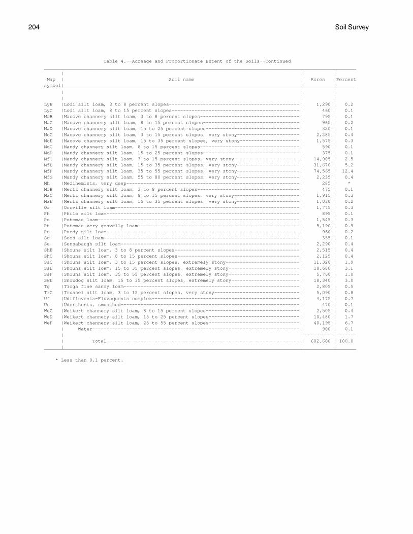
204 Soil Survey
Table 4.--Acreage and Proportionate Extent of the Soils--Continued ______________________________________________________________________________________________________________ | | | Map | Soil name | Acres |Percent symbol| | | ______________________________________________________________________________________________________________ | | | | | | LyB |Lodi silt loam, 3 to 8 percent slopes----------------------------------------------| 1,290 | 0.2 LyC |Lodi silt loam, 8 to 15 percent slopes---------------------------------------------| 460 | 0.1 MaB |Macove channery silt loam, 3 to 8 percent slopes-----------------------------------| 795 | 0.1 MaC |Macove channery silt loam, 8 to 15 percent slopes----------------------------------| 965 | 0.2 MaD |Macove channery silt loam, 15 to 25 percent slopes---------------------------------| 320 | 0.1 McC |Macove channery silt loam, 3 to 15 percent slopes, very stony----------------------| 2,285 | 0.4 McE |Macove channery silt loam, 15 to 35 percent slopes, very stony---------------------| 1,575 | 0.3 MdC |Mandy channery silt loam, 8 to 15 percent slopes-----------------------------------| 590 | 0.1 MdD |Mandy channery silt loam, 15 to 25 percent slopes----------------------------------| 375 | 0.1 MfC |Mandy channery silt loam, 3 to 15 percent slopes, very stony-----------------------| 14,905 | 2.5 MfE |Mandy channery silt loam, 15 to 35 percent slopes, very stony----------------------| 31,670 | 5.2 MfF |Mandy channery silt loam, 35 to 55 percent slopes, very stony----------------------| 74,565 | 12.4 MfG |Mandy channery silt loam, 55 to 80 percent slopes, very stony----------------------| 2,235 | 0.4 Mh |Medihemists, very deep-------------------------------------------------------------| 285 | * MrB |Mertz channery silt loam, 3 to 8 percent slopes------------------------------------| 475 | 0.1 MzC |Mertz channery silt loam, 8 to 15 percent slopes, very stony-----------------------| 1,915 | 0.3 MzE |Mertz channery silt loam, 15 to 35 percent slopes, very stony----------------------| 1,030 | 0.2 Or |Orrville silt loam-----------------------------------------------------------------| 1,775 | 0.3 Ph |Philo silt loam--------------------------------------------------------------------| 895 | 0.1 Po |Potomac loam-----------------------------------------------------------------------| 1,545 | 0.3 Pt |Potomac very gravelly loam---------------------------------------------------------| 5,190 | 0.9 Pu |Purdy silt loam--------------------------------------------------------------------| 960 | 0.2 Sc |Sees silt loam---------------------------------------------------------------------| 355 | 0.1 Se |Sensabaugh silt loam---------------------------------------------------------------| 2,290 | 0.4 ShB |Shouns silt loam, 3 to 8 percent slopes--------------------------------------------| 2,515 | 0.4 ShC |Shouns silt loam, 8 to 15 percent slopes-------------------------------------------| 2,125 | 0.4 SsC |Shouns silt loam, 3 to 15 percent slopes, extremely stony--------------------------| 11,320 | 1.9 SsE |Shouns silt loam, 15 to 35 percent slopes, extremely stony-------------------------| 18,680 | 3.1 SsF |Shouns silt loam, 35 to 55 percent slopes, extremely stony-------------------------| 5,760 | 1.0 SwE |Snowdog silt loam, 15 to 35 percent slopes, extremely stony------------------------| 18,340 | 3.0 Tg |Tioga fine sandy loam--------------------------------------------------------------| 2,805 | 0.5 TrC |Trussel silt loam, 3 to 15 percent slopes, very stony------------------------------| 5,090 | 0.8 Uf |Udifluvents-Fluvaquents complex----------------------------------------------------| 4,175 | 0.7 Us |Udorthents, smoothed---------------------------------------------------------------| 470 | 0.1 WeC |Weikert channery silt loam, 8 to 15 percent slopes---------------------------------| 2,505 | 0.4 WeD |Weikert channery silt loam, 15 to 25 percent slopes--------------------------------| 10,480 | 1.7 WeF |Weikert channery silt loam, 25 to 55 percent slopes--------------------------------| 40,195 | 6.7 | Water-------------------------------------------------------------------------| 900 | 0.1 | |-----------|------- | Total--------------------------------------------------------------------| 602,600 | 100.0 | | | ______________________________________________________________________________________________________________
* Less than 0.1 percent.

Pocahontas County, West Virginia 205
Table 5.--Land Capability and Yields per Acre of Crops and Pasture
(Yields are those that can be expected under a high level of management. Absence of a yield indicates that the soil is not suited to the crop or the crop generally is not grown on the soil)
_______________________________________________________________________________________________________________ | | | | | | | Soil name and | Land | | | | | | map symbol |capability| Corn | Oats | Wheat |Grass-legume | Alfalfa hay | Kentucky | | | | | hay | | bluegrass _______________________________________________________________________________________________________________ | | Bu | Bu | Bu | Tons | Tons | AUM* __ __ __ ____ ____ ____ | | | | | | | AlB-------------| IIe | 115 | 75 | 45 | 3.5 | 4.5 | 5.0 Allegheny | | | | | | | | | | | | | | AlC-------------| IIIe | 105 | 70 | 40 | 3.5 | 4.0 | 4.5 Allegheny | | | | | | | | | | | | | | At--------------| IIIw | 100 | 60 | 30 | 3.0 | --- | 4.5 Atkins | | | | | | | | | | | | | | BaB-------------| IIe | 120 | 75 | 45 | 3.5 | 4.5 | 5.5 Belmont | | | | | | | | | | | | | | BaC-------------| IIIe | 110 | 70 | 40 | 3.0 | 4.0 | 4.5 Belmont | | | | | | | | | | | | | | BaD-------------| IVe | 95 | 60 | 35 | 3.0 | 4.0 | 4.5 Belmont | | | | | | | | | | | | | | BbC-------------| VIs | --- | --- | --- | --- | --- | 4.0 Belmont | | | | | | | | | | | | | | BbE, BbF--------| VIIs | --- | --- | --- | --- | --- | --- Belmont | | | | | | | | | | | | | | BeB-------------| IIe | 80 | 60 | 35 | 3.0 | 3.5 | 4.0 Berks | | | | | | | | | | | | | | BeC-------------| IIIe | 75 | 55 | 35 | 2.5 | 3.0 | 4.0 Berks | | | | | | | | | | | | | | BeD-------------| IVe | 70 | 50 | 30 | 2.5 | 3.0 | 3.5 Berks | | | | | | | | | | | | | | BeE-------------| VIe | --- | --- | --- | --- | --- | 2.5 Berks | | | | | | | | | | | | | | BfC-------------| VIs | --- | --- | --- | --- | --- | 2.5 Berks | | | | | | | | | | | | | | BfE, BfF--------| VIIs | --- | --- | --- | --- | --- | --- Berks | | | | | | | | | | | | | | BgC-------------| VIs | --- | --- | --- | --- | --- | 2.5 Berks-Dekalb | | | | | | | | | | | | | | BgE, BgF--------| VIIs | --- | --- | --- | --- | --- | --- Berks-Dekalb | | | | | | | | | | | | | | BhG-------------| VIIs | --- | --- | --- | --- | --- | --- Berks, Weikert,| | | | | | | and Calvin | | | | | | | | | | | | | | BlC, BlE, BlF---| VIIs | --- | --- | --- | --- | --- | --- Blackthorn | | | | | | | | | | | | | | BoB-------------| IIw | 75 | 60 | 35 | 2.5 | 3.0 | 5.0 Blairton | | | | | | | | | | | | | |
See footnote at end of table.

206 Soil Survey
Table 5.--Land Capability and Yields per Acre of Crops and Pasture--Continued _______________________________________________________________________________________________________________ | | | | | | | Soil name and | Land | | | | | | map symbol |capability| Corn | Oats | Wheat |Grass-legume | Alfalfa hay | Kentucky | | | | | hay | | bluegrass _______________________________________________________________________________________________________________ | | Bu | Bu | Bu | Tons | Tons | AUM* __ __ __ ____ ____ ____ | | | | | | | BrF-------------| VIIs | --- | --- | --- | --- | --- | --- Briery-Rock | | | | | | | outcrop | | | | | | | | | | | | | | CaC-------------| IIIe | 75 | 55 | 35 | 2.5 | 3.0 | 4.0 Calvin | | | | | | | | | | | | | | CbC-------------| VIs | --- | --- | --- | --- | --- | 2.5 Calvin | | | | | | | | | | | | | | CbE, CbF--------| VIIs | --- | --- | --- | --- | --- | --- Calvin | | | | | | | | | | | | | | CdC-------------| VIs | --- | --- | --- | --- | --- | 2.5 Calvin-Dekalb- | | | | | | | Berks | | | | | | | | | | | | | | CdE, CdF--------| VIIs | --- | --- | --- | --- | --- | --- Calvin-Dekalb- | | | | | | | Berks | | | | | | | | | | | | | | CeB-------------| IIe | 95 | 70 | 40 | 3.5 | 4.0 | 4.5 Cateache | | | | | | | | | | | | | | CeC-------------| IIIe | 90 | 65 | 35 | 3.0 | 4.0 | 4.5 Cateache | | | | | | | | | | | | | | CeD-------------| IVe | 85 | 60 | 30 | 2.5 | 3.5 | 4.0 Cateache | | | | | | | | | | | | | | CfC-------------| VIs | --- | --- | --- | --- | --- | 3.0 Cateache | | | | | | | | | | | | | | CfE, CfF, CfG---| VIIs | --- | --- | --- | --- | --- | --- Cateache | | | | | | | | | | | | | | Ch--------------| I | 120 | 80 | 45 | 4.0 | 5.0 | 5.0 Chavies | | | | | | | | | | | | | | CuB-------------| IIe | 100 | 75 | 45 | 4.0 | 4.5 | 4.5 Culleoka | | | | | | | | | | | | | | CuC-------------| IIIe | 95 | 70 | 40 | 3.5 | 4.0 | 4.5 Culleoka | | | | | | | | | | | | | | CuD-------------| IVe | 90 | 65 | 35 | 2.5 | 3.5 | 4.0 Culleoka | | | | | | | | | | | | | | CuE-------------| VIe | --- | --- | --- | --- | --- | 3.5 Culleoka | | | | | | | | | | | | | | CuF-------------| VIIe | --- | --- | --- | --- | --- | --- Culleoka | | | | | | | | | | | | | | DhC-------------| VIs | --- | --- | --- | --- | --- | 2.5 Dekalb-Hazleton| | | | | | | | | | | | | | DhE, DhF--------| VIIs | --- | --- | --- | --- | --- | --- Dekalb-Hazleton| | | | | | | | | | | | | |
See footnote at end of table.

Pocahontas County, West Virginia 207
Table 5.--Land Capability and Yields per Acre of Crops and Pasture--Continued _______________________________________________________________________________________________________________ | | | | | | | Soil name and | Land | | | | | | map symbol |capability| Corn | Oats | Wheat |Grass-legume | Alfalfa hay | Kentucky | | | | | hay | | bluegrass _______________________________________________________________________________________________________________ | | Bu | Bu | Bu | Tons | Tons | AUM* __ __ __ ____ ____ ____ | | | | | | | DuB-------------| IIe | 130 | 80 | 50 | 3.5 | 5.0 | 5.5 Duffield | | | | | | | | | | | | | | DuC-------------| IIIe | 125 | 75 | 45 | 3.0 | 4.5 | 5.0 Duffield | | | | | | | | | | | | | | ElF-------------| VIIs | --- | --- | --- | --- | --- | --- Elliber | | | | | | | | | | | | | | FaC, FaE--------| VIs | --- | --- | --- | --- | --- | 3.0 Faywood | | | | | | | | | | | | | | FaF-------------| VIIs | --- | --- | --- | --- | --- | --- Faywood | | | | | | | | | | | | | | GaC-------------| VIIs | --- | --- | --- | --- | --- | --- Gauley | | | | | | | | | | | | | | GaE-------------| VIIs | --- | --- | --- | --- | --- | --- Gauley | | | | | | | | | | | | | | Ho--------------| IIIw | 100 | 70 | 35 | 3.0 | --- | 4.5 Holly | | | | | | | | | | | | | | LeC-------------| VIs | --- | --- | --- | --- | --- | 2.5 Leatherbark | | | | | | | | | | | | | | LlB-------------| IIe | 95 | 70 | 40 | 3.5 | 4.0 | 4.5 Lily | | | | | | | | | | | | | | LlC-------------| IIIe | 85 | 65 | 35 | 3.0 | 3.5 | 4.0 Lily | | | | | | | | | | | | | | LlD-------------| IVe | 80 | 60 | 30 | 2.5 | 3.0 | 3.5 Lily | | | | | | | | | | | | | | Lo--------------| IIw | 120 | 75 | 45 | 3.5 | 4.5 | 5.0 Lobdell | | | | | | | | | | | | | | LyB-------------| IIe | 135 | 85 | 50 | 4.0 | 5.0 | 6.0 Lodi | | | | | | | | | | | | | | LyC-------------| IIIe | 130 | 80 | 45 | 3.5 | 4.5 | 5.5 Lodi | | | | | | | | | | | | | | MaB-------------| IIe | 90 | 70 | 40 | 3.0 | 3.5 | 4.5 Macove | | | | | | | | | | | | | | MaC-------------| IIIe | 85 | 65 | 35 | 3.0 | 3.5 | 4.0 Macove | | | | | | | | | | | | | | MaD-------------| IVe | 75 | 60 | 30 | 3.0 | 3.5 | 3.5 Macove | | | | | | | | | | | | | | McC-------------| VIs | --- | --- | --- | --- | --- | 3.5 Macove | | | | | | | | | | | | | | McE-------------| VIIs | --- | --- | --- | --- | --- | --- Macove | | | | | | | | | | | | | | MdC-------------| IIIe | --- | --- | --- | --- | --- | 3.5 Mandy | | | | | | | | | | | | | |
See footnote at end of table.

208 Soil Survey
Table 5.--Land Capability and Yields per Acre of Crops and Pasture--Continued _______________________________________________________________________________________________________________ | | | | | | | Soil name and | Land | | | | | | map symbol |capability| Corn | Oats | Wheat |Grass-legume | Alfalfa hay | Kentucky | | | | | hay | | bluegrass _______________________________________________________________________________________________________________ | | Bu | Bu | Bu | Tons | Tons | AUM* __ __ __ ____ ____ ____ | | | | | | | MdD-------------| IVe | --- | --- | --- | --- | --- | 3.0 Mandy | | | | | | | | | | | | | | MfC-------------| VIs | --- | --- | --- | --- | --- | 2.0 Mandy | | | | | | | | | | | | | | MfE, MfF, MfG---| VIIs | --- | --- | --- | --- | --- | --- Mandy | | | | | | | | | | | | | | Mh. | | | | | | | Medihemists | | | | | | | | | | | | | | MrB-------------| IIe | 110 | 70 | 40 | 3.5 | 4.5 | 5.0 Mertz | | | | | | | | | | | | | | MzC-------------| VIs | --- | --- | --- | --- | --- | 4.0 Mertz | | | | | | | | | | | | | | MzE-------------| VIIs | --- | --- | --- | --- | --- | --- Mertz | | | | | | | | | | | | | | Or--------------| IIw | 110 | 75 | 45 | 3.5 | --- | 5.0 Orrville | | | | | | | | | | | | | | Ph--------------| IIw | 110 | 75 | 45 | 3.5 | 4.5 | 5.0 Philo | | | | | | | | | | | | | | Po--------------| IVs | 85 | 60 | --- | 2.5 | 3.0 | 3.5 Potomac | | | | | | | | | | | | | | Pt--------------| Vs | --- | --- | --- | 2.0 | 2.5 | 3.0 Potomac | | | | | | | | | | | | | | Pu--------------| IVw | 80 | 55 | 40 | 2.5 | --- | 3.0 Purdy | | | | | | | | | | | | | | Sc--------------| IIIw | 80 | 55 | 40 | 3.0 | --- | 3.5 Sees | | | | | | | | | | | | | | Se--------------| IIw | 110 | 75 | 45 | 3.5 | 4.5 | 5.0 Sensabaugh | | | | | | | | | | | | | | ShB-------------| IIe | 120 | 80 | 50 | 4.0 | 5.0 | 5.5 Shouns | | | | | | | | | | | | | | ShC-------------| IIIe | 115 | 75 | 45 | 3.5 | 4.5 | 5.0 Shouns | | | | | | | | | | | | | | SsC, SsE, SsF---| VIIs | --- | --- | --- | --- | --- | --- Shouns | | | | | | | | | | | | | | SwE-------------| VIIs | --- | --- | --- | --- | --- | --- Snowdog | | | | | | | | | | | | | | Tg--------------| I | 120 | 80 | 45 | 4.0 | 5.0 | 5.0 Tioga | | | | | | | | | | | | | | TrC-------------| VIs | --- | --- | --- | --- | --- | 2.0 Trussel | | | | | | | | | | | | | |
See footnote at end of table.

Pocahontas County, West Virginia 209
Table 5.--Land Capability and Yields per Acre of Crops and Pasture--Continued _______________________________________________________________________________________________________________ | | | | | | | Soil name and | Land | | | | | | map symbol |capability| Corn | Oats | Wheat |Grass-legume | Alfalfa hay | Kentucky | | | | | hay | | bluegrass _______________________________________________________________________________________________________________ | | Bu | Bu | Bu | Tons | Tons | AUM* __ __ __ ____ ____ ____ | | | | | | | Uf*. | | | | | | | Udlfluvents- | | | | | | | Fluvaquents | | | | | | | | | | | | | | Us. | | | | | | | Udorthents | | | | | | | | | | | | | | WeC-------------| IVe | 60 | 45 | 20 | 2.0 | 2.0 | 3.0 Weikert | | | | | | | | | | | | | | WeD-------------| VIe | --- | --- | --- | --- | --- | 2.0 Weikert | | | | | | | | | | | | | | WeF-------------| VIIe | --- | --- | --- | --- | --- | --- Weikert | | | | | | | | | | | | | | _______________________________________________________________________________________________________________
* Animal-unit-month: The amount of forage or feed required to feed one animal unit (one cow, one horse, one mule, five sheep, or five goats) for 30 days.

210 Soil Survey
Table 6.--Capability Classes and Subclasses
(Miscellaneous areas are excluded. Absence of an entry indicates no acreage)
______________________________________________________ | |Major management concerns (Subclass) ____________________________________ Class | Total | | | Soil | acreage | Erosion | Wetness | problem | | (e) | (w) | (s) ______________________________________________________ | | Acres | Acres | Acres _____ _____ _____ | | | | | | | | I | 5,415| --- | --- | --- | | | | II | 24,660| 17,235 | 7,425 | --- | | | | III | 18,235| 13,785 | 4,450 | --- | | | | IV | 13,815| 11,310 | 960 | 1,545 | | | | V | 5,190| --- | --- | 5,190 | | | | VI | 59,470| 11,530 | --- | 47,940 | | | | VII | 469,985| 42,200 | --- | 427,785 | | | | VIII | ---| --- | --- | --- | | | | ______________________________________________________
Table 7.--Prime Farmland
(Only the soils considered prime farmland are listed. Urban or built-up areas of the soils listed are not considered prime farmland)
______________________________________________________________________________________________________________ | Map | Soil name symbol | ______________________________________________________________________________________________________________ | | AlB |Allegheny loam, 3 to 8 percent slopes BaB |Belmont silt loam, 3 to 8 percent slopes CeB |Cateache channery silt loam, 3 to 8 percent slopes Ch |Chavies fine sandy loam CuB |Culleoka silt loam, 3 to 8 percent slopes DuB |Duffield silt loam, 3 to 8 percent slopes LlB |Lily loam, 3 to 8 percent slopes Lo |Lobdell silt loam MaB |Macove channery silt loam, 3 to 8 percent slopes MrB |Mertz channery silt loam, 3 to 8 percent slopes Ph |Philo silt loam Se |Sensabaugh silt loam ShB |Shouns silt loam, 3 to 8 percent slopes Tg |Tioga fine sandy loam | ______________________________________________________________________________________________________________

Pocahontas County, West Virginia 211
Table 8.--Woodland Management
(Only the soils suitable for production of commercial trees are listed. Absence of an entry indicates that information was not available)
_______________________________________________________________________________________________________________ | | | | | | Operability of Soil name and | Erosion | Seedling | Plant |Haul roads and |Log landings** | equipment in map symbol | hazard* | mortality* | competition* | skid roads** | | logging areas** | | | | | |_______________________________________________________________________________________________________________ | | | | | | | | | | | |AlB--------------|Slight----|Slight-------|Moderate: |Moderate: |Moderate: |Slight. Allegheny | | | high productivity.| low strength. | low strength. | | | | | | |AlC--------------|Slight----|Slight-------|Moderate: |Moderate: |Moderate: |Slight. Allegheny | | | high productivity.| low strength. | slope. | | | | | | |At---------------|Slight----|Severe: |Severe: |Severe: |Severe: |Severe: Atkins | | wetness. | wetness. | wetness, | wetness. | wetness. | | | | flooding. | | | | | | | |BaB--------------|Slight----|Slight-------|Moderate: |Moderate: |Moderate: |Slight. Belmont | | | high productivity.| low strength. | low strength. | | | | | | |BaC--------------|Slight----|Slight-------|Moderate: |Moderate: |Moderate: |Slight. Belmont | | | high productivity.| low strength. | low strength, | | | | | | slope. | | | | | | |BaD--------------|Moderate: |Slight-------|Moderate: |Moderate: |Severe: |Moderate: Belmont | slope. | | high productivity.| slope, | slope. | slope. (north aspect) | | | | low strength. | | | | | | | |BaD--------------|Moderate: |Moderate: |Moderate: |Moderate: |Severe: |Moderate: Belmont | slope. | slope. | high productivity.| slope, | slope. | slope. (south aspect) | | | | low strength. | | | | | | | |BbC--------------|Slight----|Slight-------|Moderate: |Moderate: |Moderate: |Slight. Belmont | | | high productivity.| low strength. | low strength, | | | | | | slope. | | | | | | |BbE--------------|Moderate: |Slight-------|Moderate: |Moderate: |Severe: |Moderate: Belmont | slope. | | high productivity.| slope, | slope. | slope. (north aspect) | | | | low strength. | | | | | | | |BbE--------------|Moderate: |Moderate: |Moderate: |Moderate: |Severe: |Moderate: Belmont | slope. | slope. | high productivity.| slope, | slope. | slope. (south aspect) | | | | low strength. | | | | | | | |BbF--------------|Severe: |Slight-------|Moderate: |Severe: |Severe: |Severe: Belmont | slope. | | high productivity.| slope. | slope. | slope. (north aspect) | | | | | | | | | | | |BbF--------------|Severe: |Moderate: |Moderate: |Severe: |Severe: |Severe: Belmont | slope. | slope. | high productivity.| slope. | slope. | slope. (south aspect) | | | | | | | | | | | |BeB--------------|Slight----|Moderate: |Slight-------------|Slight---------|Slight---------|Slight. Berks | | rock | | | | | | fragments. | | | | | | | | | |BeC--------------|Slight----|Moderate: |Slight-------------|Slight---------|Moderate: |Slight. Berks | | rock | | | slope. | | | fragments. | | | | | | | | | |BeD--------------|Moderate: |Moderate: |Slight-------------|Moderate: |Severe: |Moderate: Berks | slope. | rock | | slope. | slope. | slope. (north aspect) | | fragments. | | | | | | | | | |
See footnotes at end of table.

212 Soil Survey
Table 8.--Woodland Management--Continued_______________________________________________________________________________________________________________ | | | | | | Operability of Soil name and | Erosion | Seedling | Plant |Haul roads and |Log landings** | equipment in map symbol | hazard* | mortality* | competition* | skid roads** | | logging areas** | | | | | |_______________________________________________________________________________________________________________ | | | | | | | | | | | |BeD--------------|Moderate: |Moderate: |Slight-------------|Moderate: |Severe: |Moderate: Berks | slope. | rock | | slope. | slope. | slope. (south aspect) | | fragments, | | | | | | slope. | | | | | | | | | |BeE--------------|Moderate: |Moderate: |Slight-------------|Moderate: |Severe: |Moderate: Berks | slope. | rock | | slope. | slope. | slope. (north aspect) | | fragments. | | | | | | | | | |BeE--------------|Moderate: |Moderate: |Slight-------------|Moderate: |Severe: |Moderate: Berks | slope. | rock | | slope. | slope. | slope. (south aspect) | | fragments, | | | | | | slope. | | | | | | | | | |BfC--------------|Slight----|Moderate: |Slight-------------|Slight---------|Moderate: |Slight. Berks | | rock | | | slope. | | | fragments. | | | | | | | | | |BfE--------------|Moderate: |Moderate: |Slight-------------|Moderate: |Severe: |Moderate: Berks | slope. | rock | | slope. | slope. | slope. (north aspect) | | fragments. | | | | | | | | | |BfE--------------|Moderate: |Moderate: |Slight-------------|Moderate: |Severe: |Moderate: Berks | slope. | rock | | slope. | slope. | slope. (south aspect) | | fragments, | | | | | | slope. | | | | | | | | | |BfF--------------|Severe: |Moderate: |Slight-------------|Severe: |Severe: |Severe: Berks | slope. | rock | | slope. | slope. | slope. (north aspect) | | fragments. | | | | | | | | | |BfF--------------|Severe: |Moderate: |Slight-------------|Severe: |Severe: |Severe: Berks | slope. | rock | | slope. | slope. | slope. (south aspect) | | fragments, | | | | | | slope. | | | | | | | | | |BgC***: | | | | | | Berks-----------|Slight----|Moderate: |Slight-------------|Slight---------|Moderate: |Slight. | | rock | | | slope. | | | fragments. | | | | | | | | | | Dekalb----------|Slight----|Moderate: |Slight-------------|Moderate: |Moderate: |Slight. | | rock | | depth to rock.| depth to rock,| | | fragments. | | | slope. | | | | | | |BgE***: | | | | | | Berks-----------|Moderate: |Moderate: |Slight-------------|Moderate: |Severe: |Moderate: (north aspect) | slope. | rock | | slope. | slope. | slope. | | fragments. | | | | | | | | | | Dekalb----------|Moderate: |Moderate: |Slight-------------|Moderate: |Severe: |Moderate: (north aspect) | slope. | rock | | slope, | slope. | slope. | | fragments. | | depth to rock.| | | | | | | |BgE***: | | | | | | Berks-----------|Moderate: |Moderate: |Slight-------------|Moderate: |Severe: |Moderate: (south aspect) | slope. | rock | | slope. | slope. | slope. | | fragments, | | | | | | slope. | | | | | | | | | |
See footnotes at end of table.

Pocahontas County, West Virginia 213
Table 8.--Woodland Management--Continued_______________________________________________________________________________________________________________ | | | | | | Operability of Soil name and | Erosion | Seedling | Plant |Haul roads and |Log landings** | equipment in map symbol | hazard* | mortality* | competition* | skid roads** | | logging areas** | | | | | |_______________________________________________________________________________________________________________ | | | | | | | | | | | |BgE***: | | | | | | Dekalb----------|Moderate: |Moderate: |Slight-------------|Moderate: |Severe: |Moderate: (south aspect) | slope. | rock | | slope, | slope. | slope. | | fragments, | | depth to rock.| | | | slope. | | | | | | | | | |BgF***: | | | | | | Berks-----------|Severe: |Moderate: |Slight-------------|Severe: |Severe: |Severe: (north aspect) | slope. | rock | | slope. | slope. | slope. | | fragments. | | | | | | | | | | Dekalb----------|Severe: |Moderate: |Slight-------------|Severe: |Severe: |Severe: (north aspect) | slope. | rock | | slope. | slope. | slope. | | fragments. | | | | | | | | | |BgF***: | | | | | | Berks-----------|Severe: |Moderate: |Slight-------------|Severe: |Severe: |Severe: (south aspect) | slope. | rock | | slope. | slope. | slope. | | fragments, | | | | | | slope. | | | | | | | | | | Dekalb----------|Severe: |Moderate: |Slight-------------|Severe: |Severe: |Severe: (south aspect) | slope. | rock | | slope. | slope. | slope. | | fragments, | | | | | | slope. | | | | | | | | | |BhG***: | | | | | | Berks-----------|Severe: |Moderate: |Slight-------------|Severe: |Severe: |Severe: (north aspect) | slope. | rock | | slope. | slope. | slope. | | fragments. | | | | | | | | | | Weikert---------|Severe: |Moderate: |Slight-------------|Severe: |Severe: |Severe: (north aspect) | slope. | rock | | slope. | slope. | slope. | | fragments, | | | | | | restrictive | | | | | | layer. | | | | | | | | | | Calvin----------|Severe: |Moderate: |Moderate-----------|Severe: |Severe: |Severe: (north aspect) | slope. | rock | | slope. | slope. | slope. | | fragments. | | | | | | | | | |BhG***: | | | | | | Berks-----------|Severe: |Moderate: |Slight-------------|Severe: |Severe: |Severe: (south aspect) | slope. | rock | | slope. | slope. | slope. | | fragments, | | | | | | slope. | | | | | | | | | | Weikert---------|Severe: |Moderate: |Slight-------------|Severe: |Severe: |Severe: (south aspect) | slope. | rock | | slope. | slope. | slope. | | fragments, | | | | | | restrictive | | | | | | layer, | | | | | | slope. | | | | | | | | | | Calvin----------|Severe: |Moderate: |Slight-------------|Severe: |Severe: |Severe: (south aspect) | slope. | rock | | slope. | slope. | slope. | | fragments, | | | | | | slope. | | | | | | | | | |
See footnotes at end of table.

214 Soil Survey
Table 8.--Woodland Management--Continued_______________________________________________________________________________________________________________ | | | | | | Operability of Soil name and | Erosion | Seedling | Plant |Haul roads and |Log landings** | equipment in map symbol | hazard* | mortality* | competition* | skid roads** | | logging areas** | | | | | |_______________________________________________________________________________________________________________ | | | | | | | | | | | |BlC--------------|Slight----|Slight-------|Moderate: |Moderate: |Moderate: |Slight. Blackthorn | | | high productivity.| too stony. | too stony, | | | | | | slope. | | | | | | |BlE--------------|Moderate: |Slight-------|Moderate: |Moderate: |Severe: |Moderate: Blackthorn | slope. | | high productivity.| slope, | slope. | slope. | | | | too stony. | | | | | | | |BlF--------------|Severe: |Slight-------|Moderate: |Severe: |Severe: |Severe: Blackthorn | slope. | | high productivity.| slope. | slope. | slope. | | | | | |BoB--------------|Slight----|Slight-------|Severe: |Moderate: |Moderate: |Slight. Blairton | | | wetness. | wetness, | wetness, | | | | | low strength. | low strength. | | | | | | |BrF***: | | | | | | Briery----------|Severe: |Severe: |Slight-------------|Severe: |Severe: |Severe: | slope. | rock | | slope. | slope. | slope. | | fragments. | | | | | | | | | | Rock outcrop. | | | | | | | | | | | |CaC--------------|Slight----|Moderate: |Slight-------------|Moderate: |Moderate: |Slight. Calvin | | rock | | low strength. | low strength, | | | fragments. | | | slope. | | | | | | |CbC--------------|Slight----|Moderate: |Slight-------------|Moderate: |Moderate: |Slight. Calvin | | rock | | low strength. | low strength, | | | fragments. | | | slope. | | | | | | |CbE--------------|Moderate: |Moderate: |Moderate: |Moderate: |Severe: |Moderate: Calvin | slope. | rock | high productivity.| slope, | slope. | slope. (north aspect) | | fragments. | | low strength. | | | | | | | |CbE--------------|Moderate: |Moderate: |Slight-------------|Moderate: |Severe: |Moderate: Calvin | slope. | rock | | slope, | slope. | slope. (south aspect) | | fragments, | | low strength. | | | | slope. | | | | | | | | | |CbF--------------|Severe: |Moderate: |Moderate: |Severe: |Severe: |Severe: Calvin | slope. | rock | high productivity.| slope. | slope. | slope. (north aspect) | | fragments. | | | | | | | | | |CbF--------------|Severe: |Moderate: |Slight-------------|Severe: |Severe: |Severe: Calvin | slope. | rock | | slope. | slope. | slope. (south aspect) | | fragments, | | | | | | slope. | | | | | | | | | |CdC***: | | | | | | Calvin----------|Slight----|Moderate: |Slight-------------|Moderate: |Moderate: |Slight. | | rock | | low strength. | low strength. | | | fragments. | | | | | | | | | | Dekalb----------|Slight----|Moderate: |Slight-------------|Moderate: |Moderate: |Slight. | | rock | | depth to rock.| depth to rock,| | | fragments. | | | slope. | | | | | | | Berks-----------|Slight----|Moderate: |Slight-------------|Slight---------|Moderate: |Slight. | | rock | | | slope. | | | fragments. | | | | | | | | | |
See footnotes at end of table.

Pocahontas County, West Virginia 215
Table 8.--Woodland Management--Continued_______________________________________________________________________________________________________________ | | | | | | Operability of Soil name and | Erosion | Seedling | Plant |Haul roads and |Log landings** | equipment in map symbol | hazard* | mortality* | competition* | skid roads** | | logging areas** | | | | | |_______________________________________________________________________________________________________________ | | | | | | | | | | | |CdE***: | | | | | | Calvin----------|Moderate: |Moderate: |Moderate: |Moderate: |Severe: |Moderate: (north aspect) | slope. | rock | high productivity.| slope, | slope. | slope. | | fragments. | | low strength. | | | | | | | | Dekalb----------|Moderate: |Moderate: |Slight-------------|Moderate: |Severe: |Moderate: (north aspect) | slope. | rock | | slope, | slope. | slope. | | fragments. | | depth to rock.| | | | | | | | Berks-----------|Moderate: |Moderate: |Slight-------------|Moderate: |Severe: |Moderate: (north aspect) | slope. | rock | | slope. | slope. | slope. | | fragments. | | | | | | | | | |CdE***: | | | | | | Calvin----------|Moderate: |Moderate: |Slight-------------|Moderate: |Severe: |Moderate: (south aspect) | slope. | rock | | slope, | slope. | slope. | | fragments, | | low strength. | | | | slope. | | | | | | | | | | Dekalb----------|Moderate: |Moderate: |Slight-------------|Moderate: |Severe: |Moderate: (south aspect) | slope. | rock | | slope, | slope. | slope. | | fragments, | | depth to rock.| | | | slope. | | | | | | | | | | Berks-----------|Moderate: |Moderate: |Slight-------------|Moderate: |Severe: |Moderate: (south aspect) | slope. | rock | | slope. | slope. | slope. | | fragments, | | | | | | slope. | | | | | | | | | |CdF***: | | | | | | Calvin----------|Severe: |Moderate: |Moderate: |Severe: |Severe: |Severe: (north aspect) | slope. | rock | high productivity.| slope. | slope. | slope. | | fragments. | | | | | | | | | | Dekalb----------|Severe: |Moderate: |Slight-------------|Severe: |Severe: |Severe: (north aspect) | slope. | rock | | slope. | slope. | slope. | | fragments. | | | | | | | | | | Berks-----------|Severe: |Moderate: |Slight-------------|Severe: |Severe: |Severe: (north aspect) | slope. | rock | | slope. | slope. | slope. | | fragments. | | | | | | | | | |CdF***: | | | | | | Calvin----------|Severe: |Moderate: |Slight-------------|Severe: |Severe: |Severe: (south aspect) | slope. | rock | | slope. | slope. | slope. | | fragments, | | | | | | slope. | | | | | | | | | | Dekalb----------|Severe: |Moderate: |Slight-------------|Severe: |Severe: |Severe: (south aspect) | slope. | rock | | slope. | slope. | slope. | | fragments, | | | | | | slope. | | | | | | | | | | Berks-----------|Severe: |Moderate: |Slight-------------|Severe: |Severe: |Severe: (south aspect) | slope. | rock | | slope. | slope. | slope. | | fragments, | | | | | | slope. | | | | | | | | | |CeB--------------|Slight----|Slight-------|Moderate: |Moderate: |Moderate: |Slight. Cateache | | | high productivity.| low strength. | low strength. | | | | | | | | | | | | |
See footnotes at end of table.

216 Soil Survey
Table 8.--Woodland Management--Continued_______________________________________________________________________________________________________________ | | | | | | Operability of Soil name and | Erosion | Seedling | Plant |Haul roads and |Log landings** | equipment in map symbol | hazard* | mortality* | competition* | skid roads** | | logging areas** | | | | | |_______________________________________________________________________________________________________________ | | | | | | | | | | | |CeC--------------|Slight----|Slight-------|Moderate: |Moderate: |Moderate: |Slight. Cateache | | | high productivity.| low strength. | low strength, | | | | | | slope. | | | | | | |CeD--------------|Moderate: |Slight-------|Moderate: |Severe: |Severe: |Severe: Cateache | slope. | | high productivity.| slippage. | slope, | slippage. (north aspect) | | | | | slippage. | | | | | | |CeD--------------|Moderate: |Moderate: |Moderate: |Severe: |Severe: |Severe: Cateache | slope. | slope. | high productivity.| slippage. | slope, | slippage. (south aspect) | | | | | slippage. | | | | | | |CfC--------------|Slight----|Slight-------|Moderate: |Moderate: |Moderate: |Slight. Cateache | | | high productivity.| low strength. | low strength, | | | | | | slope. | | | | | | |CfE--------------|Moderate: |Slight-------|Moderate: |Severe: |Severe: |Severe: Cateache | slope. | | high productivity.| slippage. | slope, | slippage. (north aspect) | | | | | slippage. | | | | | | |CfE--------------|Moderate: |Moderate: |Moderate: |Severe: |Severe: |Severe: Cateache | slope. | slope. | high productivity.| slippage. | slope, | slippage. (south aspect) | | | | | slippage. | | | | | | |CfF--------------|Severe: |Slight-------|Moderate: |Severe: |Severe: |Severe: Cateache | slope. | | high productivity.| slope, | slope, | slope, (north aspect) | | | | slippage. | slippage. | slippage. | | | | | |CfF--------------|Severe: |Moderate: |Moderate: |Severe: |Severe: |Severe: Cateache | slope. | slope. | high productivity.| slope, | slope, | slope, (south aspect) | | | | slippage. | slippage. | slippage. | | | | | |CfG--------------|Severe: |Slight-------|Moderate: |Severe: |Severe: |Severe: Cateache | slope. | | high productivity.| slope, | slope, | slope, (north aspect) | | | | slippage. | slippage. | slippage. | | | | | |CfG--------------|Severe: |Moderate: |Moderate: |Severe: |Severe: |Severe: Cateache | slope. | slope. | high productivity.| slope, | slope, | slope, (south aspect) | | | | slippage. | slippage. | slippage. | | | | | |Ch---------------|Slight----|Slight-------|Moderate: |Moderate: |Moderate: |Slight. Chavies | | | high productivity.| low strength. | low strength. | | | | | | |CuB--------------|Slight----|Slight-------|Moderate: |Moderate: |Moderate: |Slight. Culleoka | | | high productivity.| low strength. | low strength. | | | | | | |CuC--------------|Slight----|Slight-------|Moderate: |Moderate: |Moderate: |Slight. Culleoka | | | high productivity.| low strength. | low strength, | | | | | | slope. | | | | | | |CuD--------------|Moderate: |Slight-------|Moderate: |Moderate: |Severe: |Moderate: Culleoka | slope. | | high productivity.| slope, | slope. | slope. (north aspect) | | | | low strength. | | | | | | | |CuD--------------|Moderate: |Moderate: |Moderate: |Moderate: |Severe: |Moderate: Culleoka | slope. | slope. | high productivity.| slope, | slope. | slope. (south aspect) | | | | low strength. | | | | | | | |CuE--------------|Moderate: |Slight-------|Moderate: |Moderate: |Severe: |Moderate: Culleoka | slope. | | high productivity.| slope, | slope. | slope. (north aspect) | | | | low strength. | | | | | | | |
See footnotes at end of table.

Pocahontas County, West Virginia 217
Table 8.--Woodland Management--Continued_______________________________________________________________________________________________________________ | | | | | | Operability of Soil name and | Erosion | Seedling | Plant |Haul roads and |Log landings** | equipment in map symbol | hazard* | mortality* | competition* | skid roads** | | logging areas** | | | | | |_______________________________________________________________________________________________________________ | | | | | | | | | | | |CuE--------------|Moderate: |Moderate: |Moderate: |Moderate: |Severe: |Moderate: Culleoka | slope. | slope. | high productivity.| slope, | slope. | slope. (south aspect) | | | | low strength. | | | | | | | |CuF--------------|Severe: |Slight-------|Moderate: |Severe: |Severe: |Severe: Culleoka | slope. | | high productivity.| slope. | slope. | slope. (north aspect) | | | | | | | | | | | |CuF--------------|Severe: |Moderate: |Moderate: |Severe: |Severe: |Severe: Culleoka | slope. | slope. | high productivity.| slope. | slope. | slope. (south aspect) | | | | | | | | | | | |DhC***: | | | | | | Dekalb----------|Severe----|Moderate: |Slight-------------|Moderate: |Moderate: |Slight. | | rock | | depth to rock.| depth to rock,| | | fragments. | | | slope. | | | | | | | Hazleton--------|Slight----|Slight-------|Moderate: |Slight---------|Moderate: |Slight. | | | high productivity.| | slope. | | | | | | |DhE***: | | | | | | Dekalb----------|Moderate: |Moderate: |Slight-------------|Moderate: |Severe: |Moderate: (north aspect) | slope. | rock | | slope, | slope. | slope. | | fragments. | | depth to rock.| | | | | | | | Hazleton--------|Moderate: |Slight-------|Moderate: |Moderate: |Severe: |Moderate: (north aspect) | slope. | | high productivity.| slope. | slope. | slope. | | | | | |DhE***: | | | | | | Dekalb----------|Moderate: |Moderate: |Slight-------------|Moderate: |Severe: |Moderate: (south aspect) | slope. | rock | | slope, | slope. | slope. | | fragments. | | depth to rock.| | | | | | | | Hazleton--------|Moderate: |Moderate: |Slight-------------|Moderate: |Severe: |Moderate: (south aspect) | slope. | slope. | | slope. | slope. | slope. | | | | | |DhF***: | | | | | | Dekalb----------|Severe: |Moderate: |Slight-------------|Severe: |Severe: |Severe: (north aspect) | slope. | rock | | slope. | slope. | slope. | | fragments. | | | | | | | | | | Hazleton--------|Severe: |Slight-------|Moderate: |Severe: |Severe: |Severe: (north aspect) | slope. | | high productivity.| slope. | slope. | slope. | | | | | |DhF***: | | | | | | Dekalb----------|Severe: |Moderate: |Slight-------------|Severe: |Severe: |Severe: (south aspect) | slope. | rock | | slope. | slope. | slope. | | fragments. | | | | | | | | | | Hazleton--------|Severe: |Moderate: |Slight-------------|Severe: |Severe: |Severe: (south aspect) | slope. | slope. | | slope. | slope. | slope. | | | | | |DuB--------------|Slight----|Slight-------|Moderate: |Moderate: |Moderate: |Slight. Duffield | | | high productivity.| low strength. | low strength. | | | | | | |DuC--------------|Moderate: |Slight-------|Moderate: |Moderate: |Moderate: |Slight. Duffield | slope. | | high productivity.| low strength. | low strength, | | | | | | slope. | | | | | | |
See footnotes at end of table.

218 Soil Survey
Table 8.--Woodland Management--Continued_______________________________________________________________________________________________________________ | | | | | | Operability of Soil name and | Erosion | Seedling | Plant |Haul roads and |Log landings** | equipment in map symbol | hazard* | mortality* | competition* | skid roads** | | logging areas** | | | | | |_______________________________________________________________________________________________________________ | | | | | | | | | | | |ElF--------------|Severe: |Slight-------|Severe: |Severe: |Severe: |Severe: Elliber | slope. | | high productivity.| slope. | slope. | slope. (north aspect) | | | | | | | | | | | |ElF--------------|Severe: |Moderate: |Moderate: |Severe: |Severe: |Severe: Elliber | slope. | slope. | high productivity.| slope. | slope. | slope. (south aspect) | | | | | | | | | | | |FaC--------------|Slight----|Slight-------|Moderate: |Moderate: |Moderate: |Slight. Faywood | | | high productivity.| low strength, | depth to rock,| | | | | depth to rock.| low strength, | | | | | | slope. | | | | | | |FaE--------------|Moderate: |Slight-------|Moderate: |Severe: |Severe: |Moderate: Faywood | slope. | | high productivity.| low strength. | low strength, | slope. | | | | | slope. | | | | | | |FaF--------------|Severe: |Slight-------|Moderate: |Severe: |Severe: |Severe: Faywood | slope. | | high productivity.| slope, | low strength, | slope. | | | | low strength. | slope. | | | | | | |GaC--------------|Slight----|Moderate: |Severe: |Moderate: |Moderate: |Slight. Gauley | | rock | high productivity.| too stony. | too stony, | | | fragments. | | depth to rock.| depth to rock,| | | | | | slope. | | | | | | |GaE--------------|Moderate: |Moderate: |Severe: |Moderate: |Severe: |Moderate: Gauley | slope. | rock | high productivity.| slope, | slope. | slope. | | fragments. | | too stony, | | | | | | depth to rock.| | | | | | | |Ho---------------|Slight----|Moderate: |Severe: |Severe: |Severe: |Severe: Holly | | wetness. | wetness, | wetness, | wetness, | wetness, | | | high productivity.| flooding. | flooding. | flooding. | | | | | |LeC--------------|Slight----|Slight-------|Severe: |Severe: |Severe: |Moderate: Leatherbark | | | high productivity.| wetness. | wetness. | wetness. | | | | | |LlB--------------|Slight----|Slight-------|Slight-------------|Moderate: |Moderate: |Slight. Lily | | | | low strength, | depth to rock,| | | | | depth to rock.| low strength. | | | | | | |LlC--------------|Slight----|Slight-------|Slight-------------|Moderate: |Moderate: |Slight. Lily | | | | low strength, | depth to rock,| | | | | depth to rock.| low strength, | | | | | | slope. | | | | | | |LlD--------------|Moderate: |Slight-------|Slight-------------|Moderate: |Severe: |Moderate: Lily | slope. | | | slope, | slope. | slope. | | | | low strength, | | | | | | depth to rock.| | | | | | | |Lo---------------|Slight----|Slight-------|Severe: |Moderate: |Moderate: |Moderate: Lobdell | | | high productivity.| low strength, | low strength, | flooding. | | | | flooding. | flooding. | | | | | | |LyB--------------|Slight----|Slight-------|Severe: |Moderate: |Moderate: |Slight. Lodi | | | high productivity.| low strength. | low strength. | | | | | | |
See footnotes at end of table.

Pocahontas County, West Virginia 219
Table 8.--Woodland Management--Continued_______________________________________________________________________________________________________________ | | | | | | Operability of Soil name and | Erosion | Seedling | Plant |Haul roads and |Log landings** | equipment in map symbol | hazard* | mortality* | competition* | skid roads** | | logging areas** | | | | | |_______________________________________________________________________________________________________________ | | | | | | | | | | | |LyC--------------|Slight----|Slight-------|Severe: |Moderate: |Moderate: |Slight. Lodi | | | high productivity.| low strength. | low strength, | | | | | | slope. | | | | | | |MaB--------------|Slight----|Slight-------|Moderate: |Moderate: |Moderate: |Slight. Macove | | | high productivity.| low strength. | low strength. | | | | | | |MaC--------------|Slight----|Slight-------|Moderate: |Moderate: |Moderate: |Slight. Macove | | | high productivity.| low strength. | low strength, | | | | | | slope. | | | | | | |MaD--------------|Moderate: |Slight-------|Moderate: |Moderate: |Severe: |Moderate: Macove | slope. | | high productivity.| slope, | slope. | slope. (north aspect) | | | | low strength. | | | | | | | |MaD--------------|Moderate: |Moderate: |Slight-------------|Moderate: |Severe: |Moderate: Macove | slope. | slope. | | slope, | slope. | slope. (south aspect) | | | | low strength. | | | | | | | |McC--------------|Slight----|Slight-------|Moderate: |Moderate: |Moderate: |Slight. Macove | | | high productivity.| low strength. | low strength, | | | | | | slope. | | | | | | |McE--------------|Moderate: |Slight-------|Moderate: |Moderate: |Severe: |Moderate: Macove | slope. | | high productivity.| slope, | slope. | slope. (north aspect) | | | | low strength. | | | | | | | |McE--------------|Moderate: |Moderate: |Slight-------------|Moderate: |Severe: |Moderate: Macove | slope. | slope. | | slope, | slope. | slope. (south aspect) | | | | low strength. | | | | | | | |MdC--------------|Slight----|Slight-------|Moderate: |Slight---------|Moderate: |Slight. Mandy | | | high productivity.| | slope. | | | | | | |MdD--------------|Moderate: |Slight-------|Moderate: |Moderate: |Severe: |Moderate: Mandy | slope. | | high productivity.| slope, | slope. | slope. | | | | | |MfC--------------|Slight----|Slight-------|Moderate: |Slight---------|Moderate: |Slight. Mandy | | | high productivity.| | slope. | | | | | | |MfE--------------|Moderate: |Slight-------|Moderate: |Moderate: |Severe: |Moderate: Mandy | slope. | | high productivity.| slope. | slope. | slope. | | | | | |MfF--------------|Severe: |Slight-------|Moderate: |Severe: |Severe: |Severe: Mandy | slope. | | high productivity.| slope. | slope. | slope. | | | | | |MfG--------------|Severe: |Slight-------|Moderate: |Severe: |Severe: |Severe: Mandy | slope. | | high productivity.| slope. | slope. | slope. | | | | | |MrB--------------|Slight----|Moderate: |Moderate: |Moderate: |Moderate: |Slight. Mertz | | rock | high productivity.| low strength. | low strength. | | | fragments. | | | | | | | | | |MzC--------------|Slight----|Moderate: |Moderate: |Moderate: |Moderate: |Slight. Mertz | | rock | high productivity.| low strength. | low strength, | | | fragments. | | | slope. | | | | | | |MzE--------------|Moderate: |Moderate: |Moderate: |Moderate: |Severe: |Moderate: Mertz | slope. | rock | high productivity.| slope, | slope. | slope. | | fragments. | | low strength. | | | | | | | |
See footnotes at end of table.

220 Soil Survey
Table 8.--Woodland Management--Continued_______________________________________________________________________________________________________________ | | | | | | Operability of Soil name and | Erosion | Seedling | Plant |Haul roads and |Log landings** | equipment in map symbol | hazard* | mortality* | competition* | skid roads** | | logging areas** | | | | | |_______________________________________________________________________________________________________________ | | | | | | | | | | | |Or---------------|Slight----|Slight-------|Severe: |Severe: |Severe: |Severe: Orville | | | wetness. | wetness. | wetness. | wetness. | | | | | |Ph---------------|Slight----|Slight-------|Severe: |Moderate: |Moderate: |Moderate: Philo | | | high productivity.| low strength, | low strength, | flooding. | | | | flooding. | flooding. | | | | | | |Po---------------|Slight----|Moderate: |Moderate: |Moderate: |Moderate: |Moderate: Potomac | | droughty. | high productivity.| too cobbly, | flooding, | flooding. | | | | flooding. | too cobbly. | | | | | | |Pt---------------|Slight----|Moderate: |Moderate: |Moderate: |Moderate: |Moderate: Potomac | | droughty, | high productivity.| too cobbly, | flooding, | flooding. | | rock | | flooding. | too cobbly. | | | fragments. | | | | | | | | | |Pu---------------|Slight----|Moderate: |Severe: |Severe: |Severe: |Severe: Purdy | | wetness. | wetness, | wetness. | wetness. | wetness. | | | high productivity.| | | | | | | | |Sc---------------|Slight----|Slight-------|Severe: |Severe: |Severe: |Slight. Sees | | | wetness, | low strength. | low strength. | | | | high productivity.| | | | | | | | |Se---------------|Slight----|Slight-------|Severe: |Moderate: |Moderate: |Moderate: Sensabaugh | | | high productivity.| low strength, | flooding, | flooding. | | | | flooding. | low strength. | | | | | | |ShB--------------|Slight----|Slight-------|Moderate: |Moderate: |Moderate: |Slight. Shouns | | | high productivity.| low strength. | low strength. | | | | | | |ShC--------------|Slight----|Slight-------|Moderate: |Moderate: |Moderate: |Slight. Shouns | | | high productivity.| low strength. | low strength, | | | | | | slope. | | | | | | |SsC--------------|Slight----|Slight-------|Moderate: |Moderate: |Moderate: |Slight. Shouns | | | high productivity.| too stony, | too stony, | | | | | low strength. | low strength, | | | | | | slope. | | | | | | |SsE--------------|Moderate: |Slight-------|Moderate: |Moderate: |Severe: |Moderate: Shouns | slope. | | high productivity.| slope, | slope. | slope. (north aspect) | | | | too stony, | | | | | | low strength. | | | | | | | |SsE--------------|Moderate: |Moderate: |Slight-------------|Moderate: |Severe: |Moderate: Shouns | slope. | slope. | | slope, | slope. | slope. (south aspect) | | | | too stony, | | | | | | low strength. | | | | | | | |SsF--------------|Severe: |Slight-------|Moderate: |Severe: |Severe: |Severe: Shouns | slope. | | high productivity.| slope, | slope, | slope, (north aspect) | | | | slippage. | slippage. | slippage. | | | | | |SsF--------------|Severe: |Moderate: |Slight-------------|Severe: |Severe: |Severe: Shouns | slope. | slope. | | slope, | slope, | slope, (south aspect) | | | | slippage. | slippage. | slippage. | | | | | |SwE--------------|Moderate: |Moderate: |Moderate: |Moderate: |Severe: |Moderate: Snowdog | slope. | restrictive | high productivity.| slope, | slope. | slope. | | layer. | | low strength. | | | | | | | |
See footnotes at end of table.

Pocahontas County, West Virginia 221
Table 8.--Woodland Management--Continued_______________________________________________________________________________________________________________ | | | | | | Operability of Soil name and | Erosion | Seedling | Plant |Haul roads and |Log landings** | equipment in map symbol | hazard* | mortality* | competition* | skid roads** | | logging areas** | | | | | |_______________________________________________________________________________________________________________ | | | | | | | | | | | |Tg---------------|Slight----|Slight-------|Moderate: |Moderate: |Moderate: |Moderate: Tioga | | | high productivity.| low strength. | flooding, | flooding. | | | | flooding. | low strength. | | | | | | |TrC--------------|Slight----|Moderate: |Severe: |Severe: |Severe: |Severe: Trussel | | wetness, | wetness, | wetness. | wetness. | wetness. | | restrictive | high productivity.| | | | | layer. | | | | | | | | | |WeC--------------|Slight----|Moderate: |Slight-------------|Slight---------|Moderate: |Slight. Weikert | | rock | | | slope. | | | fragments, | | | | | | restrictive | | | | | | layer. | | | | | | | | | |WeD--------------|Moderate: |Moderate: |Slight-------------|Moderate: |Severe: |Moderate: Weikert | slope. | rock | | slope. | slope, | slope. (north aspect) | | fragments, | | | | | | restrictive | | | | | | layer. | | | | | | | | | |WeD--------------|Moderate: |Moderate: |Slight-------------|Moderate: |Severe: |Moderate: Weikert | slope. | rock | | slope. | slope, | slope. (south aspect) | | fragments, | | | | | | restrictive | | | | | | layer, | | | | | | slope. | | | | | | | | | |WeF--------------|Severe: |Moderate: |Slight-------------|Severe: |Severe: |Severe: Weikert | slope. | rock | | slope. | slope, | slope. (north aspect) | | fragments, | | | | | | restrictive | | | | | | layer. | | | | | | | | | |WeF--------------|Severe: |Moderate: |Slight-------------|Severe: |Severe: |Severe: Weikert | slope. | rock | | slope. | slope, | slope. (south aspect) | | fragments, | | | | | | restrictive | | | | | | layer, | | | | | | slope. | | | | | | | | | |________________________________________________________________________________________________________________
* The ratings for erosion hazard, seeding mortality, and plant competition are from criteria in the“National Forestry Manual.” ** The ratings for haul roads and skid roads, log landings, and equipment operability are from criteriajointly prepared by the Natural Resources Conservation Service and the Forest Service for this soil survey. *** See description of the map unit for composition and behavior characteristics of the map unit.

222 Soil Survey
Table 9.--Woodland Productivity
(Only the soils suitable for production of commercial trees are listed. Absence of an entry indicates that information was not available)
__________________________________________________________________________________ | | Potential productivity | Average annual growth in**-- Soil name and | Ordi- | | _________________________________________________________ map symbol |nation | | | | | |symbol*|Commonly grown trees|Site |Cubic feet|Board feet| Cords | | |index| per acre | per acre |per acre__________________________________________________________________________________ | | | | | | | | | | | |AlB-------------| 4A |Northern red oak----| 80 | 62 | 250 | 0.81 Allegheny | |Eastern white pine--| 90 | 166 | --- | --- | |White oak-----------| 75 | 57 | 215 | 0.74 | | | | | |AlC-------------| 4A |Northern red oak----| 80 | 62 | 250 | 0.81 Allegheny | |Eastern white pine--| 90 | 166 | --- | --- | |White oak-----------| 75 | 57 | 215 | 0.74 | | | | | |At--------------| 4W |Pin oak-------------| 80 | 62 | 250 | 0.81 Atkins | |American sycamore---| --- | --- | --- | --- | |River birch---------| --- | --- | --- | --- | |Red maple-----------| --- | --- | --- | --- | |Eastern white pine--| --- | --- | --- | --- | | | | | |BaB-------------| 4A |Northern red oak----| 77 | 59 | 229 | 0.77 Belmont | |Hickory-------------| --- | --- | --- | --- | |American beech------| --- | --- | --- | --- | |Sugar maple---------| 80 | 50 | --- | --- | |Black walnut--------| --- | --- | --- | --- | | | | | |BaC-------------| 4A |Northern red oak----| 77 | 59 | 229 | 0.77 Belmont | |Hickory-------------| --- | --- | --- | --- | |American beech------| --- | --- | --- | --- | |Sugar maple---------| 80 | 50 | --- | --- | |Black walnut--------| --- | --- | --- | --- | | | | | |BaD-------------| 4R |Northern red oak----| 80 | 62 | 250 | 0.81 Belmont | |Hickory-------------| --- | --- | --- | --- (north aspect)| |American beech------| --- | --- | --- | --- | |Sugar maple---------| 80 | 50 | --- | --- | |Black walnut--------| --- | --- | --- | --- | | | | | |BaD-------------| 4R |Northern red oak----| 74 | 56 | 208 | 0.73 Belmont | |White oak-----------| 74 | 56 | 208 | 0.73 (south aspect)| |Hickory-------------| --- | --- | --- | --- | |American beech------| --- | --- | --- | --- | |Sugar maple---------| 70 | 43 | --- | --- | | | | | |BbC-------------| 4A |Northern red oak----| 77 | 59 | 229 | 0.77 Belmont | |Hickory-------------| --- | --- | --- | --- | |American beech------| --- | --- | --- | --- | |Sugar maple---------| --- | --- | --- | --- | |Black walnut--------| --- | --- | --- | --- | | | | | |BbE-------------| 4R |Northern red oak----| 80 | 62 | 250 | 0.81 Belmont | |Hickory-------------| --- | --- | --- | --- (north aspect)| |American beech------| --- | --- | --- | --- | |Sugar maple---------| 80 | 50 | --- | --- | |Black walnut--------| --- | --- | --- | --- | | | | | |BbE-------------| 4R |Northern red oak----| 74 | 56 | 208 | 0.73 Belmont | |White oak-----------| 74 | 56 | 208 | 0.73 (south aspect)| |Hickory-------------| --- | --- | --- | --- | |American beech------| --- | --- | --- | --- | |Sugar maple---------| 70 | 43 | --- | --- | | | | | |
See footnotes at end of table.

Pocahontas County, West Virginia 223
Table 9.--Woodland Productivity--Continued__________________________________________________________________________________ | | Potential productivity | Average annual growth in**-- Soil name and | Ordi- | | _________________________________________________________ map symbol |nation | | | | | |symbol*|Commonly grown trees|Site |Cubic feet|Board feet| Cords | | |index| per acre | per acre |per acre__________________________________________________________________________________ | | | | | | | | | | | |BbF-------------| 4R |Northern red oak----| 80 | 62 | 250 | 0.81 Belmont | |Hickory-------------| --- | --- | --- | --- (north aspect)| |American beech------| --- | --- | --- | --- | |Sugar maple---------| 80 | 50 | --- | --- | |Black walnut--------| --- | --- | --- | --- | | | | | |BbF-------------| 4R |Northern red oak----| 74 | 56 | 208 | 0.73 Belmont | |White oak-----------| 74 | 56 | 208 | 0.73 (south aspect)| |Hickory-------------| --- | --- | --- | --- | |American beech------| --- | --- | --- | --- | |Sugar maple---------| 70 | 43 | --- | --- | | | | | |BeB-------------| 3A |Northern red oak----| 60 | 43 | 110 | 0.52 Berks | |White oak-----------| 60 | 43 | 110 | 0.52 | |Hickory-------------| --- | --- | --- | --- | |Eastern white pine--| 70 | 121 | --- | --- | |Red maple-----------| --- | --- | --- | --- | |Chestnut oak--------| 60 | 43 | 110 | 0.52 | | | | | |BeC-------------| 3A |Northern red oak----| 60 | 43 | 110 | 0.52 Berks | |White oak-----------| 60 | 43 | 110 | 0.52 | |Hickory-------------| --- | --- | --- | --- | |Eastern white pine--| 70 | 121 | --- | --- | |Red maple-----------| --- | --- | --- | --- | |Chestnut oak--------| 60 | 43 | 110 | 0.52 | | | | | |BeD-------------| 3R |Northern red oak----| 65 | 48 | 145 | 0.60 Berks | |White oak-----------| 65 | 48 | 145 | 0.60 (north aspect)| |Hickory-------------| --- | --- | --- | --- | |Eastern white pine--| 70 | 121 | --- | --- | |Red maple-----------| --- | --- | --- | --- | | | | | |BeD-------------| 3R |Northern red oak----| 55 | 38 | 85 | 0.45 Berks | |White oak-----------| 55 | 38 | 85 | 0.45 (south aspect)| |Hickory-------------| --- | --- | --- | --- | |Eastern white pine--| 60 | 97 | --- | --- | |Chestnut oak--------| 55 | 38 | 85 | 0.45 | | | | | |BeE-------------| 3R |Northern red oak----| 65 | 48 | 145 | 0.60 Berks | |White oak-----------| 65 | 48 | 145 | 0.60 (north aspect)| |Hickory-------------| --- | --- | --- | --- | |Eastern white pine--| 70 | 121 | --- | --- | |Red maple-----------| --- | --- | --- | --- | | | | | |BeE-------------| 3R |Northern red oak----| 55 | 38 | 85 | 0.45 Berks | |White oak-----------| 55 | 38 | 85 | 0.45 (south aspect)| |Hickory-------------| --- | --- | --- | --- | |Eastern white pine--| 60 | 97 | --- | --- | |Chestnut oak--------| 55 | 38 | 85 | 0.45 | | | | | |BfC-------------| 3A |Northern red oak----| 60 | 43 | 110 | 0.52 Berks | |White oak-----------| 60 | 43 | 110 | 0.52 | |Hickory-------------| --- | --- | --- | --- | |Eastern white pine--| 70 | 121 | --- | --- | |Red maple-----------| --- | --- | --- | --- | |Chestnut oak--------| 60 | 43 | 110 | 0.52 | | | | | |
See footnotes at end of table.

224 Soil Survey
Table 9.--Woodland Productivity--Continued__________________________________________________________________________________ | | Potential productivity | Average annual growth in**-- Soil name and | Ordi- | | _________________________________________________________ map symbol |nation | | | | | |symbol*|Commonly grown trees|Site |Cubic feet|Board feet| Cords | | |index| per acre | per acre |per acre__________________________________________________________________________________ | | | | | | | | | | | |BfE-------------| 3R |Northern red oak----| 65 | 48 | 145 | 0.60 Berks | |White oak-----------| 65 | 48 | 145 | 0.60 (north aspect)| |Hickory-------------| --- | --- | --- | --- | |Eastern white pine--| 70 | 121 | --- | --- | |Red maple-----------| --- | --- | --- | --- | | | | | |BfE-------------| 3R |Northern red oak----| 55 | 38 | 85 | 0.45 Berks | |White oak-----------| 55 | 38 | 85 | 0.45 (south aspect)| |Hickory-------------| --- | --- | --- | --- | |Eastern white pine--| 60 | 97 | --- | --- | |Chestnut oak--------| 55 | 38 | 85 | 0.45 | | | | | |BfF-------------| 3R |Northern red oak----| 65 | 48 | 145 | 0.60 Berks | |White oak-----------| 65 | 48 | 145 | 0.60 (north aspect)| |Hickory-------------| --- | --- | --- | --- | |Eastern white pine--| 70 | 121 | --- | --- | |Red maple-----------| --- | --- | --- | --- | | | | | |BfF-------------| 3R |Northern red oak----| 55 | 38 | 85 | 0.45 Berks | |White oak-----------| 55 | 38 | 85 | 0.45 (south aspect)| |Hickory-------------| --- | --- | --- | --- | |Eastern white pine--| 60 | 97 | --- | --- | |Chestnut oak--------| 55 | 38 | 85 | 0.45 | | | | | |BgC***: | | | | | | Berks----------| 3A |Northern red oak----| 60 | 43 | 110 | 0.52 | |White oak-----------| 60 | 43 | 110 | 0.52 | |Hickory-------------| --- | --- | --- | --- | |Red maple-----------| --- | --- | --- | --- | |Chestnut oak--------| 60 | 43 | 110 | 0.52 | | | | | | Dekalb---------| 3A |Northern red oak----| 60 | 43 | 110 | 0.52 | |White oak-----------| 60 | 43 | 110 | 0.52 | |Hickory-------------| --- | --- | --- | --- | |Chestnut oak--------| 60 | 43 | 110 | 0.52 | | | | | |BgE***: | | | | | | Berks----------| 3R |Northern red oak----| 65 | 48 | 145 | 0.60 (north aspect)| |White oak-----------| 65 | 48 | 145 | 0.60 | |Red maple-----------| --- | --- | --- | --- | |Yellow buckeye------| --- | --- | --- | --- | |Black cherry--------| --- | --- | --- | --- | | | | | | Dekalb---------| 3R |Northern red oak----| 60 | 43 | 110 | 0.52 (north aspect)| |White oak-----------| 60 | 43 | 110 | 0.52 | |Red maple-----------| --- | --- | --- | --- | |Yellow buckeye------| --- | --- | --- | --- | | | | | |BgE***: | | | | | | Berks----------| 3R |Northern red oak----| 55 | 38 | 85 | 0.45 (south aspect)| |White oak-----------| 55 | 38 | 85 | 0.45 | |Red maple-----------| --- | --- | --- | --- | |Chestnut oak--------| 55 | 38 | 85 | 0.45 | | | | | | Dekalb---------| 2R |Northern red oak----| 50 | 34 | 60 | 0.38 (south aspect)| |White oak-----------| 50 | 34 | 60 | 0.38 | |Chestnut oak--------| 50 | 34 | 60 | 0.38 | |Red maple-----------| --- | --- | --- | --- | | | | | |
See footnotes at end of table.

Pocahontas County, West Virginia 225
Table 9.--Woodland Productivity--Continued__________________________________________________________________________________ | | Potential productivity | Average annual growth in**-- Soil name and | Ordi- | | _________________________________________________________ map symbol |nation | | | | | |symbol*|Commonly grown trees|Site |Cubic feet|Board feet| Cords | | |index| per acre | per acre |per acre__________________________________________________________________________________ | | | | | | | | | | | |BgF***: | | | | | | Berks----------| 3R |Northern red oak----| 65 | 48 | 145 | 0.60 (north aspect)| |White oak-----------| 65 | 48 | 145 | 0.60 | |Red maple-----------| --- | --- | --- | --- | |Yellow buckeye------| --- | --- | --- | --- | |Black cherry--------| --- | --- | --- | --- | | | | | | Dekalb---------| 3R |Northern red oak----| 60 | 43 | 110 | 0.52 (north aspect)| |White oak-----------| 60 | 43 | 110 | 0.52 | |Red maple-----------| --- | --- | --- | --- | |Yellow buckeye------| --- | --- | --- | --- | | | | | |BgF***: | | | | | | Berks----------| 3R |Northern red oak----| 55 | 38 | 85 | 0.45 (south aspect)| |White oak-----------| 55 | 38 | 85 | 0.45 | |Red maple-----------| --- | --- | --- | --- | |Chestnut oak--------| 55 | 38 | 85 | 0.45 | | | | | | Dekalb---------| 2R |Northern red oak----| 50 | 34 | 60 | 0.38 (south aspect)| |White oak-----------| 50 | 34 | 60 | 0.38 | |Chestnut oak--------| 50 | 34 | 60 | 0.38 | |Red maple-----------| --- | --- | --- | --- | | | | | |BhG***: | | | | | | Berks----------| 3R |Northern red oak----| 65 | 48 | 145 | 0.60 (north aspect)| |White oak-----------| 65 | 48 | 145 | 0.60 | |Eastern white pine--| 70 | 121 | --- | --- | |Red maple-----------| --- | --- | --- | --- | |Hickory-------------| --- | --- | --- | --- | | | | | | Weikert--------| 2R |Northern red oak----| 50 | 34 | 60 | 0.38 (north aspect)| |Chestnut oak--------| 50 | 34 | 60 | 0.38 | |Scarlet oak---------| 50 | 34 | 60 | 0.38 | |White oak-----------| 50 | 34 | 60 | 0.38 | |Pitch pine----------| 50 | --- | --- | --- | |Hickory-------------| --- | --- | --- | --- | | | | | | Calvin---------| 4R |Northern red oak----| 70 | 52 | 180 | 0.67 (north aspect)| |Eastern hemlock-----| --- | --- | --- | --- | |White oak-----------| 70 | 52 | 180 | 0.67 | |Red maple-----------| --- | --- | --- | --- | |Hickory-------------| --- | --- | --- | --- | | | | | |BhG***: | | | | | | Berks----------| 3R |Northern red oak----| 55 | 38 | 85 | 0.45 (south aspect)| |White oak-----------| 55 | 38 | 85 | 0.45 | |Hickory-------------| --- | --- | --- | --- | |Chestnut oak--------| 55 | 38 | 85 | 0.45 | |Eastern white pine--| 60 | 97 | --- | --- | | | | | | Weikert--------| 2R |Northern red oak----| 40 | 26 | --- | --- (south aspect)| |Chestnut oak--------| 40 | 26 | --- | --- | |Pitch pine----------| 40 | --- | --- | --- | |Hickory-------------| --- | --- | --- | --- | |Scarlet oak---------| 40 | 26 | --- | --- | |White oak-----------| 40 | 26 | --- | --- | | | | | | Calvin---------| 3R |Northern red oak----| 60 | 43 | 110 | 0.52 (south aspect)| |White oak-----------| 60 | 43 | 110 | 0.52 | |Red maple-----------| --- | --- | --- | --- | |Hickory-------------| --- | --- | --- | ---
See footnotes at end of table.

226 Soil Survey
Table 9.--Woodland Productivity--Continued__________________________________________________________________________________ | | Potential productivity | Average annual growth in**-- Soil name and | Ordi- | | _________________________________________________________ map symbol |nation | | | | | |symbol*|Commonly grown trees|Site |Cubic feet|Board feet| Cords | | |index| per acre | per acre |per acre__________________________________________________________________________________ | | | | | | | | | | | |BlC-------------| 4X |Northern red oak----| 70 | 52 | 180 | 0.67 Blackthorn | |White oak-----------| 70 | 52 | 180 | 0.67 | |Eastern white pine--| 80 | 144 | --- | --- | |Cucumbertree--------| 75 | --- | --- | --- | |Black locust--------| --- | --- | --- | --- | | | | | |BlE-------------| 4R |Northern red oak----| 70 | 52 | 180 | 0.67 Blackthorn | |White oak-----------| 70 | 52 | 180 | 0.67 | |Eastern white pine--| 80 | 144 | --- | --- | |Cucumbertree--------| 75 | --- | --- | --- | |Black locust--------| --- | --- | --- | --- | | | | | |BlF-------------| 4R |Northern red oak----| 70 | 52 | 180 | 0.67 Blackthorn | |White oak-----------| 70 | 52 | 180 | 0.67 | |Eastern white pine--| 80 | 144 | --- | --- | |Cucumbertree--------| 75 | --- | --- | --- | |Black locust--------| --- | --- | --- | --- | | | | | |BoB-------------| 4A |Northern red oak----| 70 | 52 | 180 | 0.67 Blairton | |White ash-----------| 70 | 75 | --- | --- | |Yellow-poplar-------| 80 | 71 | 320 | 0.83 | | | | | |BrF***: | | | | | | Briery---------| 4R |Red pine------------| 45 | 54 | --- | --- | |Scotch pine---------| 45 | --- | --- | --- | |Black locust--------| --- | --- | --- | --- | | | | | | Rock outcrop. | | | | | | | | | | | |CaC-------------| 3A |Northern red oak----| 65 | 48 | 145 | 0.60 Calvin | |White oak-----------| 65 | 48 | 145 | 0.60 | |Hickory-------------| --- | --- | --- | --- | |Red maple-----------| --- | --- | --- | --- | |Black locust--------| --- | --- | --- | --- | | | | | |CbC-------------| 3A |Northern red oak----| 65 | 48 | 145 | 0.60 Calvin | |White oak-----------| 65 | 48 | 145 | 0.60 | |Hickory-------------| --- | --- | --- | --- | |Red maple-----------| --- | --- | --- | --- | |Black locust--------| --- | --- | --- | --- | | | | | |CbE-------------| 4R |Northern red oak----| 70 | 52 | 180 | 0.67 Calvin | |White oak-----------| 70 | 52 | 180 | 0.67 (north aspect)| |Hickory-------------| --- | --- | --- | --- | |Red maple-----------| --- | --- | --- | --- | |Black locust--------| --- | --- | --- | --- | | | | | |CbE-------------| 3R |Northern red oak----| 60 | 43 | 110 | 0.52 Calvin | |White oak-----------| 60 | 43 | 110 | 0.52 (south aspect)| |Hickory-------------| --- | --- | --- | --- | |Red maple-----------| --- | --- | --- | --- | | | | | |CbF-------------| 4R |Northern red oak----| 70 | 52 | 180 | 0.67 Calvin | |White oak-----------| 70 | 52 | 180 | 0.67 (north aspect)| |Hickory-------------| --- | --- | --- | --- | |Red maple-----------| --- | --- | --- | --- | |Black locust--------| --- | --- | --- | --- | | | | | |
See footnotes at end of table.

Pocahontas County, West Virginia 227
Table 9.--Woodland Productivity--Continued__________________________________________________________________________________ | | Potential productivity | Average annual growth in**-- Soil name and | Ordi- | | _________________________________________________________ map symbol |nation | | | | | |symbol*|Commonly grown trees|Site |Cubic feet|Board feet| Cords | | |index| per acre | per acre |per acre__________________________________________________________________________________ | | | | | | | | | | | |CbF-------------| 3R |Northern red oak----| 60 | 43 | 110 | 0.52 Calvin | |White oak-----------| 60 | 43 | 110 | 0.52 (south aspect)| |Hickory-------------| --- | --- | --- | --- | |Red maple-----------| --- | --- | --- | --- | | | | | |CdC***: | | | | | | Calvin---------| 3A |Northern red oak----| 65 | 48 | 145 | 0.60 | |White oak-----------| 65 | 48 | 145 | 0.60 | |Hickory-------------| --- | --- | --- | --- | |Red maple-----------| --- | --- | --- | --- | |Black locust--------| --- | --- | --- | --- | | | | | | Dekalb---------| 3A |Northern red oak----| 60 | 43 | 110 | 0.52 | |White oak-----------| 60 | 43 | 110 | 0.52 | |Chestnut oak--------| 60 | 43 | 110 | 0.52 | |Pitch pine----------| --- | --- | --- | --- | | | | | | Berks----------| 3A |Northern red oak----| 60 | 43 | 110 | 0.52 | |White oak-----------| 60 | 43 | 110 | 0.52 | |Chestnut oak--------| 60 | 43 | 110 | 0.52 | |Red maple-----------| --- | --- | --- | --- | |Eastern white pine--| 70 | 121 | --- | --- | | | | | |CdE***: | | | | | | Calvin---------| 4R |Northern red oak----| 70 | 52 | 180 | 0.67 (north aspect)| |White oak-----------| 70 | 52 | 180 | 0.67 | |Hickory-------------| --- | --- | --- | --- | |Red maple-----------| --- | --- | --- | --- | |Black locust--------| --- | --- | --- | --- | | | | | | Dekalb---------| 3R |Northern red oak----| 60 | 43 | 110 | 0.52 (north aspect)| |White oak-----------| 60 | 43 | 110 | 0.52 | |Hickory-------------| --- | --- | --- | --- | |Red maple-----------| --- | --- | --- | --- | | | | | | Berks----------| 3R |Northern red oak----| 65 | 48 | 145 | 0.60 (north aspect)| |White oak-----------| 65 | 48 | 145 | 0.60 | |Eastern white pine--| 70 | 121 | --- | --- | |Red maple-----------| --- | --- | --- | --- | | | | | |CdE***: | | | | | | Calvin---------| 3R |Northern red oak----| 60 | 43 | 110 | 0.52 (south aspect)| |White oak-----------| 60 | 43 | 110 | 0.52 | |Hickory-------------| --- | --- | --- | --- | |Pitch pine----------| --- | --- | --- | --- | | | | | | Dekalb---------| 2R |Northern red oak----| 50 | 34 | 60 | 0.38 (south aspect)| |White oak-----------| 50 | 34 | 60 | 0.38 | |Chestnut oak--------| 50 | 34 | 60 | 0.38 | |Pitch pine----------| --- | --- | --- | --- | | | | | | Berks----------| 3R |Northern red oak----| 55 | 38 | 85 | 0.45 (south aspect)| |White oak-----------| 55 | 38 | 85 | 0.45 | |Chestnut oak--------| 55 | 38 | 85 | 0.45 | |Pitch pine----------| --- | --- | --- | --- | | | | | |
See footnotes at end of table.

228 Soil Survey
Table 9.--Woodland Productivity--Continued__________________________________________________________________________________ | | Potential productivity | Average annual growth in**-- Soil name and | Ordi- | | _________________________________________________________ map symbol |nation | | | | | |symbol*|Commonly grown trees|Site |Cubic feet|Board feet| Cords | | |index| per acre | per acre |per acre__________________________________________________________________________________ | | | | | | | | | | | |CdF***: | | | | | | Calvin---------| 4R |Northern red oak----| 70 | 52 | 180 | 0.67 (north aspect)| |White oak-----------| 70 | 52 | 180 | 0.67 | |Hickory-------------| --- | --- | --- | --- | |Red maple-----------| --- | --- | --- | --- | |Black locust--------| --- | --- | --- | --- | | | | | | Dekalb---------| 3R |Northern red oak----| 60 | 43 | 110 | 0.52 (north aspect)| |White oak-----------| 60 | 43 | 110 | 0.52 | |Hickory-------------| --- | --- | --- | --- | |Red maple-----------| --- | --- | --- | --- | | | | | | Berks----------| 3R |Northern red oak----| 65 | 48 | 145 | 0.60 (north aspect)| |White oak-----------| 65 | 48 | 145 | 0.60 | |Eastern white pine--| 70 | --- | --- | --- | |Red maple-----------| --- | --- | --- | --- | | | | | |CdF***: | | | | | | Calvin---------| 3R |Northern red oak----| 60 | 43 | 110 | 0.52 (south aspect)| |White oak-----------| 60 | 43 | 110 | 0.52 | |Hickory-------------| --- | --- | --- | --- | |Pitch pine----------| --- | --- | --- | --- | | | | | | Dekalb---------| 2R |Northern red oak----| 50 | 34 | 60 | 0.38 (south aspect)| |White oak-----------| 50 | 34 | 60 | 0.38 | |Chestnut oak--------| 50 | 34 | 60 | 0.38 | |Pitch pine----------| --- | --- | --- | --- | | | | | | Berks----------| 3R |Northern red oak----| 55 | 38 | 85 | 0.45 (south aspect)| |White oak-----------| 55 | 38 | 85 | 0.45 | |Chestnut oak--------| 55 | 38 | 85 | 0.45 | |Pitch pine----------| --- | --- | --- | --- | | | | | |CeB-------------| 4A |Northern red oak----| 80 | 62 | 250 | 0.81 Cateache | |Black cherry--------| 80 | 50 | --- | --- | |Cucumbertree--------| 80 | --- | --- | --- | |American beech------| --- | --- | --- | --- | |Sugar maple---------| 80 | 50 | --- | --- | | | | | |CeC-------------| 4A |Northern red oak----| 80 | 62 | 250 | 0.81 Cateache | |Black cherry--------| 80 | 50 | --- | --- | |Cucumbertree--------| 80 | --- | --- | --- | |American beech------| --- | --- | --- | --- | |Sugar maple---------| 80 | 50 | --- | --- | | | | | |CeD-------------| 4R |Northern red oak----| 80 | 62 | 250 | 0.81 Cateache | |Black cherry--------| 80 | 50 | --- | --- (north aspect)| |Cucumbertree--------| 80 | --- | --- | --- | |American beech------| --- | --- | --- | --- | |Sugar maple---------| 80 | 50 | --- | --- | | | | | |CeD-------------| 4R |Northern red oak----| 70 | 52 | 180 | 0.67 Cateache | |Black cherry--------| 70 | 43 | --- | --- (south aspect)| |Cucumbertree--------| 70 | --- | --- | --- | |American beech------| --- | --- | --- | --- | |Sugar maple---------| 70 | 43 | --- | --- | | | | | |
See footnotes at end of table.
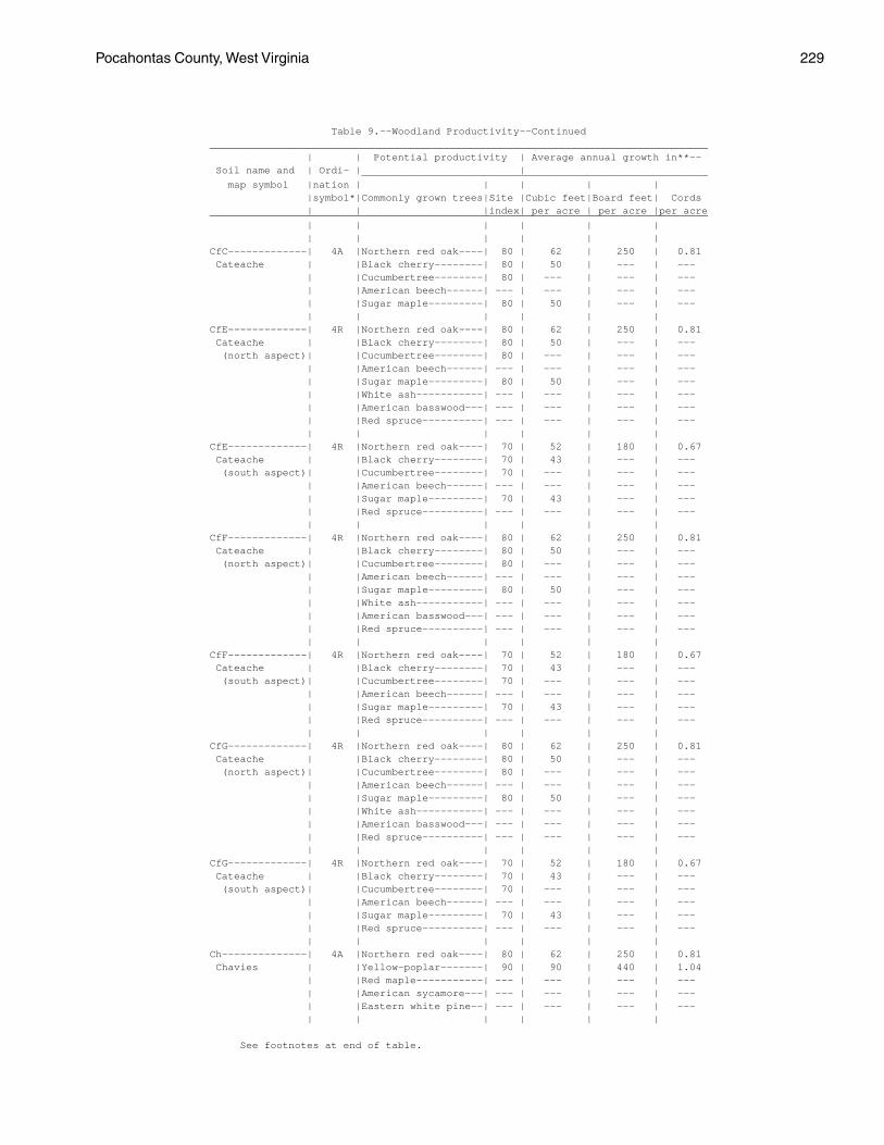
Pocahontas County, West Virginia 229
Table 9.--Woodland Productivity--Continued__________________________________________________________________________________ | | Potential productivity | Average annual growth in**-- Soil name and | Ordi- | | _________________________________________________________ map symbol |nation | | | | | |symbol*|Commonly grown trees|Site |Cubic feet|Board feet| Cords | | |index| per acre | per acre |per acre__________________________________________________________________________________ | | | | | | | | | | | |CfC-------------| 4A |Northern red oak----| 80 | 62 | 250 | 0.81 Cateache | |Black cherry--------| 80 | 50 | --- | --- | |Cucumbertree--------| 80 | --- | --- | --- | |American beech------| --- | --- | --- | --- | |Sugar maple---------| 80 | 50 | --- | --- | | | | | |CfE-------------| 4R |Northern red oak----| 80 | 62 | 250 | 0.81 Cateache | |Black cherry--------| 80 | 50 | --- | --- (north aspect)| |Cucumbertree--------| 80 | --- | --- | --- | |American beech------| --- | --- | --- | --- | |Sugar maple---------| 80 | 50 | --- | --- | |White ash-----------| --- | --- | --- | --- | |American basswood---| --- | --- | --- | --- | |Red spruce----------| --- | --- | --- | --- | | | | | |CfE-------------| 4R |Northern red oak----| 70 | 52 | 180 | 0.67 Cateache | |Black cherry--------| 70 | 43 | --- | --- (south aspect)| |Cucumbertree--------| 70 | --- | --- | --- | |American beech------| --- | --- | --- | --- | |Sugar maple---------| 70 | 43 | --- | --- | |Red spruce----------| --- | --- | --- | --- | | | | | |CfF-------------| 4R |Northern red oak----| 80 | 62 | 250 | 0.81 Cateache | |Black cherry--------| 80 | 50 | --- | --- (north aspect)| |Cucumbertree--------| 80 | --- | --- | --- | |American beech------| --- | --- | --- | --- | |Sugar maple---------| 80 | 50 | --- | --- | |White ash-----------| --- | --- | --- | --- | |American basswood---| --- | --- | --- | --- | |Red spruce----------| --- | --- | --- | --- | | | | | |CfF-------------| 4R |Northern red oak----| 70 | 52 | 180 | 0.67 Cateache | |Black cherry--------| 70 | 43 | --- | --- (south aspect)| |Cucumbertree--------| 70 | --- | --- | --- | |American beech------| --- | --- | --- | --- | |Sugar maple---------| 70 | 43 | --- | --- | |Red spruce----------| --- | --- | --- | --- | | | | | |CfG-------------| 4R |Northern red oak----| 80 | 62 | 250 | 0.81 Cateache | |Black cherry--------| 80 | 50 | --- | --- (north aspect)| |Cucumbertree--------| 80 | --- | --- | --- | |American beech------| --- | --- | --- | --- | |Sugar maple---------| 80 | 50 | --- | --- | |White ash-----------| --- | --- | --- | --- | |American basswood---| --- | --- | --- | --- | |Red spruce----------| --- | --- | --- | --- | | | | | |CfG-------------| 4R |Northern red oak----| 70 | 52 | 180 | 0.67 Cateache | |Black cherry--------| 70 | 43 | --- | --- (south aspect)| |Cucumbertree--------| 70 | --- | --- | --- | |American beech------| --- | --- | --- | --- | |Sugar maple---------| 70 | 43 | --- | --- | |Red spruce----------| --- | --- | --- | --- | | | | | |Ch--------------| 4A |Northern red oak----| 80 | 62 | 250 | 0.81 Chavies | |Yellow-poplar-------| 90 | 90 | 440 | 1.04 | |Red maple-----------| --- | --- | --- | --- | |American sycamore---| --- | --- | --- | --- | |Eastern white pine--| --- | --- | --- | --- | | | | | |
See footnotes at end of table.

230 Soil Survey
Table 9.--Woodland Productivity--Continued__________________________________________________________________________________ | | Potential productivity | Average annual growth in**-- Soil name and | Ordi- | | _________________________________________________________ map symbol |nation | | | | | |symbol*|Commonly grown trees|Site |Cubic feet|Board feet| Cords | | |index| per acre | per acre |per acre__________________________________________________________________________________ | | | | | | | | | | | |CuB-------------| 4A |Northern red oak----| 80 | 62 | 250 | 0.81 Culleoka | |White oak-----------| 80 | 62 | 250 | 0.81 | |American beech------| --- | --- | --- | --- | |American basswood---| --- | --- | --- | --- | |Hickory-------------| --- | --- | --- | --- | | | | | |CuC-------------| 4A |Northern red oak----| 80 | 62 | 250 | 0.81 Culleoka | |White oak-----------| 80 | 62 | 250 | 0.81 | |American beech------| --- | --- | --- | --- | |American basswood---| --- | --- | --- | --- | |Hickory-------------| --- | --- | --- | --- | | | | | |CuD-------------| 4R |Northern red oak----| 80 | 62 | 250 | 0.81 Culleoka | |White oak-----------| 80 | 62 | 250 | 0.81 (north aspect)| |American beech------| --- | --- | --- | --- | |American basswood---| --- | --- | --- | --- | |Eastern hemlock-----| --- | --- | --- | --- | | | | | |CuD-------------| 4R |Northern red oak----| 70 | 52 | 180 | 0.67 Culleoka | |White oak-----------| 70 | 52 | 180 | 0.67 (south aspect)| |Hickory-------------| --- | --- | --- | --- | |American beech------| --- | --- | --- | --- | |American basswood---| --- | --- | --- | --- | | | | | |CuE-------------| 4R |Northern red oak----| 80 | 62 | 250 | 0.81 Culleoka | |White oak-----------| 80 | 62 | 250 | 0.81 (north aspect)| |American beech------| --- | --- | --- | --- | |American basswood---| --- | --- | --- | --- | |Eastern hemlock-----| --- | --- | --- | --- | | | | | |CuE-------------| 4R |Northern red oak----| 70 | 52 | 180 | 0.67 Culleoka | |White oak-----------| 70 | 52 | 180 | 0.67 (south aspect)| |Hickory-------------| --- | --- | --- | --- | |American beech------| --- | --- | --- | --- | |American basswood---| --- | --- | --- | --- | | | | | |CuF-------------| 4R |Northern red oak----| 80 | 62 | 250 | 0.81 Culleoka | |White oak-----------| 80 | 62 | 250 | 0.81 (north aspect)| |American beech------| --- | --- | --- | --- | |American basswood---| --- | --- | --- | --- | |Eastern hemlock-----| --- | --- | --- | --- | | | | | |CuF-------------| 4R |Northern red oak----| 70 | 52 | 180 | 0.67 Culleoka | |White oak-----------| 70 | 52 | 180 | 0.67 (south aspect)| |Hickory-------------| --- | --- | --- | --- | |American beech------| --- | --- | --- | --- | |American basswood---| --- | --- | --- | --- | | | | | |DhC***: | | | | | | Dekalb---------| 3A |Northern red oak----| 60 | 43 | 110 | 0.52 | |White oak-----------| 60 | 43 | 110 | 0.52 | |Chestnut oak--------| 60 | 43 | 110 | 0.52 | |Hickory-------------| --- | --- | --- | --- | |Red maple-----------| --- | --- | --- | --- | | | | | | Hazleton-------| 4A |Northern red oak----| 70 | 52 | 180 | 0.67 | |White oak-----------| 70 | 52 | 180 | 0.67 | |Eastern white pine--| --- | --- | --- | --- | |Red maple-----------| --- | --- | --- | --- | | | | | |
See footnotes at end of table.

Pocahontas County, West Virginia 231
Table 9.--Woodland Productivity--Continued__________________________________________________________________________________ | | Potential productivity | Average annual growth in**-- Soil name and | Ordi- | | _________________________________________________________ map symbol |nation | | | | | |symbol*|Commonly grown trees|Site |Cubic feet|Board feet| Cords | | |index| per acre | per acre |per acre__________________________________________________________________________________ | | | | | | | | | | | |DhE***: | | | | | | Dekalb---------| 3R |Northern red oak----| 60 | 43 | 110 | 0.52 (north aspect)| |White oak-----------| 60 | 43 | 110 | 0.52 | |Red maple-----------| --- | --- | --- | --- | |Eastern white pine--| --- | --- | --- | --- | | | | | | Hazleton-------| 4R |Northern red oak----| 70 | 52 | 180 | 0.67 (north aspect)| |White oak-----------| 70 | 52 | 180 | 0.67 | |Red maple-----------| --- | --- | --- | --- | |Eastern white pine--| --- | --- | --- | --- | |Eastern hemlock-----| --- | --- | --- | --- | | | | | |DhE***: | | | | | | Dekalb---------| 2R |Northern red oak----| 50 | 34 | 60 | 0.38 (south aspect)| |White oak-----------| 50 | 34 | 60 | 0.38 | |Chestnut oak--------| 50 | 34 | 60 | 0.38 | |Hickory-------------| --- | --- | --- | --- | |Red maple-----------| --- | --- | --- | --- | | | | | | Hazleton-------| 3R |Northern red oak----| 60 | 43 | 110 | 0.52 (south aspect)| |White oak-----------| 60 | 43 | 110 | 0.52 | |Eastern white pine--| --- | --- | --- | --- | |Red maple-----------| --- | --- | --- | --- | | | | | |DhF***: | | | | | | Dekalb---------| 3R |Northern red oak----| 60 | 43 | 110 | 0.52 (north aspect)| |White oak-----------| 60 | 43 | 110 | 0.52 | |Red maple-----------| --- | --- | --- | --- | |Eastern white pine--| --- | --- | --- | --- | | | | | | Hazleton-------| 4R |Northern red oak----| 70 | 52 | 180 | 0.67 (north aspect)| |White oak-----------| 70 | 52 | 180 | 0.67 | |Red maple-----------| --- | --- | --- | --- | |Eastern white pine--| --- | --- | --- | --- | |Eastern hemlock-----| --- | --- | --- | --- | | | | | |DhF***: | | | | | | Dekalb---------| 2R |Northern red oak----| 50 | 34 | 60 | 0.38 (south aspect)| |White oak-----------| 50 | 34 | 60 | 0.38 | |Chestnut oak--------| 50 | 34 | 60 | 0.38 | |Hickory-------------| --- | --- | --- | --- | |Red maple-----------| --- | --- | --- | --- | | | | | | Hazleton-------| 3R |Northern red oak----| 60 | 43 | 110 | 0.52 (south aspect)| |White oak-----------| 60 | 43 | 110 | 0.52 | |Eastern white pine--| --- | --- | --- | --- | |Red maple-----------| --- | --- | --- | --- | | | | | |DuB-------------| 4A |Northern red oak----| 79 | 61 | 243 | 0.80 Duffield | |White oak-----------| 80 | 62 | 250 | 0.81 | |Hickory-------------| --- | --- | --- | --- | |Black locust--------| --- | --- | --- | --- | |Red maple-----------| --- | --- | --- | --- | | | | | |DuC-------------| 4A |Northern red oak----| 79 | 61 | 243 | 0.80 Duffield | |White oak-----------| 80 | 62 | 250 | 0.81 | |Hickory-------------| --- | --- | --- | --- | |Black locust--------| --- | --- | --- | --- | |Red maple-----------| --- | --- | --- | --- | | | | | |
See footnotes at end of table.

232 Soil Survey
Table 9.--Woodland Productivity--Continued__________________________________________________________________________________ | | Potential productivity | Average annual growth in**-- Soil name and | Ordi- | | _________________________________________________________ map symbol |nation | | | | | |symbol*|Commonly grown trees|Site |Cubic feet|Board feet| Cords | | |index| per acre | per acre |per acre__________________________________________________________________________________ | | | | | | | | | | | |ElF-------------| 5R |Northern red oak----| 85 | 67 | 285 | 0.88 Elliber | |Red maple-----------| --- | --- | --- | --- (north aspect)| |Hickory-------------| --- | --- | --- | --- | |Eastern white pine--| 95 | 176 | --- | --- | |Eastern hemlock-----| --- | --- | --- | --- | | | | | |ElF-------------| 4R |Northern red oak----| 80 | 62 | 250 | 0.81 Elliber | |Hickory-------------| --- | --- | --- | --- (south aspect)| |Chestnut oak--------| 80 | 62 | 250 | 0.81 | |Eastern white pine--| 90 | 166 | --- | --- | |Pitch pine----------| --- | --- | --- | --- | | | | | |FaC-------------| 4A |Northern red oak----| 70 | 52 | 180 | 0.67 Faywood | |White oak-----------| 60 | 43 | 110 | 0.52 | |Hickory-------------| --- | --- | --- | --- | |Eastern white pine--| 75 | 132 | --- | --- | |Black locust--------| --- | --- | --- | --- | | | | | |FaE-------------| 4R |Northern red oak----| 70 | 52 | 180 | 0.67 Faywood | |White oak-----------| 60 | 43 | 110 | 0.52 | |Hickory-------------| --- | --- | --- | --- | |Eastern white pine--| 75 | 132 | --- | --- | |Black locust--------| --- | --- | --- | --- | | | | | |FaF-------------| 4R |Northern red oak----| 70 | 52 | 180 | 0.67 Faywood | |White oak-----------| 60 | 43 | 110 | 0.52 | |Hickory-------------| --- | --- | --- | --- | |Eastern white pine--| 75 | 132 | --- | --- | |Black locust--------| --- | --- | --- | --- | | | | | |GaC-------------| 6X |Red spruce----------| 42 | 88 | --- | --- Gauley | |Yellow birch--------| --- | --- | --- | --- | |Red maple-----------| --- | --- | --- | --- | |Bigtooth aspen------| --- | --- | --- | --- | | | | | |GaE-------------| 6R |Red spruce----------| 42 | 88 | --- | --- Gauley | |Yellow birch--------| --- | --- | --- | --- | |Red maple-----------| --- | --- | --- | --- | |Bigtooth aspen------| --- | --- | --- | --- | | | | | |Ho--------------| 5W |Pin oak-------------| 90 | 72 | 320 | 0.95 Holly | |American sycamore---| --- | --- | --- | --- | |River birch---------| --- | --- | --- | --- | |Red maple-----------| --- | --- | --- | --- | |Eastern white pine--| --- | --- | --- | --- | | | | | |LeC-------------| 7W |Red spruce----------| 45 | 95 | --- | --- Leatherbark | |Black cherry--------| 70 | 43 | --- | --- | |American beech------| --- | --- | --- | --- | |Yellow birch--------| --- | --- | --- | --- | |Red maple-----------| --- | --- | --- | --- | |Sugar maple---------| --- | --- | --- | --- | |Eastern hemlock-----| --- | --- | --- | --- | | | | | |LlB-------------| 3A |Northern red oak----| 60 | 43 | 110 | 0.52 Lily | |White oak-----------| 60 | 43 | 110 | 0.52 | |Scarlet oak---------| 60 | 43 | 110 | 0.52 | |Eastern white pine--| --- | --- | --- | --- | |Red maple-----------| --- | --- | --- | --- | | | | | |
See footnotes at end of table.
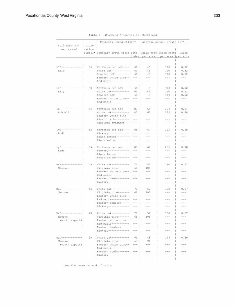
Pocahontas County, West Virginia 233
Table 9.--Woodland Productivity--Continued__________________________________________________________________________________ | | Potential productivity | Average annual growth in**-- Soil name and | Ordi- | | _________________________________________________________ map symbol |nation | | | | | |symbol*|Commonly grown trees|Site |Cubic feet|Board feet| Cords | | |index| per acre | per acre |per acre__________________________________________________________________________________ | | | | | | | | | | | |LlC-------------| 3A |Northern red oak----| 60 | 43 | 110 | 0.52 Lily | |White oak-----------| 60 | 43 | 110 | 0.52 | |Scarlet oak---------| 60 | 43 | 110 | 0.52 | |Eastern white pine--| --- | --- | --- | --- | |Red maple-----------| --- | --- | --- | --- | | | | | |LlD-------------| 3R |Northern red oak----| 60 | 43 | 110 | 0.52 Lily | |White oak-----------| 60 | 43 | 110 | 0.52 | |Scarlet oak---------| 60 | 43 | 110 | 0.52 | |Eastern white pine--| --- | --- | --- | --- | |Red maple-----------| --- | --- | --- | --- | | | | | |Lo--------------| 5A |Northern red oak----| 87 | 69 | 299 | 0.91 Lobdell | |White oak-----------| 85 | 67 | 285 | 0.88 | |Eastern white pine--| --- | --- | --- | --- | |River birch---------| --- | --- | --- | --- | |American sycamore---| --- | --- | --- | --- | | | | | |LyB-------------| 5A |Northern red oak----| 85 | 67 | 285 | 0.88 Lodi | |Hickory-------------| --- | --- | --- | --- | |Black locust--------| --- | --- | --- | --- | |Black walnut--------| --- | --- | --- | --- | | | | | |LyC-------------| 5A |Northern red oak----| 85 | 67 | 285 | 0.88 Lodi | |Hickory-------------| --- | --- | --- | --- | |Black locust--------| --- | --- | --- | --- | |Black walnut--------| --- | --- | --- | --- | | | | | |MaB-------------| 4A |White oak-----------| 70 | 52 | 180 | 0.67 Macove | |Virginia pine-------| 68 | 105 | --- | --- | |Eastern white pine--| --- | --- | --- | --- | |Red maple-----------| --- | --- | --- | --- | |Eastern hemlock-----| --- | --- | --- | --- | |Hickory-------------| --- | --- | --- | --- | | | | | |MaC-------------| 4A |White oak-----------| 70 | 52 | 180 | 0.67 Macove | |Virginia pine-------| 68 | 105 | --- | --- | |Eastern white pine--| --- | --- | --- | --- | |Red maple-----------| --- | --- | --- | --- | |Eastern hemlock-----| --- | --- | --- | --- | |Hickory-------------| --- | --- | --- | --- | | | | | |MaD-------------| 4R |White oak-----------| 70 | 52 | 180 | 0.67 Macove | |Virginia pine-------| 68 | 105 | --- | --- (north aspect)| |Eastern white pine--| --- | --- | --- | --- | |Red maple-----------| --- | --- | --- | --- | |Eastern hemlock-----| --- | --- | --- | --- | |Hickory-------------| --- | --- | --- | --- | | | | | |MaD-------------| 3R |White oak-----------| 65 | 48 | 145 | 0.60 Macove | |Virginia pine-------| 63 | 96 | --- | --- (south aspect)| |Eastern white pine--| --- | --- | --- | --- | |Red maple-----------| --- | --- | --- | --- | |Eastern hemlock-----| --- | --- | --- | --- | |Hickory-------------| --- | --- | --- | --- | | | | | |
See footnotes at end of table.

234 Soil Survey
Table 9.--Woodland Productivity--Continued__________________________________________________________________________________ | | Potential productivity | Average annual growth in**-- Soil name and | Ordi- | | _________________________________________________________ map symbol |nation | | | | | |symbol*|Commonly grown trees|Site |Cubic feet|Board feet| Cords | | |index| per acre | per acre |per acre__________________________________________________________________________________ | | | | | | | | | | | |McC-------------| 4A |White oak-----------| 70 | 52 | 180 | 0.67 Macove | |Virginia pine-------| 68 | 105 | --- | --- | |Eastern white pine--| --- | --- | --- | --- | |Red maple-----------| --- | --- | --- | --- | |Eastern hemlock-----| --- | --- | --- | --- | |Hickory-------------| --- | --- | --- | --- | | | | | |McE-------------| 4R |White oak-----------| 70 | 52 | 145 | 0.60 Macove | |Virginia pine-------| 68 | 105 | --- | --- (north aspect)| |Eastern white pine--| --- | --- | --- | --- | |Red maple-----------| --- | --- | --- | --- | |Eastern hemlock-----| --- | --- | --- | --- | |Hickory-------------| --- | --- | --- | --- | | | | | |McE-------------| 3R |White oak-----------| 65 | 48 | 145 | 0.60 Macove | |Virginia pine-------| 63 | 96 | --- | --- (south aspect)| |Eastern white pine--| --- | --- | --- | --- | |Red maple-----------| --- | --- | --- | --- | |Eastern hemlock-----| --- | --- | --- | --- | |Hickory-------------| --- | --- | --- | --- | | | | | |MdC-------------| 4A |Black cherry--------| 80 | 50 | --- | --- Mandy | |American beech------| --- | --- | --- | --- | |Sugar maple---------| --- | --- | --- | --- | |Yellow birch--------| --- | --- | --- | --- | |Red spruce----------| 65 | 152 | --- | --- | | | | | |MdD-------------| 4R |Black cherry--------| 80 | 50 | --- | --- Mandy | |American beech------| --- | --- | --- | --- | |Sugar maple---------| --- | --- | --- | --- | |Yellow birch--------| --- | --- | --- | --- | |Red spruce----------| 65 | 152 | --- | --- | | | | | |MfC-------------| 4A |Black cherry--------| 80 | 50 | --- | --- Mandy | |American beech------| --- | --- | --- | --- | |Sugar maple---------| --- | --- | --- | --- | |Yellow birch--------| --- | --- | --- | --- | |Red spruce----------| 65 | 152 | --- | --- | | | | | |MfE-------------| 4R |Black cherry--------| 80 | 50 | --- | --- Mandy | |American beech------| --- | --- | --- | --- | |Sugar maple---------| --- | --- | --- | --- | |Yellow birch--------| --- | --- | --- | --- | |Red spruce----------| 65 | 152 | --- | --- | | | | | |MfF-------------| 4R |Black cherry--------| 80 | 50 | --- | --- Mandy | |American beech------| --- | --- | --- | --- | |Sugar maple---------| --- | --- | --- | --- | |Yellow birch--------| --- | --- | --- | --- | |Red spruce----------| 65 | 152 | --- | --- | | | | | |MfG-------------| 4R |Black cherry--------| 80 | 50 | --- | --- Mandy | |American beech------| --- | --- | --- | --- | |Sugar maple---------| --- | --- | --- | --- | |Yellow birch--------| --- | --- | --- | --- | |Red spruce----------| 65 | 152 | --- | --- | | | | | |
See footnotes at end of table.

Pocahontas County, West Virginia 235
Table 9.--Woodland Productivity--Continued__________________________________________________________________________________ | | Potential productivity | Average annual growth in**-- Soil name and | Ordi- | | _________________________________________________________ map symbol |nation | | | | | |symbol*|Commonly grown trees|Site |Cubic feet|Board feet| Cords | | |index| per acre | per acre |per acre__________________________________________________________________________________ | | | | | | | | | | | |MrB-------------| 4A |Northern red oak----| 80 | 62 | 250 | 0.81 Mertz | |White oak-----------| 80 | 62 | 250 | 0.81 | |Eastern white pine--| --- | --- | --- | --- | |Red maple-----------| --- | --- | --- | --- | |Pitch pine----------| 75 | --- | --- | --- | | | | | |MzC-------------| 4A |Northern red oak----| 80 | 62 | 250 | 0.81 Mertz | |White oak-----------| 80 | 62 | 250 | 0.81 | |Eastern white pine--| --- | --- | --- | --- | |Red maple-----------| --- | --- | --- | --- | |Pitch pine----------| 75 | --- | --- | --- | | | | | |MzE-------------| 4R |Northern red oak----| 80 | 62 | 250 | 0.81 Mertz | |White oak-----------| 80 | 62 | 250 | 0.81 | |Eastern white pine--| --- | --- | --- | --- | |Red maple-----------| --- | --- | --- | --- | |Pitch pine----------| 75 | --- | --- | --- | | | | | |Or--------------| 4W |Northern red oak----| 80 | 62 | 250 | 0.81 Orville | |White oak-----------| 80 | 62 | 250 | 0.81 | |Eastern white pine--| --- | --- | --- | --- | |River birch---------| --- | --- | --- | --- | |American sycamore---| --- | --- | --- | --- | | | | | |Ph--------------| 5A |Northern red oak----| 86 | 68 | 292 | 0.89 Philo | |White oak-----------| 85 | 67 | 285 | 0.88 | |Eastern white pine--| --- | --- | --- | --- | |River birch---------| --- | --- | --- | --- | |American sycamore---| --- | --- | --- | --- | | | | | |Po--------------| 4F |Northern red oak----| 70 | 52 | 180 | 0.67 Potomac | |White oak-----------| 70 | 52 | 180 | 0.67 | |Eastern white pine--| 80 | 144 | --- | --- | |River birch---------| --- | --- | --- | --- | |American sycamore---| --- | --- | --- | --- | | | | | |Pt--------------| 4F |Northern red oak----| 70 | 52 | 180 | 0.67 Potomac | |White oak-----------| 70 | 52 | 180 | 0.67 | |Eastern white pine--| 80 | 144 | --- | --- | |River birch---------| --- | --- | --- | --- | |American sycamore---| --- | --- | --- | --- | | | | | |Pu--------------| 5W |Pin oak-------------| 85 | 66 | 278 | 0.87 Purdy | |Yellow-poplar-------| 90 | 90 | --- | --- | |Sweetgum------------| 85 | 93 | --- | --- | | | | | |Sc--------------| 5A |White oak-----------| 85 | 67 | 285 | 0.88 Sees | |Shingle oak---------| --- | --- | --- | --- | |Red maple-----------| --- | --- | --- | --- | |Quaking aspen-------| --- | --- | --- | --- | | | | | |Se--------------| 4A |White oak-----------| 80 | 62 | 250 | 0.81 Sensabaugh | |Yellow poplar-------| 100 | 107 | 580 | 1.23 | |River birch---------| --- | --- | --- | --- | |American sycamore---| --- | --- | --- | --- | | | | | |
See footnotes at end of table.

236 Soil Survey
Table 9.--Woodland Productivity--Continued__________________________________________________________________________________ | | Potential productivity | Average annual growth in**-- Soil name and | Ordi- | | _________________________________________________________ map symbol |nation | | | | | |symbol*|Commonly grown trees|Site |Cubic feet|Board feet| Cords | | |index| per acre | per acre |per acre__________________________________________________________________________________ | | | | | | | | | | | |ShB-------------| 4A |Northern red oak----| 70 | 52 | 180 | 0.67 Shouns | |American beech------| --- | --- | --- | --- | |Black cherry--------| --- | --- | --- | --- | |Eastern hemlock-----| --- | --- | --- | --- | |White oak-----------| 70 | 52 | 180 | 0.67 | |Sugar maple---------| --- | --- | --- | --- | | | | | |ShC-------------| 4A |Northern red oak----| 70 | 52 | 180 | 0.67 Shouns | |American beech------| --- | --- | --- | --- | |Black cherry--------| --- | --- | --- | --- | |Eastern hemlock-----| --- | --- | --- | --- | |White oak-----------| 70 | 52 | 180 | 0.67 | |Sugar maple---------| --- | --- | --- | --- | | | | | |SsC-------------| 4X |Northern red oak----| 70 | 52 | 180 | 0.67 Shouns | |American beech------| --- | --- | --- | --- | |Black cherry--------| --- | --- | --- | --- | |Eastern hemlock-----| --- | --- | --- | --- | |White oak-----------| 70 | 52 | 180 | 0.67 | |Sugar maple---------| --- | --- | --- | --- | | | | | |SsE-------------| 4R |Northern red oak----| 70 | 52 | 180 | 0.67 Shouns | |American beech------| --- | --- | --- | --- (north aspect)| |Black cherry--------| --- | --- | --- | --- | |Eastern hemlock-----| --- | --- | --- | --- | |White oak-----------| 70 | 52 | 180 | 0.67 | |Sugar maple---------| --- | --- | --- | --- | | | | | |SsE-------------| 3R |Northern red oak----| 60 | 43 | 110 | 0.52 Shouns | |American beech------| --- | --- | --- | --- (south aspect)| |Black cherry--------| --- | --- | --- | --- | |White oak-----------| 60 | 43 | 110 | 0.52 | |Sugar maple---------| --- | --- | --- | --- | | | | | |SsF-------------| 4R |Northern red oak----| 70 | 52 | 180 | 0.67 Shouns | |American beech------| --- | --- | --- | --- (north aspect)| |Black cherry--------| --- | --- | --- | --- | |Eastern hemlock-----| --- | --- | --- | --- | |White oak-----------| 70 | 52 | 180 | 0.67 | |Sugar maple---------| --- | --- | --- | --- | | | | | |SsF-------------| 3R |Northern red oak----| 60 | 43 | 110 | 0.52 Shouns | |American beech------| --- | --- | --- | --- (south aspect)| |Black cherry--------| --- | --- | --- | --- | |White oak-----------| 60 | 43 | 110 | 0.52 | |Sugar maple---------| --- | --- | --- | --- | | | | | |SwE-------------| 4R |Black cherry--------| 80 | 50 | --- | --- Snowdog | |Red spruce----------| 65 | 152 | --- | --- | |Red maple-----------| --- | --- | --- | --- | |Yellow birch--------| --- | --- | --- | --- | | | | | |Tg--------------| 4A |Northern red oak----| 75 | 57 | 215 | 0.74 Tioga | |Yellow-poplar-------| 85 | 81 | 380 | 0.93 | |American sycamore---| --- | --- | --- | --- | |River birch---------| --- | --- | --- | --- | |Yellow buckeye------| --- | --- | --- | --- | | | | | |
See footnotes at end of table.

Pocahontas County, West Virginia 237
Table 9.--Woodland Productivity--Continued__________________________________________________________________________________ | | Potential productivity | Average annual growth in**-- Soil name and | Ordi- | | _________________________________________________________ map symbol |nation | | | | | |symbol*|Commonly grown trees|Site |Cubic feet|Board feet| Cords | | |index| per acre | per acre |per acre__________________________________________________________________________________ | | | | | | | | | | | |TrC-------------| 7W |Red spruce----------| 45 | 95 | --- | --- Trussel | |Red maple-----------| --- | --- | --- | --- | |Black cherry--------| 60 | 38 | --- | --- | |Yellow birch--------| --- | --- | --- | --- | | | | | | | | | | | |WeC-------------| 2D |Northern red oak----| 50 | 34 | 60 | 0.38 Weikert | |White oak-----------| 50 | 34 | 60 | 0.38 | |Hickory-------------| --- | --- | --- | --- | |Pitch pine----------| 50 | --- | --- | --- | |Eastern white pine--| --- | --- | --- | --- | |Chestnut oak--------| 50 | 34 | 60 | 0.38 | | | | | |WeD-------------| 3R |Northern red oak----| 60 | 43 | 110 | 0.52 Weikert | |White oak-----------| 60 | 43 | 110 | 0.52 (north aspect)| |Hickory-------------| --- | --- | --- | --- | |Pitch pine----------| 60 | --- | --- | --- | |Eastern white pine--| --- | --- | --- | --- | |Chestnut oak--------| 60 | 43 | 110 | 0.52 | | | | | |WeD-------------| 2R |Northern red oak----| 50 | 34 | 60 | 0.38 Weikert | |White oak-----------| 50 | 34 | 60 | 0.38 (south aspect)| |Hickory-------------| --- | --- | --- | --- | |Pitch pine----------| 50 | --- | --- | --- | |Chestnut oak--------| 50 | 34 | 60 | 0.38 | | | | | |WeF-------------| 2R |Northern red oak----| 50 | 34 | 60 | 0.38 Weikert | |White oak-----------| 50 | 34 | 60 | 0.38 (north aspect)| |Hickory-------------| --- | --- | --- | --- | |Pitch pine----------| 50 | --- | --- | --- | |Eastern white pine--| --- | --- | --- | --- | |Chestnut oak--------| 50 | 34 | 60 | 0.38 | | | | | |WeF-------------| 2R |Northern red oak----| 40 | 26 | --- | --- Weikert | |White oak-----------| 40 | 26 | --- | --- (south aspect)| |Hickory-------------| --- | --- | --- | --- | |Pitch pine----------| 40 | --- | --- | --- | |Chestnut oak--------| 40 | 26 | --- | --- | | | | | |__________________________________________________________________________________
* The number in the ordination symbol is the yield in cubic meters per hectareper year calculated at the age of culmination of mean annual increment for fullystocked natural stands. The woodland ordination symbols have been developed fromcriteria in the “National Soil Survey Handbook” and the “National Forestry Manual”and from separate criteria developed for this soil survey by the Natural ResourcesConservation Service and the Forest Service. ** Average annual growth is the total volume growth at rotation divided byrotation age. The actual annual growth varies with stand vigor and other factors.Yield data are based on site indices of natural stands at age 50. TheInternational 1/4 Log Rule is used for board feet. Cords are standard rough cords.This information should be used for planning only. *** See description of the map unit for composition and behaviorcharacteristics of the map unit.
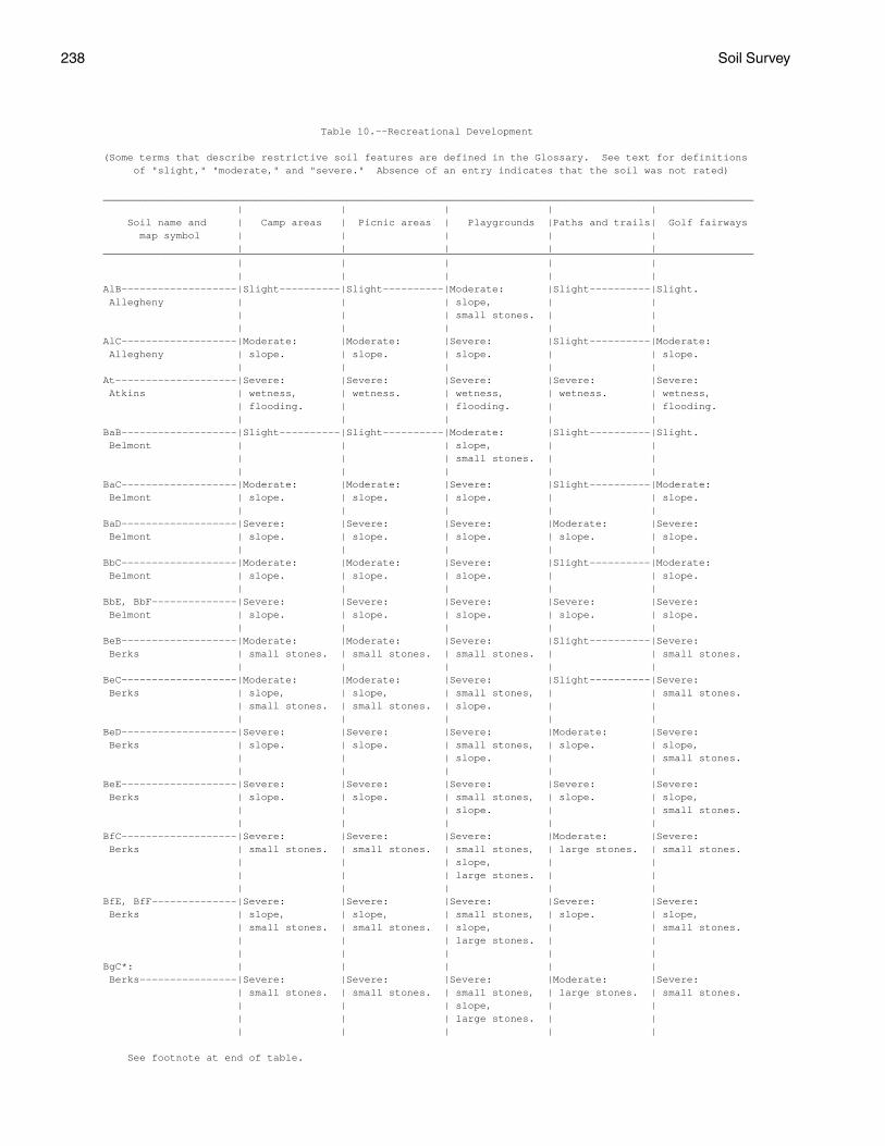
238 Soil Survey
Table 10.--Recreational Development
(Some terms that describe restrictive soil features are defined in the Glossary. See text for definitions of "slight," "moderate," and "severe." Absence of an entry indicates that the soil was not rated)
___________________________________________________________________________________________________________ | | | | | Soil name and | Camp areas | Picnic areas | Playgrounds |Paths and trails| Golf fairways map symbol | | | | | | | | | | ___________________________________________________________________________________________________________ | | | | | | | | | | AlB-------------------|Slight----------|Slight----------|Moderate: |Slight----------|Slight. Allegheny | | | slope, | | | | | small stones. | | | | | | | AlC-------------------|Moderate: |Moderate: |Severe: |Slight----------|Moderate: Allegheny | slope. | slope. | slope. | | slope. | | | | | At--------------------|Severe: |Severe: |Severe: |Severe: |Severe: Atkins | wetness, | wetness. | wetness, | wetness. | wetness, | flooding. | | flooding. | | flooding. | | | | | BaB-------------------|Slight----------|Slight----------|Moderate: |Slight----------|Slight. Belmont | | | slope, | | | | | small stones. | | | | | | | BaC-------------------|Moderate: |Moderate: |Severe: |Slight----------|Moderate: Belmont | slope. | slope. | slope. | | slope. | | | | | BaD-------------------|Severe: |Severe: |Severe: |Moderate: |Severe: Belmont | slope. | slope. | slope. | slope. | slope. | | | | | BbC-------------------|Moderate: |Moderate: |Severe: |Slight----------|Moderate: Belmont | slope. | slope. | slope. | | slope. | | | | | BbE, BbF--------------|Severe: |Severe: |Severe: |Severe: |Severe: Belmont | slope. | slope. | slope. | slope. | slope. | | | | | BeB-------------------|Moderate: |Moderate: |Severe: |Slight----------|Severe: Berks | small stones. | small stones. | small stones. | | small stones. | | | | | BeC-------------------|Moderate: |Moderate: |Severe: |Slight----------|Severe: Berks | slope, | slope, | small stones, | | small stones. | small stones. | small stones. | slope. | | | | | | | BeD-------------------|Severe: |Severe: |Severe: |Moderate: |Severe: Berks | slope. | slope. | small stones, | slope. | slope, | | | slope. | | small stones. | | | | | BeE-------------------|Severe: |Severe: |Severe: |Severe: |Severe: Berks | slope. | slope. | small stones, | slope. | slope, | | | slope. | | small stones. | | | | | BfC-------------------|Severe: |Severe: |Severe: |Moderate: |Severe: Berks | small stones. | small stones. | small stones, | large stones. | small stones. | | | slope, | | | | | large stones. | | | | | | | BfE, BfF--------------|Severe: |Severe: |Severe: |Severe: |Severe: Berks | slope, | slope, | small stones, | slope. | slope, | small stones. | small stones. | slope, | | small stones. | | | large stones. | | | | | | | BgC*: | | | | | Berks----------------|Severe: |Severe: |Severe: |Moderate: |Severe: | small stones. | small stones. | small stones, | large stones. | small stones. | | | slope, | | | | | large stones. | | | | | | |
See footnote at end of table.

Pocahontas County, West Virginia 239
Table 10.--Recreational Development--Continued ___________________________________________________________________________________________________________ | | | | | Soil name and | Camp areas | Picnic areas | Playgrounds |Paths and trails| Golf fairways map symbol | | | | | | | | | | ___________________________________________________________________________________________________________ | | | | | | | | | | BgC*: | | | | | Dekalb---------------|Severe: |Severe: |Severe: |Moderate: |Severe: | small stones. | small stones. | slope, | large stones. | small stones. | | | small stones, | | | | | large stones. | | | | | | | BgE*, BgF*: | | | | | Berks----------------|Severe: |Severe: |Severe: |Severe: |Severe: | slope, | slope, | small stones, | slope. | slope, | small stones. | small stones. | slope, | | small stones. | | | large stones. | | | | | | | Dekalb---------------|Severe: |Severe: |Severe: |Severe: |Severe: | slope, | slope, | slope, | slope. | slope, | small stones. | small stones. | small stones, | | small stones. | | | large stones. | | | | | | | BhG*: | | | | | Berks----------------|Severe: |Severe: |Severe: |Severe: |Severe: | slope, | slope, | small stones, | slope. | slope, | small stones. | small stones. | slope, | | small stones. | | | large stones. | | | | | | | Weikert--------------|Severe: |Severe: |Severe: |Severe: |Severe: | slope, | slope, | slope, | slope. | slope, | small stones, | small stones, | large stones, | | small stones, | depth to rock. | depth to rock. | depth to rock, | | depth to rock. | | | small stones. | | | | | | | Calvin---------------|Severe: |Severe: |Severe: |Severe: |Severe: | slope. | slope. | large stones, | slope. | slope. | | | slope, | | | | | small stones. | | | | | | | BlC-------------------|Severe: |Severe: |Severe: |Slight----------|Moderate: Blackthorn | large stones. | large stones. | large stones, | | small stones, | | | slope, | | large stones, | | | small stones. | | slope. | | | | | BlE, BlF--------------|Severe: |Severe: |Severe: |Severe: |Severe: Blackthorn | slope, | slope, | large stones, | slope. | slope. | large stones. | large stones. | slope, | | | | | small stones. | | | | | | | BoB-------------------|Severe: |Severe: |Severe: |Moderate: |Moderate: Blairton | wetness. | wetness. | wetness. | wetness. | wetness. | | | | | BrF*: | | | | | Briery---------------|Variable--------|Variable--------|Variable--------|Variable--------|Variable. | | | | | Rock outcrop. | | | | | | | | | | CaC-------------------|Moderate: |Moderate: |Severe: |Slight----------|Moderate: Calvin | slope, | slope, | slope, | | large stones, | small stones. | small stones. | small stones. | | slope, | | | | | depth to rock. | | | | | CbC-------------------|Moderate: |Moderate: |Severe: |Slight----------|Moderate: Calvin | slope, | slope, | large stones, | | large stones, | large stones, | large stones, | slope, | | slope, | small stones. | small stones. | small stones. | | depth to rock. | | | | |
See footnote at end of table.

240 Soil Survey
Table 10.--Recreational Development--Continued ___________________________________________________________________________________________________________ | | | | | Soil name and | Camp areas | Picnic areas | Playgrounds |Paths and trails| Golf fairways map symbol | | | | | | | | | | ___________________________________________________________________________________________________________ | | | | | | | | | | CbE, CbF--------------|Severe: |Severe: |Severe: |Severe: |Severe: Calvin | slope. | slope. | large stones, | slope. | slope. | | | slope, | | | | | small stones. | | | | | | | CdC*: | | | | | Calvin---------------|Moderate: |Moderate: |Severe: |Slight----------|Moderate: | slope, | slope, | large stones, | | large stones, | large stones, | large stones, | slope, | | slope, | small stones. | small stones. | small stones. | | depth to rock. | | | | | Dekalb---------------|Severe: |Severe: |Severe: |Moderate: |Severe: | small stones. | small stones. | slope, | large stones. | small stones. | | | small stones, | | | | | large stones. | | | | | | | Berks----------------|Severe: |Severe: |Severe: |Moderate: |Severe: | small stones. | small stones. | small stones, | large stones. | small stones. | | | slope, | | | | | large stones. | | | | | | | CdE*, CdF*: | | | | | Calvin---------------|Severe: |Severe: |Severe: |Severe: |Severe: | slope. | slope. | large stones, | slope. | slope. | | | slope, | | | | | small stones. | | | | | | | Dekalb---------------|Severe: |Severe: |Severe: |Severe: |Severe: | slope, | slope, | slope, | slope. | slope, | small stones. | small stones. | small stones, | | small stones. | | | large stones. | | | | | | | Berks----------------|Severe: |Severe: |Severe: |Severe: |Severe: | slope, | slope, | small stones, | slope. | slope, | small stones. | small stones. | slope, | | small stones. | | | large stones. | | | | | | | CeB-------------------|Moderate: |Moderate: |Moderate: |Slight----------|Moderate: Cateache | small stones. | small stones. | slope, | | depth to rock, | | | depth to rock, | | small stones. | | | small stones. | | | | | | | CeC-------------------|Moderate: |Moderate: |Severe: |Slight----------|Moderate: Cateache | slope, | slope, | slope. | | slope, | small stones. | small stones. | | | depth to rock, | | | | | small stones. | | | | | CeD-------------------|Severe: |Severe: |Severe: |Moderate: |Severe: Cateache | slope. | slope. | slope. | slope. | slope. | | | | | CfC-------------------|Moderate: |Moderate: |Severe: |Slight----------|Moderate: Cateache | small stones, | small stones, | slope, | | slope, | slope. | slope. | large stones, | | depth to rock, | | | small stones. | | large stones. | | | | | CfE, CfF, CfG---------|Severe: |Severe: |Severe: |Severe: |Severe: Cateache | slope. | slope. | slope, | slope. | slope. | | | large stones, | | | | | small stones. | | | | | | | Ch--------------------|Severe: |Slight----------|Moderate: |Slight----------|Slight. Chavies | flooding. | | small stones. | |
See footnote at end of table.

Pocahontas County, West Virginia 241
Table 10.--Recreational Development--Continued ___________________________________________________________________________________________________________ | | | | | Soil name and | Camp areas | Picnic areas | Playgrounds |Paths and trails| Golf fairways map symbol | | | | | | | | | | ___________________________________________________________________________________________________________ | | | | | | | | | | CuB-------------------|Slight----------|Slight----------|Moderate: |Slight----------|Moderate: Culleoka | | | slope, | | depth to rock. | | | small stones. | | | | | | | CuC-------------------|Moderate: |Moderate: |Severe: |Slight----------|Moderate: Culleoka | slope. | slope. | slope. | | slope, | | | | | depth to rock. | | | | | CuD-------------------|Severe: |Severe: |Severe: |Moderate: |Severe: Culleoka | slope. | slope. | slope. | slope. | slope. | | | | | CuE, CuF--------------|Severe: |Severe: |Severe: |Severe: |Severe: Culleoka | slope. | slope. | slope. | slope. | slope. | | | | | DhC*: | | | | | Dekalb---------------|Severe: |Severe: |Severe: |Moderate: |Severe: | small stones. | small stones. | slope, | large stones. | small stones. | | | small stones, | | | | | large stones. | | | | | | | Hazleton-------------|Moderate: |Moderate: |Severe: |Slight----------|Moderate: | slope, | slope, | slope, | | slope, | large stones. | large stones. | small stones, | | large stones. | | | large stones. | | | | | | | DhE*, DhF*: | | | | | Dekalb---------------|Severe: |Severe: |Severe: |Severe: |Severe: | slope, | slope, | slope, | slope. | slope, | small stones. | small stones. | small stones, | | small stones. | | | large stones. | | | | | | | Hazleton-------------|Severe: |Severe: |Severe: |Severe: |Severe: | slope. | slope. | slope, | slope. | slope. | | | small stones, | | | | | large stones. | | | | | | | DuB-------------------|Slight----------|Slight----------|Moderate: |Slight----------|Slight. Duffield | | | slope, | | | | | small stones. | | | | | | | DuC-------------------|Moderate: |Moderate: |Severe: |Slight----------|Moderate: Duffield | slope. | slope. | slope. | | slope. | | | | | ElF-------------------|Severe: |Severe: |Severe: |Severe: |Severe: Elliber | slope, | slope, | slope, | slope, | small stones, | small stones. | small stones. | small stones. | small stones. | droughty, | | | | | slope. | | | | | FaC-------------------|Moderate: |Moderate: |Severe: |Severe: |Moderate: Faywood | slope, | slope, | slope. | erodes easily. | large stones, | percs slowly. | percs slowly. | | | slope, | | | | | depth to rock. | | | | | FaE, FaF--------------|Severe: |Severe: |Severe: |Severe: |Severe: Faywood | slope. | slope. | slope. | slope, | slope. | | | | erodes easily. | | | | | | GaC-------------------|Severe: |Severe: |Severe: |Moderate: |Severe: Gauley | large stones, | large stones, | slope, | large stones. | large stones, | small stones. | small stones. | large stones, | | small stones. | | | small stones. | | | | | | |
See footnote at end of table.

242 Soil Survey
Table 10.--Recreational Development--Continued ___________________________________________________________________________________________________________ | | | | | Soil name and | Camp areas | Picnic areas | Playgrounds |Paths and trails| Golf fairways map symbol | | | | | | | | | | ___________________________________________________________________________________________________________ | | | | | | | | | | GaE-------------------|Severe: |Severe: |Severe: |Severe: |Severe: Gauley | slope, | slope, | slope, | slope. | slope, | large stones, | large stones, | large stones, | | large stones. | small stones. | small stones. | small stones. | | | | | | | Ho--------------------|Severe: |Severe: |Severe: |Severe: |Severe: Holly | flooding, | wetness. | wetness, | wetness. | wetness, | wetness. | | flooding. | | flooding. | | | | | LeC-------------------|Severe: |Severe: |Severe: |Severe: |Severe: Leatherbark | wetness. | wetness. | large stones, | wetness. | wetness. | | | slope, | | | | | wetness. | | | | | | | LlB-------------------|Slight----------|Slight----------|Moderate: |Slight----------|Moderate: Lily | | | slope, | | depth to rock. | | | depth to rock. | | | | | | | LlC-------------------|Moderate: |Moderate: |Severe: |Slight----------|Moderate: Lily | slope. | slope. | slope. | | slope, | | | | | depth to rock. | | | | | LlD-------------------|Severe: |Severe: |Severe: |Moderate: |Severe: Lily | slope. | slope. | slope. | slope. | slope. | | | | | Lo--------------------|Severe: |Moderate: |Moderate: |Moderate: |Moderate: Lobdell | flooding. | wetness. | wetness, | wetness. | flooding, | | | flooding. | | wetness. | | | | | LyB-------------------|Slight----------|Slight----------|Moderate: |Slight----------|Slight. Lodi | | | slope, | | | | | small stones. | | | | | | | LyC-------------------|Moderate: |Moderate: |Severe: |Severe: |Moderate: Lodi | slope. | slope. | slope. | erodes easily. | slope. | | | | | MaB-------------------|Moderate: |Moderate: |Severe: |Slight----------|Moderate: Macove | small stones. | small stones. | small stones. | | small stones, | | | | | large stones. | | | | | MaC-------------------|Moderate: |Moderate: |Severe: |Slight----------|Moderate: Macove | slope, | slope, | slope, | | small stones, | small stones. | small stones. | small stones. | | large stones, | | | | | slope. | | | | | MaD-------------------|Severe: |Severe: |Severe: |Moderate: |Severe: Macove | slope. | slope. | slope, | slope. | slope. | | | small stones. | | | | | | | McC-------------------|Severe: |Severe: |Severe: |Severe: |Severe: Macove | small stones. | small stones. | large stones, | small stones. | small stones. | | | slope, | | | | | small stones. | | | | | | | McE-------------------|Severe: |Severe: |Severe: |Severe: |Severe: Macove | slope, | slope, | large stones, | slope, | small stones, | small stones. | small stones. | slope, | small stones. | slope. | | | small stones. | | | | | | |
See footnote at end of table.

Pocahontas County, West Virginia 243
Table 10.--Recreational Development--Continued ___________________________________________________________________________________________________________ | | | | | Soil name and | Camp areas | Picnic areas | Playgrounds |Paths and trails| Golf fairways map symbol | | | | | | | | | | ___________________________________________________________________________________________________________ | | | | | | | | | | MdC-------------------|Moderate: |Moderate: |Severe: |Slight----------|Moderate: Mandy | slope, | slope, | slope, | | small stones, | small stones. | small stones. | small stones. | | slope, | | | | | depth to rock. | | | | | MdD-------------------|Severe: |Severe: |Severe: |Moderate: |Severe: Mandy | slope. | slope. | slope, | slope. | slope. | | | small stones. | | | | | | | MfC-------------------|Moderate: |Severe: |Severe: |Slight----------|Moderate: Mandy | large stones, | large stones. | large stones, | | large stones, | small stones, | | slope, | | slope, | slope. | | small stones. | | depth to rock. | | | | | MfE, MfF, MfG---------|Severe: |Severe: |Severe: |Severe: |Severe: Mandy | slope. | slope, | large stones, | slope. | slope. | | large stones. | slope, | | | | | small stones. | | | | | | | Mh. | | | | | Medihemists | | | | | | | | | | MrB-------------------|Moderate: |Moderate: |Severe: |Slight----------|Moderate: Mertz | small stones, | small stones, | small stones. | | small stones. | percs slowly. | percs slowly. | | | | | | | | MzC-------------------|Severe: |Severe: |Severe: |Slight----------|Severe: Mertz | small stones. | small stones. | large stones, | | small stones. | | | slope, | | | | | small stones. | | | | | | | MzE-------------------|Severe: |Severe: |Severe: |Severe: |Severe: Mertz | slope, | slope, | large stones, | slope. | small stones, | small stones. | small stones. | slope, | | slope. | | | small stones. | | | | | | | Or--------------------|Severe: |Moderate: |Severe: |Moderate: |Moderate: Orrville | flooding, | wetness. | wetness. | wetness. | wetness, | wetness. | | | | flooding. | | | | | Ph--------------------|Severe: |Moderate: |Moderate: |Moderate: |Moderate: Philo | flooding. | wetness. | small stones, | wetness. | wetness, | | | flooding, | | flooding. | | | wetness. | | | | | | | Po--------------------|Severe: |Moderate: |Severe: |Moderate: |Severe: Potomac | flooding. | flooding. | flooding. | flooding. | droughty, | | | | | flooding. | | | | | Pt--------------------|Severe: |Severe: |Severe: |Moderate: |Severe: Potomac | flooding, | small stones. | small stones, | flooding. | small stones, | small stones. | | flooding. | | droughty, | | | | | flooding. | | | | | Pu--------------------|Severe: |Severe: |Severe: |Severe: |Severe: Purdy | wetness, | wetness, | wetness, | wetness. | wetness. | percs slowly. | percs slowly. | percs slowly. | | | | | | | Sc--------------------|Severe: |Moderate: |Severe: |Severe: |Moderate: Sees | wetness. | wetness, | wetness. | wetness. | wetness. | | percs slowly. | | | | | | | |
See footnote at end of table.

244 Soil Survey
Table 10.--Recreational Development--Continued ___________________________________________________________________________________________________________ | | | | | Soil name and | Camp areas | Picnic areas | Playgrounds |Paths and trails| Golf fairways map symbol | | | | | | | | | | ___________________________________________________________________________________________________________ | | | | | | | | | | Se--------------------|Severe: |Slight----------|Moderate: |Slight----------|Moderate: Sensabaugh | flooding. | | small stones, | | flooding. | | | flooding. | | | | | | | ShB-------------------|Slight----------|Slight----------|Moderate: |Slight----------|Slight. Shouns | | | slope, | | | | | small stones. | | | | | | | ShC-------------------|Moderate: |Moderate: |Severe: |Slight----------|Moderate: Shouns | slope. | slope. | slope. | | slope. | | | | | SsC-------------------|Severe: |Severe: |Severe: |Moderate: |Moderate: Shouns | large stones. | large stones. | large stones, | large stones. | large stones, | | | slope. | | slope. | | | | | SsE, SsF--------------|Severe: |Severe: |Severe: |Severe: |Severe: Shouns | slope, | slope, | large stones, | slope. | slope. | large stones. | large stones. | slope. | | | | | | | SwE-------------------|Severe: |Severe: |Severe: |Severe: |Severe: Snowdog | slope, | slope, | large stones, | slope. | slope. | large stones. | large stones. | slope, | | | | | small stones. | | | | | | | Tg--------------------|Severe: |Slight----------|Moderate: |Slight----------|Moderate: Tioga | flooding. | | flooding. | | flooding. | | | | | TrC-------------------|Severe: |Severe: |Severe: |Severe: |Severe: Trussel | wetness. | wetness. | wetness, | wetness. | wetness. | | | large stones, | | | | | slope. | | | | | | | Uf*: | | | | | Udifluvents. | | | | | | | | | | Fluvaquents. | | | | | | | | | | Us. | | | | | Udorthents | | | | | | | | | | WeC-------------------|Severe: |Severe: |Severe: |Slight----------|Severe: Weikert | small stones, | small stones, | slope, | | droughty, | depth to rock. | depth to rock. | small stones. | | depth to rock. | | | | | WeD-------------------|Severe: |Severe: |Severe: |Moderate: |Severe: Weikert | slope, | slope, | slope, | slope. | droughty, | small stones. | small stones. | small stones. | | depth to rock. | | | | | WeF-------------------|Severe: |Severe: |Severe: |Severe: |Severe: Weikert | slope, | slope, | slope, | slope. | droughty, | small stones. | small stones. | small stones. | | depth to rock, | | | | | slope. | | | | | ___________________________________________________________________________________________________________
* See description of the map unit for composition and behavior characteristics of the map unit.

Pocahontas County, West Virginia 245
Table 11.--Wildlife Habitat
(See text for definitions of "good," "fair," "poor," and "very poor." Absence of an entry indicates that the soil was not rated)
_____________________________________________________________________________________________________________ | Potential for habitat elements |Potential as habitat for-- _________________________________________________________________________________________ Soil name and | | | Wild | | | | | | | map symbol | Grain |Grasses | herba- |Hardwood| Conif- |Wetland |Shallow |Openland|Woodland|Wetland |and seed| and | ceous | trees | erous | plants | water |wildlife|wildlife|wildlife | crops |legumes | plants | | plants | | areas | | | _____________________________________________________________________________________________________________ | | | | | | | | | | | | | | | | | | | | AlB----------------|Good |Good |Good |Good |Good |Poor |Very |Good |Good |Very Allegheny | | | | | | | poor. | | | poor. | | | | | | | | | | AlC----------------|Fair |Good |Good |Good |Good |Very |Very |Good |Good |Very Allegheny | | | | | | poor. | poor. | | | poor. | | | | | | | | | | At-----------------|Poor |Fair |Fair |Fair |Fair |Good |Fair |Fair |Fair |Fair. Atkins | | | | | | | | | | | | | | | | | | | | BaB----------------|Good |Good |Good |Good |Good |Poor |Very |Good |Good |Very Belmont | | | | | | | poor. | | | poor. | | | | | | | | | | BaC----------------|Fair |Good |Good |Good |Good |Very |Very |Good |Good |Very Belmont | | | | | | poor. | poor. | | | poor. | | | | | | | | | | BaD----------------|Poor |Fair |Good |Good |Good |Very |Very |Fair |Good |Very Belmont | | | | | | poor. | poor. | | | poor. | | | | | | | | | | BbC----------------|Very |Poor |Good |Good |Good |Very |Very |Poor |Good |Very Belmont | poor. | | | | | poor. | poor. | | | poor. | | | | | | | | | | BbE----------------|Very |Poor |Good |Good |Good |Very |Very |Poor |Good |Very Belmont | poor. | | | | | poor. | poor. | | | poor. | | | | | | | | | | BbF----------------|Very |Poor |Good |Good |Good |Very |Very |Poor |Good |Very Belmont | poor. | | | | | poor. | poor. | | | poor. | | | | | | | | | | BeB----------------|Poor |Fair |Fair |Poor |Poor |Poor |Very |Fair |Poor |Very Berks | | | | | | | poor. | | | poor. | | | | | | | | | | BeC----------------|Poor |Fair |Fair |Poor |Poor |Very |Very |Fair |Poor |Very Berks | | | | | | poor. | poor. | | | poor. | | | | | | | | | | BeD----------------|Poor |Fair |Fair |Poor |Poor |Very |Very |Fair |Poor |Very Berks | | | | | | poor. | poor. | | | poor. | | | | | | | | | | BeE----------------|Very |Fair |Fair |Poor |Poor |Very |Very |Poor |Poor |Very Berks | poor. | | | | | poor. | poor. | | | poor. | | | | | | | | | | BfC, BfE, BfF------|Very |Poor |Fair |Poor |Poor |Very |Very |Poor |Poor |Very Berks | poor. | | | | | poor. | poor. | | | poor. | | | | | | | | | | BgC*: | | | | | | | | | | Berks-------------|Very |Poor |Fair |Poor |Poor |Very |Very |Poor |Poor |Very | poor. | | | | | poor. | poor. | | | poor. | | | | | | | | | | Dekalb------------|Very |Poor |Good |Fair |Fair |Very |Very |Poor |Fair |Very | poor. | | | | | poor. | poor. | | | poor. | | | | | | | | | | BgE*, BgF*: | | | | | | | | | | Berks-------------|Very |Poor |Fair |Poor |Poor |Very |Very |Poor |Poor |Very | poor. | | | | | poor. | poor. | | | poor. | | | | | | | | | | Dekalb------------|Very |Poor |Good |Fair |Fair |Very |Very |Poor |Fair |Very | poor. | | | | | poor. | poor. | | | poor. | | | | | | | | | |
See footnote at end of table.

246 Soil Survey
Table 11.--Wildlife Habitat--Continued _____________________________________________________________________________________________________________ | Potential for habitat elements |Potential as habitat for-- _________________________________________________________________________________________ Soil name and | | | Wild | | | | | | | map symbol | Grain |Grasses | herba- |Hardwood| Conif- |Wetland |Shallow |Openland|Woodland|Wetland |and seed| and | ceous | trees | erous | plants | water |wildlife|wildlife|wildlife | crops |legumes | plants | | plants | | areas | | | _____________________________________________________________________________________________________________ | | | | | | | | | | | | | | | | | | | | BhG*: | | | | | | | | | | Berks-------------|Very |Very |Fair |Poor |Poor |Very |Very |Poor |Poor |Very | poor. | poor. | | | | poor. | poor. | | | poor. | | | | | | | | | | Weikert-----------|Very |Very |Poor |Very |Very |Very |Very |Very |Very |Very | poor. | poor. | | poor. | poor. | poor. | poor. | poor. | poor. | poor. | | | | | | | | | | Calvin------------|Very |Very |Good |Fair |Fair |Very |Very |Poor |Fair |Very | poor. | poor. | | | | poor. | poor. | | | poor. | | | | | | | | | | BlC, BlE-----------|Very |Very |Good |Good |Good |Very |Very |Poor |Fair |Very Blackthorn | poor. | poor. | | | | poor. | poor. | | | poor. | | | | | | | | | | BlF----------------|Very |Very |Good |Good |Good |Very |Very |Poor |Fair |Very Blackthorn | poor. | poor. | | | | poor. | poor. | | | poor. | | | | | | | | | | BoB----------------|Fair |Good |Good |Good |Good |Poor |Very |Good |Good |Very Blairton | | | | | | | poor. | | | poor. | | | | | | | | | | BrF*: | | | | | | | | | | Briery------------|Very |Poor |Fair |Fair |Fair |Very |Very |Poor |Fair |Very | poor. | | | | | poor. | poor. | | | poor. | | | | | | | | | | Rock outcrop. | | | | | | | | | | | | | | | | | | | | CaC----------------|Fair |Good |Good |Fair |Fair |Very |Very |Good |Fair |Very Calvin | | | | | | poor. | poor. | | | poor. | | | | | | | | | | CbC, CbE-----------|Very |Poor |Good |Fair |Fair |Very |Very |Poor |Fair |Very Calvin | poor. | | | | | poor. | poor. | | | poor. | | | | | | | | | | CbF----------------|Very |Poor |Good |Fair |Fair |Very |Very |Poor |Fair |Very Calvin | poor. | | | | | poor. | poor. | | | poor. | | | | | | | | | | CdC*: | | | | | | | | | | Calvin------------|Very |Poor |Good |Fair |Fair |Very |Very |Poor |Fair |Very | poor. | | | | | poor. | poor. | | | poor. | | | | | | | | | | Dekalb------------|Very |Poor |Good |Fair |Fair |Very |Very |Poor |Fair |Very | poor. | | | | | poor. | poor. | | | poor. | | | | | | | | | | Berks-------------|Very |Poor |Fair |Poor |Poor |Very |Very |Poor |Poor |Very | poor. | | | | | poor. | poor. | | | poor. | | | | | | | | | | CdE*: | | | | | | | | | | Calvin------------|Very |Poor |Good |Fair |Fair |Very |Very |Poor |Fair |Very | poor. | | | | | poor. | poor. | | | poor. | | | | | | | | | | Dekalb------------|Very |Poor |Good |Fair |Fair |Very |Very |Poor |Fair |Very | poor. | | | | | poor. | poor. | | | poor. | | | | | | | | | | Berks-------------|Very |Poor |Fair |Poor |Poor |Very |Very |Poor |Poor |Very | poor. | | | | | poor. | poor. | | | poor. | | | | | | | | | | CdF*: | | | | | | | | | | Calvin------------|Very |Poor |Good |Fair |Fair |Very |Very |Poor |Fair |Very | poor. | | | | | poor. | poor. | | | poor. | | | | | | | | | |
See footnote at end of table.

Pocahontas County, West Virginia 247
Table 11.--Wildlife Habitat--Continued _____________________________________________________________________________________________________________ | Potential for habitat elements |Potential as habitat for-- _________________________________________________________________________________________ Soil name and | | | Wild | | | | | | | map symbol | Grain |Grasses | herba- |Hardwood| Conif- |Wetland |Shallow |Openland|Woodland|Wetland |and seed| and | ceous | trees | erous | plants | water |wildlife|wildlife|wildlife | crops |legumes | plants | | plants | | areas | | | _____________________________________________________________________________________________________________ | | | | | | | | | | | | | | | | | | | | CdF*: | | | | | | | | | | Dekalb------------|Very |Poor |Good |Fair |Fair |Very |Very |Poor |Fair |Very | poor. | | | | | poor. | poor. | | | poor. | | | | | | | | | | Berks-------------|Very |Poor |Fair |Poor |Poor |Very |Very |Poor |Poor |Very | poor. | | | | | poor. | poor. | | | poor. | | | | | | | | | | CeB----------------|Fair |Good |Good |Good |Good |Poor |Very |Good |Good |Very Cateache | | | | | | | poor. | | | poor. | | | | | | | | | | CeC----------------|Fair |Good |Good |Good |Good |Very |Very |Good |Good |Very Cateache | | | | | | poor. | poor. | | | poor. | | | | | | | | | | CeD----------------|Poor |Fair |Good |Good |Good |Very |Very |Fair |Good |Very Cateache | | | | | | poor. | poor. | | | poor. | | | | | | | | | | CfC----------------|Very |Poor |Good |Good |Good |Very |Very |Poor |Good |Very Cateache | poor. | | | | | poor. | poor. | | | poor. | | | | | | | | | | CfE, CfF-----------|Very |Poor |Good |Good |Good |Very |Very |Poor |Good |Very Cateache | poor. | | | | | poor. | poor. | | | poor. | | | | | | | | | | CfG----------------|Very |Very |Good |Good |Good |Very |Very |Poor |Fair |Very Cateache | poor. | poor. | | | | poor. | poor. | | | poor. | | | | | | | | | | Ch-----------------|Good |Good |Good |Good |Good |Poor |Very |Good |Good |Very Chavies | | | | | | | poor. | | | poor. | | | | | | | | | | CuB----------------|Fair |Good |Good |Fair |Fair |Poor |Very |Good |Fair |Very Culleoka | | | | | | | poor. | | | poor. | | | | | | | | | | CuC----------------|Fair |Good |Good |Fair |Fair |Very |Very |Good |Fair |Very Culleoka | | | | | | poor. | poor. | | | poor. | | | | | | | | | | CuD----------------|Poor |Fair |Good |Fair |Fair |Very |Very |Fair |Fair |Very Culleoka | | | | | | poor. | poor. | | | poor. | | | | | | | | | | CuE----------------|Very |Fair |Good |Fair |Fair |Very |Very |Fair |Fair |Very Culleoka | poor. | | | | | poor. | poor. | | | poor. | | | | | | | | | | CuF----------------|Very |Poor |Good |Fair |Fair |Very |Very |Poor |Fair |Very Culleoka | poor. | | | | | poor. | poor. | | | poor. | | | | | | | | | | DhC*: | | | | | | | | | | Dekalb------------|Very |Poor |Good |Fair |Fair |Very |Very |Poor |Fair |Very | poor. | | | | | poor. | poor. | | | poor. | | | | | | | | | | Hazleton----------|Very |Poor |Good |Fair |Fair |Very |Very |Poor |Fair |Very | poor. | | | | | poor. | poor. | | | poor. | | | | | | | | | | DhE*, DhF*: | | | | | | | | | | Dekalb------------|Very |Poor |Good |Fair |Fair |Very |Very |Poor |Fair |Very | poor. | | | | | poor. | poor. | | | poor. | | | | | | | | | | Hazleton----------|Very |Poor |Good |Fair |Fair |Very |Very |Poor |Fair |Very | poor. | | | | | poor. | poor. | | | poor. | | | | | | | | | | DuB----------------|Good |Good |Good |Good |Good |Poor |Very |Good |Good |Very Duffield | | | | | | | poor. | | | poor. | | | | | | | | | |
See footnote at end of table.

248 Soil Survey
Table 11.--Wildlife Habitat--Continued _____________________________________________________________________________________________________________ | Potential for habitat elements |Potential as habitat for-- _________________________________________________________________________________________ Soil name and | | | Wild | | | | | | | map symbol | Grain |Grasses | herba- |Hardwood| Conif- |Wetland |Shallow |Openland|Woodland|Wetland |and seed| and | ceous | trees | erous | plants | water |wildlife|wildlife|wildlife | crops |legumes | plants | | plants | | areas | | | _____________________________________________________________________________________________________________ | | | | | | | | | | | | | | | | | | | | DuC----------------|Fair |Good |Good |Good |Good |Very |Very |Good |Good |Very Duffield | | | | | | poor. | poor. | | | poor. | | | | | | | | | | ElF----------------|Very |Poor |Good |Good |Good |Very |Very |Poor |Good |Very Elliber | poor. | | | | | poor. | poor. | | | poor. | | | | | | | | | | FaC, FaE, FaF------|Very |Poor |Good |Good |Good |Very |Very |Poor |Good |Very Faywood | poor. | | | | | poor. | poor. | | | poor. | | | | | | | | | | GaC, GaE-----------|Very |Very |Good |Fair |Fair |Very |Very |Poor |Fair |Very Gauley | poor. | poor. | | | | poor. | poor. | | | poor. | | | | | | | | | | Ho-----------------|Poor |Fair |Fair |Fair |Fair |Good |Good |Fair |Fair |Good. Holly | | | | | | | | | | | | | | | | | | | | LeC----------------|Very |Poor |Good |Good |Good |Very |Very |Poor |Fair |Very Leatherbark | poor. | | | | | poor. | poor. | | | poor. | | | | | | | | | | LlB----------------|Fair |Good |Good |Good |Good |Poor |Very |Good |Good |Very Lily | | | | | | | poor. | | | poor. | | | | | | | | | | LlC----------------|Fair |Good |Good |Good |Good |Very |Very |Good |Good |Very Lily | | | | | | poor. | poor. | | | poor. | | | | | | | | | | LlD----------------|Poor |Fair |Good |Good |Good |Very |Very |Fair |Good |Very Lily | | | | | | poor. | poor. | | | poor. | | | | | | | | | | Lo-----------------|Good |Good |Good |Good |Good |Poor |Poor |Good |Good |Poor. Lobdell | | | | | | | | | | | | | | | | | | | | LyB----------------|Good |Good |Good |Good |Good |Poor |Very |Good |Good |Very Lodi | | | | | | | poor. | | | poor. | | | | | | | | | | LyC----------------|Fair |Good |Good |Good |Good |Very |Very |Good |Good |Very Lodi | | | | | | poor. | poor. | | | poor. | | | | | | | | | | MaB----------------|Good |Good |Good |Fair |Fair |Poor |Very |Good |Fair |Very Macove | | | | | | | poor. | | | poor. | | | | | | | | | | MaC----------------|Fair |Good |Good |Fair |Fair |Very |Very |Good |Fair |Very Macove | | | | | | poor. | poor. | | | poor. | | | | | | | | | | MaD----------------|Poor |Fair |Good |Fair |Fair |Very |Very |Fair |Fair |Very Macove | | | | | | poor. | poor. | | | poor. | | | | | | | | | | McC----------------|Very |Poor |Good |Fair |Fair |Very |Very |Poor |Fair |Very Macove | poor. | | | | | poor. | poor. | | | poor. | | | | | | | | | | McE----------------|Very |Poor |Good |Fair |Fair |Very |Very |Poor |Fair |Very Macove | poor. | | | | | poor. | poor. | | | poor. | | | | | | | | | | MdC----------------|Poor |Fair |Fair |Poor |Poor |Very |Very |Fair |Poor |Very Mandy | | | | | | poor. | poor. | | | poor. | | | | | | | | | | MdD----------------|Poor |Fair |Fair |Poor |Poor |Very |Very |Fair |Poor |Very Mandy | | | | | | poor. | poor. | | | poor. | | | | | | | | | | MfC, MfE, MfF------|Very |Poor |Fair |Poor |Poor |Very |Very |Poor |Poor |Very Mandy | poor. | | | | | poor. | poor. | | | poor. | | | | | | | | | |
See footnote at end of table.

Pocahontas County, West Virginia 249
Table 11.--Wildlife Habitat--Continued _____________________________________________________________________________________________________________ | Potential for habitat elements |Potential as habitat for-- _________________________________________________________________________________________ Soil name and | | | Wild | | | | | | | map symbol | Grain |Grasses | herba- |Hardwood| Conif- |Wetland |Shallow |Openland|Woodland|Wetland |and seed| and | ceous | trees | erous | plants | water |wildlife|wildlife|wildlife | crops |legumes | plants | | plants | | areas | | | _____________________________________________________________________________________________________________ | | | | | | | | | | | | | | | | | | | | MfG----------------|Very |Very |Fair |Poor |Poor |Very |Very |Poor |Poor |Very Mandy | poor. | poor. | | | | poor. | poor. | | | poor. | | | | | | | | | | Mh. | | | | | | | | | | Medihemists | | | | | | | | | | | | | | | | | | | | MrB----------------|Good |Good |Good |Good |Good |Very |Very |Good |Good |Very Mertz | | | | | | poor. | poor. | | | poor. | | | | | | | | | | MzC----------------|Very |Poor |Good |Fair |Fair |Very |Very |Poor |Fair |Very Mertz | poor. | | | | | poor. | poor. | | | poor. | | | | | | | | | | MzE----------------|Very |Poor |Good |Fair |Fair |Very |Very |Poor |Fair |Very Mertz | poor. | | | | | poor. | poor. | | | poor. | | | | | | | | | | Or-----------------|Fair |Good |Good |Good |Good |Fair |Fair |Good |Good |Fair. Orrville | | | | | | | | | | | | | | | | | | | | Ph-----------------|Good |Good |Good |Good |Good |Poor |Poor |Good |Good |Poor. Philo | | | | | | | | | | | | | | | | | | | | Po, Pt-------------|Poor |Fair |Fair |Poor |Poor |Very |Very |Fair |Poor |Very Potomac | | | | | | poor. | poor. | | | poor. | | | | | | | | | | Pu-----------------|Poor |Fair |Fair |Fair |Fair |Good |Fair |Fair |Fair |Fair. Purdy | | | | | | | | | | | | | | | | | | | | Sc-----------------|Fair |Good |Good |Good |Good |Poor |Fair |Good |Good |Poor. Sees | | | | | | | | | | | | | | | | | | | | Se-----------------|Good |Good |Good |Good |Good |Very |Very |Good |Good |Very Sensabaugh | | | | | | poor. | poor. | | | poor. | | | | | | | | | | ShB----------------|Good |Good |Good |Good |Good |Very |Very |Good |Good |Very Shouns | | | | | | poor. | poor. | | | poor. | | | | | | | | | | ShC----------------|Fair |Good |Good |Good |Good |Very |Very |Good |Good |Very Shouns | | | | | | poor. | poor. | | | poor. | | | | | | | | | | SsC, SsE-----------|Very |Very |Good |Good |Good |Very |Very |Poor |Fair |Very Shouns | poor. | poor. | | | | poor. | poor. | | | poor. | | | | | | | | | | SsF----------------|Very |Very |Good |Good |Good |Very |Very |Poor |Fair |Very Shouns | poor. | poor. | | | | poor. | poor. | | | poor. | | | | | | | | | | SwE----------------|Very |Very |Good |Good |Good |Very |Very |Poor |Fair |Very Snowdog | poor. | poor. | | | | poor. | poor. | | | poor. | | | | | | | | | | Tg-----------------|Good |Good |Good |Good |Good |Poor |Very |Good |Good |Very Tioga | | | | | | | poor. | | | poor. | | | | | | | | | | TrC----------------|Very |Poor |Fair |Poor |Poor |Good |Very |Poor |Poor |Poor. Trussel | poor. | | | | | | poor. | | | | | | | | | | | | | | | | | | | | | | | Uf*: | | | | | | | | | | Udifluvents. | | | | | | | | | | | | | | | | | | | | Fluvaquents. | | | | | | | | | | | | | | | | | | | |
See footnote at end of table.

250 Soil Survey
Table 11.--Wildlife Habitat--Continued _____________________________________________________________________________________________________________ | Potential for habitat elements |Potential as habitat for-- _________________________________________________________________________________________ Soil name and | | | Wild | | | | | | | map symbol | Grain |Grasses | herba- |Hardwood| Conif- |Wetland |Shallow |Openland|Woodland|Wetland |and seed| and | ceous | trees | erous | plants | water |wildlife|wildlife|wildlife | crops |legumes | plants | | plants | | areas | | | _____________________________________________________________________________________________________________ | | | | | | | | | | | | | | | | | | | | Us. | | | | | | | | | | Udorthents | | | | | | | | | | | | | | | | | | | | WeC, WeD, WeF------|Very |Poor |Poor |Very |Very |Very |Very |Poor |Very |Very Weikert | poor. | | | poor. | poor. | poor. | poor. | | poor. | poor. | | | | | | | | | | _____________________________________________________________________________________________________________
* See description of the map unit for composition and behavior characteristics of the map unit.

Pocahontas County, West Virginia 251
Table 12.--Building Site Development
(Some terms that describe restrictive soil features are defined in the Glossary. See text for definitions of "slight," "moderate," and "severe." Absence of an entry indicates that the soil was not rated. The information in this table indicates the dominant soil condition but does not eliminate the need for onsite investigation)
__________________________________________________________________________________________________________________ | | | | | | Soil name and | Shallow | Dwellings | Dwellings | Small | Local roads | Lawns and map symbol | excavations | without | with | commercial | and streets | landscaping | | basements | basements | buildings | | __________________________________________________________________________________________________________________ | | | | | | | | | | | | AlB---------------|Slight---------|Slight---------|Slight---------|Moderate: |Slight---------|Slight. Allegheny | | | | slope. | | | | | | | | AlC---------------|Moderate: |Moderate: |Moderate: |Severe: |Moderate: |Moderate: Allegheny | slope. | slope. | slope. | slope. | slope. | slope. | | | | | | At----------------|Severe: |Severe: |Severe: |Severe: |Severe: |Severe: Atkins | wetness. | flooding, | flooding, | flooding, | flooding, | wetness, | | wetness. | wetness. | wetness. | wetness, | flooding. | | | | | frost action. | | | | | | | BaB---------------|Moderate: |Moderate: |Moderate: |Moderate: |Severe: |Slight. Belmont | depth to rock.| shrink-swell. | depth to rock,| shrink-swell, | low strength. | | | | shrink-swell. | slope. | | | | | | | | BaC---------------|Moderate: |Moderate: |Moderate: |Severe: |Severe: |Moderate: Belmont | slope, | shrink-swell, | slope, | slope. | low strength. | slope. | depth to rock.| slope. | depth to rock,| | | | | | shrink-swell. | | | | | | | | | BaD---------------|Severe: |Severe: |Severe: |Severe: |Severe: |Severe: Belmont | slope. | slope. | slope. | slope. | slope, | slope. | | | | | low strength. | | | | | | | BbC---------------|Moderate: |Moderate: |Moderate: |Severe: |Severe: |Moderate: Belmont | slope, | shrink-swell, | slope, | slope. | low strength. | slope. | depth to rock.| slope. | depth to rock,| | | | | | shrink-swell. | | | | | | | | | BbE, BbF----------|Severe: |Severe: |Severe: |Severe: |Severe: |Severe: Belmont | slope. | slope. | slope. | slope. | slope, | slope. | | | | | low strength. | | | | | | | BeB---------------|Moderate: |Slight---------|Moderate: |Moderate: |Slight---------|Severe: Berks | depth to rock.| | depth to rock.| slope. | | small stones. | | | | | | BeC---------------|Moderate: |Moderate: |Moderate: |Severe: |Moderate: |Severe: Berks | slope, | slope. | slope, | slope. | slope. | small stones. | depth to rock.| | depth to rock.| | | | | | | | | BeD, BeE----------|Severe: |Severe: |Severe: |Severe: |Severe: |Severe: Berks | slope. | slope. | slope. | slope. | slope. | slope, | | | | | | small stones. | | | | | | BfC---------------|Moderate: |Moderate: |Moderate: |Severe: |Moderate: |Severe: Berks | slope, | large stones, | depth to rock,| slope. | slope, | small stones. | depth to rock,| slope. | large stones, | | large stones. | | large stones. | | slope. | | | | | | | | | BfE, BfF----------|Severe: |Severe: |Severe---------|Severe: |Severe: |Severe: Berks | slope. | slope. | | slope. | slope. | slope, | | | | | | small stones. | | | | | |

252 Soil Survey
Table 12.--Building Site Development--Continued __________________________________________________________________________________________________________________ | | | | | | Soil name and | Shallow | Dwellings | Dwellings | Small | Local roads | Lawns and map symbol | excavations | without | with | commercial | and streets | landscaping | | basements | basements | buildings | | __________________________________________________________________________________________________________________ | | | | | | | | | | | | BgC*: | | | | | | Berks------------|Moderate: |Moderate: |Moderate: |Severe: |Moderate: |Severe: | slope, | large stones, | depth to rock,| slope. | slope, | small stones. | depth to rock,| slope. | large stones, | | large stones. | | large stones. | | slope. | | | | | | | | | Dekalb-----------|Severe: |Moderate: |Severe: |Severe: |Moderate: |Severe: | depth to rock.| slope, | depth to rock.| slope. | slope, | small stones. | | depth to rock,| | | depth to rock,| | | large stones. | | | large stones. | | | | | | | BgE*, BgF*: | | | | | | Berks------------|Severe: |Severe: |Severe: |Severe: |Severe: |Severe: | slope. | slope. | slope. | slope. | slope. | slope, | | | | | | small stones. | | | | | | Dekalb-----------|Severe: |Severe: |Severe: |Severe: |Severe: |Severe: | slope, | slope. | slope, | slope. | slope. | slope, | depth to rock.| | depth to rock.| | | small stones. | | | | | | BhG*: | | | | | | Berks------------|Severe: |Severe: |Severe: |Severe: |Severe: |Severe: | slope. | slope. | slope. | slope. | slope. | slope, | | | | | | small stones. | | | | | | Weikert----------|Severe: |Severe: |Severe: |Severe: |Severe: |Severe: | slope, | slope. | slope, | slope. | slope. | slope, | depth to rock.| | depth to rock.| | | small stones, | | | | | | depth to rock. | | | | | | Calvin-----------|Severe: |Severe: |Severe: |Severe: |Severe: |Severe: | slope. | slope. | slope. | slope. | slope. | slope. | | | | | | BlC---------------|Moderate: |Moderate: |Moderate: |Severe: |Moderate: |Moderate: Blackthorn | large stones, | slope, | slope, | slope. | slope, | small stones, | slope. | large stones. | large stones. | | large stones. | large stones, | | | | | | slope. | | | | | | BlE, BlF----------|Severe: |Severe: |Severe: |Severe: |Severe: |Severe: Blackthorn | slope. | slope. | slope. | slope. | slope. | slope. | | | | | | BoB---------------|Severe: |Severe: |Severe: |Severe: |Severe: |Moderate: Blairton | wetness. | wetness. | wetness. | wetness. | frost action. | wetness. | | | | | | BrF*: | | | | | | Briery-----------|Variable-------|Variable-------|Variable-------|Variable-------|Variable-------|Variable. | | | | | | Rock outcrop. | | | | | | | | | | | | CaC---------------|Moderate: |Moderate: |Moderate: |Severe: |Moderate: |Moderate: Calvin | slope, | slope. | slope, | slope. | slope, | large stones, | depth to rock.| | depth to rock.| | frost action. | slope, | | | | | | depth to rock. | | | | | | CbC---------------|Moderate: |Moderate: |Moderate: |Severe: |Moderate: |Moderate: Calvin | depth to rock,| slope. | depth to rock,| slope. | slope, | large stones, | slope. | | slope. | | frost action. | slope, | | | | | | depth to rock. | | | | | | CbE, CbF----------|Severe: |Severe: |Severe: |Severe: |Severe: |Severe: Calvin | slope. | slope. | slope. | slope. | slope. | slope. | | | | | |
See footnote at end of table.

Pocahontas County, West Virginia 253
Table 12.--Building Site Development--Continued __________________________________________________________________________________________________________________ | | | | | | Soil name and | Shallow | Dwellings | Dwellings | Small | Local roads | Lawns and map symbol | excavations | without | with | commercial | and streets | landscaping | | basements | basements | buildings | | __________________________________________________________________________________________________________________ | | | | | | | | | | | | CdC*: | | | | | | Calvin-----------|Moderate: |Moderate: |Moderate: |Severe: |Moderate: |Moderate: | depth to rock,| slope. | depth to rock,| slope. | slope, | large stones, | slope. | | slope. | | frost action. | slope, | | | | | | depth to rock. | | | | | | Dekalb-----------|Severe: |Moderate: |Severe: |Severe: |Moderate: |Severe: | depth to rock.| slope, | depth to rock.| slope. | slope, | small stones. | | depth to rock,| | | depth to rock,| | | large stones. | | | large stones. | | | | | | | Berks------------|Moderate: |Moderate: |Moderate: |Severe: |Moderate: |Severe: | slope, | large stones, | depth to rock,| slope. | slope, | small stones. | depth to rock,| slope. | large stones, | | large stones. | | large stones. | | slope. | | | | | | | | | CdE*, CdF*: | | | | | | Calvin-----------|Severe: |Severe: |Severe: |Severe: |Severe: |Severe: | slope. | slope. | slope. | slope. | slope. | slope. | | | | | | Dekalb-----------|Severe: |Severe: |Severe: |Severe: |Severe: |Severe: | slope, | slope. | slope, | slope. | slope. | slope, | depth to rock.| | depth to rock.| | | small stones. | | | | | | Berks------------|Severe: |Severe: |Severe: |Severe: |Severe: |Severe: | slope. | slope. | slope. | slope. | slope. | slope, | | | | | | small stones. | | | | | | CeB---------------|Moderate: |Moderate: |Moderate: |Moderate: |Moderate: |Moderate: Cateache | depth to rock.| shrink-swell. | depth to rock,| slope, | shrink-swell, | depth to rock, | | | shrink-swell. | shrink-swell. | frost action. | small stones. | | | | | | CeC---------------|Moderate: |Moderate: |Moderate: |Severe: |Moderate: |Moderate: Cateache | slope, | slope, | slope, | slope, | slope, | slope, | depth to rock.| shrink-swell. | depth to rock,| slippage. | shrink-swell, | depth to rock, | | | shrink-swell. | | frost action. | small stones. | | | | | | CeD---------------|Severe: |Severe: |Severe: |Severe: |Severe: |Severe: Cateache | slope, | slope, | slope, | slope, | slope, | slope. | slippage. | slippage. | slippage. | slippage. | slippage. | | | | | | | CfC---------------|Moderate: |Moderate: |Moderate: |Severe: |Moderate: |Moderate: Cateache | slope, | slope, | slope, | slope, | slope, | slope, | depth to rock.| shrink-swell. | depth to rock,| slippage. | shrink-swell, | depth to rock, | | | shrink-swell. | | frost action. | large stones. | | | | | | CfE, CfF, CfG-----|Severe: |Severe: |Severe: |Severe: |Severe: |Severe: Cateache | slope, | slope, | slope, | slope, | slope, | slope. | slippage. | slippage. | slippage. | slippage. | slippage. | | | | | | | Ch----------------|Slight---------|Severe: |Severe: |Severe: |Moderate: |Slight. Chavies | | flooding. | flooding. | flooding. | flooding. | | | | | | | CuB---------------|Moderate: |Slight---------|Moderate: |Moderate: |Moderate: |Moderate: Culleoka | depth to rock.| | depth to rock.| slope. | low strength. | depth to rock. | | | | | | CuC---------------|Moderate: |Moderate: |Moderate: |Severe: |Moderate: |Moderate: Culleoka | depth to rock,| slope. | depth to rock,| slope. | low strength, | slope, | slope. | | slope. | | slope. | depth to rock. | | | | | |
See footnote at end of table.

254 Soil Survey
Table 12.--Building Site Development--Continued __________________________________________________________________________________________________________________ | | | | | | Soil name and | Shallow | Dwellings | Dwellings | Small | Local roads | Lawns and map symbol | excavations | without | with | commercial | and streets | landscaping | | basements | basements | buildings | | __________________________________________________________________________________________________________________ | | | | | | | | | | | | CuD, CuE, CuF-----|Severe: |Severe: |Severe: |Severe: |Severe: |Severe: Culleoka | slope. | slope. | slope. | slope. | slope. | slope. | | | | | | DhC*: | | | | | | Dekalb-----------|Severe: |Moderate: |Severe: |Severe: |Moderate: |Severe: | depth to rock.| slope, | depth to rock.| slope. | slope, | small stones. | | depth to rock,| | | depth to rock,| | | large stones. | | | large stones. | | | | | | | Hazleton---------|Moderate: |Moderate: |Moderate: |Severe: |Moderate: |Moderate: | depth to rock,| slope, | slope, | slope. | slope, | slope, | slope, | large stones. | large stones, | | frost action, | large stones. | large stones. | | depth to rock.| | large stones. | | | | | | | DhE*, DhF*: | | | | | | Dekalb-----------|Severe: |Severe: |Severe: |Severe: |Severe: |Severe: | slope, | slope. | slope, | slope. | slope. | slope, | depth to rock.| | depth to rock.| | | small stones. | | | | | | Hazleton---------|Severe: |Severe: |Severe: |Severe: |Severe: |Severe: | slope. | slope. | slope. | slope. | slope. | slope. | | | | | | DuB---------------|Slight---------|Moderate: |Moderate: |Moderate: |Severe: |Slight. Duffield | | shrink-swell. | shrink-swell. | shrink-swell, | low strength. | | | | | slope. | | | | | | | | DuC---------------|Moderate: |Moderate: |Moderate: |Severe: |Severe: |Moderate: Duffield | slope. | shrink-swell, | slope, | slope. | low strength. | slope. | | slope. | shrink-swell. | | | | | | | | | ElF---------------|Severe: |Severe: |Severe: |Severe: |Severe: |Severe: Elliber | slope. | slope. | slope. | slope. | slope. | small stones, | | | | | | droughty, | | | | | | slope. | | | | | | FaC---------------|Severe: |Moderate: |Severe: |Severe: |Severe: |Moderate: Faywood | depth to rock.| shrink-swell, | depth to rock.| slope. | low strength. | large stones, | | slope, | | | | slope, | | depth to rock.| | | | depth to rock. | | | | | | FaE, FaF----------|Severe: |Severe: |Severe: |Severe: |Severe: |Severe: Faywood | depth to rock,| slope. | depth to rock,| slope. | low strength, | slope. | slope. | | slope. | | slope. | | | | | | | GaC---------------|Severe: |Moderate: |Severe: |Severe: |Moderate: |Severe: Gauley | depth to rock.| slope, | depth to rock.| slope. | slope, | large stones, | | depth to rock,| | | depth to rock,| small stones. | | large stones. | | | frost action. | | | | | | | GaE---------------|Severe: |Severe: |Severe: |Severe: |Severe: |Severe: Gauley | slope, | slope. | slope, | slope. | slope. | slope, | depth to rock.| | depth to rock.| | | large stones. | | | | | | Ho----------------|Severe: |Severe: |Severe: |Severe: |Severe: |Severe: Holly | cutbanks cave,| flooding, | flooding, | flooding, | wetness, | wetness, | wetness. | wetness. | wetness. | wetness. | flooding, | flooding. | | | | | frost action. | | | | | | |
See footnote at end of table.

Pocahontas County, West Virginia 255
Table 12.--Building Site Development--Continued __________________________________________________________________________________________________________________ | | | | | | Soil name and | Shallow | Dwellings | Dwellings | Small | Local roads | Lawns and map symbol | excavations | without | with | commercial | and streets | landscaping | | basements | basements | buildings | | __________________________________________________________________________________________________________________ | | | | | | | | | | | | LeC---------------|Severe: |Severe: |Severe: |Severe: |Severe: |Severe: Leatherbark | wetness. | wetness. | wetness. | wetness. | frost action, | wetness. | | | | | wetness. | | | | | | | LlB---------------|Severe: |Moderate: |Severe: |Moderate: |Moderate: |Moderate: Lily | depth to rock.| depth to rock.| depth to rock.| slope, | depth to rock.| depth to rock. | | | | depth to rock.| | | | | | | | LlC---------------|Severe: |Moderate: |Severe: |Severe: |Moderate: |Moderate: Lily | depth to rock.| slope, | depth to rock.| slope. | depth to rock,| slope, | | depth to rock.| | | slope. | depth to rock. | | | | | | LlD---------------|Severe: |Severe: |Severe: |Severe: |Severe: |Severe: Lily | depth to rock,| slope. | depth to rock,| slope. | slope. | slope. | slope. | | slope. | | | | | | | | | Lo----------------|Severe: |Severe: |Severe: |Severe: |Severe: |Moderate: Lobdell | wetness. | flooding. | flooding, | flooding. | flooding, | flooding. | | | wetness. | | frost action. | | | | | | | LyB---------------|Moderate: |Moderate: |Moderate: |Moderate: |Severe: |Slight. Lodi | too clayey. | shrink-swell. | shrink-swell. | shrink-swell, | low strength. | | | | | slope. | | | | | | | | LyC---------------|Moderate: |Moderate: |Moderate: |Severe: |Severe: |Moderate: Lodi | slope, | shrink-swell, | slope, | slope. | low strength. | slope. | too clayey. | slope. | shrink-swell. | | | | | | | | | MaB---------------|Severe: |Severe: |Severe: |Severe: |Severe: |Moderate: Macove | large stones. | large stones. | large stones. | large stones. | large stones. | small stones, | | | | | | large stones. | | | | | | MaC---------------|Severe: |Severe: |Severe: |Severe: |Severe: |Moderate: Macove | large stones. | large stones. | large stones. | slope, | large stones. | small stones, | | | | large stones. | | large stones, | | | | | | slope. | | | | | | MaD---------------|Severe: |Severe: |Severe: |Severe: |Severe: |Severe: Macove | large stones, | slope, | slope, | slope, | slope, | slope. | slope. | large stones. | large stones. | large stones. | large stones. | | | | | | | McC---------------|Moderate: |Moderate: |Moderate: |Severe: |Moderate: |Severe: Macove | large stones, | slope, | slope, | slope. | slope, | small stones. | slope. | large stones. | large stones. | | frost action, | | | | | | large stones. | | | | | | | McE---------------|Severe: |Severe: |Severe: |Severe: |Severe: |Severe: Macove | slope. | slope. | slope. | slope. | slope. | small stones, | | | | | | slope. | | | | | | MdC---------------|Moderate: |Moderate: |Moderate: |Severe: |Moderate: |Moderate: Mandy | depth to rock,| slope. | depth to rock,| slope. | slope. | small stones, | slope. | | slope. | | | slope, | | | | | | depth to rock. | | | | | | MdD---------------|Severe: |Severe: |Severe: |Severe: |Severe: |Severe: Mandy | slope. | slope. | slope. | slope. | slope. | slope. | | | | | |
See footnote at end of table.

256 Soil Survey
Table 12.--Building Site Development--Continued __________________________________________________________________________________________________________________ | | | | | | Soil name and | Shallow | Dwellings | Dwellings | Small | Local roads | Lawns and map symbol | excavations | without | with | commercial | and streets | landscaping | | basements | basements | buildings | | __________________________________________________________________________________________________________________ | | | | | | | | | | | | MfC---------------|Moderate: |Moderate: |Moderate: |Severe: |Moderate: |Moderate: Mandy | depth to rock,| slope. | depth to rock,| slope. | slope. | large stones, | slope. | | slope. | | | slope, | | | | | | depth to rock. | | | | | | MfE, MfF, MfG-----|Severe: |Severe: |Severe: |Severe: |Severe: |Severe: Mandy | slope. | slope. | slope. | slope. | slope. | slope. | | | | | | Mh. | | | | | | Medihemists | | | | | | | | | | | | MrB---------------|Slight---------|Slight---------|Slight---------|Moderate: |Moderate: |Moderate: Mertz | | | | slope. | low strength, | small stones. | | | | | frost action. | | | | | | | MzC---------------|Moderate: |Moderate: |Moderate: |Severe: |Moderate: |Severe: Mertz | slope. | slope. | slope. | slope. | low strength, | small stones. | | | | | slope, | | | | | | frost action. | | | | | | | MzE---------------|Severe: |Severe: |Severe: |Severe: |Severe: |Severe: Mertz | slope. | slope. | slope. | slope. | slope. | small stones, | | | | | | slope. | | | | | | Or----------------|Severe: |Severe: |Severe: |Severe: |Severe: |Moderate: Orrville | cutbanks cave,| flooding, | flooding, | flooding, | flooding, | wetness, | wetness. | wetness. | wetness. | wetness. | frost action. | flooding. | | | | | | Ph----------------|Severe: |Severe: |Severe: |Severe: |Severe: |Moderate: Philo | cutbanks cave,| flooding. | flooding, | flooding. | flooding. | wetness, | wetness. | | wetness. | | | flooding. | | | | | | Po----------------|Severe: |Severe: |Severe: |Severe: |Severe: |Severe: Potomac | cutbanks cave.| flooding. | flooding. | flooding. | flooding. | droughty, | | | | | | flooding. | | | | | | Pt----------------|Severe: |Severe: |Severe: |Severe: |Severe: |Severe: Potomac | cutbanks cave.| flooding. | flooding. | flooding. | flooding. | small stones, | | | | | | droughty, | | | | | | flooding. | | | | | | Pu----------------|Severe: |Severe: |Severe: |Severe: |Severe: |Severe: Purdy | wetness. | wetness. | wetness. | wetness. | wetness, | wetness. | | | | | low strength, | | | | | | frost action. | | | | | | | Sc----------------|Severe: |Severe: |Severe: |Severe: |Severe: |Moderate: Sees | wetness. | wetness. | wetness. | wetness. | low strength. | wetness. | | | | | | Se----------------|Moderate: |Severe: |Severe: |Severe: |Severe: |Moderate: Sensabaugh | wetness, | flooding. | flooding. | flooding. | flooding. | flooding. | flooding. | | | | | | | | | | | ShB---------------|Slight---------|Slight---------|Slight---------|Moderate: |Moderate: |Slight. Shouns | | | | slope. | low strength. | | | | | | | ShC---------------|Moderate: |Moderate: |Moderate: |Severe: |Moderate: |Moderate: Shouns | slope. | slope. | slope. | slope. | low strength, | slope. | | | | | slope. | | | | | | |
See footnote at end of table.

Pocahontas County, West Virginia 257
Table 12.--Building Site Development--Continued __________________________________________________________________________________________________________________ | | | | | | Soil name and | Shallow | Dwellings | Dwellings | Small | Local roads | Lawns and map symbol | excavations | without | with | commercial | and streets | landscaping | | basements | basements | buildings | | __________________________________________________________________________________________________________________ | | | | | | | | | | | | SsC---------------|Moderate: |Moderate: |Moderate: |Severe: |Moderate: |Moderate: Shouns | slope. | slope. | slope. | slope. | low strength, | large stones, | | | | | slope, | slope. | | | | | frost action. | | | | | | | SsE, SsF----------|Severe: |Severe: |Severe: |Severe: |Severe: |Severe: Shouns | slope. | slope. | slope. | slope. | slope. | slope. | | | | | | SwE---------------|Severe: |Severe: |Severe: |Severe: |Severe: |Severe: Snowdog | wetness, | slope. | wetness, | slope. | slope. | slope. | slope. | | slope. | | | | | | | | | Tg----------------|Severe: |Severe: |Severe: |Severe: |Severe: |Moderate: Tioga | cutbanks cave.| flooding. | flooding. | flooding. | flooding. | flooding. | | | | | | TrC---------------|Severe: |Severe: |Severe: |Severe: |Severe: |Severe: Trussel | wetness. | wetness. | wetness. | wetness, | wetness, | wetness. | | | | slope. | frost action. | | | | | | | Uf*: | | | | | | Udifluvents. | | | | | | | | | | | | Fluvaquents. | | | | | | | | | | | | Us. | | | | | | Udorthents | | | | | | | | | | | | WeC---------------|Severe: |Moderate: |Severe: |Severe: |Moderate: |Severe: Weikert | depth to rock.| slope, | depth to rock.| slope. | depth to rock,| droughty, | | depth to rock.| | | slope, | depth to rock. | | | | | frost action. | | | | | | | WeD, WeF----------|Severe: |Severe: |Severe: |Severe: |Severe: |Severe: Weikert | depth to rock,| slope. | depth to rock,| slope. | slope. | droughty, | slope. | | slope. | | | depth to rock, | | | | | | slope. | | | | | | __________________________________________________________________________________________________________________
* See description of the map unit for composition and behavior characteristics of the map unit.

258 Soil Survey
Table 13.--Sanitary Facilities
(Some terms that describe restrictive soil features are defined in the Glossary. See text for definitions of "slight," "good," and other terms. Absence of an entry indicates that the soil was not rated. The information in this table indicates the dominant soil condition but does not eliminate the need for onsite investigation)
______________________________________________________________________________________________________________ | | | | | Soil name and | Septic tank | Sewage lagoon | Trench | Area | Daily cover map symbol | absorption | areas | sanitary | sanitary | for landfill | fields | | landfill | landfill | ______________________________________________________________________________________________________________ | | | | | | | | | | AlB-----------------|Moderate: |Moderate: |Severe: |Slight-----------|Fair: Allegheny | percs slowly. | seepage, | seepage. | | too clayey. | | slope. | | | | | | | | AlC-----------------|Moderate: |Severe: |Severe: |Moderate: |Fair: Allegheny | slope, | slope. | seepage. | slope. | too clayey, | percs slowly. | | | | slope. | | | | | At------------------|Severe: |Severe: |Severe: |Severe: |Poor: Atkins | flooding, | flooding, | flooding, | flooding, | wetness. | wetness, | wetness, | wetness, | wetness, | | percs slowly. | seepage. | seepage. | seepage. | | | | | | BaB-----------------|Moderate: |Moderate: |Severe: |Moderate: |Fair: Belmont | depth to rock, | slope, | depth to rock. | depth to rock. | too clayey, | percs slowly. | depth to rock, | | | depth to rock, | | seepage. | | | thin layer. | | | | | BaC-----------------|Moderate: |Severe: |Severe: |Moderate: |Fair: Belmont | depth to rock, | slope. | depth to rock. | depth to rock, | slope, | slope, | | | slope. | too clayey, | percs slowly. | | | | depth to rock, | | | | | thin layer. | | | | | BaD-----------------|Severe: |Severe: |Severe: |Severe: |Poor: Belmont | slope. | slope. | slope, | slope. | slope. | | | depth to rock. | | | | | | | BbC-----------------|Moderate: |Severe: |Severe: |Moderate: |Fair: Belmont | depth to rock, | slope. | depth to rock. | depth to rock, | slope, | slope, | | | slope. | too clayey, | percs slowly. | | | | depth to rock. | | | | | BbE, BbF------------|Severe: |Severe: |Severe: |Severe: |Poor: Belmont | slope. | slope. | slope, | slope. | slope. | | | depth to rock. | | | | | | | BeB-----------------|Severe: |Severe: |Severe: |Severe: |Poor: Berks | depth to rock. | seepage, | depth to rock, | seepage, | small stones, | | depth to rock. | seepage. | depth to rock. | depth to rock, | | | | | thin layer. | | | | | BeC-----------------|Severe: |Severe: |Severe: |Severe: |Poor: Berks | depth to rock. | slope, | depth to rock, | seepage, | small stones, | | seepage, | seepage. | depth to rock. | depth to rock, | | depth to rock. | | | thin layer. | | | | | BeD, BeE------------|Severe: |Severe: |Severe: |Severe: |Poor: Berks | depth to rock, | slope, | slope, | seepage, | small stones, | slope. | seepage, | depth to rock, | slope, | slope, | | depth to rock. | seepage. | depth to rock. | depth to rock. | | | | | BfC-----------------|Severe: |Severe: |Severe: |Severe: |Poor: Berks | depth to rock. | slope, | depth to rock, | seepage, | small stones, | | depth to rock, | seepage. | depth to rock. | depth to rock, | | seepage. | | | thin layer. | | | | |

Pocahontas County, West Virginia 259
Table 13.--Sanitary Facilities--Continued ______________________________________________________________________________________________________________ | | | | | Soil name and | Septic tank | Sewage lagoon | Trench | Area | Daily cover map symbol | absorption | areas | sanitary | sanitary | for landfill | fields | | landfill | landfill | ______________________________________________________________________________________________________________ | | | | | | | | | | BfE, BfF------------|Severe: |Severe: |Severe: |Severe: |Poor: Berks | depth to rock, | slope, | slope, | seepage, | small stones, | slope. | depth to rock, | depth to rock, | slope, | slope, | | seepage. | seepage. | depth to rock. | depth to rock. | | | | | BgC*: | | | | | Berks--------------|Severe: |Severe: |Severe: |Severe: |Poor: | depth to rock. | slope, | depth to rock, | seepage, | small stones, | | depth to rock, | seepage. | depth to rock. | depth to rock, | | seepage. | | | thin layer. | | | | | Dekalb-------------|Severe: |Severe: |Severe: |Severe: |Poor: | depth to rock, | slope, | depth to rock, | seepage, | small stones, | poor filter. | depth to rock, | seepage. | depth to rock. | depth to rock, | | seepage. | | | thin layer. | | | | | BgE*, BgF*: | | | | | Berks--------------|Severe: |Severe: |Severe: |Severe: |Poor: | depth to rock, | slope, | slope, | seepage, | small stones, | slope. | depth to rock, | depth to rock, | slope, | slope, | | seepage. | seepage. | depth to rock. | depth to rock. | | | | | Dekalb-------------|Severe: |Severe: |Severe: |Severe: |Poor: | slope, | slope, | slope, | slope, | slope, | depth to rock, | depth to rock, | depth to rock, | seepage, | small stones, | poor filter. | seepage. | seepage. | depth to rock. | depth to rock, | | | | | thin layer. | | | | | BhG*: | | | | | Berks--------------|Severe: |Severe: |Severe: |Severe: |Poor: | depth to rock, | slope, | slope, | seepage, | small stones, | slope. | depth to rock, | depth to rock, | slope, | slope, | | seepage. | seepage. | depth to rock. | depth to rock. | | | | | Weikert------------|Severe: |Severe: |Severe: |Severe: |Poor: | slope, | slope, | slope, | slope, | slope, | depth to rock. | depth to rock, | depth to rock, | seepage, | depth to rock, | | seepage. | seepage. | depth to rock. | seepage. | | | | | Calvin-------------|Severe: |Severe: |Severe: |Severe: |Poor: | slope, | slope, | depth to rock, | depth to rock, | depth to rock, | depth to rock. | depth to rock, | seepage, | seepage, | small stones, | | seepage. | slope. | slope. | slope. | | | | | BlC-----------------|Moderate: |Severe: |Moderate: |Severe: |Poor: Blackthorn | percs slowly, | seepage, | slope, | seepage. | small stones. | slope, | slope. | large stones. | | | large stones. | | | | | | | | | BlE, BlF------------|Severe: |Severe: |Severe: |Severe: |Poor: Blackthorn | slope. | seepage, | slope. | seepage, | small stones, | | slope. | | slope. | slope. | | | | | BoB-----------------|Severe: |Severe: |Severe: |Severe: |Poor: Blairton | depth to rock, | depth to rock, | depth to rock, | depth to rock, | depth to rock, | wetness, | wetness. | wetness. | wetness. | small stones, | percs slowly. | | | | thin layer. | | | | | BrF*: | | | | | Briery-------------|Variable---------|Variable---------|Variable---------|Variable---------|Variable. | | | | | Rock outcrop. | | | | |
See footnote at end of table.

260 Soil Survey
Table 13.--Sanitary Facilities--Continued ______________________________________________________________________________________________________________ | | | | | Soil name and | Septic tank | Sewage lagoon | Trench | Area | Daily cover map symbol | absorption | areas | sanitary | sanitary | for landfill | fields | | landfill | landfill | ______________________________________________________________________________________________________________ | | | | | | | | | | CaC, CbC------------|Severe: |Severe: |Severe: |Severe: |Poor: Calvin | depth to rock. | slope, | depth to rock, | depth to rock, | depth to rock, | | depth to rock, | seepage. | seepage. | small stones, | | seepage. | | | thin layer. | | | | | CbE, CbF------------|Severe: |Severe: |Severe: |Severe: |Poor: Calvin | slope, | slope, | depth to rock, | depth to rock, | depth to rock, | depth to rock. | depth to rock, | seepage, | seepage, | small stones, | | seepage. | slope. | slope. | slope. | | | | | CdC*: | | | | | Calvin-------------|Severe: |Severe: |Severe: |Severe: |Poor: | depth to rock. | slope, | depth to rock, | depth to rock, | depth to rock, | | depth to rock, | seepage. | seepage. | small stones, | | seepage. | | | thin layer. | | | | | Dekalb-------------|Severe: |Severe: |Severe: |Severe: |Poor: | depth to rock, | slope, | depth to rock, | seepage, | small stones, | poor filter. | depth to rock, | seepage. | depth to rock. | depth to rock, | | seepage. | | | thin layer. | | | | | Berks--------------|Severe: |Severe: |Severe: |Severe: |Poor: | depth to rock. | slope, | depth to rock, | seepage, | small stones, | | depth to rock, | seepage. | depth to rock. | depth to rock, | | seepage. | | | thin layer. | | | | | CdE*, CdF*: | | | | | Calvin-------------|Severe: |Severe: |Severe: |Severe: |Poor: | slope, | slope, | depth to rock, | depth to rock, | depth to rock, | depth to rock. | depth to rock, | seepage, | seepage, | small stones, | | seepage. | slope. | slope. | slope. | | | | | Dekalb-------------|Severe: |Severe: |Severe: |Severe: |Poor: | slope, | slope, | slope, | slope, | slope, | depth to rock, | depth to rock, | depth to rock, | seepage, | small stones, | poor filter. | seepage. | seepage. | depth to rock. | depth to rock. | | | | | Berks--------------|Severe: |Severe: |Severe: |Severe: |Poor: | depth to rock, | slope, | slope, | seepage, | small stones, | slope. | depth to rock, | depth to rock, | slope, | slope, | | seepage. | seepage. | depth to rock. | depth to rock. | | | | | CeB-----------------|Severe: |Severe: |Severe: |Severe: |Poor: Cateache | depth to rock. | depth to rock. | depth to rock. | depth to rock. | depth to rock, | | | | | thin layer. | | | | | CeC-----------------|Severe: |Severe: |Severe: |Severe: |Poor: Cateache | depth to rock. | slope, | depth to rock. | depth to rock. | depth to rock, | | depth to rock. | | | thin layer. | | | | | CeD-----------------|Severe: |Severe: |Severe: |Severe: |Poor: Cateache | slope, | slope, | slope, | slope, | slope, | depth to rock, | depth to rock. | depth to rock, | depth to rock, | depth to rock, | slippage. | | slippage. | slippage. | thin layer. | | | | | CfC-----------------|Severe: |Severe: |Severe: |Severe: |Poor: Cateache | depth to rock. | slope, | depth to rock. | depth to rock. | depth to rock, | | depth to rock. | | | thin layer. | | | | |
See footnote at end of table.

Pocahontas County, West Virginia 261
Table 13.--Sanitary Facilities--Continued ______________________________________________________________________________________________________________ | | | | | Soil name and | Septic tank | Sewage lagoon | Trench | Area | Daily cover map symbol | absorption | areas | sanitary | sanitary | for landfill | fields | | landfill | landfill | ______________________________________________________________________________________________________________ | | | | | | | | | | CfE, CfF, CfG-------|Severe: |Severe: |Severe: |Severe: |Poor: Cateache | slope, | slope, | slope, | slope, | slope, | depth to rock, | depth to rock. | depth to rock, | depth to rock, | depth to rock, | slippage. | | slippage. | slippage. | thin layer. | | | | | Ch------------------|Moderate: |Severe: |Severe: |Severe: |Good. Chavies | flooding. | seepage. | seepage. | seepage. | | | | | | CuB-----------------|Severe: |Severe: |Severe: |Severe: |Poor: Culleoka | depth to rock. | seepage, | depth to rock, | depth to rock, | depth to rock, | | depth to rock. | seepage. | seepage. | thin layer. | | | | | CuC-----------------|Severe: |Severe: |Severe: |Severe: |Poor: Culleoka | depth to rock. | seepage, | depth to rock, | depth to rock, | depth to rock, | | depth to rock, | seepage. | seepage. | thin layer. | | slope. | | | | | | | | CuD, CuE, CuF-------|Severe: |Severe: |Severe: |Severe: |Poor: Culleoka | depth to rock, | seepage, | depth to rock, | depth to rock, | depth to rock, | slope. | depth to rock, | seepage, | seepage, | slope, | | slope. | slope. | slope. | thin layer. | | | | | DhC*: | | | | | Dekalb-------------|Severe: |Severe: |Severe: |Severe: |Poor: | depth to rock, | slope, | depth to rock, | seepage, | small stones, | poor filter. | depth to rock, | seepage. | depth to rock. | depth to rock, | | seepage. | | | thin layer. | | | | | Hazleton-----------|Severe: |Severe: |Severe: |Severe: |Poor: | poor filter. | slope, | seepage, | seepage. | small stones. | | seepage. | depth to rock. | | | | | | | DhE*, DhF*: | | | | | Dekalb-------------|Severe: |Severe: |Severe: |Severe: |Poor: | slope, | slope, | slope, | slope, | slope, | depth to rock, | depth to rock, | depth to rock, | seepage, | small stones, | poor filter. | seepage. | seepage. | depth to rock. | depth to rock. | | | | | Hazleton-----------|Severe: |Severe: |Severe: |Severe: |Poor: | poor filter, | slope, | slope, | slope, | slope, | slope. | seepage. | seepage, | seepage. | small stones. | | | depth to rock. | | | | | | | DuB-----------------|Moderate: |Moderate: |Severe: |Moderate: |Poor: Duffield | depth to rock. | seepage, | depth to rock. | depth to rock. | hard to pack. | | depth to rock, | | | | | slope. | | | | | | | | DuC-----------------|Moderate: |Severe: |Severe: |Moderate: |Poor: Duffield | depth to rock, | slope. | depth to rock. | depth to rock, | hard to pack. | slope. | | | slope. | | | | | | ElF-----------------|Severe: |Severe: |Severe: |Severe: |Poor: Elliber | slope. | seepage, | seepage, | seepage, | seepage, | | slope. | slope. | slope. | small stones, | | | | | slope. | | | | | FaC-----------------|Severe: |Severe: |Severe: |Severe: |Poor: Faywood | depth to rock, | depth to rock, | depth to rock, | depth to rock. | depth to rock, | percs slowly. | slope. | too clayey. | | too clayey, | | | | | hard to pack. | | | | |
See footnote at end of table.

262 Soil Survey
Table 13.--Sanitary Facilities--Continued ______________________________________________________________________________________________________________ | | | | | Soil name and | Septic tank | Sewage lagoon | Trench | Area | Daily cover map symbol | absorption | areas | sanitary | sanitary | for landfill | fields | | landfill | landfill | ______________________________________________________________________________________________________________ | | | | | | | | | | FaE, FaF------------|Severe: |Severe: |Severe: |Severe: |Poor: Faywood | depth to rock, | depth to rock, | depth to rock, | depth to rock, | depth to rock, | percs slowly, | slope. | slope, | slope. | too clayey, | slope. | | too clayey. | | hard to pack. | | | | | GaC-----------------|Severe: |Severe: |Severe: |Severe: |Poor: Gauley | depth to rock. | slope, | depth to rock, | depth to rock, | depth to rock, | | seepage, | seepage, | seepage. | small stones. | | depth to rock. | slope. | | | | | | | GaE-----------------|Severe: |Severe: |Severe: |Severe: |Poor: Gauley | slope, | slope, | depth to rock, | slope, | slope, | depth to rock. | seepage, | seepage, | depth to rock, | depth to rock, | | depth to rock. | slope. | seepage. | small stones. | | | | | Ho------------------|Severe: |Severe: |Severe: |Severe: |Poor: Holly | flooding, | seepage, | flooding, | flooding, | wetness. | wetness, | flooding, | seepage, | seepage, | | percs slowly. | wetness. | wetness. | wetness. | | | | | | LeC-----------------|Severe: |Severe: |Severe: |Severe: |Poor: Leatherbark | depth to rock, | depth to rock, | depth to rock, | depth to rock, | depth to rock, | wetness, | slope, | wetness. | wetness. | wetness. | percs slowly. | wetness. | | | | | | | | LlB-----------------|Severe: |Severe: |Severe: |Severe: |Poor: Lily | depth to rock. | seepage, | depth to rock, | depth to rock, | depth to rock. | | depth to rock. | seepage. | seepage. | | | | | | LlC-----------------|Severe: |Severe: |Severe: |Severe: |Poor: Lily | depth to rock. | seepage, | depth to rock, | depth to rock, | depth to rock. | | depth to rock, | seepage. | seepage. | | | slope. | | | | | | | | LlD-----------------|Severe: |Severe: |Severe: |Severe: |Poor: Lily | depth to rock, | seepage, | depth to rock, | depth to rock, | depth to rock, | slope. | depth to rock, | seepage, | seepage, | slope. | | slope. | slope. | slope. | | | | | | Lo------------------|Severe: |Severe: |Severe: |Severe: |Fair: Lobdell | flooding, | seepage, | flooding, | flooding, | wetness. | wetness. | flooding, | seepage, | seepage, | | | wetness. | wetness. | wetness. | | | | | | LyB-----------------|Moderate: |Moderate: |Severe: |Slight-----------|Poor: Lodi | percs slowly. | seepage, | too clayey. | | too clayey, | | slope. | | | hard to pack. | | | | | LyC-----------------|Moderate: |Severe: |Severe: |Moderate: |Poor: Lodi | percs slowly, | slope. | too clayey. | slope. | too clayey, | slope. | | | | hard to pack. | | | | | MaB-----------------|Severe: |Severe: |Severe: |Severe: |Poor: Macove | large stones. | seepage, | seepage, | seepage. | large stones. | | large stones. | large stones. | | | | | | | MaC-----------------|Severe: |Severe: |Severe: |Severe: |Poor: Macove | large stones. | seepage, | seepage, | seepage. | large stones. | | slope, | large stones. | | | | large stones. | | | | | | | |
See footnote at end of table.

Pocahontas County, West Virginia 263
Table 13.--Sanitary Facilities--Continued ______________________________________________________________________________________________________________ | | | | | Soil name and | Septic tank | Sewage lagoon | Trench | Area | Daily cover map symbol | absorption | areas | sanitary | sanitary | for landfill | fields | | landfill | landfill | ______________________________________________________________________________________________________________ | | | | | | | | | | MaD-----------------|Severe: |Severe: |Severe: |Severe: |Poor: Macove | slope, | seepage, | seepage, | seepage, | large stones, | large stones. | slope, | slope, | slope. | slope. | | large stones. | large stones. | | | | | | | McC-----------------|Moderate: |Severe: |Severe: |Severe: |Poor: Macove | slope, | seepage, | seepage, | seepage. | seepage, | large stones. | slope. | large stones. | | large stones. | | | | | McE-----------------|Severe: |Severe: |Severe: |Severe: |Poor: Macove | slope. | seepage, | seepage, | seepage, | seepage, | | slope. | slope, | slope. | large stones, | | | large stones. | | slope. | | | | | MdC-----------------|Severe: |Severe: |Severe: |Severe: |Poor: Mandy | depth to rock. | depth to rock, | depth to rock. | depth to rock. | depth to rock, | | slope. | | | small stones, | | | | | thin layer. | | | | | MdD-----------------|Severe: |Severe: |Severe: |Severe: |Poor: Mandy | slope, | depth to rock, | depth to rock, | depth to rock, | depth to rock, | depth to rock. | slope. | slope. | slope. | small stones, | | | | | slope. | | | | | MfC-----------------|Severe: |Severe: |Severe: |Severe: |Poor: Mandy | depth to rock. | depth to rock, | depth to rock. | depth to rock. | depth to rock, | | slope. | | | small stones, | | | | | thin layer. | | | | | MfE, MfF, MfG-------|Severe: |Severe: |Severe: |Severe: |Poor: Mandy | slope, | depth to rock, | depth to rock, | depth to rock, | depth to rock, | depth to rock. | slope. | slope. | slope. | small stones, | | | | | slope. | | | | | Mh. | | | | | Medihemists | | | | | | | | | | MrB-----------------|Severe: |Moderate: |Moderate: |Slight-----------|Poor: Mertz | percs slowly. | slope. | too clayey. | | small stones. | | | | | MzC-----------------|Severe: |Severe: |Moderate: |Moderate: |Poor: Mertz | percs slowly. | slope. | slope, | slope. | small stones. | | | too clayey. | | | | | | | MzE-----------------|Severe: |Severe: |Severe: |Severe: |Poor: Mertz | percs slowly, | slope. | slope. | slope. | small stones, | slope. | | | | slope. | | | | | Or------------------|Severe: |Severe: |Severe: |Severe: |Poor: Orrville | flooding, | seepage, | flooding, | flooding, | wetness. | wetness. | flooding, | seepage, | wetness. | | | wetness. | wetness. | | | | | | | Ph------------------|Severe: |Severe: |Severe: |Severe: |Fair: Philo | flooding, | seepage, | flooding, | flooding, | wetness. | wetness, | flooding, | seepage. | seepage, | | poor filter. | wetness. | | wetness. | | | | | |
See footnote at end of table.

264 Soil Survey
Table 13.--Sanitary Facilities--Continued ______________________________________________________________________________________________________________ | | | | | Soil name and | Septic tank | Sewage lagoon | Trench | Area | Daily cover map symbol | absorption | areas | sanitary | sanitary | for landfill | fields | | landfill | landfill | ______________________________________________________________________________________________________________ | | | | | | | | | | Po, Pt--------------|Severe: |Severe: |Severe: |Severe: |Poor: Potomac | flooding, | seepage, | flooding, | flooding, | seepage, | poor filter. | flooding. | seepage, | seepage. | too sandy, | | | wetness. | | small stones. | | | | | Pu------------------|Severe: |Severe: |Severe: |Severe: |Poor: Purdy | wetness, | wetness. | wetness, | wetness. | wetness, | percs slowly. | | too clayey. | | too clayey, | | | | | hard to pack. | | | | | Sc------------------|Severe: |Severe: |Severe: |Moderate: |Poor: Sees | wetness, | wetness. | wetness. | wetness. | too clayey, | percs slowly. | | | | hard to pack, | | | | | wetness. | | | | | Se------------------|Severe: |Severe: |Severe: |Severe: |Poor: Sensabaugh | flooding. | seepage, | flooding, | flooding, | small stones. | | flooding. | seepage, | seepage. | | | | wetness. | | | | | | | ShB-----------------|Moderate: |Moderate: |Moderate: |Slight-----------|Fair: Shouns | percs slowly. | seepage, | too clayey. | | too clayey. | | slope. | | | | | | | | ShC-----------------|Moderate: |Severe: |Moderate: |Moderate: |Fair: Shouns | percs slowly, | slope. | slope, | slope. | too clayey, | slope. | | too clayey. | | slope. | | | | | SsC-----------------|Moderate: |Severe: |Moderate: |Moderate: |Fair: Shouns | percs slowly, | slope. | slope, | slope. | too clayey, | slope. | | too clayey. | | small stones, | | | | | slope. | | | | | SsE, SsF------------|Severe: |Severe: |Severe: |Severe: |Poor: Shouns | slope. | slope. | slope. | slope. | slope. | | | | | SwE-----------------|Severe: |Severe: |Severe: |Severe: |Poor: Snowdog | wetness, | seepage, | seepage, | slope, | small stones, | percs slowly, | slope, | wetness, | wetness. | slope. | slope. | wetness. | slope. | | | | | | | Tg------------------|Severe: |Severe: |Severe: |Severe: |Good. Tioga | flooding, | flooding, | flooding, | flooding, | | poor filter. | seepage. | seepage, | seepage, | | | | wetness. | wetness. | | | | | | TrC-----------------|Severe: |Severe: |Severe: |Severe: |Poor: Trussel | wetness, | slope, | wetness. | wetness. | wetness. | percs slowly. | wetness. | | | | | | | | Uf*: | | | | | Udifluvents. | | | | | | | | | | Fluvaquents. | | | | | | | | | | Us. | | | | | Udorthents | | | | | | | | | |
See footnote at end of table.

Pocahontas County, West Virginia 265
Table 13.--Sanitary Facilities--Continued ______________________________________________________________________________________________________________ | | | | | Soil name and | Septic tank | Sewage lagoon | Trench | Area | Daily cover map symbol | absorption | areas | sanitary | sanitary | for landfill | fields | | landfill | landfill | ______________________________________________________________________________________________________________ | | | | | | | | | | WeC-----------------|Severe: |Severe: |Severe: |Severe: |Poor: Weikert | depth to rock. | seepage, | depth to rock, | depth to rock. | depth to rock, | | depth to rock, | seepage. | | seepage, | | slope. | | | small stones. | | | | | WeD, WeF------------|Severe: |Severe: |Severe: |Severe: |Poor: Weikert | depth to rock, | seepage, | depth to rock, | depth to rock, | depth to rock, | slope. | depth to rock, | seepage, | slope. | seepage, | | slope. | slope. | | small stones. | | | | | ______________________________________________________________________________________________________________
* See description of the map unit for composition and behavior characteristics of the map unit.

266 Soil Survey
Table 14.--Construction Materials
(Some terms that describe restrictive soil features are defined in the Glossary. See text for definitions of "good," "fair," and other terms. Absence of an entry indicates that the soil was not rated. The information in this table indicates the dominant soil condition but does not eliminate the need for onsite investigation)
______________________________________________________________________________________________________________ | | | | Soil name and | Roadfill | Sand | Gravel | Topsoil map symbol | | | | | | | | ______________________________________________________________________________________________________________ | | | | | | | | AlB-------------------|Good-----------------|Improbable: |Improbable: |Fair: Allegheny | | excess fines. | excess fines. | small stones, | | | | area reclaim. | | | | AlC-------------------|Good-----------------|Improbable: |Improbable: |Fair: Allegheny | | excess fines. | excess fines. | small stones, | | | | area reclaim, | | | | slope. | | | | At--------------------|Poor: |Improbable: |Improbable: |Poor: Atkins | wetness. | excess fines. | excess fines. | wetness. | | | | BaB-------------------|Poor: |Improbable: |Improbable: |Fair: Belmont | low strength. | excess fines. | excess fines. | too clayey, | | | | small stones. | | | | BaC-------------------|Poor: |Improbable: |Improbable: |Fair: Belmont | low strength. | excess fines. | excess fines. | too clayey, | | | | small stones, | | | | slope. | | | | BaD-------------------|Poor: |Improbable: |Improbable: |Poor: Belmont | low strength. | excess fines. | excess fines. | slope. | | | | BbC-------------------|Poor: |Improbable: |Improbable: |Fair: Belmont | low strength. | excess fines. | excess fines. | too clayey, | | | | small stones, | | | | slope. | | | | BbE, BbF--------------|Poor: |Improbable: |Improbable: |Poor: Belmont | slope, | excess fines. | excess fines. | slope. | low strength. | | | | | | | BeB, BeC--------------|Poor: |Improbable: |Improbable: |Poor: Berks | depth to rock. | excess fines, | excess fines, | small stones. | | thin layer. | thin layer. | | | | | BeD-------------------|Poor: |Improbable: |Improbable: |Poor: Berks | depth to rock. | excess fines, | excess fines, | small stones, | | thin layer. | thin layer. | slope. | | | | BeE-------------------|Poor: |Improbable: |Improbable: |Poor: Berks | slope, | excess fines, | excess fines, | small stones, | depth to rock. | thin layer. | thin layer. | slope. | | | | BfC-------------------|Poor: |Improbable: |Improbable: |Poor: Berks | depth to rock. | excess fines, | excess fines, | small stones. | | thin layer. | thin layer. | slope. | | | | BfE, BfF--------------|Poor: |Improbable: |Improbable: |Poor: Berks | slope, | excess fines, | excess fines, | slope, | depth to rock. | thin layer. | thin layer. | small stones. | | | |

Pocahontas County, West Virginia 267
Table 14.--Construction Materials--Continued ______________________________________________________________________________________________________________ | | | | Soil name and | Roadfill | Sand | Gravel | Topsoil map symbol | | | | | | | | ______________________________________________________________________________________________________________ | | | | | | | | BgC*: | | | | Berks----------------|Poor: |Improbable: |Improbable: |Poor: | depth to rock. | excess fines, | excess fines, | small stones. | | thin layer. | thin layer. | | | | | Dekalb---------------|Poor: |Improbable: |Improbable: |Poor: | depth to rock. | excess fines, | excess fines, | small stones. | | thin layer. | thin layer. | | | | | BgE*, BgF*: | | | | Berks----------------|Poor: |Improbable: |Improbable: |Poor: | slope, | excess fines, | excess fines, | slope, | depth to rock. | thin layer. | thin layer. | small stones. | | | | Dekalb---------------|Poor: |Improbable: |Improbable: |Poor: | slope, | excess fines, | excess fines, | slope, | depth to rock. | thin layer. | thin layer. | small stones. | | | | BhG*: | | | | Berks----------------|Poor: |Improbable: |Improbable: |Poor: | slope, | excess fines, | excess fines, | slope, | depth to rock. | thin layer. | thin layer. | small stones. | | | | Weikert--------------|Poor: |Improbable: |Improbable: |Poor: | slope, | small stones, | thin layer. | slope, | depth to rock. | thin layer. | | small stones, | | | | area reclaim. | | | | Calvin---------------|Poor: |Improbable: |Improbable: |Poor: | slope, | excess fines. | excess fines. | slope, | depth to rock. | | | small stones. | | | | BlC-------------------|Fair: |Improbable: |Improbable: |Poor: Blackthorn | large stones. | excess fines. | excess fines. | small stones, | | | | area reclaim. | | | | BlE, BlF--------------|Poor: |Improbable: |Improbable: |Poor: Blackthorn | slope. | excess fines. | excess fines. | small stones, | | | | area reclaim, | | | | slope. | | | | BoB-------------------|Poor: |Improbable: |Improbable: |Poor: Blairton | depth to rock. | excess fines, | excess fines, | small stones. | | thin layer. | thin layer. | | | | | BrF*: | | | | Briery---------------|Poor: |Improbable: |Improbable: |Poor: | slope. | excess fines. | excess fines. | small stones, | | | | area reclaim, | | | | slope. | | | | Rock outcrop. | | | | | | | | CaC, CbC--------------|Poor: |Improbable: |Improbable: |Poor: Calvin | depth to rock. | excess fines. | excess fines. | small stones. | | | | CbE, CbF--------------|Poor: |Improbable: |Improbable: |Poor: Calvin | slope, | excess fines. | excess fines. | slope, | depth to rock. | | | small stones. | | | |
See footnote at end of table.

268 Soil Survey
Table 14.--Construction Materials--Continued ______________________________________________________________________________________________________________ | | | | Soil name and | Roadfill | Sand | Gravel | Topsoil map symbol | | | | | | | | ______________________________________________________________________________________________________________ | | | | | | | | CdC*: | | | | Calvin---------------|Poor: |Improbable: |Improbable: |Poor: | depth to rock. | excess fines. | excess fines. | small stones. | | | | Dekalb---------------|Poor: |Improbable: |Improbable: |Poor: | depth to rock. | excess fines, | excess fines, | small stones. | | thin layer. | thin layer. | | | | | Berks----------------|Poor: |Improbable: |Improbable: |Poor: | depth to rock. | excess fines, | excess fines, | small stones. | | thin layer. | thin layer. | | | | | CdE*, CdF*: | | | | Calvin---------------|Poor: |Improbable: |Improbable: |Poor: | slope, | excess fines. | excess fines. | slope, | depth to rock. | | | small stones. | | | | Dekalb---------------|Poor: |Improbable: |Improbable: |Poor: | slope, | excess fines, | excess fines, | slope, | depth to rock. | thin layer. | thin layer. | small stones. | | | | Berks----------------|Poor: |Improbable: |Improbable: |Poor: | slope, | excess fines, | excess fines, | slope, | depth to rock. | thin layer. | thin layer. | small stones. | | | | CeB, CeC--------------|Poor: |Improbable: |Improbable: |Poor: Cateache | depth to rock. | excess fines, | excess fines, | small stones. | | thin layer. | thin layer. | | | | | CeD-------------------|Poor: |Improbable: |Improbable: |Poor: Cateache | depth to rock. | excess fines, | excess fines, | slope, | | thin layer. | thin layer. | small stones. | | | | CfC-------------------|Poor: |Improbable: |Improbable: |Poor: Cateache | depth to rock. | excess fines, | excess fines, | small stones. | | thin layer. | thin layer. | | | | | CfE, CfF, CfG---------|Poor: |Improbable: |Improbable: |Poor: Cateache | slope, | excess fines, | excess fines, | slope, | depth to rock. | thin layer. | thin layer. | small stones. | | | | Ch--------------------|Good-----------------|Improbable: |Improbable: |Fair: Chavies | | excess fines. | excess fines. | small stones, | | | | area reclaim. | | | | CuB-------------------|Poor: |Improbable: |Improbable: |Fair: Culleoka | depth to rock. | excess fines, | excess fines, | area reclaim. | | thin layer. | thin layer. | | | | | CuC-------------------|Poor: |Improbable: |Improbable: |Fair: Culleoka | depth to rock. | excess fines, | excess fines, | area reclaim, | | thin layer. | thin layer. | slope. | | | | CuD-------------------|Poor: |Improbable: |Improbable: |Poor: Culleoka | depth to rock. | excess fines, | excess fines, | slope. | | thin layer. | thin layer. | | | | | CuE, CuF--------------|Poor: |Improbable: |Improbable: |Poor: Culleoka | depth to rock, | excess fines, | excess fines, | slope. | slope. | thin layer. | thin layer. | | | | |
See footnote at end of table.
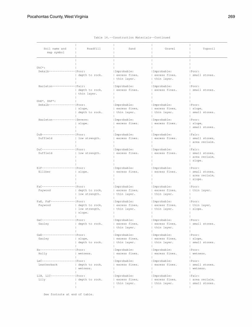
Pocahontas County, West Virginia 269
Table 14.--Construction Materials--Continued ______________________________________________________________________________________________________________ | | | | Soil name and | Roadfill | Sand | Gravel | Topsoil map symbol | | | | | | | | ______________________________________________________________________________________________________________ | | | | | | | | DhC*: | | | | Dekalb---------------|Poor: |Improbable: |Improbable: |Poor: | depth to rock. | excess fines, | excess fines, | small stones. | | thin layer. | thin layer. | | | | | Hazleton-------------|Fair: |Improbable: |Improbable: |Poor: | depth to rock, | excess fines. | excess fines. | small stones. | thin layer. | | | | | | | DhE*, DhF*: | | | | Dekalb---------------|Poor: |Improbable: |Improbable: |Poor: | slope, | excess fines, | excess fines, | slope, | depth to rock. | thin layer. | thin layer. | small stones. | | | | Hazleton-------------|Severe: |Improbable: |Improbable: |Poor: | slope. | excess fines. | excess fines. | slope, | | | | small stones. | | | | DuB-------------------|Poor: |Improbable: |Improbable: |Fair: Duffield | low strength. | excess fines. | excess fines. | small stones, | | | | area reclaim. | | | | DuC-------------------|Poor: |Improbable: |Improbable: |Fair: Duffield | low strength. | excess fines. | excess fines. | small stones, | | | | area reclaim, | | | | slope. | | | | ElF-------------------|Poor: |Improbable: |Improbable: |Poor: Elliber | slope. | excess fines. | excess fines. | small stones, | | | | area reclaim, | | | | slope. | | | | FaC-------------------|Poor: |Improbable: |Improbable: |Poor: Faywood | depth to rock, | excess fines, | excess fines, | thin layer. | low strength. | thin layer. | thin layer. | | | | | FaE, FaF--------------|Poor: |Improbable: |Improbable: |Poor: Faywood | depth to rock, | excess fines, | excess fines, | thin layer, | low strength, | thin layer. | thin layer. | slope. | slope. | | | | | | | GaC-------------------|Poor: |Improbable: |Improbable: |Poor: Gauley | depth to rock. | excess fines, | excess fines, | small stones. | | thin layer. | thin layer. | | | | | GaE-------------------|Poor: |Improbable: |Improbable: |Poor: Gauley | slope, | excess fines, | excess fines, | slope, | depth to rock. | thin layer. | thin layer. | small stones. | | | | Ho--------------------|Poor: |Improbable: |Improbable: |Poor: Holly | wetness. | excess fines. | excess fines. | wetness. | | | | LeC-------------------|Poor: |Improbable: |Improbable: |Poor: Leatherbark | depth to rock, | excess fines. | excess fines. | small stones, | wetness. | | | wetness. | | | | LlB, LlC--------------|Poor: |Improbable: |Improbable: |Fair: Lily | depth to rock. | excess fines, | excess fines, | area reclaim, | | thin layer. | thin layer. | small stones. | | | |
See footnote at end of table.

270 Soil Survey
Table 14.--Construction Materials--Continued ______________________________________________________________________________________________________________ | | | | Soil name and | Roadfill | Sand | Gravel | Topsoil map symbol | | | | | | | | ______________________________________________________________________________________________________________ | | | | | | | | LlD-------------------|Poor: |Improbable: |Improbable: |Poor: Lily | depth to rock. | excess fines, | excess fines, | slope. | | thin layer. | thin layer. | | | | | Lo--------------------|Fair: |Improbable: |Improbable: |Fair: Lobdell | wetness. | excess fines. | excess fines. | small stones. | | | | LyB, LyC--------------|Poor: |Improbable: |Improbable: |Poor: Lodi | low strength. | excess fines. | excess fines. | too clayey. | | | | MaB, MaC--------------|Fair: |Improbable: |Improbable: |Poor: Macove | large stones. | excess fines, | excess fines, | area reclaim, | | large stones. | large stones. | small stones. | | | | MaD-------------------|Fair: |Improbable: |Improbable: |Poor: Macove | large stones. | excess fines, | excess fines, | area reclaim, | | large stones. | large stones. | small stones, | | | | slope. | | | | McC-------------------|Fair: |Improbable: |Improbable: |Poor: Macove | large stones. | large stones. | large stones. | area reclaim, | | | | small stones. | | | | McE-------------------|Poor: |Improbable: |Improbable: |Poor: Macove | slope. | large stones. | large stones. | area reclaim, | | | | small stones, | | | | slope. | | | | MdC-------------------|Poor: |Improbable: |Improbable: |Poor: Mandy | depth to rock. | excess fines, | excess fines, | small stones. | | thin layer. | thin layer. | | | | | MdD-------------------|Poor: |Improbable: |Improbable: |Poor: Mandy | depth to rock. | excess fines, | excess fines, | small stones, | | thin layer. | thin layer. | slope. | | | | MfC-------------------|Poor: |Improbable: |Improbable: |Poor: Mandy | depth to rock. | excess fines, | excess fines, | small stones. | | thin layer. | thin layer. | | | | | MfE, MfF, MfG---------|Poor: |Improbable: |Improbable: |Poor: Mandy | depth to rock, | excess fines, | excess fines, | small stones, | slope. | thin layer. | thin layer. | slope. | | | | Mh. | | | | Medihemists | | | | | | | | MrB-------------------|Poor: |Improbable: |Improbable: |Poor: Mertz | low strength. | excess fines. | excess fines. | small stones, | | | | area reclaim. | | | | MzC-------------------|Good-----------------|Improbable: |Improbable: |Poor: Mertz | | excess fines. | excess fines. | small stones, | | | | area reclaim. | | | | MzE-------------------|Poor: |Improbable: |Improbable: |Poor: Mertz | slope. | excess fines. | excess fines. | small stones, | | | | area reclaim, | | | | slope. | | | |
See footnote at end of table.

Pocahontas County, West Virginia 271
Table 14.--Construction Materials--Continued ______________________________________________________________________________________________________________ | | | | Soil name and | Roadfill | Sand | Gravel | Topsoil map symbol | | | | | | | | ______________________________________________________________________________________________________________ | | | | | | | | Or--------------------|Fair: |Improbable: |Improbable: |Fair: Orrville | wetness. | excess fines. | excess fines. | small stones, | | | | area reclaim. | | | | Ph--------------------|Fair: |Improbable: |Improbable: |Poor: Philo | depth to rock, | excess fines. | excess fines. | small stones, | wetness. | | | area reclaim. | | | | Po, Pt----------------|Good-----------------|Probable-------------|Probable-------------|Poor: Potomac | | | | too sandy, | | | | small stones, | | | | area reclaim. | | | | Pu--------------------|Poor: |Improbable: |Improbable: |Poor: Purdy | wetness. | excess fines. | excess fines. | wetness, | | | | too clayey. | | | | Sc--------------------|Poor: |Improbable: |Improbable: |Poor: Sees | low strength. | excess fines. | excess fines. | area reclaim. | | | | Se--------------------|Good-----------------|Improbable: |Improbable: |Poor: Sensabaugh | | excess fines. | excess fines. | small stones, | | | | area reclaim. | | | | ShB-------------------|Good-----------------|Improbable: |Improbable: |Fair: Shouns | | excess fines. | excess fines. | too clayey, | | | | small stones. | | | | ShC-------------------|Good-----------------|Improbable: |Improbable: |Fair: Shouns | | excess fines. | excess fines. | too clayey, | | | | small stones, | | | | slope. | | | | SsC-------------------|Good-----------------|Improbable: |Improbable: |Poor: Shouns | | excess fines. | excess fines. | small stones. | | | | SsE, SsF--------------|Poor: |Improbable: |Improbable: |Poor: Shouns | slope. | excess fines. | excess fines. | small stones, | | | | slope. | | | | SwE-------------------|Poor: |Improbable: |Improbable: |Poor: Snowdog | slope. | excess fines. | excess fines. | small stones, | | | | area reclaim, | | | | slope. | | | | Tg--------------------|Good-----------------|Probable-------------|Probable-------------|Poor: Tioga | | | | small stones, | | | | area reclaim. | | | | TrC-------------------|Poor: |Improbable: |Improbable: |Poor: Trussel | wetness. | excess fines. | excess fines. | large stones, | | | | wetness. | | | | Uf*: | | | | Udifluvents. | | | | | | | | Fluvaquents. | | | | | | | | Us. | | | | Udorthents | | | | | | | |
See footnote at end of table.

272 Soil Survey
Table 14.--Construction Materials--Continued ______________________________________________________________________________________________________________ | | | | Soil name and | Roadfill | Sand | Gravel | Topsoil map symbol | | | | | | | | ______________________________________________________________________________________________________________ | | | | | | | | WeC-------------------|Poor: |Improbable: |Improbable: |Poor: Weikert | depth to rock. | small stones, | thin layer. | depth to rock, | | thin layer. | | small stones. | | | | WeD-------------------|Poor: |Improbable: |Improbable: |Poor: Weikert | depth to rock. | small stones, | thin layer. | depth to rock, | | thin layer. | | small stones, | | | | slope. | | | | WeF-------------------|Poor: |Improbable: |Improbable: |Poor: Weikert | depth to rock, | small stones, | thin layer. | depth to rock, | slope. | thin layer. | | small stones, | | | | slope. | | | | ______________________________________________________________________________________________________________
* See description of the map unit for composition and behavior characteristics of the map unit.

Pocahontas County, West Virginia 273
Table 15.--Water Management
(Some terms that describe restrictive soil features are defined in the Glossary. See text for definitions of "slight," "moderate," and "severe." Absence of an entry indicates that the soil was not evaluated. The information in this table indicates the dominant soil condition but does not eliminate the need for onsite investigation)
______________________________________________________________________________________________________________ | Limitations for-- | Features affecting-- ___________________________________________________________________________________________ Soil name and | Pond | Embankments, | | Terraces | map symbol | reservoir | dikes, and | Drainage | and | Grassed | areas | levees | | diversions | waterways ______________________________________________________________________________________________________________ | | | | | | | | | | AlB---------------|Moderate: |Severe: |Deep to water----|Favorable--------|Favorable. Allegheny | seepage, | piping. | | | | slope. | | | | | | | | | AlC---------------|Severe: |Severe: |Deep to water----|Slope------------|Slope. Allegheny | slope. | piping. | | | | | | | | At----------------|Severe: |Severe: |Flooding, |Wetness, |Wetness, Atkins | seepage. | piping, | frost action, | percs slowly. | percs slowly. | | wetness. | percs slowly. | | | | | | | BaB---------------|Moderate: |Moderate: |Deep to water----|Favorable--------|Favorable. Belmont | seepage, | thin layer. | | | | depth to rock, | | | | | slope. | | | | | | | | | BaC, BaD----------|Severe: |Moderate: |Deep to water----|Slope------------|Slope. Belmont | slope. | thin layer. | | | | | | | | BbC, BbE, BbF-----|Severe: |Moderate: |Deep to water----|Slope------------|Slope. Belmont | slope. | thin layer. | | | | | | | | BeB---------------|Severe: |Severe: |Deep to water----|Depth to rock, |Droughty, Berks | seepage. | seepage. | | large stones. | depth to rock, | | | | | large stones. | | | | | BeC, BeD, BeE-----|Severe: |Severe: |Deep to water----|Depth to rock, |Droughty, Berks | seepage, | seepage. | | slope, | depth to rock, | slope. | | | large stones. | slope. | | | | | BfC, BfE, BfF-----|Severe: |Severe: |Deep to water----|Slope, |Depth to rock, Berks | seepage, | seepage. | | depth to rock, | large stones, | slope. | | | large stones. | slope. | | | | | BgC*, BgE*, BgF*: | | | | | Berks------------|Severe: |Severe: |Deep to water----|Slope, |Depth to rock, | seepage, | seepage. | | depth to rock, | large stones, | slope. | | | large stones. | slope. | | | | | Dekalb-----------|Severe: |Severe: |Deep to water----|Slope, |Slope, | seepage, | piping, | | depth to rock, | large stones, | slope. | seepage, | | large stones. | droughty. | | large stones. | | | | | | | | BhG*: | | | | | Berks------------|Severe: |Severe: |Deep to water----|Slope, |Depth to rock, | seepage, | seepage. | | depth to rock, | large stones, | slope. | | | large stones. | slope. | | | | | Weikert----------|Severe: |Severe: |Deep to water----|Slope, |Slope, | depth to rock, | seepage, | | depth to rock. | droughty, | slope, | thin layer. | | | depth to rock. | seepage. | | | | | | | | |
See footnote at end of table.
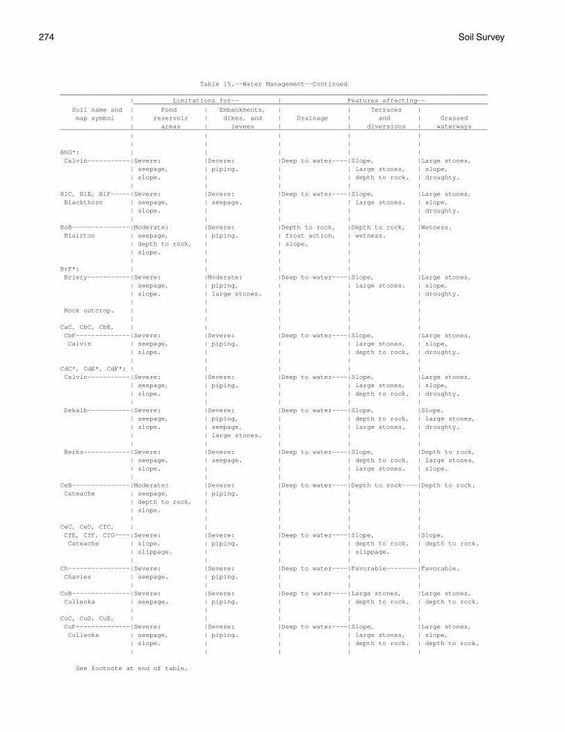
274 Soil Survey
Table 15.--Water Management--Continued ______________________________________________________________________________________________________________ | Limitations for-- | Features affecting-- ___________________________________________________________________________________________ Soil name and | Pond | Embankments, | | Terraces | map symbol | reservoir | dikes, and | Drainage | and | Grassed | areas | levees | | diversions | waterways ______________________________________________________________________________________________________________ | | | | | | | | | | BhG*: | | | | | Calvin-----------|Severe: |Severe: |Deep to water----|Slope, |Large stones, | seepage, | piping. | | large stones, | slope, | slope. | | | depth to rock. | droughty. | | | | | BlC, BlE, BlF-----|Severe: |Severe: |Deep to water----|Slope, |Large stones, Blackthorn | seepage, | seepage. | | large stones. | slope, | slope. | | | | droughty. | | | | | BoB---------------|Moderate: |Severe: |Depth to rock, |Depth to rock, |Wetness. Blairton | seepage, | piping. | frost action, | wetness. | | depth to rock, | | slope. | | | slope. | | | | | | | | | BrF*: | | | | | Briery-----------|Severe: |Moderate: |Deep to water----|Slope, |Large stones, | seepage, | piping, | | large stones. | slope, | slope. | large stones. | | | droughty. | | | | | Rock outcrop. | | | | | | | | | | CaC, CbC, CbE, | | | | | CbF--------------|Severe: |Severe: |Deep to water----|Slope, |Large stones, Calvin | seepage, | piping. | | large stones, | slope, | slope. | | | depth to rock. | droughty. | | | | | CdC*, CdE*, CdF*: | | | | | Calvin-----------|Severe: |Severe: |Deep to water----|Slope, |Large stones, | seepage, | piping. | | large stones, | slope, | slope. | | | depth to rock. | droughty. | | | | | Dekalb-----------|Severe: |Severe: |Deep to water----|Slope, |Slope, | seepage, | piping, | | depth to rock, | large stones, | slope. | seepage, | | large stones. | droughty. | | large stones. | | | | | | | | Berks------------|Severe: |Severe: |Deep to water----|Slope, |Depth to rock, | seepage, | seepage. | | depth to rock, | large stones, | slope. | | | large stones. | slope. | | | | | CeB---------------|Moderate: |Severe: |Deep to water----|Depth to rock----|Depth to rock. Cateache | seepage, | piping. | | | | depth to rock, | | | | | slope. | | | | | | | | | CeC, CeD, CfC, | | | | | CfE, CfF, CfG----|Severe: |Severe: |Deep to water----|Slope, |Slope, Cateache | slope, | piping. | | depth to rock, | depth to rock. | slippage. | | | slippage. | | | | | | Ch----------------|Severe: |Severe: |Deep to water----|Favorable--------|Favorable. Chavies | seepage. | piping. | | | | | | | | CuB---------------|Severe: |Severe: |Deep to water----|Large stones, |Large stones, Culleoka | seepage. | piping. | | depth to rock. | depth to rock. | | | | | CuC, CuD, CuE, | | | | | CuF--------------|Severe: |Severe: |Deep to water----|Slope, |Large stones, Culleoka | seepage, | piping. | | large stones, | slope, | slope. | | | depth to rock. | depth to rock. | | | | |
See footnote at end of table.

Pocahontas County, West Virginia 275
Table 15.--Water Management--Continued ______________________________________________________________________________________________________________ | Limitations for-- | Features affecting-- ___________________________________________________________________________________________ Soil name and | Pond | Embankments, | | Terraces | map symbol | reservoir | dikes, and | Drainage | and | Grassed | areas | levees | | diversions | waterways ______________________________________________________________________________________________________________ | | | | | | | | | | DhC*, DhE*, DhF*: | | | | | Dekalb-----------|Severe: |Severe: |Deep to water----|Slope, |Slope, | seepage, | piping, | | depth to rock, | large stones, | slope. | seepage, | | large stones. | droughty. | | large stones. | | | | | | | | Hazleton---------|Severe: |Severe: |Deep to water----|Large stones, |Large stones, | seepage, | seepage, | | slope. | slope, | slope. | large stones. | | | droughty. | | | | | DuB---------------|Moderate: |Severe: |Deep to water----|Favorable--------|Favorable. Duffield | seepage, | piping, | | | | depth to rock, | hard to pack. | | | | slope. | | | | | | | | | DuC---------------|Severe: |Severe: |Deep to water----|Slope------------|Slope. Duffield | slope. | piping. | | | | | | | | ElF---------------|Severe: |Severe: |Deep to water----|Slope, |Large stones, Elliber | seepage, | seepage. | | large stones. | slope, | slope. | | | | droughty. | | | | | FaC---------------|Severe: |Severe: |Deep to water----|Slope, |Slope, Faywood | slope. | hard to pack. | | depth to rock. | depth to rock. | | | | | FaE, FaF----------|Severe: |Severe: |Deep to water----|Slope, |Slope, Faywood | slope. | hard to pack. | | depth to rock. | depth to rock. | | | | | GaC, GaE----------|Severe: |Severe: |Deep to water----|Slope, |Slope, Gauley | slope, | piping, | | large stones, | large stones, | seepage. | large stones. | | depth to rock. | droughty. | | | | | Ho----------------|Severe: |Severe: |Flooding, |Wetness----------|Wetness. Holly | seepage. | piping, | frost action. | | | | wetness. | | | | | | | | LeC---------------|Severe: |Severe: |Depth to rock, |Depth to rock, |Large stones, Leatherbark | slope. | piping, | frost action, | slope, | wetness, | | wetness. | slope. | large stones. | slope. | | | | | LlB---------------|Severe: |Severe: |Deep to water----|Depth to rock----|Depth to rock. Lily | seepage. | piping. | | | | | | | | LlC---------------|Severe: |Severe: |Deep to water----|Slope, |Slope, Lily | seepage, | piping. | | depth to rock. | depth to rock. | slope. | | | | | | | | | LlD---------------|Severe: |Severe: |Deep to water----|Slope, |Slope, Lily | seepage, | piping. | | depth to rock. | depth to rock. | slope. | | | | | | | | | Lo----------------|Severe: |Severe: |Flooding, |Erodes easily, |Erodes easily. Lobdell | seepage. | piping, | frost action. | wetness. | | | seepage. | | | | | | | | LyB---------------|Moderate: |Moderate: |Deep to water----|Favorable--------|Favorable. Lodi | seepage, | hard to pack. | | | | slope. | | | | | | | | |
See footnote at end of table.

276 Soil Survey
Table 15.--Water Management--Continued ______________________________________________________________________________________________________________ | Limitations for-- | Features affecting-- ___________________________________________________________________________________________ Soil name and | Pond | Embankments, | | Terraces | map symbol | reservoir | dikes, and | Drainage | and | Grassed | areas | levees | | diversions | waterways ______________________________________________________________________________________________________________ | | | | | | | | | | LyC---------------|Severe: |Moderate: |Deep to water----|Slope------------|Slope. Lodi | slope. | hard to pack. | | | | | | | | MaB---------------|Severe: |Severe: |Deep to water----|Large stones-----|Large stones, Macove | seepage. | seepage, | | | droughty. | | large stones. | | | | | | | | MaC, MaD----------|Severe: |Severe: |Deep to water----|Slope, |Large stones, Macove | seepage, | seepage, | | large stones. | slope, | slope. | large stones. | | | droughty. | | | | | McC, McE----------|Severe: |Severe: |Deep to water----|Slope, |Large stones, Macove | seepage, | seepage, | | large stones. | slope, | slope. | large stones. | | | droughty. | | | | | MdC, MdD----------|Severe: |Severe: |Deep to water----|Slope, |Slope, Mandy | slope. | piping. | | depth to rock. | droughty, | | | | | depth to rock. | | | | | MfC, MfE, MfF, | | | | | MfG--------------|Severe: |Severe: |Deep to water----|Slope, |Large stones, Mandy | slope. | piping. | | large stones, | slope, | | | | depth to rock. | depth to rock. | | | | | Mh. | | | | | Medihemists | | | | | | | | | | MrB---------------|Moderate: |Severe: |Deep to water----|Favorable--------|Favorable. Mertz | slope. | piping. | | | | | | | | MzC, MzE----------|Severe: |Severe: |Deep to water----|Slope, |Large stones, Mertz | slope. | piping. | | large stones. | slope, | | | | | droughty. | | | | | Or----------------|Moderate: |Severe: |Flooding, |Erodes easily, |Wetness, Orrville | seepage. | piping, | frost action. | wetness. | erodes easily. | | wetness. | | | | | | | | Ph----------------|Severe: |Severe: |Flooding---------|Wetness----------|Favorable. Philo | seepage. | piping, | | | | | wetness. | | | | | | | | Po, Pt------------|Severe: |Severe: |Deep to water----|Large stones, |Large stones, Potomac | seepage. | seepage. | | too sandy. | droughty. | | | | | Pu----------------|Slight------------|Severe: |Percs slowly, |Wetness, |Wetness, Purdy | | piping, | frost action. | percs slowly. | percs slowly. | | wetness. | | | | | | | | Sc----------------|Slight------------|Severe: |Percs slowly-----|Wetness, |Wetness, Sees | | wetness. | | percs slowly. | percs slowly. | | | | | Se----------------|Severe: |Moderate: |Deep to water----|Large stones-----|Large stones. Sensabaugh | seepage. | large stones. | | | | | | | | ShB---------------|Moderate: |Severe: |Deep to water----|Favorable--------|Favorable. Shouns | seepage, | piping. | | | | slope. | | | | | | | | |
See footnote at end of table.

Pocahontas County, West Virginia 277
Table 15.--Water Management--Continued ______________________________________________________________________________________________________________ | Limitations for-- | Features affecting-- ___________________________________________________________________________________________ Soil name and | Pond | Embankments, | | Terraces | map symbol | reservoir | dikes, and | Drainage | and | Grassed | areas | levees | | diversions | waterways ______________________________________________________________________________________________________________ | | | | | | | | | | ShC, SsC, SsE, | | | | | SsF--------------|Severe: |Severe: |Deep to water----|Slope------------|Slope. Shouns | slope. | piping. | | | | | | | | SwE---------------|Severe: |Severe: |Percs slowly, |Slope, |Large stones, Snowdog | seepage, | seepage, | large stones, | large stones, | slope, | slope. | piping. | slope. | wetness, | droughty, | | | | rooting depth. | rooting depth. | | | | | Tg----------------|Severe: |Severe: |Deep to water----|Favorable--------|Droughty. Tioga | seepage. | piping. | | | | | | | | TrC---------------|Severe: |Severe: |Frost action, |Slope, |Slope, Trussel | slope. | wetness, | slope, | wetness, | wetness, | | piping. | percs slowly. | rooting depth. | rooting depth. | | | | | Uf*: | | | | | Udifluvents. | | | | | | | | | | Fluvaquents. | | | | | | | | | | Us. | | | | | Udorthents | | | | | | | | | | WeC, WeD, WeF-----|Severe: |Severe: |Deep to water----|Slope, |Large stones, Weikert | depth to rock, | seepage, | | large stones, | slope, | slope. | thin layer. | | depth to rock. | depth to rock. | | | | | ______________________________________________________________________________________________________________
* See description of the map unit for composition and behavior characteristics of the map unit.

278 Soil Survey
Table 16.--Engineering Index Properties
(The symbol < means less than; > means more than. Absence of an entry indicates that data were not estimated)
_________________________________________________________________________________________________________________ | | | Classification |Frag- | Percentage passing | | ____________________ Soil name and |Depth| USDA texture | | |ments | sieve number-- |Liquid | Plas- ___________________________ map symbol | | | Unified | AASHTO | 3-10 | | | | | limit | ticity | | | | |inches| 4 | 10 | 40 | 200 | | index _________________________________________________________________________________________________________________ | In | | | | Pct | | | | | Pct | __ ___ ___ | | | | | | | | | | | AlB, AlC---------| 0-8 |Loam-------------|ML, CL |A-4 | 0 |90-100|80-100|65-100|55-95 | <35 | NP-10 Allegheny | 8-40|Gravelly silt |ML, CL, |A-4, A-6,| 0 |55-100|50-100|35-100|20-90 | <35 | NP-15 | | loam, gravelly | SM, SC | A-2 | | | | | | | | | loam, very | | | | | | | | | | | gravelly fine | | | | | | | | | | | sandy loam, | | | | | | | | | | | loam. | | | | | | | | | |40-65|Clay loam, sandy |SM, GC, |A-4, A-6,| 0-5 |15-60 |10-55 | 5-55 | 5-45 | <35 | NP-15 | | loam, extremely | ML, CL | A-2, A-1| | | | | | | | | gravelly fine | | | | | | | | | | | sandy loam. | | | | | | | | | | | | | | | | | | | | At---------------| 0-4 |Silt loam--------|ML, CL, |A-4, A-6 | 0 |90-100|85-100|75-100|60-95 | 20-40 | 3-20 Atkins | | | CL-ML | | | | | | | | | 4-25|Silty clay loam, |SM, SC, |A-4, A-6 | 0-5 |90-100|85-100|65-100|45-85 | 20-40 | 3-20 | | silt loam, sandy| ML, CL | | | | | | | | | | loam. | | | | | | | | | |25-65|Stratified silty |SM, CL, |A-2, A-4,| 0-15 |35-100|30-100|20-100|10-95 | 20-40 | 1-15 | | clay loam to | GM, ML | A-6 | | | | | | | | | very gravelly | | | | | | | | | | | sandy loam. | | | | | | | | | | | | | | | | | | | | BaB, BaC, BaD----| 0-6 |Silt loam--------|CL, ML, |A-4, A-6 | 0-5 |80-100|75-100|65-100|50-90 | 20-40 | 5-15 Belmont | | | CL-ML | | | | | | | | | 6-23|Channery silty |ML, CL-ML,|A-4, A-6,| 0-5 |80-100|75-100|70-100|50-95 | 25-45 | 5-20 | | clay loam, | CL | A-7 | | | | | | | | | channery silt | | | | | | | | | | | loam, clay loam.| | | | | | | | | |23-35|Silty clay loam, |CL |A-6, A-7 | 0-5 |80-100|75-100|70-100|50-95 | 25-50 | 11-25 | | clay loam, | | | | | | | | | | | channery silty | | | | | | | | | | | clay. | | | | | | | | | |35-51|Channery clay |CL, GC |A-4, A-6,| 0-20 |40-75 |35-70 |25-70 |15-65 | 25-45 | 7-25 | | loam, very | | A-7 | | | | | | | | | channery silty | | | | | | | | | | | clay, channery | | | | | | | | | | | sandy clay loam.| | | | | | | | | | 51 |Unweathered | --- | --- | --- | --- | --- | --- | --- | --- | --- | | bedrock. | | | | | | | | | | | | | | | | | | | | BbC, BbE, BbF----| 0-6 |Very rocky silt |CL, ML, |A-4, A-6 | 0-5 |80-100|75-100|65-100|50-90 | 20-40 | 5-15 Belmont | | loam. | CL-ML | | | | | | | | | 6-23|Channery silty |CL-ML, CL |A-4, A-6,| 0-5 |80-100|75-100|70-100|50-95 | 25-45 | 5-20 | | clay loam, | | A-7 | | | | | | | | | channery silt | | | | | | | | | | | loam, clay loam.| | | | | | | | | |23-35|Silty clay loam, |CL |A-6, A-7 | 0-5 |80-100|75-100|70-100|50-95 | 25-50 | 11-25 | | clay loam, | | | | | | | | | | | channery silty | | | | | | | | | | | clay. | | | | | | | | | |35-51|Channery clay |CL, GC, SC|A-4, A-6,| 0-20 |40-75 |35-70 |25-70 |15-65 | 25-45 | 7-25 | | loam, very | | A-7, A-2| | | | | | | | | channery silty | | | | | | | | | | | clay, channery | | | | | | | | | | | sandy clay loam.| | | | | | | | | | 51 |Unweathered | --- | --- | --- | --- | --- | --- | --- | --- | --- | | bedrock. | | | | | | | | | | | | | | | | | | | |

Pocahontas County, West Virginia 279
Table 16.--Engineering Index Properties--Continued _________________________________________________________________________________________________________________ | | | Classification |Frag- | Percentage passing | | ____________________ Soil name and |Depth| USDA texture | | |ments | sieve number-- |Liquid | Plas- ___________________________ map symbol | | | Unified | AASHTO | 3-10 | | | | | limit | ticity | | | | |inches| 4 | 10 | 40 | 200 | | index _________________________________________________________________________________________________________________ | In | | | | Pct | | | | | Pct | __ ___ ___ | | | | | | | | | | | BeB, BeC, BeD, | | | | | | | | | | | BeE-------------| 0-4 |Channery silt |GM, ML, |A-2, A-4 | 0-20 |50-80 |45-70 |40-60 |30-55 | 25-36 | 5-10 Berks | | loam. | GC, SC | | | | | | | | | 4-22|Channery loam, |GM, GC, |A-1, A-2,| 0-30 |40-80 |35-70 |25-60 |20-45 | 25-36 | 5-10 | | very channery | SM, SC | A-4 | | | | | | | | | silt loam, | | | | | | | | | | | channery silt | | | | | | | | | | | loam. | | | | | | | | | |22-31|Channery loam, |GM, SM |A-1, A-2 | 0-40 |35-65 |25-55 |20-40 |15-35 | 24-38 | 2-10 | | very channery | | | | | | | | | | | loam, extremely | | | | | | | | | | | channery silt | | | | | | | | | | | loam. | | | | | | | | | | 31 |Weathered bedrock| --- | --- | --- | --- | --- | --- | --- | --- | --- | | | | | | | | | | | BfC, BfE, BfF----| 0-4 |Very stony silt |GM, SM, |A-2, A-4 |15-30 |40-80 |35-70 |30-60 |25-45 | 25-36 | 5-10 Berks | | loam. | GC, SC | | | | | | | | | 4-22|Channery loam, |GM, GC, |A-1, A-2,| 0-30 |40-80 |35-70 |25-60 |20-45 | 25-36 | 5-10 | | very channery | SM, SC | A-4 | | | | | | | | | silt loam, | | | | | | | | | | | channery silt | | | | | | | | | | | loam. | | | | | | | | | |22-31|Channery loam, |GM, SM |A-1, A-2 | 0-40 |35-65 |25-55 |20-40 |15-35 | 24-38 | 2-10 | | very channery | | | | | | | | | | | loam, extremely | | | | | | | | | | | channery silt | | | | | | | | | | | loam. | | | | | | | | | | 31 |Weathered bedrock| --- | --- | --- | --- | --- | --- | --- | --- | --- | | | | | | | | | | | BgC*, BgE*, BgF*:| | | | | | | | | | | Berks-----------| 0-4 |Very stony silt |GM, SM, |A-2, A-4 |15-30 |40-80 |35-70 |30-60 |25-45 | 25-36 | 5-10 | | loam. | GC, SC | | | | | | | | | 4-22|Channery loam, |GM, GC, |A-1, A-2,| 0-30 |40-80 |35-70 |25-60 |20-45 | 25-36 | 5-10 | | very channery | SM, SC | A-4 | | | | | | | | | silt loam, | | | | | | | | | | | channery silt | | | | | | | | | | | loam. | | | | | | | | | |22-31|Channery loam, |GM, SM |A-1, A-2 | 0-40 |35-65 |25-55 |20-40 |15-35 | 24-38 | 2-10 | | very channery | | | | | | | | | | | loam, extremely | | | | | | | | | | | channery silt | | | | | | | | | | | loam. | | | | | | | | | | 31 |Weathered bedrock| --- | --- | --- | --- | --- | --- | --- | --- | --- | | | | | | | | | | | Dekalb----------| 0-4 |Very stony loam |SM, GM, |A-2, A-4,|10-30 |50-90 |45-80 |40-75 |20-55 | 10-32 | NP-10 | | | ML, CL-ML| A-1 | | | | | | | | 4-26|Channery sandy |SM, GM, |A-2, A-4,| 5-40 |50-85 |40-75 |40-75 |20-55 | 15-32 | NP-9 | | loam, channery | ML, GM-GC| A-1 | | | | | | | | | loam, very | | | | | | | | | | | channery loam. | | | | | | | | | |26-36|Very channery |SM, GM, |A-2, A-4,|10-50 |45-85 |25-75 |20-65 |15-40 | 15-32 | NP-9 | | sandy loam, | SC, GC | A-1 | | | | | | | | | flaggy sandy | | | | | | | | | | | loam, very | | | | | | | | | | | flaggy loamy | | | | | | | | | | | sand. | | | | | | | | | | 36 |Unweathered | --- | --- | --- | --- | --- | --- | --- | --- | --- | | bedrock. | | | | | | | | | | | | | | | | | | | |
See footnote at end of table.

280 Soil Survey
Table 16.--Engineering Index Properties--Continued _________________________________________________________________________________________________________________ | | | Classification |Frag- | Percentage passing | | ____________________ Soil name and |Depth| USDA texture | | |ments | sieve number-- |Liquid | Plas- ___________________________ map symbol | | | Unified | AASHTO | 3-10 | | | | | limit | ticity | | | | |inches| 4 | 10 | 40 | 200 | | index _________________________________________________________________________________________________________________ | In | | | | Pct | | | | | Pct | __ ___ ___ | | | | | | | | | | | BhG*: | | | | | | | | | | | Berks-----------| 0-4 |Very stony silt |GM, SM, |A-2, A-4 |15-30 |40-80 |35-70 |30-60 |25-45 | 25-36 | 5-10 | | loam. | GC, SC | | | | | | | | | 4-22|Channery loam, |GM, GC, |A-1, A-2,| 0-30 |40-80 |35-70 |25-60 |20-45 | 25-36 | 5-10 | | very channery | SM, SC | A-4 | | | | | | | | | silt loam, | | | | | | | | | | | channery silt | | | | | | | | | | | loam. | | | | | | | | | |22-31|Channery loam, |GM, SM |A-1, A-2 | 0-40 |35-65 |25-55 |20-40 |15-35 | 24-38 | 2-10 | | very channery | | | | | | | | | | | loam, extremely | | | | | | | | | | | channery silt | | | | | | | | | | | loam. | | | | | | | | | | 31 |Weathered bedrock| --- | --- | --- | --- | --- | --- | --- | --- | --- | | | | | | | | | | | Weikert---------| 0-6 |Very stony silt |GM, ML, SM|A-1, A-2,| 3-15 |35-70 |35-70 |25-65 |20-55 | 30-40 | 4-10 | | loam. | | A-4 | | | | | | | | 6-15|Very channery |GM, GP-GM |A-1, A-2 | 0-20 |15-60 |10-55 | 5-45 | 5-35 | 28-36 | 3-9 | | silt loam, | | | | | | | | | | | extremely | | | | | | | | | | | channery silt | | | | | | | | | | | loam, channery | | | | | | | | | | | loam. | | | | | | | | | | 15 |Weathered bedrock| --- | --- | --- | --- | --- | --- | --- | --- | --- | | | | | | | | | | | Calvin----------| 0-4 |Very stony silt |ML, CL |A-4 | 3-15 |70-100|70-100|65-95 |55-90 | --- | --- | | loam. | | | | | | | | | | 4-27|Channery silt |ML, SM, GM|A-2, A-4,| 0-15 |70-95 |55-90 |40-90 |30-75 | 22-38 | NP-11 | | loam, channery | | A-6 | | | | | | | | | loam, very | | | | | | | | | | | channery silt | | | | | | | | | | | loam. | | | | | | | | | |27-39|Channery silt |GM, SM, |A-2, A-1,| 0-20 |35-75 |30-65 |15-60 |15-40 | 23-39 | 3-11 | | loam, extremely | GM-GC, | A-6 | | | | | | | | | channery silt | SC-SM | | | | | | | | | | loam, very | | | | | | | | | | | channery loam. | | | | | | | | | | 39 |Weathered bedrock| --- | --- | --- | --- | --- | --- | --- | --- | --- | | | | | | | | | | | BlC, BlE, BlF----| 0-10|Extremely stony |ML, SM, |A-2, A-4,| 5-15 |65-90 |60-85 |35-70 |15-55 | 15-27 | NP-7 Blackthorn | | loam. | CL-ML, | A-1 | | | | | | | | | | SC-SM | | | | | | | | |10-51|Channery sandy |GM, SM, |A-2, A-4,| 5-30 |40-90 |25-90 |20-60 |10-45 | 18-30 | 1-9 | | loam, very | SC, SC-SM| A-1 | | | | | | | | | channery sandy | | | | | | | | | | | loam, very | | | | | | | | | | | channery loam. | | | | | | | | | |51-65|Clay, clay loam, |CL, CH |A-6, A-7 | 0-10 |85-100|70-100|65-95 |55-90 | 30-65 | 15-40 | | silty clay. | | | | | | | | | | | | | | | | | | | |
See footnote at end of table.

Pocahontas County, West Virginia 281
Table 16.--Engineering Index Properties--Continued _________________________________________________________________________________________________________________ | | | Classification |Frag- | Percentage passing | | ____________________ Soil name and |Depth| USDA texture | | |ments | sieve number-- |Liquid | Plas- ___________________________ map symbol | | | Unified | AASHTO | 3-10 | | | | | limit | ticity | | | | |inches| 4 | 10 | 40 | 200 | | index _________________________________________________________________________________________________________________ | In | | | | Pct | | | | | Pct | __ ___ ___ | | | | | | | | | | | BoB--------------| 0-2 |Silt loam--------|ML, CL-ML |A-4 | 0 |80-100|75-100|65-90 |50-80 | 20-35 | 2-10 Blairton | 2-24|Silt loam, very |ML, CL, GM|A-4, A-6,| 0-5 |50-90 |35-90 |30-85 |25-70 | 25-42 | 2-20 | | channery silty | | A-7, A-2| | | | | | | | | clay loam, silty| | | | | | | | | | | clay loam. | | | | | | | | | |24-34|Very channery |GM, SM, |A-4, A-2,| 0-10 |15-65 |15-65 |15-65 |10-60 | 25-40 | 2-12 | | loam, channery | ML, CL | A-6, A-1| | | | | | | | | loam, extremely | | | | | | | | | | | channery silt | | | | | | | | | | | loam. | | | | | | | | | | 34 |Weathered bedrock| --- | --- | --- | --- | --- | --- | --- | --- | --- | | | | | | | | | | | BrF*: | | | | | | | | | | | Briery----------| 0-2 |Very stony silt |GC |A-2, A-4 | 3-15 |45-60 |40-55 |30-50 |20-40 | 25-35 | 7-11 | | loam. | | | | | | | | | | 2-65|Very channery |GC |A-2, A-4 | 5-30 |30-55 |25-50 |25-45 |20-45 | 25-35 | 7-11 | | silt loam, | | | | | | | | | | | extremely | | | | | | | | | | | channery silty | | | | | | | | | | | clay loam. | | | | | | | | | | | | | | | | | | | | Rock outcrop. | | | | | | | | | | | | | | | | | | | | | | CaC--------------| 0-4 |Channery silt |ML, CL |A-4 | 0-15 |70-95 |70-90 |65-90 |55-75 | --- | --- Calvin | | loam. | | | | | | | | | | 4-27|Channery silt |ML, SM, GM|A-2, A-4,| 0-15 |70-95 |55-90 |40-90 |30-75 | 22-38 | NP-11 | | loam, channery | | A-6 | | | | | | | | | loam, very | | | | | | | | | | | channery silt | | | | | | | | | | | loam. | | | | | | | | | |27-39|Channery silt |GM, SM, |A-2, A-1,| 0-20 |35-75 |30-65 |15-60 |15-40 | 23-39 | 3-13 | | loam, extremely | SC, GC | A-4, A-6| | | | | | | | | channery silt | | | | | | | | | | | loam, very | | | | | | | | | | | channery loam. | | | | | | | | | | 39 |Weathered bedrock| --- | --- | --- | --- | --- | --- | --- | --- | --- | | | | | | | | | | | CbC, CbE, CbF----| 0-4 |Very stony silt |ML, CL |A-4 | 3-15 |70-100|70-100|65-95 |55-90 | --- | --- Calvin | | loam. | | | | | | | | | | 4-27|Channery silt |ML, SM, GM|A-2, A-4,| 0-15 |70-95 |55-90 |40-90 |30-75 | 22-38 | NP-11 | | loam, channery | | A-6 | | | | | | | | | loam, very | | | | | | | | | | | channery silt | | | | | | | | | | | loam. | | | | | | | | | |27-39|Channery silt |GM, SM, |A-2, A-1,| 0-20 |35-75 |30-65 |15-60 |15-40 | 23-39 | 3-11 | | loam, extremely | GM-GC, | A-6 | | | | | | | | | channery silt | SC-SM | | | | | | | | | | loam, very | | | | | | | | | | | channery loam. | | | | | | | | | | 39 |Weathered bedrock| --- | --- | --- | --- | --- | --- | --- | --- | --- | | | | | | | | | | |
See footnote at end of table.

282 Soil Survey
Table 16.--Engineering Index Properties--Continued _________________________________________________________________________________________________________________ | | | Classification |Frag- | Percentage passing | | ____________________ Soil name and |Depth| USDA texture | | |ments | sieve number-- |Liquid | Plas- ___________________________ map symbol | | | Unified | AASHTO | 3-10 | | | | | limit | ticity | | | | |inches| 4 | 10 | 40 | 200 | | index _________________________________________________________________________________________________________________ | In | | | | Pct | | | | | Pct | __ ___ ___ | | | | | | | | | | | CdC*, CdE*, CdF*:| | | | | | | | | | | Calvin----------| 0-4 |Very stony silt |ML, CL |A-4 | 3-15 |70-100|70-100|65-95 |55-90 | --- | --- | | loam. | | | | | | | | | | 4-27|Channery silt |ML, SM, GM|A-2, A-4,| 0-15 |70-95 |55-90 |40-90 |30-75 | 22-38 | NP-11 | | loam, channery | | A-6 | | | | | | | | | loam, very | | | | | | | | | | | channery silt | | | | | | | | | | | loam. | | | | | | | | | |27-39|Channery silt |GM, SM, |A-2, A-1,| 0-20 |35-75 |30-65 |15-60 |15-40 | 23-39 | 3-11 | | loam, extremely | GM-GC, | A-6 | | | | | | | | | channery silt | SC-SM | | | | | | | | | | loam, very | | | | | | | | | | | channery loam. | | | | | | | | | | 39 |Weathered bedrock| --- | --- | --- | --- | --- | --- | --- | --- | --- | | | | | | | | | | | Dekalb----------| 0-4 |Very stony loam |SM, GM, |A-2, A-4,|10-30 |50-90 |45-80 |40-75 |20-55 | 10-32 | NP-10 | | | ML, CL-ML| A-1 | | | | | | | | 4-26|Channery sandy |SM, GM, |A-2, A-4,| 5-40 |50-85 |40-75 |40-75 |20-55 | 15-32 | NP-9 | | loam, channery | ML, GM-GC| A-1 | | | | | | | | | loam, very | | | | | | | | | | | channery loam. | | | | | | | | | |26-36|Very channery |SM, GM, |A-2, A-4,|10-50 |45-85 |25-75 |20-65 |15-40 | 15-32 | NP-9 | | sandy loam, | SC, GC | A-1 | | | | | | | | | flaggy sandy | | | | | | | | | | | loam, very | | | | | | | | | | | flaggy loamy | | | | | | | | | | | sand. | | | | | | | | | | 36 |Unweathered | --- | --- | --- | --- | --- | --- | --- | --- | --- | | bedrock. | | | | | | | | | | | | | | | | | | | | Berks-----------| 0-4 |Very stony silt |GM, SM, |A-2, A-4 |15-30 |40-80 |35-70 |30-60 |25-45 | 25-36 | 5-10 | | loam. | GC, SC | | | | | | | | | 4-22|Channery loam, |GM, GC, |A-1, A-2,| 0-30 |40-80 |35-70 |25-60 |20-45 | 25-36 | 5-10 | | very channery | SM, SC | A-4 | | | | | | | | | silt loam, | | | | | | | | | | | channery silt | | | | | | | | | | | loam. | | | | | | | | | |22-31|Channery loam, |GM, SM |A-1, A-2 | 0-40 |35-65 |25-55 |20-40 |15-35 | 24-38 | 2-10 | | very channery | | | | | | | | | | | loam, extremely | | | | | | | | | | | channery silt | | | | | | | | | | | loam. | | | | | | | | | | 31 |Weathered bedrock| --- | --- | --- | --- | --- | --- | --- | --- | --- | | | | | | | | | | | CeB, CeC, CeD----| 0-6 |Channery silt |CL, CL-ML,|A-4, A-6 | 0-10 |70-85 |65-80 |60-75 |45-70 | 20-40 | 4-15 Cateache | | loam. | GM-GC, GC| | | | | | | | | 6-28|Channery silty |CL-ML, CL,|A-2, A-4,| 0-15 |40-85 |35-80 |30-80 |25-70 | 20-40 | 4-15 | | clay loam, very | GC, GM-GC| A-6 | | | | | | | | | channery silty | | | | | | | | | | | clay loam. | | | | | | | | | |28-32|Very channery |GM-GC, GC,|A-2, A-4,| 0-20 |20-60 |10-50 |10-45 |10-40 | 20-40 | 4-15 | | silty clay loam,| GP, GP-GC| A-6, A-1| | | | | | | | | extremely | | | | | | | | | | | channery silty | | | | | | | | | | | clay loam. | | | | | | | | | | 32 |Weathered bedrock| --- | --- | --- | --- | --- | --- | --- | --- | --- | | | | | | | | | | |
See footnote at end of table.

Pocahontas County, West Virginia 283
Table 16.--Engineering Index Properties--Continued _________________________________________________________________________________________________________________ | | | Classification |Frag- | Percentage passing | | ____________________ Soil name and |Depth| USDA texture | | |ments | sieve number-- |Liquid | Plas- ___________________________ map symbol | | | Unified | AASHTO | 3-10 | | | | | limit | ticity | | | | |inches| 4 | 10 | 40 | 200 | | index _________________________________________________________________________________________________________________ | In | | | | Pct | | | | | Pct | __ ___ ___ | | | | | | | | | | | CfC, CfE, CfF, | | | | | | | | | | | CfG-------------| 0-6 |Very stony silt |CL, CL-ML,|A-4, A-6 |15-30 |70-85 |65-80 |60-75 |45-70 | 20-40 | 4-15 Cateache | | loam. | GM-GC, GC| | | | | | | | | 6-28|Channery silty |CL-ML, CL,|A-2, A-4,| 0-15 |40-85 |35-80 |30-80 |25-70 | 20-40 | 4-15 | | clay loam, very | GC, GM-GC| A-6 | | | | | | | | | channery silty | | | | | | | | | | | clay loam. | | | | | | | | | |28-32|Very channery |GM-GC, GC,|A-2, A-4,| 0-20 |20-60 |10-50 |10-45 |10-40 | 20-40 | 4-15 | | silty clay loam,| GP-GC | A-6, A-1| | | | | | | | | extremely | | | | | | | | | | | channery silty | | | | | | | | | | | clay loam. | | | | | | | | | | 32 |Weathered bedrock| --- | --- | --- | --- | --- | --- | --- | --- | --- | | | | | | | | | | | Ch---------------| 0-8 |Fine sandy loam |SM, ML, |A-4 | 0 |85-100|75-100|40-90 |40-75 | <25 | NP-5 Chavies | | | CL-ML, | | | | | | | | | | | SC-SM | | | | | | | | | 8-41|Fine sandy loam, |SM, ML |A-4 | 0 |85-100|75-100|65-100|45-85 | <35 | NP-8 | | silt loam, loam.| | | | | | | | | |41-65|Fine sandy loam, |SM, ML, |A-4, A-2,| 0-5 |70-100|60-95 |40-85 |20-75 | <25 | NP-5 | | gravelly fine | CL-ML, | A-1-b | | | | | | | | | sandy loam, | SC-SM | | | | | | | | | | loam. | | | | | | | | | | | | | | | | | | | | CuB, CuC, CuD, | | | | | | | | | | | CuE, CuF--------| 0-1 |Silt loam--------|ML, CL, |A-4 | 0-5 |90-100|85-100|70-100|55-95 | <35 | NP-10 Culleoka | | | CL-ML | | | | | | | | | 1-21|Channery silt |ML, CL, |A-6, A-4 | 5-25 |80-95 |75-95 |65-95 |55-90 | 20-40 | 2-20 | | loam, very | CL-ML | | | | | | | | | | channery silt | | | | | | | | | | | loam, silty clay| | | | | | | | | | | loam. | | | | | | | | | |21-33|Very flaggy silty|ML, CL, |A-6, A-4,|10-60 |50-95 |40-90 |35-90 |30-85 | 20-40 | 2-20 | | clay loam, | GC, GM | A-2 | | | | | | | | | extremely | | | | | | | | | | | channery silt | | | | | | | | | | | loam, flaggy | | | | | | | | | | | loam. | | | | | | | | | | 33 |Unweathered | --- | --- | --- | --- | --- | --- | --- | --- | --- | | bedrock. | | | | | | | | | | | | | | | | | | | | DhC*, DhE*, DhF*:| | | | | | | | | | | Dekalb----------| 0-4 |Very stony loam |SM, GM, |A-2, A-4,|10-30 |50-90 |45-80 |40-75 |20-55 | 10-32 | NP-10 | | | ML, CL-ML| A-1 | | | | | | | | 4-26|Channery sandy |SM, GM, |A-2, A-4,| 5-40 |50-85 |40-75 |40-75 |20-55 | 15-32 | NP-9 | | loam, channery | ML, GM-GC| A-1 | | | | | | | | | loam, very | | | | | | | | | | | channery loam. | | | | | | | | | |26-36|Very channery |SM, GM, |A-2, A-4,|10-50 |45-85 |25-75 |20-65 |15-40 | 15-32 | NP-9 | | sandy loam, | SC, GC | A-1 | | | | | | | | | flaggy sandy | | | | | | | | | | | loam, very | | | | | | | | | | | flaggy loamy | | | | | | | | | | | sand. | | | | | | | | | | 36 |Unweathered | --- | --- | --- | --- | --- | --- | --- | --- | --- | | bedrock. | | | | | | | | | | | | | | | | | | | |
See footnote at end of table.

284 Soil Survey
Table 16.--Engineering Index Properties--Continued _________________________________________________________________________________________________________________ | | | Classification |Frag- | Percentage passing | | ____________________ Soil name and |Depth| USDA texture | | |ments | sieve number-- |Liquid | Plas- ___________________________ map symbol | | | Unified | AASHTO | 3-10 | | | | | limit | ticity | | | | |inches| 4 | 10 | 40 | 200 | | index _________________________________________________________________________________________________________________ | In | | | | Pct | | | | | Pct | __ ___ ___ | | | | | | | | | | | DhC*, DhE*, DhF*:| | | | | | | | | | | Hazleton--------| 0-2 |Very stony loam |ML, GM, SM|A-4, A-2 | 5-15 |60-85 |50-80 |50-70 |35-55 | --- | --- | 2-30|Channery fine |GM, SM, |A-2, A-4,| 0-50 |60-95 |45-90 |35-70 |20-55 | <30 | NP-8 | | sandy loam, | ML, SC | A-1 | | | | | | | | | channery loam, | | | | | | | | | | | very channery | | | | | | | | | | | sandy loam. | | | | | | | | | |30-50|Channery loam, |GM, SM, |A-2, A-1,| 5-60 |50-80 |35-75 |25-65 |15-50 | <30 | NP-8 | | extremely | SC, GC | A-4 | | | | | | | | | channery sandy | | | | | | | | | | | loam, very | | | | | | | | | | | channery loamy | | | | | | | | | | | sand. | | | | | | | | | | 50 |Unweathered | --- | --- | --- | --- | --- | --- | --- | --- | --- | | bedrock. | | | | | | | | | | | | | | | | | | | | DuB, DuC---------| 0-8 |Silt loam--------|ML, CL, |A-4, A-6,| 0 |85-100|85-100|80-100|70-95 | 20-50 | 5-20 Duffield | | | CL-ML | A-7 | | | | | | | | 8-37|Silty clay loam, |ML, CL, |A-4, A-6,| 0-10 |65-100|60-100|55-100|55-95 | 30-55 | 8-22 | | silty clay, | MH, CH | A-7 | | | | | | | | | channery loam. | | | | | | | | | |37-46|Channery silty |MH, GM, |A-7, A-5 | 0-20 |65-100|50-100|45-90 |40-90 | 40-60 | 9-29 | | clay, loam, | SM, ML | | | | | | | | | | clay. | | | | | | | | | | 46 |Weathered bedrock| --- | --- | --- | --- | --- | --- | --- | --- | --- | | | | | | | | | | | ElF--------------| 0-2 |Extremely |GM, GP |A-2, A-1,| 5-15 |30-60 |20-55 |15-45 |10-40 | --- | --- Elliber | | channery silt | | A-4 | | | | | | | | | loam. | | | | | | | | | | 2-65|Extremely |GM, SP-SM,|A-2, A-1,|20-40 |40-65 |30-60 |25-50 | 5-40 | 20-35 | NP-7 | | channery silt | SM, GP-GM| A-4 | | | | | | | | | loam, very | | | | | | | | | | | channery clay | | | | | | | | | | | loam, very | | | | | | | | | | | channery loam. | | | | | | | | | | | | | | | | | | | | FaC, FaE, FaF----| 0-8 |Silt loam--------|ML, CL-ML |A-4 | 0-15 | 100 |95-100|90-100|85-100| 25-35 | 4-10 Faywood | 8-28|Silty clay, clay,|CH, CL |A-7 | 0-15 |90-100|90-100|85-100|75-100| 42-70 | 20-45 | | silty clay loam.| | | | | | | | | | 28 |Unweathered | --- | --- | --- | --- | --- | --- | --- | --- | --- | | bedrock. | | | | | | | | | | | | | | | | | | | | GaC, GaE---------| 0-9 |Extremely stony |GM, SM, |A-1, A-2,|30-50 |40-80 |40-75 |35-70 |20-55 | 15-25 | NP-7 Gauley | | sandy loam. | ML, CL-ML| A-4 | | | | | | | | 9-23|Channery loam, |GM, SM, |A-1, A-2,|10-40 |45-80 |40-80 |40-75 |20-55 | 15-25 | NP-7 | | very channery | ML, CL-ML| A-4 | | | | | | | | | loam, very | | | | | | | | | | | channery sandy | | | | | | | | | | | loam. | | | | | | | | | |23-35|Channery loam, |GM, SM, |A-1, A-2,|10-50 |45-75 |30-75 |25-70 |20-50 | 15-25 | NP-7 | | very channery | GM-GC, | A-4 | | | | | | | | | sandy loam, | SC-SM | | | | | | | | | | extremely | | | | | | | | | | | channery loam. | | | | | | | | | | 35 |Unweathered | --- | --- | --- | --- | --- | --- | --- | --- | --- | | bedrock. | | | | | | | | | | | | | | | | | | | |
See footnote at end of table.

Pocahontas County, West Virginia 285
Table 16.--Engineering Index Properties--Continued _________________________________________________________________________________________________________________ | | | Classification |Frag- | Percentage passing | | ____________________ Soil name and |Depth| USDA texture | | |ments | sieve number-- |Liquid | Plas- ___________________________ map symbol | | | Unified | AASHTO | 3-10 | | | | | limit | ticity | | | | |inches| 4 | 10 | 40 | 200 | | index _________________________________________________________________________________________________________________ | In | | | | Pct | | | | | Pct | __ ___ ___ | | | | | | | | | | | Ho---------------| 0-4 |Silt loam--------|ML |A-4 | 0 |90-100|85-100|80-100|70-90 | 25-35 | 3-10 Holly | 4-42|Silt loam, loam, |ML, SM |A-4, A-6 | 0 |85-100|75-100|70-95 |45-85 | 20-40 | NP-14 | | sandy loam. | | | | | | | | | |42-65|Silt loam, loam, |ML, SM |A-4, A-2 | 0 |85-100|75-100|50-95 |25-80 | 20-40 | NP-10 | | sandy loam. | | | | | | | | | | | | | | | | | | | | LeC--------------| 0-5 |Very stony silt |ML, CL-ML |A-4 | 0-10 |80-95 |75-90 |60-90 |45-80 | 20-30 | 5-10 Leatherbark | | loam. | | | | | | | | | | 5-35|Loam, channery |ML, CL, |A-4, A-6 | 5-15 |75-100|70-90 |60-85 |40-80 | 25-40 | 5-15 | | silt loam, silty| CL-ML, SC| | | | | | | | | | clay loam. | | | | | | | | | |35-38|Loam, very |CL, CL-ML,|A-4, A-6 |10-25 |55-80 |50-75 |40-75 |30-70 | 25-35 | 5-15 | | channery silt | ML, SC | | | | | | | | | | loam, channery | | | | | | | | | | | loam. | | | | | | | | | | 38 |Weathered bedrock| --- | --- | --- | --- | --- | --- | --- | --- | --- | | | | | | | | | | | LlB, LlC, LlD----| 0-2 |Loam-------------|ML, CL-ML |A-4 | 0-5 |90-100|85-100|70-95 |55-80 | <35 | NP-10 Lily | 2-32|Clay loam, |SM, SC, |A-4, A-6 | 0-5 |90-100|85-100|75-100|40-80 | <35 | 3-15 | | channery sandy | ML, CL | | | | | | | | | | loam, loam. | | | | | | | | | | 32 |Weathered bedrock| --- | --- | --- | --- | --- | --- | --- | --- | --- | | bedrock. | | | | | | | | | | | | | | | | | | | | Lo---------------| 0-10|Silt loam--------|ML, CL-ML,|A-4 | 0 |95-100|90-100|80-100|65-90 | 20-30 | NP-8 Lobdell | | | CL | | | | | | | | |10-28|Loam, silt loam |ML |A-4 | 0 |90-100|80-100|70-95 |55-85 | 20-35 | NP-10 |28-65|Stratified sandy |ML, SM, |A-4, A-2 | 0 |35-100|30-100|20-100|10-90 | 15-35 | NP-10 | | loam to very | CL-ML, | | | | | | | | | | gravelly silt | CL, GM | | | | | | | | | | loam. | | | | | | | | | | | | | | | | | | | | LyB, LyC---------| 0-6 |Silt loam--------|ML, CL, |A-2, A-4,| 0-5 |80-100|75-95 |50-90 |25-85 | <30 | NP-15 Lodi | | | SM, SC | A-6 | | | | | | | | 6-21|Clay, silt loam, |CL |A-6 | 0-10 |85-100|75-95 |65-90 |55-85 | 25-40 | 10-20 | | clay loam. | | | | | | | | | |21-47|Clay, silty clay |CH, CL, SC|A-7 | 0-5 |85-100|75-95 |60-95 |40-80 | 40-60 | 20-35 | | loam, sandy clay| | | | | | | | | | | loam. | | | | | | | | | |47-65|Silty clay, clay |ML, SM, |A-4, A-6 | 0-5 |85-100|75-95 |60-85 |40-80 | <40 | NP-25 | | loam, loam. | CL, SC | | | | | | | | | | | | | | | | | | | MaB, MaC, MaD----| 0-4 |Channery silt |SM, GM |A-4, | 5-10 |30-60 |25-60 |20-50 |15-40 | 20-30 | NP-7 Macove | | loam. | | A-1-b, | | | | | | | | | | | A-2-4 | | | | | | | | 4-14|Channery silt |GM, SM, |A-4, | 5-45 |40-65 |30-60 |25-50 | 5-40 | 20-30 | NP-7 | | loam, very | GP-GM | A-1-a, | | | | | | | | | channery silt | | A-1-b | | | | | | | | | loam, very | | | | | | | | | | | channery loam. | | | | | | | | | |14-65|Extremely |GM, SM, |A-2, |25-75 |35-60 |25-50 |20-45 | 5-25 | 20-30 | NP-7 | | channery silty | GP-GM | A-1-b, | | | | | | | | | clay loam, very | | A-1-a | | | | | | | | | channery loam, | | | | | | | | | | | very channery | | | | | | | | | | | silty clay loam.| | | | | | | | | | | | | | | | | | | |
See footnote at end of table.

286 Soil Survey
Table 16.--Engineering Index Properties--Continued _________________________________________________________________________________________________________________ | | | Classification |Frag- | Percentage passing | | ____________________ Soil name and |Depth| USDA texture | | |ments | sieve number-- |Liquid | Plas- ___________________________ map symbol | | | Unified | AASHTO | 3-10 | | | | | limit | ticity | | | | |inches| 4 | 10 | 40 | 200 | | index _________________________________________________________________________________________________________________ | In | | | | Pct | | | | | Pct | __ ___ ___ | | | | | | | | | | | McC, McE---------| 0-4 |Very stony silt |SM, GM |A-4, | 5-10 |30-60 |25-60 |20-50 |15-40 | 20-30 | NP-7 Macove | | loam. | | A-1-b, | | | | | | | | | | | A-2-4 | | | | | | | | 4-14|Channery silt |SM, GM |A-4, | 5-10 |30-60 |25-60 |20-50 |15-40 | 20-30 | NP-7 | | loam, very | | A-1-b, | | | | | | | | | channery silt | | A-2-4 | | | | | | | | | loam, very | | | | | | | | | | | channery loam. | | | | | | | | | |14-65|Very channery |GM, SM, |A-2, |25-75 |35-60 |25-50 |20-45 | 5-25 | 20-30 | NP-7 | | silty clay loam,| GP-GM | A-1-b, | | | | | | | | | extremely | | A-1-a | | | | | | | | | channery silty | | | | | | | | | | | clay loam, very | | | | | | | | | | | channery loam. | | | | | | | | | | | | | | | | | | | | MdC, MdD---------| 0-5 |Channery silt |CL-ML, CL |A-4 | 0-15 |65-80 |60-75 |55-70 |50-65 | 20-32 | 4-10 Mandy | | loam. | | | | | | | | | | 5-28|Channery silt |GM, GC, |A-1, A-2,| 0-30 |40-80 |35-70 |25-60 |20-45 | 20-32 | 4-10 | | loam, very | SC-SM | A-4 | | | | | | | | | channery silt | | | | | | | | | | | loam, extremely | | | | | | | | | | | channery loam. | | | | | | | | | |28-36|Extremely |GM, GC, |A-1, A-2 | 0-40 |35-65 |25-55 |20-40 |15-35 | 20-32 | 4-10 | | channery silt | SC-SM | | | | | | | | | | loam, extremely | | | | | | | | | | | channery loam. | | | | | | | | | | 36 |Weathered bedrock| --- | --- | --- | --- | --- | --- | --- | --- | --- | | | | | | | | | | | MfC, MfE, MfF, | | | | | | | | | | | MfG-------------| 0-5 |Very stony silt |CL-ML, CL |A-4 |15-30 |65-80 |60-75 |55-70 |50-65 | 20-32 | 4-10 Mandy | | loam. | | | | | | | | | | 5-28|Channery silt |GM, GC, |A-1, A-2,| 0-30 |40-80 |35-70 |25-60 |20-45 | 20-32 | 4-10 | | loam, very | SM, SC | A-4 | | | | | | | | | channery silt | | | | | | | | | | | loam, extremely | | | | | | | | | | | channery loam. | | | | | | | | | |28-36|Extremely |GM, GC, |A-1, A-2 | 0-40 |35-65 |25-55 |20-40 |15-35 | 20-32 | 4-10 | | channery silt | SM, SC | | | | | | | | | | loam, extremely | | | | | | | | | | | channery loam. | | | | | | | | | | 36 |Weathered bedrock| --- | --- | --- | --- | --- | --- | --- | --- | --- | | | | | | | | | | | Mh. | | | | | | | | | | | Medihemists | | | | | | | | | | | | | | | | | | | | | | MrB--------------| 0-3 |Channery silt |ML, GM |A-4 | 5-10 |70-95 |55-85 |45-85 |40-75 | --- | NP Mertz | | loam. | | | | | | | | | | 3-54|Very channery |ML, CL, |A-6, A-7,| 5-20 |55-95 |45-85 |45-85 |40-75 | 30-45 | 7-20 | | clay loam, | GM, GC | A-4 | | | | | | | | | extremely | | | | | | | | | | | channery silty | | | | | | | | | | | clay loam, | | | | | | | | | | | channery silt | | | | | | | | | | | loam, channery | | | | | | | | | | | silty clay loam.| | | | | | | | | |54-65|Channery clay |CL, GC, SC|A-6, A-7,| 5-50 |55-80 |30-75 |30-70 |25-55 | 30-45 | 10-20 | | loam, very | | A-2 | | | | | | | | | channery loam, | | | | | | | | | | | extremely | | | | | | | | | | | channery silty | | | | | | | | | | | clay loam. | | | | | | | | |
See footnote at end of table.

Pocahontas County, West Virginia 287
Table 16.--Engineering Index Properties--Continued _________________________________________________________________________________________________________________ | | | Classification |Frag- | Percentage passing | | ____________________ Soil name and |Depth| USDA texture | | |ments | sieve number-- |Liquid | Plas- ___________________________ map symbol | | | Unified | AASHTO | 3-10 | | | | | limit | ticity | | | | |inches| 4 | 10 | 40 | 200 | | index _________________________________________________________________________________________________________________ | In | | | | Pct | | | | | Pct | __ ___ ___ | | | | | | | | | | | MzC, MzE---------| 0-3 |Very stony silt |ML, GM |A-4 | 5-15 |60-95 |45-85 |45-85 |40-75 | 25-40 | 4-12 Mertz | | loam. | | | | | | | | | | 3-54|Channery silt |ML, CL, |A-4, A-6,| 5-20 |55-95 |45-85 |45-85 |40-75 | 30-45 | 7-20 | | loam, extremely | GM, GC | A-7 | | | | | | | | | channery silty | | | | | | | | | | | clay loam, very | | | | | | | | | | | channery clay | | | | | | | | | | | loam. | | | | | | | | | |54-65|Channery silt |ML, CL, |A-6, A-7 | 5-20 |55-80 |30-75 |30-70 |25-55 | 30-45 | 10-20 | | loam, extremely | GC, GM | | | | | | | | | | channery silty | | | | | | | | | | | clay loam, | | | | | | | | | | | extremely | | | | | | | | | | | channery silt | | | | | | | | | | | loam. | | | | | | | | | | | | | | | | | | | | Or---------------| 0-9 |Silt loam--------|ML, CL-ML,|A-4 | 0 | 100 |90-100|85-100|60-80 | 20-35 | 3-10 Orrville | | | CL | | | | | | | | | 9-40|Silt loam, loam, |CL, CL-ML,|A-4, A-6 | 0-2 |95-100|75-100|70-95 |50-90 | 20-40 | 2-16 | | silty clay loam.| ML | | | | | | | | |40-65|Stratified very |ML, CL, |A-4, A-2,| 0-2 |50-100|45-100|20-100|10-90 | 15-35 | NP-10 | | gravelly loamy | SM, SC | A-1 | | | | | | | | | sand to silt | | | | | | | | | | | loam. | | | | | | | | | | | | | | | | | | | | Ph---------------| 0-9 |Silt loam--------|ML, SM, |A-4 | 0-5 |95-100|80-100|85-90 |60-80 | 20-35 | 1-10 Philo | | | CL-ML | | | | | | | | | 9-33|Silt loam, loam, |ML, GM, |A-4 | 0-5 |80-100|75-100|70-90 |45-80 | 20-35 | 1-10 | | gravelly loam. | CL-ML | | | | | | | | |33-40|Very gravelly |GM, SM, |A-2, A-4 | 0-5 |55-100|50-100|40-85 |35-80 | 20-35 | 1-10 | | loam, gravelly | GW-GM | | | | | | | | | | silt loam, loam.| | | | | | | | | |40-65|Stratified |GM, SM, |A-2, A-4 | 0-10 |25-100|20-100|15-95 |10-90 | 15-30 | 1-10 | | extremely | GC, SC | | | | | | | | | | gravelly sand to| | | | | | | | | | | extremely | | | | | | | | | | | gravelly silt | | | | | | | | | | | loam. | | | | | | | | | | | | | | | | | | | | Po---------------| 0-10|Loam-------------|SM, ML, |A-2, A-4 | 0-10 |80-100|80-100|50-85 |30-60 | <20 | NP-5 Potomac | | | SC-SM, | | | | | | | | | | | CL-ML | | | | | | | | |10-65|Extremely |SM, GM, |A-1, A-2 |10-25 |25-35 |20-30 |10-25 | 5-15 | <15 | NP-3 | | gravelly sandy | SW-SM, | | | | | | | | | | loam, extremely | GW-GM | | | | | | | | | | gravelly loamy | | | | | | | | | | | sand, extremely | | | | | | | | | | | gravelly sand. | | | | | | | | | | | | | | | | | | | |Pt----------------| 0-10|Very gravelly |SM, GM, |A-1, A-2,| 0-25 |45-55 |40-50 |20-50 | 5-40 | <20 | NP-5 Potomac | | loam. | SC-SM, | A-4 | | | | | | | | | | GM-GC | | | | | | | | |10-65|Extremely |SM, GM, |A-1, A-2 |10-25 |25-35 |20-30 |10-25 | 5-15 | <15 | NP-3 | | gravelly sandy | SW-SM, | | | | | | | | | | loam, extremely | GW-GM | | | | | | | | | | gravelly loamy | | | | | | | | | | | sand, extremely | | | | | | | | | | | gravelly sand. | | | | | | | | | | | | | | | | | | | |
See footnote at end of table.

288 Soil Survey
Table 16.--Engineering Index Properties--Continued _________________________________________________________________________________________________________________ | | | Classification |Frag- | Percentage passing | | ____________________ Soil name and |Depth| USDA texture | | |ments | sieve number-- |Liquid | Plas- ___________________________ map symbol | | | Unified | AASHTO | 3-10 | | | | | limit | ticity | | | | |inches| 4 | 10 | 40 | 200 | | index _________________________________________________________________________________________________________________ | In | | | | Pct | | | | | Pct | __ ___ ___ | | | | | | | | | | | Pu---------------| 0-5 |Silt loam--------|ML, CL |A-4, A-6,| 0 |95-100|90-100|90-100|90-100| 25-50 | 4-20 Purdy | | | | A-7 | | | | | | | | 5-38|Silty clay, clay,|CL, CH, MH|A-6, A-7 | 0 |95-100|90-100|85-100|75-85 | 30-65 | 11-30 | | silty clay loam.| | | | | | | | | |38-65|Silty clay, very |CL, CH, |A-6, A-7,| 0 |40-100|35-100|30-100|25-95 | 30-65 | 11-30 | | gravelly silty | MH, GC, | A-2 | | | | | | | | | clay loam, clay.| GM | | | | | | | | | | | | | | | | | | | Sc---------------| 0-8 |Silt loam--------|ML, CL |A-6, A-7 | 0-15 |90-100|90-100|80-100|70-90 | 30-45 | 12-25 Sees | 8-58|Silty clay, clay,|CH, MH, CL|A-7, A-6 | 0-15 |90-100|90-100|85-100|80-95 | 35-70 | 20-40 | | silty clay loam.| | | | | | | | | |58-65|Silty clay, clay,|CH, MH, CL|A-7 | 0-30 |80-100|80-100|75-100|70-95 | 45-75 | 25-45 | | flaggy silty | | | | | | | | | | | clay. | | | | | | | | | | | | | | | | | | | | Se---------------| 0-6 |Silt loam--------|CL-ML, CL,|A-4 | 0-5 |90-100|75-95 |65-85 |55-75 | 16-29 | 3-9 Sensabaugh | | | ML | | | | | | | | | 6-21|Gravelly loam, |CL-ML, CL,|A-4, A-6 | 2-18 |70-95 |55-90 |45-75 |35-65 | 20-35 | 5-14 | | gravelly clay | SC-SM, GC| | | | | | | | | | loam, gravelly | | | | | | | | | | | silty clay loam.| | | | | | | | | |21-40|Very gravelly |SC-SM, SC,|A-4, A-6 | 5-25 |70-90 |55-75 |45-65 |35-55 | 22-36 | 6-15 | | loam, gravelly | GM-GC, GC| | | | | | | | | | sandy clay loam,| | | | | | | | | | | gravelly silty | | | | | | | | | | | clay loam. | | | | | | | | | |40-65|Very gravelly |SC-SM, SC,|A-4, A-6,| 5-30 |55-90 |25-75 |25-65 |20-55 | 20-36 | 6-15 | | loam, gravelly | GM-GC, GC| A-2 | | | | | | | | | clay loam, | | | | | | | | | | | extremely | | | | | | | | | | | gravelly loam. | | | | | | | | | | | | | | | | | | | | ShB, ShC---------| 0-3 |Silt loam--------|ML, CL, |A-4, A-6 | 0 |80-100|75-100|65-95 |55-90 | 15-30 | 3-12 Shouns | | | CL-ML | | | | | | | | | 3-6 |Silt loam, loam |ML, CL, |A-4, A-6 | 0 |80-100|75-100|70-95 |60-90 | 15-35 | 5-15 | | | CL-ML | | | | | | | | | 6-40|Channery silty |CL, ML, |A-4, A-6,| 0 |45-100|40-100|35-100|35-95 | 25-40 | 8-17 | | clay loam, | GM, GC | A-2 | | | | | | | | | very channery | | | | | | | | | | | silty clay loam.| | | | | | | | | |40-65|Silty clay loam, |CL, ML |A-6, A-7 |10-25 |75-100|65-90 |60-85 |50-75 | 30-45 | 10-20 | | clay loam, very | | | | | | | | | | | channery clay | | | | | | | | | | | loam. | | | | | | | | | | | | | | | | | | | | SsC, SsE, SsF----| 0-3 |Extremely stony |ML, CL, |A-4, A-6 | 5-15 |80-100|75-100|65-95 |55-90 | 15-30 | 3-12 Shouns | | silt loam. | CL-ML | | | | | | | | | 3-40|Channery silty |CL, CL-ML,|A-4, A-6,| 0-5 |45-100|40-100|35-100|35-95 | 25-40 | 8-17 | | clay loam, | GM, GC | A-2 | | | | | | | | | silt loam, very | | | | | | | | | | | channery silty | | | | | | | | | | | clay loam. | | | | | | | | | |40-65|Silty clay loam, |CL, ML |A-6, A-7 |10-25 |75-100|65-90 |60-85 |50-75 | 30-45 | 10-20 | | clay loam, very | | | | | | | | | | | channery clay | | | | | | | | | | | loam. | | | | | | | | | | | | | | | | | | | |
See footnote at end of table.

Pocahontas County, West Virginia 289
Table 16.--Engineering Index Properties--Continued _________________________________________________________________________________________________________________ | | | Classification |Frag- | Percentage passing | | ____________________ Soil name and |Depth| USDA texture | | |ments | sieve number-- |Liquid | Plas- ___________________________ map symbol | | | Unified | AASHTO | 3-10 | | | | | limit | ticity | | | | |inches| 4 | 10 | 40 | 200 | | index _________________________________________________________________________________________________________________ | In | | | | Pct | | | | | Pct | __ ___ ___ | | | | | | | | | | | SwE--------------| 0-2 |Extremely stony |CL, CL-ML,|A-2, A-4 | 0-25 |60-95 |55-90 |45-90 |35-80 | 20-30 | 5-10 Snowdog | | silt loam. | SC, SC-SM| | | | | | | | | 2-16|Silt loam, |ML, CL, |A-2, A-4,| 0-15 |60-95 |55-90 |45-90 |35-80 | 25-35 | 5-15 | | channery silt | SM, SC | A-6 | | | | | | | | | loam, very | | | | | | | | | | | channery loam. | | | | | | | | | |16-40|Channery sandy |ML, CL, |A-2, A-4,|10-30 |45-80 |40-75 |25-75 |10-70 | 25-35 | 5-15 | | loam, very | SM, SC | A-6 | | | | | | | | | channery sandy | | | | | | | | | | | loam, very | | | | | | | | | | | channery loam. | | | | | | | | | |40-65|Channery silt |ML, CL, |A-2, A-4,|10-30 |45-80 |40-75 |25-75 |10-70 | 20-40 | 5-20 | | loam, very | SM, SC | A-6 | | | | | | | | | channery loam, | | | | | | | | | | | very channery | | | | | | | | | | | sandy loam. | | | | | | | | | | | | | | | | | | | | Tg---------------| 0-10|Fine sandy loam |ML, SM |A-4 | 0 | 100 |95-100|65-95 |40-85 | <15 | NP-4 Tioga |10-38|Silt loam, fine |SM, GM, ML|A-1, A-2,| 0 |55-100|50-100|35-90 |20-80 | <15 | NP-2 | | sandy loam, | | A-4 | | | | | | | | | gravelly fine | | | | | | | | | | | sandy loam. | | | | | | | | | |38-65|Silt loam, |GW-GM, GM,|A-1, A-2,| 0-10 |35-100|30-100|15-90 | 5-80 | <15 | NP-2 | | fine sandy loam,| SM, ML | A-4, A-3| | | | | | | | | very gravelly | | | | | | | | | | | loamy sand. | | | | | | | | | | | | | | | | | | | | TrC--------------| 0-6 |Very stony silt |CL-ML, CL,|A-4 |15-30 |75-100|70-100|60-95 |45-90 | 20-30 | 5-10 Trussel | | loam. | SC | | | | | | | | | 6-18|Channery silt |CL, ML, SC|A-4, A-6 | 0-10 |75-100|70-100|60-100|45-95 | 25-40 | 7-14 | | loam, silt loam,| | | | | | | | | | | silty clay loam.| | | | | | | | | |18-35|Channery silt |CL, ML, |A-2, A-4,| 0-30 |45-90 |40-85 |35-80 |25-75 | 25-35 | 7-14 | | loam, very | SC, GC | A-6 | | | | | | | | | channery loam, | | | | | | | | | | | channery loam. | | | | | | | | | |35-65|Channery silt |CL, ML, |A-2, A-4,| 0-30 |45-90 |40-85 |35-80 |25-75 | 25-35 | 7-14 | | loam, very | SC, GC | A-6 | | | | | | | | | channery loam, | | | | | | | | | | | channery loam. | | | | | | | | | | | | | | | | | | | | Uf*: | | | | | | | | | | | Udifluvents. | | | | | | | | | | | | | | | | | | | | | | Fluvaquents. | | | | | | | | | | | | | | | | | | | | | | Us. | | | | | | | | | | | Udorthents | | | | | | | | | | | | | | | | | | | | | | WeC, WeD, WeF----| 0-6 |Channery silt |GM, ML, SM|A-1, A-2,| 0-10 |35-70 |35-70 |25-65 |20-55 | 30-40 | 4-10 Weikert | | loam. | | A-4 | | | | | | | | 6-15|Channery loam, |GM, GP-GM |A-1, A-2 | 0-20 |15-60 |10-55 | 5-45 | 5-35 | 28-36 | 3-9 | | very channery | | | | | | | | | | | silt loam, | | | | | | | | | | | extremely | | | | | | | | | | | channery silt | | | | | | | | | | | loam. | | | | | | | | | | 15 |Unweathered | --- | --- | --- | --- | --- | --- | --- | --- | --- | | bedrock. | | | | | | | | | | | | | | | | | | | | _________________________________________________________________________________________________________________
* See description of the map unit for composition and behavior characteristics of the map unit.

290 Soil Survey
Table 17.--Physical and Chemical Properties of the Soils
(The symbol < means less than; > means more than. Entries under "Erosion factors--T" apply to the entire profile. Entries under "Organic matter" apply only to the surface layer. Absence of an entry indicates that data were not available or were not estimated)
______________________________________________________________________________________________________________ | | | | | | | | Erosion | Soil name and |Depth| Clay | Moist |Permeability |Available| Soil |Shrink-swell | factors | Organic _________ map symbol | | | bulk | | water |reaction| potential | | | matter | | | density | |capacity | | | K | T | ______________________________________________________________________________________________________________ | In | Pct | g/cc | In/hr | In/in | pH | | | | Pct __ ___ ____ _____ _____ __ ___ | | | | | | | | | | AlB, AlC---------| 0-8 | 15-27 |1.20-1.40| 0.6-2.0 |0.12-0.22|3.6-5.5 |Low----------|0.32| 4 | 1-4 Allegheny | 8-40| 18-35 |1.20-1.50| 0.6-2.0 |0.13-0.18|3.6-5.5 |Low----------|0.28| | |40-65| 10-35 |1.20-1.40| 0.6-6.0 |0.03-0.08|3.6-5.5 |Low----------|0.28| | | | | | | | | | | | At---------------| 0-4 | 18-30 |1.20-1.40| 0.6-2.0 |0.14-0.22|4.5-5.5 |Low----------|0.32| 4 | 2-4 Atkins | 4-25| 18-35 |1.20-1.50| 0.06-2.0 |0.14-0.18|4.5-5.5 |Low----------|0.32| | |25-65| 10-35 |1.20-1.50| 0.2-6.0 |0.08-0.18|4.5-5.5 |Low----------|0.28| | | | | | | | | | | | BaB, BaC, BaD, | | | | | | | | | | BbC, BbE, BbF---| 0-6 | 18-27 |1.20-1.40| 0.6-6.0 |0.16-0.20|5.1-6.5 |Low----------|0.32| 3 | 2-4 Belmont | 6-23| 23-35 |1.30-1.50| 0.6-2.0 |0.14-0.18|5.1-6.5 |Moderate-----|0.32| | |23-35| 27-40 |1.30-1.50| 0.6-2.0 |0.14-0.18|5.6-7.3 |Moderate-----|0.32| | |35-51| 20-40 |1.30-1.50| 0.6-2.0 |0.12-0.16|5.6-7.8 |Moderate-----|0.28| | | 51 | --- | --- | --- | --- | --- |-------------|----| | | | | | | | | | | | BeB, BeC, BeD, | | | | | | | | | | BeE-------------| 0-4 | 5-23 |1.20-1.50| 0.6-6.0 |0.08-0.12|3.6-5.5 |Low----------|0.17| 3 | .5-3 Berks | 4-22| 5-32 |1.20-1.60| 0.6-6.0 |0.04-0.10|3.6-5.5 |Low----------|0.17| | |22-31| 5-20 |1.20-1.60| 2.0-6.0 |0.04-0.10|3.6-5.5 |Low----------|0.17| | | 31 | --- | --- | --- | --- | --- |-------------|----| | | | | | | | | | | | BfC, BfE, BfF----| 0-4 | 5-23 |1.20-1.50| 0.6-6.0 |0.08-0.12|3.6-5.5 |Low----------|0.17| 3 | 1-4 Berks | 4-22| 5-32 |1.20-1.60| 0.6-6.0 |0.04-0.10|3.6-5.5 |Low----------|0.17| | |22-31| 5-20 |1.20-1.60| 2.0-6.0 |0.04-0.10|3.6-5.5 |Low----------|0.17| | | 31 | --- | --- | --- | --- | --- |-------------|----| | | | | | | | | | | | BgC*, BgE*, BgF*:| | | | | | | | | | Berks-----------| 0-4 | 5-23 |1.20-1.50| 0.6-6.0 |0.08-0.12|3.6-5.5 |Low----------|0.17| 3 | 1-4 | 4-22| 5-32 |1.20-1.60| 0.6-6.0 |0.04-0.10|3.6-5.5 |Low----------|0.17| | |22-31| 5-20 |1.20-1.60| 2.0-6.0 |0.04-0.10|3.6-5.5 |Low----------|0.17| | | 31 | --- | --- | --- | --- | --- |-------------|----| | | | | | | | | | | | Dekalb----------| 0-4 | 10-20 |1.20-1.50| 6.0-20 |0.08-0.12|3.6-5.5 |Low----------|0.17| 2 | 2-4 | 4-26| 7-18 |1.20-1.50| 6.0-20 |0.06-0.12|3.6-5.5 |Low----------|0.17| | |26-36| 5-15 |1.20-1.50| >6.0 |0.05-0.10|3.6-5.5 |Low----------|0.17| | | 36 | --- | --- | --- | --- | --- |-------------|----| | | | | | | | | | | | BhG*: | | | | | | | | | | Berks-----------| 0-4 | 5-23 |1.20-1.50| 0.6-6.0 |0.08-0.12|3.6-5.5 |Low----------|0.17| 3 | 1-4 | 4-22| 5-32 |1.20-1.60| 0.6-6.0 |0.04-0.10|3.6-5.5 |Low----------|0.17| | |22-31| 5-20 |1.20-1.60| 2.0-6.0 |0.04-0.10|3.6-5.5 |Low----------|0.17| | | 31 | --- | --- | --- | --- | --- |-------------|----| | | | | | | | | | | | Weikert---------| 0-6 | 15-27 |1.20-1.40| 2.0-6.0 |0.08-0.14|4.5-5.5 |Low----------|0.20| 2 | 1-3 | 6-15| 15-27 |1.20-1.40| 2.0-6.0 |0.04-0.08|4.5-5.5 |Low----------|0.28| | | 15 | --- | --- | --- | --- | --- |-------------|----| | | | | | | | | | | | Calvin----------| 0-4 | 10-25 |1.20-1.40| 2.0-6.0 |0.10-0.18|4.5-5.5 |Low----------|0.15|3-2 | 1-4 | 4-27| 15-30 |1.40-1.60| 2.0-6.0 |0.08-0.16|4.5-5.5 |Low----------|0.20| | |27-39| 15-30 |1.40-1.60| 2.0-6.0 |0.06-0.10|4.5-5.5 |Low----------|0.20| | | 39 | --- | --- | --- | --- | --- |-------------|----| | | | | | | | | | | | BlC, BlE, BlF----| 0-10| 2-10 |1.20-1.40| 0.6-6.0 |0.10-0.15|4.5-6.0 |Low----------|0.20| 4 | 2-5 Blackthorn |10-51| 7-18 |1.20-1.50| 0.6-6.0 |0.08-0.12|4.5-6.0 |Low----------|0.20| | |51-65| 27-60 |1.30-1.60| 0.2-2.0 |0.14-0.18|4.5-5.5 |Moderate-----|0.28| | | | | | | | | | | |
See footnote at end of table.

Pocahontas County, West Virginia 291
Table 17.--Physical and Chemical Properties of the Soils--Continued ______________________________________________________________________________________________________________ | | | | | | | | Erosion | Soil name and |Depth| Clay | Moist |Permeability |Available| Soil |Shrink-swell | factors | Organic _________ map symbol | | | bulk | | water |reaction| potential | | | matter | | | density | |capacity | | | K | T | ______________________________________________________________________________________________________________ | In | Pct | g/cc | In/hr | In/in | pH | | | | Pct __ ___ ____ _____ _____ __ ___ | | | | | | | | | | BoB--------------| 0-2 | 10-27 |1.40-1.60| 0.6-2.0 |0.14-0.18|3.6-5.0 |Low----------|0.43|3-2 | 1-4 Blairton | 2-24| 18-35 |1.50-1.70| 0.2-0.6 |0.08-0.14|3.6-5.0 |Low----------|0.32| | |24-34| 20-40 |1.40-1.60| 0.2-2.0 |0.04-0.10|3.6-5.0 |Low----------|0.32| | | 34 | --- | --- | --- | --- | --- |-------------|----| | | | | | | | | | | | BrF*: | | | | | | | | | | Briery----------| 0-2 | 18-27 |1.35-1.65| 0.6-6.0 |0.07-0.16|5.1-7.8 |Low----------|0.32| 5 | <.5 | 2-65| 18-32 |1.35-1.65| 0.6-6.0 |0.07-0.16|5.1-7.8 |Low----------|0.32| | | | | | | | | | | | Rock outcrop. | | | | | | | | | | | | | | | | | | | | CaC--------------| 0-4 | 10-25 |1.20-1.40| 2.0-6.0 |0.10-0.16|4.5-5.5 |Low----------|0.20|3-2 | .5-2 Calvin | 4-27| 15-30 |1.40-1.60| 2.0-6.0 |0.08-0.16|4.5-5.5 |Low----------|0.20| | |27-39| 15-30 |1.40-1.60| 2.0-6.0 |0.06-0.10|4.5-5.5 |Low----------|0.20| | | 39 | --- | --- | --- | --- | --- |-------------|----| | | | | | | | | | | | CbC, CbE, CbF----| 0-4 | 10-25 |1.20-1.40| 2.0-6.0 |0.10-0.18|4.5-5.5 |Low----------|0.15|3-2 | 1-4 Calvin | 4-27| 15-30 |1.40-1.60| 2.0-6.0 |0.08-0.16|4.5-5.5 |Low----------|0.20| | |27-39| 15-30 |1.40-1.60| 2.0-6.0 |0.06-0.10|4.5-5.5 |Low----------|0.20| | | 39 | --- | --- | --- | --- | --- |-------------|----| | | | | | | | | | | | CdC*, CdE*, CdF*:| | | | | | | | | | Calvin----------| 0-4 | 10-25 |1.20-1.40| 2.0-6.0 |0.10-0.18|4.5-5.5 |Low----------|0.15|3-2 | 1-4 | 4-27| 15-30 |1.40-1.60| 2.0-6.0 |0.08-0.16|4.5-5.5 |Low----------|0.20| | |27-39| 15-30 |1.40-1.60| 2.0-6.0 |0.06-0.10|4.5-5.5 |Low----------|0.20| | | 39 | --- | --- | --- | --- | --- |-------------|----| | | | | | | | | | | | Dekalb----------| 0-4 | 10-20 |1.20-1.50| 6.0-20 |0.08-0.12|3.6-5.5 |Low----------|0.17| 2 | 2-4 | 4-26| 7-18 |1.20-1.50| 6.0-20 |0.06-0.12|3.6-5.5 |Low----------|0.17| | |26-36| 5-15 |1.20-1.50| >6.0 |0.05-0.10|3.6-5.5 |Low----------|0.17| | | 36 | --- | --- | --- | --- | --- |-------------|----| | | | | | | | | | | | Berks-----------| 0-4 | 5-23 |1.20-1.50| 0.6-6.0 |0.08-0.12|3.6-5.5 |Low----------|0.17| 3 | 1-4 | 4-22| 5-32 |1.20-1.60| 0.6-6.0 |0.04-0.10|3.6-5.5 |Low----------|0.17| | |22-31| 5-20 |1.20-1.60| 2.0-6.0 |0.04-0.10|3.6-5.5 |Low----------|0.17| | | 31 | --- | --- | --- | --- | --- |-------------|----| | | | | | | | | | | | CeB, CeC, CeD, | | | | | | | | | | CfC, CfE, CfF, | | | | | | | | | | CfG-------------| 0-6 | 15-27 |1.20-1.40| 0.6-2.0 |0.14-0.18|4.5-6.0 |Low----------|0.28| 3 | 1-4 Cateache | 6-28| 18-35 |1.30-1.60| 0.6-2.0 |0.12-0.16|4.5-6.0 |Moderate-----|0.28| | |28-32| 15-35 |1.30-1.60| 0.6-2.0 |0.08-0.12|5.1-6.0 |Low----------|0.28| | | 32 | --- | --- | --- | --- | --- |-------------|----| | | | | | | | | | | | Ch---------------| 0-8 | 7-18 |1.20-1.40| 2.0-6.0 |0.11-0.18|4.5-7.3 |Low----------|0.24| 4 | .5-4 Chavies | 8-41| 7-18 |1.20-1.40| 2.0-6.0 |0.11-0.20|4.5-7.3 |Low----------|0.24| | |41-65| 7-18 |1.30-1.50| 2.0-6.0 |0.08-0.18|4.5-6.0 |Low----------|0.24| | | | | | | | | | | | CuB, CuC, CuD, | | | | | | | | | | CuE, CuF--------| 0-1 | 15-27 |1.20-1.40| 0.6-6.0 |0.14-0.20|5.1-6.0 |Low----------|0.32| 3 | 1-4 Culleoka | 1-21| 18-35 |1.20-1.50| 0.6-6.0 |0.12-0.20|5.1-6.0 |Low----------|0.28| | |21-33| 18-45 |1.20-1.50| 0.6-6.0 |0.05-0.14|5.1-5.5 |Low----------|0.17| | | 33 | --- | --- | --- | --- | --- |-------------|----| | | | | | | | | | | | DhC*, DhE*, DhF*:| | | | | | | | | | Dekalb----------| 0-4 | 10-20 |1.20-1.50| 6.0-20 |0.08-0.12|3.6-5.5 |Low----------|0.17| 2 | 2-4 | 4-26| 7-18 |1.20-1.50| 6.0-20 |0.06-0.12|3.6-5.5 |Low----------|0.17| | |26-36| 5-15 |1.20-1.50| >6.0 |0.05-0.10|3.6-5.5 |Low----------|0.17| | | 36 | --- | --- | --- | --- | --- |-------------|----| | | | | | | | | | | |
See footnote at end of table.
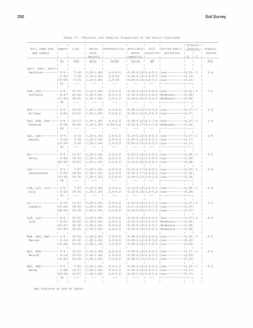
292 Soil Survey
Table 17.--Physical and Chemical Properties of the Soils--Continued ______________________________________________________________________________________________________________ | | | | | | | | Erosion | Soil name and |Depth| Clay | Moist |Permeability |Available| Soil |Shrink-swell | factors | Organic _________ map symbol | | | bulk | | water |reaction| potential | | | matter | | | density | |capacity | | | K | T | ______________________________________________________________________________________________________________ | In | Pct | g/cc | In/hr | In/in | pH | | | | Pct __ ___ ____ _____ _____ __ ___ | | | | | | | | | | DhC*, DhE*, DhF*:| | | | | | | | | | Hazleton--------| 0-2 | 7-18 |1.20-1.40| 2.0-6.0 |0.10-0.16|3.6-5.5 |Low----------|0.15| 3 | 2-4 | 2-30| 7-18 |1.20-1.40| 2.0-20 |0.08-0.12|3.6-5.5 |Low----------|0.15| | |30-50| 5-15 |1.20-1.40| 2.0-20 |0.06-0.12|3.6-5.5 |Low----------|0.15| | | 50 | --- | --- | --- | --- | --- |-------------|----| | | | | | | | | | | | DuB, DuC---------| 0-8 | 15-30 |1.10-1.40| 0.6-2.0 |0.16-0.22|4.5-6.0 |Low----------|0.32| 4 | 1-2 Duffield | 8-37| 20-42 |1.30-1.60| 0.6-2.0 |0.14-0.20|4.5-6.0 |Moderate-----|0.28| | |37-46| 18-41 |1.30-1.60| 0.6-2.0 |0.14-0.20|4.5-6.0 |Moderate-----|0.28| | | 46 | --- | --- | --- | --- | --- |-------------|----| | | | | | | | | | | | ElF--------------| 0-2 | 10-20 |1.20-1.40| 0.6-6.0 |0.08-0.12|3.6-5.5 |Low----------|0.17| 3 | 1-3 Elliber | 2-65| 12-27 |1.40-1.60| 0.6-6.0 |0.08-0.12|3.6-5.5 |Low----------|0.17| | | | | | | | | | | | FaC, FaE, FaF----| 0-8 | 15-27 |1.30-1.40| 0.6-2.0 |0.18-0.22|6.1-7.8 |Low----------|0.37| 3 | 1-4 Faywood | 8-28| 35-60 |1.35-1.45| 0.06-0.6 |0.12-0.17|6.1-7.8 |Moderate-----|0.28| | | 28 | --- | --- | --- | --- | --- |-------------|----| | | | | | | | | | | | GaC, GaE---------| 0-9 | 3-15 |1.20-1.40| 2.0-6.0 |0.10-0.16|3.6-5.5 |Low----------|0.17| 2 | 2-4 Gauley | 9-23| 5-18 |1.20-1.40| 2.0-6.0 |0.07-0.12|3.6-5.5 |Low----------|0.17| | |23-35| 5-18 |1.20-1.40| 2.0-6.0 |0.06-0.10|3.6-5.5 |Low----------|0.17| | | 35 | --- | --- | --- | --- | --- |-------------|----| | | | | | | | | | | | Ho---------------| 0-4 | 15-27 |1.20-1.40| 0.6-2.0 |0.20-0.24|5.6-6.5 |Low----------|0.28| 5 | 2-5 Holly | 4-42| 18-30 |1.20-1.50| 0.2-2.0 |0.17-0.21|5.1-6.5 |Low----------|0.28| | |42-65| 10-27 |1.20-1.45| 0.6-6.0 |0.10-0.20|5.6-6.5 |Low----------|0.28| | | | | | | | | | | | LeC--------------| 0-5 | 7-27 |1.20-1.50| 0.6-2.0 |0.10-0.17|3.6-5.5 |Low----------|0.20| 3 | 2-4 Leatherbark | 5-35| 18-35 |1.30-1.50| 0.2-0.6 |0.09-0.17|3.6-5.5 |Low----------|0.28| | |35-38| 18-35 |1.30-1.50| 0.2-0.6 |0.09-0.13|3.6-5.5 |Low----------|0.28| | | 38 | --- | --- | --- | --- | --- |-------------|----| | | | | | | | | | | | LlB, LlC, LlD----| 0-2 | 7-27 |1.20-1.40| 0.6-6.0 |0.13-0.18|3.6-5.5 |Low----------|0.28| 2 | .5-4 Lily | 2-32| 18-35 |1.25-1.35| 2.0-6.0 |0.12-0.18|3.6-5.5 |Low----------|0.28| | | 32 | --- | --- | --- | --- | --- |-------------|----| | | | | | | | | | | | Lo---------------| 0-10| 15-27 |1.20-1.40| 0.6-2.0 |0.20-0.24|5.1-7.3 |Low----------|0.37| 5 | 1-3 Lobdell |10-28| 18-30 |1.25-1.60| 0.6-2.0 |0.17-0.22|5.1-7.3 |Low----------|0.37| | |28-65| 15-30 |1.20-1.60| 0.6-6.0 |0.12-0.18|5.6-7.3 |Low----------|0.37| | | | | | | | | | | | LyB, LyC---------| 0-6 | 12-25 |1.20-1.50| 0.6-6.0 |0.14-0.18|4.5-5.5 |Low----------|0.37| 4 | .5-2 Lodi | 6-21| 10-50 |1.30-1.60| 0.6-2.0 |0.12-0.15|4.5-5.5 |Moderate-----|0.28| | |21-47| 35-60 |1.35-1.65| 0.6-2.0 |0.10-0.18|4.5-5.5 |Moderate-----|0.28| | |47-65| 10-50 |1.35-1.65| 0.6-2.0 |0.10-0.18|4.5-5.5 |Moderate-----|0.28| | | | | | | | | | | | MaB, MaC, MaD----| 0-4 | 10-25 |1.20-1.40| 2.0-6.0 |0.08-0.14|4.5-5.5 |Low----------|0.20| 5 | .5-2 Macove | 4-14| 10-30 |1.20-1.50| 2.0-6.0 |0.08-0.14|4.5-5.5 |Low----------|0.20| | |14-65| 10-30 |1.20-1.50| 2.0-6.0 |0.08-0.12|4.5-5.5 |Low----------|0.20| | | | | | | | | | | | McC, McE---------| 0-4 | 10-25 |1.20-1.40| 2.0-6.0 |0.08-0.14|4.5-5.5 |Low----------|0.17| 5 | .5-2 Macove | 4-14| 10-25 |1.20-1.40| 2.0-6.0 |0.08-0.14|4.5-5.5 |Low----------|0.20| | |14-65| 10-30 |1.20-1.50| 2.0-6.0 |0.08-0.12|4.5-5.5 |Low----------|0.20| | | | | | | | | | | | MdC, MdD---------| 0-5 | 7-25 |1.20-1.50| 0.6-2.0 |0.08-0.12|3.6-5.5 |Low----------|0.24| 3 | .5-3 Mandy | 5-28| 10-27 |1.20-1.60| 0.6-2.0 |0.04-0.10|3.6-5.5 |Low----------|0.17| | |28-36| 10-27 |1.20-1.60| 0.6-2.0 |0.04-0.10|3.6-5.5 |Low----------|0.17| | | 36 | --- | --- | --- | --- | --- |-------------|----| | | | | | | | | | | |
See footnote at end of table.

Pocahontas County, West Virginia 293
Table 17.--Physical and Chemical Properties of the Soils--Continued ______________________________________________________________________________________________________________ | | | | | | | | Erosion | Soil name and |Depth| Clay | Moist |Permeability |Available| Soil |Shrink-swell | factors | Organic _________ map symbol | | | bulk | | water |reaction| potential | | | matter | | | density | |capacity | | | K | T | ______________________________________________________________________________________________________________ | In | Pct | g/cc | In/hr | In/in | pH | | | | Pct __ ___ ____ _____ _____ __ ___ | | | | | | | | | | MfC, MfE, MfF, | | | | | | | | | | MfG-------------| 0-5 | 7-25 |1.20-1.50| 0.6-2.0 |0.08-0.12|3.6-5.5 |Low----------|0.20| 3 | .5-3 Mandy | 5-28| 10-27 |1.20-1.60| 0.6-2.0 |0.04-0.10|3.6-5.5 |Low----------|0.17| | |28-36| 10-27 |1.20-1.60| 0.6-2.0 |0.04-0.10|3.6-5.5 |Low----------|0.17| | | 36 | --- | --- | --- | --- | --- |-------------|----| | | | | | | | | | | | Mh. | | | | | | | | | | Medihemists | | | | | | | | | | | | | | | | | | | | MrB--------------| 0-3 | 10-27 |1.20-1.40| 0.6-2.0 |0.14-0.18|5.1-6.0 |Low----------|0.28| 4 | 1-3 Mertz | 3-54| 15-35 |1.40-1.60| 0.2-0.6 |0.08-0.18|5.1-6.0 |Low----------|0.17| | |54-65| 15-35 |1.40-1.60| 0.2-0.6 |0.08-0.18|4.5-5.5 |Low----------|0.17| | | | | | | | | | | | MzC, MzE---------| 0-3 | 10-18 |1.20-1.40| 0.6-2.0 |0.08-0.11|5.1-6.0 |Low----------|0.28| 4 | 1-3 Mertz | 3-54| 15-35 |1.40-1.60| 0.2-0.6 |0.07-0.12|5.1-6.0 |Low----------|0.17| | |54-65| 15-35 |1.40-1.60| 0.2-0.6 |0.07-0.12|4.5-5.5 |Low----------|0.17| | | | | | | | | | | | Or---------------| 0-9 | 12-27 |1.25-1.45| 0.6-2.0 |0.18-0.22|5.1-6.5 |Low----------|0.37| 5 | 2-4 Orrville | 9-40| 18-30 |1.30-1.50| 0.6-2.0 |0.15-0.19|5.1-6.5 |Low----------|0.37| | |40-65| 10-25 |1.20-1.40| 0.6-6.0 |0.08-0.15|5.1-6.5 |Low----------|0.37| | | | | | | | | | | | Ph---------------| 0-9 | 10-18 |1.20-1.40| 0.6-2.0 |0.14-0.20|4.5-6.0 |Low----------|0.37| 5 | 2-4 Philo | 9-33| 10-18 |1.20-1.40| 0.6-2.0 |0.10-0.20|4.5-6.0 |Low----------|0.32| | |33-40| 10-18 |1.20-1.50| >6.0 |0.05-0.10|4.5-6.0 |Low----------|0.24| | |40-65| 5-18 |1.20-1.50| >6.0 |0.03-0.06|4.5-6.0 |Low----------|0.17| | | | | | | | | | | | Po---------------| 0-10| 7-15 |1.20-1.40| 0.6-6.0 |0.10-0.14|5.1-7.3 |Low----------|0.24| 3 | 0-2 Potomac |10-65| 4-10 |1.30-1.60| >6.0 |0.03-0.06|5.1-7.3 |Low----------|0.17| | | | | | | | | | | | Pt---------------| 0-10| 5-12 |1.20-1.40| >6.0 |0.04-0.08|5.1-7.3 |Low----------|0.17| 3 | 0-2 Potomac |10-65| 4-10 |1.30-1.60| >6.0 |0.03-0.06|5.1-7.3 |Low----------|0.17| | | | | | | | | | | | Pu---------------| 0-5 | 18-35 |1.30-1.50| 0.2-0.6 |0.18-0.24|3.6-5.5 |Moderate-----|0.43| 3 | 2-4 Purdy | 5-38| 35-50 |1.30-1.60| <0.2 |0.12-0.18|3.6-5.5 |Moderate-----|0.32| | |38-65| 35-50 |1.30-1.60| <0.2 |0.10-0.16|3.6-5.5 |Moderate-----|0.32| | | | | | | | | | | | Sc---------------| 0-8 | 20-35 |1.20-1.40| 0.2-2.0 |0.17-0.22|5.1-7.3 |Low----------|0.37| 3 | 2-5 Sees | 8-58| 35-50 |1.40-1.60| 0.06-0.2 |0.11-0.20|5.1-7.3 |Moderate-----|0.28| | |58-65| 40-60 |1.50-1.60| 0.06-0.2 |0.10-0.15|6.6-8.4 |Moderate-----|0.28| | | | | | | | | | | | Se---------------| 0-6 | 8-25 |1.25-1.40| 0.6-6.0 |0.12-0.18|6.1-7.3 |Low----------|0.24| 5 | 1-3 Sensabaugh | 6-21| 18-35 |1.30-1.50| 0.6-6.0 |0.10-0.16|6.1-7.3 |Low----------|0.20| | |21-40| 12-35 |1.30-1.50| 0.6-6.0 |0.10-0.15|6.1-7.3 |Low----------|0.17| | |40-65| 12-38 |1.25-1.50| 0.6-6.0 |0.08-0.14|6.1-7.3 |Low----------|0.17| | | | | | | | | | | | ShB, ShC---------| 0-3 | 10-20 |1.35-1.50| 0.6-2.0 |0.13-0.20|4.5-6.0 |Low----------|0.32| 5 | 1-3 Shouns | 3-6 | 10-25 |1.35-1.50| 0.6-2.0 |0.12-0.20|4.5-6.0 |Low----------|0.28| | | 6-40| 27-35 |1.40-1.60| 0.6-2.0 |0.12-0.18|4.5-6.0 |Low----------|0.28| | |40-65| 27-35 |1.40-1.60| 0.6-2.0 |0.09-0.15|4.5-6.0 |Low----------|0.28| | | | | | | | | | | | SsC, SsE, SsF----| 0-3 | 15-27 |1.35-1.50| 0.6-2.0 |0.11-0.18|4.5-6.0 |Low----------|0.20| 5 | .5-3 Shouns | 3-40| 27-35 |1.40-1.60| 0.6-2.0 |0.12-0.18|4.5-6.0 |Low----------|0.28| | |40-65| 27-35 |1.40-1.60| 0.6-2.0 |0.09-0.15|4.5-6.0 |Low----------|0.28| | | | | | | | | | | | SwE--------------| 0-2 | 7-27 |1.20-1.50| 0.6-2.0 |0.12-0.16|3.6-5.5 |Low----------|0.20| 3 | 1-4 Snowdog | 2-16| 18-35 |1.20-1.50| 0.6-2.0 |0.12-0.16|3.6-5.5 |Low----------|0.24| | |16-40| 18-35 |1.40-1.70| 0.06-0.6 |0.08-0.12|3.6-5.5 |Low----------|0.24| | |40-65| 7-40 |1.20-1.50| 0.6-6.0 |0.08-0.12|3.6-5.5 |Low----------|0.17| | | | | | | | | | | |
See footnote at end of table.

294 Soil Survey
Table 17.--Physical and Chemical Properties of the Soils--Continued ______________________________________________________________________________________________________________ | | | | | | | | Erosion | Soil name and |Depth| Clay | Moist |Permeability |Available| Soil |Shrink-swell | factors | Organic _________ map symbol | | | bulk | | water |reaction| potential | | | matter | | | density | |capacity | | | K | T | ______________________________________________________________________________________________________________ | In | Pct | g/cc | In/hr | In/in | pH | | | | Pct __ ___ ____ _____ _____ __ ___ | | | | | | | | | | Tg---------------| 0-10| 5-18 |1.15-1.40| 0.6-6.0 |0.15-0.21|5.1-7.3 |Low----------|0.37| 5 | 2-6 Tioga |10-38| 5-18 |1.15-1.45| 0.6-6.0 |0.07-0.20|5.1-7.3 |Low----------|0.28| | |38-65| 3-15 |1.25-1.55| 0.6-20 |0.02-0.20|5.6-7.8 |Low----------|0.28| | | | | | | | | | | | TrC--------------| 0-6 | 7-25 |1.20-1.50| 0.6-2.0 |0.10-0.17|3.6-5.5 |Low----------|0.20| 4 | 1-4 Trussel | 6-18| 18-35 |1.30-1.50| 0.6-2.0 |0.09-0.17|3.6-5.5 |Low----------|0.28| | |18-35| 18-27 |1.40-1.70| 0.06-0.6 |0.09-0.13|3.6-5.5 |Low----------|0.24| | |35-65| 18-27 |1.30-1.60| 0.6-2.0 |0.10-0.14|3.6-5.5 |Low----------|0.24| | | | | | | | | | | | Uf*: | | | | | | | | | | Udifluvents. | | | | | | | | | | | | | | | | | | | | Fluvaquents. | | | | | | | | | | | | | | | | | | | | Us. | | | | | | | | | | Udorthents | | | | | | | | | | | | | | | | | | | | WeC, WeD, WeF----| 0-6 | 15-27 |1.20-1.40| 2.0-6.0 |0.08-0.14|4.5-5.5 |Low----------|0.28| 2 | 1-3 Weikert | 6-15| 15-27 |1.20-1.40| 2.0-6.0 |0.04-0.08|4.5-5.5 |Low----------|0.28| | | 15 | --- | --- | --- | --- | --- |-------------|----| | | | | | | | | | | | ______________________________________________________________________________________________________________
* See description of the map unit for composition and behavior characteristics of the map unit.

Pocahontas C
ounty, West V
irginia295
Table 18.--Soil and Water Features
("Flooding" and "water table" and terms such as "rare," "frequent," "apparent," and "perched" are explained in the text. The symbol < means less than; > means more than. Absence of an entry indicates that the feature is not a concern or that data were not estimated)
_________________________________________________________________________________________________________________________ | | | High water table | Bedrock | | Risk of corrosion ____________________________________________ ___________________ Soil name and |Hydrologic| Frequency | | | | | |Potential| | map symbol | group | of flooding | Depth | Kind |Months | Depth | Hardness| frost |Uncoated |Concrete | | | | | | | | action | steel | _________________________________________________________________________________________________________________________ | | | Ft | | | In | | | | __ __ | | | | | | | | | | AlB, AlC----------| B |None------------| >6.0 | --- | --- | >60 | --- |Low------|Low------|High. Allegheny | | | | | | | | | | | | | | | | | | | | At----------------| D |Frequent--------| 0-1.0|Apparent|Nov-Jun| >60 | --- |High-----|High-----|Moderate. Atkins | | | | | | | | | | | | | | | | | | | | BaB, BaC, BaD, | | | | | | | | | | BbC, BbE, BbF----| B |None------------| >6.0 | --- | --- | 40-60 |Hard |Moderate |Moderate |Moderate. Belmont | | | | | | | | | | | | | | | | | | | | BeB, BeC, BeD, | | | | | | | | | | BeE, BfC, BfE, | | | | | | | | | | BfF--------------| C |None------------| >6.0 | --- | --- | 20-40 |Soft |Low------|Low------|High. Berks | | | | | | | | | | | | | | | | | | | | BgC*, BgE*, BgF*: | | | | | | | | | | Berks------------| C |None------------| >6.0 | --- | --- | 20-40 |Soft |Low------|Low------|High. | | | | | | | | | | Dekalb-----------| A |None------------| >6.0 | --- | --- | 20-40 |Hard |Low------|Low------|High. | | | | | | | | | | BhG*: | | | | | | | | | | Berks------------| C |None------------| >6.0 | --- | --- | 20-40 |Soft |Low------|Low------|High. | | | | | | | | | | Weikert----------| C/D |None------------| >6.0 | --- | --- | 10-20 |Soft |Moderate |Moderate |Moderate. | | | | | | | | | | Calvin-----------| C |None------------| >6.0 | --- | --- | 20-40 |Soft |Moderate |Low------|Moderate. | | | | | | | | | | BlC, BlE, BlF-----| B |None------------| >6.0 | --- | --- | >60 | --- |Low------|Moderate |High. Blackthorn | | | | | | | | | | | | | | | | | | | | BoB---------------| C |None------------|1.0-2.0|Perched |Nov-Mar| 20-40 |Soft |High-----|High-----|High. Blairton | | | | | | | | | | | | | | | | | | | | BrF*: | | | | | | | | | | Briery-----------| C |None------------| >6.0 | --- | --- | >60 | --- |Moderate |Low------|Low. | | | | | | | | | | Rock outcrop. | | | | | | | | | | | | | | | | | | | |
See footnote at end of table.

296S
oil Survey
Table 18.--Soil and Water Features--Continued _________________________________________________________________________________________________________________________ | | | High water table | Bedrock | | Risk of corrosion ____________________________________________ ___________________ Soil name and |Hydrologic| Frequency | | | | | |Potential| | map symbol | group | of flooding | Depth | Kind |Months | Depth | Hardness| frost |Uncoated |Concrete | | | | | | | | action | steel | _________________________________________________________________________________________________________________________ | | | Ft | | | In | | | | __ __ | | | | | | | | | | CaC, CbC, CbE, | | | | | | | | | | CbF--------------| C |None------------| >6.0 | --- | --- | 20-40 |Soft |Moderate |Low------|Moderate. Calvin | | | | | | | | | | | | | | | | | | | | CdC*, CdE*, CdF*: | | | | | | | | | | Calvin-----------| C |None------------| >6.0 | --- | --- | 20-40 |Soft |Moderate |Low------|Moderate. | | | | | | | | | | Dekalb-----------| A |None------------| >6.0 | --- | --- | 20-40 |Hard |Low------|Low------|High. | | | | | | | | | | Berks------------| C |None------------| >6.0 | --- | --- | 20-40 |Soft |Low------|Low------|High. | | | | | | | | | | CeB, CeC, CeD, | | | | | | | | | | CfC, CfE, CfF, | | | | | | | | | | CfG--------------| C |None------------| >6.0 | --- | --- | 20-40 |Soft |Moderate |Moderate |Moderate. Cateache | | | | | | | | | | | | | | | | | | | | Ch----------------| B |Rare------------| >6.0 | --- | --- | >60 | --- |Moderate |Low------|Moderate. Chavies | | | | | | | | | | | | | | | | | | | | CuB, CuC, CuD, | | | | | | | | | | CuE, CuF---------| B |None------------| >6.0 | --- | --- | 20-40 |Soft |Moderate |Low------|Moderate. Culleoka | | | | | | | | | | | | | | | | | | | | DhC*, DhE*, DhF*: | | | | | | | | | | Dekalb-----------| A |None------------| >6.0 | --- | --- | 20-40 |Hard |Low------|Low------|High. | | | | | | | | | | Hazleton---------| B |None------------| >6.0 | --- | --- | 40-60 |Hard |Moderate |Low------|High. | | | | | | | | | | DuB, DuC----------| B |None------------| >6.0 | --- | --- | >40 |Hard |Moderate |Moderate |Moderate. Duffield | | | | | | | | | | | | | | | | | | | | ElF---------------| A |None------------| >6.0 | --- | --- | >60 | --- |Moderate |Low------|High. Elliber | | | | | | | | | | | | | | | | | | | | FaC, FaE, FaF-----| C |None------------| >6.0 | --- | --- | 20-40 |Hard |Moderate |High-----|Moderate. Faywood | | | | | | | | | | | | | | | | | | | | GaC, GaE----------| C |None------------| >6.0 | --- | --- | 20-40 |Hard |Moderate |Low------|High. Gauley | | | | | | | | | | | | | | | | | | | | Ho----------------| D |Frequent--------| 0-1.0|Apparent|Dec-May| >60 | --- |High-----|High-----|Moderate. Holly | | | | | | | | | | | | | | | | | | | |
See footnote at end of table.

Pocahontas C
ounty, West V
irginia297
Table 18.--Soil and Water Features--Continued _________________________________________________________________________________________________________________________ | | | High water table | Bedrock | | Risk of corrosion ____________________________________________ ___________________ Soil name and |Hydrologic| Frequency | | | | | |Potential| | map symbol | group | of flooding | Depth | Kind |Months | Depth | Hardness| frost |Uncoated |Concrete | | | | | | | | action | steel | _________________________________________________________________________________________________________________________ | | | Ft | | | In | | | | __ __ | | | | | | | | | | LeC---------------| C |None------------|0.5-1.0|Perched |Nov-Apr| 20-40 |Soft |High-----|High-----|High. Leatherbark | | | | | | | | | | | | | | | | | | | | LlB, LlC, LlD-----| B |None------------| >6.0 | --- | --- | 20-40 |Hard |Moderate |Moderate |High. Lily | | | | | | | | | | | | | | | | | | | | Lo----------------| B |Occasional------|1.5-2.0|Apparent|Dec-Apr| >60 | --- |High-----|Low------|Moderate. Lobdell | | | | | | | | | | | | | | | | | | | | LyB, LyC----------| B |None------------| >6.0 | --- | --- | >60 | --- |Moderate |Moderate |High. Lodi | | | | | | | | | | | | | | | | | | | | MaB, MaC, MaD, | | | | | | | | | | McC, McE---------| B |None------------| >6.0 | --- | --- | >60 | --- |Moderate |Moderate |Moderate. Macove | | | | | | | | | | | | | | | | | | | | MdC, MdD, MfC, | | | | | | | | | | MfE, MfF, MfG----| C |None------------| >6.0 | --- | --- | 20-40 |Soft |Low------|Low------|High. Mandy | | | | | | | | | | | | | | | | | | | | Mh. | | | | | | | | | | Medihemists | | | | | | | | | | | | | | | | | | | | MrB, MzC, MzE-----| C |None------------| >6.0 | --- | --- | >60 | --- |Moderate |Moderate |High. Mertz | | | | | | | | | | | | | | | | | | | | Or----------------| C |Occasional------|1.0-2.0|Apparent|Nov-Jun| >60 | --- |High-----|High-----|Moderate. Orrville | | | | | | | | | | | | | | | | | | | | Ph----------------| B |Occasional------|1.5-3.0|Apparent|Dec-Apr| >60 | --- |Moderate |Low------|High. Philo | | | | | | | | | | | | | | | | | | | | Po, Pt------------| A |Frequent--------|4.0-6.0|Apparent| --- | >60 | --- |Low------|Low------|Moderate. Potomac | | | | | | | | | | | | | | | | | | | | Pu----------------| D |None------------| +1-1.0|Apparent|Nov-Jun| >60 | --- |High-----|High-----|High. Purdy | | | | | | | | | | | | | | | | | | | | Sc----------------| C |Rare------------|1.0-2.0|Perched |Jan-Apr| >60 | --- |High-----|Moderate |Low. Sees | | | | | | | | | | | | | | | | | | | | Se----------------| B |Occasional------|4.0-6.0|Apparent|Jan-Apr| >60 | --- |Moderate |Low------|Low. Sensabaugh | | | | | | | | | |
See footnote at end of table.

298S
oil Survey
Table 18.--Soil and Water Features--Continued _________________________________________________________________________________________________________________________ | | | High water table | Bedrock | | Risk of corrosion ____________________________________________ ___________________ Soil name and |Hydrologic| Frequency | | | | | |Potential| | map symbol | group | of flooding | Depth | Kind |Months | Depth | Hardness| frost |Uncoated |Concrete | | | | | | | | action | steel | _________________________________________________________________________________________________________________________ | | | Ft | | | In | | | | __ __ | | | | | | | | | | | | | | | | | | | | ShB, ShC----------| B |None------------| >6.0 | --- | --- | >60 | --- |Moderate |Moderate |Moderate. Shouns | | | | | | | | | | | | | | | | | | | | SsC, SsE, SsF-----| B |None------------| >6.0 | --- | --- | >60 | --- |Moderate |Moderate |Moderate. Shouns | | | | | | | | | | | | | | | | | | | | SwE---------------| C |None------------|1.5-2.5|Perched |Nov-May| >60 | --- |Moderate |Moderate |High. Snowdog | | | | | | | | | | | | | | | | | | | | Tg----------------| B |Occasional------|3.0-6.0|Apparent|Feb-Apr| >60 | --- |Moderate |Low------|Moderate. Tioga | | | | | | | | | | | | | | | | | | | | TrC---------------| C |None------------| 0-0.5|Perched |Oct-Jun| >60 | --- |High-----|High-----|High. Trussel | | | | | | | | | | | | | | | | | | | | Uf*: | | | | | | | | | | Udifluvents. | | | | | | | | | | | | | | | | | | | | Fluvaquents. | | | | | | | | | | | | | | | | | | | | Us. | | | | | | | | | | Udorthents | | | | | | | | | | | | | | | | | | | | WeC, WeD, WeF-----| D |None------------| >6.0 | --- | --- | 10-20 |Soft |Moderate |Moderate |Moderate. Weikert | | | | | | | | | | | | | | | | | | | | _________________________________________________________________________________________________________________________
* See description of the map unit for composition and behavior characteristics of the map unit.

Pocahontas County, West Virginia 299
Table 19.--Classification of the Soils
(An asterisk in the first column indicates that the soil is a taxadjunct to the series. See text for a description of those characteristics of the soil that are outside the range of the series)
______________________________________________________________________________________________________________ | Soil name | Family or higher taxonomic class | ______________________________________________________________________________________________________________ | | Allegheny-----------------| Fine-loamy, mixed, mesic Typic Hapludults Atkins--------------------| Fine-loamy, mixed, acid, mesic Typic Fluvaquents Belmont-------------------| Fine-loamy, mixed, mesic Typic Hapludalfs Berks---------------------| Loamy-skeletal, mixed, mesic Typic Dystrochrepts Blackthorn----------------| Loamy-skeletal, mixed, mesic Typic Hapludults Blairton------------------| Fine-loamy, mixed, mesic Aquic Hapludults Briery--------------------| Loamy-skeletal, mixed, nonacid, frigid Typic Udorthents Calvin--------------------| Loamy-skeletal, mixed, mesic Typic Dystrochrepts Cateache------------------| Fine-loamy, mixed, mesic Ultic Hapludalfs Chavies-------------------| Coarse-loamy, mixed, mesic Ultic Hapludalfs Culleoka------------------| Fine-loamy, mixed, mesic Ultic Hapludalfs Dekalb--------------------| Loamy-skeletal, mixed, mesic Typic Dystrochrepts Duffield------------------| Fine-loamy, mixed, mesic Ultic Hapludalfs Elliber-------------------| Loamy-skeletal, mixed, mesic Typic Hapludults Faywood-------------------| Fine, mixed, mesic Typic Hapludalfs Fluvaquents---------------| Fluvaquents Gauley--------------------| Loamy-skeletal, siliceous, frigid Typic Haplorthods Hazleton------------------| Loamy-skeletal, mixed, mesic Typic Dystrochrepts Holly---------------------| Fine-loamy, mixed, nonacid, mesic Typic Fluvaquents Leatherbark---------------| Fine-loamy, mixed, frigid Aquic Dystrochrepts Lily----------------------| Fine-loamy, siliceous, mesic Typic Hapludults Lobdell-------------------| Fine-loamy, mixed, mesic Fluvaquentic Eutrochrepts Lodi----------------------| Clayey, mixed, mesic Typic Hapludults Macove--------------------| Loamy-skeletal, mixed, mesic Typic Hapludults Mandy---------------------| Loamy-skeletal, mixed, frigid Typic Dystrochrepts Medihemists---------------| Medihemists Mertz---------------------| Loamy-skeletal, mixed, mesic Typic Hapludults Orrville------------------| Fine-loamy, mixed, nonacid, mesic Aeric Fluvaquents Philo---------------------| Coarse-loamy, mixed, mesic Fluvaquentic Dystrochrepts Potomac-------------------| Sandy-skeletal, mixed, mesic Typic Udifluvents Purdy---------------------| Clayey, mixed, mesic Typic Ochraquults *Sees----------------------| Fine, mixed, mesic Aquollic Hapludalfs Sensabaugh----------------| Fine-loamy, mixed, mesic Dystric Fluventic Eutrochrepts Shouns--------------------| Fine-loamy, mixed, mesic Typic Hapludults Snowdog-------------------| Fine-loamy, mixed, frigid Typic Fragiochrepts Tioga---------------------| Coarse-loamy, mixed, mesic Dystric Fluventic Eutrochrepts Trussel-------------------| Fine-loamy, mixed, frigid Aeric Fragiaquepts Udifluvents---------------| Udifluvents Udorthents----------------| Udorthents Weikert-------------------| Loamy-skeletal, mixed, mesic Lithic Dystrochrepts | ______________________________________________________________________________________________________________


The Natural Resources Conservation Service (NRCS) is committed to making itsinformation accessible to all of its customers and employees. If you are experiencingaccessibility issues and need assistance, please contact our Helpdesk by phone at1-800-457-3642 or by e-mail at [email protected]. For assistancewith publications that include maps, graphs, or similar forms of information, you mayalso wish to contact our State or local office. You can locate the correct office andphone number at http://offices.sc.egov.usda.gov/locator/app.
NRCS Accessibility Statement