SOCIAL SAFEGUARDS ASSESSMENT REPORT
62
GOVERNMENT OF THE PEOPLE’S REPUBLIC OF BANGLADESH Bangladesh Municipal Development Fund (BMDF) SOCIAL SAFEGUARDS ASSESSMENT REPORT Name of the Sub-project: Improvement of Road and Drain; Sub-Project-1 Municipal Governance and Services Project (MGSP) Submitted by Kaliakair Municipality
Transcript of SOCIAL SAFEGUARDS ASSESSMENT REPORT

GOVERNMENT OF THE PEOPLE’S REPUBLIC OF BANGLADESH
Bangladesh Municipal Development Fund (BMDF)
SOCIAL SAFEGUARDS ASSESSMENT REPORT
Name of the Sub-project:
Improvement of Road and Drain; Sub-Project-1
Municipal Governance and Services Project (MGSP)
Submitted by
Kaliakair Municipality

ii
Disclaimer
This Social Safeguards Assessment Report is prepared by the own fund of the Kaliakair
Pourashava to fulfill the requirements of Bangladesh Municipal Development Fund (BMDF) in
seeking the financial support for the “Construction of Road and Drain (SP-1)” under its
Municipal Governance and Services Project (MGSP).

iii
TABLE OF CONTENTS
TABLE OF CONTENTS ............................................................................................................. iii
LIST OF TABLES ...................................................................................................................... v
LIST OF FIGURES .................................................................................................................... v
ABBREVIATIONS ...................................................................................................................... v
SECTION 1: INTRODUCTION ................................................................................................... 1
1.1 Background ........................................................................................................................ 1
1.2 Justification of Selecting the Sub-project ............................................................................ 5
1.3 Importance of Social Safeguard Assessment ...................................................................... 6
1.4 Project Description .............................................................................................................. 6
1.5 Project Location .................................................................................................................. 8
1.6. Present Condition of the Proposed Roads ........................................................................ 11
1.6 Project Affected People .................................................................................................... 12
1.7 Scenario of Existing Infrastructure by Major Component ................................................... 12
1.7.1 Roads ..................................................................................................................... 12
1.7.2. Drains ................................................................................................................. 13
1.7.3. Water Supply and Sanitation Facilities ................................................................ 13
1.7.4. Bus and Truck Terminals .................................................................................... 14
1.7.5. Market Facilities .................................................................................................. 15
1.7.6. Community Center .............................................................................................. 15
1.7.7. Recreational Park, Public Library and Cinema Hall ............................................. 15
1.7.8. Street Poles and Lights ....................................................................................... 15
1.7.9. Slaughter House ................................................................................................. 15
1.7.10. Solid Waste Management System ...................................................................... 15
1.7.11. Fecal Sludge Management system ..................................................................... 16
1.8. Legal and Policy Framework ............................................................................................. 16
SECTION 2: METHODOLOGY OF SOCIAL SAFEGUARDS ASSESSMENT .......................... 16
2.1 Objective of the Study ....................................................................................................... 16
2.2 Methodology of the Study ................................................................................................. 16
SECTION 3: SOCIO ECONOMIC BASELINE OF KALIAKAIR POURASHAVA ....................... 17
3.1 Population Status and Household Size ............................................................................. 17
3.2 Housing and Settlement Pattern ....................................................................................... 18
3.3 Education.......................................................................................................................... 20
3.4 Educational and Cultural Institutions ................................................................................. 20
3.5 Land use, Income and Employment Pattern ..................................................................... 20
3.6 Economic System ............................................................................................................. 21
3.7 Archeological, Historical and Religious Institutions ........................................................... 21

iv
3.8 Health and Sanitation Status............................................................................................. 22
3.9 Water Supply Situation ..................................................................................................... 23
3.10 Drainage system ............................................................................................................... 24
3.11 Solid Waste Management ................................................................................................. 24
3.12 Mode of Transportation, Road Network and Traffic Volume .............................................. 24
3.13 Land acquisition and resettlement .................................................................................... 25
3.14 Tribal Communities ........................................................................................................... 25
3.15 Economic Benefits ............................................................................................................ 25
3.16 Stakeholder Identification and Analysis ............................................................................. 26
3.17 Gender and Vulnerability Analysis .................................................................................... 28
SECTION 4: SOCIO ECONOMIC IMPACT ASSESSMENT .................................................... 29
4.1 Social Safeguard Assessment Using Screening Format ................................................... 29
4.2 Community Consultation and Participation ........................................................................ 30
4.2.1 Consultation and participation process ................................................................... 30
4.2.2 Key findings of Community Consultation: Issues and Recommendations ............... 32
SECTION 5: SOCIAL MANAGEMENT PLAN .......................................................................... 33
5.1 Key Issues Considered in Social Management Plan ......................................................... 33
5.2 Access to Information and Disclosure ............................................................................... 33
5.3 Grievance Redress Mechanism ........................................................................................ 33
5.3.1 Grievance redress committee (GRC) ...................................................................... 34
5.3.2 Grievance resolution process ................................................................................. 36
5.4 Labor Influx and Management .......................................................................................... 37
5.5 Institutional Capacity Building ........................................................................................... 37
5.6 Social Management Plan .................................................................................................. 37
SECTION 6: MONITORING PLAN OF SMP ............................................................................ 40
6.1 Monitoring Strategy ........................................................................................................... 40
6.2 Internal Monitoring ............................................................................................................ 40
6.3 External Review and Evaluation ....................................................................................... 40
6.4 Monitoring Plan Matrix ...................................................................................................... 40
6.5 Reporting .......................................................................................................................... 42
SECTION 7: CONCLUSION AND RECOMMENDATIONS ...................................................... 42
7.1 Conclusion ........................................................................................................................ 42
7.2 Recommendations ............................................................................................................ 42
REFERENCES ........................................................................................................................ 43
ANNEXURES .......................................................................................................................... 44
Annexure 1: Format I: Sscreening format for social safeguards issues .................................... 44
Annexure 2: Layout plan of the proposed RCC road ................................................................ 50
v
Annexure 3: Legal document of the land .................................................................................. 51
Annexure 4: Attendance of community people in FGD (female) ............................................... 53
Annexure 6: Attendance of local participants in screening exercise ......................................... 55
LIST OF TABLES
Table 1-1 : The significant features of the proposed sub-project
Table 1-2 : Short brief of proposed roads
Table 1-3 : Location of proposed roads
Table 1-4 : Existing condition of proposed roads
Table 1-5 : Different types of roads, its lengths and present condition
Table 1-6 : Types of drains, its length and present condition
Table 1-7 : Brief scenario of Pourashava owned markets
Table 3-1 : Land use classification under broad category in Kaliakair Pourashava area
Table 3-2 : List of stakeholders and anticipated benefits of stakeholders
Table 3-3 : Concerns on gender and mitigation measures
Table 5-1 : Social management plan matrix
Table 6-1 : Monitoring plan matrix
LIST OF FIGURES
Figure 1 : Percentage distribution of population by religion
Figure 2 : Percentage distribution of household by type of structure
Figure 3 : Percentage of tenancy of houses
Figure 4 : Distribution of population aged 7 years and above by sex and literacy
Figure 5 : Percentage distribution of households by type of toilet facility
Figure 6 : Percentage distribution of general HHs by sources of drinking water
Flow chart 5-1: Grievance resolution process
ABBREVIATIONS
BMDF Bangladesh Municipal Development Fund
CIP Capital Investment Plan
FGD Focus Group Discussion

vi
GoB Government of Bangladesh
GRC Grievance Redress Committee
GRM Grievance Redress Mechanism
GRP Grievance Redress Procedure
KII Key Informants Interviews
LGED Local Government Engineering Department
MD Managing Director
MGSP Municipal Governance and Services Project
NGO Non-Governmental Organization
OP Operational Policy
PAP Project Affected Person
PIU Project Implement Unit
PMU Project Management Unit
RCC Reinforced Concrete Cement
SIA Social Impact Assessment
SMF Social Management Framework
SMP Social Management Plan
SSS Social Safeguards Specialist
ULB Urban Local Body
WB World Bank
SECTION 1: INTRODUCTION
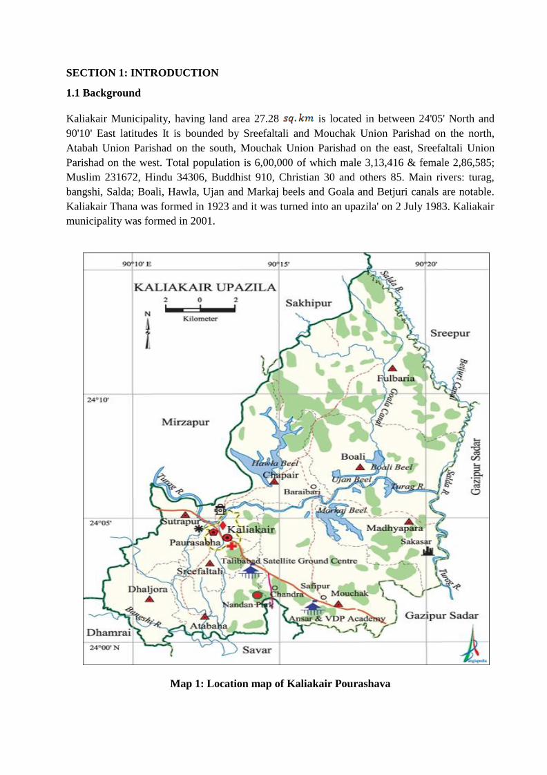
1.1 Background
Kaliakair Municipality, having land area 27.28 is located in between 24'05' North and
90'10' East latitudes It is bounded by Sreefaltali and Mouchak Union Parishad on the north,
Atabah Union Parishad on the south, Mouchak Union Parishad on the east, Sreefaltali Union
Parishad on the west. Total population is 6,00,000 of which male 3,13,416 & female 2,86,585;
Muslim 231672, Hindu 34306, Buddhist 910, Christian 30 and others 85. Main rivers: turag,
bangshi, Salda; Boali, Hawla, Ujan and Markaj beels and Goala and Betjuri canals are notable.
Kaliakair Thana was formed in 1923 and it was turned into an upazila' on 2 July 1983. Kaliakair
municipality was formed in 2001.
Map 1: Location map of Kaliakair Pourashava

2
Archaeological heritage and relics are Shiddhimadhav Sakashwar Buddhist Pillar, remnants
of historical relics and Kotamoni Dighi of' Dholsamudra, Chandra Mosque at Mouchak.
Kaliakair has become independent at 13th December 1971. The literacy rate is average
Average literacy 48.4%; male 54.9%, female 41.5%. Educational institutions: college 6,
secondary school 35, primary school 115, madrasa 15. Noted educational institutions:
Kaliakair Degree College (1968), Chapair BB High School (1910), Bhingoraj Talibabad
Multilateral High School (1928), Kaliakair Baraibari AKU Institute and College (1949),
Akkel Ali High School (1968), Ansar VDP High School (1985), Bhupenashari
Girls'HighSchool. (Source: Population and Housing Census 2011)
Urbanization is considered to be closely and positively associated process with complex and
mutually reinforcing links of the economic growth. In attaining and sustaining economic
growth, it is essential to develop urban areas. The urban centers are the places of
accumulation of economic activities, and the important hubs of production, processing,
innovation and employment. The importance of urbanization with available urban facilities
and services is growing day by day to meet the demand of growing population. Moreover,
in the Kaliakair Pourashava, traffic volume is increasing day by day with the increase in
population and vehicles. But, the narrow, substandard and damaged infrastructures cannot
cope with the growing demand. Hence, planned development of road network and drainage
system becomes essential to meet the emergent demand. Therefore, this sub-project will
directly contribute to the economy, livelihood and social spheres of the citizen as well as to
improve the overall environment of the Pourashava by constructing its infrastructures.

3
Map 2: Boundary map of Kaliakair Pourashava

4
The Kaliakair Pourashava has implemented different development projects with the fund of
Annual Development Programme allocated by the government and UGIIP. Recently, the
Pourashava has prepared its Capital Investment Plan (CIP) for its infrastructural development
following a participatory approach with the technical assistance from Bangladesh Municipal
Development Fund (BMDF) and identified the “Improvement of roads and drains” as the highest
priority for meeting the long pending demand of roads and drains for ensuring easy and water
logged free movement of Poura citizen and local vehicles within the Pourashava areas. All the
priority of roads of Kaliakair Pourashava have brought under sub-project-1. This sub-project is
named as “Improvements of Roads and drains (Sub-project 1)” and includes roads of CIP # R1,
R2 and R3 along with drains 0f CIP # D1, D2, D3, D4, D5, D6, D7 and D8. The estimated cost
of the sub-project is BDT 50 million and the duration of construction is 15 months starting in
January 2018 and to be ended in April 2020.
The Pourashava has already submitted an application for sub-credit to BMDF in order to the
“Construction of roads (Sub-project-1)”. The significant features of the sub-project are given in
Table 1-1 as below:
Table 1-1: The significant features of the proposed sub-project
Name of the Sub-Project Improvement of Road and Drain: Sub-project-1
Name of District Gazipur
Name of ULB Kaliakair Pourashava
Location of the Sub-project The sub-project is located at 07 Wards (out of 09 Wards) of the
Kaliakair Pourashava. The Wards are ward # 3, ward # 4, ward #
5, ward # 6, ward # 7, ward # 8 and ward # 9 of the Pourashava.
Service Areas The sub-project will ultimately serve all the areas under the
Pourashava. More specifically, the people living at ward # 3,
ward # 4, ward # 5, ward # 6, ward # 7 ward # 8 and ward # 9
will frequently use the facilities.
Beneficiary Population Primarily, all the people of the Pourashava will be benefitted.
But, ultimately, all the people of the Kaliakair district will be
benefitted.
Tribal People No tribal people are living in the sub-project influence areas.
Structural Design Option Both RCC and BC road; and RCC drain at both sides of the
road.
Total length and width of
road
The total length of roads is 4490 meters (m). The width of the
road ranges from 3m to 5m based on availability of land and
requirements.
The total length of drains is 5535 m. The width of the drains
varies from 1016 millimeters (mm) to 1320mm based on
availability of land and requirements.

5
Land Acquisition Pourashava is the legal owner of lands.
Estimated Cost BDT 50 millions
Sub-project Duration 15 months
Tentative Starting Date January 2019
Tentative Completion Date April 2020
1.2 Justification of Selecting the Sub-project
The proposed sub-project has significant importance in internal and external communication of
the citizen of the Pourashava as well as drainage of household and industrial waste water. The
proposed roads under this sub-project are mostly link roads and by lanes which are connected
with main roads of the Pourashava and hence, ultimately connected with Kaliakair-Tangail,
Kaliakair-Savar and Kaliakair-Dhaka national highways. The proposed roads physically cover 6
Wards, out of 09 Wards, of the Pourashava but ultimately are being used by all inhabitants of all
the Wards of the Pourashava. However, the condition of the roads is very bad having wearing
surface, damaged WBM, pot holes, depressions, undulation and rubbish mixed pavements which
make the inhabitants and vehicles very difficult to move from one place to another. This
damaged condition of the roads causes frequent accident to the people by breaking parts and
turning over the vehicles. The water logged situation on the roads during heavy rainfall at any
season and especially during rainy season becomes ineffectual for the movement of vehicles and
people and causes untold sufferings to the citizen particularly school going children and women,
and hampers regular movement and transportation of official, drivers, traders and laborers. Thus,
ultimately affect the regular income and livelihood of the citizens of the Pourshava. Therefore,
the construction of proposed roads is crucially important for the Pourashava.
The drainage system of the Pourashava is very poor and there is limited number of storm drain
within the Pourashava. The drains within the Pourashava, those are existing at present, are
severely damaged and mostly nonfunctional. Thus, causing water logged in most of the areas of
the Pourashava almost all the year round, and inhabitants of the Pourashava have been suffering
a lot through intrusion of water into households even at this dry season. Bad smell and
reproduction of mosquito fueled the sufferings of the citizen in manifolds. Therefore, the
construction of drains within the Pourashava is highly important. The proposed drains, beside
the proposed roads, are connected or to be connected with households, offices and business
establishments at one end and connected with main drains and ultimate different outfalls of the
Pourashava at other end. Thus, ensure the run-off of storm water and reduce the suffering of the
people of the Pourashava.
Further, the sub-project has significant social and economic benefits to the community people.
After completion, the road sub-project will provide smooth pavement for the safe movement of
inhabitants and vehicles which will reduce the risk of accidents. By constructing smooth road
surface and footpath over the drain, it will provide better, easy and safe movement facilities for
the travelers. On the contrary, new drains will minimize the drainage congestion and water
logged problem. In addition, the proposed sub-project will significantly enhance the business
facilities and hence increase the income of the people, businessmen and industrialists. It will also
add the commercial and aesthetic value of the area. Therefore, considering the benefits that will
derive, the sub-project is selected for the implementation in Kaliakair Pourashava.
6
1.3 Importance of Social Safeguard Assessment
The Social Management Framework (SMF) that is developed by BMDF according to regulatory
framework of the country and policy guidelines of the World Bank indicates that any sub-project
to be implemented by ULBs through the finance of BMDF must consider some social issues. It
is expected in the SMF that the sub-project to be selected for infrastructural improvement
preferably use land available with ULBs and avoid acquisition of additional lands and
displacement of people from public or private land. However, there could be some sub-projects
that may require additional land that are private in nature or belong to other public agencies.
Additionally, people may be using land that belongs to ULBs or other agencies that may have
been under use by authorized or unauthorized citizens. It is also indicated in the SMF that no
intervention will be undertaken that impacts “tribal group” in sub-project areas. Therefore, it
becomes a policy obligation to consider ownership of the land, requirements of acquisition of
addition land, displacement of people and areas of tribal groups during selecting and
implementing any sub-project. In order to determine the above issues, it becomes important to
conduct social safeguard assessment under the proposed sub-project.
Now, as per the social management framework of BMDF, it is required to conduct a social
safeguards assessment of the proposed RCC/BC road to meet the regulatory framework of the
Government of Bangladesh and World Bank policies. Therefore, the Kaliakair Pourashava
Authority has deployed an individual consultant to carry out the social safeguards assessment on
the proposed sub-project.
1.4 Project Description
The proposed sub-project will be consisted of both RCC and BC roads and RCC drains. The
sub-project is consisted of 3 roads and 8 drains. The total estimated length of the roads and
drains are 4490 m and 4535 m respectively. The width of the roads will be varied from road to
road based on the requirements and availability of the land and will be ranged from 3m to 6m.
The subgrade and base courses of the existing road will be rebuilt on some roads and as well as
for the road widening work, whereas elsewhere new materials will be placed on top of the
existing roadway and extension portions. The height of some roads will be raised to ensure the
proper drainage system of the Pourashava. The width of the drain will also be varied based on
requirements and will be ranged from 1016 mm to 1320 mm. The drains will be constructed
along both proposed and existing roads at one or both sides of the roads depending on site
condition and to meet the design criteria. The drains will be covered by concrete slabs and it will
be used as footpath. The concrete slab will also protect the drains from unwanted throwing of
solid waste from households, commercial settings and administrative offices. Hence, will reduce
the chance of being blocked and remain the drain functional to run off the storm water and grey
water. The height of some drains will also be raised to ensure the proper drainage system of the
Pourashava.
The proposed roads and drain under this sub-project are distributed among the ward # 3, ward #
4, ward # 5, ward # 6, ward # 7, ward # 8 and ward # 9 of the Pourashava areas. These areas
consist of mixed land use pattern of commercial, industrial, administrative and residential area of
the Pourashava. Various commercial, industrial, social, administrative and residential areas are
established at the both sides of the road. Hence, the proposed roads remain busy round the clock

7
due to commercial, industrial, administrative and domestic purposes. In addition, the condition
of the proposed drains is very poor. Due to the damaged condition of the drains, about 65% of
the Poura area becomes water logged during rainy season and water logged situation persist at
about 30%-40% of Poura area even in dry season. A short brief of proposed roads is given in
Table 1-2 and Table 1-3 as below:
Table 1-2: Short brief of proposed roads
ID. Name of Scheme Effective
length
(m)
Present
width
(m)
Proposed
Improvement
Length/width
(m)
Proposed
Improvement
RCC/BC
A. Roads
R1 Improvement of Kalampur
road starting from Chandra
Tri morh to High-Tech Park
Road
3110 2.5 3 RCC, DBC
R2 Improvement of Chapra
Moshjid Road
920 3 3,4,5 RCC,DBC
R3 Improvement of Malek
Spinning Mill Road
715 2.5 3,4 RCC
Total length of roads 4745 m
Table 1-3: Short brief of proposed drains
ID
#
Name of Scheme Effective
length
(m)
Present
width
(mm)
Propose
d Clear
width
(mm)
Proposed
Improvement
B. Drains
D1 Construction of Drain
beside Malek
Spinning mill road
715 300 600 RCC
D2 Construction of Drain
beside Safipur
Bazar to Ibn Sina
Bridge
500 No drain 600 RCC
D3 Construction of Drain
Ibn Sina bridge to
Bord Mill
1820 450 900 RCC
D4 Construction of Allahr
Dan colony road
side drain
500 No drain 600 RCC

8
D5 Construction of Aziz
Garments road side
drain
500 No drain 600 RCC
D6 Construction of
Bhanga Mosjid
(Jora Pump) road
side drain
500 300 600 RCC
D7 Construction of Haisa
House road side
drain
500 No drain 600 RCC
D8 Construction of Babul
Sarker Mosque
road side drain
500 No drain 600 RCC
Total length of drains 5535 m
The layout of the proposed roads and drains is shown in Annexure 2. The proposed roads and
drains under this sub-project will be constructed on the right-of-way of the existing roads which
are owned by the Pourashava. But, the proposed roads and drains will be wider than the existing
width of the roads and drain. However, acquisition of land will not be required as there are
required space for widening the roads and drain. Hence, there is no need of removing any
structures and earth filling to prepare the site for the construction.
1.5 Project Location
The proposed roads are located at the different parts of 7 Wards (out of 09 Wards) of the
Kaliakair Pourashava. The Wards are ward # 3, ward # 4, ward # 5, ward # 6, ward # 7 and ward
# 8. The location of roads among these Wards is given in Table 1-4 for as below:
Table 1-4: Location of proposed roads
CIP
#
Name of Scheme Effective
length
(m)
Located under
the Ward
A. Road
R1 Improvement of Kalampur road starting from
Chandra Tri morh to High-Tech Park Road
3110
3
R2 Improvement of Chapra Moshjid Road
920 4, 5, 6
R3 Improvement of Malek Spinning Mill Road 715
9

9
Total length of roads 4745 m
B. Drain
D1 Construction of Drain beside Malek Spinning
mill road
715 9
D2 Construction of Drain beside Safipur Bazar to
Ibne Sina Bridge
500 9
D3 Construction of Drain Ibne Sina bridge to Bord
Mill
1820 7,8,9
D4 Construction of Allahr Dan colony road side
drain
500 7
D5 Construction of Aziz Garments road side drain 500 8
D6 Construction of Bhanga Mosjid (Jora Pump)
road side drain
500 7
D7 Construction of Haisa House road side drain 500 8
D8 Construction of Babul Sarker Mosque road
side drain
500 6
Total length of drains 5535 m

10
The location map of the proposed roads and drains is given as below:
Map 3: Location map of proposed Roads and Drains under the sub-project

11
1.6. Present Condition of the Proposed Roads and Drains
All the roads those are proposed under this sub-project are bituminous carpeting (BC), RCC
road. There are also few roads those have partial Katcha roads in addition to the BC roads.
Under this sub-project, all the roads will be improved as BC or RCC road. The existing
condition of the proposed roads is too bad. For about 10 years, partial maintenance work is done
on these roads. As a result, BC of the most of the roads is severely damaged. In some cases, no
BC is found on roads. Due to long time use by the both light and heavy vehicles, the existing BC
roads are severely damaged having damaged WBM, cracks, pot holes, broken edge, undulation
and depressions. Waterlogged situation with bad smell and melted earth are found all along the
road # R1, R2 and R3 during the field observation. The existing condition of specific roads is
shown in Table 1-5 which is given as below.
Further, the most of the drains those are proposed under this sub-project are brick drain and
katcha drain. There are also few RCC drains. In addition, there are some drains having both
brick drain and katcha drain. Now, under this sub-project, all the drains will be constructed as
RCC drain. The existing condition of the proposed drains is very poor. All the drains are
damaged having broken brick drains and filled in katcha drain resulting over flow of roads with
long time water logged of the areas, bad smells with environmental pollution and breading space
of mosquitos. Further, the final outfalls of the drains i.e. different sections of Turag River are
highly polluted and have comparatively high river bed than the normal land area of the
Pourashava. Thus it is causing low speed of water flow through the drains. Sometimes, back
flow of water through the drains is also happening in these areas during the rainy season. The
existing condition of specific drains is shown in Table 1-5 which is given as below
Table 1-5: Existing condition of proposed roads and drains
CIP
#
Name of Scheme Effective
length (m)
Existing condition of roads
and drains
A. Roads
R1 Improvement of Kalampur road starting
from Chandra Tri morh to High-Tech
Park Road
3110 Brick Soling are totally
damaged , water logged,
undulation and some portion
constructed by RCC is good.
R2 Improvement of Chapra Moshjid Road
920 BC road having damaged
WBM, water logged,
undulation and partly katcha
road.
R3 Improvement of Malek Spinning Mill
Road
715 BC road having damaged
WBM, water logged and
undulation.
Total length of roads 4745 m

12
B. Drains
D1 Construction of Drain beside Malek
Spinning mill road
715 300 mm
D2 Construction of Drain beside Safipur
Bazar to Ibne Sina Bridge
500 No drain exist
D3 Construction of Drain Ibne Sina bridge
to Bord Mill
1820 450 mm
D4 Construction of Allahr Dan colony road
side drain
500 No drain exist
D5 Construction of Aziz Garments road
side drain
500 No drain exist
D6 Construction of Bhanga Mosjid (Jora
Pump) road side drain
500 300 mm
D7 Construction of Haisa House road side
drain
500 No drain exist
D8 Construction of Babul Sarker Mosque
road side drain
500 No drain exist
Total length of drains 5535 m
1.6 Project Affected People
The proposed sub-project will be constructed on the right-of-way of the existing roads which is
owned by the Pourashava. The widening of roads and drains where required, will also be done
within the land which is also owned by the Pourashava. Therefore, there is no to acquire any
land for constructing the proposed sub-project. Thus, no people will be directly or indirectly
affected by the proposed sub-project.
1.7 Scenario of Existing Infrastructure by Major Component
The existing infrastructures by major component involves roads, drains, culverts, bridges, water
supply facilities, public sanitation facilities, bus terminal, truck terminal, markets, community
centers, recreation parks, street lights, slaughter houses etc. The brief scenario of existing
infrastructure by major components of the Kaliakair Pourashava is given as below:
1.7.1 Roads
The Kaliakair Pourashava has 200 km road networks for internal communication. The road network
includes different types of road and brief of these roads are given in Table 1-5 as below:

13
Table 1-5: Different types of roads, its lengths and present condition
Sl.
No
Type of Roads Length
(km)
Present Condition (in percentage)
Good Moderately good Bad
01 Bituminous Carpeting Road 70 50% 30% 20%
02 HBB road 91 50% 20% 30%
03 Cement Concrete Road 100% - - -
04 Earthen Road 25 - 10% 90%
05 Footpath 1 100% - -
Total length of roads 200
(Source: Pourashava Data, 2018)
In addition, there are 30 culverts and 15 bridges in the Municipal area.
1.7.2. Drains
The Kaliakair Pourashava has 140.875 km drainage network to run off the storm water. The
scenario of the drainage system is given in Table 1-6 as below:
Table 1-6: Type of drain, its length and present condition
Sl. No Type of Drain Length
(km)
Present Condition (in percentage)
Good Moderately good Not good
01 Brick drain 13.75 100% - -
02 RCC drain 25.125 100% - -
03 Katcha drain 102 20% 20% 60%
Total length of drain 140.875
(Source: Pourashava Data, 2018)
1.7.3. Water Supply and Sanitation Facilities
There are 278 Hand tube well within the Pourashava. There are also 10957 private hand tube
wells, 1276 motorized hand tube wells (private & govt.). The water supply system of the
municipality consists of
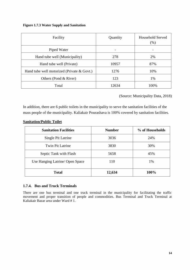
14
Figure 1.7.3 Water Supply and Sanitation
Facility Quantity Household Served
(%)
Piped Water - -
Hand tube well (Municipality) 278 2%
Hand tube well (Private) 10957 87%
Hand tube well motorized (Private & Govt.) 1276 10%
Others (Pond & River) 123 1%
Total 12634 100%
(Source: Municipality Data, 2018)
In addition, there are 6 public toilets in the municipality to serve the sanitation facilities of the
mass people of the municipality. Kaliakair Pourashava is 100% covered by sanitation facilities.
Sanitation/Public Toilet
Sanitation Facilities Number % of Households
Single Pit Latrine 3036 24%
Twin Pit Latrine 3830 30%
Septic Tank with Flash 5658 45%
Use Hanging Latrine/ Open Space 110 1%
Total 12,634 100%
1.7.4. Bus and Truck Terminals
There are one bus terminal and one truck terminal in the municipality for facilitating the traffic
movement and proper transition of people and commodities. Bus Terminal and Truck Terminal at
Kaliakair Bazar area under Ward # 1.

15
1.7.5. Market Facilities
There are 2 markets in the municipality areas amongst which 01 market is owned by the
Kaliakair Municipality. There is 01 Kitchen market and 01 Hat-bazar. The brief scenario of
municipality owned markets is given in Table 1-7 as below:
Figure 1.7.4 Market facilities
(Source: Municipality Data, 2018)
1.7.6. Community Center
At present, there is 01 community center in the Municipality which is located at Kaliakair Bazar
area. The condition of the community center is moderately good. It needs some renovation works
and adds some modern facilities.
1.7.7. Recreational Park, Public Library and Cinema Hall
Amusement centres and Tourist spots Nandan Park, Shiddhimadhav Pillar, Ansar VDP Academy,
Bangladesh Scouts' National Training Centre, Baliadi Zamindar Bari, Sreefaltali Zamindar Bari,
Talibabad Satellite Ground Centre. There are 38 Public Library. Further, there are 2 Cinema Hall
in the Pouroshava.
1.7.8. Street Poles and Lights
The Kaliakair Pourashava has only 2500 street poles and at present, there are 2500 bulbs. It
lightens 30% areas of the Pourashava. More bulbs are required. The Pourashava has a plan to
cover 50% areas with street light.
1.7.9. Slaughter House
The Kaliakair Pourashava has 2 slaughter house which is located Ward # 02, Ward # 09.
1.7.10. Solid Waste Management System
The solid waste management system of the municipality is consisted of solid waste collection
from the households, markets, roads at every day as well as there are 40 dustbins. A total of 94
cleaners are engaged in collecting, depositing and transferring the solid waste by using 10 vans
and 5 garbage trucks. A total of 45 tons’ garbage is produced every day at the municipality
areas. There is a Dumping station in Latifpur at the municipality area.
Sl.
No
Name/Type Location Area of
Market
Earnings Per
year (BDT)
Present Condition
Good Moderately
good
Not
good
1 Kaliakair
Bazar
Shrefoltoli
Mouza
322,000
sq. m
1,400,105.00 Good - -
2 Kh. Mosharaf
hossain Hat
Bazzar
Safipur
(Private &
Public)
140000
sq. m
4,125,000.00 Good - -

16
1.7.11. Fecal Sludge Management system
There is no fecal sludge management system in the Pourashava. Even, there is no vacuum
cleaner here. The fecal sludge of individual households is managed by their own. Individual
household managed their fecal sludge by digging a hole, discharging the fecal sludge into it and
overfilling it by soil. Kaliakair municipal has a plan to install modern fecal sludge system in
Latifpur.
1.8. Legal and Policy Framework
For the sub-project preparation and implementation, the World Bank’s Operational Policy (OP)
on Involuntary Resettlement (OP 4.12) and on Indigenous Peoples (OP 4.10) has been triggered
to the sub-project. A Social Management Framework (SMF) has been adopted by BMDF for the
sub-project that meets the requirements of the country’s legal frameworks in Bangladesh “The
Acquisition and Requisition of Immovable Property, Ordinance, 1982” and the Bank’s
requirements including OP 4.12 and OP 4.10. The SMF also requires that the sub-projects are
prepared ensuring inclusion, participation, transparency, and social accountability. The sub-
projects have been prepared by the respective urban local bodies (ULBs) in a process complying
with the SMF requirements. BMDF reviews the sub-project proposals for technical, engineering,
environmental, social development, and safeguards compliance before allocation of the
financing to the ULBs.
SECTION 2: METHODOLOGY OF SOCIAL SAFEGUARDS ASSESSMENT
2.1 Objective of the Study
This assessment is undertaken to complement the necessary social compliances relevant to the
proposed market as per the Government of Bangladesh and World Bank safeguards
compliances. The key objectives of the study are:
To provide an accurate representation of the social, cultural and economic conditions of
the population surrounding the sub-project areas;
To identify the potential socio-economic positive and negative impacts on local
community, organizations and groups;
To develop attainable mitigation measures to enhance positive impacts and to eliminate,
reduce or avoid negative impacts; and
To develop management and monitoring measures to be implemented throughout the life
of the sub-project.
2.2 Methodology of the Study
This is a qualitative study. However, both quantitative and qualitative data are collected and
analyzed to achieve the objective of the study and show the baseline information of the study
areas. The quantitative data are collected from secondary sources through literature review and
qualitative data are collected from primary sources using different qualitative approach and

17
methods. The approach and methods those are employed during the assessment include: (i)
literature review of relevant national and local documents; (ii) social survey; (iii) key informant
interview; (iv) consultative meeting; and (v) focus group discussion.
Relevant national, district and Pourashava documents are reviewed for gathering available and
updated quantitative data of socio-economic condition of the community people.
Social survey through random interview is done for gathering both qualitative and quantitative
data of community people living around the sub-project areas.
Key informant interview is done to know about the key features of the areas on which the
proposed sub-project might have an impact.
Consultative meeting with different stakeholders such as Ward Councilors, available
businessmen, available local people, representatives of shop keepers adjacent to the market etc,
male and female community participants has done to know their attitudes towards the proposed
sub-project, its impact and their feedback, and suggestions on mitigating the potential negative
impacts and enhancing the positive impacts of the sub-project.
In addition, social screening of the project sub-project is done using prescribed social safeguard
assessment form of BMDF with the participation of different stakeholders and community
representatives.
SECTION 3: SOCIO ECONOMIC BASELINE OF KALIAKAIR POURASHAVA
3.1 Population Status and Household Size
According to the source of pourashava data 2018 there are 6,00,000 people living in Kaliakair
Pouraashava amongst which 3,13,416 are male (52.24%) and 286584 are female (47.76%). The
average size of the household is 4.2. The total area of the Pourashava is 27.28 km and hence
indicating that the density of the population per square kilometer is 22000. The Population and
Housing Census 2011 reveals that most of the people in the Pourashava are Muslim. There are
Muslim 231672, Hindu 34306, Buddhist 910, Christian 30 and others 85 people live in the
Pourashava areas. Figure 1 shows the percentage distribution of people by religion.

18
According to the source of pourashava data 2018 also shows that the highest percentage of
population lies on the age group of 20-24 and it is 17 percent of the total population. The
percentages of other age groups of people in the Pourashava are 9% at 0-4 years, 9% at 5-9
years, 6% at 10-14 years, 11% at 15-19 years, 15% at 20-24 years, 17% at 25-29 years, 12% at
30-49 years, 14% at 50-59 years, 6% at 60-80 years and 1% at 80 plus age group.
3.2 Housing and Settlement Pattern
The Population and Housing Census 2011 reveals that the people of the Pourashava live in
Pucca, Semi-Pucca and Kutcha houses. The Figure-2 shows that the highest percentage of
general households of the Pourashava is Semi-Pucca (76 percent). The percentage of other
general household by the type of structure of the Pourashava are 14 percent pucca households,
10 percent kutcha households.

19
Further, the people of the Pourashava live in owned and rented houses amongst which most of
the people have no houses as their own. The Figure 3 shows that 25 percent people live in own
house and 75 percent people live in rented house.
There are markets, shops, educational institutes, private offices, government offices, business
establishments, industries etc in the surrounding areas of the sub-project.

20
3.3 Education
According to the Population and Housing Census 2011, the literacy rate among both sex of the
Pourashava is 48.4 percent. The Figure 4 shows that the literacy rate among the male is 54.9
percent and the female is 41.5 percent, remarkably below from the male counterpart.
3.4 Educational and Cultural Institutions
According to the Population and Housing Census 2011, the literacy rate among both sex of the
Pourashava is 48.4 percent. The Figure 4 shows that the literacy rate among the male is 54.9
percent and the female is 41.5 percent, remarkably below from the male counterpart. The
Kaliakair Pourashava has Educational institutions: college 6, secondary school 35, primary
school 115, madrasa 15. Noted educational institutions: Kaliakair Degree College (1968),
Chapair BB High School (1910), Bhingoraj Talibabad Multilateral High School (1928),
Kaliakair Baraibari AKU Institute and College (1949), Akkel Ali High School (1968), Ansar
VDP High School (1985), Bhupenashari Girls' High School.
There is 03 Recreational park facility in the Municipal area. Nandan Park, Shilpakunjo, Sohag
Palli are remarkable.
3.5 Land use, Income and Employment Pattern
The major part (31.15%) of the Kaliakair Pourashava area is being used for residential purposes.
Industrial use is the second highest land use of the Pourashava containing 20.46% of land. A
large part (19.54%) of the land is occupied by forest. The agriculture and commercial use
occupied 15.36% and 1.94 % of land respectively. The detail land use classification under broad
category in Kaliakair Pourashava area is given in Table 3-1 as below:

21
Table 3-1: Land use classification under broad category in Kaliakair
Paurashava area
Land use area
Type % of Total Area
Industrial 20.46
Agriculture 15.36
Residential 31.15
Forest 19.54
Commercial 1.94
Others 10.55
Total 100
The Final Master Plan of Kaliakair Pourashava shows that Agriculture 51.5%, non-agricultural
labourer 3.6%, commerce 13.63%, transport and communication 3.39%, service 15.4% and
others 12.48%.
3.6 Economic System
Main sources of income Agriculture 51.5%, non-agricultural labourer 3.6%, commerce 13.63%,
transport and communication 3.39%, service 15.4% and others 12.48%. Ownership of
agricultural land Landowner' 58.48%, landless 41.52%; agricultural landowner: urban 54.61%
and rural 68.92%. Main crops Paddy, jute, sugarcane, mustard. Extinct or nearly extinct crops
Sesame, sweet potato, arahar, cotton, wheat, china. Main fruits Mango, jackfruit, banana,
papaya, litchi, blackberry, pineapple, guava. Fisheries, dairies and poultries Fishery 169, dairy
255, poultry 511. Noted manufactories Textile mill, saw mill, rice mill, ice cream factory.
Cottage industries Goldsmith, blacksmith, weaving, potteries, bamboo work, wood work,
tailoring.
3.7 Archeological, Historical and Religious Institutions
Kaliakair Pourashava is very rich in cultural, historical and religious heritage. There are a
number of places of interest within Paurashava area that can become attractions for tourists from
home and abroad. These may be broadly classified as heritages and recreational sites. Important
heritages in and around the city include Shiddhimadhav Sakashwar Buddhist Pillar, remnants of
historical relics and Kotamoni Dighi of' Dholsamudra, Chandra Mosque at Mouchak. During the
war of liberation in 1971, freedom fighters (the Kaderia Bahini) launched an attack on the Pak
army base at Uttar Para under Fulbaria union in which one freedom fighter was killed. About 34
razakars and 12 Pak soldiers were killed when the freedom fighters launched attack on them on
9 October. Encounter also held consequently at 28, 30 October and finally 13 december the Pak
army was completely defeated in an encounter with the Kaderia Bahini at Safipur and thereby
Kaliakair was liberated. The literacy rate is average Average literacy 48.4%; male 54.9%, female
41.5%. Educational institutions: college 6, secondary school 35, primary school 115, madrasa

22
15. Noted educational institutions: Kaliakair Degree College (1968), Chapair BB High School
(1910), Bhingoraj Talibabad Multilateral High School (1928), Kaliakair Baraibari AKU Institute
and College (1949), Akkel Ali High School (1968), Ansar VDP High School (1985),
Bhupenashari Girls'HighSchool. More interestingly, Kaliakair Pourashava itself a famous
Pourashava of the district, was established in 2001.
(Source: Population and Housing Census 2011)
3.8 Health and Sanitation Status
As a developed Pourashava, health facilities are available in Kaliakair Pourashava area. Health
centers are 250 bedded general hospital, health complex 1. Beside Kaliakair General Hospital,
Shafipur General Hospital, Kaliakair Central Hospital @ Diagnostic Center(pvt), Tanha Health
Care Hospital. There are also 4 satellite clinic, 15 private clinics, 15 diagnostic center, family
planning center 8, hospital 4, and diabetic hospital 1. 05 no of Public toilet is owned by
Kaliakair Municipal. (Source: Pourashava Data, 2018)
Drainage, sewerage and latrine facilities are very much important facilities for any urban areas.
However, there is no separate sewerage line and fecal sludge management facilities in Kaliakair
Pourashava. In most of the cases, people in the urban area give direct connection of the
household sewer to the surface drains without using any septic tanks. All the drainage out falls
of the Pourashava are connected with a canal through to Turag river and discharging directly
without any sort of treatment. Thus, domestic water and raw human excreta are polluting surface
water resources in and around the Pourashava area.
According to the source of pourashava data 2018 reveals that the most of the people of the
Pourashava use sanitary latrine.
Table 3-2: Sanitation/Public Toilet
Sanitation Facilities Number % of Households
Single Pit Lartine 3036 24%
Twin Pit Latrine 3830 30%
Septic Tank with Flash 5658 45%
Use Hanging Latrine/ Open Space 110 1%
Total 12,634 100%
(Source: Municipality Data, 2018)

23
The Figure 5 shows that 45 percent households have sanitary latrine Septic Tank with Flash, 30
percent households Twin Pit Latrine, 24 percent households have Single Pit Lartine and 1
percent households have Use Hanging Latrine/ Open Space.
In addition, the Pourashava has been providing sanitation facilities for mass citizens within
Pourashava areas. There are 6 public toilets in the Pourashava. (Pourashava data, 2018)
3.9 Water Supply Situation
According to the source of pourashava data 2018, the most of the people (87%) of the
Pourashava collect drinking water from private tube well while 10% of the people collect
drinking water from Hand tube well motorized (Private & Govt.), 2% of the people from Hand
tube well (Municipality) and 1% of the people from other (Pond and River). The Figure 6 which
is given as below shows that percentage distribution of general households by source of drinking
water.

24
3.10 Drainage system
According to the source of Pourashava data 2018 shows that the most of the storm water of
Kaliakair Pourashava is directed to discharge into Turag River. Existing drains are undersized
and inadequate. The existing drains get blocked due to (a) accumulation of refuse, leaves, and
earth in the drain, (b) root growth, especially from nearby trees, (c) excessive vegetation
growing in drainage channel, (d) silt deposited in low section of drains. Most of the drains fall
under bad condition have damaged side-walls and surfaces. .
The Pourashava has 140.875 km long drainage network amongst which 13.75 km are brick
drain, 25.125 km are RCC drain and 102 km are earthen drain respectively. Most of the drain is
damaged and blocked. Water logging situation prevails in most of the areas of the Pourashava.
These existing drains are not enough to carry both storm and domestic waste water.
Table 3-3: Type of drain, its length and present condition:
Sl.
No
Type of Drain Length
(Km)
Present Condition (In percentage)
Good Moderately Good Not Good
1 Drain (Brick) 13.75 100% - -
2 Drain(RCC) 25.125 100% 15% -
3 Drain(Earthen) 102 20% 20% 60%
Total Length of drain 140.875 70% 10% 20
(Source: Pourashava Data, 2018)
3.11 Solid Waste Management
The solid waste management system of the municipality is consisted of solid waste collection
from the households, markets, roads at every day as well as there are 40 dustbins. A total of 94
cleaners are engaged in collecting, depositing and transferring the solid waste by using 10 vans
and 5 garbage trucks. A total of 45 ton’s garbage is produced every day at the municipality
areas. There is a Dumping station in Latifpur at the municipality area.
(Source: Municipality Data 2018)
3.12 Mode of Transportation, Road Network and Traffic Volume
The Pourashava data 2018 reveals that the Kaliakair Pourashava area is served by 200 km of
road network. Among the total length of road network, 70 km is BC road, 13 km is RCC road,
91 km is HBB road, 25 km is earthen road and only 1 km is footpath. The condition of most of
the road (30%) is not good while 20% is moderately good and only 60% is good. The condition
of BC road is extremely bad and only 10.19% of BC road is in good condition leaving 73.46%
BC road in bad condition and the rest of BC road is in moderately good condition. However, the

25
condition of 6.5 km road is very bad while only 1.5 km and the same length of roar are in good
and moderately good condition.
The Final Master Plan 2011 shows that non-motorized transport (rickshaw, van, bicycle, etc.)
dominates the traffic scene in the Kaliakair Paurashava where percentage of rickshaws and
bicycles varies between 70 to 91% of the traffic and where 90% of all retail and wholesale food
stuff are moved by rickshaws and vans. This Master Plan also shows that 90% of daily trips in
Kaliakair Paurahava are made by rickshaws/vans, easybike and bicycles, while another 7% are
made on foot and rest of the 3% made by cars. Average journey time within Paurashava area is
around 20 minutes and 69% of all trips are related to either home or work, leaving another 15%
which are made to schools and college. No major traffic congestion is observed anywhere in city
except in front of Chandra Bus stand, Safipur bazar road and kaliakair bazar mostly due to lack
of strict traffic rules enforcement. But during the rush hour of factories, entry-exit and lunch
time there are traffic congestion in overall roads. The community Traffic Policing controlled the
traffic congestion. The traffic rush is observed from 8am to 10am before noon and 4pm to 7pm
in after noon. Paurashava sources revealed the existing condition of roads 60-70% are in bad
condition. There is no foot path in Kaliakair Paurashava except Safipur bazar.
In addition, consultation with community people reveals that the movement of vehicles through
the proposed road is less than the actual movement of vehicles at present. There are some roads
through which no vehicle move and local people move through these roads only on foot. It is
anticipated that five times more movement of vehicles will be happened after the construction of
the road.
3.13 Land acquisition and resettlement
The sub-project will be implemented along the right-of-way of existing roads. And the land of
all the sub-project sites is owned by the Pourashava. Hence, there is no need to acquire land.
There is no human settlement and business establishments on the land of proposed sites for the
sub-project. Thus, the issue of resettlement is absent here. In addition, the social expert will
evaluate the anticipated social issues regarding the sub-project intervention and measures will be
given accordingly.
3.14 Tribal Communities
There is no indigenous or tribal people settlement in the sub-project area. Therefore, there is no
need to take any kind of protective measures for indigenous peoples’ safeguard.
3.15 Economic Benefits
There is no possibility of any adverse impact in terms of losing income or livelihood of the
people living and/or running their business within the markets and industries at the surrounding
areas. Eventually, the proposed roads will create employment and business opportunities for the
people living around the site or within the Pourashava. No grievances are found that need to be
mitigated.
The proposed sub-project will create business and employment opportunity. The local economy
will be highly influenced by the constructed road by easing the transportation facilities for
business and daily household services, and enhancing the land value of the surrounding areas.

26
The improved road will encourage other industries to be installed by the industrialists which will
create more employment opportunities. In addition, it will create more employment opportunity
by engaging young people in transportation business and driving of motorized vehicles. The
local people will be benefited by getting opportunity of easy and quick movement from one
place to another place within the Pourashava as well as outside of the Pourashava. Moreover, the
Pourashava will be able to earn more revenue from the establishments of the road.
3.16 Stakeholder Identification and Analysis
As a part of the overall assessment, the study identified the key stakeholders of the proposed
sub-project areas and assessed the power relationships as well as influence and interests of
stakeholders involved in the development work of the sub-project. The key stakeholders for
Roads were identified in consultation with the Mayor and officials of Kaliakair Pourashava,
local elites, representatives of business associations, and community people etc who are
involved directly and indirectly with management and are benefited from the roads. Table 3-3
shows a list of stakeholders, their benefits from the road, and the level of their influence to the
road.
Table 3-3: List of stakeholders and anticipated benefits of stakeholders
Potential
stakeholders
How they become
Stakeholders
Benefit Level of Influence
and Interest
Pourashava
Authority
Pourashava authority is
owner and key
implementation,
operation and
maintenance authority
of the sub-project
Pourashava authority will
fulfill their commitment to
the people as a serve
providing institution.
High
Owner of
Industries
and Business
institutions,
and Business
men/ and
traders
The vehicles of
Industries, business
institutions,
businessmen or traders
will move through the
road and use the
drainage facility.
Transport raw materials,
products, business items
and others to and from their
business establishments
easily using different types
of vehicles.
Facility to discharge their
waste water into the drain,
High
Owners of
bus, truck,
pick-up and
other heavy
vehicles
User of the road as
vehicle owner
Good conditioned road for
smooth transportation
facility.
Reduce operation and
maintenance cost of
vehicles.
Reduce fuel consumption of
vehicles by getting smooth
High

27
running surface.
More trip and more regular
earnings.
Officials Regular road user for
living smooth
livelihood
Take less time to go to
office, decrease travelling
cost and reduce the risk of
accident.
Medium
Community
people
All time user of road Good transportation
facilities.
Take less time to go at
different places.
Decrease travel cost.
Reduce the chance of
accident.
Facility to discharge their
waste water into the drain.
Enjoy waterlogging and
odor free environment.
Footpath for safe
movement.
High
House wives All time user of road Good transportation
facilities.
Discharge household waste
water into drain and enjoy
hygienic environment.
High
Laborers Working opportunity
during construction
and operation
Earn wages during
construction.
Earn more wages through
carrying out the goods at
different industries,
business centers and shops.
Medium
Mayor and
Ward
Councilors
Key persons of taking
decision in
implementation,
operation and
maintenance of road.
Can fulfill the requirements
of the citizen and show the
commitments to the voters.
High
Rickshaw
pullers, easy
Road users for More trip and more regular High
28
bike and
auto-
rickshaw
drivers
livelihood earnings.
Good conditioned road for
safe driving.
Reduce operation and
maintenance cost of
vehicles.
Reduce fuel consumption of
vehicles by getting smooth
running surface.
Traffic
control
authority
Service provider for
ensuring smooth and
congestion free
movement of vehicles
Easy to manage the
movement of vehicles.
Easy to ensure congestion
free road.
Fulfill the duty with less
mental pressure.
Medium
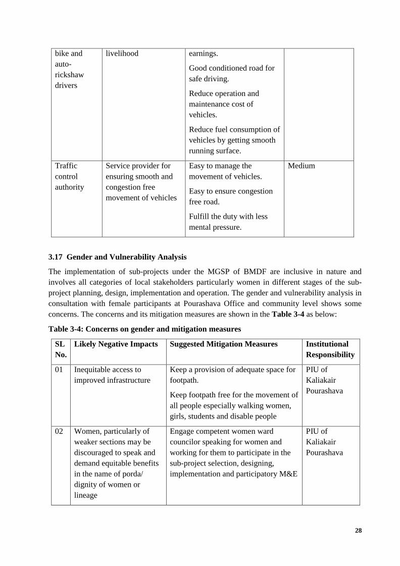
3.17 Gender and Vulnerability Analysis
The implementation of sub-projects under the MGSP of BMDF are inclusive in nature and
involves all categories of local stakeholders particularly women in different stages of the sub-
project planning, design, implementation and operation. The gender and vulnerability analysis in
consultation with female participants at Pourashava Office and community level shows some
concerns. The concerns and its mitigation measures are shown in the Table 3-4 as below:
Table 3-4: Concerns on gender and mitigation measures
SL
No.
Likely Negative Impacts Suggested Mitigation Measures Institutional
Responsibility
01 Inequitable access to
improved infrastructure
Keep a provision of adequate space for
footpath.
Keep footpath free for the movement of
all people especially walking women,
girls, students and disable people
PIU of
Kaliakair
Pourashava
02 Women, particularly of
weaker sections may be
discouraged to speak and
demand equitable benefits
in the name of porda/
dignity of women or
lineage
Engage competent women ward
councilor speaking for women and
working for them to participate in the
sub-project selection, designing,
implementation and participatory M&E
PIU of
Kaliakair
Pourashava

29
03 ULBs may lack
information, awareness
and expertise to take up
implement sub-projects
specially beneficial to
women
Impart awareness training for both
elected representatives and employees
(executives).
Impart more detailed training for the
executives and staff.
PIU of
Kaliakair
Pourashava
04 Wage discrimination Make conditionality in the bid
document to ensure equal wage for
equal work.
Ensure compliance by close
supervision by the ULB with the
assistance of consultant as required
Activate GRC in this regard hearing
complaints and resolving them
PIU of
Kaliakair
Pourashava
05 Participation Representative of women and
vulnerable groups in GRC
Occupational groups men and women
consultation process
Beneficiary options reflected in sub-
project design and implementation
PIU of
Kaliakair
Pourashava
06 Eve teasing and sexual
abuse
Keep a provision of safe space for
women and girls at all stoppages along
with road.
PIU of
Kaliakair
Pourashava
07 Absence of movement
facilities for disable people
from road to market
premises
Disable friendly design and
implementation;
Involvement of disable people at
planning and design stage, if possible;
Provision of ramp from road to markets
for the movement of the disable people.
PIU of
Kaliakair
Pourashava
SECTION 4: SOCIO ECONOMIC IMPACT ASSESSMENT
4.1 Social Safeguard Assessment Using Screening Format
The social safeguard assessment of proposed road, using the screening format given in the SMF
of MGSP, BMDF, has been conducted with the participation of different stakeholders and
community people. The screening format, prescribed in SMF of MGSP, is administered to
collect some key information regarding the social safeguard issues includes: (i) identification of
the sub-project, participants in screening exercise and would-be affected people; (ii) land
requirements and ownership; (iii) current use of existing and additional lands and potential

30
impacts; and (iv) information on tribal people living in the sub-project areas. The filled in
screening format for social safeguard issues and the list of participants attended in the screening
exercise are attached as Annexure 1 and Annexure 2 respectively.
The key findings of the screening exercise are given as below:
(i) Sub-project site and would-be affected people: The sub-project will be implemented along the
alignment of existing 4 roads and 6 drains those go through the 07 Wards (out of 09 Wards)
of the Kaliakair Pourashava. The Wards are ward # 3, ward # 4, ward # 5, ward # 6, ward #
7 ward # 8 and ward # 9 of the Pourashava. The participants identified the sub-project site
as an appropriate because it is in worst condition for movement of vehicles and community
people by foot even. The regular business and household activities are being hampered
severely due to lack of proper communication way. No people or households or business
establishments will be affected by this sub-project. Even, the widening of roads will be done
within the right-of-way of the roads those are owned by the Pourashava.
(ii) Land requirements and ownership: No additional land is required for constructing the
proposed roads. All the lands of the proposed roads are owned by the Pourashava. Hence,
there is no issue of land acquisition and subsequently, the issue of compensation is absent
here.
(iii) Current use of proposed land and potential impacts: The existing sub-project sites are
being used as for the local transportation facilities. However, the condition of the roads is too
worse to move the vehicles. The local transportation vehicles those are running through these
roads has been facing frequent accident due to sudden broken of different parts as there are
holes, depressions, cracks, waterlogging and muddy conditions all along the road. The daily
life of the community people and business are being hampered severely. By the
improvement of the roads under this sub-project will ensure the proper transportation facility
for the community people and smooth movement of vehicles for business and trades. It will
quicken transportation of business goods and raw materials, the reduce the operation and
maintenance cost of vehicles, reduce the consumption of fuel of vehicles, reduce the
travelling cost of local people and officials, increase the value of local land, attract more
industries and business centers to install, increase the employment opportunity in different
industries and business centers, engagement of unskilled young people in driving local
motorized vehicles, reduce the incidents of accidents and ultimately enhance the revenue
generation of the Pourashava. After the completion of the sub-project, the overall
environmental and social condition of the sub-project areas will be improved.
(iv) Information of tribal people: There is no indigenous or tribal people settlement in the sub-
project area. Therefore, there is no need to take any kind of protective measures for
indigenous peoples’ safeguard.
4.2 Community Consultation and Participation
4.2.1 Consultation and participation process
Public consultation about the planning, design, implementation and operation is done at different
stages following different participatory methods. The methods followed in public consultation
are: (1) consultative meeting with different stakeholders, (ii) Focus group discussion with

31
community people through the participation of male participants, (iii) Focus group discussion
with community people through the
participation of female participants, girls and
boys, and disable people, and (iv) key
informant interview with relevant persons of
Pourashava and local elites.
One consultative meeting was organized at
community level through the participation of
concern stakeholders including Councilors of
Kaliakair Pourashava, local leaders, community
elites, representatives of industries, and
representatives of business men and traders
living or running business at the both sides of
the proposed road. The participants were
informed about the detail design and activities of
sub-project going to be implemented. They were
asked to share their opinion, feedback and
suggestions on potential environmental and social
impacts of the sub-projects as well as the
mitigation measures to avoid or reduce the
potential impacts. All the participants provided
their opinions spontaneously. The list of
participants is attached as Annexure 4.
Further, one focus group discussion was
organized with male community participants
from different professions residing at the
surrounding areas of the sub-project site and doing business at the both sides of the road and
surrounding areas. The participants were informed about the detail design and activities of sub-
project going to be implemented and asked
about their opinion, feedback and suggestions
on environmental and social impacts of the
sub-projects as well as the mitigation
measures to avoid or reduce the potential
impacts. All the participants provided their
opinions spontaneously and raised different
important issues to be considered at both pre-
construction, construction and operational
phases. The list of participants of the FGD is
attached as Annexure 5.
Another focus group discussion was
organized with female community participants
Figure: Consultative meeting with local people
(male)
Figure: Consultative meeting with stakeholders
Figure: Consultative meeting with local people
(Female)

32
living at the surrounding areas and both sides of the proposed sub-project site. The participants
were also informed about the detail design and activities of sub-project going to be implemented
and asked about their opinion, feedback and suggestions on environmental and social impacts of
the sub-projects as well as the mitigation measures to avoid or reduce the potential impacts on
women’s point of view. In this session, boy and girls, and disable people were also present. All
the participants provided their opinions spontaneously and raised different important issues to be
considered at both pre-construction, construction and operational phases. Most of the female
participants gave emphasis on discharge of household waste water and disposal of household
waste. The list of participants of FGD is attached as Annexure 6.
The key informant interviews were done with local elites and Pourashava representatives to get
the in-depth information about the surrounding socio-economic environment of the sub-project
area and the potential impacts of sub-project on surrounding communities and livelihood.
Special efforts were made to include the elderly, women, and vulnerable groups and to allow
them to express their views regarding the sub-project implementation. In all cases, the
impression of stakeholders and general mass regarding sub-project implementation found highly
positive.
4.2.2 Key findings of Community Consultation: Issues and Recommendations
Different issues were raised by the participants related to sub-project during community
consultation. The issues, concerns and recommendations by the participants are given as below:
The water logging condition should be removed and healthy environmental condition
should be retrieved by constructing and improving all the roads;
Narrow roads should be widened and brick roads should be replaced by RCC road;
The drains should be widened and the depth of the drains should be increased to ensure
flow; the functional water
The drain should be constructed in such a way that the household waste water can
discharge easily to drain and no water can flow from one house to another house. It will
help to avoid quarrels among the neighbor households;
The height of roads should be maintained in such a way that the storm water on road may
discharge easily into the drain;
The Pourashava should collect the household waste and remove the fecal sludge by
introducing proper solid waste and fecal sludge management system. In addition, there
should be provision of penalty, if any household throw solid waste into drains and
connect septic tank with the drains;
Noise and air pollution should be controlled so that its impact might be minimum on
community people;
Sufficient protective measures should be taken so that no accident of workers and
community people occurs during the construction work;
The construction of roads should be completed within least possible time to reduce the
transportation problem of the local people;
The constructed roads should be cleaned and regular maintenance of roads should be
ensured by the Pourashava;

33
The footpath over the top of the drains should be ensured, where required and possible,
for the pedestrians;
In most of the cases, utility lines are given after the construction road and it damaged the
road. Hence, the utility lines should be given whether before the construction of road or
there should be adequate provision of road repair and maintenance during providing
utility lines;
In most of the cases, small roads of the Pourashava are being damaged due to movement
of heavy vehicles those are being used for carrying construction materials for building of
individual household. It is not rational to damage the public property for individual
purposes. Hence, the movement of these heavy vehicles should be restricted in the
constructed road by providing barrier at the entry point of each road so that limited
height fleet can enter into the road only.
Proper traffic control mechanism including sign of speed, sign of turning, community
traffic police with flag at important points etc. should be ensured;
Community people and shop keepers should be mobilized through awareness campaign
so that they can keep generated solid waste in own waste bin and no waste is thrown on
the road. The Pourashava should ensure the collect, treatment and disposal of solid waste
properly; and
Overall the quality of the work should be ensured through proper monitoring of works as
well as involving community people in monitoring.
SECTION 5: SOCIAL MANAGEMENT PLAN
5.1 Key Issues Considered in Social Management Plan
Social management principles such as inclusion, participation, transparency, social
accountability and social safeguards are considered at different stages of sub-project cycle such
as sub-project identification, sub-project planning and detailed sub-project preparation as well as
the principles will be followed during sub-project appraisal, sub-project implementation, and
operation and maintenance. The social screening and community consultation identified some
key social issues or impacts (both negative and positive) that need to be brought under social
management and monitoring plan. Some other additional issues are considered in social
management plan following the guidelines of SMF of BMDF.
5.2 Access to Information and Disclosure
The social safeguards assessment report should be translated into Bengali and disseminated
locally. The copies of the report (both in English and Bengali) will be sent to all the concerned
personnel responsible for sub-project implementation. It will also be made available to the
public. The final assessment report (both English and Bangla) will also be uploaded in the
Kaliakair Pourashava website, BMDF website and the World Bank website after approval. In
addition, a signboard containing all information of the sub-project will be displayed at the
different places along the roads so that mass people can know about the sub-project.
5.3 Grievance Redress Mechanism
The sub-project-specific Grievance Redress Mechanism (GRM) is established by the PIU of
Kaliakair Pourashava to receive, evaluate, and facilitate the solution of affected people’s (APs)

34
concerns, complaints and grievances concerning the social and environmental performance of
the sub-project. The GRM is aimed to provide a time-bound and transparent mechanism to voice
and resolve social and environmental concerns linked to the sub-project.
The grievance mechanism is related to resolve the risks and adverse impacts of the sub-project.
It addresses APs’ concerns and complaints promptly, using an understandable and transparent
process that is also gender responsive, and culturally appropriate. It is readily accessible to all
segments of the affected people at no costs and without retribution. The mechanism should not
impede access to the country’s judicial or administrative remedies. The affected people will be
appropriately informed about the mechanism.
BMDF has its own Grievance Redress Procedure (GRP) and they operate it to address any
dissatisfaction and complaints by the local people regarding its activities. This procedure is
being applied to address any complaints or grievances through negotiations with the community
leaders and representatives of the APs during implementation of the MGSP.
5.3.1 Grievance redress committee (GRC)
The Kaliakair Pourashava has formed a Grievance Redress Committee (GRC) headed by the
Mayor. With the facilitation of Consultant, the Mayor nominated the GRC members and
included representative from the Government Agencies, local NGO, and Civil Society. The GRC
will nominate a focal person. Complaints will be received through drop box, by post, email and
website of Pourashava. The grievance box will be set up at construction site to receive
complaints. The grievance response focal point will be available at the Pourashava for recording
the complaints and necessary response to an aggrieved person. It will receive complaints or
suggestions, and produce them to the GRC for hearing and resolution. If any complaint is not
resolved at Pourashava level, then the complaint will be produced to MD-BMDF. If it is not
resolved by the MD-BMDF, then the sub-project will be dropped.
The structure of the GRC and membership are given as below:
Chairman : ULB Mayor
Member-Secretary : Head of the Engineering Section of ULB
Member : Representative from local administration
: Teacher from a local educational institution
: Representative of a local NGO
: Representative of civil society
: Female ward councilor (of respective area)
The GRC members will play their roles and responsibilities as per SMF of BMDF. They will
also ensure the proper documentation of the complaints to be raised as per this guideline. The list
of GRC members along with office order from the Mayor is attached as Annexure 7.
It is to be noted that if the appellant is still not satisfied, he or she has the right to take the case
to the public courts. The Kaliakair Pourashava should also publish the outcome of the cases on
the public notice boards. All costs involved in resolving the complaints (meetings, consultations,

35
communication, and information dissemination) will be borne by the Kaliakair Pourashava. The
Pourashava authority will try to resolve the issues (in most of the cases, in amicable settlement)
within shortest possible time. However, the public court system is always open to resolve the
issues.

36
5.3.2 Grievance resolution process
The grievance resolution is a systematic process. The flow chart to be followed as grievance
resolution process for this sub-project is given as below:
Flow chart 5-1: Grievance Resolution Process
WLCC Drop Box By Post By Email Website
Complaints and
suggestions from
communities and
other stakeholder
ULB
GRC
Suggestions and Complains
designated for ULB GRC
GRM Books &
Data Bank
Complain
ts
resolved
and
implemen
ted Unresolved
Complaints referred
to PMU, BMDF
Proceeding and decisions
entered in GRM Books and in
Databank
Sub-project or its concerned
component is dropped for
cases
Unresolved at LGED/BMDF
level
GRM Data Management /
Reports
BMDF, PD (MD)
Independent Review and Evaluation
Public Dissemination via
BMDF/ ULB Websites and
printed reports

37
5.4 Labor iinflux and Management
The proposed road will have a positive impact on labor engagement since it will attract
employment of local laborers. The labor influx will be minimum here, because of the most of the
works will be done by the local laborers and there is very limited chance of engagement of
outside laborers. However, there is a chance to deprive female workers of poor households to be
employed in construction activities.
Kaliakair Pourashava Authority will ensure the labor rights. Project Implementation Unit (PIU)
of the Kaliakair Pourashava will monitor the labor management issues with the assistance of
Contractor. The PIU of Kaliakair Pourashava will ensure the following issues:
No child ( age group 0 to below 18) and no people of more than 65-years old will be
engaged in the sub-project’s activities as laborer;
No gender discrimination at any work of the sub-project;
Availability of safe drinking water, first aid and sanitation to the workers at sub-project
site;
Separate toilet for the female laborers including breast feeding corner;
Equal payment for equal work in due time for both male and female laborers.
5.5 Institutional Capacity Building
A day-long training in participation of PIU members of Kaliakair Pourashava was organized by
the Project Management Unit (PMU) of BMDF to build the capability of PIU of Kaliakair
Pourashava dated on October 11, 2018. The Consultant, hired by the Kaliakair Pourashava also
participated in the training program. The PMU of BMDF organized this training program in
order to enhance the ULB’s capacity to conduct Environmental Assessment and Social Impact
Assessment to be done for any proposed sub-project. A series of sessions were conducted by the
Specialists of the PMU of BMDF. The major sessions include: (i) importance of social safeguard
assessment, (ii) legal and administrative framework of GoB and World Bank, (iii) process of
social management plan, (iv) contents and preparation of social safeguard assessment, (v)
grievance redress mechanism, and (v) safeguard compliance issues to be incorporated with the
tender document as well as with BOQ for construction. The PIU of Kaliakair Pourashava will
organized an orientation of contractor, workers and other support staff on social safeguard issues
to be considered and mitigation measures to be taken during pre-construction, construction and
operational phases before deploying to the work sites in order to achieve the expected standards.
5.6 Social Management Plan
Based on the social safeguards assessment, it is found that although the Pourashava is the legal
owner of the land of existing road, there is a need to acquire addition land for extending road at
both sides. The extension of road at both sides will require removal of extended portion of some
business premises. However, during the consultative meeting and FGDs with community people,
businessmen, local leaders, community elites etc. it is found that they will remove the extension
parts of their structures voluntarily considering their own business interest and importance of

38
road in this areas. In addition, there is no human settlement on that land. Therefore, no people
will be directly or indirectly affected by the proposed sub-project. Hence the issues of
resettlement and compensation are absent here. Further, no tribal people are living in sub-project
and its adjacent area. However, the commercial markets and shops at the both sides of the road
may face minor negative impacts during construction period. On the other hand, the community
people and businessmen have raised some concerns that need to be addressed as part of social
management to avert or minimize the potential social impacts. Considering the abovementioned
situation, the social management plan (SMP) has been developed and will continue to be
updated for the sub-project period. The Table 5-1 depicts the SMP to be adopted during the
implementation and operation of the RCC/BC road.
Table 5-1: Social management plan matrix
Issues/ Impacts
identified
Proposed mitigation or enhancement
measures to be taken
Responsibility Timeframe
Employment of
local laborers in
construction work
Circulate labor employment message
through community consultation and
hanging notice at the construction site.
Contractor During pre-
construction
Regular movement
of vehicles on the
road
Engage more than two contractors in
completing the works in earliest
possible time.
The PIU of
Kaliakair
Pourashava
During pre-
construction
Security of the
community people
Provide proper orientation of the
employed laborers on the social security
issue and prohibit them not to visit local
community especially at night.
Contractor and
the PIU of
Kaliakair
Pourashava
During
construction
period
Occurrence of
accidents
Provide speed-breaker at certain interval
of the road and in front of each
vulnerable institution such as schools
and markets.
Provide PPEs to all workers.
Contractor and
the PIU of
Kaliakair
Pourashava
During
construction
period
Generation of
employment
Encourage unemployed and less
educated young people in driving
vehicles
PIU of
Kaliakair
Pourashava
During
operational
period
Gender and
vulnerability
Include female and other vulnerable
groups in every work related to
planning, design, implementation and
operation of the proposed road Make
conditionality in the bid document to
ensure equal wage for equal work.
PIU of
Kaliakair
Pourashava
During
planning,
design,
construction
and
operational
periods
Construction work Prepare a proper work schedule of Contractor and During

39
at night construction work and orient the
laborers and supervisors on it. No
construction work should be done after
10:00 pm.
Follow the schedule properly.
PIU of
Kaliakair
Pourashava
construction
period
Quality of work Involve community people both male
and female groups in monitoring and
supervision of the construction work,
and
Create a provision to check the quality
of work at certain interval.
PIU of
Kaliakair
Pourashava
During
construction
period
Facilities for
disable people
Ensure the proper facilities for disable
people in the design of road so that they
can go to different markets adjacent to
the road and its effective
implementation.
PIU of
Kaliakair
Pourashava
During
construction
and
operational
period
Solid waste
disposal on road
Arrange awareness campaign among the
shop keepers and businessmen and
community people not to throw solid
waste on the roads, and use dustbin.
The Pourashava should collect the waste
from dustbin and dispose the waste in a
selected landfill.
PIU and the
Pourashava
Authority of
Kaliakair
Pourashava
During
operational
phase.
Fecal sludge
management
Restrict the connection of septic tank of
household to the drainage system.
Keep provision of penalty to the
households that are connected septic
tank with drains
Organize awareness campaign among
the community people
Ensure proper collection, treatment and
disposal of fecal sludge.
Pourashava
Authority
During
operational
phase.
Damage of roads
by the movement
of heavy vehicles
Restrict the movement of heavy vehicles
through the small link roads by
installing height barrier at the entrance
of the roads.
Pourashava
Authority
During
operational
phase.

40
SECTION 6: MONITORING PLAN OF SMP
6.1 Monitoring Strategy
Monitoring of the sub-project will be done in a participatory manner and will be a bottom up
process. The participants, in monitoring and evaluation particularly in reporting the grassroots
level activities on social management issues in sub-project planning and implementation, will be
the community people, shop keepers and traders, representative of drivers and rickshaw pullers,
and assigned staff of Pourashava authority. The PIU of Kaliakair Pourashava and the Specialist
of PMU under BMDF will ensure the monitoring of social management issues during
construction and operational phase. The monitoring of social management issues as identified
during social safeguard assessment will be done from inclusiveness, participation, transparency
and social accountability point of view.
6.2 Internal Monitoring
Social Development Focal Point of the Kaliakair Pourashava will be responsible for internal
monitoring of the social management actions. He or she will monitor the sub-project activities
and provide report to Pourashava authority after certain interval as suggested by the BMDF.
6.3 External Review and Evaluation
External review and evaluation will be carried out to assess how effectively and efficiently
social development and social safeguards issues have been identified, management and
mitigation measures planned and implemented. An independent consultant (individual expert or
an organization) will be employed upon agreement and jointly by both BMDF and Kaliakair
Pourashava for carrying out independent evaluation.
6.4 Monitoring Plan Matrix
The monitoring plan matrix as given in Table 6-1 will be followed in monitoring the social
impacts:
Table 6-1: Monitoring plan matrix
Key issues to
be Monitored
Indicators to be monitored Responsibility Frequency of
monitoring
Employment
of local
laborers in
construction
work
Total number of labors employed
Ratio of employed local and
external laborers
PIU of
Kaliakair
Pourashava
Once in a
month
Regular
movement of
vehicles on the
road
Number of contractors are engaged PIU of
Kaliakair
Pourashava
Once in a
month
Security of the
community
Number of cases related to visit of
laborer to the community happened.
PIU of
Kaliakair
Once in a
month

41
Pourashava
Occurrence of
accidents
Number of speed-breakers is built.
Number of accidents occurs.
Number of PPEs set delivers to the
workers
PIU of
Kaliakair
Pourashava
Once in a
month
Generation of
employment
Number of young people engaged in
driving motorized vehicles.
PIU of
Kaliakair
Pourashava
Once in a
month
Gender and
vulnerability
Number of women involved in
construction and operation and
maintenance related activities.
PIU of
Kaliakair
Pourashava
Once in a
month
Construction
work at night
Whether or not, construction
activities are going on at night.
PIU of
Kaliakair
Pourashava
Once in a month
Quality of
work
Number of event happened in
checking the quality of work
Number of community people are
involved in checking the quality of
work
PIU of
Kaliakair
Pourashava
Once in a month
Facilities for
disable people
Numbers of ramp constructed for
the movement of disable people.
PIU of
Kaliakair
Pourashava
Once in a month
Solid waste
disposal
Number of awareness campaigning
sessions organized
Whether or not, the Pourashava
Authority collects solid waste from
households or dustbins.
PIU of
Kaliakair
Pourashava
Once in a month
Fecal sludge
management
Whether or not, an office order is
circulated to restrict the connection
of septic tank with drainage system.
Number of household fined for
connecting septic tank with local
drainage system.
Number of awareness campaigning
sessions organized
Whether or not, the Pourashava
Authority collects fecal sludge from
PIU of
Kaliakair
Pourashava
Once in a month

42
households.
Damage of
roads by the
movement of
heavy vehicles
Number of height barrier of vehicles
installed.
PIU of
Kaliakair
Pourashava
Once in a month
6.5 Reporting
The Kaliakair Pourashava will provide monthly progress reports to the PMU of BMDF on
progress and achievements against the social management plan.
Quarterly, semi-annual and annual Progress Report indicating progress on social
safeguards issues and mitigation measures;
Updates for formal supervision missions , i f the report produced for the current
quarter is deemed not sufficiently informative;
The independent social review and evaluation consultant will produce a baseline; a
mid-term review and an end-term evaluation report.
SECTION 7: CONCLUSION AND RECOMMENDATIONS
7.1 Conclusion
Based on the analysis of overall social environment of surrounding areas and potential social
impacts of the sub-project, it can be concluded that the proposed sub-project stands socially
sound, highly required and sustainable. The lands are owned by the Pourashava and the
proposed roads will be constructed along the alignment of the existing roads. No people will be
affected by the sub-project and there is no need of compensatory land acquisition and preparing
resettlement plan for affected people. The issue of tribal people is also absent here. The
community people appreciated the construction of the sub-project positively and hoping to be
highly benefited by it as it will relief them from waterlogging situation and unhealthy
environment; create employment opportunity, ease to the communication. It will create highly
positive impact on social economy by increasing demand and value of the land, creating income
opportunity by renting the houses to outsiders and easy movement of community people and
official with decreased travelling cost and time. It will also help to increase the revenue
generation of the Pourashava through increasing tax.
7.2 Recommendations
The attitude of the community people towards the improvement of RCC road is highly positive
as well as they have some recommendations to minimize the social impacts during its
construction and operation. The Government of Bangladesh and World Bank have some legal
and social safeguard compliance issues those are applicable during constructing and operating
the proposed road. Considering the above-mentioned issues and findings of the study, following
key recommendations are made for smooth construction and successful operation of the road:

43
The condition of the roads is very bad and public demand for this road is very high. The
construction of the road should be started as soon as possible and should be completed
within least possible time;
Proposed social management plan should be implemented strictly both during operation
and construction phase of the project;
Suggestions and recommendation made by public for design and construction of road,
traffic management, solid waste management and waste water discharge should be taken
into consideration;
This plan could be updated at any stages of the construction and operation of the sub-
project in case of addressing the environmental issues those are not identified and raised
at this stage
The grievance should be redressed and documented properly as per GRM.
REFERENCES
1. Bangladesh Bureau of Statistics. District Statistics 2011 of Kaliakair.
2. Bangladesh Bureau of Statistics. Bangladesh Population and Housing Census 2011.
3. Bangladesh Municipal Development Fund. Social Management Framework, 2017.
4. Final Master Plan of Kaliakair Pourashava, May 2008.
5. Kaliakair Pourashava Data, 2018.
6. https://en.wikipedia.org/wiki/Kaliakair_District, Dated on 5 July 2018.

44
ANNEXURES
Annexure 1: Format I: Sscreening format for social safeguards issues
A. Identification
1. Name of ULB: Kaliakair Pourashava
ward # 3, ward # 4, ward # 5, ward # 6, ward # 7 ward
# 8 and ward # 9
District: Kaliakair
Upazila: Kaliakair
2. Sub-project Name: “Improvement of Roads and Drains (Sub-project -1)
Project Component: The key components of the sub-project are as below:
(i) BC and RCC roads; and
(ii) RCC drains
3. Brief description of the physical works:
This sub-project is located at different Wards (7 Wards out of 9 Wards) within the Pourashava.
The Wards ward # 3, ward # 4, ward # 5, ward # 6, ward # 7, ward # 8 and ward # 9 of the
Pourashava. Many residential and commercial buildings are situated beside the sub-project
site. The condition of roads and drains are very poor and water logging persist almost all the
year round even in dry season.
The major activities to be carried out during preconstruction phase of RCC roads and drains
include:
Site cleaning and grabbing works;
Construction of semi-pucca site office;
Construction of separate laber shed with latrine facilities for male and female;
Relocation of electric poles and GI poles;
Removal of illegal establishment at the both sides of the road;
Voluntarily acquisition of land for expansion of road;
Construction of temporary fence around the labor shed and stockyard; and
Construction of pucca platform for stocking construction materials;
The major activities to be carried out during the construction phase of RCC road include:
Loosing, leveling and dressing of the damaged BC road;
Sand filling on the existing road bed and on the extended portions at the both sides;
Construction of aggregated sand sub base;
Box cutting;
Mechanical compaction;

45
Laying of polythene sheet; and
Casting of pavement by RCC mixture.
The major activities to be carried out during the construction phase of RCC drain include:
Earth work in excavation of the foundation;
Pumping and bailing out of water as per requirement;
Lying of polythene sheet;
Sand filling for the preparing foundation bed;
Plain cement concrete work in foundation;
Manufacturing and placing of CC blocks;
Fabrication of the ribbed or deformed bar;
Reinforced cement concrete work;
Construction of collection box or hole;
Construction of drain slabs; and
Placing of pavement tiles on the top of the drain.
4. Screening Date(s): 11th October 2018
B. Participation in Screening
6. Names of Consultants’ representatives who screened the sub-project:
(i) Md. Humayun Kabir, Lead Auditor
7. Names of ULB officials participated in screening:
(i) Engr. Haripada Roy, Executive Engineer, Kaliakair Municipality
(ii) Md. Ferdous Alam Khan, Assistant Engineer, Kaliakair Municipality.
8. WLCC members, NGOs, community groups/CBOs participated in screening: List them in
separate pages with names and addresses, in terms of road sections/spots and any other
information to identify them during preparation of impact mitigation plans. List of
participants is attached as Annexure 2.
9. Would-be affected persons participated in screening: List them in separate pages with
names, addresses in terms of road sections/spots where they would be affected, and any other
information to identify them during preparation of impact mitigation plans. N/A
C. Land Requirements & Ownership
10. Will there be a need for additional lands1 to carry out the intended works under this
contract?
[] Yes [√] No
1Additional lands’ mean lands beyond the carriageways and shoulders in case of roads/drains and outside currently
used space for markets, community centers or other interventions

46
11. If ‘Yes’, what will the additional lands be used for? (Indicate all that apply):
[√]road widening [ ] curve correction [ ] construction/expansion of physical structure
[ ] strengthening narrow eroding road
section between high and low
lands
[ ]
Others (Mention): ……………………………
12. If ‘Yes’, the required lands presently belong to (Indicate all that apply):
[ ] ULB [] Government – khas & other GOB agencies [√] Private citizens
[ ] Others (Mention): …………………………………………
13. If the proposed activities have been planned to use the existing available land, is it free from
encroachment and encumbrances by private people? Not applicable.
[] Yes [ ] No
D. Current Use of Existing and Additional Lands and Potential Impacts
14. If the required lands belong to Private Citizens, they are currently used for (Indicate all that
apply):
[ ] Agriculture Number of households using the lands: …………
[ ] Residential purposes Number of households using them: ………….
[√]Commercial
purposes
Number of persons using them: … No. of shops:
[] Other Uses (Mention)..………………………………..… No. of users:
15. If the required lands (existing and additional) belong to ULB and/or other Government
agencies, they are currently used for (Indicate all that apply):
[ ] Agriculture Number of persons/households using the lands: …….……..
[ ] Residential purposes Number of households living on them: ……………
[ ]Commercial purposes Number of persons using them: No. of Shops:
[√]Other Uses (Mention): Dr. There is exiting roads. No. of Users: N/A
16. How many of the present users have lease agreements with any government agencies? N/A
17. Number of private homesteads that would be affected on private lands: N/A
Entirely, requiring relocation: N/A Partially, but can still live on present homestead: N/A
18. Number of business premises/ buildings that would be affected on private lands :
Entirely and will require relocation: N/A # of businesses housed in them: N/A
√Partially, but can still use the premises: # of businesses housed in them:
19. Residential households will be affected on ULB’s own and & public lands:
Entirely affected and will require relocation: N/A No. of these structures: N/A

47
No. of structures built with brick, RCC, & other expensive and durable materials: N/A
No. of structures built with inexpensive salvageable materials (bamboo, GI sheets, etc.: N/A
√Partially affected, but can still live on the present homestead: No. of structures:
No. of structures built with brick, RCC, & other expensive and durable materials: N/A
No. of structures built with inexpensive salvageable materials (bamboo, GI sheets, etc.):
20. No. of business premises that would be affected on ULB’s own & other public lands: N/A
Entirely affected and will require relocation: N/A No. of these structures: N/A
No. of businesses housed in these structures: N/A
No. of persons presently employed in the above businesses: N/A
No. of these structures built with brick, RCC, & other durable materials: N/A
No. of structure built with inexpensive salvageable materials (bamboo, GI sheets, etc.): N/A
Partially affected, but can still stay in the present
premises: N/A
No. of these structures: ..N/A
No. of businesses housed in these structures: N/A
No. of persons presently employed in these businesses: N/A
No. of these structures built with brick, RCC, & other durable materials: N/A
No. of structure built with inexpensive salvageable materials (bamboo, GI sheets, etc.): N/A
21. No. of businesses/trading activities that would be displaced
from make-shift structures on the road, and other areas/spots:
None
22. Do the proposed sub-project works affect any community groups’ access to any resources
that are used for livelihood purposes?
[ ] Yes [√] No
23. If ‘Yes’, description of the resources: N/A
……………………………………………………………………………………..……………
…
24. Do the proposed works affect community facilities like school, cemetery, mosque, temple,
or others that are of religious, cultural and historical significance?
[] Yes [√] No
25. If ‘Yes’, description of the facilities: N/A
26. Describe any other impacts that have not been covered in this questionnaire? N/A
27. Describe alternatives, if any, to avoid or minimize use of additional lands: N/A
E. ADDITIONAL INFORMATION ON TRIBAL PEOPLES

48
(This section must be filled in if sub-projects are located in areas that are also inhabited by
tribal peoples) No tribal people inhabits in proposed sub-project areas. So, this section is
not applicable for the proposed sub-project.
28. Names of tribal community members and organizations who participated in screening:
29. Have the tribal community and the would-be affected TPs been made aware of the
potential positive and negative impacts and consulted for their feedback and inputs?
[ ] Yes [ ]No
30. Has there been a broad-based community consensus on the proposed works?
[ ] Yes [ ]No
31. Total number of would-be affected tribal households:
32. The would-be affected tribal households have the following forms of rights to the required
lands:
[ ] Legal: No. of households: …………
[ ] Customary: No. of households: …………
[ ] Lease agreements with any GoB agencies: No. of households: …..…..…
[ ] Others (Mention): .…………………………………. No. of households: ...………
33. Does the sub-project affect any objects that are of religious and cultural significance to the
IPs?
[ ] Yes [ ]No
34. If ‘Yes’, description of the objects: ………………………………
35. The following are the three main economic activities of the would-be affected tribal
households:
a. .…………………………………………………………………………………………
……
b. …………………………………………………………………………………………
……
c. …………………………………………………………………………………………
……
36. Social concerns expressed by tribal communities/organizations about the works proposed
under the sub-project:
37. The tribal community and organizations perceive the social outcomes of the sub-project:
[√] Positive [ ] Negative [] Neither positive nor negative
On behalf of the ULB, this Screening Form has been filled in by:

49

50
Annexure 2: Layout Plan of the proposed RCC roads and drains
Cross Section of RCC Road
Cross Section of RCC Drain

51
Annexure 3: Legal document of the land

52

53
Annexure 4: Attendance of community people in FGD (female)

54
Annexure 5: Attendance of community people in FGD (male)

55
Annexure 6: Attendance of local participants in screening exercise

56
Annexure 7: The List of GRC members along with office order from the Mayor