Site Assessment Forms
135
-1- Central Bedfordshire Council www.centralbedfordshire.gov.uk Site Assessment Forms Toddington
Transcript of Site Assessment Forms

- 1 -
Central Bedfordshire Councilwww.centralbedfordshire.gov.uk
Site Assessment FormsToddington
Pag
e2
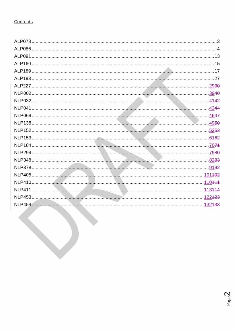
Contents
ALP078 ............................................................................................................................................3
ALP086 ............................................................................................................................................4
ALP091 ..........................................................................................................................................13
ALP160 ..........................................................................................................................................15
ALP189 ..........................................................................................................................................17
ALP193 ..........................................................................................................................................27
ALP227 ......................................................................................................................................2930
NLP002......................................................................................................................................3940
NLP032......................................................................................................................................4142
NLP041......................................................................................................................................4344
NLP069......................................................................................................................................4647
NLP138......................................................................................................................................4950
NLP152......................................................................................................................................5253
NLP153......................................................................................................................................6162
NLP184......................................................................................................................................7071
NLP294......................................................................................................................................7980
NLP348......................................................................................................................................8283
NLP378......................................................................................................................................9192
NLP405..................................................................................................................................101102
NLP410..................................................................................................................................110111
NLP411..................................................................................................................................113114
NLP453..................................................................................................................................122123
NLP454..................................................................................................................................132133

Pag
e3
Site Assessment Framework for HOUSING1
Site detailsReference Number ALP078
Site Name Land to the rear of 55 & 56 Luton RoadSite Address Land to the rear of 55 & 56 Luton Road, ToddingtonSettlement ToddingtonSize Submitted Developable Area: 0.07ha
Submitted Whole Site Area: 0.07haMeasured GIS Area:0.07ha
Proposed UseAny otherinformation
STAGE 1 : SUITABILITY AND AVAILABILITY (EXCLUSIONARY STAGE)This section will exclude any sites which do not pass the exclusionary suitability criteria and they will notbe assessed further.
STAGE 1A ASSESSMENTThis stage of the assessment rules out sites that are too small or conflict with national policy designations.Provisional Site Capacity1 Is the site likely to accommodate less than 10
dwellings?Work out the number of new homes from site sizeusing density of 30dph and exclude up to 40 %depending on site size of land for infrastructure andservices, take into account topography or significantareas of undevelopable land.Site Size Gross to net ratio standards
Up to 0.4 hectare 100% 0.4 to 2 hectares 80% 2 hectares or above 60%
Note: for this calculation use the submittedDevelopable Area, or the area measured in GIS ifthis is smaller.
Yes Number of proposed dwellings asper proforma:
3
Number of proposed dwellings asper CBC methodology:
2
Flood Risk (All sites which reach Stage 2 will be subject to the Sequential Test)2 Is more than 50% of the site located in Flood Zone 2
or 3?No Not in Floodzone 2 and 3
3 Is more than 50% of the site at risk from surfacewater flooding?
No Not at risk from surface waterflooding
Nationally significant designations (All sites which reach Stage 2 be subject to detailed assessment)4 Is more than 50% of the site covered by nationally
significant designations? These are: Sites of SpecialScientific Interest, National Nature Reserves,Scheduled Monuments, Registered Parks andGardens.
No Not within nationally significantdesignation
5 Is more than 50% of the site located within the Areaof Outstanding Natural Beauty?
No Not within AONB.
Does the site continue to next stage? No
1Employment sites and Gypsy and Traveller sites will be assessed using separate bespoke site assessment criteria.
Pag
e4
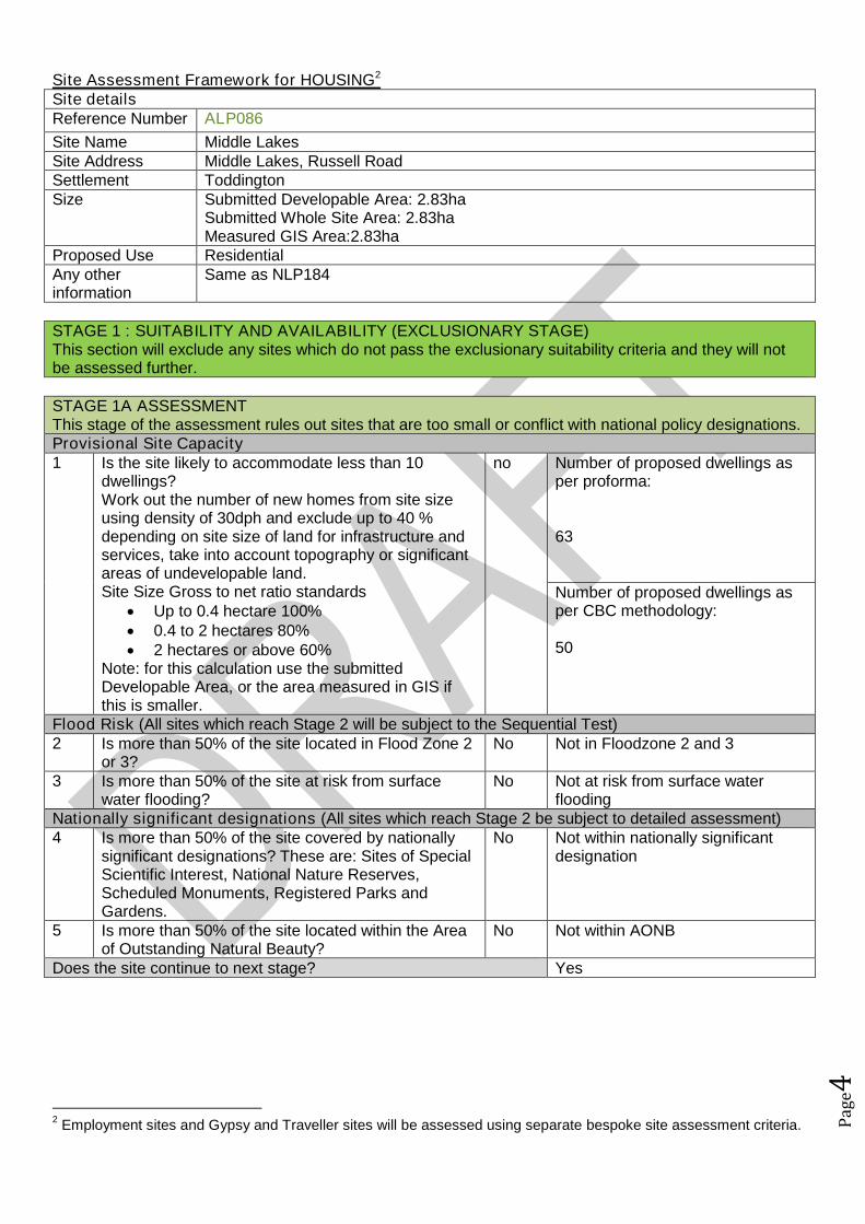
Site Assessment Framework for HOUSING2
Site detailsReference Number ALP086
Site Name Middle LakesSite Address Middle Lakes, Russell RoadSettlement ToddingtonSize Submitted Developable Area: 2.83ha
Submitted Whole Site Area: 2.83haMeasured GIS Area:2.83ha
Proposed Use ResidentialAny otherinformation
Same as NLP184
STAGE 1 : SUITABILITY AND AVAILABILITY (EXCLUSIONARY STAGE)This section will exclude any sites which do not pass the exclusionary suitability criteria and they will notbe assessed further.
STAGE 1A ASSESSMENTThis stage of the assessment rules out sites that are too small or conflict with national policy designations.Provisional Site Capacity1 Is the site likely to accommodate less than 10
dwellings?Work out the number of new homes from site sizeusing density of 30dph and exclude up to 40 %depending on site size of land for infrastructure andservices, take into account topography or significantareas of undevelopable land.Site Size Gross to net ratio standards
Up to 0.4 hectare 100% 0.4 to 2 hectares 80% 2 hectares or above 60%
Note: for this calculation use the submittedDevelopable Area, or the area measured in GIS ifthis is smaller.
no Number of proposed dwellings asper proforma:
63
Number of proposed dwellings asper CBC methodology:
50
Flood Risk (All sites which reach Stage 2 will be subject to the Sequential Test)2 Is more than 50% of the site located in Flood Zone 2
or 3?No Not in Floodzone 2 and 3
3 Is more than 50% of the site at risk from surfacewater flooding?
No Not at risk from surface waterflooding
Nationally significant designations (All sites which reach Stage 2 be subject to detailed assessment)4 Is more than 50% of the site covered by nationally
significant designations? These are: Sites of SpecialScientific Interest, National Nature Reserves,Scheduled Monuments, Registered Parks andGardens.
No Not within nationally significantdesignation
5 Is more than 50% of the site located within the Areaof Outstanding Natural Beauty?
No Not within AONB
Does the site continue to next stage? Yes
2Employment sites and Gypsy and Traveller sites will be assessed using separate bespoke site assessment criteria.
Pag
e5
STAGE 1B ASSESSMENTThis stage of the assessment rules out sites that are not well related to existing settlements but are of aninsufficient size to be self contained. It also rules out sites which would cause coalescence of existingtowns or villages. For the purposes of this assessment, a self-contained site is defined as a site which willprovide 1,500 homes or more3.Relationship to Settlement6 For sites that are not of a sufficient scale to be self-
contained, is the site a logical extension to thesettlement or are there any major physicalconstraints(for example A roads, rivers or railways)that separate it from the main settlement?
G The site is located to the south ofToddington and it adjoins thesettlement. As such it would form alogical extension to the village ofToddington.
7 Does the site cause coalescence between anexisting village or town and another existing villageor town? If yes, then grade as Amber if the sitewould be able to provide appropriate buffers orgreen wedges to mitigate this, or Red if it would notbe possible for appropriate buffers to be providedleaving a reasonable developable area based on theindividual context of the site.
G The site would not causecoalescence.
Does the site continue to next stage? Yes
STAGE 1C ASSESSMENTThis stage of the assessment rules out sites that are not able to meet their critical infrastructure needs4.Critical Infrastructure8 Can the site meet the critical infrastructure
requirements that will enable delivery5?A Further information required.
Does the site continue to next stage? Yes
STAGE 1D ASSESSMENTThis stage of the assessment rules out sites that are not available. A site is considered available fordevelopment where there are no legal or ownership problems and the landowner has expressed anintention to develop the site.Availability9 What is the existing use of the site?
Would the existing use limit the developmentpotential?
G Greenfield
10 Is the land controlled by a developer or land ownerwho has expressed an intention to develop the site?
G Land controlled by land ownerintent on developing the site.
11 Are there any legal or ownership problems that coulddelay or prevent development?If Yes, then can these be issues be realisticallyovercome?
G There are no legal or ownershipproblems.
12 Does the site already have planning permission forthe proposed use? If yes, then score as Redbecause it’s not eligible for allocation.
G No planning permission
3The figure of 1,500 homes has been taken from the Government Publication ‘Locally-Led Garden Villages, Towns
and Cities’. This defines the eligibility criteria for Garden Villages as standalone settlements of between 1,500 and10,000 homes. ( see https://www.gov.uk/government/uploads/system/uploads/attachment_data/file/508205/Locally-led_garden_villages__towns_and_cities.pdf )4
Critical infrastructure is that which has been identified as infrastructure that must happen to enable physicaldevelopment. These infrastructure items are often known as ‘blockers’ or ‘showstoppers’, and are most common inrelation to transport and utilities infrastructure. Failure to provide these pieces of infrastructure could result insignificant delays in the delivery of development.5
This is an assessment based on the information known at this stage, a full assessment of infrastructure requirementswill be undertaken before any sites are allocated.
Pag
e6
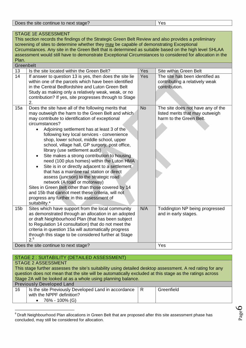
Does the site continue to next stage? Yes
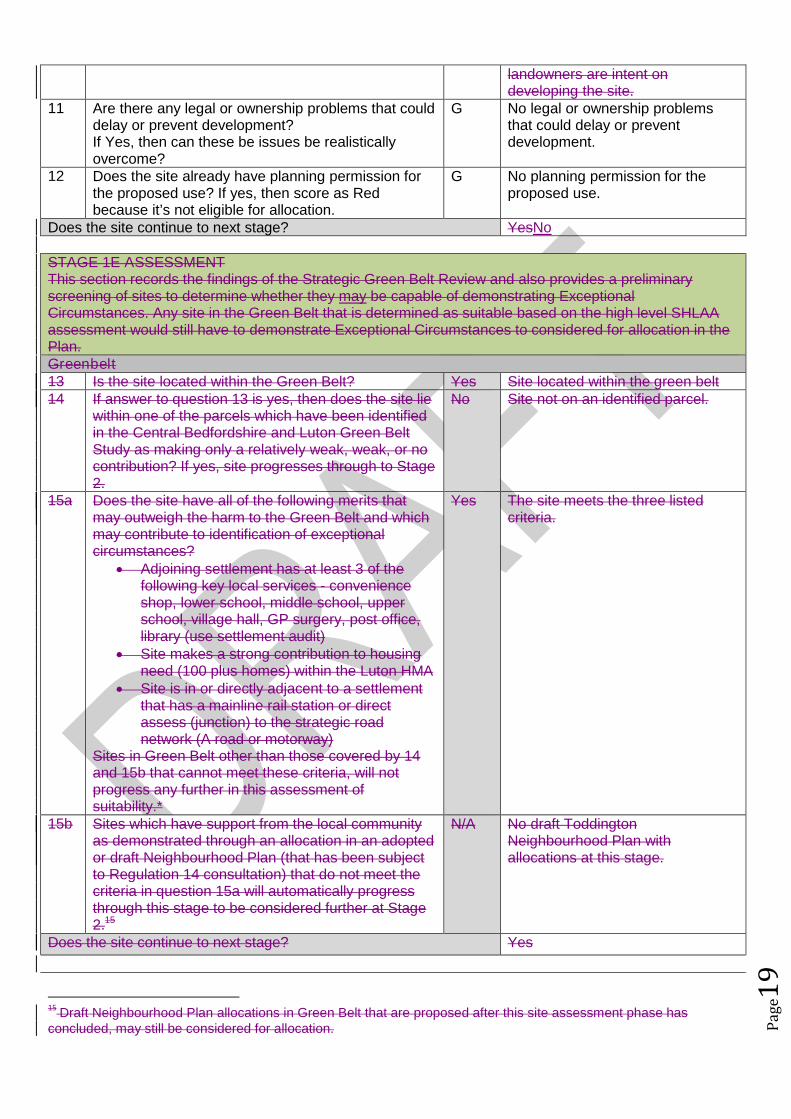
STAGE 1E ASSESSMENTThis section records the findings of the Strategic Green Belt Review and also provides a preliminaryscreening of sites to determine whether they may be capable of demonstrating ExceptionalCircumstances. Any site in the Green Belt that is determined as suitable based on the high level SHLAAassessment would still have to demonstrate Exceptional Circumstances to considered for allocation in thePlan.Greenbelt13 Is the site located within the Green Belt? Yes Site within Green Belt14 If answer to question 13 is yes, then does the site lie
within one of the parcels which have been identifiedin the Central Bedfordshire and Luton Green BeltStudy as making only a relatively weak, weak, or nocontribution? If yes, site progresses through to Stage2.
Yes The site has been identified ascontributing a relatively weakcontribution.
15a Does the site have all of the following merits thatmay outweigh the harm to the Green Belt and whichmay contribute to identification of exceptionalcircumstances?
Adjoining settlement has at least 3 of thefollowing key local services - convenienceshop, lower school, middle school, upperschool, village hall, GP surgery, post office,library (use settlement audit)
Site makes a strong contribution to housingneed (100 plus homes) within the Luton HMA
Site is in or directly adjacent to a settlementthat has a mainline rail station or directassess (junction) to the strategic roadnetwork (A road or motorway)
Sites in Green Belt other than those covered by 14and 15b that cannot meet these criteria, will notprogress any further in this assessment ofsuitability.*
No The site does not have any of thelisted merits that may outweighharm to the Green Belt.
15b Sites which have support from the local communityas demonstrated through an allocation in an adoptedor draft Neighbourhood Plan (that has been subjectto Regulation 14 consultation) that do not meet thecriteria in question 15a will automatically progressthrough this stage to be considered further at Stage2.6
N/A Toddington NP being progressedand in early stages.
Does the site continue to next stage? Yes
STAGE 2 : SUITABILITY (DETAILED ASSESSMENT)STAGE 2 ASSESSMENTThis stage further assesses the site’s suitability using detailed desktop assessment. A red rating for anyquestion does not mean that the site will be automatically excluded at this stage as the ratings acrossStage 2A will be looked at as a whole using planning balance.Previously Developed Land16 Is the site Previously Developed Land in accordance
with the NPPF definition? 76% - 100% (G)
R Greenfield
6Draft Neighbourhood Plan allocations in Green Belt that are proposed after this site assessment phase has
concluded, may still be considered for allocation.
Pag
e7
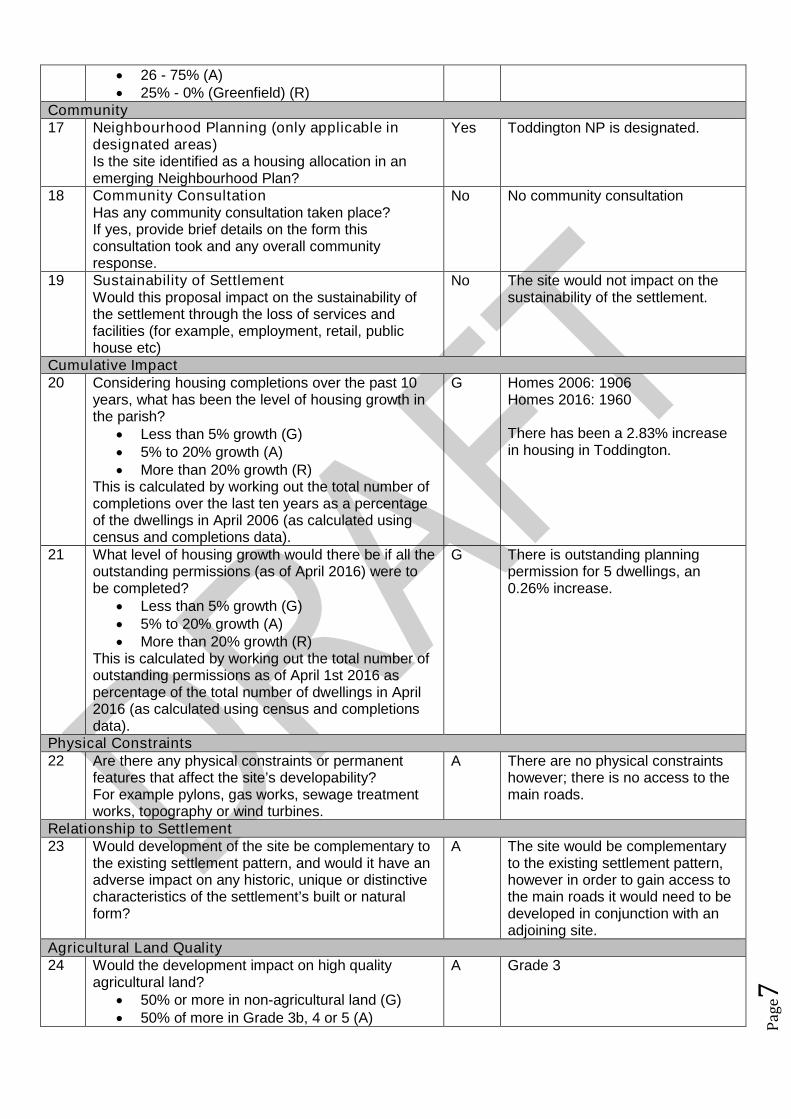
26 - 75% (A) 25% - 0% (Greenfield) (R)
Community17 Neighbourhood Planning (only applicable in
designated areas)Is the site identified as a housing allocation in anemerging Neighbourhood Plan?
Yes Toddington NP is designated.
18 Community ConsultationHas any community consultation taken place?If yes, provide brief details on the form thisconsultation took and any overall communityresponse.
No No community consultation
19 Sustainability of SettlementWould this proposal impact on the sustainability ofthe settlement through the loss of services andfacilities (for example, employment, retail, publichouse etc)
No The site would not impact on thesustainability of the settlement.
Cumulative Impact20 Considering housing completions over the past 10
years, what has been the level of housing growth inthe parish?
Less than 5% growth (G) 5% to 20% growth (A) More than 20% growth (R)
This is calculated by working out the total number ofcompletions over the last ten years as a percentageof the dwellings in April 2006 (as calculated usingcensus and completions data).
G Homes 2006: 1906Homes 2016: 1960
There has been a 2.83% increasein housing in Toddington.
21 What level of housing growth would there be if all theoutstanding permissions (as of April 2016) were tobe completed?
Less than 5% growth (G) 5% to 20% growth (A) More than 20% growth (R)
This is calculated by working out the total number ofoutstanding permissions as of April 1st 2016 aspercentage of the total number of dwellings in April2016 (as calculated using census and completionsdata).
G There is outstanding planningpermission for 5 dwellings, an0.26% increase.
Physical Constraints22 Are there any physical constraints or permanent
features that affect the site’s developability?For example pylons, gas works, sewage treatmentworks, topography or wind turbines.
A There are no physical constraintshowever; there is no access to themain roads.
Relationship to Settlement23 Would development of the site be complementary to
the existing settlement pattern, and would it have anadverse impact on any historic, unique or distinctivecharacteristics of the settlement’s built or naturalform?
A The site would be complementaryto the existing settlement pattern,however in order to gain access tothe main roads it would need to bedeveloped in conjunction with anadjoining site.
Agricultural Land Quality24 Would the development impact on high quality
agricultural land? 50% or more in non-agricultural land (G) 50% of more in Grade 3b, 4 or 5 (A)
A Grade 3

Pag
e8
50% or more in Grade 1, 2 or 3a (R)
STAGE 2 ASSESSMENTThis stage further assesses the site’s suitability using comments from technical specialists. A red rating forany question does not mean that the site will be automatically excluded at this stage as the ratings acrossStage 2B will be looked at as a whole using planning balance.Transport and Access to Services25 Facilities and services
Question 26 considers the suitability and sustainability of the site for housing. It links to theCouncil’s Settlement Hierarchy Audit.
Issues relating to capacity are assessed separately25a Does the settlement have a Primary/Lower school?
Yes, in the settlement (G) Yes, proposed as part of the development (G) No, but an adjoining settlement does (A) Not in the settlement or an adjoining
settlement (R)
G In settlement
25b Does the settlement have a Middle school (ifapplicable)?
Yes, in the settlement (G) Yes, proposed as part of the development (G) No, but an adjoining settlement does (A) Other catchment school available (A)
G In settlement
25c Does the settlement have a Secondary/ Upperschool?
Yes, in the settlement (G) Yes, proposed as part of the development (G) No, but an adjoining settlement does (A) Other catchment school available (A)
A Adjoining settlement
25d Does the settlement have a GPs surgery or medicalcentre?
Yes, in the settlement (G) Yes, proposed as part of the development (G) No, but an adjoining settlement does (A) Not in the settlement or an adjoining
settlement (R)
G In settlement
26 What retail provision does the settlement offer? Town Centre/ Supermarket (G) Convenience Store / Post Office / Newsagent
(A) None (R)
A Convenience store
27 Distance to bus stops with a frequent service (atleast hourly at peak times):
Less than 400m (G) 400m-800m (A) Over 800m (R) OR submission form stated that improved
public transport facilities could be provided aspart of the development (G)
A 781m from a bus stop
28 Distance to nearest train station: Less than 800m (G) 800m-1200m (A) Over 1200m (R)
R Over 1200m
29 Is the site accessible from the existing road network? R No
Pag
e9
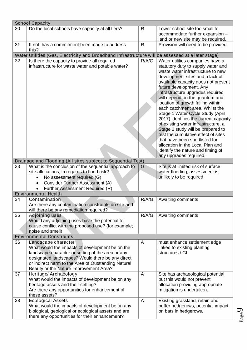
School Capacity30 Do the local schools have capacity at all tiers? R Lower school site too small to
accommodate further expansion –land or new site may be required.
31 If not, has a commitment been made to addressthis?
R Provision will need to be provided.
Water Utilities (Gas, Electricity and Broadband Infrastructure will be assessed at a later stage)32 Is there the capacity to provide all required
infrastructure for waste water and potable water?R/A/G Water utilities companies have a
statutory duty to supply water andwaste water infrastructure to newdevelopment sites and a lack ofavailable capacity does not preventfuture development. Anyinfrastructure upgrades requiredwill depend on the quantum andlocation of growth falling withineach catchment area. Whilst theStage 1 Water Cycle Study (April2017) identifies the current capacityof existing water infrastructure, aStage 2 study will be prepared totest the cumulative effect of sitesthat have been shortlisted forallocation in the Local Plan andidentify the nature and timing ofany upgrades required.
Drainage and Flooding (All sites subject to Sequential Test)33 What is the conclusion of the sequential approach to
site allocations, in regards to flood risk? No assessment required (G) Consider Further Assessment (A) Further Assessment Required (R)
G Site is at limited risk of surfacewater flooding, assessment isunlikely to be required
Environmental Health34 Contamination
Are there any contamination constraints on site andwill there be any remediation required?
R/A/G Awaiting comments
35 Adjoining usesWould any adjoining uses have the potential tocause conflict with the proposed use? (for example;noise and smell)
R/A/G Awaiting comments
Environmental Constraints36 Landscape character
What would the impacts of development be on thelandscape character or setting of the area or anydesignated landscapes? Would there be any director indirect harm to the Area of Outstanding NaturalBeauty or the Nature Improvement Area?
A must enhance settlement edgelinked to existing plantingstructures / GI
37 Heritage/ ArchaeologyWhat would the impacts of development be on anyheritage assets and their setting?Are there any opportunities for enhancement ofthese assets?
A Site has archaeological potentialbut this would not preventallocation providing appropriatemitigation is undertaken.
38 Ecological AssetsWhat would the impacts of development be on anybiological, geological or ecological assets and arethere any opportunities for their enhancement?
A Existing grassland, retain andbuffer hedgerows, potential impacton bats in hedgerows.
Pag
e10
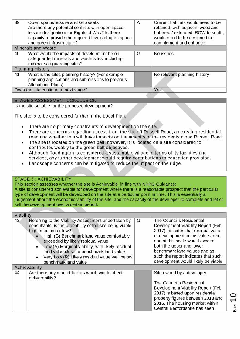
39 Open space/leisure and GI assetsAre there any potential conflicts with open space,leisure designations or Rights of Way? Is therecapacity to provide the required levels of open spaceand green infrastructure?
A Current habitats would need to beretained, with adjacent woodlandbuffered / extended. ROW to south,would need to be designed tocomplement and enhance.
Minerals and Waste40 What would the impacts of development be on
safeguarded minerals and waste sites, includingmineral safeguarding sites?
G No issues
Planning History41 What is the sites planning history? (For example
planning applications and submissions to previousAllocations Plans)
No relevant planning history
Does the site continue to next stage? Yes
STAGE 2 ASSESSMENT CONCLUSIONIs the site suitable for the proposed development?
The site is to be considered further in the Local Plan.
There are no primary constraints to development on the site. There are concerns regarding access from the site off Russell Road, an existing residential
road and whether this will have impacts on the amenity of the residents along Russell Road. The site is located on the green belt, however, it is located on a site considered to
contributes weakly to the green belt objectives. Although Toddington is considered a sustainable village in terms of its facilities and
services, any further development would require contributions to education provision. Landscape concerns can be mitigated to reduce the impact on the ridge.
STAGE 3 : ACHIEVABILITYThis section assesses whether the site is Achievable in line with NPPG Guidance:A site is considered achievable for development where there is a reasonable prospect that the particulartype of development will be developed on the site at a particular point in time. This is essentially ajudgement about the economic viability of the site, and the capacity of the developer to complete and let orsell the development over a certain period.
Viability43 Referring to the Viability Assessment undertaken by
consultants, is the probability of the site being viablehigh, medium or low?
High (G) Benchmark land value comfortablyexceeded by likely residual value
Low (A) Marginal viability, with likely residualland value close to benchmark land value
Very Low (R) Likely residual value well belowbenchmark land value
G The Council’s ResidentialDevelopment Viability Report (Feb2017) indicates that residual valueof development in this value areaand at this scale would exceedboth the upper and lowerbenchmark land values and assuch the report indicates that suchdevelopment would likely be viable.
Achievability44 Are there any market factors which would affect
deliverability?Site owned by a developer.
The Council’s ResidentialDevelopment Viability Report (Feb2017) is based upon residentialproperty figures between 2013 and2016. The housing market withinCentral Bedfordshire has seen

Pag
e11
significant increases in residentialproperty values in a relatively shortperiod of time, whereby it isconsidered that the viability ofdevelopments within this report hasbeen cautious. For example in2016 Dunstable has benefited froma 17.9% housing price increasewith an average annual house priceincrease in 2016 for housing withinCentral Bedfordshire of 10.74%.
This increase in property value hasbeen a result of not only nationaltrends in house prices and existingtransport links to economicallysuccessful areas but alsosignificant infrastructure projectswithin the pipeline including: East-West Rail; M1-A5 link road; A421upgrades; Oxford to CambridgeExpress Way; Luton and DunstableGuided Busway; M1 improvements;and potential A1 improvements. Itis considered that as suchinfrastructure projects progress thatproperty prices within the LocalAuthority will likely continue toincrease which has and willincrease viability/deliverability ofdevelopment not only in the highervalue areas but also the lowervalue areas of the Authority.
45 When can the scheme realistically commencedelivery?
0 to 5 years (deliverable) 6 to 10 years 11 to 15 years 15 to 20 years Outside Plan Period
0 to 5 years
46 What is the indicative build out time of the site? The Case Study Sites outlinedwithin the Council’s ResidentialDevelopment Viability Report (Feb2017 indicates that after the sitehas received detailed planningpermission a single housebuilderwould likely take one year to firstcompletion and would build out thesite at a rate of 40 dwellings perannum there after.
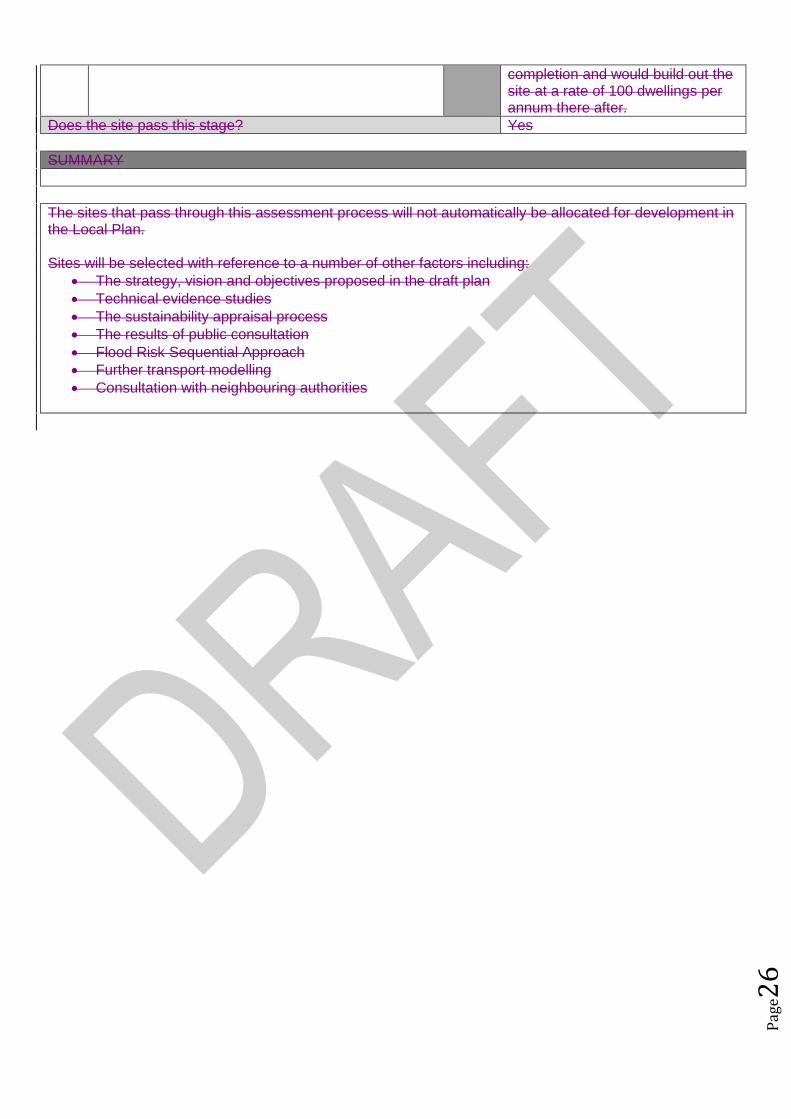
Does the site pass this stage? Yes
SUMMARY
The sites that pass through this assessment process will not automatically be allocated for development inthe Local Plan.

Pag
e12
Sites will be selected with reference to a number of other factors including: The strategy, vision and objectives proposed in the draft plan Technical evidence studies The sustainability appraisal process The results of public consultation Flood Risk Sequential Approach Further transport modelling Consultation with neighbouring authorities

Pag
e13
Site Assessment Framework for HOUSING7
Site detailsReference Number ALP091
Site Name Land at 117 Leighton RoadSite Address Land at 117 Leighton RoadSettlement ToddingtonSize Submitted Developable Area: 1.4ha
Submitted Whole Site Area: 1.4haMeasured GIS Area:1.4ha
Proposed Use ResidentialAny otherinformation
STAGE 1 : SUITABILITY AND AVAILABILITY (EXCLUSIONARY STAGE)This section will exclude any sites which do not pass the exclusionary suitability criteria and they will notbe assessed further.
STAGE 1A ASSESSMENTThis stage of the assessment rules out sites that are too small or conflict with national policy designations.Provisional Site Capacity1 Is the site likely to accommodate less than 10
dwellings?Work out the number of new homes from site sizeusing density of 30dph and exclude up to 40 %depending on site size of land for infrastructure andservices, take into account topography or significantareas of undevelopable land.Site Size Gross to net ratio standards
Up to 0.4 hectare 100% 0.4 to 2 hectares 80% 2 hectares or above 60%
Note: for this calculation use the submittedDevelopable Area, or the area measured in GIS ifthis is smaller.
no Number of proposed dwellings asper proforma:
30
Number of proposed dwellings asper CBC methodology:
33
Flood Risk (All sites which reach Stage 2 will be subject to the Sequential Test)2 Is more than 50% of the site located in Flood Zone 2
or 3?No Not in Floodzone 2 and 3
3 Is more than 50% of the site at risk from surfacewater flooding?
No Not at risk from surface waterflooding
Nationally significant designations (All sites which reach Stage 2 be subject to detailed assessment)4 Is more than 50% of the site covered by nationally
significant designations? These are: Sites of SpecialScientific Interest, National Nature Reserves,Scheduled Monuments, Registered Parks andGardens.
No Not within nationally significantdesignation
5 Is more than 50% of the site located within the Areaof Outstanding Natural Beauty?
No Not within AONB
Does the site continue to next stage? Yes
7Employment sites and Gypsy and Traveller sites will be assessed using separate bespoke site assessment criteria.
Pag
e14
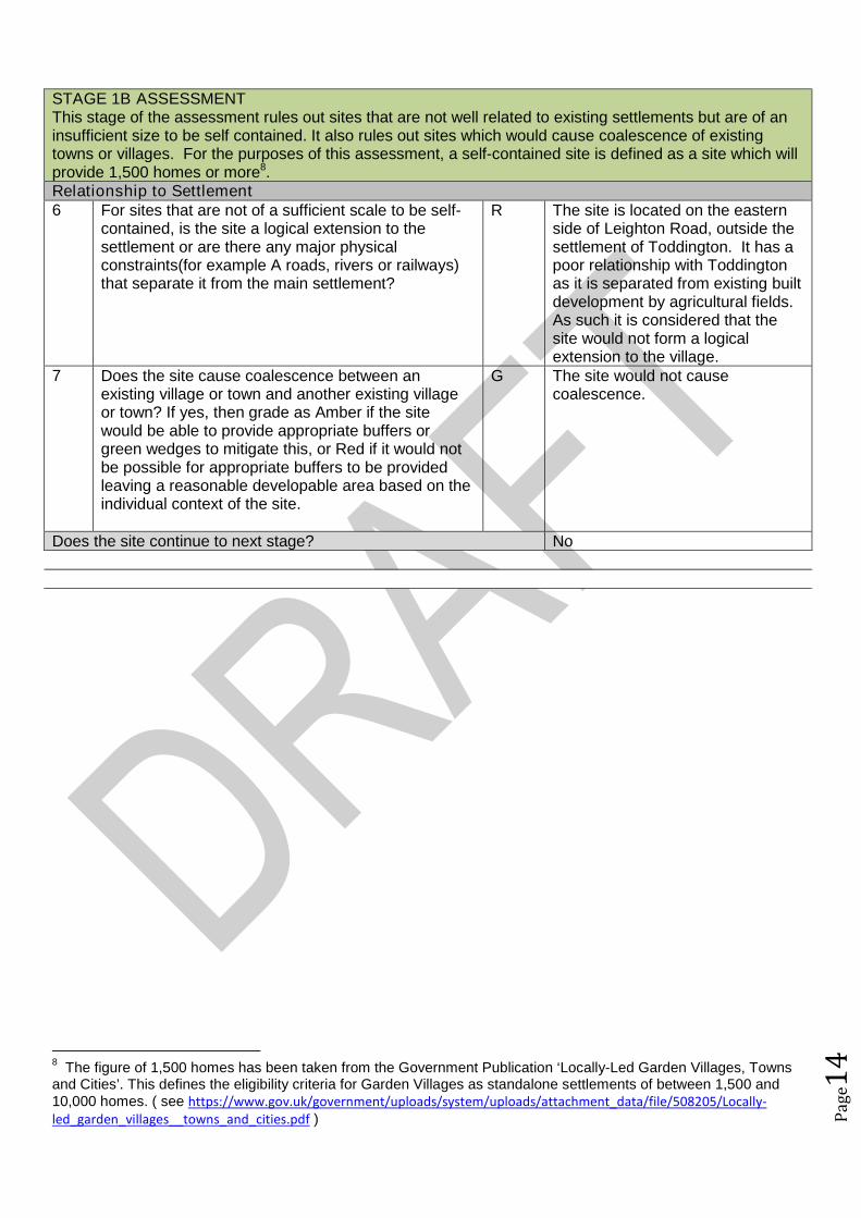
STAGE 1B ASSESSMENTThis stage of the assessment rules out sites that are not well related to existing settlements but are of aninsufficient size to be self contained. It also rules out sites which would cause coalescence of existingtowns or villages. For the purposes of this assessment, a self-contained site is defined as a site which willprovide 1,500 homes or more8.Relationship to Settlement6 For sites that are not of a sufficient scale to be self-
contained, is the site a logical extension to thesettlement or are there any major physicalconstraints(for example A roads, rivers or railways)that separate it from the main settlement?
R The site is located on the easternside of Leighton Road, outside thesettlement of Toddington. It has apoor relationship with Toddingtonas it is separated from existing builtdevelopment by agricultural fields.As such it is considered that thesite would not form a logicalextension to the village.
7 Does the site cause coalescence between anexisting village or town and another existing villageor town? If yes, then grade as Amber if the sitewould be able to provide appropriate buffers orgreen wedges to mitigate this, or Red if it would notbe possible for appropriate buffers to be providedleaving a reasonable developable area based on theindividual context of the site.
G The site would not causecoalescence.
Does the site continue to next stage? No
8The figure of 1,500 homes has been taken from the Government Publication ‘Locally-Led Garden Villages, Towns
and Cities’. This defines the eligibility criteria for Garden Villages as standalone settlements of between 1,500 and10,000 homes. ( see https://www.gov.uk/government/uploads/system/uploads/attachment_data/file/508205/Locally-led_garden_villages__towns_and_cities.pdf )
Pag
e15
Site Assessment Framework for HOUSING9
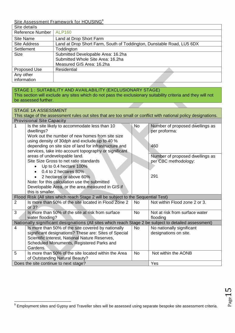
Site detailsReference Number ALP160
Site Name Land at Drop Short FarmSite Address Land at Drop Short Farm, South of Toddington, Dunstable Road, LU5 6DXSettlement ToddingtonSize Submitted Developable Area: 16.2ha
Submitted Whole Site Area: 16.2haMeasured GIS Area: 16.2ha
Proposed Use ResidentialAny otherinformation
STAGE 1 : SUITABILITY AND AVAILABILITY (EXCLUSIONARY STAGE)This section will exclude any sites which do not pass the exclusionary suitability criteria and they will notbe assessed further.
STAGE 1A ASSESSMENTThis stage of the assessment rules out sites that are too small or conflict with national policy designations.Provisional Site Capacity1 Is the site likely to accommodate less than 10
dwellings?Work out the number of new homes from site sizeusing density of 30dph and exclude up to 40 %depending on site size of land for infrastructure andservices, take into account topography or significantareas of undevelopable land.Site Size Gross to net ratio standards
Up to 0.4 hectare 100% 0.4 to 2 hectares 80% 2 hectares or above 60%
Note: for this calculation use the submittedDevelopable Area, or the area measured in GIS ifthis is smaller.
No Number of proposed dwellings asper proforma:
460
Number of proposed dwellings asper CBC methodology:
291
Flood Risk (All sites which reach Stage 2 will be subject to the Sequential Test)2 Is more than 50% of the site located in Flood Zone 2
or 3?No Not within Flood zone 2 or 3.
3 Is more than 50% of the site at risk from surfacewater flooding?
No Not at risk from surface waterflooding
Nationally significant designations (All sites which reach Stage 2 be subject to detailed assessment)4 Is more than 50% of the site covered by nationally
significant designations? These are: Sites of SpecialScientific Interest, National Nature Reserves,Scheduled Monuments, Registered Parks andGardens.
No No nationally significantdesignations on site.
5 Is more than 50% of the site located within the Areaof Outstanding Natural Beauty?
No Not within the AONB
Does the site continue to next stage? Yes
9Employment sites and Gypsy and Traveller sites will be assessed using separate bespoke site assessment criteria.
Pag
e16
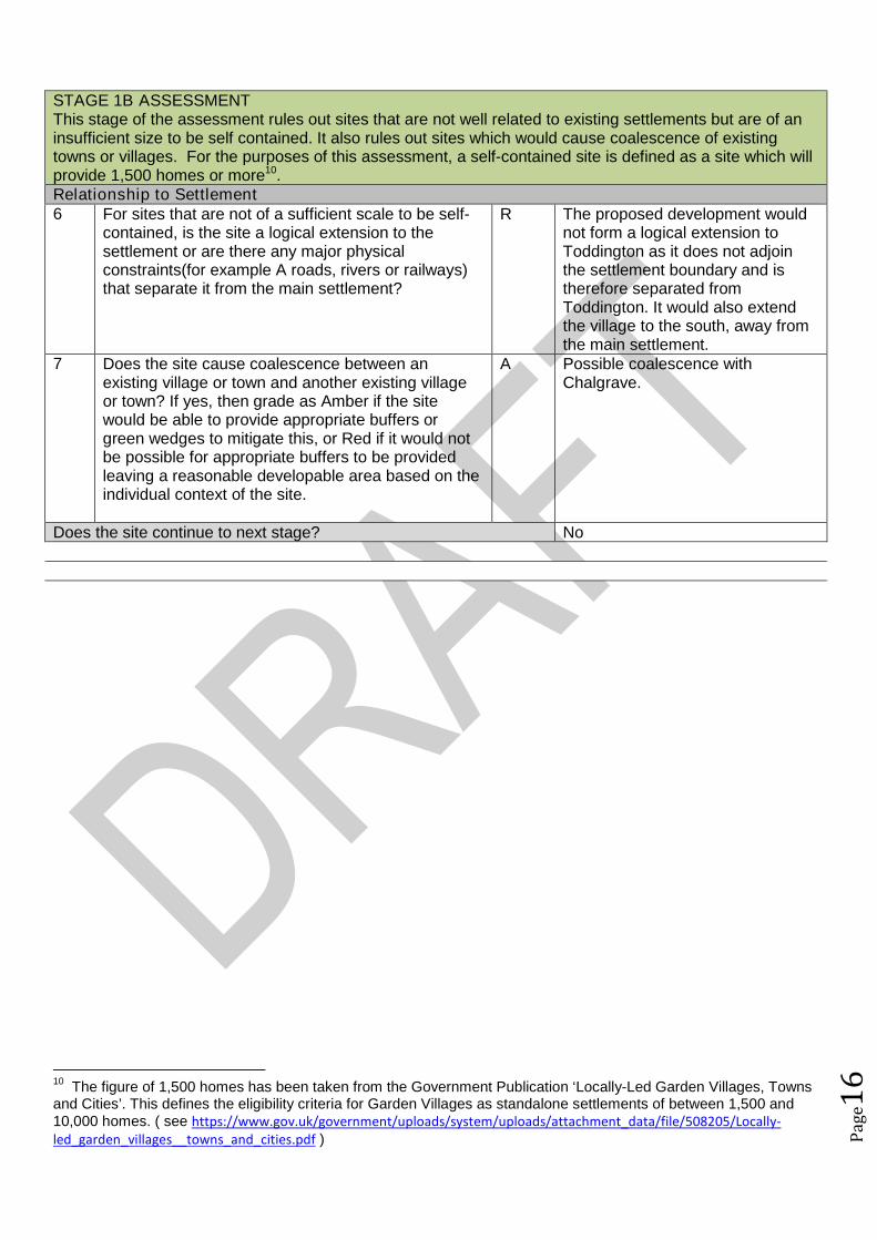
STAGE 1B ASSESSMENTThis stage of the assessment rules out sites that are not well related to existing settlements but are of aninsufficient size to be self contained. It also rules out sites which would cause coalescence of existingtowns or villages. For the purposes of this assessment, a self-contained site is defined as a site which willprovide 1,500 homes or more10.Relationship to Settlement6 For sites that are not of a sufficient scale to be self-
contained, is the site a logical extension to thesettlement or are there any major physicalconstraints(for example A roads, rivers or railways)that separate it from the main settlement?
R The proposed development wouldnot form a logical extension toToddington as it does not adjointhe settlement boundary and istherefore separated fromToddington. It would also extendthe village to the south, away fromthe main settlement.
7 Does the site cause coalescence between anexisting village or town and another existing villageor town? If yes, then grade as Amber if the sitewould be able to provide appropriate buffers orgreen wedges to mitigate this, or Red if it would notbe possible for appropriate buffers to be providedleaving a reasonable developable area based on theindividual context of the site.
A Possible coalescence withChalgrave.
Does the site continue to next stage? No
10The figure of 1,500 homes has been taken from the Government Publication ‘Locally-Led Garden Villages, Towns
and Cities’. This defines the eligibility criteria for Garden Villages as standalone settlements of between 1,500 and10,000 homes. ( see https://www.gov.uk/government/uploads/system/uploads/attachment_data/file/508205/Locally-led_garden_villages__towns_and_cities.pdf )
Pag
e17
Site Assessment Framework for HOUSING11
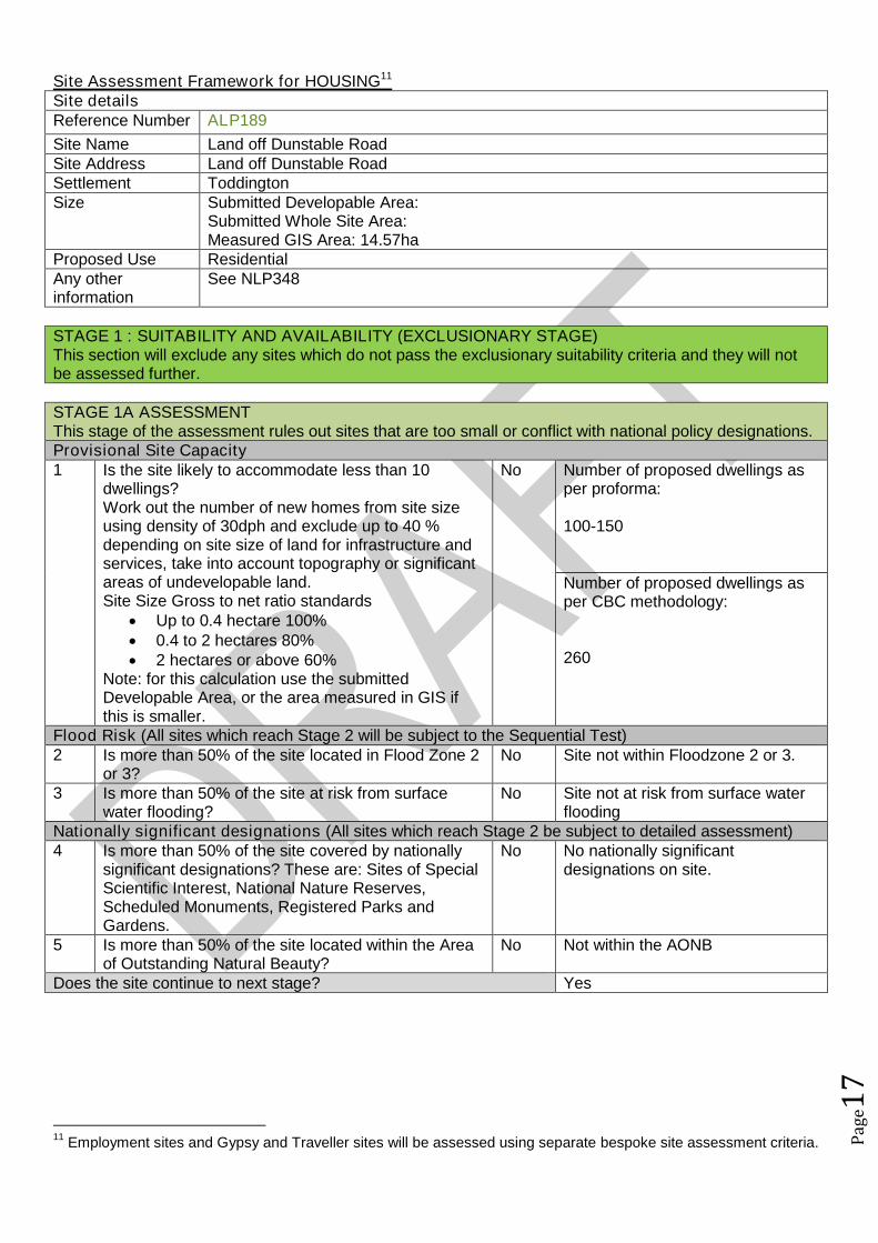
Site detailsReference Number ALP189
Site Name Land off Dunstable RoadSite Address Land off Dunstable RoadSettlement ToddingtonSize Submitted Developable Area:
Submitted Whole Site Area:Measured GIS Area: 14.57ha
Proposed Use ResidentialAny otherinformation
See NLP348
STAGE 1 : SUITABILITY AND AVAILABILITY (EXCLUSIONARY STAGE)This section will exclude any sites which do not pass the exclusionary suitability criteria and they will notbe assessed further.
STAGE 1A ASSESSMENTThis stage of the assessment rules out sites that are too small or conflict with national policy designations.Provisional Site Capacity1 Is the site likely to accommodate less than 10
dwellings?Work out the number of new homes from site sizeusing density of 30dph and exclude up to 40 %depending on site size of land for infrastructure andservices, take into account topography or significantareas of undevelopable land.Site Size Gross to net ratio standards
Up to 0.4 hectare 100% 0.4 to 2 hectares 80% 2 hectares or above 60%
Note: for this calculation use the submittedDevelopable Area, or the area measured in GIS ifthis is smaller.
No Number of proposed dwellings asper proforma:
100-150
Number of proposed dwellings asper CBC methodology:
260
Flood Risk (All sites which reach Stage 2 will be subject to the Sequential Test)2 Is more than 50% of the site located in Flood Zone 2
or 3?No Site not within Floodzone 2 or 3.
3 Is more than 50% of the site at risk from surfacewater flooding?
No Site not at risk from surface waterflooding
Nationally significant designations (All sites which reach Stage 2 be subject to detailed assessment)4 Is more than 50% of the site covered by nationally
significant designations? These are: Sites of SpecialScientific Interest, National Nature Reserves,Scheduled Monuments, Registered Parks andGardens.
No No nationally significantdesignations on site.
5 Is more than 50% of the site located within the Areaof Outstanding Natural Beauty?
No Not within the AONB
Does the site continue to next stage? Yes
11Employment sites and Gypsy and Traveller sites will be assessed using separate bespoke site assessment criteria.

Pag
e18
STAGE 1B ASSESSMENTThis stage of the assessment rules out sites that are not well related to existing settlements but are of aninsufficient size to be self contained. It also rules out sites which would cause coalescence of existingtowns or villages. For the purposes of this assessment, a self-contained site is defined as a site which willprovide 1,500 homes or more12.Relationship to Settlement6 For sites that are not of a sufficient scale to be self-
contained, is the site a logical extension to thesettlement or are there any major physicalconstraints(for example A roads, rivers or railways)that separate it from the main settlement?
A The site is located adjacent to thesettlement envelope of Toddingtonand if development wasconcentrated along the built-upedge and the remainder of the siteto the south west remainundeveloped the developmentwould be a logical extension toToddington and respect thelandscape.
7 Does the site cause coalescence between anexisting village or town and another existing villageor town? If yes, then grade as Amber if the sitewould be able to provide appropriate buffers orgreen wedges to mitigate this, or Red if it would notbe possible for appropriate buffers to be providedleaving a reasonable developable area based on theindividual context of the site.
G No coalescence.
Does the site continue to next stage? Yes
STAGE 1C ASSESSMENTThis stage of the assessment rules out sites that are not able to meet their critical infrastructure needs13.Critical Infrastructure8 Can the site meet the critical infrastructure
requirements that will enable delivery14?A Further information required.
Does the site continue to next stage? Yes
STAGE 1D ASSESSMENTThis stage of the assessment rules out sites that are not available. A site is considered available fordevelopment where there are no legal or ownership problems and the landowner has expressed anintention to develop the site.Availability9 What is the existing use of the site?
Would the existing use limit the developmentpotential?
G The site is a greenfield site.
10 Is the land controlled by a developer or land ownerwho has expressed an intention to develop the site?
GR A landowner of this site hascontacted the Council andconfirmed that they do not wish todevelop the site for housing.All
12The figure of 1,500 homes has been taken from the Government Publication ‘Locally-Led Garden Villages, Towns
and Cities’. This defines the eligibility criteria for Garden Villages as standalone settlements of between 1,500 and10,000 homes. ( see https://www.gov.uk/government/uploads/system/uploads/attachment_data/file/508205/Locally-led_garden_villages__towns_and_cities.pdf )13
Critical infrastructure is that which has been identified as infrastructure that must happen to enable physicaldevelopment. These infrastructure items are often known as ‘blockers’ or ‘showstoppers’, and are most common inrelation to transport and utilities infrastructure. Failure to provide these pieces of infrastructure could result insignificant delays in the delivery of development.14
This is an assessment based on the information known at this stage, a full assessment of infrastructurerequirements will be undertaken before any sites are allocated.
Pag
e19
landowners are intent ondeveloping the site.
11 Are there any legal or ownership problems that coulddelay or prevent development?If Yes, then can these be issues be realisticallyovercome?
G No legal or ownership problemsthat could delay or preventdevelopment.
12 Does the site already have planning permission forthe proposed use? If yes, then score as Redbecause it’s not eligible for allocation.
G No planning permission for theproposed use.
Does the site continue to next stage? YesNo
STAGE 1E ASSESSMENTThis section records the findings of the Strategic Green Belt Review and also provides a preliminaryscreening of sites to determine whether they may be capable of demonstrating ExceptionalCircumstances. Any site in the Green Belt that is determined as suitable based on the high level SHLAAassessment would still have to demonstrate Exceptional Circumstances to considered for allocation in thePlan.Greenbelt13 Is the site located within the Green Belt? Yes Site located within the green belt14 If answer to question 13 is yes, then does the site lie
within one of the parcels which have been identifiedin the Central Bedfordshire and Luton Green BeltStudy as making only a relatively weak, weak, or nocontribution? If yes, site progresses through to Stage2.
No Site not on an identified parcel.
15a Does the site have all of the following merits thatmay outweigh the harm to the Green Belt and whichmay contribute to identification of exceptionalcircumstances?
Adjoining settlement has at least 3 of thefollowing key local services - convenienceshop, lower school, middle school, upperschool, village hall, GP surgery, post office,library (use settlement audit)
Site makes a strong contribution to housingneed (100 plus homes) within the Luton HMA
Site is in or directly adjacent to a settlementthat has a mainline rail station or directassess (junction) to the strategic roadnetwork (A road or motorway)
Sites in Green Belt other than those covered by 14and 15b that cannot meet these criteria, will notprogress any further in this assessment ofsuitability.*
Yes The site meets the three listedcriteria.
15b Sites which have support from the local communityas demonstrated through an allocation in an adoptedor draft Neighbourhood Plan (that has been subjectto Regulation 14 consultation) that do not meet thecriteria in question 15a will automatically progressthrough this stage to be considered further at Stage2.15
N/A No draft ToddingtonNeighbourhood Plan withallocations at this stage.
Does the site continue to next stage? Yes
15Draft Neighbourhood Plan allocations in Green Belt that are proposed after this site assessment phase has
concluded, may still be considered for allocation.

Pag
e20
STAGE 2 : SUITABILITY (DETAILED ASSESSMENT)STAGE 2 ASSESSMENTThis stage further assesses the site’s suitability using detailed desktop assessment. A red rating for anyquestion does not mean that the site will be automatically excluded at this stage as the ratings acrossStage 2A will be looked at as a whole using planning balance.Previously Developed Land16 Is the site Previously Developed Land in accordance
with the NPPF definition? 76% - 100% (G) 26 - 75% (A) 25% - 0% (Greenfield) (R)
R Site greenfield
Community17 Neighbourhood Planning (only applicable in
designated areas)Is the site identified as a housing allocation in anemerging Neighbourhood Plan?
No Toddington Neighbourhood Plan inearly stages.
18 Community ConsultationHas any community consultation taken place?If yes, provide brief details on the form thisconsultation took and any overall communityresponse.
No No community consultation
19 Sustainability of SettlementWould this proposal impact on the sustainability ofthe settlement through the loss of services andfacilities (for example, employment, retail, publichouse etc)
No The proposal would not impact onthe sustainability of the settlement.
Cumulative Impact20 Considering housing completions over the past 10
years, what has been the level of housing growth inthe parish?
Less than 5% growth (G) 5% to 20% growth (A) More than 20% growth (R)
This is calculated by working out the total number ofcompletions over the last ten years as a percentageof the dwellings in April 2006 (as calculated usingcensus and completions data).
G Homes in 2006: 1906Homes in 2016: 1960
2.83% increase in new homes.
21 What level of housing growth would there be if all theoutstanding permissions (as of April 2016) were tobe completed?
Less than 5% growth (G) 5% to 20% growth (A) More than 20% growth (R)
This is calculated by working out the total number ofoutstanding permissions as of April 1st 2016 aspercentage of the total number of dwellings in April2016 (as calculated using census and completionsdata).
G Outstanding permissions increaseby 0.26%
Physical Constraints22 Are there any physical constraints or permanent
features that affect the site’s developability?For example pylons, gas works, sewage treatmentworks, topography or wind turbines.
A As a whole the site has limitedphysical constraints however thesouthern and south westernportions of the site do slope, whichhas the potential to affectdevelopability.
Relationship to Settlement

Pag
e21
23 Would development of the site be complementary tothe existing settlement pattern, and would it have anadverse impact on any historic, unique or distinctivecharacteristics of the settlement’s built or naturalform?
A The site would extend thesettlement envelope southwardsaway from the village centre.
Agricultural Land Quality24 Would the development impact on high quality
agricultural land? 50% or more in non-agricultural land (G) 50% of more in Grade 3b, 4 or 5 (A) 50% or more in Grade 1, 2 or 3a (R)
R Grade 3
STAGE 2 ASSESSMENTThis stage further assesses the site’s suitability using comments from technical specialists. A red rating forany question does not mean that the site will be automatically excluded at this stage as the ratings acrossStage 2B will be looked at as a whole using planning balance.Transport and Access to Services25 Facilities and services
Question 26 considers the suitability and sustainability of the site for housing. It links to theCouncil’s Settlement Hierarchy Audit.
Issues relating to capacity are assessed separately25a Does the settlement have a Primary/Lower school?
Yes, in the settlement (G) Yes, proposed as part of the development (G) No, but an adjoining settlement does (A) Not in the settlement or an adjoining
settlement (R)
G Yes in settlement
25b Does the settlement have a Middle school (ifapplicable)?
Yes, in the settlement (G) Yes, proposed as part of the development (G) No, but an adjoining settlement does (A) Other catchment school available (A)
G Yes in settlement
25c Does the settlement have a Secondary/ Upperschool?
Yes, in the settlement (G) Yes, proposed as part of the development (G) No, but an adjoining settlement does (A) Other catchment school available (A)
A Adjoining settlement (Harlington)
25d Does the settlement have a GPs surgery or medicalcentre?
Yes, in the settlement (G) Yes, proposed as part of the development (G) No, but an adjoining settlement does (A) Not in the settlement or an adjoining
settlement (R)
G Yes in settlement
26 What retail provision does the settlement offer? Town Centre/ Supermarket (G) Convenience Store / Post Office / Newsagent
(A) None (R)
A Convenience Store, post office andnewsagent
27 Distance to bus stops with a frequent service (atleast hourly at peak times):
Less than 400m (G)
G 371m
Pag
e22
400m-800m (A) Over 800m (R) OR submission form stated that improved
public transport facilities could be provided aspart of the development (G)
28 Distance to nearest train station: Less than 800m (G) 800m-1200m (A) Over 1200m (R)
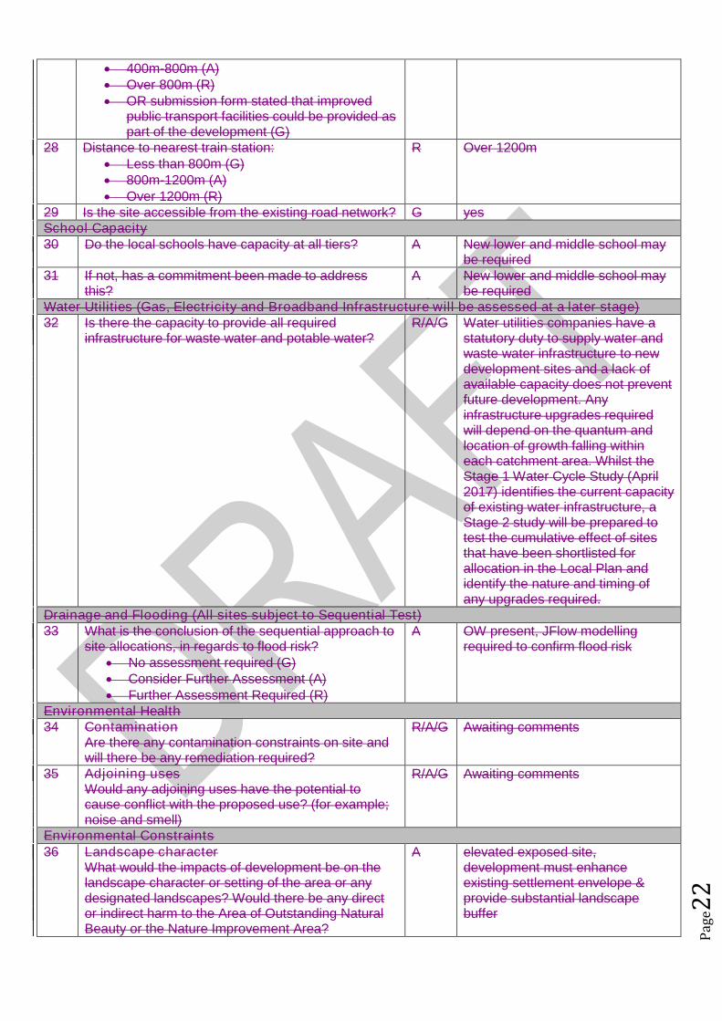
R Over 1200m
29 Is the site accessible from the existing road network? G yesSchool Capacity30 Do the local schools have capacity at all tiers? A New lower and middle school may
be required31 If not, has a commitment been made to address
this?A New lower and middle school may
be requiredWater Utilities (Gas, Electricity and Broadband Infrastructure will be assessed at a later stage)32 Is there the capacity to provide all required
infrastructure for waste water and potable water?R/A/G Water utilities companies have a
statutory duty to supply water andwaste water infrastructure to newdevelopment sites and a lack ofavailable capacity does not preventfuture development. Anyinfrastructure upgrades requiredwill depend on the quantum andlocation of growth falling withineach catchment area. Whilst theStage 1 Water Cycle Study (April2017) identifies the current capacityof existing water infrastructure, aStage 2 study will be prepared totest the cumulative effect of sitesthat have been shortlisted forallocation in the Local Plan andidentify the nature and timing ofany upgrades required.
Drainage and Flooding (All sites subject to Sequential Test)33 What is the conclusion of the sequential approach to
site allocations, in regards to flood risk? No assessment required (G) Consider Further Assessment (A) Further Assessment Required (R)
A OW present, JFlow modellingrequired to confirm flood risk
Environmental Health34 Contamination
Are there any contamination constraints on site andwill there be any remediation required?
R/A/G Awaiting comments
35 Adjoining usesWould any adjoining uses have the potential tocause conflict with the proposed use? (for example;noise and smell)
R/A/G Awaiting comments
Environmental Constraints36 Landscape character
What would the impacts of development be on thelandscape character or setting of the area or anydesignated landscapes? Would there be any director indirect harm to the Area of Outstanding NaturalBeauty or the Nature Improvement Area?
A elevated exposed site,development must enhanceexisting settlement envelope &provide substantial landscapebuffer

Pag
e23
37 Heritage/ ArchaeologyWhat would the impacts of development be on anyheritage assets and their setting?Are there any opportunities for enhancement ofthese assets?
A Site has multi-periodarchaeological potential but thiswould not prevent allocationproviding appropriate mitigationis undertaken
38 Ecological AssetsWhat would the impacts of development be on anybiological, geological or ecological assets and arethere any opportunities for their enhancement?
A Dropshot Marsh SSSI ons.boundary but good bufferingshown on preliminary proposal ,potential farmland species impact,good opportunities forenhancement.
39 Open space/leisure and GI assetsAre there any potential conflicts with open space,leisure designations or Rights of Way? Is therecapacity to provide the required levels of open spaceand green infrastructure?
R/A/ Extensive ROW network aroundand across site. Would need to beenhanced / set within greencorridors. Site includes existingallotments, would need to beretained, and developmentdesigned to relate positively to thisexisting asset. Existing woodlandincluding SSSI on southernboundary, would need protecting,enhancing extending and buffering.Loss of The Glebe Small AmenitySpace, The Glebe Sports Field,Dunstable Road Allotments andpartial loss of Dropshort Marsh.
Minerals and Waste40 What would the impacts of development be on
safeguarded minerals and waste sites, includingmineral safeguarding sites?
G No issues
Planning History41 What is the sites planning history? (For example
planning applications and submissions to previousAllocations Plans)
No relevant planning history
Does the site continue to next stage? Yes
STAGE 2 ASSESSMENT CONCLUSIONIs the site suitable for the proposed development?
On balance the whole site is not considered appropriate for further assessment. However, due toits impact on landscape, site size and scale a portion would be considered more acceptable.
The site is located in the south of Toddington and would extend the settlement southwards. The site is in an elevated position, which would expose this site in landscape terms. The site is large in scale in relation to the village and its size together with location would
adversely impact upon the character and pattern of development, which has benconstrained due to the Green Belt, in Toddington.
As such a portion of the site will be considered further.
STAGE 3 : ACHIEVABILITYThis section assesses whether the site is Achievable in line with NPPG Guidance:A site is considered achievable for development where there is a reasonable prospect that the particulartype of development will be developed on the site at a particular point in time. This is essentially ajudgement about the economic viability of the site, and the capacity of the developer to complete and let or

Pag
e24
sell the development over a certain period.
Viability43 Referring to the Viability Assessment undertaken by
consultants, is the probability of the site being viablehigh, medium or low?
High (G) Benchmark land value comfortablyexceeded by likely residual value
Low (A) Marginal viability, with likely residualland value close to benchmark land value
Very Low (R) Likely residual value well belowbenchmark land value
A The Council’s ResidentialDevelopment Viability Report (Feb2017) indicates that residual valueof development in this value areaand at this scale with £38kinfrastructure costs would notexceed the upper benchmark landvalue and as such the reportindicates that such developmentmay not be viable.
However the Council’s ResidentialDevelopment Viability Report (Feb2017) is based upon residentialproperty figures between 2013 and2016 and based on the averagebuilding costs during 2016. Thehousing market within CentralBedfordshire has seen significantincreases in residential propertyvalues in a relatively short period oftime, whereby it is considered thatthe viability of developments withinthis report has been cautious. Forexample in 2016 Dunstable hasbenefited from a 17.9% housingprice increase with an averageannual house price increase in2016 for housing within CentralBedfordshire of 10.74%.
This increase in property value hasbeen a result of not only nationaltrends in house prices and existingtransport links to economicallysuccessful areas but alsosignificant infrastructure projectswithin the pipeline including: East-West Rail; M1-A5 link road; A421upgrades; Oxford to CambridgeExpress Way; Luton and DunstableGuided Busway; M1 improvements;and potential A1 improvements. Itis considered that as suchinfrastructure projects progress thatproperty prices within the LocalAuthority will likely continue toincrease which has and willincrease viability/deliverability ofdevelopment not only in the highervalue areas but also the lowervalue areas of the Authority.
For the reasons outlined above it is

Pag
e25
considered that this scale ofdevelopment within this value areamay be viable.
Achievability44 Are there any market factors which would affect
deliverability?The Council’s ResidentialDevelopment Viability Report (Feb2017) is based upon residentialproperty figures between 2013 and2016. The housing market withinCentral Bedfordshire has seensignificant increases in residentialproperty values in a relatively shortperiod of time, whereby it isconsidered that the viability ofdevelopments within this report hasbeen cautious. For example in2016 Dunstable has benefited froma 17.9% housing price increasewith an average annual house priceincrease in 2016 for housing withinCentral Bedfordshire of 10.74%.
This increase in property value hasbeen a result of not only nationaltrends in house prices and existingtransport links to economicallysuccessful areas but alsosignificant infrastructure projectswithin the pipeline including: East-West Rail; M1-A5 link road; A421upgrades; Oxford to CambridgeExpress Way; Luton and DunstableGuided Busway; M1 improvements;and potential A1 improvements. Itis considered that as suchinfrastructure projects progress thatproperty prices within the LocalAuthority will likely continue toincrease which has and willincrease viability/deliverability ofdevelopment not only in the highervalue areas but also the lowervalue areas of the Authority.
45 When can the scheme realistically commencedelivery?
0 to 5 years (deliverable) 6 to 10 years 11 to 15 years 15 to 20 years Outside Plan Period
0 to 5 years
46 What is the indicative build out time of the site? The Case Study Sites outlinedwithin the Council’s ResidentialDevelopment Viability Report (Feb2017) indicates that after the sitehas received detailed planningpermission two housebuilderswould likely take one year to first
Pag
e26
completion and would build out thesite at a rate of 100 dwellings perannum there after.
Does the site pass this stage? Yes
SUMMARY
The sites that pass through this assessment process will not automatically be allocated for development inthe Local Plan.
Sites will be selected with reference to a number of other factors including: The strategy, vision and objectives proposed in the draft plan Technical evidence studies The sustainability appraisal process The results of public consultation Flood Risk Sequential Approach Further transport modelling Consultation with neighbouring authorities
Pag
e27
Site Assessment Framework for HOUSING16
Site detailsReference Number ALP193
Site Name Briarmead FarmSite Address Briarmead FarmSettlement ToddingtonSize Submitted Developable Area: 2.2ha
Submitted Whole Site Area: 2.2haMeasured GIS Area:2.03ha
Proposed Use ResidentialAny otherinformation
STAGE 1 : SUITABILITY AND AVAILABILITY (EXCLUSIONARY STAGE)This section will exclude any sites which do not pass the exclusionary suitability criteria and they will notbe assessed further.
STAGE 1A ASSESSMENTThis stage of the assessment rules out sites that are too small or conflict with national policy designations.Provisional Site Capacity1 Is the site likely to accommodate less than 10
dwellings?Work out the number of new homes from site sizeusing density of 30dph and exclude up to 40 %depending on site size of land for infrastructure andservices, take into account topography or significantareas of undevelopable land.Site Size Gross to net ratio standards
Up to 0.4 hectare 100% 0.4 to 2 hectares 80% 2 hectares or above 60%
Note: for this calculation use the submittedDevelopable Area, or the area measured in GIS ifthis is smaller.
no Number of proposed dwellings asper proforma:
30
Number of proposed dwellings asper CBC methodology:
36
Flood Risk (All sites which reach Stage 2 will be subject to the Sequential Test)2 Is more than 50% of the site located in Flood Zone 2
or 3?No Not in Floodzone 2 and 3
3 Is more than 50% of the site at risk from surfacewater flooding?
No Not at risk from surface waterflooding
Nationally significant designations (All sites which reach Stage 2 be subject to detailed assessment)4 Is more than 50% of the site covered by nationally
significant designations? These are: Sites of SpecialScientific Interest, National Nature Reserves,Scheduled Monuments, Registered Parks andGardens.
No Not within nationally significantdesignation
5 Is more than 50% of the site located within the Areaof Outstanding Natural Beauty?
No Not within AONB
Does the site continue to next stage? Yes
16Employment sites and Gypsy and Traveller sites will be assessed using separate bespoke site assessment criteria.

Pag
e28
STAGE 1B ASSESSMENTThis stage of the assessment rules out sites that are not well related to existing settlements but are of aninsufficient size to be self contained. It also rules out sites which would cause coalescence of existingtowns or villages. For the purposes of this assessment, a self-contained site is defined as a site which willprovide 1,500 homes or more17.Relationship to Settlement6 For sites that are not of a sufficient scale to be self-
contained, is the site a logical extension to thesettlement or are there any major physicalconstraints(for example A roads, rivers or railways)that separate it from the main settlement?
R The site is separate from thesettlement of Toddington and is notwell related to be an extension tothe village.
7 Does the site cause coalescence between anexisting village or town and another existing villageor town? If yes, then grade as Amber if the sitewould be able to provide appropriate buffers orgreen wedges to mitigate this, or Red if it would notbe possible for appropriate buffers to be providedleaving a reasonable developable area based on theindividual context of the site.
G The site would not causecoalescence.
Does the site continue to next stage? No
17The figure of 1,500 homes has been taken from the Government Publication ‘Locally-Led Garden Villages, Towns
and Cities’. This defines the eligibility criteria for Garden Villages as standalone settlements of between 1,500 and10,000 homes. ( see https://www.gov.uk/government/uploads/system/uploads/attachment_data/file/508205/Locally-led_garden_villages__towns_and_cities.pdf )

Pag
e29
Site Assessment Framework for HOUSING18
Site detailsReference Number ALP227
Site Name Crowbush FarmSite AddressSettlement ToddingtonSize Submitted Developable Area:
Submitted Whole Site Area: 23.4haMeasured GIS Area: 32.89ha
Proposed Use Residential development including recreational open spaceAny otherinformation
See NLP453
STAGE 1 : SUITABILITY AND AVAILABILITY (EXCLUSIONARY STAGE)This section will exclude any sites which do not pass the exclusionary suitability criteria and they will notbe assessed further.
STAGE 1A ASSESSMENTThis stage of the assessment rules out sites that are too small or conflict with national policy designations.Provisional Site Capacity1 Is the site likely to accommodate less than 10
dwellings?Work out the number of new homes from site sizeusing density of 30dph and exclude up to 40 %depending on site size of land for infrastructure andservices, take into account topography or significantareas of undevelopable land.Site Size Gross to net ratio standards
Up to 0.4 hectare 100% 0.4 to 2 hectares 80% 2 hectares or above 60%
Note: for this calculation use the submittedDevelopable Area, or the area measured in GIS ifthis is smaller.
No Number of proposed dwellings asper proforma:
150-350
Number of proposed dwellings asper CBC methodology:
600
Flood Risk (All sites which reach Stage 2 will be subject to the Sequential Test)2 Is more than 50% of the site located in Flood Zone 2
or 3?No Not within Floodzone 2 or 3
3 Is more than 50% of the site at risk from surfacewater flooding?
No Not at risk from surface waterflooding
Nationally significant designations (All sites which reach Stage 2 be subject to detailed assessment)4 Is more than 50% of the site covered by nationally
significant designations? These are: Sites of SpecialScientific Interest, National Nature Reserves,Scheduled Monuments, Registered Parks andGardens.
No No nationally significantdesignations on site.
5 Is more than 50% of the site located within the Areaof Outstanding Natural Beauty?
No Not within the AONB
Does the site continue to next stage? Yes
18Employment sites and Gypsy and Traveller sites will be assessed using separate bespoke site assessment criteria.

Pag
e30
STAGE 1B ASSESSMENTThis stage of the assessment rules out sites that are not well related to existing settlements but are of aninsufficient size to be self contained. It also rules out sites which would cause coalescence of existingtowns or villages. For the purposes of this assessment, a self-contained site is defined as a site which willprovide 1,500 homes or more19.Relationship to Settlement6 For sites that are not of a sufficient scale to be self-
contained, is the site a logical extension to thesettlement or are there any major physicalconstraints(for example A roads, rivers or railways)that separate it from the main settlement?
A The site is an extension toToddington and could form alogical extension to the settlementto the south. Development on thissite would be a considerabledistance from the village centre.
7 Does the site cause coalescence between anexisting village or town and another existing villageor town? If yes, then grade as Amber if the sitewould be able to provide appropriate buffers orgreen wedges to mitigate this, or Red if it would notbe possible for appropriate buffers to be providedleaving a reasonable developable area based on theindividual context of the site.
A Possible coalescence with Fancott.
Does the site continue to next stage? Yes
STAGE 1C ASSESSMENTThis stage of the assessment rules out sites that are not able to meet their critical infrastructure needs20.Critical Infrastructure8 Can the site meet the critical infrastructure
requirements that will enable delivery21?G Form states that critical
infrastructure can be provided.Does the site continue to next stage? Yes
STAGE 1D ASSESSMENTThis stage of the assessment rules out sites that are not available. A site is considered available fordevelopment where there are no legal or ownership problems and the landowner has expressed anintention to develop the site.Availability9 What is the existing use of the site?
Would the existing use limit the developmentpotential?
G Site currently in use as residential,employment and greenfield.
10 Is the land controlled by a developer or land ownerwho has expressed an intention to develop the site?
GR Site promoted by owners.Alandowner of this site hascontacted the Council andconfirmed that they do not wish todevelop the site for housing.
11 Are there any legal or ownership problems that coulddelay or prevent development?If Yes, then can these be issues be realistically
G No legal or ownership problems.
19The figure of 1,500 homes has been taken from the Government Publication ‘Locally-Led Garden Villages, Towns
and Cities’. This defines the eligibility criteria for Garden Villages as standalone settlements of between 1,500 and10,000 homes. ( see https://www.gov.uk/government/uploads/system/uploads/attachment_data/file/508205/Locally-led_garden_villages__towns_and_cities.pdf )20
Critical infrastructure is that which has been identified as infrastructure that must happen to enable physicaldevelopment. These infrastructure items are often known as ‘blockers’ or ‘showstoppers’, and are most common inrelation to transport and utilities infrastructure. Failure to provide these pieces of infrastructure could result insignificant delays in the delivery of development.21
This is an assessment based on the information known at this stage, a full assessment of infrastructurerequirements will be undertaken before any sites are allocated.

Pag
e31
overcome?12 Does the site already have planning permission for
the proposed use? If yes, then score as Redbecause it’s not eligible for allocation.
G No existing planning permission.
Does the site continue to next stage? YesNo
STAGE 1E ASSESSMENTThis section records the findings of the Strategic Green Belt Review and also provides a preliminaryscreening of sites to determine whether they may be capable of demonstrating ExceptionalCircumstances. Any site in the Green Belt that is determined as suitable based on the high level SHLAAassessment would still have to demonstrate Exceptional Circumstances to considered for allocation in thePlan.Greenbelt13 Is the site located within the Green Belt? Yes Site located within the green belt.14 If answer to question 13 is yes, then does the site lie
within one of the parcels which have been identifiedin the Central Bedfordshire and Luton Green BeltStudy as making only a relatively weak, weak, or nocontribution? If yes, site progresses through to Stage2.
No Not within an identified parcel
15a Does the site have all of the following merits thatmay outweigh the harm to the Green Belt and whichmay contribute to identification of exceptionalcircumstances?
Adjoining settlement has at least 3 of thefollowing key local services - convenienceshop, lower school, middle school, upperschool, village hall, GP surgery, post office,library (use settlement audit)
Site makes a strong contribution to housingneed (100 plus homes) within the Luton HMA
Site is in or directly adjacent to a settlementthat has a mainline rail station or directassess (junction) to the strategic roadnetwork (A road or motorway)
Sites in Green Belt other than those covered by 14and 15b that cannot meet these criteria, will notprogress any further in this assessment ofsuitability.*
Yes Site meets three listed merits.
15b Sites which have support from the local communityas demonstrated through an allocation in an adoptedor draft Neighbourhood Plan (that has been subjectto Regulation 14 consultation) that do not meet thecriteria in question 15a will automatically progressthrough this stage to be considered further at Stage2.22
N/A No draft ToddingtonNeighbourhood Plan withallocations at this stage.
Does the site continue to next stage? Yes
STAGE 2 : SUITABILITY (DETAILED ASSESSMENT)STAGE 2 ASSESSMENTThis stage further assesses the site’s suitability using detailed desktop assessment. A red rating for anyquestion does not mean that the site will be automatically excluded at this stage as the ratings acrossStage 2A will be looked at as a whole using planning balance.
22Draft Neighbourhood Plan allocations in Green Belt that are proposed after this site assessment phase has
concluded, may still be considered for allocation.

Pag
e32
Previously Developed Land16 Is the site Previously Developed Land in accordance
with the NPPF definition? 76% - 100% (G) 26 - 75% (A) 25% - 0% (Greenfield) (R)
R Site is greenfield
Community17 Neighbourhood Planning (only applicable in
designated areas)Is the site identified as a housing allocation in anemerging Neighbourhood Plan?
No Toddington Neighbourhood Plan inearly stages.
18 Community ConsultationHas any community consultation taken place?If yes, provide brief details on the form thisconsultation took and any overall communityresponse.
No No community consultation.
19 Sustainability of SettlementWould this proposal impact on the sustainability ofthe settlement through the loss of services andfacilities (for example, employment, retail, publichouse etc)
No The proposal would not impact onthe sustainability of the settlement.
Cumulative Impact20 Considering housing completions over the past 10
years, what has been the level of housing growth inthe parish?
Less than 5% growth (G) 5% to 20% growth (A) More than 20% growth (R)
This is calculated by working out the total number ofcompletions over the last ten years as a percentageof the dwellings in April 2006 (as calculated usingcensus and completions data).
G Number of homes in 2006:1906Number of homes in 2016: 1960
A growth of 2.83%.
21 What level of housing growth would there be if all theoutstanding permissions (as of April 2016) were tobe completed?
Less than 5% growth (G) 5% to 20% growth (A) More than 20% growth (R)
This is calculated by working out the total number ofoutstanding permissions as of April 1st 2016 aspercentage of the total number of dwellings in April2016 (as calculated using census and completionsdata).
G Outstanding permissions would bean additional 0.26%.
Physical Constraints22 Are there any physical constraints or permanent
features that affect the site’s developability?For example pylons, gas works, sewage treatmentworks, topography or wind turbines.
A The site slopes down towardsFancott. Toddington is elevatedand development of this whole sitewould mean developmentextending down the slope, which isout of keeping with the character ofthe village.
Relationship to Settlement23 Would development of the site be complementary to
the existing settlement pattern, and would it have anadverse impact on any historic, unique or distinctivecharacteristics of the settlement’s built or natural
A The site extends the settlementpattern of Toddington southeastwards which is not withinkeeping of the character of

Pag
e33
form? Toddington. The site also results incoalescence with Fancott
Agricultural Land Quality24 Would the development impact on high quality
agricultural land? 50% or more in non-agricultural land (G) 50% of more in Grade 3b, 4 or 5 (A) 50% or more in Grade 1, 2 or 3a (R)
A Grade 3
STAGE 2 ASSESSMENTThis stage further assesses the site’s suitability using comments from technical specialists. A red rating forany question does not mean that the site will be automatically excluded at this stage as the ratings acrossStage 2B will be looked at as a whole using planning balance.Transport and Access to Services25 Facilities and services
Question 26 considers the suitability and sustainability of the site for housing. It links to theCouncil’s Settlement Hierarchy Audit.
Issues relating to capacity are assessed separately25a Does the settlement have a Primary/Lower school?
Yes, in the settlement (G) Yes, proposed as part of the development (G) No, but an adjoining settlement does (A) Not in the settlement or an adjoining
settlement (R)
G Yes in settlement
25b Does the settlement have a Middle school (ifapplicable)?
Yes, in the settlement (G) Yes, proposed as part of the development (G) No, but an adjoining settlement does (A) Other catchment school available (A)
G Yes in settlement
25c Does the settlement have a Secondary/ Upperschool?
Yes, in the settlement (G) Yes, proposed as part of the development (G) No, but an adjoining settlement does (A) Other catchment school available (A)
A Adjoining settlement (Harlington)
25d Does the settlement have a GPs surgery or medicalcentre?
Yes, in the settlement (G) Yes, proposed as part of the development (G) No, but an adjoining settlement does (A) Not in the settlement or an adjoining
settlement (R)
G Yes in settlement
26 What retail provision does the settlement offer? Town Centre/ Supermarket (G) Convenience Store / Post Office / Newsagent
(A) None (R)
A Convenience Store, post office andnewsagent
27 Distance to bus stops with a frequent service (atleast hourly at peak times):
Less than 400m (G) 400m-800m (A) Over 800m (R) OR submission form stated that improved
R Over 800m
Pag
e34
public transport facilities could be provided aspart of the development (G)
28 Distance to nearest train station: Less than 800m (G) 800m-1200m (A) Over 1200m (R)
R Over 1200m
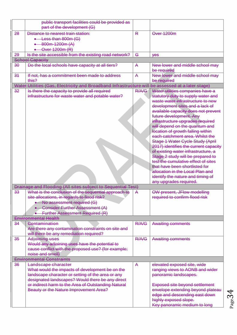
29 Is the site accessible from the existing road network? G yesSchool Capacity30 Do the local schools have capacity at all tiers? A New lower and middle school may
be required31 If not, has a commitment been made to address
this?A New lower and middle school may
be requiredWater Utilities (Gas, Electricity and Broadband Infrastructure will be assessed at a later stage)32 Is there the capacity to provide all required
infrastructure for waste water and potable water?R/A/G Water utilities companies have a
statutory duty to supply water andwaste water infrastructure to newdevelopment sites and a lack ofavailable capacity does not preventfuture development. Anyinfrastructure upgrades requiredwill depend on the quantum andlocation of growth falling withineach catchment area. Whilst theStage 1 Water Cycle Study (April2017) identifies the current capacityof existing water infrastructure, aStage 2 study will be prepared totest the cumulative effect of sitesthat have been shortlisted forallocation in the Local Plan andidentify the nature and timing ofany upgrades required.
Drainage and Flooding (All sites subject to Sequential Test)33 What is the conclusion of the sequential approach to
site allocations, in regards to flood risk? No assessment required (G) Consider Further Assessment (A) Further Assessment Required (R)
A OW present, JFlow modellingrequired to confirm flood risk
Environmental Health34 Contamination
Are there any contamination constraints on site andwill there be any remediation required?
R/A/G Awaiting comments
35 Adjoining usesWould any adjoining uses have the potential tocause conflict with the proposed use? (for example;noise and smell)
R/A/G Awaiting comments
Environmental Constraints36 Landscape character
What would the impacts of development be on thelandscape character or setting of the area or anydesignated landscapes? Would there be any director indirect harm to the Area of Outstanding NaturalBeauty or the Nature Improvement Area?
A elevated exposed site, wideranging views to AONB and widerpanoramic landscapes.
Exposed site beyond settlementenvelope extending beyond plateauedge and descending east downhighly exposed slope.Key panoramic medium to long
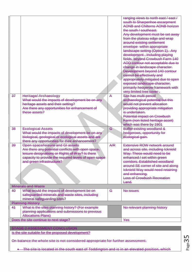
Pag
e35
ranging views to north east / east /south to Sharpenhoe escarpmentAONB and Chilterns AONB horizonthe south / southeast.Any development must be set awayfrom the plateau edge and wraparound existing settlementenvelope within appropriatelandscape setting (Option 1). Anydevelopment , including playingfields, beyond Crowbush Farm 140AOD contour not acceptable due tochange in landscape character.Development beyond 140 contourcannot be effectively andappropriately mitigated due to openexposed landscape character,primarily hedgerow framework withvery limited tree cover ,
37 Heritage/ ArchaeologyWhat would the impacts of development be on anyheritage assets and their setting?Are there any opportunities for enhancement ofthese assets?
A Site has multi-periodarchaeological potential but thiswould not prevent allocationproviding appropriate mitigationis undertaken.Potential impact on CrowbushFarm (non listed heritage asset)which was there by 1901
38 Ecological AssetsWhat would the impacts of development be on anybiological, geological or ecological assets and arethere any opportunities for their enhancement?
G Buffer existing woodland &hedgerows, opportunity forecological gain.
39 Open space/leisure and GI assetsAre there any potential conflicts with open space,leisure designations or Rights of Way? Is therecapacity to provide the required levels of open spaceand green infrastructure?
A/R Extensive ROW network aroundand across site, including IcknieldWay. These would need to beenhanced / set within greencorridors. Established woodlandaround SE corner of site and alongIcknield Way would need retainingand enhancing.Loss of Crowbush RecreationLand.
Minerals and Waste40 What would the impacts of development be on
safeguarded minerals and waste sites, includingmineral safeguarding sites?
G No issues
Planning History41 What is the sites planning history? (For example
planning applications and submissions to previousAllocations Plans)
No relevant planning history
Does the site continue to next stage? Yes
STAGE 2 ASSESSMENT CONCLUSIONIs the site suitable for the proposed development?
On balance the whole site is not considered appropriate for further assessment.
The site is located in the south east of Toddington and is in an elevated position, which

Pag
e36
would expose this site and village in landscape terms. The site is also large in scale in relation to the village and its size together with location
would adversely impact upon the character and pattern of development, which has benconstrained due to the Green Belt, in Toddington.
The size of the site and its extend towards Fancott could potentially result in coalescencewith Fancott.
The development would result in the loss of recreation land. In order to safeguard the landscape and views from the site, development must be set away
from the plateau edge and wrap around existing settlement envelope and must not extendbeyond contour 140 due to the unacceptable changes in landscape character.
As such it is only considered that a small portion of this site, adjoining the boundary withToddington could be considered appropriate for further consideration.
STAGE 3 : ACHIEVABILITYThis section assesses whether the site is Achievable in line with NPPG Guidance:A site is considered achievable for development where there is a reasonable prospect that the particulartype of development will be developed on the site at a particular point in time. This is essentially ajudgement about the economic viability of the site, and the capacity of the developer to complete and let orsell the development over a certain period.
Viability43 Referring to the Viability Assessment undertaken by
consultants, is the probability of the site being viablehigh, medium or low?
High (G) Benchmark land value comfortablyexceeded by likely residual value
Low (A) Marginal viability, with likely residualland value close to benchmark land value
Very Low (R) Likely residual value well belowbenchmark land value
A The Council’s ResidentialDevelopment Viability Report (Feb2017) indicates that residual valueof development in this value areaand at this scale with £38kinfrastructure costs would notexceed the upper benchmark landvalue and as such the reportindicates that such developmentmay not be viable.
However the Council’s ResidentialDevelopment Viability Report (Feb2017) is based upon residentialproperty figures between 2013 and2016 and based on the averagebuilding costs during 2016. Thehousing market within CentralBedfordshire has seen significantincreases in residential propertyvalues in a relatively short period oftime, whereby it is considered thatthe viability of developments withinthis report has been cautious. Forexample in 2016 Dunstable hasbenefited from a 17.9% housingprice increase with an averageannual house price increase in2016 for housing within CentralBedfordshire of 10.74%.
This increase in property value hasbeen a result of not only nationaltrends in house prices and existingtransport links to economically

Pag
e37
successful areas but alsosignificant infrastructure projectswithin the pipeline including: East-West Rail; M1-A5 link road; A421upgrades; Oxford to CambridgeExpress Way; Luton and DunstableGuided Busway; M1 improvements;and potential A1 improvements. Itis considered that as suchinfrastructure projects progress thatproperty prices within the LocalAuthority will likely continue toincrease which has and willincrease viability/deliverability ofdevelopment not only in the highervalue areas but also the lowervalue areas of the Authority.
For the reasons outlined above it isconsidered that this scale ofdevelopment within this value areamay be viable.
Achievability44 Are there any market factors which would affect
deliverability?The Council’s ResidentialDevelopment Viability Report (Feb2017) is based upon residentialproperty figures between 2013 and2016. The housing market withinCentral Bedfordshire has seensignificant increases in residentialproperty values in a relatively shortperiod of time, whereby it isconsidered that the viability ofdevelopments within this report hasbeen cautious. For example in2016 Dunstable has benefited froma 17.9% housing price increasewith an average annual house priceincrease in 2016 for housing withinCentral Bedfordshire of 10.74%.
This increase in property value hasbeen a result of not only nationaltrends in house prices and existingtransport links to economicallysuccessful areas but alsosignificant infrastructure projectswithin the pipeline including: East-West Rail; M1-A5 link road; A421upgrades; Oxford to CambridgeExpress Way; Luton and DunstableGuided Busway; M1 improvements;and potential A1 improvements. Itis considered that as suchinfrastructure projects progress thatproperty prices within the LocalAuthority will likely continue to
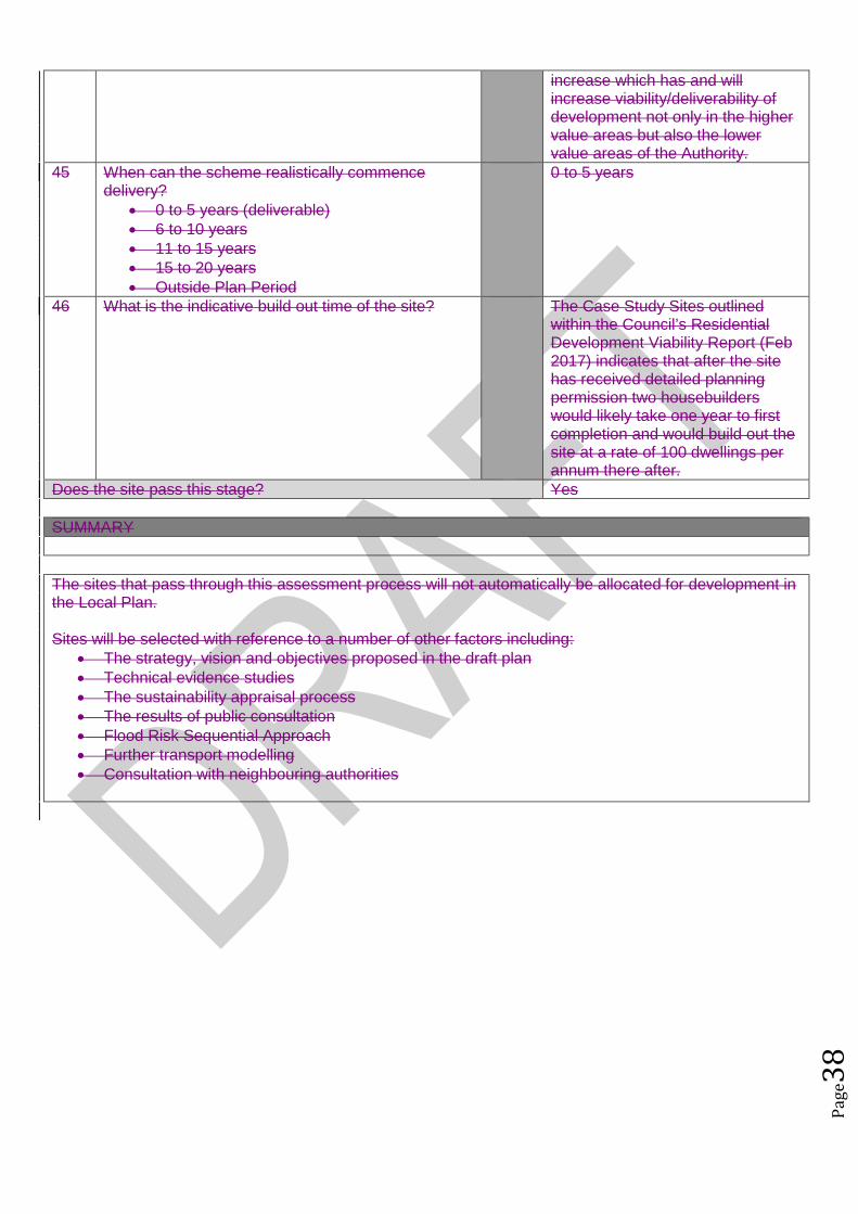
Pag
e38
increase which has and willincrease viability/deliverability ofdevelopment not only in the highervalue areas but also the lowervalue areas of the Authority.
45 When can the scheme realistically commencedelivery?
0 to 5 years (deliverable) 6 to 10 years 11 to 15 years 15 to 20 years Outside Plan Period
0 to 5 years
46 What is the indicative build out time of the site? The Case Study Sites outlinedwithin the Council’s ResidentialDevelopment Viability Report (Feb2017) indicates that after the sitehas received detailed planningpermission two housebuilderswould likely take one year to firstcompletion and would build out thesite at a rate of 100 dwellings perannum there after.
Does the site pass this stage? Yes
SUMMARY
The sites that pass through this assessment process will not automatically be allocated for development inthe Local Plan.
Sites will be selected with reference to a number of other factors including: The strategy, vision and objectives proposed in the draft plan Technical evidence studies The sustainability appraisal process The results of public consultation Flood Risk Sequential Approach Further transport modelling Consultation with neighbouring authorities

Pag
e39
Site Assessment Framework for HOUSING23
Site detailsReference Number NLP002
Site Name Land near Griffin FarmSite Address Griffin Farm, Conger Lane, LU5 6BTSettlement ToddingtonSize Submitted Developable Area: 18ha
Submitted Whole Site Area: 50.26haMeasured GIS Area: 51.238ha
Proposed Use ResidentialAny otherinformation
STAGE 1 : SUITABILITY AND AVAILABILITY (EXCLUSIONARY STAGE)This section will exclude any sites which do not pass the exclusionary suitability criteria and they will notbe assessed further.
STAGE 1A ASSESSMENTThis stage of the assessment rules out sites that are too small or conflict with national policy designations.Provisional Site Capacity1 Is the site likely to accommodate less than 10
dwellings?Work out the number of new homes from site sizeusing density of 30dph and exclude up to 40 %depending on site size of land for infrastructure andservices, take into account topography or significantareas of undevelopable land.Site Size Gross to net ratio standards
Up to 0.4 hectare 100% 0.4 to 2 hectares 80% 2 hectares or above 60%
Note: for this calculation use the submittedDevelopable Area, or the area measured in GIS ifthis is smaller.
No Number of proposed dwellings asper proforma:
Up to 500
Number of proposed dwellings asper CBC methodology:
Up to 324
Flood Risk (All sites which reach Stage 2 will be subject to the Sequential Test)2 Is more than 50% of the site located in Flood Zone 2
or 3?No Not located within Flood zone 2 or
33 Is more than 50% of the site at risk from surface
water flooding?No Site not at risk from surface water
floodingNationally significant designations (All sites which reach Stage 2 be subject to detailed assessment)4 Is more than 50% of the site covered by nationally
significant designations? These are: Sites of SpecialScientific Interest, National Nature Reserves,Scheduled Monuments, Registered Parks andGardens.
No Less than 50% of the site iscovered by nationally significantdesignations.
5 Is more than 50% of the site located within the Areaof Outstanding Natural Beauty?
No Site not within AONB
Does the site continue to next stage? Yes
23Employment sites and Gypsy and Traveller sites will be assessed using separate bespoke site assessment criteria.
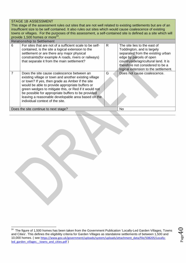
Pag
e40
STAGE 1B ASSESSMENTThis stage of the assessment rules out sites that are not well related to existing settlements but are of aninsufficient size to be self contained. It also rules out sites which would cause coalescence of existingtowns or villages. For the purposes of this assessment, a self-contained site is defined as a site which willprovide 1,500 homes or more24.Relationship to Settlement6 For sites that are not of a sufficient scale to be self-
contained, is the site a logical extension to thesettlement or are there any major physicalconstraints(for example A roads, rivers or railways)that separate it from the main settlement?
R The site lies to the east ofToddington, and is largelyseparated from the existing urbanedge by parcels of opencountryside/agricultural land. It istherefore not considered to be alogical extension to the settlement.
7 Does the site cause coalescence between anexisting village or town and another existing villageor town? If yes, then grade as Amber if the sitewould be able to provide appropriate buffers orgreen wedges to mitigate this, or Red if it would notbe possible for appropriate buffers to be providedleaving a reasonable developable area based on theindividual context of the site.
G Does not cause coalescence.
Does the site continue to next stage? No
24The figure of 1,500 homes has been taken from the Government Publication ‘Locally-Led Garden Villages, Towns
and Cities’. This defines the eligibility criteria for Garden Villages as standalone settlements of between 1,500 and10,000 homes. ( see https://www.gov.uk/government/uploads/system/uploads/attachment_data/file/508205/Locally-led_garden_villages__towns_and_cities.pdf )
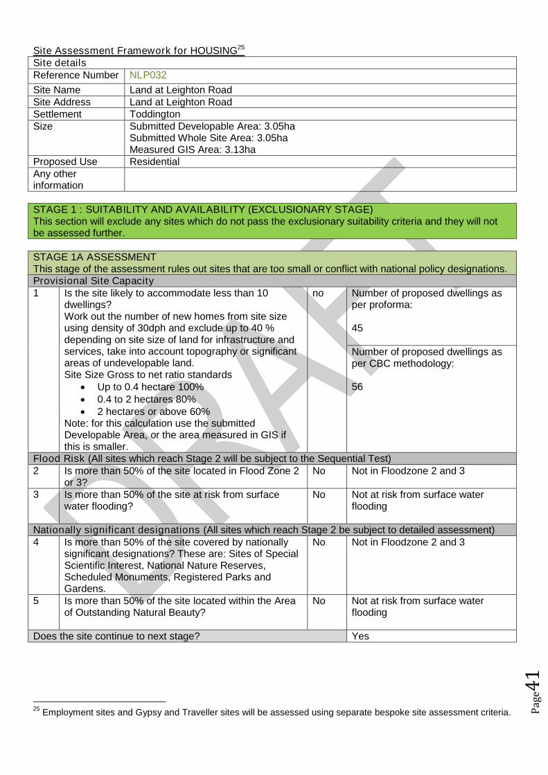
Pag
e41
Site Assessment Framework for HOUSING25
Site detailsReference Number NLP032
Site Name Land at Leighton RoadSite Address Land at Leighton RoadSettlement ToddingtonSize Submitted Developable Area: 3.05ha
Submitted Whole Site Area: 3.05haMeasured GIS Area: 3.13ha
Proposed Use ResidentialAny otherinformation
STAGE 1 : SUITABILITY AND AVAILABILITY (EXCLUSIONARY STAGE)This section will exclude any sites which do not pass the exclusionary suitability criteria and they will notbe assessed further.
STAGE 1A ASSESSMENTThis stage of the assessment rules out sites that are too small or conflict with national policy designations.Provisional Site Capacity1 Is the site likely to accommodate less than 10
dwellings?Work out the number of new homes from site sizeusing density of 30dph and exclude up to 40 %depending on site size of land for infrastructure andservices, take into account topography or significantareas of undevelopable land.Site Size Gross to net ratio standards
Up to 0.4 hectare 100% 0.4 to 2 hectares 80% 2 hectares or above 60%
Note: for this calculation use the submittedDevelopable Area, or the area measured in GIS ifthis is smaller.
no Number of proposed dwellings asper proforma:
45
Number of proposed dwellings asper CBC methodology:
56
Flood Risk (All sites which reach Stage 2 will be subject to the Sequential Test)2 Is more than 50% of the site located in Flood Zone 2
or 3?No Not in Floodzone 2 and 3
3 Is more than 50% of the site at risk from surfacewater flooding?
No Not at risk from surface waterflooding
Nationally significant designations (All sites which reach Stage 2 be subject to detailed assessment)4 Is more than 50% of the site covered by nationally
significant designations? These are: Sites of SpecialScientific Interest, National Nature Reserves,Scheduled Monuments, Registered Parks andGardens.
No Not in Floodzone 2 and 3
5 Is more than 50% of the site located within the Areaof Outstanding Natural Beauty?
No Not at risk from surface waterflooding
Does the site continue to next stage? Yes
25Employment sites and Gypsy and Traveller sites will be assessed using separate bespoke site assessment criteria.
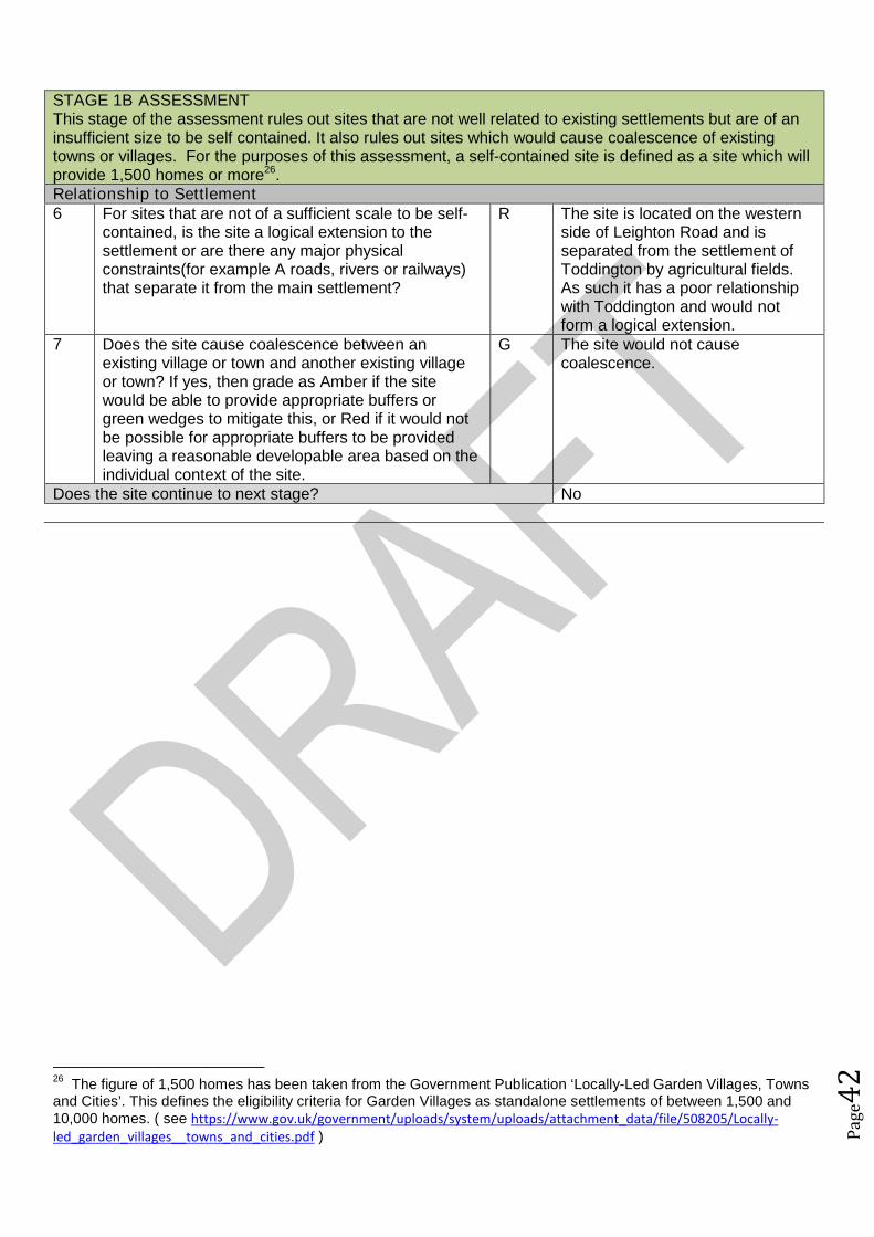
Pag
e42
STAGE 1B ASSESSMENTThis stage of the assessment rules out sites that are not well related to existing settlements but are of aninsufficient size to be self contained. It also rules out sites which would cause coalescence of existingtowns or villages. For the purposes of this assessment, a self-contained site is defined as a site which willprovide 1,500 homes or more26.Relationship to Settlement6 For sites that are not of a sufficient scale to be self-
contained, is the site a logical extension to thesettlement or are there any major physicalconstraints(for example A roads, rivers or railways)that separate it from the main settlement?
R The site is located on the westernside of Leighton Road and isseparated from the settlement ofToddington by agricultural fields.As such it has a poor relationshipwith Toddington and would notform a logical extension.
7 Does the site cause coalescence between anexisting village or town and another existing villageor town? If yes, then grade as Amber if the sitewould be able to provide appropriate buffers orgreen wedges to mitigate this, or Red if it would notbe possible for appropriate buffers to be providedleaving a reasonable developable area based on theindividual context of the site.
G The site would not causecoalescence.
Does the site continue to next stage? No
26The figure of 1,500 homes has been taken from the Government Publication ‘Locally-Led Garden Villages, Towns
and Cities’. This defines the eligibility criteria for Garden Villages as standalone settlements of between 1,500 and10,000 homes. ( see https://www.gov.uk/government/uploads/system/uploads/attachment_data/file/508205/Locally-led_garden_villages__towns_and_cities.pdf )

Pag
e43
Site Assessment Framework for HOUSING27
Site detailsReference Number NLP041
Site Name Longview Long LandSite Address Longview Long LaneSettlement ToddingtonSize Submitted Developable Area: 1.5ha
Submitted Whole Site Area: 2haMeasured GIS Area:1.88ha
Proposed Use ResidentialAny otherinformation
STAGE 1 : SUITABILITY AND AVAILABILITY (EXCLUSIONARY STAGE)This section will exclude any sites which do not pass the exclusionary suitability criteria and they will notbe assessed further.
STAGE 1A ASSESSMENTThis stage of the assessment rules out sites that are too small or conflict with national policy designations.Provisional Site Capacity1 Is the site likely to accommodate less than 10
dwellings?Work out the number of new homes from site sizeusing density of 30dph and exclude up to 40 %depending on site size of land for infrastructure andservices, take into account topography or significantareas of undevelopable land.Site Size Gross to net ratio standards
Up to 0.4 hectare 100% 0.4 to 2 hectares 80% 2 hectares or above 60%
Note: for this calculation use the submittedDevelopable Area, or the area measured in GIS ifthis is smaller.
no Number of proposed dwellings asper proforma:
15-30
Number of proposed dwellings asper CBC methodology:
36
Flood Risk (All sites which reach Stage 2 will be subject to the Sequential Test)2 Is more than 50% of the site located in Flood Zone 2
or 3?No Not in Floodzone 2 and 3
3 Is more than 50% of the site at risk from surfacewater flooding?
No Not at risk from surface waterflooding
Nationally significant designations (All sites which reach Stage 2 be subject to detailed assessment)4 Is more than 50% of the site covered by nationally
significant designations? These are: Sites of SpecialScientific Interest, National Nature Reserves,Scheduled Monuments, Registered Parks andGardens.
No Not within nationally significantdesignation
5 Is more than 50% of the site located within the Areaof Outstanding Natural Beauty?
No Not within AONB
Does the site continue to next stage? Yes
27Employment sites and Gypsy and Traveller sites will be assessed using separate bespoke site assessment criteria.

Pag
e44
STAGE 1B ASSESSMENTThis stage of the assessment rules out sites that are not well related to existing settlements but are of aninsufficient size to be self contained. It also rules out sites which would cause coalescence of existingtowns or villages. For the purposes of this assessment, a self-contained site is defined as a site which willprovide 1,500 homes or more28.Relationship to Settlement6 For sites that are not of a sufficient scale to be self-
contained, is the site a logical extension to thesettlement or are there any major physicalconstraints(for example A roads, rivers or railways)that separate it from the main settlement?
A The site is located on the northernedge of Toddington, outside thesettlement envelope. It has a poorrelationship with Toddington as it isseparated by parcels of opencountryside/agricultural land.
7 Does the site cause coalescence between anexisting village or town and another existing villageor town? If yes, then grade as Amber if the sitewould be able to provide appropriate buffers orgreen wedges to mitigate this, or Red if it would notbe possible for appropriate buffers to be providedleaving a reasonable developable area based on theindividual context of the site.
G The site would not causecoalescence.
Does the site continue to next stage? No
STAGE 1C ASSESSMENTThis stage of the assessment rules out sites that are not able to meet their critical infrastructure needs29.Critical Infrastructure8 Can the site meet the critical infrastructure
requirements that will enable delivery30?A Further information required.
Does the site continue to next stage? Yes
STAGE 1D ASSESSMENTThis stage of the assessment rules out sites that are not available. A site is considered available fordevelopment where there are no legal or ownership problems and the landowner has expressed anintention to develop the site.Availability9 What is the existing use of the site?
Would the existing use limit the developmentpotential?
G Greenfield
10 Is the land controlled by a developer or land ownerwho has expressed an intention to develop the site?
G Land controlled by land ownerintent on developing the site.
11 Are there any legal or ownership problems that coulddelay or prevent development?If Yes, then can these be issues be realisticallyovercome?
G There are no legal or ownershipproblems.
12 Does the site already have planning permission for G No planning permission
28The figure of 1,500 homes has been taken from the Government Publication ‘Locally-Led Garden Villages, Towns
and Cities’. This defines the eligibility criteria for Garden Villages as standalone settlements of between 1,500 and10,000 homes. ( see https://www.gov.uk/government/uploads/system/uploads/attachment_data/file/508205/Locally-led_garden_villages__towns_and_cities.pdf )29
Critical infrastructure is that which has been identified as infrastructure that must happen to enable physicaldevelopment. These infrastructure items are often known as ‘blockers’ or ‘showstoppers’, and are most common inrelation to transport and utilities infrastructure. Failure to provide these pieces of infrastructure could result insignificant delays in the delivery of development.30
This is an assessment based on the information known at this stage, a full assessment of infrastructurerequirements will be undertaken before any sites are allocated.

Pag
e45
the proposed use? If yes, then score as Redbecause it’s not eligible for allocation.
Does the site continue to next stage? Yes
STAGE 1E ASSESSMENTThis section records the findings of the Strategic Green Belt Review and also provides a preliminaryscreening of sites to determine whether they may be capable of demonstrating ExceptionalCircumstances. Any site in the Green Belt that is determined as suitable based on the high level SHLAAassessment would still have to demonstrate Exceptional Circumstances to considered for allocation in thePlan.Greenbelt13 Is the site located within the Green Belt? Yes Site within Green Belt14 If answer to question 13 is yes, then does the site lie
within one of the parcels which have been identifiedin the Central Bedfordshire and Luton Green BeltStudy as making only a relatively weak, weak, or nocontribution? If yes, site progresses through to Stage2.
No The site does not lie within one ofthe parcels.
15a Does the site have all of the following merits thatmay outweigh the harm to the Green Belt and whichmay contribute to identification of exceptionalcircumstances?
Adjoining settlement has at least 3 of thefollowing key local services - convenienceshop, lower school, middle school, upperschool, village hall, GP surgery, post office,library (use settlement audit)
Site makes a strong contribution to housingneed (100 plus homes) within the Luton HMA
Site is in or directly adjacent to a settlementthat has a mainline rail station or directassess (junction) to the strategic roadnetwork (A road or motorway)
Sites in Green Belt other than those covered by 14and 15b that cannot meet these criteria, will notprogress any further in this assessment ofsuitability.*
No The site does not have any of thelisted merits that may outweighharm to the Green Belt.
15b Sites which have support from the local communityas demonstrated through an allocation in an adoptedor draft Neighbourhood Plan (that has been subjectto Regulation 14 consultation) that do not meet thecriteria in question 15a will automatically progressthrough this stage to be considered further at Stage2.31
N/A No draft ToddingtonNeighbourhood Plan withallocations at this stage.
Does the site continue to next stage? No
31Draft Neighbourhood Plan allocations in Green Belt that are proposed after this site assessment phase has
concluded, may still be considered for allocation.

Pag
e46
Site Assessment Framework for HOUSING32
Site detailsReference Number NLP069
Site Name Land north of Station RoadSite Address Land north of Station RoadSettlement ToddingtonSize Submitted Developable Area: 0.54ha
Submitted Whole Site Area: 0.88haMeasured GIS Area:0.90ha
Proposed Use ResidentialAny otherinformation
STAGE 1 : SUITABILITY AND AVAILABILITY (EXCLUSIONARY STAGE)This section will exclude any sites which do not pass the exclusionary suitability criteria and they will notbe assessed further.
STAGE 1A ASSESSMENTThis stage of the assessment rules out sites that are too small or conflict with national policy designations.Provisional Site Capacity1 Is the site likely to accommodate less than 10
dwellings?Work out the number of new homes from site sizeusing density of 30dph and exclude up to 40 %depending on site size of land for infrastructure andservices, take into account topography or significantareas of undevelopable land.Site Size Gross to net ratio standards
Up to 0.4 hectare 100% 0.4 to 2 hectares 80% 2 hectares or above 60%
Note: for this calculation use the submittedDevelopable Area, or the area measured in GIS ifthis is smaller.
no Number of proposed dwellings asper proforma:
10-12
Number of proposed dwellings asper CBC methodology:
16
Flood Risk (All sites which reach Stage 2 will be subject to the Sequential Test)2 Is more than 50% of the site located in Flood Zone 2
or 3?No Not in Floodzone 2 and 3
3 Is more than 50% of the site at risk from surfacewater flooding?
No Not at risk from surface waterflooding
Nationally significant designations (All sites which reach Stage 2 be subject to detailed assessment)4 Is more than 50% of the site covered by nationally
significant designations? These are: Sites of SpecialScientific Interest, National Nature Reserves,Scheduled Monuments, Registered Parks andGardens.
No Not within nationally significantdesignation
5 Is more than 50% of the site located within the Areaof Outstanding Natural Beauty?
No Not within AONB
Does the site continue to next stage? Yes
32Employment sites and Gypsy and Traveller sites will be assessed using separate bespoke site assessment criteria.
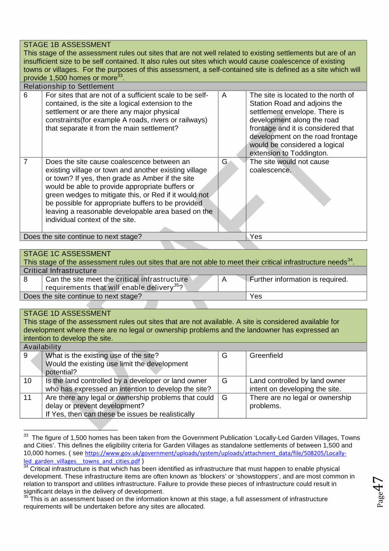
Pag
e47
STAGE 1B ASSESSMENTThis stage of the assessment rules out sites that are not well related to existing settlements but are of aninsufficient size to be self contained. It also rules out sites which would cause coalescence of existingtowns or villages. For the purposes of this assessment, a self-contained site is defined as a site which willprovide 1,500 homes or more33.Relationship to Settlement6 For sites that are not of a sufficient scale to be self-
contained, is the site a logical extension to thesettlement or are there any major physicalconstraints(for example A roads, rivers or railways)that separate it from the main settlement?
A The site is located to the north ofStation Road and adjoins thesettlement envelope. There isdevelopment along the roadfrontage and it is considered thatdevelopment on the road frontagewould be considered a logicalextension to Toddington.
7 Does the site cause coalescence between anexisting village or town and another existing villageor town? If yes, then grade as Amber if the sitewould be able to provide appropriate buffers orgreen wedges to mitigate this, or Red if it would notbe possible for appropriate buffers to be providedleaving a reasonable developable area based on theindividual context of the site.
G The site would not causecoalescence.
Does the site continue to next stage? Yes
STAGE 1C ASSESSMENTThis stage of the assessment rules out sites that are not able to meet their critical infrastructure needs34.Critical Infrastructure8 Can the site meet the critical infrastructure
requirements that will enable delivery35?A Further information is required.
Does the site continue to next stage? Yes
STAGE 1D ASSESSMENTThis stage of the assessment rules out sites that are not available. A site is considered available fordevelopment where there are no legal or ownership problems and the landowner has expressed anintention to develop the site.Availability9 What is the existing use of the site?
Would the existing use limit the developmentpotential?
G Greenfield
10 Is the land controlled by a developer or land ownerwho has expressed an intention to develop the site?
G Land controlled by land ownerintent on developing the site.
11 Are there any legal or ownership problems that coulddelay or prevent development?If Yes, then can these be issues be realistically
G There are no legal or ownershipproblems.
33The figure of 1,500 homes has been taken from the Government Publication ‘Locally-Led Garden Villages, Towns
and Cities’. This defines the eligibility criteria for Garden Villages as standalone settlements of between 1,500 and10,000 homes. ( see https://www.gov.uk/government/uploads/system/uploads/attachment_data/file/508205/Locally-led_garden_villages__towns_and_cities.pdf )34
Critical infrastructure is that which has been identified as infrastructure that must happen to enable physicaldevelopment. These infrastructure items are often known as ‘blockers’ or ‘showstoppers’, and are most common inrelation to transport and utilities infrastructure. Failure to provide these pieces of infrastructure could result insignificant delays in the delivery of development.35
This is an assessment based on the information known at this stage, a full assessment of infrastructurerequirements will be undertaken before any sites are allocated.

Pag
e48
overcome?12 Does the site already have planning permission for
the proposed use? If yes, then score as Redbecause it’s not eligible for allocation.
G No planning permission
Does the site continue to next stage? Yes
STAGE 1E ASSESSMENTThis section records the findings of the Strategic Green Belt Review and also provides a preliminaryscreening of sites to determine whether they may be capable of demonstrating ExceptionalCircumstances. Any site in the Green Belt that is determined as suitable based on the high level SHLAAassessment would still have to demonstrate Exceptional Circumstances to considered for allocation in thePlan.Greenbelt13 Is the site located within the Green Belt? Yes Site within Green Belt14 If answer to question 13 is yes, then does the site lie
within one of the parcels which have been identifiedin the Central Bedfordshire and Luton Green BeltStudy as making only a relatively weak, weak, or nocontribution? If yes, site progresses through to Stage2.
No Site is not identified as making aweak contribution.
15a Does the site have all of the following merits thatmay outweigh the harm to the Green Belt and whichmay contribute to identification of exceptionalcircumstances?
Adjoining settlement has at least 3 of thefollowing key local services - convenienceshop, lower school, middle school, upperschool, village hall, GP surgery, post office,library (use settlement audit)
Site makes a strong contribution to housingneed (100 plus homes) within the Luton HMA
Site is in or directly adjacent to a settlementthat has a mainline rail station or directassess (junction) to the strategic roadnetwork (A road or motorway)
Sites in Green Belt other than those covered by 14and 15b that cannot meet these criteria, will notprogress any further in this assessment ofsuitability.*
No The site does not have any of thelisted merits that may outweighharm to the Green Belt.
15b Sites which have support from the local communityas demonstrated through an allocation in an adoptedor draft Neighbourhood Plan (that has been subjectto Regulation 14 consultation) that do not meet thecriteria in question 15a will automatically progressthrough this stage to be considered further at Stage2.36
N/A No draft ToddingtonNeighbourhood Plan withallocations at this stage.
Does the site continue to next stage? No
36Draft Neighbourhood Plan allocations in Green Belt that are proposed after this site assessment phase has
concluded, may still be considered for allocation.
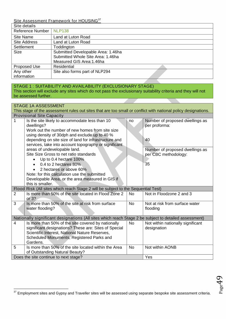
Pag
e49
Site Assessment Framework for HOUSING37
Site detailsReference Number NLP138
Site Name Land at Luton RoadSite Address Land at Luton RoadSettlement ToddingtonSize Submitted Developable Area: 1.46ha
Submitted Whole Site Area: 1.46haMeasured GIS Area:1.46ha
Proposed Use ResidentialAny otherinformation
Site also forms part of NLP294
STAGE 1 : SUITABILITY AND AVAILABILITY (EXCLUSIONARY STAGE)This section will exclude any sites which do not pass the exclusionary suitability criteria and they will notbe assessed further.
STAGE 1A ASSESSMENTThis stage of the assessment rules out sites that are too small or conflict with national policy designations.Provisional Site Capacity1 Is the site likely to accommodate less than 10
dwellings?Work out the number of new homes from site sizeusing density of 30dph and exclude up to 40 %depending on site size of land for infrastructure andservices, take into account topography or significantareas of undevelopable land.Site Size Gross to net ratio standards
Up to 0.4 hectare 100% 0.4 to 2 hectares 80% 2 hectares or above 60%
Note: for this calculation use the submittedDevelopable Area, or the area measured in GIS ifthis is smaller.
no Number of proposed dwellings asper proforma:
40
Number of proposed dwellings asper CBC methodology:
35
Flood Risk (All sites which reach Stage 2 will be subject to the Sequential Test)2 Is more than 50% of the site located in Flood Zone 2
or 3?No Not in Floodzone 2 and 3
3 Is more than 50% of the site at risk from surfacewater flooding?
No Not at risk from surface waterflooding
Nationally significant designations (All sites which reach Stage 2 be subject to detailed assessment)4 Is more than 50% of the site covered by nationally
significant designations? These are: Sites of SpecialScientific Interest, National Nature Reserves,Scheduled Monuments, Registered Parks andGardens.
No Not within nationally significantdesignation
5 Is more than 50% of the site located within the Areaof Outstanding Natural Beauty?
No Not within AONB
Does the site continue to next stage? Yes
37Employment sites and Gypsy and Traveller sites will be assessed using separate bespoke site assessment criteria.
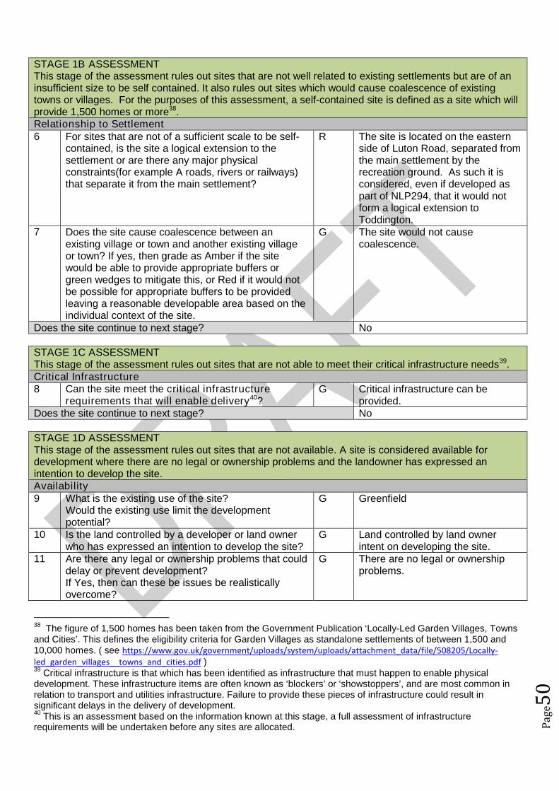
Pag
e50
STAGE 1B ASSESSMENTThis stage of the assessment rules out sites that are not well related to existing settlements but are of aninsufficient size to be self contained. It also rules out sites which would cause coalescence of existingtowns or villages. For the purposes of this assessment, a self-contained site is defined as a site which willprovide 1,500 homes or more38.Relationship to Settlement6 For sites that are not of a sufficient scale to be self-
contained, is the site a logical extension to thesettlement or are there any major physicalconstraints(for example A roads, rivers or railways)that separate it from the main settlement?
R The site is located on the easternside of Luton Road, separated fromthe main settlement by therecreation ground. As such it isconsidered, even if developed aspart of NLP294, that it would notform a logical extension toToddington.
7 Does the site cause coalescence between anexisting village or town and another existing villageor town? If yes, then grade as Amber if the sitewould be able to provide appropriate buffers orgreen wedges to mitigate this, or Red if it would notbe possible for appropriate buffers to be providedleaving a reasonable developable area based on theindividual context of the site.
G The site would not causecoalescence.
Does the site continue to next stage? No
STAGE 1C ASSESSMENTThis stage of the assessment rules out sites that are not able to meet their critical infrastructure needs39.Critical Infrastructure8 Can the site meet the critical infrastructure
requirements that will enable delivery40?G Critical infrastructure can be
provided.Does the site continue to next stage? No
STAGE 1D ASSESSMENTThis stage of the assessment rules out sites that are not available. A site is considered available fordevelopment where there are no legal or ownership problems and the landowner has expressed anintention to develop the site.Availability9 What is the existing use of the site?
Would the existing use limit the developmentpotential?
G Greenfield
10 Is the land controlled by a developer or land ownerwho has expressed an intention to develop the site?
G Land controlled by land ownerintent on developing the site.
11 Are there any legal or ownership problems that coulddelay or prevent development?If Yes, then can these be issues be realisticallyovercome?
G There are no legal or ownershipproblems.
38The figure of 1,500 homes has been taken from the Government Publication ‘Locally-Led Garden Villages, Towns
and Cities’. This defines the eligibility criteria for Garden Villages as standalone settlements of between 1,500 and10,000 homes. ( see https://www.gov.uk/government/uploads/system/uploads/attachment_data/file/508205/Locally-led_garden_villages__towns_and_cities.pdf )39
Critical infrastructure is that which has been identified as infrastructure that must happen to enable physicaldevelopment. These infrastructure items are often known as ‘blockers’ or ‘showstoppers’, and are most common inrelation to transport and utilities infrastructure. Failure to provide these pieces of infrastructure could result insignificant delays in the delivery of development.40
This is an assessment based on the information known at this stage, a full assessment of infrastructurerequirements will be undertaken before any sites are allocated.
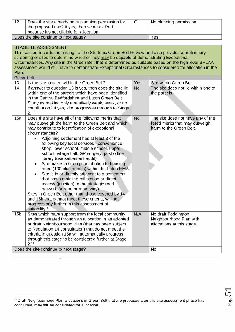
Pag
e51
12 Does the site already have planning permission forthe proposed use? If yes, then score as Redbecause it’s not eligible for allocation.
G No planning permission
Does the site continue to next stage? Yes
STAGE 1E ASSESSMENTThis section records the findings of the Strategic Green Belt Review and also provides a preliminaryscreening of sites to determine whether they may be capable of demonstrating ExceptionalCircumstances. Any site in the Green Belt that is determined as suitable based on the high level SHLAAassessment would still have to demonstrate Exceptional Circumstances to considered for allocation in thePlan.Greenbelt13 Is the site located within the Green Belt? Yes Site within Green Belt14 If answer to question 13 is yes, then does the site lie
within one of the parcels which have been identifiedin the Central Bedfordshire and Luton Green BeltStudy as making only a relatively weak, weak, or nocontribution? If yes, site progresses through to Stage2.
No The site does not lie within one ofthe parcels.
15a Does the site have all of the following merits thatmay outweigh the harm to the Green Belt and whichmay contribute to identification of exceptionalcircumstances?
Adjoining settlement has at least 3 of thefollowing key local services - convenienceshop, lower school, middle school, upperschool, village hall, GP surgery, post office,library (use settlement audit)
Site makes a strong contribution to housingneed (100 plus homes) within the Luton HMA
Site is in or directly adjacent to a settlementthat has a mainline rail station or directassess (junction) to the strategic roadnetwork (A road or motorway)
Sites in Green Belt other than those covered by 14and 15b that cannot meet these criteria, will notprogress any further in this assessment ofsuitability.*
No The site does not have any of thelisted merits that may outweighharm to the Green Belt.
15b Sites which have support from the local communityas demonstrated through an allocation in an adoptedor draft Neighbourhood Plan (that has been subjectto Regulation 14 consultation) that do not meet thecriteria in question 15a will automatically progressthrough this stage to be considered further at Stage2.41
N/A No draft ToddingtonNeighbourhood Plan withallocations at this stage.
Does the site continue to next stage? No
41Draft Neighbourhood Plan allocations in Green Belt that are proposed after this site assessment phase has
concluded, may still be considered for allocation.
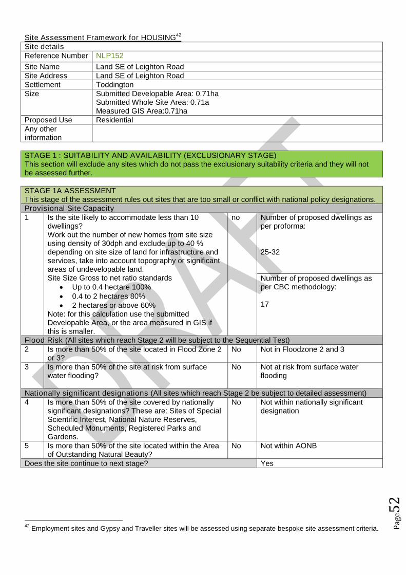
Pag
e52
Site Assessment Framework for HOUSING42
Site detailsReference Number NLP152
Site Name Land SE of Leighton RoadSite Address Land SE of Leighton RoadSettlement ToddingtonSize Submitted Developable Area: 0.71ha
Submitted Whole Site Area: 0.71aMeasured GIS Area:0.71ha
Proposed Use ResidentialAny otherinformation
STAGE 1 : SUITABILITY AND AVAILABILITY (EXCLUSIONARY STAGE)This section will exclude any sites which do not pass the exclusionary suitability criteria and they will notbe assessed further.
STAGE 1A ASSESSMENTThis stage of the assessment rules out sites that are too small or conflict with national policy designations.Provisional Site Capacity1 Is the site likely to accommodate less than 10
dwellings?Work out the number of new homes from site sizeusing density of 30dph and exclude up to 40 %depending on site size of land for infrastructure andservices, take into account topography or significantareas of undevelopable land.Site Size Gross to net ratio standards
Up to 0.4 hectare 100% 0.4 to 2 hectares 80% 2 hectares or above 60%
Note: for this calculation use the submittedDevelopable Area, or the area measured in GIS ifthis is smaller.
no Number of proposed dwellings asper proforma:
25-32
Number of proposed dwellings asper CBC methodology:
17
Flood Risk (All sites which reach Stage 2 will be subject to the Sequential Test)2 Is more than 50% of the site located in Flood Zone 2
or 3?No Not in Floodzone 2 and 3
3 Is more than 50% of the site at risk from surfacewater flooding?
No Not at risk from surface waterflooding
Nationally significant designations (All sites which reach Stage 2 be subject to detailed assessment)4 Is more than 50% of the site covered by nationally
significant designations? These are: Sites of SpecialScientific Interest, National Nature Reserves,Scheduled Monuments, Registered Parks andGardens.
No Not within nationally significantdesignation
5 Is more than 50% of the site located within the Areaof Outstanding Natural Beauty?
No Not within AONB
Does the site continue to next stage? Yes
42Employment sites and Gypsy and Traveller sites will be assessed using separate bespoke site assessment criteria.

Pag
e53
STAGE 1B ASSESSMENTThis stage of the assessment rules out sites that are not well related to existing settlements but are of aninsufficient size to be self contained. It also rules out sites which would cause coalescence of existingtowns or villages. For the purposes of this assessment, a self-contained site is defined as a site which willprovide 1,500 homes or more43.Relationship to Settlement6 For sites that are not of a sufficient scale to be self-
contained, is the site a logical extension to thesettlement or are there any major physicalconstraints(for example A roads, rivers or railways)that separate it from the main settlement?
G The site is located on the southeastern edge of Toddington and iswell related to the village. It isconsidered that the site could forma logical extension to Toddington.
7 Does the site cause coalescence between anexisting village or town and another existing villageor town? If yes, then grade as Amber if the sitewould be able to provide appropriate buffers orgreen wedges to mitigate this, or Red if it would notbe possible for appropriate buffers to be providedleaving a reasonable developable area based on theindividual context of the site.
G The site would not causecoalescence.
Does the site continue to next stage? Yes
STAGE 1C ASSESSMENTThis stage of the assessment rules out sites that are not able to meet their critical infrastructure needs44.Critical Infrastructure8 Can the site meet the critical infrastructure
requirements that will enable delivery45?G Critical infrastructure can be
delivered.Does the site continue to next stage? Yes
STAGE 1D ASSESSMENTThis stage of the assessment rules out sites that are not available. A site is considered available fordevelopment where there are no legal or ownership problems and the landowner has expressed anintention to develop the site.Availability9 What is the existing use of the site?
Would the existing use limit the developmentpotential?
G Greenfield
10 Is the land controlled by a developer or land ownerwho has expressed an intention to develop the site?
G Land controlled by land ownerintent on developing the site.
11 Are there any legal or ownership problems that coulddelay or prevent development?If Yes, then can these be issues be realisticallyovercome?
G There are no legal or ownershipproblems.
12 Does the site already have planning permission forthe proposed use? If yes, then score as Redbecause it’s not eligible for allocation.
G No planning permission
43The figure of 1,500 homes has been taken from the Government Publication ‘Locally-Led Garden Villages, Towns
and Cities’. This defines the eligibility criteria for Garden Villages as standalone settlements of between 1,500 and10,000 homes. ( see https://www.gov.uk/government/uploads/system/uploads/attachment_data/file/508205/Locally-led_garden_villages__towns_and_cities.pdf )44
Critical infrastructure is that which has been identified as infrastructure that must happen to enable physicaldevelopment. These infrastructure items are often known as ‘blockers’ or ‘showstoppers’, and are most common inrelation to transport and utilities infrastructure. Failure to provide these pieces of infrastructure could result insignificant delays in the delivery of development.45
This is an assessment based on the information known at this stage, a full assessment of infrastructurerequirements will be undertaken before any sites are allocated.
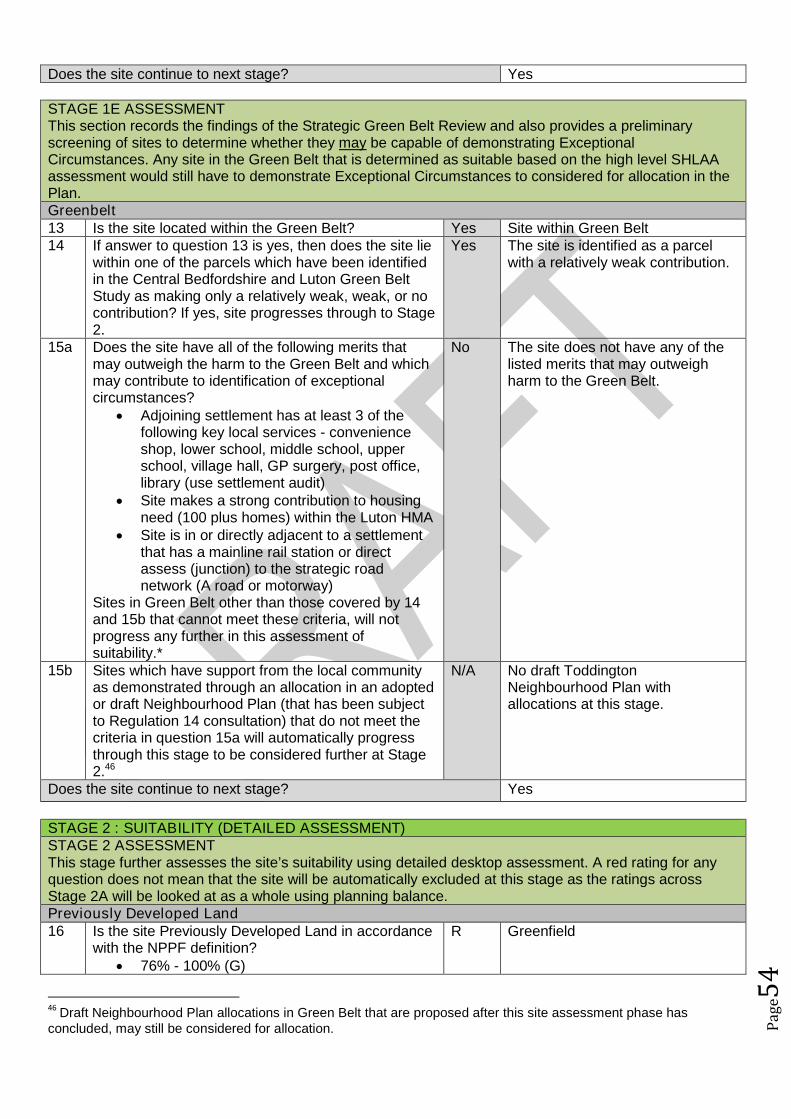
Pag
e54
Does the site continue to next stage? Yes
STAGE 1E ASSESSMENTThis section records the findings of the Strategic Green Belt Review and also provides a preliminaryscreening of sites to determine whether they may be capable of demonstrating ExceptionalCircumstances. Any site in the Green Belt that is determined as suitable based on the high level SHLAAassessment would still have to demonstrate Exceptional Circumstances to considered for allocation in thePlan.Greenbelt13 Is the site located within the Green Belt? Yes Site within Green Belt14 If answer to question 13 is yes, then does the site lie
within one of the parcels which have been identifiedin the Central Bedfordshire and Luton Green BeltStudy as making only a relatively weak, weak, or nocontribution? If yes, site progresses through to Stage2.
Yes The site is identified as a parcelwith a relatively weak contribution.
15a Does the site have all of the following merits thatmay outweigh the harm to the Green Belt and whichmay contribute to identification of exceptionalcircumstances?
Adjoining settlement has at least 3 of thefollowing key local services - convenienceshop, lower school, middle school, upperschool, village hall, GP surgery, post office,library (use settlement audit)
Site makes a strong contribution to housingneed (100 plus homes) within the Luton HMA
Site is in or directly adjacent to a settlementthat has a mainline rail station or directassess (junction) to the strategic roadnetwork (A road or motorway)
Sites in Green Belt other than those covered by 14and 15b that cannot meet these criteria, will notprogress any further in this assessment ofsuitability.*
No The site does not have any of thelisted merits that may outweighharm to the Green Belt.
15b Sites which have support from the local communityas demonstrated through an allocation in an adoptedor draft Neighbourhood Plan (that has been subjectto Regulation 14 consultation) that do not meet thecriteria in question 15a will automatically progressthrough this stage to be considered further at Stage2.46
N/A No draft ToddingtonNeighbourhood Plan withallocations at this stage.
Does the site continue to next stage? Yes
STAGE 2 : SUITABILITY (DETAILED ASSESSMENT)STAGE 2 ASSESSMENTThis stage further assesses the site’s suitability using detailed desktop assessment. A red rating for anyquestion does not mean that the site will be automatically excluded at this stage as the ratings acrossStage 2A will be looked at as a whole using planning balance.Previously Developed Land16 Is the site Previously Developed Land in accordance
with the NPPF definition? 76% - 100% (G)
R Greenfield
46Draft Neighbourhood Plan allocations in Green Belt that are proposed after this site assessment phase has
concluded, may still be considered for allocation.

Pag
e55
26 - 75% (A) 25% - 0% (Greenfield) (R)
Community17 Neighbourhood Planning (only applicable in
designated areas)Is the site identified as a housing allocation in anemerging Neighbourhood Plan?
No Toddington Neighbourhood Plan inearly stages.
18 Community ConsultationHas any community consultation taken place?If yes, provide brief details on the form thisconsultation took and any overall communityresponse.
No No community consultation
19 Sustainability of SettlementWould this proposal impact on the sustainability ofthe settlement through the loss of services andfacilities (for example, employment, retail, publichouse etc)
No The site would not impact on thesustainability of the settlement.
Cumulative Impact20 Considering housing completions over the past 10
years, what has been the level of housing growth inthe parish?
Less than 5% growth (G) 5% to 20% growth (A) More than 20% growth (R)
This is calculated by working out the total number ofcompletions over the last ten years as a percentageof the dwellings in April 2006 (as calculated usingcensus and completions data).
G Homes 2006: 1906Homes 2016: 1960
There has been a 2.83% increasein housing in Toddington.
21 What level of housing growth would there be if all theoutstanding permissions (as of April 2016) were tobe completed?
Less than 5% growth (G) 5% to 20% growth (A) More than 20% growth (R)
This is calculated by working out the total number ofoutstanding permissions as of April 1st 2016 aspercentage of the total number of dwellings in April2016 (as calculated using census and completionsdata).
G There is outstanding planningpermission for 5 dwellings, an0.26% increase.
Physical Constraints22 Are there any physical constraints or permanent
features that affect the site’s developability?For example pylons, gas works, sewage treatmentworks, topography or wind turbines.
G There are no physical constraints.
Relationship to Settlement23 Would development of the site be complementary to
the existing settlement pattern, and would it have anadverse impact on any historic, unique or distinctivecharacteristics of the settlement’s built or naturalform?
G The site would be complementaryto the existing settlement pattern.
Agricultural Land Quality24 Would the development impact on high quality
agricultural land? 50% or more in non-agricultural land (G) 50% of more in Grade 3b, 4 or 5 (A) 50% or more in Grade 1, 2 or 3a (R)
A Grade 3

Pag
e56
STAGE 2 ASSESSMENTThis stage further assesses the site’s suitability using comments from technical specialists. A red rating forany question does not mean that the site will be automatically excluded at this stage as the ratings acrossStage 2B will be looked at as a whole using planning balance.Transport and Access to Services25 Facilities and services
Question 26 considers the suitability and sustainability of the site for housing. It links to theCouncil’s Settlement Hierarchy Audit.
Issues relating to capacity are assessed separately25a Does the settlement have a Primary/Lower school?
Yes, in the settlement (G) Yes, proposed as part of the development (G) No, but an adjoining settlement does (A) Not in the settlement or an adjoining
settlement (R)
G In settlement
25b Does the settlement have a Middle school (ifapplicable)?
Yes, in the settlement (G) Yes, proposed as part of the development (G) No, but an adjoining settlement does (A) Other catchment school available (A)
G In settlement
25c Does the settlement have a Secondary/ Upperschool?
Yes, in the settlement (G) Yes, proposed as part of the development (G) No, but an adjoining settlement does (A) Other catchment school available (A)
A Adjoining settlement
25d Does the settlement have a GPs surgery or medicalcentre?
Yes, in the settlement (G) Yes, proposed as part of the development (G) No, but an adjoining settlement does (A) Not in the settlement or an adjoining
settlement (R)
G In settlement
26 What retail provision does the settlement offer? Town Centre/ Supermarket (G) Convenience Store / Post Office / Newsagent
(A) None (R)
A Convenience store
27 Distance to bus stops with a frequent service (atleast hourly at peak times):
Less than 400m (G) 400m-800m (A) Over 800m (R) OR submission form stated that improved
public transport facilities could be provided aspart of the development (G)
A 781m from a bus stop
28 Distance to nearest train station: Less than 800m (G) 800m-1200m (A) Over 1200m (R)
R Over 1200m
29 Is the site accessible from the existing road network? G Leighton Road
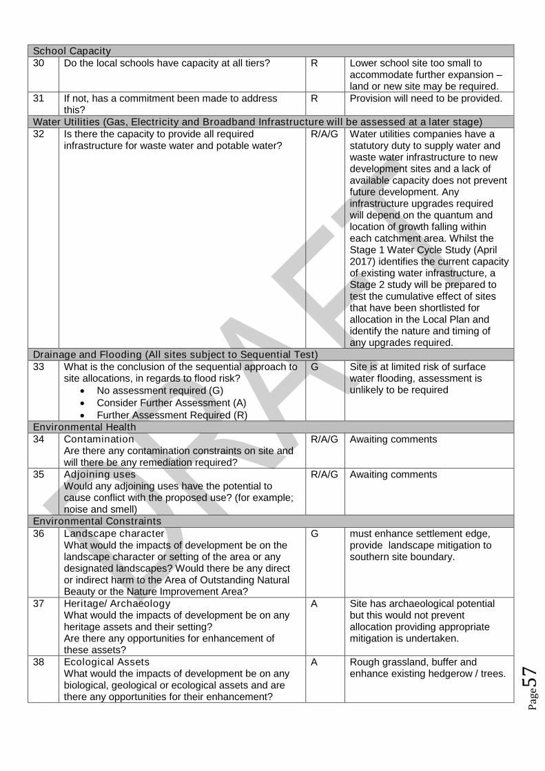
Pag
e57
School Capacity30 Do the local schools have capacity at all tiers? R Lower school site too small to
accommodate further expansion –land or new site may be required.
31 If not, has a commitment been made to addressthis?
R Provision will need to be provided.
Water Utilities (Gas, Electricity and Broadband Infrastructure will be assessed at a later stage)32 Is there the capacity to provide all required
infrastructure for waste water and potable water?R/A/G Water utilities companies have a
statutory duty to supply water andwaste water infrastructure to newdevelopment sites and a lack ofavailable capacity does not preventfuture development. Anyinfrastructure upgrades requiredwill depend on the quantum andlocation of growth falling withineach catchment area. Whilst theStage 1 Water Cycle Study (April2017) identifies the current capacityof existing water infrastructure, aStage 2 study will be prepared totest the cumulative effect of sitesthat have been shortlisted forallocation in the Local Plan andidentify the nature and timing ofany upgrades required.
Drainage and Flooding (All sites subject to Sequential Test)33 What is the conclusion of the sequential approach to
site allocations, in regards to flood risk? No assessment required (G) Consider Further Assessment (A) Further Assessment Required (R)
G Site is at limited risk of surfacewater flooding, assessment isunlikely to be required
Environmental Health34 Contamination
Are there any contamination constraints on site andwill there be any remediation required?
R/A/G Awaiting comments
35 Adjoining usesWould any adjoining uses have the potential tocause conflict with the proposed use? (for example;noise and smell)
R/A/G Awaiting comments
Environmental Constraints36 Landscape character
What would the impacts of development be on thelandscape character or setting of the area or anydesignated landscapes? Would there be any director indirect harm to the Area of Outstanding NaturalBeauty or the Nature Improvement Area?
G must enhance settlement edge,provide landscape mitigation tosouthern site boundary.
37 Heritage/ ArchaeologyWhat would the impacts of development be on anyheritage assets and their setting?Are there any opportunities for enhancement ofthese assets?
A Site has archaeological potentialbut this would not preventallocation providing appropriatemitigation is undertaken.
38 Ecological AssetsWhat would the impacts of development be on anybiological, geological or ecological assets and arethere any opportunities for their enhancement?
A Rough grassland, buffer andenhance existing hedgerow / trees.
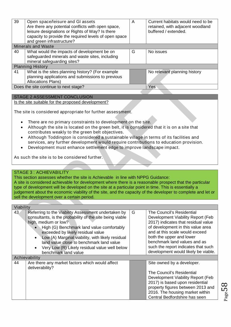
Pag
e58
39 Open space/leisure and GI assetsAre there any potential conflicts with open space,leisure designations or Rights of Way? Is therecapacity to provide the required levels of open spaceand green infrastructure?
A Current habitats would need to beretained, with adjacent woodlandbuffered / extended.
Minerals and Waste40 What would the impacts of development be on
safeguarded minerals and waste sites, includingmineral safeguarding sites?
G No issues
Planning History41 What is the sites planning history? (For example
planning applications and submissions to previousAllocations Plans)
No relevant planning history
Does the site continue to next stage? Yes
STAGE 2 ASSESSMENT CONCLUSIONIs the site suitable for the proposed development?
The site is considered appropriate for further assessment.
There are no primary constraints to development on the site. Although the site is located on the green belt, it is considered that it is on a site that
contributes weakly to the green belt objectives. Although Toddington is considered a sustainable village in terms of its facilities and
services, any further development would require contributions to education provision. Development must enhance settlement edge to improve landscape impact.
As such the site is to be considered further.
STAGE 3 : ACHIEVABILITYThis section assesses whether the site is Achievable in line with NPPG Guidance:A site is considered achievable for development where there is a reasonable prospect that the particulartype of development will be developed on the site at a particular point in time. This is essentially ajudgement about the economic viability of the site, and the capacity of the developer to complete and let orsell the development over a certain period.
Viability43 Referring to the Viability Assessment undertaken by
consultants, is the probability of the site being viablehigh, medium or low?
High (G) Benchmark land value comfortablyexceeded by likely residual value
Low (A) Marginal viability, with likely residualland value close to benchmark land value
Very Low (R) Likely residual value well belowbenchmark land value
G The Council’s ResidentialDevelopment Viability Report (Feb2017) indicates that residual valueof development in this value areaand at this scale would exceedboth the upper and lowerbenchmark land values and assuch the report indicates that suchdevelopment would likely be viable.
Achievability44 Are there any market factors which would affect
deliverability?Site owned by a developer.
The Council’s ResidentialDevelopment Viability Report (Feb2017) is based upon residentialproperty figures between 2013 and2016. The housing market withinCentral Bedfordshire has seen

Pag
e59
significant increases in residentialproperty values in a relatively shortperiod of time, whereby it isconsidered that the viability ofdevelopments within this report hasbeen cautious. For example in2016 Dunstable has benefited froma 17.9% housing price increasewith an average annual house priceincrease in 2016 for housing withinCentral Bedfordshire of 10.74%.
This increase in property value hasbeen a result of not only nationaltrends in house prices and existingtransport links to economicallysuccessful areas but alsosignificant infrastructure projectswithin the pipeline including: East-West Rail; M1-A5 link road; A421upgrades; Oxford to CambridgeExpress Way; Luton and DunstableGuided Busway; M1 improvements;and potential A1 improvements. Itis considered that as suchinfrastructure projects progress thatproperty prices within the LocalAuthority will likely continue toincrease which has and willincrease viability/deliverability ofdevelopment not only in the highervalue areas but also the lowervalue areas of the Authority.
45 When can the scheme realistically commencedelivery?
0 to 5 years (deliverable) 6 to 10 years 11 to 15 years 15 to 20 years Outside Plan Period
0 to 5 years
46 What is the indicative build out time of the site? The Case Study Sites outlinedwithin the Council’s ResidentialDevelopment Viability Report (Feb2017) indicates that after the sitehas received detailed planningpermission a single housebuilderwould likely take one year to buildout this site.
Does the site pass this stage? Yes
SUMMARY
The sites that pass through this assessment process will not automatically be allocated for development inthe Local Plan.
Sites will be selected with reference to a number of other factors including:

Pag
e60
The strategy, vision and objectives proposed in the draft plan Technical evidence studies The sustainability appraisal process The results of public consultation Flood Risk Sequential Approach Further transport modelling Consultation with neighbouring authorities

Pag
e61
Site Assessment Framework for HOUSING47
Site detailsReference Number NLP153
Site Name Land SE of Leighton RoadSite Address Land SE of Leighton RoadSettlement ToddingtonSize Submitted Developable Area: 2.12ha
Submitted Whole Site Area: 2.12haMeasured GIS Area: 2.12ha
Proposed Use ResidentialAny otherinformation
STAGE 1 : SUITABILITY AND AVAILABILITY (EXCLUSIONARY STAGE)This section will exclude any sites which do not pass the exclusionary suitability criteria and they will notbe assessed further.
STAGE 1A ASSESSMENTThis stage of the assessment rules out sites that are too small or conflict with national policy designations.Provisional Site Capacity1 Is the site likely to accommodate less than 10
dwellings?Work out the number of new homes from site sizeusing density of 30dph and exclude up to 40 %depending on site size of land for infrastructure andservices, take into account topography or significantareas of undevelopable land.Site Size Gross to net ratio standards
Up to 0.4 hectare 100% 0.4 to 2 hectares 80% 2 hectares or above 60%
Note: for this calculation use the submittedDevelopable Area, or the area measured in GIS ifthis is smaller.
no Number of proposed dwellings asper proforma:
60-75
Number of proposed dwellings asper CBC methodology:
38
Flood Risk (All sites which reach Stage 2 will be subject to the Sequential Test)2 Is more than 50% of the site located in Flood Zone 2
or 3?No Not in Floodzone 2 and 3
3 Is more than 50% of the site at risk from surfacewater flooding?
No Not at risk from surface waterflooding
Nationally significant designations (All sites which reach Stage 2 be subject to detailed assessment)4 Is more than 50% of the site covered by nationally
significant designations? These are: Sites of SpecialScientific Interest, National Nature Reserves,Scheduled Monuments, Registered Parks andGardens.
No Not within nationally significantdesignation
5 Is more than 50% of the site located within the Areaof Outstanding Natural Beauty?
No Not within AONB
Does the site continue to next stage? Yes
47Employment sites and Gypsy and Traveller sites will be assessed using separate bespoke site assessment criteria.

Pag
e62
STAGE 1B ASSESSMENTThis stage of the assessment rules out sites that are not well related to existing settlements but are of aninsufficient size to be self contained. It also rules out sites which would cause coalescence of existingtowns or villages. For the purposes of this assessment, a self-contained site is defined as a site which willprovide 1,500 homes or more48.Relationship to Settlement6 For sites that are not of a sufficient scale to be self-
contained, is the site a logical extension to thesettlement or are there any major physicalconstraints(for example A roads, rivers or railways)that separate it from the main settlement?
G The site is located on the southeastern edge of Toddington and iswell related to the village. It isconsidered that the site could forma logical extension to Toddington.
7 Does the site cause coalescence between anexisting village or town and another existing villageor town? If yes, then grade as Amber if the sitewould be able to provide appropriate buffers orgreen wedges to mitigate this, or Red if it would notbe possible for appropriate buffers to be providedleaving a reasonable developable area based on theindividual context of the site.
G The site would not causecoalescence.
Does the site continue to next stage? Yes
STAGE 1C ASSESSMENTThis stage of the assessment rules out sites that are not able to meet their critical infrastructure needs49.Critical Infrastructure8 Can the site meet the critical infrastructure
requirements that will enable delivery50?G Critical infrastructure can be
delivered.Does the site continue to next stage? Yes
STAGE 1D ASSESSMENTThis stage of the assessment rules out sites that are not available. A site is considered available fordevelopment where there are no legal or ownership problems and the landowner has expressed anintention to develop the site.Availability9 What is the existing use of the site?
Would the existing use limit the developmentpotential?
G Greenfield
10 Is the land controlled by a developer or land ownerwho has expressed an intention to develop the site?
G Land controlled by land ownerintent on developing the site.
11 Are there any legal or ownership problems that coulddelay or prevent development?If Yes, then can these be issues be realisticallyovercome?
G There are no legal or ownershipproblems.
12 Does the site already have planning permission forthe proposed use? If yes, then score as Redbecause it’s not eligible for allocation.
G No planning permission
48The figure of 1,500 homes has been taken from the Government Publication ‘Locally-Led Garden Villages, Towns
and Cities’. This defines the eligibility criteria for Garden Villages as standalone settlements of between 1,500 and10,000 homes. ( see https://www.gov.uk/government/uploads/system/uploads/attachment_data/file/508205/Locally-led_garden_villages__towns_and_cities.pdf )49
Critical infrastructure is that which has been identified as infrastructure that must happen to enable physicaldevelopment. These infrastructure items are often known as ‘blockers’ or ‘showstoppers’, and are most common inrelation to transport and utilities infrastructure. Failure to provide these pieces of infrastructure could result insignificant delays in the delivery of development.50
This is an assessment based on the information known at this stage, a full assessment of infrastructurerequirements will be undertaken before any sites are allocated.
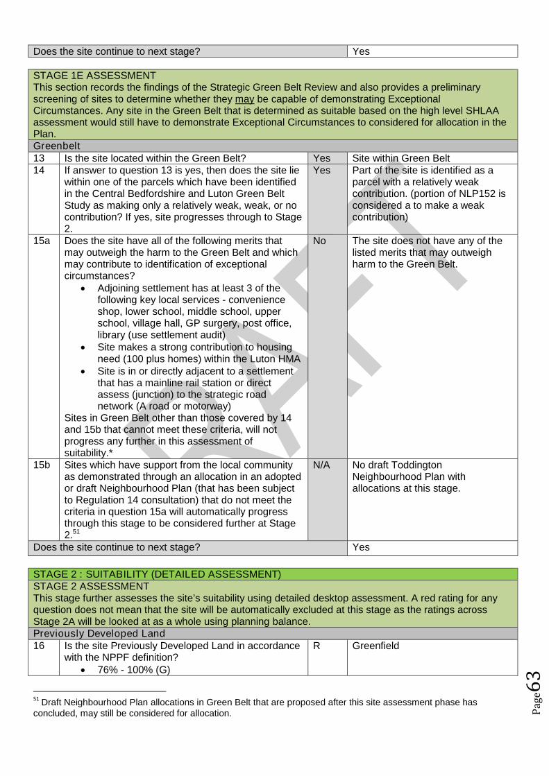
Pag
e63
Does the site continue to next stage? Yes
STAGE 1E ASSESSMENTThis section records the findings of the Strategic Green Belt Review and also provides a preliminaryscreening of sites to determine whether they may be capable of demonstrating ExceptionalCircumstances. Any site in the Green Belt that is determined as suitable based on the high level SHLAAassessment would still have to demonstrate Exceptional Circumstances to considered for allocation in thePlan.Greenbelt13 Is the site located within the Green Belt? Yes Site within Green Belt14 If answer to question 13 is yes, then does the site lie
within one of the parcels which have been identifiedin the Central Bedfordshire and Luton Green BeltStudy as making only a relatively weak, weak, or nocontribution? If yes, site progresses through to Stage2.
Yes Part of the site is identified as aparcel with a relatively weakcontribution. (portion of NLP152 isconsidered a to make a weakcontribution)
15a Does the site have all of the following merits thatmay outweigh the harm to the Green Belt and whichmay contribute to identification of exceptionalcircumstances?
Adjoining settlement has at least 3 of thefollowing key local services - convenienceshop, lower school, middle school, upperschool, village hall, GP surgery, post office,library (use settlement audit)
Site makes a strong contribution to housingneed (100 plus homes) within the Luton HMA
Site is in or directly adjacent to a settlementthat has a mainline rail station or directassess (junction) to the strategic roadnetwork (A road or motorway)
Sites in Green Belt other than those covered by 14and 15b that cannot meet these criteria, will notprogress any further in this assessment ofsuitability.*
No The site does not have any of thelisted merits that may outweighharm to the Green Belt.
15b Sites which have support from the local communityas demonstrated through an allocation in an adoptedor draft Neighbourhood Plan (that has been subjectto Regulation 14 consultation) that do not meet thecriteria in question 15a will automatically progressthrough this stage to be considered further at Stage2.51
N/A No draft ToddingtonNeighbourhood Plan withallocations at this stage.
Does the site continue to next stage? Yes
STAGE 2 : SUITABILITY (DETAILED ASSESSMENT)STAGE 2 ASSESSMENTThis stage further assesses the site’s suitability using detailed desktop assessment. A red rating for anyquestion does not mean that the site will be automatically excluded at this stage as the ratings acrossStage 2A will be looked at as a whole using planning balance.Previously Developed Land16 Is the site Previously Developed Land in accordance
with the NPPF definition? 76% - 100% (G)
R Greenfield
51Draft Neighbourhood Plan allocations in Green Belt that are proposed after this site assessment phase has
concluded, may still be considered for allocation.
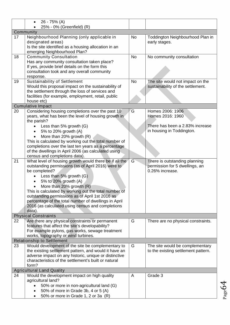
Pag
e64
26 - 75% (A) 25% - 0% (Greenfield) (R)
Community17 Neighbourhood Planning (only applicable in
designated areas)Is the site identified as a housing allocation in anemerging Neighbourhood Plan?
No Toddington Neighbourhood Plan inearly stages.
18 Community ConsultationHas any community consultation taken place?If yes, provide brief details on the form thisconsultation took and any overall communityresponse.
No No community consultation
19 Sustainability of SettlementWould this proposal impact on the sustainability ofthe settlement through the loss of services andfacilities (for example, employment, retail, publichouse etc)
No The site would not impact on thesustainability of the settlement.
Cumulative Impact20 Considering housing completions over the past 10
years, what has been the level of housing growth inthe parish?
Less than 5% growth (G) 5% to 20% growth (A) More than 20% growth (R)
This is calculated by working out the total number ofcompletions over the last ten years as a percentageof the dwellings in April 2006 (as calculated usingcensus and completions data).
G Homes 2006: 1906Homes 2016: 1960
There has been a 2.83% increasein housing in Toddington.
21 What level of housing growth would there be if all theoutstanding permissions (as of April 2016) were tobe completed?
Less than 5% growth (G) 5% to 20% growth (A) More than 20% growth (R)
This is calculated by working out the total number ofoutstanding permissions as of April 1st 2016 aspercentage of the total number of dwellings in April2016 (as calculated using census and completionsdata).
G There is outstanding planningpermission for 5 dwellings, an0.26% increase.
Physical Constraints22 Are there any physical constraints or permanent
features that affect the site’s developability?For example pylons, gas works, sewage treatmentworks, topography or wind turbines.
G There are no physical constraints.
Relationship to Settlement23 Would development of the site be complementary to
the existing settlement pattern, and would it have anadverse impact on any historic, unique or distinctivecharacteristics of the settlement’s built or naturalform?
G The site would be complementaryto the existing settlement pattern.
Agricultural Land Quality24 Would the development impact on high quality
agricultural land? 50% or more in non-agricultural land (G) 50% of more in Grade 3b, 4 or 5 (A) 50% or more in Grade 1, 2 or 3a (R)
A Grade 3

Pag
e65
STAGE 2 ASSESSMENTThis stage further assesses the site’s suitability using comments from technical specialists. A red rating forany question does not mean that the site will be automatically excluded at this stage as the ratings acrossStage 2B will be looked at as a whole using planning balance.Transport and Access to Services25 Facilities and services
Question 26 considers the suitability and sustainability of the site for housing. It links to theCouncil’s Settlement Hierarchy Audit.
Issues relating to capacity are assessed separately25a Does the settlement have a Primary/Lower school?
Yes, in the settlement (G) Yes, proposed as part of the development (G) No, but an adjoining settlement does (A) Not in the settlement or an adjoining
settlement (R)
G In settlement
25b Does the settlement have a Middle school (ifapplicable)?
Yes, in the settlement (G) Yes, proposed as part of the development (G) No, but an adjoining settlement does (A) Other catchment school available (A)
G In settlement
25c Does the settlement have a Secondary/ Upperschool?
Yes, in the settlement (G) Yes, proposed as part of the development (G) No, but an adjoining settlement does (A) Other catchment school available (A)
A Adjoining settlement
25d Does the settlement have a GPs surgery or medicalcentre?
Yes, in the settlement (G) Yes, proposed as part of the development (G) No, but an adjoining settlement does (A) Not in the settlement or an adjoining
settlement (R)
G In settlement
26 What retail provision does the settlement offer? Town Centre/ Supermarket (G) Convenience Store / Post Office / Newsagent
(A) None (R)
A Convenience store
27 Distance to bus stops with a frequent service (atleast hourly at peak times):
Less than 400m (G) 400m-800m (A) Over 800m (R) OR submission form stated that improved
public transport facilities could be provided aspart of the development (G)
A 781m from a bus stop
28 Distance to nearest train station: Less than 800m (G)
R Over 1200m

Pag
e66
800m-1200m (A) Over 1200m (R)
29 Is the site accessible from the existing road network? G Leighton RoadSchool Capacity30 Do the local schools have capacity at all tiers? R Lower school site too small to
accommodate further expansion –land or new site may be required.
31 If not, has a commitment been made to addressthis?
R Provision will need to be provided.
Water Utilities (Gas, Electricity and Broadband Infrastructure will be assessed at a later stage)32 Is there the capacity to provide all required
infrastructure for waste water and potable water?R/A/G Water utilities companies have a
statutory duty to supply water andwaste water infrastructure to newdevelopment sites and a lack ofavailable capacity does not preventfuture development. Anyinfrastructure upgrades requiredwill depend on the quantum andlocation of growth falling withineach catchment area. Whilst theStage 1 Water Cycle Study (April2017) identifies the current capacityof existing water infrastructure, aStage 2 study will be prepared totest the cumulative effect of sitesthat have been shortlisted forallocation in the Local Plan andidentify the nature and timing ofany upgrades required.
Drainage and Flooding (All sites subject to Sequential Test)33 What is the conclusion of the sequential approach to
site allocations, in regards to flood risk? No assessment required (G) Consider Further Assessment (A) Further Assessment Required (R)
G Site is at limited risk of surfacewater flooding, assessment isunlikely to be required
Environmental Health34 Contamination
Are there any contamination constraints on site andwill there be any remediation required?
R/A/G Awaiting comments
35 Adjoining usesWould any adjoining uses have the potential tocause conflict with the proposed use? (for example;noise and smell)
R/A/G Awaiting comments
Environmental Constraints36 Landscape character
What would the impacts of development be on thelandscape character or setting of the area or anydesignated landscapes? Would there be any director indirect harm to the Area of Outstanding NaturalBeauty or the Nature Improvement Area?
A elevated increasingly exposed tosouthern / eastern site boundaries.
37 Heritage/ ArchaeologyWhat would the impacts of development be on anyheritage assets and their setting?Are there any opportunities for enhancement ofthese assets?
A Site has archaeological potentialbut this would not preventallocation providing appropriatemitigation is undertaken.
38 Ecological Assets R Scrubby rough grass with orchard

Pag
e67
What would the impacts of development be on anybiological, geological or ecological assets and arethere any opportunities for their enhancement?
(HPI), mixed habitat cannotdemonstrate biodiversity net gain
39 Open space/leisure and GI assetsAre there any potential conflicts with open space,leisure designations or Rights of Way? Is therecapacity to provide the required levels of open spaceand green infrastructure?
A Current habitats would need to beretained, with existing woodlandretained / enhanced / buffered /extended.
Minerals and Waste40 What would the impacts of development be on
safeguarded minerals and waste sites, includingmineral safeguarding sites?
G No issues
Planning History41 What is the sites planning history? (For example
planning applications and submissions to previousAllocations Plans)
No relevant planning history
Does the site continue to next stage? Yes
STAGE 2 ASSESSMENT CONCLUSIONIs the site suitable for the proposed development?
A portion of the site is considered appropriate for further assessment.
Although there are no primary constraints to development on the site, there are concernsregarding ecological and landscape issues. Any development here would requiresubstantial mitigation to compensate for the landscape concerns and ecological losses.
The site is located on the green belt, however, a portion of the site (parcel NLP152) islocated on land considered to contributes weakly to the green belt objectives.
Although Toddington is considered a sustainable village in terms of its facilities andservices, any further development would require contributions to education provision.
Due to the above landscape and ecological issues and the fact that the site is located on the greenbelt, only a portion of the site is considered appropriate for further assessment.
STAGE 3 : ACHIEVABILITYThis section assesses whether the site is Achievable in line with NPPG Guidance:A site is considered achievable for development where there is a reasonable prospect that the particulartype of development will be developed on the site at a particular point in time. This is essentially ajudgement about the economic viability of the site, and the capacity of the developer to complete and let orsell the development over a certain period.
Viability43 Referring to the Viability Assessment undertaken by
consultants, is the probability of the site being viablehigh, medium or low?
High (G) Benchmark land value comfortablyexceeded by likely residual value
Low (A) Marginal viability, with likely residualland value close to benchmark land value
Very Low (R) Likely residual value well belowbenchmark land value
G The Council’s ResidentialDevelopment Viability Report (Feb2017) indicates that residual valueof development in this value areaand at this scale would exceedboth the upper and lowerbenchmark land values and assuch the report indicates that suchdevelopment would likely be viable.
Achievability44 Are there any market factors which would affect
deliverability?Site part owned by a developer.
The Council’s ResidentialDevelopment Viability Report (Feb
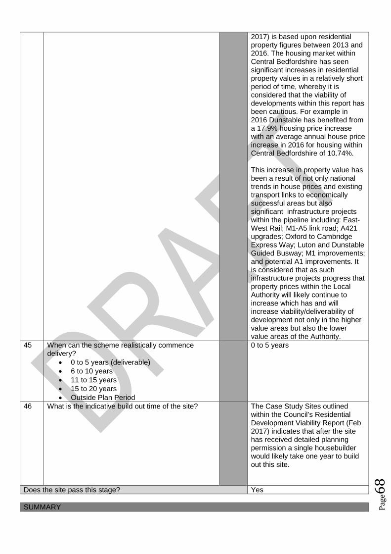
Pag
e68
2017) is based upon residentialproperty figures between 2013 and2016. The housing market withinCentral Bedfordshire has seensignificant increases in residentialproperty values in a relatively shortperiod of time, whereby it isconsidered that the viability ofdevelopments within this report hasbeen cautious. For example in2016 Dunstable has benefited froma 17.9% housing price increasewith an average annual house priceincrease in 2016 for housing withinCentral Bedfordshire of 10.74%.
This increase in property value hasbeen a result of not only nationaltrends in house prices and existingtransport links to economicallysuccessful areas but alsosignificant infrastructure projectswithin the pipeline including: East-West Rail; M1-A5 link road; A421upgrades; Oxford to CambridgeExpress Way; Luton and DunstableGuided Busway; M1 improvements;and potential A1 improvements. Itis considered that as suchinfrastructure projects progress thatproperty prices within the LocalAuthority will likely continue toincrease which has and willincrease viability/deliverability ofdevelopment not only in the highervalue areas but also the lowervalue areas of the Authority.
45 When can the scheme realistically commencedelivery?
0 to 5 years (deliverable) 6 to 10 years 11 to 15 years 15 to 20 years Outside Plan Period
0 to 5 years
46 What is the indicative build out time of the site? The Case Study Sites outlinedwithin the Council’s ResidentialDevelopment Viability Report (Feb2017) indicates that after the sitehas received detailed planningpermission a single housebuilderwould likely take one year to buildout this site.
Does the site pass this stage? Yes
SUMMARY
Pag
e69
The sites that pass through this assessment process will not automatically be allocated for development inthe Local Plan.
Sites will be selected with reference to a number of other factors including: The strategy, vision and objectives proposed in the draft plan Technical evidence studies The sustainability appraisal process The results of public consultation Flood Risk Sequential Approach Further transport modelling Consultation with neighbouring authorities

Pag
e70
Site Assessment Framework for HOUSING52
Site detailsReference Number NLP184
Site Name Middle LakesSite Address Middle Lakes, Russell RoadSettlement ToddingtonSize Submitted Developable Area: 2.83ha
Submitted Whole Site Area: 2.83haMeasured GIS Area:2.83ha
Proposed Use ResidentialAny otherinformation
Same as ALP086
STAGE 1 : SUITABILITY AND AVAILABILITY (EXCLUSIONARY STAGE)This section will exclude any sites which do not pass the exclusionary suitability criteria and they will notbe assessed further.
STAGE 1A ASSESSMENTThis stage of the assessment rules out sites that are too small or conflict with national policy designations.Provisional Site Capacity1 Is the site likely to accommodate less than 10
dwellings?Work out the number of new homes from site sizeusing density of 30dph and exclude up to 40 %depending on site size of land for infrastructure andservices, take into account topography or significantareas of undevelopable land.Site Size Gross to net ratio standards
Up to 0.4 hectare 100% 0.4 to 2 hectares 80% 2 hectares or above 60%
Note: for this calculation use the submittedDevelopable Area, or the area measured in GIS ifthis is smaller.
no Number of proposed dwellings asper proforma:
63
Number of proposed dwellings asper CBC methodology:
50
Flood Risk (All sites which reach Stage 2 will be subject to the Sequential Test)2 Is more than 50% of the site located in Flood Zone 2
or 3?No Not in Floodzone 2 and 3
3 Is more than 50% of the site at risk from surfacewater flooding?
No Not at risk from surface waterflooding
Nationally significant designations (All sites which reach Stage 2 be subject to detailed assessment)4 Is more than 50% of the site covered by nationally
significant designations? These are: Sites of SpecialScientific Interest, National Nature Reserves,Scheduled Monuments, Registered Parks andGardens.
No Not within nationally significantdesignation
5 Is more than 50% of the site located within the Areaof Outstanding Natural Beauty?
No Not within AONB
Does the site continue to next stage? Yes
52Employment sites and Gypsy and Traveller sites will be assessed using separate bespoke site assessment criteria.
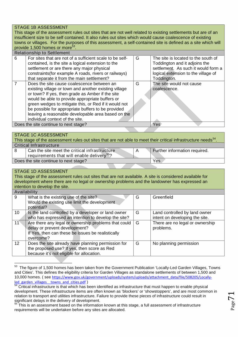
Pag
e71
STAGE 1B ASSESSMENTThis stage of the assessment rules out sites that are not well related to existing settlements but are of aninsufficient size to be self contained. It also rules out sites which would cause coalescence of existingtowns or villages. For the purposes of this assessment, a self-contained site is defined as a site which willprovide 1,500 homes or more53.Relationship to Settlement6 For sites that are not of a sufficient scale to be self-
contained, is the site a logical extension to thesettlement or are there any major physicalconstraints(for example A roads, rivers or railways)that separate it from the main settlement?
G The site is located to the south ofToddington and it adjoins thesettlement. As such it would form alogical extension to the village ofToddington.
7 Does the site cause coalescence between anexisting village or town and another existing villageor town? If yes, then grade as Amber if the sitewould be able to provide appropriate buffers orgreen wedges to mitigate this, or Red if it would notbe possible for appropriate buffers to be providedleaving a reasonable developable area based on theindividual context of the site.
G The site would not causecoalescence.
Does the site continue to next stage? Yes
STAGE 1C ASSESSMENTThis stage of the assessment rules out sites that are not able to meet their critical infrastructure needs54.Critical Infrastructure8 Can the site meet the critical infrastructure
requirements that will enable delivery55?A Further information required.
Does the site continue to next stage? Yes
STAGE 1D ASSESSMENTThis stage of the assessment rules out sites that are not available. A site is considered available fordevelopment where there are no legal or ownership problems and the landowner has expressed anintention to develop the site.Availability9 What is the existing use of the site?
Would the existing use limit the developmentpotential?
G Greenfield
10 Is the land controlled by a developer or land ownerwho has expressed an intention to develop the site?
G Land controlled by land ownerintent on developing the site.
11 Are there any legal or ownership problems that coulddelay or prevent development?If Yes, then can these be issues be realisticallyovercome?
G There are no legal or ownershipproblems.
12 Does the site already have planning permission forthe proposed use? If yes, then score as Redbecause it’s not eligible for allocation.
G No planning permission
53The figure of 1,500 homes has been taken from the Government Publication ‘Locally-Led Garden Villages, Towns
and Cities’. This defines the eligibility criteria for Garden Villages as standalone settlements of between 1,500 and10,000 homes. ( see https://www.gov.uk/government/uploads/system/uploads/attachment_data/file/508205/Locally-led_garden_villages__towns_and_cities.pdf )54
Critical infrastructure is that which has been identified as infrastructure that must happen to enable physicaldevelopment. These infrastructure items are often known as ‘blockers’ or ‘showstoppers’, and are most common inrelation to transport and utilities infrastructure. Failure to provide these pieces of infrastructure could result insignificant delays in the delivery of development.55
This is an assessment based on the information known at this stage, a full assessment of infrastructurerequirements will be undertaken before any sites are allocated.

Pag
e72
Does the site continue to next stage? Yes
STAGE 1E ASSESSMENTThis section records the findings of the Strategic Green Belt Review and also provides a preliminaryscreening of sites to determine whether they may be capable of demonstrating ExceptionalCircumstances. Any site in the Green Belt that is determined as suitable based on the high level SHLAAassessment would still have to demonstrate Exceptional Circumstances to considered for allocation in thePlan.Greenbelt13 Is the site located within the Green Belt? Yes Site within Green Belt14 If answer to question 13 is yes, then does the site lie
within one of the parcels which have been identifiedin the Central Bedfordshire and Luton Green BeltStudy as making only a relatively weak, weak, or nocontribution? If yes, site progresses through to Stage2.
Yes The site has been identified ascontributing a relatively weakcontribution.
15a Does the site have all of the following merits thatmay outweigh the harm to the Green Belt and whichmay contribute to identification of exceptionalcircumstances?
Adjoining settlement has at least 3 of thefollowing key local services - convenienceshop, lower school, middle school, upperschool, village hall, GP surgery, post office,library (use settlement audit)
Site makes a strong contribution to housingneed (100 plus homes) within the Luton HMA
Site is in or directly adjacent to a settlementthat has a mainline rail station or directassess (junction) to the strategic roadnetwork (A road or motorway)
Sites in Green Belt other than those covered by 14and 15b that cannot meet these criteria, will notprogress any further in this assessment ofsuitability.*
No The site does not have any of thelisted merits that may outweighharm to the Green Belt.
15b Sites which have support from the local communityas demonstrated through an allocation in an adoptedor draft Neighbourhood Plan (that has been subjectto Regulation 14 consultation) that do not meet thecriteria in question 15a will automatically progressthrough this stage to be considered further at Stage2.56
N/A No draft ToddingtonNeighbourhood Plan withallocations at this stage.
Does the site continue to next stage? Yes
STAGE 2 : SUITABILITY (DETAILED ASSESSMENT)STAGE 2 ASSESSMENTThis stage further assesses the site’s suitability using detailed desktop assessment. A red rating for anyquestion does not mean that the site will be automatically excluded at this stage as the ratings acrossStage 2A will be looked at as a whole using planning balance.Previously Developed Land16 Is the site Previously Developed Land in accordance
with the NPPF definition? 76% - 100% (G)
R Greenfield
56Draft Neighbourhood Plan allocations in Green Belt that are proposed after this site assessment phase has
concluded, may still be considered for allocation.
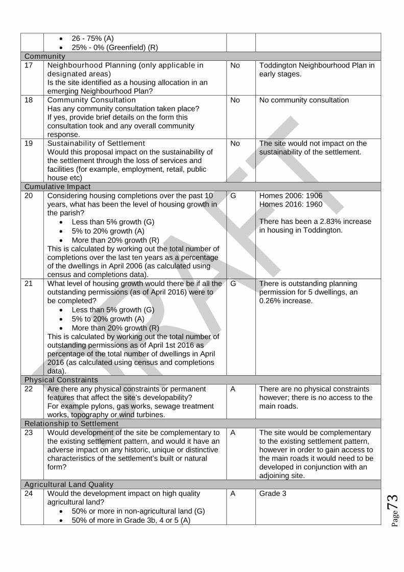
Pag
e73
26 - 75% (A) 25% - 0% (Greenfield) (R)
Community17 Neighbourhood Planning (only applicable in
designated areas)Is the site identified as a housing allocation in anemerging Neighbourhood Plan?
No Toddington Neighbourhood Plan inearly stages.
18 Community ConsultationHas any community consultation taken place?If yes, provide brief details on the form thisconsultation took and any overall communityresponse.
No No community consultation
19 Sustainability of SettlementWould this proposal impact on the sustainability ofthe settlement through the loss of services andfacilities (for example, employment, retail, publichouse etc)
No The site would not impact on thesustainability of the settlement.
Cumulative Impact20 Considering housing completions over the past 10
years, what has been the level of housing growth inthe parish?
Less than 5% growth (G) 5% to 20% growth (A) More than 20% growth (R)
This is calculated by working out the total number ofcompletions over the last ten years as a percentageof the dwellings in April 2006 (as calculated usingcensus and completions data).
G Homes 2006: 1906Homes 2016: 1960
There has been a 2.83% increasein housing in Toddington.
21 What level of housing growth would there be if all theoutstanding permissions (as of April 2016) were tobe completed?
Less than 5% growth (G) 5% to 20% growth (A) More than 20% growth (R)
This is calculated by working out the total number ofoutstanding permissions as of April 1st 2016 aspercentage of the total number of dwellings in April2016 (as calculated using census and completionsdata).
G There is outstanding planningpermission for 5 dwellings, an0.26% increase.
Physical Constraints22 Are there any physical constraints or permanent
features that affect the site’s developability?For example pylons, gas works, sewage treatmentworks, topography or wind turbines.
A There are no physical constraintshowever; there is no access to themain roads.
Relationship to Settlement23 Would development of the site be complementary to
the existing settlement pattern, and would it have anadverse impact on any historic, unique or distinctivecharacteristics of the settlement’s built or naturalform?
A The site would be complementaryto the existing settlement pattern,however in order to gain access tothe main roads it would need to bedeveloped in conjunction with anadjoining site.
Agricultural Land Quality24 Would the development impact on high quality
agricultural land? 50% or more in non-agricultural land (G) 50% of more in Grade 3b, 4 or 5 (A)
A Grade 3
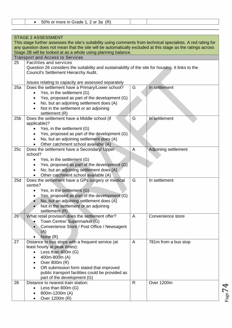
Pag
e74
50% or more in Grade 1, 2 or 3a (R)
STAGE 2 ASSESSMENTThis stage further assesses the site’s suitability using comments from technical specialists. A red rating forany question does not mean that the site will be automatically excluded at this stage as the ratings acrossStage 2B will be looked at as a whole using planning balance.Transport and Access to Services25 Facilities and services
Question 26 considers the suitability and sustainability of the site for housing. It links to theCouncil’s Settlement Hierarchy Audit.
Issues relating to capacity are assessed separately25a Does the settlement have a Primary/Lower school?
Yes, in the settlement (G) Yes, proposed as part of the development (G) No, but an adjoining settlement does (A) Not in the settlement or an adjoining
settlement (R)
G In settlement
25b Does the settlement have a Middle school (ifapplicable)?
Yes, in the settlement (G) Yes, proposed as part of the development (G) No, but an adjoining settlement does (A) Other catchment school available (A)
G In settlement
25c Does the settlement have a Secondary/ Upperschool?
Yes, in the settlement (G) Yes, proposed as part of the development (G) No, but an adjoining settlement does (A) Other catchment school available (A)
A Adjoining settlement
25d Does the settlement have a GPs surgery or medicalcentre?
Yes, in the settlement (G) Yes, proposed as part of the development (G) No, but an adjoining settlement does (A) Not in the settlement or an adjoining
settlement (R)
G In settlement
26 What retail provision does the settlement offer? Town Centre/ Supermarket (G) Convenience Store / Post Office / Newsagent
(A) None (R)
A Convenience store
27 Distance to bus stops with a frequent service (atleast hourly at peak times):
Less than 400m (G) 400m-800m (A) Over 800m (R) OR submission form stated that improved
public transport facilities could be provided aspart of the development (G)
A 781m from a bus stop
28 Distance to nearest train station: Less than 800m (G) 800m-1200m (A) Over 1200m (R)
R Over 1200m

Pag
e75
29 Is the site accessible from the existing road network? R NoSchool Capacity30 Do the local schools have capacity at all tiers? R Lower school site too small to
accommodate further expansion –land or new site may be required.
31 If not, has a commitment been made to addressthis?
R Provision will need to be provided.
Water Utilities (Gas, Electricity and Broadband Infrastructure will be assessed at a later stage)32 Is there the capacity to provide all required
infrastructure for waste water and potable water?R/A/G Water utilities companies have a
statutory duty to supply water andwaste water infrastructure to newdevelopment sites and a lack ofavailable capacity does not preventfuture development. Anyinfrastructure upgrades requiredwill depend on the quantum andlocation of growth falling withineach catchment area. Whilst theStage 1 Water Cycle Study (April2017) identifies the current capacityof existing water infrastructure, aStage 2 study will be prepared totest the cumulative effect of sitesthat have been shortlisted forallocation in the Local Plan andidentify the nature and timing ofany upgrades required.
Drainage and Flooding (All sites subject to Sequential Test)33 What is the conclusion of the sequential approach to
site allocations, in regards to flood risk? No assessment required (G) Consider Further Assessment (A) Further Assessment Required (R)
G Site is at limited risk of surfacewater flooding, assessment isunlikely to be required
Environmental Health34 Contamination
Are there any contamination constraints on site andwill there be any remediation required?
R/A/G Awaiting comments
35 Adjoining usesWould any adjoining uses have the potential tocause conflict with the proposed use? (for example;noise and smell)
R/A/G Awaiting comments
Environmental Constraints36 Landscape character
What would the impacts of development be on thelandscape character or setting of the area or anydesignated landscapes? Would there be any director indirect harm to the Area of Outstanding NaturalBeauty or the Nature Improvement Area?
A must enhance settlement edgelinked to existing plantingstructures / GI
37 Heritage/ ArchaeologyWhat would the impacts of development be on anyheritage assets and their setting?Are there any opportunities for enhancement ofthese assets?
A Site has archaeological potentialbut this would not preventallocation providing appropriatemitigation is undertaken.
38 Ecological AssetsWhat would the impacts of development be on anybiological, geological or ecological assets and are
A Existing grassland, retain andbuffer hedgerows, potential impacton bats in hedgerows.
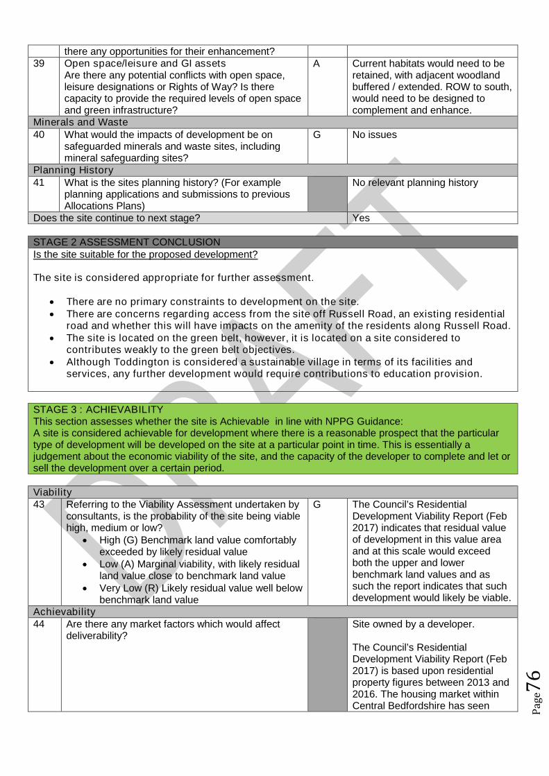
Pag
e76
there any opportunities for their enhancement?39 Open space/leisure and GI assets
Are there any potential conflicts with open space,leisure designations or Rights of Way? Is therecapacity to provide the required levels of open spaceand green infrastructure?
A Current habitats would need to beretained, with adjacent woodlandbuffered / extended. ROW to south,would need to be designed tocomplement and enhance.
Minerals and Waste40 What would the impacts of development be on
safeguarded minerals and waste sites, includingmineral safeguarding sites?
G No issues
Planning History41 What is the sites planning history? (For example
planning applications and submissions to previousAllocations Plans)
No relevant planning history
Does the site continue to next stage? Yes
STAGE 2 ASSESSMENT CONCLUSIONIs the site suitable for the proposed development?
The site is considered appropriate for further assessment.
There are no primary constraints to development on the site. There are concerns regarding access from the site off Russell Road, an existing residential
road and whether this will have impacts on the amenity of the residents along Russell Road. The site is located on the green belt, however, it is located on a site considered to
contributes weakly to the green belt objectives. Although Toddington is considered a sustainable village in terms of its facilities and
services, any further development would require contributions to education provision.
STAGE 3 : ACHIEVABILITYThis section assesses whether the site is Achievable in line with NPPG Guidance:A site is considered achievable for development where there is a reasonable prospect that the particulartype of development will be developed on the site at a particular point in time. This is essentially ajudgement about the economic viability of the site, and the capacity of the developer to complete and let orsell the development over a certain period.
Viability43 Referring to the Viability Assessment undertaken by
consultants, is the probability of the site being viablehigh, medium or low?
High (G) Benchmark land value comfortablyexceeded by likely residual value
Low (A) Marginal viability, with likely residualland value close to benchmark land value
Very Low (R) Likely residual value well belowbenchmark land value
G The Council’s ResidentialDevelopment Viability Report (Feb2017) indicates that residual valueof development in this value areaand at this scale would exceedboth the upper and lowerbenchmark land values and assuch the report indicates that suchdevelopment would likely be viable.
Achievability44 Are there any market factors which would affect
deliverability?Site owned by a developer.
The Council’s ResidentialDevelopment Viability Report (Feb2017) is based upon residentialproperty figures between 2013 and2016. The housing market withinCentral Bedfordshire has seen
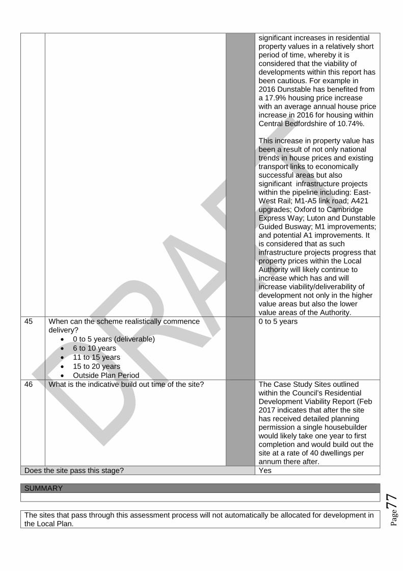
Pag
e77
significant increases in residentialproperty values in a relatively shortperiod of time, whereby it isconsidered that the viability ofdevelopments within this report hasbeen cautious. For example in2016 Dunstable has benefited froma 17.9% housing price increasewith an average annual house priceincrease in 2016 for housing withinCentral Bedfordshire of 10.74%.
This increase in property value hasbeen a result of not only nationaltrends in house prices and existingtransport links to economicallysuccessful areas but alsosignificant infrastructure projectswithin the pipeline including: East-West Rail; M1-A5 link road; A421upgrades; Oxford to CambridgeExpress Way; Luton and DunstableGuided Busway; M1 improvements;and potential A1 improvements. Itis considered that as suchinfrastructure projects progress thatproperty prices within the LocalAuthority will likely continue toincrease which has and willincrease viability/deliverability ofdevelopment not only in the highervalue areas but also the lowervalue areas of the Authority.
45 When can the scheme realistically commencedelivery?
0 to 5 years (deliverable) 6 to 10 years 11 to 15 years 15 to 20 years Outside Plan Period
0 to 5 years
46 What is the indicative build out time of the site? The Case Study Sites outlinedwithin the Council’s ResidentialDevelopment Viability Report (Feb2017 indicates that after the sitehas received detailed planningpermission a single housebuilderwould likely take one year to firstcompletion and would build out thesite at a rate of 40 dwellings perannum there after.
Does the site pass this stage? Yes
SUMMARY
The sites that pass through this assessment process will not automatically be allocated for development inthe Local Plan.

Pag
e78
Sites will be selected with reference to a number of other factors including: The strategy, vision and objectives proposed in the draft plan Technical evidence studies The sustainability appraisal process The results of public consultation Flood Risk Sequential Approach Further transport modelling Consultation with neighbouring authorities

Pag
e79
Site Assessment Framework for HOUSING57
Site detailsReference Number NLP294
Site Name Land lying to the east of Luton RoadSite Address Land lying to the east of Luton RoadSettlement ToddingtonSize Submitted Developable Area: 0.9ha
Submitted Whole Site Area: 1haMeasured GIS Area:0.44ha
Proposed Use ResidentialAny otherinformation
Site also forms part of NLP138
STAGE 1 : SUITABILITY AND AVAILABILITY (EXCLUSIONARY STAGE)This section will exclude any sites which do not pass the exclusionary suitability criteria and they will notbe assessed further.
STAGE 1A ASSESSMENTThis stage of the assessment rules out sites that are too small or conflict with national policy designations.Provisional Site Capacity1 Is the site likely to accommodate less than 10
dwellings?Work out the number of new homes from site sizeusing density of 30dph and exclude up to 40 %depending on site size of land for infrastructure andservices, take into account topography or significantareas of undevelopable land.Site Size Gross to net ratio standards
Up to 0.4 hectare 100% 0.4 to 2 hectares 80% 2 hectares or above 60%
Note: for this calculation use the submittedDevelopable Area, or the area measured in GIS ifthis is smaller.
no Number of proposed dwellings asper proforma:
12
Number of proposed dwellings asper CBC methodology:
11
Flood Risk (All sites which reach Stage 2 will be subject to the Sequential Test)2 Is more than 50% of the site located in Flood Zone 2
or 3?No Not in Floodzone 2 and 3
3 Is more than 50% of the site at risk from surfacewater flooding?
No Not at risk from surface waterflooding
Nationally significant designations (All sites which reach Stage 2 be subject to detailed assessment)4 Is more than 50% of the site covered by nationally
significant designations? These are: Sites of SpecialScientific Interest, National Nature Reserves,Scheduled Monuments, Registered Parks andGardens.
No Not within nationally significantdesignation
5 Is more than 50% of the site located within the Areaof Outstanding Natural Beauty?
No Not within AONB
Does the site continue to next stage? Yes
57Employment sites and Gypsy and Traveller sites will be assessed using separate bespoke site assessment criteria.
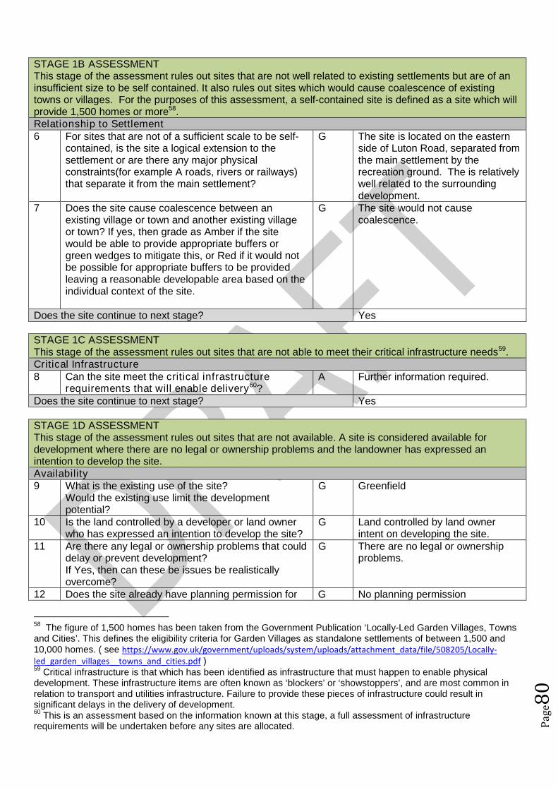
Pag
e80
STAGE 1B ASSESSMENTThis stage of the assessment rules out sites that are not well related to existing settlements but are of aninsufficient size to be self contained. It also rules out sites which would cause coalescence of existingtowns or villages. For the purposes of this assessment, a self-contained site is defined as a site which willprovide 1,500 homes or more58.Relationship to Settlement6 For sites that are not of a sufficient scale to be self-
contained, is the site a logical extension to thesettlement or are there any major physicalconstraints(for example A roads, rivers or railways)that separate it from the main settlement?
G The site is located on the easternside of Luton Road, separated fromthe main settlement by therecreation ground. The is relativelywell related to the surroundingdevelopment.
7 Does the site cause coalescence between anexisting village or town and another existing villageor town? If yes, then grade as Amber if the sitewould be able to provide appropriate buffers orgreen wedges to mitigate this, or Red if it would notbe possible for appropriate buffers to be providedleaving a reasonable developable area based on theindividual context of the site.
G The site would not causecoalescence.
Does the site continue to next stage? Yes
STAGE 1C ASSESSMENTThis stage of the assessment rules out sites that are not able to meet their critical infrastructure needs59.Critical Infrastructure8 Can the site meet the critical infrastructure
requirements that will enable delivery60?A Further information required.
Does the site continue to next stage? Yes
STAGE 1D ASSESSMENTThis stage of the assessment rules out sites that are not available. A site is considered available fordevelopment where there are no legal or ownership problems and the landowner has expressed anintention to develop the site.Availability9 What is the existing use of the site?
Would the existing use limit the developmentpotential?
G Greenfield
10 Is the land controlled by a developer or land ownerwho has expressed an intention to develop the site?
G Land controlled by land ownerintent on developing the site.
11 Are there any legal or ownership problems that coulddelay or prevent development?If Yes, then can these be issues be realisticallyovercome?
G There are no legal or ownershipproblems.
12 Does the site already have planning permission for G No planning permission
58The figure of 1,500 homes has been taken from the Government Publication ‘Locally-Led Garden Villages, Towns
and Cities’. This defines the eligibility criteria for Garden Villages as standalone settlements of between 1,500 and10,000 homes. ( see https://www.gov.uk/government/uploads/system/uploads/attachment_data/file/508205/Locally-led_garden_villages__towns_and_cities.pdf )59
Critical infrastructure is that which has been identified as infrastructure that must happen to enable physicaldevelopment. These infrastructure items are often known as ‘blockers’ or ‘showstoppers’, and are most common inrelation to transport and utilities infrastructure. Failure to provide these pieces of infrastructure could result insignificant delays in the delivery of development.60
This is an assessment based on the information known at this stage, a full assessment of infrastructurerequirements will be undertaken before any sites are allocated.

Pag
e81
the proposed use? If yes, then score as Redbecause it’s not eligible for allocation.
Does the site continue to next stage? Yes
STAGE 1E ASSESSMENTThis section records the findings of the Strategic Green Belt Review and also provides a preliminaryscreening of sites to determine whether they may be capable of demonstrating ExceptionalCircumstances. Any site in the Green Belt that is determined as suitable based on the high level SHLAAassessment would still have to demonstrate Exceptional Circumstances to considered for allocation in thePlan.Greenbelt13 Is the site located within the Green Belt? Yes Site within Green Belt14 If answer to question 13 is yes, then does the site lie
within one of the parcels which have been identifiedin the Central Bedfordshire and Luton Green BeltStudy as making only a relatively weak, weak, or nocontribution? If yes, site progresses through to Stage2.
No The site does not lie within one ofthe parcels.
15a Does the site have all of the following merits thatmay outweigh the harm to the Green Belt and whichmay contribute to identification of exceptionalcircumstances?
Adjoining settlement has at least 3 of thefollowing key local services - convenienceshop, lower school, middle school, upperschool, village hall, GP surgery, post office,library (use settlement audit)
Site makes a strong contribution to housingneed (100 plus homes) within the Luton HMA
Site is in or directly adjacent to a settlementthat has a mainline rail station or directassess (junction) to the strategic roadnetwork (A road or motorway)
Sites in Green Belt other than those covered by 14and 15b that cannot meet these criteria, will notprogress any further in this assessment ofsuitability.*
No The site does not have any of thelisted merits that may outweighharm to the Green Belt.
15b Sites which have support from the local communityas demonstrated through an allocation in an adoptedor draft Neighbourhood Plan (that has been subjectto Regulation 14 consultation) that do not meet thecriteria in question 15a will automatically progressthrough this stage to be considered further at Stage2.61
N/A No draft ToddingtonNeighbourhood Plan withallocations at this stage.
Does the site continue to next stage? No
61Draft Neighbourhood Plan allocations in Green Belt that are proposed after this site assessment phase has
concluded, may still be considered for allocation.

Pag
e82
Site Assessment Framework for HOUSING62
Site detailsReference Number NLP348
Site Name Fairview FarmSite Address Fairview Farm ToddingtonSettlement ToddingtonSize Submitted Developable Area: 6.3ha
Submitted Whole Site Area: 30haMeasured GIS Area: 14.57ha
Proposed Use ResidentialAny otherinformation
See ALP189
STAGE 1 : SUITABILITY AND AVAILABILITY (EXCLUSIONARY STAGE)This section will exclude any sites which do not pass the exclusionary suitability criteria and they will notbe assessed further.
STAGE 1A ASSESSMENTThis stage of the assessment rules out sites that are too small or conflict with national policy designations.Provisional Site Capacity1 Is the site likely to accommodate less than 10
dwellings?Work out the number of new homes from site sizeusing density of 30dph and exclude up to 40 %depending on site size of land for infrastructure andservices, take into account topography or significantareas of undevelopable land.Site Size Gross to net ratio standards
Up to 0.4 hectare 100% 0.4 to 2 hectares 80% 2 hectares or above 60%
Note: for this calculation use the submittedDevelopable Area, or the area measured in GIS ifthis is smaller.
No Number of proposed dwellings asper proforma:
100
Number of proposed dwellings asper CBC methodology:
113
Flood Risk (All sites which reach Stage 2 will be subject to the Sequential Test)2 Is more than 50% of the site located in Flood Zone 2
or 3?No Site not within Floodzone 2 or 3.
3 Is more than 50% of the site at risk from surfacewater flooding?
No Site not at risk from surface waterflooding
Nationally significant designations (All sites which reach Stage 2 be subject to detailed assessment)4 Is more than 50% of the site covered by nationally
significant designations? These are: Sites of SpecialScientific Interest, National Nature Reserves,Scheduled Monuments, Registered Parks andGardens.
No No nationally significantdesignations on site.
5 Is more than 50% of the site located within the Areaof Outstanding Natural Beauty?
No Not within the AONB
Does the site continue to next stage? Yes
62Employment sites and Gypsy and Traveller sites will be assessed using separate bespoke site assessment criteria.
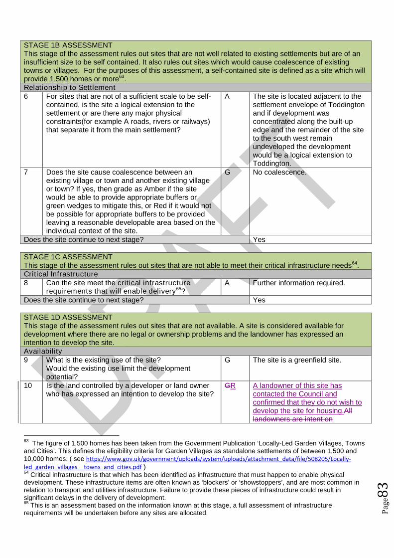
Pag
e83
STAGE 1B ASSESSMENTThis stage of the assessment rules out sites that are not well related to existing settlements but are of aninsufficient size to be self contained. It also rules out sites which would cause coalescence of existingtowns or villages. For the purposes of this assessment, a self-contained site is defined as a site which willprovide 1,500 homes or more63.Relationship to Settlement6 For sites that are not of a sufficient scale to be self-
contained, is the site a logical extension to thesettlement or are there any major physicalconstraints(for example A roads, rivers or railways)that separate it from the main settlement?
A The site is located adjacent to thesettlement envelope of Toddingtonand if development wasconcentrated along the built-upedge and the remainder of the siteto the south west remainundeveloped the developmentwould be a logical extension toToddington.
7 Does the site cause coalescence between anexisting village or town and another existing villageor town? If yes, then grade as Amber if the sitewould be able to provide appropriate buffers orgreen wedges to mitigate this, or Red if it would notbe possible for appropriate buffers to be providedleaving a reasonable developable area based on theindividual context of the site.
G No coalescence.
Does the site continue to next stage? Yes
STAGE 1C ASSESSMENTThis stage of the assessment rules out sites that are not able to meet their critical infrastructure needs64.Critical Infrastructure8 Can the site meet the critical infrastructure
requirements that will enable delivery65?A Further information required.
Does the site continue to next stage? Yes
STAGE 1D ASSESSMENTThis stage of the assessment rules out sites that are not available. A site is considered available fordevelopment where there are no legal or ownership problems and the landowner has expressed anintention to develop the site.Availability9 What is the existing use of the site?
Would the existing use limit the developmentpotential?
G The site is a greenfield site.
10 Is the land controlled by a developer or land ownerwho has expressed an intention to develop the site?
GR A landowner of this site hascontacted the Council andconfirmed that they do not wish todevelop the site for housing.Alllandowners are intent on
63The figure of 1,500 homes has been taken from the Government Publication ‘Locally-Led Garden Villages, Towns
and Cities’. This defines the eligibility criteria for Garden Villages as standalone settlements of between 1,500 and10,000 homes. ( see https://www.gov.uk/government/uploads/system/uploads/attachment_data/file/508205/Locally-led_garden_villages__towns_and_cities.pdf )64
Critical infrastructure is that which has been identified as infrastructure that must happen to enable physicaldevelopment. These infrastructure items are often known as ‘blockers’ or ‘showstoppers’, and are most common inrelation to transport and utilities infrastructure. Failure to provide these pieces of infrastructure could result insignificant delays in the delivery of development.65
This is an assessment based on the information known at this stage, a full assessment of infrastructurerequirements will be undertaken before any sites are allocated.

Pag
e84
developing the site.11 Are there any legal or ownership problems that could
delay or prevent development?If Yes, then can these be issues be realisticallyovercome?
G No legal or ownership problemsthat could delay or preventdevelopment.
12 Does the site already have planning permission forthe proposed use? If yes, then score as Redbecause it’s not eligible for allocation.
G No planning permission for theproposed use.
Does the site continue to next stage? YesNo
STAGE 1E ASSESSMENTThis section records the findings of the Strategic Green Belt Review and also provides a preliminaryscreening of sites to determine whether they may be capable of demonstrating ExceptionalCircumstances. Any site in the Green Belt that is determined as suitable based on the high level SHLAAassessment would still have to demonstrate Exceptional Circumstances to considered for allocation in thePlan.Greenbelt13 Is the site located within the Green Belt? Yes Site located within the green belt14 If answer to question 13 is yes, then does the site lie
within one of the parcels which have been identifiedin the Central Bedfordshire and Luton Green BeltStudy as making only a relatively weak, weak, or nocontribution? If yes, site progresses through to Stage2.
No Site not on an identified parcel.
15a Does the site have all of the following merits thatmay outweigh the harm to the Green Belt and whichmay contribute to identification of exceptionalcircumstances?
Adjoining settlement has at least 3 of thefollowing key local services - convenienceshop, lower school, middle school, upperschool, village hall, GP surgery, post office,library (use settlement audit)
Site makes a strong contribution to housingneed (100 plus homes) within the Luton HMA
Site is in or directly adjacent to a settlementthat has a mainline rail station or directassess (junction) to the strategic roadnetwork (A road or motorway)
Sites in Green Belt other than those covered by 14and 15b that cannot meet these criteria, will notprogress any further in this assessment ofsuitability.*
Yes The site meets the three listedcriteria.
15b Sites which have support from the local communityas demonstrated through an allocation in an adoptedor draft Neighbourhood Plan (that has been subjectto Regulation 14 consultation) that do not meet thecriteria in question 15a will automatically progressthrough this stage to be considered further at Stage2.66
N/A No draft ToddingtonNeighbourhood Plan withallocations at this stage.
Does the site continue to next stage? Yes
STAGE 2 : SUITABILITY (DETAILED ASSESSMENT)
66Draft Neighbourhood Plan allocations in Green Belt that are proposed after this site assessment phase has
concluded, may still be considered for allocation.
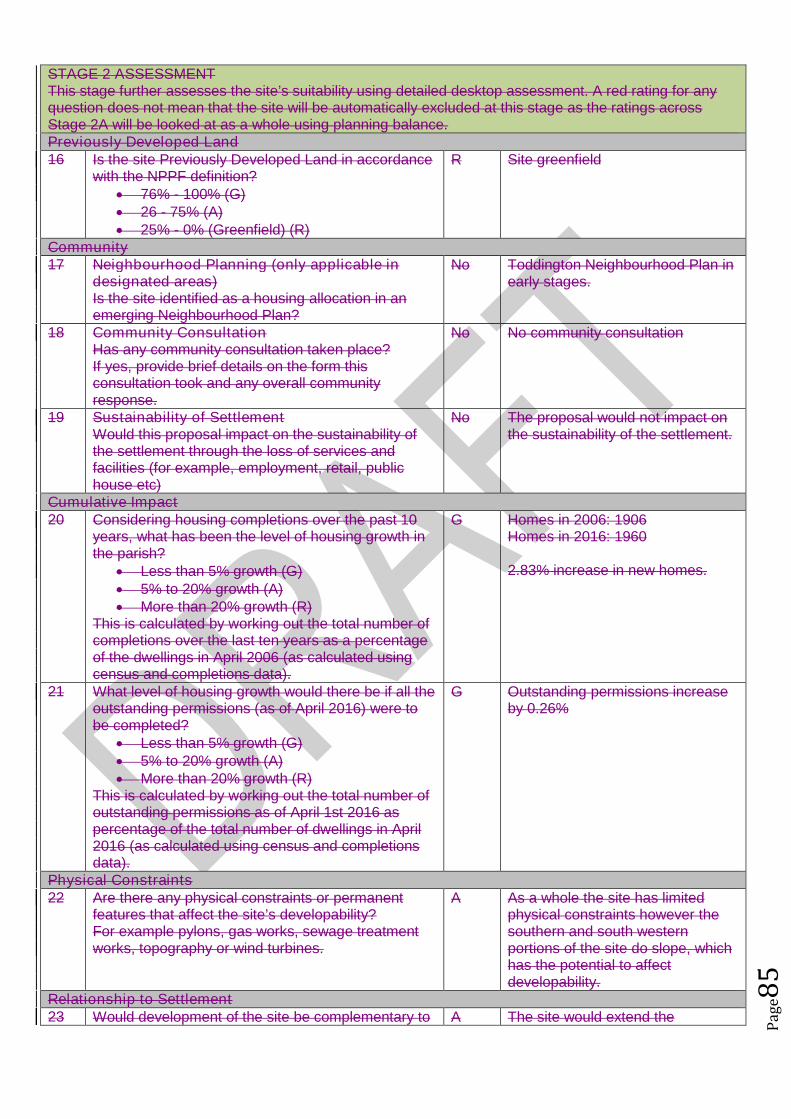
Pag
e85
STAGE 2 ASSESSMENTThis stage further assesses the site’s suitability using detailed desktop assessment. A red rating for anyquestion does not mean that the site will be automatically excluded at this stage as the ratings acrossStage 2A will be looked at as a whole using planning balance.Previously Developed Land16 Is the site Previously Developed Land in accordance
with the NPPF definition? 76% - 100% (G) 26 - 75% (A) 25% - 0% (Greenfield) (R)
R Site greenfield
Community17 Neighbourhood Planning (only applicable in
designated areas)Is the site identified as a housing allocation in anemerging Neighbourhood Plan?
No Toddington Neighbourhood Plan inearly stages.
18 Community ConsultationHas any community consultation taken place?If yes, provide brief details on the form thisconsultation took and any overall communityresponse.
No No community consultation
19 Sustainability of SettlementWould this proposal impact on the sustainability ofthe settlement through the loss of services andfacilities (for example, employment, retail, publichouse etc)
No The proposal would not impact onthe sustainability of the settlement.
Cumulative Impact20 Considering housing completions over the past 10
years, what has been the level of housing growth inthe parish?
Less than 5% growth (G) 5% to 20% growth (A) More than 20% growth (R)
This is calculated by working out the total number ofcompletions over the last ten years as a percentageof the dwellings in April 2006 (as calculated usingcensus and completions data).
G Homes in 2006: 1906Homes in 2016: 1960
2.83% increase in new homes.
21 What level of housing growth would there be if all theoutstanding permissions (as of April 2016) were tobe completed?
Less than 5% growth (G) 5% to 20% growth (A) More than 20% growth (R)
This is calculated by working out the total number ofoutstanding permissions as of April 1st 2016 aspercentage of the total number of dwellings in April2016 (as calculated using census and completionsdata).
G Outstanding permissions increaseby 0.26%
Physical Constraints22 Are there any physical constraints or permanent
features that affect the site’s developability?For example pylons, gas works, sewage treatmentworks, topography or wind turbines.
A As a whole the site has limitedphysical constraints however thesouthern and south westernportions of the site do slope, whichhas the potential to affectdevelopability.
Relationship to Settlement23 Would development of the site be complementary to A The site would extend the
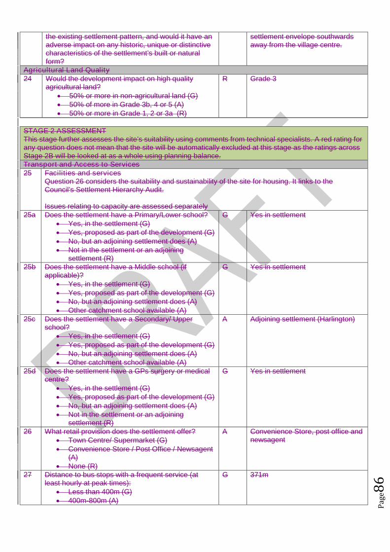
Pag
e86
the existing settlement pattern, and would it have anadverse impact on any historic, unique or distinctivecharacteristics of the settlement’s built or naturalform?
settlement envelope southwardsaway from the village centre.
Agricultural Land Quality24 Would the development impact on high quality
agricultural land? 50% or more in non-agricultural land (G) 50% of more in Grade 3b, 4 or 5 (A) 50% or more in Grade 1, 2 or 3a (R)
R Grade 3
STAGE 2 ASSESSMENTThis stage further assesses the site’s suitability using comments from technical specialists. A red rating forany question does not mean that the site will be automatically excluded at this stage as the ratings acrossStage 2B will be looked at as a whole using planning balance.Transport and Access to Services25 Facilities and services
Question 26 considers the suitability and sustainability of the site for housing. It links to theCouncil’s Settlement Hierarchy Audit.
Issues relating to capacity are assessed separately25a Does the settlement have a Primary/Lower school?
Yes, in the settlement (G) Yes, proposed as part of the development (G) No, but an adjoining settlement does (A) Not in the settlement or an adjoining
settlement (R)
G Yes in settlement
25b Does the settlement have a Middle school (ifapplicable)?
Yes, in the settlement (G) Yes, proposed as part of the development (G) No, but an adjoining settlement does (A) Other catchment school available (A)
G Yes in settlement
25c Does the settlement have a Secondary/ Upperschool?
Yes, in the settlement (G) Yes, proposed as part of the development (G) No, but an adjoining settlement does (A) Other catchment school available (A)
A Adjoining settlement (Harlington)
25d Does the settlement have a GPs surgery or medicalcentre?
Yes, in the settlement (G) Yes, proposed as part of the development (G) No, but an adjoining settlement does (A) Not in the settlement or an adjoining
settlement (R)
G Yes in settlement
26 What retail provision does the settlement offer? Town Centre/ Supermarket (G) Convenience Store / Post Office / Newsagent
(A) None (R)
A Convenience Store, post office andnewsagent
27 Distance to bus stops with a frequent service (atleast hourly at peak times):
Less than 400m (G) 400m-800m (A)
G 371m

Pag
e87
Over 800m (R) OR submission form stated that improved
public transport facilities could be provided aspart of the development (G)
28 Distance to nearest train station: Less than 800m (G) 800m-1200m (A) Over 1200m (R)
R Over 1200m
29 Is the site accessible from the existing road network? G yesSchool Capacity30 Do the local schools have capacity at all tiers? A New lower and middle school may
be required31 If not, has a commitment been made to address
this?A New lower and middle school may
be requiredWater Utilities (Gas, Electricity and Broadband Infrastructure will be assessed at a later stage)32 Is there the capacity to provide all required
infrastructure for waste water and potable water?R/A/G Water utilities companies have a
statutory duty to supply water andwaste water infrastructure to newdevelopment sites and a lack ofavailable capacity does not preventfuture development. Anyinfrastructure upgrades requiredwill depend on the quantum andlocation of growth falling withineach catchment area. Whilst theStage 1 Water Cycle Study (April2017) identifies the current capacityof existing water infrastructure, aStage 2 study will be prepared totest the cumulative effect of sitesthat have been shortlisted forallocation in the Local Plan andidentify the nature and timing ofany upgrades required.
Drainage and Flooding (All sites subject to Sequential Test)33 What is the conclusion of the sequential approach to
site allocations, in regards to flood risk? No assessment required (G) Consider Further Assessment (A) Further Assessment Required (R)
A OW present, JFlow modellingrequired to confirm flood risk
Environmental Health34 Contamination
Are there any contamination constraints on site andwill there be any remediation required?
R/A/G Awaiting comments
35 Adjoining usesWould any adjoining uses have the potential tocause conflict with the proposed use? (for example;noise and smell)
R/A/G Awaiting comments
Environmental Constraints36 Landscape character
What would the impacts of development be on thelandscape character or setting of the area or anydesignated landscapes? Would there be any director indirect harm to the Area of Outstanding NaturalBeauty or the Nature Improvement Area?
A elevated exposed site,development must enhanceexisting settlement envelope &provide substantial landscapebuffer
37 Heritage/ Archaeology A Site has multi-period

Pag
e88
What would the impacts of development be on anyheritage assets and their setting?Are there any opportunities for enhancement ofthese assets?
archaeological potential but thiswould not prevent allocationproviding appropriate mitigationis undertaken
38 Ecological AssetsWhat would the impacts of development be on anybiological, geological or ecological assets and arethere any opportunities for their enhancement?
A Dropshot Marsh SSSI ons.boundary but good bufferingshown on preliminary proposal ,potential farmland species impact,good opportunities forenhancement.
39 Open space/leisure and GI assetsAre there any potential conflicts with open space,leisure designations or Rights of Way? Is therecapacity to provide the required levels of open spaceand green infrastructure?
R/A/ Extensive ROW network aroundand across site. Would need to beenhanced / set within greencorridors. Site includes existingallotments, would need to beretained, and developmentdesigned to relate positively to thisexisting asset. Existing woodlandincluding SSSI on southernboundary, would need protecting,enhancing extending and buffering.Loss of The Glebe Small AmenitySpace, The Glebe Sports Field,Dunstable Road Allotments andpartial loss of Dropshort Marsh.
Minerals and Waste40 What would the impacts of development be on
safeguarded minerals and waste sites, includingmineral safeguarding sites?
G No issues
Planning History41 What is the sites planning history? (For example
planning applications and submissions to previousAllocations Plans)
No history
Does the site continue to next stage? Yes
STAGE 2 ASSESSMENT CONCLUSIONIs the site suitable for the proposed development?
On balance the whole site is not considered appropriate for further assessment. However due toits impact on landscape, site size and scale a portion would be considered more acceptable.
The site is located in the south of Toddington and would extend the settlement southwards. The site is in an elevated position, which would expose this site in landscape terms. The site is large in scale in relation to the village and its size together with location would
adversely impact upon the character and pattern of development, which has benconstrained due to the Green Belt, in Toddington.
As such a portion of the site will be considered further.
STAGE 3 : ACHIEVABILITYThis section assesses whether the site is Achievable in line with NPPG Guidance:A site is considered achievable for development where there is a reasonable prospect that the particulartype of development will be developed on the site at a particular point in time. This is essentially ajudgement about the economic viability of the site, and the capacity of the developer to complete and let or
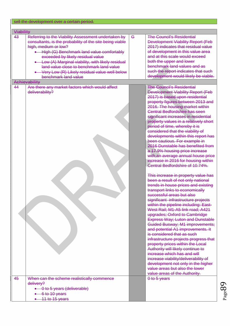
Pag
e89
sell the development over a certain period.
Viability43 Referring to the Viability Assessment undertaken by
consultants, is the probability of the site being viablehigh, medium or low?
High (G) Benchmark land value comfortablyexceeded by likely residual value
Low (A) Marginal viability, with likely residualland value close to benchmark land value
Very Low (R) Likely residual value well belowbenchmark land value
G The Council’s ResidentialDevelopment Viability Report (Feb2017) indicates that residual valueof development in this value areaand at this scale would exceedboth the upper and lowerbenchmark land values and assuch the report indicates that suchdevelopment would likely be viable.
Achievability44 Are there any market factors which would affect
deliverability?The Council’s ResidentialDevelopment Viability Report (Feb2017) is based upon residentialproperty figures between 2013 and2016. The housing market withinCentral Bedfordshire has seensignificant increases in residentialproperty values in a relatively shortperiod of time, whereby it isconsidered that the viability ofdevelopments within this report hasbeen cautious. For example in2016 Dunstable has benefited froma 17.9% housing price increasewith an average annual house priceincrease in 2016 for housing withinCentral Bedfordshire of 10.74%.
This increase in property value hasbeen a result of not only nationaltrends in house prices and existingtransport links to economicallysuccessful areas but alsosignificant infrastructure projectswithin the pipeline including: East-West Rail; M1-A5 link road; A421upgrades; Oxford to CambridgeExpress Way; Luton and DunstableGuided Busway; M1 improvements;and potential A1 improvements. Itis considered that as suchinfrastructure projects progress thatproperty prices within the LocalAuthority will likely continue toincrease which has and willincrease viability/deliverability ofdevelopment not only in the highervalue areas but also the lowervalue areas of the Authority.
45 When can the scheme realistically commencedelivery?
0 to 5 years (deliverable) 6 to 10 years 11 to 15 years
0 to 5 years

Pag
e90
15 to 20 years Outside Plan Period
46 What is the indicative build out time of the site? The Case Study Sites outlinedwithin the Council’s ResidentialDevelopment Viability Report (Feb2017) indicates that after the sitehas received detailed planningpermission a single housebuilderwould likely take one year to firstcompletion and would build out thesite at a rate of 50 dwellings perannum there after.
Does the site pass this stage? Yes
SUMMARY
The sites that pass through this assessment process will not automatically be allocated for development inthe Local Plan.
Sites will be selected with reference to a number of other factors including: The strategy, vision and objectives proposed in the draft plan Technical evidence studies The sustainability appraisal process The results of public consultation Flood Risk Sequential Approach Further transport modelling Consultation with neighbouring authorities
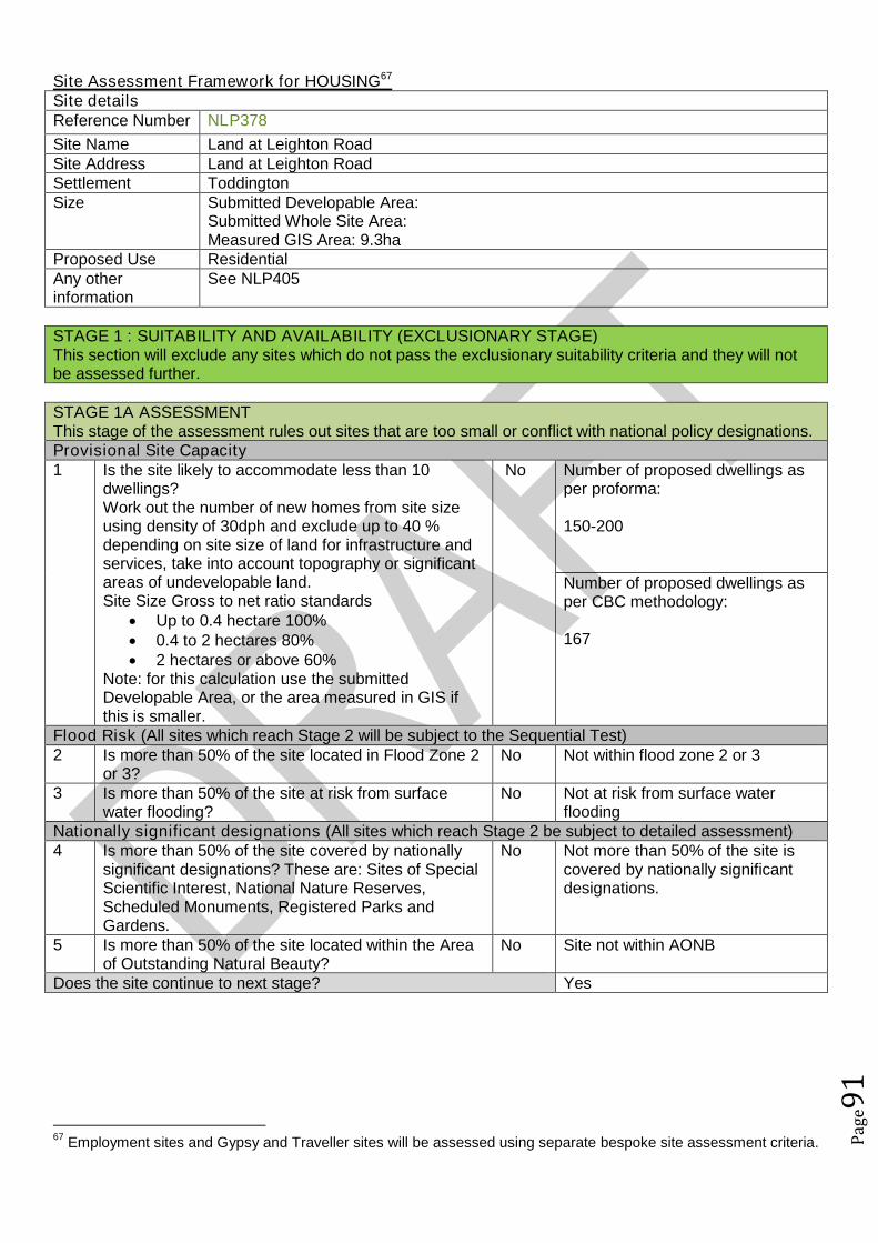
Pag
e91
Site Assessment Framework for HOUSING67
Site detailsReference Number NLP378
Site Name Land at Leighton RoadSite Address Land at Leighton RoadSettlement ToddingtonSize Submitted Developable Area:
Submitted Whole Site Area:Measured GIS Area: 9.3ha
Proposed Use ResidentialAny otherinformation
See NLP405
STAGE 1 : SUITABILITY AND AVAILABILITY (EXCLUSIONARY STAGE)This section will exclude any sites which do not pass the exclusionary suitability criteria and they will notbe assessed further.
STAGE 1A ASSESSMENTThis stage of the assessment rules out sites that are too small or conflict with national policy designations.Provisional Site Capacity1 Is the site likely to accommodate less than 10
dwellings?Work out the number of new homes from site sizeusing density of 30dph and exclude up to 40 %depending on site size of land for infrastructure andservices, take into account topography or significantareas of undevelopable land.Site Size Gross to net ratio standards
Up to 0.4 hectare 100% 0.4 to 2 hectares 80% 2 hectares or above 60%
Note: for this calculation use the submittedDevelopable Area, or the area measured in GIS ifthis is smaller.
No Number of proposed dwellings asper proforma:
150-200
Number of proposed dwellings asper CBC methodology:
167
Flood Risk (All sites which reach Stage 2 will be subject to the Sequential Test)2 Is more than 50% of the site located in Flood Zone 2
or 3?No Not within flood zone 2 or 3
3 Is more than 50% of the site at risk from surfacewater flooding?
No Not at risk from surface waterflooding
Nationally significant designations (All sites which reach Stage 2 be subject to detailed assessment)4 Is more than 50% of the site covered by nationally
significant designations? These are: Sites of SpecialScientific Interest, National Nature Reserves,Scheduled Monuments, Registered Parks andGardens.
No Not more than 50% of the site iscovered by nationally significantdesignations.
5 Is more than 50% of the site located within the Areaof Outstanding Natural Beauty?
No Site not within AONB
Does the site continue to next stage? Yes
67Employment sites and Gypsy and Traveller sites will be assessed using separate bespoke site assessment criteria.
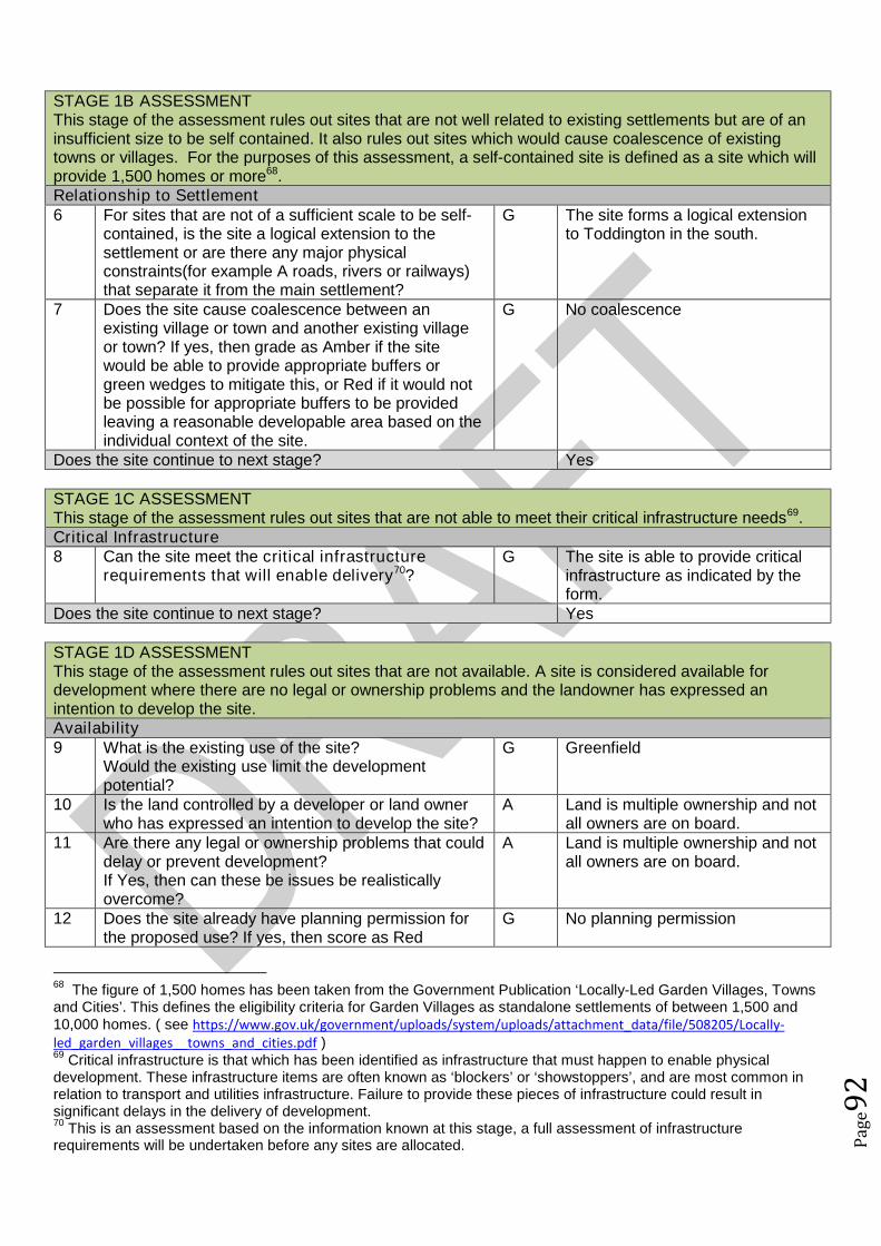
Pag
e92
STAGE 1B ASSESSMENTThis stage of the assessment rules out sites that are not well related to existing settlements but are of aninsufficient size to be self contained. It also rules out sites which would cause coalescence of existingtowns or villages. For the purposes of this assessment, a self-contained site is defined as a site which willprovide 1,500 homes or more68.Relationship to Settlement6 For sites that are not of a sufficient scale to be self-
contained, is the site a logical extension to thesettlement or are there any major physicalconstraints(for example A roads, rivers or railways)that separate it from the main settlement?
G The site forms a logical extensionto Toddington in the south.
7 Does the site cause coalescence between anexisting village or town and another existing villageor town? If yes, then grade as Amber if the sitewould be able to provide appropriate buffers orgreen wedges to mitigate this, or Red if it would notbe possible for appropriate buffers to be providedleaving a reasonable developable area based on theindividual context of the site.
G No coalescence
Does the site continue to next stage? Yes
STAGE 1C ASSESSMENTThis stage of the assessment rules out sites that are not able to meet their critical infrastructure needs69.Critical Infrastructure8 Can the site meet the critical infrastructure
requirements that will enable delivery70?G The site is able to provide critical
infrastructure as indicated by theform.
Does the site continue to next stage? Yes
STAGE 1D ASSESSMENTThis stage of the assessment rules out sites that are not available. A site is considered available fordevelopment where there are no legal or ownership problems and the landowner has expressed anintention to develop the site.Availability9 What is the existing use of the site?
Would the existing use limit the developmentpotential?
G Greenfield
10 Is the land controlled by a developer or land ownerwho has expressed an intention to develop the site?
A Land is multiple ownership and notall owners are on board.
11 Are there any legal or ownership problems that coulddelay or prevent development?If Yes, then can these be issues be realisticallyovercome?
A Land is multiple ownership and notall owners are on board.
12 Does the site already have planning permission forthe proposed use? If yes, then score as Red
G No planning permission
68The figure of 1,500 homes has been taken from the Government Publication ‘Locally-Led Garden Villages, Towns
and Cities’. This defines the eligibility criteria for Garden Villages as standalone settlements of between 1,500 and10,000 homes. ( see https://www.gov.uk/government/uploads/system/uploads/attachment_data/file/508205/Locally-led_garden_villages__towns_and_cities.pdf )69
Critical infrastructure is that which has been identified as infrastructure that must happen to enable physicaldevelopment. These infrastructure items are often known as ‘blockers’ or ‘showstoppers’, and are most common inrelation to transport and utilities infrastructure. Failure to provide these pieces of infrastructure could result insignificant delays in the delivery of development.70
This is an assessment based on the information known at this stage, a full assessment of infrastructurerequirements will be undertaken before any sites are allocated.

Pag
e93
because it’s not eligible for allocation.Does the site continue to next stage? Yes
STAGE 1E ASSESSMENTThis section records the findings of the Strategic Green Belt Review and also provides a preliminaryscreening of sites to determine whether they may be capable of demonstrating ExceptionalCircumstances. Any site in the Green Belt that is determined as suitable based on the high level SHLAAassessment would still have to demonstrate Exceptional Circumstances to considered for allocation in thePlan.Greenbelt13 Is the site located within the Green Belt? Yes Site is within the green belt.14 If answer to question 13 is yes, then does the site lie
within one of the parcels which have been identifiedin the Central Bedfordshire and Luton Green BeltStudy as making only a relatively weak, weak, or nocontribution? If yes, site progresses through to Stage2.
Yes Part of the site falls within a parcelof land identified with a weakcontribution.
15a Does the site have all of the following merits thatmay outweigh the harm to the Green Belt and whichmay contribute to identification of exceptionalcircumstances?
Adjoining settlement has at least 3 of thefollowing key local services - convenienceshop, lower school, middle school, upperschool, village hall, GP surgery, post office,library (use settlement audit)
Site makes a strong contribution to housingneed (100 plus homes) within the Luton HMA
Site is in or directly adjacent to a settlementthat has a mainline rail station or directassess (junction) to the strategic roadnetwork (A road or motorway)
Sites in Green Belt other than those covered by 14and 15b that cannot meet these criteria, will notprogress any further in this assessment ofsuitability.*
Yes The site meets the three criterialisted.
15b Sites which have support from the local communityas demonstrated through an allocation in an adoptedor draft Neighbourhood Plan (that has been subjectto Regulation 14 consultation) that do not meet thecriteria in question 15a will automatically progressthrough this stage to be considered further at Stage2.71
N/A No draft ToddingtonNeighbourhood Plan with allocationat this stage.
Does the site continue to next stage? Yes
STAGE 2 : SUITABILITY (DETAILED ASSESSMENT)STAGE 2 ASSESSMENTThis stage further assesses the site’s suitability using detailed desktop assessment. A red rating for anyquestion does not mean that the site will be automatically excluded at this stage as the ratings acrossStage 2A will be looked at as a whole using planning balance.Previously Developed Land16 Is the site Previously Developed Land in accordance
with the NPPF definition?R The site is greenfield
71Draft Neighbourhood Plan allocations in Green Belt that are proposed after this site assessment phase has
concluded, may still be considered for allocation.

Pag
e94
76% - 100% (G) 26 - 75% (A) 25% - 0% (Greenfield) (R)
Community17 Neighbourhood Planning (only applicable in
designated areas)Is the site identified as a housing allocation in anemerging Neighbourhood Plan?
No Toddington Neighbourhood Plan isearly stage.
18 Community ConsultationHas any community consultation taken place?If yes, provide brief details on the form thisconsultation took and any overall communityresponse.
No No community consultation
19 Sustainability of SettlementWould this proposal impact on the sustainability ofthe settlement through the loss of services andfacilities (for example, employment, retail, publichouse etc)
No The proposal will not impact on thesustainability of the settlement.
Cumulative Impact20 Considering housing completions over the past 10
years, what has been the level of housing growth inthe parish?
Less than 5% growth (G) 5% to 20% growth (A) More than 20% growth (R)
This is calculated by working out the total number ofcompletions over the last ten years as a percentageof the dwellings in April 2006 (as calculated usingcensus and completions data).
G Homes in 2006: 1906Homes in 2016: 1960
There has been a 2.83% increasein homes.
21 What level of housing growth would there be if all theoutstanding permissions (as of April 2016) were tobe completed?
Less than 5% growth (G) 5% to 20% growth (A) More than 20% growth (R)
This is calculated by working out the total number ofoutstanding permissions as of April 1st 2016 aspercentage of the total number of dwellings in April2016 (as calculated using census and completionsdata).
G Outstanding permissions willincrease the level of housinggrowth by an additional 0.26%
Physical Constraints22 Are there any physical constraints or permanent
features that affect the site’s developability?For example pylons, gas works, sewage treatmentworks, topography or wind turbines.
A Topography - The site slopes downeastwards.
Relationship to Settlement23 Would development of the site be complementary to
the existing settlement pattern, and would it have anadverse impact on any historic, unique or distinctivecharacteristics of the settlement’s built or naturalform?
G There are no adverse impacts onthe settlement character or pattern.
Agricultural Land Quality24 Would the development impact on high quality
agricultural land? 50% or more in non-agricultural land (G) 50% of more in Grade 3b, 4 or 5 (A)
A Grade 3

Pag
e95
50% or more in Grade 1, 2 or 3a (R)
STAGE 2 ASSESSMENTThis stage further assesses the site’s suitability using comments from technical specialists. A red rating forany question does not mean that the site will be automatically excluded at this stage as the ratings acrossStage 2B will be looked at as a whole using planning balance.Transport and Access to Services25 Facilities and services
Question 26 considers the suitability and sustainability of the site for housing. It links to theCouncil’s Settlement Hierarchy Audit.
Issues relating to capacity are assessed separately25a Does the settlement have a Primary/Lower school?
Yes, in the settlement (G) Yes, proposed as part of the development (G) No, but an adjoining settlement does (A) Not in the settlement or an adjoining
settlement (R)
G Yes in settlement
25b Does the settlement have a Middle school (ifapplicable)?
Yes, in the settlement (G) Yes, proposed as part of the development (G) No, but an adjoining settlement does (A) Other catchment school available (A)
G Yes in settlement
25c Does the settlement have a Secondary/ Upperschool?
Yes, in the settlement (G) Yes, proposed as part of the development (G) No, but an adjoining settlement does (A) Other catchment school available (A)
A Adjoining settlement (Harlington)
25d Does the settlement have a GPs surgery or medicalcentre?
Yes, in the settlement (G) Yes, proposed as part of the development (G) No, but an adjoining settlement does (A) Not in the settlement or an adjoining
settlement (R)
G Yes in settlement
26 What retail provision does the settlement offer? Town Centre/ Supermarket (G) Convenience Store / Post Office / Newsagent
(A) None (R)
A Convenience Store, post office andnewsagent
27 Distance to bus stops with a frequent service (atleast hourly at peak times):
Less than 400m (G) 400m-800m (A) Over 800m (R) OR submission form stated that improved
public transport facilities could be provided aspart of the development (G)
A 774m
28 Distance to nearest train station: Less than 800m (G) 800m-1200m (A) Over 1200m (R)
R Over 1200m
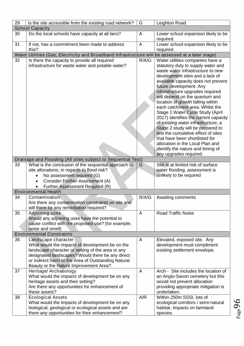
Pag
e96
29 Is the site accessible from the existing road network? G Leighton RoadSchool Capacity30 Do the local schools have capacity at all tiers? A Lower school expansion likely to be
required.31 If not, has a commitment been made to address
this?A Lower school expansion likely to be
required.Water Utilities (Gas, Electricity and Broadband Infrastructure will be assessed at a later stage)32 Is there the capacity to provide all required
infrastructure for waste water and potable water?R/A/G Water utilities companies have a
statutory duty to supply water andwaste water infrastructure to newdevelopment sites and a lack ofavailable capacity does not preventfuture development. Anyinfrastructure upgrades requiredwill depend on the quantum andlocation of growth falling withineach catchment area. Whilst theStage 1 Water Cycle Study (April2017) identifies the current capacityof existing water infrastructure, aStage 2 study will be prepared totest the cumulative effect of sitesthat have been shortlisted forallocation in the Local Plan andidentify the nature and timing ofany upgrades required.
Drainage and Flooding (All sites subject to Sequential Test)33 What is the conclusion of the sequential approach to
site allocations, in regards to flood risk? No assessment required (G) Consider Further Assessment (A) Further Assessment Required (R)
G Site is at limited risk of surfacewater flooding, assessment isunlikely to be required
Environmental Health34 Contamination
Are there any contamination constraints on site andwill there be any remediation required?
R/A/G Awaiting comments
35 Adjoining usesWould any adjoining uses have the potential tocause conflict with the proposed use? (for example;noise and smell)
A Road Traffic Noise
Environmental Constraints36 Landscape character
What would the impacts of development be on thelandscape character or setting of the area or anydesignated landscapes? Would there be any director indirect harm to the Area of Outstanding NaturalBeauty or the Nature Improvement Area?
A Elevated, exposed site. Anydevelopment must complimentexisting settlement envelope.
37 Heritage/ ArchaeologyWhat would the impacts of development be on anyheritage assets and their setting?Are there any opportunities for enhancement ofthese assets?
A Arch - Site includes the location ofan Anglo-Saxon cemetery but thiswould not prevent allocationproviding appropriate mitigation isundertaken.
38 Ecological AssetsWhat would the impacts of development be on anybiological, geological or ecological assets and arethere any opportunities for their enhancement?
A/R Within 250m SSSI, lots ofecological corridors / semi-naturalhabitat. Impacts on farmlandspecies.
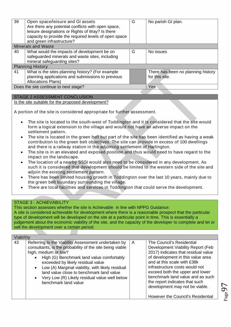
Pag
e97
39 Open space/leisure and GI assetsAre there any potential conflicts with open space,leisure designations or Rights of Way? Is therecapacity to provide the required levels of open spaceand green infrastructure?
G No parish GI plan.
Minerals and Waste40 What would the impacts of development be on
safeguarded minerals and waste sites, includingmineral safeguarding sites?
G No issues
Planning History41 What is the sites planning history? (For example
planning applications and submissions to previousAllocations Plans)
There has been no planning historyfor this site.
Does the site continue to next stage? Yes
STAGE 2 ASSESSMENT CONCLUSIONIs the site suitable for the proposed development?
A portion of the site is considered appropriate for further assessment.
The site is located to the south-west of Toddington and it is considered that the site wouldform a logical extension to the village and would not have an adverse impact on thesettlement pattern.
The site is located in the green belt but part of the site has been identified as having a weakcontribution to the green belt objectives. The site can provide in excess of 100 dwellingsand there is a railway station in the adjoining settlement of Harlington.
The site is in an elevated and exposed position and thus would need to have regard to theimpact on the landscape.
The location of a nearby SSSI would also need to be considered in any development. Assuch it is considered that development should be limited to the western side of the site andadjoin the existing settlement pattern.
There has been limited housing growth in Toddington over the last 10 years, mainly due tothe green belt boundary surrounding the village.
There are local facilities and services in Toddington that could serve the development.
STAGE 3 : ACHIEVABILITYThis section assesses whether the site is Achievable in line with NPPG Guidance:A site is considered achievable for development where there is a reasonable prospect that the particulartype of development will be developed on the site at a particular point in time. This is essentially ajudgement about the economic viability of the site, and the capacity of the developer to complete and let orsell the development over a certain period.
Viability43 Referring to the Viability Assessment undertaken by
consultants, is the probability of the site being viablehigh, medium or low?
High (G) Benchmark land value comfortablyexceeded by likely residual value
Low (A) Marginal viability, with likely residualland value close to benchmark land value
Very Low (R) Likely residual value well belowbenchmark land value
A The Council’s ResidentialDevelopment Viability Report (Feb2017) indicates that residual valueof development in this value areaand at this scale with £38kinfrastructure costs would notexceed both the upper and lowerbenchmark land value and as suchthe report indicates that suchdevelopment may not be viable.
However the Council’s Residential
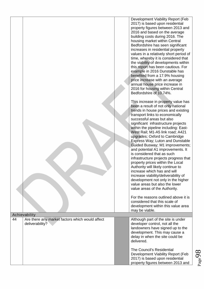
Pag
e98
Development Viability Report (Feb2017) is based upon residentialproperty figures between 2013 and2016 and based on the averagebuilding costs during 2016. Thehousing market within CentralBedfordshire has seen significantincreases in residential propertyvalues in a relatively short period oftime, whereby it is considered thatthe viability of developments withinthis report has been cautious. Forexample in 2016 Dunstable hasbenefited from a 17.9% housingprice increase with an averageannual house price increase in2016 for housing within CentralBedfordshire of 10.74%.
This increase in property value hasbeen a result of not only nationaltrends in house prices and existingtransport links to economicallysuccessful areas but alsosignificant infrastructure projectswithin the pipeline including: East-West Rail; M1-A5 link road; A421upgrades; Oxford to CambridgeExpress Way; Luton and DunstableGuided Busway; M1 improvements;and potential A1 improvements. Itis considered that as suchinfrastructure projects progress thatproperty prices within the LocalAuthority will likely continue toincrease which has and willincrease viability/deliverability ofdevelopment not only in the highervalue areas but also the lowervalue areas of the Authority.
For the reasons outlined above it isconsidered that this scale ofdevelopment within this value areamay be viable.
Achievability44 Are there any market factors which would affect
deliverability?Although part of the site is underdeveloper control, not all thelandowners have signed up to thedevelopment. This may cause adelay in when the site could bedelivered.
The Council’s ResidentialDevelopment Viability Report (Feb2017) is based upon residentialproperty figures between 2013 and
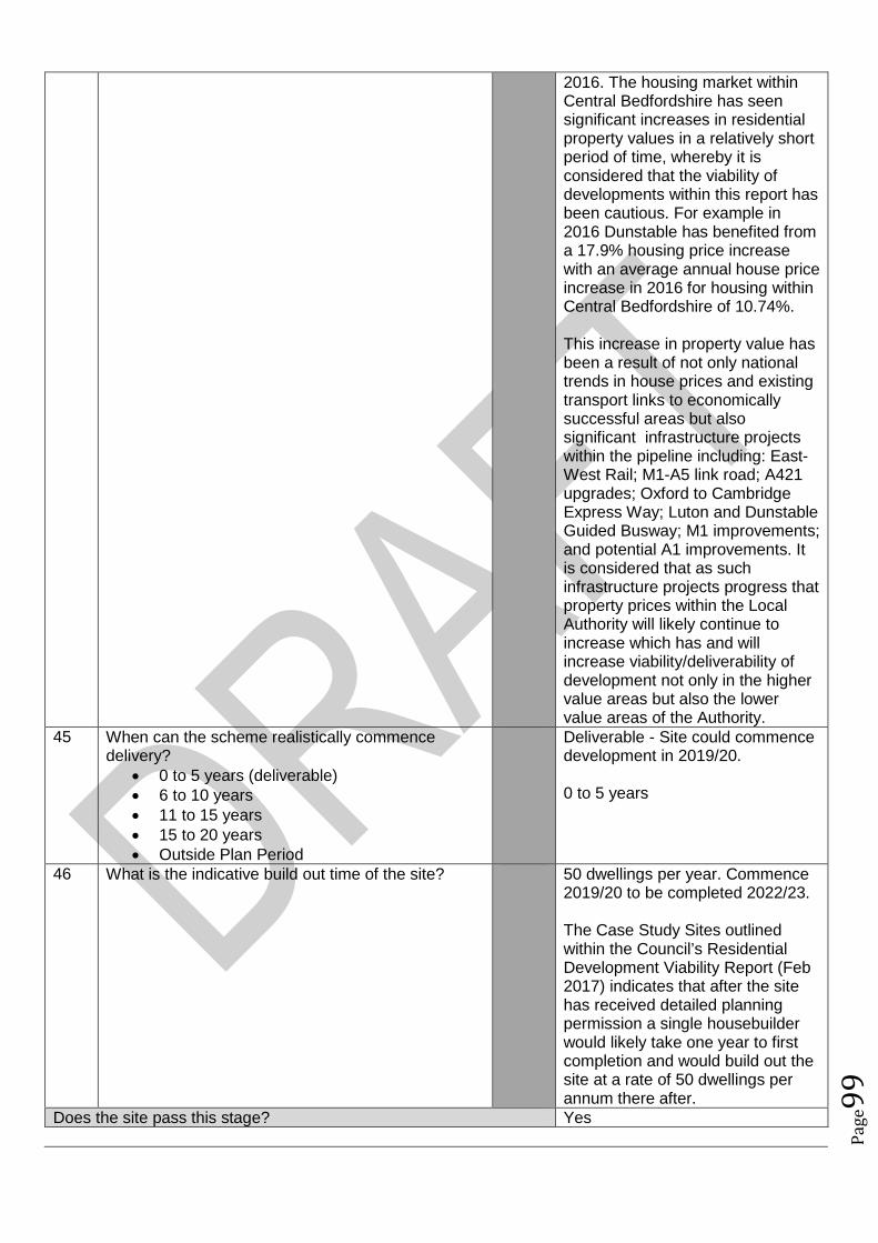
Pag
e99
2016. The housing market withinCentral Bedfordshire has seensignificant increases in residentialproperty values in a relatively shortperiod of time, whereby it isconsidered that the viability ofdevelopments within this report hasbeen cautious. For example in2016 Dunstable has benefited froma 17.9% housing price increasewith an average annual house priceincrease in 2016 for housing withinCentral Bedfordshire of 10.74%.
This increase in property value hasbeen a result of not only nationaltrends in house prices and existingtransport links to economicallysuccessful areas but alsosignificant infrastructure projectswithin the pipeline including: East-West Rail; M1-A5 link road; A421upgrades; Oxford to CambridgeExpress Way; Luton and DunstableGuided Busway; M1 improvements;and potential A1 improvements. Itis considered that as suchinfrastructure projects progress thatproperty prices within the LocalAuthority will likely continue toincrease which has and willincrease viability/deliverability ofdevelopment not only in the highervalue areas but also the lowervalue areas of the Authority.
45 When can the scheme realistically commencedelivery?
0 to 5 years (deliverable) 6 to 10 years 11 to 15 years 15 to 20 years Outside Plan Period
Deliverable - Site could commencedevelopment in 2019/20.
0 to 5 years
46 What is the indicative build out time of the site? 50 dwellings per year. Commence2019/20 to be completed 2022/23.
The Case Study Sites outlinedwithin the Council’s ResidentialDevelopment Viability Report (Feb2017) indicates that after the sitehas received detailed planningpermission a single housebuilderwould likely take one year to firstcompletion and would build out thesite at a rate of 50 dwellings perannum there after.
Does the site pass this stage? Yes

Pag
e10
0
SUMMARY
The sites that pass through this assessment process will not automatically be allocated for development inthe Local Plan.
Sites will be selected with reference to a number of other factors including: The strategy, vision and objectives proposed in the draft plan Technical evidence studies The sustainability appraisal process The results of public consultation Flood Risk Sequential Approach Further transport modelling Consultation with neighbouring authorities
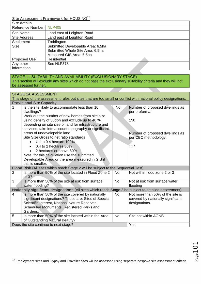
Pag
e10
1
Site Assessment Framework for HOUSING72
Site detailsReference Number NLP405
Site Name Land east of Leighton RoadSite Address Land east of Leighton RoadSettlement ToddingtonSize Submitted Developable Area: 6.5ha
Submitted Whole Site Area: 6.5haMeasured GIS Area: 6.5ha
Proposed Use ResidentialAny otherinformation
See NLP378
STAGE 1 : SUITABILITY AND AVAILABILITY (EXCLUSIONARY STAGE)This section will exclude any sites which do not pass the exclusionary suitability criteria and they will notbe assessed further.
STAGE 1A ASSESSMENTThis stage of the assessment rules out sites that are too small or conflict with national policy designations.Provisional Site Capacity1 Is the site likely to accommodate less than 10
dwellings?Work out the number of new homes from site sizeusing density of 30dph and exclude up to 40 %depending on site size of land for infrastructure andservices, take into account topography or significantareas of undevelopable land.Site Size Gross to net ratio standards
Up to 0.4 hectare 100% 0.4 to 2 hectares 80% 2 hectares or above 60%
Note: for this calculation use the submittedDevelopable Area, or the area measured in GIS ifthis is smaller.
No Number of proposed dwellings asper proforma:
150
Number of proposed dwellings asper CBC methodology:
117
Flood Risk (All sites which reach Stage 2 will be subject to the Sequential Test)2 Is more than 50% of the site located in Flood Zone 2
or 3?No Not within flood zone 2 or 3
3 Is more than 50% of the site at risk from surfacewater flooding?
No Not at risk from surface waterflooding
Nationally significant designations (All sites which reach Stage 2 be subject to detailed assessment)4 Is more than 50% of the site covered by nationally
significant designations? These are: Sites of SpecialScientific Interest, National Nature Reserves,Scheduled Monuments, Registered Parks andGardens.
No Not more than 50% of the site iscovered by nationally significantdesignations.
5 Is more than 50% of the site located within the Areaof Outstanding Natural Beauty?
No Site not within AONB
Does the site continue to next stage? Yes
72Employment sites and Gypsy and Traveller sites will be assessed using separate bespoke site assessment criteria.

Pag
e10
2
STAGE 1B ASSESSMENTThis stage of the assessment rules out sites that are not well related to existing settlements but are of aninsufficient size to be self contained. It also rules out sites which would cause coalescence of existingtowns or villages. For the purposes of this assessment, a self-contained site is defined as a site which willprovide 1,500 homes or more73.Relationship to Settlement6 For sites that are not of a sufficient scale to be self-
contained, is the site a logical extension to thesettlement or are there any major physicalconstraints(for example A roads, rivers or railways)that separate it from the main settlement?
A The site does form an extension toToddington as part of the site as itadjoins the settlement boundary.Half the site is separated from thesettlement due to the site size. Ifthe whole site adjoined thesettlement boundary of Toddingtonit would form a more logicalextension (see NLP378).
7 Does the site cause coalescence between anexisting village or town and another existing villageor town? If yes, then grade as Amber if the sitewould be able to provide appropriate buffers orgreen wedges to mitigate this, or Red if it would notbe possible for appropriate buffers to be providedleaving a reasonable developable area based on theindividual context of the site.
G No coalescence
Does the site continue to next stage? Yes
STAGE 1C ASSESSMENTThis stage of the assessment rules out sites that are not able to meet their critical infrastructure needs74.Critical Infrastructure8 Can the site meet the critical infrastructure
requirements that will enable delivery75?A Form states that no infrastructure
investment required for theproposed development as all utilityservices are available and accessto the site is off Leighton Road.
Does the site continue to next stage? Yes
STAGE 1D ASSESSMENTThis stage of the assessment rules out sites that are not available. A site is considered available fordevelopment where there are no legal or ownership problems and the landowner has expressed anintention to develop the site.Availability9 What is the existing use of the site?
Would the existing use limit the developmentpotential?
G Greenfield
10 Is the land controlled by a developer or land ownerwho has expressed an intention to develop the site?
G All the landowners are intent ondeveloping the site. There are 5
73The figure of 1,500 homes has been taken from the Government Publication ‘Locally-Led Garden Villages, Towns
and Cities’. This defines the eligibility criteria for Garden Villages as standalone settlements of between 1,500 and10,000 homes. ( see https://www.gov.uk/government/uploads/system/uploads/attachment_data/file/508205/Locally-led_garden_villages__towns_and_cities.pdf )74
Critical infrastructure is that which has been identified as infrastructure that must happen to enable physicaldevelopment. These infrastructure items are often known as ‘blockers’ or ‘showstoppers’, and are most common inrelation to transport and utilities infrastructure. Failure to provide these pieces of infrastructure could result insignificant delays in the delivery of development.75
This is an assessment based on the information known at this stage, a full assessment of infrastructurerequirements will be undertaken before any sites are allocated.
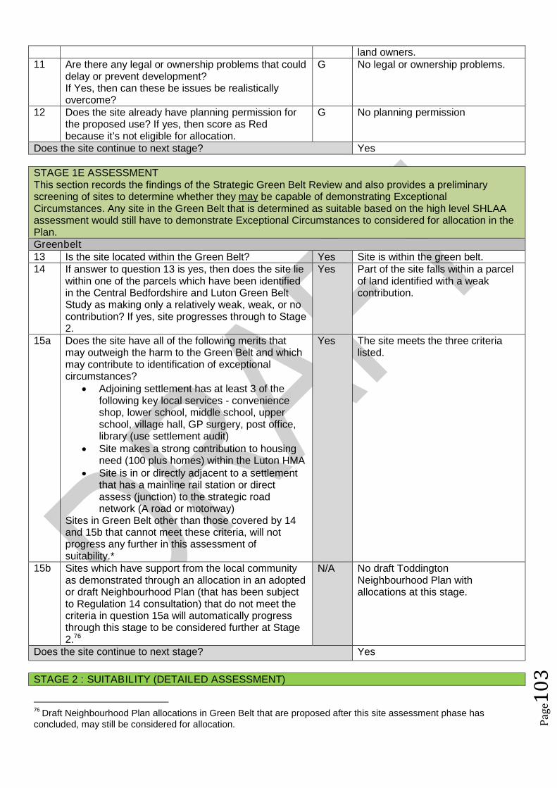
Pag
e10
3
land owners.11 Are there any legal or ownership problems that could
delay or prevent development?If Yes, then can these be issues be realisticallyovercome?
G No legal or ownership problems.
12 Does the site already have planning permission forthe proposed use? If yes, then score as Redbecause it’s not eligible for allocation.
G No planning permission
Does the site continue to next stage? Yes
STAGE 1E ASSESSMENTThis section records the findings of the Strategic Green Belt Review and also provides a preliminaryscreening of sites to determine whether they may be capable of demonstrating ExceptionalCircumstances. Any site in the Green Belt that is determined as suitable based on the high level SHLAAassessment would still have to demonstrate Exceptional Circumstances to considered for allocation in thePlan.Greenbelt13 Is the site located within the Green Belt? Yes Site is within the green belt.14 If answer to question 13 is yes, then does the site lie
within one of the parcels which have been identifiedin the Central Bedfordshire and Luton Green BeltStudy as making only a relatively weak, weak, or nocontribution? If yes, site progresses through to Stage2.
Yes Part of the site falls within a parcelof land identified with a weakcontribution.
15a Does the site have all of the following merits thatmay outweigh the harm to the Green Belt and whichmay contribute to identification of exceptionalcircumstances?
Adjoining settlement has at least 3 of thefollowing key local services - convenienceshop, lower school, middle school, upperschool, village hall, GP surgery, post office,library (use settlement audit)
Site makes a strong contribution to housingneed (100 plus homes) within the Luton HMA
Site is in or directly adjacent to a settlementthat has a mainline rail station or directassess (junction) to the strategic roadnetwork (A road or motorway)
Sites in Green Belt other than those covered by 14and 15b that cannot meet these criteria, will notprogress any further in this assessment ofsuitability.*
Yes The site meets the three criterialisted.
15b Sites which have support from the local communityas demonstrated through an allocation in an adoptedor draft Neighbourhood Plan (that has been subjectto Regulation 14 consultation) that do not meet thecriteria in question 15a will automatically progressthrough this stage to be considered further at Stage2.76
N/A No draft ToddingtonNeighbourhood Plan withallocations at this stage.
Does the site continue to next stage? Yes
STAGE 2 : SUITABILITY (DETAILED ASSESSMENT)
76Draft Neighbourhood Plan allocations in Green Belt that are proposed after this site assessment phase has
concluded, may still be considered for allocation.
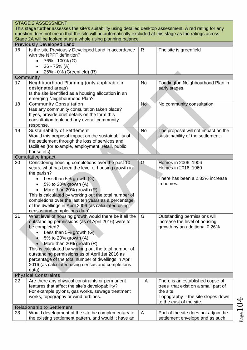
Pag
e10
4
STAGE 2 ASSESSMENTThis stage further assesses the site’s suitability using detailed desktop assessment. A red rating for anyquestion does not mean that the site will be automatically excluded at this stage as the ratings acrossStage 2A will be looked at as a whole using planning balance.Previously Developed Land16 Is the site Previously Developed Land in accordance
with the NPPF definition? 76% - 100% (G) 26 - 75% (A) 25% - 0% (Greenfield) (R)
R The site is greenfield
Community17 Neighbourhood Planning (only applicable in
designated areas)Is the site identified as a housing allocation in anemerging Neighbourhood Plan?
No Toddington Neighbourhood Plan inearly stages.
18 Community ConsultationHas any community consultation taken place?If yes, provide brief details on the form thisconsultation took and any overall communityresponse.
No No community consultation
19 Sustainability of SettlementWould this proposal impact on the sustainability ofthe settlement through the loss of services andfacilities (for example, employment, retail, publichouse etc)
No The proposal will not impact on thesustainability of the settlement.
Cumulative Impact20 Considering housing completions over the past 10
years, what has been the level of housing growth inthe parish?
Less than 5% growth (G) 5% to 20% growth (A) More than 20% growth (R)
This is calculated by working out the total number ofcompletions over the last ten years as a percentageof the dwellings in April 2006 (as calculated usingcensus and completions data).
G Homes in 2006: 1906Homes in 2016: 1960
There has been a 2.83% increasein homes.
21 What level of housing growth would there be if all theoutstanding permissions (as of April 2016) were tobe completed?
Less than 5% growth (G) 5% to 20% growth (A) More than 20% growth (R)
This is calculated by working out the total number ofoutstanding permissions as of April 1st 2016 aspercentage of the total number of dwellings in April2016 (as calculated using census and completionsdata).
G Outstanding permissions willincrease the level of housinggrowth by an additional 0.26%
Physical Constraints22 Are there any physical constraints or permanent
features that affect the site’s developability?For example pylons, gas works, sewage treatmentworks, topography or wind turbines.
A There is an established copse oftrees that exist on a small part ofthe site.Topography – the site slopes downto the east of the site.
Relationship to Settlement23 Would development of the site be complementary to
the existing settlement pattern, and would it have anA Part of the site does not adjoin the
settlement envelope and as such
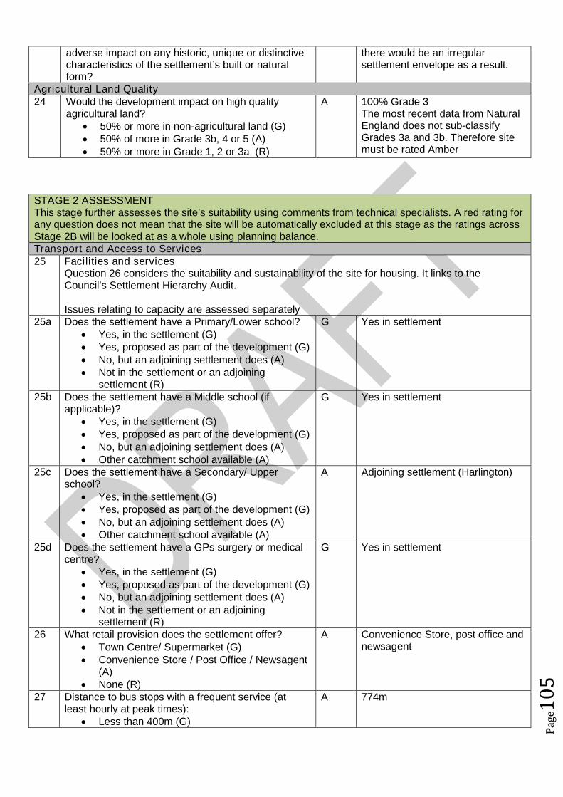
Pag
e10
5
adverse impact on any historic, unique or distinctivecharacteristics of the settlement’s built or naturalform?
there would be an irregularsettlement envelope as a result.
Agricultural Land Quality24 Would the development impact on high quality
agricultural land? 50% or more in non-agricultural land (G) 50% of more in Grade 3b, 4 or 5 (A) 50% or more in Grade 1, 2 or 3a (R)
A 100% Grade 3The most recent data from NaturalEngland does not sub-classifyGrades 3a and 3b. Therefore sitemust be rated Amber
STAGE 2 ASSESSMENTThis stage further assesses the site’s suitability using comments from technical specialists. A red rating forany question does not mean that the site will be automatically excluded at this stage as the ratings acrossStage 2B will be looked at as a whole using planning balance.Transport and Access to Services25 Facilities and services
Question 26 considers the suitability and sustainability of the site for housing. It links to theCouncil’s Settlement Hierarchy Audit.
Issues relating to capacity are assessed separately25a Does the settlement have a Primary/Lower school?
Yes, in the settlement (G) Yes, proposed as part of the development (G) No, but an adjoining settlement does (A) Not in the settlement or an adjoining
settlement (R)
G Yes in settlement
25b Does the settlement have a Middle school (ifapplicable)?
Yes, in the settlement (G) Yes, proposed as part of the development (G) No, but an adjoining settlement does (A) Other catchment school available (A)
G Yes in settlement
25c Does the settlement have a Secondary/ Upperschool?
Yes, in the settlement (G) Yes, proposed as part of the development (G) No, but an adjoining settlement does (A) Other catchment school available (A)
A Adjoining settlement (Harlington)
25d Does the settlement have a GPs surgery or medicalcentre?
Yes, in the settlement (G) Yes, proposed as part of the development (G) No, but an adjoining settlement does (A) Not in the settlement or an adjoining
settlement (R)
G Yes in settlement
26 What retail provision does the settlement offer? Town Centre/ Supermarket (G) Convenience Store / Post Office / Newsagent
(A) None (R)
A Convenience Store, post office andnewsagent
27 Distance to bus stops with a frequent service (atleast hourly at peak times):
Less than 400m (G)
A 774m
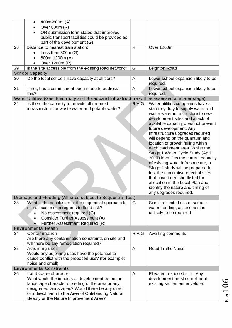
Pag
e10
6
400m-800m (A) Over 800m (R) OR submission form stated that improved
public transport facilities could be provided aspart of the development (G)
28 Distance to nearest train station: Less than 800m (G) 800m-1200m (A) Over 1200m (R)
R Over 1200m
29 Is the site accessible from the existing road network? G Leighton RoadSchool Capacity30 Do the local schools have capacity at all tiers? A Lower school expansion likely to be
required.31 If not, has a commitment been made to address
this?A Lower school expansion likely to be
required.Water Utilities (Gas, Electricity and Broadband Infrastructure will be assessed at a later stage)32 Is there the capacity to provide all required
infrastructure for waste water and potable water?R/A/G Water utilities companies have a
statutory duty to supply water andwaste water infrastructure to newdevelopment sites and a lack ofavailable capacity does not preventfuture development. Anyinfrastructure upgrades requiredwill depend on the quantum andlocation of growth falling withineach catchment area. Whilst theStage 1 Water Cycle Study (April2017) identifies the current capacityof existing water infrastructure, aStage 2 study will be prepared totest the cumulative effect of sitesthat have been shortlisted forallocation in the Local Plan andidentify the nature and timing ofany upgrades required.
Drainage and Flooding (All sites subject to Sequential Test)33 What is the conclusion of the sequential approach to
site allocations, in regards to flood risk? No assessment required (G) Consider Further Assessment (A) Further Assessment Required (R)
G Site is at limited risk of surfacewater flooding, assessment isunlikely to be required
Environmental Health34 Contamination
Are there any contamination constraints on site andwill there be any remediation required?
R/A/G Awaiting comments
35 Adjoining usesWould any adjoining uses have the potential tocause conflict with the proposed use? (for example;noise and smell)
A Road Traffic Noise
Environmental Constraints36 Landscape character
What would the impacts of development be on thelandscape character or setting of the area or anydesignated landscapes? Would there be any director indirect harm to the Area of Outstanding NaturalBeauty or the Nature Improvement Area?
A Elevated, exposed site. Anydevelopment must complimentexisting settlement envelope.
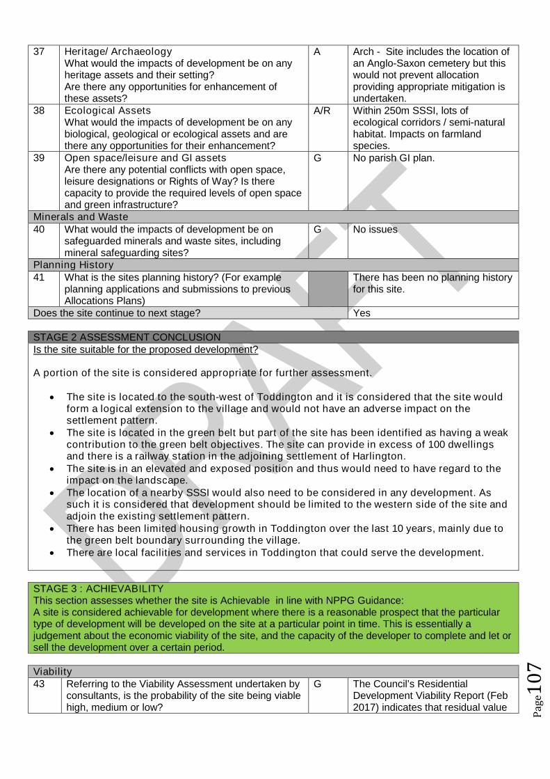
Pag
e10
7
37 Heritage/ ArchaeologyWhat would the impacts of development be on anyheritage assets and their setting?Are there any opportunities for enhancement ofthese assets?
A Arch - Site includes the location ofan Anglo-Saxon cemetery but thiswould not prevent allocationproviding appropriate mitigation isundertaken.
38 Ecological AssetsWhat would the impacts of development be on anybiological, geological or ecological assets and arethere any opportunities for their enhancement?
A/R Within 250m SSSI, lots ofecological corridors / semi-naturalhabitat. Impacts on farmlandspecies.
39 Open space/leisure and GI assetsAre there any potential conflicts with open space,leisure designations or Rights of Way? Is therecapacity to provide the required levels of open spaceand green infrastructure?
G No parish GI plan.
Minerals and Waste40 What would the impacts of development be on
safeguarded minerals and waste sites, includingmineral safeguarding sites?
G No issues
Planning History41 What is the sites planning history? (For example
planning applications and submissions to previousAllocations Plans)
There has been no planning historyfor this site.
Does the site continue to next stage? Yes
STAGE 2 ASSESSMENT CONCLUSIONIs the site suitable for the proposed development?
A portion of the site is considered appropriate for further assessment.
The site is located to the south-west of Toddington and it is considered that the site wouldform a logical extension to the village and would not have an adverse impact on thesettlement pattern.
The site is located in the green belt but part of the site has been identified as having a weakcontribution to the green belt objectives. The site can provide in excess of 100 dwellingsand there is a railway station in the adjoining settlement of Harlington.
The site is in an elevated and exposed position and thus would need to have regard to theimpact on the landscape.
The location of a nearby SSSI would also need to be considered in any development. Assuch it is considered that development should be limited to the western side of the site andadjoin the existing settlement pattern.
There has been limited housing growth in Toddington over the last 10 years, mainly due tothe green belt boundary surrounding the village.
There are local facilities and services in Toddington that could serve the development.
STAGE 3 : ACHIEVABILITYThis section assesses whether the site is Achievable in line with NPPG Guidance:A site is considered achievable for development where there is a reasonable prospect that the particulartype of development will be developed on the site at a particular point in time. This is essentially ajudgement about the economic viability of the site, and the capacity of the developer to complete and let orsell the development over a certain period.
Viability43 Referring to the Viability Assessment undertaken by
consultants, is the probability of the site being viablehigh, medium or low?
G The Council’s ResidentialDevelopment Viability Report (Feb2017) indicates that residual value
Pag
e10
8
High (G) Benchmark land value comfortablyexceeded by likely residual value
Low (A) Marginal viability, with likely residualland value close to benchmark land value
Very Low (R) Likely residual value well belowbenchmark land value
of development in this value areaand at this scale would exceedboth the upper and lowerbenchmark land values and assuch the report indicates that suchdevelopment would likely be viable.
Achievability44 Are there any market factors which would affect
deliverability?There are 5 different land ownersfor the site although the form statesthat all land owners are intent ondeveloping the site.
The Council’s ResidentialDevelopment Viability Report (Feb2017) is based upon residentialproperty figures between 2013 and2016. The housing market withinCentral Bedfordshire has seensignificant increases in residentialproperty values in a relatively shortperiod of time, whereby it isconsidered that the viability ofdevelopments within this report hasbeen cautious. For example in2016 Dunstable has benefited froma 17.9% housing price increasewith an average annual house priceincrease in 2016 for housing withinCentral Bedfordshire of 10.74%.
This increase in property value hasbeen a result of not only nationaltrends in house prices and existingtransport links to economicallysuccessful areas but alsosignificant infrastructure projectswithin the pipeline including: East-West Rail; M1-A5 link road; A421upgrades; Oxford to CambridgeExpress Way; Luton and DunstableGuided Busway; M1 improvements;and potential A1 improvements. Itis considered that as suchinfrastructure projects progress thatproperty prices within the LocalAuthority will likely continue toincrease which has and willincrease viability/deliverability ofdevelopment not only in the highervalue areas but also the lowervalue areas of the Authority.
45 When can the scheme realistically commencedelivery?
0 to 5 years (deliverable) 6 to 10 years 11 to 15 years 15 to 20 years
Deliverable - Site could commencedevelopment in 2019/20.
0 to 5 years

Pag
e10
9
Outside Plan Period46 What is the indicative build out time of the site? The form states that the
development could be completewithin 2 years of commencement.
However assuming a completionfigure of 50 dwellings per year, it ismore likely that the site could becompleted within 3 years ofcommencement.Commence 2018/19End 2020/21
The Case Study Sites outlinedwithin the Council’s ResidentialDevelopment Viability Report (Feb2017) indicates that after the sitehas received detailed planningpermission a single housebuilderwould likely take one year to firstcompletion and would build out thesite at a rate of 50 dwellings perannum there after.
Does the site pass this stage? Yes
SUMMARY
The sites that pass through this assessment process will not automatically be allocated for development inthe Local Plan.
Sites will be selected with reference to a number of other factors including: The strategy, vision and objectives proposed in the draft plan Technical evidence studies The sustainability appraisal process The results of public consultation Flood Risk Sequential Approach Further transport modelling Consultation with neighbouring authorities
Pag
e11
0
Site Assessment Framework for HOUSING77
Site detailsReference Number NLP410
Site Name Land south of Harlington RoadSite Address Land off Dunstable RoadSettlement ToddingtonSize Submitted Developable Area: 1.3ha
Submitted Whole Site Area: 7.2haMeasured GIS Area: 14ha
Proposed Use ResidentialAny otherinformation
STAGE 1 : SUITABILITY AND AVAILABILITY (EXCLUSIONARY STAGE)This section will exclude any sites which do not pass the exclusionary suitability criteria and they will notbe assessed further.
STAGE 1A ASSESSMENTThis stage of the assessment rules out sites that are too small or conflict with national policy designations.Provisional Site Capacity1 Is the site likely to accommodate less than 10
dwellings?Work out the number of new homes from site sizeusing density of 30dph and exclude up to 40 %depending on site size of land for infrastructure andservices, take into account topography or significantareas of undevelopable land.Site Size Gross to net ratio standards
Up to 0.4 hectare 100% 0.4 to 2 hectares 80% 2 hectares or above 60%
Note: for this calculation use the submittedDevelopable Area, or the area measured in GIS ifthis is smaller.
No Number of proposed dwellings asper proforma:
39
Number of proposed dwellings asper CBC methodology:
31
Flood Risk (All sites which reach Stage 2 will be subject to the Sequential Test)2 Is more than 50% of the site located in Flood Zone 2
or 3?No Site not within Flood zone 2 or 3
3 Is more than 50% of the site at risk from surfacewater flooding?
No Site not at risk from surface waterflooding
Nationally significant designations (All sites which reach Stage 2 be subject to detailed assessment)4 Is more than 50% of the site covered by nationally
significant designations? These are: Sites of SpecialScientific Interest, National Nature Reserves,Scheduled Monuments, Registered Parks andGardens.
No Not more than 50% of the site iscovered by nationally significantdesignations.
5 Is more than 50% of the site located within the Areaof Outstanding Natural Beauty?
No The site is not within the AONB.
Does the site continue to next stage? Yes
77Employment sites and Gypsy and Traveller sites will be assessed using separate bespoke site assessment criteria.
Pag
e11
1
STAGE 1B ASSESSMENTThis stage of the assessment rules out sites that are not well related to existing settlements but are of aninsufficient size to be self contained. It also rules out sites which would cause coalescence of existingtowns or villages. For the purposes of this assessment, a self-contained site is defined as a site which willprovide 1,500 homes or more78.Relationship to Settlement6 For sites that are not of a sufficient scale to be self-
contained, is the site a logical extension to thesettlement or are there any major physicalconstraints(for example A roads, rivers or railways)that separate it from the main settlement?
A The site lies to the east ofToddington, adjacent to existinglow density residential developmentalong the frontage of HarlingtonRoad. The site would extend thesettlement in a linear nature, awayfrom the main form of the villagebut could form an extension.
7 Does the site cause coalescence between anexisting village or town and another existing villageor town? If yes, then grade as Amber if the sitewould be able to provide appropriate buffers orgreen wedges to mitigate this, or Red if it would notbe possible for appropriate buffers to be providedleaving a reasonable developable area based on theindividual context of the site.
G Does not cause coalescence.
Does the site continue to next stage? Yes
STAGE 1C ASSESSMENTThis stage of the assessment rules out sites that are not able to meet their critical infrastructure needs79.Critical Infrastructure8 Can the site meet the critical infrastructure
requirements that will enable delivery80?A Further information required
Does the site continue to next stage? Yes
STAGE 1D ASSESSMENTThis stage of the assessment rules out sites that are not available. A site is considered available fordevelopment where there are no legal or ownership problems and the landowner has expressed anintention to develop the site.Availability9 What is the existing use of the site?
Would the existing use limit the developmentpotential?
G Greenfield
10 Is the land controlled by a developer or land ownerwho has expressed an intention to develop the site?
G Land controlled by land ownerintent on developing the site.
11 Are there any legal or ownership problems that coulddelay or prevent development?If Yes, then can these be issues be realisticallyovercome?
G No legal or ownership problems.
78The figure of 1,500 homes has been taken from the Government Publication ‘Locally-Led Garden Villages, Towns
and Cities’. This defines the eligibility criteria for Garden Villages as standalone settlements of between 1,500 and10,000 homes. ( see https://www.gov.uk/government/uploads/system/uploads/attachment_data/file/508205/Locally-led_garden_villages__towns_and_cities.pdf )79
Critical infrastructure is that which has been identified as infrastructure that must happen to enable physicaldevelopment. These infrastructure items are often known as ‘blockers’ or ‘showstoppers’, and are most common inrelation to transport and utilities infrastructure. Failure to provide these pieces of infrastructure could result insignificant delays in the delivery of development.80
This is an assessment based on the information known at this stage, a full assessment of infrastructurerequirements will be undertaken before any sites are allocated.
Pag
e11
2
12 Does the site already have planning permission forthe proposed use? If yes, then score as Redbecause it’s not eligible for allocation.
G No planning permission
Does the site continue to next stage? yes
STAGE 1E ASSESSMENTThis section records the findings of the Strategic Green Belt Review and also provides a preliminaryscreening of sites to determine whether they may be capable of demonstrating ExceptionalCircumstances. Any site in the Green Belt that is determined as suitable based on the high level SHLAAassessment would still have to demonstrate Exceptional Circumstances to considered for allocation in thePlan.Greenbelt13 Is the site located within the Green Belt? Yes Site within the green belt14 If answer to question 13 is yes, then does the site lie
within one of the parcels which have been identifiedin the Central Bedfordshire and Luton Green BeltStudy as making only a relatively weak, weak, or nocontribution? If yes, site progresses through to Stage2.
No Site not within an identified parcel.
15a Does the site have all of the following merits thatmay outweigh the harm to the Green Belt and whichmay contribute to identification of exceptionalcircumstances?
Adjoining settlement has at least 3 of thefollowing key local services - convenienceshop, lower school, middle school, upperschool, village hall, GP surgery, post office,library (use settlement audit)
Site makes a strong contribution to housingneed (100 plus homes) within the Luton HMA
Site is in or directly adjacent to a settlementthat has a mainline rail station or directassess (junction) to the strategic roadnetwork (A road or motorway)
Sites in Green Belt other than those covered by 14and 15b that cannot meet these criteria, will notprogress any further in this assessment ofsuitability.*
No No merits
15b Sites which have support from the local communityas demonstrated through an allocation in an adoptedor draft Neighbourhood Plan (that has been subjectto Regulation 14 consultation) that do not meet thecriteria in question 15a will automatically progressthrough this stage to be considered further at Stage2.81
NA No draft ToddingtonNeighbourhood Plan withallocations at this stage.
Does the site continue to next stage? No.
81Draft Neighbourhood Plan allocations in Green Belt that are proposed after this site assessment phase has
concluded, may still be considered for allocation.

Pag
e11
3
Site Assessment Framework for HOUSING82
Site detailsReference Number NLP411
Site Name Alma FarmSite Address Alma Farm, Alma Farm RoadSettlement ToddingtonSize Submitted Developable Area: 6.6ha
Submitted Whole Site Area: 6.6haMeasured GIS Area: 6.6ha
Proposed Use ResidentialAny otherinformation
STAGE 1 : SUITABILITY AND AVAILABILITY (EXCLUSIONARY STAGE)This section will exclude any sites which do not pass the exclusionary suitability criteria and they will notbe assessed further.
STAGE 1A ASSESSMENTThis stage of the assessment rules out sites that are too small or conflict with national policy designations.Provisional Site Capacity1 Is the site likely to accommodate less than 10
dwellings?Work out the number of new homes from site sizeusing density of 30dph and exclude up to 40 %depending on site size of land for infrastructure andservices, take into account topography or significantareas of undevelopable land.Site Size Gross to net ratio standards
Up to 0.4 hectare 100% 0.4 to 2 hectares 80% 2 hectares or above 60%
Note: for this calculation use the submittedDevelopable Area, or the area measured in GIS ifthis is smaller.
No Number of proposed dwellings asper proforma:
95-130
Number of proposed dwellings asper CBC methodology:
118
Flood Risk (All sites which reach Stage 2 will be subject to the Sequential Test)2 Is more than 50% of the site located in Flood Zone 2
or 3?No Not within flood zone 2 or 3
3 Is more than 50% of the site at risk from surfacewater flooding?
No Not at risk from surface waterflooding
Nationally significant designations (All sites which reach Stage 2 be subject to detailed assessment)4 Is more than 50% of the site covered by nationally
significant designations? These are: Sites of SpecialScientific Interest, National Nature Reserves,Scheduled Monuments, Registered Parks andGardens.
No Not more than 50% of the site iscovered by nationally significantdesignations.
5 Is more than 50% of the site located within the Areaof Outstanding Natural Beauty?
No Site not within AONB
Does the site continue to next stage? Yes
82Employment sites and Gypsy and Traveller sites will be assessed using separate bespoke site assessment criteria.
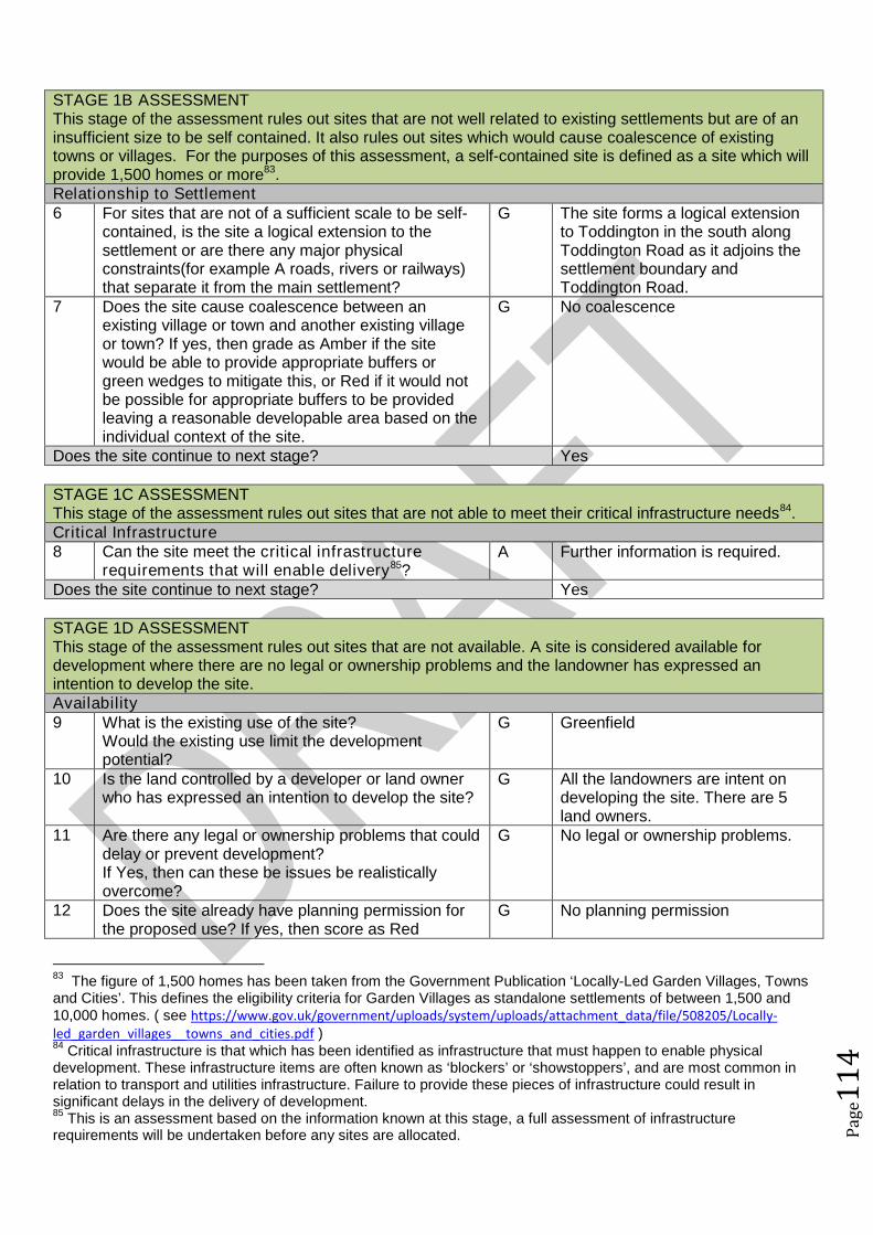
Pag
e11
4
STAGE 1B ASSESSMENTThis stage of the assessment rules out sites that are not well related to existing settlements but are of aninsufficient size to be self contained. It also rules out sites which would cause coalescence of existingtowns or villages. For the purposes of this assessment, a self-contained site is defined as a site which willprovide 1,500 homes or more83.Relationship to Settlement6 For sites that are not of a sufficient scale to be self-
contained, is the site a logical extension to thesettlement or are there any major physicalconstraints(for example A roads, rivers or railways)that separate it from the main settlement?
G The site forms a logical extensionto Toddington in the south alongToddington Road as it adjoins thesettlement boundary andToddington Road.
7 Does the site cause coalescence between anexisting village or town and another existing villageor town? If yes, then grade as Amber if the sitewould be able to provide appropriate buffers orgreen wedges to mitigate this, or Red if it would notbe possible for appropriate buffers to be providedleaving a reasonable developable area based on theindividual context of the site.
G No coalescence
Does the site continue to next stage? Yes
STAGE 1C ASSESSMENTThis stage of the assessment rules out sites that are not able to meet their critical infrastructure needs84.Critical Infrastructure8 Can the site meet the critical infrastructure
requirements that will enable delivery85?A Further information is required.
Does the site continue to next stage? Yes
STAGE 1D ASSESSMENTThis stage of the assessment rules out sites that are not available. A site is considered available fordevelopment where there are no legal or ownership problems and the landowner has expressed anintention to develop the site.Availability9 What is the existing use of the site?
Would the existing use limit the developmentpotential?
G Greenfield
10 Is the land controlled by a developer or land ownerwho has expressed an intention to develop the site?
G All the landowners are intent ondeveloping the site. There are 5land owners.
11 Are there any legal or ownership problems that coulddelay or prevent development?If Yes, then can these be issues be realisticallyovercome?
G No legal or ownership problems.
12 Does the site already have planning permission forthe proposed use? If yes, then score as Red
G No planning permission
83The figure of 1,500 homes has been taken from the Government Publication ‘Locally-Led Garden Villages, Towns
and Cities’. This defines the eligibility criteria for Garden Villages as standalone settlements of between 1,500 and10,000 homes. ( see https://www.gov.uk/government/uploads/system/uploads/attachment_data/file/508205/Locally-led_garden_villages__towns_and_cities.pdf )84
Critical infrastructure is that which has been identified as infrastructure that must happen to enable physicaldevelopment. These infrastructure items are often known as ‘blockers’ or ‘showstoppers’, and are most common inrelation to transport and utilities infrastructure. Failure to provide these pieces of infrastructure could result insignificant delays in the delivery of development.85
This is an assessment based on the information known at this stage, a full assessment of infrastructurerequirements will be undertaken before any sites are allocated.
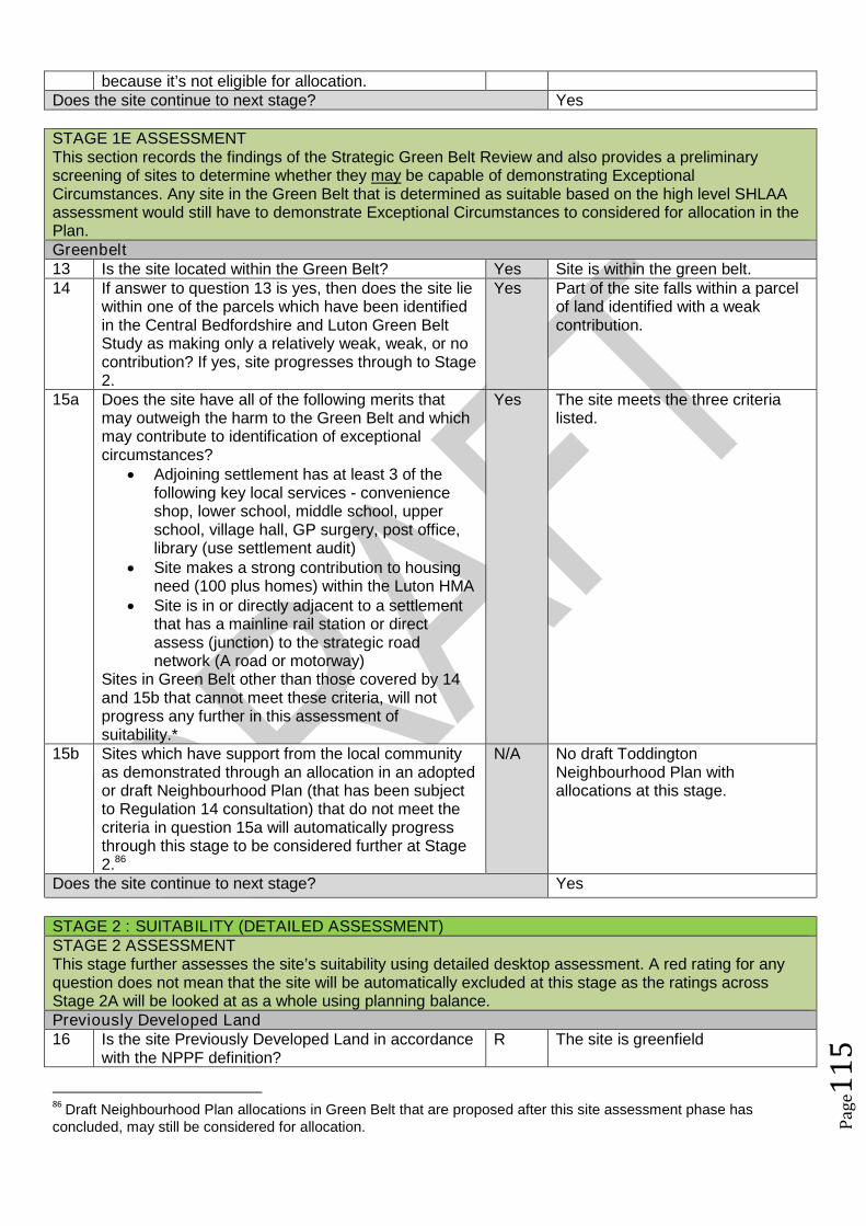
Pag
e11
5
because it’s not eligible for allocation.Does the site continue to next stage? Yes
STAGE 1E ASSESSMENTThis section records the findings of the Strategic Green Belt Review and also provides a preliminaryscreening of sites to determine whether they may be capable of demonstrating ExceptionalCircumstances. Any site in the Green Belt that is determined as suitable based on the high level SHLAAassessment would still have to demonstrate Exceptional Circumstances to considered for allocation in thePlan.Greenbelt13 Is the site located within the Green Belt? Yes Site is within the green belt.14 If answer to question 13 is yes, then does the site lie
within one of the parcels which have been identifiedin the Central Bedfordshire and Luton Green BeltStudy as making only a relatively weak, weak, or nocontribution? If yes, site progresses through to Stage2.
Yes Part of the site falls within a parcelof land identified with a weakcontribution.
15a Does the site have all of the following merits thatmay outweigh the harm to the Green Belt and whichmay contribute to identification of exceptionalcircumstances?
Adjoining settlement has at least 3 of thefollowing key local services - convenienceshop, lower school, middle school, upperschool, village hall, GP surgery, post office,library (use settlement audit)
Site makes a strong contribution to housingneed (100 plus homes) within the Luton HMA
Site is in or directly adjacent to a settlementthat has a mainline rail station or directassess (junction) to the strategic roadnetwork (A road or motorway)
Sites in Green Belt other than those covered by 14and 15b that cannot meet these criteria, will notprogress any further in this assessment ofsuitability.*
Yes The site meets the three criterialisted.
15b Sites which have support from the local communityas demonstrated through an allocation in an adoptedor draft Neighbourhood Plan (that has been subjectto Regulation 14 consultation) that do not meet thecriteria in question 15a will automatically progressthrough this stage to be considered further at Stage2.86
N/A No draft ToddingtonNeighbourhood Plan withallocations at this stage.
Does the site continue to next stage? Yes
STAGE 2 : SUITABILITY (DETAILED ASSESSMENT)STAGE 2 ASSESSMENTThis stage further assesses the site’s suitability using detailed desktop assessment. A red rating for anyquestion does not mean that the site will be automatically excluded at this stage as the ratings acrossStage 2A will be looked at as a whole using planning balance.Previously Developed Land16 Is the site Previously Developed Land in accordance
with the NPPF definition?R The site is greenfield
86Draft Neighbourhood Plan allocations in Green Belt that are proposed after this site assessment phase has
concluded, may still be considered for allocation.
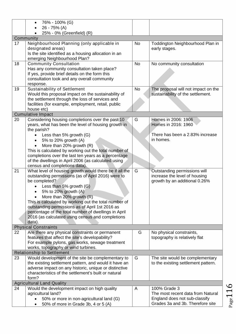
Pag
e11
6
76% - 100% (G) 26 - 75% (A) 25% - 0% (Greenfield) (R)
Community17 Neighbourhood Planning (only applicable in
designated areas)Is the site identified as a housing allocation in anemerging Neighbourhood Plan?
No Toddington Neighbourhood Plan inearly stages.
18 Community ConsultationHas any community consultation taken place?If yes, provide brief details on the form thisconsultation took and any overall communityresponse.
No No community consultation
19 Sustainability of SettlementWould this proposal impact on the sustainability ofthe settlement through the loss of services andfacilities (for example, employment, retail, publichouse etc)
No The proposal will not impact on thesustainability of the settlement.
Cumulative Impact20 Considering housing completions over the past 10
years, what has been the level of housing growth inthe parish?
Less than 5% growth (G) 5% to 20% growth (A) More than 20% growth (R)
This is calculated by working out the total number ofcompletions over the last ten years as a percentageof the dwellings in April 2006 (as calculated usingcensus and completions data).
G Homes in 2006: 1906Homes in 2016: 1960
There has been a 2.83% increasein homes.
21 What level of housing growth would there be if all theoutstanding permissions (as of April 2016) were tobe completed?
Less than 5% growth (G) 5% to 20% growth (A) More than 20% growth (R)
This is calculated by working out the total number ofoutstanding permissions as of April 1st 2016 aspercentage of the total number of dwellings in April2016 (as calculated using census and completionsdata).
G Outstanding permissions willincrease the level of housinggrowth by an additional 0.26%
Physical Constraints22 Are there any physical constraints or permanent
features that affect the site’s developability?For example pylons, gas works, sewage treatmentworks, topography or wind turbines.
G No physical constraints,topography is relatively flat
Relationship to Settlement23 Would development of the site be complementary to
the existing settlement pattern, and would it have anadverse impact on any historic, unique or distinctivecharacteristics of the settlement’s built or naturalform?
G The site would be complementaryto the existing settlement pattern.
Agricultural Land Quality24 Would the development impact on high quality
agricultural land? 50% or more in non-agricultural land (G) 50% of more in Grade 3b, 4 or 5 (A)
A 100% Grade 3The most recent data from NaturalEngland does not sub-classifyGrades 3a and 3b. Therefore site
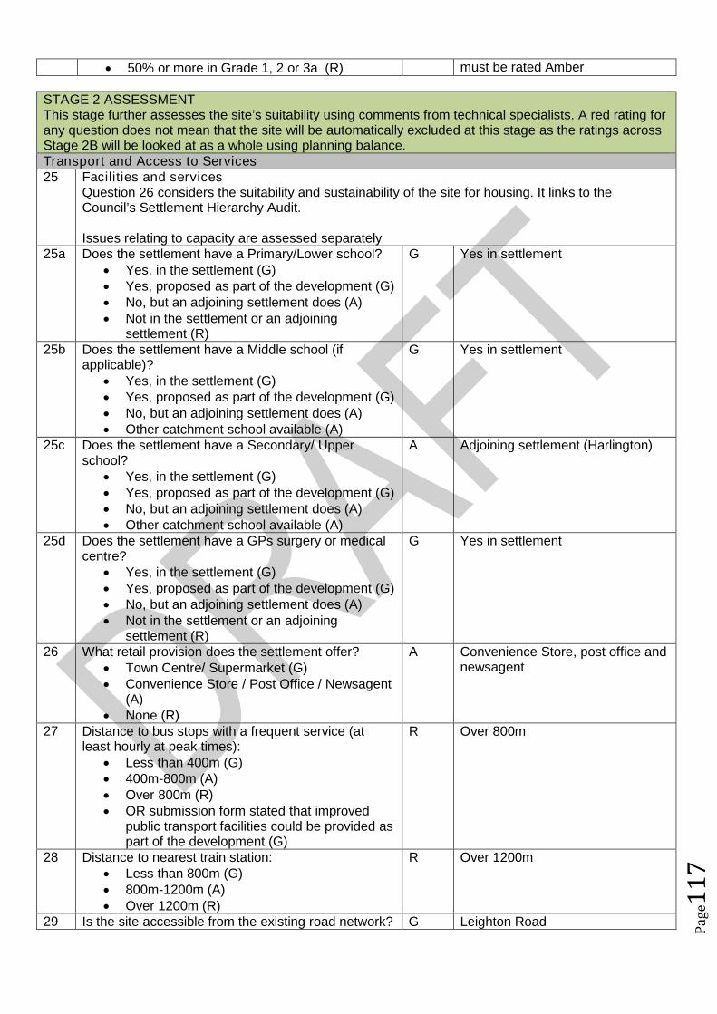
Pag
e11
7
50% or more in Grade 1, 2 or 3a (R) must be rated Amber
STAGE 2 ASSESSMENTThis stage further assesses the site’s suitability using comments from technical specialists. A red rating forany question does not mean that the site will be automatically excluded at this stage as the ratings acrossStage 2B will be looked at as a whole using planning balance.Transport and Access to Services25 Facilities and services
Question 26 considers the suitability and sustainability of the site for housing. It links to theCouncil’s Settlement Hierarchy Audit.
Issues relating to capacity are assessed separately25a Does the settlement have a Primary/Lower school?
Yes, in the settlement (G) Yes, proposed as part of the development (G) No, but an adjoining settlement does (A) Not in the settlement or an adjoining
settlement (R)
G Yes in settlement
25b Does the settlement have a Middle school (ifapplicable)?
Yes, in the settlement (G) Yes, proposed as part of the development (G) No, but an adjoining settlement does (A) Other catchment school available (A)
G Yes in settlement
25c Does the settlement have a Secondary/ Upperschool?
Yes, in the settlement (G) Yes, proposed as part of the development (G) No, but an adjoining settlement does (A) Other catchment school available (A)
A Adjoining settlement (Harlington)
25d Does the settlement have a GPs surgery or medicalcentre?
Yes, in the settlement (G) Yes, proposed as part of the development (G) No, but an adjoining settlement does (A) Not in the settlement or an adjoining
settlement (R)
G Yes in settlement
26 What retail provision does the settlement offer? Town Centre/ Supermarket (G) Convenience Store / Post Office / Newsagent
(A) None (R)
A Convenience Store, post office andnewsagent
27 Distance to bus stops with a frequent service (atleast hourly at peak times):
Less than 400m (G) 400m-800m (A) Over 800m (R) OR submission form stated that improved
public transport facilities could be provided aspart of the development (G)
R Over 800m
28 Distance to nearest train station: Less than 800m (G) 800m-1200m (A) Over 1200m (R)
R Over 1200m
29 Is the site accessible from the existing road network? G Leighton Road
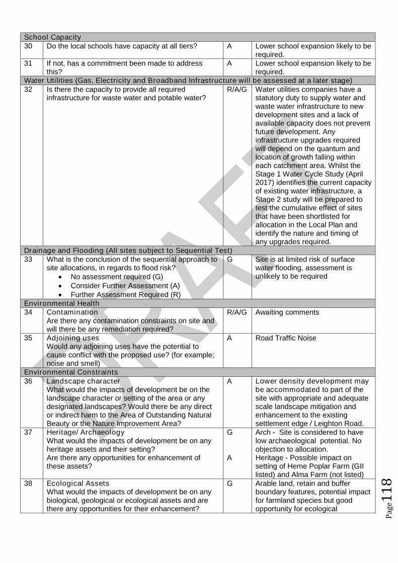
Pag
e11
8
School Capacity30 Do the local schools have capacity at all tiers? A Lower school expansion likely to be
required.31 If not, has a commitment been made to address
this?A Lower school expansion likely to be
required.Water Utilities (Gas, Electricity and Broadband Infrastructure will be assessed at a later stage)32 Is there the capacity to provide all required
infrastructure for waste water and potable water?R/A/G Water utilities companies have a
statutory duty to supply water andwaste water infrastructure to newdevelopment sites and a lack ofavailable capacity does not preventfuture development. Anyinfrastructure upgrades requiredwill depend on the quantum andlocation of growth falling withineach catchment area. Whilst theStage 1 Water Cycle Study (April2017) identifies the current capacityof existing water infrastructure, aStage 2 study will be prepared totest the cumulative effect of sitesthat have been shortlisted forallocation in the Local Plan andidentify the nature and timing ofany upgrades required.
Drainage and Flooding (All sites subject to Sequential Test)33 What is the conclusion of the sequential approach to
site allocations, in regards to flood risk? No assessment required (G) Consider Further Assessment (A) Further Assessment Required (R)
G Site is at limited risk of surfacewater flooding, assessment isunlikely to be required
Environmental Health34 Contamination
Are there any contamination constraints on site andwill there be any remediation required?
R/A/G Awaiting comments
35 Adjoining usesWould any adjoining uses have the potential tocause conflict with the proposed use? (for example;noise and smell)
A Road Traffic Noise
Environmental Constraints36 Landscape character
What would the impacts of development be on thelandscape character or setting of the area or anydesignated landscapes? Would there be any director indirect harm to the Area of Outstanding NaturalBeauty or the Nature Improvement Area?
A Lower density development maybe accommodated to part of thesite with appropriate and adequatescale landscape mitigation andenhancement to the existingsettlement edge / Leighton Road.
37 Heritage/ ArchaeologyWhat would the impacts of development be on anyheritage assets and their setting?Are there any opportunities for enhancement ofthese assets?
G
A
Arch - Site is considered to havelow archaeological potential. Noobjection to allocation.Heritage - Possible impact onsetting of Heme Poplar Farm (GIIlisted) and Alma Farm (not listed)
38 Ecological AssetsWhat would the impacts of development be on anybiological, geological or ecological assets and arethere any opportunities for their enhancement?
G Arable land, retain and bufferboundary features, potential impactfor farmland species but goodopportunity for ecological
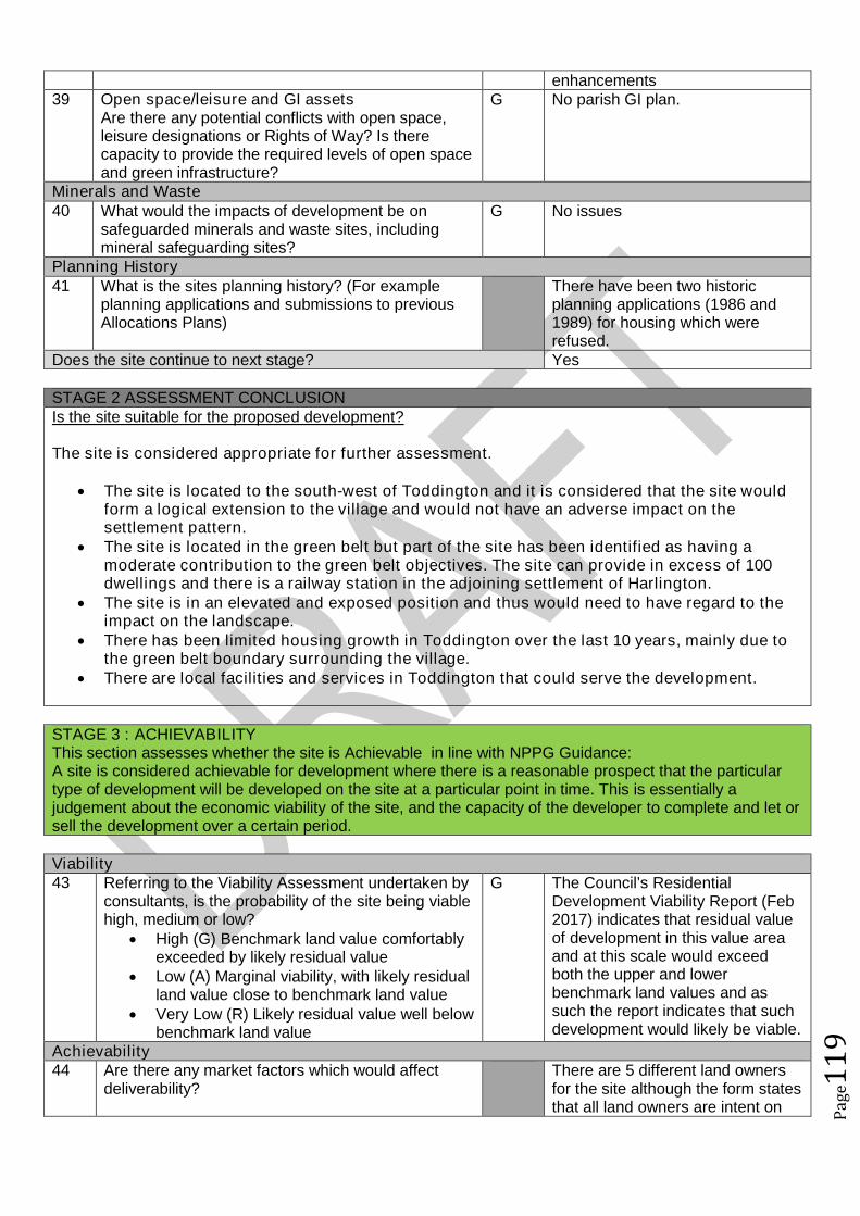
Pag
e11
9
enhancements39 Open space/leisure and GI assets
Are there any potential conflicts with open space,leisure designations or Rights of Way? Is therecapacity to provide the required levels of open spaceand green infrastructure?
G No parish GI plan.
Minerals and Waste40 What would the impacts of development be on
safeguarded minerals and waste sites, includingmineral safeguarding sites?
G No issues
Planning History41 What is the sites planning history? (For example
planning applications and submissions to previousAllocations Plans)
There have been two historicplanning applications (1986 and1989) for housing which wererefused.
Does the site continue to next stage? Yes
STAGE 2 ASSESSMENT CONCLUSIONIs the site suitable for the proposed development?
The site is considered appropriate for further assessment.
The site is located to the south-west of Toddington and it is considered that the site wouldform a logical extension to the village and would not have an adverse impact on thesettlement pattern.
The site is located in the green belt but part of the site has been identified as having amoderate contribution to the green belt objectives. The site can provide in excess of 100dwellings and there is a railway station in the adjoining settlement of Harlington.
The site is in an elevated and exposed position and thus would need to have regard to theimpact on the landscape.
There has been limited housing growth in Toddington over the last 10 years, mainly due tothe green belt boundary surrounding the village.
There are local facilities and services in Toddington that could serve the development.
STAGE 3 : ACHIEVABILITYThis section assesses whether the site is Achievable in line with NPPG Guidance:A site is considered achievable for development where there is a reasonable prospect that the particulartype of development will be developed on the site at a particular point in time. This is essentially ajudgement about the economic viability of the site, and the capacity of the developer to complete and let orsell the development over a certain period.
Viability43 Referring to the Viability Assessment undertaken by
consultants, is the probability of the site being viablehigh, medium or low?
High (G) Benchmark land value comfortablyexceeded by likely residual value
Low (A) Marginal viability, with likely residualland value close to benchmark land value
Very Low (R) Likely residual value well belowbenchmark land value
G The Council’s ResidentialDevelopment Viability Report (Feb2017) indicates that residual valueof development in this value areaand at this scale would exceedboth the upper and lowerbenchmark land values and assuch the report indicates that suchdevelopment would likely be viable.
Achievability44 Are there any market factors which would affect
deliverability?There are 5 different land ownersfor the site although the form statesthat all land owners are intent on
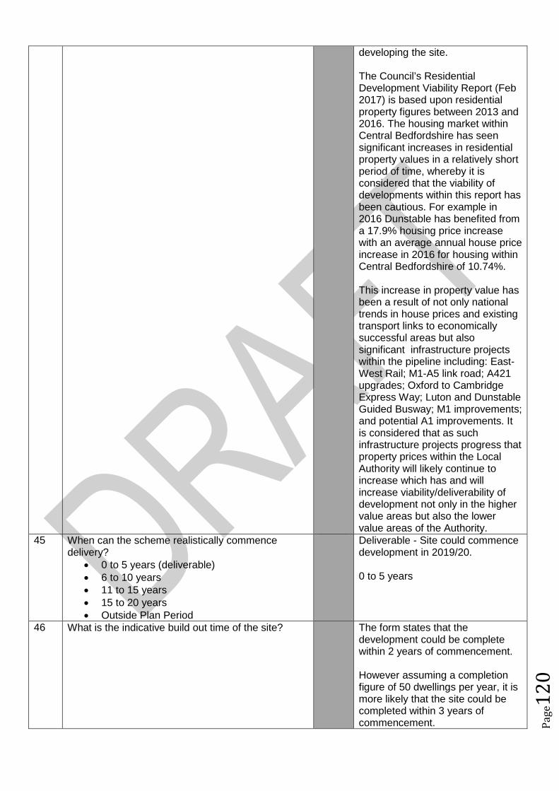
Pag
e12
0
developing the site.
The Council’s ResidentialDevelopment Viability Report (Feb2017) is based upon residentialproperty figures between 2013 and2016. The housing market withinCentral Bedfordshire has seensignificant increases in residentialproperty values in a relatively shortperiod of time, whereby it isconsidered that the viability ofdevelopments within this report hasbeen cautious. For example in2016 Dunstable has benefited froma 17.9% housing price increasewith an average annual house priceincrease in 2016 for housing withinCentral Bedfordshire of 10.74%.
This increase in property value hasbeen a result of not only nationaltrends in house prices and existingtransport links to economicallysuccessful areas but alsosignificant infrastructure projectswithin the pipeline including: East-West Rail; M1-A5 link road; A421upgrades; Oxford to CambridgeExpress Way; Luton and DunstableGuided Busway; M1 improvements;and potential A1 improvements. Itis considered that as suchinfrastructure projects progress thatproperty prices within the LocalAuthority will likely continue toincrease which has and willincrease viability/deliverability ofdevelopment not only in the highervalue areas but also the lowervalue areas of the Authority.
45 When can the scheme realistically commencedelivery?
0 to 5 years (deliverable) 6 to 10 years 11 to 15 years 15 to 20 years Outside Plan Period
Deliverable - Site could commencedevelopment in 2019/20.
0 to 5 years
46 What is the indicative build out time of the site? The form states that thedevelopment could be completewithin 2 years of commencement.
However assuming a completionfigure of 50 dwellings per year, it ismore likely that the site could becompleted within 3 years ofcommencement.
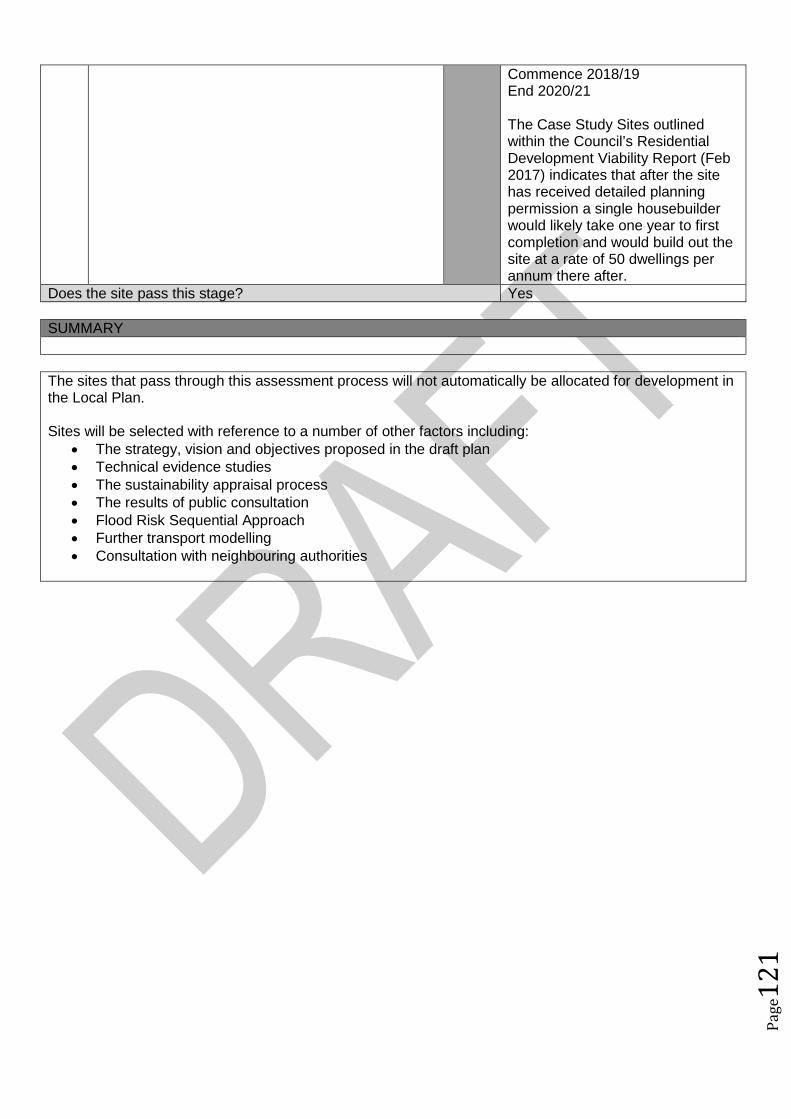
Pag
e12
1
Commence 2018/19End 2020/21
The Case Study Sites outlinedwithin the Council’s ResidentialDevelopment Viability Report (Feb2017) indicates that after the sitehas received detailed planningpermission a single housebuilderwould likely take one year to firstcompletion and would build out thesite at a rate of 50 dwellings perannum there after.
Does the site pass this stage? Yes
SUMMARY
The sites that pass through this assessment process will not automatically be allocated for development inthe Local Plan.
Sites will be selected with reference to a number of other factors including: The strategy, vision and objectives proposed in the draft plan Technical evidence studies The sustainability appraisal process The results of public consultation Flood Risk Sequential Approach Further transport modelling Consultation with neighbouring authorities

Pag
e12
2
Site Assessment Framework for HOUSING87
Site detailsReference Number NLP453
Site Name Land Toddington between Luton Road – Dunstable Road including Crowbush FarmSite AddressSettlement ToddingtonSize Submitted Developable Area:
Submitted Whole Site Area:Measured GIS Area: 34.51ha
Proposed Use Residential development including recreational open spaceAny otherinformation
See ALP227
STAGE 1 : SUITABILITY AND AVAILABILITY (EXCLUSIONARY STAGE)This section will exclude any sites which do not pass the exclusionary suitability criteria and they will notbe assessed further.
STAGE 1A ASSESSMENTThis stage of the assessment rules out sites that are too small or conflict with national policy designations.Provisional Site Capacity1 Is the site likely to accommodate less than 10
dwellings?Work out the number of new homes from site sizeusing density of 30dph and exclude up to 40 %depending on site size of land for infrastructure andservices, take into account topography or significantareas of undevelopable land.Site Size Gross to net ratio standards
Up to 0.4 hectare 100% 0.4 to 2 hectares 80% 2 hectares or above 60%
Note: for this calculation use the submittedDevelopable Area, or the area measured in GIS ifthis is smaller.
No Number of proposed dwellings asper proforma:
150-350
Number of proposed dwellings asper CBC methodology:
600
Flood Risk (All sites which reach Stage 2 will be subject to the Sequential Test)2 Is more than 50% of the site located in Flood Zone 2
or 3?No Not within Floodzone 2 or 3
3 Is more than 50% of the site at risk from surfacewater flooding?
No Not at risk from surface waterflooding
Nationally significant designations (All sites which reach Stage 2 be subject to detailed assessment)4 Is more than 50% of the site covered by nationally
significant designations? These are: Sites of SpecialScientific Interest, National Nature Reserves,Scheduled Monuments, Registered Parks andGardens.
No No nationally significantdesignations on site.
5 Is more than 50% of the site located within the Areaof Outstanding Natural Beauty?
No Not within the AONB
Does the site continue to next stage? Yes
87Employment sites and Gypsy and Traveller sites will be assessed using separate bespoke site assessment criteria.
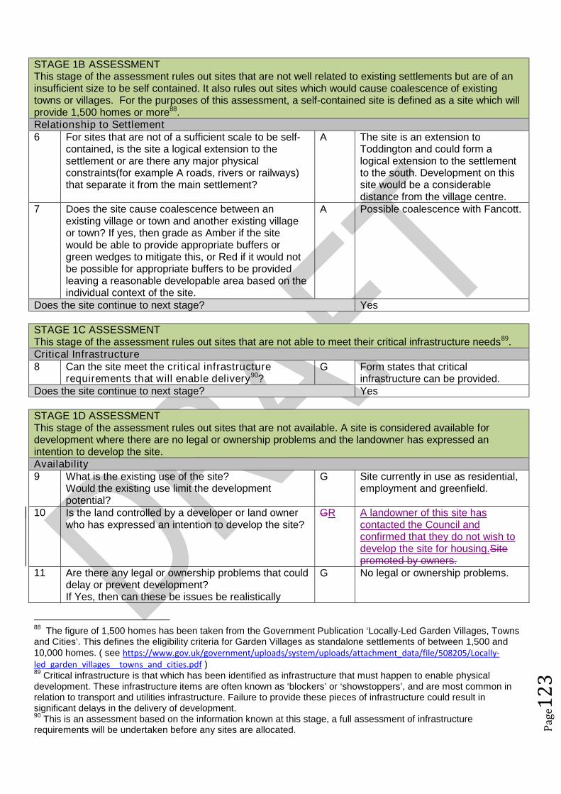
Pag
e12
3
STAGE 1B ASSESSMENTThis stage of the assessment rules out sites that are not well related to existing settlements but are of aninsufficient size to be self contained. It also rules out sites which would cause coalescence of existingtowns or villages. For the purposes of this assessment, a self-contained site is defined as a site which willprovide 1,500 homes or more88.Relationship to Settlement6 For sites that are not of a sufficient scale to be self-
contained, is the site a logical extension to thesettlement or are there any major physicalconstraints(for example A roads, rivers or railways)that separate it from the main settlement?
A The site is an extension toToddington and could form alogical extension to the settlementto the south. Development on thissite would be a considerabledistance from the village centre.
7 Does the site cause coalescence between anexisting village or town and another existing villageor town? If yes, then grade as Amber if the sitewould be able to provide appropriate buffers orgreen wedges to mitigate this, or Red if it would notbe possible for appropriate buffers to be providedleaving a reasonable developable area based on theindividual context of the site.
A Possible coalescence with Fancott.
Does the site continue to next stage? Yes
STAGE 1C ASSESSMENTThis stage of the assessment rules out sites that are not able to meet their critical infrastructure needs89.Critical Infrastructure8 Can the site meet the critical infrastructure
requirements that will enable delivery90?G Form states that critical
infrastructure can be provided.Does the site continue to next stage? Yes
STAGE 1D ASSESSMENTThis stage of the assessment rules out sites that are not available. A site is considered available fordevelopment where there are no legal or ownership problems and the landowner has expressed anintention to develop the site.Availability9 What is the existing use of the site?
Would the existing use limit the developmentpotential?
G Site currently in use as residential,employment and greenfield.
10 Is the land controlled by a developer or land ownerwho has expressed an intention to develop the site?
GR A landowner of this site hascontacted the Council andconfirmed that they do not wish todevelop the site for housing.Sitepromoted by owners.
11 Are there any legal or ownership problems that coulddelay or prevent development?If Yes, then can these be issues be realistically
G No legal or ownership problems.
88The figure of 1,500 homes has been taken from the Government Publication ‘Locally-Led Garden Villages, Towns
and Cities’. This defines the eligibility criteria for Garden Villages as standalone settlements of between 1,500 and10,000 homes. ( see https://www.gov.uk/government/uploads/system/uploads/attachment_data/file/508205/Locally-led_garden_villages__towns_and_cities.pdf )89
Critical infrastructure is that which has been identified as infrastructure that must happen to enable physicaldevelopment. These infrastructure items are often known as ‘blockers’ or ‘showstoppers’, and are most common inrelation to transport and utilities infrastructure. Failure to provide these pieces of infrastructure could result insignificant delays in the delivery of development.90
This is an assessment based on the information known at this stage, a full assessment of infrastructurerequirements will be undertaken before any sites are allocated.
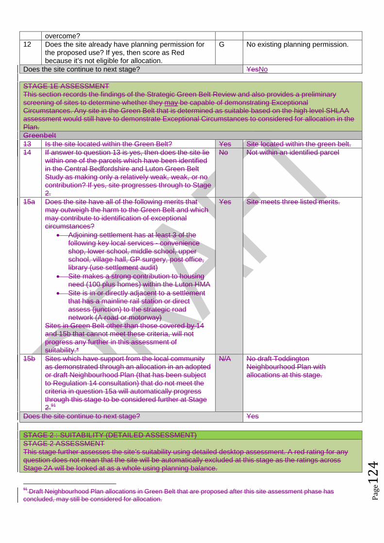
Pag
e12
4
overcome?12 Does the site already have planning permission for
the proposed use? If yes, then score as Redbecause it’s not eligible for allocation.
G No existing planning permission.
Does the site continue to next stage? YesNo
STAGE 1E ASSESSMENTThis section records the findings of the Strategic Green Belt Review and also provides a preliminaryscreening of sites to determine whether they may be capable of demonstrating ExceptionalCircumstances. Any site in the Green Belt that is determined as suitable based on the high level SHLAAassessment would still have to demonstrate Exceptional Circumstances to considered for allocation in thePlan.Greenbelt13 Is the site located within the Green Belt? Yes Site located within the green belt.14 If answer to question 13 is yes, then does the site lie
within one of the parcels which have been identifiedin the Central Bedfordshire and Luton Green BeltStudy as making only a relatively weak, weak, or nocontribution? If yes, site progresses through to Stage2.
No Not within an identified parcel
15a Does the site have all of the following merits thatmay outweigh the harm to the Green Belt and whichmay contribute to identification of exceptionalcircumstances?
Adjoining settlement has at least 3 of thefollowing key local services - convenienceshop, lower school, middle school, upperschool, village hall, GP surgery, post office,library (use settlement audit)
Site makes a strong contribution to housingneed (100 plus homes) within the Luton HMA
Site is in or directly adjacent to a settlementthat has a mainline rail station or directassess (junction) to the strategic roadnetwork (A road or motorway)
Sites in Green Belt other than those covered by 14and 15b that cannot meet these criteria, will notprogress any further in this assessment ofsuitability.*
Yes Site meets three listed merits.
15b Sites which have support from the local communityas demonstrated through an allocation in an adoptedor draft Neighbourhood Plan (that has been subjectto Regulation 14 consultation) that do not meet thecriteria in question 15a will automatically progressthrough this stage to be considered further at Stage2.91
N/A No draft ToddingtonNeighbourhood Plan withallocations at this stage.
Does the site continue to next stage? Yes
STAGE 2 : SUITABILITY (DETAILED ASSESSMENT)STAGE 2 ASSESSMENTThis stage further assesses the site’s suitability using detailed desktop assessment. A red rating for anyquestion does not mean that the site will be automatically excluded at this stage as the ratings acrossStage 2A will be looked at as a whole using planning balance.
91Draft Neighbourhood Plan allocations in Green Belt that are proposed after this site assessment phase has
concluded, may still be considered for allocation.

Pag
e12
5
Previously Developed Land16 Is the site Previously Developed Land in accordance
with the NPPF definition? 76% - 100% (G) 26 - 75% (A) 25% - 0% (Greenfield) (R)
R Site is greenfield
Community17 Neighbourhood Planning (only applicable in
designated areas)Is the site identified as a housing allocation in anemerging Neighbourhood Plan?
No Toddington Neighbourhood Plan inearly stages.
18 Community ConsultationHas any community consultation taken place?If yes, provide brief details on the form thisconsultation took and any overall communityresponse.
No No community consultation.
19 Sustainability of SettlementWould this proposal impact on the sustainability ofthe settlement through the loss of services andfacilities (for example, employment, retail, publichouse etc)
No The proposal would not impact onthe sustainability of the settlement.
Cumulative Impact20 Considering housing completions over the past 10
years, what has been the level of housing growth inthe parish?
Less than 5% growth (G) 5% to 20% growth (A) More than 20% growth (R)
This is calculated by working out the total number ofcompletions over the last ten years as a percentageof the dwellings in April 2006 (as calculated usingcensus and completions data).
G Number of homes in 2006:1906Number of homes in 2016: 1960
A growth of 2.83%.
21 What level of housing growth would there be if all theoutstanding permissions (as of April 2016) were tobe completed?
Less than 5% growth (G) 5% to 20% growth (A) More than 20% growth (R)
This is calculated by working out the total number ofoutstanding permissions as of April 1st 2016 aspercentage of the total number of dwellings in April2016 (as calculated using census and completionsdata).
G Outstanding permissions would bean additional 0.26%.
Physical Constraints22 Are there any physical constraints or permanent
features that affect the site’s developability?For example pylons, gas works, sewage treatmentworks, topography or wind turbines.
A The site slopes down towardsFancott. Toddington is elevatedand development of this whole sitewould mean developmentextending down the slope, which isout of keeping with the character ofthe village.
Relationship to Settlement23 Would development of the site be complementary to
the existing settlement pattern, and would it have anadverse impact on any historic, unique or distinctivecharacteristics of the settlement’s built or natural
A The site extends the settlementpattern of Toddington southeastwards which is not withinkeeping of the character of
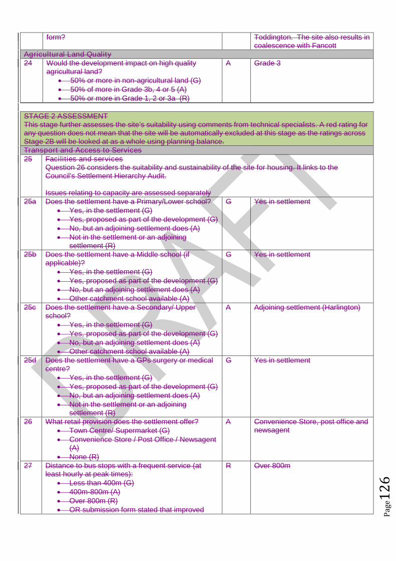
Pag
e12
6
form? Toddington. The site also results incoalescence with Fancott
Agricultural Land Quality24 Would the development impact on high quality
agricultural land? 50% or more in non-agricultural land (G) 50% of more in Grade 3b, 4 or 5 (A) 50% or more in Grade 1, 2 or 3a (R)
A Grade 3
STAGE 2 ASSESSMENTThis stage further assesses the site’s suitability using comments from technical specialists. A red rating forany question does not mean that the site will be automatically excluded at this stage as the ratings acrossStage 2B will be looked at as a whole using planning balance.Transport and Access to Services25 Facilities and services
Question 26 considers the suitability and sustainability of the site for housing. It links to theCouncil’s Settlement Hierarchy Audit.
Issues relating to capacity are assessed separately25a Does the settlement have a Primary/Lower school?
Yes, in the settlement (G) Yes, proposed as part of the development (G) No, but an adjoining settlement does (A) Not in the settlement or an adjoining
settlement (R)
G Yes in settlement
25b Does the settlement have a Middle school (ifapplicable)?
Yes, in the settlement (G) Yes, proposed as part of the development (G) No, but an adjoining settlement does (A) Other catchment school available (A)
G Yes in settlement
25c Does the settlement have a Secondary/ Upperschool?
Yes, in the settlement (G) Yes, proposed as part of the development (G) No, but an adjoining settlement does (A) Other catchment school available (A)
A Adjoining settlement (Harlington)
25d Does the settlement have a GPs surgery or medicalcentre?
Yes, in the settlement (G) Yes, proposed as part of the development (G) No, but an adjoining settlement does (A) Not in the settlement or an adjoining
settlement (R)
G Yes in settlement
26 What retail provision does the settlement offer? Town Centre/ Supermarket (G) Convenience Store / Post Office / Newsagent
(A) None (R)
A Convenience Store, post office andnewsagent
27 Distance to bus stops with a frequent service (atleast hourly at peak times):
Less than 400m (G) 400m-800m (A) Over 800m (R) OR submission form stated that improved
R Over 800m
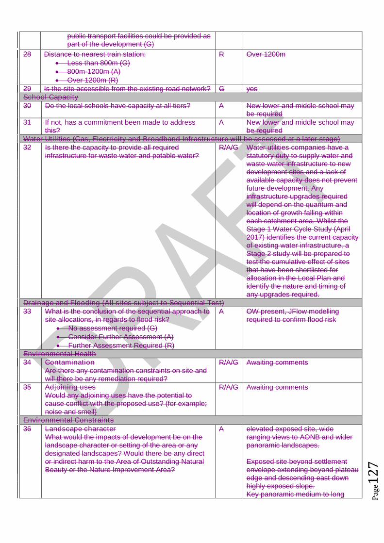
Pag
e12
7
public transport facilities could be provided aspart of the development (G)
28 Distance to nearest train station: Less than 800m (G) 800m-1200m (A) Over 1200m (R)
R Over 1200m
29 Is the site accessible from the existing road network? G yesSchool Capacity30 Do the local schools have capacity at all tiers? A New lower and middle school may
be required31 If not, has a commitment been made to address
this?A New lower and middle school may
be requiredWater Utilities (Gas, Electricity and Broadband Infrastructure will be assessed at a later stage)32 Is there the capacity to provide all required
infrastructure for waste water and potable water?R/A/G Water utilities companies have a
statutory duty to supply water andwaste water infrastructure to newdevelopment sites and a lack ofavailable capacity does not preventfuture development. Anyinfrastructure upgrades requiredwill depend on the quantum andlocation of growth falling withineach catchment area. Whilst theStage 1 Water Cycle Study (April2017) identifies the current capacityof existing water infrastructure, aStage 2 study will be prepared totest the cumulative effect of sitesthat have been shortlisted forallocation in the Local Plan andidentify the nature and timing ofany upgrades required.
Drainage and Flooding (All sites subject to Sequential Test)33 What is the conclusion of the sequential approach to
site allocations, in regards to flood risk? No assessment required (G) Consider Further Assessment (A) Further Assessment Required (R)
A OW present, JFlow modellingrequired to confirm flood risk
Environmental Health34 Contamination
Are there any contamination constraints on site andwill there be any remediation required?
R/A/G Awaiting comments
35 Adjoining usesWould any adjoining uses have the potential tocause conflict with the proposed use? (for example;noise and smell)
R/A/G Awaiting comments
Environmental Constraints36 Landscape character
What would the impacts of development be on thelandscape character or setting of the area or anydesignated landscapes? Would there be any director indirect harm to the Area of Outstanding NaturalBeauty or the Nature Improvement Area?
A elevated exposed site, wideranging views to AONB and widerpanoramic landscapes.
Exposed site beyond settlementenvelope extending beyond plateauedge and descending east downhighly exposed slope.Key panoramic medium to long

Pag
e12
8
ranging views to north east / east /south to Sharpenhoe escarpmentAONB and Chilterns AONB horizonthe south / southeast.Any development must be set awayfrom the plateau edge and wraparound existing settlementenvelope within appropriatelandscape setting (Option 1). Anydevelopment , including playingfields, beyond Crowbush Farm 140AOD contour not acceptable due tochange in landscape character.Development beyond 140 contourcannot be effectively andappropriately mitigated due to openexposed landscape character,primarily hedgerow framework withvery limited tree cover ,
37 Heritage/ ArchaeologyWhat would the impacts of development be on anyheritage assets and their setting?Are there any opportunities for enhancement ofthese assets?
A Site has multi-periodarchaeological potential but thiswould not prevent allocationproviding appropriate mitigationis undertaken.Potential impact on CrowbushFarm (non listed heritage asset)which was there by 1901
38 Ecological AssetsWhat would the impacts of development be on anybiological, geological or ecological assets and arethere any opportunities for their enhancement?
G Buffer existing woodland &hedgerows, opportunity forecological gain.
39 Open space/leisure and GI assetsAre there any potential conflicts with open space,leisure designations or Rights of Way? Is therecapacity to provide the required levels of open spaceand green infrastructure?
A/R Extensive ROW network aroundand across site, including IcknieldWay. These would need to beenhanced / set within greencorridors. Established woodlandaround SE corner of site and alongIcknield Way would need retainingand enhancing.Loss of Crowbush RecreationLand.
Minerals and Waste40 What would the impacts of development be on
safeguarded minerals and waste sites, includingmineral safeguarding sites?
G No issues
Planning History41 What is the sites planning history? (For example
planning applications and submissions to previousAllocations Plans)
No relevant planning history
Does the site continue to next stage? Yes
STAGE 2 ASSESSMENT CONCLUSIONIs the site suitable for the proposed development?
On balance the whole site is not considered appropriate for further consideration.
The site is located in the south east of Toddington and is in an elevated position, which

Pag
e12
9
would expose this site and village in landscape terms. The site is also large in scale in relation to the village and its size together with location
would adversely impact upon the character and pattern of development, which has benconstrained due to the Green Belt, in Toddington.
The size of the site and its extend towards Fancott could potentially result in coalescencewith Fancott.
The development would result in the loss of recreation land. In order to safeguard the landscape and views from the site, development must be set away
from the plateau edge and wrap around existing settlement envelope and must not extendbeyond contour 140 due to the unacceptable changes in landscape character.
As such it is only considered that a small portion of this site, adjoining the boundary withToddington should be considered further.
STAGE 3 : ACHIEVABILITYThis section assesses whether the site is Achievable in line with NPPG Guidance:A site is considered achievable for development where there is a reasonable prospect that the particulartype of development will be developed on the site at a particular point in time. This is essentially ajudgement about the economic viability of the site, and the capacity of the developer to complete and let orsell the development over a certain period.
Viability43 Referring to the Viability Assessment undertaken by
consultants, is the probability of the site being viablehigh, medium or low?
High (G) Benchmark land value comfortablyexceeded by likely residual value
Low (A) Marginal viability, with likely residualland value close to benchmark land value
Very Low (R) Likely residual value well belowbenchmark land value
A The Council’s ResidentialDevelopment Viability Report (Feb2017) indicates that residual valueof development in this value areaand at this scale with £38kinfrastructure costs would notexceed the upper benchmark landvalue and as such the reportindicates that such developmentmay not be viable.
However the Council’s ResidentialDevelopment Viability Report (Feb2017) is based upon residentialproperty figures between 2013 and2016 and based on the averagebuilding costs during 2016. Thehousing market within CentralBedfordshire has seen significantincreases in residential propertyvalues in a relatively short period oftime, whereby it is considered thatthe viability of developments withinthis report has been cautious. Forexample in 2016 Dunstable hasbenefited from a 17.9% housingprice increase with an averageannual house price increase in2016 for housing within CentralBedfordshire of 10.74%.
This increase in property value hasbeen a result of not only nationaltrends in house prices and existingtransport links to economically
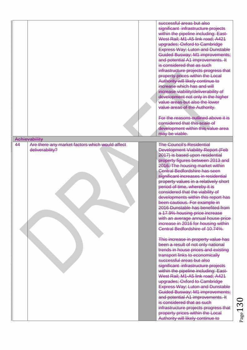
Pag
e13
0
successful areas but alsosignificant infrastructure projectswithin the pipeline including: East-West Rail; M1-A5 link road; A421upgrades; Oxford to CambridgeExpress Way; Luton and DunstableGuided Busway; M1 improvements;and potential A1 improvements. Itis considered that as suchinfrastructure projects progress thatproperty prices within the LocalAuthority will likely continue toincrease which has and willincrease viability/deliverability ofdevelopment not only in the highervalue areas but also the lowervalue areas of the Authority.
For the reasons outlined above it isconsidered that this scale ofdevelopment within this value areamay be viable.
Achievability44 Are there any market factors which would affect
deliverability?The Council’s ResidentialDevelopment Viability Report (Feb2017) is based upon residentialproperty figures between 2013 and2016. The housing market withinCentral Bedfordshire has seensignificant increases in residentialproperty values in a relatively shortperiod of time, whereby it isconsidered that the viability ofdevelopments within this report hasbeen cautious. For example in2016 Dunstable has benefited froma 17.9% housing price increasewith an average annual house priceincrease in 2016 for housing withinCentral Bedfordshire of 10.74%.
This increase in property value hasbeen a result of not only nationaltrends in house prices and existingtransport links to economicallysuccessful areas but alsosignificant infrastructure projectswithin the pipeline including: East-West Rail; M1-A5 link road; A421upgrades; Oxford to CambridgeExpress Way; Luton and DunstableGuided Busway; M1 improvements;and potential A1 improvements. Itis considered that as suchinfrastructure projects progress thatproperty prices within the LocalAuthority will likely continue to
Pag
e13
1
increase which has and willincrease viability/deliverability ofdevelopment not only in the highervalue areas but also the lowervalue areas of the Authority.
45 When can the scheme realistically commencedelivery?
0 to 5 years (deliverable) 6 to 10 years 11 to 15 years 15 to 20 years Outside Plan Period
0 to 5 years
46 What is the indicative build out time of the site? The Case Study Sites outlinedwithin the Council’s ResidentialDevelopment Viability Report (Feb2017) indicates that after the sitehas received detailed planningpermission two housebuilderswould likely take one year to firstcompletion and would build out thesite at a rate of 100 dwellings perannum there after.
Does the site pass this stage? Yes
SUMMARY
The sites that pass through this assessment process will not automatically be allocated for development inthe Local Plan.
Sites will be selected with reference to a number of other factors including: The strategy, vision and objectives proposed in the draft plan Technical evidence studies The sustainability appraisal process The results of public consultation Flood Risk Sequential Approach Further transport modelling Consultation with neighbouring authorities
Pag
e13
2
Site Assessment Framework for HOUSING92
Site detailsReference Number NLP454
Site Name Land rear of Station Road and adjacent to Long LaneSite Address Land rear of Station Road and adjacent to Long LaneSettlement ToddingtonSize Submitted Developable Area:
Submitted Whole Site Area:Measured GIS Area: 4.5ha
Proposed Use ResidentialAny otherinformation
STAGE 1 : SUITABILITY AND AVAILABILITY (EXCLUSIONARY STAGE)This section will exclude any sites which do not pass the exclusionary suitability criteria and they will notbe assessed further.
STAGE 1A ASSESSMENTThis stage of the assessment rules out sites that are too small or conflict with national policy designations.Provisional Site Capacity1 Is the site likely to accommodate less than 10
dwellings?Work out the number of new homes from site sizeusing density of 30dph and exclude up to 40 %depending on site size of land for infrastructure andservices, take into account topography or significantareas of undevelopable land.Site Size Gross to net ratio standards
Up to 0.4 hectare 100% 0.4 to 2 hectares 80% 2 hectares or above 60%
Note: for this calculation use the submittedDevelopable Area, or the area measured in GIS ifthis is smaller.
No Number of proposed dwellings asper proforma:
18-30
Number of proposed dwellings asper CBC methodology:
81
Flood Risk (All sites which reach Stage 2 will be subject to the Sequential Test)2 Is more than 50% of the site located in Flood Zone 2
or 3?No Not within flood zone 2 or 3
3 Is more than 50% of the site at risk from surfacewater flooding?
No Not at risk from surface waterflooding
Nationally significant designations (All sites which reach Stage 2 be subject to detailed assessment)4 Is more than 50% of the site covered by nationally
significant designations? These are: Sites of SpecialScientific Interest, National Nature Reserves,Scheduled Monuments, Registered Parks andGardens.
No Not more than 50% of the site iscovered by nationally significantdesignations.
5 Is more than 50% of the site located within the Areaof Outstanding Natural Beauty?
No Site not within AONB
Does the site continue to next stage? Yes
92Employment sites and Gypsy and Traveller sites will be assessed using separate bespoke site assessment criteria.
Pag
e13
3
STAGE 1B ASSESSMENTThis stage of the assessment rules out sites that are not well related to existing settlements but are of aninsufficient size to be self contained. It also rules out sites which would cause coalescence of existingtowns or villages. For the purposes of this assessment, a self-contained site is defined as a site which willprovide 1,500 homes or more93.Relationship to Settlement6 For sites that are not of a sufficient scale to be self-
contained, is the site a logical extension to thesettlement or are there any major physicalconstraints(for example A roads, rivers or railways)that separate it from the main settlement?
A The site could form an extension toToddington in the north and islocated on back gardens onexisting residential buildings. Thesite slopes down towards the north.
7 Does the site cause coalescence between anexisting village or town and another existing villageor town? If yes, then grade as Amber if the sitewould be able to provide appropriate buffers orgreen wedges to mitigate this, or Red if it would notbe possible for appropriate buffers to be providedleaving a reasonable developable area based on theindividual context of the site.
G No coalescence
Does the site continue to next stage? Yes
STAGE 1C ASSESSMENTThis stage of the assessment rules out sites that are not able to meet their critical infrastructure needs94.Critical Infrastructure8 Can the site meet the critical infrastructure
requirements that will enable delivery95?G No major infrastructure required to
develop the site.Does the site continue to next stage? Yes
STAGE 1D ASSESSMENTThis stage of the assessment rules out sites that are not available. A site is considered available fordevelopment where there are no legal or ownership problems and the landowner has expressed anintention to develop the site.Availability9 What is the existing use of the site?
Would the existing use limit the developmentpotential?
G Site currently used as garden land.
10 Is the land controlled by a developer or land ownerwho has expressed an intention to develop the site?
G All landowners are intent ondeveloping the site.
11 Are there any legal or ownership problems that coulddelay or prevent development?If Yes, then can these be issues be realisticallyovercome?
G No legal or ownership problems.
12 Does the site already have planning permission forthe proposed use? If yes, then score as Redbecause it’s not eligible for allocation.
G No planning permission for theproposed use.
93The figure of 1,500 homes has been taken from the Government Publication ‘Locally-Led Garden Villages, Towns
and Cities’. This defines the eligibility criteria for Garden Villages as standalone settlements of between 1,500 and10,000 homes. ( see https://www.gov.uk/government/uploads/system/uploads/attachment_data/file/508205/Locally-led_garden_villages__towns_and_cities.pdf )94
Critical infrastructure is that which has been identified as infrastructure that must happen to enable physicaldevelopment. These infrastructure items are often known as ‘blockers’ or ‘showstoppers’, and are most common inrelation to transport and utilities infrastructure. Failure to provide these pieces of infrastructure could result insignificant delays in the delivery of development.95
This is an assessment based on the information known at this stage, a full assessment of infrastructurerequirements will be undertaken before any sites are allocated.

Pag
e13
4
Does the site continue to next stage? Yes
STAGE 1E ASSESSMENTThis section records the findings of the Strategic Green Belt Review and also provides a preliminaryscreening of sites to determine whether they may be capable of demonstrating ExceptionalCircumstances. Any site in the Green Belt that is determined as suitable based on the high level SHLAAassessment would still have to demonstrate Exceptional Circumstances to considered for allocation in thePlan.Greenbelt13 Is the site located within the Green Belt? Yes Site is within the green belt.14 If answer to question 13 is yes, then does the site lie
within one of the parcels which have been identifiedin the Central Bedfordshire and Luton Green BeltStudy as making only a relatively weak, weak, or nocontribution? If yes, site progresses through to Stage2.
No Not in an identified parcel
15a Does the site have all of the following merits thatmay outweigh the harm to the Green Belt and whichmay contribute to identification of exceptionalcircumstances?
Adjoining settlement has at least 3 of thefollowing key local services - convenienceshop, lower school, middle school, upperschool, village hall, GP surgery, post office,library (use settlement audit)
Site makes a strong contribution to housingneed (100 plus homes) within the Luton HMA
Site is in or directly adjacent to a settlementthat has a mainline rail station or directassess (junction) to the strategic roadnetwork (A road or motorway)
Sites in Green Belt other than those covered by 14and 15b that cannot meet these criteria, will notprogress any further in this assessment ofsuitability.*
No No listed merits
15b Sites which have support from the local communityas demonstrated through an allocation in an adoptedor draft Neighbourhood Plan (that has been subjectto Regulation 14 consultation) that do not meet thecriteria in question 15a will automatically progressthrough this stage to be considered further at Stage2.96
N/A No draft ToddingtonNeighbourhood Plan with allocationat this stage.
Does the site continue to next stage? No
96Draft Neighbourhood Plan allocations in Green Belt that are proposed after this site assessment phase has
concluded, may still be considered for allocation.
Pag
e13
5
A great place to live and work