Site Allocations Modifications for consultation
45
Site Allocations Modifications for consultation
Transcript of Site Allocations Modifications for consultation

Site Allocations
Modifications for consultation

1
1 Introduction ................................................................................................................................... 2
2. New Site Allocations………………………………………………………………………………………………………………….3
3. Site Allocations to be removed………………………………………………………………………………………………..15
4. Modifications to Site Allocations……………………………………………………………………………………………..18

2
1 Introduction
This document contains all the changes (known as modifications) to the Islington Site Allocations document proposed since the document was submitted to the Planning Inspectorate for Examination in February 2020.
Modifications are identified as being ‘Main’ or ‘Minor’. The Minor Modifications do not materially affect the substance of the plan, its overall soundness or the submitted sustainability appraisal. The minor modifications relate to points of clarification, factual updates and typographical or grammatical errors. The reasons for making each of the changes are clearly set out.
The Modifications are split into three chapters. The first chapter sets out new sites that are proposed to be allocated, the second chapter sets out sites that are proposed to be deleted from the document, the final chapter sets out Main and Minor modifications that are proposed to the rest of the Site Allocations document.
This document is accompanied by schedules setting out relevant changes on the Strategic and Development Management Policies document and Bunhill and Clerkenwell Area Action Plan. An update to the Sustainability Appraisal/IIA and relevant changes to the Policies Map have also been published.
Format of changes The following format has been used to set out what the changes are and distinguish between existing and new text Bold blue – new text proposed Strikethrough red text – text proposed for removal Changes to diagrams, tables etc described in italic text

3
2 New Site Allocations
This sections sets out new Site Allocations that are proposed to be allocated to the plan. These sites are proposed to be included to further add to the boroughs housing supply over the plan period to help meet identified housing needs.
Reference Page Site reference, site name and section
Proposed allocation
Main or minor modification
SA-M01 29 KC8, Bemerton Estate South, Section 2
KC8: Bemerton Estate South
Address Bemerton Estate South
Ownership London Borough of Islington
Approximate size of site:
14,623sqm
Current/previous use Housing estate
How the site was identified and relevant planning history
Pre-application discussions.
Allocation and justification
Infill residential development including the provision of additional genuinely affordable housing. Re-provision of community space and provision of new retail/commercial spaces along Caledonian Road. Improved landscaping, lighting, seating, play spaces and security measures across the estate.
Main

4
Site designations and constraints
Adjacent to Barnsbury Conservation Area.
Opposite a row of Grade II listed buildings (214-268 Caledonian Road).
Development considerations
Any development should ensure high quality design and meet identified local housing needs.
Development should maximise opportunities to improve urban greening and enhance green infrastructure. There are a number of trees on the estate which should be carefully considered as part of a comprehensive landscaping plan for the estate.
Development should increase permeability with the creation of safe, direct, active and overlooked routes through the estate.
Estimated timescale 2021/22-2025/26
SA-MO2 181 OIS27: York Way Estate, Section 9
Address York Way Estate, N7 9QA
Ownership City of London Corporation
Approximate size of site:
19,109sqm
Current/previous use
Residential estate with large areas of underused car parking (surface level and basement), perimeter hardstanding, amenity space and estate community centre.
Main

5
How the site was identified and relevant planning history
Pre-application discussions with the site owner
Allocation and justification
Additional genuinely affordable housing can be accommodated on new blocks within the estate, improved play space provision, improvements to communal facilities and enhanced landscaping.
Site designations and constraints
No site-specific designations in current plan
Adjacent to Caledonian Park which is a Borough Grade 1 SINC and listed heritage asset (the railings, walls, gate piers and gates to the Park, running along Market Road and Shearling Way are Grade II listed and the Clock Tower within the park is Grade II* listed).
Adjacent to Grade II listed building, 24 North Road.
Development considerations
Any development should look to integrate with the character of the surrounding townscape as well as the existing estate and ensure high quality contextual design.
Any development should improve the quality of landscaping and permeability and enhance usability to create inclusive spaces.
Estimated timescale 2021/22-2025/26
SA-MO3 182 OIS28: Barnsbury Estate, Section 9
OIS28: Barnsbury Estate
Address Barnsbury Estate
Ownership Newlon Housing Trust
Approximate size of site:
55,764sqm
Main

6
Current/previous use Housing estate
How the site was identified and relevant planning history
Pre-application discussions
Allocation and justification
Refurbishment of Old Barnsbury estate and redevelopment of New Barnsbury estate for residential use, including the provision of additional new homes and genuinely affordable housing. Improvements to existing estate open spaces including the creation of a park on Pultney Street, and the provision of a new park on Carnegie Street with a community centre, play and exercise equipment and ball court. Improvements to landscaping, planting, lighting and security measures, play spaces, seating and bin and cycle storage across the estate.
Site designations and constraints
Adjacent to the Barnsbury and Regent's Canal West Conservation Areas.
Adjacent to the Regent's Canal (West) Site of Importance for Nature Conservation (Metropolitan grade) and Regent’s Canal Open Space.
Adjacent to Thornhill Bridge Community Garden open space.
Within Local Views 4 (view from Archway Road) and 5 (view from Archway Bridge).
In close proximity to a terrace of Grade II listed buildings (16-62 Barnsbury Road).
Regents Canal runs through Islington Tunnel underneath the Estate with the West Portal of the tunnel opening on Muriel Street. The Portal and Tunnel are Grade II listed.
The site is partially within a local flood risk zone (LFRZ).
Development considerations
Any development should ensure high quality design and meet identified local housing needs with an emphasis on improving space standards within dwellings and reducing overcrowding.
Development should increase permeability with the creation of safe, accessible, direct, active and overlooked routes through the estate from north to south (Copenhagen Street to Carnegie Street) and east to west (for example Pultney Street to Caledonian Road). The delivery of usable, inclusive spaces is a priority.
Active frontages should be provided, particularly along Caledonian Road with the currently blocked access to the estate restored.
Replacement commercial uses should be provided to maintain and enhance the retail and service

7
function of the Caledonian Road Local Shopping Area, alongside public realm improvements to Caledonian Road.
Opportunities to improve urban greening and enhance green infrastructure should be maximised as part of an integrated approach to landscape design. Development must be sensitive to the adjacent SINC.
Estate-wide improvements for pedestrians and cyclists should be provided, including improved connections along the Regent’s Canal to deliver a safer pedestrian and cycling environment. The cycle hire station on Charlotte Terrace should be retained.
Estimated timescale 2021/22-2025/26; 2026/27-2030/31
SA-MO4 184 OIS29: Highbury Quadrant Congregational Church, Section 9
OIS29: Highbury Quadrant Congregational Church
Address Highbury Quadrant Congregational Church, Highbury Quadrant, N5 2TE
Ownership The Congregational Federation Limited
Approximate size of site:
2,764sqm
Current/previous use
Place of worship and community space
How the site was identified and relevant planning history
Pre-application discussions and planning application P2020/2507/FUL
Allocation and justification
Re-provision of the Church and community space alongside residential development, including affordable housing. Landscaping and public realm improvements should be provided. Improvements to pedestrian
Main

8
access to the site are also important given its ‘island’ location.
Site designations and constraints
The site contains a number of trees subject to Tree Preservation Orders (TPOs) which should be considered as part of any development proposals and landscaping plans for the site.
In close proximity to Highbury Quadrant Island Open Space.
Development considerations
Development of the site represents an opportunity to bring an underused community facility back into beneficial use. Any net loss of social infrastructure must be justified in line with policy SC1.
The site occupies a prominent location and warrants a well-designed building that optimises the development potential of the site alongside public realm improvements that will contribute to a high quality street environment.
High quality residential accommodation must be provided, including genuinely affordable housing to meet identified local housing need.
Estimated timescale 2021/22-2025/26
SA-MO5 185 OIS30: Cluse Court, Section 9
OIS30: Cluse Court
Address Cluse Court, St. Peter’s Street, N1 8PD
Ownership London Borough of Islington
Approximate size of site:
12,031sqm
Current/previous use
Housing estate
How the site was identified and
Pre-application discussions
Main

9
relevant planning history
Allocation and justification
Additional residential development, including the provision of genuinely affordable housing. Improvements to play space, amenity space and landscaping across the estate.
Site designations and constraints
Adjacent to the Duncan Terrace/Colebrooke Row Conservation Area.
In close proximity to the Waterside Play and Youth Project Adventure Playground.
Opposite a terrace of Grade II listed buildings at 64-82 St. Peter's Street.
In close proximity to the Regent's Canal open space.
Development considerations
Any development should ensure high quality design and meet identified local housing needs.
Development should maximise opportunities to improve urban greening and enhance green infrastructure. There are a number of trees on the site which should be carefully considered as part of a comprehensive landscaping plan for the estate.
Development should increase permeability with the creation of safe, direct, active and overlooked routes through the estate.
Services provided by the Waterside Play and Youth Project should remain available throughout any development.
The site falls within the Crossrail 2 safeguarding limits (March 2015). Liaison with Crossrail 2 should take place at an early stage as part of any development proposals for this site.
Estimated timescale 2021/22-2025/26

10
SA-MO6 187 OIS31: Hillside Estate, Section 9
OIS31: Hillside Estate
Address Hillside Estate, N19
Ownership London Borough of Islington
Approximate size of site:
36,508sqm
Current/previous use
Housing estate
How the site was identified and relevant planning history
Pre-application discussions
Allocation and justification
Subject to justifying any loss of social infrastructure, additional residential development including the provision of genuinely affordable housing. Improvements to play space, amenity space and landscaping across the estate.
Site designations and constraints
Adjacent to the Whitehall Park Conservation Area.
Hillside Park and Pilgrims Way Garden open spaces fall within the estate boundary.
Adjacent to a locally listed building (131 St. John's Way).
The Hazelville Road frontage of the site is opposite Elthorne Park and Sunnyside Gardens which is a SINC (Borough Grade 2).
Development considerations
Any development should ensure high quality design and meet identified local housing needs.
Development should maximise opportunities to improve urban greening and enhance green infrastructure. There are a number of trees on the site which should be carefully considered as part of a
Main

11
comprehensive landscaping plan for the estate. In addition any potential impacts on the designated open spaces falling within the site boundary should be carefully considered and mitigated.
Development should increase permeability with the creation of safe, direct, active and overlooked routes through the estate. Opportunities to provide more active frontages to Pilgrims Way and St. John’s Way should be explored.
Estimated timescale 2021/22-2025/26
SA-MO7 188 OIS32: New Orleans Estate, Section 9
OIS32: New Orleans Estate
Address New Orleans Estate, Hornsey Rise, N19
Ownership London Borough of Islington
Approximate size of site:
24,058sqm
Current/previous use
Housing estate
How the site was identified and relevant planning history
Pre-application discussions
Allocation and justification
Additional residential development including the provision of genuinely affordable housing. Relocation and re-provision of the existing multi-use games area and community building. Improvements to play space, amenity space and landscaping across the estate.
Site designations and constraints
In close proximity to the Whitehall Park Conservation Area.
Opposite locally listed building 87 Sunnyside Road.
Development considerations
Any development should ensure high quality design and meet identified local housing needs.
Main

12
Any development should maximise opportunities to improve urban greening and enhance green infrastructure. There are a number of trees on the estate which should be carefully considered as part of a comprehensive landscaping plan for the estate.
Development should increase permeability with the creation of safe, direct, active and overlooked routes through the estate.
Development proposals should introduce a built edge and provide an active frontage onto Hornsey Rise.
Estimated timescale 2021/22-2025/26
SA-MO8 189 OIS33: Drakeley Court and Aubert Court
OIS33: Drakeley Court and Aubert Court
Address Drakeley Court Estate and Aubert Court Estate
Ownership London Borough of Islington
Approximate size of site:
18,542sqm
Current/previous use
Housing estate
How the site was identified and relevant planning history
Pre-application discussions
Allocation and justification
Additional residential development including the provision of genuinely affordable housing. Improving access to a new community facility in the heart of the estate that will improve visibility. Improved landscaping, including the creation of a new green square. Improved lighting, seating, play space and security measures across the estate.
Main

13
Site designations and constraints
Adjacent to the Highbury Fields Conservation Area
Adjacent to the Grade II listed Highbury Stadium site
Development considerations
Any development should ensure high quality design, meet identified local housing needs and respect the integrity of the existing estates where appropriate.
Any development should maximise opportunities to improve urban greening and enhance green infrastructure. There are a large number of trees on the site which should be carefully considered as part of a comprehensive landscaping plan.
Development should increase permeability and usability with the creation of safe, direct, active and overlooked routes through the estates. There is an opportunity to open up access from the estates to Avenell Road.
Estimated timescale 2021/22-2025/26
SA-MO9 190 OIS34: Kerridge Court OIS34: Kerridge Court
Address Kerridge Court, Balls Pond Road and Kingsbury Road,
N1
Ownership London Borough of Islington
Approximate size of site:
13,496sqm
Current/previous use
Housing estate
How the site was identified and relevant planning history
Pre-application discussions
Allocation and justification
Additional residential development including the provision of genuinely affordable housing. Re-provision of the existing multi-use games area within a new,
Main

14
centrally located public space. Improvements to play space, amenity space and landscaping across the estate.
Site designations and constraints
The site is in close proximity to the Kingsbury Road Conservation Area, incorporating the Grade II listed Jewish Burial Ground, a designated open space which is also a SINC (borough grade 2).
Adjacent to the North London Line East SINC (borough grade 1).
Development considerations
Any development should ensure high quality design and meet identified local housing needs.
Development should maximise opportunities to improve urban greening and enhance green infrastructure. There are a number of trees on the estate which should be carefully considered as part of a comprehensive landscaping plan for the estate.
Development should increase permeability with the creation of safe, direct, active and overlooked routes through the estate. Development offers an opportunity to improve east to west pedestrian routes through the estate (King Henry’s Walk to Kingsland Road) and provide more legible access into the estate, particularly from Balls Pond Road.
Active frontages should be provided, particularly along Kingsbury Road and Balls Pond Road.
Estimated timescale 2021/22-2025/26

15
3 Site Allocations proposed to be removed
Reference Page Site reference, site name and section
Proposed allocation
Main or minor modification
SA-MO10 115 FP10: Former George Robey Public House, 240 Seven Sisters Road
Delete allocation FP10:
Islington’s 2019/20 Development Starts and Completions survey indicated that development of this site has been completed, with a hotel opening on the site in early 2020. As such it is considered the allocation is no longer required.

16
SA-MO11 162 OIS9: Ladbroke House, 62-66 Highbury Grove
Delete allocation OIS9:
Islington’s 2019/20 Development Starts and Completions survey indicated that development of this site for educational purposes has been completed, with a new college operating from the building since September 2019. As such it is considered the allocation is no longer required.

17
18
4 Modifications to Site Allocations
This section sets out proposed main and minor changes to Site Allocations
Reference Page Section/Paragraph/Policy
Proposed change Reason Main or minor modification
SA-MO12 1 Section 1, paragraph 1.2
Amend text as follows: The Local Plan, including this document, covers the period 20210/221 to 2035/36 (“the plan period”).
Updated detail Minor
SA-MO13 1 Section 1, paragraph 1.4
Amend second sentence as follows: As well as setting out the most appropriate uses for sites, site allocations also detail site-specific constraints and development considerations where relevant.
Error Minor
SA-MO14 3 Section 1, paragraph 1.13
Amend second sentence as follows: Whilst individual site allocations provide information on the designations relevant to a site - such as its existing uses, location within a conservation area or listed building status - applicants should refer to the appropriate chapter of the Local Plan for guidance on how such a designation information should be taken into account when developing planning applications, and how it will inform the planning decision making process.
To provide additional clarification in response to discussions with Sport England, as outlined in the Statement of Common Ground.
Minor
SA-MO15 4 Section 1, Figure 1.2: Islington Spatial Strategy areas and site allocations
Replace Figure 1.2 with an updated plan showing the location of new site allocations KC8 and OIS27-OIS34 and removing completed allocations FP10 and OIS9.
Updated detail Minor

19
SA-MO16 5 Section 1, Policy SA1 Amend text as follows: A. The Local Plan will deliver its objectives and priorities by ensuring that sites allocated for specific uses within the Site Allocations DPD and Bunhill and Clerkenwell AAP actually deliver particular types of development in line with the allocations. Proposals comprising uses which are not specified in the allocations will be inconsistent with the allocation and will not be permitted. B. For the avoidance of doubt, where sites are allocated for a specific use which falls within a broader use class (i.e. office or retail uses which sit within use class E), the specific allocated use will be secured at planning stage. This is to ensure that development contributes towards meeting Islington’s identified development needs. Where the site allocations are expressed more broadly in
To clarify the Council’s approach to determining development proposals for allocated sites in light of the Town and Country Planning (Use Classes) (Amendment) (England) Regulations 2020 and the potential impact of the new class E on Islington’s ability to meet its evidenced priority development needs.
Main

20
1 There are further strategic and non-strategic sites identified in the Bunhill and Clerkenwell AAP.
terms of use class, there is more may be some flexibility regarding athe range of acceptable uses, subject to compliance with all relevant Local Plan policies.
SA-MO17 5 Section 1, new paragraph 1.17
Amend text as follows: The Town and Country Planning (Use Classes) (Amendment) (England) Regulations 2020 (the Regulations) came into effect on 1 September 2020. The most significant impact of the Regulations in relation to site allocations is the creation of a new use class ‘E’ comprising the former ‘A’ (shops, professional and financial services, restaurants and cafes, drinking establishments and hot foot takeaways) and ‘B1’ (business) uses, alongside parts of the former D1 (clinics, health centres, creches and day nurseries, day centres) and D2 (gyms and indoor recreation facilities) use classes.
Explanatory text following the Town and Country Planning (Use Classes) (Amendment) (England) Regulations 2020 and the absorption of some former D1 uses into the new class E.
Main
SA-MO18 5 Section 1, new paragraph 1.18
Amend text as follows: Changes of use within Class E are not classed as development and do not require planning permission. Whilst this introduces a level of flexibility that could have benefits in allowing landowners to respond to changing circumstances, it may also have consequences for the Council’s ability to meet its evidenced development need, particularly for office floorspace, as well as for the availability of services valued by residents such as shops, health clinics and day centres.
Explanatory text following the Town and Country Planning (Use Classes) (Amendment) (England) Regulations 2020 and the absorption of some former D1 uses into the new class E.
Main
SA-MO19 5-6 Section 1, paragraph 1.19 (formerly paragraph 1.17)
Amend text as follows: In order for the Local Plan to deliver its objectives and priorities, and given the shortage of available land in the borough and the potential impacts of use class E, it is necessary to ensure that sites allocated for specific uses actually deliver particular types of development in line with the allocations. Therefore, on the majority of sites the allocations explicitly identify which uses are required, e.g. offices, residential. These uses have been established through consideration of priority development needs and the context of each site; proposals comprising uses which are not specified in the allocations will be inconsistent with the allocation and will not be permitted. In line with this, to ensure that priority uses are delivered, where an allocated use (e.g. offices or retail) falls within a broader use class the Council will require the specific allocated use to be secured at planning stage.
To clarify the Council’s approach to determining development proposals for allocated sites in light of the Town and Country Planning (Use Classes) (Amendment) (England) Regulations 2020.
Main
SA-MO20 6-11 Section 1, Table 1.1: List of strategic and non-strategic policies and allocations
Amend table as follows:
Table 1.1: List of strategic and non-strategic policies and allocations1
Site allocations Strategic policies Non-strategic policies
Policy SA1: Delivering development priorities None
Strategic allocations Non-strategic allocations
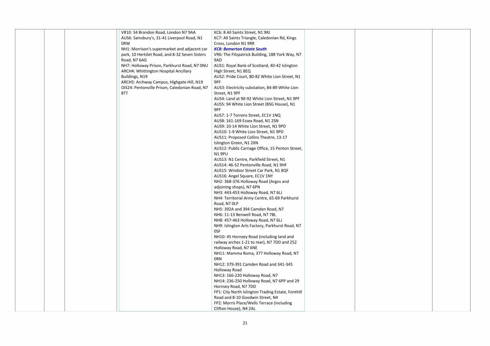
VR1: Fayers Site, 202-228 York Way, Former Venus Printers, 22-23 Tileyard Road, 196-200 York Way, N7 9AX VR2: 230-238 York Way, N7 9AG VR3: Tileyard Studios, Tileyard Road, N7 9AH VR4: 20 Tileyard Road, N7 9AH VR5: 4 Brandon Road, N7 9AA VR7: 43-53 Brewery Road, N7 9QH VR8: 55-61 Brewery Road, N7 9QH VR9: Rebond House, 98-124 Brewery Road, N7 9BG
KC1: King's Cross Triangle Site, bounded by York Way, East Coast Main Line & Channel Tunnel Rail Link, N1 KC2: 176-178 York Way, N1 0AZ; 57-65 Randell’s Road, N1 KC3: Regents Wharf, 10, 12, 14, 16 and 18 All Saints Street, N1 KC4: Former York Road Station, 172-174 York Way KC5: Belle Isle Frontage, land on the east side of York Way
Table updated to remove deleted allocations (FP10 and OIS9) and include new draft allocations (KC8 and OIS27 to OIS34).
Minor
21
VR10: 34 Brandon Road, London N7 9AA AUS6: Sainsbury's, 31-41 Liverpool Road, N1 0RW NH1: Morrison's supermarket and adjacent car park, 10 Hertslet Road, and 8-32 Seven Sisters Road, N7 6AG NH7: Holloway Prison, Parkhurst Road, N7 0NU ARCH4: Whittington Hospital Ancillary Buildings, N19 ARCH5: Archway Campus, Highgate Hill, N19 OIS24: Pentonville Prison, Caledonian Road, N7 8TT
KC6: 8 All Saints Street, N1 9RJ KC7: All Saints Triangle, Caledonian Rd, Kings Cross, London N1 9RR KC8: Bemerton Estate South VR6: The Fitzpatrick Building, 188 York Way, N7 9AD AUS1: Royal Bank of Scotland, 40-42 Islington High Street, N1 8EQ AUS2: Pride Court, 80-82 White Lion Street, N1 9PF AUS3: Electricity substation, 84-89 White Lion Street, N1 9PF AUS4: Land at 90-92 White Lion Street, N1 9PF AUS5: 94 White Lion Street (BSG House), N1 9PF AUS7: 1-7 Torrens Street, EC1V 1NQ AUS8: 161-169 Essex Road, N1 2SN AUS9: 10-14 White Lion Street, N1 9PD AUS10: 1-9 White Lion Street, N1 9PD AUS11: Proposed Collins Theatre, 13-17 Islington Green, N1 2XN AUS12: Public Carriage Office, 15 Penton Street, N1 9PU AUS13: N1 Centre, Parkfield Street, N1 AUS14: 46-52 Pentonville Road, N1 9HF AUS15: Windsor Street Car Park, N1 8QF AUS16: Angel Square, EC1V 1NY NH2: 368-376 Holloway Road (Argos and adjoining shops), N7 6PN NH3: 443-453 Holloway Road, N7 6LJ NH4: Territorial Army Centre, 65-69 Parkhurst Road, N7 0LP NH5: 392A and 394 Camden Road, N7 NH6: 11-13 Benwell Road, N7 7BL NH8: 457-463 Holloway Road, N7 6LJ NH9: Islington Arts Factory, Parkhurst Road, N7 0SF NH10: 45 Hornsey Road (including land and railway arches 1-21 to rear), N7 7DD and 252 Holloway Road, N7 6NE NH11: Mamma Roma, 377 Holloway Road, N7 0RN NH12: 379-391 Camden Road and 341-345 Holloway Road NH13: 166-220 Holloway Road, N7 NH14: 236-250 Holloway Road, N7 6PP and 29 Hornsey Road, N7 7DD FP1: City North Islington Trading Estate, Fonthill Road and 8-10 Goodwin Street, N4 FP2: Morris Place/Wells Terrace (including Clifton House), N4 2AL

22
FP3: Finsbury Park Station and Island, Seven Sisters Road, N4 2DH FP4: 129-131 & 133 Fonthill Road & 13 Goodwin Street, N4 FP5: 1 Prah Road, N4 2RA FP6: Cyma Service Station, 201A Seven Sisters Road, N4 3NG FP7: Holloway Police Station, 284 Hornsey Road, N7 7QY FP8: 113-119 Fonthill Road, N4 3HH FP9: 221-233 Seven Sisters Road, N4 2DA FP10: Former George Robey Public House, 240 Seven Sisters Road, N4 2HX FP11: 139-149 Fonthill Road, N4 3HF FP12: 179-199 Hornsey Road, N7 9RA FP13: Tesco, 103-115 Stroud Green Road, N4 3PX FP14: Andover Estate bounded by Durham Road, Moray Road, Andover Road, Hornsey Road, Newington Barrow Way and Seven Sisters Road, London N7 FP15: 216-220 Seven Sisters Road, N4 3NX ARCH1: Vorley Road/Archway Bus Station, N19 ARCH2: 4-10 Junction Road (buildings adjacent to Archway Underground Station), N19 5RQ ARCH3: Archway Central Methodist Hall, Archway Close, N19 3TD ARCH6: Job Centre, 1 Elthorne Road, N19 4AL ARCH7: 207A Junction Road, N19 5QA ARCH8: Brookstone House, 4-6 Elthorne Road, N19 4AJ ARCH9: 724 Holloway Road, N19 3JD ARCH10: Elthorne Estate, Archway, N19 4AG ARCH11: Dwell House, 619-639 Holloway Road, N19 5SS ARCH12: 798-804 Holloway Road, N19 3JH HC1: 10, 12, 16-18, 20-22 and 24 Highbury Corner, N5 1RA HC2: Spring House, 6-38 Holloway Road, N7 8JL HC3: Highbury and Islington Station, Holloway Road, N5 1RA HC4: Dixon Clark Court, Canonbury Road, N1 2UR HC5: 2 Holloway Road, N7 8JL and 4 Highbury Crescent, London, N5 1RN HC6: Land adjacent to 40-44 Holloway Road, N7 8JL OIS1: Leroy House, 436 Essex Road, N1 3QP OIS2: The Ivories, 6-8 Northampton Street, N1 2HY

23
OIS3: Belgravia Workshops, 157-163 Marlborough Road, N19 4NF OIS4: 1 Kingsland Passage and the BT Telephone Exchange, Kingsland Green OIS5: Bush Industrial Estate, Station Road, N19 5UN OIS6: Site of Harvist Under Fives, 100 Hornsey Road, N7 7NG OIS7: Highbury Delivery Office, 2 Hamilton Lane, N5 1SW OIS8: Legard Works, 17a Legard Road, N5 1DE OIS9: Ladbroke House, 62-66 Highbury Grove OIS10: 500-502 Hornsey Road and Grenville Works, 2A Grenville Road, N19 4EH OIS11: Park View Estate, Collins Road, N5 OIS12: 202-210 Fairbridge Road, N19 3HT OIS13: Highbury Roundhouse Community Centre, 71 Ronald's Road, N5 1XB OIS14: 17-23 Beaumont Rise, N19 3AA OIS15: Athenaeum Court, 94 Highbury New Park, N5 2DN OIS16: Harvist Estate Car Park, N7 7NJ OIS17: Hathersage and Besant Courts, Newington Green, N1 4RF OIS18: Wedmore Estate Car Park, N19 4NU OIS19: 25-27 Horsell Road, N5 1XL OIS20: Vernon Square, Penton Rise, WC1X 9EW OIS21: Former railway sidings adjacent to and potentially including Caledonian Road Station OIS22: 114 Balls Pond Road and 1 King Henry's Walk, N1 4NL OIS23: 1 Lowther Road, N7 8US OIS25: Charles Simmons House, 3 Margery Street, WC1X 0HP OIS26: Amwell Street Water Pumping Station, EC1R OIS27: York Way Estate OIS28: Barnsbury Estate OIS29: Highbury Quadrant Congregational Church OIS30: Cluse Court Estate OIS31: Hillside Estate OIS32: New Orleans Estate OIS33: Drakeley Court Estate and Aubert Court Estate OIS34: Kerridge Court Estate
SA-MO21 13 Section 1, Table 1.2: Site capacity assumptions
Amend Table 1.2 as follows:
Table 1.2: Site capacity assumptions
Years 1-5 Years 6-10 Years 11-15 Total
Table 1.2 amended to reflect changes made to capacity assumptions following the grant of planning permission for certain sites, as well as the addition of
Main

24
Homes
(no.)
Offices
(sqm)
Homes
(no.)
Offices
(sqm)
Homes
(no.)
Offices
(sqm)
Homes
(no.)
Offices
(sqm)
King's Cross and Pentonville Road 200 120 900 1,300 70 18,700 0 900 270 190
20,500
900
Vale Royal/Brewery Road LSIS 0
8,700
4,900 0 0 0 0 0
8,700
4,900
Angel and Upper Street 1 30
7,600
9,000 0 13,200 30
3,900
5,400 4 60
27,6
24,700
Nag's Head and Holloway 95 760
15,500
14,650 34 630
8,800
4,660
8 140 6,6 2,700 1,530 70 30,900
21,990
Finsbury Park 13 200 5 3,700 90 16,500 0 0 290 20
22
20,200
Archway 44 480 6,700 7 100 1,600 0 0 510 8,300
Highbury Corner and Lower
Holloway 50 2,800 0 0 0 1,400 50 4,200
Other important sites 260 500
10,3
9,600
260
830 4,500
370
550 2,300
890
1,880
17,1
16,400
Total 1,960
2,230
56,200
54,580
1,810
1,710
63,3
59,070 480 720
16,600
11,130
3,270
4,650
136,00
124,780
new site allocations and amendments to existing site allocations outlined in this schedule of modifications.
SA-MO22 14 Section 1, paragraph 1.32 (formerly paragraph 1.30)
Amend text of second sentence as follows: Over the 15 year period from 2021/22 to 2035/36, Islington’s total housing requirement will be 11,625 residential units per annum; this means that 1,163 residential units will need to be identified on sites of one hectare or less, to accord with the NPPF.
Error Minor
SA-MO23 15 Section 2, paragraph 2.2
Amend text of second sentence as follows: These sites can contribute towards the Local Plan’s priority development needs and provide opportunitiesy to deliver key spatial objectives set out in policy SP2.
Error Minor
SA-MO24 15 Section 2, Table 2.1: King’s Cross and Pentonville Road Spatial Strategy area site allocations
Add new row to table as follows:
Table 2.1: King’s Cross and Pentonville Road Spatial Strategy area site allocations
Site reference
Site name
KC1 King's Cross Triangle Site, bounded by York Way, East Coast Main Line & Channel Tunnel Rail Link, N1
KC2 176-178 York Way, N1 0AZ; 57-65 Randell’s Road, N1
KC3 Regents Wharf, 10, 12, 14, 16 and 18 All Saints Street, N1
KC4 Former York Road Station, 172-174 York Way, N1
KC5 Belle Isle Frontage, land on the east side of York Way
KC6 8 All Saints Street, N1 9RJ
KC7 All Saints Triangle, Caledonian Road, N1 9RR
KC8 Bemerton Estate South
To include new King’s Cross and Pentonville Road Spatial Strategy area Site Allocation (reference KC8: Bemerton Estate South)
Minor
SA-MO25 16 Section 2, Figure 2.1: Location of King’s
Replace Figure 2.1 to include new site allocation KC8 (Bemerton Estate South).
Updated details Minor

25
Cross and Pentonville Road Spatial Strategy area site allocations
SA-MO26 16-17 Section 2, Site KC1: King’s Cross Triangle Site, Allocation and justification
Amend text of second paragraph as follows: Should the site be subject to further amendments or new applications, uses should include residential (in particular maximising genuinely affordable housing), business, retail (within the A1, A2, A3 and A4 use classes), leisure and community facilities, amenity and open space.
To reflect the removal of the ‘A’ use classes from the Town and Country Planning (Use Classes) Order 1987 following the Town and Country Planning (Use Classes) (Amendment) (England) Regulations 2020.
Minor
SA-MO27 Various
Sections 2-9, Sites: KC2; KC3; KC4; KC5; KC6; KC7; VR1; VR3; VR4; VR5, VR6; VR7; VR8; VR9; VR10;
Each of these site allocations has the same typo in the Development Considerations, amend text as follows: Upgrades to the wastewater network may be required as a result of development on this site
Error Minor

26
AUS2; AUS3; AUS4: AUS5; AUS6; AUS7; AUS8; AUS9; AUS10; AUS13; AUS14; AUS15; AUS16; NH1; NH2; NH3; NH4; NH5; NH6; NH7; NH8; NH9; NH10; NH11; NH12; FP1; FP2; FP4; FP5: FP6; FP7; FP8; FP9; FP10; FP11; FP12; FP13; FP14; FP15; ARCH2; ARCH3; ARCH4; ARCH6; ARCH7; ARCH8; ARCH9; ARCH10; ARCH11; ARCH12; HC1; HC2; HC3; HC4; HC5; HC6; OIS1; OIS2: OIS3: OIS4; OIS6: OIS7; OIS10; OIS11; OIS12; OIS13; OIS14; OIS15; OIS16; OIS17; OIS18; OIS21; OIS22; OIS24; OIS26, Development Considerations
SA-MO28 20-21 Section 2, KC3: Regents Wharf, 10, 12, 14, 16 and 18 All Saints Street, Ownership
Amend text as follows: BNP Paribas Securities Services Trust Company (Jersey) Limited Regent’s Wharf Unit Trust
Updated details Minor
SA-MO29 20-21 Section 2, KC3: Regents Wharf, 10, 12, 14, 16 and 18 All Saints Street, How the site was identified and relevant planning history
Amend text as follows: Planning applicationpermission P2019/3481/FULP2016/4805/FUL (refused)
Updated details Minor
SA-MO30 20-21 Section 2, KC3: Regents Wharf, 10, 12, 14, 16 and 18 All Saints Street, Allocation and justification
Amend second sentence as follows: Small scale commercical uses at ground floor level.
Error Minor
SA-MO31 20-21 Section 2, KC3: Regents Wharf, 10,
Amend text of third bullet point as follows:
Error Minor

27
12, 14, 16 and 18 All Saints Street, Development Considerations
Early engagement with the Canal and River Trust is advised in order to avoid adverse impacts on the canal and its infrastructure, and to maximise positive impacts as a result of the site’s its close proximity to the canal.
SA-MO32 23-24 Section 2, KC5: Belle Isle Frontage, land on the east side of York Way, Allocation and justification
Amend second sentence as follows: The front portion of the site should ould be business/office-led linking to the office cluster at King's Cross.
Error Minor
SA-MO33 25-26 Section 2, KC6; 8 All Saints Street, Allocation and justification
Amend second sentence as follows: Small scale commericial uses at ground floor level.
Error Minor
SA-MO34 30-31 Section 3, VR1: Fayers Site, 202-228 York Way, Former Venus Printers, 22-23 Tileyard Toad, 196-220 York Way, N7 9AX, How the site was identified and planning history
Amend text as follows: Pre-application discussions, and planning permission P2019/3300/FUL P2015/1204/FUL and planning application P2019/3410/FUL (approved subject to conditions/S106 agreement)
Updated details Minor
SA-MO35 30-31 Section 3, VR1: Fayers Site, 202-228 York Way, Former Venus Printers, 22-23 Tileyard Toad, 196-220 York Way, N7 9AX, Allocation and justification
Amend text as follows: Retention and intensification for industrial uses (B1(c), B2 and B8) to contribute toward the delivery of the strategic priorities for the Spatial Strategy area. The site has planning permission for a mix of B1(c), B8, flexible B1/B1(a) and A3 floorspace. Should the site be subject to further amendments or new planning applications, any proposal should seek to retain and intensify industrial uses to contribute toward the delivery of the strategic priorities for the Spatial Strategy area in line with policies B2-B4 and SP3. Office floorspace will only be acceptable as part of a hybrid workspace scheme.
To reflect recent planning decisions affecting the site.
Main
SA-MO36 32 Section 3, VR2: 230-238 York Way, Allocation and justification
Amend text as follows: Retention and intensification for industrial uses (B1(c), B2 and B8) to contribute toward the delivery of the strategic priorities for the Spatial Strategy area and in line with policies B2-B4 and SP3.
To reflect the removal of the ‘B1’ use class from the Town and Country Planning (Use Classes) Order 1987 following the Town and Country Planning (Use Classes) (Amendment) (England) Regulations 2020. The provision of industrial uses, including light industrial uses now falling within class E will continue to be prioritised at the site.
Minor
SA-MO37 32 Section 3, VR2: 230-238 York Way, Development Considerations
Amend first bullet point: Delete additional full stop. Error Minor
SA-MO38 33 Section 3, VR3: Tileyard Studios,
Amend text as follows:
To reflect the removal of the ‘B1’ use class from the Town and
Minor

28
Tileyard Road, N7 9AH, Allocation and justification
Retention and intensification for industrial uses (B1(c), B2 and B8) to contribute toward the delivery of the strategic priorities for the Spatial Strategy area in line with policies B2-B4 and SP3.
Country Planning (Use Classes) Order 1987 following the Town and Country Planning (Use Classes) (Amendment) (England) Regulations 2020. The provision of industrial uses, including light industrial uses now falling within class E will continue to be prioritised at the site.
SA-MO39 34 Section 3, VR4: 20 Tileyard Road, Allocation and justification
Amend text as follows: Retention and intensification for industrial uses (B1(c), B2 and B8) to contribute toward the delivery of the strategic priorities for the Spatial Strategy area in line with policies B2-B4 and SP3.
To reflect the removal of the ‘B1’ use class from the Town and Country Planning (Use Classes) Order 1987 following the Town and Country Planning (Use Classes) (Amendment) (England) Regulations 2020. The provision of industrial uses, including light industrial uses now falling within class E will continue to be prioritised at the site.
Minor
SA-MO40 35 Section 3, VR5: 4 Brandon Road, Allocation and justification
Amend text as follows: Retention and intensification for industrial uses (B1(c), B2 and B8) to contribute toward the delivery of the strategic priorities for the Spatial Strategy area in line with policies B2-B4 and SP3.
To reflect the removal of the ‘B1’ use class from the Town and Country Planning (Use Classes) Order 1987 following the Town and Country Planning (Use Classes) (Amendment) (England) Regulations 2020. The provision of industrial uses, including light industrial uses now falling within class E will continue to be prioritised at the site.
Minor
SA-MO41 36-37 Section 3, VR6: The Fitzpatrick Building, 188 York Way, Allocation and justification
Amend second sentence as follows: Should the site be subject to further amendments or new planning applications, any proposal should seek to retain and intensify industrial uses (B1(c), B2 and B8) to contribute toward the delivery of the strategic priorities for the Spatial Strategy area in line with policies B2-B4 and SP3.
To reflect the removal of the ‘B1’ use class from the Town and Country Planning (Use Classes) Order 1987 following the Town and Country Planning (Use Classes) (Amendment) (England) Regulations 2020. The provision of industrial uses, including light industrial uses now falling within class E will continue to be prioritised at the site.
Minor
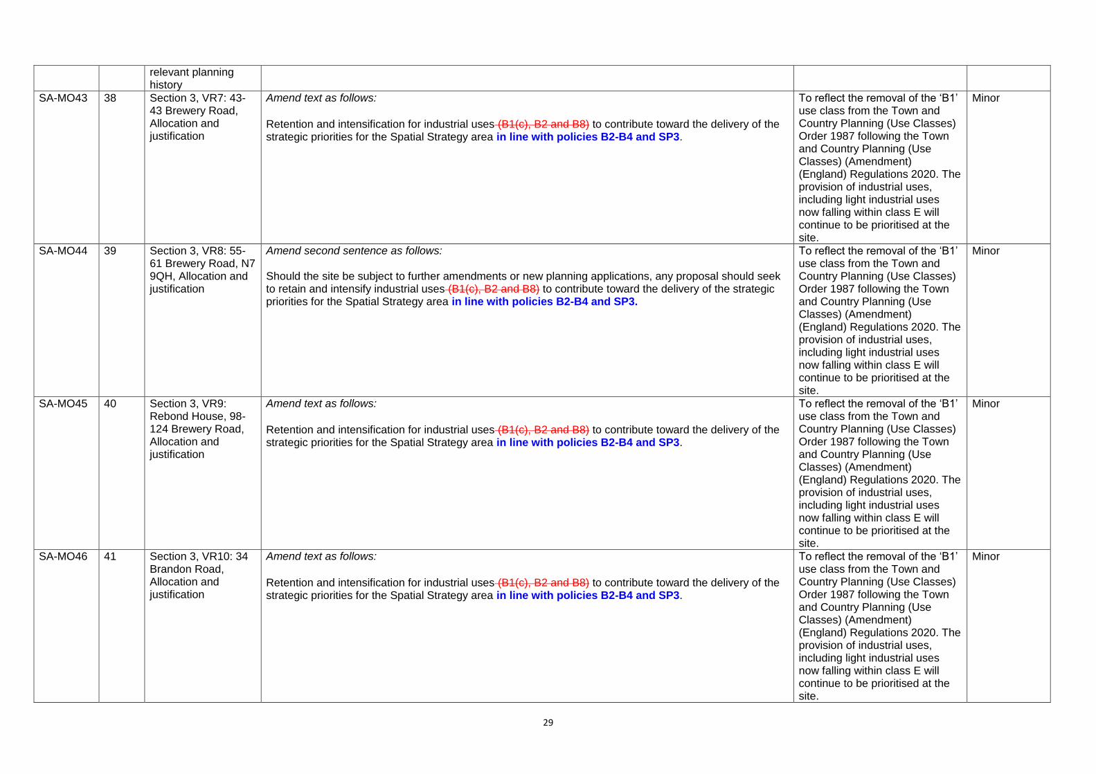
SA-MO42 38 Section 3, VR7: 43-43 Brewery Road, How the site was identified and
Amend text as follows: Planning application P2020/1891/FUL P2018/0136/FUL
Updated details Minor
29
relevant planning history
SA-MO43 38 Section 3, VR7: 43-43 Brewery Road, Allocation and justification
Amend text as follows: Retention and intensification for industrial uses (B1(c), B2 and B8) to contribute toward the delivery of the strategic priorities for the Spatial Strategy area in line with policies B2-B4 and SP3.
To reflect the removal of the ‘B1’ use class from the Town and Country Planning (Use Classes) Order 1987 following the Town and Country Planning (Use Classes) (Amendment) (England) Regulations 2020. The provision of industrial uses, including light industrial uses now falling within class E will continue to be prioritised at the site.
Minor
SA-MO44 39 Section 3, VR8: 55-61 Brewery Road, N7 9QH, Allocation and justification
Amend second sentence as follows: Should the site be subject to further amendments or new planning applications, any proposal should seek to retain and intensify industrial uses (B1(c), B2 and B8) to contribute toward the delivery of the strategic priorities for the Spatial Strategy area in line with policies B2-B4 and SP3.
To reflect the removal of the ‘B1’ use class from the Town and Country Planning (Use Classes) Order 1987 following the Town and Country Planning (Use Classes) (Amendment) (England) Regulations 2020. The provision of industrial uses, including light industrial uses now falling within class E will continue to be prioritised at the site.
Minor
SA-MO45 40 Section 3, VR9: Rebond House, 98-124 Brewery Road, Allocation and justification
Amend text as follows: Retention and intensification for industrial uses (B1(c), B2 and B8) to contribute toward the delivery of the strategic priorities for the Spatial Strategy area in line with policies B2-B4 and SP3.
To reflect the removal of the ‘B1’ use class from the Town and Country Planning (Use Classes) Order 1987 following the Town and Country Planning (Use Classes) (Amendment) (England) Regulations 2020. The provision of industrial uses, including light industrial uses now falling within class E will continue to be prioritised at the site.
Minor
SA-MO46 41 Section 3, VR10: 34 Brandon Road, Allocation and justification
Amend text as follows: Retention and intensification for industrial uses (B1(c), B2 and B8) to contribute toward the delivery of the strategic priorities for the Spatial Strategy area in line with policies B2-B4 and SP3.
To reflect the removal of the ‘B1’ use class from the Town and Country Planning (Use Classes) Order 1987 following the Town and Country Planning (Use Classes) (Amendment) (England) Regulations 2020. The provision of industrial uses, including light industrial uses now falling within class E will continue to be prioritised at the site.
Minor

30
SA-MO47 46-47 Section 4, AUS2: Pride Court, 80-82 White Lion Street, How the site was identified and relevant planning history
Amend text as follows: Amended allocation (formerly part of AUS4) and planning permission P2018/3351/FUL
Updated details Minor
SA-MO48 46-47 Section 4, AUS2: Pride Court, 80-82 White Lion Street, Allocation and justification
Amend text as follows: The site has planning permission for the change of use of the ground floor to a restaurant, reconfiguration of the existing office floorspace and relocation of the two on-site residential units. Should the site be subject to further amendments or new applications, Iintensification of business floorspace should be prioritised.
Updated in response to the recent grant of planning permission for the site.
Main
SA-MO49 54-55 Section 4, AUS6: Sainsbury’s, 31-41 Liverpool Road, Development Considerations
Delete empty fifth bullet point
Error Minor
SA-MO50 56-57 Section 4, AUS7: 1-7 Torrens Street, Site designations and constraints
Amend text of third bullet point as follows: In a close proximity to the Duncan Terrace/Colebrooke Row, Angel and New River Conservation Areas
Error Minor
SA-MO51 58-59 Section 4, AUS8: 161-169 Essex Road, Allocation and justification
Amend text as follows: A mix of retail, culture and leisure uses are considered suitable on this site. There is an opportunity to develop the car park in at the rear of the site for residential use; any development on this part of the site should prioritise business floorspace, particularly offices.
In response to representation R19.0185.
Main
SA-MO52 59-60 Section 4, AUS9: 10-14 White Lion Street, How the site was identified and relevant planning history
Amend text as follows: Planning application permission P2017/0297/FUL (granted subject to completion of legal agreement, January 2018)
Updated details Minor
SA-MO53 64 Section 4, AUS12: Public Carriage Office, 15 Penton Street, Allocation and justification
Amend text as follows: Mixed-use development for re-provision and intensification of business floorspace with an element of residential uses
Error Minor
SA-MO54 65-66 Section 4, AUS13: N1 Centre, Parkfield Street, How the site was identified and relevant planning history
Amend text as follows: Planning application permission P2017/2964/FUL
Updated details Minor
SA-MO55 67-68 Section 4, AUS14: 46-52 Pentonville Road, How the site was identified and
Amend text as follows: Planning application permission P2017/3100/FUL
Updated details Minor

31
relevant planning history
SA-MO56 67-68 Section 4, AUS14: 46-52 Pentonville Road, Allocation and justification
Amend text of second sentence as follows: Should the site be subject to further amendments or new applications should prioritise business floorspace should be prioritised.
Error Minor
SA-MO57 74-75 Section 5, NH1: Morrison's supermarket and adjacent car park, 10 Hertslet Road, and 8-32 Seven Sisters Road, Allocation and justification
Amend text as follows: The site has potential for a significant retail-led mixed-use development, with a large quantum of residential use, retention of and improvements to existing retail floorspace provision of improved retail provision (in terms of quantum and quality) as well as and a significant amount of new office floorspace; residential accommodation may be acceptable on the upper floors, subject to amenity issues being addressed. Existing site permeability through to Seven Sisters Road and the market should be maintained. Retention and enhancement of the covered market will be supported.
It is considered that seeking a greater amount of residential accommodation would be appropriate at the site, whilst retaining and improving retail floorspace.
Main
SA-MO58 74-75 Section 5, NH1: Morrison's supermarket and adjacent car park, 10 Hertslet Road, and 8-32 Seven Sisters Road, Estimated timescale
Amend as follows: 2026/271/22-2030/3125/26; 2031/32-2035/36
Updated details Minor
SA-MO59 78 Section 5, NH3: 443-453 Holloway Road, How the site was identified and relevant planning history
Amend as follows: 2013 Site Allocation (NH4) and planning permission P2013/3213/FUL (now lapsed). New planningP2019/2839/FUL (granted on appeal). application P2018/1812/FUL (yet to be determined)
Updated details Minor
SA-MO60 78 Section 5, NH3: 443-453 Holloway Road, Allocation and justification
Amend second sentence as follows: Existing arts/cultural uses .should be retained.
Error Minor
SA-MO61 79 Section 5, NH4: Territorial Army Centre, 65-69 Parkhurst Road, How the site was identified and relevant planning history
Amend text as follows: 2013 Site Allocation (NH5) and refused planning applications planning permission P2020/0648/FUL
Updated details Minor
SA-MO62 80-81 Section 5, NH5: 392A Camden Road and 1 Hillmarton Road, N7 and 394 Camden Road, How the site was identified and relevant planning history
Amend text as follows: 2013 Site Allocation (NH9). Extant pPlanning permission for 392A Camden Road and 1 Hillmarton Road (permission references P121287 and P121288)
Updated details Minor
SA-MO63 83-84 Section 5, NH7: Holloway Prison,
Amend text as follows: Ministry of JusticePeabody Group
Updated details Minor

32
Parkhurst Road, Ownership
SA-MO64 83-84 Section 5, NH7: Holloway Prison, Parkhurst Road, How the site was identified and relevant planning history
Amend text as follows: GLA SHLAA Call for Sites 2017, and discussions with the Ministry of Justice and pre-application discussions
Updated details Minor
SA-MO65 85 Section 5, NH8: 457-463 Holloway Road, Site designations and constraints
Amend text of third bullet point as follows:
Prioirity Employment Location
Error Minor
SA-MO66 85 Section 5, NH8: 457-463 Holloway Road, Development Considerations
Amend first sentence of first bullet point as follows:
The building is currently in a state of disrepair, with various inappropriate and unsympathetic additions/actions which affect and detract from the building’s contribution to the conservation area.
Error Minor
SA-MO67 88-89 Section 5, NH10: 45 Hornsey Road and 252 Holloway Road, Ownership
Amend text as follows: Ashburton Trading Limited; Network Rail
Update Minor
SA-MO68 88-89 Section 5, NH10: 45 Hornsey Road and 252 Holloway Road, Development Considerations
Amend text of fifth bullet point as follows: The close proximity of the site to the busy Holloway Road and railway tracks mean that the design of conventional residential and/or student accommodation should address and mitigate noise and air quality issues.
Error Minor
SA-MO69 91-92 Section 5, NH12: 379-391 Camden Road and 341-345 Holloway Road, Approximate size of site
Amend as follows: 1,5622,697sqm
Updated details
Minor
SA-MO70 95 Section 6, Table 6.1 Finsbury Park Spatial Strategy area site allocations
Amend table 6.1 as follows:
Table 6.1: Finsbury Park Spatial Strategy area site allocations
Site reference
Site name
FP1 City North Islington Trading Estate, Fonthill Road and 8-10 Goodwin Street, N4
FP2 Morris Place/Wells Terrace (including Clifton House), N4 2AL
FP3 Finsbury Park Station and Island, Seven Sisters Road, N4 2DH
FP4 129-131 & 133 Fonthill Road & 13 Goodwin Street, N4
FP5 1 Prah Road, N4 2RA
FP6 Cyma Service Station, 201A Seven Sisters Road, N4 3NG
FP7 Holloway Police Station, 284 Hornsey Road, N7 7QY
Table updated to remove developed site FP10 (Former George Robey Public House).
Minor

33
FP8 113-119 Fonthill Road, N4 3HH
FP9 221-233 Seven Sisters Road, N4 2DA
FP10 Former George Robey Public House, 240 Seven Sisters Road, N4 2HX
FP11 139-149 Fonthill Road, N4 3HF
FP12 179-199 Hornsey Road, N7 9RA
FP13 Tesco, 105-119 Stroud Green Road, N4 3PX
FP14 Andover Estate bounded by Durham Road, Moray Road, Andover Road, Hornsey Road, Newington Barrow Way and Seven Sisters Road, London N7
FP15 216-220 Seven Sisters Road, N4 3NX
SA-MO71 96 Section 6, Figure 6.1: Location of Finsbury Park Spatial Strategy area site allocations
Replace Figure 6.1 to remove completed site allocation FP10 (Former George Robey Public House).
Updated details Minor
SA-MO72 101-102
Section 6, FP3: Finsbury Park Station and Island, Seven
Amend as follows: 4,78318,732sqm
Error Minor

34
Sisters Road, Approximate size of site
SA-MO73 103-104
Section 6, FP4: 129-131 & 133 Fonthill Road & 13 Goodwin Street, How the site was identified and relevant planning history
Amend as follows: 2013 Site Allocation (FP2) and planning application P2020/2722/FUL
Updated details Minor
SA-MO74 105 Section 6, FP5: 1 Prah Road, Allocation and justification
Amend as follows: Business floorspace, particularly workspace suitable for SMEs. Residential development and public realm improvements.
In response to representation R19.0174. Whilst residential use of this site is deemed to be appropriate, it should be noted that the landowner’s representations regarding a large HMO/build-to-rent type scheme remains contrary to policy.
Main
SA-MO75 108 Section 6, FP8: 113-119 Fonthill Road, Site designations and constraints
Amend third bullet point as follows:
Close Pproximity to locally listed building at 4-5 Goodwin Street
Error Minor
SA-MO76 113 Section 6, FP11: 139-149 Fonthill Road, How the site was identified and relevant planning history
Amend text as follows: Planning permission P2019/2563/FUL application P2017/0333/FUL (refused; dismissed on appeal)
Updated details Minor
SA-MO77 114 Section 6, FP12: 179-199 Hornsey Road, How the site was identified and relevant planning history
Amend text as follows: Planning permission P2018/1452/FUL application P2017/2175/FUL
Updated details Minor
SA-MO78 121-122
Section 7, ARCH1: Vorley Road/Archway Bus Station, Allocation and justification
Amend text as follows: Residential led development with social and community infrastructure uses. an There may also be potential for an element of business floorspace including affordable workspace and space suitable for SMEs .
The site has been identified as having potential to support social infrastructure uses.
Main
SA-MO79 124-125
Section 7, ARCH3: Archway Central Methodist Hall, Archway Close, Ownership
Amend as follows: Trustees for Methodist Church; Flowervale Properties UK Limited; London Underground Limited
Updated details Minor
SA-MO80 124-125
Section 7, ARCH3: Archway Central Methodist Hall, Archway Close, Current/previous use
Amend text as follows: Vacant community space (D1/D2)
In response to changes to the Town and Country Planning (Use Classes) Order 1987 following the Town and Country Planning (Use Classes) (Amendment) (England) Regulations 2020.
Minor

35
SA-MO81 124-125
Section 7, ARCH3: Archway Central Methodist Hall, Archway Close, N19 3TD, How the site was identified and relevant planning history
Amend text as follows: Amended allocation (formerly part of 2013 Site Allocation ARCH1), planning application P2018/4068/FUL (refused on appeal) and pre-application discussions
Updated details Minor
SA-MO82 126 Section 7, ARCH4: Whittington Hospital Ancillary Buildings, How the site was identified and relevant planning history
Amend text as follows: 2013 Site Allocation (ARCH2) and planning permission P2020/0687/FUL
Updated details Minor
SA-MO83 126 Section 7, ARCH4: Whittington Hospital Ancillary Buildings, Estimated timescale
Amend as follows: 2031/32-2035/362026/27-2030/31
Error – updated to match information in the housing trajectory
Minor
SA-MO84 131 Section 7, ARCH5: Archway Campus, Highgate Hill, Current/ previous use
Amend text as follows: Education, clinical and health services research (D1)Site currently vacant, formerly used by University College London/Whittington Health NHS Trust
Updated details Minor
SA-MO85 127 Section 7, ARCH5: Archway Campus, Highgate Hill, Allocation and justification
Amend text as follows: Residential-led mixed use development, with some commercial and with community and social infrastructure uses on the ground floor. Given the very limited supply of development land in Islington policies strongly prioritise the most urgent need, which is conventional housing. An element of student housing may be acceptable as part of the development mix, provided that the quantum of student accommodation is not held to weigh against both the provision of priority conventional housing on the site, and provided that it ensures that the development can achieve the quantum and the tenure of affordable housing which is fully policy compliant.
To increase flexibility to facilitate delivery of this site.
Main
SA-MO86 127 Section 7, ARCH5: Archway Campus, Highgate Hill, Development Considerations
Delete third bullet point:
Any net loss of existing social infrastructure must be justified in line with policy SC1
Requirement captured by SDMP policy SC1
Minor
SA-MO87 128 Section 7, ARCH6: Job Centre, 1 Elthorne Road, Ownership
Amend text as follows: Department for Environment, Food and Rural AffairsGladquote Ltd.
Updated details Minor
SA-MO88 128 Section 7, ARCH6: Job Centre, 1 Elthorne Road, Allocation and justification
Amend text as follows: Business led mixed-use development, including provision of SME workspace , and with an element of residential use.
Error Minor

36
SA-MO89 128 Section 7, ARCH6: Job Centre, 1 Elthorne Road, Estimated timescale
Amend as follows: 2021/22-2025/262026/27-2030/31
Updated to reflect information from landowner
Minor
SA-MO90 129 Section 7, ARCH7: 207A Junction Road, Development considerations
Amend first bullet point as follows:
This backland site is constrained by close proximity to existing residential uses and the railway line. Development must have regard to the potential impact on the nearby residential properties, and impacts on future residential occupiers in terms of noise and vibration.
Error Minor
SA-MO91 129 Section 7, ARCH8: Brookstone House, 4-6 Elthorne Road
Amend site reference and site address as follows: Bellside House, 4 Elthorne Road and Brookstone House, 4-6 Elthorne Road
Updated details Minor
SA-MO92 131 Section 7, ARCH9: 724 Holloway Road, How the site was identified and relevant planning history
Amend text as follows: Planning applications: P2016/4533/FUL and P2015/4816/FUL permission P2018/3191/FUL
Updated details Minor
SA-MO93 133 Section 7, ARCH12: 798-804 Holloway Road, How the site was identified and relevant planning history
Amend text as follows: Planning permission P2016/4529/FUL and P2017/4826/S73
Updated details Minor
SA-MO94 142 Section 8, HC4: Dixon Clark Court, How the site was identified and relevant planning history
Amend text as follows: Planning application permission P2017/2936/FUL (granted subject to completion of legal agreement, March 2018)
Updated details Minor
SA-MO95 143-144
Section 8, HC5: 2 Holloway Road and 4 Highbury Crescent, Allocation and justification
Amend text as follows: Mixed use commericial and residential redevelopment. Retail frontage onto Holloway Road to be retained. Any proposal should include business floorspace.
Error Minor
SA-MO96 146-147
Section 9, Table 9.1: Other important site allocations
Amend table 9.1 as follows:
Table 9.1: Other important site allocations
Site reference
Site name
OIS1 Leroy House, 436 Essex Road, N1 3QP
OIS2 The Ivories, 6-8 Northampton Street, N1 2HY
OIS3 Belgravia Workshops, 157-163 Marlborough Road, N19 4NF
OIS4 1 Kingsland Passage and tThe BT Telephone Exchange, Kingsland Green, Dalston, E8 2BB
Table updated to remove deleted allocation (OIS9: Ladbroke House) and include draft new allocations OIS27 to OIS34.
Minor

37
OIS5 Bush Industrial Estate, Station Road, N19 5UN
OIS6 Site of Harvist Under Fives, 100 Hornsey Road, N7 7NG
OIS7 Highbury Delivery Office, 2 Hamilton Lane, N5 1SW
OIS8 Legard Works, 17a Legard Road, N5 1DE
OIS9 Ladbroke House, 62-66 Highbury Grove, N5 2AD
OIS10 500-502 Hornsey Road and Grenville Works, 2A Grenville Road, N19 4EH
OIS11 Park View Estate, Collins Road, N5
OIS12 202-210 Fairbridge Road, N19 3HT
OIS13 Highbury Roundhouse Community Centre, 71 Ronald's Road, N5 1XB
OIS14 17-23 Beaumont Rise, N19 3AA
OIS15 Athenaeum Court, 94 Highbury New Park, N5 2DN
OIS16 Harvist Estate Car Park, N7 7NJ
OIS17 Hathersage and Besant Courts, Newington Green, N1 4RF
OIS18 Wedmore Estate Car Park, N19 4NU
OIS19 25-27 Horsell Road, N5 1XL
OIS20 Vernon Square, Penton Rise, WC1X 9EW
OIS21 Former railway sidings adjacent to and potentially including Caledonian Road Station
OIS22 114 Balls Pond Road and land on the west side of King Henry’s Walk
OIS23 1 Lowther Road, N7 8US
OIS24 Pentonville Prison
OIS25 Charles Simmons House, 3 Margery Street, WC1X 0HP
OIS26 Amwell Street Water Pumping Station, EC1R
OIS27 York Way Estate
OIS28 Barnsbury Estate
OIS29 Highbury Quadrant Congregational Church
OIS30 Cluse Court Estate
OIS31 Hillside Estate
OIS32 New Orleans Estate
OIS33 Drakeley Court Estate and Aubert Court Estate
OIS34 Kerridge Court Estate
SA-MO97 148 Section 9, Figure 9.1: Location of site allocations outside Spatial Strategy areas
Replace Figure 9.1 to include new site allocations OIS27-OIS34 and remove completed allocation OIS9 (Ladbroke House).
Updated details Minor

38
SA-MO98 149 Section 9, OIS1:
Leroy House, 436 Essex Road, How the site was identified and relevant planning history
Amend text as follows: 2013 Site Allocation (OIS3); planning application permission P2017/3081/FUL (registered)
Updated details Minor
SA-MO99 152-153
Section 9, OIS4: 1 Kingsland Passage and the BT Telephone
Amend site name: OIS4: 1 Kingsland Passage and tThe BT Telephone Exchange, Kingsland Green Amend site boundary to exclude 1 Kingsland Passage as follows:
A recent grant of planning permission for 1 Kingsland Passage has made comprehensive development of
Main

39
Exchange, Kingsland Green
Amend address: 1 Kingsland Passage and tThe BT Telephone Exchange, Kingsland Green, Dalston, E8 2BB Amend ownership: MRC Pension Trust Limited; British Telecommunications PLC Amend site size: 4,734sqm3,783sqm Amend current/previous use: 1 Kingsland Passage is currently used as offices (B1). Some of the telephone exchange is still in use but most of the building is vacant. Amend how the site was identified: 2013 Site Allocation (OIS7) and planning permission P2016/4155/FUL
the site as originally envisaged by the allocation unlikely during the plan period. The telephone exchange building continues to have development potential.

40
Amend allocation and justification: Mixed use commercial and residential development, which maximises the provision of office use at the ground floor and lower levels. Development which improves the quality and quantity of existing business floorspace provision is encouraged. 1 Kingsland Passage has planning permission for 360sqm of additional B1(a) office floorspace. Amend second bullet point of development considerations: • Comprehensive development of 1 Kingsland Passage and the BT Telephone Exchange is encouraged. Some accommodation for a new telephone exchange will need to be reprovided on-site or nearby. This is likely to be significantly smaller than the current building. Amend estimated timescale: 2026/27-2030/312031/32-2035/36
SA-MO100
154-155
Section 9, OIS5: Bush Industrial Estate, Station Road, Allocation and justification
Amend text as follows: Retention and intensification for industrial uses (B1(c), B2 and B8). Office floorspace will only be acceptable as part of a hybrid workspace scheme.
In response to changes to the Town and Country Planning (Use Classes) Order 1987 following the Town and Country Planning (Use Classes) (Amendment) (England) Regulations 2020.
Minor
SA-MO101
154-155
Section 9, OIS5: Bush Industrial Estate, Station Road, Site designations and constraints
Add two new site designations and constraints:
Upper Holloway Railway Cutting SINC
Adjacent to Yerbury Primary School
Updated context Minor
SA-MO102
154-155
Section 9, OIS5: Bush Industrial Estate, Station Road, Development considerations
Add a new development consideration as follows: The northeastern section of the site is located in close proximity to Yerbury Primary School, Whittington Park (a designated SINC), and existing residential uses. Development proposals for this section of the site will be required to carefully consider and mitigate potential negative impacts.
Additional information provided in relation to the sites context and how this should be considered by future proposals.
Main
SA-MO103 155 Section 9, OIS6: Site of Harvist Under Fives, 100 Hornsey Road, How the site was identified and relevant planning history
Amend text as follows: 2013 Site Allocation (OIS11); planning applications P2016/3478/FUL (refused at appeal) and P2018/4131/FUL (registeredapproved subject to conditions/S106 agreement)
Updated details Minor
SA-MO104 155 Section 9, OIS6: Site of Harvist Under Fives, 100 Hornsey Road, Allocation and justification
Amend text as follows: Residential redevelopment with provision of nursery, open space and public realm improvements.
Updated in response to advice from the Early Years’ Service and the recent grant of planning permission for the site.
Main
41
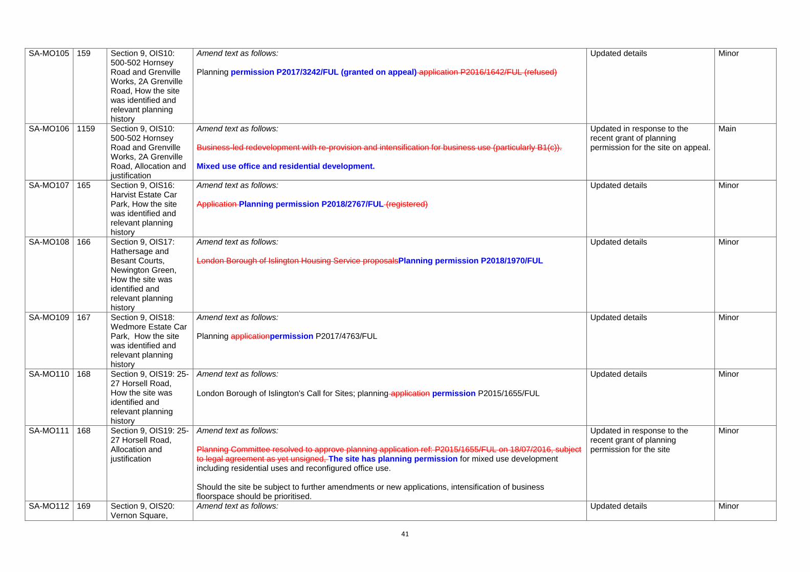
SA-MO105 159 Section 9, OIS10: 500-502 Hornsey Road and Grenville Works, 2A Grenville Road, How the site was identified and relevant planning history
Amend text as follows: Planning permission P2017/3242/FUL (granted on appeal) application P2016/1642/FUL (refused)
Updated details Minor
SA-MO106 1159 Section 9, OIS10: 500-502 Hornsey Road and Grenville Works, 2A Grenville Road, Allocation and justification
Amend text as follows: Business-led redevelopment with re-provision and intensification for business use (particularly B1(c)). Mixed use office and residential development.
Updated in response to the recent grant of planning permission for the site on appeal.
Main
SA-MO107 165 Section 9, OIS16: Harvist Estate Car Park, How the site was identified and relevant planning history
Amend text as follows: Application Planning permission P2018/2767/FUL (registered)
Updated details Minor
SA-MO108 166 Section 9, OIS17: Hathersage and Besant Courts, Newington Green, How the site was identified and relevant planning history
Amend text as follows: London Borough of Islington Housing Service proposalsPlanning permission P2018/1970/FUL
Updated details Minor
SA-MO109 167 Section 9, OIS18: Wedmore Estate Car Park, How the site was identified and relevant planning history
Amend text as follows: Planning applicationpermission P2017/4763/FUL
Updated details Minor
SA-MO110 168 Section 9, OIS19: 25-27 Horsell Road, How the site was identified and relevant planning history
Amend text as follows:
London Borough of Islington's Call for Sites; planning application permission P2015/1655/FUL
Updated details Minor
SA-MO111 168 Section 9, OIS19: 25-27 Horsell Road, Allocation and justification
Amend text as follows: Planning Committee resolved to approve planning application ref: P2015/1655/FUL on 18/07/2016, subject to legal agreement as yet unsigned, The site has planning permission for mixed use development including residential uses and reconfigured office use. Should the site be subject to further amendments or new applications, intensification of business floorspace should be prioritised.
Updated in response to the recent grant of planning permission for the site
Minor
SA-MO112 169 Section 9, OIS20: Vernon Square,
Amend text as follows:
Updated details Minor

42
Penton Rise, Current/previous use
Vacant, previously used as higher education facilities by SOASTemporarily occupied by the Courtauld Institute for educational purposes.
SA-MO113 174 Section 9, OIS24: Pentonville Prison, Caledonian Road
Amend site boundary to include land to the west and to the northeast as follows:
In response to representations from the MoJ (R19.0144) stating that the prison estate is more extensive than shown on the published plan. The MoJ stated the site boundary should be extended further west up to the boundary with Caledonian Road. The boundary is also amended to include the land to the northeast of the site at Wellington Mews because this forms part of the prison estate and is ancillary to the prison.
Main
SA-MO114 174 Section 9, OIS24: Pentonville Prison, Caledonian Road, Approximate size of site
Amend as follows: 33,17841,660sqm
To reflect the extended site boundary.
Minor
SA-MO115 177 Section 10, Monitoring, paragraph 10.3
Amend second sentence as follows: This completion data will be assessed spatially with reference to relevant Local Plan policies and designations; this could include development located within or in close proximity to a specific designation.
Error Minor
SA-MO116 177 Section 10, Monitoring, paragraph 10.4
Amend as follows: Future AMRs will include an indicator monitoring the progress of individual site allocations to help the Council assess the success of policy SA1 (Delivering development priorities). Success will be measured in terms of the number of sites permitted in accordance with the allocated uses. Other
To provide additional information on how the delivery of allocated sites will be monitored.
Main

43
information relating to The AMR will include specific monitoring of site allocations may also be kept under review, utilising all relevant quantitative and qualitative information. This could includinge information on the status of a particular site allocation, for example, whether a planning permission has been granted, implemented, completed or has lapsed; and (where relevant) the reasons why specific sites have not come forward in line with the estimated timescales within the allocation. It could also include data on how the quantum of development which is coming forward through applications compares to the site capacity assumptions identified in the Local Plan.
SA-MO117 182 Appendix 2: Glossary and Abbreviations; Term: Business floorspace/buildings/development/uses
Amend text as follows: Office, research and development and light industrial aActivities as well as industrial uses B2 general industrial and B8 storage and distribution, and Sui Generis industrial uses. or uses that fall within the B-use class. Sui generis Generis uses which are akin to business floorspace, such as depots or builders merchants, can be classed as business floorspace for the purposes of the Local Plan.
To reflect the removal of the ‘B1’ use class from the Town and Country Planning (Use Classes) Order 1987 following the Town and Country Planning (Use Classes) (Amendment) (England) Regulations 2020.
Main
SA-MO118 182 Appendix 2: Glossary and Abbreviations; Term: Commercial floorspace/buildings/development/uses
Amend text as follows: Activities or uses which involve business activities and/or the sale of good or services. For the purposes of the Local Plan, this is a broad term which encompasses business and retail uses.
Error Minor
SA-MO119 187 Appendix 2: Glossary and Abbreviations; Term: Hybrid space
Amend text as follows: The main feature of hybrid space is that it straddles different B-usebusiness floorspace classes uses.
To reflect the removal of the ‘B1’ use class from the Town and Country Planning (Use Classes) Order 1987 following the Town and Country Planning (Use Classes) (Amendment) (England) Regulations 2020.
Minor
SA-MO120 187 Appendix 2: Glossary and Abbreviations; Term: Industrial floorspace/buildings/development/uses/ land
Amend text as follows: Activities or uses that fall within light industrial (B1c), general industry (B2) and storage and distribution (B8) uses, Sui Generis industrial uses, and some sui Sui generis Generis akin to industrial uses such as depots and builder’s merchants.
To reflect the removal of the ‘B1’ use class from the Town and Country Planning (Use Classes) Order 1987.
Main
SA-MO121 188 Appendix 2: Glossary and Abbreviations; Term: Leisure uses
Add new definition: Activities or uses including food and drink uses as defined within Class E(b), some indoor recreational activities falling within E(d) and some Sui Generis uses including drinking establishments including pubs and wine bars, hot food take aways, live music venues, cinemas, concert halls, nightclubs and theatres.
To provide clarification following the Town and Country Planning (Use Classes) (Amendment) (England) Regulations 2020.
Main
SA-MO122 189 Appendix 2: Glossary and Abbreviations; Term: Locally Significant Industrial Sites
Amend text as follows: Designated areas where light industrial (B1c), general industry (B2) and storage and distribution (B8) are the priority land uses.
To reflect the removal of the ‘B1’ use class from the Town and Country Planning (Use Classes) Order 1987.
Minor
SA-MO123 190 Appendix 2: Glossary and Abbreviations; Term: Office-led development
Amend text as follows: Development where the majority of floorspace/uses is office. within use class B1(a)
To reflect the removal of the ‘B1’ use class from the Town and Country Planning (Use Classes) Order 1987.
Minor

44
SA-MO124 191 Appendix 2: Glossary and Abbreviations; Term: Retail floorspace/buildings/development/uses
Amend text as follows: Activities or uses that fall within the A1 use class. Uses for the display or retail sale of goods, other than hot food, principally to visiting members of the public - as defined in Class E(A). This includes shops, retail warehouses, hairdressers, undertakers, travel and ticket agencies, post offices, pet shops, sandwich bars, domestic hire shops, dry cleaners, funeral directors and internet cafes.
To reflect the removal of the ‘A’ use class from the Town and Country Planning (Use Classes) Order 1987.
Major
SA-MO125 193 Appendix 2: Glossary and Abbreviations; Term: Social and community infrastructure
Amend text as follows: Infrastructure that is available to, and serves the needs of, local communities and others, which is often funded in some way by a grant or investment from a government department, public body and/or the voluntary sector. Social and community facilities comprises a wide variety of facilities/buildings including those which accommodate social services such as day-care centres, luncheon clubs, and drop-in centres; education and training facilities including early years providers, nurseries, schools, colleges and universities; children and young peoples’ play facilities; health facilities; youth centres; libraries; community meeting facilities; community halls; places of worship; sport, leisure and recreation facilities; and policing facilities. Social and community infrastructure generally falls within Use Classes E, F.1 or F.2, C2, D1 or D2, and possibly some Sui Generis uses. This list is not intended to be exhaustive and other facilities can be included as social and community infrastructure.
To reflect the removal of the D1 and D2 use classes from the Town and Country Planning (Use Classes) Order 1987.
Minor
SA-MO126 193 Appendix 2: Glossary and Abbreviations; Term: Source Protection Zones
Amend text as follows: Areas of influence around groundwater sources used for public drinking which provide additional protection to safeguard drinking water quality, through constraining the close proximity of an activity that may impact upon a drinking water abstraction.
Error Minor