
SIMPLIFIED TASK ORDER REQUEST FOR PROPOSAL · SIMPLIFIED TASK ORDER REQUEST FOR PROPOSAL OPTION...
17
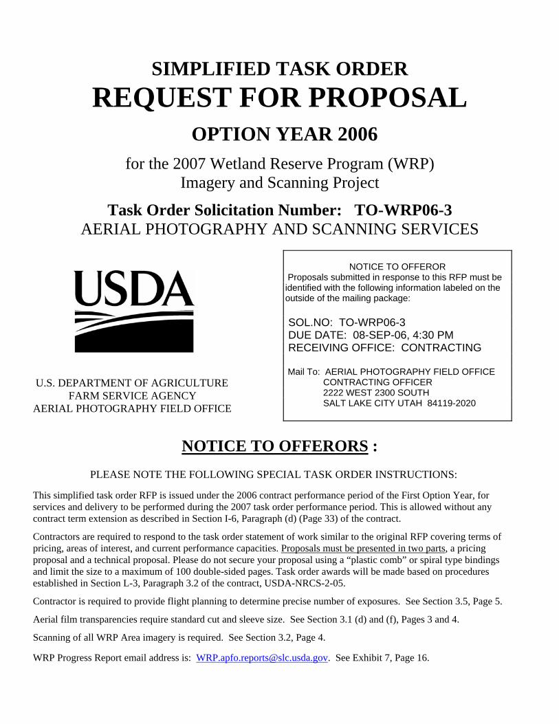
SIMPLIFIED TASK ORDER REQUEST FOR PROPOSAL OPTION YEAR 2006 for the 2007 Wetland Reserve Program (WRP) Imagery and Scanning Project Task Order Solicitation Number: TO-WRP06-3 AERIAL PHOTOGRAPHY AND SCANNING SERVICES U.S. DEPARTMENT OF AGRICULTURE FARM SERVICE AGENCY AERIAL PHOTOGRAPHY FIELD OFFICE NOTICE TO OFFERORS : PLEASE NOTE THE FOLLOWING SPECIAL TASK ORDER INSTRUCTIONS: This simplified task order RFP is issued under the 2006 contract performance period of the First Option Year, for services and delivery to be performed during the 2007 task order performance period. This is allowed without any contract term extension as described in Section I-6, Paragraph (d) (Page 33) of the contract. Contractors are required to respond to the task order statement of work similar to the original RFP covering terms of pricing, areas of interest, and current performance capacities. Proposals must be presented in two parts , a pricing proposal and a technical proposal. Please do not secure your proposal using a “plastic comb” or spiral type bindings and limit the size to a maximum of 100 double-sided pages. Task order awards will be made based on procedures established in Section L-3, Paragraph 3.2 of the contract, USDA-NRCS-2-05. Contractor is required to provide flight planning to determine precise number of exposures. See Section 3.5, Page 5. Aerial film transparencies require standard cut and sleeve size. See Section 3.1 (d) and (f), Pages 3 and 4. Scanning of all WRP Area imagery is required. See Section 3.2, Page 4. WRP Progress Report email address is: [email protected] . See Exhibit 7, Page 16. NOTICE TO OFFEROR Proposals submitted in response to this RFP must be identified with the following information labeled on the outside of the mailing package: SOL.NO: TO-WRP06-3 DUE DATE: 08-SEP-06, 4:30 PM RECEIVING OFFICE: CONTRACTING Mail To: AERIAL PHOTOGRAPHY FIELD OFFICE CONTRACTING OFFICER 2222 WEST 2300 SOUTH SALT LAKE CITY UTAH 84119-2020
Transcript of SIMPLIFIED TASK ORDER REQUEST FOR PROPOSAL · SIMPLIFIED TASK ORDER REQUEST FOR PROPOSAL OPTION...
SIMPLIFIED TASK ORDER REQUEST FOR PROPOSAL
OPTION YEAR 2006
for the 2007 Wetland Reserve Program (WRP) Imagery and Scanning Project
Task Order Solicitation Number: TO-WRP06-3 AERIAL PHOTOGRAPHY AND SCANNING SERVICES
U.S. DEPARTMENT OF AGRICULTURE FARM SERVICE AGENCY AERIAL PHOTOGRAPHY FIELD OFFICE
NOTICE TO OFFERORS :
PLEASE NOTE THE FOLLOWING SPECIAL TASK ORDER INSTRUCTIONS:
This simplified task order RFP is issued under the 2006 contract performance period of the First Option Year, for services and delivery to be performed during the 2007 task order performance period. This is allowed without any contract term extension as described in Section I-6, Paragraph (d) (Page 33) of the contract.
Contractors are required to respond to the task order statement of work similar to the original RFP covering terms of pricing, areas of interest, and current performance capacities. Proposals must be presented in two parts, a pricing proposal and a technical proposal. Please do not secure your proposal using a “plastic comb” or spiral type bindings and limit the size to a maximum of 100 double-sided pages. Task order awards will be made based on procedures established in Section L-3, Paragraph 3.2 of the contract, USDA-NRCS-2-05.
Contractor is required to provide flight planning to determine precise number of exposures. See Section 3.5, Page 5.
Aerial film transparencies require standard cut and sleeve size. See Section 3.1 (d) and (f), Pages 3 and 4.
Scanning of all WRP Area imagery is required. See Section 3.2, Page 4. WRP Progress Report email address is: [email protected]. See Exhibit 7, Page 16.
NOTICE TO OFFEROR
Proposals submitted in response to this RFP must be identified with the following information labeled on the outside of the mailing package: SOL.NO: TO-WRP06-3 DUE DATE: 08-SEP-06, 4:30 PM RECEIVING OFFICE: CONTRACTING Mail To: AERIAL PHOTOGRAPHY FIELD OFFICE
CONTRACTING OFFICER 2222 WEST 2300 SOUTH SALT LAKE CITY UTAH 84119-2020

TO-WRP06-3
1
TASK ORDER REQUEST FOR PROPOSAL
2007 WETLANDS RESERVE PROGRAM (WRP)
1.0 2007 WRP AERIAL PHOTOGRAPHY AND SCANNING SERVICES Furnish aerial photography services, scanning services, and related supplies in accordance with the requirements, specifications, terms, conditions, clauses, and provisions specified herein and in the original indefinite-delivery, indefinite-quantity contract, effective for the periods stated in the schedule. 1.1 Task Order Pricing Proposal
2007 WETLANDS RESERVE PROGRAM (WRP), AERIAL PHOTOGRAPHY AND SCANS OF WRP CONTRACT AREAS
(WRP AREAS) COMPANY NAME: AUTHORIZED SIGNATURE:
TOTAL QUANTITY OF EXPOSURES/SCANS UNIT UNIT PRICE TOTAL AMOUNT
EXPOSURES $ $
SCAN $ $
PRICING PROPOSAL INSTRUCTIONS: The offeror is required to provide the flight planning to determine the total quantity of exposures/scans for the WRP areas proposed. In the space provided below, or on a separate paper, or delineated on a map, indicate by state(s) the WRP areas proposed in your offer. You must confirm your proposed areas by marking the appropriate boxes on the next page, Section 1.2 STATE DESCRIPTION AND CHECK LIST. PLEASE NOTE: The minimum unit of offer is a complete state encompassing all WRP Contract Areas, including scans, within that state.

TO-WRP06-3
2
1.2 Location Description of WRP Contract Areas (WRP Areas) State Description and Check List The following are WRP Digitized Contract Area quantities for the 2007 WRP requirements. Please mark the appropriate space provided below (Check Box) next to the state(s) you are offering in your task order proposal. A brief description of your proposed area is required in Section 1.1, of the previous page. PLEASE NOTE: The minimum unit of offer is a complete state listed below including all WRP Areas within that state. CHECK WRP 2007 BASE EST. BOX STATE AREAS PHOTO PERIOD [ ] ARKANSAS 327 AUG 1 - SEP 30 [ ] CALIFORNIA 139 JUN 1 - SEP 30 [ ] COLORADO 76 JUL 1 - AUG 15 [ ] ILLINOIS 332 JUL 1 - JUL 31 [ ] INDIANA 220 JUL 1 - SEP 30 [ ] LOUSIANA 379 AUG 1 - SEP 30 [ ] MICHIGAN 183 JUL 1 - SEP 30 [ ] MISSISSIPPI 353 JUN 15 - JUL 15 [ ] MONTANA 38 JUN 15 - JUL 31
CHECK WRP 2007 BASE EST. BOX STATE AREAS PHOTO PERIOD [ ] NEBRASKA 140 JUL 15 - SEP 15 [ ] NORTH CAROLINA 60 MAY 15 - JUL 31 [ ] NORTH DAKOTA 114 JUN 1 - JUL 31 [ ] OKLAHOMA 152 JUN 15 - JUL 31 [ ] OREGON 52 JUN 15 - JUL 31 [ ] TENNESSEE 92 JUL 1 - AUG 31 [ ] WASHINGTON 123 JUN 1 - AUG 15 [ ] WISCONSIN 427 JUN 1 - AUG 15 TOTAL WRP AREAS 3,207
1.3 Location of Work The WRP Areas listed above are in states that are expected to form part of the 2007 NRI Task Order. The 2007 option year NRI Program is expected to cover a sample of approximately 70,000 NRI Sites located in the conterminous 48 states. The WRP Areas will have the same photo periods as the 2006 and 2007 NRI Task Orders. Please refer to Exhibit 3, 2007 WRP Contract Areas, for the location distribution for the proposed 2007 WRP Task Order. 2.0 WETLAND RESERVE PROGRAM (WRP) REQUIREMENTS The general scope of this task order is to procure vertical, high resolution, natural color aerial photography and associated digital scans of WRP Areas in 17 (seventeen) states. The WRP imagery shall be used to monitor wetland protection and restoration efforts on WRP conservation easement lands. The United States Department of Agriculture (USDA), Natural Resources Conservation Service (NRCS) shall use the imagery collected to monitor the areas by means of photo interpretation, change detection and use of Geographic Information Systems (GIS) technologies. Within each area, data is collected on wetland restoration, recreational uses, land cover and use, structures, and characteristics of other natural resources. 2.1 Performance Period
The performance period for the 2006 task order for the acquisition and delivery of 2007 WRP aerial photography and all related materials is: January 1, 2007 through December 31, 2007.

TO-WRP06-3
3
2.2 Contract Deliverables
The deliverables for this 2006 option year Task Order consist of the following: Original color positive film transparencies, one (1) or more as needed of each WRP Area, cut and sleeved, and one (1) digital scan of each transparency, with associated metadata, provided on External Combo USB2.0/IEEE1394(Firewire) hard drives.
3.0 PROJECT TECHNICAL REQUIREMENTS 3.1 Aerial Photography Requirements
(a) Nominal Photographic Scale: 1:7,920
(b) Minimum Sun Angle: 30 Degrees (c) Aerial Camera:
(1) Nominal Lens Focal Length: 6 inch (153mm); Filter: Antivignetting (2) Other Lens Focal Lengths: 8¼ inch (210mm) and 12 inch (305mm). Use of
other focal length lenses shall require prior written approval by the Contracting Officer.
(d) Aerial Film: Color Positive Aerial Film (Brand Names: Kodak Aerochrome III MS
Film 2427, Agfa Aviphot Chrome 200 PEI, or equivalent).
(1) Every film transparency shall be cut to the following dimensions: (i) Maximum Length: 25.4 cm (10 inches) long, (ii) Standard Film Width: 24.1 cm (9.5 inches) wide, (2) The uniform cut-film dimensions are designed to standardize the NRI film
transparency storage requirements.
(e) Film Titling: Every exposure shall be titled in accordance with the format and instructions specified herein and in Section C-6 of the contract. Automatic electronic titling may be permitted upon Contracting Officer's approval. Each exposure shall be clearly titled on the northern edge of the film in accordance with the following format example sketch and required project data:
+ AZ 08035_66_4423_8_4873_1_1 + 8 USDA-NRCS 06-12-05 +
State Acronym: The two-letter acronym representing the state designation. Exposure Label: Exposure information developed from Exhibit 4, the WRP Exposure Naming Convention.
Scale: Nominal photographic scale represented by one or two digits to the nearest
thousand (8 = 1:7,920, 12 = 1:12,000). Agency Designator: The acronym of the Government agency the image is being acquired for and used by: USDA-NRCS. Date: Month-Day-Year in standard numeric notation (MM-DD-YY).

TO-WRP06-3
4
(f) Film Sleeves: Every WRP film transparency shall be protected and submitted in
clear, sturdy archival quality polypropylene film sleeves in accordance with the following requirements:
(1) Aerial film sleeve maximum dimensions: 25.4 cm (10 inches) by 25.4 cm (10
inches); 3.0 mil thickness. (2) Brand names for aerial sleeve: Picture Pocket®Corporation, FilmGuard
Corporation, or equivalent. (3) Film sleeves must have a fold-over lip seal. (4) Original aerial film and film sleeves shall be free of any marks or labels which
would obstruct any part of the film transparency.
3.2 Scanning Requirements:
Each WRP film transparency shall be scanned, with appropriate titling information, in accordance with the following requirements:
(a) Scanning Resolution: The original aerial film shall be scanned at 40 microns / 600
‘dpi’ (‘pixels’ per inch) according to the specifications in the original contract (including Modifications 1 & 2.)
(b) Scan Orientation: The orientation of the scanned image shall be such that north is at the top of the scanned image when viewed with conventional image viewing products. This shall be irrespective of the orientation of the original aerial film image while still in roll format.
(c) Delivery Media: The delivery media shall be External Combo USB2.0/IEEE1394 (Firewire) hard drives with a suggested capacity of 200 through 300 gigabytes per drive.
(d) Content of Drives: Each drive may contain more than one state and may contain partial county coverages. It is the preference of the government, however, that only full county coverage be provided to facilitate inspection and record keeping. The scans shall be organized by State and County as per the contract specifications. The top level directory where more than one state is included on a drive shall be the State Name (Missouri, South Dakota.) See Section C-7 of the original contract, AERIAL PHOTOGRAPHY SCANNING for the specifications.
(e) Scanning Accuracy: The contractor is required to meet the scanning accuracy requirement value of two (2.0) (pixels) RMSE or less. The contractor shall provide a scanner calibration report that certifies the RMSE measurement (value) of the scanner(s) that is(are) used, both for the Stage and Geometric precision. The date of the report shall not be earlier than one year prior to the date of this Task Order. (f) Refer to Exhibit 4, WRP Exposure Naming Convention, for an explanation and sample of the naming convention. 3.3 Size of WRP Areas
Nationally, some WRP Areas are less than one (1) acre while others may be as large as 13,000 acres. The WRP Areas within the 17 (seventeen) states are less than one (1) acre to as large as 6,950 acres. The nominal size for estimating purposes is 284.8 acres per WRP Digitized Contract, which may cover more than one individual area. There are 3,207 contracts identified for this project covering 3,952 parcels. The nature of the Wetland Reserve Program is such that most of these contracts cover irregular locations around streams or other water sources.

TO-WRP06-3
5
3.4 Approximate Photographic Periods
The 2007 WRP project is planned to follow the photo periods that were used in the 2006 NRI acquisition season and will be established for the 2007 NRI acquisition season. The WRP project has the following general photo periods.
(a) Early Start Photo Periods
Nearly all states contain one or more counties with front-end extended photographic acquisition periods. These early start photo periods are designed to allow earlier photo acquisition windows for non-agricultural terrain. Early start photo periods end when the base photo period begins. Early start dates which begin March 1, 2007 are preferred for the WRP areas. Please refer to Exhibit 2, Sample FY2006 Early Start Counties, for an example of early start county distribution.
(b) Base Photo Periods
There will be several separate photographic acquisition periods, covering 48 United States, that are designed to capture specific crop types during their prime growing season. These photo periods generally follow state boundaries (with exceptions in CA and TX) and range between the dates of March 15 through September 30, 2006. Please refer to Exhibit 1, Sample FY2006 Photo Periods for an example of photo period distribution.
3.5 Project Flight Plan Description (a) All WRP Areas shall be flown at flight altitudes designed to achieve a nominal
photographic scale of 1:7,920, with the nominal flight altitude above ground of 1,207 meters (3,960 feet) with a 6” focal length lens. Deviation from the specified flight altitude shall not exceed 2% low or 3% high. Elevations for each of the contract areas/easements have been provided in the accompanying data set.
(b) The APFO will provide a shape file identifying the WRP Areas, including 3,207
contract areas and 3,952 individual easements that are associated with this project. The contractor will be required to provide the actual flight planning necessary to achieve physical coverage of each of the contracts. Physical coverage is defined as coverage of each contract area with at least 20% sidelap and 20% endlap where more than one (1) image is required. In addition to complete coverage of each contract area, USDA requires coverage including a buffer zone beyond the actual boundary. The minimum buffer shall be 1,320 feet, (402 meters) or (1/4 mile). The following relationships exist within the identified contract areas and easements:
(1) One (1) image will cover one contract area/easement. (2) More than one (1) image will be needed to cover one (1) contract
area/easement. (3) More than one (1) contract area/easement may be covered by one (1) image
(c) The contractor is required to determine the precise number of exposures for the
purpose of establishing project quantities, based on the flight planning description above. The quantity of exposures/scans shall be entered in the space provided in Section 1.1 (Page 1) and shall be the pricing basis for task order award. The quantities calculated by each offeror will be compared for accuracy and are subject to
TO-WRP06-3
6
review and negotiation. (d) WRP Area Flight Requirements: (1) Flight Orientation: Preferred – North - South or East – West. Note: There may be areas that require non-preferred flight orientation. Such
non-preferred orientations should be kept to the minimum practicable. (2) The WRP Area centroids shall be identified by object ID (RECNO =
Easement ID) and Contract Number (CONTRACT_N), and latitude – longitude coordinates based on NAD 1983, and expressed in decimal degrees with five (5) decimal places of precision (31.50255, 87.10906).
(3) The Contract Number(s) are the ‘contract area(s)’ mentioned in this task order.
3.6 Project Map: See Exhibit 3, 2007 Wetland Reserve Program (WRP) Contract Areas.
4.0 GOVERNMENT-FURNISHED PROPERTY Pursuant to the Government-Furnished Property (GFP) clause (see Section I-7) the Government shall furnish the item(s) of property listed below as GFP to the Contractor. 4.1 Contract/Area Easement Data
The Contractor will be furnished the data associated with this task order as a separate .ZIP file. The .ZIP file (2007_WRP_Data.zip) contains the following data:
(a) wrp_06_rfp_elev_dd_83.shp – which is a shapefile, including all necessary
associated files (.dbf, .prj, .sbn, .sbx, and .shx) identifying the individual contract areas (CONTRACT_N in the .dbf file) and the individual easements (RECNO in the .dbf file. NOTE: Some of the easements cross both state and county lines.
(b) selected_states.shp – which is a shapefile, including all necessary associated files (.dbf, .prj, .sbn, .sbx, and .shx) of the 17 (seventeen) states included in the task order.
(c) selected_counties.shp – which is a shapefile, including all necessary associated files (.dbf, .prj, .sbn, .sbx, and .shx) of the counties within the states where the contract areas/easements are located.
(d) 2007 Revised WRP.pdf – a reference map of the project in .PDF format. (e) wrp_06_cnty_sum_v2.txt – a text file summary of WRP Areas by county.
5.0 SCANNED IMAGERY DELIVERY SCHEDULE The scanned images shall be delivered as each external hard drive is filled to its capacity of
approximately of 200 to 300 gigabytes.
(a) The recommended delivery schedule, to encourage prompt delivery, is for each external hard drive, to be shipped as early as possible, but no later than 15 calendar days after the last acquisition date of imagery contained on the hard drive.
(b) The required delivery schedule, to facilitate timely delivery with more consistent and uniform flow of contract materials, is for each external hard drive to be shipped no later than 30 calendar days after the latest acquisition date of imagery contained on the drive.
The required final delivery date for all scanned imagery shall be 30 calendar days after the

TO-WRP06-3
7
end of the last photographic period or any extension thereof. The external hard drive may contain more than one state and may contain partial county coverage. The drives shall contain only WRP data. Refer to this Task Order, Section 7.0 Content of Drives, and the original contract for further explanation.
6.0 ADMINISTRATIVE MATTERS 6.1 Annual Representations and Certifications, FAR Clause 52.204-8 (JAN 2006)
NRI Contractors shall complete electronic annual representations and certifications at http://orca.bpn.gov in conjunction with the required registration in the Central Contractor Registration (CCR) database. Contractors shall submit updates to the Online Representations and Certifications Application (ORCA) as necessary, but at least annually, to ensure they are kept current, accurate, and complete. The representations and certifications are effective until one year from the date of submission or update to ORCA. Please refer to Section K-1, Annual Representations and Certifications, FAR Clause 52.204-8 (JAN 2006), Modification 3, of the contract.
6.2 Small Business Subcontracting Plan, FAR Clause 52.204-8 (JAN 2006)
All NRI Contractors, except those certified as a small business concern, shall submit a subcontracting plan that separately addresses subcontracting with small business, veteran-owned small business, service-disabled veteran-owned small business, HUBZone small business concerns, small disadvantaged business and women owned small business concerns. The subcontracting plan shall be included and made a part of the resultant task order award and be negotiated with the Contracting Officer during the task order negotiation period. Failure to submit and negotiate the subcontracting plan shall make the offeror ineligible for award. Please refer to Section I-7, Clauses Incorporated by Reference, Small Business Subcontracting Plan, FAR Clause 52.219-09 (JAN 2002), of the contract.

TO-WRP06-3
8
LIST OF ATTACHMENTS EXHIBIT DESCRIPTION PAGE Exhibit 1 FY 2006 Sample Photo Periods (1 page) 9 Exhibit 2 FY 2006 Sample Early Start Counties (1 page) 10 Exhibit 3 2007 Wetland Reserve Program (WRP) Contract Areas (1 page) 11 Exhibit 4 WRP Exposure Naming Convention (1 page) 12 Exhibit 5 Equipment and Information Updates (2 pages) 13-14 Exhibit 6 Progress Report (1 page) 15 Exhibit 7 Packing Slip (1 page) 16

TO-WRP06-3
9
EXHIBIT 1
FY 2006 SAMPLE PHOTO PERIODS

TO-WRP06-3
10
EXHIBIT 2
FY 2006 SAMPLE EARLY START COUNTIES

TO-WRP06-3
11
EXHIBIT 3
2007 WETLAND RESERVE PROGRAM (WRP) CONTRACT AREAS
TO-WRP06-3
12
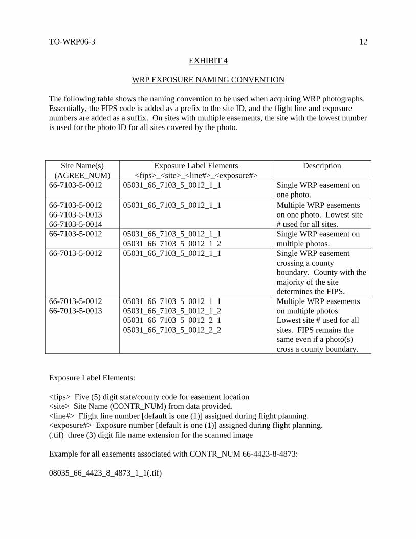
EXHIBIT 4
WRP EXPOSURE NAMING CONVENTION
The following table shows the naming convention to be used when acquiring WRP photographs. Essentially, the FIPS code is added as a prefix to the site ID, and the flight line and exposure numbers are added as a suffix. On sites with multiple easements, the site with the lowest number is used for the photo ID for all sites covered by the photo.
Site Name(s) (AGREE_NUM)
Exposure Label Elements <fips>_<site>_<line#>_<exposure#>
Description
66-7103-5-0012 05031_66_7103_5_0012_1_1 Single WRP easement on one photo.
66-7103-5-0012 66-7103-5-0013 66-7103-5-0014
05031_66_7103_5_0012_1_1 Multiple WRP easements on one photo. Lowest site # used for all sites.
66-7103-5-0012 05031_66_7103_5_0012_1_1 05031_66_7103_5_0012_1_2
Single WRP easement on multiple photos.
66-7013-5-0012 05031_66_7103_5_0012_1_1 Single WRP easement crossing a county boundary. County with the majority of the site determines the FIPS.
66-7013-5-0012 66-7013-5-0013
05031_66_7103_5_0012_1_1 05031_66_7103_5_0012_1_2 05031_66_7103_5_0012_2_1 05031_66_7103_5_0012_2_2
Multiple WRP easements on multiple photos. Lowest site # used for all sites. FIPS remains the same even if a photo(s) cross a county boundary.
Exposure Label Elements: <fips> Five (5) digit state/county code for easement location <site> Site Name (CONTR_NUM) from data provided. <line#> Flight line number [default is one (1)] assigned during flight planning. <exposure#> Exposure number [default is one (1)] assigned during flight planning. (.tif) three (3) digit file name extension for the scanned image Example for all easements associated with CONTR_NUM 66-4423-8-4873: 08035_66_4423_8_4873_1_1(.tif)

TO-WRP06-3
13
EXHIBIT 5
EQUIPMENT AND INFORMATION UPDATES AIRCRAFT TO BE USED IN COMPLETION OF ITEM(S) IN THIS TASK ORDER:
Make/Model
Registration #
Operating Ceiling
Bidder Owned
(check appropriate block)
[ ] Yes [ ] No *
[ ] Yes [ ] No *
[ ] Yes [ ] No *
* If the aircraft is/are not offeror owned, a written statement of availability from the owner of the aircraft must be enclosed. See Section C-2 of the original contract. CAMERA(S) TO BE USED IN COMPLETION OF ITEM(S) IN THIS TASK ORDER: Current calibration report(s) must be enclosed or on file at the Aerial Photography Field Office.
Make/Model
Lens Number
Magazine Number
Bidder Owned
(check appropriate block)
[ ] Yes [ ] No *
[ ] Yes [ ] No *
[ ] Yes [ ] No *
If the camera(s) is/are not offeror owned, a written statement of availability from the owner(s) of the camera(s) must be enclosed. See Section C-2 of the original contract. INCOMPLETE CONTRACTS AS OF DATE OF PROPOSAL:
Indicate by Linear Miles Remaining Work - Summer
Remaining Work – Winter
U.S. Government Contracts
All Other Contracts

TO-WRP06-3
14
EXHIBIT 5
EQUIPMENT AND INFORMATION UPDATES (Continued) KEY PERSONNEL INTENDED FOR PERFORMANCE ON THIS TASK ORDER: List all key professional and technical personnel intended to perform on this contract. List may include project manager, pilot(s), photographer(s), and key back-up or support personnel.
Name
Title
Education
Years of Experience
PROPOSED AERIAL PHOTO ACQUISITION SUBCONTRACTS FOR THIS TASK ORDER: List all proposed subcontractors, and related information, intended to perform aerial photography acquisition on this task order.
Company Name and Address and Telephone Number
Areas
Proposed
% of Total Acquisition
Camera Lens Number Proposed for Use

TO-WRP06-3
15
EXHIBIT 6
U.S. DEPARTMENT OF AGRICULTURE
AERIAL PHOTOGRAPHY PROGRESS REPORT
INSTRUCTIONS This report shall be prepared only for days that performance is accomplished in acquiring project photography. Reports shall be submitted to the government office E-mail address indicated below no later than the day following performance. Reports shall be submitted in ASCII text format. A list of WRP Areas flown shall be indicated by their County and WRP identification numbers, and shall reflect only the previous day's performance. A cumulative progress record of all areas acquired shall be maintained by the Contractor.
2006 WRP PROGRESS REPORT USDA-NRCS-2-06, ITEM # ???
TO: FROM: Geoff Gabbott, Contracting Officer Name Aerial Photography Field Office Company E-mail Address: [email protected] Telephone Number PERFORMANCE RECORD: Date Acquired: 07-MAR-07 WRP Areas Acquired: 66-7103-0-0276 66-7103-0-0277 66-7103-0-0278 66-7103-0-0279 66-7103-5-0073 66-7103-5-0075 66-7103-5-0090 66-7103-5-0090 66-7103-5-0091 66-7103-5-0093 66-7103-5-0093 66-7103-5-0094 66-7103-5-0098 66-7103-5-0099 66-7103-5-0100 66-7103-0-0280

TO-WRP06-3
16
EXHIBIT 7
PACKING SLIP
STATEMENT OF SHIPMENT FOR 2006 WRP AREAS
INSTRUCTIONS: This document will accompany all shipments from the contractor. Please complete the requested information at the top of the page and indicate all counties that are included in this shipment with an "X". If quantities submitted for individual counties differ from the quantities listed, then a quantity of WRP Areas acquired for the county(s) should be recorded instead. SEND TO: CONTRACTING OFFICER USDA-FSA-APFO 2222 WEST 2300 SOUTH SALT LAKE CITY, UT 84119-2020
DATE: ______________ SHIPMENT NUMBER: ______________ TOTAL OF WRP AREAS IN SHIPMENT: ______________ TOTAL OF COUNTIES IN SHIPMENT: ______________
COLORADO
TOTAL COUNTIES: 19 TOTAL WRP AREAS: 76 FIPS COUNTY WRP AREAS
[ ] 08003 ALAMOSA 3 [ ] 08011 BENT 4 [ ] 08021 CONEJOS 1 [ ] 08035 DOUGLAS 3 [ ] 08039 ELBERT 5 [ ] 08051 GUNNISON 2 [ ] 08069 LARIMER 4 [ ] 08075 LOGAN 30 [ ] 08085 MONTROSE 1 [ ] 08087 MORGAN 4 [ ] 08089 OTERO 4 [ ] 08093 PARK 1 [ ] 08101 PUEBLO 3 [ ] 08105 RIO GRANDE 2 [ ] 08109 SAGUACHE 1 [ ] 08115 SEDGWICK 4 [ ] 08121 WASHINGTON 2 [ ] 08123 WELD 1 [ ] 08125 YUMA 1