
Sheffield Riverside Management Plan
24
100231201 LSC 315 Restoration Ecology and Vegetation Management Sheffield Riverside Management Plan
-
Upload
martin-shaw -
Category
Documents
-
view
219 -
download
1
description
Located on The River Don for the Castlegate area of the city
Transcript of Sheffield Riverside Management Plan
100231201LSC 315 Restoration Ecology and Vegetation Management
Sheffield Riverside Management Plan

Sheffield Riverside Management PlanTable of Contents
1
Table of Contents
1 Introduction...........................................................................................................2 1.1 The Brief 1.2 Purpose of the Report 1.3 Sheffield Local Biodiversity Action Plan2 Site Details.............................................................................................................3 2.1 Location and Extent 2.2 Landscape Value 2.3 History and Past Landscape Uses 2.4 Vegetation Survey3 Vision......................................................................................................................5 3.1 Vision Statement 3.2 Priority Themes4 Priority Habitat......................................................................................................6 4.1 Priority Habitats5 Priority Species......................................................................................................7 5.1 Priority Species6 Masterplan............................................................................................................9 6.1 Masterplan Process 6.2 Conceptual Masterplan 6.3 Final Masterplan 6.4 Habitat/Species Relationship7 Detailed Zone......................................................................................................14 7.1 Detailed Zone Masterplan 7.2 Habitats8 Establishment.......................................................................................................16 8.1 Soft or Green Engineering Techniques 8.2 Seeding and Planting of Bare Soil 8.3 Planting Trees and Shrubs 8.4 Marginal Vegetation9 Management......................................................................................................18 9.1 Aims and Objectives 9.2 Reed Bed 9.3 Wet Woodland 9.4 Meadow 9.5 River 9.6 Scrub 9.7 Woodland10 Conclusion.........................................................................................................2511 References.........................................................................................................26

Sheffield Riverside Management PlanIntroduction
2
1.1 The Brief
Sheffield City Council has an ambition to develop a ‘green oasis’ for nature around the Castlegate area of the city where 3 water features meet. These are The River Don, The River Sheath and the Sheffield and Tinsley Canal.
The ambition is to allow the rivers greater capacity to store water here during flood periods, and to re-landscape the area to be more sensitive to nature, particularly to facilitate species migration along the water courses.
1.2 Objective
Sheffield is the greenest city in Britain. This strategy will be a leading area of the cities green spaces for future generations to use and enjoy.
This document will provide context for this area of the city; looking at location, landscape value, and history. A masterplan has been created for the area using the information gained from the context. This focuses on habitats, and animal and plant species. A detailed zone of the site has also been put together with a site management plan which will be implemented to maintain and develop the area.
The above has been formulated using a variety of UK and Sheffield Local Biodiversity Action Plans.
1.3 Sheffield Local Biodiversity Action Plan
The ‘Sheffield Local Biodiversity Action Plans’ will be used to put together this management plan. The action plans highlight a variety of habitat and species types which will be targeted in order to achieve the goals of the city.
An action plan has already been put in place for The River Don and its canals called ‘The River Don and The Sheffield & South Yorkshire Navigation Canals Spatial Biodiversity Action Plan’. This action plan will be a focal point in the design and management of the proposed site to create a variety of habitats that will fit in with the mosaic of habitats found across the length of The Don.
1. Introduction

Sheffield Riverside Management PlanThe Site
3
2. The Site
2.1 Location and Extent
The site is located North-East of the city centre in the Castlegate and Riverside regions of the city. It is based around the area where The River Don, The River Sheath, and the Sheffield and Tinsley Canal meet and extends out across these water bodies. Figure 1 shows its location within the context of the city.
Figure 1. (Above) Site location
City Centre
River Don
River Sheaf
Sheffield and Tinsley Canal
The River Don rises on the southern Pennine moors and flows from the Peak District National Park, through the urban centres of Sheffield and Rotheram, before joinging the River Ouse at Goole.
The River Sheaf, one of The Dons major tributaries, flows northwards, past Dore, through Abbeydale Valley and north of Heeley. It then passes into a culvert, through which it flows under the centre of Sheffield emerging just once before joining the River Don near Blonk Street Bridge.
The Sheffield and Tinsley Canal runs 3.9 miles from Tinsley, where it leaves the River Don, to the Shef-field Canal Basin now known as Victoria Quays, in the city centre. It is the largest body of water in the lowland part of Sheffield.
Figure 2. (Above) Where The Sheaf meets the Don
Figure 3. (Above) The River Don in the Castlegate area of the city
Figure 4. (Above) The Sheffield and Tinsley Canal at Victoria Quays

2.2 Landscape Value
Due to the site being located within a conjested area the city centre it has little landscpae value. Al-though the rivers and canal found within the site provide value, they have been culverted so much of this has been lost. Opening these water features up will provide an opportunity to intergrate a variety of different habitats. Most notably wetland, which will create flood control. Flooding has been an issue within the city centre ever since the rivers were culverted. This is the perfect opportunity to adress this situation whilst creating habitats, and filtering water.
Sheffield Riverside Management PlanThe Site
4
2.3 History and Past Landscape Uses
For over 1000 years this area of the city was the main civic and trading centre. Due to the markets that took place here a variety of transport links were built. This included a canal which is the Shef-field and Tinsley Canal that can be found there today. Ever since this time the use of the area has remained the same. The River Sheaf was culverted due to the construction of the Castlefolds Market and the tram network.
The purpose of the site has now been planned to change as the markets are moving to The Moor area of the city. Now the attention is being turned back to the rivers and the canal.
2.4 Vegetation Survey
Sorbus aucuparia
Carpinus betulus
Buddleia davidii
Lavandula
Rumex obtusifolius & Nasturtium officinale
Cotoneaster sp.
Deschampsia cespitosa
Hedera helix Fraxinus excelsior
Acer pseudoplatanus Betula pendula
The area is lacking in diverse vegetation although various species can be found. As well as these species there are a variety of mosses, lichen, weeds and evergreen shrubs that can be found.

Sheffield Riverside Management PlanVision
5
3 Vision
3.1 Vision Statement
‘To connect the three watercourses that meet in the area creating a variety of habitats for a variety of plant and animal species whilst encouraging greater use, understanding and enjoyment for the local and wider community.’
3.2 Priority Themes
- To Develop ‘green oasis’ for the Castlegate area of the city connecting the 3 water features that meet in the area. These are the River Don, the River Sheath, and the Sheffield and Tinsley Canal. - Create habitats where animal and plant species can thrive - Re-landscape the area to be more sensitive to nature and facilitate species migration along the water courses - Create area to store water during flood periods

Sheffield Riverside Management PlanPriority Habitats
6
4.Priority Habitats
4.1 Priority HabitatsThe ‘Sheffield Biodiversity Action Plan’ has been used to identify the priority habitats. The location of the site alongside the three water features lends itself to being predominantly wetland based, which will also provide flood protection. Some other habitat types will be created at the sites perim-eters where the affect of the rivers will be lower.
The ‘Sheffield Local Biodiversity Action Plan’ has highlighted wetland as a priority habitat. The ‘Wet-land Habitat Action Plan’ has been put in place to adress the issues. It states that one of the cur-rent factors in causing loss or decline is the poor management of water bodies and their adjacent habitats. This document will adress these issues ensuring that they are maintained to be as rich and diverse as possible. The wetland habitats that will be taken from this are:
-River (Figure 5)-Standing Open Water and Ponds (Figure 6)-Dykes (Figure 7)-Flood Plain Marsh (Figure 8)-Fens (Figure 9)-Wet Woodland (Figure 10)-Reed Beds (Figure 11)
There other types og habitats that will be found within the green corridor. They are also of high importnace in the UKHAP. These habitats are: -Canal (Figure 12) -Woodland (Figure 13) -Lowland Meadow (Figure 14) -Scrub/woodland Edge (Figure 15)
Figure 5. (above) River Habitat Figure 6. (above) Standing Open Water and Ponds
Figure 7. (above) Dykes Figure 8. (above) Flood Plain Marsh
Figure 9. (above) Fen Figure 10. (above) Wet Woodland Figure 11. (above) Reed Bed Figure 12. (above) Canal
Figure 13. (above) Woodland Figure 14. (above) Lowland Meadow
Figure 15. (above) Scrub/Woodland Edge
Sheffield Riverside Management PlanPriority Species
7
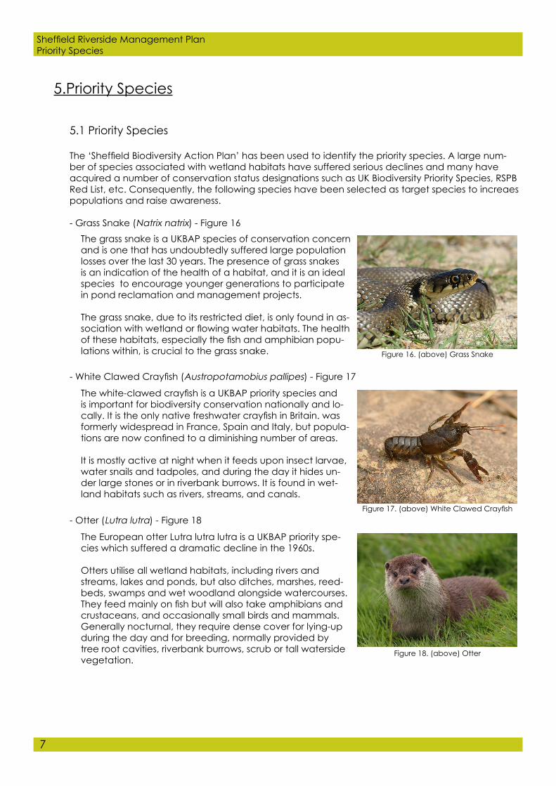
5.Priority Species
5.1 Priority Species
The ‘Sheffield Biodiversity Action Plan’ has been used to identify the priority species. A large num-ber of species associated with wetland habitats have suffered serious declines and many have acquired a number of conservation status designations such as UK Biodiversity Priority Species, RSPB Red List, etc. Consequently, the following species have been selected as target species to increaes populations and raise awareness.
- Grass Snake (Natrix natrix) - Figure 16The grass snake is a UKBAP species of conservation concern and is one that has undoubtedly suffered large population losses over the last 30 years. The presence of grass snakes is an indication of the health of a habitat, and it is an ideal species to encourage younger generations to participate in pond reclamation and management projects.
The grass snake, due to its restricted diet, is only found in as-sociation with wetland or flowing water habitats. The health of these habitats, especially the fish and amphibian popu-lations within, is crucial to the grass snake. Figure 16. (above) Grass Snake
The white-clawed crayfish is a UKBAP priority species and is important for biodiversity conservation nationally and lo-cally. It is the only native freshwater crayfish in Britain. was formerly widespread in France, Spain and Italy, but popula-tions are now confined to a diminishing number of areas.
It is mostly active at night when it feeds upon insect larvae, water snails and tadpoles, and during the day it hides un-der large stones or in riverbank burrows. It is found in wet-land habitats such as rivers, streams, and canals.
- White Clawed Crayfish (Austropotamobius pallipes) - Figure 17
Figure 17. (above) White Clawed Crayfish- Otter (Lutra lutra) - Figure 18
The European otter Lutra lutra lutra is a UKBAP priority spe-cies which suffered a dramatic decline in the 1960s.
Otters utilise all wetland habitats, including rivers and streams, lakes and ponds, but also ditches, marshes, reed-beds, swamps and wet woodland alongside watercourses. They feed mainly on fish but will also take amphibians and crustaceans, and occasionally small birds and mammals.Generally nocturnal, they require dense cover for lying-up during the day and for breeding, normally provided by tree root cavities, riverbank burrows, scrub or tall waterside vegetation.
Figure 18. (above) Otter

Sheffield Riverside Management PlanPriority Species
8
- Great Crested Newt (Triturus cristatus) - Figure 21
- Water Vole (Arvicola amphibius) - Figure 19
The Water vole is a UKBAP priority species and is in urgent need of action.
The water vole is found throughout mainland Britain in a variety of bank side habitats and is the UK’s largest vole. The water vole inhabits slow-moving rivers, streams, ditches and ponds, particularly those with well-developed banks. It feeds on grass and waterside vegetation, and is a skilled swimmer, both underwater and on the surface. Breeding takes place in underground tunnels and there-fore anadequate bank in which to dig a series of burrows is necessary.
Figure 19. (above) Water Vole
- Kingfisher (Alcedo atthis) - Figure 20
The Kingfisher is a UKBAP species of conservation concern.
They require a high quality of water with good populations of aquatic invertebrates or small fish. Rivers are gradually returning back to their former states, holding healthy pop-ulations of invertebrates, and a wide variety of fish spe-cies. They are good indicators of the quality and health of the aquatic environment. They inhabit clear, slow-flowing streams and rivers, and lakes with well-vegetated banks. It frequents scrubs and bushes with overhanging branches close to shallow open water to hunt. Figure 20. (above) Kingfisher
The great crested newt is a species of national conserva-tion concern, and is a Priority Species inthe UKBAP
They require cover and invertebrate prey, usually provided by rough grassland and/or other semi-natural areas. Re uges such as logs, loose rock or dry stone walls provide both resting and hibernation sites. They spend much of their time on land returning to ponds between March and July to breed. The rest of the year is spent in neighbouring habitats such as rough grassland. Figure 21. (above) Great Crested Newt

Sheffield Riverside Management PlanMasterplan
9
6. Masterplan
6.1 Masterplan Process
The masterplan stage began by identifying sites alongside the river and canal that could be re-placed and used to create habitats.
To restore the River Don various features will be reinstated: - Meanders - In-channel deflectors to disrupt straight flow - Bank re-profiling - Channel narrowing - Backwater creation - Wetland scrapes - Replanting of riverside vegetation
Once the spaces have been identified and the river restored habitats will be selected strategically based around the priorty species in chapter 6. These spaces will be linked with vegetation and of course, by the river.
Figure 22 shows the conceptual masterplan stage. The masterplan (Figure 23) has been developed from this.

Sheffield Riverside Management PlanMasterplan
12
6.4 Habitat/Species Relationship

Sheffield Riverside Management PlanMasterplan
13
Figure 24. (above) Habitat/Species Relationship table

Sheffield Riverside Management PlanDeatiled Zone
14
7. Detailed Zone
7.1 Detailed Zone Masterplan
See Figure 25
7.2 Habitats
Retained - River (figure 5)- Being the main part of the site and the only habitat of quality, this part of the site will be retained.
CreatedThere are a variety of habitats that are to be created within this area of the site. These are: - Reed Beds (Figure 11) - Wet Woodland (Figure 10) - River (Figure 5) - Lowland Meadow (Figure 14) - Scrub/woodland Edge (Figure 15) - Woodland (Figure 13)
Figure 24 shows the relationship between the habitats and the target species, as well as showing an example of selected plant species for each habitat.

Sheffield Riverside Management PlanEstablishement
16
8.1 Soft or Green Engineering Techniques
Sometimes vegetation needs aid to establish itself on river banks. The use of soft or green engineer-ing techniques would be appropriate. This includes: Geotextile (figure 26)- This is a mesh that stablises river banks by allowing vegetation to grow through it. It will be used to aid re-establishment to stabilise an eroding bank. Where this geo textile is to be used under water it must be different from that above.
Coir rolls (figure 27)- These will be placed at the toe of ther iver to prevent erosion. They will be pre- planted with vegetation such as reeds. Reeds (figure 28)- These will be established above normal water level. They will then spread down the bank into the water to provide strong underwater growth.
Objectives- Retain river banks Prevent erosion Provide substrate for vegetation establishment Provide habitat for wildlife
How to install- During low flow periods and from the bank Secure with stakes
8. Establishment
Figure 26. (above) Use of geotextile on river bank
Figure 27. (above) Use of coir rolls at edge of river bank
Figure 28. (above) Use of reeds to provide strong underwater growth and erosion protection
8.2 Seeding and Planting of Bare Soil
It is important that a cover of vegetation is established as soon as possible having stablised the river banks.
In some situations where quick greening is required, a nurse species can be planted to stabilise the soil and provide niches for more desirable species to establish.
A friable subsoil with small amounts of top soil is better for establishing low maintenance seed mixes (topsoil is often high in plant nutrients and can contain weed seeds)

Sheffield Riverside Management PlanEstablishment
17
8.3 Planting Trees and Shrubs
Riparian woodlands play a crucial role in helping maintain the health and productivity of rivers. They protect river banks and control erosion. The aim is to re-create semi-natural woodland using native species.
The shade created by the trees will also aid the growth of aquatic plants, freshwater algae and ground plants. This will then have a positive impact on invertebrates and fish. By establishing the trre planting correctly, habitat enhancment from tree planting may reduce the need for weed and algae management.
Small trees will be planted as they establish better than larger ones. Planting distances will be kept simple, with amixture of trees and shrubs to give maximum structural diversity. Single species will be grouped to prevent fast growing species from dominating others. Trees and shrubs will be planted no further than 1.5m apart to prevent weed growth and create early shrub cover.
Each shrub will be have the surrounding vegetation impeded to give the growing shoot a chance to develop and prevent it being smothered by tall, or dominant weeds. Weeds will be controlled using mulch mats and strimming rather than herbicides.
Patch scarification will be used to improve survival of a small number of planted trees. This will be done manually to avoid damage by machinery. They should be plnated on weed free spots. Tree shelters will be used to provide protection and encourage early growth.
8.4 Marginal Vegetation
Marginal vegetation provides a valuable habitat for wildlife and erosion protection for the river bank. Individual plants will be obtained from elsewhere on The Don and planted on this site.
Vegetation will be planted in Spring. They will immediately be planted into shallow water or moist ground. Faggots will be used to provide protection from the flow of ther river (figure 29). This way they will have a better chance of establishing.
Figure 29. (above) Use of faggots to pro-vide protection for vegetation
Tussocks of species such as mat-grass, tufted hair-grass and soft rush, or creeping species such as bent grasses, can be dug up and pulled apart to form a large number of rooted fragments for transplanting. Transplants have high survival rates provided they are not allowed to dry out.
Sow seeds in the spring (April to May)
Figure 30. (above) Tree shelter

Sheffield Riverside Management PlanManagement
18
9. Management
9.2 Reed Bed
Without the management of reed beds natural succession would take place and the reed bed would be lost. Some form of management is required to retain them. There are several man-agement methods of burning and grazing, but these would not be practical in an urban enviro-ment.
Figure 31. (above) Reed Bed management time table
9.1 Aims and Objectives
To create and maintain a successful flood alleviation space in the centre of Sheffiled’s city cen-tre through appropriate habitat management, habitat creation, data collection, and educa-tion

Cut reed has a variety of uses including; bundled and stacked at the edge of the reedbed to create further wildlife habitat for reptiles, amphibians and invertebrates; mulched/composted; or used to construct reed screens and blinds on wildlife reserves.
Reeds will also filtrate the water making The River Don cleaner and a better habitats for wildlife. The sooner they establish the greater the impact they will have.
19
Sheffield Riverside Management PlanManagement
Management for visitors is also required. This includes; - Creating viewpoints to provide views into the habitat. This can be done by cutting reeds at various heights. This is also beneficial to habitat creation. - Vareity of path routes - Lowered water levels to reveal muddy pools. This is beneficial to both species and visi tors.

20
Sheffield Riverside Management PlanManagement
Riaprian woodland captures and recycles mineral nutrients, increases biodiversity and filters pollutants.
When trees are coppiced the wood can be sold on as fire wood. This will provide a source of income for the project.
9.3 Wet Woodland
Figure 32. (above) Wet woodland management time table
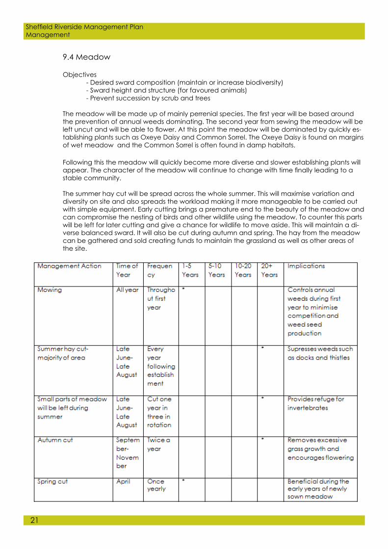
9.4 Meadow
Objectives - Desired sward composition (maintain or increase biodiversity) - Sward height and structure (for favoured animals) - Prevent succession by scrub and trees
The meadow will be made up of mainly perrenial species. The first year will be based around the prevention of annual weeds dominating. The second year from sewing the meadow will be left uncut and will be able to flower. At this point the meadow will be dominated by quickly es-tablishing plants such as Oxeye Daisy and Common Sorrel. The Oxeye Daisy is found on margins of wet meadow and the Common Sorrel is often found in damp habitats.
Following this the meadow will quickly become more diverse and slower establishing plants will appear. The character of the meadow will continue to change with time finally leading to a stable community.
The summer hay cut will be spread across the whole summer. This will maximise variation and diversity on site and also spreads the workload making it more manageable to be carried out with simple equipment. Early cutting brings a premature end to the beauty of the meadow and can compromise the nesting of birds and other wildlife using the meadow. To counter this parts will be left for later cutting and give a chance for wildlife to move aside. This will maintain a di-verse balanced sward. It will also be cut during autumn and spring. The hay from the meadow can be gathered and sold creating funds to maintain the grassland as well as other areas of the site.
21
Sheffield Riverside Management PlanManagement

9.5 River
There are several management techniques for the river bank that will be put in place which can aid the river itself.
- The rivers banks will be kept smooth to allow the free flow of water. This will also provide better views to the river.- Rodent’s burrowing will be minimised as this can have a detrimental impact on the rivers banks.
22
Sheffield Riverside Management PlanManagement
Figure 33. (above) Meadow management time table
Figure 34. (above) River management time table

23
Sheffield Riverside Management PlanManagement
9.6 Scrub
Often considered an undesirable land use/habitat and is often controlled or eradicated the conservation and biodiversity value of this habitat type is now being recognised.
The interface between scrub and other habitats is important. A diverse, long interface provides shelter and a variety of aspects, optimising microhabitats.
Decaying wood is important for invertebrates and fungi and may be under represented.Standing dead wood can be created by ring barking.
As a component of the structural mosaic of scrub stands, bare earth is important for inverte-brates and pioneer plants.
Figure 35. (above) Scrub management time table

24
Sheffield Riverside Management PlanManagement
9.7 Woodland
Figure 36. (above) Woodland management time table

25
Sheffield Riverside Management PlanConclusion
10. Conclusion
Carrying out this management affectively will provide a variety of successful habitats for a vare-ity of species. Not just the target species (see section 6), but a variety of invertebrates and bird species as well.
It will also become part of a wider network of spaces across The River Don providing flood al-leviation for the city and surrounding area.
The benefits of the spaces will have a big social impact on the city, providing a refuge form the hustle and bustle of the city centre. This will raise awareness and will hopefully get people inter-ested in environmental effects and encourgae them to get involved in the scheme.

26
Sheffield Riverside Management PlanReferences
11. References