Sharing Good Practices on Systems for Information Exchange...
23
Seventh Session of the Committee of Experts on Global Geospatial Information Management NIA-WG Side Event 01 August 2017 Lim Liyang Senior Manager, GeoSpatial & Data Singapore Land Authority [email protected] Sharing Good Practices on Systems for Information Exchange and Sharing
Transcript of Sharing Good Practices on Systems for Information Exchange...

Seventh Session of the Committee of Experts on Global Geospatial Information Management
NIA-WG Side Event 01 August 2017 Lim Liyang
Senior Manager, GeoSpatial & Data Singapore Land Authority
Sharing Good Practices on Systems for Information Exchange and Sharing

Background
1. Description of Instrument
a) Technical systems for geospatial information exchange and flows and the content of these systems
b) Examples include national geoportals, and government-wide information system
2. Relevance of Instrument to NIA
a) Helps with the efficient organization of information flows and systems, which aligns the needs and information exchange across stakeholders for decision-making
b) National, integrated systems help provide strategic overview of government activities
2
S1. Establishment of coordinating functions or entities
S2. Reshuffling division of competences
S3. Establishment of a legal framework
S4. Regulated markets
S5. Systems for information exchange and sharing
S6. Entities for collective decision-making
S7. Partnerships
M1. Strategic planning
M2. Financial management: input-oriented
M3. Financial management: performance-oriented
M4. Financial management: joined up working and
cooperation
M5. Inter-organizational culture and knowledge
management
M6. Capacity building
13 instruments have been identified as mechanisms of national institutional arrangements
Structural Mechanisms
Managerial Mechanisms

France
Background Good practices from 12 countries identified by the NIA WG and consultant
Canada
Singapore
Korea
Morocco
Mexico
Ecuador Kenya
Rwanda Indonesia
New Zealand
Good practices from 5 countries will be highlighted
Spain
3
Canada’s Federal Geospatial Platform Coordinates Data Sharing Across a Vast Range of Stakeholders
3. Description a) One-stop platform for searching, discovering, viewing and analysing accurate and authoritative federal geospatial data b) Provides a common suite of decision-support tools that are built once and re-used many times c) Operates on shared infrastructure and governance d) Offers the public free data for download and re-use under the Open Government Licence, through its open data portal e) Designed through a client engagement process that involves creation of user stories based on clients’ needs
2. Background a) Integrating geospatial data from various federal departments for decision-making
required significant time and effort due to differing policies and standards, and licensing barriers
b) Canada’s Federal Committee on Geomatics and Earth Observations (FCGEO) led the development of a common web-based environment for data discovery and access
1. Learning Points a) Collaborative approach to coordinating geospatial asset management
across widely-varying administrative departments b) Supports Canada's Action Plan on Open Government through an open
data licence framework
4
Source: http://www.un-
ggim-
americas.org/images/re
uniones/2016_persepe
ctivas_info_geo_est/re
union2/4.%20canada_l
oubier_geospatial_plat
form.pdf
Canada’s Federal Geospatial Platform Coordinates Data Sharing Across a Vast Range of Stakeholders
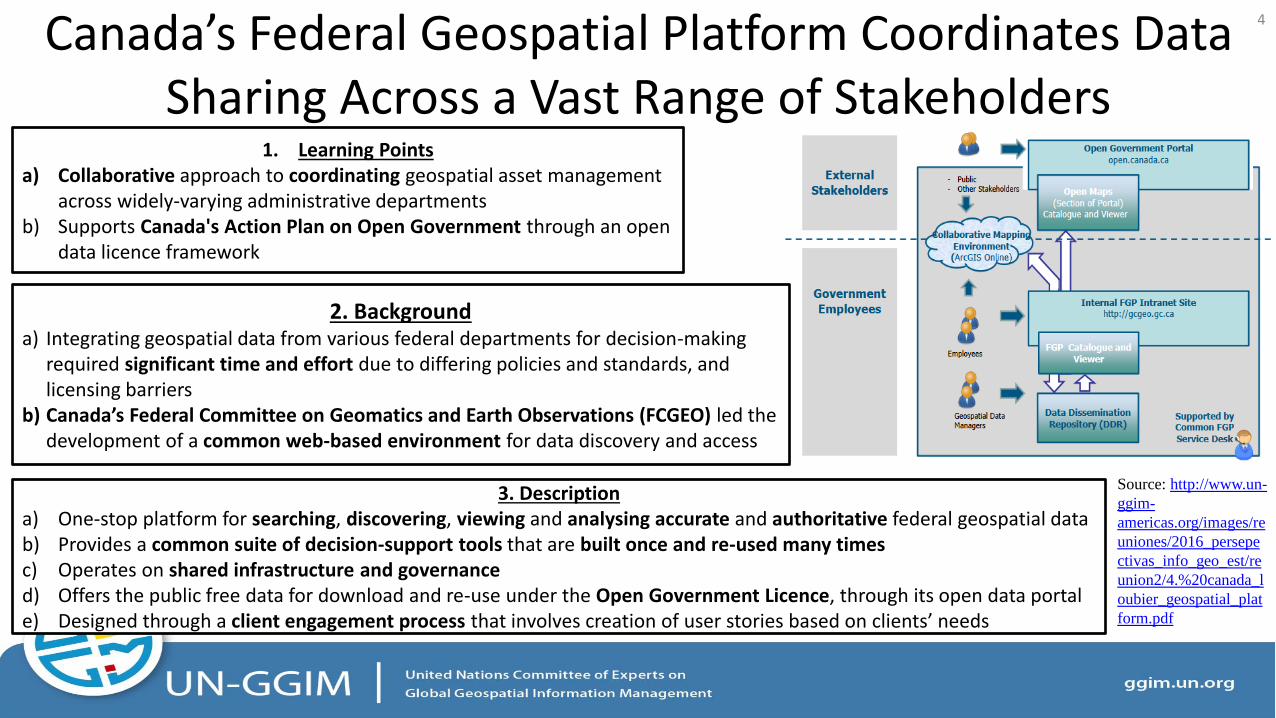
Based on a set of core data,
the Federal Geospatial
Platform coordinates data
sharing across different
domains and federal
departments, and
encourages re-use of
existing data
5
Source: http://www.un-ggim-
americas.org/images/reuniones/2016_per
sepectivas_info_geo_est/reunion2/4.%20
canada_loubier_geospatial_platform.pdf

Indonesia Coordinates Data Sharing Through National Geospatial Information Networks
3. Description a) The National Geospatial Information Networks was created by
Presidential regulation to facilitate sharing of uniform geospatial information across various levels of government
b) Supports geospatial data development and sharing through policy, technology and capacity building initiatives
c) Involves OneMap policy for achieving a single geo-reference, geo-database, geo-standard, data custodian, and data version; as well as the National Competency Standard Performance (SKKNI) for providing certification guidelines
2. Background a) Indonesia needed quality integrated geospatial data for
nationwide development and decision-making b) Complex geography made access to such data even more
critical.
1. Learning Points a) Strong political commitment to overcoming national challenges in geospatial data sharing and coordination
Presidential Regulation Nr.27 / 2014 : National
Geospatial Information Networks (JIGN)
6
Source: Adi Rusmanto, Dodi Sukmayadi, Nurwadjedi. 10 May 2016. The Role and Function of
Geospatial Information Authority (Big) on the National Planning And Development

Indonesia Coordinates Data Sharing Through National Geospatial Information Networks
UNIT
BIRO
BADAN
KANTOR
CUSTODIAN
SHIP
METADATA
CATALOG
PORTAL
NATIONAL DATA
CENTER
BIG
CLEARING UNIT
DATA
CENTER
DATA
CENTER
WALI DATA
WALI DATA
METADATA
KATALOG
PORTAL
UNIT
KLIRING
Ministry of
Marine & Fishery
UNIT KLIRING
METADATA
DATABASE
PORTAL
SIMPUL
KABUPATEN UNIT KLIRING
METADATA
DATABASE
PORTAL
SIMPUL
KOTA
CLEARING
UNIT
CUSTODIAN
SHIP
PROVINCE
DKI Jakarta
PROVINCE DATA
CENTER
METADATA
CATALOG
PORTAL
NATIONAL
GEOPORTAL
http://portal.ina-sdi.or.id
57 Ministries, 34 Provinces, And 508 Regencies/Cities
a) A network of nodes coordinates
geospatial data sharing across
different levels of government
b) The national geoportal and Badan
Informasi Geospasial (BIG)’s
geospatial data centre coordinated
data sharing and processing across
production units
c) Supports the production of national
base and thematic maps for various
applications
7
Source: http://ggim.un.org/docs/meetings/2ndHighLevelForum/Session%204/4-UNGGIM-DOHA_BIG_INDONESIA.pdf

France’s National Geoportal Acts as a Building Block for other NSDI Initiatives
3. Description a) Integrates and provides access to different 2D and 3D thematic geospatial information across national administrative organizations b) Forms the basis for other regional and local geoportals to be developed, as well as other thematic geoportals, such those for land
planning and the environment c) Offers viewing, download and geo-processing services, as well as a ‘Geo-catalogue’ service that provides a key national access point
for metadata published by different authorities d) APIs allow government agencies to integrate geospatial data available in other administrations into their e-services, facilitating re-use
and efficiency
2. Background a) The geoportal was co-implemented by the IGN (National Mapping
and Cartographic Agency) and the BRGM (National Geological Survey), as part of a broader effort to digitalise the French national administration through a geospatial component
1. Learning Points a) Geoportal is a key building block for other regional and thematic
platforms of the NSDI b) Geospatial data can be an important component of the
digitalization of government services
8
Source: https://www.geoportail.gouv.fr/

France’s National Geoportal Acts as a Building Block for other NSDI Initiatives
Taps upon the IGN’s “Carto API” as a building
block for integrating geospatial data and web
services into agencies’ e-services interfaces,
such as application forms
This allows data to be retrieved from the
geoportal and cross-checked for filling
application forms (e.g. cadastral plot identifier
can be obtained from addresses for building
permit applications)
9
Source: https://apicarto.ign.fr/

New Zealand’s LINZ Data Service (LDS) Provides Free Geospatial Data for Creating Products and Services
3. Description a) Offers the public free, updated land and seabed data in a range of formats, as well as web services to support
customization and visualization of LINZ data b) Provides web services to automate the integration of LDS data with users’ web, mobile and GIS applications c) Uses self-help reference material and online discussion forum to support data access
2. Background a) Users needed direct access to Land Information New
Zealand (LINZ)’s datasets instead of third-party sources, in order to plug into them cost-effectively
1. Learning Points a) Facilitate open, quick access to government geospatial data
through use of the Creative Commons licensing framework b) Supports efficient, innovative creation of other information
infrastructures, products and services across sectors
10
Source: https://data.linz.govt.nz/

New Zealand’s LINZ Data Service (LDS) Provides Free Geospatial Data for Creating Products and Services
11
LINZ Data Services’s web
services enable machine-to-
machine sharing of data and
real-time access for on-demand
visualization and consumption,
thus saving time and cost in
data management
Source: http://www.linz.govt.nz/data/linz-data-service/guides-
and-documentation/which-web-service-should-i-use

Rwanda’s SpIDeRR System Enhances Capacity for Disaster Management
3. Description a) Provides a platform for agencies to share data relevant to each phase of disaster risk reduction (preparedness,
response, mitigation and recovery) b) Involves training workshops that train officers to use the portal, and user guides with step-by-step instructions c) Offers access to free and open source tools for data analysis and mapping d) Supports the development of the Rwanda National Risk Atlas, a comprehensive disaster risk profile for the nation
2. Background a) Rwanda experiences high vulnerability to natural disasters due to
topographic and socio-economic factors b) Rwanda Ministry of Disaster Management and Refugee Affairs (MIDIMAR)
partnered with inter-governmental organisations to create the Spatial Information and Data Portal for Disaster Risk Reduction to offer agencies and the public disaster-related maps and climate information
1. Learning Points a) Thematically-focused geoportals facilitate the creation of specific
information products b) Training workshops and user guides promote usability of geoportals
and build capacity
12
Source: http://41.74.166.109/layers/?limit=100&offset=0
Rwanda’s SpIDeRR System Enhances Capacity for Disaster Management
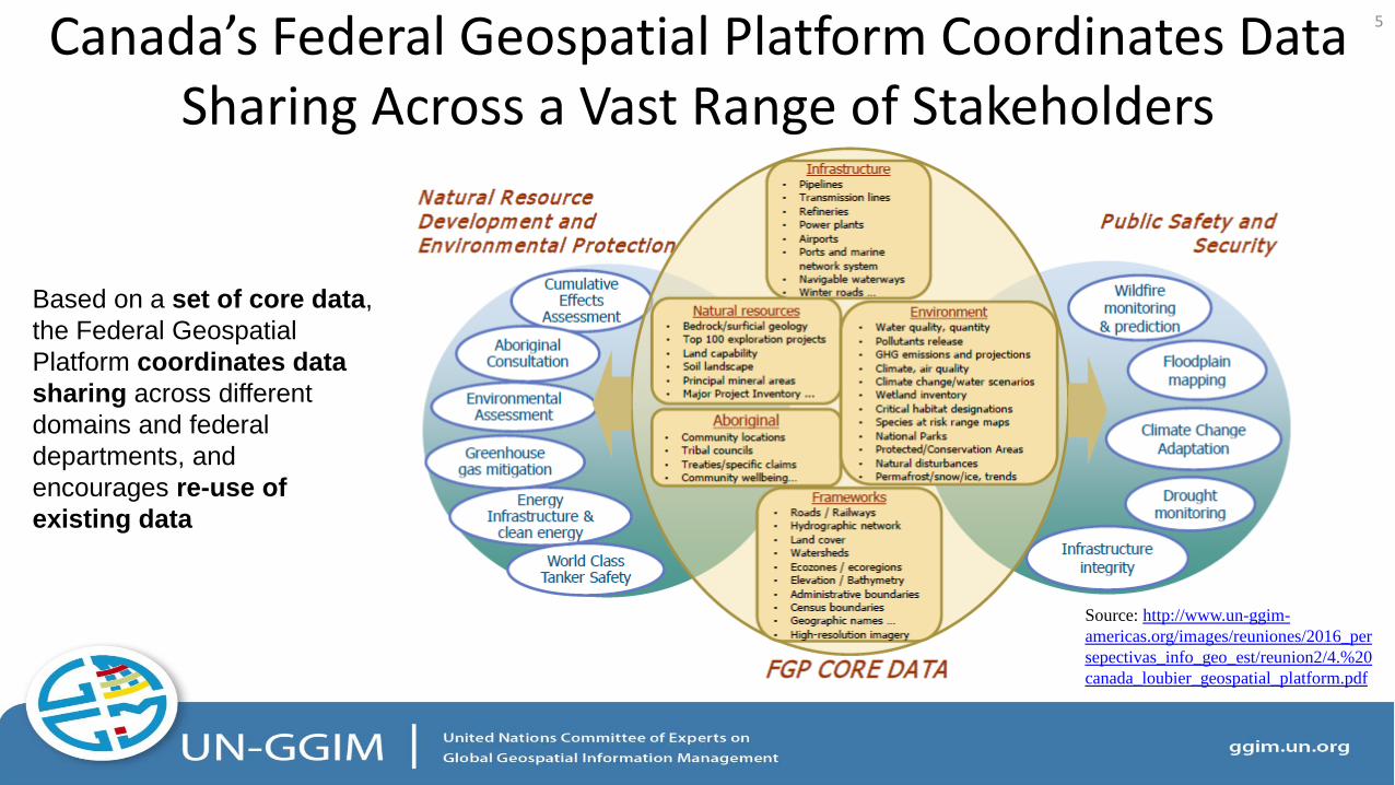
Maps of hydrologic models and rainfall time series in
SpIDeRR helps with flood prediction and seasonal drought
monitoring. This supports agencies’ roles in the national early
warning system, by providing them with spatial data that
targets the preparedness phase in disaster risk reduction
User-friendly tours and tutorials
provide detailed steps from registering
an account to processing spatial data
13
Source: http://41.74.166.109/user_guide/tutorials/users/index.html
Source: http://41.74.166.109/earlywarning/
Key Lessons and Guidelines 1. Systems for information exchange and sharing are not just data infrastructures, but also communication channels between data
suppliers and users across sectors
2. Strengthen collaborations among key geospatial information organizations in order to supply data, products and services meeting user needs
3. Easing systems usability should be prioritized e.g. provision of a range of query/analysis tools, provision of guides and a user forum, etc.
4. Any information sharing system should be spearheaded by national commitment
5. Adopt and implement an open data license framework (e.g. Creative Commons) as this will massively stimulate re‐use and value‐add of the data.
6. Adopt internationally-recognized geospatial standards as the utilization of these standards will facilitate the effective and efficient exchange, sharing and use of geospatial information.
7. Transparent and updated assessment of the usage of the systems e.g. provision of usage statistics in a meaningful way, system ‘openness’, etc.
14

Thank you for your attention
Lim Liyang Senior Manager, GeoSpatial & Data
Singapore Land Authority [email protected]

Annex A: Other Good Practices
16

Ecuador’s National Spatial Data Infrastructure Facilitates Emergency Response to Earthquakes
3. Description a) Offers tools such as Geographic Viewer Earthquake, Web map services (WMS), and a virtual ‘space’ (platform) for downloading
geographic information relevant to response (including base mapping b) develops, ortho‐photographs, digital terrain models) and geospatial studies (e.g. destroyed c) buildings and proposed temporary shelters, etc.). d) The "Open Data in Ecuador“ policy facilitated timeliness of uploaded data, including the constant updating of maps in the most affected
placed by OpenStreetMap
2. Background a) Due to demand, the Military Geographic Institute (IGM) of Ecuador initiated
the production and sharing of timely geographic b) information for mitigation and response to earthquakes such as the large
one on April 16, 2016 c) The MGI developed solutions to facilitate access, use, download and analysis
of information, based on its NSDI
1. Learning Points a) Strong national commitment facilitates pro-active policies
towards data timeliness, and transparency of data sharing
17
Source: IGM‐Ecuador Geoportal

Kenya’s National Land Information Management System Promotes Efficient Service Delivery
3. Description a) Land Registration maps and Land Ownership Data are in a single
integrated GIS based Land Database to provide clients and customers with timely, high quality land information products and services.
b) Land data are now easily made available by highlighting a feature to display all information stored about it. The amount of information (spatial and related non‐spatial) that can be stored in a Geographical Information System(GIS)/ Land Information Management System (LIMS) Database is almost limitless.
2. Background a) Land administration relied on paper-based manual systems that are
inefficient and costly b) The National Land information system (NLIMS) was developed to
computerize land administrative functions
1. Learning Points a) Geospatial systems and technology can be an important component
of digitalization of services
Analogue, static land
records that might get
lost or damaged
Dynamic, interactive
geospatial information
that is easily-retrievable
and promotes prompt
service delivery
18
Source: Creation of the National Land Information Management System (Murage Mundia, 2013)
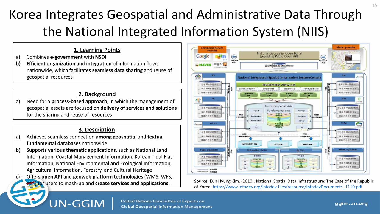
Korea Integrates Geospatial and Administrative Data Through the National Integrated Information System (NIIS)
3. Description a) Achieves seamless connection among geospatial and textual
fundamental databases nationwide b) Supports various thematic applications, such as National Land
Information, Coastal Management Information, Korean Tidal Flat Information, National Environmental and Ecological Information, Agricultural Information, Forestry, and Cultural Heritage
c) Offers open API and geoweb platform technologies (WMS, WFS, etc.) for users to mash‐up and create services and applications.
2. Background a) Need for a process‐based approach, in which the management of
geospatial assets are focused on delivery of services and solutions for the sharing and reuse of resources
1. Learning Points a) Combines e-government with NSDI b) Efficient organization and integration of information flows
nationwide, which facilitates seamless data sharing and reuse of geospatial resources
19
Source: Eun Hyung Kim. (2010). National Spatial Data Infrastructure: The Case of the Republic of Korea. https://www.infodev.org/infodev‐files/resource/InfodevDocuments_1110.pdf

The Digital Map of Mexico Facilitates Access to Geographical and Statistical Data Across Sectors
3. Description a) Offers both geographical information and georeferenced
statistical information b) Based on an architecture supported on services with international
specifications for the interoperability of geospatial data (Open Geospatial Consortium standards), allowing it to interact with other software and services that apply those standards
2. Background a) The Digital Map of Mexico is a Geographic Information System
developed by INEGI (national geographic and statistical agency) in the early 2000s to provide citizens and government a tool that allows easy query of official geographic information
1. Learning Points a) The integration of statistical and geographic information could
promote widespread data sharing and access
20
Source: gaia.inegi.org.mx

Morocco’s Government-Wide Geoportal Brings Data Closer to the Citizens
3. Description a) Single-stop platform that brings together geospatial data from
throughout the government on the location of 14,000 governmental services that might have relevance for businesses or citizens
b) Besides this general geoportal, there are also other geoportals with more specific information on various topics. The geoportal of the Ministry of Agriculture and Maritime Fisheries is an example of this.
c) Both an intranet and extranet application have been developed for users
2. Background a) The Moroccan Government developed a government-wide
geoportal as part of its intent to digitalize the administration as it allows for a higher accessibility and flexibility of the administration
1. Learning Points a) Strong national commitment and collaboration are key to sharing
data effectively
21
Source: http://map.service‐public.ma/mfpma/geo/front/
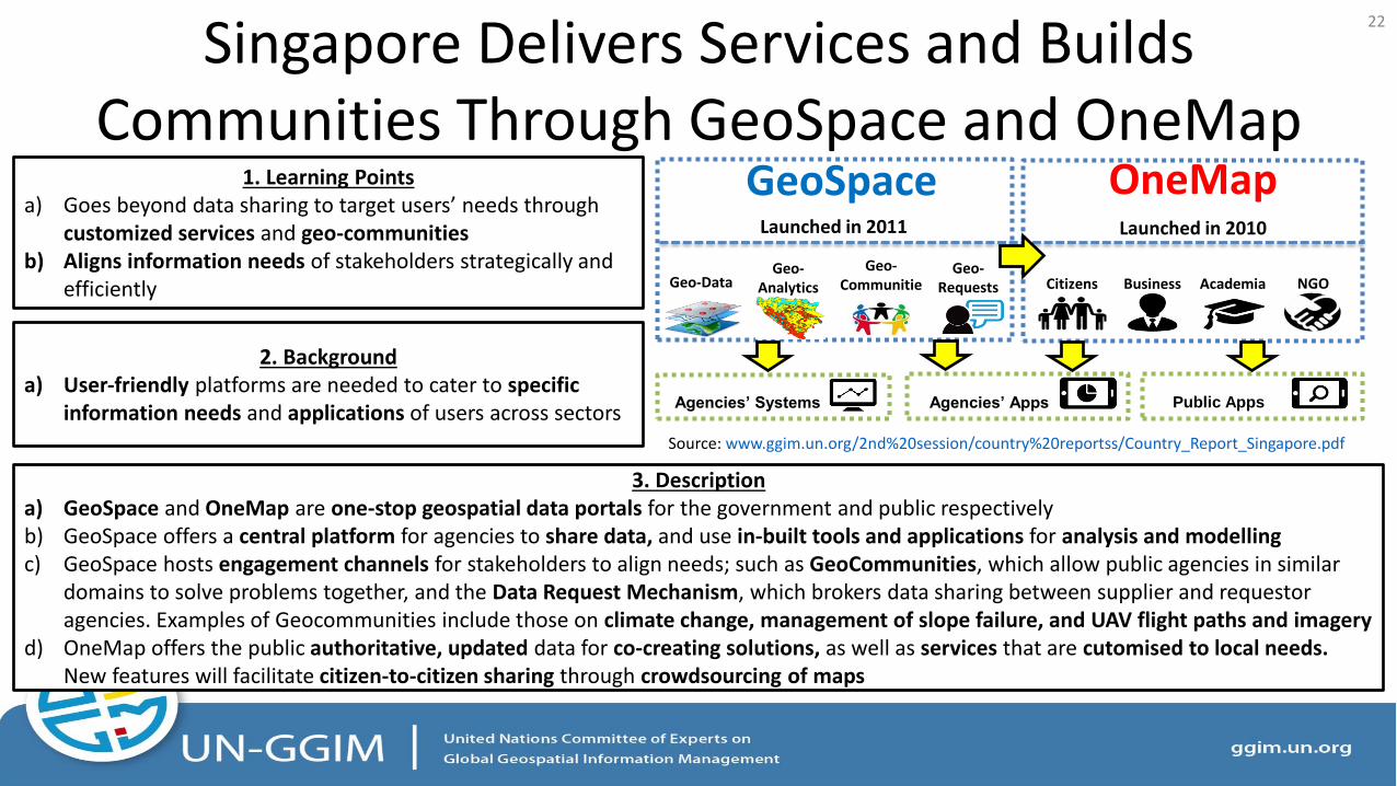
Singapore Delivers Services and Builds Communities Through GeoSpace and OneMap
Geo-Data Geo-
Analytics
Geo-Communitie
s
Geo-Requests Citizens Business Academia NGO
Agencies’ Systems Agencies’ Apps Public Apps
Launched in 2011 Launched in 2010
GeoSpace OneMap
3. Description a) GeoSpace and OneMap are one-stop geospatial data portals for the government and public respectively b) GeoSpace offers a central platform for agencies to share data, and use in-built tools and applications for analysis and modelling c) GeoSpace hosts engagement channels for stakeholders to align needs; such as GeoCommunities, which allow public agencies in similar
domains to solve problems together, and the Data Request Mechanism, which brokers data sharing between supplier and requestor agencies. Examples of Geocommunities include those on climate change, management of slope failure, and UAV flight paths and imagery
d) OneMap offers the public authoritative, updated data for co-creating solutions, as well as services that are cutomised to local needs. New features will facilitate citizen-to-citizen sharing through crowdsourcing of maps
2. Background a) User‐friendly platforms are needed to cater to specific
information needs and applications of users across sectors
1. Learning Points a) Goes beyond data sharing to target users’ needs through
customized services and geo-communities b) Aligns information needs of stakeholders strategically and
efficiently
22
Source: www.ggim.un.org/2nd%20session/country%20reportss/Country_Report_Singapore.pdf

Spain’s Cadastral Electronic Site (SEC)
3. Description a) Provides a series of web services that enables querying cadastral
information (both protected and unprotected data) and its updating b) Provides three services: Request and certification of cadastral data,
including geospatial information;Massive exchange of information; and INSPIRE services dealing with cadastral cartography
2. Background a) The Cadastral Electronic Site (SEC) started up in May 2003 with the main
goal of providing other Administrations with information which, up to that moment, citizens were requested to present in the suitable office after collecting it themselves from the cadastral office
1. Learning Points a) Systems for information exchange can act as data banks that brokers
needs between government bodies and the public for planning
23
Source: http://www.catastro.meh.es/