Sharing a common view of the Information Landscape
25
Sharing a common view of the "Information Landscape" Steve Hawtin Solution Architect Schlumberger
Transcript of Sharing a common view of the Information Landscape

Sharing a common view of the
"Information Landscape"
Steve Hawtin
Solution Architect
Schlumberger

3
Stating the obvious…
Information Management (IM) has a significant impact on the
success of E&P companies
The most difficult (and important) IM issues are people ones
Different stakeholders, different needs:
– IM Professionals: Details, implementation
– Business owners: Costs, benefits
– Information users: only notice IM when it fails
A shared common view of IM is a crucial first step

4
Example Business Impact Statements
Missing well test data in North Field → wells remain shut in
Impact: 250bbls x 10 wells x 2 months production => $6.0M
4 out of 5 Field Rework projects delayed for 3 months each while
searching for data
Impact: 1500bbls x 4projects x 45days x $40 => $10.8M
Investment of USD $11M/ year reduced annual data loss 3%
Impact: 47,984 well logs, replacement cost => $74M

5
Complete Enterprise Architecture
Business
Processes
Information
Landscape
Application
Infrastructure
ProceduresPoliciesPatternsPrinciples

6
The Information Landscape
How information is managed:
Streams: how data is organised
Activities: what needs doing when and by whom
Data flows: how information moves
Roles: which categories of information are held where
Exceptions: how IM varies within the organisation
Organisation: relationships between groups
Data Flow
Overview
Contract
Clauses
Documented
ExceptionsRoles and
Repositories
Table
Other
Artefacts
Core
Understanding
7
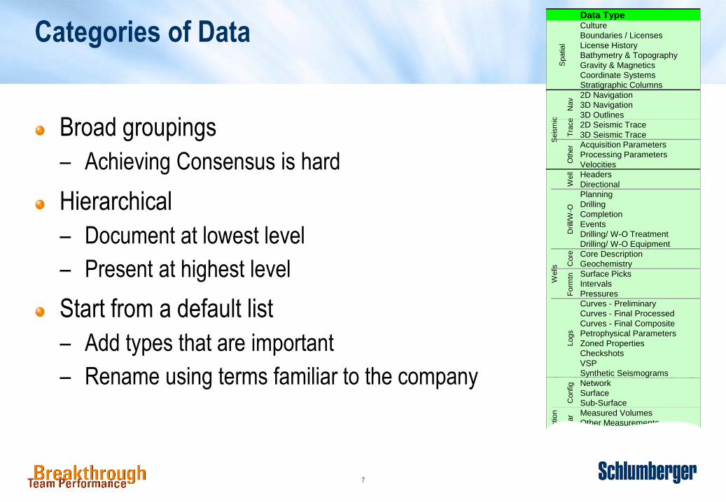
Categories of Data
Broad groupings
– Achieving Consensus is hard
Hierarchical
– Document at lowest level
– Present at highest level
Start from a default list
– Add types that are important
– Rename using terms familiar to the company
Data TypeCulture
Boundaries / Licenses
License History
Bathymetry & Topography
Gravity & Magnetics
Coordinate Systems
Stratigraphic Columns
2D Navigation
3D Navigation
3D Outlines
2D Seismic Trace
3D Seismic Trace
Acquisition Parameters
Processing Parameters
Velocities
Headers
Directional
Planning
Drilling
Completion
Events
Drilling/ W-O Treatment
Drilling/ W-O Equipment
Core Description
Geochemistry
Surface Picks
Intervals
Pressures
Curves - Preliminary
Curves - Final Processed
Curves - Final Composite
Petrophysical Parameters
Zoned Properties
Checkshots
VSP
Synthetic Seismograms
Network
Surface
Sub-Surface
Measured Volumes
Other Measurements
Config
Regula
r
Pro
ductio
nW
ells
Logs
Form
tnC
ore
Drill/
W-O
Well
Spatial
Seis
mic
Nav
Tra
ce
Oth
er

8
What data do users need
Data Edited Data Used
Data Type
Culture
Licenses / Leases
License History
Bathymetry
Surface Images
Grav & Magnetics
Coordinates
Stratigraphy
2D Navigation
3D Navigation
3D Outlines
2D Seismic Trace
3D Seismic Trace
Acquisition Param
Processing Param
Velocities
Headers
Directional
Planning
Drilling
Completion
Events
Dril/ WO Treatmt
Core Description
Geochemistry
Surface Picks
Intervals
Pressures
Curves - Raw
Curves - CPI
Final Composite
Pphysical Param
Zoned Properties
Checkshots
VSP
Synth Seis
External Network
Network
Surface
Sub-Surface
Measured Vols
Pump Data
Other Msurement
Operational
Allocated Vols
Planned Events
Unplanned Events
Samples
Well Tests
Reserves
Seis Interpretation
Previous Studies
Horizon Time Grid
Horizon Depth Grid
Geologic Models
Simulation Models
Physical Assets
Scanned Docs
Electronic Docs
Well
Drill/
W-O
Core
Form
atn
Inde
xe
sC
onfig
Regula
rO
ccasio
nal
Re
se
rvo
ir Fie
ldM
odel
Logs
Sp
atia
lS
eis
mic
Nav
Dig
its
Oth
er
We
lls
3 9 9 3 9
9 9 9 9
9 3 3 9 9
9
9
3
9 9 9 9 9 9 9 3 3 9 3 3 9 9
9 9 9 9 3 3 9 9
9 9 3 9 3 9 9 9 9 3 9 3 3 9 9
3 9 3 9
9 9 3 3 3 9 9 9 3 3 9 9 9 9
9 3 9 9 9 9 9
9 3 3 3 9 9 9 9 9 9
9 3 9
3 9
9 9 9 9 9
9 9 9 9 9 3
3 3
9 9 9 9
9 9 3 9 9
9 9 9
3 9 3 9
9 9 3
9 3 9 9 9 9 3
9 9 3 9 9 9 3 3
9 9 3 9 9 9 3 9 9 3
3 9 9 9 9 9 9 9
3 9 9 9 9 9 9
3 9 9 9 9 9 3
3 9 9 9 9 9 3
3 9 9 3 9 3 3 3
9 9 9 9 9 9 3 9 3 9 9 9 9
9 9 9 9 9 3 3 9 3
9 9 9 3 9 9 9 9
9 9 9 9 3 3 9 9 9
9 9 3 3 3 9 9 9 3 9 9
9 9 9 9 9 9
9
9
9
9 3 9 9
3 3 9 9 9 3
3 3 9
9
9 3 3
Edit
3 9 3 9 9 3 9 9 3 9 9 9 3 9 9
9 9 9 9 9 3 9 9 9 3 9 3 3 9 9
3 9 3 3 3
9 9 9 3 9 9 9 9 9 3
9 9 9 3
9 3 9 9 9 9 9 3 9 9 9 3 9 9 3
3 9 9 9 9 9 9 9 9 9
9 9 3 3 9 9 9 3 9
9 9 3 3 9
3 9 9 3 9
9 9 3 9
9 9 3 3
3 9 9 3
3 9
3 9
3
9 9 9 9 9 9 9 9 9 9 9 9 9 9 9 9 9 9 9 9 9 9 9
9 9 3 9 3 9 9 9 9 9 9 9 9 9 9 9 3 9 9
9 9 9 9 9 9 9 9 9 9 9 3 9 9 9
9 9 9 9 9 9 3 9 9 3 9 9
9 9 9 9 9 9 3 9 9 9 9 9 9 3 9 9 9 9 9 9 9
9 9 3 9 9 9 9 9 3 9 9 3 3 9 9
9 9 9 9 9 9 9 9 3 9 3 3 9 3 9 9 9
9 9 9 9 3 9 9 9 9 9 3 3 3 3 9
9 9 9 3 9 3 9 3 3 3 3
9 9 3 9 3 9 9 9 9 9 3 9 9 9 9 9
9 9 9 9 3 9 3 9 9 9 9 9 3 3 9 9
9 9 9 9 3 9 3 9 9 9 9 3 9 9
9 9 9 3 9 9 9 9
9 9 9 3 9 9 9 9 9 9 9 9 9 9
9 9 9 9 9 9 9 9
9 9 9 9 9 9
9 9 9 9 3 9
3
3
9 9 9 9 9 9 9 9 9 9 3 3
9 9 9 9 9 9 9 9 9 9 3 3 3 9
9 9 9 9 9 9 9 9 9 9 9 9 9 9 9 9 9 9 9 3
9 9 9 9 9 9 9 9 9 9 9 9 3 3 3 9 9 9 9 9
9 9 9 9 9 9 9 9 9 9 3 9 3 3 9 9 3 3 9
9 9 9 9 9 9 9 9 9 9 9 9 3 9 9 9 9
9 9 9 9 9 9 9 9 9 9 3 9 3 3 9 9 9 9 9
9 9 9 9 9 9 9 9 9 9 9 9 9 9 9 9 3
9 9 9 9 9 9 9 9 9 9 9 9 9 9 9 9 9 9
9 9 9 9 9 9 9 9 9 3 9 9 9 9 3 9
9 3 9 9 9 3 9 3 9 9 9 9 9 9 9 9
9 9 9 9 9 9 3 9 9 9 9 9 9 3 9 9 9 9
9 9 9 3 9 9 9 9 9 9 9 9 9 9 9
9 9 9 9 9 3 9
9 9 3 9 9
9 9 9
9 9 3
9 9 9 9 9 9 9 3 3 3
9 3 9 9 9 3 9 9 9 9 3
9 9 9 9
9 9 3
9 3 9 9 9 3 9
Use
Rec
ord
sR
eser
voir
Sp
atia
l
Seismic
Data
Production
DataP
rod
uct
ion
Lo
gs
Dri
llin
gS
eism
ic

9
Different user’s data requirements
Analysis on user’s
stated data needs
shows that while the
needs overlap the two
sites have distinct data
requirements
Location 2 users fall
into two distinct groups
A single user falls
outside the “standard”
Location 1 data profile
Location 2
Users
Location 1
Users

10
User’s Impression of Information Management
ProcessesPeopleDataTools
Formation
Sei
smic
Pro
du
ctio
nR
eser
voir
Other Geophys
Records
Cultural/ Spatial
Regular Data
Drill/W-O
Field
Traces
Well
Navigation
Core
Logs
Model
Configuration
Occasional
Wel
ls
Production Data not documented
Is a Concern Serious IssuesAbove AverageWorks Well

11
Who is responsible for IM activities?
Data Users
Info Mgmt Group
External Contractrs
Formation
Sei
smic
Pro
du
ctio
nR
eser
voir
Other Geophys
Records
Spatial
Regular Data
Drill/W-O
Field
Traces
Well
Navigation
Core
Logs
Model
Configuration
Occasional
Wel
ls
RelinquishDistributePublishEditLoadCatalogueCapture

12
What activities?
RelinquishDistributePublishInterpret/
EditLoadCatalogueCapture
Partner
Companies
Contractors
Info Mgmt
Group
Asset
Team
Raw Curves
to CDA
Dispose of
orig tapes
Partners obtain
data from CDA
Well
Logged
Well
Logged
Data dispatched
once sufficient
set is gathered
Load curves
Contractor A
puts on CDs
Produces the
processed curves
Publish into
FINDER
Petrophysics
validation

13
Working
The roles that repositories play
Project
Project
Project
Original
ExternalIn
Real Time
Master
Managed Sequence
Standard Flows
Infrequent Flows
Supporting Data
Externalout

14
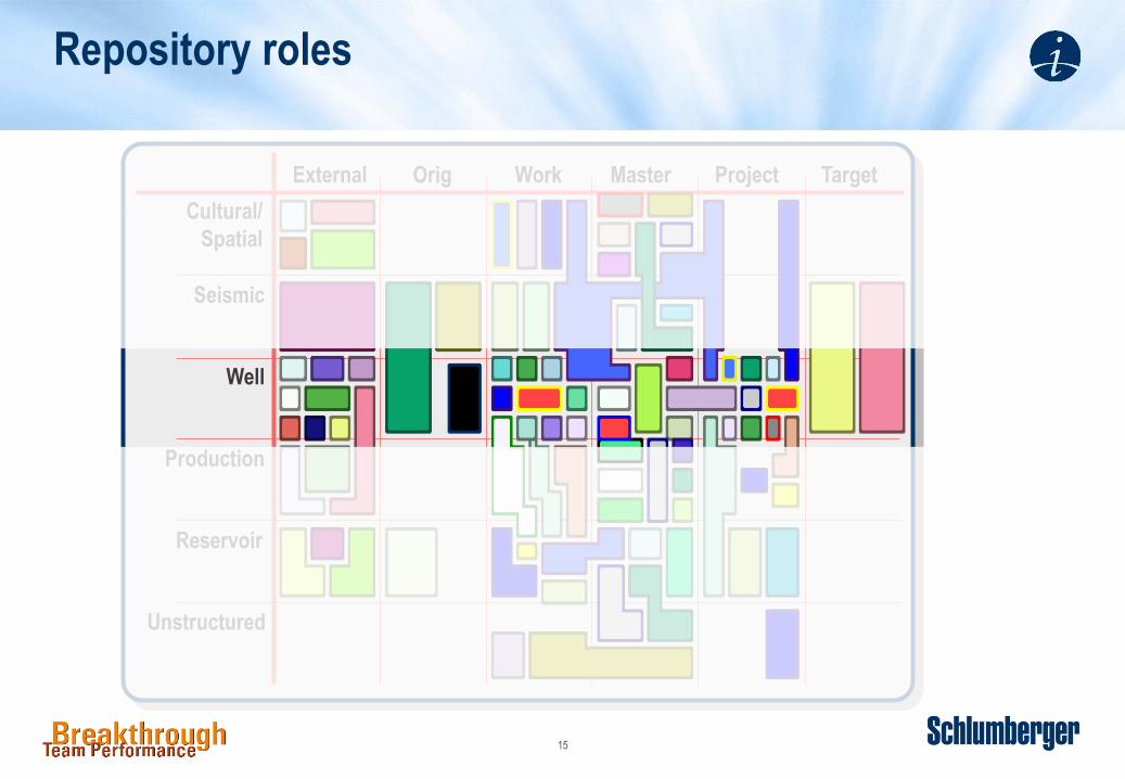
Repository roles
Well
Seismic
Unstructured
External Orig Work Master Project Target
Reservoir
Production
Cultural/
Spatial
15
Repository roles
Well
Seismic
Unstructured
External Orig Work Master Project Target
Reservoir
Production
Cultural/
Spatial

16
Repository roles - Well Data
Core
Drilling
External Orig Work Master Project Target
Curves
Formation
Header

17
Repository roles - Curve Data
Final Composite
Curves - CPI
Checkshots
External Orig Work Master Project Target
Synth Seis
VSP
Zoned Properties
Petrophs Params
Curves - Raw

18
Data Flows for Log Curves
Partner
Companies
Regulatory
Agency
CDA
Diskos
LWD
Logging
Contractor Recall
Interactive
Petrophys
Geolog
File Room
Recall
Master
GeoFrame
Petrel
Master
Petrel
Final Well
Report

19
IM Enables Customer Dataflows
External
Source
Field
Data
Master
Data
Working
Data
External
Wells
Logs
Seismic
Surface
Reservoir
Production
Physical
ProMax
VIP
DSS
Energy
Components
Geolog
Excel
DTE
GeoProbe
Government
InfoLogic
Intergraph
LogDB
Asset Master
Drill Master
DIMS
OpenWorks
Partners
PRS
RMS
Seismic
Archive
SeisWorks
Master
Zmap+
SeisWorks
NDR
Compass
Documentum
WITSML
VPP
Finder

20
Corporate Structure
Research
Corp
Domestic
North
Info Mgmt
South
International
Egypt
Kuwait
Iraq
North Sea
Canada
Eur Info Mgmt

21
External FFR
Consultants
Differences between Information Landscapes
Research
Corp
Domestic
North
Info Mgmt
South
International
Egypt
Kuwait
Iraq
North Sea
Canada
Eur Info Mgmt
Research
International DM
International UsersDomestic Users
Domestic DM
Gulf

22
External Orig Working Master Project Target
Spatial
Seismic
Production
Field
Unstructured
Wells
Drilling
Logs
Information Landscape – Repositories Used
Site C
IHSUDS
Contract
SeisNavSeg-Y
Dri
ll R
ep
LIS
Region
Consult
Orgnics PSC
DM
Dep
t
Rango DISPaper File
Petrel
SW
RMS ZMap
ReO
Pro
Max
Arc
IMS
Pro
be
Finder
GF
ram
e
ZM
ap
OW
Pet
rel
Geo
Fra
me
ArcIMSEclipse
LogDBPIMS
PPointDIMS WelCAT
LogDB
OFM
Eclipse
RMS
ZMap
GeodsyPPoint
ExcelCompas
Op
enW
ork
s
OW
SWPetrel
PIMS PIMS
EclipseCPS-3
Excel
UDS
Finder A
SeisW

23
Real companies have multiple sites

24
Comparing Usage in different sites
Records
Spatial
Reservoir
Wells
Seismic
Production
External Original Working Master Project TargetLocation 1
Records
Spatial
Reservoir
Wells
Seismic
Production
External Original Working Master Project TargetLocation 2
Core
Analysis Report
Field Office
File Room
File Room
Paper Prints
Paper Production
Reports
Well Information
Sheet

25
The Information Landscape
Document the way information is managed:
Streams: how data is organised
Activities: what needs doing when and by whom
Data flows: how information moves
Roles: which categories of information are held where
Exceptions: how IM varies within the organisation
Organisation: relationships between groups
Data Flow
Overview
Contract
Clauses
Documented
ExceptionsRoles and
Repositories
Table
Other
Artefacts
Core
Understanding

26
Discussion – Communicating with your users
What are the keys to shared understanding of information flows in your
organisation?
Which categories of data are most and least important for your company?,
Why?
Do you have activity descriptions for the most crucial data categories? How
do you represent activities?
What roles do your key repositories play? For what data?
How many “ways of working” do you have to enable? What are the main
differences?
How do you present IM to new users? To managers looking for a potential
new project?