
Selected Images of the Effects of the October 15, 2006 ...
26
Selected Images of the Effects of the October 15, 2006, Kïholo Bay-Mähukona, Hawai‘i, Earthquakes and Recovery Efforts Data Series 506 U.S. Department of the Interior U.S. Geological Survey
Transcript of Selected Images of the Effects of the October 15, 2006 ...
Selected Images of the Effects of the October 15, 2006, Kïholo Bay-Mähukona, Hawai‘i, Earthquakes and Recovery Efforts
Data Series 506
U.S. Department of the InteriorU.S. Geological Survey
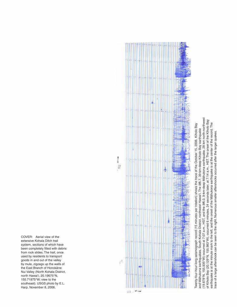
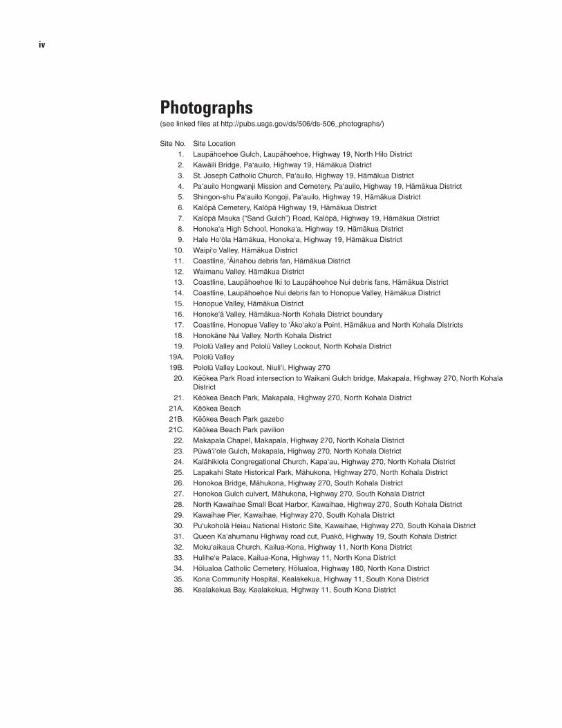
COVER: Aerial view of the extensive Kohala Ditch trail system, sections of which have been completely filled with debris from rock slides. The trail, once used by residents to transport goods in and out of the valley by mule, zigzags up the walls of the East Branch of Honokäne Nui Valley (North Kohala District, north Hawai‘i, 20.19675°N, 155.71975°W; view to the southeast). USGS photo by E.L. Harp, November 8, 2006. Twen
ty-f
our-
hour
-long
sei
smog
raph
rec
ord
(15
min
utes
per
rot
atio
n) s
how
s th
e tr
ace
of th
e O
ctob
er 1
5, 2
006,
Kïh
olo
Bay
an
d M
ähuk
ona
eart
hqua
kes,
Sou
th K
ohal
a D
istr
ict,
nort
hwes
t Haw
ai‘i.
The
M 6
.7, 3
9-km
-dee
p K
ïhol
o B
ay e
arth
quak
e (1
9.87
8°N
, 155
.935
°W)
occu
rred
at 7
:07
a.m
., H
ST,
and
the
M 6
.0, 9
-km
-dee
p M
ähuk
ona
eart
hqua
ke, 2
8 km
nor
th-n
orth
wes
t of
Kïh
olo
Bay
(20
.129
°N, 1
55.9
83°W
), o
ccur
red
6 m
inut
es, 2
4 se
cond
s la
ter,
at 7
:14
a.m
., H
ST.
The
ons
et o
f the
Kïh
olo
Bay
ea
rthq
uake
is a
t the
min
ute
mar
k to
the
left,
and
the
onse
t of t
he M
ähuk
ona
eart
hqua
ke is
at t
he c
ente
r of
the
reco
rd. T
he
trac
e of
a la
rge
afte
rsho
ck c
an b
e se
en to
the
right
. Num
erou
s sm
alle
r af
ters
hock
s oc
curr
ed a
fter
the
larg
er q
uake
s.

Selected Images of the Effects of the October 15, 2006, Kıïholo Bay-Mähukona, Hawai‘i, Earthquakes and Recovery Efforts
By Taeko Jane Takahashi, Nancy A. Ikeda, Paul G. Okubo, Maurice K. Sako, David C. Dow, Anna M. Priester, and Nolan A. Steiner
Data Series 506
U.S. Department of the InteriorU.S. Geological Survey

U.S. Department of the InteriorKEN SALAZAR, Secretary
U.S. Geological SurveyMarcia K. McNutt, Director
U.S. Geological Survey, Reston, Virginia: 2011
This report and any updates to it are available online at:
http://pubs.usgs.gov/ds/506/
For product and ordering information:
World Wide Web: http//www.usgs.gov/pubprod
Telephone: 1-888-ASK-USGS (1-888-275-8747)
Any use of trade, product, or firm names is for descriptive purposes only and does not imply endorsement by the U.S. Government.
For more information on the USGS—the Federal source for science about the Earth, its natural and living resources, natural hazards, and the environment: World Wide Web: http://www.usgs.gov Telephone: 1-888-ASK-USGS
Although this report is in the public domain, permission must be secured from the individual copyright owners to reproduce any copyrighted material contained within this report.
Suggested citation:Takahashi, T.J., Ikeda, N.A., Okubo, P.G., Sako, M.K., Dow, D.C., Priester, A.M., and Steiner, N.A., 2011. Selected images of the effects of the October 15, 2006, Kïholo Bay-Mähukona, Hawai‘i, earthquakes and recovery efforts: U.S. Geological Survey Data Series 506.

iii
Contents
Seismic Overview of the Earthquakes—by P.G. Okubo.................................................................................... 1
Overview of Selected Sites—by T.J. Takahashi ................................................................................................ 7
Acknowledgments .......................................................................................................................................... 11
References ..................................................................................................................................................... 11
Glossary of Hawaiian Words .......................................................................................................................... 15
Appendix Earthquake reports received via the USGS Community Internet Intensity Map (see linked file http://pubs.usgs.gov/ds/506/ds506_appendix_a.txt)
Figures 1. Recent earthquakes in Hawai‘i ......................................................................................................... 2
2. Peak horizontal ground accelerations .............................................................................................. 3
3 Frequency of magnitude 6.0 earthquakes ........................................................................................ 3
4. USGS Community Internet Intensity Map ........................................................................................ 4
5. Community decimal intensity (CDI) by location ................................................................................ 5
6. October 15, 2006, earthquake damage assessment ....................................................................... 6
7. Google Earth map of selected sites, Island of Hawai‘i ..................................................................... 7
8. Overview map of selected sites, Island of Hawai‘i ............................................................................ 8
Table 1. Site locations, with coordinates and distances from the Kïholo Bay epicenter, Island of Hawai‘i ... 10
iv
Photographs(see linked files at http://pubs.usgs.gov/ds/506/ds-506_photographs/)
Site No. Site Location
1. Laupähoehoe Gulch, Laupähoehoe, Highway 19, North Hilo District
2. Kawäili Bridge, Pa‘auilo, Highway 19, Hämäkua District
3. St. Joseph Catholic Church, Pa‘auilo, Highway 19, Hämäkua District
4. Pa‘auilo Hongwanji Mission and Cemetery, Pa‘auilo, Highway 19, Hämäkua District
5. Shingon-shu Pa‘auilo Kongoji, Pa‘auilo, Highway 19, Hämäkua District
6. Kalöpä Cemetery, Kalöpä Highway 19, Hämäkua District
7. Kalöpä Mauka (“Sand Gulch”) Road, Kalöpä, Highway 19, Hämäkua District
8. Honoka‘a High School, Honoka‘a, Highway 19, Hämäkua District
9. Hale Ho‘öla Hämäkua, Honoka‘a, Highway 19, Hämäkua District
10. Waipi‘o Valley, Hämäkua District
11. Coastline, ‘Äinahou debris fan, Hämäkua District
12. Waimanu Valley, Hämäkua District
13. Coastline, Laupähoehoe Iki to Laupähoehoe Nui debris fans, Hämäkua District
14. Coastline, Laupähoehoe Nui debris fan to Honopue Valley, Hämäkua District
15. Honopue Valley, Hämäkua District
16. Honoke‘ä Valley, Hämäkua-North Kohala District boundary
17. Coastline, Honopue Valley to ‘Äko‘ako‘a Point, Hämäkua and North Kohala Districts
18. Honokäne Nui Valley, North Kohala District
19. Pololü Valley and Pololü Valley Lookout, North Kohala District
19A. Pololü Valley
19B. Pololü Valley Lookout, Niuli‘i, Highway 270
20. Këökea Park Road intersection to Waikani Gulch bridge, Makapala, Highway 270, North Kohala District
21. Këökea Beach Park, Makapala, Highway 270, North Kohala District
21A. Këökea Beach
21B. Këökea Beach Park gazebo
21C. Këökea Beach Park pavilion
22. Makapala Chapel, Makapala, Highway 270, North Kohala District
23. Püwä‘i‘ole Gulch, Makapala, Highway 270, North Kohala District
24. Kalähikiola Congregational Church, Kapa‘au, Highway 270, North Kohala District
25. Lapakahi State Historical Park, Mähukona, Highway 270, North Kohala District
26. Honokoa Bridge, Mähukona, Highway 270, South Kohala District
27. Honokoa Gulch culvert, Mähukona, Highway 270, South Kohala District
28. North Kawaihae Small Boat Harbor, Kawaihae, Highway 270, South Kohala District
29. Kawaihae Pier, Kawaihae, Highway 270, South Kohala District
30. Pu‘ukoholä Heiau National Historic Site, Kawaihae, Highway 270, South Kohala District
31. Queen Ka‘ahumanu Highway road cut, Puakö, Highway 19, South Kohala District
32. Moku‘aikaua Church, Kailua-Kona, Highway 11, North Kona District
33. Hulihe‘e Palace, Kailua-Kona, Highway 11, North Kona District
34. Hölualoa Catholic Cemetery, Hölualoa, Highway 180, North Kona District
35. Kona Community Hospital, Kealakekua, Highway 11, South Kona District
36. Kealakekua Bay, Kealakekua, Highway 11, South Kona District

Seismic Overview of the Earthquakes
By Paul G. Okubo
Early on the morning of October 15, 2006, two moder-ate earthquakes—the largest in decades—struck the Island of Hawai‘i. The first of these, which occurred at 7:07 a.m., HST (1707 UTC), was a magnitude (M)6.7 earthquake, centered beneath Kïholo Bay on the northwestern coast of the island (19.878°N, 155.935°W), at a depth of 39 km. The second earthquake, which struck 6 minutes, 24 seconds later, at 7:14 a.m., HST (1714 UTC), was located 28 km to the north-northwest of Kïholo Bay (20.129°N, 155.983°W), centered at a depth of 19 km. This M6.0 earthquake has since been referred to as the Mähukona earthquake. Losses from the combined effects of these earthquakes are estimated to be $200 million—the most costly events, by far, in Hawai‘i’s earthquake history.
Figure 1 shows the epicenters of these earthquakes and the first few days of aftershocks from October 2006, as posted on the U.S. Geological Survey (USGS), Hawaiian Volcano Observatory’s earthquakes page on the World Wide Web (http://tux.wr.usgs.gov). To date, the largest aftershock was a M5.0 earthquake that occurred on November 23, 2007. The aftershock sequence from the Kïholo Bay earthquake continued through 2008. Analysis of earthquake locations and source mechanisms suggests that the M6.7 Kïholo Bay mainshock ruptured a deep fault plane that extends west-northwest from the coastline beneath the bay and dips to the south (Yamada and others, 2008). Stress modeling of the response of a lithospheric plate due to volcanic loading shows the Kïholo Bay and Mähukona earthquakes to be con-sistent with downward flexing of a layered lithospheric plate (McGovern, 2007).
Since 1973, the USGS has operated accelerographs in Hawai‘i to record strong ground motions of potential engi-neering interest. Some of these instruments were upgraded in 1999 from their original photographic film-based recording systems, to telemeter digital strong-motion recordings. Fol-lowing the earthquakes, the upgraded stations automatically transmitted their recordings to the USGS National Strong Motion Data Center in Menlo Park, California, operated by the USGS National Strong Motion Project (NSMP). Records from instruments still using photographic film were retrieved by NSMP personnel in the weeks following the October earthquakes and subsequently were developed and digitized for data reduction and analysis. At the same time, some stations were upgraded with units capable of onsite digitiza-tion. Since the October 2006 earthquakes, all USGS NSMP
instruments in Hawai‘i have been upgraded with digital recorders and connected by using modems and telephone circuits to automatically transmit their records to the NSMP Data Center (E. Anjal, written commun., 2007).
The strongest ground accelerations from the October 15 earthquakes were recorded at stations on the northwestern part of the Island of Hawai‘i (fig. 2 and table 1). The distribution of peak ground accelerations, as presented in figure 2, reflects the effect of local site conditions at the recording-instrument locations and the amplitude of seismic waves at that distance from the hypocenter. In Hawai‘i, site amplifications of seismic ground motion have been closely linked to the presence of volcanic ash deposits (Munson and Thurber, 1997). Although not the closest station to the Kïholo Bay earthquake, the accel-erograph at the Waimea Fire Station, underlain by volcanic ash deposits, recorded the highest peak accelerations in the entire data set. The effects of site conditions are also seen at sites in Hilo, where data reflect relative amplification of recorded peak accelerations, depending upon whether the stations are located on volcanic ash or on hard rock.
Alhough infrequent, damage and other effects of moderate and larger earthquakes in Hawai‘i have been recorded for nearly 200 years. The effects of some 59 moderate and larger earth-quakes (magnitudes 6 and above) have been recorded since writ-ten accounts of earthquake damage were first kept in Hawai‘i in 1823 (Wyss and Koyanagi, 1992). The largest earthquake ever recorded in Hawai‘i occurred on April 2, 1868; its magnitude was estimated to be 7.9. The October 15, 2006, earthquake was the largest to occur in Hawai‘i in 23 years (fig. 3).
Using information submitted on the Internet by the general public, the USGS has developed a means of collecting and post-ing reports of earthquakes as USGS Community Internet Inten-sity Maps (CIIM) (Wald and others, 1999). If an earthquake is felt, individuals may file reports on the effects of the quake at http://earthquake.usgs.gov/eqcenter/dyfi. Contributors reply to a list of standard questions used to determine earthquake intensity. Reports are then compiled and presented in maps, according to postal zip code and Community Decimal Intensity (CDI) per zip code. The intensities displayed on the maps represent average Modified Mercalli Intensity (Wood and Neumann, 1931; Rich-ter, 1958) for these communities or zip codes (see appendix; see linked file http://pubs.usgs.gov/ds/506/ds506_appendix_a.txt)
Figure 4 shows the CIIM posted after the October 15, 2006, Kïholo Bay earthquake, which was felt across the entire State of Hawaii. The strongest individual earthquake effects

Selected Images of the Effects of the October 15, 2006, Kıïholo Bay-Mähukona, Hawai‘i, Earthquakes and Recovery Efforts 22 Seismic Overview of the Earthquakes Selected Images of the Effects of the October 15, 2006, Kıïholo Bay-Mähukona, Hawai‘i, Earthquakes and Recovery Efforts 3
Figure 1. U.S. Geological Survey, Hawaiian Volcano Observatory, October 27, 2006, Web page of recent earthquakes
showing the October 15, 2006, Kïholo Bay and Mähukona, Hawai‘i, earthquakes.

Selected Images of the Effects of the October 15, 2006, Kıïholo Bay-Mähukona, Hawai‘i, Earthquakes and Recovery Efforts 2Selected Images of the Effects of the October 15, 2006, Kıïholo Bay-Mähukona, Hawai‘i, Earthquakes and Recovery Efforts 3
were reported as CDI IX, from the Kohala, Hämäkua, and Kona Districts on the northern and western parts of the Island of Hawai‘i. The close timing and proximity of the Kïholo Bay mainshock and the subsequent Mähukona earthquake did not allow for a clear separation between reports of the effects of the two earthquakes, and a CIIM for the M6.0 Mähukona earthquake was not produced.
In the earthquakes’ aftermaths, the County of Hawaii received many requests from homeowners for assessments of earthquake-generated building damage. In response to these requests, the Hawaii County Department of Public Works adopted the ATC-20 rapid evaluation procedure (Applied Technology Council, 2005). Nearly 2,000 homes were dam-aged, and 10 destroyed, by the effects of the earthquakes. Inspectors and engineers from the Hawaii County Department of Public Works coordinated and directed teams of engineers comprised of volunteer engineers (many flown in from other Hawaiian islands) to conduct the ATC-20 evaluations in a timely manner.
Figure 5 is the deaggregated CIIM, which shows the variability of reported earthquake effects across the county.
156°15' 156°00' 155°15' 155°30' 155°15' 155°00' 154°45'
18°45' 18°45'
19°00' 19°00'
19°15' 19°15'
19°30' 19°30'
19°45' 19°45'
20°00' 20°00'
20°15' 20°15'
20°30' 20°30'
25 km
156°15' 156°00' 155°15' 155°30' 155°15' 155°00' 154°45'
184
268
1030
508
197
312
229
640
253
350
5876
232
176
58
64
123
83
http://nsmp.wr.usgs.gov/data_sets/20061015_1707.html
M6.0
M6.7
Peak horizontal ground accelerations recorded from 15-OCT-2006 M6.7 Kïholo Bay earthquake
accelerations shown in units of cm/s/s
Figure 2. Map showing peak horizontal accelerations recorded
during the October 15, 2006, M 6.7 Kïholo Bay, Hawai‘i, earthquake.
Data are from the U.S. Geological Survey National Strong Motion
Project (http://nsmp.wr.usgs.gov/data_sets/20061015_1707.html).
Figure 3. Earthquakes in Hawai‘i of magnitude 6 or greater,
1823–present, adapted from figure 51 of Wyss and Koyanagi, 1992,
Isoseismal maps, macroseismic epicenters, and estimated magnitudes
of historic earthquakes in the Hawaiian Islands, U.S. Geological Survey
Bulletin 2006.
The pattern of individual earthquake reports is somewhat reflective of the home damage assessments resulting from the ATC-20 inspections.
Of the nearly 1,700 homes inspected, approximately 1,000 were evaluated during the first week after the main-shock. Sixty-seven of the 1,000 homes were determined to be unsafe to enter or occupy and received the ATC-20 red-tag designation. Another 227 homes received the ATC-20 yellow-tag designation allowing restricted entry, occupancy, and law-ful use. The remaining homes were considered safe to occupy. The ATC-20 evaluations clearly reflected particular vulnerabil-ity of wooden homes with single-wall construction to strong shaking as a result of earthquakes. Figure 6 is a map, provided by the County of Hawaii, showing locations of the red- and yellow-tagged homes.
Following the 2006 earthquakes, the Department of Homeland Security’s Federal Emergency Management Agency (FEMA) responded quickly and dispatched teams to the affected areas. In addition to disaster relief and recovery, FEMA enabled detailed voluntary inspections and assessments of residential damage and, subsequently, prescribed retrofits

Selected Images of the Effects of the October 15, 2006, Kıïholo Bay-Mähukona, Hawai‘i, Earthquakes and Recovery Efforts 44 Seismic Overview of the Earthquakes Selected Images of the Effects of the October 15, 2006, Kıïholo Bay-Mähukona, Hawai‘i, Earthquakes and Recovery Efforts 5
Figure 4. U.S. Geological Survey Community Internet Intensity Map for the October 15, 2006, M 6.7 Kïholo Bay,
Hawai‘i earthquake.
to harden structures against the impact of earthquakes. The agency has supported technical efforts to better understand observed earthquake effects and to promote mitigation against future damaging earthquakes in the State of Hawaii.
A geotechnical project was initiated on the Island of Hawai‘i to help interpret the patterns of strong ground shaking and ground failure following the earthquakes. Using a truck-based controlled seismic source, surveys of seismic wave speeds were done at locations of NSMP strong-motion recorders and the State of Hawaii’s Kawaihae Harbor port facility. In addi-tion to the basic geotechnical data, the results of these surveys will be incorporated into updated calculations of probabilistic seismic hazards in Hawai‘i.
Although the vast majority of earthquakes in the State of Hawaii are closely related to the active volcanism associated with the southeastern part of the Island of Hawai‘i, the October 2006 Kïholo Bay and Mähukona earthquakes clearly suggest the devastating potential of deeper lithospheric earthquakes. Large earthquakes thought to be nearly M 7 have struck near the islands of Läna‘i (1871) and Maui (1938). It is thought that these, like the 2006 earthquakes, were deep lithospheric flexure earthquakes (Wyss and Koyanagi, 1992; Klein and others, 2001). Thus, it is important to recognize the potential seismic hazard posed by such earthquakes beneath the older Hawaiian Islands. The data and observations afforded by the 2006 earthquakes promise to improve probabilistic seismic hazards modeling in Hawai‘i.

Selected Images of the Effects of the October 15, 2006, Kıïholo Bay-Mähukona, Hawai‘i, Earthquakes and Recovery Efforts 4Selected Images of the Effects of the October 15, 2006, Kıïholo Bay-Mähukona, Hawai‘i, Earthquakes and Recovery Efforts 5
Figure 5. Individually computed Community Decimal Intensities, CDI, compiled from reports posted to the U.S. Geological Survey’s Community
Internet Intensity Maps Web site after the M 6.7 Kïholo Bay and M 6.0 Mähukona earthquakes of October 15, 2006. No attempts were made to
discriminate between reports from one or the other earthquake because the events occurred within minutes of each other.
M6.0
M6.7
Community Decimal Intensity (CDI) by LocationOctober 15, 2006, M6.7 Kiholo Bay and M6.0 Mahukona Earthquakes
CDI
0 - 1
1 - 2
2 - 3
3 - 4
4 - 5
5 - 6
6 - 7
7 - 8
8 - 9
9 - 10
N
0 105 20 Kilometers
0 5 10 20 Miles

Selected Images of the Effects of the October 15, 2006, Kıïholo Bay-Mähukona, Hawai‘i, Earthquakes and Recovery Efforts 66 Seismic Overview of the Earthquakes
Figure 6. Map showing locations of homes in Hawaii County assigned red and yellow tags following ATC-20 post-earthquake assessments.
M6
M6.7
0 105 20 Kilometers
0 5 10 20 Miles
N
Overview of Selected Sites
By Taeko Jane Takahashi
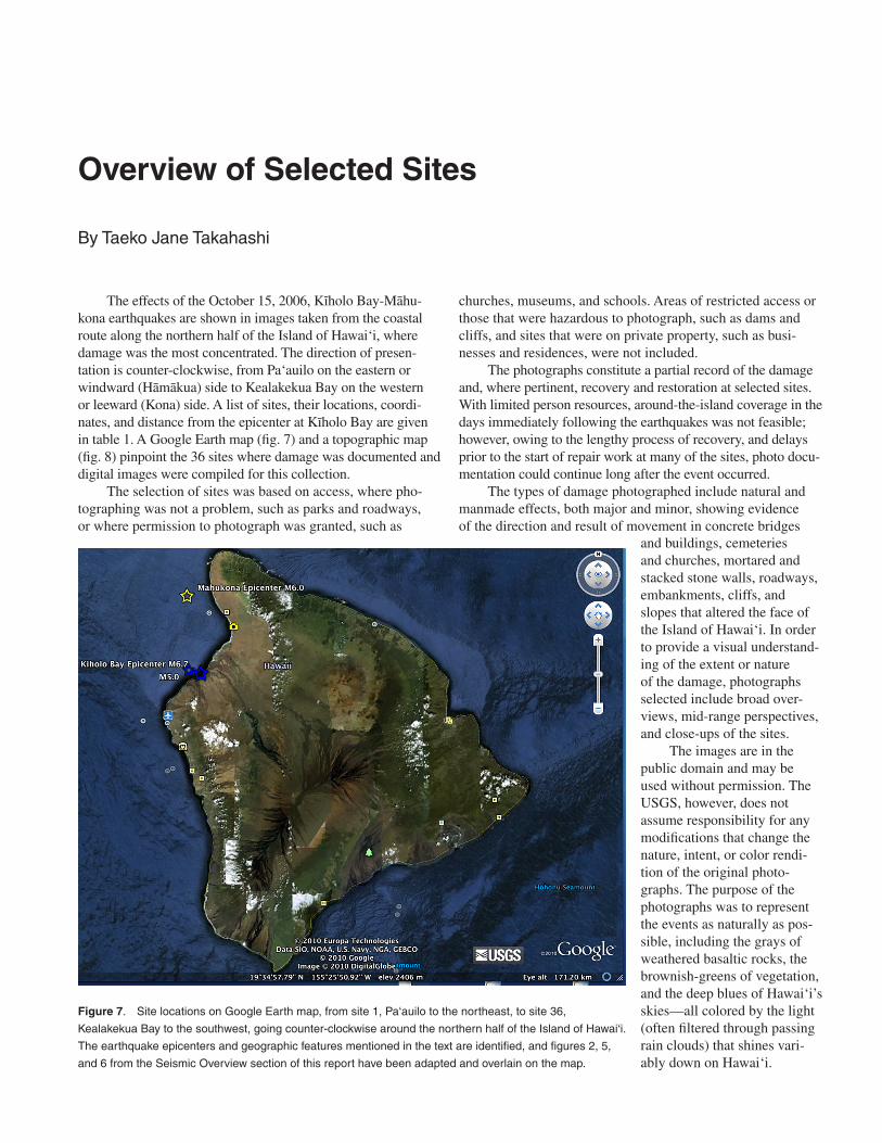
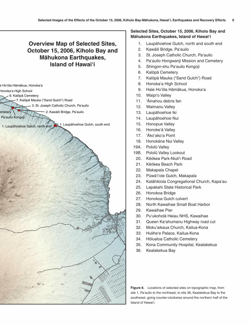
The effects of the October 15, 2006, Kïholo Bay-Mähu-kona earthquakes are shown in images taken from the coastal route along the northern half of the Island of Hawai‘i, where damage was the most concentrated. The direction of presen-tation is counter-clockwise, from Pa‘auilo on the eastern or windward (Hämäkua) side to Kealakekua Bay on the western or leeward (Kona) side. A list of sites, their locations, coordi-nates, and distance from the epicenter at Kïholo Bay are given in table 1. A Google Earth map (fig. 7) and a topographic map (fig. 8) pinpoint the 36 sites where damage was documented and digital images were compiled for this collection.
The selection of sites was based on access, where pho-tographing was not a problem, such as parks and roadways, or where permission to photograph was granted, such as
churches, museums, and schools. Areas of restricted access or those that were hazardous to photograph, such as dams and cliffs, and sites that were on private property, such as busi-nesses and residences, were not included.
The photographs constitute a partial record of the damage and, where pertinent, recovery and restoration at selected sites. With limited person resources, around-the-island coverage in the days immediately following the earthquakes was not feasible; however, owing to the lengthy process of recovery, and delays prior to the start of repair work at many of the sites, photo docu-mentation could continue long after the event occurred.
The types of damage photographed include natural and manmade effects, both major and minor, showing evidence of the direction and result of movement in concrete bridges
Figure 7. Site locations on Google Earth map, from site 1, Pa‘auilo to the northeast, to site 36,
Kealakekua Bay to the southwest, going counter-clockwise around the northern half of the Island of Hawai‘i.
The earthquake epicenters and geographic features mentioned in the text are identified, and figures 2, 5,
and 6 from the Seismic Overview section of this report have been adapted and overlain on the map.
and buildings, cemeteries and churches, mortared and stacked stone walls, roadways, embankments, cliffs, and slopes that altered the face of the Island of Hawai‘i. In order to provide a visual understand-ing of the extent or nature of the damage, photographs selected include broad over-views, mid-range perspectives, and close-ups of the sites.
The images are in the public domain and may be used without permission. The USGS, however, does not assume responsibility for any modifications that change the nature, intent, or color rendi-tion of the original photo-graphs. The purpose of the photographs was to represent the events as naturally as pos-sible, including the grays of weathered basaltic rocks, the brownish-greens of vegetation, and the deep blues of Hawai‘i’s skies—all colored by the light (often filtered through passing rain clouds) that shines vari-ably down on Hawai‘i.

Selected Images of the Effects of the October 15, 2006, Kıïholo Bay-Mähukona, Hawai‘i, Earthquakes and Recovery Efforts 88 Overview of Selected Sites Selected Images of the Effects of the October 15, 2006, Kıïholo Bay-Mähukona, Hawai‘i, Earthquakes and Recovery Efforts 9
29. Kawaihae Pier
21. Këökea Beach Park
26. Honokoa Bridge
19B. Pololü Valley
17. ‘Äko‘ako‘a Point
15. Honopue Valley
12. Waimanu Valley
10. Waipi‘o Valley
6. Kalöpä Cemetery
16. Honoke‘ä Valley
11. ‘Äinahou debris fan
18. Honokäne Nui Valley
8. Honoka‘a High School
27. Honokoa Gulch culvert
19A. Pololü Valley Lookout
2. Kawäili Bridge, Pa‘auilo4. Pa‘auilo Hongwanji Mission and Cemetary
36. Kealakekua Bay
7. Kalöpä Mauka (”Sand Gulch”) Road
1. Laupähoehoe Gulch, south end1. Laupähoehoe Gulch, north end
13. Laupähoehoe Iki debris fan14. Laupähoehoe Nui debris fan
33. Hulihe‘e Palace, Kailua-Kona
9. Hale Ho‘öla Hämäkua, Honoka‘a
32. Moku‘aikaua Church, Kailua-Kona
30. Pu‘ukoholä Heiau NHS, Kawaihae
25. Lapakahi State Historical Park
31. Queen Ka‘ahumanu Highway road cut
24. Kalähikiola Congregational Church, Kapa‘au
35. Kona Community Hospital, Kealakekua
34. Hölualoa Catholic Cemetery
M5.0
M6.0
M6.7
22. Makapala Chapel
20. Këökea-Niuli‘i Road23. Püwä‘i‘ole Gulch, Makapala
5. Shingon-shu Pa‘auilo Kongoji
28. North Kawaihae Small Boat Harbor3. St. Joseph Catholic Church, Pa‘auilo
Overview Map of Selected SitesOctober 15, 2006, Kïholo Bay and Mähukona Earthquakes,
Island of Hawai‘i
0 94.5 18 27 Kilometers
27 Miles1890 4.5
N
Selected Images of the Effects of the October 15, 2006, Kıïholo Bay-Mähukona, Hawai‘i, Earthquakes and Recovery Efforts 8Selected Images of the Effects of the October 15, 2006, Kıïholo Bay-Mähukona, Hawai‘i, Earthquakes and Recovery Efforts 9
29. Kawaihae Pier
21. Këökea Beach Park
26. Honokoa Bridge
19B. Pololü Valley
17. ‘Äko‘ako‘a Point
15. Honopue Valley
12. Waimanu Valley
10. Waipi‘o Valley
6. Kalöpä Cemetery
16. Honoke‘ä Valley
11. ‘Äinahou debris fan
18. Honokäne Nui Valley
8. Honoka‘a High School
27. Honokoa Gulch culvert
19A. Pololü Valley Lookout
2. Kawäili Bridge, Pa‘auilo4. Pa‘auilo Hongwanji Mission and Cemetary
36. Kealakekua Bay
7. Kalöpä Mauka (”Sand Gulch”) Road
1. Laupähoehoe Gulch, south end1. Laupähoehoe Gulch, north end
13. Laupähoehoe Iki debris fan14. Laupähoehoe Nui debris fan
33. Hulihe‘e Palace, Kailua-Kona
9. Hale Ho‘öla Hämäkua, Honoka‘a
32. Moku‘aikaua Church, Kailua-Kona
30. Pu‘ukoholä Heiau NHS, Kawaihae
25. Lapakahi State Historical Park
31. Queen Ka‘ahumanu Highway road cut
24. Kalähikiola Congregational Church, Kapa‘au
35. Kona Community Hospital, Kealakekua
34. Hölualoa Catholic Cemetery
M5.0
M6.0
M6.7
22. Makapala Chapel
20. Këökea-Niuli‘i Road23. Püwä‘i‘ole Gulch, Makapala
5. Shingon-shu Pa‘auilo Kongoji
28. North Kawaihae Small Boat Harbor3. St. Joseph Catholic Church, Pa‘auilo
Overview Map of Selected SitesOctober 15, 2006, Kïholo Bay and Mähukona Earthquakes,
Island of Hawai‘i
0 94.5 18 27 Kilometers
27 Miles1890 4.5
N
Figure 8. Locations of selected sites on topographic map, from
site 1, Pa‘auilo to the northeast, to site 36, Kealakekua Bay to the
southwest, going counter-clockwise around the northern half of the
Island of Hawai‘i.
Selected Sites, October 15, 2006, Kïholo Bay and Mähukona Earthquakes, Island of Hawai‘i
1. Laupähoehoe Gulch, north and south end 2. Kawäili Bridge, Pa‘auilo 3. St. Joseph Catholic Church, Pa‘auilo 4. Pa‘auilo Hongwanji Mission and Cemetery 5. Shingon-shu Pa‘auilo Kongoji 6. Kalöpä Cemetery 7. Kalöpä Mauka (“Sand Gulch”) Road 8. Honoka‘a High School 9. Hale Ho‘öla Hämäkua, Honoka‘a 10. Waipi‘o Valley 11. ‘Äinahou debris fan 12. Waimanu Valley 13. Laupähoehoe Iki 14. Laupähoehoe Nui 15. Honopue Valley 16. Honoke‘ä Valley 17. ‘Äko‘ako‘a Point 18. Honokäne Nui Valley 19A. Pololü Valley 19B. Pololü Valley Lookout 20. Këökea Park-Niuli‘i Road 21. Këökea Beach Park 22. Makapala Chapel 23. Püwä‘i‘ole Gulch, Makapala 24. Kalähikiola Congregational Church, Kapa‘au 25. Lapakahi State Historical Park 26. Honokoa Bridge 27. Honokoa Gulch culvert 28. North Kawaihae Small Boat Harbor 29. Kawaihae Pier 30. Pu‘ukoholä Heiau NHS, Kawaihae 31. Queen Ka‘ahumanu Highway road cut 32. Moku‘aikaua Church, Kailua-Kona 33. Hulihe‘e Palace, Kailua-Kona 34. Hölualoa Catholic Cemetery 35. Kona Community Hospital, Kealakekua 36. Kealakekua Bay
Overview Map of Selected Sites, October 15, 2006, Kïholo Bay and
Mähukona Earthquakes, Island of Hawai‘i

Selected Images of the Effects of the October 15, 2006, Kıïholo Bay-Mähukona, Hawai‘i, Earthquakes and Recovery Efforts 1010 Overview of Selected Sites Selected Images of the Effects of the October 15, 2006, Kıïholo Bay-Mähukona, Hawai‘i, Earthquakes and Recovery Efforts 11
Site Hwy Mile Actual Latitude LongitudeNo. Post Mileage (°N) (°W) (km) (mi)
1 Laupähoehoe Gulch, Laupähoehoe, North Hilo District Laupähoehoe Gulch, south end 19 26 26.3 19.98716 155.24615 73.0 45.4 Laupähoehoe Gulch, north end 19 26 26.6 19.98808 155.24930 72.7 45.2
2 Kawäili Bridge, Pa‘auilo, Hämäkua District 19 35 35.2 20.03334 155.35542 63.0 39.13 St. Joseph Catholic Church, Pa‘auilo, Hämäkua District 19 36 36.4 20.04143 155.37260 61.5 38.24 Pa‘auilo Hongwanji Mission and Cemetery, Pa‘auilo, Hämäkua District 19 36 36.4 20.04117 155.37417 61.4 38.15 Shingon-shu Pa‘auilo Kongoji, Pa‘auilo, Hämäkua District 19 36 36.4 20.04069 155.37344 61.4 38.26 Kalöpä Cemetery, Kalöpä, Hämäkua District 19 39 39.8 20.05916 155.41804 57.7 35.87 Kalöpä Mauka (“Sand Gulch”) Road, Kalöpä, Hämäkua District 19 39 39.8 20.05226 155.42113 57.1 35.58 Honoka‘a High School, Honoka‘a, Hämäkua District 19 43 43.0 20.07607 155.46380 53.9 33.59 Hale Ho‘öla Hämäkua, Honoka‘a, Hämäkua District 19 43 43.6 20.07651 155.47020 53.4 33.2
10 Waipi‘o Valley, Hämäkua District N/A 20.11922 155.59030 42.2 26.211 Coastline, ‘Äinahou debris fan, Hämäkua District N/A 20.13467 155.60764 44.5 27.712 Waimanu Valley, Hämäkua District N/A 20.14441 155.63672 43.0 26.713 Coastline, Laupähoehoe Iki to Lauphoehoe Nui debris fans, Hämäkua District N/A 20.16265 155.65286 43.2 26.9
Laupähoehoe Iki debris fan N/A 20.15363 155.64204 43.3 26.9Laupähoehoe Nui debris fan N/A 20.16265 155.65286 43.2 26.9
14 Coastline, Laupähoehoe Nui debris fan to Honopue Valley, Hämäkua District Laupähoehoe Nui debris fan N/A 20.16265 155.65286 43.2 26.9Honopue Valley N/A 20.17780 155.68818 42.1 26.2
15 Honopue Valley, Hämäkua District N/A 20.17780 155.68818 42.1 26.216 Honoke‘ä Valley, Hämäkua-North Kohala District boundary N/A 20.18563 155.69951 42.1 26.217 Coastline, Honopue Valley to ‘Äko‘ako‘a Point, Hämäkua and North Kohala Districts
Honopue Valley, Hämäkua District N/A 20.17780 155.68818 42.1 26.2‘Äko‘ako‘a Point, North Kohala District N/A 20.19234 155.71646 41.7 25.9
18 N/A 20.19675 155.71975 42.0 26.119 Pololü Valley and Pololü Valley Lookout, North Kohala District
19A Pololü Valley N/A 20.20370 155.73111 42.0 26.119B Pololü Valley Lookout, Niuli‘i–Häwï Road 270 29 29.0 20.20357 155.73375 41.9 26.0
20 Këökea Park Road intersection toWaikani Gulch bridge, Makapala, North Kohala District 270 27 27.2 20.22029 155.74826 42.8 26.6Këökeakea Park Road intersection 270 27 27.3 20.22064 155.74698 42.9 26.6Waikani Gulch one-lane bridge, Makapala 270 27 27.2 20.22029 155.74826 42.8 26.5
21 Këökea Beach Park, Makapala, North Kohala District21A Këökea Beach 270 27 27.3 20.22747 155.74579 43.6 27.121B Këökea Beach Park gazebo 270 27 27.3 20.22782 155.74540 43.6 27.121C Këökea Beach Park pavilion 270 27 27.3 20.22697 155.74559 43.6 27.1
22 Makapala Chapel, Makapala, North Kohala District 270 27 27.1 20.22133 155.74883 42.8 26.623 Püwä‘i‘ole Gulch, Makapala, North Kohala District 270 26 26.6 20.22104 155.75501 42.5 26.424 Kalähikiola Congregational Church, Kapa‘au, North Kohala District 270 23 23.9 20.22261 155.79454 41.0 25.525 Lapakahi State Historical Park, Mähukona, North Kohala District 270 13 13.9 20.17535 155.89753 33.3 20.726 Honokoa Bridge, Mähukona, South Kohala District 270 4 4.5 20.05158 155.83952 21.7 13.527 Honokoa Gulch culvert, Mähukona, South Kohala District 270 4 4.3 20.04896 155.83803 21.5 13.428 North Kawaihae Small Boat Harbor, Kawaihae, South Kohala District 270 3 3.4 20.03887 155.83148 20.9 13.029 Kawaihae Pier, Kawaihae, South Kohala District 270 3 3.4 20.03642 155.82916 20.8 12.930 Pu‘ukoholä Heiau National Historic Site, Kawaihae, South Kohala District 270 2 2.3 20.02761 155.82148 20.4 12.731 Queen Ka‘ahumanu Highway road cut, Puakö, South Kohala District 19 71 71.6 19.95728 155.82577 14.4 9.032 Moku‘aikaua Church, Kailua-Kona, North Kona District 11 119 119.6 19.63964 155.99389 27.2 16.933 Hulihe‘e Palace, Kailua-Kona, North Kona District 11 119 119.6 19.63929 155.99453 27.3 16.934 Hölualoa Catholic Cemetery, Hölualoa, North Kona District 180 5 5.0 19.63539 155.95062 27.0 16.835 Kona Community Hospital, Kealakekua, South Kona District 11 112 112.1 19.51957 155.91712 39.9 24.836 Kealakekua Bay, Kealakekua, South Kona District 11 105 105.8 19.47510 155.91961 44.8 27.9
Site Location Epicenter distance
Honokäne Nui Valley North Kohala District
Table 1. Site locations, with coordinates and distances from the Kïholo Bay epicenter, Island of Hawai‘i.

Selected Images of the Effects of the October 15, 2006, Kıïholo Bay-Mähukona, Hawai‘i, Earthquakes and Recovery Efforts 10Selected Images of the Effects of the October 15, 2006, Kıïholo Bay-Mähukona, Hawai‘i, Earthquakes and Recovery Efforts 11
Acknowledgments
The authors gratefully acknowledge Edwin L. Harp, USGS, Denver, and David C. Wilson and James P. Kauahikaua, USGS, Hawaiian Volcano Observatory, for their thoughtful reviews. In addition, we thank Ed and Jim for images of rock falls along the Hämäkua Coast and in North Kohala valleys, which contributed substantively to the scope of this project.
The persons whose names are listed below gave a tour of a damaged site, provided photographs, stories, and information, or helped with data-gathering and formatting. The authors are deeply grateful for their experience, expertise, and assistance, which enhanced the clarity and accuracy of this work.
Hawaii County Civil Defense Staff
Hawaii County Department of Public WorksMack S. Asato, Highways Division
Hawaii State Department of Land and Natural ResourcesSteven Bergfeld, Division of Forestry and WildlifeKevin L. Gooding, Commission on Water Resources Management
Hawaii State Department of TransportationElton Suganuma, Harbors Division, Kawaihae HarborMarissa Bondaug, Harbors Division, Kawaihae Harbor
Hulihe‘e Palace Museum Staff and Volunteers
Kalähikiola Congregational ChurchReverend George BaybrookBoyd and Rebecca Bond
Kona Community Hospital Staff
John P. (Jack) Lockwood
National Park ServiceAdam M. Johnson, Pu‘ukoholä Heiau National Historic SiteBobby Camara, Hawai‘i Volcanoes National ParkLaura Schuster, Hawai‘i Volcanoes National Park
Pa‘auilo Hongwanji MissionRowan Matsumoto
University of Hawai‘i at Hilo Center for the Study of Active Volcanoes
David (Dave) A. Whilldin
USGS, DenverEdwin L. HarpRandall W. Jibson
USGS, Hawaiian Volcano Observatory StaffLoren J. AntolikJames P. (Jim) Kauahikaua
USGS, Hawaiian Volcano Observatory Staff—contMichael P. (Mike) PolandFrank A. TrusdellDavid (Dave) C. Wilson
USGS, Hawaiian Volcano Observatory VolunteersLauren E. ColwellCynthia FrancosCharlie G. JonesJ. Katie MarksTorge S. Steensen
Other VolunteersLaura S. MizunoErnest C. PascuaLorraine Yadao
References20000-Names.com, 1999, Akoni: http://www.20000-names.
com/male_hawaiian_names.htm, last accessed 5/18/2010.
Applied Technology Council, 2005, Field manual—Postearthquake safety evaluation of buildings, no. ATC-20-1, 2nd ed.: Oakland, Calif., R.P. Gallagher Associates, Inc., 159 p.
Cabatu, Elena, 2006, East Hawaii medical facilities respond to Sunday morning earthquake: Hawaii Reporter, Oct. 16, http://www.hawaiireporter.com/story.aspx?c0b55e68-bc2e-4790-b8f6-d5a2b758314b, last accessed 2/23/2009.
Chock, Gary, ed., 2006, Compilation of observations of the October 15, 2006 Kiholo Bay (Mw6.7) and Mahukona (Mw6.0) earthquakes, Hawaiÿi: Honolulu, EERI/SEAOH/UH Report, 53 p. [Authors: Robertson, Ian, Nicholson, Peter, Brandes, Horst, Medley, Edward, Okubo, Paul, Hirshorn, Barry, Sumada, Jiro, Kindred, Troy, Iinuma, Gen, Lau, Ernest, Sarwar, Afaq, Dal Pino, John, Holmes, William, Structural Engineers Association of Hawaii, and Hawaii State Earthquake Advisory Committee].
Clark, J.R.K., 1985, Beaches of the Big Island: Honolulu, University of Hawaii Press, 171 p.
Department of Land and Natural Resources, [n.d.], Lapakahi State Historical Park brochure: Honolulu, Hawai‘i Department of Land and Natural Resources, Division of State Parks, 2 printed sides.
Desha, S.L. (translated by Frazier, F.N.), 2000, Kamehameha and his warrior Kekühaupi‘o: Honolulu, Kamehameha Schools Press, p. 309 [originally published in Ka Hoku o Hawaii (The Star of Hawai‘i) between Dec. 16, 1920, and Sept. 11, 1924].
Earthquake Engineering Research Institute, 2006, Preliminary observations on the Hawaiÿi earthquakes of October 15, 2006: EERI Special Report, Dec., 12 p.

Selected Images of the Effects of the October 15, 2006, Kıïholo Bay-Mähukona, Hawai‘i, Earthquakes and Recovery Efforts 1212 References Selected Images of the Effects of the October 15, 2006, Kıïholo Bay-Mähukona, Hawai‘i, Earthquakes and Recovery Efforts 13
Eaton, Kim, 2006, Kona Community Hospital should be fully operational by Friday: West Hawaii Today, Oct. 24, http://www.westhawaiitoday.com/articles/2006/10/24/local/local04, last accessed 3/1/2009.
Federal Emergency Management Agency (FEMA), 2006, FEMA situation report, FEMA-1664-DR-HI, DHS SITREP #1: Fort Shafter, Hawaii, unpaginated [9 p.].
FEMA Library, 2007, The case of Kona Community Hospital, Hawaii, in Design guide for improving hospital safety in earthquakes, floods, and high winds—Providing protection to people and buildings: http://www.fema.gov/library/viewRecord.do?id=2739, chap. 2.3.2.2, unpaginated [9 p.], last accessed 5/6/2010.
Hammond, E.V., 1919, The golden treasury of the Bible, new edition: New York, Edwin S. Gorham, p. 34.
Hawaii Herald, 1909, Part of Hamakua slides into the sea: Hawaii Herald, May 27, 1909 [reprinted from Kohala Midget, May 26, 1909].
HawaiiWeb.com, 2002, Lapakahi State Historical Park: http://www.hawaiiweb.com/hawaii/html/sites/lapakahi_state_historical_park.html, last accessed 5/6/2010.
HawaiiWeb.com, 2002, Mokuaikaua Church: http://www.hawaiiweb.com/hawaii/html/sites/mokuaikaua_church.html, last accessed 5/6/2010.
Hawaiirama, 2006, Waimanu Valley—Remote, rugged, magical: http://hawaiirama.com/2006/07/flickrsrchttphawaiiramacomwaim, last accessed 5/6/2010.
Huynh, Lisa, 2006, Landslide rips pali at Kealakekua Bay: West Hawaii Today, Oct. 16, http://www.westhawaiitoday.com/articles/2006/10/16/local/local03.txt, last accessed 5/6/2010.
Kamehameha Schools, 1994, The ahupua‘a; life in early Hawai‘i: Honolulu, Bernice Pauahi Bishop Estate, 59 p.
Klein, F.W., Frankel, A.D., Mueller, C.S., Wesson, R.L., and Okubo, P.G., 2001, Seismic hazard in Hawaii—High rate of large earthquakes and probabilistic ground-motion maps: Bulletin of the Seismological Society of America, v. 91, no. 3, p. 479–498.
Knudsen, Greg, 2006, School closures (earthquakes)—Tuesday, October 17, news release: State of Hawaii Department of Education, http://www.hcps.k12.hi.us/STATE/COMM/DOEPRESS.NSF/a1d7af052e94dd120a2561f7000a037c/c594226d1fbaa7770a257146006cbc86?OpenDocument, last accessed 5/6/2010.
Let’s Go Hawaii, 2008, Big Island earthquake 10/15/06: http://www.letsgo-hawaii.com/news/earthquake.html, last accessed 5/6/2010.
Lucas, Carolyn, 2006, Hawaii’s oldest church needs $500K in repairs: West Hawaii Today, Oct. 19, http://www.
westhawaiitoday.com/articles/2006/10/19/local/local06. http://www.westhawaiitoday.com/articles/2006/10/19/local/local06.txt, last accessed 5/6/2010.
Lucas, Carolyn, 2009, Church is reborn following quakes: Hawaii Tribune-Herald, Jan. 25, p. A1, A12.
MacGowan, D.B., 2009, Waipiÿo Valley, Hamakua Coast on the Big Island of Hawaii: http://www.spongefish.com/creations/9729-Waipi-o-Valley-Hamakua-Coast-on-the-Big-Island-of-Hawaii/steps/1, last accessed 3/1/2009.
Mason, Glenn, 2006, Hulihe‘e Palace—Assessment of earthquake damage: Honolulu, Mason Architects, Inc., Oct. 23, 7 p.
McClure, Bruce, 2007, Kalopa Sand Gulch Road re-opens: Hawaii County Department of Public Works, press release, Jan. 10, 1 p.
McGovern, P.J., 2007, Flexural stresses beneath Hawaii—Implications for the October 15, 2006, earthquakes and magma ascent: Geophysical Research Letters, v. 34, no. 23, L23305, 6 p.
Medley, E.W., 2006, Geological engineering reconnaissance of damage resulting from the October 15, 2006 earthquakes, Island of Hawaii, Hawaii, USA: Oakland, Calif., Geosyntec Consultants, 37 p.
Munson, C.G., and Thurber, C.H., 1997, Analysis of the attenuation of strong ground motion on the Island of Hawaii: Bulletin of the Seismological Society of America, v. 87, no. 4, p. 945–960.
National Park Service, [n.d.], Pu‘ukoholä Heiau: [s.l.], National Park Service brochure, 2 printed sides.
Neal, Marie, 1965, In gardens of Hawaii: Honolulu, Bernice P. Bishop Museum Special Publication 50, 924 p.
New Moon Foundation, 2006, Kalahikiola Church; history: http://www.newmoonfoundtion.org/facilities/history.html, last accessed 5/6/2010.
Okubo, A.T., 2006, Emergency structural assessment of earthquake damage to North Kawaihae Small Boat Harbor located at Kawaihae, Hawaii: Honolulu, Arnold T. Okubo & Associates, Inc., unpaginated [40 p.].
Pelletier, Mark and Sue, 1999, Hawaii highways road photos—Waipio Valley: http://www.hawaiihighways.com/photos-Waipio-Valley.htm, last accessed 5/6/2010.
Pratt, L.W., and Abbott, L.L., 1996, Vascular plants of Pu‘ukohola Heiau National Historic Site, Hawaiÿi Island: Honolulu, University of Hawaiÿi at Manoa, Cooperative National Park Resources Studies Unit, Technical Report 101, p. 23 [33 p].
Pukui, M.K., and Elbert, S.H., 2003, Hawaiian dictionary: Honolulu, University of Hawai‘i Press, http://www.wehewehe.org, last accessed 5/6/2010.

Selected Images of the Effects of the October 15, 2006, Kıïholo Bay-Mähukona, Hawai‘i, Earthquakes and Recovery Efforts 12Selected Images of the Effects of the October 15, 2006, Kıïholo Bay-Mähukona, Hawai‘i, Earthquakes and Recovery Efforts 13
Pukui, M.K., Elbert, S.H., and Mookini, E.T., 2003, Place names of Hawai‘i: Honolulu, University of Hawai‘i Press, http://www.wehewehe.org, last accessed 5/6/2010.
Richter, C.F., 1958, Elementary seismology: San Francisco, W.H. Freeman and Company, p. 135–149.
Risk Management Solutions, 2006, 2006 Kiholo Bay, Hawaii earthquake; RMS Event Report: [s.l.], Risk Management Solutions, Inc., unpaginated [16 p.].
Robertson, I.N., Nicholson, P.G., and Brandes, H.G., 2006, Reconnaissance following the October 15th, 2006, earthquakes on the Island of Hawaiÿi: Honolulu, University of Hawai‘i College of Engineering, Research Report UHM/CEE/06-07, 65 p.
Structural Engineers Association of Hawaii (SEA), 2007, ATC-20 Post-earthquake building safety evaluations performed after the October 15, 2006 Hawaiÿi earthquakes—Summary and recommendations for improvements (updated): Honolulu, Structural Engineers Association of Hawaii, 5 p.
Thompson, Rod, 2006, State opens Kohala trail refurbished after quakes: Star-Bulletin, v. 11, no. 325, Nov. 21, http://archives.starbulletin.com/2006/11/21/news/story08.html, last accessed 5/6/2010.
Thompson, Rod, 2007, Repairs end care home camp-out: Star-Bulletin, v. 12, no. 4, Jan. 4, http://archives.starbulletin.com/2007/01/04/news/story07.html, last accessed 5/18/2010.
Wald, D.J., Quitoriano, Vincent, Dengler, L.A., and Dewey, J.W., 1999, Utilization of the Internet for rapid community
intensity maps: Seismological Research Letters, v. 70, no. 6, p. 680–697.
Weaver, Anna, 2008, Quake-damaged Big Island mission church torn down: Hawaii Catholic Herald, Sept. 19, 2008, http://www.hawaiicatholicherald.com, last accessed 5/18/2010.
Weaver, Anna, 2008, Quake-damaged Big Island mission church torn down: Hawaii Catholic Herald, Sept. 19, 2008, http://www.hawaiicatholicherald.org/Home/tabid/256/newsid884/1728/Default.aspx, last accessed 5/18/2010.
Wehewehe.org, 2004, Na puke wehewehe ‘ölelo Hawai‘i [the books explaining Hawaiian words or language]; Hawaiian dictionaries: Ulukau, The Hawaiian Electronic Library, http://www.wehewehe.org, last accessed 5/6/2010.
Wikipedia, the Free Encyclopedia, 2011, ‘Akoni Pule: http://en.wikipedia.org/wiki/Akoni_Pule_Highway, last accessed 5/01/2011.
Wood, H.O., and Neumann, Frank, 1931, Modified Mercalli intensity scale of 1931: Bulletin of the Seismological Society of America, v. 21, no. 4, p. 277–283.
Wyss, Max, and Koyanagi, R.Y., 1992, Isoseismal maps, macroseismic epicenters and estimated magnitudes of historic earthquakes in the Hawaiian Islands: U.S. Geological Survey Bulletin 2006, 93 p.
Yamada, Takuji, Okubo, P.G., and Wolfe, C.J., 2008, Hypocenter relocation and source parameters of the 2006 Kiholo Bay, Hawaii earthquake sequence [abs.]: Eos (American Geophysical Union Transactions), v. 89, no. 53, abstract no. S23B–1899.

Selected Images of the Effects of the October 15, 2006, Kıïholo Bay-Mähukona, Hawai‘i, Earthquakes and Recovery Efforts 14
This page intentionally left blank.

Glossary of Hawaiian Words and Place Names
Äpau All, entirely. Debris fan north of Laupähoehoe Nui and south of Honopue Valley, Hämäkua District, northeast Hawai‘i.
‘Äwini Sharp, bold, forward. Ahupua‘a, gulch, and trail (extending from the northern mouth of Pololü Valley and end-ing at the Kohala Ditch Trail northwest of Honoke‘ä Valley), North Kohala District, northeast Hawai‘i.
hale House, building, hall.
Hämäkua Long corner. Forest reserve, ditch, ditch trail, district of central and northeast Hawai‘i.
Häpuna Spring. Beach, State Recreation Area, bay, and ahupua‘a, South Kohala District, northwest Hawai‘i.
haukapila Hospital.
Hauola Dew of life. Road in Pa‘auilo, Hämäkua District, northeast Hawai‘i.
Häwï Meaning unknown. Literally, hä, to breathe, four, fourth note in the musical scale; wï, the sound of wind, of gnashing teeth, a high, shrill sound. Village and land section, north Kohala District, north Hawai‘i. (Situated at the northern-most tip of the island, Häwï is known for the high winds that blow through the region and bend its trees.)
heiau Hawaiian place of worship, from earth terraces to stone platforms and enclosures. Different types of heiau: heiau ho‘öla heiau for treating the sick. heiau ho‘oulu ‘ai heiau for offering first fruit to insure
a bountiful harvest. heiau ho‘oulu i‘a heiau for offering fish to insure good
fishing. heiau ho‘oulu ua heiau for offerings to ensure rain. heiau ma‘o small, temporary heiau covered with tapa
dyed green (ma‘o) for the ho‘oulu ‘ai ceremony. heiau po‘o kanaka heiau for offering human sacrifices. heiau waikaua heiau for offerings to insure success in
war.Hi‘ilawe Lift and carry. The highest unterraced waterfall in Hawai‘i and one of the highest in the world, with a total height of about 442 m (~1,450 ft), in Waipi‘o Valley, Hämäkua Dis-trict, northeast Hawai‘i (Hi‘ilawe Falls data from USGS topo sheet, Kukuihaele quad, Island of Hawaii).
Hikiau A luakini (a heiau where human sacrifices were made) of Kamehameha I at Kealakekua Bay, South Kona Dis-trict, southwest Hawai‘i.
Hölualoa Long sled course. Village, bay, and land section, North Kona District, northwest Hawai‘i.
Honoka‘a Cavern, sea cave. Bay, town, landing, ahupua‘a, Hämäkua District, northeast Hawai‘i.
Definitions of words in this section have been taken primarily from http://www.wehewehe.org, the online Hawaiian dictionaries. Where place names were not listed in the diction-aries, literal meanings of the words that make up the names are given to shed light on their etymology. Words defined are listed alphabetically in bold type and their definitions given in italics. For place names, features that are important in this work (that is, bay, gulch, point, stream, valley, town) and their general compass direction are included. More specific loca-tions are provided in the captions.
As in all languages, Hawaiian words have many conno-tative meanings that enhance their literal definitions. Delving into the connotations of place names is invaluable in under-standing the nature of place in Hawaiian geology, history, and culture.
Words in the Hawaiian language (‘ölelo Hawai‘i) are pro-nounced, for the most part, as in pronouncing Spanish, Italian, or Japanese. The glottal stop, or ‘okina (‘), between vowels or at the beginning of a word indicates that the glottis is closed when pronouncing the word, as in “accord” for ‘a, “echo” for ‘e, “if” for ‘i, “oh-oh” for ‘o, and “ooze” for ‘u. The macron, or kahakö, over a vowel, indicates that the sound is extended, as in “ahhh” for ä, “ehhh” for ë, “eee” (as in Lee) for ï, “o” (as in singing “O holy night”) for ö, and “uuu” (as in Lou) for ü.
List of words used:
‘a‘ä Lava with a clinkery, spinose, jagged surface.
ahupua‘a Land division, usually extending from the uplands to the sea, marked, in ancient times, by a heap (ahu) of stones upon which an image of a pig (pua‘a) was lain as a marker of a tax payment to the chief.
‘Äinahou New land. Large debris fan north of Waipi‘o Val-ley and south of Waimanu Valley, Hämäkua District, northeast Hawai‘i.
‘Äko‘ako‘a Coral, coral head. Point in Niuli‘i, north of Pololü Valley, North Kohala District, northeast Hawai‘i.
‘Akoni Pule Highway 270, dedicated in July 1973, named after the Hawai‘i State legislator who helped obtain Fed-eral and State funds to construct a safer access to Häwï and Kapa‘au (towns in the North Kohala District) than through the narrow, winding, Kohala Mountain Road [Wikipedia, 2011].
Alakahi One-way. Stream and waterfall in the right branch of upper Waipi‘o Valley, Hämäkua District, northeast Hawai‘i.
Ali‘i Chief, royal. Coastal street from Keauhou Bay to Kai-lua Bay in Kailua-Kona, North Kona District, west Hawai‘i.
Selected Images of the Effects of the October 15, 2006, Kıïholo Bay-Mähukona, Hawai‘i, Earthquakes and Recovery Efforts 1616 Glossary Selected Images of the Effects of the October 15, 2006, Kıïholo Bay-Mähukona, Hawai‘i, Earthquakes and Recovery Efforts 17
Honokäne Iki Meaning unknown. Literally, hono, valley; kane, male, or (capitalized) name of Hawaiian god; iki, little. Valley, stream, and ahupua‘a, North Kohala District, northeast Hawai‘i.
Honokäne Nui Meaning unknown. Literally, hono, valley; kane, male, or (capitalized) name of Hawaiian god; nui, big. Valley and stream, Kohala Mountains, North Kohala District, northeast Hawai‘i.
Honoke‘ä Volcanic rock place. Valley and stream, North Kohala District, northeast Hawai‘i.
Honokoa Bay of brave warriors. Derived from hono, bay, gulch; koa, fearless, martial. Gulch and bridge, South Kohala District, northwest Hawai‘i.
Honopue Meaning unknown. Literally, hono, the brow of a cliff, a joining, as of mountains; pue, huddled, crouched. Valley, stream, and land section, Hämäkua District, northeast Hawai‘i.
ho‘öla Life. Hale Ho‘öla, house of life, name of hospital in Honoka‘a, Hämäkua District, northeast Hawai‘i.
Hulihe‘e Turn [and] flee. Palace at Kailua-Kona, built in 1838 by Governor Kuakini, restored by the Daughters of Hawai‘i in 1927 as a museum of Hawaiian artifacts, North Kona District, northwest Hawai‘i.
iki Small, little.
‘ilima Sida (especially Sida fallax), a shrub of the mallow family, indigenous to drier regions of the tropical Pacific, bear-ing yellow, orange, or dull-red paper-thin flowers, often strung into leis (it takes about 500 blossoms to make a lei).
‘Iole Name of a legendary rat. Mountain, stream, and ahupua‘a, Kohala Mountains; name of road leading to Kalähikiola Congregational Church in Kapa‘au, North Kohala District, northeast Hawai‘i.
Ka‘ahumanu Bird (feather) cloak. Queen, name of Kame-hameha I’s favorite wife; Highway 19, coastal highway of South Kohala and North Kona Districts, northwest Hawai‘i.
Ka‘awaloa The distant kava (referring to runners, who went to Puna or Waipi‘o to get kava for chiefs). Site of the monument to Captain Cook at Kealakekua Bay, South Kona District, southwest Hawai‘i.
Ka‘äpahu The truncation. Literally, ka, to strike; ‘äpahu, to cut squarely off, a piece cut off at right angles. Road in Kalöpä, also known as Sand Gulch Road, Hämäkua District, northeast Hawai‘i.
Kalähikiola The sun, bringing life; the day, bringing salvation. Congregational church, mountain, and ahupua‘a in Kapa‘au, North Kohala District, north Hawai‘i.
Kaläkaua King David Kaläkaua, who reigned from 1836 to 1891, often referred to as the “Merrie Monarch” for his love of learning and culture. He is author of The Legends and Myths of Hawai‘i.
Kälani‘ai Meaning unknown. Literally, kälani, gallon; ‘ai, food. Road in Kalöpä, Hämäkua District, northeast Hawai‘i.
Kalöpä The tenant farmer. Town, gulch, State Recreation Area, land section, Hämäkua District, northeast Hawai‘i.
Kamehameha The lonely one. Kamehameha I, the first king of Hawai‘i, credited with unifying the islands.
käne Male, man, husband; when capitalized, name of one of the four primary Hawaiian gods.
Kapa‘au The elevated portion of a heiau. Land section, town east of Häwï, North Kohala District, north-northeast Hawai‘i.
Kawaihae The water of wrath (of people who fought for water from a pool in this arid region). Land section, bay, road, town, Hämäkua District, northwest Hawai‘i.
Kawäili Meaning unknown. Bridge in Pa‘auilo, Hämäkua District, northeast Hawai‘i.
Kealakekua The pathway of the gods, who took a short-cut by sliding down the cliff, thereby leaving an imprint. Bay (where Captain Cook was killed), trail, village, marine pre-serve, State Historical and Underwater Parks, and land section, southwest Hawai‘i.
Ke‘ei Meaning unknown. Lagoon, village, coastal area adja-cent to, and south of, Kealakekua Bay, South Kona District, southwest Hawai‘i.
Këökea The sound of white [water]. Beach park and bay, North Kohala District, northeast Hawai‘i.
koa Acacia koa, a large endemic tree of the legume family with a smooth, gray bark and gnarly branches, bearing clusters of small white flowers that adorn the canopy, and bipinnate leaflets that mature into leathery, crescent-shaped leaves. Its wood was prized earlier in the making of canoes, paddles, surfboards, and calabashes, and is now used in making fur-niture, ‘ukuleles (a small stringed instrument shaped like a guitar), bowls, and cooking implements and cutting boards.
Kohala Cherished land. District famous for the äpa‘apa‘a (name given to a strong Kohala wind), forest reserve, ditch, trail, mountains, north Hawai‘i.
Kona Leeward. Leeward district of Hawai‘i; northwest and southwest Hawai‘i.
Kuakini Innumerable. Highway, Kailua-Kona, Hawai‘i, named after John Adams Kuakini, a governor of the island (1820–1844) and acting governor of O‘ahu (1831–1834), who was in charge of building Hulihe‘e Palace in 1838 and Moku‘aikaua Church in 1823 and rebuilding it in 1836.
Kükai‘au Current appearing. Village, gulch, and land sec-tion south of Pa‘auilo, Hämäkua District, northeast Hawai‘i.
Küka‘ilimoku Name of war god.
kukui Aleurites moluccana, the candlenut tree, a member of the spurge family, the kernels of whose oily nuts were used as lights in ancient times and used today to make ‘inamona, a relish. The polished and drilled nuts are also strung into leis, as are its flowers and silvery leaves. The soft wood was used

Selected Images of the Effects of the October 15, 2006, Kıïholo Bay-Mähukona, Hawai‘i, Earthquakes and Recovery Efforts 16Selected Images of the Effects of the October 15, 2006, Kıïholo Bay-Mähukona, Hawai‘i, Earthquakes and Recovery Efforts 17
in canoe-making, its nut coats and roots to make black dye, and gum from its bark for painting tapa cloth. An important resource for the Hawaiian people, kukui has a broad distribu-tion throughout Hawai‘i. From the air, it can be distinguished from other large forest trees in the valleys of northeast Hawai‘i by its silvery sage-green canopy.
länai Porch, veranda, shed of a house.
Lapakahi Single ridge. Restored Hawaiian coastal village site, State Historical Park, ahupua‘a, North Kohala District, northwest Hawai‘i.
lau hala Leaf of the pandanus (screw pine family), native to Hawaii and other Pacific islands, Australia, and southern Asia. Leaves from the many varieties of this tree were used in ancient times for sails, thatching, and garments. Lau (leaf) hala (pandanus) continues to be an important source of mate-rial for weaving floor coverings and place mats, baskets, hats, fans, and ornaments. The fruit of the hala is still used today as brushes for dying fabric and in lei-making.
Laupähoehoe Smooth lava flat. Land sections, stream, point, village, beach park, ancient surfing area, North Hilo District, northeast Hawai‘i.
Laupähoehoe Iki Little, smooth lava flat. Debris fan, now heavily vegetated, at the base of the sea cliffs adjacent to, and north of, Waimanu Valley, Hämäkua District, northeast Hawai‘i.
Laupähoehoe Nui Large, smooth lava flat. Larger of the two debris fans (the other being Laupähoehoe Iki), now heav-ily vegetated, at the base of the sea cliffs adjacent to, and north of, Laupähoehoe Iki, Hämäkua District, northeast Hawai‘i.
lehua See ‘öhi‘a lehua.
lei Garland, wreath, necklace of flowers leaves, shells, feathers, seeds, beads, paper, or candy, given as an expression of affection, celebration, or respect.
lele Sacrificial altar or stand at a heiau.
lo‘i Irrigated terrace, especially for taro, but also for rice.
lua Hole, pit, crater; toilet.
Mähukona Leeward steam. Beach park, harbor, village, North Kohala District, northwest Hawai‘i.
Mailekini Many maile vines (Alyxia olivaeformis; endemic twining shrub with shiny, fragrant leaves used in leis). Ancient heiau at Pu‘ukoholä National Historical Site, south of Kawai-hae, South Kohala District, northwest Hawai‘i.
Makapala Sore beginning to heal. Village and land section, North Kohala District, north-northeast Hawai‘i.
Mämalahoa Paddle fragments (after Kamehameha was struck on the head while his foot was caught in a crevice; probably named after the law of the splintered paddle, which guaranteed safety on the highway to all). Belt road, Island of Hawai‘i.
makai Ocean; towards the ocean.
mämane Sophora chrysophylla, a high-altitude endemic tree of the legume family, bearing bright yellow flowers and
winged seed pods (flowers and seeds were food for native birds), whose hard wood was prized for digging sticks, house and fence posts and beams, and papa hölua (sled) runners; also the name of the endemic bird that feeds on the nectar and seeds of the tree. Main street through Honoka‘a town, off Mämalahoa Highway, Hämäkua District, northeast Hawai‘i.
mauka Inland.
Moku‘aikaua Name derived from the forested crown lands, about two miles east of Donkey Mill, that yielded the wood for the church on Ali‘i Drive, Kailua-Kona, North Kohala District, west Hawai‘i.
Mokupuku Contracted island. Islet, off-shore Pololü Val-ley to the north and Honokäne Nui Valley to the south, North Kohala District, northeast Hawai‘i.
Muliwai River. Trail, ahupua‘a between Waimanu and Waipi‘o valleys, Hämäkua District, northeast Hawai‘i.
Napo‘opo‘o The holes. The place is so named because peo-ple in the bay in canoes saw people on-shore peering at them through holes (doors) in their grass huts. Village in Hönaunau, South Kona District, west Hawai‘i.
Niuli‘i Small coconut. Village north of Pololü Valley, ahupua‘a and stream, North Kohala District, north-northeast Hawai‘i.
nui Big, large, great, important, the greater part.
Nunulu growl [probably referring to the sound of the infamous winds of the Kohala region]. Ahupua‘a in Kapa‘au, North Kohala District, north-northeast Hawai‘i.
‘öhi‘a See ‘öhi‘a lehua.
‘öhi‘a lehua Metrosideros polymorpha, hardwood tree and blossom of the myrtle family with showy blossoms made up of clusters of red-to-yellow stamens. The tree grows from sea level to more than 2,500 m (8,000 ft), the timberline on Mauna Loa, reaching a height of more than 25 m (80 ft) in wet rain forests. Its dark, dense wood is prized for house posts and flooring, spears, poi-pounding boards, and other uses where durability is of the essence.
‘oloke‘a Scaffolding; ladder made of sticks tied horizontally to the vertical poles.
Pa‘auilo Meaning unknown. Village, gulch, Hämäkua Dis-trict, northeast Hawai‘i.
pähoehoe Smooth, sometimes ropy, basaltic lava.
Pakalana Michelia alba DC., Michelia longifolia Bl, white champak tree or blossom of the tree native to Java. The fragrant flowers are used in making leis [Neal, 1965]. Street in Honoka‘a, Hämäkua District, northeast Hawai‘i.
pali Cliff, steep hill.
Paokalani Meaning unknown. Literally, pao, cave, to scoop out, as of the action of the sea on the coast; kalani, gallon. Islet, off-shore Pololü Valley to the north and Hon-okäne Nui Valley to the south, North Kohala District, northeast Hawai‘i.

Selected Images of the Effects of the October 15, 2006, Kıïholo Bay-Mähukona, Hawai‘i, Earthquakes and Recovery Efforts 1818 Glossary
Papalele Leaping flats. Street and gulch in Kalöpä, land section, Hämäkua District, northeast Hawai‘i.
Pololü Long spear. Valley, overlook, North Kohala District, northeast Hawai‘i.
Puakea White blossom; pale, as sunset clouds; to spread, as fog; color of a buckskin horse. Ranch, land section, point, northeast Hawai‘i.
Puakö Sugar-cane blossom. Village, bay, point, road, petro-glyph field, South Kohala District, northwest Hawai‘i.
Pu‘ukoholä Hill of the whale. National historic site; heiau constructed by Kamehameha I for his war god Küka‘ilimoku, near Kawaihae, northwest Hawai‘i. Another meaning, spelled Pu‘ukohola, is given in Kamehameha and His Warrior Kekühaupi‘o: Pu‘u, desire, need (for death); kohola, reef flats; kai kohola, lagoon—hence, death in the lagoon (of the heiau) to those who do harm to the land and its people [Desha, trans-lated by Frazier, 2000].
Püwä‘i‘ole Meaning unknown. Literally, püwä, to shine, reflect brightly; ‘i, to say, great; ‘ole, not, nothingness. Gulch in Makapala, North Kohala District, north-northeast Hawai‘i.
Waiakala‘e Water of the clearness. Falls, stream, and gulch in Pololü Valley, North Kohala District, northeast Hawai‘i.
Waihïlau Many trickling waters (as on a cliff face). Stream, Waimanu Valley, Hämäkua District, northeast Hawai‘i.
Wai‘ilikahi Water with a single surface. Falls and stream, Waimanu Valley, Hämäkua District, northeast Hawai‘i.
Waikani Meaning unknown. Literally, wai, water; kani, sound. Gulch near Këökea Road, Akoni Pule Highway, North Kohala District, north-northeast Hawai‘i.
Wailoa Long water. Stream, Waipi‘o Valley, Hämäkua Dis-trict, northeast Hawai‘i.
Waimanu Bird water. Valley, bay, stream, trail, land section, Hämäkua District, northeast Hawai‘i.
Waipahi Meaning unknown. Literally, wai, water, stream; pahi, knife. Stream, south of Honokane Iki Valley and north of Honoke‘ä Valley, North Kohala District, north-northeast Hawai‘i.
Waipi‘o Curved water. Valley, bay, gulch, stream, land sec-tion, Hämäkua District, northeast Hawai‘i.

Produced in the Western Region, Menlo Park, CaliforniaManuscript approved for publication April 30, 2010Text edited by Tracey SuzukiLayout and graphic design by Susan Mayfield

Takahashi and others—S
elected Im
ages o
f the E
ffects of th
e Octo
ber 15, 2006, K
ïho
lo B
ay-Mäh
uko
na, H
awai‘i, E
arthq
uakes an
d R
ecovery—D
ata Series 506


