Section F Neighbourhood layout and structure
76
Section F Neighbourhood layout and structure The Neighbourhood Planning and Design Guide Part II Planning and design guidelines
Transcript of Section F Neighbourhood layout and structure
Section FNeighbourhood layout and structure
The Neighbourhood Planning and Design Guide
Part II
Planning and design guidelines

PART I: SETTING THE SCENE A The human settlements context
B A vision for human settlements
C Purpose, nature and scope of this Guide
D How to use this Guide
E Working together
PART II: PLANNING AND DESIGN GUIDELINES F Neighbourhood layout and structure
G Public open space
H Housing and social facilities
I Transportation and road pavements
J Water supply
K Sanitation
L Stormwater
M Solid waste management
N Electrical energy
O Cross-cutting issues
Planning and designing safe communities
Universal design
More detailed information is provided about the issue under discussion
Important considerations to be aware of are highlighted
Relevant content from a complementing resource is presented
Symbols at text boxes
Developed byDepartment of Human SettlementsPublished by the South African Government
ISBN: 978-0-6399283-2-6
© 2019
Version 1.1. Printed July 2019

Section FNeighbourhood layout and structure
The Neighbourhood Planning and Design Guide
Table of contents
F.1 Outline of this section ............................................................................................................................. 3F.1.1 Purpose ...................................................................................................................................................... 3F.1.2 Content and structure ................................................................................................................................ 3
F.2 Universal considerations ........................................................................................................................ 5F.2.1 The regulatory environment ...................................................................................................................... 5F.2.2 Key objectives ............................................................................................................................................ 7F.2.3 Approaches and concepts ..................................................................................................................... 12
F.2.3.1 Transport-oriented development ..................................................................................... 12F.2.3.2 Water Sensitive Urban Design ........................................................................................ 13F.2.3.3 Multi-modalism ................................................................................................................. 14F.2.3.4 Compact cities .................................................................................................................. 15F.2.3.5 Eco-cities ........................................................................................................................... 15F.2.3.6 Smart cities ........................................................................................................................ 15
F.2.4 The implementation context .................................................................................................................... 16F.2.4.1 The type of development .................................................................................................. 16F.2.4.2 The setting of the development ........................................................................................ 17
F.3 Planning considerations ....................................................................................................................... 20F.3.1 Characteristics of the proposed development ......................................................................................20
F.3.1.1 The nature of the proposed development .......................................................................20F.3.1.2 The residents of the area to be developed .....................................................................20
F.3.2 Characteristics of the existing environment ........................................................................................... 21F.3.2.1 The physical location of the proposed development ..................................................... 21F.3.2.2 Available engineering infrastructure and transportation facilities ................................24F.3.2.3 Existing socio-economic features ....................................................................................24F.3.2.4 Access to existing social facilities and economic nodes ...............................................25F.3.2.5 Legal/administrative considerations ...............................................................................25
F.3.3 Neighbourhood layout and structuring options ...................................................................................26F.3.3.1 Top-down approaches to street layout ...........................................................................26F.3.3.2 Bottom-up approaches to street layout ...........................................................................32
Neighbourhood layout and structureFThe Neighbourhood Planning and Design Guide
F.1
F.4 Design considerations .......................................................................................................................... 36F.4.1 Streets .......................................................................................................................................................37
F.4.1.1 Layout permeability ..........................................................................................................39F.4.1.2 Linkages to the surrounding area ....................................................................................40F.4.1.3 Street hierarchy and layout ..............................................................................................40F.4.1.4 Street curvature and gradient ..........................................................................................42F.4.1.5 Street width and cross-section design .............................................................................43
F.4.2 Street blocks and the subdivision of plots ..............................................................................................48F.4.2.1 Layout implications of the landscape ..............................................................................48F.4.2.2 Street block dimensions ....................................................................................................49F.4.2.3 Plot dimensions ................................................................................................................. 51F.4.2.4 Densities ............................................................................................................................52
F.4.3 Engineering infrastructure .......................................................................................................................54F.4.3.1 Integration of engineering infrastructure and layout design .........................................54F.4.3.2 Reticulated services and layout .......................................................................................55F.4.3.3 Emergency and service vehicle access ...........................................................................55
F.4.4 Land use ...................................................................................................................................................57F.4.4.1 Linkages to surrounding land uses ..................................................................................57F.4.4.2 Linkages between different land uses .............................................................................57F.4.4.3 Nodes and streets of activity ...........................................................................................57F.4.4.4 Land use and transportation linkages .............................................................................58
F.4.5 Social facilities .........................................................................................................................................59F.4.6 Public open space ...................................................................................................................................60
F.4.6.1 Networks of public open space ...................................................................................... 61F.4.6.2 Access to public open space ........................................................................................... 61
F.4.7 Neighbourhood identity .........................................................................................................................62
Glossary, acronyms, abbreviations ............................................................................................................... 64
Endnotes ........................................................................................................................................................ 68
Neighbourhood layout and structure FThe Neighbourhood Planning and Design Guide
F.2

F.3
Neighbourhood layout and structureF.1 Outline of this section
F.1 Outline of this section
F.1.1 Purpose
Settlements (and neighbourhoods as the ‘building blocks’ of settlements) are integrated systems in which the various components are interconnected, and this section highlights the role of neighbourhood layout and structure in this system. The aspects addressed here play an essential role in achieving the vision for human settlements outlined in Section B, since the layout and structure of a neighbourhood could significantly affect the quality of the living environments created. The interrelationship between the different components of a neighbourhood such as open spaces, social facilities, housing and transportation, and their integration into the broader settlement, play an important part in responding to international imperatives (outlined in Section B.1) and South African policies (Section B.2). Certain objectives of this Guide (outlined in Section C.1) receive explicit attention in this section. In particular, the qualities that should be sought in settlements are clearly indicated, integrated planning and design are encouraged, and sound urban planning and design principles are promoted.
Some of the components of a neighbourhood referred to in this section are discussed in more detail in separate sections, namely public open space (Section G), housing and social facilities (Section H) and transportation (Section I). The services and infrastructure discussed in the other sections in Part II are all linked to the layout and structure of a neighbourhood and should also be carefully considered when applying the guidelines provided here. Special attention should furthermore be given to the guidelines related to crime prevention through environmental design (see Section O.1).
F.1.2 Content and structure
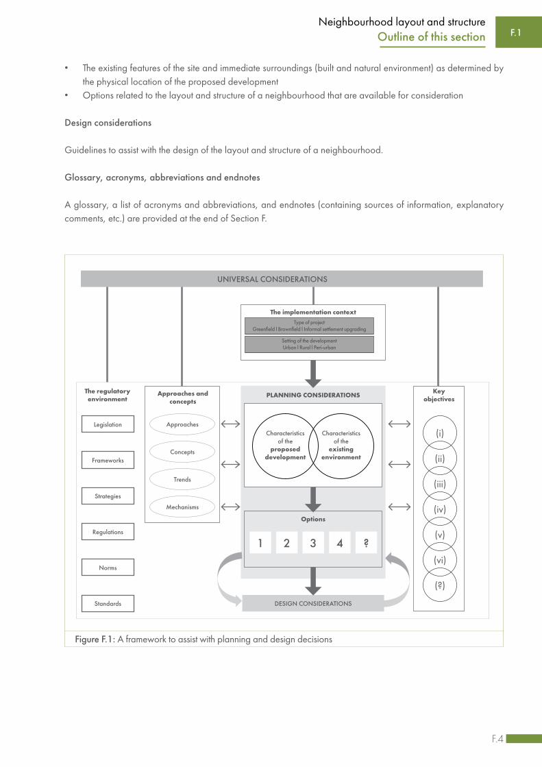
This section (Section F) is structured to support effective decision-making related to the layout and structure of a neighbourhood. The decision-making framework is outlined in Figure F.1, and the structure of this section is briefly described below.
Universal considerations
General aspects that should be taken into consideration when making higher level decisions regarding the layout and structure of a neighbourhood are highlighted, including the following:
• The regulatory environment, including key legislation, policies, frameworks and strategies• The key objectives that should be achieved as a result of the application of the guidelines provided• Local or international approaches mechanisms, concepts and current trends that could possibly be utilised to
achieve the key objectives• Contextual factors specific to the development project to be implemented such as the development type and
setting
Planning considerations
Factors to consider when making more detailed decisions regarding the layout and structure of a neighbourhood are outlined, including the following:
• The characteristics of the development, including the nature of the proposed neighbourhood, the anticipated number of residents and specific features that would have to be incorporated or requirements that would have to be met
F.4
Neighbourhood layout and structureF.1Outline of this section
• The existing features of the site and immediate surroundings (built and natural environment) as determined by the physical location of the proposed development
• Options related to the layout and structure of a neighbourhood that are available for consideration
Design considerations
Guidelines to assist with the design of the layout and structure of a neighbourhood.
Glossary, acronyms, abbreviations and endnotes
A glossary, a list of acronyms and abbreviations, and endnotes (containing sources of information, explanatory comments, etc.) are provided at the end of Section F.
Figure F.1: A framework to assist with planning and design decisions
The regulatoryenvironment
Legislation
Frameworks
Strategies
Regulations
Norms
Standards
Keyobjectives
(i)
(ii)
(iii)
(iv)
(v)
(vi)
(?)
PLANNING CONSIDERATIONS
DESIGN CONSIDERATIONS
Options
The implementation contextType of project
Greenfield l Brownfield l Informal settlement upgrading
Setting of the developmentUrban l Rural l Peri-urban
UNIVERSAL CONSIDERATIONS
Approaches and concepts
Approaches
Concepts
Trends
Mechanisms
Characteristicsof the
proposeddevelopment
Characteristicsof the
existingenvironment
1 2 3 4 ?

F.5
Neighbourhood layout and structure
F.2 Universal considerations
F.2.1 The regulatory environment
A range of legislation, policies and strategies guide the development of settlements in South Africa. Legislation and policy that have direct implications for neighbourhood planning and design are briefly outlined below. Since they are not discussed in detail, it is vital to consult the relevant documents before commencing with any development. (Also see Section D.1.)
(i) The Spatial Planning and Land Use Management Act, 2013
The Spatial Planning and Land Use Management Act (SPLUMA) is a framework act for all spatial planning and land use management legislation in South Africa. Among others, SPLUMA requires that national, provincial and municipal Spatial Development Frameworks (SDFs) be developed. Development principles, norms and standards as identified in SPLUMA guide all actions relating to spatial planning and the development or use of land, and each municipality has to adopt and approve a single land use scheme for its entire area.
Certain aspects addressed in SPLUMA relate directly to neighbourhood layout and structure. Take note of the following requirements:
• Consider the municipal SDF when planning a project to ensure alignment with the SDF.• Consider the municipal SDF when planning a project to understand the context of the project as depicted in the
municipal SDF. Typical questions to ask include: What land use and densities are planned in the vicinity of theproject? How will the project relate to the proposed developments in the rest of the municipal area?
• Adhere to the development principles (outlined in SPLUMA), namely spatial justice, spatial sustainability,efficiency, spatial resilience and good administration.
• Observe the regulations contained in the municipality’s land use scheme regarding the use and development ofland; the use, size and scale of buildings; and the intensity or density of land use.
• Adhere to the conditions of title as set out in the title deed of each property.• If required, apply to the municipal planning tribunal to change the use, form or function of land, or to remove,
amend or suspend a restrictive condition.
(ii) National Environmental Management Act, 1998 (and its subsequent amendments)
The National Environmental Management Act (NEMA) is the framework legislation for environmental management in South Africa. Any new development should adhere to the national environmental management principles included in this act and comply with its environmental management regulations. Regulations published in terms of NEMA list activities for which Environmental Impact Assessments (EIAs) are required to evaluate the impact of human actions on the receiving environment. A distinction is made between Listing Notices 1 and 3 activities, which require a Basic Assessment, and Listing Notice 2 activities, which require a full EIA (scoping followed by impact assessment). The latter involves a systematic and comprehensive process through which detailed information is gathered on the social, economic and environmental consequences of proposed developments. The environmental authority uses this information to decide whether development applications will be approved. NEMA also introduced the development of Environmental Management Plans, which most municipalities are considering or requiring when compiling SDFs. Other acts that support environmental management at a national level include the following:
F.2 Universal considerations

F.6
Neighbourhood layout and structure
• National Environmental Management: Protected Areas Act, 2003• National Environmental Management: Air Quality Act, 2004• National Environmental Management: Biodiversity Act, 2004• National Environmental Management: Integrated Coastal Management Act, 2008
Certain aspects addressed in NEMA relate directly to neighbourhood layout and structure. Take note of the following:
• Apply the principles underpinning environmental management contained in the NEMA to all neighbourhood planning and design.
• Consult the national register of all national, provincial and local protected areas to determine their proximity to and possible impact on the project site.
• Determine the nature of the activity proposed in a development project and consult with the local municipality to determine what kind of assessment is required for the site.
(iii) National Heritage Resources Act, 1999
The National Heritage Resources Act introduces an integrated and interactive system for the management of national heritage resources. According to the act, heritage sites, protected areas and heritage areas need to be taken into consideration when developments are planned (see Section F.3.2.1. (v)).
(iv) International, national, provincial and local policies, frameworks and guideline documents
Neighbourhood planning and design should be influenced and informed by the Sustainable Development Goals (SDGs) adopted by the UN Assembly in 2015. Goal 11: ‘Making cities and human settlements inclusive, safe, resilient and sustainable’ applies directly to settlement planning and design. The New Urban Agenda adopted in 2016 at Habitat III should guide efforts around planning for urbanisation. At continental level, the African Union’s Agenda 2063 and its strategic goals should be considered (refer to Section B.1).
At national level, the National Development Plan 2013 calls for improved spatial efficiency and inclusion, while the Integrated Urban Development Framework (IUDF) 2016 is the South African government’s policy position to guide the future growth of urban areas. Spatial targeting proposals are contained in a range of policy documents, including the Comprehensive Rural Development Programme, the Provincial Growth and Development Strategies (PGDS) and other regional plans and policies (refer to Section B.2 for a discussion on the national policy environment).
At a local level, the planning mechanisms employed by municipalities need to be considered, including long-term development visions and city development strategies, all Integrated Development Plan (IDP) sector plans, as well as the SDF and Built Environment Performance Plans (BEPPs). Several national government departments have introduced guidelines aimed at the local level, such as the Department of Rural Development and Land Reform’s guidelines on open space and the National Treasury’s Urban Network Strategy toolkit. In addition, municipalities often have their own guidelines on aspects such as urban design, open spaces, public facility provision and the support for informal and small businesses in well-located spaces.
It is important to take into consideration all goals, principles, spatial implications and guidelines contained in these documents when planning and designing the layout and structure of a development.
F.2Universal considerations

F.7
Neighbourhood layout and structure
F.2.2 Key objectives
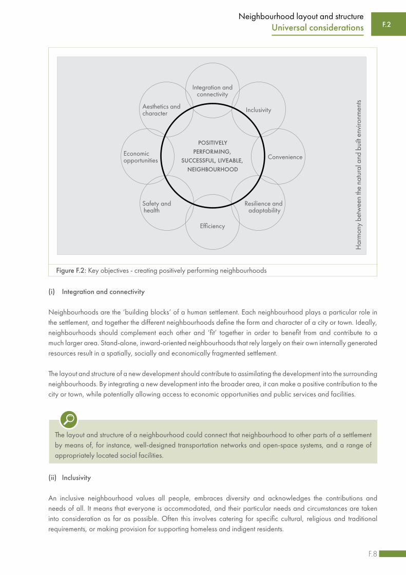
Positively performing neighbourhoods – those that are generally regarded as successful and liveable – tend to have certain characteristics in common. Successful neighbourhoods do not always exhibit all these common characteristics, but they often tend to be integrated and connected, inclusive, convenient, resilient and adaptable, efficient, safe and healthy, economically supportive, and characterful and aesthetically pleasing.
These characteristics could be translated into a set of objectives that should guide the planning and design of a development. The following objectives should always be considered when decisions are made regarding the layout and structure of a neighbourhood development:
• Integration and connectivity • Inclusivity• Convenience • Resilience and adaptability • Efficiency• Safety and health• Economic opportunities• Aesthetics and character
F.2 Universal considerations
Harmony between the natural and built environments
While the development of a neighbourhood should be guided by the objectives as summarised in Figure F.2, it is also essential to maintain a harmonious relationship between the natural and built environments.
A healthy, functioning ecosystem is a vital aspect of settlements and neighbourhoods. The built environment inevitably affects the natural environment, and it is critical to ensure that it does not have an adverse effect on the ecology. Developments could have various negative consequences, including the loss of habitat, the destruction of wetlands with their associated vegetation, the removal of vegetation, subsoil and topsoil containing material essential to the local fauna and flora.
The importance of ecological systems should always be acknowledged when planning and designing the layout and structure of a neighbourhood, and the local ecosystem should as far as possible be incorporated into the development. Du Plessis and Brandon1 take it a step further and promote an approach where the aim should be to reintegrate human habits and habitats with nature, merging and working with nature to produce a net positive impact rather than merely reducing negative impacts.
F.8
Neighbourhood layout and structure
(i) Integration and connectivity
Neighbourhoods are the ‘building blocks’ of a human settlement. Each neighbourhood plays a particular role in the settlement, and together the different neighbourhoods define the form and character of a city or town. Ideally, neighbourhoods should complement each other and ‘fit’ together in order to benefit from and contribute to a much larger area. Stand-alone, inward-oriented neighbourhoods that rely largely on their own internally generated resources result in a spatially, socially and economically fragmented settlement.
The layout and structure of a new development should contribute to assimilating the development into the surrounding neighbourhoods. By integrating a new development into the broader area, it can make a positive contribution to the city or town, while potentially allowing access to economic opportunities and public services and facilities.
F.2Universal considerations
Figure F.2: Key objectives - creating positively performing neighbourhoods
The layout and structure of a neighbourhood could connect that neighbourhood to other parts of a settlement by means of, for instance, well-designed transportation networks and open-space systems, and a range of appropriately located social facilities.
(ii) Inclusivity
An inclusive neighbourhood values all people, embraces diversity and acknowledges the contributions and needs of all. It means that everyone is accommodated, and their particular needs and circumstances are taken into consideration as far as possible. Often this involves catering for specific cultural, religious and traditional requirements, or making provision for supporting homeless and indigent residents.
POSITIVELY PERFORMING,
SUCCESSFUL, LIVEABLE, NEIGHBOURHOOD
Convenience
Integration and connectivity
Aesthetics and character
Safety and health
Inclusivity
Resilience and adaptability
Efficiency
Economic opportunities
Har
mon
y be
twee
n th
e na
tura
l and
bui
lt en
viro
nmen
ts
F.9
Neighbourhood layout and structureF.2 Universal considerations
Inclusivity also means that residents are presented with options from which to choose. Neighbourhoods should be multifaceted, offering a diversity (and thus choice) of places, lifestyles and activities. They should also provide opportunities for human contact and interaction, allowing people to live on their own but not be alone.
Neighbourhoods should also provide people with choices regarding the extent to which they wish to engage in social activity. Some people require places that are private and that allow them to distinguish between the ‘locals’ and the ‘strangers’. Some people wish to live in intensive and vibrant environments, others in quieter and more private places. These requirements vary from person to person and over the life-cycle of households. Hierarchies of movement, public spaces and social facilities, as well as the design of living areas can influence relative degrees of privacy or exposure.
Inclusivity furthermore relates to universal access, which refers to environments that aim to accommodate all users regardless of their age, gender, ability or specific circumstances. An inclusive environment is a user-friendly environment that does not have barriers that would prevent certain people from using it, including those who may have difficulties moving, hearing, seeing or communicating.
The layout and structure of a neighbourhood should encourage and facilitate inclusivity by, for instance
• allowing all residents to participate in their daily activities, including specific cultural, religious and traditional requirements,
• making provision for supporting homeless and indigent residents,• creating an environment that accommodates all and allows residents to move around with relative ease by
applying universal (inclusive) design principles, and • promoting environments that provide a range of options, so that people do not have ‘either/or’ choices,
but rather choices between options that they feel comfortable with.
(iii) Convenience
Neighbourhoods that are convenient allow residents to conduct daily activities efficiently, that is with ease and without undue delays. This means that services, retail facilities and public amenities, for instance, should be easily accessible. Access lies at the heart of convenience and is one of the main factors that influence the location, growth and functions of neighbourhoods. Convenience is improved when it is easy to get to and from a neighbourhood, and when it is easy to move around in a neighbourhood, especially on foot.
For those residents who cannot afford a motor vehicle, public transport is crucial to facilitate movement. Although this does not deny the need to accommodate motor vehicles in settlements, the structuring of settlements, particularly for those who cannot afford private transport, should encourage and facilitate pedestrian movement and public transport systems.
Access to nature is important to many people. For financial reasons, contact with nature sometimes has to be collective contact as it cannot always be provided adequately within private gardens. In addition, the productive capacity of the land can be a vital settlement resource. For many settlement dwellers, the opportunity to use the land productively or to engage in lifestyles that incorporate dimensions of both urban and rural living, is crucial to their survival.
F.10
Neighbourhood layout and structureF.2Universal considerations
(iv) Resilience and adaptability
Human settlements are constantly exposed to a range of threats, including floods, storms, fires, droughts and earthquakes. Such extreme weather conditions often cause sudden, devastating disasters, and due to climate change these conditions will become more and more common. In addition, settlements could also experience chronic stresses caused by longer-term disasters, including extreme levels of crime and violence, poverty and inequality. Settlements need to be prepared for these disasters and be able to withstand the consequences. This ability to survive different stresses and shocks, to adapt to the changing conditions and to recover from such catastrophic disruptions is referred to as resilience.
Neighbourhoods are subject to change over time. Because it is better to anticipate change rather than merely respond to it, the ways in which a neighbourhood may be required to change should be anticipated and planned. Possible changes that have to be considered include economic and societal changes, as well as changes in the environment, the needs of the residents and the composition and use of the neighbourhood.
The layout and structure of a new development could contribute to creating a convenient environment in a number of ways, for instance by
• providing an interconnected network of streets that provide people with a choice of routes that are safe, efficient and pleasant to use whether they are walking, cycling or driving,
• creating permeable neighbourhoods by providing frequent connections between existing and new streets and pathways, and
• linking social facilities with movement systems, so that people can walk, cycle and use different transport modes to access economic opportunities, community, education and healthcare facilities, commercial and entertainment areas, open spaces, places of recreation, etc.
The layout and structure of a new development should enhance the neighbourhood’s capacity to adapt to change. It should also contribute to the creation of resilient settlements, for instance through the provision of essential services and facilities, dependable, robust and well maintained infrastructure, and reliable movement networks.
The layout and structure of a neighbourhood could improve resource efficiency by, for instance, applying the principles of water sensitive urban design and sustainable drainage systems, encouraging walking and the use of non-motorised transport, and considering long-term maintenance and life-cycle costing during planning and design.
(v) Efficiency
The development of neighbourhoods requires the use of a wide range of resources including land, money, building materials and human capital. Development also makes use of, or has an impact on, natural resources such as air, energy and water. Neighbourhoods should be planned and designed to use these resources efficiently.

F.11
Neighbourhood layout and structure
(vi) Safety and health
In a safe and healthy neighbourhood there is a strong emphasis on reducing actual and perceived levels of crime and violence and a focus on injury prevention. In such a neighbourhood, environmental health risks are minimised, the physical and mental wellbeing of all residents is supported, and safe conditions are created for all street users, especially pedestrians and cyclists.
The layout and structure of a new development could contribute to the creation of safe and healthy neighbourhoods by, for instance
• reducing opportunities for criminal activities, especially in public spaces, for instance through the use of theprinciples of crime prevention through environmental design (refer to Section O.1),
• providing opportunities for residents to improve their physical and mental health, for instance by creatingan environment that encourages walking and the use of non-motorised modes of transport,
• reducing exposure to environmental health risks and the risks of injury, and• creating safe conditions on streets and sidewalks.
(vii) Economic opportunities
People often come to settlements to improve their personal welfare. This welfare has many dimensions. People may move into neighbourhoods to find shelter and also to make use of other opportunities offered by the concentration of people and the frequent human interaction. A significant proportion of workers in urban settlements are informal workers. These workers sell food or other household items, drive taxis, perform hard labour and gather, sort and recycle what industry and households throw away. In these and other ways, they earn livelihoods that sustain entire families.
(viii) Aesthetics and character
Settlements are about people and places and how they interact. Residents spend a great deal of time in their individual neighbourhoods and often identify more strongly with the neighbourhood than with the settlement as a whole. An attractive, aesthetically pleasing physical environment could add to the quality of the neighbourhood. A characterful neighbourhood is more pleasant and interesting for residents and visitors, and gives it a unique identity. The way streets are laid out and public spaces are juxtaposed with adjoining buildings can play an important role in the creation of well-functioning, visually appealing neighbourhoods.
Neighbourhoods should generate economic opportunities, and their layout and structure should contribute by supporting local, particularly small-scale, economic activity (employment, production and consumption), enabling efficient transportation and movement systems, and facilitating higher densities.
F.2 Universal considerations

F.12
Neighbourhood layout and structure
Neighbourhoods with good aesthetic qualities and a pleasant character contribute to people feeling comfortable and safe. It is essential to consider the following when making decisions regarding the layout and structure of a development:
• Acknowledge the local context and identify features that could be incorporated into a development to create a distinct character or identity.
• Recognise traditional, cultural or religious views and customs, and sensitively incorporate places of significance, natural and cultural assets, and heritage sites into a development where appropriate.
• Enhance the legibility of an area by helping people to orientate themselves, for instance through the use of a street network that is easy to understand and the incorporation of structuring elements such as landmarks, vistas and other distinct natural or built environment features. A neighbourhood is legible if the layout pattern is clear and simple and enables residents and visitors to understand how the different parts of the neighbourhood is organised, allowing them to easily make their way around.
• Pay special attention to the interaction between open space and the buildings shaping these spaces, and recognise what can be achieved through creative architecture and the innovative use of building materials, paving, landscaping and so forth to create distinctive, attractive and vibrant outdoor areas with a sense of place.
F.2Universal considerations
F.2.3 Approaches and concepts
This section briefly summarises possible approaches, strategies and mechanisms that could be utilised, or local or international concepts, ideas and trends that could be implemented to achieve the objectives discussed in Section F.2.2.
F.2.3.1 Transport-oriented development
Transport-oriented Development (TOD) refers to the concentration of a mix of medium to high-density, NMT-friendly developments around a public transport station or interchange or along a transport or activity corridor. From a transport perspective, the intention is to improve access to public transport, reduce travel time and promote the use of NMT to ultimately reduce the reliance on private cars.2 From a spatial development perspective, the focus would be on higher densities and providing adequate public spaces and a mix of land uses (residential, employment, leisure and retail) within the same space.3 The key features of any TOD generally include mixed land use, increased residential density, social (and housing) mix, high-quality pedestrian environments and good access to services and employment. It is important to keep in mind that TOD is site specific and dependent on the proximity and nature of public transport stops and stations.
The potential of TOD to drive the restructuring of South African settlements has been identified in many government plans and strategies, specifically the NDP and the IUDF. The National Treasury’s Neighbourhood Development Programme has done extensive work in applying the principles of TOD to South African cities through its Urban Networks Strategy that targets investment in identified ‘urban hubs’. Relevant documents and guidelines are available from the Neighbourhood Development Programme.4

F.13
Neighbourhood layout and structure
F.2.3.2 Water Sensitive Urban Design / Water Sensitive Design
Water Sensitive Urban Design (WSUD), an approach to urban water management that originated in Australia, is an approach aimed at managing the urban water cycle in a more sustainable manner so as to improve water security.5 Within the South African context, WSUD is also referred to as Water Sensitive Design (WSD) to acknowledge the fact that the approach could be applied to settlements in general, not only to those in an urban setting.6 The basic premise of WSUD/WSD is that water is a scarce and valuable resource, and therefore it needs to be managed wisely and with due care (sensitively). This approach encompasses all aspects of the water cycle and integrates urban design with the provision of infrastructure for water supply, sanitation, wastewater, stormwater and groundwater.
The purpose of WSUD/WSD is to reduce the negative impact of urban development on the environment and to enhance the sustainability of water. The intention is to, as far as possible, mimic the natural process of maintaining the water balance when planning and designing a neighbourhood or settlement. (See Figure F.3.)
Figure F.3: The water cycle under different conditions
F.2 Universal considerations
RunoffRunoff
Evapotranspiration
Evapotranspiration
Evapotranspiration
Evapotranspiration
GroundwaterGroundwater Groundwater
Precipitation
Evapotranspiration
LessEvapotranspiration
Potable water imported
Wastewater discharge
Less GroundwaterContaminatedrunoff Rivers and other water bodies
exposed to contamination
Contaminatedrunoff
Precipitation
IncreasedEvapotranspiration
More groundwater
Less potable water imported
Wastewater reused Less
wastewater discharge
Contaminated runoffTreatment
Better quality runoffStormwater reuse
Contaminatedrunoff
Precipitation
Rivers and other water bodies
Rivers and other water bodies
The natural water cycle
The urban water cycle
The urban water cycle with WSUD

F.14
Neighbourhood layout and structure
The natural process (water cycle) involves, amongst others, precipitation, evapotranspiration, runoff and infiltration. However, in a built-up area other components are added to the process. In addition to precipitation, potable water is imported into the area, wastewater is generated that needs to be discharged somewhere, and evapotranspiration is inhibited. Furthermore, because a substantial part of the area is covered with hard surfaces (buildings, streets, paving etc.), infiltration of water into the earth is reduced while the volume of (poor quality) runoff increases. WSUD/WSD aims to reduce the adverse effects of the built environment on water and to create settlements that preserve the natural water cycle. Strategies or interventions that could be implemented include the following:7
• Sustainable Drainage Systems (SuDS). This is an approach to managing stormwater runoff that aims to reduce downstream flooding, allow infiltration into the ground, minimise pollution, improve the quality of stormwater, reduce pollution in water bodies, and enhance biodiversity. Rather than merely collecting and discarding stormwater through a system of pipes and culverts, this approach recognises that stormwater could be a resource. SuDS involve a network of techniques aimed at controlling velocity and removing pollutants as runoff flows through the system. This involves mechanisms and methods such as rainwater harvesting, green roofs, permeable pavements, soakaways, swales, infiltration trenches, bio-retention areas, detention ponds, retention ponds, wetlands etc. These interventions can form a natural part of open spaces in a settlement and contribute to the quality of the environment and the character of a neighbourhood.8
• Appropriate sanitation and wastewater systems. Technologies that reduce water use, allow for the use of treated wastewater or recycled water, and minimise wastewater, could contribute significantly to the effective and efficient utilisation of water resources in a settlement.
• Groundwater management. Groundwater should be regarded as a resource, and therefore aquifers should be conserved and protected from contamination and artificial recharge options should be considered where appropriate.
• Sustainable water supply. Various aspects should be considered to improve efficient water use and reduce the demand for potable water, including water conservation, water demand management, addressing water losses, and developing alternative water sources (e.g. rainwater, stormwater, wastewater and groundwater).
WSUD/WSD requires a multi-disciplined, holistic approach to neighbourhood and settlement planning and design. Various sections of this Guide relate directly to this approach, in particular Section F (Neighbourhood layout and structure), Section G (Public open space), Section I (Transportation and road pavements), Section J (Water supply), Section K (Sanitation), and Section L (Stormwater).
F.2.3.3 Multi-modalism
Multi-modalism promotes the provision of a network of transport options for people to choose from, including not travelling at all. It presents a move away from private vehicle dependency and prioritises giving people choice. The quality and liveability of neighbourhoods are enhanced when residents have choices. Multi-modalism allows more mobility, while decreasing the transport cost burden, which includes roadway costs, parking costs, consumer costs and costs related to congestion, traffic accidents, energy consumption and pollution emissions. When planning and designing the layout and structure of neighbourhoods, it is important to do the following:
• Improve the connectivity of the transport system by focusing on the connections between modes, such as the quality of pedestrian and cycling access to public transport stops and stations
• Incorporate universal design and consider affordability to ensure that mobility options are available to all people
F.2Universal considerations
F.15
Neighbourhood layout and structure
F.2.3.4 Compact cities
The concept of compact cities promotes neighbourhoods with high residential densities, mixed land uses and clear boundaries. The land uses are typically supported by public transport and by measures to encourage walking and cycling, which results in the reduction of energy consumption and pollution. The idea behind this model of planning and design is to move away from unsustainable urban sprawl that increases infrastructure cost and private motor vehicle dependency. The compact cities concept has strong associations with a number of other concepts, including intensification, urban containment, growth management and smart growth. Issues to consider include mixed land uses, compact building design, housing opportunities and choices, walkable neighbourhoods, transport options and choices and strengthening existing communities.
F.2.3.5 Eco-cities
The eco-city is an umbrella concept that includes a wide range of urban-ecological proposals that aim to achieve urban sustainability. The eco-city is often modelled on the self-sustaining resilient structure and function of natural ecosystems. The aim is for inhabitants not to consume more (renewable) resources than the city produces, without producing more waste than it can assimilate, and without being toxic to itself or neighbouring ecosystems. The core of many of the approaches included under the eco-city umbrella is the management of the city, rather than suggesting a specific settlement form. However, the distinctive physical planning and design concepts that are promoted to realise the eco-city include greening, green infrastructure and passive solar design.10
F.2.3.6 Smart cities
The digitalisation of cities appears to be inevitable and the strategic use of Information and Communications Technology (ICT) can potentially assist, even in low-resource or low-income settlements, in the planning and design of positively performing neighbourhoods – those that are regarded as successful and liveable (see Section F.2.2).
There is no universally accepted definition of a smart city. At the moment, digital interventions towards the smart city tend to focus on better and new ways of data collection and interpretation and on connecting people and objects with each other. The data collected is analysed to support decision-making, manage resources efficiently and improve the effectiveness of different urban elements or processes. This might include aspects such as e-governance
Concepts associated with compact cities (from the Journal of Planning Education and Research9)
• Intensification is the process of using land more efficiently by increasing the density of development and activity. Intensification includes the development of previously undeveloped urban land, the redevelopment of existing buildings or previously developed sites, as well as subdivision, conversions, additions and extensions.
• Urban containment involves measures to prevent the outward expansion of settlements and typically includes introducing ‘push’ and ‘pull’ factors to manipulate new development in order to achieve a particular settlement form. An example would be the introduction of an urban growth boundary. This concept overlaps to a large extent with the concept of growth management.
• Smart growth promotes similar measures to manage settlement growth, but it deliberately attempts to balance growth with the meeting of economic, social and environmental needs.
F.2 Universal considerations

F.16
Neighbourhood layout and structure
and other citizen services, smart water metering, water quality monitoring and leak detection, smart parking and intelligent traffic management, energy efficient buildings and maintenance management with the help of censors. The Internet of Things (IoT) is an umbrella term referring to the drive to equip different objects with sensors that enable them to communicate and to share data with people (users) and other objects. Improved connections between people also have multiple implications for the planning and design of human settlements.
F.2.4 The implementation context
This section highlights the contextual factors that should be considered when planning and designing the layout and structure of a neighbourhood, specifically related to the type of development and its setting. Also refer to Section D.2.1 (Type of development) and Section D.2.2 (The setting of the planned development).
F.2.4.1 The type of development
(i) Greenfield development
When planning and designing the layout and structure of a neighbourhood as part of a greenfield development project, the following must be considered:
• Undisturbed portions of the natural environment are often found on greenfield sites. The preservation of open space, trees and on-site natural features should be considered when planning and designing the layout and structure of a neighbourhood. This could provide a unique and appealing amenity for future users.
• Greenfield sites often are not connected to municipal services such as water, sanitation, stormwater, electricity and solid waste removal. These service connections may even be a substantial distance away, especially if the site is in a rural area. The capacity of the services may also not be sufficient for the proposed development and an upgrade may be required to adequately service the proposed development. The costs associated with new municipal services or extensions to existing systems, and the measures to curb these costs will have a significant impact on neighbourhood layout and structure.
• Depending on where the greenfield site is located, it might be a challenge to connect to existing public transport routes. Access points are very important for the viability of a new neighbourhood and will therefore be a determining factor that could influence the layout and structure.
(ii) Brownfield development
When planning and designing the layout and structure of a neighbourhood as part of a brownfield development project, the following must be considered:
• Site assembly is often essential as part of a brownfield development. This involves combining small plots and individual properties with multiple ownership arrangements into larger parcels for comprehensive redevelopment. Site assembly is an intricate process and the outcome can have an impact on the layout and structure of a new neighbourhood.
• Brownfield sites are potentially contaminated by previous industrial uses or leftover building materials and might need environmental rehabilitation. If rehabilitation is not possible or appropriate, the contaminated land may have an impact on the layout and structure of the neighbourhood, as residential land uses and/or conventional construction methods may not be possible on certain parts of the site.
F.2Universal considerations

F.17
Neighbourhood layout and structure
• Sites for redevelopment are often located in inner city areas and are associated with very specific issues such as traffic congestion and noise that must to be taken into account when planning and designing neighbourhood layout.
• The layout and structure of the brownfield development project should link up with existing movement patterns and surrounding streets to provide as many access points into the site as possible.
• The layout and structure should also respond to the local context in terms of the landscape, the built form and the land use pattern.
• Sites for redevelopment often have built structures that may have heritage value. Preserving the unique heritage elements on site can enhance existing and potential place-making elements and localities to create a unique place-structure that responds to the urban and natural context.
• Brownfield projects often result in higher population densities. When planning and designing the structure and layout of the neighbourhood, population density may have an impact on the planning and design of municipal engineering services, as the existing infrastructure may not have the capacity to cater for these higher densities.
(iii) Informal settlement upgrading
Informal settlement upgrading often involves in-situ development, which implies that existing houses are left in place while the neighbourhood is upgraded – streets are aligned and widened, drainage is improved, and homes are connected to the water and sanitation grids. When planning and designing the layout and structure of a neighbourhood as part of an informal settlement upgrading project, the following needs to be considered:
• Informal settlements are often isolated from the settlement street grid. Linking up with existing movement networks and surrounding streets will have a major impact on the neighbourhood layout and structure.
• Informal settlements grow organically and there may be layouts that seem unconventional. The internal layout and structure of the upgraded informal settlement have to accommodate these anomalies.
• As informal settlements are mostly associated with higher densities, there would be increased focus on creating pedestrian-friendly streets when designing the layout, including pathways, stairs and steps.
• When planning and designing the structure and layout of the neighbourhood, the higher population density may have an impact on the planning and design of municipal engineering services, as the infrastructure in adjacent neighbourhoods may not have the capacity to cater for these higher densities.
• Of critical importance when planning and designing the layout of an informal settlement upgrading project, is to involve the residents. Informal settlements are not homogenous; each has its own unique community characteristics and different levels of social cohesion.
F.2.4.2 The setting of the development
(i) Urban
The urban areas of South Africa comprise a variety of settlement types. When making decisions regarding the layout and structure of an urban development, the following should be considered:
• New developments can lead to urban sprawl. The negative effects of this phenomenon should be reduced as far as possible.
• South Africa’s inner cities are changing. They are no longer the only commercial hub in many cities. Multiple commercial nodes across the city will have an impact on layout proposals as multiple linkages and access points should be provided.
F.2 Universal considerations

F.18
Neighbourhood layout and structure
• Informal settlements often require in-situ upgrading and the layout design process requires an approach that relies on intensive community participation.
• Ecosystems provide critical services to urban communities such as clean water, air, biodiversity and productive soils. Protecting ecosystems through layout planning and design builds the resilience of all communities.
(ii) Peri-urban
The development setting of peri-urban areas is diverse and includes a mix of settlement patterns, socio-economic statuses and access to services. Settlement on the periphery of metropolitan areas and towns may include informal settlements, low-income housing and high-income, low-density developments. When planning and designing the layout and structure of a development in the urban fringe area, the following should be considered:
• Peri-urban areas are under pressure as most new urban-based developments and growth are concentrated in these zones of rural-urban transition.11 The often-high rate of urbanisation (influx or people into cities) should be considered when planning and designing the layout and structure of new developments as there is a likelihood that peri-urban areas will have to accommodate more people and higher densities in future.
• Land on the periphery often does not have convenient access to urban amenities. When designing and planning the layout and structure of a development, it is important to link the development to key movement systems and specifically to existing public transport routes to allow for access to the rest of the settlement, in particular to established economic nodes.
• The boundary line between rural, peri-urban and urban is not well-defined and therefore tends to be adjusted often. Municipalities make use of a range of urban growth measures, of which the urban edge is one. When planning and designing the layout and structure of a project, it is critical to determine whether there is an official urban edge delineated, what its proximity is in relation to the development and how this will affect future change in the development.
• The costs of providing conventional urban infrastructure in peri-urban areas are often prohibitive. If alternative ways of service provision are considered, e.g. so-called package plants for sewer treatment, it could influence the layout and structure of a development.
• Ecosystems provide critical services to peri-urban communities such as clean water, air, biodiversity and productive soils. Protecting ecosystems through layout planning and design builds the resilience of all communities.
• Peri-urban areas are also often home to gated communities or security complexes. These developments are sometimes criticised for being enclaves that contribute to the fragmentation of urban form and for promoting the use of private motor vehicles. The internal layout and structure of these peri-urban settlements are often carefully planned to support walkability and provide residents with improved access. However, in most cases gated communities on the urban fringe do not respond to their immediate surroundings in terms of layout and structure.
(iii) Rural
The rural areas of South Africa comprise a variety of settlement types, including rural villages and towns, dense rural settlements and dispersed settlements. When making decisions regarding the layout and structure of a development in a rural setting, the following would typically need to be considered:
• Most traditional villages are located on farm portions or on trust land. The trust land is communally owned and is usually managed by a hierarchy of traditional leaders. Neighbourhood layout and structure decisions are directed by these decision-makers rather than by the local municipality’s SDF or land use scheme.
F.2Universal considerations
F.19
Neighbourhood layout and structure
• In a rural residential area, activities such as the traditional slaughter of animals, home burials, or seasonal land uses have to be accommodated when planning neighbourhood layout and structure.12
• Rural communities may provide certain services themselves, and these may have to be accommodated in the layout of the development.
• Ecosystems provide critical services such as clean water, air, biodiversity and productive soils to rural communities. Protecting ecosystems through layout planning and design builds the resilience of rural communities.
• Many rural households are much less likely than urban households to have access to a supply of piped water close to their dwellings. Therefore, household activities often include the collection of water, and in such cases the layout and structure of a development need to be particularly pedestrian-friendly.
• Sometimes rural settlements can only be accessed by dirt roads or even footpaths. These roads are particularly vulnerable to degradation during rains.13 In addition, the organic nature of the internal street layout of rural settlements makes it difficult to achieve certain efficiencies. The proper planning and design of street layout and neighbourhood structure should attempt to deal with some of these challenges.
The spatial form of rural settlements, specifically those under traditional leadership, differs throughout South Africa. According to the Department of Rural Development and Land Reform’s Land Use Scheme Guidelines14, in the provinces of North West and Limpopo, traditional villages are often arranged in square gardens and within square blocks, with livestock kept within the boundaries of each household, while houses and huts in KwaZulu-Natal are sometimes arranged on hilltops or on slopes or along river courses. Occasionally the houses are close together to form a village. These different spatial forms are largely associated with different cultures and traditions, as well as with the topography of the area. The planning and design of the layout and structure of a new project should respect and respond to the tradition and culture of the local people.
F.2 Universal considerations

F.20
Neighbourhood layout and structure
F.3 Planning considerations
This section deals with the planning of the layout of neighbourhood streets, the delineation of plots (private and public) and the allocation of different land uses. In this context, the term ‘planning’ means making informed decisions regarding the type or level of service to be provided, and then choosing the most appropriate layout and structuring options based on a thorough understanding of the context within which the planned development will be implemented.
F.3Planning considerations
The decisions regarding layout and structuring must be informed by a clear understanding of the features and requirements of the proposed project. This would require an assessment of the characteristics of the proposed development. Furthermore, the characteristics of the environment in which the new development will be located need to be examined and possible services and infrastructure that could be utilised must be identified.
This section outlines a range of questions that should be asked and factors that have to be considered to inform decisions regarding neighbourhood layout and structure.
F.3.1 Characteristics of the proposed development
Decisions regarding neighbourhood layout and structure need to be guided by an assessment of the characteristics of the proposed development and an understanding of the requirements or needs that will have to be met. Aspects that should be considered are discussed below.
F.3.1.1 The nature of the proposed development
The nature of the development that is planned will influence the street layout, the size of the land units and the type of engineering and other services to be delivered. The following questions can be asked to gain clarity:
• What is the dominant land use of the proposed development?• What supporting land uses will be required?• What social facilities should be provided and planned for?• If a mixed development is proposed, what type of mix is proposed, e.g. a variety of housing types, sizes,
densities and/or tenures? (see Section F.4.5)
F.3.1.2 The residents of the area to be developed
Decisions regarding neighbourhood layout and structure need to be guided by information about the potential residents and users of the planned facilities. Usually, the identities of the actual occupants of the houses to be provided are not known when a development is planned and designed. It may be possible to make assumptions regarding the expected nature of the future residents by assessing the surrounding neighbourhoods or similar developments in comparable locations or contexts. It is important to establish the following:
• The total number of residents to be accommodated. Actual numbers may be higher than anticipated becausethe provision of houses and services may attract more people than originally planned for.
• The number of households, the range of household sizes and their composition, for instance, whether there is

F.21
Neighbourhood layout and structureF.3 Planning considerations
likely to be child-headed or single-parent households. This will indicate which types of housing and services would have to be provided.
• The range of residents with special needs that would have to be accommodated, e.g. people living with HIV/Aids and with disabilities, including physical, dexterity and sensory impairment. Infrastructure and services should, as far as possible, be accessible to all residents and users.
• Age and gender of residents (i.e. gender ratios and age profile). An ageing population might, for example, require access to buildings at the ground level.
• Income and employment levels and spending patterns. This could, for instance, indicate to what extent housing should be able to accommodate private motor vehicles, and what types of streets and other infrastructure and services would be most appropriate.
F.3.2 Characteristics of the existing environment
Decisions regarding neighbourhood layout and structure need to be guided by an assessment of the context within which the development will be located. Issues that should be considered are discussed below.
F.3.2.1 The physical location of the proposed development
Constraints and opportunities posed by the site could influence the layout and structure of the neighbourhood.
(i) Topography
The topography of the project site is a key factor when making decisions regarding the layout of the development. The landscape will influence the micro-climate of the site and have a significant impact on the provision of municipal engineering services. Asking the following questions will assist in highlighting pertinent issues:
• Does the site slope? Are there significant changes in level such as embankments or retaining walls? A sloping site could mean that additional costs would have to be incurred when constructing streets, infrastructure and buildings. It may also be difficult to provide certain housing types on very steep sites.
• How will the slope or level changes affect the site layout and the positioning of buildings? Severe slopes or level changes may make it difficult to position houses and other buildings to face north, or it could be difficult to provide vehicle access to the site.
• Can the development be oriented to make the most of attractive views?
(ii) Climate
The micro- and macro-climates of the site will have an impact on street layout and plot orientation. The following questions need to be asked:
• Is the site exposed to prevailing winds? Is the wind direction seasonal? This information would assist in positioning a building on a plot.
• Where does the sun rise and set in summer and winter? The presence of shade may be important for the orientation of blocks and plots. Remember there may be external features that influence sun penetration on the site, such as a nearby mountain, hill, tree, or building.
• Does the site fall in a declared natural disaster zone? Is there a risk of seasonal flooding, earthquakes, tremors, veld fires and landslides? Do disaster management plans exist? For assistance with the development of actions to adapt settlements to the impacts of climate change, consult the Green Book: Adapting South African settlements to climate change.15

F.22
Neighbourhood layout and structureF.3Planning considerations
(iii) Geotechnical characteristics
The ground condition of a site can sometimes necessitate the use of specialised construction methods or materials or it can mean that certain areas of the site might not be suitable for construction. The ground conditions could also have implications for the population density or housing density that can be accommodated on the particular site and will have an impact on decision-making regarding plot dimensions and street widths. The following questions might be helpful:
• What is the soil condition and quality?• Are there any aggressive chemicals or minerals present? • Is the site part of or close to a dolomitic area?• Was the site used for mining and exploration in the past?• Are there large rock outcrops on the site? Are there gullies or other ditches on the site?• Is there groundwater present? What is the height of the water table?• Did dumping – legal or illegal – ever occur on the site? It is difficult to stop people from using a dumping site
that was established informally. Where possible, illegal dumping sites should be converted to legal dumping sites in the final layout of the neighbourhood.
(iv) Landscape and ecology
The physical features of the landscape could have a substantial impact on the neighbourhood layout and structure. A thorough analysis of the landscape and ecology should be conducted to determine if there are certain parts of the project site that would not be suitable for development. If the site is located in or near an ecologically sensitive area, there may be restrictions that could influence the positioning (and ease of construction) of infrastructure, streets, houses and other buildings. Gain an understanding of how the landscape is continuously evolving and changing, either through natural or human-induced processes, to assist in developing the site in the most ecologically sensitive manner. Gather information about the following:
• The position of any telephone poles, overhead or underground power cables, rock outcrops, water features, dongas, etc. that could restrict building work or may require involvement (especially permission) from various government departments
• Wetlands, surface water bodies or other ecologically sensitive areas on or near the site. Information on Critical Biodiversity Areas (CBAs) and Ecological Support Areas (ESAs) is available on the website of the South African National Biodiversity Institute (SANBI)16
• Endangered or protected plant or animal species on or near the site• Existing vegetation, especially trees, and whether they are deciduous or evergreen, indigenous or alien• Natural features that may have cultural significance
(v) Existing buildings on the site
If there are existing buildings on the proposed development site, they can be viewed as either presenting opportunities or constraints. Depending on the specific circumstances, existing buildings could restrict the layout options available, or they could add interesting alternatives and may even become structuring elements. To determine the most appropriate course of action, the following questions can be asked:
• Do the buildings have features of historic or conservation interest? (Refer to the text box on the following page for a discussion on heritage as part of neighbourhood planning and design.)
• Do the buildings have cultural significance? May these buildings be demolished?• Should these buildings be refurbished? Can these buildings be repurposed and reused? Can these buildings be
integrated into the new development?

F.23
Neighbourhood layout and structure
(vi) Adjacent land uses and edge conditions
Adjoining properties have an impact on each other. Therefore, it is important to be aware of the land uses adjacent to the development site, as well as the edge conditions that affect the site. Some of the questions that need to be asked include the following:
Heritage conservation and neighbourhood development projects
Heritage resource conservation and management in South Africa is governed by the National Heritage Resources Act, 1999. The act provides for the conservation and management of heritage resources and empowers society to assist in this management.
The act is administered by the South African Heritage Resources Agency (SAHRA) at national level. There are also provincial heritage resources authorities, while some cities manage their heritage areas at a municipal level. Thus, heritage resources and heritage areas are protected by law at local, provincial and national levels. It is important to determine which authority is responsible for the area in which the new development is proposed. Under certain circumstances it may involve all three spheres of government.
Heritage resources include settlements, places, objects, buildings, cultural practices and traditions that are valued by communities and are therefore culturally significant. A heritage resource is recognised as being culturally significant when it has historical, aesthetic, scientific and/or social value. The resource may be a tangible object or place, or an intangible practice or tradition.
A heritage area, as defined in the National Heritage Resources Act, is a designated place of environmental or cultural interest. The designation will be made based on a combination of architectural, historic, aesthetic, scientific and social characteristics. Typically places, buildings and landscapes with symbolic significance will be included in the designation. If a new development is situated within a declared heritage area, or is adjacent to a declared heritage building, it is advisable to discuss the new development with the relevant government department(s) early in the development process to get advice regarding regulations and design considerations.In terms of the act, no person may alter or demolish any structure or part of a structure that is older than 60 years without a permit issued by the relevant Heritage Resources Authority. Such a permit is dependent on the grade of the building. Specific procedures must be followed where a new development involves any addition to or alteration of a heritage resource.
The concept of cultural landscapes is included in heritage conservation and management. Cultural landscapes are described as “the combined works of nature and man” and typically include landscapes, historic places, sites, and built environments. Landscapes include agriculture and historic vegetation. Examples of cultural landscapes are avenues, squares and parks surrounded and/or defined by historic trees; designed and formal gardens; places and vegetation of symbolic value, e.g. a slave tree; groups of trees planted for shade or windbreaks; old water courses and historic domestic gardens.
Appropriate development will strengthen and enhance the value of the resource for everyone and will often add value to the resource itself.
F.3 Planning considerations

F.24
Neighbourhood layout and structure
• What are the adjacent land uses and how could that potentially influence decisions regarding the layout and structure of the proposed development?
• Are there neighbouring buildings where privacy needs to be respected?• Are there unattractive neighbouring uses from which the new development needs to be screened?• Are there existing streets and spaces adjacent to the site to which the new development should relate? • Are there noise problems from road traffic, railways or adjoining buildings? • Is there neighbouring vegetation that may be affected by the development of the site?• Does a waterway run along the edge of the site?
(vii) Access to the site
Any development must be connected to the rest of the neighbourhood and to the settlement as a whole. If there are no existing access or connection points available, there may be cost and time implications. Also, the street layout is influenced by the location of access points, existing footpaths and routes, and public transport facilities. The following questions need to be asked:
• What are the existing and potential vehicular, cycle and pedestrian access points to the site? • Are there existing footpaths or other routes (desire lines) across the site? Can the existing footpaths and routes be
accommodated in the new development? These desire lines should be considered when designing movement networks, as NMT users tend to follow established routes.
• Where are public transport facilities located in relation to the site? • What are the local destinations (such as shops, schools) that occupants of the new project will be wanting to
access? How can the new development best be linked to these to encourage walking and cycling?
F.3.2.2 Available engineering infrastructure and transportation facilities
Developments create additional demand for services (engineering and transportation) and therefore have a potential impact on existing engineering infrastructure (e.g. water pipelines, electricity cables, sewerage pipes) and transport infrastructure (e.g. streets, sidewalks, crossings, cycle paths). Infrastructure provision and settlement layout are intrinsically linked; therefore the following questions need to be answered:
• What engineering infrastructure (bulk and local) is available close to the new development?• Does the existing engineering infrastructure have enough capacity to accommodate the new development?• Can the new development be linked to existing engineering infrastructure?• Are there public transport routes close to the site? Are there bus stops, railway stations or taxi ranks close to the
site? Is there sufficient public transport capacity in the area?• Are there cycle and pedestrian facilities available?
F.3.2.3 Existing socio-economic features
The planning and design of a development must be guided by the potential needs of the residents of the new and existing neighbourhoods. If an existing community will move into the proposed development, it is critical to understand the community and involve them in the decision-making process from the outset. (See Section E.) It is also important to acquire information regarding the socio-economic features of the neighbouring communities. This will provide some indication of the types of supporting land uses that may be required. The following questions should be asked with respect to the existing community (if known) and the the adjacent neighbourhoods, especially those that are functionally linked to the proposed development:
F.3Planning considerations

F.25
Neighbourhood layout and structure
• How many people live there? • What is the average size of households in the area?• What is the age profile of the residents?• What is the income profile of the residents?• What is the employment profile of the residents?• What types of housing are people living in?
F.3.2.4 Access to existing social facilities and economic nodes
To determine the requirements for social facilities and economic nodes in the proposed development, the number of existing facilities in the neighbourhood, the services they offer, as well as the capacity of these facilities should be determined. The following questions could be asked:
• What types and how many social facilities are available in the neighbourhood, in adjacent neighbourhoods and in the settlement? See Section H for a discussion on the different types of social facilities.
• Are these facilities within acceptable reach of residents of the neighbourhood? Do these facilities have spare capacity?
• Will the community be using public or private facilities? This may be relevant to healthcare, education or recreation facilities.
• How many economic nodes are in the neighbourhood and in adjacent neighbourhoods?• What are the sizes of these economic nodes? Are these nodes within acceptable reach to serve the residents of
the proposed development?
F.3.2.5 Legal / administrative considerations
Legal issues relating to the site can influence the development and may cause considerable delays if not dealt with pro-actively. It is best to deal with the following issues early in the development planning process:
(i) Land use scheme
Each property in a municipality is regulated by its zoning. The regulations associated with each type of zoning are contained in the land use scheme and typically deal with height, coverage, building lines, parking requirements, and residential densities. The following questions should assist to determine whether the proposed development will be allowed without having to apply for a rezoning, a consent use or another departure from the scheme (e.g. through a building line relaxation):
• What is the zoning of the property? What are the regulations attached to this zoning?• Are there any other stipulations relevant to the site contained in the land use scheme?
(ii) Title deed(s) of the site
Settlement development is also regulated by conditions of title as set out in the title deed of each property, which can be obtained from the national or provincial deeds offices. The function of these conditions is to restrict or inhibit certain types of development on relevant properties. The conditions may have to be removed through a separate application to the local municipality. Development restrictions are also sometimes stipulated as part of the township establishment process and have to be considered (specifically when planning a brownfield development). Conditions in the title deed or in the township establishment scheme may affect the proposed street layout.
F.3 Planning considerations

F.26
Neighbourhood layout and structure
(iii) Site diagram
The site diagram, which can be obtained from the national or provincial deeds offices, the local municipality or a land surveyor, will provide valuable official information on the site. This information might affect the street layout and include the following:
• The extent or size of the land unit and the exact lengths and directions of the property boundaries• Any servitudes registered on the land unit
F.3.3 Neighbourhood layout and structuring options
Neighbourhood layouts consist of streets, blocks and plots. Streets could include a number of elements, including space for moving vehicles (motorised and non-motorised transport), space for parked vehicles and space for engineering infrastructure (stormwater channels and trenches for sewers, water pipes, stormwater pipes, electricity cables and telecommunication cables). A street block can be defined as the smallest part of a settlement enclosed by streets. A plot is defined as a measured piece of land that forms part of a block, and it is also referred to as an erf, a stand or a site.
There are numerous ways in which street layouts can be designed and neighbourhoods can be structured. For the purposes of this Guide, the street layout and structuring options have been categorised as layouts resulting from a top-down approach and those resulting from a bottom-up approach.17
The top-down and bottom-up approaches result in a range of street layout patterns. In practice, there may not always be a clear distinction between street layouts and patterns resulting from a top-down approach and those resulting from a bottom-up approach. In general, though, bottom-up approaches result in street layouts that are more organic than those developed in a top-down manner.
The following street layouts are described in more detail:
Top-down approach• Traditional/orthogonal grid• Liquid grid• Warped parallel grid• Fragmented parallel grid• Loops and cul-de-sacs• Fused grid
Bottom-up approach• Superblock approach• De facto approach
F.3.3.1 Top-down approaches to street layout
Top-down street layouts are designed by the public and/or private sector and are predominantly applicable to greenfield or brownfield developments.18,19,20,21
F.3Planning considerations

F.27
Neighbourhood layout and structure
(i) The traditional/orthogonal grid street layout
This grid pattern is a system of parallel streets crossing at right angles to form a pattern of rectangular blocks (Figure F.4). The grid is regarded as a permeable form of neighbourhood layout. It usually allows for easy movement within a neighbourhood (motorised and non-motorised transport).
Characteristics of the traditional grid street layout• The grid is usually permeable and motorised and non-motorised traffic are able to circulate freely within the
neighbourhood.• The intersections of the grid are often used for economic activity.• The grid is adaptive, and plots can be consolidated or subdivided with relative ease.• Finding one’s way around a grid street layout is generally relatively easy.• The high degree of accessibility of the grid often results in higher costs because there are more interchanges
and extensive road surface. • If applied to hilly sites, the grid can lead to steep street gradients, which increase the cost of drainage and
sewer reticulation.• The straight streets of the grid layout make speeding (and often also ignoring stop signs) easier.• Surrounding traffic often cuts through neighbourhoods with grid layouts to avoid traffic lights or clogged
highways.• The grid layout is sometimes viewed as monotonous and can result in plain, characterless neighbourhoods.• The grid street layout has numerous intersections and stop signs at most intersections, which could be frustrating
for motorists.
Figure F.4: The traditional grid street layout (L) and the liquid grid street layout (R)
(ii) The liquid grid street layout
This type of grid is sometimes referred to as a non-orthogonal grid, meaning that the streets do not have to meet at right angles (Figure F.4). The liquid grid is permeable and allows motorised and non-motorised transport to circulate freely within the neighbourhood.
F.3 Planning considerations

F.28
Neighbourhood layout and structure
Characteristics of the liquid grid street layout• The curved streets of the liquid grid could discourage speeding.• The liquid grid is not monotonous as no two blocks are shaped exactly the same.• The liquid grid can be adapted for steep slopes and different landscapes.• It is relatively easy to find one’s way around a neighbourhood with a liquid grid.• The high degree of accessibility of the liquid grid often results in higher costs because there are more
interchanges and extensive road surface. • The curvy streets of the liquid grid can increase the cost of engineering services.• Surrounding traffic often cuts through neighbourhoods with liquid grid layouts to avoid traffic lights or clogged
highways.• The liquid grid has numerous intersections and stop signs at most intersections, which could be frustrating for
motorists.
Figure F.5: The fragmented parallel grid street layout (L) and the warped parallel grid street layout (R)
(iii) The fragmented parallel grid street layout
The blocks of this type of layout form long, narrow rectangles and L-shapes (Figure F.5). Most crossings turn into T-intersections or L-shaped corners. Although this layout pattern’s street lengths are similar to those of the traditional grid, it has fewer blocks and access points.
F.3Planning considerations

F.29
Neighbourhood layout and structure
Characteristics of the fragmented parallel grid street layout• The fragmented parallel street layout has fewer interchanges, resulting in lower costs. • The fragmented parallel street layout is not as accessible as the traditional grid, therefore surrounding traffic
does not tend to take ‘short cuts’ through the neighbourhood.• The reduced number of access points makes the neighbourhood less permeable than the traditional grid
layout. • The long, rectangular street blocks and straight streets are sometimes viewed as monotonous and can result
in plain, characterless neighbourhoods.• Finding one’s way around a fragmented parallel street layout is not always easy.• The fragmented parallel pattern is relatively pedestrian-friendly, although the longer block lengths often
increase the distance pedestrians have to cover.
(iv) The warped parallel grid street layout
The warped parallel grid street layout has long and narrow blocks with T-intersections and L-shaped corners, but the streets are curvilinear rather than straight (Figure F.5).
Characteristics of the warped parallel grid street layout• The warped parallel grid street layout has fewer interchanges, resulting in lower costs. • The warped parallel grid street layout is not as accessible as the traditional grid, therefore surrounding traffic
does not tend to take ‘short cuts’ through the neighbourhood.• The warped parallel grid street layout can be adapted for steep slopes and different landscapes.• The curved streets of the warped parallel grid street layout discourage speeding.• The layout is not monotonous as no two blocks are shaped exactly the same.• The warped parallel grid street layout is not very pedestrian-friendly because of the curvy streets and the
longer blocks. • Finding one’s way around a warped parallel grid street layout is not always easy. • The reduced number of access points makes the neighbourhood less permeable than the traditional grid
layout.
(v) The loops and cul-de-sacs street layout
This curvilinear and disconnected layout is sometimes referred to as the ‘loops-and-lollipops’ layout (Figure F.6). The layout is a combination of two patterns: loops, which are a common form of access street, and cul-de-sacs (dead-end streets). Access to the neighbourhood is provided by one or two higher-order streets. This street layout has become synonymous with the growth of suburbia worldwide during the 20th century. The pattern is often found in gated communities and lower-density neighbourhoods.
The ‘lollipop-on-a-stick’ layout is a variation on the theme and is formed by branching off cul-de-sacs from a few through streets (Figure F.6).
F.3 Planning considerations

F.30
Neighbourhood layout and structure
Characteristics of the loops and cul-de-sacs street layout• The loops and cul-de-sacs street layout has few access points, reduces vehicular movement through the
neighbourhood and creates quiet streets that are relatively safe for pedestrians. • The layout can be adapted for steep slopes and different landscapes.• In certain cases, the cul-de-sac can also be utilised as an activity or play area, thus reducing the requirement
for public open space in the overall layout.• Engineering servicing costs can be reduced as the plots surrounding the cul-de-sac are serviced by way of
an extension of the main service line.• The loops and cul-de-sacs street layout constrains pedestrian movement as the layout is not permeable.
Pedestrians have to walk long distances to get to their destinations.• Waste removal trucks are sometimes too large to enter the cul-de-sac, especially if no turning spaces are
provided. • Stormwater management should be carefully planned to ensure that water can drain out of the cul-de-sac.• Access from a cul-de-sac can be difficult if the traffic at the open end becomes undesirably high. This can be
the result of streets that are too long and access that is provided to too many homes.• A blockage at the open end of a cul-de-sac can obstruct access to the interior plots.• Large loops and cul-de-sacs neighbourhoods force many drivers into one or two streets to get out of the
neighbourhood, which causes bottlenecks, especially during peak hours. • It is not easy to find one’s way in a neighbourhood with loops and cul-de-sacs.
Figure F.6: The loops and cul-de-sacs street layout (L) and the ‘lollipop-on-a-stick’ street layout (R)
(vi) The fused-grid street layout
The fused grid represents the synthesis of two approaches to street layout: the traditional grid and the curvilinear pattern of looped streets and cul-de-sacs (Figure F.7). The goal of the fused grid is to provide a balance between vehicular and pedestrian movement, and to create safe, sociable streets and easy connectivity to community facilities.22 This layout combines a continuous grid of streets for regional connectivity, and a discontinuous grid of streets for neighbourhood safety. The discontinuous grid of streets is supplemented by footpaths that connect all streets.
F.3Planning considerations

F.31
Neighbourhood layout and structure
The fused grid further anticipates and directs land intensification and mixed uses by creating a zone with ‘high potential for change’. It can also accommodate adaptations to future traffic demand.23
Characteristics of the fused-grid street layout• The hierarchical street system of the fused-grid layout provides for efficient traffic flow.• The fused-grid layout can be applied to both inner-city and suburban contexts.• The combination of the continuous and discontinuous grids allows for the optimal use of land for streets.• Vehicular movement through the neighbourhood is limited. Quiet streets are created that are safe for
pedestrians.• The fused grid is permeable, allowing traffic and pedestrians to circulate freely within the neighbourhood.• The fused grid can turn a neighbourhood into a fully connected pedestrian realm.• The fused grid encourages walking, while positively discouraging short-distance driving.
Application of the layout options: Fine-grain versus superblocks
Two distinct approaches to top-down layout design can be identified.24 One is referred to as the fine-grained multifunctional approach. It is usually associated with compact city-inspired mixed-use neighbourhoods where TOD projects cluster people and destinations together (see Section F.2.3.4). With this approach, blocks tend to be small and the permeability is high.
The other approach involves the use of so-called superblocks (not to be confused with the superblock layout discussed in F.3.3.2). The fused-grid layout is sometimes used to implement the superblock concept. It involves keeping motorised vehicle traffic on the outside of the development as far as possible. Movement in the central area of the superblock is mainly by NMT.
The superblock concept, also referred to by some as the courtyard concept (Figure F.8), allows for higher densities and creates safe (from traffic and from crime) and pedestrian-friendly public spaces for play and movement. To ensure an appropriate human scale, higher-density double storey units should be located next to the courtyards, while single storey units should front onto the surrounding streets. However, this configuration may vary depending on site-specific constraints and requirements. The superblocks are used as ‘building blocks’ for an entire precinct, enabling NMT users to move easily and safely through a precinct, with few higher-order streets to cross.25
F.3 Planning considerations
Mixed-use areas
Open space (parks etc.)
Streets
Housing
Figure F.7: The fused-grid street layout

F.32
Neighbourhood layout and structure
F.3.3.2 Bottom-up approaches to street layout
Layouts (usually in informal settlements) are sometimes created as people build and use a neighbourhood. The bottom-up approach is often employed when streets that developed spontaneously in informal settlements have to be formalised as part of in-situ upgrading initiatives. The street layout is therefore dependent on existing features and is often the result of extensive community participation. The following examples, which demonstrate various ways in which the bottom-up approach could be employed, are proposed and discussed in more detail in the National Upgrading Support Programme (NUSP) Resource Kit.26
(i) The superblock layout approach
The superblock approach is usually applied as part of incremental upgrading projects in higher-density areas where there is little space between existing housing units (Figure F.9). It is based on an initial assessment of existing movement routes, pathways and desire lines. This informs the proposed movement network and public space structure. The resulting movement routes create a number of large land parcels, or superblocks, containing several housing units.
Characteristics of the superblock layout approach• Since this is an in-situ process that makes use of existing movement tracks, pathways and desire lines, it
minimises displacement (see Figure F.9).• The process could be completed relatively quickly, since individual household boundaries do not have to be
taken into consideration.• The approach allows for the provision of interim collective service infrastructure.• Superblocks facilitate the provision of incremental tenure and provide communal land security in the short
term. Superblocks can be subdivided over time if required to accommodate individual freehold tenure.
Figure F.8: Example of the superblock concept as applied in Cape Town
Cre
dit:
Imag
es su
pplie
d by
the
City
of C
ape
Tow
n
F.3Planning considerations

F.33
Neighbourhood layout and structure
(ii) The de facto layout approach
This approach requires an understanding of the land boundaries of individual plots as perceived by each household. Once mapped, the rudimentary boundaries reveal the movement routes and pathways (Figure F.10). The exact plot boundaries need to be negotiated with the residents. Movement routes can then be demarcated for vehicles and, if enough space is not available, for pedestrian lanes. The de facto approach is most effective in areas that are not too dense, for instance where houses are located on a plot, with some yard space around them.
Characteristics of the de facto layout approach• This approach requires engagement with every household, which could assist in securing general support for
the eventual layout.• The process results in the formalisation of individual plots that are suitable for individual freehold tenure.• Since existing plot sizes form the basis of the layout, the final, formalised plots are often of different sizes (see
Figure F.10). This could lead to tension between community members. • The irregular layout that often results from this approach could increase the cost of providing services
infrastructure (for instance, the layout may require more pipe joints and manholes).
F.3 Planning considerations
Figure F.9: Hypothetical example of the superblock layout approach - desire lines (L) creating large land parcels (R)
Phot
o cr
edit:
Ada
pted
from
NU
SP27

F.34
Neighbourhood layout and structure
Figure F.10: Example of the bottom-up de facto layout approach
Re-blocking/blocking out
‘Re-blocking’ or ‘blocking out’ are terms used by the South African Shack/Slum Dwellers International (SDI) Alliance29 to describe an approach to in-situ informal settlement upgrading that involves the repositioning of shacks (informal dwellings) based on a spatial framework developed by the community. The process is used to mobilise the community and to involve them in the spatial reconfiguration of the area in which they live.
This approach is usually implemented in informal settlements with relatively high densities. A key focus is the development of communal spaces that would benefit the community as a whole. These spaces can be used for movement, for providing communal amenities, or for providing services such as water, sanitation and electricity. Re-blocking is done in such a way that clusters of dwellings are grouped together to form courtyards. The dwellings face the courtyard to improve safety and provide space for washing lines, food gardens, etc. Re-blocking also creates space to provide protection against the spread of fires and provide access for emergency vehicles in case of disaster.
Figure F.11 shows the informal settlement before re-blocking commenced and the proposed intervention in Mshini Wami informal settlement in Cape Town.30
F.3Planning considerationsPh
oto
cred
it: N
USP
28

F.35
Neighbourhood layout and structure
Figure F.11: The informal settlement before re-blocking commenced (L) and the proposed intervention (R)
F.3 Planning considerations
Phot
o cr
edit:
CO
RC
F.36
Neighbourhood layout and structure
F.4 Design considerations
Designing new neighbourhoods or improving existing ones requires an understanding of the many components and layers that create a well-functioning neighbourhood, and in particular how they should be assembled and integrated. Neighbourhoods consist, among others, of an arrangement of blocks, streets, buildings, open space and landscape. To a large extent, the interrelationship between all these elements (rather than their individual characteristics) determines the characteristics and the sense of place of the neighbourhood.
The structure provided by the street and plot layout creates a coherent framework that forms the basis of the design of individual projects that aim to achieve the objectives discussed in Section F.2.2. The way streets are laid out and how they relate to the surrounding buildings and spaces have a major impact on the aesthetic and functional success of a neighbourhood.
Good quality development is sensitive to its site and the surrounding area. A thorough understanding of the context, as described in Section F.3, sets the scene for a design response that is thoughtful and will likely result in development that provides a sense of ‘belonging’ to the area.
The creation of layout plans involves the detailed design – to scale and on a map – of the elements defined in concept plans. It involves making decisions about issues such as the dimensions of streets and public spaces and the extent of land needed for social facilities. In essence, it entails assigning widths, lengths and areas to the lines drawn on a concept plan.31 The following elements should be considered when preparing a neighbourhood street layout plan:
• Streets• Blocks and subdivision of plots• Engineering infrastructure• Social facilities• Land use• Public open space• Neighbourhood identity
F.4Design considerations
The layout design processDesigning a neighbourhood’s street and plot layout is an iterative process. Often, satisfying one consideration will make it difficult to satisfy another, and invariably a balance has to be struck. For instance, when a decision has to be made regarding the subdivision of plots, it is important to consider the housing type to be accommodated in the development as well as the other land uses required (public open space, social facilities, etc.). At the same time, the physical conditions on the site have to be considered as well as the cost implications of the various options available for the layout of streets, the subdivision of plots and the provision of engineering infrastructure.

F.37
Neighbourhood layout and structure
F.4.1 Streets
For the purposes of this Guide, the terms ‘roads’ and ‘streets’ are used interchangeably, referring to any pathway that is intended to accommodate and facilitate the movement of pedestrians, cyclists, wheelchairs, motor cycles, animal-drawn carts, motor vehicles, etc. as well as other activities that may take place in neighbourhood streets. The focus is specifically on the neighbourhood street, which has to respond to the local conditions and has to accommodate both motorised and non-motorised traffic as well as a range of other activities. For a more detailed discussion on the planning and design of transportation and road pavements in a neighbourhood, refer to Section I.
A neighbourhood’s street layout has a significant and lasting impact on the functioning of the neighbourhood. Facilitating movement is a key function of streets, but they fulfil other functions as well, including the following:
• Creating a sense of place by linking buildings and spaces that are on the edge of the street• Providing access to buildings and public spaces• Allowing for parking of vehicles• Providing space for interaction and play• Accommodating engineering infrastructure including electricity, water supply, sewerage and stormwater
drainage
In addition to the above, streets could also play other roles, influenced by the neighbourhood that streets are located in, the land uses, the activities and the people. The current and envisaged local context of a street is a critical factor to consider when planning and designing the street layout of a new development. What is appropriate in one setting may be out of place in another neighbourhood (see Figure F.12).
Figure F.12: Streets can fulfil a range of functions
Phot
o cr
edit:
Chr
is Ki
rchh
off (
L); J
effre
y Ba
rbee
(R) -
ww
w.b
rand
sout
hafri
ca.c
om
In many cities, streets provide the only place for some people to live. The street is their home, and it may be the only home they will ever know. In some cases, families have come to accept that they will always live on the street, and that they need to make the best of the situation. When this is part of the local context, streets should be designed to accommodate people living under these circumstances.
F.4 Design considerations

F.38
Neighbourhood layout and structure
To design a street layout that will assist in reaching the objectives outlined in Section F.2.2, a number of factors should be considered. These factors are discussed next.
Designing streets for place
The ‘Global Designing Cities Initiative’ explains the idea that streets should be designed for place as follows:
“Designing streets for place means considering the local culture and context. The specific characteristics of each site should help identify the uses and functions the street design must support. Shape streets to improve not only the built, but the natural, social, cultural, and economic environments. Whether changing the configuration of an existing roadbed or planning new neighborhoods, street design must always carefully consider the nature of its context. Streets have the power to drastically catalyze change in neighborhoods, or to enhance, protect, and improve what is already there.
Consider local culture and climate to ensure that the streets support daily routines, rituals, and behaviors. Provide access to new mobility choices and invite people to feel comfortable in their neighborhoods at all times of the day. Analyze what the street means, as a place, to the people who live and work nearby. Document how and when they use the street. Engage local communities and involve them in the process of transformation to ensure the adoption and long-term stewardship of the street.
As contexts change over time, mobility needs, activities, and behaviors will shift, and street designs should be chosen to best support current and future community goals and priorities.”32
Figure F.13: Streets play various roles and could contribute to the character of an area
F.4Design considerations
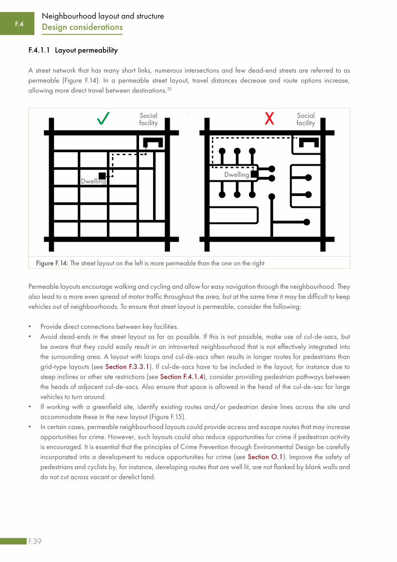
F.39
Neighbourhood layout and structure
F.4.1.1 Layout permeability
A street network that has many short links, numerous intersections and few dead-end streets are referred to as permeable (Figure F.14). In a permeable street layout, travel distances decrease and route options increase, allowing more direct travel between destinations.33
Permeable layouts encourage walking and cycling and allow for easy navigation through the neighbourhood. They also lead to a more even spread of motor traffic throughout the area, but at the same time it may be difficult to keep vehicles out of neighbourhoods. To ensure that street layout is permeable, consider the following:
• Provide direct connections between key facilities.• Avoid dead-ends in the street layout as far as possible. If this is not possible, make use of cul-de-sacs, but
be aware that they could easily result in an introverted neighbourhood that is not effectively integrated into the surrounding area. A layout with loops and cul-de-sacs often results in longer routes for pedestrians than grid-type layouts (see Section F.3.3.1). If cul-de-sacs have to be included in the layout, for instance due to steep inclines or other site restrictions (see Section F.4.1.4), consider providing pedestrian pathways between the heads of adjacent cul-de-sacs. Also ensure that space is allowed in the head of the cul-de-sac for large vehicles to turn around.
• If working with a greenfield site, identify existing routes and/or pedestrian desire lines across the site and accommodate these in the new layout (Figure F.15).
• In certain cases, permeable neighbourhood layouts could provide access and escape routes that may increase opportunities for crime. However, such layouts could also reduce opportunities for crime if pedestrian activity is encouraged. It is essential that the principles of Crime Prevention through Environmental Design be carefully incorporated into a development to reduce opportunities for crime (see Section O.1). Improve the safety of pedestrians and cyclists by, for instance, developing routes that are well lit, are not flanked by blank walls and do not cut across vacant or derelict land.
F.4 Design considerations
Figure F.14: The street layout on the left is more permeable than the one on the right
DwellingDwelling
Socialfacility
Socialfacility

F.40
Neighbourhood layout and structure
F.4.1.2 Linkages to the surrounding area
The proposed development should be connected to the surrounding area. A development with poor links to the surrounding area creates an enclave that encourages movement to and from it by car rather than by other transport modes. To link a layout to the surrounding area, consider the following:
• Where possible, provide direct connections to main streets that carry through-traffic.• Ensure that new developments are not cut off from key activity centres or social facilities by higher order roads.
This can create dangerous conditions where pedestrians might still attempt to cross these higher order roads.• Link the development with the surrounding movement networks through identified points of connection and by
extending important routes through the development to strengthen inter-neighbourhood connections. • Link the development with existing public transport routes and facilities that are near the site. Provide opportunities
for existing public transport to pass through the neighbourhood.
F.4.1.3 Street hierarchy and layout
The nature and types of streets to be provided in a neighbourhood, and the related hierarchy and layout, should be guided by the purpose of the different streets. Streets should be designed to suit the activities that will have to be accommodated, and to support activities that one would want to see happening on the street.
Existing footpaths across vacant lot
Pedestrian routes incorporated into
development
Figure F.15: Incorporate existing pedestrian routes into the layout where appropriate34
Making decisions regarding road classification
The South African Road Classification and Access Management Manual (TRH26) provides the following advice:
“Roads must be provided to suit land use and not the other way round. The road network is determined by the land use and it is the size, importance and density of destinations that need to be served that determine the number and class of road required to serve them.”35
F.4Design considerations
Streets
Buildings

F.41
Neighbourhood layout and structure
A well-considered street hierarchy can help create attractive and safe neighbourhoods (Figure F.16). For instance, by routing main distributor roads around a specific area and not through it, the quality of the area could be preserved.36
Figure F.16: A well-considered hierarchy (L) can help create a safe neighbourhood
A hierarchy of streets could assist in reducing conflict between through-traffic and local access-seeking traffic. Local conditions should guide the hierarchy, and care should be taken to consider all users of the streets, not only vehicle users. The separation of different types of traffic and road users may also not always be appropriate, and therefore a rigid hierarchy is not advisable. The following should be considered when preparing a hierarchical street layout:
• Identify streets currently used or likely to be used for public transport. • As far as possible, do not connect a street of a lower classification directly to a street of a much higher
classification. It is important to ensure a gradual change in function over the length of the trip to avoid different classes of streets affecting each other’s operations.
• Identify the location of existing and proposed activities including economic nodes and social facilities. To create economic opportunities, traffic (both motorised and non-motorised) should be encouraged to pass through an area.
• Provide dedicated NMT facilities along higher-order routes.
F.4 Design considerations

F.42
Neighbourhood layout and structure
F.4.1.4 Street curvature and gradient
Street curvature refers to the horizontal alignment of streets. Critical considerations in the design of appropriate street curvature include the place-making function of streets, the sight lines of motorists, the contours of the landscape and the provision of engineering infrastructure.37 The detailed design parameters for the horizontal alignment of streets are discussed in Section I.4. The following should guide the street layout of a neighbourhood:
• Use straight streets where possible to facilitate efficient service reticulation, specifically for stormwater, sewerage and above-ground electrical cabling. Significant cost and time savings come from having the shortest comparative service line lengths per plot, straight trenches and a minimum number of manholes.
Hierarchy of street users
In addition to multiple functions, streets also have multiple users. Often, different users have different requirements, and there is always a risk of conflict between them. A wide spectrum of needs have to be considered. One end of the spectrum relates to pure mobility, as typified by the freeway and urban arterial. Vehicle movement is the sole concern and pedestrians are totally excluded from these roads. The other end of the spectrum is concerned with accessibility and the needs of the pedestrian. Vehicular movement may be necessary on these roads but it is tolerated rather than encouraged and is subject to significant restrictions. Between these two extremes, mixed usage is found with vehicular and non-vehicular activities sharing the available space. To assist with decision- making when designing neighbourhood streets, the needs of the different users should be prioritised based on the local context and guided by the following hierarchy of users:
First consider the needs of pedestrians, followed by cyclists, public transport users, service vehicles (e.g. emergency services and waste removal), and then other motor vehicles.
It makes sense to prioritise the safety of the most vulnerable users, namely pedestrians and people with disabilities, since a safe, comfortable and attractive pedestrian environment would benefit all street users. However, streets do not all have the same purpose, and therefore the balance between different needs would be influenced by the specific circumstances. All activities should, as far as possible, be accommodated without them having to compete for space. This can be achieved by utilising the road reserve effectively and carefully designing the street cross-section (see Section F.4.1.5).
Pedestrians
Cyclists
Public transport
Service vehicles (emergency, waste, etc.)
Other motor vehicles
F.4Design considerations

F.43
Neighbourhood layout and structure
• Align streets to follow slope contours, where possible. This minimises costly ‘cut-and-fill’ exercises and enables natural gravity-flow drainage to be utilised (see Figure F.17).
• If possible, avoid layouts that use unnecessary curves, as they are costly. However, curved streets may be required under certain conditions, for instance to accommodate topographical characteristics and constraints of the development site. In some cases, cul-de-sacs could be used instead of curved streets. When using cul-de-sacs, take the factors referred to in Section F.4.1.1 into consideration.
• Weigh the financial advantages up against non-financial factors. For instance, long, straight streets might cost less than curved streets, but they can lead to unsafe driving behaviour as they sometimes encourage speeding.
Figure F.17: Align streets to follow slope contours (L)
Street gradient refers to the vertical alignment of streets. Very steep or very flat street gradients present problems relating to the circulation of larger service vehicles and the flow velocities of gravity-based engineering services. The vertical alignment of streets also has significant implications for NMT users as steep gradients are relatively easy for motorised vehicles to negotiate, but can be prohibitive to NMT users. The Department of Transport38 suggests that gradients along the paths of pedestrian and NMT travel should not be steeper than a ratio of 1:12 (8.33%), with a preferred ratio of at least 1:15 (6.66%). Access for emergency vehicles and service vehicles such as solid waste removal vehicles should ideally not be steeper than a ratio of 1:12. The detail design parameters for the vertical alignment of streets are discussed in Section I.4.
Steep gradients could have a significant impact on the cost of a development. Wherever possible, street alignment should be designed to minimise the extent and cost of earthworks and to avoid problems with access to plots. It is essential that the design of streets be coordinated with stormwater management design (Section L).
F.4.1.5 Street width and cross-section design
The cross-section of a road or street incorporates a number of components, collectively referred to as the road reserve. The road reserve is a designated area, or servitude, where certain buildings or structures and activities are not permitted. The cross-section of a road reserve comprises of two main components, namely the street or roadway, and the area between the roadway edge and the road reserve boundary, also referred to as the verge, shoulder or roadside. These two components could include various lanes for vehicular traffic, lanes set aside for
F.4 Design considerations

F.44
Neighbourhood layout and structure
public transport vehicles, parking spaces, medians (central islands), cycle lanes and sidewalks for pedestrians and NMT users.
The cross-section of a street could be designed to allow for a range of activities and users, including moving and parked vehicles, pedestrians and non-motorised vehicles such as cycles and wheelchairs. The road reserve could also accommodate engineering infrastructure and utilities such as stormwater drainage, water, electricity, communications and sewer trenches. Some of these elements can be found on the surface, while others are placed underground, either under the road itself or under the shoulder area. In addition to movement-related functions, street reserves can support recreational activities and social interaction between residents, serve as playgrounds for children, provide space for commercial activities (formal and informal trading), and they could provide a place to sleep (or even a home) to some.
Figure F.18: Road reserves can accommodate different functions depending on the context
It is evident that the width of street reserves would vary depending on the functions and activities that have to be accommodated (also see Section I.4). Some municipalities have developed their own specifications and guidelines, and information is also provided in TRH26: South African Road Classification and Access Management Manual39 and in TRH27: South African Manual for permitting services in the Road Reserve.40 The widths of road reserves, streets and lanes are dependent on the local context and would differ depending on various factors. The following should be considered:
• Under certain conditions, narrow streets, or even narrow lanes, could cause motorists to reduce speed, making for a more user-friendly streetscape and liveable neighbourhood. However, this may not always be the case, and care should be taken to ensure that narrow streets or lanes do not result in unsafe streets. The effect of the width of a street or lane on the speeds at which some motorists travel is influenced by various factors, including time of day and the number of vehicles on the road.
• The current and future purpose of the street, the traffic volume, and the type of vehicles that will be using it would influence the activities that could safely be accommodated on the shoulders and sidewalks.
• In some cases it may not be physically possible to provide a road reserve that includes more than space for a narrow street. For instance, the in-situ upgrading of an informal settlement sometimes presents a situation that challenges conventional approaches.
F.4Design considerations

F.45
Neighbourhood layout and structure
• Generally, a wider street means higher costs. It also affects the average cost of the individual plots adjoining it. Therefore, all factors, including the adjacent land uses and the scale of the buildings on either side should be carefully assessed to ensure, as far as possible, that the optimum street width is chosen.
• Topographical factors such as steep slopes may require additional space to allow for earthworks (cut and fill) within the reserve.
• In certain neighbourhoods, shoulders and sidewalks may be used for trading or light industrial activities, which would necessitate sidewalks wider than those required purely for moving pedestrians.
• Sidewalks may have to accommodate pedestrians that linger or ‘park’, for instance when they browse through goods on offer (either in shop windows or by roadside vendors), when they meet with friends, or when they patronise a sidewalk café.
• Dealing with stormwater challenges is often a critical factor that should be considered when deciding on the width of a street reserve and especially the width of the roadway itself (see Section L).
Figure F.19 illustrates typical surface elements of a road reserve. Not all these elements are always present, and the elements could be configured in a number of ways. Examples of possible permutations are demonstrated in this illustration, but more are possible. The elements included in the road reserve vary according to the availability of space, the specific needs of the neighbourhood and the costs involved in providing the various elements. The elements that could typically be included in a road reserve are discussed below.
F.4 Design considerations
Figure F.19: Surface elements of the road reserve - examples of possible configurations
Sidewalk for pedestrians
Sidewalk SidewalkCycle laneParking Traffic lanes
Sidewalk for pedestrians
(and cyclists)
Traffic lanes

F.46
Neighbourhood layout and structure
(i) Roadway (street)
The roadway is the part of the road reserve that is used by motorised vehicles and usually has a hard surface (referred to as a pavement). The number of lanes to be provided and the width of each lane should be guided by the context, including the volume and type of traffic to be accommodated. Certain neighbourhood streets would consist of two lanes in each direction, separated by a median, while in some cases one narrow lane in each direction may be more appropriate. More information is available in TRH26: South African Road Classification and Access Management Manual.41
(ii) Sidewalks
Sidewalks should provide pedestrians with a safe and convenient space to walk, linger and participate in activities taking place on the sidewalk and surrounding spaces. The width and nature of a sidewalk is determined by several factors, including the following:
• The current or anticipated future pedestrian and NMT volumes• The location of the street, for instance the CBD, a suburb or an informal settlement• The proximity to potential current and future pedestrian generators such as schools and shopping centres• The speed and volume of the traffic making use of the street related to the sidewalk, and the frequency with
which heavy vehicles may make use of the street• The types of activity that will take place on the sidewalk, including formal or informal trading• The land use associated with the properties adjacent to the sidewalk and the activities they may generate, for
instance restaurants using the sidewalk as an extension of the dining area
Figure F.20: Sidewalks may have to be adapted to accommodate the various activities that could take place there
Phot
o cr
edit:
Chr
is Ki
rchh
off (
R) -
ww
w.b
rand
sout
hafri
ca.c
om
F.4Design considerations

F.47
Neighbourhood layout and structure
Universal access
Sidewalks should, as far as possible, cater for the needs of everybody and should be designed such that they can be accessed and used by all, whether they are disabled or not, and regardless of age, size, etc. Particular attention should be paid to decisions regarding materials and the design of components such as intersections, pedestrian crossings, traffic signals, signage and street furniture. More information is provided in Section O.2.
(iii) Cycle lanes
Cycle facilities are typically accommodated either on the roadway or as a cycle-exclusive route. Care should be taken to ensure the safety of cyclists, pedestrians and motorists, for instance by using different paving material, pronounced edges and lines to demarcate lanes. The width of the movement space, and the location of street trees and signage should be carefully planned to make it safe for cyclists who are moving at a reasonable speed.
(iv) Parking and loading space
When providing on-street parking and loading space, the operating speed of traffic should be considered, as well as the activities taking place on the sidewalk. Pedestrian activity should also be taken into account and care should be taken not to create a safety hazard by allowing cars to park on the street.
(v) Lighting and street furniture
If possible, pedestrian-scaled lighting should be provided on the sidewalk or on the median (the reserved area that separates opposing lanes of traffic on divided streets). Street furniture includes seating, rubbish bins, bicycle racks and signs. Where possible, these should be grouped and located such that they enhance sidewalk activities, allow clear pathways for NMT users and do not obstruct emergency vehicles or services.
Figure F.21: Lighting, street furniture and trees make streets more pedestrian friendly
Phot
o cr
edit:
Gra
eme
Will
iam
s (R)
- w
ww
.bra
ndso
utha
frica
.com
F.4 Design considerations

F.48
Neighbourhood layout and structure
(vi) Street trees and landscaping
Trees could be used to shade the sidewalk, improve air quality, enhance the character of the streetscape and generally improve the quality of a neighbourhood. Other plants and grass could also improve the appearance of a sidewalk and provide comfortable areas for people to relax. Different paving material may be used to demarcate areas, for instance indicating the areas reserved for trading and the areas that should be kept clear for pedestrians.
(vii) Public transport bays
On designated public transport routes (or potential public transport routes) provision needs to be made for facilities such as stops, shelters and embayments. Specific attention should be given to providing parking spaces in areas where minibus taxis may be the only form of public transport.
(viii) Engineering services reticulation
Engineering service infrastructure that can be accommodated in the road reserve includes stormwater channels, and trenches for sewerage pipes, water pipes, stormwater pipes, electricity cables and telecommunication cables. The challenge is to locate this infrastructure in a manner that meets operational requirements and does not interfere with movement. Care should be taken to restore the roadway or verge where it has been disturbed after construction. More information is provided in TRH 27: South African Manual for permitting services in the Road Reserve.42
F.4.2 Street blocks and the subdivision of plots
While considering street design issues such as linkages, permeability, hierarchy, curvature, gradient and width, the layout designer should also consider the street blocks that are created through the street layout, as well as the subdivision of these street blocks into different plots. Aspects that should be considered include the impact of the natural landscape on the layout, street block dimensions, plot dimensions and densities.
F.4.2.1 Layout implications of the landscape
When planning and designing the layout of a development and determining the optimal block and plot size and shape, consider the following:
• Design blocks and plots in such a way that buildings, streets and sewers follow slope contours. This reduces the need for earthworks and allows for natural gravity-flow drainage.
• Design street blocks and individual plots so that they will drain towards the street, where possible.• Use irregular blocks where needed to adapt to the topography. • Orientate the development to make the most of attractive views.• Orientate blocks and plots so that buildings can be positioned to face north. If the long side of a plot faces
north, the building could be orientated towards the sun, and this could potentially reduce the need for heating and cooling and make it easier to install solar panels.
• Make use of unique features of the landscape such as existing buildings, rock outcrops, large trees, waterways and other characteristics to guide the layout. These could act as focus points or be included in the open space network. Land not fit for human habitation or conventional construction could possibly be used as open space or as parking areas.
F.4Design considerations

F.49
Neighbourhood layout and structure
• Accommodate risk areas (e.g. dolomitic areas and the 50-year floodplain of streams and rivers), culturally sensitive areas (e.g. grave sites) and sites of ecological importance by including them as part of open space or as conservation areas, where possible. Bear in mind that these sites have to be maintained in years to come.
F.4.2.2 Street block dimensions
The dimensions (width and length) of street blocks influence the walkability of the neighbourhood, the engineering service reticulation, the safe spacing of street intersections and plot access. Decisions regarding block dimensions should be guided by the context of the development and the following should be considered:
• Optimise block widths for safety and convenience. Block widths of around 60 m are often considered as an optimum width.
• Limit block lengths to 100 m if possible, as some pedestrians may find it strenuous if blocks are very long. Shorter blocks allow pedestrians to follow the shortest route to their destinations and they also constrain vehicle speeds.
• Provide pedestrian pathways (crosswalks) through long blocks, should the latter be the only option available. By providing these pathways in the vicinity of shopping centres, schools or parks, pedestrians would not be forced to use circuitous routes to reach their destinations. These pathways must be clearly identifiable and well maintained.
• Where possible, orientate rectangular blocks with the short side onto the street with more activities, more land uses, etc. This can increase connectivity with the surroundings and provide more crossings and junctions, which would assist in slowing down traffic, making it easier for pedestrians and cyclists to move around. Residential buildings can then line the quieter (long) sides of the block.43
• Increase the number of plots from the conventional two-plot-deep block to a four-plot-deep block in cases where plots are very small. This will reduce the total amount of space that has to be allocated to road reserves in a development. Certain subdivision patterns, like panhandle plots or blocks with dissecting pedestrian-only routes, can increase the number of plots between road reserves. However, some of these subdivision patterns assume that the plots in the middle of the block will never require private vehicular access. Ensure that most properties are accessible by vehicle.
F.4 Design considerations

F.50
Neighbourhood layout and structure
Walkable neighbourhoods
Walkable neighbourhoods can be defined as neighbourhoods that encourage and enable walking as a means of accessing different places or facilities.44 A walkable neighbourhood should typically display the following characteristics:45
• Traversable: Basic physical conditions such as smooth and uninterrupted walking surfaces and appropriate pedestrian infrastructure allow people to get from one place to another without major hindrances.
• Compact: High-density, mixed-use and transport-orientated developments (see Section F.2.3) enable pedestrians to get from one place to another by only covering a short distance.
• Safe: Low-crime areas and areas where the rules of the road are respected by all enable pedestrians to reach their destinations safely.
• Attractive: Walkable neighbourhoods are pedestrian-orientated with high-quality pedestrian infrastructure, appropriate lighting and public furniture, useful signage, attractive street trees and other amenities.
Walkable neighbourhoods have many benefits, including increased physical activity of residents, reduced carbon emissions, more affordable transportation, less congestion, less sprawl and a ‘richer’ public domain.46
When planning and designing a walkable neighbourhood, attempts are often made to establish what a comfortable walkable distance would be and to then use this as a measurement of walkability. However, a wide range of factors will affect the distance that can be walked comfortably, including whether someone is disabled or not, the person’s age, level of fitness, preferences and health status. The topography of the neighbourhood, physical characteristics such as rivers, streams and stormwater channels, and weather conditions will also affect walkability.
It is therefore challenging to identify a typical or average distance that can be regarded as a walkable distance. Often, the ease of walking is measured as the distance that can be reached within a certain time. In densely developed cities, a 5-minute walk to a destination is often regarded as convenient. Given the prevalence of low-density residential development in South African settlements (see Section F.4.2.4) and the low levels of personal mobility of large portions of the South African population, such a measure of walkability may seem ambitious. However, such convenient walking distances are technically achievable in the high-density, mixed-use and TOD zones promoted by a range of policies and plans. The use of access distances for the planning of social facilities is discussed in Section F.4.5 and in Section H.
In the broader South African settlement context, a walking time of between 15 and 20 minutes would probably be a measure of a more realistic comfortable (if not highly convenient) walkable distance. If a walking speed of 1 m/s is assumed, this would translate into a distance of between 900 m and 1.2 km.47
Walkable neighbourhoods involve more than just convenient walking distances. Such neighbourhoods are created when attention is paid to various factors, including block and plot sizes, pedestrian infrastructure, public furniture, housing typologies, densities, public transport and social facilities.
F.4Design considerations

F.51
Neighbourhood layout and structure
Engineering service reticulation also influences street block design, as the infrastructure conventionally follows the street layout. Manholes that are used for inspection of pipes and to clear blockages have to be placed at horizontal and vertical changes of direction, at junctions between main and branch pipe lines, at the head of a reticulation system and at intervals on straight stretches of pipe. These intervals on straight stretches of pipe should be spaced at approximately 80 m to 100 m from each other. Manholes can be expensive, and hence it follows that a layout with straight blocks will limit the number of manholes and save costs. Refer to Section K 4.4 for additional guidance on manhole provision.
F.4.2.3 Plot dimensions
The range of plot sizes provided in a development has a significant impact on the mix of land use activities and the range of housing types that can be accommodated. In the case of detached housing (a single house on one plot), the size of the plot often determines the density of a neighbourhood. Generally, smaller residential plots would result in relatively high densities, but this would be dependent on the context and type of neighbourhood. For instance, in low-income communities, plots in the region of 75-100 m2 would result in fairly high densities, while larger plots (in the region of 200-300 m2) may initially not achieve the same densities. However, the bigger stands may provide opportunities for house extensions and back-yard accommodation that may result in a densification of the neighbourhood as time goes by.
Development projects funded by government subsidies or grants should adhere to minimum norms and standards as specified in the National Housing Code.
The size of the plot influences its ability to accommodate change over time. A larger plot provides a flexible basis for future incremental growth to take place. (See Section H.3.3.1 for a discussion on the link between density and housing type.) The following should guide decisions regarding plot size:
• Keep the street frontage of residential plots as narrow as possible to optimise engineering services provision. The overall cost for infrastructure provided along any given street stays more or less the same, regardless of the number of plots serviced along the street. Therefore, the narrower the street frontage of the plots, the larger the number of dwelling units that share in the cost of the infrastructure and the lower the cost per dwelling unit (see Figure F.22).
• Provide larger plots for retail, commercial, industrial or civic buildings. The appropriate size and location of these plots depend on the scale, nature and compatibility of the anticipated activity, as well as on their access and distribution requirements.
• Provide a range of plot sizes that can potentially accommodate different housing types or mixed uses (see Section H.3.3.1). Upgrading an informal settlement generally does not allow for uniform plot sizes as the plot sizes emerge through a process of dialogue between relevant parties, taking into account existing buildings, spaces, streets and pathways.48
• Provide higher-density residential plots adjacent to social facilities (e.g. clinics) and open spaces (soft and hard). • Consider using panhandle plots to produce a four-plot-deep block, especially when plot lengths are less than
10 m, as it then becomes inefficient to design conventional two-plot-deep blocks. The four-plot-deep block will increase the width of the block in relation to its length and result in service cost reduction (see Figure F.22). Four-plot-deep subdivision patterns can offer reticulated engineering services at a much lower cost per plot. However, for various reasons, some people prefer plots with street frontages, for instance because of the trading opportunities they offer, because they enjoy the interaction with the street, or because it improves their sense of security.
F.4 Design considerations

F.52
Neighbourhood layout and structure
F.4.2.4 Densities
The dimensions of street blocks and the subdivision and size of plots have a direct bearing on dwelling and population densities and thus on the optimum use of land. Densification is often associated with positive outcomes such as improving the viability of public transport systems, reducing the per capita cost of providing engineering infrastructure, and allowing for more effective and efficient provision of social facilities. However, higher densities may also have undesirable effects or unintended consequences such as reducing privacy, increasing opportunities for crime, and negatively affecting the character of a neighbourhood. It is therefore important to consider the densities that might result from the street layout and structure of a neighbourhood during the planning and design phase. The link between different housing types and different densities is discussed in Section H.3.3.
When deciding on appropriate dwelling, occupancy and population densities to be accommodated in a layout, the following should be considered:
• Densities are linked to a neighbourhood’s character. Neighbourhood character is, among others, determined by architecture, activity and movement, building patterns, scale height and mix of land use. The potential impact of higher densities on existing natural, built and community qualities should be carefully assessed (see Section F.3.2 and Section F.4.7) to find ways to protect these qualities while responding to the future needs of the neighbourhood.
• There is a relationship between densities and the design of buildings. To accommodate more people on a plot (increase occupation and population density), it may be necessary to increase the height of buildings, or open spaces around buildings may have to be reduced. The relationship between residential densities and different types of housing is discussed in Section H.3.3.
• Densities have an impact on traffic volumes. More people living in a neighbourhood would result in higher traffic volumes, both motorised and non-motorised. To ensure that streets remain safe and comfortable to use, modes of transport that are less space-intensive such as NMT and public transport should be prioritised.
• Population and occupancy densities have an impact on open space requirements in a neighbourhood. If these densities are relatively high, residents rely on public open spaces as places for relaxation, recreation and
F.4Design considerations
Figure F.22: Plots with narrow street frontages (L) and panhandle plots (R) reduce service costs per plot
Stre
et
Stre
et
Panh
andl
e pl
ots
Plot
s with
wid
er st
reet
fron
tage
Plot
s with
nar
row
stre
et fr
onta
ge
Serv
ice
run
Serv
ice
run
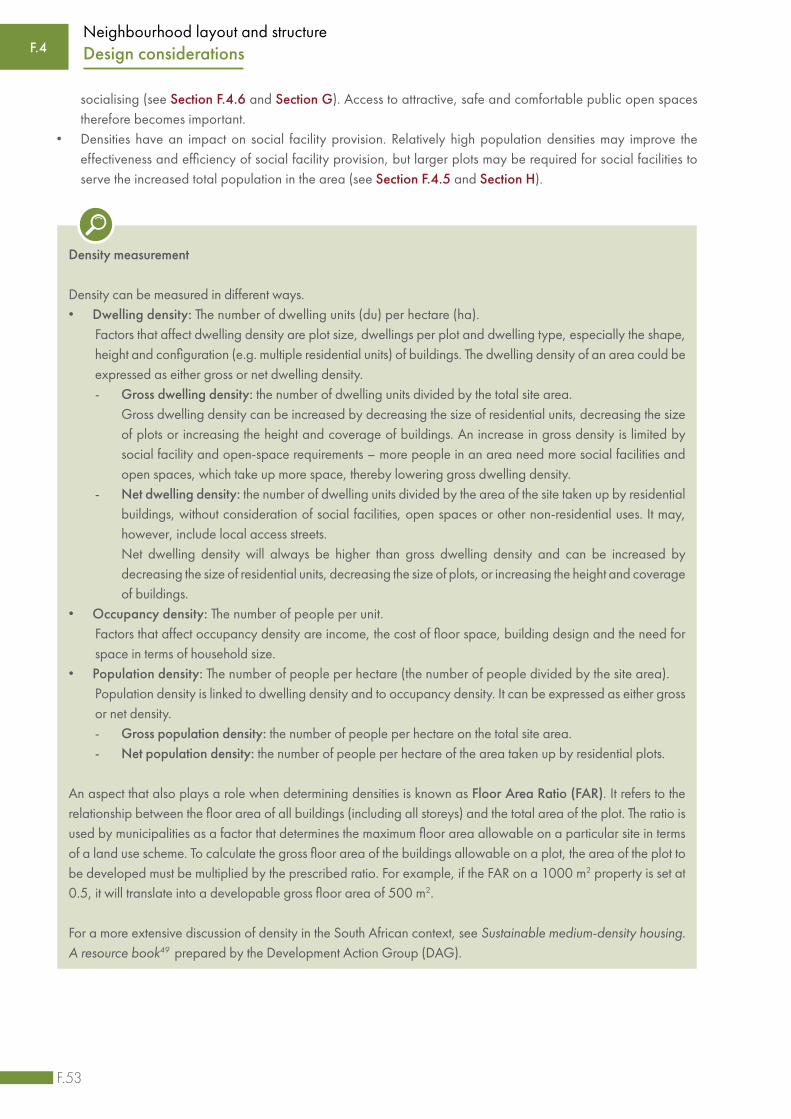
F.53
Neighbourhood layout and structure
socialising (see Section F.4.6 and Section G). Access to attractive, safe and comfortable public open spaces therefore becomes important.
• Densities have an impact on social facility provision. Relatively high population densities may improve the effectiveness and efficiency of social facility provision, but larger plots may be required for social facilities to serve the increased total population in the area (see Section F.4.5 and Section H).
Density measurement
Density can be measured in different ways. • Dwelling density: The number of dwelling units (du) per hectare (ha). Factors that affect dwelling density are plot size, dwellings per plot and dwelling type, especially the shape,
height and configuration (e.g. multiple residential units) of buildings. The dwelling density of an area could be expressed as either gross or net dwelling density.
- Gross dwelling density: the number of dwelling units divided by the total site area. Gross dwelling density can be increased by decreasing the size of residential units, decreasing the size
of plots or increasing the height and coverage of buildings. An increase in gross density is limited by social facility and open-space requirements – more people in an area need more social facilities and open spaces, which take up more space, thereby lowering gross dwelling density.
- Net dwelling density: the number of dwelling units divided by the area of the site taken up by residential buildings, without consideration of social facilities, open spaces or other non-residential uses. It may, however, include local access streets.
Net dwelling density will always be higher than gross dwelling density and can be increased by decreasing the size of residential units, decreasing the size of plots, or increasing the height and coverage of buildings.
• Occupancy density: The number of people per unit. Factors that affect occupancy density are income, the cost of floor space, building design and the need for
space in terms of household size.• Population density: The number of people per hectare (the number of people divided by the site area). Population density is linked to dwelling density and to occupancy density. It can be expressed as either gross
or net density. - Gross population density: the number of people per hectare on the total site area. - Net population density: the number of people per hectare of the area taken up by residential plots.
An aspect that also plays a role when determining densities is known as Floor Area Ratio (FAR). It refers to the relationship between the floor area of all buildings (including all storeys) and the total area of the plot. The ratio is used by municipalities as a factor that determines the maximum floor area allowable on a particular site in terms of a land use scheme. To calculate the gross floor area of the buildings allowable on a plot, the area of the plot to be developed must be multiplied by the prescribed ratio. For example, if the FAR on a 1000 m2 property is set at 0.5, it will translate into a developable gross floor area of 500 m2.
For a more extensive discussion of density in the South African context, see Sustainable medium-density housing. A resource book49 prepared by the Development Action Group (DAG).
F.4 Design considerations

F.54
Neighbourhood layout and structure
There are no absolute standards for density, and appropriate densities are specific to a range of social, economic and environmental factors. In South Africa, the description of low, medium and high dwelling densities vary, but the following ranges are often used:
• Low density: less than 40 du/ha (gross)• Medium density: 40 - 100 du/ha (gross)• High density: more than 100 du/ha (gross)
Densities cannot be easily controlled over time, since they are a result of supply and demand. A layout planned for lower densities may over time absorb more people as a result of the subdivision of large plots and the building of additional accommodation on existing plots, or because more people than anticipated occupy the dwellings in the neighbourhood. It is important that the possibility of densification over time be anticipated and allowed for in the planning and design of a neighbourhood where appropriate.
F.4.3 Engineering infrastructure
Engineering services include water provision, sewage removal, stormwater disposal, solid waste removal, ICT and electricity supply. These services are provided using a range of infrastructure, all of which have different cost implications and environmental and design requirements. Guidance on the provision of the engineering infrastructure is provided in further sections of this Guide. Certain factors should be kept in mind when planning the neighbourhood layout and structure.
F.4.3.1 Integration of engineering infrastructure and layout design
Infrastructure investments should be coordinated and integrated with the layout of a neighbourhood. Consider doing the following:
• Determine the presence, capacity and location of existing bulk or other engineering infrastructure in the area surrounding a development site. The number of connection points will affect the layout of the streets, blocks and plots.
• Design plots with narrow street frontages if possible. The overall cost for infrastructure provided along any given street stays more or less the same, regardless of the number of plots serviced along the street. Therefore, the narrower the street frontage of the plots, the more dwelling units share in the cost of the infrastructure and the lower the infrastructure cost per dwelling unit.
• Minimise the need for pump stations, manholes and junctions as these all have cost implications. • Keep street block lengths as straight as possible, as any change in direction of the infrastructure requires an
additional manhole to be added.• Keep the road reserves as narrow as possible and widen them at key points to accommodate bus stops,
informal trade and other uses.• Ensure that the road reserve is wide enough to allow access for the maintenance of engineering infrastructure
without having to run the risk of damage to adjacent properties or other infrastructure.• Make adequate provision for larger infrastructure components such as transformer stations, electrical substations
and pump stations. Provide separate plots and zone them for utility services or allow space in the layout where these components can be located.
• Consider the solid waste collection methods to be used in the new development and allow, where necessary, for separate plots for appropriate solid waste management facilities (refer to Section M.4.4) and extra space in the layout (e.g. for carts pushed by waste collectors).
F.4Design considerations

F.55
Neighbourhood layout and structure
The provision of engineering infrastructure on very flat and very hilly sites can be costly. This is particularly true for stormwater infrastructure, and thus those responsible for designing the street layout should work closely with the team dealing with stormwater management. (See Section L.)
F.4.3.2 Reticulated services and layout
Service reticulation influences the subdivision of a block into individual plots. Engineering services such as sewage removal, water supply, electrification and telecommunication cabling can be provided through reticulation either in the middle of the block or in the road reserve. Mid-block reticulation is for cost reasons often favoured in low-income areas. By not having to contend with traffic loads and other service infrastructure in the road reserve, service infrastructure located in the middle of a block can usually be laid at shallower depths.
However, there are some difficulties associated with mid-block reticulation. Gaining access to the infrastructure in the middle of a block for maintenance and other reasons is often problematic. Second dwelling units that are constructed to the rear of plots are sometimes built over the mid-block infrastructure, which may not only obstruct access – the weight of the structure on the infrastructure may also cause damage. Municipalities may have specific requirements and local restrictions may apply. (See Section K.4.4.)
F.4.3.3 Emergency and service vehicle access
Adequate access for emergency services and service vehicles is critical to serve communities. Street width affects the ability of emergency service vehicles to quickly reach a fire or medical emergency. Neighbourhood street layout must also take the movement of solid waste collection vehicles into consideration, both in terms of loading and manoeuvrability. These collection vehicles should not be required to reverse for more than 12 m if at all possible and they are usually not able to reverse up or down a slope or ramp. Narrow gates or archways and narrow or low-water bridges also restrict the movement of waste collection vehicles. (See Section M.4.2.) When designing a layout, consider the following with respect to service vehicles:
• As far as is practical, ensure that service vehicles can travel forward rather than having to reverse.• Limit the steepness of roads to enable emergency and service vehicle access. (See Section I.4.6.2.)• Provide turnaround facilities for service vehicles in areas with no through-roads (e.g. cul-de-sacs).50
• Create space within the layout for refuse collection points where vehicular access is limited.
F.4 Design considerations

F.56
Neighbourhood layout and structure
Layout design for fire safety
Settlement planning and design has limited influence on reducing the incidence of fire, but it can significantly affect its subsequent spread, people’s ability to escape from the fire, and the fighting of the fire.
The National Building Regulations, SANS 10400:2011 Part T: Fire Protection, deals with fire safety in buildings. These regulations are usually adhered to in formal developments, but they are not always applied in informal settlements. Informal structures generally do not provide the levels of fire protection required, and the lack of adequate open space between dwellings increases the risk of fires having devastating effects in these communities. It is critical for the layout of an informal settlement to allow for access by fire-fighting vehicles and equipment. Consider the following:
• Ensure adequate space between groups of buildings to limit the spread of fire, to provide escape and to provide access for fire-fighting equipment
Ensure there are fire breaks between groups of units, which can be hard or soft open spaces or movement networks. The amount of space is dependent on local weather and the topography. In windswept, flat areas, more space is required and open spaces should be downwind of the prevailing wind direction.
Heavy fire-fighting tanker vehicles can move only along paved surfaces, but usually have fire-fighting teams that are capable of handling 90 m of hose. Smaller-terrain vehicles carry less water and have 30 m hoses, but they can negotiate unpaved surfaces (gravel roads or well-maintained and clear hard or soft open spaces, including servitudes). Where regularly spaced fire hydrants are not provided, maintained or protected, each building should be within
- 30 m of a gravel road or a maintained open space network which is linked to the road network at some point, or
- 90 m of a paved road.
• Ensure adequate space between individual buildings to reduce the spread of fire Buildings should be grouped together. If dwellings are in groups of 20 or less, this effectively means that
the spread of the fire is limited to 20 units at a time, and the safety distance between the buildings can be reduced.
Decisions regarding plot size and arrangement, and the relationship between plot size, coverage and housing type should take into consideration minimum safety distance guidelines. Minimum safety distance guidelines set in SANS 10400:2011 require a safety distance of 4.5 m from wall to boundary or 9 m between buildings. Where dwelling units are in groups of less than 20 units, this can be reduced to 2 m from wall to boundary or 4 m between buildings.
• Provide access to water The provision of water for fire fighting is discussed in Section J.4.5.8.
F.4Design considerations

F.57
Neighbourhood layout and structure
F.4.4 Land use
Approaches to settlement development in the past typically emphasised land use segregation. A more appropriate approach is to integrate land uses in a network of interconnected streets designed for all users to support the development of liveable neighbourhoods. Ideally, the layout of a neighbourhood should allow for a level of land use flexibility, so as to allow land use to adapt to changing movement patterns. For settlements to be flexible over time, the layout must be able to accommodate mixed and changing land uses. A mix of uses has benefits for residents and users of a new development. Where appropriate, and where the size allows, new developments should incorporate a mix of uses. To identify the most appropriate location for certain land uses, certain factors should be considered.
F.4.4.1 Linkages to surrounding land uses
When deciding on appropriate land use for a development, it is important to acknowledge and respond to land uses in surrounding neighbourhoods. Higher-density land uses should be coordinated with those in adjacent neighbourhoods to create a larger centre of activity accessible to both neighbourhoods.
F.4.4.2 Linkages between different land uses
• Place compatible land uses next to each other. • Create buffers between zones of incompatible uses or between residential areas and risky areas that are prone
to natural disasters. The development of parks and recreation facilities in risky buffer areas is appropriate, rather than having areas of poorly maintained or unutilised spaces.
• Create noise buffers where needed (e.g. next to arterial routes, railways or industries) by the positioning of non-residential uses to provide a shield to residential uses.
• Co-locate complementary land uses such as public open space and certain social facilities.• Allow some residential plots to be used for small industry or small-scale businesses.
F.4.4.3 Nodes and streets of activity
A layout should provide for a mix of land uses and access to an identifiable activity area (node or street). This activity area provides goods and services to meet residents’ daily needs and provide important gathering places for the community. If activity areas already exist in the neighbourhood, easy access should be provided to link any new development. Should it be necessary to plan for activity nodes or streets in the layout of a new development, the following should be considered:
• Designate activity nodes or streets in locations where activity is already concentrated.• Locate appropriate and supportive land uses, such as mixed-use and higher-density developments, along
public transport routes.• Place social facilities in highly visible and accessible locations. Public squares can be used to emphasise the
civic status of these social facilities. • Enable and encourage formal and informal (where appropriate) retail or other commercial land uses in the
activity zones.• Locate higher-density housing close to identified activity nodes and along designated activity streets. Show the
distribution of higher-, medium- and lower-density residential areas in the layout plan.
F.4 Design considerations

F.58
Neighbourhood layout and structure
F.4.4.4 Land use and transportation linkages
The existing and planned public transport system provides the opportunity to concentrate development, affect the settlement’s form, and conserve the existing character of established neighbourhoods. To link land use and transportation in a layout, the following is suggested:
• Locate land uses or activities that generate a large volume of traffic along or near a main road that can be easily accessed by public transport.
• Create TOD nodes or zones at major crossings. These nodes should be served by public transport and should have high walkability.
• Locate non-residential and higher-density residential uses closer to main public transport routes (Figure F.23).
Figure F.23: Locate higher-density development along public transport routes
F.4Design considerations

F.59
Neighbourhood layout and structure
Mixed-use developments
Mixed-use developments are created by combining a range of compatible land uses into a single neighbourhood. Rather than merely consisting of a residential component, these neighbourhoods allow people to live, work, play and shop in the same area. Such developments also allow for the provision of a range of housing types (see Section H.3.3.2), which could accommodate a mix of tenure options, income groups, and social and age groups. Mixed-use developments usually result in a medium (dwelling and population) density area (see Section F.4.2.4) and provide opportunities to create a walkable neighbourhood (see Section F.4.2.2).
Potential benefits to residents of a mixed-use development may include shorter travel times, lower transportation costs, the increased viability of home-based enterprises and greater opportunities for social interaction. Community benefits of this type of development may include lower infrastructure costs and more efficient use of space and social facilities.
When designing the layout and structure of a mixed development, the following should be considered:
• Consult with the local municipality about the proposed zoning for a development. Some municipalities already have zoning categories that allow for a mix of land uses, while others have ‘special’ zoning categories with specific requirements.
• Locate higher-density uses near the entrance to a new mixed-use development site to minimise the length of roadways and of reticulated engineering services.
• Locate higher-densities and a horizontal mix of uses along major streets, in nodes and next to green open spaces.• Locate compatible uses and building types near the mixed-use development’s edge to serve as a buffer
with adjacent areas of lower density.
See Section H.4.1 for more guidance on the clustering of different facilities and land uses.
F.4.5 Social facilities
The provision of social facilities is planned at provincial, regional or local level. This section deals with the relationship between street layout and the provision of social facilities. More details regarding the planning and design of social facilities are provided in Section H.
Social facilities are critical to the functioning of any settlement and should be considered from the outset when planning and designing the layout of a neighbourhood. The placing of social facilities within neighbourhoods affects diverse aspects such as movement patterns and land use choices and could potentially contribute to better functioning and more equitable neighbourhoods.
After having applied the guidelines set out in Section H and having determined the number and size of facilities to provide for in the development project, the following need to be considered when planning for social facilities in a layout design:
• Assess the provision and viability of facilities in relation to the location and scale of the development project. Often it may not be necessary to provide certain facilities because they are already available in neighbouring
F.4 Design considerations

F.60
Neighbourhood layout and structure
areas and can also provide services to the residents of the new development. It is however not socially responsible to rely only on neighbouring areas for services, as inevitably the cumulative impact of a number of new neighbourhoods will have an impact on local services. Where possible, a number of neighbourhoods should be planned together so that each contributes equitably to the provision of land or facilities for social service provision.
• Group and develop social facilities as clusters or civic precincts according to their function so as to facilitate the sharing of resources and utilities between facilities (see Section H.4.1 for guidance on how different facilities could be grouped). Social facilities could also be clustered with retail or other commercial land uses to support nodal development and facilitate user access and convenience. When designing the layout, the following should be done to make provision for clustered social facilities:
- Set aside relatively large plots for social facility clusters or civic precincts that are well located relative to existing or future public transport. These plots could be subdivided at a later stage if necessary.
- Combine social facilities with hard public open spaces in order to accommodate supporting activities such as trading.
- Locate social facilities adjacent to public transport ranks, stops or facilities. • Provide direct, safe and convenient routes between social facilities and public transport stops, in order to
increase inter-neighbourhood access for those who use public transport. • Provide a pedestrian-friendly network to link social facilities, public open spaces and public transport. See
Section F.4.2.2 for a discussion on the walkability of neighbourhoods. • Place social facilities on plots where they may become a neighbourhood landmark. This will contribute to the
character of the neighbourhood and assist people in finding their way.
The specific location of a social facility in a neighbourhood should support the service to be provided. For instance, facilities that typically only serve a particular local community need to be accessible to the local community:
• Locate neighbourhood-focused facilities such as crèches in quiet and safe areas that are accessible to pedestrians.• Identify social facilities to be placed in a safe geographical location that can be used as refuge in case of a
natural disaster such as flooding or torrential rain.
Facilities that serve a broader community, or are likely to outlive the current community usage, should be “externalised” in the sense that they should be located on the edges of the neighbourhood or at places where they can be accessed with relative ease from surrounding neighbourhoods:
• Locate facilities such as clinics, taxi ranks, public service centres, post offices and pay points at a central locality that is accessible to several neighbourhoods to serve the greatest number of people.
• Locate emergency support facilities such as fire stations and police stations at places with easy access to distribution roads.
• Locate social facilities at accessible points on the settlement movement network. This will increase the facilities’ catchment areas.
F.4.6 Public open space
Public open space is a key component of any well-functioning settlement. Public open space should from the outset be incorporated into the layout of a development as one of the structuring elements. Provision should be made for community spaces such as playgrounds, neighbourhood parks, green corridors, riparian protection zones and squares for commercial activities like public markets. These spaces play an important role in the improvement of
F.4Design considerations

F.61
Neighbourhood layout and structure
residents’ quality of life. They reduce air, sound and visual pollution, protect the soil and the natural water cycle, and improve the permeability of the ground.
The planning and design of different types of public open space, including size and threshold guidelines, is discussed in Section G. However, decisions regarding the provision of public open space should not merely be based on thresholds, percentages or numbers per population. The role that public open space plays in improving the liveability of a neighbourhood should always be acknowledged, but must be balanced against the ability to maintain the space over the long term. The most efficient way in which public open space could be provided and where it should be located should be informed by the context and local conditions. The principles of crime prevention through environmental design as outlined in Section O.1 should also be carefully considered when planning and designing public open space.
F.4.6.1 Networks of public open space
Networks of public open space are often more useful for visual amenity, recreational use and wildlife corridors than isolated and unrelated landscape elements. These networks create linkages to existing urban areas, other development sites and the wider landscape. When planning and designing public open space as part of a neighbourhood layout, consider the following:
• Create a network of hard open spaces including streets, squares and courtyards. The movement network (streets and other routes) should form the basis for the network of hard open spaces. Neighbourhood streets can also serve as public spaces that are used for a variety of social activities (see Section F.4.1).
• Create a network of soft open space by joining up elements such as linear parks, road reserves, sports fields, private gardens, buffer planting and surface drainage corridors.
• Identify possible linkages with existing open space networks in adjacent neighbourhoods.• Create greenways that run through or along linear neighbourhood elements such as natural streams or wooded
belts and connect with parks and footpaths in nearby neighbourhoods. These can then link to neighbourhood streets that have cycle routes.
• Integrate public open space networks with engineering services like major stormwater systems (retention ponds, aquifer recharge areas and open water canals) to enable these spaces to perform numerous functions, thereby creating activity and surveillance.
• Designate areas prone to risk – such as gullies, watercourses and steep hills that are not suitable for building – as part of the natural public open space.
• Create fewer, but larger and more multi-functional public open spaces, rather than many public open spaces that are expensive to manage and maintain.51
F.4.6.2 Access to public open space
It is important to ensure that public open spaces are accessible, as residents use public open spaces and natural resources such as rivers and beaches for a variety of purposes, including as sites of worship, for rituals and for initiation practices. To optimise accessibility, consider the following:
• Locate appropriate hard and soft open spaces at points of access, for example at transport mode interchanges, public transport stops, on important access routes and close to active intersections so as to make them as accessible as possible.
• Place local parks (for children’s play, etc.) within walking distance of the majority of homes.• Locate spaces of exchange and interaction in bustling areas. • Locate spaces of relief and relaxation in quieter areas.
F.4 Design considerations

F.62
Neighbourhood layout and structure
F.4.7 Neighbourhood identity
The layout and structure of a development could contribute to the creation of a neighbourhood with a strong identity. Street layout and the interaction between buildings and open space could play a role in creating a well-functioning neighbourhood with an interesting, pleasant or aesthetically pleasing character. However, if not well considered, the layout and structure could result in a bland neighbourhood with a dull and uninspiring character. This could make for a confusing place, where it is easy to get lost and disoriented. The layout and structure of a development can be used to create places, not only spaces, by doing the following:
• Ensure that the street network is easy to understand and structure the streets and spaces in such a way that it is obvious which streets are the more important ones that connect places and are used by many people, and which are the more private, quieter streets that are mostly used by the people living on them.
• Identify opportunities for creating or reinforcing a sense of identity, for instance by using distinctive landscapes, natural features, buildings, streets, street patterns, spaces, skylines or building forms as structuring elements. The layout could be designed to incorporate these as landmarks, vistas and focal points (Figure F.24).
Figure F.24: Identify opportunities for creating or reinforcing a sense of identity
Phot
o cr
edit:
Chr
is Ki
rchh
off (
R) -
ww
w.b
rand
sout
hafri
ca.c
om
• Use the most important transport interchanges or nodes to serve as gateways to the neighbourhood. • The way buildings are placed on a plot and the relationship between buildings and the street (Figure F.25)
have an impact on how users perceive and experience a neighbourhood and therefore also contribute to the neighbourhood identity (refer to Section H.4.2).
F.4Design considerations

F.63
Neighbourhood layout and structureF.4 Design considerations
Figure F.25: Sterile street due to boundary wall (T); interaction between building and street without wall (B)

Glossary, acronyms, abbreviations
Glossary
Building lineAn imaginary line that defines an area within and parallel to the boundary of a plot within which no permanent structures may be built. The purpose of the building line is to prevent buildings from being erected too close to neighbouring properties or to the street. Building lines are defined in the local land use scheme and are not the same for all plots.
Consent useConsent use means that a municipality allows additional land use rights on a particular property upon request. The zoning of the property will not be changed. The zoning category, as described in the land use scheme, usually makes provision for a pre-described number of uses that may be allowed for with the necessary consent.
CoverageThe footprint area of a building expressed as a percentage of the total plot area, as seen from directly above the property. The coverage is not affected by the number of storeys of the building. For example, a building with an area of 400 m², which is located on a plot of 1 000 m², will have a coverage of 40%.52
Desire lineAn imaginary line that links facilities or places, and that would form a convenient and direct route for pedestrians and cyclists. Desire lines become evident when watching people move through an area. These lines are often visible as informal footpaths across an open space.
GrainGrain or urban grain refers to the pattern and intensity of buildings and their plots, as well as how they combine to form blocks within a settlement. Grain may be ‘fine’, comprising small blocks and frequent street junctions, or it may be ‘coarse’, comprising large blocks and infrequent street junctions.
Land use schemeA land use scheme forms part of a land use management system that regulates and manages land use within a municipality. The scheme confers legal rights to properties to develop and to erect and use buildings subject to certain stipulated conditions. A detail description of the content of a land use scheme is provided in Chapter 5 of SPLUMA.
PlotA measured piece of land, also known as an erf, stand or site that is registered at the deeds registration office or forms part of a municipal land use scheme.
RezoningA colloquial description of the process of making an amendment to a land use scheme (or any of its provisions), to change the land use rights and development restrictions applicable to a specific property.53
Road reserveA road reserve is a legally described area within which facilities such as roads, footpaths and associated features
The Neighbourhood Planning and Design GuideNeighbourhood layout and structure
F.64

may be constructed for public movement. It is the total area between boundaries shown on a cadastral plan. It may also include an area alongside the road that may in future be used for expansion of the road width.
Sense of placeThe sense of place of a neighbourhood can be described as the attitudes and feelings that individuals and groups hold towards the neighbourhood. A sense of place is therefore subjective, but useful generalisations can be made e.g. that some spaces, at least for most people who encounter them, provide an experience that is unique and place-specific rather than generic. Places that have unique characteristics and histories are often considered to have a heightened sense of place. Layers of history, unique architecture or layouts, and place-specific signs and symbols help differentiate one place from another. But sense of place is not just about the physical environment, it also entails our perceptions of the positive social interactions that we partake in and those that we observe within a neighbourhood.54
ServitudeA servitude is a registered right that a person or an entity has over the immovable property of another person. It usually means that a portion of land is set aside for a specific purpose, such as road widening, or provision for engineering infrastructure (e.g. water pipelines, electricity cables, sewerage pipes). The municipality might for example have the right to construct electricity cables over a privately owned property. The property owner is then restricted in what he or she can do within the servitude. The servitude is attached to the property and will continue to exist even if ownership of the land changes. The servitude forms part of the conditions contained in the title deed and can only be cancelled by agreement between both parties.
Site development planA plan that provides an overview of the intended development on a property, specifically indicating features such as the position of the proposed buildings, access provisions, parking, landscaping, adherence to the building lines and the position of servitudes.
Spatial Development FrameworkSPLUMA requires all three spheres of government to produce Spatial Development Frameworks (SDFs). The focus of the three types of SDF differ. The national SDF provides broad strategic direction, provincial SDFs focus on the coordination of spatial development, and a municipal SDF contains detailed plans for the particular area of jurisdiction. Within the municipal sphere, the SDF forms a core component of the Integrated Development Plan (IDP) and guides the overall spatial distribution of current and desirable land uses within a municipality to give effect to the vision, goals and objectives of the municipal IDP. A detailed description of the content of SDFs is provided in Chapter 4 of SPLUMA.
SprawlSprawl is sometimes described as an urban form that is the opposite of the desirable compact city. Sprawling areas are generally known for low densities, decentralised nodes and uniform land uses. However, what is considered to be sprawl can be found along a continuum of more compact to completely dispersed development. A variety of urban forms have been described as ‘urban sprawl’, including contiguous suburban growth, linear strip developments, leapfrog and scattered developments and extended residential development in tribal authority areas.55
Street blockA street block is the smallest part of a settlement enclosed by streets. It is usually rectangular in shape and usually contains several buildings.
The Neighbourhood Planning and Design GuideNeighbourhood layout and structure
F.65

Subdivision of landLand subdivision is the act of dividing a parcel of land into two or more pieces for the purpose, whether immediate or in the future, of selling the land or using it for building development.
SuperblockA superblock is a street block that is much larger than a traditional street block. It is often used in layouts to reduce the impact of cars on a neighbourhood by barring access to motorised traffic while still allowing pedestrian routes through the block.
Title deedA title deed is a government-issued document that stipulates who the owner of the property is, the property’s land use zoning and associated rights, as well as any restrictions such as servitudes, amended building lines, and area-specific conditions.
Township establishmentTownship establishment is a legal process whereby agricultural land is converted into proclaimed individual plots (with certain land use rights attached to them) which can be transferred to different owners. The process is regulated by SPLUMA.
VergeThe verge is the area between the roadway edge and the road reserve boundary.
Zoning A property’s zoning stipulates the purpose for which the land may be used and is described in the municipality’s land use scheme. The zoning also stipulates restrictions on the building erected on the property in terms of floor area ratio, coverage, density, parking requirements, etc. In order to change the purpose for which the property can be used, an application for rezoning has to be submitted to the local municipality for consideration.
Acronyms and abbreviations
BEPP Built Environment Performance Plan
CBA Critical Biodiversity Area
CBD Central Business District
DAG Development Action Group
EIA Environmental Impact Assessment
ESA Ecological Support Area
FAR Floor Area Ratio
IDP Integrated Development Plan
IUDF Integrated Urban Development Framework
NEMA National Environmental Management Act
NMT Non-Motorised Transport
PGDS Provincial Growth and Development Strategy
SAHRA South African Heritage Resources Agency
The Neighbourhood Planning and Design GuideNeighbourhood layout and structure
F.66

SANBI South African National Biodiversity Institute
SDF Spatial Development Framework
SDG Sustainable Development Goal
SPLUMA Spatial Planning and Land Use Management Act
TOD Transport-Oriented Development
WSD Water Sensitive Design
WSUD Water Sensitive Urban Design
The Neighbourhood Planning and Design GuideNeighbourhood layout and structure
F.67

Endnotes1 Du Plessis, C., Brandon, P. 2015. An ecological worldview as basis for a regenerative sustainability paradigm for
the built environment. Journal of Cleaner Production, 109, 53–61.2 Bickford, G., Behrens, R. 2015. What does transit-oriented development mean in a South African context? A
multiple stakeholder perspective from Johannesburg. Proceedings of the 34th Southern African Transport Conference. Pretoria.
3 Wilkinson, P. 2006. ‘Transit Oriented Development’: A strategic instrument for spatial restructuring and public transport system enhancement in South African cities? Proceedings of the 25th Southern African Transport Conference. Pretoria.
4 National Treasury. Neighbourhood Development Programme. http://ndp.treasury.gov.za/5 Wong, T.H.F. 2006. Water sensitive urban design - the journey thus far. Australasian Journal of Water Resources,
10(3), 213–222.6 University of Cape Town. 2018. UCT Urban Water Management: Water Sensitive Design. http://www.uwm.uct.
ac.za/7 Armitage, N., Fisher-Jeffes, L., Carden, K., Winter, K., Naidoo, V., Spiegel, A., Mauck, B., Coulson, D. 2014.
Water Sensitive Urban Design (WSUD) for South Africa: Framework and Guidelines. WRC Report No. TT 588/14. Water Research Commission, Pretoria.
8 Armitage, N., Vice, M., Fisher-Jeffes, L., Winter, K., Spiegel, A., Dunstan, J. 2013. The South African guidelines for sustainable drainage systems. Report TT 558/13. Water Research Commission, Pretoria.
9 Jabareen, Y.R. 2006. Sustainable urban forms: Their typologies, models, and concepts. Journal of Planning Education and Research, 26(1), 38–52.
10 Ecocity Builders. 2018. Ecocity Builders. https://ecocitybuilders.org/11 Adam, A.G. 2016. Urbanization and the Struggle for Land in the Peri-Urban Areas of Ethiopia. Proceedings of the
Annual Bank Conference on Africa. The World Bank Group, Oxford.12 KwaZulu-Natal Planning and Development Commission. 2010. Land Use Management Systems in Rural Areas.13 Department of Rural Development and Land Reform. 2013. Climate Change Adaptation Sector Strategy for Rural
Human Settlements.14 Department of Rural Development and Land Reform. 2017. Land Use Scheme Guidelines.15 CSIR. 2019. Green Book: Adapting South African settlements to climate change. https://greenbook.co.za.16 South African National Biodiversity Institute. https://www.sanbi.org.17 Ellickson, R.C. 2013. The law and economics of street layouts: How a grid pattern benefits a downtown. Paper
4807. http://digitalcommons.law.yale.edu/fss_papers/480718 Grammenos, F., Pollard, D. 2005. Reevaluating the Grid. http://www.greekworks.com/content/index.php/weblog/extended/reevaluating_the_grid19 Li, D. 2011. Effects of street pattern on frequency of traffic crash: A case study of Gainesville, Florida. Master’s
Degree. University of Florida. http://etd.fcla.edu/UF/UFE0043823/LI_D.pdf20 Southworth, M., Ben-Joseph, E. 2003. Streets and the Shaping of Towns and Cities. Island Press, Washington DC.21 Wheeler, S.M. 2015. Built Landscapes of Metropolitan Regions: An International Typology. Journal of the
American Planning Association, 81(3), 167–190.22 Canada Mortgage and Housing Corporation (CMHC). 2010. Applying Fused-Grid Planning in Stratford,
Ontario. Research Highlight, Socio-economic Series.23 Hawkins, C. 2007. Assessing the Fused Grid residential street design: Travel and walking levels associated with
disparate pedestrian and motor vehicle connectivity. Proceedings of the Walk 21 Conference. Toronto. http://www.fusedgrid.ca/docs/Walk21Paper-ChrisHawkins.pdf
The Neighbourhood Planning and Design GuideNeighbourhood layout and structure
F.68

24 Forsyth, A. 2015. What is a walkable place? The walkability debate in urban design. Urban Design International, 20(4), 274–292.
25 Information and images supplied by Herman Steyn, Manager: Human Settlements Management, City of Cape Town.26 The National Upgrading Support Programme (NUSP). 2015. Resource Kit - Chapter 8: Layout and Infrastructure. http://upgradingsupport.org/uploads/resource_documents/participants-combined/Chapter-8-Layout-and-
Infrastructure-May-2016.pdf 27 NUSP. 2015.28 NUSP. 2015.29 South African SDI Alliance (SASDI). 2018. South African SDI Alliance. https://www.sasdialliance.org.za/30 SASDI website. 2018.31 Behrens, R.B., Watson, V. 1996. Making Urban Places: Principles and Guidelines for Layout Planning. Urban
Problems Research Unit University of Cape Town, Cape Town.32 Global Designing Cities Initiative (GDCI). 2017. Designing Streets for Place. https://globaldesigningcities.org/publication/global-street-design-guide/designing-streets-for-place/33 Victoria Transport Policy Institute (VTPI). n.d. Online TDM Encyclopedia. http://www.vtpi.org/tdm/34 After Kruger, T., Landman, K. 2007. Crime and public transport : designing a safer journey. Proceedings of the
26th Annual Southern African Transport Conference. Pretoria.35 Committee of Transport Officials. 2012. TRH 26: South African Road Classification and Access Management
Manual.36 United Nations Human Settlements Programme (UN-Habitat). 2012. Planning Urban Settlements in South Sudan:
Basic concepts. No. 115/12E. UN-Habitat, Nairobi. https://unhabitat.org/books/planning-urban-settlements-in-south-sudan/37 Making Urban Places. 1996.38 Department of Transport. 2016. National Technical Requirement 1: Pedestrian Crossings [Part 2] (NTR1).39 TRH 26. 2012.40 Committee of Transport Officials. 2012. TRH 27: South African Manual for Permitting Services in Road Reserves.41 TRH 26. 2012.42 TRH 27. 2012.43 Llewelyn-Davies, Alan Baxter & Associates. 2007. Urban Design Compendium (Second Edition). English
Partnerships and The Housing Corporation, London.44 Lee, S., Talen, E. 2014. Measuring Walkability: A Note on Auditing Methods. Journal of Urban Design, 19(3),
368–388.45 What is a walkable place? 2015.46 Brookfield, K. 2017. Residents’ preferences for walkable neighbourhoods. Journal of Urban Design, 22(1), 44–58.47 Department of Transport. NTR1. 2016.48 The NUSP Introduction to Informal Settlement Upgrading course. 2015.49 Tonkin, A. 2008. Sustainable medium-density housing: A resource book. Development Action Group, Cape Town.50 City of Cape Town. 2016. Directives for the Planning, Design and Implementation of Human Settlements Projects
in Cape Town. http://resource.capetown.gov.za/documentcentre/Documents/Procedures,%20guidelines%20and%20
regulations/Directives%20for%20Human%20Settlements.pdf51 Directives for the Planning, Design and Implementation of Human Settlements Projects in Cape Town. 2016.52 South African Association of Consulting Professional Planners (SAACPP). https://www.saacpp.org.za/53 https://www.saacpp.org.za. 54 Wilkie, R., Roberson, G.F. 2010. Sense of Place. In Encyclopedia of Geography. SAGE, Thousand Oaks.55 Royal Town Planning Institute (RTPI). 2015. Urban form and sustainability. RTPI Research Briefing. No. 9.
The Neighbourhood Planning and Design GuideNeighbourhood layout and structure
F.69

The Neighbourhood Planning and Design GuideNeighbourhood layout and structure
F.70

The Neighbourhood Planning and Design GuideNeighbourhood layout and structure
F.71

The Neighbourhood Planning and Design GuideNeighbourhood layout and structure
F.72