Kentwood West Neighbourhood Area Structure Plan · KENTWOOD WEST NEIGHBOURHOOD AREA STRUCTURE PLAN...
28
KENTWOOD WEST NEIGHBOURHOOD AREA STRUCTURE PLAN July 1998 Adopted July 13, 1998 Amended September 2000 Amended June 2003 Prepared by: Parkland Community Planning Services & City of Red Deer Engineering Services
Transcript of Kentwood West Neighbourhood Area Structure Plan · KENTWOOD WEST NEIGHBOURHOOD AREA STRUCTURE PLAN...
KENTWOOD WEST NEIGHBOURHOOD AREA STRUCTURE PLAN
July 1998 Adopted July 13, 1998 Amended September 2000 Amended June 2003
Prepared by:
Parkland Community Planning Services &
City of Red Deer Engineering Services
KENTWOOD WEST NEIGHBOURHOOD AREA STRUCTURE PLAN
1.0 INTRODUCTION 1 1.1 PURPOSE 1 1.2 BACKGROUND 1 1.3 DEFINITION OF PLAN AREA 22.0 SITE CONTEXT AND DEVELOPMENT CONSIDERATIONS 2 2.1 NATURAL FEATURES 2 2.2 EXISTING LAND USES 3 2.3 EXISTING TRANSPORTATION NETWORK AND ACCESS 4 2.4 ENVIRONMENTAL CONSIDERATIONS 4 2.5 SERVICING 4 3.0 DEVELOPMENT OBJECTIVES 4 3.1 DEVELOPMENT OBJECTIVES 4 3.2 DEVELOPMENT PRINCIPLES 5 3.3 DEVELOPMENT CONCEPT 7
3.3.1 NEIGHBOURHOOD STRUCTURE 7I) RESIDENTIAL LOW DENSITY DISTRICT (R1) 7II) TWO STOREY RESIDENCES WITH WALKOUT BASEMENTS 7III) RESIDENTIAL NARROW LOT 7IV) RESIDENTIAL R1A (SEMI-DETACHED DWELLING) 8V) RESIDENTIAL (MEDIUM DENSITY) DISTRICT 8
3.3.2. DENSITY 8 3.3.3 COMMERCIAL (NEIGHBOURHOOD CONVENIENCE) DISTRICT 93.3.4 OPEN SPACE AND PARKS 93.3.5 SOCIAL FACILITIES 103.3.6 TRANSPORTATION 103.3.7 MUNICIPAL RESERVE 113.3.8 NEIGHBOURHOOD PARK AND TREED RESERVE PLANS 12
4.0 MUNICIPAL SERVICING 12 4.1 STORM SEWER SYSTEM 12 4.2 SANITARY SEWER SYSTEM 12 4.3 WATER DISTRIBUTION SYSTEM 13 4.4 SHALLOW UTILITIES 135.0 STAGING OF DEVELOPMENT 13 APPENDICES 14 Appendix A: Kentwood Natural Area – Ecological Profile Appendix B: Kentwood natural Area – native treed area and wetland Appendix C: Neighbourhood School and Park Site Map
List of Figures Figure 1: Location Map Figure 2: Existing Features Figure 3: Development Concept Figure 4: Major Drainage Figure 5: Storm Sewers Figure 6: Sanitary Sewers Figure 7: Watermains Figure 8: Staging
1.0 INTRODUCTION
1.1 Purpose
The purpose of this Neighbourhood Area Structure Plan is to specify the land use development
objectives for the western portion of the Kentwood neighbourhood in the City of Red Deer. This
neighbourhood consists of a 55.6 hectare (137.3 acre) site located in the Northwest quadrant of
the City at the intersection of Taylor Drive and 77th Street. The Kentwood neighbourhood sits
next to existing residential development on the eastern and southern sides, industrial
development to the north, and vacant lands to the west.
The site falls within and is subject to the Northwest Major Area Structure Plan (ASP). The
Neighbourhood Area Structure Plan presented here is intended to augment the Major Area
Structure Plan by identifying the size, location, and type of land uses found in the Kentwood
West area as well as the density of these uses. Moreover, the Neighbourhood Area Structure
Plan discusses the natural and cultural features of the site and possible environmental hazards.
The Neighbourhood Area Structure Plan submits concepts for transportation design and the
development of public and social facilities. The Plan also notes the proposed staging of
development and servicing specification for the area.
1.2 Background
In 1998, an updated Northwest Major Area Structure Plan was adopted by Council. This plan
incorporates and implements the City’s new Ecospace Management Plan. The updated Major
ASP also responds to recent roadway, park, and land use changes, which have occurred within
the Northwest Area Plan boundaries. Prior to these most recent amendments, the plan underwent
two other revisions in the years since its initial development. In 1980-81 the current Northwest
Major ASP started as two separate plans, the Section 19 Area Structure Plan and the original
Northwest Area Structure Plan. In 1989 these two plans were consolidated under the revised
Northwest Area Structure Plan. In 1992 the plan was again updated in response to new growth,
changes in school location, and railway relocation. The current Northwest Major Area Structure
Plan allows for diversified residential development between a density of 12.35 units per hectare
and 17.3 units per gross hectare. Other land uses highlighted in the plan include commercial,
1
industrial, public service (school), park, trail, natural reserve, transportation, and service facility
uses. The Northwest Major Area Structure Plan is implemented by way of Neighbourhood Area
Structure Plans for specific neighbourhoods including, this, the Kentwood West Neighbourhood
Area Structure Plan.
1.3 Definition of Plan Area
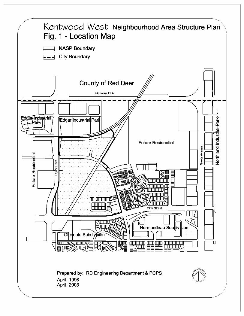
The Kentwood Neighbourhood Area Structure Plan area is situated in the Northwest section of
Red Deer. It refers to the western portion of Section 32, Township 38, Range 27, west of the 4th
Meridian. The area covered by this plan is approximately 55.6 hectares (137.3 acres) in size. It
is bounded to the north by the CPR line, to the east in part by the existing Kennedy Drive, to the
south by 77th Street, and to the west by Taylor Drive. See Figure 1.
The Neighbourhood Area Structure Plan presented here is consistent with the goals and
guidelines of the Northwest Area Structure Plan. Its overall objective is to provide a framework
and series of guidelines for neighbourhood land use planning, leading to well organized and
sustainable subdivision and land use development.
2.0 SITE CONTEXT AND DEVELOPMENT CONSIDERATIONS
2.1 Natural Features
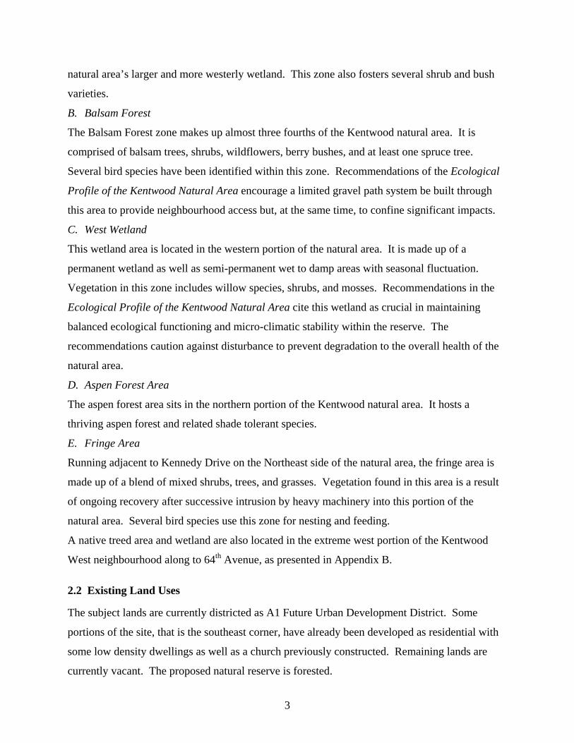
The lands within the proposed Neighbourhood Area Structure Plan area are generally flat with
elevations rising from 878.4 metres to 884 metres across the entire site, as shown in Figure 2.
The plan site includes areas that are currently cleared and awaiting development, as well as
forested tracts, wetland areas, and some previously developed residential properties.
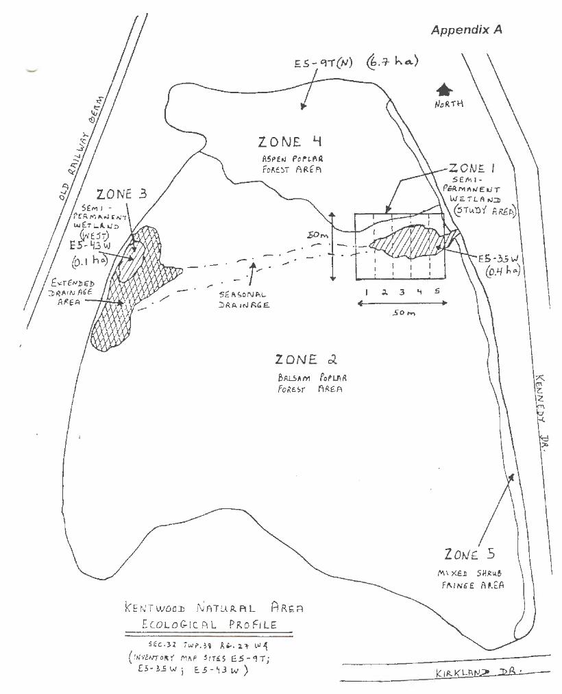
The City of Red Deer’s Ecological Profile of the Kentwood Natural Area identifies the
Kentwood natural area found in the central portion of the Neighbourhood Area Structure Plan.
The natural area is recognized as having five environmentally significant zones, as shown in
Appendix A. The ecological profile strongly recommends that all five zones within the area be
preserved due to their interconnected functioning. These five zones include:
A. Semi-Permanent Wetland
The semi-permanent wetland area is situated in the eastern portion of the natural area. It is
comprised of a wetland, which receives seasonal surface drainage and acts as a link with the
2
ca _. Q)
"'C ·u; Q)
c::: ~ :::::J _. :::::J
LL
Kentwood West Neighbourhood Area Structure Plan Fig. 1 - Location Map
~ NASP Boundary
~ City Boundary
County of Red Deer
~----..~~~~H-ig_hw_ay_1_1A~~~--i0~~~~______/ --[L-Edgar ndustrial Par EI]
Future Residential 'J ~ ~o -g
-~ Cl
5 ~
Prepared by: RD Engineering Department & PCPS
April, 1998 April, 2003
~~~ !:! t:: CD 0 ~ z
~ ti
natural area’s larger and more westerly wetland. This zone also fosters several shrub and bush
varieties.
B. Balsam Forest
The Balsam Forest zone makes up almost three fourths of the Kentwood natural area. It is
comprised of balsam trees, shrubs, wildflowers, berry bushes, and at least one spruce tree.
Several bird species have been identified within this zone. Recommendations of the Ecological
Profile of the Kentwood Natural Area encourage a limited gravel path system be built through
this area to provide neighbourhood access but, at the same time, to confine significant impacts.
C. West Wetland
This wetland area is located in the western portion of the natural area. It is made up of a
permanent wetland as well as semi-permanent wet to damp areas with seasonal fluctuation.
Vegetation in this zone includes willow species, shrubs, and mosses. Recommendations in the
Ecological Profile of the Kentwood Natural Area cite this wetland as crucial in maintaining
balanced ecological functioning and micro-climatic stability within the reserve. The
recommendations caution against disturbance to prevent degradation to the overall health of the
natural area.
D. Aspen Forest Area
The aspen forest area sits in the northern portion of the Kentwood natural area. It hosts a
thriving aspen forest and related shade tolerant species.
E. Fringe Area
Running adjacent to Kennedy Drive on the Northeast side of the natural area, the fringe area is
made up of a blend of mixed shrubs, trees, and grasses. Vegetation found in this area is a result
of ongoing recovery after successive intrusion by heavy machinery into this portion of the
natural area. Several bird species use this zone for nesting and feeding.
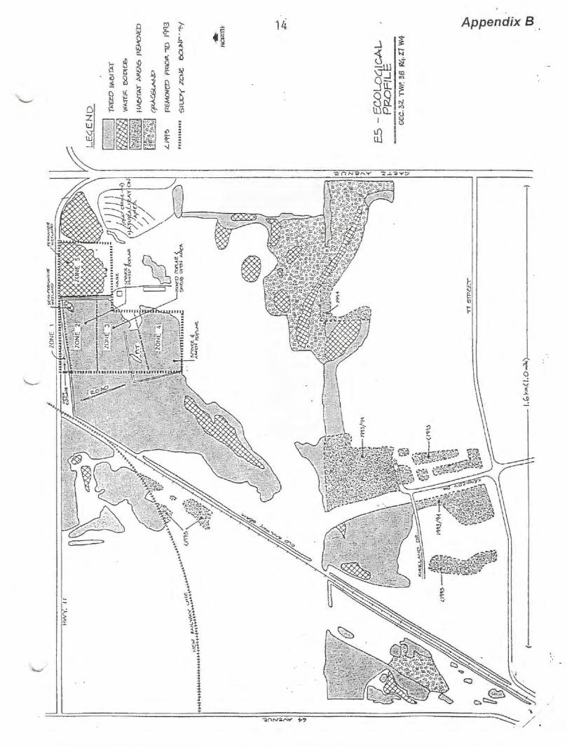
A native treed area and wetland are also located in the extreme west portion of the Kentwood
West neighbourhood along to 64th Avenue, as presented in Appendix B.
2.2 Existing Land Uses
The subject lands are currently districted as A1 Future Urban Development District. Some
portions of the site, that is the southeast corner, have already been developed as residential with
some low density dwellings as well as a church previously constructed. Remaining lands are
currently vacant. The proposed natural reserve is forested.
3
Kentwood West Neighbourhood Area Structure Plan
Fig. 2 - Existing Features E::J NASP Boundary ~ Treeline
-~ Abandoned Railway Rm .<::) ~ Seasol)SI WeUand
w > ~ 0 n:: 0 _.
~
17th STREET
Prepared by: RO Engioeemg Department & PCPS
Apfi. 1998
· Scale In Metres 0 50 100
PROPOSED KENTWOOD EAST OUTLINE PLAN
2.3 Existing Transportation Network and Access
Existing access to the site is provided by the arterial roads of 77th Street and Taylor Drive and by
Kennedy Drive, a collector road.
2.4 Environmental Considerations
A Level 1 Environmental Site Assessment was completed by UMA Engineering Ltd. and
submitted to the City of Red Deer on April 30, 1998 under separate cover. The assessment
indicated that there is no evidence nearby industrial or related activities have resulted in
contamination of Kentwood West. The assessment does state, however, that based on the
proximity of industrial uses, there is ongoing potential in the Kentwood area for environmental
impact. No spills, control orders, or underground storage tanks are on record with either the City
of Red Deer or with Alberta Environmental Protection. As regards Kentwood West, no
mitigation activities are required nor recommended by the assessment. Further investigation is
encouraged to monitor the impact of nearby industrial activities and to study the migration of
contamination in nearby quarter sections.
In 1999, a noise assessment study was completed for the portions of the Kentwood West
neighbourhood in closest proximity to the industrial uses in Edgar Industrial Park and adjacent to
the rail line. This study is available under separate cover. The recommendations of this study
have been thoroughly reviewed by the developer and the City of Red Deer. Implementation
measures for noise attenuation have been agreed to.
2.5 Servicing
The site can be fully serviced with water, sewer, and storm water utilities.
3.0 DEVELOPMENT OBJECTIVES
In keeping with City policies, and based on the unique characteristics of the Kentwood West site,
a Neighbourhood Area Structure Plan has been prepared for the subject properties. It contains
information pertaining to: development objectives, proposed land use, density, open space,
transportation, servicing, and development staging.
3.1 Development Objectives
The main objectives of the Neighbourhood Area Structure Plan are:
4
i) to develop a plan consistent with the general goals and intent of the Northwest
Major Area Structure Plan,
ii) to provide a framework for the delivery of a high quality and comprehensively
planned residential neighbourhood; a neighbourhood which integrates built land
uses, park and open space, a natural reserve, community facilities, and collector
and local roadways,
iii) to protect and synthesize the natural features of the area in a manner which is both
environmentally sustainable and developmentally feasible,
iv) to arrange for plan implementation in an efficient and well staged manner and to
set out a plan with the adaptability to respond to changes in market conditions.
The Neighbourhood Area Structure Plan is based largely on the cluster concept, meaning the
proposed development groups areas of housing through the use of a curvilinear roadway pattern.
3.2 Development Principles
Building upon these objectives, several development principles guide the designation of the
various land uses proposed within the Kentwood West area:
Residential
i) Facilitate a diversity of housing types including low and medium density
development to meet the needs and preferences of the community and to
meet municipal standards.
ii) Identify proposed residential area zoning and secure ease of
implementation and compatibility of lot sizes and housing forms within
the Neighbourhood Area Structure Plan and with regard to existing
residential development to the east of the subject site.
iii) Set out densities compatible with effective provision of educational,
recreational, and municipal service facilities including public transit.
iv) Encourage development that makes the best use of natural and cultural
features in the area including, but not limited to, the treed natural reserve,
park space, and recreational trails.
5
Commercial
i) Fulfill local convenience shopping and service needs through the
provision of a neighbourhood commercial site, while allowing major
shopping and service demands to continue to be met by City centre and
City Centre West commercial, regional and district shopping centres, and
major arterial commercial districts found in other areas of the City.
Transportation
i) Address transportation needs of residents travelling to, from, and
throughout the neighbourhood area in a safe, logical, and efficient manner.
Consider the hierarchy of modes of transportation to be present in the
neighbourhood such as pedestrian, bicycle, public transit, and private
vehicle.
Parks and Open Space
i) Preserve and harmonize the Kentwood natural area and its unique features
into the neighbourhood’s park-open space system to meet the demands of
both ecological sustainability and resident recreational use.
ii) Incorporate neighbourhood parks within the Kentwood Neighbourhood
Area Structure Plan as well as open space linkages to meet the recreational
and leisure demands of area residents. These parks may include playing
fields, trails, some hard surface play areas, children’s playgrounds, and
community shelters.
iii) Design and designate trail systems through the neighbourhood school and
park sites, natural reserve area, and utility easements for use by
pedestrians and cyclists. These trails are to meet criteria for safety and
ease of movement by all users.
Social Facilities
i) Designate sites for a social care and a church facility in suitable locations
within the Neighbourhood Area Structure Plan. These sites are to meet
the requirements of the Community Services Master Plan.
6
3.3 Development Concept
The development concept for this plan has been prepared to respond to current residential land
requirements within the City of Red Deer and at the same time to address anticipated market
trends, see Figure 3. In doing so, this plan has also attempted to direct development in such a
way as to enhance the natural features of the site, allowing the character of the community to
reflect the unique ecosystem amenities located in the area. The Plan has been developed in
conformity with the goals and objectives described in Section 3.0 of the Northwest Major Area
Structure Plan.
3.3.1 Neighbourhood Structure
The Kentwood West Neighbourhood Area Structure Plan prescribes a strategically designed
neighbourhood, which promotes a mix of housing options and opportunities. The bulk of land
within the Neighbourhood Area Structure Plan is designated for residential development. This
development combines a blend of low and medium density dwelling units including single
family, semi-detached, and multiple family. The proposed zoning in the eastern section of the
plan area has been designated in a similar manner as that of the previously constructed, abutting
neighbourhood. This designation is made to ensure continuity of character and a smooth
transition to the newer housing developments.
i) Residential Low Density District (R1)
Low density single detached housing, under the R1 designation has been generally located
through out the neighbourhood in an effort to allow for free access to neighbourhood parks, the
natural reserve, recreational trails, commercial development, the school site, and the variety of
other amenities found in the neighbourhood.
ii) Two Storey Residences with Walkout Basements
A portion of the R1 area, which borders on the natural treed reserve, has been proposed to allow
two storey residences with walkout basements.
iii) Residential Narrow Lot
Residential single family narrow lot homes will be located on approximately seven lots near the
Kent Street / Kendrew Drive intersection. As shown on Figure 3, the alternate use of the social
7
Kentwood West Neighbourhood Area Structure Plan Figure 3 - Proposed Land Use EJ NASP Plan Boundary Medium Density Residential
~ Single Family Residential
~ Semi-Detached Residential
I- ---3 Two Storey Residences With Walkout Basements Permitted
lJr w > ii:: Cl
l 0::: 0 _J
~ I-
I
lfr I
I l I
IJD
Narrow Single Family
Parks and Recreation
Pedestrian/Bike Trails
KENT STREET
LLLLLLLLLLLLLLLL LLLLLLLLLLLLLLLL LLLLLLLLLLLLLLLL LLLLLLLLLLLLLLLL LLLLLLLLLLLLLLLL LLLLLLLLLLLLLLLL LLLLLLLLLLLLLLLL [[~~ CHURCH or =[[[[ LL MULTIPLE FAMILY _L LL _L LLLLLLLLLLLLLLLL LLLLLLLLLLLLLLLL LLLLLLLLLLLLLLLL LLLLLLLLLLLLLLLL LLLLLLLLLLLLLLLL LLLLLLLLLLLLLLLL LLLLLLLLLLLLLLLL LLLLLLLLLLLLLLLL
77th STREET
Prepared by: RD Engineering Department & PCPS
July 1998, September 1998, September 2000, April 2003
Scale In Metres 0 50 100
Public utility lot
care site, should it not be developed for social care or day care use, will be residential narrow lot
development.
iv) Residential R1A (Semi-Detached Dwelling)
The R1A semi-detached dwellings are to be located within the Neighbourhood Area Structure
Plan area in small clusters. In particular, semi-detached housing is provided in the southwestern
corner of the neighbourhood, adjacent to 77th Street and Taylor Drive.
v) Residential (Medium Density) District
In the Neighbourhood Area Structure Plan, a 5.75 hectare (14.2 acre) block of medium density
residential is suggested for the northwest corner of the neighbourhood. The existing Taylor
Drive and the proposed collector provide traffic access. This medium density housing block is
situated within close proximity to the local commercial site and the social care site. It is also
adjacent to both the school/neighbourhood park and to the bicycle-pedestrian trails system
traversing the neighbourhood. This site may accommodate a mix of medium density housing
units including a condominium development or a blend of townhouses or other style medium
density dwellings.
A second block of potential multiple family housing has been proposed in the south end of the
Kentwood West Neighbourhood Area Structure Plan along 77th Street, a collector roadway. It is
currently proposed as an alternate land use should a church not be constructed on this property.
3.3.2. Density
Due to the preservation of the major stand of trees within the Kentwood West area, the
residential density of this Neighbourhood Area Structure Plan will be low in comparison with
other parts of the City. The Neighbourhood Area Structure Plan can accommodate
approximately 135 to 165 multi-attached units, approximately 50 semi-detached units,
approximately 10 single detached residential narrow lots, and approximately 300 single-family
lots. Calculating the above units with the Bylaw standard of 3.4 persons/unit for single detached,
3.3 persons/unit for semi-detached unit, and 3.0 persons/multi-attached unit, the total expected
population would be approximately 1567 persons or 28 persons per hectare. This density is well
within the design density of 45 persons per hectare. The alternative use of the church site as
multi-family units is included within this calculation, in the event that a church is not developed.
8
However, should the site be developed as a church the overall density of the neighbourhood will
be reduced.
3.3.3 Commercial (Neighbourhood Convenience) District
A 0.24 hectare (0.59 acre) commercially zoned site is proposed within the Neighbourhood Area
Structure Plan. Referred to as neighbourhood convenience, this site is expected to serve local
residents in the Kentwood West neighbourhood. Permitted uses on this site may include
merchandise sales, rental sales, or services as defined in the City’s by-law, and intended for
sale/trade to the residents of the local neighbourhood only. Under the C3 Commercial District
guidelines, and based on the actual site, a maximum of approximately 800 square metres
(8,611.4 square feet) of gross leaseable floor space can be accommodated in this location.
3.3.4 Open Space and Parks
The proposed park and open space system includes a neighbourhood park/school site, a large
treed natural area, neighbourhood parkettes, and linear open space areas.
i) Neighbourhood Park/School Site
A 4.19 hectare (10.35 acre) neighbourhood park combined with the area’s school site is proposed
in the northeast segment of the Neighbourhood Area Structure Plan area. This site will join with
the treed reserve to the south through a trail system effectively creating a large linked central
green space. The site makes use of the 0.35 hectare (0.86 acre) public utility lot located in this
area. The school site is designated as a Catholic School, to accommodate students in
kindergarten to grade 9. In order to effectively design the school and related parking facilities,
and to best serve the needs of the neighbourhood, the recreational amenities planned as part of
the overall school/park site design may require minor re-alignments as development progresses.
ii) Natural Treed Reserve
Considered an exceptional feature within this neighbourhood, the approximately 6.9 hectare
(17.11 acre) treed reserve is positioned in what will be the core of the Kentwood West
community. Contiguous to Kennedy Drive, this reserve is comprised of permanent and semi-
permanent wetlands, balsam forest, aspen forest, and mixed shrubs and grass areas. It is home to
several species of flora and fauna. The northern portion of this reserve is to be left in a natural
state. Shale pathways may be added to the reserve to make the site available to local residents
for passive recreational use and to link the reserve with the school site. The wetland in the north
east area of the treed reserve will function as a minor unconstructed detention pond facility. 9
iii) Neighbourhood Parkettes
Neighbourhood parkette area is also located in Kentwood West. Parkettes are intended to provide
green tract/recreational space to residents. In Kentwood West the parkettes will incorporate
natural features in their overall design, including the mature tract of trees preserved in the
neighbourhood’s southwest parkette.
iv) Linear Open Space
A 2.15 hectare (5.31 acre) east-west linear open space berm provides buffering between the
residential housing proposed within this plan and existing industrial developments located to the
north of the Kentwood West neighbourhood. This open space berm will be a low maintenance
area, to be planted with native grasses, trees, and shrubbery. It will not be maintained to the
same standard as the City’s typical neighbourhood parks or school/park sites. Because of the
noise and safety concerns relating to the proximity of these industrial uses particularly to the
proposed residential and school site development abutting these lands, noise abatement studies
have been undertaken and implementation of recommended mitigation techniques is underway.
3.3.5 Social Facilities
With regard to social facilities proposed for this Neighbourhood Area Structure Plan area, a
0.157 hectare (0.39 acre) social care site is designated in the north central portion of the
neighbourhood. The site is situated along a main collector roadways for ease of access. A 1.62
hectare (4.0 acre) church site is designated at the intersection of 77th Street and the
neighbourhood collector road (Kendrew Drive). The alternate use of this site is multi-family
units. A further, a 1.26 hectare (3.12 acre) church site (existing) is located at the corner of
Kennedy Drive and 77th Street. Both sites provide convenient access to the church building via a
main arterial road and limits the amount of additional traffic travelling through the
neighbourhood.
3.3.6 Transportation
A hierarchical system of roads is proposed for the Kentwood West Neighbourhood Area
Structure Plan area to provide safe, convenient, and reliable access for residents as well as others
travelling within the neighbourhood.
i) Arterial Roadways
The Neighbourhood Area Structure Plan area is bound on two sides by existing arterial
roadways, namely Taylor Drive and 77th Street. 10
ii) Collector Roadways
In addition to arterial roadways, the Neighbourhood Area Structure Plan area contains a series of
collector roadways; including Kennedy Drive, a proposed, as yet, unnamed roadway in the centre
of the plan area, and a collector running eastwards from Taylor Drive and the west side of the
school site. The collector road adjacent to the school site will provide a bus drop-off and pick-up
lane built to City of Red Deer Transit standards. It is critical that this lane be able to
accommodate three buses in order to safely provide transportation and busing services to the area
school children.
iii) Local Roadways
The system of local roadways provides access to the individual lots throughout the Kentwood
West community.
iv) Laneways
The neighbourhood has been planned with the majority of lots backing onto laneways, the only
exceptions being those lots with rear yards adjoining park/open space.
v) Bicycle and Pedestrian Paths
Specific bicycle/pedestrian paths have been identified within Kentwood West, including those
which will run along the eastern side of Taylor Drive, the West side of Kennedy Drive, and the
south side of Kent Street. This latter trail will be located within the municipal reserve area that
will include both Level I and II landscape design. Bicycle-pedestrian pathways are proposed
through the school site as well as the treed reserve.
Planning and implementation of the overall trail/pathway system will occur with consideration of
the input and opinions of future Kentwood West residents as well as the natural theme of the
neighbourhood.
3.3.7 Municipal Reserve
The municipal reserve dedication for this Neighbourhood Area Structure Plan is unique and
somewhat complex. The dedication is approximately as follows:
Treed reserve 6.92 ha
School Site 3.84 ha
Sound berm for railway 2.15 ha
Local parkettes 0.20 ha
Total 13.11 ha 11
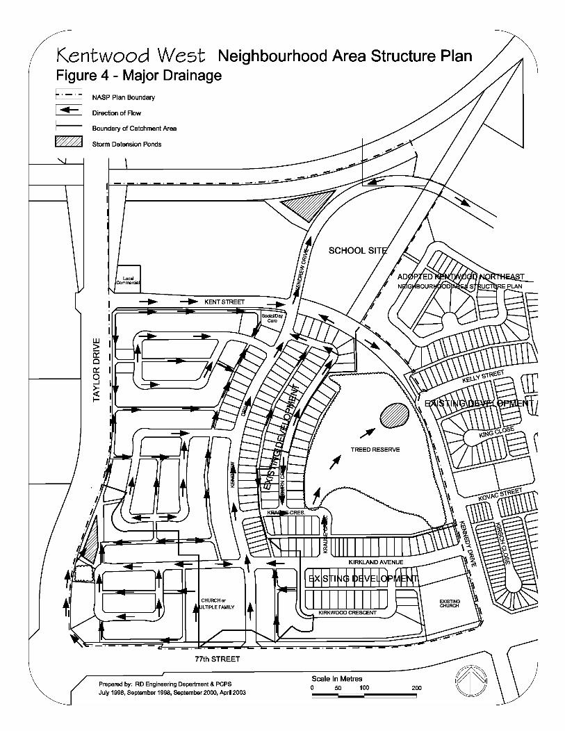
Kentwood West Neighbourhood Area Structure Plan Figure 4 - Major Drainage E::::::J NASP Plan Boundary
I ... I Direction of Flow
t:.:::.:::.:.3 Boundary of Catchment Area
~ Storm Detension Ponds
- - - - - - - - - - - -
UJ > Ci: 0 0:: 0 ...J
~ I-
Local Commercial
77th STREET
Prepared by: RD Engineering Department & PCPS
July 1998, September 1998, September 2000, April 2003
TREED RESERVE
Scale In Metres 0 50 100
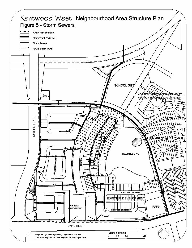
Kentwood West Neighbourhood Area Structure Plan Figure 5 - Storm Sewers [_::...:_] NASP Plan Boundary
~ Storm Trunk (Existing)
~ Storm Sewers
!······ ... ···"'I Future Storm Trunk
I - - - - - - - - - - - -
w > 0:: 0 0::: 0 ...J
~ I-
Local Commercial
CHURCH or ULTIPLE FAMILY
77th STREET
Prepared by: RD Engineering Department & PCPS
July 1998, September 1998, September 2000, April 2003
TREED RESERVE
Scale In Metres 0 50 100
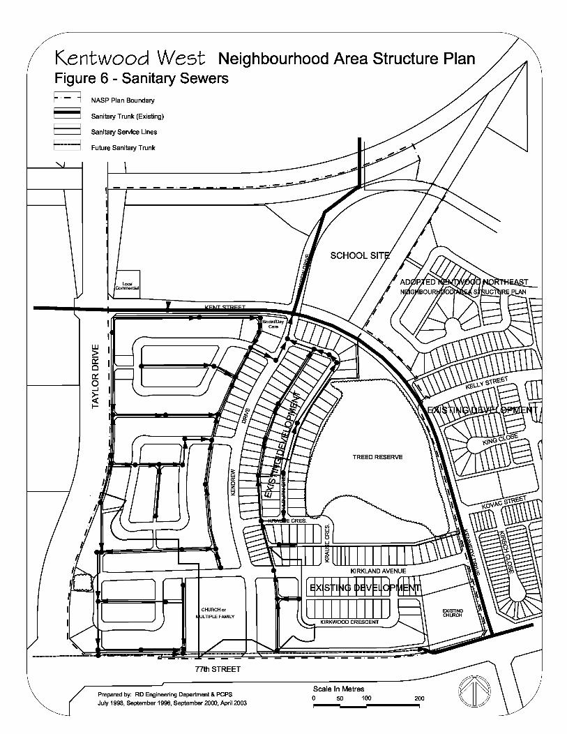
Kentwood West Neighbourhood Area Structure Plan Figure 6 - Sanitary Sewers E::::::J NASP Plan Boundary
~ Sanitary Trunk (Existing)
E:::::J Sanitary Service Lines
f··-........... 1 Future Sanitary Trunk
I - - - - - - - - - - - -
UJ > (2 Cl 0::: 0 _J
~ I-
Local Commercial
CHURCH or ULTIPLE FAMILY
17th STREET
Prepared by: RD Engineering Department & PCPS
July 1998, September 1998, September 2000, April 2003
TREED RESERVE
Scale In Metres 0 50 100
The majority of this reserve is being acquired through deferred reserve caveats from the
Industrial Park to the west; this means that additional reserve will be added to this
neighbourhood over and above the normal 10% dedication required through the Municipal
Government Act.
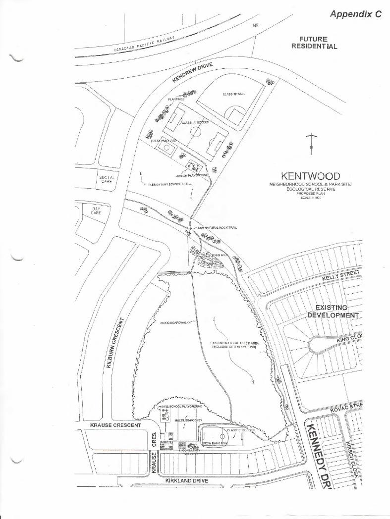
3.3.8 Neighbourhood Park and Treed Reserve Plans
The Neighbourhood Park and Treed Reserve are expected to provide several amenities to area
residents, including various playing fields, playgrounds, a multi-use pad, a hockey rink, sliding
hills, and shelters. These features are depicted in Appendix C.
4.0 MUNICIPAL SERVICING
The proposed municipal servicing design reflects the natural features of the Kentwood West area
and responds to the need for effective and efficient service delivery.
4.1 Storm Sewer System
Based on the size of the proposed development and on the topography of the area, three storm
water detention ponds will be required to service the neighbourhood. The first of the three ponds
is located in the northern portion of the Neighbourhood Area Structure Plan area in the utility lot
adjacent to the neighbourhood school site. This pond is being designed with an option to expand
into the park/school sports field site should additional capacity be required. The second pond is
located in the southwestern area of the plan next to Taylor Drive. The third, a minor
unconstructed detention pond facility, will make use of the current wetland area found in the
north east area of the natural treed reserve. The exact volume of the storm water detention ponds
will be determined during actual construction phases. Major Drainage is depicted in Figure 4 and
Storm Sewers are illustrated in Figure 5.
4.2 Sanitary Sewer System
The sanitary sewer system that is required to service the Kentwood West area is a direct
extension of the existing main sanitary sewer system trunks running along the existing Kennedy
Drive and 77th Street at the intersection to Kennedy Drive. Figure 6 illustrates the sanitary
service lines and future proposed trunks.
12
4.3 Water Distribution System
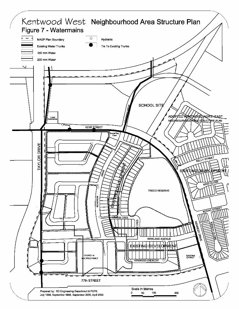
The water distribution system required to service the Kentwood West area is a direct extension
of the existing water distribution system trunks running along Kennedy Drive and Taylor Drive,
and those currently in place in the utility lots in the north portions of the plan area. Figure 7
illustrates the conceptual design for watermains, existing trunks, and proposed water servicing.
4.4 Shallow Utilities
Shallow utility providers, namely the City’s Electric Light and Power Department, the telephone,
cable, and natural gas companies, have been contacted regarding servicing to the Kentwood
West area.
The developer needs to be aware that an aerial power line exists with in the Stage 6 area and will
require relocation in conjunction with the development/sale of this land. Relocation would cost
approximately $35,000 in year 2000 dollars.
There is a lack of adequate telephone servicing for the remaining staging of Kentwood West. An
additional temporary cable, at the developer’s cost, is required (including removal costs). The
developer is to contact Telus to discuss further.
For the other shallow utilities there is adequate capacity to provide servicing in the general area.
5.0 STAGING OF DEVELOPMENT
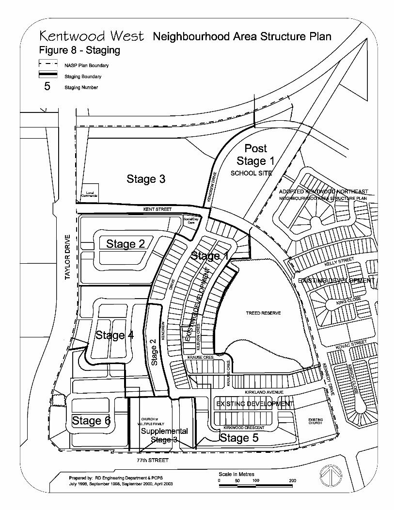
Figure 8 illustrates the anticipated development staging. The location of utilities dictates the
order of inaugural phases, with the portions of the neighbourhood abutting the treed reserve and
school site in the first phase. Market conditions may be expected to influence the actual staging
of subsequent development.
13
Kentwood West Neighbourhood Area Structure Plan Figure 7 - Watermains E::::::J NASP Plan Boundary Hydrants
~ Existing Water Trunks Tie To Existing Trunks
f ................ I 150 mm Water
E:-::J 200 mm Water
I ,_,_,_,_,_,_,_,_,_,_,_
UJ > a:: Cl c:::: 0 _J
~ I-
Local Commercial
_J CHURCH or
ULTIPLE FAMILY
17th STREET
Prepared by: RD Engineering Department & PCPS
July 1998, September 1998, September 2000, April 2003
TREED RESERVE
Scale In Metres 0 50 100 200
Kentwood West Neighbourhood Area Structure Plan Figure 8 - Staging E::::J NASP Plan Boundary
~ Staging Boundary
5 Staging Number
I - - - - - - - - - - - -
Local Commercial
r 1 ~tage §
Stage 3
17th STREET
Prepared by: RD Engineering Department & PCPS
July 1998, September 1998, September 2000, April 2003
TREED RESERVE
Scale In Metres 0 50 100

APPENDICES
14

APPENDICES
'-
,..__,
5£M I -P!A fll "-.J (Ni
WfTL .. A. lJ.b
~fj'V E5-Y3 w (0.1 ho.
-· .- .
ZONE 1-i MPfN Pof t.. f\R. foAt~T A Rf F\
--5f l\~oNP.L.. l>RA.11\J~'E...
ZON E ~ P>AL5AM fofll\P. foRE.'Jr F\R£A
KENTW00]) N ATIJ.RF\L AR~A £COLoG-IC:Al PROFILE
SEc.~2 TwP.~'l '-'-· 2 ll-"~
( 1tJ 'leN"ro1''( MM ~IT£S £.S-1T; £ 5 .. ~.5 w ; E. s .. 'i 3 w )
so,....
''·
Appendix A
s
S£f.\1· f'tA.r.t1\r.J E JJ7"
W E: 7" LA JJ::J>
(:5rL.\ni ARft\)
ZDN~ 5 M\ X£l> SH.ct11.6 fl\ I No£ IH..£A
m ~ CJ' ... 14 ~
·~ '-
Appendix B
p ~ ~ ~ ~
_j v 3:
I-' IS &: ~ ~
;o 2 ~
tt
'- ~ ~
co
_g~ "'
l ..:
F 3: §& ~ N .<')
{;I
~ t
I
" -lfl
"' / .
Appendix C
·~
T KENT~29A~SITEJ
NEIGHB~~~~ggl~~l RESERVE PROPOSED PLAN
SCALE 1 i OOO