Seattle DPD - Directors Report, Zoning Changes to the ...clerk.seattle.gov/~CFS/CF_312592.pdf ·...
35
Jim Holmes DPD South Lake Union Rezone DIR September 5, 2012 Version #2 i DIRECTOR’S REPORT ZONING CHANGES FOR THE SOUTH LAKE UNION URBAN CENTER September 5, 2012
Transcript of Seattle DPD - Directors Report, Zoning Changes to the ...clerk.seattle.gov/~CFS/CF_312592.pdf ·...

Jim Holmes DPD South Lake Union Rezone DIR September 5, 2012 Version #2
i
DIRECTOR’S REPORT ZONING CHANGES FOR THE SOUTH LAKE UNION URBAN CENTER September 5, 2012

Jim Holmes DPD South Lake Union Rezone DIR September 5, 2012 Version #2
ii
TABLE OF CONTENTS
1. Overview Page 3
1.1 Background Page 4
1.1.1 Comprehensive Plan Page 4
1.1.2 Growth Targets Page 6
1.1.3 Development Capacity Page 7
1.2 Process Page 8
1.2.1 South Lake Union Urban Center Plan Page 8
1.2.2 Urban Form Study Page 9
1.2.3 South Lake Union Urban Design Framework Page 10
1.2.4 South Lake Union Height and Density EIS Page 10
2. Rezone Recommendation Page 11
2.1 Land Use Regulation Page 12
2.2 Neighborhood Scale Page 12
2.2.1 Height Limits Page 12
2.2.2 Urban Form Page 14

Jim Holmes DPD South Lake Union Rezone DIR September 5, 2012 Version #2
iii
2.2.3 Views Page 14
2.2.4 Key Development Standards Page 15
2.2.5 Pedestrian Environment Page 17
2.2.6 Lake Union Seaport Flight Path Page 20
2.3 Subarea Development Standards Page 22
2.3.1 Eighth Avenue Residential Corridor Page 22
2.3.2 Fairview Avenue Corridor Page 22
2.3.3 Cascade Neighborhood Page 25
2.3.4 Lakefront Blocks Page 25
3. Incentive zoning Page 26
3.1 Types of Public Amenities Required Page 26
3.2 Minimum Requirements Page 26
3.3 Affordable Housing Amenities Page 27
3.4 Childcare Amenities Page 27
3.5 Other Amenities Page 28
3.6 Transfer of Development Rights Page 30
3.7 Tax Increment Financing Page 31
4. Conclusion Page 32

Jim Holmes DPD South Lake Union Rezone DIR September 5, 2012 Version #2
Page 1 of 32
Glossary of Terms: Development Standards
In addition to building height, the South Lake Union rezone uses a number of tools to regulate land use
and the type of development that occurs referred to as development standards. These standards guide
development projects to achieve the urban form goals of the legislation. Below is a summary of
development standards this legislation uses to achieve key urban design goals.
Floor Area Ratio: The ratio of total floor area allowed to the size of the lot. For example, a 5,000
square foot building on a 10,000 square foot lot has an FAR of 0.5; a 10,000 square foot building on a
5,000 square foot lot has an FAR of 2. Like floor plate limits, this is an additional tool that controls
building mass. The South Lake Union legislation uses FAR limits to regulate the bulk and mass of
commercial buildings which require a larger maximum floor plate than residential projects.
Tower: That portion of the building that sits above the podium and usually has floor plate size limits. In
South Lake Union, this is defined as any portion of a building above 85 feet.
Podium Height: The lower floors of a building that usually cover most of the lot area.
Floor Plate Size: The size of a floor on a building measured in square feet. The South Lake Union
legislation includes floor plate limits
depending on the use of the building
(residential or commercial) and the
height of the building. Floor plate size
limits, when combined with other
development standards help preserve
a sense of openness through the
neighborhood.
Setback: Setbacks require all or a
portion of a building to be built a
certain distance behind a lot line. In
South Lake Union building setbacks
that may apply to the entire building, and upper level setbacks apply to parts of a building above a
specified height. Setbacks can be effective tools in creating an open pedestrian environment,
controlling shade and shadow, and preserving view corridors.
Façade: The face of the building.

Jim Holmes DPD South Lake Union Rezone DIR September 5, 2012 Version #2
Page 2 of 32
Lot Coverage: The proportion of lot area covered by all or part of a building. The South Lake Union
legislation uses a lot coverage development standard to regulate how much lot area is required to build
a residential tower. For example, if towers are limited to 50% of lot coverage then a building with a
10,000 square foot floor plate would require a lot of 20,000 square feet.

Jim Holmes DPD South Lake Union Rezone DIR September 5, 2012 Version #2
Page 3 of 32
DIRECTOR’S REPORT
SOUTH LAKE UNION URBAN CENTER JULY 26, 2012
1. Overview
In January 2008, DPD began working with the South Lake Union Community to develop a height and
density recommendation that would advance the Comprehensive Plan and Neighborhood Plan Goals for
future development of the neighborhood. By designating South Lake Union as an Urban Center, it is the
City’s goal to support and encourage development of South Lake Union as a neighborhood of regional
significance with a concentration of jobs and housing. The South Lake Union rezone legislation
recommends a set of development regulations that include increases in height and floor area as an
incentive to provide important neighborhood amenities to ensure that as growth continues, it
contributes to livability and sustainability.
Key components of this legislation include:
Linking increased building height and floor area to expanding the City’s incentive zoning
program, creating opportunities for affordable housing and community infrastructure;
Preserving the established scale and character of the Cascade Neighborhood, one of Seattle’s
oldest, and creating a new residential community along Eighth Avenue just north of Denny Park;
Establishing new development standards to ensure towers are well‐spaced and floorplates are
limited to preserve openness to the sky and public views through the neighborhood;
Ensuring active public spaces through well‐designed ground floor retail along key streets, façade
transparency and parking standards, and pedestrian pass‐throughs on large blocks; and
Strengthening incentives to preserve landmark properties and existing open spaces.
This legislation is the result of a 5‐year process that included participation by a diverse and engaged set
of community stakeholders working to define a clear vision for the future of South Lake Union and how
increased height and density should be accommodated in the neighborhood.

Jim Holmes DPD South Lake Union Rezone DIR September 5, 2012 Version #2
Page 4 of 32
1.1 Background
The South Lake Union Urban Center is approximately 340 acres in size and is characterized by a broad
mix of land uses including industrial, commercial and residential uses. Current zoning allows
development of buildings that range from 40 feet in height to 125 feet in height (from approximately 3
to 10 stories) with most land in the neighborhood zoned for buildings that are 65 or 85 feet high (5 to 7
stories). For the most part the neighborhood is zoned Seattle Mixed (SM) which is intended for areas
transitioning from industrial uses to a mix of commercial and residential uses.
Historically, commercial and industrial development in the area tended to be one to two stories in
height and cover the entire lot. This building form reflects the needs of manufacturing and industrial
uses for efficiencies achieved when all production processes are located on one floor and for ease in
movement of materials and finished goods. Industries that used this building type in the South Lake
Union neighborhoods include furniture and cabinetry manufacturers (attracted by the sawmills and
transportation access on the shoreline), industrial laundries, printing, and a variety of other uses.
Residential development in the neighborhood was concentrated in the Cascade neighborhood, but was
found in other areas of South Lake Union as well. Housing was a mix of single‐family and multi‐family
and served those who worked in the neighborhood. Much of the housing stock outside of the Cascade
neighborhood was displaced over the past several decades to make room for commercial uses.
In recent years land use code amendments have been made to allow new uses that require different
types of space. These changes have included allowing additional building height for research and
development uses to allow greater floor to ceiling clearance necessary to accommodate building
systems necessary for these uses. Additionally, a number of projects have sought height increases to
accommodate market demands for new types of space including Amazon and Phase III of the University
of Washington biomedical research campus. Currently there are 10 projects in the development
pipeline located in South Lake UnionFive of these projects are requesting additional height and/or
change from IC to SM allowing for residential use and additional floor area to accommodate market
demands.
1.1.1 Comprehensive Plan
Comprehensive planning is a dynamic process that aims to allocate foreseeable growth throughout the
City and target public investments in infrastructure and services in a strategic and cost effective manner.
Seattle’s Comprehensive Plan introduced the Urban Village strategy, establishing a hierarchy of urban
villages to which growth is allocated in the form of growth targets. These growth targets allocate a
share of the City’s 20 year growth forecast consistent with density goals for each type of Urban Village.
At the top of this hierarchy are Urban Centers (see map x for the location of Urban Centers and Urban
Villages). In addition to serving as a key to the City’s growth management strategy, Urban Centers are
part of a regional growth management strategy in which Urban Centers are to achieve residential

Jim Holmes DPD South Lake Union Rezone DIR September 5, 2012 Version #2
Page 5 of 32

Jim Holmes DPD South Lake Union Rezone DIR September 5, 2012 Version #2
Page 6 of 32
development densities. The Comprehensive Plan establishes the following criteria for designating a
neighborhood as an Urban Center.
UV15: Designate as urban centers those areas of the city that are consistent with the following criteria
and relevant Countywide Planning Policies:
1. Area not exceeding one and on‐half square miles (960 acres).
2. Accessibility to the existing regional transportation network including access to other urban
centers, with access to the regional high‐capacity transit system to be provided in the
future.
3. Zoning that can accommodate a broad mix of activities including commercial and residential
activities, as appropriate to the planned balance of uses in the center.
4. The area is already connected to surrounding neighborhood by bicycle and/or pedestrian
facilities or can be connected through planned extensions of existing facilities.
5. The area presently includes, or is adjacent to, open space available for public use, or
opportunities exist to provide public open space in the future.
6. Zoning that permits the amount of new development needed to meet the following
minimum density targets:
a. A minimum of 15,000 jobs located within a half mile of a possible future high
capacity transit station;
b. An overall employment density of 50 jobs per acre; and
c. An overall residential density of 15 households per acre.
UV18: Promote the balance of uses in each urban center or urban center village indicated by one of the
following function designations as follows: South Lake Union – Mixed residential and employment.
1.1.2 Growth Targets
The Comprehensive Plan allocates 56 percent of all citywide growth in housing and 73 percent of growth
in employment to Urban Centers over a 20 year period. In developing growth targets, a share of
citywide growth is allocated to each Urban Center based on a variety of factors including recent growth
trends, development capacity, infrastructure investment and locational advantages among other
considerations. The 2004 Comprehensive Plan set 20‐year growth targets for South Lake Union at 8,000
households and 12,000 jobs representing approximately 17 percent of citywide household growth and
19 percent of citywide growth in jobs. These growth targets are not static and do not define ideal
densities but simply set out goals for how the city will accommodate 20 years of growth. State law
requires an update of the Comprehensive Plan every 8 years with the next update due in 2015. That
process will again allocate growth to each Urban Center based on expected citywide growth to the year
2035. The most current allocation of regional growth for Seattle is for the period 2011 to 2031.
The proposed legislation is based on a 20‐year planning horizon of 2031. The estimates for the 2031
planning horizon were developed to be consistent with the 2024 growth targets set out in the
Comprehensive Plan for the Neighborhood. The City’s Comprehensive Plan assigns to South Lake Union

Jim Holmes DPD South Lake Union Rezone DIR September 5, 2012 Version #2
Page 7 of 32
a 17 percent share of citywide housing growth and a 19 percent share of citywide employment growth –
12,000 households and 22,000 jobs by 2031. These 2031 growth estimates provide an appropriate
allocation of citywide growth to the South Lake Union neighborhood given its critical role as an Urban
Center in the City’s Comprehensive Plan and were fully analyzed by the South Lake Union FEIS
completed earlier this year.
1.1.3 Development Capacity
Development capacity estimates differ from growth targets in that they are estimates of maximum
possible development in the neighborhood over time and are not reflective of what will occur over any
particular twenty year period. The Washington State Growth Management Act requires that zoned
development capacity be equal to at least 125 percent of the City’s growth target. In a periodic update
of the Comprehensive Plan, the City must evaluate zoned development capacity to ensure that each
urban village meets this minimum requirement. Current zoning in the South Lake Union Urban Center
provides development capacity for 12,000 new dwelling units and 18,000 new jobs. . It is important to
have enough zoned development capacity in Urban Centers so that as periodic updates to the
Comprehensive Plan occur (every eight years), there is adequate capacity to address changing growth
targets without undertaking a rezone each time. While existing zoning provides adequate development

Jim Holmes DPD South Lake Union Rezone DIR September 5, 2012 Version #2
Page 8 of 32
capacity for existing 2024 growth targets, it does not provide enough development capacity for the 2031
growth target estimates used in this planning effort.
Estimates of development capacity require a number of assumptions about how development will occur
given a neighborhood’s supply of developable land, development standards, and development trends
into the future. Some of these assumptions include:
An estimate of the likely split between future residential development and
commercial development.
The average size of residential dwelling units.
The amount of square feet of commercial development per job
The supply of redevelopable land.
The probability that smaller parcels will be assembled into larger development sites.
After careful consideration of the above questions we estimate that the proposed rezone provides for
residential development capacity of 22,000 to 24,000 dwelling units and 28,000 to 30,000 jobs. This
provides zoned capacity of 190% of 2031 housing estimates and 131% of the 2031 job estimates.
1.2 Process
Development of this legislation is the result of 5 years of collaboration between DPD and the
community. This collaboration began with the Urban Form Study which was used to develop
alternatives to be studied in an Environmental Impact Statement (EIS). Public comment on the EIS
alternatives identified a need for more consideration of how growth would affect neighborhood
character. In response, the Urban Design Framework was developed to bridge the gap between the
vision set out in the Neighborhood Plan to specific recommendations that would guide the physical
development of the neighborhood. Finally, an EIS was completed earlier this year, which provides the
in‐depth analysis necessary to understand the impacts, benefits and tradeoffs associated with different
height and density options. Each of these steps informs the South Lake Union Rezone legislation.
Through each of these efforts the voices of a broad cross section of the community that included
residents, workers, business and property owners, and representatives from adjacent neighborhoods
contributed to the final products.
1.2.1 South Lake Union Urban Center Neighborhood Plan
Following its designation as an Urban Center, the South Lake Union Neighborhood Plan was updated to
incorporate countywide policies for urban centers and to engage the community in a discussion about
how the neighborhood will accommodate future growth. The neighborhood plan sets out a vision for

Jim Holmes DPD South Lake Union Rezone DIR September 5, 2012 Version #2
Page 9 of 32
the future of South Lake Union that was originally included in the 1998 neighborhood plan and affirmed
in the updated plan:
The future of South Lake Union will be characterized by:
a pervasive human scale ambiance consistent with a vital aesthetically pleasing, safe and
energetic neighborhood which embraces a dynamic intermixing of opportunities for working
living and playing;
retention of a significant element of the area’s commercial activities, including opportunities for
business growth;
a full spectrum of housing opportunities;
ecologically sound development and life‐styles and promotion of ecologically sound business
practices consistent within the regulatory environment;
ease of transportation for all modes within and through the area;
a variety of open spaces serving the needs of the area and the city, with emphasis on Lake Union, and its continued preservation for a wide range of uses;
a sensitivity to the area’s history and historical elements; and coordination with plans of adjacent neighborhoods.
This neighborhood vision is a key factor guiding the rezone recommendation. Additionally, as noted above, the Neighborhood Plan identifies strategies for using increased height to
achieve neighborhood objectives. These include using height to achieve a diversity of architectural form
throughout the neighborhood, and using height and density increases through incentive zoning to
provide the types of neighborhood amenities necessary to support a growing neighborhood (see
incentive zoning discussion below).
1.2.2 Urban Form Study
The Urban Form Study put forward three strategies for height and density in the South Lake Union
Neighborhood. The Parks Strategy placed an emphasis on using Denny, Lake Union, and Cascade Parks
to anchor clusters of dense residential development. The Edge Transitions option located the tallest and
most dense projects to the southern and western edges of the neighborhood with height and density
stepping down toward Lake Union. The Transportation Nodes and Corridors option concentrated the
greatest density on key transportation corridors. While no one strategy can be said to characterize the
rezone legislation, each of them informs some part of the recommendation.

Jim Holmes DPD South Lake Union Rezone DIR September 5, 2012 Version #2
Page 10 of 32
1.2.3 South Lake Union Urban Design Framework
The SLU Design Urban Framework (attachment 1) establishes a shared design vision and implementation
strategy for the future of South Lake Union. By bridging 15 years of community planning with specific
implementation strategies, it is intended to help realize the vision the neighborhood set out the
neighborhood plan. The UDF addresses how the physical development of the neighborhood will affect
quality of life and the role that place‐making and urban design play in creating a successful
neighborhood. The Design Framework, with the guidance of a range of community stakeholders, draws
on past planning efforts and evaluation of new opportunities to identify the specific projects, actions,
and design opportunities that will ensure new development, both public and private, strengthens the
livability and sense of place. This legislation incorporates many of the recommendations of the UDF,
particularly regarding subarea character (see below), and how development at the street level
contributes to a vibrant pedestrian environment. The UDF was developed through collaboration with
Design Professionals, an advisory group representing a cross section of community stakeholders, and
City Departments.
A key result of the process to develop the UDF was to guide revisions in the alternatives studied in the
EIS (discussed below). While the Urban Form Study set out strategies for height and density, it did not
provide guidance on how height and density would influence neighborhood character. The UDF process
and the UDF itself provides important priorities for public open space, future land use in the
neighborhood, and priorities for public amenities to be provided through the incentive zoning program.
As the UDF process concluded, the EIS alternatives were substantially revised to reflect
recommendations of the Urban Design Framework.
1.2.4 South Lake Union Height and Density EIS
The South Lake Union Height and Density EIS analyzes potential impacts on the built and natural
environment that result from different height and density scenarios and the tradeoffs that each entails.
Using the growth target proxies for 2031 discussed above, the EIS considers a broad range of potential
impacts associated with this growth and offers strategies to address these impacts – many of which are
included in this legislation as development standards. The EIS analysis provides insight to the
appropriateness of different building heights in the neighborhood and their effect on views, street level
shade and shadow impacts, impacts on open space, and development standards that improve the
transportation system by enhancing pedestrian and bicycle mobility.

Jim Holmes DPD South Lake Union Rezone DIR September 5, 2012 Version #2
Page 11 of 32
2 Rezone Recommendation
This legislation seeks to provide capacity to support increasing densities and develop an urban form
consistent with vision and values established by the community and articulated in the Neighborhood
Plan and Urban Design Framework. Development in the neighborhood under terms of the proposed
legislation will result in a neighborhood characterized by a mix of uses and building types, an urban form
that steps down in height and tower density from adjacent downtown neighborhoods, parks and open
space to support new residential communities, and a lively pedestrian environment. Key objectives
guiding this legislation include:
1. Height increases that allow for diversity in architectural form throughout the neighborhood
while incorporating development standards that carefully manage tower density. These
controls include tower setbacks, tower spacing, floor plate size limits, commercial FAR limits,
and more restrictive limits on the number of towers per block closer to Lake Union.
2. Reclassification of remaining Industrial Commercial (IC) zoned properties in the neighborhood to
Seattle Mixed (SM) to promote development of a balanced variety of land uses including
additional residential development where currently prohibited by existing zoning.
3. Incentive zoning provisions that provide for an increase in affordable housing in the city and
investments in public amenities identified in the Urban Design Framework that promote a vital
pedestrian environment and supports the needs of a growing residential population.
4. Parking standards that reinforce the City’s transportation goals.
5. Sufficient development capacity that allows the neighborhood to accommodate future
residential and employment growth beyond the estimated 2031 growth horizon.
6.
7. Development standards that emphasize the pedestrian experience and encourage development
of a pedestrian and open space network through transparency and ground level use
requirements, appropriately scaled building podium heights, and building setbacks and
stepbacks at upper stories.
This legislation allows additional height and density through an incentive zoning program, discussed
below. It is important to note, however, that in the future projects may continue to be developed, with
limited exceptions, under existing zoning regulations without participation in the incentive zoning
program.

Jim Holmes DPD South Lake Union Rezone DIR September 5, 2012 Version #2
Page 12 of 32
2.1 Land Use Regulation
The Seattle Mixed (“SM”) zone classification guides development primarily through provisions that
address design, size, and shape of a building or a piece of land. This contrasts with other zone
classifications that have a strong focus on the use of a building. The rezone recommendation continues
the SM zone’s emphasis on strong, pedestrian‐oriented building forms with flexibility to allow a broad
range of uses. SM allows a broad range of uses throughout the South Lake Union neighborhood. These
uses include industrial uses, commercial uses, and residential uses. The tools that guide urban form
include provisions that control the size of a building including height, the amount of floor area allowed
on each story of a building (floor plate), the total amount of floor area allowed on a lot (FAR),
requirements for all or parts of a building to be set back from the property line to preserve view
corridors and enhance the pedestrian environment, transparency requirements to avoid blank walls at
the pedestrian level, and open space requirements. Each of these tools is used to guide future
development and achieve an urban form consistent with the planning objectives above.
2.2 Neighborhood Scale
2.2.1 Height Limits
The map on the next page shows proposed changes in height limits throughout the neighborhood.
There are seven categories of height increases on the map with each one containing unique
development standards intended to achieve development consistent with the desired character of each
subarea. These recommendations reflect input from the community engagement process, results of
analysis found in the EIS and application of the locational criteria for establishing height limits set out in
the Seattle Municipal Code. The rezone analysis provides a detailed discussion of how the
recommendation for each subarea is consistent with these locational criteria.
The height limit designations on the map show the maximum heights for commercial and residential
uses. When there are two numbers, the first number is the maximum commercial height and the
second number is the maximum residential height. These are the maximum heights that can be
achieved through the incentive zoning program proposed in the legislation. Each zone classification also
allows for development roughly equivalent to that permitted under existing regulations without
participation in the incentive zoning program.

Jim Holmes DPD South Lake Union Rezone DIR September 5, 2012 Version #2
Page 13 of 32

Jim Holmes DPD South Lake Union Rezone DIR September 5, 2012 Version #2
Page 14 of 32
2.2.2 Urban Form
This proposal recommends height limits that balance the goal of allowing a diversity of new building
types with preserving openness to the sky, important public views through the neighborhood, and
providing sunlight to streets and public spaces. The defining topographic characteristics of the
neighborhood are the bowl shaped nature of the South Lake Union Neighborhood sloping toward Lake
Union and steep slopes of adjacent Capitol Hill and Queen Anne Hill. Views within the neighborhood
include views to the lake, views to the Space Needle, the adjacent hillsides and the downtown skyline.
Views adjacent to the neighborhood include views west from Capitol Hill to the Space Needle, Elliott
Bay, and the downtown skyline, views east from Queen Anne Hill that include the lake, Capitol Hill and
the downtown skyline. Views from Downtown looking north to South Lake Union include existing
development, the lake, and Wallingford to the north. This recommendation offers limited increases to
height limits in areas in the neighborhood adjacent to the slopes of Queen Anne and the Cascade
neighborhood adjacent to the west slope of Capitol Hill to preserve the natural topography of the area.
Based on analysis in the EIS, height limits north of Aloha Street, adjacent to Queen Anne Hill are limited
to 85 feet. Although higher height limits were studied, it is clear that tower placement at these
locations is inappropriate given the existing steep adjacent slopes and the potential for tall buildings to
obscure natural landforms.
2.2.3 Views
With taller buildings, views will change. Although changes in height will affect views identified above, a
variety of development standards are being proposed including setbacks along view corridors, limited
tower floor plate size, tower spacing requirements and limits on the number of towers per block at the
lakefront. These development standards will preserve general public views throughout and within the
neighborhood.
The City’s environmental policies related to public view protection identify important public views that
should guide development of new projects and land use regulations. Specifically, “it is the City's policy
to protect public views of significant natural and human‐made features: Mount Rainer, the Olympic and
Cascade Mountains, the downtown skyline, and major bodies of water including Puget Sound, Lake
Washington, Lake Union and the Ship Canal, from public places consisting of the specified viewpoints,
parks, scenic routes, and view corridors …”
There are three City‐designated viewpoints near the South Lake Union neighborhood – Volunteer Park,
Bhy Kracke Park and Plymouth Pillars Park (formerly known as Four Columns Park/Boren‐Pine‐Pike Park).
Views toward the South Lake Union neighborhood from Plymouth Pillars Park were analyzed in the EIS
and it was determined that the majority of the neighborhood is not visible from this viewpoint. The EIS
analyzed viewpoints as they affect Volunteer Park and Bhy Kracke Park, and found no significant adverse
impacts even for the densest alternative.

Jim Holmes DPD South Lake Union Rezone DIR September 5, 2012 Version #2
Page 15 of 32
Development standards that will guide changes to public views include:
Tower density limits, discussed below, that will maintain a degree of openness in the skyline to
allow for continued views of key features.
Tower setbacks along key corridors in the South Lake Union neighborhood such as Thomas and
John Streets to maintain view corridors toward Lake Union and the Space Needle.
2.2.4 Key Development Standards
The intent of development standards to control tower density is to promote an urban form that results
in a quality pedestrian environment, preserves views to and through the neighborhood, advances
subarea planning objectives discussed above, and maintains a flight corridor for operations at the South
Lake Union seaport. These development standards apply only to projects that take advantage of
additional height by providing public benefits through the incentive zoning program.
Development standards that preserve a sense of openness through the neighborhood and particularly
near Lake Union are a critical part of this proposal. These development standards rely on analysis in the
South Lake Union EIS and some of the work in the Urban Design Framework. Below is a summary of
development standards this legislation uses to achieve key urban design goals.
Residential Floor Plate Size. The ordinance limits residential floor plates for projects taller than 160
feet to an average of 10,500 square feet with no one floor exceeding 11,500 square feet.
Residential floor plates for towers 160 feet or less in height may be as large as 12,500 square feet
provided these towers are built with the major massing oriented north south orientation and with a
maximum east‐west plan dimension of 120 feet.
Commercial Floor Plate Size. Commercial floor plate size is proposed to be limited to 24,000 square
feet (with exceptions for a limited number of large blocks with landmark and open space
preservation goals, discussed below).
Floor Area Ratio. Commercial Floor Area is limited to a floor area ratio (FAR) of 7 for any one
commercial tower. This represents an increase of 2 FAR over the 5 FAR that current zoning allows
and may only be accessed through participation in the incentive zoning program.
Tower Lot Coverage. Residential tower footprints may not exceed 50 percent of the development
site. This standard reinforces limits on tower density by encouraging better tower spacing and also
provides an incentive to develop some portions of a site with development consistent with mid‐rise
construction, providing more architectural diversity. The average half block in South Lake Union is
approximately 40,000 square feet. Limiting tower development to 50% of lot area means that
residential towers with maximum permitted floor plates will require a lot of 22,000 square feet; the
average half block in South Lake Union is approximately 40,000 square feet.

Jim Holmes DPD South Lake Union Rezone DIR September 5, 2012 Version #2
Page 16 of 32
Limits on Towers Per Block. The proposal would limit residential towers to one residential tower per
block closer to the lake with no commercial towers allowed. Two towers would be permitted
throughout the rest of the neighborhood. Additionally, commercial towers are limited to no more than
one per block unless they are developed on a site with at least 60,000 square feet of lot area and
provide through block pedestrian connection.
Tower Setbacks. Using SEPA view protection policies and through identification of other important
view corridors in the South Lake Union Neighborhood and important view corridors identified in the
Urban Design Framework, the proposed legislation contains a series of upper level setbacks on John
Street, Valley Street, Thomas Street, Boren Avenue, and Fairview Avenue (see table below). The intent
of these upper level setbacks is to preserve public views of, to, and across Lake Union and to the Space
Needl
e.
Required upper-level setbacks Location of lot Height above which
setback is required Minimum depth of
setback from applicable street property line
Valley Street, south side, from Fairrview Ave N to Westlake Ave
65 feet 25 feet
Thomas Street, south side, from Aurora Ave N to 8th Ave N
45 feet
50 feet
Thomas Street, south side, from 8th Ave N to 9th Ave N
45 feet
40 feet
Thomas Street, south side, between 9th Ave N and alley between Fairview Ave N and Minor Ave N
45 feet
30 feet
John Street, north side, between Aurora Ave N and 9th Ave N
45 feet
30 feet
John Street, north side, between 9th Ave N and Boren Ave N
45 feet
15 feet
John Street, south side, between Aurora Ave N and Minor Ave N
45 feet
30 feet
Boren Ave N, both sides, between Mercer Street and John Street
65 feet
10 feet
Fairview Ave N, west side, from Mercer Street to Thomas Street
65 feet
10 feet
Fairview Ave N, east side, from Mercer Street to Thomas Street
65 feet
10 feet

Jim Holmes DPD South Lake Union Rezone DIR September 5, 2012 Version #2
Page 17 of 32
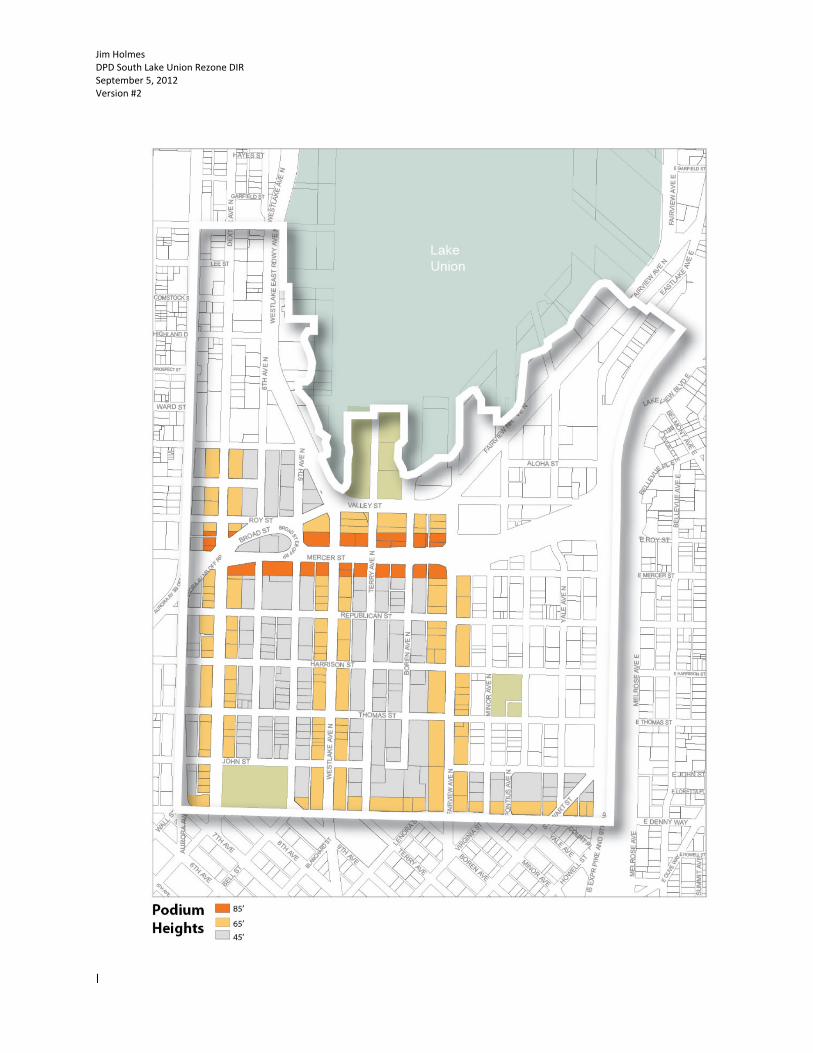
2.2.5 Pedestrian Environment
Providing a vibrant pedestrian environment has been a consistent theme through the planning process.
The legislation addresses development of property adjacent to the public right of way, and
complements plans for right of way improvements.
When addressing the pedestrian environment it is useful to imagine an outdoor room. The walls to this
room are the building facades facing the public right of way, the sidewalk, street and other open space
such as plazas that abut the right of way. Pedestrian scaled development standards consider the height
of the street wall in relation to the width and function of the street. The rezone recommendation
includes standards for building podiums (see map on next page) that allow for development of street
walls along the majority of a block face that vary in height depending on the street. Podium heights
along Dexter Avenue, Fairview Avenue, Westlake Avenue, and Denny Way are permitted to a height of
65 feet – approximately five stores. Along Mercer Street podium heights are permitted to a height of 85
feet – approximately seven stories. Elsewhere in the neighborhood podium heights are limited to 45
feet – 3 to 4 stories. The map on page 18 shows the location and height of podiums. Podiums are not
required for projects built to a height of 85 feet or less.
An important component of the street wall is the level of transparency (windows and other openings)
that face the sidewalk. Blank walls create dead space and detract from the vibrancy of the pedestrian
environment. The proposed legislation reclassifies many streets in the neighborhood as Class 2
pedestrian streets. This classification features transparency requirements for all ground level
commercial development in much of the neighborhood.
Ground floor active uses also contribute to a vibrant pedestrian environment. Active uses refer to retail;
restaurant and other types of uses that generate pedestrian traffic and create visual interest.
Conversely office uses at the ground floor generate less pedestrian activity and contribute little in the
way of visual interest. Westlake Avenue and portions of Valley Street are designated as Class 1
pedestrian streets which require active uses for much of the ground floor. The rezone
recommendation includes an incentive of up to 5 feet for ground floor active uses with a floor to ceiling
clearance of at least 20 feet. The typical ground level retail floor clearance is about 13 feet. This
provision encourages a more substantial façade to accommodate better ground level spaces.
Throughout the neighborhood, ground floor retail is encouraged by exempting this floor area from FAR
limits that apply to commercial buildings. On Class 1 pedestrian streets projects can gain an additional 5
feet in height at the podium level if ground floor retail has a minimum floor to ceiling clearance of 20
feet.

Jim Holmes DPD South Lake Union Rezone DIR September 5, 2012 Version #2
Page 18 of 32
The rezone legislation also includes a provision to require through block pedestrian connections when a
substantial portion of a block is developed with commercial projects. In cases where adequate lot size
exists to develop two Commercial projects on a block (at least 60,000 square feet) a through block
pedestrian connection is required. This will enhance pedestrian movement through the neighborhood.
This connection is required to be at mid‐block in the east/west orientation and have a minimum clear
dimension of 20 feet both horizontally and vertically.
Jim Holmes DPD South Lake Union Rezone DIR September 5, 2012 Version #2
Page 19 of 32

Jim Holmes DPD South Lake Union Rezone DIR September 5, 2012 Version #2
Page 20 of 32
2.2.6 Lake Union Seaport Flight Path
State law requires that cities consider the operations of general aviation airports, such as the South Lake
Union Seaport, in developing land use regulations. Through the EIS process, the effect of tall buildings
on safe aircraft operations was evaluated and resulted in a recommendation for a flight corridor on the
northwest portion of the South Lake Union (see map on next page) neighborhood and for specific
project level evaluation for potential conflicts within and near this air corridor.
The proposed legislation limits height north of Aloha St. to 85 feet, consistent with airspace
requirements for the flight path. South of Aloha where greater height is proposed, projects north of
Mercer Street and east of Fairview Avenue are limited to a height of 85 feet unless project level analysis
can demonstrate that greater height will not interfere with safe aircraft operations.
The EIS also shows that there is potential for wind shear and turbulence caused by taller buildings near
the flight path that would compromise safe aircraft operations. Due to the cumulative effect that occurs
as taller buildings are developed over time, it is not possible to say what effect any one project would
have on aircraft operations. Therefore, using the analysis in the EIS, the proposal would require project
level wind studies to identify any potential conlflicts with the air corridor for all projects taller than 85
feet north of Mercer Street and west of Fairview Avenue. Through these studies, alterations in project
design, placement on a lot, or tower height may be necessary to allow safe aircraft operations.

Jim Holmes DPD South Lake Union Rezone DIR September 5, 2012 Version #2
Page 21 of 32

Jim Holmes DPD South Lake Union Rezone DIR September 5, 2012 Version #2
Page 22 of 32
2.3 Subarea Development Standards
The rezone recommendation includes both general standards that apply throughout the neighborhood
and subarea specific standards with the intent of achieving particular outcomes that relate to the
desired character of a subarea or to reflect unique characteristics of an area. Below is a summary of
each subarea and goals of the rezone legislation for each. A map of each subarea is on the next page.
2.3.1 Eighth Avenue Residential Corridor
The South Lake Union Urban Design Framework recommends development of this corridor as a
residential neighborhood anchored by Denny Park and a redesigned 8th Avenue as a flexible “shared
street” with limited vehicular traffic and ample public open space. Additional development goals for this
subarea include activation of the street level through ground‐related housing (residential units with
each unit having direct access to the street). While large scale commercial uses on this corridor would
conflict with the residential character of the neighborhood, limited commercial activity at block corners
are appropriate and would contribute to street level activity.
Specific development standards in this corridor include:
Limit commercial uses to the ground floor and to block corners for neighborhood serving
businesses such as restaurants, cleaners, convenience stores and other services. This use
standard applies to all projects located along 8th Avenue between Republican Street and Denny
Park including projects that do not take advantage of the incentive zoning program to gain
height above 85 feet.
Require setbacks along 8th avenue to accommodate ground related housing and provide room
for stoops and create private open space adjacent to public open space on a reconfigured 8th
Avenue. Setback exceptions are permitted for residential lobby entrances.
2.3.2 Fairview Avenue Corridor
The Fairview Avenue corridor contains valued open space at the southwest corner of Fairivew Avenue
and John streets, a number of historic landmark buildings (the Seattle Times, Troy Laundry, David M
Smith Furniture), and public views toward Lake Union along Fairview Avenue. The west side of Fairview
Avenue is dominated by blocks larger than the average block in South Lake Union. The average block
size in South Lake Union is approximately 80,000 square feet and usually bisected by an alley. The
blocks along Fairview Avenue are approximately 110,000 square feet and several do not have alleys.
Planning goals for this subarea include providing incentives for preservation of historic structures and
existing open space and balancing new development opportunities with preservation of public views.

Jim Holmes DPD South Lake Union Rezone DIR September 5, 2012 Version #2
Page 23 of 32
Due to their size, these blocks can accommodate larger building foot prints while maintaining a scale of
development consistent with the development standards set for smaller blocks. The size of these
blocks also make redevelopment that achieves close to the maximum 7 FAR challenging without
floorplate flexibility. The proposed rezone allows larger floor plates – up to 30,000 square feet – on
blocks that preserve historic landmarks and/or existing open space. All other development standards
apply to these blocks, as well.

Jim Holmes DPD South Lake Union Rezone DIR September 5, 2012 Version #2
Page 24 of 32

Jim Holmes DPD South Lake Union Rezone DIR September 5, 2012 Version #2
Page 25 of 32
2.3.3 Cascade Neighborhood
The Cascade area is a well‐established neighborhood. It has a mix of affordable and market rate housing,
commercial, retail, parks and human services. In addition to new projects that contain affordable units
through the multi‐family tax exemption program, the neighborhood contains a number of older
privately‐operated buildings that provide affordable housing. Current zoning allows for residential
projects to be developed at heights of 75 feet and commercial projects to be built to a height of 55 feet.
The goals for this subarea are to maintain the current development pattern and to preserve and expand
opportunities for housing. The legislation recommends increasing height on those blocks located
primarily along Eastlake Avenue and north of Republican to 85 feet.
2.3.4 Lakefront Blocks
The lakefront blocks represent an important opportunity to connect the South Lake Union neighborhood
to Lake Union Park and the shoreline, and to provide active retail frontages to public spaces that create
a ‘heart’ for the neighborhood, consistent with the Neighborhood Plan and the Urban Design
Framework . The blocks bound by Valley Street, Fairview Avenue, Westlake Avenue and Mercer Street
are commonly referred to as the lakefront blocks. Originally purchased by the City for the cancelled Bay
Freeway project, most of these properties were sold in 2001. Their critical location means that these
properties provide an opportunity to connect the rest of the neighborhood to the lake and park. The
goals for this subarea include development that encourages pedestrian activity through the
neighborhood to the park and establishes a scale and character that creates a “neighborhood heart”
with strong public access, vibrant street‐level uses, and enough residential and employment to activate
the area.
Development standards include designation of Terry Avenue between Mercer Street and Valley Street as
a Pedestrian Class 1 street to require ground level active uses. This designation will continue the
pedestrian scale of Terry Avenue south of Mercer Street through to the lakefront. Supporting this
connection, 15‐foot setbacks for building frontages are required for a portion of Terry Avenue from
Valley Street south to Mercer Street. This is intended to support diverse retail and related uses and
activate Terry Avenue, building on the successful work along Terry Avenue south of Mercer
Street. Tower height is limited to one per block at a maximum height of 160 feet. An additional 80 feet
up to a maximum of 240 feet may be permitted if an agreement is in place to provide significant
additional public benefit through the City’s incentive zoning program. No commercial development is
permitted above a height of 85 feet.

Jim Holmes DPD South Lake Union Rezone DIR September 5, 2012 Version #2
Page 26 of 32
3. Incentive Zoning Under the proposed rezone, additional height and floor area must be gained by providing public
amenities through the incentive zoning program. Under this approach, developers would generally be
allowed to build to current height and floor area ratio (FAR) (called the “base” height and FAR) without
using the incentive program. Those who choose to build above this base height and FAR will be required
to contribute public amenities in proportion to the amount of extra floor area gained in addition to
meeting certain minimum requirements to use the program.
3.1 Type of Public Amenities Required
Consistent with incentive zoning in other areas of the city, projects in areas with a maximum height of
85 feet or less would meet all of their public amenity requirements through affordable housing. In areas
with maximum heights greater than 85 feet, projects would be required to provide affordable housing
and other non‐housing benefits in the following proportion:
For commercial development, 75% would go to affordable housing and child care and 25% to
other benefits.
For residential development, 60% would go to affordable housing and 40% to other benefits.
Unlike incentive zoning in other areas, this rezone would implement a new program created by the state
legislature in 2011 to leverage the portion of incentive zoning going to other benefits to provide
preservation of working farms and forests while also providing funding for local infrastructure projects.
3.2 Minimum Requirements
In order to build any extra floor area through incentive zoning, projects must meet the following
minimum standards:
Receive a Leadership in Energy and Environment Design (LEED) certification of silver or better
for building environmental performance.
Develop a transportation management program. Transportation management programs detail
the actions that the applicant must take in order to reduce single‐occupancy vehicles. These
programs must demonstrate that no more than 40 percent of trips to and from the project will
be made using single‐occupant vehicles as determined by the Seattle Department of
Transportation.
Develop an energy management program. Energy management programs detail the energy
generation and load strategies for the building, including alternative energy generation and
conservation strategies. These programs must be able to demonstrate that existing electrical
systems can accommodate the projected loads from the project as determined by Seattle City
Light.

Jim Holmes DPD South Lake Union Rezone DIR September 5, 2012 Version #2
Page 27 of 32
3.3 Affordable Housing Amenities DPD is proposing to apply the existing standards for affordable housing provision through incentive
zoning in Seattle Municipal Code Chapter 23.58A, Incentive Provisions. For the portion of incentive
zoning gained through affordable housing, a developer must provide an amount of affordable housing
equal to:
For residential projects, 14% of gross extra floor area if the housing is affordable to residents
with incomes of 80% of area median income (AMI) for rental properties and 100% of AMI for
owner‐occupied units; or 8% of gross extra floor area if the housing is affordable to residents
with incomes of 50% of AMI.
For commercial projects, 15.6% of gross extra floor area if the housing is affordable to residents
with incomes of 80% of AMI for rental properties and 100% of AMI for owner‐occupied units.
As an alternative, the developer may provide the housing off‐site, subject to approval by the Office of
Housing Director, or make a payment in lieu of providing the housing in the amount of $15.15 per gross
square foot of extra residential floor area or $18.75 per gross square foot of extra nonresidential floor
area. Housing provided on‐site or off‐site must meet the following requirements:
Affordable housing must be maintained as affordable for a minimum of 50 years.
Affordable units must be provided in a range of sizes consistent with the market‐rate units.
Affordable housing cannot use other subsidies such as state or federal grants unless approved
by the Office of Housing.
It is estimated that over the next 25 years, this program will generate a $45M investment in affordable
housing.
The proposed legislation would also make some minor revisions to the housing section of Chapter
23.58A to clarify the existing provisions.
3.4 Childcare Amenities
Commercial projects are also required to provide child care amenities proportional to the amount of
extra floor area gained through affordable housing. To meet this requirement, an applicant must either
provide a fully improved child care facility space sufficient for 0.000127 of a child care slot per square
foot of extra floor area or make a payment in lieu of providing child care equal to $3.25 per square foot
of extra floor area. Qualifying child care facilities must meet the following requirements:
The child care facility and accessory exterior space must be approved for licensing by the State
of Washington Department of Early Learning or other applicable state or local governmental
agencies.

Jim Holmes DPD South Lake Union Rezone DIR September 5, 2012 Version #2
Page 28 of 32
Space for the child care facility must be dedicated for a minimum of 20 years.
At least 20% child care slots must be affordable to families with incomes at or below the U.S.
Department of Housing and Urban Development Low Income Standard for Section 8 Housing.
3.5 Other Amenities Other amenities will be achieved by implementing a new program created by the state legislature in
2011 known as the Landscape Conservation and Local Infrastructure Program (LCLIP). This program
allows cities to use a portion of the future property tax revenue generated from new development to
fund local improvements if they establish incentive zoning programs that support preservation of farm
and forest land. The purpose of this program is to invest in urban areas to support livability and achieve
local and regional objectives by supporting working farms and forests and reducing sprawl..
The City’s program would include South Lake Union as well as all of Downtown as shown in map on the
next page. The proposed legislation establishes the framework and development standards that will be
used to enact the program; however, consistent with state law, the program will not go into effect until
the City designates a Local Infrastructure Project Area through separate legislation, which is anticipated
to occur in early 2013 after a required notice period. In the interim period, developers will be required
to purchase TDR from sites in South Lake Union with open space uses or landmark buildings to meet the
requirement for other amenities under incentive zoning.

Jim Holmes DPD South Lake Union Rezone DIR September 5, 2012 Version #2
Page 29 of 32

Jim Holmes DPD South Lake Union Rezone DIR September 5, 2012 Version #2
Page 30 of 32
The proposed LCLIP program would function through two separate but connected actions:
1. Developers in South Lake Union and Downtown will purchase development rights from farm and
forest land either directly from property owners or through a facilitator like the King County TDR
bank to gain a portion of their extra floor area (this process is known as Transfer of
Development Rights or TDR).
2. A portion of the King County property taxes on the value of new development in South Lake
Union will be used to fund local infrastructure improvements (this process is known as Tax‐
Increment Financing or TIF).
3.6 Transfer of Development Rights
Under this program, a portion of incentive zoning (5% in Downtown and 33% in South Lake Union)
would be gained through the purchase of regional TDR credits. Within South Lake Union, the portion of
extra floor area not gained through affordable housing and child care would be gained through purchase
of regional TDR. Within Downtown, the first increment of incentive zoning in certain DOC1, DOC2, and
DMC would be gained through purchase of rural TDR credit. The requirement in Downtown would
replace the portion that used to be gained through LEED certification, but expired in early 2012.
Developers would gain extra floor area according to exchange ratios specified in the Seattle Municipal
Code. The initial exchange ratios would be set as follows:.
Type of TDR acquired
Extra Floor Area Gained per Credit
(Exchange Ratio)
Commercial Residential
King County Farm credits 1120 1640
King County Forest or Rural credits
where proceeds are reinvested in Farm credits 1030 1500
Pierce County Farm credits 290 420
Snohomish County Farm credits 670 980
Pierce & Snohomish County Forest credits
where proceeds are reinvested in Farm credits 590 860
These exchange ratios were calculated to account for varying prices between different types of credits,
to prioritize the protection of King County farms, to ensure an average exchange ratio that will meet the
TDR acquisition targets of the program, and to ensure that the cost to developers is consistent with cost
of other public amenities provided through incentive zoning. For the first 200 credits, the program will
be limited to farm credits and forest or rural credits where the proceeds of the are reinvested in the
acquisition of farm credits in order to help develop the market for farm credits. However, it is the intent
of the program that after the first 200 credits have been used in projects that the program will be
broadened to allow forest and rural credits generally. The King County TDR bank has agreed to reinvest
the proceeds of any forest or rural credits sold to developers using this program in order to guarantee a
large supply of these TDR types at a consistent price. It is also anticipated that other counties or non‐

Jim Holmes DPD South Lake Union Rezone DIR September 5, 2012 Version #2
Page 31 of 32
profit brokers like Forterra may also agree to reinvest their proceeds. Over the next 15 years, it is
estimated that this program will result in the permanent protection of over 25,000 acres of working
farm and forest land.
3.7 Tax Increment Financing In exchange for implementing the TDR program discussed above, the City will receive 20% of the
property tax revenue from new development occurring in the Local Infrastructure Project Area for up to
25 years. This funding is contingent on the LCLIP program meeting certain thresholds over time. It is
anticipated that this program will result in $27.7M in infrastructure investments over 25 years. At a
discount rate of 3%, this is equivalent to $16.9M in 2012 dollars. Under state law, the City must also set‐
aside a portion of our property tax revenue equal to $66.4M or $40.3M in 2012 dollars; however, the
City is proposing to reinvest this money in planned operations and maintenance funding to avoid an
overall impact to the city budget. Money generated through this program would be split between
projects in South Lake Union and Downtown based on the amount of rural TDR generated. It is
estimated that this will result in about 60% or $16.6M ($10.3M in 2012 dollars) going to South Lake
Union projects and 40% or $11.1 ($6.6M in 2012 dollars) going to Downtown projects.
The City is developing a detailed project list that is anticipated to be adopted by City Council in early
2013. Overall, the money is proposed to be spent on parks and transportation investments in the
following proportions:

Jim Holmes DPD South Lake Union Rezone DIR September 5, 2012 Version #2
Page 32 of 32
Conclusion
This legislation is an important step for the South Lake Union neighborhood as it continues to develop as
an Urban Center and a dynamic hub of economic development for the city and region. First and
foremost, the proposed legislation advances the City’s growth management strategy as set out in the
Comprehensive Plan and Neighborhood Plan. Guided by a lengthy and rigorous public engagement, this
legislation promotes a neighborhood that will provide a more diverse mix of housing and employment,
supporting the continued growth of the city’s economy, and encourage a safe and active pedestrian
environment. The legislation takes an important new step for Seattle – creating new infrastructure
financing tools that, together with affordable housing incentives and direct City investments, can
provide the critical public infrastructure needed to support the area’s dramatic growth and ensure it
remains an attractive and livable neighborhood for all who live and work there.