Seascape Character Assessment for the North West … › government › ...east, north east, north...
67
Seascape Character Assessment for the North West Inshore and Offshore marine plan areas
Transcript of Seascape Character Assessment for the North West … › government › ...east, north east, north...

Seascape Character Assessment for the North West Inshore and Offshore marine plan areas

MMO 1134: Seascape Character Assessment for the North West Inshore and Offshore marine plan areas September 2018
Report prepared by: Land Use Consultants (LUC) Project funded by: European Maritime Fisheries Fund (ENG1595) and the Department for Environment, Food and Rural Affairs Version Author Note 0.1 Sally
Marshall Paul Macrae
First draft desk-based report completed May 2015
1.0 Paul Macrae Updated draft final report following stakeholder consultation, August 2018
1.1 Chris Graham, David Hutchinson
MMO Comments
2.0 Paul Macrae Final report, September 2018 2.1 Chris
Sweeting Independent QA

© Marine Management Organisation 2018 You may use and re-use the information featured on this website (not including logos) free of charge in any format or medium, under the terms of the Open Government Licence. Visit www.nationalarchives.gov.uk/doc/open-government-licence/ to view the licence or write to: Information Policy Team The National Archives Kew London TW9 4DU Email: [email protected] Information about this publication and further copies are available from: Marine Management Organisation Lancaster House Hampshire Court Newcastle upon Tyne NE4 7YH Tel: 0300 123 1032 Email: [email protected] Website: www.gov.uk/mmo Disclaimer This report contributes to the Marine Management Organisation (MMO) evidence base which is a resource developed through a large range of research activity and methods carried out by both MMO and external experts. The opinions expressed in this report do not necessarily reflect the views of MMO nor are they intended to indicate how MMO will act on a given set of facts or signify any preference for one research activity or method over another. MMO is not liable for the accuracy or completeness of the information contained nor is it responsible for any use of the content. If referencing this document, please cite it as: MMO (2018), Seascape Character Assessment for the North West Inshore and Offshore marine plan areas. A report produced for the Marine Management Organisation, MMO Project No: MMO1134, September 2018, 63pp
Contents 1 Introduction ......................................................................................................... 1
1.1 Context .......................................................................................................... 1 1.2 Objectives ..................................................................................................... 2 1.3 Structure of the report ................................................................................... 2
2 Methodology ....................................................................................................... 3 2.1 Gathering and assimilating data and information .......................................... 3 2.2 Undertaking a desk-based seascape character assessment ........................ 4
2.2.1 Identifying Marine Character Areas (MCAs) ........................................... 4 2.2.2 Making spatial links to adjacent Marine Character Areas (MCAs) .......... 6 2.2.3 Describing the seascape character of the Marine Character Areas (MCAs) 7 2.2.4 Making links to local-scale seascape character assessments ................ 7
2.3 Using the national visual resource mapping to inform the seascape assessment ............................................................................................................ 8 2.4 Undertaking stakeholder verification ............................................................. 8
2.4.1 Stakeholder workshops .......................................................................... 8 2.4.2 Comments submitted by email ............................................................... 8
2.5 Updating the MCA names, boundaries and descriptive information .............. 8 2.6 Creating a combined national seascape character GIS shapefile and map for England’s inshore and offshore marine plan areas .............................................. 10 2.7 Limitations ................................................................................................... 12
3 Marine Character Area profiles for the north west inshore and offshore marine plan areas ................................................................................................................ 13
3.1 Introduction ................................................................................................. 13 3.2 List of Abbreviations .................................................................................... 13 3.3.1 Profile for MCA 30: Solway Firth (England) ................................................. 17 3.3.2 Key characteristics of MCA 30: Solway Firth (England) .............................. 19 3.4.1 Profile for MCA 31: St Bees to Haverigg Coastal Waters ............................ 22 3.4.2 Key characteristics of MCA 31: St Bees to Haverigg Coastal Waters ......... 23 3.5.1 Profile for MCA 32: Walney Coastal Waters and Duddon Estuary .............. 26 3.5.2 Key characteristics of MCA 32: Walney Coastal Waters and Duddon Estuary ............................................................................................................................. 27 3.6.1 Profile for MCA 33: Morecambe Bay ........................................................... 30 3.6.2 Key characteristics of MCA 33: Morecambe Bay ........................................ 31 3.7.1 Profile for MCA 34: Blackpool Coastal Waters and Ribble Estuary ............. 34 3.7.2 Key characteristics of MCA 34: Blackpool Coastal Waters and Ribble Estuary ................................................................................................................. 35 3.8.1 Profile for MCA 35: Inner Liverpool Bay ...................................................... 38 3.8.2 Key characteristics of MCA 35: Inner Liverpool Bay ................................... 39
3.9.1 Profile for MCA 36: Dee and Mersey Estuaries and Coastal Waters .......... 41 3.9.2 Key characteristics of MCA 36: Dee and Mersey Estuaries and Coastal Waters .................................................................................................................. 42 3.10.1 Profile for MCA 37: Irish Sea North (England) .......................................... 45 3.10.2 Key characteristics of MCA 37: Irish Sea North (England) ........................ 46 3.11.1 Profile for MCA 38: Irish Sea South (England) .......................................... 48 3.11.2 Key characteristics of MCA 38: Irish Sea South (England) ....................... 49
4 References ........................................................................................................ 50 Annex 1: Data list ..................................................................................................... 55 Annex 2: List of organisations contributing to consultation ....................................... 61 Annex 3: Acknowledgement for use of EMODNet data in publications .................... 62 Figures Figure 1: The Seascape Wheel (Natural England, 2012) ........................................... 4 Figure 2: Example of GIS data used to help inform the boundaries of MCA 40: Bridgwater Bay ........................................................................................................... 6 Figure 3: Visual Resource Mapping (VRM) for England and Wales ........................... 9 Figure 4: Marine Character Areas in England and Wales ........................................ 11 Figure 5: North West Marine Character Areas ......................................................... 14 Figure 6: Visual Resource Mapping for the North West ........................................... 15 Figure 7: MCA 30 Solway Firth (England) ................................................................ 16 Figure 8: MCA 31 St Bees to Haverigg Coastal Waters ........................................... 21 Figure 9: MCA 32 Walney Coastal Waters and Duddon Estuary ............................. 25 Figure 10: MCA 33 Morecambe Bay ........................................................................ 29 Figure 11: MCA 34 Blackpool Coastal Waters and Ribble Estuary .......................... 33 Figure 12: MCA 35 Inner Liverpool Bay ................................................................... 37 Figure 13: MCA 36 Dee and Mersey Estuaries and Coastal Waters ........................ 40 Figure 14: MCA 37 Irish Sea North (England) .......................................................... 44 Figure 15: MCA 38 Irish Sea South (England) ......................................................... 47

1 of 63
1 Introduction The Marine Policy Statement (MPS, 2011) (2.6.5.2) states that, when developing marine plans, visual, cultural, historical and archaeological impacts should be considered for all coastal areas. The MPS adds that any wider social and economic impacts of a development or activity on coastal landscapes and seascapes should also be considered, taking into account existing character and quality (2.6.5.3). In addressing these requirements, this report presents a seascape assessment for the north west inshore and offshore marine plan areas.
1.1 Context
The first strategic-scale seascape assessment commissioned by the Marine Management Organisation (MMO) was undertaken for the south inshore and offshore marine plan areas in 2014. This followed the seascape character assessment for the east inshore and offshore marine plan areas commissioned by Natural England in 2011, further updated by the MMO in 2012 following a consultation exercise.
In 2015, the MMO commissioned desk-based seascape assessments for the south east, north east and north west marine plan areas. In the same year, Natural Resources Wales (NRW) and Welsh Government completed their own national study to identify and describe Marine Character Areas (MCAs) for the Welsh Marine Plan. In the following year, 2016, the MMO commissioned a desk-based seascape character assessment for the south west inshore and offshore marine plan area to complete coverage for England. Visual resource mapping (VRM) was undertaken for all marine plan areas in 2015 (see section 2.3).
This project developed MMO’s desk-based seascape assessments for the south east, north east, north west and south west marine plan areas formulated in 2015/16 to undertake stakeholder verification through a series of workshops were held in 2018 to provide the opportunity for key stakeholders to input into the process. In addition to the workshops, further comments from stakeholders across the four regions were invited by email to supplement the information gathered at the workshops.
Following consultation, this study has produced a combined national seascape character map for all England’s inshore and offshore areas, comprising a spatial framework of individual MCAs which ‘flow across’ marine plan area and administrative boundaries. The MCAs represent strategic patterns and variations in character across the national marine area.
This report for the north west comprises the baseline desk-based seascape assessments for the MCAs defined and described in 2016, further developed to account for comments received through the stakeholder verification process undertaken in 2018. Separate complementary reports are available for the south east, north east and south west marine plan areas. Existing studies are also available fort the east inshore and offshore marine plan areas and south inshore and offshore marine plan areas.

2 of 63
.
The MMO’s seascape assessments have been broadly aligned with the guiding principles set out in Natural England’s 2012 publication, An approach to Seascape Character Assessment (NECR105).
1.2 Objectives
The objectives of the overall study (for the south east, north east, north west and south west marine plan areas) were to:
• Undertake a desk-based seascape character assessment for the marine plan areas, comprising the spatial definition of strategic-scale MCAs and accompanying descriptions, with a focus on key characteristics.
• Create a single, unified Geographical Information System (GIS) data layer and a national map of seascape character for all marine plan areas in England.
• Hold stakeholder engagement workshops to refine and validate the combined seascape character assessment map and MCA descriptions
1.3 Structure of the report
This report for the north west has been structured as follows:
• Section 2 describes the methodology developed and followed for this study • Section 3 includes the MCA profiles for the north west. • Section 4 has the References used in this report. • Annex 1 is the project’s data list. • Annex 2 lists organisations consulted with for this study in the north west.
3 of 67
2 Methodology This section summarises the methodology used for the production of the north west seascape assessment. This process followed six main steps:
1. Gathering and assimilating data and information. 2. Undertaking a desk-based seascape character assessment. 3. Using the national visual resource mapping to inform the seascape character
assessment. 4. Undertaking stakeholder verification. 5. Updating the MCA names, boundaries and descriptive information. 6. Creating a combined national seascape character GIS shapefile and map for
England’s inshore and offshore marine plan areas.
These steps are described below, with additional information described relevant to this study for the north west. This includes how the project considered spatial links with the adjacent Welsh marine plan areas.
2.1 Gathering and assimilating data and information
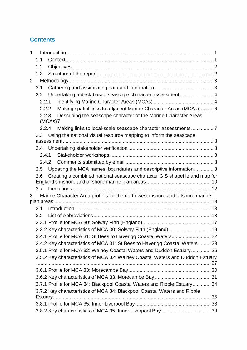
The first stage involved gathering and assimilating the range of datasets, literature, plans and strategies available to inform the work. The majority of the required spatial data was provided by the MMO, organised in a GIS database structured according to the key themes of the ‘seascape wheel’, see Figure 1(An approach to Seascape Character Assessment (NECR105). The wheel illustrates the different aspects which combine to create ‘seascape character’, under the three general themes of natural, cultural/social and perceptual and aesthetic. General information layers such as base-mapping and administrative boundaries were also collated during this first stage.
Marine raster charts and marine themes vector data provided the backdrop onto which numerous other GIS layers (geology, bathymetry, designated sites, etc.) were overlaid. Particular attention was paid to aligning the coordinate systems of onshore and offshore datasets to ensure a seamless transition between the marine and terrestrial data, drawing on the experience of previous studies. A full data list for this work is provided in Annex 1, including groupings under the three general themes of the seascape wheel to show the range of data used by this study to inform each theme.
The work undertaken for this study was primarily desk-based and aligned more with the ‘natural’ and ‘cultural/social’ themes of the seascape wheel, rather than the ‘perceptual and aesthetic’ (e.g. sight, sounds, smells) which could be gained in further detail from field/boat survey work. However, more information on perceptual and aesthetic qualities were gathered through the stakeholder engagement process undertaken in 2018.
4 of 63
Figure 1: The Seascape Wheel (Natural England, 2012)
Relevant literature and other written references were also compiled to inform the project: a reference list is provided in Section 4. Of particular use in understanding sea conditions (e.g. tides and currents) and interpreting information on marine navigation are the relevant Coast Pilots published by Imray. These were used to gain a further understanding of seascape character from the perspective of the sea and sea users.
2.2 Undertaking a desk-based seascape character assessment 2.2.1 Identifying Marine Character Areas (MCAs) The collated data and information relating to the different aspects of the seascape wheel were interrogated in order to begin to identify dominant patterns relevant to character across the inshore and offshore marine plan areas. This process informed the identification of MCAs, defined in the box over the page. This definition is consistent with that provided for ‘seascape character areas’1 in Natural England’s 2012 publication, An approach to Seascape Character Assessment, and applies to all of the other strategic-scale studies undertaken in England and Wales.
1 Marine Character Areas (MCAs) are more widely known as Seascape Character Areas (SCAs) outside of the marine planning process in England.

5 of 63
Marine Character Areas (adapted from Natural England, 2012) Definition: An MCA is an area of marine space has its own individual character and identity Application: Although MCAs can share the same generic characteristics as other areas, the use of marine character areas provides a good framework within which to draw out patterns of local distinctiveness and those factors influencing sense of place. They can be used to develop more tailored policies or strategies, reflecting the things that make a particular area different, distinctive or special.
The boundaries drawn for the MCAs represent broad transitions (rather than immediate or abrupt changes) in character from MCA to MCA, tending to reflect natural breaks or the clustering of characteristics and/or features deciphered from available data and information. The use of GIS is a key tool in the process of seascape character assessment, enabling different information layers to be interrogated in tandem and therefore allowing spatial patterns relevant to character to be investigated.
Professional judgement by a consultancy team of landscape and seascape specialists was fundamental in deciding which aspects have greatest influence on the character of each MCA, considering in particular how they shape individual distinctiveness and sense of place. Additional sources of written information, as well as LUC’s own knowledge of the north west (gained through other landscape/ seascape studies and fieldwork), were used alongside the GIS data to inform the boundary drawing process.
Draft MCA boundaries were digitised in GIS at a 1:250,000 scale with notes kept on the reasoning behind the boundaries drawn, including the use of GIS datasets. This draft classification was discussed with the MMO at this early stage, with comments made considered in a further detailed review of available information.
Figure 2 below illustrates how basemapping information detailed on the marine chart was used alongside other GIS datasets to help inform the MCA boundaries, using an example from the south west marine plan area (MCA 40: Bridgwater Bay). The character of this MCA, straddling between the Bristol Channel and Severn Estuary, is strongly influenced by natural and physical processes. Data representing the ‘natural’ theme of the seascape wheel therefore played a strong role in the boundary identification process for this MCA.
Further refinements to draft MCA boundaries resulted in the classification of nine MCAs for the north west, which were discussed at the stakeholder workshops undertaken in 2018 (see section 2.4 below). The final classification of MCAs for the north west inshore and offshore marine plan areas is illustrated at Figure 5 at the start of Section 3. A summary of the main information used to inform the boundaries is included in the ‘location and boundaries’ section of each MCA profile in Section 3.
As outlined above, it is important to note that the MCA boundaries represent broad zones of transition (i.e. not immediate breaks in character), and that natural, visual, cultural and socio-economic relationships between adjacent MCAs

6 of 63
play a key role in shaping overall character. Individual MCAs should not be considered in isolation.
Figure 2: Example of GIS data used to help inform the boundaries of MCA 40: Bridgwater Bay
© Ordnance Survey for the basemapping showing on the above figure. 2.2.2 Making spatial links to adjacent Marine Character Areas (MCAs)
This study forms part of a full national classification of MCAs across England, displaying seamless boundaries that are not constrained by the location of the different marine plan areas or administrative jurisdictions (in the case of Wales).
For the north west, this required consideration of the published seascape classification for Wales (LUC, 2015). Where seascape character was deemed to continue (or ‘flow’) across the marine plan area boundaries, the definition of English MCA boundaries was extended across the boarder into Welsh waters and other MCAs. Three of the English MCAs overlap with Welsh MCAs. These include MCA 35 Inner Liverpool Bay, MCA 36 Dee and Mersey Estuaries and Coastal Waters, and MCA 38 Irish Sea South (England) which refers to the. MCAs including England in parentheses do so to clarify that the definition only refers to the part of that area which is within the English marine plan area.
Consideration was also given to how character flows into Scottish Waters. Whilst work in Scotland is yet to commence, MCA 30 Solway Firth (England) is likely to continue into Scottish waters. Consultation as part of this study highlighted this and future studies should look in more detail at ‘flow’ across this boundary.
Where relevant, these connections are illustrated on the map and described in the ‘location and boundaries’ box at the beginning of each MCA profile in Section 3.

7 of 63
The MCA numbering in this report follows on from the north east, starting with MCA 30 Solway Firth (England). More information on the national seascape character map is provided at section 2.6.
2.2.3 Describing the seascape character of the Marine Character Areas (MCAs)
Each MCA has its own descriptive profile, which is included in Section 3 of this report. The profiles are structured as follows:
• Map of the MCA, showing its position within the wider marine plan area(s) • Overview of the MCA, with information against the following headings:
o Location and boundaries: this includes information on how the MCA was defined with reference to key sources of data/information – noting that boundaries represent zones of transition, not immediate breaks in character.
o Overall character: a summary snapshot of the overall seascape character of the MCA.
o Adjacent National Character Areas: For those MCAs with an adjacent coastline, reference is made to the adjoining National Character Areas defined by Natural England which form the equivalent spatial and descriptive units for landscape as the MCAs are for seascape.
o Adjacent and inter-visible nationally designated and defined landscapes: This section outlines which nationally designated or defined landscapes (National Parks, Areas of Outstanding Natural Beauty, Heritage Coasts, World Heritage Sites) are found along the adjacent coast or are visible to/from the MCA.
• Key characteristics: Seascape character is described using a set of bullet-pointed key characteristics which consider the main themes of the seascape wheel (Figure 1). The key characteristics are designed to capture the main features, elements and attributes of the MCA which combine to produce its overall seascape character. The key characteristics are not intended to be an exhaustive list of every site or feature present within the MCA. More fine-grained information on character can be captured in local-scale seascape character assessments (see section 2.2.4 below).
The MCA profiles drew on a range of available literature (see References at the end of Section 3) and data (Annex 1) in order to compile the key characteristics.
2.2.4 Making links to local-scale seascape character assessments
Seascape character assessments prepared at a local scale provide more detailed evidence, and have been referred to where available. In the north west, reference was made to landscape and seascape character assessments for the Solway Coast Area of Outstanding Natural Beauty (AONB) (2010) and the Arnside and Silverdale AONB (2015).
Nationally, it is envisaged that future local-scale assessments will consider the outputs of this assessment by seeking to nest smaller seascape units within the spatial framework of MCAs, where it is appropriate to do so.

8 of 63
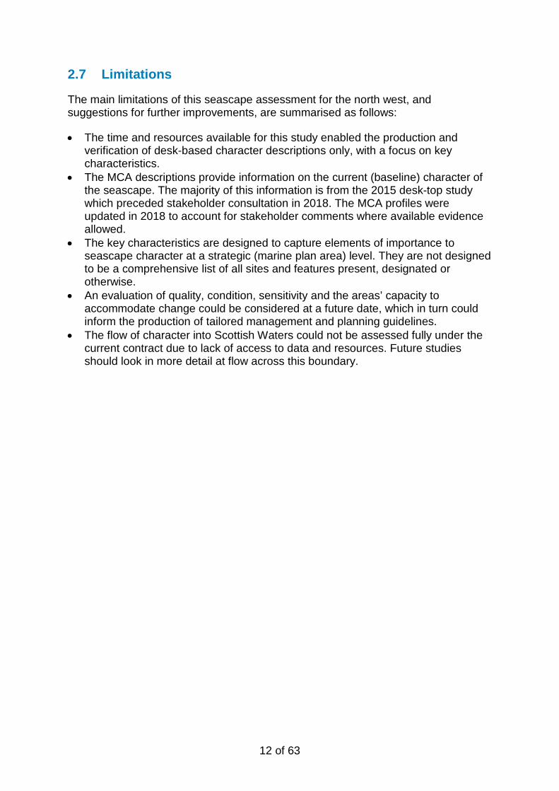
2.3 Using the national visual resource mapping to inform the seascape assessment
An approach to visual resource mapping (VRM) was developed and methodology documented as part of the seascape assessment for the South marine plan areas (2014). This has subsequently been applied nationally by the MMO. All of the MMO’s subsequent studies have referred to the VRM to help inform the ‘perceptual and aesthetic’ theme of the seascape wheel as relevant to visual character. Figure 3 presents the national VRM for England and Wales (showing both sea surface visibility from land and land with views of the sea). The north west section, showing the MCA framework, is included at Figure 6 in Section 3.
2.4 Undertaking stakeholder verification 2.4.1 Stakeholder workshops
LUC was commissioned in 2018 to undertake stakeholder verification on the draft seascape character assessments for the north west, north east, south east and south west. This included workshops held in each region. For the north west, two workshops were held as follows:
• St Bees, Thursday 15 May 2018; and • New Brighton, Wednesday 16 May 2018
A range of different stakeholders attended the workshops. A list of organisations represented is included at Annex 2. Those attending the workshops received an introductory presentation from the MMO on how seascape evidence is feeding into the marine planning process. This was followed by an overview of seascape work prepared to-date by LUC. Discussions were then facilitated to verify the MCA names, boundaries and key characteristics for consideration in the updated information provided in this report.
2.4.2 Comments submitted by email
Participants and invitees to the workshops were given a further opportunity to submit comments to the MMO via email. This consultation period ran until 25 May 2018. Those who submitted comments are also listed in Annex 2.
2.5 Updating the MCA names, boundaries and descriptive information
Responses made at the workshops and submitted by email were considered as part of an update to the MCA profiles (included in Section 3). Comments on MCA names and boundaries fed into the process of creating the national seascape character map and combined GIS layer, as described in Section 2.6.

9 of 63
Figure 3: Visual Resource Mapping (VRM) for England and Wales

10 of 63
2.6 Creating a combined national seascape character GIS shapefile and map for England’s inshore and offshore marine plan areas
An essential aim of this assessment was the creation of a single combined GIS layer and map of MCAs covering all of England’s inshore and offshore waters, replacing previously available separate datasets for individual marine plan areas.
This required an understanding of how character ‘flows’ between marine plan areas, a consideration already part of the MMO’s existing studies (see section 2.2.2). Relationships between Wales and the south west / north west marine plan areas were also considered during the preparation of the National Seascape Assessment for Wales (LUC, 2015).
This is the first time character has been mapped across all marine plan areas. It was essential to gain permission for the outputs from the north east and south east studies to supersede the seascape characterisation published for the east marine plan area by Natural England in 2012. The national seascape layer for England has, however, retained the numbering and naming of the seascape character areas (SCAs) identified by Natural England as separate to the MCAs for the remaining five marine plan areas. Otherwise the numbering is continuous, starting from the south marine plan area and running anti-clockwise around the coast to the south west marine plan area.
Using GIS, the National Marine Character Area layer for England was created by merging the individual datasets produced for the north west, north east, east, south east, south and south west marine plan areas. Areas which overlap at either end of these individual datasets were merged or amended to reflect stakeholder comments on names and boundaries, and desk-based interpretation of characteristics and features from available data and information.
The resultant national seascape character map for England is presented at Figure 4, showing how the MCAs relate to those defined for Wales. The combined GIS layer will be included on the MMO’s online Marine Information System (MIS) to inform the marine planning process, as well as downloadable from https://data.gov.uk/.

11 of 63
Figure 4: Marine Character Areas in England and Wales
12 of 63
2.7 Limitations
The main limitations of this seascape assessment for the north west, and suggestions for further improvements, are summarised as follows:
• The time and resources available for this study enabled the production and verification of desk-based character descriptions only, with a focus on key characteristics.
• The MCA descriptions provide information on the current (baseline) character of the seascape. The majority of this information is from the 2015 desk-top study which preceded stakeholder consultation in 2018. The MCA profiles were updated in 2018 to account for stakeholder comments where available evidence allowed.
• The key characteristics are designed to capture elements of importance to seascape character at a strategic (marine plan area) level. They are not designed to be a comprehensive list of all sites and features present, designated or otherwise.
• An evaluation of quality, condition, sensitivity and the areas’ capacity to accommodate change could be considered at a future date, which in turn could inform the production of tailored management and planning guidelines.
• The flow of character into Scottish Waters could not be assessed fully under the current contract due to lack of access to data and resources. Future studies should look in more detail at flow across this boundary.

13 of 63
3 Marine Character Area profiles for the north west inshore and offshore marine plan areas
3.1 Introduction This section provides descriptive profiles for each of the nine MCAs identified for the north west inshore and offshore marine plan areas. Figure 5 presents the spatial classification of all north west MCAs and Figure 6 shows the national Visual Resource Mapping results, overlain by the north west MCA framework.
Each stand-alone profile contains the following information:
A location map of the MCA (forming the front cover of each MCA profile)
Overview of the MCA
• Location and boundaries
• Overall character (summary)
• Adjacent National Character Areas (for those MCAs abutting the coast)
• Adjacent nationally designated and defined landscapes (National Parks, Areas of Outstanding Natural Beauty (AONBs), Heritage Coasts and World Heritage Sites).
Key characteristics
Comprising summary bullet points considering natural, cultural/social and perceptual/aesthetic influences on the MCA’s character.
3.2 List of Abbreviations
The following abbreviations are used throughout the MCA profiles:
AONB Area of Outstanding Natural Beauty MCA Marine Character Area MCZ Marine Conservation Zone NCA National Character Area NSA National Scenic Area SAC Special Area of Conservation SNH Scottish Natural Heritage SPA Special Protection Area WWI / WWII World War I / World War II

14 of 63
Figure 5: North West Marine Character Areas
15 of 63
Figure 6: Visual Resource Mapping for the North West

16 of 63
Figure 7: MCA 30 Solway Firth (England)

17 of 63
3.3.1 Profile for MCA 30: Solway Firth (England) Location and boundaries
This MCA covers the northern-most part of the North West Inshore marine plan area. It includes the Cumbrian coast from St Bees Head northwards to the mouth of the River Esk. The north-western boundary of the MCA is formed by the national boundary between Scotland and England, running down the centre of the Solway Firth. The western boundary with MCA 37: Irish Sea North (England) approximately follows the 20m bathymetry contour line. The southern boundary has been drawn perpendicular to St Bees, as the end of the cliffs at the southern end of St Bees Head mark a transition from the more enclosed seascape to the north, and the outward-facing coast to the south. The Solway Firth is a single character area that flows across the England-Scotland border, although this has not been mapped at this stage (see section 2.2.2).
Overall character
The Solway Firth is a long, winding estuary lying between northern Cumbria and southern Scotland. From the mouth of the River Eden in the east, the estuary is fringed by salt marshes, and widens beyond Silloth to a broad inlet of the Irish Sea. The firth marks the Scottish Border today, as it marked the edge of the Roman Empire in the time of Hadrian, whose wall has its western end at Bowness-on-Solway. Later, the coast was exploited for its coal reserves, and the industrial towns of Workington and Whitehaven grew up, two of several small but active ports in this MCA. The towns of Maryport and Silloth rely more on tourism, with people attracted to the open sandy coasts and dunes. The Solway Coast is protected as an AONB, and there are a number of important habitats in the inner Solway which attract international and national designation, including mudflats, saltmarsh and raised mires. The tidal sandbanks of the outer Solway are continually shifting, resulting in channels which move and change in depth. This dynamic element is driven by the powerful tidal flows through the area. The west Cumbria coast has been called the ‘energy coast’, reflecting not only its history of coal mining but as a setting of several wind farm developments, often built over restored mining areas. Though the southern part of the area is relatively urbanised, the north retains a strong degree of tranquillity. There are important visual relationships with the Solway Coast AONB and Lake District National Park to the south, and with the hills of Dumfriesshire to the north, particularly the coastal peak of Criffel.
Adjacent National Character Areas (NCAs) The adjacent coastline includes the following NCAs as defined by Natural England:
• 6: Solway Basin
18 of 63
• 7: West Cumbria Coastal Plain.
Adjacent and inter-visible nationally designated and defined landscapes The Solway Coast AONB covers a long, narrow section of the low-lying coast between Maryport and the mouth of the Eden, with the exception of the area around Silloth. This stretch of the coast is also included within the Frontiers of the Roman Empire World Heritage Site. The northern side of the Solway (in Scotland) falls within the Nith Estuary NSA. St Bees Head is defined as a Heritage Coast. The Lake District National Park and World Heritage Site is visible from/to, but does not adjoin this MCA.

19 of 63
3.3.2 Key characteristics of MCA 30: Solway Firth (England)
• Bedrock geology of mudstones and sandstones, including the St Bees Sandstone which outcrops at the cliffs of St Bees Head. Coal-bearing carboniferous rocks occur between Maryport and Whitehaven.
• Sea bed deposits comprise mainly sand, with gravel beds and boulder skaers following the coast south from Silloth. Further out, beyond Workington, the sea bed material becomes muddier.
• Extensive muddy sand banks are exposed at low tide in the inner firth, imparting a strong estuarine character.
• Blown sand has built up significant sand dune systems along the coast, notably between Maryport and Silloth. Raised marine deposits of sand and gravel form the lowlands of the Solway coast.
• Constantly shifting sands and navigation channels into the Solway, particularly following storms. Extensive drying banks at low tide are rapidly covered by an incoming tide that moves ‘faster than galloping horses’ (SNH, 2010).
• The Silloth Channel provides access to the port of Silloth between the drying sandbanks of Beckfoot Flats and Silloth Bank. Further out the Middle Channel is deeper, but subject to changing positions.
• Continually altering channels and sandbanks, creating uncertainty and risk. Changing shoreline, with several areas vulnerable to erosion. Coastal defences are a feature in several locations.
• The area of Maryport Roads and Allonby Bay remains shallower than 5m, becoming deeper past English Channel and Workington Bank, from where the seabed shelves to around 20m depth.
• The coastline drops rapidly from the 90m cliffs at St Bees to a low, narrow, rocky foreshore. North of Workington the strand becomes progressively sandier, with extensive sand flats off Silloth.
• Past the sandy headland of Skinburness the coastal character becomes more estuarine, with the muddy estuaries of Moricambe Bay and the River Eden flanked by extensive low-lying saltmarsh.
• Intertidal mudflats, saltmarsh and raised mires (mosses) are key habitat types in the Solway coast, with a particularly large coastal peat bog at Bowness Common.
• The inner Solway Firth is designated at international level for its intertidal habitats, supporting internationally important numbers of wintering birds. It also provides fish nursery areas and migratory areas for lamprey. The shallow waters of Allonby Bay MCZ support sponges, soft corals, sea squirts and reef-building honeycomb worms.
• St Bees Head forms part of the Cumbria Coast MCZ, and its cliffs are protected for their geology and as the only breeding site on the Cumbrian coast for a variety of seabirds.

20 of 63
• Hadrian’s Wall ends at Bowness-on-Solway, and the Romans built further structures around this coast. These are recognised as part of the Frontiers of the Roman Empire World Heritage Site, which extends along the coast from Maryport to Carlisle and beyond.
• Commercial exploitation of coal took place between Maryport and Whitehaven from at least the 16th century up to 1986, with current plans for a new mine.
• Whitehaven, built on the coal trade, also handled sugar, lime and supplied the nearby chemical works. It is now one of a series of small but active ports with docks, marina and associated infrastructure. A coastal railway links the port towns of Whitehaven, Workington and Maryport.
• Commercial fishing ports at Whitehaven, Workington, Maryport and Silloth, with boats fishing for Nephrops (Dublin Bay prawn), brown shrimp, bass, thornback ray, cod, crab and lobster, and vessels landing from Isle of Man scallop fisheries.
• Haaf netting is a long-established shallow-water fishing method that is now only practiced in the Solway.
• Recreational sailing popular along the coast, with several marinas. The coast between Maryport and Silloth is a holiday destination, with caravan parks and holiday homes along the seaboard.
• There are several coastal wind farms, as well as the Robin Rigg offshore wind farm to the north. The latter is visible from both north and south, providing a visual link that unifies the middle reaches of the Solway.
• The flat, open firth and low-lying surroundings gives the area an expansive scale, and a strong sense of exposure, in views from along the Solway Coast.
• There are expansive views over the estuary to the Scottish hills, and south over rising ground to the Lakeland fells.
• The northern and western Lake District fells, and St Bees Head, overlook the Solway Firth MCA with vistas towards Scotland and the Isle of Man. To the north there is a key visual relationship with Criffel across the Solway.
• Industrial activity and wind turbines reduce the tranquillity of the southern area: in contrast the AONB coast retains a remote feel. By night the lights on Robin Rigg offshore wind farm and the Anthorn radio masts are visible.
21 of 63
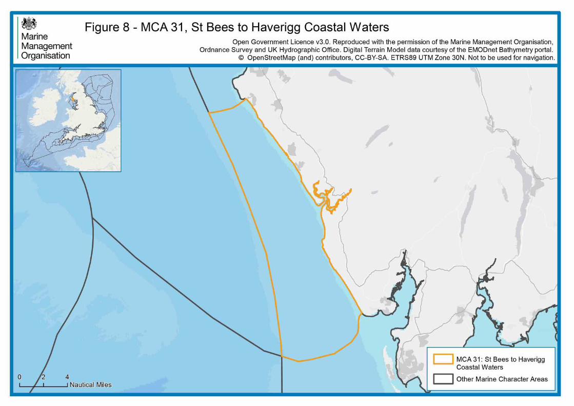
Figure 8: MCA 31 St Bees to Haverigg Coastal Waters

22 of 63
3.4.1 Profile for MCA 31: St Bees to Haverigg Coastal Waters Location and boundaries
This MCA covers the coastal waters alongside the south-west coast of Cumbria. It extends to between 5km and 15km offshore, to take in the shallow inshore waters from St Bees in the north to Haverigg Point in the south. The south-western boundary of the MCA approximately follows the 20m bathymetry contour line, beyond which is the offshore MCA 37: Irish Sea North (England). The northern boundary has been drawn perpendicular to the cliffs at the southern end of St Bees Head, as this headland marks the transition to the more enclosed seascape of the Solway Firth to the north. Haverigg Point in the south marks the location where the coast turns inward to the Duddon Estuary, and the southern boundary is drawn through the offshore Haverigg Spit to separate the estuarine sandflats of MCA 32: Walney Coastal Waters and Duddon Estuary from this MCA.
Overall character
The south-west coast of Cumbria is a relatively remote and undeveloped coastline. It is a long, smooth coast without significant indentation, and as a result supports no harbours or towns. Only at the mouth of the Esk is there any change in form, where a convoluted estuary lies behind mature dune systems. Ravenglass, on the Esk, is the major tourist centre of this coast and is within the Lake District National Park. It is one of a number of small villages along the coast, none of which have extensive development along the coastline itself. The broad sandy beaches attract holidaymakers who frequent the numerous caravan parks on the coast. These beaches are interspersed with rocky scars extending out to sea, resulting in shallow coastal waters. The major modern development is Sellafield nuclear power station, which dominates views in the northern part of the MCA. Otherwise, the lack of human activity contributes to high nature conservation value, particularly around the dune and estuary systems at Drigg. The area has high tranquillity and dark sky values.
Adjacent National Character Areas (NCAs) The adjacent coastline includes the following NCAs as defined by Natural England:
• 7: West Cumbria Coastal Plain.
Adjacent and inter-visible nationally designated and defined landscapes The Lake District National Park and World Heritage Site meets the coast in this MCA, including the Esk estuary and dunes, with the coastal farmland and foreshore as far south as Silecroft. St Bees Head is defined as a Heritage Coast.
23 of 63
3.4.2 Key characteristics of MCA 31: St Bees to Haverigg Coastal Waters • A sandstone coast, with Triassic rock extending south from
St Bees Head to Haverigg Point. The same sandstone extends offshore, giving way to mudstones and halite in the south-west.
• The rivers Esk, Mite and Irk meet at the coast at Ravenglass, forming a distinctive trident-shaped tidal estuary. Broad dune systems have built up either side of the main channel.
• Elsewhere, a long, smooth coast without significant indentation. The broad foreshore comprises sandy beaches with areas of shingle and exposed wave-cut rock.
• The foreshore and seafloor are mainly sandy, with more mud further offshore as well as overlying glacial till and gravels.
• Rocky scars project some way offshore in several locations, most notably at Selker Rocks some 2km from the High Water Mark, and Kokoarrah Scar off the Drigg dunes.
• The shallow sea slopes gently out from the coast towards the 20m depth contour, which represents a gradual transition into the adjacent MCA, with significant areas of less than 10m depth.
• Very limited low-energy tidal flows, of less than 0.5m/s. • The Cumbria Coast MCZ and protects rocky and sandy
habitats and peat exposures, from St Bees to the Esk. The Esk estuary and adjacent dune systems are protected at an international level.
• Haverigg Point, at the eastern edge of the Duddon Estuary, is protected at numerous levels for its intertidal habitats, and the area between here and the Esk provides an important area for foraging tern species.
• A particular concentration of shipwrecks is recorded off Haverigg Point.
• Britain’s ‘Energy Coast’, with nuclear power having been generated at Sellafield from the 1950s to the early 21st century. The extensive plant remains a significant visual presence in views from land and sea.
• Military firing practice range based at Eskmeals on the dunes near Ravenglass; the range extends out to sea.
• An onshore windfarm is located at Haverigg, with offshore windfarms visible to the south (see MCAs 32 and 38).
• Although there are no harbours on this coast, small yachts can moor at Ravenglass, and there are medium-use recreational sailing routes following the coast.
• Fisheries are limited but include crab, lobster, mussels and winkles around Ravenglass, and netting for bass, cod and thornback ray along the coast.
• Caravan parks located along the coastline, associated with the sandier stretches of foreshore. Ravenglass is a tourist centre in this part of the Lake District National Park.
• This area of sea is highly visible from land, including in views from the fells of the south-western Lake District National Park that look out to the Isle of Man: in turn it forms part of the seascape setting of the designated landscape.

24 of 63
• The higher hills in the south-west Lake District, including Black Combe, are prominent features in views from the sea, as is St Bees Head in the north.
• This MCA forms part of the seascape setting of St Bees Head Heritage Coast, in views south along the coastline.
• An undeveloped coastline with no large settlements. The exception is the nuclear power station and associated industrial development at Sellafield, at the mouth of the Calder.
• A strong sense of tranquillity with dark night skies, particularly between Ravenglass and Millom.

25 of 63
Figure 9: MCA 32 Walney Coastal Waters and Duddon Estuary
26 of 63
3.5.1 Profile for MCA 32: Walney Coastal Waters and Duddon Estuary Location and boundaries
This MCA covers the coastal waters to the south-west of Cumbria. The MCA extends from Haverigg Point in Cumbria to the Lune Deep off the Fleetwood coast. It includes the Duddon Estuary, Walney Island, and the shallow waters to the west of Morecambe Bay. The western boundary of the MCA approximately follows the 20m bathymetry contour line, marking a transition zone into the offshore MCA 38: Irish Sea South (England). Haverigg Point in the north marks the edge of the Duddon Estuary, and the boundary here is drawn through the offshore Haverigg Spit to separate the estuarine sandflats of this MCA from the coastal waters of MCA 31: St Bees to Haverigg Coastal Waters. The western boundary follows the outermost drying banks at the edge of the enclosed MCA 33: Morecambe Bay, and the southern boundary follows the edge of the Shell Flat and the south side of Lune Deep.
Overall character
The coastline of this MCA includes large areas of intertidal sand and mud flats within Duddon Estuary and around Walney Island. The latter is England’s largest barrier island, and protects the major port and shipbuilding centre of Barrow-in-Furness. This area has long been settled, with the 14th-century Piel Castle protecting the harbour approach, and large numbers of wrecks in the area. The MCA extends offshore to the south and west of Walney, including shallow seas generally less than 20m in depth. The major exception is the Lune Deep, a glacially carved channel up to 86m in depth which provides the main shipping access into Morecambe Bay, and which is marked by buoys. The Deep is maintained by the tidal flows which pass in and out of the bay. The offshore seascape hosts several wind farms in the waters between 7km and 20km from the coast.
Adjacent National Character Areas (NCAs) The adjacent coastline includes the following NCAs as defined by Natural England:
• 7: West Cumbria Coastal Plain.
Adjacent and inter-visible nationally designated and defined landscapes The Lake District National Park and World Heritage Site adjoins the Duddon Estuary, on the northern edge of the MCA.
27 of 63
3.5.2 Key characteristics of MCA 32: Walney Coastal Waters and Duddon Estuary
• Gently shelving, muddy sand seabed, extending from the coast and edges of Morecambe Bay westwards to a depth of around 20m.
• The exception to this bathymetry is Lune Deep, a glacially incised channel over 10km in length which reaches 86m depth at one point.
• Glacial processes and subsequent movement of coastal sediments carried by strong tidal currents have resulted in a distinctive coastal landscape.
• Complex sediment movement resulting in the development of ness/foreland dunes at several locations in the Duddon Estuary. There are also spit dunes at North Walney, formed largely from river sediment.
• Walney Island is the largest barrier island in England, formed from glacial till and alluvium, and has been extended northwards and southwards by recurved shingle spits.
• International designations reflect the importance of the intertidal habitats, including sand dunes, vegetated shingle, salt marsh and lagoons supporting a rich birdlife.
• Offshore there are important subtidal habitats, protected by the West of Walney MCZ and Shell Flat and Lune Deep SAC.
• Piel Castle is a reminder of the earlier history of the area. Built in the 14th century by the abbot of the wealthy Furness Abbey, it provided protection for trading vessels using the harbour at Barrow.
• Natural systems have been much modified over time; much of the coastal marshland has been drained over the centuries to provide farmland.
• A chain of coastal defences dating to WWI and WWII, including pillboxes and observation posts, are reminders of the importance of Barrow’s shipyard.
• Barrow-in-Furness has been a major ship-building centre from the 19th century. It continues to be a centre for building the UK’s nuclear submarine fleet, requiring the Walney Channel to be heavily dredged.
• Lune Deep is important as a shipping access route through the sand banks and flats into Morecambe Bay.
• Significant shoreline protection works line the Duddon Estuary and Barrow area, with the coastal railway line forming an important sea defence.
• Four wind farms lie off the coast, forming prominent moving structures within the seascape.
• A 34km long pipeline from the Morecambe Bay Gas Field, located in MCA 38, supplies the Rampside Gas Terminal to the east of Walney Island.
• The waters of Duddon Estuary, Walney Channel and Foulney spit support harvested mussel beds, crab and lobster fisheries, and occasional cockles.
• Other fisheries include crab and lobster potting, cod, bass and thornback ray netting, and sole and flatfish beam trawling in the Lune Deep.

28 of 63
• Inshore areas support seagrass and are important as nurseries for pelagic and demersal fish species such as herring and plaice.
• There are important bird colonies around Walney Island, as well as Cumbria’s only colony of seals.
• Wildlife and heritage are the principal attractions for visitors, with recreational angling also important for tourism.
• There is a marked contrast between natural and man-made elements on the land, coastline and sea, creating a distinct sense of place.
• Views out from the southern extent of the Lake District National Park are dominated by the undeveloped Duddon Estuary which forms a significant component of the Park’s setting in this locality.
• Views out to sea from Black Combe and the southern Fells into the MCA are a significant characteristic of this part of the Lake District National Park.
• Views inland have the backdrop of the Lake District’s mountains and also industrial elements: views offshore feature the Isle of Man and the Galloway coast in Scotland.

29 of 63
Figure 10: MCA 33 Morecambe Bay
30 of 63
3.6.1 Profile for MCA 33: Morecambe Bay Location and boundaries
This MCA comprises the enclosed estuarine bay of Morecambe, where the waters of four large rivers merge. Its outer edges are marked by Foulney Island, near Barrow, in the north and Fleetwood in the south. Drying banks running between the two form the western edge of the MCA. With the exception of Heysham Lake (up to 25m) the waters of the bay are less than 10m deep and often below 5m.
Overall character
Morecambe Bay is a broad estuarine area, where the rivers Leven, Kent, Lune and Wyre emerge into the Irish Sea. The indented coast, enclosed by the Furness peninsula, means that a large area of sand and mud flats has built up, extending to over 310km2 at low tides. This vast intertidal area of shifting sands supports rich ecological habitats and wealth of birdlife. The dynamic coastal environment of fast-moving tides causes erosion and deposition in different areas, and makes navigation difficult. The main channel is to the south, giving access to the port of Heysham. Gathering of cockles and other shellfish is an important industry in the area. The Queen’s Guide to the Sands, a traditional royal appointment, continues to offer guided walks across the shifting flats. The surrounding coasts are settled, with the towns of Fleetwood and Morecambe facing the bay. Panoramic vistas, with a backdrop of mountains to the north and wooded hills to the east, add to its unique character.
Adjacent National Character Areas (NCAs) The adjacent coastline includes the following NCAs as defined by Natural England:
• 7: West Cumbria Coastal Plain • 20: Morecambe Bay Limestones • 31: Morecambe Coast and Lune Estuary • 32: Lancashire and Amounderness Plain
Adjacent and inter-visible nationally designated and defined landscapes The Lake District National Park and World Heritage Site adjoins, and slightly overlaps in several places, the river mouths on the northern edge of the MCA. Warton Sands, on the eastern side of the Bay, lies within the Arnside and Silverdale AONB, which includes the coastline between Carnforth and Milnthorpe.
31 of 63
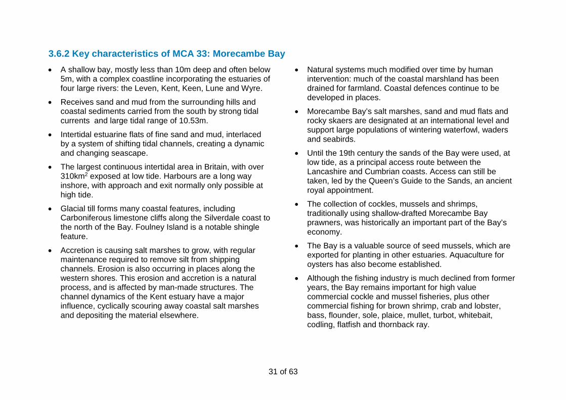
3.6.2 Key characteristics of MCA 33: Morecambe Bay • A shallow bay, mostly less than 10m deep and often below
5m, with a complex coastline incorporating the estuaries of four large rivers: the Leven, Kent, Keen, Lune and Wyre.
• Receives sand and mud from the surrounding hills and coastal sediments carried from the south by strong tidal currents and large tidal range of 10.53m.
• Intertidal estuarine flats of fine sand and mud, interlaced by a system of shifting tidal channels, creating a dynamic and changing seascape.
• The largest continuous intertidal area in Britain, with over 310km2 exposed at low tide. Harbours are a long way inshore, with approach and exit normally only possible at high tide.
• Glacial till forms many coastal features, including Carboniferous limestone cliffs along the Silverdale coast to the north of the Bay. Foulney Island is a notable shingle feature.
• Accretion is causing salt marshes to grow, with regular maintenance required to remove silt from shipping channels. Erosion is also occurring in places along the western shores. This erosion and accretion is a natural process, and is affected by man-made structures. The channel dynamics of the Kent estuary have a major influence, cyclically scouring away coastal salt marshes and depositing the material elsewhere.
• Natural systems much modified over time by human intervention: much of the coastal marshland has been drained for farmland. Coastal defences continue to be developed in places.
• Morecambe Bay’s salt marshes, sand and mud flats and rocky skaers are designated at an international level and support large populations of wintering waterfowl, waders and seabirds.
• Until the 19th century the sands of the Bay were used, at low tide, as a principal access route between the Lancashire and Cumbrian coasts. Access can still be taken, led by the Queen’s Guide to the Sands, an ancient royal appointment.
• The collection of cockles, mussels and shrimps, traditionally using shallow-drafted Morecambe Bay prawners, was historically an important part of the Bay’s economy.
• The Bay is a valuable source of seed mussels, which are exported for planting in other estuaries. Aquaculture for oysters has also become established.
• Although the fishing industry is much declined from former years, the Bay remains important for high value commercial cockle and mussel fisheries, plus other commercial fishing for brown shrimp, crab and lobster, bass, flounder, sole, plaice, mullet, turbot, whitebait, codling, flatfish and thornback ray.

32 of 63
• The construction of the Lancaster Canal and the arrival of railways led to a more rapid development of trade and tourism centred on Morecambe. The Arnside Viaduct remains a key feature in the bay. Fleetwood was also developed as a major fishing port.
• Morecambe remains the focus for tourism in the area, though Arnside & Silverdale and the Furness coast are popular for less intensive tourism. Recreational angling is also important for tourism.
• The Port of Heysham plays a key role in providing freight services to the Republic of Ireland and Northern Ireland and passenger services to the Isle of Man. Heysham nuclear power station is a notable visual landmark from coast and sea.
• Away from urban areas a strong sense of tranquillity and isolation results from the expansiveness of views and general absence of development.
• This is a very animated landscape, with the character of the Bay’s surface constantly changing, through the interplay of tides and light and the movement of its birdlife.
• There are panoramic vistas across the bay from all directions, including views from the Lake District National Park, Forest of Bowland AONB, and Arnside & Silverdale AONB (e.g. Arnside Knott).
• Morecambe Bay forms a key component to the seascape setting of the Arnside and Silverdale AONB. In turn the elevated land of the protected landscapes form a scenic backdrop to views across the Bay from its seaward side.
33 of 63
Figure 11: MCA 34 Blackpool Coastal Waters and Ribble Estuary
34 of 63
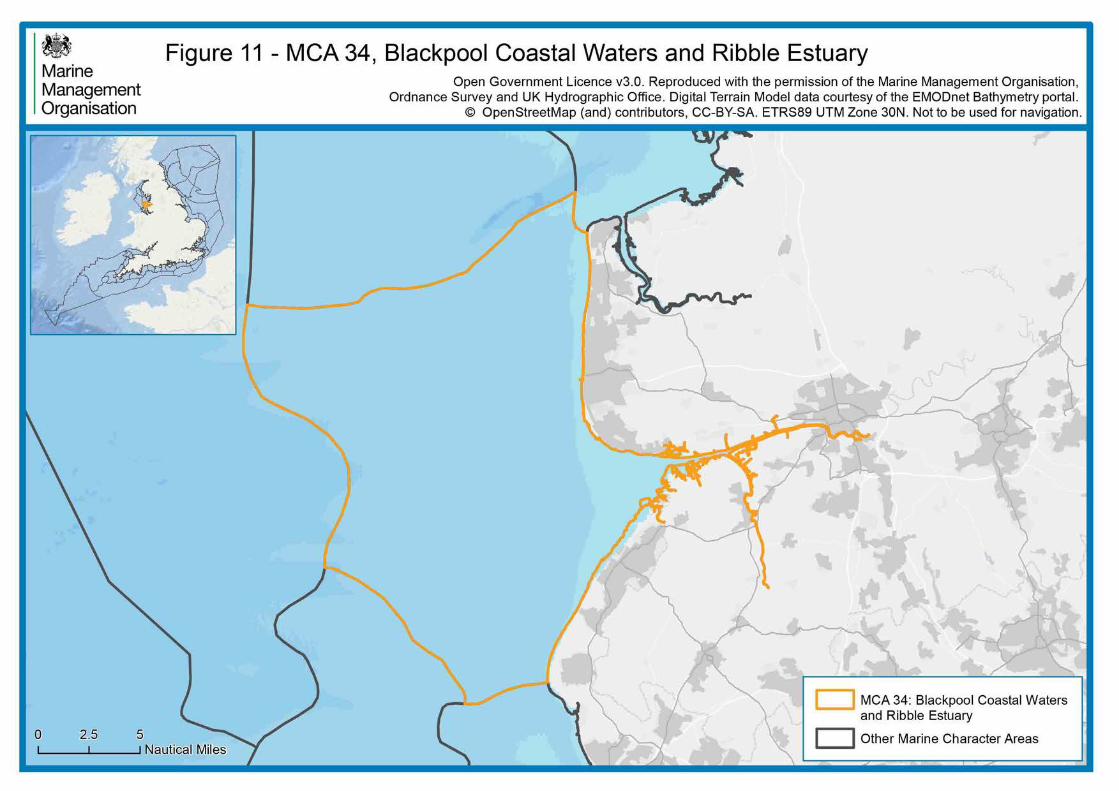
3.7.1 Profile for MCA 34: Blackpool Coastal Waters and Ribble Estuary Location and boundaries
This MCA is a shallow, coastal area no more than 20m deep on its western side, shelving very gently down from the low-lying Lancashire coastal plain. It encompasses the Fylde Coast to the north, terminating at the southern edge of Lune Deep, and the Sefton Coast as far as Formby Point to the south. Between these two coasts the Ribble Estuary, between Lytham St Anne’s and Southport, cuts inland to Preston. The northern boundary of the area follows the edge of the Shell Flat on the south side of the Lune Deep, which is within MCA 32: Walney Coastal Waters and Duddon Estuary. The western boundary approximately follows the 20m bathymetry line that marks a transition to the open waters of the Irish Sea. To the south, the boundary follows Taylor’s Bank, which defines the Mersey Channel, and then the shallower water of Jordan’s Spit to separate the busier waters of MCA 35: Inner Liverpool Bay.
Overall character
Wide, sandy beaches, resulting from a combination of shallow waters and a high tidal range, characterise the length of the MCA, but there are distinct differences between the Sefton Coast, which is dominated by sand dunes, and the more urban coastline to the north of the Ribble, centred on Blackpool. The Ribble Estuary is noted for its wildfowl, waders and seabirds. Further offshore, the Lennox oil and gas field reflects the importance of the Irish Sea for energy production.
Adjacent National Character Areas (NCAs) The adjacent coastline includes the following NCAs as defined by Natural England:
• 32: Lancashire and Amounderness Plain
• 57: Sefton Coast.
Adjacent and inter-visible nationally designated and defined landscapes This MCA does not fall adjacent to any nationally protected landscapes.

35 of 63
3.7.2 Key characteristics of MCA 34: Blackpool Coastal Waters and Ribble Estuary • A shallow, coastal area no more than 20m deep, shelving
very gently down from the low-lying Lancashire coastal plain.
• Shallow waters and a high tidal range (up to 9.8m at Lytham St Anne’s) backed by extensive sandy and muddy/sandy beaches, intertidal sand flats and mudflats.
• Complex coastal processes, with a high rate of movement of sand and shingle, although sea defences limit this in places.
• Frequent storm surges, combining with high tides to cause flooding. Man-made barriers protect most of the coast, and sand bars, salt marsh and dunes also provide a natural defence.
• Beyond the sandbanks, the Ribble Estuary is a landscape of intertidal salt marshes, pierced by dendritic creeks.
• Along the Sefton Coast the landscape is dominated by sand dunes, stretching over 17km long. Around Formby and Ainsdale the dunes reach over 20m high, forming dominant features.
• The protected dune systems support internationally and nationally important species including natterjack toad and sand lizard.
• The Ribble Estuary and the Sefton Coast dunes have distinctive character, and in places, when screened from urban influences, a sense of remoteness and wildness.
• Large intertidal areas are internationally designated for their importance for migratory wildfowl, wading birds and sea birds.
• The extensive Liverpool Bay SPA includes all of this coast, and supports common scoter and red-throated diver. The Fylde MCZ includes extensive areas of subtidal sediment habitats typical of the area, and overlaps with the Shell Flat and Lune Deep SAC.
• At Formby Point, coastal erosion of the foreshore has revealed preserved human, animal and wading bird footprints dating from the Mesolithic Period (7,000–5,000 years ago).
• Coastal waters and the Ribble Estuary are important nursery areas for commercially fished species such as herring, plaice, Dover sole and bass.
• The Ribble Estuary supports commercial fisheries for brown shrimp and cockles. Other commercial fisheries in this MCA include mussels, bass, crab, lobster, flatfish and thornback ray.
• The Lennox Oil and Gas Field, one of five interlinked sites currently operational in Liverpool Bay, is located in the south western part of the MCA.
• The Fylde Coast in particular is now very urbanised, with much industrial development e.g. around Blackpool and Preston.
• The marshy coastal area was sparsely populated until the 19th century, when land drainage enabled agriculture and

36 of 63
the railways boosted tourism, most notably for Blackpool and Southport.
• In addition to urban and beach-based tourism the coast is popular for bird watching, with a number of national and local nature reserves providing facilities for visitors. Recreational angling is also an attraction.
• There are a number of prominent landmarks on the developed areas of coast, such as Blackpool’s tower, pier and rollercoaster.
• From the coast there are long views to the mountains of North Wales and the Lake District, and from the Sefton Coast shipping lanes, wind turbines and oil and gas infrastructure are visible.
37 of 63
Figure 12: MCA 35 Inner Liverpool Bay

38 of 63
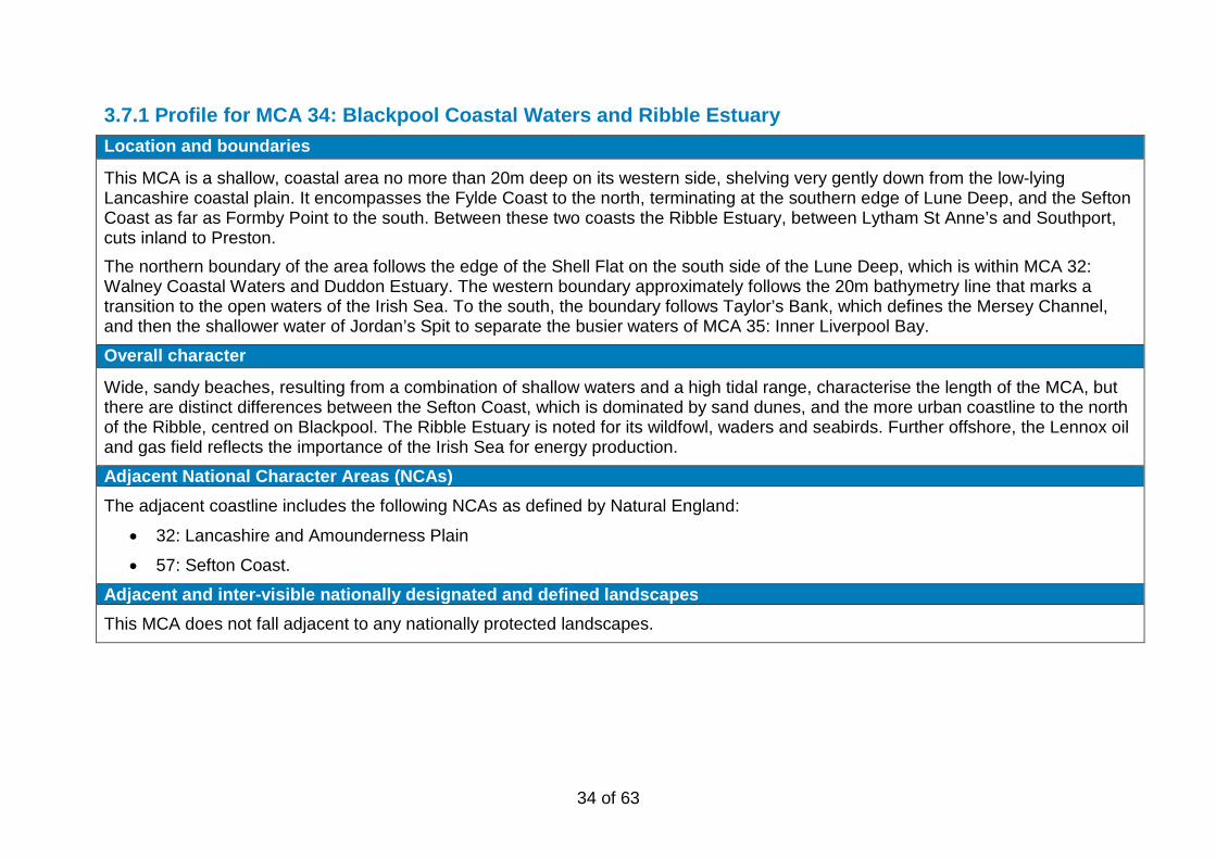
3.8.1 Profile for MCA 35: Inner Liverpool Bay Location and boundaries
This MCA is an intermediate area between the open sea to the west, beyond the infralittoral boundary, and the inshore area of flats and banks approaching the Mersey and Dee estuaries. Depths vary from about 20m to the west to around 5m on the landward sides on the MCA, and the boundaries approximately follow these bathymetry lines. The north-eastern edge of the MCA is defined by the main shipping lane from Liverpool which follows Jordan’s Spit. The south-west boundary extends into Welsh waters, guided by bathymetry and including the North Hoyle and Gwynt-y-Mor offshore wind farms. For this part in Wales, please refer to the relevant published profile for MCA 04: North Wales Open Waters, available on the Natural Resources Wales website.
Overall character
This MCA sits over 5km from the low-lying coasts to south and east. It lies in the infralittoral area of shallower waters, where freshwater influence boosts the numbers of marine organisms and helps to support fish stocks and coastal seabird populations. The area is on the main approach to the Mersey from across the Irish Sea, so is much used by shipping heading for the Queens Channel (see MCA 36: Dee and Mersey Estuaries and Coastal Waters). Ferries to the Isle of Man and Ireland pass through this area. Other human activity includes dredging and, historically, dumping of dredged material. The northern part of the area is within the Liverpool Bay oil and natural gas field, and offshore wind farms have been developed in recent years. Although offshore, the area is overlooked from the settled, low-lying coasts of the Wirral and Sefton.
Adjacent National Character Areas (NCAs) This MCA does not have an adjacent coastline.
Adjacent and inter-visible nationally designated and defined landscapes This MCA does not have an adjacent coastline.
39 of 63
3.8.2 Key characteristics of MCA 35: Inner Liverpool Bay • A gently shelving coastal zone, from around 5m depth
where it gives way to the inshore area of sand banks, mud flats and channels approaching the Mersey and Dee estuaries – to around 20m in the west and north.
• The seabed is covered with Quaternary, mostly glacial and post-glacial sand and gravel deposits. These are underlain by mudstones and halite.
• Large quantities of material dredged from estuary areas, such as the Mersey docks, have been deposited in this part of Liverpool Bay since Victorian times.
• The semi-enclosed character of the Irish Sea means that wave heights are generally low.
• Several species of phytoplankton are noted for causing blooms in Liverpool Bay, the most visual expression of this being the ‘red tides’ associated with invertebrate mortalities.
• Spawning grounds for whiting, Dover sole and plaice extend southward and eastward as far as the northern end western parts of the MCA.
• The whole of the MCA, along with other shallow waters along the north-west coast, is important as a nursery for pelagic and demersal fish species, including herring, plaice and Dover sole.
• Contains important foraging grounds sustaining the significant populations of red-throated diver, common scoter and terns, internationally designated as part of the Liverpool Bay SPA.
• Further offshore, cetaceans are found including dolphins, porpoise and occasional whales.
• A busy area for commercial shipping, with the majority of vessels entering the Mersey passing through it. There is also moderate usage by recreational craft, including recreational anglers, as well as passenger ferries.
• An important area for oil and gas extraction. One of the five interlinked sites is the Hamilton East Gas Field, connected by pipeline to the Hamilton North Gas Field in MCA 38: Irish Sea (South).
• More recently, offshore wind farms have been developed in this area.
• An area in the south west of the MCA, and extending further west, is licensed by the Crown Estates for the dredging of marine aggregates, landed at Liverpool to supply the local market.
• MCA widely visible from land in its southern parts. The closer coasts are low lying and unlikely to be prominent in views from the sea, for example from the ferries which cross this area.
• The offshore platforms, shipping activity and offshore wind turbines also influence views and perceptual qualities at night-time.
40 of 63
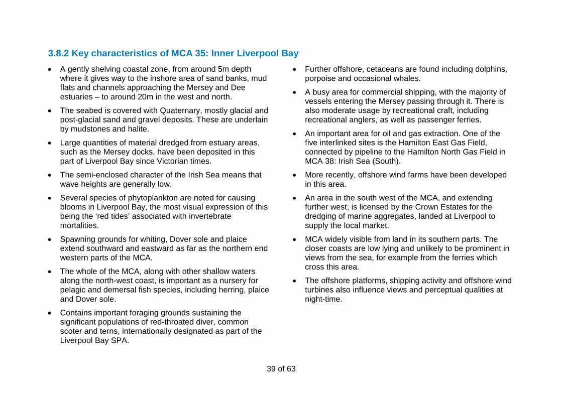
Figure 13: MCA 36 Dee and Mersey Estuaries and Coastal Waters
41 of 63
3.9.1 Profile for MCA 36: Dee and Mersey Estuaries and Coastal Waters Location and boundaries
This MCA comprises the Mersey Estuary, the Dee Estuary and their associated inshore areas, extending out to include the mudflats around inner Liverpool Bay. The area includes East Hoyle Spit, Newcome Knoll and Burbo Flats, as well as the Queen’s Channel which forms the main approach to the Mersey for shipping. The northern edge of the area is marked by Taylor’s Bank, which forms the northern side of the Queen’s Channel, and extends west of Formby. The offshore boundary with MCA 35 Inner Liverpool Bay approximately follows the bathymetry to include the majority of sea which is shallower than 5m. The south-western boundary follows the marine plan area boundary. This MCA extends into Welsh waters, as the Dee Estuary does not have a marine character division along its centre. For the part of the Dee Estuary in Wales, please refer to the relevant published profile for MCA 01: Dee Estuary (Wales).
Overall character
This MCA comprises two related but contrasting estuaries, and the coastal waters that link them. The Mersey is characterised by major urban development, centred on Liverpool and Birkenhead where the channel narrows, and extending inland around the broad inner estuary. A long-established major port, Liverpool remains a focus of shipping; the Mersey provides access inland to the Manchester Ship Canal. The Dee is much less developed, though historically has also been important for shipping. Its broad inlet is characterised by tidal mud and sand flats backed by dunes and salt marsh. Towns on the Wirral tend to be set back from this coast, though the northern coast is more developed. Extensive beaches allow access to small offshore islands at low tide. North of Crosby the urban area gives way to beaches and dune systems. The Queen’s Channel is a busy shipping lane, and wind farms onshore and offshore add to the industrial character of the area. Important habitats, such as sand dunes and salt marsh, support a rich flora and fauna.
Adjacent National Character Areas (NCAs) The adjacent coastline includes the following NCAs as defined by Natural England:
• 57: Sefton Coast (mostly adjacent to MCA 7) • 58: Merseyside Conurbation • 59: Wirral
Adjacent and inter-visible nationally designated and defined landscapes The adjacent coastline includes the Liverpool Maritime Mercantile City World Heritage Site.

42 of 63
3.9.2 Key characteristics of MCA 36: Dee and Mersey Estuaries and Coastal Waters • Coastal area consisting of the Dee Estuary, the Mersey
Estuary, the smaller Alt Estuary and their associated coastal waters.
• Low-lying coastline underlain by Triassic shales and sandstones, which form distinctive, isolated, coastal outcrops such as Hilbre Island (at the mouth of the Dee) and Perch Rock (Mersey).
• A high tidal range and shallow, very gently shelving coastal waters with numerous sand banks and mudflats.
• Sandstone bedrock constrains the width of the Mersey near its mouth, channelling water to create strong currents which cause localised tidal scour in places.
• The funnel shape of the Dee Estuary encourages sedimentation, largely from longshore drift, which over time has caused ports in the upper reaches of the estuary to silt up. The Dee itself has been channelized in the inner estuary.
• The inner Mersey Estuary is composed of extensive intertidal mud and sandflats, distinct areas of rocky shore, and areas of saltmarsh.
• Sand dunes are a notable feature, visually and ecologically, in particular the extensive system that starts at Seaforth and continues north for many miles. At up to 25m high and 5km wide, it is the largest dune system in England.
• Important nursery grounds for herring, plaice, Dover sole and bass. The Dee is also noted for a number of protected
fish species, including sturgeon and allis shad, and for shellfish beds.
• Commercial fisheries include cockles, mussels, shrimps, bass, plaice, Dover sole, flounder, dab, turbot, brill, codling, whiting, cod, mackerel and mullet.
• Mudflats, sand flats, man-made lagoons and salt marshes are internationally important for a range of wildfowl and wading bird populations, reflected in overlapping international designations across the majority of this MCA.
• The Dee Estuary supports a population of grey seals.
• At the end of the last glaciation the coast was c.15km further west. Rising sea levels covered ancient landscapes but prehistoric sites and artefacts have been discovered in the intertidal zone.
• The Merseyside Conurbation, centred on Liverpool, developed largely as a result of the physical characteristics of the coastline, with natural tidal pools providing the basis for early docks.
• A major international port for several hundred years, Liverpool suffered a decline in the 1970s, but remains an important trade hub, with ongoing investment into the ‘superport’ and a range of associated industries and services.
• Shipping routes from the Irish Sea converge on the Queens Channel/Crosby Channel to access the Mersey, with onward links inland to the Manchester Ship Canal.
43 of 63
• The combination of high shipping volumes and numerous sandbanks has resulted in many hundreds of shipwrecks, concentrated along Queen’s Channel and between Liverpool and Birkenhead.
• The River Mersey, its historic waterfront and its maritime history are at the heart of Liverpool’s strong sense of place and its importance as a tourist destination, designated as a World Heritage Site.
• The MCA’s wide, sandy beaches and local and national nature reserves are recreation and tourism draws. At Crosby, Antony Gormley’s installation ‘Another Place’ is a further attraction on the foreshore.
• Long stretches of coast are protected by man-made defences in response to threats from storm surges and sea level rise.
• The Burbo Bank Wind Farm, and several others in Welsh waters are prominent in views. There are also views across the Mersey to oil refineries at Ellesmere Port and to the Welsh coast.
• Blackpool Tower is a distant landmark to the north, and on clear days Anglesey and Snowdonia can be seen.
• Views also characterise both estuaries, with the vistas up and down the Mersey characteristic of Liverpool’s setting.
44 of 63
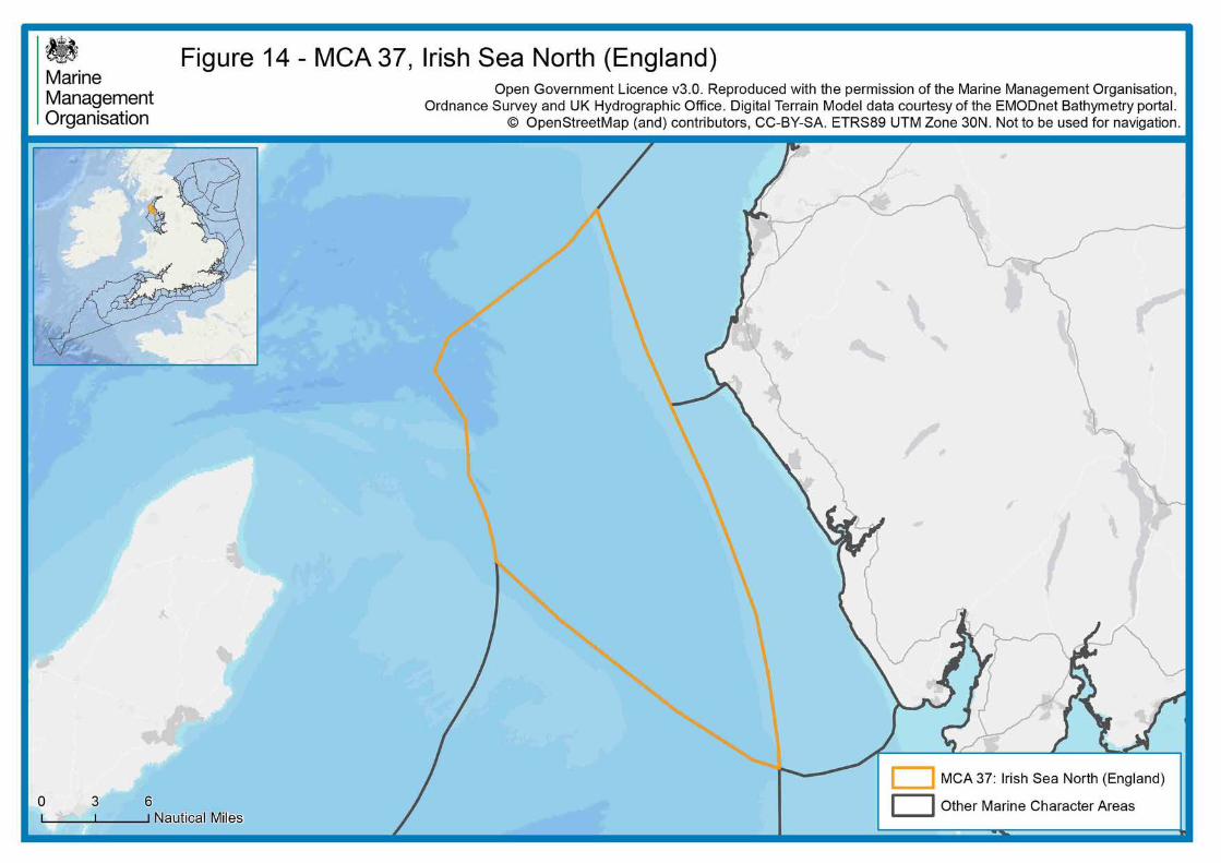
Figure 14: MCA 37 Irish Sea North (England)
45 of 63
3.10.1 Profile for MCA 37: Irish Sea North (England) Location and boundaries
This MCA lies between 5 and 15km offshore of the Cumbrian coast, in the north-eastern part of the Irish Sea. It is some 16km south of the Scottish coastline at its northern point, and it lies to the east of the Isle of Man. Its boundaries to the north and west are defined by the outer boundaries of the North West marine plan area. The eastern boundary, adjoining MCA 30: Solway Firth (England) and MCA 31: St Bees to Haverigg Coastal Waters, approximately follows the 20m bathymetry contour line – indicating a gradual transition to onshore waters – from the outer Solway Firth to a point due west of Barrow-in-Furness. The boundary with MCA 38: Irish Sea South (England) follows the main shipping lane running north-west from Morecambe Bay to the Point of Ayre, marking the transition to the busier seascape further south. The character of this MCA extends north and west beyond the marine plan area boundaries and into Scottish and Isle of Man waters, though only the English part is described here.
Overall character
This MCA comprises open waters located 5-15km off the west coast of Cumbria, lying within the north-east corner of the Irish Sea. It is surrounded by coastal waters of the Isle of Man to the west, Scotland to the north and Cumbria to the east. It is a shallow sea, rarely deeper than 50m, and with a gently sloping seabed mainly of mud and sand. This MCA has lower levels of human activity than the offshore waters further south, which are characterised by offshore platforms and busy shipping lanes. By contrast, this MCA has no offshore features other than a single light buoy. Fishing vessels trawl for Nephrops (Dublin Bay prawn), and there are some recreational sailing routes. Limited human use is reflected in the lower density of wrecks in this part of the sea. Although offshore, this MCA can be seen in views from the Lakeland fells, the southern Scottish hills and the Isle of Man under clear conditions.
Adjacent National Character Areas (NCAs) N/A – this MCA does not have an adjacent coastline.
Adjacent and inter-visible nationally designated and defined landscapes At its closest, this offshore MCA is around 8.5km from the western edge of the Lake District National Park and World Heritage Site, and 5km from the cliffs of the St Bees Heritage Coast.

46 of 63
3.10.2 Key characteristics of MCA 37: Irish Sea North (England) • Underlain largely by rocks of the Triassic period, with small
areas of Carboniferous rock west of the Isle of Man with potential hydrocarbon deposits.
• The deep basin, formed by a syncline, is filled with deep Permo-Triassic mud, sand and gravel sediments which completely obscure these rocks.
• The resulting sea floor is relatively even, shelving gently down to the west from around 20m depth to around 40m, only becoming deeper in very small areas to the north-west.
• The eastern tip of the King William Banks is within the MCA, where water depth is less than 10m. These banks extend westward into Isle of Man waters.
• A calm sea with low tidal energy and flows, rising only slightly across the northern part of the MCA where the Solway flows out.
• Areas of sea-bed mud support Nephrops (Dublin Bay prawn) as well as crabs, shrimp, sea urchins and hydroids. In the far south of the MCA these mud habitats form part of the West of Walney MCZ. Brittlestars are typical of more sandy areas.
• Spawning grounds for commercially exploited cod, whiting and plaice occur within this MCA.
• Cetaceans are found in this area, including dolphins, porpoise and occasional whales.
• Relatively few wrecks, reflecting the lower levels of activity and/or calmer seas, though a number of ships are known to have foundered off St Bees Head in the north-east of the MCA.
• There are no fixed offshore structures in this MCA, and only a single light buoy at the eastern tip of the King William Banks, giving the MCA an undeveloped character.
• Extensive military live-firing ranges cross the MCA, centred on Eskmeals Range off the Cumbrian coast and Kirkcudbright Range off the Scottish coast, resulting in potential for unexploded ordnance on the sea bed.
• The principal fishing activity is benthic trawling for Nephrops by boats from Fleetwood, Whitehaven and further afield. Other important fisheries include bass, thornback ray, cod, codling and flatfish.
• Some recreational sailing routes cross the area, noted as medium or light use, connecting the ports of Whitehaven, Douglas and Ramsey.
• Under clear conditions, there is intervisibility with the hills of the Lake District National Park, the Dumfries and Galloway coast, and the Isle of Man.
• With an absence of offshore lights, there are dark skies across this MCA.

47 of 63
Figure 15: MCA 38 Irish Sea South (England)

48 of 63
3.11.1 Profile for MCA 38: Irish Sea South (England) Location and boundaries
This MCA lies in the eastern Irish Sea, between the coasts of England, Wales and the Isle of Man. It lies 15km offshore at its closest point, off Walney Island. Its westward boundaries are defined by the outer boundaries of the North West Offshore marine plan area. The eastern boundary, adjoining MCA 32: Walney Coastal Waters and Duddon Estuary, MCA 34: Blackpool Coastal Waters and Ribble Estuary and MCA 35: Inner Liverpool Bay, approximately follows the 20m bathymetry contour line southwards from a point due west of Barrow-in-Furness, representing a gradual transition to inshore waters. The boundary with MCA 37: Irish Sea North (England) follows the main shipping lane running north-west from Morecambe Bay to the Point of Ayre, marking the transition to a less intensively used seascape. The character of this MCA extends westwards beyond the marine plan area boundaries and into Welsh and Isle of Man waters. Specifically, the area around the Douglas Oil Field platform has been drawn into this MCA, although administratively it lies within the Wales Inshore marine plan area. For this part in Wales, please refer to the relevant published profile for MCA 04: North Wales Open Waters, available on the Natural Resources Wales website
Overall character
The southern part of the Irish Sea is a busy area, with multiple offshore activities including fishing, main shipping routes, oil and gas extraction and dredging. Offshore wind farms extend into the north-west of the MCA. These activities also influence the night-time character with lighting on the main offshore platforms and wind turbines across the area. The sea is shallow, generally less than 40m deep, and is sheltered with low tidal flows. Due to the intensity of human activity there is limited nature conservation interest, though the mud and sand in the less disturbed north of the area provides key subtidal habitats. The offshore area is distant from low-lying coasts, and is not widely visible except from the ferry routes which link England with Ireland and the Isle of Man, although it is overlooked in distant views from the Lake District fells.
Adjacent National Character Areas (NCAs) N/A – this MCA does not have an adjacent coastline.
Adjacent and inter-visible nationally designated and defined landscapes At its closest, this offshore MCA is around 14km from the south-western edge of the Lake District National Park and World Heritage Site.
49 of 63
3.11.2 Key characteristics of MCA 38: Irish Sea South (England) • Seabed primarily comprising Triassic mudstones and
sandstones, with volcanic dykes running across the northern edge that coincide with shallower waters.
• The sea becomes steadily deeper from around 20m in the east to just over 40m at the westernmost point – with shallower waters associated with the volcanic dykes.
• Sand, mud and gravel seabed deposits sitting on deep layers of glacial till deposited during the Pleistocene glaciation.
• Tidal flows are generally quite weak, only becoming slightly faster along the south-western edge of the MCA.
• West of Walney MCZ protects areas of mud habitat, supporting Nephrops (Dublin Bay prawn) as well as other molluscs, sea urchins and sea pens. There are high densities of brittlestars in more sandy areas.
• Spawning grounds for commercially exploited cod, Dover sole, whiting and plaice. Scallops, queen scallops and Nephrops are targeted by trawlers.
• A series of offshore oil and gas platforms. In the north the Morecambe, Calder and Millom fields supply gas via pipelines to Barrow-in-Furness.
• The Hamilton and Douglas fields in the south deliver their gas to Point of Ayr in North Wales, while oil from these fields is transferred to tankers.
• Dredging for aggregates is carried on in the north in the shallow sea east of the Isle of Man, and in the south in the vicinity of the Douglas oil field.
• Walney Offshore Wind Farm extends west into this area from MCA 40, close to the North Morecambe gas platforms.
• Several key shipping routes cross this sea, adding to the busy nature of the waters. These routes include the approaches to the major ports of Fleetwood and the Mersey.
• A large number of ‘medium use’ recreational sailing routes criss-cross the MCA, linking all the harbours on the English, Welsh and Isle of Man coasts.
• The coast is relatively distant from this MCA, and the nearest areas are low-lying, meaning that there are low levels of intervisibility with the land. Under clear conditions, there is intervisibility with the hills of the Lake District National Park and the Isle of Man.
• Lighting from the offshore platforms and wind turbines influences night-time seaward views.
• The area is viewed from ferry services which link Liverpool and Heysham with Douglas, Belfast and Larne.

50 of 63
4 References The accessed date refers to when the information was first considered and the character initially defined.
Arnside & Silverdale AONB Partnership (2014) Arnside & Silverdale AONB Management Plan 2014-19. Available at http://www.arnsidesilverdaleaonb.org.uk/what-we-do/the-management-plan/. Accessed August 2018. Barne, J.H., Robson, C.F., Kaznowska, S.S., Doody, J.P. & Davidson, N.C., eds. (1996). Coasts and seas of the United Kingdom. Region 13 Northern Irish Sea: Colwyn Bay to Stranraer, including the Isle of Man. Peterborough, Joint Nature Conservation Committee. Bell, M. (1997). Environmental Archaeology in the Coastal Zone. In England’s Coastal Heritage: a Survey for English Heritage and the RCHME. London: English Heritage. Britain’s Energy Coast (2015) Britain’s Energy Coast Cumbria. Available at: www.britainsenergycoast.co.uk. Accessed on 30 March 2015. British Geological Survey (2015). Geoindex Offshore. Available at: http://mapapps2.bgs.ac.uk/geoindex_offshore/home.html. Accessed March 2015. British Geological Survey and Channel Coast Observatory (May 2005). DTI Strategic Environmental Assessment Area 6, Irish Sea, seabed and surficial geology and processes. Available at: https://assets.publishing.service.gov.uk/government/uploads/system/uploads/attachment_data/file/197293/SEA6_Geology_BGS.pdf. Accessed July 2018. Defra, Natural England and JNCC (2018). Marine Conservation Zone designations in England. Available online at https://www.gov.uk/government/collections/marine-conservation-zone-designations-in-england. Accessed August 2018. Engineering Timelines (2015) Mersey Approach training banks. Available at: www.engineering-timelines.com/scripts/engineeringItem.asp?id=788. Accessed on 9 August 2018. English Heritage (2018). Various pages visited at http://www.english-heritage.org.uk/visit/places/. Accessed August 2018. English Nature (1997). Cumbrian Coast Natural Area Profile. Cumbria Team, November 1997. English Nature (1997). Liverpool Bay Natural Area – A nature conservation profile, Second Consultation Draft. Nicola George, North West Team, October 1997. English Nature (1997). Morecambe Bay Natural Area profile. English Nature, November 1997.

51 of 63
English Nature (1997). Solway Firth Natural Area profile. English Nature, November 1997. Friel, I. (2003). Maritime History of Britain and Ireland. London: The British Museum Press Fulford, M., Champion, T., Long, A. (eds.) (1997). England's Coastal Heritage: A Survey for English Heritage and the RCHME. RCHME/EH Archaeological Report 15. London: EH/RCHME. Fleet Mon (2015). Live Vessel Tracking. Available at: https://www.fleetmon.com/services/live-tracking/fleetmon-explorer/. Accessed March 2015. Halcrow Group Limited (2018). North West England and North Wales Shoreline Management Plan SMP2. North West & North Wales Coastal Group. Available at http://www.mycoastline.org.uk/mycoastline/. Accessed August 2018. Hill et al (2001). Guide to best practice in seascape assessment. Prepared by the Countryside Council for Wales, University College, Dublin and Brady Shipman Martin as part of a Maritime Ireland/Wales INTERREG project. Historic England (2015). National Heritage List for England. Available at: https://historicengland.org.uk/listing/the-list/. Accessed March 2015. HM Government (2011). UK Marine Policy Statement. London: The Stationary Office. Available at: www.gov.uk/government/uploads/system/uploads/attachment_data/file/69322/pb3654-marine-policy-statement-110316.pdf. Accessed March 2015. IFCA (Inshore Fisheries and Conservation Authority) (2018). North Western. Available at: https://www.nw-ifca.gov.uk/#. Accessed July 2018. Isle of Man Steam Packet Company (2015) Timetables. Available at: www.steam-packet.com/Timetables. Accessed on 30 March 2015. Joint Nature Conservation Committee (2015). UK Protected Sites. Available at: http://jncc.defra.gov.uk/page-4. Accessed March 2015. Joint Nature Conservation Committee (2015). The Marine Conservation Zone Project. Available at: http://jncc.defra.gov.uk/page-2409. Accessed March 2015. Jones, L.A., Coyle, M.D., Gilliland, P.M., Larwood, J.G., & Murray, A.R. Irish Sea Marine Natural Area Profile: A contribution to regional planning and management of the seas around England. Peterborough: English Nature, 2004. Kis-Orca (2015). Offshore Renewable & Cable Awareness. Available at: http://www.kis-orca.eu/. Accessed March 2015.

52 of 63
Lake District National Park Partnership (2015) The Management Plan For The English Lake District 2015-2020. Available at http://www.lakedistrict.gov.uk/caringfor/lake-district-national-park-partnership/ldnppmanagementplan. Accessed August 2018. Lieberknecht, L.M.; Hooper, T.E.J.; Mullier, T.M.; Murphy, A.; Neilly, M.; Carr, H.; Haines, R.; Lewin, S.; and Hughes, E. (2011). Finding Sanctuary Regional MCZ Project Final Report. Natural England, JNCC & Science Advisory Panel. Available at http://jncc.defra.gov.uk/PDF/120718_FindingSanctuary_FinalReport_14Sep2011.pdf Accessed March 2015. Lighthouse Map of England and Wales (2015). Available at: http://www.photographers-resource.co.uk/a_heritage/lighthouses/Maps/Lighthouse_map_EW.htm Accessed March 2015. LUC (2010) Solway Coast AONB Landscape and Seascape Character Assessment. Solway Coast AONB Partnership. LUC (2015) Arnside & Silverdale Area of Outstanding Natural Beauty Landscape and Seascape Character Assessment. Arnside & Silverdale AONB Partnership in conjunction with Lancashire County Council, Lancaster City Council, South Lakeland District Council, Cumbria County Council and Natural England LUC (2016) Review of the defined area of St Bees Heritage Coast and the case to extend it northwards. National Trust. LUC (2015). National Seascape Assessment for Wales. Natural Resources Wales and Welsh Government. Available at https://www.naturalresources.wales/our-evidence-and-reports/marine-character-areas/?lang=en. Accessed August 2018. McInnes, R. and Stubbings, H. 2010. ‘A coastal historical resources guide for England’ The Crown Estate, 92 pages. ISBN: 978-1-906410-19-3. MMO (2014). Seascape Assessment for the South Marine Plan Areas: Technical Report. A report produced for the Marine Management Organisation, pp 88. MMO Project No: 1037. ISBN: 978-1-909452-25-1. Available at: https://www.gov.uk/government/publications/seascape-assessment-for-the-south-marine-plan-areas-mmo-1037. Accessed March 2016. Morecambe Bay Partnership website (various pages). Available at https://www.morecambebay.org.uk. Accessed August 2018. National Coastwatch (2015). Available at http://www.nci.org.uk/stations/location. Accessed March 2015. National Trust (2018). Various pages. Available at http://www.nationaltrust.org.uk/. Accessed August 2018.
http://www.lakedistrict.gov.uk/caringfor/lake-district-national-park-partnership/ldnppmanagementplan
53 of 63
Natural England (2018). Designated Sites View. Available at https://designatedsites.naturalengland.org.uk/. Accessed March 2018. Natural England (2012). An Approach to Seascape Character Assessment. Available online at https://www.gov.uk/government/publications/seascape-character-assessments-identify-and-describe-seascape-types . Accessed August 2018. Natural England (2016). National Character Area profiles. Available at: www.gov.uk/government/publications/national-character-area-profiles-data-for-local-decision-making/national-character-area-profiles. Accessed August 2018. NERC, Science of the Environment (2016). Open Research Archive. Available at: http://nora.nerc.ac.uk. Accessed August 2018. Northern Lighthouse Board (2015). Lighthouse Library. Available at: www.nlb.org.uk. Accessed on 29 March 2015. Offshore Technology.com (2015) Liverpool Bay Oil and Gas Fields, United Kingdom. Available at: www.offshore-technology.com/projects/bhp/. Accessed on 30 March 2015. Rainsbury, D. (2009). Irish Sea Pilot. 1st Edition. Cambridge, Imray Laurie Norie and Wilson. Royal Yachting Association (2005). Identifying Recreational Cruising Routes, Sailing and Racing Areas within the SEA 6 Area. A Report for the Department of Trade and Industry. Available at: https://assets.publishing.service.gov.uk/government/uploads/system/uploads/attachment_data/file/197285/SEA6_Boating_RYA.pdf. Accessed August 2018. Sea Britain (2015). Your Guide to the English Coast. Available at http://www.seabritain.co.uk/. Accessed March 2015. Science Direct (2015). The fish and fisheries of Jones Bank and the wider Celtic Sea. Available at: http://www.sciencedirect.com/science/article/pii/S0079661113000293. Accessed March 2015. SIMCelt (Supporting Implementation of Maritime Spatial Planning in the Celtic Seas) project outputs. Available at http://www.simcelt.eu. Accessed August 2018. Solway Coast AONB Partnership (2015) Solway Coast AONB Management Plan 2015-2020. Available at http://www.solwaycoastaonb.org.uk/downloads.php. Accessed August 2018. Steamship Mutual (2015). Mandate reporting for all tankers carrying heavy grade oils. Available at https://www.steamshipmutual.com/publications/Articles/Articles/WEPSSA_MandatReport0205.asp. Accessed March 2015.

54 of 63
The Royal Society for the Protection of Birds (RSPB) (2015). www.rspb.org.uk/. Accessed on 30 March 2015. The Wildlife Trust (2015). Marine Conservation Zones (England). Available at: www.wildlifetrusts.org/mcz. Accessed on 29 March 2015. The Encyclopaedia of Earth (March 2015). Celtic-Biscay Shelf large marine ecosystem. Available at http://www.eoearth.org/view/article/150982/. Accessed March 2016. The Encyclopaedia of Earth (March 2015). Celtic Sea. Available at http://www.eoearth.org/view/article/150983/. Accessed March 2015. TeleGeography Submarine Cable Map (2015). Available at http://www.submarinecablemap.com/#/submarine-cable/uk-channel-islands-7. Accessed March 2015. Trinity House (2015). Lighthouses and lightvessels. Available at: https://www.trinityhouse.co.uk/lighthouses-and-lightvessels Accessed March 2015. UNESCO (2018). UNESCO World Heritage List: Frontiers of the Roman Empire. Available at: http://whc.unesco.org/en/list/430. Accessed August 2018. UNESCO (2018). UNESCO World Heritage List: The English Lake District. Available at: http://whc.unesco.org/en/list/422. Accessed August 2018. UNESCO (2018). UNESCO World Heritage List: Liverpool – Maritime Mercantile City. Available at: http://whc.unesco.org/en/list/1150. Accessed August 2018. URS Scott Wilson (2012). Seascape Characterisation around the English Coast (Marine Plan Area 3 and 4 and Part of Area 6 Pilot Study). Natural England. Visit Cumbria (2015) Ravenglass. Available at: www.visitcumbria.com/wc/ravenglass/. Accessed on 30 March 2015. Visitmyharbour.com (2015). Online pilotage guide for small craft. Available at: www.visitmyharbour.com/. Accessed March 2015. Wave Hub (2015). Available at: http://www.wavehub.co.uk/. Accessed March 2015. World Wildlife Fund (2015). The Celtic Seas. Available at http://www.wwf.org.uk/where_we_work/oceans_and_coasts/the_celtic_seas/. Accessed March 2015. Wreck Site (2015). Available at: http://www.wrecksite.eu/wreck.aspx?72021. Accessed March 2015.

55 of 63
Annex 1: Data list These columns set out how the data layers were used. Some data provided context (i.e. background mapping), some has informed boundary choice/definition, and some has informed the descriptions and key characteristics. Theme Data Layers Source (obtained
from) Basemap / Context
Boundaries Descriptions
Baseline Information Maps and Charts Admiralty Charted Raster - various scales UKHO (MMO) Y Y Y
OS maps - 1:250,000 Ordnance Survey (MMO)
Y
OS maps – 1:25,000 Ordnance Survey (MMO)
Y Y Y
Boundaries/Extent of Jurisdictions
Mean High Water Mark Ordnance Survey Open Data (MMO)
Y
12 nautical mile limit (UKHO) UKHO (MMO) Y Y UK Continental Shelf Limit (UKHO) UKHO (MMO) Y UK Exclusive Economic Zone (2013) UKHO (MMO) Y UK Territorial Sea limits UKHO (MMO) Y S57 - UKHO Administrative and Regulations boundaries
UKHO (MMO) Y
Local Authority boundaries Ordnance Survey Open Data (MMO)
Y
Harbour limits UKHO (MMO) Y Marine Plan Areas MMO Y Y
Character Landscape/ Seascape Character
National Character Areas (England) Natural England (Magic)
Y
Terrestrial Natural Areas Natural England (Magic)
Y
National Character Areas (Wales) NRW (LUC) Y Marine Character Areas - Wales NRW (LUC) Y Y
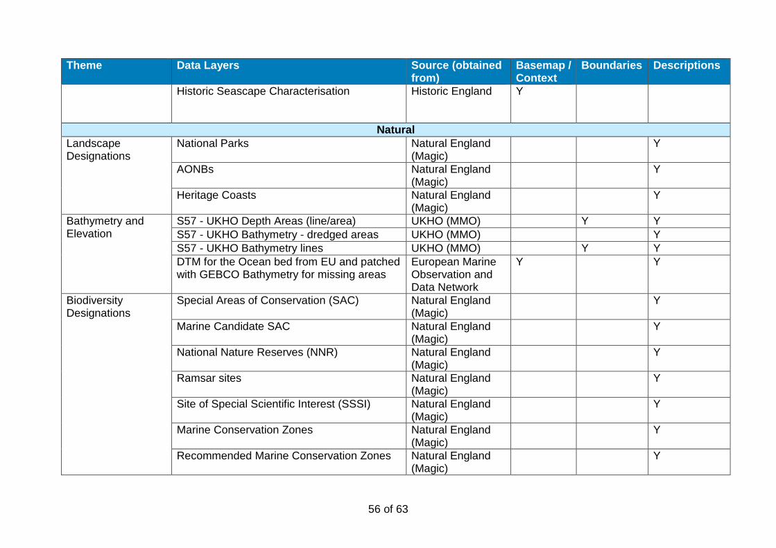
56 of 63
Theme Data Layers Source (obtained from)
Basemap / Context
Boundaries Descriptions
Historic Seascape Characterisation
Historic England Y
Natural Landscape Designations
National Parks Natural England (Magic)
Y
AONBs Natural England (Magic)
Y
Heritage Coasts Natural England (Magic)
Y
Bathymetry and Elevation
S57 - UKHO Depth Areas (line/area) UKHO (MMO) Y Y S57 - UKHO Bathymetry - dredged areas UKHO (MMO) Y S57 - UKHO Bathymetry lines UKHO (MMO) Y Y DTM for the Ocean bed from EU and patched with GEBCO Bathymetry for missing areas
European Marine Observation and Data Network
Y Y
Biodiversity Designations
Special Areas of Conservation (SAC) Natural England (Magic)
Y
Marine Candidate SAC Natural England (Magic)
Y
National Nature Reserves (NNR) Natural England (Magic)
Y
Ramsar sites Natural England (Magic)
Y
Site of Special Scientific Interest (SSSI) Natural England (Magic)
Y
Marine Conservation Zones Natural England (Magic)
Y
Recommended Marine Conservation Zones Natural England (Magic)
Y
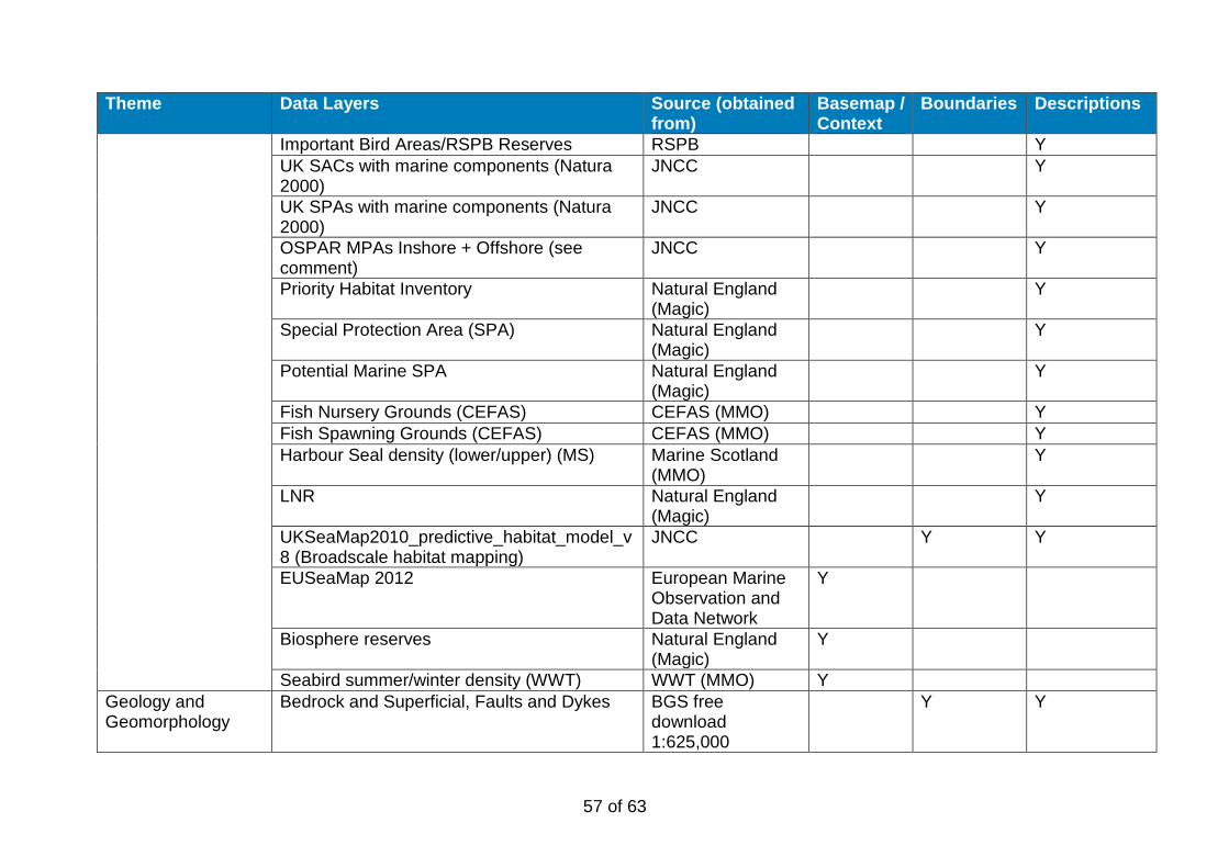
57 of 63
Theme Data Layers Source (obtained from)
Basemap / Context
Boundaries Descriptions
Important Bird Areas/RSPB Reserves RSPB Y UK SACs with marine components (Natura 2000)
JNCC Y
UK SPAs with marine components (Natura 2000)
JNCC Y
OSPAR MPAs Inshore + Offshore (see comment)
JNCC Y
Priority Habitat Inventory Natural England (Magic)
Y
Special Protection Area (SPA) Natural England (Magic)
Y
Potential Marine SPA Natural England (Magic)
Y
Fish Nursery Grounds (CEFAS) CEFAS (MMO) Y Fish Spawning Grounds (CEFAS) CEFAS (MMO) Y Harbour Seal density (lower/upper) (MS) Marine Scotland
(MMO) Y
LNR Natural England (Magic)
Y
UKSeaMap2010_predictive_habitat_model_v8 (Broadscale habitat mapping)
JNCC Y Y
EUSeaMap 2012 European Marine Observation and Data Network
Y
Biosphere reserves Natural England (Magic)
Y
Seabird summer/winter density (WWT) WWT (MMO) Y Geology and Geomorphology
Bedrock and Superficial, Faults and Dykes BGS free download 1:625,000
Y Y
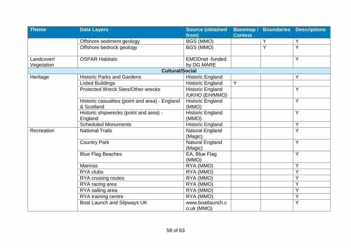
58 of 63
Theme Data Layers Source (obtained from)
Basemap / Context
Boundaries Descriptions
Offshore sediment geology BGS (MMO) Y Y Offshore bedrock geology BGS (MMO)
Y Y
Landcover/ Vegetation
OSPAR Habitats EMODnet -funded by DG MARE
Y
Cultural/Social Heritage Historic Parks and Gardens Historic England Y
Listed Buildings Historic England Y Protected Wreck Sites/Other wrecks Historic England
/UKHO (EH/MMO) Y
Historic casualties (point and area) - England & Scotland
Historic England (MMO)
Y
Historic shipwrecks (point and area) - England
Historic England (MMO)
Y
Scheduled Monuments Historic England Y Recreation National Trails Natural England
(Magic) Y
Country Park Natural England (Magic)
Y
Blue Flag Beaches EA, Blue Flag (MMO)
Y
Marinas RYA (MMO) Y RYA clubs RYA (MMO) Y RYA cruising routes RYA (MMO) Y RYA racing area RYA (MMO) Y RYA sailing area RYA (MMO) Y RYA training centre RYA (MMO) Y Boat Launch and Slipways UK www.boatlaunch.c
o.uk (MMO) Y

59 of 63
Theme Data Layers Source (obtained from)
Basemap / Context
Boundaries Descriptions
Bathing water compliance Environment Agency (MMO)
Y
Recreational Craft Slipway www.boatlaunch.co.uk (MMO)
Y
Recreational Craft Marinas www.boatlaunch.co.uk (MMO)
Y
Shipping and Navigation
Ports UKHO (MMO) Y Y S57 - UKHO Activity and Licence Installation (point/area)
UKHO (MMO) Y Y
S57 - UKHO Navigational Aids (buoy, light, etc.)
UKHO (MMO) Y
S57 - UKHO Obstructions (point/area) UKHO (MMO) Y Y S57 - UKHO Offshore installations (offshore platform/buoy) (point/line/area)
UKHO (MMO) Y Y
S57 - UKHO Transportation and routes - installations (rescue station, anchorage area, caution area, small craft facility) (point/line/area)
UKHO (MMO) Y
S57 - UKHO Wrecks (point/area) UKHO (MMO) Y Shipping AIS/Anatec (MMO) Y Ferry routes and infrastructure UKHO (MMO) Y AIS Shipping density 2011 and 2012 AIS (MMO) Y IMO Routing (line and buffer area) International
Maritime Organization (MMO)
Y
Industry, Energy and Infrastructure
Oil and Gas, aggregates The Crown Estate (MMO)
Y
The Crown Estate Aggregate Licence Area The Crown Estate (MMO)
Y
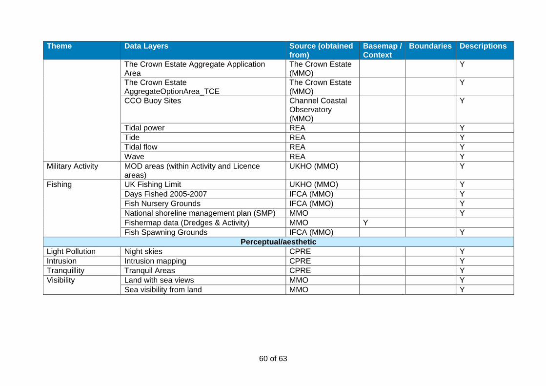
60 of 63
Theme Data Layers Source (obtained from)
Basemap / Context
Boundaries Descriptions
The Crown Estate Aggregate Application Area
The Crown Estate (MMO)
Y
The Crown Estate AggregateOptionArea_TCE
The Crown Estate (MMO)
Y
CCO Buoy Sites Channel Coastal Observatory (MMO)
Y
Tidal power REA Y Tide REA Y Tidal flow REA Y Wave REA Y
Military Activity MOD areas (within Activity and Licence areas)
UKHO (MMO) Y
Fishing UK Fishing Limit UKHO (MMO) Y Days Fished 2005-2007 IFCA (MMO) Y Fish Nursery Grounds IFCA (MMO) Y National shoreline management plan (SMP) MMO Y Fishermap data (Dredges & Activity) MMO Y Fish Spawning Grounds IFCA (MMO) Y
Perceptual/aesthetic Light Pollution Night skies CPRE Y Intrusion Intrusion mapping CPRE Y Tranquillity Tranquil Areas CPRE Y Visibility Land with sea views MMO Y
Sea visibility from land MMO Y
61 of 63
Annex 2: List of organisations contributing to consultation List of organisations represented at the Stakeholder Workshop, St Bees, 15 May 2018:
• Solway Firth Partnership • National Trust • University of St Andrews • Allerdale Borough Council
List of organisations represented at the Stakeholder Workshop, New Brighton, 16 May 2018:
• North West Coastal Forum • University of Liverpool • Sefton Council • Natural England • National Trust • Historic England
List of organisations who provided additional comments in relation to the north west marine plan areas:
• Natural England • University of Liverpool • Western Inshore Fisheries and Conservation Authority • Wirral Council • Duddon Estuary Partnership • Lancaster County Council • Arnside & Silverdale AONB
62 of 63
Annex 3: Acknowledgement for use of EMODNet data in publications The bathymetric metadata and Digital Terrain Model data products have been derived from the EMODnet Bathymetry portal - http://www.emodnet-bathymetry.eu. This portal was initiated by the European Commission as part of developing the European Marine Observation and Data Network (EMODNet). The overall objective of EMODnet is to create pilots to migrate fragmented and inaccessible marine data into interoperable, continuous and publicly available data streams for complete maritime basins. The Bathymetry portal development started in June 2009 and now provides a range of options for freely browsing and downloading new Digital Terrain Models (DTM) for a large part of the European seas. The downloadable tiles are freely available in a number of formats. The EMODnet digital bathymetry has been produced from bathymetric survey data and aggregated bathymetry data sets collated from public and private organizations. These are processed and quality controlled. A further refinement and expansion is underway, by gathering additional survey data sets, expanding geographical coverage to all European sea regions and upgrading the DTM grid resolution, and will result in new releases in time. The portal also includes a metadata discovery service that gives clear information about the background survey data used for the DTMs, their access restrictions, originators and distributors.