SBS Capstone Statewide Plan1 The Impact of Capstone Phase 1 Program – Final Report, University of...
51
ALASKAN REGION Investment in Safety Surveillance and Broadcast Services Capstone Statewide Plan Version 7.1 08 August 2007 A L A S K A A I R ME N’ S A S S OC I A TI O N , I N C .
Transcript of SBS Capstone Statewide Plan1 The Impact of Capstone Phase 1 Program – Final Report, University of...

ALASKAN REGION
Investment in Safety
Surveillance and Broadcast Services
Capstone Statewide Plan
Version 7.1 08 August 2007
ALASKA AIRMEN’S ASSOCIATION, INC .

PREAMBLE This document outlines the plan for implementing proven Capstone Program technologies throughout Alaska to increase aviation safety and rural community access. The plan includes (1) equipping Alaska-based aircraft with new safety equipment (avionics), (2) improving communications, navigation, surveillance, weather reporting infrastructure, and (3) upgrading airports to allow increased access. The Capstone Program demonstrated a 47% reduction in the aviation accident rate of Capstone-avionics equipped aircraft compared to non-equipped aircraft in southwest Alaska. Expansion of this system on a statewide basis will result in further safety gains, which is a benefit to the general public that relies on aviation for transportation across the state. This plan responds to and supplements the Memorandum of Agreement (MOA), dated 12 February 2007, between the FAA, Alaskan Aviation Safety Foundation, Alaska Airmen’s Association, Alaska Air Carrier’s Association, Helicopter Association International, and PenAir and Frontier Flying Service as the first two commercial operators to sign the agreement. It is linked to the FAA’s Acquisition Management System (AMS) process and budget requests for 2007-2012. Per the FAA Flight Plan 2007, one strategy for reducing accidents in Alaska is to “expand and accelerate implementing safety and air navigation improvement programs in Alaska” and an initiative under that is to “expand the Capstone Program as part of the NAS through a phased approach starting with Bethel and Southeast Alaska with the goal of statewide implementation.” This plan lays out the strategy for expanding Capstone proven technologies statewide. This plan is being coordinated with the Alaska aviation industry and the FAA under the Agreement Implementation Committee (AIC) defined in the MOA.
Page I

Page II

EXECUTIVE SUMMARY This plan documents the activities for implementing proven Capstone Program technologies throughout Alaska, in concert with a national implementation approach, to increase aviation safety and rural community access. This implementation will be conducted by the FAA’s Surveillance and Broadcast Services (SBS) Program Office and function as a fully operational part of the National Airspace System (NAS). It builds from the Automatic Dependent Surveillance-Broadcast (ADS-B) and the Global Position System (GPS) Wide Area Augmentation System (WAAS) navigation infrastructure developed under Capstone Phases I and II. A coordinated deployment of Federal Aviation Administration (FAA) ground infrastructure and aircraft avionics equipage is key to an accelerated implementation strategy, and a combined FAA and industry business investment case that includes the aircraft as an essential element in the NAS is being proposed. The plan includes (1) equipping at least 4,000 Alaska-based aircraft with safety avionics, (2) improving communications, navigation, surveillance, weather reporting infrastructure, and (3) upgrading airports to allow increased access. The purpose of this planning document is to implement the cooperative government/industry relationship established in the Memorandum of Agreement (MOA) between the FAA and Alaska Aviation Organizations executed in February 2007. The MOA also establishes an Agreement Implementation Committee (AIC) to develop and execute this plan. Background Alaska has the highest aviation accident rate in the country, and over 95% of the State is dependent upon aviation for its primary transportation. The hazards of weather, terrain, and the absence of surveillance capability (radar coverage) all contribute significantly to the unacceptably high Alaska accident rate. The proposed ground and airborne infrastructure addresses these hazards, and were proven under the FAA Alaska Capstone Program. Capstone demonstrated a 47% reduction in the aviation accident rate of Capstone avionics equipped aircraft compared to non-equipped aircraft in southwest Alaska1. The FAA’s Joint Resource Council recognized the benefits of this program to be $896.4 million over the time period of 2007 to 2035 in their analysis of program data for funding approval. These benefits are from the combination of fewer aviation accidents, improved search and rescue, and increased access to remote villages (including medical evacuations) when fully deployed both on the ground and in the air. In addition, there will be socio-economic improvements for rural Alaska, due to a better transportation infrastructure. Ground Infrastructure Deployment Plan The FAA has agreed to deploy, statewide, new ground-based aviation safety and access infrastructure including communications, navigation, and weather reporting systems, and upgraded airport access. The FAA will accelerate (i.e., over the next 5 years compared to the national deployment over next 10 years) this infrastructure transition if Alaska aviation operators sufficiently equip with the avionics necessary to make the FAA infrastructure effective at a rate commensurate with the FAA investment in Alaska infrastructure. This would update 50 year-old 1 The Impact of Capstone Phase 1 Program – Final Report, University of Alaska Anchorage, The MITRE Corporation, and Embry Riddle Aeronautical University, September 2006
Page III

technologies to current technology to include proven components of the Next Generation Air Transportation System (NGATS also known as NextGen). The FAA implementation strategy for the establishment of services throughout the State will be managed by the deployment of Service Volumes (SVs) in different geographic areas of Alaska. The AIC has defined these SVs, including their corresponding surveillance broadcast services, airport access improvements, and avionics equipage. The FAA will develop a benefit to cost ratio for the business case of each SV. Surveillance broadcast services within each SV will be defined as critical or essential level and may include:
• Automatic Dependent Surveillance-Broadcast (ADS-B) o Air Traffic Control Surveillance (ATC) o Operator Flight Monitoring Services (OFMS) o Search and Rescue Data Collection (SAR)
• Automatic Dependent Surveillance-Rebroadcast (ADS-R) • Flight Information Services Broadcast (FIS-B) • Traffic Information Services Broadcast (TIS-B)
All of these services may not be included in all airspace of each service volume. Due to physical and communications constraints, not all service volumes are currently capable of providing all of the above listed services. While the capability for these services will be made available, details of their deployment will require input from the national SBS contract award in August 2007. In addition, airport access infrastructure improvements may include:
• Airport RNAV Approach/Departure Procedures • Visual/Instrument Flight Rules (VFR/IFR) RNAV Route/Airway Improvements • Automated Weather Systems (AWOS/AWSS) • Air to Ground Communications Improvements
Avionics Equipage Plan The FAA statewide ground infrastructure will not provide the intended benefits without corresponding widespread aircraft avionics equipage. Due to the high cost of new technology and generally long equipage lead-times, an assistance program is required to enable near-term equipage for Alaska aircraft commercial and general aviation operators and to achieve the proven benefits. The proposed aircraft Safety Equipage Assistance Program (SEAP) funding would assist Alaska-based operators to install the airborne part of an improved Alaska aviation transportation system. This would be a Federal – State – private sector matching program, to include the FAA funding the ground infrastructure and operators providing partial match funding for the avionics. While the overall program goal is to equip every active aircraft in Alaska, this plan has a measured goal of achieving aircraft equipage equating to at least 90% of total Alaskan flight hours (approximately 4,000 aircraft). The first step focuses on the initial equipage of commercial, public safety, and high utilization general aviation aircraft to maximize reliable and safe statewide transportation access, with remaining aircraft equipped over the later years.
Page IV

Ultimately, the goal of equipping every active Alaska based aircraft will enable the maximum derivation of safety benefits from the FAA’s new technology infrastructure. Implementation Plan A coordinated deployment of surveillance broadcast services, airport access upgrades, and aircraft avionics equipage is key to an accelerated implementation strategy within each SV. This program is contingent upon deploying ground infrastructure concurrent with avionics equipage to achieve the envisioned safety and access benefits. This coordinated deployment could be described as a series of “steps” to be accomplished by the FAA and the industry in sequence. Table ES-1 represents the high-level schedule of FAA ground infrastructure deployment and industry safety avionics equipage. Figure ES-1 describes the 14 low-altitude enroute SV areas. The goal for Service Volumes in Alaska is to encompass 90% of the flight hours flown and 90% of the historical accidents. Correspondingly, the goal for avionics equipage is 90% of the annual flight hours. One of the first steps for the FAA is to finalize the ADS-B architecture and corresponding avionics standards, including an airspace mandate rule that will establish performance requirements for ADS-B transmissions. Because the airspace in Alaska is not the current target airspace expected for this rule, very few Alaska-based aircraft will be required to meet the airspace performance standards of ADS-B. In addition, the rule is expected to become effective over a 10 year period. Given this and the premium cost to equip with new technology, including the initial purchase and potential upgrades, a financial assistance program is a requirement to ensure adequate early participation by aircraft owners. Annually the AIC will review the program goals and progress on the part of the FAA and industry evaluating the level of equipage (both installed and letters of intent user commitments) and service volume enhancements. Due to hardware, software, and other outside factors beyond the direct control of both the FAA and the AIC, adjustments to the yearly and ultimate goals may be required. All parties recognize that this agreement is a living document and temporary shortfalls will not in and of themselves constitute failure. Both sides are committed to the success of this program and agree to make reasonable good faith efforts in seeing this program of early transition to NextGen in Alaska a reality.
Page V

Table ES-1. High-level Schedule
Deployment Time Period
Ground Infrastructure Deployment
SV (enroute-low altitude)
Safety Avionics Equipage
FY 07 – FY 09 6 – Anchorage-Fairbanks 11 – Nome-Seward Peninsula 13 – Kotzebue-NW AK 1 – Southeast AK Additional complete Capstone Phase 1 & 2
• End of FY 08: 525 equipped or committed
• End of FY 09: 1,325 equipped or committed
FY 08 – FY 10 3 - Cook Inlet-Kodiak 4 - AK Peninsula 5 - Lake Clark-Bristol Bay
• End of FY 10: 2,325 equipped or committed
FY 09 – FY 11 8 – Upper Yukon River
12 – Galena-Mid Yukon River-Koyukuk River 14 - North Slope
• End of FY 11: 3,325 equipped or committed
FY 10 – FY 12 2 – Prince William Sound-Gulf of Alaska 7 - AK Highway Copper River Isabel Pass 9 – McGrath-Upper Kuskokwim 10 – Yukon-Kuskokwim Delta
• End of FY 12: 4,091 equipped or committed
Figure ES-1. Low-Altitude Enroute SV Areas
Page VI

Page VII
TABLE OF CONTENTS
PREAMBLE.......................................................................................................................I
EXECUTIVE SUMMARY ............................................................................................III
1. INTRODUCTION................................................................................................. 1 1.1 Purpose.................................................................................................................... 2 1.2 Background............................................................................................................. 3 1.3 FAA Joint Resource Council (JRC)........................................................................ 4 1.4 Aircraft Safety Equipage Assistance Program (SEAP) .......................................... 5
2. GROUND INFRASTRUCTURE DEPLOYMENT PLAN....................................... 5 2.1 ADS-B Service Volumes .............................................................................................. 6
2.1.1 Initial Capstone ADS-B Sites ............................................................................................................8 2.1.2 Initial Statewide ADS-B Sites ...........................................................................................................8 2.1.3 Deployment of Additional Service Volume Coverage ....................................................................10 2.1.4 Additional Development..................................................................................................................10
2.2 Airports and RNAV Route Structure.......................................................................... 10 2.2.1 Access Upgrade Deployment of Next 25 VFR to IFR Airports ......................................................11 2.2.2 Additional Airports for Upgrade......................................................................................................12 2.2.3 RNAV Route Structure....................................................................................................................13
3. AVIONICS EQUIPAGE PLAN ................................................................................ 13 3.1 Background................................................................................................................. 13 3.2 Aircraft Safety Equipage Assistance Program Overview........................................... 14 3.3 Policies and Cost Estimates for Equipage Assistance Disbursement ......................... 17 3.4 Funding Solicitation.................................................................................................... 22 3.5 Avionics Equipage Assistance Program Administration............................................ 22 3.6 Other Related Actions................................................................................................. 23
4. IMPLEMENTATION PLAN .................................................................................... 25 4.1 Integrating Ground Infrastructure Deployment and Avionics Equipage Assistance.. 25 4.2 Schedule and Milestones............................................................................................. 25 4.3 Success Criteria and Measurement ............................................................................. 28
4.3.1 Success Criteria ...............................................................................................................................28 4.3.2 Measurement....................................................................................................................................28
4.4 Modifying the Plan ..................................................................................................... 28
APPENDIX A: ACRONYMS ......................................................................................... 1
APPENDIX B – SERVICE VOLUME DESCRIPTION............................................... 1
APPENDIX C – POTENTIAL ADS-B SITES AND UPGRADED AIRPORTS ........ 1
APPENDIX D – ANALYSIS OF AIRCRAFT EQUIPAGE......................................... 1

1
1. Introduction This document outlines the plan for implementing technologies proven under the Capstone Program throughout Alaska to increase aviation safety and rural community access. This statewide implementation will be conducted by the FAA’s Surveillance and Broadcast Services (SBS) Program Office and function as an operational part of the National Airspace System (NAS). It builds from the Automatic Dependant Surveillance-Broadcast (ADS-B) infrastructure developed in Capstone Phase I, and on the Global Position System (GPS) Wide Area Augmentation System (WAAS) navigation infrastructure developed under Capstone Phase II (Figure 1). A coordinated deployment of Federal Aviation Administration (FAA) ground infrastructure and aircraft avionics equipage is key to an accelerated implementation strategy, and a combined FAA and industry business investment case that includes the aircraft as an essential element in the NAS is being proposed. The plan includes:
1) aircraft safety avionics equipage equating to at least 90% of total Alaskan flight hours (approximately 4,000 aircraft),
2) improving communications, navigation, surveillance, weather reporting infrastructure, and
3) upgrading airports to allow increased access in reduced weather conditions.
Figure 1. Statewide Concept The mature elements of the Capstone program are now transitioned under a national implementation program managed by the FAA headquarters Air Traffic Organizations - SBS Program Office. A new SBS/Capstone Office is based in Alaska to address unique Alaskan requirements; however, the statewide deployment will be a subset of the national implementation to ensure consistency and supportability. The SBS/Capstone Office seeks near term safety and efficiency gains in aviation by accelerating implementation and use of modern technology, in both avionics and ground system infrastructure. The office will link multiple programs and initiatives under a common umbrella for planning, coordination, focus, and direction; and it will continue to develop capabilities and

2
requirements jointly with FAA, the Alaskan community and aviation industry in a manner consistent with future NAS plans and concepts. The Capstone program demonstrated a 47% reduction in the aviation accident rate of Capstone-avionics equipped aircraft compared to non-equipped aircraft in southwest Alaska from 2000 through 2004. This is shown as the number of equipped aircraft was increased from 0 aircraft to approximately 200 aircraft in the years 2000 through 2002 and safety benefits stabilize thereafter (Figure 2). The extension of these technologies on a statewide basis have been estimated by FAA to result in substantial further safety gains, which is a benefit to the general public that relies on aviation for transportation across the state.
Figure 2. Capstone Phase I Reduction in Aircraft Accident Rate2
1.1 Purpose The purpose of this planning document is to implement the cooperative government/industry relationship established in the Memorandum of Agreement (MOA) between the FAA and Alaska industry organizations executed in February 2007 to support safer aviation and increase rural access in Alaska. This includes equipping approximately 4,000 active Alaska-based aircraft with safety avionics that complement the FAA’s enhanced ground infrastructure. These airborne and ground-based enhancements together will improve communications, surveillance, navigation, weather reporting, terrain and traffic information; and upgrade airports to allow increased access in adverse weather conditions. This plan provides both aircraft owner-operators and the FAA with a sequence of reciprocal actions to ensure that the ground infrastructure and avionics equipage are progressing together and that the investments of both operators and FAA are being protected by these reciprocal actions. This Plan satisfies the Alaska AIC responsibilities set forth in the MOA, Article V, paragraph D. This plan will be revised as needed to address new information and
2 The Impact of Capstone Phase 1 Program – Final Report, University of Alaska Anchorage, The MITRE Corporation, and Embry Riddle Aeronautical University, September 2006
3
decisions. One such constraint is the FAA’s decision on a national ADS-B service provider and any corresponding revised technology standards. 1.2 Background Alaska is dependent on aviation for activities that are normally accomplished by using the existing road and rail systems in the Lower 48 United States (U.S.). As a consequence, per capita there are six (6) times the number of pilots, 14 times the number of aircraft, and 76 times as many commuter airline flights in Alaska. Moreover, Alaska has 93 of the 514 commercial service airports in the U.S.; yet, it has only seven (7) air traffic control towers in the state. Commercial jet service with 120+ passengers is provided to 17 non-towered airports in Alaska. Furthermore, the FAA has issued waivers applying to many Alaskan airports serviced by small commuter aircraft (10-31 seats) because of infrastructure limitations. In a recent National Institute of Occupational Safety and Health (NIOSH) report using data through 20023, “pilots in Alaska die at a rate nearly 100 times the mortality rate for all U.S. workers, and over five times the rate for all United States pilots. Unlike the rest of the country, many of Alaska’s villages are not connected by a road system; commuter and air taxi operators serve as the main link between these villages and regional hubs, transporting people, cargo, and mail.” The report further states: “a disproportionate number of all U.S. aircraft “accidents” occur in Alaska. Between 1990 and 2002, there were 434 commuter and air taxi accidents (CFR Part 135) in Alaska—36% of all such accidents in the United States. The state with the next highest number of commuter and air taxi accidents was Florida, which had only 4% of all such U.S. accidents. Of the Alaska commuter accidents, 67 were fatal, resulting in 194 deaths (21% of all U.S. commuter and air taxi aviation deaths).” Note that the data in this report occurred before Capstone and other Alaska safety initiatives accomplished a marked reduction in the Alaska commercial accident rate. Further challenging the Alaska aviation system is the limited availability of air traffic control (ATC) surveillance. Radar service is available in only 20% of Alaska’s airspace, and over 90% of this radar coverage is 12,000 feet and above. Therefore, most of the airspace used for IFR departure, enroute, and arrival phases of flight by intrastate commercial and general aviation operations is outside radar coverage, thus necessitating the use of non-radar ATC procedures. While inherently safe, ATC procedural separation affects both efficiency and airspace utilization (capacity). To achieve traditional radar coverage commensurate with the Lower 48 would require many additional systems. Alaska is affected also by extremes in weather conditions. However, the state has only seven (7) next generation weather radars (NEXRAD), while 3 times that many cover equivalent sized areas in the Lower 48. Given the essential role that air service plays in meeting basic transportation needs, as well as the lack of modern aviation infrastructure, Alaska requires new communication, navigation, and surveillance technologies that improve safety, efficiency, and capacity. These new technologies will enable pilots to more effectively deal with navigation, terrain, traffic, and weather hazards and enable the FAA to provide more efficient and cost effective services. This will also have socio-economic benefits to rural communities
3 Survey and Analysis of Air Transportation Safety Among Air Carrier Operators and Pilots in Alaska, NIOSH, November 2006

4
given the improved transportation infrastructure. Because commuter airlines and air taxis in Alaska need to provide highly reliable service for rural area MedEvac and economic purposes (oil production, fishing, tourism, etc.) in an environment of frequent instrument meteorological conditions and high terrain, they need an air traffic system that enables the following capabilities, all of which are enhanced by surveillance and broadcast services:
• to operate small aircraft that meet the demands of the small markets and airports the operators serve;
• to navigate under Instrument Flight Rules (IFR) on routes currently classified as uncontrolled airspace;
• to communicate with air traffic control while cruising below 10,000 feet; • to communicate with company flight monitoring or dispatchers; • to receive air traffic separation services using radar standards, Visual Flight Rules
(VFR) flight following, and flight track monitoring by commercial operators and for search and rescue;
• to receive traffic, weather, and other flight information in the cockpit to enable better pilot decision making for the safe conduct of the flight;
• to execute instrument approaches at airports where no instrument approach facilities or procedures exist; and
• to have lower weather minima at airports with existing IFR approaches.
1.3 FAA Joint Resource Council (JRC) In February 2007 the FAA’s JRC approved the Final Investment Decision: Segment 2 for NAS-wide surveillance and broadcast services. A final JRC to re-baseline is planned for August 2007. This approval included a baseline for 38 initial Alaska statewide ADS-B Ground Sites (GSs) (10 Phase I, 14 Phase II, and 14 new Statewide) and 25 VFR-to-IFR airport access upgrades (16 new IFR airports, 9 IFR airport upgrades). The JRC analysis identified benefits attributable to fewer aviation accidents, improved search and rescue, and increased access to remote villages (including MedEvac). The analysis equated these benefits at $896.4 million. This plan is based on MOA Article III. Scope, Paragraph C, which lists the following goals and objectives:
1. Equip approximately 4,000 active, Alaska-based commercial and general aviation (GA) aircraft with avionics to take advantage of enhanced services.
2. Install communications, surveillance, navigation and weather reporting infrastructure to improve safety and efficiency in select locations in Alaska.
3. Upgrade select airports in Alaska from VFR to IFR capabilities to improve safety and allow greater access during reduced weather conditions.
4. Provide ATC surveillance services in select locations in Alaska. 5. Provide broadcast services in select locations in Alaska to include weather uplink,
traffic uplink, and position downlink for flight monitoring and search and rescue initiation.

5
1.4 Aircraft Safety Equipage Assistance Program (SEAP) A key objective of this program is to equip Alaska-based aircraft with new technology, which when used in conjunction with infrastructure provided by the FAA, is projected to achieve a significant reduction in aircraft accidents (e.g., controlled flight into terrain (CFIT)) and increased access to rural airports across the state. As with most new technology, initially the equipment costs are high – often out of reach of individuals and businesses. Development of an equipage program to help lower those costs are essential to stimulate aircraft equipage on an accelerated schedule to improve aviation safety and access for the traveling public. The three foundational avionics elements are 1) ADS-B data link, 2) GPS/WAAS navigation equipment, and 3) a moving map multifunction display (MFD) for navigation, terrain, traffic, and flight information awareness. There are four levels of customers - commercial IFR, commercial VFR, GA VFR, and GA IFR (Figure 3). With full ADS-B equipage, the FAA will be able to provide more efficient and effective services (safer VFR and IFR) to all aircraft (commercial and general aviation). For the FAA to realize cost savings from decommissioning legacy ground-based navigation systems (e.g., NDBs), IFR aircraft require GPS/WAAS navigation equipment. Lastly, to realize full safety benefits, a cockpit moving map MFD for navigation, terrain, traffic, and flight information awareness needs to be on the aircraft.
Commercial VFR
Commercial IFR GA IFR/VFR
Figure 3. Equipage Customer Base 2. Ground Infrastructure Deployment Plan The SBS/Capstone statewide implementation will use a systems approach for ground and airborne infrastructure deployment. Figure 4 provides a block diagram for this infrastructure. The ground infrastructure includes remote located ADS-B ground stations with capability for outputs to ATC (Flight Service, Tower, Terminal, Enroute) and company flight monitoring, and inputs from surveillance sources (e.g., radar) and weather/flight information for broadcast services to the aircraft. Other ground infrastructure includes automated weather stations, remote VHF voice communications, and development of GPS/WAAS based RNAV routes, approach, and departure procedures.

6
ADS-B Radio
Figure 4. Capstone Statewide Infrastructure Block Diagram
2.1 ADS-B Service Volumes The central concept for designing Alaska statewide deployment is that broadcast services and airport access upgrades will be provided within geographic areas of Alaska that reflect typical patterns of VFR and IFR commercial and general aviation operations. This concept of service volumes is defined in the national SBS contract, which already includes Alaska SVs for Anchorage FIR (hi-altitude non-oceanic enroute SV-155), Anchorage (terminal Class C SV-38), Fairbanks (terminal Class D SV-216), and Juneau (enroute SV-178). In this plan we are defining an additional 14 low altitude enroute SVs to cover both VFR and IFR operations in consideration of Alaska’s needs for safety improvements and remote area access. Within each SV surveillance broadcast services, airport access improvements (including communication and weather systems), and airspace improvements (RNAV routes and procedures) will be deployed in a priority order determined by industry needs. See Figure 5 for a depiction of these 14 low altitude enroute SVs.
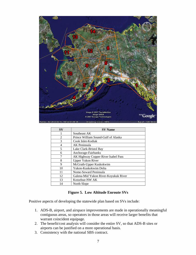
7
SV SV Name 1 Southeast AK 2 Prince William Sound-Gulf of Alaska 3 Cook Inlet-Kodiak 4 AK Peninsula 5 Lake Clark-Bristol Bay 6 Anchorage-Fairbanks 7 AK Highway Copper River Isabel Pass 8 Upper Yukon River 9 McGrath-Upper Kuskokwim
10 Yukon-Kuskokwim Delta 11 Nome-Seward Peninsula 12 Galena-Mid Yukon River-Koyukuk River 13 Kotzebue-NW AK 14 North Slope
Figure 5. Low Altitude Enroute SVs
Positive aspects of developing the statewide plan based on SVs include:
1. ADS-B, airport, and airspace improvements are made in operationally meaningful contiguous areas, so operators in those areas will receive larger benefits that warrant coincident equipage.
2. The benefit/cost analysis will consider the entire SV, so that ADS-B sites or airports can be justified on a more operational basis.
3. Consistency with the national SBS contract.

8
These low-altitude enroute SVs will have geographic boundaries as depicted in Figure 5, ceilings of 18,000ft MSL, floors of 1,000ft AGL (1,000ft AGL is the goal to cover VFR traffic, but it is understood that this is not achievable in many areas due to limitations of ground station line of site and terrain). ADS-B ground station coverage requirements will include coverage from existing legacy ADS-B sites and other sites defined by the FAA. Appendix B provides details on each SV to include geographic boundaries, services provided, and minimum coverage requirements. Appendix C provides a list of potential ADS-B sites. Surveillance broadcast services within each SV will be defined as critical or essential level and may include:
• Automatic Dependent Surveillance-Broadcast (ADS-B) o Air Traffic Control (ATC) Surveillance o Operator Flight Monitoring Services (OFMS) o Search and Rescue Data Collection (SAR)
• Automatic Dependent Surveillance-Rebroadcast (ADS-R) • Flight Information Services Broadcast (FIS-B) • Traffic Information Services Broadcast (TIS-B)
All of these services may not be included in all airspace of each service volume. Due to physical and communications constraints not all service volumes are currently capable of providing all of the above listed services. While the capability for these services will be made available, details of their deployment will require input from the national SBS contract award in August 2007. 2.1.1 Initial Capstone ADS-B Sites Southwest Alaska contains 10 legacy ADS-B sites that were deployed in the Yukon Kuskokwim Delta area under Capstone Phase I beginning in 2000. Southeast Alaska, contains 14 legacy ADS-B sites deployed under Capstone Phase II. All the ADS-B sites deployed in both the Southwest and Southeast regions are providing essential services (FIS-B, OFMS, SAR), and some are additionally providing critical services (ATC surveillance). In addition, a developmental site was deployed in Anchorage, which provides FIS-B and TIS-B services.
2.1.2 Initial Statewide ADS-B Sites The AIC has worked to develop criteria for SV justification that includes VFR/IFR flight hours, accidents, contiguous routes, and geographic coverage. The February 2007 JRC approved an initial statewide deployment, consisting of 14 ADS-B sites in addition to the original 24 Capstone Phase I and II sites. This approval was based on modeling the number of flights that fly through the coverage area of each potential site and allocating the safety benefits (i.e., those provided by the essential or critical services) to each site. Figure 6 depicts the geographic coverage of these 38 sites in terms of coverage percent of accidents (61.5%), contiguous routes (88.6%), and Alaska flight hours (82.3%). The areas shown in yellow below are not SVs, but rather are the “signals-in-space” line-of-site (LOS) areas of the 38 ADS-B sites identified.

9
SV Sites 1 Angoon, Port Alexander, Biorka Island, Cape Spencer, Gustavus, Haines, Juneau, Lena
Point, Sunny Hay, Gunnuk MTN, High MTN, Sisters Island, Wrangell, Yakutat 2 Johnstone Point 3 Homer 4 Port Moller 5 Sparrevohn, King Salmon, Dillingham, Illiamna 6 Murphy Dome-FAI, Site Summit-ANC 7 Horn MTN 8 Fort Yukon 9 Tatalina
10 Aniak, Bethel, Cape Romanzof, Cape Newenham, St. Marys, Unalakleet 11 Cape Darby-Nome 12 Indian MTN, Galena 13 Kotzebue 14 Barrow, Deadhorse
Figure 6. Capstone Phase I, II, and 14 Statewide ADS-B Sites Coverage
Based on final approval of this plan, the FAA Surveillance Broadcast System Program Manager, in concert with FAA Executive support, will authorize the use of FY07 and FY08 funds for installing additional infrastructure in Alaska this calendar year (2007). FAA’s commitment also includes additional funding for 20-year operations and maintenance support. The FAA’s initial summer 2007 SV deployment will include SV 6 (Anchorage-Fairbanks), SV 11 (Nome-Seward Peninsula), and SV 13 (Kotzebue-NW Alaska), to compliment the already installed sites in Southwest and Southeast Alaska. These new services will be provided consistent with FAA NAS processes. All of the new SVs will provide at least essential services, and some may additionally provide critical (ATC separation) services as determined by the FAA ATO based upon current radar coverage and expected IFR traffic levels.

10
2.1.3 Deployment of Additional Service Volume Coverage Approval of additional SV coverage across contiguous major routes is required to meet the user need of 90% coverage for accident and flight time – approximately equivalent to lower 48 services. The need for the broadcast information and flight tracking while enroute is important to help pilots make better decisions prior to reaching the airport area - end-to-end route coverage is highly desirable. The remote areas in between airports are where pilots have the least information and where weather and terrain are often most challenging. In preparation for the February 2007 JRC, some identified ADS-B sites did not show a positive benefit/cost ratio and consequently were not approved. That JRC analysis did not include such data as non-scheduled Part 135 flights and any flights without filed flight plans. The AIC is seeking additional reliable data on numbers of operations (e.g., Flight Service Station contacts, operator survey of non-flight plan VFR operations) that may justify deployment of additional sites. In addition, data will be sought to establish justified special consideration for remote access and socio-economic benefits in rural communities. To better correspond to both air traffic and aircraft operational needs, additional analysis will be based on needs across SVs as described in Figure 5. Additional cost/benefit justified SVs coverage will be included in the re-baseline for the August 2007 or later JRCs. The FAA is actively discussing partnering with other government agencies (e.g., DOD) or private entities (e.g., individual operators) to reduce the cost, increase the benefit, and speed deployment of the ground infrastructure. Such partner ground stations (PGSs) would be appropriate where a GS has been identified for deployment in an out year, but a partner is willing to provide a sufficient contribution to the deployment to justify FAA moving up the schedule. FAA reduced costs or specific increased partner benefits may also successfully justify additional infrastructure deployment.
2.1.4 Additional Development While the above addresses progress in transitioning proven Capstone elements to a statewide program, there is still work to be completed for continued development and support. This Plan provides for Traffic Information Services-Broadcast (TIS-B) in SVs where either radars exist or multilateration will be installed (e.g., Juneau). TIS-B of multilateration targets requires further development. In addition, Flight Information Service-Broadcast (FIS-B) products that are part of the national SBS contract will need to be tested end-to-end and could be incorporated in Alaska as the first sites (since equipage will occur first in Alaska). The FAA will ensure that both TIS-B and FIS-B essential services will be monitored for the purpose of reporting and tracking outages and ensuring that any operational anomalies are promptly addressed. As associated standards and policies are refined, systems in Alaska might need to be updated.
2.2 Airports and RNAV Route Structure The following airports and RNAV route structure deployment plan helps meet the FAA’s commitment to improve aviation access in Alaska. The benefit criteria to justify airport upgrades centered on reduced IFR cancellations, that in turn increases access to remote

11
villages during IMC. Infrastructure required to achieve low minimum IFR approaches include installation of appropriate automated weather reporting, lighting, communication, and approach development. An average cancellation cost was used to monetize the benefits. Reduced time for medical evacuation during IMC was also monetized, and the analysis assumes that with prompt medical care, remote village accidental death rates will be similar to city (Anchorage) average rates. This analysis took alternate access to medical care into account. Figure 7 shows the Alaska low altitude enroute SVs with aircraft flight path data underlayed. Airport access infrastructure improvements within these SVs may include:
• Airport RNAV Approach/Departure Procedures • VFR/IFR RNAV Route/Airway Improvements • Automated Weather Systems (AWOS/AWSS) • Air to Ground Communications Improvements
Figure 7. AK Low Altitude Enroute SVs with Flight Path Data
2.2.1 Access Upgrade Deployment of Next 25 VFR to IFR Airports The February 2007 JRC approval included upgrade of IFR infrastructure at 25 airports; Figure 8 shows the geographic locations. To meet air traffic and flight standards requirements consideration also is needed for communications, and airport lighting to allow night operations (much of the time during winter months). Coordination with the

12
Alaska Department of Transportation & Public Facilities (DOT&PF) is required for the airport upgrades and designation of the airports as IFR for State managed airports; coordination with tribes, villages, or boroughs may also be required. Work is already underway for these upgrades – full coordination with the Regional Airspace Procedure Team (RAPT) is essential. Appropriate air traffic automation adaptation and ATC training is required. Where possible the FAA will provide vertically guided and lower minima approaches using new criteria enabled by GPS/WAAS, including lateral precision with vertical guidance and lateral precision approaches. Point in space approaches should be considered to accommodate airport proximity arrival in IMC and to enable circling visual approaches at IFR and non-IFR airports.
Figure 8. Feb 2007 JRC Approved Access Upgraded Airport
2.2.2 Additional Airports for Upgrade The FAA and Alaska Aviation Industry organizations have worked together to develop criteria for airport upgrades. These include: runways greater than 2,400 ft; number of operations, passengers, cargo/mail; and proximity to medical services. The industry requested a process that is defensible, logical, and systematic, so both FAA and industry can coordinate with their constituents. During 2006, from a total of 200+ airports a first pass using the criteria established 97 possible airports to upgrade. A 2nd pass reduced that number to 55 airports given consideration of proximity to another airport, village relocation, terrain, airport scheduled for an upgrade, or airports with zero population. A third pass reduced the number of airports to 53 due to community decline and ownership issues. The analysis concluded that 25 airports had positive benefit/cost ratios, and these were approved in the February 2007 JRC.

13
Appendix C lists airports that with additional data and analysis may possibly be justified for upgrade. Better data on operations (especially VFR) from Flight Service Stations and operators, lower minimum approaches, consideration for remote access or use as alternate airport, site specific cancellation costs (e.g., economic impact of a canceled flight), and VFR benefits to IFR airport upgrades will be applied to continued business case analysis. In addition, socio-economic benefits to the rural communities also need to be considered and coordinated with the organized tribal groups for their support. Operators that provide service to these airports will help supply and validate this new data. Justified airports will be considered for re-baseline in the August 2007 or later JRCs.
2.2.3 RNAV Route Structure To connect these new IFR airports, as well as allow some ground based navigation aids to be decommissioned – an RNAV enroute structure needs to be established. Much work was accomplished in both defining criteria and procedure approval for new minimum enroute altitudes (MEAs) on existing routes, as well as optimized (altitude and distance) RNAV routes. These are currently published in blue on the low altitude enroute charts for Alaska. However, Air Traffic can not issue a clearance for these RNAV routes due to needed upgrades to the air traffic control automation system, and separation procedures using the new technologies. These routes will be evaluated by a cross organizational (ATO/AFS) FAA team to ensure operational usability for both controllers and pilots. This FAA cross organizational team is led by ATO-E, Safety and Operations Support and will coordinate and receive feedback from industry groups in order to optimize route structures. The FAA will develop a program plan to ensure flight procedures development, flight standards approval, technical support upgrades, and air traffic controller training are in place for operational use of this new route structure. The initial meeting of this team was held on May 30, 2007. 3. Avionics Equipage Plan
3.1 Background FAA and industry cooperation on technology-focused safety enhancements in Alaska evolved over the previous decade through the FAA Capstone Program. Because of the safety improvements realized by Capstone Phase I, a core coalition of aviation stakeholders was formed in 2006 with the goal of improving aviation safety and access on a statewide basis, particularly in rural areas. The key objective of this coalition was to equip Alaska-based aircraft with new avionics technologies (ADS-B, GPS/WAAS, and moving map multi-function display (MFD) of terrain, traffic and weather), which when used in conjunction with essential infrastructure provided by the FAA, is projected to achieve a 30 percent reduction in aircraft accidents across the state. This core coalition planned to expand its membership beyond the aviation industry in order to build widespread support for statewide expansion of the new technologies. Once the details of the FAA ground infrastructure enhancement plan were known, the coalition would educate the aviation community and the flying public about both the enhanced safety and access made possible by the combination of the new avionics technologies and ground infrastructure enhancements. Further, the coalition would then seek funding from

14
a combination of private, state and federal sources to provide the financial assistance for equipage necessary to accomplish this program. The central objective of the coalition was to equip approximately 90% of the active commercial and general aviation aircraft based in Alaska with the new avionics technologies. To accelerate bringing these safety benefits to Alaska, the coalition determined that an avionics equipage financial assistance program (consisting of both grants and loans) would be needed because current equipment costs of required ADS-B aircraft equipment are beyond the reach of most operators. While the FAA Capstone Program demonstrated a 47% reduction in the aviation accident rate of Capstone funded equipped aircraft compared to non-equipped aircraft in Southwest Alaska, the current cost of required avionics is too high to result in widespread equipage today. (In fact in many cases the ADS-B avionics will cost more than all the other avionics in the plane combined). Prices are expected to decrease with increased acceptance of the new technologies in the future. However, Alaska needs to implement these technologies now in order to provide the flying public in Alaska a similar level of safety and reliability currently enjoyed throughout the contiguous 48 states. With the signing of the Alaska MOA in February 2007, the AIC has adopted the work done by the coalition as the point of departure for the AIC’s planned aircraft Safety Equipage Assistance Program (SEAP). The AIC’s plan is described below. If FAA selects a service provider and strategy which does not use Universal Access Transceiver (UAT) for ADS-B (on which all previous Alaska plans have been based), re-planning will be required to include the cost and availability schedule for other avionics. If avionics standards change, FAA will consider backward compatibility for the aircraft already equipped with ADS-B systems in Alaska, and the SEAP will also address this situation.
3.2 Aircraft Safety Equipage Assistance Program Overview Aircraft installed avionics are the key element to any SBS/Capstone statewide NAS infrastructure safety improvement system. The requirements for these avionics are focused on reducing the high fatality rate accidents such as CFIT and mid-air collisions, as well as utilizing satellite-based navigation. Alaska aircraft safety avionics will consist of three major functional components (Figure 9):
1) ADS-B system, including a datalink radio and a control unit,
2) GPS/WAAS navigator for flying RNAV routes and approaches, and
3) Moving map Multi Function Display (MFD) for the data-linked weather and traffic information, as well as navigation and terrain information
The AIC plans to implement a SEAP designed to enable the equipage of the Alaska-based commercial and general aviation aircraft which fly at least 90% of the annual flight hours in Alaska, for a total of 4,091 aircraft. See Appendix D for the analysis leading to this number. The SEAP is a combined grant and loan guarantee program that will be administered by an entity selected by the AIC and will be funded from sources solicited by the AIC members and other Alaska organizations who benefit from increased aviation safety and greater rural community access in Alaska.

15
All aircraft receiving assistance must be equipped with at least both an ADS-B system certified for ATC surveillance services (termed “Critical Services”) and a moving map MFD for navigation, terrain, traffic, and flight information awareness. The ADS-B system air-to-ground transmissions will allow “radar environment” type IFR separation and VFR flight following services where none exists today, and the air-to-air transmissions between equipped aircraft will provide a traffic awareness display for see-and-avoid enhancement (to facilitate mid-air collision avoidance) anywhere. The system will also enable the reception of broadcast information when within a service volume provided by the new Surveillance and Broadcast Services ground infrastructure. The ADS-B radio will be interfaced with a cockpit MFD which will display both other ADS-B equipped aircraft from air-to-air transmissions and radar-derived traffic (from traffic information service – broadcast, TIS-B) where available. The MFD will also display weather information (flight information services – broadcast, FIS-B), in addition to terrain and navigation information on a moving map display. The level of MFD, whether portable or installed, will vary with user needs (e.g., IFR vs. VFR, GA vs commercial). IFR aircraft may choose to equip with a certified GPS/WAAS navigator (WAAS receiver plus navigation database and user interface as defined in Technical Service Order (TSO)-145a/146a). If such a unit is installed, it may provide the aircraft position to the ADS-B system. It also would provide a sole means navigation source (as allowed under SFAR 97), enabling IFR pilots to continue using current IFR routes when ground-based navaids (VORs or NDBs) are divested, enabling use of new T or Q routes, and also enabling use of the lowest minima on RNAV GPS approaches published for Alaska and use of vertical guidance on all GPS approaches.
Figure 9. Avionics Block Diagram
Tail Mounted
ADS-BADS-BTIS-B FIS-B
Panel Mounted
GPS WAAS
Panel Mounted or Portable
MFD Options IFR Option
The SEAP is the mechanism that the AIC will use to equip the aircraft that account for 90% of Alaska flight hours with an appropriate level of avionics, in order to meet the avionics equipage commitments set forth in Section 4 of this plan. The SEAP requires that when the installation is complete, the aircraft will have at least an ADS-B transceiver
16
and multi-function display, and if it is an IFR airplane it may have a WAAS/GPS navigator. The exact funding formula that will be employed, as currently envisioned, is described below. It is somewhat different in detail than the funding formula devised in 2006 by the coalition. These differences stem from continued discussion among AIC members about the best funding formula from the standpoints of funding the SEAP and encouraging operators to take part in it. All funding formulas discussed have in common a grant that would pay a high percentage of the total cost of equipping GA and commercial VFR aircraft (approximately 90% of total installed costs of required equipment), a somewhat lower percentage for GA and commercial IFR aircraft (approximately 50%). The details below describe the current funding formula. However, the AIC recognizes that this formula will likely have to be modified based on discussions with potential funders for the SEAP and aircraft operators, as necessary to achieve the equipage levels set forth in Section 4. The current funding formula of the SEAP will provide the installed price of the required ADS-B equipment, including the transceiver and any devices used to control it up to the maximum “cap” amount for the appropriate category of aircraft. The SEAP would also pay for the WAAS “half” of a WAAS/GPS navigator for IFR aircraft. This is justified by the fact that the ADS-B radio may not contain an integral WAAS receiver (and would cost less in this configuration) for installations in aircraft with another WAAS position source, such as a WAAS/GPS navigator. Amounts over the cap would be eligible for a loan guarantee program (this would cover aircraft which need remedial avionics work, possibly pushing them over the cap amounts, as well as the GPS part of the WAAS/GPS navigator). Operators who equip with qualifying avionics before the SEAP is fully operational will be eligible for retroactive reimbursement (i.e., will be “grandfathered” into the program). Operators who equipped in Capstone Phases I and II and want to upgrade their systems will be eligible on the same basis as others, for equipment not already provided by FAA. In partnership with both commercial and general aviation operators, this program is intended to result in the equipage of at least an additional 4,000 Alaska-based aircraft including both IFR and VFR, (approximately 500 additional commercial aircraft and 3,500 general aviation aircraft), over 5 years. The AIC recognizes that a combination of commercial aircraft and the highest utilization GA aircraft (those flying over 50 hours per year) account for 90% of the total Alaska flight hours. Since these aircraft will provide the greatest safety benefits by minimizing the passenger-hours of exposure to accidents and the greatest impact on rural community access, the assistance program is designed to equip these aircraft initially. The program will be extended to lower-utilization aircraft in order to extend the safety benefits as far as possible. Equipage will also be tied to deployment of the FAA infrastructure as described in Section 4 of this plan.
17
3.3 Policies and Cost Estimates for Equipage Assistance Disbursement Aircraft Safety Equipage Assistance Categories The AIC proposes a program to provide financial assistance to equip aircraft based in Alaska tailored to different aircraft certification types, operational uses, and FAA regulatory requirements. The four avionics equipage assistance categories are:
General Aviation VFR: aircraft operated under FAR Part 91 operated under VFR General Aviation IFR: aircraft operated under FAR Part 91 operated under IFR Commercial VFR: aircraft operated under FAR Part 135, 121 or requiring an operating certificate, operated under VFR Operational Specifications Commercial IFR: aircraft operated under FAR Part 135, 121 or requiring an operating certificate, operated under IFR Operational Specifications
Eligibility To participate in this program, the aircraft must be airworthy, registered in Alaska, and the aircraft owner(s) must reside in the state. The aircraft must meet the following criteria to be considered “active.” General Aviation VFR: Aircraft must have a current annual and have flown at
least 1 hour in the previous twelve months. General Aviation IFR: Aircraft must be IFR certified and equipped, have a current
annual inspection, flown at least one hour in the previous twelve months and have been logged at least 1 IFR flight plan during that time. The owner must be IFR rated and IFR current.
Commercial VFR: Aircraft must meet the GA VFR requirements, and have
operated at least 50 hours in the previous year. Commercial IFR: Aircraft must meet the requirements of the GA IFR aircraft, and
be listed in the Operations Specifications for use under IFR.
Assistance Levels Grants will be used to assist aircraft operators in installing the airborne portion of the air-ground system by providing the installed price of required ADS-B avionics and by providing one half of the installed price of new WAAS GPS navigators. ADS-B and WAAS are not conventional aircraft systems, but are required in Alaska to obtain safety and access benefits. Assistance caps will be based on the different categories of equipage and will take into account actual cost of installed ADS-B and WAAS GPS avionics prices, available SEAP funding, and the level of operator participation. Guaranteed loans will provide financial assistance to upgrade beyond the minimum approved equipment or over the cap amounts. Caps per aircraft in each category are estimated to be:

18
GA VFR $12K GA IFR $25K Commercial VFR $20K Commercial IFR $35K
• To be eligible for SEAP assistance, at the completion of the installation the
aircraft must have at least: 1. An ADS-B transceiver (if the airplane has a transponder, it must have one
that will simultaneously enter the beacon code into the ADS-B transmitter, i.e., a “single point of entry” into the automation system).
2. A multi-function display (MFD) that has terrain and displays traffic and weather information from the ADS-B datalink.
3. If it is an IFR airplane, it may also have a WAAS navigator. In all cases, the airplane must have a source of aircraft position based on WAAS GPS or equivalent performance in order to comply with expected SBS national program objectives. If the aircraft does not have a WAAS navigator, it must have a WAAS receiver integral to the ADS-B datalink or another WAAS-or-equivalent position source.
• The required avionics specific to the ADS-B and WAAS capability are those
eligible for grant reimbursement. The justification for providing these grants includes:
o 100% of the current installed price of ADS-B systems, including the ADS-B data link transceivers, a WAAS receiver used for ADS-B position fixing, and any controls for the transceiver, including the “single point of entry” transponder and an installed MFD that controls the transceiver. Justification for assistance program participation includes:
a) These are new avionics that have not yet been adopted in the lower 48 states.
b) This equipment is required in order to receive services normally provided by FAA (radars for surveillance services and voice radio for traffic and weather information).
c) These avionics build or enhance the necessary transportation infrastructure (the airborne portion) for 90% of the flight hours in the state of Alaska.
d) Assisting with this equipage ensures that the FAA will deploy the ADS-B ground infrastructure according to this agreement.
o 50% of the current installed price of a WAAS navigator. As the FAA decommissions IFR navaids while transitioning to the NextGen NAS, the WAAS/GPS system will be the sole means of IFR navigation required in Alaska to utilize IFR services at new airports being upgraded from VFR to IFR status. Many of these airports are not currently served by existing navaids. 50% is paid because the WAAS navigation capability is not part of basic GPS equipment, the WAAS navigation capability adds to the cost of a GPS unit, and the WAAS navigator may also provide the aircraft position to the ADS-B system.
• Avionics not subject to grant reimbursement, but eligible for a loan guarantee program include:

19
o Portable GPS Moving Map and MFDs o Installed MFDs that do not control the ADS-B transceiver. o Any other avionics or electrical system upgrades or fixes on the aircraft
appropriate for that aircraft’s upgrade to ADS-B and WAAS capability. For flexibility and efficiency of program administration (especially as ADS-B avionics costs decline over time), the administering entity will establish and adjust as necessary:
• A list of qualified avionics that satisfies the minimum required equipage eligible for financial assistance, for each of the four aircraft categories (GA VFR and IFR, CO VFR and IFR).
• A dollar cap on assistance program grant payments, for each of the four aircraft
categories, will be published and periodically adjusted to take into account current market prices for avionics, available program resources, and levels of operator equipage. Since ADS-B avionics prices are expected to decline during the life of the program, theses caps are expected to be reduced from the initial levels stated above. In addition, based on available program funding and the level of operator equipage at the current cap levels, these levels will be adjusted upward or downward to maximize equipage per dollar of assistance program resources and to meet program goals for equipage.
• A loan guarantee program for amounts not reimbursed under the grant
reimbursement portion of the program will be pursued. This would include amounts necessary to return the aircraft to service that do not relate to qualified avionics, or other avionics upgrades.
• Additional qualifications necessary to ensure only Alaska-based aircraft
participate: initially the only requirements would be an Alaska aircraft registration and a recent record of a permanent fund dividend, with a periodic audit to ensure this is effective in avoiding abuse. Restrictions would include only one suite per aircraft, unless the AIC decides otherwise because of a technology change necessitating a replacement of the ADS-B system. Other restrictions may be implemented as necessary based on the results of the audits.
Schedule and Funding Requirements This is anticipated to be a four-year program for eligibility, with installation schedules lasting for an additional year. While this plan is designed to provide avionics for the aircraft flying at least 90% of the flight hours in Alaska, the ultimate goal of the Alaska aviation industry is to equip 90% of all Alaska-based active aircraft. Using FAA-estimated numbers of active aircraft per category, the total cost of the avionics equipage program (avionics and installations, for all active aircraft) is projected to be just over 80 million dollars. Note: this plan commits to equipping only the aircraft flying 90% of the flight hours, however, the funding requirement estimate below is based on equipping 90% of the active aircraft, which the AIC industry members have as their ultimate goal, but is not required by this plan.

20
The initial investment is the responsibility of the aircraft owners, for an estimated minimum of 20 – 30% of the required equipment and installation costs, depending on their installation. AIC members will solicit financial support from private, state and federal sources to fund the SEAP. Funding is needed for both the grant and loan program. Avionics Installation Numbers and Cost Estimates • The estimated fleet of general aviation and commercial operator active aircraft (1+
hour per year flight time) based in Alaska during CY 2009 follows: VFR IFR Total General Aviation 4,717 680 5,397 Commercial 690 268 958 Total 5,407 948 6,355 These figures are projected based on FAA operator survey data on Alaska-based active aircraft (those with a current annual), which approximates the number of aircraft registered in Alaska, owned by an Alaska residents or Alaska based companies. This represents the aircraft targeted for avionics equipage assistance to increase aviation safety in the state. The AIC will apply additional restrictions as necessary to prevent abuse of the program. • The ultimate program goal (over 5 years) is to equip 90% of the projected eligible
active aircraft in the state. The initial goal is to equip all commercial aircraft that are not yet equipped (about 500) and the high utilization GA aircraft (about 3,500). Below is a breakout of the numbers of aircraft installations and costs associated by aircraft use category for the ultimate program goal of equipping 90% of active Alaska based aircraft.
VFR IFR Total GA Aircraft Equipped 4,276 607 4,883 GA Avionics Cost $48.1 M $17.7 M $65.8 M CO Aircraft Equipped 499 227 726 CO Avionics Cost $8.0 M $9,6 M $17.6 M Total Aircraft Equipped
4,775 834 5,609
Total Avionics Cost $56.1 M $27.3 $83.4 • As described above, the initial proposed financial grant assistance caps by aircraft
category are:
GA VFR = $12,000 Commercial VFR = $20,000 GA IFR = $25,000 Commercial IFR = $35,000
These caps will be adjusted as the price of ADS-B avionics is reduced by the economies of scale resulting from this program, and the national ADS-B program airspace performance requirement rule. The caps will also be adjusted as necessary to account for

21
available assistance program resources and levels of aircraft operator participation compared to the equipage goals for each year under this plan. The AIC desires to promote early equipage by commercial aircraft and high utilization GA aircraft, but does not want to exclude lower utilization GA operators (who may represent safety gains out of proportion to their hours of exposure). The method of accomplishing these goals will be:
1. Commercial operators (COs) and high utilization GA operators (such as those flying under IFR) will be solicited by the AIC to equip early. There will be no minimum hours requirement, other than the requirement to have a current annual inspection and have flown at least one hour in the preceding year.
2. Available funding will be placed into three “bins”: CO, IFR GA, and VFR GA. In the first year, sufficient funds will be placed in the CO bin to equip all CO aircraft not equipped in Phases I and II, and sufficient funds will be placed in the IFR GA bin to equip one half of those operators, with the remaining funds in the VFR GA bin.
3. Applications will be accepted on a first-come, first-served basis until the applicable bin is exhausted. Thus, if there are many GA VFR applications early in the year, subsequent applications may be deferred for lack of funds in the GA VFR bin at that time, even though there are funds available in the CO bin or GA IFR bin.
• The effects of these caps on the amount of cost paid by the operator and by the
assistance program, and the amount of funding needed for the grant program to equip all active aircraft are stated below. These figures are believed to represent a very conservative (high) estimate of costs borne by the assistance program, especially compared to the amount required to meet the equipage goal of 90% of flight hours:
Cost born by
Owners/Operators$ Million
Cost born by Assistance Program $ Million
Total Equipage Cost$ Million
GA 9.7 56.1 65.8 Commercial Operator 4.2 13.4 17.6 Total $13.9 $69.5 $83.4 This funding estimate is based on equipage with a UAT ADS-B system, and where the aircraft has a transponder, it also includes a modern transponder capable of simultaneously setting the beacon code into the UAT when it is entered into the transponder. If it is necessary to replace the UAT ADS-B units already installed in approximately 375 commercial aircraft under Capstone Phases I and II, there will be an additional cost for replacement 1090 ES ADS-B units. However, this amount will be offset against the amounts previously estimated for new Mode A/C and Mode S transponders that can also control the UAT and provide the beacon code to it. This capability is not needed in a 1090 ES system which is effectively a Mode-S transponder with ADS-B capability.

22
The funding required to equip all 5,609 active aircraft in Alaska with the described avionics is $83.4 Million. Based on the projected number of aircraft and the identified funding caps; in order to be successful a grant program would have to provide $70 Million of the above listed 83.4 million (plus amounts for loan guarantee program and program administration) that will be expended over a 5 year period beginning in 2008. The remaining $13.4 million would be provided by operators. The AIC Plan includes the installation of approximately 4,000 aircraft over a 5 year period beginning in September 2007. These 4,000 aircraft represent those aircraft that constitute 90% of the flight hours logged in the Alaskan airspace. It also provides full reimbursement for ADS-B systems, none for portable MFDs, and 50% for WAAS navigators. This reimbursement plan differs from the one devised by a joint industry-FAA coalition in 2006 which recommended reimbursement of 90% of the installed price of all Capstone technology avionics. However, current estimates for this equipment, including reimbursement caps as agreed in 2006, indicate total program costs approximately equal to the 2006 estimate. If FAA does not implement a UAT-based ADS-B system for general aviation in its national ADS-B service contract, the cost and schedule estimates in Section 4 will need to be revised.
3.4 Funding Solicitation The AIC will solicit funds for the grant and loan program from private, state, and federal government sources. This solicitation will be made in coordination with a public outreach program aimed at aircraft operators throughout Alaska. This solicitation plan will include the expansion of the AIC and an Alaska statewide working group to include representatives of all groups which would benefit from increased aviation safety and community access in Alaska, e.g., the associations of school boards and principals, of health care providers and law enforcement, of native corporations representing remote communities, and the state agencies (e.g. Departments of Transportation & Public Facilities and Department of Commerce, Community and Economic Development). The AIC has begun to implement a detailed plan for this funding solicitation. This SEAP will be initiated when funding is available, selection of the national service provider is made, and upon completion of the JRC scheduled for August 2007. This is the earliest time that important aspects of the equipage assistance program will be known, i.e., the type, and hence the cost and availability schedule, of ADS-B avionics performance necessary to meet the national ADS-B program, and the planned service volume implementation schedule. If the FAA selects an ADS-B technology other than UAT for the national program, this plan will have to be revised accordingly. Delay in equipage and the related benefits would likely be substantial because the only ADS-B transceivers currently available for GA are UAT units. Note: Taking a proactive approach, in April 2007, the AIC industry members submitted a formal request for funding the first year’s equipage to the Alaska Legislature and the Alaska Congressional delegation.
3.5 Avionics Equipage Assistance Program Administration An administrative entity will be selected based on its ability to implement the equipage assistance program, including its experience in handing similar (or greater) amounts of funds. This entity will work with the AIC to define the technical details concerning

23
eligibility, qualified equipment, and reimbursement. An agreement dealing with accounting, auditing, and other aspects of the AIC’s oversight of the entity will be necessary between the AIC and the administrative entity. The AIC anticipates that an Alaska-based aircraft owner will obtain an application form describing the program, and fill it out in conjunction with an avionics installer. Once reviewed and approved as meeting the criteria for the program by an installer already approved by the Administering Entity to approve such applications, the applicant would receive a commitment to provide financial assistance for the equipment installation from the Administering entity, based on funds availability, good for a defined period of time sufficient to accomplish the installation. In general, this would be similar to the process of securing financing for an automobile at a car dealership. The applicant would pay the avionics installer directly for his portion of the cost. The installer would receive payment for grant or loan moneys directly from the program administrator or its designated financial institution once the installation is completed. Applications would be accepted on a first come - first served basis, and would authorize reimbursement up to the limits of funds available under the program. Owners will be required to state, as part of the application form, that aircraft equipped under this program are intended to remain based in Alaska, similar to statements made when applying for an Alaska Permanent Fund Dividend (and proof of receipt of such a dividend will be a major element in showing the Alaska residence of the applicant).
3.6 Other Related Actions The AIC will work with the FAA and Alaska organizations on the following tasks necessary to support the avionics equipage assistance program. It must be noted that JRC action will influence the schedule of avionics installation due to the currently open issue of ADS-B technology, and the schedule of ground system deployment with the resulting service volume area implementation schedule.
1) FAA Regulatory Issues It is essential to the success of a five year implementation program in Alaska (and also to the success of the lower 48 equipage of the GA fleet with ADS-B avionics) that the installation process approval be streamlined. FAA will continue to support the development and approval of installation guidance documents as part of the certification process (e.g., supplemental type certificate) for all ADS-B units, which will contain sufficient information to enable installations without individual FAA action. In addition, operational approvals for FAR Part 121, 125, 135, 137, and some 91 operators will have to be facilitated by FAA approval of model minimum equipment lists and potentially other policy documents. FAA and industry will work together to identify what additional documents are needed. Some FAA funding may be required to develop engineering documents to support installation guidance, but this is expected to result in a greater reduction of FAA AVS costs for aircraft certification or flight standards resources to approve individual projects.

24
2) University of Alaska Anchorage (UAA) Avionics Installer Workforce Enhancements
The size of the avionics installation workforce in Alaska will have to roughly double through the addition of an estimated 60 technicians to perform the installations of the desired number of aircraft over the period of the program. The Capstone Program funded the development of a plan to accomplish this, including national standards and model curricula produced by the University of Alaska Anchorage (UAA) and the National Center for Aviation Technician Training (NCATT). The UAA is poised to begin classes once it is determined what avionics will meet program requirements. UAA has been coordinating this with the Aircraft Electronic Association and the Alaska based FAR 147 FAA approved installation facilities. This program delivery is intended to be optimized through the cooperation of the Alaska Workforce Development Office, which may provide stipends for trainees, in addition to the free tuition which is already planned for this program.
3) FAA support for Pilot Training The FAA will continue to support development and approval of pilot training materials based on FAA/Industry Training Standards (FITS) principles for the operation of the avionics - including use of the ADS-B broadcast services, FIS-B, and TIS-B. These training elements should be common to national implementation efforts. To meet the needs of this program, training should be easily accessible throughout the state, without requiring costly travel to a centralized location. FAA and industry, including the Medallion Foundation, will work together to assure necessary training is provided. In order to receive SEAP assistance, the aircraft operator must have completed training specific to their suite of avionics, in order to insure the maximum safety benefit is achieved from the use of the equipment. This training may also be necessary to qualify for potential insurance reductions.
4) FAA support for Maintenance Training The FAA will continue to support development and approval of maintenance training materials based on FITS principles. The maintenance training is “FITS Like” for the continued airworthiness, maintenance, and repair of the system after install and in operational use. This “FITS Like” maintenance training includes GPS systems, data links, and cockpit displays. These training elements should be common to national implementation efforts.
5) Manufacturer Considerations The SEAP will encourage avionics manufacturers to produce avionics that interface with a variety of systems to include displays, GPS/WAAS navigators, ADS-B datalink radios, and control units.

25
4. Implementation Plan A coordinated deployment of SVs and aircraft avionics equipage is key to an accelerated implementation strategy. A combined FAA and industry business investment case, which includes the aircraft as an essential element in the NAS is being proposed. This program is contingent upon deploying SBS and airport upgrade ground infrastructure concurrent with avionics equipage to achieve the safety and access benefits envisioned.
4.1 Integrating Ground Infrastructure Deployment and Avionics Equipage Assistance Improving aviation safety and access across the state of Alaska requires the integration of the ground infrastructure plan described in section 2 and the avionics equipage plan presented in section 3. The benefits of the overall program to the FAA, aircraft operators, and the general public only accrue as both elements are deployed, and the corresponding services become available.
4.2 Schedule and Milestones A coordinated deployment of surveillance broadcast services, airport access upgrades, and aircraft avionics equipage is key to an accelerated implementation strategy within each SV. This program is contingent upon deploying ground infrastructure concurrent with avionics equipage to achieve the envisioned safety and access benefits. This coordinated deployment could be described as a series of “steps” to be accomplished by the FAA and the industry in sequence. Table 1 represents the schedule of FAA ground infrastructure deployment and industry safety avionics equipage. The goal for Service Volumes in Alaska is to encompass 90% of the flight hours flown and 90% of the geographic areas of the historical accidents sites. Correspondingly, the goal for avionics equipage is 90% of the annual flight hours, and to help bring safety in Alaska up to near CONUS standards. One of the first steps for the FAA is to finalize the ADS-B architecture and corresponding avionics standards, to include a Notice of Proposed Rule Making (NPRM). However, the NPRM is expected to require equipage over a 10 year period, and it may not be applicable to most Alaskan aircraft. Given this and the premium cost to equip with new technology, including the initial purchase and potential upgrades, a financial assistance program is a requirement to ensure adequate early participation by aircraft owners. Annually the AIC will review the program goals and progress on the part of the FAA and industry evaluating the level of equipage (both installed and letters of intent user commitments) and service volume enhancements. Due to outside factors beyond the direct control of both the FAA and the AIC, adjustments to the yearly and ultimate goals may be required. All parties recognize that this agreement is a living document and temporary shortfalls will not in and of themselves constitute failure. Both sides are committed to the success of this program and agree to make reasonable good faith efforts in seeing this program of early transition to NextGen in Alaska a reality.

26
Table 1. Deployment Schedule
Deployment Time Period
Ground Infrastructure Deployment
SV (enroute-low altitude)
Safety Avionics Equipage
Baseline Status in July 2007
• 24 ADS-B sites in the Southwest and Southeast regions of Alaska.
• Approximately 190 commercial aircraft equipped with ADS-B avionics in the Western Region.
• Approximately 185 commercial aircraft equipped with ADS-B avionics and WAAS avionics in the Southeast Region.
• Total of 375 aircraft equipped • SEAP being defined.
FY 07 – FY 09 6 – Anchorage-Fairbanks 11 – Nome-Seward Peninsula 13 – Kotzebue-NW AK 1 – Southeast AK Additional complete Capstone Phase 1 & 2 Actions: • Immediately begin
deployment of 3 SVs o Anchorage-Fairbanks
(SV-6) o Nome-Seward
Peninsula (SV-11) o Kotzebue-NW AK
(SV-13) • Complete the SVs initiated in
Capstone I and II. • Establish clear avionics
standards (including UAT or 1090ES) and publish NPRM by end FY 07.
• Continue work on first 13 airports including at least site surveys.
Status: End of FY 09: SVs 6, 11, 13, 1 operational
• End of FY 08: 525 equipped or committed
• End of FY 09: 1,325 equipped or committed
Actions: • Implement SEAP, beginning after
JRC decision. • FY 08 additional:
o 150 installed o 300 user agreements
• FY 09 additional: o 800 installed o 350 user agreements
Status: • Outreach program defined by
September 07. • Outreach program secures funding
for first year funding needs of SEAP in FY 08.
• End of FY 08: 525 equipped or committed to equip (with user agreements)
• End of FY 09: 1,325 equipped or committed to equip.

27
FY 08 – FY 10 3 - Cook Inlet-Kodiak
4 - AK Peninsula 5 - Lake Clark-Bristol Bay Actions: • Deploy SVs 3, 4, 5 Status: • End of FY 10: SVs 6, 11, 13,
1, 3, 4, 5 operational
End of FY 10: 2,325 equipped or committed Actions: • 1,000 additional installed • 350 additional user agreements Status: • End of FY 10: 2,325 equipped or
committed. FY09 - FY11 8 – Upper Yukon River
12 – Galena-Mid Yukon River-Koyukuk River 14 - North Slope Actions: • Deploy SVs 8, 12, 14 Status: • End of FY 11: SVs 6, 11, 13,
1, 3, 4, 5, 8, 12, 14 operational
End of FY 11: 3,325 equipped or committed Actions: • 1,000 additional installed • 150 additional user agreements Status: • End of FY 11: 3,325 equipped or
committed
FY 10 – FY 11 2 – Prince William Sound-Gulf of Alaska 7 - AK Highway Copper River Isabel Pass 9 – McGrath-Upper Kuskokwim 10 – Yukon-Kuskokwim Delta Actions: • Deploy SVs 2, 7, 9, 10 Status: • End of FY 11: SVs 6, 11, 13,
1, 3, 4, 5, 8, 12, 14, 2, 7, 9, 10 operational
• All SVs in all regions will be operational – to include SBS and airport access upgrades, covering 90% of flight hours and accidents
End of FY 12: 4,091 equipped or committed Actions: • 800 additional installed • 150 additional user agreements Status: • At least an estimated 4,091
aircraft equipped, approximately 95% of commercial aircraft and 65% of GA aircraft, representing virtually all commercial passenger operations and 90% of annual GA flight hours

28
4.3 Success Criteria and Measurement 4.3.1 Success Criteria The major measures of success from this plan are an increase in aviation safety and access by air travel across the state of Alaska. Along with reduction of accident rates, a number of secondary benefits should be examined including the change in on-time-arrival, fuel savings, reduction of insurance costs, and improved search and rescue operations.
4.3.2 Measurement The following are suggested primary and secondary measures to quantify the implementation impact of the plan. For accurate measurement, baseline data is required to be collected and that effort needs to begin prior to implementation. Primary measurements are:
Increase in aviation safety (1) reduction of accidents (2) reduction in aviation fatalities (3) reduced insurance costs based on safety equipage
Increase in access (1) reduction of IFR cancellations (2) decrease in MedEvac response times (3) community socio-economic growth based on improved aviation transportation infrastructure
Secondary measurements are:
(1) Aircraft equipped with approved avionics package (2) SV’s installed and operational (3) Number of airports upgraded from VFR to IFR (4) Additional weather reporting stations (5) Additional RCO’s and/or RCAG’s (6) Fuel savings and on-time-arrival schedule due to improved infrastructure. (7) Reduction in SAR costs
4.4 Modifying the Plan This plan is based on the best information currently available. Obtaining information on the location and frequency of existing aircraft operations across the state is at best inexact, as many facets of aviation are not systematically recorded or reported in a uniform fashion. The Alaska aviation system is dynamic with changes in given areas driven by outside influences, such as military mission changes, natural disasters, and changes in economic conditions. As these and other factors change, specific areas of the plan will be re-evaluated and revised appropriately. Representatives from a statewide working group (AIC members, FAA, Alaska operators, other interested Alaska and national entities) will monitor conditions, and along with other entities as appropriate, periodically review this plan, recommend changes which will be considered for adoption by the AIC.

1
Appendix A: Acronyms ADS-B Automatic Dependent Surveillance-Broadcast ADS-R Automatic Dependent Surveillance-Rebroadcast ARTCC Air Route Traffic Control Center ATC Air Traffic Control AWOS Automated Weather Observing System CNS Communications, Navigation and Surveillance DOT Department of Transportation FIS-B Flight Information Service-Broadcast GPS Global Positioning System IFR Instrument Flight Rules LOS Line of Site MFD Multi-Function Display NAS National Airspace System NAVAID Navigational Aid OFMS Operator Flight Monitoring Service PGS Partner Ground Station RNAV Area Navigation RNP Required Navigation Performance SAR Search and Rescue SDP Service Delivery Point SEAP Safety Equipage Assistance Program SV Service Volume TIS-B Traffic Information Service-Broadcast UAT Universal Access Transceiver VFR Visual Flight Rules WAAS Wide Area Augmentation System

Appendix B – Service Volume Description
SV-ID
Name Domain Vertices Lat Long Floor Ceiling Coverage Criteria
Services
155 Anchorage Enroute 178 Juneau Enroute 38 Anchorage Terminal Class
C 216 Fairbanks Terminal Class
D
See national SBS contract for definitions.
36 59°38’15.16N 140°12’33.55W 38 60°05’30.85N 138°51’53.01W 39 60°05’12.69N 135°50’05.10W 40 59°18’39.33N 133°56’42.55W 41 58°39’14.83N 132°56’04.89W 42 57°53.29.62N 132°44’11.98W 43 56°37’55.60N 131°07’57.11W 44 56°17’31.42N 129°51’30.07W 45 54°54’07.39N 128°50’51.91W 46 54°25’54.19N 130°42’54.93W
AK1 Southeast AK Low-Enroute
47 54°32’01.61N 132°49’28.81W
1,000 ft AGL (goal to cover VFR traffic, but not achievable in many areas due to limitations of ground station line of site and terrain)
FL180 90% of flight hours flown and 90% of the historical accidents, Other coverage is for the existing legacy ADS-B locations and a set of sites defined by FAA. Service is not needed throughout the entire SV.
ADS-B ATC (ZAN defined) ADS-B OFMS ADS-B SAR ADS-R (hub airports) FIS-B TIS-B (where radar/MLAT exists)
19 62°04’49.41N 148°24’01.63W 20 60°42’04.66N 141°02’38.08W 34 60°32’37.82N 140°16’22.77W 37 60°14’24.39N 138°25’42.82W 38 60°05’30.85N 138°51’53.01W 36 59°38’15.16N 140°12’33.55W
AK2 Prince William Sound-Gulf of Alaska
Low-Enroute
35 59°30’43.09N 140°34’52.36W
1,000 ft AGL (goal to cover VFR traffic, but not achievable in many areas due to limitations
FL180 90% of flight hours flown and 90% of the historical accidents, Other
ADS-B ATC (ZAN defined) ADS-B OFMS ADS-B SAR ADS-R (hub airports) FIS-B
1

SV-ID
Name Domain Vertices Lat Long Floor Ceiling Coverage Services Criteria
33 59°19’59.36N 146°01’49.80W 32 59°58’29.23N 148°05’56.29W 31 60°44’16.29N 150°33’22.62W 30 61°07’18.39N 150°20’15.16W 26 60°57’58.00N 149°09’54.50W
of ground station line of site and terrain)
coverage is for the existing legacy ADS-B locations and a set of sites defined by FAA. Service is not needed throughout the entire SV.
TIS-B (where radar/MLAT exists)
30 61°07’18.39N 150°20’15.16W 31 60°44’16.29N 150°33’22.62W 32 59°58’29.23N 148°05’56.29W 48 57°54’53.45N 151°02’20.48W 49 56°30’14.44N 153°48’29.65W 51 56°51’57.19N 154°52’06.40W 50 57°02’27.60N 155°23’17.40W 28 58°34’06.15N 154°02’46.52W
AK3 Cook Inlet-Kodiak
Low-Enroute
29 60°54’32.96N 152°00’28.44W
1,000 ft AGL (goal to cover VFR traffic, but not achievable in many areas due to limitations of ground station line of site and terrain)
FL180 90% of flight hours flown and 90% of the historical accidents, Other coverage is for the existing legacy ADS-B locations and a set of sites defined by FAA. Service is not needed throughout the entire SV.
ADS-B ATC (ZAN defined) ADS-B OFMS ADS-B SAR ADS-R (hub airports) FIS-B TIS-B (where radar/MLAT exists)
27 58°00’29.28N 158°33’16.14W 28 58°34’06.15N 154°02’46.52W 50 57°02’27.60N 155°23’17.40W
AK4 AK Peninsula Low-Enroute
51 56°51’57.19N 154°52’06.40W
1,000 ft AGL (goal to cover VFR traffic, but not
FL180 90% of flight hours flown and 90% of the historical
ADS-B ATC (ZAN defined) ADS-B OFMS ADS-B SAR
2

SV-ID
Name Domain Vertices Lat Long Floor Ceiling Coverage Services Criteria
52 53°24’34.88N 164°58’14.94W 53 53°48’03.84N 167°23’13.02W 54 54°43’29.63N 166°12’02.35W
achievable in many areas due to limitations of ground station line of site and terrain)
accidents, Other coverage is for the existing legacy ADS-B locations and a set of sites defined by FAA. Service is not needed throughout the entire SV.
ADS-R (hub airports) FIS-B TIS-B (where radar/MLAT exists)
24 60°40’39.86N 155°50’02.44W 25 61°18’31.99N 151°28’01.67W 30 61°07’18.39N 150°20’15.16W 29 60°54’32.96N 152°00’28.44W 28 58°34’06.15N 154°02’46.52W 27 58°00’29.28N 158°33’16.14W
AK5 Lake Clark-Bristol Bay
Low-Enroute
22 58°48’42.40N 160°33’27.44W
1,000 ft AGL (goal to cover VFR traffic, but not achievable in many areas due to limitations of ground station line of site and terrain)
FL180 90% of flight hours flown and 90% of the historical accidents, Other coverage is for the existing legacy ADS-B locations and a set of sites defined by FAA. Service is not needed throughout the entire SV.
ADS-B ATC (ZAN defined) ADS-B OFMS ADS-B SAR ADS-R (hub airports) FIS-B TIS-B (where radar/MLAT exists)
15 65°21’59.00N 148°42’36.99W AK6 Anchorage-
Fairbanks Low-Enroute
16 65°06’31.07N 146°17’50.53W 1,000 ft AGL (goal to cover
FL180 90% of flight hours flown
ADS-B ATC (ZAN defined)
3

SV-ID
Name Domain Vertices Lat Long Floor Ceiling Coverage Services Criteria
17 64°36’29.16N 146°38’32.51W 19 62°04’49.41N 148°24’01.63W 26 60°57’58.00N 149°09’54.50W 30 61°07’18.39N 150°20’15.16W 25 61°18’31.99N 151°28’01.67W 14 64°38’28.85N 149°12’09.29W
VFR traffic, but not achievable in many areas due to limitations of ground station line of site and terrain)
and 90% of the historical accidents, Other coverage is for the existing legacy ADS-B locations and a set of sites defined by FAA. Service is not needed throughout the entire SV.
ADS-B OFMS ADS-B SAR ADS-R (hub airports) FIS-B TIS-B (where radar/MLAT exists)
17 64°36’29.16N 146°38’32.51W 18 64°10’40.08N 141°03’50.83W 20 60°42’04.66N 141°02’38.08W
AK7 AK Highway Copper River Isabel Pass
Low-Enroute
19 62°04’49.41N 148°24’01.63W
1,000 ft AGL (goal to cover VFR traffic, but not achievable in many areas due to limitations of ground station line of site and terrain)
FL180 90% of flight hours flown and 90% of the historical accidents, Other coverage is for the existing legacy ADS-B locations and a set of sites defined by FAA. Service is not needed throughout the entire SV.
ADS-B ATC (ZAN defined) ADS-B OFMS ADS-B SAR ADS-R (hub airports) FIS-B TIS-B (where radar/MLAT exists)
4

SV-ID
Name Domain Vertices Lat Long Floor Ceiling Coverage Services Criteria
6 68°44’58.30N 145°26’39.97W 7 68°44’11.87N 141°06’33.49W
18 64°10’40.08N 141°03’50.83W 17 64°36’29.16N 146°38’32.51W 16 65°06’31.07N 146°17’50.53W 15 65°21’59.00N 148°42’36.99W 5 67°37’07.82N 152°15’28.36W
55 67°56’04.74N 148°10’25.01W
AK8 Upper Yukon River
Low-Enroute
1,000 ft AGL (goal to cover VFR traffic, but not achievable in many areas due to limitations of ground station line of site and terrain)
FL180 90% of flight hours flown and 90% of the historical accidents, Other coverage is for the existing legacy ADS-B locations and a set of sites defined by FAA. Service is not needed throughout the entire SV.
ADS-B ATC (ZAN defined) ADS-B OFMS ADS-B SAR ADS-R (hub airports) FIS-B TIS-B (where radar/MLAT exists)
12 64°13’09.24N 160°48’00.10W 13 64°39’43.09N 157°40’29.39W 14 64°38’28.85N 149°12’09.29W 25 61°18’31.99N 151°28’01.67W 24 60°40’39.86N 155°50’02.44W
AK9 McGrath-Upper Kuskokwim
Low-Enroute
1,000 ft AGL (goal to cover VFR traffic, but not achievable in many areas due to limitations of ground station line of site and terrain)
FL180 90% of flight hours flown and 90% of the historical accidents, Other coverage is for the existing legacy ADS-B locations and a set of sites defined by FAA. Service is not needed throughout
ADS-B ATC (ZAN defined) ADS-B OFMS ADS-B SAR ADS-R (hub airports) FIS-B TIS-B (where radar/MLAT exists)
5

SV-ID
Name Domain Vertices Lat Long Floor Ceiling Coverage Services Criteria
the entire SV.
11 63°09’18.04N 168°18’35.70W 12 64°13’09.24N 160°48’00.10W 24 60°40’39.86N 155°50’02.44W 23 58°37’56.28N 161°00’47.35W 22 58°48’42.40N 160°33’27.44W 21 58°25’31.26N 162°30’35.87W 57 59°26’42.09N 167°36’25.07W
AK10 Yukon-Kuskokwim Delta
Low-Enroute
1,000 ft AGL (goal to cover VFR traffic, but not achievable in many areas due to limitations of ground station line of site and terrain)
FL180 90% of flight hours flown and 90% of the historical accidents, Other coverage is for the existing legacy ADS-B locations and a set of sites defined by FAA. Service is not needed throughout the entire SV.
ADS-B ATC (ZAN defined) ADS-B OFMS ADS-B SAR ADS-R (hub airports) FIS-B TIS-B (where radar/MLAT exists)
8 66°22’48.19N 167°20’35.76W 9 65°55’38.28N 159°13’06.78W
13 64°39’43.09N 157°40’29.39W 12 64°13’09.24N 160°48’00.10W 11 63°09’18.04N 168°18’35.70W 10 63°49’17.83N 171°54’46.35W
AK11 Nome-Seward Peninsula
Low-Enroute
1,000 ft AGL (goal to cover VFR traffic, but not achievable in many areas due to limitations of ground station line of site and terrain)
FL180 90% of flight hours flown and 90% of the historical accidents, Other coverage is for the existing legacy ADS-B locations and a set of sites defined by FAA. Service is not
ADS-B ATC (ZAN defined) ADS-B OFMS ADS-B SAR ADS-R (hub airports) FIS-B TIS-B (where radar/MLAT exists)
6

SV-ID
Name Domain Vertices Lat Long Floor Ceiling Coverage Services Criteria
needed throughout the entire SV.
4 67°48’33.88N 155°15’43.90W 5 67°37’07.82N 152°15’28.36W
15 65°21’59.00N 148°42’36.99W 14 64°38’28.85N 149°12’09.29W 13 64°39’43.09N 157°40’29.39W
AK12 Galena-Mid Yukon River-Koyukuk River
Low-Enroute
9 65°55’38.28N 159°13’06.78W
1,000 ft AGL (goal to cover VFR traffic, but not achievable in many areas due to limitations of ground station line of site and terrain)
FL180 90% of flight hours flown and 90% of the historical accidents, Other coverage is for the existing legacy ADS-B locations and a set of sites defined by FAA. Service is not needed throughout the entire SV.
ADS-B ATC (ZAN defined) ADS-B OFMS ADS-B SAR ADS-R (hub airports) FIS-B TIS-B (where radar/MLAT exists)
3 69°40’11.10N 164°19’50.66W 4 67°48’33.88N 155°15’43.90W 9 65°55’38.28N 159°13’06.78W 8 66°22’48.19N 167°20’35.76W
56 68°38’25.72N 168°08’04.33W
AK13 Kotzebue-NW AK
Low-Enroute
1,000 ft AGL (goal to cover VFR traffic, but not achievable in many areas due to limitations of ground station line of site and terrain)
FL180 90% of flight hours flown and 90% of the historical accidents, Other coverage is for the existing legacy ADS-B locations and a set of sites defined
ADS-B ATC (ZAN defined) ADS-B OFMS ADS-B SAR ADS-R (hub airports) FIS-B TIS-B (where radar/MLAT exists)
7
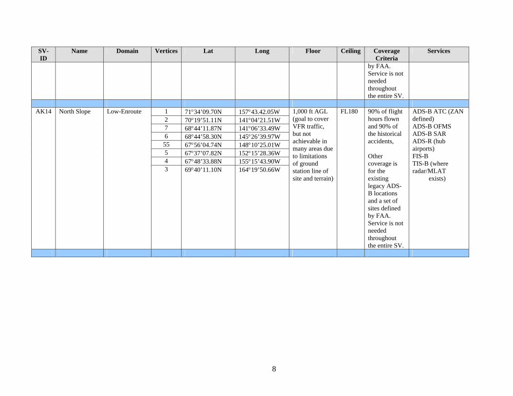
8
SV-ID
Name Domain Vertices Lat Long Floor Ceiling Coverage Criteria
Services
by FAA. Service is not needed throughout the entire SV.
1 71°34’09.70N 157°43.42.05W 2 70°19’51.11N 141°04’21.51W 7 68°44’11.87N 141°06’33.49W 6 68°44’58.30N 145°26’39.97W
55 67°56’04.74N 148°10’25.01W 5 67°37’07.82N 152°15’28.36W 4 67°48’33.88N 155°15’43.90W
AK14 North Slope Low-Enroute
3 69°40’11.10N 164°19’50.66W
1,000 ft AGL (goal to cover VFR traffic, but not achievable in many areas due to limitations of ground station line of site and terrain)
FL180 90% of flight hours flown and 90% of the historical accidents, Other coverage is for the existing legacy ADS-B locations and a set of sites defined by FAA. Service is not needed throughout the entire SV.
ADS-B ATC (ZAN defined) ADS-B OFMS ADS-B SAR ADS-R (hub airports) FIS-B TIS-B (where radar/MLAT exists)
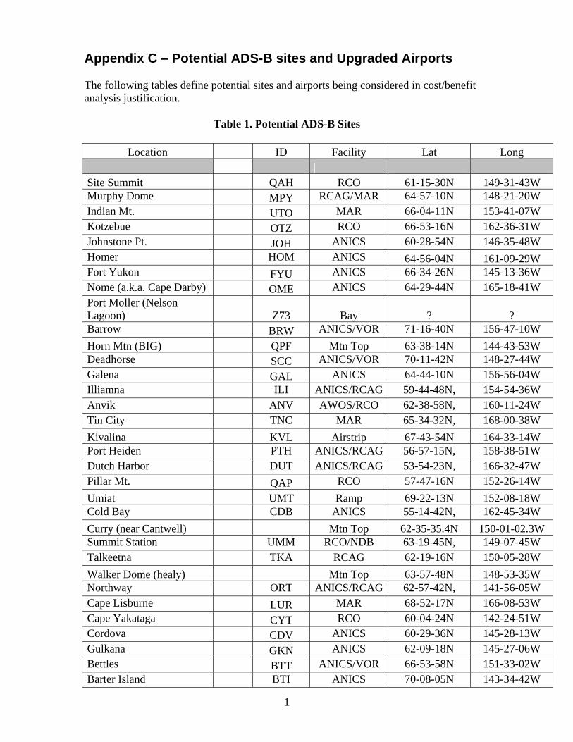
1
Appendix C – Potential ADS-B sites and Upgraded Airports The following tables define potential sites and airports being considered in cost/benefit analysis justification.
Table 1. Potential ADS-B Sites
Location ID Facility Lat Long Site Summit QAH RCO 61-15-30N 149-31-43W Murphy Dome MPY RCAG/MAR 64-57-10N 148-21-20W Indian Mt. UTO MAR 66-04-11N 153-41-07W Kotzebue OTZ RCO 66-53-16N 162-36-31W Johnstone Pt. JOH ANICS 60-28-54N 146-35-48W Homer HOM ANICS 64-56-04N 161-09-29W Fort Yukon FYU ANICS 66-34-26N 145-13-36W Nome (a.k.a. Cape Darby) OME ANICS 64-29-44N 165-18-41W Port Moller (Nelson Lagoon)
Z73 Bay ? ?
Barrow BRW ANICS/VOR 71-16-40N 156-47-10W Horn Mtn (BIG) QPF Mtn Top 63-38-14N 144-43-53W Deadhorse SCC ANICS/VOR 70-11-42N 148-27-44W Galena GAL ANICS 64-44-10N 156-56-04W Illiamna ILI ANICS/RCAG 59-44-48N, 154-54-36W Anvik ANV AWOS/RCO 62-38-58N, 160-11-24W Tin City TNC MAR 65-34-32N, 168-00-38W Kivalina KVL Airstrip 67-43-54N 164-33-14W Port Heiden PTH ANICS/RCAG 56-57-15N, 158-38-51W Dutch Harbor DUT ANICS/RCAG 53-54-23N, 166-32-47W Pillar Mt. QAP RCO 57-47-16N 152-26-14W Umiat UMT Ramp 69-22-13N 152-08-18W Cold Bay CDB ANICS 55-14-42N, 162-45-34W Curry (near Cantwell) Mtn Top 62-35-35.4N 150-01-02.3W Summit Station UMM RCO/NDB 63-19-45N, 149-07-45W Talkeetna TKA RCAG 62-19-16N 150-05-28W Walker Dome (healy) Mtn Top 63-57-48N 148-53-35W Northway ORT ANICS/RCAG 62-57-42N, 141-56-05W Cape Lisburne LUR MAR 68-52-17N 166-08-53W Cape Yakataga CYT RCO 60-04-24N 142-24-51W Cordova CDV ANICS 60-29-36N 145-28-13W Gulkana GKN ANICS 62-09-18N 145-27-06W Bettles BTT ANICS/VOR 66-53-58N 151-33-02W Barter Island BTI ANICS 70-08-05N 143-34-42W

2
Cumshewa ZCU Radar 53-08-39N, 131-57-56W Homer HOM ANICS/RCAG 59-42-32N, 151-27-24W Kenai ENA ANICS/RCAG 60-34-04N, 151-14-20W Minchumina MHM RCO 63-52-58N, 152-18-48W ODK2 RSP Coast Guard 58-04-06N, 153-22-57W Mt Fairplay QPF Mtn Top 63-40-25W 142-12-48N Rugged Isl (seward) Mtn Top 59-51-42N 149-23-30W Sitkinak (s Kodiak) Mtn Top 56-33-36N 154-10-55W Naked Isl ISL Mtn Top 60-40-00N 147-25-00W Ambler (Kotz) AFM Mtn Top ? ? Phase I and II Sites Bethel BET Cape Newenham EHM Cape Romanzof CZF Dillingham DLG King Salmon AKN Saint Mary’s KSM Aniak ANI Unalakleet UNK Tatalina TLJ Sparrevohn SVW Biorka Island BKA Gustavus GST Haines HNS Juneau JNU Lena Point LPJ Sister’s Island SSR Yakutat YAK Angoon AGN Gunnuk Mountain GNK Wrangell WRG High Mountain Cape Spencer CSP Sunny Hay Port Alexander

Table 2. Potential Access Upgrade Airports
Name ID
SBS JRC Approved
List RAPT
Approved
State of Alaska
Dis-allowed
GPS Surveys_
Flight Plan List
QUINHAGAK PAQH X X KASIGLUK PAZ09 X X X SOUTH NAKNEK 2 PAWSN X X TATITLEK PA7KA X BREVIG MISSION PAKTS X X X WHITE MOUNTAIN PAWMO X X X KWETHLUK PAKWT X X X LARSEN BAY PA2A3 X X X BIRCHWOOD PABV X X CIRCLE CITY/NEW PACERC X CLARKS POINT PACLP X ELIM PAELI X X CENTRAL PACEM X NAPAKIAK PAWNA X HEALY RIVER PAHRR X X KOYUKUK PAKYU X X BOB CURTIS/NOORVIK PAD76 X X SHAKTOOLIK PA2C7 X X X SHAGELUK PASHX X X EAGLE PAEAA X X X HUGHES PAHUS X X CHUATHBALUK PA9A3 X X Remaining Airports SKWENTNA PASKW SHELDON POINT PASXP TWIN HILLS PPAA63 BIRCH CREEK PAZ91 X KOBUK PAOBU X LEVELOCK PPAKLL DELTA JUNCTION PAD66 FALSE PASS PAKFP NINILCHIK PANIN PEDRO BAY PA4KO NUNAPITCHUK PA16A PORT LIONS PAORI X X PILOT STATION PA0AK TUNUNAK PA4KA X X GRAYLING PAKGX X X SLEETMUTE PASLQ X X X
3

4
IFR Wx Upgrade WALES IWK X n/a TELLER K54 X n/a ALLAKAKET 6AB X n/a TOK JUNCTION 6K8 X n/a WILLOW UUO X n/a CHALKYITSIK CIK X n/a KWIGILLINGOK A85 X n/a BEAVER WBQ X n/a POINT LAY PIZ X n/a

1
Appendix D – Analysis of Aircraft Equipage Avionics equipage estimates. All statistics are based on the 2004 GA and Air Taxi Activity Survey (which is used for the Administrator’s Factbook and other FAA estimates of the GA and air taxi fleet), with Alaska-based Part 121 aircraft added, and adjusted forward to estimated 2009 levels. It is estimated that there will be 958 commercial aircraft in 2009 (of which 190 have been installed in Capstone I, and 185 have been installed in Capstone II, for a total of 375). Source: Capstone office. Based on an analysis of the annual utilization patterns of non-part 135 aircraft (virtually all are GA aircraft), 65% of these aircraft fly 90% of the GA flight hours. See Table 3 of the ASE Report to Capstone dated August 22, 2006. Therefore, of the 5,397 active GA aircraft estimated to be based in Alaska in 2009, 3,508 (65%) would fly 90% of the GA flight hours, and this is the target number for GA equipage. The SEAP administering entity will collect data on the utilization of participating aircraft to track performance toward this goal, and will adjust the program to achieve the goal of equipping the at least the 3,508 highest utilization GA aircraft and all commercial aircraft. (Note: this will entail equipping additional aircraft with low utilization as necessary to meet the goal of equipping the high utilization aircraft. The total number of additional aircraft (beyond Capstone I and II aircraft) to be equipped to target is:
• The total number of active commercial aircraft, 958 • Less, those already equipped by Capstone, 375 = 583 remaining to be equipped • Plus at least the highest utilization GA aircraft, 3,508 = 4,091 total aircraft to be
equipped • If 1090 ES is selected for all user groups, then an additional 375 aircraft (the
Capstone I and II aircraft), will have to be re-equipped. However, this will be a substantially simpler process than an initial Capstone installation.

1