Satellite SAR ship detections from PMAR in support of...
24
Satellite SAR ship detections from PMAR in support of Cutlass Express Harm Greidanus, Marlene Alvarez, Tulay Cokacar, Andrea Pesaresi, Carlos Santamaria, Vladimir Kyovtorov EUR 25140 EN - 2011
Transcript of Satellite SAR ship detections from PMAR in support of...

Satellite SAR ship detections from PMAR in support of Cutlass Express
Harm Greidanus Marlene Alvarez Tulay Cokacar Andrea PesaresiCarlos Santamaria Vladimir Kyovtorov
EUR 25140 EN - 2011
The mission of the JRC-IPSC is to provide research results and to support EU policy-makers in their effort towards global security and towards protection of European citizens from accidents deliberate attacks fraud and illegal actions against EU policies European Commission Joint Research Centre Institute for the Protection and Security of the Citizen Contact information E-mail pmarjrceceuropaeu httpipscjrceceuropaeu httpwwwjrceceuropaeu Legal Notice Neither the European Commission nor any person acting on behalf of the Commission is responsible for the use which might be made of this publication
Europe Direct is a service to help you find answers to your questions about the European Union
Freephone number ()
00 800 6 7 8 9 10 11
() Certain mobile telephone operators do not allow access to 00 800 numbers or these calls may be billed
A great deal of additional information on the European Union is available on the Internet It can be accessed through the Europa server httpeuropaeu JRC 67445 EUR 25140 EN ISBN 978-92-79-22557-4 ISSN 1831-9424 doi10278839567 Luxembourg Publications Office of the European Union 2011 copy European Union 2011 Reproduction is authorised provided the source is acknowledged Printed in Italy
1
Summary Cutlass Express is a naval exercise on maritime interdiction and counter-piracy to which a number of East African countries participate It is organised by the US Navy for the purpose of regional maritime capacity building JRC has been invited to join based on its activities in the PMAR (ldquoPiracy Maritime Awareness and Risksrdquo) project The at-sea operations in Cutlass Express took place 25-27 Oct 2011 and during those days JRC had satellite SAR (Synthetic Aperture Radar) images collected and analysed The resulting ship detections were fed into MSSIS SeaVision a system to enable international sharing of the maritime picture In this way PMAR results were made available to African operational maritime authorities in near-real time The activity has succeeded in its goals to explore and demonstrate regional sharing of maritime surveillance data in the Horn of Africa to bring PMAR results to African maritime authorities to explore how satellite SAR can contribute to the maritime awareness and to collect a part of the data needed for further work in the PMAR project
2
Contents Summary 1 Acronyms 3 Background 4 Objectives 4 Activities 5 Results 6 Evaluation 7 Conclusions 8 Acknowledgements 9 Appendix A ndash All satellite images with their detected ships using SUMO with manual verification 10
3
Acronyms AIS Automatic Identification System CSK CS Cosmo-Skymed EUNAVFOR European Union Naval Force Somalia ndash Operation Atalanta IMO International Maritime Organisation JRC Joint Research Centre of the European Commission LRIT Long Range Identification and Tracking MSSIS Maritime Safety and Security Information System NATO North Atlantic Treaty Organization NRT Near-Real Time OTHTTS Over The Horizon Tactical Tracking System PMAR Piracy Maritime Awareness and Risks RS2 R2 Radarsat-2 SAR Synthetic Aperture Radar SUMO JRCrsquos ship detector for SAR images TSX TX TerraSAR-X VDS Vessel Detection System VMS Vessel Monitoring System
4
Background 1 JRC is running the PMAR (ldquoPiracy Maritime Awareness and Risksrdquo) project to explore technical possibilities to increase the maritime domain awareness with authorities in Africa The project investigates which data sources and tools can be used to build up maritime situational awareness the sources include ship reporting systems (coastal AIS satellite AIS LRIT VMS) and observation systems (mainly satellite SAR) During certain periods in the project large amounts of ship traffic data are collected in certain test regions in order to enable the evaluation of different types of data and of test methods to combine them 2 Cutlass Express is a maritime interdiction counter-piracy naval exercise It is organised off East Africa by the US Navy with a number of maritime operational authorities in the region participating These include Djibouti Kenya Mauritius Mozambique Seychelles Tanzania Uganda Yemen East African Standby Force EUNAVFOR IMO and NATO The at-sea activities were taking place 25-27 Oct 2011 Maritime situational awareness during the exercise is obtained by using coastal AIS satellite AIS coastal and shipsrsquo radar sightings and special systems (OTHTTS) The Cutlass Express exercise plan including operation areas and temporal scenarios has been fixed in detail during a one-year preparation phase 3 During contacts in 2010 and 2011 JRC with its PMAR project was invited by US Naval Forces Africa to join the Cutlass Express exercise Considering that this would positively contribute to fulfilling the PMAR objectives and that timewise it could fit in the PMAR planning JRC accepted this invitation at the occasion of the Cutlass Express table-top exercise held in Mombasa Kenya in the week of 18 July 2011 JRC scheduled a part of its PMAR data collection campaign to coincide with the Cutlass Express at-sea exercise times and locations which were 25-27 Oct 2011 in two operation areas in front of Dar Es Salaam and Mombasa The contribution of PMAR to Cutlass Express is the provision of ship detections from satellite SAR images also known as VDS a data source that was not yet used in Cutlass Express thereby adding to the maritime situational awareness 4 From its own experience with VDS JRC is well aware that its nature is quite different from most other ship detection or tracking systems In particular VDS has clear shortfalls for operational use related to data content data quality and timeliness These are issues of current RampD 5 A key system to exchange and share the maritime situational picture is MSSIS a global ship tracking system operated by the Volpe Center of the US Department of Transportation The maritime picture in MSSIS can be visualised by the add-on SeaVision designed by the US Navy for maritime domain awareness in Africa MSSIS SeaVision was one of the main tools used in Cutlass Express to share maritime awareness between all exercise participants
Objectives 6 The objectives of JRCrsquos contribution to Cutlass Express were - Explore and demonstrate how VDS (satellite SAR ship detections) can contribute to the
maritime situational and domain awareness for the operational scenarios of Cutlass Express (counter-piracy maritime interdiction maritime law enforcement ndash carried out in multi-national cooperation)
- Explore and demonstrate how VDS data can be shared among operational partners - Show activities and results of PMAR to an audience of maritime operational authorities in
East Africa - Collect a part of the test data needed for the PMAR project
5
Activities 7 Based on the Cutlass Express exercise plan potential satellite SAR image acquisitions were checked (The satellites pass over the Earth in a fixed orbit pattern so if a certain area needs to be imaged it has to be checked at which times this is possible) There are three satellite SAR systems that give useful and reliable results for ship detection Cosmo-Skymed provided by e-Geos Radarsat-2 provided by KSAT and TerraSAR-X provided by InfoTerra and DLR JRC has set up purchase contracts with these providers for PMAR During the 3 days of the exercise a total of 16 satellite image acquisitions were possible over the two operation areas Of those 11 were selected Also the imaging mode and product type of the SAR data were selected (swath width resolution incidence angle polarisation detectedcomplex geographic projection) The selection was based on optimal performance for ship detection and matching to the operation area sizes The selected acquisitions were communicated to the satellite providers The figure below shows the operation areas (the two smallest boxes in front of Mombasa and Dar Es Salaam) and the requested satellite SAR images (the tilted boxes enclosing the operation areas plus the one large tilted box)
8 Although JRC is very well capable to perform ship detection on SAR images with its SUMO ship detector the satellite providers (mentioned above) were asked to perform the ship detection This is because the results needed to be available as fast as possible many images were taken in the night and JRC does not support 247 operations as it is a research centre not an operational centre Taking into account (a) the time needed for the satellite to orbit between the position where it acquired the image and the ground station in Europe where the data can be downlinked (b) the time to process the downlinked SAR data to an image and (c) the time needed to do the ship detection on the image the results could be made available to JRC 1-4 hours after the acquisition of each image This is considered as Near-Real Time (NRT) 9 Software was set up at JRC to automatically download the ship detection results from the ftp sites of the three providers As a second step this software converted the (three different) formats of the ship detection reports from the providers into one single format the PVOL format (for MSSIS) As a last step the software uploaded the PVOL results file to MSSIS In
6
this way it was aimed that the satellite SAR ship detections were visible in MSSIS SeaVision within a few hours after acquisition Although this is much further from real-time than coastal AIS for satellite SAR this is very fast at the state-of-the-art and it is not much slower than the delivery of satellite AIS 10 The US Navyrsquos SPAWAR research centre and the Volpe Center have given essential support to JRC on the aspect of interfacing with MSSIS through the mediation of US Naval Forces Africa The Volpe Center of the US Department of Transportation who run MSSIS had already before provided JRC with access to the MSSIS and SeaVision and with the software to read and upload data (TV32) SPAWAR provided JRC with software to write PVOL files 11 In addition to the PVOL upload of the ship detections that was designed to function automatically some time later an email was sent to a list of addressees with information about the detections overview jpg images total number of detections and list of detections still based on the detection results from the satellite image providers 12 After that the satellite SAR images themselves were downloaded from the providersrsquo ftp sites and analysed with JRCrsquos SUMO ship detector The results of this are more reliable because the automatic results are quality-checked by hand which leads to a significant improvement These results were sent by email to the same list as above as kmz files (for viewing in Google Earth) and jpg images 13 All the while contact was maintained via email with the Cutlass Express operations centres in Dar Es Salaam Tanzania and Naples Italy and with SPAWAR San Diego
Results 14 In total 9 satellite SAR images were obtained and analysed see table below
Date (Oct 2011)
Time (UTC) Area Satellite Mode Detections
by provider
Detections by JRC-SUMO
25 030518 Mombasa TSX Strip 16 13 25 030554 Dar Es Salaam TSX Strip 0 0 26 144248 Dar Es Salaam CSK Strip 4 3 26 152444 Dar Es Salaam CSK Strip 3 3 26 154506 both areas RS2 Scan 43 38 27 033021 Dar Es Salaam CSK Strip 1 2 27 033057 Mombasa CSK Strip 10 14 27 150009 Mombasa CSK Strip 21 29 27 150046 Dar Es Salaam CSK Strip 0 0
Images in Stripmap mode have a higher resolution but a smaller swath they are the smaller ones in the figure under point 7 Images in ScanSAR mode have a lower resolution but a wider swath it is the one large image in the figure under point 7 Only 9 instead of the 11 requested images were obtained because in two cases the satellite operators could not honour the scheduling request 15 Appendix A shows all satellite images with their detected ships as Google Earth screen dumps from the SUMO kmz files 16 On the first day of the exercise it was announced that the Kenya Navy unfortunately had to withdraw from the exercise This meant that there was no activity in the Mombasa operations area On the second day the Tanzania Navy announced that they would change the operations area As the satellite images have to be planned at least 3 days in advance the image locations could not be changed This meant that many of the collected satellite images did not contain
7
exercise activities 17 The automatic software at JRC to read data from the providersrsquo ftp sites and upload them to MSSIS being run for the first time during the week of the experiment had many problems During the week many steps had to be corrected by hand By the end of the week however the automatic software was functioning well except for the final ingestion of the PVOL data into MSSIS This step had to be done by emailing to SPAWAR who ingested the data into MSSIS It is still being examined why this step did not work at JRC 18 All VDS positions (satellite ship detections) from JRC were eventually present in MSSIS and visible in SeaVision MSSIS SeaVision is designed to show the most recent AIS position of each ship which is for coastal AIS normally a few minutes old But in order to handle satellite AIS which can become available with a delay in the order of hours ship positions can be shown with an age of up to 24 hours The same approach was now used for the satellite SAR ship detections they became visible immediately after upload when they were a few hours old and remained visible up to 24 hours after original image acquisition The figure below shows an example (as viewed in SeaVision on 25 Oct 1718 UTC) the pink symbols are JRCrsquos input the ships detected from satellite SAR (here from the TSX overpass at 0305 UTC that day)
Evaluation 19 Regarding timeliness the NRT VDS results were available to the Cutlass Express participants either by email or in SeaVision in most cases within 4-6 hours after satellite acquisition The best possible automatic upload of VDS results into MSSIS in the current configuration is 45 minutes 20 Regarding the quality of the VDS results the control using SUMO with manual verification showed that the NRT results from the providers contained at least 3 false alarms (3 of the total number of 98 ship detections) It is inherent to satellite SAR imaging that there may be a small percentage more of false alarms which are not as such recognised It is also inherent to SAR imaging that the smallest ships remain undetected with the minimum detectable ship size
8
depending on image mode (ie resolution and swath width) metocean conditions and several other parameters Areas near the coast (out to some 3 nm) are prone to false alarms due to contamination from bright reflectors on land and physical features such as human constructions reefs shallows outflows etc The difference in the number of ship detections between the provider results and the SUMO results listed under point 14 is (apart from the mentioned 3 false alarms) mostly due to the inclusion or exclusion of such uncertain detections 21 The well-known inflexibility of the tasking of satellite observations (fixed orbit pattern several days advance scheduling) was again shown to be a problem for operational use 22 In spite of these intrinsic shortfalls satellite SAR ship detection is nonetheless valuable because it is the only way to know about the presence of medium and large ships that do not show up in the maritime picture constructed from the ship reporting systems (AIS LRIT VMS) To make best use of this capability is it needed to correlate VDS detections with ship positions from reporting systems so as to pinpoint and display only the additional non-reporting ships This correlation functionality which has been demonstrated before by JRC in the context of fisheries control is still under development in the PMAR project Concerning the display of VDS targets in SeaVision it is believed that displaying only the non-reporting ships avoiding to add VDS targets that are already present in SeaVision from the reporting systems would be less confusing It is hoped that feedback about the VDS targets in SeaVision will be provided by those who have used it during the exercise 23 The three providers of satellite images and derived NRT VDS results all used a different format for their VDS reports both regarding contents (attribute set with each detection) and formatting A standardisation would be most desirable Possibly this can be reached under the ESA-funded MARISS project aimed at professionalising earth observation services in which all three providers participate
Conclusions 24 All objectives (point 6) have been reached First it has been explored and demonstrated how VDS data (satellite SAR ship detections) can be shared among operational partners ndash namely in the first place by uploading the VDS results into the MSSIS SeaVision system and additionally by email with attachments that visualise the results Second it has been explored and demonstrated how VDS can contribute to the maritime situational and domain awareness for the operational scenarios of Cutlass Express Considering the VDS delay of a few hours the more valuable contribution was probably to the domain awareness Under different operational scenarios however the VDS even with that delay can contribute significantly to the situational awareness Third activities and results of the PMAR project have been shown to an audience of maritime operational authorities in East Africa ndash namely those who have been actively involved in or passively following the Cutlass Express exercise Fourth a part of the test data needed for the PMAR project has been collected 25 Considering the above the activity has been a success and even the issues mentioned under point 16 (last minute cancellation and change of operations) do not detract from that 26 Based on this experience it is now seriously considered to join the ldquoObangame Expressrdquo exercise that is planned for end February 2012 in the Gulf of Guinea This is a similar exercise involving Ghana Togo Nigeria Cameroon Equatorial Guinea Gabon Republic of Congo and Sao Tomeacute amp Principe It would fit very well in JRCrsquos PMAR-Gulf of Guinea project
9
Acknowledgements This work was done in cooperation with andor using inputs from US Naval Forces Africa SPAWAR San Diego the Volpe Center of the US Department of Transportation DLR InfoTerra e-Geos and KSAT Cosmo-Skymed images are copy e-Geos 2011 TerraSAR-X images are copy InfoTerraDLR 2011 Radarsat-2 images are copy MDA 2011
10
Appendix A ndash All satellite images with their detected ships using SUMO with manual verification In this appendix each satellite SAR image is shown overlaid on Google Earth The image gray scaling is adapted to show radar backscatter details on the sea surface so the land is mostly saturated (white) The ship detections as found by SUMO are indicated and divided into high medium and low reliability in the colours green yellow and orange respectively The lower the reliability the higher the possibility that the detection is a false alarm If a heading can be recognised from the ship outline the detection is indicated on the image as a bar There is 180 degree ambiguity as to the heading If the ship outline does not show a clear heading the detection is indicated with a dot
11
2011-10-25 030518 UTC TerraSAR-X
12
2011-10-25 030554 UTC TerraSAR-X
13
2011-10-26 144248 UTC Cosmo-Skymed
14
2011-10-26 152444 UTC Cosmo-Skymed
15
2011-10-26 154506 UTC Radarsat-2
16
2011-10-27 033021 UTC Cosmo-Skymed
17
2011-10-27 033057 UTC Cosmo-Skymed
18
2011-10-27 150009 UTC Cosmo-Skymed
19
2011-10-27 150046 UTC Cosmo-Skymed
20
European Commission EUR 25140 EN ndash Joint Research Centre ndash Institute for the Protection and Security of the Citizen Title Satellite SAR ship detections from PMAR in support of Cutlass Express Author(s) H Greidanus M Alvarez T Cokacar A Pesaresi C Santamaria V Kyovtorov Luxembourg Publications Office of the European Union 2011 ndash 21 pp ndash 210 x 297 cm EUR ndash Scientific and Technical Research series ndash ISSN 1831-9424 (online) ISSN 1018-5593 (print) ISBN 978-92-79-22557-4 doi10278839567 Abstract Cutlass Express is a naval exercise on maritime interdiction and counter-piracy to which a number of East African countries participate It is organised by the US Navy for the purpose of regional maritime capacity building JRC has been invited to join based on its activities in the PMAR (ldquoPiracy Maritime Awareness and Risksrdquo) project The at-sea operations in Cutlass Express took place 25-27 Oct 2011 and during those days JRC had satellite SAR images collected and analysed The resulting ship detections were fed into MSSIS SeaVision a system to enable international sharing of the maritime picture In this way PMAR results were made available to African operational maritime authorities in near-real time The activity has succeeded in its goals to explore and demonstrate regional sharing of maritime surveillance data in the Horn of Africa to bring PMAR results to African maritime authorities to explore how satellite SAR can contribute to the maritime awareness and to collect a part of the data needed for further work in the PMAR project
21
How to obtain EU publications Our priced publications are available from EU Bookshop (httpbookshopeuropaeu) where you can place an order with the sales agent of your choice The Publications Office has a worldwide network of sales agents You can obtain their contact details by sending a fax to (352) 29 29-42758
22
The mission of the JRC is to provide customer-driven scientific and technical supportfor the conception development implementation and monitoring of EU policies As a service of the European Commission the JRC functions as a reference centre of science and technology for the Union Close to the policy-making process it serves the common interest of the Member States while being independent of special interests whether private or national
LB
-NA
-25140-EN-N
- Summary
- Acronyms
- Background
- Objectives
- Activities
- Results
- Evaluation
- Conclusions
- Acknowledgements
- Appendix A ndash All satellite images with their detected ships using SUMO with manual verification
-
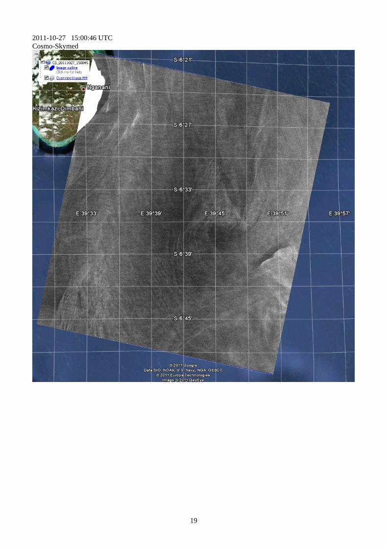